Collaborative Land Use Planning and Sustainable ... · Institutional Arrangements for strengthening...
28
Collaborative Land Use Planning and Sustainable Institutional Arrangements for strengthening land tenure, forest and community rights in Indonesia (CoLUPSIA) ANNUAL REPORT Year 3 (March 2012 – February 2013) and WORK PLAN AND BUDGET Year Four (March 2013 – February 2014) CIRAD CIFOR TELAPAK HuMA TOMA Universitas Pattimura, Ambon Universitas Gadjamada, Yogjakarta Supported by the European Commission
Transcript of Collaborative Land Use Planning and Sustainable ... · Institutional Arrangements for strengthening...
Collaborative Land Use Planning and Sustainable
Institutional Arrangements for strengthening land
tenure, forest and community rights in Indonesia
(CoLUPSIA)
ANNUAL REPORT Year 3
(March 2012 – February 2013)
and
WORK PLAN AND BUDGET Year Four
(March 2013 – February 2014)
CIRAD
CIFOR
TELAPAK
HuMA
TOMA
Universitas Pattimura, Ambon
Universitas Gadjamada, Yogjakarta
Supported by the European Commission
2
1. GENERAL DESCRIPTION
1.1. Beneficiary: Centre International de Recherche Agronomique pour le
Développement (CIRAD France)
1.2. Contact person: Yves Laumonier (CIRAD – CIFOR)
1.3. Partners in the Action: 1. Center International for Forestry Research (CIFOR, Bogor),
2. Perkumpulan TELAPAK (TELAPAK, Bogor),
3. HuMA (Natural resource management and Law NGO, Jakarta),
4. TOMA (Environmental NGO, Ambon),
5. Pattimura University (Ambon),
6. Gadjamada University (Yogjakarta)
1.4. Title of the Action: Collaborative Land Use Planning and Sustainable
Institutional Arrangements for strengthening land tenure, forest and
community rights in Indonesia (CoLUPSIA)
1.5. Contract number: DCI-ENV/2009/151-620
1.6. Reporting period: March 2012 – February 2013
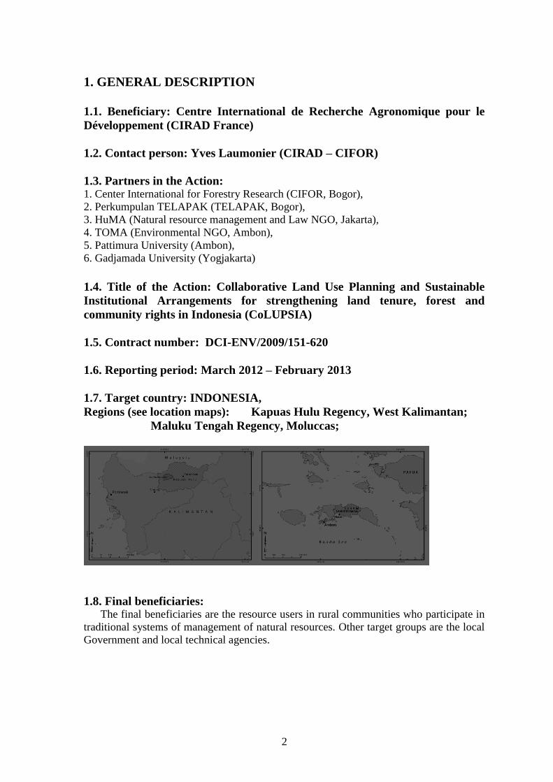
1.7. Target country: INDONESIA,
Regions (see location maps): Kapuas Hulu Regency, West Kalimantan;
Maluku Tengah Regency, Moluccas;
1.8. Final beneficiaries: The final beneficiaries are the resource users in rural communities who participate in
traditional systems of management of natural resources. Other target groups are the local
Government and local technical agencies.
3
Resource users in rural communities, including indigenous members of forest-edge
communities who participate in traditional systems of management of natural resources
The action works with this group because they have a traditional system of managing
natural resources, and include the poorest members of the population. Traditional NRM
systems are still often effective, backed by systems of fines as well as social pressure to
conform, but their effectiveness is increasingly compromised, often linked to land tenure
issues. The estimated size of the target group to benefit from strengthening and
legitimization of such systems through the formal planning process is the entire rural
population of the regencies, approximately 2,000,000 people, with multiplier effects
throughout Indonesia. The estimated number of indigenous forest-edge communities
beneficiaries is 200,000 people.
Local Government (Province and Regencies) and governance system
With decentralization, the local government has responsibility for planning and
management, however its authority is constrained by the involvement of many central
Government agencies. The action addresses lack of coordination among agencies,
deficiencies in capacity, and also support more inclusive approaches by involving
government staff in all stages of implementation, ensuring as well that community needs
are linked to government.
1.9. Background and Objectives The loss of ecological services provided by tropical forests, together with the reduced
availability of renewable resource, is particularly important to population who rely on
natural resources for their livelihood. A new approach to conservation and mitigation of
environment degradation, still in its experimental phase, is to develop payments and pro-
poor markets for environmental services (PES). It will require institutions that can
monitor ecosystem health, but also can allocate and enforce rights and responsibilities. A
participatory development approach is needed providing stakeholders with organizational
arrangements that allow them to coordinate and jointly decide on collective actions.
The Overall Objective is to avoid deforestation and environmental degradation and the
Project Purpose is: to establish collaborative and equitable LUP and NRM, leading to
the design and testing of new institutional arrangements, environmental policies and
pro-poor financing instruments ensuring more secure land tenure and community
rights.
It includes Specific Objectives that are to:
1. Improve capacity of stakeholders to collectively design participatory
development actions, including agreements on land tenure and rights, NRM
instruments and policies
2. Establish collaborative assessment of land conditions, current management
and possible future trajectories
3. Design mutually agreed land allocation, legal CLUP/NRM plans and
participatory development actions
4. Initiate and evaluate specific pilot activities supporting pro-poor financing
mechanisms for forest conservation and sustainable management of resources
5. Raise public awareness on CLUP and ecosystem services value
4
2. ASSESSMENT OF IMPLEMENTATION OF ACTION
2.1. EXECUTIVE SUMMARY
In Year 3, CIRAD and its partners (CIFOR, TELAPAK, HuMA, TOMA, Pattimura
University) consolidate its capacity building program. Emphasis was given on training on
skills that are relevant to the land allocation and Land Use Planning process, for
government officials, local NGOs and university members. The database has been
installed at local government offices in Putussibau (Kapuas Hulu) and Masohi (Seram).
In Year Three, the project also tested decision models using the resource information
system developed in Year Two and the development of the land use rule base model for
land allocation. Importantly, legal team continues its work in advising on laws, policies,
and regulations related to spatial land use planning and tenure. More biophysical data and
land cover maps (topography, soil, geology, vegetation) have been added, together with a
lot of efforts on carbon accounting for REDD + readiness in both regencies, many
satellite images rectified and pretreated (Landsat and SPOT, ALOS radar).
Important outputs for Year Three are also series of publications on Practical guide for
Socio-economic livelihoods, land tenure & rights surveys for use in Collaborative
ecosystem-based land use planning in Indonesia, livelihood reports for Maluku Tengah
and Kapuas Hulu, socio-economic reports for pilot sites (five for Maluku and four for
Kaluas Hulu), and report and guidelines on Payment for Environmental Services:
Assessment for PES potentials in Seram and Kapuas Hulu; and wok on governance
aspects: Unpacking tenure security: development of a conceptual framework and
application to the case of oil palm expansion on customary land in Kapuas Hulu regency.
Further activities for ER 3 “Land allocation, CLUP plans and participatory
development actions ensuring communities’ rights for land are endorsed and
legalized” have been conducted in consultation with key local stakeholders when
producing Land-Use Plans for the regencies. The project has now demonstrated the value of
participatory and inclusive approaches to management, land tenure and community-based
interventions at several meetings and participatory workshops. Regular reviews, detailed
monitoring, cross visits, and links to government has been done in Year three and many
stakeholders have already endorse CoLUPSIA new concepts and instruments.
In addition, raising the awareness of all the stakeholders of their rights and
responsibilities was a major follow up for Year Three for the legal team of CoLUPSIA
(HuMA).
Finally the awareness and dissemination program led by Telapak partner run as planed
and helped to secure support from the civil society and local government in taking more
collaborative decisions about natural resources and land use planning. During the third
year, the used strategy includes: Collecting audio-visual documentation of the works
associated with the project, coordinate with the whole COLUPSIA team to generate
powerful messages on conservation and development actions that minimize impact on
environment.
5
2.2. ACTIVITIES and RESULTS
The project has carried out its activities equally in the two sites, Kapuas Hulu and
Maluku Tengah regencies.
Activity 1.1. Review availability and actual implementation of natural resource
management plans in relation to systems and institutional responsibility, and
identify key stakeholders for development and implementation of the plan
(completed – Y1 & Y2)
Activity 1.2 Carry out capacity development need assessment for each stakeholder
in relation to their probable role in the management of natural resources
(completed – Y1 & Y2)
Activity 1.3 Build capacity through formal training, joint work, shared learning
across sites, specialist advice including building and strengthening skills for working
groups (continued from Y1, Y2 in Y3)
In Year three, these activities continued through additional training to local agencies,
especially the Regional Planning and Development Board staff, the use of developed scenario and
the integration of ecosystem services into LUP. The COLUPSIA project continues to
facilitate the process of Participatory Prospective Analysis for helping stakeholders take
decision on the shared vision they developed for the future of their region. It is a long
process that must be closely monitored (Table 1).
These activities were done together with relevant stakeholders including local
government, academic, and NGO. For mapping and land allocation process, we worked
with national park, local forestry agency and BAPPEDA. In year two we demonstrated
first the added value of our GIS and spatial planning techniques, and in Year Three we
organized further training for local agency both in Seram and Kapuas Hulu for them to
understand better the process and be able to replicate the work later on.
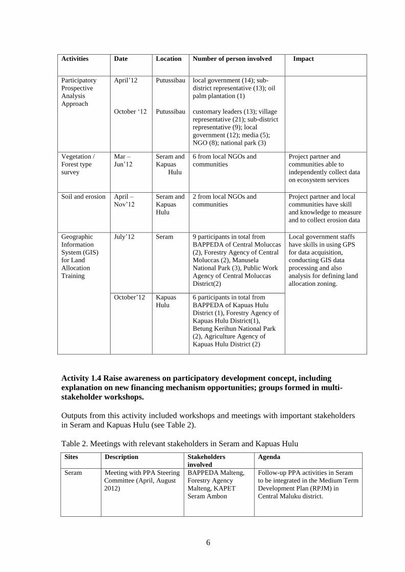
Table 1. Outputs of joint work with project partner and local stakeholders in Year three
Activities Date Location Number of person involved Impact
Participatory
Prospective
Analysis
Approach
April’12 Ambon
Masohi
University (4), NGO (2), Local
Gov (1), KAPET Seram (1)
Local Gov (10),
National Park (1)
Stakeholders able to
develop a shared vision
for their input to the
planning process and use
of developed scenario
and the integration of
ecosystem services into
LUP
6
Activities Date Location Number of person involved Impact
Participatory
Prospective
Analysis
Approach
April’12
October ‘12
Putussibau
Putussibau
local government (14); sub-
district representative (13); oil
palm plantation (1)
customary leaders (13); village
representative (21); sub-district
representative (9); local
government (12); media (5);
NGO (8); national park (3)
Vegetation /
Forest type
survey
Mar –
Jun’12
Seram and
Kapuas
Hulu
6 from local NGOs and
communities
Project partner and
communities able to
independently collect data
on ecosystem services
Soil and erosion April –
Nov’12
Seram and
Kapuas
Hulu
2 from local NGOs and
communities
Project partner and local
communities have skill
and knowledge to measure
and to collect erosion data
Geographic
Information
System (GIS)
for Land
Allocation
Training
July’12 Seram
9 participants in total from
BAPPEDA of Central Moluccas
(2), Forestry Agency of Central
Moluccas (2), Manusela
National Park (3), Public Work
Agency of Central Moluccas
District(2)
Local government staffs
have skills in using GPS
for data acquisition,
conducting GIS data
processing and also
analysis for defining land
allocation zoning.
October’12 Kapuas
Hulu
6 participants in total from
BAPPEDA of Kapuas Hulu
District (1), Forestry Agency of
Kapuas Hulu District(1),
Betung Kerihun National Park
(2), Agriculture Agency of
Kapuas Hulu District (2)
Activity 1.4 Raise awareness on participatory development concept, including
explanation on new financing mechanism opportunities; groups formed in multi-
stakeholder workshops.
Outputs from this activity included workshops and meetings with important stakeholders
in Seram and Kapuas Hulu (see Table 2).
Table 2. Meetings with relevant stakeholders in Seram and Kapuas Hulu
Sites Description Stakeholders
involved
Agenda
Seram
Meeting with PPA Steering
Committee (April, August
2012)
BAPPEDA Malteng,
Forestry Agency
Malteng, KAPET
Seram Ambon
Follow-up PPA activities in Seram
to be integrated in the Medium Term
Development Plan (RPJM) in
Central Maluku district.
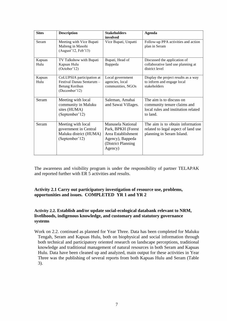
7
Sites Description Stakeholders
involved
Agenda
Seram Meeting with Vice Bupati
Malteng in Masohi
(August’12, Feb’13)
Vice Bupati, Unpatti Follow-up PPA activities and action
plan in Seram
Kapuas
Hulu
TV Talkshow with Bupati
Kapuas Hulu
(October’12)
Bupati, Head of
Bappeda
Discussed the application of
collaborative land use planning at
district level
Kapuas
Hulu CoLUPSIA participation at
Festival Danau Sentarum –
Betung Kerihun
(December’12)
Local government
agencies, local
communities, NGOs
Display the project results as a way
to inform and engage local
stakeholders
Seram Meeting with local
community in Maluku
sites (HUMA)
(September’12)
Saleman, Amahai
and Sawai Villages.
The aim is to discuss on
community tenure claims and
local rules and institution related
to land.
Seram Meeting with local
government in Central
Maluku district (HUMA)
(September’12)
Manusela National
Park, BPKH (Forest
Area Establishment
Agency), Bappeda
(District Planning
Agency)
The aim is to obtain information
related to legal aspect of land use
planning in Seram Island.
The awareness and visibility program is under the responsibility of partner TELAPAK
and reported further with ER 5 activities and results.
Activity 2.1 Carry out participatory investigation of resource use, problems,
opportunities and issues. COMPLETED YR 1 and YR 2
Activity 2.2. Establish and/or update social-ecological databank relevant to NRM,
livelihoods, indigenous knowledge, and customary and statutory governance
systems
Work on 2.2. continued as planned for Year Three. Data has been completed for Maluku
Tengah, Seram and Kapuas Hulu, both on biophysical and social information through
both technical and participatory oriented research on landscape perceptions, traditional
knowledge and traditional management of natural resources in both Seram and Kapuas
Hulu. Data have been cleaned up and analyzed, main output for these activities in Year
Three was the publishing of several reports from both Kapuas Hulu and Seram (Table
3).

8
Table 3. Main output of Year 3
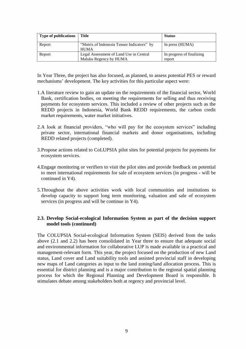
Type of publications Title Status
CIRAD-CIFOR
Working Series Paper
Socio-economic considerations for land use
planning. The case of Seram, Central Maluku
In press (Publish in May’13)
Socio-economic considerations for land use
planning. The case of Kapuas Hulu, West
Kalimantan
In press (Publish in May’13)
CIRAD-CIFOR
Working Series Paper
Five Pilot Site Reports for Maluku In press (Publish in May’13)
Four Pilot Site Reports for Kapuas Hulu In press (Publish in May’13)
CIFOR booklet Practical guide for Socio-economic livelihoods,
land tenure & rights surveys for use in
Collaborative ecosystem-based land use
planning
Publish in December 2012
CIRAD-CIFOR
Working Series Paper
Unpacking tenure security: development of a
conceptual framework and application to the
case of oil palm expansion on customary land
in Kapuas Hulu regency, West Kalimantan,
Indonesia
Publish in November 2012
GFAR Info brief Brief No. 39: Building a shared vision:
Scenarios for collaborative land use planning
on Seram Island, Central Moluccas Regency,
Indonesia
Publish in GFAR (The
Global Forum of Agricultural
research) in August 2012
GFAR Info brief Brief No. 18: Seeking harmony: Scenarios for
nature conservation and agricultural
development in Kapuas Hulu district, Indonesia
Publish in GFAR (The
Global Forum of Agricultural
research) in July 2012
Article online Seeking harmony in Indonesia Publish online in New
Agriculturist April 2013
http://www.new-
ag.info/en/research/innovatio
nItem.php?a=2934.
Journal Article Sasaoka, M., and Y. Laumonier. 2012.
Suitability of local resource management
practices based on supernatural enforcement
mechanisms in the local social-cultural
context.
Ecology and Society 17(4):
6.http://dx.doi.org/10.5751/E
S-05124-170406
Conference paper Basuki, I. and Y. Laumonier. 2013. Dynamics
of soil nutrients and organic carbon of land-use
changes in tropical forests: a case study from
Indonesian Borneo.
Accepted for oral
presentation in ATBC
conference, Costa Rica, June
2013.
MSc Thesis CIRAD Cosiaux, A. Local Uses of tree species and
contribution of mixed tree gardens to
livelihoods of Saleman village near Manusela
National Park, Seram island, Maluku
(Indonesia).
Master thesis, Universite
Montpellier. 2012
MSc Thesis CIRAD Dos Santos, T. Ecosystem-based management
in Central Seram, Maluku, Indonesia.
Master thesis, Universite
Montpellier 2. 2012
MSc Thesis CIRAD Chakib, A. Assessment of the impact of NGOs
on LUP in West Kalimantan
Master thesis, Agroparistech
University, Paris
CoLUPSIA
Handbook
“Buku Saku Tentang Pengetahuan Tentang
Tata Ruang” (Handbook of Knowledge on
Land use).
Printed by HUMA for
various Colupsia Workshops
and events
CoLUPSIA Policy
Brief
“Hak dan Partisipasi Komunitas Dalam
Penentuan Kebijakan Tata Ruang kehutanan”
(Right and Participation of Community in
Forestry Land use Policy” by HUMA
In press (HUMA)
9
Type of publications Title Status
Report “Matrix of Indonesia Tenure Indicators” by
HUMA
In press (HUMA)
Report Legal Assessment of Land Use in Central
Maluku Regency by HUMA
In progress of finalizing
report
In Year Three, the project has also focused, as planned, to assess potential PES or reward
mechanisms’ development. The key activities for this particular aspect were:
1. A literature review to gain an update on the requirements of the financial sector, World
Bank, certification bodies, on meeting the requirements for selling and thus receiving
payments for ecosystem services. This included a review of other projects such as the
REDD projects in Indonesia, World Bank REDD requirements, the carbon credit
market requirements, water market initiatives.
2. A look at financial providers, “who will pay for the ecosystem services” including
private sector, international financial markets and donor organisations, including
REDD related projects (completed).
3. Propose actions related to CoLUPSIA pilot sites for potential projects for payments for
ecosystem services.
4. Engage monitoring or verifiers to visit the pilot sites and provide feedback on potential
to meet international requirements for sale of ecosystem services (in progress - will be
continued in Y4).
5. Throughout the above activities work with local communities and institutions to
develop capacity to support long term monitoring, valuation and sale of ecosystem
services (in progress and will be continue in Y4).
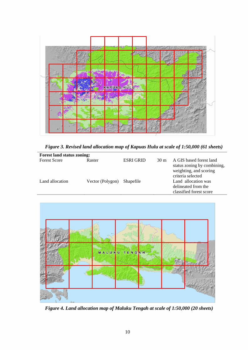
2.3. Develop Social-ecological Information System as part of the decision support
model tools (continued)
The COLUPSIA Social-ecological Information System (SEIS) derived from the tasks
above (2.1 and 2.2) has been consolidated in Year three to ensure that adequate social
and environmental information for collaborative LUP is made available in a practical and
management-relevant form. This year, the project focused on the production of new Land
status, Land cover and Land suitability tools and assisted provincial staff in developing
new maps of Land categories as input to the land zoning/land allocation process. This is
essential for district planning and is a major contribution to the regional spatial planning
process for which the Regional Planning and Development Board is responsible. It
stimulates debate among stakeholders both at regency and provincial level.
10
Figure 3. Revised land allocation map of Kapuas Hulu at scale of 1:50,000 (61 sheets)
Forest land status zoning:
Forest Score Raster ESRI GRID 30 m A GIS based forest land
status zoning by combining,
weighting, and scoring
criteria selected
Land allocation Vector (Polygon) Shapefile Land allocation was
delineated from the
classified forest score
Figure 4. Land allocation map of Maluku Tengah at scale of 1:50,000 (20 sheets)
11
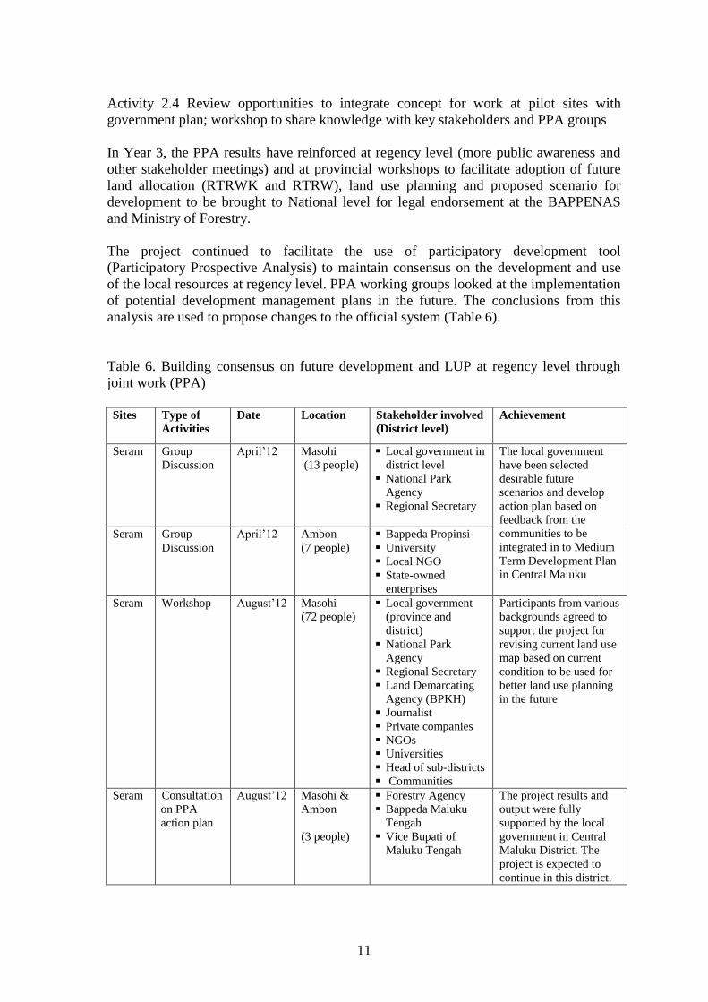
Activity 2.4 Review opportunities to integrate concept for work at pilot sites with
government plan; workshop to share knowledge with key stakeholders and PPA groups
In Year 3, the PPA results have reinforced at regency level (more public awareness and
other stakeholder meetings) and at provincial workshops to facilitate adoption of future
land allocation (RTRWK and RTRW), land use planning and proposed scenario for
development to be brought to National level for legal endorsement at the BAPPENAS
and Ministry of Forestry.
The project continued to facilitate the use of participatory development tool
(Participatory Prospective Analysis) to maintain consensus on the development and use
of the local resources at regency level. PPA working groups looked at the implementation
of potential development management plans in the future. The conclusions from this
analysis are used to propose changes to the official system (Table 6).
Table 6. Building consensus on future development and LUP at regency level through
joint work (PPA)
Sites Type of
Activities
Date Location Stakeholder involved
(District level)
Achievement
Seram Group
Discussion
April’12 Masohi
(13 people)
Local government in
district level
National Park
Agency
Regional Secretary
The local government
have been selected
desirable future
scenarios and develop
action plan based on
feedback from the
communities to be
integrated in to Medium
Term Development Plan
in Central Maluku
Seram Group
Discussion
April’12 Ambon
(7 people)
Bappeda Propinsi
University
Local NGO
State-owned
enterprises
Seram Workshop August’12 Masohi
(72 people)
Local government
(province and
district)
National Park
Agency
Regional Secretary
Land Demarcating
Agency (BPKH)
Journalist
Private companies
NGOs
Universities
Head of sub-districts
Communities
Participants from various
backgrounds agreed to
support the project for
revising current land use
map based on current
condition to be used for
better land use planning
in the future
Seram Consultation
on PPA
action plan
August’12 Masohi &
Ambon
(3 people)
Forestry Agency
Bappeda Maluku
Tengah
Vice Bupati of
Maluku Tengah
The project results and
output were fully
supported by the local
government in Central
Maluku District. The
project is expected to
continue in this district.
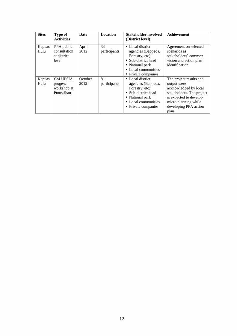
12
Sites Type of
Activities
Date Location Stakeholder involved
(District level)
Achievement
Kapuas
Hulu
PPA public
consultation
at district
level
April
2012
34
participants
Local district
agencies (Bappeda,
Forestry, etc)
Sub-district head
National park
Local communities
Private companies
Agreement on selected
scenarios as
stakeholders’ common
vision and action plan
identification
Kapuas
Hulu
CoLUPSIA
progess
workshop at
Putussibau
October
2012
81
participants
Local district
agencies (Bappeda,
Forestry, etc)
Sub-district head
National park
Local communities
Private companies
The project results and
output were
acknowledged by local
stakeholders. The project
is expected to develop
micro planning while
developing PPA action
plan
13
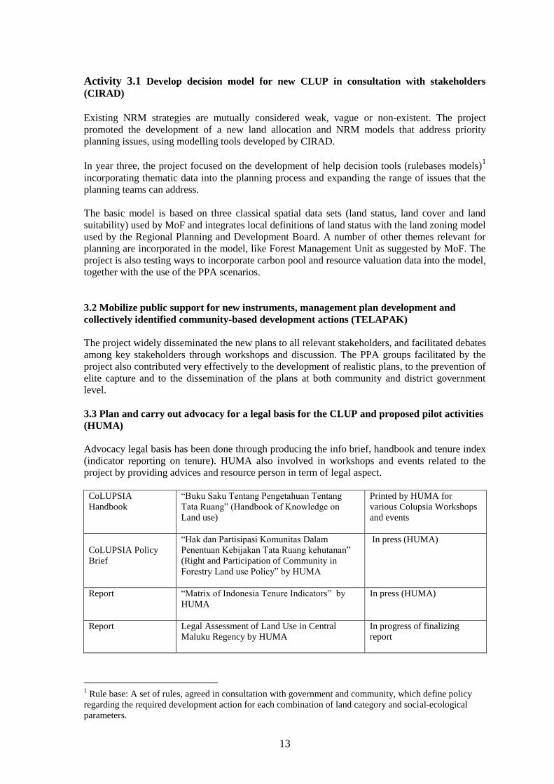
Activity 3.1 Develop decision model for new CLUP in consultation with stakeholders
(CIRAD) Existing NRM strategies are mutually considered weak, vague or non-existent. The project
promoted the development of a new land allocation and NRM models that address priority
planning issues, using modelling tools developed by CIRAD.
In year three, the project focused on the development of help decision tools (rulebases models)1
incorporating thematic data into the planning process and expanding the range of issues that the
planning teams can address.
The basic model is based on three classical spatial data sets (land status, land cover and land
suitability) used by MoF and integrates local definitions of land status with the land zoning model
used by the Regional Planning and Development Board. A number of other themes relevant for
planning are incorporated in the model, like Forest Management Unit as suggested by MoF. The
project is also testing ways to incorporate carbon pool and resource valuation data into the model,
together with the use of the PPA scenarios.
3.2 Mobilize public support for new instruments, management plan development and
collectively identified community-based development actions (TELAPAK)
The project widely disseminated the new plans to all relevant stakeholders, and facilitated debates
among key stakeholders through workshops and discussion. The PPA groups facilitated by the
project also contributed very effectively to the development of realistic plans, to the prevention of
elite capture and to the dissemination of the plans at both community and district government
level.
3.3 Plan and carry out advocacy for a legal basis for the CLUP and proposed pilot activities
(HUMA)
Advocacy legal basis has been done through producing the info brief, handbook and tenure index
(indicator reporting on tenure). HUMA also involved in workshops and events related to the
project by providing advices and resource person in term of legal aspect.
CoLUPSIA
Handbook
“Buku Saku Tentang Pengetahuan Tentang
Tata Ruang” (Handbook of Knowledge on
Land use)
Printed by HUMA for
various Colupsia Workshops
and events
CoLUPSIA Policy
Brief
“Hak dan Partisipasi Komunitas Dalam
Penentuan Kebijakan Tata Ruang kehutanan”
(Right and Participation of Community in
Forestry Land use Policy” by HUMA
In press (HUMA)
Report “Matrix of Indonesia Tenure Indicators” by
HUMA
In press (HUMA)
Report Legal Assessment of Land Use in Central
Maluku Regency by HUMA
In progress of finalizing
report
1 Rule base: A set of rules, agreed in consultation with government and community, which define policy
regarding the required development action for each combination of land category and social-ecological
parameters.
14
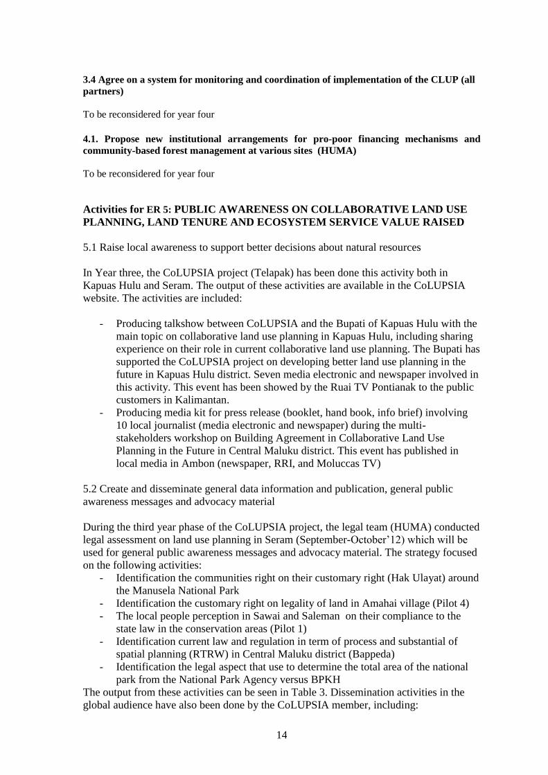
3.4 Agree on a system for monitoring and coordination of implementation of the CLUP (all
partners)
To be reconsidered for year four
4.1. Propose new institutional arrangements for pro-poor financing mechanisms and
community-based forest management at various sites (HUMA)
To be reconsidered for year four
Activities for ER 5: PUBLIC AWARENESS ON COLLABORATIVE LAND USE
PLANNING, LAND TENURE AND ECOSYSTEM SERVICE VALUE RAISED
5.1 Raise local awareness to support better decisions about natural resources
In Year three, the CoLUPSIA project (Telapak) has been done this activity both in
Kapuas Hulu and Seram. The output of these activities are available in the CoLUPSIA
website. The activities are included:
- Producing talkshow between CoLUPSIA and the Bupati of Kapuas Hulu with the
main topic on collaborative land use planning in Kapuas Hulu, including sharing
experience on their role in current collaborative land use planning. The Bupati has
supported the CoLUPSIA project on developing better land use planning in the
future in Kapuas Hulu district. Seven media electronic and newspaper involved in
this activity. This event has been showed by the Ruai TV Pontianak to the public
customers in Kalimantan.
- Producing media kit for press release (booklet, hand book, info brief) involving
10 local journalist (media electronic and newspaper) during the multi-
stakeholders workshop on Building Agreement in Collaborative Land Use
Planning in the Future in Central Maluku district. This event has published in
local media in Ambon (newspaper, RRI, and Moluccas TV)
5.2 Create and disseminate general data information and publication, general public
awareness messages and advocacy material
During the third year phase of the CoLUPSIA project, the legal team (HUMA) conducted
legal assessment on land use planning in Seram (September-October’12) which will be
used for general public awareness messages and advocacy material. The strategy focused
on the following activities:
- Identification the communities right on their customary right (Hak Ulayat) around
the Manusela National Park
- Identification the customary right on legality of land in Amahai village (Pilot 4)
- The local people perception in Sawai and Saleman on their compliance to the
state law in the conservation areas (Pilot 1)
- Identification current law and regulation in term of process and substantial of
spatial planning (RTRW) in Central Maluku district (Bappeda)
- Identification the legal aspect that use to determine the total area of the national
park from the National Park Agency versus BPKH
The output from these activities can be seen in Table 3. Dissemination activities in the
global audience have also been done by the CoLUPSIA member, including:
15
- GCARD conference 2012 in Uruguay by presenting Kapuas Hulu PPA case in
one of the conference parallel session
- IUFRO conference 2012 in Chile by presenting Maluku case on Trade-off
between conservation and development.
16
2.3. ACTIVITIES PLANNED but NOT IMPLEMENTED 3.4 Agree on a system for monitoring and coordination of implementation of the CLUP (all
partners)
4.1. Propose new institutional arrangements for pro-poor financing mechanisms and
community-based forest management at various sites (HUMA)
2.4. ASSESSMENT OF RESULTS
The extent to which results was achieved towards objectives during the year 2012-2013
is reported in Table 7. Indicators are monitored based on the initial logical framework
and milestones in the Work plan.
Table 7. Project achievement in Year 3
Results Objectively
Verifiable Indicators Means of verification Progress compared
to OVI
ER 1. Capacity of
stakeholders to
collectively design
and monitor
participatory
development actions,
including agreements
on land tenure and
rights, NRM
instruments and
policies improved
I1a: Government,
community and
NGO's have
equipment / resources
and skill for
developing CLUP
Management team
reports; Completed Y2
Minutes of meetings; Completed Y2 Activity reports from
training events; Completed Y2
Workshops meetings; Completed Y2 Copies of project
initiated publicity and
awareness
information;
Completed Y3
Copies of media
publicity; Completed Y3
Website. Completed Y2 Agreements with local
authorities, villages; Completed Y3
Project Steering
Committee evaluation
report;
Completed Y3
I1b: Monitoring
system involves
all stakeholders
and Government
and community
representatives
have skills and
knowledge to
monitor and
implementation
land-use plan.
Outputs of workshop
to agree monitoring
system, subsequent
reports on progress,
subsequent reports on
progress,
Completed Y2 and Y3
Community survey
showing key groups
that are willing to
participate in any
monitoring
Completed Y3
Report indicating
community capacity
Partly achieved in Y3,
continue in Y4
17
Results Objectively
Verifiable Indicators Means of verification Progress compared
to OVI
to monitor and
implement LUP is
improved
Reports indicating
monitoring
implemented (PPA)
Partly achieved in Y3,
continue in Y4
Expected Result 2:
Collaborative
assessment of land
conditions, current
management and
possible future
trajectories
established
I2a: Communities and
Governmental
agencies have,
understand and
agree on the
proper data for
improved natural
resource
management at
pilot sites
Technical reports and
publications;
Completed Y2
set of thematic maps
(estimate 250 at scale
1:100,000); LULC
maps, LULC Change
model;
Completed Y2 and Y3
Biophysical data set; Completed Y3,
continue in Y4
Socio economic data
set;
Completed Y2 and Y3
Natural Resource
valuation reports;
Partly completed in
Ye, continue in Y4
Free access to Social
Ecological
Information System
via Internet on project
web site;
Partly achieved,
continue in Y4
I2b: Community
members,
including CSO-
NGOs and the
private sector,
and government
collectively
identify long term
environmental
issues which can
jeopardize their
livelihoods
A set of reports on
mutually agreed
future work, based on
PPA groups and key
stakeholder workshop
Completed Y3
Social survey report:
pilot site plan
indicators of progress
and progress reports
show participation by
disadvantaged groups,
such as women and
indigenous people.
Completed Y3
I2c: Formal
agreement
between project
and key
stakeholders for
joint natural
resource planning
Community-project
agreement for work at
pilot site with
representation from
disadvantaged groups
Completed Y3
ER 3. Mutually
agreed land
allocation,
CLUP/NRM plans
and participatory
development actions
I3a: Agreement from
key stakeholders
for land-use plan.
Land use plan with
formal endorsement
and record of process
Partly achieved in Y3,
need formal
endorsement and
record of process
Technical reports and
guidelines on the use
Completed Y3
18
Results Objectively
Verifiable Indicators Means of verification Progress compared
to OVI
designed and legal
process initiated of Decision model for
CLUP;
Media products from
the awareness
campaign;
Completed Y3
Laws, regulations and
other legal documents
for CLUP;
Completed Y3
Report on monitoring
guidelines and
implementation for
pro poor financing
mechanism proposals.
Completed Y3
List of publications on
social ecological, land
tenure and payments
for eco-services.
Completed Y3
I3b: Head of Local
government
adopts land-use
plan and the plan
is in the process
of legalization.
Formal records of
legal process
Partially completed,
need formal
endorsement
I3c: Local Parliament
adopts land-use
plan and the plan
is in the process
of legalization.
Formal records of
legal process
Partially completed,
need formal
endorsement
ER 4. Specific pilot
activities supporting
pro-poor financing
mechanisms for forest
conservation and
sustainable
management
evaluated and begun
I4a: No evidence of
large forest
degradation or
lost, no decline in
the
populations/stock
of key wild
species resources
Report on different
trials on different
sites; Reports and
publications on the
real benefit or added
value of proposed
intervention (PES or
REDD);
Completed Y3
(feasibility PES)
Reports indicating
that the legality of
local institutions for
PES market is
recognised;
Not yet, continue in
Y4 (HUMA)
Reports on system of
monitoring;
Not yet, continue in
Y4
Media evidence that
the awareness
program has been
successful in bringing
Not yet, continue in
Y4
19
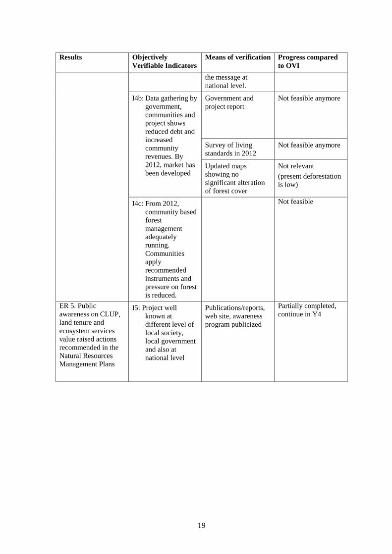
Results Objectively
Verifiable Indicators Means of verification Progress compared
to OVI
the message at
national level.
I4b: Data gathering by
government,
communities and
project shows
reduced debt and
increased
community
revenues. By
2012, market has
been developed
Government and
project report
Not feasible anymore
Survey of living
standards in 2012
Not feasible anymore
Updated maps
showing no
significant alteration
of forest cover
Not relevant
(present deforestation
is low)
I4c: From 2012,
community based
forest
management
adequately
running.
Communities
apply
recommended
instruments and
pressure on forest
is reduced.
Not feasible
ER 5. Public
awareness on CLUP,
land tenure and
ecosystem services
value raised actions
recommended in the
Natural Resources
Management Plans
I5: Project well
known at
different level of
local society,
local government
and also at
national level
Publications/reports,
web site, awareness
program publicized
Partially completed,
continue in Y4
20
2.4. UPDATED ACTION PLAN
(Year Four, March 2013 – February 2014)
Activity 1.4 Raise awareness of the participatory development concept, including an
explanation of new financing mechanism opportunities; groups formed in multi-
stakeholder workshops.
The project will continue to conduct multi stakeholder workshop and publish the project finding
in Y4. The main activities are included:
- Bringing the output from the district into Provincial (June) and National level (Oct)
- Deliver the feedback from national debate to the province, district and communities
- Publish poster/brochure/info brief (legal aspect and PPA)
- Publish the project finding from biophysical, socio-economic, and legal aspect (full year)
Activity 2.1 Carry out participatory investigation of resource use, problems,
opportunities and issues Completed, no further activities in year four
Activity 2.2 Establish and/or update social-ecological databank relevant to NRM,
livelihoods, indigenous knowledge, and customary and statutory governance
systems
In Year 4 the remaining activity 2.1 is to finalize the project report on economic valuation in both
sites (Feb-August).
Activity 2.3 Develop Social-ecological Information System as part of the decision
support model tools
Considered completed with now consolidation of the database (data quality check and control)
Activity 2.4 Review opportunities to integrate concept for work at pilot sites with
government plans; Workshops to share knowledge with key stakeholders and PPA
groups.
Related to the activity 1.4 the project will facilitate a process of community based development
micro projects in pilot sites.
21
The project will also continue to conduct several workshops to share knowledge with
stakeholders and PPA groups. The project output in district, province and national level.
The main activities are include:
- Further work with communities in Pilot sites using participatory approach (PRA) to
promote the community aspiration on specific project which could be implemented in
these pilot sites
- To follow-up agreement for developing future land allocation and LUP in regency
Masohi involving PPA group & DPRD
Activity 3.1 Develop decision model for new CLUP in consultation with stakeholders
(CIRAD CIFOR)
The main activities are:
- To finalize the development of the decision model for land allocation and CLUP
- To continue capacity building on Remote Sensing, GIS and use of COLUPSIA modeling
for local government in Maluku and Kapuas Hulu regencies
Activity 3.2 Mobilize public support for new instruments, management plan
development and collectively identified community-based development actions;
In year four, this will be related to ER 5 Awareness. It will includes:
Public support to:
(1) generate and maintain pressure on the local parliament and head of the local government to
ensure that plan development and implementation are effective;
(2) ensure that the population is aware of their rights and responsibilities under the plan,
including the reasons for any restrictions on resource use. This might include a component of
education on the role of forests in water supply, for example, as part of explaining the need for
refusal of applications for palm oil or logging on vulnerable land.
Existing communication channels (for example, health sector, school system, agricultural
extension) will be utilised. Likely mechanisms for dissemination are local radio, television, and
existing institutions.
Activity 3.3 Plan and carry out advocacy for a legal basis for the CLUP and
proposed pilot activities (HUMA)
The endorsement of CLUP and maps will be followed up to the provincial level, and facilitation
will be provided for negotiation with Central Government. New NR management plans and
proposed land allocation will be promoted for incorporation as revisions of the District Spatial
Plan following the approval of the head of the local government and local parliament. Following
this, specific regulations concerned key aspects of resource management will be drafted for
approval by the local parliament.
Following this, specific regulations concerned key aspects of resource management will be
drafted for approval by the local parliament. The project will facilitate this process by promoting
the aims and importance of the collaborative action to the heads of the local government and local
parliament from the start, and by working through technical arms of government to influence
decision-makers. The project will provide legal assistance for drafting regulations when
necessary. The strength of central government antagonism to formal tenure recognition, though,
must be acknowledged from the start.
22
Activity 3.4 Agree on a system for monitoring and coordination of implementation
of the CLUP (all partners)
The whole decision-making process needs to be transparent, with adequate consultation and
genuine involvement of stakeholders and with agreed information available to all concerned. The
project will build on the shared understanding and capacities built at the local and district levels,
in a process to negotiate precise mechanisms for use in monitoring the implementation of CLUP.
These efforts are likely to include a forum for government and community leaders and
community members including women, to discuss and plan implementation of pro-poor financing
mechanisms. Other important components to be implemented include ad-hoc groups to monitor
particular development projects (for example, a joint community-forestry department group to
monitor timber extraction), and a mechanism for regular feedback to all concerned (perhaps using
local radio).
The project and partners will ensure that within future implementation of the participatory
development scheme, conditions are set to limit the environmental impact of new developments
based on the policies and zoning in the plan. These will emphasize that:
- Clear and equitable land tenure and access are guaranteed
- Institutions required for implementation are strengthened as necessary
- The Bureau for Environmental Impact Control (BAPPEDALDA) makes recommendations
to the head of local government on proposals for new development projects based on the
policies and zoning in the plan
- There is active monitoring at the community and district levels to ensure that development
is implemented in accordance with the approval
- Action is taken to stop or change unauthorised activities that contravene the policies in the
plan
Clearly the active involvement of community and government personnel will be a critical at all
stages of this process.
Activity 4.1 Propose new institutional arrangements for pro-poor financing
mechanisms and community-based forest management at various sites (HUMA)
Within the previously collectively identified framework and on the basis of more secure land
tenure and suitable data, the feasibility of pilot activities supporting pro-poor financing
mechanisms for forest conservation and sustainable management will be evaluated and
publicized. Relevant new institutional arrangements between different levels of government;
local communities and the private sector will be proposed. These new institutional arrangements
will again be developed using participatory methodologies and operate within the ongoing
participatory framework developed by the project that enables those with a direct stake in forest
resources to be part of all forest management decision-making.
Potential environmental rewards for activities that help increase forest area under SFM will be
carefully assessed. Careful preparation (proper data) for REDD or PES type interventions,
together with improved land tenure and rights developed by the project, will help, but improved
legal aspects, such as new district regulations for accommodating PES, will again be needed.
New tools and mechanisms for ensuring PES (including REDD+) works for local people and
potential links with private sector will also be explored.
After fostering community participation, encouraging individuals to form associations to promote
their common interests, the project will assist in the provision of legal and management advice to
assist in the development of appropriate structures supporting activities that can attract public
funding. This can be conducted by PPA group members teaching others.
23
Depending on each local situation and data collected in ER 2 (baseline data, proposed activities,
environmental problems...), possible markets for ecosystem services (carbon, water, biodiversity,
scenic beauty) will be identified, together with an analysis of the key market issues from the point
of view of both buyers and local communities (benefit sharing, monitoring, permanence,
prioritised areas for conservation or sustainable management...).
The project will conduct stakeholder workshop in district level in Maluku and Kapuas Hulu
related to activity 3.4.
Clearly the active involvement of community and government personnel will be a critical at all
stages of this process.
In Year 4, the project is planning to conduct several activities as follow:
- To provide training and capacity building to manage microhydro (maintenance,
organization etc) (Riak Bumi, Telapak)
- To conduct sharing knowledge related to tengkawang oil processing with other villages
(Riak Bumi)
Activity 4.2 Test local institutions for improvement of the efficiency and added
value of local and global PES and/or REDD
Depending on the sites, it is anticipated that the project may facilitate the involvement of the
above local institutions in community-based forest management or tree farming/plantations. Or it
could focus more on forest and water management, leading to greater forest benefits for local
communities, while also providing greater incentives to sustainably manage and protect those
resources, via environmental rewards mechanisms.
The project will
identify local arrangements that could address these issues, such as: increase benefit sharing,
guarantee transparent monitoring, strengthen the likelihood of more permanent provision of
ecosystem services, target activities to prioritized areas (those with more carbon or more
threats of deforestation, those with more biodiversity or more effects on water quality...)...
Support the development of local institutions to ensure the sustainability of the provision of
ecosystem services.
The activities that could be considered to conduct in pilot sites:
- Tengkawang oil processing project at Keluin
- Improve marketing (laboratory test, potential market assessment etc)
Activity 4.3 Strengthen legal role of local institutions for PES market and REDD
initiatives
This issue is a contentious one in Indonesia, but one that needs to be addressed. One strategy will
be the strengthening of community members’ (men’s and women’s) skills (via their participation
in facilitated PAR groups) in self-analysis, visioning, planning, monitoring/assessing progress,
negotiation, conflict management, networking, and communication in fora operating at broader
scales. This will strengthen their voices in local level deliberations and also improve the
perceptions of higher level bureaucrats about their capabilities.
A second strategy will involve the PPA/PAR groups at the district level, which will be focused on
cross-sector collaboration/coordination. The simultaneous planning processes at the community
and district levels will identify some shared concerns at both levels, on which local community-
based institutions can build. These shared interests will strengthen informal social capital
24
between the groups at both levels. We anticipate that this will strengthen the commitment of
district level actors to support the communities in the expression of their needs and desires.
Finally, we anticipate that this approach will lead to positive results on the ground, and the
project can thereby serve as a ‘model’ from which other parts of Indonesia can learn. Such a role
can also serve to strengthen the likelihood that community-based institutions’ legal bases can be
better articulated to the advantage of local communities.
The project initiatives to follow up the activity 4.3 are included:
- Micro project on pilot sites in Maluku and Kapuas Hulu
- Legal implication on PES (HUMA, April – August)
- Dialogue about the boundary between NPM & community
- Preparation work for preparing community for PES
Activity 4.4. Establish a system of monitoring for the provision of ES or REDD
Village management plans developed by communities at pilot sites will include targets and
indicators for monitoring. Where possible these will be monitored by the communities
themselves. This monitoring will be made with necessary support from the project at the
beginning, but later linked to technical support from government departments to avoid creating
dependence on the project for long-term technical assistance. The PPA/PAR groups may also
have their own indicators, some of which may be widely useful to divide monitoring work
between community and districts.
Detailed planning with local government and stakeholders will define more precisely the process
for development of the management plan for the region including indicators for monitoring status
and extent of SFM. Indicators of progress will be monitored by the relevant implementing body
and fed back to a forum of stakeholders established to oversee the process.
Long-term monitoring baselines will be established and capacity built for repeating simple
monitoring protocols to allow monitoring over extended time periods. The biophysical databank
built by the project will serve as a baseline monitoring tool for key species, resources, and
habitats, allowing comparison with new data. The system will contain provision for monitoring of
key resources using GIS and new satellite imagery supplemented with minimal ground surveys.
4.5. Bring results to national debate for legal input to policy change
The project will develop a pro-active dissemination strategy that addresses decision-making
bodies and the public about its social-ecological findings. This will be designed to enhance local,
national and international awareness of LULCC (Land Use Land Cover Change), forest and
climatic change, as well as foster active networking among participatory development oriented
action projects in the region. Here, synergies with existing communication tools will be explored.
The international strength of CIRAD and CIFOR will also be used to organize comparative
events on results of similar projects in Africa and Latin America. CIFOR is building an
international platform for “demonstration activities” on REDD schemes, and the sites of this
project will be included in the list.
The activities are included:
- National workshop on LUP (Sep/Oct)
- Disseminate our finding at national workshop in August (Bali) & Sep (Bogor), various
papers (August)
- Support legal advocacy on national workshop (Sep)
25
Visibility Actions
Activity 5.1 Raise local awareness to support better local decisions about natural
resources/forest/land use/ecosystem services by the community, local government
and civil society (TELAPAK CIFOR)
The visibility action and awareness program focuse here on information for local stakeholders,
decision-making bodies and the public, through a proactive dissemination strategy. Here,
synergies with existing tools will be widely explored. This includes simple explanation of the
findings of sociological, biological and ecological data to formulate NRM plans, the importance
of ecosystem services to society, and the ways in which better management could benefit
livelihoods. It will include a lot about new financing mechanisms or rewards such as PES which
are quite unclear for local societies. The ultimate target of the messages are the civil society of
the Province, but intermediate targets who can assist in disseminating the message are
government extension workers (agriculture, health), schools, churches, mosques, clinics, credit
meetings and traditional leaders. Information will include messages on forests, the hydrological
cycle, soil erosion and land use decisions, Indonesia management planning law, and the rights of
communities, the project and opportunities to participate.
Activity 5.2 Create and disseminate general data information and publications
(CIFOR)
Published reports on project findings, including the results of workshops, research into local
knowledge, socio-economics and economics, ecological assessments (hardcopy and on web site),
and formal publications on lessons-learnt and generally applicable conclusions will be produced
for the government, NGOs and an international audience.
In Year Three evaluation reports will document and assess the success or impact of the
interventions, and the project approach to multi-stakeholder management planning. Formal
“government publications” from the project will be made available to district technical
departments, village heads and key institutions such as churches/mosques but also to be
distributed to other districts/NGOs in the concerned province and in Indonesia.
The project will produce the following activities in Year 4:
- Blogs stories (CIFOR)
- Workshop dissemination/PR
- Finalizing video documentary
- Footage Kapuas Hulu
Activity 5.3 Create and disseminate general public awareness messages and
advocacy material (CIFOR CIRAD TELAPAK)
This program aims at facilitating national consensus on the new instruments for land use, land
tenure and NR management policies in Indonesia. Whilst the interventions will improve general
public’s understanding of resource management, sharing understanding about these interventions
will be crucial for the lessons they will provide at national level, and the demonstration value, in
advocating participatory and inclusive approaches to management.
Advocacy material, targeted at political decision-making levels of Regency, Provincial and
National government. This will emphasise the importance of the work of the project as a basis for
sustainable development of the Region, and the rights and responsibilities of local decision-
makers to improve the livelihoods of the populations. The impact of these will be backed up with
national media articles featuring the project process and highlighting the positive aspects of
26
Government/community collaboration. It will be also delivered through a variety of media
including posters and leaflets, video programmes for television, and through the newspapers.
3. PARTNERS AND OTHER CO-OPERATION
3.1. Relationship between the formal partners of this Action
Please provide specific information for each partner organisation.
CIFOR, TELAPAK, HuMA, TOMA, PATTIMURA, GADJAMADA
CIRAD, CIFOR, TELAPAK, TOMA have previously collaborated in implementing
projects and development programmes in Indonesia. The current project has deepened
and strengthened this relationship. In addition to being a full partner in the overall
implementation of the project, through their production house “Gecko”, TELAPAK have
taken on special responsibility for the actions directly relating to awareness-raising, while
CIFOR concentrates on the compiling of social, economic and cultural data from the
target communities. Whilst CIRAD has legal responsibility for financial expenditure and
implementation through its contract with the EC, decisions on implementation of
activities are done by mutual agreement with all partners. HuMA is being instrumental in
channeling the legal aspects of the action while TOMA and PATTIMURA ensured the
good organization of local workshops and meeting in the Moluccas. In summary, the
relationship with all implementing partners has been positive, professional and inspiring.
3.2. How would you assess the relationship between your organisation and State
authorities in the Action countries? How has this relationship affected the Action?
Both in KAPUAS HULU and MALUKU TENGAH Regencies, the project has been well
received as indicated by the minutes and analysis of the workshops. Local government
agencies but also local community leaders were all represented in the discussions and all
agreed that the idea of a “collaborative” action was necessary to avoid future conflict
between parties.
3.3. Where applicable, describe your relationship with any other organisations
involved in implementing the Action:
Associate(s)
FORDA, LIPI, IAHRI
Good relationships with these institutions, through joint data collection in the field;
Since Year one, the project build excellent relationship with a local NGO in West
Kalimantan RIAK BUMI
Sub-contractor(s) (if any)
none
Final Beneficiaries and Target groups
Two early in the life of the project to describe relationship, should become visible
after year 3
Other third parties involved (including other donors, other government agencies or local
government units, NGOs, etc)
Inapplicable
27
3.4. Where applicable, outline any links and synergies you have developed with
other actions.
The project developed good relationship with other existing projects in Kapuas Hulu;
WWF Indonesia (Heart of Borneo Initiative project) and Flora Fauna International
(AUSAID-Development of REDD and Community Forest projects in West Kalimantan,
Indonesia), mainly for exchange of data, but also local institutions, technical services of
the local government that are very much interested in beneficiating from quality data.
3.5. If your organisation has received previous EC grants in view of strengthening
the same target group, in how far has this Action been able to build
upon/complement the previous one(s)? (List all previous relevant EC grants).
The CIRAD Participatory LUP in Tanimbar project (CIRAD BIRDLIFE 2003-2006),
Southeastern Maluku allowed renewing former contacts in the Moluccas (provincial level
Ambon and the “case” of Tanimbar discussed as example when describing what this
particular Action may do in Seram.
4. VISIBILITY
The visibility of the EU contribution is being ensured in the project mainly via specific
activities under “Expected Result 5” with TELAPAK as leading partner on that issue.
Brochures, banners at the workshop, pictures and video shooting, some examples are
given in Annex.
28
5. FINANCIAL INDICATORS of PROGRESS
Project expenditures of the project to the end of the 2012-2013 fiscal year period are
recorded in separate financial report. A Summary of budget expenditure is given below
(Table 2):
normal disbursement occurred for Year three that reaches % of what was originally
planned.
The European Commission may wish to publicise the results of Actions. Do you have
any objection to this report being published on EuropeAid Co-operation Office website?
If so, please state your objections here.
No objections
Name of the contact person for the Action: Yves LAUMONIER
Signature:
Location: CIRAD CIFOR, Bogor, Indonesia
Date report due: April 15, 2013
Date report sent: April 23, 2013 ; revised May , 2013
Budget in EURO Total
budget
(yr 1 to 4)
Budget
Year 3
Expenses
Year 3
% used
of Year
3
% used of
Total
budget
1. Salaries & Per
diems
2. Travel
3. Equipment
4. Office costs
5. Service costs
Total