The Economics of Environmental Regulation of Housing Development

Codebook for the Local Housing Regulation
Database
Jenny Schuetz
Kennedy School of Government Harvard University
January 2006
Local Housing Regulation Database: Codebook
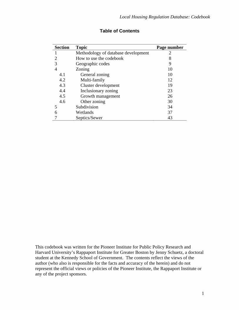
Table of Contents
Section Topic Page number 1 Methodology of database development 2 2 How to use the codebook 8 3 Geographic codes 9 4 Zoning 10 4.1 General zoning 10 4.2 Multi-family 12 4.3 Cluster development 19 4.4 Inclusionary zoning 23 4.5 Growth management 26 4.6 Other zoning 30 5 Subdivision 34 6 Wetlands 37 7 Septics/Sewer 43
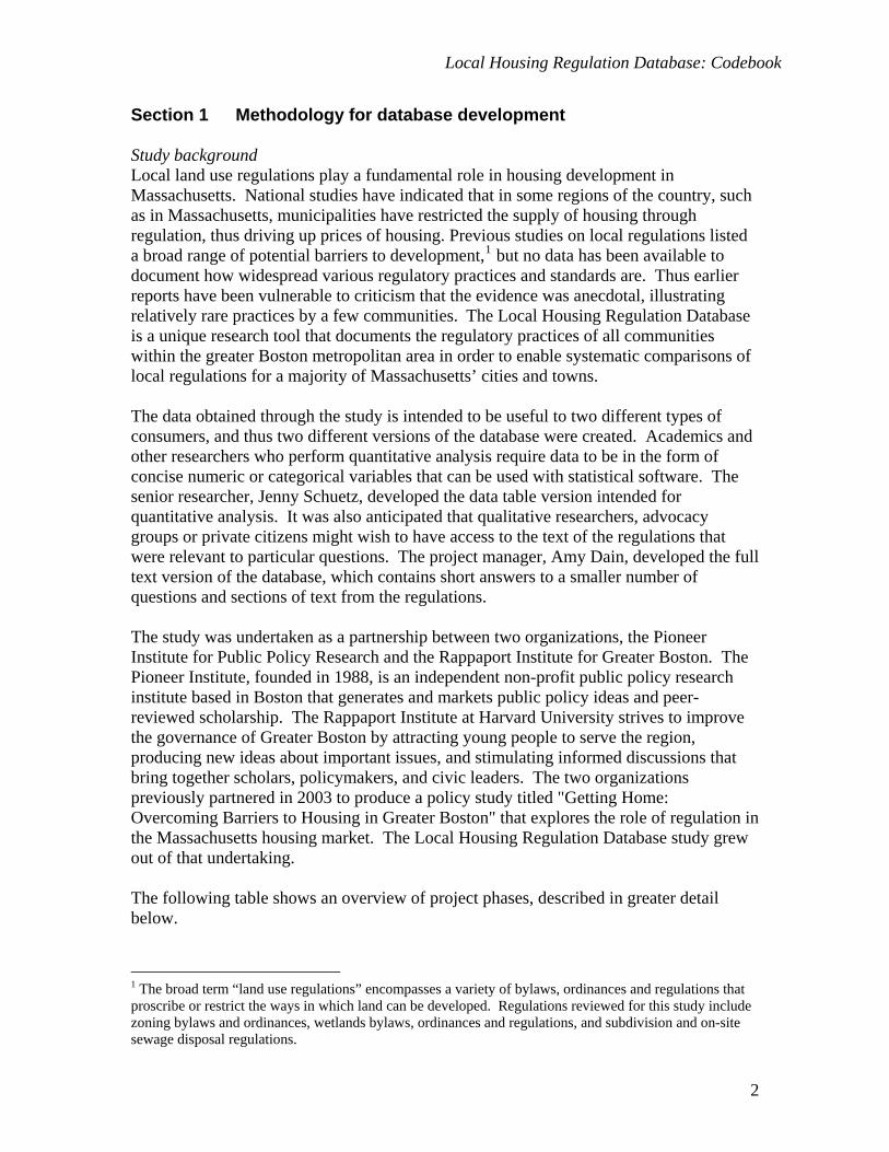
This codebook was written for the Pioneer Institute for Public Policy Research and Harvard University’s Rappaport Institute for Greater Boston by Jenny Schuetz, a doctoral student at the Kennedy School of Government. The contents reflect the views of the author (who also is responsible for the facts and accuracy of the herein) and do not represent the official views or policies of the Pioneer Institute, the Rappaport Institute or any of the project sponsors.
1
Local Housing Regulation Database: Codebook
Section 1 Methodology for database development Study background Local land use regulations play a fundamental role in housing development in Massachusetts. National studies have indicated that in some regions of the country, such as in Massachusetts, municipalities have restricted the supply of housing through regulation, thus driving up prices of housing. Previous studies on local regulations listed a broad range of potential barriers to development,1 but no data has been available to document how widespread various regulatory practices and standards are. Thus earlier reports have been vulnerable to criticism that the evidence was anecdotal, illustrating relatively rare practices by a few communities. The Local Housing Regulation Database is a unique research tool that documents the regulatory practices of all communities within the greater Boston metropolitan area in order to enable systematic comparisons of local regulations for a majority of Massachusetts’ cities and towns. The data obtained through the study is intended to be useful to two different types of consumers, and thus two different versions of the database were created. Academics and other researchers who perform quantitative analysis require data to be in the form of concise numeric or categorical variables that can be used with statistical software. The senior researcher, Jenny Schuetz, developed the data table version intended for quantitative analysis. It was also anticipated that qualitative researchers, advocacy groups or private citizens might wish to have access to the text of the regulations that were relevant to particular questions. The project manager, Amy Dain, developed the full text version of the database, which contains short answers to a smaller number of questions and sections of text from the regulations. The study was undertaken as a partnership between two organizations, the Pioneer Institute for Public Policy Research and the Rappaport Institute for Greater Boston. The Pioneer Institute, founded in 1988, is an independent non-profit public policy research institute based in Boston that generates and markets public policy ideas and peer-reviewed scholarship. The Rappaport Institute at Harvard University strives to improve the governance of Greater Boston by attracting young people to serve the region, producing new ideas about important issues, and stimulating informed discussions that bring together scholars, policymakers, and civic leaders. The two organizations previously partnered in 2003 to produce a policy study titled "Getting Home: Overcoming Barriers to Housing in Greater Boston" that explores the role of regulation in the Massachusetts housing market. The Local Housing Regulation Database study grew out of that undertaking. The following table shows an overview of project phases, described in greater detail below.
1 The broad term “land use regulations” encompasses a variety of bylaws, ordinances and regulations that proscribe or restrict the ways in which land can be developed. Regulations reviewed for this study include zoning bylaws and ordinances, wetlands bylaws, ordinances and regulations, and subdivision and on-site sewage disposal regulations.
2
Local Housing Regulation Database: Codebook
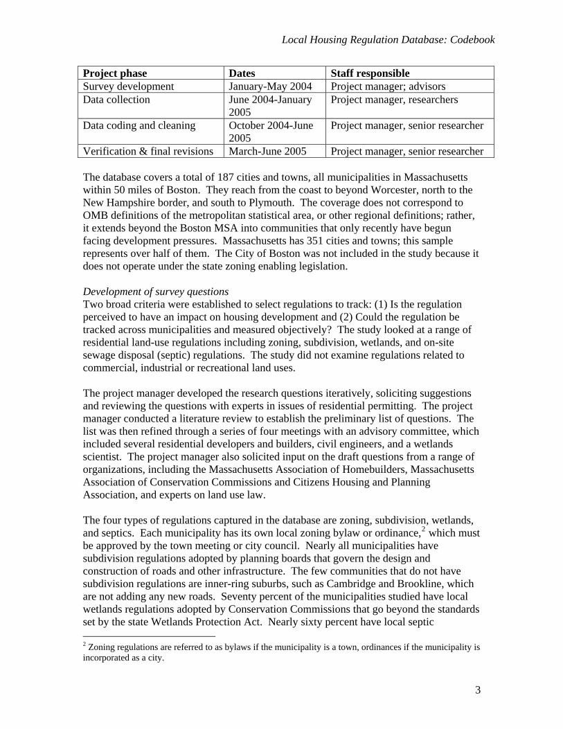
Project phase Dates Staff responsible Survey development January-May 2004 Project manager; advisors Data collection June 2004-January
2005 Project manager, researchers
Data coding and cleaning October 2004-June 2005
Project manager, senior researcher
Verification & final revisions March-June 2005 Project manager, senior researcher The database covers a total of 187 cities and towns, all municipalities in Massachusetts within 50 miles of Boston. They reach from the coast to beyond Worcester, north to the New Hampshire border, and south to Plymouth. The coverage does not correspond to OMB definitions of the metropolitan statistical area, or other regional definitions; rather, it extends beyond the Boston MSA into communities that only recently have begun facing development pressures. Massachusetts has 351 cities and towns; this sample represents over half of them. The City of Boston was not included in the study because it does not operate under the state zoning enabling legislation. Development of survey questions Two broad criteria were established to select regulations to track: (1) Is the regulation perceived to have an impact on housing development and (2) Could the regulation be tracked across municipalities and measured objectively? The study looked at a range of residential land-use regulations including zoning, subdivision, wetlands, and on-site sewage disposal (septic) regulations. The study did not examine regulations related to commercial, industrial or recreational land uses. The project manager developed the research questions iteratively, soliciting suggestions and reviewing the questions with experts in issues of residential permitting. The project manager conducted a literature review to establish the preliminary list of questions. The list was then refined through a series of four meetings with an advisory committee, which included several residential developers and builders, civil engineers, and a wetlands scientist. The project manager also solicited input on the draft questions from a range of organizations, including the Massachusetts Association of Homebuilders, Massachusetts Association of Conservation Commissions and Citizens Housing and Planning Association, and experts on land use law. The four types of regulations captured in the database are zoning, subdivision, wetlands, and septics. Each municipality has its own local zoning bylaw or ordinance,2 which must be approved by the town meeting or city council. Nearly all municipalities have subdivision regulations adopted by planning boards that govern the design and construction of roads and other infrastructure. The few communities that do not have subdivision regulations are inner-ring suburbs, such as Cambridge and Brookline, which are not adding any new roads. Seventy percent of the municipalities studied have local wetlands regulations adopted by Conservation Commissions that go beyond the standards set by the state Wetlands Protection Act. Nearly sixty percent have local septic 2 Zoning regulations are referred to as bylaws if the municipality is a town, ordinances if the municipality is incorporated as a city.
3

Local Housing Regulation Database: Codebook
regulations adopted by the Board of Health that go beyond the state’s regulations. The table below shows the number of municipalities with each type of regulation and the number of variables coded for each section in the data table version.
Regulation type Variables Municipalities Zoning 64 187 Subdivision 14 181 Wetlands 21 131 Septics/Sewer 20 109
Data on minimum lot sizes and other standard dimensional requirements were not collected as part of the study. Mass GIS, the Office of Geographic and Environmental Information within the state Executive Office of Environmental Affairs, conducted a survey of dimensional requirements in zoning bylaws for all 351 cities and towns in 1999-2000 and assembled a database of these regulations that is publicly available. Therefore the Pioneer-Rappaport study did not duplicate these efforts. Data collection The project manager and twelve research assistants conducted primary data collection. Prior to data collection, the project manager provided an extensive training for the research assistants on the regulatory issues and research methodology. Researchers obtained the regulations from a variety of different sources. When possible, researchers downloaded regulations from the municipalities’ websites. Zoning and subdivision regulations that were not available on websites were downloaded from a commercial firm, Ordinance.com, which provides local regulations for several states on a subscription basis. In cases where wetlands and septics regulations were not available on the municipal websites, researchers called the conservation commission, board of health or municipal clerk to obtain a copy. As not every municipality has wetlands, septics and subdivision regulations, researchers called or emailed municipal staff to determine whether the regulations existed. Once regulations had been obtained, researchers reviewed the documents and recorded answers to the survey questions in a Microsoft Access database. If answers could not be determined from the regulations, researchers called or emailed the relevant municipal officials. For each question, researchers recorded a short answer (generally either “Yes” or “No” or a single number, but occasionally longer text answers). The database also included a “Notes” field for each question into which the researchers copied and pasted lengthy sections of the regulations, emails from staff or summaries of phone conversations. The “Notes” sections were often several pages per question per town. The manager reviewed all data entries on a daily basis to ensure completeness and consistency across the research team. Data coding, cleaning and verification Several types of changes were made to the database during the coding and cleaning phase. The senior researcher recoded some of the short answers, coded additional variables for the data table version, and developed a codebook to accompany the dataset.
4

Local Housing Regulation Database: Codebook
Both the project manager and senior researcher identified variables with incomplete or ambiguous data; gaps and questions were re-checked by reviewing bylaws and/or communicating with municipal staff. Answers in the data table version of the database are consistent with the short answers in the full text version, unless specifically noted otherwise. For a number of variables, the senior researcher recoded the short answers to ensure that variables used consistent definitions and assumptions across all municipalities. For example, one survey question asked, “What is the width of pavement on a “typical” subdivision road?” Most municipalities define different road widths for different categories of roads, intended to serve different numbers of houses and automobile trips. Thus the initial widths recorded in the short answer to this question did not reflect widths of comparable streets; some were coded for “Lanes” with 4-6 houses, others for “Minor Roads” intended to serve up to 30 houses. The senior researcher created a new variable that identified the name of the road category intended to serve 10-30 houses, or the nearest equivalent, and recoded the short answer to correspond to that road type. The senior researcher also coded additional variables from the text of the regulations to capture descriptive details. Many of the original survey questions were quite broad, while the text of the regulations included in the “Notes” field contained significant qualitative and quantitative differences in regulations across municipalities. For example, one survey question asked, “Is cluster/flexible development allowed by special permit anywhere in the municipality?” and researchers recorded “Yes” or “No.” However, specific details of the cluster provisions are likely to affect the feasibility or attractiveness to developers of using the provisions, such as the minimum parcel size required and whether more housing units can be developed under cluster than under conventional subdivision standards. The senior researcher coded new variables from the “Notes” field for several of the original survey questions, notably on multi-family zoning, cluster development, inclusionary zoning, and growth management, as well as the dates various provisions were adopted or most recently amended (see notes below on timing of changes). All variable definitions and clarifying assumptions used to create consistency were documented by the senior researcher in the codebook that accompanies the dataset. The codebook also lists the survey question on which the variable is based, the type of variable (numeric or text), and information on interpreting the coded values (i.e category names and units of measurement). Definitions and clarifying assumptions are also documented in the full text version of the database. Following data coding and cleaning, the project manager sent the short answers for 70 percent of the variables to planning departments, conservation commissions and health departments for verification. At least one department from 110 of the 187 municipalities returned the verification survey. Some of the questions and answers were excluded from the verification surveys to make review easier for municipal staff and to avoid confusion. For example, many municipalities have several types of cluster development with varying dimensional requirements. To avoid confusion, municipal staff were not asked to verify data coded from multiple cluster provisions, but were asked to verify that cluster provisions existed. Enough questions/answers were included for each issue tracked to
5
Local Housing Regulation Database: Codebook
catch any “red-flags” in the researchers’ coding and interpretation. The project manager and senior researcher revised the data to incorporate municipal comments and corrections, where appropriate. Additional notes and comments The database presents a snapshot of regulations that were on the books at the time of data collection (summer and fall of 2004). Regulations are cumulative documents – provisions are added, deleted or revised frequently, but even in instances when a new bylaw is adopted, it is rare for all the provisions to differ substantially from the previous version. Particularly because of the durable nature of buildings, the most basic elements of zoning bylaws – the districts established on the zoning map – may remain generally the same for long periods of time. In a few cases, towns amended their regulations during the period of data collection, so researchers had to revise earlier data entries to reflect changes. When possible, the database documents the year in which each provision of interest was originally adopted and most recently amended. What is actually built may vary from what appears to be allowed “on the books” for several reasons. First, variances can be granted that waive certain regulations for specific projects. Second, what is listed as “allowed” may be made infeasible by the details of the regulations, as appeared to be the case for some types of multi-family housing and cluster development. Third, some municipalities enforce “policies” that have not been formally promulgated, and thus are hard to track by researchers. For example, several conservation commissions enforce building setbacks from wetlands that are not codified in the local wetlands bylaw/ordinance. Fourth, outdated regulations that are still on the books may not be enforced. Staff at several health departments said that they do not enforce outdated regulations of septic systems. Finally, regulations are often vague or ambiguous, so interpretation of the same written language can vary across municipalities. For instance, conservation commissions varied in their interpretation of the width of jurisdiction from the mean annual water line of vernal pools; based on virtually identical language, some municipalities claimed 200 feet of jurisdiction, while others enforced only 100 feet. The database is coded according to the official or “on the books” regulations. The greatest challenge in developing the database was to create standardized variables that can be compared across municipalities from distinctly non-standardized regulations. The terms used for the same concept, and the definitions of the same terms, may vary considerably across municipalities, so researchers carefully reviewed the text of the regulations. For instance, the provisions for flexible residential development may be called “Cluster Development,” “Conservation Subdivision,” “Planned Development,” or “Open Space Residential Development,” to give just a few names. Some provisions for “Planned Development” allow reductions in minimum lot sizes in exchange for permanent open space, others allow a mix of residential and commercial uses with no open space provisions (the former were coded as “cluster” while the latter were not). Other municipalities may have provisions for age-restricted homes with open space requirements that meet the definition of cluster, but are located in a separate section of
6
Local Housing Regulation Database: Codebook
the bylaw. Careful and meticulous review was essential to ensure that the variables truly compare similar items from town to town. Staff: Project Manager: Amy Dain
Pioneer Institute for Public Policy Research Senior Researcher: Jenny Schuetz
Kennedy School of Government, Harvard University Researchers: Janelle Austin Shannon McKay
Casey Barnard Emily Mechem Brian Chirco Adriana Nunez
Anna Doherty Hayley Snaddon Molly Giammarco Eva Claire Synkowski Michael Kane Gabrielle Watson
Pioneer Institute for Public Policy Research
James Stergios, Executive Director Rappaport Institute for Greater Boston
Edward L. Glaeser, Director David Luberoff, Executive Director
Pioneer Sponsors for the Study: Associated Industries of Massachusetts Counselors of Real Estate Homebuilders Association of Massachusetts Massachusetts Association of Realtors Massachusetts Business Roundtable Massachusetts Lumber Retailers’ Association National Association of Industrial and Office Properties The Senior Researcher received funding from the Rappaport Institute’s Dan Paul Fund and the Taubman Center for State and Local Government. Citation When using data from this database, source credit should be stated as: Pioneer Institute for Public Policy Research and Rappaport Institute for Greater Boston. 2005. Massachusetts Housing Regulation Database. Prepared by Amy Dain and Jenny Schuetz. Questions and comments on the project should be sent to [email protected]
7
Local Housing Regulation Database: Codebook
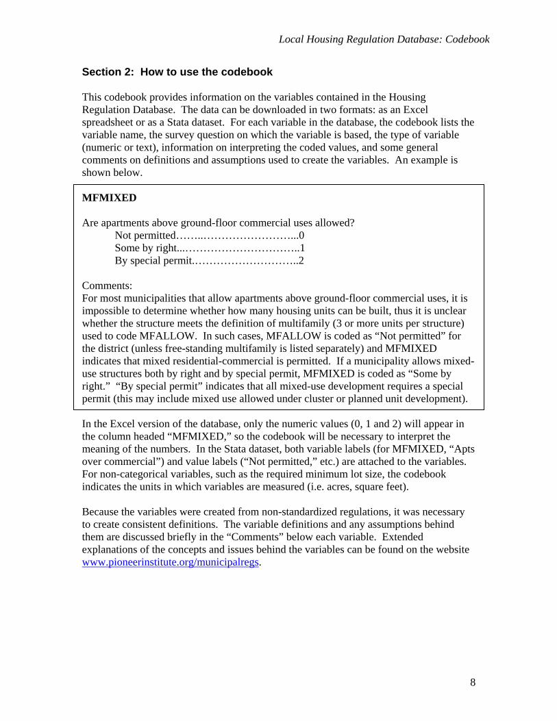
Section 2: How to use the codebook This codebook provides information on the variables contained in the Housing Regulation Database. The data can be downloaded in two formats: as an Excel spreadsheet or as a Stata dataset. For each variable in the database, the codebook lists the variable name, the survey question on which the variable is based, the type of variable (numeric or text), information on interpreting the coded values, and some general comments on definitions and assumptions used to create the variables. An example is shown below. MFMIXED Are apartments above ground-floor commercial uses allowed?
Not permitted……..……………………...0 Some by right...…………………………..1 By special permit.………………………..2
Comments: For most municipalities that allow apartments above ground-floor commercial uses, it is impossible to determine whether how many housing units can be built, thus it is unclear whether the structure meets the definition of multifamily (3 or more units per structure) used to code MFALLOW. In such cases, MFALLOW is coded as “Not permitted” for the district (unless free-standing multifamily is listed separately) and MFMIXED indicates that mixed residential-commercial is permitted. If a municipality allows mixed-use structures both by right and by special permit, MFMIXED is coded as “Some by right.” “By special permit” indicates that all mixed-use development requires a special permit (this may include mixed use allowed under cluster or planned unit development). In the Excel version of the database, only the numeric values (0, 1 and 2) will appear in the column headed “MFMIXED,” so the codebook will be necessary to interpret the meaning of the numbers. In the Stata dataset, both variable labels (for MFMIXED, “Apts over commercial”) and value labels (“Not permitted,” etc.) are attached to the variables. For non-categorical variables, such as the required minimum lot size, the codebook indicates the units in which variables are measured (i.e. acres, square feet). Because the variables were created from non-standardized regulations, it was necessary to create consistent definitions. The variable definitions and any assumptions behind them are discussed briefly in the “Comments” below each variable. Extended explanations of the concepts and issues behind the variables can be found on the website www.pioneerinstitute.org/municipalregs.
8
Local Housing Regulation Database: Codebook
Section 3 Geographic identifiers TOWNNAME Name of city or town
Text CITYID Unique ID code for each municipality assigned by Pioneer Institute
Number CTYCODE County code defined by U.S. Census Bureau
Number PLCODE Place code defined by U.S. Census Bureau
Number Comments: A small number of cities and towns in Massachusetts are Census Designated Places, others are County Subdivisions or Minor Civil Divisions. MASSGIS Unique ID code for each municipality assigned by Mass GIS
Number
9
Local Housing Regulation Database: Codebook
Section 4 Zoning 4.1 General zoning ZONEDIST How many regular zoning districts are established in the bylaw or ordinance?3
Number of districts Comments: Zoning districts are geographic areas defined by the zoning map in the bylaw or ordinance; permitted uses and dimensional requirements are assigned by district. ZONEDIST counts all regular (non-overlay) districts listed in the bylaws, both residential and non-residential. Two towns (Berkley and Essex) are not divided into districts; they are coded as a single district for the entire town. OVERLAY How many overlay zoning districts are established in the bylaws?
Number of overlays Comments: Overlay districts can be used to allow different land uses and dimensional requirements than are permitted in regular zoning districts, without redefining the underlying districts. The boundaries of an overlay district may or may not coincide with the boundaries of regular zoning districts. Some of the most common overlay districts, such as Wireless Communications Services, do not directly impact residential development. Others affect development indirectly; for instance, Floodplain or Aquifer Protection Overlays designate certain areas as for heightened environmental protection, which may impose additional restrictions on development. Some types of overlays explicitly enable or encourage development, such as Senior Residential Overlays which permit age-restricted housing and may allow residential development non-residential zones or may allow higher density than the underlying districts. RESDIST How many primarily residential zoning districts are established in the bylaws?
Number of residential districts Comments: RESDIST is a count of the number of non-overlay zoning districts in which residential development is the primary allowed use, based on the district name. The names of zoning districts indicate the primary allowed or intended use type(s) in that district. For
3 Regulations are referred to as a “bylaw” when the municipality is a town, an “ordinance” when the municipality is a city. In this codebook, the term “bylaw” will be understood as inclusive of both.
10
Local Housing Regulation Database: Codebook
instance, a district called “Residential I” or “Urban Multifamily” or “Suburban Housing” would be classified as a residential district, while “Commercial” or “Mixed Use” would not be counted as a residential district. Many non-residential districts do allow residential uses, however, and primarily residential districts may allow commercial or other use types. In municipalities with a single district, that district is classified as residential. ZONEWEB Are the zoning regulations available on the town’s website?
Yes…………………………………..1 No…………………………………...0
Comments: Zoning bylaws or ordinances may be located in a variety of locations on the municipal website. Among the more common locations are the City/Town Clerk’s Office, the Department of Planning, Housing or Community Development, or the Zoning Board of Appeals.
11
Local Housing Regulation Database: Codebook
4.2 Multifamily zoning MFALLOW Is multifamily housing allowed in any district in the municipality, and by what process?
Not permitted…………………………………….0 By right only……………………………………..1 By special permit only…………….……………..2 By cluster/planned development only...................3 By right and special permit………………..……..4 By right and cluster.………….…………………..5 By special permit and cluster.…………..………..6 By right, special permit and cluster.……………..7
Comments: Types of allowed uses (single-family, multifamily, commercial) and dimensional requirements are defined by zoning districts, so all the variables on multifamily housing were entered separately for each zoning district, then aggregated to the municipal level. MFALLOW tracks whether new construction of free-standing buildings with 3 or more units per building is allowed in any district, and by what process. The variable does not count apartments over commercial space (counted separately in MFMIXED), conversion of existing structures (counted in MFCONVERT), townhouses (see notes under MFATTACH for exceptions), assisted living, congregate housing for seniors or nursing homes, dormitories or lodging houses. Values of MFALLOW indicating multifamily is allowed by multiple processes (for instance, by right and cluster) generally refer to different process requirements in different zoning districts, although a few municipalities allow multifamily both by right and special permit in the same district (special permits are usually required for larger structures). Virtually all multifamily allowed through cluster or planned development requires a special permit. MFSGPA Which entity acts as the special permit granting authority for special permits related to multifamily housing?
Planning Board…………………………………………………….1 Zoning Board of Appeals………………………………………….2 Council/Selectmen………………………………………………...3 Planning Board & Zoning Board of Appeals……………………...4 Zoning Board of Appeals & Council………………………….......5 Planning Board & Council………………………………………...6 Planning Board, Zoning Board of Appeals & Council……………7
Comments: If multifamily housing in some part of the municipality requires a special permit, then one or more entities will be designated in the zoning bylaw as having the authority to grant those special permits. MFSPGA indicates which entity or entities are the
12
Local Housing Regulation Database: Codebook
designated special permit granting authorities for multifamily housing that requires special permits. It captures multifamily housing of any type, including free-standing new construction (MFALLOW), mixed use (MFMIXED) and conversion (MFCONVERT) that can be developed by special permit, including as part of cluster or planned unit development. For municipalities coded as Council/Selectmen, the SPGA will be the council if the municipality is incorporated as a city, the Board of Selectmen if the municipality is a town. Some municipalities divide responsibility between entities based on age-restricted versus non-restricted, by size of development, zoning districts, or for new construction versus conversion. SITEPLAN If MF is permitted anywhere in the municipality by right, is site plan review required?
Yes…………………………………..1 No…………………………………...0
Comments: Multifamily housing development that is permitted by right may still require site plan approval, generally from the Planning Board. Site plan review is considered a relatively low barrier to development compared to obtaining a special permit. SITEPLAN indicates whether the zoning bylaws explicitly require site plan review for multifamily housing; a number of municipalities indicated that site plan approval is required in practice even if not explicitly listed in the bylaws. MFATTACH Does the municipality's definition of multifamily housing include attached single-family units, also called townhouses?
Yes…………………………………..1 No…………………………………...0
Comments: Some bylaws define multifamily housing as a "building or series of buildings, for 3 or more families, including apartment house...townhouse or rowhouse". For these municipalities, structures that are coded in MFALLOW as allowed may be either multifamily structures under the definition described above or attached single-family (townhouses). If the bylaw’s definition does not explicitly list townhouses, then MFATTACH is coded as “No.” However, quite a few municipalities reported informally that they consider townhouses to be a form of multifamily and would allow townhouses in districts zoned for multifamily.
13
Local Housing Regulation Database: Codebook
MFMIXED Are apartments above ground-floor commercial uses allowed?
Not permitted……..……………………...0 Some by right...…………………………..1 By special permit.………………………..2
Comments: For most municipalities that allow apartments above ground-floor commercial uses, it is impossible to determine whether how many housing units can be built, thus it is unclear whether the structure meets the definition of multifamily (3 or more units per structure) used to code MFALLOW. In such cases, MFALLOW is coded as “Not permitted” for the district (unless free-standing multifamily is listed separately) and MFMIXED indicates that mixed residential-commercial is permitted. If a municipality allows mixed-use structures both by right and by special permit, MFMIXED is coded as “Some by right.” “By special permit” indicates that all mixed-use development requires a special permit (this may include mixed use allowed under cluster or planned unit development). Some municipalities reported that they would allow mixed-use structures in districts that allow both free-standing multifamily housing and commercial uses, but MFMIXED is only coded if mixed-use within a single structure is explicitly listed as an allowed use. MFCONVERT Is multifamily housing allowed through conversion or reuse of existing structures, either of single-family/two-family residential buildings or non-residential buildings?
Not permitted……..……………………...0 Some by right...…………………………..1 By special permit.………………………..2
Comments: Development of multifamily housing through conversion of existing structures falls into two general types: single-family or two-family houses may be reconfigured to contain three or more units, or reuse of non-residential structures, particularly mills and other former industrial buildings or schools and municipal buildings. Conversion of the latter type is often done through overlay districts (Mill Conversion Overlay Districts are common) or in industrial districts, while the former type is generally allowed in residential or business districts. If a municipality allows conversion both by right and by special permit, MFCONVERT is coded as “Some by right.” “By special permit” indicates that all multifamily through conversion requires a special permit. MFPARCEL If bylaws list a minimum tract or parcel size necessary for multifamily development, what is the size?
Number of acres
14
Local Housing Regulation Database: Codebook
Comments: Municipalities that permit multifamily as part of cluster or planned unit development generally specify a minimum parcel size needed, as do many municipalities that permit planned development of age-restricted multifamily housing. If multiple districts have different minimum parcel sizes, then MFPARCEL is coded for the smallest parcel in any district that has a parcel size requirement. Some municipalities may require a minimum parcel size in one district that allows multifamily through cluster, but do not have a parcel requirement in another district that allows multifamily as a single building. In such instances MFPARCEL is coded for the requirement, but it is not applicable in all districts allowing multifamily housing. MFMINLOT If the bylaws indicate a minimum lot size required for multifamily housing, what is it?
Number of square feet Comments: Minimum lot size required for multifamily housing varies by zoning district, and often by the number of units in the building. When the lot size differs by number of units, MFMINLOT indicates the minimum lot need for a three-unit building (the smallest structure counted as multifamily). MFMINLOT gives the smallest minimum lot size required for multifamily housing in any zoning district in the municipality. For some municipalities, lot sizes are taken from a database assembled by Mass GIS based on a survey conducted in 2000 of local zoning bylaws and ordinances. UNITAREA If the bylaws indicate a minimum lot area per dwelling unit, what is the area?
Number of square feet Comments: Many bylaws list a minimum lot area per dwelling unit for multifamily structures; this is particularly common for bylaws that allow multifamily through flexible development and may be given instead of minimum lot sizes. Often the bylaws list a maximum density as the number of units allowed per acre; in these cases UNITAREA is calculated as 43,560 square feet divided by the maximum number of units. If multiple districts have different area per dwelling unit requirements, then UNITAREA gives the smallest value in any district. In cases where the bylaws gave different area per unit depending the number of units (for instance, 20,000 square feet for the first unit and 10,000 square feet for each successive unit), UNITAREA is the average area per unit for the first three units (in this example, 13,333 square feet).
15
Local Housing Regulation Database: Codebook
TOWNHOUS Are attached single-family houses or townhouses allowed in any district?
Not permitted……..……………………...0 Some by right...…………………………..1 By special permit.………………………..2
Comments: Many municipalities treat attached single-family or townhouse as equivalent to multifamily and will permit townhouses to be built in any district that allows multifamily, even if they are not listed as an allowed use. TOWNHOUS indicates whether the municipality explicitly lists townhouses as an allowed use. TOWNHOUS is coded as “Some by right” if townhouses are allowed by right anywhere in the municipality, “By special permit” indicates that townhouses are allowed only by special permit. Structures allowed through cluster or planned unit development are coded as “By special permit”. MFSENIOR Does the zoning bylaw or ordinance impose age restrictions on multifamily housing in any district?
Yes…………………………………..1 No…………………………………...0
Comments: MFSENIOR is coded as “Yes” if the bylaw includes provisions for age-restricted multifamily housing that would be included in MFALLOW (excluding assisted living, nursing care and congregate care facilities). It is also coded “Yes” if there are provisions for some part of a larger development to be age restricted, for instance under flexible development. MFSENIOR is coded as “No” if the bylaw only contains age-restrictions that apply to single-family detached or townhouse structures. Two types of age-restricted multifamily were commonly found in bylaws. Some municipalities permit development of multifamily that is restricted by both age and income and must be owned or managed by a public and non-profit agency. This essentially permits development of senior housing under federal or state subsidy programs, such as HUD’s Section 202, which was more commonly used in the 1970s and 1980s. More recently, many municipalities have adopted provisions for age-restricted market-rate multifamily housing, often as part of planned retirement communities which may include age-restricted single family, assisted living and community facilities. Both types of age-restrictions are coded as “Yes” in MFSENIOR. ONLYOLD Is multifamily housing only permitted in the municipality if it is restricted to seniors?
Yes…………………………………..1 No…………………………………...0
16
Local Housing Regulation Database: Codebook
Comments: ONLYOLD is coded as “Yes” if all multifamily housing (as defined in MFALLOW) permitted in the town has age-restrictions; no multifamily housing can be built for occupancy by residents under a certain age limit (generally 55). ONLYOLD is coded as “No” either if the town allows non-age restricted multifamily or does not permit any multifamily. AGELIMIT If the bylaw has provisions for age-restricted multifamily housing, what is the minimum age specified?
Number of years AGEZONE Are there provisions for age restricted housing of any structure type?
Yes…………………………………..1 No…………………………………...0
Comments: AGEZONE is coded “Yes” if provisions exist for any age-restricted housing regardless of structure type: single-family, townhouse, duplex, multifamily or accessory apartments. Assisted living facilities, nursing homes, and congregate care are still excluded. Zoning provisions may be in the form of an age-restricted overlay, cluster development, density bonus for age-restricted units, or other zoning requirements or incentives for age-restricted housing. ACCESAPT Are accessory apartments allowed by right or by special permit in any district?
Not permitted……..……………………...0 Some by right...…………………………..1 By special permit.………………………..2
Comments: Accessory apartments, self-contained dwelling units with separate kitchen and bathroom facilities, may be allowed on the same lot with a single-family dwelling. ACCESSAPT is coded as allowing accessory apartments if they are explicitly listed as an allowed use, although they could also be permitted in districts that allow two-family houses. Many municipalities restrict residence in accessory apartments to relatives, caregivers or domestic servants of the owners of the primary residence. Some municipalities allow by right development if the accessory apartment will be occupied by a family member, but require a special permit otherwise; in these cases ACCESAPT is coded as “By special permit.” If a municipality allows accessory apartments by right in at least one district, ACCESAPT is coded as “Some by right.”
17
Local Housing Regulation Database: Codebook
AASPGA If accessory apartments are allowed by special permit, what entity is the special permit granting authority
Planning Board……………………1 Zoning Board of Appeals………....2 City Council/Selectmen…………..3
AAFAMILY Is residence in accessory apartments restricted to family members of the primary unit’s occupants?
Yes……………………1 No…………………….0
Comments: AAFAMILY is coded as “Yes” if the municipality allows accessory apartments to be built only under the condition that residents are “related by blood, marriage or adoption” to the owner-occupant of the principal residence. AAFAMILY is coded as “No” if accessory apartments can also be occupied by age- or income-restricted residents, caretakers or domestic employees.
18
Local Housing Regulation Database: Codebook
4.3 Zoning – Cluster development CLUSTER Does the zoning bylaw or ordinance have provisions to allow flexible or cluster zoning for residential development?
Not permitted…………………………………….0 By right only……………………………………..1 By special permit only…………….……………..2 By right and special permit………………..……..3
Comments: Cluster zoning provisions allow residential development under more flexible development standards than would be permitted through conventional zoning. This may include allowing residential uses in non-residential districts, a greater range of structure types (for instance, townhouses or multifamily in single family districts), or a reduction of minimum lot sizes in exchange for setting aside some land as permanent open space. Cluster development can be used as an alternative to traditional subdivisions for large-scale housing development, but it may also apply to a small number of units (as few as five). CLUSTER is coded to include various types of flexible development, commonly called Open Space Residential Development, Planned Unit Development, Conservation Subdivision or Conservation Clusters. Age-restricted flexible development is included in CLUSTER; provisions for flexible or planned development primarily intended to accommodate non-residential or mixed-use developments are not coded. CLBUILT Has any development been approved under the flexible development provisions?
Yes………………………………….1 No…………………………………..0
Comments: Municipal staff, generally in the town’s Planning Department, were asked in phone interviews, by email and in a mail survey whether any development has been done under the flexible development provisions. CLBUILT is coded as “Yes” if they reported any development that has been permitted or constructed (some have been permitted and are currently under construction, and are coded as “Yes”). These answers are self-reported and cannot be independently verified.
19

Local Housing Regulation Database: Codebook
CLSPGA If cluster development is allowed by special permit, what entity is designated as the special permit granting authority?
Planning Board…………………….1 Zoning Board of Appeals………….2 Selectmen/City Council……………3 Combination…………………….…4
CLADOPT In what year were the flexible development provisions of the bylaw originally adopted?
Number (year) Comments: If a bylaw contains multiple provisions for flexible development, then CLADOPT is coded as the year the first provision was adopted. For a few municipalities, staff reported only the decade in which provisions were adopted (i.e. “in the 1970s”); in these cases CLADOPT is coded as the first year in that decade. CLAMEND In what year were the flexible development provisions of the bylaw most recently amended?
Number (year) Comments: CLAMEND is coded for the most recent year that any flexible development provisions were amended. CLBONUS Can more units be built under flexible development than would be allowed by underlying zoning?
Yes…………………………………..1 No…………………………………...0
Comments: Some bylaws explicitly state that no more units can be built under flexible provisions than would be permitted under conventional zoning; many of these municipalities require the developer to submit site plans with an estimated number of units allowed under conventional and flexible provisions. Such bylaws are coded as “No” under CLBONUS. Bylaws coded as “Yes” include provisions for additional or “bonus” units under flexible development in exchange for meeting certain goals, such as including affordable or age-restricted units, designating a larger amount of open space, “quality of site selection or design”, creating traffic or pedestrian improvements, or public recreational facilities.
20
Local Housing Regulation Database: Codebook
Often the bylaws are ambiguous about whether more units can be built under flexible development, and so are coded as missing, unless clarified by municipal staff in response to the mail survey. CLTYPE What type of structures can be built under flexible development provisions?
Single-family only………………………………………………0 Single-family & multifamily…………………………………....1 Single-family & townhouses….……………….………………..2 Single-family, multifamily & townhouses……………..……….3
Comments: If municipalities have more than one provision for flexible development, and allow different structure types under different provisions, CLTYPE is coded for all possible structure types that can be built under all relevant provisions. Some municipalities also allow two-family houses, assisted living or congregate elderly housing; these structure types are not included in CLTYPE. CLPARCEL What is the minimum parcel or tract size necessary under flexible development?
Number of acres Comments: A municipality with provisions for several types of flexible development may specify different minimum parcel size for each cluster provision, by structure types within the same development or by underlying zoning districts. If multiple parcel sizes are given for a municipality, CLPARCEL is coded for the smallest one. If the parcel size is described as a minimum number of units, then CLPARCEL is calculated as the minimum lot size per unit multiplied by the number of units, plus the amount of required open space. CLMINLOT What is the minimum lot size per dwelling unit allowed under flexible development?
Number, square feet Comments: Within a municipality, minimum lot size for flexible development may vary by type of cluster provision (for municipalities with multiple types of flexible development), by structure types used or by underlying zoning districts. If multiple lot sizes are given for the town, CLPARCEL is coded as the smallest one. Many municipalities explicitly say that there is no minimum lot size under flexible development; these are coded as missing.
21
Local Housing Regulation Database: Codebook
CLOPEN What percent of the parcel must be maintained as open space under flexible development?
Number, percent of parcel Comments: All the flexible development provisions included in CLUSTER require that some portion of the parcel be maintained permanently as open space; bylaws vary in whether the open space can be used for recreational purposes (i.e. walking trails, playgrounds) or must be maintained in its natural state. If multiple percentages of open space are given for one municipality, then CLOPEN is coded as the smallest number. A few bylaws describe the amount of open space through a formula, depending on the number and type of units developed and amount of wetlands; for these, CLOPEN is coded as missing.
22
Local Housing Regulation Database: Codebook
4.4 Zoning – Inclusionary INCLUDE Does the bylaw include any provisions for inclusionary zoning?
No inclusionary……………………….0 Optional……………………………….1 Mandatory …………………………….2 Both optional and mandatory……….....3
Comments: Inclusionary zoning is defined as any program that requires or provides incentives for developers to designate some housing units within a development as “affordable” to low- or moderate-income households. Most municipalities use the state and federal definitions of income, with low-income as those households earning up to 80% of area median income and moderate-income households earning up to 120% of area median income, but there is some variation in income limits. INCLUDE is coded as “Optional” for any provisions that give developers the choice of whether to designate affordable units, usually in exchange for density bonuses; “Mandatory” means that developers are required to set aside affordable units, and “Both optional and mandatory” means that provisions for both types exist. For instance, a town may provide a density bonus under cluster development for designated affordable units (an “Optional” program) and may require that 10 percent of new conventional subdivision units are affordable (“Mandatory”). INCLUDE does not count provisions for entirely affordable, subsidized housing development by public or non-profit corporations (i.e. development of public housing or Low Income Housing Tax Credit projects). INCSTRUC What types of structures are allowed for affordable units built under inclusionary provisions?
Single-family detached only……………….1 Single-family and townhouses……………..2 Single-family and multifamily..……………3 Multiple structure types……………………4
Comments: Multiple structure types can include any mixture of single-family, two-family, attached single-family, multifamily, or accessory apartments. INCLIEU Do developers have alternatives to building affordable units on site?
Yes…………………………………..1 No…………………………………...0
23
Local Housing Regulation Database: Codebook
Comments: Some inclusionary provisions allow developers to build affordable units at a different location or donate land or cash equivalents to the town in lieu of building affordable units within the development. INCBONUS Does town offer additional "bonus" units as part of inclusionary zoning program?
No bonus………………….………0 Optional…………………….……..1 Guaranteed………………………..2 Optional & guaranteed..….……….3
Comments: A few municipalities specify that the developer is guaranteed to receive bonus units in exchange for affordable units (coded as “Guaranteed”), while most indicate that extra units may be granted at the discretion of the Planning Board or Zoning Board of Appeals (coded as “Optional”). INCRELAX Are other regulations relaxed if affordable units are included?
Yes…………………………………..1 No…………………………………...0
Comments: Either in addition to or instead of granting additional units, municipalities may provide other incentives to developers for designating affordable units, such as reducing the minimum lot size or frontage, allowing a smaller portion of open space, or reducing parking requirements. INCADOPT In what year did the town first adopt provisions for inclusionary zoning?
Number (year) Comments: In some cases the date of adoption was written in the bylaw, in other cases dates were reported by municipal staff.
24
Local Housing Regulation Database: Codebook
INCDEVS According to the town planner or other municipal official, have any affordable units been built under the inclusionary zoning provisions?
Yes…………………………………..1 No…………………………………...0
Comments: The numbers in INCDEVS and INCUNITS were collected from municipal officials in phone interviews, emails, or as responses to a mailed survey. They are informal estimates of the results of the inclusionary zoning program, to the best knowledge of the staff member responding, and have not been independently verified. INCUNITS According to the town planner or other municipal official, how many affordable units have been built under inclusionary zoning?
Number of units Comments: These numbers are unofficial estimates and have not been independently verified. In some cases the numbers given may be the total number of units in all developments invoking the inclusionary provisions, not necessarily the number of affordable units.
25
Local Housing Regulation Database: Codebook
4.5 Zoning – Growth management GROWRATE Does the zoning bylaw indicate a planned or targeted growth rate that limits the annual number of residential permits issued in the municipality?
Yes…………………………………..1 No…………………………………...0
Comments: Planned or targeted growth rates may be implemented in one of two ways: they may indicate a cap or limit on the number of permits (coded in GROWRATE), or there may be some limit at which all new projects must be phased over a period of years (coded in PHASING). For some municipalities in the survey, the bylaws indicate that planned growth rates were in effect in previous years but have expired. Where possible, the relevant information has been coded into the appropriate variables, but GROWRATE and PHASING are coded as “No.” GROWNUM What is the number of permits allowed annually under the targeted growth rate?
Number of permits Comments: In cases where the bylaws indicated the number of permits that can be issued over a two-year period, GROWNUM is half of the two-year limit. PHASING Do the zoning bylaws or subdivision regulations require phased or scheduled development?
Yes…………………………………..1 No…………………………………...0
Comments: Phased or scheduled development limits the number of residential permits that can be issued to any one development in a single year. Permits issued under phased development may or may not be subject to an overall cap on the number of permits. PHUNITS What number of units can be permitted per development each year under phasing?
Number of units
26
Local Housing Regulation Database: Codebook
Comments: Most development schedules give varying numbers based on the size of the project; PHUNITS is coded as the number for a development of 30 units. GROWADPT In what year was the targeted growth rate or phasing originally adopted?
Number (year) GROWTEMP Is the targeted growth rate (either GROWRATE or PHASING) temporary?
Yes…………………………………..1 No…………………………………...0
Comments: Often municipalities adopt targeted growth rates or phasing schedules as temporary measures, usually lasting 5 or 10 years, after which the provisions expire or can be renewed. GROWEXP If there is a temporary provision for targeted growth rate, in what year does it expire?
Number (year) Comments: GROWEXP gives the expiration date for temporary targeted growth rates; it is coded both for provisions currently in effect and some which have already expired. EXSENIOR If the bylaws impose a targeted growth rate or project phasing, is age-restricted (55+) housing exempted or given priority?
Yes…………………………………..1 No…………………………………...0
Comments: Municipalities with targeted growth rates or phased development may exempt certain types of residential permits from the cap, or not require them to be phased. Some municipalities with phased development give preference to certain types of development, either allowing an increased number of permits per year or giving priority. Some grounds for exemption are almost universal and so are not coded individually for municipalities. Under Massachusetts General Law Chapter 40A, Section 6, developments that have received approval prior to the adoption of the cap/phasing are automatically grandfathered in under prior regulations. Units developed under comprehensive permits (Chapter 40B) are also exempted from caps. “Enlargement,
27

Local Housing Regulation Database: Codebook
reconstruction or restoration” of a dwelling unit currently in existence is also exempt from growth management limits, as is construction of a single-family unit on a lot, intended for residence by the lot’s owner (not as part of a larger development). EXAFFORD Is there an exemption from growth caps or project phasing for housing that is affordable to low- and moderate-income households?
Yes…………………………………..1 No…………………………………...0
EXOPEN Is there an exemption from growth caps or project phasing for projects that preserve open space?
Yes…………………………………..1 No…………………………………...0
Comments: Developments under cluster of flexible development may be exempted, or conventional subdivisions that designate some land as permanent open space. EXLODENS Is there an exemption from growth caps or project phasing for developments that create lower density/larger lot sizes than the underlying zoning requires?
Yes…………………………………..1 No…………………………………...0
EXINFRA Is there an exemption from growth caps or project phasing for developments that provide infrastructure or contribute to public services for the town?
Yes…………………………………..1 No…………………………………...0
Comments: Infrastructure/service contributions may include improvements to roads and sewer systems, providing recreational facilities or municipal buildings.
28
Local Housing Regulation Database: Codebook
EXOTHER Is there an exemption from growth caps or project phasing for other contributions or project characteristics?
Yes…………………………………..1 No…………………………………...0
CAPFIRM Does the zoning bylaw or ordinance restrict the number of permits a single firm can obtain in a year?
Yes…………………………………..1 No…………………………………...0
29
Local Housing Regulation Database: Codebook
4.6 Zoning – Other MLAEXCLUD Does the city/town exclude wetlands, easements, or sloped land from calculations of minimum land area requirements?
Yes…………………………………..1 No…………………………………...0
Comments: Municipalities may require that some percentage of the required minimum lot area be met by non-wetlands (upland) area, or exclude land under easements or with steep slopes from counting towards the minimum lot area. Wetlands are the most frequently excluded type of land. MLACBA Does the zoning bylaw require some portion of the minimum lot area to be Contiguous Buildable Areas?
Yes…………………………………..1 No…………………………………...0
Comments: A subset of the municipalities that exclude some land from minimum lot area calculations require that some percent of the non-excluded land (i.e. uplands or non-sloped land) be contiguous. If MLAEXCLUD is coded as “No” then MLACBA is also coded as “No.” MLAPCT If the bylaw excludes some types of land from minimum lot area calculations, what percent of minimum lot area must be upland, non-sloped, etc?
Number, percent of lot area Comments: If multiple percents are given (generally for different districts), MLAPCT is coded as the lowest percent (least restrictive). For all but one town (Franklin) where MLACBA is coded “Yes,” MLAPCT is also the percent required to be contiguous. If MLAEXCLUD is coded “No,” then MLAPCT is coded as missing. MLAPCT is also missing for municipalities that list the uplands requirement as square footage rather than a percentage.
30
Local Housing Regulation Database: Codebook
SHAPRULE If the bylaw imposes any constraints on lot shape, what type of rule is used?
No shape rule……………………………0
P-A ratio: Xap
≤2
……………………..1
P-A ratio: Xap≤ ……………………….2
P-A ratio: Xra
ap
≤÷2
………………...3
Circle test………………………………...4 Other……………………………………..5
Comments: In the equations given for perimeter-area ratios, “a” is the actual lot area (square feet), “p” is lot perimeter (feet) and “r” is required lot area (square feet). Some equations have been algebraically rearranged from the form listed in the bylaw in order to show in a
standard form: Xap
≤2
. The 2 variations of this equation sometimes given are
Xp
a≥2
16 16a and 2
4⎟⎠⎞
⎜⎝⎛⋅≥
pXa
“Circle test” refers to a requirement that the lot be configured such that circle of given diameter (generally 75-80% of minimum required frontage) can be a) place tangent to the frontage without crossing any side lot lines or b) “passed along a continuous line from the lot frontage to the rear yard setback without the circumference intersecting any lot lines” (Southborough). SHAPENUM If lot shape regulated with a perimeter-area ratio, what is the maximum number permitted?
Number (X in SHAPRULE) Comments: The lower the maximum number permitted, the more restrictive the requirement. Values should only be compared for municipalities with the same SHAPRULE. If multiple numbers are given for different districts in a town, SHAPENUM is the largest number (least restrictive).
31
Local Housing Regulation Database: Codebook
HTCALC According to the zoning bylaw, what grade is used to calculate building height?
Mean finished grade, all sides………..1 Natural grade…………………………2 Front/street side only…………………3 Curb/street level ……………………..4 Other………………………………….5
Comments: Most municipalities specify that building height should be calculated from the finished (post-construction) grade, averaged across all sides of the building. For municipalities where HTCALC is coded as “Front/street side only”, the answer assumes that finished grade on the front side will be used. Any definition indicating natural grade is coded as “Natural”, regardless of the number of sides. HTCALC was coded as missing if no definition of building height could be found in the bylaws. FRONT150 Does the city/town have frontage requirements equal to or greater than 150 feet in any of its residential single-family zones?
Yes…………………………………..1 No…………………………………...0
LONGZONE In how many residential districts is the frontage requirement at least 150 feet?
Number of districts MAXFRONT What is the longest residential single-family frontage requirement in the town’s zoning?
Number of feet FRONTOUT Are there circumstances where portions of the front of a lot may be excluded from the “frontage” for zoning calculations?
Yes…………………………………..1 No…………………………………...0
32
Local Housing Regulation Database: Codebook
Comments: Bylaws gave three main reasons given for excluding some portion of the lot from frontage calculations. Some municipalities require that land along the lot frontage must meet the minimum depth/setback requirement to be included. Several municipalities do not permit easements or wetlands to be counted. Others state that frontage calculations “Shall not include jogs in street width, back-up strips and other irregularities in street line.” MAXBUILD What is the maximum potential growth possible under existing zoning, according to the MassGIS buildout analysis?
Number of units Comments In 1999-2000, MassGIS conducted an analysis to determine how many units could be built in each town, based on the amount of undeveloped land and the existing zoning requirements. MAXBUILD is taken directly from the Mass GIS numbers. A number of municipalities close to Boston and on the urban fringe were not included in the Mass GIS analysis.
33
Local Housing Regulation Database: Codebook
Section 5 Subdivision regulations SUBDRULE Does the city/town have subdivision rules/regulations?
Yes…………………………………..1 No…………………………………...0
Comments: If SUBDRULE is coded “No” then all other variables in this section are missing. SUBDWEB Are the subdivision rules available on the website?
Yes…………………………………..1 No…………………………………...0
SUBADOPT In what year were subdivision rules originally adopted?
Number (year) SUBAMEND In what year were the subdivision rules most recently amended?
Number (year) Comments: Municipalities that adopted subdivision rules recently generally do not have amendment dates. From responses to surveys sent to municipalities in the spring of 2005, it appears that some municipalities amended their subdivision regulations in 2005 after data collection was completed; these changes are not incorporated, and the date amended is given for amendments through 2004. MAXLENGTH What is the maximum length allowed for a cul de sac or dead end street?
Number of feet Comments: MAXLENGTH is coded as the longest cul de sac allowed without additional constraints (requirement of sprinklers, etc.). In cases where regulations specify number of houses, the length is calculated as the number of houses multiplied by the longest frontage width allowed in any residential district, assuming houses on both sides of the street. A value of zero indicates that cul de sacs are not permitted.
34
Local Housing Regulation Database: Codebook
TYPEROAD What category of road is a “typical” subdivision street?
Text, category name Comments: TYPEROAD is coded as the type of street intended to serve 10-30 houses (100-300 vehicle trips per day) or the closest equivalent category defined in the regulations. If no house or traffic counts were listed, TYPERAOD is coded as the category “used primarily to provide access to abutting lots”, generally not intended to carry through traffic. If no category names were given, then TYPEROAD was coded as “NA.” PAVEWID1 What is the width of pavement required on typical subdivision roads?
Number of feet Comments: PAVEWID1 is coded as the width for the “typical” subdivision street identified in TYPEROAD. PAVEWID2 What is the narrowest allowable pavement width on any subdivision street?
Number of feet Comments: If the “typical” road width was the narrowest road allowed, then PAVEWID2 is the same as PAVEWID1. The road type selected to answer this question in a few cases was “Private.” Courts and lanes are also used. RGHTWAY1 What is the width of right of way required on typical subdivision roads?
Number of feet CURB On typical subdivision roads, what is the curbing requirement?
None…………………………………………………………………1 Bituminous concrete…………………………………………………2 Granite……………………………………………………………….3
Comments: Virtually all municipalities require granite curbing at particular places, such as catch basins and sharp curves; if bituminous concrete is allowed at other locations, CURB is
35
Local Housing Regulation Database: Codebook
coded as “Bituminous.” Some municipalities do not require curbs, but specify that if curbs are voluntarily installed, they must be made of granite; in such cases, CURB is coded as “Granite.” SIDEWALK Does the town require paved sidewalks in typical subdivision roads?
None…………………………………………………………………0 One side……………………………………………………………...1 Two sides…………………………………………………………….2
Comments: Regulations indicating that sidewalks could be required "at the discretion of the Planning Board" are coded as “None.” If the regulations present the option of one side or both, SIDEWALK is coded as “One side.” SIDEWIDE What is the required minimum width of sidewalks?
Number of feet Comments: Sidewalk width was collected for about two-thirds of municipalities that require sidewalks on subdivision roads. MAXGRADE What is the maximum grade allowed for typical subdivision residential streets?
Number (percent) Comments: Generally municipalities allow steeper grades for smaller roads; MAXGRADE is coded as the percent grade required for the street coded in TYPEROAD. Within road categories, a few municipalities allow steeper grades for lower-density neighborhoods, defined at the discretion of the Planning Board. If one grade is allowed for a limited number of feet, MAXGRADE is coded for the more restrictive grade. MAXGRAD2 What is the maximum grade allowed on any residential subdivision road?
Number (percent) Comments: Maximum grade requirements often vary for different types of roads, density of surrounding housing, or length of road. MAXGRAD2 is coded as the maximum grade allowed on any road, including private roads, for any distance.
36
Local Housing Regulation Database: Codebook
Section 6 Wetlands WETBYLAW Does the municipality have a local wetland bylaw or ordinance?
Yes…………………………………..1 No…………………………………...0
Comments: If WETBYLAW is “No” then all other variables in this section are coded as missing. Some municipalities regulate development near wetlands in the zoning bylaw, rather than in a separate wetlands bylaw or regulations; regulations from zoning bylaws are not coded in this section. WETADOPT What year was the local wetlands bylaw or ordinance originally enacted?
Number (year) WETAMEND In what year was the town wetlands bylaw most recently amended?
Number (year) CCADOPT Has the Conservation Commission adopted wetlands regulations?
Yes…………………………………..1 No…………………………………...0
WETONLINE Are the wetlands regulations and/or bylaw available on the website?
Yes…………………………………..1 No…………………………………...0
VERNPOOL Does the municipality regulate vernal pools that are not certified by the state?
Yes…………………………………..1 No…………………………………...0
Comments: Some municipalities explicitly regulate all vernal pools, regardless of whether the pools are state-certified. Other municipalities explicitly indicate that pools must be state-
37
Local Housing Regulation Database: Codebook
certified to be regulated. If the regulations state that they protect “any vernal pool,” VERNPOOL is coded as “Yes.” VERNLIST Are vernal pools listed as a resource area in the jurisdiction of the bylaw or regulations?
Yes…………………………………..1 No…………………………………...0
Comments: Wetlands regulations list specific resources areas that are granted protection, such as marshes, wet meadows and swamps. VERNLIST is coded as “Yes” only if vernal pools are listed separately from other resource categories; if it is included under land subject to flooding or isolated vegetated wetlands, VERNLIST is coded as “No.” BUFFPOOL Does the town regulate activities in buffer zones around vernal pools that would not be regulated by the state?
Yes…………………………………..1 No…………………………………...0
Comments: BUFFPOOL is coded as “Yes” either if the municipality regulates the buffer zone of non-certified vernal pools or regulates a buffer around certified vernal pools beyond the jurisdiction granted in the state Wetlands Protection Act. Under state regulations, Conservation Commissions can regulate certified vernal pools and the 100-foot habitat extending from the pool’s waterline only to the extent that the vernal pool and habitat fall within state defined wetland resources areas. Many local bylaws and ordinances establish that vernal pools do not need to fall within the state defined resource area to be regulated; and many also grant a buffer zone around the vernal pool. POOLDEFN Does the regulation define the vernal pool’s “habitat” to be part of the resource area?
Yes…………………………………..1 No…………………………………...0
Comments: POOLDEFN is coded as “Yes” when the wetlands bylaw, ordinance or regulation defines “vernal pools” to include not only the confined basin depression that holds water for two contiguous months, but also the “habitat” that extends out from the mean annual boundary or waterline of the depression.
38
Local Housing Regulation Database: Codebook
VERNWIDE If the municipality regulates buffer zones around non-certified vernal pools (that fall outside of the wetlands resource area), what is the width of the buffer zone?
Number of feet Comments: If the town does not treat vernal pools in a different way from the state regulations prescribes, then VERNWIDE is coded as missing. MAXJURIS According to the researchers’ interpretation of the regulations, what is the maximum width of jurisdiction from the mean annual waterline of vernal pools?
Number of feet Comments: Some municipalities define the vernal pool to include the 100 foot habitat (around the waterline), and then grant a 100 foot buffer around the vernal pool, giving the Conservation Commission 200 feet of jurisdiction. In practice, some Conservation Commissions enforcing bylaws with this language give vernal pools only 100 feet of protection from the waterline, while others, using the same language enforce 200 feet. The answers to this question are the researcher’s interpretation of the regulations, not necessarily what is actually enforced by the Conservation Commission. BUFFISOL Does the municipality regulate buffer zones around isolated vegetated wetlands?
Yes…………………………………..1 No…………………………………...0
Comments: Municipalities are coded as “Yes” if the bylaws state that they protect “any wetland” or “whether or not [wetlands] border surface waters.” Municipalities are also coded “Yes” if they only regulate isolated vegetated wetlands that meet a minimum size. The state regulations only grant jurisdiction to regulate wetlands that border on lakes, streams, ponds, etc. ISOLWIDE If the municipality regulates buffer zones around isolated vegetated wetlands, what is the width of jurisdiction?
Number of feet
39
Local Housing Regulation Database: Codebook
FLOODEXP Does the local wetland bylaw, ordinance or regulation expand coverage of "areas subject to inundation and flooding” beyond wetlands that would be protected under the state Wetlands Protection Act?
Yes…………………………………..1 No…………………………………...0
Comments: The Massachusetts Wetlands Protection Regulations grant protection to “land subject to flooding,” but do not grant a buffer zone around land subject to flooding. There are several ways that local regulations differ from the state standards. Many municipalities add the terms “land subject to flooding and inundation by groundwater or surface water,” or another variation. Some municipalities relax the definition of flooding. In addition, many municipalities grant buffer zones to land subject to flooding. There are a few municipalities that add the terms “inundation and flooding by groundwater or surface water” to the jurisdiction, but do not redefine flooding or give protection of a buffer zone to those areas; in these cases FLOODEXP is coded as “No.” ADDTERMS In the wetlands bylaw, are additional terms added to the phrase “land subject to flooding”?
Yes…………………………………..1 No…………………………………...0
Comments: ADDTERMS is coded as Yes if the municipality adds the terms “land subject to flooding and inundation by groundwater or surface water,” or another variation to the jurisdiction. TERMDEFN If additional terms are added to the phrase, “land subject to flooding”, are those terms defined in the regulations?
Yes…………………………………..1 No…………………………………...0
Comments: TERMDEFN is coded as “Yes” for municipalities that define any of the terms “inundation by surface water or groundwater” that identify the local jurisdiction on land subject to flooding. This variable is coded as missing if ADDTERMS is coded as “No.”
40
Local Housing Regulation Database: Codebook
BUFFLSF Does the town’s jurisdiction extend to cover a buffer zone around “land subject to flooding?”
Yes…………………………………..1 No…………………………………...0
Comments: The state does not grant a buffer zone around land subject to flooding. For municipalities that have a buffer, nearly all require the same width specified for other resource areas (i.e. isolated or bordering vegetated wetlands). LSFDEFN Does the regulation include definitions for “land subject to flooding” beyond the state’s definition?
Yes…………………………………..1 No…………………………………...0
Comments: The state defines Isolated Land Subject to Flooding as standing water at a volume of ¼ acre feet and to a depth of at least six inches. The boundary of Bordering Land Subject to Flooding is the estimated extent of flood water which would result from the statistical 100-year frequency storm, as estimated by the Federal Emergency Management Agency. LSFDEFN is coded as “Yes” if the municipality defines either isolated or bordering land subject to flooding such that it protects a broader area than the state’s definition. NOBUILD Does the wetlands bylaw or regulation create limited use zones where there is “no building”, “no disturbance”, “no clearing” or “no cutting”?
Yes…………………………………..1 No…………………………………...0
Comments: A “no disturb” zone prohibits most construction-related activity, while a “no build” zone prohibits construction of structures but may allow other activities, including clearing and installation of driveways, sidewalks, or accessory uses. NOBUILD is coded “Yes” if either of these is written into the bylaws or regulations. Several municipalities enforce “no build” zones as a matter of informal policy; these are coded as “No” under NOBUILD, as are no-build zones that are written in zoning bylaws.
41
Local Housing Regulation Database: Codebook
NOGOWIDE If the wetland bylaw, ordinance or regulation creates limited use zones, what is the width of the zone?
Number of feet Comments: Several municipalities create concentric zones with a smaller “no disturb” surrounded by a larger “no build”, or establish multiple zones of different widths based on different use types (single family residential, multifamily residential, commercial). NOGOWIDE captures the largest width of any zone given that applies to residential development. DELAYCERT Does the wetlands bylaw, ordinance or regulation give the Commission the right to delay the determination or certification of wetlands resource areas in a drought year or dry season or during winter months?
Yes…………………………………..1 No…………………………………...0
Comments: If the Conservation Commission does this as a matter of informal policy, then DELAYCERT is coded as “No.” If the bylaw says certification is not permitted in winter or when the temperature is below freezing, or gives the Commission "authority to continue the hearing to a certain date...for reasons...which may include receipt of additional information,” then DELAYCERT is coded as “Yes.”
42
Local Housing Regulation Database: Codebook
Section 7 Septic regulations/Sewer SEPTRULE Does the municipality have its own regulations for on-site sub-surface sewage disposal systems (i.e. septic systems) that go beyond Title 5's requirements?
Yes…………………………………..1 No…………………………………...0
Comments: If the municipality has no septic regulations, then all other variables in this section are coded as missing. SEPTDATE In what year were the septic rules adopted or most recently revised?
Number (year) Comments: SEPTDATE was coded as the year septic rules were most recently amended; if never amended then coded for the date of adoption. SEPTWEB Are the septics regulations available on the website?
Yes…………………………………..1 No…………………………………...0
GRNDMIN What is the highest "depth to groundwater" minimum requirement in any area of the city/town?
Number of feet Comments: Title 5 requires 4 feet “depth to groundwater” if the percolation rate is more than 2 minutes per inch and 5 feet if the percolation rate is less than 2 minutes per inch. “Depth to groundwater” refers to the minimum vertical separation distance between the stone underlying the soil absorption system and the high groundwater elevation. The purpose of the requirement is to ensure that the effluent percolates through enough soil to be cleansed. Some municipalities require a “depth to groundwater” greater than 5 feet in areas near wetlands or in soils with certain percolation rates.
43
Local Housing Regulation Database: Codebook
ROOMFLOW What does the municipality require for the design flow in gallons per bedroom per day?
Number of gallons Comments: The state requires capacity to accommodate 110 gallons per bedroom per day without a garbage disposal or a 50 percent increase (165 gallons per bedroom per day) with a garbage disposal. Some municipalities require the design flow to accommodate garbage disposals, regardless of whether one is to be installed. HOUSFLOW What is the requirement for design flow for a three-bedroom house?
Number of gallons Comments: For most municipalities, HOUSFLOW will equal three times ROOMFLOW. However, some municipalities have the same per bedroom flow requirements as the state, but require that the design flow accommodate at least 4 bedrooms, unless 3 bedrooms are written into a deed restriction. For these municipalities, the variable HOUSFLOW will be four times ROOMFLOW. BEDCOUNT Does the municipality count bedrooms in a different way from the way Title 5 does?
Yes…………………………………..1 No…………………………………...0
Comments: Some town’s regulations define any room that could be used as a bedroom, including living rooms and studies, as bedrooms, thus the design flow for the house must be increased by the number of rooms designated bedrooms. MAXPERC What is the municipality’s maximum allowable percolation rate?
Number, minutes per inch Comments: The state requires a maximum of 60 minutes per inch.
44
Local Housing Regulation Database: Codebook
LEACHSIZ If the city/town requires a minimum size for the leaching field, what is the size requirement?
Number, square feet Comments: Municipalities that have rules on the books are counted as yes, even if they do not enforce the rules. Answers are given in various forms, including multiple sizes based on house size. For consistency, LEACHSIZ gives the minimum size for a leaching field that can serve a three bedroom house without percolation rate additions. Some municipalities prohibit leaching fields; these are coded as having no minimum size. PROPBACK What setback distance does the municipality require between a soil absorption system and the property line?
Number of feet Comments: Title 5 requires that soil absorption systems are set back at least 10 feet from the property line. WETBACK What setback distance does the municipality require between a soil absorption system and bordering vegetated wetlands?
Number of feet Comments: Title 5 requires that soil absorption systems are set back at least 50 feet from bordering vegetated wetlands. WELLBACK What setback (or offset) distance does the city/town require between the soil absorption system and private wells?
Number of feet Comments: Title 5 requires that soil absorption systems are set back at least 100 feet from private wells.
45

Local Housing Regulation Database: Codebook
PERCTEST Does the municipality limit the times of year when percolation tests to be observed?
Yes…………………………………..1 No…………………………………...0
Comments: The state does not set restrictions on the times of the year that percolation tests can be conducted. Municipalities that restrict percolation tests when the ground is frozen are coded as no. Municipalities that explicitly limit percolation tests in certain months regardless of ground conditions, or that set other seasonal limitations, are coded for the appropriate time period. SEPTTIME Does the town limit the months when septic systems can be installed/constructed?
Yes…………………………………..1 No…………………………………...0
Comments: Title 5 does not restrict the times when septic systems can be installed. NOSHARE Does the municipality prohibit shared septic systems?
Yes…………………………………..1 No…………………………………...0
Comments According to Title 5, a shared system serves more than one facility or more than one dwelling on a single facility. Title 5 does not define a system serving condominium units on the same facility as a shared system. NOSHARE is coded as “Yes” on this question if the local regulations (1) require that a system be located on the same lot as the dwelling it serves, (2) explicitly prohibit “shared systems,” or (3) prohibit “condo systems” or “common systems.” Municipalities that require a system to be on the same lot as the dwelling it serves may allow condo systems.
46
Local Housing Regulation Database: Codebook
PCTSEWER According to municipal officials, what percentage of the city/town is serviced by public sewer?
No houses on sewer………….0 1-25%......................................1 26-50%....................................2 51-75%....................................3 76-98%....................................4 99-100%..................................5
Comments: PCTSEWER reports estimates given by staff at the Board of Health or Department of Public Works. Estimates were most accurate close to zero or close to 100 (staff often reported that “99%” of houses were on public sewer if a few houses have septic systems), so PCTSEWER is coded as ranges rather than exact numbers. IIPARTIC Does the municipality require developers of new housing to participate in an inflow and infiltration program?
Yes…………………………………..1 No…………………………………...0
Comments: Some municipalities require developers of new housing to remove one, two, or more times the amount of inflow of non-wastewater into the sewer system as the new development is projected to introduce in wastewater. Developers may be required to certify the removal of inflow or to pay into a fund dedicated to correcting inflow and infiltration. IIRATIO If the municipality has an infiltration and inflow program, what ratio does the municipality require?
Number, gallons removed/gallons introduced Comments: For municipalities with inflow-infiltration programs that require developers to pay into a fund rather than directly remove waste, IIRATIO is coded as missing. IICASH Does the city/town require cash in lieu of inflow-infiltration?
Yes…………………………………..1 No…………………………………...0
47
Local Housing Regulation Database: Codebook
Comments: The fee structure in lieu of I/I varies considerably by town; some charge per gallon, some per bedroom, some have flat fees or vary by location, so the numbers are difficult to compare. SEWERFEE What are the city/town’s sewer hook-up fees per dwelling?
Number, dollars Comments: Many municipalities use variable formula depending on number of bedrooms, size of pipe, distance from road, etc. If the amount is given per bedroom, SEWERFEE is coded as the cost for a 3-bedroom house. If a range of numbers is given, SEWERFEE is coded for the minimum. If town requires developer to pay contractor to be hooked up, coded as zero (Stoughton, Cohasset, Duxbury). This is coded as missing for municipalities without public sewers.
48

Local Housing Regulation Database: Codebook
Kennedy School of Government 79 John F. Kennedy Street Cambridge MA 02138 617-495-5091 [email protected] http://www.rappaportinstitute.org
85 Devonshire Street Boston, MA 021109 617-723-2277 http://www.pioneerinstitute.org [email protected]
49