Coastal Navigation - Markings For coastal channels in USA the rule is: –Red – Right – South...
11
Coastal Navigation - Markings • For coastal channels in USA the rule is: – Red – Right – South • Red Landward / Green Seaward • Atlantic Intracoastal Water way (AICW), Gulf Intracoastal Water Way (GICW), Okeechobee Waterway – ICWs Part of Returning River • The primary marking (R/G) is for the River • Superimposed may be sub-marking for ICW
-
Upload
loraine-knight -
Category
Documents
-
view
215 -
download
0
Transcript of Coastal Navigation - Markings For coastal channels in USA the rule is: –Red – Right – South...

Coastal Navigation - Markings• For coastal channels in USA the rule is:
– Red – Right – South • Red Landward / Green Seaward• Atlantic Intracoastal Water way (AICW), Gulf
Intracoastal Water Way (GICW), Okeechobee Waterway
– ICWs Part of Returning River• The primary marking (R/G) is for the River • Superimposed may be sub-marking
for ICW

RR RR RR
Red – Right – Returning
>>2

Marker on port side underway.
Look closely for yellow triangle under bird’s nest
Which way traveling on ICW, N or S?
Traveling North on the ICW

Marker on port side underway.
Which way traveling on ICW, N or S?
Traveling South on the ICW
Buoy on port side underway.
Which way traveling on ICW, N or S, upstream or downstream?
Traveling downstream toward the Atlantic Ocean (south on the ICW)
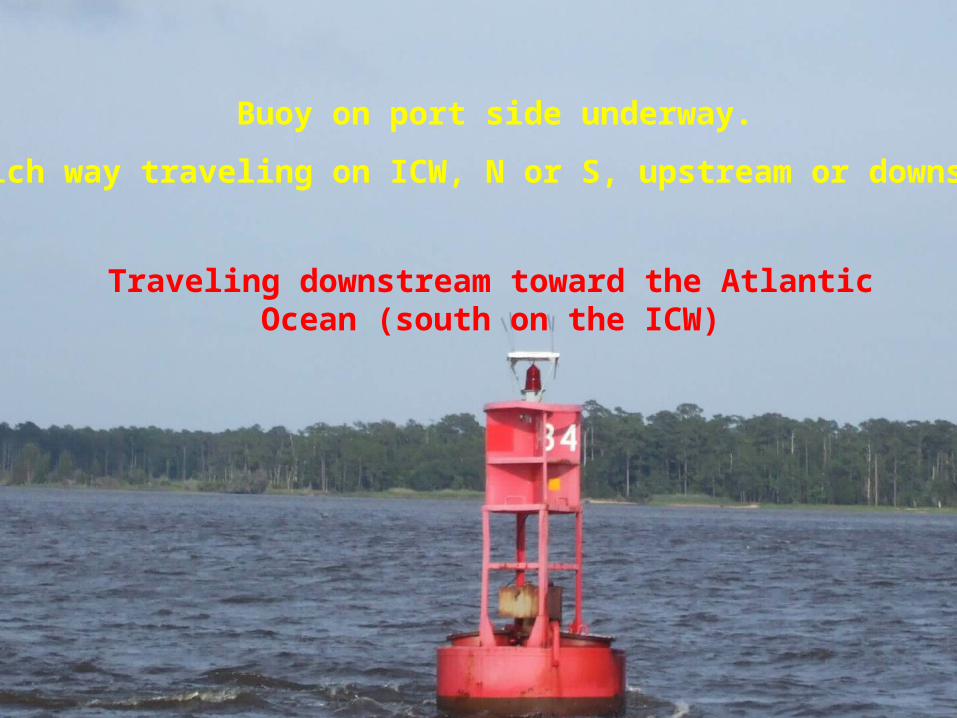
ICW Channel OnlySouthbound
• ICW – Landward– Red Triangle– Yellow Triangle – ICW Indicator– Always On Right (Landward)
• ICW – Seaward– Green Square– Yellow Square – ICW Indicator– Always On Left (Seaward)

Downstream on RiverSouthbound on ICW
• ICW – Right Side– Green Square – River Marking
Returning– Yellow Triangle – ICW Indicator– On Right; Landward Side
• ICW – Left Side– Red Triangle – River Marking– Yellow Square – ICW Indicator– On Left; Seaward Side

Upstream on River Northbound on ICW
• ICW – Right Side, Seaward– Red Triangle – River Marking
Returning– Yellow Square – ICW Indicator
• ICW – Left Side, Landward– Green Square – River Marking– Yellow Triangle – ICW Indicator
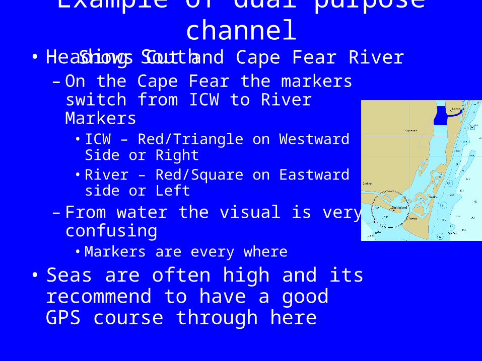
Example of dual purpose channelSnows Cut and Cape Fear River
• Heading South – On the Cape Fear the markers
switch from ICW to River Markers• ICW – Red/Triangle on Westward Side
or Right• River – Red/Square on Eastward side
or Left
– From water the visual is very confusing
• Markers are every where
• Seas are often high and its recommend to have a good GPS course through here

Snows Cut and Cape Fear River
North

Summary• Presented were only a few of the complicated
parts to North Carolina’s Aids to Navigation• Always study your chart before your journey• Understand which Aids of Navigation should
be observed and why• Read Chart and mark off aids as you go• of the trip and highlight areas of concern• *** Be vigilant of ICW markings especially
when leaving from or returning to port via a river