Coastal Flood Risk Study Project for Georgia Risk Review...Coastal Flood Risk Study Project for...
52
Coastal Flood Risk Study Project for Georgia Flood Risk Review Meeting August 20, 2015
Transcript of Coastal Flood Risk Study Project for Georgia Risk Review...Coastal Flood Risk Study Project for...

Coastal Flood Risk Study
Project for Georgia
Flood Risk Review Meeting
August 20, 2015

2
Introductions
Risk MAP Project Team
• FEMA Region IV
• BakerAECOM, FEMA
Mapping Partner
Project Stakeholders
• Community CEOs
• Community FPAs
• Political Representatives
• Other State and Federal
Agencies
• Public

3
Why We Are Here
Project Review and Update
• Data Collected
• Modeling Approaches
Hurricane Surge
Overland Waves
Questions and Answers
Open Discussion of Draft Work Maps
Nassau County, FL

4
FEMA Flood Risk Study Is Not Evacuation Study

5
Project Area
NEFL Georgia
Coastal Counties
Bryan
Duval Camden
Flagler Chatham
Nassau Glynn
St. Johns Liberty
Volusia McIntosh

6
Flood risk changes over time – Effective study based
on outdated hurricane modeling and topographic data
Ability to more accurately define risk and account for
significant development in project area
Why the Coastal Flood Risk Study Is Being Updated
To gain a complete and current
picture of coastal flood risks
This helps community:
• Plan for the risk
• Communicate the risk to your citizens
• Take action to reduce flood risk to
lives and property
• Build smarter and safer

7
Current surge analysis is 20 to 40+ years old
• Chatham County - Environmental Sciences Services
Administration’s JPM Method – 1970 publication
• Climate data from 1965 to 1981 NOAA reports
• Glynn and Camden Counties – updated surge in 1989
using SURGE model
Why the Coastal Flood Risk Study Is Being Updated (Cont’d)

8
Your risk is better defined through
• Updated elevation data (topographic data and aerial imagery)
• New climatological data based on recent storms
• Computing resources – a lot has changed in 30 years!
• Updated coastal hazard methodologies/modeling
• Improvement in Geographic Information System (GIS)
technologies to improve coastal mapping accuracy
Why the Coastal Flood Risk Study Is Being Updated (Cont’d)

9
Kickoff Meetings – November 8-9, 2010
• GA – Floodplain Managers Conference – March 13,
2013
Technical Update Meetings – April 8, 2013
• ASCE – Technical Update – September 4, 2013
Storm Surge Analysis Update Meetings – May 8,
2014
• Coastal Regional Council – March 2015
Flood Risk Review Meeting - Today
Outreach Meetings To Date

10
Basic Elements of a Coastal
Flood Risk Study
Base Flood Elevation (BFE) on FIRM includes 4
components:
1. Storm surge stillwater elevation (SWEL)
2. Amount of wave setup
3. Wave height above storm surge (SWEL) elevation
4. Wave runup above storm surge elevation (where present)
Determined from
storm surge model

11
Coordinated with
community officials
and stakeholders
regarding available
data
Conducted thorough
data investigation
Conducted field
investigations
Gathered Field Data

12
LIDAR system-
generated data
Gathered
bathymetric
data
Gathered LIDAR, Topographic Data

13
Gathered Bathymetric Data

14
Created Digital Elevation Model (DEM)

15
Seamless DEM for GA-NEFL

16
Hurricane Model Mesh Development
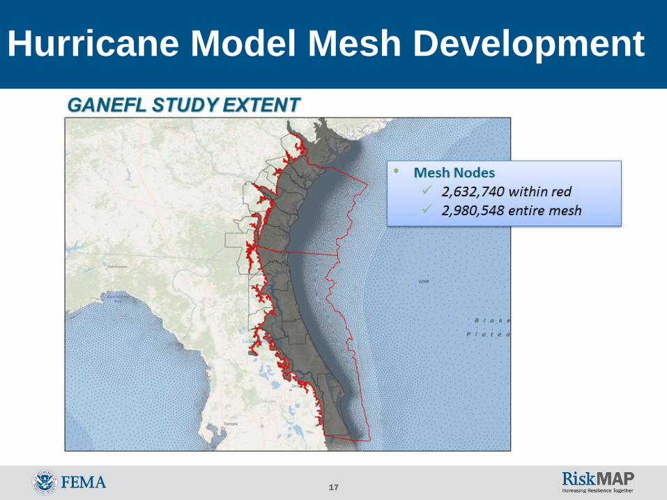
17
Hurricane Model Mesh Development
18
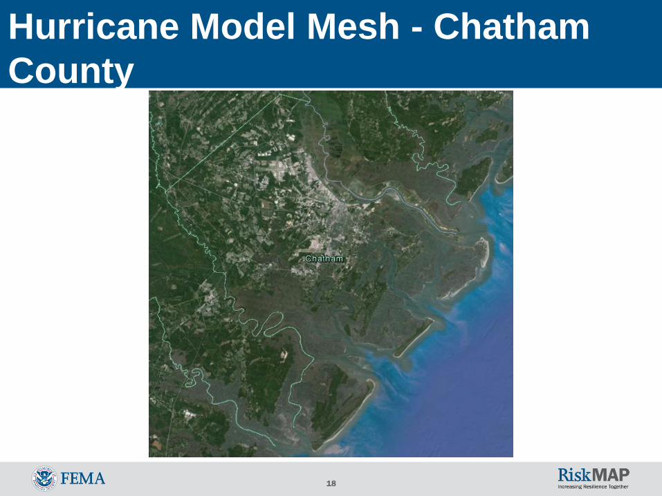
Hurricane Model Mesh - Chatham
County

19
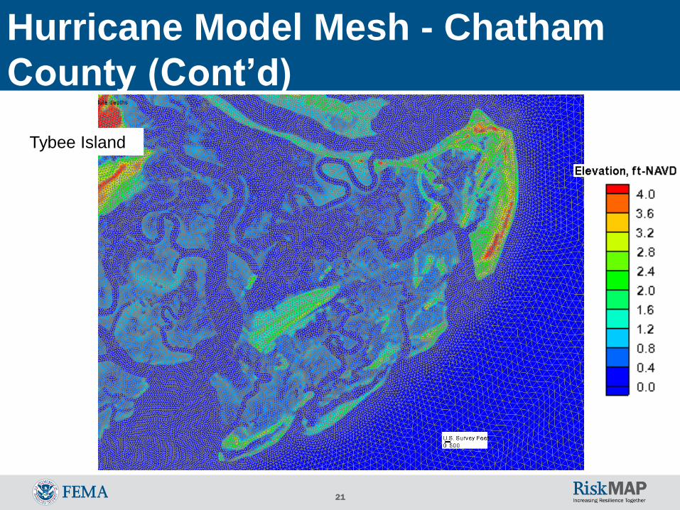
Hurricane Model Mesh - Chatham
County (Cont’d)

20
Tybee Island
Hurricane Model Mesh - Chatham
County (Cont’d)
21
Tybee Island
Hurricane Model Mesh - Chatham
County (Cont’d)

22
Hurricane Model Mesh - Bryan
County

23
Hurricane Model Mesh - Bryan
County (Cont’d)

24
Savage Island
Hurricane Model Mesh - Bryan
County (Cont’d)

25
Savage Island
Hurricane Model Mesh - Bryan
County (Cont’d)

26
Hurricane Model Mesh - Liberty
County (Cont’d)

27
Hurricane Model Mesh - Liberty
County (Cont’d)

28
Riceboro, GA
Hurricane Model Mesh - Liberty
County (Cont’d)

29
Riceboro, GA
Hurricane Model Mesh - Liberty
County (Cont’d)

30
Tropical Storms:
1940 - 2010
Passing within 175
nautical miles of
Jacksonville
Limited data before
1940
Storm Climatology: in Study Area

31
Storm Climatology
Review historical storms
Pick 5 storms to validate the hurricane/surge
model
Generate hundreds of hypothetical storms

32
Criteria Sorting of Storms
1. Local
Landfall
2. Significant WL
Difference
3. WL Data Availability
(> 3 Stations)4. Wave Data Availability
(2 or more stations)
Cleo
Dora
David
Chris
Edouard
Tammy
Fay
Dora (5.91 ft)
David (5.55 ft)
Jeanne (4.22 ft)
Tammy (4.07 ft)
Fay (3.99 ft)
Frances (3.85 ft)
Gabrielle (3.82 ft)
Floyd (3.8 ft)
Ophelia (3.04 ft)
Abby (2.93 ft)
Irene (2.92 ft)
Bertha (2.62 ft)
Bob (2.44 ft)
Erin (2.43 ft)
Cleo (2.35 ft)
Dennis 99 (2.24 ft)
Frances (15)
Charley (14)
Jeanne (14)
Ophelia (9)
Tammy (9)
Dennis 99 (8)
Edouard (8)
Floyd (7)
Irene (7)
Fay (6)
David (5)
Frances (5)
Ophelia (5)
Tammy (5)
Fay (5)
Jeanne (4)
Edouard (3)
Charley (3)
Chris (2)
Dennis99 (2)
Floyd (2)
Irene (2)
Validation Storm Selection:
Significant Surge Events

33
Criteria Sorting of Storms
1. Local
Landfall
2. Significant WL
Difference
3. WL Data Availability
(> 3 Stations)4. Wave Data Availability
(2 or more stations)
Cleo
Dora
David
Chris
Edouard
Tammy
Fay
Dora (5.91 ft)
David (5.55 ft)
Jeanne (4.22 ft)
Tammy (4.07 ft)
Fay (3.99 ft)
Frances (3.85 ft)
Gabrielle (3.82 ft)
Floyd (3.8 ft)
Ophelia (3.04 ft)
Abby (2.93 ft)
Irene (2.92 ft)
Bertha (2.62 ft)
Bob (2.44 ft)
Erin (2.43 ft)
Cleo (2.35 ft)
Dennis 99 (2.24 ft)
Frances (15)
Charley (14)
Jeanne (14)
Ophelia (9)
Tammy (9)
Dennis 99 (8)
Edouard (8)
Floyd (7)
Irene (7)
Fay (6)
David (5)
Frances (5)
Ophelia (5)
Tammy (5)
Fay (5)
Jeanne (4)
Edouard (3)
Charley (3)
Chris (2)
Dennis99 (2)
Floyd (2)
Irene (2)
Validation Storm Selection:
Significant Surge Events (Cont’d)

34
Five validation storms
were selected:
Hurricane Dora (1964)
Hurricane David (1979)
Hurricane Frances (2004)
Tropical Storm Tammy (2005)
Tropical Storm Fay (2008)
Validation Storm Selection:
Significant Surge Events (Cont’d)

35
Validation: Summary
Validation completed for tides and five
historical storms
Demonstrated model capability to
reproduce water levels and waves in
project area
Comparisons to available data showed
reasonable agreement for water levels
and waves

36
Hypothetical Storms
Developed using 5 parameters• Central pressure
• Radius to maximum winds
• forward speed
• storm heading
• Holland’s B (shape parameter)
Simulate whole range of possible storms
for GA (based on historic data for area)
Run storms on super computer
QC results

37
Set up “mesh” for
hurricane/surge model
Validated hurricane/surge
model
Ran hundreds of hypothetical
storms
Computed return periods for
study area
Resulting storm surge still
water elevations for the 1%-
annual-chance event (ACE)
Surge Modeling Gives 1% ACE

38
Modeling Part 2 – Overland Waves

39
Basic Elements of a Coastal Flood Risk Study
Normal water level
Storm surge level
Wave setup
Wave action
40
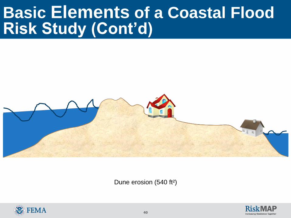
Basic Elements of a Coastal Flood Risk Study (Cont’d)
Dune erosion (540 ft²)

41
Basic Elements of a Coastal Flood Risk Study (Cont’d)
Dune erosion (removal)
42
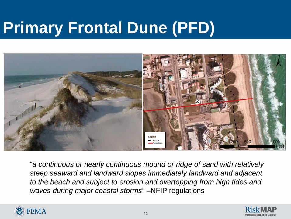
“a continuous or nearly continuous mound or ridge of sand with relatively
steep seaward and landward slopes immediately landward and adjacent
to the beach and subject to erosion and overtopping from high tides and
waves during major coastal storms” –NFIP regulations
Primary Frontal Dune (PFD)
43
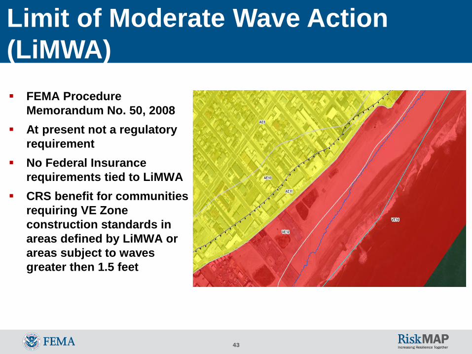
FEMA Procedure
Memorandum No. 50, 2008
At present not a regulatory
requirement
No Federal Insurance
requirements tied to LiMWA
CRS benefit for communities
requiring VE Zone
construction standards in
areas defined by LiMWA or
areas subject to waves
greater then 1.5 feet
Limit of Moderate Wave Action
(LiMWA)

44
Combining Riverine and Coastal
Flooding

45
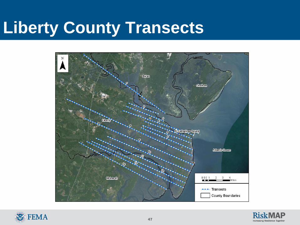
Bryan County Transects

46
Chatham County Transects
47
Liberty County Transects

48
Work Maps - Example

49
Outreach Activities

50
www.southeastcoastalmaps.com

51
Open Discussion
Technical questions …?
General questions
about Risk MAP
products?
General questions
about project schedule?
General questions
about meeting fact
sheet? Other outreach
resources?
Other questions?

52
Coastal Flood Risk Study Contacts
Michael DelCharco, PE
(904) 472-0082
Chris Mack, PE, PMP
(843) 767-4602
Mark Vieira, PE
(770) 220-5450
Christina Lindemer
(770) 220-5424
Todd Harris, PMP, CFM
(404) 651-8504
Tom Shillock, CFM
(404) 362-2606