
COASTAL ALABAMA RIVER BASIN MANAGEMENT · PDF fileFigure 16 Listed Segment in Styx River...
96
COASTAL ALABAMA RIVER BASIN MANAGEMENT PLAN Prepared for the Coastal Alabama Clean Water Partnership By the South Alabama Regional Planning Commission This project was funded or partially funded by the U.S. Environmental Protection Agency and the Alabama Department of Environmental Management and the Mobile/Baldwin County Soil and Water Conservation Districts. January 2004
Transcript of COASTAL ALABAMA RIVER BASIN MANAGEMENT · PDF fileFigure 16 Listed Segment in Styx River...
COASTAL ALABAMA
RIVER BASIN MANAGEMENT PLAN
Prepared for the
Coastal Alabama Clean Water Partnership
By the
South Alabama Regional Planning Commission
This project was funded or partially funded by the U.S. Environmental Protection Agency and the Alabama Department of Environmental Management and the Mobile/Baldwin County Soil and Water Conservation Districts.
January 2004

TABLE OF CONTENTS
EXECUTIVE SUMMARY ............................................................................. i INTRODUCTION
Overview of Coastal Clean Water Partnership and Area .................. 1 Purpose of Plan................................................................................. 3 The 303(d) Program in Coastal Alabama.......................................... 4
DESCRIPTION OF THE COASTAL ALABAMA BASIN PROJECT Location............................................................................................. 9 Climate.............................................................................................. 10 Physiography and Hydrology ............................................................ 12
Soils .................................................................................................. 13 Land Use and Population Growth ..................................................... 14 Economic and Industrial Trends........................................................ 17 Development Outlook........................................................................ 19 Infrastructure Development ............................................................... 23
DESCRIPTION OF COASTAL ALABAMA IMPAIRED WATERS Gulf of Mexico ................................................................................... 25 Mississippi Sound (Segment Classified for Shellfish Harvesting)....................... 26 Mobile Bay (Southwest Bay) ................................................................... 26 Mobile Bay (Segment Classified for Shellfish Harvesting).................................. 27 Portersville Bay ................................................................................. 27 Bon Secour Bay ................................................................................ 28 Mobile County ................................................................................... 30
Baldwin County ................................................................................. 51 Escambia County .............................................................................. 61 SUMMARY OF EXISTING WATERSHED PROJECT MANAGEMENT MEASURES Mobile Bay National Estuary Program .............................................. 65 Weeks Bay Watershed Project.......................................................... 67 Dog River Watershed Project............................................................ 68 Perdido Basin Management Strategies Report ................................. 69 COASTAL ALABAMA CLEAN WATER PARTNERSHIP MANAGEMENT PLAN AND IMPLEMENTATION STRATEGY ................... 70 REFERENCES ............................................................................................ 77 ACRONYM LIST.......................................................................................... 78
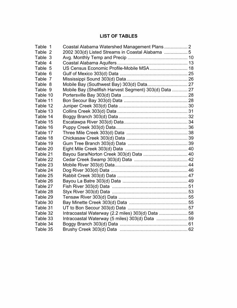
LIST OF TABLES
Table 1 Coastal Alabama Watershed Management Plans .................. 2 Table 2 2002 303(d) Listed Streams in Coastal Alabama .................. 5 Table 3 Avg. Monthly Temp and Precip .............................................. 10 Table 4 Coastal Alabama Aquifers ...................................................... 13 Table 5 US Census Economic Profile-Mobile MSA ............................. 18 Table 6 Gulf of Mexico 303(d) Data .................................................... 25 Table 7 Mississippi Sound 303(d) Data............................................... 26 Table 8 Mobile Bay (Southwest Bay) 303(d) Data............................... 27 Table 9 Mobile Bay (Shellfish Harvest Segment) 303(d) Data ............ 27 Table 10 Portersville Bay 303(d) Data .................................................. 28 Table 11 Bon Secour Bay 303(d) Data ................................................. 28 Table 12 Juniper Creek 303(d) Data ..................................................... 30 Table 13 Collins Creek 303(d) Data ...................................................... 31 Table 14 Boggy Branch 303(d) Data ..................................................... 32 Table 15 Escatawpa River 303(d) Data................................................. 34 Table 16 Puppy Creek 303(d) Data....................................................... 36 Table 17 Three Mile Creek 303(d) Data ............................................... 38 Table 18 Chickasaw Creek 303(d) Data ............................................... 39 Table 19 Gum Tree Branch 303(d) Data .............................................. 39 Table 20 Eight Mile Creek 303(d) Data ................................................ 40 Table 21 Bayou Sara/Norton Creek 303(d) Data .................................. 40 Table 22 Cedar Creek Swamp 303(d) Data ......................................... 42 Table 23 Mobile River 303(d) Data........................................................ 44 Table 24 Dog River 303(d) Data ........................................................... 46 Table 25 Rabbit Creek 303(d) Data ...................................................... 47 Table 26 Bayou La Batre 303(d) Data .................................................. 49 Table 27 Fish River 303(d) Data .......................................................... 51 Table 28 Styx River 303(d) Data .......................................................... 53 Table 29 Tensaw River 303(d) Data ..................................................... 55 Table 30 Bay Minette Creek 303(d) Data ............................................. 55 Table 31 UT to Bon Secour 303(d) Data .............................................. 57 Table 32 Intracoastal Waterway (2.2 miles) 303(d) Data ...................... 58 Table 33 Intracoastal Waterway (5 miles) 303(d) Data ........................ 59 Table 34 Boggy Branch 303(d) Data .................................................... 61 Table 35 Brushy Creek 303(d) Data .................................................... 62
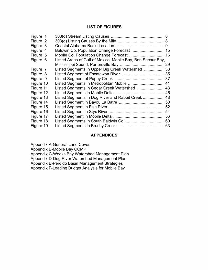
LIST OF FIGURES Figure 1 303(d) Stream Listing Causes ............................................... 8 Figure 2 303(d) Listing Causes By the Mile ......................................... 8 Figure 3 Coastal Alabama Basin Location ........................................... 9 Figure 4 Baldwin Co. Population Change Forecast ............................. 15 Figure 5 Mobile Co. Population Change Forecast ............................... 16 Figure 6 Listed Areas of Gulf of Mexico, Mobile Bay, Bon Secour Bay,
Mississippi Sound, Portersville Bay ....................................... 29 Figure 7 Listed Segments in Upper Big Creek Watershed .................. 33 Figure 8 Listed Segment of Escatawpa River ...................................... 35 Figure 9 Listed Segment of Puppy Creek ............................................ 37 Figure 10 Listed Segments in Metropolitan Mobile ................................ 41 Figure 11 Listed Segments in Cedar Creek Watershed ........................ 43 Figure 12 Listed Segments in Mobile Delta ........................................... 45 Figure 13 Listed Segments in Dog River and Rabbit Creek ................... 48 Figure 14 Listed Segment in Bayou La Batre ........................................ 50 Figure 15 Listed Segment in Fish River ................................................. 52 Figure 16 Listed Segment in Styx River ................................................ 54 Figure 17 Listed Segment in Mobile Delta ............................................. 56 Figure 18 Listed Segments in South Baldwin Co. .................................. 60 Figure 19 Listed Segments in Brushy Creek ......................................... 63
APPENDICES Appendix A-General Land Cover Appendix B-Mobile Bay CCMP Appendix C-Weeks Bay Watershed Management Plan Appendix D-Dog River Watershed Management Plan Appendix E-Perdido Basin Management Strategies Appendix F-Loading Budget Analysis for Mobile Bay

THIS PAGE LEFT INTENTIONALLY BLANK
Coastal Alabama River Basin Management Plan i
Executive Summary In response to water quality concerns, and with support from the Alabama Department of Environmental Management, the Mobile and Baldwin County Soil and Water Conservation Districts established the Coastal Clean Water Partnership. The “Partnership” is being facilitated by the Auburn University Marine Extension and Research Center. The Coastal Alabama River Basin Management Plan documents the labor of many throughout the Coastal Clean Water Partnership area to protect and restore natural resources in Baldwin, Escambia, and Mobile Counties. This planning project was made possible by the Alabama Department of Environmental Management and the Environmental Protection Agency’s §319 Program and 104(b)(3) Water Protection Program. There are a number of existing comprehensive management plans and programs in place within the area. These projects have extensively described the physical characteristics of the two counties, documented challenges to restoring and maintaining healthy watersheds in Coastal Alabama and developed goals, strategies, and management measures to address these challenges. As so much local effort and so many federal, state and local resources have been invested in watershed management planning in Baldwin and Mobile Counties, it is only appropriate that the existing plans serve as the foundation for this Coastal Area Basin Management Plan. The plan documents for each watershed project in place in the Coastal Alabama Basin are listed below and, when available, included in Appendices B-E.
Document Entity/Agency Comprehensive Conservation Management Plan
Mobile Bay National Estuary Program
Weeks Bay Watershed Management Plan
Weeks Bay Watershed Project
Dog River Watershed Management Plan
Dog River Watershed Project
Perdido Ecosystem Restoration Plan
Perdido Ecosystem Restoration Group
Wolf Bay Watershed Management Plan (in prep)
Alabama Coastal Foundation
Bon Secour Watershed Management Plan (in prep)
Auburn Marine Extension and Research Center
Alabama Coastal Nonpoint Source Pollution Control Program
Alabama Department of Conservation and Natural Resource
Table. ES1.

Coastal Alabama River Basin Management Plan ii
Along with information included in the above mentioned plans, the Alabama Department of Environmental Management has completed in-depth surveys for the Dog River, Bon Secour, Chickasaw Creek, Bayou Sara and Little Lagoon watersheds. These surveys document the effects of development in the watershed and assess the effects of urban nonpoint pollution sources on living resources. Additionally, the Mobile Bay National Estuary Program and the Mobile District, U.S. Army Corps of Engineers commissioned a study to analyze pollutant contributions to Mobile Bay. The “Loading Budget Analysis for Mobile Bay Modeling” was completed by Tetra Tech in 2001. According to the report, the main objectives of the study were to:
• Develop a pollutant mass balance for the Mobile River Basin, both point and nonpoint sources.
• Assess the total load of pollutants contributed by the Mobile River basin to
Mobile Bay.
• Characterize the distribution of sources and loads within the basin. The primary goal of this project is to guide and document the efforts of the Coastal Alabama Clean Water Partnership to coordinate management measures that will need to be implemented to reduce pollutants in critical areas. This document includes a description of land uses and potential pollutant sources along 303(d) listed stream segments in the Coastal Alabama Basin, a description of basin-wide management measures and a proposed implementation strategy for these measures. An estimate of funding sources and identification of resource agencies and authorities that may be relied upon to implement these measures is included. Finally, there is a monitoring strategy that includes criteria to determine progress and a process for revisions and updates. Realization of the goals established in the above mentioned plans and projects will occur through undertaking specific action items included in this Coastal Basin Management Plan and through the Partnership’s continued active support for implementation of the Mobile Bay Comprehensive Conservation Management Plan, the Dog River Watershed Management Plan, the Weeks Bay Management Plan, the Wolf Bay Watershed Management Plan (in prep), the Bon Secour Management Plan (in prep), and the Little Lagoon Management Plan to be developed in 2004. The Basin wide action items included here are not all encompassing and may be modified to fit a particular sub-watershed management problem. Further, action items may be deleted or added as opportunities, new information, or additional funds are obtained. Responsible parties are agencies with regulatory or legal authority or other entities with an interest in development and implementation of
Coastal Alabama River Basin Management Plan iii
this plan. Cooperators are those who could assist the responsible parties through shared resources and/or technical assistance. Potential funding identifies resources to implement the strategy. The schedule suggests implementation timelines on a quarterly basis, with most of the action items ongoing. Because of the limited assessment data and the large area encompassed by the basin, definitive load reduction estimates are unknown at this time. Budgets are estimates or unknown as implementation is dependent on funding and stakeholder interest and support.
ACTION ITEMS
Develop and implement a campaign designed to foster establishment of stakeholder groups in all sub-watersheds with priority in those that contain
303(d) listed streams and to involve new groups in the Coastal Alabama Clean Water Partnership.
Responsible Entities: ADEM, ADCNR, AUMERC Cooperators: SWCD, NRCS, MBNEP, SARPC, ACF Potential Funding: EPA 319, NOAA 306, MBNEP Schedule: Ongoing Estimated Cost: tbd Tasks Establish a CACWP Subcommittee to identify tasks, prioritize watersheds to target and implement campaign Develop list of loosely organized grassroots watershed groups Target activities to these groups while developing strategy for watersheds with no existing stakeholder involvement Progress Benchmarks Documented step-by-step watershed group organizing campaign Increase in number of organized watershed groups in the Basin
Establish a rotating TMDL Advisory Committee to assist ADEM with development and implementation of TMDLs for each listed segment.
Responsible Entities: CACWP Technical Committee, ADEM, ADCNR Cooperators: SWCD, Mobile BayWatch/BayKeeper, ADCNR
Coastal Alabama River Basin Management Plan iv
Potential Funding: None Schedule: Committee established by December 2003. TMDLs established based on EPA approved TMDL development schedule Estimated Cost: No additional cost Tasks Request a TMDL development status update from ADEM Request a meeting with ADEM to define the role of the CACWP in development of TMDL’s Establish TMDL Advisory Committee organization guidelines to allow for rotating members Establish Committee Progress Benchmarks Working committee established and reporting to CACWP quarterly
Coordinate and assist with identifying funding for all types of water quality protection and best management practice demonstration projects-urban,
construction, agriculture, forestry, on-site sewage disposal systems. Responsible Entities: CACWP Facilitator Cooperators: MBNEP, ADEM, ADCNR Potential Funding: None Schedule: On-going Estimated Cost: No additional cost Tasks Meet with Technical Advisory Committee to review potential projects and identify potential funding sources on a monthly basis Progress Benchmarks Assist with identifying funding for at least one project per year.
Update education and outreach strategy to consider tasks such as expanding the Clean Water Guardian Program and developing a “Greener
By the Par” program for environmentally friendly golf courses.
Coastal Alabama River Basin Management Plan v
Responsible Entities: CACWP Facilitator, ACES Cooperators: ADEM, ADCNR, AUMERC, SWCD, NRCS, ACES Potential Funding: EPA 319, NOAA 306 Schedule: FY 2004 Estimated Cost: $15,000 Tasks Establish Outreach Committee Meet monthly to develop strategy and implementation schedule by third quarter FY 04 Implement strategy Progress Benchmarks Documented strategy developed and approved by CACWP Implementation results in increased participation in “Guardian” type programs
Provide Clean Marina Program Technical Assistance to marinas throughout the Basin.
Responsible Entities: AUMERC, Mississippi-Alabama Sea Grant Extension, ADCNR Cooperators: ADEM, ADCNR, MBNEP, ADEM, DISL, Mississippi DEQ, SWCD Potential Funding: EPA 319, NOAA 306, CVA, RC&D, MBNEP, GOMP Schedule: ongoing Estimated Cost: The above programs currently fund this item. Should the funding guidelines change additional sources will be identified. Tasks CACWP Facilitator will present program details to the CACWP by second quarter of 2004 Develop a targeted list of priority marinas Solicit participants Progress Benchmarks Targeted marinas receive solicitation and technical assistance on the program
Coastal Alabama River Basin Management Plan vi
At least one marina in each Sub-Basin is participating by first quarter of 2005
Continue to promote and support stream restoration/stormwater BMP workshops and demonstration projects in the CACWP area.
Responsible Entities: CACWP Facilitator, MBNEP, ACES Cooperators: AUMERC, ADEM, MASGC, ADCNR Potential Funding: EPA 319, NOAA 306, CVA Schedule: on-going Estimated Cost: The above programs currently fund this item. Should the funding guidelines change additional sources will be identified. Tasks CACWP facilitator will assist in coordinating at least 2 workshops per year CACWP facilitator will work to implement stream restoration and stormwater BMP demonstration projects in the Basin Progress Benchmarks Participants trained Workshops held Projects implemented
Coastal Alabama River Basin Management Plan 1
INTRODUCTION Water quality and the health of local streams and rivers directly impact the quality of life of communities. This is especially true for coastal communities. Both natural events and human activities have altered and continue to impact waterways. It can be said that human activities have the greatest potential for long term impacts to waterways. These impacts may be localized, but their cumulative affects can be far greater and more permanent than natural events. Without proper management, these human affects will compromise watershed health and ultimately the quality of life. The Alabama Department of Environmental Management (ADEM) began addressing water quality and the health of local streams in 1996 by initiating the Five Year Rotational River Basin Assessment under the §319 Nonpoint Source Program. This coincided with the development of Clean Water Partnerships throughout Alabama. In response to water quality concerns on the Gulf Coast, the Mobile and Baldwin County Soil and Water Conservation Districts established the Coastal Alabama Clean Water Partnership. The “Partnership” is being facilitated by the Auburn University Marine Extension and Research Center and is supported by ADEM. Overview of Coastal Clean Water Partnership and Area The mission of the Coastal Clean Water Partnership is to protect, improve, and maintain water quality in Alabama's Coastal River Basins by meeting the goals of the Clean Water Act through basin-wide public/private partnerships. This mission is pursued through a broad based Steering Committee. The Committee meets regularly to:
• Set policy and provide leadership • Oversee the planning and implementation of the organizational structure
for the Perdido/Mobile/Escatawpa River Basins Watershed Management Program
• Offer guidance and assistance to the Perdido/Mobile/Escatawpa river sub-basin committees in directing and coordinating community-based watershed restoration and protection initiatives
The Coastal Alabama River Basin Management Plan documents the labor of many throughout the Coastal Clean Water Partnership area to protect and restore natural resources in Baldwin, Escambia, and Mobile Counties. This planning project was made possible by the Alabama Department of Environmental Management and the Environmental Protection Agency’s §319 Program and 104(b)(3) Water Protection Program. The planning area is rich in water resources with most surface streams continuing to flow year-round even during moderate droughts. The area is
Coastal Alabama River Basin Management Plan 2
underlain with both shallow and deep aquifers capable of supplying substantial volumes of potable water. The Mobile Delta and Mobile Bay separates the region with an area of 44,000 square miles (not included in the planning area) contributing to flow through the delta. Many local streams drain over 3,000 square miles comprising the planning area. Some of the local streams empty into Mobile River or the local bays and others flow into Mississippi Sound or the Gulf of Mexico. There are a number of existing comprehensive management plans and programs in place within the area. These projects have extensively described the physical characteristics of the two counties, documented challenges to restoring and maintaining healthy watersheds in Coastal Alabama and developed goals, strategies, and management measures to address these challenges. As so much local effort and so many federal, state and local resources have been invested in watershed management planning in Baldwin and Mobile Counties, it is only appropriate that the existing plans serve as the foundation for this Coastal Area Basin Management Plan. The plan documents for each watershed project in place in the Coastal Alabama Basin are listed below and, where available, included in Appendices B-F.
Document Entity/Agency Comprehensive Conservation Management Plan
Mobile Bay National Estuary Program
Weeks Bay Watershed Management Plan
Weeks Bay Watershed Project
Dog River Watershed Management Plan
Dog River Watershed Project
Perdido Ecosystem Restoration Plan
Perdido Ecosystem Restoration Project
Wolf Bay Watershed Management Plan (in prep)
Alabama Coastal Foundation
Bon Secour Watershed Management Plan (in prep)
Auburn Marine Extension and Research Center
Alabama Coastal Nonpoint Source Pollution Control Program
Alabama Department of Conservation and Natural Resources
Table 1. While addressing Partnership specific goals and objectives, action items included in this Coastal Alabama River Basin Management Plan are intended to provide the Partnership’s continued active support for implementation of the Mobile Bay Comprehensive Conservation Management Plan, the Dog River Watershed Management Plan, the Weeks Bay Management Plan, the Wolf Bay Watershed Management Plan (in prep), the Bon Secour Management Plan (in prep), the Little Lagoon Management Plan to be developed in 2005, and the Fowl River Plan to be developed in 2006.
Coastal Alabama River Basin Management Plan 3
Along with information included in the above mentioned plans, the Alabama Department of Environmental Management has completed in-depth surveys for the Dog River, Bon Secour, Chickasaw Creek, Bayou Sara and Little Lagoon watersheds. These surveys document the effects of development in the watershed and assess the effects of urban nonpoint pollution sources on living resources. Additionally, the Mobile Bay National Estuary Program and the Mobile District, U.S. Army Corps of Engineers commissioned a study to analyze pollutant contributions to Mobile Bay. The “Loading Budget Analysis for Mobile Bay Modeling” was completed by Tetra Tech in 2001. According to the report, the main objectives of the study were to:
• Develop a pollutant mass balance for the Mobile River Basin, both point and nonpoint sources.
• Assess the total load of pollutants contributed by the Mobile River basin to
Mobile Bay.
• Characterize the distribution of sources and loads within the basin. The total loads contributed by the Upper Mobile River basin to Mobile Bay were compared to the total loads contributed by the Lower Mobile River basin. As a result of this comparison, Tetra Tech states that “contributions from the upper watershed are estimated to be significantly higher than those from the immediate bay area” (Tetra Tech, p. 6-10, 2001). The full report is located in Appendix E. Purpose of Plan The primary goal of this project is to guide and document the efforts of the Coastal Alabama Clean Water Partnership to coordinate management measures that will need to be implemented to reduce pollutants in critical areas. This document includes a description of land uses and potential pollutant sources along 303(d) listed stream segments in the Coastal Alabama Basin, a description of basin-wide management measures and a proposed implementation strategy for these measures as well as an estimate of funding sources needed and identification of resource agencies and authorities that may be relied upon to implement measures as well as a monitoring strategy that includes criteria to determine progress and a process for revisions and updates. The description of potential pollutant sources, goals, and action items have been developed with assistance from the Coastal Alabama Clean Water Partnership.

Coastal Alabama River Basin Management Plan 4
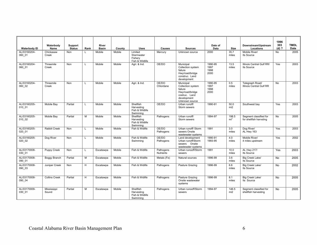
The 303(d) Program in Coastal Alabama The State of Alabama adopted water use classifications under the authority of the Code of Alabama 1975 Title 22 Section 22-1. These classifications are codified in the Administrative Code of Alabama 335-6-10. These classifications include: Public Water Supply, Swimming and Other Whole Body Water Contact Sports, Shellfish Harvesting, Fish and Wildlife, Agricultural and Industrial Water Supply, Limited Warmwater Fishery, and Outstanding Alabama Water (www.adem.state.al.us). Section 303(d) of the Clean Water Act requires that each state identify those waters that do not currently support designated uses, and establish a priority ranking of the waters taking into account the severity of the pollution and the use classification of the waters. For each pollutant on the list, the state is required to establish total maximum daily load (TMDL) for the pollutant or pollutants of concern at a level necessary to implement the applicable water quality standards. Guidance issued in August 1997 by the Environmental Protection Agency (EPA) suggests that states also include a schedule for (TMDL) development. Expected completion dates range from one to ten years. In the “2002 303(d) List for the State of Alabama” there are 8 listings for Baldwin County, 21 for Mobile County and 2 for Escambia County. These listings include the major water bodies of Dog River, Bon Secour Bay, portions of Mobile Bay, Portersville Bay, the Mississippi Sound, and the Gulf of Mexico. Streams and bays listed in Alabama’s 2002 Section 303(d) List as not fully supporting their currently designated uses are included in the following tables provided by the Alabama Department of Environmental Management (ADEM) (www.adem.state.al.us). Table 2 reports sources that have been identified or confirmed by the ADEM. Later in this report each water body will be discussed more fully. There will be additional sources identified separate from the ADEM table. These sources are based on onsite inspections and field work by the Coastal Alabama Clean Water Partnership members, and data published in “Loading Budget Analysis for Mobile Bay Modeling” (Tetra Tech, 2001).

Coastal Alabama River Basin Management Plan 5
Waterbody ID Waterbody
Name Support Status Rank
River Basin County Uses Causes Sources
Date of Data Size
Downstream/Upstream Locations
1996 303 (d) ?
TMDL Date
AL/03140107-040_01
Intracoastal Waterway
Non L Perdido-Escambia
Baldwin Fish & Wildlife OE/DO Urban runoff/ Storm sewers Natural sources
1995-99 5 miles AL Hwy 59 Wolf Bay
Yes 2003 AL/03160204-040_01
Bay Minette Creek
Non L Mobile Baldwin Fish & Widlife Mercury Unknown source 2000 16.6 miles
Bay Minette/ Its source
No 2005
AL/03160205-050_02
Fish River Non L Mobile Baldwin Fish & Wildlife Swimming
Mercury Pathogens
Unknown source Pasture grazing
1996 31.5 miles
Weeks Bay/ Its Source
No 2005
AL/03160205-070_01
Intracoastal Waterway
Non L Mobile Baldwin Fish & Wildlife OE/DO Urban runoff/Storm sewers Natural sources
1990-91 2.2 miles
Oyster Bay/ Alabama Hwy 59
Yes 2003
AL/03160205-070_01
UT to Bon Secour R
Non H Mobile Baldwin Fish & Wildlife Pathogens Urban runoff/Storm sewers Pasture grazing
1995 2.3 miles
Baldwin Co. Road 65/ Its Source
No 2005
AL/03160205-070_02
Bon Secour Bay
Partial M Mobile Baldwin Shellfish Harvesting Swimming Fish & Wildlife
Pathogens Urban runoff/Storm sewers Onsite wastewater systems
1994-97 121.3 mi2
Segment classified for shellfish harvsting
No 2005
AL03140106-170_01
Styx River Partial M Perdido-Escambia
Baldwin Fish & Wildlife Mercury Unknown Source 2002 27.1 miles
Perdido River No 2007
AL03160204-040-_02
Tensaw River Partial H Mobile Baldwin Outstanding National Resource Water
Mercury Unknown Source 2002 42.6 miles
Mobile Bay/ No 2007
AL/03140106-070_01
Boggy Branch Partial L Perdido-Escambia
Escambia Fish & Wildlife OE/DO Zinc Chlorides
Industrial 1996-97 0.2 miles
Atmore WWTP/ Masland Carpets WWTP
No 2005
AL/03140106-070_02
Brushy Creek Non H Perdido-Escambia
Escambia Fish & Wildlife OE/DO Industrial Municipal Urban runoff/storm sewers
1999 0.2 miles
AL/Fla State Line/ Boggy Branch
No 2005
AL/03160204-020_01
Cold Creek Swamp
Partial L Mobile Mobile Fish & Widlife Metals (Hg) Contaminated sediments Flow reg/mod
1993 1.0 mi2 Cold Creek with Mobile R. / West through swamp
Yes 2003
AL/03160204-030_01
Bayou Sara/ Norton Creek
Partial H Mobile Mobile Swimming Fish & Wildlife
Nurients Unknown source 1992 3.7 miles
Saraland WWTP/ Gunnison Creek
Yes 2003
AL/03160204-050_01
Eightmile Creek
Partial M Mobile Mobile Public Water Supply Fish & Wildlife
Pathogens Urban runoff/Storm sewers Collection system failure
1996-97 3.2 miles
Al Hwy. 45/ Highpoint Blvd.
No 2005
AL/03160204-050_02
Gum Tree Branch
Non H Mobile Mobile Fish & Widlife Pathogens Collection system failure Urban runoff/ Storm sewers
1998 2.2 miles
Eightmile Creek / Its Source
No 2005
Coastal Alabama River Basin Management Plan 6
Waterbody ID Waterbody
Name Support Status Rank
River Basin County Uses Causes Sources
Date of Data Size
Downstream/Upstream Locations
1996 303 (d) ?
TMDL Date
AL/03160204-060_01
Chickasaw Creek
Non L Mobile Mobile Limited Warmwater Fishery Fish & Wildlife
Mercury Unknown source 2000 35.7 miles
Mobile River/ Its Source
No 2005
AL/03160204-060_01
Threemile Creek
Non L Mobile Mobile Agri. & Ind. OE/DO Municipal Collection system failure Hwy/road/bridge construc. Land development
1990-95 1997 1998 2000
13.5 miles
Illinois Central Gulf RR/ Its Source
Yes 2003
AL/03160204-060_02
Threemile Creek
Non L Mobile Mobile Agri. & Ind. OE/DO Chlordane
Municipal Collection system failure Hwy/road/bridge costruc. Land development Unknown source
1990-95 1997 1998 2000
0.5 miles
Telegraph Road/ Illinois Central Gulf RR
No 2003
AL/03160205-010_01
Mobile Bay Partial L Mobile Mobile Shellfish Harvesting Fish & Wildlife Swimming
OE/DO Urban runoff/ Storm sewers
1990-91 50.0 mi2
Southwest bay Yes 2003
AL/03160205-010_02
Mobile Bay Partial M Mobile Mobile Shellfish Harvesting Fish & Wildlife Swimming
Pathogens Urban runoff/ Storm sewers
1994-97 198.5 mi2
Segment classified for for shellfish harvsting
No 2005
AL/03160205-020_01
Rabbit Creek Non L Mobile Mobile Fish & Widlife OE/DO Pathogens
Urban runoff/ Storm sewers Onsite wastewater systems
1991 3.0 miles
Dog River/ AL Hwy 163
Yes 2003
AL/03160205-020_02
Dog River Non L Mobile Mobile Fish & Widlife Swimming
OE/DO Pathogens
Land development Urban runoff/Storm sewers Onsite wastewater systems
1990-91 1993-95
4.0 miles
Mobile River/ 4 miles upstream
Yes 2002
AL/03170008-030_01
Puppy Creek Non L Escatawpa Mobile Fish & Widlife Pathogens Nutrients
Urban runooff/Storm sewers
1991 10.0 miles
AL Hwy 217/ Its Source
Yes 2003
AL/03170008-090_01
Boggy Branch Partial M Escatawpa Mobile Fish & Widlife Metals (Fe) Natural sources 1996-99 3.6 miles
Big Creek Lake/ Its Source
No 2005
AL/03170008-090_03
Juniper Creek Non H Escatawpa Mobile Fish & Widlife Pathogens Pasture Grazing 1996-99 6.6 miles
Big Creek Lake/ Its Source
No 2002
AL/03170008-090_04
Collins Creek Partial H Escatawpa Mobile Fish & Widlife Pathogens Pasture Grazing Onsite wastewater systems
1996-99 8.1 miles
Big Creek Lake/ Its Source
No 2005
AL/03170009-030_01
Mississippi Sound
Partial M Escatawpa Mobile Shellfish Harvesting Fish & Wildlife Swimming
Pathogens Urban runooff/Storm sewers
1994-97 146.5 mi2
Segment classified for shellfish harvesting
No 2005

Coastal Alabama River Basin Management Plan 7
Waterbody ID Waterbody
Name Support Status Rank
River Basin County Uses Causes Sources
Date of Data Size
Downstream/Upstream Locations
1996 303 (d) ?
TMDL Date
AL/03170009-030_02
Portersville Bay
Non L Escatawpa Mobile Shellfish Harvesting Fish & Wildlife
Pathogens Municipal Industrial
1996 23.2 mi2
1000 ft. W. of outfall / Bayou La Batre Utilities Outfall
No 2005
AL/3170009-050_01
Bayou La Batre
Non L Escatawpa Mobile Fish & Widlife OE/DO Pathogens
Urban runooff/Storm sewers
1990-91 4.0 miles
Portersville Bay/ Its Source
Yes 2003
AL/Gulf of Mexico_01
Gulf of Mexico Non L Mobile Mobile Shellfish Harvesting Swimming Fish & Wildlife
Mercury Unknown source 1996-97 238 mi2
Mississippi/ Florida No 2005
AL/Mobile R_01 Mobile River Partial L Mobile Mobile Limited Warmwater Fishery Fish & Wildlife
Mercury Unknown source 2000 29.5 miles
Mobile Bay/ Cold Creek
No 2005
AL03170008-070_01
Escatawpa River
Non H Escatawpa Mobile Fish & Wildlife Mercury Unknown Source 2002 68.3 miles
AL/MS Stateline No 2007
Table 2. 2002 303(d) Listed Waterbodies in Coastal Alabama.
Coastal Alabama River Basin Management Plan 8
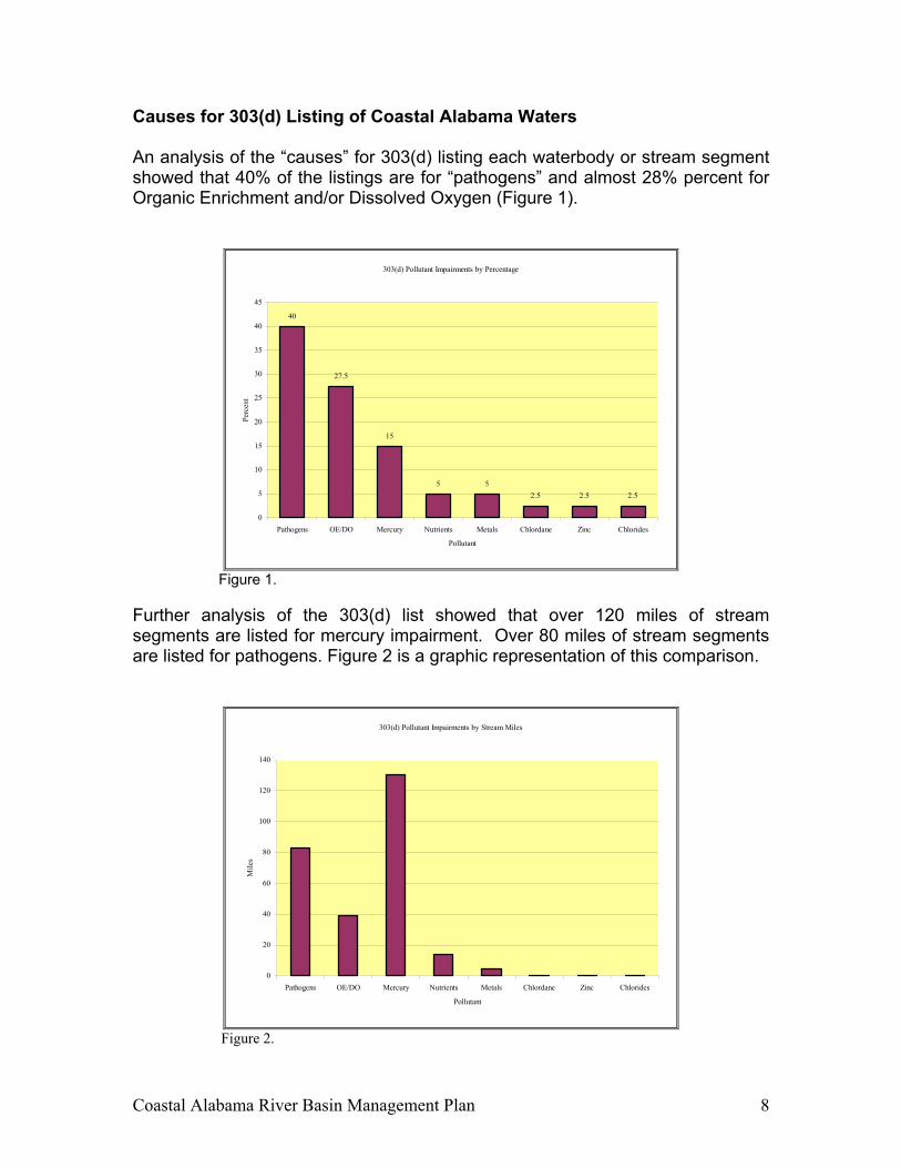
Causes for 303(d) Listing of Coastal Alabama Waters An analysis of the “causes” for 303(d) listing each waterbody or stream segment showed that 40% of the listings are for “pathogens” and almost 28% percent for Organic Enrichment and/or Dissolved Oxygen (Figure 1).
303(d) Pollutant Impairments by Percentage
40
27.5
15
5 52.5 2.5 2.5
0
5
10
15
20
25
30
35
40
45
Pathogens OE/DO Mercury Nutrients Metals Chlordane Zinc Chlorides
Pollutant
Perc
ent
Figure 1.
Further analysis of the 303(d) list showed that over 120 miles of stream segments are listed for mercury impairment. Over 80 miles of stream segments are listed for pathogens. Figure 2 is a graphic representation of this comparison.
303(d) Pollutant Impairments by Stream Miles
0
20
40
60
80
100
120
140
Pathogens OE/DO Mercury Nutrients Metals Chlordane Zinc Chlorides
Pollutant
Mile
s
Figure 2.

Coastal Alabama River Basin Management Plan 9
DESCRIPTION OF THE COASTAL ALABAMA RIVER BASIN PROJECT Location The boundaries for the Basin Management Plan are primarily in Baldwin and Mobile Counties and include the portions of the Escatawpa, Mobile, and Perdido River Basins and the Gulf of Mexico that are within the State of Alabama. The Coastal Alabama Clean Water Partnership includes representatives from the Jackson County, Mississippi side of the Escatawpa Basin and the Escambia County, Florida side of the Perdido Basin.
Figure 3.
Coastal Alabama Basin Project Area

Coastal Alabama River Basin Management Plan 10
Climate Baldwin and Mobile Counties are in a humid subtropical region typical of the Gulf coast. Summers are characteristically warm while winters are relatively mild with occasional cold waves. In the contiguous United States, this region is second only to the Pacific Northwest in total rainfall (Baldwin 1973), receiving precipitation from a combination of winter storms, thunderstorms, and tropical systems. The following table lists the average precipitation and temperature for the weather station located in Fairhope, Alabama, (Baldwin County Wetland Advance Identification, January, 1999).
Average Monthly Temperature and Precipitation Month
Avg. Temperature (Degrees F)
Avg. Precipitation (Inches)
January 49.0 5.01 February 51.9 6.06 March 59.1 6.08 April 66.6 4.13 May 73.2 5.36 June 79.1 5.56 July 81.0 7.29 August 80.5 6.66 September 77.1 5.65 October 67.6 3.18 November 59.4 4.22 December 52.1 4.90 Annual 66.4 65.10
Table 3. Summer Climate High barometric pressure over the Atlantic Ocean is a dominant factor in the summer weather pattern. This Semi-permanent weather system, called the subtropical anticyclone, provides a persistent southerly flow of humid air from the Gulf of Mexico. This air is normally unstable and thus, is easily lifted and condensed through convective heating or sea breeze convergences. As a result, thunderstorms are frequent and account for the major portion of summer rainfall. The influx of moisture from the Gulf of Mexico, in combination with numerous thunderstorms, produces a small diurnal temperature range during the summer. Average maximum air temperatures range from the upper 80’s to the lower 90’s (degrees Fahrenheit). Temperatures may rise rapidly in the morning hours but the high frequency of thundershowers usually limit the peak to the lower 90’s

Coastal Alabama River Basin Management Plan 11
(Williams 1973). Because of the absolute humidity during this period, temperatures of 100 degrees Fahrenheit are occasionally observed. Winter Climate During the winter months, the Atlantic subtropical anticyclone retreats southward allowing the polar front to make numerous incursions into the Gulf States region. The arrival of polar air is frequently marked by heavy rain and strong wind shift from southerly to northwesterly. When extremely low temperatures occur for at least two successive nights, freezing of the Mobile Bay may take place near the shore. Winter Storms Winter storms produce heavy downpours. Those winter storms with the greatest impact originate in west Texas or along the Texas Coast and are usually formed by upper atmosphere troughs that track across the southwestern U.S. Surface cyclones developing beneath these troughs either move eastward from Texas across the Gulf States or along the coast. Storms of this type gain enormous energy from the contrast between warm Gulf waters and polar air positioned over the area. The high frequency of winter storms produces an average rainfall in excess of 7 inches for the month of March (Schroeder et al. 1990b). Tropical Storms The central Gulf coast has one of the highest frequencies of hurricane landfall in the U.S. for the period 1871-1990. Tropical storms are capable of producing enormous rainfall over Mobile Bay and surrounding counties. Rainfalls of 5 to 10 inches are not unusual. In July 1997 rainfall estimates from hurricane Danny were 27 inches in the general area of Baldwin and Mobile Counties. However, hurricane rainfall totals vary considerably from storm to storm. Often the combination of flood runoff, erosion and the destruction of trees and buildings results in the transport of large amounts of sediment and debris into local streams. This can have a profound impact on the ecosystems of the streams and receiving bays including some Gulf areas.
Coastal Alabama River Basin Management Plan 12
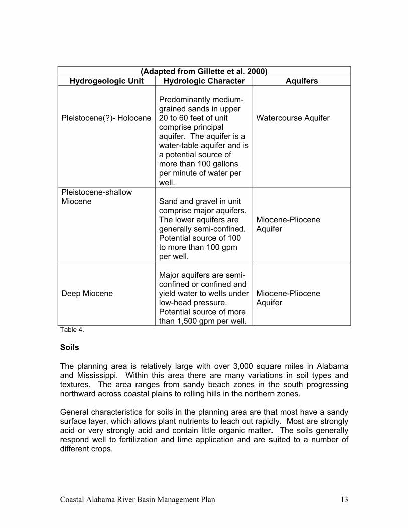
Physiography and Hydrology The general planning area is located in the East Gulf Coastal Plain section of the Coastal Plain physiographic province. Upland areas lie within the Southern Pine Hills physiographic district. Coastal areas are in the Coastal Lowlands physiographic district. Topography in planning area varies from elevations of less than 5 feet National Geodetic Vertical Datum of 1929 (NGVD) in the low-lying marsh areas to over 300 feet NGVD in the northern portions of the area. The Mobile Delta and Mobile Bay lie between Baldwin and Mobile Counties and receive inflow and runoff from about 44,000 square miles. This drainage area includes most of Alabama, portions of northeast Mississippi and Georgia, and a small part of southern Tennessee. Principal rivers in the basin include the Alabama-Coosa, the Tombigbee-Warrior and the Mobile. There are about 500 square miles that drain directly into Mobile Bay through local streams including Dog and Fowl Rivers in Mobile County and Fish and Bon Secour Rivers in Baldwin County. The Escatawpa River and Big Creek drain from Mobile County into Mississippi. The Perdido River and Perdido Bay form the boundary between Baldwin County and Florida (U.S. Army Corps of Engineers 1993). The Geological Survey of Alabama divides sediments cropping out at the surface in Baldwin and Mobile County into two major aquifers, the Watercourse Aquifer and the Miocene-Pliocene Aquifer. Table 4 outlines the aquifer descriptions and is adapted from Table 2 included in “Hydrogeology and Vulnerability to Contamination of Major Aquifers in Alabama: Area 13” (Gillette et al. 2000).
Coastal Alabama River Basin Management Plan 13
(Adapted from Gillette et al. 2000) Hydrogeologic Unit Hydrologic Character Aquifers
Pleistocene(?)- Holocene
Predominantly medium-grained sands in upper 20 to 60 feet of unit comprise principal aquifer. The aquifer is a water-table aquifer and is a potential source of more than 100 gallons per minute of water per well.
Watercourse Aquifer
Pleistocene-shallow Miocene
Sand and gravel in unit comprise major aquifers. The lower aquifers are generally semi-confined. Potential source of 100 to more than 100 gpm per well.
Miocene-Pliocene Aquifer
Deep Miocene
Major aquifers are semi-confined or confined and yield water to wells under low-head pressure. Potential source of more than 1,500 gpm per well.
Miocene-Pliocene Aquifer
Table 4. Soils The planning area is relatively large with over 3,000 square miles in Alabama and Mississippi. Within this area there are many variations in soil types and textures. The area ranges from sandy beach zones in the south progressing northward across coastal plains to rolling hills in the northern zones. General characteristics for soils in the planning area are that most have a sandy surface layer, which allows plant nutrients to leach out rapidly. Most are strongly acid or very strongly acid and contain little organic matter. The soils generally respond well to fertilization and lime application and are suited to a number of different crops.
Coastal Alabama River Basin Management Plan 14
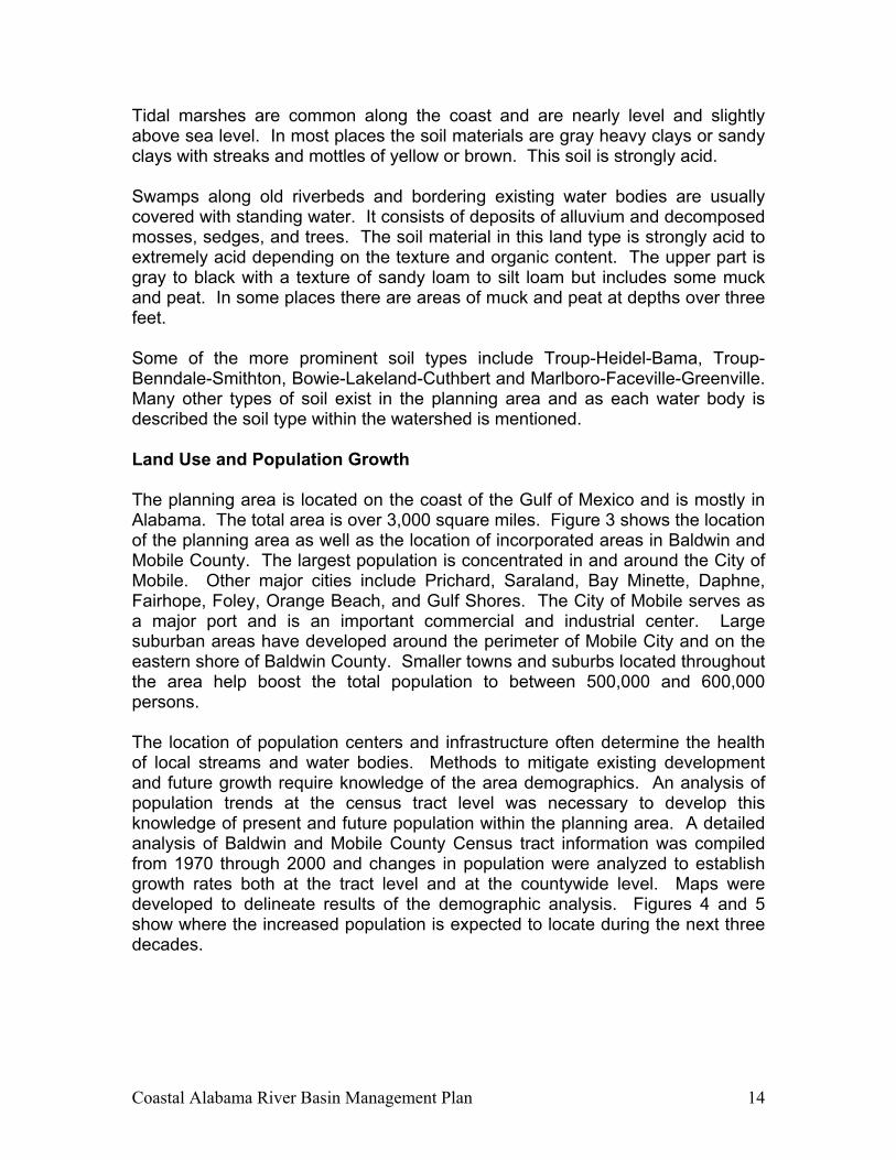
Tidal marshes are common along the coast and are nearly level and slightly above sea level. In most places the soil materials are gray heavy clays or sandy clays with streaks and mottles of yellow or brown. This soil is strongly acid. Swamps along old riverbeds and bordering existing water bodies are usually covered with standing water. It consists of deposits of alluvium and decomposed mosses, sedges, and trees. The soil material in this land type is strongly acid to extremely acid depending on the texture and organic content. The upper part is gray to black with a texture of sandy loam to silt loam but includes some muck and peat. In some places there are areas of muck and peat at depths over three feet. Some of the more prominent soil types include Troup-Heidel-Bama, Troup-Benndale-Smithton, Bowie-Lakeland-Cuthbert and Marlboro-Faceville-Greenville. Many other types of soil exist in the planning area and as each water body is described the soil type within the watershed is mentioned. Land Use and Population Growth The planning area is located on the coast of the Gulf of Mexico and is mostly in Alabama. The total area is over 3,000 square miles. Figure 3 shows the location of the planning area as well as the location of incorporated areas in Baldwin and Mobile County. The largest population is concentrated in and around the City of Mobile. Other major cities include Prichard, Saraland, Bay Minette, Daphne, Fairhope, Foley, Orange Beach, and Gulf Shores. The City of Mobile serves as a major port and is an important commercial and industrial center. Large suburban areas have developed around the perimeter of Mobile City and on the eastern shore of Baldwin County. Smaller towns and suburbs located throughout the area help boost the total population to between 500,000 and 600,000 persons. The location of population centers and infrastructure often determine the health of local streams and water bodies. Methods to mitigate existing development and future growth require knowledge of the area demographics. An analysis of population trends at the census tract level was necessary to develop this knowledge of present and future population within the planning area. A detailed analysis of Baldwin and Mobile County Census tract information was compiled from 1970 through 2000 and changes in population were analyzed to establish growth rates both at the tract level and at the countywide level. Maps were developed to delineate results of the demographic analysis. Figures 4 and 5 show where the increased population is expected to locate during the next three decades.
Coastal Alabama River Basin Management Plan 15
Figure 4.

Coastal Alabama River Basin Management Plan 16
Figure 5.
Coastal Alabama River Basin Management Plan 17
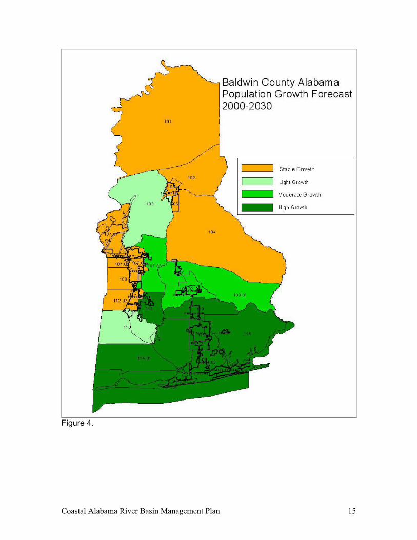
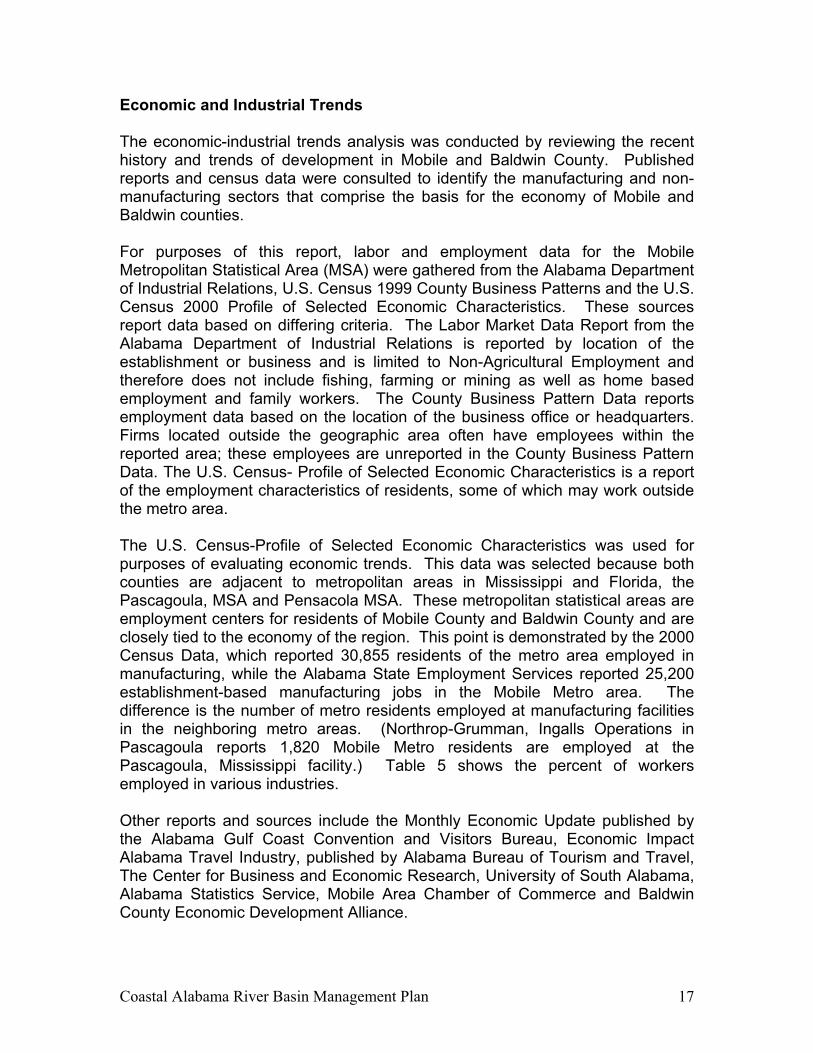
Economic and Industrial Trends The economic-industrial trends analysis was conducted by reviewing the recent history and trends of development in Mobile and Baldwin County. Published reports and census data were consulted to identify the manufacturing and non-manufacturing sectors that comprise the basis for the economy of Mobile and Baldwin counties. For purposes of this report, labor and employment data for the Mobile Metropolitan Statistical Area (MSA) were gathered from the Alabama Department of Industrial Relations, U.S. Census 1999 County Business Patterns and the U.S. Census 2000 Profile of Selected Economic Characteristics. These sources report data based on differing criteria. The Labor Market Data Report from the Alabama Department of Industrial Relations is reported by location of the establishment or business and is limited to Non-Agricultural Employment and therefore does not include fishing, farming or mining as well as home based employment and family workers. The County Business Pattern Data reports employment data based on the location of the business office or headquarters. Firms located outside the geographic area often have employees within the reported area; these employees are unreported in the County Business Pattern Data. The U.S. Census- Profile of Selected Economic Characteristics is a report of the employment characteristics of residents, some of which may work outside the metro area. The U.S. Census-Profile of Selected Economic Characteristics was used for purposes of evaluating economic trends. This data was selected because both counties are adjacent to metropolitan areas in Mississippi and Florida, the Pascagoula, MSA and Pensacola MSA. These metropolitan statistical areas are employment centers for residents of Mobile County and Baldwin County and are closely tied to the economy of the region. This point is demonstrated by the 2000 Census Data, which reported 30,855 residents of the metro area employed in manufacturing, while the Alabama State Employment Services reported 25,200 establishment-based manufacturing jobs in the Mobile Metro area. The difference is the number of metro residents employed at manufacturing facilities in the neighboring metro areas. (Northrop-Grumman, Ingalls Operations in Pascagoula reports 1,820 Mobile Metro residents are employed at the Pascagoula, Mississippi facility.) Table 5 shows the percent of workers employed in various industries. Other reports and sources include the Monthly Economic Update published by the Alabama Gulf Coast Convention and Visitors Bureau, Economic Impact Alabama Travel Industry, published by Alabama Bureau of Tourism and Travel, The Center for Business and Economic Research, University of South Alabama, Alabama Statistics Service, Mobile Area Chamber of Commerce and Baldwin County Economic Development Alliance.
Coastal Alabama River Basin Management Plan 18
U. S. Census Profile of Selected Economic Characteristics 2000
Mobile MSA (Mobile County and Baldwin County) Industry Percentage Employed
Agriculture, forestry, fishing and hunting and mining
1.1
Construction 9.2Manufacturing 13.2Wholesale Trade 3.0Retail 13.2Transportation and warehousing, and utilities 4.5Information 2.8Finance, Real Estate and rental and leasing 6.9Professional, scientific, management, administrative and waste management services
7.6
Educational, health and social services 21.6Arts, entertainment, recreation, accommodation and food services
7.0
Other services (except public administration 5.3Public administration 4.0Table 5.
Coastal Alabama River Basin Management Plan 19
Development Outlook The development outlook is broken down by the employment sectors utilized by the Department of Labor.
Manufacturing Transportation and Warehousing and Utilities Mobile County and Baldwin County have followed recent national trends with regard to manufacturing. Several major employers in the paper industry have closed in recent years. Jobs have also been lost in the garment industry. However, the area has seen growth in the aerospace industry and other smaller technology firms. Recent concerns over air emission issues and new Federal guidelines for ozone levels may limit the number of new companies and expansion of companies with air emission considerations. An analysis of local and national trends suggests that the next two to three decades should see moderate growth in the manufacturing sector as a whole. Most of the growth is likely to come from small to medium size companies, many of which will be considered light industry. Economic development groups are presently targeting these companies for recruitment. There are also programs underway to promote new business development through business incubators. Plant closings in the paper industry are expected to reduce the volume of surface and ground water extracted and the volumes of permitted wastewater discharges. Acordis Cellulosic Fibers, a wood fiber processing plant has recently closed. It was reported that the company had been using 8-10 million gallons per day from groundwater wells for processing. There is a significant potential for growth based on improvements to the Port of Mobile and increased trade with Central and South America. The Alabama legislature recently approved a $300 million capital improvement program for the Port. The program underway will improve facilities and equip the Port of Mobile to become a major container port on the Gulf of Mexico. Improvements to the Port of Mobile will be the catalyst for new business and further development of Port related business. The trend in shipping is toward more containerized cargo. The Port of Mobile offers good highway and rail access and the option of inland water transportation via the Inter-coastal and Tombigbee Waterway System. Given trends in shipping, the new facilities and an aggressive marketing effort the Port of Mobile will be a major economic asset to the community. Transportation advantages and opportunities for warehouse and distribution are present throughout coastal Alabama. Both the Mobile Area Chamber of Commerce and the Baldwin County Economic Development Alliance have targeted warehousing and distribution in their recruitment efforts. This targeted
Coastal Alabama River Basin Management Plan 20
marketing has resulted in the location of several major distribution facilities in recent years. Continued growth of these sectors is likely. Increasingly, companies are seeking distribution sites to service the growing markets of the Gulf South. Mobile and Baldwin are located equal distance from major population centers in Florida and Texas and the strategic location of Interstates 10 and 65, rail and port facilities will enhance development opportunities. Expected areas of growth: Port activity, warehouse and distribution, light industrial and back office operations are not large water users.
Retail, Wholesale Arts, Entertainment, Accommodation and Food services
Other services These industry groups are significantly impacted by tourism as well as the general health of the local economy. The Alabama Bureau of Tourism and Travel reports that 2001 tourism related expenditures in Baldwin County at $1.5 billion and $530 million for Mobile County. Tourism officials report that nationally, there has been a decline in tourism over the past three years due to changes in the national economy. However, the decline has been less dramatic in Baldwin County. State tourism reports a 6.7% decline in tourism nationally, while Alabama experienced a modest 1% increase. The outlook for tourism and retirement related business is outstanding. To date, the major attraction for visitors to the area were the beaches, golf, shopping, and cultural events. The Convention and Visitors Bureaus (CVB) in both counties are aggressively promoting new markets and events that will fill rooms during periods that have been historically slow. Each has had major successes with promoting major sporting events, cultural exhibits, and golf packages. Indications are that the golf industry will continue to grow in the area, Alabama has received international attention for the development of the Robert Trent Jones Golf Trail. The Trail has brought thousands of golfers and significant media attention to the state. Golfers coming to the area to play the Trail and the other championship courses in Baldwin County have contributed to the increased number of visitors. Golfers have been instrumental in extending the tourist season beyond the traditional spring and summer. Golf has been an interesting phenomenon because it has brought visitors that would not have otherwise visited the area. The golfers frequently make return trips, often bringing other family members. Golf has been a mechanism to attract development to the area. Local industry experts predict that the number of area golf courses will double in the next 10- 15 years. This projection is reasonable, given the success of golf packages, the commitment from local CVB and the State of Alabama Division of Tourism and Travel. A relative new tourism segment, eco-Tourism, has the potential to greatly expand the number of visitors to the area. The Alabama Coastal Birding Trail is
Coastal Alabama River Basin Management Plan 21
attracting thousands of bird enthusiasts. Programs are underway to promote the Mobile–Tensaw River Delta for eco-tourism. Nationally, eco-tourism is one of the fastest growing segments of the tourism market. Development of resort properties and condominiums has occurred at double-digit rates in recent years. Over 3,500 condominium units have been built in Baldwin County since 1997, a 42% increase over 5 years. Tourism officials expect growth to continue, but at a slower pace than the most recent past. The Alabama Gulf Coast Convention and Visitors Bureau monitors the new accommodations projects announced or under construction. The projects announced are scheduled for completion before 2005. When pending projects are completed, the inventory of available units (hotel or condominiums) will be increased by 12%. Construction and development of single-family properties for second homes and the rental market is also expected to continue. Real estate executives note a trend of water front single-family units that were previously used as rentals are being acquired and taken out of the rental programs. Two major tourism projects will likely have long term positive impact on the region. Work has begun on a $79 million renovation and expansion of the Gulf State Park Hotel. The project will upgrade the property to a world-class resort and add a convention center. The Marriott Grand Hotel in Point Clear has recently completed a $35 million dollar expansion that added 130 guest rooms, a 26,000-square-foot European spa, and a new pool complex. Baldwin County has established a reputation as a retirement community. The area has been named by the publication “Retirement Places Rated” as one of the top retirement areas in the country. Census data reflect that the over-65 age group has grown by 45.8% in Baldwin County and 7.3% in Mobile County between the years of 1990 and 2000. As previously discussed, tourism is a significant economic sector in the area economy. Nationally there has been a trend for tourism areas to evolve as retirement destinations. People visit a community and have a positive experience, then choose the area as a retirement destination. Nationally, one can review the evolution South Florida, Arizona and Las Vegas to confirm this pattern. Each of these areas was a popular vacation destination first, then later evolved into a retirement community. It is natural to assume that this trend will be duplicated in Baldwin County. More and more active retirees are selecting small towns with a high quality of life for retirement destination. An additional incentive for continued growth of the retirement industry in Alabama is the relative low cost of living. Taxes in Alabama rank among the lowest in the nation. Housing costs are low when compared to national averages. Retail sales in the area are greatly enhanced by the Riviera Center in Foley. For the past three years the center has exceeded sales of $400 million. The Riviera Center is a tourism destination as well as retail facility. Employment in retail sales will grow in response to the overall economic expansion that will occur in
Coastal Alabama River Basin Management Plan 22
the two county area. Additional growth in retail will be in specific response and relationship to the expanding tourism industry.
Agriculture, Forestry, Fishing, Hunting and Mining In Baldwin County and in Mobile County, there is a presence of the seafood industry, including shrimping, fishing and oystering. Employment figures in the category of agriculture and fishing appear to be low. These figures (1.1%) refer to jobs in “harvesting” and not the processing of seafood. Seafood processing provides a number of jobs in this area. Further processing or packaging of seafood is considered manufacturing and is reported with that category. Seafood is an important, if somewhat small, part of the local economy. Nationally, there has been a trend of decline in the seafood industry. The decline can be attributed to increased competition from foreign interest, over-harvesting of some species and increased pressure from environmental interest. Over the next two decades there will likely be a continued slow decline in the seafood industry. Environmental pressures and pressure to develop the coastline could further reduce the number of traditional seafood processors. The abundance of fertile land and the increased number of acres devoted to high yield crops such as sod will ensure that agriculture will continue to play an important role in the area economy. The farmland remaining under cultivation will likely use more irrigation. Sod farms, nursery products and vegetables are high yield crops that may require intensive irrigation. There will be some pressure to convert farmland to residential development. This pressure may further reduce the amount of farm employment.
Information Professional, Scientific, Management, Administrative and Waste Management
The targeted industry marketing programs of the Mobile Area Chamber and Baldwin County Economic Development Alliance will likely expand employment in these sectors. Attraction programs are underway to recruit back-office, light industry and technology firms. It was noted by several of those interviewed that the area, particularly Baldwin County, had experienced growth in these sectors due to a national trend in business and communications. Increasingly, businesses are not tied to a single location. Computers, phones and fax allow many businesses to locate where the owner wants to live. The close proximity to the beach, recreation opportunities and quality of life are causing people to move into the area.
Construction
Finance, Real Estate and Rental and Leasing
Coastal Alabama River Basin Management Plan 23
Growth in the economy as a whole will increase employment in these sectors. Individuals interviewed agreed that tourism and the retirement industry might be cause for significant activity in these sectors. Growth and development at the Port, in manufacturing and other activities will also spur growth. It is likely that the construction of the new RSA office tower in downtown Mobile would be a catalyst for redevelopment of Downtown. Much of the new development will likely occur on the second tier of land, inland from the beaches. This is a pattern identified in similar resort communities. National events have caused security to become more of an issue. Therefore, more people are choosing to live in small towns where there is a perception of safety. The small towns and rural areas of Baldwin County and Mobile County offer the small town “feel” with all the amenities of a metro area only minutes away in the City of Mobile and neighboring Pensacola, Florida. Area Chambers report new members that fit this profile.
Educational, Health and Social Services Public Administration
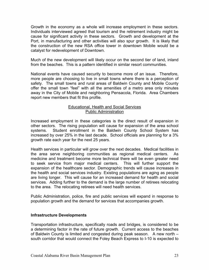
Increased employment in these categories is the direct result of expansion in other sectors. The rising population will cause for expansion of the area school systems. Student enrollment in the Baldwin County School System has increased by over 25% in the last decade. School officials are planning for a 3% growth rate each year for the next 25 years. Health services in particular will grow over the next decades. Medical facilities in the area serve neighboring communities as regional medical centers. As medicine and treatment become more technical there will be even greater need to seek service from major medical centers. This will further support the expansion of the healthcare sector. Demographic trends will cause increases in the health and social services industry. Existing populations are aging as people are living longer. This will cause for an increased demand for health and social services. Adding further to the demand is the large number of retirees relocating to the area. The relocating retirees will need health services. Public Administration, police, fire and public services will expand in response to population growth and the demand for services that accompanies growth. Infrastructure Developments Transportation infrastructure, specifically roads and bridges, is considered to be a determining factor in the rate of future growth. Current access to the beaches of Baldwin County is limited and congested during peak season. A new north – south corridor that would connect the Foley Beach Express to I-10 is expected to
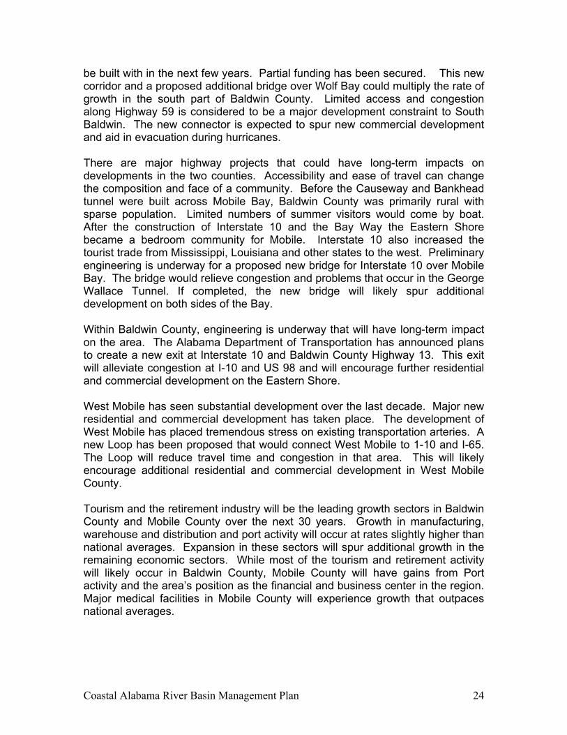
Coastal Alabama River Basin Management Plan 24
be built with in the next few years. Partial funding has been secured. This new corridor and a proposed additional bridge over Wolf Bay could multiply the rate of growth in the south part of Baldwin County. Limited access and congestion along Highway 59 is considered to be a major development constraint to South Baldwin. The new connector is expected to spur new commercial development and aid in evacuation during hurricanes. There are major highway projects that could have long-term impacts on developments in the two counties. Accessibility and ease of travel can change the composition and face of a community. Before the Causeway and Bankhead tunnel were built across Mobile Bay, Baldwin County was primarily rural with sparse population. Limited numbers of summer visitors would come by boat. After the construction of Interstate 10 and the Bay Way the Eastern Shore became a bedroom community for Mobile. Interstate 10 also increased the tourist trade from Mississippi, Louisiana and other states to the west. Preliminary engineering is underway for a proposed new bridge for Interstate 10 over Mobile Bay. The bridge would relieve congestion and problems that occur in the George Wallace Tunnel. If completed, the new bridge will likely spur additional development on both sides of the Bay. Within Baldwin County, engineering is underway that will have long-term impact on the area. The Alabama Department of Transportation has announced plans to create a new exit at Interstate 10 and Baldwin County Highway 13. This exit will alleviate congestion at I-10 and US 98 and will encourage further residential and commercial development on the Eastern Shore. West Mobile has seen substantial development over the last decade. Major new residential and commercial development has taken place. The development of West Mobile has placed tremendous stress on existing transportation arteries. A new Loop has been proposed that would connect West Mobile to 1-10 and I-65. The Loop will reduce travel time and congestion in that area. This will likely encourage additional residential and commercial development in West Mobile County. Tourism and the retirement industry will be the leading growth sectors in Baldwin County and Mobile County over the next 30 years. Growth in manufacturing, warehouse and distribution and port activity will occur at rates slightly higher than national averages. Expansion in these sectors will spur additional growth in the remaining economic sectors. While most of the tourism and retirement activity will likely occur in Baldwin County, Mobile County will have gains from Port activity and the area’s position as the financial and business center in the region. Major medical facilities in Mobile County will experience growth that outpaces national averages.

Coastal Alabama River Basin Management Plan 25
DESCRIPTION OF COASTAL ALABAMA IMPAIRED WATERS The following section focuses on the coastal Alabama waters included in the State of Alabama 2002 303(d) list. Along with the information included in the 2002 303(d) listing and map of the segment or waterway, potential pollutant sources are identified and the general land use is described. The impaired stream segments are grouped by county and the impaired waterbodies are grouped by hydrologic order. The 2002 §303(d) report (Table) for each segment is included with the description. The description of Potential Pollutant Sources will include the sources reported in the 303(d) list as well as others that have been identified as a result of this study and field work by the Coastal Alabama Clean Water Partnership. Note: All listings for mercury are based on fish tissue samples not water column samples. Gulf of Mexico Description of Potential Pollutant Sources: While the Gulf of Mexico is included on the 303(d) list for Mercury contamination and the cause is listed as unknown, the waters of the Gulf of Mexico are vulnerable to contamination from numerous sources upstream and from nonpoint source pollution resulting from high density land use directly along the coast. Another possible source is atmospheric deposition. General Land use: Development along the shores of the Gulf of Mexico in Baldwin County is primarily high density multi-unit residential with commercial development associated with a major tourist destination area. Development along Dauphin Island in Mobile County is less dense consisting of primarily single unit residential development and light commercial and industrial uses.
Waterbody ID Waterbody Name Support Status Rank River Basin County Uses Causes Sources Date of
Data Size Downstream/Upstream
Locations
1996 303 (d) ?
TMDL Date
AL/Gulf of Mexico_01
Gulf of Mexico Non L Mobile Mobile Shellfish Harvesting Swimming Fish & Wildlife
Mercury Unknown source 1996-97 238 mi2 Mississippi/ Florida No 2005
Table 6.
Coastal Alabama River Basin Management Plan 26
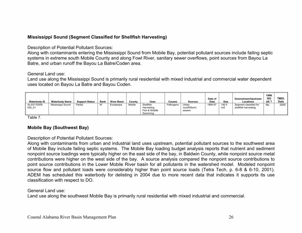
Mississippi Sound (Segment Classified for Shellfish Harvesting) Description of Potential Pollutant Sources: Along with contaminants entering the Mississippi Sound from Mobile Bay, potential pollutant sources include failing septic systems in extreme south Mobile County and along Fowl River, sanitary sewer overflows, point sources from Bayou La Batre, and urban runoff the Bayou La Batre/Coden area. General Land use: Land use along the Mississippi Sound is primarily rural residential with mixed industrial and commercial water dependent uses located on Bayou La Batre and Bayou Coden.
Waterbody ID Waterbody Name Support Status Rank River Basin County Uses Causes Sources Date of
Data Size Downstream/Upstream
Locations
1996 303 (d) ?
TMDL Date
AL/03170009-030_01
Mississippi Sound Partial M Escatawpa Mobile Shellfish Harvesting Fish & Wildlife Swimming
Pathogens Urban runoff/Storm sewers
1994-97 146.5 mi2
Segment classified for shellfish harvesting
No 2005
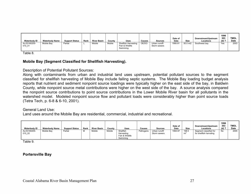
Table 7. Mobile Bay (Southwest Bay) Description of Potential Pollutant Sources: Along with contaminants from urban and industrial land uses upstream, potential pollutant sources to the southwest area of Mobile Bay include failing septic systems. The Mobile Bay loading budget analysis reports that nutrient and sediment nonpoint source loadings were typically higher on the east side of the bay, in Baldwin County, while nonpoint source metal contributions were higher on the west side of the bay. A source analysis compared the nonpoint source contributions to point source contributions in the Lower Mobile River basin for all pollutants in the watershed model. Modeled nonpoint source flow and pollutant loads were considerably higher than point source loads (Tetra Tech, p. 6-8 & 6-10, 2001). ADEM has scheduled this waterbody for delisting in 2004 due to more recent data that indicates it supports its use classification with respect to DO. General Land use: Land use along the southwest Mobile Bay is primarily rural residential with mixed industrial and commercial.
Coastal Alabama River Basin Management Plan 27
Waterbody ID Waterbody Name Support Status Rank River Basin County Uses Causes Sources Date of
Data Size Downstream/Upstream
Locations
1996 303 (d) ?
TMDL Date
AL/03160205-010_01
Mobile Bay Partial L Mobile Mobile Shellfish Harvesting Fish & Wildlife Swimming
OE/DO Urban runoff/ Storm sewers
1990-91 50.0 mi2 Southwest bay Yes 2003
Table 8. Mobile Bay (Segment Classified for Shellfish Harvesting). Description of Potential Pollutant Sources: Along with contaminants from urban and industrial land uses upstream, potential pollutant sources to the segment classified for shellfish harvesting of Mobile Bay include failing septic systems. The Mobile Bay loading budget analysis reports that nutrient and sediment nonpoint source loadings were typically higher on the east side of the bay, in Baldwin County, while nonpoint source metal contributions were higher on the west side of the bay. A source analysis compared the nonpoint source contributions to point source contributions in the Lower Mobile River basin for all pollutants in the watershed model. Modeled nonpoint source flow and pollutant loads were considerably higher than point source loads (Tetra Tech, p. 6-8 & 6-10, 2001). General Land Use: Land uses around the Mobile Bay are residential, commercial, industrial and recreational.
Waterbody ID Waterbody Name Support Status Rank River Basin County Uses Causes Sources Date of
Data Size Downstream/Upstream
Locations
1996 303 (d) ?
TMDL Date
AL/03160205-010_02
Mobile Bay Partial M Mobile Mobile Shellfish Harvesting Fish & Wildlife Swimming
Pathogens Urban runoff/ Storm sewers
1994-97 198.5 mi2
Segment classified for for shellfish harvsting
No 2005
Table 9. Portersville Bay
Coastal Alabama River Basin Management Plan 28
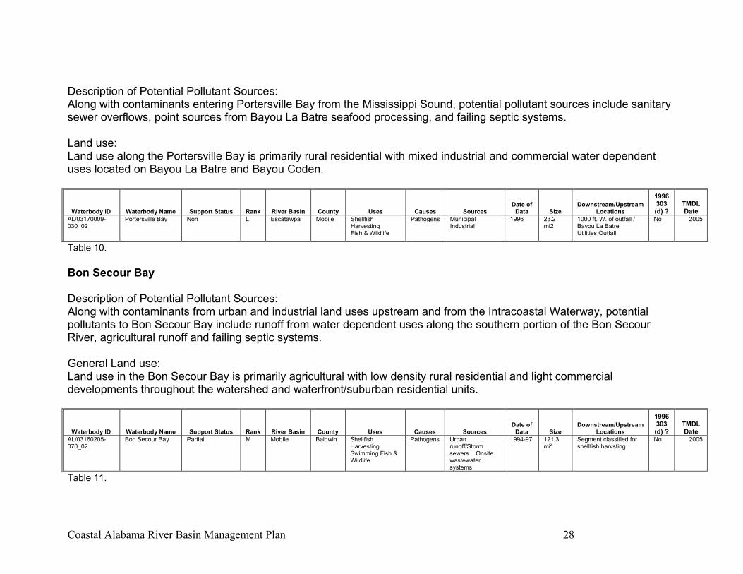
Description of Potential Pollutant Sources: Along with contaminants entering Portersville Bay from the Mississippi Sound, potential pollutant sources include sanitary sewer overflows, point sources from Bayou La Batre seafood processing, and failing septic systems. Land use: Land use along the Portersville Bay is primarily rural residential with mixed industrial and commercial water dependent uses located on Bayou La Batre and Bayou Coden.
Waterbody ID Waterbody Name Support Status Rank River Basin County Uses Causes Sources Date of
Data Size Downstream/Upstream
Locations
1996 303 (d) ?
TMDL Date
AL/03170009-030_02
Portersville Bay Non L Escatawpa Mobile Shellfish Harvesting Fish & Wildlife
Pathogens Municipal Industrial
1996 23.2 mi2
1000 ft. W. of outfall / Bayou La Batre Utilities Outfall
No 2005
Table 10. Bon Secour Bay Description of Potential Pollutant Sources: Along with contaminants from urban and industrial land uses upstream and from the Intracoastal Waterway, potential pollutants to Bon Secour Bay include runoff from water dependent uses along the southern portion of the Bon Secour River, agricultural runoff and failing septic systems. General Land use: Land use in the Bon Secour Bay is primarily agricultural with low density rural residential and light commercial developments throughout the watershed and waterfront/suburban residential units.
Waterbody ID Waterbody Name Support Status Rank River Basin County Uses Causes Sources Date of
Data Size Downstream/Upstream
Locations
1996 303 (d) ?
TMDL Date
AL/03160205-070_02
Bon Secour Bay Partial M Mobile Baldwin Shellfish Harvesting Swimming Fish & Wildlife
Pathogens Urban runoff/Storm sewers Onsite wastewater systems
1994-97 121.3 mi2
Segment classified for shellfish harvsting
No 2005
Table 11.
Coastal Alabama River Basin Management Plan 29
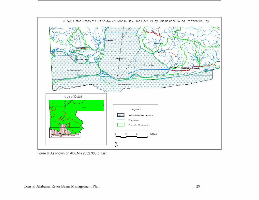
Figure 6. As shown on ADEM’s 2002 303(d) List.

Coastal Alabama River Basin Management Plan 30
Mobile County Three of the 303(d) listed streams in the Escatawpa River watershed are located in the Upper Big Creek Subwatershed and drain into J. B. Converse Lake, the drinking water supply for the Mobile Area. The following information is paraphrased from the “Assessment of Water-Quality Conditions in J. B. Converse Lake Watershed” by the United States Geologic Survey. Juniper Creek Description of Potential Pollutant Sources: Potential sources of pollutants include nonpoint source runoff from agriculture and grazing activities and failing septic tanks. General Land use: Land use in this watershed is primarily agricultural and low density residential.
Waterbody ID Waterbody Name Support Status Rank River Basin County Uses Causes Sources Date of
Data Size Downstream/Upstream
Locations
1996 303 (d) ?
TMDL Date
AL/03170008-090_03
Juniper Creek Non H Escatawpa Mobile Fish & Widlife Pathogens Pasture Grazing 1996-99 6.6 miles
Big Creek Lake/ Its Source
No 2002
Table 12.
Coastal Alabama River Basin Management Plan 31
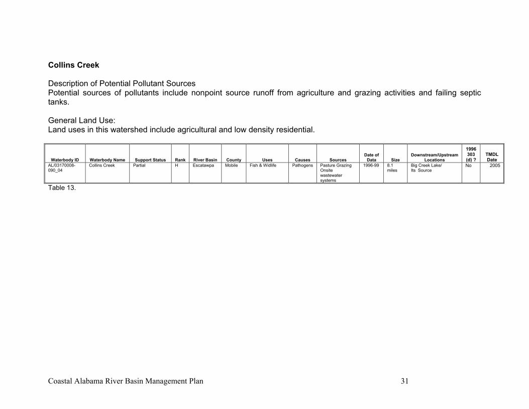
Collins Creek Description of Potential Pollutant Sources Potential sources of pollutants include nonpoint source runoff from agriculture and grazing activities and failing septic tanks. General Land Use: Land uses in this watershed include agricultural and low density residential.
Waterbody ID Waterbody Name Support Status Rank River Basin County Uses Causes Sources Date of
Data Size Downstream/Upstream
Locations
1996 303 (d) ?
TMDL Date
AL/03170008-090_04
Collins Creek Partial H Escatawpa Mobile Fish & Widlife Pathogens Pasture Grazing Onsite wastewater systems
1996-99 8.1 miles
Big Creek Lake/ Its Source
No 2005
Table 13.
Coastal Alabama River Basin Management Plan 32
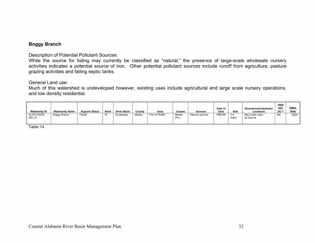
Boggy Branch Description of Potential Pollutant Sources: While the source for listing may currently be classified as “natural,” the presence of large-scale wholesale nursery activities indicates a potential source of iron. Other potential pollutant sources include runoff from agriculture, pasture grazing activities and failing septic tanks. General Land use: Much of this watershed is undeveloped however, existing uses include agricultural and large scale nursery operations, and low density residential.
Waterbody ID Waterbody Name Support Status Rank River Basin County Uses Causes Sources Date of
Data Size Downstream/Upstream
Locations
1996 303 (d) ?
TMDL Date
AL/03170008-090_01
Boggy Branch Partial M Escatawpa Mobile Fish & Widlife Metals (Fe)
Natural sources 1996-99 3.6 miles
Big Creek Lake/ Its Source
No 2005
Table 14.
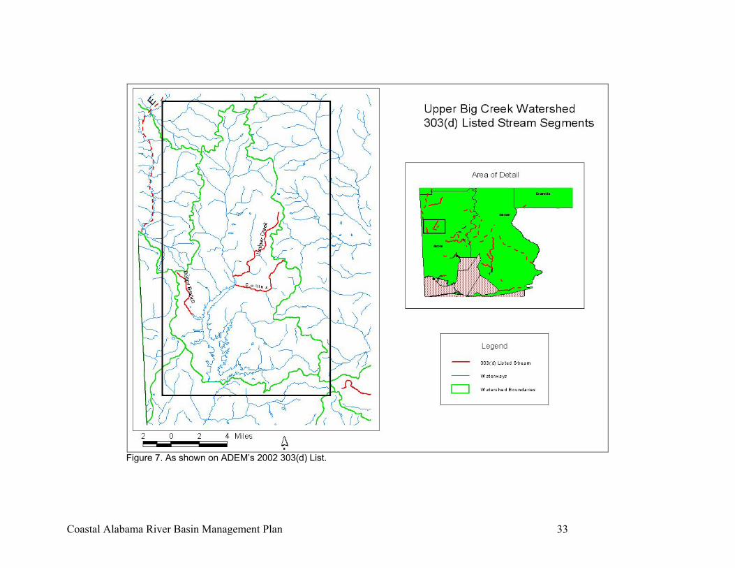
Coastal Alabama River Basin Management Plan 33
Figure 7. As shown on ADEM’s 2002 303(d) List.
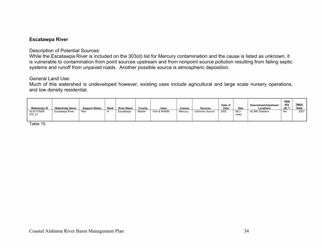
Coastal Alabama River Basin Management Plan 34
Escatawpa River Description of Potential Sources: While the Escatawpa River is included on the 303(d) list for Mercury contamination and the cause is listed as unknown, it is vulnerable to contamination from point sources upstream and from nonpoint source pollution resulting from failing septic systems and runoff from unpaved roads. Another possible source is atmospheric deposition. General Land Use: Much of this watershed is undeveloped however, existing uses include agricultural and large scale nursery operations, and low density residential.
Waterbody ID Waterbody Name Support Status Rank River Basin County Uses Causes Sources Date of
Data Size Downstream/Upstream
Locations
1996 303 (d) ?
TMDL Date
AL03170008-070_01
Escatawpa River Non H Escatawpa Mobile Fish & Wildlife Mercury Unknown Source 2002 68.3 miles
AL/MS Stateline No 2007
Table 15.
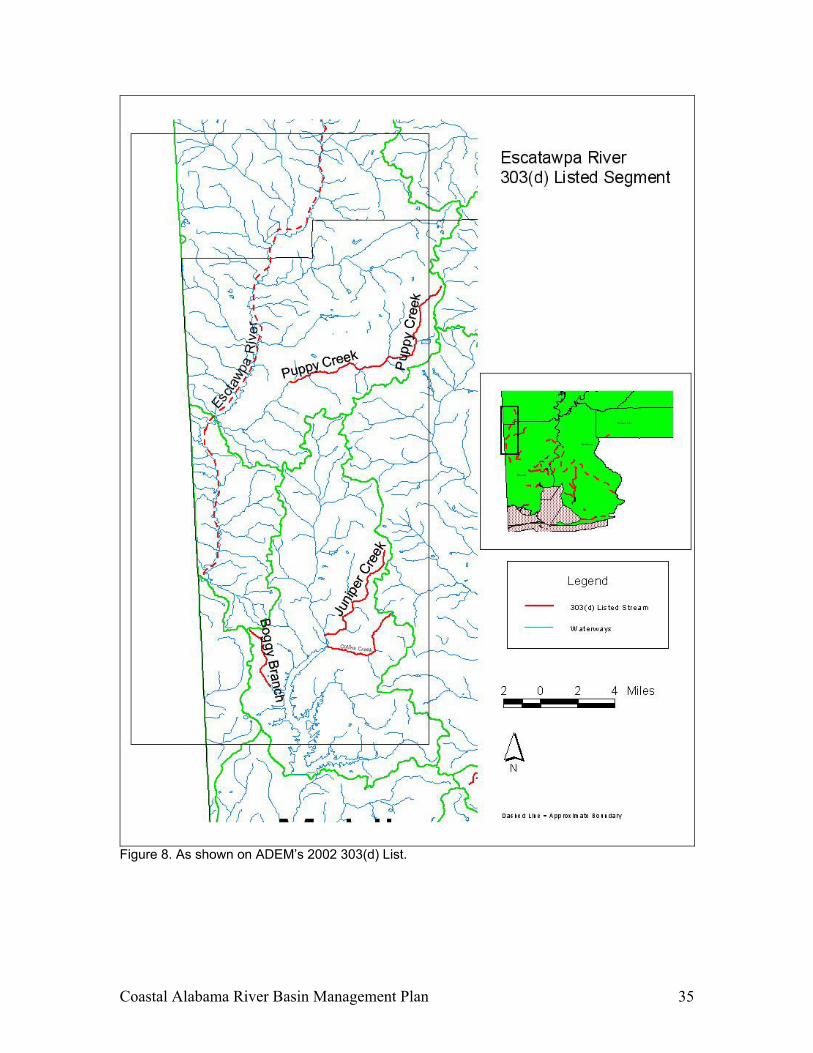
Coastal Alabama River Basin Management Plan 35
Figure 8. As shown on ADEM’s 2002 303(d) List.

Coastal Alabama River Basin Management Plan 36
Puppy Creek Description of Potential Pollutant Sources: The CACWP Technical Committee took a field trip to Puppy Creek to identify potential sources. The Committee noticed a strong sewage odor in the creek water. A representative from the wastewater treatment facility reported that the sewer lines flow through the creek. This lift station is the main lift station; it collects all sewage from the City of Citronelle and pumps it to the wastewater treatment plant just downstream. The sewer system (approx. 850 customers) services the older portion of the city, with newer developing areas on septic systems. The 10-12 in. sewer lines are unlined terra cotta from the 1950s and 1960s. General Land use: The upper portion of the watershed consists of low density urban/suburban area of the City of Citronelle. The remainder of the watershed is low density rural with predominantly agricultural and silvicultural land uses.
Waterbody ID Waterbody Name Support Status Rank River Basin County Uses Causes Sources Date of
Data Size Downstream/Upstream
Locations
1996 303 (d) ?
TMDL Date
AL/03170008-030_01
Puppy Creek Non L Escatawpa Mobile Fish & Widlife Pathogens Nutrients
Urban runooff/Storm sewers
1991 10.0 miles
AL Hwy 217/ Its Source
Yes 2003
Table 16.

Coastal Alabama River Basin Management Plan 37
Figure 9. As shown on ADEM’s 2002 303(d) List.
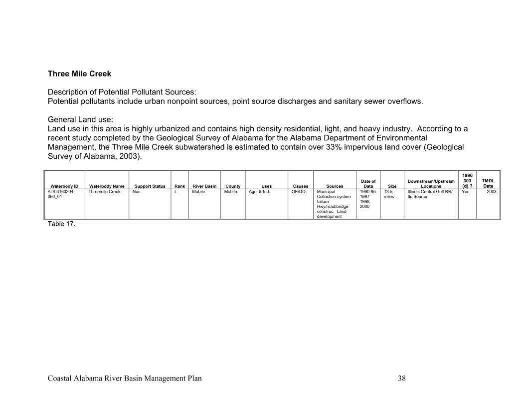
Coastal Alabama River Basin Management Plan 38
Three Mile Creek Description of Potential Pollutant Sources: Potential pollutants include urban nonpoint sources, point source discharges and sanitary sewer overflows. General Land use: Land use in this area is highly urbanized and contains high density residential, light, and heavy industry. According to a recent study completed by the Geological Survey of Alabama for the Alabama Department of Environmental Management, the Three Mile Creek subwatershed is estimated to contain over 33% impervious land cover (Geological Survey of Alabama, 2003).
Waterbody ID Waterbody Name Support Status Rank River Basin County Uses Causes Sources Date of
Data Size Downstream/Upstream
Locations
1996 303 (d) ?
TMDL Date
AL/03160204-060_01
Threemile Creek Non L Mobile Mobile Agri. & Ind. OE/DO Municipal Collection system failure Hwy/road/bridge construc. Land development
1990-95 1997 1998 2000
13.5 miles
Illinois Central Gulf RR/ Its Source
Yes 2003
Table 17.
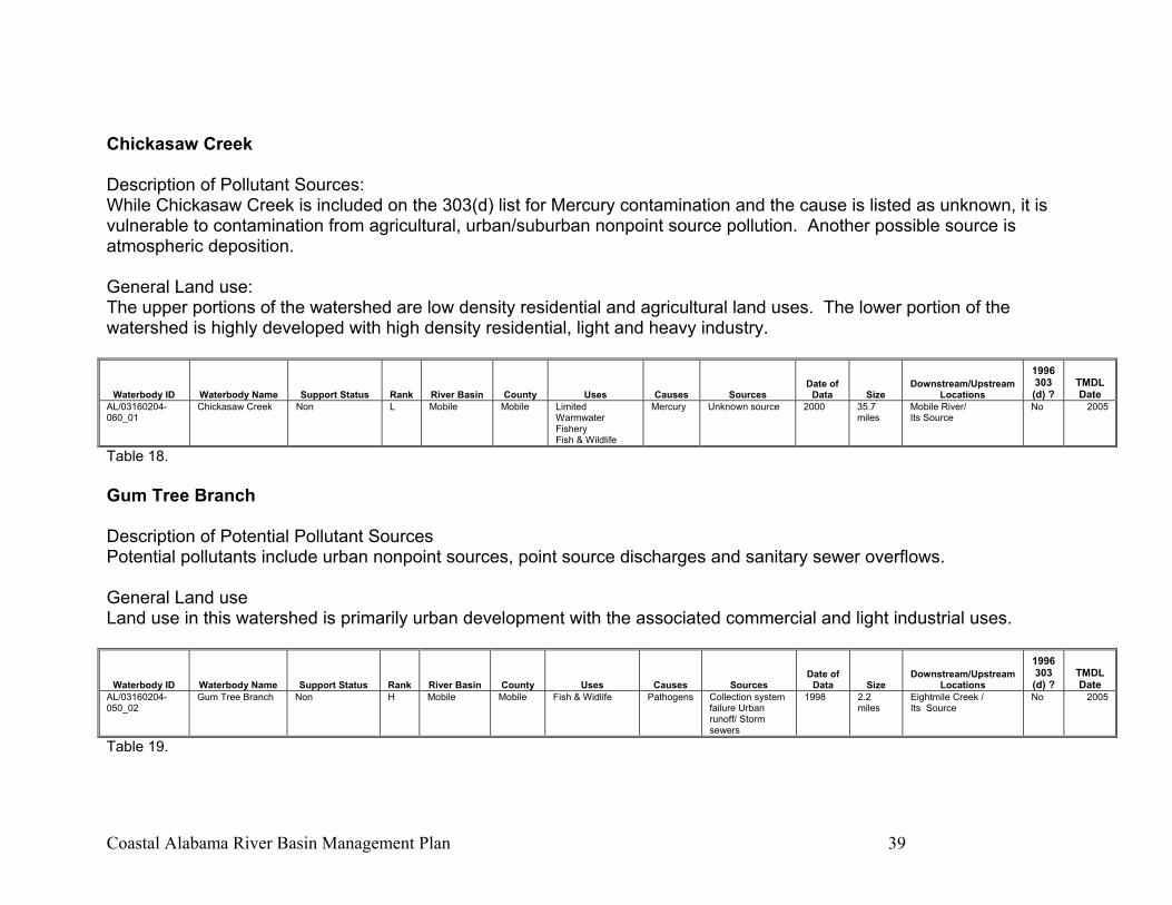
Coastal Alabama River Basin Management Plan 39
Chickasaw Creek Description of Pollutant Sources: While Chickasaw Creek is included on the 303(d) list for Mercury contamination and the cause is listed as unknown, it is vulnerable to contamination from agricultural, urban/suburban nonpoint source pollution. Another possible source is atmospheric deposition. General Land use: The upper portions of the watershed are low density residential and agricultural land uses. The lower portion of the watershed is highly developed with high density residential, light and heavy industry.
Waterbody ID Waterbody Name Support Status Rank River Basin County Uses Causes Sources Date of
Data Size Downstream/Upstream
Locations
1996 303 (d) ?
TMDL Date
AL/03160204-060_01
Chickasaw Creek Non L Mobile Mobile Limited Warmwater Fishery Fish & Wildlife
Mercury Unknown source 2000 35.7 miles
Mobile River/ Its Source
No 2005
Table 18. Gum Tree Branch Description of Potential Pollutant Sources Potential pollutants include urban nonpoint sources, point source discharges and sanitary sewer overflows. General Land use Land use in this watershed is primarily urban development with the associated commercial and light industrial uses.
Waterbody ID Waterbody Name Support Status Rank River Basin County Uses Causes Sources Date of
Data Size Downstream/Upstream
Locations
1996 303 (d) ?
TMDL Date
AL/03160204-050_02
Gum Tree Branch Non H Mobile Mobile Fish & Widlife Pathogens Collection system failure Urban runoff/ Storm sewers
1998 2.2 miles
Eightmile Creek / Its Source
No 2005
Table 19.
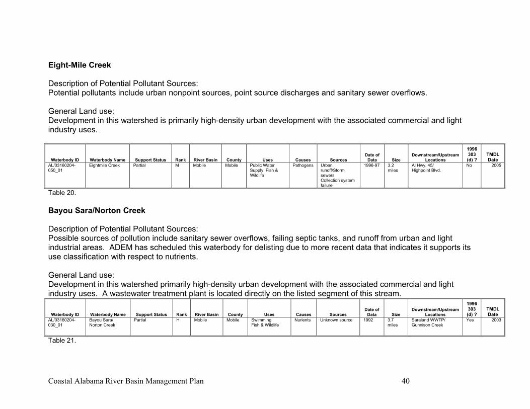
Coastal Alabama River Basin Management Plan 40
Eight-Mile Creek Description of Potential Pollutant Sources: Potential pollutants include urban nonpoint sources, point source discharges and sanitary sewer overflows. General Land use: Development in this watershed is primarily high-density urban development with the associated commercial and light industry uses.
Waterbody ID Waterbody Name Support Status Rank River Basin County Uses Causes Sources Date of
Data Size Downstream/Upstream
Locations
1996 303 (d) ?
TMDL Date
AL/03160204-050_01
Eightmile Creek Partial M Mobile Mobile Public Water Supply Fish & Wildlife
Pathogens Urban runoff/Storm sewers Collection system failure
1996-97 3.2 miles
Al Hwy. 45/ Highpoint Blvd.
No 2005
Table 20. Bayou Sara/Norton Creek Description of Potential Pollutant Sources: Possible sources of pollution include sanitary sewer overflows, failing septic tanks, and runoff from urban and light industrial areas. ADEM has scheduled this waterbody for delisting due to more recent data that indicates it supports its use classification with respect to nutrients. General Land use: Development in this watershed primarily high-density urban development with the associated commercial and light industry uses. A wastewater treatment plant is located directly on the listed segment of this stream.
Waterbody ID Waterbody Name Support Status Rank River Basin County Uses Causes Sources Date of
Data Size Downstream/Upstream
Locations
1996 303 (d) ?
TMDL Date
AL/03160204-030_01
Bayou Sara/ Norton Creek
Partial H Mobile Mobile Swimming Fish & Wildlife
Nurients Unknown source 1992 3.7 miles
Saraland WWTP/ Gunnison Creek
Yes 2003
Table 21.
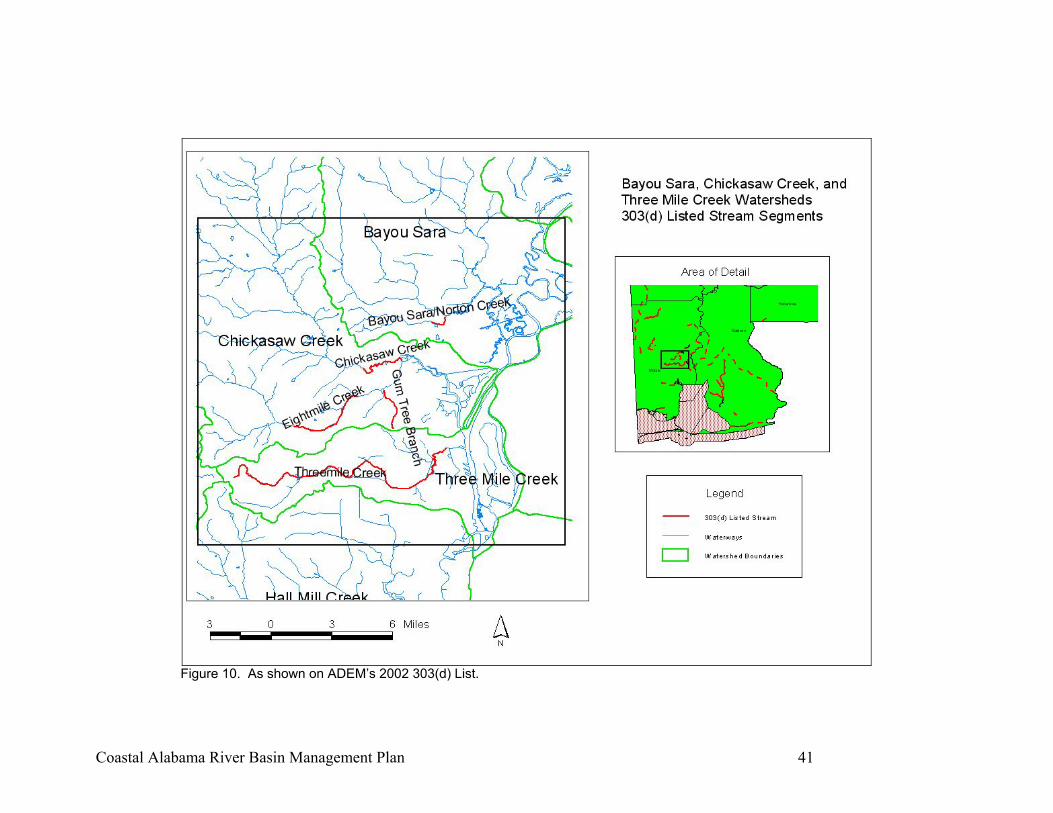
Coastal Alabama River Basin Management Plan 41
Figure 10. As shown on ADEM’s 2002 303(d) List.

Coastal Alabama River Basin Management Plan 42
Cold Creek Swamp Description of Potential Pollutant Sources: Processes operated on this site produced the following contaminants: carbon disulfide, sulfuric acid, carbon tetrachloride, caustic/chlorine, Crystex (a sulfur compound), thiocarbamates and various metals including mercury. Wastewaters from these processes were held in clay-lined lagoons and discharged to the Cold Creek Swamp until approximately 1975 (www.epa.gov). Cold Creek Swamp will be structured by ADEM as a Decision Document rather than a TMDL or delisting. A Decision Document indicates that remediation of the waterbody will be executed through another environmental program (such as the Superfund (CERCLA) program). General Land use: This area is utilized by heavy industry. This is a Superfund site that was added to the National Priority List on September 21, 1984 (www.epa.gov).
Waterbody ID Waterbody Name Support Status Rank River Basin County Uses Causes Sources Date of
Data Size Downstream/Upstream
Locations
1996 303 (d) ?
TMDL Date
AL/03160204-020_01
Cold Creek Swamp
Partial L Mobile Mobile Fish & Widlife Metals (Hg)
Contaminated sediments Flow reg/mod
1993 1.0 mi2 Cold Creek with Mobile R. / West through swamp
Yes 2003
Table 22.
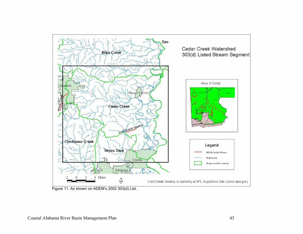
Coastal Alabama River Basin Management Plan 43
Figure 11. As shown on ADEM’s 2002 303(d) List.

Coastal Alabama River Basin Management Plan 44
Mobile River Description of Potential Pollutant Sources: While this segment of the Mobile River is included on the 303(d) list for Mercury contamination and the cause is listed as unknown, a potential source is the Cold Creek Swamp (see page 43). Another possible source is atmospheric deposition. Further, the waters of the Mobile are vulnerable to contamination from numerous sources upstream and from nonpoint source pollution resulting from point sources and from urban land use. General Land use: Development in this watershed primarily high-density urban development with the associated commercial and light and heavy industry uses.
Waterbody ID Waterbody Name Support Status Rank River Basin County Uses Causes Sources Date of
Data Size Downstream/Upstream
Locations
1996 303 (d) ?
TMDL Date
AL/Mobile R_01 Mobile River Partial L Mobile Mobile Limited Warmwater Fishery Fish & Wildlife
Mercury Unknown source 2000 29.5 miles
Mobile Bay/ Cold Creek
No 2005
Table 23.
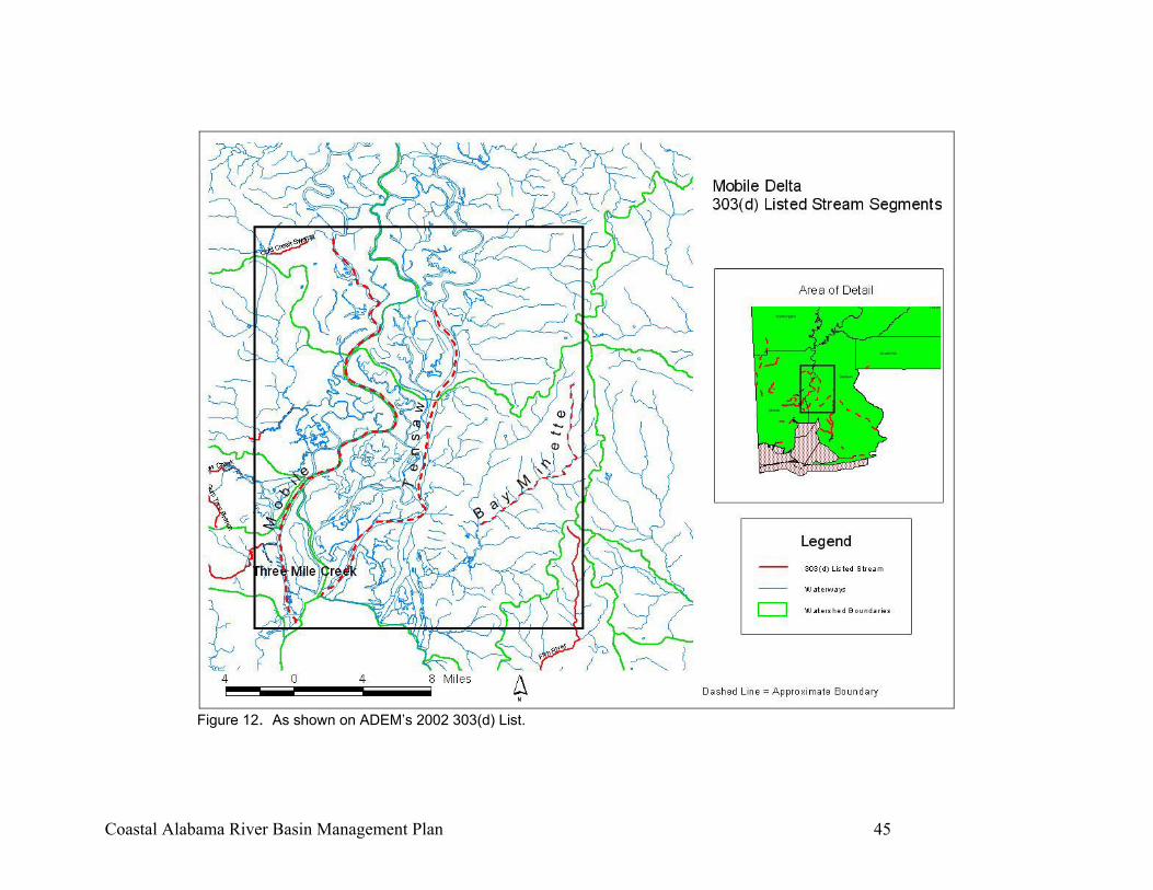
Coastal Alabama River Basin Management Plan 45
Figure 12. As shown on ADEM’s 2002 303(d) List.
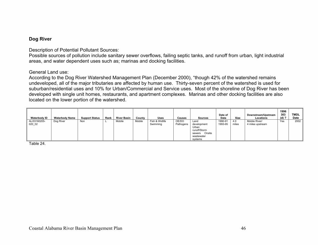
Coastal Alabama River Basin Management Plan 46
Dog River Description of Potential Pollutant Sources: Possible sources of pollution include sanitary sewer overflows, failing septic tanks, and runoff from urban, light industrial areas, and water dependent uses such as; marinas and docking facilities. General Land use: According to the Dog River Watershed Management Plan (December 2000), “though 42% of the watershed remains undeveloped, all of the major tributaries are affected by human use. Thirty-seven percent of the watershed is used for suburban/residential uses and 10% for Urban/Commercial and Service uses. Most of the shoreline of Dog River has been developed with single unit homes, restaurants, and apartment complexes. Marinas and other docking facilities are also located on the lower portion of the watershed.
Waterbody ID Waterbody Name Support Status Rank River Basin County Uses Causes Sources Date of
Data Size Downstream/Upstream
Locations
1996 303 (d) ?
TMDL Date
AL/03160205-020_02
Dog River Non L Mobile Mobile Fish & Widlife Swimming
OE/DO Pathogens
Land development Urban runoff/Storm sewers Onsite wastewater systems
1990-91 1993-95
4.0 miles
Mobile River/ 4 miles upstream
Yes 2002
Table 24.
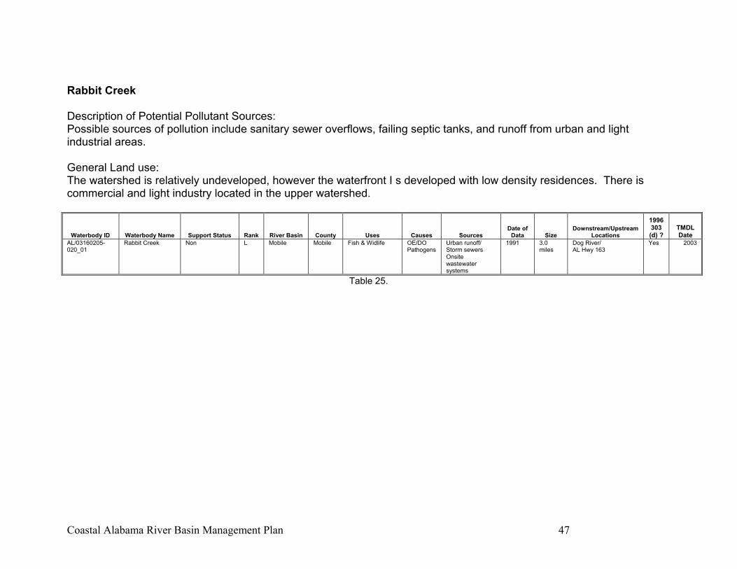
Coastal Alabama River Basin Management Plan 47
Rabbit Creek Description of Potential Pollutant Sources: Possible sources of pollution include sanitary sewer overflows, failing septic tanks, and runoff from urban and light industrial areas. General Land use: The watershed is relatively undeveloped, however the waterfront I s developed with low density residences. There is commercial and light industry located in the upper watershed.
Waterbody ID Waterbody Name Support Status Rank River Basin County Uses Causes Sources Date of
Data Size Downstream/Upstream
Locations
1996 303 (d) ?
TMDL Date
AL/03160205-020_01
Rabbit Creek Non L Mobile Mobile Fish & Widlife OE/DO Pathogens
Urban runoff/ Storm sewers Onsite wastewater systems
1991 3.0 miles
Dog River/ AL Hwy 163
Yes 2003
Table 25.
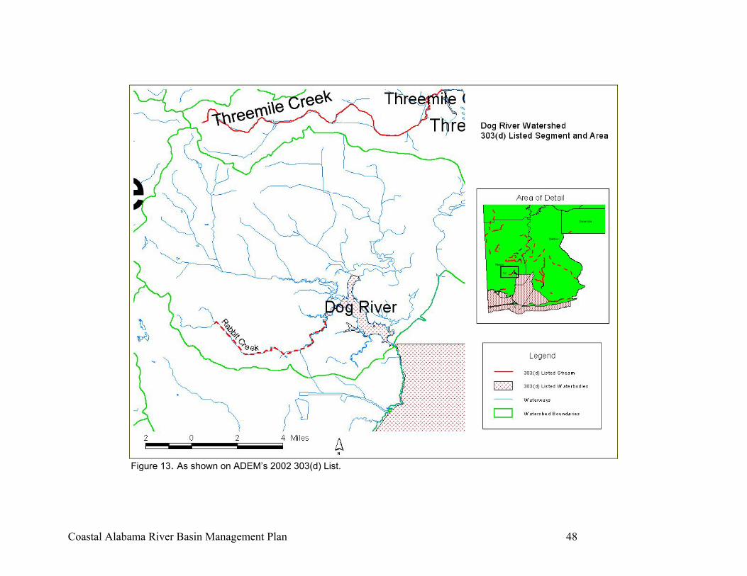
Coastal Alabama River Basin Management Plan 48
Figure 13. As shown on ADEM’s 2002 303(d) List.
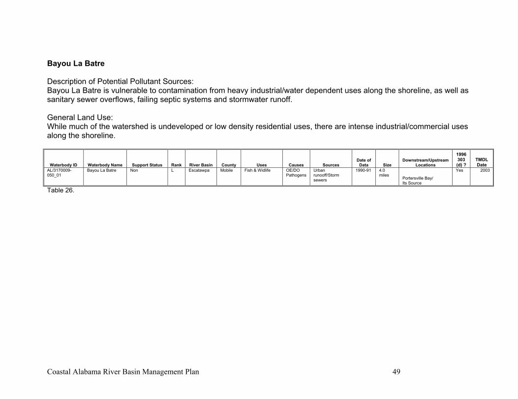
Coastal Alabama River Basin Management Plan 49
Bayou La Batre Description of Potential Pollutant Sources: Bayou La Batre is vulnerable to contamination from heavy industrial/water dependent uses along the shoreline, as well as sanitary sewer overflows, failing septic systems and stormwater runoff. General Land Use: While much of the watershed is undeveloped or low density residential uses, there are intense industrial/commercial uses along the shoreline.
Waterbody ID Waterbody Name Support Status Rank River Basin County Uses Causes Sources Date of
Data Size Downstream/Upstream
Locations
1996 303 (d) ?
TMDL Date
AL/3170009-050_01
Bayou La Batre Non L Escatawpa Mobile Fish & Widlife OE/DO Pathogens
Urban runooff/Storm sewers
1990-91 4.0 miles
Portersville Bay/ Its Source
Yes 2003
Table 26.
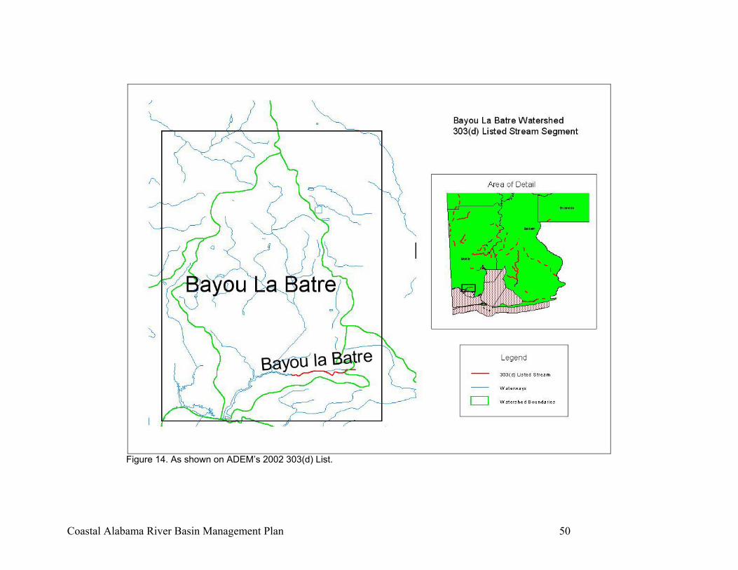
Coastal Alabama River Basin Management Plan 50
Figure 14. As shown on ADEM’s 2002 303(d) List.
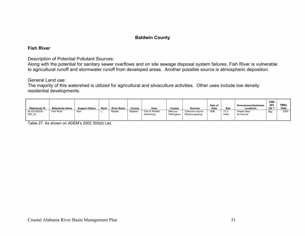
Coastal Alabama River Basin Management Plan 51
Baldwin County
Fish River Description of Potential Pollutant Sources: Along with the potential for sanitary sewer overflows and on site sewage disposal system failures, Fish River is vulnerable to agricultural runoff and stormwater runoff from developed areas. Another possible source is atmospheric deposition. General Land use: The majority of this watershed is utilized for agricultural and silvaculture activities. Other uses include low density residential developments.
Waterbody ID Waterbody Name Support Status Rank River Basin County Uses Causes Sources Date of
Data Size Downstream/Upstream
Locations
1996 303 (d) ?
TMDL Date
AL/03160205-050_02
Fish River Non L Mobile Baldwin Fish & Wildlife Swimming
Mercury Pathogens
Unknown source Pasture grazing
1996 31.5 miles
Weeks Bay/ Its Source
No 2005
Table 27. As shown on ADEM’s 2002 303(d) List.
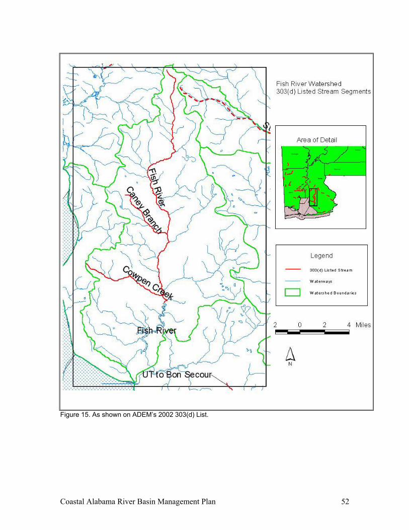
Coastal Alabama River Basin Management Plan 52
Figure 15. As shown on ADEM’s 2002 303(d) List.
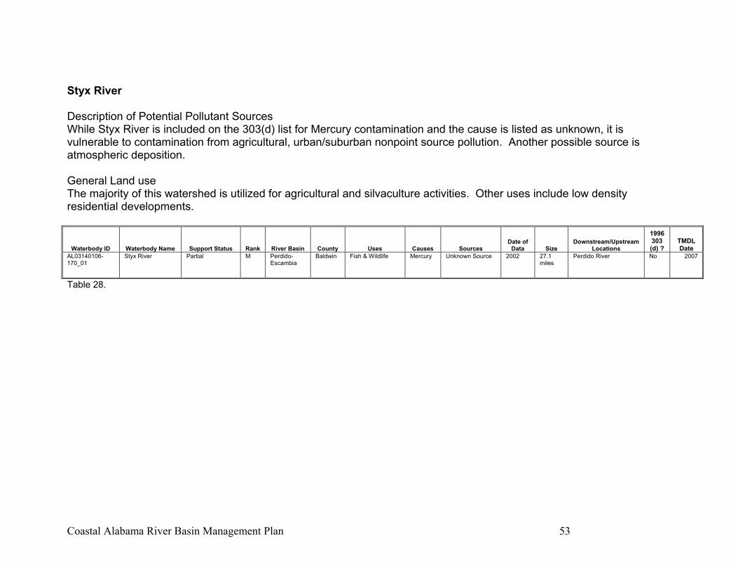
Coastal Alabama River Basin Management Plan 53
Styx River Description of Potential Pollutant Sources While Styx River is included on the 303(d) list for Mercury contamination and the cause is listed as unknown, it is vulnerable to contamination from agricultural, urban/suburban nonpoint source pollution. Another possible source is atmospheric deposition. General Land use The majority of this watershed is utilized for agricultural and silvaculture activities. Other uses include low density residential developments.
Waterbody ID Waterbody Name Support Status Rank River Basin County Uses Causes Sources Date of
Data Size Downstream/Upstream
Locations
1996 303 (d) ?
TMDL Date
AL03140106-170_01
Styx River Partial M Perdido-Escambia
Baldwin Fish & Wildlife Mercury Unknown Source 2002 27.1 miles
Perdido River No 2007
Table 28.
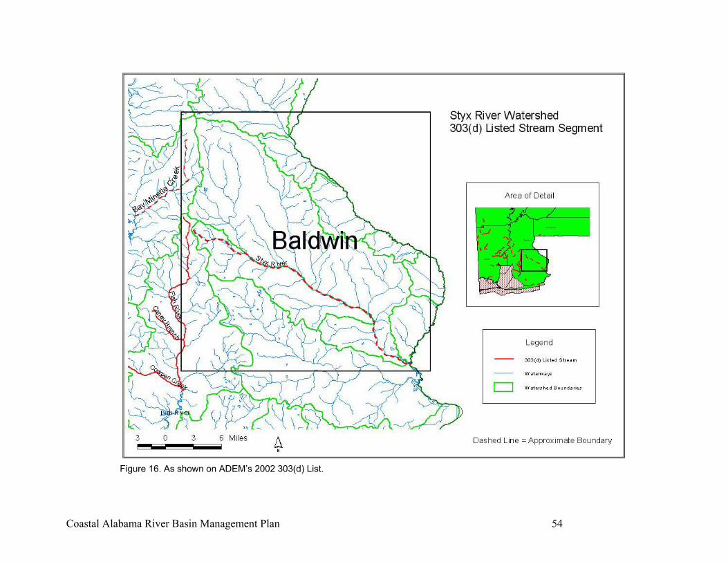
Coastal Alabama River Basin Management Plan 54
Figure 16. As shown on ADEM’s 2002 303(d) List.
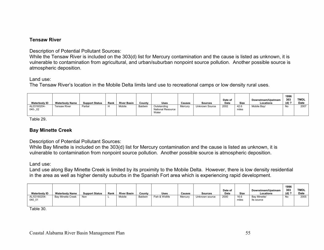
Coastal Alabama River Basin Management Plan 55
Tensaw River Description of Potential Pollutant Sources: While the Tensaw River is included on the 303(d) list for Mercury contamination and the cause is listed as unknown, it is vulnerable to contamination from agricultural, and urban/suburban nonpoint source pollution. Another possible source is atmospheric deposition. Land use: The Tensaw River’s location in the Mobile Delta limits land use to recreational camps or low density rural uses.
Waterbody ID Waterbody Name Support Status Rank River Basin County Uses Causes Sources Date of
Data Size Downstream/Upstream
Locations
1996 303 (d) ?
TMDL Date
AL03160204-040-_02
Tensaw River Partial H Mobile Baldwin Outstanding National Resource Water
Mercury Unknown Source 2002 42.6 miles
Mobile Bay/ No 2007
Table 29. Bay Minette Creek Description of Potential Pollutant Sources: While Bay Minette is included on the 303(d) list for Mercury contamination and the cause is listed as unknown, it is vulnerable to contamination from nonpoint source pollution. Another possible source is atmospheric deposition. Land use: Land use along Bay Minette Creek is limited by its proximity to the Mobile Delta. However, there is low density residential in the area as well as higher density suburbs in the Spanish Fort area which is experiencing rapid development.
Waterbody ID Waterbody Name Support Status Rank River Basin County Uses Causes Sources Date of
Data Size Downstream/Upstream
Locations
1996 303 (d) ?
TMDL Date
AL/03160204-040_01
Bay Minette Creek Non L Mobile Baldwin Fish & Widlife Mercury Unknown source 2000 16.6 miles
Bay Minette/ Its source
No 2005
Table 30.
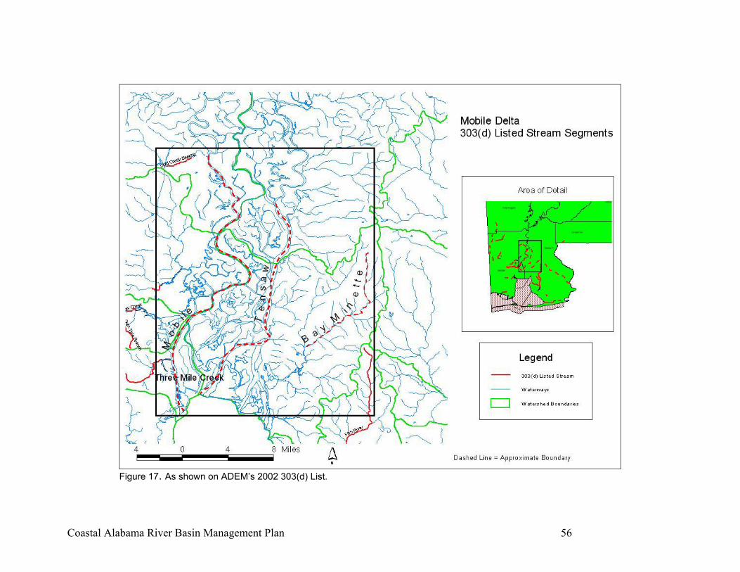
Coastal Alabama River Basin Management Plan 56
Figure 17. As shown on ADEM’s 2002 303(d) List.
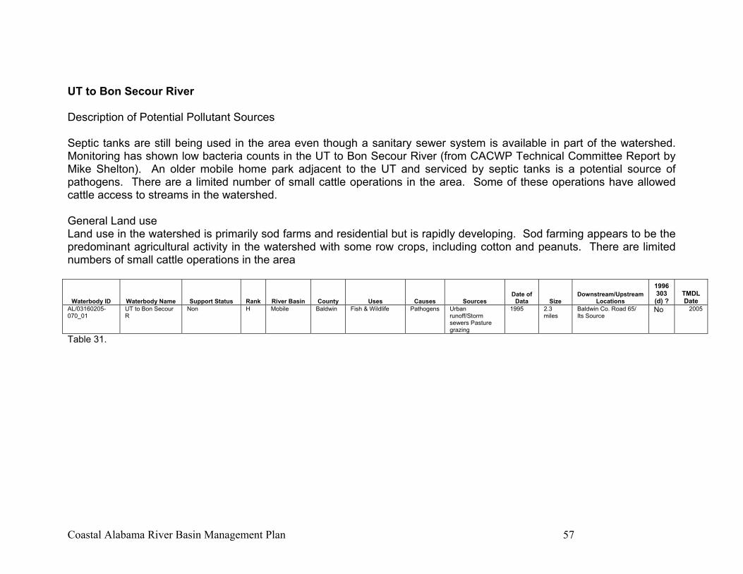
Coastal Alabama River Basin Management Plan 57
UT to Bon Secour River Description of Potential Pollutant Sources Septic tanks are still being used in the area even though a sanitary sewer system is available in part of the watershed. Monitoring has shown low bacteria counts in the UT to Bon Secour River (from CACWP Technical Committee Report by Mike Shelton). An older mobile home park adjacent to the UT and serviced by septic tanks is a potential source of pathogens. There are a limited number of small cattle operations in the area. Some of these operations have allowed cattle access to streams in the watershed. General Land use Land use in the watershed is primarily sod farms and residential but is rapidly developing. Sod farming appears to be the predominant agricultural activity in the watershed with some row crops, including cotton and peanuts. There are limited numbers of small cattle operations in the area
Waterbody ID Waterbody Name Support Status Rank River Basin County Uses Causes Sources Date of
Data Size Downstream/Upstream
Locations
1996 303 (d) ?
TMDL Date
AL/03160205-070_01
UT to Bon Secour R
Non H Mobile Baldwin Fish & Wildlife Pathogens Urban runoff/Storm sewers Pasture grazing
1995 2.3 miles
Baldwin Co. Road 65/ Its Source
No 2005
Table 31.
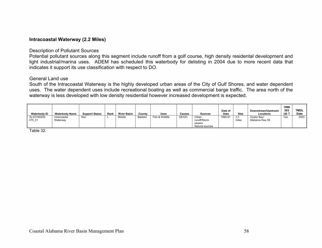
Coastal Alabama River Basin Management Plan 58
Intracoastal Waterway (2.2 Miles) Description of Pollutant Sources Potential pollutant sources along this segment include runoff from a golf course, high density residental development and light industrial/marina uses. ADEM has scheduled this waterbody for delisting in 2004 due to more recent data that indicates it support its use classification with respect to DO. General Land use South of the Intracoastal Waterway is the highly developed urban areas of the City of Gulf Shores, and water dependent uses. The water dependent uses include recreational boating as well as commercial barge traffic. The area north of the waterway is less developed with low density residential however increased development is expected.
Waterbody ID Waterbody Name Support Status Rank River Basin County Uses Causes Sources Date of
Data Size Downstream/Upstream
Locations
1996 303 (d) ?
TMDL Date
AL/03160205-070_01
Intracoastal Waterway
Non L Mobile Baldwin Fish & Wildlife OE/DO Urban runoff/Storm sewers Natural sources
1990-91 2.2 miles
Oyster Bay/ Alabama Hwy 59
Yes 2003
Table 32.
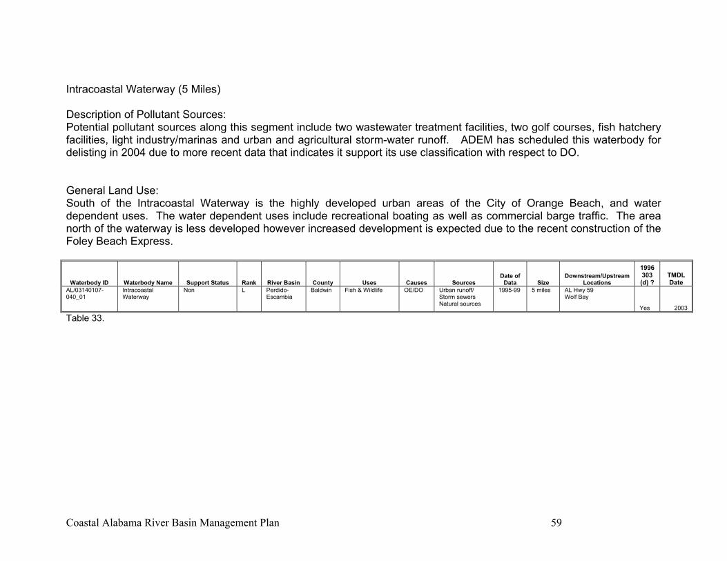
Coastal Alabama River Basin Management Plan 59
Intracoastal Waterway (5 Miles) Description of Pollutant Sources: Potential pollutant sources along this segment include two wastewater treatment facilities, two golf courses, fish hatchery facilities, light industry/marinas and urban and agricultural storm-water runoff. ADEM has scheduled this waterbody for delisting in 2004 due to more recent data that indicates it support its use classification with respect to DO. General Land Use: South of the Intracoastal Waterway is the highly developed urban areas of the City of Orange Beach, and water dependent uses. The water dependent uses include recreational boating as well as commercial barge traffic. The area north of the waterway is less developed however increased development is expected due to the recent construction of the Foley Beach Express.
Waterbody ID Waterbody Name Support Status Rank River Basin County Uses Causes Sources Date of
Data Size Downstream/Upstream
Locations
1996 303 (d) ?
TMDL Date
AL/03140107-040_01
Intracoastal Waterway
Non L Perdido-Escambia
Baldwin Fish & Wildlife OE/DO Urban runoff/ Storm sewers Natural sources
1995-99 5 miles AL Hwy 59 Wolf Bay
Yes 2003
Table 33.
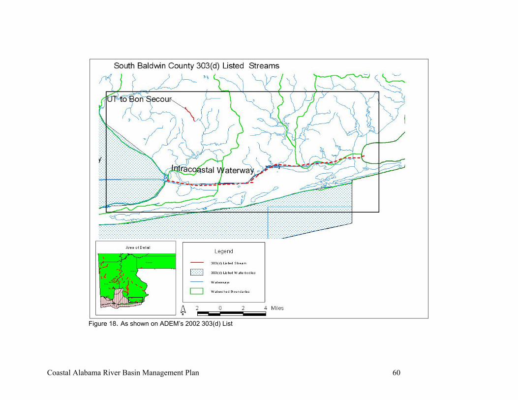
Coastal Alabama River Basin Management Plan 60
Figure 18. As shown on ADEM’s 2002 303(d) List
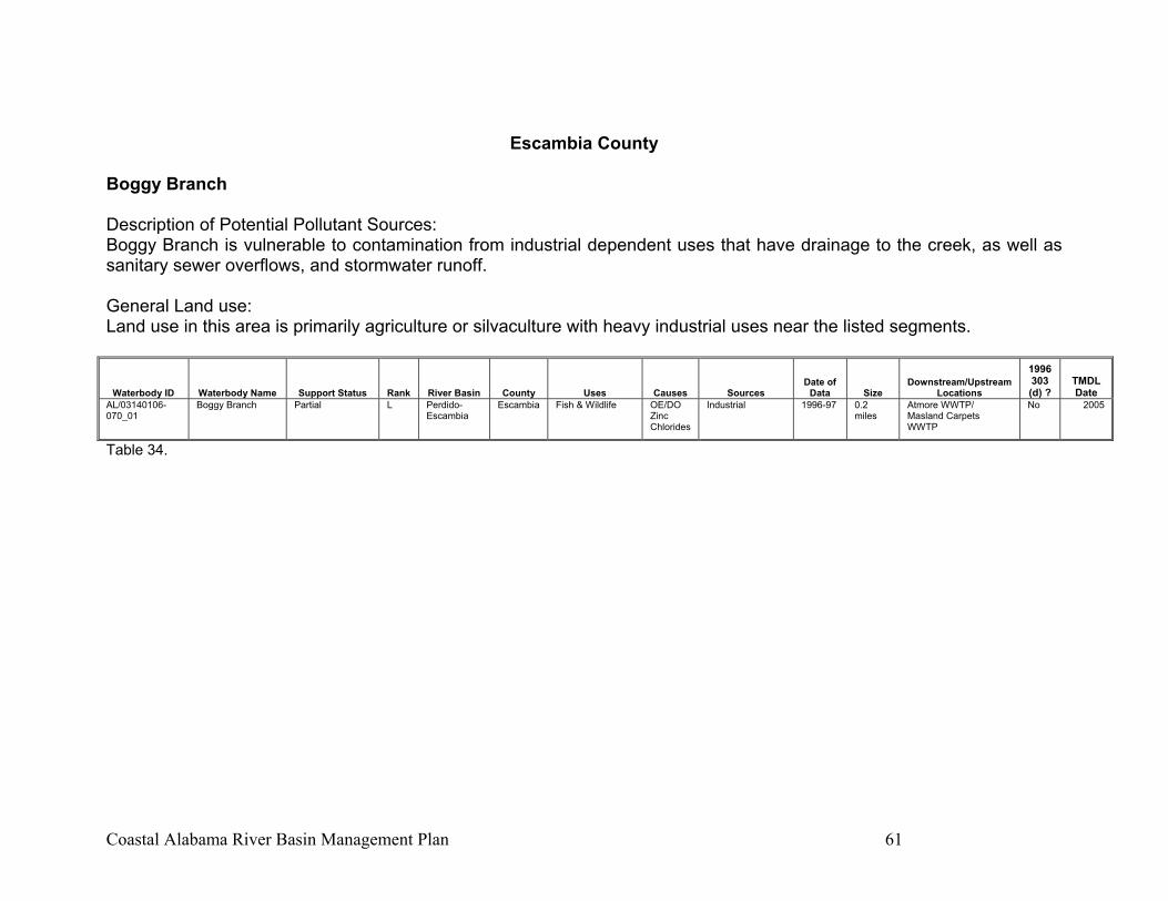
Coastal Alabama River Basin Management Plan 61
Escambia County
Boggy Branch Description of Potential Pollutant Sources: Boggy Branch is vulnerable to contamination from industrial dependent uses that have drainage to the creek, as well as sanitary sewer overflows, and stormwater runoff. General Land use: Land use in this area is primarily agriculture or silvaculture with heavy industrial uses near the listed segments.
Waterbody ID Waterbody Name Support Status Rank River Basin County Uses Causes Sources Date of
Data Size Downstream/Upstream
Locations
1996 303 (d) ?
TMDL Date
AL/03140106-070_01
Boggy Branch Partial L Perdido-Escambia
Escambia Fish & Wildlife OE/DO Zinc Chlorides
Industrial 1996-97 0.2 miles
Atmore WWTP/ Masland Carpets WWTP
No 2005
Table 34.
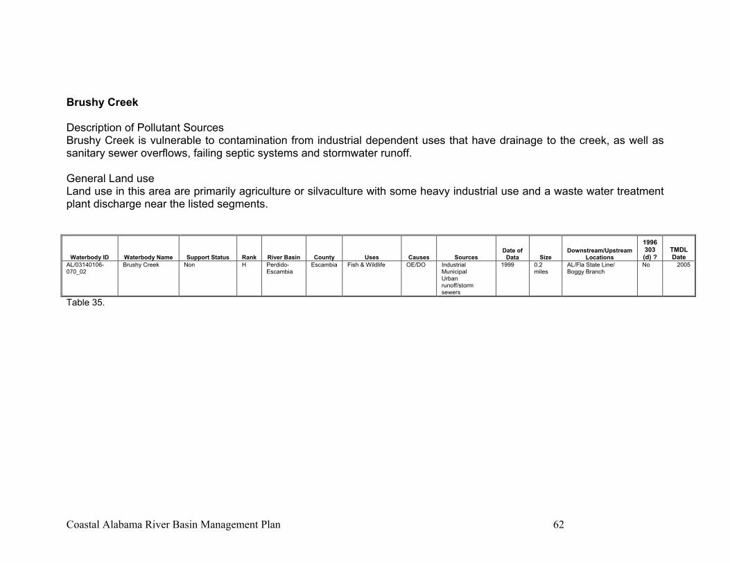
Coastal Alabama River Basin Management Plan 62
Brushy Creek Description of Pollutant Sources Brushy Creek is vulnerable to contamination from industrial dependent uses that have drainage to the creek, as well as sanitary sewer overflows, failing septic systems and stormwater runoff. General Land use Land use in this area are primarily agriculture or silvaculture with some heavy industrial use and a waste water treatment plant discharge near the listed segments.
Table 35.
Waterbody ID Waterbody Name Support Status Rank River Basin County Uses Causes Sources Date of
Data Size Downstream/Upstream
Locations
1996 303 (d) ?
TMDL Date
AL/03140106-070_02
Brushy Creek Non H Perdido-Escambia
Escambia Fish & Wildlife OE/DO Industrial Municipal Urban runoff/storm sewers
1999 0.2 miles
AL/Fla State Line/ Boggy Branch
No 2005
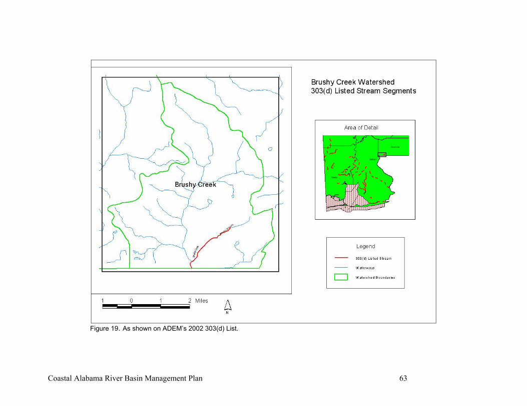
Coastal Alabama River Basin Management Plan 63
Figure 19. As shown on ADEM’s 2002 303(d) List.
Coastal Alabama River Basin Management Plan 64
THIS PAGE INTENTIONALLY BLANK
Coastal Alabama River Basin Management Plan 65
SUMMARY OF EXISTING WATERSHED PROJECT MANAGEMENT MEASURES
Mobile Bay National Estuary Program The goal of the Mobile Bay National Estuary Program is “to promote wise stewardship of the water quality characteristics and living resources of the Mobile Bay Estuarine System. Five priority issues were identified and serve as the focus of NEP efforts: Water Quality, Living Resources, Habitat Management, Human Uses, and Education & Public Involvement. The following objective for water quality in the Mobile Bay Estuary was adopted by the Management Conference: “Attain and/or maintain water quality sufficient to support healthy aquatic communities and designated human uses by 2010.” The nine specific action items developed to achieve this objective are listed below and explained in detail in Volume 2 of “The Path to Success-Preliminary action plans for restoring and maintaining the Mobile Bay estuary” published in April of 2002 (see Appendix B).
WQ-A1 Assess data to identify water quality problems WQ-A2 Incorporate loadings information into NPDES WQ-A3 Maintain groundwater quality WQ-A4 Ensure protection and maintenance of High Quality Waters WQ-B1 Reduce excessive nutrient loadings in the Mobile Bay NEP WQ-B2 Address upstream nutrient inputs WQ-C1 Reduce opportunities for pathogen introduction WQ-D1 Assess problems related to sediment quality WQ-D2 Provide for safe disposal of hazardous waste
The following objective for Living Resources in the Mobile Bay Estuary was adopted by the Management Conference: “Maintain native populations within historical ranges and natural habitat and restore populations that have declined.” The six specific action items developed to achieve this objective are listed below and explained in detail in Volume 2 of “The Path to Success-Preliminary action plans for restoring and maintaining the Mobile Bay estuary” published in April of 2002 (see Appendix B).
LR-A1 Improve monitoring of key living resources LR-A2 Improve monitoring of at-risk species LR-B1 Develop management plans for nuisance species LR-C1 Efficiently measure fishing effort
Coastal Alabama River Basin Management Plan 66
LR-C3 Manage commercial and recreational fishing effort The following objective was established by the Management Conference to guide habitat management efforts in the Mobile Bay Estuary. “Provide optimum fish and wildlife habitat in the Mobile Bay system by effectively preserving, restoring, and managing resources to maintain adequate extent, diversity, distribution, connectivity, and natural functions of all habitat types. The seven specific action items developed to achieve this objective are listed below and explained in detail in Volume 2 of “The Path to Success-Preliminary action plans for restoring and maintaining the Mobile Bay estuary” published in April of 2002 (see Appendix B).
HM-A1 Develop a Coastal Habitats Coordinating Team HM-B1 Protect or restore SAV habitat HM-C1 Maintain and/or improve beneficial wetland function HM-D1 Assess beach and dune habitat loss HM-D2 Determine impacts of dredging on coastal habitats HM-D3 Address shoreline erosion HM-E1 Prevent nesting habitat decline
The following objective to guide development of human uses management strategies in the Mobile Bay Estuary was adopted by the Management Conference: “Provide consistent, enforceable, regional land and water use management that ensures smart growth for sustainable development and decreases the negative impacts of growth-related activities on human health and safety, public access, and quality of life by developing and implementing plans consistent with the CCMP by 2006.” The five specific action items developed to achieve this objective are listed below and explained in detail in Volume 2 of “The Path to Success-Preliminary action plans for restoring and maintaining the Mobile Bay estuary” published in April of 2002 (see Appendix B).
HU-A1 Develop and implement comprehensive land use planning HU-B1 Assess hydrologic effects of development practices HU-B2 Restore natural hydrologic conditions HU-B3 Better control erosion and sedimentation
The five specific action items developed to achieve this objective are listed below and explained in detail in Volume 2 of “The Path to Success-Preliminary action plans for restoring and maintaining the Mobile Bay estuary” published in April of 2002 (see Appendix B).
Coastal Alabama River Basin Management Plan 67
EPI-A1 Enhance public education and outreach EPI-BI Develop comprehensive citizen monitoring and reporting
programs
Weeks Bay Watershed Project The goal of the Weeks Bay Watershed Project is to “improve and maintain water quality in the Weeks Bay watershed to meet or exceed state water quality standards for waterbodies classified as Swimming and/or Fish and Wildlife.” The thirteen objectives established to meet this goal have been categorized and listed in the Weeks Bay Management Plan as follows. See Appendix C for more detailed information on specific action items. Nonpoint Source Pollution Reduce nonpoint source pollution from agricultural activities. Reduce nonpoint source pollution from construction and land clearing activities. Reduce ground water resources through reduction in nonpoint source pollution. Reduce the pollution generated by water-related recreational activities, including sewage, petroleum products, and litter. Continue Weeks Bay Water Watch monitoring and formally examine data in order to establish trends and design recovery plans if necessary. Habitat Restoration and Protection Ensure protection of fish and wildlife habitat, including submerged grassbeds, fringe marsh, shorelines, and other wetlands and upland forest through land acquisition, education, and incentive programs. Protection, Growth Management, and Infrastructure Reduce pollution from existing and future on-site sewage systems. Promote planning and zoning that will protect environmentally sensitive areas. Identify unpaved roads that contribute sediment to the watershed and work with the county government to develop a plan to improve these roads within a reasonable time frame.
Coastal Alabama River Basin Management Plan 68
Dog River Watershed Project
The Auburn Marine Extension and Research Center was granted the task of developing a Dog River Watershed Management Plan in 1999. The stakeholders developed the following goals that are included in the Dog River Watershed Management Plan. The Action Items associated with these goals are included in Appendix D.
• “Reduce loss of aquatic and riparian habitats. Conserve existing habitats by establishing greenways and other natural areas to improve wildlife habitat and water quality.”
• “Promote and encourage land clearing control and land use planning.”
• “Encourage the enforcement of speed control and “no wake” zones for
watercraft to reduce stream bank erosion in smaller tributaries.”
• “Reduce nonpoint source urban stormwater runoff, including litter, and runoff from construction, industrial, and residential areas.”
• “Encourage enforcement of existing regulations and Best Management
Practices, including larger fines for violations and increased funding for the Alabama Department of Environmental Management. Promote “stop work” authority for building inspectors.”
• “Reduce nonpoint source pollution from septic tank seepage and work
with the Mobile Area Water and Sewer Service to reduce sewer overflow events.”
• “Educate homeowners and businesses on proper septic tank installation
operation and maintenance, use of septic tank filters, and advantages of alternative OSDS.”
• “Promote limited home rule legislation for Mobile County or environmental
issues, including planning and zoning authority.”
• “Pursue the development of a watershed management authority or watershed conservancy district.”
• “Implement a public outreach and awareness program, including K-12
education, involving the concepts of watershed responsibilities, and environmentally friendly development.”
Coastal Alabama River Basin Management Plan 69
• “Coordinate and partner with agencies, including the Mobile Bay National Estuary Program, the Corps of Engineers, and ADEM, to achieve the objectives and strategies described.”
Perdido Basin Management Strategies Report This document provides a summary of existing and potential environmental concerns in the Perdido Basin and suggests management strategies to address these concerns. Management strategies were identified to address existing and potential environmental degradation problems. See Appendix E for details. These strategies resulted in 44 action plans that were categorized in the following manner:
• Nonpoint Source Pollution Control Strategies 10 Action Plans
• Point Source Pollution Control Strategies 12 Action Plans
• Anthropogenic Sediment Control Strategies 2 Action Plans
• Future Land Use Planning Strategies 4 Action Plans
• Land Acquisition Strategies 4 Action Plans
• Interstate Environmental Control Compact 3 Action Plans
• Restoration Projects 2 Action Plans
• Effectiveness Tracking 7 Action Plans
• Fisheries Resources 1 Action Plan
• Gulf Ecological Management Sites 1 Action Plan
• Educational Programs 2 Action Plans
• Future Studies 1 Action Plan
Coastal Alabama River Basin Management Plan 70
COASTAL ALABAMA BASIN MANAGEMENT PLAN MANAGEMENT AND IMPLEMENTATION STRATEGY
Through a series of small group activities and stream walks, the Coastal Alabama Clean Water Partnership (CACWP) reviewed water quality problems, discussed existing action plans, and arrived at a re-evaluation of the role of the Partnership. As a result of this concerted effort, the following role statement, goals and action items were established for the Coastal Alabama Basin Management Project and the CACWP. It was agreed that the CACWP role will be to focus on addressing water quality issues throughout the basin by continuing and expanding public-private partnerships, increasing outreach to local stakeholders, serving as an information clearinghouse, and assisting with pursuing funding for water quality improvement projects. Given this role, these goals were established for the Coastal Alabama Basin Project:
• To work towards improving water quality in impaired waters within the CACWP area.
• To promote protection of waters currently meeting use classification.
• To promote restoration of natural stream characteristics (where feasible).
• To develop and implement innovative methods for recruiting non-
traditional members to the CACWP.
• To assist in developing and implementing effective education and outreach programs to all stakeholders throughout the Basin.
• To partner with other environmental and watershed/subwatershed groups
in consolidating existing data into a user friendly format that is compatible with Geographic Information Systems software.
Realization of these goals will occur through undertaking specific action items included in this Coastal River Basin Management Plan and through the Partnership’s continued active support for implementation of the existing sub watershed plans. Efforts are being made to complete or start additional plans for the remaining sub watersheds. As these plans are completed, the Coastal Alabama River Basin Management Plan should be updated to incorporate additional action items.
Coastal Alabama River Basin Management Plan 71
Implementation Strategy The Basin wide action items included here are not all encompassing and may be modified to fit a particular subwatershed management problem. Further, action items may be deleted or added as opportunities, new information, or additional funds are obtained. Responsible parties are agencies with regulatory or legal authority or other entities with an interest in development and implementation of this plan. Cooperators are those who could assist the responsible parties through shared resources and/or technical assistance. Potential funding identifies resources to implement the strategy. The schedule suggests implementation timelines on a quarterly basis, with most of the action items ongoing. Because of the limited assessment data and the large area encompassed by the basin, definitive load reduction estimates are unknown at this time. Budgets are estimates or unknown as implementation is dependent on funding and stakeholder interest and support.
ACTION ITEMS
Develop and implement a campaign designed to foster establishment of stakeholder groups in all subwatersheds with priority in those that contain
303(d) listed streams and to involve new groups in the Coastal Alabama Clean Water Partnership.
Responsible Entities: ADEM, ADCNR, AUMERC Cooperators: SWCD, NRCS, MBNEP, SARPC, ACF Potential Funding: EPA 319, NOAA 306 Schedule: Ongoing Estimated Cost: tbd Tasks Establish an CACWP Subcommittee to identify tasks and implement campaign Develop list of loosely organized grassroots watershed groups Target activities to these groups while developing strategy for watersheds with no existing stakeholder involvement. Progress Benchmarks Documented step-by-step watershed group organizing campaign Increase in number of organized watershed groups in the Basin
Coastal Alabama River Basin Management Plan 72
Establish a rotating TMDL Advisory Committee to assist ADEM with development and implementation of TMDLs for each listed segment.
Responsible Entities: CACWP Technical Committee, ADEM, ADCNR Cooperators: SWCD, Mobile BayWatch/BayKeeper Potential Funding: None Schedule: Committee established by December 2003. TMDLs established based on EPA approved TMDL development schedule Estimated Cost: No additional cost Tasks Request a TMDL development status update from ADEM Request a meeting with ADEM to define assistance parameters Establish TMDL Advisory Committee organization guidelines to allow for rotating members Establish Committee Progress Benchmarks Working committee established and reporting to CACWP quarterly
Coastal Alabama River Basin Management Plan 73
Coordinate and assist pursuit of funding for all types of water quality best
management practice demonstration projects-urban, construction, agriculture, forestry, on-site sewage disposal systems.
Responsible Entities: CACWP Facilitator Cooperators: MBNEP, ADEM Potential Funding: None Schedule: On-going Estimated Cost: No additional cost Tasks Meet with Technical Advisory Committee to review potential projects and identify potential funding sources on a monthly basis Progress Benchmarks Assist with identifying funding for at least one project per year.

Coastal Alabama River Basin Management Plan 74
Update education and outreach strategy to consider tasks such as
expanding the Clean Water Guardian Program and developing a “Greener By the Par” program for environmentally friendly golf courses.
Responsible Entities: CACWP Facilitator, ACES Cooperators: ADEM, ADCNR, AUMERC Potential Funding: EPA 319, NOAA 306 Schedule: FY 2004 Estimated Cost: $15,000 Tasks Establish Outreach Committee Meet monthly to develop strategy and implementation schedule by third quarter FY 04 Implement strategy Progress Benchmarks Documented strategy developed and approved by CACWP Implementation results in increased participation in “Guardian” type programs
Coastal Alabama River Basin Management Plan 75
Provide Clean Marina Program Technical Assistance to marinas throughout
the basin.
Responsible Entities: AUMERC, Mississippi-Alabama Sea Grant Extension, Cooperators: ADEM, ADCNR, MBNEP, ADEM, DISL, Mississippi DEQ Potential Funding: EPA 319, NOAA 306, CVA, RC&D Schedule: ongoing Estimated Cost: No additional cost Tasks CACWP Facilitator will present program details to the CACWP by second quarter of 2004 Develop a targeted list of priority marinas Solicit participants Progress Benchmarks Targeted marinas receive solicitation and technical assistance on the program At least one marina in each county is participating by first quarter of 2005
Coastal Alabama River Basin Management Plan 76
Continue to promote and support stream restoration/stormwater BMP
workshops and demonstration projects in the CACWP area. Responsible Entities: CACWP Facilitator, MBNEP, ACES Cooperators: AUMERC, ADEM, MASGC, ACAMP Potential Funding: EPA 319 Schedule: on-going Estimated Cost: No additional costs Tasks: CACWP facilitator will assist in coordinating at least 2 workshops per year CACWP facilitator will work to implement stream restoration and stormwater BMP demonstration projects in the Basin Progress Benchmarks: Participants trained Workshops held Projects implemented
Coastal Alabama River Basin Management Plan 77
References Alabama Department of Environmental Management. 2003. Final 2002 303(d) List and Fact Sheet. www.adem.state.al.us. Auburn Marine Extension and Research Center. 2000. Dog River Watershed Management Plan. Mobile, Alabama. Environmental Protection Agency. 1984. Alabama NPL/NPL Caliber Cleanup Site Summaries-Stauffer Chemical (Cold Creek Plant). www.epa.gov. Florida-Alabama Water Resources Coordinating Council. 1995. Perdido Basin Management Strategies Report. Gillett, Blakeney, et al, 2000. Hydrogeology and Vulnerability to Contamination of Major Aquifers in Alabama: Area 13. Geologic Survey of Alabama. Tuscaloosa, Alabama. Geological Survey of Alabama. 2003. Impervious Surface Mapping for Mobile, Baldwin, & Mobile Counties, Alabama. Tuscaloosa, Alabama. Journey, C.A., and Gilff, A.C., 2000. Assessment of Water-Quality Conditions in the J.B. Converse Lake Watershed, Mobile County, Alabama, 1990-98. Malcolm Pirnie, Inc. Mobile, Alabama. Mobile Bay National Estuary Program. 2002. Mobile Bay Comprehensive Conservation And Management Plan. Mobile, Alabama. Tetra Tech Inc., 2001. Loading Budget Analysis for Mobile Bay. Prepared for the Mobile Bay NEP and the U.S. Army COE. Weeks Bay Watershed Project. 2001. Weeks Bay Watershed Management Plan. Fairhope, Alabama.
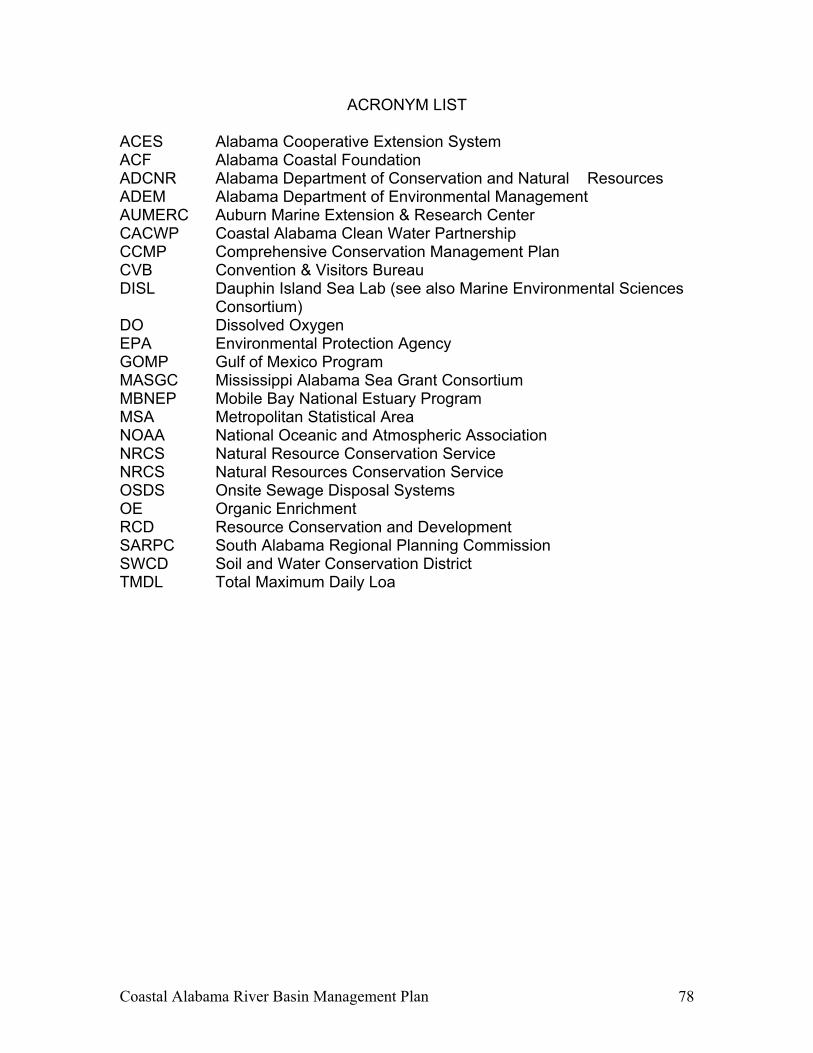
Coastal Alabama River Basin Management Plan 78
ACRONYM LIST ACES Alabama Cooperative Extension System ACF Alabama Coastal Foundation ADCNR Alabama Department of Conservation and Natural Resources ADEM Alabama Department of Environmental Management AUMERC Auburn Marine Extension & Research Center CACWP Coastal Alabama Clean Water Partnership CCMP Comprehensive Conservation Management Plan CVB Convention & Visitors Bureau DISL Dauphin Island Sea Lab (see also Marine Environmental Sciences
Consortium) DO Dissolved Oxygen EPA Environmental Protection Agency GOMP Gulf of Mexico Program MASGC Mississippi Alabama Sea Grant Consortium MBNEP Mobile Bay National Estuary Program MSA Metropolitan Statistical Area NOAA National Oceanic and Atmospheric Association NRCS Natural Resource Conservation Service NRCS Natural Resources Conservation Service OSDS Onsite Sewage Disposal Systems OE Organic Enrichment RCD Resource Conservation and Development SARPC South Alabama Regional Planning Commission SWCD Soil and Water Conservation District TMDL Total Maximum Daily Loa

Coastal Alabama River Basin Management Plan 79
APPENDIX A GENERAL LAND COVER MAP
COASTAL ALABAMA CLEAN WATER PARTNERSHIP AREA
Coastal Alabama River Basin Management Plan Appendix A A-1
Coastal Alabama Land Cover Image
The Alabama Land Cover datalayer and graphics were provided by the Baldwin County Soil and Water Conservation District. The methods used to develop the land cover data and images are described in the following excerpts from the “Evaluation of the National Land Cover Dataset for Field Office Use with ArcView 3.2a,” prepared by the Natural Resource Conservation Service, GIS Data Analysis Team, Geospatial Database Branch, 2001.
The U.S. Geological Survey (USGS) produced the National Land Cover Dataset (NLCD) as part of a cooperative project between the USGS and the U.S. Environmental Protection Agency (USEPA). The project produced a consistent land cover data layer for the conterminous United States using 30-meter Landsat thematic mapper (TM) data. These data can be used in a geographic information system (GIS) for any number of purposes, such as assessing wildlife habitat, water quality, pesticide runoff, land use change, and so on. The NLCD was compiled from Landsat TM imagery (circa 1992) with a spatial resolution of 30 meters supplemented by various ancillary data (where available). The reliability of the data is greatest at the State or multi-State level. The statistical accuracy of the data is known only for the region. The classification system used for the NLCD is modified from the Anderson land use and land cover classification system. Many of the Anderson classes, especially the level III classes, are best derived using aerial photographs. It is not appropriate to attempt to derive some of these classes using Landsat TM data owing to issues of spatial resolution and interpretability of the data. Thus, no attempt was made to derive classes that were extremely difficult or impractical to obtain using Landsat TM data, such as the level III urban classes. In addition, some Anderson level II classes were consolidated into a single NLCD class.
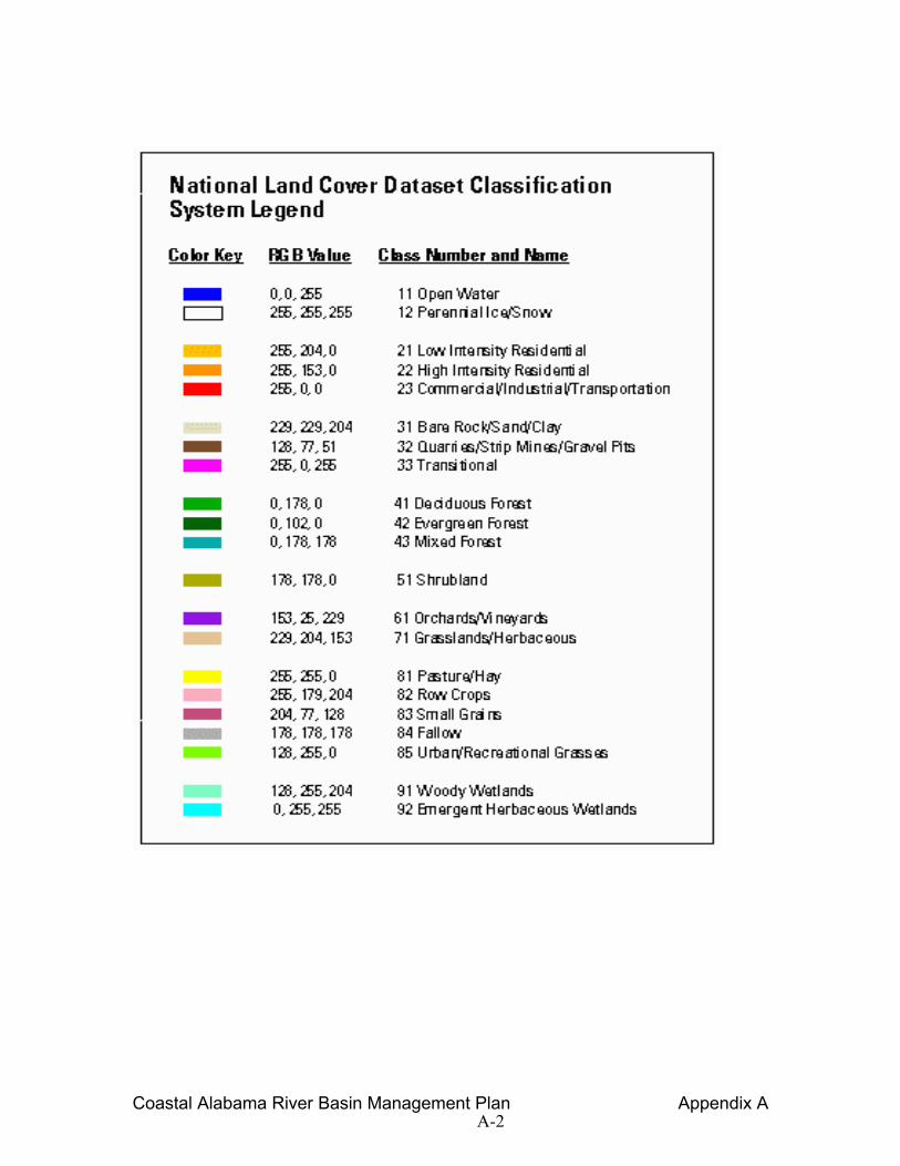
Coastal Alabama River Basin Management Plan Appendix A A-2
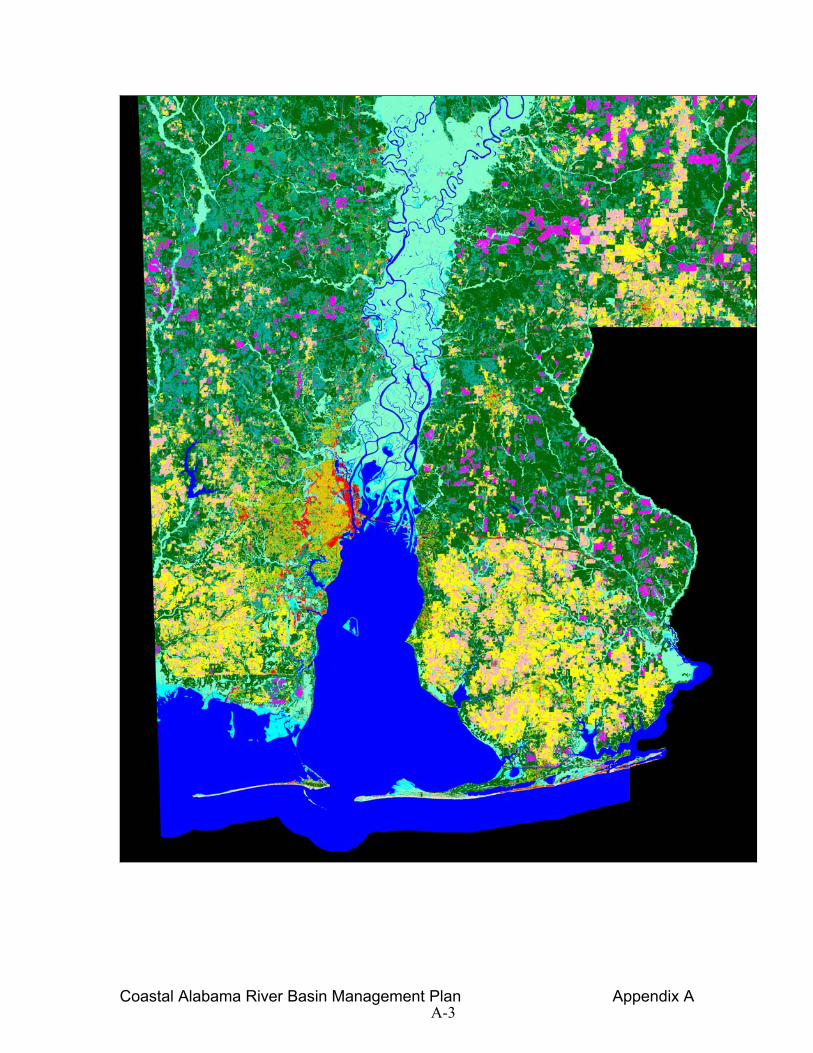
Coastal Alabama River Basin Management Plan Appendix A A-3
Coastal Alabama River Basin Management Plan
THIS PAGE INTENTIONALLY BLANK


