Coastal Alabama Living Shorelines Policies, Rules, and Model … · 2013-08-28 · Coastal Alabama...
50
Coastal Alabama Living Shorelines Policies, Rules, and Model Ordinance Manual By Chris A. Boyd, Ph.D. Mississippi State University Coastal Research and Extension Center 1815 Popps Ferry Road Biloxi, MS 39532 And Niki L. Pace, J.D., LL.M. Mississippi-Alabama Sea Grant Legal Program University of Mississippi School of Law 254 Kinard Hall, Wing E University, MS 38677 This project was supported by the Mobile Bay National Estuary Program with a grant from AL Department of Conservation and Natural Resources, State Lands Division, Coastal Section, through funding from the National Oceanic and Atmospheric Administration, Office of Ocean and Coastal Resource Management, Award # 11NOS4190104.
Transcript of Coastal Alabama Living Shorelines Policies, Rules, and Model … · 2013-08-28 · Coastal Alabama...

Coastal Alabama Living Shorelines Policies, Rules, and
Model Ordinance Manual
By
Chris A. Boyd, Ph.D.
Mississippi State University
Coastal Research and Extension Center
1815 Popps Ferry Road
Biloxi, MS 39532
And
Niki L. Pace, J.D., LL.M.
Mississippi-Alabama Sea Grant Legal Program
University of Mississippi School of Law
254 Kinard Hall, Wing E
University, MS 38677
This project was supported by the Mobile Bay National Estuary Program with a grant from AL
Department of Conservation and Natural Resources, State Lands Division, Coastal Section, through
funding from the National Oceanic and Atmospheric Administration, Office of Ocean and Coastal
Resource Management, Award # 11NOS4190104.
2
TABLE OF CONTENTS
Chapter 1 Introduction ………………………………………………………......... 3
Chapter 2 Why Living Shorelines………………………………………………… 5
Living Shorelines………………………………………………………. 5
Coastal Economy………………………………………………………. 5
Coastal Erosion ………………………………………………………... 6
Shoreline Armoring….……………….................................................... 7
Shoreline Management Options…………………………....................... 10
Selected Alabama Living Shoreline Projects…………………………... 13
Chapter 3 Laws and Regulations for Shoreline Erosion Control…..……………… 18
Alabama Erosion Control Structures Regulations…………………….... 18
ADCNR-SLD Regulations……………………………………………… 18
ADEM Regulations…………………………………………………….. 19
Shoreline Property Boundaries – Background…………………………. 20
USACE Mobile District Regulations…………………………………… 21
Other State Erosion Control Structure Regulations……………………. 23
Recommended Changes to Alabama Regulatory Policies……………... 24
Chapter 4 Living Shoreline Design and Permitting Challenges………………….. 27
Living Shoreline Design……………………………………………….. 27
Permitting Challenges for Living Shorelines………………………….. 27
Chapter 5 Living Shoreline Model Ordinances …………………………………... 30
Example Living Shoreline Model Ordinances…………………………. 30
Living Shoreline Model Ordinance Guidance…………………………. 31
Living Shoreline Model Ordinance……………………………………. 34
Incentive Based Programs for Promoting Living Shorelines………….. 35
Chapter 6 Conclusions…………………………………………………………….. 36
References ………………………………………………………………………….. 37
Appendix 1. U.S. Army Corps of Engineers Mobile District General
Permit ALG10-2011…………………………………………………… 39
Appendix 2. U.S. Army Corps of Engineers Mobile District General
Permit ALG11-2011………………………………………………….... 41
Appendix 3. U.S. Army Corps of Engineers Mobile District General
Permit ALG26-2011………………………………………………….... 42
Appendix 4. NWFL DEP, Florida Living Shoreline General Permit Exemption …... 43
Appendix 5. North Carolina General Permits for Sheetpile Sill…………………….... 44
Appendix 6. North Carolina General Permit for Riprap Sills………………………… 47
3
Coastal Alabama Living Shorelines Policies, Rules, and Model Ordinance Manual
by
Chris A. Boyd, Ph.D. and Niki L. Pace, J.D., LL.M.
Chapter 1. Introduction
The purpose of this study is to analyze the rules and regulations governing living shoreline
installation in the state of Alabama. The project focuses primarily on the coastal region of the state
that includes Mobile and Baldwin Counties. The project will provide Living Shorelines Policies,
Rules, and Model Ordinances for consideration by state and local governments and regulatory
agencies.
The current trend in Alabama is to install hard structures, such as bulkheads, seawalls, or rip-
rap, on the shoreline to protect waterfront coastal property from erosion. Around Mobile Bay, more
than 38% of property owners have built some sort of hard structure for shoreline protection (Jones, et.
al. 2012), and 31% of the state’s coastal shoreline has been armored as of 2012. At the current rate of
shoreline armoring, greater than 45% of Mobile Bay will be armored by 2020. Other coastal areas in
the state are experiencing similar rates of armoring, with 62% of Bayou St. John and 56% of Arnica
Bay, both in Baldwin County, currently armored.
Other state natural resource agencies have recommended alternative shoreline protection
measures, such as “living shorelines,” to effectively reduce shoreline erosion in low to moderate wave
environments while incurring less environmental damage than bulkheads. In addition, living
shorelines allow waterfront access needed for loading boats, fishing, and other forms of recreation (N.
Pace, 2011). The Maryland Department of Natural Resources has permitted over 1,000 living
shorelines projects over the past two and a half decades. In one study that surveyed over 200 living
shoreline projects in Maryland, greater than 74% of the projects were still in good condition (B.
Subramanian, 2010). Maryland, Virginia, North West Florida, North Carolina, Kauai, Hawaii, and
Delaware are encouraging property owners to install more sustainable erosion control structures.
These states are promoting the installation of living shorelines through general permits, exemptions,
or a more rigorous application process for approving bulkhead construction. These amended
permitting processes could ultimately slow the rate of hard armoring in coastal waters.
The coastal regulatory agencies for Alabama that administer shoreline protection permits
include the Alabama Department of Conservation and Natural Resources, State Lands Division
(ADCNR-SLD), the Alabama Department of Environmental Management (ADEM), and the U. S.
Army Corps of Engineers, Mobile District (USACE Mobile District). While regulations governing
the construction of shoreline erosion control structures in Alabama encourage more natural
alternatives to control erosion, it is often easier or timelier to obtain a permit for a bulkhead.
Over the last fifteen years, there have been a limited number of living shoreline research
projects constructed in coastal Alabama that have been managed by universities, natural resource
agencies, and non-governmental agencies. There are currently large living shorelines projects either
in the construction or the permitting phases involving property owners. These projects involve the use
of grant funding to help motivate homeowners to install living shorelines on their properties.
4
The primary goals of this manual are to define “living shorelines;” discuss why living
shorelines should be the suggested strategy to control coastal erosion; identify permitting
requirements and associated challenges for living shoreline projects; evaluate whether applicable
policies, rules, and regulations encourage or discourage alternative shoreline stabilization techniques;
identify limitations; determine whether rules and regulations need to be modified to make it easier to
receive application approval; discuss other states’ living shoreline permitting policies; and discuss
how a model ordinance or incentive-based program could be used by coastal communities to
encourage living shorelines.
5
Chapter 2. Why Living Shorelines
Living Shorelines
The concept of living shorelines is based on blending shoreline erosion control project design
with the natural shoreline dynamics while maintaining the ecological integrity of near-shoreline
habitats (K. M. Smith). Dr. Edgar Garbisch, founder and president of Environmental Concern, Inc.,
promoted using wetland native vegetation to reclaim and create marshes in the early 1970s. He
branded this technique as “nonstructural shoreline erosion control” and began promoting this new
industry on the east coast of the U. S.
There are a number of definitions for a living shoreline throughout the United States.
Currently these definitions are being debated at the national level. One general definition of a living
shoreline is “an erosion control project that uses living plant material, oyster shells, earthen material
or a combination of natural structures with riprap or offshore breakwaters to protect property from
erosion (Boyd, 2007).” The Virginia Institute of Marine Science’s definition is “the restoration or
enhancement of vegetated shoreline habitats through strategic placement of plants, stone, sand fill and
other structural or organic materials to control erosion in low energy settings.” NOAA defines living
shorelines as “a shoreline management practice that provides erosion control benefits; protects,
restores, or enhances natural shoreline habitat; and maintains coastal processes through strategic
placement of plants, stone, sand fill, and other structural organic materials.”
Coastal Economy
Alabama’s coastal region provides many recreational and commercial fishing opportunities to
thousands of residents and tourists each year. Mobile and Baldwin County contain 826 miles of tidal
shoreline that includes 53 miles of beaches, over 28,000 acres of marsh, and 1,600 acres of subaquatic
vegetation (Wallace, 1994 and Gulf of Mexico Program). Since 1970, the population of Mobile and
Baldwin counties has increased by 58% and currently approaches 600,000. The two coastal counties
have a total land area of 2,819 square miles that accommodates almost 12.5% of the state’s population
with a population density of 212 people per square mile.
In 2009, over $196 million in economic impacts were reported for the Alabama Seafood
Industry (NOAA Fisheries: Office of Science and Technology). This value represents both the
commercial and recreational fisheries sectors. The annual payroll for the two coastal counties in
Alabama was valued at over $7 billion in 2010, contributing 12.2% to the state’s economy (U.S.
Census Bureau). Additionally, over 1.3 million tourists visited Baldwin County from fall 2010 to
summer 2011 and contributed over $605 million (Evan-Klags. Inc., 2011). Visitors to the coastal area
enjoyed sandy beach shorelines, sun bathed, fished, dolphin-watched, and ate fresh seafood from the
Gulf of Mexico. Even with its relatively small amount of coast line, Alabama contributes greatly to
the reported $1.2 trillion U.S. Gross Domestic Product for the tourism and travel industry reported by
the World Travel and Tourism Council in 2010 (J. F. O’Connell). Therefore, it is in the best interest
of the state, federal, and local governments to protect our valuable coastal resources in order to
maintain economic growth and to preserve coastal ecosystems that fuel the state’s economy.
Coastal ecosystems provide society with many goods and services including seafood, shipping
routes, recreation, and waste treatment. These goods and services are critical for sustaining coastal
communities and their economies. The beaches, dunes, fresh, brackish, and saltwater marshes, and
tidal creeks of coastal Alabama are important aquatic nursery areas that provide refuge and food for
6
juvenile fish, shrimp, oysters, and crabs. Red drum, spotted sea trout, croaker, white and brown
shrimp, and blue crabs represent some of the economically important components of both commercial
and recreational fisheries.
People are continually migrating to the coast to be closer to these recreational and commercial
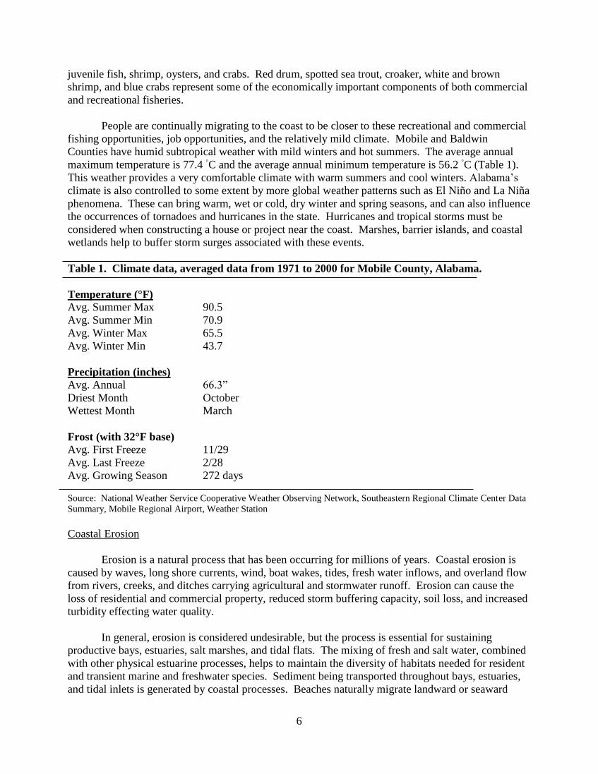
fishing opportunities, job opportunities, and the relatively mild climate. Mobile and Baldwin
Counties have humid subtropical weather with mild winters and hot summers. The average annual
maximum temperature is 77.4 ◦C and the average annual minimum temperature is 56.2
◦C (Table 1).
This weather provides a very comfortable climate with warm summers and cool winters. Alabama’s
climate is also controlled to some extent by more global weather patterns such as El Niño and La Niña
phenomena. These can bring warm, wet or cold, dry winter and spring seasons, and can also influence
the occurrences of tornadoes and hurricanes in the state. Hurricanes and tropical storms must be
considered when constructing a house or project near the coast. Marshes, barrier islands, and coastal
wetlands help to buffer storm surges associated with these events.
Table 1. Climate data, averaged data from 1971 to 2000 for Mobile County, Alabama.
Temperature (°F)
Avg. Summer Max 90.5
Avg. Summer Min 70.9
Avg. Winter Max 65.5
Avg. Winter Min 43.7
Precipitation (inches)
Avg. Annual 66.3”
Driest Month October
Wettest Month March
Frost (with 32°F base)
Avg. First Freeze 11/29
Avg. Last Freeze 2/28
Avg. Growing Season 272 days
Source: National Weather Service Cooperative Weather Observing Network, Southeastern Regional Climate Center Data
Summary, Mobile Regional Airport, Weather Station
Coastal Erosion
Erosion is a natural process that has been occurring for millions of years. Coastal erosion is
caused by waves, long shore currents, wind, boat wakes, tides, fresh water inflows, and overland flow
from rivers, creeks, and ditches carrying agricultural and stormwater runoff. Erosion can cause the
loss of residential and commercial property, reduced storm buffering capacity, soil loss, and increased
turbidity effecting water quality.
In general, erosion is considered undesirable, but the process is essential for sustaining
productive bays, estuaries, salt marshes, and tidal flats. The mixing of fresh and salt water, combined
with other physical estuarine processes, helps to maintain the diversity of habitats needed for resident
and transient marine and freshwater species. Sediment being transported throughout bays, estuaries,
and tidal inlets is generated by coastal processes. Beaches naturally migrate landward or seaward
7
over time due to erosion and accretion, and it is important for shoreline property owners and decision-
makers to better understand these processes.
The two major types of near shore erosion are long-term (passive) erosion and short-term
(active) erosion. Long-term erosion is caused by wave action moving sediment within the coastal
system. Waves generally approach the shore at an angle and transport sediment in the direction of the
breaking wave. Long-term erosion occurs gradually, when there is not enough new sediment to
replenish the sediment removed by wave action. Conversely short-term or active erosion, also called
“avulsion,” is driven by high energy storms with large waves. Short-term erosional events created
from hurricanes and tropical storms can quickly erode and reshape beaches and coast lines (J. C.
Thomas Blate, 2010). These erosional events occur infrequently but must be considered due to the
large amount of damage they typically generate (Table 2). Return periods range from 10 years for
class I hurricanes to 62 years for class IV hurricanes (B. W. Webb, 2011).
Table 2. Hurricane return periods and corresponding storm categories for landfalling hurricanes near
Mon Louis Island, Alabama. As of the 2010 hurricane season, the Saffir-Simpson scale no longer
includes estimates of storm surge for each storm category. These values are included here for purpose
of comparison only. (Table modified from B. M. Webb, 2011, The Coastal Processes of Mon Louis
Island Part 1.)
Storm Category Wind Speed
(mph)
Storm Surge
(ft)
Damage Return Period
(years)
I 74-95 4-5 Minimal 10
II 96-110 6-8 Moderate 21
III 111-130 9-12 Extensive 33
IV 131-155 13-18 Extreme 62
V > 155 > 18 Catastrophic 140
Shoreline Armoring
As the population has increased in coastal Alabama, the amount of armoring to protect against
erosional forces has increased. With increased modification of the natural system, the littoral drift
system has been compromised. The sand that once naturally bypassed tidal inlets and nourished
neighboring coastal segments has become minimized. In various sections of Alabama’s shoreline
erosion rates have increased due to maintenance dredging, bulkheading, and the installation of groins
and jetties. The mean shoreline change rate ranges from -1.4 to -6.1 feet per year in portions of
coastal Alabama (Jones, et. al, 2012).
With the high cost of coastal real estate, shorefront property owners must defend their
properties against erosion where long term erosion is occurring. Traditionally, hard structures such as
bulkheads, riprap, groins, and seawalls have been the suggested structures to combat shoreline
erosion. Contractors tend to recommend these familiar practices to their customers, and coastal
property owners have accepted this straight-line approach, which allows them to walk onto docks to
access the water.
Hard armoring leads to decreased water quality, habitat loss, and loss of public water access
(Figure 1). As of 2012, over 31% of coastal Alabama shorelines were armored using both hard and
living shoreline structures, with hard armoring being used the majority of the time. The highest
percentages of armoring reported in the state include Bayou St. John with over 62%, Bayou La Batre
8
with 58%, Arnica Bay with 56%, Fly Creek with 53%, the Intercoastal Waterway with 51%, Coden
Bayou with 47%, and Mobile Bay with 38% (Table 3).
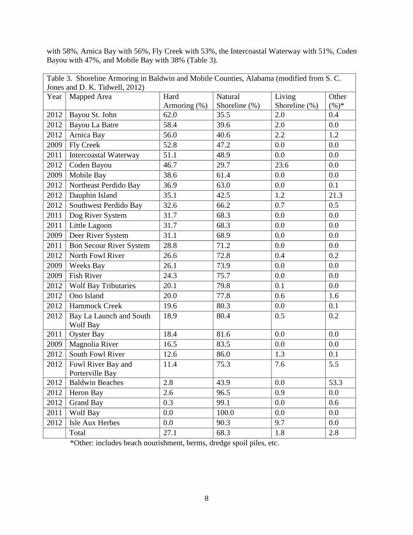
Table 3. Shoreline Armoring in Baldwin and Mobile Counties, Alabama (modified from S. C.
Jones and D. K. Tidwell, 2012)
Year Mapped Area Hard
Armoring (%)
Natural
Shoreline (%)
Living
Shoreline (%)
Other
(%)*
2012 Bayou St. John 62.0 35.5 2.0 0.4
2012 Bayou La Batre 58.4 39.6 2.0 0.0
2012 Arnica Bay 56.0 40.6 2.2 1.2
2009 Fly Creek 52.8 47.2 0.0 0.0
2011 Intercoastal Waterway 51.1 48.9 0.0 0.0
2012 Coden Bayou 46.7 29.7 23.6 0.0
2009 Mobile Bay 38.6 61.4 0.0 0.0
2012 Northeast Perdido Bay 36.9 63.0 0.0 0.1
2012 Dauphin Island 35.1 42.5 1.2 21.3
2012 Southwest Perdido Bay 32.6 66.2 0.7 0.5
2011 Dog River System 31.7 68.3 0.0 0.0
2011 Little Lagoon 31.7 68.3 0.0 0.0
2009 Deer River System 31.1 68.9 0.0 0.0
2011 Bon Secour River System 28.8 71.2 0.0 0.0
2012 North Fowl River 26.6 72.8 0.4 0.2
2009 Weeks Bay 26.1 73.9 0.0 0.0
2009 Fish River 24.3 75.7 0.0 0.0
2012 Wolf Bay Tributaries 20.1 79.8 0.1 0.0
2012 Ono Island 20.0 77.8 0.6 1.6
2012 Hammock Creek 19.6 80.3 0.0 0.1
2012 Bay La Launch and South
Wolf Bay
18.9 80.4 0.5 0.2
2011 Oyster Bay 18.4 81.6 0.0 0.0
2009 Magnolia River 16.5 83.5 0.0 0.0
2012 South Fowl River 12.6 86.0 1.3 0.1
2012 Fowl River Bay and
Porterville Bay
11.4 75.3 7.6 5.5
2012 Baldwin Beaches 2.8 43.9 0.0 53.3
2012 Heron Bay 2.6 96.5 0.9 0.0
2012 Grand Bay 0.3 99.1 0.0 0.6
2011 Wolf Bay 0.0 100.0 0.0 0.0
2012 Isle Aux Herbes 0.0 90.3 9.7 0.0
Total 27.1 68.3 1.8 2.8
*Other: includes beach nourishment, berms, dredge spoil piles, etc.
9
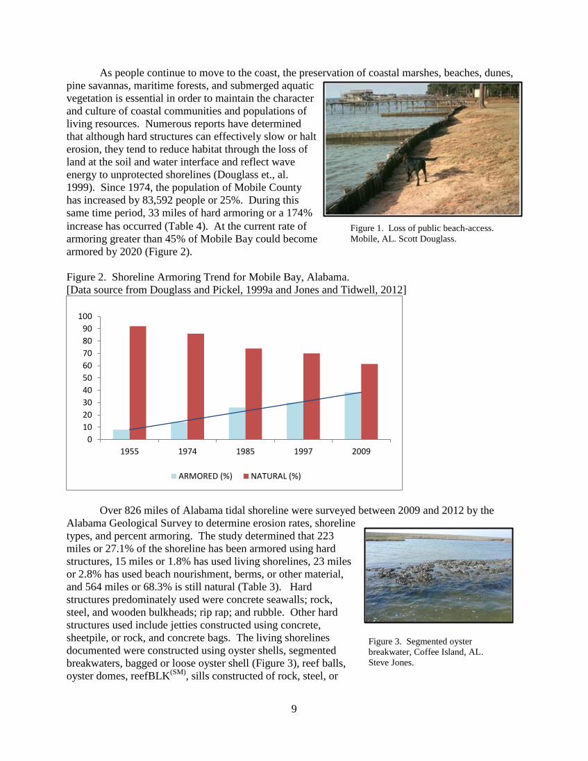
Figure 1. Loss of public beach-access.
Mobile, AL. Scott Douglass.
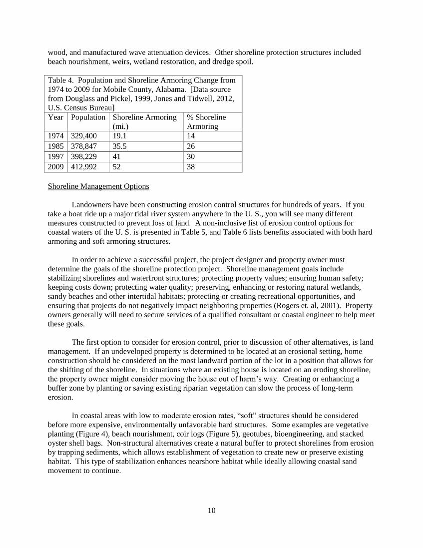
As people continue to move to the coast, the preservation of coastal marshes, beaches, dunes,
pine savannas, maritime forests, and submerged aquatic
vegetation is essential in order to maintain the character
and culture of coastal communities and populations of
living resources. Numerous reports have determined
that although hard structures can effectively slow or halt
erosion, they tend to reduce habitat through the loss of
land at the soil and water interface and reflect wave
energy to unprotected shorelines (Douglass et., al.
1999). Since 1974, the population of Mobile County
has increased by 83,592 people or 25%. During this
same time period, 33 miles of hard armoring or a 174%
increase has occurred (Table 4). At the current rate of
armoring greater than 45% of Mobile Bay could become
armored by 2020 (Figure 2).
Figure 2. Shoreline Armoring Trend for Mobile Bay, Alabama.
[Data source from Douglass and Pickel, 1999a and Jones and Tidwell, 2012]
Over 826 miles of Alabama tidal shoreline were surveyed between 2009 and 2012 by the
Alabama Geological Survey to determine erosion rates, shoreline
types, and percent armoring. The study determined that 223
miles or 27.1% of the shoreline has been armored using hard
structures, 15 miles or 1.8% has used living shorelines, 23 miles
or 2.8% has used beach nourishment, berms, or other material,
and 564 miles or 68.3% is still natural (Table 3). Hard
structures predominately used were concrete seawalls; rock,
steel, and wooden bulkheads; rip rap; and rubble. Other hard
structures used include jetties constructed using concrete,
sheetpile, or rock, and concrete bags. The living shorelines
documented were constructed using oyster shells, segmented
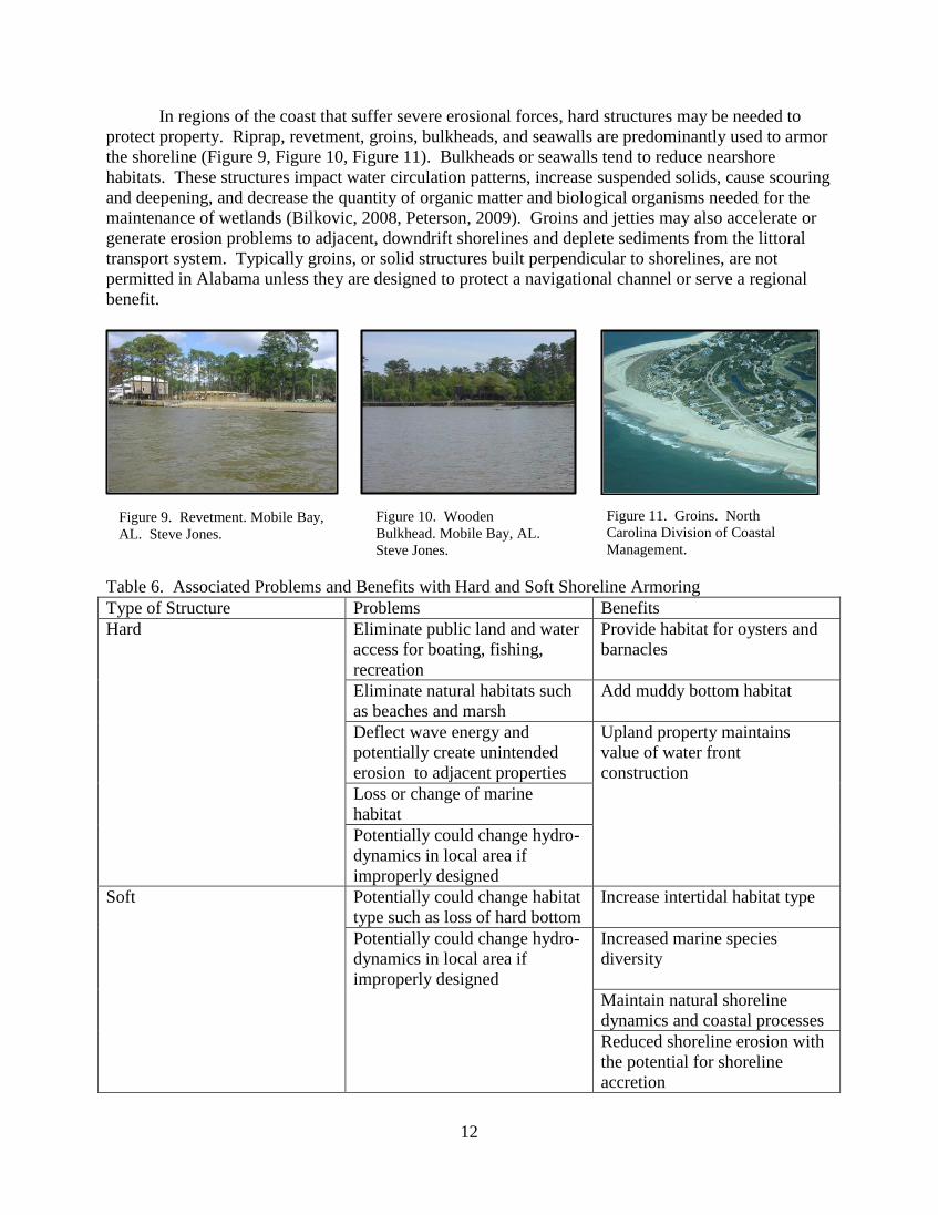
breakwaters, bagged or loose oyster shell (Figure 3), reef balls,
oyster domes, reefBLK(SM)
, sills constructed of rock, steel, or
0
10
20
30
40
50
60
70
80
90
100
1955 1974 1985 1997 2009
ARMORED (%) NATURAL (%)
Figure 3. Segmented oyster
breakwater, Coffee Island, AL.
Steve Jones.
10
wood, and manufactured wave attenuation devices. Other shoreline protection structures included
beach nourishment, weirs, wetland restoration, and dredge spoil.
Table 4. Population and Shoreline Armoring Change from
1974 to 2009 for Mobile County, Alabama. [Data source
from Douglass and Pickel, 1999, Jones and Tidwell, 2012,
U.S. Census Bureau]
Year Population Shoreline Armoring
(mi.)
% Shoreline
Armoring
1974 329,400 19.1 14
1985 378,847 35.5 26
1997 398,229 41 30
2009 412,992 52 38
Shoreline Management Options
Landowners have been constructing erosion control structures for hundreds of years. If you
take a boat ride up a major tidal river system anywhere in the U. S., you will see many different
measures constructed to prevent loss of land. A non-inclusive list of erosion control options for
coastal waters of the U. S. is presented in Table 5, and Table 6 lists benefits associated with both hard
armoring and soft armoring structures.
In order to achieve a successful project, the project designer and property owner must
determine the goals of the shoreline protection project. Shoreline management goals include
stabilizing shorelines and waterfront structures; protecting property values; ensuring human safety;
keeping costs down; protecting water quality; preserving, enhancing or restoring natural wetlands,
sandy beaches and other intertidal habitats; protecting or creating recreational opportunities, and
ensuring that projects do not negatively impact neighboring properties (Rogers et. al, 2001). Property
owners generally will need to secure services of a qualified consultant or coastal engineer to help meet
these goals.
The first option to consider for erosion control, prior to discussion of other alternatives, is land
management. If an undeveloped property is determined to be located at an erosional setting, home
construction should be considered on the most landward portion of the lot in a position that allows for
the shifting of the shoreline. In situations where an existing house is located on an eroding shoreline,
the property owner might consider moving the house out of harm’s way. Creating or enhancing a
buffer zone by planting or saving existing riparian vegetation can slow the process of long-term
erosion.
In coastal areas with low to moderate erosion rates, “soft” structures should be considered
before more expensive, environmentally unfavorable hard structures. Some examples are vegetative
planting (Figure 4), beach nourishment, coir logs (Figure 5), geotubes, bioengineering, and stacked
oyster shell bags. Non-structural alternatives create a natural buffer to protect shorelines from erosion
by trapping sediments, which allows establishment of vegetation to create new or preserve existing
habitat. This type of stabilization enhances nearshore habitat while ideally allowing coastal sand
movement to continue.

11
Table 5. Shoreline Erosion Control Options for Coastal Shoreline Properties
Land Management Soft Structures Hybrid Structures Hard Structures
Retreat Vegetative Planting Oyster Breakwater with
marsh planting
Rip-rap
Set Back Limit Beach nourishment
and dune restoration
Wood or Stone Sill with
marsh planting
Groins
Buffer Zone Coir Fiber Log Wood or Stone Sill with
grading, sand placement,
and marsh planting
Bulkhead
Riparian vegetation
management
Geotubes Wave Attenuation Device
with planting or sand
placement to protect beach
Seawalls
Oyster Shell Bags Headland Breakwater
In regions of the coast that have moderate erosion rates created by winds, waves, and boat
wakes, hybrid structures can be used. Hybrid structures are used to restore, protect, and create
shoreline habitat while maintaining natural sedimentation and water exchange. A property owner
could enhance a marsh fringe with sills constructed of rock, wood, or oyster shell positioned parallel
to shore (Figure 6); use a wooden wave fence with sandfill and marsh plantings (Figure 7); or install a
headland breakwater to protect an existing shoreline (Figure 8). Other options include using reef
balls, reefBLK™, or wave attenuation structures along with marsh planting or beach nourishment.
Figure 5. Coir fiber with vegetative planting.
Moss Point, MS. Chris Boyd. Figure 4. Vegetative plantings. Bayou Texar,
Pensacola, FL. Chris Verlinde.
Figure 6, Rock sill. Baldwin
County, AL. Steve Jones.
Figure 7, Wooden breakwater
with vegetative planting.
Mobile, AL. Scott Douglass.
Figure 8, Brookley headland
breakwater project. Mobile,
AL. Scott Douglass.
12
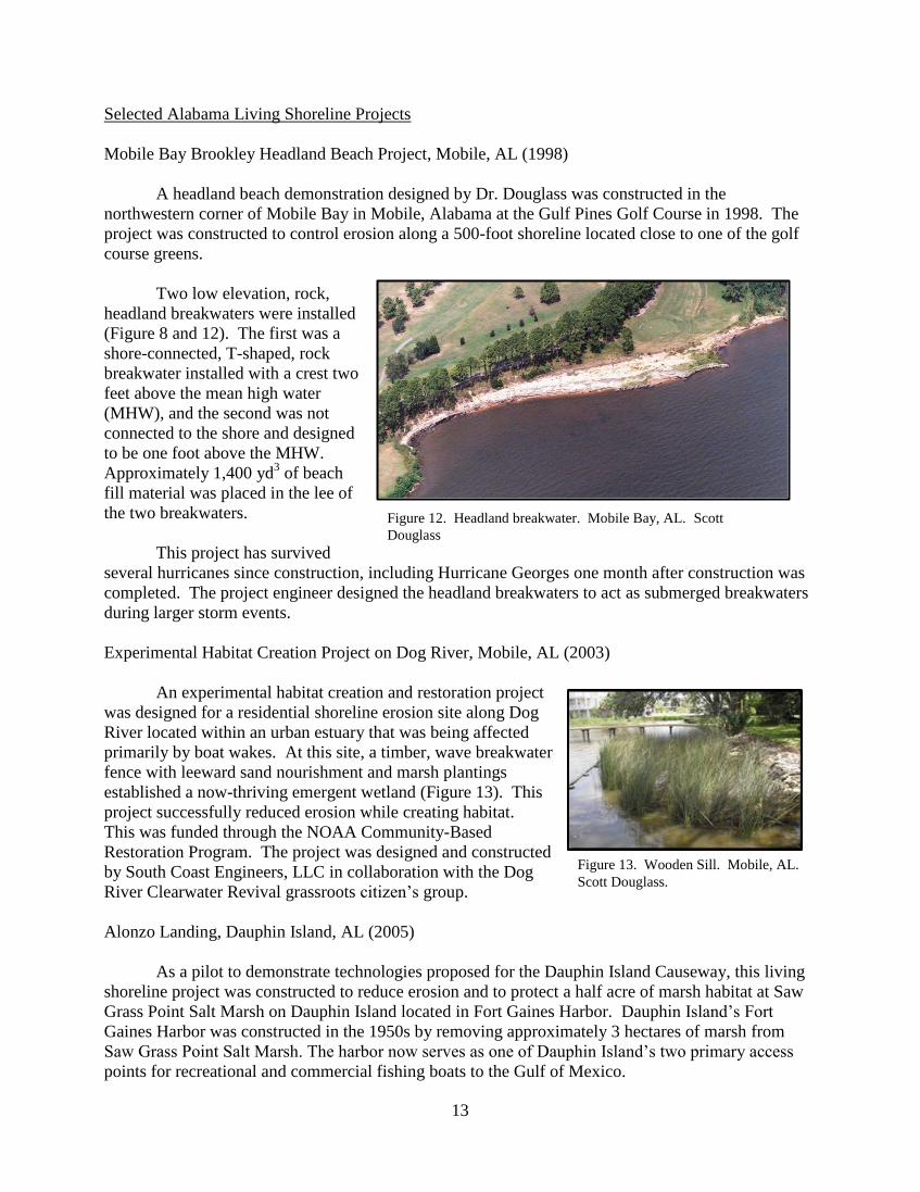
In regions of the coast that suffer severe erosional forces, hard structures may be needed to
protect property. Riprap, revetment, groins, bulkheads, and seawalls are predominantly used to armor
the shoreline (Figure 9, Figure 10, Figure 11). Bulkheads or seawalls tend to reduce nearshore
habitats. These structures impact water circulation patterns, increase suspended solids, cause scouring
and deepening, and decrease the quantity of organic matter and biological organisms needed for the
maintenance of wetlands (Bilkovic, 2008, Peterson, 2009). Groins and jetties may also accelerate or
generate erosion problems to adjacent, downdrift shorelines and deplete sediments from the littoral
transport system. Typically groins, or solid structures built perpendicular to shorelines, are not
permitted in Alabama unless they are designed to protect a navigational channel or serve a regional
benefit.
Table 6. Associated Problems and Benefits with Hard and Soft Shoreline Armoring
Type of Structure Problems Benefits
Hard Eliminate public land and water
access for boating, fishing,
recreation
Provide habitat for oysters and
barnacles
Eliminate natural habitats such
as beaches and marsh
Add muddy bottom habitat
Deflect wave energy and
potentially create unintended
erosion to adjacent properties
Upland property maintains
value of water front
construction
Loss or change of marine
habitat
Potentially could change hydro-
dynamics in local area if
improperly designed
Soft Potentially could change habitat
type such as loss of hard bottom
Increase intertidal habitat type
Potentially could change hydro-
dynamics in local area if
improperly designed
Increased marine species
diversity
Maintain natural shoreline
dynamics and coastal processes
Reduced shoreline erosion with
the potential for shoreline
accretion
Figure 9. Revetment. Mobile Bay,
AL. Steve Jones.
Figure 11. Groins. North
Carolina Division of Coastal
Management.
Figure 10. Wooden
Bulkhead. Mobile Bay, AL.
Steve Jones.
13
Figure 13. Wooden Sill. Mobile, AL.
Scott Douglass.
Figure 12. Headland breakwater. Mobile Bay, AL. Scott
Douglass
Selected Alabama Living Shoreline Projects
Mobile Bay Brookley Headland Beach Project, Mobile, AL (1998)
A headland beach demonstration designed by Dr. Douglass was constructed in the
northwestern corner of Mobile Bay in Mobile, Alabama at the Gulf Pines Golf Course in 1998. The
project was constructed to control erosion along a 500-foot shoreline located close to one of the golf
course greens.
Two low elevation, rock,
headland breakwaters were installed
(Figure 8 and 12). The first was a
shore-connected, T-shaped, rock
breakwater installed with a crest two
feet above the mean high water
(MHW), and the second was not
connected to the shore and designed
to be one foot above the MHW.
Approximately 1,400 yd3 of beach
fill material was placed in the lee of
the two breakwaters.
This project has survived
several hurricanes since construction, including Hurricane Georges one month after construction was
completed. The project engineer designed the headland breakwaters to act as submerged breakwaters
during larger storm events.
Experimental Habitat Creation Project on Dog River, Mobile, AL (2003)
An experimental habitat creation and restoration project
was designed for a residential shoreline erosion site along Dog
River located within an urban estuary that was being affected
primarily by boat wakes. At this site, a timber, wave breakwater
fence with leeward sand nourishment and marsh plantings
established a now-thriving emergent wetland (Figure 13). This
project successfully reduced erosion while creating habitat.
This was funded through the NOAA Community-Based
Restoration Program. The project was designed and constructed
by South Coast Engineers, LLC in collaboration with the Dog
River Clearwater Revival grassroots citizen’s group.
Alonzo Landing, Dauphin Island, AL (2005)
As a pilot to demonstrate technologies proposed for the Dauphin Island Causeway, this living
shoreline project was constructed to reduce erosion and to protect a half acre of marsh habitat at Saw
Grass Point Salt Marsh on Dauphin Island located in Fort Gaines Harbor. Dauphin Island’s Fort
Gaines Harbor was constructed in the 1950s by removing approximately 3 hectares of marsh from
Saw Grass Point Salt Marsh. The harbor now serves as one of Dauphin Island’s two primary access
points for recreational and commercial fishing boats to the Gulf of Mexico.
14
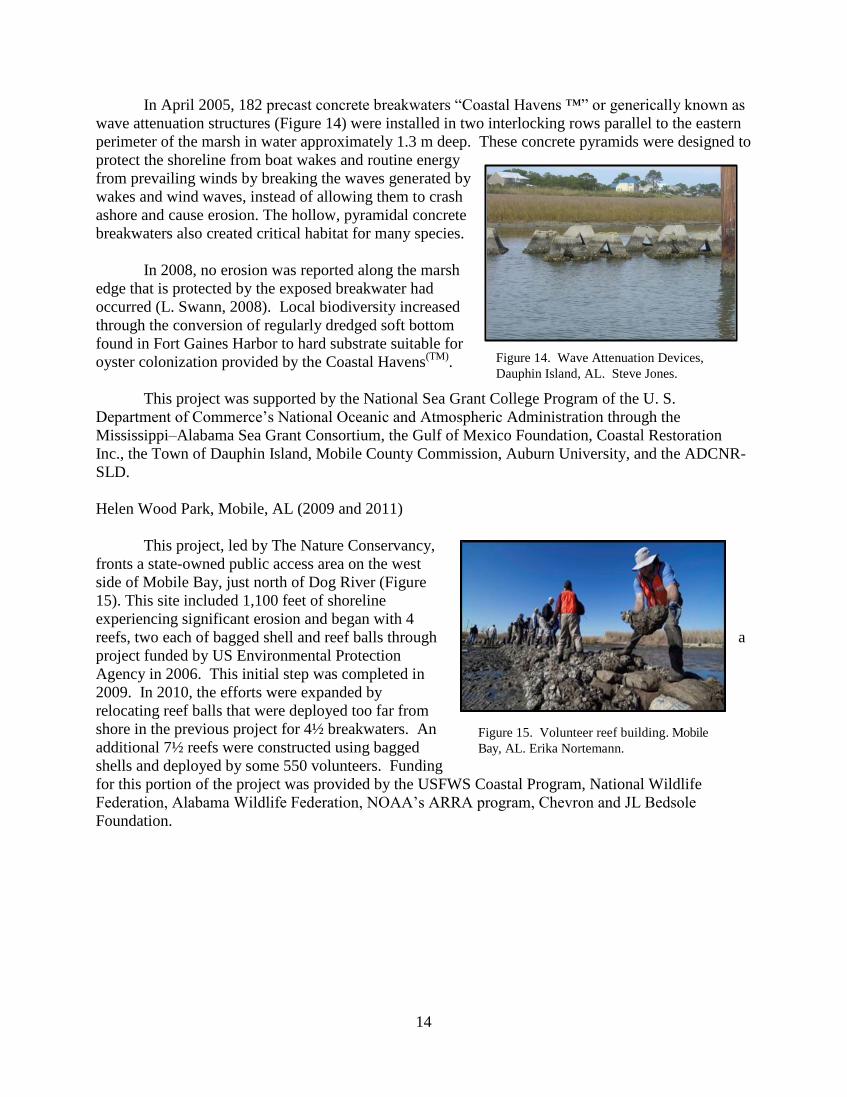
In April 2005, 182 precast concrete breakwaters “Coastal Havens ™” or generically known as
wave attenuation structures (Figure 14) were installed in two interlocking rows parallel to the eastern
perimeter of the marsh in water approximately 1.3 m deep. These concrete pyramids were designed to
protect the shoreline from boat wakes and routine energy
from prevailing winds by breaking the waves generated by
wakes and wind waves, instead of allowing them to crash
ashore and cause erosion. The hollow, pyramidal concrete
breakwaters also created critical habitat for many species.
In 2008, no erosion was reported along the marsh
edge that is protected by the exposed breakwater had
occurred (L. Swann, 2008). Local biodiversity increased
through the conversion of regularly dredged soft bottom
found in Fort Gaines Harbor to hard substrate suitable for
oyster colonization provided by the Coastal Havens(TM)
.
This project was supported by the National Sea Grant College Program of the U. S.
Department of Commerce’s National Oceanic and Atmospheric Administration through the
Mississippi–Alabama Sea Grant Consortium, the Gulf of Mexico Foundation, Coastal Restoration
Inc., the Town of Dauphin Island, Mobile County Commission, Auburn University, and the ADCNR-
SLD.
Helen Wood Park, Mobile, AL (2009 and 2011)
This project, led by The Nature Conservancy,
fronts a state-owned public access area on the west
side of Mobile Bay, just north of Dog River (Figure
15). This site included 1,100 feet of shoreline
experiencing significant erosion and began with 4
reefs, two each of bagged shell and reef balls through a
project funded by US Environmental Protection
Agency in 2006. This initial step was completed in
2009. In 2010, the efforts were expanded by
relocating reef balls that were deployed too far from
shore in the previous project for 4½ breakwaters. An
additional 7½ reefs were constructed using bagged
shells and deployed by some 550 volunteers. Funding
for this portion of the project was provided by the USFWS Coastal Program, National Wildlife
Federation, Alabama Wildlife Federation, NOAA’s ARRA program, Chevron and JL Bedsole
Foundation.
Figure 14. Wave Attenuation Devices,
Dauphin Island, AL. Steve Jones.
Figure 15. Volunteer reef building. Mobile
Bay, AL. Erika Nortemann.
15
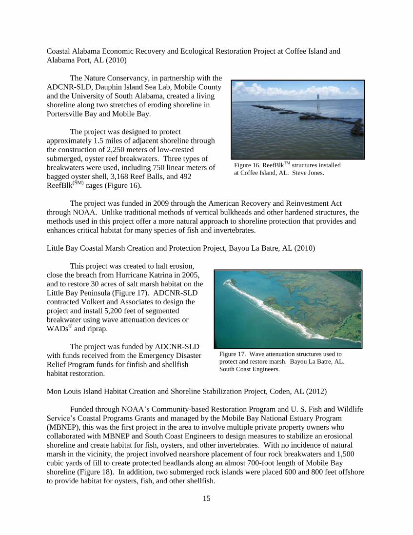
Figure 16. ReefBlkTM
structures installed
at Coffee Island, AL. Steve Jones.
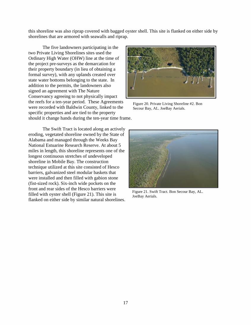
Figure 17. Wave attenuation structures used to
protect and restore marsh. Bayou La Batre, AL.
South Coast Engineers.
Coastal Alabama Economic Recovery and Ecological Restoration Project at Coffee Island and
Alabama Port, AL (2010)
The Nature Conservancy, in partnership with the
ADCNR-SLD, Dauphin Island Sea Lab, Mobile County
and the University of South Alabama, created a living
shoreline along two stretches of eroding shoreline in
Portersville Bay and Mobile Bay.
The project was designed to protect
approximately 1.5 miles of adjacent shoreline through
the construction of 2,250 meters of low-crested
submerged, oyster reef breakwaters. Three types of
breakwaters were used, including 750 linear meters of
bagged oyster shell, 3,168 Reef Balls, and 492
ReefBlk(SM)
cages (Figure 16).
The project was funded in 2009 through the American Recovery and Reinvestment Act
through NOAA. Unlike traditional methods of vertical bulkheads and other hardened structures, the
methods used in this project offer a more natural approach to shoreline protection that provides and
enhances critical habitat for many species of fish and invertebrates.
Little Bay Coastal Marsh Creation and Protection Project, Bayou La Batre, AL (2010)
This project was created to halt erosion,
close the breach from Hurricane Katrina in 2005,
and to restore 30 acres of salt marsh habitat on the
Little Bay Peninsula (Figure 17). ADCNR-SLD
contracted Volkert and Associates to design the
project and install 5,200 feet of segmented
breakwater using wave attenuation devices or
WADs® and riprap.
The project was funded by ADCNR-SLD
with funds received from the Emergency Disaster
Relief Program funds for finfish and shellfish
habitat restoration.
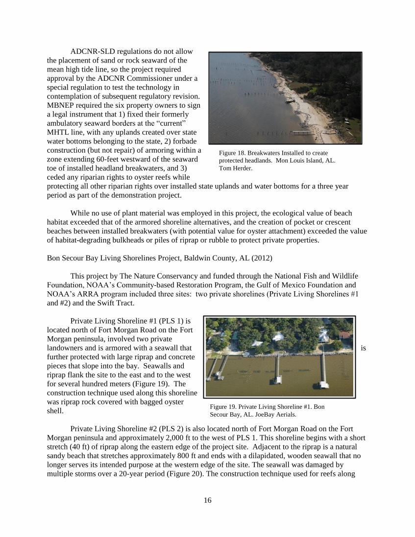
Mon Louis Island Habitat Creation and Shoreline Stabilization Project, Coden, AL (2012)
Funded through NOAA’s Community-based Restoration Program and U. S. Fish and Wildlife
Service’s Coastal Programs Grants and managed by the Mobile Bay National Estuary Program
(MBNEP), this was the first project in the area to involve multiple private property owners who
collaborated with MBNEP and South Coast Engineers to design measures to stabilize an erosional
shoreline and create habitat for fish, oysters, and other invertebrates. With no incidence of natural
marsh in the vicinity, the project involved nearshore placement of four rock breakwaters and 1,500
cubic yards of fill to create protected headlands along an almost 700-foot length of Mobile Bay
shoreline (Figure 18). In addition, two submerged rock islands were placed 600 and 800 feet offshore
to provide habitat for oysters, fish, and other shellfish.
16
ADCNR-SLD regulations do not allow
the placement of sand or rock seaward of the
mean high tide line, so the project required
approval by the ADCNR Commissioner under a
special regulation to test the technology in
contemplation of subsequent regulatory revision.
MBNEP required the six property owners to sign
a legal instrument that 1) fixed their formerly
ambulatory seaward borders at the “current”
MHTL line, with any uplands created over state
water bottoms belonging to the state, 2) forbade
construction (but not repair) of armoring within a
zone extending 60-feet westward of the seaward
toe of installed headland breakwaters, and 3)
ceded any riparian rights to oyster reefs while
protecting all other riparian rights over installed state uplands and water bottoms for a three year
period as part of the demonstration project.
While no use of plant material was employed in this project, the ecological value of beach
habitat exceeded that of the armored shoreline alternatives, and the creation of pocket or crescent
beaches between installed breakwaters (with potential value for oyster attachment) exceeded the value
of habitat-degrading bulkheads or piles of riprap or rubble to protect private properties.
Bon Secour Bay Living Shorelines Project, Baldwin County, AL (2012)
This project by The Nature Conservancy and funded through the National Fish and Wildlife
Foundation, NOAA’s Community-based Restoration Program, the Gulf of Mexico Foundation and
NOAA’s ARRA program included three sites: two private shorelines (Private Living Shorelines #1
and #2) and the Swift Tract.
Private Living Shoreline #1 (PLS 1) is
located north of Fort Morgan Road on the Fort
Morgan peninsula, involved two private
landowners and is armored with a seawall that is
further protected with large riprap and concrete
pieces that slope into the bay. Seawalls and
riprap flank the site to the east and to the west
for several hundred meters (Figure 19). The
construction technique used along this shoreline
was riprap rock covered with bagged oyster
shell.
Private Living Shoreline #2 (PLS 2) is also located north of Fort Morgan Road on the Fort
Morgan peninsula and approximately 2,000 ft to the west of PLS 1. This shoreline begins with a short
stretch (40 ft) of riprap along the eastern edge of the project site. Adjacent to the riprap is a natural
sandy beach that stretches approximately 800 ft and ends with a dilapidated, wooden seawall that no
longer serves its intended purpose at the western edge of the site. The seawall was damaged by
multiple storms over a 20-year period (Figure 20). The construction technique used for reefs along
Figure 19. Private Living Shoreline #1. Bon
Secour Bay, AL. JoeBay Aerials.
Figure 18. Breakwaters Installed to create
protected headlands. Mon Louis Island, AL.
Tom Herder.
17
this shoreline was also riprap covered with bagged oyster shell. This site is flanked on either side by
shorelines that are armored with seawalls and riprap.
The five landowners participating in the
two Private Living Shorelines sites used the
Ordinary High Water (OHW) line at the time of
the project pre-surveys as the demarcation for
their property boundary (in lieu of obtaining a
formal survey), with any uplands created over
state water bottoms belonging to the state. In
addition to the permits, the landowners also
signed an agreement with The Nature
Conservancy agreeing to not physically impact
the reefs for a ten-year period. These Agreements
were recorded with Baldwin County, linked to the
specific properties and are tied to the property
should it change hands during the ten-year time frame.
The Swift Tract is located along an actively
eroding, vegetated shoreline owned by the State of
Alabama and managed through the Weeks Bay
National Estuarine Research Reserve. At about 5
miles in length, this shoreline represents one of the
longest continuous stretches of undeveloped
shoreline in Mobile Bay. The construction
technique utilized at this site consisted of Hesco
barriers, galvanized steel modular baskets that
were installed and then filled with gabion stone
(fist-sized rock). Six-inch wide pockets on the
front and rear sides of the Hesco barriers were
filled with oyster shell (Figure 21). This site is
flanked on either side by similar natural shorelines.
Figure 20. Private Living Shoreline #2. Bon
Secour Bay, AL. JoeBay Aerials.
Figure 21. Swift Tract. Bon Secour Bay, AL.
JoeBay Aerials.
18
Chapter 3. Laws and Regulations for Shoreline Erosion Control
Alabama Erosion Control Structure Regulations
In order to obtain an approved permit in coastal Alabama for a shoreline stabilization project,
the property owner must submit an application to the ADCNR-SLD, ADEM, and the USACE Mobile
District. All three agencies promote the use of natural alternatives where feasible and tend to favor
the use of living shorelines. Although the agencies are in favor of natural alternatives, hard armoring
remains the predominant form of erosion control permitted. A list of potential options to amend these
regulations in favor of the living shoreline approach will be discussed later in this chapter.
The USACE Mobile District has three general permits that include a living shoreline general
permit and two nationwide permits that can be used to speed up the review process for shoreline
protection and enhancement projects. In addition, information from other state natural resource
management programs that is relevant to helping to facilitate the adoption of living shoreline policy
by both state and federal agencies is included.
ADCNR-SLD Regulations
Activities on State-Owned Submerged Lands
o Uses cannot be contrary to the public interest.
o Lands are to be managed primarily for the maintenance of essentially natural conditions,
propagation of fish and wildlife, and traditional recreational uses such as fishing, boating,
and swimming. (Ala. Admin. Code r. 220-4-.09(4)(b)(1).)
o Reclamation activities on state owned submerged lands shall be approved only if avulsion
or artificial erosion is affirmatively demonstrated. Other activities involving the placement
of fill material below the ordinary low water line of non-tidal streams or the mean high tide
line of tidal water shall not be approved. (Ala. Admin. Code r. 220-4-.09(4)(b)(5).)
o To the maximum extent possible, shoreline stabilization should be accomplished by the
establishment of appropriate native wetland vegetation. Riprap materials, pervious
interlocking brick systems, filter mats, and other similar stabilization methods should be
utilized in lieu of vertical seawalls wherever feasible. (Ala. Admin. Code r. 220-4-
.09(4)(b)(6).)
o Activity must be setback 10 feet from the riparian lines of adjacent property owners. (Ala.
Admin. Code r. 220-4-.09(4)(b)(11).)
o If in riparian area, the permittee must have upland property interest unless:
A governmental entity is conducting restoration or enhancement activities.
o Riprap can be placed within 10 feet waterward of the mean high tide line. (Ala. Admin.
Code r. 220-4-.09(4)(e)(1)(iv).)
o Mooring pilings, breakwaters, and jetties must be setback 10 feet from the riparian lines.
(Ala. Admin. Code r. 220-4-.09(4)(c)(4).)

19
ADEM Regulations
General Rules
o The extent to which coastal resources will be adversely impacted must be considered by
the department. (Ala. Admin. Code r. 335-8-2-.01.)
o Coastal resources to be considered include:
Historical, architectural, or archaeological sites. (Ala. Admin. Code r. 335-8-2-
.01(2)(a).)
Wildlife and fishery habitat, particularly those designated critical habitat of any
endangered species. (Ala. Admin. Code r. 335-8-2-.01(2)(b).)
The public access to tidal and submerged lands, navigable waters and beaches or
other public recreational resources. (Ala. Admin. Code r. 335-8-2-.01(2)(c).)
Shoreline Stabilization and Erosion Mitigation
o The use of bulkheads, riprap, and other structural shoreline armament are permitted as long
as:
No fill material is placed in wetlands or submersed grassbeds (unless specifically
authorized by regulations),
Structure is placed at or above mean high tide and landward of wetlands, and
There are no other feasible non-structural alternatives available. (Ala. Admin. Code
r. 335-8-2-.06(1).)
o The use of jetties, groins, breakwaters and like structures are permitted as long as:
It is necessary in protecting an existing navigational channel or regional use
benefit,
No other non-structural alternatives are feasible, and
There are no significant impacts to adjacent shorelines. (Ala. Admin. Code r. 335-
8-2-.06(2).)
o Non-structural alternatives include preservation and restoration of dunes, beaches,
wetlands, submersed grassbeds, and shoreline restoration and nourishment and retreat or
abandonment. (Ala. Admin. Code r. 335-8-2-.06(1)(d).)
Dredging and Filling of Wetlands
o Dredging and filling for shoreline stabilization will be permissible so long as the following
conditions are met:
The activity is related to an approved beach nourishment, shoreline stabilization or
marsh creation, restoration or enhancement project;
Is not in close proximity to existing natural oyster reefs, except in association with
the approved creation or enhancement of oyster reefs or artificial fish attracting
structures;
Is not in close proximity of submersed grassbeds;
Applicable water quality standards will be met; and
No alternative project site or design is feasible and the adverse impacts to coastal
resources have been reduced to the greatest extent practicable. (Ala. Admin. Code
r. 335-8-2-.02(1)(a).)
o Dredging and filling in non-adjacent wetlands may be permitted provided that there are no
alternative sites that are feasible and the adverse impacts have been reduced.
20
Shoreline Property Boundaries – Background
State-Owned Submerged Lands:
o Alabama expressly claims ownership of submerged lands: “All the beds and bottoms of the
rivers, bayous, lagoons, lakes, bays, sounds and inlets within the jurisdiction of the state of
Alabama are the property of the state of Alabama to be held in trust for the people thereof
… .” (ALA. CODE § 9-12-22.)
o Alabama regulations define state owned submerged lands as including but not limited to
“tidal lands, sand bars, shallow banks, and lands waterward of the mean low water line
beneath navigable fresh water or the mean high tide line beneath tidally-influenced waters,
to which the State of Alabama acquired title on December 14, 1819, by virtue of statehood,
or thereafter and which have not been heretofore conveyed or alienated.” (Ala. Admin.
Code r. 220-4-.09(3)(n)).
o General Rule: Shorelines naturally shift and shoreline property boundaries (between the
upland owner and the state-owned submerged lands) shift with the natural processes
because the mean high tide line serves as the property line. In limited circumstances,
waterward property boundaries may be set at a fixed point. These instances are evaluated
on a case-by-case basis.
Mean High Tide Line:
o The boundary line between state owned submerged lands and private property is the mean
high tide line (MHTL) in tidal areas and the mean low water mark along non-tidal
navigable waterways. (Ala. Admin. Code r. 220-4-.09.)
Public Trust Doctrine:
o Alabama recognizes the public’s right to use these waters for navigation, commerce,
fishing, and swimming. (Ala. Admin. Code r. 222-4-.09(c).)
Riparian/Littoral Rights:
o Waterfront property owners may also exercise riparian rights over waters abutting their
shoreline.
o Riparian rights include the right to access the water, the right to construct piers, and the
right to harvest oysters. (ALA. CODE §§ 33-7-50 through 33-7-53, 9-12-22.)
Artificial Accretion:
o Alabama defines artificial erosion as “the slow and imperceptible loss or washing away of
sand, sediment, or other material from property caused by man-made projects and
operations.” (Ala. Admin. Code r. 220-4-.09(3)(a).)
o Accretions caused by man-made activities, like U.S. Army Corps of Engineer’s dredging
projects, are artificial accretions. (State v. Gill, 66 So. 2d 141, 142 (Ala. 1953); Reid v.
State, 373 So. 2d 1071, 1073 (Ala. 1979)).
o Accretions or erosions resulting from living shoreline installations fall within this category.
Ownership of Accretions:
o Upland property owners cannot obtain ownership of submerged lands by artificially filling
those lands. (Reid v. State, 373 So. 2d 1071, 1073 (Ala. 1979)).
o If the upland owner or his predecessor in title caused the accretion, the accretion belongs to
the state. (Spottswood v. Reimer, 41 So. 3d 787, 795 (Ala. Civ. App. 2009)).
21
o An upland owner may claim ownership of the accreted land only if he (or any prior owner
of his land) did not cause, consent to, or participate in the making of the artificially
accreted lands. (Reid v. State, 373 So. 2d 1071, 1073 (Ala. 1979)).
o If the upland owner’s land accretes due to natural conditions, the new dry land is now
owned by the upland property owner.
Avulsion
o Avulsion means the sudden or perceptible loss or addition to land by the action of water.
(Ala. Admin. Code r. 220-4-.09).
o Avulsion differs from naturally occurring erosion/accretion because it happens suddenly.
Sudden changes resulting from flooding or hurricanes are avulsive events.
o An avulsive event does not change property boundaries.
o Reclamation activities on state-owned submerged lands shall be approved only if avulsion
or artificial erosion is affirmatively demonstrated. (Ala. Admin. Code r. 220-4-
.09(4)(b)(5)).
o If the avulsive event creates new dry land on a property, the upland owner does not own
the newly exposed land. Because avulsive events do not change the property boundaries,
Alabama continues to own the new dry land even though it is no longer submerged.
Beach renourishment projects exception:
o State law establishes that any land accreted as a result of beach projects undertaken by
coastal municipalities remains state owned land.
o Riparian landowners impacted by this law are “entitled to all statutory and common-law
riparian or littoral rights of access to the mean high tide line across the state-owned lands
filled in the course of a permitted beach project or by subsequent natural or artificial fill
process, including, without limitation, access rights for ingress, egress, boating, bathing,
and fishing.” (ALA. CODE § 9-15-55(d).)
USACE Mobile District Regulations
Permit types:
o Individual Permit (IP)
o General Permit – Regional or Nationwide (NWP)
Used for activities that are similar in nature, will cause only minimal adverse
environmental effects when performed separately, and will have only minimal
cumulative adverse effect on the environment.
Individual Permit:
o Issued for projects that propose extensive impacts, or impacts to rare or fragile aquatic
environments.
o Generally required for projects whose proposed impacts will be greater than one acre of
wetland or stream, but USACE can chose to review any project under an individual permit,
regardless of its impact or size.
o Most detailed and time consuming wetland permitting process.
Regional General Permit:
o Typically required for projects that fall somewhere between an IP and NWP in terms of
their proposed impacts.
22
o Usually includes provisions intended to protect the environment and resources of a
specific region that shares similar interests.
o There are three general permits that can be used to control shoreline erosion.
ALG10-2011 Living Shorelines General Permit. This general permit allows for the
installation of native wetland plants and breakwaters composed of approved
construction material if wave attenuation is needed for project success. Approval
by the ADCNR-SLD is needed and oyster shells must only be used in classified
“Conditionally Approved” waters by the Alabama Department of Public Health
(Appendix 1).
ALG11-2011 Armoring Systems (Riprap), Bulkheads, River Training Structures,
Bioengineering, and other Standard Shoreline Protection/Stabilization Devices
roughly paralleling, and at the Existing Shoreline or Bank. This general permit
states that shoreline stabilization should be accomplished by using appropriate
native vegetation. In cases where native vegetation will not accomplish shoreline
stabilization riprap materials, pervious interlocking brick systems, filter mats, and
other similar stabilization methods should be used in lieu of vertical seawalls and
bulkheads whenever feasible. Coordination with ADCNR-SLD is required
(Appendix 2).
ALG26-2011 – Shoreline/Bank Protection General Permit for Weeks Bay NERR.
Shoreline protection shall only be considered in those areas where the riparian
vegetation proves inadequate in preventing erosion. The shoreline protection is
limited to the placement of riprap (Appendix 3).
Nationwide Permit
o A general permit that allows the USACE to authorize activities across the country
that cause minimal impact.
o Permitted activity must satisfy all of the permit conditions, which include compliance with
state or regional laws and regulations.
o NWPs relevant to restoration projects include NWP 13 and NWP 27.
o Nationwide Permit 13: Bank Stabilization
Authorizes activities necessary to prevent erosion and stabilize shorelines.
Limited to projects no more than 500 feet in length, unless waived by a USACE
district engineer citing minimal adverse effects.
Permitted activity must also comply with any regional or state laws and regulations.
ADEM has denied the NW 13 coastal consistency; therefore, bulkhead applicants
must apply for an IP. This denial encourages property owners to choose living
shorelines to control erosion on their property through the use of the ALG10-2011
Living Shorelines General Permit.
o Nationwide Permit 27: Aquatic Habitat Restoration, Establishment, and Enhancement
Activities
Authorizes activities associated with the restoration, enhancement, and establishment
of tidal and non-tidal wetlands.
Specifically authorizes the construction of oyster habitat in tidal waters.
Permitted activity must also comply with any regional or state laws and regulations.
23
Other State Erosion Control Structures Regulations
Florida
Shoreline stabilization and restoration projects will generally require permitting for use of
environmental resources, sovereign submerged lands, and federal dredge and fill. To simplify
permitting, the state has combined these needs into one joint permit application under the
Environmental Resource Permitting (ERP) program.
Restoration projects may qualify for a de minimus exception for activities that have only a
minimal or insignificant individual or cumulative impact on water resources (F.S.A, § West's F.S.A.
§ 373.406(6)). This exemption applies to projects that would otherwise require an ERP. The
provision allows any district to exempt qualifying projects on a case-by-case basis. To qualify,
applicants must request the exemption in writing and no activity may begin until the district issues a
written decision. This exemption has been used in the FLDEP Central District for restoration
activities.
The Northwest Florida Department of Environmental Protection District (NWFL DEP)
approves exceptions for living shorelines made of native vegetation that are less than 150 feet long
(Appendix 4). An oyster breakwater can be installed if permanent wave attenuation is needed to
maintain the health of planted native vegetation. The outer edge of the oyster breakwater shall not
extend more than 10 linear feet waterward of the approximate MHWL. Three foot gaps must be
present for every 20 feet of oyster reef. In addition, the reefs must be constructed of predominantly
natural oyster shell or fossilized oyster shell, although unconsolidated boulder, rocks, and clean
concrete rubble can be associated with the oyster shell. Property owners or applicant would receive a
regulatory exemption from the NWFL DEP and a waived application fee upon approval. The
applicant would still have to submit an application to the USACE.
North Carolina
Living shoreline projects are permitted under the Coastal Area Management Act (CAMA) in
North Carolina. North Carolina Department of Natural Resources Division of Coastal Management
oversees CAMA permitting. Five general permits for estuarine shoreline stabilization are approved
and listed below:
General Permit for the construction of sheetpile sills (Appendix 5).
General Permit for the construction of riprap sills for wetland enhancement and public trust
waters (Appendix 6).
General Permit for placement of riprap revetments for wetland protection in estuarine and
public trust waters.
General Permit for construction of groins in estuarine and public trust waters and ocean
hazard areas.
General Permit for construction of bulkheads and riprap revetments for shoreline
protection in estuarine and public trust waters and ocean hazard areas.
The general permits for sheet pile sills and riprap sills can be used for living shoreline
projects. Additionally, an exemption is available to use vegetative planting for shoreline stabilization.
These living shorelines general permits were approved in 2003. “The intent of the legislation was to
24
replace an implied preference for hardened shorelines with a policy preference for more natural and
sustainable shoreline management practices” (Virginia Institute of Marine Science, 2010).
Maryland
In 2008, the legislature passed the Living Shorelines Protection Act stating “living shorelines”
are the preferred method of shore protection as they trap sediment, filter pollution, and provide
important aquatic and terrestrial habitat; and whereas, it is the public policy of the State to protect
natural habitat and that shoreline protection practices, where necessary, consist of nonstructural
“living shoreline” erosion control measures wherever technologically and ecologically appropriate
(2008 Md. Laws Ch. 304 (H.B. 973)). In addition, it states that improvements to protect a person’s
property against erosion shall consist of nonstructural shoreline stabilization measures that preserve
the natural environment, such as marsh creation, except in areas designated by the Maryland
Department of Natural Resources (MDNR) Mapping Department as appropriate for structural
shoreline stabilization measures; or in areas where the person can demonstrate to the MDNR
satisfaction that such measures are not feasible, including areas of excessive erosion, areas subject to
heavy tides, and areas too narrow for effective use of nonstructural shoreline stabilization measures.
Virginia
A law was passed in 2011 stating that the Marine Resources Commission, in cooperation with
the Department of Conservation and Recreation and with technical assistance from the Virginia
Institute of Marine Science, shall establish and implement a general permit regulation that authorizes
and encourages the use of living shorelines as the preferred alternative for stabilizing tidal shorelines
in the Commonwealth. In developing the general permit, the Commission shall consult with the U.S.
Army Corps of Engineers to ensure the minimization of conflicts with federal law and regulation.
(VA. CODE ANN. § 28.2-104.1 (West 2011)).
Recommended Changes to Alabama Regulatory Policies
The below rules and regulations should be considered for modification to better encourage
living shoreline projects by ADCNR-SLD and ADEM.
ADCNR-SLD
Reclamation activities on state owned submerged lands shall be approved only if avulsion or
artificial erosion is affirmatively demonstrated. Other activities involving the placement of fill
material below the ordinary low water line of non-tidal streams or the mean high tide line of tidal
water shall not be approved. (Ala. Admin. Code r. 220-4-.09(4)(b)(5).)
o This provision has been identified as a potential obstacle to living shoreline
installations.
To the maximum extent possible, shoreline stabilization should be accomplished by the
establishment of appropriate native wetland vegetation. Rip-rap materials, pervious interlocking
brick systems, filter mats, and other similar stabilization methods should be utilized in lieu of
vertical seawalls wherever feasible. (Ala. Admin. Code r. 220-4-.09(4)(b)(6).)
25
o This provision suggests that living shorelines would be a favored alternative to use in place
of hard structures. Living shorelines could be added to the list of shoreline stabilization
methods with rip-rap to encourage their use.
Proposed Revision: To the maximum extent possible, shoreline stabilization
should be accomplished by the establishment of appropriate native wetland
vegetation. Rip-rap materials, pervious interlocking brick systems, filter mats, coir
fiber logs, off shore breakwaters composed of rock, wood, or oyster shells, wave
attenuation devices, or other living shoreline stabilization methods should be
utilized in lieu of vertical seawalls wherever feasible.
o Note that suggested modification was to recognize and include living shoreline
methods within the recognized preferred materials.
Riprap can be placed within 10 feet waterward of the mean high tide line. (Ala. Admin. Code r.
220-4-.09(4)(e)(1)(iv).)
o In the context of shoreline stabilization, riprap may be placed 10 linear feet waterward of
the mean high tide line. Conceivably, living shoreline installations serving the same
purpose as riprap could be permitted within this same area.
Proposed revision: Riprap, oyster shell (in conditionally approved waters), wave
attenuation devices, or other living shoreline installations serving the same purpose as
riprap can be placed within 10 linear feet waterward of the mean high tide line.
ADEM
Shoreline Stabilization and Erosion Mitigation
o The use of bulkheads, rip-rap, and other structural shoreline armament are permitted as
long as:
o No fill material is placed in wetlands or submersed grassbeds (unless specifically
authorized by regulations),
o Structure is placed at or above mean high tide and landward of wetlands, and there are no
other feasible non-structural alternatives available. (Ala. Admin. Code r. 335-8-2-.06(1).)
Proposed revision to Ala. Admin. Code r.335-8-2-.06(1). Structure is placed at or
above mean high tide and landward of wetlands, and there are no other feasible
non-structural alternatives or living shoreline options available. If fill material
must be used to ensure success of a living shoreline project, it must not impact
wetlands or submersed grassbeds. If offshore breakwaters are needed for wave
attenuation they can be installed up to 10 linear feet waterward of the mean high
tide line if approved materials are used.
o Note that 10 feet limitation was included here following the rule allowing
riprap 10 feet waterward of the mean high tide as a model and for
consistency. This measurement can be modified as regulators see
appropriate if this provision was adopted.
The use of jetties, groins, breakwaters and like structures are permitted as long as:
o It is necessary in protecting an existing navigational channel or regional use benefit,
o No other non-structural alternatives are feasible, and
Proposed revision: No other feasible non-structural alternatives or living shorelines
options available
o There are no significant impacts to adjacent shorelines. (Ala. Admin. Code r. 335-8-2-
.06(2).)
26
Non-structural alternatives include preservation and restoration of dunes, beaches, wetlands,
submersed grassbeds, and shoreline restoration and nourishment and retreat or abandonment. (Ala.
Admin. Code r. 335-8-2-.06(1)(d).)
o Proposed revision: Non-structural alternatives include preservation and restoration of dunes,
beaches, wetlands, submersed grassbeds, installation of living shorelines that could include
wetland plants, fill material to ensure project success or to reestablish existing beach, and
wave attenuation structures where appropriate, and shoreline restoration and nourishment and
retreat or abandonment.
Creation of an approved definition of what a living shoreline is would be useful and needed to
promote and encourage their use.
o Proposed living shoreline definition: A shoreline management practice that provides erosion
control benefits; protects, restores, or enhances natural shoreline habitat; and maintains coastal
processes through strategic placement of plants, stone, sand fill, and other structural organic
materials. This definition was taken from NOAA.
ADEM could deny the use of the Regional General Permit ALG11-2011 therefore, bulkhead
applicants must apply for an Individual Permit. This denial would encourage property owners to
choose living shorelines to control erosion on their property through the use of the ALG10-2011
Living Shorelines General Permit.
27
Chapter 4. Living Shorelines Design and Permitting Challenges
Living Shorelines Design
In order for a living shoreline project to be successful, the design and construction must be
implemented correctly. There are many erosional processes to be considered when constructing a
project. Factors to consider include wave climate and characteristics, tides, storm surge, bottom
sediment type, longshore transport, habitat type, currents, fetch, bathymetry, and boat traffic at the
site. An engineer, consultant, contractor, or property owner must then develop a design based on
these factors and overall project goals.
Planting wetland vegetation alone might not be sufficient to stabilize shorelines in many
Alabama locations. In order to have a successful project that only employs installing marsh
vegetation, the site must have a limited fetch, an average nearshore water depth of less than 1.5 feet, a
shallow slope, and presence of existing marsh vegetation, such as Spartina alterniflora, Spartina
patens or Juncus romerianus. In regions with slightly higher erosion rates, offshore breakwaters may
be required to protect existing marsh along with the planting of additional wetland vegetation.
Grading and filling of the land may be needed in many circumstances to ensure optimum elevation
and slope to stabilize the site and to ensure project success. If fill material is needed, clean sand
containing less than 10% material able to pass through a standard number 100 sieve is recommended
(A. Baldwin, 2006). If the project site contains a sandy beach habitat on an erosional shoreline, the
project designer may need to install offshore or headland breakwaters along with sand fill to ensure
uninterrupted sand transport and allow the sandy shoreline to reach equilibrium. Finally, high
erosional areas may require larger and more numerous breakwaters, wave attenuation devices, or a
combination of headland breakwaters with grading, fill, and installation of plants to ensure project
success.
As more natural shoreline erosion control projects are installed in Alabama, property owners
will likely wish to incorporate recreational benefits, erosion control, and habitat protection into project
designs. Hopefully, regulators will be open-minded and flexible in allowing innovative designs as
alternatives to bulkheads.
Permitting Challenges for Living Shorelines
Certain challenges exist for permitting shoreline stabilization projects. These issues include
coastal property rights; public health concerns; navigational hazards; grading riparian areas; disruption
or removal of natural vegetation; placement of rock, shell, or other material on state submerged land
to preserve existing or a newly planted vegetated area; and filling nearshore waters to create intertidal
wetlands or to enhance sandy beaches.
In order for certain living shoreline projects to be approved shoreline management agencies
might have to accept certain impacts in order for these more natural and sustainable practices to be
approved in a more expedited manner. Therefore, the successful promotion of the living shoreline
program will require cooperative efforts by all regulatory agencies in coastal Alabama. The primary
regulatory agencies are ADCNR-SLD, ADEM, and USACE Mobile District. In addition, the
Alabama Department of Marine Resources, NOAA, the U.S. Fish and Wildlife Service, and the
Alabama Historical Commission having the opportunity to provide comments related to the potential
impacts.
28
The major issue for the ADCNR-SLD is ensuring that state-owned submerged lands are not
converted to private ownership due to the construction of living shoreline projects, resulting in loss of
state land. The ADCNR-SLD also must ensure that a property owner does not convert accreted lands
to uplands through the construction of a bulkhead or similar structures on property belonging to the
state.
Since state of Alabama public trust lands have not been comprehensively delineated, property
owners will be required to provide a survey that shows the MHTL. Property owners will then be
required to sign an affidavit before a living shoreline project is approved by ADCNR-SLD, agreeing
that if state water bottoms are lost due to shoreline accretion as a result of the project, the State retains
ownership of that “new” upland area. The State of Mississippi overcame these concerns by
implementing a fixed property line, which they established through the Public Trust Tidelands Act
(MISS. CODE ANN. §§ 29-15-1 to 29-15-7 (West 2010)). A second option would be to adopt a policy
similar to that of beach re-nourishment projects. This would allow construction of living shoreline
projects while preserving state ownership of submerged lands in the event of artificial accretion. It
would also give the upland owner assurance of retaining their riparian rights for access and other
purposes.
The most recent proposed regulatory policy change related to alternative shoreline structures
for the ADCNR-SLD states that to approve a shoreline erosion control project, the agency must
determine that the project is not contrary to public interest, and it must include the conditions, terms,
and restrictions necessary to protect state submerged lands. The use of alternatives to bulkheads, and
similar structures shall be designed and located to avoid and/or minimize impacts to navigation or
public trust resources. The use of alternatives to bulkheads, and similar structures extending seaward
of the riparian private property owner’s fee simple property greater than 10 feet seaward shall provide
notarized documentation of the pre-project shoreline location. Alternatives which are primarily
designed to establish shoreline vegetation, fish, shellfish, and/or wildlife habitat; or to promote public
recreational opportunities may utilize fill to elevate the near shore to the minimum elevation approved
by the Department as necessary. ADCNR-SLD may require pre-project and post project monitoring
of the immediate shoreline. The use of alternatives to bulkheads for the purpose of shoreline
reclamation requires pre-approved reclamation efforts.
Additionally, in areas with high rates of erosion, retaining walls are thought to potentially
create a future shoreline armoring issue due to erosion, scouring, and impacts to adjacent and down-
drift properties. For instance, if a retaining wall built on the upland portion of a property later
becomes submerged in water as a consequence of erosion unintended erosion may occur on adjacent
properties. Therefore, this issue should be addressed by state, county, and municipal regulators.
Although living shorelines are the suggested erosion control alternative in some states, an
applicant must still provide evidence that the project will maintain the ecological condition of the pre-
existing shoreline. For instance, a proposed living shoreline design that includes an oyster reef
breakwater to protect an existing marsh with installed native vegetation must ensure that they take into
account issues like changing shorelines, currents, sand flows, potential to create shoaling within a
localized area, and if the projects intention is to trap sand would the project restrict essential water
circulation. In addition if the project site accretes marsh or another habitat type that begins to
encroach on submerged aquatic vegetation or other critical habitat, the applicant would have to
modify the project design to avoid negative impacts to these existing habitats.
29
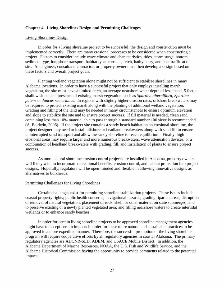
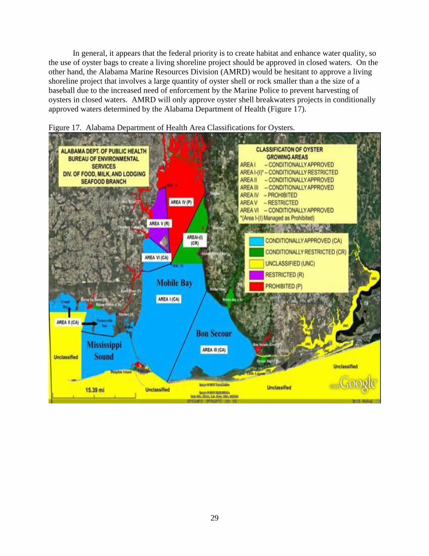
In general, it appears that the federal priority is to create habitat and enhance water quality, so
the use of oyster bags to create a living shoreline project should be approved in closed waters. On the
other hand, the Alabama Marine Resources Division (AMRD) would be hesitant to approve a living
shoreline project that involves a large quantity of oyster shell or rock smaller than a the size of a
baseball due to the increased need of enforcement by the Marine Police to prevent harvesting of
oysters in closed waters. AMRD will only approve oyster shell breakwaters projects in conditionally
approved waters determined by the Alabama Department of Health (Figure 17).
Figure 17. Alabama Department of Health Area Classifications for Oysters.
30
Chapter 5. Living Shoreline Model Ordinances
The use of living shorelines could be implemented in city and county model ordinances in the
coastal region of Alabama. Such ordinances would ensure that more property owners consider using
living shorelines technologies to protect their waterfront property from erosion. They would
encourage the establishment of landscape architectural and coastal engineering designs before
construction begins on new properties, and existing properties could gradually be retrofitted with
living shorelines technologies instead of replacing aging or storm-damaged bulkheads. Municipalities
in other states have created non-structural armoring ordinances and incentive-based programs to
encourage more sustainable erosion control practices, as discussed below.
Example Living Shoreline Model Ordinance
A local ordinance created for Kent County, Maryland allows county regulations to be more
stringent than the Maryland Department of Natural Resources regulations related to erosion and
sediment controls to protect its natural resources. Current Kent County policy for shoreline erosion
control requires property owners considering installation of hardened shoreline armor to demonstrate
that a living shoreline would be inappropriate for that site. This policy was codified into the Land Use
Ordinance for Kent County, Maryland in 2002. The Ordinance states the following:
The purpose of this section is to encourage the protection of rapidly eroding portions of the
shoreline in the County by public and private landowners. When such measures can
effectively and practically reduce or prevent shoreline erosion, the use of nonstructural
shore protection measures shall be encouraged to conserve and protect plant, fish, and
wildlife habitat. The following criteria shall be followed when selecting shore erosion
protection practices:
o Nonstructural practices shall be used whenever possible;
o Structural measures shall be used only in areas where nonstructural
practices are impractical or ineffective;
o Where structural measures are required, the measure that best
provides for the conservation of fish and plant habitat and which is
practical and effective shall be used;
o If significant alteration of the characteristics of a shoreline occurs,
the measure that best fits the change may be used for sites in that
area.
Kent County’s Department of Planning and Zoning has also created many educational and
outreach mechanisms to ensure that the public, consultants, designers, and contractors understand the
importance of installing living shorelines (J. C. Thomas-Blate, 2010). Additionally, residents of Kent
County can use the Maryland Coastal Atlas, created by the Maryland Department of Natural
Resources, a shoreline mapping tool that helps natural resource planners, property owners,
researchers, and contractors to obtain shoreline erosion data. These data can be used to improve the
implementation of shoreline stabilization measures.
In Honolulu County, Hawaii, local regulations allow authorities to deny a property owner’s
request for a variance to build a shoreline hardening structure unless the structure is minor and does
not interfere significantly with natural processes (HONOLULU COUNTY, HAW., CODE § 23-1.8 (2010)).
The main point is for Honolulu County to protect and preserve the natural shoreline, especially sandy
beaches (Codigan and Wagner, 2011). In Kaua’i County, Hawaii, local regulations state that newly
31
constructed structures cannot adversely affect beach processes, artificially fix the shoreline, interfere
with public access or public views along the shoreline, impede natural processes and/or movement of
the shoreline and/or sand dunes, or alter the grade of the shoreline set back area (KAUA’I COUNTY,
HAW., CODE § 8-27.2 (2013)).
Communities in coastal Alabama should consider updating their ordinances to include
encouraging use of living shorelines technologies to protect their properties from erosion. The
ordinances could include guidance to county permitting authorities to grant or deny permits for
shoreline armoring structures. In addition to creating local ordinances, other initiatives could be
implemented to encourage designers, contractors, and property owners to consider more sustainable
shoreline erosion control measures.
Living Shorelines Model Ordinance Guidance
Local governments in coastal Alabama may wish to incorporate a living shorelines ordinance
into their local land use code to demonstrate preference for nonstructural shoreline stabilization
techniques and limit the use of new bulkheads within the community. Local governments may wish
to adopt stand-alone living shoreline regulations or incorporate living shorelines into existing shore
stabilization requirements. The following information is intended to facilitate the adoption of a living
shoreline ordinance by local governments by outlining the necessary considerations, potential
approaches, and examples.
Preliminary Considerations:
Before adopting a living shoreline ordinance, there are several preliminary matters a local government
should consider.
The ordinance cannot contradict Alabama state laws and regulations addressing shoreline
management but should be complementary.
The ordinance could be developed in conjunction with the U.S. Army Corps of Engineers
Mobile District General Permit for Living Shorelines (ALG10-2011) to ease permitting
requirements.
The local government should review its existing ordinances addressing shoreline stabilization
(and particularly bulkhead regulations) to identify any potential conflicts the new ordinance
may have with existing requirements.
The local government should decide whether the living shoreline ordinance should be a stand-
alone provision of its local code or be incorporated into its existing shoreline regulations. For
a cohesive shoreline regulation, the living shoreline components should be incorporated into
existing ordinances addressing shoreline stabilization so that the new provisions will be easily
accessible to both regulators and property owners and will work in conjunction with other
shoreline requirements.
32
Drafting the Ordinance:
When drafting a new living shoreline ordinance, the local government should:
Decide on a definition of living shoreline.
Decide whether living shorelines will be required (mandatory), preferred, or a hybrid approach
(wherein a community requires living shorelines in specific prioritized areas and prefers living
shorelines in other areas of the same community).
Determine the geographic scope of the living shoreline ordinance and what land use zones it
will cover (such as all waterfront, or only certain waterfront areas within the community).
Definition:
Having a clear definition of what living shorelines mean within the context of the ordinance will
benefit property owners as well as local officials responsible for the ordinance implementation.
Definitions may range from specifically outlining the term living shoreline to referencing acceptable
types of nonstructural shore stabilization.
For example:
NOAA defines living shorelines as “a shoreline management practice that provides erosion
control benefits; protects, restores, or enhances natural shoreline habitat; and maintains coastal
processes through strategic placement of plants, stone, sand fill, and other structural organic
materials (e.g. biologs, oyster reefs, etc).”
The Virginia legislature follows the NOAA definition and defines living shorelines as “a
shoreline management practice that provides erosion control and water quality benefits;
protects, restores or enhances natural shoreline habitat; and maintains coastal processes
through the strategic placement of plants, stone, sand fill, and other structural and organic
materials.” (VA. CODE ANN. § 28.2-104.1 (West 2011)).
Brevard County, Florida Sec. 62-3661 defines living shorelines as “erosion management
techniques, such as the strategic placement of plants, stone, sand, and other structural and
organic materials, that are used primarily in areas with low to moderate wave energy, and are
designed to mimic natural coastal processes.” (BREVARD COUNTY, FLA., CODE § 62-3661
(2011)).
o The definition goes on to also include living shorelines in its definition of shoreline
stabilization: “Shoreline stabilization means alteration of the shoreline or the surface
water protection buffer from its natural state for the purpose of minimizing erosion
utilizing riprap material, interlocking brick systems, rock revetments, vegetation, living
shorelines, retaining structures located in uplands, or other allowable methods.”
Kent County, Maryland Land Use Ordinance 6-3.10 refers to “nonstructural shore protection
measures.” (KENT COUNTY, MD., CODE § 6-3.10 (2013)).
33
The Mobile District Living Shoreline Permit (ALG10-2011) refers to shoreline stabilization
through “the establishment of vegetation communities representative of the targeted habitat”
and goes on to reference the use of oyster shells, natural materials, concrete, and riprap.
Required or Voluntary:
When incorporating living shorelines into the local land use code, the local government must decide if
it wishes to mandate the use of living shorelines in certain circumstances or merely encourage their
use through incentives (i.e., “fast-tracked” permitting process or reduced permitting fees).
For example:
Brevard County, Florida prohibits the construction of new bulkheads in certain areas and
makes living shorelines the preferred shoreline stabilization method in areas where bulkheads
and reinforced rock revetment habitats are prohibited. (BREVARD COUNTY, FLA., CODE § 62-
3666(9) (2011)).
Kent County, Maryland requires the use of nonstructural practices “whenever possible” unless
they are impractical or ineffective at preventing shoreline erosion. (KENT COUNTY, MD., CODE
§ 6-3.10 (2013)).
To encourage the use of living shorelines, a local ordinance should, at a minimum, identify
nonstructural techniques as a means of shoreline stabilization. This may be accomplished by
including living shorelines in existing regulations on shoreline stabilization. Depending on
community objectives, the local government could amend regulations pertaining to bulkheads to
include, favor, or require use of living shorelines.
For instance, the City of Foley, Alabama has only one shoreline protection method in its local code –
bulkheads. If the City were interested in incorporating living shorelines into its existing regulations,
the City could amend “shoreline protection” to include both bulkheads and living shorelines. The
City could then: (1) favor or encourage use of living shorelines over bulkheads, or (2) restrict the use
of bulkheads to areas where living shorelines are not feasible.
Geographic Scope:
A final consideration in adopting a local living shoreline ordinance is the determination of its
geographic scope. If a community is incorporating the living shoreline requirements into existing
shoreline regulations, this will likely be already determined by the scope of those regulations.
However, if a local government is adopting new regulations, it should identify the geographic
boundaries of the new requirements. For instance, a community with a construction control line, like
Orange Beach, Alabama, may encourage the use of living shorelines (where feasible) in all non-beach
areas seaward of the control line.
34
Living Shoreline Model Ordinance
Shoreline Stabilization
1. Purpose: The purpose of this section is to encourage the protection of eroding portions of the
shoreline in [City/County] by public and private landowners. When such measures can effectively and
practically reduce or prevent shoreline erosion, the use of nonstructural shore protection measures
shall be encouraged to conserve and protect plant, fish and wildlife habitat and improve water quality.
2. Definitions:
A. Living shoreline means a shoreline management practice that provides erosion control;
protects, restores or enhances natural shoreline habitat; and maintains coastal processes
through the strategic placement of plants, stone, sand fill, and other structural and organic
materials.
Drafters Note: City/County may wish to include additional definitions or incorporate the
living shoreline definition into a pre-existing definition section of the local code.
3. Scope: The following provisions apply to all waterfront areas within the [City/County] except as
otherwise regulated by beach/dune provisions.
Drafters Note: Scope should be adjusted to reflect how these provisions will operate with other
shoreline regulations. The suggested language takes into consideration local communities that have
existing beach and dune regulations however communities without such regulations may wish to
remove that terminology.
4. Requirements:
A. Living shorelines shall be the preferred shoreline stabilization technique where technically
[and economically – see Drafters Note] feasible.
Drafters Note: The City/County may wish to incorporate economic feasibility into the
requirements. However, the local government should adopt criteria for determining what is
economically feasible to ensure consistent application across properties as well as ensuring
that this provision does not create a large loophole in the regulation that will allow
continued permitting of bulkheads in most situations.
B. Construction of new structural shoreline stabilization methods such as bulkheads are
prohibited and shall only be used in areas where living shorelines are impractical or
ineffective at controlling shoreline erosion.
Drafters Note: This provision is intended to limit the construction of new bulkheads in
areas where living shorelines are suitable. The City/County may wish to use the modify the
specific terminology used to suit the community’s objectives.
C. Reconstruction/repair of existing bulkheads shall only be allowed where the bulkhead is
less than 50% damaged. If the bulkhead is more than 50% damaged, living shorelines shall
be used where technically feasible.
35
D. Permit applications for structural methods shall include an evaluation of alternative
methods of shoreline stabilization, such as the use of vegetation or offshore breakwaters.
E. Design/Construction should first consider vegetation alone to control erosion. In higher
wave energy environments living shorelines techniques would be considered before
bulkheads or rip-rap. All erosion control installations shall not create a navigational
hazard or cause adverse impacts to surrounding properties or resources.
Drafters Note: The City/County should consider the chosen definition of living shoreline
in Section 2.A and ensure consistency between that definition and the terminology used in
design/construction requirements.
Incentive Based Programs for Promoting Living Shorelines
The Green Shores for Homes Program is being developed in the U.S. Pacific Northwest and in
British Columbia, Canada to encourage preserving and enhancing coastal ecosystems by offering
incentives to participating individuals. These incentives include expedited permit reviews, discounted
or waived permit fees, and possible tax or insurance deductions. This program is based on the
LEEDtm
Green Building Rating System. In order to become certified for this program, a participant
must meet certain prerequisites and obtain credits. There are three levels of certification (Stewardship
Centre for British Columbia, 2010). The level of certification is based on a total number of points
obtained from particular credit categories. Example of credit categories include; shore friendly public
access, site design related to conservation of the shore zone, rehabilitation of coastal habitats, light
pollution reduction, integrated stormwater planning and design, and the creation of a climate change
adaptation plan.
The North Carolina Department of Environment and Natural Resources Division of Coastal
Management works with the North Carolina Division of Soil and Water Conservation Community
Assistance Program to promote sustainable shoreline erosion control measures through a voluntary,
incentive based program designed to improve water quality through the installation of various best
management practices. This program can potentially reimburse 75% of actual costs for construction
or enhancement of riparian buffers, 75% of streambank and shoreline protection, and 75% of marsh
sill projects up to $5,000.
Maryland Department of Natural Resources offers assistance with project design, construction,
and financing to control stream bank erosion or shoreline erosion to properties owners. Financial
assistance is only granted for non-structural projects. Interest free five-, 15-, and 20-year loans are
available depending on the type of project design.
36
Chapter 6. Conclusions
With 31% of coastal Alabama shorelines armored, it is critical that state and federal natural
resource agencies continue to amend rules and regulations to reduce the loss of valuable coastal marsh
and sandy beach habitat. As discussed throughout this report, numerous challenges exist for
permitting shoreline stabilization projects. A cohesive streamlined approach with support from all
permitting agencies will promote the installation of more natural shoreline stabilization structures. By
incorporating living shorelines into the regulatory guidelines for shoreline stabilization, regulators will
put this alternative approach on a level playing field with more traditional shoreline hardening
approaches such as bulkheads. Finally, agencies can further promote living shorelines by encouraging
coastal cities and counties to modify ordinances to enhance the use of non-structural shoreline
protection projects.

37
References
Baldwin, A., J. Bosch, C. Foley, L. Lipinski, C. McCarth, J. McNamara, A. Naimaster, A. Raphael,
and A. Yang. 2006. Shoreline Erosion Control Guidelines Marsh Creation. Maryland Department of
the Environment Wetland and Waterways Program.
Bilkovic, D. M., and M. Roggero. 2008. Effects of Coastal Development on Nearshore Estuarine
Nekton Communities. Marine Ecology Progress Series 358: 27-39.
Boyd, C. A. 2007. Shoreline protection alternatives. Mississippi Alabama Sea Grant Consortium
MASGP-07-026.
Douglas C. and K. Wager. 2011. Sea-Level Rise and Coastal Land Use in Hawai‘i: A Policy Tool
Kit for State and Local Governments. Center for Island Climate Adaptation and Policy.
Douglass S. L. and B. H. Pickel. Headland Beach Construction on Bay Shorelines.
http://www.southalabama.edu/cesrp/hbeach.htm.
Douglass, S. L., and B. H. Pickel. The Tide Doesn’t Go Out Any More – The Effect of Bulkheads on
Urban Bays Shorelines.
Duhring, K. A. Overview of Living Shoreline Design Options for Erosion Protection on Tidal
Shorelines. Last accessed on 9/27/12,
http://www.vims.edu/cbnerr/_docs/ctp_docs/ls_docs/06_LS_Design.pdf
Gulf of Mexico Program. Seagrass Habitat in the Northern Gulf of Mexico: Degradation,
Conservation, and Restoration of a Valuable Resource. Gulf of Mexico Program. 855-R-04-001
Jones, S. C., and D. K. Tidwell. 2012. Comprehensive Shoreline Mapping, Baldwin and Mobile
Counties, Alabama: Phase III. Geological Survey of Alabama, Tuscaloosa, Alabama.
Maryland House Bill 973.
http://dcm2.enr.state.nc.us/estuarineshoreline/Maryland%20House%20Bill%20973.pdf).
National Oceanic and Atmospheric Administration. Tidal Creek Habitats Sentinels of Coastal Health.
National Oceanic and Atmospheric Administration. Last Accessed on 8/31/12,
http://coastalhealth.noaa.gov/pdf/tidal_creek_booklet.pdf
O’Connell, J. F. Shoreline Armoring Impact and Management Along the Shores of Massachusetts
and Kauai, Hawaii. Pugent Sound Shorelines and the Impact of Armoring-Proceeding of a State of
the Science Workshop, pp. 65-76. Last accessed on 8/31/12,
http://pubs.usgs.gov/sir/2010/5254/pdf/sir20105254_chap7.pdf
Pace, N. 2011. Wetlands or Seawall? Adapting Shoreline Regulation to Address Sea Level Rise and
Wetland Preservation in the Gulf of Mexico. Journal of Land Use and Environmental Law.
38
Peterson, M. S. and M. R. Lowe. 2009. Implications of Cumulative Impacts to Estuarine and Marine
Habitat Quality for Fish and Invertebrate Resources. Reviews in Fisheries Science 17(4): 505 – 523.
Rogers S. and T. E. Skrabal. 2001. Managing Erosion on Estuarine Shorelines. The Soundfront
Series. North Caroline Sea Grant, Publication Number UNC-SG-01-12.
Smith, K. M. Integrating Habitat and Shoreline Dynamics into Living Shoreline Applications. Living
Shoreline Summit Conference Proceedings. Last accessed on 9/27/12,
http://www.vims.edu/cbnerr/_docs/ctp_docs/ls_docs/06_LS_Design.pdf
Stewardship Centre for British Columbia. 2010. Coastal Development Rating System Version 1.0.
Stewardship Centre for British Columbia. Last accessed on 8/31/12,
http://files.greenshores.ca/RatingSystem/GSRatings_Ver4.pdf
Subramanian, B. 2010. Living Shoreline Projects: Do They Work? Maryland Department of Natural
Resources.
Swann, D. L. 2008. The Use of Living Shorelines to Mitigate the Effects of Storm Events on
Dauphin Island, Alabama. American Fisheries Society Symposium.
Thomas-Blate, J. C. 2010. Living Shorelines: Impact of Erosion Control Strategies on Coastal
Habitats. Atlantic State Marine Fisheries Commission, Habitat Management Series #10. Last
accessed on 8/30/2012
http://www.fws.gov/northeast/marylandfisheries/reports/hms10livingshorelines.pdf
Wallace, R. 1994. Mobile Bay and Alabama Coastal Waters. Mississippi Alabama Sea Grant
Consortium MASGP-94-017.
Webb, B. M. 2011. The Coastal Processes of Mon Louis Island Part 1. Mon Louis Island
Community Based Restoration Meeting. Last accessed on 4/10/2013,
http://www.mobilebaynep.com/images/uploads/library/CoastalProcesses_MonLouisIsland_DrBretWe
bb.pdf
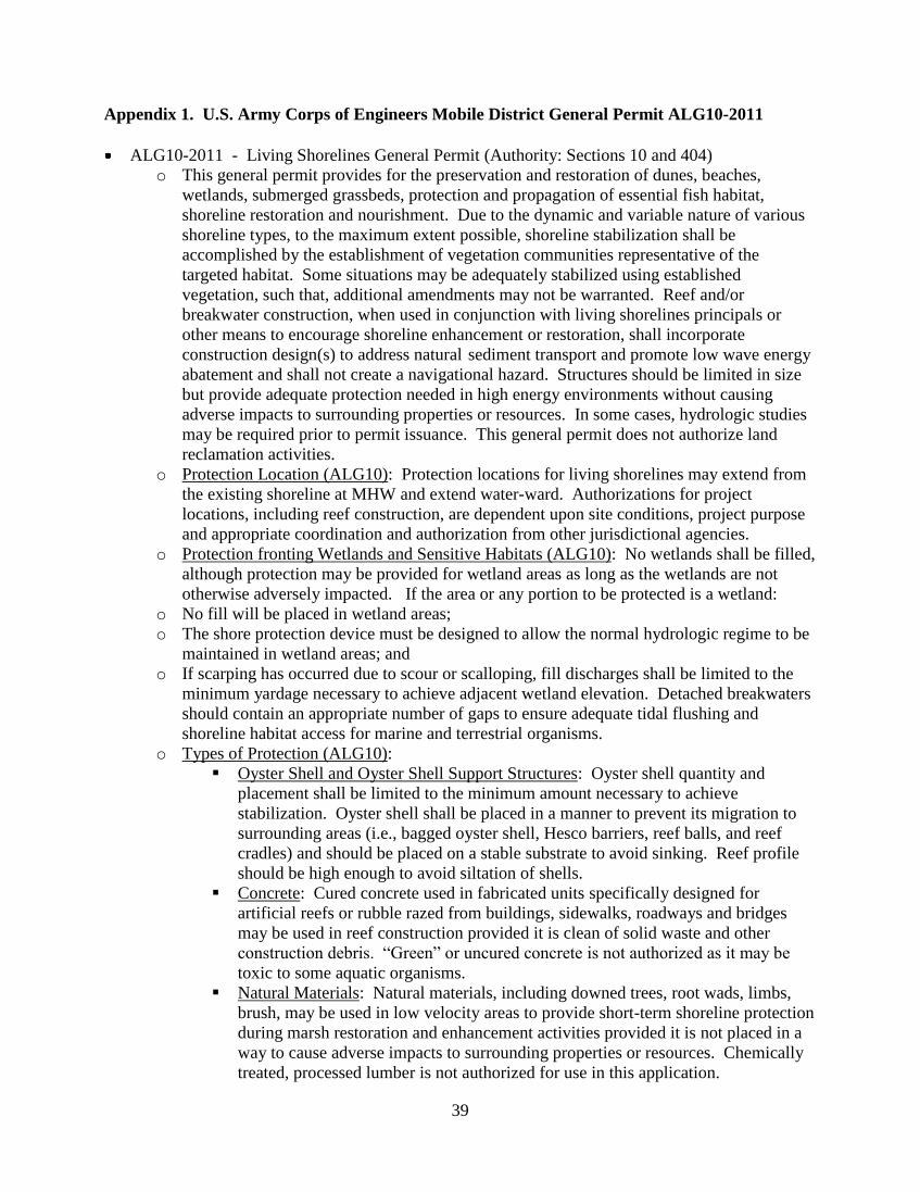
39
Appendix 1. U.S. Army Corps of Engineers Mobile District General Permit ALG10-2011
ALG10-2011 - Living Shorelines General Permit (Authority: Sections 10 and 404)
o This general permit provides for the preservation and restoration of dunes, beaches,
wetlands, submerged grassbeds, protection and propagation of essential fish habitat,
shoreline restoration and nourishment. Due to the dynamic and variable nature of various
shoreline types, to the maximum extent possible, shoreline stabilization shall be
accomplished by the establishment of vegetation communities representative of the
targeted habitat. Some situations may be adequately stabilized using established
vegetation, such that, additional amendments may not be warranted. Reef and/or
breakwater construction, when used in conjunction with living shorelines principals or
other means to encourage shoreline enhancement or restoration, shall incorporate
construction design(s) to address natural sediment transport and promote low wave energy
abatement and shall not create a navigational hazard. Structures should be limited in size
but provide adequate protection needed in high energy environments without causing
adverse impacts to surrounding properties or resources. In some cases, hydrologic studies
may be required prior to permit issuance. This general permit does not authorize land
reclamation activities.
o Protection Location (ALG10): Protection locations for living shorelines may extend from
the existing shoreline at MHW and extend water-ward. Authorizations for project
locations, including reef construction, are dependent upon site conditions, project purpose
and appropriate coordination and authorization from other jurisdictional agencies.
o Protection fronting Wetlands and Sensitive Habitats (ALG10): No wetlands shall be filled,
although protection may be provided for wetland areas as long as the wetlands are not
otherwise adversely impacted. If the area or any portion to be protected is a wetland:
o No fill will be placed in wetland areas;
o The shore protection device must be designed to allow the normal hydrologic regime to be
maintained in wetland areas; and
o If scarping has occurred due to scour or scalloping, fill discharges shall be limited to the
minimum yardage necessary to achieve adjacent wetland elevation. Detached breakwaters
should contain an appropriate number of gaps to ensure adequate tidal flushing and
shoreline habitat access for marine and terrestrial organisms.
o Types of Protection (ALG10):
Oyster Shell and Oyster Shell Support Structures: Oyster shell quantity and
placement shall be limited to the minimum amount necessary to achieve
stabilization. Oyster shell shall be placed in a manner to prevent its migration to
surrounding areas (i.e., bagged oyster shell, Hesco barriers, reef balls, and reef
cradles) and should be placed on a stable substrate to avoid sinking. Reef profile
should be high enough to avoid siltation of shells.
Concrete: Cured concrete used in fabricated units specifically designed for
artificial reefs or rubble razed from buildings, sidewalks, roadways and bridges
may be used in reef construction provided it is clean of solid waste and other
construction debris. “Green” or uncured concrete is not authorized as it may be
toxic to some aquatic organisms.
Natural Materials: Natural materials, including downed trees, root wads, limbs,
brush, may be used in low velocity areas to provide short-term shoreline protection
during marsh restoration and enhancement activities provided it is not placed in a
way to cause adverse impacts to surrounding properties or resources. Chemically
treated, processed lumber is not authorized for use in this application.
40
Riprap: Only clean riprap material free of exposed rebar, asphalt, plastic, soil, etc.,
may be used. Riprap may be authorized to augment other protection methods.
Note: If a channel is being protected by riprap, the backfill is limited to one (1)
cubic yard per linear foot for each side. There is no limit to the linear feet of
shoreline or bank that may be protected by installation of riprap. Use of
appropriate filter fabric is required. Riprap materials, pervious interlocking brick
systems, filter mats, and other similar stabilization methods should be utilized in
lieu of vertical seawalls and bulkheads wherever feasible.
Other: Other shoreline protection devices and reef construction materials shall
evaluated on a case-by-case basis prior to being authorized for use.
o Submerged Grassbeds: Prior to permit issuance and/or placement of structures, project
locations within areas with conditions which may support submerged grassbeds or areas
where submerged grassbeds have historically been known to occupy may be subject to an
submerged grassbeds survey. With the exception of rhizome cross-sectional surveys,
submerged grassbed surveys must be conducted not earlier than the first of June or later
than the end of September.
o Invasive Species (ALG10): The shoreline shall be monitored for presence of invasive or
undesirable species for the life of the project. These species shall be removed upon
discovery and the area replanted with desired target community vegetation to discourage
future re-infestation.
o Coordination with ADCNR-SLD (ALG10): Authorization from the ADCNR-SLD is
required for land reclamation activities. In some cases, ADCNR-SLD may require a
separate permit, riparian easement and/or fees for the proposed activity. Shoreline
accretion resulting from permitted activities undertaken by use of the general permit may
not result in a change in property boundaries. Project coordination with ADCNR is the
permittee’s responsibility.
o Coordination with SHPO (ALG10): Coordination with the Alabama Historical
Commission is required to ensure no impacts will occur to historic entities or other items
which may be of historic significance.
o Markers and Signage (ALG10): All constructed shorelines and reef complexes must
display proper signage, markers and/or lighting to inform waterway users of their presence
and in accordance with the United States Coast Guard.
o Exclusions (ALG10): This permit does not authorize (1) placement of fill in wetlands; (2)
ancillary structures such as wing walls, groins, jetties, or any solid structures roughly
perpendicular to the shore or bank; (3) activities which result in land reclamation; (4)
activities constructed for the purpose of land reclamation; (5) an activity which creates a
hazard to navigation; and (6) loose or bagged oyster shell can only be used in areas
classified as “Conditionally Approved” by the Alabama Department of Public Health.
41
Appendix 2. U.S. Army Corps of Engineers Mobile District General Permit ALG11-2011
ALG11-2011 – Armoring Systems (RipRap), Bulkheads, River Training Structures,
Bioengineering, and other Standard Shoreline Protection/Stabilization Devices roughly
paralleling, and at the Existing Shoreline or Bank (Authority: Sections 10 and 404):
o This permit is only applicable where it is demonstrated to the satisfaction of the Corps that
there are no feasible non-structural alternative available including, but not limited to,
preservation and restoration of wetlands, submerged grassbeds, shoreline restoration and/or
nourishment.
o Protection Location (ALG11): Protection must be the existing shoreline at the plane of
ordinary high tide, the plane of ordinary high water or landward of all jurisdictional
wetlands at the time of construction, unless otherwise specifically authorized.
o Protection Fronting Wetlands (ALG11): No wetlands shall be filled, although protection
may be provided for wetland areas as long as the wetlands are not otherwise adversely
impacted. If any portion to be protected is a wetland. (1) no fill will be placed in wetland
areas; and (2) the shore protection devices must be designed to allow the normal
hydrologic regime to be maintained in wetland areas.
o Bank Dessing (ALG11): Should the shore, bank or channel require dressing, the bedding
placed below the plane of ordinary high water or the plane of ordinary high tide may not
exceed an average average of one (1) cubic yard per linear foot of shoreline being
protected.
o Types of Protection (ALG11): To the maximum extent possible, shoreline stabilization
should be accomplished by the establishment of appropriate native vegetation. Riprap
materials, pervious interlocking brick systems, filter mats, and other similar stabilization
methods should be utilized in lieu of vertical seawalls and bulkheads wherever feasible.
Riprap: Only clean riprap material free of exposed rebar, asphalt, plastic, soil, etc.,
may be used. Riprap may be authorized to augment other protection methods.
NOTE: If a channel is being protected by riprap, the backfill is limited to one (1)
cubic yard per linear foot of each bank. Use of appropriate filter fabric is required.
Bulkheads: Bulkhead placement is limited to a total project length of 1,000 linear
feet. Vertical face structures intended to replace failed erosion control structures
shall not extend more than 24-inches waterward from the base of the failed
structure. Use of appropriate filter fabric is required. Only clean material free of
waste, metal and organic trash, unsightly debris, etc., may be used as backfill. The
use of solid waste is specifically excluded from use as backfill or riprap material.
NOTE: Bulkhead installation is specifically excluded from areas fronting the
waters of Weeks Bay and Ono Island man-made canals.
Other: Shoreline protection devices, other than bulkhead or riprap installation, will
have to be specifically authorized
o Coordination with ADCNR-SLD (ALG11): ADCNR-SLD may require a separate permit,
riparian easement and/or fee for the proposed activity. Project coordination with ADCNR-
SLD is the permittee’s responsibility.
o Exclusion (ALG11): This permit does not authorize (1) placement of fill in wetlands or
submerged grassbeds; (2) ancillary structures such as wing walls, groins, jetties, or any
solid structures roughly perpendicular to the shore or bank; or (3) any activity to regain
land lost to erosion, or otherwise accrete land.
o Excluded Areas (ALG11): Areas fronting the water of the Gulf of Mexico, Pelican Bay
and the man- made canals on Ono-Island.
42
Appendix 3. U.S. Army Corps of Engineers Mobile District General Permit ALG26-2011
ALG26-2011 – Shoreline/Bank Protection General Permit for Weeks Bay NERR:
o Shoreline protection shall only be considered in those areas where the riparian vegetation
proves inadequate in preventing erosion. The shoreline protection is LIMITED TO the
placement of riprap.
o Protection must be along the existing shoreline at the plane of ordinary high tide, or
landward of all jurisdictional wetland at the time of construction, unless otherwise
specifically authorized.
o The activity shall not exceed one cubic yard per linear foot placed along the bank below
the mean high tide line. Only clean material, free of exposed rebar, asphalt, plastic, soil,
etc. may be used. Use of filter cloth is required.
o Protection fronting wetlands (ALG26): No wetlands shall be filled, although protection
may be provided for wetland areas as long as the wetlands are not otherwise adversely
impacted. If the area or any portion to be protected is wetlands, no fill will be placed on
the wetlands and the shoreline protection must be designed to allow the normal
hydrologic regime to be maintained in wetland areas.
o Bank Dressing (ALG26): Should the shore or bank require dressing, the bedding placed
below the plane of mean high tide may not exceed an average of one (1) cubic yard per
linear foot of shoreline being protected, unless otherwise specifically authorized.
o Excluded Activities (ALG26): This permit does not authorize (1) filling of wetlands or
submerged grassbeds; (2) the construction of ancillary structures such as wing walls,
graoins, jetties, or any solid structures roughly perpendicular to the shore or bank; or (3)
any activity to regain land lost to erosion, or otherwise accrete land.
43
Appendix 4. NWFL DEP, Florida Living Shoreline General Permit Exemption 62-346.051 14(e)
14 (e) The restoration of an eroding shoreline of 150 feet or less by planting with native wetland
vegetation no more than 10 feet waterward of the approximate mean high water line (MHWL), in
accordance with the following:
1. Plantings shall consist of native vegetative species such as salt meadow hay (Spartina patens),
black needle rush (Juncus roemarianus), and smooth cordgrass (Spartina alterniflora), obtained from
commercially-grown stock that is endemic to the geographic area of the Northwest Florida Water
Management District.
2. Any invasive/exotic vegetative species that may occur along the shoreline, such as common reed
(Phragmites australis), shall be removed in conjunction with the planting.
3. If wave attenuation is needed to protect and ensure survivability of the plantings, turbidity curtains
shall be installed immediately waterward of and parallel to the planting area, but must be removed
within three months after completion of vegetation planting.
4. No filling by anything other than vegetative planting is authorized, except that if permanent wave
attenuation is required to maintain shoreline vegetation, an oyster reef “breakwater” is authorized to
be established concurrent with the planting, provided that:
a. The outer edge of the “breakwater” shall extend no more than 10 feet waterward of the approximate
MHWL.
b. The “breakwater” shall be composed predominantly of natural oyster shell cultch such as clean
oyster shell and fossilized oyster shell, although unconsolidated boulders, rocks, and clean concrete
rubble can be associated with the oyster material. Oyster shell may be packaged in biodegradeable
bags (i.e. coir fiber) prior to placement in the water.
c. The “breakwater” shall not be placed over, or within 3 feet (in any direction) of any submerged
grassbed or existing emergent marsh vegetation.
d. The “breakwater” shall be placed in units so that there is a minimum of three feet of tidal channel
within every 20 feet of structure, so as to not substantially impede the flow of water, and shall not
create a navigational hazard.
44
Appendix 5. North Carolina General Permits for Sheetpile Sill
SECTION .2100 - GENERAL PERMIT FOR CONSTRUCTION OF SHEETPILE SILL FOR
SHORELINE PROTECTION IN ESTUARINE AND PUBLIC TRUST WATERS AND OCEAN
HAZARD AREAS
15A NCAC 07H .2101 PURPOSE
A general permit pursuant to this Section shall allow the construction of offshore parallel sheetpile
sills, constructed from timber, vinyl, or steel sheetpiles for shoreline protection in conjunction with
existing or created coastal wetlands. This permit shall only be applicable in public trust areas and
estuarine waters according to authority provided in 15A NCAC 07J .1100 and according to the
procedures and conditions outlined in this subchapter. This permit shall not apply to oceanfront
shorelines or to waters and shorelines adjacent to the Ocean Hazard AEC with the exception of those
shorelines that feature characteristics of Estuarine Shorelines. Such features include the presence of
wetland vegetation, lower wave energy, and lower erosion rates than in adjoining Ocean Erodible
Area.
History Note: Authority G.S. 113A-107; 113A-118.1; Eff. June 1, 1994;
Amended Eff. February 1, 2009; April 1, 2003; August 1, 2000.
15A NCAC 07H .2102 APPROVAL PROCEDURES
(a) An applicant for a General Permit under this Subchapter shall contact the Division of Coastal
Management and request approval for development. The applicant shall provide information on site
location, dimensions of the project area, and the applicant’s name and address.
(b) The applicant shall provide:
(1) confirmation that a written statement has been obtained signed by the adjacent riparian property
owners indicating that they have no objections to the proposed work; or
(2) confirmation that the adjacent riparian property owners have been notified by certified mail of the
proposed work. The notice shall instruct adjacent property owners to provide written comments on
the proposed development to the Division of Coastal Management within 10 days of receipt of the
notice, and, indicate that no response shall be interpreted as no objection. The Division of Coastal
Management shall review all comments and determine, based on their relevance to the potential
impacts of the proposed project, if the proposed project can be approved by a General Permit. If the
Division of Coastal Management determines that the project exceeds the rules established by the
General Permit Process, DCM shall notify the applicant that an application for a major development
permit shall be required.
(c) No work shall begin until an on-site meeting is held with the applicant and a Division of Coastal
Management representative so that the proposed sill alignment may be marked. Written authorization
to proceed with the proposed development shall be issued if the Division representative finds that the
application meets all the requirements of this Subchapter. Construction of the sill shall be completed
within 120 days of the issuance of the permit or the general authorization shall expire and it shall be
necessary to re-examine the alignment to determine if the general authorization may be reissued.
History Note: Authority G.S. 113A-107; 113A-118.1; Eff. June 1, 1994;
Amended Eff. February 1, 2009; October 1, 2007; September 1, 2006; August 1, 2000.
45
15A NCAC 07H .2103 PERMIT FEE
The applicant shall pay a permit fee of two hundred dollars ($200.00). This fee shall be paid by check
or money order made payable to the Department.
History Note: Authority G.S. 113A-107; 113A-118.1; 113A-119.1; Eff. June 1, 1994.
Amended Eff. September 1, 2006; August 1, 2000.
15A NCAC 07H .2104 GENERAL CONDITIONS
(a) This permit authorizes only the construction of sills conforming to the standards herein.
(b) Individuals shall allow authorized representatives of the Department of Environment and Natural
Resources to make periodic inspections at any time deemed necessary in order to ensure that the
activity being performed under authority of this general permit is in accordance with the terms and
conditions prescribed herein.
(c) The placement of sills authorized in this Rule shall not interfere with the established or traditional
rights of navigation of the water by the public.
(d) This permit shall not be applicable to proposed construction where the Division of Coastal
Management has determined, based on an initial review of the application, that notice and review
pursuant to G.S. 113A-119 is necessary because there are unresolved questions concerning the
proposed activity's impact on adjoining properties or on water quality; air quality; coastal wetlands;
cultural or historic sites; wildlife; fisheries resources; or public trust rights.
(e) This permit shall not eliminate the need to obtain any other required state, local, or federal
authorization.
(f) Development carried out under this permit shall be consistent with all local requirements, AEC
rules, and local land use plans current at the time of authorization.
History Note: Authority G.S. 113A-107; 113A-118.1;
RRC Objection due to ambiguity Eff. May 19, 1994; Eff. July 1, 1994;
Amended Eff. February 1, 2009; August 1,1998.
15A NCAC 07H .2105 SPECIFIC CONDITIONS
(a) The sill shall be positioned no more than 20 feet waterward of the normal high water or normal
water level or 20 feet waterward of the waterward edge of existing wetlands at any point along its
alignment. For narrow waterbodies (canals, creeks, etc.) the sill alignment shall not be positioned
offshore more than one sixth (1/6) the width of the waterbody.
(b) Sills authorized under this General Permit shall be allowed only in waters that average less than
three feet in depth along the proposed alignment as measured from the normal high water or normal
water level.
(c) Where the Division of Coastal Management staff determine that insufficient wetland habitat exists
along the permittee's shoreline to provide adequate shoreline stabilization, the permittee shall be
required to plant appropriate wetland species landward of the sill structure as directed by the Division
of Coastal Management staff.
(d) Construction authorized by this general permit shall be limited to a maximum length of 500 feet.
(e) The sill shall be constructed with an equal gap between each sheathing board totaling at least one
inch of open area every linear foot of sill. The sill shall have at least one five-foot opening at every
100 feet. The sill sections shall be staggered and overlap as long as the five-foot separation between
sections is maintained. Overlapping sections shall not overlap more than 10 feet.
(f) The height of the sill shall not exceed six inches above normal high water or the normal water
level.
(g) Offshore sill sections shall be set back 15 feet from the riparian access dividing line. The line of
division of riparian access shall be established by drawing a line along the channel or deep water in
46
front of the property, then drawing a line perpendicular to the line of the channel so that it intersects
with the shore at the point the upland property line meets the water's edge. The set back may be
waived by written agreement of the adjacent riparian owner(s) or when the two adjoining riparian
owners are co-applicants. Should the adjacent property be sold before construction of the sill begins,
the applicant shall obtain a written agreement with the new owner waiving the minimum setback and
submit it to the Division of Coastal Management prior to initiating any construction of the sill.
(h) Sills shall be marked at 50-foot intervals with yellow reflectors extending at least three feet above
mean high water. (i) No backfill of the sill or any other fill of wetlands, estuarine waters, public trust
areas, or highground is authorized by this general permit.
(j) No excavation of the shallow water bottom, any wetlands, or high ground is authorized by this
general permit.
(k) The sill shall be constructed of vinyl or steel sheet pile, formed concrete, timber, or other suitable
equivalent materials approved by the Division of Coastal Management.
(l) Perpendicular sections, return walls, or sections that would enclose estuarine waters or public trust
areas shall not be allowed under this permit.
(m) The permittee will maintain the sill in good condition and in conformance with the terms and
conditions of this permit or the remaining sill structure shall be removed within 90 days of notification
from the Division of Coastal Management.
History Note: Authority G.S. 113A-107; 113A-118.1; Eff. June 1, 1994;
Amended Eff. February 1, 2009; August 1, 2000.
47
Appendix 6. North Carolina General Permit for Riprap Sills
SECTION .2700 – GENERAL PERMIT FOR THE CONSTRUCTION OF RIPRAP SILLS FOR
WETLAND ENHANCEMENT IN ESTUARINE AND PUBLIC TRUST WATERS
15A NCAC 7H .2701 PURPOSE
A general permit pursuant to this Section shall allow for the construction of riprap sills for wetland
enhancement in estuarine and public trust waters as set out in Subchapter 7J .1100 and according to
the rules in this Section.
History Note: Authority G.S. 113A-107; 113A-118.1; Temporary Eff. June 15, 2004;
Eff. April 1, 2005.
15A NCAC 07H .2702 APPROVAL PROCEDURES
(a) An applicant for a General Permit under this Subchapter shall contact the Division of Coastal
Management and request approval for development. The applicant shall provide information on site
location, dimensions of the project area, and applicant name and address.
(b) The applicant shall provide:
(1) confirmation that a written statement has been obtained signed by the adjacent riparian property
owners indicating that they have no objections to the proposed work; or
(2) confirmation that the adjacent riparian property owners have been notified by certified mail of the
proposed work. The notice shall instruct adjacent property owners to provide any comments on the
proposed development in writing for consideration by permitting officials to the Division of Coastal
Management within 10 days of receipt of the notice, and, indicate that no response will be interpreted
as no objection.
(c) DCM staff shall review all comments and determine, based on their relevance to the potential
impacts of the proposed project, if the proposed project can be approved by a General Permit.
(d) No work shall begin until an on-site meeting is held with the applicant and a Division of Coastal
Management representative to review the proposed development. Written authorization to proceed
with the proposed development shall be issued if the Division representative finds that the application
meets all the requirements of this Subchapter. Construction shall be completed within 120 days of the
issuance of the general authorization or the authorization shall expire and it shall be necessary to re-
examine the proposed development to determine if the general authorization may be reissued.
History Note: Authority G.S. 113A-107; 113A-118.1; Temporary Adoption Eff. June 15, 2004; Eff.
April 1, 2005;
Amended Eff. October 1, 2007.
15A NCAC 7H .2703 PERMIT FEE
The applicant shall pay a permit fee of two hundred dollars ($200.00). This fee shall be paid by check
or money order made payable to the Department.
History Note: Authority G.S. 113A-107; 113A-118.1; 113A-119.1; Temporary Eff. June 15, 2004;
Eff. April 1, 2005
Amended Eff. September 1, 2006
15A NCAC 7H .2704 GENERAL CONDITIONS
(a) Structures authorized by a permit issued pursuant to this Section shall be riprap or stone sills
conforming to the standards in these Rules.
48
(b) Individuals shall allow authorized representatives of the Department of Environment and Natural
Resources (DENR) to make periodic inspections at any time deemed necessary in order to insure that
the activity being performed under authority of this general permit is in accordance with the terms and
conditions prescribed in these Rules.
(c) The placement of riprap or stone sills authorized in these Rules shall not interfere with the
established or traditional rights of navigation of the waters by the public.
(d) This permit shall not be applicable to proposed construction where the Department has
determined, based on an initial review of the application, that notice and review pursuant to G.S.
113A-119 is necessary because there are unresolved questions concerning the proposed activity’s
impact on adjoining properties or on water quality, air quality, coastal wetlands, cultural or historic
sites, wildlife, fisheries resources, or public trust rights.
(e) This permit does not eliminate the need to obtain any other required state, local, or federal
authorization.
(f) Development carried out under this permit shall be consistent with all local requirements, AEC
Guidelines as set out in Subchapter 7H. 0200, and local land use plans current at the time of
authorization.
History Note: Authority G.S. 113A-107; 113A-118.1;
Temporary Eff. June 15, 2004; Eff. April 1, 2005.
15A NCAC 7H .2705 SPECIFIC CONDITIONS
(a) A general permit issued pursuant to this Section shall be applicable only for the construction of
riprap or stone sill structures built in conjunction with existing, created or restored wetlands.
(b) This general permit shall not apply within the Ocean Hazard System Areas of Environmental
Concern (AEC) or waters adjacent to these AECs with the exception of those portions of shoreline
within the Inlet Hazard Area AEC that feature characteristics of Estuarine Shorelines. Such features
include the presence of wetland vegetation, lower wave energy, and lower erosion rates than in the
adjoining Ocean Erodible Area.
(c) On shorelines where no fill is proposed, the landward edge of the sill shall be positioned no more
than 5 feet waterward of the waterward depth contour of locally growing wetlands or to mid-tide
depth contour, whichever is greater. Where no wetlands exist, in no case shall the landward edge on of
the sill be positioned greater than 30 feet waterward of the mean high water or normal high water line.
(d) On shorelines where fill is proposed, the landward edge of the sill shall be positioned no more
than 30 feet waterward of the existing mean high water or normal high water line.
(e) The permittee shall maintain the authorized sill and existing or planted wetlands in conformance
with the terms and conditions of this permit, or the remaining sill structures shall be removed within
90 days of notification from the Division of Co astal Management.
(f) The height of sills shall not exceed six inches above mean high water, normal water level, or the
height of the adjacent wetland substrate, whichever is greater.
(g) Sill construction authorized by this permit shall be limited to a maximum length of 500 feet.
(h) Sills shall be porous to allow water circulation through the structure.
(i) The sills shall have at least one five-foot drop-down or opening every 100 feet and may be
staggered or overlapped or left open as long as the five-foot drop-down or separation between sections
is maintained. Overlapping sections shall not overlap more than 10 feet. Deviation from these drop-
down requirements shall be allowable following coordination with the N.C. Division of Marine
Fisheries and the National Marine Fisheries Service.
(j) The riprap structure shall not exceed a slope of a one foot rise over a two foot horizontal distance
and a minimum slope of a one and a half foot rise over a one foot horizontal distance. The width of
the structure on the bottom shall be no wider than 15 feet.
49
(k) For the purpose of protection of public trust rights, fill waterward of the existing mean high water
line shall not be placed higher than the mean high water elevation.
(l) The permittee shall not claim title to any lands raised above the mean high or normal water levels
as a result of filling or accretion.
(m) For water bodies more narrow than 150 feet, the structures shall not be positioned offshore more
than one sixth (1/6) the width of the waterbody.
(n) The sill shall not be within a navigation channel marked or maintained by a state or federal
agency.
(o) The sill shall not interfere with leases or franchises for shellfish culture.
(p) All structures shall have a minimum setback distance of 15 feet between any parts of the structure
and the adjacent property owner’s riparian access corridor, unless either a signed waiver statement is
obtained from the adjacent property owner or the portion of the structure within 15 feet of the adjacent
riparian access corridor is located no more than 25 feet from the mean high or normal water level. The
riparian access corridor line is determined by drawing a line parallel to the channel, then drawing a
line perpendicular to the channel line that intersects with the shore at the point where the upland
property line meets the water’s edge.
(q) The sill shall not interfere with the exercise of riparian rights by adjacent property owners,
including access to navigation channels from piers, or other means of access.
(r) Sills shall be marked at 50-foot intervals with yellow reflectors extending at least three feet above
mean high water level.
(s) If the crossing of wetlands with mechanized construction equipment is necessary, temporary
construction mats shall be utilized for the areas to be crossed. The temporary mats shall be removed
immediately upon completion of the construction of the riprap structure.
(t) Sedimentation and erosion control measures shall be implemented to ensure that eroded materials
do not enter adjacent wetlands or waters.
(u) No excavation or filling of any native submerged aquatic vegetation is authorized by this general
permit.
(v) No excavation of the shallow water bottom or any wetland is authorized by this general permit.
(w) No more than 100 square feet of wetlands may be filled as a resulted of the authorized activity.
(x) Backfilling of sill structures may only be utilized only for the purpose of creating a suitable
substrate for the establishment or reestablishment of wetlands. Only clean sand fill material may be
utilized.
(y) The riprap material shall consist of clean rock or masonry materials such as granite or broken
concrete. Riprap material shall be free of loose sediment or any pollutant. The structures shall be of
sufficient size and slope to prevent its movement from the site by wave or current action.
(z) If one or more contiguous acre of property is to be graded, excavated or filled, an erosion and
sedimentation control plan shall be filed with the Division of Land Resources, Land Quality Section,
or appropriate government having jurisdiction. The plan must be approved prior to commencing the
land-disturbing activity.
(aa) In order to ensure that no adverse impacts occur to important fisheries resources, the Division of
Marine Fisheries shall review and concur with the location and design of the proposed project prior to
the issuance of this general permit.
(bb) Prior to the issuance of this general permit, Division staff shall coordinate with the Department
of Administration’s State Property Office to determine whether or not an easement will shall be
required for the proposed activity.
(cc) Following issuance of this general permit, the permittee shall contact the N.C. Division of Water
Quality and the U.S. Army Corps of Engineers to determine any additional permit requirements. Any
such required permits, or a certification from the appropriate agency(s) that no additional permits are
50
required, shall be obtained and copies provided to the Division of Coastal Management prior to the
initiation of any development activities authorized by this permit.
History Note: Authority G.S. 113A-107; 113A-118.1;
Temporary Eff. June 15, 2004; Eff. April 1, 2005.