Co Conservation Almanacnservation … for over five years, but studies, inventories, and other...
7
Co Co Co Conservation Almanac nservation Almanac nservation Almanac nservation Almanac Trinity County Resource Conservation District Summer 1997 Vol. VI No. 3 In This Issue: RCD Revegetation Workshop East Fork/Smokey Creek Watershed Analysis New Uses for Spoiled Sand Keeping Cattle In and Out Employee Feature CRMP Projects in the South Fork Trinity River T he South Fork Trinity River Coordinated Resource Management Plan (CRMP) group has been very active this year coordinating and sponsoring erosion-control projects in the South Fork Trinity River watershed. These projects reflect the CRMPs emphasis on innovative partnerships to get on-the-ground sediment-reduction projects implemented. This is in line with the CRMPs stated goal of developing and implementing a coordinated resource management plan for the recovery of fisheries and economies in the South Fork Trinity River Basin. One project involves the Natural Resources Conservation Service (NRCS) working closely with Simpson Timber, a CRMP participant, on their private lands in the Pelletreau Creek watershed. The project will upgrade undersized culverts, which tend to plug and fail with high storm flows, causing road fill to enter the creek as sediment. The NRCS provides designs and technical support for the Trinity County Resource Conservation District (RCD), which is implementing the project. The ground was laid for this effort in Pelletreau Creek watershed by the Northwest Emergency Assistance Program (NEAP), which provided funds to inventory roads and assess the (Continued on page 7) People who live, work, and recreate on a given piece of land are the people who are most interested in and capable of developing plans for sustainable use. Storm Damage: Hidden Valley Ranch (left) and River Spirit (right) both had roads washed out by the storms of January this year. Native plants are crucial for restoration because they have evolved with local site conditions and are uniquely adapted to the local environment. (See page 6 for more)
Transcript of Co Conservation Almanacnservation … for over five years, but studies, inventories, and other...

Co Co Co Conservation Almanacnservation Almanacnservation Almanacnservation Almanac Trinity County Resource Conservation District
Summer 1997 Vol. VI No. 3
In This Issue: RCD Revegetation Workshop East Fork/Smokey Creek Watershed Analysis
New Uses for Spoiled Sand Keeping Cattle In� and Out
Employee Feature
CRMP Projects in the South Fork Trinity River
TTTT he South Fork Trinity River Coordinated Resource Management Plan (CRMP) group has been very active
this year coordinating and sponsoring erosion-control projects in the South Fork Trinity River watershed. These projects reflect the CRMP�s emphasis on innovative partnerships to get on-the-ground sediment-reduction projects implemented. This is in line with the CRMP�s stated goal of developing and implementing �a coordinated resource management plan for the recovery of fisheries and economies� in the South Fork Trinity River Basin. One project involves the Natural Resources Conservation Service (NRCS) working closely with
Simpson Timber, a CRMP participant, on their private lands
in the Pelletreau Creek watershed. The project will upgrade undersized
culverts, which tend to plug and fail with high storm flows, causing road fill to enter the creek as sediment. The NRCS provides designs and technical
support for the Trinity County Resource Conservation District (RCD), which is implementing the project. The ground was laid for this effort in Pelletreau Creek watershed by the Northwest Emergency Assistance Program (NEAP), which provided funds to inventory roads and assess the
(Continued on page 7)
People who live, work, and recreate on a given piece of land are the people who are most interested in and capable of developing plans for sustainable use.
Storm Damage: Hidden Valley Ranch (left) and River Spirit (right) both had roads washed out by the storms of January this year.
�Native plants are crucial for restoration because they have evolved with local site
conditions and are uniquely adapted to the local environment.� (See page 6 for more)

Page 2 Trinity County Resource Conservation District Summer Issue 1997
Revegetation Revegetation Revegetation Revegetation Workshop InformsWorkshop InformsWorkshop InformsWorkshop Informs
Resource Conservation Resource Conservation Resource Conservation Resource Conservation ProfessionalsProfessionalsProfessionalsProfessionals
On June 6th the RCD presented a one-day workshop on the revegetation techniques utilized in its restoration work in the Grass Valley Creek watershed. The workshop was directed towards natural resource professionals who are involved in restoration projects, with interested participants coming from such agencies as the US Forest Service, AmeriCorps, California Department of Forestry, and the National Park Service. Several private consultants also participated. The workshop consisted of a morning lecture session where basic revegetation techniques were presented, including seeding, mulching, fertilizing, and
planting. Dana Sandifer, Revegetation Coordinator for the RCD, described the process of collecting native seeds, cones, and acorns, as well as establishing a small-scale native plant nursery. Christina Veverka, the RCD Revegetation Manager, described the use of hardwood cuttings
such as willow stakes for revegetating riparian areas, as well as the
monitoring program that is currently being used to evaluate revegetation projects. In addition to the workshop itself, all participants received a draft of the Grass Valley Creek Restoration Project manual, which will be available to the public by the end of this summer (see the sidebar for details). In the afternoon the workshop participants went to visit the RCD�s native plant nursery adjacent to Indian Creek, and they continued on to the Grass Valley Creek watershed to practice some of the techniques they had learned during the morning session. The responses from workshop participants were quite positive, with most finding the workshop informative and useful for the restoration work they are implementing in various parts of Northern California. !
Grass Valley Creek Watershed Restoration
Manual The RCD and the Natural Resources Conservation Service have completed a draft version of the Grass Valley Creek Watershed Restoration Project: A Study in Large-Scale Restoration for review and comment by other agencies and individuals involved or interested in the project. The manual is intended to document all aspects of the large-scale, multi-year restoration project undertaken in Grass Valley Creek watershed, a tributary historically known to deliver large amounts of sediment to the mainstem of the Trinity River. This manual is an historical account of the restoration project and summarizes what has been learned to-date and prescribes treatments for the conditions found in this watershed. The RCD has been involved in this project for over five years, but studies, inventories, and other solutions such as sediment catchment dams and basins have been part of an ongoing fifteen-year project intended to reduce the amount of sediment entering the Trinity River from Grass Valley Creek. It is hoped that the final version of the manual will be completed by August. We are providing copies to those interested at the cost to make copies--$10. Please give us a call if you are interested in receiving a copy of the manual.
Participants in the Revegetation Workshop get hands-on experience in the Grass Valley Creek Watershed.
(916) 623-6004

Page 3 Trinity County Resource Conservation District Summer Issue 1997
watershed analysis is public input during the process. Several public meetings were held to discuss planning and in-progress work for the analysis. The public can provide valuable insights and information not readily available to the interdisciplinary team. Particularly valuable are first-hand accounts from landowners and long-term residents of the study area, which can provide information onthe watersheds, particularly information related to human use of the area historically. The watershed analysis is slated to continue into August, with a draft copy of findings and recommendations delivered to the USFS later during the summer. If you have any questions or comments on the watershed analysis, or if you are interested in attending future public meetings, contact Jim Spear at 623-3991 or Scott Brennan-Smith at 623-6004. Note: All quotes for this article are from Ecosystem Analysis at the Watershed Scale: Federal Guide for Watershed Analysis
adjacent watersheds and share many characteristics. Watershed analysis seeks to understand the �human, aquatic, riparian, and terrestrial features, conditions, processes, and interactions� (ecosystem elements) in a watershed. The process is not undertaken, however, to merely gather as much information about a watershed as possible. Watershed analysis is �issue driven� and is conducted in order to provide information for management decisions at a later date. As part of the process, the analysis team makes recommendations for future management activities, which include �ecologically sustainable programs to produce water, timber, recreation, and other commodities.� Because of the sensitive nature of the East Fork and Smoky Creek watersheds, the interdisciplinary team is identifying restoration opportunities to highlight as part of its recommendations for future management activities. The importance of restoration in these key watersheds is underscored by the fact that the project is funded through the Trinity River Restoration Program. Watershed analyses are usually funded and undertaken by the USFS alone. This unique partnership was envisioned by the USFS in order to speed up the analysis process. The participating agencies and contractors have repeatedly demonstrated their ability to produce high-quality work in a short amount of time. One component of
Unique Partnership for Watershed
Analysis Undertaken
AAAA Watershed Analysis is currently underway to study the Smoky Creek
and East Fork tributaries of the South Fork Trinity River. This watershed analysis includes several aspects unique to the process. One significant way this project is different is that it is a joint undertaking of the United States Forest Service (USFS) and the South Fork Coordinated Resource Management Plan, and it combines specialists from a diverse array of agencies and organizations who work together as an inter-disciplinary team. Team members are drawn from the USDA Natural Resources Conservation Service, the RCD, the US Fish and Wildlife Service, Humboldt State University, and Pacific Watershed Associates, as well as the USFS, which typically undertakes such projects alone. Several private consultants, including a Registered Professional Forester, are also involved in the project. The project is unusual also because it seeks to analyze past, present, and future desired conditions of two watersheds, instead of one. The interdisciplinary team decided that a watershed analysis of both these areas was feasible because they are
Cheat Sheet for AcronymsCheat Sheet for AcronymsCheat Sheet for AcronymsCheat Sheet for Acronyms CRMP Coordinated Resource Management Plan NEAP Northwest Emergency Asistance Program NRCS Natural Resources Conservation Service PUD Public Utilities District RCD Resource Conservation District RC&D Resource Conservation and Development Council USFS United States Forest Service

Page 4 Trinity County Resource Conservation District Summer Issue 1997
New Uses for Spoiled Sand
TTTT he RCD recently found a home for unwanted sand. The sand is decomposed
granite sediment that is periodically dredged from catchment ponds near the mouth of Grass Valley Creek and elsewhere in the watershed. The RCD has done quite a lot of work over the years, implementing measures to prevent the sediment from entering the Trinity River, which degrades fish habitat in the river. Sediment ponds at the confluence of Grass Valley Creek and the Trinity River, known as �Hamilton Ponds,� as well as other sediment ponds throughout the watershed, are designed to catch and hold sediment to prevent its further migration downstream into the Trinity River. The ponds do exactly what they are designed to do but fill up with sediment in the process, particularly after large storms, such as those we saw in January of this year. The ponds have to be dredged of accumulated sediment to remain effective.
The ponds have been filling more slowly in recent years as upstream sediment reduction efforts in the watershed have proven more and more effective. Nevertheless, The Hamilton Ponds have to be dredged every year or two. In the past, dredged sand has been �spoiled� (deposited) on flats
near the ponds and seeded with grasses to keep them in place. These flat areas have filled up over the years, and the RCD, with the assistance of the Trinity County Resource Conservation and Development (RC&D) Council�s Scott Eberly, has found some creative ways to use the sand. One such recent project, The Clark Springs Beach project, used decomposed granite to replenish the sand swimming beach on Trinity Lake near a boat ramp and campground just off Highway 3, past the Stewart�s Fork confluence with Trinity Lake. The beach is part
of an upgrade of facilities at the Clark Springs site (approximately 17 miles north of Weaverville), which also includes a bath house and parking as well as the boat ramp, campground, and beach. The RCD is administering the contracts for the project and the US Forest Service will be the on-sight coordinator for construction. The RC&D is a co-sponsor and is coordinating the project. The contract for hauling the sand was put out to sealed bid in May, and Yingling Construction was awarded the contract in early June.
Clark Springs is the first of three proposed projects to restore beaches on Trinity Lake. Two other potential sites for spoiling decomposed granite sand are the Tannery Gulch and Hayward Flat campgrounds. Trinity Lake was developed for recreation back in the 1970�s following the construction of Trinity Dam, but wave action over the years has washed away sand
(Continued on next page) Decomposed granite sand awaiting use
for Lee Fong Park vollyball court.
The site at Clark Springs Beach ready for sand spoiled from Grass Valley Creek watershed.
Page 5 Trinity County Resource Conservation District Summer Issue 1997
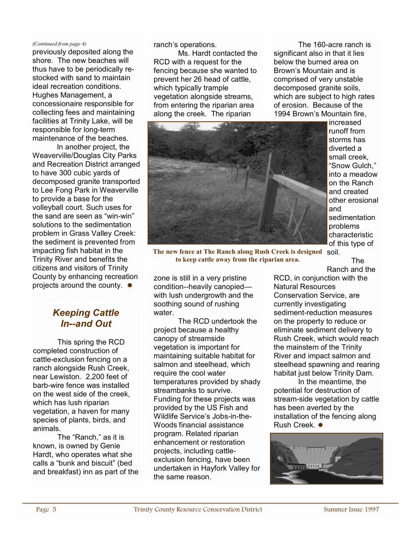
ranch�s operations. Ms. Hardt contacted the RCD with a request for the fencing because she wanted to prevent her 26 head of cattle, which typically trample vegetation alongside streams, from entering the riparian area along the creek. The riparian
zone is still in a very pristine condition--heavily canopied�with lush undergrowth and the soothing sound of rushing water. The RCD undertook the project because a healthy canopy of streamside vegetation is important for maintaining suitable habitat for salmon and steelhead, which require the cool water temperatures provided by shady streambanks to survive. Funding for these projects was provided by the US Fish and Wildlife Service�s Jobs-in-the-Woods financial assistance program. Related riparian enhancement or restoration projects, including cattle-exclusion fencing, have been undertaken in Hayfork Valley for the same reason.
The 160-acre ranch is significant also in that it lies below the burned area on Brown�s Mountain and is comprised of very unstable decomposed granite soils, which are subject to high rates of erosion. Because of the 1994 Brown�s Mountain fire,
increased runoff from storms has diverted a small creek, �Snow Gulch,� into a meadow on the Ranch and created other erosional and sedimentation problems characteristic of this type of soil. The Ranch and the
RCD, in conjunction with the Natural Resources Conservation Service, are currently investigating sediment-reduction measures on the property to reduce or eliminate sediment delivery to Rush Creek, which would reach the mainstem of the Trinity River and impact salmon and steelhead spawning and rearing habitat just below Trinity Dam. In the meantime, the potential for destruction of stream-side vegetation by cattle has been averted by the installation of the fencing along Rush Creek. !
(Continued from page 4) previously deposited along the shore. The new beaches will thus have to be periodically re-stocked with sand to maintain ideal recreation conditions. Hughes Management, a concessionaire responsible for collecting fees and maintaining facilities at Trinity Lake, will be responsible for long-term maintenance of the beaches. In another project, the Weaverville/Douglas City Parks and Recreation District arranged to have 300 cubic yards of decomposed granite transported to Lee Fong Park in Weaverville to provide a base for the volleyball court. Such uses for the sand are seen as �win-win� solutions to the sedimentation problem in Grass Valley Creek: the sediment is prevented from impacting fish habitat in the Trinity River and benefits the citizens and visitors of Trinity County by enhancing recreation projects around the county. !
The new fence at The Ranch along Rush Creek is designed to keep cattle away from the riparian area.
Keeping Cattle In--and Out
This spring the RCD completed construction of cattle-exclusion fencing on a ranch alongside Rush Creek, near Lewiston. 2,200 feet of barb-wire fence was installed on the west side of the creek, which has lush riparian vegetation, a haven for many species of plants, birds, and animals. The �Ranch,� as it is known, is owned by Genie Hardt, who operates what she calls a �bunk and biscuit� (bed and breakfast) inn as part of the

Page 6 Trinity County Resource Conservation District Summer Issue 1997
Featured Employee: Christina Veverka
What do restoration ecology, competitive mountain bike racing, and world travel have in common? Christina Veverka, the RCD�s Revegetation Manager is as interested in fun and adventure as in plant ecology. Christina brings a sense of humor and serious dedication as a professional to the working climate of the RCD. Christina started working for the RCD in March of 1996 as an ecologist/botanist and was promoted to Revegetation Manager in December of that year. As head of the revegetation program, Christina is responsible for planning and monitoring progress on the RCD�s revegetation program in Grass Valley and Indian Creeks, as well as in Hayfork. She also does quite a bit of writing, creating technical reports and articles on revegetation and restoration ecology. One of her assigned roles is to write the plant ecology sections of the East
Fork/Smoky Creek watershed analysis currently underway (see the related article in this issue). Christina has made several presentations to professional organizations and at conferences regarding the revegetation efforts the RCD has implemented in Grass Valley Creek watershed. With Dana Sandifer, she also planned and presented the June Revegetation Workshop the RCD held at the Victorian Inn (see the related article in this issue.) Christina has long been interested in plants in general and in restoration ecology specifically. She received Bachelor�s and Master�s degrees in biology from the University of San Diego and Idaho State University, respectively. Her decision to specialize in restoration ecology is embodied in her master�s thesis on the subject. She is particularly interested in the valuable role native plants can play in restoration ecology: �Natives are crucial for restoration because they have evolved with local site conditions and are uniquely adapted to the local environment. In using natives one is maintaining biodiversity, which contributes to the long-term health of local ecosystems.� Exotic plants may out-compete natives in the short run, but fail to provide suitable habitat and healthy development to other species in the area in the long run. Working with plants has suited her need to be outside much of the time, and this need is further met by her personal interests, which
include mountain biking and travel. Christina has been a serious cyclist for about two years, and has begun mountain biking competitively during the past year. She took second place in the Sport division of the LaGrange Classic here in May of this year. Christina spent two months backpacking in New Zealand this past winter where she explored the native plant communities of that country, hiking in lush, evergreen forests, alpine grasslands, and dense beech forests. She has also traveled to Central America, Thailand and Nepal, Alaska, the Caribbean, and Europe. Whatever she does, Christina loves most to be outside. This is the thread that runs through her interests, whether they be personal or professional, and her commitment to enhancing the beauty and health of the world around her is part of her love of the outdoors.!
Christina races down a slope on the La Grange Classic Bike race track.

Page 7 Trinity County Resource Conservation District Summer Issue 1997
(Continued from page 1) need for culvert upgrades at stream crossings. NEAP is a program to provide assistance and training to displaced fishermen in the wake of serious declines in fisheries habitat. Over the years fish stocks have fallen in watersheds throughout the northwest as a result of habitat degradation and harvest management. NEAP was initiated in 1994 by the Clinton Administration to provide relief for fishermen impacted by this decline. In another project, the RCD has been working with Post Mountain Public Utilities District (PUD) to reduce sediment delivery in the Post Mountain area. Sedimentation from eroded roads has the potential to enter tributaries to Rattlesnake Creek and work its way into the South Fork Trinity River, adversely affecting fisheries in this important spawning and rearing habitat. The stream crossings and roads in the Post Mountain subdivision were inventoried by the RCD in 1996. Road surfaces in Post Mountain will be upgraded by the installation of rolling dips to improve drainage and reduce sediment delivery. Poorly drained roads often erode when water runoff washes away road surfaces themselves. A few culverts will also be upgraded to withstand higher flows during serious storms. Other projects were undertaken at the request of two private land owners in the South Fork--Hidden Valley Ranch and River Spirit--to repair damage to roads inflicted
by the January 1997 storms. In some places, entire sections of road on these properties were washed out where culverts plugged and water ran down the road for extended distances. Similar upgrades to culverts and road surfaces discussed above are being undertaken by the RCD on these properties because of the direct impact sediment from road crossing failures has on the South Fork Trinity River. Both properties are located adjacent to the South Fork Trinity River itself, so sediment delivery to the river is potentially very large when erosion does occur. All of these projects reflect the CRMP�s philosophy that people who �live, work, and recreate on a given piece of land are the people who are most interested in and capable of developing plans for its sustainable use.� �Sustainable use� also includes reducing impact to streams and rivers by controlling sediment, which seriously affects fish habitat, as sand from upland sources covers the bottoms of watercourses. Spawning fish need course, gravely river bottoms to lay their eggs. Because fine sand coating river bottoms does not allow water to circulate freely, eggs laid in sand suffocate, further reducing the number of already threatened fish populations in creeks and rivers around the North State. The CRMP welcomes opportunities to create partnerships between private landowners such as Simpson Timber, Hidden Valley Ranch, and River Spirit and local, state, and federal agencies in order to meet the
needs of all parties involved and to protect and enhance valuable resources in the process. !
RCD at the County Fair
TTTT his summer, the RCD will again be participating in the Trinity County Fair.
The Fair will be held at Hayfork Fairgrounds on August 22, 23, and 24. The RCD will have several displays highlighting their resource conservation work and educational programs. Among the displays, the RCD will show off their new No-Till Drill, which helps farmers and ranchers seed fields and pastures with little to no disturbance to soils. The RCD will also highlight its participation in the California Envirothon, a yearly competition for high school students that tests their knowledge of various resource conservation and environmental issues. Look for us at the Fair. We�ll be there!
Illus
tratio
n by
Sco
tt Br
enna
n-Sm
ith