Cloud-Base Distribution and Cirrus Properties Based on Micropulse ...
14
ADVANCES IN ATMOSPHERICSCIENCES, VOL. 32, JULY 2015, 991–1004 Cloud-Base Distribution and Cirrus Properties Based on Micropulse Lidar Measurements at a Site in Southeastern China Jianjun LIU 1,2,3 , Zhanqing LI ∗1,2 , ZHENG Youfei 3 , and Maureen CRIBB 2 1 State Laboratory of Earth Surface Process and Resource Ecology and College of Global Change and Earth System Science, Beijing Normal University, Beijing 100875 2 Earth System Science Interdisciplinary Center, University of Maryland, College Park, Maryland, 20740, USA 3 Jiangsu Key Laboratory of Atmospheric Environment Monitoring and Pollution Control, Nanjing University of Information Science and Technology, Nanjing 210044 (Received 09 August 2014; revised 11 November 2014; accepted 5 December 2014) ABSTRACT The cloud fraction (CF) and cloud-base heights (CBHs), and cirrus properties, over a site in southeastern China from June 2008 to May 2009, are examined by a ground-based lidar. Results show that clouds occupied the sky 41% of the time. Significant seasonal variations in CF were found with a maximum/minimum during winter/summer and similar magnitudes of CF in spring and autumn. A distinct diurnal cycle in the overall mean CF was seen. Total, daytime, and nighttime annual mean CBHs were 3.05 ± 2.73 km, 2.46 ± 2.08 km, and 3.51 ± 3.07 km, respectively. The lowest/highest CBH occurred around noon/midnight. Cirrus clouds were present ∼36.2% of the time at night with the percentage increased in summer and decreased in spring. Annual mean values for cirrus geometrical properties were 8.89 ± 1.65 km, 9.80 ± 1.70 km, 10.73 ± 1.86 km and 1.83 ± 0.91 km for the base, mid-cloud, top height, and the thickness, respectively. Seasonal variations in cirrus geometrical properties show a maximum/minimum in summer/winter for all cirrus geometrical parameters. The mean cirrus lidar ratio for all cirrus cases in our study was ∼ 25 ± 17 sr, with a smooth seasonal trend. The cirrus optical depth ranged from 0.001 to 2.475, with a mean of 0.34 ± 0.33. Sub-visual, thin, and dense cirrus were observed in ∼12%, 43%, and 45% of the cases, respectively. More frequent, thicker cirrus clouds occurred in summer than in any other season. The properties of cirrus cloud over the site are compared with other lidar-based retrievals of midlatitude cirrus cloud properties. Key words: cloud-base distribution, cirrus properties, lidar, southeastern China Citation: Liu, J. J., Z. Q. Li, Y. F. Zheng, and M. Cribb, 2015: Cloud-base distribution and cirrus properties based on micropulse lidar measurements at a site in southeastern China. Adv. Atmos. Sci., 32(7), 991–1004, doi: 10.1007/s00376-014-4176-2. 1. Introduction The significant influences of clouds on the redistribution of energy and moisture, atmospheric dynamics, thermody- namics, and the hydrological cycle on regional and global scales by means of scattering and absorbing radiation and releasing latent heat mainly depend on their spatio–temporal variations in vertical structure and horizontal distribution (Stephens, 2005; Dong et al., 2005). Among the multiple cloud types, cirrus clouds play an important role in Earth’s climate and cover 17%–30% of Earth’s atmosphere (Dessler and Yang, 2003; Sassen et al., 2008). The frequency of occurrence of cirrus clouds can reach 45% in the tropics (Stubenrauch et al., 2006). Cirrus clouds in the upper tro- posphere have two opposite effects: an infrared greenhouse effect and a solar albedo effect, which strongly depend on their macrophysical and optical properties. The radiative and ∗ Corresponding author: Zhanqing LI Email: [email protected] climate effects of clouds, especially cirrus clouds, still re- main largely uncertain. A clear understanding of their macro- physical and optical properties at different geographical loca- tions is essential for climate modeling studies (Giannakaki et al., 2007). Satellite-based passive remote sensing, such as that performed by the Moderate Resolution Imaging Spectro- radiometer (MODIS), has enabled the observation of cloud characteristics such as the amount and top height on a global scale (Platnick et al., 2003). However, their retrieval accuracy suffers from various limitations (Chang and Li, 2005). Pas- sive satellite sensors with visible and near-infrared channels have difficulty inferring the properties of low and optically thin clouds (Wu et al., 2009). Spaceborne active remote sen- sors, such as CloudSat and Cloud-Aerosol Lidar Pathfinder Satellite Observations (CALIPSO), can provide information about cloud vertical structure worldwide (Winker et al., 2003; Mace et al., 2009), but the temporal resolution is limited, making any investigation of the diurnal cycle of clouds over specific regions impossible (Min et al., 2010). Ground-based instruments can capture the diurnal cycle © Institute of Atmospheric Physics/Chinese Academy of Sciences, and Science Press and Springer-Verlag Berlin Heidelberg 2015
-
Upload
dinhkhuong -
Category
Documents
-
view
220 -
download
1
Transcript of Cloud-Base Distribution and Cirrus Properties Based on Micropulse ...

ADVANCES IN ATMOSPHERIC SCIENCES, VOL. 32, JULY 2015, 991–1004
Cloud-Base Distribution and Cirrus Properties Based on Micropulse Lidar
Measurements at a Site in Southeastern China
Jianjun LIU1,2,3, Zhanqing LI∗1,2, ZHENG Youfei3, and Maureen CRIBB2
1State Laboratory of Earth Surface Process and Resource Ecology and College of Global Change and Earth System Science,
Beijing Normal University, Beijing 1008752Earth System Science Interdisciplinary Center, University of Maryland, College Park, Maryland, 20740, USA
3Jiangsu Key Laboratory of Atmospheric Environment Monitoring and Pollution Control,
Nanjing University of Information Science and Technology, Nanjing 210044
(Received 09 August 2014; revised 11 November 2014; accepted 5 December 2014)
ABSTRACT
The cloud fraction (CF) and cloud-base heights (CBHs), and cirrus properties, over a site in southeastern China fromJune 2008 to May 2009, are examined by a ground-based lidar. Results show that clouds occupied the sky 41% of the time.Significant seasonal variations in CF were found with a maximum/minimum during winter/summer and similar magnitudesof CF in spring and autumn. A distinct diurnal cycle in the overall mean CF was seen. Total, daytime, and nighttime annualmean CBHs were 3.05± 2.73 km, 2.46± 2.08 km, and 3.51± 3.07 km, respectively. The lowest/highest CBH occurredaround noon/midnight. Cirrus clouds were present∼36.2% of the time at night with the percentage increased in summer anddecreased in spring. Annual mean values for cirrus geometrical properties were 8.89±1.65 km, 9.80±1.70 km, 10.73±1.86km and 1.83± 0.91 km for the base, mid-cloud, top height, and the thickness,respectively. Seasonal variations in cirrusgeometrical properties show a maximum/minimum in summer/winter for all cirrus geometrical parameters. The mean cirruslidar ratio for all cirrus cases in our study was∼ 25±17 sr, with a smooth seasonal trend. The cirrus optical depthrangedfrom 0.001 to 2.475, with a mean of 0.34±0.33. Sub-visual, thin, and dense cirrus were observed in∼12%, 43%, and 45%of the cases, respectively. More frequent, thicker cirrus clouds occurred in summer than in any other season. The propertiesof cirrus cloud over the site are compared with other lidar-based retrievals of midlatitude cirrus cloud properties.
Key words: cloud-base distribution, cirrus properties, lidar, southeastern China
Citation: Liu, J. J., Z. Q. Li, Y. F. Zheng, and M. Cribb, 2015: Cloud-base distribution and cirrus properties based on micropulselidar measurements at a site in southeastern China.Adv. Atmos. Sci., 32(7), 991–1004, doi: 10.1007/s00376-014-4176-2.
1. Introduction
The significant influences of clouds on the redistributionof energy and moisture, atmospheric dynamics, thermody-namics, and the hydrological cycle on regional and globalscales by means of scattering and absorbing radiation andreleasing latent heat mainly depend on their spatio–temporalvariations in vertical structure and horizontal distribution(Stephens, 2005; Dong et al., 2005). Among the multiplecloud types, cirrus clouds play an important role in Earth’sclimate and cover 17%–30% of Earth’s atmosphere (Desslerand Yang, 2003; Sassen et al., 2008). The frequency ofoccurrence of cirrus clouds can reach 45% in the tropics(Stubenrauch et al., 2006). Cirrus clouds in the upper tro-posphere have two opposite effects: an infrared greenhouseeffect and a solar albedo effect, which strongly depend ontheir macrophysical and optical properties. The radiativeand
∗ Corresponding author: Zhanqing LIEmail: [email protected]
climate effects of clouds, especially cirrus clouds, stillre-main largely uncertain. A clear understanding of their macro-physical and optical properties at different geographicalloca-tions is essential for climate modeling studies (Giannakaki etal., 2007). Satellite-based passive remote sensing, such asthat performed by the Moderate Resolution Imaging Spectro-radiometer (MODIS), has enabled the observation of cloudcharacteristics such as the amount and top height on a globalscale (Platnick et al., 2003). However, their retrieval accuracysuffers from various limitations (Chang and Li, 2005). Pas-sive satellite sensors with visible and near-infrared channelshave difficulty inferring the properties of low and opticallythin clouds (Wu et al., 2009). Spaceborne active remote sen-sors, such as CloudSat and Cloud-Aerosol Lidar PathfinderSatellite Observations (CALIPSO), can provide informationabout cloud vertical structure worldwide (Winker et al., 2003;Mace et al., 2009), but the temporal resolution is limited,making any investigation of the diurnal cycle of clouds overspecific regions impossible (Min et al., 2010).
Ground-based instruments can capture the diurnal cycle
© Institute of Atmospheric Physics/Chinese Academy of Sciences, and Science Press and Springer-Verlag Berlin Heidelberg 2015

992 CLOUD BASE AND CIRRUS PROPERTIES IN SOUTHEASTERN CHINA VOLUME 32
of clouds and are valuable for monitoring long-term trends atfixed locations. Although ground-based lidars cannot pene-trate optically thick clouds or determine cloud-top heights,they can detect the presence of clouds and measure low-est layer cloud-base heights (CBH). Numerous studies havedemonstrated their ability to observe cloud properties (Camp-bell and Shiobara, 2008; Shupe et al., 2011; Thorsen et al.,2013), and in particular, to quantify and characterize the ver-tical structure and optical properties of cirrus clouds. Lidarobservations provide information on cloud vertical structurewith a much higher sensitivity to optically thin clouds thana cloud radar (Thorsen et al., 2013). The capability of aground-based lidar system to detect thin cirrus clouds makesit one of the most appropriate instruments to use for the studyof these clouds (Noel et al., 2007).
Using ground-based lidar data, many studies have beencarried out regarding the temporal and spatial variations ofcloud structure (Mahesh et al., 2005; Bissonnette et al., 2007;Shupe et al., 2011) and macro- and microphysical and opticalproperties, as well as radiative effects of cirrus clouds overdifferent regions, such as the tropics (Sassen and Campbell,2001; Comstock et al., 2002; Seifert et al., 2007; Sunilkumaret al., 2008) and the midlatitudes (Reichardt, 1999; Keckhutet al., 2005; Wang et al., 2008; Das et al., 2009; Dupont et al.,2010). Significant differences in cloud characteristics existfrom one region to another and the representation of cloudsin climate models is still poor (Zhang et al., 2005). Charac-terizing the spatial and temporal distributions of clouds withbetter spatial and temporal resolutions, including the macro-physics and optical properties of cirrus clouds at differentgeographic locations, is fundamental to understanding andquantifying the roles of clouds in climate change and in im-proving weather climate models (IPCC, 2007; Vukicevic etal., 2010).
During the deployment of the United States Departmentof Energy’s Atmospheric Radiation Measurement Mobile Fa-cility in China (Li et al., 2011), extensive measurements weremade at Taihu from May 2008 to December 2009 for thepurpose of studying aerosol–cloud interactions under heavilypolluted conditions. The site (31.702◦N, 120.358◦E; 10 mabove sea level) is located in the heart of the Yangtze Delta,where there is an abundance of different types of anthro-pogenic aerosols (Li et al., 2007). To help unravel aerosol–cloud interactions, cloud and aerosol properties were mea-sured by numerous advanced instruments installed at the site.By virtue of continuous ground-based lidar measurements,we investigate the cloud-base distribution and geometricaland optical properties of cirrus clouds with the goal of lay-ing the foundations for studying aerosol–cloud interactions.
The remainder of the paper is organized as follows. Sec-tion 2 describes the micropulse lidar system and methodsused to determine the cloud mask and to retrieve cirrus op-tical properties. Seasonal patterns and the diurnal cycle ofthe cloud-base distribution are discussed in section 3. Sec-tion 4 presents the seasonal evolution of the vertical struc-ture, macrophysical properties, and optical properties ofcir-rus clouds. Section 5 gives the main conclusions.
2. Instruments and methods
A depolarization-sensitive micropulse lidar (MPL),which is a compact and solid state lidar developed at NASAand manufactured by the Sigma Space Corporation, was used(Spinhirne et al., 1995). It uses an Nd: YLF pulsed laserdiode, operating at a wavelength of 527 nm with a pulse rep-etition rate of 2500 Hz. The bin time of the MPL receiverwas 200 ns, with a 30 m vertical resolution. The MPL sys-tem averages many low-energy pulses in short durations toachieve a good signal-to-noise ratio (SNR). A pulsed solid-state laser, a narrow field-of-view (FOV:∼100µrad), narrowinterference filters (∼0.3 nm full width at half maximum),and photon counting capability result in a highly sensitivein-strument. Further detail regarding the features of the MPLcan be found in Spinhirne et al. (1995).
Figure 1 shows the steps taken to retrieve cloud proper-ties in this study. Using the method described by Campbell etal. (2002), raw data were corrected to the normalized relativebackscatter signal (NRB). Lidar signals at upper-troposphericranges are significantly influenced by the afterpulse. To min-imize this influence, afterpulse calibrations were performedfrequently using the methods proposed by Campbell et al.(2002) and Liu et al. (2011). Cloud boundaries were de-rived using the cloud mask algorithm of Wang and Sassen(2001). This algorithm is based on characteristics of the li-dar signal, as in the differential zero-crossing and thresholdmethods, and also takes into account the underlying physi-cal differences between cloud and aerosol layers, and noiseeffects. To distinguish a cloud layer from an aerosol layer,empirical threshold values were used (Clothiaux et al., 1998;Campbell et al., 2002; Zhao et al., 2014). Use of these valuesin the algorithm proved successful at separating clouds fromaerosols with high accuracy. More detail is given in Wang andSassen (2001). Cirrus optical properties were retrieved usingthe algorithm of Comstock and Sassen (2001), which is basedon the solution of the lidar equation. The cloud backscattercoefficient,βc (km sr−1), is given by
βc(z) =G(z0,z)
1−2ηk∫ z
z0G(z0,z)dz
−βm(z) ,
G(z0,z) = βm(z0)S(z)z2
S(z0)z20
×exp
[
2
(
8π3
−ηk
)
∫ z
z0
βm(z)dz
]
,
whereβm is the scattering contribution from air molecules,S(z) is the normalized lidar backscatter signal, andη andkare the forward multiple-scattering correction parameterandthe extinction-to-backscatter ratio, respectively.z0 denotesthe height just below the cloud base where the scattering ispresumably due to molecules, andz is the height at whichthe backscatter signals are received. The parameterk is de-termined using an iterative technique where the value ofk isincreased incrementally from 5 to 100 sr. It reaches its fi-nal value when the average backscatter coefficient above thecloud is equal to the average molecular backscatter coeffi-cient above the cloud.
The optical depth of the cirrus cloud,τc, can be deter-mined by integratingβc between the cirrus cloud base,zb,

JULY 2015 LIU ET AL. 993
Fig. 1. Diagram of the steps taken to retrieve cloud properties in this study.
and the cloud top,zt. The primary uncertainty in theτc re-trieval is in estimating the parameterk, which results in amaximum uncertainty of∼24% for the retrieved value ofτc
(Comstock and Sassen, 2001). This algorithm has been ap-plied to several long-term datasets in both the midlatitudesand the tropics with reasonable accuracy (Sassen and Com-stock, 2001; Comstock et al., 2002). The forward multiple-scattering correction parameter was used to compensate forthe effect of forward multiple-scattering on the return energy.The contribution of forward multiple-scattering to the totalcloud optical depth was assumed to be relatively small herebecause the MPL receiving telescope has a narrow FOV (Daset al., 2009). In this study, we setη = 0.9 based on simula-tions of the multiple scattering correction factor by Comstockand Sassen (2001).
The linear volume depolarization ratio (δ ), defined asthe ratio of cross-polarized and co-polarized scattering ratios,was computed from MPL measurements using the methodof Flynn et al. (2007). This quantity is useful for studyingthe shape of ice crystals and provides dynamical informationabout cloud formation.
3. Cloud fraction and cloud-base distribution
3.1. Cloud fraction
The cloud fraction (CF) is defined here as the percent-age of returns that are identified as cloudy within a speci-fied sampling period (e.g., a month) regardless of the numberof cloud layers. Although lidar-derived CF represents only
a pencil beam of the sky that depends on the advection ofclouds overhead, studies have found that they are statisticallyrepresentative in terms of long-term averages (Dong et al.,2006, 2010).
Figure 2a shows the monthly mean CF from June 2008to May 2009 with seasonal and annual mean values summa-rized in Table 1. CF varied significantly throughout the year.CF peaked during February, October and March, with val-ues larger than 50% and reached a minimum during June andJuly, with values around 25%. The largest CF (∼67.2%) wasmore than 2.5 times greater than the smallest CF (25.4%).The annual averaged CF was 40.6% and the seasonal meanCF was marked by maxima during winter and minima dur-ing summer (Table 1). The CF seasonal variability reflectsthe difference in large-scale atmospheric dynamics betweenthe summer and the winter and transition periods (Kolliaset al., 2007). A similar CF and the same seasonal varia-tion in CF were also found at another midlatitude site, theSouthern Great Plains (SGP) site in the U. S. (Dong et al.,2006). Monthly (Fig. 2b) and seasonal (Table 1) mean day-time and nighttime CF show that more clouds occurred dur-ing the night than during the day. On average, the largest sea-sonal CF for daytime and nighttime occurred in winter andspring, and the smallest values for both were found in sum-mer. Annual mean daytime and nighttime CFs were 17.9%and 22.7%, respectively, during the entire study period.
Seasonal and annual mean diurnal cycles of the CFanomaly, defined as the difference between hourly and dailymean CF, are presented in Fig. 3. The annual average CFanomaly experienced a significant diurnal cycle with ampli-

994 CLOUD BASE AND CIRRUS PROPERTIES IN SOUTHEASTERN CHINA VOLUME 32
Jul Sep Nov Jan Mar May0
20
40
60
80(a)
Clo
ud
Fra
ctio
n (
%)
Jul Sep Nov Jan Mar May0
10
20
30
40
Month of Year
(b)
Day
Night
Fig. 2. Monthly variation in (a) mean cloud fraction (b) dur-ing the day (0600–1800 LST) and during the night (1800–0600LST) over Taihu from June 2008 to May 2009.
0 2 4 6 8 10 12 14 16 18 20 22 24−20
−15
−10
−5
0
5
10
15
20
25
Cloud Fraction Mean Anomaly(%)
Hour (Local)
Spring
Summer
Autumn
Winter
Year
Fig. 3. Seasonal and annual mean diurnal cycles of the cloudfraction mean anomaly (hourly mean minus daily mean) overTaihu from June 2008 to May 2009.
tudes of about 24.6%. The annual average CF anomaly de-creased sharply from the beginning of the day to midday, andthen gradually increased again. Maxima in the CF anomalyoccurred at around 0200 and 2200 LST and the minimum oc-curred at around local noon. This is possibly related to anincrease in solar heating at the cloud top at noon resulting ina relative stabilization of the cloud layer leading to somewhatless cloudiness (Shupe et al., 2011). Concerning the seasonaldiurnal cycle, a strong diurnal variation can be seen in spring,summer, and autumn with amplitudes of 35.0%, 32.1%, and24.2%, respectively. A relatively moderate diurnal variationwas found in winter with amplitude of about 15.7%, whichis partly due to the weak local convection at the surface inwintertime (Dong et al., 2005). Generally speaking, seasonalpatterns in the variation of the diurnal CF mean anomaly aresimilar to the annual pattern, except for wintertime. In winter,the minimum CF mean anomaly occurred at 0500 LST andaround 1200 LST, with a sharp variation between the begin-ning of the day and the late afternoon, followed by a levelingoff for the remainder of the night. Although similar variationsare found in spring, summer and autumn, differences in therelative variation are seen. For example, in summer, the vari-ation was smoother before and after noon than it was duringspring and autumn.
3.2. Cloud-base distribution
Due to the severe attenuation in lidar signals by thickclouds, the analysis of cloud bases presented here refers totheanalysis of the first cloud layer base detected from the groundregardless of the number of cloud layers above it. Monthlystatistics of total (T), daytime (D), and nighttime (N) CBH,with annual means given on the right-hand side of the plot(shaded), are summarized in Fig. 4. Seasonal and annualmeans, standard deviations, and median values of CBH for T,D, and N cases are shown in Table 1. Relatively high annualmean CBHs were found, with mean values of 3.05±2.73 (T),2.46±2.08 (D), and 3.51±3.07 km (N). The highest annualmean CBH was found during the night. Monthly variationsin the mean CBH for all cases were almost the same, with the
Table 1. Seasonal and annual mean cloud fraction (CF) and cloud-baseheight (CBH) in three altitude bins (L, M, H)* based on total (T),daytime (D), and nighttime (N) observations. Also includedare the seasonal and annual mean probability distribution functions (PDFs) inthe three altitude bins.
CF (T) CF (D) CF (N)CBH (T)** CBH (D)** CBH (N)**
PDF (L) PDF (M) PDF (H)(Median) (Median) (Median)
Spring 42.7% 16.6% 26.1% 3.74±2.75 2.86±2.05 4.30±2.98 35.8% 34.3% 29.9%3.09 2.25 3.63
Summer 27.7% 9.9% 17.8% 3.98±3.57 2.74±2.63 4.68±3.82 41.5% 25.8% 32.7%2.77 1.57 3.52
Autumn 46.5% 24.0% 22.5% 2.35±2.03 2.20±1.82 2.51±2.22 57.7% 31.3% 11.0%1.59 1.50 1.71
Winter 51.4% 25.5% 25.9% 2.23±2.11 2.22±1.96 2.24±2.24 60.8% 27.6% 11.6%1.35 1.45 1.29
Year 40.6% 17.9% 22.7% 3.05±2.73 2.46±2.08 3.51±3.07 48.9% 30.3% 20.8%2.07 1.74 2.40
*L, M, H: cloud-base heights located below 2 km, between 2 km and 5 km, and above 5 km, respectively.**Mean values of cloud-base height. Units: km.
JULY 2015 LIU ET AL. 995
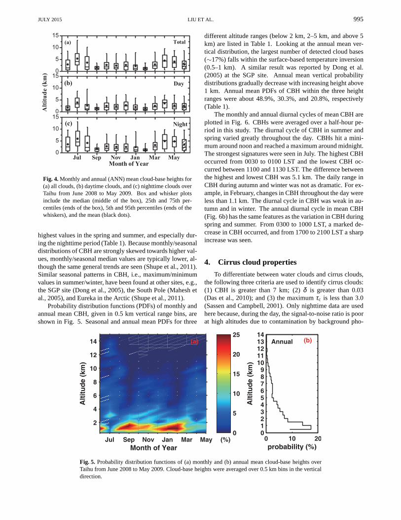
Fig. 4. Monthly and annual (ANN) mean cloud-base heights for(a) all clouds, (b) daytime clouds, and (c) nighttime cloudsoverTaihu from June 2008 to May 2009. Box and whisker plotsinclude the median (middle of the box), 25th and 75th per-centiles (ends of the box), 5th and 95th percentiles (ends ofthewhiskers), and the mean (black dots).
highest values in the spring and summer, and especially dur-ing the nighttime period (Table 1). Because monthly/seasonaldistributions of CBH are strongly skewed towards higher val-ues, monthly/seasonal median values are typically lower, al-though the same general trends are seen (Shupe et al., 2011).Similar seasonal patterns in CBH, i.e., maximum/minimumvalues in summer/winter, have been found at other sites, e.g.,the SGP site (Dong et al., 2005), the South Pole (Mahesh etal., 2005), and Eureka in the Arctic (Shupe et al., 2011).
Probability distribution functions (PDFs) of monthly andannual mean CBH, given in 0.5 km vertical range bins, areshown in Fig. 5. Seasonal and annual mean PDFs for three
different altitude ranges (below 2 km, 2–5 km, and above 5km) are listed in Table 1. Looking at the annual mean ver-tical distribution, the largest number of detected cloud bases(∼17%) falls within the surface-based temperature inversion(0.5–1 km). A similar result was reported by Dong et al.(2005) at the SGP site. Annual mean vertical probabilitydistributions gradually decrease with increasing height above1 km. Annual mean PDFs of CBH within the three heightranges were about 48.9%, 30.3%, and 20.8%, respectively(Table 1).
The monthly and annual diurnal cycles of mean CBH areplotted in Fig. 6. CBHs were averaged over a half-hour pe-riod in this study. The diurnal cycle of CBH in summer andspring varied greatly throughout the day. CBHs hit a mini-mum around noon and reached a maximum around midnight.The strongest signatures were seen in July. The highest CBHoccurred from 0030 to 0100 LST and the lowest CBH oc-curred between 1100 and 1130 LST. The difference betweenthe highest and lowest CBH was 5.1 km. The daily range inCBH during autumn and winter was not as dramatic. For ex-ample, in February, changes in CBH throughout the day wereless than 1.1 km. The diurnal cycle in CBH was weak in au-tumn and in winter. The annual diurnal cycle in mean CBH(Fig. 6b) has the same features as the variation in CBH duringspring and summer. From 0300 to 1000 LST, a marked de-crease in CBH occurred, and from 1700 to 2100 LST a sharpincrease was seen.
4. Cirrus cloud properties
To differentiate between water clouds and cirrus clouds,the following three criteria are used to identify cirrus clouds:(1) CBH is greater than 7 km; (2)δ is greater than 0.03(Das et al., 2010); and (3) the maximumτc is less than 3.0(Sassen and Campbell, 2001). Only nighttime data are usedhere because, during the day, the signal-to-noise ratio is poorat high altitudes due to contamination by background pho-
Fig. 5. Probability distribution functions of (a) monthly and (b) annual mean cloud-base heights overTaihu from June 2008 to May 2009. Cloud-base heights were averaged over 0.5 km bins in the verticaldirection.

996 CLOUD BASE AND CIRRUS PROPERTIES IN SOUTHEASTERN CHINA VOLUME 32
Fig. 6. (a) Monthly and (b) annual mean diurnal cycles of mean cloud-base heights over Taihu fromJune 2008 to May 2009. Cloud-base heights were averaged over30 minutes.
ton counts (Dupont et al., 2011). The cirrus occurrence frac-tion is defined as the ratio of the number of nights that cir-rus was detected to the total number of nights measurementswere made. Cirrus clouds were identified in 42, 45, 17, and13 nights out of a total of 83, 87, 85, and 68 nights dur-ing spring, summer, autumn, and winter, respectively. Thiscorresponds to cirrus occurrence fractions of 50.6%, 51.7%,20%, and 19.1%, respectively. The annual mean cirrus oc-currence fraction was 36.2%. A maximum cirrus occurrencein summer and a minimum in winter were also found fromtwo years’ worth of Cloud-Aerosol Lidar with OrthogonalPolarization (CALIOP) data over northern China (Min et al.,2011). The summertime maximum happens because thereis a relatively abundant supply of upper-tropospheric watervapor introduced by regional convective activity influencedby the western tropical Pacific and because of the seasonalmeridional displacement of subtropical cirrus bands (Sassenet al., 2008; Min et al., 2011). The annual mean cirrus occur-rence in our study is similar to that (37%) calculated from aneight-year cirrus climatology generated by Das et al. (2009)over Chung-Li, a site in East Asia.
4.1. Cirrus geometrical properties
Figure 7 shows the following cirrus geometrical proper-ties in the form of box plots: (a) CBH, (b) mid-cloud height;(c)cloud-top height, and (d) geometrical thickness in eachmonth and year-round. Seasonal and annual mean cirrus ge-ometrical properties and vertical probability distributions ofcirrus geometrical properties are summarized in Table 2 andplotted in Fig. 8. The mid-cloud height is the weighted CBH,which is defined as
M =
∫ ztopzbase
zRB(z)dz∫ ztop
zbaseRB(z)dz
.
Here, zbase and ztop correspond to CBH and CTH, respec-tively, and z is the height at which the backscatter signalsare received. The parameterRB(z) is the backscattering ratio,
which can be expressed as
RB(z) =βc(z)+ βγ(z)
βγ(z),
whereβγ(z) andβc(z) are the backscattering coefficients ofair and cloud at the laser wavelength, respectively.
Figures 7a and 7b show that cirrus base and mid-cloudheights varied greatly by month. Maximum and minimummonthly mean cirrus base (mid-cloud) heights of 10.8±2.2km (11.8±2.2 km) and 7.7±0.6 km (8.4±0.6 km) occurredin July and December, respectively. For most of the year,cloud-base and mid-cloud height distributions were stronglyskewed towards higher values because median values weretypically lower, although the same general trends are seen(Shupe et al., 2011). Seasonal mean cirrus cloud-base heights(mid-cloud heights) were 8.38± 1.02 km (9.21± 0.99 km),9.89±1.97 km (10.97±1.93 km), 7.94±0.71 km (8.66±0.69 km), and 7.75± 0.60 km (8.40± 0.61 km) in spring,summer, autumn, and winter, respectively, with an annualmean of 8.89±1.65 km (9.80±1.70 km) during the courseof the study (Table 2). The vertical distribution of summer-time cloud-base heights shows a broad distribution in summerranging from 7 km to 14.3 km and a relatively smooth vari-ation with height. For other seasons, about 62.7% (spring),82.8% (autumn) and 89.4% (winter) of cirrus cloud basesare located below 8.5 km. Figure 8b shows that the verticaloccurrence of mid-cloud heights also experienced a smoothvariation with height in summer, with peaks at 8.5 km and12.5–13 km. In spring, around 81.5% of mid-cloud heightsfell between 8.0 and 10.5 km, and about 87.5% and 93.0% ofmid-cloud heights varied between 7.5 km and 9.5 km in au-tumn and winter. From data over the whole year, cirrus baseand mid-cloud heights ranged from 7 km to 14.3 km and from7.1 km to 15 km, respectively. The majority of cirrus baseheights (∼56%) and mid-cloud heights (∼50%) were locatedin the range of 7–8.5 km and 8–9.5 km, respectively.
Cirrus cloud-top heights (CTHs) also experienced signif-icant monthly variations (Fig. 7c). Mean CTHs were 10.08±

JULY 2015 LIU ET AL. 997
Table 2. Seasonal and annual averages, standard deviations, and median values of cirrus base height (BH), top height (TH), mid-height(MH), and geometrical thickness (GT).
BH (km) MH (km) TH (km) GT (km)
Mean± std Median Mean± std Median Mean± std Median Mean± std Median
Spring 8.38±1.02 8.09 9.21±0.99 8.92 10.08±1.07 9.95 1.69±0.76 1.65Summer 9.89±1.97 9.44 10.97±1.93 10.90 12.10±1.98 12.22 2.22±0.97 2.17Autumn 7.94±0.71 7.76 8.66±0.69 8.59 9.25±0.80 9.26 1.31±0.72 1.26Winter 7.75±0.60 7.64 8.40±0.61 8.37 8.99±0.75 8.81 1.24±0.57 1.26Year 8.89±1.65 8.33 9.80±1.70 9.24 10.73±1.86 10.22 1.83±0.91 1.77
Fig. 7. The same as Fig. 4, but for cirrus geometrical properties: (a) cloud-base height; (b) mid-cloudheight; (c) cloud-top height; (d) geometrical thickness.
1.07 (spring), 12.10±1.98 (summer), 9.25±0.80 (autumn)and 8.99±0.75 km (winter), with an annual mean of 10.73±1.86 km. Figure 8c shows that CTHs had a broad (7–16 km)and multimodal distribution, with a major mode centered onthe 13–13.5 km height range in summer. Nearly 70% andmore than 90% of CTHs in spring and in autumn and winter,respectively, were located below 10.5 km. Most CTHs (morethan 40%) reached an altitude of 9–10.5 km during the studyperiod.
Cirrus geometrical thickness monthly and annual statis-tics are shown in Fig. 7d. There is a noticeable month-to-month variation. Maximum (minimum) values are found insummer (autumn). The annual mean thickness was 1.83±0.91 km and seasonal mean thicknesses were 1.69± 0.76
(spring), 2.22± 0.97 (summer), 1.31± 0.72 (autumn), and1.24± 0.57 km (winter). The PDF for cirrus thickness ineach season (Fig. 8d) has a distribution with one mode andthicknesses are mostly less than 5 km (spring), 6 km (sum-mer), 3.5 km (autumn) and 3 km (winter). Peaks in thicknesswere found in 26.1% of the cases in spring (1.5–2 km), 23.8%of the cases in summer (2–2.5 km), 22.0% of the cases in au-tumn (1–1.5 km), and 35.1% of the cases in winter (1–1.5km). In terms of the annual PDF, approximately 86.2% ofthe cases studied had thicknesses between 0.5 km and 3 km.
4.2. Cirrus optical properties
Cirrus optical properties, including the extinction-to-backscattering ratio (commonly known as the lidar ratio, LR),

998 CLOUD BASE AND CIRRUS PROPERTIES IN SOUTHEASTERN CHINA VOLUME 32
Fig. 8. Probability distributions of cirrus geometrical properties for each season (horizontal bars) and annualmeans (solid lines): (a) cloud-base height; (b) mid-cloud height; (c) cloud-top height; (d) geometrical thickness.
the cirrus extinction coefficient (σ ), andτc over Taihu areinvestigated. In the case of sub-visible cirrus, the Fernaldretrieval relation (Fernald, 1984) is insensitive to estimatesof LR. For such cases encountered in this study, the cirrusLR is set to 24 sr. This value represents the mean of all re-trieved cirrus LR for clouds withτ <0.3 found in the study.This approach has been used by Das et al. (2009). MeanLR in spring, summer, autumn, and winter was 27.6±20.1,23.5± 15.1, 24.1± 15.3, and 25.3± 16.7 sr, respectively,with an annual mean LR of 25.3±17.7 sr (Table 3). Sassenet al. (1989) simulated the backscattering-to-extinctionratio(1/LR) for hexagonal ice crystals and found that for thin-plate, thick plate, and column ice crystals, 1/LR is equal to0.026 sr−1, 0.086 sr−1, and 0.038 sr−1, respectively. Fig-ure 9a shows the frequency occurrence of 1/LR calculatedfrom data collected over Taihu. About 70% of the valuesfall between 0.025 sr−1 and 0.055 sr−1, with a peak at 0.035sr−1, suggesting that most of the cirrus clouds observed inour study consisted of column ice crystals. Values of 1/LRclose to 0.2 sr−1 are likely due to specular reflection causedby falling or horizontally-oriented ice crystals, especially ifobserved through a vertically-pointing lidar (Ansmann et al.,1992; Das et al., 2009). Seasonal and annual mean LR as afunction of mid-cloud height is shown in Fig. 9b. The LRis averaged over every 1 km height bin and vertical bars rep-resent the standard deviation of the annual mean LR. Thereis no obvious correlation between LR and mid-cloud heights.This may be due to large variations in ice crystal mode and
size and is also likely due to the process that forms cirrusclouds over the site.
In this study,σ ranged from 0.001 to 1.59 km−1, withan annual mean of 0.25± 0.31 km−1 (Table 3). Seasonalmeanσ values were 0.23±0.35 (spring), 0.19±0.19 (sum-mer), 0.37±0.56 (autumn), and 0.20±0.40 km−1 (winter).Mean σ as a function of mid-cloud height in each seasonand over the entire study period is shown in Fig. 10. Themeanσ is averaged over every 1 km height bin and the stan-dard deviations of the annual meanσ are shown as verticalbars. On the whole, the meanσ decreased with increasingmid-cloud height in each season and year-round. Others haveshown thatσ increases with mid-cloud temperature (Pace etal., 2003; Das et al., 2010), which is consistent with this studybecause higher mid-cloud heights are usually associated withrelatively lower temperatures.
For all cirrus cloud cases in this study,τc ranged from0.001 to 2.475, with mean values of 0.31±0.24, 0.40±0.33,0.34±0.30, and 0.20±0.20 in spring, summer, autumn, andwinter, respectively. The annual mean was 0.34±0.33 (Ta-ble 3). Clouds with differentτc play different roles whenit comes to cloud radiative effects, which depend on cloudcomposition and geometrical thickness. Cirrus clouds hereare classified into three cloud categories: sub-visible cloud(τc < 0.03), optically thin cloud (0.03< τc < 0.3), and opti-cally dense cloud (τc > 0.3) (Seifert et al., 2007; Das et al.,2009). Table 3 lists the optical properties of cirrus cloud ineach of these categories for all seasons and year-round. Num-

JULY 2015 LIU ET AL. 999
Table 3. Seasonal and annual mean optical properties of sub-visible, thin, and dense cirrus. Standard deviations are given in parentheses.
All Sub-visible Thin Dense
σ∗ (km−1) τ∗ LR (sr)* σ (km−1) τ σ (km−1) τ LR (sr) σ (km−1) τ LR (sr)
Spring 0.23 0.31 27.6 0.017 0.016 0.123 0.16 24.7 0.38 0.53 32.6(0.35) (0.24) (20.1) (0.022) (0.009) (0.100) (0.08) (19.7) (0.47) (0.19) (19.2)
Summer 0.19 0.40 23.5 0.011 0.015 0.094 0.16 19.4 0.29 0.65 28.1(0.19) (0.33) (15.1) (0.009) (0.009) (0.064) (0.08) (13.7) (0.19) (0.31) (14.3)
Autumn 0.37 0.34 24.1 0.024 0.015 0.160 0.15 21.6 0.70 0.63 27.2(0.56) (0.30) (15.3) (0.025) (0.009) (0.155) (0.07) (14.7) (0.70) (0.23) (14.2)
Winter 0.20 0.20 25.3 0.021 0.014 0.128 0.13 25.9 0.54 0.52 28.6(0.40) (0.20) (16.7) (0.015) (0.009) (0.167) (0.07) (15.7) (0.70) (0.20) (16.6)
Year 0.25 0.34 25.3 0.016 0.016 0.120 0.16 23.6 0.43 0.60 28.5(0.31) (0.30) (17.7) (0.020) (0.009) (0.107) (0.08) (17.2) (0.43) (0.35) (16.8)
*σ , extinction coefficient;τ , optical depth; LR, lidar ratio.
0 0.04 0.08 0.12 0.16 0.20
5
10
15
20
25
Occu
rre
nce
s (
%)
1/LR (sr−1
)
(a)
8 9 10 11 12 13 14 150
10
20
30
40
50
60
Lid
ar
Ra
tio
(sr)
Mid−cloud Height (km)
(b)Spring
Summer
Autumn
Winter
Year
Fig. 9. (a) Frequency distribution of 1/LR over Taihu from June 2008to May 2009 and (b) seasonal andannual mean LR as a function of mid-cloud height.
bers in parentheses are standard deviations. For all analyzedcirrus cloud cases,∼12% of the cases were sub-visible cirrus,∼43% were thin cirrus, and 45% were dense cirrus. Signifi-cant differences in the magnitude ofσ for all three categoriesof cirrus cloud are found.
4.3. Comparisons with lidar-based retrievals
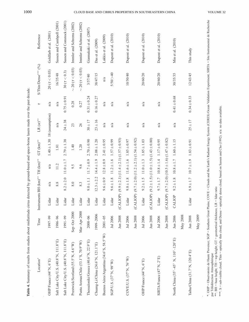
For the sake of a proper comparison, we summarize infor-mation about midlatitude cirrus clouds detected by ground-based and space-borne lasers from studies made over the pastdecade (Table 4). A large range of cirrus CBH can occur.For example, at the Observatoire de Haute Provence (OHP)and Site Instrumental de Recherche par Teledetection At-mospherique (SIRTA) sites in France, they range from 7–13km, and over the Clouds and the Earth’s Radiant EnergySystem (CERES) Ocean Validation Experiment (COVE) andSGP sites in the U. S., cirrus CBH ranges from 7 km to 15 km
8 9 10 11 12 13 14 15
0
0.2
0.4
0.6
0.8
1
Me
an
Extin
ctio
n C
oe
ffic
ien
t (1
/km
)
Mid−cloud Height (km)
Spring
Summer
Autumn
Winter
Year
Fig. 10. Seasonal and annual mean extinction coefficient as afunction of mid-cloud height.
1000 CLOUD BASE AND CIRRUS PROPERTIES IN SOUTHEASTERN CHINA VOLUME 32

JULY 2015 LIU ET AL. 1001
(Dupont et al., 2010). In this study, cirrus CBH ranges from7 km to 14 km. Mean cirrus base heights range from 8 to10 km in most of the studies listed in Table 4. One site(Chung-Li) has a relatively high base height of greater than12 km (Das et al., 2009). The mean base height from thestudies presented in Table 4 (excluding Chung-Li) is around9.2 km, which is considered a typical base height for mid-latitude cirrus clouds. The mean cloud-base height in thisstudy (8.9±1.7 km) is comparable to this typical value. Aslisted in Table 4, mean cirrus cloud-top heights range from9.5 km to 14.4 km, with most located around 11 km. Themean value (excluding Chung-Li) is about 11.0 km, which isclose to the value found in this study (10.7±1.9 km). A studyon the global characterization of cirrus using CALIPSO data(not shown in Table 4) has also shown that, between 20◦Nand 60◦N, cirrus clouds with base and top altitudes at 8 kmand 11 km, respectively, occur most often and that there areno significant differences in the vertical distribution of cirrusclouds between (20◦–60◦N) and (20◦–60◦S) (Nazaryan et al.,2008). Although cloud thickness generally has a broad distri-bution, e.g., from about 7.0 km over Salt Lake City (Sassenand Comstock, 2001) and Chung-Li (Das et al., 2009), andranging from 0.5 km to 5 km over French and Americansites (Dupont et al., 2010), most cirrus cloud thicknesses areless than 2.0 km. The mean cirrus thickness over Taihu was1.83±0.91 km, which is slightly larger than that found overthe OHP (Goldfarb et al., 2001), Prestwick and Punta Are-nas (Immler and Schrems, 2002), and SIRTA (Dupont et al.,2010) sites, and less than that over Salt Lake City (Sassen andComstock, 2001), Thessaloniki (Giannakaki et al., 2007), andBuenos Aires (Lakkis et al., 2009). Averaging all values fromTable 4, the typical thickness of midlatitude cirrus cloudsis1.7 km. Based on cirrus data sets derived using different de-tection techniques, Dowling and Radke (1990) reported thata typical global value for cirrus cloud thickness is 1.5 km.
The mean LR in this study was 25± 17 sr for all cirruscloud cases, which falls within the range of values shown inTable 4. Using lidar data from Salt Lake City, Sassen andComstock (2001) calculated a mean LR of about 24±38 srand a median value of∼27 sr. They also reported that themean LR for anvil cirrus, and cirrus formed from synopticflows and from orographic effects, is∼ 24± 43 sr, 26± 40sr, and 20± 35 sr, respectively. The mean LR for midlat-itude cirrus in the Northern Hemisphere over Thessalonikifrom 2000 to 2006 was 30±17 sr (Giannakaki et al., 2007).From two studies made at Chung-Li (Chen et al., 2002; Das etal., 2009), values of 29±12 sr and 23±16 sr were found, re-spectively. A similar value of 23 sr was found over Prestwickduring September to October 2000 (Immler and Schrems,2002). At a site in the Southern Hemisphere, a mean value of26 sr was calculated from data collected in March and Aprilof 2000 (Immler and Schrems, 2002). Results found in thisstudy are consistent with those from these earlier works. TheLR depends on the properties of ice crystals and is also influ-enced by the height of the cirrus cloud. For example, in thestudy over Chung-Li, the LR varied randomly below 12 kmand varied between 20 sr to 40 sr from 12–15 km, and 10 sr
to 30 sr from 15–16 km (Chen et al., 2002).The variability in τc depends on the composition and
thickness of the cloud (Sivakumar et al., 2003). From thestudy by Sassen and Cho (1992), approximately 60% of cir-rus clouds are optically thin and, over Chung-Li, more than80% of the cirrus cases are optically thin (Das et al., 2009).Overall, most midlatitude cirrus clouds are optically thinandoccur 60% of the time. The frequency of sub-visible cirrusin this study is approximately 12%, which is much higherthan the 3% reported by Giannakaki et al. (2007) over Thes-saloniki and the 5% reported by Dupont et al. (2010) overthe SGP site. It is significantly lower than the 38% reportedby Das et al. (2009) over Chung-Li. The frequency of sub-visible cirrus in this study is roughly in line with that fromstudies of midlatitude cirrus over the COVE site (Dupont etal., 2010), at the OHP (Goldfarb et al., 2001; Dupont et al.,2010), Salt Lake City (Sassen and Campbell, 2001), Prest-wick (Immler and Schrems, 2002), Punta Arenas (Immler andSchrems, 2002), the SIRTA (Dupont et al., 2010) sites, andnorthern China (Min et al., 2010). Since most midlatitude cir-rus clouds are optically thin, the mean value ofτc is generallyless than 1.0. The meanτ for all cirrus clouds in this studyis 0.34±0.33, which is consistent with the mean values of0.31 reported by Giannakaki et al. (2007) and 0.28 reportedby Immler and Schrems (2002). However, the mean valuefound in this study is significantly larger than the value of0.16±0.27 reported by Das et al. (2009) and slightly smallerthan the value of 0.41± 0.68 reported by Min et al. (2011).The mean value ofτc is much smaller than that of 0.75±0.91reported by Sassen and Campbell (2001).
These differences are expected due to the variability incirrus clouds arising from factors such as synoptic conditions,water vapor amount, and number of cloud condensation nu-clei (Sassen and Campbell, 2001; Min et al., 2010). In ad-dition, discrepancies may also arise from artifacts causedbyinstrument characteristics, such as lidar vertical resolution,maximum pulsed energy, receiver solid signals and so on, aswell as from different methods used to retrieve optical prop-erties and to correct for multiple scattering. Different waysof identifying/defining a cirrus cloud can also result in dif-ferences in their optical properties. For example, Das et al.(2009) define a cirrus cloud as the lowest cloud with a baseheight located above 8 km, while Wang and Sassen (2001,2002) and Dupont et al. (2010) use a value of 7 km for thelowest cirrus CBH. An even smaller value of 5 km was usedin the studies by Nazaryan et al. (2008) and Min et al. (2010)using CALIPSO data. Other observed variables such asRB(z)and lidar depolarization ratio can also be used to identify cir-rus clouds. Discrepancies in any of these can contribute todifferences in retrieved cirrus cloud properties.
5. Conclusion
Towards gaining insights into the characteristics ofaerosols, clouds, and their interactions in southeastern China,a heavily polluted area in East Asia, a suite of instruments,

1002 CLOUD BASE AND CIRRUS PROPERTIES IN SOUTHEASTERN CHINA VOLUME 32
including a depolarization-sensitive MPL, was installed atTaihu, located in the center of the Yangtze Delta region, fromMay 2008 to December 2009. The seasonal patterns and thediurnal cycles of CF and CBH, and the vertical structure andoptical properties of cirrus clouds, were first examined. Al-though only one year’s worth of data were collected, they pro-vide a useful first look at the characteristics of clouds, espe-cially cirrus clouds, over this part of the world. The measure-ments collected also provide the opportunity to make com-parisons with similar clouds in other regions of the world.
Overall, clouds were observed 41% of the time over thesite throughout the campaign, and varied seasonally with atypical summer minimum (27.7%) and a winter maximum(51.4%). These results are similar to those reported in astudy based on ground-based radar-lidar observations overthe SGP site from 1997 to 2002. In most months, moreclouds were found at night than during the day. On average,the largest/smallest seasonal CF occurred in winter/summerduring the day, while the largest/smallest value at night oc-curred in spring/summer. Annual average CF experienceda significant diurnal cycle with amplitudes of about 24.6%.Cloud amounts decreased noticeably from the beginning ofthe day to midday, and then continuously increased from lo-cal noon to the end of the day. Annual mean CBHs were3.05±2.73, 2.46±2.08, and 3.51±3.07 km for all clouds,daytime clouds only, and nighttime clouds only, respectively.The highest CBHs were found in spring and summer, espe-cially during the night. The largest number of detected cloudbases fell within the range of 0.5 km to 1.0 km. The annualmean diurnal cycle of CBH shows that low CBH occurredaround noon and high CBHs appeared around midnight. Theseasonal mean diurnal cycle of CBH was strong in spring andsummer and relatively weak in autumn and winter.
Cirrus clouds comprised∼36.2% of nighttime cloud ob-servations with peaks in occurrence during the summer. Cir-rus base heights ranged from 7 km to 14.3 km. More than56% of cirrus base heights were located between 7 km and8.5 km. Cirrus top heights showed a broad (7–16 km) andmulti-modal distribution, with more than 40% of top heightsappearing in the range of 9–10.5 km. Most of the cir-rus cloud cases had thicknesses less than 3 km. Annualmean cirrus base and top heights were 8.89± 1.65 km and10.73± 1.86 km, respectively. The annual mean thicknesswas∼ 1.83± 0.91 km. The mean LR for all cirrus cloudcases in our study was∼ 25±17 sr, with a smooth seasonalvariation. Approximately 70% of LRs fell within 18–40 sr,with a peak at 29 sr. No obvious relation between seasonaland annual mean LR and mid-cloud height was found. Largeranges in the magnitudes of cirrusσ (0.001–1.59 km−1) andcirrus τ (0.001–2.475) were observed. Annual mean cirruscloud σ andτ were 0.25± 0.31 km−1 and 0.34±0.33, re-spectively. Approximately 12% of the cirrus cloud cases weresub-visible cirrus, 43% were thin cirrus, and 45% were densecirrus. Thicker cirrus clouds occurred more frequently dur-ing the summer than in winter. Cirrus geometrical and opticalproperties derived in this study are similar to those reported inother studies using lasers to detect midlatitude cirrus clouds.
Acknowledgements. This study was supported by the Min-istry of Science and Technology of China (Grant Nos. Change:2013CB955802 to 2012AA120901), State Laboratory of Earth Sur-face Process and Resource Ecology, National Science Foundation ofChina (41175019), and the US Department of Energy (Grant Nos.DEFG0208ER64571and DE-SC0007171). The authors are gratefulto Prof. Zhien WANG, University of Wyoming, for providing thecloud mask code.
REFERENCES
Ansmann, A., U. Wandinger, M. Riebesell, C. Weitkamp, and W.Michaels, 1992: Independent measurement of extinction andbackscatter profiles in cirrus clouds by using a combined Ra-man elastic backscatter lidar.Appl. Opt., 31, 7113–7131.
Bissonnette, L. R., G. Roy, and G. Tremblay, 2007: Lidar-based characterization of the geometry and structure of waterclouds.J. Atmos. Oceanic Technol., 24(8), 1364–1376.
Campbell, J. R., and M. Shiobara, 2008: Glaciation of a mixed-phase boundary layer cloud at a coastal arctic site as depictedin continuous lidar measurements.Polar Science, 2(2), 121–127.
Campbell, J. R., D. L. Hlavka, E. J. Welton, C. J. Flynn, D. D.Turner, J. D. Spinhirne, V. S. Scott, and I. H. Hwang, 2002:Full-time, eye-safe cloud and aerosol lidar observation atAt-mospheric Radiation Measurement Program sites: Instrumentand data processing.J. Atmos. Oceanic Technol., 19, 431–442.
Chang, F. L., and Z. Li, 2005: A new method for detection of cirrusoverlapping water clouds and determination of their opticalproperties.J. Atmos. Sci., 62, 3993–4009.
Chen, W. N., C. W. Chiang, and J. B. Nee, 2002: Lidar ratio anddepolarization ratio for cirrus clouds.Appl. Opt., 41, 6470–6476.
Clothiaux, E. E., G. G. Mace, T. P. Ackerman, T. J. Kane, J. D.Spinhirne, and V. S. Scott, 1998: An automated algorithm fordetection of hydrometeor returns in micro pulse lidar data,J.Atmos. Oceanic Tech., 15, 1035–1042.
Comstock, J. M., and K. Sassen, 2001: Retrieval of cirrus cloudcadiative and backscattering properties using combined Lidarand Infrared Radiometer (LIRAD) measurements.J. Atmos.Oceanic Technol., 18(10), 1658–1673.
Comstock, J. M., T. P. Ackerman, and G. G. Mace, 2002: Ground-based lidar and radar remote sensing of tropical cirrus cloudsat Nauru Island: Cloud statistics and radiative impacts.J. Geophys. Res., 107(D23), AAC 16-1–AAC 16-14, doi:10.1029/2002JD002203.
Das, S. K., C. W. Chiang, and J. B. Nee, 2009: Characteristicsofcirrus clouds and its radiative properties based on lidar obser-vation over Chung-Li, Taiwan.Atmos. Res., 93(4), 723–735.
Das, K, S., J. B. Nee, and C. W. Chiang, 2010: A LiDAR study ofthe effective size of cirrus ice crystals over Chung-Li, Taiwan.J. Atmos. Sol.-Terr. Phys., 72(9–10), 781–788.
Dessler, A. E., and P. Yang, 2003: The distribution of tropical thincirrus clouds inferred from terra MODIS data.J. Climate, 16,1241–1247.
Dong, X. Q., P. Minnis, and B. K. Xi, 2005: A climatology ofmid-latitude continental clouds from ARM SGP site: Part I.Low-level cloud macrophysical, microphysical and radiativeproperties.J. Climate, 18, 1391–1410.
Dong, X. Q., B. K. Xi, and P. Minnis, 2006: A climatology of

JULY 2015 LIU ET AL. 1003
mid-latitude continental clouds from the ARM SGP CentralFacility: Part II: Cloud fraction and surface radiative forcing.J. Climate, 19, 1765–1783.
Dong, X. Q., B. K. Xi, K. Crosby, C. N. Long, R. S. Stone, andM. D. Shupe, 2010: A 10 year climatology of Arctic cloudfraction and radiative forcing at Barrow, Alaska.J. Geophys.Res., 115, D17212, doi: 10.1029/2009JD013489.
Dowling, D. R., and L. F. Radke, 1990: A summary of the physicalproperties of cirrus clouds.J. Appl. Meteor., 29(9), 970–978.
Dupont, J. C., M. Haeffelin, Y. Morile, V. Noel, P. Keckhut, D.Winker, J. Comstock, and A. Roblin, 2010: Macrophysicaland optical properties of mid-latitude cirrus clouds from fourground-based lidars and collocated CALIOP observations.J.Geophys. Res., 115, D00H24, doi: 10.1029/2009JD011943.
Dupont, J. C., M. Haeffelin, Y. Morille, J. M. Comstock, C.Flynn, C. N. Long, C. Sivaraman, and R. K. Newson, 2011:Cloud properties derived from two lidars over the ARM SGPsite.Geophys. Res. Lett., 38, L08814, doi: 10.1029/2010GL046274.
Fernald, F. G., 1984: Analysis of atmospheric lidar observations:Some comments.Appl. Opt., 23, 652–653.
Flynn, C. J., A. Mendoza, Y. Zheng, and S. Mathur, 2007:Novel polarization-sensitive micropulse lidar measurementtechnique.Optics Express, 15(6), 2785–2790.
Giannakaki, E., D. S. Balis, V. Amiridis, and S. Kazadzis, 2007:Optical and geometrical characteristics of cirrus clouds overa Southern European lidar station.Atmos. Chem. Phys., 7,5519–5530.
Goldfarb, L., P. Keckhut, M. L. Chanin, and A. Hauchecorne,2001: Cirrus climatological results from lidar measurementsat OHP (44◦N, 6◦E). Geophys. Res. Lett., 28(9), 1687–1690.
Immler, F., and O. Schrems, 2002: LIDAR measurements of cir-rus clouds in the northern and southern mid-latitudes duringINCA (55 ◦N, 53 ◦S): A comparative study.Geophys. Res.Lett., 16, 56-1–56-4, doi: 10.1029/2002GL015077.
IPCC, 2007:Climate Change 2007: The Physical Science Basis.Contribution of Working Group I to the Forth Assessment Re-port of the Intergovernmental Panel on Climate Change, S.Solomon et al., Eds. Cambridge University Press, Cambridge,United Kingdom and New York, NY, USA, 996 pp.
Keckhut, P., A. Hauchecorne, S. Bekki, A. Colette, C. David,and J.Jumelet, 2005: Indications of thin cirrus clouds in the strato-sphere at mid-latitudes.Atmos. Chem. Phys., 5(12), 3407–3414.
Kollias, P., G. Tselioudis, and B. A. Albrecht, 2007: Cloud cli-matology at the Southern Great Plains and the layer structure,drizzle, and atmospheric modes of continental stratus.J. Geo-phys. Res., 112(D9), D09116, doi: 10.1029/2006jd007307.
Lakkis, S. G., M. Lavorato, and P. O. Canziani, 2009: Monitoringcirrus clouds with lidar in the Southern Hemisphere: A localstudy over Buenos Aires. 1. Tropopause heights.Atmos. Res.,92, 18–26.
Li, Z., and Coauthors, 2007: Preface to special section onEast Asian Studies of Tropospheric Aerosols: An Interna-tional Regional Experiment (EAST-AIRE).J. Geophys. Res.,112(D22), doi: 10.1029/2007JD008853.
Li, Z., and Coauthors, 2011: East Asian Studies of Tropo-spheric Aerosols and their Impact on Regional Climate (EAS-TAIRC): An overview.J. Geophys. Res., 116, D00K34, doi:10.1029/2010JD015257.
Liu, J., Y. Zheng, Z. Li, C. Flynn, E. J. Welton, and M. Cribb,2011: Transport, vertical structure and radiative properties of
dust events in southeast China determined from ground andspace sensors.Atmos. Environ., 45(35), 6469–6480.
Mace, G. G., Q. Zhang, M. Vaughan, R. Marchand, G. Stephens,C. Trepte, and D. Winker, 2009: A description of hydrome-teor layer occurrence statistics derived from the first yearofmerged CloudSat and CALIPSO data.J. Geophys. Res., 114,D00A26, doi: 10.1029/2007JD009755.
Mahesh, A., J. R. Campbell, and J. D. Spinhirne, 2005: Multi-year measurements of cloud base heights at South Pole bylidar. Geophys. Res. Lett., 32, L09812, doi: 10.1029/2004GL021983.
Min, M., P. C. Wang, J. R. Campbell, X. M. Zong, and Y. Li, 2010:Midlatitude cirrus cloud radiative forcing over China.J. Geo-phys. Res., 115(D20), doi: 10.1029/2010JD014161.
Min, M., P. Wang, J. R. Campbell, X. Zong, and J. Xia, 2011:Cirrus cloud macrophysical and optical properties over northChina from CALIOP measurements.Adv. Atmos. Sci., 28(3),653–664, doi: 10.1007/s00376-010-0049-5.
Nazaryan, H., M. P. McCormick, and W. P. Menzel, 2008: Globalcharacterization of cirrus clouds using CALIPSO data.J.Geophys. Res., 113, D16211, doi: 10.1029/2007JD009481.
Noel, V., D. M. Winker, T. J. Garrett, and M. Mcgill, 2007: Ex-tinction coefficients retrieved in deep tropical ice cloudsfromlidar observations using CALIPSO like algorithm comparedto in-situ measurements from cloud integrating nephelome-ter during CRYSTAL-FACE.Atmos. Chem. Phys., 7, 1415–1422.
Pace, G., M. Cacciani, A. di Sarra, G. Fiocco, and D. Fua, 2003:Lidar observations of equatorial cirrus clouds at Mahe Sey-chelles.J. Geophys. Res., 108(D8), 4236, doi: 10.1029/2002JD002710.
Platnick, S., M. D. King, S. A. Ackerman, W. P. Menzel, B.A. Baum, J. C. Riedi, and R. A. Frey, 2003: The MODIScloud products: Algorithms and examples from Terra.IEEET. Geosci. Remote, 41(2), 459–473.
Reichardt, J., 1999: Optical and geometrical properties ofnorthernmidlatitude cirrus clouds observed with a UV Raman lidar.Phys. Chem. Earth, Part B, 24, 255–260.
Sassen, K., and B. S. Cho, 1992: Subvisual-thin cirrus lidardatasetfor satellite verification and climatological research.J. Appl.Meteor., 31, 1275–1285.
Sassen, K., and J. R. Campbell, 2001: A midlatitude cirrus cloudclimatology from the facility for atmospheric remote sensing.Part I: Macrophysical and synoptic properties.J. Atmos. Sci.,58, 481–496.
Sassen, K., and J. M. Comstock, 2001: A mid-latitude cirrus cloudclimatology from the facility for atmospheric remote sensing.Part III: Radiative properties.J. Atmos. Sci., 58, 2113–2127.
Sassen, K., M. K. Griffin, and G. C. Dodd, 1989: Optical scat-tering and microphysical properties of subvisual cirrus cloud,and climatic implications.J. Appl. Meteor., 28, 91–98.
Sassen, K., Z. E. Wang, and D. Liu, 2008: Global distributionof cirrus clouds from Cloud-Sat/Cloud-Aerosol Lidar and In-frared Pathfinder Satellite Observations (CALIPSO) measure-ments.J. Geophys. Res., 113, doi: 10.1029/2008JD009972.
Seifert, P., A. Ansmann, D. Muller, U. Wandinger, D. Althausen,A. J. Heymsfield, S. T. Massie, and C. Schmitt, 2007: Cir-rus optical properties observed with lidar, radiosonde, andsatellite over the tropical Indian Ocean during the aerosol-polluted northeast and clean maritime southwest monsoon.J.Geophys. Res., 112, doi: 10.1029/2006JD008352.
Shupe, M. D., V. P. Walden, E. Eloranta, T. Uttal, J. R. Campbell,

1004 CLOUD BASE AND CIRRUS PROPERTIES IN SOUTHEASTERN CHINA VOLUME 32
S. M. Starkweather and M. Shiobara, 2011: Clouds at arcticatmospheric observatories. Part I: Occurrence and .acrophys-ical properties.J. Appl. Meteor. Climatol., 50, 626–644.
Sivakumar, V., Y. Bhavanikumar, P. B. Rao, K. Mizutani, T. Aoki,M. Yasui, and T. Itabe, 2003: Lidar observed character-istics of the tropical cirrus clouds.Radio Sci., 38(6), doi:10.1029/2002RS002719.
Spinhirne, J. D., J. A. R. Rall, and V. S. Scott, 1995: Compacteyesafe lidar systems.Rev. Laser Eng., 23, 112–118.
Stephens, G. L., 2005: Cloud feedbacks in the climate system: Acritical review.J. Climate, 18, 237–273.
Stubenrauch, C. J., A. Chedin, G. Radel, N. A. Scott, and S. Serrar,2006: Cloud properties and their seasonal and diurnal vari-ability from TOVS Path-B.J. Climate, 19, 5531–5553.
Sunilkumar, S. V., K. Parameswaran, and B. V. Thampi, 2008: In-terdependence of tropical cirrus properties and their variabil-ity. Ann. Geophys., 26(3), 413–429.
Thorsen, T. J., Q. Fu, J. M. Comstock, C. Sivaraman, M. A.Vaughan, D. M. Winker, and D. D. Turner, 2013: Macrophys-ical properties of tropical cirrus clouds from the CALIPSOsatellite and from ground-based micropulse and Raman lidars.J. Geophys. Res., 118, 9209–9220.
Vukicevic, T., O. Coddington, and P. Pilewskie, 2010: Char-acterizing the retrieval of cloud properties from opticalremote sensing.J. Geophys. Res., 115, D20211, doi:10.1029/2009JD012830.
Wang, Z., and K. Sassen, 2001: Cloud type and macrophysicalproperty retrieval using multiple remote sensors.J. Appl. Me-teor., 40(10), 1665–1682.
Wang, Z., and K. Sassen, 2002: Cirrus cloud microphysical prop-erty retrieval using lidar and radar measurements. Part II:Mid-latitude cirrus microphysical and radiative properties.J.Atmos. Sci., 59(14), 2291–2302.
Wang, Z. Z., R. L. Chi, B. Liu, and J. Zhou, 2008: Depolariza-tion properties of cirrus clouds from polarization lidar mea-surements over Hefei in spring.Chinese Optics Letters, 6(4),235–237.
Winker, D. M., J. R. Pelon, and M. P. McCormick, 2003:The CALIPSO mission: Spaceborne lidar for observationof aerosols and clouds.Proc. SPIE, 4893, doi: 10.1117/12.466539.
Wu, Y. H., S. K. Chaw, B. Gross, F. Moshary, and S. Ahmed, 2009:Low and optically thin cloud measurements using a Raman-Mie lidar. Appl. Opt., 48(6), 1218–1227.
Zhang, M. H., and Coauthors, 2005: Comparing clouds andtheir seasonal variations in 10 atmospheric general circulationmodels with satellite measurements.J. Geophys. Res., 110,D15S02, doi: 10.1029/2004JD005021.
Zhao, C. F., Y. Z. Wang, Q. Q. Wang, Z. Q. Li, Z. E. Wang, and D.Liu, 2014: A new cloud and aerosol layer detection methodbased on micropulse lidar measurements.J. Geophys. Res.,119, 6788–6802, doi: 10.1002/2014JD021760.