CLIMATE CONTROLS ON STRATIGRAPHY - Brigham...
25
CLIMATE CONTROLS ON STRATIGRAPHY Edited by: C. BLAINE CECIL U.S. Geological Survey, Reston, Virginia 20192, U.S.A. AND N. TERENCE EDGAR U.S. Geological Survey, St. Petersburg, Florida 33710, U.S.A. Copyright 2003 by SEPM (Society for Sedimentary Geology) Laura J. Crossey, Editor of Special Publications SEPM Special Publication Number 77 Tulsa, Oklahoma, U.S.A. October, 2003 1 2 3 4 5 6 7 8 9 10 11 12 NUMBER OF MONTHS WHEN RAINFALL EXCEEDS EVAPOTRANSPORATION POTENTIAL SOLID SEDIMENT YIELD
Transcript of CLIMATE CONTROLS ON STRATIGRAPHY - Brigham...

CLIMATE CONTROLSON STRATIGRAPHY
Edited by:
C. BLAINE CECILU.S. Geological Survey, Reston, Virginia 20192, U.S.A.
AND
N. TERENCE EDGARU.S. Geological Survey, St. Petersburg, Florida 33710, U.S.A.
Copyright 2003 bySEPM (Society for Sedimentary Geology)
Laura J. Crossey, Editor of Special PublicationsSEPM Special Publication Number 77
Tulsa, Oklahoma, U.S.A. October, 2003
1 2 3 4 5 6 7 8 9 10 11 12
NUMBER OF MONTHS WHEN RAINFALL
EXCEEDS EVAPOTRANSPORATION
PO
TE
NT
IAL S
OLID
SE
DIM
EN
T Y
IELD
Climate Controls on Stratigraphy

ISBN 1-56576-085-9
© 2003 bySEPM (Society for Sedimentary Geology)
6128 E. 38th Street, Suite 308Tulsa, OK 74135-5814, U.S.A.
Printed in the United States of America
SEPM and the authors are grateful to the followingfor their generous contribution to the cost of publishing
Climate Controls on Stratigraphy
Contributions were applied to the cost of production, which reduced thepurchase price, making the volume available to a wide audience
United States Geological Survey
ChevronTexaco
The National Center for Atmospheric Research(sponsored by the National Science Foundation)
SEPM (Society for Sedimentary Geology) is an international not-for-profit Society based in Tulsa,Oklahoma. Through its network of international members, the Society is dedicated to the disseminationof scientific information on sedimentology, stratigraphy, paleontology, environmental sciences, marinegeology, hydrogeology, and many additional related specialties.
The Society supports members in their professional objectives by publication of two major scientific journals, theJournal of Sedimentary Research (JSR) and PALAIOS, in addition to producing technical conferences, shortcourses, and Special Publications. Through SEPM's Continuing Education, Publications, Meetings, and otherprograms, members can both gain and exchange information pertinent to their geologic specialties.
For more information about SEPM, please visit www.sepm.org.

29OBSERVATIONS ON CLIMATE AND SEDIMENT DISCHARGE IN SELECTED TROPICAL RIVERS, INDONESIA
OBSERVATIONS ON CLIMATE AND SEDIMENT DISCHARGEIN SELECTED TROPICAL RIVERS, INDONESIA
C. BLAINE CECILU.S. Geological Survey, Reston, Virginia 20192, U.S.A.
FRANK T. DULONGU.S. Geological Survey, Reston, Virginia 20192, U.S.A.
RONALD A. HARRISBrigham Young University, Provo, Utah 84602, U.S.A.
JAMES C. COBBKentucky Geological Survey, Lexington, Kentucky 40506, U.S.A.
HAROLD G. GLUSKOTERU.S. Geological Survey, Reston, Virginia 20192, U.S.A.
AND
HENDRO NUGROHODepartment of Geology, UPN Veteran Yogyakarta, Yogyakarta, Indonesia
Present address: Department of Geology, Brigham Young University, Provo, Utah 84602, U.S.A.
ABSTRACT: Factors that influence fluvial sediment discharge in warm climates (catchment-basin size, relief, gradient, tectonic setting,bedrock lithology, and rainfall) can readily be evaluated in fluvial systems of Indonesia. In equatorial Sumatra and Seram, rainfall,catchment-basin size, relief, and gradient are similar, whereas bedrock geology and tectonic setting differ. The relief and rainfall inequatorial Borneo is similar to that of Sumatra and Seram, but gradient, catchment-basin size, and tectonic setting differ. All factors,except rainfall, are very similar for Timor and Seram. A pronounced dry season in Timor and Java distinguish those islands from thewet climates of Seram and Sumatra, respectively.
The nature of stream channels (braided or meandering), stream bed materials, the degree of fluvial estuarine fill, deltas, and the natureof coastlines were used to evaluate sediment discharge. In addition, reconnaissance-level stream sampling was conducted for solid-suspended-sediment concentrations, solute concentrations, and pH in rivers in equatorial regions in Sumatra and Borneo, in Seram at 3°S, in Irian Jaya at 4° S, and in West Timor at 10° S. Rainfall in Sumatra, Borneo, and Seram exceeds evapotranspiration for all months of theyear (> 100 mm/month and > 2.4 m/yr, perhumid climate). In contrast, in Timor 85 percent of all rainfall (1.4 m/yr) occurs during a four-month rainy season (dry subhumid climate).
The absence of a fluvially derived bed load, river-mouth deltas, the lack of fluvial fill of estuaries, and mud-dominated coastal zonesin the perhumid regions are indicative of a very low fluvial sediment discharge. Very low sediment concentrations (10 mg/l suspendedand 10 mg/l solute) in modern rivers in the perhumid equatorial region of Indonesia are consistent with this observation. In contrast,sediment discharge in dry subhumid climates of Indonesia is very high, as indicated by coarse-grained braided-stream bed materialswith cobbles transported to the coast, the complete fluvial fill of estuaries, the formation of river-mouth deltas, and coarse-grainedbeaches. Very high sediment concentrations (2100 mg/l suspended and 340 mg/l dissolved) during rainy-season discharge in modernrivers in dry-subhumid regions of Indonesia (Timor) are consistent with this observation. The dominant variable affecting fluvialsediment discharge among the islands of Indonesia, therefore, appears to be the degree of seasonality in rainfall regardless of tectonicsetting, relief, or catchment-basin size. Solute concentrations in humid and perhumid climates are indicative of bedrock geology.Chemical weathering of massive Miocene limestone thrust sheets in high mountainous areas of Seram and Irian Jaya results in soluteconcentrations that approximate the solubility of calcite (~ 50 mg/l). Humid and perhumid areas without significant limestone bedrockgeology have solute concentrations that approximate that of rainwater (~ 10 mg/l).
Climate Controls on StratigraphySEPM Special Publication No. 77, Copyright © 2003SEPM (Society for Sedimentary Geology), ISBN 1-56576-085-9, p. 29–50.
INTRODUCTION
This study compares and contrasts the apparent sedimenttransport in some modern tropical river systems that may serveas analogues for sediment supply to ancient depositional sys-tems, particularly those in ancient cratonic seas. Much of theinformation on sediment supply from modern tropical rivers hasbeen derived from hydrological and geomorphological studies(e.g., Summerfield, 1991; Olive et al., 1994) rather than sedimen-tological investigations and the perspective of sediment supply.Modern analogues that can be used to interpret sediment sup-plies in ancient depositional systems are, therefore, underdevel-oped. Modern large rivers of the tropics and subtropics, such asthe Amazon, the Ganges/Brahmaputra, the Indus, and the Zaire(Congo), empty along passive continental margins. As a result,
these rivers generally appear to be atypical of sediment-supplysystems to most ancient cratonic depositional environments.Smaller river systems, such as those in Indonesia, may be repre-sentative of sediment supply in ancient cratonic seas and foreland-basin systems.
If cyclic variation in sediment supply (sedimentation) isrelated to cyclicity in paleoclimate (Huntington 1907; Wanlessand Shepard, 1936; Cecil, 1990), then the rivers on the islands ofIndonesia are ideal analogues because they span climate beltsthat range from perhumid at the equator (Cecil, this volume,Part 1) to dry subhumid at 10° S (Fig. 1). By studying sedimentsupply in these modern rivers, it may be possible to extrapolateresults to ancient systems where the climate may have cycledbetween relative extremes in both seasonality and amount ofannual rainfall. Climatic changes of large magnitude, and their

C.B. CECIL, F.T. DULONG, R.A. HARRIS, J.C. COBB, H.G. GLUSKOTER, AND H. NUGROHO30
5°
0°
5°
10°
15°
SU
MATR
A
BORNEO
IRIAN JAYA
JAVA
TIMOR
SERAM
AUSTRALIA
MA
LAY
SIA
0 100 200 400 600 miles
0 200 400 600 kilometers
Arafura Sea
JavaSea
INDONESIA
effects on variation in sediment supply, are not well docu-mented in the humid tropics (Verstappen, 1975) although thereis a considerable body of evidence that is indicative of signifi-cant shifts in rainfall regimes during the Quaternary (Van derKarrs, 1988). There also appears to have been extreme climateshifts in the eastern Sahara Desert (dry tropics) where ground-penetrating radar has revealed at least two periods of majorfluvial incision that underlie modern sand seas (see Summerfield,1991, p. 359-360). Interpretations of lithostratigraphic relation-ships can be improved, therefore, as cyclic fluctuation inpaleoclimate is further documented and related to cycles insediment supply.
Considerable uncertainty persists regarding controls on sedi-ment discharge (supply) in modern fluvial systems (Millimanand Meade, 1983; Milliman, 1997). Many studies suggest thattectonic uplift is the primary control on erosion and fluvialsediment discharge (Meade, 1996; Milliman, 1997). Catchment-basin size and provenance also are proposed to be importantcontrolling factors on yield (Staub and Esterle, 1994; Walling andWebb, 1996; Milliman, 1997). In addition, rainfall is one of theprimary controls on sediment yield from modern rivers (Langbeinand Schumm, 1958; Fournier, 1960). Unless the level of uncer-tainty concerning the importance of the variables can be reducedor somehow quantified, it will always be difficult to use existingstudies of modern environments as analogues for the interpreta-tion of ancient depositional systems.
Comparison of Sediment Supply in Four Tropicaland Subtropical River Systems
Although there have been studies in modern tropical environ-ments, an understanding of fluvial sediment discharge as afunction of climate remains ambiguous. Most studies generallyhave compared sediment discharge with annual rainfall (Milliman,1997) rather than monthly rainfall amounts and monthly distri-bution throughout the year, as suggested by Fournier (1960) andCecil and Dulong (this volume, Part 1). As a result, there has been
a tendency to suggest that high annual rainfall results in highfluvial sediment discharge. Other studies point out that there islittle (if any) correlation between sediment discharge and annualrainfall (Milliman and Meade, 1983; Milliman, 1997; Hooke,2000). In western Indonesia, it is sometimes assumed that erosionrates and sediment loads must be high because the climate isperhumid (Keller and Richards, 1967; Milliman and Meade, 1983)or because the region is undergoing tectonic uplift, which in turnis believed to be the primary control on sediment discharge(Meade, 1996; Milliman, 1997). However, neither high mountain-ous areas nor perhumid climates necessarily equate to highsediment discharge. This is demonstrated by the exceedingly lowsediment discharge from the western slope of the arid centralAndes Mountains and by the very limited degree of sedimentaryfill extending into the adjacent central Peru–Chile trench (Ceciland Edgar, 1994; Edgar and Cecil, this volume, Part 3). It is alsodemonstrated by the exceedingly low sediment discharge fromrivers that debouch from the mountainous perhumid regions ofequatorial Sumatra to the Sunda Shelf (Cecil et al., 1993) and theZaire (Congo) River (Meade, 1996). Extreme conditions of rain-fall, tectonic setting, or catchment-basin size compound the prob-lem of understanding sediment discharge in rivers of the tropicsand subtropics. Four previously studied tropical to subtropicalriver systems with headwaters in high mountainous areas (> 5000m) include the following: (1) the Fly River, New Guinea, which isin a humid climate setting, (2) the Amazon River, South America,whose huge catchment basin is in a humid to subhumid climate,(3) the Zaire, where the catchment is situated primarily in ahumid to perhumid climate, and (4) the Ganges/Brahmaputrariver system, where the catchment is situated mainly in a drysubhumid climate. In the humid climate of the Fly River, thesediment load is thought to be derived primarily from intenseslope failure in high and very steep mountainous areas (Markhamand Day, 1994). The combined effects of high mountains, highrainfall, and frequent earth tremors are conducive to extremevolumes of landslide debris (Markham and Day, 1994). Therelatively high sediment discharge (derived from erosion of
FIG. 1.—Climate belts in Indonesian study areas, which range from perhumid at the equator (dark blue) to dry subhumid in Timorat 10° S (yellow).

31OBSERVATIONS ON CLIMATE AND SEDIMENT DISCHARGE IN SELECTED TROPICAL RIVERS, INDONESIA
landslide debris in high mountains in a tectonically active areaand a humid climate) has apparently contributed to the conceptthat high mountains and high annual rainfall always equateswith high sediment discharge. The sediment discharge from theAmazon River to the Atlantic Ocean further contributes to theconcept that high annual rainfall always results in high sedimentdischarge (Meade, 1996). It has been suggested that the sedimentin the Amazon is derived principally from the vast catchmentbasins of the eastern slope of the Andes Mountains and that muchof the sediment is stored in upstream portions of the Amazon(Meade, 1996). The sheer volume of the Amazon River dischargeand the subhumid climates in the upper reaches of the AmazonBasin probably accounts for the relatively high annual sedimentdischarge to the Atlantic Ocean. On the basis of data from Meade(1996), the annual sediment discharges of the Amazon andGanges/Brahmaputra are nearly equal even though water dis-charged from the Amazon is nearly six times that of the Ganges/Brahmaputra (Table 1).
When sediment discharges are normalized on a mass per unitvolume basis (tons of sediment per km3 of water discharge),sediment concentrations of the Ganges/Brahmaputra in the highlyseasonal rainfall (dry subhumid climate) of southern Asia areapproximately twice that of the Fly, six times that of the Amazon,and two orders of magnitude greater than that of the Zaire(Congo) (Table 1). The comparisons in Table 1 are indicative of theinfluence of seasonal distribution of rainfall on sediment supplyin tropical and subtropical settings. Only the Fly River shows adistinct influence of tectonics on sediment discharge, apparentlybecause of slope instability high in the catchment basin. Thedominant control on the other rivers appears to be the degree ofseasonality of rainfall regardless of tectonic setting, heights ofmountains, or catchment basin size.
The data in Table 1 indicate that a significant climatic changewithin a given catchment basin also causes a major change insediment supply. For example, if the climate of the Zaire Basinshifted from perhumid or humid to dry-subhumid conditions,sediment discharge would undergo a major increase even thoughannual rainfall would likely decrease.
River Systems, Climate, and Tectonic Setting of Indonesia
A primary objective of our study is to delimit and relate theperhumid to dry subhumid climatic conditions in Indonesia tofluvial sediment discharge, which we equate to sediment supply.Indonesia represents an ideal natural laboratory to test the role ofclimate as a control on fluvial sediment discharge in warmclimates because many Indonesian islands have similarities ingeomorphology and geology but significant differences in rain-
fall distribution. Similarities in the size of catchment basins,stream gradients, relief, and geology are due mostly to similari-ties in tectonic setting. For example, the islands of Sumatra andJava are both part of the Sunda arc–trench system but annualrainfall in Java is much less and more seasonal than in Sumatra.A similar situation exists with the islands of Seram and Timor,both of which are part of the Banda arc–continent collision zoneof eastern Indonesia, but Timor is much drier and rainfall is moreseasonal. In both the Sunda and Banda arcs, where tectonic andgeologic settings are similar, the number of consecutive wetmonths per year is the primary variable that controls differencesin sediment discharge (supply) among fluvial systems.
In order to test the influence that climate may have on sedi-ment supply, Indonesian rivers were evaluated in the regions ofnortheastern Sumatra, western and south-central Borneo, Timor,Seram, and the southern coast of Irian Jaya (western New Guinea)(Fig.1). Rainfall for these areas ranges from perhumid in equato-rial islands to dry subhumid in the more southern islands of Javaand Timor (Ahrens, 1991). Rainfall throughout the study areas isstrongly affected by the seasonal movement of the intertropicalconvergence zone (ITCZ), where the Hadley circulations of thenorthern and southern hemispheres meet and rise in response toa low-pressure system that is generated by equatorial solarheating (Verstappen, 1975; Ahrens, 1991). As the moisture-ladenair of the ITCZ rises, the air cools and precipitation occurs.Wherever the ITCZ is stationary, or nearly so, rainfall is high andevenly distributed throughout the year. Because of the nearlycontinuous influence of the ITCZ, rainfall conditions in the equa-torial areas of Indonesia are humid to perhumid. In contrast, theislands of Timor and Java are outside the influence of the ITCZ formuch of the year. As a result, the climate of these two islands isdry subhumid, and their wet months are generally concentratedinto a three- to four-month period.
All the islands in this study have experienced identical glacio-eustatic histories. For the purposes of evaluating modern fluvialsediment discharge, the amount of tectonic movement probablydid not significantly affect variation in either sea level or fluvialsediment discharge since the last eustatic rise in sea level about8000–12,000 yr B.P. (sea-level history is summarized in Hanebuth,2000).
The present tectonic setting of these areas appears to beanalogous to conditions in eastern North America during theCarboniferous and in western North America during the Juras-sic–Cretaceous. Many of the intracratonic basins of North Americaformed during episodes of crustal loading from continental ac-cretion and extension, conditions that exist today in the Java andin the Arafura and Timor Seas of Indonesia (Hamilton, 1979;Silver and Smith, 1983). The Java Sea separates the Sunda arc–
TABLE 1.—Annualized sediment concentrations (mass/unit volume) for four tropical to subtropical rivers.Data are average annual water and sediment discharge.
River system Approximate
Mean
Number
of wet months
Water
discharge,109 m3/y
suspended
sediment
discharge,106 t/y
Annualized sediment
concentrations
(106 t/km3
of water discharge)
Zaire (Congo)(2) 11 1250 43 0.034
Amazon(2) 8–10 6300 1000–1300 0.21
Fly(1) 9 150 81 0.54
Ganges/Brahmaputra(2) 5 970 900–1200 1.2
Data sources: (1) Markham and Day (1994), and (2) Meade (1996). Approximations of mean seasonality of rainfall
for each catchment basin are based on data from EARTHINFO (1966).
C.B. CECIL, F.T. DULONG, R.A. HARRIS, J.C. COBB, H.G. GLUSKOTER, AND H. NUGROHO32
trench system from the stable craton of Borneo, which is a modernanalog for the Jurassic–Cretaceous seas and basins that formedbetween the Sierra arc–trench system and stable North America.Rivers along the northeastern coast of Sumatra and northerncoast of Java drain from the high volcanic mountains of the SundaArc and empty into the shallow epeiric Java Sea of the cratonicSunda Shelf. The rivers in southwestern and central Borneo draina craton of granitic and sedimentary rocks that are primarilysiliciclastic. The Arafura and Timor Seas represent foreland ba-sins forming astride active fold–thrust belts produced by colli-sion similar to the collisions that formed the Appalachian andSevier belts of North America. The islands of Timor, Seram, andIrian Jaya represent the emergent parts of a fold–thrust beltforming on the northern edge of the Australian continent. Drain-age basins in these islands consist primarily of sedimentary rock,particularly thick carbonates in the high mountains.
FIELD INVESTIGATIONS
Reconnaissance field investigations were conducted in rivers,estuaries, and offshore environments in the Indonesian prov-inces of Sumatra, West and Central Kalimantan (Borneo), Timor,Seram, and Irian Jaya (Fig. 2). These studies were conducted todetermine the relative effects of tectonic, eustatic, and climaticvariability on supply of fluvial sediment to epeiric seas andcontinental margins. Specific parameters evaluated included theaverage monthly amount and distribution of rainfall throughoutthe year, heights of mountains, stream type, degree of estuarinefill, and, where possible, the nature of bed load and of solid andsolute concentrations in rivers, estuaries, and offshore. Watersamples were collected for the determination of pH, specificconductivity as a measure of solute concentrations, and sus-pended-solids concentrations. At selected sites, a modified Pflegercorer and/or dredge were used to collect bottom samples todetermine whether the bottom was erosional or depositional. Thenature, composition, and size of any bed-load materials or lagdeposits were also determined. Our analyses of sediment supplyalso considered the average monthly amount and distribution ofrainfall throughout the year.
The climate of the study region varies from perhumid inequatorial Indonesia to dry subhumid in southern Indonesia. Theclimate of the river catchment basins we studied in Sumatra,Borneo, Seram, and Irian Jaya were either perhumid or humid. Incontrast, the climate of the river catchment basins in our studyareas in Java and Timor ranged from subhumid in Java to drysubhumid in Timor.
Studies in Perhumid and Humid Climates
Sumatra.—
The climate of the Sumatran equatorial study region isperhumid, on the basis of averaged monthly rainfall data thatwere collected at Pakenbaru on the Siak River approximately 100km inland from the coast (EARTHINFO, 1966) (Fig. 3). Theperhumid climate of the region is the result of a maritime influ-ence combined with movements of the ITCZ over the equatorialregion of Sumatra (Ahrens, 1991).
In the Sumatra study region, the Siak and Kampar Rivers(which drain from volcanic mountains in excess of 1600 m inelevation before crossing the eastern coastal plain of Sumatra)were evaluated for pH, solute concentrations, suspended-sedi-ment concentrations, and the nature of bottom sediment. Particu-lar attention was paid to the Kampar because interpretation ofsatellite imagery prior to field investigations indicated the fol-lowing characteristics: (1) minimal anthropogenic disturbance inthe catchment basin, (2) sediment filling the lower reaches of theKampar, and (3) a sediment plume off the mouth of the river in theSunda Sea.
Field investigations revealed that high suspended-sedimentconcentrations (1700 mg/l) are present at the mouth of theKampar estuary but decrease upstream to approximately 40 mg/l at 80 km inland, and finally to 8 mg/l in the middle estuary 150km from the coast (Cecil et al., 1993). Maximum bed load occursin the lower estuary from the mouth of the estuary to approxi-mately 85 km upstream, then it rapidly diminishes and is gone at180 km upstream. The lower 85 km is exceedingly shallow anddifficult to navigate even in small boats of very shallow draft. At
0 100 200 400 600 mi
0 200 400 600 km
Pontianak
Banjarmasin
Jakarta
Pakenbaru
KupangSoe
Ambon
Merauke
0°
Balikpapan
INDONESIA
Palangkaraya
2
5SERAM
8TIMOR
6
3
1
4
7
SUMATRA
BORNEO
JAVA
IRIANJAYA
INDONESIA
FIG. 2.—Study areas (circumscribed and numbered) and cities (dots) where rainfall data were collected.

33OBSERVATIONS ON CLIMATE AND SEDIMENT DISCHARGE IN SELECTED TROPICAL RIVERS, INDONESIA
approximately 180 km inland bottom sediment is not detectableby dredging or bottom profiling, and water depths are over 20meters. The estuary bottom at 180 km inland is erosional andconsists of a sparse channel lag on partially indurated preexistingsediment of the Tertiary Minas Formation. It is possible that the20 m depth at 180 km inland is the result of incision during the lastglacial lowstand. The solute content of the Kampar River estuaryhas a distribution analogous to that of the suspended solids.Maximum solute concentrations (23,000 mg/l) occur at the mouthas a result of mixing of river water with sea water. At approxi-mately 35 km inland, concentrations decrease to 6000 mg/l, andfinally to 10 mg/l at 85 km upstream and beyond. Both sus-pended-solids and dissolved-solids concentrations in the upperestuary and fluvial portion of the Kampar system are approxi-mately equivalent to solids and solute concentrations in rainwa-ter. The pH of the system above the region of salt-water influenceaveraged 4.5. Conditions of the Siak River and estuary are similarto those of the Kampar, except for the absence of bottom sedi-ments in the lower Siak estuary, where water depths are fairlyconsistent at 20 m. This estuary is devoid of bottom sedimentexcept at the mouth, where there is a mud-dominated estuarymouth bar, apparently deposited by tidal processes. Both dis-solved solids and suspended sediment exhibit a dramatic de-crease in concentration upstream. The pH of the Siak Riverupstream of salt water influence is also 4.5. The water in bothrivers is tea colored (such coloration is generally referred to as“black water”).
Satellite imagery had revealed the presence of both a sedi-ment fill and a sediment plume in the lower reaches of theKampar and offshore, respectively. This imagery was suggestiveof high sediment supply from the Kampar River. Field investiga-tions in the Kampar system, however, revealed that the lowerreaches of the Kampar were flood-tide dominated and that sus-pended and bottom sediments were unrelated to fluvial pro-cesses. Instead, these sediments were derived from tidal pro-cesses. Tidal influence was estimated to extend upstream forapproximately 180 km, with the lower 100 km being flood-tidedominated. The bottom sediment and plume observed on thesatellite image were determined to be the result of strong bankerosion and redeposition by tidal currents in the lower estuary,and not the result of fluvial supply.
Bottom sampling revealed that the entire coastal and offshoremarine environments in the Straits of Malacca and the Sunda Seaare sediment starved, probably as a result of the lack of fluvialsediment supply. Much of the coastal zone consists of tidal mudflats colonized by mangroves. Because of low-velocity surfacewinds and rare tropical storms within the low-pressure belt of theITCZ, wave energy is exceedingly low and wave-dominatedcoastal beaches do not occur except where coastlines are exposed
to waves generated in the open ocean outside the ITCZ. The verylimited amount of modern sediment in coastal and offshore areasis derived entirely from bottom scouring and coastal erosion bystrong tidal currents (Cecil et al., 1993). Conductivity measure-ments in coastal and offshore areas revealed diminished salinity(~ 22 ppt), probably as a result of high water discharge and themixing of river water draining into the marine environment of theSunda Shelf. Shallow Pfleger cores (generally < 0.5 m) retrievedin offshore areas commonly contained partially indurated red-mottled, gray-brown mud that appeared to be a paleosol, prob-ably developed during the last glacial lowstand of sea level(Hanebuth, 2000). At locations where recent sediment was en-countered, this sediment consisted of soft mud that was easilypenetrated by the Pfleger corer.
The mineral soils in the Sumatra study area are composedlargely of kaolinite and contain a spodic horizon. These soils mostclosely resemble Spodosols, which belong to the suborder ofAquods. Extensive Histosols (domed peat deposits) are presentbetween the Kampar and Siak estuaries, and on offshore islands.Vegetal matter in the peat is generally well preserved and the soilsuborder is Fibrist. These Histosols consist of domed low-ashpeat (< 10 percent ash), are up to 13 m thick, and have accumu-lated during the last 5000 years (Neuzil et al., 1993: Supardi et al.,1993; Neuzil, 1997).
The high mountains and perhumid climate of central Sumatrado not result in high fluvial sediment supply as has been previ-ously inferred (Keller and Richards, 1967; Gupta, 1996). Instead,solute and solid sediment concentrations in undisturbed fluvialsystems are exceedingly low. The low pH and black water offluvial systems are the result of acidic drainage from extensivedeposits of domed peat (Histosols). Coastal and offshore areasare sediment starved, and most areas are undergoing erosion bytidal processes, except on the lee sides of islands, where deposi-tion of recent sediment is occurring.
In addition to controlling sediment supply, the perhumidclimate has been a primary control on formation of mineral soiland peat. Spodosol and Histosol genesis are the result of theperhumid climate and degree of soil drainage.
Gupta (1996) suggested that satellite images can be used to seesediment plumes off the mouths of rivers and infer fluvial sedi-ment yield throughout the region. Our data indicate, however,that satellite images alone cannot be used to determine eithersediment source, fluvial sediment discharge, or sediment yieldfrom tropical rivers. Sediment sources specific to estuaries andestuary mouth bars must be determined by field investigations.
West Kalimantan (Western Borneo).—
The climate of West Kalimantan is perhumid (Fig. 4), as aresult of maritime influences in combination with movement ofthe ITCZ over the equatorial region (Ahrens, 1991). The rainfalldata were collected at Pontianak, on the equator, approximately130 km south of our study area (EARTHINFO, 1966). The WestKalimantan study area (Fig. 2) included the Sambas River andshallow offshore areas of the cratonic shelf under the South ChinaSea (Fig. 5). Samples were collected from the Sambas River andestuary to evaluate pH, solute concentrations, suspended-sedi-ment concentrations, and the nature of bottom sediment. As withthe rivers studied in Sumatra, field investigations in the Sambasrevealed that the lower reaches were tidally controlled and thatsuspended and bottom sediment is derived from tidal processes.On the basis of salinity measurements and the tidal range ob-served along the banks of the system, tidal influence was esti-mated to extend upstream for approximately 40 km from theestuary mouth. The highest suspended-sediment concentrations
0
100
200
300
400
500
600
Jan
Feb Mar
Apr
May Ju
nJu
lAug
Sep O
ctNov
Dec
Pre
cip
ita
tio
n, m
m
FIG. 3.—Average monthly rainfall, Pakanbaru, Sumatra.

C.B. CECIL, F.T. DULONG, R.A. HARRIS, J.C. COBB, H.G. GLUSKOTER, AND H. NUGROHO34
were detected at the mouth of the estuary (170 mg/l; Fig. 6) butdecreased up-stream to 3 mg/l at 57 kilometers inland (Fig. 6).Sediment fill was restricted to an estuary mouth bar. This sedi-ment is likely derived from tidal erosion and redeposition alongthe coast and in the lower estuary. Bed load is present only in thelower estuary and is derived from tidal processes and not fromfluvial processes.
The solute concentrations in the Sambas estuary have adistribution analogous to the suspended solids. Maximum sol-ute concentrations (23,000 mg/l) occur at the mouth as a resultof mixing of river water with sea water. At approximately 35kilometers inland, concentrations decreased to 6000 mg/l, andfinally to 10 mg/l at 85 km upstream and beyond. As with therivers in Sumatra, both suspended-solid and dissolved-solidconcentrations in the fluvial part of the Sambas system areapproximately equivalent to the concentrations of rainwater(Figs. 6, 7A, B).
Conditions of the Sambas River and estuary are analogous tothose of the Siak River in Sumatra. As in the Siak, the Sambasestuary is devoid of bottom sediment except at the mouth, wherethere is an estuary-mouth bar, apparently the result of tidalprocesses. Both dissolved solids and suspended sediment de-creased dramatically upstream.
In coastal areas of the West Kalimantan study area, sedimen-tation is restricted to fine-grained material that is being depos-ited along the coast north of the mouth of the Sambas. Sus-pended-sediment concentrations in offshore areas are very low(approximately 5 mg/l) (Fig. 6), even though the bottom isrelatively shallow (< 20 m) and tidal currents are quite strong.Depth profiling revealed a hummocky bottom surface. Pflegercores retrieved in offshore areas commonly contained partiallyindurated red-mottled, gray-brown mud. Dredging revealed abottom lag, consisting primarily of shell fragments resting onthe partially indurated silty clay. The lag appeared to be con-fined to the swales,whereas the hummocks are scoured. Thehummocky surface may be a relict soil catena (surface), whichwas probably developed during the last glacial lowstand of sealevel. The lack of recent offshore bottom sediment results fromthe lack of fluvial sediment supply and from strong tidal cur-rents that scour and remove any fine-grained material from thebottom. The very limited amount of modern sediment thatoccurs along the coastal area is derived from bottom scouringand coastal erosion by strong tidal currents, and perhaps also bywave energy that comes from the open ocean of the South ChinaSea. Salinity values offshore were somewhat below normalsalinity for sea water (Fig. 7A).
Mineral soils in the West Kalimantan were not evaluatedbecause of logistical considerations. However, extensive Histosolshave developed over the last 5000 years in response to the
0
100
200
300
400
500
600
Pre
cip
ita
tio
n, m
m
FIG. 4.—Average monthly rainfall, Pontianak, West Kalimantan.
SAMBASRIVER
SOUTHCHINA SEA
10' 20'50'40'
50'
10'
20'
30'
1° 00' N
109° 00' E
0 10 20 miles
0 10 20 kilometers1
234
5
67
8
91011
1213
14
15161718
1920
21
2223
2429
30
31
S1
S2
S3
S4S5
S6
S7
28
27
26 25S8
S9
FIG. 5.—West Kalimantan study area with sample locations.
SAMBASRIVER
SOUTHCHINA SEA
10' 20'50'40'
50'
10'
20'
30'
1° 00' N
109° 00' E
0 10 20 miles
0 10 20 kilometers11
5.8
6.61111
6.16.32.7
644.83.9
3242.22.5
8.8130
5.36.4
5.2
40
281837
6.9
4.5
31
1640 140
140170
15
16
3.1
9
17
5.1 6.7
5
15
515
5
5
FIG. 6.—Suspended-sediment concentrations (mg/l) in the river,estuarine, and marine environments, West Kalimantan.Isoconcentration lines are shown at 5 mg/l and 15 mg/l.

35OBSERVATIONS ON CLIMATE AND SEDIMENT DISCHARGE IN SELECTED TROPICAL RIVERS, INDONESIA
perhumid climate of the region ( Neuzil et al., 1993; Supardi et al.,1993; Neuzil, 1997).
The highlands of interior Borneo and the perhumid climate ofthe region do not result in a high sediment supply by rivers suchas the Sambas. Instead, fluvial sediment supply, both solid andsolute, is exceedingly low, as demonstrated by the absence ofesturine fill, the absence of offshore sediment, and low sedimentconcentrations away from tidal disturbance. The partially indu-rated hummocky bottom in offshore areas may be a relict soil thatdeveloped during the last glacial lowstand of sea level.
Central Kalimantan (South-Central Borneo).—
The Central Kalimantan study locality is in the vicinity ofPalangkaraya (Fig. 2), which is located at 2° 12' S latitude and isapproximately 130 km north of the southern coast of Borneo. Theclimate data were collected closer to the coast at Banjarmasin onthe Barito River, which is located at 3° 20' S and approximately 1°10' (130 km) S of Palangkaraya (EARTHINFO, 1966) (Figs. 2, 8).Climate data were not available for Palangkaraya, but rainfallmay not exceed 100 mm/month during the annual dry season inthe study area (June through August), and, therefore, the climateat Palangkaraya may be slightly drier than the southern coast.Thus the climate of the study area is estimated to be marginallyperhumid or humid, given the inland setting. The humid climateis partly the result of rainfall associated with movement of theITCZ over the equatorial region (e.g., Ahrens, 1991) and, to alesser extent, maritime influence.
Reconnaissance investigations were conducted along theKahayan River and the Rungan River, and in the Histosols northof Palangkaraya (Figs. 9, 10). The Kahayan flows into a very largeestuary that extends to the Java Sea approximately 130 km southof the study area. The Kayahan estuary is typical of several largeestuaries along the coast of southern Borneo. There appeared tobe a minor tidal range of approximately 0.5 m on the KahayanRiver at Palangkaraya 130 km inland. We were not able, however,to document tidal influence at this locality unequivocally. Logsfloating in the Rungan indicated the presence of a significanttimber operation upstream of the study area. We did not attemptdetailed studies of suspended-sediment concentration, in partbecause upstream anthropogenic activities such as logging mayaffect erosion and suspended-sediment concentrations. How-ever, logging is unlikely to accelerate weathering at a rate suffi-cient to affect pH and specific conductivity.
A cursory evaluation of water in the Kahayan and RunganRivers revealed differences in pH and conductivity (Fig. 10). TheRungan is characterized by values of pH 5 and solute concentra-tions of 8 mg/l, whereas the Kayahan has pH values of 6.6 andsolute concentrations of 21 mg/l. These differences may bepartially related to drainage of acidic black water with lowdissolved solids from extensive Histosols in the Rungan drain-age. Both the Kayahan and Rungan are meandering streamswithin the study area. They both contain a bed load that issufficient to develop point bars that are composed almost entirelyof quartz sand. The bed load diminishes downstream of theconfluence of these two rivers and is nearly gone upon reachingthe upper estuary. Maps of southern Borneo that include fluvialsystems, estuaries, and coastal zones indicate that both meanders
20,000
15,000
10,000
5,000
0
0
20 40 60
Ca
lcu
late
d d
isso
lve
d s
olid
s,
mg
/l
Distance from river mouth, km
B
SAMBASRIVER
SOUTHCHINA SEA
10' 20'50'40'
50'
10'
20'
30'
1° 00' N
109° 00' E
0 10 20 miles
0 10 20 kilometers31
313231
3130
31
303032
2932
32
27313030
3230
3230
31
31
3232
32
32
32
31
3117
6 (6950)
6 (6700)
4 (5250)
4 (4500)
3 (3000)
4 (3900)
2 (1600)
< 1 (11)
A
FIG. 7.—A) Solute concentrations as salinity in ppt and mg/l ( ), inthe estuarine and marine environments, West Kalimantan,Indonesia. B) Solute concentration (mg/l) in the Sambas Riverestuary versus distance from the mouth.
600
500
400
300
200
100
0
Pre
cip
ita
tio
n, m
m
FIG. 8.—Average monthly rainfall, Banjarmasin, CentralKalimantan.

C.B. CECIL, F.T. DULONG, R.A. HARRIS, J.C. COBB, H.G. GLUSKOTER, AND H. NUGROHO36
and point bars diminish downstream in the fluvial systems andare not developed in the estuaries. Gilmore (1996, and personalcommunication) pointed out that the sand content of the BaritoRiver in South Kalimantan decreased downstream and gave wayto mud in the estuary and offshore environments. Map bathym-etry of the lower estuaries and nearshore environments suggeststhe presence of estuary-mouth bars that are analogous to the barsdocumented at our study sites in Sumatra and West Kalimantan.Coastal zones and offshore areas appear to consist primarily ofmud (Gilmore, 1996), and coastal zones have been colonized bymangroves.
Soils in the study area are primarily Histosols and Spodosols.Histosols (domed peat) blanket much of the interfluve areas. Up toseven meters of peat were measured in the center of the peat domenorth of Palangakraya. The peat began to form approximately 9000yr B.P., on the basis of 14C age dates from samples collected at thebase of the domed peat deposits (Neuzil, 1997). Peat accumulationstopped approximately 2000 yr B.P. (Neuzil, 1997). Petrographicanalysis of the peat revealed very high concentrations of fine-grained, highly carbonized macerals that are the result of aerobicdegradation, probably over the last 2000 yr. The Histosols aredegraded to the soil suborder of Saprists. The degradation isprobably in response to a weak dry season, which allows the peatto drain partially and to undergo aerobic degradation. This type ofpeat may be a precursor to splint coal in the rock record.
The region, including the Histosols, is underlain by regionallydeveloped Spodosols, suborder of Tropaquods. The Spodosolsare up to 15 m thick, and they are composed primarily of quartzsand with a black spodic horizon that occurs deep in the soilprofile. The spodic horizon commonly occurs 2–4 m above riverlevel and is composed of amorphous organic material, Al, and Fe.This horizon is an aquiclude, or confining bed, that inhibitsdownward percolation of soil water in the otherwise highlyporous quartz sand above and below the spodic horizon. Thespodic horizon maintains a perched water table that sequesterswater in the overlying horizons of the Spodosol and domed peatdeposits.
The fluvial and esturine processes in Central Kalimantan aresimilar to those in the study areas in Sumatra and West Kalimantan.Differences in water chemistry in the Kayahan and Rungan maybe related partially to drainage of acidic black water with lowdissolved solids from extensive Histosols in the Rungan drain-age. Values of pH 5 and solute concentrations of 8 mg/l in theRungan, compared with pH 6.6 and solute concentrations in theKayahan of 21 mg/l, are consistent with this interpretation. Theestuaries and coastal areas of southern Borneo are sedimentstarved. The estuaries have not been filled since maximum sealevelwas reached approximately 8000 to 5000 yr B.P. (sealevel historyis summarized in Hanebuth, 2000). This indicates that sedimentdischarge has been insufficient to fill the estuaries since the lastrise in sealevel.
The regionally extensive Spodosols are the source of quartzsand in the fluvial parts of the rivers as a result of erosion of cut
50 m
67 m330 m
1892 m
795 m1260 m
1255 m
1150 m
MARTAPURA
BANJARMARSIN
PALANGKARAYA
BARIT
O R
.
NEG
ARA R
.
PULA
UPETA
K R
.
KA
PU
AS
R.
KA
HAYA
N R
.
KAHAYAN R.
RUNGAN R.
JAVA SEA
BA
RIT
O R
.
= Approximate upper limit of tidal influence
* *
*
*
*
= Palangkaraya study area
30'
30'
6040
80604020
0
0
20
kilometers
miles
2° S
3° S
4° S
115° E114° E
Palangkaraya
RunganRiver
KahayanRiver
D5.0, 8
C5.6, 15
E6.6, 21
B5.6, 18
Site IDpH, solute (mg/l)
10
0 2 4 6 8 10
0 2 4 6 8
kilometers
miles
FIG. 9.—Central Kalimantan study area.
FIG. 10.—pH (left-hand value) and solute concentrations (right-hand value) in the Rungan and Kayahan Rivers, CentralKalimantan.

37OBSERVATIONS ON CLIMATE AND SEDIMENT DISCHARGE IN SELECTED TROPICAL RIVERS, INDONESIA
banks in meanders (Fig. 11). The thickness and regional extent ofthe Spodosols document the importance of humid tropical weath-ering as a mechanism for the production of a quartz residuum.Such an accumulation of quartz sand represents a highly signifi-cant provenance for quartz arenites. Erosion and redeposition ofsuch deposits could result in orthoquartzites that are mineralogi-cally mature but texturally immature (such as Lower Pennsylva-nian sandstones found in the Appalachian, Illinois, and Ouachitabasins of the United States). The spodic horizon appears to haveformed at a paleo–water table, and probably records a previousriver or estuarine level linked to an earlier glacioeustatic highstandof sea level at 9 ka to 12 ka. The 9 ka estimate is derived from 14Cage dating of samples acquired at the base of the domed peatdeposits (Neuzil, 1997).
East Kalimantan.—
The climate of the East Kalimantan study region is humid onthe basis of rainfall data collected at Balikpapan (1° 16' S)(EARTHINFO, 1966) (Fig. 12). Rivers draining East Kalimantanfrom the highlands of central Borneo debouch into the MakassarStrait (Fig. 13). Data from maps and satellite images indicate thatmost of these equatorial rivers have well defined estuaries andare without deltas (e.g., Voss, 1983). The Mahakam River, how-ever, is enigmatic because it has a large river-mouth delta. Thedelta is located where the Mahakam River empties into theMakassar Strait, less than one degree south of the equator. Allenet al. (1979) describe the delta as a mixed river- and tide-dominated system. They note the strong influence of tides onthe distribution of modern sediments. They also point out thatdata on sediment discharge of the Mahakam River were un-available at the time of their study. An uneven distribution inmonthly rainfall is indicated in the headwaters of the MahakamRiver by an annual rise and fall of about 8 m in water levels inthe Kutai Basin (Diemont and Pons, 1992). The Kutai Basin (theKutei Basin of Hamilton, 1979) is a very large depression andswampy region located approximately 120 km upstream of theMahakam Delta (Fig. 12).
The Mahakam River and many of its tributaries have theirheadwaters in the highlands of central Borneo. The main stem of
the Mahakam River and numerous tributaries flow in a generaleastward direction into the Kutai Basin, located approximately120 km upstream of the head of the distributaries in the Mahakamdelta (Fig. 13). The Kutai Basin is a large Tertiary and Quaternarystructural basin (Hamilton, 1979) that is situated between aTertiary fold belt to the east and upland areas of Borneo to thewest. The modern Kutai Basin consists of a vast swamp forest(Voss, 1988, p. 42), which is thought to contain extensive areas oftopogenous peat (Voss, 1988, p. 38; Diemont and Pons, 1992;Supardi, personal communication, Directorate of Mineral Re-sources, Republic of Indonesia, 1990) (Fig. 13). On the basis ofdata from numerous map sources (e.g., Voss, 1982, p. 42), themouths of the Mahakam River and its tributaries appear to bedrowned as they enter the Kutai Basin. Swampy conditionsappear to extend well up the main stem of the Mahakam and itstributary rivers as they enter the swamp (Fig. 13).
The apparent lack of prograding deltas at the mouths of theMahakam and its tributaries (where they enter the western mar-gin of the Kutai Basin) indicates that the modern rivers aresediment starved as they debouch from the highlands of centralBorneo into the Kutai Basin. The lack of sediment entering the
Spodic horizon
600
500
400
300
200
100
0
Pre
cip
ita
tio
n, m
m
FIG. 11.—Spodosol (~ 7 m thick) exposed in the cut bank of ameander in the Kahayan River. The Spodosol is composedentirely of quartz with trace amounts of accessory minerals.The Spodic horizon is the dark-colored zone (~ 1 m thick)approximately 2 m above river level.
FIG. 12.—Average monthly rainfall, Balikpapan, East Kalimantan.
0
0
20
2010 40
60 kilometers
60 miles
116° E 30' 117° E
30'
1° S
0°
1223 m
825 m590 m
331 m
50 m
487 m
401 m 2000 m
425 m
750 m
348 m
339 m
211 m
72 m
385 m
333 m 1274 m
722 m
1015 m
656 m373 m
25 m
= Approximate extent of the freshwater swamp forest, Kutai Basin
MahakamDelta
Mak
asar
Strai
t
FIG. 13.—Mahakam River and delta, and modern Kutai Basin,East Kalimantan.

C.B. CECIL, F.T. DULONG, R.A. HARRIS, J.C. COBB, H.G. GLUSKOTER, AND H. NUGROHO38
Kutai Basin (which in itself is a sediment trap) negates thepossibility of significant sediment discharge from the highlandsof central Borneo to the modern Mahakam delta and the MakassarStraits. It appears, therefore, that sediment supply from thehighlands of central Borneo to the modern Mahakam delta is nil.
On the basis of 14C dating, Diemont and Pons (1992) suggestthat swamp conditions developed in the Kutai Basin about 5000yr B.P. Their dates indicate that the modern swamp began todevelop concurrently with the last high stand of sea level, whichalso occurred at about 5000 yr B.P. (Grossman et al., 1998;Hanebuth, 2000). It is unlikely that significant amounts of sedi-ment have reached either the Kutai Basin or the modern MahakamDelta since the inception of the swamp conditions in the KutaiBasin at 5000 yr B.P.
The available data indicate that the sediment discharge fromthe modern Mahakam River and its tributaries is exceedinglylow. The delineations of kilometer-scale swampy conditionsupstream of the central Kutai Basin strongly indicate that limitedamounts of sediment have entered the Kutai Basin since theinception of swamp development, which began some 5000 yr B.P.(Demont and Pons, 1988). If large amounts of sediment werecoming in from the highlands, there would be evidence of deltasprograding into the swamps of the Kutai Basin. The modernMahakam Delta, therefore, is a relict feature that is being re-worked by tidal processes. A strong tidal influence has beennoted by Allen et al. (1979) and by Gastaldo et al. (1995). Themodern subaerial and intertidal parts of the delta (as described byAllen et al., 1978) likely were deposited prior to 5000 yr B.P. Sea-level fall (Hanebuth, 2000) and tidal reworking during the last5000 years probably accounts for the morphology of the modernsubaerial and intertidal parts of the delta, rather than recentprogradation as suggested by Allen et al. (1979).
Although the modern Mahakam River delta may be sedimentstarved, vast amounts of sediment have been delivered in thepast. There are various explanations for the source of the sedi-ment in the delta. It is possible that the Mahakam River is anantecedent stream that has cut and eroded the Tertiary fold beltas uplift progressed in the region between the modern Kutaidepositional basin and the coast (Voss, 1988). This downcuttingand lateral erosion over a downstream distance of 100 kilometersmust have produced an enormous amount of sediment. Analysesof sedimentary rock fragments and quartz in cores extracted fromthe delta (Welton et al., 2000; Welton, personal communication,2000) also indicate that sediment was supplied from the anteced-ent portion of the Mahakam River. Sediment supply from streamsthat are actively downcutting during uplift represents an inter-play between tectonics and stream erosion, in which climate mayhave a secondary effect.
In addition to potential sediment supply from an antecedentstream, there may have been variations in fluvial sediment sup-ply to the Mahakam Delta that were linked to variation inpaleoclimate. Palynomorphs retrieved from cores in the deltaindicate that a shift in vegetation from rainforest to grasses(savannah) occurred 18,000 yr B.P. (Caratini and Tissot, 1988).Other workers have suggested similar climate changes through-out the region (van der Kaars, 2000). A shift from rainforest tosavannah vegetation correlates with paleoclimate cooling and anincrease in detritus along with grass pollen, and a concomitantdrop in sea level (Caratini and Tissot, 1988). We suggest that adrier and more seasonal climate may account for periods ofsavannah development and increased sediment supply.
There is general agreement on both sea-level and climatehistory during the Holocene in the equatorial Pacific, includingthe Mahakam Delta region (e.g., Verstappen, 1975; Stuijts et al.,1988; van der Kaars, 1988; Grossman et al., 1998; Hanebuth, 2000).
During drier periods, rainforests were replaced by grasslandsand the periods of grassland cover correlate with periods ofincreased sediment discharge. Coastal sedimentation and stratig-raphy of the modern environments therefore need to be reas-sessed in terms of variations in sediment discharge as related tovariations in paleoclimate.
Sediment supply by the modern Mahakam River and itstributaries is very low, as they flow from the highlands of centralBorneo into the Kutai Basin. Because of the low sediment supplyand the presence of the Kutai Basin sediment trap, it is unlikelythat significant amounts of modern fluvial sediment are reachingthe Mahakam Delta from the highlands of central Borneo. Thepresence of extensive estuaries at the mouths of other rivers alongthe east coast of Borneo are also indicative of low supply of fluvialsediment. Most of the sediment deposited in the Mahakam Deltamay have been derived from erosion by the antecedent part of theMahakam River. There remains a need, however, for detailedevaluation of the sediment source and sediment discharge varia-tions of the Mahakam River and its delta.
Seram.—
The Seram study area is located approximately 3° S (Fig. 2).Rainfall data collected at Ambon indicate that the climate ofSeram is perhumid (data from EARTHINFO, 1966) (Fig. 14).Unlike the other study areas, with a perhumid climate wheremonthly rainfall is rather evenly distributed, Seram has a four-month period (May through August) of exceedingly intenserainfall. The maximum rainfall of nearly 600 mm per monthoccurs in June and July (Fig. 14). This period of extremely highrainfall may be related partially to the movement of the ITCZ overthe area. The overall climate, however, is controlled by the ITCZplus maritime and orographic effects. Our investigations wereconducted during July at the height of the period of most intenserainfall.
Reconnaissance investigations were conducted near themouths of several rivers that drain the rugged southwesterncoastal area of Seram (Figs.15, 16). All the streams in the studyhave a relatively straight course in response to rather steepgradients. These streams debouch into the Banda Sea. As a resultof the tectonic setting in Seram, the coast line is rugged, the coastalplains are very narrow, and the estuaries generally are notextensive. Bottom sediment in the rivers consisted mostly of sandand pebbles with some cobbles. Water samples were collected toevaluate suspended sediment (Fig. 17, Table 2) and pH andconductivity (Fig. 18, Table 2). The pH values were relativelyconstant and ranged between 7.5 and 8.0. Conductivity was usedto estimate solute concentrations, which ranged from a high of125 mg/l to a low of 10 mg/l. Most solute concentrations, how-
0
100
200
300
400
500
600
Pre
cip
ita
tio
n, m
m
FIG. 14.—Average monthly rainfall, Ambon, Seram.

39OBSERVATIONS ON CLIMATE AND SEDIMENT DISCHARGE IN SELECTED TROPICAL RIVERS, INDONESIA
ever, approximated calcite saturation of 50 mg/l (Krauskopf,1967).
Suspended-sediment concentrations clearly have a bimodaldistribution directly related to the presence or absence of timber-
ing operations in the various catchment basins. Catchmentswithout timbering had very low suspended-sediment concentra-tions that ranged from a low of 7 mg/l to a high of 14 mg/l.Catchments with timbering operations have high suspended-
130° E128° E 30'
3° S
4° S
30'
0
0 20 60 kilometers
10 30 miles
805 m
600 m
620 m
1038 m1006 m 1331 m
1400 m1245 m 1075 m
3019 m
2080 m
1445 m2121 m
1688 m
1071m
1351 m
FIG. 15.—River locations and elevation of some mountains in Seram.
0
0
10 30 miles
20 40 kilometers
128° E 30'
Ambon
3° S
30'
129°
S1
S3
S4
S2
S5
S8
S9S10
S6
S7
S13
S12S11
FIG. 16.—Sample sites in Seram.

C.B. CECIL, F.T. DULONG, R.A. HARRIS, J.C. COBB, H.G. GLUSKOTER, AND H. NUGROHO40
sediment concentrations that ranged from 190 to 820 mg/l (Fig.17, Table 2).
Coastal zones consist of mud colonized by mangroves. Somesand beaches are present, but they are less common than mud-dominated coastlines. As in the other perhumid study areas,
there is insufficient sediment coming down the rivers to fill theestuaries. Soils in the study area were not investigated.
The fluvial processes in Seram are similar to those in thestudy areas in Sumatra and in West, Central, and EastKalimantan. The solid-sediment and solute loads of the streams
0
0
10 30 miles
20 40 kilometers
128° E 30'
Ambon
3° S
30'
129°
Sample locations;suspended sediment (mg/l)
S111
S311
S411
S26.7
S568
S8120
S914
S108.2
S667
S7210
S13190
S12820
S1137
FIG. 17.—Suspended-sediment concentrations (mg/l) in pristine (star) and disturbed (dot) drainage sample locations in Seram.(Data are from Table 2.)
TABLE 2.—pH, conductivity (µmohs), calculated solute concentrations, and suspended-sediment concentrationsfor selected rivers in Seram. Data were collected during the period of intense rainfall. Samples collected in river systems
disturbed by logging operations contained suspended-sediment concentrations ranged from ≥ 200 mg/l (X = 430 mg/l = 0.43 x10⁶ metric tons/km3 of water discharged). All other rivers had very low suspended-sediment concentrations (X = 26 mg/l =
0.026 x 10⁶ metric tons/km3 of water discharged).
––
ID S Lat. E Long. Temp.,°C
pH conductivityµmohs
Solutes, mg/l
Solids,mg/l
S1 3° 20' 28" 128° 21' 45" 27° 7.7 203 130 11S2 3° 25' 46" 128° 24' 25" 24° 7.3 7S3 3° 26' 14" 128° 33' 43" 26° 7.3 58 37 11
S4-1 3° 26' 10" 128° 34' 30" 25° 6 13 10 11S5 3° 25' 58" 128° 38' 32" 26° 7.3 61 39 68S6 3° 22' 53" 128° 40' 03" 26° 7.3 23 16 67S7 3° 21' 53" 128° 40' 18" 26.5° 7.4 192 120 210
S8-1 3° 19' 39" 128° 41' 41" 24° 7.6 86 54 510S9 3° 14' 10" 129° 04' 08" 24° 7.9 78 49 14
S10 3° 12' 01" 128° 58' 01" 24° 7.5 120 75 8S11 3° 14' 20" 128° 49' 55" 23° 7.9 90 56 37S12 3° 15' 01" 128° 48' 02" 24° 8.0 105 65 820S13 3° 16' 10" 128° 48' 18" 24° 8.0 89 56 190

41OBSERVATIONS ON CLIMATE AND SEDIMENT DISCHARGE IN SELECTED TROPICAL RIVERS, INDONESIA
are highly restricted, except in those rivers with anthropogeniceffects from timbering operations. The lack of esturine fill andprograding deltas is also indicative of the low sediment dis-charges. The coastal areas of Seram also appear to be sedimentstarved because of the lack of sediment coming down the riverseven though there is active tectonic uplift and heavy rainfall.The low sediment discharge persists in undisturbed catchmentbasins even during the period of extremely high rainfall. Someof the stream sampling was conducted during torrential rains,yet the stream waters were clear and free of suspended sedi-ment. The nearly neutral pH and solute concentrations thatapproximate calcite saturation in the fluvial systems are prob-ably the result of drainage from Miocene carbonates in the highmountains.
Irian Jaya.—
The island of New Guinea is one of the largest islands in theworld, spanning nearly ten degrees of latitude and longitude.Irian Jaya, the easternmost province of Indonesia, covers thewestern half of the island. Many climatic zones occur because ofthe size of the island, the annual movement of the ITCZ acrossthe island, and orographic and maritime effects. Cold andhumid climates occur in the high mountains, where glaciers arepresent only three degrees south of the equator. In contrast, thehot climates of the coastal lowlands range from perhumid alongthe north coast to dry subhumid in the south. On the basis ofrainfall data collected at Meruke (data from EARTHINFO, 1966)(Fig. 19), approximately 600 km to the southeast, we estimatethe climate of the coastal lowlands of the study area to be moistsubhumid or humid. Our reconnaissance investigation was
confined to one area that ranged from the coastal plain up tonear the crest of the mountains in the vicinity of 137° E, 4° S (Figs.1, 20). The high alpine region (4000 m) is humid to perhumid andcold with remnant glaciers. Rainforests of the coastal lowlandsgive way to a fern-dominated vegetation in alpine areas.
The high mountains are exceedingly steep, and orographicprecipitation in the form of rainfall and condensing fog is quitehigh. Landslides are common, and recent slides continue topartially block stream drainage. Slides probably occur at decadaltime scales, and fresh landslide scars dot the alpine landscape.
Low-gradient alluvial fans occur where the rivers debouch atthe foot of the mountains. Streams become braided on the fans butmeander on the low-gradient coastal plain until they reach theupper estuary. The braided-stream beds consist mainly of smallboulders and cobbles with lesser amounts of pebbles. The mod-
FIG. 18.—pH (left-hand values) and solute concentrations (right-hand values) in Seram. (Data are from Table 2.)
0
0
10 30 miles
20 40 kilometers
128° E 30'
Ambon
3° S
30'
129°
Sample locations;pH, solute (mg/l)
S17.7, 125
S37.3, 37
S46.0, 10
S27.3
S57.3, 39
S87.6, 54
S97.9, 49
S107.5, 75
S67.3, 16
S77.4, 118
S138.0, 56
S128.0, 65
S117.9, 56
0
100
200
300
400
500
600
Pre
cip
ita
tio
n,
mm
FIG. 19.—Average monthly rainfall, Meruke, Irian Jaya.
C.B. CECIL, F.T. DULONG, R.A. HARRIS, J.C. COBB, H.G. GLUSKOTER, AND H. NUGROHO42
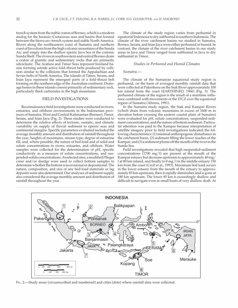
ern fans are vegetated with rainforest, and they do not appear tobe aggrading.
The pH, conductivity, and suspended-sediment concentra-tions were measured in five closely spaced rivers (Figs. 21, 22;Table 3). Water from all sites had a pH of approximately 7.Conductivity measurements indicate that solute concentrationswere low and near the solubility of calcite, except for station 14,which had a conductivity of 525 µmohs. The high conductivity atthis locality is the result of salt-water influence in the estuary fromwhich the sample was collected. Suspended-sediment concentra-tions were very low (< 50 mg/l), even in the high mountains(stations 15–17; Fig. 21, Table 3).
A low sediment discharge in the Irian Jaya study area isindicated by the presence of estuaries that extend across thecoastal plain nearly to the toes of the low-gradient alluvial fans.
If there were a significant sediment discharge, then we wouldexpect the estuaries to be filled and deltas to be prograding intothe Arafura Sea. On the basis of satellite imagery, filled estuariesand prograding deltas are rare. The apparent low sedimentdischarge in the study area in Irian Jaya is consistent with the lowsediment discharges we observed in the other humid andperhumid study areas.
The alluvial fans at the base of the mountains may be the resultof deposition caused by the sudden and major decrease in gradi-ent. The very coarse material in the fans may be derived fromlandslides in the high mountains, or the fans may be relictfeatures that were deposited under a more seasonal and drierclimatic regime during glacial intervals.
136° 30' E 137° 00'
4° 00' S
30'
5° 00'
0
0
20
20 miles10
40 kilometers
Arafura Sea
S14
S12
S11
S13
S16
S15S17
FIG. 20.—Sampling sites, Irian Jaya.
136° 30' E 137° 00'
4° 00' S
30'
5° 00'
0
0
20
20 miles10
40 kilometers
Arafura Sea
110.62
1244
1322
146.3
150.76
160.99
174.9
Suspended sediment (mg/l)Sample locations
FIG. 21.—Suspended sediment, Irian Jaya. Data are from Table 3.
TABLE 3.—pH, conductivity (µmohs), calculated solute concentrations, and suspended-sedimentconcentrations for selected rivers in Irian Jaya.
ID E Long. S Lat. Temp,
°C
pH Conductivity,µmohs
Solutes,
mg/l
Solids,
mg/l
S11 136° 57' 12" 4° 26' 04" 25 6.9 20 14 0.62
S12 136° 53' 54" 4° 26' 13" 24.7 7.9 140 87 44
S13 136° 49' 14" 4° 23' 38" 24.7 7.7 130 81 22
S14 136° 51' 49" 4° 45' 16" 28 7.1 525 320 6.3
S15 137° 05' 46" 4° 07' 18" 15 6.9 20 14 0.76
S16 137° 05' 44" 4° 06' 44" 14 7.0 29 20 0.99
S17 137° 05' 58" 4° 09' 37" 13.5 6.7 2 3.0 4.9

43OBSERVATIONS ON CLIMATE AND SEDIMENT DISCHARGE IN SELECTED TROPICAL RIVERS, INDONESIA
Studies in Dry Subhumid Climates
North Coast of Java.—
The climate of northern Java (Fig. 2) is dry subhumid, on thebasis of averaged monthly rainfall data collected at Jakarta(EARTHINFO, 1966) (Fig. 23). Northward-draining rivers origi-nate in the high volcanic mountains of Java and debouch into theshallow epeiric Java Sea. Rivers along the north coast of Java aremuddy and sediment laden, in contrast to the rivers in humid andperhumid areas, where the rivers are commonly black but free ofsediment. Estuaries do not occur along the Java coast. If estuaries
existed since the last rise in sea level, they have since been filledby sediment.
The geomorphology of the drainage basins and coastal plainsof Java and Sumatra appear to be very similar. Rivers from bothislands drain into the shallow epeiric Sunda Sea. Unlike thecoastal plain of equatorial Sumatra, where extensive deposits ofthick domed peat have formed, there are no significant amountsof peat in Java.
The similarities in catchment-basin size, heights of moun-tains, and stream gradients in Java and Sumatra preclude thesevariables as the primary control on differences in sediment deliv-ery to the Sunda Shelf from these two islands. Sediment in therivers in Java could be the result of anthropogenic effects, al-though this seems unlikely because major anthropogenic effectshave not existed for a long enough period to account for thesediment fill of any estuaries. Instead, it appears that the drysubhumid climate of Java results in high sediment discharges,and also precludes peat formation. In contrast, the humid andperhumid climates of Sumatra result in highly restricted fluvialsediment discharge, unfilled estuaries, extensive deposits of peat,and sediment-starved coastal and marine environments.
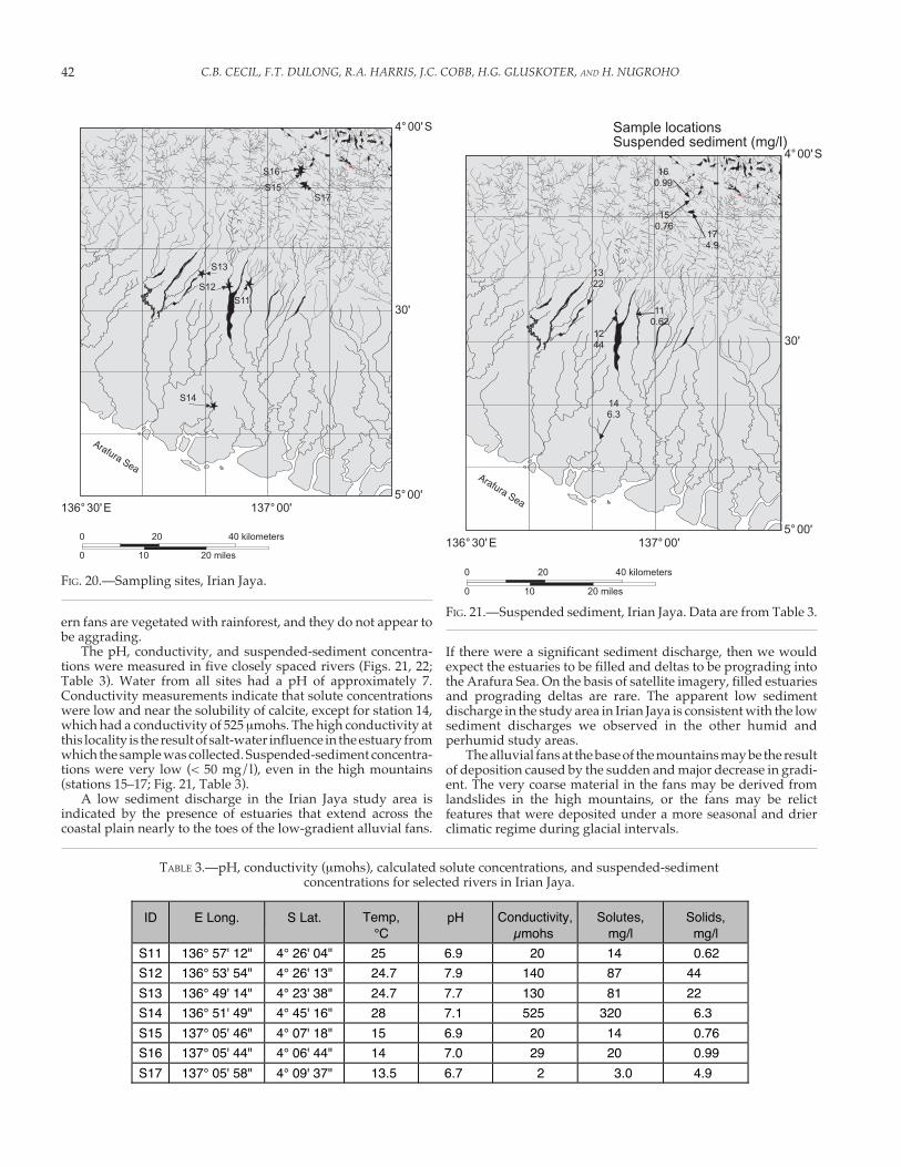
West Timor.—
The West Timor study region is located between 9° and 12° Slatitude (Fig. 2), and the climate of the region is dry subhumid, onthe basis of averaged montly rainfall data collected at Kupangand Soe (EARTHINFO, 1966) (Fig. 25A, B). Kupang has four wetmonths and eight dry months, whereas Soe has four wet monthsplus two months where the average monthly rainfall marginallyexceeds evapotranspiration and six dry months (Fig. 25A, B). Therainy season partially coincides with the passage of the ITCZ overTimor. The minor differences in rainfall between Kupang and Soeare probably related to orographic effects as a result of differencesin elevation. Our field investigations were conducted during adry season and a wet season.
Fluvial systems, both north and south of the east–west trend-ing drainage divide in West Timor, were evaluated (Fig. 24).Rivers in the study area are braided from the mountains to thecoast (Fig. 24), and bed sediments are dominated by cobbles andpebbles, with lesser amounts of sand-size material. These sedi-ments are transported across the coastal plain to both the north-ern and southern coasts. The beaches are composed of cobblesand pebbles with subordinate amounts of sand near the mouthsof the Mina and Benain Rivers along the southern coast (Fig. 24).Beaches near the mouth of the Tona River on the north coast (Fig.24) were composed of sand. In contrast to mangrove forests alongthe sediment-starved, mud-dominated coasts in humid andperhumid regions, mangrove forests were not observed on eithercoast of Timor.
Two sets of samples were collected in Timor. One set ofsamples was collected near the middle of the eight-month dryseason (August) and a second set was collected in the middle ofthe four-month rainy season (February). The suspended-sedi-ment concentrations, pH, and solute concentrations are illus-trated in Figures 26A and B and 27A and B, respectively, andTable 4. Water samples collected during the dry season werealkaline, and solute concentrations were one to two orders ofmagnitude higher than in fluvial systems in Sumatra and Borneo.Solute concentrations in water samples collected during the rainyseason were also an order of magnitude higher than in samplesfrom fluvial systems in Sumatra and Borneo and six times higherthan the mean value for Seram. In contrast to the high soluteconcentrations, dry-season suspended-sediment concentrationswere generally less than 5 mg/l (Table 4), whereas the mean value
136° 30' E 137° 00'
4° 00'S
30'
5°00'
0
0
20
20 miles10
40 kilometers
Arafura Sea
127.9, 87
116.9, 20
137.7, 81
147.1, 320
167.0, 20
156.8, 14 17
6.7, 3
Sample locationspH, Solute (mg/l)
FIG. 22.—pH (left-hand values) and solute concentrations (right-hand values), Irian Jaya. Data are from Table 3.
0
100
200
300
400
500
600
Pre
cip
ita
tio
n,
mm
FIG. 23.—Average monthly rainfall, Jakarta, Java.

C.B. CECIL, F.T. DULONG, R.A. HARRIS, J.C. COBB, H.G. GLUSKOTER, AND H. NUGROHO44
for suspended-sediment concentrations in samples collectedduring the rainy season was 2100 mg/l.
Samples collected in the dry season had very low suspended-sediment concentrations (X = 4.4 mg/l), consistent with the low-flow condition of the rivers. Very high suspended-sedimentconcentrations (X = 2100 mg/l) confirm very high sedimentdischarge during the four-month rainy season. All streams werebraided under low flow conditions. The bed material of thebraided streams and high-water marks resulting from abrasionon outcrops are indicative of a very high bed load and suspendedload during rainy-season high-flow conditions. A further indica-tion of high sediment load in the rivers of Timor is the commonoccurrence of river-mouth deltas and complete absence of estuar-ies along the coasts.
Alkaline pH values of 8 and high solute concentrations (200–500 mg/l) in samples collected during the dry season indicatethat stream waters exceed calcite saturation of 50 mg/l (Krauskopf,1967, p. 65). High solute values during the dry season indicatethat streams and groundwater contain dissolved salts in additionto calcium carbonate. These high values are consistent with a highsolute load in a dry subhumid climatic setting where solutes areconcentrated by evapotranspiration (Cecil and Dulong, this vol-ume, Part 1, their Figure 2).
Coral reefs, quite common in offshore areas along the south-ern coast of Timor, also belie major differences in sedimentologybetween Timor and the study areas in Sumatra and Borneo,where coral reefs were not observed. The absence of coral reefs inSumatra and Borneo may, in part, be the result of high waterdischarge and low sea-water salinity (20 ppt and 30 ppt, respec-tively) relative to a salinity of 35 ppt for normal sea water. Incoastal Timor the salinity was measured at 39 ppt during the dryseason. The coarse-grained materials in fluvial and coastal sys-
0 40 kilometers
10° S
125° E124° E 10' 30'
50'
30'
0 10
10
30 miles
MINA RIVERBASIN
BENAIN RIVERBASIN
1375 m
1190 m
2425 m
2070 m
1635 m
1115 m
Kupang
Pantemakassar
01
04
05
06
09
08
07
0203
10
FIG. 24.—Sampling sites in fluvial systems in West Timor ( = wells, � = rivers, and ★ = beach observation sites).
0
100
200
300
400
500
600
Pre
cip
ita
tio
n,
mm
600
Pre
cip
ita
tio
n,
mm 500
400
300
200
100
0
FIG. 25.—A) Average monthly rainfall, Kupang, West Timor. B)Average monthly rainfall, Soe, West Timor.
A
B
°
–
–

45OBSERVATIONS ON CLIMATE AND SEDIMENT DISCHARGE IN SELECTED TROPICAL RIVERS, INDONESIA
tems in Timor, in contrast to mud-dominated systems in humidstudy areas, indicate that delivery and dispersal of fine-grainedsediment into offshore coral habitats are not significant. Coastaland peritidal sedimentation in Timor is, therefore, one of mixedcarbonates and siliciclastics. This mixed system is primarily theresult of the dry-subhumid climate.
Our observations on soils in Timor indicate that Histosols donot occur and that calcic Vertisols (suborder Usterts) are verycommon. The highly seasonal rainfall of the dry-subhumid cli-mate of Timor is particularly conducive to the formation of calcicVertisols but is not conductive to the formation of soils that formunder humid and perhumid climatic conditions, such as Histosols(as low-ash peat), Ultisols, Oxisols, or Spodosols (Cecil andDulong, this volume, Part 1, and references therein).
The dry-subhumid climate of Timor controls the solute loadand the sediment load in rivers. Fluvial sediment discharge, bothsolid and solute, is especially high when compared to the perhumidstudy areas in Sumatra, Borneo, and Seram. The high sedimentdischarges are interpreted from grain size of the bed materials weobserved during low-flow conditions, braided streams to thecoast, the complete fill of estuaries, wave-dominated deltas andhigh solute concentrations throughout the year and high sus-pended-sediment concentration during the rainy-season high-flow conditions. The coarse-grained sediments of the Timorcoasts are in sharp contrast to the mud-dominated coasts ofSumatra, Seram, and Borneo.
Given the similarities in height of mountains, stream gradi-ents, and catchment basin-size among the various study areas, it
is the difference in climate that accounts for the marked contrastin stream load and soil formation among the perhumid studyareas of Sumatra, Borneo, Seram, and the dry-subhumid climateof Timor. The extensive development of calcic Vertisols and theabsence of Histosols in the dry-subhumid climate of Timor are inmarked contrast to the combination of extensive Oxisols, Ultisols,Spodosols, and Histosols that occur in the humid and perhumidequatorial study areas.
There are no estuaries in Timor, unlike Sumatra, Borneo, Seram,and Irian Jaya. Estuaries never developed because sediment sup-ply kept pace with sea-level rise, or estuaries formed during earlysea level rise but were subsequently filled because of the highsupply of fluvial sediment. If we assume that rainy-season dis-charge accounts for all suspended sediment discharged by therivers in Timor, then the annualized sediment concentration is 0.7x 10⁶ metric tons/km3 of water discharged. The 0.7 x 10⁶ metrictons/km3 value is 60 percent of that of the Ganges/Bramaputraand 27 times that of the average value for the undisturbed rivers wesampled in Seram. The geology, including tectonic setting andgeomorphology, of Seram and Timor is nearly identical. It is,therefore, the perhumid climate of Seram versus the dry-subhumidclimate of Timor that best accounts for the sharp contrasts inannualized sediment concentrations and fluvial sediment supply.
SUMMARY AND CONCLUSIONS
Indonesia represents an optimal natural laboratory to studyrelations among allocyclic processes and fluvial sediment dis-
TABLE 4.—pH, conductivity (µ mohs), solute concentrations (calculated from conductivity), and suspended-sediment concentra-tions for selected rivers in West Timor. Stream samples were collected during low-flow conditions in the dry season and
moderate-flow to flood conditions in the rainy season.
ID River S Lat. E Long. Season & relative
flow
Temp .,
°C
pH Conductivity,
µmohs
Solutes,
mg/l
Solids,
mg/l
02 Tona 9º 12' 24" 124º 18' 40" dry, low 27.9 8.2 720 440 16
03 well water 9º 15' 30" 124º 20' 53" dry, N/A 26.7 7.2 1600 970 3.9
Mina Basin
07 Besi 9º 58' 39" 124º 05' 38" dry, low 23.1 8.1 550 330 1.7
107 Besi 9º 58' 33" 124º 07' 22" rainy, ebb flood 27.3 7.6 520 320 3500
08 Besi 9º 54' 13" 124º 05' 24" dry, low 26.8 8.2 525 320 2.3
108 Besi 9º 58' 08" 124º 04' 21" rainy, unflooded 30.0 7.6 650 400 55
09 well water 10º 18' 04" 124º 18' 04" dry, N/A 26.6 8.1 2900 1800 7.0
109 well water 10º 04' 10" 124º 13' 10" rainy, N/A 29.5 5200 3100 8.0
10 Mina 10º 05' 01" 124º 12' 15" dry, low 28.2 8.2 775 470 4.3
110 Mina 10º 05' 01" 124º 12' 15" rainy, unflooded 30.0 7.4 600 360 470
Benain
Basin
01 Noni 9º 33' 28" 124º 21' 57" dry, low 8.2 360 220 0.13
101 Noni 9º 33' 28" 124º 22' 01" rainy,
flood
24.0 7.6 230 140 1800
04 Muti 9º 33' 38" 124º 30' 20" dry, low 22.9 8.0 500 300 0.80
104A Muti 9º 33' 29" 124º 30' 06" rainy, not flooding 29.0 7.5 435 260 200
104B Muti rainy, flooded 285 170 7600
05 Benain 9º 42' 30" 124º 27' 52" dry, low 24.3 8.4 450 270 3.0
105 Benain 9º 42' 26" 124º 27' 58" rainy, flood 27.3 7.5 560 340 1100
06 Benain,
near coast
9º 36' 16" 124º 52' 04" dry, low 25.1 8.4 600 360 2.4
C.B. CECIL, F.T. DULONG, R.A. HARRIS, J.C. COBB, H.G. GLUSKOTER, AND H. NUGROHO46
0 40 kilometers
10° S
125° E124° E 10' 30'
50'
30'
0 10
10
30 miles
010.13
040.80
053.0
062.4
097.0
082.3
071.7
0216
033.9
104.3
0 40 kilometers
10° S
125° E124° E 10' 30'
50'
30'
0 10
10
30 miles
1011800
104B7600
1051100
1098.0
10855
1073500
110470
104A200
FIG. 26.—A) Suspended-sediment concentrations (mg/l) in West Timor, dry season (data are from Table 4). B) Suspended-sedimentconcentrations in West Timor, rainy season (data are from Table 4).
A
B

47OBSERVATIONS ON CLIMATE AND SEDIMENT DISCHARGE IN SELECTED TROPICAL RIVERS, INDONESIA
0 40 kilometers
10° S
125° E124° E 10' 30'
50'
30'
0 10
10
30 miles
018.2, 220
047.7, 300
058.4, 270
068.4, 360
098.1, 1700
088.2, 320
078.1, 330
028.2, 440
037.2, 970
108.2, 470
0 40 kilometers
10° S
125° E124° E 10' 30'
50'
30'
0 10
10
30 miles
1017.6, 140
104A7.5, 260
1057.5, 340
109--, 3100
1087.6, 400
1077.6, 320
1107.4, 360
104B--, 170
FIG. 27.—A) pH (left-hand values) and solute concentrations (right-hand values) in West Timor, dry season (data are from Table 4).B) pH (left-hand values) and solute concentrations (right-hand values) in West Timor, rainy season (data are from Table 4).
A
B

C.B. CECIL, F.T. DULONG, R.A. HARRIS, J.C. COBB, H.G. GLUSKOTER, AND H. NUGROHO48
charge. Our study areas included climates that range fromperhumid in Sumatra, East, Central, and West Kalimantan, andSeram, to humid in Irian Jaya, to dry-subhumid in Timor andJava, among which are settings that represent the same tectonicsystem in two different climates. Most Indonesian rivers in ourstudy have similar-size catchment basins and stream gradients,and all rivers have identical glacioeustatic sea-level histories. Thepredominant allocyclic variable that controls variation in sedi-ment discharge among Indonesian rivers is, therefore, climate(chiefly the amount and seasonality of rainfall).
Perhumid and Humid Climates
Rivers draining the perhumid and humid areas of Sumatra,West and Central Kalimantan, and Irian Jaya cross broad andflat coastal plains before debouching into shallow epeiric seas.The rivers evaluated in the humid climates of Seram and EastKalimantan cross a rugged coastal area with very narrow coastalplains before emptying into the deep Banda Sea and MakassarStrait, respectively. With the exception of Irian Jaya, character-istics of those settings with perhumid climates and extensivecoastal plains that border epeiric seas include the following: (1)extensive Histosols and Spodosols, (3) meandering acidic black-water rivers with exceedingly low solute and suspended-sedi-ment concentrations but which may contain significant amountsof terrestrial organic matter, (4) limited fluvial bed loads, prima-rily as point bars, which diminish downstream and finallydisappear before, or in, the upper estuaries, (5) extensive estu-aries without sediment fill derived from fluvial systems, (6)mud-dominated, sediment-starved coastal and nearshore ma-rine environments, and (7) the absence of nearshore coral reefs.The Irian Jaya study area differs because of the presence of low-gradient alluvial fans with braided streams between the base ofthe mountains and the proximal coastal plain. The active tec-tonic setting of Seram precludes the development of broadcoastal plains, extensive estuaries, and extensive deposits ofpeat. The fluvial systems of Seram are, however, also sedimentstarved. The estuaries that do exist in Seram are not filled withsediment, and deltas have not developed. The rivers in EastKalimantan also appear to be sediment starved. Most haveestuaries, except for the Mahakam River, which has a largedelta. The predominant source of the sediment for the MahakamDelta is probably from the antecedent part of the MahakamRiver, which eroded the tectonically active 70-km-wide areabetween the delta and Kutai Basin during Neogene and Quater-nary folding and uplift. Hamilton (1979) suggests that foldingwas concurrent with Neogene sedimentation.
Dry-Subhumid Climates
In contrast to the sediment-starved Indonesian rivers inperhumid and humid climates, river and coastal systems in thedry-subhumid climates of Timor and Java can be characterizedby river-mouth deltas, sand and coarser-grained beaches, ab-sence of estuaries, and absence of Histosols, Spodosols, Oxisols,and Ultisols. In addition, the island of Timor has characteristicsthat contrast with humid and perhumid regions as follows: (1)calcic Vertisols, (2) braided rivers with high annual solute loads,bed loads, and suspended loads, coarse-grained detritus in coastzones, and (4) coral reefs. Black-water rivers and mangroveforests were not observed in Timor.
The pedogenic and sedimentologic regimes of the study areas(Fig. 28) are consistent with the conceptual diagrams for soilformation and sediment supply of Cecil and Dulong (this vol-ume, Part 1). The findings of our study reinforce the concept of
climate as a primary agent of weathering, erosion, sedimenttransport, and sedimentation. Therefore, evaluation ofpaleoclimate and paleoclimate change should be included ingenetic stratigraphic analysis, especially in terrestrial, coastal,continental-margin, and epeiric-seaway depositional sequences.
REFERENCES
AHRENS, D.A., 1991, Meteorology Today: St. Paul, Minnesota, West Pub-lishing Co., 576 p.
ALLEN, G.P., LAURIER, D. AND THOUVENIN, J.P., 1979, Etude Sédimentologiquedu delta de la Mahakam: TOTAL, Compagnies Françaises des Pétroles,Paris, Notes et Mémoirés 15, 156 p.
BURNHAM, C.P., 1984, The Forest environment: Soils, in Whitmore, T.C.,Tropical Rainforests of the Far East: Chapter 10: Oxford, U.K.,Clarendon Press, p.137-152.
CARATINI, C., AND TISSOT, C., 1988, Paleogeographical evolution of theMahakam delta in Kalamantan, Indionesia during the Quaternaryand Late Holocene: Review of Palaeobotany and Palynology, v. 55, p.217-228.
CECIL, C.B., 1990, Paleoclimate controls on stratigraphic repetition ofchemical and siliciclastic rocks: Geology, v. 18, p. 533-536.
CECIL, C.B., DULONG, F.T., COBB, J.C., AND SUPARDI, 1993, Allogenic andautogenic controls on sedimentation in the central Sumatra basin asan analogue for Pennsylvanian coal-bearing strata in the Appala-chian basin, in Cobb, J.C., and Cecil, C.B., eds., Modern and AncientCoal-Forming Environments: Geological Society of America, SpecialPaper 286, p. 3-22.
CECIL, C.B., AND EDGAR, N.T., 1994, Climatic influence on basin sedimen-tation—application to the Ouachita basin, in Cecil, C.B. and Edgar,N.T., eds., Predictive Stratigraphic Analysis—Concept and Applica-tion: U.S. Geological Survey, Bulletin 2110, p. 59-62
COBB, J.C., AND CECIL, C.B., eds., 1993, Modern and Ancient Coal-FormingEnvironments: Geological Society of America, Special Paper 286, 193 p.
DE BOER, P.L., AND SMITH, D.G., eds., 1994, Orbital Forcing and CyclicSedimentary Sequences: International Association of Sedimentolo-gists, Special Publication 19, 559 p.
DIEMONT, W.H., AND PONS, L.J., 1992, A preliminary note on peat formationand gleying in the Mahakam indland floodplain, East Kalimantan,Indonesia, in Aminuddin, B.Y., and Tan, S.L., eds., Tropical Peat:International Symposium on Tropical Peatland, 6–10 May, 1991,Kuching, Sarawak, Malaysia, Proceeedings p. 74-80.
EARTHINFO, 1996, GHCN GLOBAL CLIMATE, Boulder, Colorado,EarthInfo, Inc., CD ROM.
FOURNIER, F., 1960, Climat et érosion: Paris, Presses Universitaires de Paris,201 p.
GASTALDO, R.A., AND HUC, A.-Y., 1993, Sediment facies, depositionalenvironments, and distribution of phytoclasts in the Recent MahakamRiver delta, Kalimantan, Indonesia: Palaios, v. 7, p. 574-590.
GASTALDO, R.A., ALLEN, G.P., AND HUC, A.-Y., 1995, The tidal character offluvial sediments of the modern Mahakam River delta, Kalimantan,Indonesia, IN Flemming, B.W., and Bartholomä, eds., Tidal Signaturesin Modern and Ancient Sediments: International Association of Sedi-mentologists, Special Publication 24, p. 171-181.
GILMORE, H.L., 1996, The Barito River depositional system of South andCentral Kalimantan (Borneo): a non-deltaic modern day analogue forthe Upper Talang Akar Formation of the Sunda and Asrl basins ofIndonesia (abstract): American Association of Petroleum Geologists,1996 Annual Meeting, Official Program, p. A 53.
GROSSMAN, E.E., FLETCHER, C.H., AND RICHMOND, B.M., 1998, The Holocenesea-level highstand in the equatorial Pacific: analysis of the insularpaleosea-level database: Coral Reefs, v. 17, p. 309-327.
GUPTA, A., 1996, Erosion and sediment yield in southeast Asia: a regionalperspective, in Walling, D.E., and Webb, B.W., Erosion and Sedi-ment Yield: Global and Regional Perspectives: International Asso-

49OBSERVATIONS ON CLIMATE AND SEDIMENT DISCHARGE IN SELECTED TROPICAL RIVERS, INDONESIA
1 2 3 4 5 6 7 8 9 10 11 12
ARID
SEMIARID
DRY SUBHUMID
MOIST SUBHUMID
HUMID
PERHUMID
Su = Sumatra; WK = Western Kalimantan; CK = Central Kalimantan; EK = East Kalimantan; T = Timor; S = Seram; IJ = Irian Jaya; J = Java
1 2 3 4 5 6 7 8 9 10 11 12
T
J
IJ
SEKCKWKSU
SE
DIM
EN
T Y
IEL
D
NUMBER OF WET MONTHSWET: RAINFALL EXCEEDS EVAPOTRANSPIRATION
1 2 3 4 5 6 7 8 9 10 11 12
T IJSEKCKWKSU
SO
LU
TE
YIE
LD
NUMBER OF WET MONTHSWET: RAINFALL EXCEEDS EVAPOTRANSPIRATION
PE
AT
FO
RM
AT
ION
1 2 3 4 5 6 7 8 9 10 11 12
SUWKCKEK
NUMBER OF WET MONTHSWET: RAINFALL EXCEEDS EVAPOTRANSPIRATION
1 2 3 4 5 6 7 8 9 10 11 12E
OL
IAN
TR
AN
SP
OR
T
NUMBER OF WET MONTHSWET: RAINFALL EXCEEDS EVAPOTRANSPIRATION
1 2 3 4 5 6 7 8 9 10 11 12
ENTISOL AND INCEPTISOL
HISTOSOL
VERTISOL
ARIDISOL
SPODOSOLOXISOLULTISOL
MOLLISOLALFISOL
SU WK CK
T EK
NUMBER OF WET MONTHSWET: RAINFALL EXCEEDS EVAPOTRANSPIRATION
NUMBER OF WET MONTHSWET: RAINFALL EXCEEDS EVAPOTRANSPIRATION
FIG. 28.—Schematic representation of sediment yield of tropical rivers and soils in Indonesia as a function of climate.
ciation of Hydrological Sciences, Oxfordshire, U.K., IAHS Publica-tion 236, p. 215-223.
HAMILTON, W., 1979, Tectonics of the Indonesian region: U.S. GeologicalSurvey, Professional Paper 1078, 345 p.
HANEBUTH, T.J.J., 2000, Sea-level changes on the Sunda Shelf during thelast 50,000 years: Christian-Albrechts-Universität zu Kiel, Institut furGeowissenschaften, Berichte, no. 12, 104 p.
HOOKE, R.LEB., 2000, Toward a uniform theory of clastic sediment yieldin fluvial systems: Geological Society of America, Bulletin, v. 112, p.1778-1786.
HUNTINGTON, E., 1907, Some characteristics of the glacial period in non-glaciated regions: Geological Society of America, Bulletin, v. 18, p.351-358.
KELLER, G.H., AND RICHARDS, A.F., 1967, Sediments of the Malacca Strait,Southeast Asia: Journal of Sedimentary Petrology, v. 37, p. 102-127.
KRAUSKOPF, K.B., 1967, Introduction to Geochemistry: New York, McGraw-Hill, Inc., 721 p.
LANGBEIN, W.B., AND SCHUMM, S.A., 1958, Yield of sediment in relation tomean annual precipitation: American Geophysical Union, Transac-tions, v. 39, p. 1076-1085.

C.B. CECIL, F.T. DULONG, R.A. HARRIS, J.C. COBB, H.G. GLUSKOTER, AND H. NUGROHO50
MARKHAM, A., AND DAY, G., 1994, Sediment transport in the Fly River Basin,Papua New Guinea, in Olive, L.J., Loughran, R.J. and Kesby, J.A., eds.,Variability in stream erosion and sediment transport: InternationalAssociation of Hydrological Sciences, IAHS Publication 224,Oxfordshire, U.K., IAHS Press, p. 233-239.
MEADE, R.H., 1996, River-sediment inputs to major deltas, in Milliman,J.D., and Haq B.U., eds., Sea-Level Rise and Coastal Subsidence;Causes, Consequences, and Strategies: Coastal Systems and Conti-nental Margins, v. 2, p. 63-85.
MILLIMAN, J.D., 1997, Fluvial sediment discharge to the sea and theimportance of regional tectonics, in Ruddiman, W.F., ed., TectonicUplift and Climate Change: New York, Plenum Press, p. 240-257.
MILLIMAN, J.D., AND MEADE, R.H., 1983, Worldwide delivery of sediment tothe world oceans: Journal of Geology, v. 91, p. 1-21.
MOHR, E.C.J., VAN BAREN, F.A., AND VAN SCHUYLENBORGH, J., 1972, TropicalSoils: Dordrecht, The Netherlands, Geuze, 481 p.
NEUZIL, S.G., 1997, Onset and rate of peat and carbon accumulation in fourdomed ombrogenous peat deposits, Indonesia, in Reiley, J.O., andPage, S.E., eds., Biodiversity and Sustainability of Tropical Peatlands:Tresaith, Cardigan, U.K., Samara Publishing Limited, Samara House,p. 73-80.
NEUZIL, S.G., SUPARDI, CECIL, C.B., KANE, J.S., AND SOEDJONO, K., 1993,Inorganic geochemistry of domed peat in Indonesia and its implica-tions for the origin of mineral matter in coal, in Cobb, J.C., and Cecil,C.B., eds., Modern and Ancient Coal-Forming Environments: Geo-logical Society of America, Special Paper 286, p. 23-44.
OLIVE, L.J., LOUGHRAN, R.J. AND KESBY, J.A., eds., 1994, Variability in StreamErosion and Sediment Transport: International Association of Hy-drological Sciences, IAHS Publication 224, Oxfordshire, U.K., IAHSPress, 498 p.
OLSEN, P.E., AND KENT, D.V., 1996, Milankovitch climate forcing in thetropics of Pangea during the Late Triassic: Palaeogeography,Palaeoclimatology, Palaeoecology, v. 122, p. 1-26.
SILVER, E.A., AND SMITH, R.B., 1983, Comparison of terrane accretion inmodern Southeast Asia and the Mesozoic North America Cordillera:Geology, v. 11, p. 198-202.
STAUB, J.R., AND ESTERLE, J.S., 1994, Peat-accumulating depositional sys-tems of Sarawak, East Malaysia: Sedimentary Geology, v. 89, p. 91-106.
STUIJTS, J.C., NEWSOME, J.C., AND FLENDLEY, J.R., 1988, Evidence for LateQuaternary vegetational change in the Sumatran and Javan high-lands: Review of Palaeobotany and Palynology, v. 55, p. 207-216.
SUMMERFIELD, M.A., 1991, Global Geomorphology; An Introduction to theStudy of Landforms: New York, John Wiley & Sons, 537 p.
SUPARDI, SUBEKTY, A.D., AND NEUZIL, S.G., 1993, General geology and peatresources of the Siak Kanan and Bengkalis Island peat deposits,Sumatra, Indonesia, in Cobb, J.C., and Cecil, C.B., eds., Modern andAncient Coal-Forming Environments: Geological Society of America,Special Paper 286, p. 45-62.
VAN DER KARRS, W.A., 1988, Palynology of eastern Indonesian marinepiston-cores: A Late Quaternary vegetational and climate record forAustralasia: Palaeogeography, Palaeoclimatology, Palaeoecology, v.85, p. 239-302.
VAN DER KAARS, S., WANG, X., KERSHAW, P., GUICHARD, F., AND SETIABUDI, D.A.,2000, A Late Quaternary palaeoecological record from the Banda Sea,Indonesia: patterns of vegetation, climate and biomass burning inIndonesia and northern Australia: Palaeogeography, Palaeoclima-tology, Palaeoecology, v. 155, p. 135-153.
VERSTAPPEN, H.TH., 1975, On palaeo climates and landform develop-ment in Malesia: Modern Quaternary Research in Southeast Asia, v.1, p. 3-35.
VOSS, F., 1982, Kalimantan Timur, Vegetation 1974 Map 3, in Fasbender,K., and Kebschull, D., eds., Kalimantan Timur, East KalimantanTransmigration Area Development Project (TAD) Atlas: HWWAInstitut für Wirtschaftsforschung—Hamburg, 52 p.
WANLESS, H.R., AND SHEPARD, F.P., 1936, Sea level and climate changerelated to Late Paleozoic cycles: Geological Society of America, Bul-letin, v. 47, p. 1177-1206
WELTON, J.E., STOKELY, S.M., MOIOLA, R.J., AND ROBERTS, H.H., 2000, ModernMahakam delta sediments: the search for a precursor to early authigenicchlorite grain coatings (abstract): American Association of PetroleumGeologists, Annual Convention Abstracts, v. 9, p. A155.
WHITMORE, T.C., 1984, Tropical Rainforests of the Far East: Oxford, U.K.,Clarendon Press, 241 p.

Society for Sedimentary Geology
Membership Application
check/money order enclosed Total Amount:_______________ bill my credit card
Visa American Express MasterCard
Account Number:_________________________________________________
Expiration Date: __________________________________________________
Printed Name: ____________________________________________________
Signature: _______________________________________________________
Fax this form with creditcard information to:918.621.1685918.621.1685918.621.1685918.621.1685918.621.1685
or mail with payment to:SEPM MembershipSEPM MembershipSEPM MembershipSEPM MembershipSEPM Membership6128 E. 38th Street, #3086128 E. 38th Street, #3086128 E. 38th Street, #3086128 E. 38th Street, #3086128 E. 38th Street, #308TTTTTulsa, OK 74135, USAulsa, OK 74135, USAulsa, OK 74135, USAulsa, OK 74135, USAulsa, OK 74135, USA
Last Name, First (Given) Middle Initial Date of Birth
Preferred Mailing Address
City State/Province Postal Code
Country Phone Number
Fax Number Citizenship E-mail Address
Personal Information:
Payment Information:
From To Institution Major Degree/DateAcademic Record:
From To Employer Address Nature of WorkProfessional Record:
AAPG AGU PS GSA IAS Other: ___________
Affiliations:
N a m e
Address
N a m e
Address
References:1
2
Sustaining Member ................................................ $300Financial support may be dedicated to a specific program.
Voting Member .............................. see Journal ChoiceRequires 3 years professional experience past bachelors degree.
Associate Member ....................... see Journal ChoiceWaives professional experience. May not vote or hold office.
Spouse Member ....................................................... $30Membership at same address without additional journal.
membership type:
Journal of Sedimentary Research Print: $75 Online: $70 Both: $85
PALAIOS Print: $75 Online: $70 Both: $85
Both Journals Print: $120 Online: $110 Both: $130
Add $10 surcharge to defray mailing outside the USA
Journal Choice:
568