CLIMATE CHANGE AND WATER RESOURCES IN …pdf.usaid.gov/pdf_docs/PA00K6DR.pdfAn Assessment of...
67
An Assessment of Groundwater Management 1 CLIMATE CHANGE AND WATER RESOURCES IN WEST AFRICA: AN ASSESSMENT OF GROUNDWATER MANAGEMENT MARCH 2014 This report is made possible by the support of the American people through the U.S. Agency for International Development (USAID). The contents are the sole responsibility of Tetra Tech ARD and do not necessarily reflect the views of USAID or the U.S. Government.
Transcript of CLIMATE CHANGE AND WATER RESOURCES IN …pdf.usaid.gov/pdf_docs/PA00K6DR.pdfAn Assessment of...
An Assessment of Groundwater Management 1
CLIMATE CHANGE AND WATER RESOURCES IN WEST AFRICA:
AN ASSESSMENT OF GROUNDWATER
MANAGEMENT
MARCH 2014
This report is made possible by the support of the American people through the U.S. Agency for International Development (USAID). The contents are the sole
responsibility of Tetra Tech ARD and do not necessarily reflect the views of USAID or the U.S. Government.
This report was prepared by D. Hammond Murray-Rust1 and S.H.M. Fakhruddin2 through
subcontracts with Tetra Tech ARD.
1 Independent Consultant
2 Regional Integrated Multi-Hazard Early Warning System (RIMES)
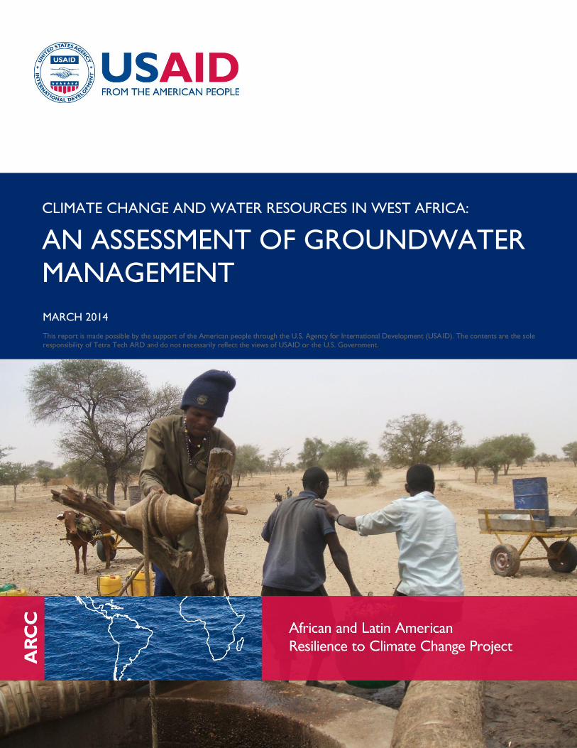
Cover Photo: Traditional water well near Maradi, Niger. April 2008. Credit: D. Hammond Murray-Rust.
This publication was produced for the United States Agency for International Development by Tetra
Tech ARD, through a Task Order under the Prosperity, Livelihoods, and Conserving Ecosystems
(PLACE) Indefinite Quantity Contract Core Task Order (USAID Contract No. AID-EPP-I-00-06-00008,
Order Number AID-OAA-TO-11-00064).
Tetra Tech ARD Contacts:
Patricia Caffrey
Chief of Party
African and Latin American Resilience to Climate Change (ARCC)
Burlington, Vermont
Tel.: 802.658.3890
Anna Farmer
Project Manager
Burlington, Vermont
Tel.: 802.658.3890
An Assessment of Groundwater Management i
CLIMATE CHANGE AND WATER RESOURCES IN WEST AFRICA:
AN ASSESSMENT OF
GROUNDWATER MANAGEMENT
AFRICAN AND LATIN AMERICAN RESILIENCE TO CLIMATE CHANGE (ARCC)
MARCH 2014

An Assessment of Groundwater Management ii
TABLE OF CONTENTS
ACRONYMS AND ABBREVIATIONS ......................................................................................IV
ABOUT THIS SERIES .................................................................................................................VI
EXECUTIVE SUMMARY........................................................................................................... VII
1.0 INTRODUCTION ................................................................................................................. 1
1.1 GROUNDWATER AS A DRIVER OF DEVELOPMENT .................................................................................. 1
1.2 THREATS TO GROUNDWATER-BASED DEVELOPMENT ...................................................................... 1
1.3 PURPOSE OF THE STUDY ................................................................................................................................... 3
1.4 SCOPE OF THE STUDY ........................................................................................................................................ 3
2.0 GROUNDWATER IN WEST AFRICA ............................................................................... 5
2.1 HYDROGEOLOGIC SETTING ........................................................................................................................... 5
2.2 GROUNDWATER HYDROLOGY ................................................................................................................... 13
3.0 CLIMATE CHANGE AND GROUNDWATER ................................................................ 19
3.1 CLIMATE CHANGE IMPACTS ON GROUNDWATER ............................................................................ 19
3.2 MODELLING THE IMPACT OF CLIMATE CHANGE ON GROUNDWATER ................................... 22
4.0 GROUNDWATER USE IN RURAL WEST AFRICA ....................................................... 28
4.1 EARLY-PHASE EXPLOITATION ...................................................................................................................... 28
4.2 THE ADVENT OF BOREHOLES AND MANUAL PUMPING ................................................................. 29
4.3 THE INCREASING ROLE OF MOTORIZED PUMPS .................................................................................. 31
5.0 IWRM AND GROUNDWATER MANAGEMENT ........................................................... 35
5.1 THE VISION OF IWRM ....................................................................................................................................... 35
5.2 PRACTICAL STEPS TOWARD IMPROVED GROUNDWATER MANAGEMENT ............................. 37
5.3 TWO SPECIAL CASES FOR GROUNDWATER MANAGEMENT ......................................................... 42
6.0 KEY QUESTIONS: WHAT CAN BE DONE? ................................................................... 45
6.1 IMPROVING INFORMATION ON GROUNDWATER AND ITS EXPLOITATION ......................... 46
6.2 GROUNDWATER DEMAND MANAGEMENT ACTIVITIES ................................................................... 46
6.3 MANAGEMENT OF GROUNDWATER SUPPLY ........................................................................................ 47
6.4 IWRM INSTITUTION-BUILDING AT THE LOCAL LEVEL ....................................................................... 48

An Assessment of Groundwater Management iii
7.0 CONCLUSIONS .................................................................................................................. 50
8.0 SOURCES ............................................................................................................................. 51
ANNEX A. GROUNDWATER MAPS ...................................................................................... 54

An Assessment of Groundwater Management iv
ACRONYMS AND ABBREVIATIONS
AMMA African Monsoon Multidisciplinary Analysis
ARCC African and Latin American Resilience to Climate Change
BGR Federal Institute for Geosciences and Natural Resources, Germany
CATCH Couplage de l’Atmosphère Tropicale et du Cycle Hydrologique
CCLM Consortium for Small-Scale Modeling – Climate Modeling
CREPA Centre Regionale pour l’Eau Potable et de l’Assainissement au cout faible
DRI Desert Research Institute
FAO Food and Agriculture Organization
GCM Global Circulation or Climate Model
GEF Global Environment Facility
GWP Global Water Partnership
IGRAC International Groundwater Resource Assessment Center
IPCC International Panel for Climate Change
IUCN International Union for Conservation of Nature
IWMI International Water Management Institute
IWRM Integrated Water Resources Management
KML Keyhole Markup Language
MDG Millennium Development Goals
MLPI Mali Livestock and Poultry Initiative
MUS Multiple Use Services for water
NGO Nongovernmental Organization
SIGIRE Systeme d’Information pour la Gestion Integree des Resources en Eau
SKAT Swiss Centre for Development Cooperation in Technology and Management
SWAT Soil Water Assessment Tool
UNESCO United Nations Educational Scientific and Cultural Organization
USAID United States Agency for International Development
USDA United States Department of Agriculture
An Assessment of Groundwater Management v
WSA Water and Sanitation in Africa (formerly CREPA)
WAWI West Africa Water Initiative
WEAP Water Evaluation and Planning model
WHO World Health Organization
WHYMAP World-wide Hydrogeological Mapping and Assessment Programme
WUA Water User Association

An Assessment of Groundwater Management vi
ABOUT THIS SERIES
THE STUDIES ON CLIMATE CHANGE VULNERABILITY AND ADAPTATION
IN WEST AFRICA
This document is part of a series of studies produced by the African and Latin American Resilience to
Climate Change (ARCC) project that address adaptation to climate change in West Africa. Within the
ARCC West Africa studies, this document falls in the subseries on Climate Change and Water
Resources in West Africa. ARCC has also developed a subseries on Agricultural Adaptation to Climate
Change in the Sahel, Climate Change and Conflict in West Africa, and Climate Change in Mali.
THE SUBSERIES ON CLIMATE CHANGE AND WATER RESOURCES
Upon the request of the United States Agency for International Development (USAID), ARCC
undertook the West Africa water studies to increase understanding of the potential impacts of climate
change on water resources in West Africa and to identify means to support adaptation to these changes.
Other documents in the Climate Change and Water Resources in West Africa series include
Transboundary River Basins, Mapping the Exposure of Socioeconomic and Natural Systems of West
Africa to Coastal Climate Stressors, and Coastal Biophysical and Institutional Analysis.

An Assessment of Groundwater Management vii
EXECUTIVE SUMMARY
This paper addresses the potential impacts of climate change on groundwater management in West
Africa. Its general focus is sustainability of rural groundwater resources, because most rural populations
heavily depend on groundwater. The recommended approach to achieving this goal is to start at local
levels and slowly build up larger and more formal organizations to share in the governance not only of
groundwater but of all water resources, and to ensure that water resources are not permanently
depleted.
Variations in the hydrogeology of West Africa are large but fall into two main categories: the large
sedimentary basins of the major rivers that have continuous aquifers, and the extensive areas of
basement complex rocks with lateritic cover that provide limited groundwater in discontinuous aquifers.
There has been a huge increase in exploitation of groundwater resources mostly to provide drinking
water under the auspices of the Millennium Development Goal targets. This exploitation in rural areas
has relied heavily on drilling boreholes and installing hand pumps, with extraction rates generally
sufficiently low enough to not threaten the long-term sustainability of the underlying aquifer.
Nevertheless, current levels of groundwater resources and their exploitation are threatened in three
ways:
1. Climate change predictions of increased temperatures as well as more erratic and variable rainfall
during the present century are likely to lead to a decrease in recharge, as more water will be lost to
transpiration and evaporation. Areas with basement complex geology and lower rainfall are the
most vulnerable to declining aquifer discharge.
2. Population growth rates in rural areas at about 3 percent per annum mean that twice as much
drinking water will be required in 25 years. Urban areas relying on groundwater for drinking will be
much more vulnerable due to rapid urbanization.
3. Technological changes probably pose the greatest threat to groundwater sustainability. Any increase
in the use of motorized pumping places additional stress on any aquifer. Although currently beyond
the purchasing power of smallholders, there is increasing promotion of both diesel and solar
powered irrigation. While potentially manageable for very small garden plots, increased
commercialization will definitely require more water.
There is weak institutional capacity for effective governance of water throughout the region. Water
management initiatives are mostly confined to national-level dialogue and do not reach down to the local
level, where water is actually managed. Databases tend to be concentrated in national capitals and do
not act as useful management tools for those who actually manage water.
There is increasing recognition that Integrated Water Resources Management (IWRM) is the best
option for sustainable exploitation of water, not only at national level but also at the local level, where
day-to-day decisions are made about water use. Introduction of IWRM requires adoption of two key
approaches from the outset:
1. Groundwater cannot be managed independently of surface water. The two are connected
hydrologically. IWRM requires that all sources and types of water are included in the management

An Assessment of Groundwater Management viii
program. Management approaches must not only address demand-side issues — such as making
water use more efficient though education, changes in cropping practices, pricing, and regulation —
but also supply-side management, including better natural resources management, soil conservation
technologies, and augmenting groundwater recharge. Insofar as climate change will increase
evapotranspiration and the variability of variable rainfall, integrated management of all water
resources will be a priority.
2. IWRM is a participatory process. It does not function properly when left solely to government
departments and agencies. Water users help define the management targets and techniques, they
help police and regulate water use, and they sit on boards of directors of water management
districts. Ultimately it is the water users themselves, acting individually and collectively, who control
the destiny of their water resources. Without their full and equal involvement, the water resources
of West Africa may become another “tragedy of the commons.”
The paper concludes with a proposed course of action that will allow for implementation of appropriate
and feasible aspects of an IWRM in a rural setting in West Africa. The underlying model is Multiple-Use
Services (MUS) of water, successfully piloted in Niger using United States Agency for International
Development (USAID) funding under the recent West Africa Water Initiative (WAWI), a multi-donor
program for water, sanitation, and health. IWRM looks at all water resources in a community and all
demands for water (domestic, livestock, agriculture, aquaculture, and ecosystem) and provides a
comprehensive management plan for resource use that does not deplete resources beyond annual
replenishment by rainfall or rivers. With some modifications, it should be possible to add an IWRM
component to agricultural and food security programs so that there is proper integration of water,
agriculture, and human development.
If effective management systems for both groundwater and surface water are established, then it is
possible to envisage stable production systems that have the capacity to respond to external threats,
including but not limited to the effects of climate change. Where water resources are sufficient, these
stable systems can include irrigation as well as more traditional uses of domestic water supply and
livestock.
An Assessment of Groundwater Management 1
1.0 INTRODUCTION
1.1 GROUNDWATER AS A DRIVER OF DEVELOPMENT
Access to good quality groundwater has transformed the lives of tens of millions of people in West
Africa. Rural populations that once depended on unreliable and polluted surface water sources or
unprotected hand-dug wells now have access to potable water. With proper installation of wells
supported by strong local management arrangements, groundwater is generally free of biological
contaminants. This approach has profound impacts on rural health reduces child and maternal mortality,
reduces incidences of many water related diseases, and reduces the drudgery of walking miles to arrive
at the nearest water source. Children, and particularly girls, have greater opportunities to attend school.
Impacts on health related to groundwater chemistry, particularly arsenic, are less well documented and
may be significant locally. Nevertheless, with few exceptions, groundwater provides a far better option
for safe drinking water than surface water.
The exploitation of groundwater has been made possible by huge investments and concerted efforts of
countries within the region, supported by multi-lateral and bilateral donors, major international
nongovernment organizations (NGOs), and myriad private NGOs. The prospect of providing access to
good quality water, now viewed as a fundamental human right, captured the imagination of the world
and helped focus efforts with the establishment of the Millennium Development Goals (MDG) that aim
to reduce poverty and misery globally.
Although most countries in West Africa have not yet attained the MDG targets, they all continue to
move in the right direction, and the improvement in access to good quality water has been a great
success – one in which everyone involved can take pride.
Increasingly, there is interest in expanding the role of groundwater in irrigation development. Irrigation
holds the promise of increasing food production, raising nutritional standards, and generating additional
income in rural areas.
Nevertheless, groundwater resources are finite. Groundwater systems are only sustainable as long as
annual depletion, particularly during the dry season, does not exceed replenishment during the
subsequent rainy season or two. Depletion of groundwater over long periods is very difficult to reverse
and will threaten all activities that depend on its use.
1.2 THREATS TO GROUNDWATER-BASED DEVELOPMENT
With every successful campaign comes the risk of complacency. As countries near their MDG targets, it
is easy to forget the threats to those accomplishments both in terms of sustaining gains and in reacting
to external threats that might undermine those successes.
Sustaining the gains presents a major challenge. With tens of thousands of new water supply points
scattered all over the rural landscape of West Africa, the challenge to continue to finance and manage
long-term repair and replacement of that infrastructure will become greater. While many donors,
particularly smaller NGOs, like to build something new, they have a smaller appetite for the more
mundane and less attractive task of operations and maintenance. Large areas of the region remain very
poor with little or no capital resources and simply do not generate sufficient income to pay for the new
infrastructure they have received. Insofar as governments do have those resources, groundwater
An Assessment of Groundwater Management 2
development begs the question as to who will pay for the recurrent operations and maintenance (O&M)
to sustain the new water supply infrastructure.
In a somewhat longer time frame, there is growing concern that the gains made during the past two or
three decades could be undermined by three substantial threats: climate change, population growth, and
modern technology. It remains unclear whether there is sufficient management capacity to address these
threats as well as to find acceptable and practical ways to sustain the gains made so far.
1.2.1 Climate
While Global Climate Models (GCMs) agree on a long-term increase in temperature on the order of 2.5
– 3.5 °C by the end of the 21st century, they strongly disagree on future precipitation. Other
characteristics of climate, such as the onset and length of the rainy season and the distribution of dry
spells within the season — which are critical for climate-sensitive sectors such as agriculture — are even
more difficult to project with confidence. There is some indication that the rainy season in the Sahelian
region might be delayed in the future and that extreme rainfall events, such as droughts and floods,
might become more frequent (ARCC, 2013).
1.2.2 Population
West Africa continues to face a major population increase in rural areas. With annual growth rates of
about 3 percent, the population will continue to double approximately every 25 years. If we look into
the not too distant future, say the year 2040, there will be twice as many people requiring potable water
than there are at present. Some will migrate to urban areas, creating a different water supply challenge,
but many will remain in rural areas. The impacts of population change vary greatly from one location to
another. In dry locations, existing wells do not meet basic human requirements and do not have capacity
to support more people. In other locations, groundwater for existing uses (domestic water supply and
livestock) may be sufficient to meet population growth but may not have capacity to cope with
increased intensification of groundwater use.
1.2.3 Technology
The third threat to sustainability has not yet become a major topic for discussion, although its
importance is gaining recognition. This threat is technology, and particularly the technology to pump
useful volumes of groundwater from deeper and deeper parts of aquifers. Whenever the rate of
groundwater extraction exceeds annual recharge into an aquifer, the resource use becomes
unsustainable.
Traditional technology to access groundwater relied on ropes and buckets in deep wells. The
development of tubewell technology with hand pumps allowed people to raise water more efficiently so
that people could obtain sufficient water to meet both drinking and hygiene needs. The vast majority of
rural water supply infrastructure is based on manual lifting of water, which has become a self-regulating
mechanism; the rate at which groundwater can be lifted to the surface is limited by the physical capacity
of the people using that well or borehole.
This self-regulating mechanism disappears as soon as people get access to external power sources. The
source of the power does not matter – wind, diesel fuel, electricity, and sunshine all allow people to lift
more water more quickly from increasing depths. This access allows people to consider additional uses
for water, notably irrigation. Irrigated agriculture has the potential to increase food production, improve
nutrition, and generate additional income for rural communities.

An Assessment of Groundwater Management 3
As long as the rate of extraction does not exceed the rate of replenishment, then there is no threat to
sustainability. However, when it does exceed replenishment, groundwater becomes one of many
examples of the “tragedy of the commons,” in which individuals or small groups of individuals can
independently access and benefit from a common resource to the point where the resource is depleted
and everyone suffers. Rural areas in West Africa face this issue not only in terms of access to
groundwater, but also for grazing, forests, fishing, wildlife, soil fertility, and so on.
1.3 PURPOSE OF THE STUDY
The purpose of this study is to inform region-wide programming in West Africa by assessing and
prioritizing opportunities to improve the efficiency and sustainability of groundwater within the context
of likely changes in climatic conditions. More specifically, the objectives of the report are to:
develop an understanding from available evidence of climate change impacts on groundwater supply
and demand in West Africa;
identify the aquifers most vulnerable to climate change in West Africa;
propose options regarding which uses of groundwater are sustainable and the best ways to promote
efficient and sustainable use of groundwater in West Africa;
develop an initial action plan with options for fieldwork that will help support a program of
sustainable and efficient groundwater use, including development and use of data-driven decision
support systems at local, regional, and national levels; and
provide a guide for future pathways to establish governance systems that support the overall
concept of integrated water management.
1.4 SCOPE OF THE STUDY
This paper is not intended to be a comprehensive review of all aspects of the impacts of climate change
on groundwater management in West Africa. Instead, it focuses on issues of groundwater development
in rural areas as well as the next steps in maintaining and exploiting groundwater resources in a
sustainable manner in the light of the potential threats of climate change, population growth, and
technology.
As such, this paper does not address in detail issues related to groundwater in an urban context. This
focus does not imply that urban issues are not important; more than 50 percent of the population of
West Africa lives in urban areas, most of which rely on groundwater as the primary source of drinking
water. Urban issues are closely related to investment strategies and capacities, with an emphasis on
deep wells, pipeline development for water transfers, and a water distribution network to homes or
standpipes. Urban water supply requires specific technical and managerial skills provided by large water
utilities, a significant contrast to the myriad small, locally managed independent water sources typical of
most rural areas. Chapter 2 looks at key elements of groundwater hydrology, because understanding the
different types of groundwater resources and their renewal in West Africa is essential to seeking
sustainable development solutions.
Climate change is addressed in Chapter 3, which describes how anticipated changes in both rainfall and
temperature may affect natural renewal of groundwater resources and the way in which people may
affect groundwater resources by modifying their behavior in response to those changes in climate.
Chapter 4 looks at current technologies for exploiting groundwater in rural areas as well as the
opportunities and threats associated with change and innovation in water-lifting technology.

An Assessment of Groundwater Management 4
Chapter 5 addresses governance issues for sustainable groundwater use. There are opportunities for
improved management at all levels of society: at the international, national, district, and individual
community levels. Each level calls for different interventions that require different skills and approaches.
This chapter focuses primarily on needs at the district and village level rather than addressing the policy
and research components of the national level.
Chapter 6 focuses on potential opportunities for intervention, specifically from the perspective of
USAID and its programmed support for rural populations in West Africa in the context of IWRM. The
Appendices present some suggestions for action to support these opportunities.

An Assessment of Groundwater Management 5
2.0 GROUNDWATER IN WEST
AFRICA
In determining suitable strategies for countering the effects of climate change, it is important to have a
clear idea of the hydrogeologic situation in any area targeted for intervention. Some areas have relatively
shallow groundwater – less than 50 meters below the ground surface, which permits the use of a wide
range of lifting technologies. In other locations, groundwater may be several hundred meters below the
surface, requiring some form of a motor pump to lift water.
This interaction between the physical setting of groundwater on one hand, and the capacity to utilize
this water through different lifting and pumping technologies on the other provides an intriguing set of
management problems.
This chapter provides a brief overview of the hydrogeologic setting in West Africa and looks at key
issues of groundwater hydrology that determine the extent to which groundwater can be used as a
valuable resource in the battle against climate change. The following chapter looks at how climate
change may affect the basin physical attributes of groundwater and aquifer recharge, while Chapter 4
looks at anthropogenic impacts on groundwater resources as a result of the evolution of different
pumping and lifting technologies.
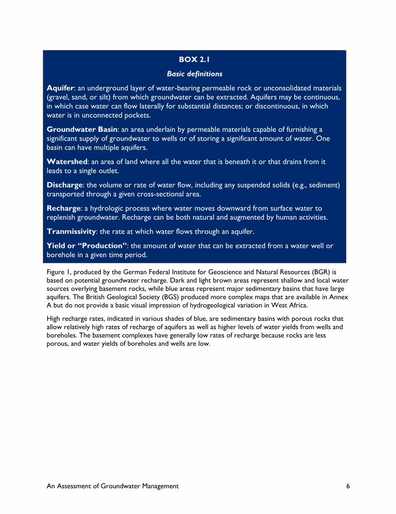
Box 2.1 provides a few definitions of different aspects of groundwater hydrology for reference.
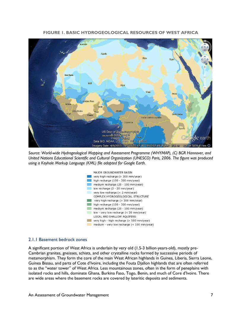
2.1 HYDROGEOLOGIC SETTING
In planning effective utilization of groundwater resources, it is important to understand the overall
hydrogeologic setting of any particular area within the West African context. Too often, generalizations
are made about groundwater without clear reference to hydrogeology, which may result in
misunderstandings about potential and risk.
For the most part, West Africa can be divided into four main hydrogeologic zones with specific
groundwater characteristics. The distribution of these zones can be seen in Figure 1; brown areas have
low groundwater recharge potential, and blue areas have high groundwater recharge potential.
However, high potential recharge does not automatically mean there is a lot of readily available
groundwater – that depends on annual rainfall and depth to the aquifer. A brief description of each
hydrogeological zone follows.
An Assessment of Groundwater Management 6
BOX 2.1
Basic definitions
Aquifer: an underground layer of water-bearing permeable rock or unconsolidated materials
(gravel, sand, or silt) from which groundwater can be extracted. Aquifers may be continuous,
in which case water can flow laterally for substantial distances; or discontinuous, in which
water is in unconnected pockets.
Groundwater Basin: an area underlain by permeable materials capable of furnishing a
significant supply of groundwater to wells or of storing a significant amount of water. One
basin can have multiple aquifers.
Watershed: an area of land where all the water that is beneath it or that drains from it
leads to a single outlet.
Discharge: the volume or rate of water flow, including any suspended solids (e.g., sediment)
transported through a given cross-sectional area.
Recharge: a hydrologic process where water moves downward from surface water to replenish groundwater. Recharge can be both natural and augmented by human activities.
Tranmissivity: the rate at which water flows through an aquifer.
Yield or “Production”: the amount of water that can be extracted from a water well or
borehole in a given time period.
Figure 1, produced by the German Federal Institute for Geoscience and Natural Resources (BGR) is
based on potential groundwater recharge. Dark and light brown areas represent shallow and local water
sources overlying basement rocks, while blue areas represent major sedimentary basins that have large
aquifers. The British Geological Society (BGS) produced more complex maps that are available in Annex
A but do not provide a basic visual impression of hydrogeological variation in West Africa.
High recharge rates, indicated in various shades of blue, are sedimentary basins with porous rocks that
allow relatively high rates of recharge of aquifers as well as higher levels of water yields from wells and
boreholes. The basement complexes have generally low rates of recharge because rocks are less
porous, and water yields of boreholes and wells are low.
An Assessment of Groundwater Management 7
FIGURE 1. BASIC HYDROGEOLOGICAL RESOURCES OF WEST AFRICA
Source: World-wide Hydrogeological Mapping and Assessment Programme (WHYMAP), (C) BGR Hannover, and
United Nations Educational Scientific and Cultural Organization (UNESCO) Paris, 2006. The figure was produced
using a Keyhole Markup Language (KML) file adapted for Google Earth.
2.1.1 Basement bedrock zones
A significant portion of West Africa is underlain by very old (1.5-3 billion-years-old), mostly pre-
Cambrian granites, gneisses, schists, and other crystalline rocks formed by successive periods of
metamorphism. They form the core of the main West African highlands in Guinea, Liberia, Sierra Leone,
Guinea Bissau, and parts of Cote d’Ivoire, including the Fouta Djallon highlands that are often referred
to as the “water tower” of West Africa. Less mountainous zones, often in the form of peneplains with
isolated rocks and hills, dominate Ghana, Burkina Faso, Togo, Benin, and much of Core d’Ivoire. There
are wide areas where the basement rocks are covered by lateritic deposits and sediments.
An Assessment of Groundwater Management 8
Further east, the pre-Cambrian basement forms the base of the central Nigeria plateau and much of
Cameroun, although the highest parts of Cameroun are the result of more recent volcanism associated
with tectonic movements in the Tertiary era, some 70 million years ago.
None of the rocks found in the basement complex make good aquifers. The rocks are largely
impervious, so water cannot pass through them, and groundwater is only found in areas with a lot of
cracks and fissures.
Exploitable quantities of groundwater in basement rocks are only found in fracture zones or in areas
where there has been more extensive weathering that allowed water to move around in the rocks.
These water resources are mostly discontinuous, meaning that water is found in individual pockets or
mini-basins, and there is no hydraulic connectivity between the water sources. As a result, it is possible
to over-extract water in one location and have no material effect on neighboring locations. BGS (2008)
refers to these as local and shallow aquifers.
Armed with good geological maps and satellite images, it is not too difficult to find groundwater in the
basement rocks; however, the yield of wells is generally low – less than 5 liters per second. This yield is
adequate to support rural water supply in dispersed villages, marginal to support more densely settled
areas, and not suited to larger extractions for urban areas or intensive irrigation. Without good data on
location of fracture zones, drilling for water is somewhat hit or miss, and success rates for wells will
often be less than 50 percent.
2.1.2 Major Sedimentary Basins
Four main sedimentary basins in West Africa have been accumulating sediments for hundreds of millions
of years as a result of erosion of the pre-Cambrian basement interspersed with marine and terrestrial
sediments in the form of limestones, shales, and sandstones. The four basins are the Senegal-Gambia
basin, the upper Niger basin that includes almost all of southern Mali and extends in western Burkina
Faso, the lower Niger basin in southwest Niger that cuts through western Nigeria, and the Chad-Benue
basin of Chad and east and central Nigeria.
These four basins cover a high percentage of the Sahelian zone in West Africa (Figure 2). The only other
major river basin, the Volta, is almost exclusively underlain by the basement complex and has a different
relationship between surface and groundwater resources.

An Assessment of Groundwater Management 9
FIGURE 2. RIVER BASINS OF WEST AFRICA
Source: West Africa Gateway of Club du Sahel, 2011
Coarser sedimentary rocks (sandstones, shales, and limestones) move vertically and horizontally and are
porous, allowing water to pass directly into the rock itself. Clays, which are less porous, do hold water;
however, the rate of flow through clay layers is much less that through other sedimentary rocks. Clays
may act as barriers to movement of groundwater.
The large sedimentary basins of West Africa have large areas of continuous aquifers that allow water to
move laterally along one layer. There is a lot of vertical movement of water, unless layers of clay and
fine-grained shale reduce vertical flow of groundwater in some locations. Aquifers are like underground
sponges that have a capacity to hold a lot of water in spaces between individual rock particles and allow
water to move either through gravity or differential hydraulic pressure. Coarse-grained alluvial
sediments, sandstones, coarse shales, and limestones make the best aquifers, because water movement
within them is easy. As a consequence, wells and boreholes have potentially high yields.
However, groundwater is not necessarily readily available. True aquifers may be several tens or
hundreds of meters below the surface, making pumping an expensive proposition. Rural water supplies
instead rely on shallow aquifers that impermeable sediments support and that are within reach of
smaller pumping technologies.
2.1.3 Coastal Aquifers
Coastal aquifers are a special case. They are relatively recent water-bearing sediments formed through
erosion in inland mountain areas, interspersed with marine sediments associated with periods of higher
sea level. They are generally continuous aquifers, so extraction of water in one location can directly
affect groundwater availability in other locations served by the same aquifer.
An Assessment of Groundwater Management 10
The freshwater in coastal aquifers normally floats on top of the denser saline groundwater that is
connected to the sea, so there is a lens of fresh water available. However, if the thickness of the
freshwater lens declines, either through excessive pumping or reduced streamflow as a result of climate
change or diversion for irrigation, then the boundary between the freshwater lens and saline
groundwater below will rise toward the surface. Wells that once pumped freshwater start to pump
saline water and must be abandoned.
All major cities along the West African coastline face a threat of salinization of coastal aquifers through
the dual threats of excessive extraction of fresh groundwater (it is relatively easy to sink boreholes into
these sediments) and reduced streamflow into coastal areas. They also face serious issues of
groundwater pollution from industry and human waste (UNEP, 2006).
Coastal aquifer management is more complex than regular aquifer management, because attention must
be paid not only to rates of recharge and depletion but also to the movement of the boundary layer
between freshwater and saline water within an aquifer.
Some aspects of coastal aquifer management that distinguish them from other aspects of groundwater
management are discussed in section 5.3.2.
2.1.4 Fossil Groundwater
Northern parts of West Africa have large water resources in the form of fossil groundwater, resulting
from recharge of aquifers during wet periods during the last Ice Age. There are three such aquifers of
economic importance.
Figure 3 shows that, for the most part, the major aquifers of West Africa are situated in the southern
parts of the Sahara and adjacent parts of the Sahel, where mean average rainfall is less than 500
mm/year. The only significant exceptions to this pattern are found in Nigeria, where aquifers reach
southward along the lower part of the Niger River and the Benue River, merging with the Niger delta at
the coast.
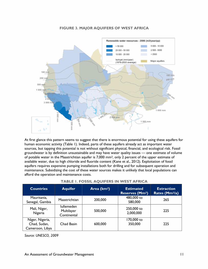
An Assessment of Groundwater Management 11
FIGURE 3. MAJOR AQUIFERS OF WEST AFRICA
At first glance this pattern seems to suggest that there is enormous potential for using these aquifers for
human economic activity (Table 1). Indeed, parts of these aquifers already act as important water
sources, but tapping this potential is not without significant physical, financial, and ecological risk. Fossil
groundwater is by definition unsustainable and may have water quality issues — one estimate of volume
of potable water in the Maastrichtian aquifer is 7,000 mm3, only 2 percent of the upper estimate of
available water, due to high chloride and fluoride content (Kane et al., 2012). Exploitation of fossil
aquifers requires expensive pumping installations both for drilling and for subsequent operation and
maintenance. Subsidizing the cost of these water sources makes it unlikely that local populations can
afford the operation and maintenance costs.
TABLE 1. FOSSIL AQUIFERS IN WEST AFRICA
Countries Aquifer Area (km2) Estimated
Reserves (Mm3)
Extraction
Rates (Mm3/a)
Mauritania,
Senegal, Gambia Maastrichtian 200,000
480,000 to
580,000 265
Mali, Niger,
Nigeria
Iullemeden
Multilayer
Continental
500,000 250,000 to
2,000,000 225
Niger, Nigeria,
Chad, Sudan,
Cameroon, Libya
Chad Basin 600,000
170,000 to
350,000
225
Source: UNESCO, 2009
An Assessment of Groundwater Management 12
Further, and more ecologically complex, is the effect of pumping fossil groundwater into locations that
have an ecological setting reflecting current day rainfall and land-use patterns. As early as 1983, the
National Research Council (1983) recognized that the sinking of wells into fossil aquifers was enabling
livestock to survive drought conditions because of augmented water supplies; however, livestock were
starving to death because of a lack of commensurate grazing resources supported only by sporadic and
declining rainfall. Section 5.3.1 further discusses the complex relationship between groundwater
exploitation for large herds of livestock and the prevailing ecological resources at the land surface.
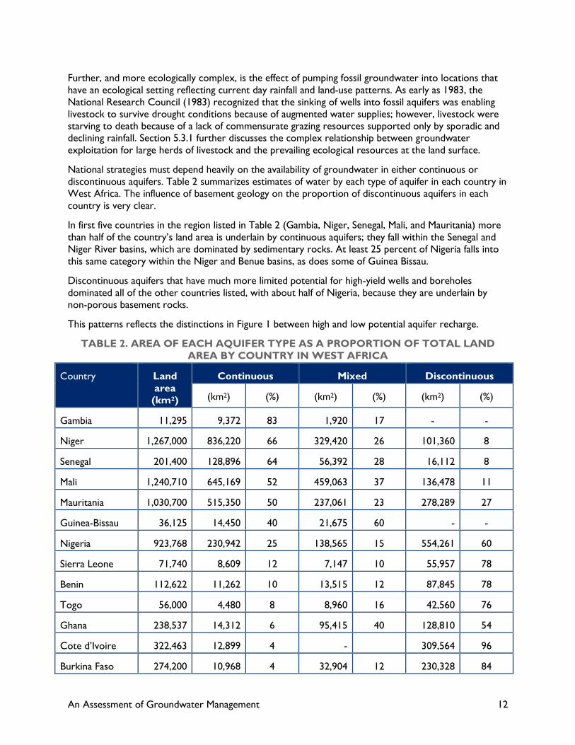
National strategies must depend heavily on the availability of groundwater in either continuous or
discontinuous aquifers. Table 2 summarizes estimates of water by each type of aquifer in each country in
West Africa. The influence of basement geology on the proportion of discontinuous aquifers in each
country is very clear.
In first five countries in the region listed in Table 2 (Gambia, Niger, Senegal, Mali, and Mauritania) more
than half of the country’s land area is underlain by continuous aquifers; they fall within the Senegal and
Niger River basins, which are dominated by sedimentary rocks. At least 25 percent of Nigeria falls into
this same category within the Niger and Benue basins, as does some of Guinea Bissau.
Discontinuous aquifers that have much more limited potential for high-yield wells and boreholes
dominated all of the other countries listed, with about half of Nigeria, because they are underlain by
non-porous basement rocks.
This patterns reflects the distinctions in Figure 1 between high and low potential aquifer recharge.
TABLE 2. AREA OF EACH AQUIFER TYPE AS A PROPORTION OF TOTAL LAND
AREA BY COUNTRY IN WEST AFRICA
Country Land
area
(km2)
Continuous Mixed Discontinuous
(km2) (%) (km2) (%) (km2) (%)
Gambia 11,295 9,372 83 1,920 17 - -
Niger 1,267,000 836,220 66 329,420 26 101,360 8
Senegal 201,400 128,896 64 56,392 28 16,112 8
Mali 1,240,710 645,169 52 459,063 37 136,478 11
Mauritania 1,030,700 515,350 50 237,061 23 278,289 27
Guinea-Bissau 36,125 14,450 40 21,675 60 - -
Nigeria 923,768 230,942 25 138,565 15 554,261 60
Sierra Leone 71,740 8,609 12 7,147 10 55,957 78
Benin 112,622 11,262 10 13,515 12 87,845 78
Togo 56,000 4,480 8 8,960 16 42,560 76
Ghana 238,537 14,312 6 95,415 40 128,810 54
Cote d’Ivoire 322,463 12,899 4 - 309,564 96
Burkina Faso 274,200 10,968 4 32,904 12 230,328 84

An Assessment of Groundwater Management 13
Country Land
area
(km2)
Continuous Mixed Discontinuous
Liberia 111,500 2,230 2 - - 109,270 98
Guinea 245,857 2,459 1 66,381 27 177,017 72
Cape Verde 4,033 - - - - 4,033 100
Source: Adapted from Diagana, 1994
2.2 GROUNDWATER HYDROLOGY
The usefulness of an aquifer for economic purposes depends on several factors, many of which are
directly affected by human activities. Without knowing something about each of these factors, it is
difficult to assess the real potential of groundwater at a specific location. To make matters somewhat
more complicated, local variations in geology and topography may lead to quite large variations in
groundwater potential over relatively short distances. This is particularly true for discontinuous aquifers.
One critical aspect of groundwater hydrology is that it is directly affected by both natural physical
conditions and by anthropogenic factors. It is almost impossible to separate out the two sets of
influences, as is discussed in Chapter 3, which looks at the interactions between climate change and
groundwater. Discussion in this section focuses on the most important aspects of groundwater
hydrology that need to be understand in order to effectively manage groundwater resources.
Figure 4 schematically represents different ways in which groundwater can be pumped or lifted to the
surface. The different well types, which are described in more detail in Chapter 4, provide significantly
different threats to groundwater sustainability. Box 2.1 above provides some basic definitions to ensure
that there is no confusion over groundwater terminology in the remainder of this paper.
FIGURE 4. DIFFERENT TYPES OF WELLS USED IN TAPPING GROUNDWATER
RESOURCES
Source: Tuinoff et al., 2011
An Assessment of Groundwater Management 14
2.2.1 Yield
Yield represents the flow rate of water that can be obtained from a well. It is determined in part by the
water-holding capacity of sediments near the well, including porosity and fracturing; in part by the
transmissivity of the aquifer that determines the rate of flow of groundwater within the aquifer; and in
part by the distance the well is sunk into the aquifer itself.
It is difficult to predict yield from any given borehole or well because of local differences in these
variables. Dug wells generally have low yields, because it is difficult to sink the well very deep into the
saturated portion of the aquifer. However, dug wells can be deepened during dry periods.
2.2.2 Recharge
Groundwater can be recharged through one of three main mechanisms: rainfall percolating through the
soil into the top of the aquifer, flooding of rivers and lakes during the wet season, and long-distance
horizontal movement along an aquifer from areas of higher ground with higher rainfall to lower-lying
areas.
These natural processes can be amplified through proper groundwater supply management, as discussed
in Chapter 6.2. Groundwater supply management helps to increase the total amount of water
percolating into aquifers, either through soil conservation techniques at the land surface or the
construction of dams and sand dams that trap water that would otherwise flow into rivers.
Theoretically, aquifers can be artificially recharged by pumping downwards into specially designed wells,
but this very energy dependent option is not economically viable for West Africa.
The percentage of total rainfall that actually percolates through the soil to recharge aquifers is
surprisingly small. When water reaches the soil surface, it can either evaporate back to the atmosphere,
run off horizontally toward lower areas (augmenting lakes and rivers), or be used by plants as
transpiration from the root zone. Only the residual amount will percolate through the root zone and
start to flow vertically toward the aquifer.
The relative proportions of surface runoff and groundwater recharge heavily depend on the nature of
individual rainfall events and are less influenced by total annual rainfall. Intensive rainfall events have a
higher proportion of surface runoff; climate change models indicate that there is a likelihood of an
increase in the number of high intensity storms. However, the impact of changing rainfall patterns on
recharge also relates to the storage capacity of soils and aquifers. If the aquifer totally fills up during the
wet season such that no more rain water can be stored and must become part of surface runoff, then
there is no significant impact on water availability in the dry season. The change in depth to groundwater
is more important in understanding the sustainability of groundwater exploitation. Sections 2.3 and 2.4
below address this issue in more detail.
It is immediately clear that anthropogenic actions at the land surface directly affect groundwater
recharge. The effects of overgrazing, lack of fallowing, clearance of forests, and other negative impacts
on vegetative cover all lead to reduced infiltration of rainfall and a reduction in water recharging the
aquifer. Destruction of vegetation that leads to soil crusting and increases the speed of runoff leads to
soil erosion and flash flooding, allowing more rainfall to reach rivers but making it less available for
groundwater recharge. Destruction of vegetation also increases evaporation from the soil surface.
Most watershed management programs are based on the principle of increasing infiltration but slowing
down runoff using mulching, terraces, bunds, vegetation, and small catch basins to keep water on the soil
long enough for it to infiltrate. While good vegetation cover means increased transpiration, there is a far
greater increase in percolation toward the aquifer because of reduced runoff and reduced surface

An Assessment of Groundwater Management 15
evaporation. These activities can be broadly classified as groundwater supply management, which is
discussed further in Chapter 6.3
At a larger scale, it is more difficult to manage groundwater recharge. Increasingly, West Africa faces the
risk of moving from “open” basins to “closed” basins, so that almost all useful flow in a river is diverted
for economic purposes before it reaches the sea. This shift has a direct impact on coastal aquifers,
because there is less surplus water for recharge near the coast; it also affects water levels in rivers in
upstream areas. High fluctuations in water surface elevation enhance recharge in the wet season,
because water infiltrates into river banks and flooded riverine areas. Reduction in water levels due to
wet season water storage in reservoirs reduces groundwater recharge.
2.2.3 Overall storage capacity of an aquifer
Total aquifer resources are determined by the thickness of the water-bearing strata, the degree of
connectivity of the aquifer, and the regional slope of aquifers into major sedimentary basins. In most
sedimentary basins in West Africa, the total resources far exceed our capacity to extract them;1
however, if there is sufficient capital available to invest in large-scale pumping, depletion becomes a
significant threat, particularly where fossil groundwater reserves are being mined. Until recently, Libya
was the only country close to West Africa with the financial wherewithal to invest in such major
schemes. Similar investments in West Africa are unlikely in the foreseeable future.
Pumping water from aquifers has its biggest impact at the edges of an aquifer and comparatively less
impact in the center of a basin, because lowering of the water table in the center of a basin causes water
to flow toward the center. Pumping from the edge of an aquifer will have a significantly greater impact
but may not affect overall aquifer storage to any great extent.
Siting of wells within continuous aquifers is an important aspect of groundwater management to ensure
that the overall impact on aquifer storage capacity is minimized.
Sustainability of groundwater within an aquifer is affected by the thickness of the aquifer itself and its
depth below the ground surface. The large aquifers shown in Figure 3 have huge water resources
because they are many hundreds of feet thick, and current rates of abstraction are low in comparison to
the reserves. However, many smaller aquifers closer to the ground surface provide the source of much
of the groundwater used for human activity.
If the rate of groundwater extraction does not match total annual recharge, then the system is stable
and not threatened by depletion; however, accurate data on the extent, thickness, and water holding
capacity of aquifers is incomplete. With limited information on actual pumping rates from each aquifer, it
is not possible to make definitive statements about sustainability of groundwater use under present
conditions. Using extrapolation, it is even less clear what the consequences of climate change may be.
1 The history of the Ogallala aquifer in the high plains of the United States is one example of where large sections of an
aquifer effectively have been drained dry; the water supply aquifer for the city of Sana’a in Yemen is almost fully depleted.

An Assessment of Groundwater Management 16
2.2.4 Depth to water table
The distance from the ground surface to the top of the saturated zone of the aquifer, i.e., the depth to
water table, has a major impact on how water can be exploited and how much of it can be brought to
the surface.
The relationship between depth to water table and the type of available water-lifting mechanism is
critical to understanding the sustainability of groundwater resources as well as the economics of lifting
water. This relationship is further discussed in Chapter 4.
Most countries have some form of groundwater monitoring program that collects data from observation
wells and keeps the results in centralized databases. These data are patchy and do not always reflect the
need for water table monitoring in areas particularly sensitive to groundwater depletion. The monitoring
networks, normally underfunded by government, have not kept up with the pace of groundwater
development during the past couple of decades.
When assessing how to effectively exploit groundwater resources, it is important to recognize that
depth to water table is a dynamic, not static value. Shallow water tables, those used by most rural water
supply installations, fluctuate annually in response to wet season recharge and dry season depletion.
Depletion is a natural process caused by evapotranspiration at the ground surface and lateral flow
toward rivers and lakes as their water levels drop. Just as anthropogenic factors affect recharge, the rate
of depletion is also a combination of natural and manmade factors.
Measurement of the groundwater depth at the end of the rainy season is the best indicator of the health
of the groundwater resource. If the aquifer fills by the end of the rainy season, then the underground
reservoir is full and cannot store any more. The rate of decline of the water table can be predicted with
accuracy once the rates of natural and anthropogenic depletion are known.
One example of variability of depth to water table over a several-year period is shown in Figure 5. The
hydrographs show considerable sensitivity to both total rainfall during the wet season and the length of
the rainy season, while the rate of drawdown of the water table is more or less uniform during each dry
season. With careful analysis, it ought to be possible to determine the relative importance of total
rainfall during the season; the length of the wet season; the number of individual rainfall events; and the
importance of large, high intensity storms on the recharge of the aquifer. Unfortunately, the type of data
shown in Figure 5 is very uncommon, and much more detailed data at the local level is required to
determine the exact relationships between rainfall, depletion, and water table.2
Unless aquifers are completely drained, depth to groundwater has to be placed within the context of
available lifting technology. Once groundwater falls below the depth limit of installed lifting devices, the
groundwater becomes inaccessible. This could be at 6 meters for some types of pumps, or hundreds of
meters for others. Interpretation of the importance of depth to water table is therefore a complex
parameter, not a simple measurement.
A clear indication of groundwater stress comes when people must deepen their wells to continue to
obtain water later in the dry season. Deepening wells is not an easy task; hand-dug wells have to be
more or less dry before people can be lowered down the well shaft, while bore-hole deepening requires
2 Given that these data come from a USAID program, it should be possible to request that involved researchers check if their data can be further analyzed to better quantify these relationships.

An Assessment of Groundwater Management 17
access to drilling machines. The stress comes about not because the aquifer is necessarily running dry,
but because the available technology is not enough to raise water from the increased depth.
FIGURE 5. HYDROGRAPHS FOR TWO WATERHOLES IN BANI DISTRICT,
1998–2010
Source: MLPI Annual Report, 2012
2.2.5 Water quality
Issues of water quality in West Africa have been neglected largely because of the pressure to provide
potable water to rural communities, although all countries in the region have established water quality
guidelines normally based on World Health Organization (WHO) standards and subject to local
variations. The capacity of most countries to enforce water quality regulations is very limited. It is easier
to get water samples for testing from large drilling rigs that have to be licensed by government, so larger
boreholes are better regulated than smaller ones sunk by private sector organizations.
Some donors, including USAID, insist on water quality testing before a well or borehole is
commissioned; however, in reality it is very difficult not to fix a pump on a well with marginally sub-
standard water when the only other available water supply is a highly polluted surface water source.
This issue may pose a genuine human dilemma: is it appropriate to allow people access to water that
does not meet basic minimum standards when their only alternative is to continue to use water that is
far below those minimum standards? USAID is currently reviewing its policy on ensuring safe water
An Assessment of Groundwater Management 18
supply and is preparing a revised draft set of guidelines for providing safe drinking water (Chris
McGahey, personal communication).
The main water quality concerns focus on potable water. Water quality concerns for livestock and
irrigation are minor, because there is no direct threat to human health. In collaboration with the British
Geological Survey, WaterAid sponsored a series of groundwater quality reports for all countries in
which it worked in the early 2000s. For West Africa, it included factsheets for Mali, Nigeria, and Ghana.
All of these factsheets addressed nitrates, salinity, fluoride, iron, arsenic, iodine, and other trace
elements based on available published materials. For the most part, groundwater throughout those
countries normally met or exceeded WHO water quality guidelines; however, it was recognized that
aquifers, particularly near larger cities, were at risk of pollution and bacterial contamination.
One specific issue relates to the capacity to test for the full range of considered parameters when
determining the potability of groundwater. While most national and local laboratories have the capacity
to test for common chemical and biological contaminants, they rarely have the capacity to conduct more
complex and expensive tests for elements such as arsenic. A few donor programs have proceeded
without these tests, sometimes with negative impacts on human health.
An Assessment of Groundwater Management 19
3.0 CLIMATE CHANGE AND
GROUNDWATER
This chapter addresses two aspects of the relationship between climate change and groundwater. It
starts with an overview of the impact of predicted climate changes on the dynamics of groundwater
recharge and depletion. These impacts heavily rely on the GCMs used to predict temperature and
precipitation changes during the next several decades.
The second section of this chapter examines different modeling efforts in West Africa that have tried to
predict changes in groundwater recharge during the same time period. All modeling efforts face
problems of data availability, scale, and timeframes. They also require prediction of groundwater use
patterns, because it is impossible to separate out the direct impacts of climate change on groundwater
from the indirect impacts of human responses to climate change that will affect both hydrological
processes and will change demand for groundwater.
3.1 CLIMATE CHANGE IMPACTS ON GROUNDWATER
Assessing the impact of climate change on groundwater is complex and remains plagued by uncertainty.
As indicated earlier in Chapter 2, it is quite difficult to distinguish changes in rainfall and temperature on
groundwater from changes in groundwater conditions resulting from anthropogenic factors.
Nevertheless, some overall generalizations can help understand the likely impacts at a regional level.
At a very broad level of generalization, predictions of the impact of climate change by itself on
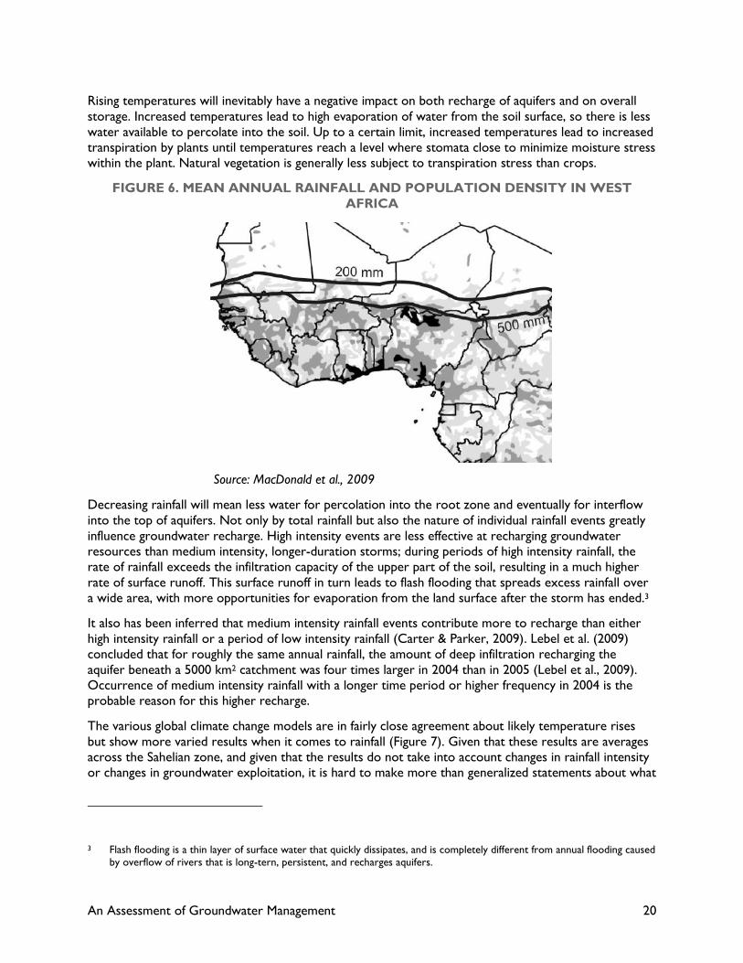
groundwater are not too bleak. In comparing population density with mean annual rainfall, most of the
population of West Africa lives in areas with at least 500 mm of rainfall (Figure 6), so that demand for
rural water supply using hand pumping technology should not be particularly threatened. However, if
rainfall declines so that the critical belt lying between 200 mm and 500 mm of rain shifts southwards,
then more densely populated parts of Mali, Niger, northern Nigeria, northern Cameroun, and southern
Chad will fall into the threatened zone.
Rather than looking at the rainfall pattern, it is more instructive to look at overall water availability per
capita to determine the relative priority of groundwater management programs. In addition to showing
the location of major aquifers, Figure 3 also shows national-level data on per capita water availability.
Countries with darker shades of blue have abundant water resources, primarily in surface water, and
groundwater depletion is simply not an issue except in coastal aquifers. By contrast, the drier countries
such as Ghana, Burkina Faso, Niger, and large parts of Nigeria have annual per capita water resources of
less than 2500 m3/person, perilously close to the level of 1,750 m3/year that is when true water stress
occurs. Given that there is wide spatial variability in access to water in those countries, local water
stress is widespread.
These data include both surface and groundwater resources. While Figure 3 seems to indicate that
intermediate countries such as Mali, Senegal, Mauritania, and Cameroun are not yet close to water
stress, the reality is that if they discount the deeper fossil groundwater resources, they also are close to
the cut-off point for water stress, and definitely so at the local level.
An Assessment of Groundwater Management 20
Rising temperatures will inevitably have a negative impact on both recharge of aquifers and on overall
storage. Increased temperatures lead to high evaporation of water from the soil surface, so there is less
water available to percolate into the soil. Up to a certain limit, increased temperatures lead to increased
transpiration by plants until temperatures reach a level where stomata close to minimize moisture stress
within the plant. Natural vegetation is generally less subject to transpiration stress than crops.
FIGURE 6. MEAN ANNUAL RAINFALL AND POPULATION DENSITY IN WEST
AFRICA
Source: MacDonald et al., 2009
Decreasing rainfall will mean less water for percolation into the root zone and eventually for interflow
into the top of aquifers. Not only by total rainfall but also the nature of individual rainfall events greatly
influence groundwater recharge. High intensity events are less effective at recharging groundwater
resources than medium intensity, longer-duration storms; during periods of high intensity rainfall, the
rate of rainfall exceeds the infiltration capacity of the upper part of the soil, resulting in a much higher
rate of surface runoff. This surface runoff in turn leads to flash flooding that spreads excess rainfall over
a wide area, with more opportunities for evaporation from the land surface after the storm has ended.3
It also has been inferred that medium intensity rainfall events contribute more to recharge than either
high intensity rainfall or a period of low intensity rainfall (Carter & Parker, 2009). Lebel et al. (2009)
concluded that for roughly the same annual rainfall, the amount of deep infiltration recharging the
aquifer beneath a 5000 km2 catchment was four times larger in 2004 than in 2005 (Lebel et al., 2009).
Occurrence of medium intensity rainfall with a longer time period or higher frequency in 2004 is the
probable reason for this higher recharge.
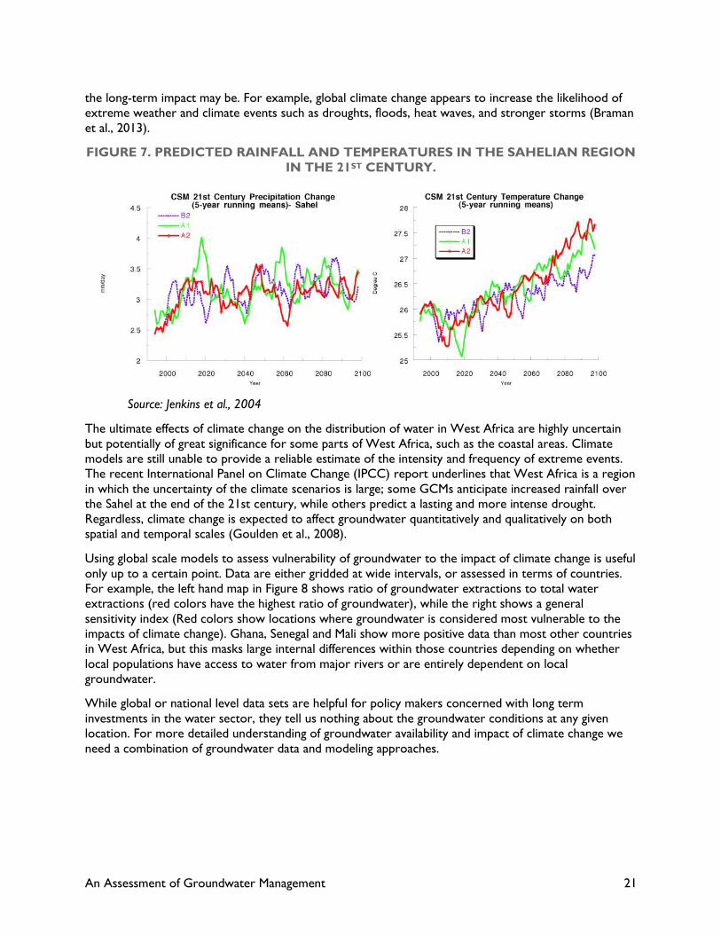
The various global climate change models are in fairly close agreement about likely temperature rises
but show more varied results when it comes to rainfall (Figure 7). Given that these results are averages
across the Sahelian zone, and given that the results do not take into account changes in rainfall intensity
or changes in groundwater exploitation, it is hard to make more than generalized statements about what
3 Flash flooding is a thin layer of surface water that quickly dissipates, and is completely different from annual flooding caused by overflow of rivers that is long-tern, persistent, and recharges aquifers.
An Assessment of Groundwater Management 21
the long-term impact may be. For example, global climate change appears to increase the likelihood of
extreme weather and climate events such as droughts, floods, heat waves, and stronger storms (Braman
et al., 2013).
FIGURE 7. PREDICTED RAINFALL AND TEMPERATURES IN THE SAHELIAN REGION
IN THE 21ST CENTURY.
Source: Jenkins et al., 2004
The ultimate effects of climate change on the distribution of water in West Africa are highly uncertain
but potentially of great significance for some parts of West Africa, such as the coastal areas. Climate
models are still unable to provide a reliable estimate of the intensity and frequency of extreme events.
The recent International Panel on Climate Change (IPCC) report underlines that West Africa is a region
in which the uncertainty of the climate scenarios is large; some GCMs anticipate increased rainfall over
the Sahel at the end of the 21st century, while others predict a lasting and more intense drought.
Regardless, climate change is expected to affect groundwater quantitatively and qualitatively on both
spatial and temporal scales (Goulden et al., 2008).
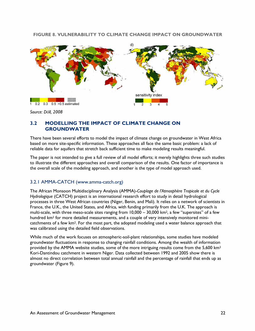
Using global scale models to assess vulnerability of groundwater to the impact of climate change is useful
only up to a certain point. Data are either gridded at wide intervals, or assessed in terms of countries.
For example, the left hand map in Figure 8 shows ratio of groundwater extractions to total water
extractions (red colors have the highest ratio of groundwater), while the right shows a general
sensitivity index (Red colors show locations where groundwater is considered most vulnerable to the
impacts of climate change). Ghana, Senegal and Mali show more positive data than most other countries
in West Africa, but this masks large internal differences within those countries depending on whether
local populations have access to water from major rivers or are entirely dependent on local
groundwater.
While global or national level data sets are helpful for policy makers concerned with long term
investments in the water sector, they tell us nothing about the groundwater conditions at any given
location. For more detailed understanding of groundwater availability and impact of climate change we
need a combination of groundwater data and modeling approaches.
An Assessment of Groundwater Management 22
FIGURE 8. VULNERABILITY TO CLIMATE CHANGE IMPACT ON GROUNDWATER
Source: Döll, 2008
3.2 MODELLING THE IMPACT OF CLIMATE CHANGE ON
GROUNDWATER
There have been several efforts to model the impact of climate change on groundwater in West Africa
based on more site-specific information. These approaches all face the same basic problem: a lack of
reliable data for aquifers that stretch back sufficient time to make modeling results meaningful.
The paper is not intended to give a full review of all model efforts; it merely highlights three such studies
to illustrate the different approaches and overall comparison of the results. One factor of importance is
the overall scale of the modeling approach, and another is the type of model approach used.
3.2.1 AMMA-CATCH (www.amma-catch.org)
The African Monsoon Multidisciplinary Analysis (AMMA)-Couplage de l’Atmosphère Tropicale et du Cycle
Hydrologique (CATCH) project is an international research effort to study in detail hydrological
processes in three West African countries (Niger, Benin, and Mali). It relies on a network of scientists in
France, the U.K., the United States, and Africa, with funding primarily from the U.K. The approach is
multi-scale, with three meso-scale sites ranging from 10,000 – 30,000 km2, a few “supersites” of a few
hundred km2 for more detailed measurements, and a couple of very intensively monitored mini-
catchments of a few km2. For the most part, the adopted modeling used a water balance approach that
was calibrated using the detailed field observations.
While much of the work focuses on atmospheric-soil-plant relationships, some studies have modeled
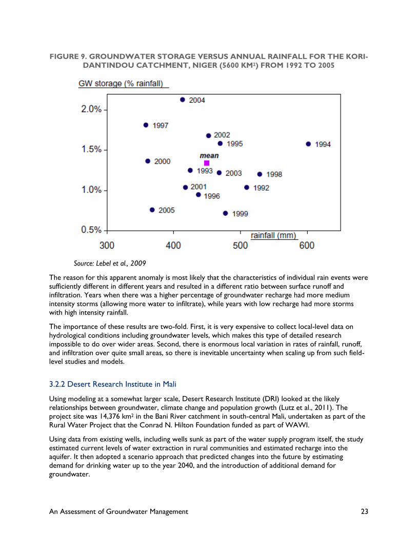
groundwater fluctuations in response to changing rainfall conditions. Among the wealth of information
provided by the AMMA website studies, some of the more intriguing results come from the 5,600 km2
Kori-Dantindou catchment in western Niger. Data collected between 1992 and 2005 show there is
almost no direct correlation between total annual rainfall and the percentage of rainfall that ends up as
groundwater (Figure 9).
An Assessment of Groundwater Management 23
FIGURE 9. GROUNDWATER STORAGE VERSUS ANNUAL RAINFALL FOR THE KORI-
DANTINDOU CATCHMENT, NIGER (5600 KM2) FROM 1992 TO 2005
Source: Lebel et al., 2009
The reason for this apparent anomaly is most likely that the characteristics of individual rain events were
sufficiently different in different years and resulted in a different ratio between surface runoff and
infiltration. Years when there was a higher percentage of groundwater recharge had more medium
intensity storms (allowing more water to infiltrate), while years with low recharge had more storms
with high intensity rainfall.
The importance of these results are two-fold. First, it is very expensive to collect local-level data on
hydrological conditions including groundwater levels, which makes this type of detailed research
impossible to do over wider areas. Second, there is enormous local variation in rates of rainfall, runoff,
and infiltration over quite small areas, so there is inevitable uncertainty when scaling up from such field-
level studies and models.
3.2.2 Desert Research Institute in Mali
Using modeling at a somewhat larger scale, Desert Research Institute (DRI) looked at the likely
relationships between groundwater, climate change and population growth (Lutz et al., 2011). The
project site was 14,376 km2 in the Bani River catchment in south-central Mali, undertaken as part of the
Rural Water Project that the Conrad N. Hilton Foundation funded as part of WAWI.
Using data from existing wells, including wells sunk as part of the water supply program itself, the study
estimated current levels of water extraction in rural communities and estimated recharge into the
aquifer. It then adopted a scenario approach that predicted changes into the future by estimating
demand for drinking water up to the year 2040, and the introduction of additional demand for
groundwater.

An Assessment of Groundwater Management 24
Four assumptions about water demand patterns were used. In Scenario 1, demand was primarily for
domestic consumption with no change in rainfall. Scenario 2 increased consumption to include some
pumping for irrigation but with no change in rainfall. Scenario 3 increased consumption to include some
pumping for irrigation and reduced rainfall by 20 percent. Scenario 4 had variable annual rainfall with
reductions ranging from 0-20 percent together with increased demand.
The results are very different for the different scenarios (Table 3). The implications are that as long as
groundwater is used for hand-pumped domestic water use only, then there should be little or no impact
of overall groundwater resources if population doubles by 2040, because the groundwater demand
would only increase to 0.55 percent of total rainfall. However, as soon as demand for other uses of
groundwater increases (primarily for agriculture and small industry), the percentage of rainfall required
to recharge groundwater increases to greater than 3 percent and reaches almost 4 percent if rainfall
decreases by 20 percent (Scenario 3). For this reason, Figure 10 shows an increasing drawdown of
groundwater in larger urban areas and where population density is higher.
TABLE 3. SUMMARY OF THE FOUR MODEL SCENARIOS
Scenario Population Consumption Precipitation Extraction
(M) l/p/day (mm) Mm3 % of rainfall
0 Present Conditions 0.59 90 505 23.1 0.32%
1 Population doubles 1.18 90 505 39.7 0.55%
2 Agriculture & Industry 1.18 695 505 222 3.10%
3 Drying trend 1.18 695 405 222 3.80%
4 Variable Precipitation 1.18 695 405− 540 222 3.0-3.8%
Source: Adapted from Lutz et al., 2011
The results heavily depend on assumptions of increased per capita water use; however, the trends are
already there, because without increased per capita water use, particularly for small-scale irrigation, the
rural economies of such areas will continue to stagnate. It should also be noted that the amount
allocated for small-scale irrigation is insufficient to meet staple food requirements (millet, maize, etc.)
and only provides for irrigation of gardens for vegetables and some cash crops.
Assuming a well initially designed for drinking water for 400 people (the standard adopted in Mali) and a
daily requirement of 25 l/day, then daily demand for drinking water would be 10,000 liters. Irrigation of
1 ha, which is only 20 m2 of irrigated land per family of eight, requires approximately 86,400 liters;
therefore, it is not unreasonable to assume that even small-scale irrigation would greatly increase
demand for water quite independently of population growth because of the increased intensification of
water use.
An Assessment of Groundwater Management 25
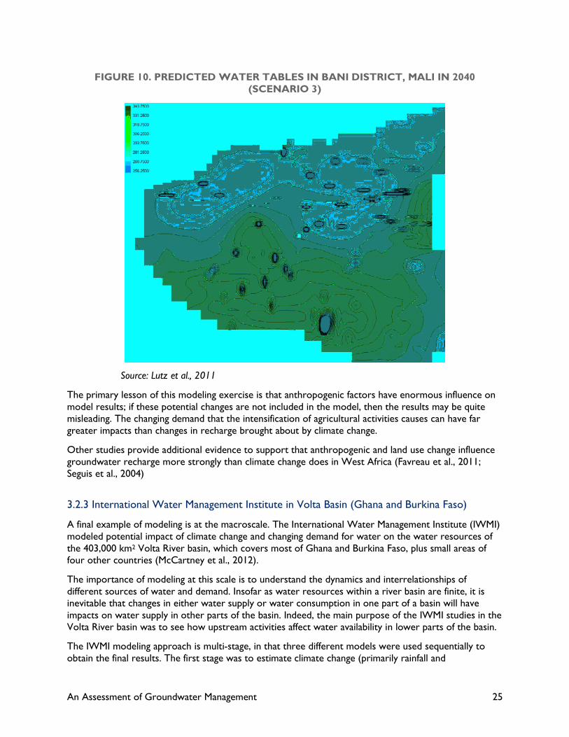
FIGURE 10. PREDICTED WATER TABLES IN BANI DISTRICT, MALI IN 2040
(SCENARIO 3)
Source: Lutz et al., 2011
The primary lesson of this modeling exercise is that anthropogenic factors have enormous influence on
model results; if these potential changes are not included in the model, then the results may be quite
misleading. The changing demand that the intensification of agricultural activities causes can have far
greater impacts than changes in recharge brought about by climate change.
Other studies provide additional evidence to support that anthropogenic and land use change influence
groundwater recharge more strongly than climate change does in West Africa (Favreau et al., 2011;
Seguis et al., 2004)
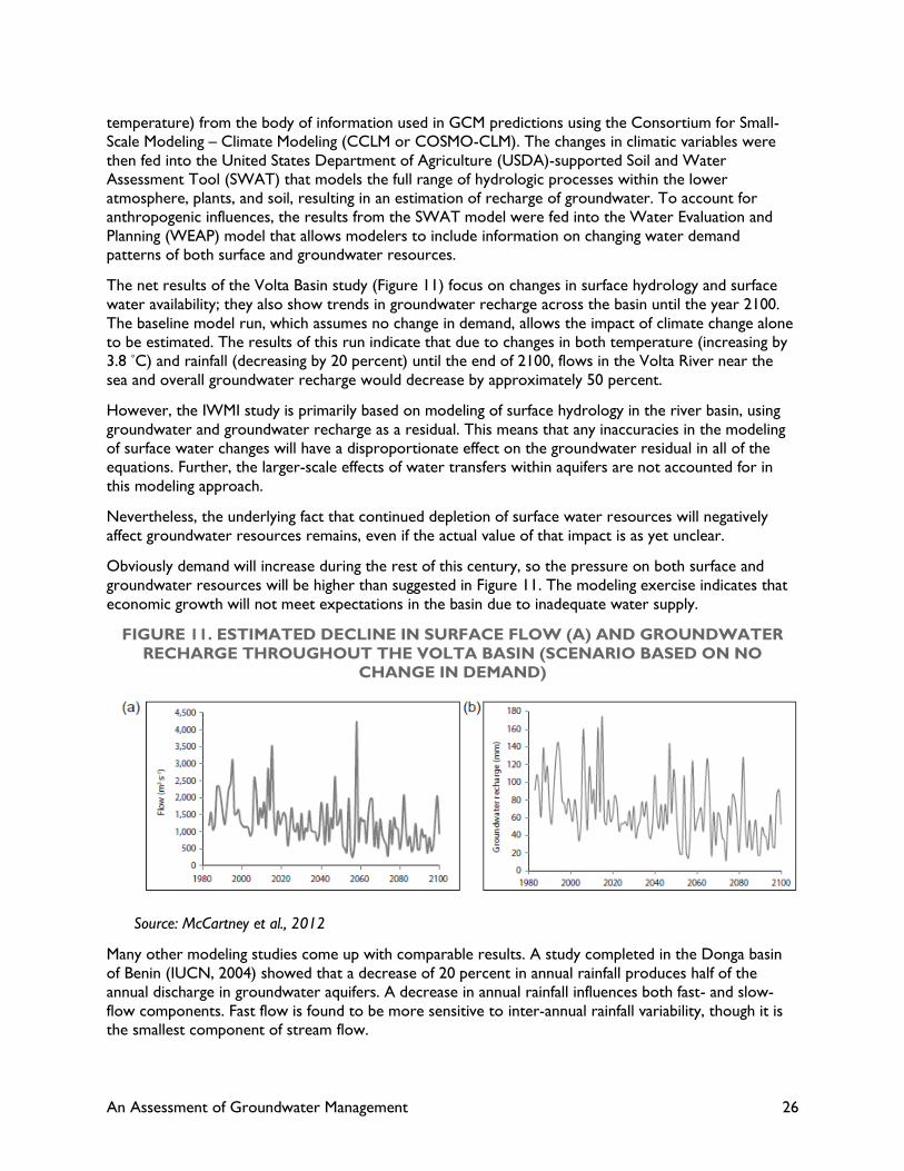
3.2.3 International Water Management Institute in Volta Basin (Ghana and Burkina Faso)
A final example of modeling is at the macroscale. The International Water Management Institute (IWMI)
modeled potential impact of climate change and changing demand for water on the water resources of
the 403,000 km2 Volta River basin, which covers most of Ghana and Burkina Faso, plus small areas of
four other countries (McCartney et al., 2012).
The importance of modeling at this scale is to understand the dynamics and interrelationships of
different sources of water and demand. Insofar as water resources within a river basin are finite, it is
inevitable that changes in either water supply or water consumption in one part of a basin will have
impacts on water supply in other parts of the basin. Indeed, the main purpose of the IWMI studies in the
Volta River basin was to see how upstream activities affect water availability in lower parts of the basin.
The IWMI modeling approach is multi-stage, in that three different models were used sequentially to
obtain the final results. The first stage was to estimate climate change (primarily rainfall and
An Assessment of Groundwater Management 26
temperature) from the body of information used in GCM predictions using the Consortium for Small-
Scale Modeling – Climate Modeling (CCLM or COSMO-CLM). The changes in climatic variables were
then fed into the United States Department of Agriculture (USDA)-supported Soil and Water
Assessment Tool (SWAT) that models the full range of hydrologic processes within the lower
atmosphere, plants, and soil, resulting in an estimation of recharge of groundwater. To account for
anthropogenic influences, the results from the SWAT model were fed into the Water Evaluation and
Planning (WEAP) model that allows modelers to include information on changing water demand
patterns of both surface and groundwater resources.
The net results of the Volta Basin study (Figure 11) focus on changes in surface hydrology and surface
water availability; they also show trends in groundwater recharge across the basin until the year 2100.
The baseline model run, which assumes no change in demand, allows the impact of climate change alone
to be estimated. The results of this run indicate that due to changes in both temperature (increasing by
3.8 °C) and rainfall (decreasing by 20 percent) until the end of 2100, flows in the Volta River near the
sea and overall groundwater recharge would decrease by approximately 50 percent.
However, the IWMI study is primarily based on modeling of surface hydrology in the river basin, using
groundwater and groundwater recharge as a residual. This means that any inaccuracies in the modeling
of surface water changes will have a disproportionate effect on the groundwater residual in all of the
equations. Further, the larger-scale effects of water transfers within aquifers are not accounted for in
this modeling approach.
Nevertheless, the underlying fact that continued depletion of surface water resources will negatively
affect groundwater resources remains, even if the actual value of that impact is as yet unclear.
Obviously demand will increase during the rest of this century, so the pressure on both surface and
groundwater resources will be higher than suggested in Figure 11. The modeling exercise indicates that
economic growth will not meet expectations in the basin due to inadequate water supply.
FIGURE 11. ESTIMATED DECLINE IN SURFACE FLOW (A) AND GROUNDWATER
RECHARGE THROUGHOUT THE VOLTA BASIN (SCENARIO BASED ON NO
CHANGE IN DEMAND)
Source: McCartney et al., 2012
Many other modeling studies come up with comparable results. A study completed in the Donga basin
of Benin (IUCN, 2004) showed that a decrease of 20 percent in annual rainfall produces half of the
annual discharge in groundwater aquifers. A decrease in annual rainfall influences both fast- and slow-
flow components. Fast flow is found to be more sensitive to inter-annual rainfall variability, though it is
the smallest component of stream flow.

An Assessment of Groundwater Management 27
Both the IWMI and IUCN studies highlight the need for a more comprehensive modeling assessment of
both surface and groundwater variations, including sensitivity to both climate change and continued
anthropogenic impacts.
Common to all of these studies is the consensus that groundwater recharge is very sensitive both to the
impact of climate change and to changes in demand for water. The following chapter examines in detail
what demands for groundwater currently exist and how they may change in the future.

An Assessment of Groundwater Management 28
4.0 GROUNDWATER USE IN
RURAL WEST AFRICA
Exploitation of groundwater resources in rural areas in West Africa has entered a third phase, which
poses considerable threats to the heretofore relative stability of aquifer conditions. To understand the
nature of these threats, it is helpful to review briefly how people have been able to tap groundwater.
4.1 EARLY-PHASE EXPLOITATION
For centuries, people have tapped groundwater for drinking and livestock by using hand-dug wells
equipped with rope and buckets (Figure 12). Some lifting is strictly manual, and some uses animal power
to haul larger buckets made of leather or, more recently, nylon or plastic. In traditional wells, logs are
used to help guide ropes and pull water up. In more modern times, the ropes run over metal pulley
wheels to reduce the friction.
FIGURE 12. TRADITIONAL DUG WELL WITH ROPE AND BUCKET LIFTING
Source: USAID website for Niger

An Assessment of Groundwater Management 29
With this technology, the amount of water that can be raised at any one time is quite low. The deeper
the water level in the well, the less water can be raised. In many areas, animals are harnessed to the
rope so that larger volumes can be raised – typical buckets for animal lifting have about an 80-liter (80-
kg) capacity; with four to six animals, water can be raised from more than 100 meters.
Although the overall water yield of hand-dug wells is low, they have allowed human settlement in large
parts of West Africa, particularly in drier areas where there are few other sources of potable water.
They have helped support large herds of livestock throughout the Sahel.
Hand-dug wells cannot easily be dug into the saturated portion of an aquifer. They may only penetrate a
meter or two into the saturated zone, and are thus susceptible to a decline in groundwater levels.
However, although risky and extremely unpleasant, it is possible to deepen hand-dug wells as the need
arises (Figure 13).
FIGURE 13. WELL DIGGER IN NIGER
Source: Friends of Niger, n.d.
4.2 THE ADVENT OF BOREHOLES AND MANUAL PUMPING
The introduction of modern drilling techniques has been the key to the success of potable water
programs. Drilling enables the installation of metal or plastic tubes (hence the term tubewells) down
into the saturated part of the aquifer, and can extend deep into the saturated zone. This practice
increases water yields significantly, as a greater area of aquifer can be tapped.
The vast majority of tubewells are fitted with hand- or foot-powered pumps. Because the tubes are
narrow in diameter and the pumping mechanism is fitted with a foot valve, water can be lifted from a
greater depth than if the tubewell were fitted with a simple suction pump. Simple suction pumps cannot
raise water more than about 7 meters; the weight of water supported by atmospheric pressure alone
will cause the water column to break if it exceeds 7 meters.
Most modern hand pumps use lifting principles that allow people to obtain water from between 15 and
45 meters depending on the pump design. Below 45 meters, the designs become more complicated, are
generally less reliable, and require significantly more effort to raise the water. It is theoretically possible
to use hand pumps to lift water from about 70 meters, but the effort involved is enormous.
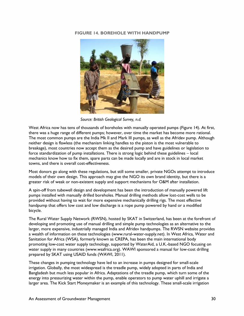
An Assessment of Groundwater Management 30
FIGURE 14. BOREHOLE WITH HANDPUMP
Source: British Geological Survey, n.d.
West Africa now has tens of thousands of boreholes with manually operated pumps (Figure 14). At first,
there was a huge range of different pumps; however, over time the market has become more rational.
The most common pumps are the India Mk II and Mark III pumps, as well as the Afridev pump. Although
neither design is flawless (the mechanism linking handles to the piston is the most vulnerable to
breakage), most countries now accept them as the desired pump and have guidelines or legislation to
force standardization of pump installations. There is strong logic behind these guidelines – local
mechanics know how to fix them, spare parts can be made locally and are in stock in local market
towns, and there is overall cost-effectiveness.
Most donors go along with these regulations, but still some smaller, private NGOs attempt to introduce
models of their own design. This approach may give the NGO its own brand identity, but there is a
greater risk of weak or non-existent supply and support mechanisms for O&M after installation.
A spin-off from tubewell design and development has been the introduction of manually powered lift
pumps installed with manually drilled boreholes. Manual drilling methods allow lost-cost wells to be
provided without having to wait for more expensive mechanically drilling rigs. The most effective
handpump that offers low cost and low discharge is a rope pump powered by hand or a modified
bicycle.
The Rural Water Supply Network (RWSN), hosted by SKAT in Switzerland, has been at the forefront of
developing and promoting use of manual drilling and simple pump technologies as an alternative to the
larger, more expensive, industrially managed India and Afridev handpumps. The RWSN website provides
a wealth of information on these technologies (www.rural-water-supply.net). In West Africa, Water and
Sanitation for Africa (WSA), formerly known as CREPA, has been the main international body
promoting low-cost water supply technology, supported by WaterAid, a U.K.-based NGO focusing on
water supply in many countries (www.wsafrica.org). WAWI sponsored a manual for low-cost drilling
prepared by SKAT using USAID funds (WAWI, 2011).
These changes in pumping technology have led to an increase in pumps designed for small-scale
irrigation. Globally, the most widespread is the treadle pump, widely adopted in parts of India and
Bangladesh but much less popular in Africa. Adaptations of the treadle pump, which turn some of the
energy into pressurizing water within the pump, enable operators to pump water uphill and irrigate a
larger area. The Kick Start Moneymaker is an example of this technology. These small-scale irrigation
An Assessment of Groundwater Management 31
pumps, which can also use surface water bodies, are limited to the 7-meter lift limit because they
primarily act as suction pumps.
There is widespread consensus that up to this level of development, manual pumping of water
associated with mechanical or manually drilled boreholes does not pose a significant threat to
groundwater resources. Such was the conclusion of Lutz et al. (2011) in the Bami area modeling
exercise as well as of the BGS and other experts in the field. The human effort required to lift water
manually does not permit significant drawdown of the water table, and rates of extraction almost always
appear to be less than those of natural aquifer recharge.
Increasingly, however, people are trying to modify manually operated pumps so that other sources of
power can drive them. We have reached the point in West Africa where this practice is beginning to
threaten groundwater resources.
4.3 THE INCREASING ROLE OF MOTORIZED PUMPS
As soon as a motor is attached to a pump, the whole dynamic of groundwater exploitation changes.
Rather than relying on the limits imposed by human energy in raising water, motorization allows pumps
to operate for much longer periods at higher discharges. Not only can basic needs for drinking water
and livestock be met, but now water is also readily available for irrigation.
Pumping groundwater for both water supply and irrigation is not new to West Africa, but this niche has
been occupied largely by government entities either for small town water supply systems or strategic
rural water installations as part of drought mitigation systems. The high energy costs, particularly for
deep groundwater extraction, limit the number of installations government can afford to operate and
maintain.
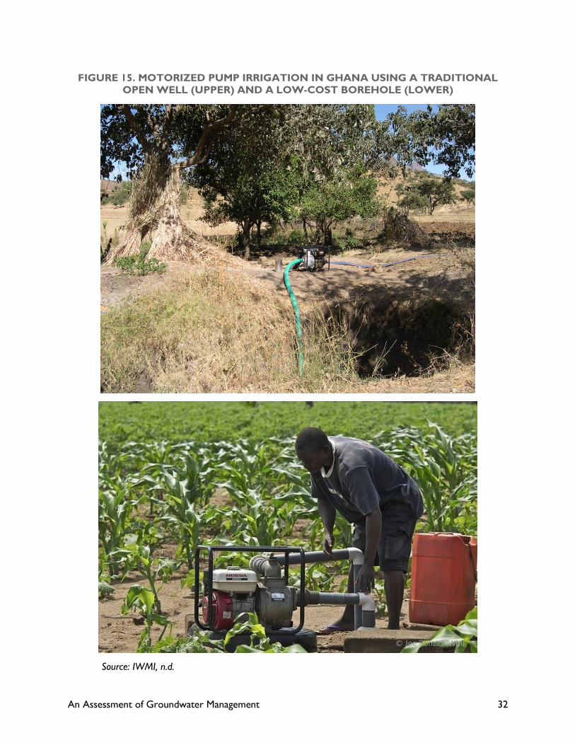
An Assessment of Groundwater Management 32
FIGURE 15. MOTORIZED PUMP IRRIGATION IN GHANA USING A TRADITIONAL
OPEN WELL (UPPER) AND A LOW-COST BOREHOLE (LOWER)
Source: IWMI, n.d.

An Assessment of Groundwater Management 33
More recently, motorized pumping has become attractive to the commercial sector and many NGOs
because of the increased availability of small (5-7 horsepower) diesel or petrol-driven motor and pump
sets (Figure 15). The portability of these motors means that they are well suited for small-scale
irrigation, particularly if there are many small plots scattered within a village.
There is also a big increase in the number of solar-powered motors being used for irrigation and
livestock. Solar pumps have very high investment costs but low operating costs. They do not normally
have the power to lift large volumes of water to the surface, but because they run for 10-12 hours per
day, they can gradually fill storage tanks for use as and when required (Figure 16).
FIGURE 16. SOLAR-POWERED SMALL-SCALE IRRIGATION, BENIN
Source: Post Carbon Institute, n.d.
The impact of extractions of comparatively large amounts of water from an aquifer may be felt over
wide areas. All water in a river basin is interconnected in one form or another. Extracting water from an
aquifer for irrigation means the aquifer is being depleted and that there will be less water somewhere
else, caused either by simple a lowering of the water table or a reduction in the rate of groundwater
replenishment of rivers and surface water bodies.
The impact of scaling up motorized groundwater pumping is much more important than that of scaling
up manually pumped groundwater, because the total volumes involved are so much larger. For example,
the hydrologic consequences of motorization of groundwater use for irrigation are completely different
than for hand pumping of water for drinking. With a good hand pump, it is not difficult to supply about
25 l/person/day, so a pump typically serving 50 families or 400 people will extract 10 m3/day. An efficient
solar-powered drip irrigation system that provides enough water for each family to cultivate 120m2 will
require upwards of 42m3/day4, increasing the total water extraction from the same water source by
more than five times.
4 These figures are not random guesses; they are based on an actual solar-powered system in Benin.

An Assessment of Groundwater Management 34
The lure of not only providing good quality drinking water but also of improving nutritional and
economic conditions provides a big incentive for promoting small-scale irrigation based on motorization,
and scant attention is paid to management of groundwater resources. One example of the somewhat
cavalier attitude toward the water management and institutional dimensions of promoting small-scale
irrigation follows (Burney et al., 2010):
Groundwater PVDI (photo-voltaic pressurized irrigation) systems must be designed based on
existing groundwater resources (either previously drilled boreholes or new ones based on
hydrogeological surveys). Beyond these very local constraints, however, national and regional
level estimates suggest that irrigation can sustainably play a much larger role in agriculture in
the Sudano–Sahel.
At present, the number of installed motor pumps for groundwater-based irrigation appears to be
comparatively small, but the number is on the verge of skyrocketing. Several reasons exist for this
incipient explosion of motorized pumping: costs of solar- and diesel-powered motors are dropping,
capital costs are often covered through subsidy programs from government or through donations from
donors and NGOs, and entrepreneurs are learning that they can recoup their initial investment and
expand their commercial interests.
The growth of motorized groundwater extraction is still in its infancy and has all of the attributes of a
nascent sub-sector. It is largely uncontrolled and unregulated. Although permits might be required, it is
all too easy to install a small-scale irrigation system using a diesel or solar pump without obtaining
permission. Groundwater is treated as a freely available resource, although some commercial
enterprises may pay modest water fees. The siting and depth of wells is unregulated.
There are many reasons for this lack of regulation and the resulting lack of sustainable management of
motorized pumping of groundwater. The reasons are primarily institutional in nature; Chapter 5
addresses institutional issues as they relate to groundwater management.
Does the threat to groundwater that motorized pumping causes mean that motorized pumping should
be discouraged? No, and it would be impossible to do so because of market forces. What is instead
required is that we rethink how we manage groundwater resources at different scales, so that resources
can be used efficiently and economically.
Pump irrigation is really effective in “conjunctive use” irrigation systems. Surface irrigation systems have
comparatively low irrigation efficiencies due to over-irrigation in upper parts of the system and
conveyance losses from the network of canals and ditches. Much of the unused water seeps into shallow
groundwater. This groundwater can be pumped back to the surface, particularly in lower portions of the
irrigation system, thereby raising system-level water use efficiency much higher.
Ultimately, the key to sustaining groundwater resources is to ensure that the rate of extraction does
not exceed the annual recharge of the aquifer. In an ideal situation, monitoring groundwater extraction
rates with parallel monitoring of water table elevation would allow groundwater to be used to its full
extent without risk of depletion. However, in an environment with weak monitoring capacity of both
volume of water pumped and water table elevation, there is a clear risk of overexploitation. This risk is
amplified if there is uncertainty over aquifer recharge rates as a result of climate change.

An Assessment of Groundwater Management 35
5.0 IWRM AND
GROUNDWATER
MANAGEMENT
The previous chapters have presented a rather bleak view of groundwater and its sustainability in West
Africa. There is limited accurate information on groundwater sources and current levels of exploitation,
and there are threats to groundwater availability from the impacts of climate change, population growth
and, perhaps most importantly, from the potential proliferation of motorized pumping. Existing
institutions are poorly equipped to meet these threats. Planning, exploitation, and use of groundwater
resources are fragmented and fail to take into account the need for a more integrated management
approach.
Moving from this rather chaotic and piecemeal groundwater approach to a more rational program of
integrated water management aimed at greater efficiency and sustainability of a critical resource may
seem impossible; however, several practical actions may help improve the current situation.
IWRM is a process rather than a set of simple prescriptive steps. The process described below provides
opportunities for establishing a more effective way of managing water resources that covers the full
gamut of technical, economic, social, and governance concerns to ensure sustainable use of both water
and land resources.
Although the process is applicable to most water management scenarios, some special cases in West
Africa require additional concern – the management of groundwater for large herds of livestock, and the
management of coastal aquifers. These two special cases are discussed at the end of this section.
5.1 THE VISION OF IWRM
There is a lot of talk about applying the principles of IWRM, but there seems to be little consensus
about what this application actually entails. USAID’s detailed description in its Water and Development
Strategy document forms the basis for the descriptions of IWRM that follow (USAID, 2013).
IWRM is a participatory, bottom-up approach that makes short-term decisions on water use based on
balancing water supply and demand. It focuses specifically on issues of governance with clearly defined
responsibilities at different levels of civil society. What is absolutely fundamental to understanding IWRM
is that it can operate effectively at the local level even if national-level activities are very weak or non-
existent; however, it cannot function at the national level if it is not working effectively at local level.
In raising awareness of IWRM among different countries, we see an inevitable focus on the national-level
activities from such entities as the Global Water Partnership (GWP). This focus is important in ensuring
that policy and other supporting measures enter into the public debate; however, there has been no
development of effective, local action programs that provide the basis for successful IWRM.
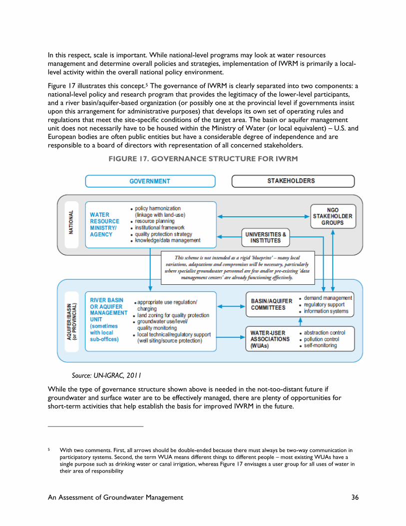
An Assessment of Groundwater Management 36
In this respect, scale is important. While national-level programs may look at water resources
management and determine overall policies and strategies, implementation of IWRM is primarily a local-
level activity within the overall national policy environment.
Figure 17 illustrates this concept.5 The governance of IWRM is clearly separated into two components: a
national-level policy and research program that provides the legitimacy of the lower-level participants,
and a river basin/aquifer-based organization (or possibly one at the provincial level if governments insist
upon this arrangement for administrative purposes) that develops its own set of operating rules and
regulations that meet the site-specific conditions of the target area. The basin or aquifer management
unit does not necessarily have to be housed within the Ministry of Water (or local equivalent) – U.S. and
European bodies are often public entities but have a considerable degree of independence and are
responsible to a board of directors with representation of all concerned stakeholders.
FIGURE 17. GOVERNANCE STRUCTURE FOR IWRM
Source: UN-IGRAC, 2011
While the type of governance structure shown above is needed in the not-too-distant future if
groundwater and surface water are to be effectively managed, there are plenty of opportunities for
short-term activities that help establish the basis for improved IWRM in the future.
5 With two comments. First, all arrows should be double-ended because there must always be two-way communication in participatory systems. Second, the term WUA means different things to different people – most existing WUAs have a
single purpose such as drinking water or canal irrigation, whereas Figure 17 envisages a user group for all uses of water in
their area of responsibility
An Assessment of Groundwater Management 37
5.2 PRACTICAL STEPS TOWARD IMPROVED GROUNDWATER
MANAGEMENT
This section presents practical steps to help develop a more sustainable approach to the management of
water resources, both surface and groundwater, as a precursor to a broader program of IWRM.
5.2.1 Appraisal of potential technical and governance interventions
The first requirement is to undertake an appraisal of whether the water resources in a project area are
suitable for additional exploitation or whether there are opportunities for sustainable management of
those water resources. The Global Environment Facility (GEF)/UN Food and Agriculture Organization
Groundwater Governance Series provides practical measures that can be adopted for given target areas.
The decision tree in Figure 18 helps guide designers of a water management project toward the types of
interventions, both technical and governance-related, required for any specific location. It is not difficult
to conceive that this framework can be superimposed upon other project activities in the same location
that may have an impact on the supply and demand of water resources. For example, a program to
provide irrigation in rural areas can use this appraisal tool to determine whether there is scope for
mechanized pumping in the area, or whether the project focus should be strictly limited to manual
pumping that will probably never exhaust the local groundwater conditions.
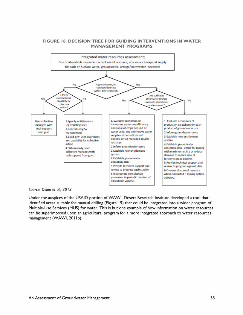
An Assessment of Groundwater Management 38
FIGURE 18. DECISION TREE FOR GUIDING INTERVENTIONS IN WATER
MANAGEMENT PROGRAMS
Source: Dillon et al., 2013
Under the auspices of the USAID portion of WAWI, Desert Research Institute developed a tool that
identified areas suitable for manual drilling (Figure 19) that could be integrated into a wider program of
Multiple-Use Services (MUS) for water. This is but one example of how information on water resources
can be superimposed upon an agricultural program for a more integrated approach to water resources
management (WAWI, 2011b).
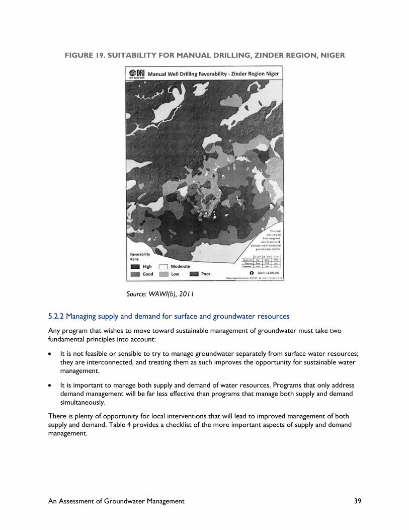
An Assessment of Groundwater Management 39
FIGURE 19. SUITABILITY FOR MANUAL DRILLING, ZINDER REGION, NIGER
Source: WAWI(b), 2011
5.2.2 Managing supply and demand for surface and groundwater resources
Any program that wishes to move toward sustainable management of groundwater must take two
fundamental principles into account:
It is not feasible or sensible to try to manage groundwater separately from surface water resources;
they are interconnected, and treating them as such improves the opportunity for sustainable water
management.
It is important to manage both supply and demand of water resources. Programs that only address
demand management will be far less effective than programs that manage both supply and demand
simultaneously.
There is plenty of opportunity for local interventions that will lead to improved management of both
supply and demand. Table 4 provides a checklist of the more important aspects of supply and demand
management.
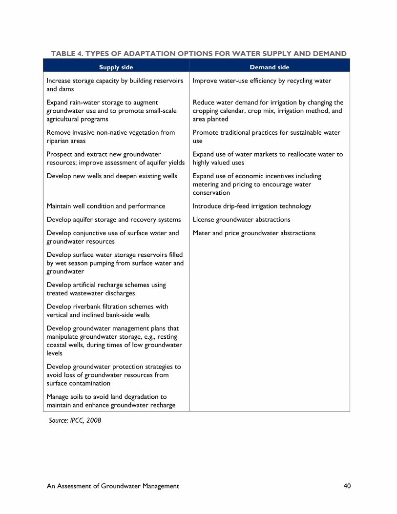
An Assessment of Groundwater Management 40
TABLE 4. TYPES OF ADAPTATION OPTIONS FOR WATER SUPPLY AND DEMAND
Supply side Demand side
Increase storage capacity by building reservoirs
and dams
Improve water-use efficiency by recycling water
Expand rain-water storage to augment
groundwater use and to promote small-scale
agricultural programs
Reduce water demand for irrigation by changing the
cropping calendar, crop mix, irrigation method, and
area planted
Remove invasive non-native vegetation from
riparian areas
Promote traditional practices for sustainable water
use
Prospect and extract new groundwater
resources; improve assessment of aquifer yields
Expand use of water markets to reallocate water to
highly valued uses
Develop new wells and deepen existing wells Expand use of economic incentives including
metering and pricing to encourage water
conservation
Maintain well condition and performance Introduce drip-feed irrigation technology
Develop aquifer storage and recovery systems License groundwater abstractions
Develop conjunctive use of surface water and
groundwater resources
Meter and price groundwater abstractions
Develop surface water storage reservoirs filled
by wet season pumping from surface water and
groundwater
Develop artificial recharge schemes using
treated wastewater discharges
Develop riverbank filtration schemes with
vertical and inclined bank-side wells
Develop groundwater management plans that
manipulate groundwater storage, e.g., resting
coastal wells, during times of low groundwater
levels
Develop groundwater protection strategies to
avoid loss of groundwater resources from
surface contamination
Manage soils to avoid land degradation to
maintain and enhance groundwater recharge
Source: IPCC, 2008
An Assessment of Groundwater Management 41
Demand-side management
Demand management for groundwater focuses on two elements: efforts to minimize the amount of
water extracted (demand reduction) and efforts to make water use as efficient as possible once it has
been pumped or lifted to the ground surface (water-use efficiency). In reality, the amount of savings or
efficiency increases that can be accomplished when water is manually lifted is very small. People
minimize pumping to meet their actual needs; thus, as long as the amount of manually pumped water
does not exceed aquifer replenishment, then there is little basis for action.
If water is extracted in quantities greater than those of recharge, then demand management becomes
important, particularly for larger-volume users with mechanical pumping capacity. Implementing a
demand management program retrospectively is difficult, particularly where people have been able to
access groundwater more or less without volumetric limits or water fees. The cost of power is the only
available instrument.
Looking at current patterns of groundwater use in West Africa, we can make a very crude distinction
between groundwater systems specifically designed for domestic drinking water supply, and those that
include additional uses of water, primarily for livestock and for irrigation.
Typical estimations of demands on water for domestic consumption alone vary from 25 l/day for hand
pumps in rural areas, 50-70 l/day for standpipe systems, and more than 100 l/day where people are
connected to some form of pipe network. The increased demand reflects greater capacity to include
health-related water uses to include better washing, laundry, and sanitation.
When livestock and irrigation are added to the estimation of demand, these figures escalate dramatically.
Actual livestock water requirements vary according to the moisture content of feedstuff, whether the
animals are pastured or grazing in forests, and the species (a typical cow may require up to 50 l/day, and
sheep and goats about 10 l/day). In locations with large herds or where transhumance is practiced, this
demand can place quite considerable stress on water resources (Schlink et al., 2010).
Irrigation further compounds the problem. Dry-land grain crops require 300 to 500 mm of water during
the growing season, increasing to closer to 1000 mm in rice-based systems. Obviously some of this
water can come from irrigation, reducing demand for irrigation water if there is timely and effective
response to rainfall events. Based on these figures, water requirements for food to meet basic human
nutrition requirements can be upwards to 1000 m3 per year. Indeed the food requirement forms the
vast bulk of estimates of 1,750 m3/year as the baseline for determining whether an area is exposed to
water stress.
Supply-side management
While most of the demand-side adaptations are well known and are incorporated into many agricultural
and water management projects, the supply side adaptations are less commonly practiced. Many of the
demand adaptations aim at inducing recharge into aquifers, using the aquifer as an underground
reservoir. Figure 20 shows some of the approaches that can be adopted to manage recharge of
groundwater in addition to natural recharge processes.

An Assessment of Groundwater Management 42
FIGURE 20. APPROACHES TO AUGMENTING RECHARGE OF GROUNDWATER
Source: UN-IGRAC, 2011
Supply-side efforts to manage recharge illustrate very clearly the integration of management of surface
and groundwater resources, as well as the linkage with land use and other anthropogenic factors. If soils
and natural vegetation are properly managed, particularly with various types of conservation agriculture,
then it is possible to not only enhance crop production and crop water productivity, but also to help
recharge groundwater for later use.
As a result, supply-side water management for both surface and groundwater forms a logical and integral
part of agricultural development and natural resource oriented programs. This side is the heart of
IWRM and should be much more widely practiced than it currently is.
It is almost inevitable that at some point a zero-sum situation will develop as water resources get
scarcer. At the river-basin level, the concept of “open” and “closed” basins effectively distinguishes
between situations in which there is sufficient water to meet all needs (with excess water leaving the
system [the “open” basin scenario]), and one in which water is insufficient to meet all needs, and
tradeoffs between uses or locations is necessary (the “closed” basin scenario).
This concept of open and closed applies at every scale. Local-level water resources can be managed with
the same overall philosophy of quantifying supply and demand and making the appropriate supply and
demand management adjustments, as is done at the scale of a major river basin.
5.3 TWO SPECIAL CASES FOR GROUNDWATER MANAGEMENT
5.3.1 The special case of water and livestock
The large livestock herds of nomadic and semi-nomadic people in West Africa require special attention
where exploitation of groundwater is concerned. Under conditions of long-term sustainability, there is
some form of overall balance between climate, vegetation, water resources, and human activity.
An Assessment of Groundwater Management 43
Anthropogenic impacts that lead to reduction in the overall carrying capacity of water and vegetation
are not sustainable, and some form of adjustment is required. This adjustment can include urban
migration, internal migration to areas with higher carrying capacities, and changes in behavior toward
more productive systems.
Shallow aquifers form part of this interlinked ecosystem – too much depletion of groundwater has quick
impacts on the production system, and adjustments have to be made.
Nomadism and transhumance are responses to seasonal variability in the productivity of different
ecosystems. Moving livestock from place to place in a regular pattern so that resources would not be
depleted beyond a critical threshold underlies the entire transhumance process. Both vegetation and
water play a role in determining the pattern and timing of movement.
Development of groundwater resources to augment water supplies in locations where water is
inadequate seems like a good idea and has certainly helped to mitigate the impact of drought in many
parts of the Sahel. However, tinkering with only one part of the ecological system may impose huge
stresses on other parts: vegetation also suffers during drought periods, and if it is inadequate herders
may move their animals to other locations to avoid both lack of water and lack of food for their animals.
If the water constraint is removed so that animals are watered adequately, the pressure on vegetation
suddenly increases dramatically. The National Research Council observed this trend and reported on
the negative impacts as early as 1983; however, some programs still aim to provide supplemental water
to nomadic groups, which ultimately is likely to have negative impacts on vegetation resources.
Using fossil groundwater only exacerbates this potential imbalance, because the existing ecosystem has
evolved without the benefit of this additional water resource. Given that the fossil groundwater
resources are largely found in the driest parts of West Africa, the potential for negative impacts on local
ecologies is very high. The very high-cost Libyan solution of pumping water hundreds of miles toward
more robust ecological areas is not a viable option for West Africa given the lack of cheap energy.
IWRM in these dry areas with high levels of transhumance, with or without use of fossil groundwater,
needs special attention to safeguard fragile ecological resources.
5.3.2 The special case of coastal aquifers
Coastal aquifers provide another special case for IWRM. Unlike normal aquifers, where the main
concerns are with managing the depth to groundwater and ensuring that the water resources of aquifers
are not depleted, coastal aquifers require managing the boundary between saline water and freshwater.
Near major urban areas, pollution from sewerage and industry may become an additional management
concern.
In coastal aquifers, freshwater sits on top of saline water within the same geological layers. Saline water
is denser and is kept at depth by the weight of the freshwater in the upper portions of the aquifer. If the
freshwater is depleted, then the saline water will move upward and inland; if it reaches into the well
extraction zone, then the water rapidly becomes unsuitable for human consumption.
Coastal aquifers are replenished by a combination of local rainfall and excess water draining toward the
coast through normal streamflow; thus, unlike many groundwater-dependent systems, coastal aquifer
management is both a local and a regional management issue. Local activities, primarily pumping without
regard to levels of sustainability of the underlying aquifer, have the potential to deplete the aquifer. But
poor upstream management of surface water resources, such as indiscriminate damming or pumping,
An Assessment of Groundwater Management 44
may greatly reduce the level of replenishment of coastal aquifers during the flood season. Indeed, one
characteristic of a closed coastal basin is that salt-water intrusion becomes probable, if not inevitable.
Many of the coastal aquifers in West Arica are already threatened by poor upstream management of
surface water resources, and there has been concern for some time about the depletion of mangrove
and fish resources. Close to major cities — notably Dakar, which heavily depends on groundwater for
domestic and industrial use — the aquifers are under even greater stress from a combination of
depletion and pollution.
Because coastal aquifers are so delicate, and because the management problems are much more
complex than in inland locations, coastal aquifer management requires an entirely different set of skills
and approaches to IWRM.

An Assessment of Groundwater Management 45
6.0 KEY QUESTIONS: WHAT
CAN BE DONE?
In determining the opportunities that exist for improving groundwater management in light of the
possible consequences of climate change, it is necessary to ask ourselves two questions:
When we consider possible changes in climatic conditions, must we develop additional management
requirements over and above what we should be doing in the regular course of events?
Can we effectively disaggregate the impacts of climate change from anthropogenic changes related
to population increase, migration, and adoption of new technologies?
The probable answer to both of these questions is “no, we can’t,” but that is no reason not to include
climate change in our response to the continued and growing need to provide more and better-quality
water to both rural and urban populations throughout West Africa.
One commonly voiced strategy for ameliorating the impacts of climate change is to increase irrigation as
part of the focus on assuring food security under increasingly uncertain and variable climatic conditions.
Irrigation — preferably small scale and locally controlled rather than less efficient large-scale, state-run
systems — has enormous potential to provide more stable and healthier food production; however, it
also requires a great deal of water. Programs that promote small-scale irrigation have the responsibility
to ensure that by adding irrigation to the demand for water, be it groundwater or surface water, they
will not threaten the overall sustainability of the water source. These programs must also ensure that
adding additional water into local ecosystems will not lead to inadvertent effects such as salinization, soil
degradation, or waterlogging.
As in the example of irrigation, with adaptive strategies, we must ensure that we provide robust and
participatory management systems for implementing groundwater development programs that include
awareness of the impacts of all external threats to the community and its natural resources. This shift
includes, but is not limited to, an awareness of and response to the impacts of climate change.
At present, conventional wisdom is that IWRM provides the best approach for coping with external
threats at the community level, with appropriate upward linkages to management, policy, and strategies
articulated at provincial and national levels.
It would be naïve to think that an effective program of IWRM with a nested and responsive governance
framework could be created in the short term. As long as there is some degree of an overall shared
vision of what IWRM should look like in the future, several different types of project activities within a
target area can be undertaken to help meet the shared vision.
Existing programs that address issues of agricultural or national resources may guide the selection of a
target area. While it is a long-term goal to manage water by basin or by aquifer, the initial likelihood is
that the target area will conform to administrative boundaries.
A practical and effective approach is to adopt a modified MUS program. Under the WAWI project in
Niger, Winrock successfully implemented a pilot MUS program involving several clusters of villages. The
An Assessment of Groundwater Management 46
results are described in detail in one of the Technical Reports that accompanied the Final Report of the
WAWI II project, submitted to USAID in February 2011. It should be noted that MUS received strong
support from the provincial government in Zinder, including the Governor himself and the head of the
provincial office of the Ministere de l’Hydraulique.
However, for an IWRM-oriented program, there must be some modification of the scope of work of
the Niger MUS activity. Most of the water management activities were demand-side oriented, so a
supply-side component would need to be added. On the other hand, less focus on hygiene behavior
change would release resources for more water-oriented activities.
6.1 IMPROVING INFORMATION ON GROUNDWATER AND ITS
EXPLOITATION
Once a target area has been identified, an invaluable first step is to begin to establish some form of
database for the water resources. Traditionally this step has been viewed as the purview of the Ministry
of Water or equivalent, but it should be a highly participatory activity. Use of rapid rural appraisal
techniques to identify water sources, water use patterns, cropping calendars, and so on using satellite-
based maps provides an ideal opportunity to involve villages directly at the outset of any effort to
establish effective IWRM.
The second step is to help establish a database of that information clearly within the public domain.
Databases that are locked away in government offices are of little value. An excellent example of a
targeted database is the Systeme d’Information pour la Gestion Integree des Ressources en Eau (SIGIRE)
database in Mali, developed with support from the German government through GTZ. More details on
the types of information included in SIGIRE are available at: http://www.aht-
group.com/index.php?id=715. Two target regions of Timbuctou and Kayes were selected as pilots to
help develop both the data collection program and the database design. The program is being extended
to other parts of Mali under a second phase of the project.
Research inputs are also valuable at this stage. The DRI map of areas suitable for manual drilling in
Zinder District, Niger, provides guidance as to where water is most likely to be found in adequate
quantities for both drinking water and agriculture.
One piece of information important for supporting both demand-side and supply-side groundwater
management is the seasonal variation in depth to water table. This information allows people to
determine early in the dry season whether the groundwater resource is under threat, and whether
there need to be restrictions in groundwater extraction to conserve water until the next rainy season.
The development of improved databases is a key element in the effectiveness of response to climate
change. Given uncertainty of climatic variables into the future — and especially that of rainfall in terms
of both total annual rainfall and the nature of individual rainfall events — a close watch of both short-
term fluctuations in water table elevation and long-term changes in aquifer storage is essential. This
watch will help warn of impending groundwater shortfalls that a result from drought and will pave the
way for mitigating measures to help conserve water during abnormal periods.
Other resource-mapping programs, primarily based on satellite interpretation that field-level
observation supports, also complement the water database.
6.2 GROUNDWATER DEMAND MANAGEMENT ACTIVITIES
Project components can be drawn from the list of groundwater demand-side interventions shown in
Table 4. The exact selection of possible interventions heavily depends on the local conditions as well as
An Assessment of Groundwater Management 47
the existing institutional framework. To the extent possible, the selection should also be as participatory
as possible.
Projects that introduce technologies into an area for the first time have a better chance of implementing
the more economic or fiscal instruments, because there will be fewer preconceptions about paying for
water or limiting amounts extracted from aquifers.
The main focus for demand-side management is irrigation and other larger consumers of water. Water
supply and even manually pumped or lifted water projects do not need economic or fiscal instruments
because they are more or less self-regulating.
A huge gap in most countries is the presence of irrigation and water management technicians who can
help implement IWRM programs. In almost every country, the split between agriculture and engineering
means that agricultural extension agents know little or nothing about water management (aside from
maybe some idea of crop water requirements); at the same time, the Ministry of Water field staff know
little or nothing about agricultural production, conservation agriculture, or natural resource
management.
IWRM is the ideal place to field people in the discipline of rural engineering, which crosses the
boundaries between hydrology and hydraulics on one side, and agriculture and land use management on
the other. A project focused on water management would do well to help establish a partnership of this
nature.
Demand management has to start at the local level and be based on a local interpretation of fairness,
particularly in the event of either short-term or long-term changes in groundwater availability in light of
climate change. If groundwater levels are dropping, particularly early in the dry season, then the
community has to devise measures that will help conserve water for use until the next rainy season.
This type of demand management cannot be imposed from outside, because it is impossible to manage
this process without the full collaboration of water users themselves. However, water resources
frequently cross administrative or customary boundaries, so there is always a need for direct
interactions between neighboring communities to ensure that one community is not negatively affecting
adjacent ones. For large aquifers, some form of regional-level monitoring may be required, accompanied
by clear guidelines of extraction rates in the constituent communities.
Over time, a well-functioning Water Management District and its constituent Village Water Resource
Management Committees6 will be better equipped to develop strategies to respond to changes in rainfall
and groundwater availability and to implement appropriate water conservation strategies.7
6.3 MANAGEMENT OF GROUNDWATER SUPPLY
At the village level, management of the supply side of groundwater aims to implant best practices that
will increase the total amount of infiltration into productive aquifers. Some of these practices are part of
the standard arsenal of natural resources management; others require more specialized inputs.
6 See section 6.4 for an explanation of this term.
7 This is the way the Water Management Districts in Florida function. They have a laid-back approach until groundwater levels reach a critical depth, when they then impose water conservation strategies to maintain water tables at levels
required to protect drinking water and agricultural water resources.
An Assessment of Groundwater Management 48
All soil conservation techniques, including terraces, tied ridges, live terraces, and windbreaks help to
slow the rate of surface runoff and to increase the volume of water infiltrating into the soil. Unless the
rainfall event is followed by a prolonged dry period, some of this additional soil moisture will pass
through the root zone and end up as groundwater.
Forest and grazing land protection and management also help rainfall to infiltrate into the soil. Bare soil
that crusts as it dries out results in high levels of surface runoff, leading to a reduction in the amount of
water available for recharge.
The AMMA CATCH results that showed that channeling runoff toward areas where infiltration is faster
will help recharge aquifers; thus, there must be community-wide agreement on how to channel flows as
well as an accompanying aquifer management plan.
A more drastic approach adopted in Burkina Faso has been the construction of thousands of small dams
to help groundwater recharge. Although the small dams were designed as surface water supplies to
provide agriculture and livestock water in the dry season, they also help recharge groundwater that can
be pumped out for irrigation.
If local recharge efforts work, then water tables will be consistently higher at the start of the dry season,
providing additional security if rainfall patterns become unfavorable. The worst-case scenario at the local
level is to fail to replenish the aquifer by the end of the wet season, because groundwater will be under
increasing stress during the ensuing dry season.
6.4 IWRM INSTITUTION-BUILDING AT THE LOCAL LEVEL
The closest USAID has come to supporting IWRM-oriented institutions is through the implementation
of MUS programs. In its very conception, MUS addresses almost all the elements of a well-managed
IWRM-based Water User Association (in the sense implied in Figure 17): documentation of and
responsibility for all sources of water in a village, for who accesses that water under what conditions, for
promoting effective use of water for drinking, hygiene, livestock, and irrigation, as well as managing the
soil and vegetation resources of the village. Although cumbersome, the title “Village Water Resources
Management Committee” best describes their function.
A good MUS program promotes both supply and demand management activities at the village level and
facilitates the creation of federations to address management issues at the sub-basin, basin, or aquifer
level. Linkages with technical agencies can be focused and strengthened here.
Government agencies’ and civil society’s widespread acceptance of the MUS program in Niger indicate
that it is a viable approach even in areas where water resources are limited. This acceptance was
accomplished without any formal water organizations being formed; however, there clearly would have
been scope for these formations if the project had not ended.
The same approach to institution-building from the bottom-up would work just as well for a modified
MUS approach, initially relying on informal linkages. At a later stage, once benefits are perceived and
there is greater confidence in being able to manage the approach, the establishment of more formal
basin-level or aquifer bodies can be considered.
Establishing strong management institutions, particularly at the local level, is a critical first step to
respond better to climate change. Local institutions can respond to local water resource variations if
they can develop a monitoring capacity and not have to rely on longer-term information from central
government. Central government may be in a position to make national or regional estimates of rainfall
and temperature variations to help in planning, but responsiveness must remain primarily a local

An Assessment of Groundwater Management 49
function. Without a dual set of efforts at both the national and local levels, countries will be less well
equipped to respond to climate change.
An Assessment of Groundwater Management 50
7.0 CONCLUSIONS
Groundwater in West Africa is one of the region’s most precious resources. Its exploitation has
supported pastoral and nomadic communities for centuries, and more recently has been the backbone
of improvements in drinking water supplies for tens of millions of people. It is logical that future
development, particularly in rural areas, will continue to maximize the value of groundwater for
domestic consumption, livestock, and agriculture. With the likelihood of changing rainfall patterns
associated with climate change, groundwater provides a critically important resource to sustain human
health and livelihoods. Many intervention programs view groundwater, and particularly groundwater for
irrigation, as a potential solution to counteract the effects of climate change.
Despite this context, the recent boom in groundwater exploitation has been poorly regulated. Village
water supplies based on groundwater have proliferated due to the concerted efforts of governments,
donors, and NGOs without effective monitoring of the impact of that proliferation on groundwater
sustainability. A triple threat of changing rainfall patterns due to climate change, continued population
growth that doubles the population every 25 years, and the increased use of motorized groundwater
pumping combine to threaten long-term sustainability of groundwater availability.
Effective management of groundwater must start at the local level, because communities have to find
ways to regulate access to groundwater; however, this regulation must cover access to all water
sources, be they groundwater, stream-flow, seasonal ponds, or small reservoirs. This coverage forms
the basis for integrated water management programs that can not only manage the demand for water
but also help to replenish aquifers through supply management. This approach predicates the creation of
Village Water Management Associations that should replace single-purpose Water User Associations
established to maintain drinking water facilities or deal with irrigation water distribution.
The concept of Multiple Use Services for water — one that looks at how all water sources can best
promote improved health, small-scale agriculture, livestock and protection of natural resources such as
grazing and forests — has been viable at the pilot scale in West Africa. The MUS concept needs to be
expanded to include the supply side of water management as well as demand management, and to
incorporate local monitoring of water table conditions to guide communities toward safe levels of water
extraction from aquifers. Such monitoring also provides indications of abnormal conditions brought
about by the impacts of climate change, increased demand of water for drinking, and expansion of small-
scale irrigation.
Central government support for IWRM at the local level should focus on policy, research, and the
regulatory framework. Managers at the local level should have readily available information. Because
IWRM is a participatory process and not a top-down approach, efforts must include the creation of
appropriate institutions at all levels of civil society.
An Assessment of Groundwater Management 51
8.0 SOURCES
Braman, L. M., van Aalst, M. K., Mason, S. J., Suarez, P., Ait-Chellouche, Y., and Tall, A. (2013). Climate
forecasts in disaster management: Red Cross flood operations in West Africa, 2008. Disasters,
37(1): 144-164.
British Geological Survey. (2011). “Download digital groundwater maps of Africa.” Retrieved from
http://www.bgs.ac.uk/research/groundwater/international/africanGroundwater/mapsDownload.ht
ml
British Geological Survey. (n.d.). “British Geological Survey.” Retrieved from http://www.bgs.ac.uk/
Burney, J., Woltering, L., Burke,M., Naylor, R., and D. Pasternak. (2010). Solar-powered drip irrigation
enhances food security in the Sudano–Sahel. Retrieved from
http://www.pnas.org/content/early/2010/01/13/0909678107.full.pdf
Carter, R.C. & Parker, A. (2009). Climate change, population trends and groundwater in Africa.
Hydrological Sciences Journal, 54(4): 676-689.
Diagana, B., (1994). Improving Water Supply Systems in Rural West and Central Africa, IDRC,
workshop held in December 1994 in Cairo, Egypt.
Döll, P. (2009). Vulnerability to the impact of climatemchange on renewable groundwaterresources: a
global-scale assessment. Environ. Res. Lett. 4 (2009) 035006 (12pp). DOI :10.1088/1748-
9326/4/3/035006
Dillon, P., Escalante, E.E., & Tuinhof A. (2013). Management of aquifer recharge and discharge processes
and aquifer storageequilibrium. GEF-FAO Groundwater Governance Thematic Paper 4: GEF,
Washington, D.C.
Friends of Niger. (n.d.). “Website of the Friends of Niger.” Retrieved from
http://www.friendsofniger.org/
GEF-FAO (2011). Trends in local groundwater management institutions. Groundwater Governance
Project: A Global Framework for Country Action, Thematic Paper 7. GEF, Washington, D.C.
Goulden, M., Conway, D., and Persechino, A., (2008). Adaptation to climate change in international river
basins in Africa: a review.
IGRAC. (2012). Special Edition for the 6th World Water Forum, Marseille, March 2012.
IMWI. (n.d.). “IWMI website.” Retrieved from www.iwmi.cgiar.org
IPCC. (2008). Climate Change 2007: impacts, adaptation and vulnerability. Summary for policy makers.
IUCN. (2004). Reducing West Africa’s Vulnerability to Climate Impacts on Water Resources, Wetland
and Desertification. Elements for Regional Strategy for Preparedness and Adaptation. Editors:
MadiodioNiasse, Adel Afouda, and AbouAmani.
Jenkins, G., Gaye, A., Kamga, A., Adedoyin, A., Garba, A., and Sarr, A. (2004). GCM simulations for
West Africa: Validation against observations and projections for future change. Presentation to

An Assessment of Groundwater Management 52
the 2nd AIACC Regional Workshop for Africa & Indian Ocean Islands, March 24-27, 2004,
Dakar, Senegal.
Kane C., Diene, M., Fall, M., Sarr, B., and Thiam, A. (2012). Reassessment of the Resources of a Deep
Aquifer System under Physical and Chemical Constraints: The Maastrichtian Aquifer. Journal of
Water Resource and Protection, 4(4): 217-223. DOI: 10.4236/jwarp.2012.44024
Lebel, Thierry, Cappelaere, Bernard, Galle, Sylvie, Hanan, Niall, Kergoat, Laurent, Levis, Samuel, et al.
(2009). AMMA-CATCH studies in the Sahelian region of West-Africa: An overview. Journal of
Hydrology, 375(1–2): 3-13. DOI: http://dx.doi.org/10.1016/j.jhydrol.2009.03.020
Lutz, A., Thomas, J.M., and Keita, M. (2011). Effects of Population Growth and Climate Variability on
Sustainable Groundwater in Mali, West Africa. Sustainability, 3: 21-34.
MacDonald A.M., Calow, R.C., Macdonald, D.M.J., Darling, W.G. & Dochartaigh, O.B.E., (2009). What
impact will climate change have on rural water supplies in Africa? Hydrological Sciences Journal, 54:
690-703.
McCartney, M., Forkuor, G., Sood, A., Amisigo, B., Hattermann, F., and Muthuwatta, L. (2012). The
waterresource implications of changing climate in the Volta River Basin. Colombo, Sri Lanka:
International Water Management Institute (IWMI). 40p. IWMI Research Report 146. DOI:
10.5337/2012.219
National Research Council, Advisory Board on the Sahel. (1983). Agroforestry in the Sahel. Washington,
D.C.
Post Carbon Institute. (n.d.). “Post Carbon Institute.” Retrieved from www.postcarbon.org
Pavelic, P., Giordano, M., Keraita, B., Ramesh, V., and Rao, T. (Eds.). (2012). Groundwater availability and
use in Sub-Saharan Africa: A review of 15 countries. Colombo, Sri Lanka: International Water
Management Institute (IWMI). 274 p. DOI: 10.5337/2012.213
Schlink, A.C., Nguyen, M-L & Viljoen, G.J. (2010) Water requirements for livestock production: a global
perspective. Rev. Sci. Tech. Off. Int. Epiz, 29(3): 603-619.
Tuinoff, A., Foster, S., van Steenbergen, F., Talbi A & Wishart, M. (2011) Appropriate Groundwater
Management Policy for Sub-Saharan Africain face of demographic pressure and climatic
variability. Sustainable Groundwater Management, Strategic Overview Series Number 5. UN-
IGRAC. World Bank: Washington, D.C. 40 pp.
UNEP. (2006). Groundwater Pollution in Africa. Edsitors: Yongxin Xu&Brent Usher, Tylor, and Francis.
UNESCO. (2009). Transboundary Aquifers: Managing a Vital Resource - The UNILC draft articles on the
law of transboundary aquifers. Saint-Denis, France.
USAID. (2013). Water and Development Strategy. USAID: Washington, D.C., 33pp.
WAWI. (2011a). Manual on Low Cost Drilling, prepared by SKAT and presented to USAID as annex to
WAWI Final Report.
WAWI. (2011b). Manual on Low Cost Surveys for suitability for Low Cost Drilling, prepared by DRI and
presented to USAID as an annex to WAWI Final Report.
WAWI. (2011c). Technical Report on Multiple Use Services for water, prepared by Winrock
International and presented to USAID as annex to WAWI Final Report.

An Assessment of Groundwater Management 53
West Africa Gateway of Club du Sahel. (2011). "West Africa Gateway.” Retrieved from
www.westafricagateway.org
WHYMAP, (C) BGR Hannover, and UNESCO Paris. (2006). “WMS Information of the BGR Hannover.”
Retrieved from http://www.bgr.de/Service/groundwater/whymap
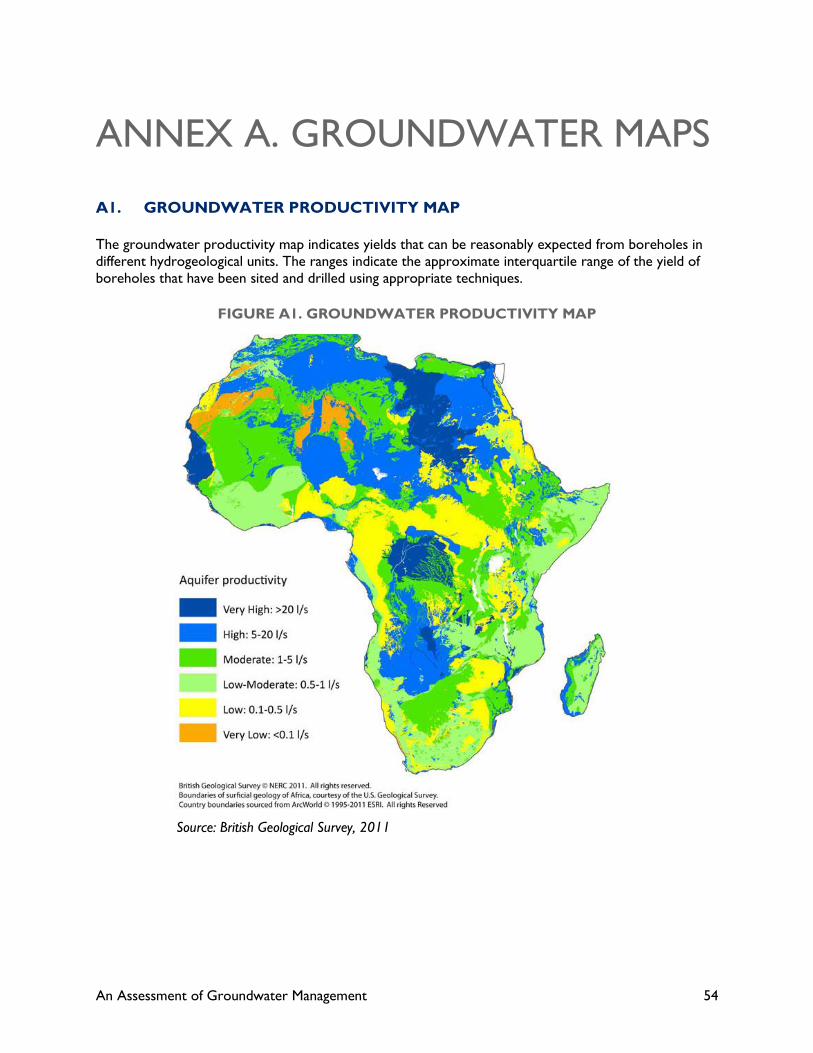
An Assessment of Groundwater Management 54
ANNEX A. GROUNDWATER MAPS
A1. GROUNDWATER PRODUCTIVITY MAP
The groundwater productivity map indicates yields that can be reasonably expected from boreholes in
different hydrogeological units. The ranges indicate the approximate interquartile range of the yield of
boreholes that have been sited and drilled using appropriate techniques.
FIGURE A1. GROUNDWATER PRODUCTIVITY MAP
Source: British Geological Survey, 2011

An Assessment of Groundwater Management 55
A2. GROUNDWATER STORAGE MAP
Groundwater storage was estimated by combining the saturated aquifer thickness and effective porosity
of aquifers across Africa. For each aquifer flow/storage type, an effective porosity range was assigned
based on a series of studies across Africa and surrogates in other parts of the world.
FIGURE A2. GROUNDWATER STORAGE MAP
Source: British Geological Survey, 2011
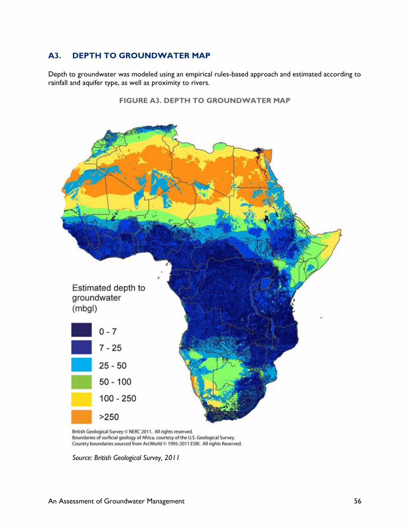
An Assessment of Groundwater Management 56
A3. DEPTH TO GROUNDWATER MAP
Depth to groundwater was modeled using an empirical rules-based approach and estimated according to
rainfall and aquifer type, as well as proximity to rivers.
FIGURE A3. DEPTH TO GROUNDWATER MAP
Source: British Geological Survey, 2011

U.S. Agency for International Development
1300 Pennsylvania Avenue, NW
Washington, DC 20523
Tel: (202) 712-0000
Fax: (202) 216-3524
www.usaid.gov