CLATSOP COUNTY LAND AND WATER … and water . development and use ordinance . ordinance 80-14 . ......
373
CLATSOP COUNTY LAND AND WATER DEVELOPMENT AND USE ORDINANCE ORDINANCE 80-14 Adopted By: Clatsop County Board of Commissioners September 30, 1980 Effective Upon Adoption This Ordinance is codified as of March 29, 2013. Developed and Maintained by: Clatsop County’s Planning Division Community Development Department 800 Exchange Street, Suite 100 Astoria OR 97103 (503) 325-8611 www.co.clatsop.or.us The Land and Water Development and Use Ordinance combines zoning, subdivision, land partitioning, use and activity standards, transportation standards into one ordinance.
Transcript of CLATSOP COUNTY LAND AND WATER … and water . development and use ordinance . ordinance 80-14 . ......

CLATSOP COUNTY
LAND AND WATER
DEVELOPMENT AND USE ORDINANCE
ORDINANCE 80-14
Adopted By:
Clatsop County Board of Commissioners September 30, 1980
Effective Upon Adoption
This Ordinance is codified as of March 29, 2013.
Developed and Maintained by: Clatsop County’s Planning Division
Community Development Department
800 Exchange Street, Suite 100 Astoria OR 97103
(503) 325-8611 www.co.clatsop.or.us
The Land and Water Development and Use Ordinance combines zoning, subdivision, land partitioning, use and activity standards, transportation standards into one ordinance.

______________________________________________________________________________ Clatsop County Land and Water i March 29, 2013 Development and Use Ordinance
CLATSOP COUNTY LAND AND WATER DEVELOPMENT AND USE ORDINANCE TABLE OF CONTENTS
ARTICLE 1. INTRODUCTORY PROVISIONS .......................................................................... 1 Section 1.010. Title. ....................................................................................................................................................... 1 Section 1.020. Purpose. ................................................................................................................................................. 1 Section 1.025. Application. ............................................................................................................................................ 1 Section 1.030. Definitions. ............................................................................................................................................. 1 Section 1.035. Rules of Construction. .......................................................................................................................... 42 Section 1.040. Scope and Compliance. ........................................................................................................................ 42 Section 1.050. Consistency with Comprehensive Plan. ............................................................................................... 42
ARTICLE 2. PROCEDURES FOR LAND USE APPLICATIONS .......................................... 43 Section 2.010. Procedure Types and Determination of Proper Procedure . ............................................................... 43 Section 2.015. Type I Procedure. ................................................................................................................................. 43 Section 2.020. Type II Procedure. ............................................................................................................................... 43 Section 2.025. Type IIa Procedure. ............................................................................................................................. 44 Section 2.030 Type III Procedure. ............................................................................................................................... 44 Section 2.035 Type IV Procedure. ............................................................................................................................... 45 Section 2.040 Legislative Enactments Not Restricted. ................................................................................................. 46 Section 2.045 Pre-application Conference. ................................................................................................................. 46 Section 2.050. Development Permit Required. ............................................................................................................ 46 Section 2.051 Effective Date of Development Permits. ............................................................................................... 47 Section 2.052 Exclusions from Development Permit Requirement. ............................................................................. 47 Section 2.055 Use of a Development. .......................................................................................................................... 48 Section 2.060 Procedures for Processing Development Permits................................................................................. 48 Section 2.065 Coordination of Development Permit Procedure. ................................................................................ 48 Section 2.070 Development Permit Application. ......................................................................................................... 48 Section 2.075 Submission of Development Permit Application. .................................................................................. 49 Section 2.080 Referral and Review of the Development Permit Applications. ............................................................ 49 Section 2.085 Development Permit Decision............................................................................................................... 49 Section 2.090 Action on Resubmission of Denied Application. ................................................................................... 50 Section 2.095 Remand. ................................................................................................................................................ 51 Section 2.100 Public Deliberations and Hearings ..................................................................................................... 52 Section 2.105 Responsibility of Director for Hearings. ............................................................................................... 52 Section 2.110 Mailed Notice of a Public Hearing. ...................................................................................................... 52 Section 2.115 Mailed Notice for a Type II procedure.................................................................................................. 53 Section 2.120 Procedure for Mailed Notice. ............................................................................................................... 54 Section 2.125 Procedure for Published Notice. ........................................................................................................... 54 Section 2.130 Challenges to Impartiality. ................................................................................................................... 54 Section 2.140 Disqualification. .................................................................................................................................... 54 Section 2.150 Participation by Interested Officers or Employees. .............................................................................. 54 Section 2.160 Ex-Parte Contacts. ................................................................................................................................ 55 Section 2.165 Staff Contacts. ....................................................................................................................................... 55 Section 2.170 Abstention or Disqualification. ............................................................................................................. 55 Section 2.175 Rights of Disqualified Member of the Hearing Body. ........................................................................... 55 Section 2.180 Burden and Nature of Proof. ................................................................................................................. 56 Section 2.185 Quasi-Judicial Hearing Procedure. ...................................................................................................... 56 Section 2.190 Decision. ............................................................................................................................................... 57 Section 2.195 Findings and Order. .............................................................................................................................. 58 Section 2.220 Record of Proceedings. ......................................................................................................................... 58 Section 2.230 Request for Review / Appeal. ................................................................................................................ 58

______________________________________________________________________________ Clatsop County Land and Water ii March 29, 2013 Development and Use Ordinance
Section 2.240 Requirements of Notice of Appeal. ........................................................................................................ 59 Section 2.245 Review. .................................................................................................................................................. 59 Section 2.250 Review on the Record. ........................................................................................................................... 59 Section 2.255 Review Consisting of Additional Evidence or De Novo Review. ........................................................... 59 Section 2.260 Review Body Decision. .......................................................................................................................... 60 Section 2.300 Legislation. ........................................................................................................................................... 61 Section 2.310 Legislative Action Under This Ordinance. ............................................................................................ 61 Section 2.315 Legislative Hearing Notice. .................................................................................................................. 61 Section 2.320 Arguments on Policy. ............................................................................................................................ 61 Section 2.325 Information at Planning Commission Hearing. .................................................................................... 61 Section 2.330 Planning Commission Recommendation. .............................................................................................. 61 Section 2.335 Board of Commissioners Legislative Action. ........................................................................................ 62
ARTICLE 3. ZONES AND SPECIAL PURPOSE DISTRICTS ............................................... 63 Section 3.010. Establishment of Zones. ....................................................................................................................... 63 Section 3.030. Special Purpose Districts. .................................................................................................................... 65 Section 3.032. Interpretation of Zone Boundaries. ...................................................................................................... 66 Section 3.035. Review of Land Transportation Facilities for Compliance with Land Use Regulations. ..................... 66 Section 3.040. District Boundary Changes. ................................................................................................................. 67 Section 3.052. Zone Changes. ...................................................................................................................................... 67 Section 3.054. Effective Date of District and Zone Changes. ...................................................................................... 67 Section 3.056. Updating the Land and Water Development Map................................................................................ 67 Section 3.060. Arch Cape Rural Community Residential Zone (AC- RCR). ............................................................ 68 Section 3.062. Purpose and Intent. .............................................................................................................................. 68 Section 3.064. Development and Use Permitted. ......................................................................................................... 68 Section 3.068. Development and Use Standards. ........................................................................................................ 69 Section 3.072. Miles Crossing, Jeffers Gardens and Westport Rural Community Residential Zone (RCR) ........... 73 Section 3.074. Purpose and Intent. .............................................................................................................................. 73 Section 3.076. Development and Use Permitted (RCR). .............................................................................................. 73 Section 3.078. Conditional Development and Use. ..................................................................................................... 74 Section 3.080. Development and Use Standards. ........................................................................................................ 75 Section 3.082. Additional Development and Use Standards: ...................................................................................... 76 Section 3.084. State and Federal Permits .................................................................................................................... 76 Section 3.086. Knappa and Svensen Rural Community Residential Zone (KS-RCR). ............................................ 77 Section 3.088. Purpose and Intent. .............................................................................................................................. 77 Section 3.090. Development and Use Permitted (KS-RCR). ........................................................................................ 77 Section 3.092 Conditional Development and Use. ...................................................................................................... 78 Section 3.094. Development and Use Permitted. ......................................................................................................... 79 Section 3.096. Development and Use Standards. ........................................................................................................ 79 Section 3.098. Additional Development and Use Standards: ...................................................................................... 80 Section 3.099. State and Federal Permits .................................................................................................................... 80 Section 3.100. RSA-Single Family Residential Zone (RSA-SFR). ........................................................................... 81 Section 3.102. Purpose. ............................................................................................................................................... 81 Section 3.104. Development and Use Permitted (RSA-SFR). ...................................................................................... 81 Section 3.106. Conditional Development and Use. ..................................................................................................... 81 Section 3.108. Development and Use Standards. ........................................................................................................ 82 Section 3.112. State and Federal Permits. ................................................................................................................... 83 Section 3.114 rural community multi-family residential zone (RC-MFR) ............................................................... 84 Section 3.115. Purpose. ............................................................................................................................................... 84 Section 3.116. Development and Use Permitted (RC-MFR)........................................................................................ 84 Section 3.117. Conditional Development and Use. ..................................................................................................... 85 Section 3.118. Development and Use Standards. ........................................................................................................ 85 Section 3.119. State and Federal Permits. ................................................................................................................... 87 Section 3.120. RSA Multi-Family Residential Zone (RSA-MFR). ............................................................................ 88 Section 3.122. Purpose. ............................................................................................................................................... 88

______________________________________________________________________________ Clatsop County Land and Water iii March 29, 2013 Development and Use Ordinance
Section 3.124. Development and Use Permitted (RSA-MFR). ..................................................................................... 88 Section 3.126. Conditional Development and Use. ..................................................................................................... 88 Section 3.128. Development and Use Standards. ........................................................................................................ 89 Section 3.130. State and Federal Permits. ................................................................................................................... 90 Section 3.140. Coastal Residential ZONE (CR)......................................................................................................... 91 Section 3.142. Purpose. ............................................................................................................................................... 91 Section 3.144. Development and Use Permitted (CR). ................................................................................................ 91 Section 3.146. Conditional Development and Use. ..................................................................................................... 91 Section 3.148. Conditional Development and Use Criteria. ........................................................................................ 92 Section 3.150. Development and Use Standards. ........................................................................................................ 92 Section 3.152. State and Federal Permits. ................................................................................................................... 94 Section 3.160. Single Family Residential-1 Zone (SFR-1). ...................................................................................... 95 Section 3.162. Purpose. ............................................................................................................................................... 95 Section 3.164. Development and Use Permitted (SFR-1). ........................................................................................... 95 Section 3.166. Conditional Development and Use. ..................................................................................................... 95 Section 3.168. Development and Use Standards. ........................................................................................................ 96 Section 3.170. Additional Development and Use Standards in the Clatsop Plains Planning Area. ............................ 97 Section 3.172. State and Federal Permits. ................................................................................................................... 97 Section 3.180. Residential-Agriculture-1 ZONE (RA-1). .......................................................................................... 98 Section 3.182. Purpose. ............................................................................................................................................... 98 Section 3.184. Development and Use Permitted (RA-1). ............................................................................................. 98 Section 3.190. Conditional Development and Use. ..................................................................................................... 99 Section 3.194. Development and Conditional Development and Use Standards. ....................................................... 99 Section 3.196. Additional Development and Use Standards in the Clatsop Plains Planning Area. .......................... 101 Section 3.198. State and Federal Permit. .................................................................................................................. 101 Section 3.200. Residential-Agriculture-2 Zone (RA-2). .......................................................................................... 102 Section 3.202. Purpose. ............................................................................................................................................. 102 Section 3.204. Development and Use Permitted (RA-2). ........................................................................................... 102 Section 3.207. Conditional Development and Use. ................................................................................................... 103 Section 3.208. Development and Conditional Development and Use Standards. ..................................................... 103 Section 3.209. Additional Development and Use Standards in the Clatsop Plains Planning Area ........................... 104 Section 3.212. State and Federal Permit. .................................................................................................................. 105 Section 3.220. Residential-Agriculture-5 Zone (RA-5). .......................................................................................... 106 Section 3.222. Purpose. ............................................................................................................................................. 106 Section 3.224. Development and Use Permitted (RA-5). ........................................................................................... 106 Section 3.226. Additional Development and Use Permitted in the Clatsop Plains Planning Area. .......................... 107 Section 3.227. Conditional Development and Use. ................................................................................................... 107 Section 3.228. Development and Conditional Development and Use Standards. ..................................................... 107 Section 3.230. Additional Development and Use Standards in the Seaside Rural Planning Area. ........................... 109 Section 3.232. State and Federal Permits. ................................................................................................................. 109 SECTION 3.230. RESIDENTIAL-AGRICULTURE-10 ZONE (RA-10). ............................................................................. 110 Section 3.231. Purpose. ............................................................................................................................................. 110 Section 3.232. Development and Use Permitted. ....................................................................................................... 110 Section 3.233. Additional Development and Use Permitted in the Clatsop Plains Planning Area. .......................... 111 Section 3.234. Conditional Development and Use. ................................................................................................... 111 Section 3.235. Development and Conditional Development and Use Standards. ..................................................... 111 Section 3.236. Additional Development and Use Standards in the Clatsop Plains Planning Area. .......................... 112 Section 3.237. State and Federal Permits. ................................................................................................................. 113 Section 3.240. Coastal Beach Residential ZONE (CBR). ........................................................................................ 114 Section 3.242. Purpose. ............................................................................................................................................. 114 Section 3.244. Development and Use Permitted. ....................................................................................................... 114 Section 3.246. Conditional Development and Use. ................................................................................................... 114 Section 3.248. Development and Use Standards. ...................................................................................................... 115 Section 3.250. State and Federal Permits. ................................................................................................................. 116 Section 3.252. Rural Community Commercial Zone (RCC). .................................................................................. 117

______________________________________________________________________________ Clatsop County Land and Water iv March 29, 2013 Development and Use Ordinance
Section 3.254. Purpose and Intent. ............................................................................................................................ 117 Section 3.256. Development and Use Permitted. ....................................................................................................... 117 Section 3.258. Commercial Conditional Development and Use. ............................................................................... 117 Section 3.260. Conditional Development and Use. ................................................................................................... 118 Section 3.262. Development and Use Standards. ...................................................................................................... 119 Section 3.264 State and Federal Permits ................................................................................................................... 121 Section 3.268. Purpose and Intent (RCC-LI). ............................................................................................................ 122 Section 3.300. Neighborhood Commercial Zone (NC). ........................................................................................... 128 Section 3.302. Purpose. ............................................................................................................................................. 128 Section 3.304. Development and Use Permitted. ....................................................................................................... 128 Section 3.306. Conditional Development and Use. ................................................................................................... 128 Section 3.310. Conditional Development and Use Criteria. ...................................................................................... 129 Section 3.312. Development and Conditional Development and Use Standards. ..................................................... 129 Section 3.314. State and Federal Permits. ................................................................................................................. 130 Section 3.320. Tourist Commercial Zone (TC). ....................................................................................................... 131 Section 3.322. Purpose. ............................................................................................................................................. 131 Section 3.324. Application. ........................................................................................................................................ 131 Section 3.326. Development and Use Permitted. ....................................................................................................... 131 Section 3.328. Conditional Development and Use. ................................................................................................... 131 Section 3.330. Conditional Development and Use Criteria (TC). ............................................................................. 132 Section 3.332. Development and Conditional Development and Use Standards. ..................................................... 133 Section 3.334. State and Federal Permits. ................................................................................................................. 134 Section 3.340. General Commercial Zone (GC). ..................................................................................................... 135 Section 3.342. Purpose. ............................................................................................................................................. 135 Section 3.344. Application. ........................................................................................................................................ 135 Section 3.346. Development and Use Permitted. ....................................................................................................... 135 Section 3.348. Conditional Development and Use. ................................................................................................... 135 Section 3.350. Conditional Development and Use Criteria. ...................................................................................... 137 Section 3.352. Development and Conditional Development and Use Standards (GC). ............................................ 137 Section 3.354. State and Federal Permits. ................................................................................................................. 138 Section 3.400. Heavy Industrial Zone (HI). ............................................................................................................. 139 Section 3.402. Purpose. ............................................................................................................................................. 139 Section 3.404. Development and Use Permitted. ....................................................................................................... 139 Section 3.405. Conditional Development and Use. ................................................................................................... 139 Section 3.406. Development and Use Standards (HI). .............................................................................................. 140 Section 3.408. State and Federal Permits. ................................................................................................................. 142 Section 3.440. Light Industrial Zone (LI) ................................................................................................................ 143 Section 3.442. Purpose. ............................................................................................................................................. 143 Section 3.444. Development and Use Permitted. ....................................................................................................... 143 Section 3.446. Conditional Development and Use. ................................................................................................... 143 Section 3.448. Development and Use Standards. ...................................................................................................... 144 Section 3.449. State and Federal Permits. ................................................................................................................. 146 Section 3.450. Rural Community Light Industrial Zone (RCI). ............................................................................. 147 Section 3. 452. Purpose and Intent. ........................................................................................................................... 147 Section 3. 454. Development and Use Permitted. ...................................................................................................... 147 Section 3. 456. Development and Use Permitted. ...................................................................................................... 147 Section 3. 458. Conditional Development and Use. .................................................................................................. 148 Section 3. 459 Development and Use Standards. ...................................................................................................... 148 Section 3.459(a) State and Federal Permits .............................................................................................................. 150 Section 3.460. Quarry and Mining Zone (QM). ...................................................................................................... 151 Section 3.462. Purpose. ............................................................................................................................................. 151 Section 3.464. Application. ........................................................................................................................................ 151 Section 3.466. Development and Use Permitted. ....................................................................................................... 151 Section 3.468. Conditional Developments and Uses. ................................................................................................ 151 Section 3.470. Development and Use Standards. ...................................................................................................... 151

______________________________________________________________________________ Clatsop County Land and Water v March 29, 2013 Development and Use Ordinance
Section 3.472. State and Federal Permits. .............................................................................................................. 152 Urban Growth Boundary Zone (UGB). ................................................................................................................... 153 Section 3.482. Purpose. ............................................................................................................................................. 153 Section 3.484. Land and Water Development Map. .................................................................................................. 153 Section 3.488. Permitted Development and Use, Conditional Development and Use, and Development and Use
Standards. ..................................................................................................................................... 153 Section 3.490. State and Federal Permits. ................................................................................................................. 153 Section 3.510. Agriculture-Forestry Zone (AF). ...................................................................................................... 154 Section 3.512. Purpose. ............................................................................................................................................. 154 Section 3.513. State Forestry- Regulated Uses. ......................................................................................................... 154 Section 3.514. Development and Use Permitted. ....................................................................................................... 154 Section 3.518. Conditional Development and Use. ................................................................................................... 157 Section 3.519. Conditional Development and Use. ................................................................................................... 158 Section 3.522. Development and Use Standards. ...................................................................................................... 160 Section 3.524. State and Federal Permit. .................................................................................................................. 161 Section 3.550. Forest-80 Zone (F-80). ..................................................................................................................... 162 Section 3.551. Purpose. ............................................................................................................................................. 162 Section 3.552. State Forestry-Regulated Uses. .......................................................................................................... 162 Section 3.553. Development and Use Permitted. ....................................................................................................... 162 Section 3.554. Conditional Development and Use. ................................................................................................... 163 Section 3.555. Conditional Development and Use. ................................................................................................... 164 Section 3.557. Development and Use Standards. ...................................................................................................... 166 Section 3.558. State and Federal Permits. ................................................................................................................. 167 Section 3.560. Exclusive Farm Use Zone (EFU). ................................................................................................... 168 Section 3.562. Purpose. ............................................................................................................................................. 168 Section 3.563. State Forestry-Related Uses. .............................................................................................................. 168 Section 3.564. Development and Use Permitted. ....................................................................................................... 168 Section 3.566. Conditional Development and Use. ................................................................................................... 169 Section 3.567. Conditional Development and Use. ................................................................................................... 170 Section 3.572. Development and Conditional Development and Use Standards. ..................................................... 171 Section 3.574. Prohibited Uses. ................................................................................................................................. 175 Section 3.576. State and Federal Permits. ................................................................................................................. 175 Section 3.580. Open Space, Parks, and Recreation Zone (OPR). ........................................................................... 176 Section 3.582. Purpose. ............................................................................................................................................. 176 Section 3.584. Development and Use Permitted. ....................................................................................................... 176 Section 3.586. Conditional Development and Use. ................................................................................................... 176 Section 3.588. Conditional Development and Use Criteria. ...................................................................................... 177 Section 3.590. Development and Use Standards. ...................................................................................................... 177 Section 3.592. State and Federal Permits. ................................................................................................................. 177 Section 3.594. Recreation Management Zone (RM). .............................................................................................. 178 Section 3.595. Purpose. ............................................................................................................................................. 178 Section 3.596. Development and Use Permitted. ....................................................................................................... 178 Section 3.597. Conditional Development and Use Permitted. ................................................................................... 178 Section 3.598. Development and Conditional Development and Use Standards. ..................................................... 178 Section 3.599 State and Federal Permits. .................................................................................................................. 179 Section 3.602. Purpose. ............................................................................................................................................. 180 Section 3.604. Development and Use Permitted. ....................................................................................................... 180 Section 3.606. Conditional Development and Use. ................................................................................................... 180 Section 3.608. State and Federal Permits. ................................................................................................................. 180 Section 3.610. Lake and Wetlands Zone (LW). ........................................................................................................ 181 Section 3.611. Purpose. ............................................................................................................................................. 181 Section 3.612. Zone Boundaries. ............................................................................................................................... 181 Section 3.613. Development and Use Permitted. ....................................................................................................... 181 Section 3.614. Conditional Development and Use Permitted. ................................................................................... 182 Section 3.615. Additional Conditional Uses and Activities Permitted in Goal 5 Wetlands. ...................................... 182

______________________________________________________________________________ Clatsop County Land and Water vi March 29, 2013 Development and Use Ordinance
Section 3.616. Development and Conditional Development and Use Standards. ..................................................... 182 Section 3.617. State and Federal Permits. ................................................................................................................. 183 Section 3.620. Marine Industrial Shorelands Zone (MI). ....................................................................................... 184 Section 3.622. Purpose and Areas Included. ............................................................................................................. 184 Section 3.624. Permitted Developments. ................................................................................................................... 184 Section 3.626. Review Developments. ....................................................................................................................... 185 Section 3.628. Conditional Developments. ................................................................................................................ 185 Section 3.634. Development Standards. .................................................................................................................... 186 Section 3.636. State and Federal Permits. ................................................................................................................. 188 Section 3.660. Conservation Shorelands Zone (CS). ............................................................................................... 189 Section 3.662. Purpose and Areas Included. ............................................................................................................. 189 Section 3.664. Permitted Developments. ................................................................................................................... 189 Section 3.666. Review Developments. ....................................................................................................................... 189 Section 3.668. Conditional Developments. ................................................................................................................ 190 Section 3.670. Development Standards. .................................................................................................................... 190 Section 3.674. State and Federal Permits. ................................................................................................................. 190 Section 3.680. Natural Shorelands Zone (NS)......................................................................................................... 191 Section 3.682. Purpose and Areas Included. ............................................................................................................. 191 Section 3.684. Permitted Developments. ................................................................................................................... 191 Section 3.686. Review Developments. ....................................................................................................................... 191 Section 3.688. Conditional Developments. ................................................................................................................ 191 Section 3.690. Development Standards. .................................................................................................................... 192 Section 3.694. State and Federal Permits. ................................................................................................................. 192 Section 3.700. Ecola Aquatic Conservation Zone (EAC). ....................................................................................... 193 Section 3.702. Purpose. ............................................................................................................................................. 193 Section 3.704. Permitted Developments. ................................................................................................................... 193 Section 3.706. Conditional Developments. ................................................................................................................ 193 Section 3.708. Conditional Developments Subject to Use and Resource Capability. ................................................ 194 Section 3.710. Additional Development Standards and Procedural Requirements. .................................................. 194 Section 3.711 State and Federal Permits. .................................................................................................................. 194 Section 3.740. Aquatic Development Zone (AD). .................................................................................................... 195 Section 3.742. Purpose and Areas Included. ............................................................................................................. 195 Section 3.744. Permitted Developments. ................................................................................................................... 195 Section 3.746. Review Developments. ....................................................................................................................... 196 Section 3.748. Conditional Developments. ................................................................................................................ 197 Section 3.754. Development Standards. .................................................................................................................... 198 Section 3.756. State and Federal Permits. ................................................................................................................. 198 Section 3.760. Aquatic Conservation One Zone (AC-1). ......................................................................................... 199 Section 3.762. Purpose and Areas Included. ............................................................................................................. 199 Section 3.764. Permitted Developments. ................................................................................................................... 199 Section 3.766. Review Developments. ....................................................................................................................... 199 Section 3.768. Conditional Developments. ................................................................................................................ 200 Section 3.770. Development Standards. .................................................................................................................... 201 Section 3.772. State and Federal Permits. ................................................................................................................. 201 If any state or federal permit is required for a development or use, an applicant, prior to issuance of a
development permit or action, shall submit to the Planning Department a copy of the state or federal permit. .............................................................................................................................. 201
Section 3.780. Aquatic Conservation Two Zone (AC-2). ......................................................................................... 202 Section 3.782. Purpose and Areas Included. ............................................................................................................. 202 Section 3.784. Permitted Developments. ................................................................................................................... 202 Section 3.786. Review Developments. ....................................................................................................................... 203 Section 3.788. Conditional Developments. ................................................................................................................ 204 Section 3.790. Development Standards. .................................................................................................................... 204 Section 3.792. State and Federal Permits. ................................................................................................................. 205 SECtion 3.800. Aquatic Natural Zone (AN). ........................................................................................................... 206

______________________________________________________________________________ Clatsop County Land and Water vii March 29, 2013 Development and Use Ordinance
Section 3.802. Purpose and Areas Includes............................................................................................................... 206 Section 3.804. Permitted Developments. ................................................................................................................... 206 Section 3.806. Review Developments. ....................................................................................................................... 206 Section 3.808. Conditional Developments. ................................................................................................................ 207 Section 3.810. Development Standards. .................................................................................................................... 207 Section 3.812. State and Federal Permits. ................................................................................................................. 208 Section 3.820. Necanicum Estuary Aquatic Conservation Zone (NAC-2). ............................................................ 209 Section 3.822. Purpose. ............................................................................................................................................. 209 Section 3.824. Development and Use Permitted. ....................................................................................................... 209 Section 3.826. Conditional Development and Use. ................................................................................................... 209 Section 3.828. Development and Use Standards. ...................................................................................................... 210 Section 3.829. State and Federal Permits. ................................................................................................................. 217 Section 3.845. Military Reserve Zone (MR). ............................................................................................................ 218 Section 3.847. Purpose. ............................................................................................................................................. 218 Section 3.849. Development and Use Permitted. ....................................................................................................... 218 Section 3.851. Conditional Development and Use. ................................................................................................... 218 Section 3.853. Additional Conditional Development and Use. .................................................................................. 218 Section 3.855. Development and Conditional Development and Use Standards. ..................................................... 219 Section 3.857. Additional Development and Use Standards...................................................................................... 219 Section 3.859. State and Federal Permit. .................................................................................................................. 219 Section 3.900. Park Master Plan Zone (PMP). ....................................................................................................... 220 Section 3.910. Purpose. ............................................................................................................................................. 220 Section 3.911. Applicability. ...................................................................................................................................... 220 Section 3.912. Park Development and Uses Allowed. ............................................................................................... 220 Section 3.913. Park Master Plan. .............................................................................................................................. 222 Section 3.914. State and Federal Permits. ................................................................................................................. 222 Section 3.915. Standards for Reviewing Proposed Variations from Park Master Plans. .......................................... 222 Section 3.916. Standards for Review Proposed Location Changes and Expansions of Existing Park Uses and
Facilities. ...................................................................................................................................... 223 section 3.920 Airport Overlay ZONE (AO) .............................................................................................................. 225 Section 3.921. Purpose. ............................................................................................................................................. 225 Section 3.923. Special Definitions. ............................................................................................................................ 225 Section 3.924 Permitted Uses Within the Runway Approach Zone (RAZ)................................................................. 227 Section 3.925 Conditional Uses Within the Airport Approach Safety Zone. ............................................................. 227 Section 3.926 Procedures. ......................................................................................................................................... 228 Section 3.927 Limitations. ......................................................................................................................................... 228 Section 3.928 State and Federal Permits. .................................................................................................................. 229
ARTICLE 4. SPECIAL DISTRICTS ........................................................................................ 230 Section 4.000. Flood Hazard Overlay District (/FHO) ............................................................................................ 230 Section 4.010. Purpose .............................................................................................................................................. 230 Section 4.011. Definitions .......................................................................................................................................... 230 Section 4.015 Interpretation ..................................................................................................................................... 234 Section 4.016 Floodplain Administrator Duties and Responsibilities ..................................................................... 234 Section 4.017 Alteration of Water Courses .............................................................................................................. 236 Section 4.018 Non-Conversion of Enclosed areas below the Lowest Floor ........................................................... 236 Section 4.019 Floodplain Inspection and Enforcement .......................................................................................... 236 (1) The Administrator or designee shall make periodic inspections of floodplain areas to establish
that development activities within the floodplain are being performed in compliance with an
approved floodplain development permit. The Administrator or designee shall prepare a field
report listing non-complying conditions to be delivered to the Code Compliance Officer within 5
business days. ................................................................................................................................ 236 Section 4.020 Warning and Disclaimer of Liability ................................................................................................ 237 Section 4.021 Appeals ............................................................................................................................................... 237 Section 4.022 Permit Procedures ............................................................................................................................. 237

______________________________________________________________________________ Clatsop County Land and Water viii March 29, 2013 Development and Use Ordinance
Section 4.023 Substantial Damage and Substantial Improvement Determination ................................................ 238 Section 4.024 Variances ........................................................................................................................................... 239 Section 4.025 Development Standards ..................................................................................................................... 241 Section 4.026 Development in Floodways ................................................................................................................ 246 Section 4.028 Zones Without Base Flood Elevations .............................................................................................. 247 Section 4.029 Coastal High Hazard Area ................................................................................................................ 248 Section 4.030 Non-Coastal High Hazard Areas ...................................................................................................... 248 Section 4.031 Specific Standards for Areas of Shallow Flooding (AO and AH Zone) .......................................... 249 Section 4.032 Requirement to Submit New Technical Data ................................................................................... 249 Section 4.040 Geologic Hazards Overlay DISTRICT (/GHO) ................................................................................ 250 Section 4.041 Purpose ............................................................................................................................................... 250 Section 4.042 Applicability ........................................................................................................................................ 250 Section 4.043 Geologic Hazard Permit Requirements. ............................................................................................. 250 Section 4.044 Geotechnical Report Requirements ..................................................................................................... 251 Section 4.045 Geologic Hazard Permit Review. ........................................................................................................ 252 Section 4.046 Independent Review ............................................................................................................................ 253 Section 4.047 Standards ............................................................................................................................................ 253 Section 4.050. Beach and Dune Overlay District (/BDO). ...................................................................................... 255 Section 4.051. Purpose. ............................................................................................................................................. 255 Section 4.052. Applicability. ...................................................................................................................................... 255 Section 4.053. Relationship to the Underlying Zone. ................................................................................................ 255 Section 4.054 State Parks and Recreation Department Regulated Uses. .................................................................. 255 Section 4.055. Permitted Development and Uses. ..................................................................................................... 255 Section 4.056 Development and Uses Permitted with Review. .................................................................................. 257 Section 4.057. Conditional Development and Use. ................................................................................................... 258 Section 4.058 Prohibited Activities. ........................................................................................................................... 259 Section 4.059. General Development and Use Criteria............................................................................................. 259 Section 4.080. Shoreland Overlay District (/SO). .................................................................................................... 261 Section 4.082. Purpose. ............................................................................................................................................. 261 Section 4.084. Designation of Shoreland Overlay District. ....................................................................................... 261 Section 4.086. Categories of Coastal Shorelands. ..................................................................................................... 261 Section 4.088. Developments Permitted with Category 1 Coastal Shorelands. ........................................................ 262 Section 4.090. Developments Permitted within Category 2 Coastal Shorelands. ..................................................... 262 Section 4.092. Development Standards. .................................................................................................................... 262 Section 4.095. State and Federal Permits. ................................................................................................................. 263 Section 4.100. ARCH CAPE RURAL COMMUNITY OVERLAY DISTRICT (/RCO). ............................................... 264 Section 4.101. Purpose. ............................................................................................................................................. 264 Section 4.102. Types of Review. ................................................................................................................................. 264 Section 4.103. Criteria for Design Review Evaluation. ............................................................................................. 265 Section 4.108. Design Review Advisory Committee. ................................................................................................. 267 Section 4.132. Aquifer Reserve Overlay District (/ARO). ........................................................................................ 277 Section 4.133. Purpose. ............................................................................................................................................. 277 Section 4.134. Development and Uses Permitted. ..................................................................................................... 277 Section 4.135. Conditional Development and Use. ................................................................................................... 277 Section 4.136. Prohibited Development and Use. ..................................................................................................... 277 Section 4.137. Determination by the Community Development Director. ................................................................. 277 Section 4.140. Planned Development Overlay District (/PDO). .............................................................................. 278 Section 4.141. Purpose. ............................................................................................................................................. 278 Section 4.142. Applicability. ...................................................................................................................................... 279 Section 4.143. Approval Criteria. .............................................................................................................................. 279 Section 4.144. General Development and Use Standards and Requirements. .......................................................... 279 Section 4.145. Development and Use Standards. ...................................................................................................... 281 Section 4.146. Application Procedures. ..................................................................................................................... 282 Section 4.147. Limitation on Resubmission. .............................................................................................................. 285 Section 4.148. Adherence to Approved Plan and Modification Thereof. ................................................................... 285

______________________________________________________________________________ Clatsop County Land and Water ix March 29, 2013 Development and Use Ordinance
Section 4.149. Violation of Conditions. ..................................................................................................................... 285 Section 4.150. Common Open Space. ........................................................................................................................ 285 Section 4.160. Dredged Material Disposal Site Reservation Overlay District (/DMD). ......................................... 286 Section 4.162. Purpose. ............................................................................................................................................. 286 Section 4.164. District Boundaries. ........................................................................................................................... 286 Section 4.166. Dredged Material Disposal Sites. ..................................................................................................... 286 Section 4.168. Uses Allowed in Dredged Material Disposal Sites. ........................................................................... 286 Section 4.172. Preemptive Uses. ................................................................................................................................ 287 Section 4.180. Mitigation Site Overlay District (/MIT). .......................................................................................... 288 Section 4.182. Purpose. ............................................................................................................................................. 288 Section 4.184. Designation of Mitigation Sites. ......................................................................................................... 288 Section 4.186. Developments Allowed in Mitigation Sites. ........................................................................................ 288 Section 4.188. Removal of the Mitigation Site Overlay District. ............................................................................... 289 Section 4.189. Preemptive Uses. ................................................................................................................................ 291 Section 4.200. Sensitive Bird Habitat Overlay District (/SBHO). ........................................................................... 292 Section 4.210. Purpose. ............................................................................................................................................. 292 Section 4.220. Definition of Nest Sites. ...................................................................................................................... 292 Section 4.240. Development and Uses Permitted. ..................................................................................................... 292 Section 4.260. Development and Use Criteria. .......................................................................................................... 292 Section 4.340. Destination Resort Overlay District (/DRO). ................................................................................... 294 Section 4.342. Purpose and Intent. ............................................................................................................................ 294 Section 4.344. General Provisions. ........................................................................................................................... 294 Section 4.346. Development and Use Permitted. ....................................................................................................... 294 Section 4.348. Application of the District and Procedure. ........................................................................................ 295 Section 4.350. Application for Destination Resort Overlay District Zone Change. .................................................. 296 Section 4.352. Approval Criteria for Destination Resort Overlay District Zone Change. ........................................ 297 Section 4.354. Contents of Application for Conceptual Plan. ................................................................................... 297 Section 4.356. Development Standards. .................................................................................................................... 298 Section 4.358. Conceptual Plan. ................................................................................................................................ 299 Section 4.360. Development Plan Contents. .............................................................................................................. 300 Section 4.362. Development Plan Approval Criteria. ............................................................................................... 300 Section 4.364. Conditions. ......................................................................................................................................... 300 Section 4.400. Quarry & Mining Overlay District (/QMO). .................................................................................... 301 Section 4.402. Purpose. ............................................................................................................................................. 301 Section 4.404. Definitions. ......................................................................................................................................... 301 Section 4.406. Application of Overlay Zone. ............................................................................................................. 302 Section 4.408. Exemptions. ........................................................................................................................................ 302 Section 4.410. Pre-Existing and Non-Conforming Uses............................................................................................ 303 Section 4.412. Permitted Uses - Extraction Areas. .................................................................................................... 303 Section 4.414. Development Standards - Extraction Area. ........................................................................................ 304 Section 4.416. Application Process. .......................................................................................................................... 306 Section 4.418. Site Plan Review................................................................................................................................. 306 Section 4.420. Impact Area - Uses and Standards. .................................................................................................... 307 Section 4.421. Sensitive Uses. .................................................................................................................................... 307 Section 4.422. Designation of Overlay Zone. ............................................................................................................ 307 Section 4.424. Determination of Significance. ........................................................................................................... 307 Section 4.426. Termination of QMO Zone. ................................................................................................................ 308
ARTICLE 5. PERMIT AND ISSUE DETERMINATIONS .................................................... 309 Section 5.000. Conditional Development and Use. .................................................................................................. 309 Section 5.005 General. .............................................................................................................................................. 309 Section 5.010. Application for a Conditional Development and Use. ....................................................................... 309 Section 5.015. Authorization of a Conditional Development and Use....................................................................... 309 Section 5.025. Requirements for Conditional Development and Use. ....................................................................... 311 Section 5.030. Time Limit on Permit for Conditional Use. ........................................................................................ 311

______________________________________________________________________________ Clatsop County Land and Water x March 29, 2013 Development and Use Ordinance
Section 5.040. Development and Use Permitted with Review. ................................................................................. 312 Section 5.042. Application for a Development and Use Permitted with Review. ...................................................... 312 Section 5.045. Authorization of a Development and Use Permitted with Review...................................................... 312 Section 5.050. Requirements for Development and Use Permitted with Review. ...................................................... 312 Section 5.051. Time Limit on Permit for Review Use. ............................................................................................... 313 Section 5.060. Developments and Uses of the Same Type. ...................................................................................... 314 Section 5.061. Determination of Nature of Unlisted Developments and Uses. ......................................................... 314 Section 5.062. Authorization of the Development and Use. ....................................................................................... 314 Section 5.064. Record of Determination. ................................................................................................................... 314 Section 5.120. Coastal Zone Consistency Review. ................................................................................................... 315 Section 5.122. Applicability. ...................................................................................................................................... 315 Section 5.124. Consistency Review Procedure for Activities Requiring State or Federal Permits or Licenses. ....... 315 Section 5.125. Consistency Review Procedure for Federal Activities and Development Projects. ........................... 315 Section 5.126. Outer Continental Shelf Activities. ..................................................................................................... 316 Section 5.127. Federal Grants and Financial Assistance. ......................................................................................... 316 Section 5.130. Variance. ........................................................................................................................................... 317 Section 5.132. Variance Procedure. .......................................................................................................................... 317 Section 5.133. Notification. ....................................................................................................................................... 318 Section 5.134. Expiration/Extension. ......................................................................................................................... 318 Section 5.200. Subdivisions, Partitions and Property Line Adjustments. ............................................................... 319 Section 5.201. Purpose. ............................................................................................................................................. 319 Section 5.202. Applicability. ...................................................................................................................................... 319 Section 5.203 Processing Property Line Adjustments ............................................................................................. 321 Section 5.204 General Standards for Property Line Adjustments .......................................................................... 321 Section 5.205. Processing Minor and Major Partitions. ........................................................................................... 322 Section 5.206. Appeal of Partitions or Property Line Adjustments. .......................................................................... 322 Section 5.207. General Standards for Minor and Major Partitions. ......................................................................... 322 Section 5.208. Extent of Road Improvements. ........................................................................................................... 324 Section 5.209. Exceptions to General Standards for Minor and Major Partitions and Property Line Adjustments. 324 Section 5.210. Tentative Partition Plan Submission Requirements. .......................................................................... 325 Section 5.211. Submission of Final Partition Plat. .................................................................................................... 326 Section 5.212. Submission and Review of Final Plat. ................................................................................................ 326 Section 5.213. Approval Signature for Final Partition Plat. ..................................................................................... 326 Section 5.220. Subdivisions. ...................................................................................................................................... 327 Section 5.222. Preliminary Plat. ................................................................................................................................ 327 Section 5.224. Form and Scale of Preliminary Plat. ................................................................................................. 327 Section 5.226. Preliminary Plat Information. ............................................................................................................ 327 Section 5.228. Preliminary Plat Review. ................................................................................................................... 330 Section 5.230. Granting of Extensions. ...................................................................................................................... 331 Section 5.232. Submission of Final Plat. ................................................................................................................... 331 Section 5.234. Form and Scale of Final Plat. ............................................................................................................ 332 Section 5.236. Information on Final Plat. ................................................................................................................. 332 Section 5.238. Survey Requirements. ......................................................................................................................... 333 Section 5.240. Supplementary Information with Final Plat. ...................................................................................... 333 Section 5.242. Agreement for Improvements. ............................................................................................................ 334 Section 5.244. Performance Bond. ............................................................................................................................ 334 Section 5.246. Final Plat Approval. .......................................................................................................................... 335 Section 5.248. Filing of Final Plat. ........................................................................................................................... 335 Section 5.250. Time Limit for Recording of a Plat. ................................................................................................... 336 Section 5.252. Partial Platting. ................................................................................................................................. 336 Section 5.300. Site Plan Review................................................................................................................................ 337 Section 5.302. Site Plan Review Requirements. ......................................................................................................... 337 Section 5.350 Transportation System Impact Review .............................................................................................. 338 Section 5.352 Traffic Impact Study ............................................................................................................................ 338 Section 5.354 Amendments Affecting the Transportation System .............................................................................. 339

______________________________________________________________________________ Clatsop County Land and Water xi March 29, 2013 Development and Use Ordinance
Section 5.400. Zone Changes. .................................................................................................................................. 341 Section 5.410. Purpose. ............................................................................................................................................. 341 Section 5.412. Zone Change Criteria. ....................................................................................................................... 341 Section 5.500. Temporary Use Permits. ................................................................................................................... 342 Section 5.502. Purpose and Intent. ............................................................................................................................ 342 Section 5.504. Goals. ................................................................................................................................................. 342 Section 5.506. Permitted Temporary Uses, Criteria and Limitations. ....................................................................... 342 Section 5.508. General Standards. ............................................................................................................................ 343 Section 5.510. Conditions. ......................................................................................................................................... 344 Section 5.512. Revocation.......................................................................................................................................... 345 Section 5.600 Non-conforming Uses and Structures .............................................................................................. 346 Section 5.602. Purpose. ............................................................................................................................................. 346 Section 5.604 Definitions. .......................................................................................................................................... 346 Section 5.605. Floating Residences & Floating Recreational Cabins. ...................................................................... 347 Section 5.606. Continuance. ...................................................................................................................................... 348 Section 5.608. Alteration. .......................................................................................................................................... 348 Section 5.610. Expansion ........................................................................................................................................... 348 Section 5.612. Changes to a Non-conforming Use. ................................................................................................... 349 Section 5.616 Completion. ......................................................................................................................................... 350 Section 5.618 Discontinuance of Use. ....................................................................................................................... 350 Section 5.620 Compliance with Other Requirements. ............................................................................................... 350 Section 5.800. Columbia River Estuary Impact Assessment and Resource Capability Determination. ................ 351 Section 5.810. Impact Assessment. ............................................................................................................................ 351 Section 5.820. Impact Assessment Requirements. ..................................................................................................... 351 Section 5.825. Use of Impact Assessment. ................................................................................................................. 351 Section 5.830. Information to be Provided in the Impact Assessment. ...................................................................... 351 Section 5.840. Impact Assessment Conclusion. ......................................................................................................... 352 Section 5.860. Resource Capability Determination. .................................................................................................. 352 Section 5.870. Resource Capability Procedure. ........................................................................................................ 353 Section 5.880. Determining Consistency with the Purpose of the Zone. ................................................................... 353 Section 5.950. Ecola Creek Estuary and Necanicum Estuary Impact Assessment and Resource Capability
Determination. .............................................................................................................................. 354 Section 5.952. Purpose. ............................................................................................................................................. 354 Section 5.960. Resource Capability Determination. .................................................................................................. 356 Section 5.970. Revocation of Permits. ....................................................................................................................... 358
ARTICLE 6. GENERAL PROVISIONS................................................................................... 359 Section 6.010. Authorization of Similar Development. .............................................................................................. 359 Section 6.015. Maintenance of Ordinance Requirements. ......................................................................................... 359 Section 6.020. Access. ................................................................................................................................................ 359 Section 6.110. Bond or Cash Deposit. ....................................................................................................................... 359 Section 6.120. Non-Compliance with Provisions Under Obligation. ........................................................................ 360 Section 6.150. Adjusting Bond or Deposit for Future Obligation. ............................................................................ 360 Section 6.180. Fees and Deposits. ............................................................................................................................. 361 Section 6.210. Interpretation. .................................................................................................................................... 361 Section 6.220. Severability. ....................................................................................................................................... 361

______________________________________________________________________________ Clatsop County Land and Water 1-1 March 29, 2013 Development and Use Ordinance
CLATSOP COUNTY LAND AND WATER DEVELOPMENT
AND USE ORDINANCE
ORDINANCE NO. 80-14 AN ORDINANCE REGULATING THE DEVELOPMENT AND USE OF LAND AND WATER IN CLATSOP COUNTY AND ESTABLISHING ZONES AND SPECIAL DISTRICTS FOR THAT PURPOSE. The Board of County Commissioners for Clatsop County, State of Oregon does ordain as follows:
ARTICLE 1. INTRODUCTORY PROVISIONS
Section 1.010. Title. This Ordinance shall be known as the Clatsop County Land and Water Development and Use
Ordinance of 1980.
Section 1.020. Purpose. The purpose of this Ordinance is to coordinate County regulations governing the development and use of land and water, and to implement the objectives, goals and policies set forth in the Clatsop County Comprehensive Plan.
Section 1.025. Application. This Ordinance shall apply to all land or water within Clatsop County.
Section 1.030. Definitions. As used in this Ordinance, the following words and phrases shall have the following meanings: ABANDONMENT OF SURFACE MINING -- A cessation of surface mining, not set forth in an operator's plan of operation or by any other sufficient written notice, extending for more than six (6) consecutive months or when, by reason of examination of the premises or by any other means, it becomes the opinion of the Community Development Director that the operation has in fact been abandoned by the operator. The operator may, within thirty (30) days of receipt of written notification from the Community Development Director of its intent to declare the operation abandoned, submit evidence to the Community Development Director's satisfaction that the operation is in fact not abandoned. ABSENTEE OWNER -- Any real property owner(s) who customarily resides some place other than the property (whether an estate or business) in question.
jhickner
Highlight
jhickner
Highlight
jhickner
Highlight

______________________________________________________________________________ Clatsop County Land and Water 1-2 March 29, 2013 Development and Use Ordinance
ABUTMENT-- A substructure composed of stone, concrete, brick or timber supporting the end of a single span bridge or the ends of a multi-span superstructure and, in general, retaining or supporting the approach embankment placed in contact there-with. ACCEPTED FARMING PRACTICES -- A mode of operation that is common to farms of a similar nature, necessary for the operation of such farms to obtain a profit in money, and customarily utilized in conjunction with farm use. ACCESS -- The way or means by which pedestrians and vehicles enter and leave property. ACCESSORY BUILDING - A detached subordinate building, the use of which is customarily incidental to that of the main building or to the main use of the land and which is located on the same tract with the main building or use. Accessory building includes, but is not limited to:
BARN -- A structure used for the storage of farm products, feed, and for housing farm animals and light farm equipment. Allowed in Forest, Exclusive Farm Use, Rural Agriculture and Open Space zones.
CARETAKER'S RESIDENCE -- A single dwelling unit which is used exclusively by the owner, manager or operator of a principal permitted use and which is located on the same parcel as the principal use. A maximum of one caretaker's residence per principal use may be permitted in lieu of other residential uses allowed in the zone. Allowed in Forest, Commercial, Industrial and Open Space zones.
GARAGE, PRIVATE -- A deck, building, or part thereof customarily used for the parking and storage of vehicles.
PERSONAL STORAGE STRUCTURE -- A structure over 1,000 square feet for the storage of the owner’s personal possessions which is located on the same property as the owner’s residence. The owner may not lease the structure or any portion of the storage area to a second party. The structure shall not be used for any form of commercial activities. SHED, FARM STORAGE -- A structure large enough to store or repair a property owner's machinery and heavy equipment used in conjunction with agricultural/forestry practices on the same property on which the structure is located or on adjacent property under the same ownership. Allowed in Forest, Exclusive Farm Use, Rural Agriculture and Open Space zones. SHED, STORAGE -- A structure up to 1,000 square feet in which possessions are kept for future use and which is constructed on the owner's property. The owner may not lease the structure or any portion of the storage area to a second party. The structure shall not be used for any form of commercial activities.
jhickner
Highlight

______________________________________________________________________________ Clatsop County Land and Water 1-3 March 29, 2013 Development and Use Ordinance
ACCESSORY BUILDING, ATTACHED -- An accessory building which is attached to the main building through common wall construction or by the roof over a breezeway connecting the accessory building and the main building. An attached accessory building shall be considered as a part of the main building both as to area coverage and yard regulations. ACCESSORY TO -- With respect to forest management dwellings, accessory to means that a forest dwelling is incidental and subordinate to the main forest use. ACCESSORY USE -- A use customarily incidental and subordinate to the principal use and located on the same lot, tract or parcel. ACCESSWAY -- An unobstructed right-of-way of specified width containing a drive or roadway which provides vehicular access within a mobile home park and connects to a public street. (See Alley) ACCRETION -- The build-up of land along a beach or shore by the deposition of waterborne or airborne sand, sediment, or other material. ACTIVITY – See Development. ADJUSTED PROPERTY LINE -- See property line adjustment. AGITATION DREDGING -- Dredging by displacement of sediments out of a shoaled area using currents generated by a ship's propeller or large pump. Also referred to as propwash dredging and sandwave skimming, depending on the gear and techniques used. AGRICULTURAL LAND -- (1)
(A) Lands classified by the U.S. Soil Conservation Service (SCS) or Natural Resources Conservation Service (NRCS) as predominantly Class I-IV soils;
(B) Land in other soil classes that is suitable for farm use as defined in ORS 215.203(2)(a), taking into consideration soil fertility; suitability for grazing; climatic conditions; existing and future availability of water for farm irrigation purposes; existing land use patterns; technological and energy inputs required; and accepted farming practices; and
(C) Land that is necessary to permit farm practices to be undertaken on adjacent or nearby agricultural lands.
(2) Land in capability classes other than I-IV that is adjacent to or intermingled with lands in capability classes I-IV within a farm unit, shall be inventoried as agricultural lands even though this land may not be cropped or grazed;
(3) “Agricultural Land” does not include land within acknowledged urban growth boundaries or land within acknowledged exception areas for Goal 3 or 4.
jhickner
Highlight
______________________________________________________________________________ Clatsop County Land and Water 1-4 March 29, 2013 Development and Use Ordinance
AIRPORT -- Any land area, runway or other facility designed, used or intended to be used either publicly or by any person or persons for the landing and taking off of aircraft, including all necessary taxiways, aircraft storage and tie-down areas, hangars, and other necessary buildings and open spaces. ALL TERRAIN VEHICLE (ATV) -- A vehicle defined in ORS 801.190-801.194. ALL TERRAIN VEHICLE (ATV) RECREATION AREA -- An area or tract of land where ATVs have been approved by Clatsop County for use. ALLEY -- A public right-of-way of not over twenty-five (25) feet wide providing a secondary means of access to private property. (see Accessway). ALTERATION, STRUCTURAL -- Any change or repair which would tend to prolong the life of the supporting members of a building or structure, such as alteration or bearing walls, foundation, columns, beams, or girders. In addition, any change in the external dimensions of the building shall be considered a structural alteration. APPEAL -- A request for review of a decision concerning matters addressed by the Comprehensive Plan and Ordinance. APPLICANT -- Any person who makes an application to the Clatsop County Department of Community Development for a Development Permit. AQUACULTURE -- The raising, feeding, planting and harvesting of fish, shellfish, aquatic plants or other aquatic organisms, including associated facilities necessary to engage in the use. AQUATIC AREAS -- Aquatic areas include the tidal waters, including subtidal areas and wetlands of the estuaries and non-tidal sloughs, streams, and wetlands within the shorelands area boundary. The lands underlying the waters are also included. The upper limit of aquatic areas is the upper limit of aquatic vegetation or, where such a line cannot be accurately determined, Mean Higher High Water (MHHW) in tidal areas or Ordinary High Water (OHW) in non-tidal areas. ARCHAEOLOGICAL RESOURCES -- Districts, sites, building, structures, and artifacts with material evidence of prehistoric human lift and culture. AUTO WRECKING YARD -- Any property where two or more motor vehicles not in running condition, or the parts thereof, are stored in the open and are not being restored to operation; or any land, building or structure used for the wrecking or storing of such motor vehicles or the parts thereof. AUTOMOBILE SERVICE STATION -- Any premises used for supplying gasoline, oil, minor accessories and services, excluding body and fender repair, for automobiles at retail direct to the customer.
jhickner
Highlight
jhickner
Highlight

______________________________________________________________________________ Clatsop County Land and Water 1-5 March 29, 2013 Development and Use Ordinance
AUTOMOBILE AND OTHER VEHICLE SALES AREA -- An open area, other than a street, used for the display, sale or rental of new or used motor vehicles or trailers and where no repair work is done except minor incidental repair of motor vehicles or trailers to be displayed, sold or rented on the premises. AUXILIARY -- With respect to uses in the F-80 and AF zones, auxiliary means a use or alteration of a structure or land which provides help or is directly associated with the conduct of a particular forest practice. An auxiliary structure is located on site, temporary in nature, and is not designed to remain for the forest's entire growth cycle from planting to harvesting. An auxiliary use is removed when a particular forest practice has concluded. AVULSION -- A tearing away or separation by the force of water. Land which is separated from uplands or adjacent properties by the action of a stream or river cutting through the land to form a new stream bed. AWNING -- Any stationary structure used in conjunction with a mobile home, other than a window awning for the purpose of providing shelter from the sun and rain, and having a roof with supports and not more than one wall or storage cabinet substitution for a wall. BANKLINE ALTERATION -- Realignment of a stream bank or the entire stream, either within or without its normal high water boundaries. BASEMENT -- A portion of a building which has less than one-half (½) of its height measured from finished floor to finished ceiling above the average grade of the adjoining ground, and not deemed a story unless the ceiling is six (6) feet or more above the grade. BEACH -- Gently sloping areas of loose material (e.g., sand, gravel and cobbles) that extend landward from the low-water line (extreme low tide) to a point where there is a definite change in the material type or landform, or to the line of year-round established vegetation. BEACH ACCESS, PUBLIC OR PRIVATE -- Trails or roads which provide access for the public to the beach. BEACH NOURISHMENT -- Placement of sand material on actively eroding beach sites identified in the Dredged Material Management Plan to maintain the historic beach profile. Beach nourishment does not include creation of new land area or beaches and must provide for the protection of estuarine resources (including habitat, nutrient, fish, wildlife, and aesthetic resources). Dredged material may be used for beach nourishment. BED & BREAKFAST -- An owner occupied dwelling where rooms are available for transient lodging and where a morning meal is provided.
jhickner
Highlight
______________________________________________________________________________ Clatsop County Land and Water 1-6 March 29, 2013 Development and Use Ordinance
BENEFICIAL USE -- The using of dredged material for some productive or beneficial purpose in a manner consistent with applicable laws, not harmful to the environment, and not in conflict with other uses authorized in this plan, such as fisheries and ports. “Beneficial use” includes the use of dredged materials to improve or enhance upland sites; to protect or stabilize beaches or shorelines; to enhance native and natural wildlife habitat; to enhance or create aquatic habitat; disposal at ocean beaches; or for construction purposes (for a road foundation, for example). BLOCK -- All land along one side of a street which is between two (2) intersections or intercepting streets, or interrupting streets and a railroad right-of-way, or unsubdivided land or water course. BOARD -- The Board of County Commissioners, Clatsop County, Oregon. BOARDING HOUSE -- A building or premises where meals or lodging are offered for compensation for three (3) or more persons but not more than nine (9) persons, and having no more than five (5) sleeping rooms for this purpose. An establishment where meals are served for compensation for more than nine (9) persons shall be deemed a restaurant. An establishment with more than five (5) sleeping rooms shall be deemed a hotel. BOAT HOUSE -- A floating or pile-supported structure used for the protection and storage of a boat or boats. BOAT RAMP OR LAUNCH -- An improved sloped surface extending from a shoreland area into an aquatic area suitable for removing a boat from the water and launching a boat into the water from a trailer. BREAKWATER -- A protective navigational structure built of rock, concrete, steel, piling or constructed to float for the purpose of protecting the shore or facility behind the structure. BRIDGE CROSSING -- The portion of a bridge spanning a waterway not including supporting structures or fill located in the water or adjacent wetlands. BRIDGE CROSSING SUPPORT STRUCTURES -- Piers, piling, abutments, and similar structures necessary to support a bridge span but not including fill for causeways or approaches. BUILDING -- A structure built or placed for the support, shelter, or enclosure of persons, animals, chattels, or property of any kind. BUILDING LINE -- A line on the Comprehensive Plan, Zoning Map, or plat, parallel to the street right-of-way, indicating the limit beyond which buildings or structures may not be erected, or the minimum distance as prescribed by the provisions of this Ordinance between the front property line abutting a street and the closest point of the roof line of any building or structure related thereto.
jhickner
Highlight

______________________________________________________________________________ Clatsop County Land and Water 1-7 March 29, 2013 Development and Use Ordinance
BUILDING PERMIT-- Written permission by the Clatsop County Building Department for the construction, repair, alteration or addition to a structure. BULKHEAD -- A vertical wall of steel, timber or concrete used for erosion protection or as a retaining wall. CAMPGROUND, PRIMITIVE -- Any area or tract of land where two or more campsites are located for both tent or trailer camping purposes or tent camping only. The campground is characterized by no sewage disposal hookups, no utilities, running water and pit toilets are provided nearby, and it may or may not include a flush toilet. CAMPSITE -- A space provided in a campground or recreational vehicle (R.V.) park which usually contains a table, stove, parking place and space for a tent to accommodate a one-family group. CARPORT -- A covered shelter for an automobile open on two or more sides. CEMETERY -- Land used or intended to be used for the burial of the dead and dedicated for cemetery purposes, including columbariums, mausoleums and mortuaries, when operated in conjunction with and within the boundary of such cemetery. CHANNELIZATION -- Diversion of flow from shallow areas into the main channel by dredging, pile dikes or other means to the degree that circulation is markedly decreased and sedimentation increased in the shallow areas. CLEAR-VISION AREAS -- A triangular shaped portion of land established at street intersections in which nothing is erected, placed, planted, or allowed to grow in such a manner as to limit or obstruct the sight distance of motorists entering or leaving the intersection. (See Clatsop County Standards Document, Section S2.012) CLUSTER DEVELOPMENT -- A development technique wherein house sites or structures are grouped together around accessways or cul-de-sacs, with the remainder of the tract left in open space or common open space. Clustering can be carried out in the context of a major or minor partition, subdivision, planned development or through the replatting of existing lots. No commercial or industrial uses are permitted in a cluster development.
jhickner
Highlight

______________________________________________________________________________ Clatsop County Land and Water 1-8 March 29, 2013 Development and Use Ordinance
COASTAL SHORELANDS -- Those areas immediately adjacent to the ocean, estuaries, associated wetland and coastal lakes. The extent of shorelands shall include at least: (1) Areas subject to ocean flooding and lands within 100 feet of the ocean shore or within 50
feet of an estuary or coastal lake; (2) Adjacent areas of geologic instability where the geologic instability is related or will
impact a coastal water body; (3) Natural or man-made riparian resources, especially vegetation necessary to stabilize the
shoreline and to maintain water quality and temperature necessary for the maintenance of fish habitat and spawning areas;
(4) Areas of significant shoreland and wetland biological habitats whose habitat quality is primarily derived from or related to the association with coastal water areas;
(5) Areas necessary for water-dependent and water-related uses including areas of recreational importance which utilize coastal water or riparian resources; areas appropriate for navigation and port facilities, dredged material disposal and mitigation sites, and areas having characteristics suitable for aquaculture;
(6) Areas of exceptional aesthetic or scenic quality, where the quality is primarily derived from or related to the association with coastal water areas.
(7) Coastal headlands. (8) Dikes and their associated inland toe drains; and (9) Locations of archaeological or historical importance associated with the estuary. COMPREHENSIVE PLAN -- A generalized, coordinated land use map and policy statement of the governing body of a local government that interrelates all functional and natural systems and activities relating to the use of lands, including but not limited to sewer and water systems, transportation systems, educational facilities, recreational facilities, and natural resources and air and water quality management programs. “Comprehensive” means all-inclusive, both in terms of geographic area covered and functional and natural activities and systems occurring in the area covered by the plan. “General nature” means a summary of policies and proposals in broad categories and does not necessarily indicate specific locations of any area, activity or use. A plan is “coordinated” when the needs of all levels of governments, semi-public and private agencies and citizens of Oregon have been considered and accommodated as much as possible. “Land” includes water, both surface and subsurface, and the air. COMMON OPEN SPACE -- See Open Space definition. COMMUNICATION FACILITIES -- Power and communication lines and towers, antennas and microwave receivers. COMPUTATION OF TIME -- A designated period of time used in determining public notice requirements and appeal deadlines. The date of the act from which the designated period of time begins to run shall not be included, unless it is a Saturday or legal holiday, including Sunday in which event the period runs until the end of the next day which is not a Saturday or legal holiday.
jhickner
Highlight

______________________________________________________________________________ Clatsop County Land and Water 1-9 March 29, 2013 Development and Use Ordinance
CONDITIONAL USE -- A type of development which requires special consideration prior to being permitted in a particular zone because of its possible impact on adjacent developments, land and water resources and the growth and development of the County. The characteristics of designated conditional developments shall be reviewed to determine whether or not the development is appropriate and compatible in the particular location proposed and what, if any, conditions are necessary to ensure compatibility. A conditional development may be permitted or denied at the discretion of the Community Development Director or hearings body based on findings of fact. CONDOMINIUM -- Ownership in common with others of a parcel of land and certain parts of a building, together with individual ownership in fee of a particular unit in such building or of an individual detached unit. CONTESTED CASE -- A proceeding in which the legal rights, duties, or privileges of specific parties under general rules or policies provided under ORS 215.010 to 215.422, or an ordinance, rule of regulation adopted pursuant thereto, are required to be determined only after a hearing at which specific parties are entitled to appear and be heard. COOKING FACILITIES – Are defined as stoves, ovens or other equipment designed to prepare hot meals including a 220-volt outlet and any non-electrical fuel sources, but does not include a single hot plate, microwave or toaster. COUNTY -- The County of Clatsop, Oregon. COUNTY ROAD -- See Road, County. COURT -- An open occupied space, other than a yard, on the same lot with a building and enclosed on two (2) or more sides by such building. CULTURED CHRISTMAS TREES -- Means trees: (1) Grown on lands used exclusively for that purpose, capable of preparation by intensive
cultivation methods such as plowing or turning over the soil; (2) Of a marketable species; (3) Managed to produce trees meeting U.S. No. 2 or better standards for Christmas trees as
specified by the Agriculture Marketing Services of the U.S. Department of Agriculture; and
(4) Evidencing periodic maintenance practices of shearing for Douglas Fir and pine species, weed and brush control and one or more of the following practices: Basal pruning, fertilizing, insect and disease control, stump culture, soil cultivation, irrigation.
DECK -- A flat floored, roofless area adjoining a house, greater than 30 inches above finished grade. (see Patio).
jhickner
Highlight

______________________________________________________________________________ Clatsop County Land and Water 1-10 March 29, 2013 Development and Use Ordinance
DESTINATION RESORTS -- A destination resort is a self-contained development providing primarily visitor oriented accommodations and developed recreation facilities which have the following characteristics: (1) It is located on a large site (e.g. 160 acres or more) with high natural amenities. (2) A majority of the site is maintained as common open space, and the design, density and
layout of the development maintain the resource oriented character of the site. (3) Taken together, developed recreation facilities and natural amenities are primarily an
attraction for visitors rather than year-round residents. (4) It is located at least 25 road miles from an urban growth boundary with a population of
50,000 or more. The following uses are not considered destination resorts: -Cities or planned communities
- recreational vehicle parks -campgrounds
- rural subdivisions or planned developments
- amusement parks - schools or academies
- hunting, fishing lodges, or cabins
- hotels or motels - organization camps, campgrounds or centers
These uses by themselves do not constitute a destination resort, but may be part of a destination resort:
Developed recreation facilities require a significant investment and are provided on site and at least in proportion to the number of accommodations in the development. Included are golf courses, high intensity marinas, tennis courts, swimming pools.
Self-contained development means that sewer, water and recreational facilities are provided on-site and are limited to meet the needs of the destination resort. Visitor-oriented accommodations are lodging, restaurants, meeting facilities and other facilities which are designed to and provide for the needs of visitors rather than year-round residents. Visitor oriented accommodations must be a majority of the uses provided.
DEVELOPMENT -- Any man-made change to improved or unimproved real estate, including but not limited to: construction, reconstruction, conversion, relocation or enlargement of any structure; any mining, excavation, landfill or land disturbance, any use or extension of the use of land.
jhickner
Highlight

______________________________________________________________________________ Clatsop County Land and Water 1-11 March 29, 2013 Development and Use Ordinance
DIKES -- With regard to flood protection, a structure designed and built to prevent inundation of a parcel of land by water. With regard to dredged material disposal, a structure consisting of sediments, rock, or other material designed to contain the dredged material and allow for settling of solids in a specific areas while it is being deposited and after deposition has occurred. A dike is considered new when placed on an area which: (1) has never previously been diked, or (2) has reviously been diked, but all or a substantial part of the area is subject to daily inundation and tidal marsh has been established. Maintenance and repair refer to: (1) existing serviceable dikes (including those that allow some seasonal inundation), and (2) those that have been damaged by flooding, erosion, tide gate failure, etc., but where reversion to tidal marsh has not yet occurred, or where repair work is commenced within 36 months of the breach regardless if the area has reverted to estuarine habitat. Dike is synonymous with levee as defined in CREST’s 2002 Columbia River Estuary Dredged Material Management Plan. DIRECTOR -- The Community Development Director, the administrative official of Clatsop County, or his duly authorized representative, designated to administer the responsibilities of the Department of Community Development. DISPOSAL SITE -- Land and facilities used for the disposal, handling or transfer of resource recovery from solid wastes, including but not limited to dumps, landfills, sludge lagoons, sludge treatment facilities, disposal sites for septic tank pumping or cesspool cleaning service, transfer stations, resource recovery facilities, incinerators for solid waste delivered by the public or by a solid waste collection service, composting plants and land and facilities previously used for solid waste disposal at a land disposal site; but the term does not include a facility subject to the permit requirements of ORS 468.740 (wastewater disposal); a landfill site which is used by the owner or person in control of the premises to dispose of soil, rock, concrete, or other similar ondecomposable material, unless the site is used by the public either directly or through a solid waste collection service; or a site operation by a wrecker issued a certificate under ORS 822.110. DISTRIBUTION LINES -- For natural gas - the act of distributing gas from the plant to the customer. For electric - the act of distributing electric power using low voltage transmission lines that deliver power to retail customers. DOCKS -- A pier or secured float or floats for vessel moorage, fishing, or other water use. DREDGED MATERIAL -- Sediments, gravels and other solids removed from an aquatic area. DREDGED MATERIAL DISPOSAL -- The deposition of dredged material in aquatic areas or land areas. Methods include land disposal (deposition in specific land areas or on the tops and landward sides of flood protection dikes) and in-water disposal (including beach nourishment, flowlane disposal, ocean disposal, estuarine open-water disposal, and agitation dredging). DREDGING -- The extraction or displacement of aquatic sediment or other material for the purpose of maintaining or deepening a navigation channel, mooring basin or other navigational areas, obtaining fill material or mining and mineral extraction.
jhickner
Highlight

______________________________________________________________________________ Clatsop County Land and Water 1-12 March 29, 2013 Development and Use Ordinance
DRIFT RIGHT -- A specific area or section of river bottom that has been cleared of snags and sunken debris and is shared and actively managed by a group of fisherman as their fishing grounds. DRIVEWAY -- An improved travel surface, on privately owned property and maintained by private funds for the exclusive use of private parties, that is intended to provide access from a federal, state, county, public, or private road to no more than two lots, parcels, areas or tracts of land. DUCK SHACK -- A structure having no permanent water or sewage treatment connection which is used to store recreational equipment meant for hunting waterfowl. DUNE -- A hill or ridge of sand built up by wind along sandy coasts. DUNE, ACTIVE -- A dune that migrates, grows and diminishes from the force of wind and supply of sand. Active dunes include all open sand dunes, active hummocks, and active foredunes. DUNE, CONDITIONALLY STABLE -- A dune which is presently in a stable condition, but vulnerable to becoming active due to fragile vegetative cover. DUNE, INTERDUNE AREA -- A low lying area between higher sand land forms which is generally under water during part of the year. Interdune areas are characterized by a deflation plain which is wind scoured to the level of the summer water table. DUNE, OLDER STABILIZED -- A dune that is stable from wind erosion, has significant soil development, and that may include diverse forest cover. May include older foredunes. DUNE, OPEN SAND -- A collective term for active unvegetated dune land forms. DUNE, RECENTLY STABILIZED -- A dune with sufficient vegetation to be stabilized from wind erosion, but with little, if any, development of soil or cohesion of sand under the vegetation. Recently stabilized dunes include conditionally stable foredunes, conditionally stable dunes, dune complexes, and younger stabilized dunes. DUNE, YOUNGER STABILIZED -- A wind stable dune with weakly developed soils and vegetation. DWELLING TYPES -- For the purpose of this Ordinance, dwellings are separated into the Following categories and herewith defined accordingly:
jhickner
Highlight

______________________________________________________________________________ Clatsop County Land and Water 1-13 March 29, 2013 Development and Use Ordinance
(1) One Family Dwelling - a single household unit other than a mobile home whose construction is characterized by no common wall or ceiling with another unit.
(2) One Family Dwelling Detached - An attached building containing two or more dwelling units other than a mobile home which are individually owned with each owner having a recordable deed enabling the unit to be sold, mortgaged or exchanged independently.
(3) Two Family (Duplex) - An attached building containing two dwelling units in single ownership.
(4) Multiple Family Dwelling -- Three or more household units with common walls or ceilings common to another unit in single ownership.
DWELLING UNIT -- One room, or rooms connected together, constituting a separate independent housekeeping establishment for owner occupancy, or rental or lease on a weekly, monthly, or longer basis, and physically separated from any other rooms or dwelling units which may be in the same structure, and containing independent cooking and sleeping facilities. DWELLING UNIT, ACCESSORY (ADU) – For the purposes of clarity, a single-family dwelling with an accessory dwelling unit (ADU), as defined herein, located within one of the rural community zoners shall not be considered a duplex or multiple-family dwelling. In addition to other standards of this code, ADUs shall comply with the following development standards:
(1) ADUs shall be allowed only on lots or parcels serviced by a State approved Sanitary Sewer. (2) ADUs shall be allowed only in conjunction with parcels containing one single-family dwelling
(the "primary dwelling"). A maximum of one ADU or Guesthouse (see “Guesthouse”) is permitted per lot or parcel. ADUs shall not be permitted in conjunction with a duplex or multi-family dwelling.
(3) ADUs shall comply with maximum lot coverage and setback requirements applicable to the parcel containing the primary dwelling.
(4) The ADU may be created through conversion of an existing structure, or construction of a new structure that is either attached to the primary dwelling or detached.
(5) The maximum gross habitable floor area (GHFA) of the ADU shall not exceed 75 percent of the GHFA of the main floor of the primary dwelling on the lot, or 900 square feet, whichever is less. The floor area of any garage shall not be included in the total GHFA.
(6) Only one entrance may be located on the front of the existing dwelling unless the existing dwelling contained more than one entrance before the addition of the ADU.
(7) In order to maintain a consistent architectural character, Accessory dwellings shall be constructed with similar building materials, architectural design and colors that generally match those used on the primary dwelling, except where the approving hearing body requires different materials and/or detailing to promote compatibility with single family dwellings on abutting lots.
(8) A parcel containing a primary dwelling unit and an ADU shall provide a minimum of three off-street parking spaces designed in accordance with County Standards Document S2.202§1.
EASEMENT -- A non-possessory interest in the land of another which entitles the owner of the interest to a limited use or enjoyment of the other's land and protection from interference with this use. EFFLUENT -- With regard to water quality, treated or untreated liquid entering the estuary from
jhickner
Highlight

______________________________________________________________________________ Clatsop County Land and Water 1-14 March 29, 2013 Development and Use Ordinance
a point source. With regard to dredging, water, including dissolved and suspended materials, which flows from a dredged material disposal site. EMERGENCY -- Emergency conditions are limited to activities such as bankline or streamline alteration, dike repair, fill, and shoreline stabilization undertaken during high water and/or storm conditions. Emergency activities affecting removal of material from estuarine aquatic areas or filling of estuarine aquatic areas are those necessary for preventing irreparable harm, injury or damage to persons or property. The Oregon Division of State Lands requires notification within 24 hours following the start of emergency activities. Measures taken as a result of emergency conditions will be inspected following notification and denied or approved. ESTUARINE ENHANCEMENT -- An action which results in a long-term improvement of existing estuarine functional characteristics and processes that is not the result of a creation or restoration action. ESTUARINE OPEN-WATER DREDGED MATERIAL DISPOSAL -- All type of in-water dredged material disposal within the estuary which do not fall into the classifications of flowlane disposal, beach nourishment, sump disposal, agitation dredging and disposal to provide fill material for an approved aquatic area fill project. ESTUARY -- A body of water semi-enclosed by land, connecting with the open ocean, and within which salt water is diluted by freshwater derived from the land. The estuary includes: estuarine water, intertidal areas, and submerged lands. The Columbia River Estuary, for regulatory purposes, extends to the western edge of Puget Island as defined by the north/south line between Section 21 and 22, Township 8 North, Range 6 West on the Oregon side, to the Wahkiakum-Cowlitz County line on the Washington side, and to the head of tide for all tributaries. EXCAVATE -- The removal by man of sand, sediment, or other material from an area of land or water for other than commercial or industrial use. EXCEPTION AREA -- An area no longer subject to the requirements of one or more of the Statewide Planning Goals because the area is the subject of a site specific exception acknowledged pursuant to ORS 197.732 and OAR Chapter 660, Division 4. EXPLORATION FOR MINERAL AND AGGREGATE RESOURCES -- All activities conducted on or beneath the surface of the earth for the purpose of determining presence, location, extent, grade, or economic viability of a deposit. “Exploration” does not include prospecting or chemical processing of minerals. “Minerals” includes soil, coal, clay, stone, sand, gravel, metallic ore and any other solid material or substance excavated for commercial, industrial or construction use from natural deposits situated within or upon lands in this state.
jhickner
Highlight

______________________________________________________________________________ Clatsop County Land and Water 1-15 March 29, 2013 Development and Use Ordinance
FAMILY -- An individual or two or more persons related by blood, marriage, adoption or legal guardianship, living together as one housekeeping units using one kitchen, and providing meals or lodging to not more than two additional persons, excluding servants; or a group of not more than five (5) unrelated persons, excluding servants, living together as one housekeeping unit using one kitchen. Every additional group of five (5) or less persons living in such housekeeping unit shall be considered as a separate family. FARM USE -- The current employment of land for the primary purpose of obtaining a profit in money by raising, harvesting and selling crops or the feeding, breeding, management and sale of, or the produce of, livestock, poultry, fur-bearing animals or honeybees or for dairying and the sale of dairy products or any other agricultural or horticultural use or animal husbandry or any combination thereof. "Farm use" includes the preparation and storage of the products raised on such land for human use and animal use and disposal by marketing or otherwise. “Farm use” also includes the current employment of land for the primary purpose of obtaining a profit in money by stabling or training equines including but not limited to providing riding lessons, training clinics and schooling shows. "Farm use" also includes the propagation, cultivation, maintenance and harvesting of aquatic species. It does not include the use of land subject to the provisions of ORS Chapter 321, except land used exclusively for growing cultured Christmas subsection ORS 215.203(3) or land described in ORS 321.267(1)(e) or 321.415(5). “Current Employment”, as used in this definition, includes: (1) Farmland, the operation or use of which is subject to any farm-related government
program; (2) Land lying fallow for one year as a normal and regular requirement of good agricultural
husbandry; (3) Land planted in orchards or other perennials, other than land specified in sub-paragraph
(4) of this paragraph, prior to maturity; (4) Land not in an Exclusive Farm Use zone which has not been eligible for assessment at
special farm use value in the year prior to planting the current crop and has been planted in orchards, cultured Christmas trees or vineyards for at least three years;
(5) Wasteland, in an Exclusive Farm Use zone, dry or covered with water, neither economically tillable nor grazeable, lying in or adjacent to and in common ownership with a farm use land and which is not currently being used for an economic farm use;
(6) Land under buildings supporting accepted farm practices; (7) Water impoundments lying in or adjacent to and in common ownership with farm use
land; (8) Any land constituting a woodlot, not to exceed 20 acres, contiguous to and owned by the
owner of land specially valued for farm use event if the land constituting the woodlot is not utilized in conjunction with farm use;
(9) Land lying idle for no more than one year where the absence of farming activity is due to the illness of the farmer or member of the farmer’s immediate family. For purposes of the paragraph, illness includes injury or infirmity whether or not such illness results in death;
(10) Any land described under ORS 321.267(1)(e) or 321.415(5); and (11) Any land in an Exclusive Farm Use zone used for the storage of agricultural products that
would otherwise be disposed of through open field burning or propane flaming.
jhickner
Highlight

______________________________________________________________________________ Clatsop County Land and Water 1-16 March 29, 2013 Development and Use Ordinance
FEDERAL INSURANCE RATE MAP (FIRM) -- The official map on which the Federal Insurance Administration has delineated both the areas of special flood hazards and the risk premium zones for those areas. FENCE, SIGHT OBSCURING -- A fence consisting of wood, metal or masonry, or an evergreen hedge or other evergreen planting, arranged in such a way as to obstruct vision. FILL -- The placement by man of sand, sediment or other material to create new uplands or raise the elevation of the land. FLATS -- Intertidal and all subtidal areas with low slopes and current velocities, and usually consisting of relatively fine sediments. FLOATING RESIDENCE -- A dwelling unit which floats on a water body and is designed such that it does not come into contact with land except by ramp. Floating residences may also be referred to as floating homes or houseboats. A floating residence is not equivalent to a duck shack or other similar recreational structure designed for temporary use. It is also not equivalent to a boathouse, designed for storage of boats. FLOOR AREA -- The sum of the gross horizontal areas of the several floors of a building, measured from the exterior faces of the exterior walls or from the center line of walls separating two buildings, but not including: (1) Attic space providing headroom of less than seven feet. (2) Basement, if more than 50% of the basement is less than grade. (3) Uncovered steps or fire escapes. (4) Private garages, carports or porches. (5) Accessory water towers or cooling towers. (6) Accessory off-street parking or loading spaces. FLOW-LANE DISPOSAL -- Disposal of dredged material in the flow lane, in a location where the prevailing sediment transport is in a downstream direction. FLOW-LANE DREDGED MATERIAL DISPOSAL -- Deposition of dredged material in or adjacent to a natural or maintained navigational channel in a location where the prevailing sediment transport will carry the material downstream. Note: Downstream from the Astoria-Megler Bridge, flow-lane disposal is allowed only in Development management units in water depths between 20 and 65 feet below MLLW. Upstream from the Astoria-Megler Bridge, flow-lane disposal is allowed only in Development management units in water depths of 20 feet below MLLW and deeper. See Plan Policy P 20.5(11)(e). FLUSHING TIME -- The length of time required to remove an introduced pollutant from a body of water through tidal or fresh water flow. FOREDUNE, ACTIVE -- An unstable barrier ridge of sand paralleling the beach and subject to wind erosion, water erosion, and growth from new sand deposits. Active foredunes may include areas with beach grass, and occur in sand spits and at river mouths as well as elsewhere.
jhickner
Highlight
jhickner
Highlight

______________________________________________________________________________ Clatsop County Land and Water 1-17 March 29, 2013 Development and Use Ordinance
FOREDUNE BREACHING – The alteration of the crest of an active foredune or conditionally stable foredune or conditionally stable foredune where alteration is not conducted as part of a foredune grading plan or remedial grading. FOREDUNE, CONDITIONALLY STABLE -- An active foredune that has ceased growing in height, and that has become conditionally stable with regard to wind erosion. FOREDUNE GRADING – The alteration of active dunes in a manner that changes their shape and height. Foredune grading is intended to be preventative and is undertaken primarily for view enhancement. FOREDUNE, OLDER -- A conditionally stable foredune that has become wind stabilized by diverse vegetation and soil development. FOREST LANDS -- Those lands acknowledged as forest lands in the Comprehensive Plan. Where a plan amendment involving forest lands is proposed, forest land shall include lands which are suitable for commercial forest uses including adjacent or nearby lands which are necessary to permit forest operations or practices and other forested land that maintain soil, air, water, scenic resources, and fish and wildlife resources. Land use exclusively for growing cultured Christmas trees is not included in this definition of forest lands. FOREST MANAGEMENT FACILITY -- Permanent or temporary structure(s) to provide workspace, storage, repair, operational base, communication site and support for the management of public or private forest lands. FOREST MANAGEMENT, RESEARCH AND EXPERIMENTATION FACILITIES -- Facilities needed by the State Board of Higher Education to conduct research and experimentation programs to develop the maximum yield from the forest lands of Oregon to obtain the fullest utilization of the forest resource, and to study air and water pollution as it relates to the forest products industries. FRONTAGE -- All the property fronting on one (1) side of a street between intersecting or intercepting streets or between a street and right-of-way, waterway and/or dead end street or county boundary, measured along the street line. An intercepting street shall determine only the boundary of the frontage on the side of the street which it intercepts.
FULL CUT-OFF LIGHTING -- A luminaire light distribution where zero candela intensity occurs at an angle of 90 degrees above nadir, and at all greater angles from nadir. Additionally, the candela per 1000 lamp lumens does not exceed 100 (10 percent) at a vertical angle of 80 degrees above nadir. This applies to all lateral angles around the luminaire. (See Image)
jhickner
Highlight
jhickner
Highlight

______________________________________________________________________________ Clatsop County Land and Water 1-18 March 29, 2013 Development and Use Ordinance
GARAGE, PRIVATE -- See Accessory Building. GARAGE, PUBLIC -- A deck, building or part thereof used for repair or storage of vehicles for remuneration by the owner and/or employees of said garage. GAS -- All natural gas and all other fluid hydrocarbons not defined as oil, including condensate originally in the gaseous phase in the reservoir. GAS OIL WELL -- A well from which oil or gas is obtained. GEOLOGIC -- Relating to the occurrence and properties of earth. Geologic hazards include faults, land and mudslides, and earthquakes. GOLF COURSE -- A 9 or 18-hole regulation golf course or a combination 9 and 18 hole regulation golf course consistent with the following: (1) A regulation 18 hole golf course is generally characterized by a site of about 120 to 150
acres of land, has a playable distance of 5,000 to 7,200 yards, and a par of 64 to 73 strokes;
(2) A regulation 9 hole golf course is generally characterized by a site of about 65 to 90 acres of land, has a playable distance of 2,500 to 3,600 yards, and a par of 32 to 36 strokes;
(3) Non-regulation golf courses are not allowed uses within these areas. GOVERNING BODY -- A City Council, County Board of Commissioners, or County Court or its designate, including Community Development Director, Hearings Office, Planning Commission or as provided by Oregon law. GRADE, AVERAGE -- The average elevation of the undisturbed ground prior to construction at the four principal corners of the proposed structure. GRAZING -- The use of land for pasture of horses, cattle, sheep, goats and/or other domestic herbivorous animals, alone or in conjunction with agricultural pursuits. GROINS -- A partial barrier to waterflow, that is constructed of rock and designed to interrupt sand movement along a shore. GROSS FLOOR AREA (GFA) -- Total gross floor area including exterior building walls of all floors of a building or structure. Also referred to as gross square feet, or GSF.
GROSS LEASABLE AREA (GLA) -- The portion of GFA that is available for leasing to a tenant. Generally, GLA is equal to GFA less common areas that are not leased to tenants, including spaces for circulation between tenant spaces (lobbies, elevator cores, stairs, corridors, and atriums, for example), utility / mechanical spaces and parking areas.
jhickner
Highlight

______________________________________________________________________________ Clatsop County Land and Water 1-19 March 29, 2013 Development and Use Ordinance
GUEST HOUSE -- An accessory building, studio, or other habitable space/structure, used in conjunction with the main dwelling for the temporary housing of non-paying visitors and guests, subject to the following provisions:
(1) The maximum gross habitable floor area (GHFA) shall not to exceed 75 percent of the GHFA of the main floor of the primary dwelling on the lot, or 600 square feet, whichever is less. The floor area of any garage shall not be included in the total GHFA.
(2) Metering devices shall not be permitted on guesthouses. (3) Cooking Facilities shall not be permitted in guesthouses. (See “Cooking Facilities”) (4) A maximum of one ADU or Guesthouse is permitted per lot or parcel and must
accompany a primary residence (5) Guesthouses shall only be allowed in rural community and rural residential zones as
designated by this ordinance. GUEST ROOMS -- Any room or rooms used or intended to be used by a guest for sleeping purposes. Every 100 square feet of superficial floor area in a dormitory shall be considered to be a guest room. HANDICAPPED HOUSING FACILITY -- A residential home for five or fewer handicapped persons and for staff who need not be related to each other or to any other home resident. As used herein, a handicapped person is an individual who has a physical or mental impairment which for the individual constitutes or results in a functional limitation to one or more major life activities (these are self-care, ambulation, communication, transportation, education, socialization, employment and the ability to acquire and maintain adequate, safe and decent shelter). HEALTH HARDSHIP -- Circumstances where the temporary placement of a manufactured dwelling or recreational vehicle to accommodate a seriously ill person or their attendant is justified by the absence of a reasonable alternative and subject to the standards in S3.025. HEIGHT, BUILDING -- The vertical distance measured from the average grade to the highest point on the building or structure excluding chimneys, utility vents, and antennas, except dish antennas. HISTORICAL RESOURCE -- Those districts, sites, buildings, structures, and artifacts which have a relationship to events or conditions of the human past. HOME OCCUPATION -- Any occupation or profession carried on by a member of the family residing on the premises, if the occupation or profession: (1) will be operated by a resident of the property on which the business is located and the
resident files an annual report verifying that the home occupation complies with the conditions originally imposed;
(2) will employ no more than five full or part-time persons; (3) will be operated in:
(A) the dwelling; or (B) other buildings normally associated with uses permitted in the zone in which the
property is located; and
jhickner
Highlight

______________________________________________________________________________ Clatsop County Land and Water 1-20 March 29, 2013 Development and Use Ordinance
(4) will not interfere with existing uses on nearby land or with other uses permitted in the zone in which the property is located;
(5) will comply with all conditions imposed pursuant to Sections 5.000 through 5.030 and all standards as set forth in S3.460 through S3.462.
The existence of home occupations shall not be used for justification for a zone change. HOME OCCUPATION, LIMITED -- Any lawful activity commonly carried on within a dwelling by a member or members of a family, no employee or other person being engaged in the same and in which said activity is secondary to the use of the dwelling for living purposes; provided that the home occupation: (1) Be operated in its entirety within the principal dwelling; (2) Not have a separate entrance from outside the building; (3) Not involve alteration or construction not customarily found in dwellings; (4) Not using any mechanical equipment except that which is used normally for purely
domestic or household purposes; (5) Not using more than twenty-five percent (25%) of the total actual floor area of the
dwelling. (6) Not display, or create outside the structure any external evidence of the operation of the
home occupation except for one unanimated, non-illuminated wall sign having an area of not more than one (2) square foot.
HOTEL -- A building or portion thereof of more than five (5) sleeping rooms designated or used for occupancy of individuals who are lodged with or without meals, and in which no provision is made for cooking in any individual room or suite. IN-KIND -- With respect to mitigation, any actions that duplicate the full array of wetland and aquatic area characteristics that are lost or impaired by a development action. INTERTIDAL -- Between extreme low water and the landward limit of aquatic vegetation, or where vegetation is absent, mean higher high water. IN-WATER DISPOSAL -- The disposal of dredged material in the estuary, river or ocean. IN-WATER DREDGED MATERIAL DISPOSAL -- Deposition of dredged materials in an aquatic area. Methods include beach nourishment, flowlane disposal, estuarine open-water disposal, in-water sump disposal, agitation dredging and ocean disposal. JETTY -- A barrier to waterflow that is constructed of rock or concrete and used to stabilize the navigation channel and improve scour at the mouth of the estuary. Jetties must be able to withstand extreme wave conditions and may alter littoral drift. KENNEL -- Any lot or premises in which four (4) or more dogs or cats at least four months of age are kept commercially for board, propagation, training or sale. LAND DISPOSAL -- Deposition of dredged material on upland areas or on shorelands,
jhickner
Highlight

______________________________________________________________________________ Clatsop County Land and Water 1-21 March 29, 2013 Development and Use Ordinance
including on the top and landward sides of flood control dikes. LAND DIVISION -- A lot or parcel of land created through the process of dividing land. LOADING SPACE, OFF-STREET -- In space logically and conveniently located for bulk pickups and deliveries, scaled to delivery vehicles expected to be used, and accessible to such deliveries when required off-street parking spaces are filled. Required off-street loading space is not to be included as off-street parking space in computation of required off-street parking space. LOG DUMP/SORT AREA (IN WATER) -- The use of an area to transfer logs to or from the land to water, normally associated with log storage/sort yards, log booming or processing/shipping facilities where rafts are built or dismantled. LOG STORAGE (IN WATER) -- The use of water surface area to store commercial logs in rafts until ready for market. LOG STORAGE/SORTING AREA (DRY LAND) -- An area where logs are gathered from surrounding harvest areas, weighed, sorted for species, size and quality, and stored until ready for transfer to water storage areas or to market. LOT -- A unit of land that is created by a subdivision (from ORS 92). (In certain instances, this ordinance also uses the term "lot" in a broader sense inclusive of the terms parcel, unit of land, and tract of land).
LEGAL LOT -- A unit of land which meets the minimum requirements of the zone in which it is situated and is provided with a minimum 25 foot frontage upon a state, county or public road or which has access to a state, county, or public road by means of a private road easement.
BUILDABLE LOT -- A legal lot which is proposed for use in compliance with this Ordinance, and has received approval of the water supply and sewage disposal method as appropriate to such use. LOT OF RECORD -- Any lot or parcel lawfully created by a subdivision or partition plat of record in the County Clerk’s Office, or lawfully created by deed or land sales contract prior to land use partitioning requirements, and of record in the Deed Records of Clatsop County. Development of a “lot of record” must meet all other applicable development standards, except for the minimum lot size or lot dimensions of the zone. Development standards include all applicable requirements of the zone, overlay district, the Land and Water Development and Use Ordinance and the Standards Document, and state and federal statutes and administrative rules. Lot of record status does not authorize development of a lot or parcel without compliance with the requirements in Clatsop County Standards Document, Section S1.030.
LOT AREA -- The total area of a lot or tract of land exclusive of (1) public and county road
jhickner
Highlight

______________________________________________________________________________ Clatsop County Land and Water 1-22 March 29, 2013 Development and Use Ordinance
rights-of-way, (2) bodies of water normally greater than 20% of the total lot area. LOT CORNER -- A lot abutting on two or more streets, other than an alley, at their intersection. LOT COVERAGE -- The area of a lot covered by a building or buildings, expressed as a percentage of the total lot area. LOT DEPTH -- The perpendicular distance measured from the mid-point of the front lot line to the mid-point of the opposite lot line. LOT INTERIOR -- A lot other than a corner lot. LOT LINE -- The property line bounding a lot. LOT LINE ADJUSTMENT -- See Property Line Adjustment. Also see Section 5.202. LOT LINE, FRONT -- The property line separating the lot from the street, as defined in Section 1.030, other than an alley, from which access is provided to the lot. For the purpose of establishing setback requirements, orientation of the dwelling unit is independent of access to the parcel. In the case of a corner lot, the front lot line is the property line with the narrow dimension adjacent to the street. LOT LINE, REAR -- The lot line which is opposite and most distant from the front lot line and which is in the same plane and runs parallel to the front lot. In the case of an irregular, triangular or other-shaped lot, a line ten (10) feet in length within the lot, parallel to and at a maximum distance from the front lot line. LOT LINE, SIDE -- Any property line which is neither a front nor a rear lot line. LOT TYPES -- (1) Corner lot: A lot of which at least two (2) adjacent sides border public or private streets
or roads, other than alleys. (2) Interior Lot: A lot with frontage only on one (1) street. (3) Double-Frontage Lot: A lot other than a corner lot with frontage on more than one (1)
street. (4) Cul-de-sac Lot: A lot which has a front lot line contiguous with the outer radius of the
turn-around portion of a cul-de-sac. Such lots have a minimum street frontage of forty five (45) feet. The calculation of lot width is made by measuring width at the midpoint of side lot lines.
(5) Flag Lot: A lot with a minimum access way and frontage of twenty-five (25) feet which provides an access way from a public road or street to a site located behind other lots which have road or street frontage. Calculations of lot area shall include the access way or “staff” portion of the flag lot. The buildable or “flag” portion of the lot shall meet the dimensional standards of the zone in which it is located. The front lot line for the purposes of setbacks shall be designated as that property line which intersects the access way for the flag lot.
jhickner
Highlight

______________________________________________________________________________ Clatsop County Land and Water 1-23 March 29, 2013 Development and Use Ordinance
(6) Ocean Front Lot -- A lot, parcel, or unit of land where no residence may be legally placed or constructed between the subject lot and the ocean. Often creating an unobstructed view of, and/or access to, the ocean beaches and headlands. See Also Standards Document S3.030.
LOT, THROUGH -- An interior lot having frontage on two streets. LOT WIDTH -- The average horizontal distance between the side lot lines, ordinarily measured parallel to the front lot lines. LOW WATER BRIDGES -- A specific type of bridge crossing. Low water bridges are temporarily placed by private property owners across minor streams and sloughs during periods of low or intermittent water flow in order to provide access for farm machinery and other uses. Low water bridges are generally constructed of logs or planking and cable, and, as such, fill required for approaches to these bridges will in all cases be minimal (e.g. grading of a road approach) and consistent with the resource capabilities of the area and the purpose of the management unit. Low water bridges are removed during periods of high water flow and are replaced in the same location in subsequent seasons. Note that in sloughs behind tidegates, where water levels are regulated and changes in seasonal water heights are minimal low water bridges may be in place year-round. MAINTENANCE -- Routine upkeep of existing structure or facilities which are in current use or operation. MAINTENANCE AND REPAIR -- Routine upkeep of an existing structure or remedial restoration of a damaged structure in current use or operation. Maintenance and repair may involve changes in the structure's location, configuration, orientation, or alignment if these changes are limited to the minimum amount necessary to retain or restore its operation or function or to meet current building, engineering or safety standards. MANUFACTURED DWELLING (as per ORS 197.475) includes: (1) Residential trailer: A structure, greater than 400 square feet, constructed for movement on
the public highways that has sleeping, cooking and plumbing facilities, that is intended for human occupancy, that is being used for residential purposes and that was constructed before January 1, 1962.
(2) Mobile home: A structure having at least 400 square feet of floor area and which is transportable in one or more sections. A structure constructed for movement on the public highways that has sleeping, cooking and plumbing facilities, that is intended for human occupancy, that is being used for residential purposes and that was constructed between January 1, 1962 and June 15, 1976, and met the construction requirements of Oregon mobile home law in effect at the time of construction.
(3) Manufactured home: A structure constructed for movement on the public highways, after June 15, 1976, that has sleeping, cooking and plumbing facilities, that is intended for human occupancy, that is being used for residential purposes and that was constructed in accordance with federal manufactured housing construction and safety standards and regulations in effect at the time of construction.
jhickner
Highlight

______________________________________________________________________________ Clatsop County Land and Water 1-24 March 29, 2013 Development and Use Ordinance
MANUFACTURED DWELLING PARK: A place where either four or more manufactured dwellings are located on one or more contiguous lots, tracts, or parcels of land under a single ownership, the purpose of which is to provide permanent residential spaces for charge or fee paid for the use of facilities, or to offer space free of charge in connection with securing the trade, patronage or services of the occupant. MANUFACTURED HOME -- (used in connection with flood hazard regulations only) A structure, transportable in one or more sections, which is built on a permanent chassis and designed to be used with or without a permanent foundation when connected to the required utilities. It includes recreational vehicles or travel trailers that are placed on a site for more than 180 consecutive days. MARINA -- Facilities which provide moorage, launching, storage, supplies and a variety of services for recreational, commercial and fishing vessels. They are differentiated from docks and moorages by their larger scale, the provision of significant land side services and/or the use of a solid breakwater (rock, bulkheading, etc.). MAXIMUM OCCUPANCY -- For each rental unit shall be calculated on the basis of two (2) persons per sleeping room plus an additional four (4) persons, up to a maximum of fourteen (14) persons. For this purpose, a sleeping room is defined as fully- enclosed habitable space with a heat source, and an emergency escape or rescue opening.
MEAN HIGH WATER (MHW) -- The average height of all high waters over a 19-year period. MEAN HIGHER HIGH WATER (MHHW) -- The average height of the higher high waters over a 19-year period. MEAN LOW WATER (MLW) -- The average height of all low waters over a 19-year period. MEAN LOWER LOW WATER (MLLW) – The average height of the lower low waters over a 19-year period. MEAN SEA LEVEL -- The average height of the sea for all states of the tide. MILITARY ACTIVITIES -- The movement of equipment and/or personnel related to the military including but not limited to the following (allowed in Military Reserve (MR) and EFU, and AF zones): (1) Combat exercises. (2) Air and ground combat exercises. (3) Transport of military property. MINERAL RESOURCES -- Soil, coal, clay, stone, sand, gravel, metallic ore and any other solid material or substance excavated for commercial, industrial or construction uses from natural deposits situated within or upon lands in this state.
jhickner
Highlight

______________________________________________________________________________ Clatsop County Land and Water 1-25 March 29, 2013 Development and Use Ordinance
MINING -- Premises from which any rock, sand, gravel, stone, topsoil, clay, mud, peat, or mineral is removed or excavated for sale, or other reasons, and exclusive of excavating and grading for streets and roads and the process of grading a lot preparatory to the construction of a building for which a permit has been issued by a public agency. MINING AND PROCESSING OF AGGREGATE AND MINERAL RESOURCES -- “Processing” includes, but is not limited to, crushing, washing, milling and screening as well as the batching and blending of mineral aggregate into asphalt and Portland cement concrete located within the operating permit area. “Mining” includes all or any part of the process of mining by the removal of overburden and the extraction of natural mineral deposits thereby exposed by any method including open pit mining operations, auger mining operations, processing, surface impacts of underground mining, production of surface mining refuse and the construction of adjacent of off-site borrow pits except those constructed for use as access roads. “Mining” does not include excavations of sand, gravel, clay, rock or other similar materials conducted by a landowner or tenant on the landowner or tenant’s property for the primary purpose of reconstruction or maintenance of access roads and excavation or grading operations conducted in the process of farming or cemetery operations, on-site road construction or other on-site construction of non-surface impacts of underground mines. MINING AND PROCESSING OF OIL, GAS OR OTHER SUBSURFACE RESOURCES -- “Gas” means all natural gas and all other fluid hydrocarbons not defined as oil, including condensation originally in the gaseous phase in the reservoir. “Oil” means crude petroleum oil and all other hydrocarbons, regardless of gravity, which are produced in liquid form by ordinary production methods, but does not include liquid hydrocarbons that we were originally in a gaseous phase in the reservoir. “Mining” includes all or any part of the process of mining by the removal of overburden and the extraction of natural mineral deposits thereby exposed by any method including open pit mining operations, auger mining operations, processing, surface impacts of underground mining, production of surface mining refuse and the construction of adjacent or off-site borrow pits except those constructed for use as access roads. “Mining” does not include excavations of sand, gravel, clay, rock or other similarly materials conducted by a landowner or tenant on the landowner or tenant’s property for the primary purpose of reconstruction or maintenance of access roads and excavation or grading operations conducted in the process of farming or cemetery operations, on-site road construction or other on-site construction or non-surface impacts of underground mines. MINING/MINERAL EXTRACTION -- The removal for economic use of minerals, petroleum resources, sands, gravels or other naturally occurring materials from the shorelands or submerged lands. MINOR NAVIGATIONAL IMPROVEMENT -- Alterations necessary to provide water access to existing or permitted uses including dredging for access channels and for maintaining existing navigation but excluding fill and in-water navigational structures other than floating breakwaters or similar permeable wave barriers.
jhickner
Highlight

______________________________________________________________________________ Clatsop County Land and Water 1-26 March 29, 2013 Development and Use Ordinance
MITIGATION -- Any action that, to some degree, softens the impact of development on wetlands and aquatic areas. This may include all or any one of the following actions: (1) avoiding the impact altogether by not taking a certain action or parts of an action; (2) minimizing impacts by limiting the degree or magnitude of an action and its implementation; (3) rectifying the impact by repairing, rehabilitating, or restoring the affected environment; (4) reducing or eliminating the impact over time by preservation and maintenance operations; and (5) compensating for the impact by creation, restoration, or enhancement of wetlands and aquatic areas to maintain their functional processes, such as natural biological productivity, habitat, and species diversity, unique features and water quality. Any mitigation action or combination of actions may involve monitoring and remedial follow-up measures. MOORAGE -- Piling or a dock, or both, used to secure a boat or barge. MOTEL – A building or group of buildings on the same lot, containing guest units with separate entrances and consisting of individual sleeping quarters detached or in connected rows, with or without cooking facilities, for rental to transients. NAVIGATION AIDS -- Beacons, buoys, range markers and other objects providing directional assistance. NAVIGATION CHANNEL -- Authorized channel(s) maintained by the Corps of Engineers, and other natural or locally maintained channels. NAVIGATIONAL STRUCTURES -- Jetties, groins, pile dikes, breakwaters, and other in-water structures designed to change or moderate hydraulic characteristics for the purpose of improving navigation. NECESSARY FOR -- With respect to forest management dwellings, "necessary for" means the dwelling will contribute substantially to effective and efficient management of the forest land to be managed by the resident(s) of the dwelling. NEIGHBORHOOD PARK OR PLAYGROUND -- An area for intense recreational activities, such as but not limited to field games, court games, crafts, playground apparatus area, skating, walking, viewing, picnicking, wading pools, swimming pools. NEW CONSTRUCTION -- Structures for which the start of construction commenced on or after the effective date of this ordinance. NEW DREDGING -- Dredging in an area that has not been dredged before; or deepening an existing dredged channel, basin, or other facility beyond its previously authorized or approved depth; or dredging a channel, basin, or other facility that has not been in use or operation in the past five years.
jhickner
Highlight

______________________________________________________________________________ Clatsop County Land and Water 1-27 March 29, 2013 Development and Use Ordinance
NON-REGULATION GOLF COURSE -- A golf course or golf course-like development that does not meet the definition of golf course in this rule, including but not limited to executive golf courses, par 3 golf courses, pitch and putt golf courses, miniature golf courses and driving ranges. NOXIOUS MATTER -- Materials which are capable of causing injury to living organisms by chemical reaction or is capable of causing detrimental effects upon the psychological, social, or economic well-being of human beings. NURSERY, HORTICULTURAL -- A place where trees, shrubs, vines, etc. are propagated for transplanting or for use as stocks for grafting and where such flora can be sold. OCCUPATION – refers to any service, trade or business which has employees, manufactures a product or provides service to the public. OCEAN FLOODING -- The flooding of lowland areas by salt water owing to tidal action, storm surge, or tsunamis (seismic sea waves). Land forms subject to ocean flooding include beaches, marshes, coastal lowlands, and low lying interdune areas. Areas of ocean flooding are mapped by the Federal Emergency Management Agency (FEMA). Ocean flooding includes areas of velocity flooding and associated shallow marine flooding. OCEAN YARD -- a yard measured horizontally and at a right angle from the Statutory Vegetation Line established and described by ORS 390.770 to the nearest point of a building, as building is defined in Section S3.015. An ocean yard may be a front yard, rear yard, or a side yard. OFF-SITE -- With respect to mitigation, an area separated from the impact area by a significant distance and that offers little or no opportunity for reestablishing lost values and functions to organisms which originally benefited from the lost habitat. OIL -- Crude petroleum oil and all other hydrocarbons, regardless of gravity, which are produced in liquid form by ordinary production methods, but not including liquid hydrocarbons that were originally in a gaseous phase in the reservoir. OIL AND GAS, GEOTHERMAL PRODUCTION -- Liquid or vaporous hydrocarbon substances, when at normal temperatures, which are removed from the earth by means other than mining (Conditional use in resource zones). ON-SITE -- With respect to mitigation, an area adjacent to or near the impact area that offers a reasonable opportunity for reestablishing lost values and functions to organisms which originally benefited from the lost habitat.
jhickner
Highlight

______________________________________________________________________________ Clatsop County Land and Water 1-28 March 29, 2013 Development and Use Ordinance
OPEN SPACE -- Land used for farm or forest uses, and any land area that would, if preserved and continued in its present use: (1) Conserve and enhance natural or scenic resources; (2) Protect air or streams or water supply; (3) Promote conservation of soils, wetlands, beaches or tidal marshes; (4) Conserve landscape areas, such as public or private golf courses, that reduce air pollution
and enhance the value of abutting or neighboring property; (5) Enhance the value to the public of abutting or neighboring parks, forests, wildlife
preserves, nature reservations or sanctuaries or other open space; (6) Promote orderly urban development. OPEN SPACE, COMMON -- A parcel of land together with any improvements that are to be used, maintained and enjoyed by the owners and occupants of the individual building units (Homeowners Association) in subdivisions with common open space, planned development or cluster development. OPERATOR -- Any individual, public or private corporation, political subdivision, agency, board or department of this State, any municipality, partnership, association, firm, trust, estate or any other legal entity whatsoever that is engaged in mining operations. ORIGINAL PARCEL -- The tract of land referred to prior to dividing. OUT-OF-KIND -- With respect to mitigation, any action that replaces wetland or aquatic area characteristics that have been impaired or lost due to a development action with a different set of characteristics that are judged to be of equal resource value. OVER-CHANNELIZATION – Diversion of flow from shallow areas into the main channel by dredging, pile dikes or other means to the degree that circulation is markedly decreased and sedimentation increased in the shallow areas. OVERLAY DISTRICT -- A supplementary district which places special restrictions or preempts the use of land beyond those required in the underlying zones. OWNER -- The owner of record of real property as shown on the tax rolls of the County, or a person who is purchasing a piece of property under contract. OWNERSHIP -- The existence of a legal or equitable title to land. PARCEL – (1) Includes a unit of land created:
By partitioning of land as defined in ORS 92.010; (C) In compliance with all applicable planning, zoning and partitioning ordinances and
regulations; or (D) By deed or land sales contract, if there were no applicable planning, zoning or
partitioning ordinances or regulations. (2) Does not include a unit of land created solely to establish a separate tax account.
jhickner
Highlight

______________________________________________________________________________ Clatsop County Land and Water 1-29 March 29, 2013 Development and Use Ordinance
PARKING SPACE -- An enclosed or unenclosed surface area of not less than twenty (20) feet by eight (8) feet in size, or not less than eighteen (18) feet by seven (7) feet where compact spaces are authorized by this code, exclusive of maneuvering and access area, permanently reserved for the temporary storage of one automobile, and connected with a street or alley which affords ingress and egress for automobiles. PARKS AND CAMPGROUNDS -- An area devoted to overnight temporary use for vacation, recreational or emergency purposes, but not for residential purposes. A camping site may be occupied by a tent, travel trailer or recreational vehicle. Campgrounds shall not include intensively developed recreational uses such as swimming pools, tennis courts, retail stores or gas stations. PARTITION -- Either an act of partitioning land or an area or tract of land partitioned. PARTITION LAND -- To divide land into two or three parcels of land within a calendar year, but does not include: (1) A division of land resulting from a lien foreclosure, foreclosure of a recorded contract for
the sale of real property or the creation of cemetery lots; (3) An adjustment of a property line by the relocation of a common boundary where an
additional unit of land is not created and where the existing unit of land reduced in size by the adjustment complies with any applicable zoning ordinance; or
(4) A sale or grant by a person to a public agency or public body for state highway, county road, city street or other right-of-way purposes provided that such road or right-of-way complies with the comprehensive plan and ORS 215.213(2)(q) to (s) and 215.283(2)(p) to (r). However, any property divided by the sale or grant of property for state highway, county road, city street or other right-of-way purposes shall continue to be considered a single unit of land until such time as the property is further subdivided or partitioned.
Partitioned lots are subject to the standards of Section 1.030, 5.200-5.212 and 6.000 of this Ordinance. PARTITION PLAT -- A final map and other writing containing all the descriptions, locations, specifications, provisions and information concerning a partition. PATIO -- A recreation area adjoining a dwelling which is often paved or a wood platform. Patio surface is not higher than 30 inches above finished grade (see Deck). PERFORMANCE STANDARDS -- A criterion to control noise, odor, smoke, toxic or noxious matter, vibration, fire and explosive hazards, or glare or heat generated by or inherent in uses of land or buildings. PERMIT -- Discretionary approval of a proposed development of land under ORS 227.215. PERSON -- Any natural person, firm, partnership, association, social or fraternal organization,
jhickner
Highlight

______________________________________________________________________________ Clatsop County Land and Water 1-30 March 29, 2013 Development and Use Ordinance
corporation, estate, trust, receiver, syndicate, branch of government, or any other person or combination acting as a unit. PERSONAL STORAGE STRUCTURE -- See Accessory Building. PERSONAL USE AIRPORT -- An airstrip restricted, except for aircraft emergencies, to use by the owner, and on an infrequent and occasional basis, by invited guests, and by commercial aviation activities in connection with agricultural operations. No aircraft may be based on a personal use airport other than those owned or controlled by the owner of the airstrip. PILE DIKE -- A partial barrier to water flow, constructed of piling, that is designed to direct river flow in a particular direction. PILING -- Wood, concrete or steel posts driven into the bottom in aquatic areas either as mooring devices, or to support a dock, float, range marker, or other structure. PILING/DOLPHIN INSTALLATION -- The driving of wood, concrete or steel piling into the bottom in aquatic areas to support piers or docks, structures, moored floating structures, vessels or log rafts or for other purposes. A dolphin is a group of piling held together by steel cable and used for mooring vessels, log rafts or floating structures. PLAT -- A final subdivision plat, replat or partition plat. POTABLE WATER SUPPLY -- See Water Supply, Potable. PRIMARY PROCESSING OF A FOREST PRODUCT -- The use of a portable chipper or stud mill or other similar methods of initial treatment of a forest product in order to enable its shipment to market. PRINCIPAL USE -- The main use to which the premises are devoted and the principal purpose for which the premises exist. PRINCIPALLY ABOVE GROUND -- At least 51 percent of the actual cash value of the structure, less land value, is above ground. PRIVATE ROAD -- See Road, Private. PROFESSION – A personal service or services rendered to the public which may only be lawfully rendered pursuant to a license issued by the State of Oregon. PROPERTY LINE ADJUSTMENT -- The relocation or elimination of all or a portion of the common property line between abutting properties that does not create an additional lot or parcel. PUBLIC ACCESS -- Public access to shoreline and aquatic areas either may be achieved through:
jhickner
Highlight
______________________________________________________________________________ Clatsop County Land and Water 1-31 March 29, 2013 Development and Use Ordinance
(1) direct physical access to shoreland and aquatic areas (i.e. boat ramps); (5) aesthetic access (i.e. viewing opportunities); and (6) other facilities providing some degree of access to shorelands and aquatic areas. PUBLIC GAIN -- The net gain from combined economic, social, and environmental effects which accrue to the public because of a use or activity and its subsequent resulting effects. PUBLIC ROAD -- A road over which the public has a right of use that is a matter of public record. PUBLIC USE -- A structure or use intended or used for a public purpose by a city, school district, county, state, or by any other public agency or by a public utility. PUBLIC OR SEMI-PUBLIC USE -- A structure or use, owned or operated by a state, county, city, school district or other public or private agency or concern for the benefit of the public generally including schools, fire stations, libraries, community building, museums, child care centers, fairgrounds, and churches but does not include specific uses or structures which are defined separately in this section. PUBLIC UTILITY -- A private business or organization such as a public service corporation, performing some public service and subject to special governmental regulations, or a governmental agency performing similar public services, the service by either of which are paid for directly by the recipients thereof. Such services shall include, but are not limited to, water supply electric power, gas and transportation of persons or freight. REACH -- A hydraulic engineering term used to describe longitudinal segments along a stream or a river. A reach will generally include the segment of the flood hazard area where flood heights are primarily controlled by man-made or natural obstructions or constrictions. In an urban area an example of reach would be the segment of a stream or river between two consecutive bridge crossings. RECLAMATION -- The employment in a surface mining or mining operation or procedures, reasonably designed to minimize as much as practicable the disruption from the surface mining operation and to provide for the rehabilitation of any such surface and resources adversely affected by such surface mining operations through the rehabilitation of plant cover, soil stability, water resources, and other measures appropriate to the subsequent beneficial use of such mined and reclaimed lands. RECORD -- To submit instrumentation to, and have such instrumentation accepted by, the Office of the County Clerk for the purpose of placing an instrumentation, or copies thereof, in official plat evidence. RECREATION, HIGH INTENSITY -- Uses involving specially built facilities, or occurring in such density or form that is requires or results in a modification of the area or resource. Campgrounds, golf courses, public beaches, and marinas are examples of facilities for high intensity recreation.
jhickner
Highlight

______________________________________________________________________________ Clatsop County Land and Water 1-32 March 29, 2013 Development and Use Ordinance
RECREATION, LOW INTENSITY -- Recreation that does not require developed facilities and can be accommodated without change to the area or resource. For example, boating, hunting, hiking, wildlife photography, and beach or shore activities can be low intensity recreation. Facilities included as low-intensity recreation include picnic tables, trail signs, unpaved trails and portable restrooms. RECREATIONAL VEHICLE - A portable temporary dwelling unit, with a gross floor area not exceeding 400 square feet in the set up mode, which is intended for vacation, emergency or recreational use, but not for permanent residential use. Recreational Vehicle includes the following: (1) CAMPER - A structure containing a floor that is designed to be temporarily mounted
upon a motor vehicle, and which is designed to provide facilities for temporary human habitation.
(7) MOTOR HOME - A motor vehicle with a permanently attached camper, or that is originally designed, reconstructed or permanently altered to provide facilities for temporary human habitation.
(8) TRAVEL TRAILER - A trailer that is capable of being used for temporary human habitation, which is not more than eight feet wide, and except in the case of a tent trailer, has four permanent walls when it is in the usual travel position.
(9) SELF-CONTAINED RECREATIONAL VEHICLE - A vehicle that contains a factory-equipped, on board system for the storage and disposal of gray water and sewage.
RECREATIONAL VEHICLE PARK -- An area of ground upon which two or more recreational vehicles are located, established or maintained for occupancy by recreational vehicles of the general public as temporary living quarters for recreational, education or vacation purposes. RECYCLING CENTER -- A center for the receiving and storage of recyclable materials such as paper, glass and aluminum. The center would receive materials from the general public. This use may involve some outside storage. REHABILITATION -- Infrequent, extensive repair of more than routine nature to existing structures or facilities which are in current use or operation. REMEDIAL DUNE GRADING - Grading that is undertaken on an active dune in order to protect existing improvements from the effects of wind-borne sand. The grading is intended to remedy the effect of sand inundation that has already occurred. RENTAL, SHORT-TERM -- A dwelling unit that is rented to any person or entity for a period of up to thirty (30) consecutive nights.
RENTED -- The use and possession of a residence is granted to one or more persons in exchange for consideration valued in money, goods, labor, credits, property or other consideration valued in money, without any deduction. REPLAT -- The act of platting the lots, parcels and easements in a recorded subdivision or partition plat to achieve a reconfiguration of the existing subdivision or partition plat or to
jhickner
Highlight

______________________________________________________________________________ Clatsop County Land and Water 1-33 March 29, 2013 Development and Use Ordinance
increase or decrease the number of lots in the subdivision. RESERVE STRIP -- A strip of land one (1) foot in width which may overlay the outer one (1) foot of any public road right-of-way and over which authority is reserved to the Board specifically for the control of access to adjacent lands. Such control remains in effect until a plan for logical development of adjacent lands is accepted by the County or until adjacent right-of-way is accepted by the County for the continuation or widening of the street. RESORT -- Any area of land or water used for open land commercial or private recreation where overnight lodging, meals and related tourist services are provided in conjunction with such recreational use. RESOURCE ZONES -- The following zones shall be considered resource zones: EFU, AF, F- 80, OPR, RM, LW, AN, AC-1, AC-2, NU, QM, NS, CS, NAC-1, NAC-2, EAC. RESTORATION -- Revitalizing, returning or replacing attributes and amenities such as natural biological productivity and aesthetic or cultural resources which have been diminished or lost by past alterations, activities or catastrophic events. For the purpose of Oregon Statewide Planning Goal 16, estuarine restoration means to revitalize or reestablish functional characteristics and processes of the estuary diminished or lost by past alterations, activities, or catastrophic events. A restored area must be a shallow subtidal or an intertidal or tidal marsh area after alteration work is performed, and may not have been a functioning part of the estuarine system when alteration work began.
Active restoration involves the use of specific remedial actions such as removing dikes or fills, installing water treatment facilities, or rebuilding or removing deteriorated urban waterfront areas or returning diked areas to tidal influence.
Passive restoration is the use of natural processes, sequences, and timing which occurs after the removal or reduction of adverse stresses without other specific positive remedial action.
RESTORATION AS MITIGATION -- For the purposes of Statewide Planning Goal 16 estuarine restoration means to revitalize or reestablish functional characteristics and processes of the estuary diminished or lost by past alterations, activities, or catastrophic events. A restored area must be a shallow subtidal or an intertidal or tidal marsh area after alteration work is performed, and may not have been a functioning part of the estuarine system when alteration work began. RETAIL SALES – In person sales of items for a customer’s personal use but does not include the sale of a seasonal use manufactured on the premises in Residential Agriculture (i.e. RA-1, RA-2, RA-5, RA-10) or resource zone (i.e. EFU, AF, F-80). RIPARIAN -- Of, pertaining to, or situated on the edge of the bank of a river or other body of water. RIPRAP -- A layer, facing, or protective mound of stones randomly placed to prevent erosion,
jhickner
Highlight

______________________________________________________________________________ Clatsop County Land and Water 1-34 March 29, 2013 Development and Use Ordinance
scour or sloughing of a structure or embankment; also, the stone so used. In local usage, the similar use of other hard material, such as concrete rubble, is also frequently included as riprap. ROAD, COUNTY -- An improved travel surface placed within a dedicated public right-of-way which has been formally accepted by the county for access purposes and which is maintained by the county. ROAD, PRIVATE -- An improved travel surface placed within a private road easement that is intended to provide access from a state, county, or public road to one or more lots, parcels, areas or tracts of land and which is maintained by private funds for the exclusive use of private parties. ROAD, PUBLIC -- A road over which the public has a right of use that is a matter of public record. ROAD, STATE -- An improved travel surface placed within a dedicated public right-of-way which is maintained by the state. ROOMING HOUSE -- Same as Boarding House. SAND DUNES -- The accumulation of sand in ridges or mounds, usually by natural means, landward of the beach. SEASONAL FARMWORKER HOUSING -- Housing limited to occupancy by seasonal farmworkers and their immediate families which is occupied no more than nine months a years. For purposes of this definition, “nine months” means 273 days within any calendar year. SEASONAL USE – A use carried on for only a part of the year during a designated season, such as the spring, summer, the fall or the winter months. SENSITIVE USE -- A conflicting use or structure considered sensitive to dust, odor, vibration, and/or noise, including an office, business, residence, school, park, church or hospital. Industrial, agricultural and forestry activities are not sensitive uses unless the activity includes an accessory residential use. SHORELINE -- The boundary between a body of water and the land, measured on tidal waters at the landward limit of aquatic vegetation or, where aquatic vegetation is absent, Mean Higher High Water; and on non-tidal waterways at the ordinary high water mark. SHORELINE STABILIZATION -- The protection from erosion and sloughing of ocean and estuary shorelines and the banks of tidal or non-tidal streams, rivers or lakes by vegetative or structural means. Vegetative shoreline stabilization is the use of lands that anchor the soil to prevent shoreline erosion and sloughing. Structural shoreline stabilization is the use of riprap, bulkheads, sea walls, or other non-vegetative material to prevent shoreline erosion. SIGN -- Any letter, figures, symbols, or designs which are intended to convey a message or to attract the attention of a person on a public street.
jhickner
Highlight
______________________________________________________________________________ Clatsop County Land and Water 1-35 March 29, 2013 Development and Use Ordinance
SIGN, FLASHING -- Any illuminated sign on which the artificial light is not maintained stationary and/or constant in intensity and color at all times when such sign is in use. For the purpose of this ordinance, any moving, illuminated sign shall be considered a flashing sign. SIGNIFICANT AREAS -- An area of more than local significance; so designated because it possesses important natural, scientific, historical, cultural and/or archaeological resources. SIGNIFICANT SHORELAND RESOURCES -- Are described in subarea plans, and are included in the Coastal Shorelands boundaries. Significant shoreland resources include significant non-tidal wetlands, significant shoreland fish and wildlife habitat, significant riparian vegetation, exception aesthetic resources and coastal headlands. SOLAR ACCESS -- The exposure of a building to the sun which enables such building to obtain south-facing surface area exposure, in excess of 50% on the date of the winter solstice, adequate for solar space heating or water heating purposes. SOLID WASTE -- All putrescible and non-putrescible wastes including but not limited to garbage, rubbish, refuse, ashes, waste paper and cardboard; sewage sludge, septic tank and cesspool plumbing and other sludge; commercial, industrial demolition and construction wastes, discarded or abandoned vehicles or parts thereof; discarded home and industrial appliances; manure, vegetable or animal solid and semi-solid wastes, dead animals and other wastes; but the term does not include: (1) Environmentally hazardous wastes as defined in Ordinance 72-3, pertaining to Solid
Waste Nuisance Abatement. (10) Materials used for fertilizer for other productive purposes or which are salvageable as
such materials are used on land in agricultural operations and the growing or harvesting of crops and raising of fowl or animals.
SOLID WASTE TRANSFER STATION -- This use would involve the transfer of solid waste materials from route collection trucks to larger capacity semi-trailers for transport to a solid waste disposal site. The transfer activities would be conducted entirely within an enclosed structure. The use may involve a service area for the repair and maintenance of trucks and an outside parking area for trucks. STABILIZATION -- The process of controlling soil or sand activity (i.e. stilling the movement of sand and eroding soil) by natural vegetative growth, planting of grasses and shrubs, or mechanical means (e.g. wire net, fencing).
jhickner
Highlight

______________________________________________________________________________ Clatsop County Land and Water 1-36 March 29, 2013 Development and Use Ordinance
START OF CONSTRUCTION – (2) For a structure other than a mobile home "start of construction" means the first placement
of permanent construction on a site, such as the pouring of slabs or footings or any work beyond the state of excavation. Permanent construction does not include land preparation, such as clearing, grading or filling; nor does it include the installation of streets and/or walkways; not does it include the excavation for a basement; footing, piers or foundations or the erection of temporary forms; nor does it include the installation on the property of accessory buildings, such as garages or sheds not occupied as dwelling units or not as part of the main structure. For a structure without a basement or poured footings, the "start of construction" includes the first permanent framing or assembly of the structure or any part thereof on its piling or foundation.
(11) For mobile homes not within a mobile home park/subdivision "start of construction" means the placing of the mobile home on the property.
(12) For mobile homes within mobile home park/subdivision "start of construction" means the date on which the construction of facilities for servicing the site on which the mobile home is to be affixed (including at a minimum, the construction of streets, either final site grading or the pouring of concrete pads, and the installation of utilities) is completed.
STATE ROAD -- See Road, State. STORAGE -- To keep for future use. Placement of a structure, excluding mobile homes, RV's and trailers in residential zones in which valued possessions are kept for use at a future date. STREET -- A roadway dedicated to the public, which has been accepted by the Board that is created to provide ingress and/or egress to one (1) or more lots, parcels, areas or tracts of land including the terms road, highways, lanes, avenue, or similar designation. Classification: (1) Principal Arterial: Streets which form a connected rural network of continuous routes
having the following characteristics: (E) Serve projected corridor movements having trip length and travel density
characteristics indicative of substantial statewide or interstate travel. (F) Serve all, or virtually all, year 2000 urban areas of 50,000 and over population and a
large majority of those with population of 25,000 and over. (G) Provide an integrated network with stub connections except where unusual
geographic or traffic flow conditions dictate otherwise (e.g. international boundary connections and connections to coastal cities).
(2) Minor Arterial: Streets which, in conjunction with principal arterials, form a rural network having the following characteristics:
(A) Link cities and larger towns (and other traffic generators, such as major resort areas, that are capable of attracting travel over similarly long distances) and form an integrated network providing interstate and intercounty service.
(B) Be spaced at such intervals, consistent with population density, so that all developed areas of the State are within a reasonable distance of an arterial highway.
jhickner
Highlight

______________________________________________________________________________ Clatsop County Land and Water 1-37 March 29, 2013 Development and Use Ordinance
(C) Provide (because of the two characteristics defined in A and B above) service to corridors with trip lengths and travel density greater than those predominantly served by rural collector or local systems. Minor arterials therefore constitute routes whose design should be expected to provide for relatively high overall travel speeds, with minimum interference to through movement.
(3) Major Collectors: These routes should: (1) provide service to any County seat not on an arterial route, to the larger towns not directly served by the higher systems, and to other traffic generators of equivalent intracounty importance, such as consolidated schools, shipping points, etc.; (2) link these places with nearby larger towns or cities, or with routes of higher classification; and (3) serve the more important intracounty travel corridors.
(4) Minor Collectors: These routes should: (1) be spaced at intervals, consistent with population density, to collect traffic from local roads and bring all developed areas within a reasonable distance of a collector road; (2) provide service to the remaining smaller communities; and (3) tend to feed predominately residential traffic from local roads into major collectors or arterials.
(5) Local Road or Street: A road or street which a) serve primarily to provide access to adjacent land; and b) provide service to travel over relatively short distances as compared to collectors or other higher systems. They are designed specifically to have high accessibility and to connect to collector and arterial roads, and are typically not used for through traffic.
Types: (1) Cul-de-sac: A street having only one (1) outlet for vehicular traffic, with a turnaround at
the opposite end, which is not to be extended or continued to serve future subdivisions or development on adjacent lands.
(2) Frontage Road: A street which is parallel and adjacent to an arterial, and which provides access to abutting properties while relieving them of the effect of through traffic.
(3) Stubbed Street: A street having only one (1) outlet for vehicular traffic and which is to be extended or continued to serve future subdivisions or development on adjacent property.
STRUCTURE -- Anything constructed, erected, portable, or located on the ground or water, or attached to the ground or to an existing structure, including but not limited to, residences, apartments, barns, stores, offices, factories, sheds, cabins, mobile and floating homes, and other buildings. SUBDIVIDE LAND -- To divide an area or tract of land into four or more lots within a calendar year when such area or tract of land exists as a unit or contiguous units of land under a single ownership at the beginning of such year (revised as per ORS 92). SUBDIVIDER -- Any person who undertakes the subdivision of land for the purpose of ownership or development at any time, whether immediate or future. SUBDIVISION -- Either an act of subdividing land or an area of tract of land subdivided as defined in this section (revised as per ORS 92).
jhickner
Highlight

______________________________________________________________________________ Clatsop County Land and Water 1-38 March 29, 2013 Development and Use Ordinance
SUBMERGED LANDS -- Lands lying below the line of Mean Low Water in tidal areas and the line of Ordinary Low Water in non-tidal areas. SUBMERSIBLE LANDS -- Land lying between Extreme Low Water and Extreme High Water. SUBSTANTIAL CONSTRUCTION – Any development-related activity (site preparation or construction activities), including any combination of development, building, or septic permits, septic construction, clearing, grading, excavation or other earthwork, road construction, utility placement, surveying, engineering and architectural design, that has been met prior to the expiration of the specific development permit as outlined in S2.011. SUBSTANTIAL IMPROVEMENT -- Any repair, reconstruction, or improvement of a structure, the cost of which equals or exceeds fifty percent (50%) of the market value of the structure either:
(1) Before the improvement or repair is started, or (2) If the structure has been damaged and is being restored, before the damage occurred.
For the purpose of this definition, substantial improvement is considered to occur when the first alteration of any wall, ceiling, floor, or other structural part of the building commences, whether or not the alteration affects the external dimensions of the building. The term does not, however, include:
(1) Any project for improvement of a structure to comply with existing state or local health, sanitary or safety code specifications which are solely necessary to assure safe living conditions, or
(2) Any alteration of a structure listed on the National Register of Historical Places or a State Inventory of Historic Places.
SUBTIDAL -- Below the level of mean lower low tide. In the Columbia River Estuary this is generally 3 feet below mean lower lot water. SUMP DREDGED MATERIAL DISPOSAL, IN-WATER -- Deposition of dredged materials in a temporary in-water holding area and subsequently rehandling the material to place it on a land disposal site. SURVEY AND MONUMENT -- To locate and monument the boundaries of a partition parcel, road right-of-way or road easement. A survey shall be completed by a state licensed surveyor and be such that the error of closure shall not exceed one foot in 5,000 feet. At a minimum, the corners of all parcels and the boundaries of all roads which are created or easements which are utilized shall be monumented. Points shall be monumented along road boundaries at the point of beginning, at road intersections and where the boundary line changes direction. If a cul-de-sac is proposed, the center of the cul-de-sac shall be monumented. TEMPORARY ESTUARINE ALTERATION -- Dredging, filling, or other estuarine alteration occurring over a specified short period of time which is needed to facilitate an allowed use. Temporary alterations may not be for more than three years and the affected area must be restored to its previous condition. Temporary alterations include: (1) alterations necessary for
jhickner
Highlight

______________________________________________________________________________ Clatsop County Land and Water 1-39 March 29, 2013 Development and Use Ordinance
disposal sites by barge or pipeline and staging areas or dredging for jetty maintenance, (2) alterations to establish mitigation sites, alterations for bridge construction or repair and for drilling or other explanatory operations, and (3) minor structures (such as blinds) necessary for research and educational observation. TEMPORARY USE -- A non-permanent structure, use or activity involving minimal capital investment that does not result in the permanent alteration of the site and is removed from the site within one year. TIDAL MARSH -- Tidal wetlands vegetated with emergent vascular plants lying between extreme low tide and landward limit of aquatic vegetation. TIDEGATE – A device placed in a dike or dam that allows the passage of water through a culvert in a single direction. TOWNHOUSE – A building or structure that has two (2) or more one (1) family dwelling units erected as a single family building, each being separated from the adjoining unit or units by an approved fire wall or walls along individual property lines and provided for fee simple ownership of land and dwelling unit. TOXIC MATERIALS -- A substance (liquid, solid, or gaseous) which by reason of an inherent deleterious property tends to destroy life or impair health. TRACT OF LAND -- A contiguous area of land which exists or has existed in single ownership. TRANSMISSION LINES – Lines designated to move bulk energy products from where they are produced, generated or stored in bulk to distribution lines that carry the energy products to consumers. TREE -- any woody plant having at least one well-defined stem at least six inches in diameter measured at a height of four and one-half feet above the natural grade. USE -- See Development. UTILITIES -- Local sewer, water, gas, telephone and power distribution lines necessary for local utility service. Included in this definition are uses needed to operate transmission and distribution lines including pumping stations, repeater stations, and water storage tanks. UTILITIES NECESSARY FOR PUBLIC SERVICE -- Major structure owned or operated by a public, private, or cooperative electric, fuel, communication, sewage or water company for the treatment, storage, transmission, distribution or processing of its products including sewage plants, solid waste disposal sites and transfer stations, dams and reservoirs for community water systems, water treatment plant, sanitary landfill or utility substation.
jhickner
Highlight

______________________________________________________________________________ Clatsop County Land and Water 1-40 March 29, 2013 Development and Use Ordinance
VARIANCE -- A grant of relief to a person from the quantifiable standards of this ordinance in a manner that would otherwise be prohibited by this ordinance. “Variance” does not include grants of relief from standards regulating uses, minimum lot size or density. VEGETATIVE HEDGE – One or more species of vegetation, excluding trees, growing along a line and pleated together as they grow. Vegetative hedges include, but are not limited to: Laurel Bushes, Boxwoods, Rhododendron, Bottle Brush, Chaenomeles, Shrub althea, Honeysuckle, Magnolia, Wax Mallow and any other vegetation, used to buffer adjacent property and screen out objectionable views. VEHICLE – Any device in, upon or by which any person or property is or may be transported or drawn and includes vehicles that are propelled or powered by any means. VETERINARY CLINIC -- Any building or portion thereof designed or used for the care, observation or treatment of animals. WAREHOUSE -- A structure or part of a structure, for storing goods, wares, and merchandise, whether for the owner or for others, and whether it is a public or private warehouse. WATER-DEPENDENT -- A use or use and activity which can only be carried out on, in or adjacent to water areas because the use requires access to the waterbody for water-borne transportation, recreation, energy production, or source of water. WATER-ORIENTED -- A use whose attraction to the public is enhanced by a view or access to coastal waters.
jhickner
Highlight

______________________________________________________________________________ Clatsop County Land and Water 1-41 March 29, 2013 Development and Use Ordinance
WATER-RELATED -- Uses which are not directly dependent upon access to a water body, but which provide goods or services that are directly associated with water-dependent land or waterways, and which, if not located adjacent to water, would result in a public loss of quality in the goods or services offered. Except as necessary for water-dependent or water-related uses or facilities, residences, parking lots, spoil and dump sites, roads and highways, restaurants, businesses, factories, and trailer parks are not generally considered dependent on or related to water location needs. WATER SUPPLY, POTABLE -- A water source that complies with appropriate state agency regulations as to quality and quantity. WETLAND CREATION -- Alteration, by excavation or other means, of upland areas to allow local hydrologic conditions to convert soils and vegetation to hydric character. WETLAND ENHANCEMENT -- An action which results in a long term improvement of existing wetland functional characteristics and processes that is not the result of a creation of restoration action. WETLANDS -- Those areas that are inundated or saturated by surface or ground water at a frequency and duration sufficient to support, and that under normal circumstances do support, a prevalence of vegetation typically adapted for life in saturated soil conditions. WETLANDS, SIGNIFICANT NON-TIDAL -- Non-tidal wetlands described as significant in Coastal Shorelands boundary descriptions or protected by the County's Goal 5 element. WINDMILL -- A structure designed to generate power or pump water through the action of wind on vanes or sails (see Clatsop County Standards Document, Section S3.020). WINERY -- A facility that produces wine with a maximum annual production of: (1) Less than 50,000 gallons and that:
(A) owns an on-site vineyard of at least 15 acres; (B) owns a contiguous vineyard of at least 15 acres; (C) has a long-term contract for the purchase of all of the grapes from at least 15 acres of
a vineyard contiguous to the winery; or (D) obtains grapes from any combination of subparagraph (A), (B) or (C) of this
paragraph; or (3) At least 50,000 gallons and no more than 100,000 gallons and that:
(A) owns an on-site vineyard of at least 40 acres; (B) owns a contiguous vineyard of at least 40 acres; (C) has a long-term contract for the purchase of all of the grapes from at least 40 acres of
a vineyard contiguous to the winery; or (D) obtains grapes from any combination of subparagraph (A), (B) or (C) of this
paragraph. YARD -- An open area on a lot with a building and bounded on one (1) or more sides by such building, such space being unoccupied land unobstructed from the ground upward.
jhickner
Highlight

______________________________________________________________________________ Clatsop County Land and Water 1-42 March 29, 2013 Development and Use Ordinance
YARD, FRONT -- A yard between the front line of the main building (exclusive of steps) and the front property line. YARD, SIDE -- An open, unoccupied space on the same lot with the main building, between the side wall line of the main building and the side line of the lot. YARD, STREET SIDE -- A yard adjacent to a street between the front yard and the rear lot line measured horizontally and at right angles from the side lot line to the nearest point of the building. Section 1.035. Rules of Construction. Unlisted words and phrases: The definition of any word or phrase not listed in this chapter which is in question when administering this Ordinance shall be defined from one of the following sources. The sources shall be consulted in the order listed. (1) Clatsop County Comprehensive Plan. (2) Any other Clatsop County resolution, Ordinance, codes or regulation. (3) Any statute or regulation of the State of Oregon (including the Uniform Building Code
and LCDC Goals and Guidelines). (4) Legal definition from case law or law dictionary. Section 1.040. Scope and Compliance. The provisions of this Ordinance shall apply to all unincorporated areas of Clatsop County, Oregon which are not within the urban growth boundary of an incorporated city or town. The procedural provisions of this ordinance will continue to be utilized for unincorporated areas within urban growth boundaries. A parcel of land or water area may be used, developed by land division or otherwise, and a structure may be used or developed by construction, reconstruction, alteration, occupancy or otherwise only as this Ordinance permits. In addition to complying with the criteria and other provisions within this Ordinance, each development shall comply with the applicable standards set forth in County Development and Use Standards Document. The requirements of this Ordinance apply to the person undertaking a development or the user of a development and to the person's successors in interest. Section 1.050. Consistency with Comprehensive Plan. Actions initiated under this Ordinance shall be consistent with the Clatsop County Comprehensive Plan as adopted or hereafter amended. Where a provision of this Ordinance is in conflict with the Comprehensive Plan, the Comprehensive Plan shall apply. A provision of this Ordinance that is in addition to another requirement is not in conflict.
jhickner
Highlight

____________________________________________________________________________ Clatsop County Land and Water 2-43 August 23rd, 2007 Development and Use Ordinance
ARTICLE 2. PROCEDURES FOR LAND USE APPLICATIONS
Section 2.010. Procedure Types and Determination of Proper Procedure . An application for a development permit or land use action shall be processed under either a Type I, II, IIa, III or IV procedure as stated within the procedures under Sections 2.015 to 2.035. All land use actions shall be classified as one of the following unless State law mandates different or additional procedures for particular land use actions or categories of land use actions or specified otherwise by this Code:
Section 2.015. Type I Procedure. (1) Type I development actions involve permitted uses or developments governed by clear
and objective review criteria. Type I actions do not encompass discretionary land use decisions. Impacts have been recognized by the development standards within each zone.
(2) Those actions identified in this code as development and uses permitted under the Type I procedure are Type I actions.
(3) Under the Type I procedure, an application shall be processed without a need for public hearing or notification of other property owners. As provided for by other provisions of this Ordinance, the nature of the development proposed may require a review committee to determine compliance with standards. When that is required, the action of the Director to issue or deny the development permit pursuant to Sections 2.060 to 2.090 will consider the determination of the committee.
(4) A decision of the Community Development Director may be appealed by the applicant to the Hearings Officer, pursuant to Section 2.230.
Section 2.020. Type II Procedure. (1) Type II land use actions generally involve uses or development for which review criteria
are reasonably objective, requiring only limited discretion. Impacts on nearby properties may be associated with conditions of approval to minimize those impacts or ensure compliance with this code.
(2) Those actions identified in this code as a conditional development and use, development permitted with review, subdivisions containing six lots or less, partitions, and applications related to non-conforming uses/structures under the Type II procedure are Type II actions.
(3) Except as provided in subsection (5), under the Type II procedure an application for a development permit shall be processed without a need for public hearing. The Community Development Director shall determine whether or not the proposed development meets the required development standards. The Director may obtain technical assistance from a review committee or local or state agencies.
(4) If the Director finds that the development appears to satisfy the required standards, the Director shall mail a notice of intent to issue a development permit to the applicant and to other persons pursuant to Sections 2.115 to 2.120.
(5) If the Community Development Director believes that persons other than the applicant can be expected to question the application's compliance with the Ordinance, the Director may treat the application as a Type IIa procedure.

____________________________________________________________________________ Clatsop County Land and Water 2-44 August 23rd, 2007 Development and Use Ordinance
(6) The Community Development Director shall review any information received under subsection (4) and make a finding for each of the points in dispute. The Director shall make a decision on the application by approving, conditionally approving, or denying the application.
(7) A decision by the Community Development Director may be appealed to the Hearings Officer by the applicant or by a person who responded to the notice, pursuant to Section 2.230.
Section 2.025. Type IIa Procedure. (1) Type IIa land use actions involve development or uses which require the exercise of
discretion and judgment when applying the development criteria contained in this Code, the Comprehensive Plan or the applicable Community Plan. Impacts may be significant and the development issues complex. Extensive conditions of approval may be imposed to mitigate impacts or ensure compliance with this Code and the Comprehensive Plan. Under the Type IIa procedure, an application for a land use action shall be processed by the Hearings Officer after holding a public hearing. The Hearings Officer shall determine whether or not the proposed development meets the required development standards.
(2) Those actions identified in this Code as a variance or conditional use under the Type IIa procedure are Type IIa actions.
(3) Once an application is determined by the Community Development Director to be complete, it is scheduled for public hearing pursuant to Section 2.105 before the Hearings Officer.
(4) The Director shall provide notice (published and mailed) of intent to hold a public hearing and issue a decision on a land use application pursuant to Section 2.110 and Section 2.125.
(5) The Hearings Officer shall review any information that has been made a part of the official record and make a finding for each of the points in dispute. The Hearings Officer shall make a decision on the application by approving, conditionally approving, or denying the application.
(6) A decision by the Hearings Officer may be appealed by a party of record to the Board of Commissioners in accordance with Section 2.230.
Section 2.030 Type III Procedure. (1) Type III actions involve complex or subjective decisions which may impose possible
significant effects on some persons or a broad effect on a number of persons. Often these applications include subdivisions with seven or more lots, similar use, quasi-judicial zoning map amendments that do not involve any change to the comprehensive plan or designation. Once an application is determined by the Community Development Director to be complete, it is scheduled for public hearing pursuant to Section 2.105 before the Planning Commission.
(2) The Director shall mail and publish a notice pursuant to Section 2.110 and Section 2.125. (3) At the public hearing, the staff, the applicant, and interested persons may present
information relevant to the criteria and standards pertinent to the proposal, given reasons why the application should or should not be approved or proposing modifications and the reasons the person believes the modifications are necessary for approval. The Planning Commission may attach certain development or use conditions beyond those warranted

____________________________________________________________________________ Clatsop County Land and Water 2-45 August 23rd, 2007 Development and Use Ordinance
for compliance with the Development and Use Standards Document in granting an approval if the Planning Commission determines the conditions are necessary to avoid imposing burdensome public service obligations on the County, to mitigate detrimental effects to others where such mitigation is consistent with an established policy of the County and to otherwise fulfill the criteria for approval.
(4) A decision of the Planning Commission may be appealed by a party of record to the Board of Commissioners in accordance with Section 2.230.
Section 2.035 Type IV Procedure. (1) Type IV actions will involve either a legislative or quasi-judicial process as appropriate
to the circumstances. They may involve the creation, broad scale implementation or revision of public policy such as amendments to the text of the Comprehensive Plan, Community Plans, Zoning Code, or Comprehensive Plan Zoning Map are generally processed as legislative. Large scale changes in Community Development maps also may be characterized as legislative where a larger number of property owners are directly affected. Requests for changes affecting specific properties, a limited number of property owners and/or a specific project are considered quasi-judicial. The Type IV procedure is to be used where indicated in this Ordinance.
(2) Under the Type IV procedure, the Director shall schedule a public hearing pursuant to Section 2.105 before the Planning Commission.
(3) The Director shall mail and publish a notice pursuant to Section 2.315. (4) At the public hearing, the staff, the applicant, and interested persons may present
testimony relevant to the proposal. If pertinent, they may give information on whether the proposal does or does not meet appropriate criteria and standards for approval or their proposals for modifications they consider would be necessary for approval. If criteria are involved, the Planning Commission shall have made a finding for each of the criteria applicable, including whether the proposal conforms to criteria found in the Comprehensive Plan. A written report and recommendation shall be submitted to the Board of Commissioners.
(5) If the Planning Commission has recommended against or has failed to act on a legislative proposal, the Board of Commissioners may terminate further consideration of the proposal. For quasi-judicial proposals and legislative proposals on which the Planning Commission has made a favorable recommendation and for other proposals that have not been terminated, the Board of Commissioners shall conduct a public hearing. The Director shall set a date for the hearing, pursuant to Section 2.105. The form of notice and persons to receive notice are as required by the relevant sections of this Ordinance. At the public hearing, the staff shall review the report of the Planning Commission and provide other pertinent information, and interested persons shall be given the opportunity to present new testimony and information relevant to the proposal that was not heard before the Planning Commission and make final arguments why the matter should or should not be approved, and if approved, the nature of the provisions to be contained in approving action.

____________________________________________________________________________ Clatsop County Land and Water 2-46 August 23rd, 2007 Development and Use Ordinance
(6) To the extent that a finding of fact is required, the Board of Commissioners shall make a finding for each of the criteria applicable and in doing so may sustain or reverse a finding of the Planning Commission. The Board of Commissioners may delete, add or modify any of the provisions pertaining to the proposal or attach certain development or use conditions beyond those warranted for compliance with standards in granting an approval if the Board of Commissioners determines the conditions are appropriate to fulfill the criteria for approval.
(7) To the extent that a policy is to be established or revised, the Board of Commissioners shall make its decision after information from the hearing has been received. The decision shall become effective by passage of an Ordinance.
(8) Unless specifically provided otherwise, the procedures of this Article do not apply to legislative action which shall be adopted in accordance with the Clatsop County Charter and State Law.
Section 2.040 Legislative Enactments Not Restricted. Nothing in Article 2 shall limit the authority of the Board of Commissioners to make changes in district or zone designations or requirements as part of some more extensive revision of the Comprehensive Plan or the implementing ordinance or to make changes in the Development and Use Standards Document. Nothing in this article shall relieve a use or development from compliance with other applicable laws.
Section 2.045 Pre-application Conference. An applicant or the applicant's authorized representative shall request the Director to arrange a pre-application conference. Unless the applicant and Director agree that a conference is not needed, the conference shall be held within 15 days of the request. The purpose of the conference shall be to acquaint the applicant with the substantive and procedural requirements of the Ordinance, provide for an exchange of information regarding applicable elements of the Comprehensive Plan and development requirements, arrange such technical and design assistance as will aid the applicant, and to otherwise identify policies and proposed development. The Director, if requested by the applicant, shall provide the applicant with a written summary of the conference within 5 days of the conference. The summary shall include confirmation of the procedures to be used to process the application, a list of materials to be submitted and the criteria and standards which may apply to the approval of the application.
Section 2.050. Development Permit Required. (1) Except as excluded by Section 2.052, no person shall engage in or cause to occur a
development for which a development permit has not been issued. The Building Official shall not issue a permit for the construction, reconstruction or alteration of a structure or a part of a structure for which a development permit has not been issued.
(2) A development permit shall be issued by the Community Development Director according to the provisions of this Ordinance. The Director shall not issue a development permit for the improvement or use of land that has been previously divided or otherwise developed in violation of this Ordinance, regardless of whether the permit applicant created the violation, unless the violation can be rectified as part of the development.

____________________________________________________________________________ Clatsop County Land and Water 2-47 August 23rd, 2007 Development and Use Ordinance
(3) A decision on a development permit shall be final upon expiration of the period provided for filing an appeal or, if appealed, upon rendering of the decision by the reviewing body.
(4) Authorization of a development permit shall be void after 180 days unless substantial construction or action has taken place.
Section 2.051 Effective Date of Development Permits. (2) A decision on a Type II, IIa, III or IV request shall not become final until expiration of
the period provided for filing an appeal, pursuant to Section 2.230 or ORS 197.830, whichever applies, has elapsed.
(2) If appealed, the decision rendered pursuant to Section 2.051(1) shall not become final until rendering of the decision by the reviewing body.
Section 2.052 Exclusions from Development Permit Requirement. The activities listed below do not require a development permit. Exclusion from the requirement for a development permit does not exempt the development or its use from the other applicable requirements of the Ordinance. (1) Landscaping, gardening or other similar treatment or use of the land surface not involving
the placement of a structure. (2) Fences less than or equal to 6.0 feet in height and not located on the portion of a corner
lot so as to obstruct the clear line of vision of vehicular traffic approaching on either of two opposing streets (see Section 1.030 - Clear Vision Area) or located in a designated floodway. Fences greater than 6.0 feet in height require a development permit and must meet applicable setback standards.
(3) A change internal to a building or other structure that does not substantially affect the use of the structure and that does not require a building permit.
(4) Residential accessory structures less than 200 square feet and less than 10 feet in height are not subject to a development permit when placed on the owner's property where said owner resides. No structures may be placed on a corner lot so as to obstruct the clear line of vision of vehicular traffic approaching on either of two opposing streets (see Section 1.030 - Clear Vision Area).
(5) A temporary emergency measure necessary for the safety or protection of property in the event of a natural disaster or catastrophic event, until appropriate permits may be obtained, if state, federal or local permits are required for the activity, structure or use.
(6) Erection of a tent or similar portable structure for not more than 30 days. (7) Farming, except in the F-80 zone. (8) Seasonal flower stands, selling flowers produced on the property on which the stand is
located and which stand is no larger than 10 square feet in size or over 10 feet in height. (9) The propagation, management, or harvest of timber regulated by the Oregon Department
of Forestry under the Oregon Forest Practices Act. This exclusion does not include those lands for which an exception to State Planning Goal 4 has been taken.
(10) Structures (excluding mobile homes but including campers, trailers, motor homes, boats and other recreational vehicles) may be temporarily occupied by the property owners or their family or guests for not more than 30 days out of any 90-day period. No more than three recreational vehicles may be used for temporary occupancy purposes on said

____________________________________________________________________________ Clatsop County Land and Water 2-48 August 23rd, 2007 Development and Use Ordinance
property at any time, and shall be removed from the property at the end of each occupancy period.
(11) The establishment, construction or termination of a public facility or utility that directly serves a limited area of authorized development including such facilities as a private or public street, sewer, water line, electrical power or gas distribution line, or telephone or television cable system. This activity requires a development permit in special purpose districts and resource zones.
Section 2.055 Use of a Development. A development may be used only for a lawful use. A lawful use of a development is one that is not prohibited by law and for which the development is designed, arranged and intended or which is non-conforming (See Section 5.600 Nonconforming uses and structures).
Section 2.060 Procedures for Processing Development Permits. (1) An application for a development permit shall be processed under either a Type I, II, IIa
or III procedure as these procedures are described in Section 2.010 to 2.030. (2) When an application and proposed development is submitted, the Director shall
determine the appropriate procedure. When an application includes procedures that call for different procedure types they shall be considered by a single hearing body. When there is a question as to the appropriate type procedure, the question shall be resolved in favor of the higher type number. An application shall be processed under the highest numbered procedure required for any part of the development proposal.
Section 2.065 Coordination of Development Permit Procedure. The Director shall be responsible for the coordination of the development permit application and decision-making procedure and shall issue a development permit to an applicant whose application and proposed development is in compliance with the provisions of this Ordinance, including those set forth in the Development and Use Standards Document. Sufficient information shall be submitted to resolve all determinations that require furnishing notice to persons other than the applicant. In the case of a Type II, IIa, or Type III procedure, an applicant may defer submission of details demonstrating compliance with standards where such detail is not relevant to the approval under those procedures. Before issuing the development permit the Director shall be provided with the detail required to establish full compliance with the requirements of this Ordinance.
Section 2.070 Development Permit Application. An application for a development permit shall consist of the materials specified in this Section, plus any other materials required by this Ordinance. (1) A completed development permit application form with a site map drawn to scale. (2) An explanation of intent, stating the nature of the proposed development, reasons for the
permit request, pertinent background information, information required by the Development and Use Standards Document and other information that may have a bearing in determining the action to be taken.

____________________________________________________________________________ Clatsop County Land and Water 2-49 August 23rd, 2007 Development and Use Ordinance
(A) Applications for permits, excluding land divisions, requesting the construction of a dwelling unit, whether the dwelling be seasonal or year-round, or other development requiring the following services, shall be accompanied by the following proofs of services:
1) Proof that a year round source of potable water has been obtained pursuant to Clatsop County Standards Document, Section S2.400.
2) There shall be verification of septic approval or hook-up to a state approved sewer system.
(3) Proof that the property affected by the application is in the exclusive ownership of the applicant, or that the applicant has the consent of all partners in ownership of the affected property.
(4) Proof of legal access to the property: a. If access is taken directly from a State, County, or Public road, documentation
from the appropriate agency verifying legal access. b. If access is taken from a Private road or across property not in exclusive
ownership of the applicant, proof of easement shall be provided. (5) Legal description of the property affected by the application. (6) Authorization from the local fire official. (7) Additional information required by other sections of this Ordinance because of the type
of development proposal or the area involved.
Section 2.075 Submission of Development Permit Application. Application materials shall be submitted to the Director who shall have the date of submission indicated on each copy of the materials submitted. The Director shall have 30 days from the date the application is submitted in which to determine if the application is complete. If the application is deemed incomplete the Director shall notify the applicant in writing of exactly what information is missing. Within 180 days the application shall be deemed complete if the applicant: (a) provides all of the missing information; or (b) provides some of the missing information and written notice that no other information will be provided; or (c) provides written notice that none of the information will be provided.
Section 2.080 Referral and Review of the Development Permit Applications. (1) Transmit one copy of the application, or appropriate parts of the application, to
appropriate referral agencies for review and comment and for determination of compliance with state and federal requirements. If the referral agency does not comment within ten (10) days, unless an extension of up to ten (10) days is requested by the agency and granted by the Director, the referral agency is presumed to have no comment. The Director shall grant an extension only if the application involves unusual circumstances or if due to circumstances related to a Type III procedure.
(2) Transmit an application involving review or approval by others for disposition as provided by the applicable sections of this Ordinance. The Director shall, whenever feasible, consolidate action on approvals.
(3) If a Type III procedure is required, the Director shall provide for notice and hearing as set forth in Section 2.110 and Section 2.125.
Section 2.085 Development Permit Decision.

____________________________________________________________________________ Clatsop County Land and Water 2-50 August 23rd, 2007 Development and Use Ordinance
(1) The Director shall issue a development permit if he finds that applicable approvals by others have been granted and the proposed development otherwise conforms to the requirements of this Ordinance.
(2) The Director shall deny the development permit if required approvals are not obtained or the application otherwise fails to comply with Ordinance requirements. The notice shall describe the reason for denial.
(3) Within forty-five (45) days of the date of accepting a permit application not involving approval by others or within ten (10) days of receiving required approval by others, the Director shall grant or deny the application, the evidence, comments from referral agencies and review committees and approvals required by others. The Director shall notify the applicant and, if required, others entitled to notice of the disposition of the application. The notice shall indicate the date that the decision will take effect and describe the right of appeal pursuant to Section 2.230.
(4) An application for a Development Permit may be processed using abbreviated findings when the proposed development is found to meet all of the following: (A) The proposed development is in compliance with the zoning regulations of this
ordinance if: 1) The use is allowed, and 2) Meets lot width/depth radio, and 3) All setbacks are adequate, and 4) An approved access is available, and 5) Potable water supply is present pursuant to Clatsop County Standards
Document, Section S2.400 (does not apply to land partitions), and 6) Proof of sewage disposal acceptable to DEQ.
(B) The proposed development is not in a floodway or floodplain as shown on the County floodway maps.
(C) The proposed development is not in a hazards zone as shown on the County's hazard map.
(D) No other agencies need to be notified of the development prior to the County issuing a development permit.
In the event of an appeal, the Community Development Director may expand upon the abbreviated findings used when making the original determination.
Abbreviated findings shall be restricted to Type I and Type II procedures where no or little discretion is needed to make a decision and shall serve as a development permit if all questions are answered positively.
(5) Except for Type IV procedures, all County actions on development permits, including
resolution of all appeals at the Planning Commission and Board of Commissioners must be complete within 150 days of receipt of a completed application (see Section 2.075 for determination of completed application). This 150 day period may be extended no more than 215 days at the request of the applicant.
Section 2.090 Action on Resubmission of Denied Application.

____________________________________________________________________________ Clatsop County Land and Water 2-51 August 23rd, 2007 Development and Use Ordinance
After sixty (60) days from the date of final determination denying an application, an applicant may make appropriate alterations to a proposal and resubmit it with payment of any additional fees required. If a previously denied application is resubmitted within one year, previous approvals need not be reconsidered unless the Director finds that changed conditions or changes in the proposal warrant such reconsideration.
Section 2.095 Remand. The director shall submit to the Planning Commission remands made to the Planning Commission by the Board of Commissioners pursuant to Section 2.260(1) and 2.335(2)(B). If no additional information is required from the applicant, the remand will be scheduled for the next Planning Commission hearing and will be subject to time limitations as set out in Section 2.085. If additional information is required from the applicant concerning the items on remand, the Department shall notify the applicant within ten (10) days of the Board of Commissioners written action. The applicant has from the date of notification to the 30th day after the Board's written action to submit all the requested information. The application is considered complete for the remand when all the requested information is submitted or, on the 31st day after the Board's written action, whichever comes first. The remand shall then be scheduled for the next Planning Commission hearing and shall be subject to the time limitations of Section 2.085

____________________________________________________________________________ Clatsop County Land and Water 2-52 August 23rd, 2007 Development and Use Ordinance
SECTION 2.100 PUBLIC DELIBERATIONS AND HEARINGS
Section 2.105 Responsibility of Director for Hearings. The Director, subject to further direction of the governing body, shall provide for the following duties pertaining to a hearing, all in accordance with other provisions of this Ordinance. (1) Schedule and assign the matter for review and hearing. (2) Conduct the correspondence of the hearing body. (3) Give notice. (4) Maintain a record and enter into the record relevant dates such as those of giving notice,
hearings, postponement and continuances and a summary of action taken by the hearings body.
(5) Prepare minutes to include the decision on the matter heard and the reasons for the decision.
(6) Reduce the decisions of the hearings body to writing within a reasonable time. (7) Mail a copy of the decision to a party requesting the same upon payment of a reasonable
fee, if a fee has been established.
Section 2.110 Mailed Notice of a Public Hearing. (1) Mailed notice of a hearing shall be reasonably calculated to give actual notice and, other
than for a legislative action under Sections 2.310 to 2.335, shall: (A) Explain the nature of the application and the proposed use or uses, which could be
authorized; (B) List the applicable criteria from the Ordinance and the Plan that apply to the
application at issue; (C) Set forth the street address or other easily understood geographical reference to the
subject property; (D) State the date, time and location of this hearing; (E) State that failure of an issue to be raised in a hearing, in person or by letter, or failure
to provide statements or evidence sufficient to afford the decision maker an opportunity to respond to the issue precludes an appeal based on that issue;
(F) Be mailed at least: 1) Twenty days before the evidentiary hearing; or 2) If two or more evidentiary hearings are allowed, 10 days before the first
evidentiary hearing; (G) Include the name of a local government representative to contact and the telephone
number where additional information may be obtained; (H) State that a copy of the application, all documents and evidence submitted by or on
behalf of the applicant and applicable criteria are available for inspection at no cost and will be provided at reasonable cost;
(I) State that a copy of the staff report will be available for inspection at no cost at least seven days prior to the hearing and will be provided at reasonable cost; and
(J) Include a general explanation of the requirements for submission of testimony and the procedure for conduct of hearings.
(8) Notice of the hearings governed by this section shall be provided: (A) To the applicant; and

____________________________________________________________________________ Clatsop County Land and Water 2-53 August 23rd, 2007 Development and Use Ordinance
(B) To owners of record of property on the most recent property tax assessment roll where such property is located:
1) within 100 feet of the property which is the subject of the notice where the subject property is wholly or in part within an urban growth boundary; or
2) within 250 feet of the property which is the subject of the notice where the subject property is outside an urban growth boundary and not within a farm or forest zone; or
3) within 750 feet of the property which is the subject of the notice where the subject property is within a farm or forest zone; and
(C) To any neighborhood or community organization recognized by the governing body and whose boundaries include the site; and
(D) To the Oregon Department of Transportation (ODOT) for Type II A and Type III applications related to property within 750 feet of a state highway or that in the opinion of the Community Development Director may be found to have a significant impact on State facilities.
Section 2.115 Mailed Notice for a Type II procedure (1) Notice of intent to issue a Development Permit shall be provided:
(A) To the applicant; and (B) To owners of record of property on the most recent property tax assessment roll
where such property is located: 1) within 100 feet of the property which is the subject of the notice where the
subject property is wholly or in part within an urban growth boundary; or 2) within 250 feet of the property which is the subject of the notice where the
subject property is outside an urban growth boundary and not within a farm or forest zone; or
3) within 750 feet of the property which is the subject of the notice where the subject property is within a farm or forest zone; and
(C) To any neighborhood or community organization recognized by the governing body and whose boundaries include the site.
(D) To the Oregon Department of Transportation (ODOT) for applications related to property within 750 feet of a state highway or that in the opinion of the Community Development Director may be found to have a significant impact on State facilities.
(9) The notice shall: (A) Describe the proposed development; (B) Summarize the standards and facts that justify approval of the permit; (C) Invite persons to submit information relevant to the proposed development and
applicable standards within ten (10) days giving reasons why the permit application should or should not be approved or proposing modifications the person believes are necessary for approval according to the standards;
(D) Advise of the right and the procedure to appeal the decision on the proposed development if the person’s concerns are not resolved.

____________________________________________________________________________ Clatsop County Land and Water 2-54 August 23rd, 2007 Development and Use Ordinance
Section 2.120 Procedure for Mailed Notice. Unless otherwise provided, addresses for a mailed notice required by this Ordinance shall be obtained from the County Assessor's real property tax records. Unless the address is on file with the Director, a person whose name is not in the tax records at the time of filing of an application, or of initiating other action not based on an application, need not be furnished mailed notice. The failure of a property owner to receive notice shall not invalidate an action if a good faith attempt was made to comply with the requirements of this Ordinance for notice. In addition to persons who receive notice as required by the matter under consideration, the Director may provide notice to others he has reason to believe are affected or otherwise represent an interest that may be affected by the proposed development.
Section 2.125 Procedure for Published Notice. Notice shall be published at least once in a newspaper of general circulation for a public hearing. The notice shall identify the time, date, location and agenda of the public hearing.
Section 2.130 Challenges to Impartiality. Except for Type IV hearings conducted by the governing body, a party to a hearing or a member of a hearing body may challenge the qualifications of a member of the hearing body to participate in the hearing and decision regarding the matter. The challenge shall state by affidavit the facts relied upon by the challenger relating to a person's bias, prejudgment, personal interest, or other facts from which the challenger has concluded that the member of the hearing body cannot participate in an impartial manner. Except for good cause shown, challenge shall be delivered by personal service to the Community Development Director not less than (48) hours preceding the time set for public hearing. The Director shall attempt to notify the person whose qualifications are challenged prior to the meeting. The challenge shall be incorporated into the record of the hearing.
Section 2.140 Disqualification. Except for Type IV hearings conducted by the governing body, no member of a hearing body shall participate in a discussion of the proposal or vote on the proposal when any of the following conditions exist: (1) Any of the following have a direct or substantial financial interest in the proposal: the
hearing body member or the member's immediate family member, any business in which the member is then serving or has served within the previous two years, or any business with which the member is negotiating for or has an arrangement or understanding concerning prospective partnership or employment.
(2) The member owns property within the area entitled to receive notice of the public hearing.
(3) The member has a direct private interest in the proposal. (4) For any other valid reason, the member has determined that participation in the hearing
and decision cannot be in an impartial manner.
Section 2.150 Participation by Interested Officers or Employees. No officer or employee of the County who has a financial or other private interest in a proposal shall participate in discussion with or give an official opinion to the hearing body on the proposal without first declaring for the record the nature and extent of each interest.

____________________________________________________________________________ Clatsop County Land and Water 2-55 August 23rd, 2007 Development and Use Ordinance
Section 2.160 Ex-Parte Contacts. Except for Type IV hearings conducted by the governing body, the general public has a right to have hearing body members free from prehearing or exparte contacts on matters heard by them. It is recognized that a public right is free access to public officials on any matter. No decision or action of a Planning Commission or County governing body shall be invalid due to exparte contact or bias resulting from exparte contact with a member of the decision-making body, if the member of the decision-making body receiving the contact: (1) Places on the record the substance of any written or oral exparte communications
concerning the decision or action; and (2) Has a public announcement of the content of the communication and of the parties' right
to rebut the substance of the communication made at the first hearing following the communication where action will be considered or taken on the subject to which the communication related. Hearing body members shall reveal any prehearing or exparte contacts with regard to any matter at the commencement of the public hearing on the matter. If such contacts have not impaired the member's impartiality or ability to vote on the matter, the member shall so state and shall participate or abstain in accordance with Section 2.170.
Section 2.165 Staff Contacts. A communication between County staff and the Planning Commission or governing body shall not be considered an exparte contact for the purposes of Section 2.160.
Section 2.170 Abstention or Disqualification. Except for Type IV hearings conducted by the governing body, disqualification for reasons other than the member's own judgment may be ordered by a majority of the members of a hearing body present and voting. The member who is the subject of the motion for disqualification may not vote on the motion.
Section 2.175 Rights of Disqualified Member of the Hearing Body. (1) An abstaining or disqualified member of the hearing body may be counted for purposes
of forming a quorum. A member who represents personal interest at a hearing may do so only by abstaining from voting on the proposal, physically joining the audience and vacating the seat on the hearing body, and making full disclosure of his or her status and position at the time of addressing the hearing body.
(2) If all members of the hearing body abstain or are disqualified, the administrative rule of necessity shall apply. All members present who declare their reasons for abstention or disqualification shall thereby be requalified to act.
(3) Except for Type IV hearings conducted by the governing body, a member absent during the presentation of evidence in a hearing may not participate in the deliberations or final decision regarding the matter of the hearing unless the member has reviewed the evidence received.
____________________________________________________________________________ Clatsop County Land and Water 2-56 August 23rd, 2007 Development and Use Ordinance
Section 2.180 Burden and Nature of Proof. (1) Except as otherwise provided, the applicant shall bear the burden of proof that the
proposal is in compliance with the applicable standards. In addition, evidence of mistake of adoption of the plan designation or development regulations or subsequent change in the affected area are relevant considerations.
(2) Unless specifically identified as jurisdictional, failure to comply with a provision of this Article shall invalidate an action only if it prejudices the substantial rights of the person alleging the error. Persons alleging procedural error shall have the burden of proof as to whether the error occurred and whether the error has prejudiced the person’s substantial rights.
Section 2.185 Quasi-Judicial Hearing Procedure. (1) At any quasi-judicial hearing held under this Ordinance, the hearing body shall have
authority to conduct a public hearing and; (A) Determine who qualifies as a party; (B) Regulate the course, sequence and decorum of the hearing; (C) Dispose of procedural requirements or similar matters; (D) Rule on offers of proof and relevancy of evidence and testimony; (E) Impose reasonable limitations on the number of witnesses heard and set reasonable
time limits for oral presentation and rebuttal testimony; (F) Take such other action appropriate for conduct commensurate with the nature of the
hearing. (2) Any hearing that is held to receive evidence shall be conducted as follows:
(A) Announce the nature and purpose of the hearing and summarize the rules of conducting the hearing.
(B) Allow the Director or a representative to summarize the application. (C) Allow the applicant or a representative to be heard. (D) Allow the opponent or representative to be heard. (E) Allow parties or witnesses in favor of the applicant to be heard. (F) Allow parties or witnesses in favor of the opponent to be heard. (G) Allow the applicant to offer rebuttal evidence and testimony limited to rebuttal of
points raised. New testimony will not be heard. (H) Conclude the hearing and announce a decision or take the matter under advisement.
(3) A hearing that is to be held on an existing record shall be conducted as follows: (A) Announce the nature and purpose of the hearing and summarize the rules of
conducting the hearing. (B) Allow the Director or representative to summarize the application. (C) Allow the applicant or a representative to be heard. (D) Allow the opponent or a representative to be heard. (E) Conclude the hearing and announce a decision or take the matter under advisement.
(4) The announcement described in paragraphs (2)(A) and (3)(A) shall at a minimum: (A) List the applicable substantive criteria. (B) State that testimony and evidence must be directed toward the criteria described in
paragraph (A) of this subsection or other criteria in the Plan or land use regulation which the person believes to apply to the decision; and

____________________________________________________________________________ Clatsop County Land and Water 2-57 August 23rd, 2007 Development and Use Ordinance
(C) State that failure to raise an issue accompanied by statements or evidence sufficient to afford the decision maker and the parties an opportunity to respond to the issue precludes appeal based on that issue.
(5) Prior to the conclusion of any initial evidentiary hearing, any participant may request an opportunity to present additional evidence or testimony regarding the application. The hearing body shall grant such request by continuing the public hearing pursuant to paragraph (6) of this subsection or leaving the record open for additional written evidence or testimony pursuant to paragraph (7) of this subsection.
(6) If the hearing body grants a continuance, the hearing shall be continued to a date, time and place certain at least seven days from the date of the initial evidentiary hearing. An opportunity shall be provided at the continued hearing for persons to present and rebut new evidence and testimony. If new written evidence is submitted at the continued hearing, any person may request, prior to the conclusion of the continued hearing, that the record be left open for at least seven days to submit additional written evidence or testimony for the purpose of responding to the new written evidence.
(7) If the hearing body leaves the record open for additional written evidence or testimony, the record shall be left open for at least seven days. Any participant may file a written request with the hearing body for an opportunity to respond to new evidence submitted during the period the record was left open. If such a request is filed, the hearing body shall reopen the record pursuant to subsection (8) of this section. (A) A continuance or extension granted pursuant to this section shall be subject to the
limitations of ORS 215.248, unless the continuance or extension is requested or agreed to by the applicant.
(B) Unless waived by the applicant, the hearing body shall allow the applicant at least seven days after the record is closed to all other parties to submit final written arguments in support of the application. The applicant’s final submittal shall be considered part of the record, but shall not include any new evidence.
(8) When the hearing body reopens a record to admit new evidence or testimony, any person may raise new issues which relate to the new evidence, testimony or criteria for decision making which apply to the matter at issue.
(9) A decision under this Ordinance shall be final when it has been reduced to writing and either: (A) Mailed to an affected party; or (B) Publicly recorded; or (C) The affected party has actual notice of the written decision.
Section 2.190 Decision. Following the hearing procedure described in Section 2.185, the hearing body shall approve, approve with conditions, or deny the application or if the hearing is in the nature of an appeal, affirm with modifications or additional conditions, reverse or remand the decision that is on appeal. A decision on a hearing or an application for a development permit shall be made within the time limitation set out in Section 2.085.

____________________________________________________________________________ Clatsop County Land and Water 2-58 August 23rd, 2007 Development and Use Ordinance
Section 2.195 Findings and Order. The hearing body shall prepare findings of fact and an order which shall include: (1) A statement of the applicable criteria and standards against which the proposal was
tested, and of the hearing body's interpretation of what would be required to achieve compliance with the criteria and standards.
(2) A statement of the facts which the hearing body found establishing compliance or noncompliance with each applicable criteria and assurance of compliance with applicable standards.
(3) The reasons for a conclusion to approve or deny. (4) The decision to deny or approve the proposed change with or without conditions.
Section 2.220 Record of Proceedings. The hearing body shall cause the proceedings to be recorded stenographically or electronically. (1) Testimony shall be transcribed if required for judicial review or if ordered by the hearing
body. (2) The hearing body shall, where practicable, retain as part of the hearing record each item
of physical or documentary evidence presented and shall have the items marked to show the identity of the person offering the same and whether presented on behalf of a proponent or opponent. Exhibits received into evidence shall be retained in the hearing file until after the applicable appeal period has expired, at which time the exhibits may be released to the person identified thereon, or otherwise disposed of.
(3) The findings and order shall be included in the record. (4) A person shall have access to the record of the proceedings at reasonable times, places
and circumstances. A person shall be entitled to make copies of the record at the person's own expense.
Section 2.230 Request for Review / Appeal. (1) The Hearings Officer shall hear appeals from Type I and Type II decisions of the
Director (2) The Board of Commissioners shall hear appeals of decisions of the Hearings Officer
(Type IIa) and Planning Commission (Type III). (3) The affected party shall file an appeal with the Director within twelve (12) days of a
final decision. An additional five days after filing of an appeal may be granted to allow the appellant to submit additional justification for the appeal. The actual appeal, however, must be filed within the twelve-day limit.
(4) At its discretion, the reviewing body may, after considering the application and appeal, and finding that the facts therein stated do not warrant further hearing, summarily affirm the action and deny the appeal. The Board of Commissioners, if it believes the matter warrants review, may limit an appeal or review to a review of the record and a hearing for receipt of oral arguments regarding the record, or may accept new evidence and testimony. If new evidence is to be received, a hearing shall be conducted pursuant to this article.
(5) A final decision of the Board of Commissioners may be appealed to the Land Use Board of Appeals, pursuant to ORS 197.829.

____________________________________________________________________________ Clatsop County Land and Water 2-59 August 23rd, 2007 Development and Use Ordinance
Section 2.240 Requirements of Notice of Appeal. A notice of appeal shall contain: (1) An identification of the decision sought to be reviewed, including the date of the
decision. (2) A statement of the standing of the person seeking review. (3) The specific grounds relied upon for review. (4) If de novo review or review by additional testimony and other evidence is requested, a
statement relating the request to the factors listed in Section 2.255(1).
Section 2.245 Review. The Board of Commissioners shall issue an order stating the scope of review to be one of the following: (1) Denying review. (2) Restricting review to the record made by the hearing body. (3) Limit review to such issues as the Board of Commissioners determines necessary for a
proper resolution of the matter. (4) De novo hearing on the merits.
Section 2.250 Review on the Record. Unless otherwise provided for by the Board of Commissioners, review of the decision on appeal shall be confined to the record of the proceeding as specified in this section. The record shall include: (1) A factual report prepared by the Community Development Director. (2) All exhibits, materials, pleadings, memoranda, stipulations and motions submitted by any
party and received or considered in reaching the decision under review. (3) The transcript of the hearing, if previously prepared; otherwise, a detailed summary of
the evidence, but the details need not be set forth verbatim.
Section 2.255 Review Consisting of Additional Evidence or De Novo Review. (1) The reviewing body may hear the entire matter de novo; or it may admit additional
testimony and other evidence without holding a de novo hearing if it is satisfied that the additional testimony or other evidence could not reasonably have been presented at the prior hearing. The reviewing body shall consider all of the following in making such a decision. (A) Prejudice to the parties. (B) Convenience or availability of evidence at the time of the initial hearing. (C) Surprise to opposing parties. (D) The competency, relevancy and materiality of the proposed testimony or other
evidence. (2) "De novo hearing" shall mean a hearing by the reviewing body as if the action had not
been previously heard and as if no decision has been rendered, except that all testimony, evidence and other material from the record of the previous consideration shall be included in the record of the review.

____________________________________________________________________________ Clatsop County Land and Water 2-60 August 23rd, 2007 Development and Use Ordinance
Section 2.260 Review Body Decision. (1) Upon review, the review body may by order affirm, reverse or modify in whole or part a
determination or requirement of the decision that is under review. When the review body modifies or renders a decision that reverses a decision of the hearing body, the review body, in its order, shall set forth its findings and state its reasons for taking the action encompassed in the order. When the review body elects to remand the matter back to the hearing body for such further consideration as it deems necessary, it shall include a statement explaining the error found to have materially affected the outcome of the original decision and the action necessary to rectify such.
(2) Action by the review body shall be decided by a majority vote of its members present at the meeting at which review was made and shall be taken either at that or any subsequent meeting. The review body shall render its decision no later than sixty (60) days after the filing of the request for review.
(3) The Director shall by written notice send by first class mail the decision arrived at by the Director or hearing body to the applicant, to any participant in the proceeding leading to the decision and any person, entity or organization requesting information pertaining to a final decision on the application.

____________________________________________________________________________ Clatsop County Land and Water 2-61 August 23rd, 2007 Development and Use Ordinance
SECTION 2.300 LEGISLATION.
Section 2.310 Legislative Action Under This Ordinance. (1) The following are legislative actions under this Ordinance:
(A) An amendment to this Ordinance. (B) A district or zone change action the County Commission has designated as legislative
after finding the matter at issue involves such a substantial area and number of property owners or such broad public policy changes that administrative processing would be inappropriate.
(2) A legislative action shall follow the Type IV procedure subject to the modifications and supplements of Sections 2.310 to 2.335.
Section 2.315 Legislative Hearing Notice. Notice of a hearing on a legislative decision under this Ordinance need not include a mailing to property owners where the matter at issue does not relate to a specific geographic area. Where such mailing or posting is omitted, the Community Development Director shall prepare a notice program designed to reach persons believed to have a particular interest and to provide the general public with a reasonable opportunity to be aware of the hearings on the proposal.
Section 2.320 Arguments on Policy. In addition to matters pertaining to compliance with criteria and consistency with the Comprehensive Plan, a person may provide information and opinion regarding the desirable policy of the County relevant to the proposed legislative matter.
Section 2.325 Information at Planning Commission Hearing. The Planning Commission shall afford an interested person the opportunity to submit written recommendations and comment in advance of the hearing and this information shall be available for public inspection. At the hearing, written recommendations and other information will be received and oral statements will be permitted.
Section 2.330 Planning Commission Recommendation. In preparing its recommendation the Planning Commission shall do the following: (1) Identify the provisions of the Comprehensive Plan that govern the decision and prepare
findings describing how the proposal complies or fails to comply with these Plan provisions.
(2) Review the nature of the proposal and describe whether the proposal warrants processing as a legislative matter.
(3) State reasons for the recommendations and make the recommendations. Recommendations may include policy advice of the Planning Commission in addition to determinations described in (1) and (2) above.

____________________________________________________________________________ Clatsop County Land and Water 2-62 August 23rd, 2007 Development and Use Ordinance
Section 2.335 Board of Commissioners Legislative Action. (1) The Board of Commissioners may limit the nature of the information it will receive at the
hearing and may establish separate rules for consideration of each of the following: (A) Compliance with the Plan. (B) Appropriateness of the legislative process. (C) Policy changes or refinements proposed.
(2) After confirming, amending or reversing the recommendations of the Planning Commission, the Board of Commissioners may take any of the following steps: (A) Enact or defeat an Ordinance on all or part of the proposal under consideration. (B) Refer some or all of the proposal back to the Planning Commission for further
consideration. If such referral is subsequently returned, no further hearing need be conducted if the proposal is processed under the County procedure for Ordinance enactment.
_____________________________________________________________________________ Clatsop County Land and Water 3-63 March 29, 2013 Development and Use Ordinance
ARTICLE 3. ZONES AND SPECIAL PURPOSE DISTRICTS
Section 3.010. Establishment of Zones. The classification system used in the Clatsop County Comprehensive Plan was established and mapped as a management tool to implement the policies and intent of the Comprehensive Plan. The classifications are defined in the Land Use Planning Element of the Comprehensive Plan and the Development Patterns section of each of the Community Plans. With each Plan classification, land use zones are established which are appropriate to carry out the intent and purpose of the Plan classification. The zone and district classification within each of the Comprehensive Plan designations for the County are shown in Table 3.010. The zone boundaries are as shown on the Clatsop County "Comprehensive Plan/Zoning Map" and Columbia River Estuary Resource Maps which in their present form are hereby adopted by reference. Where the abbreviated designation is used in this Ordinance, it has the same meaning as the entire classification title.

_____________________________________________________________________________ Clatsop County Land and Water 3-64 March 29, 2013 Development and Use Ordinance
Table 3.010 Comprehensive Plan Zoning Designations TABLE 3.010
COMPREHENSIVE PLAN ZONING DESIGNATIONS Conservation Forest Lands AF Agriculture Forest
F80 Forest 80 Conservation Other Resources AC1 Aquatic Conservation One
AC2 Aquatic Conservation Two NAC2 Necanicum Estuary Aquatic Conservation OPR Open Space, Parks and Recreation RM Recreation Management CS Coastal Shorelands EAC Ecola Aquatic Conservation LW Lake and Wetland QM Quarry and Mining
Natural AN Aquatic Natural NU Natural Uplands NS Natural Shorelands
Rural Agricultural Lands EFU Exclusive Farm Use Rural Lands CBR Coastal Beach Residential
CR Coastal Residential SFR1 Single Family Residential 1 RA1 Residential Agriculture 1 RA2 Residential Agriculture 2 RA5 Residential Agriculture 5 RA10 Residential Agriculture 10 GC General Commercial NC Neighborhood Commercial TC Tourist Commercial MR Military Reserve
Development AD Aquatic Development RSA-SFR Rural Service Area-Single Family Residential RSA-MFR Rural Service Area-Multi Family Residential RCR Rural Community Residential AC-RCR Arch Cape Rural Community Residential KS-RCR Knappa-Svensen Rural Community Residential RCC Rural Community Commercial RCC-LI Rural Community Light Industrial RCI Rural Community Industrial RC-MFR Rural Community-Multi Family Residential LI Light Industrial HI Heavy Industrial MI Marine Industrial UGB Urban Growth Boundary
jhickner
Highlight
jhickner
Highlight

_____________________________________________________________________________ Clatsop County Land and Water 3-65 March 29, 2013 Development and Use Ordinance
Section 3.030. Special Purpose Districts. A special purpose district is an overlay district which may be combined with any portion of any zone as appropriate to the purpose of the district. The regulations of a special purpose district may add to or modify the requirements of the underlying zone, and the regulations of the special purpose district and the zone shall all apply. Where the requirements of a special purpose overlay district and the underlying base zone conflict, the regulations that are more restrictive shall control. The boundaries of special purpose districts, except as indicated below are shown on the Clatsop County Land and Water Development Map and Columbia River Estuary Resource Base Maps. (Amended by Ordinance 05-05) (1) The boundaries of the Flood Hazard Overlay (FHO) district shall be the areas of flood
hazards identified by the Federal Emergency Management Agency (FEMA) in a report entitled: Flood Insurance Study, Clatsop County, Oregon Unincorporated Areas, dated September 17, 2010 and accompanying Digital Flood Insurance Rate Maps (DFIRM) and Flood Boundary and Floodway maps dated effective September 17, 2010. This report and maps are hereby adopted by this reference as a part of this Ordinance.
(2) The boundaries of the Geologic Hazards Overlay (GHO) district are identified in the geological hazard overlay zone.
(3) The boundaries of the Beaches and Dunes Overlay (/BDO) District shall be the areas of all beach and dune landforms to the eastern limit of Highway 101.
(4) The boundaries of the Dredged Material Disposal (/DMD) Overlay District, Mitigation Site Overlay Reserve (/MIT) District and Restoration Inventory Sites (/RI) Overlay District shall be the areas of Dredged Material Disposal, Mitigation and Restoration identified on the Columbia River Estuary Resource Base Maps dated September 30, 1983. These maps are hereby adopted by reference as a part of this Ordinance.
(5) The boundary of the Coastal Shorelands boundary shall be the following: (A) Elk Creek Estuary Coastal Shorelands boundary as identified on the Elk Creek
Estuary Map of the Elk Creek Estuary section of the Estuarine Resources and Coastal Shorelands Element of the Clatsop County Comprehensive Plan dated September 30, 1983; and
(B) Necanicum River Estuary Coastal Shorelands boundary as identified on the Elk Creek Estuary Map of the Elk Creek Estuary section of the Estuarine Resources and Coastal Shorelands Element of the Clatsop County Comprehensive Plan dated September 30, 1983; and
(C) Columbia River Estuary Coastal Shorelands boundary as identified on the Columbia River Estuary Resource Maps dated July 2002; and
(D) Coastal Shorelands boundary as identified on the Ocean and Coastal Lake Shorelands Maps of the Ocean and Coastal Lake Shorelands of the Estuarine Resources and Coastal Shorelands Element of the Clatsop County Comprehensive Plan dated September 30, 1983.
These maps are hereby adopted by this reference as a part of this Ordinance, and as amended by Ordinance No. 05-05.
jhickner
Highlight

_____________________________________________________________________________ Clatsop County Land and Water 3-66 March 29, 2013 Development and Use Ordinance
Each special purpose district and the abbreviated designation suffix are listed in Table 3.030.
Table 3.030 Special Purpose Districts Abbreviations Designations
TABLE 3.030 SPECIAL PURPOSE DISTRICTS ABBREVIATED DESIGNATION
Flood Hazard Overlay /FHO Geologic Hazard Overlay /GHO Beaches and Dunes Overlay /BDO Shoreland Overlay /SO Planned Development Overlay /PDO Rural Community Overlay /RCO Aquifer Reserve Overlay /ARO Sensitive Bird Habitat Overlay /SBHO Dredged Material Disposal Overlay /DMD Mitigation Site Overlay Reserve /MIT Destination Resort Overlay /DRO Quarry and Mining Overlay /QMO Airport Overlay /AO
Section 3.032. Interpretation of Zone Boundaries. Land use zone boundary lines shall be deemed to follow property lines, lot lines, or centerlines of streets, unless otherwise specified. Where a boundary line is not indicated as following a street, lot line or property ownership line, the boundary line shall be determined by the use of the scale designated on the zoning map. When questions arise concerning the exact location of a district boundary the Director shall interpret the zone boundaries or if need be, may refer the matter to the Planning Commission.
Section 3.035. Review of Land Transportation Facilities for Compliance with Land Use Regulations. (1) Except where otherwise specifically regulated by this ordinance, the following
improvements are permitted outright uses and activities: (A) Normal operation, maintenance, repair, and preservation activities of existing
transportation facilities. (B) Installation of culverts, pathways, medians, fencing, guardrails, lighting, water lines,
sewer lines, and similar types of improvements within existing right-of- way.
jhickner
Highlight
jhickner
Highlight

_____________________________________________________________________________ Clatsop County Land and Water 3-67 March 29, 2013 Development and Use Ordinance
(C) Projects specifically identified in the County’s adopted Transportation System Plan including those projects in resource zones where the TSP includes required goal findings or a goal exception and the proposed project is determined to be consistent with the adopted goal findings or exception. Resource zones for the purpose of this section are: Lake and Wetland Zone (LW), Conservation Shoreland Zone (CS), Natural Shoreland Zone (NS), Ecola Aquatic Conservation Zone (EAC), Aquatic Conservation Two Zone (AC-2), Aquatic Conservation One (AC1), Beach and Dune Overlay Zone (BDO).
(D) Landscaping as part of a land transportation facility. (E) Emergency measures necessary for the safety and protection of the public and
property. (F) Acquisition of right-of-way for public streets, highways, and other transportation
improvements designated in the Transportation System Plan (TSP).
Section 3.040. District Boundary Changes. A change in a special purpose district designation of a portion of the County may be made by one of the following procedures, as applicable. (1) By the revision procedures of Section 5.400. (2) By legislative action amending the Land Development map.
Section 3.052. Zone Changes. A change in the zone designation of a portion of the County may be made by one of the following procedures, as applicable. (1) A zone boundary revision can be made under Section 5.400. (2) Legislative action can result in a change in the Land Development Map.
Section 3.054. Effective Date of District and Zone Changes. A change in a zone or special purpose district designation of an area shall take effect thirty (30) days after the date of approval, unless adopted by emergency clause.
Section 3.056. Updating the Land and Water Development Map. It shall be the responsibility of the Director to keep the Land and Water Development Map and to make any alterations to the map necessary to keep it up-to-date and current. A copy of the map as it existed on the effective date of this Ordinance shall be retained for reference. Alterations shall be made within ten (10) days of the effective date of an action authorized by this Ordinance that alters a boundary or a zone or special purpose district. If a discrepancy is found between the classification of land shown on the Land and Water Development Map and a record of action, the record of action shall prevail.
jhickner
Highlight

_____________________________________________________________________________ Clatsop County Land and Water 3-68 March 29, 2013 Development and Use Ordinance
SECTION 3.060. ARCH CAPE RURAL COMMUNITY RESIDENTIAL ZONE (AC- RCR).
Section 3.062. Purpose and Intent. The Arch Cape RCR zone is intended to accommodate the immediate and foreseeable demand for low density housing in Clatsop County's rural communities. This zone has been developed with the purpose to: (1) Allow residential development that is compatible with rural communities that wish to maintain a primarily single family rural residential character, (2) do not adversely impact adjacent resource lands, (3) allow for minimum lot sizes and densities, that will provide for an ultimate build out that is more commensurate with actual physical, and (4) environmental constraints, and the availability of community water and sewer facilities, and may provide for non-residential uses that are small in scale, intended for the needs of the local community or for people traveling through the rural community, and are compatible with surrounding uses.
Section 3.064. Development and Use Permitted. The following uses and their accessory uses are permitted under a Type I permit procedure subject to applicable development standards. (1) One family dwelling. (2) Accessory Dwelling Unit (ADU) per section 1.030. (3) Guest House per section 1.030. (4) Accessory buildings per section 1.030 are permitted only as follows:
(A) In conjunction with, or following the permitting or lawful establishment of the principal use on the same tract. Accessory buildings are limited to uninhabitable spaces such as detached garages, storage buildings, garden sheds, greenhouses, shops, etc.
(B) Accessory buildings in this zone shall be subordinate in size to the primary dwelling. (5) Signs only as follows, subject to the provisions of S2.300:
(A) Temporary signs. (B) Nameplates.
(6) Handicapped housing facility as defined in Section 1.030. (7) Home occupation, Limited. (8) Low intensity recreation. (9) Utilities, maximum utilization of existing easements and rights-of-way shall be made. (10) Health hardship pursuant to Section S3.025, no public notice required. (11) Temporary uses including use of a Recreational Vehicle during construction phase,
subject to the provisions of Section 5.500. (12) Short term rental subject to the provisions of Clatsop County Standards Document,
Section S4.109. (13) Land transportation facilities as specified in Section 3.035 with the exception of new
public or private road development, See Section 3.066(12).
jhickner
Highlight
jhickner
Highlight

_____________________________________________________________________________ Clatsop County Land and Water 3-69 March 29, 2013 Development and Use Ordinance
Section 3.066. Conditional Development and Use. The following uses and their accessory uses are permitted under a Type II permit procedure subject to applicable development standards. Combined square footage of commercial uses, including their accessory uses occur in building or buildings that do not exceed the following area standards: (1) Two family dwelling (duplex). (2) Accessory uses may be permitted prior to the issuance of a development permit for the
primary use, subject to an approval by the Community Development Director provided that: (A) The applicant submits a letter to the Director explaining the unique or unusual
circumstances and nature of the intended use; and (B) Provided the property owner obtains the primary use development permit within one-
year (1) from the date the accessory use development permit is issued; and (C) A statement that the accessory use, during the one-year period prior to establishing
the primary use is not intended for the storage of, or the establishment of a Recreational Vehicle use; and
(D) May be subject to other conditions of approval deemed necessary to protect the primary purpose and intent of the zone, and to provide for public health, safety and welfare.
(3) Public or private elementary, middle, or high school. (4) Home occupation. (5) Churches or similar places of worship. (6) Golf Course, driving range, country club, tennis club, and similar recreation uses
provided building or buildings for each commercial use does not exceed 4,000 square foot of floor area.
(7) Park, playground, ball fields, or community center. (8) Day nursery or day care center, provided building or buildings for each commercial use
does not exceed 4,000 square foot of floor area. (9) Buildings and uses of a public works, public service, or public utility nature, but not
including equipment storage, repair yards, warehouses, or related activities. (10) Bed and Breakfast establishment subject to the standards in Clatsop County Standards
Document, Section S3.464 - S3.468. (11) Temporary real estate office in a legally recorded subdivision. (12) Any new public or private road development or road extension.
Section 3.068. Development and Use Standards. The following standards are applicable to permitted uses in this zone. (1) Lot sizes:
(A) Parcels not served by an approved public community sewer system, shall have a minimum parcel size of one (1) acre, and a minimum width of 120 feet.
jhickner
Highlight
jhickner
Highlight

_____________________________________________________________________________ Clatsop County Land and Water 3-70 March 29, 2013 Development and Use Ordinance
(B) Parcels served by an approved community, municipal or public sewer system shall have a minimum parcel size of 7,500 square feet, and a minimum width of 60 feet with lot sizes varying according to the following requirements:
Slope Minimum Lot Size/Density
0-12% 7,500 sq.ft./ 1 dwelling unit, 15,000 sq.ft./2 dwelling units 13-25% 7,500 sq.ft/1 dwelling unit 15,000 per acre, 2 dwelling units/acre > 25% 1 dwelling unit/acre
(C) Lot size for conditional developments shall be based upon:
1) the site size need of the proposed use, 2) the nature of the proposed use in relation to the impacts on nearby properties,
and 3) consideration of sewer district impacts and requirements, local setback and
other criteria and standards of this ordinance. (D) Maximum lot coverage for residential or non-residential use: 40%. (E) Two family dwelling (duplex) minimum lot size 15,000 sq.ft. (F) Cluster developments are subject to the provisions of S3.150-S3.161. (G) Other development and use standards as required to meet State sanitation
requirements and local setback and ordinance requirements. (H) New development, lot width/depth dimension shall not exceed a 1:3 ratio.
(2) Required front yard setback, measured from the abutting edge of the right-of-way, when front line abuts: (A) Major arterial: fifty feet (50). (B) Minor arterial: thirty feet (30). (C) Major collector: thirty feet (30). (D) Minor collector: twenty-five feet (25). (E) Local street: twenty feet (20).
(3) Required rear yard: twenty feet (20). (A) Exception on corner lot: 5 feet. (B) Exception when adjacent to resource zones, all structures: fifty feet (50).
(4) Required side yard: (A) Minimum side yard: 10 feet, except on a corner lot, the minimum street side yard
measured from the abutting edge of the right-of-way, shall be twenty feet (20). (B) For lots of record created prior to September 30, 1980 that are less than the
minimum lot size required, side yards shall be five feet (5). (C) Exception when adjacent to resource zones, all structures: fifty feet (50).
(5) For lots abutting the oceanshore, the ocean yard shall be determined by the oceanfront setback line established by Section S3.015 Oceanfront Setback.
(6) An accessory structure separated from the established main building may be located in the required rear and side yard setback except in the required street side of a corner lot provided that it is no closer than five feet (5) to a property line.
jhickner
Highlight

_____________________________________________________________________________ Clatsop County Land and Water 3-71 March 29, 2013 Development and Use Ordinance
(7) Maximum building height: twenty-six feet (26). Except for ocean front lots, which shall have a maximum height of: eighteen feet The height of a structure is measured from the average grade of the undisturbed ground at the four principal corners of the proposed structure. To determine height: (A) Construction/building plans submitted for use permitted in this zone shall show the
elevations of the undisturbed ground prior to construction as measured at the four principal corners of the proposed structure on a plot plan. A permanently accessible control point shall be established outside of the building’s footprint.
(B) Photographs of the undisturbed site shall be required. Photographs need not be professional or aerial photographs.
(C) To verify the height, a survey by a registered surveyor may be required by the Community Development Director.
(8) All new developments and cumulative or incremental expansion of an existing footprint greater than twenty-five percent shall indicate on the building permit how storm water is to be drained from the property or retained on site. The Building Official or County Engineer may require the installation of culverts, dry wells, retention facilities, or other mitigation measures, where development may create adverse storm drainage impacts on surrounding properties, adjacent streams or wetlands, and particularly on low lands or on slopes greater than twenty-five percent.
(9) In areas where the parcel or lot has the potential to be further partitioned or subdivided, the Community Development Director shall, where practicable, require that roads be designated and located so as to facilitate the future division of land in a manner that accommodates smaller lot sizes and the extension of street and utilities and may require a potential development plat showing the location of potential lots and the rights-of-way improvements, to include those identified in the County Transportation System Plan (TSP).
(10) Conditional Development and Use are subject to the following limitations and requirements: (A) The proposed development shall be consistent with the Clatsop County
Comprehensive Plan. (B) The proposed development shall include safe ingress and egress. (C) Prior to final building permit approval any/all road damages created or exacerbated
by the development activity shall be repaired, and the road returned to its previous condition or better.
(11) Exterior lighting shall be of a full cut-off design as defined in Clatsop County’s Zoning Ordinance Section 1.030. Glare shall be directed away from neighboring property or shielded in a manner not to cause offense (i.e. Full Cut-off Fixtures). A complaint from neighbors shall be cause for review of exterior lighting.
(12) Where a buffer of trees exists along properties abutting Highway 101, a buffer of 25 feet in width shall be maintained or planted when the property is developed.
jhickner
Highlight
jhickner
Highlight

_____________________________________________________________________________ Clatsop County Land and Water 3-72 March 29, 2013 Development and Use Ordinance
(13) A twenty-five (25) foot buffer of native, non-invasive vegetation combined with proper removal of noxious weeds shall be maintained along Arch Cape, Asbury Creek, & Shark Creek.
(14) All planned development and subdivisions shall be required to cluster land uses and designate areas as permanent common open space. The development shall be reviewed according to Section 4.140 for Planned Developments or Clatsop County Standards Document, Section S3.150 for Cluster Developments. The minimum percentage of common open space shall be 30% excluding roads and lands under water.
(15) The setback for all structures shall be fifty feet (50) from the line of non-aquatic vegetation.
(16) Vegetative hedges and fences that impede or have the potential to impede views shall be maintained at or below 6 feet. Hedges & fences extending beyond the ocean front setback shall be maintained at or below 4 feet.
(17) All standards as set forth in the Clatsop County Standards Document, as amended. Section 3.070 State and Federal Permits. If any state or federal permit is required for a development or use, an applicant, prior to issuance of a development permit or action, shall submit to the Planning Department a copy of the state or federal permit.
jhickner
Highlight
jhickner
Highlight
jhickner
Highlight

_____________________________________________________________________________ Clatsop County Land and Water 3-73 March 29, 2013 Development and Use Ordinance
SECTION 3.072. MILES CROSSING, JEFFERS GARDENS AND WESTPORT RURAL COMMUNITY RESIDENTIAL ZONE (RCR)
Section 3.074. Purpose and Intent. The Miles Crossing, Jeffers Gardens and Westport RCR zone is intended to accommodate the immediate and foreseeable demand for low density housing in Clatsop County rural communities. This zone has been developed with the purpose to: (1) allow residential development that is compatible with rural communities that wish to maintain a primarily single family rural residential character, (2) do not adversely impact adjacent resource lands, e.g. farm or forest, (3) allow for minimum lot sizes and densities, that will provide for an ultimate build out that is more commensurate with actual physical, and environmental constraints, and the availability of community water and sewer, and (4) may provide for non-residential uses that are small in scale, intended for the needs of the local community or for people traveling through the rural community, and are compatible with surrounding uses.
Section 3.076. Development and Use Permitted (RCR). The following uses and their accessory uses are permitted under a Type I permit procedure subject to applicable development standards. Combined square footage of commercial uses, including their accessory uses occur in building or buildings that do not exceed the following area standards: (1) One family dwelling. (2) Accessory Dwelling Unit (ADU) per Section 1.030. (3) Guesthouse per Section 1.030. (4) Accessory buildings per Section 1.030 are permitted only as follows:
(A) In conjunction with, or following the permitting or lawful establishment of the principal use on the same tract. Accessory buildings are limited to uninhabitable spaces such as detached garages, storage buildings, garden sheds, greenhouses, shops, etc.
(5) Signs only as follows: (A) Temporary signs, subject to the provisions of S2.300 (B) Nameplates subject to the provisions of Clatsop County Standards Document,
Section S2.300. (6) Handicapped housing facility as defined in Section 1.030. (7) Home occupation, Limited. (8) Low intensity recreation. (9) Utilities, maximum utilization of existing easements and rights-of-way shall be made. (10) Farm use. (11) Roadside stand for farm products grown on the premises, subject to provisions of S5.032-
S5.033. (12) Health hardship pursuant to Section S3.025, no public notice required.
jhickner
Highlight
jhickner
Highlight
_____________________________________________________________________________ Clatsop County Land and Water 3-74 March 29, 2013 Development and Use Ordinance
(13) Temporary uses including use of a Recreational Vehicle during construction phase, subject to the provisions of Section 5.500.
(14) Land transportation facilities as specified in Section 3.035.
Section 3.078. Conditional Development and Use. The following uses and their accessory uses are permitted under a Type II permit procedure subject to applicable development standards. Combined square footage of commercial uses, including their accessory uses occur in building or buildings that do not exceed the following area standards: (1) Two family dwelling (duplex). (2) Accessory uses may be permitted prior to the issuance of a development permit for the
primary use, subject to an approval by the Community Development Director provided that: (A) The applicant submits a letter to the Director explaining the unique or unusual
circumstances and nature of the intended use; and (B) Provided the property owner obtains the primary use development permit within one-
year (1) from the date the accessory use development permit is issued; and (C) A statement that the accessory use, during the one-year period prior to establishing
the primary use is not intended for the storage of, or the establishment of a Recreational Vehicle use; and
(D) May be subject to other conditions of approval deemed necessary to protect the primary purpose and intent of the zone, and to provide for public health, safety and welfare.
(3) Public or private elementary, middle, or high school. (4) Home occupation. (5) Boat ramps subject to Section 4.080-4.095 for areas identified as Coastal Shorelands in
the Comprehensive Plan. (6) Churches or similar places of worship. (7) Golf Course, driving range, country club, tennis club, and similar recreation uses and
provided building or buildings for each commercial use does not exceed 4,000 square foot of floor area.
(8) Park, playground, ball fields, or community center. (9) Day nursery or day care center, not part of a primary residential use and provided
building or buildings for each commercial use does not exceed 4,000 square foot of floor area.
(10) Buildings and uses of a public works, public service, or public utility nature, but not including equipment storage, repair yards, warehouses, or related activities.
(11) Bed and Breakfast establishment subject to the standards in Clatsop County Standards Document, Section S3.464-S3.468.
(12) Temporary real estate office in a legally recorded subdivision.
jhickner
Highlight

_____________________________________________________________________________ Clatsop County Land and Water 3-75 March 29, 2013 Development and Use Ordinance
(13) By a Type III procedure, any uses determined by the Planning Commission to be similar in use and compatibility to those uses described under sections 1-12 above, subject to the provisions of section 5.060, provided building or buildings for each commercial use does not exceed 4,000 square feet of floor area.
Section 3.080. Development and Use Standards. The following standards are applicable to permitted uses in this zone. (1) Lot sizes:
(A) Parcels not served by an approved public community sewer system, shall have a minimum parcel size of 1 acre and a minimum width of 150 feet. Parcels served by an approved public community sewer system, shall have a minimum parcel size of 7,500 square feet and a minimum width of 75 feet.
(B) Lot size for conditional developments shall be based upon: 1) the site size need of the proposed use, 2) the nature of the proposed use in relation to the impacts on nearby properties,
and 3) consideration of state sanitation requirements, local setback and other criteria
and standards of this ordinance. (C) Maximum lot coverage for residential or non-residential use including accessory
structures: 40%. (D) Two family dwelling (duplex) minimum lot size on sewer, 15,000 sq.ft. (E) Cluster developments are subject to the provisions of S3.150-S3.161. (F) Other development and use standards as required to meet State sanitation
requirements and local setback and ordinance requirements. (2) New development, lot width/depth dimension shall not exceed a 1:3 ratio. (3) Required front yard setback for any structure, measured from the abutting edge of the
right-of-way, when front line abuts: (A) Major arterial: fifty feet (50). (B) Minor arterial: thirty feet (30). (C) Major collector: thirty feet (30). (D) Minor collector: twenty-five feet (25). (E) Local street: twenty feet (20).
(4) Required rear yard setback for any structure, measured from the edged of the property boundary within the Rural Community Zone, twenty feet (20), and excluding any portion of the parcel that has a different zone, e.g. split zones. (A) Exception on a corner lot: 5 feet. (B) Exception when adjacent to resource zones, all structures: fifty feet (50).
(5) Required side yard: (6) Minimum side yard: ten feet (10), except on a corner lot, the minimum street side yard
measured from the abutting edge of the right-of-way shall be twenty feet (20). (7) For lots of record created prior to September 30, 1980 that are less than the minimum lot
size required, side yards shall be five feet (5).
jhickner
Highlight
jhickner
Highlight

_____________________________________________________________________________ Clatsop County Land and Water 3-76 March 29, 2013 Development and Use Ordinance
(8) Exception when adjacent to resource zones, all structures: fifty feet (50). (9) An accessory structure separated from the established main use may be located in the
required rear and side yard setback except in the required street side of a corner lot provided it is no closer than five (5) feet to a property line.
(10) The setback for all structures shall be thirty-five feet (35) from the line of non-aquatic vegetation.
(11) Maximum building height: thirty-five feet (35). (12) All new developments and cumulative or incremental expansion of an existing footprint
greater than twenty-five percent (25%) shall indicate on the building permit how storm water is to be drained from the property or retained on site. The Building Official or County Engineer may require the installation of culverts, dry wells, retention facilities, or other mitigation measures, where development may create adverse storm drainage impacts on surrounding properties, adjacent streams or wetlands, and particularly on low lands from runoff on slopes greater than twenty-five percent (25%).
(13) In areas where the parcel or lot has the potential to be further partitioned or subdivided, the Community Development Director shall, where practicable, require that roads be designated and located so as to facilitate the future division of land in a manner that accommodates smaller lot sizes and the extension of street and utilities and may require a potential development plat showing the location of potential lots and the rights-of-way improvements, to include those identified in the County Transportation System Plan (TSP).
(14) Conditional Development and Use are subject to the following limitations and requirements: (A) The proposed development shall be consistent with the Clatsop County
Comprehensive Plan. (B) The proposed development shall include safe ingress and egress.
(15) All standards as set forth in the Clatsop County Standards Document, as amended.
Section 3.082. Additional Development and Use Standards: All planned development and subdivisions may be required to cluster land uses and designate areas as permanent common open space. The development shall be reviewed according to Section 4.130 for Planned Developments or Clatsop County Standards Document, Section S3.150 for Cluster Developments. The minimum percentage of common open space shall be thirty percent (30%) excluding roads.
Section 3.084. State and Federal Permits If any state or federal permit is required for a development or use, an applicant, prior to issuance of a development permit or action, shall submit to the Planning Department a copy of the state or federal permit.
jhickner
Highlight

_____________________________________________________________________________ Clatsop County Land and Water 3-77 March 29, 2013 Development and Use Ordinance
SECTION 3.086. KNAPPA AND SVENSEN RURAL COMMUNITY RESIDENTIAL ZONE (KS-RCR).
Section 3.088. Purpose and Intent. The Knappa and Svensen RCR zone is intended to accommodate the immediate and foreseeable demand for low density housing in Clatsop County rural communities. This zone has been developed with the purpose to: (1) allow residential development that is compatible with rural communities that wish to maintain a primarily single family rural residential character, (2) do not adversely impact adjacent resource lands, (3) allow for minimum lot sizes and densities, that will provide for an ultimate build out that is more commensurate with actual physical, and environmental constraints, and the availability of community water and do not exceed the carrying capacity of the property absorb waste, and (4) may provide for non-residential uses that are small in scale, intended for the needs of the local community or for people traveling through the rural community, and are compatible with surrounding uses.
Section 3.090. Development and Use Permitted (KS-RCR). The following uses and their accessory uses are permitted under a Type I permit procedure subject to applicable development standards. (1) One family dwelling. (2) Accessory Dwelling Unit (ADU) per Section 1.030. (3) Guesthouse per Section 1.030. (4) Accessory buildings per Section 1.030 are permitted only as follows:
(A) In conjunction with, or following the permitting or lawful establishment of the principal use on the same tract. Accessory buildings are limited to uninhabitable spaces such as detached garages, storage buildings, garden sheds, greenhouses, shops, etc.
(5) Signs only as follows: (A) Temporary signs subject to the provisions of S2.300. (B) Nameplates subject to the provisions of Clatsop County Standards Document,
Section S2.300. (6) Handicapped housing facility as defined in Section 1.030. (7) Home occupation, Limited. (8) Low intensity recreation. (9) Utilities, maximum utilization of existing easements and rights-of-way shall be made. (10) Farm use. (11) Roadside stand for farm products grown on the premises, subject to provisions S5.032-
S5.033. (12) Health hardship pursuant to Section S3.025, no public notice required. (13) Temporary uses including use of a Recreational Vehicle during construction phase,
subject to the provisions of Section 5.500. (14) Land transportation facilities as specified in Section 3.035.
jhickner
Highlight
jhickner
Highlight

_____________________________________________________________________________ Clatsop County Land and Water 3-78 March 29, 2013 Development and Use Ordinance
Section 3.092 Conditional Development and Use. The following uses and their accessory uses are permitted under a Type II permit procedure subject to applicable development standards. (1) Two family dwelling (duplex). (2) Accessory uses may be permitted prior to the issuance of a development permit for the
primary use, subject to an approval by the Community Development Director provided that: (A) The applicant submits a letter to the Director explaining the unique or unusual
circumstances and nature of the intended use; and (B) Provided the property owner obtains the primary use development permit within one-
year (1) from the date the accessory use development permit is issued; and (C) A statement that the accessory use, during the one-year period prior to establishing
the primary use is not intended for the storage of, or the establishment of a Recreational Vehicle use; and
(D) May be subject to other conditions of approval deemed necessary to protect the primary purpose and intent of the zone, and to provide for public health, safety and welfare.
(3) Public or private elementary, middle, or high school. (4) Home occupation. (5) Boat ramps subject to Section 4.080-4.095 for areas identified as Coastal Shorelands in
the Comprehensive Plan. (6) Churches or similar places of worship. (7) Golf Course, driving range, country club, tennis club, and similar recreation uses, and
provided building or buildings for each commercial use does not exceed 4,000 square foot of floor area.
(8) Park, playground, ball fields, or community center. (9) Day nursery or day care center, not part of a primary residential use, and provided
building or buildings for each commercial use does not exceed 4,000 square foot of floor area.
(10) Buildings and uses of a public works, public service, or public utility nature, but not including equipment storage, repair yards, warehouses, or related activities.
(11) Bed and Breakfast establishment subject to the standards in Clatsop County Standards Document, Section S3.464 - S3.468.
(12) Temporary real estate office in a legally recorded subdivision. (13) By a Type III procedure, any uses determined by the Planning Commission to be similar
in use and compatibility to those uses described under sections 1-12 above, subject to the provisions of section 5.060.
jhickner
Highlight

_____________________________________________________________________________ Clatsop County Land and Water 3-79 March 29, 2013 Development and Use Ordinance
Section 3.094. Development and Use Permitted. The following uses and their accessory uses are permitted under a Type III permit procedure subject to applicable development standards. (1) Subdivisions, subject to the provisions of Section 5.220.
Section 3.096. Development and Use Standards. The following standards are applicable to permitted uses in this zone. (1) Lot sizes:
(A) Parcels not served by an approved public community sewer system, shall have a minimum parcel size of one (1) acre and a minimum width of 150 feet.
1) Lot size for conditional developments shall be based upon: the site size need of the proposed use,
2) The nature of the proposed use in relation to the impacts on nearby properties, and
3) Consideration of state sanitation requirements, water district capacity, local setback and other criteria and standards of this ordinance.
(2) Maximum lot coverage for residential or non-residential use including accessory structures: 40%. (A) Two family dwelling (duplex) minimum lot size 2 acres. (B) Cluster developments are subject to the provisions of S3.150-S3.161. (C) Other development and use standards as required to meet State sanitation
requirements and local setback and ordinance requirements. (D) New development, lot width/depth dimension shall not exceed a 1:3 ratio.
(3) Required front yard setback for any structure, measured from the abutting edge of the right-of-way, when front line abuts: (A) Major arterial: fifty feet (50). (B) Minor arterial: thirty feet (30). (C) Major collector: thirty feet (30). (D) Minor collector: twenty-five feet (25). (E) Local street: twenty feet (20).
(4) Required rear yard setback for any structure, measured from the edge of the property boundary within the Rural Community Zone, twenty feet (20), and excluding any portion of the parcel that has a different zone, e.g. split zones. (A) Exception when adjacent to resource zones, all permitted structures: fifty feet (50). (B) Exception on a corner Lot: 5 feet.
(5) Required side yard: (A) Minimum side yard: ten feet (10), except on a corner lot, the minimum street side
yard measured from the abutting edge of the right-of-way, shall be twenty feet (20). (B) For lots of record created prior to September 30, 1980 that are less than the minimum
lot size required, side yards shall be five feet (5). (C) Exception when adjacent to resource zones, all structures: fifty feet (50).
jhickner
Highlight
jhickner
Highlight

_____________________________________________________________________________ Clatsop County Land and Water 3-80 March 29, 2013 Development and Use Ordinance
(6) An accessory structure separated from the established main use may be located in the required rear and side yard setback except in the required street side of a corner lot provided it is not closer than 5 feet to a property line.
(7) The setback for all structures shall be thirty-five feet (35) from the line of non-aquatic vegetation.
(8) Maximum building height: thirty-five feet (35). (9) All new developments and cumulative or incremental expansion of an existing footprint
greater than twenty-five percent (25%) shall indicate on the building permit how storm water is to be drained from the property or retained on site. The Building Official or County Engineer may require the installation of culverts, dry wells, retention facilities, or other mitigation measures, where development may create adverse storm drainage impacts on surrounding properties, adjacent streams or wetlands, and particularly on low lands from runoff on slopes greater than twenty-five percent (25%).
(10) In areas where the parcel or lot has the potential to be further partitioned or subdivided, the Community Development Director shall, where practicable, require that roads be designated and located so as to facilitate the future division of land in a manner that accommodates smaller lot sizes and the extension of street and utilities and may require a potential development plat showing the location of potential lots and the rights-of-way improvements, to include those identified in the County Transportation System Plan (TSP).
(11) Conditional Development and Uses are subject to the following limitations and requirements: (A) The proposed development shall be consistent with the Clatsop County
Comprehensive Plan. (B) The proposed development shall include safe ingress and egress. (C) All standards as set forth in the Clatsop County Standards Document, as amended.
Section 3.098. Additional Development and Use Standards: All planned development and subdivisions may be required to cluster land uses and designate areas as permanent common open space. The development shall be reviewed according to Section 4.130 for Planned Developments or Clatsop County Standards Document, Section S3.150 for Cluster Developments. The minimum percentage of common open space shall be thirty percent (30%) excluding roads.
Section 3.099. State and Federal Permits If any state or federal permit is required for a development or use, an applicant, prior to issuance of a development permit or action, shall submit to the Planning Department a copy of the state or federal permit.
jhickner
Highlight
jhickner
Highlight

_____________________________________________________________________________ Clatsop County Land and Water 3-81 March 29, 2013 Development and Use Ordinance
SECTION 3.100. RSA-SINGLE FAMILY RESIDENTIAL ZONE (RSA-SFR).
Section 3.102. Purpose. The RSA-SFR zone is intended to accommodate the foreseeable demand for single family residential development in areas where public facilities such as sewer, fire protection and water are available or planned in Rural Service Areas (RSA).
Section 3.104. Development and Use Permitted (RSA-SFR). The following developments and their accessory developments are permitted under a Type I procedure subject to applicable standards. (1) One family dwelling per lot. (2) Guesthouse per Section 1.030. (3) Accessory buildings are permitted only as follows:
(A) In conjunction with, or following the permitting or lawful establishment of the principal use on the same tract. Accessory buildings are limited to uninhabitable spaces such as detached garages, storage buildings, garden sheds, greenhouses, shops, etc.
(4) Limited home occupation. (5) Utilities in conjunction with a permitted use. (6) Low intensity recreation. (7) Public or private neighborhood park or playground. (8) Signs subject to the provisions of Clatsop County Standards Document, Section S2.300. (9) Temporary uses subject to the provisions of Section 5.500. (10) Handicapped housing facility. (11) Land transportation facilities as specified in Section 3.035.
Section 3.106. Conditional Development and Use. The following developments and their accessory development may be permitted under a Type II procedure and Sections 5.000 to 5.030 subject to applicable criteria and development standards and site plan review. (1) Public/semi-public uses. (2) Utilities necessary for public service. (3) Temporary real estate office in a legally recorded subdivision. (4) Two family dwelling (duplex). (5) Bed and breakfast establishment subject to the standards in Clatsop County Standards
Document, Section S3.464-S3.468. (6) Boat ramps subject to Section 4.080-4.095 for areas identified as Coastal Shorelands in
the Comprehensive Plan.
jhickner
Highlight
jhickner
Highlight

_____________________________________________________________________________ Clatsop County Land and Water 3-82 March 29, 2013 Development and Use Ordinance
Section 3.108. Development and Use Standards. The following standards are applicable to permitted and conditional developments in this area: (1) Lot size:
(A) 7,500 square feet with State approved sanitary sewer where the lot size shall vary according to the following requirements:
SLOPE MINIMUM LOT SIZE DENSITY
0-12% 7,500 sq.ft./dwelling unit 13-25% 2 dwelling units/acre > 25% 1 dwelling unit/acre
(B) 15,000 square feet for non-sewered lots. (C) Double the above requirements (A) and (B) for two family dwellings (duplex). (D) Lot size for conditional developments shall be based upon:
1) the site size need of the proposed use, 2) the nature of the proposed use in relation to the impacts on nearby properties,
and 3) consideration of state sanitation requirements, local setback and other criteria
and standards of this ordinance. (14) Minimum lot width: 60 feet. (15) Lot width/depth dimension shall not exceed a 1:3 ratio. (16) Maximum lot coverage for residential or non-residential use: 40%. (17) Required front yard when front lot line abuts:
(A) Major arterial: 50 feet. (B) Minor arterial: 30 feet. (C) Major collector: 30 feet. (D) Minor collector: 25 feet. (E) Local street: 20 feet. Except for Fishhawk Lake Estates waterfront property where lake setbacks may be less than this ordinance requires unless it is not permissible by Covenants-Deed Restrictions of Fishhawk Lake Estates.
(18) Required rear yard: 20 feet. (A) Exception on a corner lot: 5 feet. Except for Fishhawk Lake Estates waterfront property where lake setbacks may be less than this ordinance requires unless it is not permissible by Covenants-Deed Restrictions of Fishhawk Lake Estates.
jhickner
Highlight

_____________________________________________________________________________ Clatsop County Land and Water 3-83 March 29, 2013 Development and Use Ordinance
(19) Required side yard: (A) Minimum side yard 5 feet, except on a corner lot, the minimum street side yard shall
be 20 feet. (B) For lots of record created prior to September 30, 1980 that are less than the minimum
lot size, required side yards shall be 5 feet. (C) When the side yard abuts a resource zone, the minimum side yard shall be 50 feet.
(20) An accessory structure separated from the main building may be located in the required rear and side yard except in the required street side of a corner lot provided that it is no closer than five (5) feet to a property line.
(21) Maximum building height: 35 feet. The height of a structure is measured from the average grade of the undisturbed ground at the four principal corners of the proposed structure. To determine height: (A) Construction/building plans submitted for uses permitted in this zone shall show the
elevations of the undisturbed ground prior to construction as measured at the four principal corners of the proposed structure on a plot plan. A control point shall be established outside of the building's footprint.
(B) Photographs of the undisturbed site shall be required. Photographs need not be professional or aerial photographs, but can be taken using a Polaroid or other camera.
(C) To verify the height, a survey by a registered surveyor may be required by the Community Development Director.
(22) All new development shall indicate on the building permit how storm water is to be drained from the property. The Building Official shall require the installation of culverts, dry wells or retention facilities in cases where a development has major storm drainage impacts.
(23) All standards as set forth in the Clatsop County Development Standards Document 80-14, as amended.
(24) Positioning of Structures for Future Subdivision or Partitioning: In areas where the future intention of the property or lot is further partitioning or subdivision, the Community Development Director shall, where practicable, require that structures be located so as to facilitate the future division of land in a manner that accommodates smaller lot sizes and the extension of streets and utilities.
(25) The setback for all structures shall be thirty-five (35) feet from the line of non-aquatic vegetation.
Section 3.112. State and Federal Permits. If any state or federal permit is required for a development or use, an applicant, prior to issuance of a development permit or action, shall submit to the Planning Department a copy of the state or federal permit.
jhickner
Highlight

_____________________________________________________________________________ Clatsop County Land and Water 3-84 March 29, 2013 Development and Use Ordinance
SECTION 3.114 RURAL COMMUNITY MULTI-FAMILY RESIDENTIAL ZONE (RC-MFR) Section 3.115. Purpose. The RC-MFR zone is intended to provide areas suitable for various types of residential development at a rural community density in areas where public facilities such as sewer, fire protection and water are available, or were historically developed with mobile home parks, manufactured home parks and multi-family housing. Section 3.116. Development and Use Permitted (RC-MFR). The following developments and their accessory developments are permitted under a Type I procedure subject to applicable development standards. (1) One family dwelling. (2) Accessory Dwelling Unit (ADU) per Section 1.030. (3) Guesthouse per Section 1.030. (4) Accessory building are permitted only as follows:
(A) In conjunction with, or following the permitting or lawful establishment of the principal use on the same tract. Accessory buildings are limited to uninhabitable spaces such as detached garages, storage buildings, garden sheds, greenhouses, shops, etc.
(5) Two family dwelling (duplex). (6) Accessory buildings are permitted only as follows:
(A) In conjunction with, or following the permitting or lawful establishment of the principal use on the same tract. Accessory buildings are limited to uninhabitable spaces such as detached garages, storage buildings, garden sheds, greenhouses, shops, etc.
(7) Mobile home subject to the provisions in Clatsop County Standards Document, Section S3.190.
(8) Limited home occupation. (9) Utilities, maximum utilization of existing easements and rights-of-way shall be made. (10) Low intensity recreation. (11) Public or private neighborhood park or playground. (12) Signs only as follows:
(A) Temporary signs, subject to provisions of S2.300. (B) Nameplates subject to the provisions of Clatsop County Standards Document,
Section S2.300. (13) Temporary uses subject to the provisions of Section 5.500. (14) Cluster developments subject to the provisions of Clatsop County Standards Document,
Section S3.150. (15) Handicapped housing facility. (16) Communication facilities subject to the standards in Clatsop County Standards
Document, Section S4.700. (17) Land transportation facilities as specified in Section 3.035.
jhickner
Highlight
jhickner
Highlight

_____________________________________________________________________________ Clatsop County Land and Water 3-85 March 29, 2013 Development and Use Ordinance
Section 3.117. Conditional Development and Use. The following developments and their accessory developments may be permitted under a Type II procedure and Sections 5.000 to 5.030 subject to applicable criteria and development standards and site plan review. (1) Multi-family dwelling. (2) Mobile home park or Manufactured home park (permitted under a Type III procedure)
subject to provisions in Clatsop County Standards Document, Section S3.200. (3) Boarding or rooming house or other group housing. (4) Public/semi-public use. (5) Temporary real estate office in a legally recorded subdivision. (6) Home occupations. (7) Boat ramps subject to Section 4.080-4.095 for areas identified as Coastal Shorelands in
the Comprehensive Plan. (8) Bed and Breakfast establishment subject to the standards in Clatsop County Standards
Document, Section S3.464-S3.468. (9) Accessory uses may be permitted prior to the issuance of a development permit for the
primary use, subject to an approval by the Community Development Director provided that: (A) The applicant submits a letter to the Director explaining the unique or unusual
circumstances and nature of the intended use; and (B) Provided the property owner obtains the primary use development permit within one-
year (1) from the date the accessory use development permit is issued; and (C) A statement that the accessory use, during the one-year period prior to establishing
the primary use is not intended for the storage of, or the establishment of a Recreational Vehicle use; and
(D) May be subject to other conditions of approval deemed necessary to protect the primary purpose and intent of the zone, and to provide for public health, safety and welfare.
Section 3.118. Development and Use Standards. The following standards are applicable to permitted and conditional developments in this zone: (1) Lot size with state approved sewer or an approved community septic system:
(A) One family dwelling: 7,500 square feet. (B) Mobile Home: 7,500 square feet. (C) Duplex: 10,000 square feet.
(2) Lot size without state approved sewer: (A) One family dwelling: one (1) acre. (B) Mobile home: one (1) acre. (C) Duplex: two (2) acres. (D) Multiple family: two (2) acres the first two (2) units plus one (1) acre for each
additional unit. (3) Lot size for conditional developments shall be based upon:
jhickner
Highlight
jhickner
Highlight

_____________________________________________________________________________ Clatsop County Land and Water 3-86 March 29, 2013 Development and Use Ordinance
(A) The site size needed of the proposed use, (B) The nature of the proposed use in relation to the impacts on nearby properties, and (C) Consideration of state sanitation requirements, potable water, local setback and
other criteria and standards of this ordinance. (4) Minimum lot width: seventy-five (75) feet. (5) Lot width/depth dimension shall not exceed a 1:3 ratio. (6) Maximum lot coverage for residential or non-residential use: 40% (7) Required front yard when front lot line abuts:
(A) Major arterial: 50 feet (B) Minor arterial: 30 feet (C) Major collector: 30 feet (D) Minor collector: 25 feet (E) Local street: 20 feet
(8) Required rear yard: 20 feet (A) Exception on a corner lot: 5 feet
(9) Required side yard: (A) Minimum side yard 5 feet, except on a corner lot, the minimum street side yard shall
be 20 feet. (B) For lots of record created prior to September 30, 1980 that are less than the
minimum lot size, required yards shall be 5 feet. (C) When the side yard abuts a resource zone, the minimum side yard shall be 50 feet.
(10) An accessory structure separated from the main building may be located in the required rear and side yard except in the required street side of a corner lot provided that it is no closer than five (5) feet to a property line.
(11) Maximum building height: 35 feet. (12) All new development shall indicate on the building permit how storm water is to be
drained from the property. The Building Official shall require the installation of culverts, dry wells, or retention facilities in cases where development has major storm drainage impacts.
(13) All standards set forth in the Clatsop County Development Standards Document 80-14, as amended.
(14) Positioning of structures for future subdivision or partitioning of lots greater than two acres, in areas where the future intent of the property or lot is further partitioned or subdivision, the Community Development Director shall, where practicable, require a Tentative Partition or Subdivision Platt that identifies where structures be located so as to facilitate the future division of land in a manner that accommodates smaller lot sizes, the extension of street and utilities, and the rights-of-way improvements, to include those identified in the County Transportation System Plan (TSP).
(15) The setback for all structures shall be thirty-five (35) feet from the line of non-aquatic vegetation.
jhickner
Highlight

_____________________________________________________________________________ Clatsop County Land and Water 3-87 March 29, 2013 Development and Use Ordinance
Section 3.119. State and Federal Permits. If any state or federal permit is required for a development or use, an applicant, prior to issuance of a development permit or action, shall submit to the Planning Department a copy of the state or federal permit.
jhickner
Highlight

_____________________________________________________________________________ Clatsop County Land and Water 3-88 March 29, 2013 Development and Use Ordinance
SECTION 3.120. RSA MULTI-FAMILY RESIDENTIAL ZONE (RSA-MFR).
Section 3.122. Purpose. The RSA-MFR zone is intended to provide areas suitable for various types of residential development at an urban density in areas where public facilities such as sewer, fire protection and water are available or planned in Rural Service Areas (RSA).
Section 3.124. Development and Use Permitted (RSA-MFR). The following developments and their accessory developments are permitted under a Type I procedure subject to applicable development standards. (1) One family dwelling or two family dwelling (duplex) per lot. (2) Guesthouse per Section 1.030. (3) Accessory buildings are permitted only as follows:
(A) In conjunction with, or following the permitting or lawful establishment of the principal use on the same tract. Accessory buildings are limited to uninhabitable spaces such as detached garages, storage buildings, garden sheds, greenhouses, shops, etc.
(4) Mobile home subject to the provisions in Clatsop County Standards Document, Section S3.190.
(5) Limited home occupation. (6) Minor utilities. (7) Low intensity recreation. (8) Public or private neighborhood park or playground. (9) Signs subject to the provisions of Clatsop County Standards Document, Section S2.300. (10) Temporary uses subject to the provisions of Section 5.500. (11) Handicapped housing facility. (12) Communication facilities subject to the standards in Clatsop County Standards
Document, Section S4.700. (13) Land transportation facilities as specified in Section 3.035.
Section 3.126. Conditional Development and Use. The following developments and their accessory developments may be permitted under a Type II procedure and Sections 5.000 to 5.030 subject to applicable criteria and development standards and site plan review. (1) Multi-family dwelling. (2) Mobile home park (permitted under a Type III procedure) subject to provisions in
Clatsop County Standards Document, Section S3.200. (3) Boarding or rooming house or other group housing. (4) Public/semi-public use. (5) Utilities necessary for public service. (6) Temporary real estate office in a legally recorded subdivision. (7) Home occupations.
jhickner
Highlight
jhickner
Highlight

_____________________________________________________________________________ Clatsop County Land and Water 3-89 March 29, 2013 Development and Use Ordinance
(8) Boat ramps subject to Section 4.080-4.095 for areas identified as Coastal Shorelands in the Comprehensive Plan.
(9) Bed and breakfast establishment subject to the standards in Section Clatsop County Standards Document, S3.464-S3.468.
Section 3.128. Development and Use Standards. The following standards are applicable to permitted and conditional developments in this zone: (1) Lot size with state approved sewer:
(A) One family dwelling: 7,500 square feet. (B) Mobile Home: 7,500 square feet. (C) Duplex: 10,000 square feet.
(2) Lot size without state approved sewer: (A) One family dwelling: 15,000 square feet. (B) Mobile home: 15,000 square feet. (C) Duplex: 20,000 square feet. (D) Multiple family: 15,000 square feet for the first unit plus 5,000 square feet for each
additional unit. (3) Lot size for conditional developments shall be based upon:
(A) the site size need of the proposed use, (B) the nature of the proposed use in relation to the impacts on nearby properties, and (C) consideration of state sanitation requirements, local setback and other criteria and
standards of this ordinance. (4) Minimum lot width: 60 feet. (5) Lot width/depth dimension shall not exceed a 1:3 ratio. (6) Maximum lot coverage for residential or non-residential use: 40%. (7) Required front yard when front lot line abuts:
(A) Major arterial: 50 feet. (B) Minor arterial: 30 feet. (C) Major collector: 30 feet. (D) Minor collector: 25 feet. (E) Local street: 20 feet.
(8) Required rear yard: 20 feet. (A) Exception on a corner lot: 5 feet.
(9) Required side yard: (A) Minimum side yard 5 feet, except on a corner lot, the minimum street side yard shall
be 20 feet. (B) For lots of record created prior to September 30, 1980 that are less than the minimum
lot size, required side yards shall be 5 feet. (C) When the side yard abuts a resource zone, the minimum side yard shall be 50 feet.
jhickner
Highlight

_____________________________________________________________________________ Clatsop County Land and Water 3-90 March 29, 2013 Development and Use Ordinance
(10) An accessory structure separated from the main building may be located in the required rear and side yard except in the required street side of a corner lot provided that it is no closer than five (5) feet to a property line.
(11) Maximum building height: 35 feet. (12) All new development shall indicate on the building permit how storm water is to be
drained from the property. The Building Official shall require the installation of culverts, dry wells, or retention facilities in cases where a development has major storm drainage impacts.
(13) All standards set forth in the Clatsop County Development Standards Document 80-14, as amended.
(14) Positioning of Structures for Future Subdivision or Partitioning. In areas where the future intention of the property or lot is further partitioning or subdivision, the Community Development Director shall, where practicable, require that structures be located so as to facilitate the future division of land in a manner that accommodates smaller lot sizes and the extension of streets and utilities.
(15) The setback for all structures shall be thirty-five (35) feet from the line of non-aquatic vegetation.
Section 3.130. State and Federal Permits. If any state or federal permit is required for a development or use, an applicant, prior to issuance of a development permit or action, shall submit to the Planning Department a copy of the state or federal permit.
jhickner
Highlight

_____________________________________________________________________________ Clatsop County Land and Water 3-91 March 29, 2013 Development and Use Ordinance
SECTION 3.140. COASTAL RESIDENTIAL ZONE (CR).
Section 3.142. Purpose. The CR zone is intended to encourage residential and very limited recreation development in the Southwest Coastal planning area primarily where commitments to such development have been made through existing subdivision, partitioning or development, of where the anticipated magnitude or density of development will not require more than a very basic level of services. This zone is a Goal 14 exceptions area.
Section 3.144. Development and Use Permitted (CR). The following developments and their accessory developments are permitted under a Type I procedure subject to applicable development standards. (1) One family dwelling per lot. (2) Guesthouse per Section 1.030. (3) Accessory buildings are permitted only as follows:
(A) In conjunction with, or following the permitting or lawful establishment of the principal use on the same tract. Accessory buildings are limited to uninhabitable spaces such as detached garages, storage buildings, garden sheds, greenhouses, shops, etc.
(4) Limited home occupation. (5) Low intensity recreation. (6) Public or private neighborhood park or playground. (7) Cluster development subject to the provisions of Clatsop County Standards Document,
Section S3.150. (8) Signs subject to provisions of Clatsop County Standards Document, Section S2.300. (9) Handicapped housing facility. (10) Accessory uses as follows:
(A) In conjunction with, or following the permitting or lawful establishment of the primary use on the same lot or parcel to include, but not limited to detached garages, storage buildings, or other non-agricultural farm uses.
(11) Utilities, maximum utilization of existing easements and rights-of-way shall be made. (12) Land transportation facilities as specified in Section 3.035.
Section 3.146. Conditional Development and Use. The following developments and their accessory development may be permitted under a Type II procedure and Sections 5.000 to 5.030 subject to applicable criteria and development standards and site plan review. (1) Campground, primitive. (2) Bed & breakfast establishment subject to the standards in Clatsop County Standards
Document, Section S3.464-S3.468. (3) R.V. Park subject to Clatsop County Standards Document, Section S3.550-S3.552 except
in the Clatsop Plains Planning Area.
jhickner
Highlight
jhickner
Highlight

_____________________________________________________________________________ Clatsop County Land and Water 3-92 March 29, 2013 Development and Use Ordinance
(4) Accessory uses may be permitted prior to the issuance of a development permit for the primary use, subject to an approval by the Community Development Director provided that: (A) The applicant submits a letter to the Director explaining the unique or unusual
circumstances and nature of the intended use; and (B) Provided the property owner obtains the primary use development permit within one-
year (1) from the date the accessory use development permit is issued; and (C) A statement that the accessory use, during the one-year period prior to establishing
the primary use is not intended for the storage of, or the establishment of a Recreational Vehicle use; and
(D) May be subject to other conditions of approval deemed necessary to protect the primary purpose and intent of the zone, and to provide for public health, safety and welfare.
(5) Boat ramps subject to Section 4.080-4.095 for areas identified as Coastal Shorelands in the Comprehensive Plan.
Section 3.148. Conditional Development and Use Criteria. The following limitations and requirements shall apply to conditional developments: (1) The proposed development shall be consistent with the Clatsop County Comprehensive
Plan. (2) The proposed development shall include safe ingress and egress. (3) The development shall be compatible with and appropriate to the natural resources and
features of the area. (4) In no event shall the proposed development destroy or endanger the natural and
recreational resources giving value to the area. (5) The proposed development shall include adequate measures to reduce fire hazards and
prevent the spread of fire to surrounding areas. (6) The location of buildings, signs, parking, recreation and open space shall be compatible
with adjacent areas and the natural scenic amenities of the locality.
Section 3.150. Development and Use Standards. The following standards are applicable to permitted and conditional developments in this zone: (1) All standards as set forth in the Clatsop County Development Standards Document 80-
14, as amended. (2) Lot size
(A) For residential development: 20,000 square feet. (B) Cluster development subject to the provisions of Clatsop County Standards
Document, Section S3.150-S3.161. (C) Lots outside the exceptions area, two (2) acres in size. (D) Other permitted development as required to meet State sanitation requirements and
local setback and ordinance requirements. (E) Conditional developments shall be based upon:
jhickner
Highlight
jhickner
Highlight

_____________________________________________________________________________ Clatsop County Land and Water 3-93 March 29, 2013 Development and Use Ordinance
1) the site size need of the proposed use, 2) the nature of the proposed use in relation to the impacts on nearby properties,
and 3) consideration of State sanitation requirements, local setback and other criteria
and standards of this Ordinance. (3) Minimum lot width: 100 feet. (4) Lot width/depth dimension shall not exceed a 1:3 ratio. (5) Required front yard when front line abuts:
(A) Major arterial: 50 feet. (B) Minor arterial: 30 feet. (C) Major collector: 30 feet. (D) Minor collector: 25 feet. (E) Local street: 20 feet.
(6) Required rear yard: 20 feet. (A) Exception on a corner lot: 5 feet.
(7) Required side yard: (A) Minimum side yard 10 feet, except on a corner lot, the minimum street side yard shall
be 20 feet. (B) For lots of record created prior to September 30, 1980 that are less than the minimum
lot size, required side yards shall be 5 feet. (C) When the side yard abuts a resource zone, the minimum side yard shall be 50 feet.
(8) For lots abutting the oceanshore, the ocean yard shall be determined by the oceanfront setback line established by Section S3.015 Oceanfront Setback.
(9) An accessory structure separated from the main building may be located in the required rear and side yard except in the required street side of a corner lot provided that it is no closer than five (5) feet to a property line.
(10) Maximum building height: (A) Ocean frontage lots: 18 feet. (B) Others: 26 feet. (C) The height of a structure is measured from the average grade of the undisturbed
ground at the four principal corners of the proposed structure. To determine height: 1) Construction/building plans submitted for uses permitted in this zone shall
show the elevations of the undisturbed ground prior to construction as measured at the four principal corners of the proposed structure on a plot plan. A control point shall be established outside of the building's footprint.
2) Photographs of the undisturbed site shall be required. Photographs need not be professional or aerial photographs, but can be taken using a Polaroid or other camera.
3) To verify the height, a survey by a registered surveyor may be required by the Community Development Director.
jhickner
Highlight

_____________________________________________________________________________ Clatsop County Land and Water 3-94 March 29, 2013 Development and Use Ordinance
(11) All new developments shall indicate on the building permit how storm water is to be drained from the property. The Community Development Director may require the installation of culverts, dry wells or retention facilities in cases where a development has major storm drainage impacts.
(12) The setback for all structures shall be thirty-five (35) feet from the line of non-aquatic vegetation.
Section 3.152. State and Federal Permits. If any state or federal permit is required for a development or use, an applicant, prior to issuance of a development permit or action, shall submit to the Planning Department a copy of the state or federal permit.
jhickner
Highlight

_____________________________________________________________________________ Clatsop County Land and Water 3-95 March 29, 2013 Development and Use Ordinance
SECTION 3.160. SINGLE FAMILY RESIDENTIAL-1 ZONE (SFR-1).
Section 3.162. Purpose. The SFR-1 zone is intended to accommodate the immediate foreseeable demand for low density rural housing in areas where commitments to such uses have already been made through existing subdivisions, partitioning, development and availability of public services (i.e. fire, protection/community water system). The zone is intended for those areas that have development or will develop having little or no farm uses and houses constructed in a traditional manner, and tracts of land sold on a lot-by-lot basis together with some typical subdivision development. This zone is a Goal 14 exceptions area.
Section 3.164. Development and Use Permitted (SFR-1). The following uses and their accessory uses are permitted under a Type I permit procedure subject to applicable development standards. (1) One family dwelling. (2) Guesthouse per Section 1.030. (3) Accessory buildings are permitted only as follows:
(A) In conjunction with, or following the permitting or lawful establishment of the principal use on the same tract. Accessory buildings are limited to uninhabitable spaces such as detached garages, storage buildings, garden sheds, greenhouses, shops, etc.
(4) Limited home occupation. (5) Public or private neighborhood park or playground. (6) No signs except for:
(A) Temporary signs subject to the provisions of Clatsop County Standards Document, Section S2.300.
(B) Name plates subject to the provisions of Clatsop County Standards Document, Section S2.300.
(7) Handicapped housing facility. (8) Low intensity recreation. (9) Utilities, maximum utilization of existing easements and rights-of-way shall be made. (10) Land transportation facilities as specified in Section 3.035.
Section 3.166. Conditional Development and Use. (1) Bed & breakfast establishment subject to the standards in Clatsop County Standards
Document, Section S3.464-S3.468. (2) Boat ramps subject to Section 4.080-4.095 for areas identified as Coastal Shorelands in
the Comprehensive Plan. (3) Accessory uses may be permitted prior to the issuance of a development permit for the
primary use, subject to an approval by the Community Development Director provided that:
jhickner
Highlight
jhickner
Highlight
_____________________________________________________________________________ Clatsop County Land and Water 3-96 March 29, 2013 Development and Use Ordinance
(A) The applicant submits a letter to the Director explaining the unique or unusual circumstances and nature of the intended use; and
(B) Provided the property owner obtains the primary use development permit within one-year (1) from the date the accessory use development permit is issued; and
(C) A statement that the accessory use, during the one-year period prior to establishing the primary use is not intended for the storage of, or the establishment of a Recreational vehicle use; and
(D) May be subject to other conditions of approval deemed necessary to protect the primary purpose and intent of the zone, and to provide for public health, safety and welfare.
Section 3.168. Development and Use Standards. The following standards are applicable to permitted uses in this zone: (1) Lot size:
(A) For residential uses: one (1) acre except for the following parcels which are not exceptions areas and therefore, require two (2) acres;
1) T.4N., R.10W., Section 7CD, Tax Lot 100, 200 and 300. 2) T.7N., R.10W., Section 34B, Tax Lot 3300 and 3400.
(B) Cluster development subject to the provisions of Clatsop County Standards Document, Section S3.150-S3.161 provided lots are not less than one (1) acre in size, and
(C) lots outside the exceptions area, two (2) acre in size. (D) other permitted development as required to meet State sanitation requirements and
local setback and ordinance requirements. (2) Minimum lot width: 125 feet. (3) Lot width/depth dimension shall not exceed a 1:3 ratio. (4) Required front yard when front line abuts:
(A) Major arterial: 50 feet. (B) Minor arterial: 30 feet. (C) Major collector: 30 feet. (D) Minor collector: 25 feet. (E) Local street: 20 feet.
(5) Required rear yard: 20 feet. (A) Exception on a corner lot: 5 feet. (B) Exception when adjacent to resource zones, all structures: 50 feet.
(6) Required side yard: (A) Minimum side yard 10 feet, except on a corner lot, the minimum street side yard shall
be 20 feet. (B) For lots of record created prior to September 30, 1980 that are less than the minimum
lot size, required side yards shall be 5 feet. (C) When the side yard abuts a resource zone, the minimum side yard shall be 50 feet.
jhickner
Highlight

_____________________________________________________________________________ Clatsop County Land and Water 3-97 March 29, 2013 Development and Use Ordinance
(7) An accessory structure separated from the main building may be located in the required rear and side yard except in the required street side of a corner lot provided that is no closer than five (5) feet to a property line.
(8) Maximum building height: 26 feet. (A) Except for ocean front lots, where maximum is: 18 feet. (B) The height of a structure is measured from the average grade of the undisturbed
ground at the four principal corners of the proposed structure. To determine height: 1) Construction/building plans submitted for uses permitted in this zone shall
show the elevations of the undisturbed ground prior to construction as measured at the four principal corners of the proposed structure on a plot plan. A control point shall be established outside of the building's footprint.
2) Photographs of the undisturbed site shall be required. Photographs need not be professional or aerial photographs, but can be taken using a Polaroid or other camera.
(9) To verify the height, a survey by a registered surveyor may be required by the Community Development Director. All new development shall indicate on the building permit how storm water is to be drained from the property. The Community Development Director may require the installation of culverts, dry wells or retention facilities in cases where a development has major storm drainage impacts.
(10) All standards as set forth in the Clatsop County Development Standards Document 80- 14, as amended.
(11) The setback for all structures shall be 35 feet from the line of non-aquatic vegetation.
Section 3.170. Additional Development and Use Standards in the Clatsop Plains Planning Area. (1) Where a buffer of trees exists along properties abutting Highway 101 at the effective date
of this Ordinance, a buffer of trees 25 feet in width shall be maintained or planted when the property is developed. The Community Development Director or designate may waive this requirement where the size of the lot or natural topography would create a hardship.
(2) All planned developments and subdivisions shall be required to cluster land uses and designate areas as permanent common open space. The development shall be reviewed according to Section 4.130 for Planned Developments or Clatsop County Standards Document, Section S3.150 for Cluster Developments. The minimum percentage of common open space shall be 30% excluding roads.
Section 3.172. State and Federal Permits. If any state or federal permit is required for a development or use, an applicant, prior to issuance of a development permit or action, shall submit to the Planning Department a copy of the state or federal permit.
jhickner
Highlight

_____________________________________________________________________________ Clatsop County Land and Water 3-98 March 29, 2013 Development and Use Ordinance
SECTION 3.180. RESIDENTIAL-AGRICULTURE-1 ZONE (RA-1).
Section 3.182. Purpose. The RA-1 zone is intended to accommodate the immediate foreseeable demand for low density rural residential development in areas where commitments to such uses have already been made through existing subdivision, partitioning, development and availability of public services (fire protection, community water system and roads). In areas contiguous with RA-2 or Urban Growth Boundary residential zones or similar city zone designations, the RA-1 zone is intended to be a transitional zoning district between the AF, F-80, EFU zones and is the same as RA-2 zone, with the conversion of such lands to higher density residential use occurring in an orderly and economical manner.
Section 3.184. Development and Use Permitted (RA-1). The following developments and their accessory developments are permitted under a Type I procedure subject to applicable development standards. (1) One family dwelling. (2) Guesthouse per Section 1.030. (3) Accessory buildings per are permitted only as follows:
(A) In conjunction with, or following the permitting or lawful establishment of the principal use on the same tract. Accessory buildings are limited to uninhabitable spaces such as detached garages, storage buildings, garden sheds, greenhouses, shops, etc.
(4) Limited home occupations. (5) Farm use. (6) Roadside stand for farm products grown on the premises. (7) Forestry. (8) Low intensity recreation. (9) Public or private neighborhood park or playground. (10) Horticultural nursery. (11) Temporary uses subject to the provisions of Section 5.500. (12) Handicapped housing facility. (13) Utilities, maximum utilization of existing easements and rights-of-way shall be made. (14) Health hardship dwelling subject to the standards in Clatsop County Standards
Document, Section S3.025. (15) Communication facilities subject to the standards in Clatsop County Standards
Document, Section S4.700. (16) Land transportation facilities as specified in Section 3.035.
jhickner
Highlight
jhickner
Highlight

_____________________________________________________________________________ Clatsop County Land and Water 3-99 March 29, 2013 Development and Use Ordinance
Section 3.190. Conditional Development and Use. The following developments and their accessory developments may be permitted under a Type II procedure and Sections 5.000 to 5.030 subject to applicable criteria and development standards and site plan review. (1) Public/semi-public development. (2) Extraction, processing, and stockpiling of rock, sand, mineral and other subsurface
materials. (3) Dog kennel. (4) Airport. (5) Public or private recreation such as riding stable, fishing or boating docks or ramps, gun
club, golf course, or resort type establishment in association with recreation. (6) Campground, primitive. (7) Home occupation subject to standards in Clatsop County Standards Document, Section
S3.460. (8) Veterinary clinic. (9) Golf course subject to Section 4.040. (10) Golf driving range. (11) Boat ramps subject to Section 4.080-4.095 for areas identified as Coastal Shorelands in
the Comprehensive Plan. (12) Accessory uses may be permitted prior to the issuance of a development permit for the
primary use, subject to an approval by the Community Development Director provided that: (A) The applicant submits a letter to the Director explaining the unique or unusual
circumstances and nature of the intended use; and (B) Provided the property owner obtains the primary use development permit within one-
year (1) from the date the accessory use development permit is issued; and (C) A statement that the accessory use, during the one-year period prior to establishing
the primary use is not intended for the storage of, or the establishment of a Recreational Vehicle use; and
(D) May be subject to other conditions of approval deemed necessary to protect the primary purpose and intent of the zone, and to provide for public health, safety and welfare.
(13) Bed and breakfast establishment subject to the standards in Clatsop County Standards Document, Section S3.464-S3.468.
(14) By a Type III procedure, any uses determined by the Planning Commission to be similar in use and compatibility to those uses described under sections 1-14 above, subject to the provisions of section 5.060, provided no commercial use is allowed.
Section 3.194. Development and Conditional Development and Use Standards. The following standards are applicable to permitted and conditional developments in this zone. (1) Lot size:
(A) For one family dwelling: two (2) acre.
jhickner
Highlight
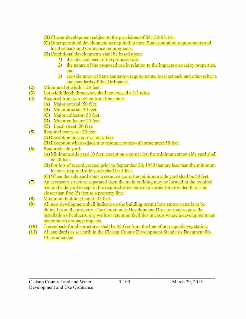
_____________________________________________________________________________ Clatsop County Land and Water 3-100 March 29, 2013 Development and Use Ordinance
(B) Cluster development subject to the provisions of S3.150-S3.161. (C) Other permitted development as required to meet State sanitation requirements and
local setback and Ordinance requirements. (D) Conditional developments shall be based upon:
1) the site size need of the proposed use, 2) the nature of the proposed use in relation to the impacts on nearby properties,
and 3) consideration of State sanitation requirements, local setback and other criteria
and standards of this Ordinance. (2) Minimum lot width: 125 feet. (3) Lot width/depth dimension shall not exceed a 1:3 ratio. (4) Required front yard when front line abuts:
(A) Major arterial: 50 feet. (B) Minor arterial: 30 feet. (C) Major collector: 30 feet. (D) Minor collector: 25 feet. (E) Local street: 20 feet.
(5) Required rear yard: 20 feet. (A) Exception on a corner lot: 5 feet. (B) Exception when adjacent to resource zones - all structures: 50 feet.
(6) Required side yard: (A) Minimum side yard 10 feet, except on a corner lot, the minimum street side yard shall
be 20 feet. (B) For lots of record created prior to September 30, 1980 that are less than the minimum
lot size, required side yards shall be 5 feet. (C) When the side yard abuts a resource zone, the minimum side yard shall be 50 feet.
(7) An accessory structure separated from the main building may be located in the required rear and side yard except in the required street side of a corner lot provided that is no closer than five (5) feet to a property line.
(8) Maximum building height: 35 feet. (9) All new development shall indicate on the building permit how storm water is to be
drained from the property. The Community Development Director may require the installation of culverts, dry wells or retention facilities in cases where a development has major storm drainage impacts.
(10) The setback for all structures shall be 35 feet from the line of non-aquatic vegetation. (11) All standards as set forth in the Clatsop County Development Standards Document 80-
14, as amended.
jhickner
Highlight
jhickner
Highlight

_____________________________________________________________________________ Clatsop County Land and Water 3-101 March 29, 2013 Development and Use Ordinance
Section 3.196. Additional Development and Use Standards in the Clatsop Plains Planning Area. (1) Where a buffer of trees exist along properties abutting Highway 101 at the effective date
of this Ordinance, a buffer of trees 25 feet in width shall be maintained or planted when the property is developed. The Community Development Director or designate may waive this requirement where the size of the lot or natural topography would create a hardship.
(2) All planned developments and subdivision shall be required to cluster land uses and designate areas as permanent common open space. The development shall be reviewed according to Clatsop County Standards Document, Section 4.130 for Planned Developments or Section S3.150 for Clustered Developments. The minimum percentage of common open space shall be 30%, excluding roads and property under water.
Section 3.198. State and Federal Permit. If any state or federal permit is required for a development or use, an applicant, prior to issuance of a development permit or action, shall submit to the Planning Department a copy of the state or federal permit.
jhickner
Highlight

_____________________________________________________________________________ Clatsop County Land and Water 3-102 March 29, 2013 Development and Use Ordinance
SECTION 3.200. RESIDENTIAL-AGRICULTURE-2 ZONE (RA-2).
Section 3.202. Purpose. The RA-2 zone is intended to accommodate the immediate foreseeable demand for very low density rural residential development where commitments to such uses have already been made through existing subdivision, partitioning or development, or in selected, small areas having unique scenic quality and other development that will not require more than a very basic level of services (fire protection or community water). In areas contiguous with the SFR or RA-1 or any Urban Growth Boundary area the RA-2 zone is intended to be a transitional zone between the AF, F-80, EFU zones and said residential zone, with conversion of such lands to higher density residential use occurring in an orderly and economical manner.
Section 3.204. Development and Use Permitted (RA-2). The following developments and their accessory developments are permitted under a Type I procedure subject to applicable development standards. (1) One family dwelling. (2) Guesthouse per Section 1.030. (3) Accessory buildings are permitted only as follows:
(A) In conjunction with, or following the permitting or lawful establishment of the principal use on the same tract. Accessory buildings are limited to uninhabitable spaces such as detached garages, storage buildings, garden sheds, greenhouses, shops, etc.
(4) One mobile home per lot subject to standards in Clatsop County Standards Document, Section S3.190.
(5) Limited home occupation. (6) Utilities, maximum utilization of existing easements and rights-of-way shall be made. (7) Farm use. (8) Roadside stand for farm products grown on the premises. (9) Forestry. (10) Low intensity recreation. (11) Public or private neighborhood park or playground. (12) Horticultural nursery. (13) Temporary uses subject to the provisions of Section 5.500. (14) Handicapped housing facility. (15) Health hardship dwelling, subject to the standards in Clatsop County Standards
Document, Section S3.025. (16) Communication facilities subject to the standards in Clatsop County Standards
Document, Section S4.700. (17) Land transportation facilities as specified in Section 3.035.
jhickner
Highlight
jhickner
Highlight

_____________________________________________________________________________ Clatsop County Land and Water 3-103 March 29, 2013 Development and Use Ordinance
Section 3.207. Conditional Development and Use. The following developments and their accessory developments may be permitted under a Type II procedure and Sections 5.000 to 5.030 subject to applicable criteria and development standards and site plan review. (1) Public/semi-public development. (2) Extraction, processing, and stockpiling of rock, sand, mineral and other subsurface
materials. (3) Dog kennel. (4) Airport. (5) Public or private recreation such as riding stable, fishing or boating docks or ramps, gun
club, golf course, or resort type establishment in association with recreation. (6) Home occupation subject to Clatsop County Standards Document, Section S3.460. (7) Veterinary clinic. (8) Golf course subject to Section 4.040 of this Ordinance. (9) Golf driving range. (10) Campground, primitive. (11) Boat ramps subject to Section 4.080-4.095 for areas identified as Coastal Shorelands in
the Comprehensive Plan. (12) Bed and breakfast establishment subject to the standards in Clatsop County Standards
Document, Section S3.464-S3.468. (13) Accessory uses may be permitted prior to the issuance of a development permit for the
primary use, subject to an approval by the Community Development Director provided that: (B) The applicant submits a letter to the Director explaining the unique or unusual
circumstances and nature of the intended use; and (C) Provided the property owner obtains the primary use development permit within one-
year (1) from the date the accessory use development permit is issued; and (D) A statement that the accessory use, during the one-year period prior to establishing
the primary use is not intended for the storage of, or the establishment of a Recreational Vehicle use; and
(E) May be subject to other conditions of approval deemed necessary to protect the primary purpose and intent of the zone, and to provide for public health, safety and welfare.
(14) By a Type III procedure, any uses determined by the Planning Commission to be similar in use and compatibility to those uses described under sections 1-14 above, subject to the provisions of section 5.060, provided no commercial use is allowed.
Section 3.208. Development and Conditional Development and Use Standards. The following standards are applicable to permitted and conditional developments in this zone. (1) Lot size:
(A) One family dwelling: 2 acres. (B) Cluster development subject to the provision of S3.150-S3.161.
jhickner
Highlight
jhickner
Highlight

_____________________________________________________________________________ Clatsop County Land and Water 3-104 March 29, 2013 Development and Use Ordinance
(C) Other permitted development as required to meet State sanitation requirements and local setback and Ordinance requirements.
(D) Conditional developments shall be based upon: 1) the site size need of the proposed use, 2) the nature of the proposed use in relation to the impacts on nearby properties,
and 3) consideration of State sanitation requirements, local setback and other criteria
and standards of the Ordinance. (2) Minimum lot width: 175 feet. (3) Lot width/depth dimension shall not exceed a 1:3 ratio. (4) Required front yard when front line abuts:
(A) Major arterial: 50 feet. (B) Minor arterial: 30 feet. (C) Major collector: 30 feet. (D) Minor collector: 25 feet. (E) Local street: 20 feet.
(5) Required rear yard: 20 feet. (A) Exception on a corner lot: 5 feet. (B) Exception when adjacent to resource zones - all structures: 50 feet.
(6) Required side yard: (A) Minimum side yard 10 feet, except on a corner lot, the minimum street side yard shall
be 20 feet. (B) For lots of record created prior to September 30, 1980 that are less than the minimum
lot size, required side yards shall be 5 feet. (C) When the side yard abuts a resource zone, the minimum side yard shall be 50 feet.
(7) An accessory structure separated from the main building may be located in the required rear and side yard except in the required street side of a corner lot provided that it is no closer than five (5) feet to a property line.
(8) Maximum building height: 35 feet. (9) All new development shall indicate on the building permit how storm water is to be
drained from the property. The Community Development Director may require the installation of culverts, dry wells or retention facilities in cases where a development has major storm drainage impacts.
(10) The setback for all structures shall be 35 feet from the line on non-aquatic vegetation. (11) All standards as set forth in the Clatsop County Development Standards Document 80-
14, as amended. Section 3.209. Additional Development and Use Standards in the Clatsop Plains Planning Area Where a buffer of trees exist along properties abutting Highway 101 at the effective date of this Ordinance, a buffer of trees 25 feet in width shall be maintained or planted when the property is developed. The Community Development Director or designate may waive this requirement
jhickner
Highlight
jhickner
Highlight
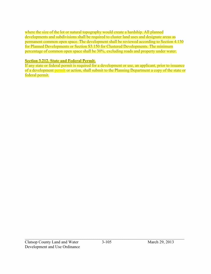
_____________________________________________________________________________ Clatsop County Land and Water 3-105 March 29, 2013 Development and Use Ordinance
where the size of the lot or natural topography would create a hardship. All planned developments and subdivisions shall be required to cluster land uses and designate areas as permanent common open space. The development shall be reviewed according to Section 4.130 for Planned Developments or Section S3.150 for Clustered Developments. The minimum percentage of common open space shall be 30%, excluding roads and property under water. Section 3.212. State and Federal Permit. If any state or federal permit is required for a development or use, an applicant, prior to issuance of a development permit or action, shall submit to the Planning Department a copy of the state or federal permit.
jhickner
Highlight
jhickner
Highlight

_____________________________________________________________________________ Clatsop County Land and Water 3-106 March 29, 2013 Development and Use Ordinance
SECTION 3.220. RESIDENTIAL-AGRICULTURE-5 ZONE (RA-5).
Section 3.222. Purpose. The RA-5 zone is intended to accommodate the immediate foreseeable demand for very low density rural residential development in designated outlying areas where commitments to such uses have already been made through existing subdivision, partitioning, or development, or in selected small areas having unique scenic, locational and other suitable site qualities. The RA-5 zone is intended to be applied to land where the anticipated magnitude or density of development will not require more than a very basic level of services, such as single local road access, individual domestic wells and sewage disposal systems. The very lot density limitation of the RA-5 zone is also based on prevailing lot sizes, limited or undetermined domestic water sources, or limitations of soil conditions for subsurface sewage disposal.
Section 3.224. Development and Use Permitted (RA-5). The following developments and their accessory developments are permitted under a Type I procedure subject to applicable development standards. (1) One family dwelling per lot. (2) Guesthouse per Section 1.030. (3) Accessory buildings are permitted only as follows:
(A) In conjunction with, or following the permitting or lawful establishment of the principal use on the same tract. Accessory buildings are limited to uninhabitable spaces such as detached garages, storage buildings, garden sheds, greenhouses, shops, etc.
(4) One mobile home per lot subject to standards in Clatsop County Standards Document, Section S3.190.
(5) Limited home occupation. (6) Minor utilities. (7) Farm use. (8) Roadside stand for farm products grown on the premises. (9) Forestry. (10) Low intensity recreation. (11) Public or private neighborhood park or playground. (12) Horticultural nursery. (13) Two family dwelling (duplex) subject to Section 3.228, (1)(A). (14) Temporary uses subject to the provisions of Section 5.500. (15) Handicapped housing facility. (16) Health hardship dwelling, subject to the standards in Clatsop County Standards
Document, Section S3.025. (17) Communication facilities subject to the standards in Clatsop County Standards
Document, Section S4.700. (18) Land transportation facilities as specified in Section 3.035.
jhickner
Highlight
jhickner
Highlight

_____________________________________________________________________________ Clatsop County Land and Water 3-107 March 29, 2013 Development and Use Ordinance
Section 3.226. Additional Development and Use Permitted in the Clatsop Plains Planning Area. (1) One mobile home per lot subject to the following standard: A mobile home shall be at
least 16 feet in width and installed according to State standards including skirting and tie downs.
Section 3.227. Conditional Development and Use. The following developments and their accessory developments may be permitted under a Type II procedure and Sections 5.000 to 5.030 subject to applicable criteria and development standards and site plan review. (1) Public/semi-public development. (2) Utilities necessary for public service. (3) Extraction, processing, and stockpiling of rock, sand, mineral and other subsurface
materials. (4) Dog kennel. (5) Airport. (6) Public or private recreation such as riding stable, fishing or boating docks or ramps, gun
club, golf course, resort type establishment in association with recreation. (7) Home occupation subject to Clatsop County Standards Document, Section S3.460. (8) Veterinary clinic. (9) Golf course subject to Section 4.130 of this Ordinance. (10) Golf driving range. (11) R.V. Park subject to Clatsop County Standards Document, Section S3.550-S3.552 except
in the Clatsop Plains Planning Area. (12) Campground, primitive. (13) Boat ramps subject to Section 4.080-4.095 for areas identified as Coastal Shorelands in
the Comprehensive Plan. (14) Cluster development subject to the provisions of Clatsop County Standards Document,
S3.150-S3.161. (15) Bed and breakfast establishment subject to the standards in Clatsop County Standards
Document, Section S3.464-S3.468. (16) By a Type III procedure, any uses determined by the Planning Commission to be similar
in use and compatibility to those uses described under sections 1-15 above, subject to the provisions of section 5.060, provided no commercial use is allowed.
Section 3.228. Development and Conditional Development and Use Standards. The following standards are applicable to permitted and conditional developments in this zone. (1) Lot size:
(A) One family dwelling: 5 acres. Two family dwelling: 10 acres.
(B) Cluster development subject to the provision of Clatsop County Standards Document, S3.150-S3.161.
jhickner
Highlight
jhickner
Highlight

_____________________________________________________________________________ Clatsop County Land and Water 3-108 March 29, 2013 Development and Use Ordinance
(C) Other permitted development as required to meet State sanitation requirements and local setback and Ordinance requirements.
(D) Conditional developments shall be based upon: 1) the site size need of the proposed use, 2) the nature of the proposed use in relation to the impacts on nearby properties,
and 3) consideration of State sanitation requirements, local setback and other criteria
and standards of the Ordinance. (2) Minimum lot width: 275 feet. (3) Lot width/depth dimension shall not exceed a 1:3 ratio. (4) Required front yard when front line abuts:
(A) Major arterial: 50 feet. (B) Minor arterial: 30 feet. (C) Major collector: 30 feet. (D) Minor collector: 25 feet. (E) Local street: 20 feet.
(5) Required rear yard: 20 feet. (A) Exception on a corner lot: 5 feet. (B) Exception when adjacent to resource zones - all structures: 50 feet.
(6) Required side yard: (A) Minimum side yard 10 feet, except on a corner lot, the minimum street side yard shall
be 20 feet. (B) For lots of record created prior to September 30, 1980 that are less than the minimum
lot size, required side yards shall be 5 feet. (C) When the side yard abuts a resource zone, the minimum side yard shall be 50 feet.
(7) An accessory structure separated from the main building may be located in the required rear and side yard except in the required street side of a corner lot provided that it is no closer than five (5) feet to a property line.
(8) Maximum building height: 35 feet. (9) All new development shall indicate on the building permit how storm water is to be
drained from the property. The Building Official shall require the installation of culverts, dry wells or retention facilities in cases where a development has major storm drainage impacts.
(10) The setback for all structures shall be 35 feet from the line on non-aquatic vegetation. (11) All standards as set forth in the Clatsop County Development Standards Document 80-
14, as amended. Section 3.229. Additional Development and Use Standards in the Clatsop Plains Planning Area. (1) Where a buffer of trees exist along properties abutting Highway 101 at the effective date
of this Ordinance, a buffer of trees 25 feet in width shall be maintained or planted when the property is developed. The Community Development Director or designate may
jhickner
Highlight

_____________________________________________________________________________ Clatsop County Land and Water 3-109 March 29, 2013 Development and Use Ordinance
waive this requirement where the size of the lot or natural topography would create a hardship.
(2) All planned developments and subdivisions shall be required to cluster land uses and designate areas as permanent common open space. The development shall be reviewed according to Section 4.130 for Planned Developments or Clatsop County Standards Document, Section S3.150 for Clustered Developments. The minimum percentage of common open space shall be 30%, excluding roads and property under water.
Section 3.230. Additional Development and Use Standards in the Seaside Rural Planning Area. (1) Mobile homes shall be at least 12 feet wide and contain 600 square feet exclusive of the
tongue.
Section 3.232. State and Federal Permits. If any state or federal permit is required for a development or use, an applicant, prior to issuance of a development permit or action, shall submit to the Planning Department a copy of the state or federal permit.
jhickner
Highlight

_____________________________________________________________________________ Clatsop County Land and Water 3-110 March 29, 2013 Development and Use Ordinance
SECTION 3.230. RESIDENTIAL-AGRICULTURE-10 ZONE (RA-10).
Section 3.231. Purpose. The RA-10 zone is intended to accommodate the immediate foreseeable demand for very low density rural residential development in outlying areas where commitments to such uses have already been made through existing subdivision, partitioning, development, or in selected small areas having unique scenic, locational and other suitable site qualities. The RA-10 zone is intended to be applied to land where the anticipated magnitude or density of development will not require more than a very basic level of services, such as single local road access, individual domestic wells and sewage disposal systems. The lot density limitation of the RA-10 zone is also based on prevailing lot sizes, limited or undetermined domestic water sources, or limitations of soil conditions for subsurface sewage disposal.
Section 3.232. Development and Use Permitted. The following developments and their accessory developments are permitted under a Type I procedure subject to applicable development standards. (1) One family dwelling per lot. (2) Guesthouse per Section 1.030. (3) Accessory buildings per Section 1.030 are permitted only as follows:
(A) In conjunction with, or following the permitting or lawful establishment of the principal use on the same tract. Accessory buildings are limited to uninhabitable spaces such as detached garages, storage buildings, garden sheds, greenhouses, shops, etc.
(4) One mobile home per lot subject to standards in Clatsop County Standards Document, Section S3.190.
(5) Limited home occupation. (6) Minor utilities. (7) Farm use. (8) Roadside stand for farm products grown on the premises. (9) Forestry. (10) Low intensity recreation. (11) Public or private neighborhood park or playground. (12) Horticultural nursery. (13) Two family dwelling (duplex) per Section 3.228(1)(A). (14) Temporary uses per Section 5.500. (15) Handicapped housing facility. (16) Health hardship dwelling, subject to the standards in Clatsop County Standards
Document, Section S3.025. (17) Communication facilities subject to the standards in Clatsop County Standards
Document, Section S4.700. (18) Land transportation facilities as specified in Section 3.035.
jhickner
Highlight
jhickner
Highlight

_____________________________________________________________________________ Clatsop County Land and Water 3-111 March 29, 2013 Development and Use Ordinance
Section 3.233. Additional Development and Use Permitted in the Clatsop Plains Planning Area. (1) One mobile home per lot, subject to the following standard: A mobile home shall be at
least 16 feet in width and installed according to State standards including skirting and tie downs.
Section 3.234. Conditional Development and Use. The following developments and their accessory developments may be permitted under a Type II procedure and Sections 5.000 to 5.030 subject to applicable criteria and development standards and site plan review. (1) Public/semi-public development. (2) Utilities necessary for public service. (3) Extraction, processing, and stockpiling of rock, sand, mineral and other subsurface
materials. (4) Dog kennel. (5) Airport. (6) Public or private recreation such as riding stable, fishing or boating docks or ramps, gun
club, golf course, resort type establishment in association with recreation. (7) Home occupation per Section S3.460. (8) Veterinary clinic. (9) Golf course per Section 4.130 of this Ordinance. (10) Golf driving range. (11) R.V. Park subject to Clatsop County Standards Document, Section S3.550-S3.552 except
in the Clatsop Plains Planning Area. (12) Campground, primitive. (13) Boat ramps subject to Section 4.080-4.095 for areas identified as Coastal Shorelands in
the Comprehensive Plan. (14) Cluster development subject to the provisions of Clatsop County Standards Document,
S3.150-S3.161. (15) Bed and breakfast establishment per Section S3.464-S3.468.
Section 3.235. Development and Conditional Development and Use Standards. The following standards are applicable to permitted and conditional developments in this zone. (1) Lot size:
(A) One family dwelling: 10 acres. Two family dwelling: 20 acres.
(B) Cluster development subject to the provision of Clatsop County Standards Document S3.150-S3.161.
(C) Other permitted development as required to meet State sanitation requirements and local setback and Ordinance requirements.
(D) Conditional developments shall be based upon: 1) The site size need of the proposed use,
jhickner
Highlight
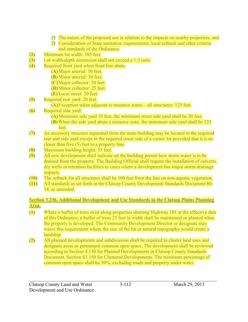
_____________________________________________________________________________ Clatsop County Land and Water 3-112 March 29, 2013 Development and Use Ordinance
2) The nature of the proposed use in relation to the impacts on nearby properties, and 3) Consideration of State sanitation requirements, local setback and other criteria
and standards of the Ordinance. (2) Minimum lot width: 385 feet. (3) Lot width/depth dimension shall not exceed a 1:3 ratio. (4) Required front yard when front line abuts:
(A) Major arterial: 50 feet. (B) Minor arterial: 30 feet. (C) Major collector: 30 feet. (D) Minor collector: 25 feet. (E) Local street: 20 feet.
(5) Required rear yard: 20 feet. (A) Exception when adjacent to resource zones – all structures: 125 feet.
(6) Required side yard: (A) Minimum side yard 10 feet, the minimum street side yard shall be 20 feet. (B) When the side yard abuts a resource zone, the minimum side yard shall be 125
feet. (7) An accessory structure separated from the main building may be located in the required
rear and side yard except in the required street side of a corner lot provided that it is no closer than five (5) feet to a property line.
(8) Maximum building height: 35 feet. (9) All new development shall indicate on the building permit how storm water is to be
drained from the property. The Building Official shall require the installation of culverts, dry wells or retention facilities in cases where a development has major storm drainage impacts.
(10) The setback for all structures shall be 100 feet from the line on non-aquatic vegetation. (11) All standards as set forth in the Clatsop County Development Standards Document 80-
14, as amended.
Section 3.236. Additional Development and Use Standards in the Clatsop Plains Planning Area. (1) Where a buffer of trees exist along properties abutting Highway 101 at the effective date
of this Ordinance, a buffer of trees 25 feet in width shall be maintained or planted when the property is developed. The Community Development Director or designate may waive this requirement where the size of the lot or natural topography would create a hardship.
(2) All planned developments and subdivisions shall be required to cluster land uses and designate areas as permanent common open space. The development shall be reviewed according to Section 4.130 for Planned Developments or Clatsop County Standards Document, Section S3.150 for Clustered Developments. The minimum percentage of common open space shall be 30%, excluding roads and property under water.
jhickner
Highlight

_____________________________________________________________________________ Clatsop County Land and Water 3-113 March 29, 2013 Development and Use Ordinance
Section 3.237. State and Federal Permits. If any state or federal permit is required for a development or use, an applicant, prior to issuance of a development permit or action, shall submit to the Planning Department a copy of the state or federal permit.
jhickner
Highlight

_____________________________________________________________________________ Clatsop County Land and Water 3-114 March 29, 2013 Development and Use Ordinance
SECTION 3.240. COASTAL BEACH RESIDENTIAL ZONE (CBR).
Section 3.242. Purpose. The CBR zone is intended to accommodate the immediate foreseeable demand for low density residential development in the area commonly known as Surf Pines. Surf Pines covers an area of approximately 1-1/2 square miles and is located south of the community of Sunset Beach and west of Neacoxie Lake and Creek. Surf Pines is an area committed to low density rural residential development. This zone is a Goal 14 exceptions area.
Section 3.244. Development and Use Permitted. The following uses and their accessory uses are permitted under a permit procedure subject to the applicable development standards. (1) One family dwelling. (2) Guesthouse per Section 1.030. (3) Accessory buildings are permitted only as follows:
(A) In conjunction with, or following the permitting or lawful establishment of the principal use on the same tract. Accessory buildings are limited to uninhabitable spaces such as detached garages, storage buildings, garden sheds, greenhouses, shops, etc.
(4) Limited home occupation. (5) Public or private neighborhood park or playground. (6) Utilities, maximum utilization of existing easements and rights-of-way shall be made. (7) No sign except for:
(A) Temporary signs subject to the provisions of Clatsop County Standards Document, Section S2.300.
(B) Nameplates subject to the provisions of Clatsop County Standards Document, Section S2.300.
(8) Handicapped housing facility. (9) Cluster development subject to the provisions of Clatsop County Standards Document,
Section S3.150-S3.161. (10) Low intensity recreation. (11) Land transportation facilities as specified in Section 3.035.
Section 3.246. Conditional Development and Use. None.
jhickner
Highlight
jhickner
Highlight

_____________________________________________________________________________ Clatsop County Land and Water 3-115 March 29, 2013 Development and Use Ordinance
Section 3.248. Development and Use Standards. The following standards are applicable to permitted uses in this zone: (1) Lot size
(A) for residential uses: one (1) acre except for the following parcels which are not exceptions areas and therefore, require two (2) acres: T.7N., R.10W., Section 16C, Tax Lot 300 and 301.
(B) Cluster development subject to the provisions of Section S3.150-S3.161. (C) Lots outside the exceptions area, two (2) acre in size. (D) Other permitted development as required to meet State sanitation requirements and
local setback and ordinance requirements. (2) Minimum lot width: 100 feet. (3) Lot width/depth dimension shall not exceed 1:3 ratio. (4) Required front yard: 20 feet. (5) Required side yard:
(A) Minimum side yard 10 feet, except on a corner lot, the minimum street side yard shall be 20 feet.
(B) For lots of record created prior to September 30, 1980 that are less than the minimum lot size, required side yards shall be 5 feet.
(C) When the side yard abuts a resource zone, the minimum side yard shall be 50 feet. (6) Required rear yard: 20 feet, exception on a corner lot: 10 feet. (7) For lots abutting the oceanshore, the ocean yard shall be determined by the oceanfront
setback line established by Section S3.015 Oceanfront Setback. (8) An accessory structure separated from the main building may be located in the required
rear and side yard except in the required street side of a corner lot provided that it is no closer than five (5) feet to a property line.
(9) Maximum building height: 26 feet, except for ocean front lots which shall be: 18 feet. (A) The height of a structure is measured from the average grade of the undisturbed
ground at the four principal corners of the proposed structure. (B) To determine height:
1) Construction/building plans submitted for uses permitted in this zone shall show the elevations of the undisturbed ground prior to construction as measured at the four principal corners of the proposed structure on a plot plan. A control point shall be established outside of the building's footprint.
2) Photographs of the undisturbed site shall be required. Photographs need not be professional or aerial photographs, but can be taken using a Polaroid or other camera.
3) To verify the height, a survey by a registered surveyor may be required by the Community Development Director.
jhickner
Highlight

_____________________________________________________________________________ Clatsop County Land and Water 3-116 March 29, 2013 Development and Use Ordinance
(10) All new development shall indicate on the building permit how storm water is to be drained from the property. The Community Development Director may require the installation of culverts, dry wells or retention facilities in cases where a development has major storm drainage impacts.
(11) All standards as set forth in the Clatsop County Development Standards Document 80- 14, as amended.
(12) The setback for all structures shall be 35 feet from the line of non-aquatic vegetation. (13) Utility lines shall be placed underground. (14) Fence, wall, hedge, or coping not higher than 8 feet. (15) Livestock: none.
Section 3.250. State and Federal Permits. If any state or federal permit is required for a development or use, an applicant, prior to issuance of a development permit or action, shall submit to the Planning Department a copy of the state or federal permit.
jhickner
Highlight

_____________________________________________________________________________ Clatsop County Land and Water 3-117 March 29, 2013 Development and Use Ordinance
SECTION 3.252. RURAL COMMUNITY COMMERCIAL ZONE (RCC). Section 3.254. Purpose and Intent. This zone is located in the Rural Community of Arch Cape, Svensen, Westport, Miles Crossing and Jeffers Gardens. The RCC zone is intended to: (1) provide support for existing small concentrations of retail and commercial services; (2) contribute to community identity; (3) provide job opportunities within the community; (4) allow only those uses that are compatible with the surrounding uses considering varying environmental and other site constraints, and the availability of community water, sewer, or if such services are not available, such uses do not exceed the carrying capacity of the property to provide potable water and absorb waste; and (5) provide services for the community, surrounding rural, farm and forest areas, and traveling public. New commercial uses are those defined under state law as “small-scale, low impact” with building or buildings not to exceed 4,000 square feet of floor area, unless determined that large buildings are intended to serve the rural community, surrounding rural area or the travel needs of the people passing through the area. Expansion of an existing commercial use resulting in building or buildings exceeding 4,000 square feet of floor area are appropriate when the use is intended to serve the rural community, surrounding rural area or the travel needs of people passing through the area.
Section 3.256. Development and Use Permitted. The following uses and their accessory uses are permitted under a Type I permit procedure subject to applicable development standards. (1) Splitting and sale of firewood. (2) Roadside stand, which shall be less than 120 sq. ft. in size, subject to provisions S5.032-
S5.033. (3) Low intensity recreation. (4) Utilities, maximum utilization of existing easements and rights-of-way shall be made. (5) Handicapped housing facility. (6) Land transportation facilities as specified in Section 3.035. Section 3.258. Commercial Conditional Development and Use. The following commercial uses and their accessory uses are permitted under a Type II permit procedure subject to applicable development standards provided that commercial uses occur in a building or buildings that do not exceed the following area standards: (1) A retail grocery, bakery, delicatessen, confectionary or similar store including the
preparation of foodstuffs for sale primarily on the premises, provided building or buildings for each commercial use does not exceed 4,000 square foot of floor area.
(2) A retail drug, variety, gift, antique, hardware, sporting goods, dry goods, music, florist, book, stationery, art gallery, or similar store provided building or buildings for each commercial use does not exceed 4,000 square foot of floor area.
jhickner
Highlight
jhickner
Highlight
jhickner
Highlight

_____________________________________________________________________________ Clatsop County Land and Water 3-118 March 29, 2013 Development and Use Ordinance
(3) A barber, beauty, tailor, shoe repair, laundromat, cleaners, photographic shop or similar personal service business provided building or buildings for each commercial use does not exceed 4,000 square foot of floor area.
(4) Sporting equipment and other recreational equipment rental service provided building or buildings for each commercial use does not exceed 4,000 square foot of floor area.
(5) An eating or drinking establishment provided building or buildings for each commercial use does not exceed 4,000 square foot of floor area.
(6) An automobile service station, including auto fuel, towing and minor repair, excluding auto sales and auto storage provided building or buildings for each commercial use does not exceed 4,000 square foot of floor area.
(7) Professional offices provided building or buildings for each commercial use does not exceed 4,000 square foot of floor area.
(8) Park, or playground, ball fields, or community center. (9) Churches or similar places of worship. (10) Veterinary clinic provided the square footage of the building or buildings devoted to the
care of household pets does not exceed 4,000 square feet of floor area. (11) Medical and dental offices provided building or buildings for each commercial use does not
exceed 4,000 square foot of floor area. (12) Buildings and uses of a public works, public service, or public utility nature, that may
include equipment storage, repair yards, warehouses, or related activities. (13) Instructional or vocational schools, such as dance studio, karate, theatre, music, computer
science provided building or buildings for each commercial use does not exceed 4,000 square foot of floor area.
(14) Communication Facilities subject to the provisions of Clatsop County Standards Document S4.700.
(15) Farm or garden supply, equipment sales and repair. (16) Mini-storage. (17) Legally existing and allowed uses (as of the effective date of this ordinance) may continue
as permitted uses. (18) By a Type III procedure, any uses determined by the Planning Commission to be similar in
use and compatibility to those uses described under sections 1-17 above subject to the provisions of section 5.060, provided building or buildings for each commercial use does not exceed 4,000 square feet of floor area.
Section 3.260. Conditional Development and Use. The following uses and their accessory uses are permitted under a Type II-a permit procedure subject to applicable development standards and site plan review. (1) Expansion of commercial building or buildings, existing on (date of this ordinance) where
the total floor area for the commercial use exceeds 4,000 square feet provided the commercial use, intended to occupy more than 4,000 square feet of floor area, is intended to serve the rural community, the surrounding rural area, or the traveling needs of people passing through the area.
jhickner
Highlight

_____________________________________________________________________________ Clatsop County Land and Water 3-119 March 29, 2013 Development and Use Ordinance
(2) Mixed Use or Residential developments in association with a Commercial or Retail component that is permitted or conditional. Residential development shall be located above or behind the permitted or conditional use.
(3) A hotel, motel, lodge, resort, inn, or other enclosed tourist/traveler accommodations, provided: (A) It is served by a community sewer system, (B) Does not have over 35 units, and (C) Each commercial use associated with the lodging shall not exceed 4,000 square feet
(i.e. Gift Shop, Office, Restaurant, etc). (4) Recreational Vehicle (RV) Park subject to the following provisions:
(A) Density, Maximum fifteen (15) RV spaces per acre. (B) Minimum 30-foot setback to any adjoining residential zone. (C) Minimum 50-foot setback to any adjoining resource zone. (D) Subject to meeting the State Building Code requirements; and (E) Subject to provisions of Clatsop County Standards Document, S.3.550 – S3.552
(2)(A)(F)(I)(J)(K) and (3)-(10) inclusive. Section 3.262. Development and Use Standards. The following standards are applicable to all permitted Type II uses in this zone. (1) Plan review and approval: No building permit or other permit for construction or alteration
of any building structure or use in this zone shall be issued until plans have been reviewed and approved by the Community Development Director in order to evaluate the conformity with the performance standards of this zone and the Comprehensive Plan and the compatibility of vehicular access, signs, lighting, building placement and designs, landscaping, adjoining uses and location of water and sewage facilities.
(2) Standards: (A) Air quality: The air quality standards set by the Department of Environmental Quality
shall be the guiding standards in this zone, except that open burning is prohibited in any case.
(B) Noise: As permitted under all laws and regulations. (C) Storage: Materials and or equipment shall be enclosed within a structure or concealed
behind sight-obscuring screening. (D) Fencing: Allowed inside a boundary planting screen and where it is necessary to
protect property or to protect the public from a dangerous condition. The proposed fence locations and design will be subject to Community Development Director review and approval.
(E) Buffer: Where the RCC zone adjoins a zone other than RCC, there shall be a buffer area of depth adequate to provide for a dense evergreen landscape buffer which attains a minimum height of 8-10 feet, or such other screening measures as may be prescribed by the Community Development Director in the event differences in elevation or other circumstances should defeat the purpose of this requirement. In no
jhickner
Highlight
jhickner
Highlight

_____________________________________________________________________________ Clatsop County Land and Water 3-120 March 29, 2013 Development and Use Ordinance
case shall the buffer area have less width than the required 50-foot setback of this zone.
(F) Vibration: No vibration other than that caused by highway vehicles, trains and aircraft shall be permitted which is discernible without instruments at the property line of the use concerned.
(G) Heat and glare: Except for exterior lighting, operations producing heat or glare shall be constructed entirely within an enclosed building.
(H) Lighting: Exterior lighting shall be directed away from adjacent property, with cutoff lighting required, when adjacent to a residential zone.
(3) Density Provisions: (A) The minimum lot width shall be 75 feet. (B) Other permitted development standards as required to meet State sanitation
requirements and local setback and ordinance requirements. (C) Lot width/depth dimension shall not exceed a 1:3 ratio.
(4) Setback requirements: (A) Front yard setbacks: 25 feet. (B) Side and rear yard when abutting a residence or residential zone: 10 feet. (C) For lots of record created prior to September 30, 1980 that are less than minimum lot
size required side yards shall be 5 feet. (D) The setbacks for all structures shall be thirty-five feet (35) from the line of non-
aquatic vegetation. (E) All structures shall be a minimum of fifty feet (50) from adjacent resource zones.
(5) Building height: (A) The maximum building height for commercial uses shall be 35 feet. (B) The maximum building height for light industrial uses shall be 45 feet, except when
within 100 feet of a residential zone, the height shall be 35 feet. (6) Building size:
(A) The maximum building size for new commercial uses shall not exceed the floor area standards listed in Section 3.258 unless: 1) The findings approving the use are included in an amendment to the
comprehensive plan, processed under post acknowledgement procedures (ORS 197.610 through 197.625);
2) The use is limited to a size of building or buildings that is intended to serve the rural community, surrounding rural area of the travel needs of people passing through the area; and
3) The total floor area of building or buildings does not exceed 12,000 square feet unless an exception to goal 14 has been acknowledged pursuant to ORS 197.625.
(7) Off-street parking requirements: Off-street parking shall be subject to Clatsop County Standards Document, Section S2.200 of the Development and Use Standards Document.
jhickner
Highlight
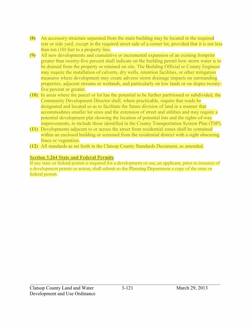
_____________________________________________________________________________ Clatsop County Land and Water 3-121 March 29, 2013 Development and Use Ordinance
(8) An accessory structure separated from the main building may be located in the required rear or side yard, except in the required street side of a corner lot, provided that it is not less than ten (10) feet to a property line.
(9) All new developments and cumulative or incremental expansion of an existing footprint greater than twenty-five percent shall indicate on the building permit how storm water is to be drained from the property or retained on site. The Building Official or County Engineer may require the installation of culverts, dry wells, retention facilities, or other mitigation measures where development may create adverse storm drainage impacts on surrounding properties, adjacent streams or wetlands, and particularly on low lands or on slopes twenty-five percent or greater.
(10) In areas where the parcel or lot has the potential to be further partitioned or subdivided, the Community Development Director shall, where practicable, require that roads be designated and located so as to facilitate the future division of land in a manner that accommodates smaller lot sizes and the extension of street and utilities and may require a potential development plat showing the location of potential lots and the rights-of-way improvements, to include those identified in the County Transportation System Plan (TSP).
(11) Developments adjacent to or across the street from residential zones shall be contained within an enclosed building or screened from the residential district with a sight obscuring fence or vegetation.
(12) All standards as set forth in the Clatsop County Standards Document, as amended.
Section 3.264 State and Federal Permits If any state or federal permit is required for a development or use, an applicant, prior to issuance of a development permit or action, shall submit to the Planning Department a copy of the state or federal permit.
jhickner
Highlight

_____________________________________________________________________________ Clatsop County Land and Water 3-122 March 29, 2013 Development and Use Ordinance
Section 3.266. Rural Community Commercial and Light Industrial zone (RCC-LI).
Section 3.268. Purpose and Intent (RCC-LI). This zone is located in the Rural Community of Knappa and Westport. The RCC-LI zone is intended to: (1) provide support for existing small concentrations of retail and commercial services mixed with light industrial; (2) contribute to community identity; (3) provide necessary retail services to the community; (4) provide job opportunities within the community; (5) allow only those uses that are compatible with the surrounding uses considering varying environmental and other site constraints, and the availability of community water, sewer, or if such services are not available, such uses do not exceed the carrying capacity of the property to provide potable water and absorb waste; and (6) provide services for the community, surrounding rural, farm and forest areas, and traveling public. New commercial uses are those defined under state law as “small-scale, low impact” with building or buildings not to exceed 4,000 square feet of floor area, unless determined that large buildings are intended to serve the rural community, surrounding rural area or the travel needs of the people passing through the area. Expansion of an existing commercial use resulting in building or buildings exceeding 4,000 square feet of floor area are appropriate when the use is intended to serve the rural community, surrounding rural area or the travel needs of people passing through the area. Section 3.270. Development and Use Permitted. The following uses and their accessory uses are permitted under a Type I permit procedure subject to applicable development standards. (1) Splitting and sale of firewood. (2) Roadside stand, which shall be less than 120 sq. ft. in size, subject to provides S5.032-
S5.033. (3) Low intensity recreation. (4) Utilities, maximum utilization of existing easements and rights-of-way shall be made. (5) Handicapped housing facility. (6) Land transportation facilities as specified in Section 3.035. Section 3.272. Commercial Uses Conditional Development and Use. The following commercial uses and their accessory uses are permitted under a Type II permit procedure subject to applicable development standards provided that commercial uses occur in a building or buildings that do not exceed the following area standards: (1) A retail grocery, bakery, delicatessen, confectionary or similar store including the
preparation of foodstuffs for sale primarily on the premises, provided building or buildings for each commercial use does not exceed 4,000 square foot of floor area.
(2) A retail drug, variety, gift, antique, hardware, sporting goods, dry goods, music, florist, book, stationery, art gallery, or similar store provided building or buildings for each commercial use does not exceed 4,000 square foot of floor area.
jhickner
Highlight
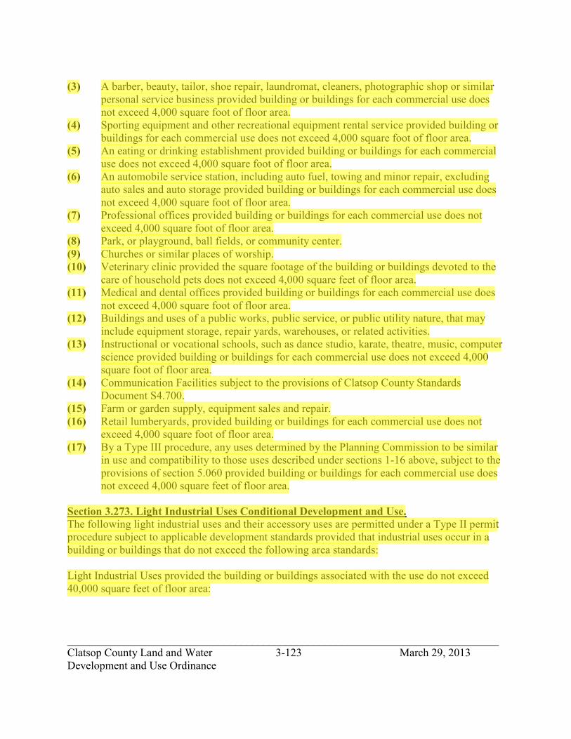
_____________________________________________________________________________ Clatsop County Land and Water 3-123 March 29, 2013 Development and Use Ordinance
(3) A barber, beauty, tailor, shoe repair, laundromat, cleaners, photographic shop or similar personal service business provided building or buildings for each commercial use does not exceed 4,000 square foot of floor area.
(4) Sporting equipment and other recreational equipment rental service provided building or buildings for each commercial use does not exceed 4,000 square foot of floor area.
(5) An eating or drinking establishment provided building or buildings for each commercial use does not exceed 4,000 square foot of floor area.
(6) An automobile service station, including auto fuel, towing and minor repair, excluding auto sales and auto storage provided building or buildings for each commercial use does not exceed 4,000 square foot of floor area.
(7) Professional offices provided building or buildings for each commercial use does not exceed 4,000 square foot of floor area.
(8) Park, or playground, ball fields, or community center. (9) Churches or similar places of worship. (10) Veterinary clinic provided the square footage of the building or buildings devoted to the
care of household pets does not exceed 4,000 square feet of floor area. (11) Medical and dental offices provided building or buildings for each commercial use does
not exceed 4,000 square foot of floor area. (12) Buildings and uses of a public works, public service, or public utility nature, that may
include equipment storage, repair yards, warehouses, or related activities. (13) Instructional or vocational schools, such as dance studio, karate, theatre, music, computer
science provided building or buildings for each commercial use does not exceed 4,000 square foot of floor area.
(14) Communication Facilities subject to the provisions of Clatsop County Standards Document S4.700.
(15) Farm or garden supply, equipment sales and repair. (16) Retail lumberyards, provided building or buildings for each commercial use does not
exceed 4,000 square foot of floor area. (17) By a Type III procedure, any uses determined by the Planning Commission to be similar
in use and compatibility to those uses described under sections 1-16 above, subject to the provisions of section 5.060 provided building or buildings for each commercial use does not exceed 4,000 square feet of floor area.
Section 3.273. Light Industrial Uses Conditional Development and Use. The following light industrial uses and their accessory uses are permitted under a Type II permit procedure subject to applicable development standards provided that industrial uses occur in a building or buildings that do not exceed the following area standards: Light Industrial Uses provided the building or buildings associated with the use do not exceed 40,000 square feet of floor area:
jhickner
Highlight
jhickner
Highlight

_____________________________________________________________________________ Clatsop County Land and Water 3-124 March 29, 2013 Development and Use Ordinance
(1) Machine shops. (2) Bottling works. (3) Equipment storage yard. (4) Hauling, freighting and trucking yard terminal. (5) Logging operations, including accessory uses such an office or watchman’s quarters. (6) Welding shop. (7) Wholesale storage business or warehouse. (8) Manufacturing, compounding, assembling, or treating products. (9) Recycling collection center. (10) Legally existing and allowed uses (as of the effective date of this ordinance) may
continue as permitted uses. (11) Communications Facilities, subject to provisions in Clatsop County Standards Document
S4.700. (12) By a Type III procedure, any uses determined by the Planning Commission to be similar
in use and compatibility to those uses described under sections 1-11 above, subject to the provisions of section 5.060, provided building or buildings for each commercial use does not exceed 4,000 square feet of floor area.
Section 3.274. Conditional Development and Use.
The following uses and their accessory uses are permitted under a Type II-a permit procedure subject to applicable development standards and site plan review. (1) Expansion of commercial building or buildings, existing on (date of this ordinance)
where the total floor area for the commercial use exceeds 4,000 square feet provided the commercial use, intended to occupy more than 4,000 square feet of floor area, is intended to serve the rural community, the surrounding rural area, or the traveling needs of people passing through the area.
(2) Residential developments in association with a development that is permitted or conditional, such as a dwelling for the owner or operator of a commercial development.
(3) A hotel, motel, lodge, resort, inn, or other enclosed tourist/traveler accommodations, provided: (A) It is served by a community sewer system, (B) Does not have over 35 units, and (C) Each commercial use associated with the lodging shall not occur in a building or
buildings that exceed 4,000 square feet. (4) Mini-storage. (5) Recreational Vehicle (RV) Park subject to the following provisions:
(A) Density, Maximum fifteen (15) RV spaces per acre. (B) Minimum 30-foot setback to any adjoining residential zone. (C) Minimum 50-foot setback to any adjoining resource zone. (D) Subject to meeting the State Building Code requirements; and (E) Subject to provisions of S.3.550 – S3.552(2)(A)(F)(I)(J)(K) and (3)-(10) inclusive.
jhickner
Highlight
jhickner
Highlight

_____________________________________________________________________________ Clatsop County Land and Water 3-125 March 29, 2013 Development and Use Ordinance
Section 3.276. Conditional Development and Use. The following Light Industrial uses and their accessory uses are permitted under a Type III permit procedure subject to applicable development standards and site plan review, provided building or buildings associated with the use do not exceed 40,000 square feet of floor area: (1) Solid waste transfer station. (2) Automobile wrecking yard. (3) Food products manufacturing. (4) Concrete, ready-mix or asphalt batching plant. (5) Any uses determined by the Planning Commission to be similar in use and compatibility
to those uses described under sections 1-4 above, subject to the provisions of section 5.060 provided building or buildings for each commercial use does not exceed 4,000 square feet of floor area.
Section 3.278. Development and Use Standards. The following standards are applicable to all permitted uses in this zone. (1) Plan review and approval:
(A) No building permit or other permit for construction or alteration of any building structure or use in this zone shall be issued until plans have been reviewed and approved by the Community Development Director in order to evaluate the conformity with the performance standards of this zone and the Comprehensive Plan and the compatibility of vehicular access, signs, lighting, building placement and designs, landscaping, adjoining uses and location of water and sewage facilities or waste water treatment.
(2) Standards: (A) Air quality: The air standards set by the Department of Environmental Quality shall
be the guiding standards in this zone, except that open burning is prohibited in any case.
(B) Noise: As permitted under all laws and regulations. (C) Storage: Materials and or equipment shall be enclosed within a structure or concealed
behind sight-obscuring screening. (D) Fencing: Allowed inside a boundary planting screen and where it is necessary to
protect property or to protect the public from a dangerous condition. The proposed fence locations and design will be subject to Community Development Director review and approval.
(E) Buffer: Where the RCC- LI zone adjoins a zone other than RCC-LI, there shall be a buffer area of depth adequate to provide for a dense evergreen landscape buffer which attains a minimum height of 8-10 feet, or such other screening measures as may be prescribed by the Community Development Director in the event differences in elevation or other circumstances should defeat the purpose of this requirement. In no case shall the buffer area have less width than the required 50-foot setback of this zone.
jhickner
Highlight
jhickner
Highlight

_____________________________________________________________________________ Clatsop County Land and Water 3-126 March 29, 2013 Development and Use Ordinance
(F) Vibration: No vibration other than that caused by highway vehicles, trains and aircraft shall be permitted which is discernible without instruments at the property line of the use concerned.
(G) Heat and glare: Except for exterior lighting, operations producing heat or glare shall be constructed entirely within an enclosed building.
(H) Lighting: Exterior lighting shall be directed away from adjacent property, with cutoff lighting required, when adjacent to a residential zone.
(3) Density Provisions: (A) The minimum lot width shall be 75 feet. (B) Other permitted development standards as required to meet State sanitation
requirements and local setback and ordinance requirements. (C) Lot width/depth dimension shall not exceed a 1:3 ratio.
(4) Setback requirements: (A) Front yard setbacks: twenty-five feet (25). (B) Side and rear yard when abutting a residence or residential zone: ten feet (10). (C) For lots of record created prior to September 30, 1980 that are less than minimum lot
size required side yards shall be five feet (5). (D) The setbacks for all structures shall be thirty-five feet (35) from the line of non-
aquatic vegetation. (E) All structures shall be a minimum of fifty-feet (50) from adjacent resource zones.
(5) Building height: (A) The maximum building height for commercial uses shall be thirty-five feet (35). (B) The maximum building height for light industrial uses shall be forty-five feet (45),
except when within 100 feet of a residential zone, the height shall be thirty- five feet (35).
(6) Building size: (A) The maximum building size for new commercial uses shall not exceed the floor area
standards listed in Section 3.272 unless: 1) The findings approving the use are included in an amendment to the
comprehensive plan, processed under post acknowledgement procedures (ORS 197.610 through 197.625);
2) The use is limited pursuant to Section 5.025 to a size of building or buildings that is intended to serve the rural community, surrounding rural area of the travel needs of people passing through the area; and
3) The total floor area of building or buildings does not exceed 12,000 square feet.
(B) The maximum building size for light industrial uses shall not exceed 40,000 square feet of floor area unless authorized pursuant to 197.713 or 197.719.
(7) Off-street parking requirements: Off-street parking shall be subject to Section S2.200 of the Development and Use Standards Document.
jhickner
Highlight

_____________________________________________________________________________ Clatsop County Land and Water 3-127 March 29, 2013 Development and Use Ordinance
(8) An accessory structure separated from the main building may be located in the required rear or side yard, except in the required street side of a corner lot, provided that it is not less than ten feet (10) to a property line.
(9) All new developments and cumulative or incremental expansion of an existing footprint greater than twenty-five percent shall indicate on the building permit how storm water is to be drained from the property or retained on site. The Building Official or County Engineer may require the installation of culverts, dry wells, retention facilities, or other mitigation measures where development may create adverse storm drainage impacts on surrounding properties, adjacent streams or wetlands, and particularly on low lands or on slopes twenty-five percent or greater.
(10) Developments adjacent to or across the street from residential zones shall be contained within an enclosed building or screened from the residential district with a sight obscuring fence or vegetation.
(11) In areas where the parcel or lot has the potential to be further partitioned or subdivided, the Community Development Director shall, where practicable, require that roads be designated and located so as to facilitate the future division of land in a manner that accommodates smaller lot sizes and the extension of street and utilities and may require a potential development plat showing the location of potential lots, and the rights-of-way improvements, to include those identified in the County Transportation System Plan (TSP).
(12) All standards as set forth in the Clatsop County Standards Document, as amended.
Section 3.280 State and Federal Permits If any state or federal permit is required for a development or use, an applicant, prior to issuance of a development permit or action, shall submit to the Planning Department a copy of the state or federal permit.
jhickner
Highlight

_____________________________________________________________________________ Clatsop County Land and Water 3-128 March 29, 2013 Development and Use Ordinance
SECTION 3.300. NEIGHBORHOOD COMMERCIAL ZONE (NC).
Section 3.302. Purpose. In addition to the purposes listed in the policies of the Comprehensive Plan, the purpose of the Neighborhood Commercial zone (NC) is to provide for small concentrations of retail and commercial service surrounding rural areas; to stabilize existing commercial districts; to contribute to community identify and to protect adjacent residences and resources from adverse hazards, noise, glare, traffic congestion and other effects. New commercial uses are those defined under state law as “small-scale, low impact” with building or buildings not to exceed 3,000 square feet of floor area, unless determined through review that large buildings are intended to serve the surrounding rural area or the travel needs of the people passing through the area. Expansion of an existing commercial use resulting in building or buildings exceeding 3,000 square feet of floor area are appropriate when the use is intended to serve the surrounding rural area or the travel needs of people passing through the area.
Section 3.304. Development and Use Permitted. The following developments and their accessory developments are permitted under a Type I procedure subject to applicable development standards. (1) Handicapped housing facility. (2) Bed & breakfast establishment subject to the standards in Section S3.464-S3.468. (3) Utilities, maximum utilization of existing easements and rights-of-way shall be made. (4) Land transportation facilities as specified in Section 3.035.
Section 3.306. Conditional Development and Use. The following developments and their accessory developments may be permitted under a Type II procedure and Sections 5.000 to 5.030 subject to applicable criteria and development standards and site plan review. (1) A general store including retail grocery, bakery, delicatessen, drug, garden, feed and
seed, or similar store, including the preparation of foodstuffs for sale primarily on the premises.
(2) Eating and drinking establishment. (3) An automobile service station and minor repair shop, not including body work, used car
sales, or wrecking yard, (4) One residential use in association with a permitted outright or conditional use such as a
dwelling for the owner or operator or caretaker of a commercial activity. (5) Sale of pre-split firewood. (6) By a Type III procedure, any uses determined by the Planning Commission to be similar
in use and compatibility to those uses described under sections 1-5 above subject to the provisions of section 5.060.
jhickner
Highlight

_____________________________________________________________________________ Clatsop County Land and Water 3-129 March 29, 2013 Development and Use Ordinance
Section 3.310. Conditional Development and Use Criteria. The following limitations and requirements shall apply to conditional development and use: (1) Developments shall not detract from or conflict with the rural/neighborhood residential
character of the area. (2) The development shall be limited in size and function to serve the rural/neighborhood
area where it is located.
Section 3.312. Development and Conditional Development and Use Standards. (1) Building size:
(A) The maximum building size for new commercial uses shall not exceed 3,000 square feet unless:
1) The findings approving the use are included in an amendment to the comprehensive plan, processed under post acknowledgement procedures (ORS 197.610 through 197.625);
2) The use is limited to a size of building or buildings that is intended to serve the surrounding rural area or the travel needs of people passing through the area; and
3) The total floor area of building or buildings does not exceed 10,000 square feet.
(B) Expansion of commercial building or buildings, existing on September 10, 2003, where the total floor area for the commercial use exceeds 3,000 square feet provided the commercial use, intended to occupy more than 3,000 square feet of floor area, is intended to serve the surrounding rural area, or the traveling needs of people passing through the area.
(2) Lot size: (A) Permitted development: 10,000 square feet. (B) Lot size for conditional development shall be based upon:
1) the site size need of the proposed use, 2) the nature of the proposed use in relation to the impacts on nearby properties,
and 3) consideration of state sanitation requirements, local setback and other criteria
and standards of this ordinance. (3) Minimum lot width: 100 feet. (4) Lot width/depth dimension shall not exceed a 1:3 ratio. (5) Setbacks:
(A) Front yard setback: 25 feet. (B) Side and rear yard, none except as follows:
1) When abutting a residence or a residential zone, the minimum side yard and rear yard shall be 20 feet.
2) On a corner lot the minimum street yard shall be 5 feet.
jhickner
Highlight

_____________________________________________________________________________ Clatsop County Land and Water 3-130 March 29, 2013 Development and Use Ordinance
3) (Grandfathered) Lots of Record created prior to September 30, 1980 that are less than the minimum lot size, when abutting a residence or a residential zone, the minimum side yard and rear yard shall be 5 feet.
(6) The setback for all structures shall be 35 feet from the line of non-aquatic vegetation. (7) The setback from adjacent resource zones: 50 feet. (8) Maximum building height: 35 feet. (9) An accessory structure separated from the main building may be located in the required
rear and side yard except in the required street side of a corner lot provided that it is no closer than five (5) feet to a property line.
(10) All standards as set forth in the Clatsop County Development Standards Document 80- 14, as amended.
Section 3.314. State and Federal Permits. If any state or federal permit is required for a development or use, an applicant, prior to issuance of a development permit or action, shall submit to the Planning Department a copy of the state or federal permit.
jhickner
Highlight

_____________________________________________________________________________ Clatsop County Land and Water 3-131 March 29, 2013 Development and Use Ordinance
SECTION 3.320. TOURIST COMMERCIAL ZONE (TC).
Section 3.322. Purpose. The Tourist Commercial (TC) zone is intended to provide for accommodations and facilities serving tourists, the motoring public and other travelers; to provide basic services for permanent and seasonal residents; and to concentrate commercial development in appropriate areas so as to maintain the efficiency of major roads. New commercial uses are those defined under state law as “small-scale, low impact” with building or buildings not to exceed 3,000 square feet of floor area, unless determined through review that large buildings are intended to serve the surrounding rural area or the travel needs of the people passing through the area. Expansion of an existing commercial use resulting in building or buildings exceeding 3,000 square feet of floor area are appropriate when the use is intended to serve the surrounding rural area or the travel needs of people passing through the area.
Section 3.324. Application. The TC zone is to be applied at central intervals on major roads in areas with high recreation or tourist uses; adjacent to or within communities; and in similar areas with intensive tourist use.
Section 3.326. Development and Use Permitted. The following developments and their accessory developments are permitted under a Type I procedure subject to applicable development standards. (1) Residential developments in association with a development that is permitted or
conditional such as a dwelling for the owner or operator of a commercial development. (2) Handicapped housing facility. (3) Bed & breakfast establishment subject to the standards in Section S3.464-S3.468. (4) Public or private neighborhood park or playground. (5) Golf driving range. (6) Low intensity recreation. (7) Boat ramps subject to Section 4.080-4.095 for areas identified as Coastal Shorelands in
the Comprehensive Plan. (8) Utilities, maximum utilization of existing easements and rights-of-way shall be made. (9) Land transportation facilities as specified in Section 3.035.
Section 3.328. Conditional Development and Use. The following developments and their accessory developments may be permitted under a Type II procedure and Sections 5.000 to 5.030 subject to applicable criteria and development standards and site plan review. (1) A retail grocery, bakery, delicatessen, confectionery or similar store including the
preparation of foodstuffs for sale primarily on the premises, provided building or buildings for each commercial use does not exceed 3,000 square foot of floor area.
jhickner
Highlight
jhickner
Highlight

_____________________________________________________________________________ Clatsop County Land and Water 3-132 March 29, 2013 Development and Use Ordinance
(2) A retail drug, variety, gift, antique, garden, hardware, sporting goods, dry goods, music, florist, book, stationery, art gallery, or similar store, provided building or buildings for each commercial use does not exceed 3,000 square foot of floor area.
(3) A barber, beauty, tailor, shoe repair, laundromat, cleaners, photographic shop or similar personal service business, provided building or buildings for each commercial use does not exceed 3,000 square foot of floor area.
(4) Sporting equipment and other recreational equipment rental service, provided building or buildings for each commercial use does not exceed 3,000 square foot of floor area.
(5) An eating or drinking establishment, provided building or buildings for each commercial use does not exceed 3,000 square foot of floor area.
(6) Drive-in restaurant, provided building or buildings for each commercial use does not exceed 3,000 square foot of floor area.
(7) A hotel, motel, tourist court, lodge, resort, inn or other enclosed tourist/traveler accommodations, size limitation maximum of twenty-five units.
(8) An automobile service station, including towing, and a minor repair shop but not including body work, used car sales or wrecking yard, provided building or buildings for each commercial use does not exceed 3,000 square foot of floor area.
(9) A bus station. (10) Tourist information center. (11) R.V. Park subject to Section S3.550-S3.552 except in the Clatsop Plains Planning Area. (12) Veterinary clinic or animal hospital. (13) Professional offices such as real estate, legal, medical, planning and accounting provided
building or buildings for each commercial use does not exceed 3,000 square foot of floor area.
(14) Public or semi-public development. (15) Mini-storage. (16) Amusement and entertainment enterprises, such as bowling alley, billiard hall, skating
rink or theater subject to S3.640-S3.646 provided building or buildings for each commercial use does not exceed 3,000 square foot of floor area.
(17) Amusement enterprises such as games of skill and science, thrill rides, penny arcade, and shooting gallery subject to S3.640-S3.646 provided building or buildings for each commercial use does not exceed 3,000 square foot of floor area.
(18) Splitting and sale of firewood. (19) Communication facilities subject to the standards in Section S4.700. 34. (20) By a Type III procedure, any uses determined by the Planning Commission to be similar
in use and compatibility to those uses described under sections 1-19 above, subject to the provisions of section 5.060, provided building or buildings for each commercial use does not exceed 4,000 square feet of floor area.
Section 3.330. Conditional Development and Use Criteria (TC). The following limitations and requirements shall apply to conditional developments:
jhickner
Highlight

_____________________________________________________________________________ Clatsop County Land and Water 3-133 March 29, 2013 Development and Use Ordinance
(1) Conditional developments shall not detract from or conflict with the tourist/traveler oriented commercial developments permitted in this district.
(2) Developments abutting or across the street from residential zones shall be contained within an enclosed building unless screened from the residential district with a sight-obscuring fence or vegetation.
(3) Location Criteria of RV Parks: (A) The RV Park shall be served by hard surfaced roads. (B) The RV Park shall not be located where it will have a hazardous entrance or exit onto
a road or onto a road that has a hazardous intersection with a major arterial. (C) The amount of traffic generated by the RV Park shall not exceed the capability of
roads serving the development. (4) Building size:
(A) The maximum building size for new commercial uses shall not exceed the 3,000 square foot limit unless:
1) The findings approving the use are included in an amendment to the comprehensive plan, processed under post acknowledgement procedures (ORS 197.610 through 197.625);
2) The use is limited to a size of building or buildings intended to serve the surrounding rural area of the travel needs of people passing through the area; and
3) The total floor area of building or buildings does not exceed 10,000 square feet.
(B) Expansion of commercial building or buildings, existing on September 10, 2003 where the total floor area for the commercial use exceeds 3,000 square feet provided the commercial use, intended to occupy more than 3,000 square feet of floor area, is intended to serve the surrounding rural area, or the traveling needs of people passing through the area.
Section 3.332. Development and Conditional Development and Use Standards. The following standards are applicable for all permitted and conditional developments: (1) All standards as set forth in the Clatsop County Development Standards Document 80-
14, as amended. (2) Lot size, for permitted development: 15,000 square feet plus 10,000 square feet for one
family dwelling or mobile home. (A) Lot size for conditional developments shall be based upon:
1) the site size need of the proposed use, 2) the nature of the proposed use in relation to the impacts on nearby properties,
and 3) consideration of state sanitation requirements, local setback and other criteria
and standards of this ordinance. (3) Minimum lot width: 75 feet. (4) Lot width/depth dimension shall not exceed a 1:3 ratio.
jhickner
Highlight

_____________________________________________________________________________ Clatsop County Land and Water 3-134 March 29, 2013 Development and Use Ordinance
(5) Setbacks: (A) Front yard for structures: 25 feet. (B) Side and rear yard when abutting a residence or residential zone: 10 feet. (C) (Grandfathered) Lots of record created prior to September 30, 1980 that are less than
minimum lot size, the side yard and rear yard shall be 5 feet. (D) The setbacks for all structures shall be 35 feet from the line of non-aquatic vegetation. (E) All structures shall be a minimum of 50 feet from adjacent resource zone. (F) For lots abutting the oceanshore, the ocean yard shall be determined by the ocean
front setback line established by Section 3.015 Oceanfront Setback. (6) An accessory structure separated from the main building may be located in the required
rear and side yard except in the required street side of a corner lot provided that it is no closer than five (5) feet to a property line.
(7) Maximum building height: 35 feet. (8) Development of each building or buildings for each commercial use shall not exceed
3,000 square feet of floor area.
Section 3.334. State and Federal Permits. If any state or federal permit is required for a development or use, an applicant, prior to issuance of a development permit or action, shall submit to the Planning Department a copy of the state or federal permit.
jhickner
Highlight

_____________________________________________________________________________ Clatsop County Land and Water 3-135 March 29, 2013 Development and Use Ordinance
SECTION 3.340. GENERAL COMMERCIAL ZONE (GC).
Section 3.342. Purpose. The purpose of the GC zone is to provide for commercial developments which require large land area including outdoor merchandise display and storage and for wholesale and heavier commercial developments not suitable for location in other commercial zones; and to reserve land along major thoroughfares for developments which require high traffic volumes and prominent visible locations. New commercial uses are those defined under state law as “small- scale, low impact” with building or buildings not to exceed 3,000 square feet of floor area, unless determined through review that large buildings are intended to serve the surrounding rural area or the travel needs of the people passing through the area. Expansion of an existing commercial use resulting in building or buildings exceeding 3,000 square feet of floor area are appropriate when the use is intended to serve the surrounding rural area, or the travel needs of people passing through the area.
Section 3.344. Application. The GC zone is to be applied on major roads adjacent to or within rural communities.
Section 3.346. Development and Use Permitted. The following developments and their accessory developments are permitted under a Type I procedure subject to applicable development standards. (1) Bed & breakfast establishment subject to the standards in Section S3.464-S3.468. (2) Splitting and sale of firewood. (3) Public or private neighborhood park or playground. (4) Golf driving range. (5) Low intensity recreation. (6) Boat ramps subject to Sections 4.080-4.095 for areas identified as Coastal Shorelands in
the Comprehensive Plan. (7) Utilities, maximum utilization of existing easements and rights-of-way shall be made. (8) Land transportation facilities as specified in Section 3.035.
Section 3.348. Conditional Development and Use. The following developments and their accessory development may be permitted under a Type II procedure and Sections 5.000 to 5.030 subject to applicable criteria and development standards and site plan review. (1) A general store including retail grocery, bakery, delicatessen, drug, garden, feed and
seed, or similar store, including the preparation of foodstuffs for sale, primarily on the premises, provided building or buildings for each commercial use does not exceed 3,000 square foot of floor area.
jhickner
Highlight

_____________________________________________________________________________ Clatsop County Land and Water 3-136 March 29, 2013 Development and Use Ordinance
(2) A retail drug, variety, gift, antique, garden, hardware, sporting goods, dry goods, music, florist, book, stationery, art gallery, or similar store, provided building or buildings for each commercial use does not exceed 3,000 square foot of floor area.
(3) A barber, beauty, tailor, shoe repair, laundromat, cleaners, photographic shop or similar personal service business, provided building or buildings for each commercial use does not exceed 3,000 square foot of floor area.
(4) Sporting equipment and other recreational equipment rental service, provided building or buildings for each commercial use does not exceed 3,000 square foot of floor area.
(5) Eating or drinking establishment, provided building or buildings for each commercial use does not exceed 3,000 square foot of floor area.
(6) Drive-in facility or service provided building or buildings for each commercial use does not exceed 3,000 square foot of floor area.
(7) A hotel, motel, tourist court, lodge, resort, inn or other enclosed tourist/traveler accommodations, size limitation maximum of twenty-five units.
(8) An automobile service station, including towing, and a minor repair shop but not including body work, used car sales or wrecking yard, provided building or buildings for each commercial use does not exceed 3,000 square foot of floor area.
(9) A bus station. (10) An automobile rental agency, provided building or buildings for each commercial use
does not exceed 3,000 square foot of floor area. (11) Tourist information center. (12) Car wash facilities, provided building or buildings for each commercial use does not
exceed 3,000 square foot of floor area. (13) Automobile, truck, mobile home, recreation vehicle sales, service, repair and towing,
provided building or buildings for each commercial use does not exceed 3,000 square foot of floor area.
(14) Wholesale business, storage, warehousing, transfer company and trucking company, provided building or buildings for each use does not exceed 30,000 square foot of floor area.
(15) Builders supplies including retail sales of plumbing, heating, electrical, construction, and painting supplies, provided building or buildings for each commercial use does not exceed 3,000 square foot of floor area.
(16) Farm and forestry supplies and equipment sales and services. (17) Extensive commercial services such as cabinet shop, contractor's offices and storage,
equipment, rentals, mini-storage, sheet metal, plumbing and machine shops, tire shops including incidental recapping, printing and publishing provided building or buildings for each commercial use does not exceed 3,000 square foot of floor area.
(18) Second hand stores operated within an enclosed building provided building or buildings for each commercial use does not exceed 3,000 square foot of floor area.
(19) Offices, banks, consumer service businesses, provided building or buildings for each commercial use does not exceed 3,000 square foot of floor area.
(20) Veterinary clinic.
jhickner
Highlight

_____________________________________________________________________________ Clatsop County Land and Water 3-137 March 29, 2013 Development and Use Ordinance
(21) Small scale, light industrial developments such as assembly, fabricating, processing, compounding, packing and similar operations within an enclosed building, provided the buildings or buildings for each industrial use does not exceed 30,000 square feet of floor area.
(22) Auction house or yard. (23) Automobile wrecking yard. (24) Public or semi-public development. (25) One residential use in association with a permitted outright or conditional use such as a
dwelling for the owner or operator or caretaker of a commercial activity. (26) Amusement and entertainment enterprises, such as bowling alley, billiard hall, skating
rink or theater subject to S3.640-S3.646 provided building or buildings for each commercial use does not exceed 3,000 square foot of floor area.
(27) Amusement enterprises such as games of skill and science, thrill rides, penny arcade, and shooting gallery subject to S3.640-S3.646 provided building or buildings for each commercial use does not exceed 3,000 square foot of floor area.
(28) R.V. Park subject to Section S3.550-S3.552 except in the Clatsop Plains Planning Area. (29) Communication facilities subject to the standards in Section S4.700. (30) By a Type III procedure, any uses determined by the Planning Commission to be similar
in use and compatibility to those uses described under sections 1-29 above subject to the provisions of section 5.060 provided building or buildings for each commercial use does not exceed 4,000 square feet of floor area.
Section 3.350. Conditional Development and Use Criteria. The following limitations and requirements shall apply to conditional developments. (1) Stored materials shall not be exposed to view from outside the property. (2) The development is not objectionable due to odor, dust, smoke, noise, vibration or
appearance.
Section 3.352. Development and Conditional Development and Use Standards (GC). The following standards are applicable for all permitted and conditional development and use. (1) All standards as set forth in the Clatsop County Development Standards Document 80-
14, as amended. (2) Lot size for permitted development: 15,000 square feet plus 10,000 square feet for one
family dwelling or mobile home. (A) Lot size for conditional developments shall be based upon:
1) the site size need of the proposed use, 2) the nature of the proposed use in relation to the impacts on nearby properties,
and 3) consideration of state sanitation requirements, local setback and other criteria
and standards of this ordinance. (3) Minimum lot width: 75 feet. (4) Lot width/depth dimension shall not exceed 1:3 ratio.
jhickner
Highlight
jhickner
Highlight

_____________________________________________________________________________ Clatsop County Land and Water 3-138 March 29, 2013 Development and Use Ordinance
(5) Setbacks: (A) Front yard for structures: 25 feet. (B) Side and rear yard when abutting a residence or a residential zone: 10 feet. (C) (Grandfathered) Lots of record created prior to September 30, 1980 that are less than
minimum lot size, the side yard and rear yard shall be 5 feet. (D) The setback for all structures shall be 35 feet from the line of non-aquatic vegetation. (E) All structures shall be a minimum of 50 feet from any adjacent resource zones.
(6) Maximum building height: 35 feet. (7) An accessory structure separated from the main building may be located in the required
rear and side yard except in the required street side of a corner lot provided that it is no closer than five (5) feet to a property line.
(8) Building size: (A) The maximum building size for new commercial uses shall not exceed the floor area
standards listed in Section 3.348 unless: 1) The findings approving the use are included in an amendment to the
comprehensive plan, processed under post acknowledgement procedures (ORS 197.610 through 197.625);
2) The use is limited to a size of building or buildings intended to serve the surrounding rural area of the travel needs of people passing through the area; and
3) The total floor area of building or buildings does not exceed 10,000 square feet.
(9) The maximum building size for light industrial uses shall not exceed 30,000 square feet of floor area unless authorized pursuant to 197.713 or 197.719.
(10) Expansion of commercial building or buildings, existing on (date of this ordinance) where the total floor area for the commercial use exceeds 3,000 square feet provided the commercial use, intended to occupy more than 3,000 square feet of floor area, is intended to serve the surrounding rural area, or the traveling needs of people passing through the area.
(11) Unless authorized pursuant to 197.713 or 197.719, expansion of industrial building or buildings, existing on September 10, 2003 where the total floor area for the industrial use exceeds 30,000 square feet or is intended to occupy more than 30,000 square feet of floor area, providing the size is necessary for the intended use and can demonstrate the use will not exceed the carrying capacity of the land to provide adequate water and absorb waste.
Section 3.354. State and Federal Permits. If any state or federal permit is required for a development or use, an applicant, prior to issuance of a development permit or action, shall submit to the Planning Department a copy of the state or federal permit.
jhickner
Highlight

_____________________________________________________________________________ Clatsop County Land and Water 3-139 March 29, 2013 Development and Use Ordinance
SECTION 3.400. HEAVY INDUSTRIAL ZONE (HI).
Section 3.402. Purpose. The intent of this zone is to provide areas for industrial activities which may require large land areas for uses involving manufacturing, assembling, heavy fabrications, processing, bulk handling of products and large amounts of storage and warehousing. In addition, it is the purpose of this classification to provide sites for industrial uses which are potentially incompatible with most other establishments and are typically appropriate to areas with extensive rail or shipping facilities. New industrial uses are limited in size with building or buildings not to exceed 30,000 square feet of floor area, unless determined through review that larger building(s) will not exceed the carrying capacity of the land to provide adequate water and absorb waste. Expansion of an existing industrial use resulting in building or buildings exceeding 30,000 square feet of floor area are appropriate when the use will not exceed the carrying capacity of the land.
Section 3.404. Development and Use Permitted. The following developments and their accessory developments are permitted under a Type I procedure subject to applicable development standards. (1) Property line adjustment subject to provisions Section 5.200 – 5.208 and the following:
(A) Provided the existing parcel is not reduced below the minimum lot size. (B) Provided the lot line adjustment is within the same zone.
(2) Partition subject to provisions of Section 5.200 –5.208, and provided the existing parcel and new parcel(s) meet the minimum lot size and dimensions.
(3) Splitting and sale of firewood. (4) Communication facilities subject to the standards in Section S4.700. (5) Utilities, maximum utilization of existing easements and rights-of-way shall be made. (6) Land transportation facilities as specified in Section 3.035.
Section 3.405. Conditional Development and Use. The following uses are allowed as a Review Use under a Type II procedure subject to the provisions of Section 2.020 and the standards of Section 3.406: (1) Any heavy or light fabrication, production, processing, assembling, packaging, or
treatment of materials, goods, foodstuffs and other semi-finished or finished products from semi-finished or raw materials.
(2) Storage, distribution services and fabrication facilities, including terminals, warehouses, storage buildings and yards, contractor's establishments, production mills or similar uses.
(3) Research and development laboratories, including experimental testing and processing facilities.
(4) Automobile and vehicle repair, welding and service part facilities. (5) Recycling collection center. (6) Splitting and sale of firewood. (7) Communication facilities subject to the standards in Section S4.700.
jhickner
Highlight

_____________________________________________________________________________ Clatsop County Land and Water 3-140 March 29, 2013 Development and Use Ordinance
(8) Solid waste transfer station. (9) Eating or drinking establishment, provided building or buildings for each commercial use
does not exceed 3,000 square foot of floor area. (10) By a Type III procedure, any uses determined by the Planning Commission to be similar
in use and compatibility to those uses described under sections 1-9 above, subject to the provisions of section 5.060 provided building or buildings for each commercial use does not exceed 3,000 square feet of floor area and building or buildings for each industrial use does not exceed 30,000 square feet of floor area.
Section 3.406. Development and Use Standards (HI). (1) The following standards are applicable to permitted and conditional developments in this
zone: All standards as set forth in the Clatsop County Development Standards Document 80-14, as amended.
(2) Plan review and approval: (A) No building permit or other permit for construction or alteration of any building
structure or use in the HI zone shall be issued until plans have been reviewed and approved by the Community Development Director in order to evaluate the conformity with the performance standards of this zone and the Comprehensive Plan and compatibility of vehicular access, signs, lighting, building placement and designs, landscaping, adjoining uses and location of water and sewage facilities.
(3) Standards: (A) Air quality: The air quality standards set by the Department of Environmental Quality
shall be the building standards in this zone, except that open burning is prohibited in any case.
(B) Noise: As may be permitted under all laws and regulations. (C) Storage: Materials shall be enclosed within a structure or concealed behind sight-
obscuring screening. (D) Fencing: Will be allowed inside a boundary planting screen and where it is necessary
to protect property of the use concerned or to protect the public from a dangerous condition. The proposed fence locations and design will be subject to Community Development Director review and approval.
(E) Buffer: Where the HI zone adjoins a zone other than LI or MI, there shall be a buffer area of depth adequate to provide for a dense evergreen landscape buffer which attains a minimum height of 8-10 feet, or such other screening measures as may be prescribed by the Community Development Director in the event differences in elevation or other circumstances should defeat the purpose of this requirement. In no case shall the buffer area have less width than the required 50 foot setback of this zone.
(F) Vibration: No vibration other than that caused by highway vehicles, trains and aircraft shall be permitted which is discernible without instruments at the property line of the use concerned.
jhickner
Highlight

_____________________________________________________________________________ Clatsop County Land and Water 3-141 March 29, 2013 Development and Use Ordinance
(G) Heat and glare: Except for exterior lighting, operations producing heat and glare shall be constructed entirely within an enclosed building.
(H) Lighting: Exterior lighting shall be directed away from adjacent property. (4) Density provisions:
(A) The minimum lot area shall be one (1) acre. (B) The minimum lot width shall be 100 feet.
(5) Setback requirements: (A) The front, side and rear yard setbacks shall be 10 feet except when abutting or across
the street from a zone other than LI or MI, it shall be 50 feet. (Grandfathered) Lots of record created prior to September 30, 1980 that are less than minimum lot size shall have a 5 foot side yard setback.
(B) Setbacks are required where side or rear property lines abut a railroad right-of- way. (C) All structures shall be a minimum of 50 feet from adjacent resource zones outside
RSA designations. (6) Building height:
(A) There shall be no height limitation except within 100 feet of a zone other than LI or MI, in which case the maximum building height shall be the same height as the abutting district.
(7) Off-street parking requirements: Off-street parking shall be subject to Section S2.200 of the Development and Use Standards Document.
(8) An accessory structure separated from the main building may be located in the required rear and side yard except in the required street side of a corner lot provided that it is no closer than five (5) feet to a property line.
(9) Building size: (A) The maximum building size for new commercial uses shall not exceed the floor area
standards listed in Section 3.405. New commercial uses shall not exceed the 3,000 square foot limit unless:
1) The findings approving the use are included in an amendment to the comprehensive plan, processed under post acknowledgement procedures (ORS 197.610 through 197.625);
2) The use is limited to a size of building or buildings that is intended to serve the surrounding rural area of the travel needs of people passing through the area; and c. The total floor area of building or buildings does not exceed 10,000 square feet.
3) The total floor area of building or buildings does not exceed 10,000 square feet.
(10) Unless authorized pursuant to 197.713 or 197.719, the maximum building size for all industrial uses shall not exceed 30,000 square feet of floor area.
(11) Expansion of commercial building or buildings, existing on (date of this ordinance) where the total floor area for the commercial use exceeds 3,000 square feet provided the commercial use, intended to occupy more than 3,000 square feet of floor area, is intended
jhickner
Highlight

_____________________________________________________________________________ Clatsop County Land and Water 3-142 March 29, 2013 Development and Use Ordinance
to serve the surrounding rural area, or the traveling needs of people passing through the area
(12) Unless authorized pursuant to 197.713 or 197.719, expansion of industrial building or buildings, existing on September 10, 2003 where the total floor area for the industrial use exceeds 30,000 square feet or is intended to occupy more than 30,000 square feet of floor area, provided the size is necessary for the intended use and can demonstrate the use will not exceed the carrying capacity of the land to provide adequate water and absorb waste.
Section 3.408. State and Federal Permits. If any state or federal permit is required for a development or use, an applicant, prior to issuance of a development permit or action, shall submit to the Planning Department a copy of the state or federal permit.
jhickner
Highlight

_____________________________________________________________________________ Clatsop County Land and Water 3-143 March 29, 2013 Development and Use Ordinance
SECTION 3.440. LIGHT INDUSTRIAL ZONE (LI)
Section 3.442. Purpose. The intent of this zone is to provide areas for industrial developments that could be incompatible in a commercial or residential zone but have few objectionable characteristics. This zone is intended for development with limited external impacts, such as processing, assembling and minor manufacturing. The development should be largely contained in buildings, have minimal raw material storage and minimal air, water and noise nuisance characteristics. New industrial use building or buildings may not exceed 30,000 square feet of floor area, unless determined through further review that larger buildings will not exceed the carrying capacity of the land to provide adequate water and absorb waste. Expansion of an existing industrial use resulting in building or buildings exceeding 30,000 square feet of floor area are appropriate when the use will not exceed the carrying capacity of the land.
Section 3.444. Development and Use Permitted. The following developments and their accessory developments are permitted under a Type I procedure subject to applicable development standards. (1) Property line adjustment subject to provisions Section 5.200 – 5.208 and the following:
(A) Provided the existing parcel is not reduced below the minimum lot size; and (B) Provided the lot line adjustment is within the same zone.
(2) Partition subject to provisions of Section 5.200 –5.208, and provided the existing parcel and new parcel(s) meet the minimum lot size and dimensions.
(3) Splitting and sale of firewood. (4) Land transportation facilities as specified in Section 3.035.
Section 3.446. Conditional Development and Use. The following developments and their accessory developments may be permitted under a Type II procedure and Sections 5.000 to 5.030 subject to applicable criteria and development standards and site plan review: (1) Automobile wrecking yard. (2) Food products manufacturing. (3) Concrete, ready-mix or asphalt batching plant. (4) Solid waste transfer station subject to the standards of Section 3.448. (5) Communication facilities subject to the standards in Section S4.700. (6) Retail, wholesale or service business establishment, provided development of each
building or buildings for each commercial or retail use shall not exceed 3,000 square foot of floor area.
(7) Lumber yards, retail, including mill works. (8) Machine shops. (9) Bottling works. (10) Equipment storage yard.
jhickner
Highlight

_____________________________________________________________________________ Clatsop County Land and Water 3-144 March 29, 2013 Development and Use Ordinance
(11) Hauling, freighting and trucking yard or terminal. (12) Welding shop. (13) Wholesale business, storage building or warehouse. (14) Manufacturing, compounding, assembling, or treating products. (15) Laboratory for experiment, research or testing. (16) Recycling collection center. (17) By a Type III procedure, any uses determined by the Planning Commission to be similar
in use and compatibility to those uses described under sections 1-16 above, subject to the provisions of section 5.060, provided building or buildings for each industrial use does not exceed 30,000 square feet of floor area.
Section 3.448. Development and Use Standards. (1) The following standards are applicable to permitted and conditional developments in this
zone: All standards as set forth in the Clatsop County Development Standards Document 80-14, as amended.
(2) Plan review and approval: (A) No building permit or other permit for construction or alteration of any building
structure or use in the LI zone shall be issued until plans have been reviewed and approved by the Community Development Director in order to evaluate the conformity with the performance standards of this zone and the Comprehensive Plan and the compatibility of vehicular access, signs, lighting, building placement and designs, landscaping, adjoining uses and location of water and sewage facilities.
(3) Standards: (A) Air quality: The air quality standards set by the Department of Environmental Quality
shall be the guiding standards in this zone, except that open burning is prohibited in any case.
(B) Noise: As may be permitted under all laws and regulations. (C) Storage: Materials shall be enclosed within a structure or concealed behind sight-
obscuring screening. (D) Fencing: Will be allowed inside a boundary planting screen and where it is necessary
to protect property of the use concerned or to protect the public from a dangerous condition. The proposed fence locations and design will be subject to Community Development Director review and approval.
(E) Buffer: Where the LI zone adjoins a zone other than LI or MI, there shall be a buffer area of depth adequate to provide for a dense evergreen landscape buffer which attains a minimum height of 8-10 feet, or such other screening measures as may be prescribed by the Community Development Director in the event differences in elevation or other circumstances should defeat the purpose of this requirement. In no case shall the buffer area have less width than the required 50 foot setback of this zone.
jhickner
Highlight
jhickner
Highlight

_____________________________________________________________________________ Clatsop County Land and Water 3-145 March 29, 2013 Development and Use Ordinance
(F) Vibration: No vibration other than that caused by highway vehicles, trains and aircraft shall be permitted which is discernible without instruments at the property line of the use concerned.
(G) Heat and glare: Except for exterior lighting, operations producing heat or glare shall be constructed entirely within an enclosed building.
(H) Lighting: Exterior lighting shall be directed away from adjacent property. (4) Density provisions:
(A) The minimum lot area shall be 10,000 square feet. (B) The minimum lot width shall be 75 feet.
(5) Setback requirements: (A) The front, side and rear yard setbacks shall be 10 feet except when abutting or across
the street from a zone other than LI or MI, it shall be 50 feet. (Grandfathered) Lots of record created prior to September 30, 1980 that are less than minimum lot size shall have a 5 foot side yard setback.
(B) Setbacks are not required where side or rear property lines abut a railroad right- of-way.
(C) All structures shall be a minimum of 50 feet from any adjacent resource zones. (6) Building height:
(A) The maximum building height shall be 45 feet, except within 100 feet of a zone other than LI or MI, in which case the maximum building height shall be the same height as the abutting district.
(7) Off-street parking requirements: Off-street parking shall be subject Section S2.200 of the Development and Use Standards Document.
(8) An accessory structure separated from the main building may be located in the required rear and side yard except in the required street side of a corner lot provided that it is not closer than five (5) feet to a property line.
(9) Building size: (A) The maximum building size for all industrial uses shall not exceed 30,000 square feet
of floor area, per use unless authorized pursuant to ORS 197.719 or 197.719. (B) Expansion of commercial building or buildings, existing on September 10, 2003
where the total floor area for the commercial use exceeds 3,000 square feet of floor area or is intended to exceed 3,000 square feet of floor area, provided:
1) The total floor area of building or buildings does not exceed 10,000 square feet of floor area;
2) The area is necessary for the intended use; and 3) Can demonstrate that the use will not exceed the carrying capacity of the land
to provide adequate water and absorb waste. (C) Unless authorized pursuant to 197.713 or 197.719 expansion of industrial building or
buildings, existing on September 10, 2003 where the total floor area for the industrial use exceeds 30,000 square feet of floor area or is intended to exceed 30,000 square feet of floor area may be permitted, provided the area is necessary for the intended
jhickner
Highlight

_____________________________________________________________________________ Clatsop County Land and Water 3-146 March 29, 2013 Development and Use Ordinance
use and can demonstrate that the use will not exceed the carrying capacity of the land to provide adequate water and absorb waste.
Section 3.449. State and Federal Permits. If any state or federal permit is required for a development or use, an applicant, prior to issuance of a development permit or action, shall submit to the Planning Department a copy of the state or federal permit.
jhickner
Highlight
jhickner
Highlight

_____________________________________________________________________________ Clatsop County Land and Water 3-147 March 29, 2013 Development and Use Ordinance
SECTION 3.450. RURAL COMMUNITY LIGHT INDUSTRIAL ZONE (RCI).
Section 3. 452. Purpose and Intent. This zone is located in Miles Crossing and Jeffers Gardens and is intended for light industrial development with limited external impacts, such as processing, assembling, and minor manufacturing. The development should be largely contained in buildings, have minimal raw material storage and minimum air, water, and noise nuisance characteristics. The intent of this zone is to provide areas for industrial developments that could be incompatible in a commercial or residential zone but have few objectionable characteristics. Unless authorized pursuant to 197.713 or 197.719, new industrial use building or buildings may not exceed 40,000 square feet of floor area, unless determined through further review that larger buildings will not exceed the carrying capacity of the land to provide adequate water and absorb waste. Expansion of an existing industrial use resulting in building or buildings exceeding 40,000 square feet of floor area are appropriate when the use will not exceed the carrying capacity of the land.
Section 3. 454. Development and Use Permitted. The following uses and their accessory uses are permitted under a Type I permit procedure subject to applicable development standards. (1) Utilities, maximum utilization of existing easements and rights-of-way shall be made. (2) Splitting and sale of firewood. (3) Roadside stand, which shall be less than 120 sq. ft. in size, subject to provisions S5.032-
S5.033. (4) Land transportation facilities as specified in Section 3.035.
Section 3. 456. Development and Use Permitted. The following uses and their accessory uses are permitted under a Type II permit procedure subject to applicable development standards. (1) Retail lumberyards. (2) Machine shops. (3) Bottling works. (4) Equipment storage yard. (5) Hauling, freighting and trucking yard terminal. (6) Logging operations, including accessory uses such an office or watchman’s quarters. (7) Welding shop. (8) Wholesale storage business or warehouse. (9) Manufacturing, compounding, assembling, or treating products. (10) Recycling collection center. (11) Legally existing and allowed uses (as of the effective date of this ordinance) may
continue as permitted uses. (12) Communications Facilities, subject to provisions in S4.700.
jhickner
Highlight

_____________________________________________________________________________ Clatsop County Land and Water 3-148 March 29, 2013 Development and Use Ordinance
(13) By a Type III procedure, any uses determined by the Planning Commission to be similar in use and compatibility to those uses described under sections 1-12 above, subject to the provisions of section 5.060, provided building or buildings for each industrial use does not exceed 40,000 square feet of floor area.
Section 3. 458. Conditional Development and Use. The following uses and their accessory uses are permitted under a Type III permit procedure subject to applicable development standards and site plan review. (1) Solid waste transfer station. (2) Automobile wrecking yard. (3) Food products manufacturing. (4) Concrete, ready-mix or asphalt batching plant. (5) By a Type III procedure, any uses determined by the Planning Commission to be similar
in use and compatibility to those uses described under sections 1-4 above, subject to the provisions of section 5.060 provided building or buildings for each commercial industrial use does not exceed 40,000 square feet of floor area.
Section 3. 459 Development and Use Standards. The following standards are applicable to permitted and conditional developments in this zone. (1) Plan review and approval:
No building permit or other permit for construction or alteration of any building structure or use in this zone shall be issued until plans have been reviewed and approved by the Community Development Director in order to evaluate the conformity with the performance standards of this zone and the Comprehensive Plan and the compatibility of vehicular access, signs, lighting, building placement and designs, landscaping, adjoining uses and location of water and sewage facilities.
(2) Standards: (A) Air quality: The air quality standards set by the Department of Environmental Quality
shall be the guiding standards in this zone, except that open burning is prohibited in any case.
(B) Noise: As permitted under all laws and regulations. (C) Storage: Materials and or equipment shall be enclosed within a structure or concealed
behind sight-obscuring screening. (D) Fencing: Allowed inside a boundary planting screen and where it is necessary to
protect property or to protect the public from a dangerous condition. The proposed fence locations and design will be subject to Community Development Director review and approval.
(E) Buffer: Where the RCI zone adjoins a zone other than RCI, there shall be a buffer area of depth adequate to provide for a dense evergreen landscape buffer which attains a minimum height of 8-10 feet, or such other screening measures as may be prescribed by the Community Development Director in the event differences in elevation or other circumstances should defeat the purpose of this requirement. In no
jhickner
Highlight

_____________________________________________________________________________ Clatsop County Land and Water 3-149 March 29, 2013 Development and Use Ordinance
case shall the buffer area have less width than the required 50-foot setback of this zone.
(F) Vibration: No vibration other than that caused by highway vehicles, trains and aircraft shall be permitted which is discernible without instruments at the property line of the use concerned.
(G) Heat and glare: Except for exterior lighting, operations producing heat or glare shall be constructed entirely within an enclosed building.
(H) Lighting: Exterior lighting shall be directed away from adjacent property, with cutoff lighting required, when adjacent to a residential zone.
(3) Density provisions: (A) The minimum lot width shall be 75 feet.
(4) Setback requirements: (A) The front setback shall be 25 feet, (B) Side and rear yard setbacks when abutting a residence shall be 10 feet. (C) Setbacks are not required where side or rear property lines abut a railroad right- of-
way or other commercial or industrial use (D) Setback for all development when abutting a resource zone shall be 50 feet.
(5) Building height: (A) The maximum building height shall be 45 feet, except within 100 feet of a zone other
than RCI, in which case the maximum building height shall be the same height as the adjacent zone.
(6) Building size: (A) The maximum building size for new commercial uses shall not exceed 4,000 square
foot limit unless: 1. The findings approving the use are included in an amendment to the
comprehensive plan, processed under post acknowledgement procedures (ORS 197.610 through 197.625);
2. The use is limited pursuant to Section 3.456 and 3.458 to a size of building or buildings that is intended to serve the rural community, surrounding rural area of the travel needs of people passing through the area; and
3. The total floor area of building or buildings does not exceed 12,000 square feet. (B) The maximum building size for light industrial uses shall not exceed 40,000 square
feet of floor area unless authorized pursuant to ORS 197.. (C) Expansion of commercial building or buildings, existing on September 10, 2003
where the total floor area for the commercial use exceeds 4,000 square feet provided the commercial use, intended to occupy more than 4,000 square feet of floor area, is intended to serve the surrounding rural area, or the traveling needs of people passing through the area.
(D) Expansion of industrial building or buildings, existing on September 10, 2003 where the total floor area for the industrial use exceeds 40,000 square feet or is intended to occupy more than 40,000 square feet of floor area, providing the size is necessary for
jhickner
Highlight
jhickner
Highlight

_____________________________________________________________________________ Clatsop County Land and Water 3-150 March 29, 2013 Development and Use Ordinance
the intended use and can demonstrate the use will not exceed the carrying capacity of the land to provide adequate water and absorb waste unless pursuant to ORS.
(7) Off-street parking requirements: Off-street parking shall be subject to Section S2.200 of the Development and Use Standards Document.
(8) An accessory structure separated from the main building may be located in the required rear or side yard, except in the required street side of a corner lot, provided that it is not less than five (5) feet to a property line.
(9) All standards as set forth in the Clatsop County Standards Document, as amended. (10) All new developments and cumulative or incremental expansion of an existing footprint
greater than twenty-five percent shall indicate on the building permit how storm water is to be drained from the property or retained on site. The Building Official or County Engineer may require the installation of culverts, dry wells, retention facilities, or other mitigation measures where development may create adverse storm drainage impacts on surrounding properties, adjacent streams or wetlands, and particularly on low lands or on slopes twenty-five percent or greater.
(11) In areas where the parcel or lot has the potential to be further partitioned or subdivided, the Community Development Director shall, where practicable, require that roads be designated and located so as to facilitate the future division of land in a manner that accommodates smaller lot sizes and the extension of street and utilities and may require a potential development plat showing the location of potential lots and the rights-of-way improvements, to include those identified in the County Transportation System Plan (TSP).
Section 3.459(a) State and Federal Permits If any state or federal permit is required for a development or use, an applicant, prior to issuance of a development permit or action, shall submit to the Planning Department a copy of the state or federal permit.
jhickner
Highlight
jhickner
Highlight
jhickner
Highlight

_____________________________________________________________________________ Clatsop County Land and Water 3-151 March 29, 2013 Development and Use Ordinance
SECTION 3.460. QUARRY AND MINING ZONE (QM).
Section 3.462. Purpose. The intent of this zone is to protect aggregate and other mineral sites from incompatible uses where such material is needed for primarily non-forest uses. Good quality aggregate and mineral sites are uncommon in the County and are vital to a healthy and growing economy. These sites should be protected from conflicting uses, primarily structures which would preempt an extractive resource use.
Section 3.464. Application. The QM zone applies to sites shown by a "QM" letter designation on the County zoning map and described on a list in the Department of Community Development. Generally, sites are located to the nearest quarter section, although some sites are listed only by section, as per State Department of Geology and Mineral Industries permits. The QM District applies only to that portion of the listed section upon which the rock resource is located. There are a number of existing and potential rock pits and stockpile sites which are not designated on the County map due to lack of adequate information concerning the sites. It is anticipated that many of those sites will be designated QM upon further information and a Goal 5 analysis and Comprehensive Plan amendment.
Section 3.466. Development and Use Permitted. The following developments and uses and their accessory developments and uses are permitted under a Type I procedure subject to applicable development standards. (1) Surface or subsurface mining. (2) Concrete, ready-mix, or asphalt batching plant accessory to and on the same site as an
existing or approved surface or subsurface mining operation, and subject to the standards in the Light Industrial (LI) zone Section 3.448(3).
(3) Offices, warehouses and maintenance buildings appropriate to uses permitted in the district.
(4) Forestry. (5) Farm use. (6) Low-intensity recreation. (7) Rock crushing subject to standards in Section 3.470. (8) Property line adjustment. (9) Land transportation facilities as specified in Section 3.035.
Section 3.468. Conditional Developments and Uses. None.
Section 3.470. Development and Use Standards.
jhickner
Highlight
jhickner
Highlight

_____________________________________________________________________________ Clatsop County Land and Water 3-152 March 29, 2013 Development and Use Ordinance
(1) Lot size shall be based upon: (A) The site need of the proposed use, (B) The nature of the proposed use in relation to its impact on nearby properties, and (C) Consideration of state sanitation and other requirements, local setback and other
criteria and standards of the Ordinance. (2) Setbacks:
(A) Excavation shall not be conducted closer than 100 feet to any residence or residential district.
(B) Equipment and structures shall not be built or located closer than 50' from the perimeter boundary or the right-of-way of an existing road, except when such boundary adjoins a residence or residentially zoned district, in which case such setback shall be 100'.
(C) Stockpiling of sand and gravel and sedimentation ponds shall be located no closer than 25' to the perimeter boundary or the right-of-way of an existing road.
(3) Screen Landscape. Existing trees and natural vegetation shall be preserved along a public road or adjoining a residential district for a width of 50' or within the minimum setback, whichever is less.
(4) Road Conditions. All private access and service roads shall be maintained in a dust-free condition during intensive operations.
(5) Safety Fencing. Prior to operations which will result in open excavation with a depth of ten feet or more and a slope steeper than one vertical foot to two horizontal feet and which is located within 100' of a residentially occupied structure, a fence shall be erected at least ten feet outside the edge of the excavation at least four feet in height, to control access to such excavation.
(6) Setbacks from Waterways. No mining or structural improvements shall occur within the riparian setbacks as specified in S4.500. In no case, however, shall the minimum setback from a waterway be less than 25'.
(7) Screening Vegetation. Any new mining or stockpile site which fronts on a public roadway shall be screened from such roadway by a line of vegetation sufficient to substantially block view of the site from the road. The vegetation shall be either native vegetation which is maintained or vegetation which is planted at the time of permit issuance and maintained for the life of the operation.
(8) Rock Crushing. The crusher shall be licensed by the Department of Environmental Quality.
(9) Other Applicable Standards. State and federal standards regarding air, water and noise discharges and reclamation of the site shall be followed as well as any other applicable state, federal or local standards. Section 3.480.
Section 3.472. State and Federal Permits. If any state or federal permit is required for a development or use, an applicant, prior to issuance of a development permit or action, shall submit to the Planning Department a copy of the state or federal permit.
jhickner
Highlight
jhickner
Highlight

_____________________________________________________________________________ Clatsop County Land and Water 3-153 March 29, 2013 Development and Use Ordinance
URBAN GROWTH BOUNDARY ZONE (UGB).
Section 3.482. Purpose. This zone is intended for those areas within Urban Growth Boundaries (UGB) designated by the Cities and Clatsop County in their Comprehensive Plans. The UGB zone is intended to provide joint review and consideration of land use concerns by Clatsop County and the appropriate municipality to insure that land use activities on the urban fringe conforms to orderly growth and extension of city services, facilities, and land use patterns. The UGB zone is also designed to implement provisions of the UGB Provisions which the County has entered into with the various municipalities.
Section 3.484. Land and Water Development Map. All unincorporated areas within the mutually adopted UGB are shown on the Clatsop County Land and Water Development and Use Map. The designations used are those agreed upon by designations and the listing of permitted and conditional developments and applicable standards are included in the land use ordinance adopted by: City of Astoria, City of Warrenton, City of Seaside, City of Cannon Beach, Town of Hammond and City of Gearhart.
Section 3.488. Permitted Development and Use, Conditional Development and Use, and Development and Use Standards. Refer to the provisions in the appropriate municipal Ordinance.
Section 3.490. State and Federal Permits. If any state or federal permit is required for a development or use, an applicant, prior to issuance of a development permit or action, shall submit to the Planning Department a copy of the state or federal permit.

_____________________________________________________________________________ Clatsop County Land and Water 3-154 March 29, 2013 Development and Use Ordinance
SECTION 3.510. AGRICULTURE-FORESTRY ZONE (AF).
Section 3.512. Purpose. The AF zone is intended to provide for small-scale forest management and agriculture where parcel size and ownership patterns are not appropriate for the larger-scale commercial practices such as those found in the Forest-80 (F-80) or the Exclusive Farm Use (EFU) zones. The purpose of the AF zone is to encourage forestry and agriculture as primary uses of such lands with a view of preserving such land for as long as possible for the production of forest and agricultural products. The AF zone is shown on the County’s Comprehensive Plan and Zoning Map as AF-20 and F-38.
Section 3.513. State Forestry- Regulated Uses. The following uses and activities are permitted subject to the applicable requirements of the Oregon Forest Practices Act and its administrative rules: (1) Forest operations or forest practices including, but not limited to, reforestation of forest
land, road construction and maintenance, harvesting or a forest tree species, application of chemicals, and disposal of slash. A forest operation is any commercial activity relating to the growing or harvesting of any forest tree species. “Forest tree species” does not include: (A) Christmas trees on land uses solely for the production of cultured Christmas trees as
defined in ORS 215.203(3). (B) Hardwood timber, including but not limited to hybrid cottonwood, which is:
1) grown or growing on land which has been prepared by intensive cultivation methods and which is cleared of competing vegetation for at least three years after tree planting;
2) of a species marketable as fiber for inclusion in the “furnish” for manufacturing paper products;
3) harvested on a rotation cycle within 12 years after planting; and 4) subject to intensive agricultural practices such as fertilization, insect and
disease control, cultivation and irrigation.
Section 3.514. Development and Use Permitted. The following developments and uses and their accessory developments and uses are permitted under a Type I procedure subject to applicable development standards. (1) Temporary portable facility for the primary processing of forest products. “Forest
products”means timber grown upon a tract where the primary processing facility is located.
jhickner
Highlight
jhickner
Highlight

_____________________________________________________________________________ Clatsop County Land and Water 3-155 March 29, 2013 Development and Use Ordinance
(2) Physical alterations to the land auxiliary to forest practices including, but not limited to, those made for purposes of exploration, mining, commercial gravel extraction and processing, landfills, dams, reservoirs, road construction or recreational facilities. Auxiliary means a use or alteration of a structure or land which provides help or is directly associated with the conduct of a particular forest practice. An auxiliary structure is located on site, temporary in nature, and is not designed to remain for the forest’s entire growth cycle from planting to harvesting. An auxiliary use is removed when a particular forest practice has concluded.
(3) Exploration for and production of geothermal, gas, oil, and other associated hydrocarbons, including the placement and operation of compressors, separators and other customary production equipment for an individual well adjacent to the well head, subject to Section S4.311 and S4.312.
(4) Farm use. (5) Local distribution lines (e.g. electric, telephone, natural gas) and accessory equipment
(e.g. electric distribution transformers, poles, meter cabinets, terminal boxes, pedestals), or equipment which provides service hookups, including water service hookups.
(6) Uses to conserve soil, air and water quality and to provide for fish and wildlife resources. (7) Uninhabitable structures accessory to fish and wildlife enhancement. (8) Towers and fire stations for forest fire protection. (9) Temporary forest labor camps. (10) Alteration, restoration or replacement of a lawfully established dwelling pursuant to
Section 3.522(7). (11) Caretaker residences for public parks and fish hatcheries. (12) Private hunting and fishing operations without any lodging accommodations. (13) Widening of roads within existing rights-of-way in conformance with the Transportation
Element of the Comprehensive Plan including public road and highway projects as follows: (A) Climbing and passing lanes within the right-of-way existing as of July 1, 1987; (B) Reconstruction or modification of public roads and highways, including the
placement of utility facilities overhead and in the subsurface of public roads and highways along the public right-of-way, but not including the addition of travel lanes, where no removal or displacement of buildings would occur, or no new land parcels result;
(C) Temporary public road and highway detours that will be abandoned and restored to original condition or use at such time as no longer needed;
(D) Minor betterment of existing public road and highway related facilities, such as maintenance yards, weigh stations and rest areas, within right-of-way existing as of July 1, 1987, and contiguous public-owned property utilized to support the operation and maintenance of public roads and highways.
(14) Exploration for mineral and aggregate resources as defined in ORS Chapter 517.
jhickner
Highlight

_____________________________________________________________________________ Clatsop County Land and Water 3-156 March 29, 2013 Development and Use Ordinance
(15) Temporary on-site structures which are auxiliary to and used during the term of a particular forest operation. Auxiliary means a use or alteration of a structure or land which provides help or is directly associated with the conduct of a particular forest practice. An auxiliary structure is located on site, temporary in nature, and is not designed to remain for the forest’s entire growth cycle from planting to harvesting. An auxiliary use is removed when a particular forest practice has concluded. A forest operation is any commercial activity relating to the growing or harvesting or any forest tree species. “Forest tree species” does not include: (A) Christmas trees on land used solely for the production of cultured Christmas trees as
defined in ORS 215.203(3). (B) Hardwood timber, including but not limited to hybrid cottonwood, which is:
1) Grown or growing on land which has been prepared by intensive cultivation methods and which is cleared of competing vegetation for at least three years after tree planting;
2) Of a species marketable as fiber for inclusion in the “furnish” for manufacturing paper products;
3) Harvested on a rotation cycle within 12 years after planting; and 4) Subject to intensive agricultural practices such as fertilization, insect and
disease control, cultivation and irrigation. (16) Water intake facilities, canals and distribution lines for farm irrigation and ponds. (17) Temporary forest labor camps. (18) Public or private schools, including all buildings essential to the operation of a school. (19) Churches and cemeteries in conjunction with churches. (20) Creation, restoration or enhancement of wetlands. (21) Farm stand subject to the standards in Section 3.522(8). (22) Operations for the exploration for minerals as defined by ORS 517.750. Any activities or
construction relating to such operations shall not be a basis for an exception under ORS 197.732(1)(a) or (b).
(23) A replacement dwelling to be used in conjunction with farm use if the existing dwelling has been listed in the County’s inventory as historic property or on the National Register of Historic Places.
(24) Seasonal farm worker housing. (25) Utility facilities necessary for public service, including Communication Facilities subject
to the standards in Sections S3.509 and S4.700, except commercial facilities for the purpose of generating power for public use by sale and transmission towers over 200 feet in height.
(26) A winery subject to the standards in Section S3.513.
jhickner
Highlight
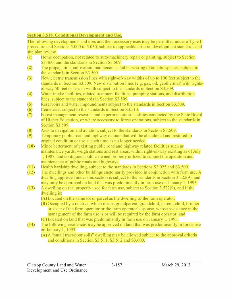
_____________________________________________________________________________ Clatsop County Land and Water 3-157 March 29, 2013 Development and Use Ordinance
Section 3.518. Conditional Development and Use. The following developments and uses and their accessory uses may be permitted under a Type II procedure and Sections 5.000 to 5.030, subject to applicable criteria, development standards and site plan review. (1) Home occupation, not related to auto/machinery repair or painting, subject to Section
S3.460, and the standards in Section S3.509. (2) The propagation, cultivation, maintenance and harvesting of aquatic species, subject to
the standards in Section S3.509. (3) New electric transmission lines with right-of-way widths of up to 100 feet subject to the
standards in Section S3.509. New distribution lines (e.g. gas, oil, geothermal) with rights-of-way 50 feet or less in width subject to the standards in Section S3.509.
(4) Water intake facilities, related treatment facilities, pumping stations, and distribution lines, subject to the standards in Section S3.509.
(5) Reservoirs and water impoundments subject to the standards in Section S3.509. (6) Cemeteries subject to the standards in Section S3.513. (7) Forest management research and experimentation facilities conducted by the State Board
of Higher Education, or where accessory to forest operations, subject to the standards in Section S3.509.
(8) Aids to navigation and aviation, subject to the standards in Section S3.509. (9) Temporary public road and highway detours that will be abandoned and restored to
original condition or use at such time as no longer needed. (10) Minor betterment of existing public road and highway related facilities such as
maintenance yards, weigh stations and rest areas, within right-of-way existing as of July 1, 1987, and contiguous public-owned property utilized to support the operation and maintenance of public roads and highways.
(11) Health hardship dwelling, subject to the standards in Sections S3.025 and S3.509. (12) The dwellings and other buildings customarily provided in conjunction with farm use. A
dwelling approved under this section is subject to the standards in Section 3.522(9), and may only be approved on land that was predominantly in farm use on January 1, 1993.
(13) A dwelling on real property used for farm use, subject to Section 3.522(9), and if the dwelling is: (A) Located on the same lot or parcel as the dwelling of the farm operator; (B) Occupied by a relative, which means grandparent, grandchild, parent, child, brother
or sister of the farm operator or the farm operator’s spouse, whose assistance in the management of the farm use is or will be required by the farm operator; and
(C) Located on land that was predominantly in farm use on January 1, 1993. (14) The following residences may be approved on land that was predominantly in forest use
on January 1, 1993: (A) A “small tract/poor soils” dwelling may be allowed subject to the approval criteria
and conditions in Section S3.511, S3.512 and S3.600.
jhickner
Highlight

_____________________________________________________________________________ Clatsop County Land and Water 3-158 March 29, 2013 Development and Use Ordinance
(B) If a dwelling is not allowed pursuant to subsection (a) of this section, a “large tract” dwelling may be allowed subject to the approval criteria and conditions in Section S3.512, S3.600 and S3.514.
(C) A single family dwelling may be allowed subject to the “template test” described in Section S3.515, and subject to the approval criteria and conditions in Section S3.512, S6.000 and S3.515.
(15) Bed and breakfast establishment subject to the standards in Section S3.464-S3.468 and Section S3.509.
(16) Transmission towers including Communication Facilities, subject to the standards in Section S3.509 and S4.700.
Section 3.519. Conditional Development and Use. The following forest and non-forest developments and uses and their accessory uses may be permitted under a Type IIA procedure and Sections 5.010 to 5.025, and subject to applicable criteria, development standards and site plan review. (1) Mining and processing of oil, gas, or other subsurface resources, as defined in ORS
Chapter 520, and not otherwise permitted under Section 3.514(3) of this zone (e.g., compressors, separators and storage serving multiple wells), and mining and processing or aggregate and mineral resources as defined in ORS Chapter 517, subject to the standards in Section S3.509.
(2) Subject to the standards in S3.509, operations conducted for: (A) Mining and processing of geothermal resources as defined by ORS 522.005 and oil
and gas as defined by ORS 520.005 not otherwise permitted in this zone; (B) Mining, crushing or stockpiling of aggregate and other mineral and other subsurface
resources subject to standards in Section S3.516; (C) Processing, as defined by ORS 517.750, of aggregate into asphalt or Portland cement;
and (D) Processing of other mineral resources and other subsurface resources.
(3) Disposal site for solid waste approved by the governing body of a city or county or both and for which the Oregon Department of Environmental Quality has granted a permit under ORS 459.245, together with equipment, facilities or buildings necessary for its operation, subject to the standards in Section S3.509.
(4) Dog kennels subject to the standards in Section S3.509 (5) A facility for the primary processing of forest products subject to the standards in Section
S3.509. (6) Permanent logging equipment repair and storage subject to the standards in Section
S3.509. (7) Log scaling and weigh stations subject to the standards in Section S3.509. (8) Private seasonal accommodations for fee hunting operations may be allowed subject to
the standards in Section S3.509, S3.512 and the following requirements: (A) Accommodations are limited to no more than 15 guest rooms; (B) Only minor incidental and accessory retail sales are permitted;
jhickner
Highlight
jhickner
Highlight

_____________________________________________________________________________ Clatsop County Land and Water 3-159 March 29, 2013 Development and Use Ordinance
(C) Accommodations are occupied temporarily for the purpose of hunting during game bird and big game hunting seasons authorized by the Oregon Fish and Wildlife Commission; and
(D) The County may impose other appropriate conditions. (9) Private accommodations for fishing occupied on a temporary basis may be allowed
subject to the standards in Sections S3.509, S3.512 and the following requirements: (A) Accommodations are limited to no more than 15 guest rooms; (B) Only minor incidental and accessory retail sales are permitted; (C) Accommodations are occupied temporarily for the purpose of fishing during fishing
seasons authorized by the Oregon Fish and Wildlife Commission; and (D) Accommodations must be located within 1/4 mile of fish bearing Class I waters; and (E) The County may impose other appropriate conditions.
(10) Private parks, playgrounds, hunting and fishing preserves and campgrounds, subject to the standards in Section S3.509.
(11) Parks, playgrounds or community centers owned and operated by a governmental agency or a non-profit community organization, subject to the standards in Section S3.509.
(12) Golf courses subject to the standards in Section S3.509. (13) Utility facilities for the purpose of generating power subject to the standards in Section
S3.509. A power generation facility shall not preclude more than ten acres from use as a commercial forest operation unless an exception is taken pursuant to OAR Chapter 660, Division 4.
(14) Transmission towers including Communication Facilities over 200 feet in height, subject to the standards in Section S3.509 and S4.700.
(15) Expansion of existing airports subject to the standards in Section S3.509. (16) Subject to the standards in Section S3.509, personal use airports for airplanes and
helicopter pads, including associated hangar, maintenance and service facilities. (17) Transportation uses and improvements may be authorized under conditions and standards
as set forth in OAR 660-12-035 and 660-12-065. (18) Climbing and passing lanes within the right-of-way existing as of July 1, 1987. (19) Temporary asphalt and concrete batch plants as accessory uses to specific highway
projects subject to the standards in Section S3.509. (20) Reconstruction or modification of public roads and highways, including the placement of
utility facilities overhead and in the subsurface of public roads and highways along the public right-of-way, but not including the addition of travel lanes, where no removal or displacement of buildings would occur, and no new land parcels result.
jhickner
Highlight

_____________________________________________________________________________ Clatsop County Land and Water 3-160 March 29, 2013 Development and Use Ordinance
(21) Construction of additional passing and travel lanes requiring the acquisition of right- of-way but not resulting in the creation of new land parcels, subject to the standards in Section S3.509.
(22) Reconstruction or modification of public roads and highways involving the removal or displacement of buildings but not resulting in the creation of new land parcels, subject to the standards in Section S3.509.
(23) Improvement of public road and highway related facilities, such as maintenance yards, weigh stations.
(24) Roads, highways and other transportation facilities and improvements not allowed under other provisions of this zone may be established, subject to the standards in Section S3.509 and the approval of an exception to the goal related to agricultural lands and to any other applicable goal with which the facility or improvement does not comply.
(25) Fire stations for rural fire protection subject to the standards in Section S3.509. (26) Firearms training facility subject to the standards in Section S3.513.
Section 3.522. Development and Use Standards. The following standards are applicable to permitted and conditional development in the zone: (1) Lot size:
(A) Minimum for division of land: 80 acres. (2) Setbacks for buildings:
(A) Front yard: 30 feet. (B) Side and rear yard: 20 feet. (C) Setbacks in wetland areas shall be in accordance with Section S4.500.
(3) Maximum building height: 45 feet. (4) Setback for surface and subsurface mining operations: 500 feet from adjacent residences
and adjacent residential lands. (5) Uses in this zone which are in either a Major or Peripheral Big Game Range, as shown on
the map in the County’s Comprehensive Plan, are subject to the standards in Section S3.517. A copy of each application for a conditional use shall be sent to the Oregon Department of Fish and Wildlife for their comments on the proposed use's potential adverse impacts on Big Game Range and their recommendations for minimizing any adverse impacts. It shall be assumed that the Department of Fish and Wildlife finds the proposed use consistent with the protection of Big Game Range if no comment is received within 7 working days of the date of the notice.
(6) An accessory structure separated from the main building shall be located in accordance with yard setback requirements.
(7) A lawfully established dwelling may be altered, restored or replaced pursuant to Section 3.514(10) only if the dwelling: (A) Has intact exterior walls and roof structures; (B) Has indoor plumbing consisting of a kitchen, sink, toilet and bathing facilities
connected to a sanitary waste disposal system; (C) Has interior wiring for interior lights;
jhickner
Highlight
jhickner
Highlight

_____________________________________________________________________________ Clatsop County Land and Water 3-161 March 29, 2013 Development and Use Ordinance
(D) Has a heating system; and (E) In the case of replacement, is removed, demolished or converted to an allowable non-
residential use within three months of the completion of the replacement dwelling. (8) Farm stands may be approved in this zone under Section 3.514(21) subject to the
following standards: (A) The structures are designed and used for the sale of farm crops and livestock grown
on farms in the local agricultural area, including the sale of retail incidental items, if the sales of the incidental items make up no more than 25 percent of the total sales of the farm stand; and
(B) The farm stand does not include structures designed for occupancy as a residence or for activities other than the sale of farm crops and livestock and does not include structures for banquets, public gatherings or public entertainment.
(9) A dwelling may be approved as a conditional use (Type II) under Sections 3.518(12) or 3.518(13) of this zone subject to the following approval criteria and standards: (A) The County shall require as a condition of approval of a single family dwelling that
the landowner for the dwelling sign and record in the deed records for the County a document binding the landowner, and the landowner’s successors in interest, prohibiting them from pursuing a claim for relief or cause of action alleging injuring from farming or forest practices for which no action or claim is allowed under ORS 30.936 or 30.937.
Section 3.524. State and Federal Permit. If any state or federal permit is required for a development or use, an applicant, prior to issuance of a development permit or action, shall submit to the Planning Department a copy of the state or federal permit.
jhickner
Highlight

_____________________________________________________________________________ Clatsop County Land and Water 3-162 March 29, 2013 Development and Use Ordinance
SECTION 3.550. FOREST-80 ZONE (F-80).
Section 3.551. Purpose. The purpose of the F-80 zone is to conserve forest lands by maintaining the County's forest land base; to protect the County's forest economy by making possible economically efficient forest practices that assure the continuous growth and harvest of forest tree species as the leading use of forest land consistent with sound management of soil, air, water, fish and wildlife resources, and scenic resources; and to provide for public and private recreational opportunities and agriculture.
Section 3.552. State Forestry-Regulated Uses. The following uses and activities are permitted subject to the applicable requirements of the Oregon Forest Practices Act and its administrative rules: (1) Forest operations or forest practices including, but not limited to, reforestation of forest
land, road construction and maintenance, harvesting of forest tree species, application of chemicals, and disposal of slash. A forest operation is any commercial activity relating to the growing or harvesting of any forest tree species. (Section S3.509(3))
Section 3.553. Development and Use Permitted. The following uses and activities and their accessory uses may be permitted under a Type I procedure subject to applicable development standards: (1) Temporary on-site structures which are auxiliary to and used during the term of a
particular forest operation. Auxiliary means a use or alteration of a structure or land which provides help or is directly associated with the conduct of a particular forest practice. An auxiliary structure is located on site, temporary in nature, and is not designed to remain for the forest’s entire growth cycle from planting to harvesting. An auxiliary use is removed when a particular forest practice has concluded. A forest operation is any commercial activity relating to the growing or harvesting of any forest tree species.
(2) Physical alterations to the land auxiliary to forest practices including, but not limited to, those made for purposes of exploration, mining, commercial gravel extraction and processing, landfills, dams, reservoirs, road construction or recreational facilities.
(3) Uses to conserve soil, air and water quality and to provide for fish and wildlife resources. (4) Local distribution lines (e.g. electrical, telephone, natural gas) and accessory equipment
(e.g. electric distribution transformers, meter cabinets, terminal boxes, pedestals), or other equipment which provides service hookups, including water service hookups.
(5) Temporary portable facility for the primary processing of forest products. “Forest products” means timber grown upon a tract where the primary processing facility is located.
(6) Exploration for mineral and aggregate resources. (7) Private hunting or fishing operations without lodging accommodations. (8) Towers and fire stations for forest fire protection.
jhickner
Highlight
jhickner
Highlight

_____________________________________________________________________________ Clatsop County Land and Water 3-163 March 29, 2013 Development and Use Ordinance
(9) Widening of roads within existing rights-of-way in conformance with the Transportation Element of the Comprehensive Plan, including the following public road and highway projects: (A) Climbing and passing lanes within the right-of-way existing as of July 1, 1987. (B) Reconstruction or modification of public roads and highways, not including the
addition of travel lanes, where no removal or displacement of buildings would occur, or new land parcels result.
(C) Temporary public road and highway detours that will be abandoned and restored to original condition or use at such time as no longer needed.
(D) Minor betterment of existing public roads and highway-related facilities, such as maintenance yards, weight stations and rest areas within right-of-way existing as of July 1, 1987, and contiguous publicly-owned property used to support the operation and maintenance of public roads and highways.
(10) Uninhabitable structures accessory to fish or wildlife enhancement. (11) Temporary forest labor camps. (12) Alteration, restoration or replacement of a lawfully established dwelling that:
(A) Has intact exterior walls and roof structures; (B) Has indoor plumbing consisting of a kitchen, sink, toilet and bathing facilities
connected to a sanitary waste disposal system; (C) Has interior wiring for interior lights; (D) Has a heating system; and (E) In the case of replacement, is removed, demolished or converted to an allowable non-
residential use within three months of the completion of the replacement dwelling. (13) Exploration for and production of geothermal, gas, oil, and other associated
hydrocarbons, including the placement and operation of compressors, separators and other customary production equipment for an individual well adjacent to the well head, subject to Section S4.311 and S4.312.
(14) Communication facilities subject to the standards in Section S3.509 and S4.700.
Section 3.554. Conditional Development and Use. The following uses and activities and their accessory uses may be permitted under a Type II procedure and Section 5.000 to 5.030, subject to applicable criteria, development standards and site plan review. (1) Farm use. (2) Aids to navigation or aviation subject to the standards in S3.509. (3) Water intake facilities, related treatment facilities, pumping stations, and distribution
lines subject to the standards in Section S3.509. (4) Reservoirs and water impoundments subject to the standards in Section S3.509. (5) New electric transmission lines with right-of-way widths of up to 100 feet as specified in
ORS 772.210, subject to the standards in Section S3.509. New distribution lines (e.g. gas, oil, geothermal) with rights-of-way 50 feet or less in width subject to the standards in Section S3.509.
jhickner
Highlight

_____________________________________________________________________________ Clatsop County Land and Water 3-164 March 29, 2013 Development and Use Ordinance
(6) Home occupations not related to auto/machinery repair or painting subject to the standards in Section S3.509 and S3.460.
(7) Forest management research and experimentation facilities subject to the standards in Section S3.509: (A) where accessory to forest operations; or (B) conducted by the Oregon State Board of Higher Education.
(8) The following residences may be approved on land that was predominantly in forest use on January 1, 1993: (A) A “small tract/poor soils” dwelling may be allowed subject to the approval criteria
and conditions in Section S3.511, S3.512 and S6.000. (B) If a dwelling is not allowed pursuant to subsection (a) of this section, a “large tract”
dwelling may be allowed subject to the approval criteria and conditions in Section S3.512, S6.000 and S3.514.
(C) A single family dwelling may be allowed subject to the “template test” described in Section S3.515, and subject to the approval criteria and conditions in Section S3.512, S6.000, and S3.515.
(9) Cemetery subject to the standards in Section S3.509. (10) Health hardship dwelling, subject to the standards in Sections S3.025 and S3.509. (11) Bed and breakfast establishment subject to the standards in Section S3.464-S3.468 and
Section S3.509. (12) Communication facilities subject to the standards in Section S3.509 and S4.700.
Section 3.555. Conditional Development and Use. The following forest and non-forest developments and uses and their accessory developments and uses may be permitted under a Type IIA procedure and Sections 5.000-5.030, subject to applicable criteria, development standards and site plan review. (1) Water intake facilities, canals and distribution lines for farm irrigation or ponds. (2) Caretaker residences for public parks and fish hatcheries. (3) A facility for the primary processing of forest products subject to the standards in Section
S3.509. (4) Permanent logging equipment repair and storage subject to the standards in Section
S3.509. (5) Log scaling and weigh stations subject to the standards in Section S3.509. (6) Disposal site for solid waste approved by the governing body of a city or county or both
and for which the Oregon Department of Environmental Quality has granted a permit under ORS 459.245, together with equipment, facilities or buildings necessary for its operation, subject to the standards in Section S3.509.
(7) Parks and campgrounds subject to the standards in Section S3.509. (8) Mining or processing of oil, gas, or other subsurface resources, not otherwise permitted
under Section 3.553(6) of this zone, subject to the standards in Section S3.509; and mining and processing or aggregate and mineral resources not otherwise permitted under Section 3.553(13), subject to the standards in Section S3.509.
jhickner
Highlight

_____________________________________________________________________________ Clatsop County Land and Water 3-165 March 29, 2013 Development and Use Ordinance
(9) Communication facilities and transmission towers, subject to the standards in Section S3.509 and S4.700.
(10) Fire stations for rural fire protection subject to the standards in Section S3.509. (11) Utility facilities for the purpose of generating power subject to the standards in Section
S3.509. A power generation facility shall not preclude more than ten acres from use as a commercial forest operation unless an exception is taken pursuant to OAR Chapter 660, Division 4.
(12) Firearms training facility subject to the standards in Section S3.509. (13) Private seasonal accommodations for fee hunting subject to the standards in Section
S3.509 and the following requirements: (A) Accommodations are limited to no more than 15 guest rooms; (B) Only minor incidental and accessory retail sales are permitted; (C) Accommodations are occupied temporarily for the purpose of hunting during game
bird and big game hunting seasons authorized by the Oregon Fish and Wildlife Commission; and
(D) The County may impose other appropriate conditions. (14) Temporary asphalt or concrete batch plants as accessory uses to specific highway projects
subject to the standards in Section S3.509. (15) Any of the following public road and highway projects subject to the Standards in
Section S3.509: (A) Construction of additional passing and travel lanes requiring the acquisition of right-
of-way but not resulting in the creation of new land parcels. (B) Reconstruction or modification of public roads and highways involving the removal
or displacement of buildings but not resulting in the creation of new land parcels. (C) Improvement of public roads and highway-related facilities such as maintenance
yards, weigh stations and rest areas, where additional property or right-of-way is required but not resulting in the creation of new land parcels.
(D) Roads, highways and other transportation facilities and improvements not allowed elsewhere in this zone may be established, subject to adoption of an exception to the goal related to agricultural lands and to any other applicable goal with which the facility or improvement does not comply.
(16) Private accommodations for fishing subject to the standards in Section S3.509 and the following standards: (A) Accommodations limited to no more than 15 guest rooms; (B) Only minor incidental and accessory retail sales are permitted; (C) Accommodations occupied temporarily for the purpose of fishing during fishing
seasons authorized by the Oregon Fish and Wildlife Commission; (D) Accommodations must be located within 1/4 mile of fish bearing Class I waters; and (E) The County may impose other appropriate conditions.
jhickner
Highlight

_____________________________________________________________________________ Clatsop County Land and Water 3-166 March 29, 2013 Development and Use Ordinance
Section 3.557. Development and Use Standards. The following standards are applicable to permitted and conditional development in the zone: (1) The minimum lot size for land divisions other than those described under subsections
below, is 80 acres. (2) Land divisions resulting in parcels smaller than 80 acres may be approved for the
following uses provided that such uses have been approved subject to the standards in Section S3.509, and the resulting parcels are the minimum size necessary for the use: (A) Exploration for and production of geothermal resources, gas, oil and other associated
hydrocarbons, including the placement and operation of compressors, separators and other customary production equipment for an individual well adjacent to the well head. (Section S3.512 and S4.311).
(B) A facility for the primary processing of forest products subject to the standards in Section S3.509.
(C) Permanent logging equipment repair and storage subject to the standards in Section S3.509.
(D) Log scaling and weigh station subject to the standards in Section S3.509. (E) Disposal of solid waste approved by the governing body of a city or a county or both
and for which the Oregon Department of Environmental Quality has granted a permit under ORS 459.245, together with equipment, facilities or buildings necessary for its operation, subject to the standards in Section S3.509.
(F) Parks and campgrounds subject to the standards in Section S3.509. (G) Mining or processing of oil, gas, mineral, aggregate or other subsurface resources not
otherwise permitted under Section 3.553(6) of this zone, subject to the standards in Section S3.509; and mining and processing of aggregate and mineral resources not otherwise permitted under Section 3.553(13), subject to the standards in Section S3.509.
(H) Communication facilities and transmission towers subject to the standards in Section S3.509.
(I) Fire stations for rural fire protection subject to the standards in Section S3.509. (J) Utility facilities for the purpose of generating power, subject to the standards in
Section S3.509. A power generation facility shall not preclude more than ten acres from use as a commercial forest operation unless an exception is taken pursuant to OAR Chapter 660, Division 4.
(K) Aids to navigation or aviation subject to the standards in Section S3.509. (L) Water intake facilities, related treatment facilities, pumping stations and distribution
lines subject to the standards in Section S3.509. (M) Reservoirs and water impoundments subject to the standards in Section S3.509. (N) Firearms training facility subject to standards in Section S3.509. (O) Cemetery subject to the standards in Section S3.509.
jhickner
Highlight

_____________________________________________________________________________ Clatsop County Land and Water 3-167 March 29, 2013 Development and Use Ordinance
(3) Minimum setbacks for dwellings: (A) Front yard: 30 feet. (B) Side and rear yard: 30 feet. (C) Setbacks in wetland areas shall be in accordance with Section S4.500. These are
minimum setbacks. Actual setbacks for dwellings will be based on the forest management plan, and may exceed these minimums.
(4) Maximum building height: 45 feet. (5) Setback for surface and subsurface mining operations: 1,000 feet from adjacent
residences and residential lands. (6) An accessory structure separated from the main building shall be located in accordance
with yard setback requirements. (7) All roads, bridges and driveways providing access to structures in the F-80 zone must
meet the design standards in Section S6.000. (8) Mining or processing of rock permitted under Section 3.553(13) of this zone is permitted
subject to the following restrictions: (A) No more than 50,000 cubic yards of material may be removed during a three year
period from a single quarry; (B) A minimum distance of 2,500 feet between the quarry/processing operation and any
school, church or residence must be maintained; (C) The quarry/processing operation must not be visible from a public road; (D) Measures recommended by the Oregon Department of Fish and Wildlife to protect
aquatic habitat must be followed; (E) There must be no conflict between the quarry/processing operation and any Goal 5
resources; and (F) Applicable state requirements must be met.
Section 3.558. State and Federal Permits. If any state or federal permit is required for a development or use, an applicant, prior to issuance of a development permit or action, shall submit to the Planning Department a copy of the state or federal permit.
jhickner
Highlight

_____________________________________________________________________________ Clatsop County Land and Water 3-168 March 29, 2013 Development and Use Ordinance
SECTION 3.560. EXCLUSIVE FARM USE ZONE (EFU).
Section 3.562. Purpose. The purpose and intent of the EFU zone is to provide areas for the continued practice of agriculture and permit the establishment of only those new developments which are compatible with agricultural activities. It is the intent of this zone classification to provide the automatic farm use valuation for farms which qualify under the provisions of Oregon Revised Statutes (ORS) 308.345-308.406. Therefore, the EFU zone is to be applied in those areas generally well suited for farming, as indicated by the nature and type of soil, size and location of the property, the suitability of the terrain and other similar factors. Further, the EFU zone is intended to guarantee the preservation and maintenance of the areas so classified for farm use free from conflicting non-farm uses and influences. It is the purpose and intent of this zone to encourage farm or agricultural use of land. All partitions of land within an EFU zone shall be subject to the requirements of Sections 3.572 and 5.200 of this Ordinance.
Section 3.563. State Forestry-Related Uses. The following uses and activities are permitted subject to the applicable requirements of the Oregon Forest Practices Act and its administrative rules: (1) The propagation and harvesting of a forest product.
Section 3.564. Development and Use Permitted. The following developments and their accessory uses are permitted under a Type I procedure subject to applicable development standards. (1) Farm uses (see definition). (2) Operations for the exploration of geothermal resources as defined by ORS 522.005, and
oil and gas as defined by ORS 520.005, including the placement and operation of compressors, separators and other customary production equipment for an individual well adjacent to the wellhead. Any activities or construction relating to such operations shall not be a basis for an exception under ORS 197.732(1)(a) or (b).
(3) Public or private schools, including all buildings essential to the operation of a school, subject to the standards in Section 3.572(17).
(4) Utility facilities necessary for public service including Communication Facilities subject to the standards in Section S4.700, except commercial facilities for the purpose of generating power for public use by sale and transmission towers over 200 feet in height. The facility is necessary if it must be situated in the EFU zone in order for the service to be provided.
(5) Winery subject to the standards in Section S3.513.
jhickner
Highlight
jhickner
Highlight

_____________________________________________________________________________ Clatsop County Land and Water 3-169 March 29, 2013 Development and Use Ordinance
(6) Operations for the exploration for minerals as defined by ORS 517.750. Any activities or construction relating to such operations shall not be a basis for an exception under ORS 197.732(1)(a) or (b).
(7) Climbing and passing lanes within the right-of-way existing as of July 1, 1987. (8) Reconstruction or modification of public roads and highways, including the placement of
utility facilities overhead and in the subsurface of public roads and highways along the public right-of-way, but not including the addition of travel lanes, where no removal or displacement of buildings would occur, and new land parcels result.
(9) Temporary public road or highway detours that will be abandoned and restored to original condition or use at such time as no longer needed.
(10) Minor betterment of existing public road and highway related facilities such as maintenance yards, weigh stations and rest areas, within right-of-way existing as of July 1, 1987 and contiguous public-owned property utilized to support the operation and maintenance of public roads and highways.
(11) Creation, restoration, or enhancement of wetlands. (12) Alteration, restoration, or replacement of a lawfully established dwelling, subject to the
standards in Section 3.572(10). (13) Churches and cemeteries in conjunction with churches, subject to the standards in Section
3.572(17). (14) Seasonal farm worker housing, subject to the standards in Section 3.572(20). (15) Replacement dwelling to be used in conjunction with farm use if the existing dwelling
has been listed on the National Register of Historic Places.
Section 3.566. Conditional Development and Use. The following developments and their accessory uses may be permitted under a Type II procedure and Sections 5.010 to 5.025 subject to applicable criteria and development standards and site plan review. (1) Commercial activities in conjunction with farm use subject to the standards in Section
S3.509. (2) Home occupations not related to auto/machinery repair or painting, subject to the
standards in Section S3.509 and S3.460 and, in the case of a home occupation on high- value farmland, subject to the standard in Section 3.572(13).
(3) The propagation, cultivation, maintenance and harvesting of aquatic species, subject to the standards in Section S3.509.
(4) A dwelling on property used for farm use located on the same lot or parcel as the dwelling of the farm operator, and occupied by an immediate family member of the farm operator or the farm operator’s spouse, whose assistance in the management of the farm use is or will be required by the farm operator, subject to the standard in Section 3.572(19).
(5) Dwelling customarily provided in conjunction with farm use, subject to standards in Section S3.518. Other buildings customarily provided in conjunction with farm use.
jhickner
Highlight

_____________________________________________________________________________ Clatsop County Land and Water 3-170 March 29, 2013 Development and Use Ordinance
(6) A “small tract/poor soils” dwelling may be allowed subject to the approval criteria and conditions in Section S3.511, S3.512 and S6.000.
(7) A non-farm dwelling subject to the standards in Section S3.519. (8) A non-farm dwelling subject to the standards in Section S3.520. (9) Room and board arrangements for a maximum of five unrelated persons in existing
residences, subject to the standards in Section S3.509. (10) Health hardship dwelling, subject to the standards in Sections S3.025 and S3.509. (11) Bed and breakfast establishment subject to the standards in Section S3.464-S3.468 and
Section S3.509. (12) Transmission towers including Communication Facilities subject to the standards in
Sections S3.509 and S4.700.
Section 3.567. Conditional Development and Use. The following forest and non-forest developments and uses and their accessory uses may be permitted under a Type IIa procedure and Sections 5.000-5.030, subject to applicable criteria, development standards and site plan review. (1) Operations conducted for the mining and processing of geothermal resources as defined
by ORS 522.005 and for oil and gas as defined in ORS 520.005 not otherwise permitted in this zone, subject to the standards in Section S3.509.
(2) Private parks, playgrounds, hunting and fishing preserves and campgrounds may be maintained, enhanced or expanded on high-value farmlands, and may be established as new uses on other lands in this zone subject to the standards in Section S3.509 and, in the case of campgrounds, subject to Section 3.572(11).
(3) Parks, playgrounds, or community centers owned and operated by governmental agency of non-profit community organization, subject to the standards in Section S3.509.
(4) Existing golf courses wholly within the EFU zone may be maintained, enhanced or expanded on high-value farmlands. New golf courses may be established on non-high- value farmlands in this zone subject to the standards in Section S3.509 and in Section 3.572(12).
(5) A facility for the primary processing of forest products subject to the standards in Section 3.572(14).
(6) Personal use airports subject to the standards in Section S3.509 and Section 3.572(15). (7) A site for the disposal of solid waste together with equipment, facilities or buildings
necessary for its operation, subject to the standards in Section S3.509 and Section 3.572(16).
(8) Commercial utility facilities for the purpose of generating power for public use by sale subject to the standards in Section S3.509 and Section 3.572(18).
(9) Transmission towers including Communication Facilities over 200 feet in height, subject to the standards in Section S3.509.
jhickner
Highlight

_____________________________________________________________________________ Clatsop County Land and Water 3-171 March 29, 2013 Development and Use Ordinance
(10) On high-value farmland, the enhancement, expansion and maintenance of existing dog kennels. On farmland that is not high-value farmland, the establishment of new dog kennels or the enhancement, expansion and maintenance of existing dog kennels, subject to the standards in Section S3.509.
(11) Processing of aggregate into asphalt or Portland cement, subject to the standards in Section S3.509.
(12) Operations conducted for the mining, crushing or stockpiling of aggregate and other mineral and other subsurface resources, subject to the standard in Section S3.509.
(13) Processing of other mineral resources and other subsurface resources not otherwise permitted in the EFU zone, subject to the standards in Section S3.509.
(14) Improvement of public road and highway related facilities, such as maintenance yards, weigh stations and rest areas, where additional property or right-of-way is required but not resulting in the creation of new land parcels, subject to the standards in Section S3.509.
(15) Construction of additional passing and travel lanes requiring acquisition of right-of-way but not resulting in the creation of new land parcels, subject to the standards in Section S3.509.
(16) Reconstruction or modification of public roads and highways involving the removal or displacement of buildings but not resulting in the creation of new land parcels, subject to the standards in Section S3.509.
(17) Roads, highways and other transportation facilities, and improvements not otherwise allowed in the EFU zone, subject to the adoption by the County of an exception to Statewide Planning Goal 3.
Section 3.572. Development and Conditional Development and Use Standards. General Standards: (1) The minimum parcel size for new parcels shall be 80 acres, or if the new parcel is to be
created for a nonfarm use authorized in this zone, it shall be the minimum size needed to accommodate the use in a manner consistent with other requirements of this zone and other applicable state and federal laws but in no case shall it be smaller than 20 acres. No new lot or parcel may be created for a non-farm dwelling until the dwelling has been approved.
(2) Maximum building height: (A) Dwellings: 45 feet. (B) All other structures: no standard.
(3) Minimum front yard: 30 feet for all structures abutting a street. (4) Minimum rear yard:
(A) Dwellings: 20 feet. (B) Churches, public and private schools and other non-farm uses: 20 feet.
(5) Minimum side yard: (A) Dwellings: 30 feet, except 20 feet on a corner lot. (B) Churches, public and private schools and other non-farm uses: 20 feet.
jhickner
Highlight

_____________________________________________________________________________ Clatsop County Land and Water 3-172 March 29, 2013 Development and Use Ordinance
(6) No requirement of Section S2.012 Clear Vision Areas shall interfere with growing of farm crops.
(7) Agricultural uses in an EFU/SO zone shall be subject to the standards in S4.204. (8) An accessory structure separated from the main building shall be located in accordance
with yard setback requirements. (9) A farm stand may be allowed under Section 3.564(1) of the zone subject to the following
standards: (A) The structures are designed and used for the sale of farm crops and livestock grown
on farms in the local agricultural area, including the sale of retail incidental items, if the sales of the incidental items make up no more than 25 percent of the total sales of the farm stand; and
(B) The farm stand does not include structures designed for occupancy as a residence or for activities other than the sale of farm crops and livestock and does not include structures for banquets, public gatherings or public entertainment.
(10) (A) A lawfully established dwelling under Section 3.564(12) of this zone is a single family dwelling which:
1) Has intact exterior walls and roof structure; 2) Has indoor plumbing consisting of a kitchen sink, toilet and bathing facilities
connected to a sanitary waste disposal system; 3) Has interior wiring for interior lights; and 4) Has a heating system.
(B) In the case of replacement, the dwelling to be replaced shall be removed, demolished, or converted to an allowable use within three months of the completion of the replacement dwelling.
(C) An accessory farm dwelling may only be replaced by a manufactured dwelling. (11) New campgrounds may be established under Section 3.567(2) of this zone, except for
areas of high-value farmland. (12) A new golf course may be established in this zone, Section 3.567(4), except on high-
value farmland. (13) Home occupations on high-value farmland in this zone, Section 3.566(2), Section S3.462
may be authorized if they are operated substantially in the dwelling or other buildings normally associated with uses permitted in this zone.
(14) A facility for the primary processing of forest products approved under Section 3.567(5) of this zone shall not seriously interfere with accepted farming practices and shall be compatible with farm uses described in ORS 215.203(2). Such facility may be approved for a one-year period which is renewable and is intended to be only portable or temporary in nature. The primary processing of a forest product, as used in this section, means the use of a portable chipper or stud mill or other similar methods of initial treatment of a forest product in order to enable its shipment to market. Forest products as used in this section means timber grown upon a tract where the primary processing facility is located.
(15) A personal-use airport approved under Section 3.567(6) of this zone.
jhickner
Highlight

_____________________________________________________________________________ Clatsop County Land and Water 3-173 March 29, 2013 Development and Use Ordinance
(16) A site for the disposal of solid waste approved under Section 3.567(7) of this zone is subject to the following standards: (A) The site must be approved by the governing body of a city or county or both; (B) The site must be permitted under ORS 459.245 by the Department of Environmental
Quality; (C) On high-value farmland, an existing facility may be maintained, enhanced or
expanded, but no new facilities may be developed. In the EFU zone, new solid waste disposal sites may only be approved on land which is not high-value farmland.
(17) Uses subject to this standard shall not be approved; within three miles of an urban growth boundary unless an exception is approved pursuant to ORS 197.732 and OAR 660, Division 4; or on high-value farmlands. Existing facilities wholly within the EFU zone may be maintained, enhanced or expanded subject to other applicable requirements.
(18) (A) Pursuant to Section 3.567(8) of this zone, a commercial utility facility for the
purpose of generating power for public use by sale located on high-value farmland shall not preclude more than 12 acres from a use as a commercial agricultural enterprise unless an exception is taken pursuant to OAR 660, Division 4.
(B) A commercial utility facility for the purpose of generating power for public use by sale located on land that is not high-value farmland shall not preclude more than 20 acres from use as a commercial agricultural enterprise unless an exception is taken pursuant to OAR 660, Division 4.
(C) For purposes of subsections (1) and (2), a commercial agricultural enterprise consists of farm operations that will:
1) Contribute in a substantial way to the area’s existing agricultural economy; 2) Help maintain agricultural processors and established farm markets. When
determining whether a farm is part of the commercial agricultural enterprise, not only what is produced, but how much and how it is marketed shall be considered. These are important factors because of the intent of Goal 3 to maintain the agricultural economy of the state.
(19) To qualify for the farm help dwelling under Section 3.566(4) of this zone, a dwelling shall be occupied by persons whose assistance in the management and farm use of the existing commercial farming operation is required by the farm operator. The farm operator shall continue to play the predominant role in the management and farm use of the farm. A farm operator is a person who operates a farm, doing the work and making the day-to-day decisions about such things as planting, harvesting, feeding and marketing.
(20) Location of seasonal farm worker housing approved under Section 3.564(14) of this zone; siting standards. (A) The availability of decent, safe and sanitary housing opportunities for seasonal farm
workers is a matter of statewide concern. (B) When a need has been shown for seasonal farm worker housing within the rural area
of a county, needed housing shall be permitted in a zone or zones with sufficient
jhickner
Highlight

_____________________________________________________________________________ Clatsop County Land and Water 3-174 March 29, 2013 Development and Use Ordinance
buildable land to satisfy that need. The County shall consider rural centers and areas committed to non-resource uses in accommodating the identified need.
(C) Subsection (2) of this section shall not be construed as an infringement on a local government’s prerogative to:
1) Set approval standards under which seasonal farm worker housing is permitted outright;
2) Improve special conditions upon approval of a specific development proposal; or
3) Establish approval procedures. (D) Any approval standards, special conditions and procedures for approval adopted by a
local government shall be clear and objective and shall not have the effect, either in themselves or cumulatively, of discouraging needed housing through unreasonable cost or delay.
(21) Mining in Exclusive Farm Use zone; land use permit. (A) For purposes of Section 3.567(13), a land use permit is required for mining more than
1,000 cubic yards of material or excavation preparatory to mining of a surface area of more than one acre. The County may set standards for a lower volume or smaller surface area than that set forth in this subsection.
(B) A permit for mining of aggregate shall be issued only for a site included on an inventory in an acknowledged Comprehensive Plan.
(22) High-value farmland is a tract composed predominantly of soils that are: (A) Irrigated and classified prime, unique, Class I or II; or
Not irrigated and classified prime, unique, Class I or II. (B) In addition to that land described in subsection (a) of this section, high-value
farmland, if outside the Willamette Valley, includes tracts growing specified perennials as demonstrated by the most recent aerial photography of the Agricultural Stabilization and Conservation Service of the U.S. Department of Agriculture taken prior to November 4, 1993. “Specified Perennials” means perennials grown for market or research purposes including, but not limited to, nursery stock, berries, fruits, nuts, Christmas trees, or vineyards, but not including seed crops, hay, pasture or alfalfa.
(C) In addition to that land described in subsection (a) of this section, high-value farmland, if west of the summit of the Coast Range and used in conjunction with a dairy operation on January 1, 1993, includes tracts composed predominantly of the following soils in Class III or IV of composed predominantly of a combination of the soils described in subsection (a) of this section and the following soils:
1) Subclassification IIIe, specifically, Astoria, Hembre, Knappa, Meda, Quillayette and Winema;
2) Subclassification IIIw, specifically, Brennar and Chitwood; 3) Subclassification I’VE, specifically, Astoria, Hembre, Meda, Neskowin and
Winema; and 4) Subclassification IVw, specially, Coquille.
jhickner
Highlight

_____________________________________________________________________________ Clatsop County Land and Water 3-175 March 29, 2013 Development and Use Ordinance
(D) In addition to that land described in subsection (a) of this section, high-value farmland includes tracts located west of U.S. Highway 101 composed predominantly of the following soils in Class III or IV or composed predominantly of a combination of the soils described in subsection (a) of this section and the following soils:
1) Subclassification IIIw, specifically, Ettersburg silt loam and Croftland silt loam;
2) Subclassification IIIe, specifically, Klooqueth silty clay loam and Winchuck silt loam; and
3) Subclassification IVw, specifically, Huffling silty clay loam. (E) The soil class, soil rating or other soil designation of a specific lot or parcel may be
changed if: 1) The property owner submits a statement of agreement from the Natural
Resource Conservation Service (NRCS) that the soil class, soil rating or other soil designation should be adjusted based on new information; or
2) The property owner submits a report from a soils scientist whose credentials are acceptable to the State Department of Agriculture that the soil class, soil rating or other soil designation should be changed; and the property owner submits a statement from the State Department of Agriculture that the Director of Agriculture or the Director’s designee has reviewed the report described in this paragraph and finds the analysis to be soundly and scientifically based.
3) Soil classes, soil ratings or other soil designations used in or made pursuant to this definition are those of the NCRS in its most recent publication for that class, rating or designation before November 4, 1993.
4) For purposes of subsection, “irrigated” means watered by an artificial or controlled means, such as sprinklers, furrows, ditches or spreader dikes. An area or tract is “irrigated” if it is currently watered, or has established rights to use water for irrigation, including such tracts that receive water for irrigation from a water or irrigation district or other provider.
Section 3.574. Prohibited Uses. It shall be unlawful to erect, structurally alter, enlarge, maintain or establish in an EFU zone any building, use or occupancy not permitted or allowed in the foregoing provisions of this zone, excepting non-conforming uses which may continue as provided in Section 5.600-5.620. Subdivisions not consistent with the purpose and intent of this zone are prohibited in an EFU zone.
Section 3.576. State and Federal Permits. If any state or federal permit is required for a development or use, an 126 applicant, prior to issuance of a development permit or action, shall submit to the Planning Department a copy of the state or federal permit.
jhickner
Highlight

_____________________________________________________________________________ Clatsop County Land and Water 3-176 March 29, 2013 Development and Use Ordinance
SECTION 3.580. OPEN SPACE, PARKS, AND RECREATION ZONE (OPR).
Section 3.582. Purpose. The OPR zone is intended to provide for the conservation of open space; the protection and development of areas uniquely suited for outdoor recreation and the protection of designated scenic, natural and cultural resource areas.
Section 3.584. Development and Use Permitted. The following developments and their accessory developments are permitted under a Type I procedure subject to applicable development standards. (1) Farm use. (2) Forest use. (3) Wildlife refuge or management area. (4) Public regional park or recreation area excluding campgrounds. (5) Historical or archaeological site/area. (6) Golf courses except in areas identified as Coastal Shorelands. (7) R.V. Park subject to Section S3.550-S3.552 except in the Clatsop Plains Planning Area. (8) Other watersheds. (9) Public or private neighborhood park or playground. (10) Golf driving range. (11) Municipally owned watersheds. (12) Accessory development customarily provided in conjunction with the above
developments. (13) Low intensity recreation.
Section 3.586. Conditional Development and Use. The following developments and their accessory developments may be permitted under a Type II procedure and Sections 5.000 to 5.030 subject to applicable criteria and development standards and site plan review. (1) Campground, primitive except in areas identified as Coastal Shorelands. (2) Group camping facilities (e.g. youth, church) except in areas identified as Coastal
Shorelands. (3) Hunting and fishing clubs except in areas identified as Coastal Shorelands. (4) Hiking, nature observation or horse trails. (5) Marinas, boat launchings and moorage facilities. (6) Structures for viewing or exhibition of natural resources. (7) Cemetery except in areas identified as Coastal Shorelands. (8) Other developments within a historical structure provided the use would not result in the
modification of the outward appearance of the structure. (9) Riding stables except in areas identified as Coastal Shorelands.
jhickner
Highlight
jhickner
Highlight
jhickner
Highlight

_____________________________________________________________________________ Clatsop County Land and Water 3-177 March 29, 2013 Development and Use Ordinance
(10) Accessory development customarily provided in conjunction with the above developments.
Section 3.588. Conditional Development and Use Criteria. The following limitations and requirements shall apply to conditional developments: (1) The proposed development shall be consistent with the Clatsop County Comprehensive
Plan. (2) The development shall be compatible with and appropriate to the natural resources and
features, recreational characteristics and current predominant land use of the area for which it is proposed.
(3) In no event shall the proposed development destroy or endanger the natural and recreational resources giving value to the area.
(4) The proposed development shall include adequate measures to reduce fire hazards and prevent the spread of fire to surrounding areas.
(5) The location of buildings, signs, parking, recreation areas and open space shall be compatible with adjacent areas and the natural scenic amenities of the locality.
Section 3.590. Development and Use Standards. The following standards are applicable to permitted and conditional developments in this zone: (1) Setbacks. No structures shall be placed closer than 100 feet to perennial streams, lakes or
other water bodies or closer than 60 feet to arterials, collectors or public roads and highways or closer than 20 feet to other roads and property lines.
(2) Utility Services. All utility services, including power and telephone, shall be installed underground where physical conditions permit.
(3) Building Height. Maximum height for all structures shall be 35 feet or the maximum height allowed in an adjacent zone that has a lower maximum height standard.
(4) Area and Lot Size. The minimum area and lot size shall be that determined to be necessary for the protection of health and natural resources.
(5) An accessory structure separated from the main building shall be located in accordance with yard setback requirements.
Section 3.592. State and Federal Permits. If any state or federal permit is required for a development or use, an applicant, prior to issuance of a development permit or action, shall submit to the Planning Department a copy of the state or federal permit.
jhickner
Highlight
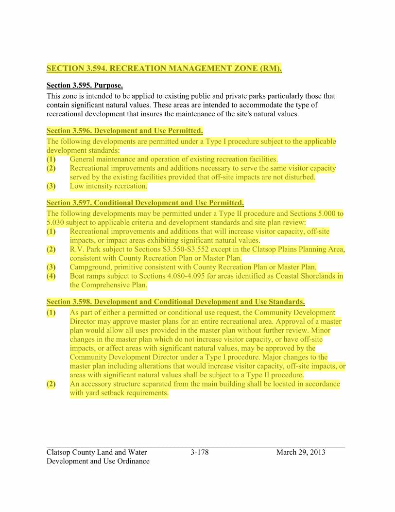
_____________________________________________________________________________ Clatsop County Land and Water 3-178 March 29, 2013 Development and Use Ordinance
SECTION 3.594. RECREATION MANAGEMENT ZONE (RM).
Section 3.595. Purpose. This zone is intended to be applied to existing public and private parks particularly those that contain significant natural values. These areas are intended to accommodate the type of recreational development that insures the maintenance of the site's natural values.
Section 3.596. Development and Use Permitted. The following developments are permitted under a Type I procedure subject to the applicable development standards: (1) General maintenance and operation of existing recreation facilities. (2) Recreational improvements and additions necessary to serve the same visitor capacity
served by the existing facilities provided that off-site impacts are not disturbed. (3) Low intensity recreation.
Section 3.597. Conditional Development and Use Permitted. The following developments may be permitted under a Type II procedure and Sections 5.000 to 5.030 subject to applicable criteria and development standards and site plan review: (1) Recreational improvements and additions that will increase visitor capacity, off-site
impacts, or impact areas exhibiting significant natural values. (2) R.V. Park subject to Sections S3.550-S3.552 except in the Clatsop Plains Planning Area,
consistent with County Recreation Plan or Master Plan. (3) Campground, primitive consistent with County Recreation Plan or Master Plan. (4) Boat ramps subject to Sections 4.080-4.095 for areas identified as Coastal Shorelands in
the Comprehensive Plan.
Section 3.598. Development and Conditional Development and Use Standards. (1) As part of either a permitted or conditional use request, the Community Development
Director may approve master plans for an entire recreational area. Approval of a master plan would allow all uses provided in the master plan without further review. Minor changes in the master plan which do not increase visitor capacity, or have off-site impacts, or affect areas with significant natural values, may be approved by the Community Development Director under a Type I procedure. Major changes to the master plan including alterations that would increase visitor capacity, off-site impacts, or areas with significant natural values shall be subject to a Type II procedure.
(2) An accessory structure separated from the main building shall be located in accordance with yard setback requirements.
jhickner
Highlight
jhickner
Highlight

_____________________________________________________________________________ Clatsop County Land and Water 3-179 March 29, 2013 Development and Use Ordinance
Section 3.599 State and Federal Permits. If any state or federal permit is required for a development or use, an applicant, prior to issuance of a development permit or action, shall submit to the Planning Department a copy of the state or federal permit.
jhickner
Highlight

_____________________________________________________________________________ Clatsop County Land and Water 3-180 March 29, 2013 Development and Use Ordinance
SECTION 3.600. NATRURAL UPLANDS ZONE (NU).
Section 3.602. Purpose. The NU zone is intended to provide for the preservation of designated significant natural resource areas in the upland portions of the County. Emphasis is placed on the limitation and regulation of human activity in those areas to protect their unique, irreplaceable or fragile qualities.
Section 3.604. Development and Use Permitted. The following developments and their accessory developments are permitted under a Type I procedure subject to applicable development standards. (1) Wildlife sanctuary or preserve. (2) Forest or plant preserve. (3) Low intensity recreation.
Section 3.606. Conditional Development and Use. The following developments and their accessory developments may be permitted under a Type II procedure and Sections 5.000 to 5.030 subject to applicable criteria and development standards and site plan review. (1) Facilities for scientific and educational observation and experimentation. (2) The following public recreational/educational development limited to day use and
provided that the development does not destroy or endanger the natural resources. (A) An exhibition of the natural characteristics of the area and the vegetation or wildlife
supported by such land and water resources; (B) Accessory facility for an outdoor recreation activity such as fishing, hiking, or
horseback riding. (C) All non-water related dependent structures shall be 100 feet from bodies of water.
Section 3.608. State and Federal Permits. If any state or federal permit is required for a development or use, an applicant, prior to issuance of a development permit or action, shall submit to the Planning Department a copy of the state or federal permit.
jhickner
Highlight
jhickner
Highlight
jhickner
Highlight

_____________________________________________________________________________ Clatsop County Land and Water 3-181 March 29, 2013 Development and Use Ordinance
SECTION 3.610. LAKE AND WETLANDS ZONE (LW).
Section 3.611. Purpose. The purpose of the LW zone is to assure the conservation of important shoreland and wetland biological habitats and conserve examples of different natural ecosystem types and to assure a diversity of species and ecological relations in Clatsop County. Low intensity uses which do not result in major alterations are appropriate in this zone. Low to moderate intensity recreation is appropriate in coastal lakes. This zone includes coastal and non-coastal lakes, significant non-estuarine freshwater marshes and important upland biological habitat. The freshwater marshes in this district are of two categories: those designated under Goal 17 which were formed by coastal processes, and those designated under Goal 5.
Section 3.612. Zone Boundaries. The zone shall be designated on the Clatsop County Land and Water Development and Use Ordinance zoning map, and shall conform to the 1" to 400' photocontour maps entitled "Significant Shoreland and Wetland Biological Habitats" on file at the Clatsop County Department of Community Development office and hereby adopted by reference.
Section 3.613. Development and Use Permitted. The following developments are permitted under a Type I procedure subject to the applicable development standards: (1) Low intensity recreation. (2) Passive restoration. (3) Vegetative shoreline stabilization. (4) Submerged cable, sewerline, waterline or other pipeline. (5) Maintenance and repair of existing structures. (6) Cultivation and harvest of cranberries, including irrigation equipment, pumps and ditches
necessary for the management and protection of cranberries. This use is permitted only in the Delmoor Loop Road area as described in the County's Goal 5 Element.
(7) Bridges and pile supported walkways or other piling supported structures under 500 sq.ft., other than docks.
(8) Land transportation facilities as specified in Section 3.035.
jhickner
Highlight
jhickner
Highlight
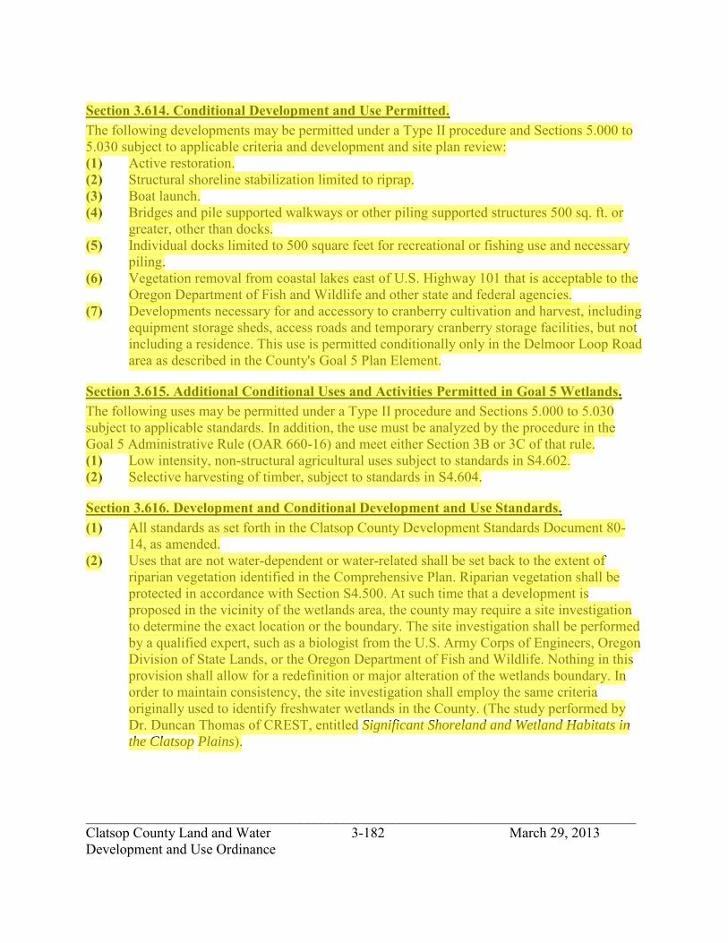
_____________________________________________________________________________ Clatsop County Land and Water 3-182 March 29, 2013 Development and Use Ordinance
Section 3.614. Conditional Development and Use Permitted. The following developments may be permitted under a Type II procedure and Sections 5.000 to 5.030 subject to applicable criteria and development and site plan review: (1) Active restoration. (2) Structural shoreline stabilization limited to riprap. (3) Boat launch. (4) Bridges and pile supported walkways or other piling supported structures 500 sq. ft. or
greater, other than docks. (5) Individual docks limited to 500 square feet for recreational or fishing use and necessary
piling. (6) Vegetation removal from coastal lakes east of U.S. Highway 101 that is acceptable to the
Oregon Department of Fish and Wildlife and other state and federal agencies. (7) Developments necessary for and accessory to cranberry cultivation and harvest, including
equipment storage sheds, access roads and temporary cranberry storage facilities, but not including a residence. This use is permitted conditionally only in the Delmoor Loop Road area as described in the County's Goal 5 Plan Element.
Section 3.615. Additional Conditional Uses and Activities Permitted in Goal 5 Wetlands. The following uses may be permitted under a Type II procedure and Sections 5.000 to 5.030 subject to applicable standards. In addition, the use must be analyzed by the procedure in the Goal 5 Administrative Rule (OAR 660-16) and meet either Section 3B or 3C of that rule. (1) Low intensity, non-structural agricultural uses subject to standards in S4.602. (2) Selective harvesting of timber, subject to standards in S4.604.
Section 3.616. Development and Conditional Development and Use Standards. (1) All standards as set forth in the Clatsop County Development Standards Document 80-
14, as amended. (2) Uses that are not water-dependent or water-related shall be set back to the extent of
riparian vegetation identified in the Comprehensive Plan. Riparian vegetation shall be protected in accordance with Section S4.500. At such time that a development is proposed in the vicinity of the wetlands area, the county may require a site investigation to determine the exact location or the boundary. The site investigation shall be performed by a qualified expert, such as a biologist from the U.S. Army Corps of Engineers, Oregon Division of State Lands, or the Oregon Department of Fish and Wildlife. Nothing in this provision shall allow for a redefinition or major alteration of the wetlands boundary. In order to maintain consistency, the site investigation shall employ the same criteria originally used to identify freshwater wetlands in the County. (The study performed by Dr. Duncan Thomas of CREST, entitled Significant Shoreland and Wetland Habitats in
the Clatsop Plains).
jhickner
Highlight

_____________________________________________________________________________ Clatsop County Land and Water 3-183 March 29, 2013 Development and Use Ordinance
Section 3.617. State and Federal Permits. If any state or federal permit is required for a development or use, an applicant, prior to issuance of a development permit or action, shall submit to the Planning Department a copy of the state or federal permit.
jhickner
Highlight

_____________________________________________________________________________ Clatsop County Land and Water 3-184 March 29, 2013 Development and Use Ordinance
SECTION 3.620. MARINE INDUSTRIAL SHORELANDS ZONE (MI).
Section 3.622. Purpose and Areas Included. The purpose of the MI zone is to manage Columbia River Estuary shorelands in urban and urbanizable areas and shorelands in rural areas especially suited for water-dependent development and to reserve these shorelands for water-dependent industrial, commercial, and high-intensity recreational use. New industrial use building or buildings may not exceed 30,000 square feet of floor area, unless determined through further review that larger buildings will not exceed the carrying capacity of the land to provide adequate water and absorb waste. Expansion of an existing industrial use resulting in building or buildings exceeding 30,000 square feet of floor area are appropriate when the use will not exceed the carrying capacity of the land. Marine Industrial Shoreland areas have unique characteristics that make them especially suited for water-dependent development. Characteristics that contribute to suitability for water-dependent development include: (1) Deep water close to shore with supporting land transportation facilities suitable for ship
and barge facility. (2) Potential for aquaculture. (3) Protected areas subject to scour which would require little dredging for use as a marine;
and (4) Potential for recreational utilization of coastal waters or riparian resources. Uses of the MI zone shall maintain the integrity of the estuary and coastal waters. Water-dependent development uses receive highest priority, followed by water-related uses. Uses which are not water-dependent or water-related are provided for, only if they do not foreclose options for future higher priority uses and do not limit the potential for more intensive use of the area.
Section 3.624. Permitted Developments. The following uses and activities, and their accessory uses and activities, are permitted in the MI zone under a Type I procedure, Section 2.015, provided that commercial and subject to the provisions of Section 3.634, Development Standards: (1) Low-intensity water-dependent recreation. (2) Vegetative shoreline stabilization. (3) Navigational aids. (4) Passive restoration. (5) Grazing or other farm uses involving no structures. (6) Forestry activities. (7) Maintenance and repair to existing structures and facilities, including dikes. (8) Temporary dike for emergency flood protection, subject to state and federal regulations,
limited to 60 days. (9) Dredged material disposal including beach nourishment at sites designated in the
Comprehensive Plan.
jhickner
Highlight

_____________________________________________________________________________ Clatsop County Land and Water 3-185 March 29, 2013 Development and Use Ordinance
(10) Water-dependent industrial and port uses, including but not limited to: (A) port facilities and/or shipping activities (B) fuel storage and dispensing facilities (C) vessel construction, maintenance or repair facilities (D) marine railway facilities (E) seafood receiving, processing and storage (F) ice making and sales establishment (G) integrated manufacturing and shipping facility where a significant portion of the
operation is water-dependent (H) other water-dependent industrial, or port uses meeting the criteria in Section
S4.243(1), Water-dependent Use Criteria. (11) Utilities, maximum utilization of existing easements and rights-of-way shall be made.
Section 3.626. Review Developments. The following uses and activities, and their accessory uses and activities, may be permitted as Review Uses in the MI zone under a Type II procedure, Section 2.020, when authorized in accordance with Sections 5.040-5.051 Development and Use Permitted with Review, and subject to the provisions of Section 3.634, Development Standards: (1) Public utility structures. (2) Communication facilities. (3) Landfalls and access corridors for sewer line, water line, submerged cables or other
pipeline crossing. (4) Structural shoreline stabilization. (5) Dredged material disposal at sites not designated in the Comprehensive Plan provided
that the disposal does not preempt the use of the site for allowable water-dependent development activities.
(6) Excavation to create new water surface area.
Section 3.628. Conditional Developments. The following uses and activities, and their accessory uses and activities, may be permitted as Conditional Uses in the MI zone under a Type II procedure, Section 2.020, when authorized in accordance with Sections 5.000-5.030 Conditional Development and Use, and subject to the provisions of Section 3.634, Development Standards: (1) Water-related industrial and commercial uses where retail commercial buildings or
buildings for each commercial use do not exceed 3,000 square foot of floor area and industrial buildings or buildings for each industrial use does not exceed 30,000 square feet of floor area, including but not limited to: (A) administrative offices of a water-dependent business (B) marine hardware sales and repair (C) security guard quarters in conjunction with a water-dependent use (D) marine craft and/or equipment sales (E) charter fishing offices
jhickner
Highlight

_____________________________________________________________________________ Clatsop County Land and Water 3-186 March 29, 2013 Development and Use Ordinance
(F) seafood market (G) sports fish cleaning, smoking or canning (H) cold storage and/or ice processing facilities independent of seafood processing
facilities (I) other water-related industrial and commercial uses meeting the criteria in Section
S4.243(2), Water-related Use Criteria. (2) High intensity water-dependent commercial and recreational facilities including boat
ramps, commercial moorages, and marinas for commercial and recreational marine craft, provided buildings or building for each commercial use do not exceed 3,000 square feet of floor area.
(3) New dike and tidegate construction. (4) Storm-water and treated wastewater outfalls. (5) Non-water-dependent, non-related uses involving minimal capital investment, including
temporary uses. (6) Forest manufacturing. (7) Aquaculture facilities. (8) Mining and mineral extraction processing and differentiation. (9) Mitigation, restoration, creation and enhancement. (10) Marine research and education facility. (11) Land transportation systems.
Section 3.634. Development Standards. (1) All uses and activities shall satisfy applicable regional policies contained in the
Comprehensive Plan, Estuarine Resources and Coastal Shorelands Element. (2) All uses and activities shall satisfy applicable Columbia River Estuary Shoreland and
Aquatic Use and Activity standards contained in the Development and Use Standards Document.
(3) All other applicable ordinance requirements shall be satisfied. (4) When a proposal includes several uses, the uses shall be reviewed in aggregate under the
more stringent procedure. (5) Uses that are water-dependent must meet the criteria in Section S4.243(1). Uses that are
water-related must meet the criteria in Section S2.243(2). (6) Uses and activities that are not water-dependent shall not preclude or conflict with
existing or probable future water-dependent use on the site or in the vicinity. If non-water-dependent development is proposed in the MI zone under Section 3.626, Review Developments or under Section 3.628, Conditional Developments, the County shall provide mailed notice to state and federal agencies with statutory planning and permit issuance authority in aquatic areas, including the Oregon Division of State Lands, Oregon Department of Fish and Wildlife, US Fish and Wildlife Service, National Marine Fisheries Service, Army Corps of Engineers, and the Environmental Protection Agency.
jhickner
Highlight
jhickner
Highlight

_____________________________________________________________________________ Clatsop County Land and Water 3-187 March 29, 2013 Development and Use Ordinance
(7) Plan review and approval: (A) A building permit or other permit for construction or alteration of any structure or use
in the MI zone will not be issued until plans have been reviewed and approved for conformity with the performance standards of this zone and the policies of the Comprehensive Plan, and for compatibility of the proposed structures or uses with surrounding uses considering factors such as transportation, access, signs, lighting, building placement and design, noise, air quality, vibration, storage, landscaping, adjoining uses and location of public utilities including water and sewer facilities. Any activity or structures reviewed and approved by the Community Development Director will be considered a permitted development with review satisfying Section 3.626. The approved activity or structure must be completed within the time frame specified in the approval, and not to exceed five years. If the permitted use status is lost due to inactivity or lack of construction within the time specified, a new plan must be submitted for review and approval.
(8) All uses must meet applicable state and federal air quality and noise laws or regulations. (9) Storage: All materials, including wastes, shall be stored and maintained in a manner that
will not attract or aid the propagation of insects or rodents or other animals or birds, or otherwise create a health hazard or nuisance.
(10) Fencing: Will be allowed inside a boundary planting screen and where it is necessary to protect property of the use concerned or to protect the public from a dangerous condition, with the following provisions: (A) No fence shall be constructed in the required setback from the public right-of-way
unless otherwise specifically approved by the Community Development Director. (B) Fences shall be aesthetically compatible with the surrounding property.
(11) Lighting: Exterior lighting shall be directed away from zones other than LI unless otherwise approved.
(12) Density provisions: (A) The minimum lot area shall be one (1) acre. (B) The minimum lot width shall be 150 feet.
(13) Setback requirements: (A) Where a lot abuts a zone other than LI, there shall be a front, side or rear yard setback
of not less than 50 feet. Otherwise, the front, side, or rear yards may be reduced to zero.
(B) Setbacks are not required where side, rear, or front property lines abut a railroad right-of-way.
(C) Uses that are not water-dependent or water-related shall be set back 50 feet from mean higher high water or the line of non-aquatic vegetation.
jhickner
Highlight
_____________________________________________________________________________ Clatsop County Land and Water 3-188 March 29, 2013 Development and Use Ordinance
(14) Buffer: Where the MI zone adjoins a zone other than LI, there shall be an area of depth adequate to provide for a dense evergreen landscaped area which attains a minimum height of 8-10 feet, or such other screening measures as may be prescribed by the Community Development Director. In no case shall the buffer area have less width than the required 50 foot setback of this zone.
(15) Height: There is no height limitation except within 100 feet of a zone other than LI in which case the maximum height shall be the same height as the abutting zone.
(16) Building size: (A) The maximum building size for all industrial uses shall not exceed 30,000 square feet
of floor area, per use. Old mill sites are exempt from building size requirements, and would include the following: the portion of Bradwood zoned Marine Industrial.
(B) The maximum building size for new industrial uses shall not exceed the floor area standards listed in Section 3.446 up to 30,000 square feet of floor area. New uses shall not exceed the 30,000 square feet of floor area industrial use outside of urban unincorporated communities and 40,000 square feet of floor area for industrial uses inside of unincorporated communities unless:
1) The findings approving the use are included in an amendment to the comprehensive plan, processed under post acknowledgement procedures (ORS 197.610 through 197.625); and
2) Is necessary for the intended use; and 3) Can demonstrate the use will not exceed the carrying capacity of the land to
provide adequate water and absorb waste (C) Expansion of commercial building or buildings, existing on (date of this ordinance)
where the total floor area for the commercial use exceeds 3,000 square feet of floor area or is intended to exceed 3,000 square feet of floor area, provided:
1) The total floor area of building or buildings does not exceed 10,000 square feet;
2) Is necessary for the intended use, and 3) Can demonstrate the use will not exceed the carrying capacity of the land to
provide adequate water and absorb waste. (D) Expansion of industrial building or buildings, existing on (date of this ordinance)
where the total floor area for the industrial use exceeds 30,000 square feet of floor area or is intended to exceed 30,000 square feet of floor area may be permitted, provided the area is necessary for the intended use and can demonstrate that the use will not exceed the carrying capacity of the land to provide adequate water and absorb waste.
Section 3.636. State and Federal Permits. If any state or federal permit is required for a development or use, an applicant, prior to issuance of a development permit or action, shall submit to the Planning Department a copy of the state or federal permit.
jhickner
Highlight

_____________________________________________________________________________ Clatsop County Land and Water 3-189 March 29, 2013 Development and Use Ordinance
SECTION 3.660. CONSERVATION SHORELANDS ZONE (CS).
Section 3.662. Purpose and Areas Included. This zone is intended to conserve Columbia River Estuary shorelands which provide important resource or ecosystem support functions and to designate areas for long term uses of renewable resources that do not require major alterations of the estuary, except for the purpose of restoration. They are managed for the protection and maintenance of water quality, fish and wildlife habitat, water-dependent uses, economic resources, aesthetic values and recreation. Uses of these shorelands shall be compatible with characteristics and uses of the adjacent estuarine waters.
Section 3.664. Permitted Developments. The following uses and activities and their accessory uses and activities, are permitted in the CS zone under a Type I procedure, Section 2.015, and subject to the provisions of Section 3.670, Development Standards: (1) Low intensity recreation. (2) Navigational aids. (3) Vegetative shoreline stabilization. (4) Emergency repair to existing functional and serviceable dikes. (5) Temporary dike for emergency flood protection, subject to state and federal
requirements, limited to 60 days. (6) Agriculture. (7) Forest activities. (8) Dredged material disposal including beach nourishment at sites designated in the
Comprehensive Plan. (9) Passive restoration measures. (10) Land transportation facilities as specified in Section 3.035.
Section 3.666. Review Developments. The following uses and activities, and their accessory uses and activities, may be permitted as Review Uses in the CS zone under a Type II procedure, Section 2.020, when authorized in accordance with Sections 5.040-5.051 Development and Use Permitted with Review, and subject to the provisions of Section 3.670, Development Standards. (1) Structural shoreline stabilization. (2) Maintenance and repair of existing structures and facilities, including dikes. (3) Excavation to create new water surface area. (4) Active restoration, mitigation. (5) Individual dock or moorage or public recreational boat ramp with minimal on-shore
facilities.
jhickner
Highlight
jhickner
Highlight

_____________________________________________________________________________ Clatsop County Land and Water 3-190 March 29, 2013 Development and Use Ordinance
Section 3.668. Conditional Developments. The following uses and activities, and their accessory uses and activities, may be permitted as Conditional Uses in the CS zone under a Type II procedure, Section 2.020, when authorized in accordance with Sections 5.000-5.030 Conditional Development and Use, and subject to the provisions of Section 3.670, Development Standards. (1) Marine research and education facilities. (2) High intensity water-dependent commercial and recreational facilities including boat
ramps, moorages, or marina facilities. (3) Aquaculture facilities. (4) Log storage and sorting yard. (5) Public utility structure. (6) Land transportation facilities. (7) Landfalls and access corridors for sewer line, water line, submerge cables or other
pipeline crossing. (8) New dike and tidegate construction. (9) Storm water and treated wastewater outfalls.
Section 3.670. Development Standards. (1) All uses and activities shall satisfy applicable regional policies contained in the
Comprehensive Plan, Estuarine Resources and Coastal Shorelands Element. (2) All uses and activities shall satisfy applicable Columbia River Estuary Shoreland and
Aquatic Use and Activity Standards contained in the Development and Use Standards Document.
(3) All other applicable ordinance requirements shall be satisfied. (4) Shoreline setbacks shall meet the requirements of development standards S4.237,
Riparian Vegetation Protection. (5) When a proposal includes several uses, the uses shall be reviewed in aggregate under the
more stringent procedure. (6) Uses that are water-dependent must meet the criteria in Section S4.243(1). Uses that are
water-related must meet the criteria in Section S4.243(2). (7) Uses that are not water-dependent shall not preclude or conflict with existing or probable
future water dependent uses on the site or in the vicinity.
Section 3.674. State and Federal Permits. If any state or federal permit is required for a development or use, an applicant, prior to issuance of a development permit or action, shall submit to the Planning Department a copy of the state or federal permit.
jhickner
Highlight

_____________________________________________________________________________ Clatsop County Land and Water 3-191 March 29, 2013 Development and Use Ordinance
SECTION 3.680. NATURAL SHORELANDS ZONE (NS).
Section 3.682. Purpose and Areas Included. This zone is for Columbia River Estuary shoreland areas which should be managed for resource protection, preservation, restoration, and recreation, with severe restrictions on the intensity and types of uses permitted. Natural Shorelands zone includes areas of unique vegetative or wildlife habitat, and critical habitat of endangered or threatened species. This designation is intended to preserve those natural resource systems existing relatively free of human influence.
Section 3.684. Permitted Developments. The following uses and activities, and their accessory uses and activities, are permitted in the NS zone under a Type I procedure, Section 2.015, and subject to the provisions of Section 3.690, Development Standards. (1) Navigational aids. (2) Low intensity recreation. (3) Vegetative shoreline stabilization. (4) Emergency repair to existing functional and serviceable dikes. (5) Research and educational observation. (6) Land transportation facilities as specified in Section 3.035.
Section 3.686. Review Developments. The following uses and activities, and their accessory uses and activities, may be permitted as Review Uses in the NS zone under a Type II procedure, Section 2.020, when authorized in accordance with Sections 5.040-5.051 Development and Use Permitted with Review, and subject to the provisions of Section 3.690, Development Standards: (1) Maintenance and repair of existing structures and facilities, including dikes. (2) Structural shoreline stabilization limited to riprap.
Section 3.688. Conditional Developments. The following uses and activities, and their accessory uses and activities, may be permitted as Conditional Uses in the NS zone under a Type II procedure, Section 2.020, when authorized in accordance with Sections 5.000-5.030 Conditional Development and Use, and subject to the provisions of Section 3.690, Development Standards: (1) Marine research and/or education facilities. (2) Restoration, mitigation. (3) Landfalls and access corridors for sewer line, water line, submerged cables or other
pipeline crossing.
jhickner
Highlight
jhickner
Highlight
jhickner
Highlight

_____________________________________________________________________________ Clatsop County Land and Water 3-192 March 29, 2013 Development and Use Ordinance
Section 3.690. Development Standards. (1) All uses and activities shall satisfy applicable regional policies contained in the
Comprehensive Plan, Estuarine Resources and Coastal Shorelands element. (2) All uses and activities shall satisfy Columbia River Estuary Shoreland and Aquatic Use
and Activity Standards contained in the Development and Use Standards Document. (3) All other applicable ordinance requirements shall be satisfied. (4) Shoreline setbacks shall meet the requirements of development standard S4.237, Riparian
Vegetation Protection.
Section 3.694. State and Federal Permits. If any state or federal permit is required for a development or use, an applicant, prior to issuance of a development permit or action, shall submit to the Planning Department a copy of the state or federal permit.
jhickner
Highlight

_____________________________________________________________________________ Clatsop County Land and Water 3-193 March 29, 2013 Development and Use Ordinance
SECTION 3.700. ECOLA AQUATIC CONSERVATION ZONE (EAC).
Section 3.702. Purpose. The purpose of the EAC zone is to designate areas for long-term uses of renewable resources that do not require major alteration of the estuary, except for the purpose of restoration. These areas shall be managed to conserve the natural resources and benefits. These shall include areas needed for maintenance and enhancement of biological productivity, recreational and aesthetic uses. Included are tracts of significant habitat, and recreational shellfish beds. Areas which are partially altered and adjacent to existing development of moderate intensity are also included.
Section 3.704. Permitted Developments. The following uses and activities, and their accessory uses and activities, are permitted under a Type I procedure, Section 2.015, subject to applicable development standards in Section 3.710. (1) Passive restoration measures. (2) Vegetative shoreline stabilization. (3) Research and educational observations. (4) Emergency repair to existing dikes, subject to state and federal requirements. (5) Temporary dike for emergency flood protection, limited to 60 days, subject to state and
federal requirements. (6) Maintenance and repair of dikes. (7) Undeveloped low intensity, water-dependent recreation. (8) Emergency repair to the existing Highway 101 bridge or in an emergency situation,
temporary bridge crossing, bridge crossing support structures and any necessary filling or dredging necessary for their installation, limited to 60 days, subject to state and federal requirements.
(9) Property line adjustment. (10) Land transportation facilities as specified in Section 3.035.
Section 3.706. Conditional Developments. The following uses and activities, and their accessory uses and activities, may be permitted under a Type II procedure, Section 2.020, and Sections 5.000 to 5.030 Conditional Development and Use, and subject to applicable criteria and development standards of Section 3.710 and site plan review: (1) Submerged cable, sewer line, water line, or other pipeline. (2) Maintenance and repair of structures or facilities existing as of October 7, 1977, which no
longer meet the purposes of the Ecola Aquatic Conservation zone. (3) Bridge crossings.
jhickner
Highlight
jhickner
Highlight

_____________________________________________________________________________ Clatsop County Land and Water 3-194 March 29, 2013 Development and Use Ordinance
Section 3.708. Conditional Developments Subject to Use and Resource Capability. The following uses and activities and their accessory uses and activities may be permitted under a Type II procedure, Section 2.020, and Sections 5.000 to 5.030 Conditional Development and Use, and subject to applicable criteria and development standards of Section 3.710 and site plan review. (1) Riprap shoreline stabilization. (2) Storm water and treated wastewater outfalls. (3) Active restoration of fish habitat, wildlife habitat or water quality. (4) Bridge crossing support structures and dredging necessary for their installation. (5) Dredging, fill, or piling installation necessary for the installation of a conditional use
listed above. (6) Uses and activities permitted by an approved Goal Exception. (7) Temporary alterations.
Section 3.710. Additional Development Standards and Procedural Requirements. (1) All uses shall satisfy applicable standards of the Standards Document. Where a proposal
involves several uses, the standards applicable to each use shall be satisfied. (2) When a proposal includes several uses, the uses shall be reviewed in aggregate under the
more stringent procedure. In addition, a proposal with several uses shall be reviewed in aggregate for consistency with the resource capability and purposes of the EAC zone, when a resource capability determination is required.
(3) All applicable policies in the County Comprehensive Plan shall be adhered to. (4) A proposal which requires new dredging, fill, in-water structures, riprap, water in-take or
withdrawal and effluent discharge, application of pesticides and herbicides, or other activities which could affect the estuary's physical processes or biological resources is subject to an Impact Assessment, Section 5.950.
(5) No use shall be allowed in the EAC zone which would cause a major alteration of the estuary.
(6) Uses and activities permitted under Section 3.704 of this zone, Permitted Developments, are subject to the public notice provisions of Sections 2.115, if an impact assessment is required pursuant to Section 5.950; or if a resource capability determination is required pursuant to Section 5.960; or if a determination of consistency with the purpose of the EAC zone is required pursuant to Section 5.960; or if the Community Development Director determines that the permit decision will require interpretation or the exercise of factual, policy, or legal judgment
Section 3.711 State and Federal Permits. If any state or federal permit is required for a development or use, an applicant, prior to issuance of a development permit or action, shall submit to the Planning Department a copy of the state or federal permit
jhickner
Highlight

_____________________________________________________________________________ Clatsop County Land and Water 3-195 March 29, 2013 Development and Use Ordinance
SECTION 3.740. AQUATIC DEVELOPMENT ZONE (AD).
Section 3.742. Purpose and Areas Included. The purpose of the AD zone is to provide for navigation, and other identified needs for public, commercial, and industrial water-dependent uses, consistent with the level of development or alteration allowed by this zone and the need to minimize damage to the Columbia River estuarine ecosystem. The objective of the AD zone is to ensure optimum utilization of appropriate aquatic areas by providing for intensive development. Such areas include deep water areas adjacent to or near the shoreline, navigation channels, turning basins, subtidal areas for in- water disposal of dredged materials, areas of minimal biological significance needed for uses requiring alteration of the estuary not included in Aquatic Conservation-Two Zone, Aquatic Conservation-One Zone, and Aquatic Natural Zone, and areas for which an exception to Statewide Planning Goal 16, Estuarine Resources has been adopted. Uses of the AD zone shall maintain the integrity of the estuary and coastal waters. Water-dependent development uses receive highest priority, followed by water-related uses. Permissible uses in areas managed for water dependent activities include navigation, water-dependent commercial and industrial uses, water transport channels, water-storage areas when needed for products used in or resulting from commerce or recreation, flowlane disposal of dredged material, and marinas. Other uses, including uses which are not water-dependent or water-related are provided for when consistent with the purposes of the AD zone, and if they do not foreclose options for future higher priority uses or do not limit the potential for more intensive use of the area.
Section 3.744. Permitted Developments. The following uses and activities, and their accessory uses and activities, are permitted in the AD zone under a Type I procedure, Section 2.015, and subject to the provisions of Section 3.754, Development Standards: (1) Undeveloped low intensity water-dependent recreation. (2) Passive restoration measures. (3) Navigational aids. (4) Vegetative shoreline stabilization. (5) Research and educational observation. (6) Maintenance and repair of existing structures or facilities, including dikes. (7) Temporary dikes for emergency flood protection, subject to state and federal
requirements. (8) Projects for the protection of habitat, nutrient, fish, wildlife and aesthetic resources.
jhickner
Highlight
jhickner
Highlight
_____________________________________________________________________________ Clatsop County Land and Water 3-196 March 29, 2013 Development and Use Ordinance
(9) Water-dependent commercial, industrial and port uses including but not limited to: (A) docks, moorages, piers or wharves (B) fuel storage and dispensing facilities (C) cargo loading and unloading facilities (D) vessel construction, maintenance or repair facilities (E) seafood receiving, processing and storage (F) cargo marshaling, assembly and storage facilities (G) ice making and sales establishments (H) integrated manufacturing and shipping facility where a significant portion of the
operation is water-dependent (I) marine railway facilities (J) other water-dependent uses meeting the criteria in Section S4.243(1), Water-
dependent Use criteria. (10) Piling and dredging in conjunction with permitted uses 3, and 5 through 9 listed above,
pursuant to the applicable standards in Sections S4.208 and S4.232. (11) Fill in conjunction with permitted uses 6 through 9 listed above, pursuant to the
applicable standards in Section S4.235. (12) Communication facilities subject to the standards in Section S4.700.
Section 3.746. Review Developments. The following uses and activities, and their accessory uses and activities, may be permitted as Review Uses in the AD zone under a Type II procedure, Section 2.020, when authorized in accordance with Sections 5.040-5.051 Development and Use Permitted with Review, and subject to the provisions of Section 3.754, Development Standards: (1) Pipelines, cables and utility crossings. (2) Water-dependent public recreational and commercial facilities, such as boat ramps and
moorages, but not including marinas. (3) Installation of new tidegates in existing functional dikes. (4) Communication facilities subject to the standards in Section S4.700. (5) Estuarine in-water disposal of dredged material at sites designated in the Comprehensive
Plan. (6) Minor navigational improvements. (7) Water storage areas where needed for products used in or resulting from industry,
commerce and recreation. (8) Structural shoreline stabilization. (9) Estuarine enhancement. (10) Temporary alterations. (11) Active restoration measures. (12) Dredging to obtain fill material for dike maintenance. (13) Bridge crossings. (14) Piling in conjunction with the review uses 1 through 4, and 6 through 10, listed above,
pursuant to the applicable standards in Section S4.208.
jhickner
Highlight

_____________________________________________________________________________ Clatsop County Land and Water 3-197 March 29, 2013 Development and Use Ordinance
(15) Dredging in conjunction with the review uses 1 through 4, and 6 through 12, listed above, pursuant to the applicable standards in Section S4.232.
(16) Fill in conjunction with the review uses 1, 2, 4, 5, and 8 through 11 listed above, pursuant to the applicable standards in Section S4.235.
Section 3.748. Conditional Developments. The following uses and activities, and their accessory uses and activities, may be permitted as Conditional Uses in the AD zone under a Type II procedure, Section 2.020, when authorized in accordance with Sections 5.000-5.030 Conditional Development and Use, and subject to the provisions of Section 3.754, Development Standards. It must also be shown that these uses and activities are consistent with the purpose of the Aquatic Development zone and with the purpose of the adjacent shoreland zones. (1) Navigational structures. (2) New navigation projects or water transport channel improvements. (3) Mining or mineral extraction. (4) Bridge crossing support structures. (5) Aquaculture facilities. (6) Marinas. (7) Storm water and treated waste water outfalls. (8) Water-related uses including, but not limited to:
(A) administrative offices of a water-dependent business (B) marine hardware sales and repair (C) charter fishing offices (D) sports fish cleaning facilities (E) seafood market (F) net storage (G) other water related uses meeting the criteria in Section S4.243(2), Water-related Use
Criteria. (H) security guard quarters in conjunction with a water-dependent use.
(9) Non-water dependent, non-related uses involving minimal capital investment, including temporary uses.
(10) Piling in conjunction with the conditional uses 1 through 9 listed above, pursuant to the applicable standards in Section S4.208.
(11) Dredging in conjunction with the conditional uses 1 through 7 listed above, pursuant to the applicable standards in Section S4.232.
(12) Fill in conjunction with the conditional uses 1 and 4 through 6 above pursuant to the applicable standards in Section S4.235.
(13) Communication facilities subject to the standards in Section S4.700.
jhickner
Highlight

_____________________________________________________________________________ Clatsop County Land and Water 3-198 March 29, 2013 Development and Use Ordinance
Section 3.754. Development Standards. (1) All uses and activities shall satisfy regional policies contained in the Comprehensive
Plan, Estuarine Resources and Coastal Shorelands element. (2) All uses and activities shall satisfy applicable Columbia River Estuary Shoreland and
Aquatic Use and Activity Standards contained in the Development and Use Standards Document.
(3) All other applicable ordinance requirements shall be satisfied. (4) A proposal which requires new dredging, fill, in-water structures, riprap, new log storage
areas, water intake or withdrawal and effluent discharge, in-water disposal of dredged material, beach nourishment, application of pesticides and herbicides, or other activities which could affect the estuary's physical processes or biological resources is subject to an Impact Assessment, Sections 5.810-5.840.
(5) When a development proposal includes several uses, the uses shall be reviewed in aggregate under the more stringent procedure.
(6) Uses that are water-dependent must meet the criteria in Section S4.243(1). Uses that are water-related must meet the criteria in Section S4.243(2).
(7) Uses that are water-dependent shall not preclude or conflict with existing or probable future water dependent uses on the site or in the vicinity.
(8) Piling, dredging, filling or other estuarine alteration permitted under Section 3.744 of this zone, Permitted Developments, are subject to the public notice provisions of Sections 2.115, if an impact assessment is required pursuant to Sections 5.810 through 5.840; or if a determination of consistency with the purpose of the AD zone is require pursuant to Section 5.880; or if the Community Development Director determines that the permit decision will require interpretation or the exercise of factual, policy, or legal judgment.
Section 3.756. State and Federal Permits. If any state or federal permit is required for a development or use, an applicant, prior to issuance of a development permit or action, shall submit to the Planning Department a copy of the state or federal permit.
jhickner
Highlight

_____________________________________________________________________________ Clatsop County Land and Water 3-199 March 29, 2013 Development and Use Ordinance
SECTION 3.760. AQUATIC CONSERVATION ONE ZONE (AC-1).
Section 3.762. Purpose and Areas Included. The purpose of the AC-1 zone is to conserve designated areas of the Columbia River Estuary for long term uses of renewable resources that do not require major alterations of the estuary, except for the purpose of restoration. This zone is managed for the protection and conservation of the natural resources and benefits found in these areas. The AC-1 zone includes areas needed for maintenance and enhancement of biological productivity, recreational resources, aesthetic values and aquaculture. They shall include areas of significant habitat smaller or of less biological importance than those in the AN zone. Areas that are partially altered and adjacent to existing development of low intensity which do not possess the resource characteristics of other aquatic areas are also included in this zone.
Section 3.764. Permitted Developments. The following uses and activities, and their accessory uses and activities, are permitted in the AC-1 zone under a Type I procedure, Section 2.015, and subject to the provisions of Section 3.790, Development Standards: (1) Undeveloped low intensity water-dependent. (2) Passive restoration measures. (3) Navigational aids. (4) Vegetative shoreline stabilization. (5) Projects for the protection of habitat, nutrient, fish, wildlife and aesthetic resources. (6) Emergency repair to existing functional and serviceable dikes. (7) Temporary dike for emergency flood protection, subject to state and federal
requirements. (8) Research and educational observations. (9) Piling and dredging in conjunction with permitted uses (3), and (5) through (8) listed
above, pursuant to the applicable standards in Sections S4.208 and S4.232. (10) Filling in conjunction with permitted uses (5) through (7) listed above, pursuant to the
applicable standards in Section S4.235. (11) Land transportation facilities as specified in Section 3.035.
Section 3.766. Review Developments. (1) The following uses and activities, and their accessory uses and activities, may be
permitted as Review Uses in the AC-1 zone under a Type II procedure, Section 2.020, when authorized in accordance with Sections 5.040-5.051 Developments and Uses Permitted with Review. These uses and activities are also subject to the provisions of Section 3.790, Development Standards. Individual docks and boat ramps for public use where neither dredging nor filling for navigation access is needed.
(2) Pipelines, cables and utility crossings.
jhickner
Highlight
jhickner
Highlight

_____________________________________________________________________________ Clatsop County Land and Water 3-200 March 29, 2013 Development and Use Ordinance
(3) Maintenance and repair of existing structures or facilities, including dikes. (4) Installation of tidegates in existing functional dikes. (5) Structural shoreline stabilization. (6) Water dependent portions of an aquaculture facility which do not involve dredge or fill or
other estuarine alteration other than incidental dredging for harvest of benthic species or removable in-water structures such as stakes or racks.
(7) Beach nourishment at sites designated in the Comprehensive Plan. (8) Estuarine enhancement. (9) Bridge crossings. (10) Piling in conjunction with review uses (1) through (8) listed above, pursuant to the
applicable standards in Section S4.208. (11) Dredging in conjunction with review uses (2) through (7), and (9) listed above, pursuant
to the applicable standards in Section S4.232. (12) Filling in conjunction with review uses (2), (3), (5), (6), (8) and (9) listed above, pursuant
to the applicable standards in Section S4.235. The following review uses and activities, and their accessory uses and activities, meet the resource capability of the Aquatic Conservation zone in which they occur, subject to the procedures in Sections 5.860-880 Resource Capability Determination. (13) Dredging to obtain fill material for dike maintenance. (14) Temporary alterations. (15) Temporary uses involving an existing structure or involving new facilities requiring
minimal capital investment and no permanent structure. (16) Piling, dredging or filling in conjunction with the review uses (13) through (16) listed
above, pursuant to the applicable standards in Sections S4.208, S4.232, and S4.235.
Section 3.768. Conditional Developments. The following uses and activities, and their accessory uses and activities, may be permitted as Conditional Uses in the AC-1 zone under a Type II procedure, Section 2.020, when authorized in accordance with Sections 5.000-5.030 Conditional Development and Use. These uses and activities are also subject to the provisions of Section 3.790, Development Standards. It must also be determined that the uses and activities meet the resource capability of the Aquatic Conservation One zone, subject to the procedures in Sections 5.860-5.880 Resource Capability Determination. (1) Bridge crossing support structures. (2) Water-dependent portions of aquaculture facilities. (3) Active restoration measures. (4) Storm water and treated wastewater outfalls. (5) Minor navigational improvements. (6) Mining and mineral extraction. (7) Log storage and other water-dependent uses requiring occupation of water surface area
by means other than dredge or fill.
jhickner
Highlight

_____________________________________________________________________________ Clatsop County Land and Water 3-201 March 29, 2013 Development and Use Ordinance
(8) Piling in conjunction with conditional uses (1), (2), (5) through (7) listed above, pursuant to the applicable standards in Section S4.232.
(9) Dredging in conjunction with conditional uses (1) through (6) listed above, pursuant to the applicable standards in Section S4.232.
(10) Filling in conjunction with conditional uses (1) through (4) listed above, pursuant to the applicable standards in Section S4.235.
Section 3.770. Development Standards. (1) All uses and activities shall satisfy applicable regional policies contained in the
Comprehensive Plan, Estuarine Resources and Coastal Shorelands element. (2) All uses and activities shall satisfy applicable Columbia River Estuary Shoreland and
Aquatic Use and Activity Standards contained in the Development and Use Standards Document.
(3) All other applicable ordinance requirements shall also be satisfied. (4) A proposal which requires new dredging, fill, in-water structures, riprap, new log storage
areas, water intake or withdrawal and effluent discharge, in-water disposal of dredged material, beach nourishment, application of pesticides and herbicides, or other activities which could affect the estuary's physical processes or biological resources is subject to an Impact Assessment, Sections 5.810-5.840.
(5) When a development proposal includes several uses, the uses shall be reviewed in aggregate under the more stringent procedure.
(6) Uses that are water-dependent must meet the criteria in Section S4.243(1). Uses that are water-related must meet the criteria in Section S4.243(2).
(7) Uses that are not water-dependent shall not preclude or conflict with existing or probable future water-dependent uses on the site or in the vicinity.
(8) Uses and activities permitted under Section 3.784 of this zoned, Permitted Developments, are subject to the public notice provisions of Section 2.115, if an impact assessment is required pursuant to Sections 5.810 through 5.840; or if a resource capability determination is required pursuant to Sections 5.860-5.870; or if a determination of consistency with the purpose of the AC-1 zone is required pursuant to Section 5.880; or if the Community Development Director determines that the permit decision will require interpretation or the exercise of factual, policy, or legal judgment.
Section 3.772. State and Federal Permits. If any state or federal permit is required for a development or use, an applicant, prior to issuance of a development permit or action, shall submit to the Planning Department a copy of the state or federal permit.
jhickner
Highlight

_____________________________________________________________________________ Clatsop County Land and Water 3-202 March 29, 2013 Development and Use Ordinance
SECTION 3.780. AQUATIC CONSERVATION TWO ZONE (AC-2).
Section 3.782. Purpose and Areas Included. The purpose of the AC-2 zone is to conserve designated areas of the Columbia River Estuary for long term uses of renewable resources that do not require major alterations of the estuary, except for the purpose of restoration. They are managed for the protection and conservation of the natural resources and benefits found in these areas. The AC-2 zone includes areas needed for maintenance and enhancement of biological productivity, recreational resources, aesthetic values, aquaculture and open water portions of the estuary. The AC-2 zone includes areas of smaller or of less biological importance than those in the Aquatic Natural zone and Aquatic Conservation One zone. Areas that are partially altered and adjacent to existing development of low to moderate intensity which do not possess the resource characteristics of other aquatic areas are also included in this zone.
Section 3.784. Permitted Developments. The following uses and activities, and their accessory uses and activities, are permitted in the AC-2 zone under a Type I procedure, Section 2.015, and subject to the provisions of Section 3.770, Development Standards: (1) Undeveloped low intensity water-dependent recreation. (2) Passive restoration measures. (3) Navigational aids. (4) Vegetative shoreline stabilization. (5) Projects for the protection of habitat, nutrient, fish, wildlife and aesthetic resources. (6) Research and educational observations. (7) Emergency repair to existing functional and serviceable dikes. (8) Temporary dike for emergency flood protection, subject to state and federal
requirements. (9) New floating residences and reorientation of existing floating residences within the John
Day exception area as described in the Comprehensive Plan and subject to standards in S4.207.
(10) Piling and dredging in conjunction with permitted uses (3) and (5) through (9) listed above, pursuant to the applicable standards in Sections S4.208 and S4.232.
(11) Filling in conjunction with permitted uses (5), (7) and (8) listed above, pursuant to the applicable standards in Section S4.235.
(12) Land transportation facilities as specified in Section 3.035.
jhickner
Highlight
jhickner
Highlight

_____________________________________________________________________________ Clatsop County Land and Water 3-203 March 29, 2013 Development and Use Ordinance
Section 3.786. Review Developments. The following uses and activities, and their accessory uses and activities, are allowed as Review Uses in the AC-2 zone under a Type II procedure, Section 2.020, when authorized in accordance with Sections 5.040-5.051 Development and Uses Permitted with Review. These uses and activities are also subject to the provisions of Section 3.790, Development Standards: (1) Individual docks, and boat ramps for public use where neither dredging nor filling for
navigation access is needed. (2) Pipelines, cables and utility crossings. (3) Maintenance and repair of existing structures or facilities, including dikes. (4) Installation of tidegates in existing functional dikes. (5) Structural shoreline stabilization. (6) Water dependent portions of an aquaculture facility which do not involve dredge or fill or
other estuarine alteration other than incidental dredging for harvest of benthic species or removable in-water structures such as stakes or racks.
(7) Estuarine enhancement. (8) Bridge crossings. (9) Piling in conjunction with the review uses (1) through (9) listed above, pursuant to the
applicable standards in Section S4.208. (10) Dredging in conjunction with the review uses (2) through (11) listed above, pursuant to
the applicable standards in Section S4.232. (11) Filling in conjunction with the review uses (2) through (7), (10), and (11) listed above,
pursuant to the applicable standards in Section S4.235. It must be determined that the following uses and activities, and their accessory uses and activities, meet the resource capability of the Aquatic Conservation zone in which they occur, subject to the procedures in Sections 5.860-5.880 Resource Capability Determination. (12) Dredging to obtain fill material for dike maintenance. (13) Temporary alterations. (14) Temporary uses involving an existing structure or involving new facilities requiring
minimal capital investment and no permanent structures. (15) Piling, dredging or filling associated with the review uses (16) through (18) listed above,
pursuant to the applicable standards in Sections S4.208, S4.232, and S4.235.
jhickner
Highlight

_____________________________________________________________________________ Clatsop County Land and Water 3-204 March 29, 2013 Development and Use Ordinance
Section 3.788. Conditional Developments. The following uses and activities, and their accessory uses and activities, are allowed as Conditional Uses in the AC-2 zone under a Type II procedure, Section 2.020, when authorized in accordance with Sections 5.000-5.030 Conditional Development and Use. These uses and activities are also subject to the provisions of Section 3.790, Development Standards. It must also be determined that the uses and activities meet the resource capability of the Aquatic Conservation Two zone pursuant to Sections 5.860-5.880 Resource Capability Determination. (1) Storm water and treated wastewater outfalls. (2) High intensity water-dependent recreation, including boat ramps and marinas. (3) Mining and mineral extraction. (4) Water-dependent portions of aquaculture facilities. (5) Minor navigational improvements. (6) Log storage and other water-dependent uses requiring occupation of water surface area
by means other than dredge or fill. (7) Active restoration measures for purposes other than for habitat protection, nutrient, fish,
wildlife and aesthetic resources. (8) Piling in conjunction with any of the conditional uses (1) through (6) listed above,
pursuant to the applicable standards in Section S4.208. (9) Dredging in conjunction with any of the conditional uses (1) through (5), and (7) listed
above, pursuant to the applicable standards in Section S4.232. (10) Filling in conjunction with any of the conditional uses (1), (4) and (7) listed above,
pursuant to the applicable standards in Section S4.235.
Section 3.790. Development Standards. (1) All uses and activities shall satisfy applicable regional policies contained in the
Comprehensive Plan, Estuarine Resources and Coastal Shorelands element. (2) All uses and activities shall satisfy Columbia River Estuary Shoreland and Aquatic Use
and Activity Standards contained in the Development and Use Standards Document. (3) All other applicable ordinance requirements shall also be satisfied. (4) A proposal which requires new dredging, fill, in-water structures, riprap, net log storage
areas, water intake or withdrawal and effluent discharge, in-water disposal of dredged material, beach nourishment, application of pesticides and herbicides, or other activities which could affect the estuary's physical processes or biological resources is subject to an Impact Assessment, Sections 5.810-5.840.
(5) When a development permit proposal includes several uses, the uses shall be reviewed in aggregate under the more stringent procedure.
(6) For an expanded water-dependent commercial use of surface area (see Section 3.768, (6)), the following criteria are established and may be required by the Planning Commission: (A) That the need for additional aquatic area cannot be met at other alternative locations
in the County;
jhickner
Highlight
_____________________________________________________________________________ Clatsop County Land and Water 3-205 March 29, 2013 Development and Use Ordinance
(B) That the increase in use of estuarine aquatic area will result in minimal additional impacts to fish and wildlife;
(C) That the increase in use of estuarine aquatic area will not result in adverse impacts on the navigability of the area or adversely affect other commercial uses of adjacent aquatic areas;
(D) That the need for additional surface area to accommodate the proposed activity is precisely delineated and sufficient information presented warranting expansion.
(7) Uses that are water-dependent must meet the criteria in Section S4.243(1). Uses that are water-related must meet the criteria in Section S4.243(2).
(8) Uses and activities permitted under Section 3.764 of this zone, Permitted Developments, are subject to the public notice provisions of Section 2.115, if an impact assessment is required pursuant to Sections 5.810 through 5.840; or if a resource capability determination is required pursuant to Sections 5.860-5.080, or if a determination of consistency with the purpose of the AC-2 zone is required pursuant to Section 5.880; or if the Community Development Director determines that the permit decision will require interpretation or the exercise of factual, policy, or legal judgment.
Section 3.792. State and Federal Permits. If any state or federal permit is required for a development or use, an applicant, prior to issuance of a development permit or action, shall submit to the Planning Department a copy of the state or federal permit.
jhickner
Highlight

_____________________________________________________________________________ Clatsop County Land and Water 3-206 March 29, 2013 Development and Use Ordinance
SECTION 3.800. AQUATIC NATURAL ZONE (AN).
Section 3.802. Purpose and Areas Includes. The purpose of the AN zone designation is to assure the preservation and protection of significant fish and wildlife habitats; continued biological productivity of the Columbia River estuarine resources; and scientific research and educational opportunities. These areas are managed to preserve natural resources in recognition of dynamic, natural, geological and evolutionary processes. The AN zone includes all tidal marshes, tidal flats, and seagrass and algae beds. AN zones may also include ecologically important subtidal areas. This designation is intended to preserve those natural aquatic resource systems existing relatively free of human influence.
Section 3.804. Permitted Developments. The following uses and activities, and their accessory uses and activities, are permitted in the AN zone under a Type I procedure, Section 2.015, and subject to the provisions of Section 3.810, Development Standards: (1) Undeveloped low intensity water-dependent recreation. (2) Passive restoration measures. (3) Navigational aids. (4) Vegetative shoreline stabilization. (5) Emergency repair to existing functional and serviceable dikes. (6) Estuarine research and educational observation. (7) Projects for the protection of habitat, nutrient, fish, wildlife and aesthetic resources (8) Piling in conjunction with permitted uses (1) through (7) listed above, pursuant to the
applicable standards in Section S4.208. (9) Dredging in conjunction with permitted uses (4) and (5) listed above, pursuant to the
applicable standards in Section S4.232.
Section 3.806. Review Developments. The following uses and activities, and their accessory uses and activities, may be permitted as Review Uses in the AN zone under a Type II procedure, Section 2.020, when authorized in accordance with Sections 5.040-5.051 Developments and Uses Permitted with Review. These uses and activities are also subject to the provisions of Section 3.810, Development Standards. (1) Structural shoreline stabilization limited to riprap. (2) Maintenance and repair of existing structures or facilities, including dikes. (3) Bridge crossings. (4) Piling, dredging or filling in conjunction with review uses (1) and (2) above, pursuant to
the applicable standards in sections S4.208, S4.232, S4.235. It must be determined that the following review uses and activities and their accessory uses and activities, meet the resource capability of the Aquatic Natural zone, subject to the procedures in Sections 5.860-5.880 Resource Capability Determination.
jhickner
Highlight
jhickner
Highlight

_____________________________________________________________________________ Clatsop County Land and Water 3-207 March 29, 2013 Development and Use Ordinance
(5) Water-dependent portions of an aquaculture facility which do not involve dredge of fill or other estuarine alteration other than incidental dredging for harvest of benthic species or removable in water structures such as stakes or racks.
(6) Dredging to obtain fill material for dike maintenance. (7) Boat ramps for public use where neither dredging or filling for navigational access is
needed. (8) Estuarine enhancement. (9) Temporary alterations. (10) Bridge crossing support structures. (11) Installation of tide gates in existing functional dikes. (12) Piling in conjunction with review uses (5), (7) and (9) through (11) listed above, pursuant
to the applicable standards in Section S4.208. (13) Dredging in conjunction with review uses (5), (6) and (8) through (11) listed above,
pursuant to the applicable standards in Section S4.232. (14) Filling in conjunction with review uses (8) through (10) listed above, pursuant to the
applicable standards in Section S4.235.
Section 3.808. Conditional Developments. The following uses and activities, and their accessory uses and activities, may be permitted as Conditional Uses in the AN zone under a Type II procedure, Section 2.020, when authorized in accordance with Sections 5.000-5.030 Conditional Development and Use. These uses and activities are also subject to the provisions of Section 3.810, Development Standards. It must also be determined if these uses and activities meet the resource capability of the Aquatic Natural zone, subject to the procedures in Sections 5.860- 5.880 Resource Capability Determination. (1) Active restoration of fish and wildlife habitat or water quality. (2) Pipelines, cables and utility crossings. (3) Piling in conjunction with conditional uses (1) and (3) listed above pursuant to the
applicable standards in Section S4.208. (4) Dredging and filling in conjunction with conditional uses (1) through (3) listed above
pursuant to the applicable standards in Sections S4.232 and S4.235.
Section 3.810. Development Standards. (1) All uses and activities shall satisfy applicable regional policies contained in the
Comprehensive Plan, Estuarine Resources and Coastal Shorelands element. (2) All uses and activities shall satisfy applicable Columbia River Estuary Shoreland and
Aquatic Use and Activity Standards contained in the Development and Use Standards Document.
(3) All other applicable ordinance requirements shall be adhered to.
jhickner
Highlight

_____________________________________________________________________________ Clatsop County Land and Water 3-208 March 29, 2013 Development and Use Ordinance
(4) A proposal which requires dredging, fill, in-water structures, riprap, new log storage areas, application of pesticides and herbicides, water intake or withdrawal and effluent discharge, in-water disposal of dredged material, beach nourishment or other activities which could affect the estuary's physical processes or biological resources is subject to an Impact Assessment, Sections 5.800-5.840.
(5) When a proposal includes several uses, the uses shall be reviewed in aggregate under the more stringent procedure.
(6) Uses that are water-dependent must meet the criteria in Section S4.243(1). Uses that are water-related must meet the criteria in Section S4.243(2).
(7) Uses and activities permitted under Section 3.804 of this zoned, Permitted Developments, are subject to the public notice provisions of Section 2.115, if an impact assessment is required pursuant to Sections 5.810 through 5.840; or if a resource capability determination is required pursuant to Sections 5.860-5.870; or if a determination of consistency with the purpose of the AN zone is required pursuant to Section 5.880; or if the Community Development Director determines that the permit decision will require interpretation or the exercise of factual, policy, or legal judgment.
Section 3.812. State and Federal Permits. If any state or federal permit is required for a development or use, an applicant, prior to issuance of a development permit or action, shall submit to the Planning Department a copy of the state or federal permit.
jhickner
Highlight

_____________________________________________________________________________ Clatsop County Land and Water 3-209 March 29, 2013 Development and Use Ordinance
SECTION 3.820. NECANICUM ESTUARY AQUATIC CONSERVATION ZONE (NAC-2).
Section 3.822. Purpose. To provide for aquatic areas which shall be managed for low to moderate intensities of use. These aquatic areas can withstand limiting amounts of adjacent development or alteration and are consistent with the intent of the overall goals and policies of the estuary section of the Comprehensive Plan. Uses and activities within this zone must be managed for maintenance of resource and recreational benefits. Aquatic conservation areas may include water areas of the estuary and valuable salt marshes and tideflats of lesser biological significance than those in the NAN-1 zone.
Section 3.824. Development and Use Permitted. The following development and use and their accessory uses are permitted under a Type I procedure subject to the Development and Use Standards, Section 3.828: (1) Navigational aids. (2) Research and education observation. (3) Passive restoration. (4) Vegetative shoreline stabilization. (5) Temporary dike for emergency flood protection, limited to 60 days subject to state and
federal requirements.
Section 3.826. Conditional Development and Use. The following developments may be permitted under a Type II procedure and Sections 5.000 to 5.030, and site plan review and the Development and Use Standards of Section 3.828. It must also be determined if these uses and activities meet the resource capability of the Aquatic conservation area in which the uses and activities occur and if the uses and activities are consistent with the purpose of the Aquatic Natural zone, as stated above. The procedure of Section 5.960, Resource Capability Determination, will be used to make this determination. (1) Water-dependent portions of aquaculture facilities. (2) Boat ramp. (3) Docks, piers, moorages. (4) Maintenance and repairing structures or facilities existing as of October 7, 1977 which no
longer meet the purposes of the Aquatic Conservation zone. (5) Storm water and treated waste water outfalls. (6) Submerged cable, sewer line, water lines, and other pipelines. (7) Bridge crossings. (8) Mining and mineral extraction. (9) Active restoration. (10) Dredging, fill or piling necessary for the installation of a Conditional Use (1-10). (11) Maintenance dredging of existing facilities.
jhickner
Highlight

_____________________________________________________________________________ Clatsop County Land and Water 3-210 March 29, 2013 Development and Use Ordinance
(12) Piling in conjunction with a navigational aid or single dock or pier. (13) Structural shoreline stabilization limited to riprap. (14) Property line adjustment.
Section 3.828. Development and Use Standards. The following standards are applicable to developments in this zone: (1) All uses shall satisfy applicable standards in Chapters 1, 2, 5 and 6 and Sections of
Chapter 3 of the Development and Use Standards Document. All uses shall also satisfy applicable standards in Section S4.200, Shoreline and Aquatic Development, of Chapter 4 of the Development and Use Standards Document. Where a proposal involves several uses, the standards applicable to each use shall be satisfied (e.g. dredge, fill, shoreline stabilization, piling installation or other activities in conjunction with an aquaculture facility shall be subject to the respective standards for these uses).
(2) When a proposal includes several uses, the uses shall be reviewed in aggregate under the more stringent procedure. In addition, a proposal with several uses shall be reviewed in aggregate for consistency with the resource capability and purposes of the Aquatic Conservation zone, when a resource capability determination is required.
(3) All policies in the Comprehensive Plan shall be adhered to. (4) All other applicable ordinance requirements shall also be satisfied. (5) Uses and activities shall be preceded by a clear presentation of the impacts of the
proposed alteration, subject to the requirements of Section 5.950, Impact Assessment. (6) No use shall be allowed in an Aquatic Conservation zone which would cause a major
alteration of the estuary. (7) The maximum height of structures shall be 20 feet, except where the height is necessary
and appropriate. (8) A development project which is determined to require an Environmental Impact Study
through the Corps of Engineers permit process shall be allowed only: (A) if required for navigation or other water-dependent uses that require an estuarine
location, and (B) if a public need is demonstrated, and (C) if no alternative upland locations exist, and (D) if adverse impacts are minimized as much as feasible.
Aquaculture use (1) Structures and activities associated with an aquaculture operation shall not unduly
interfere with navigation. (2) Water diversion or other shoreline structures shall be located so as not to unduly interfere
with public shoreline access. Public access to the facility shall be provided consistent with safety and security considerations.
jhickner
Highlight

_____________________________________________________________________________ Clatsop County Land and Water 3-211 March 29, 2013 Development and Use Ordinance
(3) Aquaculture facilities shall be constructed to blend in, and not detract from the aesthetic qualities of the area. In developed areas, views of upland owners shall be given consideration in facility design.
(4) Water diversion structures or man-made spawning channels shall be constructed so as to maintain minimum required stream flows for aquatic life in the adjacent stream.
(5) The potential impacts of introducing a new fish or shellfish species (or race within a species) shall be carefully evaluated so as to protect existing aquatic life in the stream and estuary.
(6) Aquaculture facilities shall be located far enough away from sanitary sewer outfalls to the extent that there will be no potential health hazard.
(7) Water discharged from the facility shall meet all federal and state water quality standards and any conditions attached to waste discharge permit.
Boat ramps (1) Boat ramps requiring fill or dredging shall be evaluated under fill or dredging
requirements. (Fill or removal of 50 cubic yards or less do not require permits from the U.S. Army Corps of Engineers or the Division of State Lands). Necessary permits will be obtained.
(2) Boat ramps shall not be located in marsh areas or tideflats, and should be located in areas with a significant degree of alteration. Water depths shall be adequate so that dredging is not necessary.
(3) Boat ramps shall be compatible with surrounding uses, such as natural areas or residential areas.
Dock/moorage (1) Community docks or moorages shall be given higher priority than private individual
docks or moorages. (2) Where a private individual dock is proposed, the applicant must provide evidence that
alternative moorage sites such as nearby marinas, community docks or mooring buoys are not available, are impractical or will not satisfy the need.
(3) Evidence shall be provided by the applicant that the size of the dock or moorage is the minimum necessary to fulfill the purpose.
(4) Covered or enclosed moorage shall not be allowed except in connection with a commercial or industrial use where such shelter is necessary for repair and maintenance of vessels and associated equipments, such as fishing nets, etc.
(5) Open pile piers or secured floats shall be used for dock construction. Fills in aquatic areas to create a dock or moorage are not permitted.
jhickner
Highlight
_____________________________________________________________________________ Clatsop County Land and Water 3-212 March 29, 2013 Development and Use Ordinance
(6) Piers and floats shall extend no further out into the water than is needed to affect navigational access. Conflicts with other water surface uses, such as fishing or recreational boating shall be minimized.
(7) Floats in tidally-influenced areas shall be located such that they do not rest on the bottom at low water.
Fills (1) Where fills are permitted, the fill shall be the minimum necessary to accomplish the
proposed use. (2) Fills shall be permitted only after it is established through environmental impact
assessments that negative impacts on the following factors will be minimized: (A) Navigation (B) productive estuarine habitat (C) water circulation and sedimentation patterns (D) water quality (E) recreation activities
(3) Where existing public access is reduced, suitable public access as part of the development project shall be provided.
(4) Aquatic areas shall not be used for sanitary landfills or the disposal of solid waste. (5) Fill in an intertidal or tidal marsh area shall not be permitted. (6) Fills shall be permitted only in areas where alteration has taken place in the past, such as
the riprap bank of the Necanicum River in downtown Seaside. (7) The following uses and activities shall be permitted with the following findings of fact:
(A) Maintenance and protection of man-made structures (riprap or other shoreline protection)
(B) Active restoration if a public need is demonstrated. (C) Aquaculture if:
1) an estuarine location is required; 2) a public need is demonstrated; 3) no alternative upland locations exist for the portion of the use requiring fill;
and 4) adverse impacts are minimized as much as feasible.
(D) High intensity water-dependent recreation and minor navigational improvements if: 1) the findings of (7)(C)(1-4) are made; and 2) if consistent with the resource capabilities of the area and the purposes of the
management unit. (E) Flood and erosion control structures if:
1) required to protect a water-dependent use, as otherwise allowed in (7)(B)-(D);
2) land use management practices and non-structural solutions are inadequate to protect the use;
jhickner
Highlight
jhickner
Highlight

_____________________________________________________________________________ Clatsop County Land and Water 3-213 March 29, 2013 Development and Use Ordinance
3) there is no alternative upland locations for the portion of the use being protected;
4) an estuarine location is required by the use; 5) a public need is demonstrated; and 6) adverse impacts, to include those on water currents, erosion and accretion
patterns, are minimized as much as feasible. (F) Fill and/or erosion control.
Dredging shall only be permitted when it is shown that there is a public need, that adverse impacts are minimized as much as possible, and that no alternative site can be found. Land transportation facilities (1) Land transportation facilities shall not be located in wetlands or aquatic areas except
where bridge crossings on pilings are needed. (2) Highways, railroads and bridges should be designed and located to take advantage of the
natural topography so as to cause minimum disruption of the shoreline area. Causeways across aquatic areas shall not be permitted.
(3) The impacts of proposed rail or highway facilities on land use patterns and physical/visual access shall be evaluated.
(4) Culverts shall be permitted only where bridges are not feasible, and shall be large enough to protect water quality, salinity regime and wildlife habitat.
Maintenance dredging - (Necanicum River only) (1) Dredging shall not occur in marshes, tide flats, or other productive subtidal areas as
determined by the state and federal permit process. (2) Dredging shall be permitted in areas of the Necanicum River with lower productivity and
only to the extent necessary to achieve a minor navigational improvement. (3) Dredging shall be permitted for high intensity recreation purposes, including a moorage
or small marina, where such use conforms with the above standards and goals of this plan.
(4) Dredging other than for aquaculture or restoration shall be limited to the main channel of the Necanicum River.
(5) In evaluation of a proposal for dredging, in conjunction with high intensity recreation or aquaculture, the effects of both the initial dredging and subsequent maintenance dredging must be considered.
(6) Any proposal requiring dredging shall include a long-term program for the disposal of dredged material.
(7) Any dredging proposal shall include a program detailing how effects shall be mitigated by creation or restoration of another area of similar biological potential to ensure that the integrity of the estuarine ecosystem is maintained.
jhickner
Highlight

_____________________________________________________________________________ Clatsop County Land and Water 3-214 March 29, 2013 Development and Use Ordinance
Marina (1) The applicant shall provide evidence to show that existing marina facilities are
inadequate to meet the demand and that existing facilities cannot feasibly be expanded. (2) Marina facilities shall be designed and constructed so as to minimized negative impacts
on navigation, water quality, sedimentation rates and patterns, fish rearing or migration routes, important sediment dwelling organisms, birds, other wildlife, tidal marshes and other important vegetative habitat. An impact assessment shall normally be required.
(3) Flushing and water circulation adequate to maintain ambient water quality shall be provided by design or artificial means. A calculated flushing time shall be presented as evidence that this standard have been met.
(4) The size of the proposed facility, particularly that portion occupying the water surface, shall be the minimum required to meet the need. In this regard, new facilities shall make maximum use of dry boat moorage on existing shoreland areas.
(5) Means for preventing contaminants from entering the water shall be provided. Equipment shall be available on-site for clean-up of accidental spills of contaminants. Sewage, storm drainage and fish wastes shall not be discharged directly into the water.
(6) Marina facilities should provide for maximum public access and recreation use, consistent with safety and security considerations. Walkways, seating, fishing areas and similar facilities should be provided.
(7) Covered or enclosed water moorage shall be minimized, except as needed for maintenance, repair or construction activities.
(8) Marina facilities shall be located only in areas of existing shoreline development on the Necanicum River where its location would not eliminate marsh areas, and where water depths are sufficient so that new dredging is not required.
Piling (1) Piling for a use permitted in the estuary shall be approved only after the applicant has
established that adverse impacts on navigation, estuarine habitat and processes, water circulation and sedimentation patterns, water quality and recreational activities are minimized.
(2) The piling will meet with all state and federal engineering standards. (3) Pilings shall be used in lieu of fill wherever the use is engineering feasible. The number
of pilings shall be the minimum necessary to accomplish the proposed use.
jhickner
Highlight

_____________________________________________________________________________ Clatsop County Land and Water 3-215 March 29, 2013 Development and Use Ordinance
Restoration/resource enhancement - active (1) Conditional use applications for active restoration/resource enhancement should be
accomplished by an explanation of the purpose of the project and the resource(s) to be restored or enhanced. The project shall be allowed only if consistent with the resource capabilities and purpose of the designation of the area and the other adjacent uses.
(2) Aquaculture shall be evaluated under those standards. Shoreline stabilization (1) General standards.
(A) Preferred methods. 1) Property management of existing streamside vegetation is the preferred
method of stabilization, followed by planting of vegetation. Where vegetative protection is inappropriate (because of high erosion rate, the use of the site or other factors) structural means such as riprap may be used as a last resort.
2) In the placement of stabilization materials, factors to be considered include, but are not limited to: effects on bird and wildlife habitat, uses of lands and waters adjacent to the bank, effects on fishing areas, effects on aquatic habitat, relative effectiveness of the various structures, engineering feasibility, cost and erosion, flooding and sedimentation of adjacent areas.
(B) Emergency repair to shoreline stabilization facilities is permitted, not withstanding the other regulations in these standards, subject to those standards imposed by the State of Oregon, Division of State Lands and the U.S. Army Corps of Engineers.
(C) Conditional use application for shoreline stabilization shall be based on a demonstration of need and consistency with the intent of the designation of the area and the resource capabilities of the areas. Impacts shall be minimized.
(2) Standards for revegetation and vegetation management. (A) Plant species shall be selected to insure that they provide suitable stabilization and
value for wildlife. Justification shall be presented as to the necessity and feasibility for use of a bank with a slope greater than 2:1 (horizontal to vertical). Trees, shrubs and grasses native to the area are generally preferred.
(B) The area to be revegetated should be protected from excessive livestock grazing or other activities that would hinder plant growth.
(3) Standards for riprap. (A) Good engineering and construction practices shall be used in the placement of riprap,
with regard to slope, sizes, composition and quality of material, excavation of the toe trench, placement of a gravel fill blanket and operation of equipment in the water. State and federal agency regulations should be consulted in this regard.
(B) Riprapped banks should be vegetated to improve bird and wildlife habitat, where feasible.
(C) Shoreline protection measures shall not restrict existing public access to public shorelines.
jhickner
Highlight
jhickner
Highlight
jhickner
Highlight

_____________________________________________________________________________ Clatsop County Land and Water 3-216 March 29, 2013 Development and Use Ordinance
(D) Shoreline protection measures should be designed to minimize their impacts on the aesthetic qualities of the shoreline.
(E) Bankline protection is not in itself a way to increase land surface area. Where severe erosion has occurred, fill may be used to obtain the desired bank slope and restore the previous bank line. Any extension of the bank line into traditional aquatic areas shall be subject to the standards for fill. Disruption of tidal marsh, tidal flat and productive subtidal areas shall not be permitted.
(F) Construction of shoreline protection measures shall be coordinated with state and federal agencies and local interests to minimize the effects on aquatic resources and habitats. Relevant state and federal water quality standards shall be met. Stream channelization should be avoided.
(G) Use of fill material for shoreline protection shall be permitted for maintenance of manmade structures existing as of October 7, 1977.
Utilities (1) Overhead electrical or communication transmission lines shall be located so as not to
unduly interfere with migratory bird flyways and significant habitat of resident waterfowl, birds of prey and other birds. In cases of serious conflict, utility facilities should be located underground.
(2) Applications for a utility facility, including cable crossings, shall provide evidence as to why an aquatic site is needed, the alternative locations considered, and the relative impacts of each. Crossings shall avoid disrupting marsh areas wherever it is engineering feasible.
(3) Utility facilities shall not be located on new fill land unless part of an otherwise approved project and no other alternative exists.
(4) Aboveground utility facilities shall be designed to have the least adverse effect on visual and other aesthetic characteristics of the area.
(5) Effluents from point-source discharges shall meet all applicable state and federal water and air quality standards. Monitoring shall be carried out so as to determine the on-going effects on the estuarine environment.
(6) After installation or maintenance is completed, banks shall be replanted with native species or otherwise protected against erosion. The pre-project bank line shall be maintained as closely as possible.
(7) Storm water shall be directed into existing natural drainages wherever possible, and shall be dispersed into several locations so as to minimize the impact on the estuary. When adjacent to salt marshes and/or natural areas, special precautions shall be taken to insure contamination of the marsh by oil, sediment or other pollutant does not occur. This may be through use of holding ponds, weirs, dry wells, or other means.
jhickner
Highlight

_____________________________________________________________________________ Clatsop County Land and Water 3-217 March 29, 2013 Development and Use Ordinance
Section 3.829. State and Federal Permits. If any state or federal permit is required for a development or use, an applicant, prior to issuance of a development permit or action, shall submit to the Planning Department a copy of the state or federal permit. This information shall be subject to the Consistency Review procedure set forth in Section 5.120.
jhickner
Highlight
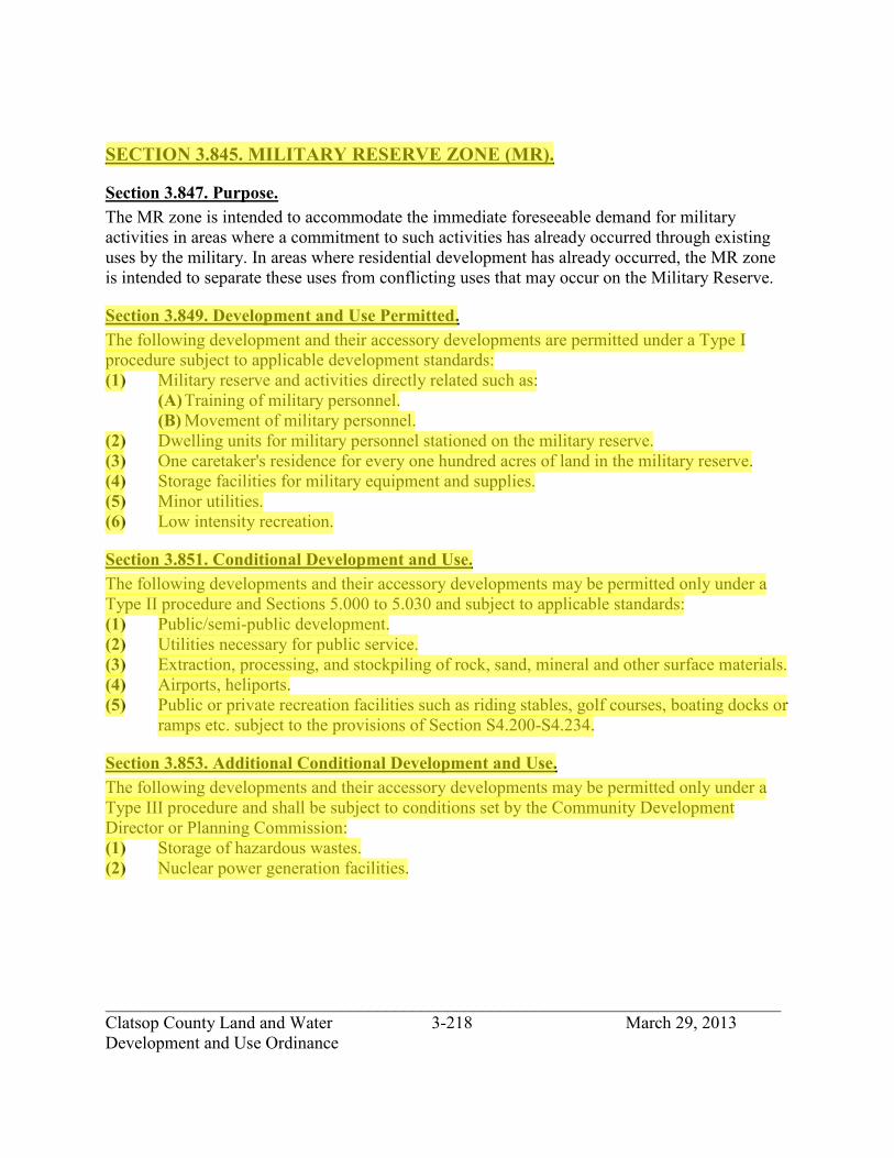
_____________________________________________________________________________ Clatsop County Land and Water 3-218 March 29, 2013 Development and Use Ordinance
SECTION 3.845. MILITARY RESERVE ZONE (MR).
Section 3.847. Purpose. The MR zone is intended to accommodate the immediate foreseeable demand for military activities in areas where a commitment to such activities has already occurred through existing uses by the military. In areas where residential development has already occurred, the MR zone is intended to separate these uses from conflicting uses that may occur on the Military Reserve.
Section 3.849. Development and Use Permitted. The following development and their accessory developments are permitted under a Type I procedure subject to applicable development standards: (1) Military reserve and activities directly related such as:
(A) Training of military personnel. (B) Movement of military personnel.
(2) Dwelling units for military personnel stationed on the military reserve. (3) One caretaker's residence for every one hundred acres of land in the military reserve. (4) Storage facilities for military equipment and supplies. (5) Minor utilities. (6) Low intensity recreation.
Section 3.851. Conditional Development and Use. The following developments and their accessory developments may be permitted only under a Type II procedure and Sections 5.000 to 5.030 and subject to applicable standards: (1) Public/semi-public development. (2) Utilities necessary for public service. (3) Extraction, processing, and stockpiling of rock, sand, mineral and other surface materials. (4) Airports, heliports. (5) Public or private recreation facilities such as riding stables, golf courses, boating docks or
ramps etc. subject to the provisions of Section S4.200-S4.234.
Section 3.853. Additional Conditional Development and Use. The following developments and their accessory developments may be permitted only under a Type III procedure and shall be subject to conditions set by the Community Development Director or Planning Commission: (1) Storage of hazardous wastes. (2) Nuclear power generation facilities.
jhickner
Highlight
jhickner
Highlight

_____________________________________________________________________________ Clatsop County Land and Water 3-219 March 29, 2013 Development and Use Ordinance
Section 3.855. Development and Conditional Development and Use Standards. (1) Development shall be permitted as required to meet State sanitation requirements and
local setback and Ordinance requirements. The following shall be the criteria for determining requirements of each development proposed: (A) The nature of the proposed use in relation to the impacts on nearby properties, and (B) Consideration of State sanitation requirements, local setbacks and other standards of
this Ordinance. (C) All residential development shall be subject to the standards of Section 3.180 (RA-1)
of this Ordinance. (2) Maximum building height: 35 feet.
(A) With the exception of antennas, control towers, and field training facilities for military personnel.
(3) All new development shall indicate on the building permit how storm water is to be drained from the property. The Building Official shall require the installation of culverts, dry wells or retention facilities in cases where development has major storm drainage impacts.
(4) The setback requirements for all structures shall be seventy-five (75) feet from the line of non-aquatic vegetation.
(5) Chapters 1, 2, 5 and 6 and Section 3.180 of Chapter 3 of this Ordinance along with Chapters 2 Section S2.010-S2.300 and Chapter 3 Section S3.010-S3.152, S3.158-S3.214, S3.550-S3.708 of the Standards Document of this Ordinance.
(6) An accessory structure separated from the main building shall be located in accordance with yard setback requirements.
Section 3.857. Additional Development and Use Standards. A buffer zone a minimum of 200 feet around the perimeter of any new Military Reserve zone and within the property boundaries of any military use area shall be established. This buffer shall be designated OPR and subject to the restrictions set forth in Chapter 4 in the Standards Document of this Ordinance and subject to Section 3.580 of this Ordinance.
Section 3.859. State and Federal Permit. If any state or federal permit is required for a development or use, an applicant, prior to issuance of a development permit or action, shall submit to the Planning Department a copy of the state or federal permit.
jhickner
Highlight

_____________________________________________________________________________ Clatsop County Land and Water 3-220 March 29, 2013 Development and Use Ordinance
SECTION 3.900. PARK MASTER PLAN ZONE (PMP).
Section 3.910. Purpose. The purpose of this zone is to provide for the long term protection, management and enjoyment of natural, cultural, scenic, open space and recreational resources within publicly-owned or managed parks. Through the implementation of adopted park master plans, this zone provides for the development of park facilities and the support of recreational uses in a manner that is consistent with defined park management objectives, the County’s Comprehensive Plan, and the Statewide Planning Goals.
Section 3.911. Applicability. This zone will be applied only to public parks which has master plans adopted by Clatsop County pursuant to OAR 660 Division 34. For state parks, the master plans shall also have adopted by the Oregon Parks and Recreation Department (OPRD) pursuant to OAR 736 Division 18. The adoption of this zone for a park shall supersede all previously adopted zones and overlay districts for the subject park property for as long as the property remains in public ownership or management and is used for public park purposes. In the event that such park property is transferred to private ownership or ceases to be managed or used for park purposes, a Comprehensive Plan and Zoning Map amendment shall be applied for and approved, consistent with the Statewide Planning Goals, prior to the approval of any development permits for the subject property.
Section 3.912. Park Development and Uses Allowed. Park uses and facilities that are consistent with a park master plan adopted pursuant to OAR 660 Division 34, and with applicable development standards, are allowed through the review procedures specified below: (1) Uses and facilities described in the park master plan are allowed through the review
procedures specified in the master plan for the described projects. (2) Minor variations from the uses and facilities described in the park master plan are
allowed through the review procedures specified in the master plan for the described projects, unless the master plan language specifically precludes such variations. The standards in Section 3.195 of this ordinance shall be used to determine whether a proposed variation from a planned use or facility is minor.
(3) Accessory uses and facilities which are incidental and customarily appurtenant to the uses and facilities described in this park master plan are allowed through Type I procedures.
(4) The repair and renovation of existing park facilities are allowed through Type I procedures.
(5) The replacement, in the same location and size, of existing park facilities is allowed through Type I procedures.
jhickner
Highlight
jhickner
Highlight
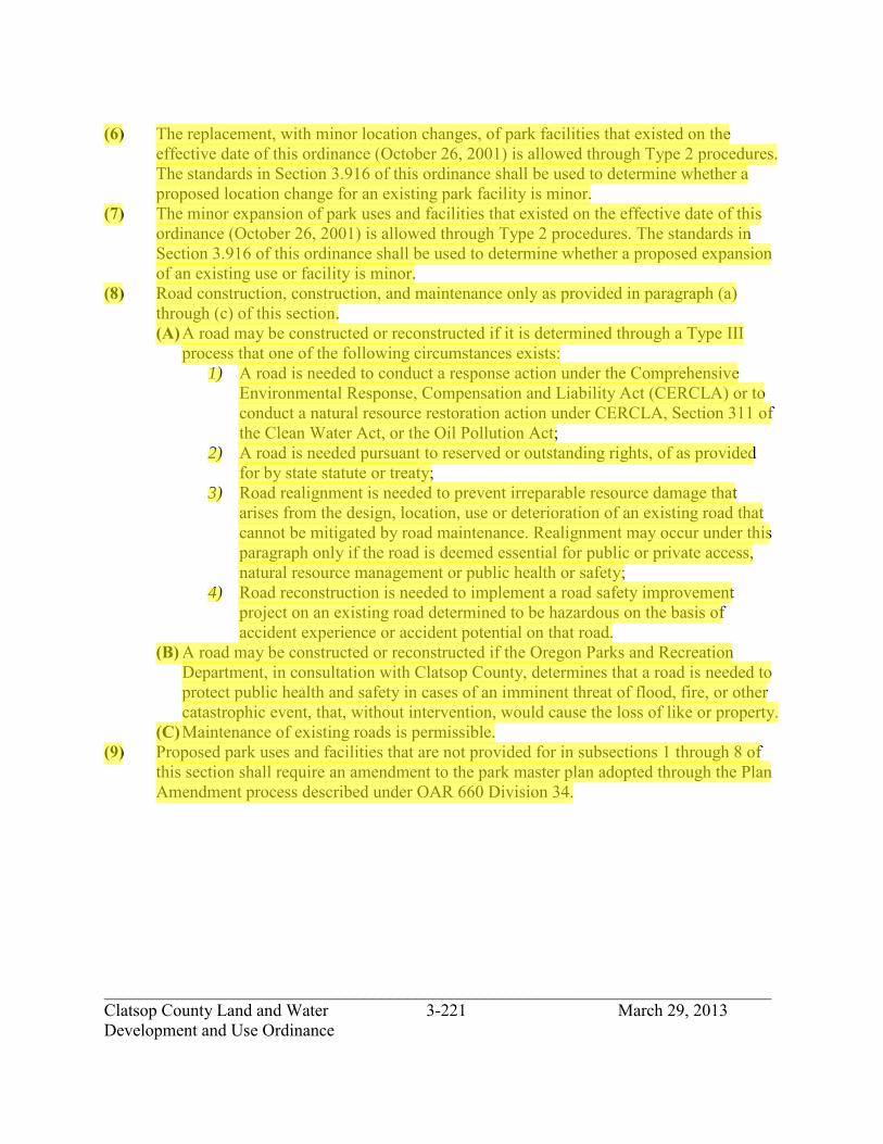
_____________________________________________________________________________ Clatsop County Land and Water 3-221 March 29, 2013 Development and Use Ordinance
(6) The replacement, with minor location changes, of park facilities that existed on the effective date of this ordinance (October 26, 2001) is allowed through Type 2 procedures. The standards in Section 3.916 of this ordinance shall be used to determine whether a proposed location change for an existing park facility is minor.
(7) The minor expansion of park uses and facilities that existed on the effective date of this ordinance (October 26, 2001) is allowed through Type 2 procedures. The standards in Section 3.916 of this ordinance shall be used to determine whether a proposed expansion of an existing use or facility is minor.
(8) Road construction, construction, and maintenance only as provided in paragraph (a) through (c) of this section. (A) A road may be constructed or reconstructed if it is determined through a Type III
process that one of the following circumstances exists: 1) A road is needed to conduct a response action under the Comprehensive
Environmental Response, Compensation and Liability Act (CERCLA) or to conduct a natural resource restoration action under CERCLA, Section 311 of the Clean Water Act, or the Oil Pollution Act;
2) A road is needed pursuant to reserved or outstanding rights, of as provided for by state statute or treaty;
3) Road realignment is needed to prevent irreparable resource damage that arises from the design, location, use or deterioration of an existing road that cannot be mitigated by road maintenance. Realignment may occur under this paragraph only if the road is deemed essential for public or private access, natural resource management or public health or safety;
4) Road reconstruction is needed to implement a road safety improvement project on an existing road determined to be hazardous on the basis of accident experience or accident potential on that road.
(B) A road may be constructed or reconstructed if the Oregon Parks and Recreation Department, in consultation with Clatsop County, determines that a road is needed to protect public health and safety in cases of an imminent threat of flood, fire, or other catastrophic event, that, without intervention, would cause the loss of like or property.
(C) Maintenance of existing roads is permissible. (9) Proposed park uses and facilities that are not provided for in subsections 1 through 8 of
this section shall require an amendment to the park master plan adopted through the Plan Amendment process described under OAR 660 Division 34.
jhickner
Highlight

_____________________________________________________________________________ Clatsop County Land and Water 3-222 March 29, 2013 Development and Use Ordinance
Section 3.913. Park Master Plan. Each park master plan implemented through this ordinance shall include: (1) Findings that describe the park issues regarding the constraints, needs, and opportunities
related to the use and development of the park and the protection, management, and interpretation of park resources.
(2) Maps that adequately illustrate the locations of park resources that are important to the use and development of the park and to the protection, management, and interpretation of resources, including maps that depict significant habitat, protected species, significant plant communities, water features, natural hazards, cultural resource sites, and scenic resources.
(3) Goals for park use and development for the protection, management, and interpretation of park resources.
(4) Narrative descriptions, site plans, and illustrations as necessary to adequately describe the types, locations, sizes, capacities, and site designs of the existing and planned park uses and facilities.
(5) Guidelines for the management of the park’s natural, cultural and scenic resources. (6) Standards for the development of planned park facilities in identified sensitive resource
areas, including riparian areas, wetlands, estuarine areas, coastal lakes, significant upland habitat, coastal dune hazard areas, and flood hazard areas.
(7) Findings that demonstrate that the park master plan is in compliance with the Statewide Planning Goals.
(8) Any additional information that the Community Development Director deems necessary to adequately assess the compliance of the park master plan with the Statewide Planning Goals.
Section 3.914. State and Federal Permits. If any state or federal permits are required for a park use or facility, the applicant shall submit copies of such permits to the Community Development Director prior to issuance of any development permits for the use or facility.
Section 3.915. Standards for Reviewing Proposed Variations from Park Master Plans. The following standards shall be used to determine whether a proposed variation from a planned park use or facility is minor. A proposed variation may be determined to be minor if it is not expected to cause significant impacts on adjacent land uses, other uses in the park, local public services, transportation systems, or important natural, cultural, or scenic resources. Further: (1) A proposed location change for a planned park facility may be determined to be minor if
it does not cause the facility to serve a different park use area.
jhickner
Highlight
jhickner
Highlight

_____________________________________________________________________________ Clatsop County Land and Water 3-223 March 29, 2013 Development and Use Ordinance
(2) The following limitations shall apply to determinations involving minor expansions of planned park facilities: (A) A maximum of 20 percent increase in the floor area of any planned permanent
building, provided that this limitation shall not apply to the following: toilet and shower buildings, garbage and recycling collection buildings; campground registration and storage buildings; and any other accessory building that does not exceed 120 square feet after expansion;
(B) A maximum of 20 percent increase in the number of planned bedrooms in any lodge, inn, bed and breakfast, barracks or bunkhouse, or group of cabins, or in any park use area;
(C) A maximum of 20 percent increase in the number of planned camp sites in any general o r group camping area;
(D) A maximum of 20 percent increase in the number of planned parking spaces in any parking lot or park use area;
(E) A maximum of 20 percent increase in the surface area of any planned road for purposes of improving safety, realignment or widening; or
(F) Extension of a road to provide access to a planned use that is expanded or relocated under the provisions of this section may be considered minor only to the extent needed to serve the expanded or relocated use.
(3) A proposal for a different kind or location of park use area from those in the adopted master plan shall not be considered a minor variation.
(4) Within an existing or planned park use area, a proposal for a park facility that is different from the kind of park facilities in that park area in the adopted master plan shall not be considered a minor variation, except that proposals for the following different facilities may be considered minor variations: toilet and shower buildings, garbage and recycling facilities; campground registration and storage buildings; any other accessory structure not exceeding 120 square feet; alternative camping structures such as yurts, camper cabins, tepees and covered wagons in planned or existing tent and RV sites; picnic shelters in day use area; and trails.
(5) Outside of existing and planned park use areas, new trails located at least 300 feet from the nearest park boundary may be considered minor variations from adopted master plans.
Section 3.916. Standards for Review Proposed Location Changes and Expansions of Existing Park Uses and Facilities. The following standards shall be used to determine whether a proposed location change or expansion of an existing park use or facility is minor. A proposed location change or expansion may be determined to be minor if it is not expected to cause significant impacts on adjacent land uses, other uses in the park, local public services, transportation systems, or important natural, cultural, or scenic resources. Further: (1) A location change for an existing park facility may be determined to be minor if it does
not cause the facility to serve a different park use.
jhickner
Highlight
jhickner
Highlight
jhickner
Highlight

_____________________________________________________________________________ Clatsop County Land and Water 3-224 March 29, 2013 Development and Use Ordinance
(2) The following limitations shall apply to determinations involving minor expansions of existing park uses and facilities; (A) A maximum of 20 percent increase in the floor area of any permanent building,
provided that this limitation shall not apply to the following: toilet and shower buildings, garbage and recycling collection buildings; campground registration and storage buildings; and any other accessory building that does not exceed 120 square feet after expansion;
(B) A maximum of 20 percent increase in the number of planned bedrooms in any lodge, inn, bed and breakfast, barracks or bunkhouse, or group of cabins, or in any park use area;
(C) A maximum of 20 percent increase in the number of planned camp sites in any general o r group camping area;
(D) A maximum of 20 percent increase in the number of planned parking spaces in any parking lot or park use area; and
(E) A maximum of 20 percent increase in the surface area of any road for purposes of improving safety, realignment or widening; or
(F) Extension of an existing road to provide access to a that is expanded or relocated under the provisions of this section may be considered minor only to the extent needed to serve the expanded or relocated use.
jhickner
Highlight

_____________________________________________________________________________ Clatsop County Land and Water 3-225 March 29, 2013 Development and Use Ordinance
SECTION 3.920 AIRPORT OVERLAY ZONE (AO)
Section 3.921. Purpose. In order to carry out the provisions of this overlay zone, there are hereby created and established certain zones which include all of the land lying beneath the Airport Imaginary surfaces as they apply to the airport in the (city/county). Such zones are shown on the current airport Airspace and Runway Approach Zone drawings. Further, this overlay zone is intended to prevent the establishment of airspace obstructions in airport approaches and surrounding areas through height restrictions and other land use controls as deemed essential to protect the health, safety, and welfare of the people of the (city/county).
Section 3.923. Special Definitions. AIRPORT APPROACH SAFETY ZONE. The land that underlies the approach surface, excluding the RAZ AIRPORT HAZARD. Any structure, tree, or use of land which exceeds height limits established by the Airport Imaginary Surfaces. AIRPORT IMAGINARY SURFACES. Those imaginary areas in space which are defined by the Approach Surface, Transitional Surface, Horizontal Surface, and Conical Surface and in which any object extending about these imaginary surfaces is an obstruction. APPROACH SURFACE. A surface longitudinally centered on the extended runway centerline and extending outward and upward from each end of the Primary Surface. The inner edge of the approach surface is the same width as the Primary Surface and extends to a width of: 1,250 feet for utility runway having only visual approaches; 1,500 feet for a runway other than a utility runway having only visual approaches; 2,000 feet for a utility runway having a non-precision instrument approach; 3,500 feet for a non-precision instrument runway other than utility, having visibility minimums greater than three-fourths of a statute mile; 4,000 feet for a non-precision instrument runway having visibility minimums as low as three-fourths statute mile; and 16,000 feet for precision instrument runways. The Approach Surface extends for a horizontal distance of 5,000 feet at a slope of 20 feet outward to each foot upward (20:1) for all utility and visual runways; 10,000 feet at a slope of 34 feet outward for each foot upward (34:10 for all non-precision instrument runways other than utility; and for all precision instrument runways extends for a horizontal distance of 10,000 feet at a slope of 50 feet outward for each foot upward (50:1); thence slopes upward 40 feet outward for each foot upward (40:1) an additional distance of 40,000 feet.
jhickner
Highlight
jhickner
Highlight

_____________________________________________________________________________ Clatsop County Land and Water 3-226 March 29, 2013 Development and Use Ordinance
CONICAL SURFACE. Extends 20 feet outward for each one foot upward (20:1) for 4,000 feet beginning at the edge of the horizontal surface (5,000 feet from the center of each of the Primary Surface of each visual and utility runway or 10,000 feet for all non-precision instrument runways other than utility at 150 feet above and airport elevation) and upward extending to a height of 350 feet above the airport elevation. HORIZONTAL SURFACE. A horizontal plane 150 feet above the established airport elevation, the perimeter of which is constructed by swinging runways 5,000 feet from the center of each end of the Primary Surface of each visual or utility runway and 10,000 feet from the center of each end of the Primary Surface of all other runways and connecting the adjacent arcs by lines tangent to those arcs. NOISE SENSITIVE AREA. Within 1,500 feet of an airport or within established noise contour boundaries exceeding 55 DNL. NON-PRECISION INSTRUMENT RUNWAY. A runway having an existing instrument approach procedure utilizing air navigation facilities with only horizontal guidance, or area type navigation equipment, for which a straight-in non-precision instrument approach procedure has been approved, or planned, or indicated on an FAA or state planning document or military service airport planning document. PLACE OF PUBLIC ASSEMBLY. Structure of place which the public may enter for such purposes as deliberation, education, worship, shopping, entertainment, amusement, awaiting transportation, or similar activity. PRECISION INSTRUMENT RUNWAY. A runway having an existing instrument approach procedure utilizing an Instrument Landing System (ILS), Microwave Landing System (MLS), Global Positioning Satellite (GPS) or a Precision Approach Radar (PAR). It also means a runway for which a precision approach system is planned and is not indicated by a FAA approved airport layout plan; any other FAA or state planning document, or military service airport-planning document. PRIMARY SURFACE. A surface longitudinally centered on a runway. When the runway has a specifically prepared hard surface, the Primary Surface extends 200 feet beyond each end of that runway. When the runway has no specially prepared hard surface, or planned hard surface, the Primary Surface ends at each end of that runway. The width of the primary Surface is 250 feet for utility runways having only visual approaches, 5,000 feet for utility runways having non-precision instrument approaches, 5,000 feet for other than utility runways having only visual approaches or non-precision instrument approaches with visibility minimums greater than three-fourths of a mile and 1,000 feet for non-precision instrument runways with visibility minimums of three-fourths of a mile or less and for precision instrument runways.
jhickner
Highlight

_____________________________________________________________________________ Clatsop County Land and Water 3-227 March 29, 2013 Development and Use Ordinance
RUNWAY APPROACH ZONE (RAZ). An area off the runway end (formerly the clear zone) used to enhance the protection of people and property on the ground. The RAZ is trapezoidal in shape and centered about the extended runway centerline. It begins 200 feet (60m) beyond the end of the arcs usable for takeoff or landing. The RAZ dimensions are functions of the type of aircraft and operations to be conducted on the runway. TRANSITIONAL SURFACE. Extend seven feet outward for each one foot upward (7:1) beginning on each side of the Primary Surface which point is the same elevation as the runway surface, and from the sides of the approach surfaces thence extending upward to a height of 150 feet above the airport elevation (Horizontal Surface) UTILITY RUNWAY. A runway that is constructed for and intended to be used by propeller driven aircraft of 12,500 pounds maximum gross weight or less. VISUAL RUNWAY. A runway that is intended solely for the operation of aircraft using visual approach procedures when no instrument approach procedures have been approved, or planned, or indicated on an FAA or state planning document or military service airport planning document.
Section 3.924 Permitted Uses Within the Runway Approach Zone (RAZ). While it is desirable to clear all objects from the RAZ, some uses are permitted, provided they do not attract wildlife, are below the approach surface and do not interfere with navigational aids. (1) Agricultural operations (other than forestry or livestock farms.) (2) Golf courses (but not club houses). (3) Automobile parking facilities
Section 3.925 Conditional Uses Within the Airport Approach Safety Zone. (1) A structure or building accessory to a permitted use. (2) Single family dwellings, mobile homes, duplexes, and multifamily dwellings, when
allowed by the underlying zone, provided the landowner signs and records in the deed and mortgage records of (city/county) a Hold Harmless Agreement and Aviation and Hazard Easement and submits them to the airport sponsor and the (city/county) Planning Departments.
(3) Commercial and industrial uses, when allowed by the underlying zone, provided the use does not result in: (A) Creating electrical interference with navigational signals or radio communication
between the airport and aircraft. (B) Making it difficult for pilots to distinguish between airport lights and lighting from
nearby land uses. (C) Impairing visibility. (D) Creating bird strike or other wildlife hazards.
jhickner
Highlight
jhickner
Highlight

_____________________________________________________________________________ Clatsop County Land and Water 3-228 March 29, 2013 Development and Use Ordinance
(E) Endangering or interfering with the landing, taking off or maneuvering of aircraft intending to use airport
(F) Attracting a large number of people (4) Buildings and uses of public works, public service, or public utility nature.
Section 3.926 Procedures. An applicant seeking a conditional use shall follow procedures set forth in the urban growth management plan/agreement between the (city/county). Information accompanying the application shall also include the following: (1) Property boundary lines as they relate to the Airport Imaginary Surfaces. (2) Location and height of all existing and proposed buildings, structures, utility lines, and
roads. In accordance with OAR Chapter 738 Division 100, City or County Planning Authority shall notify the owner of the airport and Aeronautics Section on land use permits or zone changes within 5,000 feet of a visual and 10,000 feet of instrument airport so as to provide Oregon Aeronautics Section an opportunity to review and comment.
Section 3.927 Limitations. (3) To meet the standards established in FAA Regulations, Part 77 and OAR Chapter 738
Division 70, no structure shall penetrate into the Airport Imaginary Surfaces as defined above.
(4) No place of public assembly shall be permitted in the Airport Approach Safety Zone or RAZ.
(5) No structure or building shall be allowed within the RAZ. (6) Whenever there is a conflict in height limitations prescribed by this overlay zone and the
primary zoning district, the lowest height limitation fixed shall govern; provided, however, that the height limitations here imposed shall not apply to such structures customarily employed for aeronautical purposes.
(7) No glare producing materials shall be used on the exterior of any structure located within the Airport Approach Safety Zone.
(8) In noise sensitive areas (within 1,500 feet of an airport or within established noise contour boundaries of 55 DNL and above for identified airports) where noise levels are a concern, a declaration of anticipated noise levels shall be attached to any building permit, land division appeal, deed, and mortgage records. In areas where the noise level is anticipated to be 55 DNL and above, prior to issuance of a building permit for construction of noise sensitive land use (real property normally used for sleeping or normally used as schools, churches, hospitals, or public libraries), the permit application shall be required to demonstrate that a noise abatement strategy will be incorporated into the building design which will achieve an indoor noise level equal to or less than 55 DNL. The planning and building department will review building permits or noise sensitive developments.
jhickner
Highlight
jhickner
Highlight
jhickner
Highlight

_____________________________________________________________________________ Clatsop County Land and Water 3-229 March 29, 2013 Development and Use Ordinance
(9) No development that attracts or sustains hazardous bird movements from feeding, watering, or roosting across the runways and/or approach and departure patterns of aircraft. Planning authority shall notify Oregon Aeronautics of such development (e.g., waste disposal sites and wetland enhancements) within the airport overlay zone so as to provide Oregon Aeronautics Section an opportunity to review and comment on the side in accordance with FAA AC 150/5200-33.
Section 3.928 State and Federal Permits. If any state or federal permit is required for a development or use, an applicant, prior to issuance of a development permit or action, shall submit to the Planning Department a copy of the state or federal permit
jhickner
Highlight

_____________________________________________________________________________ Clatsop County Land and Water 4-230 March 29, 2013 Development and Use Ordinance
ARTICLE 4. SPECIAL DISTRICTS SECTION 4.000. FLOOD HAZARD OVERLAY DISTRICT (/FHO) Section 4.010. Purpose The purpose of the flood hazard overlay district is to identify those areas of the County subject to the hazards of periodic flooding and establish standards and regulations to reduce flood damage or loss of life in those areas. This district shall apply to all areas of special flood hazards within the unincorporated areas of Clatsop County as identified on Flood Insurance Rate Maps (FIRM) and Flood Boundary and Floodway Maps. In advancing these principles and the general purposes of the Clatsop County Comprehensive Plan, the specific objectives are: (1) To promote the general health, welfare and safety of the County; (2) To prevent the establishment of certain structures and land uses unsuitable for human habitation because of the danger of flooding, unsanitary conditions or other hazards; (3) To minimize the need for rescue and relief efforts associated with flooding; (4) To help maintain a stable tax base by providing for sound use and development in flood- prone areas and to minimize prolonged business interruptions; (5) To minimize damage to public facilities and utilities located in flood hazard areas; (6) To insure that potential home and business buyers are notified that property is in a flood area. Section 4.011. Definitions The following words and phrases shall be interpreted so as to give them the meanings they have in common usage and to give this chapter its most reasonable application: “ACCESSORY STRUCTURE” means a structure on the same or adjacent parcel as a principal structure, the use of which is incidental and subordinate to the principal structure. A separate insurable building should not be classified as an accessory or appurtenant structure “ALTERATION OF A WATERCOURSE” includes, but is not limited to, any dam, culvert, impoundment, channel relocation, change in channel alignment, channelization, or change in cross-sectional area or capacity, which may alter, impede, retard or change the direction and/or velocity of the riverine flow of water during conditions of the base flood. “AREA OF SHALLOW FLOODING” means a designated AO or AH zone on the Flood Insurance Rate Map (FIRM). The base flood depth range is from one to three feet; a clearly defined channel does not exist; the path of flooding is unpredictable and indeterminate; and velocity flow may be evident. Such flooding is characterized by ponding or sheet flow. “AREA OF SPECIAL FLOOD HAZARD” is the land in the floodplain within a community subject to a one percent or greater chance of flooding in any given year. Zone designations on FIRMs include the letters A or V. Also known as the Special Flood Hazard Area (SFHA) “BASE FLOOD ELEVATION (BFE)” means the water surface elevation during the base flood in relation to a specified datum. The Base Flood Elevation (BFE) is depicted on the FIRM to the nearest foot and in the FIS to the nearest 0.1-foot. “BASEMENT” means any area of the building having its floor subgrade (below ground level) on all sides.
jhickner
Highlight
jhickner
Highlight
jhickner
Highlight

_____________________________________________________________________________ Clatsop County Land and Water 4-231 March 29, 2013 Development and Use Ordinance
“BELOW-GRADE CRAWLSPACE” means an enclosed area below the base flood elevation in which the interior grade is not more than two feet below the lowest adjacent exterior grade and the height, measured from the interior grade of the crawlspace to the top of the crawlspace foundation, does not exceed 4 feet at any point. “BREAKAWAY WALL” means a wall that is not a part of the structural support of the building and is intended through its design and construction to collapse under specific lateral loading forces, without causing damage to the elevated portion of the building or supporting foundation system. “BUILDING” means a building or structure subject to building codes. “BUILDING CODES” means the combined specialty codes adopted under ORS 446.062, 446.185, 447.020 (2), 455.020 (2), 455.496, 455.610, 455.680, 460.085, 460.360, 479.730 (1) or 480.545, but does not include regulations adopted by the State Fire Marshal pursuant to ORS chapter 476 or ORS 479.015 to 479.200 and 479.210 to 479.220. “COASTAL HIGH-HAZARD AREA” means the area subject to high velocity waters, including but not limited to, storm surge or tsunamis. The map is designated on a FIRM (Flood Insurance Rate Map) as a “V” zone. “CRITICAL FACILITIES” means those structures or facilities which produce, use, or store highly volatile, flammable, explosive, toxic, and/or water-reactive materials; hospitals, nursing homes, and housing likely to contain occupants who may not be sufficiently mobile to avoid death or injury during a flood; police stations, fire stations, vehicle and equipment storage facilities, and emergency operations centers that are needed for flood response activities before, during, and after a flood; and public and private facilities that are vital to maintaining or restoring normal services to flooded areas before, during and after a flood. “DATUM” is a base measurement point (or set of points) from which all elevations are determined. Historically, that common set of points has been the National Geodetic Vertical Datum of 1929 (NAVD29). The vertical datum currently adopted by the federal government as a basis for measuring heights is the North American Vertical Datum of 1988 (NAVD88). “DEVELOPMENT” means any manmade change to improved or unimproved real property, including but not limited to buildings or other structures, mining, dredging, filling, grading, paving, excavation or drilling operations located within the area of special flood hazard. Development does not include:
(1) Signs, markers, aids, etc. placed by a public agency to serve the public (2) Driveways, parking lots, or other open space use areas where no alteration of
topography occurs; (3) Minor repairs or improvements to existing structures provided that the alterations
do no increase the size or intensity of use, and do not constitute repair of substantial damage, or substantial improvement as defined in this section;
jhickner
Highlight
jhickner
Highlight
jhickner
Highlight
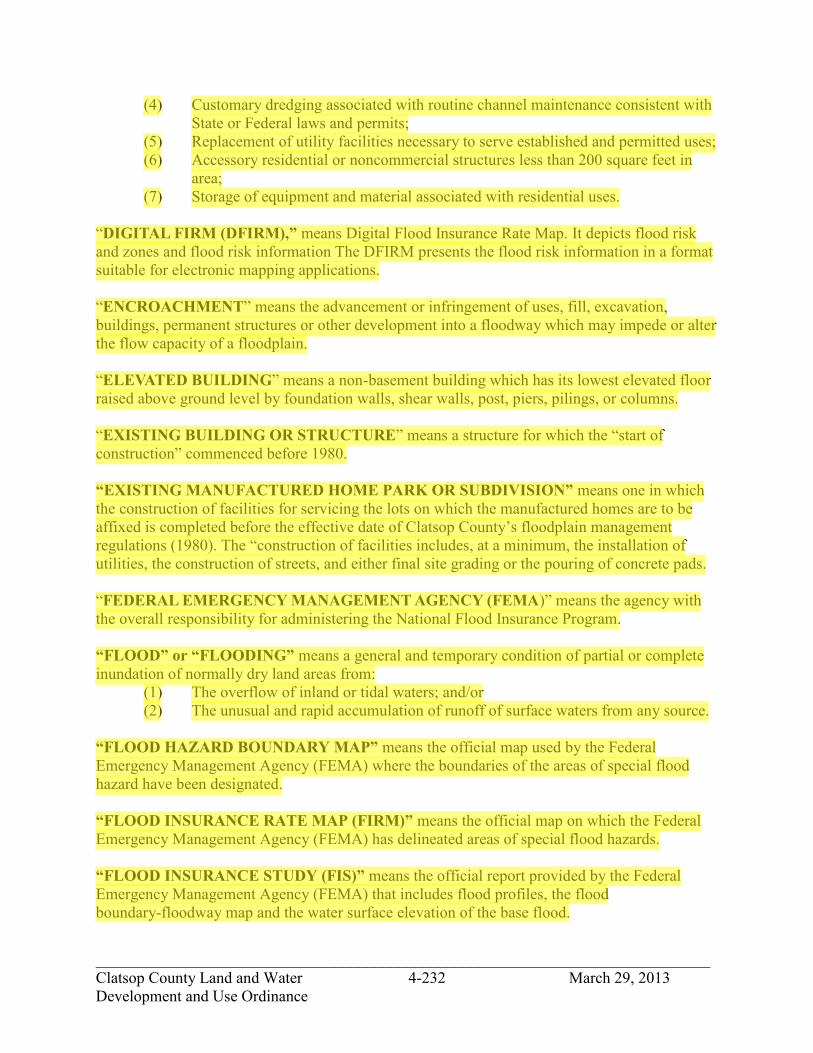
_____________________________________________________________________________ Clatsop County Land and Water 4-232 March 29, 2013 Development and Use Ordinance
(4) Customary dredging associated with routine channel maintenance consistent with State or Federal laws and permits;
(5) Replacement of utility facilities necessary to serve established and permitted uses; (6) Accessory residential or noncommercial structures less than 200 square feet in
area; (7) Storage of equipment and material associated with residential uses.
“DIGITAL FIRM (DFIRM),” means Digital Flood Insurance Rate Map. It depicts flood risk and zones and flood risk information The DFIRM presents the flood risk information in a format suitable for electronic mapping applications. “ENCROACHMENT” means the advancement or infringement of uses, fill, excavation, buildings, permanent structures or other development into a floodway which may impede or alter the flow capacity of a floodplain. “ELEVATED BUILDING” means a non-basement building which has its lowest elevated floor raised above ground level by foundation walls, shear walls, post, piers, pilings, or columns. “EXISTING BUILDING OR STRUCTURE” means a structure for which the “start of construction” commenced before 1980. “EXISTING MANUFACTURED HOME PARK OR SUBDIVISION” means one in which the construction of facilities for servicing the lots on which the manufactured homes are to be affixed is completed before the effective date of Clatsop County’s floodplain management regulations (1980). The “construction of facilities includes, at a minimum, the installation of utilities, the construction of streets, and either final site grading or the pouring of concrete pads. “FEDERAL EMERGENCY MANAGEMENT AGENCY (FEMA)” means the agency with the overall responsibility for administering the National Flood Insurance Program. “FLOOD” or “FLOODING” means a general and temporary condition of partial or complete inundation of normally dry land areas from:
(1) The overflow of inland or tidal waters; and/or (2) The unusual and rapid accumulation of runoff of surface waters from any source.
“FLOOD HAZARD BOUNDARY MAP” means the official map used by the Federal Emergency Management Agency (FEMA) where the boundaries of the areas of special flood hazard have been designated. “FLOOD INSURANCE RATE MAP (FIRM)” means the official map on which the Federal Emergency Management Agency (FEMA) has delineated areas of special flood hazards. “FLOOD INSURANCE STUDY (FIS)” means the official report provided by the Federal Emergency Management Agency (FEMA) that includes flood profiles, the flood boundary-floodway map and the water surface elevation of the base flood.
jhickner
Highlight
jhickner
Highlight
jhickner
Highlight

_____________________________________________________________________________ Clatsop County Land and Water 4-233 March 29, 2013 Development and Use Ordinance
“FLOOD PROOFING” means any combination of structural and nonstructural additions, changes, or adjustments to structures which reduce or eliminate flood damage to real estate or improved real property, water and sanitary facilities, structures and their contents. “FLOODPLAIN ADMINISTRATOR” means the Director of Transportation and Development Services, or an individual or committee that is designated by the Director, to implement and administer the provisions of this ordinance. “FLOODWAY (Regulatory Floodway)” means the channel of a river or other watercourse and those portions of the floodplain adjoining the channel required to discharge and store the floodwater or flood flows associated with the regulatory flood. “HIGHEST ADJACENT GRADE” means the highest natural elevation of the ground surface prior to construction next to the proposed walls of a structure. “HISTORIC STRUCTURE” means a structure that is:
(1) Listed individually in the National Register of Historic Places (a listing maintained by the U.S. Department of Interior) or preliminarily determined by the Secretary of the Interior as meeting the requirements for individual listing on the National Register, or; (2) Certified or preliminarily determined by the Secretary of the Interior as contributing to the historical significance of a registered historic district or to a district preliminarily determined by the Secretary to qualify as a registered historic district, or; (3) Individually listed on a state inventory of historic places and determined as eligible by states with historic preservation programs which have been approved by the Secretary of the Interior, or; (4) Individually listed on a local inventory of historic places and determined as eligible by communities with historic preservation programs that have been certified either:
a. By an approved state program as determined by the Secretary of the Interior, or b. Directly by the Secretary of the Interior in states without approved programs.
“LATERAL ADDITION” means an addition that requires a foundation to be built outside of the foundation footprint of the existing building. “LETTER OF MAP CHANGE (LOMC)” means an official FEMA determination, by letter, to amend or revise effective Flood Insurance Rate Maps and Flood Insurance Studies. LOMCs are issued in the following categories:
Letter of Map Amendment (LOMA) A revision based on technical data showing that a property was incorrectly included in a designated special flood hazard area. A LOMA amends the current effective Flood Insurance Rate Map and establishes that a specific property is not located in a special flood hazard area.
jhickner
Highlight
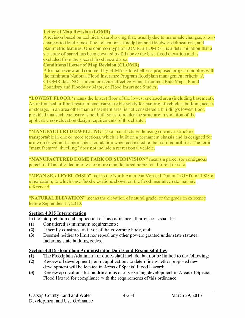
_____________________________________________________________________________ Clatsop County Land and Water 4-234 March 29, 2013 Development and Use Ordinance
Letter of Map Revision (LOMR) A revision based on technical data showing that, usually due to manmade changes, shows changes to flood zones, flood elevations, floodplain and floodway delineations, and planimetric features. One common type of LOMR, a LOMR-F, is a determination that a structure of parcel has been elevated by fill above the base flood elevation and is excluded from the special flood hazard area. Conditional Letter of Map Revision (CLOMR) A formal review and comment by FEMA as to whether a proposed project complies with the minimum National Flood Insurance Program floodplain management criteria. A CLOMR does NOT amend or revise effective Flood Insurance Rate Maps, Flood Boundary and Floodway Maps, or Flood Insurance Studies.
“LOWEST FLOOR” means the lowest floor of the lowest enclosed area (including basement). An unfinished or flood-resistant enclosure, usable solely for parking of vehicles, building access or storage, in an area other than a basement area, is not considered a building's lowest floor, provided that such enclosure is not built so as to render the structure in violation of the applicable non-elevation design requirements of this chapter. “MANUFACTURED DWELLING” (aka manufactured housing) means a structure, transportable in one or more sections, which is built on a permanent chassis and is designed for use with or without a permanent foundation when connected to the required utilities. The term “manufactured dwelling” does not include a recreational vehicle. “MANUFACTURED HOME PARK OR SUBDIVISION” means a parcel (or contiguous parcels) of land divided into two or more manufactured home lots for rent or sale. “MEAN SEA LEVEL (MSL)” means the North American Vertical Datum (NGVD) of 1988 or other datum, to which base flood elevations shown on the flood insurance rate map are referenced. “NATURAL ELEVATION” means the elevation of natural grade, or the grade in existence before September 17, 2010.
Section 4.015 Interpretation In the interpretation and application of this ordinance all provisions shall be: (1) Considered as minimum requirements; (2) Liberally construed in favor of the governing body, and; (3) Deemed neither to limit nor repeal any other powers granted under state statutes, including state building codes.
Section 4.016 Floodplain Administrator Duties and Responsibilities (1) The Floodplain Administrator duties shall include, but not be limited to the following: (2) Review all development permit applications to determine whether proposed new
development will be located in Areas of Special Flood Hazard; (3) Review applications for modifications of any existing development in Areas of Special
Flood Hazard for compliance with the requirements of this ordinance;
jhickner
Highlight

_____________________________________________________________________________ Clatsop County Land and Water 4-235 March 29, 2013 Development and Use Ordinance
(4) Interpret flood hazard area boundaries, provide available flood hazard information, and provide base flood elevations, where they exist;
(5) Review proposed development to assure that necessary permits have been received from governmental agencies from which approval is required by federal, state, and local law, including but not limited to section 404 of the Federal Water Pollution Control Act Amendments of 1972, 33 U.S.C. 1334; the Endangered Species Act of 1973, 16 U.S.C. 1531-1544; and State of Oregon Removal-Fill permits. Copies of such permits shall be provided and maintained on file.
(6) Review all development permit applications for property in a Special Flood Hazard Area to determine if the proposed development is located in the floodplain or floodway, and if so, ensure that the encroachment standards of Section 4.026.
(7) When Base Flood Elevation data or floodway data are not available, then the Floodplain Administrator shall obtain, review and reasonably utilize any base flood elevation and floodway data available from a federal, state or other source in order to administer the provisions of this ordinance.
(8) When Base Flood Elevations or other current engineering data are not available, the Floodplain Administrator shall take into account the flood hazards, to the extent they are known, to determine whether a proposed building site will be reasonably safe from flooding.
(9) Where interpretation is needed of the exact location of boundaries of the Areas of Special Flood Hazard including regulatory floodway (for example, where there appears to be a conflict between a mapped boundary and actual field conditions) the Floodplain Administrator shall make the interpretation. Any person contesting the location of the boundary shall be given a reasonable opportunity to appeal the interpretation as provided in Section 4.021.
(10) Issue floodplain development permits when the provisions of this ordinance have been met, or disapprove the same in the event of noncompliance;
(11) Coordinate with the Building Official to assure that applications for building permits comply with the requirements of this ordinance;
(12) Obtain, verify and record the actual elevation in relation to the vertical datum used on the effective FIRM, or highest adjacent grade where no BFE is available, of the lowest floor level, including basement, of all new construction or substantially improved buildings and structures.
(13) Obtain, verify and record the actual elevation, in relation to the vertical datum used on the effective FIRM, or highest adjacent grade where no BFE is available, to which any new or substantially improved buildings or structures have been flood-proofed. When flood-proofing is utilized for a structure, the Floodplain Administrator shall obtain certification of design criteria from a registered professional engineer or architect;
(14) Ensure that all records pertaining to the provisions of this ordinance are permanently maintained in the office of Transportation and Development Services and shall be open for public inspection.
(15) Make inspections in Areas of Special Flood Hazard to determine whether development has been undertaken without issuance of a floodplain development permit, ensure that development is undertaken in accordance with this ordinance, and verify that existing buildings and structures maintain compliance with this ordinance;

_____________________________________________________________________________ Clatsop County Land and Water 4-236 March 29, 2013 Development and Use Ordinance
(16) Coordinate with the Building Official to inspect areas where buildings and structures in flood hazard areas have been damaged, regardless of the cause of damage, and notify owners that permits may be required prior to repair, rehabilitation, demolition, relocation, or reconstruction of the building or structure;
(17) Make Substantial Damage or Substantial Damage determinations based on criteria set forth in Section 4.023 of this ordinance.
Section 4.017 Alteration of Water Courses (1) The bankfull flood carrying capacity of the altered or relocated portion of the water
course shall not be diminished. Prior to issuance of a floodplain development permit, the applicant must submit a description of the extent to which any water course will be altered or relocated as a result of the proposed development and submit certification by a registered professional engineer that the bankfull flood carrying capacity of the water course will not be diminished.
(2) The applicant shall notify adjacent communities, the U.S. Army Corps of Engineers, Oregon Department of State Lands, and Oregon Department of Land Conservation and Development prior to any alteration or relocation of a water source. Evidence of notification must be submitted to the floodplain administrator and to the Federal Emergency Management Agency.
(3) The applicant shall be responsible for providing the necessary maintenance for the altered or relocated portion of the watercourse so that the flood carrying capacity will not be diminished.
(4) The applicant shall meet the requirements to submit technical data in Section 4.032 when the alteration of a watercourse, including the placement of culverts, results in the relocation or elimination of the special flood hazard area.
Section 4.018 Non-Conversion of Enclosed areas below the Lowest Floor To ensure that the areas below the BFE continue to be used solely for parking vehicles, limited storage, or access to the building and not be finished for use as human habitation without first becoming fully compliant with the floodplain management ordinance in effect at the time of conversion, the Floodplain Administrator shall: (1) Determine which applicants for new construction and/or substantial improvements have
fully enclosed areas below the lowest floor that are 5 feet or higher; (2) Enter into a “NON-CONVERSION AGREEMENT FOR CONSTRUCTION WITHIN
FLOOD HAZARD AREAS” or equivalent with Clatsop County. The agreement shall be recorded with the Clatsop County Clerk as a deed restriction. The non-conversion agreement shall be in a form acceptable to the Floodplain Administrator and County Counsel; and
(3) Have the authority to inspect any area of a structure below the base flood elevation to ensure compliance upon prior notice of at least 72 hours.
Section 4.019 Floodplain Inspection and Enforcement (1) The Administrator or designee shall make periodic inspections of floodplain areas to
establish that development activities within the floodplain are being performed in compliance with an approved floodplain development permit. The Administrator or
jhickner
Highlight

_____________________________________________________________________________ Clatsop County Land and Water 4-237 March 29, 2013 Development and Use Ordinance
designee shall prepare a field report listing non-complying conditions to be delivered to the Code Compliance Officer within 5 business days.
(2) Upon receipt of the report: (A) The Code Compliance Officer shall take action in accordance with Clatsop County
Code of Regulations to effect the abatement of such violation; or (B) The property owner shall apply for a variance in accordance with the provisions of
Section 4.024 (Variance Procedures) herein. (3) If the violation is not resolved through the code enforcement or variance procedure the
Floodplain Administrator shall request to the Administrator of Federal Insurance Administration a declaration for denial of insurance, stating that the property is in violation of a cited statute or local law, regulation or ordinance, pursuant to section 1316 of the National Flood Insurance Act of 1968 as amended.
Section 4.020 Warning and Disclaimer of Liability The degree of flood protection required by this Ordinance is considered reasonable for regulatory purposes and is based on engineering and scientific considerations. Larger floods can and will occur on rare occasions. Flood heights may be increased by man-made or natural causes. This Ordinance does not imply that land outside the areas of special flood hazards or uses permitted within such areas will be free from flooding or flood damages. This ordinance shall not create a liability on the part of Clatsop County or by an officer, or employee thereof for any flood damages that result from reliance on this Ordinance or any administrative decision lawfully made there under.
Section 4.021 Appeals An appeal of a Floodplain Administrator decision pursuant to this chapter may be appealed in accordance with Section 2.230. Appeals of a decision by the Code Enforcement Officer pursuant to this chapter may be appealed in accordance with Clatsop County Code of Regulations.
Section 4.022 Permit Procedures Application for a Floodplain Development Permit shall be made to the Floodplain Administrator on forms furnished by the Administrator or the Administrator’s designee prior to starting development activities. Specifically, the following information is required: (1) Application Stage:
(A) Plans in duplicate drawn to scale with elevations of the project area and the nature, location, dimensions of existing and proposed structures, earthen fill placement, storage of materials or equipment and drainage facilities.
(B) Delineation of flood hazard areas, floodway boundaries including base flood elevations, or flood depth in AO zones, where available;
(C) For all proposed structures, elevation in relation to the highest adjacent grade and the base flood elevation, or flood depth in AO zones, of the: 1) lowest enclosed area, including crawlspace or basement floor; 2) bottom of the lowest horizontal structural member in coastal high hazard areas
(V Zones); 3) top of the proposed garage slab, if any, and; 4) next highest floor
(D) Locations and sizes of all flood openings;

_____________________________________________________________________________ Clatsop County Land and Water 4-238 March 29, 2013 Development and Use Ordinance
(E) Elevation to which any non-residential structure will be flood-proofed; (F) Certification from a registered professional engineer or architect that any
proposed non-residential flood-proofed structure will meet the flood-proofing criteria of the NFIP and building codes;
(G) Description of the extent to which any watercourse will be altered or relocated as a result of a proposed development;
(2) Construction Stage: (A) For all new construction and substantial improvements, the permit holder shall
provide to the Floodplain Administrator an as-built certification of the floor elevation or flood-proofing level immediately after the lowest floor or flood-proofing is placed and prior to further vertical construction .
(B) Any deficiencies identified by the Floodplain Administrator shall be corrected by the permit holder immediately and prior to work proceeding. Failure to submit certification or failure to make the corrections shall be cause for the Floodplain Administrator to issue a stop-work order for the project.
(3) Certificate of Occupancy (A) In addition to the requirements of the building codes pertaining to certificate of
occupancy, prior to the final inspection the owner or authorized agent shall submit the following documentation that has been prepared and sealed by a registered surveyor or engineer; 1) For elevated buildings and structures in non-coastal Areas of Special Flood
Hazard (A zones), the elevation of the lowest floor, including basement or where no base flood elevation is available the height above highest adjacent grade of the lowest floor;
2) For buildings and structures in coastal Areas of Special Flood Hazard (V zones), the elevation of the bottom of the lowest horizontal structural member supporting the lowest floor.
(B) Failure to submit certification or failure to correct violations shall be cause for the Building Official to withhold a certificate of occupancy or delay a final building inspection until such deficiencies are corrected.
(4) Expiration of Floodplain Development Permit (A) floodplain development permit shall expire 180 days after issuance unless the
permitted activity has been substantially begun and thereafter is pursued to completion.
(B) Commencement of work includes start of construction, when the permitted work requires a building permit.
Section 4.023 Substantial Damage and Substantial Improvement Determination For applications for permits to improve buildings and structures, including additions, repairs, renovations, and alterations, the Floodplain Administrator, shall: (1) Estimate the market value, or require the applicant to obtain a professional appraisal of
the market value, of the building or structure before the proposed work is performed; when repair of damage is proposed, the market value of the building or structure shall be the market value before the damage occurred;

_____________________________________________________________________________ Clatsop County Land and Water 4-239 March 29, 2013 Development and Use Ordinance
(2) Compare the cost of improvement, the cost to repair the damaged building to its pre-damaged condition, or the combined costs of improvements and repairs, if applicable, to the market value of the building or structure; (A) Except as indicated in subsections (D) and (E) below, all costs to repair
substantial damage, including emergency repairs, must be included; (B) The costs associated with the correction of pre-existing violations of state or local
health, sanitary, or safety code specifications that were identified by the building official, the director of environmental health, or any other local code enforcement official prior to the improvement or repair and that are the minimum necessary to ensure safe living conditions shall not be included;
(C) Except as indicated in subsections (d) and (e) below, the costs of complying with any county, state, or federal regulation other than those described in subsection (b) must be included;
(D) Costs associated with the following items are not included: 1) The preparation and approval of all required plans, calculations, certifications,
and specifications; 2) The performance of surveys or other geotechnical or engineering studies and
resulting reports; 3) Permit and review fees; 4) The construction, demolition, repair, or modification of outdoor
improvements, including landscaping, fences, swimming pools, detached garages and sheds, etc.;
(E) Proposed alterations of a designated historic building or structure is not to be considered substantial improvement unless the alteration causes a loss of said designation.
(3) The Floodplain Administrator shall make the final determination of whether the proposed improvement and/or repair constitutes a substantial improvement or substantial damage;
(4) The Floodplain Administrator shall notify the applicant of the results of the determination by letter,
(5) Applicant has the right to appeal the determination pursuant to Section 4.021.
Section 4.024 Variances A request for a variance from a standard contained in this chapter shall be reviewed in accordance with the procedures of Section 5.130 - 5.134. The burden to show that the variance is warranted and meets the criteria set out herein is on the applicant. When considering a variance application, the deciding body shall consider all technical evaluations, all relevant factors, standards specified in other sections of this ordinance, and: (1) The danger that materials may be swept onto other lands to the injury of others; (2) The danger to life and property due to flooding or erosion damage; (3) The susceptibility of the proposed facility and its contents to flood damage and the effect
of such damage on the individual owner; (4) The importance of the services provided by the proposed facility to the community; (5) The necessity to the facility of a waterfront location, where applicable;

_____________________________________________________________________________ Clatsop County Land and Water 4-240 March 29, 2013 Development and Use Ordinance
(6) The availability of alternative locations for the proposed use which are not subject to flooding or erosion damage;
(7) The compatibility of the proposed use with existing and anticipated development; (8) The relationship of the proposed use to the comprehensive plan and flood plain
management program for that area; (9) The safety of access to the property in times of flood for ordinary and emergency
vehicles; (10) The expected heights, velocity, duration, rate of rise, and sediment transport of the flood
waters and the effects of wave action, if applicable, expected at the site; and, (11) The costs of providing governmental services during and after flood conditions, including
maintenance and repair of public utilities and facilities such as sewer, gas, electrical, and water systems, and streets and bridges.
Upon consideration of the factors identified above and the purposes of this ordinance, the deciding body may attach such conditions to the granting of variances as it deems necessary to further the purposes of this ordinance. The floodplain administrator shall maintain a permanent record of all variances and report any variances to the Federal Emergency Management Agency upon request. The following standards are applicable to a variance request, not those of Section 5.132: (1) Generally, the only condition under which a variance from the elevation standard may be
issued is for new construction and substantial improvements to be erected on a lot of one-half acre or less in size contiguous to and surrounded by lots with existing structures constructed below the base flood level, providing items A-K in Section 4.204 have been fully considered. As the lot size increases the technical justification required for issuing the variance increases (A) Variances shall only be issued upon: (B) A showing of good and sufficient cause, (C) A determination that failure to grant the variance would result in exceptional
hardship to the applicant, and (2) A determination that the granting of a variance will not result in increased flood heights,
additional threats to public safety, extraordinary public expense, create nuisances, cause fraud on or victimization of the public or conflict with existing local laws or ordinances.
(3) Variances shall not be issued within any designated floodway if any increase in flood levels during the base flood discharge would result.
(4) Variances shall only be issued upon a determination that the variance is the minimum necessary, considering the flood hazard, to afford relief.
(5) Variances may be issued for a water dependent use provided that (A) The criteria of paragraphs (1) through (4) of this section are met, and; (B) The structure or other development is protected by methods that minimize flood
damages during the base flood and create no additional threats to public safety. (6) Variances may be issued for the repair or rehabilitation of structures listed on the
National Register of Historic Places or the Statewide Inventory of Historic Properties, without regard to the procedures set forth in this section.

_____________________________________________________________________________ Clatsop County Land and Water 4-241 March 29, 2013 Development and Use Ordinance
(7) Variances as interpreted in the National Flood Insurance Program are based on the general zoning law principle that they pertain to a physical piece or property; they are not personal in nature and do not pertain to the structure, its inhabitants, economic or financial circumstances. They primarily address small lots in densely populated residential neighborhoods. As such, variances from the flood elevations should be quite rare.
(8) Variances may be issued for nonresidential buildings in very limited circumstances to allow a lesser degree of floodproofing than watertight or dry-floodproofing, where it can be determined that such action will have low damage potential, complies with all other variance criteria and otherwise complies with building codes.
(9) When a variance is granted, the county shall give written notice to the property owner within five days after the decision is final. The notice shall state that: (A) The structure or manufactured home will be allowed to be built or placed with the
lowest floor elevation at or below the base flood elevation, and (B) That the issuance of the variance to construct a structure below the base flood
level will result in increased premium rates for flood insurance as high as twenty-five dollars for every one hundred dollars of insurance coverage, and
(C) Such construction below the base flood level increases the risk to life and property.
(D) The above notification shall be maintained with a record of all variance actions. (10) Variance Time Limit. Authorization of a variance shall conform to the requirements of
Section 5.134.
Section 4.025 Development Standards In all areas of special flood hazards as presented on the FIRM, the following standards shall apply for all new construction and substantial improvements: Site Improvements and Subdivisions: (1) All proposed new development and subdivisions shall be consistent with the need to
minimize flood damage and ensure that building sites will be reasonably safe from flooding. (A) Residential building lots shall have adequate buildable area outside of floodways. (B) All new development proposals and subdivision preliminary plats/development
plans shall include the mapped flood hazard zones from the effective FIRM. (C) Base flood elevation data shall be generated and/or provided for subdivision
proposals and all other proposed development, including manufactured home parks and subdivisions, greater than fifty lots or five acres, whichever is less.
(D) All new development and subdivisions shall have public utilities and facilities such as sewer, gas, electric and water systems located and constructed to minimize flood damage.
(E) On-site waste disposal systems shall be located and constructed to avoid functional impairment, or contamination from them, during flooding.
(F) All subdivisions shall have adequate drainage provided to reduce exposure to flood hazards. In AO and AH zones, drainage paths shall be provided to guide floodwater around and away from all proposed and existing structures.
jhickner
Highlight

_____________________________________________________________________________ Clatsop County Land and Water 4-242 March 29, 2013 Development and Use Ordinance
(G) In coastal high hazard areas (V Zones), alteration of sand dunes shall be prohibited unless it has been demonstrated by engineering analysis that the alteration will not increase potential flood damage. All development within
(H) New essential and new special occupancy structures shall not be constructed in the Tsunami Inundation Zone. The Tsunami Inundation Zone may include V, A, and potentially other flood zones. If an exception is granted then the Coastal High Hazard Area construction standards in the model ordinance shall apply to the building of these new structures in the Tsunami Inundation Zone.
(I) Building Design and Construction: Buildings and structures, including manufactured dwellings, within the scope of the building codes, including repair of substantial damage and substantial improvement of such existing buildings and structures, shall be designed and constructed in accordance with the flood-resistant construction provisions of these codes, including but not limited to Section R324 of the Residential Specialty Code and Section 1612 of the Structural Specialty Code.
(2) Manufactured Dwellings: (A) New and replacement manufactured dwellings are within the scope of the
building codes; and, (B) All new manufactured dwellings and replacement manufactured dwellings shall
be installed using methods and practices which minimize flood damage and shall be securely anchored to an adequately anchored foundation system to resist flotation, collapse and lateral movement. Methods of anchoring include, but are not limited to, use of over-the-top or frame ties to ground anchors. This requirement is in addition to applicable state and local anchoring requirements for resisting wind forces.
(3) Construction Materials and Methods: (A) All new construction and substantial improvements shall be constructed with
materials and utility equipment resistant to flood damage. (B) All new construction or substantial improvements shall be constructed by
methods and practices that minimize flood damage. (C) Electrical, heating, ventilation, plumbing and air conditioning equipment and
other service facilities shall be elevated to one foot above flood level so as to prevent water from entering or accumulating within the components during conditions of flooding.
(4) Critical Facilities: Construction of new critical facilities shall be, to the extent possible, located outside the limits of the area of special flood hazard. Construction of new critical facilities shall be permissible within the area of special flood hazard if no feasible alternative site is available. Critical facilities constructed within the areas of special flood hazard shall have the lowest floor elevated three feet above BFE (or depth number in AO zones) or to the height of the 0.2 percent (500-year) flood, whichever is higher. Access to and from the critical facility should also be protected to the height utilized above. Floodproofing and sealing measures must be taken to ensure that toxic substances or persistent organic pollutants as defined by the Oregon Department of Environmental Quality will not be displaced by or released into floodwaters. Access routes elevated to or above the level of the base flood elevation shall be provided to all critical facilities to the extent possible.
jhickner
Highlight
jhickner
Highlight
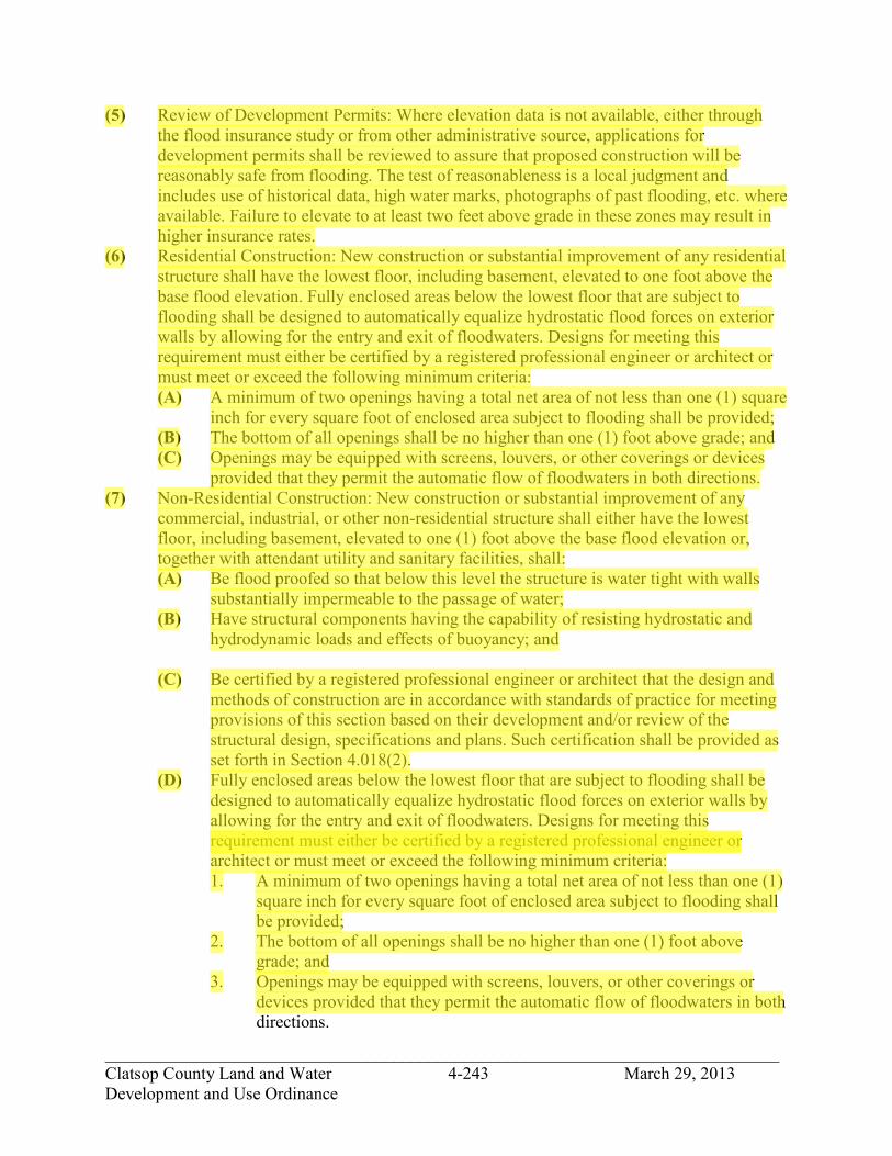
_____________________________________________________________________________ Clatsop County Land and Water 4-243 March 29, 2013 Development and Use Ordinance
(5) Review of Development Permits: Where elevation data is not available, either through the flood insurance study or from other administrative source, applications for development permits shall be reviewed to assure that proposed construction will be reasonably safe from flooding. The test of reasonableness is a local judgment and includes use of historical data, high water marks, photographs of past flooding, etc. where available. Failure to elevate to at least two feet above grade in these zones may result in higher insurance rates.
(6) Residential Construction: New construction or substantial improvement of any residential structure shall have the lowest floor, including basement, elevated to one foot above the base flood elevation. Fully enclosed areas below the lowest floor that are subject to flooding shall be designed to automatically equalize hydrostatic flood forces on exterior walls by allowing for the entry and exit of floodwaters. Designs for meeting this requirement must either be certified by a registered professional engineer or architect or must meet or exceed the following minimum criteria: (A) A minimum of two openings having a total net area of not less than one (1) square
inch for every square foot of enclosed area subject to flooding shall be provided; (B) The bottom of all openings shall be no higher than one (1) foot above grade; and (C) Openings may be equipped with screens, louvers, or other coverings or devices
provided that they permit the automatic flow of floodwaters in both directions. (7) Non-Residential Construction: New construction or substantial improvement of any
commercial, industrial, or other non-residential structure shall either have the lowest floor, including basement, elevated to one (1) foot above the base flood elevation or, together with attendant utility and sanitary facilities, shall: (A) Be flood proofed so that below this level the structure is water tight with walls
substantially impermeable to the passage of water; (B) Have structural components having the capability of resisting hydrostatic and
hydrodynamic loads and effects of buoyancy; and (C) Be certified by a registered professional engineer or architect that the design and
methods of construction are in accordance with standards of practice for meeting provisions of this section based on their development and/or review of the structural design, specifications and plans. Such certification shall be provided as set forth in Section 4.018(2).
(D) Fully enclosed areas below the lowest floor that are subject to flooding shall be designed to automatically equalize hydrostatic flood forces on exterior walls by allowing for the entry and exit of floodwaters. Designs for meeting this requirement must either be certified by a registered professional engineer or architect or must meet or exceed the following minimum criteria: 1. A minimum of two openings having a total net area of not less than one (1)
square inch for every square foot of enclosed area subject to flooding shall be provided;
2. The bottom of all openings shall be no higher than one (1) foot above grade; and
3. Openings may be equipped with screens, louvers, or other coverings or devices provided that they permit the automatic flow of floodwaters in both directions.
jhickner
Highlight
jhickner
Highlight
jhickner
Highlight

_____________________________________________________________________________ Clatsop County Land and Water 4-244 March 29, 2013 Development and Use Ordinance
(8) Foundation Protection: A registered professional civil engineer shall develop or review the structural design, specifications and plans for the foundation of the building and shall certify that the design and methods of construction are in accordance with accepted practices to withstand flotation, collapse, lateral movement, erosion and scour, undermining, and the effects of water and wind acting simultaneously on all building components during the base flood.
(9) Crawlspaces: (A) Crawlspace construction shall meet the standards for space below the lowest floor
as described for residential construction in Section 4.025(7). (B) Portions of the building below the BFE must be constructed with materials
resistant to flood damage. This includes not only the foundation walls of the crawlspace but also any joists, insulation, or other materials that extend below the BFE.
(C) Any ductwork, or other building utility system, within the crawlspace must be elevated above the BFE or sealed from floodwaters.
(D) Below-grade crawlspaces (i.e., where the interior grade of the crawlspace is below the building’s lowest adjacent exterior grade) must be constructed in accordance with Figure 1 below:
(E) The crawlspace must be provided with an adequate drainage system that removes floodwaters from the interior of the crawlspace within a reasonable time after a flood event. The type of drainage system will vary because of the site gradient and other drainage considerations, such as soil types. Possible options include natural drainage through porous, well-drained soils and drainage systems such as perforated pipes, drainage tiles, or gravel or crushed stone drainage by gravity or mechanical means.
(10) Fences and Walls: New fencing shall be designed to collapse under conditions of the base flood or to allow the passage of water by having flaps or openings in the areas at or below
Figure 1: Requirements for below-grade crawlspace construction. (Provided by FEMA)
jhickner
Highlight
jhickner
Highlight

_____________________________________________________________________________ Clatsop County Land and Water 4-245 March 29, 2013 Development and Use Ordinance
the base flood elevation sufficient to allow flood water and associated debris to pass freely.
(11) On-site Sewage Systems: (A) Soil absorption systems shall be located outside of flood hazard areas. Where
suitable soil absorption sites outside of the flood hazard area are not available, the soil absorption site is permitted to be located within the flood hazard area provided it is located to minimize the effects of inundation under conditions of the base flood.
(B) Mound systems in flood hazard areas shall be prohibited. (12) Tanks:
(A) Underground tanks in flood hazard areas shall be anchored to prevent flotation, collapse or lateral movement resulting from hydrostatic loads, including the effects of buoyancy assuming the tank is empty, during conditions of the design flood.
(B) Above-ground tanks in flood hazard areas shall be: (C) Attached to and elevated to or above the base flood elevation (or depth number in
AO zones) on a supporting structure that is designed to prevent flotation, collapse or lateral movement during conditions of the design flood; or be
(D) Anchored or otherwise designed and constructed to prevent flotation, collapse or lateral movement resulting from hydrodynamic and hydrostatic loads, including the effects of buoyancy assuming the tank is empty, during conditions of the design flood.
(E) Tank inlets, fill openings, outlets and vents shall be: 1. A minimum of 2 feet above BFE or fitted with covers designed to prevent the
inflow of floodwater or outflow of the contents of the tank during conditions of the design flood; and
2. Anchored to prevent lateral movement resulting from hydrodynamic and hydrostatic loads, including the effects of buoyancy, during conditions of the design flood.
(13) Recreation Vehicle: In all Areas of Special Flood Hazard, Recreational Vehicles that are an allowed use or structure under the zoning ordinance must either:
(A) Be on the site for fewer than 180 consecutive days, and (B) Be fully licensed and ready for highway use, on its wheels or jacking system,
attached to the site only by quick disconnect type utilities and security devices, and have no permanently attached structures or additions; or
(C) Meet the elevation and anchoring requirements for manufactured homes listed in Section 4.025.
(14) Accessory Structures: (A) Relief from the elevation or dry flood-proofing standards may be granted for an
accessory structure containing no more than 200 square feet. Such a structure must meet the following standards:
(B) The accessory structure is not subject to building codes; (C) The accessory structure shall be located on property with a dwelling; (D) The accessory structure shall not be used for human habitation and shall be used
solely for parking of vehicles or storage of items having low damage potential when submerged.
jhickner
Highlight
jhickner
Highlight

_____________________________________________________________________________ Clatsop County Land and Water 4-246 March 29, 2013 Development and Use Ordinance
(E) Toxic material, oil or gasoline, or any priority persistent pollutant identified by the Oregon Department of Environmental Quality shall not be stored below BFE, or where no BFE is available lower than three feet above grade, unless confined in a tank installed in compliance with this ordinance;
(F) The accessory structure shall be constructed of flood resistant materials. (G) The accessory structure shall be constructed and placed on the building site so as
to offer the minimum resistance to the flow of flood waters; (H) The accessory structure shall be firmly anchored to prevent flotation; (I) All service facilities, such as electrical and heating equipment associated with the
accessory structure, shall be elevated or flood proofed to or above the flood protection elevation, and;
(J) It shall be designed to equalize hydrostatic flood forces on exterior walls by allowing for the automatic entry and exit of floodwater. Designs for complying with this requirement must be certified by a licensed professional engineer or architect, or 1. Provide a minimum of two openings with a total net area of not less than one
square inch for every square foot of enclosed area subject to flooding; 2. The bottom of all openings shall be no higher than one foot above the higher
of the exterior or interior grade or floor immediately below the opening; 3. Openings may be equipped with screens, louvers, valves or other coverings or
devices provided they permit the automatic flow of floodwater in both directions without manual intervention.
(15) Temporary Structures, Storage, and Bridges (A) A floodplain development permit is required for construction or placement of
temporary structures, temporary storage associated with non-residential uses, and temporary bridges located in areas of special flood hazard:
(B) Temporary structures, not including bridges, shall be limited as to time of service, but shall not be permitted for more than 90 days. The Floodplain Administrator is authorized to grant a one-time extension, not to exceed 45 days, for demonstrated cause; such cause shall reaffirm the temporary nature of the structure. Temporary structures shall be anchored to prevent flotation, collapse, or lateral movement.
(16) Temporary storage of materials shall be limited as to time of service, but shall not be permitted for more than 90 days. The Floodplain Administrator is authorized to grant a one-time extension, not to exceed 45 days, for demonstrated cause; such cause shall reaffirm the temporary nature of the storage. Stored material shall be anchored or contained to prevent flotation or release outside the assigned storage area. Hazardous materials or materials deemed to be persistent organic pollutants by the Oregon Department of Environmental Quality shall not be stored in the floodway.
(17) Temporary encroachments in the floodway for the purposes of capital improvement projects (including bridges) require a floodplain development permit. No CLOMR/LOMR is required.
Section 4.026 Development in Floodways (1) Except as provided in paragraphs (3) and (4), encroachments, including fill, new
construction, substantial improvements, and other development are prohibited unless certification by a registered professional civil engineer is provided demonstrating through
jhickner
Highlight
jhickner
Highlight

_____________________________________________________________________________ Clatsop County Land and Water 4-247 March 29, 2013 Development and Use Ordinance
hydrologic and hydraulic analyses performed in accordance with standard engineering practice that such encroachment shall not result in any increase in flood levels during the occurrence of the base flood discharge.
(2) Any fill allowed to be placed in the floodway shall be designed to be stable under conditions of flooding, including rapid rise and rapid drawdown of floodwaters, prolonged inundation, and flood-related erosion and scour.
(3) Applicants shall obtain a Conditional Letter of Map Revision (CLOMR) before an encroachment in the floodway is permitted that will cause any increase in the base flood elevation.
(4) Projects for stream habitat restoration may be permitted in the floodway provided: (A) The project qualifies for a Department of the Army, Portland District Regional
General Permit for Stream Habitat Restoration (NWP-2007-1023); and, (B) A qualified professional (a Registered Professional Engineer; or staff of NRCS; the
county; or fisheries, natural resources, or water resources agencies) has provided a feasibility analysis and certification that the project was designed to keep any rise in 100-year flood levels as close to zero as practically possible given the goals of the project; and,
(C) No structures would be impacted by a potential rise in flood elevation; and, (D) An agreement to monitor the project, correct problems, and ensure that flood
carrying capacity remains unchanged is included as part of the local approval. (5) Construction of new fencing is prohibited, unless the fencing is designed to collapse or
break-away, and is anchored at one end and cabled together so as to not create debris. As an alternative to a break-away design, a new fence may be designed to allow the passage of water by having a flap or opening in the areas at or below the base flood elevation sufficient to allow floodwaters to pass freely.
Section 4.027 Zones with Base Flood Elevation but no Floodway (1) In areas within Zones A1-30 and AE on the community’s FIRM with a base flood
elevation, or where a base flood elevation is developed according to Section 4.025(2) but where no regulatory floodway has been designated, new construction, substantial improvements, or other development (including fill) shall be prohibited, unless it is demonstrated that the cumulative effect of the proposed development, when combined with all other existing and anticipated development, will not increase the water surface elevation of the base flood more than one foot at any point within the community.
(2) Applicants of proposed projects that increase the base flood elevation more than one foot should obtain from FEMA a Conditional Letter of Map Revision (CLOMR) before the project may be permitted.
Section 4.028 Zones Without Base Flood Elevations (1) These standards apply in riverine areas of special flood hazard where no base flood
elevation data have been provided (A Zones): (2) When base flood elevation or floodway data have not been identified by FEMA in a
Flood Insurance Study and /or Flood Insurance Rate Maps, the Floodplain Administrator shall obtain, review, and reasonably utilize scientific or historic base flood elevation and floodway data available from a federal, state, or other source, in order to administer this ordinance. If data are not available from any source, only then subsection 3 shall apply.
jhickner
Highlight
jhickner
Highlight

_____________________________________________________________________________ Clatsop County Land and Water 4-248 March 29, 2013 Development and Use Ordinance
(3) Where the floodplain administrator has obtained base flood elevation data, applicants of proposed projects that increase the base flood elevation more than one foot shall obtain from FEMA a Conditional Letter of Map Revision (CLOMR) before the project may be permitted.
(4) In special flood hazard areas without base flood elevation data, no encroachments, including structures or fill, shall be located in an Area of Special Flood Hazard within an area equal to the width of the stream or fifty feet, whichever is greater, measured from the ordinary high water mark, unless a base flood elevation is developed by a licensed professional engineer.
Section 4.029 Coastal High Hazard Area (1) All other development in coastal high hazard areas (V Zones) for which specific
provisions are not specified in this ordinance or building codes, shall: (2) Be located outside the footprint of, and not structurally attached to, buildings and
structures, and be permitted only if analysis by a registered design professional demonstrates no harmful diversion of floodwaters or wave runup and wave reflection onto adjacent buildings and structures.
Exception: A deck that is structurally attached to a building or structure is allowed if the bottom of the lowest horizontal structural member is one (1) foot above the base flood elevation and any supporting members that extend below the base flood elevation comply with the foundation requirements that apply to the building or structure and a registered design professional demonstrates that the potential loads generated by the deck on the building will be mitigated.
(3) Have nonstructural fill no steeper than one unit vertical to five units horizontal unless an engineering analysis demonstrates no harmful diversion of floodwaters or wave runup and wave reflection on adjacent development;
(4) Not alter, or cause to be altered, sand dunes in such a way to cause increased potential flood damage.
(5) Be anchored to prevent flotation or lateral movement resulting from wind and hydrostatic loads, including the effects of buoyancy, during conditions of the base flood;
(6) Be constructed of flood damage- and corrosion-resistant materials; (7) Be designed to limit creation of debris, and; (8) Have electric service and or mechanical equipment elevated above the base flood
elevation (or depth number in AO zones), except for minimum electric service required to address life safety and electric code requirements.
Section 4.030 Non-Coastal High Hazard Areas (1) All development in non-coastal high hazard areas (A zones) for which specific provisions
are not specified in this ordinance or building codes, shall: (2) Be located and constructed to minimize flood damage; (3) Be designed so as not to impede flow of flood waters under base flood conditions; (4) If located in a floodway, meet the limitations of Section 4.027 of this ordinance; (5) Be anchored to prevent flotation or lateral movement resulting from hydrostatic loads,
including the effects of buoyancy, during conditions of the design flood; (6) Be constructed of flood damage-resistant materials; and
jhickner
Highlight
jhickner
Highlight

_____________________________________________________________________________ Clatsop County Land and Water 4-249 March 29, 2013 Development and Use Ordinance
(7) Have electric service and or mechanical equipment elevated above the base flood elevation (or depth number in AO zones), except for minimum electric service required to address life safety and electric code requirements.
Section 4.031 Specific Standards for Areas of Shallow Flooding (AO and AH Zone) In all areas of special flood hazards designated as areas of shallow flooding, the following provisions shall apply: (1) All new construction and substantial improvements of residential structures shall have the
lowest floor including basement elevated to one foot plus the depth number specified on the FIRM above the highest adjacent grade on the property. The adjacent grade is defined to be the natural or existing grade of the site prior to the proposed site alteration. If no depth number is specified on the FIRM, the lowest floor including basement shall be elevated to at least two feet above the highest adjacent grade.
(2) All construction and substantial improvement of non-residential structures shall: (A) Have the lowest floor including basement elevated to one foot plus the depth number
specified on the FIRM above the highest adjacent grade on the property. The adjacent grade is defined to be the natural or existing grade of the site prior to the proposed site alteration. If no depth number is specified on the FIRM, the lowest floor including basement shall be elevated to at least two feet above the highest adjacent grade; or
(B) Together with attendant utility and sanitary facilities be completely flood proofed to meet the flood proofing standard of Section 4.025(8).
(3) Provide adequate drainage paths around structures on slopes to guide floodwaters around and away from proposed structures.
Section 4.032 Requirement to Submit New Technical Data (1) Within six months of project completion, an applicant who obtains an approved CLOMR
from FEMA, or whose development modifies floodplain boundaries or base flood elevations shall obtain from FEMA a Letter of Map Revision (LOMR) reflecting the as-built changes to the FIRM.
(2) It is the responsibility of the applicant to have technical data prepared in a format required for a Conditional Letter of Map Revision or Letter of Map Revision and to submit such data to FEMA on the appropriate application forms. Submittal and processing fees for these map revisions shall be the responsibility of the applicant.
(3) Applicants shall be responsible for all costs associated with obtaining a Conditional Letter of Map Amendment (CLOMR) or Letter of Map Revision from FEMA.
(4) Clatsop County shall be under no obligation to sign the Community Acknowledgement Form, which is part of the CLOMR/LOMR application.
jhickner
Highlight
jhickner
Highlight
jhickner
Highlight
jhickner
Highlight

_____________________________________________________________________________ Clatsop County Land and Water 4-250 March 29, 2013 Development and Use Ordinance
SECTION 4.040 GEOLOGIC HAZARDS OVERLAY DISTRICT (/GHO)
Section 4.041 Purpose The intent of the geologic hazards overlay is to minimize building hazards and threats to life and property that may be created by landslides, ocean flooding and erosion, weak foundation soils, and other hazards as identified and mapped by the County. This purpose is achieved by basing County decisions on accurate geologic and soils information prepared by qualified professionals.
Section 4.042 Applicability This section applies to all development in the following potentially hazardous areas: (1) Areas subject to mass wasting including:
(A) Active landslides, inactive landslides, landslide topography and mass movement topography identified in the Oregon Department of Geology and Mineral Industries (DOGAMI) Bulletins 74 and 79;
(B) Faults including definite, indefinite, inferred and concealed in the Oregon Department of Geology and Mineral Industries (DOGAMI) Bulletins 74 and 79;
(C) All areas identified in the report, “A Field Inventory of Geologic Hazards from
Silver Point to Cove Beach, Clatsop County, Oregon”, prepared by Martin Ross in 1978, as needing site specific investigations;
(2) Areas subject to wave attack, including: (A) All oceanfront lots; and (B) The beach and dune hazard area as defined in Section 4.052.
(3) Areas with compressible soils identified in the Soil Survey of Clatsop County (SCS) and referenced in Clatsop County’s Comprehensive Plan Background Report, Natural Hazards.
(4) The determination of whether a property is located in one of the above referenced potentially hazardous areas shall be made at the sole discretion of the Director. The mapping that forms the basis for the identification of the above areas may be generalized in nature. A specific site may not include the characteristics for which it is mapped. In these circumstances, the Director may grant a waiver from the requirements of Section 4.040. The waiver shall be in the form of a written finding. The finding shall be based on a report, from a professional specified in Section 4.044, detailing the basis for the determination that the site does not contain the identified potentially hazardous geologic condition.
Section 4.043 Geologic Hazard Permit Requirements. All persons proposing any activity requiring a development permit on property located in potentially hazardous areas identified in Section 4.042 shall obtain a geologic hazard permit. (1) Application for a geologic hazard permit shall be on forms provided by the County and
shall include a geotechnical report prepared in conformance with the requirements of Section 4.044.
jhickner
Highlight
jhickner
Highlight
jhickner
Highlight

_____________________________________________________________________________ Clatsop County Land and Water 4-251 March 29, 2013 Development and Use Ordinance
(2) Before a development permit can be issued, the geotechnical report must be approved as part of the development permit approval process. (A) Where a geotechnical report recommends that additional site investigations, such as
borings or test pits, are undertaken, application for geologic hazard permit will be deemed incomplete until the results of those investigations have been provided to the County.
(B) Where an application is made for a conditional use permit, a variance, a subdivision, a partition, or a planned development located in an area identified in Section 4.042, a geotechnical report in conformance with Section 4.044 shall be prepared. The Director may also require a geotechnical report in conjunction with a proposed zone change.
(3) Application for a geologic hazard permit may be made concurrently with an application for a development permit.
(4) The approved site investigation report shall be referred to in deed and other documents of sale and shall be recorded with the record of deeds.
Section 4.044 Geotechnical Report Requirements For areas identified in Section 4.042 (1) and 4.042 (2), the geotechnical report shall be prepared by a certified engineering geologist or a registered professional geologist. If a geotechnical report is prepared by a geologist and structural recommendations are incorporated into that report, those recommendations, must be made in consultation with an engineering geologist, structural engineer, or civil engineer. (1) For areas identified in Section 4.042 (1), the geotechnical report shall:
(A) Identify the hazards to life, public and private property which may be caused by mass movement (landsliding and sloughing), soil erosion or deposition, and earthquakes;
(B) Identify the hazards to life, public and private property, and the natural environment which may be caused by the proposed use and other human activities;
(C) Describe how the proposed development or use will be adequately protected from geologic hazards, including landsliding and sloughing, soil erosion or deposition, and earthquakes; and
(D) Describe how the proposed development is designed to minimize the adverse effects it might have on the site and adjacent areas.
(2) For areas identified in Section 4.042 (2), and in addition to the standards identified in Section 4.044 (2), the geotechnical report shall identify the hazards to life, public and private property which may be caused by wind erosion or accretion, wave undercutting (erosion), and ocean overtopping (flooding, including tsunami),
(3) For areas identified in Section 4.042 (1) and 4.042 (2), the geotechnical report shall describe how the proposed development provides for temporary and permanent stabilization and the planned maintenance of new and existing vegetation. Existing stabilizing vegetation, particularly trees, shall not be removed on slopes of 20% or greater.
jhickner
Highlight
jhickner
Highlight

_____________________________________________________________________________ Clatsop County Land and Water 4-252 March 29, 2013 Development and Use Ordinance
(4) For areas identified in Section 4.042 (1) and 4.042 (2), the geotechnical report shall be prepared in conformance with the document “ Clatsop County – Geotechnical Report Content Standards”.
(5) For areas identified in Section 4.042 (3), the geotechnical report shall be prepared by a certified engineering geologist, soils engineer, or civil engineer. Geotechnical reports prepared for areas identified in Section 4.042 (3) shall incorporate specific construction and structural recommendations to address the soil characteristics of the site. Where pertinent, the discussion of specific construction and structural recommendations shall include: site preparation such as compaction or replacement of existing soils, bearing loads and the corresponding amount of settlement, steps to be taken with respect to ground and surface water, special foundation requirements, and foundation recommendations based on bearing capacity, design criteria, and the effect of adjacent loads.
(6) For all areas identified in Section 4.042, the geotechnical report shall be prepared in conformance with the document “Clatsop County – Geotechnical Report Content Standards”.
Section 4.045 Geologic Hazard Permit Review. An application for a geologic permit shall be reviewed under a Type I procedure. (1) A geologic hazard permit shall be approved by the Director if:
(A) The conclusions of the geotechnical report supports a finding that there are no adverse effects of the site’s geologic characteristics on the proposed development and the proposed site modifications will not adversely affect geologic conditions and processes in the immediate area: or
(B) The conclusions of the geotechnical report supports a finding that if specified actions are taken to address an identified potential hazard then the effects of the site’s geologic characteristics on the proposed development will be at an acceptable level and the effects of the proposed site modifications on the geologic conditions and processes in the immediate area are at an acceptable level.
(2) Specific recommendations contained in the geologic report shall be incorporated into the approved geologic hazard permit. Based on content, recommendations and conclusions of the geotechnical report, the Director may apply other conditions to the issuance of a geologic hazard permit.
(3) The specific recommendations contained in the geotechnical report, and conditions applied to the geologic hazard permit shall be incorporated into the plans and specifications of the development which is the subject of the development permit.
(4) Where there is not a concurrent application for a geologic hazard permit and a development permit for a specified development, the person(s) who prepared the geotechnical report shall submit a letter to the Director verifying that the proposed plans, details, and specifications of the proposed development have been reviewed and are in keeping with the recommendations contained in the geotechnical report that formed the basis for the issuance of the geologic hazard permit, or they shall make recommendations or changes that are needed in the proposed development in order to bring it into conformance with the recommendations contained in the geotechnical report.
jhickner
Highlight
jhickner
Highlight

_____________________________________________________________________________ Clatsop County Land and Water 4-253 March 29, 2013 Development and Use Ordinance
(5) When a geotechnical report submitted in conjunction with a development permit that is more than two years old, a letter shall be submitted to the Director from the person(s) who prepared the report. The letter shall provide verification that the geotechnical report is still valid for the proposed project.
Section 4.046 Independent Review The Director, at his discretion and at the applicant’s expense, may require an evaluation of a geotechnical report by another expert of his choosing. As part of its review of a land use application located in an area subject to Section 4.042, the Hearings Officer, Planning Commission, or Board of Commissioners may also require, at the applicant’s expense, an evaluation of a geotechnical report that was prepared in conjunction with the land use application. The results of that evaluation shall be used in making the final decision on the effected land use permit.
Section 4.047 Standards The review and approval of development permits in the geologic hazard overlay district shall be based on the conformance of the proposed development plans with the following grading standards. Conditions of approval may be imposed on the development permit to assure that the development plan meets the standards of this section and to prevent the creation of a hazard to public or private property. (1) Site Plan Information Required. In addition to the information required for a development
permit, the site plan shall show where clearing, grading, excavation or filling is to occur, the area where existing vegetative cover will be retained, the location of any streams and wetland areas on immediately adjacent to the property, and the general direction of slopes. A statement shall be provided summarizing the extent of land clearing and grading and the quantity of cut and/or fill material involved.
(2) Preparation of Grading Plan Based on the findings and conclusions of the geotechnical report, or the nature of the proposed development, The Planning Director, at his sole discretion, may require that a grading plan prepared by a registered engineer be submitted with the application for a development permit. The Planning Director may require that such a grading plan, in addition to information required by Section 4.047(1) include the following additional information: (A) Existing and proposed contours of the property, at two-foot contour intervals; (B) The location of the existing structures and building, including those within twenty-
five feet of the property; (C) The location of all surface and subsurface drainage devices to be constructed; and (D) Design details of proposed retaining walls.
(3) General Standards. The proposed development plans shall meet the following general standards: (A) Natural vegetation will be protected and retained wherever possible; (B) To the extent possible, roads and driveways shall follow the natural contours of the
site; and (C) An erosion control plan shall be prepared and implemented in conformance with the
requirements of Section S2.500. (4) Cuts. Proposed cuts shall meet the following standards:
(A) The site development shall be design to minimize the need for cuts.
jhickner
Highlight
jhickner
Highlight
jhickner
Highlight
jhickner
Highlight

_____________________________________________________________________________ Clatsop County Land and Water 4-254 March 29, 2013 Development and Use Ordinance
(B) The slope of cut surfaces shall not be steeper than is safe for the intended use and shall not be steeper than two horizontal to one vertical unless an engineering report finds that a cut at a steeper slope will be stable and not create a hazard to public or private property;
(C) Cuts shall not remove the toe of any slope where a potential for landslide exists; (D) Cuts shall be setback from property lines so as not to endanger or disturb adjoining
property; and (E) Retaining walls shall be constructed in accordance with the Oregon State Structural
Specialty Code. (5) Fills. Proposed fills shall meet the following standards:
(A) The site development shall be designed to minimize the need for fill. (B) The slope of fill surfaces shall not be steeper than is safe for the intended uses and
shall not be steeper than two horizontal to one vertical unless an engineering report finds that a steeper slope will be stable and not create a hazard to public or private property. Fill slopes shall not be constructed on natural slopes steeper than two horizontal to one vertical.
(C) Fill shall be setback from property lines so as not to endanger or disturb adjoining property.
(D) The ground surface shall be prepared to receive fill by removing vegetation, noncomplying fill, topsoil and other unsuitable materials, and scarifying to provide a bond with the new fill.
(E) Structural fill shall be designed by a registered civil engineer in accordance with standard engineering practices.
(6) Drainage. The following standards shall be met: (A) Proposed grading shall not alter drainage patterns so that additional storm water is
directed onto adjoining property. (B) Cut and fill slopes shall be provided with subsurface drainage as necessary for
stability. (C) The site grading and drainage improvements shall be designed to carry both
concentrated water and surface sheet flow water to the nearest practical drainage way, as specified by the Planning Director.
jhickner
Highlight

_____________________________________________________________________________ Clatsop County Land and Water 4-255 March 29, 2013 Development and Use Ordinance
SECTION 4.050. BEACH AND DUNE OVERLAY DISTRICT (/BDO).
Section 4.051. Purpose. The intent of the beach and dune overlay is to regulate uses and activities in the affected areas in order to: ensure that development is consistent with the natural limitations of the oceanshore; ensure that identified recreational, aesthetic, wildlife habitat and other resources are protected; conserve, protect, where appropriate develop, and where appropriate restore the resources and benefits of beach and dune areas; and to reduce the hazards to property and human life resulting from both natural events and development activities.
Section 4.052. Applicability. The beach and dune overlay (BDO) includes the following beach and dune areas: (1) The beach, which extends from extreme low tide landward to the Statutory Vegetation
Line established and described in ORS 390.770, or the line of established upland shore vegetation, whichever is further inland;
(2) The dune hazard area, which extends from the Statutory Vegetation Line established and described by ORS 390.770 or the line of established upland shore vegetation, which ever is further inland, landward to the construction setback line.
(3) The construction setback line is established as follows: (A) A line 570 feet landward of the Statutory Vegetation Line established and described
by ORS 390.770 for the area north of Surf Pines to the Columbia River south jetty. (B) The Pinehurst construction setback line, established and described in Ordinance 92-
90; and (C) The Surf Pines construction setback line, established and described in Ordinance 83-
17 and extended north to include T7N, R10W, Section 16C, Tax Lot 300. (4) The dune construction area, which extends from the construction setback line as defined
in the section above, landward to the eastern limit of Highway 101.
Section 4.053. Relationship to the Underlying Zone. Uses and activities permitted in the Beach and Dune Overlay (BDO) are subject to the provisions and standards of the underlying zone and this chapter. Where the provisions of this district and the underlying zone conflict, the provisions of this district shall apply.
Section 4.054 State Parks and Recreation Department Regulated Uses. Uses and activities permitted on the beach, as defined in Section 4.052(1) are those permitted subject to review and approval by the Oregon Parks and recreation Department consistent with ORS 390.605-390.725 and OAR Divisions 20-30.
Section 4.055. Permitted Development and Uses. The following developments and uses are permitted under a Type I procedure subject to specific development standards. (1) In the dune hazard area as defined in Section 4.052(2),
(A) Maintenance and repair of existing structures, including roads and subsurface disposal systems.
(B) Land transportation facilities as specified in Section 3.035.
jhickner
Highlight
jhickner
Highlight

_____________________________________________________________________________ Clatsop County Land and Water 4-256 March 29, 2013 Development and Use Ordinance
(C) Drainage improvements, including storm water outfall. (D) Foredune breaching, where:
1) The breaching is required to replenish sand supply in interdune areas, or is undertaken on a temporary basis for emergency purposes such as fire control or the alleviation of a flood hazard.
2) There are no other reasonable alternatives to alleviate the emergency. 3) The breaching does not endanger existing development. 4) The area affected by the breaching is restored according to an approved
restoration plan prepared by a registered professional geologist or certified engineering geologist, where the restoration plan shall include appropriate revegetation; and
5) At a minimum, foredunes shall be restored to a dune profile which provides flood protection equivalent to that prior to breaching.
(D) Remedial grading, in the following cases: 1) Clearing of sand which is inundating houses or commercial buildings and
their associated improvements. Sand may be graded up to thirty-five feet from a building's foundation subject to the following conditions: (a) The area to be graded constitutes open sand dunes or the back slope of a
foredune, (b) There is no modification to the crest of a foredune, (c) At a minimum, the area graded shall maintain the one hundred year flood
elevation as established by the county’s Flood Insurance Rate Map (FIRM), and
(d) No grading shall occur seaward of the Statutory Vegetation Line, except for placement of material removed from the structure in question;
2) Excavation necessary for the purpose of placing a beachfront protective structure;
3) Clearing of sand which is inundating a public street and is interfering with vehicular or pedestrian traffic, including clearing of sand from a public beach access parking lot.
4) Excavation of sand necessary to alleviate storm water buildup; 4) Minor reshaping of the forward portion of a dune necessary to provide an
even slope for the planting of stabilizing vegetation; and 5) Where feasible, all graded sand shall be placed on the beach or foreslope
portion of the adjoining dune. Where not feasible, then sand shall be placed at a location approved by the county. In no event shall sand be removed from the beach and dune system.
(E) Maintenance of existing riparian vegetation, including the planting of additional riparian vegetation.
(2) In the dune construction area defined in Section 4.052(3), any permitted uses allowed in the underlying zone subject to the applicable standards of that zone and the applicable general standards of Section 4.059.
jhickner
Highlight
jhickner
Highlight
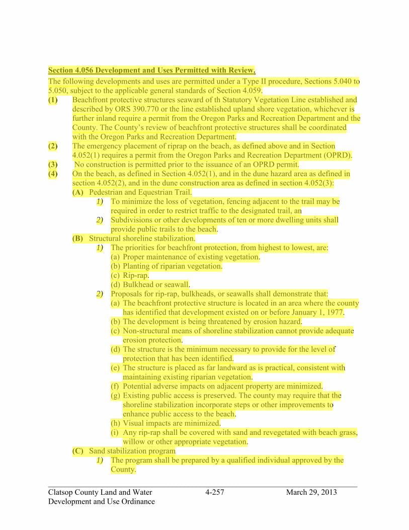
_____________________________________________________________________________ Clatsop County Land and Water 4-257 March 29, 2013 Development and Use Ordinance
Section 4.056 Development and Uses Permitted with Review. The following developments and uses are permitted under a Type II procedure, Sections 5.040 to 5.050, subject to the applicable general standards of Section 4.059. (1) Beachfront protective structures seaward of th Statutory Vegetation Line established and
described by ORS 390.770 or the line established upland shore vegetation, whichever is further inland require a permit from the Oregon Parks and Recreation Department and the County. The County’s review of beachfront protective structures shall be coordinated with the Oregon Parks and Recreation Department.
(2) The emergency placement of riprap on the beach, as defined above and in Section 4.052(1) requires a permit from the Oregon Parks and Recreation Department (OPRD).
(3) No construction is permitted prior to the issuance of an OPRD permit. (4) On the beach, as defined in Section 4.052(1), and in the dune hazard area as defined in
section 4.052(2), and in the dune construction area as defined in section 4.052(3): (A) Pedestrian and Equestrian Trail.
1) To minimize the loss of vegetation, fencing adjacent to the trail may be required in order to restrict traffic to the designated trail, an
2) Subdivisions or other developments of ten or more dwelling units shall provide public trails to the beach.
(B) Structural shoreline stabilization. 1) The priorities for beachfront protection, from highest to lowest, are:
(a) Proper maintenance of existing vegetation. (b) Planting of riparian vegetation. (c) Rip-rap. (d) Bulkhead or seawall.
2) Proposals for rip-rap, bulkheads, or seawalls shall demonstrate that: (a) The beachfront protective structure is located in an area where the county
has identified that development existed on or before January 1, 1977. (b) The development is being threatened by erosion hazard. (c) Non-structural means of shoreline stabilization cannot provide adequate
erosion protection. (d) The structure is the minimum necessary to provide for the level of
protection that has been identified. (e) The structure is placed as far landward as is practical, consistent with
maintaining existing riparian vegetation. (f) Potential adverse impacts on adjacent property are minimized. (g) Existing public access is preserved. The county may require that the
shoreline stabilization incorporate steps or other improvements to enhance public access to the beach.
(h) Visual impacts are minimized. (i) Any rip-rap shall be covered with sand and revegetated with beach grass,
willow or other appropriate vegetation. (C) Sand stabilization program
1) The program shall be prepared by a qualified individual approved by the County.
jhickner
Highlight
jhickner
Highlight

_____________________________________________________________________________ Clatsop County Land and Water 4-258 March 29, 2013 Development and Use Ordinance
2) The program shall be based on an analysis of the area subject to accretion or erosion. The area selected for management shall be found, based on the analysis, to be of sufficient size to successfully achieve the program objectives.
3) The program shall include specifications on how identified activities are to be undertaken. The specifications should address such elements as: the proposed type of vegetation to be planted or removed; the distribution, required fertilization and maintenance of vegetation to be planted; the location of any sand fences; and the timing of the elements of the proposed program.
4) Fire-resistant species are the preferred stabilizing vegetation within twenty- five feet of existing dwellings or structures. Fire resistant vegetation should only be planted when the foreslope and crest of the dune are adequately stabilized to prevent significant accumulation of windblown sand.
5) Where the placement of sand fences is proposed, evidence shall be provided that the planting of vegetation alone will not achieve the stated purpose of the sand stabilization program. Fencing may be permitted on a temporary basis to protect vegetation that is being planted as part of the program, or to control the effects of pedestrian beach access on adjacent areas.
(5) In the dune construction area as defined in section 4.052 (3), any permitted uses allowed in the underlying zone subject to the applicable standards of that zone and the applicable standards of Section 4.059.
Section 4.057. Conditional Development and Use. The following developments and uses may be permitted under a Type IIa procedure Sections 5.010 to 5.025, subject to the applicable general of Section 4.059. (1) On the beach, as defined in section 4.052(1), and in the dune hazard area as defined in
section 4.052(2): (A) Foredune grading
Foredune grading for view enhancement or to prevent sand inundation may be allowed only in foredune areas that were committed to development on or before January 1, 1977 and where an overall plan for foredune grading is prepared.
1) A foredune grading plan shall be prepared by a qualified expert approved by the County.
2) A foredune grading plan shall be based on an consideration of factors affecting the stability of the shoreline to be managed including sources of sand, ocean flooding, and patterns of accretion and erosion (including wind erosion), and the effects of beachfront protective structures and jetties.
3) The foredune grading plan shall: (a) Cover an entire beach and foredune area subject to an accretion problem,
including adjacent areas potentially affected by changes in flooding, erosion or accretion as a result of dune grading;
(b) Specify minimum dune height and width requirements to be maintained for protection from flooding and erosion. The minimum height for flood protection is four feet above the one hundred year flood elevation established by the FEMA flood insurance studies;
jhickner
Highlight
jhickner
Highlight

_____________________________________________________________________________ Clatsop County Land and Water 4-259 March 29, 2013 Development and Use Ordinance
(c) Identify and set priorities for low and narrow dune areas which need to be built up;
(d) Prescribe standards for redistribution of sand and temporary and permanent stabilization measures including the timing of these activities; and
(e) Prohibit removal of sand from the beach-foredune system. (2) In the dune construction area as defined in section 4.052(3), any conditional uses allowed
in the underlying zone subject to applicable standards of that zone and the applicable general standards of Section 4.059.
Section 4.058 Prohibited Activities. The following activities are prohibited in all areas within the beach and dune overlay (BDO) as defined in Section 4.052: (1) Removal of sand from the beach or dune system. (2) Removal of stabilizing vegetation, except in conjunction with a permitted development or
use.
Section 4.059. General Development and Use Criteria. The following criteria are applicable to developments and uses in the BDO, in addition to those specific standards identified in Sections 4.054 through 4.057. (1) For development located in all areas in the BDO as defined by Section 4.052, other than
older stabilized dunes, findings shall address the following: (A) The adverse effects the proposed development might have on the site and adjacent
areas; (B) Temporary and permanent stabilization proposed and the planned maintenance of
new and existing vegetation; (C) Methods for protecting the surrounding area from any adverse effects of the
development; (D) Hazards to life, public and private property, and the natural environment which may
be caused by the proposed use. (E) How the proposed development will not result in the draw down of the groundwater
supply in a manner that would lead to: 1) The loss of stabilizing vegetation: 2) The loss of water quality; 3) Salt water intrusion into the water supply; or 4) Significant lowering of interdune water level. Building permits for single-
family dwellings are exempt from this requirement if appropriate findings are provided at the time of subdivision approval.
(2) For development on the beach, as defined in section 4.052(1), and in the dune hazard area as defined in section 4.052(2) a geotechnical report in conformance with Section 4.044, shall be required by the Planning Director prior to the issuance of a development permit.
jhickner
Highlight
jhickner
Highlight
jhickner
Highlight

_____________________________________________________________________________ Clatsop County Land and Water 4-260 March 29, 2013 Development and Use Ordinance
(3) For development in the dune hazard area as defined in section 4.052 (2) and in the dune construction area as defined in section 4.052(3) a wind erosion control plan shall be required by the Planning Director prior to the issuance of a development permit. The purpose of the wind erosion control plan is to maintain the stability of the site during periods when the vegetative cover is removed and to ensure that adjacent properties are not adversely affected. The plan shall: (A) Identify areas where vegetation is to be removed and the type of vegetation to be
removed; (B) Describe any temporary sand stabilization measures to be used during construction; (C) The proposed type of vegetation to be planted to stabilize the site after construction,
including the density of planting, proposed fertilization, method of maintenance, and timing of the planting;
(D) The removal of vegetation shall be kept to a minimum during site preparation and construction; and
(E) No site clearing is permitted prior to the issuance of the development permit for the proposed development or use. Site clearing shall occur no sooner than is necessary prior to construction. The permanent revegetation of the site shall be started as soon as is practical, but in no event later than six months after the completion of construction.
jhickner
Highlight

_____________________________________________________________________________ Clatsop County Land and Water 4-261 March 29, 2013 Development and Use Ordinance
SECTION 4.080. SHORELAND OVERLAY DISTRICT (/SO).
Section 4.082. Purpose. The purpose of this district is to manage uses and activities in coastal shoreland areas which are not designated as a Shoreland Zone in a manner consistent with the resources and benefits of coastal shorelands and adjacent estuarine aquatic areas.
Section 4.084. Designation of Shoreland Overlay District. This overlay district refers to areas described on official Clatsop County Zoning Maps. It does not include shoreland areas of the Columbia River Estuary designated Marine Industrial Shoreland, Conservation Shoreland, or Natural Shoreland. Included in this overlay district are: (1) Areas subject to ocean flooding and lands within 100 feet of the ocean shore or within 50
feet of an estuary or a coastal lake. (2) Areas of geological instability in or adjacent to the shoreland boundary when the
geologic instability is related to or will impact a coastal water body. (3) Natural or man-made riparian resources, especially vegetation which function to stabilize
the shoreline or maintain water quality and temperature necessary for the maintenance of fish habitat and spawning areas.
(4) Areas of significant shoreland and wetland biological habitats whose habitat quality is primarily derived from or related to the association with coastal and estuarine areas.
(5) Areas necessary for water-dependent and water-related uses, including uses appropriate for port facilities and navigation, dredged material disposal and mitigation sites, and areas suitable for aquaculture.
(6) Areas of exceptional aesthetic or scenic quality, where the quality is primarily derived from or associated with the coastal or estuarine areas.
(7) Areas of recreational importance or public access which utilize coastal waters or riparian resources.
(8) Locations of archaeological or historical importance associated with the estuary. (9) Coastal headlands. (10) Dikes and their associated inland toe drains.
Section 4.086. Categories of Coastal Shorelands. There are two categories of Coastal Shorelands as described below: (1) Category 1:
(A) Those shorelands described in the Estuarine and Coastal Shoreland Element of the Comprehensive Plan as:
1) Significant, non-estuarine marshes; 2) Riparian resources; 3) Significant fish and wildlife habitat; 4) Exceptional aesthetic resources; 5) Historical and archaeological sites.
(2) Category 2: (A) All shorelands which do not fall within 1(A)1-5 and are not currently designated
Marine Industrial Shorelands, Conservation Shorelands or Natural Shorelands are the second category of Coastal Shorelands.
jhickner
Highlight
jhickner
Highlight

_____________________________________________________________________________ Clatsop County Land and Water 4-262 March 29, 2013 Development and Use Ordinance
Section 4.088. Developments Permitted with Category 1 Coastal Shorelands. Only the following uses and activities are permitted under a Type I procedure (Section 2.015) within shorelands defined in Section 4.086(1)(A)1)-5): (1) Low intensity, water-dependent recreation. (2) Existing and compatible farm uses and activities, excluding structures. (3) Forest operations only if natural values of the resource are protected, as determined by
administration of the Oregon Forest Practices Act, where applicable, otherwise as determined by the Planning Department under a Type II procedure.
(4) Research or educational activities which maintain or enhance the natural characteristics of the area and its resources.
(5) Navigational aids. (6) Vegetative shoreline stabilization. (7) Maintenance and repair of existing and serviceable dikes. (8) New dikes.
Section 4.090. Developments Permitted within Category 2 Coastal Shorelands. Within coastal shorelands defined in Section 4.086(2) the following uses and activities are permitted if otherwise allowed in the underlying zone, and subject to the requirements and standards of the use in the underlying zone: (1) Uses allowed in Section 4.088 above. (2) Single family dwellings, provided that, if possible, the dwelling is to be located on a
portion of the property outside of the Coastal Shoreland boundary. (3) Limited home occupation. (4) Home occupation in an existing building. (5) Signs. (6) Water-dependent recreation. (7) Projects for the protection of habitat, nutrient, fish, wildlife and aesthetic resources. (8) Aquaculture. (9) Utilities as necessary for public service. (10) Water-dependent commercial and industrial uses. Other uses and activities within Category 2 Coastal Shorelands are allowed under a Type IV procedure upon findings that such uses and activities are compatible with the objectives of the Comprehensive Plan to protect riparian vegetation and wildlife habitat.
Section 4.092. Development Standards. (1) All uses and activities in the Columbia River Estuary Shoreland Overlay District will
satisfy applicable Columbia River Estuary Shoreland and Aquatic Area Use and Activity Standards contained in the Development and Use Standards Document.
(2) If a proposal involves several uses, the standards applicable to each use shall be satisfied. (3) For parcels totally within the Coastal Shorelands Boundary, structures shall be sited
according to lot line setbacks and Riparian Vegetation Standards in S4.500 et seq.
jhickner
Highlight
jhickner
Highlight

_____________________________________________________________________________ Clatsop County Land and Water 4-263 March 29, 2013 Development and Use Ordinance
(4) For parcels partially within and partially outside of the Coastal Shorelands boundary, structures shall be located outside the Boundary. This requirement may be waived by the Community Development Director only upon a showing that the portion of the site outside of the Boundary cannot accommodate the use or is of such value for resource purposes that the use would impact resource productivity less if located within Coastal Shorelands.
(5) Proposed development in shoreland areas within identified hazards to development shall be evaluated prior to construction to assure that new hazards are not created or existing hazards are not worsened on adjacent property.
Section 4.095. State and Federal Permits. Applicants for developments which require a state or federal permit shall submit to the Planning Director a copy of the completed permit application and other supporting material which demonstrates that the development is consistent with the Comprehensive Plan and this Ordinance.
jhickner
Highlight

_____________________________________________________________________________ Clatsop County Land and Water 4-264 March 29, 2013 Development and Use Ordinance
Section 4.100. ARCH CAPE RURAL COMMUNITY OVERLAY DISTRICT (/RCO).
Section 4.101. Purpose. This section provides for the comprehensive review of proposed developments within the Arch Cape Rural Community Overlay District. The intent of the overlay is to ensure development occurs in a manner that preserves scenic views and promotes attractive development within the boundaries of the rural community. In addition the Arch Cape Rural Community Overlay District outlines procedures and criteria for developments that require variances or are of a non-conforming nature.
Section 4.102. Types of Review. All development which is situated within the /RCO District Boundary that falls under the thresholds in this section shall be subject to the Criteria for Design Review Evaluation, Section 4.103 and Article 2, Procedures for Land Use Applications. (1) The following types of projects shall require review according to the Type II procedure,
Section 2.020. For purposes of these types of Major projects, review by the Design Review Advisory Committee as described in Section 4.108, is required. (A) Any new residential development proposing to construct a dwelling as described in
Section 1.030 (Dwelling Types). (B) Any new commercial development proposing to construct structures devoted to a
commercial use. (C) Any new commercial development creating additional cumulative square footage. (D) Any new residential development creating additional cumulative square footage. (E) Accessory buildings in residential zones. (F) Accessory buildings associated with commercial developments and containing no
residential units. (G) Development and Construction of public or private roads. (H) Any Change in Use, Variance Request, Conditional Use Permit, or Other Use
Requiring Review through Type II, III, or IV procedures with exception of those described in 4.109(2).
(2) The following types of projects shall require design review according to the Type II Procedure, Section 2.020. For purposes of these types of Minor projects, review by the Design Review Advisory Committee as described in Section 4.108, is not required. (A) Any project that requires a building permit and does not result in the expansion of the
exterior dimensions and/or footprint. (B) If the Community Development Director determines that a development may
significantly impact adjoining properties with respect to location, bulk, compatibility, views, preservation of existing landscape, or other applicable criteria identified in Section 4.103, the application will be forwarded to the Design Review Advisory Committee for review.
jhickner
Highlight
jhickner
Highlight
jhickner
Highlight

_____________________________________________________________________________ Clatsop County Land and Water 4-265 March 29, 2013 Development and Use Ordinance
Section 4.103. Criteria for Design Review Evaluation. In addition to the requirements of the Comprehensive Plan, other applicable sections of this Ordinance and other County Ordinances, the following minimum criteria will be considered in evaluating design review applications: (1) Relation of Structures to Site. The location, height, bulk, shape, and arrangement of
structures shall be in scale and compatible with the surroundings. (2) Protection of views shall be preserved through the confines of this ordinance section
3.068. (3) Preservation of Landscape. The landscape shall be preserved in its natural state to the
maximum extent possible by minimizing tree, vegetation and soils removal. Cut and fill construction methods are discouraged. Roads and driveways should follow slope contours in a manner that prevents erosion and rapid discharge into natural drainages. Disturbed areas shall be re-vegetated with native species.
(4) Utility Service. All new service lines shall be placed underground. (5) Exterior lighting shall be of a “full cut-off” design. Glare shall be directed away from
neighboring property or shielded in a manner not to cause offense (i.e. Full Cut-off Fixtures).
(6) Buffering and Screening. In commercial zones, storage, loading, parking, service and similar accessory facilities shall be designed, located, buffered or screened to minimize adverse impacts on the site and neighboring properties.
(7) Vehicle Circulation and Parking. The location of access points to the site, the interior circulation pattern and the arrangement of parking in commercially zoned areas shall be designed to maximize safety and convenience and to be compatible with proposed and adjacent buildings. The number of vehicular access points shall be minimized.
(8) Signs. The size, location, design, material and lighting of all exterior signs shall not detract from the design of proposed or existing buildings, structures or landscaping and shall not obstruct scenic views from adjacent properties.
(9) Surface Water Drainage. Special attention shall be given to proper surface water drainage from the site so that it will not adversely affect adjacent properties or the natural or public storm drainage system.
(10) In addition to compliance with the criteria as determined by the hearing body and with the requirements of sections 1.040 and 1.050, the applicant must accept those conditions listed in Section 5.025 that the hearing body finds are appropriate to obtain compliance with the criteria. All permit criteria and conditions must be satisfied prior to final building approval and occupancy.
Section 4.104. Application Procedure. The following procedure shall be followed when applying for design review approval: (1) Pre-application Conference. The applicant shall discuss the proposed development with
the staff of the Clatsop County Department of Community Development in a pre-application conference pursuant to Section 2.045.
(2) Following the pre-application conference, the applicant shall file with the Planning Director a design review plan, which shall include the following: (A) The Site Plan shall indicate:
i. All adjacent structures within 100’. ii. All existing trees 6” caliper or greater, indicating any tree to be removed.
jhickner
Highlight

_____________________________________________________________________________ Clatsop County Land and Water 4-266 March 29, 2013 Development and Use Ordinance
iii. Existing grades in contours of 1’ vertical intervals. iv. Proposed final grading in contours of 1’ vertical intervals. v. The finished site arrangement and landscape features(pedestrian walks, fences,
walls, landscaping, etc.) vi. The location of entrances and exits and the direction of traffic flow into and out of
off street parking and loading areas. vii. Utility lines and services and how they are being provided.
viii. A drainage plan for storm water runoff and retention (bio-swales, drywells, retention ponds, etc.)
(B) Elevations of the structure(s) illustrating the relation to undisturbed average grade. Per Section 3.068 §7C, a licenses surveyor shall install a benchmark on or near the property to provide vertical control for the project. Proposed developments within two (2) feet of the building height limit will be required to have a licenses surveyor certify the building height, prior to requesting final building inspection. (**It is recommended that the contractor verify height at the framing stage prior to sheathing**)
If applicable, Site Section(s) showing how the proposed structure protects ocean and scenic views per 4.103 (2). Section 4.105. Plan Evaluation Procedure. The following procedure shall be followed in processing a design review plan: (1) Upon receipt of a design review application and plan, the Community Development
Director will examine it to determine whether it is complete (and consistent with the requirements of this
(2) Section). If found to be complete, the Community Development Director shall determine whether the application will require Minor or Major Review under Section 4.102(1-2)(Types of Review). If the request is considered a Major Review under Section 4.102(1)(Types of Review), the Director shall forward the application and plans to the Design Review Advisory Committee for its review and recommendation.
(3) The Design Review Advisory Committee will review the application and plan at its first regularly scheduled meeting and shall make a written recommendation to the Planning Director within 21 days after receipt of the application.
(4) The Community Development Director may approve the design plan, disapprove it or approve it with such modifications and conditions as may be required to make it consistent with the Comprehensive Plan, with the criteria listed in this Section and with other Sections of this Ordinance.
(5) A decision on a design review plan shall include written conditions, if any, and findings and conclusions. The findings shall address the relationships between the plan and the policies and criteria listed in the Comprehensive Plan, this Section and other Sections of this Ordinance.
(6) The Community Development Director's decision shall be mailed within seven (7) working days to the applicant and to owners of land entitled to notification. The same mail, when appropriate, shall include notice of the manner in which an appeal of the decision may be made.
(7) Appeals. See Section 2.230 for appeal procedure. Section 4.106. Modifications of Approved Design Review Plan.

_____________________________________________________________________________ Clatsop County Land and Water 4-267 March 29, 2013 Development and Use Ordinance
Proposed changes shall be submitted in writing to the Community Development Director for approval. Minor changes requested by the applicant may be approved if such changes are consistent with the purposes and general character of the original approved application. All other modifications shall be processed in the same manner as the original application. Section 4.107. Time Limit on Approval. Site design approvals shall be void after one (1) year unless a building permit has been issued and substantial construction has taken place per the International Building Code. However, the County may, at the discretion of the Community Development Director, extend authorization for an additional year upon request, provided such request is submitted in writing not less than 10 days nor more than 30 days prior to expiration of the permit.
Section 4.108. Design Review Advisory Committee. The Southwest Coastal Citizens Advisory Committee (CAC) shall serve as a Design Review Advisory Committee for Arch Cape and will review development proposals and make recommendations to the Community Development Director and Planning Commission concerning the design and scenic view aspects of proposed developments. (1) Meetings/ Records. The committee shall hold regular meetings on the first and third
Wednesday of each month at the Arch Cape Fire Hall or designated sites. However, meetings may be canceled when there are no design review plans submitted for review by the Committee. The deliberations and procedings of the committee shall be public. The Community Development Department shall keep minutes of the committee meetings and such minutes shall be public record.
(2) The Design Review Advisory Committee shall submit their recommendations to the Community Development Director within seven (7) working days of their decision.

_____________________________________________________________________________ Clatsop County Land and Water 4-268 March 29, 2013 Development and Use Ordinance
SECTION 4.109 ARCH CAPE SHORT TERM (VACATION) RENTALS. This section regulates the short-term rental of dwelling units within the Arch Cape Rural Community Overlay District. Section 4.110 Purpose. The purpose of this section is to regulate short-term rentals to enhance livability and safety in the Arch Cape residential neighborhoods. Rentals of a short-term dwelling unit shall be limited to either a minimum period of seven (7) nights or, if for fewer than seven (7) nights, then to no more than one rental within a seven (7) night period. Use of a short-term rental by a record owner of a property shall not be considered to be a rental under this section. 4.111 Permit Required. An owner shall obtain a revocable short-term rental permit whenever a dwelling unit (as defined in Section 1.030) is to be used for short-term rental purposes and shall comply with the requirements of the County’s transient room tax ordinance (No. 90-7). (1) A short-term rental permit shall be obtained prior to using the unit as a short-term rental. (2) Short-term rental permits are issued & renewed annually by July 1st of the given year. (3) Short-term rental permits are non-transferable, new owners will be required to attain new
permits or register in accordance with 4.111(2) above. (4) The short-term rental permit does not relieve the owner of the obligation to pay county
room taxes. (5) If the terms of the short-term rental permit are not met, the short-term rental permit may
be revoked and the owner subject to penalties per Section 4.115. Section 4.112 Short-Term Rental Permit Application Requirements. An application for a short-term rental permit shall be completed on the form provided by the County and shall provide the following information: (1) A list of all the property owners of the short-term rental including names, addresses and
telephone numbers. Property ownership, for the purposes of this section, shall consist of those individuals who are listed on the Clatsop County Assessor's tax records.
(2) The applicant shall provide proof of payment for county room taxes annually pursuant to County Code Chapter 39.
(3) Completion of the inspection section of the application form by an Oregon Certified Home Inspector as defined by ORS 701.005(4), based on a visual inspection to certify the following: (A) Compliance with the following standards:
1) There shall be one functioning smoke detector in each sleeping room, with a minimum of two functioning smoke detectors in each dwelling unit. There shall also be one Functioning fire extinguisher at each exit;
2) Exterior doors shall be operational. All passageways to exterior doors shall be clear and unobstructed.
3) Electrical systems shall be serviceable with no visible defects or unsafe conditions.
4) All fireplaces, fireplace inserts or other fuel burning heaters and furnaces shall be vented and properly installed.
5) Each sleeping room shall have an exterior exit that opens directly to the

_____________________________________________________________________________ Clatsop County Land and Water 4-269 March 29, 2013 Development and Use Ordinance
outside, or an emergency escape or rescue window. (B) The number of sleeping rooms within the short-term rental, as defined in Section
4.113(4). (C) The number of parking spaces on the subject property that meet the standards of
Section 4.113(5). (D) Inspection certifications shall be valid for a period of five (5) years and shall expire
June 30th of the 5th year. Additionally Inspection certificates shall be required whenever modifications requiring a building permit are made to the dwelling unit(s).
(4) A site plan, drawn to scale, showing the location of buildings and required parking. (5) The name, address and telephone number of a contact person, who shall be responsible,
and authorized, to act on the owner’s behalf to promptly remedy any violation of these standards.
(6) The contact person may be the owner or the designated agent who shall serve as a contact person.
(7) Statement that the applicant has met and will continue to comply with the standards in this section.
(8) Other information as requested by the County. Section 4.113 Short Term Rental Standards. All short-term rentals shall meet the following standards: (1) A Short-Term Rental dwelling unit shall be limited to either a minimum period of seven
(7) nights or, if for fewer than seven (7) nights, then to no more than one rental within a seven (7) night period.
(2) One rental (as defined in Section 1.030) per lot or parcel, excluding a caretaker residing in the Residence or ADU. A Guesthouse is not considered a dwelling unit and shall not be rented separately.
(3) All applicable County room taxes shall be paid pursuant to County Code Chapter 39. (4) The maximum occupancy for each short term rental unit shall be calculated on the basis
of two (2) persons per sleeping room plus an additional four (4) persons, up to a maximum of fourteen (14) persons. For this purpose, a sleeping room is defined as fully- enclosed habitable space with a heat source, and an emergency escape or rescue opening.
(5) Off-street parking shall be used if physically available and comply with S2.200-S2.210 applicable to single family or two family dwellings. On-street parking shall be used only when off-street parking spaces are not physically available. Parking is “physically available” when a garage or driveway can be emptied or materials removed so as to allow for the parking. The owner shall notify every renter in writing of these requirements and shall advise the renter where the off-street parking spaces to serve the unit are located. If on-street parking must be used, the renter shall use the parking along the frontage of the rental unit.
(6) A house number visible from the street shall be maintained. (7) Provisions shall be made for weekly garbage removal during rental periods. Garbage
containers shall be secured with tight-fitting covers at all times to prevent leakage, spilling or littering and placed where they are not clearly visible from the street except between 5 am on the day prior to pickup and 5 pm on the day of pickup.

_____________________________________________________________________________ Clatsop County Land and Water 4-270 March 29, 2013 Development and Use Ordinance
Section 4.114 Conformity Required; Display of Permits. (1) The issuance of the short-term rental permit shall be subject to the continued compliance
with the requirements of this section. (2) The current short-term rental permit shall be permanently and prominently displayed
inside and near the front entrance of the short term rental and provided to adjacent property owners within 100 feet of the property, and shall list the following: (A) The name, address and phone number of the owner and designated agent; (B) The maximum occupancy and vehicle limits for the short-term rental unit; (C) Identification of the number and location of parking spaces available; (D) A statement regarding how the parking standards under Section 4.113(4) are to be
met; (E) A statement that it is illegal to leave litter on the beach (OAR 736-021-0090(4)); (F) A statement that all fires on the beach must be extinguished before leaving the site of
the fire (OAR 736-021-0120(4); (G) A statement that the short term rental permit may be revoked for violations; (H) A statement regarding how the garbage removal standards under Section 4.113(6) are
to be met; and (I) Such other information as may be required by the County.
(3) The owners are responsible to ensure that current and accurate information is provided to the County.
Section 4.115 Compliance, Hearings and Penalties. Owners of Short-Term Rental Units shall obey all applicable ordinances and regulations of the County and shall be subject to the enforcement and penalty proceedings contained in the applicable County Ordinances. Any property owner who operates a Short-Term Rental in violation of this section may be subject to the abatement and penalty provisions of ORS 203.065, 203.810, and ordinances adopted under the Clatsop County Charter. The enforcement provisions of Clatsop County Code Compliance Ordinance, Section 38 of the Clatsop County Code shall also apply, except where modified by this section. The following process shall be followed in the event of a complaint alleging a violation of this section or a permit issued under this section: (1) The complaining party shall first attempt to contact the contact person designated on the
permit and the notice posted on the Short-Term Rental, describe the problem and indicate the desired remedy.
(2) The contact person shall promptly respond to the complaint and remedy any situation that is out of compliance with this section or permit.
(3) If the response is not satisfactory to the complaining party, the complaining party may lodge a complaint with the County by submitting a written complaint including the time, date and nature of the alleged violation. The property owner shall allow the County to inspect any records related to the short-term rental dwelling unit upon request of the County.
(4) The County may initiate enforcement under Section 38 of the Clatsop County Code. (5) In addition to any other remedy allow under Section 38 of the Clatsop County Code, the
hearings body may do any of the following: (A) Take no action on the request for the revocation of the short-term rental permit;

_____________________________________________________________________________ Clatsop County Land and Water 4-271 March 29, 2013 Development and Use Ordinance
(B) Attach conditions to the existing short-term rental permit; (C) Require a new home inspection under Section 4.112(3); (D) Suspend the short-term rental permit; (E) Revoke the short-term rental permit; and/or (F) Prohibit an owner from obtaining a short-term rental permit for a period of up to five
(5) years. (6) Should a permit be revoked, the owner may not obtain any short-term rental permit
sooner than one year after the date of revocation. (7) Any property owner found in violation of the provisions of this ordinance shall be
required to reimburse the County for its costs of enforcement including reimbursement of staff time, investigation costs, mailings, service fees, mileage and other costs related to the investigation and prosecution of the violation in question.
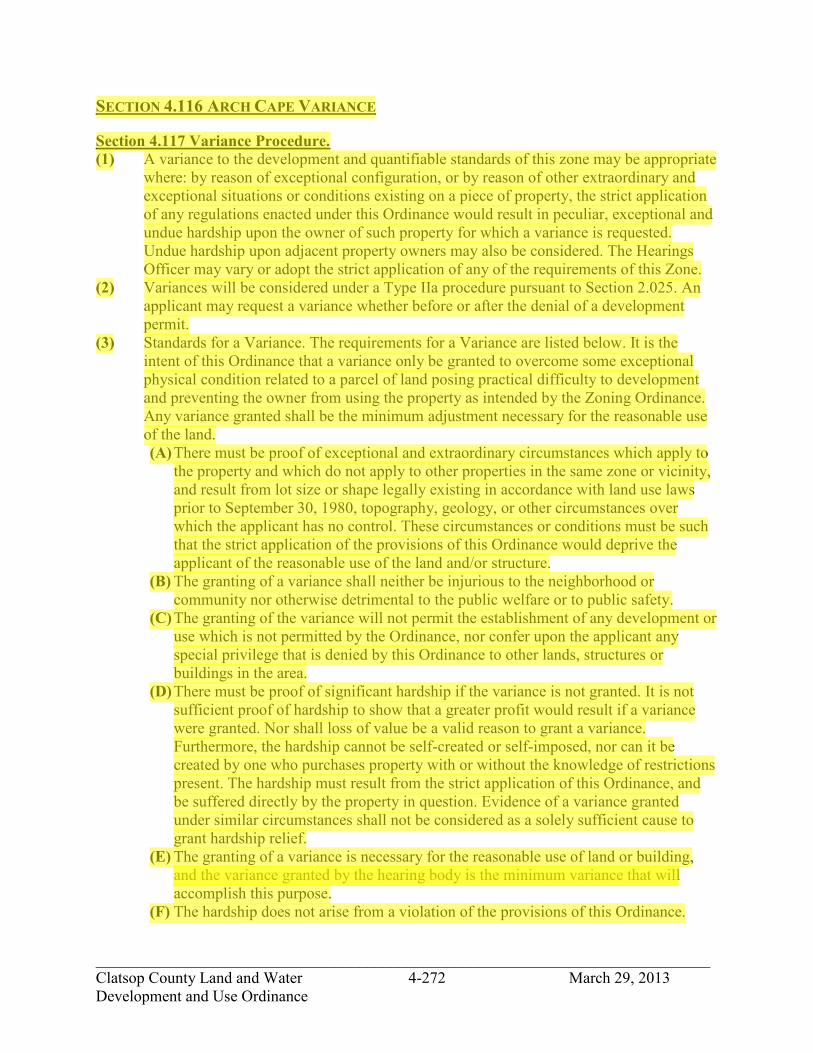
_____________________________________________________________________________ Clatsop County Land and Water 4-272 March 29, 2013 Development and Use Ordinance
SECTION 4.116 ARCH CAPE VARIANCE Section 4.117 Variance Procedure. (1) A variance to the development and quantifiable standards of this zone may be appropriate
where: by reason of exceptional configuration, or by reason of other extraordinary and exceptional situations or conditions existing on a piece of property, the strict application of any regulations enacted under this Ordinance would result in peculiar, exceptional and undue hardship upon the owner of such property for which a variance is requested. Undue hardship upon adjacent property owners may also be considered. The Hearings Officer may vary or adopt the strict application of any of the requirements of this Zone.
(2) Variances will be considered under a Type IIa procedure pursuant to Section 2.025. An applicant may request a variance whether before or after the denial of a development permit.
(3) Standards for a Variance. The requirements for a Variance are listed below. It is the intent of this Ordinance that a variance only be granted to overcome some exceptional physical condition related to a parcel of land posing practical difficulty to development and preventing the owner from using the property as intended by the Zoning Ordinance. Any variance granted shall be the minimum adjustment necessary for the reasonable use of the land. (A) There must be proof of exceptional and extraordinary circumstances which apply to
the property and which do not apply to other properties in the same zone or vicinity, and result from lot size or shape legally existing in accordance with land use laws prior to September 30, 1980, topography, geology, or other circumstances over which the applicant has no control. These circumstances or conditions must be such that the strict application of the provisions of this Ordinance would deprive the applicant of the reasonable use of the land and/or structure.
(B) The granting of a variance shall neither be injurious to the neighborhood or community nor otherwise detrimental to the public welfare or to public safety.
(C) The granting of the variance will not permit the establishment of any development or use which is not permitted by the Ordinance, nor confer upon the applicant any special privilege that is denied by this Ordinance to other lands, structures or buildings in the area.
(D) There must be proof of significant hardship if the variance is not granted. It is not sufficient proof of hardship to show that a greater profit would result if a variance were granted. Nor shall loss of value be a valid reason to grant a variance. Furthermore, the hardship cannot be self-created or self-imposed, nor can it be created by one who purchases property with or without the knowledge of restrictions present. The hardship must result from the strict application of this Ordinance, and be suffered directly by the property in question. Evidence of a variance granted under similar circumstances shall not be considered as a solely sufficient cause to grant hardship relief.
(E) The granting of a variance is necessary for the reasonable use of land or building, and the variance granted by the hearing body is the minimum variance that will accomplish this purpose.
(F) The hardship does not arise from a violation of the provisions of this Ordinance.
jhickner
Highlight
jhickner
Highlight

_____________________________________________________________________________ Clatsop County Land and Water 4-273 March 29, 2013 Development and Use Ordinance
(G) The development will occur on a parcel of land that in conjunction with adjacent land in the same ownership is not otherwise reasonably capable of development and use under the provisions of this Ordinance.
Section 4.118 Notification. In addition to the required mailed notice sent to property owners pursuant to Section 2.025 and Section 2.110, notice of variances to yard setbacks and height variances shall be sent to the fire district in which the property is served for review and comment. If a response is not received by the Department of Transportation and Development within 20 days of the notice it will be assumed that the District has no negative concerns regarding the request. Section 4.119 Expiration/Extension. Authorization of a variance shall be void after one year unless substantial construction or action pursuant thereto has taken place. However, the County may, at the discretion of the Planning Director, extend authorization for an additional six (6) months upon request, provided such request is submitted in writing at least 10 days and not more than 30 days prior to expiration of the variance.
jhickner
Highlight

_____________________________________________________________________________ Clatsop County Land and Water 4-274 March 29, 2013 Development and Use Ordinance
SECTION 4.120 ARCH CAPE NON-CONFORMING USES AND STRUCTURES Section 4.121 Purpose. The purpose of the Non-Conforming Uses and Structures provisions are to establish standards and procedures regulating the continuation, improvement and replacement of structures and uses, which do not comply with this Ordinance. Section 4.122 Definitions. The following definitions are applicable to the provisions of Section 4.120, Non-Conforming Uses and Structures. ALTERATION. A change to a structure, not involving enlargement of the external dimensions of the structure (i.e. addition or relocation of windows, replacement of siding, etc). EXPANSION. Any increase in any external dimension of a Non-Conforming Structure. LEGAL NON-CONFORMING STRUCTURE. A building or structure that does not conform to one or more standards of the zoning district in which it is located, but which legally existed at the time the applicable section(s) of the zoning district became effective. LEGAL NON-CONFORMING USE. A use, which does not conform to the use regulations of the zoning district in which it is located, but which lawfully occupied a building or parcel of land at the time the applicable use regulation became effective. NON-CONFORMING STRUCTURE. A building or structure that does not conform to one or more standards of the zoning district in which it is located, and which did not legally exist at the time the zoning district became effective. NON-CONFORMING USE. A use, which does not conform to the use regulations of the zoning district in which it is located, and which did not lawfully occupy a building or parcel of land at the time the applicable use regulation became effective. Section 4.123 Continuance. (1) A Legal Non-Conforming Use may be continued at the level of use (e.g., hours of
operation) existing on the date that the use became non-conforming2. (2) A Legal Non-Conforming Structure may continue within the building dimensions
(height, width and length) in existence on the date that the structure became non-conforming3.
(3) The applicant shall bear the burden of proof for establishing that the structure or use was lawfully established.
(4) The applicant shall bear the burden of proof for establishing the level of use that existed at the time the use became non-conforming.
(5) The county may allow a property owner, under a Type II procedure, to prove the existence, continuity, nature and extent of the use for the 10-year period immediately preceding the date of application. If the county finds evidence proving the existence, continuity, nature and extent of the use for the ten-year period preceding application, then
jhickner
Highlight
jhickner
Highlight

_____________________________________________________________________________ Clatsop County Land and Water 4-275 March 29, 2013 Development and Use Ordinance
such findings shall create a rebuttable presumption that the use, as proven, lawfully existed at the time the applicable Ordinance provision was adopted and has continued uninterrupted until the date of application.
Section 4.124 Alteration. (1) Through Type I procedures alterations shall be permitted to a non-conforming structure,
or to a structure devoted to a non-conforming use. Alteration of any such use shall be permitted when necessary to comply with any lawful requirement for alteration in the use. Except as provided in ORS 215.215, a county shall not place conditions upon the continuation or alteration of a use described under this subsection when necessary to comply with state or local health or safety requirements, or to maintain in good repair the existing structures associated with the use. A change of ownership or occupancy shall be permitted.
(2) If in a three-year period, alterations to a Non-conforming structure, or to a structure devoted to a Non-conforming use exceeds 75% of the market value of the structure, as indicated by the records of the County Assessor, the structure shall be brought into conformance with the requirements of the Ordinance.
Section 4.125 Expansion. (1) Through a Type II procedure an expansion of a Legal Non-Conforming Structure shall be
in conformance with the requirements of the Zone (i.e. height limitations and setbacks) and satisfy criteria under Section 4.125 § 3C, or a variance for the expansion shall be required pursuant to Section 4.116 Arch Cape Variance.
(2) Through a Type IIA procedure an expansion of a Non-Conforming Structure shall be in conformance with the requirements of the Zone (i.e. height limitations and setbacks) and satisfy criteria under section 4.125 § 3A-C below, or a variance for the expansion shall be required pursuant to Section 4.116 Arch Cape Variance.
(3) An expansion of a structure devoted to a Legal Non-Conforming Use, or a change in the characteristics of a Legal Non-Conforming Use, (i.e. hours of operation or levels of service provided), may be approved, pursuant to a Type II procedure, where the following standards are met: (A) The floor area of a building(s) shall not be increased by more than 20%. (B) The land area covered by structures shall not be increased by more than 10%. (C) The proposed expansion, or proposed change in characteristics shall have no greater adverse impact on neighboring areas than the existing use, considering:
1) The following factors: a) Noise, vibration, dust, odor, fume, glare, or smoke detectable at the property
line. b) Numbers and kinds of vehicular trips to the site. c) Amount and nature of outside storage, loading and parking. d) Visual impact. e) Hours of operation. f) Effect on existing vegetation. g) Effect on water drainage and water quality. h) Service or other benefit to the area.
jhickner
Highlight
jhickner
Highlight
jhickner
Highlight

_____________________________________________________________________________ Clatsop County Land and Water 4-276 March 29, 2013 Development and Use Ordinance
i) Other factors relating to conflicts or incompatibility with the character or needs of the area.
2) The character and history of the use and of development in the surrounding area. 3) An approval may be conditioned to mitigate any potential adverse impacts that
have been identified. Section 4.126 Changes to a Non-Conforming Use. (1) A Non-conforming use may only be changed to that of a conforming use. Where such a
change is made, the use shall not thereafter be changed back to a Non-conforming use. Section 4.127 Replacement and Damage. (1) Through a Type I procedure if a Legal Non-Conforming Structure or a structure occupied
by a Legal Non-Conforming Use is damaged or destroyed by any cause other than an action of the property owner or authorized agent, it shall be reconstructed in conformance with the current requirements of this Ordinance or a variance sought in accordance with section 4.116. Restoration or replacement shall be commenced within one year from the occurrence of the fire, casualty or natural disaster. If restoration or replacement is necessary under this subsection, restoration or replacement shall be done in compliance with ORS 195.260 (1)(c). If a building listed on the National Register of Historic Places is damaged or destroyed it may be reconstructed in conformance with the dimensional standards of the building prior to its destruction.
(2) Through a Type II permit procedure subject to Section 5.000-5.030 if a Non-Conforming Structure or a structure devoted to a Non-Conforming Use is damaged by any cause other than an action of the property owner or his agent, The hearing body may approve the reconstruction of the structure and accompanying use. Reconstruction of the structure or use shall be in conformance with the current requirements of this Ordinance or a variance sought in accordance with Section 4.116. Restoration or replacement shall be commenced within one year from the occurrence of the fire, casualty or natural disaster. If restoration or replacement is necessary under this subsection, restoration or replacement shall be done in compliance with ORS 195.260 (1)(c).
Section 4.128. Completion. A development that is lawfully under construction on the effective date of an ordinance that makes that use or structure Non-conforming may be completed. The use or structure may be used for the purpose for which it was designed, arranged or intended. Section 4.129. Discontinuance of Use. If a Non-conforming use is discontinued for a period of one year, subsequent use of the property shall conform to this Ordinance. Section 4.130. Compliance with Other Requirements. Notwithstanding the provisions of this section, alteration of a Nonconforming use or a Nonconforming structure shall be allowed if necessary to comply with state or local health or safety requirements.
jhickner
Highlight
jhickner
Highlight
jhickner
Highlight

_____________________________________________________________________________ Clatsop County Land and Water 4-277 March 29, 2013 Development and Use Ordinance
SECTION 4.132. AQUIFER RESERVE OVERLAY DISTRICT (/ARO).
Section 4.133. Purpose. The purpose of the aquifer reserve overlay zoning district is to protect the aquifer as a future drinking water source by controlling activities which may occur on the ground surface. These sections apply as additional restrictions to the underlying zones. Should the regulations of this overlay district be in conflict with the underlying zone, the conflict shall be resolved by the application of the more stringent regulation.
Section 4.134. Development and Uses Permitted. Unless otherwise listed in Section 4.125, any use permitted in the underlying zone may be allowed within the boundaries of this special district.
Section 4.135. Conditional Development and Use. Unless otherwise listed in Section 4.125, any use conditionally allowed in the underlying zone may be allowed within the boundaries of this special district subject to the applicable standards of that zone.
Section 4.136. Prohibited Development and Use. The following developments are prohibited in this district unless determined by the Planning Director as set out in Section 4.126 below that such use will not adversely affect the aquifer: (1) Construction of subsurface sewage disposal systems. (2) Application of fertilizers in amounts and concentrations which would add nitrates to the
groundwater. (3) Construction of oil and gas storage facilities unless they are adequately protected to
prevent spillage from reaching groundwater. (4) Other activities which, in the opinion of the Community Development Director, would
cause the degradation of groundwater as a potable water source.
Section 4.137. Determination by the Community Development Director. Any activities which, in the opinion of the Community Development Director, would adversely affect the aquifer as a potable water source, are prohibited by Section 4.125 above. To aid in this determination, the Community Development Director may require certification from a qualified professional engineer or hydrologist that a proposed activity will not cause such degradation.
jhickner
Highlight
jhickner
Highlight

_____________________________________________________________________________ Clatsop County Land and Water 4-278 March 29, 2013 Development and Use Ordinance
SECTION 4.140. PLANNED DEVELOPMENT OVERLAY DISTRICT (/PDO).
Section 4.141. Purpose. It is the intent of the Planned Development special district to encourage appropriate and orderly development of tracts of land sufficiently large to allow comprehensive planning and to provide a degree of flexibility in the application of certain regulations which cannot be obtained through traditional lot-by-lot subdivision. In this manner, environmental amenities may be enhanced by promoting a harmonious variety of uses; the economy of shared service and facilities; compatibility of surrounding areas; and the creation of attractive, healthful, efficient, and stable environments for living, shopping, or working. Specifically, it is the purpose of this section to promote and encourage: (1) Comprehensive development equal to or better than that resulting from traditional lot-by-
lot land use development. (2) Appropriate mixtures of housing types and designs. (3) Appropriate mixture of uses. (4) More attractive and usable open space. (5) Advances in technology, architectural design, functional land use design. (6) Recognition of the problems of population density, distribution, and circulation and to
allow a deviation from rigid established patterns of land uses, but controlled by defined policies and objectives.
(7) Flexibility of design in the placement and uses of buildings and open spaces, circulation facilities and off-street parking areas, and to more efficiently utilize potential of sites characterized by special features of geography, topography, size or shape.
It is also not the intention of this section to be a bypass of regular zoning provisions solely to allow increased densities nor is it a means of maximizing densities on parcels of land which have unbuildable or unusable areas.
jhickner
Highlight

_____________________________________________________________________________ Clatsop County Land and Water 4-279 March 29, 2013 Development and Use Ordinance
Section 4.142. Applicability. A Planned Development may be located in any of the following zones provided that a Planned Development (/PDO) suffix has been added to the underlying zone and provided the development is in accordance with the criteria, standards and provisions of this section: AC-RCR, KS-RCR, RCR, RCMFR, RSA- SFR, RSA-MFR, CR, SFR-1, RA-1, RA-2, RA-5, RA-10, RCC, GC, TC RCC-LI, RCI, and LI (except in the Clatsop Plains planning area).
Section 4.143. Approval Criteria. In addition to the development standards and procedures specified in this special district, the Planning Commission shall require that the following criteria are met prior to approval of a Planned Development: (1) The location, size and type of development are consistent with the County
Comprehensive Plan. (2) Commercial developments part of Planned Developments shall be limited in size and
service to that appropriate to serve the neighborhood of which the Planned Development is an integral part and shall be designed to provide goods and services primarily to the residents of the Planned Development.
(3) The location, size and design are such that the development can be well integrated with its surroundings with little if any impact on adjacent properties and development.
(4) The location, size and type of development are such that traffic generated can be accommodated safely and conveniently on existing or planned arterial or collector streets or on improved roads.
(5) The development will be adequately served by existing or planned facilities and services. (6) Any deviation from the standards of the underlying zone are warranted by the design and
amenities incorporated in the development plan and program. (7) Adequate provision is made for the preservation of natural resources such as bodies of
water, significant vegetation and special terrain features. (8) Sufficient financing exists to assure that the proposed development will be substantially
completed within four (4) years of approval. (9) Permanent common open space as part of subdivisions or planned development adjoining
one another shall be integrated and continuous whenever possible. Open space can follow ridge tops, deflation plains or shorelands, forest land (as a buffer) and other resource lands.
Section 4.144. General Development and Use Standards and Requirements. (1) Size:
(A) Planned developments may be established in residential districts on parcels of land which are suitable for and of sufficient size to be planned and developed in a manner consistent with the purposes and objectives of Section 4.130 through 4.140. For those planned developments which are located in the RSA-SFR, RSA-MFR, CR, SFR-1, RA-1, GC, TC, and LI zones, the site shall include not less than four acres of contiguous land. For those located in a RA-2 the site shall include not less than eight acres of contiguous land, and for those located in a RA-5 the site shall include not less than twenty acres of contiguous land, unless the Planning Commission or Board of commissioners, upon appeal, find that property of less than the requirement above is suitable by virtue of its unique historical character,
jhickner
Highlight
jhickner
Highlight

_____________________________________________________________________________ Clatsop County Land and Water 4-280 March 29, 2013 Development and Use Ordinance
topography, or other natural features, or by virtue of its qualifying as an isolated problem area.
(B) Combination residential-commercial-industrial developments may be established in residential, commercial and light industrial zones on parcels of land which are suitable for and of a sufficient size to be planned and developed in a manner consistent with the purpose and objectives of Sections 4.130 through 4.136.
(2) Ownership: (A) The tract or tracts of land included in a proposed planned development must be in one
ownership or control or the subject of a joint application by the owners of all the property included. The holder of a written option to purchase or any governmental agency or redeveloper under contract with a governmental agency, shall be deemed the owner of such land for the purposes of this section.
(B) Unless otherwise provided as a condition of approval of a planned development permit the permittee may divide and transfer units of any development. The transferee shall use and maintain each such unit in strict conformance with the approved permit and development plan.
(3) Professional Design: (C) The applicant for all proposed planned developments shall certify that the talents of
the following professional will be utilized in the planning process for development: (1) an architect licensed by the state, (2) a landscape architect licensed by the state, and (3) a registered engineer or land surveyor licensed by the state. The Planning Commission may waive this requirement provided the applicant can show that equivalent and acceptable design talents have been utilized in the planning process.
(D) One of the professional consultants chosen by the applicant from the above group shall be designated to be responsible for conferring with the Department of Community Development with respect to the concept and details of the plan.
(E) The selection of the professional coordinator of the design team will not limit the owner or the developer in consulting with the Department of Community Development or the Commission.
(4) General Information. The planning process for development shall include: (A) Plot plan of land in area to be developed indicating location of adjacent streets and all
private rights-of-way existing and proposed. (B) A legal boundary survey. (C) Existing and proposed finish grades of the property with all drainage features. (D) Location of all proposed structures, together with the usage to be contained therein
and approximate location of all entrances thereto and height and gross floor area thereof.
(E) Vehicular and pedestrian circulation features within the site and on adjacent streets and alleys.
(F) The extent, location, arrangement and proposed improvements of all off-street parking and loading facilities.
(G) The extent, location, arrangement, and proposed improvements of all open space, landscaping, fences and walls.
(H) Architectural drawings and sketches demonstrating the planning and character of the proposed development.
(I) Number of units proposed.
jhickner
Highlight
jhickner
Highlight
jhickner
Highlight

_____________________________________________________________________________ Clatsop County Land and Water 4-281 March 29, 2013 Development and Use Ordinance
(J) Contour lines at 2-foot intervals.
Section 4.145. Development and Use Standards. In addition to, or as a greater requirement to the regulations normally found in the district, the following guidelines and requirements shall apply to all developments for which a planned development permit is required: (1) Outdoor living area guidelines: In all residential developments, or in combination
residential-commercial-industrial developments, 40 percent of the total area should be devoted to outdoor living area. Of this area, 25 percent of said outdoor living area may be utilized privately by individual owners or users of the planned development; however, 75 percent of this area should be common or shared outdoor living area.
(2) Height guidelines: The same restrictions shall prevail as permitted outright in the district in which such development occurs, except that the Commission may further limit heights: (A) Around the site boundaries, and/or (B) To protect scenic vistas from encroachments. (C) Underground utilities: In any development which is primarily designed for or
occupied by dwellings all electric and telephone facilities, fire alarm, conduits, street light wiring, and other wiring, conduits and similar facilities shall be placed underground by the developer.
(3) Density guidelines: (A) The density of a planned development shall not exceed the density of the parent zone,
except as more restrictive regulations may be prescribed as a condition of a planned development permit. When calculating density, the gross area is used in the total area including street dedications.
(B) Areas of public or semi-public uses may be included in calculating allowable density. (4) Distribution of facilities without reference to lot lines: Individual buildings, accessory
buildings, off-street parking, and loading facilities, open space, and landscaping and screening may be located without reference to lot lines, save the boundary line of the development, except that required parking spaces serving residential uses shall be located within 200 feet of the building containing the living units served.
(5) Waiver or reduction of yard and other dimensional requirements: Except as otherwise provided in Section 4.138, the minimum lot area, width and frontage, height and yard requirements otherwise applying in the district shall not dictate the strict guidelines for development of the planned development but shall serve to inform the designers of the importance of developing a project that will be in harmony with the character of the surrounding neighborhood.
(6) Dedication and maintenance of facilities: The Planning Commission, or on appeal, the Board of Commissioners, may, as a condition of approval for any development for which a planned development permit is required, require that portions of the tract or tracts under consideration be set aside, improved, conveyed or dedicated for the following uses:
(7) Recreation facilities: The Planning Commission or Board of Commissioners, as the case may be, may require that suitable area for parks, playgrounds be set aside, improved, or permanently reserved for the owners, residents, employees or patrons of the development.
jhickner
Highlight
jhickner
Highlight

_____________________________________________________________________________ Clatsop County Land and Water 4-282 March 29, 2013 Development and Use Ordinance
(A) Outdoor living area: Whenever private outdoor living area is provided, the Planning Commission or Board of Commissioners shall require that an association of owners or tenants be created into a non-profit corporation under the laws of the State of Oregon, which shall adopt such Articles of Incorporation and Bylaws and adopt and impose such Declaration of Covenants and Restrictions on such outdoor living area and/or common areas that are acceptable to the Commission. Said association shall be formed and continued for the purpose of maintaining such outdoor living area. Such an association, if required, may undertake other functions. It shall be created in such a manner that owners of property shall automatically be members and shall be subject to assessments levied to maintain said outdoor living areas for the purposes intended. The period of existence of such association shall be not less than 20 years, and it shall continue thereafter and until a majority vote of the members shall terminate it.
(B) Streets: The Planning Commission or Board of Commissioners may require that the right-of-way width of such other streets necessary to the proper development of adjacent properties be dedicated to the County.
(C) Easements: Easements necessary to the orderly extension of public utilities may be required as a condition of approval.
(C) Developments shall be allowed only if services or public facilities (water, sewer, fire protection) are capable of supporting increased loads. Phasing of development may be allowed if improvement of public facilities is assured by the time of construction and the additional loads are anticipated.
(D) If water, sewer or public utility systems are utilized either in the development of a subdivision or the building of individual residences, the provider of the services shall approve and show intentions to install services to the new structure(s) prior to the issuance of either plat approvals or development permits.
(E) All new development shall install underground utilities such as electric, telephone and television cable.
Section 4.146. Application Procedures. There shall be a three-stage review process for planned developments consisting of Pre- application Conference (Stage One), Preliminary Approval (Stage Two), and Final Approval (Stage Three). (1) Pre-application Conference (Stage One): The owner, or his authorized agent, shall submit
to the Department of Community Development the following information: (A) A schematic drawing, drawn to a minimum scale of one inch equals 200 feet
(1"=200'), showing the general relationship contemplated among all public and private uses and existing physical features.
(B) A written statement setting forth the source of water supply, method of sewage disposal, means of drainage, dwelling types, non-residential uses, lot layout, public and private access, height of structures, lighting, landscaped areas to be devoted to various uses, and population densities per net acre and per gross acre contemplated by the applicant.
jhickner
Highlight

_____________________________________________________________________________ Clatsop County Land and Water 4-283 March 29, 2013 Development and Use Ordinance
The developer and the Department of Community Development shall meet together and determine whether the requirements of Section 4.142 of this Ordinance have been complied with. If there is disagreement on this issue, the applicant, by request, or the Department of Community Development, may take this pre-application information to the Planning Commission for their determination of whether this site qualifies for the contemplated planned development.
The applicant must indicate to the Department of Community Development or Commission his professional design team, as outlined in Section 4.142(1) during Stage One, and should also designate who is to be his professional coordinator.
The professional coordinator shall be responsible for presenting the developer's plan in all of the broad professional aspects to the Planning Department. If the Department of Community Development and applicant reach a satisfactory agreement the applicant may proceed to prepare data for Stage Two-Preliminary Approval.
(2) Preliminary Approval (Stage Two): (A) Applicants for planned developments, preliminary approval, shall be made by the
owner of all affected property or his authorized agent, and shall be filed on a form prescribed by the Department of Community Development and filed with said department. Applications shall be accompanied by the following information:
1) Four (4) copies of a preliminary development plan of the entire development, showing streets, driveways, sidewalks, pedestrian ways, off-street parking and loading areas; location and approximate dimensions of structures, utilization of structures, including activities and the number of living units; major landscaping features; relevant operational data, drawings and/or elevations clearly establishing the scale, character and relationship of buildings, streets, and open space. Such development plan shall include maps and information on the surrounding area within 400 feet of the development. A boundary survey or a certified boundary description by a registered engineer or licensed surveyor, plus contour information, shall also be submitted. The elevations of all points used to determine contours shall be indicated on the preliminary plan and said points shall be given true elevation above mean sea level as determined by the County Engineer. The base data used shall be clearly indicated and shall be compatible to County datum, if bench marks are not adjacent. Two-foot contour intervals are required. All elements listed in this subsection shall be characterized as existing or proposed and sufficiently detailed to indicate intent and impact.
2) A tabulation of the land area to be devoted to various uses, and a calculation of the average residential density per net acre.

_____________________________________________________________________________ Clatsop County Land and Water 4-284 March 29, 2013 Development and Use Ordinance
3) A stage development schedule demonstrating that the developer intends to commence construction within one year after the approval of the final development plan and will proceed diligently to completion.
4) It is proposed that the final development plan will be executed in stages, a schedule thereof will be required.
(B) An application for a planned development permit shall be considered by the Planning Commission under a Type III procedure. After such hearing, the Commission shall determine whether the proposal conforms to the permit criteria set forth in Section 4.136 and to the planned development regulations in Sections 4.130 through 4.138, and may approve or disapprove in concept the application and the accompanying preliminary development plan or require changes or impose conditions of approval as are in its judgment necessary to ensure conformity to said criteria and regulations. In so doing, the Commission may, in its discretion, authorize submission of the final development plan in stages corresponding to different units or elements of the development. It may do so only upon evidence assuring completion of the entire development in accordance with the preliminary development plan and stage development schedule. Should a decision not be rendered within 60 days after filing, the application and preliminary development plan shall be deemed approved in concept unless said time has been extended by the Commission.
(3) Final Approval (Stage Three): (A) Within one year after concept approval or modified approval of a preliminary
development plan, the applicant shall file with the Planning Department a final plan for the entire development or, when submission in stages has been authorized pursuant to Section 4.142(2) for the first unit of the development. The final plan shall conform in all major respects with the approved preliminary development plan. The final plan shall include all information included in the preliminary plan plus the following: the location of water, sewerage and drainage facilities; detailed building and landscaping plans and elevations; the character and location of signs; plans for street improvements and grading or earth moving plans. The final plan shall be sufficiently detailed to indicate fully the ultimate operation and appearance of the development. Copies of legal documents required by the Commission for dedication or reservation of public facilities, or for the creation of a non-profit homeowner association, shall also be submitted.
(B) Within 30 days after the filing of the final development plan, the Commission shall forward such development plan and the original application to the County Road Department for review of public improvements, including streets, sewers and drainage. The Commission shall not act on a development plan until it has first received a report from the County Road Department or until more than 30 days have elapsed since the plan and application were sent to the County Road Department, whichever is the shorter period.

_____________________________________________________________________________ Clatsop County Land and Water 4-285 March 29, 2013 Development and Use Ordinance
(C) Upon receipt of the final development plan, the Planning Commission shall examine such plan and determine whether it conforms in all substantial respects to the previously approved planned development permit, or require such changes in the proposed development or impose such conditions of approval as are in its judgment necessary insure conformity to the applicable criteria and standards. In so doing, the Commission may permit the applicant to revise the plan and resubmit it as a final development plan within 30 days.
(D) After final concept approval by the Planning Commission, the planned development application will be sent to the Board of Commissioners for consideration for final approval. A public hearing shall be held on each such application. After such hearing, the Board of Commissioners shall determine whether the proposal conforms to the permit criteria set forth in Section 4.138 and to the planned development regulations in Sections 4.130 through 4.138 and may approve or disapprove the application and the accompanying development plan or require changes or impose conditions of approval as are in its judgment necessary to insure conformity to said criteria and regulations. The decision of the Board of Commissioners shall be final.
Section 4.147. Limitation on Resubmission. Whenever an application for a planned development permit has been denied, no application for the same plan or any portion thereof shall be filed by the same applicant within six months after the date of denial.
Section 4.148. Adherence to Approved Plan and Modification Thereof. (1) The applicant shall agree in writing to be bound, for himself and his successors in
interest, by the conditions prescribed for approval of a development. The approved final plan and stage development schedule shall control the issuance of all building permits and shall restrict the nature, location, and design of all uses. Minor changes in an approved preliminary or final development plan may be approved by the Zoning and Subdivision Administrator if such changes are consistent with the purposes and general character of the development plan. All other modifications, including extension or revisions of the stage development schedule, shall be processed in the same manner as the original application and shall be subject to the same procedural requirements.
(2) A performance bond shall be required, in an amount to be determined by the Planning Commission, to insure that a development proposal is completed as approved and within the time limits agreed to.
Section 4.149. Violation of Conditions. Failure to comply with the final development plan, any condition of approval prescribed under Section 4.142(3), or to comply with the stage development schedule, shall constitute a violation of this Ordinance. In this event, the Board of Commissioners may, after notice and hearing, revoke a planned development permit.
Section 4.150. Common Open Space. Maintenance of common open space shall be subject to Section S3.180.
jhickner
Highlight

_____________________________________________________________________________ Clatsop County Land and Water 4-286 March 29, 2013 Development and Use Ordinance
SECTION 4.160. DREDGED MATERIAL DISPOSAL SITE RESERVATION OVERLAY DISTRICT (/DMD).
Section 4.162. Purpose. The intent of this district is to designate dredged material disposal sites in the County with respect to present and expected water-dependent development and navigational access requirements in the Columbia River Estuary and to protect these sites for dredged material disposal operations.
Section 4.164. District Boundaries. The /DMD Site Reservation District conforms to the description of dredged material disposal sites in the Columbia River Estuary Dredged Material Management Plan of the County's Comprehensive Plan. Revisions to the Columbia River Estuary Dredged Material Management Plan must be recorded by amendment to the Comprehensive Plan.
Section 4.166. Dredged Material Disposal Sites. The purpose of site designations is to protect important dredged material disposal sites from incompatible and preemptive uses that may limit their ultimate use for the deposition of dredged material, and to ensure that an adequate number of sites will be reserved in order to accommodate dredged material disposal needs resulting from five years of existing and expected water-dependent development and navigation projects.
Section 4.168. Uses Allowed in Dredged Material Disposal Sites. Dredged material disposal including beach nourishment designated in the Comprehensive Plan's background report Columbia River Estuary Dredged Material Management Plan is permitted with standards under a Type I procedure if the site is located upland or in the coastal shoreland boundary. Dredged material disposal including beach nourishment designated in the Comprehensive Plan and located in aquatic areas may be allowed as a Review Use under a Type II procedure. In addition, only those development uses and activities permitted, permitted with review or conditionally permitted in the underlying zone which are determined not to preempt the site's future use for dredged material disposal are allowed, subject to the policies and procedural requirements of the underlying zone. Section 4.170. Removal of Dredged Material Disposal Site Designation. Removal of a dredged material disposal site designation before a site has been filled to capacity shall only be approved if:
(A) Provision is made for a replacement dredged material disposal site of suitable characteristics; or
(B) The dredging need for which the site was initially designated for dredged material disposal is withdrawn or reevaluated.
jhickner
Highlight
jhickner
Highlight
jhickner
Highlight
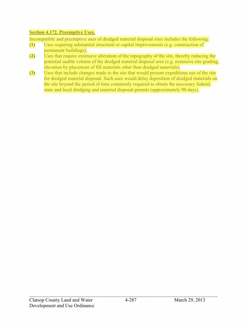
_____________________________________________________________________________ Clatsop County Land and Water 4-287 March 29, 2013 Development and Use Ordinance
Section 4.172. Preemptive Uses. Incompatible and preemptive uses of dredged material disposal sites includes the following: (1) Uses requiring substantial structural or capital improvements (e.g. construction of
permanent buildings); (2) Uses that require extensive alteration of the topography of the site, thereby reducing the
potential usable volume of the dredged material disposal area (e.g. extensive site grading, elevation by placement of fill materials other than dredged materials).
(3) Uses that include changes made to the site that would present expeditious use of the site for dredged material disposal. Such uses would delay deposition of dredged materials on the site beyond the period of time commonly required to obtain the necessary federal, state and local dredging and material disposal permits (approximately 90 days).
jhickner
Highlight

_____________________________________________________________________________ Clatsop County Land and Water 4-288 March 29, 2013 Development and Use Ordinance
SECTION 4.180. MITIGATION SITE OVERLAY DISTRICT (/MIT).
Section 4.182. Purpose. The purpose of the Mitigation Site Overlay District is to protect identified mitigation sites in the Columbia River Estuary from incompatible and preemptive development uses and activities and implement mitigation and restoration actions in designated areas of the zone. There are three priority categories and four protection levels for mitigation sites in this district.
Section 4.184. Designation of Mitigation Sites. Mitigation sites are described and identified on maps in the background report Mitigation and Restoration Plan for the Columbia River Estuary of the County's Comprehensive Plan. Revisions to mitigation site designations must be recorded by amendment to the Comprehensive Plan and Plan Map.
Section 4.186. Developments Allowed in Mitigation Sites. The Priority and Level of protection for a designated mitigation site may be determined from the background report A Mitigation and Restoration Plan for the Columbia River Estuary of the County's Comprehensive Plan. The following uses are allowable in this overlay district: (1) Priority 1, Level 1:
(A) Uses allowed in the underlying zone that do not preempt the use of the site for mitigation purposes, subject to the underlying zone's development standards.
(B) Mitigation as a Review Use under a Type II procedure pursuant to Section 2.020 and subject to the Mitigation and Restoration Standards in Section S4.218.
(C) In an Exclusive Farm Use (EFU) zone, farm related structures that are valued at $5,000 or less, subject to the development standards of the underlying zone.
(D) Priority 1, Level 2: (A) Uses allowed in the underlying zone that do not preempt the use of the site for
mitigation purposes, subject to the underlying zone's development standards. (B) Mitigation as a Review Use under a Type II procedure pursuant to Section 2.020, and
subject to the Mitigation and Restoration Standards in Section S4.218. (C) In an Exclusive Farm Use (EFU) zone, farm related structures that are valued at
$5,000 or less, subject to the development standards of the underlying zone. (D) Topographical and structural preemptive uses allowed in the underlying zone and
subject to the zone's policy and procedural requirements, under the additional conditions that:
1) if diked, demonstration that a predetermined amount of dike frontage (established in the Plan or during new site designations) and contiguous diked area is retained for mitigation purposes; or
2) if upland, demonstration that a predetermined amount of contiguous area (established in the Plan or during new site designation) is available for excavation to allow tidal influence or capable of being inundated through some water level control procedure.
(E) Restoration, creation, or enhancement outside of the context of mitigation as a Conditional Use under the conditions that:
jhickner
Highlight
jhickner
Highlight
jhickner
Highlight
jhickner
Highlight

_____________________________________________________________________________ Clatsop County Land and Water 4-289 March 29, 2013 Development and Use Ordinance
1) if diked, demonstration that a predetermined amount of dike frontage and contiguous diked area is retained for mitigation purposes; or
2) if upland, demonstration that a predetermined amount of contiguous area is available for excavation to allow tidal influence or capable of being inundated through some water level control procedure. If the underlying zone is Exclusive Farm Use (EFU), Forestry (F-80), and Agricultural/Forestry (AF), a goal exception shall be required to implement restoration, creation or enhancement outside of the context of mitigation.
(F) Priority 2, Level 3: (A) Uses allowed in the underlying zone that do not preempt the use of the site for
mitigation purposes, subject to the underlying zone's development standards. (B) Mitigation as a Review Use Under a Type II procedure pursuant to Section 2.020, and
subject to the Mitigation and Restoration Standards in Section S4.218. (C) In an Exclusive Farm Use (EFU) zone, farm related structures that are valued at
$5,000 or less, subject to the development standards of the underlying zone. (D) Restoration, creation and enhancement outside of the context of the mitigation as a
Conditional Use under a Type II procedure pursuant to Section 2.020, and subject to the Mitigation and Restoration Standards in Section S4.218. If the underlying zone is Exclusive Farm Use (EFU), Forestry ( F-80), or Agricultural/Forestry (AF), a goal exception is required to implement restoration, creation, or enhancement outside of the context of mitigation.
(E) Preemptive uses allowed in the underlying zone, subject to the zone's development standards, under the additional condition that action on the application shall be suspended for 30 days from the date a complete application is filed. The period of suspension is to allow interested parties time to review the need and negotiate use of the site for mitigation. If at the close of the 30 day period no satisfactory means of preserving the site is established, the permit will be processed under the normal procedures.
(F) Priority 3, Level 4: (A) All uses allowed in the underlying zone, subject to the underlying zone's development
standards. (B) Mitigation as a Review Use under a Type II procedure pursuant to Section 2.020, and
subject to the Mitigation and Restoration Standards in Section S4.218. (C) Restoration, creation, and enhancement outside of the context of mitigation as a
Conditional Use under a Type II procedure pursuant to Section 2.020, and subject to the Mitigation and Restoration Standards in Section S4.128. If the underlying zone is Exclusive Farm Use (EFU), Forestry (F-80), or Agricultural/Forestry (AF), a goal exception is required to implement restoration, creation, or enhancement outside of the context of mitigation.
Section 4.188. Removal of the Mitigation Site Overlay District. Removal of designated mitigation sites shall be subject to the following criteria: (1) Priority 1, Level 1:
(A) Removal of the Mitigation Site Overlay District shall be allowed for any portion of the site where a mitigation action has occurred. The site shall be removed by an amendment to the Comprehensive Plan.
jhickner
Highlight
jhickner
Highlight

_____________________________________________________________________________ Clatsop County Land and Water 4-290 March 29, 2013 Development and Use Ordinance
(B) Removal of the Mitigation Site Protection Overlay District before the site has been used wholly or in part for mitigation shall be done by an amendment to the Comprehensive Plan only where:
1) Provision is made for a replacement mitigation site of suitable characteristics; or
2) The development need for which the mitigation site was initially designated as a compensating action is withdrawn or reevaluated.
(C) Priority 2, Level 2: (A) Removal of the Mitigation Site Overlay District shall be allowed for any portion of
the site where a mitigation action has occurred. The site will be removed by plan amendment during routine plan upkeep.
(B) Removal of the Mitigation Site Overlay District shall be allowed for any portion of the site where preemptive uses have been implemented, including restoration, creation or enhancement outside of the context of mitigation provided that:
1) if diked, a demonstration that a predetermined amount of dike frontage and contiguous diked area is retained for mitigation purposes; or
2) if upland, demonstration that a predetermined amount of contiguous area is available for excavation to allow tidal influence or capable of being inundated through some water level control procedure.
(C) Removal of all or portions of the Mitigation Site Overlay District from the Comprehensive Plan before the site has been used wholly or in part for mitigation shall be done by Plan amendment and may only be approved if:
1) provision is made for a replacement of adequate mitigation area of suitable characteristics in another suitable location; or
2) the development need for which the mitigation site was initially designated as a compensating action is withdrawn or reevaluated.
(D) Priority 2, Level 3: (A) The Mitigation Site Overlay District shall be removed from any portion of a site
where a mitigation action has occurred or preemptive uses have been implemented, including restoration, creation or enhancement outside of the context of mitigation. The site shall be removed by an amendment to the Comprehensive Plan.
(B) Removal of the Mitigation Site Overlay District for all or portions of a designated mitigation site before the site has been used wholly or in part for mitigation shall be done by an amendment to the Comprehensive Plan and Zoning Ordinance where:
1) Provision is made for a replacement of adequate mitigation area of suitable characteristics in another suitable location; or
2) The development need for which the mitigation site was initially designated for compensatory purposes is withdrawn or reevaluated.
(C) Priority 3, Level 4: (A) The Mitigation Site Overlay District shall be removed from any portion of the site
that a mitigation action has occurred or preemptive uses have been implemented, including restoration, creation or enhancement outside of the context of mitigation. The site will be removed by an amendment to the Comprehensive Plan.
jhickner
Highlight
jhickner
Highlight

_____________________________________________________________________________ Clatsop County Land and Water 4-291 March 29, 2013 Development and Use Ordinance
(B) After a mitigation site has been used for mitigation or restoration, creation, or enhancement action outside of the context of mitigation and all or a portion of the site is no longer available for mitigation, the Mitigation Site Overlay District designation shall be removed and the wetland or aquatic area created through the mitigation action shall be placed in the appropriate Aquatic designation. These changes shall be made by means of an amendment to the Comprehensive Plan.
Section 4.189. Preemptive Uses. Incompatible and preemptive use of mitigation sites includes the following: (1) Uses requiring substantial structural or capital improvements (e.g. construction of
permanent building) but not including dike maintenance. (2) Uses that require extensive alteration of the topography of the site, thereby reducing the
potential for mitigation (e.g. extensive site grading, elevation of the site by placement of fill materials).
jhickner
Highlight

_____________________________________________________________________________ Clatsop County Land and Water 4-292 March 29, 2013 Development and Use Ordinance
SECTION 4.200. SENSITIVE BIRD HABITAT OVERLAY DISTRICT (/SBHO).
Section 4.210. Purpose. The purpose of the Sensitive Bird Habitat Overlay District is to insure that habitat areas identified as critical for the survival of the Northern Bald Eagle, Great Blue Heron, Band-tailed Pigeon and Snowy Plover are protected from the effects of conflicting uses or activities. This objective shall be achieved through the development of site specific management plans that are developed to insure that proposed uses and activities will neither destroy or result in the abandonment of sensitive bird habitat areas.
Section 4.220. Definition of Nest Sites. All Northern Bald Eagle nests and roosts, Great Blue Heron rookeries, Band-tailed Pigeon mineral springs and Snowy Plover nesting habitat identified in the Clatsop County Comprehensive Plan shall be subject to the requirements of the Sensitive Bird Habitat Overlay District. When additional sites are identified by the Oregon Department of Fish and Wildlife they shall be added to the Comprehensive Plan map titled "Open Space Resources of Clatsop County" and become subject to the requirements of the Sensitive Bird Habitat Overlay District.
Section 4.240. Development and Uses Permitted. Uses permitted in the underlying zone(s) are permitted or conditionally permitted in the Sensitive Bird Habitat Overlay District subject to the additional procedure and requirements of Section 4.260. The /SBHO does not regulate forest practices, only those development and uses that would require a development on lands designated Conservation Forest Lands.
Section 4.260. Development and Use Criteria. The following review procedure and criteria shall apply: (1) The review procedure is initiated when Clatsop County receives a request for a
development permit that may affect a sensitive bird habitat; (2) A proposed use or activity is considered to have the potential for affecting a sensitive bird
habitat if it is located within a quarter mile of an eagle nest or roosting site, or an osprey nest or it is within 600 feet of a heron rookery, or band-tailed pigeon mineral spring or it is within 400 feet of snowy plover nesting habitat.
(3) If a proposed use or activity meets the locational criteria of subsection 4.260(2), Clatsop County or the Oregon Department of Forestry shall notify the Oregon Department of Fish and Wildlife.
(4) Upon notification, the Oregon Department of Fish and Wildlife shall review the proposed use or activity and make a determination of whether the use or activity has the potential for adversely affecting a sensitive bird habitat area. In making this review and determination the Oregon Department of Fish and Wildlife shall consult with the affected landowner(s) and appropriate state agencies. The determination shall be completed within seven working days of the receipt of notice from Clatsop County.
jhickner
Highlight
jhickner
Highlight

_____________________________________________________________________________ Clatsop County Land and Water 4-293 March 29, 2013 Development and Use Ordinance
(5) A sensitive bird habitat will be considered affected by a use or activity if it is located within 660 feet of an eagle or osprey site or within 300 feet of a heron rookery or pigeon mineral spring, or within 200 feet of snowy plover nesting habitat. However, the Oregon Department of Fish and Wildlife may determine that uses and activities located further from the sensitive habitat also will affect the site because of unique site conditions such as topography. The basis for such a finding shall be spelled out in the Oregon Department of Fish and Wildlife's determination of impact.
(6) If the Oregon Department of Fish and Wildlife determines that the sensitive habitat area will not be affected, Clatsop County may proceed with the processing of the permit application.
(7) If the Oregon Department of Fish and Wildlife determines that the site would be affected, the Oregon Department of Fish and Wildlife shall work with the affected property owner. In the development of a site specific habitat protection plan, the plan shall consider nesting trees, critical nesting periods, roosting sites and buffer areas.
(8) Clatsop County will not process a development permit or activities detailed in a notification of operation until the required management plan has been completed and submitted to Clatsop County or the Department of Forestry.
jhickner
Highlight

_____________________________________________________________________________ Clatsop County Land and Water 4-294 March 29, 2013 Development and Use Ordinance
SECTION 4.340. DESTINATION RESORT OVERLAY DISTRICT (/DRO).
Section 4.342. Purpose and Intent. The purpose of the Destination Resort Overlay District is to recognize sites that are suitable and appropriate for the location of recreation oriented tourist and vacation resorts, and to establish standards to guide the development of such facilities. The Destination Resort Overlay District is intended to insure the compatibility of tourist and vacation resorts with the natural resources of the County. Clatsop County recognizes that ocean shorelands and major rivers (Nehalem and Columbia) constitute outstanding natural scenic and recreational resources. Therefore, the Destination Resort Overlay District is provided for and may be applied only to lands some part of which are on or have a view of ocean or major river shorelines. When a Destination Resort is requested and it is determined that an Exception is necessary to a Statewide Planning Goal an Exception shall be taken to the appropriate Goal or Goals.
Section 4.344. General Provisions. (1) This district may be requested where identified on the Comprehensive Plan/Zoning Map
or in the text of the Plan. The establishment of this district requires a public hearing by the Planning Commission in conjunction with a Conceptual Plan. The developer has three (3) years from the date of approval for the district change and Conceptual Plan to complete a Development Plan and be issued a building permit for a primary use. In the event that the developer has not been issued a building permit prior to the expiration date, the district change and Conceptual Plan are null and void. The Director shall then amend the Comprehensive Plan/Zoning Map to remove the /DRO District. (C) The Director may, upon written request by the applicant, grant an extension of the
expiration date of up to one year upon the findings that: (A) Unforeseen circumstances or conditions have caused the delay; (B) The applicant has demonstrated reasonable diligence in attempting to meet the time
limits imposed; and (C) Facts upon which the approval was based have not changed to an extent sufficient to
warrant refiling.
Section 4.346. Development and Use Permitted. The following developments are permitted subject to the approved Development Plan and to applicable development standards: (1) Developed recreation facilities, self-contained development and visitor oriented
accommodations as part of one Destination Resort.
jhickner
Highlight
jhickner
Highlight
jhickner
Highlight

_____________________________________________________________________________ Clatsop County Land and Water 4-295 March 29, 2013 Development and Use Ordinance
Section 4.348. Application of the District and Procedure. Application of the zone to a specific property is accomplished through a zone map change. Approval of a zone map change to Destination Resort Overlay District signifies that the affected property is suitable for development pursuant to Section 4.340 through 4.364 and subject to the Conceptual Plan approved at the time of zone change, but does not authorize development. The Conceptual Plan may contain phases of development. The zone district or districts applicable to the property preceding the change will be retained on the zoning map. If a proposed Development Plan (at least Phase I if the development is to be phased) is not submitted for a site within three years of the zone change to Destination Resort Overlay District, the Destination Resort Overlay District designation shall be extinguished. The Community Development Director shall then remove the Destination Resort Overlay District from the Comprehensive Plan/Zoning Map. While the Destination Resort Overlay District is applicable to certain property, no development or use of the property shall occur, except as provided in Sections 4.340 to 4.364, in the underlying zone district or districts retained on the zoning maps and except for pre-existing uses which may be continued. Development pursuant to this Destination Resort Overlay District shall be reviewed and approved without reference to the provisions of the underlying zone or zones except to the extent that the proposed development includes uses permitted in those zones and not otherwise permitted in the Destination Resort Overlay District. The requirements of other applicable overlay districts and supplemental standards shall apply. A proposed zone change from Destination Resort Overlay District to a district or districts other than the underlying zone or zones retained on the Comprehensive Plan/Zoning Map shall be evaluated as a change from such underlying district or districts. (1) Zone Change: An amendment to the Comprehensive Plan/Zoning Map to apply the
Destination Resort Overlay District may be initiated by the Board of Commissioners, by the Planning Commission or by application of the property owner. The procedure shall be as provided in Section 5.400 through 5.412 but the matters to be included in an application and considered on review shall be as set forth in Section 4.350 and the criteria for approval of the change shall be as set forth in Section 4.352. A Conceptual Plan for the site shall be approved as a part of the zone change. The Conceptual Plan will identify any areas of the site that are not available for development and the general categories of development permissible on the remainder of the site. If development as identified on the Conceptual Plan requires one or more exceptions to Land Conservation and Development Commission Goals 3, 4, 17 or 18, the Goal 2 exception process shall be complied with at the time of the zone change.
(2) Conceptual Plan: A Conceptual Plan shall determine the nature, location and phasing, if any, of development on property in the designated Destination Resort Overlay District. A property owner may initiate a request for approval of a Conceptual Plan by filing an application with the Department of Community Development. The procedure shall be as provided in Section 4.348 (3) but the matters to be included in an application and considered on review shall be as set forth in Section 4.354 and the criteria for approval shall be as set forth in Section 4.358.
jhickner
Highlight
jhickner
Highlight

_____________________________________________________________________________ Clatsop County Land and Water 4-296 March 29, 2013 Development and Use Ordinance
(3) Development Plan: A Development Plan shall include the elements provided in Section 4.360 and shall be the authority for issuance of building and other required development permits. The proposed Development Plan shall be submitted to the Planning Department and approved or denied by the Director pursuant to the criteria set forth in Section 4.362. If the proposed development will include subdivision or major partition of the property, preliminary approval shall be obtained prior to approval of the Development Plan. l the Conceptual Plan authorized phased development, the Development Plan may be for one or more of the phases. If a Development Plan is not submitted within three years of approval of the Conceptual Plan, the latter shall expire and a new Conceptual Plan shall be required unless prior to the end of the three year period, the property owner submits and receives a one-year extension.
(4) Pre-application Conference: Prior to submitting a zone change application or a Conceptual Plan application, the property owner shall confer with the Community Development Director regarding the proposal and the requisites of the applications.
Section 4.350. Application for Destination Resort Overlay District Zone Change. The following information shall be provided as part of the application for a zone change to the Destination Resort Overlay District: (1) The completed application form. (2) A site map, drawn to scale, showing the subject property and all property within 250' of
the boundaries of the subject property. (3) A vicinity map showing the area and land uses within ½ mile of the property. (4) A site inventory and map including the following information as is available in the
Comprehensive Plan or other readily available published inventories: (A) SCS soils classifications. (B) Forest site classifications. (C) Goal 5 resources inventoried in the Comprehensive Plan. (D) The shorelands boundary and shorelands resources inventoried in the Comprehensive
Plan. (E) Outstanding natural features not included within (C) or (D) above. (F) Beach and dunes land form classifications. (G) Geologic hazards. (H) Areas of the Clatsop Plains Groundwater Aquifer including areas where the greatest
amount of water may be withdrawn without damage of salt water intrusion, loss of stabilizing vegetation, loss of water quality or result in a significant and permanent drawdown of the groundwater table.
(I) A Conceptual Plan, including phases if the project is to be developed in phases, based on the site inventory and showing the general categories of development proposed for the site. The site shall be divided into units having common characteristics for the purpose of the plan. Any areas not suitable for development shall be designated.
(J) A legal description of the subject property as it appears on the deed or deeds. (K) Assessor's maps of the subject property and all property within 250'. (L) A written statement providing justification for the proposed zone change according to
the approval criteria stated in Section 4.352. (M) A detailed determination of how the site is suitable for the proposed resort
development considering:
jhickner
Highlight
jhickner
Highlight

_____________________________________________________________________________ Clatsop County Land and Water 4-297 March 29, 2013 Development and Use Ordinance
1) Natural amenities of the site; 2) The type and extent of development proposed, and its direct and indirect on-
site and off-site environmental, social and energy impacts; 3) Access to adequate transportation facilities; 4) The physical limitations for development of the site, including natural
hazards such as flooding and steep slopes; and 5) Whether or not the effects of the development can be limited to avoid
interference with continued resource use of surrounding lands including intensive farming operations, highly sensitive natural resource sites; and
6) Orderly and economic provision of key facilities (water, sewer, fire) assuming full development of the subject site.
(N) An economic and fiscal impact assessment showing whether or not there are net benefits to the County as a whole. Such an assessment should examine and consider:
1) Changes in employment and income to the area and the County 2) Changes in local revenues and demands for new or increased levels of public
facilities and services 3) Indirect economic impacts on the surrounding area including the effect of the
loss of resource land (O) Types, amounts and ownerships of units to be constructed.
Section 4.352. Approval Criteria for Destination Resort Overlay District Zone Change. A zone change to Destination Resort Overlay District shall be approved upon findings that the following criteria are satisfied: (1) The property has beach access or offers substantial views of ocean or major river
shorelines. (2) The proposed site is suitable to accommodate a variety of amenities in conjunction with
the living accommodations, or is located to take advantage of a specific scenic, natural or recreational resource that will constitute a special attraction for vacationers.
(3) The proposed development of the property in accordance with the Conceptual Plan can be accomplished without substantial interference to or significant adverse effects upon identified sensitive or unique natural areas or ecological features.
(4) The proposed development of the property can be accomplished in accordance with the Conceptual Plan in a manner than will be compatible with adjacent lands.
(5) Suitable access exists or can be provided to serve development of the proposed site. (6) Adequate public services can be provided to serve full development of the property. (7) Required findings for needed Goal exceptions have been made. (8) The requirements of Section 4.350(4)(M) and (N).
Section 4.354. Contents of Application for Conceptual Plan. The information required as part of the Conceptual Plan shall be as stated in Sections 5.200 through 5.252 of the Land and Water Development and Use Ordinance.
jhickner
Highlight
jhickner
Highlight

_____________________________________________________________________________ Clatsop County Land and Water 4-298 March 29, 2013 Development and Use Ordinance
Section 4.356. Development Standards. (1) Land Coverage Limitation (Density): Living units, enclosed recreation, entertainment or
commercial facilities, off loading facilities, parking, roads and streets may occupy a maximum of 35% of the gross land area of the development.
(2) Destination resorts shall be served by on-site sewage and water systems approved by the DEQ, except in cases where it is beneficial to connect to an existing or previously planned system serving adjacent or surrounding lands and there are no significant adverse consequences therefrom.
(3) Adequate fire protection shall be available through an existing fire district or provided on site.
(4) A Destination Resort proposal shall not alter the character of the surrounding area in a manner which substantially limits, impairs or prevents the permitted use of the surrounding properties. A Destination Resort proposal shall not force a significant change in or significantly increase the cost of farm or forest practices on nearby lands devoted to farm or forest uses.
(5) To the greatest extent possible, significant vegetation and natural features on the property shall be preserved.
(6) All requirements of other applicable County ordinance provisions shall be satisfied. Commercial services provided as a part of the Destination Resort shall be contained within the development.
(7) Commercial buildings shall be designed to be compatible in appearance with the living accommodations, and shall be constructed of similar materials. The commercial services provided shall be in scale with the overall development.
(8) A majority of the units must be visitor oriented accommodations. Availability of the units shall be assured by the agreement of the applicant imposed as a condition of Development Plan approval and by restrictive covenants recorded in the County deed records binding living units sold separately pursuant to an approved subdivision or condominium.
(9) The Final Plan shall be consistent with the Conceptual Plan approved for the property. (10) Trash receptacles, and parking lots shall be screened from view from public places and
neighboring properties, through the use of features such as berms, fences, false facades, and dense landscaping.
(11) There shall be a 50 foot wide landscaped area in the boundary area containing trees and shrubs with a fence or a berm.
(12) Long expanses of fence or wall along public streets or roads shall be designed to prevent visual monotony through the use of offsets, landscaping, and change in materials.
(13) To reduce building scale along the perimeter of the development site, earth sculpturing and other techniques shall be used.
(14) The building arrangement shall provide for open space linkages in such a way that the required open space extends from the street into the interior of the site.
(15) Access shall be designed to cause minimum interference with traffic movement on abutting streets or roads. Where necessary, additional right-of-way shall be dedicated to maintain adequate traffic circulation.
jhickner
Highlight
jhickner
Highlight

_____________________________________________________________________________ Clatsop County Land and Water 4-299 March 29, 2013 Development and Use Ordinance
(16) Metal siding and roof surfaces shall be covered and maintained with a non-reflective paint.
(17) Artificial lighting shall be so arranged and constructed as to not produce direct glare on adjacent residential properties or otherwise interfere with the use and enjoyment of any property.
Section 4.358. Conceptual Plan. The Conceptual Plan for a Destination Resort development permitted under Sections 4.340 through 4.362 may be approved upon finding that the following criteria have been met: (1) The proposed development has been designed to function as an attraction for vacationers
and other visitors, and an adequate level and variety of amenities is available in relation to the living accommodations provided to accomplish this purpose.
(2) The development has been designed to include beach access or views of the ocean or major river shorelands as a major feature of the project.
(3) The proposed type and level of development is appropriate to the site, meets the development standards contained herein, and will be compatible with the existing uses of the adjacent lands as well as the potential future uses as indicated by the current Comprehensive Plan and zoning designations.
(4) The proposed means of external and internal circulation is adequate to provide for the safe movement of vehicles and pedestrians.
(5) Adequate public services will be available to serve the development, including water supply, sewage disposal, electric power, telephone service, police and fire protection.
(6) Significant vegetation and natural features on the property have been substantially preserved.
(7) The commercial services proposed as a part of the development, if any, are in keeping with the overall scale of the project and have been located and designed to be compatible with the primary purpose of resort development.
(8) A detailed determination of how the site is suitable for the proposed resort development considering: (A) Natural amenities of the site; (B) The type and extent of development proposed, and its direct and indirect on-site and
off-site environmental, social and energy impacts; (C) Access to adequate transportation facilities; (D) The physical limitations for development of the site, including natural hazards such as
flooding and steep slopes; and (E) Whether or not the effects of the development can be limited to avoid interference
with continued resource use of surrounding lands including intensive farming operations, highly sensitive natural resource sites; and
(F) Orderly and economic provision of key facilities (water, sewer, fire) assuming full development of the subject site.
jhickner
Highlight
jhickner
Highlight

_____________________________________________________________________________ Clatsop County Land and Water 4-300 March 29, 2013 Development and Use Ordinance
(G) An economic and fiscal impact assessment showing whether or not there are net benefits to the County as a whole. Such an assessment should examine and consider:
(A) Changes in employment and income to the area and the County (B) Changes in local revenues and demands for new or increased levels of public
facilities and services (C) Indirect economic impacts on the surrounding area including the effect of the loss of
resource land.
Section 4.360. Development Plan Contents. The information required as a part of the Development Plan shall be as stated in the Clatsop County Land and Water Development and Use Ordinance (80-14).
Section 4.362. Development Plan Approval Criteria. The Development Plan for the site, or for a phase of development if applicable, shall be approved if it contains the information required under Section 4.360, is consistent with the approved Conceptual Plan and if all other applicable County requirements have been met.
Section 4.364. Conditions. Clatsop County shall require conditions necessary and sufficient to ensure that the development is compatible with continued resource use of surrounding lands. These measures may include, but are not limited to: (1) Limiting the number of dwelling units; (2) Limiting the overall density of the development; (3) Limiting the location of structures, roads and physical alterations, or otherwise restricting
layout to protect important natural features or to buffer the resort from adjacent or nearby uses; and
(4) Additional planning and zoning controls on nearby land to reduce or manage pressures of off-site development created by the destination resort.
jhickner
Highlight
jhickner
Highlight

_____________________________________________________________________________ Clatsop County Land and Water 4-301 March 29, 2013 Development and Use Ordinance
SECTION 4.400. QUARRY & MINING OVERLAY DISTRICT (/QMO).
Section 4.402. Purpose. The purpose and intent of the Quarry and Mining Overlay District (/QMO) is: (1) To allow the development and use of mineral and aggregate resources; (2) To provide uniform standards for extraction and processing of mineral and aggregate
resources; (3) To balance conflicts between mining operations and new and existing surrounding
conflicting uses; (4) To ensure the rehabilitation and restoration of mining sites; and (5) To protect mineral and aggregate resources for future use consistent with Comprehensive
Plan goals and policies and Statewide Planning Goal 5.
Section 4.404. Definitions. CONFLICTING USE -- A use authorized in the underlying zone, which, if allowed, could adversely affect operations at a significant mineral and aggregate resource site, or could be adversely affected by mining or processing activities at a significant site. For purposes of this chapter, another Goal 5 resource located on or adjacent to a significant site may be considered a conflicting use if that resource could be adversely affected by mining or processing at the site. ESEE ANALYSIS -- The analysis of Economic, Social, Environmental and Energy consequences of (a) allowing mining on a significant site, and (b) allowing conflicting uses to displace mining on a significant site. Based on the results of the ESEE analysis, the County may determine a level of protection for the resource, and implement a program to achieve the designated level of protection. EXTRACTION AREA -- The area within which mineral and aggregate extraction, processing and storage may take place under the provisions of this Chapter (see Appendix A). IMPACT AREA -- An area determined on a case-by-case basis through the ESEE analysis, within which sensitive uses are limited or regulated (see Appendix A). MINERAL AND AGGREGATE -- Includes soil, select fill, coal, metallic ore, and any other inorganic solid excavated from a natural deposit in the earth for commercial, industrial or constructional use. MINING -- All or any part of the process of mining by the removal of overburden and the extraction of natural mineral deposits thereby exposed by any method including open-pit mining operations, auger mining operations, blasting, processing, surface impacts of underground mining, production of surface mining refuse and the construction of adjacent or off-site borrow pits except those pits developed for use in the construction of access roads for surface mining operations. "Mining" does not include excavations of sand, gravel, clay, rock or other similar materials conducted by a landowner or maintenance of access roads, excavation or grading operations conducted in the process of farming or cemetery operations or road construction or other on-site construction, or the non-surface impacts of underground mines.
jhickner
Highlight
jhickner
Highlight

_____________________________________________________________________________ Clatsop County Land and Water 4-302 March 29, 2013 Development and Use Ordinance
PROCESSING – Includes, but is not limited to, extraction, washing, crushing, milling, screening, handling, conveying, batching and blending into asphalt or Portland cement, and transportation of mineral and aggregate materials. SENSITIVE USE -- A conflicting use or structure considered sensitive to dust, odor, vibration and/or noise, such as a residence, school, park or hospital. Industrial, agricultural and forestry activities are not sensitive uses unless the activity includes an accessory residential use. SIGNIFICANT RESOURCE SITE -- Includes resource sites which meet or exceed location, quality and quantity criteria set forth under Section 4.424 of this Chapter and are so designated by the County through a legislative or quasi-judicial process.
Section 4.406. Application of Overlay Zone. The provisions of this Chapter shall apply to all lands zoned Quarry and Mining Overlay. Nothing in this Chapter shall constitute a waiver or suspension of the provisions of any underlying zone or concurrent overlay zone. Any conflicts between the provisions of this Chapter and the provisions of other chapters of this Ordinance, Comprehensive Plan Goals and Policies and the Statewide Planning Goals shall be resolved through the ESEE analysis. The Quarry and Mining Overlay Zone consists of two distinct areas; the Extraction area and the Impact area. (1) EXTRACTION AREA. The mineral and aggregate extraction area shall be applied to any
site where mining will be permitted and which has been identified as a significant resource area in the Comprehensive Plan Inventory or through the QMO Overlay Zone designation procedure, outlined in Section 5.700. The area may consist of one or more tax lots or portion(s) of single tax lots, and may be applied to contiguous properties under different ownership. The size of the Extraction Area shall be determined by the Goal 5 process, but between any existing Sensitive Use and the extraction area boundary a general distance of 1,000 feet shall be applied. The exact distance may be varied through the planning process.
(2) IMPACT AREA. The mineral and aggregate Impact Area shall be applied to properties or portions of properties adjacent to and immediately surrounding an Extraction Area. The width of the Impact Area shall be determined through the ESEE analysis prior to application of the QMO Overlay Zone, based on the type of mineral or aggregate resource to be extracted as well as physical features of the area which may cause a larger or smaller area to be affected. The minimum width of the impact area shall be 1,000 feet from the Extraction Area boundary unless a reduced distance is justified, based on the ESEE analysis (see example in Appendix A).
Section 4.408. Exemptions. The following activities are exempt from the requirements of this Chapter. Operators or owners claiming any of these exemptions may be asked to establish the validity of the exemption. Areas which are designated scenic resource areas in the County Comprehensive Plan are not exempt from this chapter. (1) In zones qualified under ORS 215 and Statewide Planning Goal 3, mining less than 500
cubic yards of material or excavation preparatory to mining of a surface area of less than
jhickner
Highlight
jhickner
Highlight
jhickner
Highlight

_____________________________________________________________________________ Clatsop County Land and Water 4-303 March 29, 2013 Development and Use Ordinance
one acre. In other zones, mining less than 1,000 cubic yards of material or activities affecting less than one acre of land within a period of 12 consecutive calendar months.
(2) Forest related quarrying regulated under the Oregon Forest Practices Act. (3) Excavations of sand, gravel, clay, rock or other similar materials conducted by a
landowner or tenant of a parcel for the primary purpose of reconstruction or maintenance of on-site access roads.
(4) Excavation or grading operations conducted in the process of farming, forestry or cemetery operations.
(5) On-site road construction or other on-site construction or non-surface impacts of underground mines.
Section 4.410. Pre-Existing and Non-Conforming Uses. Mineral and aggregate sites which have a valid County permit on the effective date of this District shall be considered pre-existing sites. Pre-existing sites may continue to operate under the standards of Section 5.600. However, any expansion of a mineral and aggregate activity on a pre-existing site beyond the boundaries of the surface mining area covered by the County permit or zone, or any activity requiring a new County permit or zone, shall require a new Conditional Use Permit in accordance with Section 5.000 of this Ordinance, or application of the QMO district through Section 5.700. The lawful use of any building, structure or land on the effective date of this Chapter shall be considered a non-conforming use. Any enlargement, alteration or other change in use, or cessation of the nonconforming use shall be in accordance with Section 1.086.
Section 4.412. Permitted Uses - Extraction Areas. Any permitted use or conditional use allowed in the underlying zone, except Sensitive Uses as defined in Section 4.404, may be permitted in the QMO Extraction Area subject to the underlying zone criteria and as otherwise authorized by the ESEE analysis. The following uses may be permitted in the QMO Extraction Area subject to site plan approval in accordance with Section 4.418: (1) Mining or extraction of rock, clay, soil, sand, gravel, or other mineral or aggregate
material. (2) Stockpiling and storage of mineral and aggregate materials. (3) Processing of:
(A) Materials, including crushing, washing, milling, screening, sizing, batching of Portland cement; and
(B) Batching or blending of mineral and aggregate into asphaltic concrete. (C) Buildings, structures and equipment directly related to the above permitted uses.
(5) One temporary manufactured home or recreational vehicle for a caretaker or watchman in conjunction with a mineral and aggregate activity. The manufactured home shall meet the setbacks of the underlying zone, and shall be removed when the aggregate operation ceases, unless allowed in accordance with the requirements of the underlying zone.
(6) Storage of transportation equipment or storage of machinery or equipment used in conjunction with the on-site mineral and aggregate activity.
(7) Sale of products extracted and processed on-site from a mineral and aggregate operation.
jhickner
Highlight
jhickner
Highlight

_____________________________________________________________________________ Clatsop County Land and Water 4-304 March 29, 2013 Development and Use Ordinance
Section 4.414. Development Standards - Extraction Area. A development plan shall be submitted to the County Planning Department for any activity allowed in Section 4.412. The development plan shall provide the necessary documents, permits, and maps to demonstrate compliance with the following standards and requirements: (1) Screening and Buffering:
(A) An earthen berm and buffer of existing or planted trees or vegetation shall be maintained to fully screen the view of any mineral and aggregate activity and all related equipment from any public road, public park, or residence within 1,000 feet. Where screening is shown through the ESEE analysis to be unnecessary because of topography or other features of the site, the screening requirements may be waived by the Community Development Director.
(B) Sight obscuring fencing or approved barrier type shrubs shall be required to eliminate any safety hazards that use of the site may create. Fencing, if required, shall be sight obscuring and a minimum of 6 feet high.
(C) Access: (A) All private access roads from mineral and aggregate sites to public roads shall be
paved or graveled. If graveled, the access road shall be graded and maintained as needed to minimize dust.
(B) Improvements of fees in lieu of improvements of public roads, County roads and State highways may be required when the Community Development Director or hearings body, in consultation with the appropriate road authority, determines that the increased traffic on the roads resulting from the surface mining activity will damage the road sufficiently to warrant off-site improvement. If the fee in lieu of improvements is required, the amount of the fee shall reflect the applicant's pro- rated share of the actual total cost of the capital expenditure of the road construction or reconstruction project necessitated by and benefiting the surface mining operation. Discounts for taxes and fees already paid for such improvements, such as road taxes for vehicles and for property already dedicated or improved, shall be applied.
(C) Any internal road at a mineral and aggregate site within 250 feet of a Sensitive Use shall be paved or graveled, and shall be maintained at all times to reduce noise and dust in accordance with County or DEQ standards specified in the ESEE analysis.
(D) An effective vehicular barrier or gate shall be required at all access points to the site. (E) Hours of Operation: (A) Blasting shall be restricted to the hours of 8:00 a.m. to 5:00 p.m., Monday through
Friday. No blasting shall occur on Saturdays, Sundays, or any recognized legal holiday.
(B) Mineral and aggregate extraction, drilling, processing and equipment operation located within 1,000 feet or as established by the ESEE analysis of any Sensitive Use is restricted to the hours of 7:00 a.m. to 6:00 p.m. Monday through Friday, and 8:00 a.m. to 5:00 p.m. Saturday. All other sites are limited to operating hours of 7:00 a.m. to 10:00 p.m. Monday through Saturday. No operation shall occur on Sundays or recognized legal holidays.
(C) An increase in operating time limits shall be granted for all activities except blasting if:
1) Three are no Sensitive Uses within 1,000 feet of the mining site; or if
jhickner
Highlight
jhickner
Highlight

_____________________________________________________________________________ Clatsop County Land and Water 4-305 March 29, 2013 Development and Use Ordinance
2) There are Sensitive Uses within 1,000 feet, the increased activity will not exceed noise standards established by the County or DEQ; and
3) The operator shall notify the owners and occupants of all Sensitive Uses within 1,000 feet or the distance established by the ESEE analysis by first class mail which is mailed at least 96 hours prior to the date and approximate time of the activity for which the operator receives an exception.
(D) The operating time limits may be waived in the case of an emergency as determined by the County governing body.
(E) Environmental Standards: (A) DEQ Standards. Mineral and aggregate extraction, processing and other operations
shall conform to all applicable environmental standards of the County and State. Any crusher, asphalt, concrete, ready-mix or other machinery shall submit an approved DEQ permit(s) at the time of development plan application.
(B) DOGAMI Standards. Mineral and aggregate extraction, processing, other operations and site reclamation shall conform to the requirements of the Department of Geology and Mineral Industries (DOGAMI).
(C) Permits Required. Mining shall not commence until all applicable State and Federal permits, if any, are provided to the County.
(D) Equipment Removal: All surface mining equipment, machinery, vehicles, buildings, man-made debris and other material related to the mineral and aggregate activity shall be removed from the site within 30 days of completion of all mining, processing and reclamation, except for structures which are permitted uses in the underlying zone.
(E) Performance Agreement: (A) The operator of a mineral and aggregate site shall provide the County with annual
notification of DOGAMI permits. (B) Mineral and aggregate operations shall be insured for $500,000.00 against liability
and tort arising from production activities or operations incidental thereto conducted or carried on by virtue of any law, ordinance or condition, and such insurance shall be kept in full force and effect during the period of such operations. A prepaid policy of such insurance which is effective for a period of one year shall be deposited with the County prior to commencing any mineral and aggregate operations. The owner of operator shall annually provide the County with evidence that the policy has been renewed.
(F) Significant Resource Area Protection: Conflicts between inventoried mineral and aggregate resource sites and significant fish and wildlife habitat, riparian areas and wetlands, and ecologically and scientifically significant natural areas and scenic areas protected by the Clatsop Plains Community Plan or other provision of the County Comprehensive Plan, shall be balanced as determined by the site-specific ESEE analysis.
(G) Site Reclamation: A reclamation plan shall be submitted concurrently with the development plan required in Section 4.418. The reclamation plan shall include a schedule showing the planned order and sequence of reclamation, shall assure that the site will be restored or rehabilitated for the land uses specified in the underlying zone consistent with the site specific Goal 5 program, and shall meet DOGAMI requirements.
(H) Water Management:
jhickner
Highlight
jhickner
Highlight

_____________________________________________________________________________ Clatsop County Land and Water 4-306 March 29, 2013 Development and Use Ordinance
(A) Surface water shall be managed in a manner which meets all applicable DEQ, DOGAMI, and ODFW water quality standards. Approval may be conditioned upon meeting such standards by a specified date. Discharge across public roads shall be prohibited. Existing natural drainages on the site shall not be changed in a manner which substantially interferes with drainage patterns on adjoining property, or which drains waste materials or waste water onto adjoining property or perennial
(B) streams. Where the mineral and aggregate operation abuts a lake, river, or perennial stream, all existing vegetation within 100 feet of the mean high water mark shall be retained unless otherwise authorized in accordance with the ESEE analysis and the development plan.
(C) All water required for the mineral and aggregate operation, including dust control, landscaping and processing of material, shall be legally available and appropriated for such use. The applicant shall provide written documentation of water rights from the State Department of Water Resources and/or local water district prior to any site operation.
(I) Floodplain: (A) Any QMO Extraction Area located wholly or in part in a Special Flood Hazard Area
as shown on the Federal Insurance Rate Map (FIRM) shall receive approval in accordance with Section 4.000 of this Ordinance prior to any site operation.
Section 4.416. Application Process. Final development plan approval is required prior to the beginning of any mineral and aggregate activity listed in Section 4.412, and before any expansion of a pre-existing or non-conforming site. The applicant shall provide the following at the time of application: (1) A development plan demonstrating that the development standards required in Section
4.414 can be met, including: (A) Screening and fencing; (B) Access; (C) Hours of operation; (D) Environmental standards; (E) Equipment removal; (F) Performance agreement; (G) Significant resource area protection; (H) Site reclamation; (I) Water management; and (J) Floodplain. (K) A map or diagram showing the location and setbacks of all proposed mineral and
aggregate activities and operations and the location and distance to all Sensitive Uses within the Impact Area.
Section 4.418. Site Plan Review. (1) Site plan review is required prior to commencement of mining. Application shall be in
the form required by the County, and shall demonstrate compliance with the standards of Section 4.414 and any requirements adopted as part of the Goal 5 process.
(2) Applications for site plan approval of surface mining operations and activities authorized by Section 4.408 in accordance with ORS 215.425 and ORS 917.195.
jhickner
Highlight
jhickner
Highlight
jhickner
Highlight

_____________________________________________________________________________ Clatsop County Land and Water 4-307 March 29, 2013 Development and Use Ordinance
(3) The County shall approve, conditionally approve, or deny a site plan based on the ability of the site plan to conform to the standards of Section 4.414 and other requirements adopted as part of the Goal 5 process.
(4) If the County determines that the site plan is substantially different from the proposal approved in the Goal 5 process, the application shall be denied or conditioned to comply with the decision adopted as part of the Goal 5 process, or the applicant may choose to apply for a Comprehensive Plan amendment whereby the original decision reached through the Goal 5 process will be reexamined based on the revised site plan.
Section 4.420. Impact Area - Uses and Standards. Any permitted use or conditional use allowed in the underlying zone, including Sensitive Uses, subject to Section 4.421, may be allowed in the QMO Impact Area subject to the underlying zone criteria and as otherwise authorized by the ESEE analysis.
Section 4.421. Sensitive Uses. (1) The owner of a proposed new Sensitive Use shall sign and record in the County Deed
Records an Aggregate Operation Easement, Waiver of Remonstrance and Indemnity which shall state that if the owner (or successors) of the new noise sensitive use object to the allowed mineral and aggregate activities on the adjacent QMO Extraction Area, the owner (or successors) of the new sensitive use shall indemnify the County and the resource owner and operator against all lost cost and expense including attorney's fees arising out of remonstrance proceeding. The Aggregate Operation Easement, Waiver of Remonstrance and Indemnity shall run with the land, until such time as the operation ends and the site has been reclaimed in accordance with the approved reclamation plan. It shall be a requirement of the mineral and aggregate operator to release any restrictions, easements or waivers of remonstrance and indemnity.
(2) The use will not interfere with or cause any adverse impact on a mineral and aggregate activity allowed under Section 4.412; and
(3) The use will not prevent the adjacent mineral and aggregate activity from meeting the standards and conditions set forth in Section 4.418.
Section 4.422. Designation of Overlay Zone. The Quarry and Mining Overlay zone may be applied through the initial legislative planning process, the plan update process or through individual application for a Comprehensive Plan amendment and zone change. The boundary of the Overlay zone shall be all property contained in the Mineral and Aggregate Extraction Area and Mineral and Aggregate Impact Area. Designation shall be carried out in accordance with the LCDC Goal 5 rule, OAR 16, Division 16. Preparation of the ESEE analysis shall be the responsibility of the applicant.
Section 4.424. Determination of Significance. Only sites deemed significant shall be zoned Quarry and Mining (/QMO) Overlay. Mining and processing activities at sites not zoned QMO may be allowed after conditional use approval under the criteria of Section 5.000. All sites which have not been evaluated for significance shall be classified "1-B" on the County inventory for purposes of Goal 5. The following criteria shall be used in determining significance:
jhickner
Highlight
jhickner
Highlight
jhickner
Highlight

_____________________________________________________________________________ Clatsop County Land and Water 4-308 March 29, 2013 Development and Use Ordinance
(1) Significant Aggregate Resources. An aggregate resource shall have at least 250,000 cubic yards of reserve and meet at least two of the following minimum requirements: (A) Abrasion: Loss of not more than 35% by weight; (B) Oregon Air Degradation: Loss of not more than 35% by weight; (C) Sodium Sulphate Soundness: Not more than 17% by weight. (D) Other mineral resources. Significance of non-aggregate resources shall be determined
on a case-by-case basis after consultation with DOGAMI.
Section 4.426. Termination of QMO Zone. The Quarry and Mining Overlay zone designation shall be removed by the owner or the County through the zone change process when: (1) The owner of the mineral and aggregate site submits evidence showing a significant
resource no longer exists on the site; (2) The mineral and aggregate resource site has been reclaimed in accordance with the
approved reclamation plan; and (3) The operator has caused to be released any operation easements, restrictions or waivers of
remonstrance and indemnity relating to the application of this ordinance.
jhickner
Highlight

_____________________________________________________________________________ Clatsop County Land and Water 5-309 August 23rd, 2007 Development and Use Ordinance
ARTICLE 5. PERMIT AND ISSUE DETERMINATIONS
SECTION 5.000. CONDITIONAL DEVELOPMENT AND USE.
Section 5.005 General. Although each zoning district is primarily intended for a predominate type of use and development, there are a number of uses which may or may not be appropriate in a particular district depending upon all the circumstances of the individual case. For example, the location, nature of the proposed use, character of the surrounding development, traffic capacities of adjacent streets, and potential environmental effects, all may indicate that the circumstances of the development and use needs to be individually reviewed. It is the intent of this section to provide a system of review of such uses so that the community is assured that the uses are compatible with their locations and with surrounding land uses, and will further the purpose of this ordinance and the objectives of the comprehensive plan.
Section 5.010. Application for a Conditional Development and Use. If a development and use is classified as conditional in a zone, it is subject to approval under Sections 5.000 to 5.030. An applicant for a proposed conditional development and use shall provide facts and evidence and a site plan in compliance with Section 5.300 sufficient to enable the Community Development Director or hearing body to make a determination.
Section 5.015. Authorization of a Conditional Development and Use. (1) A new, enlarged or otherwise altered development classified by this Ordinance as a
conditional development and use may be approved by the Community Development Director under a Type II procedure except that the following conditional developments and uses may be approved by the Hearings Officer under a Type IIa procedure: (A) Dog kennel or Kennel; (B) Airport; (C) Bed & Breakfast over 3 units; (D) Golf courses; (E) Automobile service station or repair shop, including body work, used car sales,
wrecking yard; (F) Public or private recreation such as riding stable, fishing or boating docks or ramps,
gun club, golf course, or resort type establishment in association with recreation; (G) Non-farm partition; (H) Non-farm dwelling; (I) Farm help relative dwelling; (J) Home occupations related to auto/machinery repair or painting; (K) Firearms training facility; (L) Solid waste disposal site; (M) Small scale, light industrial developments such as assembly, fabricating,
processing, compounding, packing and similar operations within an enclosed building.
jhickner
Highlight

_____________________________________________________________________________ Clatsop County Land and Water 5-310 August 23rd, 2007 Development and Use Ordinance
(N) Automobile wrecking yard. (O) Amusement enterprises such as games of skill and science, thrill rides, penny arcades,
and shooting galleries.
Where the proposed development involves a non-water dependent use or activity in the Marine Industrial Shorelands Zone, Section 3.620, mailed notice shall also be provided to any interested party who has submitted a written request concerning the proposed development, and to state and federal agencies with statutory planning and permit issuance authority in aquatic areas, including the Oregon Division of State Lands, Department of Fish and Wildlife, U.S. Fish and Wildlife Service, National Marine Fisheries Service, Corps of Engineers, and the Environmental Protection Agency. (P) In addition to the other applicable standards of this ordinance, the hearing body must
determine that the development will comply with the following criteria to approve a conditional development and use.
(A) The proposed use does not conflict with any provision, goal, or policy of the Comprehensive Plan.
(B) The proposed use meets the requirements and standards of the Clatsop County Land and Water Development and Use Ordinance (Ordinance 80-14).
(C) The site under consideration is suitable for the proposed use considering: 1) The size, design, and operating characteristics of the use, including but not
limited to off-street parking, fencing/buffering, lighting, signage, and building location.
2) The adequacy of transportation access to the site, including street capacity and ingress and egress to adjoining streets.
3) The adequacy of public facilities and services necessary to serve the use. 4) The natural and physical features of the site such as topography, natural
hazards, natural resource values, and other features. (D) The proposed use is compatible with existing and projected uses on surrounding
lands, considering the factors in (C) above. (E) The proposed use will not interfere with normal use of coastal shorelands. (F) The proposed use will cause no unreasonably adverse effects to aquatic or coastal
shoreland areas, and (G) The use is consistent with the maintenance of peripheral and major big game habitat
on lands identified in the Comprehensive Plan as Agricultural Lands or Conservation Forest Lands. In making this determination, consideration shall be given to the cumulative effects of the proposed action and other development in the area on big game habitat.
(H) In addition to compliance with the criteria as determined by the hearing body and with the requirements of Sections 1.040 and 1.050, the applicant must accept those conditions listed in Section 5.025 that the hearing body finds are appropriate to obtain compliance with the criteria.
jhickner
Highlight

_____________________________________________________________________________ Clatsop County Land and Water 5-311 August 23rd, 2007 Development and Use Ordinance
Section 5.025. Requirements for Conditional Development and Use. In permitting a conditional development and use, the hearing body may impose any of the following conditions as provided by Section 5.015: (1) Limit the manner in which the use is conducted, including restricting the time an activity
may take place and restraints to minimize such environmental effects as noise, vibration, air pollution, glare and odor.
(2) Establish a special yard or other open space or lot area or dimension. (3) Limit the height, size or location of a building or other structure. (4) Designate the size, number, location or nature of vehicle access points. (5) Increase the amount of street dedication, roadway width or improvements within the
street right-of-way. (6) Designate the size, location, screening, drainage, surfacing or other improvement of a
parking or truck loading areas. (7) Limit or otherwise designate the number, size, location, height of or lighting of signs. (8) Limit the location and intensity of outdoor lighting or require its shielding. (9) Require diking, screening, landscaping or another facility to protect adjacent or nearby
property and designate standards for installation or maintenance of the facility. (10) Designate the size, height, location or materials for a fence. (11) Require the protection of existing trees, vegetation, water resources, wildlife habitat or
other significant natural resources. (12) Require provisions for public access (physical and visual) to natural, scenic and
recreational resources. (13) Specify other conditions to permit the development of the County in conformity with the
intent and purpose of the classification of development.
Section 5.030. Time Limit on Permit for Conditional Use. (1) Authorization of a conditional use shall be void after two years unless substantial
construction or action pursuant thereto has taken place (as per Section S2.011). However, the County may, at the discretion of the Community Development Director, extend authorization for an additional one year upon request, provided such request is submitted in writing at least 10 days and not more than 30 days prior to expiration of the permit. The County may grant conditional use approvals for activities such as dike maintenance for a period of time up to five years; such approvals will normally correspond with parallel state and/or federal permits.
(2) Authorization of a conditional use dwelling in the AF, EFU and F-80 zones shall be void after four years unless substantial construction or action pursuant thereto has taken place (Section S2.011). However, the County may, at the discretion of the Community Development Director, extend authorization for an additional two years upon request, provided such request is submitted in writing at least 10 days and not more than 30 days prior to expiration of the permit.
jhickner
Highlight

_____________________________________________________________________________ Clatsop County Land and Water 5-312 August 23rd, 2007 Development and Use Ordinance
SECTION 5.040. DEVELOPMENT AND USE PERMITTED WITH REVIEW.
Section 5.042. Application for a Development and Use Permitted with Review. If a development and use is listed as a development and use permitted with review, it is subject to approval under Section 5.045 and 5.050. An applicant for a proposed development and use permitted with review shall provide facts and evidence and a site plan in compliance with Section 5.300 sufficient to enable the Community Development Director or hearing body to make a determination.
Section 5.045. Authorization of a Development and Use Permitted with Review. A new, enlarged or otherwise altered development listed in this Ordinance as a development and use permitted with review shall be approved by the Community Development Director under a Type II procedure with posted notice and mailed notice to the owners of property situated within (250) feet of the property of the applicant and with published notice in a newspaper of general distribution. After taking into account location, size, design and operation characteristics of the proposed development, the Director shall determine whether or not the proposed development complies with the requirements of Sections 1.040 and 1.050. The Director may require changes in the proposed development to ensure that it will meet applicable standards. Where the proposed development involves a nonwater dependent use or activity in the Marine Industrial Shorelands zone, Section 3.620, mailed notice shall also be provided to any interested party who has submitted a written request concerning the proposed development, and to state and federal agencies with statutory planning and permit issuance authority in aquatic areas, including the Oregon Division of State Lands, Department of Fish and Wildlife, U.S. Fish and Wildlife Service, National Marine Fisheries Service, Corps of Engineers, and the Environmental Protection Agency.
Section 5.050. Requirements for Development and Use Permitted with Review. Proposed developments must be consistent with the Clatsop County Comprehensive Plan and must satisfy applicable development standards in the Development and Use Standards Document. Developments in the AF zone must be found to be consistent with the maintenance of big game habitat. In making this determination, consideration shall be given to the cumulative effects of the proposed action and other development in the area on big game habitat. Developments requiring a state or federal permit are subject to the Consistency Review Procedure set forth in Section 5.120. In permitting a development, the Director may impose any of the conditions listed in Section 5.025 to ensure that the development is consistent with the resource capabilities of the particular areas and the purpose of the zoning and special district classifications.

_____________________________________________________________________________ Clatsop County Land and Water 5-313 August 23rd, 2007 Development and Use Ordinance
Section 5.051. Time Limit on Permit for Review Use. Authorization of a review use shall be void after two (2) years unless substantial construction or action pursuant thereto has taken place. However, the County may, at the discretion of the Community Development Director, extend authorization for an additional one year upon request, provided such request is submitted in writing at least 10 days and not more than 30 days prior to expiration of the permit. The County may grant review use approvals for activities such as dike maintenance for a period of time up to five years; such approvals will normally correspond with parallel state and/or federal permits.

_____________________________________________________________________________ Clatsop County Land and Water 5-314 August 23rd, 2007 Development and Use Ordinance
SECTION 5.060. DEVELOPMENTS AND USES OF THE SAME TYPE.
Section 5.061. Determination of Nature of Unlisted Developments and Uses. The Planning Commission shall examine the characteristics of developments and uses not listed in any zone and shall make a determination as to what zone the development and use may be allowed as a development and use permitted, permitted with review, or conditional development and use. The Planning Commission shall base its decision on findings that the development is consistent with the purposes of the zoning classification and is similar to the types of development and use permitted or conditional in the zone. The decision shall be made under a Type III procedure with notice provided only in newspapers of general distribution per Section 2.125.
Section 5.062. Authorization of the Development and Use. An unlisted development and use shall be approved for the zone determined by the Planning Commission through separate action under the appropriate procedures specified in Sections 2.015-2.030.
Section 5.064. Record of Determination. Unlisted developments and uses for which the Planning Commission has made a determination as to appropriate zone and type similarity shall be listed in the Standards Document, Section S7.000, for future reference.

_____________________________________________________________________________ Clatsop County Land and Water 5-315 August 23rd, 2007 Development and Use Ordinance
SECTION 5.120. COASTAL ZONE CONSISTENCY REVIEW.
Section 5.122. Applicability. This section applies to the following activities that directly affect the coastal zone: (1) actions requiring federal permits or licenses (2) federal activities and development projects (3) outer continental shelf activities (4) federal grants or financial assistance.
Section 5.124. Consistency Review Procedure for Activities Requiring State or Federal Permits or Licenses. Applicants for activities in Clatsop County's coastal zone which require a state or federal permit or license shall submit to the Community Development Director a copy of the completed permit application, other supporting material provided to the permit granting agency and a set of findings which demonstrate that the development would be consistent with the applicable elements of the Comprehensive Plan and this Ordinance. If the activity requires a local permit, the applicant shall apply for the local permit under the established permit program. Approval of the permit shall constitute a ruling that the action is consistent with he applicable elements of the Comprehensive Plan and Ordinance. If the action does not require a local permit, the County may make an investigation to provide information on the project's conformance with the Plan and Ordinance standards and provisions. The investigation can be done administratively or through public hearings. The Community Development Director shall respond to the state or federal public permit granting agency within seven working days of the local actions. The response shall contain a statement of whether the permit is consistent with the applicable elements of the Comprehensive Plan, the reasons development is or is not consistent, standards and conditions which apply if the permit is granted, and the need for local permits for developments associated with the activity.
Section 5.125. Consistency Review Procedure for Federal Activities and Development Projects. Federal activities in the Coastal Zone are not subject to the established local permit procedures. Federal activities which directly affect the coastal zone of the county must be consistent, to the maximum extent practicable, with the coastal zone management program. The coastal zone management programs includes the County's Comprehensive Plan and Zoning Ordinance. The federal consistency determination is reviewed by the Oregon Department of Land Conservation and Development. Consistency determinations for federal activities shall be reviewed for conformance with the mandatory enforceable policies of the County's Comprehensive Plan and Ordinance. The review may be done administratively or through public hearings. The federal agency has the option of applying for a local permit to demonstrate consistency with the Plan and Ordinance.

_____________________________________________________________________________ Clatsop County Land and Water 5-316 August 23rd, 2007 Development and Use Ordinance
The Community Development Director shall communicate concurrence or disagreement with the consistency determination, and recommendations for conditions of project approval to the Oregon Department of Land Conservation and Development within 21 days of receiving the notice for reviewing the federal consistency determination.
Section 5.126. Outer Continental Shelf Activities. Federally licensed or permitted activities described in Outer Continental Shelf plans and which affect Clatsop County's coastal zone shall be conducted in a manner consistent with the coastal zone management program. The applicant's consistency certification is reviewed by the Department of Land Conservation and Development. The Community Development Director may review these activities for consistency with the Plan and Zoning Ordinance. The review may be done administratively or through public hearings. The Community Development Director may communicate concurrence or disagreement with the consistency certification to the Oregon Department of Land Conservation and Development within the time specified on the Oregon Department of Land Conservation and Development notice for the activities.
Section 5.127. Federal Grants and Financial Assistance. Federal financial assistance of grants to state agencies, cities, counties, special purpose districts, or regional bodies, for activities which affect the coastal zone shall be granted only when the activities are consistent with the coastal zone management program. The Community Development Director may review the grants and financial assistance for consistency with the Plan and Ordinance. The review may be done administratively or through public hearings. The Community Development Director may communicate the review findings to the Intergovernmental Relations Division Clearinghouse within the time specified on the Clearinghouse notice.

_____________________________________________________________________________ Clatsop County Land and Water 5-317 August 23rd, 2007 Development and Use Ordinance
SECTION 5.130. VARIANCE.
Section 5.132. Variance Procedure. (1) A variance may be appropriate where: by reason of exceptional configuration, or by
reason of other extraordinary and exceptional situations or conditions existing on a piece of property, the strict application of any regulations enacted under this Ordinance would result in peculiar, exceptional and undue hardship upon the owner of such property for which a variance is requested. Undue hardship upon adjacent property owners may also be considered. The Hearings Officer may vary or adopt the strict application of any of the requirements of this Ordinance.
(2) Variances will be considered under a Type IIa procedure pursuant to Section 2.025. An applicant may request a variance whether before or after the denial of a development permit.
(3) Standards for a Variance. The requirements for a Variance are listed below. It is the intent of this Ordinance that a variance only be granted to overcome some exceptional physical condition related to a parcel of land posing practical difficulty to development and preventing the owner from using the property as intended by the Zoning Ordinance. Any variance granted shall be the minimum adjustment necessary for the reasonable use of the land. (A) There must be proof of exceptional and extraordinary circumstances which apply to
the property and which do not apply to other properties in the same zone or vicinity, and result from lot size or shape legally existing in accordance with land use laws prior to September 30, 1980, topography, geology, or other circumstances over which the applicant has no control. These circumstances or conditions must be such that the strict application of the provisions of this Ordinance would deprive the applicant of the reasonable use of the land and/or structure.
(B) The granting of a variance shall neither be injurious to the neighborhood or community nor otherwise detrimental to the public welfare or to public safety.
(C) The granting of the variance will not permit the establishment of any development or use which is not permitted by the Ordinance, nor confer upon the applicant any special privilege that is denied by this Ordinance to other lands, structures or buildings in the area.
(D) There must be proof of significant hardship if the variance is not granted. It is not sufficient proof of hardship to show that a greater profit would result if a variance were granted. Nor shall loss of value be a valid reason to grant a variance. Furthermore, the hardship cannot be self-created or self-imposed, nor can it be created by one who purchases property with or without the knowledge of restrictions present. The hardship must result from the strict application of this Ordinance, and be suffered directly by the property in question. Evidence of a variance granted under similar circumstances shall not be considered as a solely sufficient cause to grant hardship relief.
(E) The granting of a variance is necessary for the reasonable use of land or building, and the variance granted by the hearing body is the minimum variance that will accomplish this purpose.
jhickner
Highlight
jhickner
Highlight

_____________________________________________________________________________ Clatsop County Land and Water 5-318 August 23rd, 2007 Development and Use Ordinance
(F) The hardship does not arise from a violation of the provisions of this Ordinance. (G) The development will occur on a parcel of land that in conjunction with adjacent land
in the same ownership is not otherwise reasonably capable of development and use under the provisions of this Ordinance.
Section 5.133. Notification. In addition to the notice required to be sent to property owners pursuant to Section 2.025 and Section 2.110, notice of variances to yard setbacks and height variances shall be sent to the fire district in which the property is served for review and comment. If a response is not received by the Department of Community Development within 20 days of the notice it will be assumed that the District has no negative concerns regarding the request.
Section 5.134. Expiration/Extension. Authorization of a variance shall be void after one year unless substantial construction or action pursuant thereto has taken place. However, the County may, at the discretion of the Planning Director, extend authorization for an additional six (6) months upon request, provided such request is submitted in writing at least 10 days and not more than 30 days prior to expiration of the variance.
jhickner
Highlight

_____________________________________________________________________________ Clatsop County Land and Water 5-319 August 23rd, 2007 Development and Use Ordinance
SECTION 5.200. SUBDIVISIONS, PARTITIONS AND PROPERTY LINE ADJUSTMENTS.
Section 5.201. Purpose. In accordance with the provisions of ORS 92 and 215, this section sets forth the minimum standards governing the approval of land divisions, including subdivisions, partitions and property line adjustments within Clatsop County as necessary to carry out the County's Comprehensive Plan and to promote the public health, safety and general welfare. No person may subdivide, partition land or perform a property line adjustment within Clatsop County except in accordance with ORS 92 and 215 and the provisions of this ordinance.
Section 5.202. Applicability. Whenever land owners wish to sell part of their property or place a second home on property that already has a home on it, a land division is necessary with the exception of the following: (1) A division of land resulting from a lien foreclosure of a recorded contract for the sale of
real property or the creation of cemetery lots; or (2) the relocation of a common property line between two abutting properties.
jhickner
Highlight

_____________________________________________________________________________ Clatsop County Land and Water 5-320 August 23rd, 2007 Development and Use Ordinance
Land divisions can be in the form of partitions or subdivisions. No land shall be divided prior to approval of a partition or subdivision. Oregon Revised Statutes (ORS) 92.025 states: (1) A person may not sell any lot in any subdivision or convey any interest in a parcel in any
partition until the plat of the subdivision or partition has been acknowledged and recorded with the recording office of the county in which the lot or parcel is situated.
(2) A person may not sell any lot in any subdivision or convey any interest in a parcel in any partition by reference to or exhibition or other use of a plat of the subdivision or partition before the plat for such subdivision or partition has been so recorded. In negotiating to sell a lot in a subdivision or convey any interest in a parcel in any partition under ORS 92.016(1) and (2), a person may use the approved tentative plan for the subdivision or partition.
Partitions are divided into two types, minor and major, depending on road access. For the purposes of this Ordinance access ways shall be categorized as follows: Private road -- an improved travel surface placed within a private road easement that is intended to provide access from a state, county, or public road to three or more lots, parcels, areas or tracts of land and which is maintained by private funds for the exclusive use of private parties. Public road -- an improved travel surface placed within a dedicated public right-of-way which is maintained by private funds. County road -- an improved travel surface placed within a dedicated public right-of-way which has been formally accepted by the county for and which is maintained by the county. Minor Partitions -- occur when a tract of land is divided into no more than three (3) parcels, including the parent parcel, in a calendar year when such tract of land existed at the beginning of the year and each parcel has a minimum of 25 feet of frontage on a state, county or public road and access to each parcel is taken from that frontage and within that parcel. A minor partition shall be processed by the Director under a Type II procedure as outlined in Section 5.203 through 5.208 of this Ordinance. Major Partitions -- occur when a tract of land is divided into no more than three (3) parcels, including the parent parcel, in a calendar year when such tract of land existed at the beginning of the year and any parcel has less than 25 feet of frontage on a state, county or public road. Any partition which requires the creation of a state, county or public or private road or the utilization of a private road is also considered a major partition. Both minor and major partitions shall be processed by the Director under a Type II procedure as outlined in Section 5.205 through 5.213 of this Ordinance. Property Line Adjustment -- is the relocation or elimination of all or a portion of the common property line between abutting properties that does not create an additional lot or parcel.
jhickner
Highlight
jhickner
Highlight
jhickner
Highlight

_____________________________________________________________________________ Clatsop County Land and Water 5-321 August 23rd, 2007 Development and Use Ordinance
Subdivisions -- occur when a tract of land is divided into four (4) or more lots, including the parent parcel, within a calendar year. A proposed subdivision for six (6) or less lots shall be processed by the Director under a Type II procedure. Any larger subdivision shall be processed by the Director under a Type III procedure. Section 5.220 through 5.252 of this Ordinance pertains to the processing of subdivision requests. Section 5.203 Processing Property Line Adjustments Proposed property line adjustment requests will be processed by the Department Director under a Type I procedure and include the following steps: (1) The applicant will submit a tentative property line adjustment, completed application and
filing fee, to the Department of Community Development. The tentative property line adjustment shall follow the format outlined in Section 5.209.
(2) The Director shall evaluate the tentative property line adjustment to determine conformity with lot size and dimension standards of the base zone of the proposed partition. The tentative plan may be modified, if needed, to meet these standards. The Director shall apply conditions as required by Section 5.207 and conditionally approve, or deny the application.
(3) Conditional approval of a tentative property line adjustment shall be valid for two years from the date of recording of the conditional approval. The applicant shall meet the conditions of approval attached by the Director prior to expiration of the conditional approval. The Director may, upon written request by the applicant, grant an extension of the expiration date of up to one (1) year upon a written finding that the facts upon which the approval was based have not changed to an extent sufficient to warrant refiling of the tentative plan and after finding no other development approval would be affected. If all conditions of approval for a property line adjustment are not completed prior to expiration of the tentative plan the approval shall be considered void as of the applicable expiration date.
Section 5.204 General Standards for Property Line Adjustments (1) For all areas except those identified as a Resource Zone in Section 1.030 of this
Ordinance, all property which is the subject of a property line adjustment shall be located within the same zone.
(2) For all areas except those zoned AF, F-80 and EFU: (A) Property line adjustments may be allowed between undersized lots or parcels in the
above zones provided that the resulting lots or parcels satisfy the minimum width, depth, frontage, lot width/depth ratio, yard requirements of the zone and setbacks to existing structures are not reduced by the property line adjustment below the minimum setback requirements.
(B) Property line adjustments may be allowed between undersized lots or parcels and lots or parcels conforming as to lot size provided the undersized lot meets the requirements in (1) above, and the resulting conforming lot or parcel if partitioned or subdivided would not result in a density greater than the zone(s) in which the property has been designated.
(3) For all areas zoned AF, F-80 and EFU the adjustment may be approved provided: (A) the remaining substandard parcel is not used as a basis for considering and approving
a built upon or irrevocably committed exception, and
jhickner
Highlight
jhickner
Highlight
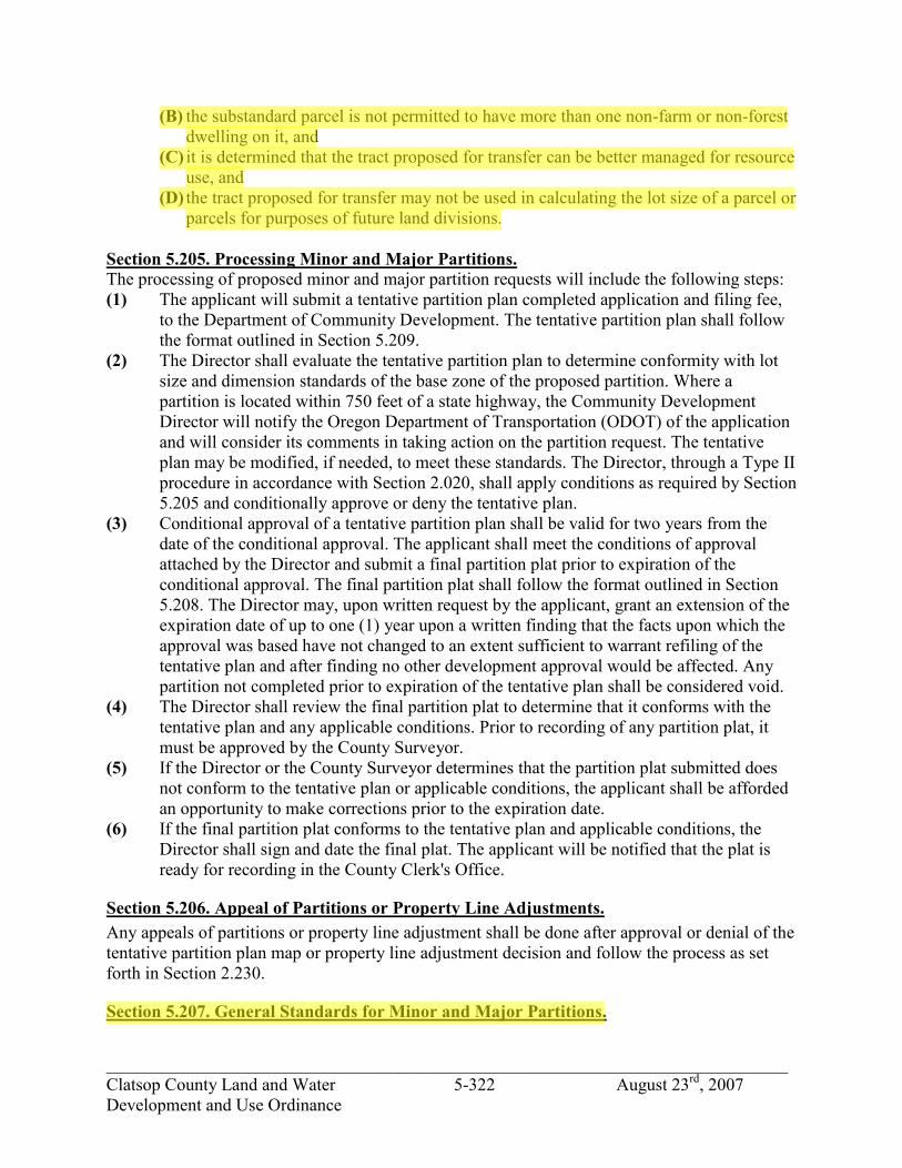
_____________________________________________________________________________ Clatsop County Land and Water 5-322 August 23rd, 2007 Development and Use Ordinance
(B) the substandard parcel is not permitted to have more than one non-farm or non-forest dwelling on it, and
(C) it is determined that the tract proposed for transfer can be better managed for resource use, and
(D) the tract proposed for transfer may not be used in calculating the lot size of a parcel or parcels for purposes of future land divisions.
Section 5.205. Processing Minor and Major Partitions. The processing of proposed minor and major partition requests will include the following steps: (1) The applicant will submit a tentative partition plan completed application and filing fee,
to the Department of Community Development. The tentative partition plan shall follow the format outlined in Section 5.209.
(2) The Director shall evaluate the tentative partition plan to determine conformity with lot size and dimension standards of the base zone of the proposed partition. Where a partition is located within 750 feet of a state highway, the Community Development Director will notify the Oregon Department of Transportation (ODOT) of the application and will consider its comments in taking action on the partition request. The tentative plan may be modified, if needed, to meet these standards. The Director, through a Type II procedure in accordance with Section 2.020, shall apply conditions as required by Section 5.205 and conditionally approve or deny the tentative plan.
(3) Conditional approval of a tentative partition plan shall be valid for two years from the date of the conditional approval. The applicant shall meet the conditions of approval attached by the Director and submit a final partition plat prior to expiration of the conditional approval. The final partition plat shall follow the format outlined in Section 5.208. The Director may, upon written request by the applicant, grant an extension of the expiration date of up to one (1) year upon a written finding that the facts upon which the approval was based have not changed to an extent sufficient to warrant refiling of the tentative plan and after finding no other development approval would be affected. Any partition not completed prior to expiration of the tentative plan shall be considered void.
(4) The Director shall review the final partition plat to determine that it conforms with the tentative plan and any applicable conditions. Prior to recording of any partition plat, it must be approved by the County Surveyor.
(5) If the Director or the County Surveyor determines that the partition plat submitted does not conform to the tentative plan or applicable conditions, the applicant shall be afforded an opportunity to make corrections prior to the expiration date.
(6) If the final partition plat conforms to the tentative plan and applicable conditions, the Director shall sign and date the final plat. The applicant will be notified that the plat is ready for recording in the County Clerk's Office.
Section 5.206. Appeal of Partitions or Property Line Adjustments. Any appeals of partitions or property line adjustment shall be done after approval or denial of the tentative partition plan map or property line adjustment decision and follow the process as set forth in Section 2.230.
Section 5.207. General Standards for Minor and Major Partitions.
jhickner
Highlight
jhickner
Highlight

_____________________________________________________________________________ Clatsop County Land and Water 5-323 August 23rd, 2007 Development and Use Ordinance
Land within resource zones is evaluated by different standards than land in non-resource zones. This is because land divisions in resource zones are considered to be primarily for resource use in resource areas, not for development. Specific road improvement standards are not required except for cluster land divisions, which are evaluated as residential parcels since their purpose is for residential use. As a condition of approving residences as conditional uses in resource zones, road improvements will be required. (1) Standards for partitions in resource zones (as defined in Section 1.030):
(A) Minor Partitions in Resource Zones shall meet the following standards: 1) Road approach approval from the appropriate agency shall be demonstrated. 2) Clustering in resource zones shall be subject to the standards for partitioning
of non-resource lands in (2) below as well as any other applicable standards. 3) County-wide Forest Lands Policy #22 shall be applied to all AF and F-80
partitions. (B) Major Partitions in Resource Zones shall meet the following standards:
1) Standards in Section 5.205(1)(A)(1-3) above shall be met. 2)
(a) If a County road is created, the right-of-way shall meet the standards from the "Basic Major Partition Improvement Standards Table" and the boundaries of the road right-of-way shall be surveyed and monumented. The road shall be improved to a standard established by the Board of Commissioners.
(b) If a public road is created, the right-of-way shall meet the standards from the "Basic Major Partition Improvement Standards Table" and the boundaries of the road right-of-way shall be surveyed and monumented.
(c) If a private road or easement is created or utilized, the easement shall meet the standards from the "Basic Major Partition Improvement Standards Table". Easements which bind all involved property owners and which specify the perpetual, non-exclusive nature of the roadway easement shall be signed and recorded with the County Clerk.
(C) Standards for Partitions in Non-Resource Zones (as defined in Section 1.030). (A) Minor Partitions in All Zones other than Resource Zones shall meet the following
standards: 1) Road approach approval from the appropriate agency shall be demonstrated. 2) Except as set out in Section 5.207(1) the boundaries of all parcels shall be
surveyed and monumented. (B) Major Partitions in Non-Resource Zones shall meet the following standards
1) Standards in 5.205(2)(A)(1-2) above shall be met. 2)
(a) If a County Road is created, the right-of-way shall meet the standards from the “basic Major Partition Improvement Standards Table” and the boundaries of the road right-of-way shall be surveyed and monumented. The road shall be improved to a standard established by the Board of Commissioners. All such roads shall be improved at least to the County’s A-20 road standard.
(b) If a public road is created, the right-of-way shall meet the standards from the "Basic Major Partition Improvement Standards Table" and the
jhickner
Highlight
jhickner
Highlight
jhickner
Highlight

_____________________________________________________________________________ Clatsop County Land and Water 5-324 August 23rd, 2007 Development and Use Ordinance
boundaries of the road right-of-way shall be surveyed and monumented. The road shall be improved to the County's A-20 road standard. An agreement shall be signed and recorded with the County Clerk outlining the responsibility of the private parties maintaining the road improvements. These maintenance responsibilities shall be enforced by the individual parties or the County at its discretion.
(c) If a private road or easement is created or utilized, the road easement shall meet the standards from the "Basic Major Partition Improvement Standards Table" and the boundaries of the road easement shall be surveyed and monumented. The road shall be improved to the County's A-12 road standard and one vehicle turnout shall be provided for every 250' of road and within 50' of each sight obscuring corner. If the travel surface width of the private road exceeds 18 feet no turnouts will be required. Easements which bind all involved property owners and which specify the perpetual, non-exclusive nature of the road way easement shall be signed and recorded with the County Clerk. An agreement shall also be signed and recorded with the County Clerk outlining the responsibilities of the private parties maintaining the road improvements. These maintenance responsibilities shall be enforced by the individual parties and not the County.
(d) Any required road improvements shall meet the applicable road standards from Section S6.000 of the Standards Document. Required road improvements shall be completed or bonded prior to the sale of any of the partitioned parcels. In the event that the partitioning party intends to retain ownership of a partitioned parcel, required road improvements shall be completed prior to the issuance of any development permit involving the partitioned parcel. Road improvements must be completed to the extent necessary to provide legal access frontage to the parcel proposed for sale or for second home placement. If the partitioning party has not completed required road improvements at the time of final partition approval, the Department of Community Development will record a development restriction upon the involved parcels to require the completion of these improvements prior to the sale of the parcels or prior to the issuance of a development permit to the partitioning party; whichever comes first. The restriction will be removed upon completion of the improvements prior to the sale of the parcels or prior to the issuance of any development permit involving the partitioned parcel.
Section 5.208. Extent of Road Improvements. (1) Required access road improvements shall be completed to provide access from the
partitioned parcels to an existing public, county or state road.
Section 5.209. Exceptions to General Standards for Minor and Major Partitions and Property Line Adjustments. (1) Surveys for Large Parcel Partitions and Property Line Adjustments.
jhickner
Highlight
jhickner
Highlight

_____________________________________________________________________________ Clatsop County Land and Water 5-325 August 23rd, 2007 Development and Use Ordinance
(A) When a partition is proposed which includes parcels that are greater than ten (10) acres in size no survey of the parcel is required. However, a partition plat must still be submitted and approved. For a major partition the entire roadway being created shall be surveyed and monumented.
(B) Partitions creating parcels in excess of 80 acres do not need to be shown on a partition plat. Nothing in this subsection shall exempt Clatsop County from minimum area requirements established in the Clatsop County Comprehensive Plan and this Ordinance.
(C) A property line adjustment created by the relocation of a common boundary as described in ORS 92.010(7)(b) shall be surveyed and monumented in accordance with Oregon law and it shall be filed with the County Surveyor.
(D) The provisions of Section 5.207(1)(C) shall not apply to the relocation of a common boundary of a lot in a subdivision or a parcel in a partition when the adjusted property line is a distance of even width along the common boundary except for the following reasons:
1) if the Community Development Director determines that a yard setback requirement might be violated; or
2) if the Community Development Director determines that the lot size requirement of the zone might be violated; or
3) if the Community Development Director determines that a dimensional requirement of the zone might be violated.
(E) No survey or monumentation is required for a property line adjustment when both parcels affected are greater than 10 acres. Nothing in this subsection shall exempt Clatsop County from minimum area requirements established in the Clatsop County Comprehensive Plan and this Ordinance.
(F) Altering Access to Improve Public Safety. If, in reviewing a minor partition application, the Community Development Director, in conjunction with the County Roadmaster or State Highway Engineer, determines that a consolidated, single access would better serve the public health, safety and welfare by reducing access points onto a public road such a condition of approval may be attached. The area utilized for such a consolidated access shall not be reduced from a parcel's lot area for the purpose of determining minimum lot size. Such a consolidated access shall serve a minimum of 3 parcels; if additional partitioning is proposed off a consolidated access, major partition road standards will be applied. Access easements shall be provided for the involved parcels.
(G) A shared common driveway may be utilized in a proposed minor partition if the following circumstances exist:
(A) Each parcel in the minor partition has the required 25 foot minimum frontage on a state, county or public road.
(B) Each parcel has an alternate means of access to the adjoining state, county or public road within its own boundaries.
(C) The shared common driveway serves no more than three parcels. (D) Recorded access easements shall be provided for the involved parcels.
Section 5.210. Tentative Partition Plan Submission Requirements.
jhickner
Highlight
jhickner
Highlight

_____________________________________________________________________________ Clatsop County Land and Water 5-326 August 23rd, 2007 Development and Use Ordinance
An applicant for a minor or major partition shall submit a copy of a plan for partitioning showing the following information (except as otherwise provided herein, the following does not require a survey): (1) A sketch of the original parcel of land (all contiguously owned land) on an 8 ½" x 11"
sheet of paper. (2) The date, northpoint, and scale of the drawing. (3) The amount of acreage in the original parcel and the acreage of the resulting parcels, and
dimensions of all parcels. (4) The location, names and widths of all roads and easements adjacent to and within the
parcel to be partitioned. (5) The existing use or uses of the property, including approximate locations of all structures
on the property. (6) The width and location of all easements for drainage or public utilities. (7) The location of zoning boundaries on the property, to the detail provided by the
Department of Community Development. (8) Approximate location of physical features on the property, such as wetlands and streams.
Section 5.211. Submission of Final Partition Plat. Prior to expiration of a tentative partition approval, a final plat shall be submitted subject to the Standards of Section S5.200.
Section 5.212. Submission and Review of Final Plat. A final plat shall be submitted and within ten (10) days of submission, the Director shall determine whether the material conforms with the approved tentative plan and with the applicable requirements of this Ordinance. If the Director determines that there is a failure to conform, the applicant shall be advised and afforded an opportunity to make corrections. When the plat is found to conform, it shall be signed and dated by the Director if other requirements for a development permit have been fulfilled.
Section 5.213. Approval Signature for Final Partition Plat. Following review and approval of a final partition plat, the Director shall take the following actions: (1) Obtain the approval signature thereon by the County Surveyor certifying that it complies
with all applicable survey laws. The Surveyor may cause field investigations to be made to certify that the map survey is sufficiently accurate. If it is determined that there has been a failure to comply, the applicant shall be notified and afforded an opportunity to make corrections. When the plat is found to conform, it shall be signed and dated by the Surveyor.
(2) The County Surveyor shall submit the final partition plat to the Clatsop County Department of Community Development. The Planning Department will review the file for completion of conditions of approval.
(3) The Clatsop County Department of Community Development shall notify the applicant that the approved partition plat has been signed by the Community Development Director.
jhickner
Highlight

_____________________________________________________________________________ Clatsop County Land and Water 5-327 August 23rd, 2007 Development and Use Ordinance
(4) The Department of Community Development will forward the Plat to the County Tax Office for review of payment of taxes. The County Tax Office shall notify the applicant that all taxes must be paid prior to final plat recording with the County Clerk. The private surveyor shall provide a signature line on the final plat for the County Assessor/Tax Collector. The County Tax Office shall notify the applicant when the Plat is ready for recording.
(5) The applicant shall take the final partition plat to the County Clerk's Office for recording.
Section 5.220. Subdivisions. An applicant for a subdivision for six (6) or less lots shall be processed by the Director under a Type II procedure. Any larger subdivision shall be processed by a Type III procedure. A subdivision occurs when four (4) or more lots are created, including the parent parcel, within a calendar year. (1) No one subdivision, contiguous group of subdivisions or planned development shall
create greater than thirty (30) lots within the same calendar year, (January 1-December 31), in the Rural designation in the Clatsop Plains planning area; and
(2) The applicant when applying for a subdivision or planned development in the Clatsop Plains Rural designation, shall show how the request addresses the NEED issue of the Clatsop Plains Community Plan below:
"6. Clatsop County intends to encourage a majority of the County's housing needs to occur within the various cities' urban growth boundaries. Approval of subdivisions and planned developments shall relate to the needs for rural housing. Through the County's Housing Study, the County has determined the Clatsop Plains rural housing needs to be approximately 900 dwelling units for both seasonal and permanent by the year 2000."
Section 5.222. Preliminary Plat. An applicant for a subdivision shall submit nine (9) copies of the Preliminary Plat, together with improvement plans and other supplementary information required by this Ordinance to indicate the design and objectives of the subdivision.
Section 5.224. Form and Scale of Preliminary Plat. The Preliminary Plat shall be clearly and legibly drawn. It shall show all pertinent information to scale so that the Commission may have an adequate understanding of what is proposed during the review process. Under ordinary circumstances, the scale of the drawing is to be one (1) inch equals fifty (50) feet or one-hundred (100) feet, or for areas over one-hundred (100) acres; one (1) inch equals two-hundred (200) feet.
Section 5.226. Preliminary Plat Information. The Preliminary Plat of the proposed subdivision shall include the following information:
jhickner
Highlight

_____________________________________________________________________________ Clatsop County Land and Water 5-328 August 23rd, 2007 Development and Use Ordinance
(1) Proposed name of subdivision. Subdivision plat names shall be subject to the approval of the County Surveyor or, in the case where there is no County Surveyor, the County Assessor. No tentative subdivision plan or subdivision plat of a subdivision shall be approved which bears a name similar to or pronounced the same as the name of any other subdivision in the same county, unless the land platted is contiguous to and platted by the same party that platted the subdivision bearing that name or unless the party files and records the consent of the party that platted the contiguous subdivision bearing that name. All subdivision plats must continue the lot numbers and, if used, the block numbers of the subdivision plat of the same name last filed. On or after January 1, 1992, any subdivision submitted for final approval shall not use block number or letters unless such subdivision is a continued phase of a previously recorded subdivision, bearing the same name, that has previously used block numbers or letters.
(2) Northpoint, scale, and date of the completed drawing, approximate acreage, and boundary lines.
(3) Appropriate identification clearly stating the map is a Preliminary Plat. (4) Location of the subdivision by section, township, range, tax lot or lots and donation land
claim sufficient to define the location and boundaries of the proposed subdivision. (5) Names, addresses and zip codes of all owners, subdividers, and engineers or surveyors
responsible for laying out the subdivision. (6) Existing locations, widths, names of both opened and unopened streets within or adjacent
to the subdivision, together with easements, or rights-of-way and other important features, such as section lines, corners, city boundary lines and monuments.
(7) A vicinity map showing the relationship of the proposed subdivision to surrounding development, streets, and sewer and water services, within one-quarter (1/4) mile of the exterior boundaries of the proposed development.
(8) Location of at least one (1) temporary bench mark within the plat boundaries. (9) Contour lines related to the temporary bench mark or other datum approved by the
County Surveyor and having contour intervals together with the calculated degrees of slope as follows: (A) For slopes not in excess of 10 percent: two-foot contours. (B) For slopes over 10 percent: five-foot contours. (C) Location of significant natural features such as rock outcroppings, marshes, wooded
areas and isolated preservable trees. (D) Location of any rare, threatened and endangered species (plant or animal) located on
or within 1,000 feet of the proposed subdivision. (E) Location and direction of all water courses and/or bodies and the location of all areas
subject to flooding. (F) Existing uses on the property, including location of all existing structures. (G) Location, width, name, approximate grade, and radii of curves of all proposed streets,
their relationship of such streets to any projected or existing streets adjoining the proposed subdivision. The subdivider shall submit documented preliminary approval, from the County Roadmaster, of his road design.
(H) Location, width, and purpose of proposed easements and private roads for private use, where permitted, and all reservations or restrictions relating to such easements and private roads.
jhickner
Highlight
jhickner
Highlight
jhickner
Highlight

_____________________________________________________________________________ Clatsop County Land and Water 5-329 August 23rd, 2007 Development and Use Ordinance
(I) Proposed plan for draining surface water, including the location and type of drainage ways to carry surface water from the development without adversely affecting adjacent properties. If any filling is proposed, the drainage plan must demonstrate that adequate provisions have been made for the prevention of backup or ponding of surface water on adjacent properties as well as within the proposed development.
(J) Location, acreage and dimensions of lots and the proposed lot numbers. (K) Site, if any, allocated for a purpose other than single family dwellings. (L) Location, acreage and dimensions of areas proposed for public use. (M) Location, acreage and dimensions of areas proposed for common open space
(30% in the Rural designation of the Clatsop Plains planning area). (N) Any subdivision may be platted in as many as three (3) phases. All phases must be
submitted on the Preliminary Plat with proposed time limitations for the recording of the various phases. However, phasing must meet the following time limitations:
(A) Phase I - shall be recorded within twelve (12) months of preliminary approval. (B) Phase II - shall be recorded within thirty-six (36) months of preliminary approval. (C) Phase III - shall be recorded within sixty (60) months of preliminary approval. The Planning staff shall review each phase prior to recording to make sure the phase, as recorded, is in accord with the preliminary approval given by the Planning Commission. Any submitted phase which does not coincide with the approval as given by the Planning Commission shall be referred to the Planning Commission for a hearing. At such hearing, the Commission shall have the authority to revoke, revise, amend or alter the prior approval. Notice shall be sent subject to Sections 6.110-6.120. For any subdivision which has an approved phasing plan as granted by the Commission under the Preliminary Plat approval, all parts of the subdivision shall fall under control of the various Ordinances in effect at the time of preliminary approval, unless state or local law shall determine that newer or current Ordinances or laws are to be followed. If any time limitation is exceeded, preliminary approval for the subdivision or any phase of the subdivision shall be void. The subdivider shall submit any future proposals for development of the property to the Commission for approval. Agreement for improvements for each phase shall comply with this Ordinance prior to the Final Plat approval of such phase. If a bond is required, such bond shall be for a sum determined by the County Engineer to be sufficient to cover costs of construction for that phase.
(10) Technical documentation shall be supplied to the Commission by the subdivider at the time of submittal of the Preliminary Plat, addressing the following items: (A) An acceptable and approved method of sewage disposal for each proposed lot which
meets the rules and regulations of the Environmental Quality Commission of the State of Oregon as administered by the Department of Environmental Quality or its contract agent.
(B) An acceptable and approved method of water supply. (C) The nature and type of improvements proposed for the subdivision, and a timetable
for their installation.
jhickner
Highlight
jhickner
Highlight

_____________________________________________________________________________ Clatsop County Land and Water 5-330 August 23rd, 2007 Development and Use Ordinance
(D) A description of community facilities which would serve the subdivision, and a timetable for the completion or installation of the facilities.
(E) Where a surface or subsurface water problem may exist, as determined by the Department of Environmental Quality, County Sanitarian, or other qualified specialist, a complete report by an independent, qualified hydrologist or hydrogeologist or other qualified specialist shall be required prior to any hearing on the Preliminary Plat by the Commission. The fee for such study shall be paid by the subdivider.
(F) Subdividers shall provide a list of any restrictive covenants which are to be recorded. (G) A demonstration that lot size and use are in compliance with the applicable zone.
(11) Compliance with the Clatsop County Comprehensive Plan and Land and Water Development and Use Ordinance, and ORS 92 and 215.
(12) Lots not intended for sale shall be designated by alphabetic symbol which indicates the intended usage. The acreage for each dedicated lot, if any, is to be shown.
(13) Notations indicating any limitations on rights-of-access to or from streets and lots or other parcels of land proposed by the developer or established by the Board.
(14) A quotation from the Clatsop County Assessor on taxes to be paid on a proposed subdivision before final platting shall take place in accordance with ORS 92.095.
(15) If any federal or state permit is required to carry out the preliminary plat approval, approval shall be subject to a condition requiring the subdivision to comply with any applicable federal and state laws.
(16) In areas subject to the geologic hazard overlay zone, a grading plan prepared in conformance with Section 4.040.
Section 5.228. Preliminary Plat Review. (1) Upon receipt of a completed Preliminary Plat, the Planning Department shall set a date
for a public hearing before the Planning Commission. Copies of the Preliminary Plat shall be furnished to all affected city, county, state and federal agencies and special districts for review and comment. Failure to provide written comment to the Planning Department within fifteen (15) working days thereof may be deemed a recommendation for approval unless an additional review period is requested by the jurisdiction and approved.
(2) The Preliminary Plat, supplementary information and recommendations of the Planning staff and other reviewing agencies shall be submitted to the Commission for review at a public hearing. The Commission shall review the plat and other data submitted, taking action upon the proposal within sixty (60) days from the date of the first hearing at which the request was heard.
(3) The Commission may approve, conditionally approve or disapprove the proposed subdivision. The Commission may attach as a condition of approval those conditions reasonably necessary to carry out the provisions of this Ordinance and may require the developer to post a bond of an amount set by the County Engineer, for all improvements or construction within the proposed subdivision. The Commission may also require the subdivider to file a map within thirty (30) days of the date of conditional approval showing the design approved by the Planning Commission.
jhickner
Highlight
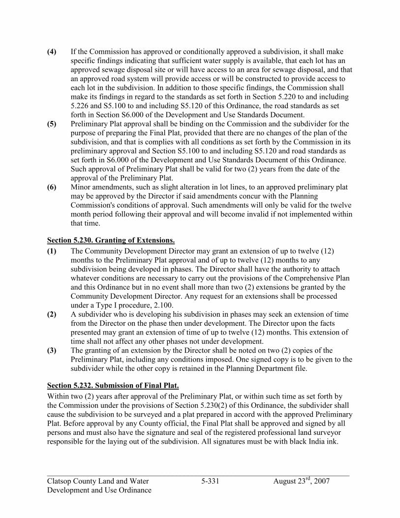
_____________________________________________________________________________ Clatsop County Land and Water 5-331 August 23rd, 2007 Development and Use Ordinance
(4) If the Commission has approved or conditionally approved a subdivision, it shall make specific findings indicating that sufficient water supply is available, that each lot has an approved sewage disposal site or will have access to an area for sewage disposal, and that an approved road system will provide access or will be constructed to provide access to each lot in the subdivision. In addition to those specific findings, the Commission shall make its findings in regard to the standards as set forth in Section 5.220 to and including 5.226 and S5.100 to and including S5.120 of this Ordinance, the road standards as set forth in Section S6.000 of the Development and Use Standards Document.
(5) Preliminary Plat approval shall be binding on the Commission and the subdivider for the purpose of preparing the Final Plat, provided that there are no changes of the plan of the subdivision, and that is complies with all conditions as set forth by the Commission in its preliminary approval and Section S5.100 to and including S5.120 and road standards as set forth in S6.000 of the Development and Use Standards Document of this Ordinance. Such approval of Preliminary Plat shall be valid for two (2) years from the date of the approval of the Preliminary Plat.
(6) Minor amendments, such as slight alteration in lot lines, to an approved preliminary plat may be approved by the Director if said amendments concur with the Planning Commission's conditions of approval. Such amendments will only be valid for the twelve month period following their approval and will become invalid if not implemented within that time.
Section 5.230. Granting of Extensions. (1) The Community Development Director may grant an extension of up to twelve (12)
months to the Preliminary Plat approval and of up to twelve (12) months to any subdivision being developed in phases. The Director shall have the authority to attach whatever conditions are necessary to carry out the provisions of the Comprehensive Plan and this Ordinance but in no event shall more than two (2) extensions be granted by the Community Development Director. Any request for an extensions shall be processed under a Type I procedure, 2.100.
(2) A subdivider who is developing his subdivision in phases may seek an extension of time from the Director on the phase then under development. The Director upon the facts presented may grant an extension of time of up to twelve (12) months. This extension of time shall not affect any other phases not under development.
(3) The granting of an extension by the Director shall be noted on two (2) copies of the Preliminary Plat, including any conditions imposed. One signed copy is to be given to the subdivider while the other copy is retained in the Planning Department file.
Section 5.232. Submission of Final Plat. Within two (2) years after approval of the Preliminary Plat, or within such time as set forth by the Commission under the provisions of Section 5.230(2) of this Ordinance, the subdivider shall cause the subdivision to be surveyed and a plat prepared in accord with the approved Preliminary Plat. Before approval by any County official, the Final Plat shall be approved and signed by all persons and must also have the signature and seal of the registered professional land surveyor responsible for the laying out of the subdivision. All signatures must be with black India ink.

_____________________________________________________________________________ Clatsop County Land and Water 5-332 August 23rd, 2007 Development and Use Ordinance
Section 5.234. Form and Scale of Final Plat. (1) The Final Plat offered for approval and recording shall be made pursuant to the Standards
in Section S5.200. (2) At the time of filing the Final Plat, the surveyor who made the plat shall furnish the
County Clerk and/or County Surveyor with an exact copy of the Final Plat offered for recording. This copy shall be made with black India ink or silver halide permanent photocopy on polyester film having the same or better characteristics of strength, stability and transparency, and shall have an affidavit that the photocopy or tracing is an exact copy of the Plat.
(3) The scale on the Final Plat will be one (1) inch to one-hundred (100) feet or, one (1) inch to fifty (50) feet. The scale may be increased or decreased if necessary to fit the legal sized 18" x 24" plat, but in all cases the scale shall be in multiples of ten.
(4) The subdivider shall provide, at his/her own expense, up to six (6) prints at the request of the Commission and/or Board.
Section 5.236. Information on Final Plat. The following information shall be shown on the Final Plat and is required by ORS 92. (1) The name of the subdivision, the date the plat was prepared, the scale, northpoint, legend
and existing features such as highways and railroads. (2) Legal description of the subdivision boundaries. (3) Reference, by distance and bearings, to adjoining recorded surveys, if any, and referenced
to a field book or map as follows: (A) Stakes, monuments or other evidence found on the ground and used to determine the
boundaries of the subdivision. (B) Adjoining corners of adjoining subdivision. (C) Other monuments found or established in making the survey of the subdivision or
required to be installed by provisions of this Ordinance. (D) Exact location and width of streets and easements intersecting the boundary of the
subdivision. (E) Subdivision boundaries, lot or tract boundaries, and street right-of-way and
centerlines with dimensions to the nearest 1/100th of a foot and bearings in degrees, minutes and seconds, pursuant to the requirements of ORS 92.
(F) Names and width of the portion of streets being dedicated, the width of any existing right-of-way, and the width on each side of the center line. For streets on curvature, curve data shall be based on the street center line. In addition to the center line dimensions, the radius, central angle, long chord bearing and distance shall be indicated.
(G) Easements denoted by fine dotted lines, clearly identified and, if already of record, there shall be written statement of the easement. The width of the easement, its length and bearing, and sufficient ties to locate the easement with respect to the subdivision must be shown. If the easement is being dedicated by the map, it shall be properly referenced in the owner's certificates of dedication.
(H) Locations and widths of drainage channels, railroad rights-of-way, reserve strips at the end of stubbed streets or along the edge of partial width streets on the boundary of the subdivision.
(I) Location of all permanent monuments within the proposed subdivision.
jhickner
Highlight
jhickner
Highlight

_____________________________________________________________________________ Clatsop County Land and Water 5-333 August 23rd, 2007 Development and Use Ordinance
(J) Ties to any city, county, or adjacent subdivision's boundary lines. (K) Acreage of each parcel to the nearest 1/100th of an acre. (L) Any conditions specified by the Commission or Board upon granting preliminary
approval. (M) A statement of water rights noted on the subdivision plat or partition plat. (N) A copy of the acknowledgment from the State Water Resources Dept. under ORS
92.122, if the person offering the subdivision or partition plat for filing indicates on the statement of water rights that a water right is appurtenant to the subdivision or partition.
Section 5.238. Survey Requirements. A complete and accurate survey of the land to be subdivided shall be made by a registered professional land surveyor licensed to practice in the State of Oregon, in accordance with ORS 92.
Section 5.240. Supplementary Information with Final Plat. (1) Evidence of Title. The Commission shall require Evidence of Title accompanying the
Final plat by a letter or Final plat report in the name of the subdivider. Such evidence shall indicate that the title company has issued a preliminary report for the parcel being subdivided and shall state that the Final plat and certificates have been reviewed. It shall also list exceptions, if any, that will be imposed by the County when the Final plat is recorded.
(2) Restrictive Covenants. A copy of any Restrictive Covenant(s) is to be filed with the Final plat. On Final plats showing areas which will be jointly owned or used by the various owners in the subdivision, a covenant document will be mandatory as part of the Final plat. For other Final plats, the covenants are optional with the subdivider.
(3) Traverse Data. The subdivider shall provide traverse data on form work sheets or complete computer printouts showing the closure of the exterior boundaries of the subdivision and of each lot and each block of the subdivision.
(4) Improvement Plans. Improvement plans shall be submitted for various facilities that are to be constructed by the subdivider, including drainage plans, sewer plans, water plans, curb and gutter, sidewalk and street plans, and any other construction plans that may be required. These plans shall indicate design criteria, assumptions and computations for proper analysis in accordance with sound engineering practice. Where such plans are or would be the same as those included in the County's Standard Specifications, they may be submitted by reference to such Standard Specifications.
(5) Dedication of Land, Rights, Easements, and Facilities for Public Ownership, Use and Utility Purposes. (A) All land shown on the Final Plat intended for dedication to the public for public use
shall be offered for dedication at the time the plat is filed and must be expressly accepted by the Board prior to the Final Plat being accepted for recording. Land dedicated for public use, other than roads, shall be accepted by the Board by the acceptance of a deed and by no other means.
(B) All streets, pedestrian ways, drainage channels, easements and other rights-of-way shown on the Final Plat as intended for public use, shall be offered for dedication for public use at the time the Final Plat is filed.
jhickner
Highlight
jhickner
Highlight

_____________________________________________________________________________ Clatsop County Land and Water 5-334 August 23rd, 2007 Development and Use Ordinance
(C) Rights of access to and from streets, lots and parcels shown on the Final Plat shall not have final approval until such time as the County Engineer is satisfied that the required street improvements are completed in accordance with applicable standards and specifications. The subdivider must petition separately to the Board for acceptance of any dedicated land, access rights or facilities. Acceptance of the Final Plat shall not be construed as approval of dedicated land rights, easements or other facilities.
(D) Reserve Strips. One (1) foot reserve strips shall be provided across the end of stubbed streets adjoining unsubdivided land or along streets or half streets adjoining unsubdivided land and shall be designated as a reserve strip on the plat. The reserve strip shall be included in the dedication granting to the Board the authority to control access over the reserve strip to assure the continuation or completion of the street. This reserve strip shall overlay the dedicated street right-of-way. The Board may require a reserve strip in other areas of the subdivision in order to control access.
(E) Drainage Plan. The Final Plat shall be accompanied by a drainage plan showing street grades, curbs, natural drainageways and other drainage works in sufficient detail to enable the engineer to determine the adequacy of provisions for drainage and the disposal of surface and storm waters within the subdivision and other adjoining areas. Subsequent changes to the drainage plan may be approved by separate action by the Board after receiving the recommendation by the County Engineer.
(F) Common Open Space. Maintenance of common open space shall be subject to Section S3.180.
Section 5.242. Agreement for Improvements. The subdivider shall improve or agree to improve lands dedicated for streets, alleys, pedestrian ways, drainage channels, easements and other rights-of-way to County Standards as a condition preceding the acceptance and approval of the Final Plat. Before the Commission approval is certified on the Final Plat, the subdivider shall either install required improvements and repair existing streets and other public facilities damaged in the development of the subdivision; or he/she shall execute and file with the Board an agreement between himself and the County specifying the period within which required improvements and repairs shall be completed. The agreement shall provide that if the work is not completed within the period specified, the County may complete the work and recover the full cost and expense thereof from the subdivider. A performance bond, as provided in Section 5.244 of this Ordinance, shall be required with such agreement. Provisions for the construction of the improvements in phases and for an extension of time under specified conditions may be made upon prior agreement by, or application to, the Commission or Board.
Section 5.244. Performance Bond. (1) The subdivider shall file with the agreement to assure full and faithful performance
thereof, one of the following: (A) A surety bond executed by a surety company authorized to transfer business in the
State of Oregon on a form approved by the District Attorney.
jhickner
Highlight
jhickner
Highlight
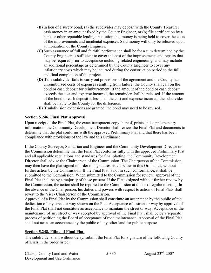
_____________________________________________________________________________ Clatsop County Land and Water 5-335 August 23rd, 2007 Development and Use Ordinance
(B) In lieu of a surety bond, (a) the subdivider may deposit with the County Treasurer cash money in an amount fixed by the County Engineer, or (b) file certification by a bank or other reputable lending institution that money is being held to cover the costs of the improvements and incidental expenses. Said money will only be released upon authorization of the County Engineer.
(C) Such assurance of full and faithful performance shall be for a sum determined by the County Engineer as sufficient to cover the cost of the improvements and repairs that may be required prior to acceptance including related engineering, and may include an additional percentage as determined by the County Engineer to cover any inflationary costs which may be incurred during the construction period to the full and final completion of the project.
(D) If the subdivider fails to carry out provisions of the agreement and the County has unreimbursed costs of expenses resulting from failure, the County shall call on the bond or cash deposit for reimbursement. If the amount of the bond or cash deposit exceeds the cost and expense incurred, the remainder shall be released. If the amount of the bond or cash deposit is less than the cost and expense incurred, the subdivider shall be liable to the County for the difference.
(E) If subdivision extensions are granted, the bond may need to be revised.
Section 5.246. Final Plat Approval. Upon receipt of the Final Plat, the exact transparent copy thereof, prints and supplementary information, the Community Development Director shall review the Final Plat and documents to determine that the plat conforms with the approved Preliminary Plat and that there has been compliance with provisions of the law and this Ordinance. If the County Surveyor, Sanitarian and Engineer and the Community Development Director or the Commission determine that the Final Plat conforms fully with the approved Preliminary Plat and all applicable regulations and standards for final platting, the Community Development Director shall advise the Chairperson of the Commission. The Chairperson of the Commission may then have the plat signed in order of signatures listed below in this Ordinance, without further action by the Commission. If the Final Plat is not in such conformance, it shall be submitted to the Commission. When submitted to the Commission for review, approval of the Final Plat shall be by a majority of those present. If the Plat is signed without further review by the Commission, the action shall be reported to the Commission at the next regular meeting. In the absence of the Chairperson, his duties and powers with respect to action of Final Plats shall revert to the Vice- Chairperson of the Commission. Approval of a Final Plat by the Commission shall constitute an acceptance by the public of the dedication of any street or way shown on the Plat. Acceptance of a street or way by approval of the Final Plat shall not constitute an acceptance to maintain the street or way. Acceptance of the maintenance of any street or way accepted by approval of the Final Plat, shall be by a separate process of petitioning the Board of acceptance of road maintenance. Approval of the Final Plat shall not act as an acceptance by the public of any other land for public purposes.
Section 5.248. Filing of Final Plat. The subdivider shall, without delay, submit the Final Plat for signature of the following County officials in the order listed:

_____________________________________________________________________________ Clatsop County Land and Water 5-336 August 23rd, 2007 Development and Use Ordinance
(1) Surveyor, in accordance with the provisions of ORS 92.100; (2) Community Development Director; (3) Assessor; (4) Board of Commissioners or its designee (upon consent of the Board); (5) Clerk.
Section 5.250. Time Limit for Recording of a Plat. The Final Plat shall be recorded within thirty (30) days of the date that the signatures and approvals as required in Section 5.248 of this Ordinance, has been obtained. In the event the Final Plat is not recorded within the time herein provided, it will be resubmitted to the Commission, which may require changes or alterations deemed necessary because of changed conditions within the general area of the subdivision.
Section 5.252. Partial Platting. If desired by the subdivider, individual phases of an approved Preliminary Plat may be recorded with the approval of the Commission and in the same manner as a Final Plat.

_____________________________________________________________________________ Clatsop County Land and Water 5-337 August 23rd, 2007 Development and Use Ordinance
SECTION 5.300. SITE PLAN REVIEW.
Section 5.302. Site Plan Review Requirements. Before a permit can be issued for development in a special purpose district or for a conditional development and use or a development and use permitted with review, a site plan for the total parcel and development must be approved by the Community Development Director or Planning Commission. Information on the proposed development shall include sketches or other explanatory information the Director may require or the applicant may offer that present facts and evidence sufficient to establish compliance with Sections 1.040, 1.050 and the requirements of this Section.

_____________________________________________________________________________ Clatsop County Land and Water 5-338 August 23rd, 2007 Development and Use Ordinance
SECTION 5.350 TRANSPORTATION SYSTEM IMPACT REVIEW The following section incorporates requirements for developments that have the potential to impact the county’s transportation system
Section 5.352 Traffic Impact Study (1) Purpose.
The purpose of this section of the code is to implement Section 660-012-0045(2)(e) of the State Transportation Planning Rule that requires the County to adopt a process to apply conditions to development proposals in order to minimize adverse impacts to and protect transportation facilities. This section establishes the standards for when a proposal must be reviewed for potential traffic impacts; when a Traffic Impact Study must be submitted with a development application in order to determine whether conditions are needed to minimize impacts to and protect transportation facilities; what must be in a Traffic Impact Study; and who is qualified to prepare the Study.
(2) When Required. A Traffic Impact Study may be required to be submitted to the County with a land use application, when the following conditions apply: (A) The development application involves one or more of the following actions:
1) A change in zoning or a plan amendment designation; or 2) Any proposed development or land use action that ODOT states may have
operational or safety concerns along a state highway; and 3) The development shall cause one or more of the following effects, which can
be determined by field counts, site observation, traffic impact analysis or study, field measurements, or crash history. The Institute of Transportation Engineers Trip Generation manual shall be used for determining vehicle trip generation: (a) An increase in site traffic volume generation by 500 Average Daily Trips
(ADT) or more (or as required by the County Engineer); or (b) An increase in ADT hour volume of a particular movement to and from
the State highway by 20 percent or more; or (c) An increase in use of adjacent streets by vehicles exceeding the 20,000
pound gross vehicle weights by 10 vehicles or more per day; or (d) The location of the access driveway does not meet minimum site distance
requirements, or is located where vehicles entering or leaving the property are restricted, or such vehicles queue or hesitate on the State highway, creating a safety hazard; or
(e) A change in internal traffic patterns that may cause safety problems, such as back up onto the highway or traffic crashes in the approach area.
(3) Traffic Impact Study Requirements; (A) Preparation. A Traffic Impact Study shall be prepared by a professional engineer in
accordance with OAR 734-051-0070. (B) Transportation Planning Rule Compliance. See Section 7 of the Transportation Plan. (C) If the proposed development may cause one or more of the effects in Section
5.352(2), above, or other traffic hazard or negative impact to a transportation facility, the Traffic Impact Study shall include recommended mitigation measures.
jhickner
Highlight
jhickner
Highlight

_____________________________________________________________________________ Clatsop County Land and Water 5-339 August 23rd, 2007 Development and Use Ordinance
(4) Approval Criteria: (A) Criteria. When a Traffic Impact Study is required, approval of the development
proposal requires satisfaction of the following criteria, in addition to other criteria applicable to the proposal:
1) The proposed site design and traffic and circulation design and facilities, for all transportation modes, including any mitigation measures, are designed to: (a) Have the least negative impact on all applicable transportation facilities;
and (b) Accommodate and encourage non-motor vehicular modes of
transportation to the extent practicable; and (c) Make the most efficient use of land and public facilities as practicable;
and (d) Provide the most direct, safe and convenient routes practicable between
on- site destinations, and between on-site and off-site destinations; and (e) Otherwise comply with applicable requirements of the Clatsop County
Land and Water Development Use Ordinance and the Standards Document.
(5) Conditions of Approval. (A) In approving an action that requires a Traffic Impact Study, the County may
condition that approval on identified mitigation measures.
Section 5.354 Amendments Affecting the Transportation System (1) Review of Applications for Effect on Transportation Facilities.
When a development application includes a proposed comprehensive plan amendment, zone change or land use regulation change, the proposal shall be reviewed to determine whether it significantly affects a transportation facility. An amendment significantly affects a transportation facility if it would: (A) Change the functional classification of an existing or planned transportation facility.
This would occur, for example, when a proposal causes future traffic to exceed the capacity of “collector” street classification, requiring a change in the classification to an “arterial” street, as identified by the Clatsop County Transportation System Plan (“TSP”); or
(B) Changes standards implementing a functional classification system; or (C) Allows types or levels of land use that would result in levels of travel or access that
are inconsistent with the functional classification of a transportation facility; or (D) Reduce the performance standards of the facility below the minimum acceptable level
identified in the Transportation System Plan. (2) Amendments That Affect Transportation Facilities.
Amendments to the comprehensive plan, zoning map and land use regulations which significantly affect a transportation facility shall assure that allowed land uses are consistent with the function, capacity, and level of service of the facility identified in the TSP. This shall be accomplished by one of the following: (A) Amending the TSP to ensure that existing, improved, or new transportation facilities
are adequate to support the proposed land uses consistent with the requirements of the Transportation Planning Rule (TPR); or,
jhickner
Highlight

_____________________________________________________________________________ Clatsop County Land and Water 5-340 August 23rd, 2007 Development and Use Ordinance
(B) Altering land use designations, densities, or design requirements to reduce demand for automobile travel and meet travel needs through other modes of transportation; or
(C) Limiting allowed land uses to be consistent with the planned function of the transportation facility; or
(D) Amending the TSP to modify the planned function, capacity and performance standards, as needed to accept greater motor vehicle congestion to promote mixed use, pedestrian friendly development where multimodal travel choices are provided.

_____________________________________________________________________________ Clatsop County Land and Water 5-341 August 23rd, 2007 Development and Use Ordinance
SECTION 5.400. ZONE CHANGES.
Section 5.410. Purpose. This section provides the criteria for amending the boundaries of any base zone or overlay district delineated on the official Clatsop County “Comprehensive Plan/Zoning Map”. A change in a base zone or overlay district may be made according to the criteria set forth in Section 5.412. The process for changing a base zone designation or overlay district that does not involve a change to the comprehensive plan or comprehensive plan designation shall be a Type III procedure. All changes involving comprehensive plan amendments or comprehensive plan designation shall be a Type IV procedure. Changes to a base zone or overlay district may be initiated by the governing body, Planning Commission, or by petition of a majority of property owners in the area proposed for change. Mailed notice of the hearing shall include the owners of property within (250) feet of the area proposed for change. If the change involves a Goal 5 resource, a Plan amendment must also be requested and the Goal 5 Administrative Rule used to justify the decision.
Section 5.412. Zone Change Criteria. The governing body shall approve a non-legislative zone designation change if it finds compliance with Section 1.040, and all of the following criteria: (1) The proposed change is consistent with the policies of the Clatsop County
Comprehensive Plan. (2) The proposed change is consistent with the statewide planning goals (ORS 197). (3) The property in the affected area will be provided with adequate public facilities and
services including, but not limited to: (A) Parks, schools and recreational facilities (B) Police and fire protection and emergency medical service (C) Solid waste collection (D) Water and wastewater facilities (E) The proposed change will insure that an adequate and safe transportation network
exists to support the proposed zoning and will not cause undue traffic congestion or hazards.
(F) The proposed change will not result in over-intensive use of the land, will give reasonable consideration to the character of the area, and will be compatible with the overall zoning pattern.
(G) The proposed change gives reasonable consideration to peculiar suitability of the property for particular uses.
(H) The proposed change will encourage the most appropriate use of land throughout Clatsop County.
(I) The proposed change will not be detrimental to the health, safety and general welfare of Clatsop County.

_____________________________________________________________________________ Clatsop County Land and Water 5-342 August 23rd, 2007 Development and Use Ordinance
SECTION 5.500. TEMPORARY USE PERMITS.
Section 5.502. Purpose and Intent. It is the intent of the temporary use permit section to provide procedures and standards for land or structures which possess unique characteristics requiring special consideration for temporary usage. The provisions of this section are to apply when the proposed use does not qualify as a continuation of a non-conforming use. Temporary use permits are not to be construed, permitted nor utilized as a means to abrogate the intent, purpose or procedures of Clatsop County’s Comprehensive Plan or Ordinance regulations. No temporary permit shall be granted which would have the effect of creating a permanent rezoning or result in a hardship when the use is not permitted to continue at the expiration of the permit periods. Further, no temporary permit may be granted which has the effect of conferring a special privilege for which other property within the same zone may not be equally eligible.
Section 5.504. Goals. The provisions of this section are designed to provide standards and criteria for temporary relief to hardship situations which result from strict Ordinance application. The reasons for the temporary relief shall be to provide an applicant an opportunity for a solution to a temporary land use problem or sufficient time to develop a permanent solution to the land use problem which will result in compliance with the relative zoning regulations. The provisions of this Section are designed to provide criteria for granting and administering temporary use permits and to provide guidelines for the imposition of additional conditions. The temporary use should be as consistent with intent and purpose of the zone as possible and comply with the requirements of the zone, except as may be additionally provided for under the provisions of Section 5.500.
Section 5.506. Permitted Temporary Uses, Criteria and Limitations. The following temporary uses may be permitted under a Type I procedure. A temporary use permit for such uses may be permitted in any zone, subject to those specified criteria and limitations described in conjunction with the temporary use pursuant to the General Standards of subsection 5.508 and subject to the condition provisions of subsection 5.510. (1) Non-Conforming Uses. A different use for non-conforming uses of structures and/or land
may be permitted by the Community Development Director provided it is determined by the Planning Director that the character and nature of the proposed temporary use will be more compatible to the surrounding vicinity than the existing non-conforming use.
(2) Existing Structures and/or Premises. Existing structures and/or premises which do not have a qualified nonconforming use status and which were designed and intended for use not allowable in their respective zone may be granted a temporary use permit to provide a solution to a temporary land use problem or to provide a temporary solution to enable a permanent solution to be developed.
jhickner
Highlight
jhickner
Highlight

_____________________________________________________________________________ Clatsop County Land and Water 5-343 August 23rd, 2007 Development and Use Ordinance
(3) New Structures. A use involving a new structure of a temporary nature necessary for the physical or economic welfare and development of the primary permitted use of the property may be granted a temporary permit by the Community Development Director subject to a finding that the new structure permitted by the temporary use permit shall be removed at the end of the temporary permit period.
(4) Accessory Structures. Existing or new structures may be utilized in conjunction with or support of the primary permitted use of the property on a temporary basis. The Planning Director may grant a temporary use permit for the structure which shall be brought into conformity with the Ordinance provisions in effect.
(5) Open Land Uses. Open land uses which do not involve structures or involve structures which create an improvement value to the combined land and structures of less than $1,000 may be permitted by temporary use permit by the Community Development Director.
(6) Manufactured dwelling or recreational vehicle for a period not to exceed one year, used during the construction of a residential structure for which a building permit has been issued.
(7) Real estate office in a legally recorded subdivision.
Section 5.508. General Standards. The following standards shall be utilized by the Community Development Director in reaching its decision on every application for a temporary use permit: (1) A proposed use shall be compatible with and will not create a material adverse effect on
the livability or appropriate development of abutting properties and the surrounding community.
(2) The proposed use will not be adversely effected by the permitted development of abutting properties and the surrounding vicinity.
(3) In applying specific temporary use criteria and limitations, these general standards, and determinations of appropriate conditions, consideration shall be given, but not limited to: (A) The harmony and scale, bulk, coverage, and density; (B) The availability of public facilities and utilities; (C) The harmful effect, if any, upon a desirable neighborhood character; (D) The generation of traffic and the capacity of surrounding streets and roads; (E) The creation of noise, vibration, odors, or other similar nuisances; (F) Any other relevant impact on the peace, quiet, comfort, and enjoyment by and of the
abutting properties and the surrounding community. (G) No structural alterations may be made to a non-conforming use structure nor may
new structures be placed upon premises to be utilized by a temporary use permit which materially prolongs the economic hardship by the discontinuance of such use and conformance with the provisions of the applicable zone.
(H) No temporary use permit shall be granted which is inconsistent with the purpose and intent set forth in subsection 5.502 or is inconsistent with the goals set forth in subsection 5.504.
jhickner
Highlight
jhickner
Highlight

_____________________________________________________________________________ Clatsop County Land and Water 5-344 August 23rd, 2007 Development and Use Ordinance
Section 5.510. Conditions. (1) Required Conditions. All temporary permits issued by the Community Development
Director shall be subject to the following conditions: (A) Restoration and Bond. Where new structures and uses thereof and new open land uses
are permitted by the temporary use permit, the premises shall be required to be restored to the same or better state of condition existing prior to the granting of the temporary use permit within three (3) months of the termination of the permit. A performance bond subject to Section 6.110 shall be required, if determined necessary by the Community Development Director at the time of approval in sufficient amount to cover the estimated costs of such restoration.
(B) Time Limit. Temporary permits shall be granted for no longer than a one (1) year period of time.
(C) Temporary Permit Renewal. Temporary permits may be renewed up to four (4) times, provided however, prior to the first renewal the applicant must submit plans to the Community Development Director demonstrating how he intends to resolve the problem after his permit expires and providing a time table for activity to accomplish his plan. No further extension shall be granted unless applicant demonstrates compliance with such time table. No parcel of property, regardless of succession of ownership, or control, shall be eligible for receiving temporary use permits, for the same or different uses, more than five (5) years out of any ten (10) year period of time. It is the intent of this Ordinance that renewals of temporary permits within the terms of this Ordinance shall not be subject to the full requirements necessary for the establishment of a temporary permit but rather, shall be reviewed for the purposes of determination of whether additional conditions need be added in order to maintain compatibility of the temporarily permitted use with the surrounding area and to determine compliance with the plan for resolution of the problem for which the temporary permit was necessary.
(D) Additional Conditions. (A) The Community Development Director may attach conditions to temporary use
permits in addition to those conditions enumerated in the applicable paragraphs of subsection 5.510(1). of this section. Some of these may include, but are not limited to:
1) Setbacks, special yards, and spaces; 2) Screening, fences, and walls; 3) Off-street parking and loading;
Control of points of vehicular ingress and egress; 4) Construction standards and maintenance.
(B) No temporary use permit shall be issued until the applicant demonstrates how the hardship associated with the temporary use will be resolved and has submitted a written statement indicating by what date the abatement will occur.
jhickner
Highlight

_____________________________________________________________________________ Clatsop County Land and Water 5-345 August 23rd, 2007 Development and Use Ordinance
Section 5.512. Revocation. (1) Basis for Revocation. Except as provided in subsection (2), temporary use permits are
automatically revoked and void without special action if: (A) The permit has not been exercised within six (6) months of the date of approval; or (B) The use approved by the temporary permit is discontinued for any reason for six (6)
continuous months, or more; or (C) Applicant, his agents or successors fail or refuse to comply with the conditions
imposed in a temporary permit and/or to refuse to adhere to the plan as approved. (D) Standing to Request Hearing. A hearing for revocation of a temporary permit may be
requested of the Hearings Officer by an affected citizen or by an administrative officer of the County who is of the opinion that one or all of the basis for revocation as stated in subsection (1) exists. Requests for revocation hearings shall be accomplished by submitting a letter to the Hearings Officer stating the basis for requesting the hearing for revocation. The Hearings Officer shall then set a hearing for the revocation if it so determines a hearing is warranted.
(E) Hearing Procedure. Public hearing, notification, and appeal procedures for revocation hearings by the Hearings Officer and the Board of Commissioners shall be held subject to Article 2 of this Ordinance.

_____________________________________________________________________________ Clatsop County Land and Water 5-346 August 23rd, 2007 Development and Use Ordinance
SECTION 5.600 NON-CONFORMING USES AND STRUCTURES
Section 5.602. Purpose. The purpose of the Non-conforming uses and structures provisions are to establish standards and procedures regulating the continuation, improvement and replacement of structures and uses which do not comply with this Ordinance.
Section 5.604 Definitions. The following definitions are applicable to the provisions of Section 5.600, Non-conforming Uses and Structures. ALTERATION. A change to a structure, not involving enlargement of the external dimensions of the structure. EXPANSION. Any increase in any external dimension of a Non-conforming structure. FLOATING RECREATIONAL CABIN: A moored floating structure used wholly or in part as a dwelling, not physically connected to any upland utility services except electricity, and is used only periodically or seasonally. FLOATING RESIDENCE: A dwelling unit which floats on a water body and is designed such that it does not come into contact with land except by ramp. Floating residences may also be referred to as floating homes or houseboats. A floating residence is not equivalent to a floating recreational cabin or other similar recreational structure designed for temporary use. It is also not equivalent to a boathouse, designed for storage of boats. LAWFULLY MOORED: To be lawfully moored, a floating recreational cabin or floating residence must be constructed upon or attached to piling or a dock by the owner or with the permission of the owner or lawful lessee of the piling or dock. If moored to piling or a dock, such piling or dock must have been installed or constructed and be maintained in compliance with all Federal, State and County requirements. If the floating recreational cabin or floating residence is attached to the shore, such attachment must also be by or with the permission of the owner or lawful lessee of the area of attachment. LEGAL NON-CONFORMING STRUCTURE: A building or structure that does not conform to one or more standards of the zoning district in which it is located, but which legally existed at the time the applicable section(s) of the zoning district took effect. LEGAL NON-CONFORMING USE: A use which does not conform to the use regulations of the zoning district in which it is located, but which lawfully occupied a building or land at the time the applicable use regulation took effect. NON-CONFORMING STRUCTURE: A building or structure that does not conform to one or more standards of the zoning district in which it is located, and which did not legally exist at the time the applicable section(s) of the zoning district took effect.
jhickner
Highlight
jhickner
Highlight

_____________________________________________________________________________ Clatsop County Land and Water 5-347 August 23rd, 2007 Development and Use Ordinance
NON-CONFORMING USE: A use which does not conform to the use regulations of the zoning district in which it is located, and which did not lawfully occupy a building or land at the time the applicable use regulation took effect.
Section 5.605. Floating Residences & Floating Recreational Cabins. (1) Except as provided in this Section, floating recreational cabins and floating residences are
not allowed in Clatsop County. Existing structures that meet criteria described in this Section shall be allowed subject to the nonconforming use and structure provisions of this Ordinance.
(2) Floating residences and floating recreational cabins are subject to applicable provisions of the Standards Document of Clatsop County Ordinance 80-14.
(3) New floating residences and floating recreational cabins are allowed only in zones that specifically allow floating residences and floating recreational cabins by approved County permit.
(4) Any floating residence or floating recreational cabin in existence and lawfully moored prior to January 1, 2000, that complies with applicable County standards may be considered a legal nonconforming structure, and will be allowed, subject to the provisions of this Section. A property owner wishing to obtain nonconforming structure status shall provide documentation that substantiates that the floating residence or recreational cabin: (A) Was in existence and lawfully moored prior to January 1, 2000; (B) Complies with applicable rules and regulations of the Oregon Division of State
Lands; and (C) Complies with applicable rules and regulations of the Oregon Department of
Environmental Quality. (D) Acceptable forms of documentation include but are not limited to, lease agreements,
legal ownership records on file with the County Clerk, tax records, dated aerial photography, sworn affidavits and/or written reports.
jhickner
Highlight
jhickner
Highlight

_____________________________________________________________________________ Clatsop County Land and Water 5-348 August 23rd, 2007 Development and Use Ordinance
(F) A lawfully moored floating residence or recreational cabin in existence prior to January 1, 2000, that does not comply with County standards shall have until January 1, 2006 to demonstrate compliance with those standards and qualify for legal nonconforming status.
Section 5.606. Continuance. (1) A Non-conforming use legally established prior to the adoption date of this Ordinance
may be continued at the level of use (e.g., hours of operation) existing on the date that the use became Non-conforming.
(2) A Non-conforming structure legally constructed prior to the effective date of this Ordinance may continue within the building dimensions (height, width and length) in existence on the date that the structure became Non-conforming.
(3) The applicant shall bear the burden of proof for establishing that the structure or use was lawfully established.
(4) The applicant shall bear the burden of proof for establishing the level of use that existed at the time the use became Non-conforming.
(5) The county may allow a property owner, under a Type II procedure, to prove the existence, continuity, nature and extent of the use for the 10-year period immediately preceding the date of application. If the county finds evidence proving the existence, continuity, nature and extent of the use for the ten-year period preceding application, then such findings shall create a rebuttable presumption that the use, as proven, lawfully existed at the time the applicable Ordinance provision was adopted and has continued uninterrupted until the date of application.
Section 5.608. Alteration. (1) Through Type I procedures alterations shall be permitted to a non-conforming structure, or to a structure devoted to a non-conforming use. Alteration of any such use shall be permitted when necessary to comply with any lawful requirement for alteration in the use. Except as provided in ORS 215.215, a county shall not place conditions upon the continuation or alteration of a use described under this subsection when necessary to comply with state or local health or safety requirements, or to maintain in good repair the existing structures associated with the use. A change of ownership or occupancy shall be permitted.
Section 5.610. Expansion (1) Through a Type II procedure an expansion of a Legal Non-Conforming Structure shall be
in conformance with the requirements of this Ordinance, and satisfy the criteria under section 5.610(3)(A)-(C) or a variance for the expansion shall be required pursuant to Section 5.130 Variances.
(2) Through a Type IIA procedure an expansion of a Non-Conforming Structure or Use shall be in conformance with the requirements of this Ordinance, and satisfy the criteria under section 5.610(3)(A)-(C) below or a variance for the expansion shall be requires pursuant to Section 5.130 Variances.
(3) An expansion of a Legal Non-Conforming Use, or a change in the characteristics of a Legal Non-Conforming Use,(i.e. hours of operation or levels of service provided) may be approved, pursuant to a Type IIA procedure, where the following standards are met: (A) The floor area of a building(s) shall not be increased by more than 20%.
jhickner
Highlight
jhickner
Highlight
jhickner
Highlight

_____________________________________________________________________________ Clatsop County Land and Water 5-349 August 23rd, 2007 Development and Use Ordinance
(B) The land area covered by structures shall not be increased by more than 10%. (C) The proposed expansion, or proposed change in characteristics of the use will have no
greater adverse impact on neighboring areas than the existing use, considering: 1) Comparison of the following factors:
(a) Noise, vibration, dust, odor, fume, glare, or smoke detectable at the property line.
(b) Numbers and kinds of vehicular trips to the site. (c) Amount and nature of outside storage, loading and parking. (d) Visual impact. (e) Hours of operation. (f) Effect on existing vegetation. (g) Effect on water drainage and water quality. (h) Service or other benefit to the area. (i) Other factors relating to conflicts or incompatibility with the character or
needs of the area. 2) The character and history of the use and of development in the surrounding
area. 3) An approval may be conditioned to mitigate any potential adverse impacts
that have been identified.
Section 5.612. Changes to a Non-conforming Use. (1) A Non-conforming use may only be changed to that of a conforming use. Where such a
change is made, the use shall not thereafter be changed back to a Non-conforming use. Section 5.614. Replacement and Damage. (1) Legal Non-conforming structures and uses.
(A) If a legal non-conforming structure or a structure occupied by a legal non-conforming use is damaged or destroyed by any cause other than an action of the property owner or his authorized agent, it may be reconstructed in conformance with the dimensional standards of the building prior to its destruction. A building permit for its reconstruction shall be obtained within one year of the date of the damage. If a building permit is not obtained within one year, the reconstruction shall be in conformance with the current requirements of this Ordinance. However, by a Type IIa procedure, the planning commission may grant an extension of the one-year period.
(B) If a legal non-conforming structure or a structure devoted to a legal non-conforming use is damaged by an action of the property owner or his authorized agent, to an extent amounting to seventy-five percent (75%) or more of its fair market value as indicated by the records of the County Assessor, it shall be reconstructed in conformance with the current requirements of this Ordinance. The determination of the percentage of fair market value loss shall be based on either square footage of all floor areas or on a third-party appraisal.
(C) If a legal non-conforming structure or a structure devoted to a legal non-conforming use is damaged by an action of the property owner or his authorized agent, to an extent amounting to less than seventy-five percent (75%) of its fair market value as indicated by the records of the County Assessor, a building permit for its reconstruction shall be obtained within one year of the date of the damage. The
jhickner
Highlight
jhickner
Highlight
jhickner
Highlight
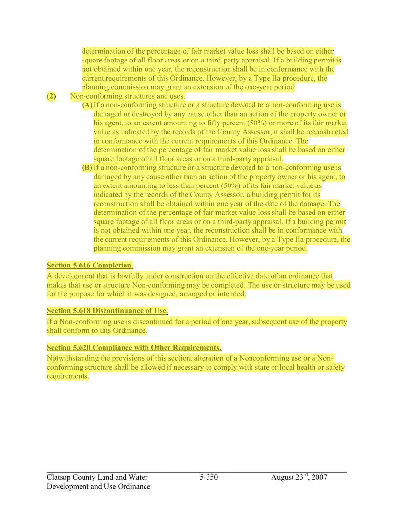
_____________________________________________________________________________ Clatsop County Land and Water 5-350 August 23rd, 2007 Development and Use Ordinance
determination of the percentage of fair market value loss shall be based on either square footage of all floor areas or on a third-party appraisal. If a building permit is not obtained within one year, the reconstruction shall be in conformance with the current requirements of this Ordinance. However, by a Type IIa procedure, the planning commission may grant an extension of the one-year period.
(2) Non-conforming structures and uses. (A) If a non-conforming structure or a structure devoted to a non-conforming use is
damaged or destroyed by any cause other than an action of the property owner or his agent, to an extent amounting to fifty percent (50%) or more of its fair market value as indicated by the records of the County Assessor, it shall be reconstructed in conformance with the current requirements of this Ordinance. The determination of the percentage of fair market value loss shall be based on either square footage of all floor areas or on a third-party appraisal.
(B) If a non-conforming structure or a structure devoted to a non-conforming use is damaged by any cause other than an action of the property owner or his agent, to an extent amounting to less than percent (50%) of its fair market value as indicated by the records of the County Assessor, a building permit for its reconstruction shall be obtained within one year of the date of the damage. The determination of the percentage of fair market value loss shall be based on either square footage of all floor areas or on a third-party appraisal. If a building permit is not obtained within one year, the reconstruction shall be in conformance with the current requirements of this Ordinance. However, by a Type IIa procedure, the planning commission may grant an extension of the one-year period.
Section 5.616 Completion. A development that is lawfully under construction on the effective date of an ordinance that makes that use or structure Non-conforming may be completed. The use or structure may be used for the purpose for which it was designed, arranged or intended.
Section 5.618 Discontinuance of Use. If a Non-conforming use is discontinued for a period of one year, subsequent use of the property shall conform to this Ordinance.
Section 5.620 Compliance with Other Requirements. Notwithstanding the provisions of this section, alteration of a Nonconforming use or a Non- conforming structure shall be allowed if necessary to comply with state or local health or safety requirements.
jhickner
Highlight
jhickner
Highlight

_____________________________________________________________________________ Clatsop County Land and Water 5-351 August 23rd, 2007 Development and Use Ordinance
SECTION 5.800. COLUMBIA RIVER ESTUARY IMPACT ASSESSMENT AND RESOURCE CAPABILITY DETERMINATION.
Section 5.810. Impact Assessment. The purpose of this section is to provide an assessment process for development alterations which could potentially alter the estuarine ecosystem. Oregon Statewide Planning Goal 16, Estuarine Resources, requires that actions which would potentially alter the Columbia River estuarine ecosystem be preceded by an assessment of potential impacts. The Impact Assessment need not be lengthy and complex, but it should enable reviewers to gain a clear understanding of the impacts expected.
Section 5.820. Impact Assessment Requirements. The following uses and activities, in addition to those so indicated in the aquatic zones, all require an Impact Assessment at the time a permit is reviewed: (1) Dredging (2) Aquatic area fill (3) In-water structures (4) Riprap (5) New in-water log storage areas (6) Application of pesticides and herbicides (7) Water intake or withdrawal (8) Effluent discharges (9) In-water dredged material disposal (10) Beach nourishment (11) Other uses or activities which could affect estuarine physical or biological resources (12) Uses or activities that require a Resource Capability Determination
Section 5.825. Use of Impact Assessment. Information contained in an Impact Assessment shall be used during the evaluation of a use or activity's significant impacts on the estuarine ecosystem; in determining whether potential impacts can be avoided or minimized; and for providing a factual base of information needed to address applicable standards in Section S4.200 through S4.243. Where a use or activity requires a Resource Capability Determination, information in the impact assessment can be used to satisfy the requirements of Section 5.870.
Section 5.830. Information to be Provided in the Impact Assessment. Information needed to complete the Impact Assessment should be obtained from sources other than the permit application (i.e. environmental impact statements, Columbia River Estuary Data Development Program data, other reports or data applicable to the Columbia River Estuary). An assessment of impacts of aquatic area pesticide and herbicide application may be provided by the Oregon Department of Agriculture and the Oregon Department of Environmental Quality. An assessment of the impacts of new point-source waste water discharges into the Columbia River Estuary may be provided through the National Pollution Discharge Elimination System (NPDES) permit program.
jhickner
Highlight
jhickner
Highlight
jhickner
Highlight

_____________________________________________________________________________ Clatsop County Land and Water 5-352 August 23rd, 2007 Development and Use Ordinance
A complete Impact Assessment includes the following information: (1) Aquatic life forms and habitat, including information on both the extent of and impacts
on: habitat type and use, species present (including threatened or endangered species), seasonal abundance, sediments, and vegetation.
(2) Shoreland life forms and habitat, including information on both the extent of and impacts on: habitat type and use, species present (including threatened or endangered species), seasonal abundance, soil types and characteristics, and vegetation present.
(3) Water quality, including information on: sedimentation and turbidity, dissolved oxygen, biochemical oxygen demand, contaminated sediments, salinity, water temperatures, and expected changes due to the proposed use or activity.
(4) Hydraulic characteristics, including information on: water circulation, shoaling patterns, potential for erosion or accretion in adjacent areas, changes in flood levels, flushing capacity, and water flow rates.
(5) Air quality, including information on quantities of particulates and expected airborne pollutants.
(6) Public access to the estuary and shoreline, including information on: proximity to publicly-owned shorelands and public street ends; effect of public boat launches, marinas and docks; and impact on inventoried public access opportunities.
(7) Navigation, including information on: distance from navigation channels, turning basins and anchorages; proximity to range markers.
(8) Demonstration that proposed structures or devices are properly engineered. (9) Demonstration that the project's potential public benefits will equal or exceed expected
adverse impacts. (10) Demonstration that non-water dependent uses will not preempt existing of future water-
dependent utilization of the area. (11) Determination of methods for mitigation and accommodation of the proposed
development, based on items (1) through (10) above, in order to avoid or minimize preventable adverse impacts.
Section 5.840. Impact Assessment Conclusion. Based on the information and analysis in Section 5.830, one of the following four conclusions shall be reached: (1) The proposed uses and activities do not represent a potential degradation or reduction of
estuarine resource. (2) The proposed uses and activities represent a potential degradation or reduction of
estuarine resources. The Impact Assessment identifies reasonable alterations or conditions that will eliminate or minimize to an acceptable level expected adverse impacts.
(3) The proposed uses and activities will result in unacceptable losses. The proposed development represents irreversible changes and actions and unacceptable degradation or reduction of estuarine resource properties will result.
(4) Available information is insufficient for predicting and evaluating potential impacts. More information is needed before the project can be approved.
Section 5.860. Resource Capability Determination.
jhickner
Highlight

_____________________________________________________________________________ Clatsop County Land and Water 5-353 August 23rd, 2007 Development and Use Ordinance
Some uses and activities in Columbia River Estuary Natural and Conservation Aquatic zones are allowed only if determined to meet the resource capabilities of the area and if determined to be consistent with the purpose of the affected zone. Some uses and activities in Development Aquatic zones are allowed only if determined to be consistent with the purpose of the zone.
Section 5.870. Resource Capability Procedure. A completed Resource Capability Determination consists of the following elements: (1) Identification of the affected area's zone, and its purpose. (2) Identification of the types and extent of estuarine resources present and expected adverse
impacts. This information is included in the Impact Assessment, Section 5.830. (3) A determination of whether the use or activity is consistent with the resource capabilities
of the affected zone. A use or activity is consistent with the resource capabilities of the area when either: (A) Impacts on estuarine resources are not significant; or (B) Resources of the area will be able to assimilate the use and activity and their affects
and continue to function in a manner which: 1) In Aquatic Natural designations, protects significant fish and wildlife
habitats, natural biological productivity, and values for scientific research and education; or
2) In Aquatic Conservation designations, conserves long term use of renewable resources, natural biological productivity, recreation and aesthetic values and aquaculture.
(C) For temporary alterations, the Resource Capability Determination must also include: (A) Determination that potential short term damage to estuary and shoreland resources is
consistent with the resource capabilities of the area; and (B) Determination that the area and affected resources can be restored to their original
condition.
Section 5.880. Determining Consistency with the Purpose of the Zone. Certain uses in Aquatic Development, Aquatic Conservation and Aquatic Natural zones may be permitted only if they are consistent with the purpose of the aquatic zone in which they occur. A Consistency Determination consists of the following elements: (1) Identification of the affected zone and its purpose. (2) Description of the proposed project's potential impact on the purposes of the affected
zone. (C) Determination that the proposal is either: (A) Consistent with the purpose of the affected zone; (B) Conditionally consistent with the purpose of the affected zone; or (C) Inconsistent with the purpose of the affected zone.
jhickner
Highlight

_____________________________________________________________________________ Clatsop County Land and Water 5-354 August 23rd, 2007 Development and Use Ordinance
SECTION 5.950. ECOLA CREEK ESTUARY AND NECANICUM ESTUARY IMPACT ASSESSMENT AND RESOURCE CAPABILITY DETERMINATION.
Section 5.952. Purpose. The purpose of this section is to provide an assessment process for development alterations which could potentially alter the integrity of the estuarine ecosystem. Further, certain uses and activities proposed for particular management areas and zones will require an assessment of resource capability of the zone. The impact assessment procedure is intended to be a comprehensive presentation of the impacts expected from a particular development proposal. This procedure will provide the information necessary to judge the capability of the resource to accommodate the identified impacts without altering the integrity of the resource as it relates to the stated purpose of the particular management area or zone. (1) Impact Assessment Requirement. An Impact Assessment in accordance with the
provisions of this section shall be required for the following uses and activities when proposed for estuarine aquatic areas: (A) Filling or dredging (B) In-water structures (C) Riprap (D) Water intake or withdrawal (E) Pesticide application (F) Effluent discharge (G) Other activities which could affect the estuary's physical processes or biological
resources
Further, an Impact Assessment shall be required: (A) When a use or activity requires a determination of consistency with resource
capability.
Note that Federal Environmental Impact Statement or Environmental Assessments may substitute for this requirement if available at the time of permit review. The Community Development Director may require an impact assessment for uses not listed above when the Director believes the use may involve significant impacts. (B) Use of Impact Assessment. (A) Information contained in impact assessments shall be used in the evaluation of a use
or activity during permit review procedure. The Impact Assessment shall be used to: 1) identify potential development alterations of significant estuarine fish and
wildlife habitats and disturbances of essential properties of the estuarine resource,
2) determine whether potential impacts can be avoided and minimized, and 3) to provide a factual base of information that will ensure that applicable
standards in Section 5.950 are met.
jhickner
Highlight
jhickner
Highlight

_____________________________________________________________________________ Clatsop County Land and Water 5-355 August 23rd, 2007 Development and Use Ordinance
(B) Where a use requires a Resource Capability Determination, information in the Impact Assessment will be used to determine consistency of proposed uses and activities with the resource capability and purpose of the affected management area or zone. Resource capability analysis shall be based on the requirements of the "Information to be Provided in the Impact Assessment" section.
(C) Information to be Provided in the Impact Assessment. Information compiled in the Impact Assessment may be drawn from available data and analysis contained in: Ecola Estuary Inventory, Necanicum Estuary Inventory, environmental impact statements of environmental assessments prepared for previous projects in the vicinity of the present development proposal; or other published environmental and estuarine studies pertaining to the estuary. The Impact Assessment should apply available information to the following general areas of analysis. The County may waive inapplicable items for any particular use or project.
(A) Aquatic life forms and habitat, including information on: habitat type and use (e.g. rearing, spawning, feeding/resting area, migration route), species present, seasonal abundance, sediment type and characteristics, vegetation present. Type of alteration, including information detailing the extent of alteration (e.g. area measurement, depths to which alteration will extend, volumes of materials removed and/or placed as fill), impacted species (including threatened or endangered species), life stages and life cycles affected with regard to timing of the proposed alteration, percent of total available habitat type subject to alteration.
(B) Shoreland life forms and habitat, including information on: habitat type and use (e.g. feeding, resting or water areas, flyways), species present, seasonal abundance, soil types and characteristics, vegetation present. Type of alteration, including information detailing the extent of alteration (e.g. area measurement, extent of grading and excavation, removal of riparian vegetation), impacted species (including threatened or endangered species), life stages and cycles affected with regard to timing of the proposed alteration, percent of total available habitat type subjected to alteration.
(C) Water quality, including information on: increases in sedimentation and turbidity, decreases in dissolved oxygen concentration, changes in biological and chemical oxygen demand, contaminated sediments, alteration of salinity regime, disruption of naturally occurring water temperatures, changes due to reduction, diversion or impoundment of water.
(D) Hydraulic characteristics, including information on: changes in water circulation patterns, shoaling patterns, potential of erosion or accretion in adjacent areas, changes in the floodplain, decreases in flushing capacity or decreases in rate of water flow from reduction or diversion or impoundment of water sources.
(E) Air quality, including information on: quantities of emissions of particulates, expected inorganic and organic airborne pollutants.
(F) The impact of the proposed project on navigation and public access to shoreline and aquatic areas.
(G) Demonstration that any proposed structures or devices are properly engineered. (H) Demonstration that the project's potential public benefits will equal or exceed
expected adverse impacts. (I) Demonstration that non-water dependent uses will not preempt existing or future
water-dependent utilization of the area.
jhickner
Highlight
jhickner
Highlight

_____________________________________________________________________________ Clatsop County Land and Water 5-356 August 23rd, 2007 Development and Use Ordinance
(J) Determination of the potential cumulative impact of the proposed development, including alteration of adjacent significant estuarine fish and wildlife habitat and disturbance of essential properties of the estuarine resources.
(K) Determination of methods for accommodation of the proposed development alteration, based on items (A) through (J) above, in order to minimize preventable adverse impacts. Determination of need for mitigation.
(L) Impact Assessment Findings. Resulting from the analysis of the information presented in the Impact Assessment, one of the following findings shall be concluded:
(A) The proposed uses and activities are in conformance with all Comprehensive Plan policies and standards and do not represent a potential degradation or reduction of significant fish and wildlife habitats and essential properties of the estuarine resource. Where an Impact Assessment is required for a resource capability determination, the proposed uses are consistent with the resource capability and purpose of the affected management area or zone.
(B) The proposed uses and activities are in conformance with all Comprehensive Plan policies and standards, but represent a potential degradation or reduction of significant fish and wildlife habitats and essential properties of the estuarine resource. The Impact Assessment is required for a resource capability determination, the adverse environmental impacts have been minimized to be consistent with the resource capability of the management area or zone. The proposed uses and activities may be accommodated and found to be consistent with resource capabilities and meet the purposes of the management.
(C) The proposed uses and activities are not in conformance with all Comprehensive Plan policies and standards. The Impact Assessment and analysis indicate that unacceptable loss will result from the proposed development alteration. The proposed uses and activities represent irreversible changes and actions and unacceptable degradation or reduction of significant estuarine fish and wildlife habitats and essential properties of the estuarine resource will result; or, that the adverse consequences of the proposed uses and activities, while unpredictable and not precisely known, would result in irreversible trends or changes in estuarine resource properties and functions.
(D) Available information is insufficient for predicting and evaluating potential impacts. More information is needed before the project can be approved.
Section 5.960. Resource Capability Determination. (1) Purpose. Certain uses and activities in Conservation and Natural aquatic management
units are allowed only if determined to meet the resource capability and purpose of the zone in which the use or activity occurs. The purpose of this section is to establish procedures for making a resource capability determination.
(2) Definition of Resource Capability. Resource capability is defined as the degree to which the natural resource can be physically, chemically, or biologically altered, or otherwise assimilate an external use and still function to achieve the purpose of the zone in which it is located.
(3) Purpose of Different Estuarine Zones. (A) Aquatic Conservation zone: The purpose of the Aquatic Conservation zone is to
designated areas for long term uses of renewable resources that do not require major
jhickner
Highlight
jhickner
Highlight

_____________________________________________________________________________ Clatsop County Land and Water 5-357 August 23rd, 2007 Development and Use Ordinance
alteration of the estuary, except for the purpose of restoration. These areas shall be managed to conserve the natural resources and benefits. These shall include areas needed for maintenance and enhancement of biological productivity, recreational and aesthetic uses, and aquaculture. Included are tracts of significant habitat, and recreational shellfish beds. Areas which are partially altered and adjacent to existing development of moderate intensity are also included.
(B) Aquatic Natural zone: The purpose of the Aquatic Natural zone is to provide for preservation and protection of estuarine resources, including significant fish and wildlife habitats, essential properties of the estuary, such as dynamic geological processes, continued biological productivity, unique communities of organisms, maintenance of species diversity. Low intensity uses consistent with the protection of natural values are appropriate.
(E) Resource Capability Procedure. In order to determine whether a use or activity is consistent with the resource capability and purpose of the zone for which the use or activity is proposed, the following procedure is required:
(A) Identification of the zone and area in which the activity is proposed and the resources in the area;
(B) Identification of adverse impacts of the proposed use or activity on the resources identified in (A) above. This information is included in the Impact Assessment section 5.950.
(C) Determination of whether the resources can continue to achieve the purpose of the zone in which the use or activity is proposed.
(D) Identification of Resources and Impacts. The applicant for a proposed use or activity in which a resource capability determination must be made shall submit the following:
(A) Information on resources present in zone in which the use or activity is proposed; (B) Impact assessment as specified in Section 5.950, Impact Assessment Procedure.
(Federal Environmental Impact Statements or Environmental Assessments may be substituted if available at the time of the permit request).
If in the course of review, additional information is required to satisfy the provisions of this ordinance, notification shall be made to the applicant outlining the additional information needed and the reason. Although the applicant shall be responsible for providing all necessary information, the Planning Department will assist the applicant in identifying inventory sources and information. Sources which can be used to identify resources included: Necanicum Estuary Inventory, environmental impact statements for project in same areas, or other published studies concerning the Necanicum Estuary. Identification of resources shall include both environmental (e.g. aquatic life and habitat present, benthic populations, migration routes) and social and economic factors (navigation channels, public access facilities).
jhickner
Highlight
jhickner
Highlight

_____________________________________________________________________________ Clatsop County Land and Water 5-358 August 23rd, 2007 Development and Use Ordinance
(C) Resource Capability Administrative Provisions. A resource capability determination for a use or activity identified in this ordinance as a Conditional Use shall be made in accordance with the Conditional Use procedure set forth in Section 5.000. Public notice of development proposals which require determination of consistency with resource capabilities shall be sent to all affected parties. State and federal resource agencies with mandates and authorities for planning, permit issuance and resource decision-making, including the following, will be notified: Oregon Department of Fish and Wildlife, Oregon Division of State Lands, Oregon Department of Land Conservation and Development, U.S. Fish and Wildlife Service, National Marine Fisheries Service, Environmental Protection Agency, U.S. Army Corps of Engineers.
Section 5.970. Revocation of Permits. (1) Any conditions placed upon a development permit by this ordinance, the Planning
Director, the Hearings Officer, the Planning Commission and/or the Board of Commissioners shall be strictly followed. In the event that the permit holder, or his assignee, fails to comply with any such conditions the underlying development permit may be revoked or modified as set forth below.
(2) When it comes to the attention of the Community Development Director that the permit holder, or his assignee, is not complying with any conditions of the permit, the Community Development Director shall undertake an investigation. If the Community Development Director determines that one or more conditions are not being met he shall cause a notice to be mailed to the permit holder or his assignee by regular mail advising him of the deficiency and requiring that the deficiency be remedied within fourteen (14) days from the date the notice is mailed or such longer period as the Community Development Director may deem appropriate.
(3) Should the permit holder or his assignee fail to remedy the deficiency within the time period set by Section 5.970(2) then the Community Development Director shall cause a notice to be mailed to the permit holder and/or his assignee advising him of his intent to revoke the development permit. Such notice shall provide that to avoid such action the permittee must request, in writing, a hearing before the Hearings Officer and then appear and show cause why his permit should not be revoked. Such a hearing request must be filed within fourteen (14) days of the date of the notice of intent to revoke. Upon appeal the Hearings Officer may uphold the permit should it determine that all conditions have been met or no longer need to be met; modify or add conditions to the permit; or revoke the permit. Appeals to the Hearings Officer shall be handled as a Type IIa proceeding. Should a permittee fail to file a timely request for hearing, then the Community Development Director shall send him a notice advising him that his development permit has been revoked and that any further action thereon would be in violation of Clatsop County Land and Water Development and Use Ordinance.
(4) The provisions of Section 5.970 shall apply to all development permits issued prior to the date of its enactment, as well as all development permits issued thereafter.
jhickner
Highlight
_____________________________________________________________________________ Clatsop County Land and Water 6-359 August 23rd, 2007 Development and Use Ordinance
ARTICLE 6. GENERAL PROVISIONS
Section 6.010. Authorization of Similar Development. If development that has been referred to a hearing body by the Director for evaluation under the Type III procedure is found comparable to development that is allowed in an area under the Type I or II procedure, the hearing body may rule that future development of the same kind shall be approved under the Type I or II procedure in the specified district or zone. To make such a ruling, the hearing body shall do the following: (1) Make a determination as part of a Type III decision in conjunction with approval of a
development that is substantially the same as an earlier development approved under the Type III procedure.
(2) Determine that the development is comparable to other development allowed in the area by either the Type I or II procedure. Similarity can be based on compliance with plan policy and standards, if appropriate within the context of the requirements for the area and type of development, as well as on language interpretation similarity.
(3) If approval and classification as a Type I or II development is dependent upon compliance with standards beyond those contained in the Development and Use Standards Document, prepare and add to the standards document the appropriate standards to be applicable to all future development.
(4) Report the determination to the Board of Commissioners at least thirty (30) days prior to the effective date of the ruling. The ruling will not become effective if the Board of Commissioners moves to have the matter addressed as an Ordinance amendment.
Section 6.015. Maintenance of Ordinance Requirements. No lot area (except as may be permitted under a lot line adjustment), yard, or other open space, required off-street parking or loading area or other site condition existing on or after the effective date of this Ordinance shall be reduced in area, dimension or size below the minimum required by this Ordinance, nor shall any site condition which is required by this Ordinance for one development be used to meet a requirement for any other development except as authorized.
Section 6.020. Access. Every lot shall abut a street, other than an alley, for at least twenty-five (25) feet. Lots which were created prior to adoption of Ordinance No. 66-2 which do not meet this provision may be built on if it is determined by the Community Development Director under a Type I procedure that: (1) Access to be provided is adequate to handle the types and amount of traffic expected for
the use. (2) Access width is adequate for fire protection vehicles.
Section 6.110. Bond or Cash Deposit. Before issuing or renewing a development permit when the applicant has an obligation to construct or improve public facilities to serve the development and use or to reclaim land such as that due to surface mining operations or to fulfill requirements for revegetation, or for any development and use that the Community Development Director, Planning Commission or Board of Commissioners deem necessary, the obligation shall either be fulfilled prior to the
jhickner
Highlight

_____________________________________________________________________________ Clatsop County Land and Water 6-360 August 23rd, 2007 Development and Use Ordinance
issuance of the development permit or the applicant shall be required to file with the County Clerk and acknowledgment of obligation. The acknowledgment shall contain the time within which it is to be met and a surety bond or cash or negotiable security deposit sufficient to cover the cost of the work as estimated by the County Engineer for the year fulfillment of the obligation is anticipated. The bond shall be conditioned upon the permittee carrying out the obligation and fulfilling the other requirements of this Ordinance that bear on the approval of the development. The deposit or bond shall be forfeited to the County if the permittee does not fulfill the requirements. The bond or deposit shall remain in the custody of the County until the obligation is completed or the bond or deposit is forfeited, or shall be placed in an escrow account subject to County control.
Section 6.120. Non-Compliance with Provisions Under Obligation. (1) If the Director finds that a permittee is not fulfilling an obligation, the Director shall, in
written notice to the permittee and the permittee's surety, specify the details of non- compliance. Unless the Director allows more time for compliance because of circumstances beyond the permittee's control, within thirty (30) days after receiving the notice, the permittee or the permittee's surety shall commence the compliance and proceed diligently to complete fulfillment of the obligation.
(2) If the permittee or the permittee's surety does not commence the compliance within the thirty (30) days or the additional time allowed by the Director, or has so commenced but fails diligently to complete the compliance, or the compliance is otherwise not completed within the time specified in granting the development permit, the County may take the following action: (A) Enter upon the site of the development and carry out the obligation in accordance
with the provisions agreed upon under the acknowledgment. (B) Notify the permittee and the permittee's surety of the permittee's failure to perform
as required by this Ordinance. (C) Demand payment from the permittee for the unfulfilled obligation. (D) If the security for the obligation is a bond, notify the surety that has furnished the
bond that reimbursement for the expense for fulfillment of the obligation is due and payable to the County or, if the security is a deposit of cash or other assets, appropriate as much of the deposit as is necessary to recoup the expenses.
(D) If a bond or other security required by Section 6.110 is not sufficient to compensate the County for expenses necessary to fulfill the obligation, the amount due to the County for the obligation is a lien in favor of the County and upon the entire contiguous real property of the owner of the land subject to the obligation.
(E) The lien attaches upon the filing with the County Clerk of notice of the claim for the amount due for the fulfillment of the obligation. The notice shall demand the amount due, allege the insufficiency of the bond or other security to compensate the County fully for the expense of the fulfillment of the obligation, and allege the permittee's failure to do the required obligation.
(F) The lien may be foreclosed in the manner prescribed by law for foreclosing other liens on real property.
Section 6.150. Adjusting Bond or Deposit for Future Obligation.

_____________________________________________________________________________ Clatsop County Land and Water 6-361 August 23rd, 2007 Development and Use Ordinance
(1) In the case of an obligation to perform at a future date, such as a surface mining reclamation obligation, the amount of bond or deposit shall be adjusted annually to reflect changing estimates of the costs of fulfilling the obligation.
(2) In the case of a surface mining reclamation obligation the bond shall be no less than an amount comparable to $600 per acre in 1978, and the minimum bond shall be adjusted by the County Engineer annually on the basis of changes in generally accepted economic indices of construction costs and costs of living. If the acreage to which the bond or deposit pertains and is designated by the permittee, excavation may take place only within the acreage so designated. Otherwise, the acreage to which the bond or deposit pertains and on which excavation may take place in the entire mining site. The permittee may apply for release of a bond or deposit pertaining to an area that has not been mined and is not intended to be mined or that has been mined and reclaimed in conformity to these standards. Within thirty (30) days after the application is filed, the Director shall consider the application. If the Director determines that the area, if unmined, is expected to remain so for the foreseeable future or if mined has been reclaimed in conformity to this Ordinance, the Director shall release the bond or deposit to the extent that is pertains to that area.
(3) Where the County carries out the obligation because the permittee has failed to do so under Section 6.120, the County may expend funds only to the extent necessary to complete the obligation. If the amount specified in the notice to the surety is not paid within thirty (30) days after that notice is given the surety, the County shall institute proceedings to recover the amount.
(4) A lien created under this Section is prior to all other liens and encumbrances, except that the lien has equal priority with tax liens.
Section 6.180. Fees and Deposits. Fees and deposits shall be set and adjusted by Board of Commissioners resolution.
Section 6.210. Interpretation. Where the conditions imposed by a provision of this Ordinance are less restrictive than comparable conditions imposed by any other provisions of this Ordinance or any other Ordinance, the provisions which are more restrictive shall govern.
Section 6.220. Severability. The provisions of this Ordinance are severable. If any section, sentence, clause or phrase of this Ordinance is adjudged by a court of competent jurisdiction to be invalid, the decision shall not affect the validity of the remaining portions of this Ordinance.


![WATER ORDINANCE, 1994 - Sarawaklawnet.sarawak.gov.my/lawnet_file/Subsidiary/SUB_Swk. L.N. 50_95h… · WATER ORDINANCE, 1994 THE WATER SUPPLY REGULATIONS, 1995 [Swk. L.N. 50/95] ...](https://static.fdocuments.net/doc/165x107/5ab1b3417f8b9a00728ca694/water-ordinance-1994-ln-5095hwater-ordinance-1994-the-water-supply-regulations.jpg)