Classes 6 and 7 - Gravity and its importance to Geodesy
80
Classes 6 and 7 - Gravity and its importance to Geodesy 2 and 4 February 2010 1 Wednesday, February 3, 2010
Transcript of Classes 6 and 7 - Gravity and its importance to Geodesy

Classes 6 and 7 - Gravity and its importance to Geodesy
2 and 4 February 20101
Wednesday, February 3, 2010

Relative Gravity meters
Wednesday, February 3, 2010

Schedule for this week
• Exam 1 this Thursday during Lab period• You are responsible for material in Chapters
1-4 in text, homework as well as all lectures and labs to date.
• It is open book and access to the Internet will be needed.
Wednesday, February 3, 2010

Natural Coordinates
Wednesday, February 3, 2010

Same Point in XYZ system
Wednesday, February 3, 2010

Geocentric v Geodetic Latitude
Wednesday, February 3, 2010

LLHs <-> XYZ
Wednesday, February 3, 2010

Wednesday, February 3, 2010

Wednesday, February 3, 2010

The System of Natural Coordinates
• Axes are defined by meaningful directions: the gravity vector and of the spin axis of the Earth.
• Gravity vector defines the up-down direction– Orthogonal to a level
surface.
• There is a difference between the gravity vector and normal to ellipsoid.
Wednesday, February 3, 2010

Wednesday, February 3, 2010

Universal Law of Gravitation
• Newton formulated the law (1687) to reflect the attraction of two point masses separated by a distance.
• f = G* [ (m*m’)/l2]– ( f is force, m and m’ are point masses, l is
distance and G is Newton’s gravitational constant)
• Currently accepted value for G – 6.67259 x 10⁻¹¹m3kg-1s-2
Wednesday, February 3, 2010

More mind-numbing detail…
• At latitude p, a conventional value of the acceleration of gravity at sea level is given by the International Gravity Formula, – g = 978.0495 [1 + 0.0052892 sin2(p) - 0.0000073 sin2
(2p)] cm per second per second (cm s-2). • The mean Earth gravity is about 981 000 mGal
(the well-known 9.81 m/s2), varies from 978,100 mGal to 983,200 mGal from Equator to pole due to the Earth's flattening and rotation.
Wednesday, February 3, 2010

• The magnitude of acceleration (b) due to the Earth’s mass on the surface using a spherical geometric reference surface (R) is:– b = GM/R2
Gravitational Acceleration
Wednesday, February 3, 2010

Centrifugal Acceleration
• Direction is always perpendicular outward from the spin axis.
• It is a function of angular velocity of the Earth squared and the distance from the point of interest on the surface of the sphere to the axis of rotation.
• ω = 7292115e-11rad sec-1• We can compute this value as ratio of
degrees over time.
Wednesday, February 3, 2010

Wednesday, February 3, 2010

• Is the vector sum of gravitational and centrifugal acceleration.
• The actual acceleration of gravity varies from place to place, depending on latitude, altitude, and local geology.
• By agreement among physicists, the standard acceleration of gravity (gn) is defined to be exactly 9.80665 meters per second per second (m s-2), or about 32.174 05 feet per second per second.
Gravitational Attraction
Wednesday, February 3, 2010

• Varies from equator to poles.• Compute magnitude by velocity squared
times the distance from the point of interest to the spin axis.
Magnitude of centrifugal acceleration
Wednesday, February 3, 2010

Gravity and Geodesy
• Defines a plumb line (local vertical) defined by gravity.
• Gravity also serves as an important reference surface. It is the level surface that is perpendicular to the plumb line at all points.
Wednesday, February 3, 2010

• Magnitude of the potential is the work that must be done by gravity to move a unit mass from infinity to the point of interest.
• Is dependent on position within the gravitation field.
Gravitational Potential
Wednesday, February 3, 2010

• Surface having constant gravity potential.– Also known as level surfaces or geopotential
surfaces.• Surfaces are perpendicular at all points of
the plumb line (gravity vector).• Potential field is a scalar field from
which the vector gravity field can be found.
• A still lake surface is an equipotential surface. – It is not horizontal but curved.
Equipotential Surfaces
Wednesday, February 3, 2010

• They are closed continuous surfaces that never cross one another.
• They are formed by long radius arcs. Generally without abrupt steps.
• They are convex everywhere.
Properties of equipotential surfaces
Wednesday, February 3, 2010

Wednesday, February 3, 2010

Image from Featherstone, W, “Height Systems and Vertical Datums” Spatial Science, Vol 51 No. 1, June 2006
Wednesday, February 3, 2010

Gravity defines the plumb line – the local vertical
Wednesday, February 3, 2010

What is Geodesy?
• “Geodesy is the discipline that deals with the measurement and representation of the earth, including its gravity field, in a three-dimensional time varying space.” – definition adopted by the National Research
Council of Canada in 1973. (Vanicek, P.K. and Edward Krakiwsky, E.(1986) Geodesy: The Concepts. Elsevier).
Wednesday, February 3, 2010

Another definition
• “The task of geodesy is the determination of the potential function W(x,y,z)” i.e. of the gravity potential of the Earth. – By Heinrich Bruns (1878)
• Both definitions indicate the linkages between positioning and gravity field determination.
Wednesday, February 3, 2010

Integrated Geodesy
• Also called “Operational Geodesy”• Integrated geodesy is a method in which a
wide variety of surveying measurements are modeled in terms of geometric positions and the earth’s geopotential.– Both geometric and gravimetric data are
simultaneously estimated using Least Squares.
Wednesday, February 3, 2010

Absolute Gravity Meters
Mendenhall pendulum gravity meter Accuracy +/-0.6 to 5 mGals
Wednesday, February 3, 2010

How does it work?
• Motion of a test mass free falling in a vacuum is interferometrically measured with respect an inertial reference.
• Controlled carriage assembly releases the test mass (a corner cube retroreflector mounted in an aluminum housing).
• The inertial reference is another corner cube retroreflector mounted on a force feedback long period (60sec) seismometer.
• Non-gravitational forces are minimized (air drag, electrostatics, and eddy current damping).
Wednesday, February 3, 2010

Wednesday, February 3, 2010

Gravity change
• FG5 accuracy:
14
Instrument 1.1 µGals
Environmental: 1.5 µGals
Observational error: ~0.4 µGals
RMS of above at instrument height (131 cm): 1.9 µGals
RMS with relative transfer to mark or excenter: 3 to 8 µGals
• +3 µGals corresponds to -1 cm elevation change
+7½ foot rise in water-table
GPS to resolve ambiguity
• Can also measure magma insertion
sea level change (with tide record comparisons)
glacial ice mass change
Wednesday, February 3, 2010

Wednesday, February 3, 2010

Wednesday, February 3, 2010

26
-12
-8
-4
0
4
8
12
16
20
24
28
32
1980 1983 1985 1988 1991 1994 1996 1999 2002 2005 2007 2010
CHURCHILL, MANITOBAg
- 981
7528
00 µ
GA
L
TIME (Yrs)
Gravity Values+ 95% Error Bound- 95% Error BoundTrend -1.91 ± 0.19 µGal/Yr
ICE-3G Theoretical (-1.11 µGal/yr)
2 cm uplift
Wednesday, February 3, 2010

Wednesday, February 3, 2010

Wednesday, February 3, 2010

Wednesday, February 3, 2010

Wednesday, February 3, 2010

Wednesday, February 3, 2010

Two models provide similar but not identical results. Difference is 1 mgal.
Wednesday, February 3, 2010

Which model to use?
• NAVD88 - Modeled Gravity uses a model developed for the NAVD88 adjustment rather than current gravity values.
Wednesday, February 3, 2010
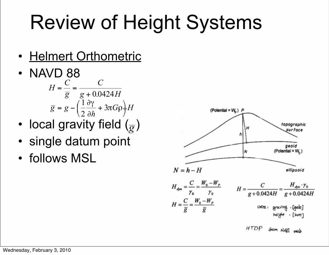
Review of Height Systems• Helmert Orthometric• NAVD 88
• local gravity field ( )• single datum point• follows MSL
Wednesday, February 3, 2010

Earth’s Gravity Field from Space• Satellite data was used
for global models– Only useful at
wavelengths of 700 km or longer
• Lower wavelength data from terrestrial or marine gravity of varying vintage, quality and geographic coverage
Terrestrial and marine gravity data in NGS data base.
Wednesday, February 3, 2010

Note the discontinuity at the shoreline.
Wednesday, February 3, 2010

Gravity
• Static gravity field – Based on long-term average within Earth
system• Temporally changing component
– Motion of water and air– Time scale ranges from hours to decades.
• Mean and time variable gravity field affect the motion of all Earth space vehicles.
Wednesday, February 3, 2010

Geoid
• The equipotential surface of the Earth's gravity field which best fits, in a least squares sense, global mean sea level.
Wednesday, February 3, 2010

48
Wednesday, February 3, 2010

49
GEOID 2009
Wednesday, February 3, 2010

Leveling Issues
• Height – The distance measured along a perpendicular
between a point and a reference surface.• Raw leveled heights
– Non-unique. Depending on the path taken a different height will be determined for the same point. They have NO physical relevance.
Wednesday, February 3, 2010

Wednesday, February 3, 2010

Equipotential Surfaces
HCHA
Reference Surface (Geoid)
ΔHAC ≠ ΔhAB + ΔhBC
Observed difference in orthometric height, ΔH, depends on the leveling route.
AC
B Topography
Δ hAB
Δ h = local leveled differences
Leveled Height vs. Orthometric Height
= Δ hBC
ΔH = relative orthometric heights
Wednesday, February 3, 2010

Wednesday, February 3, 2010

Dynamic Heights
• Takes the geopotential number at a point and divides it by a constant gravity value.
• The constant value used in the US is the normal gravity value at 45 degrees N latitude – 980.6199 gals
Wednesday, February 3, 2010

CC area Dynamic Heights
NAVD 88 and dynamic heights differ by only 1 mm at this station.
Wednesday, February 3, 2010

Dynamic Heights
NAVD 88 = 2026.545 m
DYN Hght= 2023.109
Difference = 3.436 m
Wednesday, February 3, 2010

Wednesday, February 3, 2010

Dynamic Height Problems
• Dynamic height corrections applied to spirit-leveled height differences can be very large (several meters) if the chosen gravity value is not representative for the region of operation.
Wednesday, February 3, 2010

Orthometric correction
• Occurs because equipotential surfaces are not parallel.
• In general, not parallel in a N-S direction but they are parallel in an E-W direction.
• It is computed as a function of mean orthometric height and latitude of section.
Wednesday, February 3, 2010

Leveled v Ortho. Height Diffs
• Due to non-parallelism of level surfaces the differences between published NAVD 88 points do not correspond to the leveled height difference.
• Therefore the subtraction of the published NAVD 88 heights on the NGS datasheets will NOT agree with the leveled difference.
• This is problem mostly in high elevations.
Wednesday, February 3, 2010

Wednesday, February 3, 2010

An example from Colorado
• The difference between published NAVD 88 heights is 402.156 m.
• The leveled difference is 402.085 m.
Wednesday, February 3, 2010

Reminder
• You are responsible for the material listed as REQUIRED ADDITIONAL READING in the Class 5 section of the web page.
Wednesday, February 3, 2010

Wednesday, February 3, 2010

http://www.ngs.noaa.gov/GRAD-D
Wednesday, February 3, 2010

Wednesday, February 3, 2010

Wednesday, February 3, 2010

68
Wednesday, February 3, 2010

Gravity field and steady-state Ocean Circulation Explorer
Wednesday, February 3, 2010

Wednesday, February 3, 2010

Wednesday, February 3, 2010

Wednesday, February 3, 2010

Gravity Recovery And Climate Experiment
www.csr.utexas.edu/grace/gravity/
Wednesday, February 3, 2010

Wednesday, February 3, 2010

GRACE
Wednesday, February 3, 2010

How does GRACE work?
• Motion of two satellites differ because they are at different positions in space.
• When the lead SV approaches a higher gravity mass it accelerates as it moves beyond it decelerates.
• Distance changes between SVs is measured precisely.
Wednesday, February 3, 2010

Orbit inclination: 89.048 degreesEccentricity: 0.000775Semi-major axis: 6,849,706.754mDistance between satellites: 222,732.810 m
Wednesday, February 3, 2010

Geoid Model from Earth Orbiting Space Vehicles (pre-GRACE)
Wednesday, February 3, 2010

GRACE 111 days of data
Wednesday, February 3, 2010

GRACE 363 days of data
Wednesday, February 3, 2010