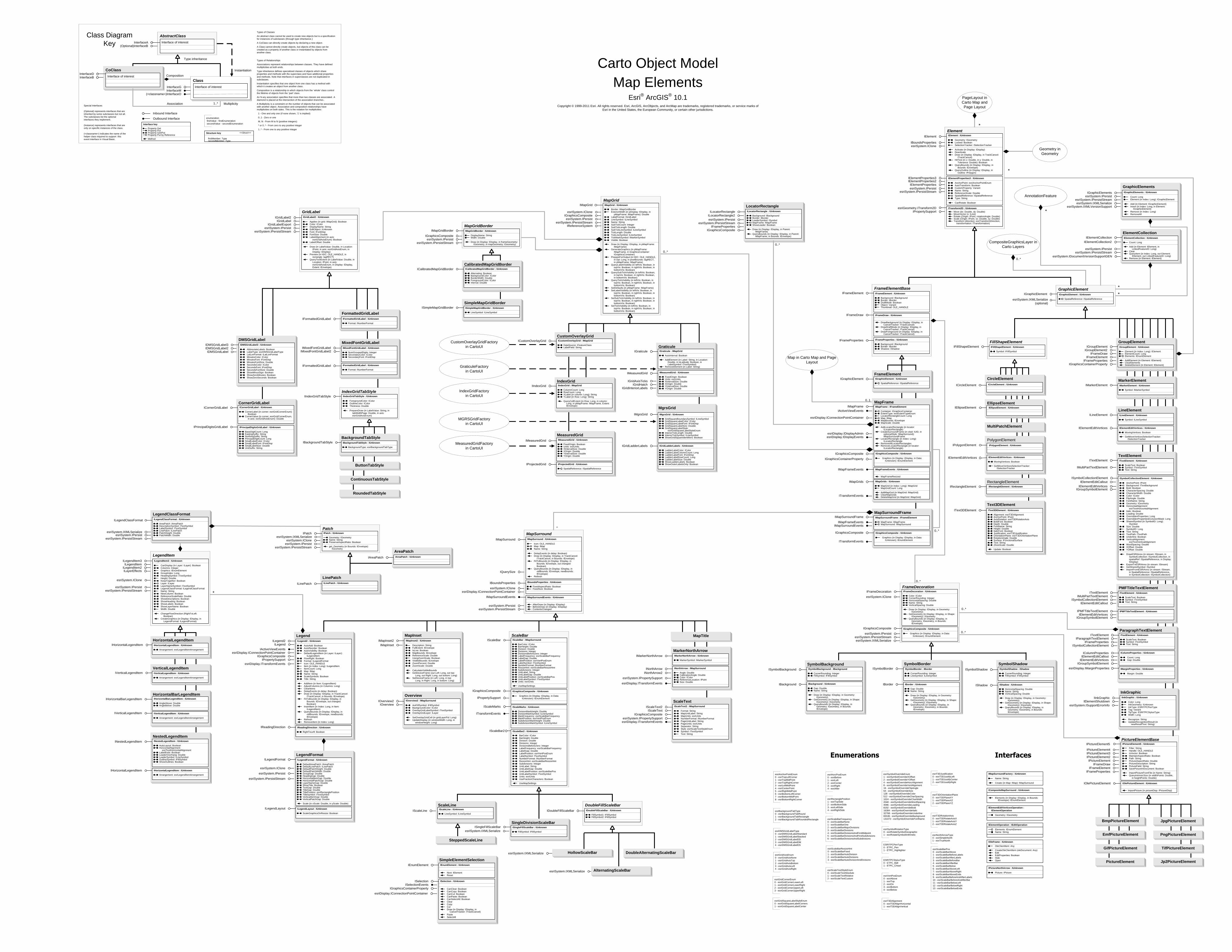
Class Diagram AbstractClass -...
12
MapDocument IMapDocument esriSystem.IDocumentVersion IDocumentInfo IDocumentInfo2 IDocumentPreview IMapDocument : IUnknown ActiveView: IActiveView DocumentFilename: String DocumentType: esriMapDocumentType DocumentVersion: esriMapDocumentVersionInfo IsMapDocument (in sDocument: String): Boolean IsPasswordProtected (in sDocument: String): Boolean IsPresent (in sDocument: String): Boolean IsReadOnly (in sDocument: String): Boolean IsRestricted (in sDocument: String): Boolean Layer (in mapIndex: Long, in layerIndex: Long): ILayer Map (in mapIndex: Long): IMap MapCount: Long PageLayout: IPageLayout Printer: IPrinter Thumbnail: IPicture UsesRelativePaths: Boolean Close GetVersionInfo (in versionInfoMissing: Boolean, in lMajor: Long, in lMinor: Long, in lRevision: Long, in lBuild: Long) New (in sDocument: String) Open (in sDocument: String, in bsPassword: String) ReplaceContents (in pObject: IMxdContents) Save (in bUseRelativePaths: Boolean, in bCreateThumnbail: Boolean) SaveAs (in sDocument: String, in bUseRelativePaths: Boolean, in bCreateThumnbail: Boolean) SetActiveView (in pActiveView: IActiveView) CoClass InterfaceD InterfaceB Types of Classes An abstract class cannot be used to create new objects but is a specification for instances of subclasses (through type inheritance.) A CoClass can directly create objects by declaring a new object. A Class cannot directly create objects, but objects of this class can be created as a property of another class or instantiated by objects from another class. Types of Relationships Associations represent relationships between classes. They have defined multiplicities at both ends. Type inheritance defines specialized classes of objects which share properties and methods with the superclass and have additional properties and methods. Note that interfaces in superclasses are not duplicated in subclasses. Instantiation specifies that one object from one class has a method with which it creates an object from another class . Composition is a relationship in which objects from the 'whole' class control the lifetime of objects from the 'part' class. An N-ary association specifies that more than two classes are associated. A diamond is placed at the intersection of the association branches . A Multiplicity is a constraint on the number of objects that can be associated with another object. Association and composition relationships have multiplicities on both sides. This is the notation for multiplicities: 1 - One and only one (if none shown, '1' is implied) 0..1 - Zero or one M..N - From M to N (positive integers) * or 0..* - From zero to any positive integer 1..* - From one to any positive integer Class Diagram Key enumeration firstValue - firstEnumeration secondValue - secondEnumeration AbstractClass Type inheritance Instantiation Association Composition 1..* Multiplicity Interface of interest InterfaceA (Optional)InterfaceB Interface of interest InterfaceG InterfaceM Outbound Interface Inbound Interface Special Interfaces (Optional) represents interfaces that are inherited by some subclasses but not all. The subclasses list the optional interfaces they implement. (Instance) represents interfaces that are only on specific instances of the class. (<classname>) indicates the name of the helper class required to support this event interface in Visual Basic. Interface key Property Get Property Put Property Get/Put Property Put by Reference Method (<classname>)InterfaceO Structure key <<Struct>> firstMember: Type secondMember: Type Class Interface of interest Carto Object Model Map and Page Layout Esri ® ArcGIS ® 10.1 Copyright © 1999-2011 Esri. All rights reserved. Esri, ArcGIS, ArcObjects, and ArcMap are trademarks, registered trademarks, or service marks of Esri in the United States, the European Community, or certain other jurisdictions. Page GraphicSnap IGraphicSnap : IUnknown Name: String SnapX (in Shape: IGeometry, in Tolerance: Double): Boolean SnapY (in Shape: IGeometry, in Tolerance: Double): Boolean IPageLayoutSnap : IGraphicSnap PageLayout: IPageLayout esriSystem.IPersist IGraphicSnap IPageLayoutSnap RulerSettings IRulerSettings : IUnknown SmallestDivision: Double esriSystem.IPersist esriSystem.IPersistStream IRulerSettings GuideSnap RulerSnap SnapGrid esriSystem.IPersist esriSystem.IPersistStream ISnapGrid : IUnknown HorizontalSpacing: Double IsVisible: Boolean VerticalSpacing: Double Draw (in Display: IDisplay, in Page: IPage) ISnapGrid Layer in Carto Layers 0..* * * esriSystem.IPersist SpatialBookmark ISpatialBookmark esriSystem.IPersistStream ISpatialBookmark : IUnknown BookmarkType: String Name: String ZoomTo (in Map: IMap) FeatureBookmark IFeatureBookmark IFeatureBookmark : ISpatialBookmark FeatureClass: IFeatureClass FeatureId: Long Draw (in Display: IDisplay) Flash (in Display: IDisplay) PanTo (in Display: IDisplay) AOIBookmark IAOIBookmark IAOIBookmark : ISpatialBookmark Location: IEnvelope esriSystem.IPersist esriSystem.IPersistStream esriSystem.IPropertySupport IFrameProperties : IUnknown Background: IBackground Border: IBorder Shadow: IShadow IPage IPageEvents IFrameProperties IPageEvents : IUnknown PageColorChanged PageMarginsChanged PageSizeChanged PageUnitsChanged esriSystem.IClone esriDisplay.IConnectionPointContainer BarrierCollection IBarrierCollection IBarrierCollection : IUnknown Count: Long Add (in Barriers: IGeometryCollection, in Weight: esriBasicOverposterWeight) Clear QueryItem (in Index: Long, out barrier: IGeometryCollection, out Weight: esriBasicOverposterWeight) * OverposterProperties in Carto Annotation /Labeling MxDocument in ArcMapUI Map Surround in Carto Map Elements Map Frame in Carto Map Elements * Element in Carto Map Elements * CompositeGraphicsLayer in Carto Layers ChangeDatabaseVersion IChangeDatabaseVersion IChangeDatabaseVersion : IUnknown Execute (in pFrom: IVersion, in pTo: IVersion, in pMap: IBasicMap): ISet Interfaces Enumerations ISupportErrorInfo MapReader IMapReader IMapReader : IUnknown AccessInternalObjects: Boolean DocumentInfo: IPropertySet Map (in Index: Long): IMap MapCount: Long PageLayout: IPageLayout Thumbnail: IPictureDisp Close Open (in FilePath: String) * IEnumLayer : IUnknown Next: ILayer Reset IEnumMap : IUnknown Next: IMap Reset IBasicMapIdentifyObject : IUnknown BasicMap: IBasicMap IContextAnalyzer : IUnknown Priority: Long GetContextMenu (in contextObject: IUnknown, out clsidMenu: IUID) IEnumMapSurround : IUnknown Next: IMapSurround Reset IEnumSpatialBookmark : IUnknown Next: ISpatialBookmark Reset IExtentStack : IUnknown Count: Long Item (in Index: Long): IEnvelope CanRedo: Boolean CanUndo: Boolean Do (in Extent: IEnvelope) Redo Reset Undo IMaps : IUnknown Count: Long Item (in Index: Long): IMap Create: IMap Remove (in Map: IMap) RemoveAt (in Index: Long) Reset IMapEvents2 : IUnknown ActiveGraphicsLayerChanged (in oldGraphicsLayer: IGraphicsLayer, in newGraphicsLayer: IGraphicsLayer) TableChanged (in oldTable: ITable, in newTable: ITable) IMapEvents3 : IUnknown BeginBuildCache (in Map: IMap) EndBuildCache (in Map: IMap) IMaps2 : IUnknown Count: Long Item (in Index: Long): IMap Create: IMap MoveItem (in pMap: IMap, in toIndex: Long) Remove (in Map: IMap) RemoveAt (in Index: Long) Reset IPushPin : ISpatialBookmark Location: IPoint MarkerSymbol: IMarkerSymbol MaxLabelWidthPts: Double TextSymbol: ITextSymbol Draw (in Display: IDisplay) Flash (in Display: IDisplay) IRotateOperation : IOperation ActiveView: IActiveView Name: String PreviousRotation: Double Refresh: Boolean Rotation: Double ITOCClass : IUnknown Description: String Label: String SymbolPatchImage (in fileType: String): String ITOCGroup : IUnknown Classes: IArray Heading: String ExportInfoGenerator IExportInfoGenerator IFeatureExportInfoGenerator IFeatureExportInfoGenerator : IUnknown HotlinkContainer: IHotlinkContainer HyperlinkContainer: IHyperlinkContainer LayerFields: ILayerFields AddFeatureAttribute (in Display: IDisplay, in FieldType: esriFieldType, in FieldName: String, in fieldValue: String) BeginFeature (in Feature: IFeature, in Display: IDisplay) BeginFeatureAttributes (in Display: IDisplay) EndFeature (in Display: IDisplay) EndFeatureAttributes (in Display: IDisplay) GenerateFeatureInfo (in Feature: IFeature, in Display: IDisplay) GenerateHyperlinkInfo (in Feature: IFeature, in Display: IDisplay) PrepareExportFilter (in fc: IFeatureClass, Filter: IQueryFilter) IExportInfoGenerator : IUnknown BeginGroup (in pDisplay: IDisplay, in Comment: String) BeginLayer (in pDisplay: IDisplay, in Comment: String) BeginLayerWithName (in pDisplay: IDisplay, in pLayer: ILayer) BeginLayerWithNameAndPhase (in pDisplay: IDisplay, in pLayer: ILayer, in viewDrawPhase: esriViewDrawPhase) BeginMap (in pDisplay: IDisplay, in hDC: OLE_HANDLE, in pMap: IMap) BeginPageLayout (in hDC: OLE_HANDLE, in FocusMap: Long) BeginText (in pDisplay: IDisplay, in Type: Long, in Kerning: Long, in Tracking: Double, in WidthScale: Double, in WordSpace: Double, in LineLeading: Double, in Text: String) EndGroup (in pDisplay: IDisplay) EndLayer (in pDisplay: IDisplay) EndMap (in hDC: OLE_HANDLE) EndPageLayout (in hDC: OLE_HANDLE) EndText (in pDisplay: IDisplay) SetCmykColor (in pDisplay: IDisplay, in cmykColor: OLE_COLOR, SpotColor: Boolean, ColorType: Long) IPage : IUnknown Background: IBackground BackgroundColor: IColor Border: IBorder DelayEvents: Boolean FormID: esriPageFormID IsPrintableAreaVisible: Boolean Orientation: Integer PageToPrinterMapping: esriPageToPrinterMapping PrintableBounds: IEnvelope StretchGraphicsWithPage: Boolean Units: esriUnits DrawBackground (in Display: IDisplay) DrawBorder (in Display: IDisplay) DrawPaper (in Display: IDisplay, in eraseColor: IColor) DrawPrintableArea (in Display: IDisplay) GetDeviceBounds (in Printer: IPrinter, in currentPage: Integer, in Overlap: Double, in Resolution: Integer, in deviceBounds: IEnvelope) GetPageBounds (in Printer: IPrinter, in currentPage: Integer, in Overlap: Double, in pageBounds: IEnvelope) PrinterChanged (in Printer: IPrinter) PrinterPageCount (in Printer: IPrinter, in Overlap: Double, out PageCount: Integer) PutCustomSize (in Width: Double, in Height: Double) QuerySize (out Width: Double, out Height: Double) SnapGuides esriSystem.IPersist esriSystem.IPersistStream ISnapGuides ISnapGuides : IUnknown AreVisible: Boolean DrawLevel: esriViewDrawPhase Guide (in idx: Long): Double GuideCount: Long AddGuide (in pos: Double) Draw (in Display: IDisplay, in IsHorizontal: Boolean) DrawHighlight (in Display: IDisplay, in IsHorizontal: Boolean) RemoveAllGuides RemoveGuide (in idx: Long) esriMapDocumentType 0 - esriMapDocumentTypeMxd 1 - esriMapDocumentTypePmf 2 - esriMapDocumentTypeLyr 3 - esriMapDocumentTypeUnknown esriMapDocumentVersionInfo 0 - esriMapDocumentVersionInfoSuccess 1 - esriMapDocumentVersionInfoFail 2 - esriMapDocumentVersionInfoUnknown esriBufferSpatialReferenceType 0 - esriMapSpatialReference 1 - esriFeatureClassSpatialReference 2 - esriFeatureOptimizedSpatialReference 3 - esriFeatureSetOptimizedSpatialReference 4 - esriOtherSpatialReference esriMapCacheUpdateMode 0 - esriMapCacheUpdateRecreateMissing 1 - esriMapCacheUpdateRecreateAll 2 - esriMapCacheUpdateDelete esriPageFormID 0 - esriPageFormLetter 1 - esriPageFormLegal 2 - esriPageFormTabloid 3 - esriPageFormC 4 - esriPageFormD 5 - esriPageFormE 6 - esriPageFormA5 7 - esriPageFormA4 8 - esriPageFormA3 9 - esriPageFormA2 10 - esriPageFormA1 11 - esriPageFormA0 12 - esriPageFormCUSTOM 13 - esriPageFormSameAsPrinter esriPageToPrinterMapping 0 - esriPageMappingCrop 1 - esriPageMappingScale 2 - esriPageMappingTile esriSelectionResultEnum 0 - esriSelectionResultNew 1 - esriSelectionResultAdd 2 - esriSelectionResultSubtract 3 - esriSelectionResultAnd 4 - esriSelectionResultXOR esriValueRepresentations 0 - esriValueRepUnknown 1 - esriValueRepRadius 2 - esriValueRepArea 3 - esriValueRepDistance 4 - esriValueRepWidth esriMappingMsgCodeEnum 103000 - esriMappingMsgCode_LayerDrawBegin 103001 - esriMappingMsgCode_LayerDrawEnd 103002 - esriMappingMsgCode_GroupLayerDrawBegin 103003 - esriMappingMsgCode_GroupLayerDrawEnd 103004 - esriMappingMsgCode_GeographyDrawBegin 103005 - esriMappingMsgCode_GeographyDrawEnd 103006 - esriMappingMsgCode_AnnotationDrawBegin 103007 - esriMappingMsgCode_AnnotationDrawEnd 103008 - esriMappingMsgCode_SelectionDrawBegin 103009 - esriMappingMsgCode_SelectionDrawEnd 103010 - esriMappingMsgCode_GraphicSelectionDrawBegin 103011 - esriMappingMsgCode_GraphicSelectionDrawEnd 103012 - esriMappingMsgCode_CustomDrawBegin 103013 - esriMappingMsgCode_CustomDrawEnd 103014 - esriMappingMsgCode_GraphicDrawBegin 103015 - esriMappingMsgCode_GraphicDrawEnd 103016 - esriMappingMsgCode_LabelingBegin 103017 - esriMappingMsgCode_LabelingEnd 103018 - esriMappingMsgCode_LabelingLayers 103019 - esriMappingMsgCode_FeatureCount 103020 - esriMappingMsgCode_GraphicCount 103021 - esriMappingMsgCode_ExecutingQuery 103022 - esriMappingMsgCode_DrawingAsMaskingLayer 103023 - esriMappingMsgCode_SymbolDrawTime 103024 - esriMappingMsgCode_Rendering 103800 - esriMappingMsgCode_LayerDrawingError esriViewDrawPhase 0 - esriViewNone 1 - esriViewBackground 2 - esriViewGeography 4 - esriViewGeoSelection 8 - esriViewGraphics 16 - esriViewGraphicSelection 32 - esriViewForeground 64 - esriViewInitialized 255 - esriViewAll esriExtentTypeEnum 0 - esriExtentDefault 0 - esriAutoExtentNone 1 - esriExtentScale 1 - esriAutoExtentScale 2 - esriExtentBounds 2 - esriAutoExtentBounds 3 - esriAutoExtentMarginPercent 4 - esriAutoExtentMarginMapUnits 5 - esriAutoExtentMarginPageUnits 6 - esriExtentPageIndex DocumentInfo IDocumentInfo2 : IUnknown Author: String Category: String Comments: String Credits: String DateExported: Variant DatePrinted: Variant DateSaved: Variant DocumentTitle: String Folder: String HyperlinkBase: String Keywords: String Name: String Path: String RelativePaths: Boolean SavePreview: Boolean Subject: String IDocumentInfo IDocumentInfo2 DataSourceHelper IDataSourceHelperLayer IDataSourceHelperMap IDataSourceHelperMapDocument IDataSourceHelperStandaloneTable IDataSourceHelperLayer : IUnknown FindAndReplaceWorkspaceNamePath (in pLayer: ILayer, in oldWorkspaceName: String, in newWorkspaceName: String, in validate: Boolean) ReplaceName (in pLayer: ILayer, in pName: IName, in validate: Boolean) IDataSourceHelperMap : IUnknown FindAndReplaceWorkspaceNamePath (in pBasicMap: IBasicMap, in oldWorkspaceName: String, in newWorkspaceName: String, in validate: Boolean) Repair (in pBasicMap: IBasicMap, in pDataLayer: IDataLayer, in pName: IName, in validate: Boolean) ReplaceWorkspaceName (in pBasicMap: IBasicMap, in pOldWorkspaceName: IWorkspaceName, in pNewWorkspaceName: IWorkspaceName, in validate: Boolean) IDataSourceHelperMapDocument : IUnknown FindAndReplaceWorkspaceNamePath (in pMapDocument: IMapDocument, in oldWorkspaceName: String, in newWorkspaceName: String, in validate: Boolean) Repair (in pMapDocument: IMapDocument, in pDataLayer: IDataLayer, in pName: IName, in validate: Boolean) ReplaceWorkspaceName (in pMapDocument: IMapDocument, in pOldWorkspaceName: IWorkspaceName, in pNewWorkspaceName: IWorkspaceName, in validate: Boolean) IDataSourceHelperStandaloneTable : IUnknown FindAndReplaceWorkspaceNamePath (in pStandaloneTable: IStandaloneTable, in oldWorkspaceName: String, in newWorkspaceName: String, in validate: Boolean) ReplaceName (in pStandaloneTable: IStandaloneTable, in pName: IName, in validate: Boolean) esriMapClipType 0 - esriMapClipNone 1 - esriMapClipShape 2 - esriMapClipMapExtent 3 - esriMapClipPageIndex esriMapTimeExtentOption 0 - esriMapTimeExtentAllData 1 - esriMapTimeExtentAllVisibleLayers 2 - esriMapTimeExtentUndefined 3 - esriMapTimeExtentSpecifiedLayer esriMapTimePlayOption 0 - esriMapTimeStopAfterPlaying 1 - esriMapTimeRepeatAfterPlaying 2 - esriMapTimeReverseAfterPlaying PageLayout IActiveView esriDisplay.IDisplayAdmin esriSystem.IPersist esriSystem.IPersistStream IGraphicsContainerSelect : IUnknown DominantElement: IElement ElementSelectionCount: Long SelectedElements: IEnumElement SelectionBounds (in Display: IDisplay): IEnvelope ElementSelected (in Element: IElement): Boolean SelectAllElements SelectedElement (in Index: Long): IElement SelectElement (in Element: IElement) SelectElements (in Elements: IEnumElement) SelectionTracker (in Index: Long): ISelectionTracker UnselectAllElements UnselectElement (in Element: IElement) UnselectElements (in Elements: IEnumElement) IGraphicsContainer IGraphicSnapEnvironment : IUnknown SnapAgent (in Index: Long): IGraphicSnap SnapAgentCount: Long SnapAgentOrder: IArray SnapTolerance: Double AddSnapAgent (in SnapAgent: IGraphicSnap) ClearSnapAgents DeleteSnapAgent (in SnapAgent: IGraphicSnap) SnapShape (in Shape: IGeometry) IGraphicSnapEnvironment esriDisplay.IConnectionPointContainer IViewManager IGraphicsContainer : IUnknown AddElement (in Element: IElement, in zorder: Long) AddElements (in Elements: IElementCollection, in zorder: Long) BringForward (in Elements: IEnumElement) BringToFront (in Elements: IEnumElement) DeleteAllElements DeleteElement (in Element: IElement) FindFrame (in frameObject: Variant): IFrameElement GetElementOrder (in Elements: IEnumElement): Variant LocateElements (in point: IPoint, in Tolerance: Double): IEnumElement LocateElementsByEnvelope (in envelope: IEnvelope): IEnumElement MoveElementFromGroup (in group: IGroupElement, in Element: IElement, in zorder: Long) MoveElementToGroup (in Element: IElement, in group: IGroupElement) Next: IElement PutElementOrder (in order: Variant) Reset SendBackward (in Elements: IEnumElement) SendToBack (in Elements: IEnumElement) UpdateElement (in Element: IElement) IActiveViewEvents IMxdContents IPageLayout IPageLayout3 IViewRefresh IPageLayout3 : IUnknown AlignToMargins: Boolean ContentProvider: IUnknown DelayEvents: Boolean HorizontalSnapGuides: ISnapGuides Page: IPage Printer: IPrinter RulerSettings: IRulerSettings SnapGrid: ISnapGrid VerticalSnapGuides: ISnapGuides ZoomPercent: Double ClearContent FocusNextMapFrame FocusPreviousMapFrame ReplaceMaps (in maps: IMaps) ZoomToPercent (in percent: Long) ZoomToWhole ZoomToWidth IPageLayout2 IPageEvents esriDisplay.ITransformEvents ISelectionEvents IPageLayoutExtensions IGraphicSnapEnvironment2 : IUnknown SnapAgent (in Index: Long): IGraphicSnap SnapAgentCount: Long SnapAgentOrder: IArray SnapTolerance: Double AddSnapAgent (in SnapAgent: IGraphicSnap) ClearSnapAgents DeleteSnapAgent (in SnapAgent: IGraphicSnap) SnapShape (in Shape: IGeometry) SnapShapeEx (in pElement: IElement, in Shape: IGeometry) IGraphicSnapEnvironment2 IGraphicsContainerSelect MapSelection esriGeodatabase.IEnumFeature esriGeodatabase.IEnumFeatureSetup ISelection ISelection : IUnknown CanClear: Boolean CanCopy: Boolean CanCut: Boolean CanPaste: Boolean CanSelectAll: Boolean Clear Copy Cut Draw (in Display: IDisplay, in CancelTracker: ITrackCancel) Paste SelectAll MSDHelper IMSDHelper : IUnknown Close GetDataset (in layerPath: String): String GetLayerDisplayName (in layerPath: String): String GetLayers (in mapPath: String): IStringArray GetLayerType (in layerPath: String): String GetMapDisplayName (in mapPath: String): String GetMaps: IStringArray GetSubLayers (in layerPath: String): IStringArray GetWorkspaceConnectionStringFromLayer (in layerPath: String): String GetWorkspaceFactoryType (in layerPath: String): String IsActiveMap (in mapPath: String): Boolean IsLayerValid (in layerPath: String): Boolean Open (in Path: String) PutWorkspaceConnectionStringInLayer (in layerPath: String, in workspaceConnectionString: String, in validate: Boolean) ReplaceAll (in mapPath: String, in oldWorkspaceConnectionString: String, in newWorkspaceConnectionString: String, in validate: Boolean) Save (in relativePath: Boolean) SaveAs (in Path: String, in relativePath: Boolean) IMSDHelper2 : IMSDHelper GetDatasetFromTable (in mapPath: String, in tableIndex: Long): String GetTableDisplayName (in mapPath: String, in tableIndex: Long): String GetTables (in mapPath: String): Long GetWorkspaceConnectionStringFromTable (in mapPath: String, in tableIndex: Long): String GetWorkspaceFactoryTypeFromTable (in mapPath: String, in tableIndex: Long): String IsDataLayer (in layerPath: String): Boolean IsTableValid (in mapPath: String, in tableIndex: Long): Boolean PutWorkspaceConnectionStringInTable (in mapPath: String, in tableIndex: Long, in newWorkspaceConnection: String, in validate: Boolean) RelativePaths: Boolean IMSDHelper IMSDHelper2 IKmlConversion : IUnknown GetLayerIDListFromMap (in pMap: IMap): IArray GetLayerIDListFromMapServer (in pMapServer: IMapServer): IArray LayerToArray (in pLayer: ILayer, in pQueryFilter: IQueryFilter, in pKmlParameters: IPropertySet): BYTE[] LayerToFile (in pLayer: ILayer, in pQueryFilter: IQueryFilter, in pKmlParameters: IPropertySet, in Filename: String) MapServerMapToArray (in pMapServer: IMapServer, in pQueryFilter: IQueryFilter, in pKmlParameters: IPropertySet, in pLayerIDs: String): BYTE[] MapServerMapToFile (in pMapServer: IMapServer, in pQueryFilter: IQueryFilter, in pKmlParameters: IPropertySet, in pLayerIDs: String, in Filename: String) MapToArray (in pMap: IMap, in pQueryFilter: IQueryFilter, in pKmlParameters: IPropertySet, in pLayerIDs: String): BYTE[] MapToFile (in pMap: IMap, in pQueryFilter: IQueryFilter, in pKmlParameters: IPropertySet, in pLayerIDs: String, in Filename: String) PrintAndExport IPrintAndExport : IUnknown PageCount (in ActiveView: IActiveView): Long PageRow (in ActiveView: IActiveView, in PageName: String): IRow PrinterNames: IEnumBSTR Export (in pActiveView: IActiveView, in pExport: IExport, in Resolution: Double, in clip2GraphicExtent: Boolean, in pTrackCancel: ITrackCancel) ExportPages (in pActiveView: IActiveView, in pPDFExport: IExportPDF, in options: IPrintAndExportPageOptions, in Resolution: Double, in pTrackCancel: ITrackCancel) Print (in pActiveView: IActiveView, in pPrinter: IPrinter, in pPage: IPage, in PageID: Long, in resRatio: Long, in pTrackCancel: ITrackCancel) PrintPages (in pActiveView: IActiveView, in pPrinter: IPrinter, in pPage: IPage, in options: IPrintAndExportPageOptions, in resRatio: Long, in pTrackCancel: ITrackCancel) IPrintAndExport GridSnap MarginSnap * * Map IMap IMapEvents : IUnknown FeatureClassChanged (in oldClass: IFeatureClass, in newClass: IFeatureClass) VersionChanged (in oldVersion: IVersion, in newVersion: IVersion) IMap : IUnknown ActiveGraphicsLayer: ILayer AnnotationEngine: IAnnotateMap AreaOfInterest: IEnvelope Barriers (pExtent: IEnvelope): IBarrierCollection BasicGraphicsLayer: IGraphicsLayer ClipBorder: IBorder ClipGeometry: IGeometry Description: String DistanceUnits: esriUnits Expanded: Boolean FeatureSelection: ISelection IsFramed: Boolean Layer (in Index: Long): ILayer LayerCount: Long Layers (in uid: IUID, in recursive: Boolean): IEnumLayer MapScale: Double MapSurround (in Index: Long): IMapSurround MapSurroundCount: Long MapUnits: esriUnits Name: String ReferenceScale: Double SelectionCount: Long SpatialReference: ISpatialReference SpatialReferenceLocked: Boolean UseSymbolLevels: Boolean AddLayer (in Layer: ILayer) AddLayers (in Layers: IEnumLayer, in autoArrange: Boolean) AddMapSurround (in MapSurround: IMapSurround) ClearLayers ClearMapSurrounds ClearSelection ComputeDistance (in p1: IPoint, in p2: IPoint): Double CreateMapSurround (in clsid: IUID, in optionalStyle: IMapSurround): IMapSurround DelayDrawing (in delay: Boolean) DelayEvents (in delay: Boolean) DeleteLayer (in Layer: ILayer) DeleteMapSurround (in MapSurround: IMapSurround) GetPageSize (out widthInches: Double, out heightInches: Double) MoveLayer (in Layer: ILayer, in toIndex: Long) RecalcFullExtent SelectByShape (in Shape: IGeometry, in env: ISelectionEnvironment, in justOne: Boolean) SelectFeature (in Layer: ILayer, in Feature: IFeature) SetPageSize (in widthInches: Double, in heightInches: Double) IMapEvents (MapEvents) IActiveView IActiveViewEvents IBasicMap2 esriDisplay.IConnectionPointContainer esriDisplay.IDisplayAdmin esriDisplay.IDisplayEvents IGraphicsContainer IGraphicsContainerSelect ILayerMasking IMapAdmin IMapAdmin2 IMapAdmin3 IMapBarriers IMapBookmarks IMapCache IMapGeographicTransformations IMapLayers IMapOverposter IMxdContents esriSystem.IPersist esriSystem.IPersistStream IRelationshipClassCollection ISelectionEvents IStandaloneTableCollection ITableCollection esriDisplay.ITransformEvents IViewManager IViewRefresh IDynamicMap IDynamicMapEvents (DynamicMapEvents) IBasicMap IMapBookmarks2 IActiveView : IUnknown ExportFrame: tagRECT Extent: IEnvelope ExtentStack: IExtentStack FocusMap: IMap FullExtent: IEnvelope GraphicsContainer: IGraphicsContainer IsMapActivated: Boolean ScreenCacheID (in phase: esriViewDrawPhase, in Data: IUnknown): Integer ScreenDisplay: IScreenDisplay Selection: ISelection ShowRulers: Boolean ShowScrollBars: Boolean ShowSelection: Boolean TipText (in x: Double, in y: Double): String Activate (hWnd: OLE_HANDLE) Clear ContentsChanged Deactivate Draw (in hDC: OLE_HANDLE, in TrackCancel: ITrackCancel) GetContextMenu (in x: Double, in y: Double, out clsidMenu: IUID) HitTestMap (in Location: IPoint): IMap IsActive: Boolean OnMessage (in msg: Unsigned Long, in wParam: UINT_PTR, in lParam: LONG_PTR) Output (in hDC: OLE_HANDLE, in Dpi: Long, in pixelBounds: tagRECT, in VisibleBounds: IEnvelope, in TrackCancel: ITrackCancel) PartialRefresh (in phase: esriViewDrawPhase, in Data: IUnknown, in envelope: IEnvelope) PrinterChanged (in Printer: IPrinter) Refresh IMapAdmin4 ILevelMasking IMapBarriers2 IMapLayers2 IMapClipOptions IMapAutoExtentOptions IMapTimeDisplay IMapTimeDisplay : IUnknown CurrentTimeExtent: ITimeExtent DefaultTimeInterval: Double DefaultTimeIntervalUnits: esriTimeUnits DefaultTimeWindow: Double DisplayDateFormat: String DisplayEachTimestamp: Boolean DisplaySpeed: Long DisplayTimeFormat: String DynamicTimeRefresh: Boolean FullTimeExtent: ITimeExtent PlayOption: esriMapTimePlayOption ShowTime: Boolean TimeExtentDefinitionLayer: ILayer TimeExtentOption: esriMapTimeExtentOption TimeReference: ITimeReference TimeValue: ITimeValue ComputeFullTimeExtent: ITimeExtent HasTimeData: Boolean IMapTimeDisplay IMapTimeDisplay2 : IMapTimeDisplay HasLiveData: Boolean ShowTimeOnDisplay: Boolean TimeRelation: esriTimeRelation IMapTimeDisplay2 IActiveViewEvents : IUnknown AfterDraw (in Display: IDisplay, in phase: esriViewDrawPhase) AfterItemDraw (in Index: Integer, in Display: IDisplay, phase: esriDrawPhase) ContentsChanged ContentsCleared FocusMapChanged ItemAdded (in Item: Variant) ItemDeleted (in Item: Variant) ItemReordered (in Item: Variant, in toIndex: Long) SelectionChanged SpatialReferenceChanged ViewRefreshed (in View: IActiveView, in phase: esriViewDrawPhase, in Data: Variant, in envelope: IEnvelope)
Transcript of Class Diagram AbstractClass -...

MapDocument
IMapDocumentesriSystem.IDocumentVersion
IDocumentInfoIDocumentInfo2
IDocumentPreview
IMapDocument : IUnknown
ActiveView: IActiveViewDocumentFilename: StringDocumentType: esriMapDocumentTypeDocumentVersion:
esriMapDocumentVersionInfoIsMapDocument (in sDocument: String):
BooleanIsPasswordProtected (in sDocument:
String): BooleanIsPresent (in sDocument: String): BooleanIsReadOnly (in sDocument: String):
BooleanIsRestricted (in sDocument: String):
BooleanLayer (in mapIndex: Long, in layerIndex:
Long): ILayerMap (in mapIndex: Long): IMapMapCount: LongPageLayout: IPageLayoutPrinter: IPrinterThumbnail: IPictureUsesRelativePaths: Boolean
CloseGetVersionInfo (in versionInfoMissing:
Boolean, in lMajor: Long, in lMinor: Long, in lRevision: Long, in lBuild: Long)
New (in sDocument: String)Open (in sDocument: String, in
bsPassword: String)ReplaceContents (in pObject:
IMxdContents)Save (in bUseRelativePaths: Boolean, in
bCreateThumnbail: Boolean)SaveAs (in sDocument: String, in
bUseRelativePaths: Boolean, in bCreateThumnbail: Boolean)
SetActiveView (in pActiveView: IActiveView)
CoClassInterfaceDInterfaceB
Types of Classes
An abstract class cannot be used to create new objects but is a specification
for instances of subclasses (through type inheritance.)
A CoClass can directly create objects by declaring a new object .
A Class cannot directly create objects, but objects of this class can be
created as a property of another class or instantiated by objects from
another class.
Types of Relationships
Associations represent relationships between classes. They have defined
multiplicities at both ends.
Type inheritance defines specialized classes of objects which share
properties and methods with the superclass and have additional properties
and methods. Note that interfaces in superclasses are not duplicated in
subclasses.
Instantiation specifies that one object from one class has a method with
which it creates an object from another class.
Composition is a relationship in which objects from the 'whole' class control
the lifetime of objects from the 'part' class.
An N-ary association specifies that more than two classes are associated. A
diamond is placed at the intersection of the association branches .
A Multiplicity is a constraint on the number of objects that can be associated
with another object. Association and composition relationships have
multiplicities on both sides. This is the notation for multiplicities:
1 - One and only one (if none shown, '1' is implied)
0..1 - Zero or one
M..N - From M to N (positive integers)
* or 0..* - From zero to any positive integer
1..* - From one to any positive integer
Class Diagram
Key
enumeration
firstValue - firstEnumeration
secondValue - secondEnumeration
AbstractClass
Type inheritance
Instantiation
Association
Composition
1..* Multiplicity
Interface of interestInterfaceA(Optional)InterfaceB
Interface of interest
InterfaceGInterfaceM
Outbound Interface
Inbound Interface
Special Interfaces
(Optional) represents interfaces that are
inherited by some subclasses but not all .
The subclasses list the optional
interfaces they implement.
(Instance) represents interfaces that are
only on specific instances of the class.
(<classname>) indicates the name of the
helper class required to support this
event interface in Visual Basic.
Interface key
Property GetProperty PutProperty Get/PutProperty Put by Reference
Method
(<classname>)InterfaceO
Structure key <<Struct>>
firstMember: TypesecondMember: Type
Class
Interface of interest
Carto Object Model
Map and Page LayoutEsri
® ArcGIS
® 10.1
Copyright © 1999-2011 Esri. All rights reserved. Esri, ArcGIS, ArcObjects, and ArcMap are trademarks, registered trademarks, or service marks of
Esri in the United States, the European Community, or certain other jurisdictions.
Page
GraphicSnap
IGraphicSnap : IUnknown
Name: String
SnapX (in Shape: IGeometry, in Tolerance: Double): Boolean
SnapY (in Shape: IGeometry, in Tolerance: Double): Boolean
IPageLayoutSnap : IGraphicSnap
PageLayout: IPageLayoutesriSystem.IPersist
IGraphicSnap
IPageLayoutSnap
RulerSettingsIRulerSettings : IUnknown
SmallestDivision: DoubleesriSystem.IPersist
esriSystem.IPersistStream
IRulerSettings
GuideSnap RulerSnap
SnapGrid
esriSystem.IPersist
esriSystem.IPersistStream
ISnapGrid : IUnknown
HorizontalSpacing: DoubleIsVisible: BooleanVerticalSpacing: Double
Draw (in Display: IDisplay, in Page: IPage)
ISnapGrid
Layer in Carto Layers
0..*
*
*
esriSystem.IPersist
SpatialBookmark
ISpatialBookmark
esriSystem.IPersistStream
ISpatialBookmark : IUnknown
BookmarkType: StringName: String
ZoomTo (in Map: IMap)
FeatureBookmarkIFeatureBookmark IFeatureBookmark : ISpatialBookmark
FeatureClass: IFeatureClassFeatureId: Long
Draw (in Display: IDisplay)Flash (in Display: IDisplay)PanTo (in Display: IDisplay)
AOIBookmarkIAOIBookmark IAOIBookmark : ISpatialBookmark
Location: IEnvelope
esriSystem.IPersistesriSystem.IPersistStream
esriSystem.IPropertySupport
IFrameProperties : IUnknown
Background: IBackgroundBorder: IBorderShadow: IShadow
IPage
IPageEvents
IFrameProperties
IPageEvents : IUnknown
PageColorChangedPageMarginsChangedPageSizeChangedPageUnitsChanged
esriSystem.IClone
esriDisplay.IConnectionPointContainer
BarrierCollectionIBarrierCollection IBarrierCollection : IUnknown
Count: Long
Add (in Barriers: IGeometryCollection, in Weight: esriBasicOverposterWeight)
ClearQueryItem (in Index: Long, out barrier:
IGeometryCollection, out Weight: esriBasicOverposterWeight)
*
OverposterProperties in
Carto Annotation /Labeling
MxDocument
in ArcMapUI
Map Surround in Carto Map
Elements
Map Frame in Carto Map
Elements
*
Element in Carto
Map Elements
*
CompositeGraphicsLayer in
Carto Layers
ChangeDatabaseVersion
IChangeDatabaseVersion IChangeDatabaseVersion : IUnknown
Execute (in pFrom: IVersion, in pTo: IVersion, in pMap: IBasicMap): ISet
Interfaces
Enumerations
ISupportErrorInfo
MapReader
IMapReader IMapReader : IUnknown
AccessInternalObjects: BooleanDocumentInfo: IPropertySetMap (in Index: Long): IMapMapCount: LongPageLayout: IPageLayoutThumbnail: IPictureDisp
CloseOpen (in FilePath: String)
*
IEnumLayer : IUnknown
Next: ILayerReset
IEnumMap : IUnknown
Next: IMapReset
IBasicMapIdentifyObject : IUnknown
BasicMap: IBasicMap
IContextAnalyzer : IUnknown
Priority: Long
GetContextMenu (in contextObject: IUnknown, out clsidMenu: IUID)
IEnumMapSurround : IUnknown
Next: IMapSurroundReset
IEnumSpatialBookmark : IUnknown
Next: ISpatialBookmarkReset
IExtentStack : IUnknown
Count: LongItem (in Index: Long): IEnvelope
CanRedo: BooleanCanUndo: BooleanDo (in Extent: IEnvelope)RedoResetUndo
IMaps : IUnknown
Count: LongItem (in Index: Long): IMap
Create: IMapRemove (in Map: IMap)RemoveAt (in Index: Long)Reset
IMapEvents2 : IUnknown
ActiveGraphicsLayerChanged (in oldGraphicsLayer: IGraphicsLayer, in newGraphicsLayer: IGraphicsLayer)
TableChanged (in oldTable: ITable, in newTable: ITable)
IMapEvents3 : IUnknown
BeginBuildCache (in Map: IMap)EndBuildCache (in Map: IMap)
IMaps2 : IUnknown
Count: LongItem (in Index: Long): IMap
Create: IMapMoveItem (in pMap: IMap, in toIndex: Long)Remove (in Map: IMap)RemoveAt (in Index: Long)Reset
IPushPin : ISpatialBookmark
Location: IPointMarkerSymbol: IMarkerSymbolMaxLabelWidthPts: DoubleTextSymbol: ITextSymbol
Draw (in Display: IDisplay)Flash (in Display: IDisplay)
IRotateOperation : IOperation
ActiveView: IActiveViewName: StringPreviousRotation: DoubleRefresh: BooleanRotation: Double
ITOCClass : IUnknown
Description: StringLabel: StringSymbolPatchImage (in fileType: String):
String
ITOCGroup : IUnknown
Classes: IArrayHeading: String
ExportInfoGenerator
IExportInfoGenerator
IFeatureExportInfoGenerator IFeatureExportInfoGenerator : IUnknown
HotlinkContainer: IHotlinkContainerHyperlinkContainer: IHyperlinkContainerLayerFields: ILayerFields
AddFeatureAttribute (in Display: IDisplay, in FieldType: esriFieldType, in FieldName: String, in fieldValue: String)
BeginFeature (in Feature: IFeature, in Display: IDisplay)
BeginFeatureAttributes (in Display: IDisplay)
EndFeature (in Display: IDisplay)EndFeatureAttributes (in Display: IDisplay)GenerateFeatureInfo (in Feature: IFeature,
in Display: IDisplay)GenerateHyperlinkInfo (in Feature:
IFeature, in Display: IDisplay)PrepareExportFilter (in fc: IFeatureClass,
Filter: IQueryFilter)
IExportInfoGenerator : IUnknown
BeginGroup (in pDisplay: IDisplay, in Comment: String)
BeginLayer (in pDisplay: IDisplay, in Comment: String)
BeginLayerWithName (in pDisplay: IDisplay, in pLayer: ILayer)
BeginLayerWithNameAndPhase (in pDisplay: IDisplay, in pLayer: ILayer, in viewDrawPhase: esriViewDrawPhase)
BeginMap (in pDisplay: IDisplay, in hDC: OLE_HANDLE, in pMap: IMap)
BeginPageLayout (in hDC: OLE_HANDLE, in FocusMap: Long)
BeginText (in pDisplay: IDisplay, in Type: Long, in Kerning: Long, in Tracking: Double, in WidthScale: Double, in WordSpace: Double, in LineLeading: Double, in Text: String)
EndGroup (in pDisplay: IDisplay)EndLayer (in pDisplay: IDisplay)EndMap (in hDC: OLE_HANDLE)EndPageLayout (in hDC: OLE_HANDLE)EndText (in pDisplay: IDisplay)SetCmykColor (in pDisplay: IDisplay, in
cmykColor: OLE_COLOR, SpotColor: Boolean, ColorType: Long)
IPage : IUnknown
Background: IBackgroundBackgroundColor: IColorBorder: IBorderDelayEvents: BooleanFormID: esriPageFormIDIsPrintableAreaVisible: BooleanOrientation: IntegerPageToPrinterMapping:
esriPageToPrinterMappingPrintableBounds: IEnvelopeStretchGraphicsWithPage: BooleanUnits: esriUnits
DrawBackground (in Display: IDisplay)DrawBorder (in Display: IDisplay)DrawPaper (in Display: IDisplay, in
eraseColor: IColor)DrawPrintableArea (in Display: IDisplay)GetDeviceBounds (in Printer: IPrinter, in
currentPage: Integer, in Overlap: Double, in Resolution: Integer, in deviceBounds: IEnvelope)
GetPageBounds (in Printer: IPrinter, in currentPage: Integer, in Overlap: Double, in pageBounds: IEnvelope)
PrinterChanged (in Printer: IPrinter)PrinterPageCount (in Printer: IPrinter, in
Overlap: Double, out PageCount: Integer)
PutCustomSize (in Width: Double, in Height: Double)
QuerySize (out Width: Double, out Height: Double)
SnapGuides
esriSystem.IPersistesriSystem.IPersistStream
ISnapGuides ISnapGuides : IUnknown
AreVisible: BooleanDrawLevel: esriViewDrawPhaseGuide (in idx: Long): DoubleGuideCount: Long
AddGuide (in pos: Double)Draw (in Display: IDisplay, in IsHorizontal:
Boolean)DrawHighlight (in Display: IDisplay, in
IsHorizontal: Boolean)RemoveAllGuidesRemoveGuide (in idx: Long)
esriMapDocumentType
0 - esriMapDocumentTypeMxd
1 - esriMapDocumentTypePmf
2 - esriMapDocumentTypeLyr
3 - esriMapDocumentTypeUnknown
esriMapDocumentVersionInfo
0 - esriMapDocumentVersionInfoSuccess
1 - esriMapDocumentVersionInfoFail
2 - esriMapDocumentVersionInfoUnknown
esriBufferSpatialReferenceType
0 - esriMapSpatialReference
1 - esriFeatureClassSpatialReference
2 - esriFeatureOptimizedSpatialReference
3 - esriFeatureSetOptimizedSpatialReference
4 - esriOtherSpatialReference
esriMapCacheUpdateMode
0 - esriMapCacheUpdateRecreateMissing
1 - esriMapCacheUpdateRecreateAll
2 - esriMapCacheUpdateDelete
esriPageFormID
0 - esriPageFormLetter
1 - esriPageFormLegal
2 - esriPageFormTabloid
3 - esriPageFormC
4 - esriPageFormD
5 - esriPageFormE
6 - esriPageFormA5
7 - esriPageFormA4
8 - esriPageFormA3
9 - esriPageFormA2
10 - esriPageFormA1
11 - esriPageFormA0
12 - esriPageFormCUSTOM
13 - esriPageFormSameAsPrinter
esriPageToPrinterMapping
0 - esriPageMappingCrop
1 - esriPageMappingScale
2 - esriPageMappingTile
esriSelectionResultEnum
0 - esriSelectionResultNew
1 - esriSelectionResultAdd
2 - esriSelectionResultSubtract
3 - esriSelectionResultAnd
4 - esriSelectionResultXOR
esriValueRepresentations
0 - esriValueRepUnknown
1 - esriValueRepRadius
2 - esriValueRepArea
3 - esriValueRepDistance
4 - esriValueRepWidth
esriMappingMsgCodeEnum
103000 - esriMappingMsgCode_LayerDrawBegin
103001 - esriMappingMsgCode_LayerDrawEnd
103002 - esriMappingMsgCode_GroupLayerDrawBegin
103003 - esriMappingMsgCode_GroupLayerDrawEnd
103004 - esriMappingMsgCode_GeographyDrawBegin
103005 - esriMappingMsgCode_GeographyDrawEnd
103006 - esriMappingMsgCode_AnnotationDrawBegin
103007 - esriMappingMsgCode_AnnotationDrawEnd
103008 - esriMappingMsgCode_SelectionDrawBegin
103009 - esriMappingMsgCode_SelectionDrawEnd
103010 - esriMappingMsgCode_GraphicSelectionDrawBegin
103011 - esriMappingMsgCode_GraphicSelectionDrawEnd
103012 - esriMappingMsgCode_CustomDrawBegin
103013 - esriMappingMsgCode_CustomDrawEnd
103014 - esriMappingMsgCode_GraphicDrawBegin
103015 - esriMappingMsgCode_GraphicDrawEnd
103016 - esriMappingMsgCode_LabelingBegin
103017 - esriMappingMsgCode_LabelingEnd
103018 - esriMappingMsgCode_LabelingLayers
103019 - esriMappingMsgCode_FeatureCount
103020 - esriMappingMsgCode_GraphicCount
103021 - esriMappingMsgCode_ExecutingQuery
103022 - esriMappingMsgCode_DrawingAsMaskingLayer
103023 - esriMappingMsgCode_SymbolDrawTime
103024 - esriMappingMsgCode_Rendering
103800 - esriMappingMsgCode_LayerDrawingError
esriViewDrawPhase
0 - esriViewNone
1 - esriViewBackground
2 - esriViewGeography
4 - esriViewGeoSelection
8 - esriViewGraphics
16 - esriViewGraphicSelection
32 - esriViewForeground
64 - esriViewInitialized
255 - esriViewAll
esriExtentTypeEnum
0 - esriExtentDefault
0 - esriAutoExtentNone
1 - esriExtentScale
1 - esriAutoExtentScale
2 - esriExtentBounds
2 - esriAutoExtentBounds
3 - esriAutoExtentMarginPercent
4 - esriAutoExtentMarginMapUnits
5 - esriAutoExtentMarginPageUnits
6 - esriExtentPageIndex
DocumentInfo
IDocumentInfo2 : IUnknown
Author: StringCategory: StringComments: StringCredits: StringDateExported: VariantDatePrinted: VariantDateSaved: VariantDocumentTitle: StringFolder: StringHyperlinkBase: StringKeywords: StringName: StringPath: StringRelativePaths: BooleanSavePreview: BooleanSubject: String
IDocumentInfoIDocumentInfo2
DataSourceHelper
IDataSourceHelperLayer
IDataSourceHelperMap
IDataSourceHelperMapDocument
IDataSourceHelperStandaloneTable
IDataSourceHelperLayer : IUnknown
FindAndReplaceWorkspaceNamePath (in pLayer: ILayer, in oldWorkspaceName: String, in newWorkspaceName: String, in validate: Boolean)
ReplaceName (in pLayer: ILayer, in pName: IName, in validate: Boolean)
IDataSourceHelperMap : IUnknown
FindAndReplaceWorkspaceNamePath (in pBasicMap: IBasicMap, in oldWorkspaceName: String, in newWorkspaceName: String, in validate: Boolean)
Repair (in pBasicMap: IBasicMap, in pDataLayer: IDataLayer, in pName: IName, in validate: Boolean)
ReplaceWorkspaceName (in pBasicMap: IBasicMap, in pOldWorkspaceName: IWorkspaceName, in pNewWorkspaceName: IWorkspaceName, in validate: Boolean)
IDataSourceHelperMapDocument : IUnknown
FindAndReplaceWorkspaceNamePath (in pMapDocument: IMapDocument, in oldWorkspaceName: String, in newWorkspaceName: String, in validate: Boolean)
Repair (in pMapDocument: IMapDocument, in pDataLayer: IDataLayer, in pName: IName, in validate: Boolean)
ReplaceWorkspaceName (in pMapDocument: IMapDocument, in pOldWorkspaceName: IWorkspaceName, in pNewWorkspaceName: IWorkspaceName, in validate: Boolean)
IDataSourceHelperStandaloneTable : IUnknown
FindAndReplaceWorkspaceNamePath (in pStandaloneTable: IStandaloneTable, in oldWorkspaceName: String, in newWorkspaceName: String, in validate: Boolean)
ReplaceName (in pStandaloneTable: IStandaloneTable, in pName: IName, in validate: Boolean)
esriMapClipType
0 - esriMapClipNone
1 - esriMapClipShape
2 - esriMapClipMapExtent
3 - esriMapClipPageIndex esriMapTimeExtentOption
0 - esriMapTimeExtentAllData
1 - esriMapTimeExtentAllVisibleLayers
2 - esriMapTimeExtentUndefined
3 - esriMapTimeExtentSpecifiedLayer
esriMapTimePlayOption
0 - esriMapTimeStopAfterPlaying
1 - esriMapTimeRepeatAfterPlaying
2 - esriMapTimeReverseAfterPlaying
PageLayout
IActiveView
esriDisplay.IDisplayAdmin
esriSystem.IPersistesriSystem.IPersistStream
IGraphicsContainerSelect : IUnknown
DominantElement: IElementElementSelectionCount: LongSelectedElements: IEnumElementSelectionBounds (in Display: IDisplay):
IEnvelope
ElementSelected (in Element: IElement): Boolean
SelectAllElementsSelectedElement (in Index: Long): IElementSelectElement (in Element: IElement)SelectElements (in Elements: IEnumElement)SelectionTracker (in Index: Long):
ISelectionTrackerUnselectAllElementsUnselectElement (in Element: IElement)UnselectElements (in Elements:
IEnumElement)
IGraphicsContainer
IGraphicSnapEnvironment : IUnknown
SnapAgent (in Index: Long): IGraphicSnapSnapAgentCount: LongSnapAgentOrder: IArraySnapTolerance: Double
AddSnapAgent (in SnapAgent: IGraphicSnap)ClearSnapAgentsDeleteSnapAgent (in SnapAgent:
IGraphicSnap)SnapShape (in Shape: IGeometry)
IGraphicSnapEnvironment
esriDisplay.IConnectionPointContainer
IViewManager
IGraphicsContainer : IUnknown
AddElement (in Element: IElement, in zorder: Long)
AddElements (in Elements: IElementCollection, in zorder: Long)
BringForward (in Elements: IEnumElement)BringToFront (in Elements: IEnumElement)DeleteAllElementsDeleteElement (in Element: IElement)FindFrame (in frameObject: Variant):
IFrameElementGetElementOrder (in Elements:
IEnumElement): VariantLocateElements (in point: IPoint, in Tolerance:
Double): IEnumElementLocateElementsByEnvelope (in envelope:
IEnvelope): IEnumElementMoveElementFromGroup (in group:
IGroupElement, in Element: IElement, in zorder: Long)
MoveElementToGroup (in Element: IElement, in group: IGroupElement)
Next: IElementPutElementOrder (in order: Variant)ResetSendBackward (in Elements: IEnumElement)SendToBack (in Elements: IEnumElement)UpdateElement (in Element: IElement)
IActiveViewEvents
IMxdContents
IPageLayout
IPageLayout3
IViewRefresh
IPageLayout3 : IUnknown
AlignToMargins: BooleanContentProvider: IUnknownDelayEvents: BooleanHorizontalSnapGuides: ISnapGuidesPage: IPagePrinter: IPrinterRulerSettings: IRulerSettingsSnapGrid: ISnapGridVerticalSnapGuides: ISnapGuidesZoomPercent: Double
ClearContentFocusNextMapFrameFocusPreviousMapFrameReplaceMaps (in maps: IMaps)ZoomToPercent (in percent: Long)ZoomToWholeZoomToWidth
IPageLayout2
IPageEvents
esriDisplay.ITransformEvents
ISelectionEvents
IPageLayoutExtensions
IGraphicSnapEnvironment2 : IUnknown
SnapAgent (in Index: Long): IGraphicSnapSnapAgentCount: LongSnapAgentOrder: IArraySnapTolerance: Double
AddSnapAgent (in SnapAgent: IGraphicSnap)
ClearSnapAgentsDeleteSnapAgent (in SnapAgent:
IGraphicSnap)SnapShape (in Shape: IGeometry)SnapShapeEx (in pElement: IElement, in
Shape: IGeometry)
IGraphicSnapEnvironment2
IGraphicsContainerSelect
MapSelection
esriGeodatabase.IEnumFeature
esriGeodatabase.IEnumFeatureSetup
ISelection ISelection : IUnknown
CanClear: BooleanCanCopy: BooleanCanCut: BooleanCanPaste: BooleanCanSelectAll: BooleanClearCopyCutDraw (in Display: IDisplay, in
CancelTracker: ITrackCancel)
PasteSelectAll
MSDHelper
IMSDHelper : IUnknown
CloseGetDataset (in layerPath: String): StringGetLayerDisplayName (in layerPath:
String): StringGetLayers (in mapPath: String):
IStringArrayGetLayerType (in layerPath: String): StringGetMapDisplayName (in mapPath: String):
StringGetMaps: IStringArrayGetSubLayers (in layerPath: String):
IStringArrayGetWorkspaceConnectionStringFromLayer
(in layerPath: String): StringGetWorkspaceFactoryType (in layerPath:
String): StringIsActiveMap (in mapPath: String): BooleanIsLayerValid (in layerPath: String): BooleanOpen (in Path: String)PutWorkspaceConnectionStringInLayer (in
layerPath: String, in workspaceConnectionString: String, in validate: Boolean)
ReplaceAll (in mapPath: String, in oldWorkspaceConnectionString: String, in newWorkspaceConnectionString: String, in validate: Boolean)
Save (in relativePath: Boolean)SaveAs (in Path: String, in relativePath:
Boolean)
IMSDHelper2 : IMSDHelper
GetDatasetFromTable (in mapPath: String, in tableIndex: Long): String
GetTableDisplayName (in mapPath: String, in tableIndex: Long): String
GetTables (in mapPath: String): LongGetWorkspaceConnectionStringFromTable
(in mapPath: String, in tableIndex: Long): String
GetWorkspaceFactoryTypeFromTable (in mapPath: String, in tableIndex: Long): String
IsDataLayer (in layerPath: String): BooleanIsTableValid (in mapPath: String, in
tableIndex: Long): BooleanPutWorkspaceConnectionStringInTable (in
mapPath: String, in tableIndex: Long, in newWorkspaceConnection: String, in validate: Boolean)
RelativePaths: Boolean
IMSDHelper
IMSDHelper2
IKmlConversion : IUnknown
GetLayerIDListFromMap (in pMap: IMap): IArray
GetLayerIDListFromMapServer (in pMapServer: IMapServer): IArray
LayerToArray (in pLayer: ILayer, in pQueryFilter: IQueryFilter, in pKmlParameters: IPropertySet): BYTE[]
LayerToFile (in pLayer: ILayer, in pQueryFilter: IQueryFilter, in pKmlParameters: IPropertySet, in Filename: String)
MapServerMapToArray (in pMapServer: IMapServer, in pQueryFilter: IQueryFilter, in pKmlParameters: IPropertySet, in pLayerIDs: String): BYTE[]
MapServerMapToFile (in pMapServer: IMapServer, in pQueryFilter: IQueryFilter, in pKmlParameters: IPropertySet, in pLayerIDs: String, in Filename: String)
MapToArray (in pMap: IMap, in pQueryFilter: IQueryFilter, in pKmlParameters: IPropertySet, in pLayerIDs: String): BYTE[]
MapToFile (in pMap: IMap, in pQueryFilter: IQueryFilter, in pKmlParameters: IPropertySet, in pLayerIDs: String, in Filename: String)
PrintAndExportIPrintAndExport : IUnknown
PageCount (in ActiveView: IActiveView): Long
PageRow (in ActiveView: IActiveView, in PageName: String): IRow
PrinterNames: IEnumBSTR
Export (in pActiveView: IActiveView, in pExport: IExport, in Resolution: Double, in clip2GraphicExtent: Boolean, in pTrackCancel: ITrackCancel)
ExportPages (in pActiveView: IActiveView, in pPDFExport: IExportPDF, in options: IPrintAndExportPageOptions, in Resolution: Double, in pTrackCancel: ITrackCancel)
Print (in pActiveView: IActiveView, in pPrinter: IPrinter, in pPage: IPage, in PageID: Long, in resRatio: Long, in pTrackCancel: ITrackCancel)
PrintPages (in pActiveView: IActiveView, in pPrinter: IPrinter, in pPage: IPage, in options: IPrintAndExportPageOptions, in resRatio: Long, in pTrackCancel: ITrackCancel)
IPrintAndExport
GridSnap MarginSnap
*
*
Map
IMap
IMapEvents : IUnknown
FeatureClassChanged (in oldClass: IFeatureClass, in newClass: IFeatureClass)
VersionChanged (in oldVersion: IVersion, in newVersion: IVersion)
IMap : IUnknown
ActiveGraphicsLayer: ILayerAnnotationEngine: IAnnotateMapAreaOfInterest: IEnvelopeBarriers (pExtent: IEnvelope):
IBarrierCollectionBasicGraphicsLayer: IGraphicsLayerClipBorder: IBorderClipGeometry: IGeometryDescription: StringDistanceUnits: esriUnitsExpanded: BooleanFeatureSelection: ISelectionIsFramed: BooleanLayer (in Index: Long): ILayerLayerCount: LongLayers (in uid: IUID, in recursive: Boolean):
IEnumLayerMapScale: DoubleMapSurround (in Index: Long): IMapSurroundMapSurroundCount: LongMapUnits: esriUnitsName: StringReferenceScale: DoubleSelectionCount: LongSpatialReference: ISpatialReferenceSpatialReferenceLocked: BooleanUseSymbolLevels: Boolean
AddLayer (in Layer: ILayer)AddLayers (in Layers: IEnumLayer, in
autoArrange: Boolean)AddMapSurround (in MapSurround:
IMapSurround)ClearLayersClearMapSurroundsClearSelectionComputeDistance (in p1: IPoint, in p2: IPoint):
DoubleCreateMapSurround (in clsid: IUID, in
optionalStyle: IMapSurround): IMapSurround
DelayDrawing (in delay: Boolean)DelayEvents (in delay: Boolean)DeleteLayer (in Layer: ILayer)DeleteMapSurround (in MapSurround:
IMapSurround)GetPageSize (out widthInches: Double, out
heightInches: Double)MoveLayer (in Layer: ILayer, in toIndex: Long)RecalcFullExtentSelectByShape (in Shape: IGeometry, in env:
ISelectionEnvironment, in justOne: Boolean)
SelectFeature (in Layer: ILayer, in Feature: IFeature)
SetPageSize (in widthInches: Double, in heightInches: Double)
IMapEvents
(MapEvents)
IActiveView
IActiveViewEvents
IBasicMap2esriDisplay.IConnectionPointContainer
esriDisplay.IDisplayAdminesriDisplay.IDisplayEvents
IGraphicsContainerIGraphicsContainerSelect
ILayerMasking
IMapAdmin
IMapAdmin2
IMapAdmin3
IMapBarriers
IMapBookmarks
IMapCache
IMapGeographicTransformations
IMapLayersIMapOverposter
IMxdContents
esriSystem.IPersistesriSystem.IPersistStream
IRelationshipClassCollectionISelectionEvents
IStandaloneTableCollectionITableCollection
esriDisplay.ITransformEventsIViewManagerIViewRefresh
IDynamicMap
IDynamicMapEvents
(DynamicMapEvents)
IBasicMap
IMapBookmarks2
IActiveView : IUnknown
ExportFrame: tagRECTExtent: IEnvelopeExtentStack: IExtentStackFocusMap: IMapFullExtent: IEnvelopeGraphicsContainer: IGraphicsContainerIsMapActivated: BooleanScreenCacheID (in phase:
esriViewDrawPhase, in Data: IUnknown): Integer
ScreenDisplay: IScreenDisplaySelection: ISelectionShowRulers: BooleanShowScrollBars: BooleanShowSelection: BooleanTipText (in x: Double, in y: Double): String
Activate (hWnd: OLE_HANDLE)ClearContentsChangedDeactivateDraw (in hDC: OLE_HANDLE, in
TrackCancel: ITrackCancel)GetContextMenu (in x: Double, in y:
Double, out clsidMenu: IUID)HitTestMap (in Location: IPoint): IMapIsActive: BooleanOnMessage (in msg: Unsigned Long, in
wParam: UINT_PTR, in lParam: LONG_PTR)
Output (in hDC: OLE_HANDLE, in Dpi: Long, in pixelBounds: tagRECT, in VisibleBounds: IEnvelope, in TrackCancel: ITrackCancel)
PartialRefresh (in phase: esriViewDrawPhase, in Data: IUnknown, in envelope: IEnvelope)
PrinterChanged (in Printer: IPrinter)Refresh
IMapAdmin4
ILevelMasking
IMapBarriers2
IMapLayers2
IMapClipOptions
IMapAutoExtentOptions
IMapTimeDisplay
IMapTimeDisplay : IUnknown
CurrentTimeExtent: ITimeExtentDefaultTimeInterval: DoubleDefaultTimeIntervalUnits: esriTimeUnitsDefaultTimeWindow: DoubleDisplayDateFormat: StringDisplayEachTimestamp: BooleanDisplaySpeed: LongDisplayTimeFormat: StringDynamicTimeRefresh: BooleanFullTimeExtent: ITimeExtentPlayOption: esriMapTimePlayOptionShowTime: BooleanTimeExtentDefinitionLayer: ILayerTimeExtentOption:
esriMapTimeExtentOptionTimeReference: ITimeReferenceTimeValue: ITimeValue
ComputeFullTimeExtent: ITimeExtentHasTimeData: Boolean
IMapTimeDisplay
IMapTimeDisplay2 : IMapTimeDisplay
HasLiveData: BooleanShowTimeOnDisplay: BooleanTimeRelation: esriTimeRelation
IMapTimeDisplay2
IActiveViewEvents : IUnknown
AfterDraw (in Display: IDisplay, in phase: esriViewDrawPhase)
AfterItemDraw (in Index: Integer, in Display: IDisplay, phase: esriDrawPhase)
ContentsChangedContentsClearedFocusMapChangedItemAdded (in Item: Variant)ItemDeleted (in Item: Variant)ItemReordered (in Item: Variant, in toIndex:
Long)SelectionChangedSpatialReferenceChangedViewRefreshed (in View: IActiveView, in
phase: esriViewDrawPhase, in Data: Variant, in envelope: IEnvelope)
IPictureElement4
PictureElementBase
IFrameElementIFrameProperties
IFrameDraw
IPictureElement2IPictureElement3
IPictureElement
IPictureElement5 : IUnknown
Filter: StringHandle: OLE_HANDLEIsVector: BooleanMaintainAspectRatio: BooleanPath: StringPictureAspectRatio: DoublePictureDescription: StringPictureField: StringSavePictureInDocument: Boolean
ImportPictureFromFile (in Name: String)QueryIntrinsicSize (in widthPoints: Double,
in heightPoints: Double)
IPictureElement5
IOlePictureElement : IUnknown
ImportPicture (in pictureDisp: IPictureDisp)
IOlePictureElement
ElementCollection
IElementCollection : IUnknown
Count: Long
Add (in Element: IElement, in LinkedFeatureID: Long)
ClearQueryItem (in Index: Long, out Element:
IElement, out LinkedFeatureID: Long)Remove (in Element: IElement)
IElementCollection
esriSystem.IPersistesriSystem.IPersistStream
IElementCollection2
esriSystem.IDocumentVersionSupportGEN
MapGridIMapGrid
esriSystem.IPersist
esriSystem.IClone
esriSystem.IPersistStream
IGraphicsComposite
IReferenceSystem
IMapGrid : IUnknown
Border: IMapGridBorderExteriorWidth (in pDisplay: IDisplay, in
pMapFrame: IMapFrame): DoubleLabelFormat: IGridLabelLineSymbol: ILineSymbolName: StringSubTickCount: IntegerSubTickLength: DoubleSubTickLineSymbol: ILineSymbolTickLength: DoubleTickLineSymbol: ILineSymbolTickMarkSymbol: IMarkerSymbolVisible: Boolean
Draw (in Display: IDisplay, in pMapFrame: IMapFrame)
GenerateGraphics (in pMapFrame: IMapFrame, in GraphicsContainer: IGraphicsContainer)
PrepareForOutput (in hDC: OLE_HANDLE, in Dpi: Long, in pixelBounds: tagRECT, in pMapFrame: IMapFrame)
QueryLabelVisibility (in leftVis: Boolean, in topVis: Boolean, in rightVis: Boolean, in bottomVis: Boolean)
QuerySubTickVisibility (in leftVis: Boolean, in topVis: Boolean, in rightVis: Boolean, in bottomVis: Boolean)
QueryTickVisibility (in leftVis: Boolean, in topVis: Boolean, in rightVis: Boolean, in bottomVis: Boolean)
SetDefaults (in pMapFrame: IMapFrame)SetLabelVisibility (in leftVis: Boolean, in
topVis: Boolean, in rightVis: Boolean, in bottomVis: Boolean)
SetSubTickVisibility (in leftVis: Boolean, in topVis: Boolean, in rightVis: Boolean, in bottomVis: Boolean)
SetTickVisibility (in leftVis: Boolean, in topVis: Boolean, in rightVis: Boolean, in bottomVis: Boolean)
esriDisplay.IConnectionPointContainer
SymbolShadow
ISymbolShadow : IShadow
CornerRounding: IntegerFillSymbol: IFillSymbol
IShadow : IUnknown
HorizontalSpacing: DoubleName: StringVerticalSpacing: Double
Draw (in Display: IDisplay, in Geometry: IGeometry)
GetGeometry (in Display: IDisplay, in Shape: IGeometry): IGeometry
QueryBounds (in Display: IDisplay, in Geometry: IGeometry, in Bounds: IEnvelope)
ISymbolShadow
IShadow
Geometry in
Geometry
PolygonElement
IPolygonElement
IElementEditVertices
IPolygonElement : IUnknown
IElementEditVertices : IUnknown
MovingVertices: Boolean
GetMoveVerticesSelectionTracker: ISelectionTracker
RectangleElementIRectangleElement IRectangleElement : IUnknown
EllipseElementIEllipseElement IEllipseElement : IUnknown
*
CircleElement
ICircleElement : IUnknownICircleElement
LineElement
ILineElement : IUnknown
Symbol: ILineSymbol
IElementEditVertices : IUnknown
MovingVertices: Boolean
GetMoveVerticesSelectionTracker: ISelectionTracker
IElementEditVertices
ILineElement
*
MultiPatchElement
FrameElementIGraphicElement : IUnknown
SpatialReference: ISpatialReference
IGraphicElement
FrameElementBase
IFrameElement : IUnknown
Background: IBackgroundBorder: IBorderDraftMode: BooleanObject: VariantThumbnail: OLE_HANDLE
IFrameElement
IFrameProperties : IUnknown
Background: IBackgroundBorder: IBorderShadow: IShadow
IFrameDraw : IUnknown
DrawBackground (in Display: IDisplay, in CancelTracker: ITrackCancel)
DrawDraftMode (in Display: IDisplay, in CancelTracker: ITrackCancel)
DrawForeground (in Display: IDisplay, in CancelTracker: ITrackCancel)
IFrameDraw
IFrameProperties
Element
IElementProperties
IElement
esriSystem.IClone
esriSystem.IPersistesriSystem.IPersistStream
IPropertySupport
IBoundsProperties
FillShapeElement
IFillShapeElement : IUnknown
Symbol: IFillSymbol
IFillShapeElement
GroupElement
IGroupElement : IUnknown
Element (in Index: Long): IElementElementCount: LongElements: IEnumElement
AddElement (in Element: IElement)ClearElementsDeleteElement (in Element: IElement)
IGroupElement
IFrameDrawIFrameElement
IFrameProperties
MarkerElement
IMarkerElement : IUnknown
Symbol: IMarkerSymbol
IMarkerElement
IElementProperties3
Text3DElement
IText3DElement IText3DElement : IUnknown
Alignment: esriT3DAlignmentAnchorPoint: IPointAxisRotation: esriT3DRotationAxisBoldFont: BooleanDepth: DoubleFontName: StringHeight: DoubleItalicFont: BooleanJustification: esriT3DJustificationOrientationPlane: esriT3DOrientationPlaneRotationAngle: DoubleSurface: IFunctionalSurfaceText: StringZAxisScale: Double
Update: Boolean
TextElement
IElementEditVertices
ITextElement : IUnknown
ScaleText: BooleanSymbol: ITextSymbolText: String
ITextElement
IGroupSymbolElement
IElementEditCallout
ISymbolCollectionElement
IMultiPartTextElement
*
JpgPictureElement
PngPictureElement
TifPictureElement
EmfPictureElement
BmpPictureElement
GifPictureElement
InkGraphic
IElementShutdownIInkGraphic IInkGraphic : IUnknown
Color: LongInkGeometry: IUnknownInkType: ESRITPCPenTypeTag: VariantTipType: ESRITPCStylusTypeWidth: Long
Recognize: StringUpdateRecognitionResult (in
newResultText: String)
ParagraphTextElement
IColumnProperties : IUnknown
Count: LongGap: Double
IMarginProperties : IUnknown
Margin: Double
IParagraphTextElement
IColumnProperties
esriDisplay.IMarginProperties
IFrameProperties
IElementEditVerticesIGroupSymbolElement
ISymbolCollectionElement
IElementEditCallout
ITextElement ITextElement : IUnknown
ScaleText: BooleanSymbol: ITextSymbolText: String
MapFrame
IActiveViewEvents
esriDisplay.IDisplayAdmin
ITransformEvents
IMapGrids : IUnknown
MapGrid (in Index: Long): IMapGridMapGridCount: Long
AddMapGrid (in MapGrid: IMapGrid)ClearMapGridsDeleteMapGrid (in MapGrid: IMapGrid)
IMapGrids
IMapFrameEvents
IGraphicsComposite
IMapFrame
IMapFrameEvents : IUnknown
MapFrameResized
esriDisplay.IConnectionPointContainer
IGraphicsContainerProperty
IMapFrame : IFrameElement
Container: IGraphicsContainerExtentType: esriExtentTypeEnumLocatorRectangleCount: LongMap: IMapMapBounds: IEnvelopeMapScale: Double
AddLocatorRectangle (in locator: ILocatorRectangle)
CreateSurroundFrame (in clsid: IUID, in optionalStyle: IMapSurround): IMapSurroundFrame
LocatorRectangle (in Index: Long): ILocatorRectangle
RemoveAllLocatorRectanglesRemoveLocatorRectangle (in locator:
ILocatorRectangle)
esriDisplay.IDisplayEvents
MapSurroundFrameIMapSurroundFrame : IFrameElement
MapFrame: IMapFrameMapSurround: IMapSurround
IMapSurroundFrame
IGraphicsComposite
IMapSurroundEventsIMapFrameEvents
ITransformEvents
esriSystem.ISupportErrorInfo
IGroupElement2
IGraphicsContainerProperty
IndexGridIIndexGrid : IMapGrid
ColumnCount: LongRowCount: LongXLabel (in column: Long): StringYLabel (in Row: Long): String
QueryCellExtent (in Row: Long, in column: Long, in pMapFrame: IMapFrame, Extent: IEnvelope)
IIndexGrid
MeasuredGridIMeasuredGrid : IUnknown
FixedOrigin: BooleanUnits: esriUnitsXIntervalSize: DoubleXOrigin: DoubleYIntervalSize: DoubleYOrigin: Double
IProjectedGrid : IUnknown
SpatialReference: ISpatialReference
IProjectedGrid
IMeasuredGrid
CustomOverlayGridICustomOverlayGrid : IMapGrid
DataSource: IFeatureClassLabelField: String
ICustomOverlayGrid
MgrsGrid
IGridLadderLabels
IMgrsGrid IMgrsGrid : IUnknown
GridSquareBoundarySymbol: ILineSymbolGridSquareLabelColor: IColorGridSquareLabelFont: IFontDispGridSquareLabelSize: DoubleGridSquareLabelStyle:
esriGridSquareLabelStyleEnumInteriorTickLength: DoubleInteriorTickSymbol: ILineSymbolShowGridSquareIdentifiers: Boolean
IGridLadderLabels : IUnknown
LadderLabelColor: IColorLadderLabelColumnCount: LongLadderLabelFont: IFontDispLadderLabelRowCount: LongLadderLabelSize: DoubleShowLadderLabels: BooleanShowOuterLabelsOnly: Boolean
CustomOverlayGridFactory
in CartoUI
GraticuleFactory
in CartoUI
MGRSGridFactory
in CartoUI
IndexGridFactory
in CartoUI
MeasuredGridFactory
in CartoUI
Graticule
IMeasuredGrid : IUnknown
FixedOrigin: BooleanUnits: esriUnitsXIntervalSize: DoubleXOrigin: DoubleYIntervalSize: DoubleYOrigin: Double
IMeasuredGrid
IGraticule
IGridAxisTicksIGridHatch
IGridInteriorLabels
IGraticule : IMapGrid
AutoInterval: Boolean
AddElement (in Label: String, in Location: Double, in isLatitude: Boolean, in LabelSymbol: ITextSymbol)
RemoveElement (in Label: String)
SymbolBorder
ISymbolBorder : IBorder
CornerRounding: IntegerLineSymbol: ILineSymbol
IBorder : IUnknown
Gap: DoubleName: String
Draw (in Display: IDisplay, in Geometry: IGeometry)
GetGeometry (in Display: IDisplay, in Shape: IGeometry): IGeometry
QueryBounds (in Display: IDisplay, in Geometry: IGeometry, in Bounds: IEnvelope)
IBorder
ISymbolBorder
FrameDecorationIFrameDecoration : IUnknown
Color: IColorCornerRounding: IntegerHorizontalSpacing: DoubleName: StringVerticalSpacing: Double
Draw (in Display: IDisplay, in Geometry: IGeometry)
GetGeometry (in Display: IDisplay, in Shape: IGeometry): IGeometry
QueryBounds (in Display: IDisplay, in Geometry: IGeometry, in Bounds: IEnvelope)
IFrameDecoration
esriSystem.IClone
esriSystem.IPersistesriSystem.IPersistStream
IGraphicsComposite
esriSystem.IXMLSerialize
GraphicElement
IGraphicElement : IUnknown
SpatialReference: ISpatialReferenceesriSystem.IXMLSerialize
(optional)
IGraphicElement
GraphicElements
IGraphicElementsesriSystem.IPersist
esriSystem.IPersistStreamesriSystem.IXMLSerialize
IGraphicElements : IUnknown
Count: LongElement (in Index: Long): IGraphicElement
Add (in Element: IGraphicElement)Insert (in Index: Long, in Element:
IGraphicElement)
Remove (in Index: Long)RemoveAll
CoClassInterfaceDInterfaceB
Types of Classes
An abstract class cannot be used to create new objects but is a specification
for instances of subclasses (through type inheritance.)
A CoClass can directly create objects by declaring a new object .
A Class cannot directly create objects, but objects of this class can be
created as a property of another class or instantiated by objects from
another class.
Types of Relationships
Associations represent relationships between classes. They have defined
multiplicities at both ends.
Type inheritance defines specialized classes of objects which share
properties and methods with the superclass and have additional properties
and methods. Note that interfaces in superclasses are not duplicated in
subclasses.
Instantiation specifies that one object from one class has a method with
which it creates an object from another class.
Composition is a relationship in which objects from the 'whole' class control
the lifetime of objects from the 'part' class.
An N-ary association specifies that more than two classes are associated. A
diamond is placed at the intersection of the association branches .
A Multiplicity is a constraint on the number of objects that can be associated
with another object. Association and composition relationships have
multiplicities on both sides. This is the notation for multiplicities:
1 - One and only one (if none shown, '1' is implied)
0..1 - Zero or one
M..N - From M to N (positive integers)
* or 0..* - From zero to any positive integer
1..* - From one to any positive integer
Class Diagram
Key
enumeration
firstValue - firstEnumeration
secondValue - secondEnumeration
AbstractClass
Type inheritance
Instantiation
Association
Composition
1..* Multiplicity
Interface of interestInterfaceA(Optional)InterfaceB
Interface of interest
InterfaceGInterfaceM
Outbound Interface
Inbound Interface
Special Interfaces
(Optional) represents interfaces that are
inherited by some subclasses but not all .
The subclasses list the optional
interfaces they implement.
(Instance) represents interfaces that are
only on specific instances of the class.
(<classname>) indicates the name of the
helper class required to support this
event interface in Visual Basic.
Interface key
Property GetProperty PutProperty Get/PutProperty Put by Reference
Method
(<classname>)InterfaceO
Structure key <<Struct>>
firstMember: TypesecondMember: Type
Class
Interface of interest
Carto Object Model
Map ElementsEsri
® ArcGIS
® 10.1
Copyright © 1999-2011 Esri. All rights reserved. Esri, ArcGIS, ArcObjects, and ArcMap are trademarks, registered trademarks, or service marks of
Esri in the United States, the European Community, or certain other jurisdictions.
SteppedScaleLine
Overview
IOverview2
ScaleLine
IScaleLineIScaleLine : IUnknown
LineSymbol: ILineSymbol
DoubleFillScaleBar
IDoubleFillScaleBar : IUnknown
FillSymbol1: IFillSymbolFillSymbol2: IFillSymbol
IDoubleFillScaleBar
MapInset
IMapInset2
SingleDivisionScaleBarISingleFillScaleBar : IUnknown
FillSymbol: IFillSymbol
ISingleFillScaleBar
ScaleBar
IScaleMarks : IUnknown
DivisionMarkHeight: DoubleDivisionMarkSymbol: ILineSymbolMarkFrequency: esriScaleBarFrequencyMarkPosition: esriVertPosEnumSubdivisionMarkHeight: DoubleSubdivisionMarkSymbol: ILineSymbol
IScaleBar
IScaleMarks
IScaleBar : IMapSurround
BarColor: IColorBarHeight: DoubleDivision: DoubleDivisions: IntegerDivisionsBeforeZero: IntegerLabelFrequency: esriScaleBarFrequencyLabelGap: DoubleLabelPosition: esriVertPosEnumLabelSymbol: ITextSymbolNumberFormat: INumberFormatResizeHint: esriScaleBarResizeHintSubdivisions: IntegerUnitLabel: StringUnitLabelGap: DoubleUnitLabelPosition: esriScaleBarPosUnitLabelSymbol: ITextSymbolUnits: esriUnits
UseMapSettings
IPropertySupport
IGraphicsComposite
MapSurround
esriSystem.IClone
esriSystem.IPersistesriSystem.IPersistStream
IMapSurround
IMapSurroundEvents
IBoundsProperties : IUnknown
FixedAspectRatio: BooleanFixedSize: Boolean
IBoundsProperties
IMapSurroundEvents : IUnknown
AfterDraw (in Display: IDisplay)BeforeDraw (in Display: IDisplay)ContentsChanged
ITransformEvents
IOverview
IQuerySize
LocatorRectangle
IFramePropertiesIGraphicsComposite
ILocatorRectangle
esriSystem.IPersistesriSystem.IPersistStream
ILocatorRectangle : IUnknown
Background: IBackgroundBorder: IBorderLeaderSymbol: ISymbolMapFrame: IMapFrameShowLeader: Boolean
Draw (in Display: IDisplay, in Parent: IMapFrame)
QueryBounds (in Display: IDisplay, in Parent: IMapFrame, in Bounds: IEnvelope)
SimpleElementSelection
esriDisplay.IConnectionPointContainer
IEnumElement
IGraphicsContainerProperty
ISelectionISelectionEvents
IEnumElement : IUnknown
Next: IElementReset
ISelection : IUnknown
CanClear: BooleanCanCopy: BooleanCanCut: BooleanCanPaste: BooleanCanSelectAll: BooleanClearCopyCutDraw (in Display: IDisplay, in
CancelTracker: ITrackCancel)
PasteSelectAll
FormattedGridLabel
IFormattedGridLabel : IUnknown
Format: INumberFormat
IFormattedGridLabel
ContinuousTabStyle
ButtonTabStyle
RoundedTabStyle
BackgroundTabStyleIBackgroundTabStyle IBackgroundTabStyle : IUnknown
BackgroundType: esriBackgroundTabType
MixedFontGridLabel
IFormattedGridLabel : IUnknown
Format: INumberFormat
IFormattedGridLabel
IMixedFontGridLabel
CornerGridLabelICornerGridLabel
IPrincipalDigitsGridLabel IPrincipalDigitsGridLabel : IUnknown
BaseDigitCount: LongEastingSuffix: StringNorthingSuffix: StringPrincipalDigitCount: LongSmallLabelColor: IColorSmallLabelFont: IFontDispSmallLabelSize: DoubleUnitSuffix: String
IMixedFontGridLabel : IUnknown
NumGroupedDigits: IntegerSecondaryColor: IColorSecondaryFont: IFontDisp
ICornerGridLabel : IUnknown
CornerLabel (in corner: esriGridCornerEnum): Boolean
CornerValue (in corner: esriGridCornerEnum, in axis: esriGridAxisEnum): Double
DMSGridLabel
IDMSGridLabel
IDMSGridLabel3
GridLabel
esriSystem.IPersistStream
IGridLabelIGridLabelExport
esriSystem.IPersist
IGridLabel2
IDMSGridLabel3 : IUnknown
AbbreviateLabels: BooleanLabelType: esriDMSGridLabelTypeLatLonFormat: ILatLonFormatMinutesColor: IColorMinutesFont: IFontDispMinutesFontSize: DoubleSecondsColor: IColorSecondsFont: IFontDispSecondsFontSize: DoubleShowMinusSign: BooleanShowZeroMinutes: BooleanShowZeroSeconds: Boolean
IDMSGridLabel2IMixedFontGridLabel2
LegendClassFormat
ILegendClassFormat : IUnknown
AreaPatch: IAreaPatchDescriptionSymbol: ITextSymbolLabelSymbol: ITextSymbolLinePatch: ILinePatchPatchHeight: DoublePatchWidth: Double
ILegendClassFormat
NestedLegendItemINestedLegendItem : IUnknown
AutoLayout: BooleanHorizontalAlignment:
esriTextHorizontalAlignmentLabelEnds: BooleanLeaderOverhang: DoubleLeaderSymbol: ILineSymbolOutlineSymbol: IFillSymbolShowOutlines: Boolean
IHorizontalLegendItem : IUnknown
Arrangement: esriLegendItemArrangement
INestedLegendItem
IHorizontalLegendItem
HorizontalLegendItemIHorizontalLegendItem IHorizontalLegendItem : IUnknown
Arrangement: esriLegendItemArrangement
VerticalLegendItemIVerticalLegendItem IVerticalLegendItem : IUnknown
Arrangement: esriLegendItemArrangement
HorizontalBarLegendItemIHorizontalBarLegendItem : IUnknown
AngleAbove: DoubleAngleBelow: Double
IVerticalLegendItem : IUnknown
Arrangement: esriLegendItemArrangement
IHorizontalBarLegendItem
IVerticalLegendItem
*
LegendItem
esriSystem.IClone
esriSystem.IPersistesriSystem.IPersistStream
ILegendItem
esriSystem.IPersistesriSystem.IPersistStream
esriSystem.IXMLSerialize
ILegendItem3 : IUnknown
CanDisplay (in Layer: ILayer): BooleanColumns: IntegerGraphics: IEnumElementGroupIndex: LongHeadingSymbol: ITextSymbolHeight: DoubleKeepTogether: BooleanLayer: ILayerLayerNameSymbol: ITextSymbolLegendClassFormat: ILegendClassFormatName: StringNewColumn: BooleanReferenceScaleRatio: DoubleShowDescriptions: BooleanShowHeading: BooleanShowLabels: BooleanShowLayerName: BooleanWidth: Double
ChangeFlowDirection (RightToLeft: Boolean)
CreateGraphics (in Display: IDisplay, in LegendFormat: ILegendFormat)
ILegendItem3
SymbolBackgroundISymbolBackground : IBackground
CornerRounding: IntegerFillSymbol: IFillSymbol
IBackground : IUnknown
Gap: DoubleName: String
Draw (in Display: IDisplay, in Geometry: IGeometry)
GetGeometry (in Display: IDisplay, in Shape: IGeometry): IGeometry
QueryBounds (in Display: IDisplay, in Geometry: IGeometry, in Bounds: IEnvelope)
IBackground
ISymbolBackground
ScaleText
esriSystem.IPropertySupport
IScaleText2
MapTitle
esriDisplay.ITransformEvents
IGraphicsComposite
esriSystem.IPropertySupport
esriDisplay.ITransformEvents
Legend
IActiveViewEvents
IGraphicsCompositeIPropertySupport
IReadingDirection : IUnknown
RightToLeft: Boolean
ILegend2
IReadingDirection
esriDisplay.IConnectionPointContainer
esriDisplay.ITransformEvents
LegendFormat
esriSystem.IClone
ILegendFormat
ILegendLayout : IUnknown
ScaleGraphicsOnResize: Boolean
ILegendLayout
ILegendFormat : IUnknown
DefaultAreaPatch: IAreaPatchDefaultLinePatch: ILinePatchDefaultPatchHeight: DoubleDefaultPatchWidth: DoubleGroupGap: DoubleHeadingGap: DoubleHorizontalItemGap: DoubleHorizontalPatchGap: DoubleLayerNameGap: DoubleShowTitle: BooleanTextGap: DoubleTitleGap: DoubleTitlePosition: esriRectanglePositionTitleSymbol: ITextSymbolVerticalItemGap: DoubleVerticalPatchGap: Double
Scale (in xScale: Double, in yScale: Double)
esriSystem.IPersist
esriSystem.IPersistStream
AreaPatch
IAreaPatch : IUnknownIAreaPatch
LinePatch
ILinePatch : IUnknownILinePatch
PatchIPatch : IUnknown
Geometry: IGeometryName: StringPreserveAspectRatio: Boolean
get_Geometry (in Bounds: IEnvelope): IGeometry
esriSystem.IPersistesriSystem.IPersistStream
IPatch
esriSystem.ICloneesriSystem.IXMLSerialize
0..*
0..*
0..*
0..*
CalibratedMapGridBorderICalibratedMapGridBorder : IUnknown
Alternating: BooleanBackgroundColor: IColorBorderWidth: DoubleForegroundColor: IColorInterval: Double
ICalibratedMapGridBorder
MapGridBorder
esriSystem.IPersistStream
IMapGridBorder : IUnknown
DisplayName: StringWidth: Double
Draw (in Display: IDisplay, in frameGeometry: IGeometry, in mapGeometry: IGeometry)
IMapGridBorder
IGraphicsCompositeesriSystem.IPersist
SimpleMapGridBorder
ISimpleMapGridBorder : IUnknown
LineSymbol: ILineSymbol
ISimpleMapGridBorder
esriAnchorPointEnum
0 - esriTopLeftCorner
1 - esriTopMidPoint
2 - esriTopRightCorner
3 - esriLeftMidPoint
4 - esriCenterPoint
5 - esriRightMidPoint
6 - esriBottomLeftCorner
7 - esriBottomMidPoint
8 - esriBottomRightCorner
esriBackgroundTabType
0 - esriBackgroundTabRound
1 - esriBackgroundTabRectangle
2 - esriBackgroundTabRoundedRectangle
esriDMSGridLabelType
0 - esriDMSGridLabelStandard
1 - esriDMSGridLabelStacked
2 - esriDMSGridLabelDD
3 - esriDMSGridLabelDM
4 - esriDMSGridLabelDS
esriGridAxisEnum
0 - esriGridAxisNone
1 - esriGridAxisTop
2 - esriGridAxisBottom
3 - esriGridAxisLeft
4 - esriGridAxisRight
esriGridCornerEnum
0 - esriGridCornerLowerLeft
1 - esriGridCornerLowerRight
2 - esriGridCornerUpperLeft
3 - esriGridCornerUpperRight
esriGridSquareLabelStyleEnum
0 - esriGridSquareLabelCorners
1 - esriGridSquareLabelCenter
esriHorzPosEnum
0 - esriBefore
1 - esriLeft
2 - esriCenter
3 - esriRight
4 - esriAfter
esriRectanglePosition
1 - esriTopSide
2 - esriBottomSide
3 - esriLeftSide
4 - esriRightSide
esriScaleBarFrequency
0 - esriScaleBarNone
1 - esriScaleBarOne
2 - esriScaleBarMajorDivisions
3 - esriScaleBarDivisions
4 - esriScaleBarDivisionsAndFirstMidpoint
5 - esriScaleBarDivisionsAndFirstSubdivisions
6 - esriScaleBarDivisionsAndSubdivisions
esriSymbolOverrideEnum
1 - esriSymbolOverrideXOffset
2 - esriSymbolOverrideYOffset
4 - esriSymbolOverrideHorzAlignment
8 - esriSymbolOverrideVertAlignment
16 - esriSymbolOverrideFlipAngle
64 - esriSymbolOverrideSize
128 - esriSymbolOverrideColor
512 - esriSymbolOverrideCharSpacing
1024 - esriSymbolOverrideCharWidth
2048 - esriSymbolOverrideWordSpacing
4096 - esriSymbolOverrideLeading
8192 - esriSymbolOverrideBold
16384 - esriSymbolOverrideItalic
32768 - esriSymbolOverrideUnderline
65536 - esriSymbolOverrideBackground
131072 - esriSymbolOverrideFontName
esriSymbolRotationType
0 - esriRotateSymbolGeographic
1 - esriRotateSymbolArithmetic
ESRITPCPenType
0 - ETPC_Pen
1 - ETPC_Highlighter
ESRITPCStylusType
0 - ETPC_Ball
1 - ETPC_Chisel
esriVertPosEnum
0 - esriAbove
1 - esriTop
2 - esriOn
3 - esriBottom
4 - esriBelow
IMapSurroundFactory : IUnknown
Name: String
Create (in Map: IMap): IMapSurround
IPictureNorthArrow : IUnknown
Picture: IPicture
ICompositeMapSurround : IUnknown
Elements (in Display: IDisplay, in Bounds: IEnvelope): IEnumElement
IElementEditVerticesOperation :
IElementOperation
Geometry: IGeometry
IElementOperation : IEditOperation
Elements: IEnumElementName: String
Enumerations Interfaces
*
PageLayout in
Carto Map and
Page Layout
CompositeGraphicsLayer in
Carto Layers
AnnotationFeature
esriT3DAlignment
0 - esriT3DAlignHorizontal
1 - esriT3DAlignVertical
esriT3DJustification
0 - esriT3DJustifyLeft
1 - esriT3DJustifyCenter
2 - esriT3DJustifyRight
esriT3DOrientationPlane
0 - esriT3DPlaneXY
1 - esriT3DPlaneXZ
2 - esriT3DPlaneYZ
esriT3DRotationAxis
0 - esriT3DRotateAxisX
1 - esriT3DRotateAxisY
2 - esriT3DRotateAxisZ
0..*
0..*
*
*
IElement : IUnknown
Geometry: IGeometryLocked: BooleanSelectionTracker: ISelectionTracker
Activate (in Display: IDisplay)DeactivateDraw (in Display: IDisplay, in TrackCancel:
ITrackCancel)HitTest (in x: Double, in y: Double, in
Tolerance: Double): BooleanQueryBounds (in Display: IDisplay, in
Bounds: IEnvelope)QueryOutline (in Display: IDisplay, in
Outline: IPolygon)
esriScaleTextStyleEnum
0 - esriScaleTextAbsolute
1 - esriScaleTextRelative
2 - esriScaleTextCustom
0..*
Map in Carto Map and Page
Layout
0..1
ISymbolCollectionElement : IUnknown
AnchorPoint: IPointBackground: ITextBackgroundBold: BooleanCharacterSpacing: DoubleCharacterWidth: DoubleColor: IColorFlipAngle: DoubleFontName: StringGeometry: IGeometryHorizontalAlignment:
esriTextHorizontalAlignmentItalic: BooleanLeading: DoubleOverriddenProperties: LongOverriddenPropertiesExclusionMask: LongSharedSymbol (in SymbolID: Long):
ISymbolSize: DoubleSymbolID: LongText: StringTextPath: ITextPathUnderline: BooleanVerticalAlignment:
esriTextVerticalAlignmentWordSpacing: DoubleXOffset: DoubleYOffset: Double
DrawESRIAnno (in stream: IStream, in SymbolCollection: ISymbolCollection, in spatialRef: ISpatialReference, in Display: IDisplay)
ExportToESRIAnno (in stream: IStream)GetSharedSymbol: ISymbolImportFromESRIAnno (in stream: IStream,
in SpatialReference: ISpatialReference, in SymbolCollection: ISymbolCollection)
IElementEditVerticesIGroupSymbolElement
IElementEditCalloutISymbolCollectionElement
IMultiPartTextElement
PMFTitleTextElement
IPMFTitleTextElement : IUnknown
ITextElement : IUnknown
ScaleText: BooleanSymbol: ITextSymbolText: String
IPMFTitleTextElement
ITextElement
ITransform2D : IUnknown
Move (dx: Double, dy: Double)MoveVector (v: ILine)Rotate (Origin: IPoint, rotationAngle: Double)Scale (Origin: IPoint, sx: Double, sy: Double)Transform (direction: esriTransformDirection,
transformation: ITransformation)
esriGeometry.ITransform2D
IElementProperties2
IMapInset2 : IUnknown
Description: StringFullExtent: IEnvelopeIsLive: BooleanMapBounds: IEnvelopeReferenceScale: DoubleUsingZoomScale: BooleanVisibleBounds: IEnvelopeZoomPercent: DoubleZoomScale: Double
CalculateVisibleBoundsGetDeviceFrame (out Left: Long, out top:
Long, out Right: Long, out bottom: Long)SetDeviceFrame (in Left: Long, in top:
Long, in Right: Long, in bottom: Long)
IMapInset
IOverview2 : IMapSurround
AoiFillSymbol: IFillSymbolBackgroundColor: IColorOverlayGridLabelSymbol: ITextSymbolOverlayGridLayer: ILayer
SetOverlayGridCell (in gridLayerFid: Long)UpdateDisplay (in windowWidth: Long, in
windowHeight: Long)
IElementProperties3 : IUnknown
AnchorPoint: esriAnchorPointEnumAutoTransform: BooleanCustomProperty: VariantName: StringReferenceScale: DoubleSpatialReference: ISpatialReferenceType: String
CanRotate: Boolean
IGraphicsComposite : IUnknown
Graphics (in Display: IDisplay, in Data: IUnknown): IEnumElement
IGraphicsComposite : IUnknown
Graphics (in Display: IDisplay, in Data: IUnknown): IEnumElement
IGraphicsComposite : IUnknown
Graphics (in Display: IDisplay, in Data: IUnknown): IEnumElement
IGraphicsComposite : IUnknown
Graphics (in Display: IDisplay, in Data: IUnknown): IEnumElement
Jp2PictureElement
esriSystem.IXMLSerialize
IMapSurround : IUnknown
Icon: OLE_HANDLEMap: IMapName: String
DelayEvents (in delay: Boolean)Draw (in Display: IDisplay, in TrackCancel:
ITrackCancel, in Bounds: IEnvelope)FitToBounds (in Display: IDisplay, in
Bounds: IEnvelope, out changed: Boolean)
QueryBounds (in Display: IDisplay, in oldBounds: IEnvelope, newBounds: IEnvelope)
Refresh
IScaleText2 : IMapSurround
Format: StringMapUnitLabel: StringMapUnits: esriUnitsNumberFormat: INumberFormatPageUnitLabel: StringPageUnits: esriUnitsSeparator: StringStyle: esriScaleTextStyleEnumSymbol: ITextSymbolText: String
IScaleText
ILayerEffectsILegendItem2
ILegend2 : IUnknown
AutoAdd: BooleanAutoReorder: BooleanAutoVisibility: BooleanDefaultLegendItem (in Layer: ILayer):
ILegendItemFlowRight: BooleanFormat: ILegendFormatIcon: OLE_HANDLEItem (in Index: Long): ILegendItemItemCount: LongMap: IMapName: StringScaleSymbols: BooleanTitle: String
AddItem (in Item: ILegendItem)AdjustColumns (in Columns: Long)ClearItemsDelayEvents (in delay: Boolean)Draw (in Display: IDisplay, in TrackCancel:
ITrackCancel, in Bounds: IEnvelope)FitToBounds (in Display: IDisplay, in
Bounds: IEnvelope, out changed: Boolean)
InsertItem (in Index: Long, in Item: ILegendItem)
QueryBounds (in Display: IDisplay, in oldBounds: IEnvelope, newBounds: IEnvelope)
RefreshRemoveItem (in Index: Long)
ILegend
esriSystem.IXMLVersionSupport
IGridLabel2 : IUnknown
Applies (in grid: IMapGrid): BooleanColor: IColorDisplayName: StringEditObject: IUnknownFont: IFontDispFontSize: DoubleLabelAlignment (in axis:
esriGridAxisEnum): BooleanLabelOffset: Double
Draw (in LabelValue: Double, in Location: IPoint, in axis: esriGridAxisEnum, in Display: IDisplay)
Preview (in hDC: OLE_HANDLE, in rectangle: tagRECT)
QueryTextExtent (in LabelValue: Double, in Location: IPoint, in axis: esriGridAxisEnum, in Display: IDisplay, Extent: IEnvelope)
IndexGridTabStyleIIndexGridTabStyle IIndexGridTabStyle : IUnknown
ForegroundColor: IColorOutlineColor: IColorThickness: Double
PrepareDraw (in LabelValue: String, in tabWidthPage: Double, in axis: esriGridAxisEnum)
esriScaleBarResizeHint
0 - esriScaleBarFixed
1 - esriScaleBarAutoDivision
2 - esriScaleBarAutoDivisions
3 - esriScaleBarAutoDivisionAndDivisionsPictureElement
ILocatorRectangle2
esriNorthArrowType
0 - esriSimpleNorth
1 - esriTrueNorth
MarkerNorthArrow
IMarkerNorthArrow IMarkerNorthArrow : IUnknown
MarkerSymbol: IMarkerSymbol
INorthArrow : IMapSurround
Angle: DoubleCalibrationAngle: DoubleColor: IColorReferenceLocation: IPointSize: Double
INorthArrow
INorthArrow2
DoubleAlternatingScaleBar
IScaleBar2 : IUnknown
BarColor: IColorBarHeight: DoubleDivision: DoubleDivisions: IntegerDivisionsBeforeZero: IntegerLabelFrequency: esriScaleBarFrequencyLabelGap: DoubleLabelPosition: esriVertPosEnumLabelSymbol: ITextSymbolNumberFormat: INumberFormatResizeHint: esriScaleBarResizeHintSubdivisions: IntegerUnitLabel: StringUnitLabelGap: DoubleUnitLabelPosition: esriScaleBarPosUnitLabelSymbol: ITextSymbolUnits: esriUnitsUseFractionCharacters: Boolean
UseMapSettings
IScaleBar2
HollowScaleBaresriSystem.IXMLSerialize
esriSystem.IXMLSerialize AlternatingScaleBar
esriScaleBarPos
0 - esriScaleBarAbove
1 - esriScaleBarBeforeLabels
2 - esriScaleBarAfterLabels
3 - esriScaleBarBeforeBar
4 - esriScaleBarAfterBar
5 - esriScaleBarBelow
6 - esriScaleBarAboveLeft
7 - esriScaleBarAboveRight
8 - esriScaleBarAboveEnds
9 - esriScaleBarBeforeAndAfterLabels
10 - esriScaleBarBeforeAndAfterBar
11 - esriScaleBarBelowLeft
12 - esriScaleBarBelowRight
13 - esriScaleBarBelowEnds
IOleFrame : IUnknown
OleClientItem: Any
CreateOleClientItem (oleDocument: Any)EditEditProperties: BooleanHideOpen

LasDatasetLayer
ILayerDrawSetup
ILegendInfo
esriGeoDatabase.IGeoDataset
esriDisplay.IDisplayFilterManager
esriGeoDatabase.IWorkspaceEvents2
ILasDatasetLayer : ILayer
AnalysisToolsResolution: DoubleCurrentResolution: DoubleDataset: ILasDatasetDisplayField: StringFileExtentSymbol: ISymbolFileNameSymbol: ITextSymbolFilter: ILasFilterFullResolutionScale: DoubleLockCurrentSurface: BooleanMaintainCurrentSurface: BooleanPointBudget: LongPointCountPerCentimeter: LongRendererCount: LongScaleSymbols: BooleanShowFileExtent: BooleanShowFileName: BooleanShowResolution: BooleanUseFullResolutionScale: Boolean
AddRenderer (in pRenderer: ITinRenderer)ClearRenderersDeleteRenderer (in pRenderer: ITinRenderer)GetCurrentSurface: ISurfaceGetRenderer (in Index: Long): ITinRendererInsertRenderer (in pRenderer: ITinRenderer,
in Index: Long)
ILasDatasetLayer
NetworkLayer
IDataset
IDisplayFilterManager
IIdentify2
ILayer2
ILayerDrawingProperties
ILayerEvents
ILegendInfoIMapLevel
INetworkLayer
INetworkRendererCollection
IPropertySupport
INetworkRendererCollection : IUnknown
Count: LongVisible (in Index: Long): Boolean
Add (in Renderer: INetworkRenderer)Insert (in Renderer: INetworkRenderer, in
Index: Long)Next: INetworkRendererRemove (in Renderer: INetworkRenderer)RemoveAllReset
INetworkLayer : IUnknown
DisplayAttribute: StringNetworkDataset: INetworkDatasetScaleSymbols: Boolean
ExpandRegionForSymbols (in Display: IDisplay, in region: IGeometry)
SearchLocatedNetworkElements (in sourceName: String, in Geometry: IGeometry): IEnumLocatedNetworkElement
ITimeData2 : ITimeData
HasLiveData: Boolean
ITimeData2
FeatureLayer
IDefinitionExpressionEvents
(DefinitionExpressionEvents)
ITimeDataITimeDataDisplay
ITimeDimensionDefinitionITimeDisplayTable
ITimeTableDefinition
ITimeData2 : ITimeData
HasLiveData: Boolean
ITimeData2
ITimeDisplayTable2 : ITimeDisplayTable
PrepareTimeQueryEx (in pTimeValue: ITimeValue, in eTimeRelation: esriTimeRelation, in pFilter: IQueryFilter)
PrepareTimeQueryFromDisplay (in pDisplay: IDisplay, in pFilter: IQueryFilter)
ITimeDisplayTable2
ILayerEvents : IUnknown
VisibilityChanged (in currentState: Boolean)
ILayerEvents
(LayerEventsHelper)
IFeatureLayerSelectionEvents : IUnknown
FeatureLayerSelectionChanged
IFeatureLayerSelectionEvents
ISymbolLevels ISymbolLevels : IUnknown
UseSymbolLevels: Boolean
ILegendInfo : IUnknown
LegendGroup (Index: Long): ILegendGroupLegendGroupCount: LongLegendItem: ILegendItemSymbolsAreGraduated: Boolean
ILegendInfo
IGeoFeatureLayer IGeoFeatureLayer : IFeatureLayer
AnnotationProperties: IAnnotateLayerPropertiesCollection
AnnotationPropertiesID: IUIDCurrentMapLevel: LongDisplayAnnotation: BooleanDisplayFeatureClass: IFeatureClassExclusionSet: IFeatureIDSetRenderer: IFeatureRendererRendererPropertyPageClassID: IUID
SearchDisplayFeatures (in queryFilter: IQueryFilter, in recycling: Boolean): IFeatureCursor
ILayerFactory
GdbRasterCatalogLayer
IRasterCatalogDisplayProps : IUnknown
DelayDraw: LongDisplayRasters: LongDrawRastersOnly: BooleanRedrawDisplay: BooleanResamplingType: rstResamplingTypesSymbol: ISymbolTransitionScale: DoubleUseScale: Boolean
IDisplayAdmin2
IGdbRasterCatalogLayer
IGeoFeatureLayerILayerEvents
(LayerEventsHelper)
ILegendInfo
IRasterCatalogDisplayProps
IRasterDataManagementEventsISecureLayer
ISymbolLevels
IRasterCatalogDisplayProps2
ITimeDataITimeDataDisplay
ITimeDimensionDefinition
ITimeDisplayTableITimeTableDefinition
ITimeDisplayTable2 : ITimeDisplayTable
PrepareTimeQueryEx (in pTimeValue: ITimeValue, in eTimeRelation: esriTimeRelation, in pFilter: IQueryFilter)
PrepareTimeQueryFromDisplay (in pDisplay: IDisplay, in pFilter: IQueryFilter)
ITimeDisplayTable2
IGdbRasterCatalogLayer : IUnknown
DrawSelectedRasters: BooleanRenderers: IArrayRendererUsage: Boolean[]
ChooseRenderer (in pRaster: IRaster): IRasterRenderer
Setup (in pTable: ITable): Boolean
*Map in Carto Map
*
esriDisplay.IMapLevel
GroupLayer
ILayerEvents : IUnknown
VisibilityChanged (in currentState: Boolean)
ILayerEvents
(LayerEventsHelper)
esriDisplay.IConnectionPointContainer
IGroupLayer : ILayer
Expanded: Boolean
Add (in Layer: ILayer)ClearDelete (in Layer: ILayer)
IGroupLayer
ILayer2
ISymbolLevelsISymbolLevels : IUnknown
UseSymbolLevels: Boolean
ILayerExtensions : IUnknown
Extension (in Index: Long): IUnknownExtensionCount: Long
AddExtension (in ext: IUnknown)RemoveExtension (in Index: Long)
ILayerExtensions
IMSMapLayer in Carto
IMS
esriDisplay.IDisplayAdmin2
esriDisplay.IDisplayAdmin
IIdentify
CompositeDataLayer
ICompositeLayer : IUnknown
Count: LongLayer (in Index: Long): ILayer
ICompositeLayer
ILayerPosition : IUnknown
LayerWeight: Double
ILayerInfo : IUnknown
LargeImage: OLE_HANDLELargeSelectedImage: OLE_HANDLESmallImage: OLE_HANDLESmallSelectedImage: OLE_HANDLE
ILayerInfo
ILayerPosition
IIdentify2 : IUnknown
Scale: Double
Identify (in pGeom: IGeometry, in pTrackCancel: ITrackCancel): IArray
IIdentify2
ILayerDrawingProperties ILayerDrawingProperties : IUnknown
DrawingPropsDirty: Boolean
esriSystem.IPersistStream
Hyperlink
IHyperlink IHyperlink : IUnknown
FeatureId: LongLink: StringLinkType: esriHyperlinkType
Jump
IPersistStream : IPersist
GetSizeMax (out pcbSize: _ULARGE_INTEGER)
IsDirtyLoad (in pstm: IStream)Save (in pstm: IStream, in fClearDirty: Long)
esriDisplay.IDisplayAdmin
esriDisplay.IConnectionPointContainer
RouteLayerExtension
in Location
DisplayLayer
ILayerExtensions
IIdentify
ILayerEffects ILayerEffects : IUnknown
Brightness: IntegerContrast: IntegerSupportsBrightnessChange: BooleanSupportsContrastChange: BooleanSupportsInteractive: BooleanSupportsTransparency: BooleanTransparency: Integer
ILayerExtensions : IUnknown
Extension (in Index: Long): IUnknownExtensionCount: Long
AddExtension (in ext: IUnknown)RemoveExtension (in Index: Long)
IIdentify : IUnknown
Identify (in pGeom: IGeometry): IArray
HatchLayerExtension
in Location
esriGeoDatabase.IDatasetesriGeoDatabase.IClass
TableLayeresriGeoDatabase.ITable
esriGeoDatabase.ITableFields
ITableSelectionITableSelection : IUnknown
SelectionSet: ISelectionSet
AddRow (in Row: IRow)ClearSelectionChangedSelectRows (in Filter: IQueryFilter, in Method:
esriSelectionResultEnum, in justOne: Boolean)
IAttributeTable IAttributeTable : IUnknown
AttributeTable: ITable
ILayerFields ILayerFields : IUnknown
Field (in Index: Long): IFieldFieldCount: LongFieldInfo (in Index: Long): IFieldInfo
FindField (in FieldName: String): Long
IDisplayRelationshipClass
IDisplayTable
ILayerDrawingProperties ILayerDrawingProperties : IUnknown
DrawingPropsDirty: Boolean
ITable : IClass
CreateRow: IRowCreateRowBuffer: IRowBufferDeleteSearchedRows (in QueryFilter:
IQueryFilter)
GetRow (in OID: Long): IRowGetRows (in oids: Variant, in Recycling:
Boolean): ICursor
Insert (in useBuffering: Boolean): ICursorRowCount (in QueryFilter: IQueryFilter):
Long
Search (in QueryFilter: IQueryFilter, in Recycling: Boolean): ICursor
Select (in QueryFilter: IQueryFilter, in selType: esriSelectionType, in selOption: esriSelectionOption, in selectionContainer: IWorkspace): ISelectionSet
Update (in QueryFilter: IQueryFilter, in Recycling: Boolean): ICursor
UpdateSearchedRows (in QueryFilter: IQueryFilter, in buffer: IRowBuffer)
ITableFields : IUnknown
Field (in Index: Long): IFieldFieldCount: LongFieldInfo (in Index: Long): IFieldInfo
FindField (in FieldName: String): Long
IRelationshipClassCollectionEditIRelationshipClassCollection
*
FeatureRenderer in
Carto Renderers
AnnotateLayer-
PropertiesCollection in
Carto Renderers
DimensionLayer
IDimensionLayer : IUnknown
ILayerEvents : IUnknown
VisibilityChanged (in currentState: Boolean)
IFeatureLayerSelectionEvents : IUnknown
FeatureLayerSelectionChanged
DummyGraduatedMarkerLayer
ILayerILegendInfo
DummyLayerILayer
ILegendInfo
FeatureLayerBase
IFeatureLayer2 : IUnknown
DataSourceType: StringDisplayField: StringFeatureClass: IFeatureClassScaleSymbols: BooleanSelectable: BooleanShapeType: esriGeometryType
ExpandRegionForSymbols (in Display: IDisplay, in region: IGeometry)
Search (in queryFilter: IQueryFilter, in recycling: Boolean): IFeatureCursor
IFeatureLayerDefinition : IUnknown
DefinitionExpression: StringDefinitionSelectionSet: ISelectionSetRelationshipClass: IRelationshipClass
CreateSelectionLayer (in LayerName: String, in useCurrentSelection: Boolean, in joinTableNames: String, in Expression: String): IFeatureLayer
IFeatureSelection : IUnknown
BufferDistance: DoubleCombinationMethod:
esriSelectionResultEnum
SelectionColor: IColorSelectionSet: ISelectionSetSelectionSymbol: ISymbolSetSelectionSymbol: Boolean
Add (in Feature: IFeature)ClearSelectFeatures (in Filter: IQueryFilter, in
Method: esriSelectionResultEnum, in justOne: Boolean)
SelectionChanged
IHotlinkContainer : IUnknown
HotlinkField: StringHotlinkType: esriHyperlinkType
IIdentify2 : IUnknown
Scale: Double
Identify (in pGeom: IGeometry, in pTrackCancel: ITrackCancel): IArray
IMapLevel : IUnknown
MapLevel: Long
IFeatureLayer2
IFeatureLayerDefinition
IFeatureSelection
IFind
IHotlinkContainer
IHotlinkMacroIHyperlinkContainer
IIdentify2
ILayer2
esriDisplay.IMapLevel
esriDataSourcesRaster.IRasterDataManagementEvents
RasterLayer
esriDisplay.IDisplayAdmin2 IDisplayAdmin2 : IUnknown
DoesBlending: BooleanRequiresBanding: BooleanUsesFilter: Boolean
ILayerEvents
(LayerEventsHelper)ILayerEvents : IUnknown
VisibilityChanged (in currentState: Boolean)
ILegendInfo ILegendInfo : IUnknown
LegendGroup (Index: Long): ILegendGroupLegendGroupCount: LongLegendItem: ILegendItemSymbolsAreGraduated: Boolean
esriGeodatabase.IObjectClass
IRasterLayer IRasterLayer : ILayer
BandCount: LongColumnCount: LongDataFrameExtent: IEnvelopeDisplayResolutionFactor: LongFilePath: StringPrimaryField: LongPyramidPresent: BooleanRaster: IRasterRenderer: IRasterRendererRowCount: LongShowResolution: BooleanVisibleExtent: IEnvelope
CreateFromDataset (in RasterDataset: IRasterDataset)
CreateFromFilePath (in FilePath: String)CreateFromRaster (in Raster: IRaster)
IGeoReference
IGeoReferenceEvents : IUnknown
GeoReferenceModifiedGeoReferenceReset
IGeoReferenceEvents
(GeoReferenceEvents)
IGeoReference : IUnknown
CanGeoRef: Boolean
FlipMirrorPointsTransform (in inPoints: IPointCollection,
in isForward: Boolean): IPointCollectionRectify (in fullpath: String, in Format: String)RegisterReScale (in xScale: Double, in yScale:
Double)ResetRotate (in ipPivotPoint: IPoint, in Angle:
Double)Shift (in deltaX: Double, in deltaY: Double)TwoPointsAdjust (in fromPoints:
IPointCollection, in toPoints: IPointCollection)
Warp (in fromPoints: IPointCollection, in toPoints: IPointCollection, in order: Long)
IRasterSpatialSelection
IDisplayTable : IUnknown
DisplaySelectionSet: ISelectionSetDisplayTable: ITable
SearchDisplayTable (in pQueryFilter: IQueryFilter, in recycling: Boolean): ICursor
SelectDisplayTable (in pQueryFilter: IQueryFilter, in selType: esriSelectionType, in selOption: esriSelectionOption, in pSelWorkspace: IWorkspace): ISelectionSet
FDOGraphicsLayerFactory
IAnnotationLayerFactory
IFDOGraphicsLayerFactory
IAnnotationLayerFactory : IUnknown
CreateAnnotationLayer (in Workspace: IFeatureWorkspace, in FeatureDataset: IFeatureDataset, in annotationClassName: String, in pGeometryDef: IGeometryDef, in pAssociatedFeatureClass: IFeatureClass, in annoLayerProps: IAnnotateLayerPropertiesCollection, in ReferenceScale: IGraphicsLayerScale, in SymbolCollection: ISymbolCollection, in AutoCreate: Boolean, in UpdateOnShapeChange: Boolean, in RequireSymbolID: Boolean, in AllowSymbolOverrides: Boolean, in OverposterProperties: IOverposterProperties, in configKeyword: String): IAnnotationLayer
FindAnnotationFeatureClassNames (in Workspace: IFeatureWorkspace): IEnumBSTR
OpenAnnotationLayer (in Workspace: IFeatureWorkspace, in FeatureDataset: IFeatureDataset, in annotationClassName: String): IAnnotationLayer
LayerFactoryHelperILayerFactoryHelper ILayerFactoryHelper : IUnknown
CreateLayersFromName (in Name: IName): IEnumLayer
GraphicsLayerScale
esriSystem.ICloneIGraphicsLayerScale
esriSystem.IPersistesriSystem.IPersistStream
IGraphicsLayerScale : IUnknown
ReferenceScale: DoubleUnits: esriUnits
MapServerLayer in
Carto Map Server
GroupLayerFactory
ILayerFactory ILayerFactory : IUnknown
CanCreate (in inputObject: IUnknown): Boolean
LayerCategory: StringPublicName: String
Create (in inputObject: IUnknown): IEnumLayer
LoadLayers: IEnumLayer
Enumerations
ICoverageAnnotationLayerFactory : IUnknown
CreateAnnotationLayer (in pAnnotationWorkspace: IFeatureWorkspace, in pFeatureDataset: IFeatureDataset, in annotationLayerName: String): ILayer
FindAnnotationLayerNames (in pAnnotationWorkspace: IFeatureWorkspace): IEnumBSTR
OpenAnnotationLayer (in pAnnotationWorkspace: IFeatureWorkspace, in pFeatureDataset: IFeatureDataset, in annotationLayerName: String): ILayer
IDataLayerExtension : IUnknown
RelativeBase: String
Connect (in pOptRepairName: IName): Boolean
ILayerExtensionDraw : IUnknown
AfterLayerDraw (in pLayer: ILayer, in DrawPhase: esriDrawPhase, in pDisplay: IDisplay, in pTrackCancel: ITrackCancel)
BeforeLayerDraw (in pLayer: ILayer, in DrawPhase: esriDrawPhase, in pDisplay: IDisplay, in pTrackCancel: ITrackCancel)
ILayerExtensionInvalidate : IUnknown
InvalidateVisibleExtent: Boolean
ILayerPropertySheet : IUnknown
ShowPropertySheet: Boolean
ISelectionLayerDefinition : IUnknown
CreateSelectionLayer (in LayerName: String, in useCurrentSelection: Boolean, in joinTableNames: String, in Expression: String): IFeatureLayer
Interfaces
Carto Object Model
LayersEsri
® ArcGIS
® 10.1
Copyright © 1999-2011 Esri. All rights reserved. Esri, ArcGIS, ArcObjects, and ArcMap are trademarks, registered trademarks, or service marks of
Esri in the United States, the European Community, or certain other jurisdictions.
esriDataSourcesFile.ICadDrawingLayersesriDataSourcesFile.ICadTransformations
CadLayer
ICad3DRenderMode : IUnknown
Cad3DRenderMode: esriCad3DRenderMode
ICadLayer : ILayer
CadDrawingDataset: ICadDrawingDatasetFilePath: StringIs2d: BooleanIs3d: BooleanIsAutoCad: BooleanIsDgn: Boolean
ICadLayer
ICad3DRenderMode
CoClassInterfaceDInterfaceB
Types of Classes
An abstract class cannot be used to create new objects but is a specification
for instances of subclasses (through type inheritance.)
A CoClass can directly create objects by declaring a new object .
A Class cannot directly create objects, but objects of this class can be
created as a property of another class or instantiated by objects from
another class.
Types of Relationships
Associations represent relationships between classes. They have defined
multiplicities at both ends.
Type inheritance defines specialized classes of objects which share
properties and methods with the superclass and have additional properties
and methods. Note that interfaces in superclasses are not duplicated in
subclasses.
Instantiation specifies that one object from one class has a method with
which it creates an object from another class.
Composition is a relationship in which objects from the 'whole' class control
the lifetime of objects from the 'part' class.
An N-ary association specifies that more than two classes are associated. A
diamond is placed at the intersection of the association branches .
A Multiplicity is a constraint on the number of objects that can be associated
with another object. Association and composition relationships have
multiplicities on both sides. This is the notation for multiplicities:
1 - One and only one (if none shown, '1' is implied)
0..1 - Zero or one
M..N - From M to N (positive integers)
* or 0..* - From zero to any positive integer
1..* - From one to any positive integer
Class Diagram
Key
enumeration
firstValue - firstEnumeration
secondValue - secondEnumeration
AbstractClass
Type inheritance
Instantiation
Association
Composition
1..* Multiplicity
Interface of interestInterfaceA(Optional)InterfaceB
Interface of interest
InterfaceGInterfaceM
Outbound Interface
Inbound Interface
Special Interfaces
(Optional) represents interfaces that are
inherited by some subclasses but not all .
The subclasses list the optional
interfaces they implement.
(Instance) represents interfaces that are
only on specific instances of the class.
(<classname>) indicates the name of the
helper class required to support this
event interface in Visual Basic.
Interface key
Property GetProperty PutProperty Get/PutProperty Put by Reference
Method
(<classname>)InterfaceO
Structure key <<Struct>>
firstMember: TypesecondMember: Type
Class
Interface of interest
ILayerMasking
esriDisplay.IDisplayFilterManager
ITemporaryLayer
(optional)
esriGeoDatabase.IObjectClassSchemaEventsesriSystem.IPropertySupport
ITableDefinitionIFeatureLayer
ILayerSymbologyExtents
ILayer2
esriDisplay.IDisplayAdmin2
RasterCatalogLayerIRasterCatalogLayer : ILayer
CatalogTable: IRasterCatalogTableDisplayRasters: LongPrimaryField: LongRenderer: IRasterRendererSymbol: ISymbol
Create (in pCatalog: IRasterCatalogTable)
IRasterCatalogLayerILayerEvents
(LayerEventsHelper)
IRasterCatalogDisplayProps : IUnknown
DelayDraw: LongDisplayRasters: LongDrawRastersOnly: BooleanRedrawDisplay: BooleanResamplingType: rstResamplingTypesSymbol: ISymbolTransitionScale: DoubleUseScale: Boolean
ILayerDrawingProperties
ILegendInfo ILegendInfo : IUnknown
LegendGroup (Index: Long): ILegendGroupLegendGroupCount: LongLegendItem: ILegendItemSymbolsAreGraduated: Boolean
ILayerDrawingProperties : IUnknown
DrawingPropsDirty: Boolean
IRasterCatalogDisplayProps
esriDataSourcesFile.ICadDrawingLayersesriDataSourcesFile.ICadTransformations
CadFeatureLayerIFeatureLayerExtendedDefinition IFeatureLayerExtendedDefinition : IUnknown
ExtendedDefinitionExpression: String
IGeoFeatureLayer IGeoFeatureLayer : IFeatureLayer
AnnotationProperties: IAnnotateLayerPropertiesCollection
AnnotationPropertiesID: IUIDCurrentMapLevel: LongDisplayAnnotation: BooleanDisplayFeatureClass: IFeatureClassExclusionSet: IFeatureIDSetRenderer: IFeatureRendererRendererPropertyPageClassID: IUID
SearchDisplayFeatures (in queryFilter: IQueryFilter, in recycling: Boolean): IFeatureCursor
ILegendInfo ILegendInfo : IUnknown
LegendGroup (Index: Long): ILegendGroupLegendGroupCount: LongLegendItem: ILegendItemSymbolsAreGraduated: Boolean
ISymbolLevels
ISecureLayer
CoverageAnnotationLayer
IBarrierPropertiesIBarrierProperties2
ICoverageAnnotationLayer
ICoverageAnnotationLayer2
ICoverageAnnotationLayerWriteICoverageAnnotationSel
IDrawAnnotationGeometryIInteractiveSearch
ILayerDrawingPhaseISecureLayer
ICoverageAnnotationLayer2 : IUnknown
ArrowSymbol: ILineSymbolFont (in SymbolNumber: Long): IFontDispFontColor (in SymbolNumber: Long): IColorLevelCount: LongLevelNumber (in Index: Long): LongLevelVisibility (in LevelNumber: Long):
BooleanNextGraphic: IElementSymbolCount: LongSymbolNumber (in Index: Long): LongTextSymbol (in SymbolNumber: Long):
ITextSymbol
GenerateGraphics (in box: IEnvelope, in Display: IDisplay, in useGroupSymbolElement: Boolean): IEnumElement
NextFeatureAndGraphic (out Feature: IFeature, out Element: IElement)
StartGeneratingGraphics (in box: IEnvelope, in Display: IDisplay, in withAttributes: Boolean, in useGroupSymbolElement: Boolean)
IFeatureLayerDefinition2
ITemporaryLayer
RasterRenderer in
Carto Renderers
RasterRenderer in
Carto Renderers
RasterRenderer in
Carto Renderers
*
GraphicsSubLayer
IGraphicsLayerScaleILayer
ILayerEvents
(LayerEventsHelper)
ILayerGeneralProperties
IGraphicsContainer
IGraphicsLayerIBarrierProperties
IBarrierProperties2
IGraphicsContainer : IUnknown
AddElement (in Element: IElement, in zorder: Long)
AddElements (in Elements: IElementCollection, in zorder: Long)
BringForward (in Elements: IEnumElement)BringToFront (in Elements: IEnumElement)DeleteAllElementsDeleteElement (in Element: IElement)FindFrame (in frameObject: Variant):
IFrameElement
GetElementOrder (in Elements: IEnumElement): Variant
LocateElements (in point: IPoint, in Tolerance: Double): IEnumElement
LocateElementsByEnvelope (in envelope: IEnvelope): IEnumElement
MoveElementFromGroup (in group: IGroupElement, in Element: IElement, in zorder: Long)
MoveElementToGroup (in Element: IElement, in group: IGroupElement)
Next: IElementPutElementOrder (in order: Variant)ResetSendBackward (in Elements:
IEnumElement)
SendToBack (in Elements: IEnumElement)UpdateElement (in Element: IElement)
esriDisplay.IConnectionPointContainer
CompositeGraphicsLayer
IGraphicsLayerScale
ICompositeGraphicsLayer2
ICompositeLayer : IUnknown
Count: LongLayer (in Index: Long): ILayer
ICompositeLayer
ISelectionEvents
IOverflowGraphicsContainerIGraphicsContainerSelect
esriGeoDatabase.
IGeoDatasetSchemaEdit
ICompositeGraphicsLayer
IGraphicsContainer : IUnknown
AddElement (in Element: IElement, in zorder: Long)
AddElements (in Elements: IElementCollection, in zorder: Long)
BringForward (in Elements: IEnumElement)BringToFront (in Elements: IEnumElement)DeleteAllElementsDeleteElement (in Element: IElement)FindFrame (in frameObject: Variant):
IFrameElement
GetElementOrder (in Elements: IEnumElement): Variant
LocateElements (in point: IPoint, in Tolerance: Double): IEnumElement
LocateElementsByEnvelope (in envelope: IEnvelope): IEnumElement
MoveElementFromGroup (in group: IGroupElement, in Element: IElement, in zorder: Long)
MoveElementToGroup (in Element: IElement, in group: IGroupElement)
Next: IElementPutElementOrder (in order: Variant)ResetSendBackward (in Elements:
IEnumElement)
SendToBack (in Elements: IEnumElement)UpdateElement (in Element: IElement)
IGraphicsContainer
IGraphicsLayer
IBarrierPropertiesIBarrierProperties2
IGraphicsLayer : IUnknown
AssociatedLayer: ILayerUseAssociatedLayerVisibility: Boolean
Activate (in containerScreen: IScreenDisplay)Deactivate
IGraphicsContainerEvents
*ILayer2 : IUnknown
AreaOfInterest: IEnvelopeCached: BooleanMaximumScale: DoubleMinimumScale: DoubleName: StringScaleRangeReadOnly: BooleanShowTips: BooleanSpatialReference: ISpatialReferenceSupportedDrawPhases: LongTipText (in x: Double, in y: Double, in
Tolerance: Double): StringValid: BooleanVisible: Boolean
Draw (in DrawPhase: esriDrawPhase, in Display: IDisplay, in TrackCancel: ITrackCancel)
ILayer2 : IUnknown
AreaOfInterest: IEnvelopeCached: BooleanMaximumScale: DoubleMinimumScale: DoubleName: StringScaleRangeReadOnly: BooleanShowTips: BooleanSpatialReference: ISpatialReferenceSupportedDrawPhases: LongTipText (in x: Double, in y: Double, in
Tolerance: Double): StringValid: BooleanVisible: Boolean
Draw (in DrawPhase: esriDrawPhase, in Display: IDisplay, in TrackCancel: ITrackCancel)
IFind : IUnknown
FindDisplayField: StringFindFields: Variant
Find (in Search: String, in Contains: Boolean, in Fields: Variant, in TrackCancel: ITrackCancel): IArray
IObjectClass : IClass
AliasName: StringObjectClassID: LongRelationshipClasses (in Role: esriRelRole):
IEnumRelationshipClass
IRasterSpatialSelection : IUnknown
MaskRasterDataset: IRasterDataset
DrawSpatialSelection (pDisplay: IDisplay, pTrackCancel: ITrackCancel)
Init (in bInit: Boolean, in FileFullName: String, in FileFormat: esriRasterSelectionMaskFileFormat)
MaskDrawPolyRect (in TrackCancel: ITrackCancel, in vRects: Variant, in op: esriRasterSelectionMaskOp)
MaskReadBitmap (in TrackCancel: ITrackCancel, in pRect: tagRECT, in vBytes: Variant, in byBits: Boolean)
MaskWriteBitmap (in TrackCancel: ITrackCancel, in pRect: tagRECT, in op: esriRasterSelectionMaskOp, in vBytes: Variant, in byBits: Boolean)
ICompositeGraphicsLayer : IGraphicsLayer
AddLayer (in LayerName: String, in FeatureLayer: IFeatureLayer): IGraphicsLayer
DeleteLayer (in LayerName: String)FindLayer (in LayerName: String):
IGraphicsLayer
ICompositeGraphicsLayer2 :
ICompositeGraphicsLayer
DrawDefault (in DrawPhase: esriDrawPhase, in Display: IDisplay, in TrackCancel: ITrackCancel)
ILayerEffects
ILayerInfo
IGeoReference
IGeoReference
ILayerInfo
FeatureLayerFactory
ILayerFactory ILayerFactory : IUnknown
CanCreate (in inputObject: IUnknown): Boolean
LayerCategory: StringPublicName: String
Create (in inputObject: IUnknown): IEnumLayer
LoadLayers: IEnumLayer
EngineCoverageAnnotationLayerFactory
ICoverageAnnotationLayerFactoryILayerFactory ILayerFactory : IUnknown
CanCreate (in inputObject: IUnknown): Boolean
LayerCategory: StringPublicName: String
Create (in inputObject: IUnknown): IEnumLayer
LoadLayers: IEnumLayer
EngineNetworkLayerFactory
ILayerFactory ILayerFactory : IUnknown
CanCreate (in inputObject: IUnknown): Boolean
LayerCategory: StringPublicName: String
Create (in inputObject: IUnknown): IEnumLayer
LoadLayers: IEnumLayer
RasterCatalogLayerFactory
ILayerFactory ILayerFactory : IUnknown
CanCreate (in inputObject: IUnknown): Boolean
LayerCategory: StringPublicName: String
Create (in inputObject: IUnknown): IEnumLayer
LoadLayers: IEnumLayer
RasterLayerFactory
ILayerFactory ILayerFactory : IUnknown
CanCreate (in inputObject: IUnknown): Boolean
LayerCategory: StringPublicName: String
Create (in inputObject: IUnknown): IEnumLayer
LoadLayers: IEnumLayer
EngineTopologyLayerFactory
TinLayer
esriGeoDatabase.ITableFields
ILayerEvents : IUnknown
VisibilityChanged (in currentState: Boolean)
ILayerEvents
(LayerEventsHelper)
ITinLayer : ILayer
Dataset: ITinDisplayField: StringRendererCount: LongScaleSymbols: Boolean
AddRenderer (in Renderer: ITinRenderer)ClearRenderersDeleteRenderer (in Renderer: ITinRenderer)GetRenderer (in Index: Long): ITinRendererInsertRenderer (in Renderer: ITinRenderer, in
Index: Long)
ITinLayer
ILayerFields : IUnknown
Field (in Index: Long): IFieldFieldCount: LongFieldInfo (in Index: Long): IFieldInfo
FindField (in FieldName: String): Long
ILayerFields
ILegendInfo : IUnknown
LegendGroup (Index: Long): ILegendGroupLegendGroupCount: LongLegendItem: ILegendItemSymbolsAreGraduated: Boolean
ILegendInfo
ILayerDrawingProperties ILayerDrawingProperties : IUnknown
DrawingPropsDirty: Boolean
esriDisplay.IDisplayFilterManager
TinRenderer in Carto
Renderers
*
ITinLayer2 : ITinLayer
ZFactor: Double
ITinLayer2
*
NetworkRenderer in
Carto Renderers
*
ILayerSymbologyExtents
EngineCadFeatureLayerFactory
ILayerFactory ILayerFactory : IUnknown
CanCreate (in inputObject: IUnknown): Boolean
LayerCategory: StringPublicName: String
Create (in inputObject: IUnknown): IEnumLayer
LoadLayers: IEnumLayer
EngineCadLayerFactory
ILayerFactory ILayerFactory : IUnknown
CanCreate (in inputObject: IUnknown): Boolean
LayerCategory: StringPublicName: String
Create (in inputObject: IUnknown): IEnumLayer
LoadLayers: IEnumLayer
TinLayerFactoryILayerFactory ILayerFactory : IUnknown
CanCreate (in inputObject: IUnknown): Boolean
LayerCategory: StringPublicName: String
Create (in inputObject: IUnknown): IEnumLayer
LoadLayers: IEnumLayer
TerrainLayerFactoryILayerFactory ILayerFactory : IUnknown
CanCreate (in inputObject: IUnknown): Boolean
LayerCategory: StringPublicName: String
Create (in inputObject: IUnknown): IEnumLayer
LoadLayers: IEnumLayer
NetCDFLayerFactoryILayerFactory ILayerFactory : IUnknown
CanCreate (in inputObject: IUnknown): Boolean
LayerCategory: StringPublicName: String
Create (in inputObject: IUnknown): IEnumLayer
LoadLayers: IEnumLayer
NetCDFTableFactory
ITableFactory ITableFactory : IUnknown
CanCreate (in inputObject: IUnknown): Boolean
PublicName: StringTableCategory: String
Create (in inputObject: IUnknown): IEnumTable
LoadTables: IEnumTable
Table in Geodatabase
IDynamicLayer : IUnknown
DynamicLayerDirty (in DynamicDrawPhase: esriDynamicDrawPhase): Boolean
DynamicRecompileRate: Long
DrawDynamicLayer (in DynamicDrawPhase: esriDynamicDrawPhase, in Display: IDisplay, in DynamicDisplay: IDynamicDisplay)
LayerFileILayerFile ILayerFile : IUnknown
Filename: StringIsLayerFile (in sFile: String): BooleanIsPresent (in sFile: String): BooleanIsReadOnly (in sFile: String): BooleanLayer: ILayerThumbnail: IPicture
CloseNew (in sFile: String)Open (in sFile: String)ReplaceContents (in pLayer: ILayer)SaveSaveAs (in sFile: String)
1..1
ServerLayerExtension
esriSystem.IPersistesriSystem.IPersistStream
IServerLayerExtension IServerLayerExtension : IUnknown
ServerProperties: IPropertySet
0..1
0..1
0..1
CadastralFabricLayerFactory
ILayerFactory ILayerFactory : IUnknown
CanCreate (in inputObject: IUnknown): Boolean
LayerCategory: StringPublicName: String
Create (in inputObject: IUnknown): IEnumLayer
LoadLayers: IEnumLayer
CadastralFabricLayer
ICadastralFabricLayerICadastralFabricLayerEvents
(CadastralFabricLayerEventsHelper)
ICadastralFabricSelection
ICompositeLayerICompositeLayer2
IDataLayerIDataLayer2
IIdentify
ILayerEffectsILayerExtensions
ILayerInfo
ICadastralFabricLayer : IUnknown
CadastralFabric: ICadastralFabricCadastralSubLayer (in LayerType:
esriCadastralFabricRenderer): IFeatureLayer
SearchCadastralFeatures (in queryFilter: IQueryFilter, in CadastralFeature: esriCadastralFeature): IFeatureIDSet
ICadastralFabricSelection : IUnknown
ControlPointSet: IFeatureIDSetControlPointSymbol: ISimpleMarkerSymbolParcelSet (in ParcelType:
esriCadastralParcelType): IFeatureIDSetParcelSymbol (in ParcelType:
esriCadastralParcelType): ISimpleFillSymbol
ClearControlPointsInJobListClearParcelsInJobList (in ParcelType:
esriCadastralParcelType)ClearSelection (in CadastralFeature:
esriCadastralFeature)SelectCadastralFeatures (in queryFilter:
IQueryFilter, in CadastralFeature: esriCadastralFeature, in XORToExistingSelection: Boolean)
WMSMapLayer in Carto
Mobile, WMS and WCS
Servers
IDimensionLayer
ISecureLayer
ILayerEvents
(LayerEventsHelper)
IFeatureLayerSelectionEvents
IBarrierPropertiesIBarrierProperties2
ILevelMasking
IHTMLPopupInfo : IUnknown
HTMLHideFieldNameColumn: BooleanHTMLOutput (in pFeature: IFeature): StringHTMLPopupEnabled: BooleanHTMLPresentationStyle:
esriHTMLPopupStyleHTMLRedirectField: StringHTMLRedirectFieldPrefix: StringHTMLRedirectFieldSuffix: StringHTMLUseCodedDomainValues: BooleanHTMLXSLStylesheet: String
IHTMLPopupInfo
ILayer2
esriDisplay.IConnectionPointContainer
IDocumentVersion
esriGeodatabase.ITableCapabilities
RasterLayerExport
IRasterLayerExport IRasterLayerExport : IUnknown
Extent: IEnvelopeForce2RGB: BooleanRasterLayer: IRasterLayerSpatialReference: ISpatialReference
Export (in pWorkspace: IWorkspace, in newname: String, in Format: String): IRasterDataset
SetSize (in cx: Long, in cy: Long)
IRasterLayerExport2 : IRasterLayerExport
StorageDef: IRasterStorageDef
IRasterLayerExport2
ILayer2
EngineCadAnnotationLayerFactory
ILayerFactory ILayerFactory : IUnknown
CanCreate (in inputObject: IUnknown): Boolean
LayerCategory: StringPublicName: String
Create (in inputObject: IUnknown): IEnumLayer
LoadLayers: IEnumLayer
CadAnnotationLayer
IGeoReference
esriDataSourcesFile.ICadDrawingLayers
esriDataSourcesFile.ICadTransformations
ICadDrawingLayers : IUnknown
DrawingLayerCount: LongDrawingLayerName (in index: Long): StringDrawingLayerVisible (in index: Long):
BooleanOriginalDrawingLayerVisible (in index:
Long): Boolean
IHTMLPopupIdentify : IUnknown
HTMLPopupEnabled: BooleanHTMLPresentationStyle:
esriHTMLPopupStyle
HTMLIdentify (in pPoint: IPoint, in Tolerance: Double): String
HTMLTipText (in pPoint: IPoint, in Tolerance: Double): String
IHTMLPopupIdentify
esriLayerSelectionMethod
0 - esriLayerSelectIntersect
1 - esriLayerSelectWithinADistance
2 - esriLayerSelectCompletelyContains
3 - esriLayerSelectCompletelyWithin
4 - esriLayerSelectHaveTheirCenterIn
5 - esriLayerSelectShareALineSegmentWith
6 - esriLayerSelectBoundaryTouches
7 - esriLayerSelectAreIdenticalTo
8 - esriLayerSelectCrossedByTheOutlineOf
9 - esriLayerSelectContains
10 - esriLayerSelectContainedBy
esriSymbolSubstituteType
0 - esriSymbolSubstituteNone
1 - esriSymbolSubstituteColor
2 - esriSymbolSubstituteIndividualSubordinate
3 - esriSymbolSubstituteIndividualDominant
esriHyperlinkType
0 - esriHyperlinkTypeDocument
1 - esriHyperlinkTypeURL
2 - esriHyperlinkTypeMacro
3 - esriHyperlinkTypeScript
esriRasterLayerError
-2147217152 - E_RASTERLAYER_UNKNOWN_ERROR
esriRasterPyramidOptEnum
0 - esriRasterPyramidAlwaysPrompt
1 - esriRasterPyramidAlwaysBuild
2 - esriRasterPyramidNeverBuild
wmsError
-2147220991 - WMS_E_SRS_NOTUNSUPPORTED
-2147220990 -
WMS_E_IMAGEFORMAT_NOTUNSUPPORTED
-2147220989 - WMS_E_INVALIDURL
-2147220988 - WMS_E_SERVICE_EXCEPTION
esriHTMLPopupStyle
0 - esriHTMLPopupStyleTwoColumnTable
1 - esriHTMLPopupStyleRedirectedHTML
2 - esriHTMLPopupStyleXSLStylesheet
BasemapSubLayerIBasemapSubLayer
(optional) ICompositeLayer(optional) ICompositeLayer2
(optional) IDataLayer(optional) IDataLayer2
(optional) IIdentify(optional) IIdentify2
(optional) ILayer2ILayerGeneralProperties
(optional) ILayerInfoILayerSymbologyExtents
(optional) ILegendInfo
ILayerEffectDIM
ILayerEffects
BasemapLayerBase
IBasemapLayer : IUnknown
Shaders: IArrayOfIShader
CanDraw: BooleanFindLayerWrapper (in pLayer: ILayer):
IBasemapSubLayerGetConversionStatus (in Layer: ILayer):
esriConversionStatusGetLayerWrapper (in Layer: ILayer):
IBasemapSubLayerHasSufficientMemory (in
numberOfAdditionalBasemapLayers: Long): Boolean
InvalidateCacheNotifyLayerChanged (in Layer: ILayer, in
eventHint: esriLayerEventHint, in eventParam: IVariantArray)
NotifyMapPropertiesChanged (in pMap: IMap, in reconvertAll: Boolean)
IBasemapLayer
HotLinkExpressionParserIAnnotationExpressionParser
IAnnotationExpressionParser2ICodedValueAttributes
HotLinkExpressionPropertiesIClone
IHotLinkExpressionPropertiesIPersist
IPersistStream
HotLinkJScriptEngineIAnnotationExpressionEngine
ICodedValueAttributesIPersist
IPersistStream
HotLinkVBScriptEngineIAnnotationExpressionEngine
ICodedValueAttributesIPersist
IPersistStream
DisplayExpressionPropertiesIClone
IDisplayExpressionPropertiesIPersist
IPersistStream
EditTemplateIEditTemplate
esriSystem.IPersistesriSystem.IPersistStream
IEditTemplate : IUnknown
CreateCount: LongDefaultValue (in Field: String): VariantDescription: StringLayer: ILayerName: StringTags: StringTool: GUID
ClearDefaultValuesSetDefaultValue (in Field: String, in Value:
Variant, in initDefaultValues: Boolean)SetDefaultValues (in Feature: IFeature)
EditTemplateFactoryIEditTemplateFactory IEditTemplateFactory : IUnknown
Create (in Name: String, in Layer: ILayer): IEditTemplate
EditTemplateManagerIEditTemplateManager
esriSystem.IPersistesriSystem.IPersistStream
IEditTemplateManager : IUnknown
Count: LongEditTemplate (in Index: Long):
IEditTemplate
0..1
*
RasterBasemapLayerFactoryIRasterBasemapLayerFactory IRasterBasemapLayerFactory : IUnknown
Create (in Layer: IRasterLayer): IRasterBasemapLayer
CreateFromMosaicLayer (in Layer: IMosaicLayer): IRasterBasemapLayer
RasterBasemapLayer
ILayer2ILayerEffects
ILayerInfo
IRasterBasemapLayer IRasterBasemapLayer : IUnknown
MosaicLayer: IMosaicLayerRasterLayer: IRasterLayerTransparency: Integer
HasMosaicLayer: Boolean
BasemapLayer
ICompositeLayeresriDisplay.IConnectionPointContainer
esriDisplay.IDisplayAdminesriDisplay.IDisplayAdmin2
IGroupLayerIIdentify
IIdentify2ILayerExtensions
ILayerInfoILayerMaskingILayerPosition
ILayerSymbologyExtentsILevelMasking
ICompositeLayer : IUnknown
Count: LongLayer (in Index: Long): ILayer
IGroupLayer : ILayer
Expanded: Boolean
Add (in Layer: ILayer)ClearDelete (in Layer: ILayer)
ArrayOfIShader
IArrayOfIShaderesriSystem.IPersist
esriSystem.IPersistStreamesriSystem.IXMLSerialize
esriSystem.IXMLVersionSupport
IArrayOfIShader : IUnknown
Count: LongElement (in Index: Long): IShader
Add (in IShaderParam: IShader)Insert (in Index: Long, in IShaderParam:
IShader)Remove (in Index: Long)RemoveAll
IBasemapSubLayer : IUnknown
Layer: ILayer
GetConversionStatus: esriConversionStatus
0..*
MosaicLayer
IAttributeTableesriSystem.IClassID
ICompositeLayer2IConnectionPointContainer
IDataLayerIDataLayer2
IDatasetIDisplayFilterManager
ILayer2ILayerEffects
ILayerExtensions
ILayerMaskingILayerSymbologyExtents
IMosaicLayer
IRasterDataManagementEventsISupportErrorInfo
ITableDefinition
ITimeData
ITimeDataDisplayITimeTableDefinition
esriGeodatabase.IWorkspaceEditEvents
IMosaicLayer : IUnknown
BoundaryLayer: IFeatureLayerFilePath: StringFootprintLayer: IFeatureLayerMosaicDataset: IMosaicDatasetPreviewLayer: IImageServerLayerSeamlineLayer: IFeatureLayer
CreateFromFilePath (in FilePath: String)CreateFromMosaicDataset (in
MosaicDataset: IMosaicDataset)
ITimeData : IUnknown
SupportsTime: BooleanTimeReference: ITimeReferenceUseTime: Boolean
GetFullTimeExtent: ITimeExtent
ITimeDataDisplay : IUnknown
TimeDataCumulative: BooleanTimeInterval: DoubleTimeIntervalUnits: esriTimeUnitsTimeOffset: DoubleTimeOffsetUnits: esriTimeUnits
IHotlinkExpression : IUnknown
ExpressionProperties: IHotLinkExpressionProperties
ExecuteExpression (in pObject: IObject): String
IHotlinkExpression
IHTMLPopupInfo2
IHTMLPopupIdentify2
IDisplayStringIIdentifyDisplay
IOrderedLayerFieldsIWorkspaceEvents
FieldInfoSetIFieldInfoSet IFieldInfoSet : IUnknown
Count: LongFieldInfo (in Index: Long): IFieldInfoFieldName (in Index: Long): String
Add (in FieldName: String, in FieldInfo: IFieldInfo)
ClearFind (in FieldName: String): IFieldInfoRemove (in FieldName: String)
esriDisplay.IDisplayFilterManager
ITimeDataITimeDataDisplay
ITimeDataCustomUI
IRasterCatalogDisplayProps2
ITimeData
ITimeDimensionDefinitionILayerDrawSetup
ITimeDataDisplay
IRasterLayerExport3
IAnnotationExpressionEngineICodedValueAttributes
IPersistStreamIPersist
HotLinkPythonEngine
esriCadastralFabricRenderer
0 - esriCFRControlPoints
1 - esriCFRLinePoints
2 - esriCFRPoints
3 - esriCFRLines
4 - esriCFRParcels
esriCadastralFeature
1 - esriCadastralParcel
2 - esriCadastralControlPoint
esriCadastralParcelType
1 - esriCadastralParcelLocked
2 - esriCadastralParcelUnlocked
esriConversionStatus
0 - esriConversionStatusSuccess
1 - esriConversionStatusWarnings
2 - esriConversionStatusErrors
esriLayerEventHint
0 - esriLayerEventHintProperties
1 - esriLayerEventHintVisibility
2 - esriLayerEventHintLayerAddedToGroup
3 - esriLayerEventHintLayerRemovedFromGroup
4 - esriLayerEventHintLayerMovedWithinGroup
LasDatasetLayerFactory
ILayerFactory : IUnknown
CanCreate (in inputObject: IUnknown): Boolean
LayerCategory: StringPublicName: String
Create (in inputObject: IUnknown): IEnumLayer
LoadLayers: IEnumLayer
ILayerFactory
TinRenderer in Carto
Renderers
FDOGraphicsLayerIFDOGraphicsLayer2
IFDOAttributeConversion : IUnknown
SetupAttributeConversion2 (in numAttributes: Long, in inputCols: Variant, in outputCols: Variant)
IFDOAttributeConversion
IFDOGraphicsLayerRead : IUnknown
NextGraphic: IElement
GenerateGraphics (in box: IEnvelope, in Display: IDisplay, in pTrackCancel: ITrackCancel, in useGroupSymbolElement: Boolean): IEnumElement
NextFeatureAndGraphic (out Feature: IFeature, out Element: IElement)
StartGeneratingGraphics (in box: IEnvelope, in Display: IDisplay, in withAttributes: Boolean, in useGroupSymbolElement: Boolean, in selectedRecordsOnly: Boolean)
IAnnotationLayer : IUnknown
AddErrorInfo (out errors: String): StringDrawUnplacedAnnotation: BooleanUnplacedAnnotationColor: IColor
BeginAddElementsDoAddElements (in pElements:
IElementCollection, in zorder: Long)
DoAddFeature (in pFeature: IFeature, in pElement: IElement, in zorder: Long, in AnnotationClassID: Long, in Status: esriAnnotationStatus)
DoAddNullElement (in FeatureId: Long, in AnnotationClassID: Long, in Status: esriAnnotationStatus)
EndAddElementsSetupAttributeConversion (in
numAttributes: Long, in inputCols: Long, in outputCols: Long)
IAnnotationLayer
IFDOGraphicsLayerRead
IFDOGraphicsLayer2 : IUnknown
BeginAddElementsDoAddElements (in pElements:
IElementCollection, in zorder: Long)
DoAddFeature (in pFeature: IFeature, in pElement: IElement, in zorder: Long)
DoAddNullElement (in FeatureId: Long)EndAddElementsSetupAttributeConversion (in
numAttributes: Long, in inputCols: Long, in outputCols: Long)
IBarrierPropertiesIBarrierProperties2
ILayerEvents
(LayerEventsHelper)
IOverflowGraphicsContainer
esriGeoDatabase.IObjectClassEventsIDrawAnnotationGeometry
ILayerDrawingPhase
ICompositeLayer
ISelectionEvents
ITimeDataITimeDataDisplay
ITimeDimensionDefinitionITimeDisplayTable
ITimeTableDefinition
ITimeDisplayTable2 : ITimeDisplayTable
PrepareTimeQueryEx (in pTimeValue: ITimeValue, in eTimeRelation: esriTimeRelation, in pFilter: IQueryFilter)
PrepareTimeQueryFromDisplay (in pDisplay: IDisplay, in pFilter: IQueryFilter)
ITimeDisplayTable2
ISecureLayerIFDOGraphicsLayer
IGraphicsContainerSelect
ICompositeLayer2
IInteractiveSearchIFDOGraphicsContainer
esriDisplay.ITransformEventsISymbolSubstitution
IGraphicsContainer
IGraphicsLayer
CadastralFabricSubLayer
ICadastralFabricSubLayer : IUnknown
CadastralFabric: ICadastralFabricCadastralTableType:
esriCadastralFabricTable
ICadastralFabricSubLayer
TerrainLayer
ITerrainLayer : ILayer
AnalysisToolsResolution: DoubleAutoLOR: BooleanCurrentResolution: DoubleDisplayField: StringLockCurrentSurface: BooleanPointBudget: LongPyramidHonored: BooleanRendererCount: LongScaleSymbols: BooleanShowResolution: BooleanTargetResolution: DoubleTerrain: ITerrainUseOverviewTerrain: BooleanUsePointBudget: Boolean
AddRenderer (in pRenderer: ITinRenderer)ClearRenderersDeleteRenderer (in pRenderer:
ITinRenderer)GetCurrentSurface: ISurfaceGetRenderer (in Index: Long): ITinRendererInsertRenderer (in pRenderer:
ITinRenderer, in Index: Long)
esriDisplay.IConnectionPointContainerITerrainEditEvents
ILayerFields : IUnknown
Field (in Index: Long): IFieldFieldCount: LongFieldInfo (in Index: Long): IFieldInfo
FindField (in FieldName: String): Long
ILayerFields
ITableFields : IUnknown
Field (in Index: Long): IFieldFieldCount: LongFieldInfo (in Index: Long): IFieldInfo
FindField (in FieldName: String): Long
ITerrainLayer
IDisplayFilterManager
ILegendInfo
ITerrainLayer2
ILayerDrawSetup
IWorkspaceEvents2
IWorkspaceEvents
esriGeoDatabase.ITableFields
esriDisplay.
IConnectionPointContainer
StandaloneTable
IAttributeTableesriGeoDatabase.IClass
esriDisplay.IConnectionPointContainer
IDataLayer
IDataLayer2esriGeoDatabase.IDatasetIDisplayRelationshipClass
esriSystem.IPersistStreamIRelationshipClassCollection
IRelationshipClassCollectionEditISelectionEvents
IStandaloneTable
esriGeoDatabase.ITable
ITableDefinitionesriGeoDatabase.ITableFields
ITableSelection
IStandaloneTable : IUnknown
DisplayField: StringName: StringTable: ITableValid: Boolean
ITable : IClass
CreateRow: IRowCreateRowBuffer: IRowBufferDeleteSearchedRows (in QueryFilter:
IQueryFilter)
GetRow (in OID: Long): IRowGetRows (in oids: Variant, in Recycling:
Boolean): ICursor
Insert (in useBuffering: Boolean): ICursorRowCount (in QueryFilter: IQueryFilter):
Long
Search (in QueryFilter: IQueryFilter, in Recycling: Boolean): ICursor
Select (in QueryFilter: IQueryFilter, in selType: esriSelectionType, in selOption: esriSelectionOption, in selectionContainer: IWorkspace): ISelectionSet
Update (in QueryFilter: IQueryFilter, in Recycling: Boolean): ICursor
UpdateSearchedRows (in QueryFilter: IQueryFilter, in buffer: IRowBuffer)
esriSystem.IPersist
IDisplayTable
IDefinitionExpressionEvents
(DefinitionExpressionEvents)
IOrderedLayerFields
ITimeDataITimeDataDisplay
ITimeDimensionDefinitionITimeDisplayTable
ITimeTableDefinitionIDisplayString
ITimeDisplayTable2 : ITimeDisplayTable
PrepareTimeQueryEx (in pTimeValue: ITimeValue, in eTimeRelation: esriTimeRelation, in pFilter: IQueryFilter)
PrepareTimeQueryFromDisplay (in pDisplay: IDisplay, in pFilter: IQueryFilter)
ITimeDisplayTable2
esriGeoDatabase.IObjectClassSchemaEvents
NITFGraphicsLayer
ILayerDrawingPropertiesILayerInfo
ILayerPosition
INITFGraphicsLayer INITFGraphicsLayer : ILayer
Add (in pGeometry: IGeometry, in pSymbol: ISymbol, in Size: Long)
Create (in Name: String, in x: Long, in y: Long, in pExtent: IEnvelope, in dx: Double, in dy: Double, in pXf: IGeodataXform, in CGM: String)
esriDisplay.IConnectionPointContainer
DataLayer
IDataLayer2 : IUnknown
DataSourceName: INameDataSourceSupported (in Name: IName):
BooleanRelativeBase: String
Connect (in pOptRepairName: IName): Boolean
DisconnectInWorkspace (in Workspace: IWorkspace):
Boolean
ILayerPosition : IUnknown
LayerWeight: Double
ILayerInfo : IUnknown
LargeImage: OLE_HANDLELargeSelectedImage: OLE_HANDLESmallImage: OLE_HANDLESmallSelectedImage: OLE_HANDLE
IDataLayer2
IDataLayer
ILayerInfo
ILayerPosition
MapServerRESTSubLayer
ILayer2 : IUnknown
AreaOfInterest: IEnvelopeCached: BooleanMaximumScale: DoubleMinimumScale: DoubleName: StringScaleRangeReadOnly: BooleanShowTips: BooleanSpatialReference: ISpatialReferenceSupportedDrawPhases: LongTipText (in x: Double, in y: Double, in
Tolerance: Double): StringValid: BooleanVisible: Boolean
Draw (in DrawPhase: esriDrawPhase, in Display: IDisplay, in TrackCancel: ITrackCancel)
ILayer2
IDisplayAdminIDisplayAdmin2
ILayerDrawingPropertiesILayerEffects
ICompositeLayerICompositeLayer2
ITimeDataITimeDataDisplay
ILegendInfoILayerExtensions
ILayerEvents
(LayerEventsHelper)
*
WCSLayer in Carto
Mobile, WMS and WCS
Servers
esriSystem.ISupportErrorInfo WMTSLayerFactoryILayerFactory
TopologyLayer
ILayerEffects
ILegendInfo
esriDisplay.IDisplayFilterManager
ILayerDrawingProperties
esriDisplay.IDisplayAdmin
ITopologyErrorSelection : IUnknown
RuleType (in Index: Long): esriTopologyRuleType
RuleTypeCount: LongSelectable (in Index: Long): BooleanSelectErrors: BooleanSelectExceptions: Boolean
ITopologyLayer : IUnknown
Renderer (in Index: esriTopologyRenderer): IFeatureRenderer
Topology: ITopology
ITopologyLayer
ITopologyErrorSelection
esriGeoDatabase.IDataset
esriDisplay.IDisplayAdmin2
WMTSLayer
IWMTSLayer : IUnknown
DataSourceName: INameDimensions: IPropertySetImageFormat: StringLayerName: StringStyle: StringTileMatrixSet: StringWMTSConnection: IWMTSConnection
Connect (in pConnectionName: IName): Boolean
IWMTSLayer
ILayerDrawingPropertiesILayerEffects
ILayerExtensionsIDisplayTable
ILegendInfo
ISecureLayerISecureLayer2
ILayerEvents
(optional) esriGeoDatabase.IGeoDataset
esriSystem.IPersist
esriSystem.IPersistStream
Layer
esriGeoDatabase.IGeoDataset
ILayer ILayer : IUnknown
AreaOfInterest: IEnvelopeCached: BooleanMaximumScale: DoubleMinimumScale: DoubleName: StringShowTips: BooleanSpatialReference: ISpatialReferenceSupportedDrawPhases: LongTipText (in x: Double, in y: Double, in
Tolerance: Double): StringValid: BooleanVisible: Boolean
Draw (in DrawPhase: esriDrawPhase, in Display: IDisplay, in TrackCancel: ITrackCancel)
ILayerGeneralProperties : IUnknown
LastMaximumScale: DoubleLastMinimumScale: DoubleLayerDescription: String
ILayerGeneralProperties
(optional)
IPublishLayer : IUnknown
DataDetails (in bsPadding: String): StringDataValid: BooleanPublishingDescription: StringSupportsPublishing: Boolean
PrepareForPublishing
IPublishLayer
(optional)
FDOGraphicsSublayer
esriDisplay.IDisplayAdminesriGeoDatabase.IGeoDataset
ILayer
ILayerDrawingPhaseesriSystem.IPersist
esriSystem.IPersistStream
IAnnotationSublayer : IUnknown
AnnotationClassID: LongParent: IAnnotationLayer
IAnnotationSublayer
ILayerGeneralProperties : IUnknown
LastMaximumScale: DoubleLastMinimumScale: DoubleLayerDescription: String
ILayerGeneralProperties
MapServerRESTLayer
ICompositeLayerICompositeLayer2
IDisplayAdminIDisplayAdmin2
ILayerDrawingProperties
ILayerEffects
IDataLayerIDataLayer2
ILayerExtensionsISecureLayer
ITimeData
ITimeDataDisplayIConnectionPointContainer
ILayerEvents
(LayerEventsHelper)
ITimeData2 : ITimeData
HasLiveData: Boolean
ITimeData2
IMapServerRESTLayer IMapServerRESTLayer : IUnknown
TransparentBackground: Boolean
Connect (in restUrl: String)
ILayerSymbologyExtents : IUnknown
ExpandRegionForSymbols (in pDisplay: IDisplay, in pRegion: IGeometry)
ILayerSymbologyExtents
ISecureLayer2 : IUnknown
HasAuthentication: Boolean
ClearPassword (bForceReconnect: Boolean)
ISecureLayer2
IRasterResamplingControl : IUnknown
ResamplingHint: esriRasterResamplingHint
esriDataSourcesRaster.IRasterResamplingControl
IServiceLayerImageFormat : IUnknown
RequestedImageType: esriImageFormatSupportedImageFormat (in Index: Long):
esriImageFormatSupportedImageFormatCount: Long
IServiceLayerImageFormat
*

CoClassInterfaceDInterfaceB
Types of Classes
An abstract class cannot be used to create new objects but is a specification
for instances of subclasses (through type inheritance.)
A CoClass can directly create objects by declaring a new object .
A Class cannot directly create objects, but objects of this class can be
created as a property of another class or instantiated by objects from
another class.
Types of Relationships
Associations represent relationships between classes. They have defined
multiplicities at both ends.
Type inheritance defines specialized classes of objects which share
properties and methods with the superclass and have additional properties
and methods. Note that interfaces in superclasses are not duplicated in
subclasses.
Instantiation specifies that one object from one class has a method with
which it creates an object from another class.
Composition is a relationship in which objects from the 'whole' class control
the lifetime of objects from the 'part' class.
An N-ary association specifies that more than two classes are associated. A
diamond is placed at the intersection of the association branches .
A Multiplicity is a constraint on the number of objects that can be associated
with another object. Association and composition relationships have
multiplicities on both sides. This is the notation for multiplicities:
1 - One and only one (if none shown, '1' is implied)
0..1 - Zero or one
M..N - From M to N (positive integers)
* or 0..* - From zero to any positive integer
1..* - From one to any positive integer
Class Diagram
Key
enumeration
firstValue - firstEnumeration
secondValue - secondEnumeration
AbstractClass
Type inheritance
Instantiation
Association
Composition
1..* Multiplicity
Interface of interestInterfaceA(Optional)InterfaceB
Interface of interest
InterfaceGInterfaceM
Outbound Interface
Inbound Interface
Special Interfaces
(Optional) represents interfaces that are
inherited by some subclasses but not all .
The subclasses list the optional
interfaces they implement.
(Instance) represents interfaces that are
only on specific instances of the class.
(<classname>) indicates the name of the
helper class required to support this
event interface in Visual Basic.
Interface key
Property GetProperty PutProperty Get/PutProperty Put by Reference
Method
(<classname>)InterfaceO
Structure key <<Struct>>
firstMember: TypesecondMember: Type
Class
Interface of interest
Carto Object Model
RenderingEsri
® ArcGIS
® 10.1
Copyright © 1999-2011 Esri. All rights reserved. Esri, ArcGIS, ArcObjects, and ArcMap are trademarks, registered trademarks, or service marks of
Esri in the United States, the European Community, or certain other jurisdictions.
esriRasterSelectionMaskFileFormat
0 - esriMaskTiffUncompress
1 - esriMaskImagineUncompress
esriRasterSelectionMaskOp
0 - esriRasterSelectionMaskSET
1 - esriRasterSelectionMaskCLEAR
2 - esriRasterSelectionMaskINVERT
3 - esriRasterSelectionMaskCOPY
4 - esriRasterSelectionMaskAND
esriRasterStretchStatsTypeEnum
0 - esriRasterStretchStats_AreaOfView
1 - esriRasterStretchStats_Dataset
2 - esriRasterStretchStats_GlobalStats
esriRasterRenderingModeEnum
0 - esriRasterRenderingBlockMode
1 - esriRasterRenderingTopToBottomMode
2 - esriRasterRenderingFullMode
Enumerations
Interfaces
IBufferProcessingSymbology : IUnknown
ColorRamp: IColorRamp
IEnumRasterUniqueValueColor : IUnknown
DoubleKey: DoublenClasses: LongStringKey: String
Next (out Index: Long)Resetset_Class (iClass: Long)
IFeatureLayerSymbology : IUnknown
CanSymbolize (in FeatureLayer: IFeatureLayer): Boolean
Priority: Double
Symbolize (in FeatureLayer: IFeatureLayer)
IRasterStretch : IUnknown
Background: BooleanBackgroundColor: IColorBackgroundValues: DoubleInvert: BooleanStandardDeviationsParam: DoubleStretchType: esriRasterStretchTypesEnum
TinLayer in
Carto Layers
TinBreaklineRenderer
ITinUniqueValueRenderer ITinUniqueValueRenderer : IUnknown
ColorScheme: StringDefaultLabel: StringDefaultSymbol: ISymbolDescription (in Value: String): StringHeading (in Value: String): StringLabel (in Value: String): StringLookupStyleset: StringReferenceValue (in Value: String): StringSymbol (in Value: String): ISymbolUseDefaultSymbol: BooleanValue (in Index: Long): StringValueCount: Long
AddReferenceValue (in Value: String, in refValue: String)
AddValue (in Value: String, in Heading: String, in Symbol: ISymbol)
RemoveAllValuesRemoveValue (in Value: String)
TinEdgeRenderer
ITinSingleSymbolRenderer : IUnknown
Description: StringLabel: StringSymbol: ISymbol
IPropertySupport
ITinSingleSymbolRenderer
TinNodeValueRenderer
ITinUniqueValueRenderer ITinUniqueValueRenderer : IUnknown
ColorScheme: StringDefaultLabel: StringDefaultSymbol: ISymbolDescription (in Value: String): StringHeading (in Value: String): StringLabel (in Value: String): StringLookupStyleset: StringReferenceValue (in Value: String): StringSymbol (in Value: String): ISymbolUseDefaultSymbol: BooleanValue (in Index: Long): StringValueCount: Long
AddReferenceValue (in Value: String, in refValue: String)
AddValue (in Value: String, in Heading: String, in Symbol: ISymbol)
RemoveAllValuesRemoveValue (in Value: String)
TinNodeRenderer
ITinSingleSymbolRenderer : IUnknown
Description: StringLabel: StringSymbol: ISymbol
IPropertySupportITinSingleSymbolRenderer
IPropertySupportITinIllumination
TinFaceRenderer
ITinSingleSymbolRenderer : IUnknown
Description: StringLabel: StringSymbol: ISymbol
ITinIllumination
TinFaceValueRenderer
ITinUniqueValueRenderer : IUnknown
ColorScheme: StringDefaultLabel: StringDefaultSymbol: ISymbolDescription (in Value: String): StringHeading (in Value: String): StringLabel (in Value: String): StringLookupStyleset: StringReferenceValue (in Value: String): StringSymbol (in Value: String): ISymbolUseDefaultSymbol: BooleanValue (in Index: Long): StringValueCount: Long
AddReferenceValue (in Value: String, in refValue: String)
AddValue (in Value: String, in Heading: String, in Symbol: ISymbol)
RemoveAllValuesRemoveValue (in Value: String)
ITinUniqueValueRenderer
IClassBreaksUIProperties
IDataSamplingITinIllumination
TinSlopeRenderer
ITinColorRampRenderer : IUnknown
Break (in Index: Long): DoubleBreakCount: LongDescription (in Index: Long): StringLabel (in Index: Long): StringMinimumBreak: DoubleSortClassesAscending: BooleanSymbol (in Index: Long): ISymbol
IClassBreaksUIPropertiesIDataSampling
ITinIllumination
TinAspectRenderer
ITinColorRampRenderer : IUnknown
Break (in Index: Long): DoubleBreakCount: LongDescription (in Index: Long): StringLabel (in Index: Long): StringMinimumBreak: DoubleSortClassesAscending: BooleanSymbol (in Index: Long): ISymbol
IClassBreaksUIPropertiesIDataSamplingITinIllumination
TinElevationRenderer
ITinColorRampRenderer : IUnknown
Break (in Index: Long): DoubleBreakCount: LongDescription (in Index: Long): StringLabel (in Index: Long): StringMinimumBreak: DoubleSortClassesAscending: BooleanSymbol (in Index: Long): ISymbol
ITinColorRampRenderer
RasterRendererMakerDefaultIRasterRendererMaker
IRasterRendererMaker2
IRasterRendererMaker : IUnknown
Priority: Long
CreateDefaultRasterRenderer (in pRaster: IRaster): IRasterRenderer
IRasterRendererMaker2 : IUnknown
CreateDefaultRasterRenderer (in pRasterDataset: IRasterDataset): IRasterRenderer
RasterUniqueValueRendererIRasterUniqueValueRenderer
IRasterRendererClassInfo
IRasterUniqueValueRenderer : IUnknown
ClassCount (in iHeading: Long): LongColorScheme: StringDefaultLabel: StringDefaultSymbol: ISymbolDescription (in iHeading: Long, in iClass:
Long): StringField: StringHeading (in iHeading: Long): StringHeadingCount: LongLabel (in iHeading: Long, in iClass: Long):
StringSymbol (in iHeading: Long, in iClass: Long):
ISymbolUseDefaultSymbol: BooleanValue (in iHeading: Long, in iClass: Long, in
iValue: Long): VariantValueCount (in iHeading: Long, in iClass:
Long): Long
AddValue (in iHeading: Long, in iClass: Long, in Value: Variant)
RemoveValues (in iHeading: Long, in iClass: Long)
IRasterRendererClassInfo : IUnknown
ClassCount: LongClassificationField: StringIsNumericClasses: BooleanNormalizationField: String
QueryNumberClass (in ClassIndex: Long, out MinValue: Double, out maxValue: Double, out outValue: Long)
QueryStringClass (in ClassIndex: Long, out inValue: String, out outValue: Long)
RasterClassifyColorRampRenderer
IRasterClassifyColorRampRenderer
IRasterClassifyUIProperties
IRasterDataExclusion
IRasterClassifyColorRampRenderer : IUnknown
Break (in Index: Long): DoubleClassCount: LongClassField: StringDescription (in Index: Long): StringLabel (in Index: Long): StringNormField: StringSortClassesAscending: BooleanSymbol (in Index: Long): ISymbol
IRasterClassifyUIProperties : IUnknown
ClassificationMethod: IUIDColorRamp: StringDeviationInterval: DoubleNumberFormat: INumberFormatShowClassGaps: Boolean
IRasterDataExclusion : IUnknown
ExcludeColor: IColorExcludeDescription: StringExcludeLabel: StringExcludeRanges: VariantExcludeShowClass: BooleanExcludeValues: Variant
IRasterRendererClassInfo IRasterRendererClassInfo : IUnknown
ClassCount: LongClassificationField: StringIsNumericClasses: BooleanNormalizationField: String
QueryNumberClass (in ClassIndex: Long, out MinValue: Double, out maxValue: Double, out outValue: Long)
QueryStringClass (in ClassIndex: Long, out inValue: String, out outValue: Long)
RasterStretchColorRampRenderer
IRasterStretchColorRampRenderer IRasterStretchColorRampRenderer : IUnknown
BandIndex: LongColorRamp: IColorRampColorScheme: StringLabelHigh: StringLabelLow: StringLabelMedium: String
ResetLabels
IRasterRendererClassInfo
IRasterStretchMinMax IRasterStretchMinMax : IUnknown
CustomStretchMax: DoubleCustomStretchMin: DoubleStretchMax: DoubleStretchMin: DoubleUseCustomStretchMinMax: Boolean
IRasterStretch2 IRasterStretch2 : IUnknown
Background: BooleanBackgroundColor: IColorBackgroundValue: VariantInvert: BooleanSpecificationHistogram: IArrayStandardDeviationsParam: DoubleStretchStats: IArrayStretchStatsType: esriRasterStretchStatsTypeEnum
StretchType: esriRasterStretchTypesEnum
IRasterRendererClassInfo : IUnknown
ClassCount: LongClassificationField: StringIsNumericClasses: BooleanNormalizationField: String
QueryNumberClass (in ClassIndex: Long, out MinValue: Double, out maxValue: Double, out outValue: Long)
QueryStringClass (in ClassIndex: Long, out inValue: String, out outValue: Long)
RasterColormapRenderer
IRasterRendererClassInfo IRasterRendererClassInfo : IUnknown
ClassCount: LongClassificationField: StringIsNumericClasses: BooleanNormalizationField: String
QueryNumberClass (in ClassIndex: Long, out MinValue: Double, out maxValue: Double, out outValue: Long)
QueryStringClass (in ClassIndex: Long, out inValue: String, out outValue: Long)
IRasterRendererUniqueValues
IRasterRendererColorRamp
IRasterRendererUniqueValues
IRasterRendererColorRamp
IColorChannelMapping
IRasterRendererColorRamp
RasterLayer in
Carto Layers
*
FeatureLayer in
Carto Layers
BiUniqueValueRendererIBivariateRenderer : IUnknown
MainRenderer: IFeatureRendererVariationRenderer: IFeatureRenderer
CreateLegend
IBivariateRenderer
ScaleDependentRendererIScaleDependentRenderer IScaleDependentRenderer : IUnknown
Break (in Index: Long): DoubleRenderer (in Index: Long): IUnknownRendererCount: Long
AddRenderer (in Renderer: IFeatureRenderer)
MoveRenderer (in Renderer: IFeatureRenderer, in toIndex: Long)
RemoveRenderer (in Renderer: IFeatureRenderer)
*
LegendGroup
ILegendGroup
esriSystem.IPersistesriSystem.IPersistStream
ILegendGroup : IUnknown
Class (in Index: Long): ILegendClassClassCount: LongEditable: BooleanHeading: StringVisible: Boolean
AddClass (in LegendClass: ILegendClass)ClearClassesInsertClass (in Index: Long, in LegendClass:
ILegendClass)RemoveClass (in Index: Long)
DotDensityRenderer
IDataExclusion
IRendererFields
IDotDensityRenderer : IUnknown
ColorScheme: StringControlLayer: IFeatureLayerDotDensitySymbol: IDotDensityFillSymbolDotValue: DoubleMaintainSize: Boolean
CreateLegend
IDotDensityRenderer
IDotDensityUIRenderer : IUnknown
MaxDensity: DoubleMaxDensityArea: DoubleMeanArea: DoubleMeanDensity: DoubleMinDensity: DoubleMinDensityArea: Double
IDotDensityUIRenderer
FeatureRendererIFeatureRenderer
esriSystem.IPersistesriSystem.IPersistStream
ILegendInfo ILegendInfo : IUnknown
LegendGroup (Index: Long): ILegendGroupLegendGroupCount: LongLegendItem: ILegendItemSymbolsAreGraduated: Boolean
LegendGroups
ILegendGroupsesriSystem.IPersist
esriSystem.IPersistStreamesriSystem.IXMLSerialize
ILegendGroups : IUnknown
Count: LongElement (in Index: Long): ILegendGroup
Add (in LegendGroup: ILegendGroup)Insert (in Index: Long, in LegendGroup:
ILegendGroup)
Remove (in Index: Long)RemoveAll
*
LegendClassesILegendClasses
esriSystem.IPersistesriSystem.IPersistStreamesriSystem.IXMLSerialize
ILegendClasses : IUnknown
Count: LongElement (in Index: Long): ILegendClass
Add (in LegendClass: ILegendClass)Insert (in Index: Long, in LegendClass:
ILegendClass)
Remove (in Index: Long)RemoveAll
*
TIN and Terrain Rendering
Raster Rendering
Feature Rendering
ColorRampSymbol
IColorRampSymbol IColorRampSymbol : IFillSymbol
ColorRamp: IColorRampColorRampInLegendGroup: IColorRampInvert: BooleanLegendClassIndex: LongLegendGroup: ILegendGroup
ColorSymbol
IColorSymbol
esriDisplay.IMapLevel
IColorSymbol : IFillSymbol
esriDisplay.IFillSymbol
esriDisplay.IMapLevel
IFillSymbol : IUnknown
Color: IColorOutline: ILineSymbol
esriDisplay.IFillSymbol IFillSymbol : IUnknown
Color: IColorOutline: ILineSymbol
RasterRGBSymbol
IColorSymbol
esriDisplay.IFillSymbol
esriDisplay.IMapLevel
IColorSymbol : IFillSymbol
IFillSymbol : IUnknown
Color: IColorOutline: ILineSymbol
esriSystem.IPropertySupport
esriSystem.IPropertySupport
esriSystem.IPropertySupport
esriDataNormalization
0 - esriNormalizeByField
1 - esriNormalizeByLog
2 - esriNormalizeByPercentOfTotal
3 - esriNormalizeByArea
4 - esriNormalizeByNothing
esriDataSampling
0 - esriAllRecords
1 - esriRandomRecords
2 - esriEveryNthRecord
DefaultNetworkLayerSymbology
INetworkLayerSymbology INetworkLayerSymbology : IUnknown
CanSymbolize (in Layer: INetworkLayer): Boolean
Priority: Double
Symbolize (in Layer: INetworkLayer)
Symbol in Display
NetworkLayer in
Carto Layers
*
*
Network Rendering
IBasicHistogramIDataNormalization
esriSystem.IStatisticsResults
ITableHistogram
RepresentationRenderer
IDataLayer
ILevelRenderer
IRendererClasses
IRepresentationRenderer IRepresentationRenderer : IUnknown
DrawInvalidRule: BooleanDrawInvisible: BooleanInvalidRuleColor: IColorInvisibleColor: IColorRepresentationClass: IRepresentationClass
SimpleRenderer
ILookupSymbol
IRotationRenderer : IUnknown
RotationField: StringRotationType: esriSymbolRotationType
ITransparencyRenderer : IUnknown
TransparencyField: String
ISimpleRenderer
IDisplayAdmin
ILevelRenderer
IRotationRenderer
ITransparencyRenderer
ISimpleRenderer : IUnknown
Description: StringLabel: StringSymbol: ISymbol
ILevelRenderer : IUnknown
CurrentDrawLevel: LongLevelArray: Variant
IDisplayAdmin : IUnknown
UsesFilter: Boolean
IRotationRenderer2
RepresentationClass
in Geodatabase1..0
IGlobeRasterStretch
IHillShadeInfo
IHillShadeInfo
TerrainDirtyAreaRenderer
IPropertySupport
ITerrainRenderer
ITinSingleSymbolRenderer
ITerrainRenderer : ITinRenderer
Terrain: ITerrain
TerrainLayer in
Carto Layers
*
ILayerSymbologyExtents
IIdentify
IXMLVersionSupportIXMLSerialize
ILookupSymbol
RasterDiscreteColorRenderer
IRasterDiscreteColorRenderer IRasterDiscreteColorRenderer : IUnknown
Colormap: IRasterColormapNumColors: Long
RepresentationLegendClass
ILegendClassIRepresentationLegendClass IRepresentationLegendClass : IUnknown
RepresentationClass: IRepresentationClassRuleID: Long
IExportSupport
ITinSingleSymbolRenderer
ITinColorRampRenderer
ITinColorRampRenderer
IDataExclusion2
RasterRGBRenderer
IRasterRGBRenderer
IRasterStretch2
IRasterRGBRenderer : IUnknown
BlueBandIndex: LongGreenBandIndex: LongRedBandIndex: LongUseBlueBand: BooleanUseGreenBand: BooleanUseRedBand: Boolean
QueryBandIndices (out redIndex: Long, out greenIndex: Long, out blueIndex: Long)
SetBandIndices (in redIndex: Long, in greenIndex: Long, in blueIndex: Long)
IRasterStretch2 : IUnknown
Background: BooleanBackgroundColor: IColorBackgroundValue: VariantInvert: BooleanSpecificationHistogram: IArrayStandardDeviationsParam: DoubleStretchStats: IArrayStretchStatsType:
esriRasterStretchStatsTypeEnumStretchType: esriRasterStretchTypesEnum
IColorChannelMappingIGlobeRasterStretch
IRasterStretch3 : IUnknown
GammaValue: VariantUseGamma: Boolean
IRasterStretch3
IRasterStretch
IRasterRGBRenderer2 : IRasterRGBRenderer
AlphaBandIndex: LongUseAlphaBand: Boolean
IRasterRGBRenderer2
IRasterStretch3 : IUnknown
GammaValue: VariantUseGamma: Boolean
IRasterStretch3
IRasterStretch
ITerrainRenderer
ITerrainRenderer
ITerrainRenderer
ITerrainRenderer
ITerrainRenderer
esriSystem.IXMLVersionSupport
esriSystem.IXMLSerialize
esriSystem.IXMLVersionSupport
IRasterRendererColorRamp
esriSystem.IXMLSerialize
esriSystem.IXMLSerialize
esriSystem.IXMLSerialize
esriSystem.IXMLSerialize
IFeatureRenderer : IUnknown
ExclusionSet: IFeatureIDSetRenderPhase (in DrawPhase:
esriDrawPhase): BooleanSymbolByFeature (in Feature: IFeature):
ISymbol
CanRender (in featClass: IFeatureClass, in Display: IDisplay): Boolean
Draw (in Cursor: IFeatureCursor, in DrawPhase: esriDrawPhase, in Display: IDisplay, in TrackCancel: ITrackCancel)
PrepareFilter (in fc: IFeatureClass, in queryFilter: IQueryFilter)
TerrainPointUniqueValueRenderer
ITerrainAttributeRenderer
ITerrainRenderer
ITerrainRenderer2 ITerrainRenderer2 : ITerrainRenderer
AreaOfInterest: IEnvelopeResolution: Double
ITerrainRenderer : ITinRenderer
Terrain: ITerrainTinContourRenderer
IMultiResolutionRenderer
ITinContourRenderer ITinContourRenderer : IUnknown
ContourDescription: StringcontourInterval: DoubleContourLabel: StringContourSymbol: ISymbolIndexContourDescription: StringindexContourFactor: LongIndexContourLabel: StringIndexContourSymbol: ISymbolreferenceContourHeight: Double
NetworkRenderer
INetworkRenderer INetworkRenderer : IUnknown
Name: StringRendererType: esriNetworkRendererTypeRenderPhase (DrawPhase:
esriDrawPhase): Boolean
CanRender (in Layer: INetworkLayer, in Display: IDisplay): Boolean
Draw (in Layer: INetworkLayer, in DrawPhase: esriDrawPhase, in Display: IDisplay, in TrackCancel: ITrackCancel)
ILegendInfo
esriSystem.IPersist
esriSystem.IPersistStream
esriSystem.IPropertySupport
SimpleNetworkRenderer
INetworkEdgeRenderer
ISimpleNetworkRenderer
INetworkEdgeRenderer : IUnknown
ArrowAttributeName: StringArrowSymbol (in symbolType:
esriNetworkArrowSymbolType): ISymbolArrowType: esriNetworkArrowType
ISimpleNetworkRenderer : IUnknown
Description: StringLabel: StringSymbol: ISymbol
INetworkEdgeRenderer2 :
INetworkEdgeRenderer
ShowArrows (in symbolType: esriNetworkArrowSymbolType): Boolean
INetworkEdgeRenderer2
NetworkDirtyAreaRenderer
ISimpleNetworkRenderer ISimpleNetworkRenderer : IUnknown
Description: StringLabel: StringSymbol: ISymbol
esriRasterTransparencyStateEnum
0 - esriRasterTransparencyStateOpaque
1 - esriRasterTransparencyStateAlpha
2 - esriRasterTransparencyStateMask
esriTopologyRenderer
0 - esriTRAreaErrors
1 - esriTRLineErrors
2 - esriTRPointErrors
3 - esriTRAreaExceptions
4 - esriTRLineExceptions
5 - esriTRPointExceptions
6 - esriTRDirtyAreas
TerrainPointElevationRenderer
IClassBreaksUIProperties
ITerrainRenderer
ITerrainRenderer2
ITinColorRampRendererITinIllumination
ITerrainRenderer2 : ITerrainRenderer
AreaOfInterest: IEnvelopeResolution: Double
ITerrainRenderer : ITinRenderer
Terrain: ITerrain
IColorRampSymbol2
IRasterStretchAdvancedLabels
IDataExclusion2ILookupLegendClass
INetworkSourceRenderer
IPropertySupportISizeRenderer
esriNetworkArrowSymbolType
0 - esriNetworkArrowSymbolOneWay
1 - esriNetworkArrowSymbolBothWays
2 - esriNetworkArrowSymbolNoWay
esriNetworkArrowType
0 - esriNetworkArrowTypeNoArrow
1 - esriNetworkArrowTypeEndpoint
2 - esriNetworkArrowTypeMidpoint
esriNetworkRendererType
0 - esriNetworkRenderer
1 - esriNetworkSystemJunctionRenderer
2 - esriNetworkJunctionRenderer
3 - esriNetworkEdgeRenderer
4 - esriNetworkTurnRenderer
5 - esriNetworkDirtyAreaRenderer
6 - esriNetworkTrafficRenderer
6 - esriNetworkRendererLast
esriSizeRendererFlags
0 - esriSizeRendererNone
1 - esriSizeRendererUseExpression
2 - esriSizeRendererRandom
esriSymbolRotation3DFlags
0 - esriSymbolRotation3DNone
1 - esriSymbolRotation3DUseExpressionX
2 - esriSymbolRotation3DUseExpressionY
4 - esriSymbolRotation3DUseExpressionZ
8 - esriSymbolRotation3DRandomX
16 - esriSymbolRotation3DRandomY
32 - esriSymbolRotation3DRandomZ
IDotDensityRenderer2
esriMaintainDensityBy
0 - esriMaintainDensityByDotSize
1 - esriMaintainDensityByDotValue
LasUniqueValueRenderer
ILasAttributeRenderer : IUnknown
Attribute: esriLasAttributeTypeFilter: ILasPointFilterThinningFactor: Double
ILasAttributeRenderer
ITinUniqueValueRendererIDatasetRenderer
IMultiResolutionRenderer
LasPointElevationRenderer
ILasAttributeRenderer : IUnknown
Attribute: esriLasAttributeTypeFilter: ILasPointFilterThinningFactor: Double
ILasAttributeRenderer
IDatasetRendererITinColorRampRenderer
IClassBreaksUIPropertiesITinIlluminationIDataSampling
TinRenderer
ITinRendererILegendInfo
esriSystem.IPersist
esriSystem.IPersistStream
ITinRenderer : IUnknown
Name: StringTin: ITinVisible: Boolean
CanRender: BooleanCopy (in pSource: ITinRenderer)Draw (in DrawPhase: esriDrawPhase, in
Display: IDisplay, in aSpatialReference: ISpatialReference, in TrackCancel: ITrackCancel)
LasDatasetLayer in
Carto Layers
*
CalcRendererValues
ICalcRendererValues ICalcRendererValues : IUnknown
CalcMinMax (out MinValue: Double, out maxValue: Double)
GetFieldTotals: VariantSetData (in Layer: IFeatureLayer, in Renderer:
IFeatureRenderer)SetDirtySetMinMax (MinValue: Double, maxValue:
Double)
ICalcRendererValues2 : ICalcRendererValues
CalcMinMaxExt (in positiveValuesOnly: Boolean, out MinValue: Double, out maxValue: Double)
ICalcRendererValues2
BasicTableHistogram
IBasicHistogram : IUnknown
CustomMax: DoubleCustomMin: Double
GetHistogram (out doubleArrayValues: Variant, out longArrayFrequencies: Variant): Boolean
InvalidateResetCustomMinMax
ITableHistogram2 : IUnknown
ExclusionClause: StringMaxSampleSize: Long
ITableHistogram2
ProportionalSymbolRenderer
IBarrierProperties2IDataExclusion
IDataNormalization
IProportionalSymbolRenderer : IUnknown
BackgroundSymbol: IFillSymbolField: StringFlanneryCompensation: BooleanLegendSymbolCount: LongMaxDataValue: DoubleMinDataValue: DoubleMinSymbol: ISymbolNormField: StringValueRepresentation:
esriValueRepresentationsValueUnit: esriUnits
CreateLegendSymbols
IProportionalSymbolRenderer
IRotationRenderer : IUnknown
RotationField: StringRotationType: esriSymbolRotationType
IRotationRenderer
IDataExclusion2
IRotationRenderer2
LegendClass
esriSystem.IPersistesriSystem.IPersistStream
ILegendClass : IUnknown
Description: StringFormat: ILegendClassFormatLabel: StringSymbol: ISymbol
esriSystem.IXMLSerialize
IDynamicLegendClass : IUnknown
Count: Long
IDynamicLegendClass
ILegendClass
IDatasetRenderer : IUnknown
Dataset: IDataset
TerrainPointAttributeRenderer
IClassBreaksUIProperties
IPropertySupportITerrainAttributeRenderer
ITerrainRenderer
ITerrainRenderer2
ITinColorRampRenderer
ITerrainRenderer2 : ITerrainRenderer
AreaOfInterest: IEnvelopeResolution: Double
ITerrainRenderer : ITinRenderer
Terrain: ITerrain
IDatasetRenderer
TinNodeElevationRenderer
ITinColorRampRenderer : IUnknown
Break (in Index: Long): DoubleBreakCount: LongDescription (in Index: Long): StringLabel (in Index: Long): StringMinimumBreak: DoubleSortClassesAscending: BooleanSymbol (in Index: Long): ISymbol
IDatasetRenderer : IUnknown
Dataset: IDataset
IDatasetRenderer
ITerrainRenderer
IDataSamplingIClassBreaksUIPropertiesITinColorRampRenderer
esriRasterStretchTypesEnum
0 - esriRasterStretch_NONE
1 - esriRasterStretch_DefaultFromSource
2 - esriRasterStretch_Custom
3 - esriRasterStretch_StandardDeviations
4 - esriRasterStretch_HistogramEqualize
5 - esriRasterStretch_MinimumMaximum
6 - esriRasterStretch_HistogramSpecification
7 - esriRasterStretch_PercentMinimumMaximum
8 - esriRasterStretch_ESRI
9 - esriRasterStretch_Count
RasterCatalogRendererPickerDefault
IRasterCatalogRendererPicker : IUnknown
AllAvailableRenderersCLSID: String[]DefaultUseRenderersCLSID: String[]Priority: Long
Pick (in pRenderers: IArray, in pRasterDataset: IRasterDataset): IRasterRenderer
IRasterCatalogRendererPicker
RasterExporter
IRasterExporter : IUnknown
RasterRenderer: IRasterRenderer
ExportToBytes (in pRaster: IRaster, in Format: String): BYTE[]
IRasterExporter
UniqueValueRendererIUniqueValueRenderer IUniqueValueRenderer : IUnknown
ColorScheme: StringDefaultLabel: StringDefaultSymbol: ISymbolDescription (in Value: String): StringField (in Index: Long): StringFieldCount: LongFieldDelimiter: StringFieldType (in Index: Long): BooleanHeading (in Value: String): StringLabel (in Value: String): StringLookupStyleset: StringReferenceValue (in Value: String): StringSymbol (in Value: String): ISymbolUseDefaultSymbol: BooleanValue (in Index: Long): StringValueCount: Long
AddReferenceValue (in Value: String, in refValue: String)
AddValue (in Value: String, Heading: String, in Symbol: ISymbol)
RemoveAllValuesRemoveValue (in Value: String)
ILookupSymbol : IUnknown
LookupSymbol (in firstPass: Boolean, in Feature: IFeature): ISymbol
ResetLookupSymbol (in Symbol: ISymbol)
ILevelRenderer
IRotationRenderer
ILookupSymbol
ITransparencyRenderer : IUnknown
TransparencyField: String
ITransparencyRenderer
IRendererClasses : IUnknown
Class (in Index: Long): StringClassCount: LongWhereClause (in Index: Long, in Table:
ITable): String
esriDisplay.IDisplayAdmin
IRotationRenderer2ISizeRenderer
ILookupLegendClass
IUniqueValueRenderer2 : IUnknown
ColorRamp: IColorRampFlipSymbols: BooleanReverseUniqueValuesSorting: Boolean
IUniqueValueRenderer2
IXMLSerializeIXMLVersionSupport
IRendererClasses
IFeatureRendererUpdate IFeatureRendererUpdate : IUnknown
Update (in pFeatureLayer: IFeatureLayer)
ClassBreaksRenderer
IDataExclusion : IUnknown
ExclusionClause: StringExclusionDescription: StringExclusionLabel: StringExclusionSymbol: ISymbolShowExclusionClass: Boolean
IRotationRenderer : IUnknown
RotationField: StringRotationType: esriSymbolRotationType
IClassBreaksRenderer
IClassBreaksUIProperties
IDataExclusion
IDataSampling
ILevelRenderer
IRotationRenderer
IClassBreaksRenderer : IUnknown
BackgroundSymbol: IFillSymbolBreak (in Index: Long): DoubleBreakCount: LongDescription (in Index: Long): StringField: StringLabel (in Index: Long): StringMinimumBreak: DoubleNormField: StringSortClassesAscending: BooleanSymbol (in Index: Long): ISymbol
IClassBreaksUIProperties : IUnknown
ColorRamp: StringDeviationInterval: DoubleLowBreak (in Index: Long): DoubleMethod: IUIDNumberFormat: INumberFormatShowClassGaps: Boolean
ILevelRenderer : IUnknown
CurrentDrawLevel: LongLevelArray: Variant
IDataNormalization
IBarrierProperties2
ILookupSymbol
IRendererClasses IRendererClasses : IUnknown
Class (in Index: Long): StringClassCount: LongWhereClause (in Index: Long, in Table:
ITable): String
esriSystem.IXMLVersionSupport
esriSystem.IXMLSerialize
IDataNormalization : IUnknown
NormalizationField: StringNormalizationFieldAlias: StringNormalizationTotal: DoubleNormalizationType: esriDataNormalization
IDataSampling : IUnknown
MaxSampleSize: LongSamplingMethod: esriDataSampling
IDataExclusion2
IRotationRenderer2
ISizeRendererILookupLegendClass
IFeatureRendererUpdate IFeatureRendererUpdate : IUnknown
Update (in pFeatureLayer: IFeatureLayer)
IClassBreaksUIProperties2 IClassBreaksUIProperties2 : IUnknown
ColorRamp: IColorRampFlipSymbols: Boolean
RasterRenderer
IDisplayAdminIIdentify
ILegendInfo
esriSystem.IPersist
esriSystem.IPersistStream
IRasterDisplayProps IRasterDisplayProps : IUnknown
BrightnessValue: LongContrastValue: LongNoDataColor: IColorTransparencyValue: Long
IRasterRendererInfo
IDisplayTableExchange
IRasterRenderer2 : IUnknown
AdaptRaster (in pRaster: IRaster)RecreateRaster (in pDataset:
IRasterDataset, in pRaster: IRaster)
IRasterRenderer2
IRasterRenderer IRasterRenderer : IUnknown
DisplayResolutionFactor: LongRaster: IRasterResamplingType: rstResamplingTypesUpdated: Boolean
CanRender (in Raster: IRaster): BooleanCopy (in pSource: IRasterRenderer)Draw (in Raster: IRaster, in DrawPhase:
esriDrawPhase, in pDisplay: IDisplay, in pTrackCancel: ITrackCancel)
Update
IRasterRendererUpdate : IUnknown
Update (in pRasterLayer: IRasterLayer)
IRasterRendererUpdate
ChartRenderer
IDataExclusion
IBarrierProperties2IBasicOverposterEvents
IDataExclusion2
IRendererFields : IUnknown
Field (in Index: Long): StringFieldAlias (in Index: Long): StringFieldCount: Long
AddField (in Name: String, in Alias: String)ClearFieldsDeleteField (in Name: String)
IRendererFields
IPieChartRenderer : IUnknown
FlanneryCompensation: BooleanMinSize: DoubleMinValue: DoubleProportionalBySum: BooleanProportionalField: StringProportionalFieldAlias: String
IPieChartRenderer
IIdentify : IUnknown
Identify (in pGeom: IGeometry): IArray
IIdentify
IDataNormalization : IUnknown
NormalizationField: StringNormalizationFieldAlias: StringNormalizationTotal: DoubleNormalizationType: esriDataNormalization
IDataNormalization
IChartRenderer : IUnknown
BaseSymbol: ISymbolChartSymbol: IChartSymbolColorScheme: StringFieldTotal (in Index: Long): DoubleLabel: StringUseOverposter: Boolean
CreateLegend
IChartRenderer
NetworkTrafficRenderer
INetworkTrafficRenderer : IUnknown
DrawLineWidthByHierarchyLevelIndex: BooleanExteriorLineWidthIncrement: DoubleInteriorLineWidthsByHierarchyLevelIndex:
IDoubleArrayLineCasingsColor: IColorScaleFilters: IDoubleArrayShowLiveTrafficOnly: BooleanUseDerivedLineCasingsColor: BooleanUseLineCasings: BooleanUseScaleFilters: Boolean
DeriveLineCasingsColor (in interiorColor: IColor): IColor
INetworkTrafficRenderer
IClassBreaksRenderer IClassBreaksRenderer : IUnknown
BackgroundSymbol: IFillSymbolBreak (in Index: Long): DoubleBreakCount: LongDescription (in Index: Long): StringField: StringLabel (in Index: Long): StringMinimumBreak: DoubleNormField: StringSortClassesAscending: BooleanSymbol (in Index: Long): ISymbol
esriSystem.IXMLSerialize
esriSystem.IXMLSerialize

OverposterProperties
IOverposterOptions : IUnknown
EnableDrawUnplaced: BooleanEnableLabelCache: BooleanInvertedLabelTolerance: DoubleRotateLabelWithDataFrame: BooleanUnplacedLabelColor: IColor
StackLabel (in Layerprops: ILabelEngineLayerProperties, in forceStack: Boolean, in labelIn: String, out stacked: Boolean, out labelOut: String)
TranslateLabel (in Layerprops: ILabelEngineLayerProperties, in labelIn: String, out translated: Boolean, out labelOut: String)
IOverposterProperties : IUnknown
AnnotateFeatureID: IUIDAnnotateMapID: IUIDFeatureLayerPropertiesID: IUIDLabelStyleID: IUIDName: String
esriSystem.IClone
IOverposterProperties
esriSystem.IPersistStream
IOverposterOptions
IOverposterOptions2 : IUnknown
PauseLabeling: Boolean
IOverposterProperties2
IOverposterOptions2 : IUnknown
PauseLabeling: Boolean
IOverposterOptions2
AnnotationVBScriptEngine
AnnotationJScriptEngine
FeatureLayer in
Carto Layers
MaplexLabelEngineLayerProperties
MaplexDictionaryEntry
esriSystem.ICloneIMaplexDictionaryEntry
esriSystem.IPersistesriSystem.IPersistStream
IMaplexDictionaryEntry : IUnknown
Abbreviation: StringText: StringType: esriMaplexAbbrevType
LabelEngineLayerProperties
AnnotateFeature
IAnnotateFeatureIAnnotateFeature2 IAnnotateFeature2 : IUnknown
Label (in overposterProps: IOverposterProperties, in annoLayerProps: IAnnotateLayerProperties, in Feature: IFeature, in Display: IDisplay, in pSpatialRef: ISpatialReference, in barrierColl: IBarrierCollection, out placedElement: IElement, out unplacedElement: IElement)
LabelStyle
esriSystem.IClone
ILabelStyleILabelStyle2
esriSystem.IPersistesriSystem.IPersistStream
ILabelStyle2 : IUnknown
BasicOverposterLayerProperties: IBasicOverposterLayerProperties
OverposterLayerProperties: IOverposterLayerProperties
Symbol: ITextSymbol
MaplexLabelStackingProperties
esriSystem.ICloneIMaplexLabelStackingProperties
esriSystem.IPersistesriSystem.IPersistStream
IMaplexLabelStackingProperties : IUnknown
MaximumNumberOfCharsPerLine: LongMaximumNumberOfLines: LongMinimumNumberOfCharsPerLine: LongSeparatorCount: LongStackJustification: esriMaplexStackingJustification
AddSeparator (in Separator: String, in Visible: Boolean, in splitForced: Boolean, in splitAfter: Boolean)
ClearSeparatorsQuerySeparator (in Index: Long, out Separator:
String, out Visible: Boolean, out splitForced: Boolean, out splitAfter: Boolean)
MaplexOffsetAlongLineProperties
esriSystem.ICloneIMaplexOffsetAlongLineProperties
esriSystem.IPersistesriSystem.IPersistStream
IMaplexOffsetAlongLineProperties : IUnknown
Distance: DoubleDistanceUnit: esriMaplexUnitLabelAnchorPoint: esriMaplexLabelAnchorPoint
PlacementMethod: esriMaplexOffsetAlongLineMethod
Tolerance: DoubleUseLineDirection: Boolean
MaplexOverposterLayerProperties
esriSystem.IClone
IMaplexOverposterLayerProperties
esriSystem.IPersistesriSystem.IPersistStream
IMaplexOverposterLayerProperties : IUnknown
AlignLabelToLineDirection: BooleanAllowAsymmetricOverrun: BooleanBackgroundLabel: BooleanCanAbbreviateLabel: BooleanCanOverrunFeature: BooleanCanPlaceLabelOutsidePolygon: BooleanCanReduceFontSize: BooleanCanRemoveOverlappingLabel: BooleanCanShiftPointLabel: BooleanCanStackLabel: BooleanCanTruncateLabel: BooleanConstrainOffset: esriMaplexConstrainOffsetDictionaryName: StringEnablePointPlacementPriorities: BooleanFeatureBuffer: LongFeatureType: esriBasicOverposterFeatureType
FeatureWeight: LongFontHeightReductionLimit: DoubleFontHeightReductionStep: DoubleFontWidthReductionLimit: DoubleFontWidthReductionStep: DoubleGraticuleAlignment: BooleanIsStreetPlacement: BooleanLabelBuffer: LongLabelPriority: LongLabelStackingProperties:
IMaplexLabelStackingProperties
LandParcelPlacement: BooleanLinePlacementMethod:
esriMaplexLinePlacementMethod
MaximumCharacterSpacing: DoubleMaximumLabelOverrun: DoubleMaximumWordSpacing: DoubleMinimumEndOfStreetClearance: DoubleMinimumRepetitionInterval: DoubleMinimumSizeForLabeling: DoubleNeverRemoveLabel: BooleanOffsetAlongLineProperties:
IMaplexOffsetAlongLineProperties
PointPlacementMethod: esriMaplexPointPlacementMethod
PointPlacementPriorities: IPointPlacementPriorities
PolygonBoundaryWeight: LongPolygonPlacementMethod:
esriMaplexPolygonPlacementMethod
PreferHorizontalPlacement: BooleanPreferredEndOfStreetClearance: DoublePrimaryOffset: DoublePrimaryOffsetUnit: esriMaplexUnitRepeatLabel: BooleanRotationProperties: IMaplexRotationProperties
SecondaryOffset: DoubleSpreadCharacters: BooleanSpreadWords: BooleanThinDuplicateLabels: BooleanThinningDistance: Double
MaplexRotationProperties
esriSystem.ICloneIMaplexRotationProperties
esriSystem.IPersistesriSystem.IPersistStream
IMaplexRotationProperties : IUnknown
AlignLabelToAngle: BooleanEnable: BooleanPerpendicularToAngle: BooleanRotationField: StringRotationType: esriLabelRotationType
LineLabelPlacementPrioritiesILineLabelPlacementPriorities ILineLabelPlacementPriorities : IUnknown
AboveAfter: LongAboveAlong: LongAboveBefore: LongAboveEnd: LongAboveStart: LongBelowAfter: LongBelowAlong: LongBelowBefore: LongBelowEnd: LongBelowStart: LongCenterAfter: LongCenterAlong: LongCenterBefore: LongCenterEnd: LongCenterStart: Long
LineLabelPosition
ILineLabelPosition : IUnknown
Above: BooleanAtEnd: BooleanAtStart: BooleanBelow: BooleanHorizontal: BooleanInLine: BooleanLeft: BooleanOffset: DoubleOnTop: BooleanParallel: BooleanPerpendicular: BooleanProduceCurvedLabels: BooleanRight: Boolean
ILineLabelPosition
PointPlacementPriorities
IPointPlacementPriorities : IUnknown
AboveCenter: LongAboveLeft: LongAboveRight: LongBelowCenter: LongBelowLeft: LongBelowRight: LongCenterLeft: LongCenterRight: Long
IPointPlacementPriorities BasicOverposterLayerProperties
IBasicOverposterLayerPropertiesIBasicOverposterLayerProperties2IBasicOverposterLayerProperties3
IBasicOverposterLayerProperties4
esriSystem.IClone
IOverposterLayerProperties2
esriSystem.IPersistesriSystem.IPersistStream
IBasicOverposterLayerProperties4 : IUnknown
BufferRatio: DoubleFeatureType: esriBasicOverposterFeatureType
FeatureWeight: esriBasicOverposterWeightGenerateUnplacedLabels: BooleanLabelWeight: esriBasicOverposterWeightLineLabelPlacementPriorities:
ILineLabelPlacementPrioritiesLineLabelPosition: ILineLabelPositionLineOffset: DoubleMaxDistanceFromTarget: DoubleNumLabelsOption: esriBasicNumLabelsOption
PerpendicularToAngle: BooleanPlaceOnlyInsidePolygon: BooleanPointPlacementAngles: VariantPointPlacementMethod:
esriOverposterPointPlacementMethodPointPlacementOnTop: BooleanPointPlacementPriorities: IPointPlacementPriorities
PolygonPlacementMethod: esriOverposterPolygonPlacementMethod
RotationField: StringRotationType: esriLabelRotationType
FeatureClassExtension in
Geodatabase
IAnnoClassAdmin2IAnnoClassAdmin
AnnotationFeatureClassExtension
esriGeodatabase.IConfirmSendRelatedObjectEvents
IAnnoClass
IAnnotationClassExtension
IAnnoClassAdmin3 IAnnoClassAdmin3 : IUnknown
AllowSymbolOverrides: BooleanAnnoProperties: IAnnotateLayerPropertiesCollection
AutoCreate: BooleanOverposterProperties: IOverposterPropertiesReferenceScale: DoubleReferenceScaleUnits: esriUnitsRequireSymbolID: BooleanSymbolCollection: ISymbolCollectionUpdateOnShapeChange: Boolean
UpdateFieldIndexesUpdateProperties
IAnnotationClassExtension : IAnnoClass
AllowSymbolOverrides: BooleanAnnotationClassIDFieldIndex: LongAutoCreate: BooleanDisplay: IDisplayLinkedFeatureClass: IFeatureClassOverposterProperties: IOverposterProperties
RequireSymbolID: BooleanStatusFieldIndex: LongUpdateOnShapeChange: Boolean
SynchronizeAttributes (in pTextElement: ITextElement, in pAnnoFeature: IAnnotationFeature)
SymbolCollection
in Display
Map in Carto Map
Elements
BasicOverposterProperties
MaplexDictionary
esriSystem.IClone
IMaplexDictionary
esriSystem.IPersistesriSystem.IPersistStream
IMaplexDictionary : IUnknown
EntryCount: LongName: String
AddEntry (in dicEntry: IMaplexDictionaryEntry)
ClearGetEntry (in Index: Long): IMaplexDictionaryEntry
AnnotationFeatureClassDescription
IOverposterLayerProperties2 : IUnknown
HasFeatureWeight: BooleanIsBarrier: BooleanPlaceLabels: BooleanPlaceSymbols: BooleanTagUnplaced: Boolean
IOverposterLayerProperties
IOverposterLayerProperties2 IOverposterLayerProperties2 : IUnknown
HasFeatureWeight: BooleanIsBarrier: BooleanPlaceLabels: BooleanPlaceSymbols: BooleanTagUnplaced: Boolean
IOverposterLayerProperties
esriSystem.ICloneesriSystem.IPersist
esriSystem.IPersistStream
esriSystem.ICloneesriSystem.IPersist
esriSystem.IPersistStream
esriSystem.ICloneesriSystem.IPersist
esriSystem.IPersistStream
esriSystem.IPersist
esriSystem.ISupportErrorInfo
esriGeodatabase.IPersistCustomFeaturesExtension
FeatureClassDescription
in Geodatabase
BasicPlacedObject
IPlacedObjectIPlacedObject2
IPlacedObject3 IPlacedObject3 : IUnknown
Angle: DoubleAreaCentroid: WKSPointClassIndex: LongControlShape: IGeometryControlShapeEndPoint: WKSPointFeatureId: LongLabel: StringLabelHeight: DoubleLabelInsidePolygon: BooleanLabelWidth: DoubleObjectType: esriPlacedObjectTypePlacementCode: esriPlacementCodePlacementMessage: String
AnnotateMap
IAnnotateMap
IAnnotateMap2
IAnnotationErrorEvents
esriDisplay.IConnectionPointContainer
esriSystem.IPersist
esriSystem.IPersistStream
esriSystem.ISupportErrorInfo
AnnotateMapPropertiesIAnnotateMapProperties
IAnnotatePropertiesesriSystem.IClone
esriSystem.IPersistesriSystem.IPersistStream
IAnnotateMapProperties : IAnnotateProperties
AnnotateLayerPropertiesCollection: IAnnotateLayerPropertiesCollection
MaplexDictionaries
esriSystem.IClone
IMaplexDictionaries
esriSystem.IPersistesriSystem.IPersistStream
IMaplexDictionaries : IUnknown
DictionaryCount: Long
AddDictionary (in dictionary: IMaplexDictionary)
ClearGetDictionary (in Index: Long): IMaplexDictionary
RemoveDictionary (in Index: Long)
MaplexAnnotationPropertiesConverter
IAnnotationPropertiesConverter IAnnotationPropertiesConverter : IUnknown
CanConvert (in sourceAnnotationPropertiesID: IUID, in destinationAnnotationPropertiesID: IUID): Boolean
Convert (in Type: esriGeometryType, in DisplayTransformation: IDisplayTransformation, in sourceAnnotationPropertiesID: IUID, in sourceProps: IAnnotateLayerPropertiesCollection, in destinationAnnotationPropertiesID: IUID): IAnnotateLayerPropertiesCollection
Feature in
Geodatabase
AnnotationElementIAnnotationElement
AnnotationFeature
IAnnotationFeature2IAnnotationFeature
IAnnotationFeature2 : IUnknown
Annotation: IElementAnnotationClassID: LongLinkedFeatureID: LongStatus: esriAnnotationStatus
GraphicElement in
Carto Map ElementsesriSystem.ISupportErrorInfo
esriDisplay.IConnectionPointContainer
Enumerations
Carto Object Model
Labeling and AnnotationEsri
® ArcGIS
® 10.1
Copyright © 1999-2011 Esri. All rights reserved. Esri, ArcGIS, ArcObjects, and ArcMap are trademarks, registered trademarks, or service marks of
Esri in the United States, the European Community, or certain other jurisdictions.
ConvertFDOAnnoToCoverageAnno
IConvertFDOAnnoToCoverageAnnoIConvertFDOAnnoToCoverageAnno : IUnknown
CancelTracker: ITrackCancelConvertOnlySelectedSet: BooleanCoverageAnnotationLayer:
ICoverageAnnotationLayer
Display: IDisplayErrorsConverting: BooleanFDOGraphicsLayer: IFDOGraphicsLayerFeaturesConverted: Long
ConvertAnnotation
AnnotateLayerPropertiesCollection
esriSystem.IPersistStream
IAnnotateLayerPropertiesCollection2 : IUnknown
Count: LongProperties (in ID: Long): IAnnotateLayerProperties
Add (in Item: IAnnotateLayerProperties): Long
ClearQueryItem (in Index: Long, out Item:
IAnnotateLayerProperties, out ID: Long)Remove (in ID: Long)Replace (in ID: Long, in
pAnnotateLayerProperties: IAnnotateLayerProperties)
Sort
IAnnotateLayerPropertiesCollection2
IAnnotateLayerPropertiesCollection
esriSystem.IClone
*
IAnnotateMap2 : IUnknown
FeatureLayerPropertiesID: IUIDName: StringOverposterPropertiesID: IUID
Draw (in Display: IDisplay, in overposterProps: IOverposterProperties, in annoMapCmdProps: IAnnotateMapProperties, in Map: IMap, in TrackCancel: ITrackCancel)
Label (in overposterProps: IOverposterProperties, in annoMapCmdProps: IAnnotateMapProperties, in Map: IMap, in TrackCancel: ITrackCancel)
IAnnoClass : IUnknown
AnnoProperties: IAnnotateLayerPropertiesCollection
ElementFieldIndex: LongFeatureClass: IFeatureClassFeatureIDFieldIndex: LongReferenceScale: DoubleReferenceScaleUnits: esriUnitsSymbol (in SymbolID: Long): ISymbolSymbolCollection: ISymbolCollectionVersion: Integer
Draw (in annoFeature: IAnnotationFeature, in Display: IDisplay, in Symbol: ISymbol)
ConvertLabelsToAnnotation
IConvertLabelsToAnnotation IConvertLabelsToAnnotation : IUnknown
AnnoLayers: IEnumLayerErrorInfo: String
AddFeatureLayer (in pFeatureLayer: IFeatureLayer, in annoLayerName: String, in pFeatureWorkspace: IFeatureWorkspace, in pFeatureDataset: IFeatureDataset, in FeatureLinked: Boolean, in appendMode: Boolean, in RequireSymbolID: Boolean, in AutoCreate: Boolean, in autoUpdate: Boolean, in configKeyword: String)
ConvertLabelsInitialize (in pMap: IMap, in storageType:
esriAnnotationStorageType, in whichFeatures: esriLabelWhichFeatures, in generateUnplacedAnnotation: Boolean, in pTrackCancel: ITrackCancel, in pAnnotationErrorEvents: IAnnotationErrorEvents)
esriMaplexStackingJustification
0 - esriMaplexChooseBestJustification
1 - esriMaplexConstrainJustificationLeftOrRight
2 - esriMaplexConstrainJustificationLeft
3 - esriMaplexConstrainJustificationRight
4 - esriMaplexConstrainJustificationCenter
esriMaplexUnit
0 - esriMaplexUnitMap
1 - esriMaplexUnitMM
2 - esriMaplexUnitInch
3 - esriMaplexUnitPoint
4 - esriMaplexUnitPercentage
esriMaplexPointPlacementMethod
0 - esriMaplexAroundPoint
1 - esriMaplexCenteredOnPoint
2 - esriMaplexNorthOfPoint
3 - esriMaplexNortheastOfPoint
4 - esriMaplexEastOfPoint
5 - esriMaplexSoutheastOfPoint
6 - esriMaplexSouthOfPoint
7 - esriMaplexSouthwestOfPoint
8 - esriMaplexWestOfPoint
9 - esriMaplexNorthwestOfPoint
esriMaplexPolygonPlacementMethod
0 - esriMaplexHorizontalInPolygon
1 - esriMaplexStraightInPolygon
2 - esriMaplexCurvedInPolygon
3 - esriMaplexHorizontalAroundPolygon
4 - esriMaplexRepeatAlongBoundary
5 - esriMaplexCurvedAroundPolygon
esriMaplexPlacementQuality
1 - esriMaplexPlacementQualityLow
2 - esriMaplexPlacementQualityMedium
3 - esriMaplexPlacementQualityHigh
esriMaplexOffsetAlongLineMethod
0 - esriMaplexBestPositionAlongLine
1 - esriMaplexBeforeStartOfLine
2 - esriMaplexAlongLineFromStart
3 - esriMaplexAlongLineFromEnd
4 - esriMaplexAfterEndOfLine
esriMaplexLabelAnchorPoint
0 - esriMaplexCenterOfLabel
1 - esriMaplexNearestSideOfLabel
2 - esriMaplexFurthestSideOfLabel
esriMaplexLinePlacementMethod
0 - esriMaplexCenteredHorizontalOnLine
1 - esriMaplexCenteredStraightOnLine
2 - esriMaplexCenteredCurvedOnLine
3 - esriMaplexCenteredPerpendicularOnLine
4 - esriMaplexOffsetHorizontalFromLine
5 - esriMaplexOffsetStraightFromLine
6 - esriMaplexOffsetCurvedFromLine
7 - esriMaplexOffsetPerpendicularFromLine
esriMaplexLineFeatureType
0 - esriMaplexLineFeature
1 - esriMaplexStreetFeature
2 - esriMaplexStreetAddressRange
3 - esriMaplexContourFeature
4 - esriMaplexRiverFeature
esriMaplexConnectionType
0 - esriMaplexMinimizeLabels
1 - esriMaplexUnambiguous
esriMaplexConstrainOffset
0 - esriMaplexNoConstraint
1 - esriMaplexAboveLine
2 - esriMaplexBelowLine
3 - esriMaplexLeftOfLine
4 - esriMaplexRightOfLine
esriMaplexAnchorPointType
0 - esriMaplexGeometricCenter
1 - esriMaplexErodedCenter
2 - esriMaplexPerimeter
3 - esriMaplexUnclippedGeometricCenter
esriMaplexContourAlignmentType
0 - esriMaplexUphillAlignment
1 - esriMaplexPageAlignment
esriMaplexContourLadderType
0 - esriMaplexNoLadder
1 - esriMaplexStraightLadder
2 - esriMaplexCurvedLadder
esriMaplexGraticuleAlignmentType
0 - esriMaplexGAStraight
1 - esriMaplexGAStraightNoFlip
2 - esriMaplexGACurved
3 - esriMaplexGACurvedNoFlip
esriMaplexAbbrevType
0 - esriMaplexAbbrevTypeTranslation
1 - esriMaplexAbbrevTypeKeyword
2 - esriMaplexAbbrevTypeEnding
esriLabelEnvLabelStyleMethod
0 - esriUseFeatureLayerLabelStyle
1 - esriChooseLabelStyle
esriLabelEnvPlacement
0 - esriPlaceWhereClick
1 - esriCalculateBestPlacement
esriLabelRotationType
0 - esriRotateLabelGeographic
1 - esriRotateLabelArithmetic
2 - esriRotateLabelRadians
3 - esriRotateLabelAV3
esriLabelWhichFeatures
0 - esriAllFeatures
1 - esriVisibleFeatures
2 - esriSelectedFeatures
esriLegendItemArrangement
0 - esriPatchLabelDescription
1 - esriPatchDescriptionLabel
2 - esriLabelPatchDescription
3 - esriLabelDescriptionPatch
4 - esriDescriptionPatchLabel
5 - esriDescriptionLabelPatch
esriBasicOverposterWeight
0 - esriNoWeight
1 - esriLowWeight
2 - esriMediumWeight
3 - esriHighWeight
annoError
-2147220991 - ANNO_E_UNSUPPORTED_VERSION
-2147220990 - ANNO_E_NULL_NOT_SUPPORTED
-2147220989 - ANNO_E_FONT_NOT_FOUND
-2147220988 - ANNO_E_INVALID_FONT_SIZE
-2147220987 - ANNO_E_INVALID_ANGLE
-2147220986 - ANNO_E_NO_SYM_OVERRIDE
-2147220985 - ANNO_E_INVALID_SYM_ID
esriAnnotationStatus
0 - esriAnnoStatusPlaced
1 - esriAnnoStatusUnplaced
esriBasicNumLabelsOption
0 - esriNoLabelRestrictions
1 - esriOneLabelPerName
2 - esriOneLabelPerShape
3 - esriOneLabelPerPart
esriBasicOverposterFeatureType
0 - esriOverposterPoint
1 - esriOverposterPolyline
2 - esriOverposterPolygon
esriAnnotationStorageType
0 - esriMapAnnotation
1 - esriDatabaseAnnotation
MaplexLabelStyle
esriSystem.ICloneILabelStyle
ILabelStyle2
IMaplexLabelStyle
esriSystem.IPersistesriSystem.IPersistStream
ILabelStyle2 : IUnknown
BasicOverposterLayerProperties: IBasicOverposterLayerProperties
OverposterLayerProperties: IOverposterLayerProperties
Symbol: ITextSymbol
IMaplexLabelStyle : IUnknown
IMaplexOverposterLayerProperties2 : IUnknown
CanFlipStackedStreetLabel: BooleanCanPlaceLabelOnTopOfFeature: BooleanCanReduceLeading: BooleanContourAlignmentType:
esriMaplexContourAlignmentTypeContourLadderType:
esriMaplexContourLadderTypeContourMaximumAngle: LongEnablePolygonFixedPosition: BooleanEnableSecondaryOffset: BooleanGraticuleAlignmentType:
esriMaplexGraticuleAlignmentTypeIsLabelBufferHardConstraint: BooleanIsMinimumSizeBasedOnArea: BooleanIsOffsetFromFeatureGeometry: BooleanLineFeatureType: esriMaplexLineFeatureType
MaximumLabelOverrunUnit: esriMaplexUnitMinimumFeatureSizeUnit: esriMaplexUnitPolygonAnchorPointType:
esriMaplexAnchorPointTypePolygonExternalZones (in zone:
esriMaplexZoneIdentifier): LongPolygonFeatureType:
esriMaplexPolygonFeatureTypePolygonInternalZones (in zone:
esriMaplexZoneIdentifier): LongRepetitionIntervalUnit: esriMaplexUnitSecondaryOffsetMaximum: DoubleSecondaryOffsetMinimum: DoubleStrategyPriority (in strategy:
esriMaplexStrategyIdentifier): LongThinningDistanceUnit: esriMaplexUnit
IMaplexOverposterLayerProperties2
IMaplexRotationProperties2 : IUnknown
AdditionalAngle: LongAlignmentType:
esriMaplexRotationAlignmentType
IMaplexRotationProperties2
IAnnotationClassExtension2 : IUnknown
Display (in pElement: IElement): IDisplay
IAnnotationClassExtension2
CoClassInterfaceDInterfaceB
Types of Classes
An abstract class cannot be used to create new objects but is a specification
for instances of subclasses (through type inheritance.)
A CoClass can directly create objects by declaring a new object .
A Class cannot directly create objects, but objects of this class can be
created as a property of another class or instantiated by objects from
another class.
Types of Relationships
Associations represent relationships between classes. They have defined
multiplicities at both ends.
Type inheritance defines specialized classes of objects which share
properties and methods with the superclass and have additional properties
and methods. Note that interfaces in superclasses are not duplicated in
subclasses.
Instantiation specifies that one object from one class has a method with
which it creates an object from another class.
Composition is a relationship in which objects from the 'whole' class control
the lifetime of objects from the 'part' class.
An N-ary association specifies that more than two classes are associated. A
diamond is placed at the intersection of the association branches .
A Multiplicity is a constraint on the number of objects that can be associated
with another object. Association and composition relationships have
multiplicities on both sides. This is the notation for multiplicities:
1 - One and only one (if none shown, '1' is implied)
0..1 - Zero or one
M..N - From M to N (positive integers)
* or 0..* - From zero to any positive integer
1..* - From one to any positive integer
Class Diagram
Key
enumeration
firstValue - firstEnumeration
secondValue - secondEnumeration
AbstractClass
Type inheritance
Instantiation
Association
Composition
1..* Multiplicity
Interface of interestInterfaceA(Optional)InterfaceB
Interface of interest
InterfaceGInterfaceM
Outbound Interface
Inbound Interface
Special Interfaces
(Optional) represents interfaces that are
inherited by some subclasses but not all .
The subclasses list the optional
interfaces they implement.
(Instance) represents interfaces that are
only on specific instances of the class.
(<classname>) indicates the name of the
helper class required to support this
event interface in Visual Basic.
Interface key
Property GetProperty PutProperty Get/PutProperty Put by Reference
Method
(<classname>)InterfaceO
Structure key <<Struct>>
firstMember: TypesecondMember: Type
Class
Interface of interest
ISupportErrorInfo
esriPlacedObjectType
0 - esriPlacedLabel
1 - esriPlacedSymbol
esriOverposterCaps
0 - esriCanPlaceLabels
1 - esriCanPlaceSymbols
2 - esriCanAddBarriers
esriOverposterPointPlacementMethod
0 - esriAroundPoint
1 - esriOnTopPoint
2 - esriSpecifiedAngles
3 - esriRotationField
esriOverposterPolygonPlacementMethod
0 - esriAlwaysHorizontal
1 - esriAlwaysStraight
2 - esriMixedStrategy
esriMaplexPolygonPlacementMethod
0 - esriMaplexHorizontalInPolygon
1 - esriMaplexStraightInPolygon
2 - esriMaplexCurvedInPolygon
3 - esriMaplexHorizontalAroundPolygon
4 - esriMaplexRepeatAlongBoundary
5 - esriMaplexCurvedAroundPolygon
esriMaplexRotationAlignmentType
0 - esriMaplexRotationAlignmentStraight
1 - esriMaplexRotationAlignmentHorizontal
2 - esriMaplexRotationAlignmentPerpendicular
esriMaplexStrategyIdentifier
0 - esriMaplexStrategyStacking
1 - esriMaplexStrategyOverrun
2 - esriMaplexStrategyFontCompression
3 - esriMaplexStrategyFontReduction
4 - esriMaplexStrategyAbbreviation
esriMaplexZoneIdentifier
0 - esriMaplexAboveLeft
1 - esriMaplexAboveCenter
2 - esriMaplexAboveRight
3 - esriMaplexCenterRight
4 - esriMaplexBelowRight
5 - esriMaplexBelowCenter
6 - esriMaplexBelowLeft
7 - esriMaplexCenterLeft
8 - esriMaplexCenter
esriPlacementCode
0 - esriPlacementOk
1 - esriPlacementUnplaced
2 - esriPlacementSystemError
IMaplexOverposterLayerProperties3
ILicensedComponent
AnnotationPythonEngine
esriMaplexPolygonFeatureType
0 - esriMaplexPolygonFeature
1 - esriMaplexLandParcelFeature
2 - esriMaplexRiverPolygonFeature
3 - esriMaplexPolygonBoundaryFeature
IMaplexOverposterLayerProperties4
MaplexOverposterProperties
IMaplexOverposterProperties IMaplexOverposterProperties : IUnknown
AllowBorderOverlap: BooleanConnectionType: esriMaplexConnectionType
Dictionaries: IMaplexDictionariesEnableConnection: BooleanLabelLargestPolygon: BooleanPlacementQuality: esriMaplexPlacementQuality
esriSystem.ISupportErrorInfoILicensedComponent
IMaplexOverposterProperties2 : IUnknown
KeyNumberGroups: IMaplexKeyNumberGroups
IMaplexOverposterProperties2
*
esriSystem.IClone
esriSystem.IDocumentVersionSupportGEN
esriSystem.IPersistStream
MaplexKeyNumberGroups
IMaplexKeyNumberGroups : IUnknown
GroupCount: Long
AddGroup (in group: IMaplexKeyNumberGroup)
ClearGetGroup (in Index: Long):
IMaplexKeyNumberGroupRemoveGroup (in Index: Long)
IMaplexKeyNumberGroups
esriSystem.IClone
esriSystem.IDocumentVersionSupportGEN
esriSystem.IPersistStream
MaplexKeyNumberGroup
IMaplexKeyNumberGroups : IUnknown
GroupCount: Long
AddGroup (in group: IMaplexKeyNumberGroup)
ClearGetGroup (in Index: Long):
IMaplexKeyNumberGroupRemoveGroup (in Index: Long)
IMaplexKeyNumberGroups
esriMaplexKeyNumberHorizontalAlignment
0 - esriMaplexKeyNumberHorizontalAlignmentAuto
1 - esriMaplexKeyNumberHorizontalAlignmentLeft
2 - esriMaplexKeyNumberHorizontalAlignmentRight
esriMaplexKeyNumberResetType
0 - esriMaplexKeyNumberResetTypeNone
1 - esriMaplexKeyNumberResetTypeMaybe
2 - esriMaplexKeyNumberResetTypeAlways
esriMaplexMultiPartOption
0 - esriMaplexOneLabelPerFeature
1 - esriMaplexOneLabelPerPart
2 - esriMaplexOneLabelPerSegment
AnnotationExpressionParser
IAnnotationExpressionParser
IAnnotationExpressionParser2
ICodedValueAttributes
IAnnotationExpressionParser2 : IUnknown
Attribute (in Index: Long): StringAttributeCount: LongExpression: String
FindLabel (in Feature: IFeature, in pLayerFields: ILayerFields): String
LastError (in number: Long, in line: Long, in Description: String)
BasicOverposter
IBasicOverposterEventsesriDisplay.IConnectionPointContainer
IOverposterIOverposter2IOverposter3
esriSystem.IPersistesriSystem.IPersistStream
IOverposter4 : IUnknown
AddClass (in props: IOverposterLayerProperties, Symbol: ITextSymbol): Long
IOverposter4
IOverposter3 : IUnknown
Capabilities (in Layer: ILayer): esriOverposterCaps
NumberOfPlacedLabels: LongNumberOfUnplacedLabels: LongNumClasses: Long
AddBarriers (in Weight: esriBasicOverposterWeight, in Barriers: IGeometryCollection)
AddClass (in props: IOverposterLayerProperties): Long
AddCurvedLabel (in ClassIndex: Long, in Label: String, in widths: Variant, in ascents: Variant, in descents: Variant, in fontHeight: Double, in fontDescent: Double, in ControlShape: IGeometry, in FeatureId: Long, in Symbol: ISymbol)
AddLabel (in ClassIndex: Long, in Label: String, in Width: Double, in Height: Double, in ControlShape: IGeometry, in FeatureId: Long, in Symbol: ISymbol)
AddLabel2 (in ClassIndex: Long, in Label: String, in Width: Double, in Height: Double, in ControlShape: IGeometry, in FeatureId: Long, in Symbol: ISymbol, in Angle: Double)
AddSymbol (in ClassIndex: Long, in Symbol: ISymbol, in Geometry: IGeometry, in FeatureId: Long)
Initialize (in Extent: IEnvelope, in Display: IDisplay, in pOverposterProps: IOverposterProperties)
InsertClass (in Index: Long, in props: IOverposterLayerProperties)
NextPlaced (in Object: IPlacedObject, in TrackCancel: ITrackCancel, in StepProgressor: IStepProgressor)
NextUnplaced (out Object: IPlacedObject)NextUnused (out Object: IPlacedObject)PlaceObjectsReleaseResourcesRemoveClass (in ClassIndex: Long)ResetClasses
ICodedValueAttributesesriSystem.IPersistStream
AnnotationExpressionEngine
IAnnotationExpressionEngine IAnnotationExpressionEngine : IUnknown
AppendCode: StringName: String
CreateFunction (in Name: String, in parameters: String, in Expression: String): String
SetCode (in fullCode: String, in runFunction: String): IAnnotationExpressionParser
SetExpression (in preCode: String, in Expression: String): IAnnotationExpressionParser
AnnotateLayerProperties
IAnnotateProperties
esriSystem.IClone
esriSystem.IPersistStream
IAnnotateLayerTransformationProperties : IUnknown
Bounds: IEnvelopeReferenceScale: DoubleScaleRatio: DoubleUnits: esriUnits
IAnnotateLayerProperties : IUnknown
AddUnplacedToGraphicsContainer: BooleanAnnotationMaximumScale: DoubleAnnotationMinimumScale: DoubleClass: StringCreateUnplacedElements: BooleanDisplayAnnotation: BooleanExtent: IEnvelope
FeatureLinked: BooleanGraphicsContainer: IGraphicsContainerLabelWhichFeatures: esriLabelWhichFeatures
UseOutput: BooleanWhereClause: String
ILabelEngineLayerProperties2
IAnnotateLayerTransformationProperties
IAnnotateLayerProperties
ILabelEngineLayerProperties
esriSystem.IPersist
ILabelEngineLayerProperties2 : IUnknown
AnnotationClassID: LongBasicOverposterLayerProperties:
IBasicOverposterLayerPropertiesExpression: StringExpressionParser: IAnnotationExpressionEngine
IsExpressionSimple: BooleanOffset: DoubleOverposterLayerProperties:
IOverposterLayerPropertiesSymbol: ITextSymbolSymbolID: Long

TimeQueryFilter
esriSystem.IPersistStreamesriGeoDatabase.IQueryFilterDefinition
esriGeoDatabase.IQueryFilterDefinition2esriGeoDatabase.ISpatialFilteresriGeoDatabase.IQueryFilter
esriGeoDatabase.IQueryFilter2esriSystem.IXMLSerialize
esriSystem.IXMLVersionSupportesriSystem.ICloneISupportErrorInfo
esriGeoDatabase.ITimeQueryFilter ITimeQueryFilter : IUnknown
OutputTimeReference: ITimeReferenceTimeRelation: esriTimeRelationTimeValue: ITimeValue
MapServerBasicSublayer
esriGeodatabase.IGeoDatasetILayer
ILayerGeneralPropertiesILegendInfo
IMapServerSublayer2
esriSystem.IPersistStream
IMapServerSublayerIMapServerGroupLayer
IMapServerSublayer2 : IUnknown
HasLabels: BooleanLayerDescription: ILayerDescriptionScaleSymbols: BooleanShowLabels: BooleanSourceID: String
ILayerDrawingProperties
CacheInfo
ICacheInfo ICacheInfo : IUnknown
TileCacheInfo: ITileCacheInfoTileImageInfo: ITileImageInfo
esriSystem.IDocumentVersionSupportGEN
esriSystem.IPersistesriSystem.IPersistStreamesriSystem.IXMLSerialize
esriSystem.IXMLVersionSupportICacheInfo2
CacheDescriptionInfo
ICacheDescriptionInfo ICacheDescriptionInfo : IUnknown
CacheControlInfo: ICacheControlInfoCacheType: esriCachedMapServiceTypeLayerCacheInfos: ILayerCacheInfosTileCacheInfo: ITileCacheInfoTileImageInfo: ITileImageInfo
esriSystem.IDocumentVersionSupportGENesriSystem.IPersist
esriSystem.IPersistStreamesriSystem.IXMLSerialize
esriSystem.IXMLVersionSupportICacheDescriptionInfo2
TileCacheInfoITileCacheInfo ITileCacheInfo : IUnknown
Dpi: LongLODInfos: ILODInfosOrigin: IPointSpatialReference: ISpatialReferenceTileCols: LongTileRows: Long
ComputeResolutionsComputeScales
esriSystem.IPersistesriSystem.IPersistStreamesriSystem.IXMLSerialize
esriSystem.IXMLVersionSupport
QueryResult
IQueryResult : IUnknown
MimeData: BYTE[]Object: IUnknownURL: String
IQueryResult
IXMLSerializeIPersistStream
IPersistIXMLVersionSupport
IDocumentVersionSupportGEN
ImageResult
IImageResult2 : IUnknown
Height: LongMimeData: BYTE[]MimeType: StringReferenceDPI: DoubleURL: StringWidth: Long
IImageResult2
IImageResultIXMLSerialize
IPersistStreamIPersist
RelateDescription
IRelateDescription : IUnknown
GeometryResultOptions: IGeometryResultOptions
GeoTransformation: IGeoTransformationIncludeGeometry: BooleanOutputSpatialReference: ISpatialReferenceOutputTimeReference: ITimeReferenceRelatedTableDefinitionExpression: StringRelatedTableFields: StringRelationshipID: LongResultFormat: esriRelateResultFormat
IRelateDescription
IXMLSerializeIXMLVersionSupport
IPersist
Carto Object Model
Map ServerEsri
® ArcGIS
® 10.1
Copyright © 1999-2011 Esri. All rights reserved. Esri, ArcGIS, ArcObjects, and ArcMap are trademarks, registered trademarks, or service marks of
Esri in the United States, the European Community, or certain other jurisdictions.
CoClassInterfaceDInterfaceB
Types of Classes
An abstract class cannot be used to create new objects but is a specification
for instances of subclasses (through type inheritance.)
A CoClass can directly create objects by declaring a new object .
A Class cannot directly create objects, but objects of this class can be
created as a property of another class or instantiated by objects from
another class.
Types of Relationships
Associations represent relationships between classes. They have defined
multiplicities at both ends.
Type inheritance defines specialized classes of objects which share
properties and methods with the superclass and have additional properties
and methods. Note that interfaces in superclasses are not duplicated in
subclasses.
Instantiation specifies that one object from one class has a method with
which it creates an object from another class.
Composition is a relationship in which objects from the 'whole' class control
the lifetime of objects from the 'part' class.
An N-ary association specifies that more than two classes are associated. A
diamond is placed at the intersection of the association branches .
A Multiplicity is a constraint on the number of objects that can be associated
with another object. Association and composition relationships have
multiplicities on both sides. This is the notation for multiplicities:
1 - One and only one (if none shown, '1' is implied)
0..1 - Zero or one
M..N - From M to N (positive integers)
* or 0..* - From zero to any positive integer
1..* - From one to any positive integer
Class Diagram
Key
enumeration
firstValue - firstEnumeration
secondValue - secondEnumeration
AbstractClass
Type inheritance
Instantiation
Association
Composition
1..* Multiplicity
Interface of interestInterfaceA(Optional)InterfaceB
Interface of interest
InterfaceGInterfaceM
Outbound Interface
Inbound Interface
Special Interfaces
(Optional) represents interfaces that are
inherited by some subclasses but not all .
The subclasses list the optional
interfaces they implement.
(Instance) represents interfaces that are
only on specific instances of the class.
(<classname>) indicates the name of the
helper class required to support this
event interface in Visual Basic.
Interface key
Property GetProperty PutProperty Get/PutProperty Put by Reference
Method
(<classname>)InterfaceO
Structure key <<Struct>>
firstMember: TypesecondMember: Type
Class
Interface of interest
esriIdentifyOption
-1 - esriIdentifyAllLayers
-2 - esriIdentifyVisibleLayers
-3 - esriIdentifyTopmost
-4 - esriIdentifyTopOneWithHTMLPopup
-5 - esriIdentifyVisibleWithHTMLPopup
*
StandaloneTableInfos
IStandaloneTableInfos : IUnknown
Count: LongElement (in Index: Long):
IStandaloneTableInfo
Add (in StandaloneTableInfo: IStandaloneTableInfo)
Insert (in Index: Long, in StandaloneTableInfo: IStandaloneTableInfo)
Remove (in Index: Long)RemoveAll
IStandaloneTableInfos
IXMLSerializeIXMLVersionSupport
IPersistStreamIPersist
*
LayoutImage
ILayoutImage : IImageResult
Extent: IEnvelopeMapImages: IMapImages
ILayoutImage
IXMLSerializeIPersistStream
IPersist
MapServerFindResults
IMapServerFindResults : IUnknown
Count: LongElement (in Index: Long):
IMapServerFindResult
Add (in findResult: IMapServerFindResult)Insert (in Index: Long, in findResult:
IMapServerFindResult)Remove (in Index: Long)RemoveAll
IMapServerFindResults
IXMLSerializeIXMLVersionSupport
IPersistStreamIPersist
QueryResultOptions
IQueryResultOptions : IUnknown
Format: esriQueryResultFormatFormatProperties: IPropertySetGeoTransformation: IGeoTransformation
IQueryResultOptions
IXMLSerializeIPersistStream
IPersistIXMLVersionSupport
IDocumentVersionSupportGEN
RelatedRecordSet
IRelatedRecordSet : IUnknown
RelatedRecordFields: IFieldsRelatedRecordGroups:
IRelatedRecordGroups
IRelatedRecordSet
IXMLSerializeIXMLVersionSupport
IPersistStreamIPersist
RelatedRecordGroup
IRelatedRecordGroup : IUnknown
Records: IRecordArraySourceRowID: Long
IRelatedRecordGroup
IXMLSerializeIXMLVersionSupport
IPersistStreamIPersist
RelatedRecordGroups
IRelatedRecordGroups : IUnknown
Count: LongElement (in Index: Long):
IRelatedRecordGroup
Add (in RelatedRecordGroup: IRelatedRecordGroup)
Insert (in Index: Long, in RelatedRecordGroup: IRelatedRecordGroup)
Remove (in Index: Long)RemoveAll
IRelatedRecordGroups
IXMLSerializeIXMLVersionSupport
IPersistStreamIPersist
MapServerLayerFactoryILayerFactory ILayerFactory : IUnknown
CanCreate (in inputObject: IUnknown): Boolean
LayerCategory: StringPublicName: String
Create (in inputObject: IUnknown): IEnumLayer
LoadLayers: IEnumLayer
esriSystem.ISupportErrorInfo
CompositeDataLayer in Carto
Layers
Enumerations
1..*
CenterAndSize
ICenterAndSize : IUnknown
Center: IPointHeight: DoubleUnits: esriUnitsWidth: Double
ICenterAndSize
MapExtentIMapExtent IMapExtent : IUnknown
Extent: IEnvelope
CenterAndScale
ICenterAndScale ICenterAndScale : IUnknown
Center: IPointMapScale: Double
FeatureExtent
IFeatureExtent IFeatureExtent : IUnknown
DefaultScale: DoubleExpandRatio: DoubleFeatureIDs: IFIDSetLayerID: LongMapName: String
AGSServerObjectName in GIS
Client
MapServerQuerySublayerIFind
IIdentifyIIdentify2
FeatureLayerDrawingDescriptionFactory
RasterLayerDrawingDescriptionFactory
MapServerObjectDescription
esriGISClient.IServerObjectDescription IServerObjectDescription : IUnknown
ClientProxyCLSID (in connType: esriAGSConnectionType): IUID
Type: String
ServerObject
in Server
LayerDrawingDescriptionFactory
ILayerDrawingDescriptionFactory ILayerDrawingDescriptionFactory : IUnknown
CanCreate (in pLayer: ILayer): BooleanCreateLayerDrawingDescription (in pLayer: ILayer):
ILayerDrawingDescription
MapDescriptions
IMapDescriptionsesriSystem.IPersist
esriSystem.IPersistStreamesriSystem.IXMLSerialize
IMapDescriptions : IUnknown
Count: LongElement (in Index: Long): IMapDescription
Add (in mapDesc: IMapDescription)Insert (in Index: Long, in mapDesc:
IMapDescription)Remove (in Index: Long)RemoveAll
esriSystem.IXMLVersionSupport
1..*
LayerResultOptions
ILayerResultOptions : IUnknown
FormatValuesInResults: BooleanGeometryResultOptions:
IGeometryResultOptionsIncludeGeometry: BooleanReturnFieldNamesInResults: Boolean
ILayerResultOptions
MapServerFindResultIMapServerFindResult IMapServerFindResult : IUnknown
FeatureId: LongFeatureProperties: IPropertySetFeatureShape: IGeometryFieldName: StringLayerID: LongValue: String
esriSystem.IPersistesriSystem.IPersistStreamesriSystem.IXMLSerialize
MapServerBookmarks
IMapServerBookmarks : IUnknown
Count: LongElement (in Index: Long):
IMapServerBookmark
Add (in bookmark: IMapServerBookmark)Insert (in Index: Long, in bookmark:
IMapServerBookmark)Remove (in Index: Long)RemoveAll
IMapServerBookmarks
IXMLSerializeIXMLVersionSupport
IPersistStreamIPersist
MapServerBookmark
IMapServerBookmark : IUnknown
Name: String
IMapServerBookmark
MapLayerInfos
IMapLayerInfos : IUnknown
Count: LongElement (in Index: Long): IMapLayerInfo
Add (in MapLayerInfo: IMapLayerInfo)Insert (in Index: Long, in MapLayerInfo:
IMapLayerInfo)Remove (in Index: Long)RemoveAll
IMapLayerInfos
IXMLSerializeIXMLVersionSupport
IPersistStreamIPersist
*
StandaloneTableDescriptions
IStandaloneTableDescriptions : IUnknown
Count: LongElement (in Index: Long):
IStandaloneTableDescription
Add (in StandaloneTableDescription: IStandaloneTableDescription)
Insert (in Index: Long, in StandaloneTableDescription: IStandaloneTableDescription)
Remove (in Index: Long)RemoveAll
IStandaloneTableDescriptions
IXMLSerializeIXMLVersionSupport
IPersistStreamIPersist
1..*
1..*
MapArea
IMapArea : IUnknown
Extent: IEnvelope
IMapAreaesriSystem.IPersist
esriSystem.IPersistStreamesriSystem.IXMLSerialize
LayerDescriptions
ILayerDescriptions ILayerDescriptions : IUnknown
Count: LongElement (in Index: Long): ILayerDescription
Add (in LayerDescription: ILayerDescription)
Insert (in Index: Long, in LayerDescription: ILayerDescription)
Remove (in Index: Long)RemoveAll
esriSystem.IPersistesriSystem.IPersistStreamesriSystem.IXMLSerialize
esriSystem.IXMLVersionSupport
PageDescription
IPageDescription IPageDescription : IUnknown
CustomGraphics: IGraphicElementsExtent: IEnvelopeHeight: DoubleMapFrames: IMapFrameDescriptionsUnits: esriUnitsWidth: Double
esriSystem.IPersistesriSystem.IPersistStreamesriSystem.IXMLSerialize
esriSystem.IPersist
MapFrameDescriptions
IMapFrameDescriptions IMapFrameDescriptions : IUnknown
Count: LongElement (in Index: Long):
IMapFrameDescription
Add (in mapFrameDesc: IMapFrameDescription)
Insert (in Index: Long, in mapFrameDesc: IMapFrameDescription)
Remove (in Index: Long)RemoveAll
esriSystem.IPersistStreamesriSystem.IXMLSerialize
esriSystem.IXMLVersionSupport
MapFrameDescription
IMapFrameDescription
esriSystem.IPersistesriSystem.IPersistStreamesriSystem.IXMLSerialize
IMapFrameDescription : IUnknown
MapDescription: IMapDescriptionPageLocation: IEnvelope
1..*
*
ImageDisplay
IImageDisplay
esriSystem.IPersistesriSystem.IPersistStreamesriSystem.IXMLSerialize
IImageDisplay2 : IUnknown
TransparentColor: IColor
DeviceResolution: DoubleHeight: Long
Width: Long
IImageDisplay2
ImageType
IImageType IImageType : IUnknown
Format: esriImageFormatReturnType: esriImageReturnType
esriSystem.IPersistesriSystem.IPersistStreamesriSystem.IXMLSerialize
ImageDescription
IImageDescription IImageDescription : IUnknown
Display: IImageDisplayType: IImageType
esriSystem.IPersistesriSystem.IPersistStreamesriSystem.IXMLSerialize
*
esriImageReturnType
0 - esriImageReturnURL
1 - esriImageReturnMimeData
esriCachedMapServiceType
0 - esriSingleFusedMapCache
1 - esriIndividualLayerCaches
esriRelateResultFormat
0 - esriRelateResultRelatedRecordSetAsObject
1 - esriRelateResultJsonAsMime
2 - esriRelateResultJsonAsURL
3 - esriRelateResultAMFAsMime
4 - esriRelateResultAMFAsURL
esriQueryResultFormat
0 - esriQueryResultRecordSetAsObject
1 - esriQueryResultKMLAsMime
2 - esriQueryResultKMLAsURL
3 - esriQueryResultJsonAsMime
4 - esriQueryResultJsonAsURL
5 - esriQueryResultAMFAsMime
6 - esriQueryResultAMFAsURL
esriServerHTMLPopupType
0 - esriServerHTMLPopupTypeNone
1 - esriServerHTMLPopupTypeAsURL
2 - esriServerHTMLPopupTypeAsHTMLText
CacheControlInfo
ICacheControlInfoesriSystem.IDocumentVersionSupportGEN
ICacheControlInfo : IUnknown
ClientCachingAllowed: Boolean
esriSystem.IPersistesriSystem.IPersistStreamesriSystem.IXMLSerialize
esriSystem.IXMLVersionSupport
TileImageInfo
ITileImageInfo
ITileImageInfo2
ITileImageInfo : IUnknown
CompressionQuality: LongFormat: String
ITileImageInfo2 : ITileImageInfo
Antialiasing: Boolean
esriSystem.IDocumentVersionSupportGEN
esriSystem.IPersistesriSystem.IPersistStream
esriSystem.IXMLSerializeesriSystem.IXMLVersionSupport
0..*
0..*
LayerCacheInfos
ILayerCacheInfos ILayerCacheInfos : IUnknown
Count: LongElement (in Index: Long): ILayerCacheInfo
Add (in pLayerCacheInfo: ILayerCacheInfo)Insert (in Index: Long, in pLayerCacheInfo:
ILayerCacheInfo)Remove (in Index: Long)RemoveAll
esriSystem.IPersistesriSystem.IPersistStreamesriSystem.IXMLSerialize
esriSystem.IXMLVersionSupport
LayerCacheInfo
ILayerCacheInfo ILayerCacheInfo : IUnknown
HasCache: BooleanID: Long
esriSystem.IDocumentVersionSupportGEN
esriSystem.IPersistesriSystem.IPersistStreamesriSystem.IXMLSerialize
esriSystem.IXMLVersionSupport
0..*
0..1
0..1
0..1
LODInfos
ILODInfosesriSystem.IPersist
esriSystem.IPersistStreamesriSystem.IXMLSerialize
esriSystem.IXMLVersionSupport
ILODInfos : IUnknown
Count: LongElement (in Index: Long): ILODInfo
Add (in pLODInfo: ILODInfo)Insert (in Index: Long, in pLODInfo:
ILODInfo)Remove (in Index: Long)RemoveAll
LODInfo
ILODInfo ILODInfo : IUnknown
LevelID: LongResolution: DoubleScale: Double
esriSystem.IPersistesriSystem.IPersistStreamesriSystem.IXMLSerialize
esriSystem.IXMLVersionSupport
0..10..1
*
PolygonLabelPlacementDescription
IPolygonLabelPlacementDescription :
IUnknown
Type: esriServerPolygonLabelPlacementType
IPolygonLabelPlacementDescription
ILabelPlacementDescriptionIXMLSerialize
IPersistStreamIPersist
IXMLVersionSupportIDocumentVersionSupportGEN
LineLabelPlacementDescription
ILineLabelPlacementDescription : IUnknown
Type: esriServerLineLabelPlacementType
ILineLabelPlacementDescription
ILabelPlacementDescriptionIXMLSerialize
IPersistStreamIPersist
IXMLVersionSupportIDocumentVersionSupportGEN
PointLabelPlacementDescription
IPointLabelPlacementDescription : IUnknown
Type: esriServerPointLabelPlacementType
IPointLabelPlacementDescription
ILabelPlacementDescriptionIXMLSerialize
IPersistStreamIPersist
IXMLVersionSupportIDocumentVersionSupportGEN
LabelPlacementDescription
ILabelPlacementDescription : IUnknownILabelPlacementDescription
LabelingDescription
ILabelingDescription : IUnknown
LabelClassDescriptions: ILabelClassDescriptions
ILabelingDescription
IXMLSerializeIPersistStream
IPersistIXMLVersionSupport
IDocumentVersionSupportGEN
FeatureLayerDrawingDescription
IFeatureLayerDrawingDescription2 : IUnknown
FeatureRenderer: IFeatureRendererLabelingDescription: ILabelingDescriptionScaleSymbols: BooleanSourceLayerID: Long
IFeatureLayerDrawingDescription2
IFeatureLayerDrawingDescriptionILayerDrawingDescription
IXMLSerializeIPersistStream
IPersistILayerEffects
RasterLayerDrawingDescription
IRasterLayerDrawingDescription IRasterLayerDrawingDescription : IUnknown
RasterRenderer: IRasterRenderer
LayerDrawingDescription
IXMLSerialize
IPersistStreamIPersist
ILayerDrawingDescription : IUnknownILayerDrawingDescription
esriImageFormat
-1 - esriImageNone
0 - esriImageBMP
1 - esriImageJPG
2 - esriImageDIB
3 - esriImageTIFF
4 - esriImagePNG
5 - esriImagePNG24
6 - esriImageEMF
7 - esriImagePS
8 - esriImagePDF
9 - esriImageAI
10 - esriImageGIF
11 - esriImageSVG
12 - esriImageSVGZ
13 - esriImagePNG32
14 - esriImageJPGPNG
FieldDomainInfo
IFieldDomainInfo : IUnknown
Domain: IDomainFieldName: StringIsInherited: Boolean
IFieldDomainInfo
IXMLSerializeIPersistStream
IPersistIXMLVersionSupport
IDocumentVersionSupportGEN
SubtypeInfo
ISubtypeInfo : IUnknown
FieldDomainInfos: IFieldDomainInfosSubtypeCode: LongSubtypeName: String
ISubtypeInfo
IXMLSerializeIPersistStream
IPersistIXMLVersionSupport
IDocumentVersionSupportGEN
MapTableSubtypeInfo
IMapTableSubtypeInfo : IUnknown
SubtypeFieldName: StringSubtypeInfos: ISubtypeInfosTableID: Long
IMapTableSubtypeInfo
IXMLSerialize
IPersistStreamIXMLVersionSupport
IDocumentVersionSupportGEN
MapTableSubtypeInfos
IMapTableSubtypeInfos : IUnknown
Count: LongElement (in Index: Long):
IMapTableSubtypeInfo
Add (in pMapTableSubtypeInfo: IMapTableSubtypeInfo)
Insert (in Index: Long, in pMapTableSubtypeInfo: IMapTableSubtypeInfo)
Remove (in Index: Long)RemoveAll
IMapTableSubtypeInfos
IXMLSerializeIPersistStream
IPersistIXMLVersionSupport
1..*
MapServerLegendPatch
IMapServerLegendPatch IMapServerLegendPatch : IUnknown
AreaPatch: IAreaPatchLinePatch: ILinePatchPatchHeight: DoublePatchResolution: DoublePatchWidth: Double
esriSystem.IPersistesriSystem.IPersistStreamesriSystem.IXMLSerialize
MapServerLegendInfo
IMapServerLegendInfo : IUnknown
LayerID: LongLayerName: StringLegendGroups: IMapServerLegendGroups
IMapServerLegendInfo
IXMLSerializeIPersistStream
IPersist
*
MapServerLegendGroup
IMapServerLegendGroup : IUnknown
Classes: IMapServerLegendClassesHeading: String
IMapServerLegendGroup
IXMLSerializeIPersistStream
IPersist
MapServerLegendGroups
IMapServerLegendGroups : IUnknown
Count: LongElement (in Index: Long):
IMapServerLegendGroup
Add (in group: IMapServerLegendGroup)Insert (in Index: Long, in group:
IMapServerLegendGroup)Remove (in Index: Long)RemoveAll
IMapServerLegendGroups
IXMLSerializeIXMLVersionSupport
IPersistStreamIPersist
1..*
MapServerLegendClasses
IMapServerLegendClasses : IUnknown
Count: LongElement (in Index: Long):
IMapServerLegendClass
Add (in LegendClass: IMapServerLegendClass)
Insert (in Index: Long, in LegendClass: IMapServerLegendClass)
Remove (in Index: Long)RemoveAll
IMapServerLegendClasses
IXMLSerializeIXMLVersionSupport
IPersistStreamIPersist
MapServerLegendClass
IMapServerLegendClass : IUnknown
Description: StringLabel: StringSymbolImage: IImageResultTransparentColor: IColor
IMapServerLegendClass
IXMLSerializeIPersistStream
IPersist
1..*
MapServerLegendInfos
IMapServerLegendInfos : IUnknown
Count: LongElement (in Index: Long):
IMapServerLegendInfo
Add (in info: IMapServerLegendInfo)Insert (in Index: Long, in info:
IMapServerLegendInfo)Remove (in Index: Long)RemoveAll
IMapServerLegendInfos
IXMLSerializeIXMLVersionSupport
IPersistStreamIPersist
MapServerRow
IMapServerRow : IUnknown
Name: StringPropertySet: IPropertySetRelatedRows: IMapServerRelationships
IMapServerRow
IXMLSerializeIXMLVersionSupport
IPersistStream
IMapServerRow2 : IMapServerRow
FeatureId: Long
IMapServerRow2
IPersistIDocumentVersionSupportGEN
MapServerRowsIMapServerRows IMapServerRows : IUnknown
Count: LongElement (in Index: Long): IMapServerRow
Add (in Row: IMapServerRow)Insert (in Index: Long, in Row:
IMapServerRow)
Remove (in Index: Long)RemoveAll
esriSystem.IPersistesriSystem.IPersistStreamesriSystem.IXMLSerialize
esriSystem.IXMLVersionSupport
*
1
RelateInfos
IRelateInfos : IUnknown
Count: LongElement (in Index: Long): IRelateInfo
Add (in RelateInfo: IRelateInfo)Insert (in Index: Long, in RelateInfo:
IRelateInfo)Remove (in Index: Long)RemoveAll
IRelateInfos
RelateInfo
IRelateInfo : IUnknown
Name: StringRelatedTableID: LongRelationshipID: Long
IRelateInfo
*
FieldDomainInfos
IFieldDomainInfos : IUnknown
Count: LongElement (in Index: Long): IFieldDomainInfo
Add (in pFieldDomainInfo: IFieldDomainInfo)
Insert (in Index: Long, in pFieldDomainInfo: IFieldDomainInfo)
Remove (in Index: Long)RemoveAll
IFieldDomainInfos
IXMLSerializeIPersistStream
IPersistIXMLVersionSupport
SubtypeInfos
ISubtypeInfos : IUnknown
Count: LongElement (in Index: Long): ISubtypeInfo
Add (in pSubtypeInfo: ISubtypeInfo)Insert (in Index: Long, in pSubtypeInfo:
ISubtypeInfo)Remove (in Index: Long)RemoveAll
ISubtypeInfos
IXMLSerializeIPersistStream
IPersistIXMLVersionSupport
LabelClassDescriptions
ILabelClassDescriptions : IUnknown
Count: LongElement (in Index: Long):
ILabelClassDescription
Add (in pLabelClassDescription: ILabelClassDescription)
Insert (in Index: Long, in pLabelClassDescription: ILabelClassDescription)
Remove (in Index: Long)RemoveAll
ILabelClassDescriptions
IXMLSerializeIPersistStream
IPersistIXMLVersionSupport
1..*
1..*
LayerDrawingDescriptions
ILayerDrawingDescriptionsesriSystem.IPersist
esriSystem.IPersistStreamesriSystem.IXMLSerialize
esriSystem.IXMLVersionSupport
ILayerDrawingDescriptions : IUnknown
Count: LongElement (in Index: Long):
ILayerDrawingDescription
Add (in pLayerDrawingDescription: ILayerDrawingDescription)
Insert (in Index: Long, in pLayerDrawingDescription: ILayerDrawingDescription)
Remove (in Index: Long)RemoveAll
*
ServerSymbolOutputOptions
esriSystem.IDocumentVersionSupportGENesriSystem.IPersist
esriSystem.IPersistStream
IServerSymbolOutputOptions
esriSystem.IXMLSerializeesriSystem.IXMLVersionSupport
IServerSymbolOutputOptions : IUnknown
ConvertLabelExpressions: BooleanPictureOutputType:
esriServerPictureOutputType
MapServer
IMapServerObjects2 : IUnknown
Layer (in MapName: String, in LayerID: Long): ILayer
LayerID (in MapName: String, in pLayer: ILayer): Long
Map (in MapName: String): IMapPageLayout: IPageLayoutThumbnail: IPictureDisp
ApplyMapDescription (in MapDescription: IMapDescription, in mapDisplay: IImageDisplay)
RefreshServerObjects
IMapServerObjects2
IMapServerData : IUnknown
GetFeature (in MapName: String, in LayerID: Long, in FeatureId: Long): IFeature
GetFeatureValue (in MapName: String, in LayerID: Long, in Feature: IFeature, in FieldName: String): String
IMapServerData
IMapServerInit : IUnknown
FilePath: StringMaxBufferCount: LongMaxImageHeight: LongMaxImageWidth: LongMaxRecordCount: LongPhysicalOutputDirectory: StringVirtualOutputDirectory: String
Connect (in FilePath: String)StartWithData (in pDataset: IDataset)Stop
IMapServerInit
IMapServerInit2 : IMapServerInit
PhysicalCacheDirectory: StringSOMCacheDirectory: StringSOMVirtualCacheDirectory: StringVirtualCacheDirectory: String
IMapServerInit2
ITiledMapServer
ITiledMapServer2
ITiledMapServer3 : IUnknown
GetCacheStorageInfo (in MapName: String): ICacheStorageInfo
ITiledMapServer3
IMapServerObjects
IObjectConstructIRequestHandler
IRequestHandler2
IObjectActivateILogSupport
ISupportErrorInfoIServerObject
IServerObjectExtensionManager
IServerObjectConfigurationManagerIServerObjectConfigurationManager2
IObjectValidate
IMapServerDataAccess : IUnknown
GetDataSource (in MapName: String, in LayerID: Long): IUnknown
GetDisplayDataSource (in MapName: String, in LayerOrTableID: Long): IUnknown
IMapServerDataAccess
IMapServer2
IMapServer
IMapServerLayout : IUnknown
DefaultPageDescription: IPageDescription
ExportLayout (in pageDesc: IPageDescription, in imageDesc: IImageDescription): ILayoutImage
ExportLegend (in Legend: ILegend, in mapDesc: IMapDescription, in pMapDisplay: IImageDisplay, in BackgroundColor: IColor, in imageDesc: IImageDescription): IImageResult
ExportNorthArrow (in arrow: INorthArrow, in mapDesc: IMapDescription, in BackgroundColor: IColor, in imageDesc: IImageDescription): IImageResult
ExportScaleBar (in Scalebar: IScaleBar, in mapDesc: IMapDescription, in pMapDisplay: IImageDisplay, in BackgroundColor: IColor, in imageDesc: IImageDescription): IImageResult
FromPagePoints (in pageExtent: IEnvelope, in pageDisplay: IImageDisplay, in pagePoints: IPointCollection, in screenXValues: ILongArray, in screenYValues: ILongArray)
ToPagePoints (in pageExtent: IEnvelope, in pageDisplay: IImageDisplay, in screenXValues: ILongArray, in screenYValues: ILongArray): IPointCollection
IMapServerLayout
esriSystem.IRESTRequestHandler
IMapServer3 : IUnknown
DefaultMapName: StringDocumentInfo: IPropertySetMapCount: LongMapName (in Index: Long): StringServiceConfigurationInfo: IPropertySet
ComputeDistance (in MapName: String, in fromPoint: IPoint, in toPoint: IPoint, in Units: esriUnits): Double
ComputeScale (in mapDesc: IMapDescription, in mapDisplay: IImageDisplay): Double
ExportMapImage (in mapDesc: IMapDescription, in imageDesc: IImageDescription): IMapImage
ExportScaleBar (in Scalebar: IScaleBar, in mapDesc: IMapDescription, in pMapDisplay: IImageDisplay, in BackgroundColor: IColor, in imageDesc: IImageDescription): IImageResult
Find (in mapDesc: IMapDescription, in MapImage: IImageDisplay, in searchString: String, in Contains: Boolean, in searchFields: String, in option: esriFindOption, in layerIds: ILongArray): IMapServerFindResults
FromMapPoints (in MapDescription: IMapDescription, in mapDisplay: IImageDisplay, in mapPoints: IPointCollection, in screenXValues: ILongArray, in screenYValues: ILongArray)
GetDefaultLayerDrawingDescriptions (in MapName: String, in pLayerIDs: ILongArray, in outputOptions: IServerSymbolOutputOptions): ILayerDrawingDescriptions
GetLegendInfo (in MapName: String, in layerIds: ILongArray, in patch: IMapServerLegendPatch, in imgType: IImageType): IMapServerLegendInfos
GetMapTableSubtypeInfos (in MapName: String, in pTableIDs: ILongArray): IMapTableSubtypeInfos
GetServerInfo (in MapName: String): IMapServerInfo
GetSQLSyntaxInfo (in MapName: String, in LayerID: Long): ISQLSyntaxInfo
GetSupportedImageReturnTypes: esriImageReturnType
Identify (in mapDesc: IMapDescription, in MapImage: IImageDisplay, in searchShape: IGeometry, in Tolerance: Long, in option: esriIdentifyOption, in layerIds: ILongArray): IMapServerIdentifyResults
QueryAttachmentData (in MapName: String, in TableID: Long, in attachmentIDs: ILongArray, in TransportType: esriTransportType): IAttachmentDataArray
QueryAttachmentInfos (in MapName: String, in TableID: Long, in rowIDs: ILongArray): IAttachmentInfoArray
QueryData (in MapName: String, in pMapTableDescription: IMapTableDescription, in Filter: IQueryFilter, in options: IQueryResultOptions): IQueryResult
QueryFeatureCount (in MapName: String, in LayerID: Long, in Filter: IQueryFilter): Long
QueryFeatureCount2 (in MapName: String, in pLayerDescription: ILayerDescription, in Filter: IQueryFilter): Long
QueryFeatureData (in MapName: String, in LayerID: Long, in Filter: IQueryFilter): IRecordSet
QueryFeatureData2 (in MapName: String, in pLayerDesciscription: ILayerDescription, in Filter: IQueryFilter, in options: IQueryResultOptions): IQueryResult
QueryFeatureIDs (in MapName: String, in LayerID: Long, in Filter: IQueryFilter): IFIDSet
QueryFeatureIDs2 (in MapName: String, in pLayerDesciscription: ILayerDescription, in Filter: IQueryFilter): IFIDSet
QueryHTMLPopups (in MapName: String, in TableID: Long, in pRowIDs: ILongArray): IStringArray
QueryHyperlinks (in mapDesc: IMapDescription, in MapImage: IImageDisplay, in layerIds: ILongArray): IMapServerHyperlinks
QueryRasterValue (in MapName: String, in sourceTableID: Long, in rowIDs: ILongArray, in FieldName: String, in rasterValueType: IImageType): IImageResults
QueryRelatedRecords (in MapName: String, in sourceTable: Long, in pFIDs: IFIDSet, in RelateDescription: IRelateDescription): IQueryResult
QueryRowCount (in MapName: String, in pTableDescription: IMapTableDescription, in pFilter: IQueryFilter): Long
QueryRowIDs (in MapName: String, in pTableDescription: IMapTableDescription, in pFilter: IQueryFilter): ILongArray
ToMapPoints (in MapDescription: IMapDescription, in mapDisplay: IImageDisplay, in screenXValues: ILongArray, in screenYValues: ILongArray): IPointCollection
IMapServer3
ITiledMapServer : IUnknown
GetCacheName (in MapName: String, in LayerID: Long): String
GetLayerTile (in MapName: String, in LayerID: Long, in Level: Long, in Row: Long, in column: Long): BYTE[]
GetMapTile (in MapName: String, in Level: Long, in Row: Long, in column: Long): BYTE[]
GetTileCacheInfo (in MapName: String): ITileCacheInfo
GetVirtualCacheDirectory (in MapName: String, in LayerID: Long): String
HasLayerCache (in MapName: String, in LayerID: Long): Boolean
HasSingleFusedMapCache (in MapName: String): Boolean
IsFixedScaleMap (in MapName: String): Boolean
ITiledMapServer2 : ITiledMapServer
GetCacheControlInfo (in MapName: String): ICacheControlInfo
GetCacheDescriptionInfo (in MapName: String): ICacheDescriptionInfo
GetLayerTileEx (in MapName: String, in LayerID: Long, in Level: Long, in Row: Long, in column: Long, in CacheFormat: Long): BYTE[]
GetMapTileEx (in MapName: String, in Level: Long, in Row: Long, in column: Long, in CacheFormat: Long): BYTE[]
GetTileImageInfo (in MapName: String): ITileImageInfo
ImageResults
IImageResultsIPersist
IPersistStreamIXMLSerialize
IXMLVersionSupport
IImageResults : IUnknown
Count: LongElement (in Index: Long): IImageResult2
Add (in pImageResult: IImageResult2)Insert (in Index: Long, in pImageResult:
IImageResult2)Remove (in Index: Long)RemoveAll
*
SimpleMapImage
IImageResultIImageResult2
IMapImageIPersist
IPersistStream
ISimpleMapImage
IXMLSerialize
ISimpleMapImage : IUnknown
Extent: IEnvelope
*
esriServerLineLabelPlacementType
0 - esriServerLinePlacementAboveAfter
1 - esriServerLinePlacementAboveAlong
2 - esriServerLinePlacementAboveBefore
3 - esriServerLinePlacementAboveStart
4 - esriServerLinePlacementAboveEnd
5 - esriServerLinePlacementBelowAfter
6 - esriServerLinePlacementBelowAlong
7 - esriServerLinePlacementBelowBefore
8 - esriServerLinePlacementBelowStart
9 - esriServerLinePlacementBelowEnd
10 - esriServerLinePlacementCenterAfter
11 - esriServerLinePlacementCenterAlong
12 - esriServerLinePlacementCenterBefore
13 - esriServerLinePlacementCenterStart
14 - esriServerLinePlacementCenterEnd
esriServerPictureOutputType
0 - esriServerPictureOutputAsPNG
1 - esriServerPictureOutputAsPNGInMime
2 - esriServerPictureOutputAsIPicture
esriServerPointLabelPlacementType
0 - esriServerPointLabelPlacementAboveCenter
1 - esriServerPointLabelPlacementAboveLeft
2 - esriServerPointLabelPlacementAboveRight
3 - esriServerPointLabelPlacementBelowCenter
4 - esriServerPointLabelPlacementBelowLeft
5 - esriServerPointLabelPlacementBelowRight
6 - esriServerPointLabelPlacementCenterCenter
7 - esriServerPointLabelPlacementCenterLeft
8 - esriServerPointLabelPlacementCenterRight
esriServerPolygonLabelPlacementType
0 - esriServerPolygonPlacementAlwaysHorizontal
esriSystem.IXMLVersionSupport
StatisticDescriptions
IStatisticDescriptions : IUnknown
Count: LongElement (in Index: Long):
IStatisticDescription
Add (in pStatisticDescription: IStatisticDescription)
Insert (in Index: Long, in pStatisticDescription: IStatisticDescription)
Remove (in Index: Long)RemoveAll
esriSystem.IPersistStream
esriSystem.IXMLSerialize
IStatisticDescriptions
StatisticsRequest
IStatisticsRequest : IUnknown
GroupByFields: StringOrderByFields: StringStatisticDescriptions: IStatisticDescriptions
IStatisticsRequest
*
0..1
0..*
MapServerIdentifyResult
IMapServerIdentifyResult2 : IUnknown
FeatureId: LongHTMLPopup: StringLayerID: LongName: StringProperties: IPropertySetRelatedRows: IMapServerRelationshipsShape: IGeometry
IMapServerIdentifyResult2
IMapServerIdentifyResultIXMLSerialize
IXMLVersionSupportIPersistStream
IPersistIDocumentVersionSupportGEN
*
1
MapServerRelationship
IMapServerRelationship : IUnknown
Name: StringRows: IMapServerRows
esriSystem.IPersistesriSystem.IPersistStreamesriSystem.IXMLSerialize
esriSystem.ISupportErrorInfo
IMapServerRelationship
esriSystem.IPersistesriSystem.IPersistStreamesriSystem.IXMLSerialize
esriSystem.IXMLVersionSupport
MapServerRelationshipsIMapServerRelationships : IUnknown
Count: LongElement (in Index: Long):
IMapServerRelationship
Add (in rel: IMapServerRelationship)Insert (in Index: Long, in Row:
IMapServerRelationship)
Remove (in Index: Long)RemoveAll
IMapServerRelationships
MapServerIdentifyResults
IMapServerIdentifyResults : IUnknown
Count: LongElement (in Index: Long):
IMapServerIdentifyResult
Add (in identifyResult: IMapServerIdentifyResult)
Insert (in Index: Long, in identifyResult: IMapServerIdentifyResult)
Remove (in Index: Long)RemoveAll
esriSystem.IPersistesriSystem.IPersistStreamesriSystem.IXMLSerialize
esriSystem.IXMLVersionSupport
IMapServerIdentifyResults
1
*
MapDescription
IMapDescription2 : IUnknown
BackgroundSymbol: IFillSymbolCustomGraphics: IGraphicElementsLayerDescriptions: ILayerDescriptionsMapArea: IMapAreaMapRotation: DoubleName: StringSelectionColor: IColorSpatialReference: ISpatialReferenceTransparentColor: IColor
IMapDescription2
IMapDescriptionIXMLSerialize
IPersistStreamIPersist
IMapTimeDescription : IUnknown
TimeReference: ITimeReferenceTimeValue: ITimeValue
IMapTimeDescription
IMapServerGeoTransformation : IUnknown
GeoTransformation: IGeoTransformation
IMapServerGeoTransformation
IMapTimeDescription2 : IMapTimeDescription
TimeRelation: esriTimeRelation
IMapTimeDescription2
SQLSyntaxInfo
ISQLSyntaxInfo : IUnknown
DelimitedIdentifierCase: BooleanFunctionNames: IPropertySetIdentifierCase: BooleanInvalidCharacters: StringInvalidStartingCharacters: StringKeywords: IStringArraySpecialCharacters: IPropertySetStringComparisonCase: BooleanSupportedClauses: IStringArraySupportedPredicates: IStringArray
esriSystem.IPersistStreamesriSystem.IXMLSerialize
esriSystem.IPersistISQLSyntaxInfo
SimpleMapServerIdentifyObject
IIdentifyObject : IUnknown
Name: StringPropertySet: IPropertySet
IMapServerIdentifyObject : IUnknown
MapServerIdentifyResult: IMapServerIdentifyResult
IIdentifyObject
IIdentifyObj
IMapServerIdentifyObject
MapServerHyperlinks
IMapServerHyperlinks : IUnknown
Count: LongElement (in Index: Long):
IMapServerHyperlink
Add (in Link: IMapServerHyperlink)Insert (in Index: Long, in Link:
IMapServerHyperlink)Remove (in Index: Long)RemoveAll
IMapServerHyperlinks
IXMLSerializeIXMLVersionSupport
IPersistStreamIPersist
*
MapServerHyperlink
IMapServerHyperlink : IUnknown
Location: IGeometryURL: String
IMapServerHyperlink
IXMLSerializeIPersistStream
IPersist
ClassBreaksDef
IClassBreaksDef : IDataClassificationDef
BreakCount: LongClassificationField: StringClassificationMethod: esriClassifyMethodNormalizationField: StringNormalizationType: esriDataNormalizationStandardDeviationInterval: Double
IClassBreaksDef
UniqueValuesDef
IUniqueValuesDef : IDataClassificationDef
FieldDelimiter: StringFields: IStringArray
IUniqueValuesDef
UniqueValueInfos
IUniqueValueInfos : IUnknown
Count: LongElement (in Index: Long): IUniqueValueInfo
Add (in pUniqueValueInfo: IUniqueValueInfo)
Insert (in Index: Long, in pUniqueValueInfo: IUniqueValueInfo)
Remove (in Index: Long)RemoveAll
IUniqueValueInfos
IXMLSerializeIPersistStream
IXMLVersionSupport
*
DataClassificationDef
IXMLSerialize
IPersistStream
IDataClassificationDef : IUnknown
BaseSymbol: ISymbolColorRamp: IColorRamp
IDataClassificationDef
IXMLVersionSupportIDocumentVersionSupportGEN
MapServerSourceDescription
IMapServerSourceDescription : IUnknownIMapServerSourceDescription
esriSystem.IDocumentVersionSupportGEN
esriSystem.IXMLVersionSupportesriSystem.IPersistStreamesriSystem.IXMLSerialize
RasterDataSourceDescription
IDataSourceDescription : IUnknown
WorkspaceID: String
IDataSourceDescription
IRasterDataSourceDescription : IUnknown
RasterName: String
IRasterDataSourceDescription
MapTableSourceDescription
IMapTableSourceDescription : IUnknown
MapTableID: LongVersionName: String
IMapTableSourceDescription
JoinTableSourceDescription
IJoinTableSourceDescription : IUnknown
JoinType: esriJoinTypeLeftSourceDescription:
IMapServerSourceDescriptionLeftTableKey: StringRightSourceDescription:
IMapServerSourceDescriptionRightTableKey: String
IJoinTableSourceDescription
TableDataSourceDescription
IDataSourceDescription : IUnknown
WorkspaceID: String
IDataSourceDescription
ITableDataSourceDescription : IUnknown
TableName: StringVersionName: String
ITableDataSourceDescription
QueryTableDataSourceDescription
IDataSourceDescription : IUnknown
WorkspaceID: String
IDataSourceDescription
IQueryTableDataSourceDescription : IUnknown
GeometryType: esriGeometryTypeOIDFields: StringQuery: StringShapeColumnName: StringSpatialReference: ISpatialReference
IQueryTableDataSourceDescription
MapServerIdentifySublayerIIdentify
IIdentify2IIdentifyDisplay
IHTMLPopupInfoIHTMLPopupInfo2
IHTMLPopupIdentifyIHTMLPopupIdentify2
MapServerFindSublayerIFind
*
StandaloneTableDescription
IStandaloneTableDescription :
IMapTableDescription
IStandaloneTableDescription
IXMLSerialize
IMapTableDescription : IUnknown
DefinitionExpression: StringID: LongSourceID: String
IMapTableDescription
IPersistStreamIPersist
IXMLVersionSupport
IMapTableTimeDescription : IUnknown
TimeDataCumulative: BooleanTimeOffset: DoubleTimeOffsetUnits: esriTimeUnitsUseTime: Boolean
IMapTableTimeDescription
IDynamicMapTableDescription IDynamicMapTableDescription : IUnknown
Source: IMapServerSourceDescription
LayerDescription
ILayerDescription : IUnknown
DefinitionExpression: StringID: LongScaleSymbols: BooleanSelectionBufferDistance: DoubleSelectionColor: IColorSelectionFeatures: IFIDSetSelectionSymbol: ISymbolSetSelectionSymbol: BooleanShowLabels: BooleanShowSelectionBuffer: BooleanVisible: Boolean
ILayerDescription
IXMLSerializeIPersistStream
IPersist
ILayerDescription2 : ILayerDescription
SelectionBufferSymbol: IFillSymbolSourceID: String
ILayerDescription2
ILayerDescription3 : ILayerDescription2
LayerResultOptions: ILayerResultOptions
ILayerDescription3
IMapTableDescription : IUnknown
DefinitionExpression: StringID: LongSourceID: String
IMapTableDescription
IMapTableTimeDescription : IUnknown
TimeDataCumulative: BooleanTimeOffset: DoubleTimeOffsetUnits: esriTimeUnitsUseTime: Boolean
IMapTableTimeDescription
IDynamicLayerDescription IDynamicLayerDescription : IUnknown
DrawingDescription: ILayerDrawingDescription
Source: IMapServerSourceDescription
IDynamicMapTableDescription IDynamicMapTableDescription : IUnknown
Source: IMapServerSourceDescription
StatisticDescription
esriSystem.IXMLVersionSupport
esriSystem.IPersistStream
esriSystem.IXMLSerialize
IStatisticDescription IStatisticDescription : IUnknown
ResultFieldName: StringStatisticFieldName: StringStatisticType: esriDataStatType
ILabelClassDescription
LabelClassDescription
IXMLSerializeIPersistStream
IPersistIXMLVersionSupport
IDocumentVersionSupportGEN
ILabelClassDescription2 : IUnknown
ExpressionType: esriLabelExpressionTypeLabelExpression: StringLabelPlacementDescription:
ILabelPlacementDescriptionMaximumScale: DoubleMinimumScale: DoubleSymbol: ITextSymbolUseCodedValue: BooleanWhereClause: String
ILabelClassDescription2
ClassBreakInfos
IClassBreakInfos : IUnknown
Count: LongElement (in Index: Long): IClassBreakInfo
Add (in pClassBreakInfo: IClassBreakInfo)Insert (in Index: Long, in pClassBreakInfo:
IClassBreakInfo)Remove (in Index: Long)RemoveAll
IClassBreakInfos
IXMLSerializeIPersistStream
IXMLVersionSupport*
esriSystem.IDocumentVersionSupportGEN
ClassBreakInfo
IClassBreakInfo : IUnknown
ClassMaximumValue: DoubleClassMinimumValue: DoubleDescription: StringLabel: StringSymbol: ISymbol
IClassBreakInfo
ICloneIPersistStreamIXMLSerialize
IXMLVersionSupport
UniqueValueInfo
IUniqueValueInfo : IUnknown
Count: LongDescription: StringLabel: StringSymbol: ISymbolValue: String
IUniqueValueInfo
ICloneIPersistStreamIXMLSerialize
IXMLVersionSupportesriSystem.IDocumentVersionSupportGEN
IXMLVersionSupport
IXMLVersionSupport
IXMLVersionSupport
MapImage
IMapImage : IImageResult
MapExtent: IEnvelopeMapScale: DoubleVisibleLayers: ILongArray
IMapImage
IXMLSerializeIPersistStream
IPersist
MapImages
IMapImages : IUnknown
Count: LongElement (in Index: Long): IMapImage
Add (in mapImg: IMapImage)Insert (in Index: Long, in mapImg:
IMapImage)Remove (in Index: Long)RemoveAll
IMapImages
IXMLSerializeIXMLVersionSupport
IPersistStreamIPersist
MapServerConfigurationFactory
esriServer.IConfigurationFactory IConfigurationFactory : IUnknown
OnAdd (in pAdmin: IServerObjectAdmin, in pProps: IPropertySet): IPropertySet
OnRemoveOnStart (in pAdmin: IServerObjectAdmin, in props:
IPropertySet)OnStop (in pAdmin: IServerObjectAdmin, in props:
IPropertySet)
IConfigurationFactory2 : IConfigurationFactory
BeforeStart (in pAdmin: IServerObjectAdmin, in props: IPropertySet)
BeforeStop (in pAdmin: IServerObjectAdmin, in props: IPropertySet)
OnRemoveEx (in pAdmin: IServerObjectAdmin, in props: IPropertySet)
esriServer.IConfigurationFactory2
esriSystem.ISupportErrorInfo
IConfigurationFactory3 : IConfigurationFactory2
OnRename (in pAdmin: IServerObjectAdmin, in props: IPropertySet): IPropertySet
esriServer.IConfigurationFactory3
esriLabelExpressionType
0 - esriLabelExpressionSimple
1 - esriLabelExpressionPython
2 - esriLabelExpressionVBScript
3 - esriLabelExpressionJScript
esriMapServerMsgCodeEnum
10000 - esriMapServerMsgCode_MessageArrival_GetDocumentInfo
10001 - esriMapServerMsgCode_MessageProcessed_GetDocumentInfo
10002 - esriMapServerMsgCode_MessageArrival_GetMapCount
10003 - esriMapServerMsgCode_MessageProcessed_GetMapCount
10004 - esriMapServerMsgCode_MessageArrival_GetMapName
10005 - esriMapServerMsgCode_MessageProcessed_GetMapName
10006 - esriMapServerMsgCode_MessageArrival_GetDefaultMapName
10007 - esriMapServerMsgCode_MessageProcessed_GetDefaultMapName
10008 - esriMapServerMsgCode_MessageArrival_GetServerInfo
10009 - esriMapServerMsgCode_MessageProcessed_GetServerInfo
10010 - esriMapServerMsgCode_MessageArrival_ExportMapImage
10011 - esriMapServerMsgCode_MessageProcessed_ExportMapImage
10012 - esriMapServerMsgCode_MessageArrival_ExportScaleBar
10013 - esriMapServerMsgCode_MessageProcessed_ExportScaleBar
10014 - esriMapServerMsgCode_MessageArrival_Find
10015 - esriMapServerMsgCode_MessageProcessed_Find
10016 - esriMapServerMsgCode_MessageArrival_Identify
10017 - esriMapServerMsgCode_MessageProcessed_Identify
10018 - esriMapServerMsgCode_MessageArrival_QueryFeatureCount
10019 - esriMapServerMsgCode_MessageProcessed_QueryFatureCount
10020 - esriMapServerMsgCode_MessageArrival_QueryFeatureIDs
10021 - esriMapServerMsgCode_MessageProcessed_QueryFeatureIDs
10022 - esriMapServerMsgCode_MessageArrival_QueryFeatureData
10023 - esriMapServerMsgCode_MessageProcessed_QueryFeatureData
10024 - esriMapServerMsgCode_MessageArrival_QueryFeatureCount2
10025 - esriMapServerMsgCode_MessageProcessed_QueryFeatureCount2
10026 - esriMapServerMsgCode_MessageArrival_QueryFeatureIDs2
10027 - esriMapServerMsgCode_MessageProcessed_QueryFeatureIDs2
10028 - esriMapServerMsgCode_MessageArrival_QueryFeatureData2
10029 - esriMapServerMsgCode_MessageProcessed_QueryFeatureData2
10030 - esriMapServerMsgCode_MessageArrival_QueryHyperlinks
10031 - esriMapServerMsgCode_MessageProcessed_QueryHyperlinks
10032 - esriMapServerMsgCode_MessageArrival_ComputeScale
10033 - esriMapServerMsgCode_MessageProcessed_ComputeScale
10034 - esriMapServerMsgCode_MessageArrival_ComputeDistance
10035 - esriMapServerMsgCode_MessageProcessed_ComputeDistance
10036 - esriMapServerMsgCode_MessageArrival_ToMapPoints
10037 - esriMapServerMsgCode_MessageProcessed_ToMapPoints
10038 - esriMapServerMsgCode_MessageArrival_FromMapPoints
10039 - esriMapServerMsgCode_MessageProcessed_FromMapPoints
10040 - esriMapServerMsgCode_MessageArrival_GetLegendInfo
10041 - esriMapServerMsgCode_MessageProcessed_GetLegendInfo
10042 - esriMapServerMsgCode_MessageArrival_GetSQLSyntaxInfo
10043 - esriMapServerMsgCode_MessageProcessed_GetSQLSyntaxInfo
10044 - esriMapServerMsgCode_MessageArrival_GetSupportedImageReturnTypes
10045 - esriMapServerMsgCode_MessageProcessed_GetSupportedImageReturnTypes
10046 - esriMapServerMsgCode_MessageArrival_IsFixedScaleMap
10047 - esriMapServerMsgCode_MessageProcessed_IsFixedScaleMap
10048 - esriMapServerMsgCode_MessageArrival_HasSingleFusedMapCache
10049 - esriMapServerMsgCode_MessageProcessed_HasSingleFusedMapCache
10050 - esriMapServerMsgCode_MessageArrival_GetTileCacheInfo
10051 - esriMapServerMsgCode_MessageProcessed_GetTileCacheInfo
10052 - esriMapServerMsgCode_MessageArrival_GetTileImageInfo
10053 - esriMapServerMsgCode_MessageProcessed_GetTileImageInfo
10054 - esriMapServerMsgCode_MessageArrival_GetMapTile
10055 - esriMapServerMsgCode_MessageProcessed_GetMapTile
10056 - esriMapServerMsgCode_MessageArrival_HasLayerCache
10057 - esriMapServerMsgCode_MessageProcessed_HasLayerCache
10058 - esriMapServerMsgCode_MessageArrival_getLayerTile
10059 - esriMapServerMsgCode_MessageProcessed_GetLayerTile
10060 - esriMapServerMsgCode_MessageArrival_GetVirtualCacheDirectory
10061 - esriMapServerMsgCode_MessageProcessed_GetVirtualCacheDirectory
10062 - esriMapServerMsgCode_MessageArrival_GetCacheName
10063 - esriMapServerMsgCode_MessageProcessed_GetCacheName
10064 - esriMapServerMsgCode_MessageArrival_GetCacheDescriptionInfo
10065 - esriMapServerMsgCode_MessageProcessed_GetCacheDescriptionInfo
10066 - esriMapServerMsgCode_MessageArrival_GetCacheControlInfo
10067 - esriMapServerMsgCode_MessageProcessed_GetCacheControlInfo
10068 - esriMapServerMsgCode_MessageArrival_GetServiceConfigurationInfo
10069 - esriMapServerMsgCode_MessageProcessed_GetServiceConfigurationInfo
10070 - esriMapServerMsgCode_MessageArrival_ExportLayout
10071 - esriMapServerMsgCode_MessageProcessed_ExportLayout
10072 - esriMapServerMsgCode_MessageArrival_ExportLegend
10073 - esriMapServerMsgCode_MessageProcessed_ExportLegend
10074 - esriMapServerMsgCode_MessageArrival_ExportNorthArrow
10075 - esriMapServerMsgCode_MessageProcessed_ExportNorthArrow
10076 - esriMapServerMsgCode_MessageArrival_FromPagePoints
10077 - esriMapServerMsgCode_MessageProcessed_FromPagePoints
10078 - esriMapServerMsgCode_MessageArrival_ToPagePoints
10079 - esriMapServerMsgCode_MessageProcessed_ToPagePoints
10080 - esriMapServerMsgCode_MessageArrival_ApplyMapDescription
10081 - esriMapServerMsgCode_MessageProcessed_ApplyMapDescription
10082 - esriMapServerMsgCode_MessageArrival_RefreshServerObjecs
10083 - esriMapServerMsgCode_MessageProcessed_RefreshServerObjecs
10084 - esriMapServerMsgCode_Layer_Find_Start
10085 - esriMapServerMsgCode_Layer_Find_End
10086 - esriMapServerMsgCode_Layer_Identify_Start
10087 - esriMapServerMsgCode_Layer_Identify_End
10088 - esriMapServerMsgCode_Layer_QueryHyperlinks_Start
10089 - esriMapServerMsgCode_Layer_QueryHyperlinks_End
10090 - esriMapServerMsgCode_Layer_GetLegendInfo_Start
10091 - esriMapServerMsgCode_Layer_GetLegendInfo_End
10092 - esriMapServerMsgCode_MapReaderOpen_Start
10093 - esriMapServerMsgCode_MapReaderOpen_End
10094 - esriMapServerMsgCode_Preparation_Start
10095 - esriMapServerMsgCode_Preparation_End
10096 - esriMapServerMsgCode_QueryOperation_Start
10097 - esriMapServerMsgCode_QueryOperation_End
10098 - esriMapServerMsgCode_ImageGeneration_Started
10099 - esriMapServerMsgCode_ImageGeneration_End
10100 - esriMapServerMsgCode_MessageArrival_QueryRelatedRecords
10101 - esriMapServerMsgCode_MessageProcessed_QueryRelatedRecords
10102 - esriMapServerMsgCode_MessageArrival_QueryRowCount
10103 - esriMapServerMsgCode_MessageProcessed_QueryRowCount
10104 - esriMapServerMsgCode_MessageArrival_QueryRowIDs
10105 - esriMapServerMsgCode_MessageProcessed_QueryRowIDs
10106 - esriMapServerMsgCode_MessageArrival_QueryData
10107 - esriMapServerMsgCode_MessageProcessed_QueryData
10108 - esriMapServerMsgCode_MessageArrival_GetCacheStorageInfo
10109 - esriMapServerMsgCode_MessageProcessed_GetCacheStorageInfo
10110 - esriMapServerMsgCode_MessageArrival_QueryRasterValue
10111 - esriMapServerMsgCode_MessageProcessed_QueryRasterValue
10112 - esriMapServerMsgCode_MessageProcessed_QueryAttachmentInfos
10113 - esriMapServerMsgCode_MessageProcessed_QueryAttachmentData
10114 - esriMapServerMsgCode_MessageArrival_QueryAttachmentInfos
10115 - esriMapServerMsgCode_MessageArrival_QueryAttachmentData
10116 - esriMapServerMsgCode_MessageArrival_QueryHTMLPopups
10117 - esriMapServerMsgCode_MessageProcessed_QueryHTMLPopups
10118 - esriMapServerMsgCode_MessageArrival_GetDefaultLayerDrawingDescriptions
10119 - esriMapServerMsgCode_MessageProcessed_GetDefaultLayerDrawingDescriptions
10120 - esriMapServerMsgCode_MessageArrival_GetMapTableSubtypeInfos
10121 - esriMapServerMsgCode_MessageProcessed_GetMapTableSubtypeInfos
10122 - esriMapServerMsgCode_MessageArrival_QueryRelatedRecords2
10123 - esriMapServerMsgCode_MessageProcessed_QueryRelatedRecords2
10124 - esriMapServerMsgCode_MessageArrival_QueryRasterValue2
10125 - esriMapServerMsgCode_MessageProcessed_QueryRasterValue2
10126 - esriMapServerMsgCode_MessageArrival_QueryAttachmentInfos2
10127 - esriMapServerMsgCode_MessageProcessed_QueryAttachmentInfos2
10128 - esriMapServerMsgCode_MessageArrival_QueryAttachmentData2
10129 - esriMapServerMsgCode_MessageProcessed_QueryAttachmentData2
10130 - esriMapServerMsgCode_MessageArrival_QueryHTMLPopups2
10131 - esriMapServerMsgCode_MessageProcessed_QueryHTMLPopups2
10132 - esriMapServerMsgCode_MessageArrival_GetMapTableSubtypeInfos2
10133 - esriMapServerMsgCode_MessageProcessed_GetMapTableSubtypeInfos2
10134 - esriMapServerMsgCode_MessageArrival_QueryDataStatistics
10135 - esriMapServerMsgCode_MessageProcessed_QueryDataStatistics
10136 - esriMapServerMsgCode_MessageArrival_GenerateDataClasses
10137 - esriMapServerMsgCode_MessageProcessed_GenerateDataClasses
10138 - esriMapServerMsgCode_MessageInput_ExportMapImage
10800 - esriMapServerMsgCode_MapServerFailed
10801 - esriMapServerMsgCode_MapServerStartedWithInvalidLayers
10802 - esriMapServerMsgCode_InvalidLicense
10803 - esriMapServerMsgCode_UnsupportedRequest
10804 - esriMapServerMsgCode_CapabilityUnsupported
10805 - esriMapServerMsgCode_InvisibleOrInvalidFieldInSubField
10806 - esriMapServerMsgCode_DisconnectedFromData
10807 - esriMapServerMsgCode_SecureLayersEmbedded
10808 - esriMapServerMsgCode_FileInvalid
10809 - esriMapServerMsgCode_FileReadableByArcReaderOnly
10810 - esriMapServerMsgCode_PMFUnservableReason
10811 - esriMapServerMsgCode_PMFFilePasswordProtexted
10812 - esriMapServerMsgCode_PMFFileHasTimeOut
10813 - esriMapServerMsgCode_PMFReadMapError
10814 - esriMapServerMsgCode_PMFFileCanNotBeOpened
10815 - esriMapServerMsgCode_PMFGlobeEmbedded
10816 - esriMapServerMsgCode_FileOpenFailed
10817 - esriMapServerMsgCode_PMFInvalidFileType
10818 - esriMapServerMsgCode_PMFUnknownError
10819 - esriMapServerMsgCode_MissingParameter
10820 - esriMapServerMsgCode_OutputDirectoryNotFound
10821 - esriMapServerMsgCode_OutputDirectoryAccessDenied
10822 - esriMapServerMsgCode_PropertyFilePathUndefined
10823 - esriMapServerMsgCode_IsCacheMissing
10824 - esriMapServerMsgCode_CacheOnDemandMissing
10825 - esriMapServerMsgCode_IgnoreCacheMissing
10826 - esriMapServerMsgCode_ClientCachingAllowedMissing
10827 - esriMapServerMsgCode_OnStartFailed
10828 - esriMapServerMsgCode_OnStopFailed
10829 - esriMapServerMsgCode_CanNotIgnorecacheIfDisconnected
10830 - esriMapServerMsgCode_CanNotCacheOnDemandIfDisconnected
10831 - esriMapServerMsgCode_CanNotCacheOnDemandAndIgnoreCache
10832 - esriMapServerMsgCode_MissingServerEnvironment
10833 - esriMapServerMsgCode_LackingServerAdminPrevileges
10834 - esriMapServerMsgCode_CanNotConnectToCache
10835 - esriMapServerMsgCode_WMSNeedsOutputDirectory
10836 - esriMapServerMsgCode_MapNotFound
10837 - esriMapServerMsgCode_GeneralGeoDatabaseError
10838 - esriMapServerMsgCode_LayerIDNotFound
10839 - esriMapServerMsgCode_FieldNotFound
10840 - esriMapServerMsgCode_FormatNotSupported
10841 - esriMapServerMsgCode_ImageGenerationFailed
10842 - esriMapServerMsgCode_TableHasNoOIDHenceQueryFailed
10843 - esriMapServerMsgCode_DefaultSymbolGenerated
10844 - esriMapServerMsgCode_TooManyDomains
10845 - esriMapServerMsgCode_SymbologyNotConverted
10846 - esriMapServerMsgCode_LayerDrawingDescriptionNotValid
10847 - esriMapServerMsgCode_InvalidEmbeddedFont
10848 - esriMapServerMsgCode_DynamicDataSourceError
esriClassifyMethod
0 - esriClassifyNaturalBreaks
1 - esriClassifyEqualInterval
2 - esriClassifyQuantile
3 - esriClassifyStandardDeviation
4 - esriClassifyGeometricalInterval
esriDataStatType
0 - esriDataStatTypeCount
1 - esriDataStatTypeSum
2 - esriDataStatTypeMin
3 - esriDataStatTypeMax
4 - esriDataStatTypeAverage
5 - esriDataStatTypeStdDev
6 - esriDataStatTypeVariance
IMapTableInfo
StandaloneTableInfo
IXMLSerialize
IPersistStreamIPersist
IXMLVersionSupport
IMapTableTimeInfo : IUnknown
EndTimeFieldName: StringFullTimeExtent: ITimeExtentStartTimeFieldName: StringSupportsTime: BooleanTimeInterval: DoubleTimeIntervalUnits: esriTimeUnitsTimeReference: ITimeReferenceTimeValueFormat: StringTrackIDFieldName: String
IMapTableTimeInfo
IMapTableInfo2 IMapTableInfo2 : IUnknown
DisplayField: StringFields: IFieldsHasAttachments: BooleanHasSubtype: BooleanHTMLPopupType: esriServerHTMLPopupTypeID: LongName: StringOIDFieldName: StringRelateInfos: IRelateInfosSupportsAdvancedQueries: BooleanSupportsStatistics: Boolean
IStandaloneTableInfo : IMapTableInfo
Description: String
IStandaloneTableInfo
MapLayerInfo
IMapLayerInfoIMapLayerInfo2IMapLayerInfo3
IXMLSerializeIPersistStream
IPersist
IMapTableInfo2 IMapTableInfo2 : IUnknown
DisplayField: StringFields: IFieldsHasAttachments: BooleanHasSubtype: BooleanHTMLPopupType: esriServerHTMLPopupTypeID: LongName: StringOIDFieldName: StringRelateInfos: IRelateInfosSupportsAdvancedQueries: BooleanSupportsStatistics: Boolean
IMapTableTimeInfo : IUnknown
EndTimeFieldName: StringFullTimeExtent: ITimeExtentStartTimeFieldName: StringSupportsTime: BooleanTimeInterval: DoubleTimeIntervalUnits: esriTimeUnitsTimeReference: ITimeReferenceTimeValueFormat: StringTrackIDFieldName: String
IMapTableTimeInfo
IMapTableInfo : IUnknown
DisplayField: StringFields: IFieldsHasAttachments: BooleanHasSubtype: BooleanHTMLPopupType: esriServerHTMLPopupType
ID: LongName: StringOIDFieldName: StringRelateInfos: IRelateInfos
IMapTableInfo
IMapLayerInfo4 IMapLayerInfo4 : IUnknown
CanFind: BooleanCanIdentify: BooleanCanModifyDrawingDescription: BooleanCanScaleSymbols: BooleanCanSelect: BooleanCopyrightText: StringDescription: StringDisplayField: StringExtent: IEnvelopeFieldAliases: IStringArrayFields: IFieldsHasAttributes: BooleanHasHyperlinks: BooleanHasLabels: BooleanHasLayerDrawingDescription: BooleanHasLiveData: BooleanID: LongIsComposite: BooleanIsFeatureLayer: BooleanMaxScale: DoubleMinScale: DoubleName: StringParentLayerID: LongSourceDescription: StringSubLayers: ILongArrayType: String
ILayerEvents
(LayerEventsHelper)
MapServerLayer
ICompositeLayer2IDataLayer
ILayerEffectsILayerInfo
ILayerStatus
IMapServerLayer : IUnknown
BackgroundColor: IColorTransparentColor: IColor
ClearDrawCacheGetConnectionInfo (out soName:
IAGSServerObjectName, out docLocation: String, out MapName: String)
LocalConnect (in docLocation: String, in MapName: String)
ServerConnect (in soName: IAGSServerObjectName, in MapName: String)
ILayerEffectsILayerExtensions
ILayerSymbologyExtents
ISecureLayer2
ISecureLayer
esriDisplay.IConnectionPointContainer
IIdentifyGroup
IIdentifyDisplayIHTMLPopupInfo
IHTMLPopupInfo2
IHTMLPopupIdentify
IHTMLPopupIdentify2
ITimeDataITimeDataDisplay
IMapServerLayer
ITimeData2 : ITimeData
HasLiveData: Boolean
ITimeData2
ITimeData : IUnknown
SupportsTime: BooleanTimeReference: ITimeReferenceUseTime: Boolean
GetFullTimeExtent: ITimeExtent
ITimeData
IServiceLayerImageFormat : IUnknown
RequestedImageType: esriImageFormatSupportedImageFormat (in Index: Long):
esriImageFormatSupportedImageFormatCount: Long
IServiceLayerImageFormat
IMapServerGroupLayer : IUnknown
Count: LongLayer (in Index: Long): ILayer
ShowLayers (in Show: Boolean, in layerIds: ILongArray)
IMapServerGroupLayer
esriDataSourcesRaster.IRasterResamplingControl
IMapServerTimeInfo
IMapServerInfo3
MapServerInfo
IMapServerInfoIMapServerInfo2
IXMLSerializeIPersistStream
IPersist
IMapServerTimeInfo2 : IUnknown
DefaultTimeInterval: DoubleDefaultTimeIntervalUnits: esriTimeUnitsDefaultTimeWindow: DoubleFullTimeExtent: ITimeExtentHasLiveData: Boolean
IMapServerTimeInfo2
IMapServerInfo4 IMapServerInfo4 : IUnknown
BackgroundColor: IColorBackgroundSymbol: IFillSymbolBookmarks: IMapServerBookmarksCopyrightText: StringDefaultMapDescription: IMapDescriptionDescription: StringExtent: IEnvelopeFullExtent: IEnvelopeMapLayerInfos: IMapLayerInfosMapUnits: esriUnitsMaxScale: DoubleMinScale: DoubleName: StringStandaloneTableDescriptions:
IStandaloneTableDescriptionsStandaloneTableInfos: IStandaloneTableInfosSupportsDynamicLayers: Boolean
1..0 1..0

GraphicFeatureServer
IServerObjectExtensionIObjectConstruct
IObjectActivateISupportErrorInfoIRequestHandler
IRequestHandler2
IGraphicFeatureServer2 IGraphicFeatureServer2 : IUnknown
Add2 (in VersionName: String, in LayerOrTableID: Long, in DataObjects: IDataObjects, in rollbackOnFailure: Boolean): IEditResults
AddAttachments2 (in VersionName: String, in LayerOrTableID: Long, in attachmentDataArray: IAttachmentDataArray, in rollbackOnFailure: Boolean): IEditResults
ApplyEdits2 (in VersionName: String, in TableEdits: ITableEdits, in rollbackOnFailure: Boolean): ITableEditResults
Delete2 (in VersionName: String, in LayerOrTableID: Long, in DefinitionExpression: String, in rollbackOnFailure: Boolean, in queryFilter: IQueryFilter)
DeleteAttachments2 (in VersionName: String, in LayerOrTableID: Long, in idsOfAttachmentsToDelete: ILongArray, in rollbackOnFailure: Boolean): IEditResults
DeleteByID2 (in VersionName: String, in LayerOrTableID: Long, in idsOfObjectsToDelete: ILongArray, in rollbackOnFailure: Boolean): IEditResults
GetCount2 (in VersionName: String, in LayerOrTableID: Long, in DefinitionExpression: String, in queryFilter: IQueryFilter): Long
GetServerInfo: IFeatureServerInfoGetServiceObjectCount2 (in VersionName:
String, in layerOrTableDescriptions: IGFSTableDescriptions, in Geometry: IGeometry): Long
Query2 (in VersionName: String, in LayerOrTableID: Long, in DefinitionExpression: String, in queryFilter: IQueryFilter, in ServiceDataOptions: IServiceDataOptions): IServiceData
QueryAttachmentData2 (in VersionName: String, in LayerOrTableID: Long, in attachmentIDs: ILongArray, in TransportType: esriTransportType): IAttachmentDataArray
QueryAttachmentInfos2 (in VersionName: String, in LayerOrTableID: Long, in objectIDs: ILongArray): IAttachmentInfoArray
QueryFromService2 (in VersionName: String, in layerOrTableDescriptions: IGFSTableDescriptions, in Geometry: IGeometry, in outSR: ISpatialReference, in outTR: ITimeReference, in ServiceDataOptions: IServiceDataOptions): IServiceData
QueryHTMLPopups2 (in VersionName: String, in LayerOrTableID: Long, in objectIDs: ILongArray): IStringArray
QueryIDs2 (in VersionName: String, in LayerOrTableID: Long, in DefinitionExpression: String, in queryFilter: IQueryFilter): ILongArray
QueryRelatedObjects2 (in VersionName: String, in sourceLayerOrTableID: Long, in objectIDsInSource: ILongArray, in RelationshipID: Long, in targetDefinitionExpression: String, in targetTableProps: String, in groupBySourceOIDs: Boolean, in outSR: ISpatialReference, in outTR: ITimeReference, in ServiceDataOptions: IServiceDataOptions): IServiceData
Update2 (in VersionName: String, in LayerOrTableID: Long, in DataObjects: IDataObjects, in rollbackOnFailure: Boolean): IEditResults
UpdateAttachments2 (in VersionName: String, in LayerOrTableID: Long, in attachmentDataArray: IAttachmentDataArray, in rollbackOnFailure: Boolean): IEditResults
IGraphicFeatureServer : IUnknown
Add (in LayerOrTableID: Long, in DataObjects: IDataObjects): IEditResults
AddAttachments (in LayerOrTableID: Long, in attachmentDataArray: IAttachmentDataArray): IEditResults
ApplyEdits (in TableEdits: ITableEdits): ITableEditResults
Delete (in LayerOrTableID: Long, in DefinitionExpression: String, in queryFilter: IQueryFilter)
DeleteAttachments (in LayerOrTableID: Long, in idsOfAttachmentsToDelete: ILongArray): IEditResults
DeleteByID (in LayerOrTableID: Long, in idsOfObjectsToDelete: ILongArray): IEditResults
GetCount (in LayerOrTableID: Long, in DefinitionExpression: String, in queryFilter: IQueryFilter): Long
GetLayers (in symbolOutputOptions: IServerSymbolOutputOptions): IGraphicFeatureLayers
GetServiceObjectCount (in layerOrTableDescriptions: IGFSTableDescriptions, in Geometry: IGeometry): Long
GetTables (in symbolOutputOptions: IServerSymbolOutputOptions, in ignoreLayers: Boolean): IDataObjectTables
Query (in LayerOrTableID: Long, in DefinitionExpression: String, in queryFilter: IQueryFilter, in ServiceDataOptions: IServiceDataOptions): IServiceData
QueryAttachmentData (in LayerOrTableID: Long, in attachmentIDs: ILongArray, in TransportType: esriTransportType): IAttachmentDataArray
QueryAttachmentInfos (in LayerOrTableID: Long, in objectIDs: ILongArray): IAttachmentInfoArray
QueryFromService (in layerOrTableDescriptions: IGFSTableDescriptions, in Geometry: IGeometry, in outSR: ISpatialReference, in outTR: ITimeReference, in ServiceDataOptions: IServiceDataOptions): IServiceData
QueryHTMLPopups (in LayerOrTableID: Long, in objectIDs: ILongArray): IStringArray
QueryIDs (in LayerOrTableID: Long, in DefinitionExpression: String, in queryFilter: IQueryFilter): ILongArray
QueryRelatedObjects (in sourceLayerOrTableID: Long, in objectIDsInSource: ILongArray, in RelationshipID: Long, in targetDefinitionExpression: String, in targetTableProps: String, in groupBySourceOIDs: Boolean, in outSR: ISpatialReference, in outTR: ITimeReference, in ServiceDataOptions: IServiceDataOptions): IServiceData
Update (in LayerOrTableID: Long, in DataObjects: IDataObjects): IEditResults
UpdateAttachments (in LayerOrTableID: Long, in attachmentDataArray: IAttachmentDataArray): IEditResults
IGraphicFeatureServer
IGraphicFeatureServerInit : IUnknown
EnableZDefaults: BooleanZDefaults: Double
Connect (in MapServer: IMapServer)
IGraphicFeatureServerInit
IRESTRequestHandler : IUnknown
GetSchema: StringHandleRESTRequest (in Capabilities: String, in
resourceName: String, in operationName: String, in operationInput: String, in outputFormat: String, in requestProperties: String, out responseProperties: String): BYTE[]
esriSystem.IRESTRequestHandler
IGraphicFeatureServerReplication : IUnknown
Replicas: IGPReplicas
AlterReplica (in Replica: IGPReplica)CreateReplica (in replicaName: String, in
replicaDescription: IGFSReplicaDescription, in repOptions: IGPReplicaOptions, in exportOptions: IGDSExportOptions, in TransportType: esriGDSTransportType): IGDSData
ExportReplicaDataChanges (in replicaName: String, in options: IGDSExportOptions, in TransportType: esriGDSTransportType): IGDSData
ImportReplicaDataChanges (in sourceType: esriGDSReplicaImportSource, in reconcilePolicy: esriReplicaReconcilePolicyType, in Data: IGDSData): Boolean
UnregisterReplica (in replicaName: String)
IGraphicFeatureServerReplication
DataObjectTypes
IDataObjectTypesIPersist
IPersistStreamIXMLSerialize
IXMLVersionSupport
IDataObjectTypes : IUnknown
Count: LongElement (in Index: Long): IDataObjectType
Add (in DataObjectType: IDataObjectType)Insert (in Index: Long, in DataObjectType:
IDataObjectType)Remove (in Index: Long)RemoveAll
PropertyInfos
esriSystem.IPersistStream
esriSystem.IXMLSerialize
IPropertyInfos : IUnknown
Count: LongElement (in Index: Long): IPropertyInfo
Add (in PropertyInfo: IPropertyInfo)Insert (in Index: Long, in PropertyInfo:
IPropertyInfo)Remove (in Index: Long)RemoveAll
IPropertyInfos
DataObjectsIDataObjects
IPersistIPersistStreamIXMLSerialize
IXMLVersionSupport
Carto Object Model
Feature ServiceEsri
® ArcGIS
® 10.1
Copyright © 1999-2011 Esri. All rights reserved. Esri, ArcGIS, ArcObjects, and ArcMap are trademarks, registered trademarks, or service marks of
Esri in the United States, the European Community, or certain other jurisdictions.
CoClassInterfaceDInterfaceB
Types of Classes
An abstract class cannot be used to create new objects but is a specification
for instances of subclasses (through type inheritance.)
A CoClass can directly create objects by declaring a new object .
A Class cannot directly create objects, but objects of this class can be
created as a property of another class or instantiated by objects from
another class.
Types of Relationships
Associations represent relationships between classes. They have defined
multiplicities at both ends.
Type inheritance defines specialized classes of objects which share
properties and methods with the superclass and have additional properties
and methods. Note that interfaces in superclasses are not duplicated in
subclasses.
Instantiation specifies that one object from one class has a method with
which it creates an object from another class.
Composition is a relationship in which objects from the 'whole' class control
the lifetime of objects from the 'part' class.
An N-ary association specifies that more than two classes are associated. A
diamond is placed at the intersection of the association branches .
A Multiplicity is a constraint on the number of objects that can be associated
with another object. Association and composition relationships have
multiplicities on both sides. This is the notation for multiplicities:
1 - One and only one (if none shown, '1' is implied)
0..1 - Zero or one
M..N - From M to N (positive integers)
* or 0..* - From zero to any positive integer
1..* - From one to any positive integer
Class Diagram
Key
enumeration
firstValue - firstEnumeration
secondValue - secondEnumeration
AbstractClass
Type inheritance
Instantiation
Association
Composition
1..* Multiplicity
Interface of interestInterfaceA(Optional)InterfaceB
Interface of interest
InterfaceGInterfaceM
Outbound Interface
Inbound Interface
Special Interfaces
(Optional) represents interfaces that are
inherited by some subclasses but not all .
The subclasses list the optional
interfaces they implement.
(Instance) represents interfaces that are
only on specific instances of the class.
(<classname>) indicates the name of the
helper class required to support this
event interface in Visual Basic.
Interface key
Property GetProperty PutProperty Get/PutProperty Put by Reference
Method
(<classname>)InterfaceO
Structure key <<Struct>>
firstMember: TypesecondMember: Type
Class
Interface of interest
DataObjectTable
*
DataObject
IXMLSerializeIPersistStream
IPersistIXMLVersionSupport
*
*
*
*
*
IXMLSerializeIPersistStream
IPersistIXMLVersionSupport
DataObjectGroups
DataObjectGroup
TableEditResult
EditResult
IEditResult : IUnknown
Code: LongDescription: StringGlobalID: StringOID: LongSucceeded: Boolean
IEditResult
*
IDataObjectGroup : IUnknown
DataObjectArray: IDataObjectArrayGroupID: Long
IDataObjectGroup
IDataObjectEx : IUnknown
Properties: IPropertySet
IDataObjectEx
ServiceDataOptions
IXMLSerializeIPersistStream
IPersist
IServiceDataOptions
ITableEditResult : IUnknown
AddResults: IEditResultsDeleteResults: IEditResultsLayerOrTableID: LongUpdateResults: IEditResults
ITableEditResult
GFSReplicationAgent
IReplicationAgentCancelControl
IFeatureProgress
IGFSReplicationAgent : IUnknown
CreateReplica (in srcGFS: IGraphicFeatureServer, in destWorkspace: IWorkspace, in replicaName: String, in desc: IGFSReplicaDescription, in repOptions: IGPReplicaOptions, in layerFolder: String)
SynchronizeReplica (in trgGFS: IGraphicFeatureServer, in srcWorkspace: IWorkspace, in replicaName: String, in dir: esriReplicaSynchronizeDirection)
IGFSReplicationAgent
IReplicationAgentCancelControl : IUnknown
CancelTracker: ITrackCancel
IFeatureProgress : IUnknown
FeatureClassName: StringIsCancelled: BooleanMaxFeatures: LongMinFeatures: LongPosition: LongStepValue: Long
Step
IDataObjects : IUnknown
DataObjectArray: IDataObjectArraySpatialReference: ISpatialReferenceTimeReference: ITimeReference
DataObjectType
IDataObjectType : IUnknown
Name: StringPropDomains: IPropertySetTemplates: ITemplateInfosTypeID: Variant
IDataObjectGroups : IUnknown
DataObjectGroupArray: IDataObjectGroupArray
SpatialReference: ISpatialReferenceTimeReference: ITimeReference
IDataObjectGroups
IMapTableTimeInfo : IUnknown
EndTimeFieldName: StringFullTimeExtent: ITimeExtentStartTimeFieldName: StringSupportsTime: BooleanTimeInterval: DoubleTimeIntervalUnits: esriTimeUnitsTimeReference: ITimeReferenceTimeValueFormat: StringTrackIDFieldName: String
IMapTableTimeInfo
IDataObjectTable IDataObjectTable : IUnknown
CopyrightText: StringDescription: StringDisplayPropName: StringGlobalIDPropName: StringHasAttachments: BooleanHTMLPopupType:
esriServerHTMLPopupTypeID: LongName: StringOIDPropName: StringPropertyInfos: IPropertyInfosRelations: IRelateInfosTemplates: ITemplateInfosTypeIDPropName: StringTypes: IDataObjectTypes
IServiceDataOptions : IUnknown
ETag: StringFormat: StringProperties: IPropertySetTransportType: esriTransportType
IDataObjectTypeIPersist
IPersistStreamIXMLSerialize
IXMLVersionSupport
DataObjectGroupArray
IDataObjectGroupArrayIPersist
IPersistStreamIXMLSerialize
IDataObjectGroupArray : IUnknown
Count: LongElement (in Index: Long):
IDataObjectGroup
Add (in DataObjectGroup: IDataObjectGroup)
Insert (in Index: Long, in DataObjectGroup: IDataObjectGroup)
Remove (in Index: Long)RemoveAll
DataObjectArray
IDataObjectArrayIPersist
IPersistStreamIXMLSerialize
IXMLVersionSupport
IDataObjectArray : IUnknown
Count: LongElement (in Index: Long): IDataObjectEx
Add (in DataObject: IDataObjectEx)Insert (in Index: Long, in DataObject:
IDataObjectEx)Remove (in Index: Long)RemoveAll
DataObjectTables
IDataObjectTablesIPersist
IPersistStreamIXMLSerialize
IXMLVersionSupport
IDataObjectTables : IUnknown
Count: LongElement (in Index: Long): IDataObjectTable
Add (in DataObjectTable: IDataObjectTable)
Insert (in Index: Long, in DataObjectTable: IDataObjectTable)
Remove (in Index: Long)RemoveAll
EditResults
IEditResultsIPersist
IPersistStreamIXMLSerialize
IEditResults : IUnknown
Count: LongElement (in Index: Long): IEditResult
Add (in EditResult: IEditResult)Insert (in Index: Long, in EditResult:
IEditResult)Remove (in Index: Long)RemoveAll
TableEditResults
IPersistIPersistStream
ITableEditResults
IXMLSerialize
ITableEditResults : IUnknown
Count: LongElement (in Index: Long): ITableEditResult
Add (in TableEditResult: ITableEditResult)Insert (in Index: Long, in TableEditResult:
ITableEditResult)Remove (in Index: Long)RemoveAll
TableEdits
IPersistIPersistStream
ITableEdits
IXMLSerialize
ITableEdits : IUnknown
Count: LongElement (in Index: Long): ITableEdit
Add (in TableEdit: ITableEdit)Insert (in Index: Long, in TableEdit:
ITableEdit)Remove (in Index: Long)RemoveAll
TableEdit
ITableEdit : IUnknown
Adds: IDataObjectsDeletes: ILongArrayLayerOrTableID: LongUpdates: IDataObjects
ITableEdit
*
*
*
DomainInfo
IDomainInfoesriSystem.IPersist
esriSystem.IPersistStreamesriSystem.IXMLSerialize
esriSystem.IXMLVersionSupport
IDomainInfo : IUnknown
Domain: IDomainInherited: Boolean
GraphicFeatures
IGraphicFeaturesesriSystem.IPersist
esriSystem.IPersistStreamesriSystem.IXMLSerialize
esriSystem.IXMLVersionSupport
IGraphicFeatures : IUnknown
Count: LongElement (in Index: Long): IGraphicFeature
Add (in Feature: IGraphicFeature)Insert (in Index: Long, in Feature:
IGraphicFeature)Remove (in Index: Long)RemoveAll
GraphicFeatureLayers
IGraphicFeatureLayersesriSystem.IPersist
esriSystem.IPersistStreamesriSystem.IXMLSerialize
esriSystem.IXMLVersionSupport
IGraphicFeatureLayers : IUnknown
Count: LongElement (in Index: Long):
IGraphicFeatureLayer
Add (in GraphicFeatureLayer: IGraphicFeatureLayer)
Insert (in Index: Long, in GraphicFeatureLayer: IGraphicFeatureLayer)
Remove (in Index: Long)RemoveAll
GraphicFeatureLayer
IGraphicFeatureLayer IGraphicFeatureLayer : IDataObjectTable
GeometryFieldName: StringGeometryType: esriGeometryTypeLayerDrawingDescription:
IFeatureLayerDrawingDescriptionMaxScale: DoubleMinScale: DoubleSpatialExtent: IEnvelopeSpatialReference: ISpatialReference
GraphicFeatureServerObjectDescription
IServerObjectDescription IServerObjectDescription : IUnknown
ClientProxyCLSID (in connType: esriAGSConnectionType): IUID
Type: String
GFLayerTableDataMappingsIGFLayerTableDataMappings
esriSystem.IPersistesriSystem.IPersistStreamesriSystem.IXMLSerialize
esriSystem.IXMLVersionSupport
IGFLayerTableDataMappings : IUnknown
Count: LongElement (in Index: Long):
IGFLayerTableDataMapping
Add (in GFLayerTableDataMapping: IGFLayerTableDataMapping)
Insert (in Index: Long, in GFLayerTableDataMapping: IGFLayerTableDataMapping)
Remove (in Index: Long)RemoveAll
GFLayerTableDataMappingIGFLayerTableDataMapping
esriSystem.IPersistesriSystem.IPersistStream
esriSystem.ISupportErrorInfoesriSystem.IXMLSerialize
esriSystem.IXMLVersionSupport
IGFLayerTableDataMapping : IUnknown
DatasetName: StringLayerOrTableName: String
LayerTablesAndDataMappings
ILayerTablesAndDataMappingsISupportErrorInfo
ILayerTablesAndDataMappings : IUnknown
GFLayerTableDataMappings: IGFLayerTableDataMappings
Layers: IEnumLayer
*
GFSTableDescription
IGFSTableDescription : IUnknown
DefinitionExpression: StringID: Long
IGFSTableDescription
GFSReplicaDescription
IGFSReplicaDescription : IUnknown
ModelType: esriReplicaModelTypeQueryGeometry: IGeometrySingleGeneration: BooleanTableDescriptions: IGFSTableDescriptions
IGFSReplicaDescription
GFSTableDescriptions
IGFSTableDescriptionsesriSystem.IPersist
esriSystem.IPersistStreamesriSystem.IXMLSerialize
esriSystem.IXMLVersionSupport
IGFSTableDescriptions : IUnknown
Count: LongElement (in Index: Long):
IGFSTableDescription
Add (in TableDescription: IGFSTableDescription)
Insert (in Index: Long, in TableDescription: IGFSTableDescription)
Remove (in Index: Long)RemoveAll
*
TemplateInfos
esriSystem.IPersistesriSystem.IPersistStream
ITemplateInfosesriSystem.IXMLSerialize
esriSystem.IXMLVersionSupport
ITemplateInfos : IUnknown
Count: LongElement (in Index: Long): ITemplateInfo
Add (in TemplateInfo: ITemplateInfo)Insert (in Index: Long, in TemplateInfo:
ITemplateInfo)Remove (in Index: Long)RemoveAll
TemplateInfo
ITemplateInfo
esriSystem.IXMLSerializeesriSystem.IPersistStream
esriSystem.IPersistesriSystem.IXMLVersionSupport
ITemplateInfo : IUnknown
DefaultTool: esriFeatureEditToolDescription: StringName: StringPrototype: IDataObjectEx
PropertyInfo
IPropertyInfo : IUnknown
AliasName: StringDomain: IDomainEditable: BooleanIsNullable: BooleanLength: LongName: StringType: esriFieldType
esriSystem.IPersistStream
esriSystem.IXMLSerialize
Enumerations
esriFeatureEditTool
0 - esriFeatureEditToolNone
1 - esriFeatureEditToolPoint
2 - esriFeatureEditToolLine
3 - esriFeatureEditToolPolygon
4 - esriFeatureEditToolAutoCompletePolygon
5 - esriFeatureEditToolCircle
6 - esriFeatureEditToolEllipse
7 - esriFeatureEditToolRectangle
8 - esriFeatureEditToolFreehand
esriSystem.IXMLVersionSupport
esriSystem.IXMLVersionSupport
IPropertyInfo
*
ServiceData
IXMLSerialize
IPersistStream
IPersist
IServiceData : IUnknown
EmbeddedData: BYTE[]NotModified: BooleanObject: IUnknownResponseETag: StringServiceDataOptions: IServiceDataOptionsURI: String
IServiceData
GraphicFeature
IXMLSerializeIPersistStream
IPersistIXMLVersionSupport
IGraphicFeature : IDataObjectEx
Geometry: IGeometry
IGraphicFeature
*
*
FeatureServerInfo
IFeatureServerInfo : IUnknown
CopyrightText: StringCurrentVersion: DoubleDescription: StringDocumentInfo: IPropertySetEnableZDefaults: BooleanFullExtent: IEnvelopeHasVersionedData: BooleanInitialExtent: IEnvelopeLayerIdentities: ITableIdentitiesMaxRecordCount: LongServiceDescription: StringSpatialReference: ISpatialReferenceSupportsDisconnectedEditing: BooleanSupportsRollbackOnFailure: BooleanTableIdentities: ITableIdentitiesUnits: esriUnitsZDefault: Double
IFeatureServerInfo
esriSystem.IPersistesriSystem.IPersistStream
esriSystem.IXMLSerializeesriSystem.IXMLVersionSupport
TableIdentities
ITableIdentities : IUnknown
Count: LongElement (in Index: Long): ITableIdentity
Add (in TableIdentity: ITableIdentity)Insert (in Index: Long, in TableIdentity:
ITableIdentity)Remove (in Index: Long)RemoveAll
ITableIdentities
esriSystem.IPersistesriSystem.IPersistStream
esriSystem.IXMLSerializeesriSystem.IXMLVersionSupport
TableIdentity
ITableIdentity : IUnknown
ID: LongName: String
ITableIdentity
esriSystem.IPersistesriSystem.IPersistStream
esriSystem.IXMLSerializeesriSystem.IXMLVersionSupport
FeatureServerConfigurationFactory
esriServer.IConfigurationFactory IConfigurationFactory : IUnknown
OnAdd (in pAdmin: IServerObjectAdmin, in pProps: IPropertySet): IPropertySet
OnRemoveOnStart (in pAdmin: IServerObjectAdmin, in props:
IPropertySet)OnStop (in pAdmin: IServerObjectAdmin, in props:
IPropertySet)
IConfigurationFactory2 : IConfigurationFactory
BeforeStart (in pAdmin: IServerObjectAdmin, in props: IPropertySet)
BeforeStop (in pAdmin: IServerObjectAdmin, in props: IPropertySet)
OnRemoveEx (in pAdmin: IServerObjectAdmin, in props: IPropertySet)
esriServer.IConfigurationFactory2
esriSystem.ISupportErrorInfo
IConfigurationFactory3 : IConfigurationFactory2
OnRename (in pAdmin: IServerObjectAdmin, in props: IPropertySet): IPropertySet
esriServer.IConfigurationFactory3

ImageServerLayer
IAttributeTableIClass
IConnectionPointContainerIDataLayer
IDataLayer2IDataset
IDefinitionExpressionEventsIDisplayAdmin
IDisplayAdmin2IDisplayTable
IFeatureLayer
IFeatureLayerDefinitionIFeatureLayerSelectionEvents
IFeatureSelectionIGeoDataset
IIdentifyIIdentifyDisplay
IISLFootprintDisplayPropsILayer
ILayerDrawingPropertiesILayerEffectsILayerEvents
ILayerExtensions
ILayerFields
ILayerGeneralPropertiesILayerInfo
ILayerPositionILegendInfo
IPersistVariantIPublishLayer
IRasterDataManagementEvents
ISecureLayerISecureLayer2
ITable
ITableCapabilitiesITableDefinition
ITableFields
ITableSelectionITimeData
ITimeDataDisplayITimeTableDefinition
ITimeDisplayTableITimeDisplayTable2 : ITimeDisplayTable
PrepareTimeQueryEx (in pTimeValue: ITimeValue, in eTimeRelation: esriTimeRelation, in pFilter: IQueryFilter)
PrepareTimeQueryFromDisplay (in pDisplay: IDisplay, in pFilter: IQueryFilter)
ITimeDisplayTable2
IRasterLayer IRasterLayer : ILayer
BandCount: LongColumnCount: LongDataFrameExtent: IEnvelopeDisplayResolutionFactor: LongFilePath: StringPrimaryField: LongPyramidPresent: BooleanRaster: IRasterRenderer: IRasterRendererRowCount: LongShowResolution: BooleanVisibleExtent: IEnvelope
CreateFromDataset (in RasterDataset: IRasterDataset)
CreateFromFilePath (in FilePath: String)CreateFromRaster (in Raster: IRaster)
IImageServerLayer2 IImageServerLayer2 : IUnknown
IsDataSourceAIS: BooleanMosaicProperties: StringServiceInfo: StringServiceProperties: StringViewpointProperties: String
GetImageMetadata (in levelOfDetail: String): String
GetMetaData (in requestString: String): String
GetProperty (in Name: String): String
IImageServerLayer IImageServerLayer : ILayer
Compression: StringCompressionQuality: LongDataFrameExtent: IEnvelopeDataSource: IUnknownRaster: IRasterRenderer: IRasterRendererServiceInfo: IImageServiceInfoServiceURL: StringShowResolution: BooleanVisibleExtent: IEnvelope
Initialize (in ServiceURL: String)
IImageServerLayer3 IImageServerLayer3 : IUnknown
EnableCacheViewMode: BooleanMosaicRule: IMosaicRuleRenderingRule: IRenderingRule
Carto Object Model
Image ServerEsri
® ArcGIS
® 10.1
Copyright © 1999-2011 Esri. All rights reserved. Esri, ArcGIS, ArcObjects, and ArcMap are trademarks, registered trademarks, or service marks of
Esri in the United States, the European Community, or certain other jurisdictions.
CoClassInterfaceDInterfaceB
Types of Classes
An abstract class cannot be used to create new objects but is a specification
for instances of subclasses (through type inheritance.)
A CoClass can directly create objects by declaring a new object .
A Class cannot directly create objects, but objects of this class can be
created as a property of another class or instantiated by objects from
another class.
Types of Relationships
Associations represent relationships between classes. They have defined
multiplicities at both ends.
Type inheritance defines specialized classes of objects which share
properties and methods with the superclass and have additional properties
and methods. Note that interfaces in superclasses are not duplicated in
subclasses.
Instantiation specifies that one object from one class has a method with
which it creates an object from another class.
Composition is a relationship in which objects from the 'whole' class control
the lifetime of objects from the 'part' class.
An N-ary association specifies that more than two classes are associated. A
diamond is placed at the intersection of the association branches .
A Multiplicity is a constraint on the number of objects that can be associated
with another object. Association and composition relationships have
multiplicities on both sides. This is the notation for multiplicities:
1 - One and only one (if none shown, '1' is implied)
0..1 - Zero or one
M..N - From M to N (positive integers)
* or 0..* - From zero to any positive integer
1..* - From one to any positive integer
Class Diagram
Key
enumeration
firstValue - firstEnumeration
secondValue - secondEnumeration
AbstractClass
Type inheritance
Instantiation
Association
Composition
1..* Multiplicity
Interface of interestInterfaceA(Optional)InterfaceB
Interface of interest
InterfaceGInterfaceM
Outbound Interface
Inbound Interface
Special Interfaces
(Optional) represents interfaces that are
inherited by some subclasses but not all .
The subclasses list the optional
interfaces they implement.
(Instance) represents interfaces that are
only on specific instances of the class.
(<classname>) indicates the name of the
helper class required to support this
event interface in Visual Basic.
Interface key
Property GetProperty PutProperty Get/PutProperty Put by Reference
Method
(<classname>)InterfaceO
Structure key <<Struct>>
firstMember: TypesecondMember: Type
Class
Interface of interest
ImageServerLayerFactory
ILayerFactory ILayerFactory : IUnknown
CanCreate (in inputObject: IUnknown): Boolean
LayerCategory: StringPublicName: String
Create (in inputObject: IUnknown): IEnumLayer
LoadLayers: IEnumLayer
ImageServerObjectDescription
esriGISClient.IServerObjectDescription IServerObjectDescription : IUnknown
ClientProxyCLSID (in connType: esriAGSConnectionType): IUID
Type: String
AISRequestIAISRequest IAISRequest : IUnknown
Arguments: IStringArrayGeoImageDescription:
IGeoImageDescriptionName: String
ServerObject
in Server
0..1
Enumerations
esriSystem.IPersistesriSystem.IPersistStreamesriSystem.IXMLSerialize
esriSystem.IXMLVersionSupport
esriImageServiceDataType
0 - esriImageServiceDataTypeGeneric
1 - esriImageServiceDataTypeRGB
2 - esriImageServiceDataTypeElevation
3 - esriImageServiceDataTypeThematic
4 - esriImageServiceDataTypeProcessed
esriImageServiceSourceType
0 - esriImageServiceSourceTypeDataset
1 - esriImageServiceSourceTypeLayer
2 - esriImageServiceSourceTypeCatalog
3 - esriImageServiceSourceTypeMosaicDataset
GeoImageDescription
IGeoImageDescription IGeoImageDescription : IUnknown
BandSelection: ILongArrayCompression: StringCompressionQuality: LongExtent: IEnvelopeHeight: LongInterpolation: rstResamplingTypesMosaicProperties: StringNoData: VariantPixelType: rstPixelTypeSpatialReference: ISpatialReferenceViewpointProperties: StringWidth: Long
esriSystem.IPersistesriSystem.IPersistStreamesriSystem.IXMLSerialize
esriSystem.IXMLVersionSupport
IGeoImageDescription2 :
IGeoImageDescription
BSQ: BooleanMosaicRule: IMosaicRuleRenderingRule: IRenderingRule
IGeoImageDescription2
0..1
0..1
MosaicLODInfoHelper
IMosaicLODInfoHelper IMosaicLODInfoHelper : IUnknown
LODInfos: IMosaicLODInfosSpatialReference: ISpatialReference
Load (in pLODs: IDoubleArray, in asMapScale: Boolean)
LoadFromTable (in pTable: ITable, in LODFieldName: String, in asMapScale: Boolean)
esriISLFootprintDisplayOptEnum
0 - esriISLFootprintDisplayAll
1 - esriISLFootprintDisplayPrimaryOnly
esriSystem.ISupportErrorInfo
ImageServerConfigurationFactory
esriServer.IConfigurationFactory IConfigurationFactory : IUnknown
OnAdd (in pAdmin: IServerObjectAdmin, in pProps: IPropertySet): IPropertySet
OnRemoveOnStart (in pAdmin: IServerObjectAdmin, in
props: IPropertySet)OnStop (in pAdmin: IServerObjectAdmin, in
props: IPropertySet)
IConfigurationFactory2 : IConfigurationFactory
BeforeStart (in pAdmin: IServerObjectAdmin, in props: IPropertySet)
BeforeStop (in pAdmin: IServerObjectAdmin, in props: IPropertySet)
OnRemoveEx (in pAdmin: IServerObjectAdmin, in props: IPropertySet)
esriServer.IConfigurationFactory2
CacheStorageInfo
ICacheStorageInfo ICacheStorageInfo : IUnknown
PacketSize: LongStorageFormat:
esriMapCacheStorageFormat
esriSystem.IPersistStream
esriSystem.IXMLSerialize
esriSystem.IXMLVersionSupport
esriMapCacheStorageFormat
0 - esriMapCacheStorageModeCompact
1 - esriMapCacheStorageModeExploded
ImageInset
IImageInset : IUnknown
Layer: ILayerMapCenter: IPointPointSymbol: ISymbolSelectionSymbol: ISymbol
IImageInset
IMapInsetIMapSurround
IMapInset2IQuerySize
IBoundsProperties
IMapSurroundEvents
esriSystem.IPersistStreamesriSystem.IClone
esriDisplay.IConnectionPointContainer
ImageServerEditResults
IImageServerEditResults : IUnknown
Count: LongElement (in Index: Long):
IImageServerEditResult
Add (in pEditResult: IImageServerEditResult)
Insert (in Index: Long, in pEditesult: IImageServerEditResult)
Remove (in Index: Long)RemoveAll
IImageServerEditResults
esriSystem.IPersistStream
esriSystem.IXMLSerialize
esriSystem.IXMLVersionSupport
*
ImageServerName
IImageServerName : IUnknown
Properties: IPropertySet
IImageServerName
esriSystem.IName
esriSystem.IPersistStream
ImageServiceInfo
IImageServiceInfo
esriSystem.IPersistesriSystem.IPersistStreamesriSystem.IXMLSerialize
esriSystem.IXMLVersionSupport
IImageServiceInfo : IUnknown
BandCount: LongCopyrightText: StringDefaultServiceProperties: StringDescription: StringExtent: IEnvelopeMaximumPixelSize: DoubleMaxNCols: LongMaxNRows: LongMinimumPixelSize: DoubleName: StringNoData: VariantPixelType: rstPixelTypeServiceDataType:
esriImageServiceDataTypeServiceSourceType:
esriImageServiceSourceTypeSpatialReference: ISpatialReference
GetPixelSize (out pDx: Double, out pDy: Double)
GetStatistics (in iBand: Long, out pMin: Double, out pMax: Double, out pMean: Double, out pStdv: Double)
esriSystem.IDocumentVersionSupportGEN
IImageServiceInfo3 : IImageServiceInfo2
Colormap: IRasterColormapHasRasterAttributeTable: BooleanHistograms: IRasterHistogramsMensurationCapabilities: StringRasterFunctions: IRasterFunctionInfosRasterTypes: IRasterTypeInfos
GetHistogram (in iBand: Long): IRasterHistogram
IImageServiceInfo2 : IImageServiceInfo
AllowedCompressions: StringAllowedFields: StringAllowedItemMetadata: StringAllowedMosaicMethods: StringDefaultCompression: StringDefaultCompressionQuality: LongDefaultMosaicMethod: esriMosaicMethodDefaultResamplingMethod:
rstResamplingTypesEndTimeFieldName: StringMaxDownloadImageCount: LongMaxMosaicImageCount: LongMaxNCols: LongMaxNRows: LongMaxRecordCount: LongStartTimeFieldName: StringSupportBSQ: BooleanSupportsTime: BooleanTimeExtent: ITimeExtentTimeReference: ITimeReferenceTimeValueFormat: String
IImageServiceInfo3
IImageServiceInfo2
esriMensurationOperation
0 - esriMensurationPoint
1 - esriMensurationDistanceAndAngle
2 - esriMensurationAreaAndPerimeter
3 - esriMensurationHeightFromBaseAndTop
4 - esriMensurationHeightFromBaseAndTopShadow
5 - esriMensurationHeightFromTopAndTopShadow
6 - esriMensurationCentroid
7 - esriMensurationPoint3D
8 - esriMensurationDistanceAndAngle3D
9 - esriMensurationAreaAndPerimeter3D
13 - esriMensurationCentroid3D
ImageView
IImageView : IUnknown
Adaptive: BooleanBandCount: LongDescription: StringExtent: IEnvelopeMosaicRule: IMosaicRuleName: StringPixelType: rstPixelTypeRenderingRule: IRenderingRuleVID: String
GetPixelSize (out pDx: Double, out pDy: Double)PutPixelSize (in dx: Double, in dy: Double)
IImageView
esriSystem.IPersistesriSystem.IPersistStream
esriSystem.ISupportErrorInfoesriSystem.IXMLSerialize
esriSystem.IXMLVersionSupport
ImageServerDownloadResult
IImageServerDownloadResult IImageServerDownloadResult : IUnknown
FileSize: UINT64RasterIDs: ILongArrayURI: String
esriSystem.IPersistStream
esriSystem.IXMLSerialize
esriSystem.IXMLVersionSupport
*
ImageServerIdentifyResult
IImageServerIdentifyResult
IImageServerIdentifyResultEdit
IImageServerIdentifyResult : IUnknown
CatalogItems: IRecordSetCatalogItemVisibilities: IDoubleArrayLocation: IPointName: StringProperties: IPropertySetValue: String
IImageServerIdentifyResultEdit :
IImageServerIdentifyResult
CatalogItems: IRecordSetCatalogItemVisibilities: IDoubleArrayLocation: IPointName: StringProperties: IPropertySetValue: String
esriSystem.IPersistStream
esriSystem.IXMLSerialize
esriSystem.IXMLVersionSupport
ImageServerIdentifyResults
IImageServerIdentifyResults : IUnknown
Count: LongElement (in Index: Long):
IImageServerIdentifyResult
Add (in pIdentifyResult: IImageServerIdentifyResult)
Insert (in Index: Long, in pIdentifyResult: IImageServerIdentifyResult)
Remove (in Index: Long)RemoveAll
IImageServerIdentifyResults
esriSystem.IPersistStream
esriSystem.IXMLSerialize
esriSystem.IXMLVersionSupport
ImageServerDownloadResults
IImageServerDownloadResults IImageServerDownloadResults : IUnknown
Count: LongElement (in Index: Long):
IImageServerDownloadResult
Add (in pDownloadResult: IImageServerDownloadResult)
Insert (in Index: Long, in pDownloadResult: IImageServerDownloadResult)
Remove (in Index: Long)RemoveAll
esriSystem.IPersistStream
esriSystem.IXMLSerialize
esriSystem.IXMLVersionSupport
RenderingRule
ICloneIRenderingRule IRenderingRule : IUnknown
Arguments: IRasterFunctionArgumentsDescription: StringFunction: IRasterFunctionName: StringRenderer: IRasterRendererVariableName: String
esriSystem.IPersistStream
esriSystem.IXMLSerialize
esriSystem.IXMLVersionSupport
esriSystem.IPersistStream
esriSystem.IXMLSerialize
esriSystem.IXMLVersionSupport
MosaicRule
IClone
IMosaicRule IMosaicRule : IUnknown
Ascending: BooleanFIDs: IFIDSetLockRasterID: StringMosaicMethod: esriMosaicMethodMosaicOperatorType:
rstMosaicOperatorTypeOrderByBaseValue: VariantOrderByFieldName: StringTimeValue: ITimeValueViewpoint: IPointWhereClause: String
RasterRenderer in
Carto Rendering
*
ImageServer
esriSystem.ILogSupportesriSystem.IObjectActivate
esriSystem.IObjectConstruct
esriSystem.IRequestHandleresriSystem.IRequestHandler2
esriServer.IServerObjectesriServer.IServerObjectExtensionManager
esriSystem.ISupportErrorInfoIImageServerObjects
esriSystem.IRESTRequestHandler
IRESTRequestHandler : IUnknown
GetSchema: StringHandleRESTRequest (in Capabilities: String, in
resourceName: String, in operationName: String, in operationInput: String, in outputFormat: String, in requestProperties: String, out responseProperties: String): BYTE[]
esriSystem.IRESTRequestHandler
IImageServerInit2 IImageServerInit2 : IImageServerInit
AllowedCompressions: StringAllowedFields: StringAllowedItemMetadata: StringAllowedMosaicMethods: StringDownloadDirectory: StringDynamicImageWorkspace: StringExcludedFields: StringMaxImageHeight: LongMaxImageWidth: LongMaxRecordCount: LongOutputDirectory: StringVirtualDownloadDirectory: StringVirtualOutputDirectory: String
IImageServerInit : IUnknown
ImageDataSourceName: IName
Initialize (FullName: String)InitializeFromDataset (pDataset:
IRasterDataset)InitializeFromServiceURL (ServiceURL: String)
IImageServerInit
IImageServer2 : IImageServer
ExportMapImage (in pImageDescription: IGeoImageDescription, in pImageType: IImageType): IMapImage
IImageServer2
IImageServer3 : IImageServer2
Fields: IFieldsMetadata: String
Download (in pFIDs: IFIDSet, in pGeometry: IGeometry, in Format: String): IImageServerDownloadResults
GenerateServiceInfo (in pRenderingRule: IRenderingRule): IImageServiceInfo
GetCatalogItemCount (in pFilter: IQueryFilter): Long
GetCatalogItemIDs (in pFilter: IQueryFilter): IFIDSet
GetCatalogItems (in pFilter: IQueryFilter): IRecordSet
GetFile (in pFile: IImageServerDownloadResult): String
GetNativePixelBlock (in RID: Long, in IID: Long, in tx: Long, in ty: Long, in Level: Long): BYTE[]
GetNativeRasterInfo (in RID: Long): IRasterInfos
GetPixelBlock (in RID: Long, in tx: Long, in ty: Long, in Level: Long): BYTE[]
GetRasterInfo (in RID: Long): IRasterInfoGetRasterMetadata (in RID: Long): StringGetThumbnail (in RID: Long): IImageResultIdentify (in pLocation: IGeometry, in
pMosaicRule: IMosaicRule, in pCellsize: IPoint): IImageServerIdentifyResult
IImageServer3
IImageServer : IUnknown
ServiceInfo: IImageServiceInfoVersion: Single
ExportImage (in pImageDescription: IGeoImageDescription, in pImageType: IImageType): IImageResult
GetImage (in pImageDescription: IGeoImageDescription): BYTE[]
IImageServer
IImageServer4 IImageServer4 : IImageServer3
KeyProperties: IPropertySetRasterAttributeTable: IRecordSet
Add (in pItemDescriptions: IRasterItemDescriptions): IImageServerEditResults
ComputeHistograms (in pGeometry: IGeometry, in pMosaicRule: IMosaicRule, in pCellsize: IPoint, in pRenderingRule: IRenderingRule): IRasterHistograms
CreateView (in pView: IImageView): IImageServerEditResult
Delete (in pRIDs: IFIDSet): IImageServerEditResults
DeleteView (in VID: String): IImageServerEditResult
Execute (in Name: String, in argument: Variant): Variant
GetRasterKeyProperties (in RID: Long): IPropertySet
GetView (in VID: String): IImageViewIdentifyAll (in pLocations: IGeometry, in
pMosaicRule: IMosaicRule, in pCellsize: IPoint, in pRenderingRule: IRenderingRule, in options: String): IImageServerIdentifyResults
Measure (in pFrom: IGeometry, in pTo: IGeometry, in pMosaicRule: IMosaicRule, in pCellsize: IPoint, in operation: esriMensurationOperation): IImageServerMeasureResult
Update (in pRIDs: IFIDSet, in pItemDescriptions: IRasterItemDescriptions): IImageServerEditResults
UpdateView (in VID: String, in pAddIDs: IFIDSet, in pDeleteIDs: IFIDSet): IImageServerEditResults
ImageServerMeasureResult
IImageServerMeasureResult : IUnknown
Measurement: IPropertySetName: StringSensorName: String
IImageServerMeasureResultesriSystem.IPersistStream
esriSystem.IXMLSerialize
esriSystem.IXMLVersionSupport
esriSystem.ISupportErrorInfo
ImageServerEditResult
esriSystem.IPersistStream
esriSystem.IXMLSerialize
esriSystem.IXMLVersionSupport
esriSystem.ISupportErrorInfo
IImageServerEditResult IImageServerEditResult : IUnknown
Code: LongDescription: StringItemID: StringRasterID: LongSucceeded: BooleanTag: String
ImageQueryFilter
ITimeQueryFilter : IUnknown
OutputTimeReference: ITimeReferenceTimeRelation: esriTimeRelationTimeValue: ITimeValue
esriGeoDatabase.ITimeQueryFilter
IImageQueryFilter IImageQueryFilter : IUnknown
PixelSize: IPoint
esriSystem.IPersistStreamesriGeoDatabase.IQueryFilterDefinition
esriGeoDatabase.IQueryFilterDefinition2esriGeoDatabase.ISpatialFilteresriGeoDatabase.IQueryFilter
esriGeoDatabase.IQueryFilter2esriSystem.IXMLSerialize
esriSystem.IXMLVersionSupportesriSystem.IClone
ISupportErrorInfo
esriImageServerMessageCodeEnum
80001 - esriImageServerMessageCode_ImageServerFailed
80002 - esriImageServerMessageCode_ImageServerNotLicensed
80003 - esriImageServerMessageCode_ImageServerStarted
80004 - esriImageServerMessageCode_ImageServerDebug
80005 - esriImageServerMessageCode_ImageServerConfig
80006 - esriImageServerMessageCode_ImageServerUnknownRequest
80007 - esriImageServerMessageCode_CapabilityUnsupported
80010 - esriImageServerMessageCode_ImageServerGetVersion
80012 - esriImageServerMessageCode_ImageServerGetServiceInfo
80014 - esriImageServerMessageCode_ImageServerGetImage
80016 - esriImageServerMessageCode_ImageServerExportImage
80017 - esriImageServerMessageCode_ImageServerExportMapImage
80018 - esriImageServerMessageCode_ImageServerExecuteAISRequest
80019 - esriImageServerMessageCode_ImageServerGetPixelBlock
80020 - esriImageServerMessageCode_ImageServerMosaic
80021 - esriImageServerMessageCode_ImageServerStart
80022 - esriImageServerMessageCode_ImageServerStop
80023 - esriImageServerMessageCode_ImageServerComputeHistograms
80024 - esriImageServerMessageCode_ImageServerIdentify
80025 - esriImageServerMessageCode_ImageServerCache
JPIPServer
IJPIPServeresriSystem.ILogSupport
esriSystem.IObjectConstruct
esriSystem.ISupportErrorInfo
IJPIPServer : IUnknown
URL: String
esriServer.IServerObjectExtension
RenderedRaster
IGeoDatasetIRaster
IRasterBandCollectionIRasterProps
IRenderedRaster
IRenderedRaster2
ISaveAsISaveAs2
IRenderedRaster : IUnknown
ForceRGB: BooleanFullName: INameLayer: ILayer
Init (in LayerFile: String)
IRenderedRaster2 : IRenderedRaster
Raster: IRasterRenderer: IRasterRendererRGB32: Boolean
esriDataSourcesRaster.IRasterResamplingControl
esriImageServerError
-2147216896 - E_IMAGESERVER_NO_AIS_CONNECTION
-2147216895 - E_IMAGESERVER_FAILED_TO_GETIMAGE
-2147216894 - E_IMAGESERVER_UNSUPPORTED_OPERATION
-2147216893 - E_IMAGESERVER_UNSUPPORTED_REQUEST
-2147216892 - E_IMAGESERVER_UNSUPPORTED_FORMAT
-2147216891 - E_IMAGESERVER_NO_FILE
-2147216890 - E_IMAGESERVER_JPIP_NOT_LICENSED
-2147216889 - E_IMAGESERVER_NO_DYNAMICIMAGEWORKSPACE
-2147216888 - E_IMAGESERVER_INVALID_FUNCTION_DATASET
-2147216887 - E_IMAGESERVER_NOT_ALLOW_FUNCTION
-2147216886 - E_IMAGESERVER_CANT_MEASURE_HEIGHT
-2147216885 - E_IMAGESERVER_CANT_MEASURE_SHADOW
-2147216884 - E_IMAGESERVER_FAILED_TO_EXPORTIMAGE
-2147216883 - E_IMAGESERVER_FAILED_TO_CREATE_VIEW
-2147216882 - E_IMAGESERVER_VIEW_ALREADY_EXIST
-2147216881 - E_IMAGESERVER_INVALID_VIEW_ID
-2147216880 - E_IMAGESERVER_NO_PERMISSION
-2147216879 - E_IMAGESERVER_VIEW_DOESNT_EXIST
-2147216878 - E_IMAGESERVER_CANT_MEASURE_3D
-2147216877 - E_IMAGESERVER_CANT_ACQUIRE_TILE_LOCK
-2147216876 - E_IMAGESERVER_CANT_ACCESS_RASTERID

ILayerGeneralPropertiesILayerSymbologyExtents
IPublishLayer
Carto Object Model
Mobile, WMS and WCS ServersEsri
® ArcGIS
® 10.1
Copyright © 1999-2011 Esri. All rights reserved. Esri, ArcGIS, ArcObjects, and ArcMap are trademarks, registered trademarks, or service marks of Esri in the United States, the European
Community, or certain other jurisdictions.
CoClassInterfaceDInterfaceB
Types of Classes
An abstract class cannot be used to create new objects but is a specification
for instances of subclasses (through type inheritance.)
A CoClass can directly create objects by declaring a new object .
A Class cannot directly create objects, but objects of this class can be
created as a property of another class or instantiated by objects from
another class.
Types of Relationships
Associations represent relationships between classes. They have defined
multiplicities at both ends.
Type inheritance defines specialized classes of objects which share
properties and methods with the superclass and have additional properties
and methods. Note that interfaces in superclasses are not duplicated in
subclasses.
Instantiation specifies that one object from one class has a method with
which it creates an object from another class.
Composition is a relationship in which objects from the 'whole' class control
the lifetime of objects from the 'part' class.
An N-ary association specifies that more than two classes are associated. A
diamond is placed at the intersection of the association branches .
A Multiplicity is a constraint on the number of objects that can be associated
with another object. Association and composition relationships have
multiplicities on both sides. This is the notation for multiplicities:
1 - One and only one (if none shown, '1' is implied)
0..1 - Zero or one
M..N - From M to N (positive integers)
* or 0..* - From zero to any positive integer
1..* - From one to any positive integer
Class Diagram
Key
enumeration
firstValue - firstEnumeration
secondValue - secondEnumeration
AbstractClass
Type inheritance
Instantiation
Association
Composition
1..* Multiplicity
Interface of interestInterfaceA(Optional)InterfaceB
Interface of interest
InterfaceGInterfaceM
Outbound Interface
Inbound Interface
Special Interfaces
(Optional) represents interfaces that are
inherited by some subclasses but not all .
The subclasses list the optional
interfaces they implement.
(Instance) represents interfaces that are
only on specific instances of the class.
(<classname>) indicates the name of the
helper class required to support this
event interface in Visual Basic.
Interface key
Property GetProperty PutProperty Get/PutProperty Put by Reference
Method
(<classname>)InterfaceO
Structure key <<Struct>>
firstMember: TypesecondMember: Type
Class
Interface of interest
ServerObjectExtension
in Server
MobileServerObjectDescription
esriGISClient.IServerObjectDescription IServerObjectDescription : IUnknown
ClientProxyCLSID (in connType: esriAGSConnectionType): IUID
Type: String
MobileServer
esriSystem.ILogSupportIMobileServer
esriSystem.IObjectConstructesriSystem.IRequestHandler
esriSystem.IRequestHandler2esriServer.IServerObjectExtension
esriSystem.ISupportErrorInfo
IMobileServer : IUnknown
WMSImageServer
WMSServer
ServerObjectExtension
in Server
WMSMapLayer
ICompositeLayer2IDataLayer
IDataLayer2IIdentifyGroupILayerEffects
ILayerExtensions
ILayerStatusILayerSymbologyExtents
IWMSMapLayer IWMSMapLayer : IUnknown
BackgroundColor: IColorServerSupportsTransparency: BooleanTransparentBackground: BooleanWMSServiceDescription:
IWMSServiceDescription
ClearDrawCache
ILayerStatus : IUnknown
StepProgressor: IStepProgressor
WMSLayer
IIdentifyILayer
ILayerEvents
(LayerEventsHelper)
IWMSLayer
WMSGroupLayer
ICompositeLayerICompositeLayer2
esriDisplay.IConnectionPointContaineresriGeodatabase.IGeoDataset
IIdentifyIIdentify2
IIdentifyGroupILayer
ILayer2ILayerDrawingProperties
ILayerEvents
(LayerEventsHelper)
ILayerGeneralPropertiesILayerPosition
esriSystem.IPersistesriSystem.IPersistStream
IPublishLayer
IWMSGroupLayer IWMSGroupLayer : IUnknown
Count: LongExpanded: BooleanLayer (in Index: Long): ILayerWMSServiceDescription:
IWMSServiceDescription
Add (in WMSLayer: ILayer)ClearCreateWMSGroupLayer (in groupName:
String): IWMSGroupLayerCreateWMSGroupLayers (in
WMSGroupLayerDescription: IWMSLayerDescription): IWMSGroupLayer
CreateWMSLayer (in pWMSLayerDescription: IWMSLayerDescription): IWMSLayer
Delete (in pWMSLayer: ILayer)InsertLayer (in WMSLayer: ILayer, in
insertPosition: Long)InsertLayers (in WMSLayers: IEnumLayer,
in insertPosition: Long)MoveLayer (in WMSLayer: ILayer, in
toPosition: Long)
*
*
ILayerEvents
(LayerEventsHelper)
EngineWMSMapLayerFactory
ILayerFactoryesriSystem.ISupportErrorInfo
ILayerFactory : IUnknown
CanCreate (in inputObject: IUnknown): Boolean
LayerCategory: StringPublicName: String
Create (in inputObject: IUnknown): IEnumLayer
LoadLayers: IEnumLayer
IWMSGroupLayerISecureLayer
ISecureLayer2
WCSLayerFactory
ILayerFactory ILayerFactory : IUnknown
CanCreate (in inputObject: IUnknown): Boolean
LayerCategory: StringPublicName: String
Create (in inputObject: IUnknown): IEnumLayer
LoadLayers: IEnumLayer
WCSImageServer
WCSServer
ServerObjectExtension
in Server
Mobile Server
WCS Server
WMS Server
Enumerations
Enumerations
WCSLayer
ILayer
ILayerInfo
esriSystem.IPersistesriSystem.IPersistStream
IWCSLayer : IUnknown
CoverageName: StringResamplingType: rstResamplingTypesServiceURL: StringTimeout: LongVersion: String
Create (in ServiceURL: String, in CoverageName: String, in serviceVersion: String)
Refresh
esriDisplay.IDisplayAdmin2 IDisplayAdmin2 : IUnknown
DoesBlending: BooleanRequiresBanding: BooleanUsesFilter: Boolean
IRasterLayer IRasterLayer : ILayer
BandCount: LongColumnCount: LongDataFrameExtent: IEnvelopeDisplayResolutionFactor: LongFilePath: StringPrimaryField: LongPyramidPresent: BooleanRaster: IRasterRenderer: IRasterRendererRowCount: LongShowResolution: BooleanVisibleExtent: IEnvelope
CreateFromDataset (in RasterDataset: IRasterDataset)
CreateFromFilePath (in FilePath: String)CreateFromRaster (in Raster: IRaster)
IWCSLayer
IDataset
IDisplayAdmin2
ILayerDrawingProperties
IRasterDataManagementEvents
DisplayLayer in
Carto Layers
IWMSLayer2 : IUnknown
Style: IWMSLayerStyleDescriptionWMSLayerDescription:
IWMSLayerDescriptionWMSServiceDescription:
IWMSServiceDescription
IWMSLayer : IUnknown
WMSLayerDescription: IWMSLayerDescription
WMSServiceDescription: IWMSServiceDescription
IWMSLayer
esriWCSServerMessageCodeEnum
81001 - esriWCSServerMessageCode_ImageServerWCSFailed
81002 - esriWCSServerMessageCode_ImageServerWCSNotLicensed
81003 - esriWCSServerMessageCode_ImageServerWCSStarted
81004 - esriWCSServerMessageCode_ImageServerWCSInitialized
81010 - esriWCSServerMessageCode_ImageServerWCSGetData
81012 - esriWCSServerMessageCode_ImageServerWCSGetCapabilities
81014 - esriWCSServerMessageCode_ImageServerWCSDescribeCoverage
81016 - esriWCSServerMessageCode_ImageServerWCSGetCoverage
81020 - esriWCSServerMessageCode_ImageServerWCSUnknownRequest
81030 - esriWCSServerMessageCode_ImageServerWCSParseKVP
81031 - esriWCSServerMessageCode_ImageServerWCSParseXML
81032 - esriWCSServerMessageCode_ImageServerWCSParseKVP11
81033 - esriWCSServerMessageCode_ImageServerWCSParseXML11
81034 - esriWCSServerMessageCode_ImageServerWCSParseWriteData
81040 - esriWCSServerMessageCode_ImageServerWCSInvalidCRS
81041 - esriWCSServerMessageCode_ImageServerWCSInvalidDataset
81042 - esriWCSServerMessageCode_ImageServerWCSInvalidLayer
81043 - esriWCSServerMessageCode_ImageServerWCSAISInitialized
81044 - esriWCSServerMessageCode_ImageServerWCSDatasetInitialized
81045 - esriWCSServerMessageCode_ImageServerWCSWrongPixelType
91001 - esriWCSServerMessageCode_GeoDataServerWCSFailed
91002 - esriWCSServerMessageCode_GeoDataServerWCSNotLicensed
91003 - esriWCSServerMessageCode_GeoDataServerWCSStarted
91004 - esriWCSServerMessageCode_GeoDataServerWCSInitialized
91010 - esriWCSServerMessageCode_GeoDataServerWCSGetData
91012 - esriWCSServerMessageCode_GeoDataServerWCSGetCapabilities
91014 - esriWCSServerMessageCode_GeoDataServerWCSDescribeCoverage
91016 - esriWCSServerMessageCode_GeoDataServerWCSGetCoverage
91020 - esriWCSServerMessageCode_GeoDataServerWCSUnknownRequest
91030 - esriWCSServerMessageCode_GeoDataServerWCSParseKVP
91031 - esriWCSServerMessageCode_GeoDataServerWCSParseXML
91032 - esriWCSServerMessageCode_GeoDataServerWCSParseKVP11
91033 - esriWCSServerMessageCode_GeoDataServerWCSParseXML11
91034 - esriWCSServerMessageCode_GeoDataServerWCSParseWriteData
91040 - esriWCSServerMessageCode_GeoDataServerWCSInvalidCRS
91041 - esriWCSServerMessageCode_GeoDataServerWCSInvalidDataset
91042 - esriWCSServerMessageCode_GeoDataServerWCSInvalidLayer
91043 - esriWCSServerMessageCode_GeoDataServerWCSAISInitialized
91044 - esriWCSServerMessageCode_GeoDataServerWCSDatasetInitialized
91045 - esriWCSServerMessageCode_GeoDataServerWCSWrongPixelType
15001 - esriWCSServerMessageCode_MapServerWCSFailed
15002 - esriWCSServerMessageCode_MapServerWCSNotLicensed
15003 - esriWCSServerMessageCode_MapServerWCSStarted
15004 - esriWCSServerMessageCode_MapServerWCSInitialized
15010 - esriWCSServerMessageCode_MapServerWCSGetData
15012 - esriWCSServerMessageCode_MapServerWCSGetCapabilities
15014 - esriWCSServerMessageCode_MapServerWCSDescribeCoverage
15016 - esriWCSServerMessageCode_MapServerWCSGetCoverage
15020 - esriWCSServerMessageCode_MapServerWCSUnknownRequest
15030 - esriWCSServerMessageCode_MapServerWCSParseKVP
15031 - esriWCSServerMessageCode_MapServerWCSParseXML
15032 - esriWCSServerMessageCode_MapServerWCSParseKVP11
15033 - esriWCSServerMessageCode_MapServerWCSParseXML11
15034 - esriWCSServerMessageCode_MapServerWCSParseWriteData
15040 - esriWCSServerMessageCode_MapServerWCSInvalidCRS
15041 - esriWCSServerMessageCode_MapServerWCSInvalidDataset
15042 - esriWCSServerMessageCode_MapServerWCSInvalidLayer
15043 - esriWCSServerMessageCode_MapServerWCSAISInitialized
15044 - esriWCSServerMessageCode_MapServerWCSDatasetInitialized
15045 - esriWCSServerMessageCode_MapServerWCSWrongPixelType
Enumerations
esriWMSServerMessageCodeEnum
16000 - esriWMSServerMessageCode_Debug
16001 - esriWMSServerMessageCode_NotLicensed
16002 - esriWMSServerMessageCode_ConstructStarted
16003 - esriWMSServerMessageCode_ConstructEnded
16004 - esriWMSServerMessageCode_InvalidPointer
16005 - esriWMSServerMessageCode_CanNotReadPrecookingFile
16006 - esriWMSServerMessageCode_CanNotParseSLD
16007 - esriWMSServerMessageCode_RequestNotRecognized
16008 - esriWMSServerMessageCode_UnknownInternalError
82001 - esriWMSServerMessageCode_ImageServerWMSFailed
82002 - esriWMSServerMessageCode_ImageServerNotLicensed
82003 - esriWMSServerMessageCode_ImageServerWMSStarted
82004 - esriWMSServerMessageCode_ImageServerWMSDebug
82005 - esriWMSServerMessageCode_ImageServerWMSGetToPost
82006 - esriWMSServerMessageCode_ImageServerWMSGetData
82010 - esriWMSServerMessageCode_ImageServerWMSGetCapabilities
82012 - esriWMSServerMessageCode_ImageServerWMSGetMap
82020 - esriWMSServerMessageCode_ImageServerWMSUnknownRequest
esriDisplay.IConnectionPointContainer
MobileLayerInfos
IMobileLayerInfosIPersist
IPersistStreamIXMLSerialize
IXMLVersionSupport
IMobileLayerInfos : IUnknown
Count: LongElement (in Index: Long): IMobileLayerInfo
Add (in MobileLayerInfo: IMobileLayerInfo)Insert (in Index: Long, in MobileLayerInfo:
IMobileLayerInfo)Remove (in Index: Long)RemoveAll
MobileMapInfo
IMobileMapInfoIPersist
IPersistStreamIXMLSerialize
IXMLVersionSupport
IMobileMapInfo : IUnknown
Description: StringExtent: IEnvelopeFullExtent: IEnvelopeMobileLayerInfos: IMobileLayerInfosName: StringSpatialReference: ISpatialReferenceUnits: esriUnits
MobileSync
IMobileSync2
IMobileSync : IUnknown
ExecuteRequest (in pRequestStream: IMemoryBlobStream, out ppResponse: IMemoryBlobStream)
Init (in pMap: IMap, in pProps: IPropertySet)
esriSystem.ISupportErrorInfo
IMobileSync
MobileLayerInfo
IMobileLayerInfoIPersist
IPersistStreamIXMLSerialize
IXMLVersionSupport
IMobileLayerInfo : IUnknown
DataType: StringDescription: StringDisplayField: StringExtent: IEnvelopeFeatureClassName: StringFeatureDatasetName: StringFieldAliases: IStringArrayFields: IFieldsGeometryType: esriGeometryTypeID: LongIsAnnotationLayer: BooleanIsComposite: BooleanIsFeatureLayer: BooleanIsRasterLayer: BooleanMaxScale: DoubleMinScale: DoubleName: StringType: String
*
IMobileSync2 : IMobileSync
GetMobileMapInfo (out ppResponse: IMobileMapInfo)
InitFromMapServer (in pMapServer: IMapServer, in pProps: IPropertySet) IServiceLayerImageFormat
ITimeDataDisplayITimeData
esriSystem.ILogSupportesriSystem.IObjectActivate
esriSystem.IObjectConstructesriServer.IServerObjectExtension
esriSystem.ISupportErrorInfo
WMSServerBase
IWMSServer
esriSystem.IWebRequestHandler
IWMSServer : IUnknown
Data (in Capabilities: String, in request: String, out pMimeType: String): BYTE[]
GetToPost (in sGet: String): StringSetParameters (in Name: String, in Value:
String)
esriSystem.ISupportErrorInfo
esriSystem.ILogSupportesriSystem.IObjectConstruct
esriServer.IServerObjectExtension
WCSServerBase
IWCSServer
esriSystem.IWebRequestHandler
IWCSServer : IUnknown
Data (in sRequest: String, out pMimeType: String): BYTE[]
SetParameters (in Name: String, in Value: String)
CompositeDataLayer in Carto
Layers
esriSystem.IPersistStream
esriMobileServerMessageCodeEnum
11001 - esriMobileServerMessageCode_MissingParameter
11002 - esriMobileServerMessageCode_InvalidParameter
11003 - esriMobileServerMessageCode_NotLicensed
11004 - esriMobileServerMessageCode_ImportFromMemoryFailure
11005 - esriMobileServerMessageCode_InvalidServerObject
11006 - esriMobileServerMessageCode_ObjectInitializationFailure
11007 - esriMobileServerMessageCode_ErrorProcessingRequest
11008 - esriMobileServerMessageCode_FindFailure
11009 - esriMobileServerMessageCode_GetBinaryFailure
11010 - esriMobileServerMessageCode_AttachToMemoryFailure
11011 - esriMobileServerMessageCode_ConstructStart
11012 - esriMobileServerMessageCode_ConstructFinish
11013 - esriMobileServerMessageCode_ExtInitSuccess
11014 - esriMobileServerMessageCode_ExtInitFailure
11015 - esriMobileServerMessageCode_SchemaLayerExtractFail
11016 - esriMobileServerMessageCode_InvalidRequest
11017 - esriMobileServerMessageCode_GetSchemaRequestError
11018 - esriMobileServerMessageCode_RequestReadFailure
11019 - esriMobileServerMessageCode_InvalidClientChecksum
11020 - esriMobileServerMessageCode_FatalServerError
11021 - esriMobileServerMessageCode_UnsupportedRequestName
11022 - esriMobileServerMessageCode_DBFieldMappingMismatch
11023 - esriMobileServerMessageCode_UseOfInvalidPointer
11024 - esriMobileServerMessageCode_NoExistingChecksumForVersion
11025 - esriMobileServerMessageCode_SettingDefaultClientVersion
11026 - esriMobileServerMessageCode_ClientServerVersions
11027 - esriMobileServerMessageCode_ClientVersionUnderBaseline
11028 - esriMobileServerMessageCode_ClientVersionReduction
11029 - esriMobileServerMessageCode_FlushUpdatesFailure
11030 - esriMobileServerMessageCode_GetFeatureCountFailure
11031 - esriMobileServerMessageCode_GetFeaturesFailure
11032 - esriMobileServerMessageCode_DownloadFeaturesFailure
11033 - esriMobileServerMessageCode_GetRasterTilesFailure
11034 - esriMobileServerMessageCode_CreateVersionFailure
11035 - esriMobileServerMessageCode_CloseVersionFailure
11036 - esriMobileServerMessageCode_UploadFeaturesFailure
11037 - esriMobileServerMessageCode_ServerVersionReduction
11038 - esriMobileServerMessageCode_SpatialReferenceDefault
11039 - esriMobileServerMessageCode_InvalidProperty
11040 - esriMobileServerMessageCode_FailedToSyncAttachInfos
11042 - esriMobileServerMessageCode_UnderlyingError
11043 - esriMobileServerMessageCode_DeleteCountMismatch
11044 - esriMobileServerMessageCode_InvalidLayerIndex
11045 - esriMobileServerMessageCode_InvalidFeatureLayer
11046 - esriMobileServerMessageCode_FailedToGetFeatureCursor
11047 - esriMobileServerMessageCode_FailedRetrievingSyncItems
11048 - esriMobileServerMessageCode_InvalidRasterLayer
11049 - esriMobileServerMessageCode_InvalidLayerCount
11050 - esriMobileServerMessageCode_LayerNotEditable
11051 - esriMobileServerMessageCode_FailedToGetVersionFeatureClass
11052 - esriMobileServerMessageCode_InvalidWorkspaceIndex
11053 - esriMobileServerMessageCode_InvalidVersionedWorkspace
11054 - esriMobileServerMessageCode_VersionAlreadyExists
11055 - esriMobileServerMessageCode_InvalidParentVersion
11056 - esriMobileServerMessageCode_FailedToCreateVersion
11057 - esriMobileServerMessageCode_InvalidChildVersion
11058 - esriMobileServerMessageCode_FailedToStartEditingWorkspace
11059 - esriMobileServerMessageCode_RequestedVersionNotFound
11060 - esriMobileServerMessageCode_InvalidDecomposedQuery
11061 - esriMobileServerMessageCode_FailedToCompressToJPEG
11062 - esriMobileServerMessageCode_FileNotFound
11063 - esriMobileServerMessageCode_FileAccessDenied
11064 - esriMobileServerMessageCode_FileInvalid
11065 - esriMobileServerMessageCode_DirectoryNotFound
11066 - esriMobileServerMessageCode_DirectoryAccessDenied
11067 - esriMobileServerMessageCode_DirectoryInvalid
11068 - esriMobileServerMessageCode_FileInvalidOrAccessDenied
11069 - esriMobileServerMessageCode_DirectoryInvalidOrAccessDenied
11070 - esriMobileServerMessageCode_InvalidServerEnvironment
11071 - esriMobileServerMessageCode_InvalidURLUseMIME
11072 - esriMobileServerMessageCode_ExportMapImageFailed
11073 - esriMobileServerMessageCode_PrepareMapServerFailed
11074 - esriMobileServerMessageCode_InvalidWorkspace
11075 - esriMobileServerMessageCode_DownloadAttachmentsFailure
11076 - esriMobileServerMessageCode_NoOutputDirectory
11077 - esriMobileServerMessageCode_InvalidExtentType
11078 - esriMobileServerMessageCode_NoRasterSupport
11079 - esriMobileServerMessageCode_CoreClassCreateFail
11080 - esriMobileServerMessageCode_FailedToCreateSchema
11081 - esriMobileServerMessageCode_FailedToAddField
11082 - esriMobileServerMessageCode_FailedToOpen
11083 - esriMobileServerMessageCode_InvalidExtent
11084 - esriMobileServerMessageCode_FailedToCreateDataPackage
11085 - esriMobileServerMessageCode_InvalidSpatialQueryFilter
11086 - esriMobileServerMessageCode_FailedToConvert
11087 - esriMobileServerMessageCode_SynchronizeFeatureStats
11088 - esriMobileServerMessageCode_FailedToGetRelatedAttachmentTable
11089 - esriMobileServerMessageCode_FailedToGetAttachmentInfo
11090 - esriMobileServerMessageCode_FailedToGetAttachmentData
11091 - esriMobileServerMessageCode_SynchronizeAttachmentStats
11092 - esriMobileServerMessageCode_SynchronizeAttachmentRate
11093 - esriMobileServerMessageCode_SynchronizeAttachmentInfosStats
11094 - esriMobileServerMessageCode_ImportChangesStats
11095 - esriMobileServerMessageCode_DeleteUploadDirFailure
11096 - esriMobileServerMessageCode_RowUpdateFailure
11097 - esriMobileServerMessageCode_FailedToCommitDataPackage
11098 - esriMobileServerMessageCode_InvalidGIDIndex
11099 - esriMobileServerMessageCode_InvalidVariantType
11100 - esriMobileServerMessageCode_ImportAttachmentsStats
11101 - esriMobileServerMessageCode_FailedParseParams
11102 - esriMobileServerMessageCode_FailedParseParam
11103 - esriMobileServerMessageCode_FailedParseReqParam
11104 - esriMobileServerMessageCode_FailedGenRep
11105 - esriMobileServerMessageCode_NoInserverConn
11106 - esriMobileServerMessageCode_NoArcGISServerConn
11107 - esriMobileServerMessageCode_FailedToCreateUploadsClient
11108 - esriMobileServerMessageCode_UploadedItemNotFound
11109 - esriMobileServerMessageCode_FailedToPopulateFDR
11110 - esriMobileServerMessageCode_FailedToSyncFeatures
11111 - esriMobileServerMessageCode_FailedToPopulateADR
11112 - esriMobileServerMessageCode_FailedToSyncAttach
11113 - esriMobileServerMessageCode_InvalidPolyGeometry
11900 - esriMobileServerMessageCode_MobileSyncDebug

Carto Object Model
GPS Support and DimensionsEsri
® ArcGIS
® 10.1
Copyright © 1999-2011 Esri. All rights reserved. Esri, ArcGIS, ArcObjects, and ArcMap are trademarks, registered trademarks, or service marks of
Esri in the United States, the European Community, or certain other jurisdictions.
DimensionGraphic
DimensionFeature
Feature in Geodatabase
IDimensionFeature IDimensionFeature : IUnknown
CustomLength: DoubleDimensionLineDisplay: esriDimensionDisplayDimensionShape: IDimensionShapeDimensionType: esriDimensionTypeExtensionLineDisplay: esriDimensionDisplayLength: DoubleMarkerDisplay: esriDimensionDisplayStyleID: LongUseCustomLength: Boolean
DimensionShape
IDimensionShape IDimensionShape : IUnknown
BeginDimensionPoint: IPointDimensionLinePoint: IPointEndDimensionPoint: IPointExtensionLineAngle: DoubleTextAngle: DoubleTextPoint: IPoint
esriSystem.IClone
FeatureClassExtension in
Geodatabase
DimensionClassDescription
DimensionClassExtension
IDimensionClassExtension IDimensionClassExtension : IUnknown
DimensionStyles: IDimensionStylesNativeTransformation: ITransformationReferenceScale: DoubleReferenceScaleUnits: esriUnits
ResetPropertiesUpdateProperties
ModifyDimensionFeedbackIModifyDimensionFeedback
DisplayFeedback in Display
DimensionStyles
esriSystem.IPersistesriSystem.IPersistStream
IDimensionStyles : IUnknown
DefaultStyleID: Long
AddStyle (in Style: IDimensionStyle)DeleteStyle (in ID: Long)FindStyle (in Name: String):
IDimensionStyle
GetStyle (in ID: Long): IDimensionStyleGetStyles: IEnumDimensionStyleRenameStyle (in ID: Long, in Name: String)
NewDimensionFeedbackINewDimensionFeedback INewDimensionFeedback : IUnknown
DimensionType: esriDimensionTypeReferenceScale: DoubleReferenceScaleUnits: esriUnitsStyle: IDimensionStyle
AddPoint (in point: IPoint)Start (in begin: IPoint)Stop: IDimensionShape
esriSystem.IClone
IDimensionStyle
IDimensionStyleDisplay
IDimensionStyleText
esriSystem.IPersistesriSystem.IPersistStream
DimensionStyle
IDimensionStyle : IUnknown
ID: LongName: String
IDimensionStyleDisplay : IUnknown
BaselineHeight: DoubleBeginMarkerSymbol: IMarkerSymbolDimensionLineDisplay:
esriDimensionDisplay
DimensionLineSymbol: ILineSymbolDrawLineOnFit: BooleanEndMarkerSymbol: IMarkerSymbolExtensionLineDisplay:
esriDimensionDisplay
ExtensionLineOffset: DoubleExtensionLineOvershot: DoubleExtensionLineSymbol: ILineSymbolMarkerDisplay: esriDimensionDisplayMarkerFit: esriDimensionMarkerFitMarkerFitTolerance: Double
IDimensionGraphic
* esriSystem.IPersistesriSystem.IPersistStream
esriGeometry.ITransform2D
IDimensionStyles
esriSystem.ISupportErrorInfo
esriGeodatabase.IPersistCustomFeaturesExtension
FeatureClassDescription in
Geodatabase
dimError
-2147220991 -
DIM_E_CONSTRUCTOR_TOOFEW_VERTICES
-2147220990 -
DIM_E_CONSTRUCTOR_TOOMANY_VERTICES
-2147220989 - DIM_E_UNSUPPORTED_VERSION
esriDimensionDisplay
0 - esriDimensionDisplayBoth
1 - esriDimensionDisplayBegin
2 - esriDimensionDisplayEnd
3 - esriDimensionDisplayNone
esriDimensionMarkerFit
0 - esriDimensionMarkerFitNone
1 - esriDimensionMarkerFitTolerance
2 - esriDimensionMarkerFitText
esriDimensionTextDisplay
0 - esriDimensionTDValueOnly
1 - esriDimensionTDPrefixSuffix
2 - esriDimensionTDExpression
3 - esriDimensionTDNone
esriDimensionTextFit
0 - esriDimensionTextFitNone
1 - esriDimensionTextFitMoveBegin
2 - esriDimensionTextFitMoveEnd
esriDimensionType
0 - esriDimensionTypeAligned
1 - esriDimensionTypeLinear
Enumerations
IEnumDimensionStyle : IUnknown
Next: IDimensionStyleReset
Interfaces
*
IModifyDimensionFeedback : IUnknown
DimensionShape: IDimensionShapeDimensionType: esriDimensionTypeReferenceScale: DoubleReferenceScaleUnits: esriUnitsStyle: IDimensionStyle
GetHandles: IPointCollectionStart (in Handle: IPoint)Stop: IDimensionShape
IDimensionGraphic : IUnknown
CustomLength: DoubleDimensionShape: IDimensionShapeLength: DoubleNativeTransformation: ITransformationNativeUnits: esriUnitsStyle: IDimensionStyleUseCustomLength: Boolean
Draw (in hDC: OLE_HANDLE, in transformation: ITransformation)
GetDefaultTextPoint: IPointGetMask (in hDC: OLE_HANDLE, in
transformation: ITransformation, in Mask: IGeometry)
QueryBoundary (in hDC: OLE_HANDLE, in transformation: ITransformation, in Boundary: IPolygon)
UpdateShape (in hDC: OLE_HANDLE, in transformation: ITransformation, in pFeature: IFeature)
IDimensionClassExtension2 : IUnknown
NativeTransformation (in pGraphic: IDimensionGraphic): ITransformation
IDimensionClassExtension2
CoClassInterfaceDInterfaceB
Types of Classes
An abstract class cannot be used to create new objects but is a specification
for instances of subclasses (through type inheritance.)
A CoClass can directly create objects by declaring a new object .
A Class cannot directly create objects, but objects of this class can be
created as a property of another class or instantiated by objects from
another class.
Types of Relationships
Associations represent relationships between classes. They have defined
multiplicities at both ends.
Type inheritance defines specialized classes of objects which share
properties and methods with the superclass and have additional properties
and methods. Note that interfaces in superclasses are not duplicated in
subclasses.
Instantiation specifies that one object from one class has a method with
which it creates an object from another class.
Composition is a relationship in which objects from the 'whole' class control
the lifetime of objects from the 'part' class.
An N-ary association specifies that more than two classes are associated. A
diamond is placed at the intersection of the association branches .
A Multiplicity is a constraint on the number of objects that can be associated
with another object. Association and composition relationships have
multiplicities on both sides. This is the notation for multiplicities:
1 - One and only one (if none shown, '1' is implied)
0..1 - Zero or one
M..N - From M to N (positive integers)
* or 0..* - From zero to any positive integer
1..* - From one to any positive integer
Class Diagram
Key
enumeration
firstValue - firstEnumeration
secondValue - secondEnumeration
AbstractClass
Type inheritance
Instantiation
Association
Composition
1..* Multiplicity
Interface of interestInterfaceA(Optional)InterfaceB
Interface of interest
InterfaceGInterfaceM
Outbound Interface
Inbound Interface
Special Interfaces
(Optional) represents interfaces that are
inherited by some subclasses but not all .
The subclasses list the optional
interfaces they implement.
(Instance) represents interfaces that are
only on specific instances of the class.
(<classname>) indicates the name of the
helper class required to support this
event interface in Visual Basic.
Interface key
Property GetProperty PutProperty Get/PutProperty Put by Reference
Method
(<classname>)InterfaceO
Structure key <<Struct>>
firstMember: TypesecondMember: Type
Class
Interface of interest
GpsFeed
IGpsFeed
esriSystem.IPersistesriSystem.IPersistStream
GpsConnectionIGpsConnection IGpsConnection : IUnknown
BaudRate: IntegerCommPort: IntegerDataBits: IntegerParity: esriGpsParityStopBits: esriGpsStopBits
esriSystem.IPersistesriSystem.IPersistStream
RealTimeFeedManager
IRealTimeFeedManager IRealTimeFeedManager : IUnknown
GpsFeed: IGpsFeedMap: IMapRealTimeFeed: IRealTimeFeedRealTimeFeedSimulator:
IRealTimeFeedSimulator
esriSystem.IPersistesriSystem.IPersistStream
IGpsDisplayProperties
IPositionTrails IPositionTrails : IUnknown
LinearTrailDistance: DoubleLinearTrailSymbol: ILineSymbolMarkerTrailColorRamp: IColorRampMarkerTrailCount: LongMarkerTrailDistance: DoubleMarkerTrailSymbol: IMarkerSymbolShowLinearTrail: BooleanShowMarkerTrails: Boolean
IRealTimeDestination IRealTimeDestination : IUnknown
BearingToDestinationSymbol: IMarkerSymbolDestinationLabel: StringDestinationLocation: IPointDestinationSymbol: IMarkerSymbolDestinationTextSymbol: ITextSymbolShowBearingToDestination: Boolean
IRealTimeFeedEvents
IRealTimeFeedSnap IRealTimeFeedSnap : IUnknown
SnapDistance: DoubleSnapLayers: IArraySnapToLines: BooleanSnapToNodes: BooleanSnapToVertices: Boolean
IRealTimeLog IRealTimeLog : IUnknown
IsLogging: BooleanLogEstimatedPosition: BooleanLogFile: IFeatureClassLogRate: DoubleMinimumLogDeflectionAngle: DoubleMinimumLogDistance: DoubleUseLogRate: BooleanUseMinimumLogDeflectionAngle: BooleanUseMinimumLogDistance: Boolean
StampGpsPositionStartLoggingStopLogging
IGpsDisplayProperties : IUnknown
AltitudeUnits: esriUnitsAutoPan: BooleanBaseMarkerSymbol: IMarkerSymbolEstimatedPositionSymbol: IMarkerSymbolHighAltitudeSize: DoubleHighAltitudeValue: DoubleHighSpeedValue: DoubleLatLongDisplayFormat:
esriGpsLatLongFormatLowAltitudeSize: DoubleLowAltitudeValue: DoubleLowSpeedValue: DoubleMinimumDisplayRate: DoublePositionsExtent: IEnvelopeShowCurrentAltitude: BooleanShowCurrentBearing: BooleanShowCurrentPosition: BooleanShowCurrentSpeed: BooleanShowEstimatedPosition: BooleanShowMarkerTrailAltitude: BooleanShowMarkerTrailBearing: BooleanShowMarkerTrailSpeed: BooleanSpeedColorRamp: IColorRampSpeedUnits: esriGpsSpeedUnitsUseMinimumDisplayRate: Boolean
ClearGpsDisplayRefreshGpsDisplay
IRealTimeFeedManagerEvents
IActiveViewEvents
GpsExtension in
ArcMapUI
Structures
IRealTimeFeedManagerEvents : IUnknown
ConnectionStatusUpdated (in pConnectionStatus: esriGpsConnectionStatus)
DateTimeUpdated (in pNewDateTime: esriGpsDateTime)
DgpsInfoUpdated (in pNewDGPSInfo: esriGpsDgpsInfo)
DopInfoUpdated (in pdop: esriGpsDOPInfo)GroundCourseUpdated (in pGroundCourse:
esriGpsGroundCourse)
MagneticVarianceUpdated (in pMagneticVar: esriGpsMagneticVariance)
PositionUpdated (in position: esriGpsPositionInfo, in estimate: Boolean)
RealTimeFeedChangedSatelliteInfoUpdated (in satelliteCount:
Long)
IGpsFeed : IUnknown
Connection: IGpsConnectionTestStatus: esriGpsConnectionStatus
IRealTimeFeedEvents IRealTimeFeedEvents : IUnknown
ConnectionStatusUpdated (in pConnectionStatus: esriGpsConnectionStatus)
DateTimeUpdated (in pNewDateTime: esriGpsDateTime)
DgpsInfoUpdated (in pNewDGPSInfo: esriGpsDgpsInfo)
DopInfoUpdated (in pdop: esriGpsDOPInfo)GroundCourseUpdated (in pGroundCourse:
esriGpsGroundCourse)MagneticVarianceUpdated (in pMagneticVar:
esriGpsMagneticVariance)PositionUpdated (in position:
esriGpsPositionInfo, in estimate: Boolean)SatelliteInfoUpdated (in satelliteCount: Long)
IRealTimeFeed IRealTimeFeed : IUnknown
ConnectionError: esriGpsConnectionErrorCurrentDateTime: esriGpsDateTimeCurrentDgpsInfo: esriGpsDgpsInfoCurrentDopInfo: esriGpsDOPInfoCurrentGroundCourse:
esriGpsGroundCourse
CurrentMagneticVariance: esriGpsMagneticVariance
CurrentPosition: esriGpsPositionInfoCurrentSatelliteCount: LongCurrentSatelliteData (in Index: Long):
esriGpsSatelliteData
SpatialReference: ISpatialReferenceStatus: esriGpsConnectionStatus
StartStop
esriDisplay.IConnectionPointContainer IConnectionPointContainer : IUnknown
EnumConnectionPoints (out ppEnum: IEnumConnectionPoints)
FindConnectionPoint (in riid: GUID, out ppCP: IConnectionPoint)
esriDisplay.IConnectionPointContainer
esriGpsConnectionError
0 - esriGpsConnectionErrorNone
1 - esriGpsConnectionErrorCommportInUse
2 - esriGpsConnectionErrorCommportNotSupported
3 - esriGpsConnectionErrorInApplication
4 - esriGpsConnectionErrorUnableToCommunicateToDevice
5 - esriGpsConnectionErrorInsufficientData
esriGpsConnectionStatus
0 - esriGpsConnectionStatusClosed
1 - esriGpsConnectionStatusOpen
2 - esriGpsConnectionStatusNoSignal
3 - esriGpsConnectionStatusPoorSignal
4 - esriGpsConnectionStatusReceiving
esriGpsLatLongFormat
0 - esriGpsDegreesMinutesSeconds
1 - esriGpsDegreesMinutes
2 - esriGpsDecimalDegrees
esriGpsParity
0 - esriGpsParityNone
1 - esriGpsParityOdd
2 - esriGpsParityEven
3 - esriGpsParityMark
4 - esriGpsParitySpace
esriGpsSpeedUnits
0 - esriGpsSpeedKph
1 - esriGpsSpeedMph
2 - esriGpsSpeedMps
3 - esriGpsSpeedFps
4 - esriGpsSpeedKnots
esriGpsStopBits
0 - esriGpsStopBits1
1 - esriGpsStopBits15
2 - esriGpsStopBits2
Enumerations
esriGpsBaudRate
300 - esriGpsBaudRate300
600 - esriGpsBaudRate600
1200 - esriGpsBaudRate1200
2400 - esriGpsBaudRate2400
4800 - esriGpsBaudRate4800
9600 - esriGpsBaudRate9600
14400 - esriGpsBaudRate14400
19200 - esriGpsBaudRate19200
1 - esriGpsBaudRate38400
2 - esriGpsBaudRate56000
3 - esriGpsBaudRate57600
4 - esriGpsBaudRate115200
Dimensions
GPS Support
RealTimeFeedSimulator
IRealTimeFeedSimulator IRealTimeFeedSimulator : IUnknown
FeatureLayer: IFeatureLayerFixedTime: BooleanTimeFactor: DoubleTimeField: StringTimeIncrement: Double
esriSystem.IPersistesriSystem.IPersistStream
esriDisplay.IConnectionPointContainer IConnectionPointContainer : IUnknown
EnumConnectionPoints (out ppEnum: IEnumConnectionPoints)
FindConnectionPoint (in riid: GUID, out ppCP: IConnectionPoint)
IRealTimeFeed
IRealTimeFeedEvents : IUnknown
ConnectionStatusUpdated (in pConnectionStatus: esriGpsConnectionStatus)
DateTimeUpdated (in pNewDateTime: esriGpsDateTime)
DgpsInfoUpdated (in pNewDGPSInfo: esriGpsDgpsInfo)
DopInfoUpdated (in pdop: esriGpsDOPInfo)GroundCourseUpdated (in pGroundCourse:
esriGpsGroundCourse)MagneticVarianceUpdated (in pMagneticVar:
esriGpsMagneticVariance)PositionUpdated (in position:
esriGpsPositionInfo, in estimate: Boolean)SatelliteInfoUpdated (in satelliteCount: Long)
IRealTimeFeed : IUnknown
ConnectionError: esriGpsConnectionErrorCurrentDateTime: esriGpsDateTimeCurrentDgpsInfo: esriGpsDgpsInfoCurrentDopInfo: esriGpsDOPInfoCurrentGroundCourse:
esriGpsGroundCourse
CurrentMagneticVariance: esriGpsMagneticVariance
CurrentPosition: esriGpsPositionInfoCurrentSatelliteCount: LongCurrentSatelliteData (in Index: Long):
esriGpsSatelliteData
SpatialReference: ISpatialReferenceStatus: esriGpsConnectionStatus
StartStop
IRealTimeFeedEvents
esriGpsDateTime <<Struct>>
dateValid: Integerday: Integerhour: IntegerlocalOffsetHours: IntegerlocalOffsetMinutes: IntegerlocalOffsetsValid: Integerminute: Integermonth: Integerseconds: DoubletimeValid: Integeryear: Integer
esriGpsDgpsInfo <<Struct>>
age: DoubleageValid: IntegeridValid: IntegerstationID: Long
esriGpsDOPInfo <<Struct>>
hdop: DoublehdopValid: Integerpdop: DoublepdopValid: Integervdop: DoublevdopValid: Integer
esriGpsGroundCourse <<Struct>>
Heading: DoubleheadingValid: Integerspeed: DoublespeedValid: Integer
esriGpsMagneticVariance <<Struct>>
magneticVariance: DoublemagVarValid: Integer
esriGpsPositionInfo <<Struct>>
altitude: DoublealtitudeValid: Integerhdop: DoublehdopValid: Integerhours: Integerlatitude: Doublelongitude: Doubleminutes: Integerpos2dValid: IntegersatellitesInUse: IntegersatellitesInUseValid: Integerseconds: DoubletimeValid: Integer
esriGpsSatelliteData <<Struct>>
azimuth: Integerelevation: Integerprn: Integersnr: Integer
ACFeatureLayer
IACFeatureLayer
IACLayerAdmin
esriSystem.IPersistesriSystem.IPersistStream
IACFeatureLayer : IUnknown
DisplayAnnotation: BooleanDisplayField: StringFeatureClass: IFeatureClassGeometryType: acGeometryTypeHasLabels: BooleanRenderer: IACRenderer
IACLayerAdmin : IUnknown
XMLLayerInfo: String
IACFeatureLayerAdmin IACFeatureLayerAdmin : IUnknown
Connect (in LayerInfo: String, in request: IIMSAxlRequest, in spatialRef: ISpatialReference, in MapUnits: acMapUnits, in FeatureClass: IFeatureClass)
esriSystem.IPersistesriSystem.IPersistStream
CompositeDataLayer in Carto
Layers
IMSMapLayer
ACMap
IACMap
ACLabelRenderer
ACScaleDependentRenderer
ACSimpleRenderer
IACLabelRenderer : IUnknown
FeatureWeight: acLabelWeightHowManyLabels: acNumLabelsLabelBufferRatio: DoubleLabelField: StringLabelProperties: StringLabelSymbol: IACSymbolLabelWeight: acLabelWeightLineLabelPosition: acLineLabelPositionRotationalAngles: String
IACScaleDependentRenderer : IUnknown
MaxScale: DoubleMinScale: DoubleRenderer: IACRenderer
IACSimpleRenderer : IUnknown
Symbol: IACSymbol
IACScaleDependentRenderer
IACSimpleRenderer
IACLabelRendererACGroupRenderer
IACGroupRenderer IACGroupRenderer : IUnknown
Count: LongRenderer (in Index: Long): IACRenderer
Add (in Renderer: IACRenderer)ClearDelete (in Renderer: IACRenderer)
esriSystem.ICloneesriSystem.IPersist
esriSystem.IPersistStream
ACRenderer
IACRenderer : IUnknown
IACAxl : IUnknown
Element: IUnknown
IACRenderer
IACAxl
ACSimpleLabelRenderer
IACSimpleLabelRenderer : IUnknown
ACValueMapLabelRenderer
IACValueMapLabelRenderer : IUnknownIACValueMapLabelRendererIACSimpleLabelRenderer
IMSGlobeConnectionIIMSGlobeConnection
IMSGlobeXMLNodeIIMSGlobeXMLNode
IIMSGlobeXMLNode : IUnknown
AttribName (in pos: Long): StringAttribValueByIndex (in pos: Long): StringAttribValueByName (in Name: String): StringChildByAttribNameValue (in AttribName:
String, in atttribValue: String): IIMSGlobeXMLNode
ChildByIndex (in i: Long): IIMSGlobeXMLNode
ChildByName (in tagName: String): IIMSGlobeXMLNode
DeepClone: IIMSGlobeXMLNodeHighestNode (in searchString: String):
IIMSGlobeXMLNodeNumAttrib: LongNumChildren: LongShallowClone: IIMSGlobeXMLNodeXmlTag: String
AddBlankAttrib: LongAddChild (in node: IIMSGlobeXMLNode)AddFullAttrib (in Name: String, in Value:
String): LongDeleteChild (in num: Long)MakeXmlStr: StringParse (in xmlStrOrig: String)
IMSGlobeXMLParserIIMSGlobeXMLParser
IIMSGlobeXMLParser : IUnknown
HighestNode (in Tag: String): IIMSGlobeXMLNode
ResponseBody: StringRoot: IIMSGlobeXMLNodeXmlHeader: String
MakeXmlStr: StringParse (in xmlStr: String)
IACValueMapRenderer
IIMSMapLayer
*
IACMapAdmin
ICompositeLayer2IDataLayer
IDataLayer2IIdentifyGroupILayerEffects
ILayerExtensionsILayerStatus
Carto Object Model
ArcIMS Layer, Symbology, and
RenderingEsri
® ArcGIS
® 10.1
Copyright © 1999-2011 Esri. All rights reserved. Esri, ArcGIS, ArcObjects, and ArcMap are trademarks, registered trademarks, or service marks of
Esri in the United States, the European Community, or certain other jurisdictions.
ACSimplePolygonSymbol
IACSimplePolygonSymbol : IUnknown
Boundary: BooleanBoundaryCapType: acCapTypeBoundaryColor: IColorBoundaryJoinType: acJoinTypeBoundaryLineType: acLineTypeBoundaryTransparency: DoubleBoundaryWidth: LongFillColor: IColorFillInterval: LongFillTransparency: DoubleFillType: acFillTypeOverlap: Boolean
ACHashLineSymbol
IACHashLineSymbol : IUnknown
Color: IColorInterval: LongLineThickness: LongOverlap: BooleanTickThickness: LongType: acHashLineTypeWidth: Long
ACSimpleLineSymbol
IACSimpleLineSymbol : IUnknown
CapType: acCapTypeColor: IColorJoinType: acJoinTypeLineType: acLineTypeOverlap: BooleanWidth: Long
ACRasterMarkerSymbolIACRasterMarkerSymbol : IUnknown
Height: LongHotSpot: IPointImage: StringOverlap: BooleanShadow: BooleanShadowColor: IColorURL: StringWidth: Long
ACCalloutMarkerSymbol
IACCalloutMarkerSymbol : IUnknown
BackColor: IColorBoundaryColor: IColorFont: StringFontColor: IColorFontSize: LongFontStyle: acFontStyleGlowing: BooleanGlowingColor: IColorInterval: LongOutline: BooleanOutlineColor: IColorShadow: BooleanShadowColor: IColor
ACTrueTypeMarkerSymbol
IACTrueTypeMarkerSymbol : IUnknown
Angle: DoubleCharacter: LongFont: StringFontColor: IColorFontSize: LongFontStyle: acFontStyleGlowing: BooleanGlowingColor: IColorOutline: BooleanOutlineColor: IColorOverlap: BooleanShadow: BooleanShadowColor: IColor
ACSimpleMarkerSymbolIACSimpleMarkerSymbol : IUnknown
Color: IColorOutline: BooleanOutlineColor: IColorOverlap: BooleanShadow: BooleanShadowColor: IColorType: acMarkerTypeWidth: Long
ACSimpleFillSymbolIACSimpleFillSymbol : IUnknown
Boundary: BooleanColor: IColorFillType: acFillTypeInterval: LongOverlap: Boolean
ACRasterFillSymbol
IACRasterFillSymbol : IUnknown
Image: StringOverlap: BooleanURL: String
ACGradientFillSymbol
IACGradientFillSymbol : IUnknown
FinishColor: IColorOverlap: BooleanStartColor: IColorType: acGradientFillType
ACRasterShieldSymbol
IACRasterShieldSymbol : IUnknown
Boundary: BooleanFont: StringFontColor: IColorFontSize: LongFontStyle: acFontStyleImage: StringLabelMode: acLabelModePrintMode: acPrintModeShadow: BooleanShadowColor: IColorTextPosition: IPointURL: String
ACShieldSymbol
IACShieldSymbol : IUnknown
Font: StringFontColor: IColorFontSize: LongFontStyle: acFontStyleLabelMode: acLabelModeMinSize: LongShadow: BooleanShadowColor: IColorType: acShieldSymbolType
IACGradientFillSymbol
IACShieldSymbol
IACRasterShieldSymbol
IACSimpleFillSymbol
IACRasterFillSymbol
IACSimpleMarkerSymbol
IACRasterMarkerSymbol
IACCalloutMarkerSymbol
IACTrueTypeMarkerSymbol
IACSimpleLineSymbol
IACSimplePolygonSymbol
IACHashLineSymbol
IMSSymbolImporter
IIMSSymbolImporter : IUnknown
CreateSymbol (in xml: String): ISymbol
IIMSSymbolImporter
ACSymbol
IACSymbol : IUnknown
Antialiasing: BooleanTransparency: Double
IACAxl : IUnknown
Element: IUnknown
IACAxl
IACSymbolesriSystem.IClone
esriSystem.IPersist
esriSystem.IPersistStream
ACTextMarkerSymbol
IACTextMarkerSymbol : IUnknown
Angle: DoubleHAlignment: acHTextAlignmentVAlignment: acVTextAlignment
IACTextMarkerSymbol
ACTextSymbolIACTextSymbol : IUnknown
Blockout: BooleanBlockoutColor: IColorFont: StringFontColor: IColorFontSize: LongFontStyle: acFontStyleGlowing: BooleanGlowingColor: IColorInterval: LongOutline: BooleanOutlineColor: IColorPrintMode: acPrintModeShadow: BooleanShadowColor: IColor
IACTextSymbol
IACLineLabelPosition : IUnknown
Above: BooleanAtEnd: BooleanAtStart: BooleanBelow: BooleanHorizontal: BooleanInLine: BooleanLeft: BooleanNone: BooleanOnTop: BooleanParallel: BooleanPerpendicular: BooleanRight: Boolean
IIMSSubLayer : IUnknown
CanIdentify: BooleanIMSLayer: IACLayerSymbologyUpdated: Boolean
Enumerations Interfaces
IIMSGlobeSubServiceDescription : IUnknown
ParentName: StringType: String
acGeometryType
0 - acGeometryPoint
1 - acGeometryLine
2 - acGeometryPolygon
3 - acGeometryNull
acGradientFillType
0 - acBDiagonalGradientFill
1 - acFDiagonalGradientFill
2 - acHorizontalGradientFill
3 - acVerticalGradientFill
acHashLineType
0 - acForegroundHashLine
1 - acBackgroundHashLine
acHTextAlignment
0 - acLeftHTextAlignment
1 - acCenterHTextAlignment
2 - acRightHTextAlignment
acCapType
0 - acRoundCap
1 - acButtCap
2 - acSquareCap
acFillType
0 - acSolidFill
1 - acBDiagonalFill
2 - acFDiagonalFill
3 - acCrossFill
4 - acDiagCrossFill
5 - acHorizontalFill
6 - acVerticalFill
7 - acGrayFill
8 - acLightGrayFill
9 - acDarkGrayFill
acFontStyle
0 - acRegularFont
1 - acBoldFont
2 - acItalicFont
3 - acUnderlineFont
4 - acOutlineFont
5 - acBoldItalicFont
acJoinType
0 - acRoundJoin
1 - acMiterJoin
2 - acBevelJoin
acLabelMode
0 - acFullLabel
1 - acNumericOnlyLabel
acLabelWeight
0 - acNoLabelWeight
2 - acMediumLabelWeight
3 - acHighLabelWeight
acLineLabelPosition
0 - acLLPlaceNone
1 - acLLPlaceAbove
2 - acLLPlaceBelow
3 - acLLPlaceOnTop
4 - acLLPlaceLeft
5 - acLLPlaceRight
6 - acLLPlaceAboveBelow
7 - acLLPlaceLeftRight
8 - acLLPlaceInLine
9 - acLLPlaceAtStart
10 - acLLPlaceAtEnd
11 - acLLPlaceAtEitherEnd
12 - acLLPlaceParallel
13 - acLLPlacePerpendicular
14 - acLLPlaceHorizontal
15 - acLLPlaceOnTopHorizontal
acLineType
0 - acSolidLine
1 - acDashLine
2 - acDotLine
3 - acDashDotLine
4 - acDashDotDotLine
acNumLabels
1 - acOneLabelPerName
2 - acOneLabelPerShape
3 - acOneLabelPerPart
acPrintMode
0 - acTitleCapsPrintMode
1 - acAllUpperPrintMode
2 - acAllLowerPrintMode
3 - acNoPrintMode
acMarkerType
0 - acCircleMarker
1 - acTriangleMarker
2 - acSquareMarker
3 - acCrossMarker
4 - acStarMarker
acRangeType
0 - acExactValue
1 - acRangeOfValues
2 - acAllOtherValues
acShieldSymbolType
0 - acInterstateShieldSymbol
1 - acUSRoadShieldSymbol
2 - acRectangleShieldSymbol
3 - acOvalShieldSymbol
4 - acMexicanShieldSymbol
acVTextAlignment
0 - acTopVTextAlignment
1 - acCenterVTextAlignment
2 - acBottomVTextAlignment
*
CoClassInterfaceDInterfaceB
Types of Classes
An abstract class cannot be used to create new objects but is a specification
for instances of subclasses (through type inheritance.)
A CoClass can directly create objects by declaring a new object .
A Class cannot directly create objects, but objects of this class can be
created as a property of another class or instantiated by objects from
another class.
Types of Relationships
Associations represent relationships between classes. They have defined
multiplicities at both ends.
Type inheritance defines specialized classes of objects which share
properties and methods with the superclass and have additional properties
and methods. Note that interfaces in superclasses are not duplicated in
subclasses.
Instantiation specifies that one object from one class has a method with
which it creates an object from another class.
Composition is a relationship in which objects from the 'whole' class control
the lifetime of objects from the 'part' class.
An N-ary association specifies that more than two classes are associated. A
diamond is placed at the intersection of the association branches .
A Multiplicity is a constraint on the number of objects that can be associated
with another object. Association and composition relationships have
multiplicities on both sides. This is the notation for multiplicities:
1 - One and only one (if none shown, '1' is implied)
0..1 - Zero or one
M..N - From M to N (positive integers)
* or 0..* - From zero to any positive integer
1..* - From one to any positive integer
Class Diagram
Key
enumeration
firstValue - firstEnumeration
secondValue - secondEnumeration
AbstractClass
Type inheritance
Instantiation
Association
Composition
1..* Multiplicity
Interface of interestInterfaceA(Optional)InterfaceB
Interface of interest
InterfaceGInterfaceM
Outbound Interface
Inbound Interface
Special Interfaces
(Optional) represents interfaces that are
inherited by some subclasses but not all .
The subclasses list the optional
interfaces they implement.
(Instance) represents interfaces that are
only on specific instances of the class.
(<classname>) indicates the name of the
helper class required to support this
event interface in Visual Basic.
Interface key
Property GetProperty PutProperty Get/PutProperty Put by Reference
Method
(<classname>)InterfaceO
Structure key <<Struct>>
firstMember: TypesecondMember: Type
Class
Interface of interest
IACMap : IUnknown
AreaOfInterest: IEnvelopeBackgroundColor: IColorImageRequestXml (in pExtent: IEnvelope,
in Dpi: Double, in Width: Long, in Height: Long, in ScaleSymbols: Boolean): String
Layer (in Index: Long): IACLayerLayerCount: LongMapUnits: acMapUnitsMaxPrintPixels: LongNativeSpatialReference: ISpatialReferenceSpatialReference: ISpatialReferenceTransparentColor: IColor
MoveLayer (in Layer: IACLayer, in toIndex: Long)
RequestImage (in pExtent: IEnvelope, in Dpi: Double, in Width: Long, in Height: Long, in ScaleSymbols: Boolean): String
RequestImageWithXml (in xml: String): String
SendAxlQueryRequest (in axl: String, in TrackCancel: ITrackCancel, in showConnectingAVI: Boolean, in processMessages: Boolean): String
SendAxlRequest (in axl: String, in TrackCancel: ITrackCancel, in showConnectingAVI: Boolean, in processMessages: Boolean): String
IMSSubLayer
IIMSSubLayerILayer
ILayerGeneralPropertiesIPublishLayer
IIMSSubLayer : IUnknown
CanIdentify: BooleanIMSLayer: IACLayerSymbologyUpdated: Boolean
*
*
ILayerEvents
(LayerEventsHelper)
EngineIMSLayerFactoryILayerFactory ILayerFactory : IUnknown
CanCreate (in inputObject: IUnknown): Boolean
LayerCategory: StringPublicName: String
Create (in inputObject: IUnknown): IEnumLayer
LoadLayers: IEnumLayer
ACConnector
IACConnector : IUnknown
Map (in AxlRequest: IIMSAxlRequest): IACMap
IACConnector
IIMSGlobeConnection : IUnknown
ServiceName: StringURL: String
MakeRequest (in strDataString: String): String
MakeRequestBinary (in strDataString: String, in bAllocateData: Boolean, out Data: Any, out Size: Long)
ACLayer
IACLayer2 IACLayer2 : IUnknown
Extent: IEnvelopeID: StringLayerDefAxl: IUnknownMaxScale: DoubleMinScale: DoubleName: StringNativeSpatialReference: ISpatialReferenceOriginalName: StringParentLayerID: StringVisible: Boolean
IACLayer
ISecureLayer
ISecureLayer2
IMSSubFeatureLayer
esriGeodatabase.IClass
IDataLayer
esriGeodatabase.IDatasetesriDisplay.IDisplayAdmin
esriDisplay.IDisplayFilterManagerIDisplayTable
IFeatureGeometryAccess
IFeatureLayer
IFeatureLayerSelectionEvents
IFeatureSelection
esriGeodatabase.IGeoDatasetIHotlinkContainer
IHotlinkMacroIHyperlinkContainer
IIdentify
IIMSSubLayer
ILayer
ILayerDrawingPropertiesILayerEvents
(LayerEventsHelper)
ILayerFieldsILayerGeneralProperties
ILayerInfo
IPublishLayerIRelationshipClassCollection
IRelationshipClassCollectionEditISelectionLayerDefinitionesriGeodatabase.ITable
esriGeodatabase.ITableFields
IIMSSubLayer : IUnknown
CanIdentify: BooleanIMSLayer: IACLayerSymbologyUpdated: Boolean
ILayer : IUnknown
AreaOfInterest: IEnvelopeCached: BooleanMaximumScale: DoubleMinimumScale: DoubleName: StringShowTips: BooleanSpatialReference: ISpatialReferenceSupportedDrawPhases: LongTipText (in x: Double, in y: Double, in
Tolerance: Double): StringValid: BooleanVisible: Boolean
Draw (in DrawPhase: esriDrawPhase, in Display: IDisplay, in TrackCancel: ITrackCancel)
IFeatureLayer : ILayer
DataSourceType: StringDisplayField: StringFeatureClass: IFeatureClassScaleSymbols: BooleanSelectable: Boolean
Search (in queryFilter: IQueryFilter, in recycling: Boolean): IFeatureCursor
IFeatureGeometryAccess : IUnknown
CanAccessGeometry: Boolean
IFeatureSelection : IUnknown
BufferDistance: DoubleCombinationMethod:
esriSelectionResultEnumSelectionColor: IColorSelectionSet: ISelectionSetSelectionSymbol: ISymbolSetSelectionSymbol: Boolean
Add (in Feature: IFeature)ClearSelectFeatures (in Filter: IQueryFilter, in
Method: esriSelectionResultEnum, in justOne: Boolean)
SelectionChanged
IHTMLPopupInfo
esriDisplay.IConnectionPointContainer
IHTMLPopupIdentify
IIMSMapLayer : ILayer
AreaOfInterest: IEnvelopeConnection: IIMSServiceDescriptionIMSMap: IACMap
ClearDrawCacheConnectToService (in Service:
IIMSServiceDescription)MoveSubLayerTo (in subLayer:
IIMSSubLayer, in Index: Long)
IServiceLayerImageFormat
ACValueMapRenderer
IACValueMapRenderer : IUnknown
Count: LongLabel (in Index: Long): StringLookupField: StringLower (in Index: Long): StringRangeType (in Index: Long): acRangeTypeSymbol (in Index: Long): IACSymbolUpper (in Index: Long): StringValue (in Index: Long): String
Add (in Symbol: IACSymbol, in range: acRangeType, in Value: String, in Label: String, in Lower: String, in Upper: String)
ClearRemove (in Index: Long)
IACValueMapRenderer
ACImageLayer
IACImageLayer : IUnknown
IACLayerAdmin : IUnknown
XMLLayerInfo: String
IACImageLayerAdmin : IUnknown
Connect (in LayerInfo: String, in request: IIMSAxlRequest, in spatialRef: ISpatialReference, in MapUnits: acMapUnits)
esriSystem.IPersistStream
esriSystem.IPersist
IACImageLayerAdmin
IACImageLayer
IACLayerAdmin
ACAcetateLayer
IACAcetateLayer : IUnknown
DisplayNorthArrow: BooleanDisplayScaleBar: Boolean
IACAcetateLayerAdmin : IUnknown
Connect (in LayerInfo: String, in request: IIMSAxlRequest, in spatialRef: ISpatialReference, in MapUnits: acMapUnits)
IACAcetateLayer
IACAcetateLayerAdmin
esriSystem.IPersistesriSystem.IPersistStream
esriSystem.IDocumentVersionSupportGEN
esriSystem.IDocumentVersionSupportGEN
esriSystem.IPersistStream
esriSystem.IPersistStream
esriGeodatabase.IGeoDataset
ILayer2ILayerPosition

FeatureServiceWorkspaceFactory
esriGeodatabase.IWorkspaceFactory2
esriGeodatabase.IWorkspaceFactory
esriGeodatabase.IPlugInWorkspaceFactoryHelper
FeatureCursorBuffer
IBufferProcessingParameterIFeatureCursorBuffer
IFeatureCursorBuffer2
FeatureCache
IFeatureCacheIFeatureCache2 IFeatureCache2 : IUnknown
Count: LongFeature (in Index: Long): IFeature
AddFeatures (in fclass: IFeatureClass, in Clip: IEnvelope)
AddLayers (in Layers: IEnumLayer, in Clip: IEnvelope)
Contains (in point: IPoint): BooleanInitialize (in point: IPoint, in Size: Double)
FeatureFindDataIFeatureFindData2
IFindObj
IFeatureFindData2 : IUnknown
Feature: IFeatureLayer: ILayer
FeatureIDSet
IFeatureIDSetesriSystem.IPersist
esriSystem.IPersistStream
IFeatureIDSet : IUnknown
Contains (in FID: Long): BooleanCount: LongMembers: Variant
Add (in FID: Long)ClearRemove (in FID: Long)
FeatureIndex
IFeatureIndexIFeatureIndex2
IIndexQueryIIndexQuery2
IFeatureIndex2 : IUnknown
FeatureClass: IFeatureClassFeatureCursor: IFeatureCursorOutputSpatialReference (in FieldName:
String): ISpatialReference
Index (in pTrackCancel: ITrackCancel, in pQueryingGeometryFullExtent: IEnvelope)
LabelEnvironmentILabelEnvironment ILabelEnvironment : IUnknown
LabelStyle: ILabelStyleLabelStyleMethod:
esriLabelEnvLabelStyleMethod
Placement: esriLabelEnvPlacement
SelectionEnvironment
esriSystem.IPersistesriSystem.IPersistStream
ISelectionEnvironment : IUnknown
AreaSearchDistance: DoubleAreaSelectionMethod: esriSpatialRelEnumCombinationMethod:
esriSelectionResultEnumDefaultColor: IColorLinearSearchDistance: DoubleLinearSelectionMethod: esriSpatialRelEnumPointSearchDistance: DoublePointSelectionMethod: esriSpatialRelEnumSearchTolerance: Long
ISelectionEnvironmentLayer : IUnknown
ClearInvisibleLayers: Boolean
ISelectionEnvironmentStorage : IUnknown
SaveSelections: Boolean
ISelectionEnvironmentThreshold : IUnknown
ShowSelectionWarning: BooleanWarningThreshold: Long
ISelectionEnvironment
ISelectionEnvironmentLayer
ISelectionEnvironmentStorage
ISelectionEnvironmentThreshold
RasterLayer in Carto
Layers
RasterFormatInfo
IRasterFormatInfo IRasterFormatInfo : IUnknown
ActiveBrowse: BooleanDefaultExts: StringFormatName: String
Environment and Feature Management
Carto Object Model
MiscellaneousEsri
® ArcGIS
® 10.1
Copyright © 1999-2011 Esri. All rights reserved. Esri, ArcGIS, ArcObjects, and ArcMap are trademarks, registered trademarks, or service marks of
Esri in the United States, the European Community, or certain other jurisdictions.
ColorRampStyleGalleryClass
ColorStyleGalleryClass
FillSymbolStyleGalleryClass
LineSymbolStyleGalleryClass
LegendItemStyleGalleryClass
MarkerSymbolStyleGalleryClass
NorthArrowStyleGalleryClass
ScalebarStyleGalleryClass
ShadowStyleGalleryClass
LabelStyleGalleryClass
ScaleTextStyleGalleryClass
BorderStyleGalleryClass
BackGroundStyleGalleryClass
AreaPatchStyleGalleryClass
LinePatchStyleGalleryClass
TextSymbolStyleGalleryClass
StyleGalleryClass
BasicGeoprocessorIBasicGeoprocessor IBasicGeoprocessor : IUnknown
CancelTracker: ITrackCancelSpatialReference: ISpatialReference
Clip (in inputTable: ITable, in useSelectedInput: Boolean, in clipTable: ITable, in useSelectedClip: Boolean, in Tolerance: Double, in outputName: IFeatureClassName): IFeatureClass
Dissolve (in inputTable: ITable, in useSelected: Boolean, in dissolveField: String, in summaryFields: String, in outputName: IDatasetName): ITable
Intersect (in inputTable: ITable, in useSelectedInput: Boolean, in overlayTable: ITable, in useSelectedOverlay: Boolean, in Tolerance: Double, in outputName: IFeatureClassName): IFeatureClass
Merge (in tables: IArray, in fieldsTable: ITable, in outputName: IFeatureClassName): IFeatureClass
Union (in inputTable: ITable, in useSelectedInput: Boolean, in overlayTable: ITable, in useSelectedOverlay: Boolean, in Tolerance: Double, in outputName: IFeatureClassName): IFeatureClass
InvalidArea
esriGeodatabase.IInvalidArea
IInvalidArea2
IInvalidArea3
IInvalidArea : IUnknown
Display: IScreenDisplay
Add (in thing: IUnknown)Invalidate (screenCache: Integer)
IInvalidArea2 : IInvalidArea
AddFeature (in Feature: IFeature, in Symbol: ISymbol)
IInvalidArea3 : IInvalidArea2
InvalidateEx (in screenCache: Integer, in symSizePoints: Double)
Style Gallery Classes
CoClassInterfaceDInterfaceB
Types of Classes
An abstract class cannot be used to create new objects but is a specification
for instances of subclasses (through type inheritance.)
A CoClass can directly create objects by declaring a new object .
A Class cannot directly create objects, but objects of this class can be
created as a property of another class or instantiated by objects from
another class.
Types of Relationships
Associations represent relationships between classes. They have defined
multiplicities at both ends.
Type inheritance defines specialized classes of objects which share
properties and methods with the superclass and have additional properties
and methods. Note that interfaces in superclasses are not duplicated in
subclasses.
Instantiation specifies that one object from one class has a method with
which it creates an object from another class.
Composition is a relationship in which objects from the 'whole' class control
the lifetime of objects from the 'part' class.
An N-ary association specifies that more than two classes are associated. A
diamond is placed at the intersection of the association branches .
A Multiplicity is a constraint on the number of objects that can be associated
with another object. Association and composition relationships have
multiplicities on both sides. This is the notation for multiplicities:
1 - One and only one (if none shown, '1' is implied)
0..1 - Zero or one
M..N - From M to N (positive integers)
* or 0..* - From zero to any positive integer
1..* - From one to any positive integer
Class Diagram
Key
enumeration
firstValue - firstEnumeration
secondValue - secondEnumeration
AbstractClass
Type inheritance
Instantiation
Association
Composition
1..* Multiplicity
Interface of interestInterfaceA(Optional)InterfaceB
Interface of interest
InterfaceGInterfaceM
Outbound Interface
Inbound Interface
Special Interfaces
(Optional) represents interfaces that are
inherited by some subclasses but not all .
The subclasses list the optional
interfaces they implement.
(Instance) represents interfaces that are
only on specific instances of the class.
(<classname>) indicates the name of the
helper class required to support this
event interface in Visual Basic.
Interface key
Property GetProperty PutProperty Get/PutProperty Put by Reference
Method
(<classname>)InterfaceO
Structure key <<Struct>>
firstMember: TypesecondMember: Type
Class
Interface of interest
SimpleWMSIdentifyObjectIIdentifyObj
IIdentifyObjectIIdentifyObj : IUnknown
hWnd: OLE_HANDLELayer: ILayerName: String
CanIdentify (in pLayer: ILayer): BooleanFlash (in pDisplay: IScreenDisplay)PopUpMenu (in x: Long, in y: Long)
WMSMapLayer in Carto
Layers
IFeatureCursorBuffer2 : IUnknown
BufferedGeometry: IEnumGeometryBufferSpatialReference: ISpatialReferenceCancelTrack: ITrackCancelDataFrameSpatialReference:
ISpatialReferenceDissolve: BooleanFeatureCursor: IFeatureCursorFieldDistance: StringPolygonBufferType: esriBufferTypeRingDistance (in numberOfRings: Long):
DoubleSourceSpatialReference: ISpatialReferenceSpatialReference: ISpatialReferenceTargetSpatialReference: ISpatialReferenceUnits (in MapUnits: esriUnits): esriUnitsValueDistance: Double
Buffer (in pNewLocationName: IFeatureClassName)
BufferToGraphics (in pCompositeGraphicsLayer: ICompositeGraphicsLayer)
GraphicsLayer2 (in pGraphicsLayer: IGraphicsLayer, in Selected: Boolean, out pSelectedElements: Long, out bHasPolygons: Boolean)
MaplexLabelStyleGalleryClass
RepresentationMarkerStyleGalleryClass
RepresentationRuleStyleGalleryClass
ServerStyleGallery in
DisplayStyleGallery in Framework
1..* 1..*
Dynamic Display
DynamicGlyphMap in Carto Map and
Page Layout
DynamicCacheLayerManager
IDynamicCacheLayerManager
DynamicDisplayBase in
Display
DynamicGlyphBase in
Display
esriBufferType
0 - esriBufferAll
1 - esriBufferOutside
2 - esriBufferInside
3 - esriBufferOutsideIncludeInside
4 - esriBufferInsideExcludeRing
esriCad3DRenderMode
0 - esriCad3DRenderWireFrame
1 - esriCad3DRenderFlatFilled
2 - esriCad3DRenderHiddenLine
3 - esriCad3DRenderFlatShaded
4 - esriCad3DRenderGouraudShaded
esriFindOption
-1 - esriFindAllLayers
-2 - esriFindVisibleLayers
IEditOperation : IOperation
IFeatureFindData : IUnknown
ActiveView: IActiveViewFeature: IFeatureLayer: ILayer
IFindObject : IFindObj
FID: Long
IGeoRefSaveAsDlg : IUnknown
CanSaveAs (in pLayer: ILayer): BooleanDoSaveAs (in pLayer: ILayer)
IMXFeatureFindData : IUnknown
ActiveView: IActiveView
Enumerations
Interfaces
IMapIdentifyObject : IUnknown
Map: IMap
INetworkIdentifyObj : IUnknown
ElementID: LongElementType: esriNetworkElementTypeNetworkName: StringShape: IGeometry
IDataBrowser : IUnknown
Databases: IEnumWorkspaceDatasets (in Workspace: IWorkspace):
IEnumDatasetFeatureClasses (in Dataset: IDataset):
IEnumFeatureClassWorkspaces (in Path: String):
IEnumWorkspace
IStyleGalleryClass2 : IUnknown
Description: StringDisplayName: StringItemClass: GUIDName: StringNewObject (in newType: String): IUnknownNewObjectTypes: IEnumBSTRPreviewRatio: Double
EditProperties (in galleryItem: IUnknown, in listener: IComPropertySheetEvents, in hWnd: OLE_HANDLE, out ok: Boolean)
Preview (in galleryItem: IUnknown, in hDC: OLE_HANDLE, in rectangle: tagRECT)
esriDisplay.IStyleGalleryClass2
esriDisplay.IStyleGalleryClass
IWMSIdentifyObject
IFindObject
IIdentifyObjWindow : IUnknown
UseWindow: Boolean
esriIdentifyOption
-1 - esriIdentifyAllLayers
-2 - esriIdentifyVisibleLayers
-3 - esriIdentifyTopmost
-4 - esriIdentifyTopOneWithHTMLPopup
-5 - esriIdentifyVisibleWithHTMLPopup
DynamicHitIDynamicHit IDynamicHit : IUnknown
NameCount: LongObject: IUnknownObjectID: LongOwner: IUnknownParentID: Long
IDynamicCacheLayerManager : IUnknown
AlwaysDrawCoarsestLevel: BooleanCacheable: BooleanConsolidatedGroupLayer: BooleanDetailsThreshold: DoubleFolderName: StringFolderPath: StringFormat: StringMaxCacheScale: DoubleProgressiveDrawingLevels: LongProgressiveFetchingLevels: LongStrictOnDemandMode: Boolean
Connect (in newFolderPath: String, in newFolderName: String)
DeleteInit (in Map: IMap, in Layer: ILayer)Invalidate (in Extent: IEnvelope, in
doubleBuffer: Boolean)Update (in Extent: IEnvelope, in
fromMapScale: Double, in targetMapScale: Double, in updateMode: esriMapCacheUpdateMode)
MapCacheExporterJobIClone
IPersistIPersistStream
IServerThreadedJobIThreadedJob
MapCacheExporter
IEnumThreadedJobsIMapCacheExporter IMapCacheExporter : IUnknown
Dataframe: StringHost: StringService: StringTargetCachePath: String
Export (in pLevels: ILongArray, in pGeometry: IGeometry, in numThreads: Long, in pTrackCancel: ITrackCancel, in pCacheStorageInfo: ICacheStorageInfo, in Overwrite: Boolean)
Import (in pLevels: ILongArray, in pGeometry: IGeometry, in numThreads: Long, in pTrackCancel: ITrackCancel, in Overwrite: Boolean)
MapCacheStorageFormatConvertor
IEnumThreadedJobsIMapCacheStorageFormatConvertor IMapCacheStorageFormatConvertor : IUnknown
CacheExtent: IEnvelopeCompressedCachePath: StringDataframe: StringHost: StringPacketSize: LongService: StringTileCachePath: String
Compress (in numThreads: Long, in LayerName: String, in pTrackCancel: ITrackCancel, in Overwrite: Boolean)
Decompress (in numThreads: Long, in LayerName: String, in pTrackCancel: ITrackCancel, in Overwrite: Boolean)
CacheRasterDatasetNameIClassID
IDatasetNameIMetadata
IMetadataEditIName
INativeTypeInfoIPersist
IPersistStream
ConvertCacheStorageFormatJob
ICloneIPersist
IPersistStreamIServerThreadedJob
IThreadedJob
QueryByLayer
IQueryByLayer IQueryByLayer : IUnknown
BufferDistance: DoubleBufferUnits: esriUnitsByLayer: IFeatureLayerFromLayer: IFeatureLayerLayerSelectionMethod:
esriLayerSelectionMethodResultType: esriSelectionResultEnumUseSelectedFeatures: Boolean
Select: ISelectionSet
TilesTable
ITilesTable ITilesTable : IUnknown
CloseCreate (in levelCacheDir: String, in Format:
String, in txStart: Long, in txEnd: Long, in tyStart: Long, in tyEnd: Long)
Delete (in levelCacheDir: String, in Format: String, in ty: Long, in tx: Long)
Exists (in layerCacheDir: String, in ty: Long, in tx: Long): Boolean
GetOffset (in ty: Long, in tx: Long): LongGetTileCount: LongInsertTile (in ty: Long, in tx: Long, in
pStream: IStream): LongIsLocked: BooleanOpen (in levelCacheDir: String, in ty: Long,
in tx: Long, in forReadOnly: Boolean)QueryTile (in ty: Long, in tx: Long): IStreamUpdateTile (in ty: Long, in tx: Long, in
pStream: IStream)
IDynamicCacheLayerManager2
FieldInfo
esriGeodatabase.IFieldInfo
esriGeoDatabase.IFieldInfo3
esriSystem.IPersistesriSystem.IPersistStream
IFieldInfo3 : IUnknown
Alias: StringAsString (in Value: Variant): StringHighlight: BooleanNumberFormat: INumberFormatReadonly: BooleanValueAsRatio: BooleanVisible: Boolean
esriGeodatabase.IFieldInfo2
esriBarStyle
0 - esriRectangleBar
1 - esriPyramidBar
2 - esriInvPyramidBar
3 - esriCylinderBar
4 - esriEllipseBar
5 - esriArrowBar
6 - esriRectGradientBar
7 - esriConeBar
8 - esriBevelBar
9 - esriSlantCubeBar
10 - esriDiamondBar
11 - esriInvArrow
12 - esriInvCone
esriDataGraphTLegendAlignment
0 - esriDataGraphTLegendLeft
1 - esriDataGraphTLegendRight
2 - esriDataGraphTLegendTop
3 - esriDataGraphTLegendBottom
esriDataGraphTLegendTextSyle
0 - esriDataGraphTLegendTextPlain
1 - esriDataGraphTLegendTextLeftValue
2 - esriDataGraphTLegendTextRightValue
3 - esriDataGraphTLegendTextLeftPercent
4 - esriDataGraphTLegendTextRightPercent
5 - esriDataGraphTLegendTextXValue
6 - esriDataGraphTLegendTextValue
7 - esriDataGraphTLegendTextPercent
8 - esriDataGraphTLegendTextXAndValue
9 - esriDataGraphTLegendTextXAndPercent
esriDataGraphTPenType
0 - esriDataGraphTPenSolid
1 - esriDataGraphTPenDash
2 - esriDataGraphTPenDot
3 - esriDataGraphTPenDashDot
4 - esriDataGraphTPenDashDotDot
5 - esriDataGraphTPenClear
6 - esriDataGraphTPenInsideFrame
7 - esriDataGraphTPenSmallDots
esriDataGraphTSymbolType
0 - esriDataGraphTSymbolRectangle
1 - esriDataGraphTSymbolCircle
2 - esriDataGraphTSymbolTriangle
3 - esriDataGraphTSymbolDownTriangle
4 - esriDataGraphTSymbolCross
5 - esriDataGraphTSymbolDiagCross
6 - esriDataGraphTSymbolStar
7 - esriDataGraphTSymbolDiamond
8 - esriDataGraphTSymbolSmallDot
9 - esriDataGraphTSymbolNothing
10 - esriDataGraphTSymbolLeftTriangle
11 - esriDataGraphTSymbolRightTriangle
esriMultiAreaType
0 - esriNoneMultiArea
1 - esriStackedMultiArea
2 - esriStacked100MultiArea
esriMultiBarType
0 - esriNoneMultiBar
1 - esriSideMultiBar
2 - esriStackedMultiBar
3 - esriStacked100MultiBar
4 - esriSideAllMultiBar
5 - esriSelfStackMultiBar
FeatureServerLayerFactory
ILayerFactory
esriSystem.ISupportErrorInfo
esriGlobeDocumentType
0 - esriGlobeDocumentTypeGmx
1 - esriGlobeDocumentTypePmf
2 - esriGlobeDocumentTypeLyr
3 - esriGlobeDocumentTypeUnknown
esriGlobeDocumentVersionInfo
0 - esriGlobeDocumentVersionInfoSuccess
1 - esriGlobeDocumentVersionInfoFail
2 - esriGlobeDocumentVersionInfoUnknown
GraphicSnapEnvironment
IGraphicSnapEnvironmentesriSystem.IPersist
esriSystem.IPersistStream
IGraphicSnapEnvironment : IUnknown
SnapAgent (in Index: Long): IGraphicSnapSnapAgentCount: LongSnapAgentOrder: IArraySnapTolerance: Double
AddSnapAgent (in SnapAgent: IGraphicSnap)
ClearSnapAgentsDeleteSnapAgent (in SnapAgent:
IGraphicSnap)
SnapShape (in Shape: IGeometry)
IGraphicSnapEnvironment2 : IUnknown
SnapAgent (in Index: Long): IGraphicSnapSnapAgentCount: LongSnapAgentOrder: IArraySnapTolerance: Double
AddSnapAgent (in SnapAgent: IGraphicSnap)
ClearSnapAgentsDeleteSnapAgent (in SnapAgent:
IGraphicSnap)SnapShape (in Shape: IGeometry)SnapShapeEx (in pElement: IElement, in
Shape: IGeometry)
IGraphicSnapEnvironment2
RasterIdentifyObj
IIdentifyObj : IUnknown
hWnd: OLE_HANDLELayer: ILayerName: String
CanIdentify (in pLayer: ILayer): BooleanFlash (in pDisplay: IScreenDisplay)PopUpMenu (in x: Long, in y: Long)
IRasterIdentifyObj : IUnknown
Location: IPointMapTip: StringName: String
InsertPropAndValue (in Property: String, in Value: String)
IRasterIdentifyObj2 : IUnknown
GetPropAndValues (in Index: Long, out Property: String, out Value: String)
IRowIdentifyObject : IUnknown
Row: IRow
IRowIdentifyObject
IRasterIdentifyObj
IIdentifyObj
IRasterIdentifyObj2
CacheDatasetInfo
ICacheDatasetInfoIPersist
IPersistStreamIXMLSerialize
IXMLVersionSupport
ICacheDatasetInfo : IUnknown
Extent: IEnvelope
DynamicGlyphFactory
esriDisplay.IDynamicGlyphFactory
esriDisplay.IDynamicGlyphFactory2
IDynamicGlyphFactory : IUnknown
DynamicGlyph (in groupId: Long, in GlyphType: esriDynamicGlyphType, in index: Long): IDynamicGlyph
CreateDynamicGlyph (in Symbol: ISymbol): IDynamicGlyph
CreateDynamicGlyphFromFile (in GlyphType: esriDynamicGlyphType, in fileName: String, in transparencyColor: IColor): IDynamicGlyph
DeleteDynamicGlyph (in glyph: IDynamicGlyph)
Init (in ScreenDisplay: IScreenDisplay)LoadDynamicGlyphsGroup (in fileName:
String): LongUnloadDynamicGlyphsGroup (in groupId:
Long)
IDynamicGlyphFactory2 :
IDynamicGlyphFactory
CreateDynamicGlyphFromBitmap (in GlyphType: esriDynamicGlyphType, in hBmp: OLE_HANDLE, in preserveAlphaChannel: Boolean, in transparencyColor: IColor): IDynamicGlyph
GetCreatedDynamicGlyphSize (in GlyphType: esriDynamicGlyphType, in sizeX: Long, in sizeY: Long)
SetCreatedDynamicGlyphSize (in GlyphType: esriDynamicGlyphType, in sizeX: Long, in sizeY: Long)
IEnumLocatedNetworkElement : IUnknown
NetworkDataset: INetworkDataset
Next (in elementGeometry: IGeometry, in ElementType: esriNetworkElementType): Long
Reset
RasterThumbnailBuilder
ICloneIPersist
IPersistStreamIRenderedThumbnailBuilder
esriDataSourcesRaster.IRasterThumbnailBuilder IRasterThumbnailBuilder : IUnknown
ThumbnailFormat: String
BuildThumbnail (in pItemURI: IItemURI, in pRaster: IRaster): BYTE[]
RasterServiceHelper
IRasterServiceHelper : IUnknown
Open (in pName: IName): IRasterDatasetOpenFromFile (in urlString: String):
IRasterDataset
EsriDataSourcesRaster.IRasterServiceHelper2
EsriDataSourcesRaster.IRasterServiceHelper
IBarSeriesProperties : IUnknown
BarSize: LongBarStyle: esriBarStyleMultipleBarType: esriMultiBarType
IDataGraphTLegendProperties : IUnknown
Alignment: esriDataGraphTLegendAlignment
TextStyle: esriDataGraphTLegendTextSyleTitle: StringVisible: Boolean
IDataGraphTPenProperties : IUnknown
Color: OLE_COLORStyle: esriDataGraphTPenTypeVisible: BooleanWidth: Long
IDataGraphTSymbolProperties : IUnknown
BorderProperties: IDataGraphTPenProperties
Color: OLE_COLORHeight: LongStyle: esriDataGraphTSymbolTypeVisible: BooleanWidth: Long
IAreaSeriesProperties : IUnknown
MultipleAreaType: esriMultiAreaTypeStairs: BooleanStairsInvert: BooleanTransparency: Long
IGlobeDocument : IUnknown
DocumentFilename: StringDocumentType: esriGlobeDocumentTypeDocumentVersion:
esriGlobeDocumentVersionInfoGlobeObject: IUnknownIsGlobeDocument (in bsDocument: String):
BooleanIsPasswordProtected (in bsDocument:
String): BooleanIsPresent (in bsDocument: String): BooleanIsReadOnly (in bsDocument: String):
BooleanIsRestricted (in bsDocument: String):
BooleanLayer (in lLayerIndex: Long): ILayerLayerCount: LongThumbnail: IPictureUsesRelativePaths: Boolean
CloseGetVersionInfo (in pbVersionInfoMissing:
Boolean, in plMajor: Long, in plMinor: Long, in plRevision: Long, in plBuild: Long)
New (in bsDocument: String)Open (in bsDocument: String, in
bsPassword: String)Save (in bUseRelativePaths: Boolean, in
bCreateThumnbail: Boolean)SaveAs (in bsDocument: String, in
bUseRelativePaths: Boolean, in bCreateThumnbail: Boolean)
esriGraphColorType
1 - esriGraphColorMatch
2 - esriGraphColorPalette
4 - esriGraphColorCustomAll
8 - esriGraphColorCustomEach
enumActionCategory
0 - enumLayer
1 - enumServer
2 - enumService
3 - enumRealtimeLayer
4 - enumNoCategory
5 - enumServerMasterCollection
6 - enumServerDSDCollection
7 - enumLayerMasterCollection
8 - enumLayerSubCollection
IAction : IUnknown
ActionCategory: enumActionCategoryAlias: StringContinueProcessing: BooleanEvaluationCount: LongFilteredCount: LongIsEnabled: BooleanLabel: StringModifiedCount: LongName: StringProcessedCount: LongRulesDescription: StringStopProcessing: BooleanStopProcessingCount: LongType: StringVersion: Double
ClearCountsEvaluate (in piObject: IUnknown, in
pvarReturnedObjects: Variant)
IActionProcessor : IUnknown
Actions: IActionCollectionExcludeRealtimeActions: BooleanProcessorWaitTimeOut: LongSuspended: Boolean
CheckLayersClearQueueProcessData (in piObject: IUnknown, in
bQueueProcessing: Boolean, in pvarReturnedObjects: Variant)
IActionCollection : IUnknown
Action (in nIndex: Long): IActionActionCount: LongCount: LongEnabledActionCount: LongExclusionCategory: enumActionCategoryMaximumDepth: LongNextActionNumber: Long
Add (in piAction: IAction, in nIndex: Long)CheckLayers (in bRebuildGeometry: Boolean)DependsUponFeatureClass (in piFeatureClass:
IFeatureClass): BooleanDisableActionsUsingLayer (in piLayer: ILayer):
BooleanFind (in piAction: IAction): LongMove (in nSourceIndex: Long, in
nDestinationIndex: Long)ReenableActionsUsingLayer (in piLayer: ILayer):
BooleanRemove (in nIndex: Long)RemoveAll
ITemporalSearch : IUnknown
LastKnownFeatures (in varStartingTime: Variant, in varEndingTime: Variant): ICursor
LastKnownOIDs (in varStartingTime: Variant, in varEndingTime: Variant): IFeatureIDSet
QueryTemporalExtent (in pvarStartTime: Variant, in pvarEndTime: Variant)
IActionState : IUnknown
ResetToDefaultState
IConditionalAction : IUnknown
ColumnList: VariantLocationTriggerName: StringLocationTriggerType: esriSpatialRelEnumNegateLocationTrigger: BooleanPolygonSource: StringQueryString: StringSpatialReference: StringTestGeometry: IGeometryTriggerLayer: ILayerTriggerLayerName: StringTriggerType: enumTriggerType
IConditionalAction2 : IUnknown
ColumnList: VariantLocationTriggerName: StringLocationTriggerType: esriSpatialRelEnumNegateLocationTrigger: BooleanPolygonSourceName: INameQueryString: StringSpatialReference: StringTestGeometry: IGeometryTriggerLayer: ILayerTriggerLayerName: StringTriggerType: enumTriggerType
IConditionalAction4 : IConditionalAction2
FavorQuery: BooleanLocationTrigger: ILocationTrigger
IHighlightSuppressionAction : IUnknown
ActionType: enumHighlightSuppressionHighlightSymbol: ISymbol
ClearObjectArrayContainsFeature (in OID: Long): BooleanIsSuppression: Boolean
ILayerAction : IUnknown
EventIdColumnNumber: LongLayer: ILayer
ILocationTrigger : IUnknown
Description: StringEventIdColumn: LongInvertable: BooleanInverted: BooleanName: StringShapeColumn: LongTestFeatureClass: IFeatureClassTestGeometry: IGeometry
EvaluateDataMessage (in piDataMessage: IDataMessage)
EvaluateFeature (in piFeature: IFeature)GeometryIsCompatible (in eTypeA:
esriGeometryType, in eTypeB: esriGeometryType)
enumHighlightSuppression
0 - enumActionTypeUnspecified
1 - enumHighlight
2 - enumSuppression
enumTriggerType
0 - enumTriggerTypeUnspecified
1 - enumAttributeTrigger
2 - enumLocationTrigger
3 - enumDualTrigger
4 - enumAlwaysTrigger
DynamicDisplay
IActiveViewEvents IActiveViewEvents : IUnknown
AfterDraw (in Display: IDisplay, in phase: esriViewDrawPhase)
AfterItemDraw (in Index: Integer, in Display: IDisplay, phase: esriDrawPhase)
ContentsChangedContentsClearedFocusMapChangedItemAdded (in Item: Variant)ItemDeleted (in Item: Variant)ItemReordered (in Item: Variant, in toIndex:
Long)SelectionChangedSpatialReferenceChangedViewRefreshed (in View: IActiveView, in
phase: esriViewDrawPhase, in Data: Variant, in envelope: IEnvelope)
FeatureServiceEditExtension
esriSystem.IPersistStream
esriSystem.IDocumentVersionSupportGEN
IFeatureServiceEditExtension IFeatureServiceEditExtension : IUnknown
CanCreateFromFeatureService (in pObject: IUnknown): Boolean
CanEdit: BooleanCreateFromFeatureService (in pObject:
IUnknown, in pGroupLayer: IGroupLayer): IEnumTable
CreateLayerFromFeatureService (in pObject: IUnknown, in LayerID: String, in pGroupLayer: IGroupLayer): IEnumTable
Disconnect (in pLayer: IGroupLayer)Extract (in pLayer: IGroupLayer, in
ipWorkspace: IWorkspace)IsEditing: BooleanStartEditing (in pLayer: IGroupLayer, in
pWorkspace: IWorkspace, in pEnvelope: IEnvelope, in repName: String)
StopEditing (in pLayer: IGroupLayer)UsesSoapEditing: Boolean
FeatureServiceLayerEditExtension
esriSystem.IPersistStream
esriSystem.IDocumentVersionSupportGEN
IFeatureServiceLayerEditExtension IFeatureServiceLayerEditExtension : IUnknown
LayerID: StringPlugInFeatureClassName: INamePlugInTableName: IName
ICFDataSourcePageExtension : IUnknown
DataSourceReadOnly: Boolean
RasterDefaultsEnv
IRasterDefaultsEnv : IUnknown
Format (in i: Long): IRasterFormatInfoNumFormats: LongPyramidCreateOpt: esriRasterPyramidOptEnum
UseExtChecking: Boolean
Query3BandRGB (out redIndex: Long, out greenIndex: Long, out blueIndex: Long)
Query4BandRGB (out redIndex: Long, out greenIndex: Long, out blueIndex: Long)
Set3BandRGB (in redIndex: Long, in greenIndex: Long, in blueIndex: Long)
Set4BandRGB (in redIndex: Long, in greenIndex: Long, in blueIndex: Long)
IRasterDefaultsEnv2 : IRasterDefaultsEnv
MaxTableSize: LongProxyFilePath: StringRenderingMode:
esriRasterRenderingModeEnum
Resampling: rstResamplingTypes
UpdateAll
IRasterDefaultsEnv3 : IRasterDefaultsEnv2
AssumeHomogeneousCatalog: BooleanFavorWorldFile: BooleanMaximumBuildAttributeTableSize: Long
IRasterDefaultsEnv4 : IRasterDefaultsEnv3
AskSubdatasetSelection: BooleanDisplayWithContrastStretch: BooleanMaximumRastersColorMatching: Long
IRasterDefaultsEnv5 : IRasterDefaultsEnv4
BackgroundColor: IColorCreateTiledTIFF: BooleanDisplayBackground: BooleanNoDataColor: IColor
QueryBackgroundValues (out pRed: Double, out pGreen: Double, out pBlue: Double)
SetBackgroundValues (in Red: Double, in Green: Double, in Blue: Double)
IRasterDefaultsEnv6 : IRasterDefaultsEnv5
BoundarySubLayerIsVisible: BooleanFootprintSubLayerIsVisible: BooleanMosaicLayerIsExpanded: BooleanPreviewSubLayerIsVisible: BooleanSeamlineSubLayerIsVisible: Boolean
IRasterDefaultsEnv7 : IRasterDefaultsEnv6
GammaBlueValue: DoubleGammaGreenValue: DoubleGammaRedValue: DoubleMaxPercent: DoubleMinPercent: DoubleStandardDeviationsParam: DoubleStretchType: esriRasterStretchTypesEnumUseGamma: Boolean
IRasterDefaultsEnv7
IRasterDefaultsEnv6
IRasterDefaultsEnv5
IRasterDefaultsEnv
IRasterDefaultsEnv2
IRasterDefaultsEnv3
IRasterDefaultsEnv4
IRasterDefaultsEnv8 IRasterDefaultsEnv8 : IRasterDefaultsEnv7
DisplayServiceCacheByDefault: BooleanRenderingDefaultsEnabled: BooleanUseBandSpectralInfoForRGBMapping: Boolean