Clase historia tierra
24
FACTORES HISTÓRICOS La tierra un planeta dinámico
-
Upload
roberto-al-h -
Category
Technology
-
view
69 -
download
1
Transcript of Clase historia tierra

FACTORES HISTÓRICOS
La tierra un planeta dinámico

According to the
continental drift
theory, the
supercontinent
Pangaea began to
break up about 225-
200 million years
ago, eventually
fragmenting into
the continents as we
know them today.

The layer of the Earth we live on is broken into a dozen or so rigid slabs (called
tectonic plates by geologists) that are moving relative to one another.

As noted by Snider-Pellegrini and Wegener, the locations of certain fossil plants and
animals on present-day, widely separated continents would form definite patterns
(shown by the bands of colors), if the continents are rejoined.


These four diagrams illustrate the shrinking of the formerly very large Farallon Plate, as it was progressively
consumed beneath the North American and Caribbean Plates, leaving only the present-day Juan de Fuca,
Rivera, and Cocos Plates as small remnants. Large solid arrows show the present-day sense of relative
movement between the Pacific and North American Plates.

Alfred Lothar
Wegener (1880-
1930), the
originator of the
theory of continental
drift. (Photograph
courtesy of the
Alfred Wegener
Institute for Polar
and Marine
Research,
Bremerhaven,
Germany.)

DESARROLLO DE LA TEORIA

The mid-ocean ridge (shown in red) winds its way between the continents much like
the seam on a baseball.

Computer-generated detailed topographic map of a segment of the Mid-Oceanic Ridge.
"Warm" colors (yellow to red) indicate the ridge rising above the seafloor, and the
"cool" colors (green to blue) represent lower elevations. This image (at latitude 9°
north) is of a small part of the East Pacific Rise.


A theoretical model of the formation of magnetic striping. New oceanic crust forming
continuously at the crest of the mid-ocean ridge cools and becomes increasingly older
as it moves away from the ridge crest with seafloor spreading (see text): a. the
spreading ridge about 5 million years ago; b. about 2 to 3 million years ago; and c.
present-day.
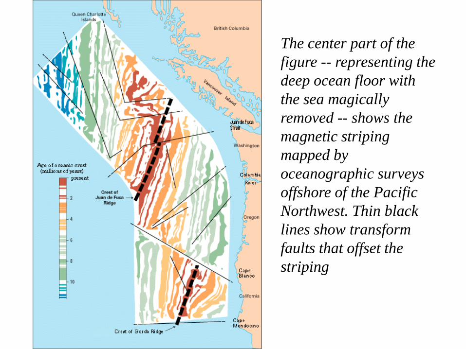
The center part of the
figure -- representing the
deep ocean floor with
the sea magically
removed -- shows the
magnetic striping
mapped by
oceanographic surveys
offshore of the Pacific
Northwest. Thin black
lines show transform
faults that offset the
striping


Crecimiento del fondo marino y
reciclamiento de la corteza oceánica.

View of the first high-temperature vent (380 °C) ever seen by scientists during a dive of
the deep-sea submersible Alvin on the East Pacific Rise (latitude 21° north) in 1979.
Such geothermal vents--called smokers because they resemble chimneys--spew dark,
mineral-rich, fluids heated by contact with the newly formed, still-hot oceanic crust.
This photograph shows a black smoker, but smokers can also be white, grey, or clear
depending on the material being ejected.
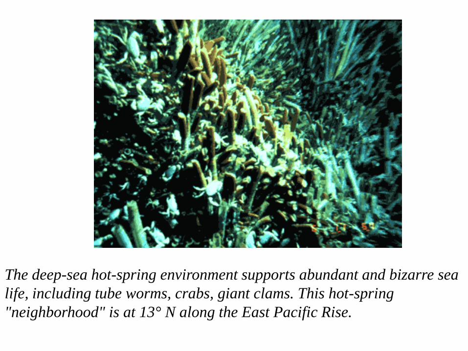
The deep-sea hot-spring environment supports abundant and bizarre sea
life, including tube worms, crabs, giant clams. This hot-spring
"neighborhood" is at 13° N along the East Pacific Rise.

The manipulator arm of the research submersible Alvin
collecting a giant clam from the deep ocean floor. (Photograph
by John M. Edmond, Massachusetts Institute of Technology.)

The size of deep-sea giant clams is evident from the hands of a
scientist holding them. (Photograph by William R. Normark, USGS.)
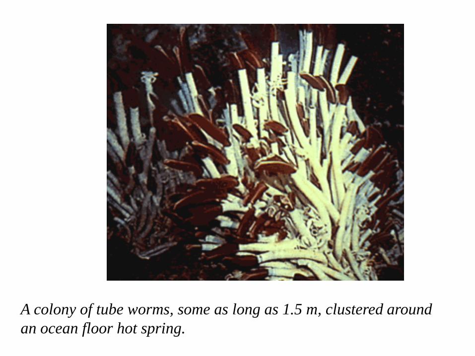
A colony of tube worms, some as long as 1.5 m, clustered around
an ocean floor hot spring.

Close-up of spider crab that was observed to be eating tube worms.

The JOIDES Resolution is the deep-sea drilling ship of the 1990s
(JOIDES= Joint Oceanographic Institutions for Deep Earth
Sampling). This ship, which carries more than 9,000 m of drill pipe,
is capable of more precise positioning and deeper drilling than the
Glomar Challenger.
Concertación de sismos
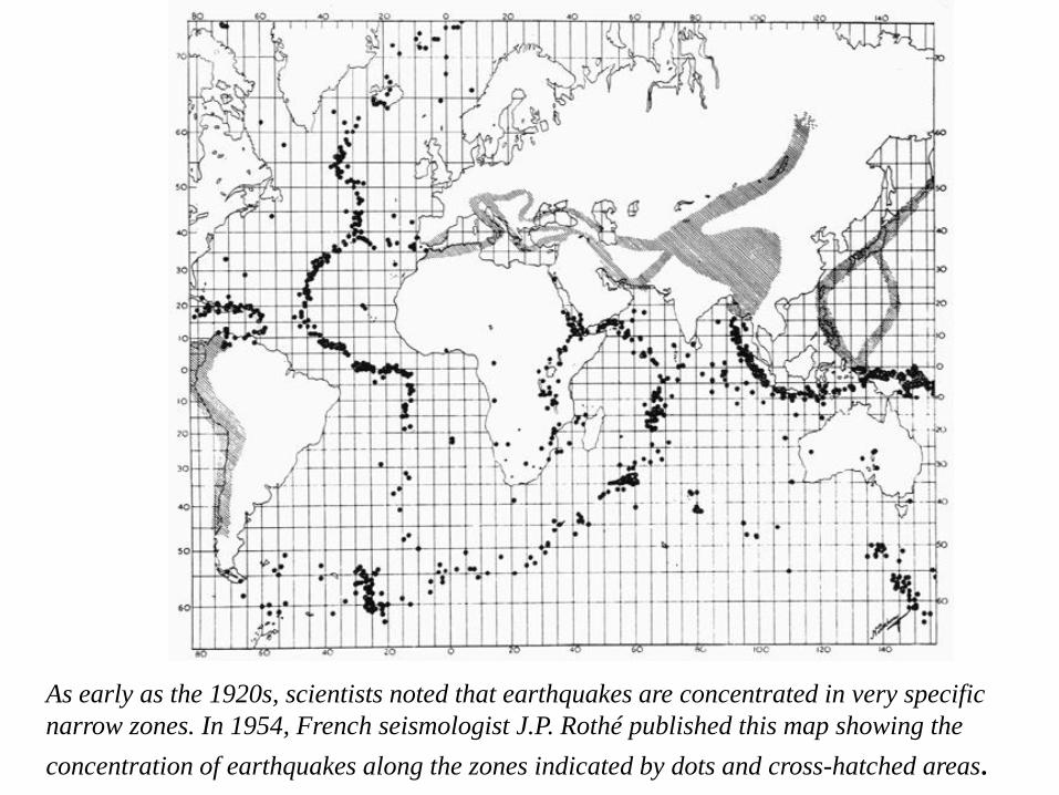
As early as the 1920s, scientists noted that earthquakes are concentrated in very specific
narrow zones. In 1954, French seismologist J.P. Rothé published this map showing the
concentration of earthquakes along the zones indicated by dots and cross-hatched areas.