Civilians Caught in the Crossfire - Satellite Sentinel Project · 1 Satellite Sentinel Project •...
17
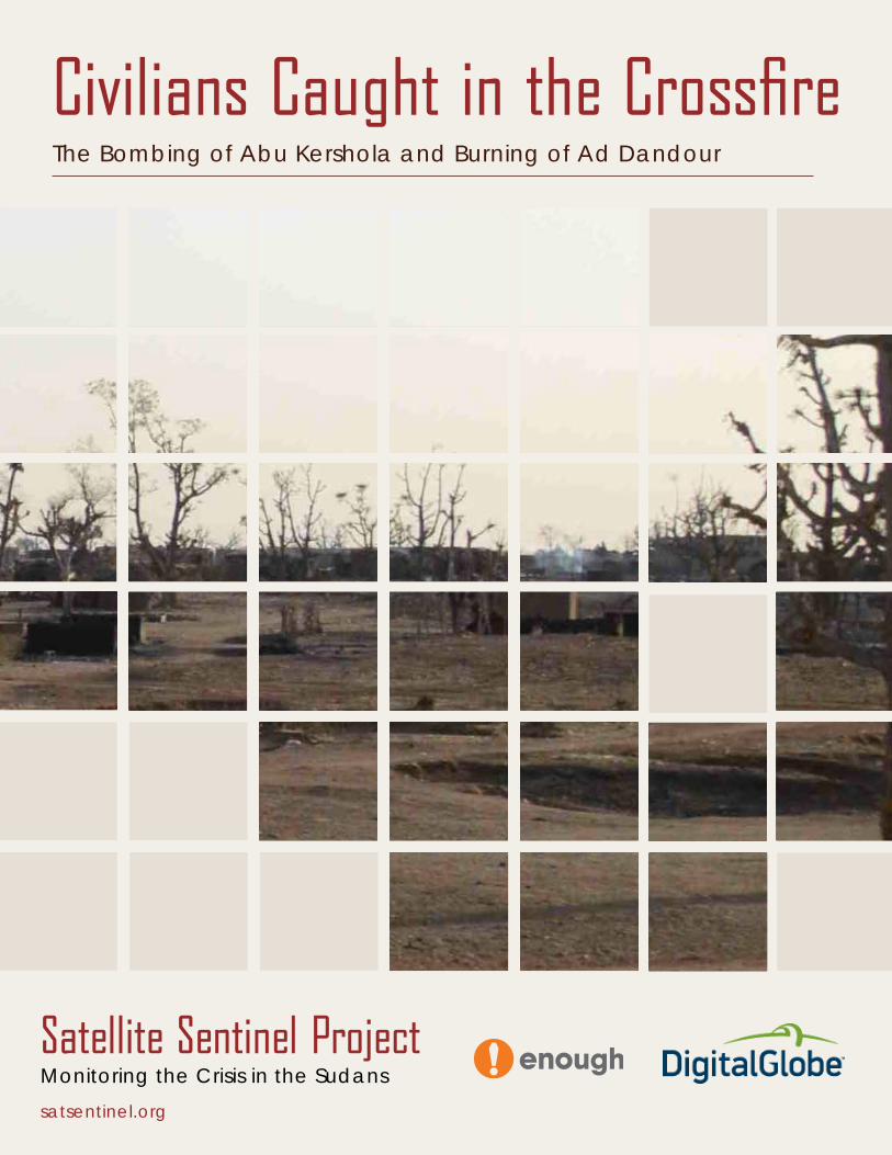
Civilians Caught in the Crossfire The Bombing of Abu Kershola and Burning of Ad Dandour Satellite Sentinel Project satsentinel.org Monitoring the Crisis in the Sudans
Transcript of Civilians Caught in the Crossfire - Satellite Sentinel Project · 1 Satellite Sentinel Project •...
Civilians Caught in the Crossfire The Bombing of Abu Kershola and Burning of Ad Dandour
Satellite Sentinel Projectsatsentinel.org
Monitoring the Crisis in the Sudans
Civilians Caught in the Crossfire The Bombing of Abu Kershola
and Burning of Ad Dandour
COVER: Visibly burned tukuls and smoke in Ad Dandour during a lull in fighting. (Credit: Nuba Reports)
Satellite Sentinel Project
1 Satellite Sentinel Project • www.satsentinel.org | Civilians Caught in the Crossfire
Civilians in South Kordofan, Sudan, continue to bear the brunt of the recent escala-tion in hostilities between the rebel Sudan Revolutionary Front, or SRF, in this case comprised of forces from the Sudan Peoples’ Liberation Movement-North, or SPLM-N and the Darfurian Justice and Equality Movement, or JEM, and the government Sudan Armed Forces, or SAF. Two paradigmatic examples are the warring parties’ struggle over strategic garrison towns that led to the burning of Ad Dandour and the repeated indis-criminate bombing of civilian areas in Abu Kershola. Exclusive DigitalGlobe satellite imagery secured by the Satellite Sentinel Project, or SSP, confirms the recent fighting’s destructive impact on both towns and corroborates reports from citizen journalists who traveled to the area during a lull in hostilities.
The bombardment of Abu Kershola
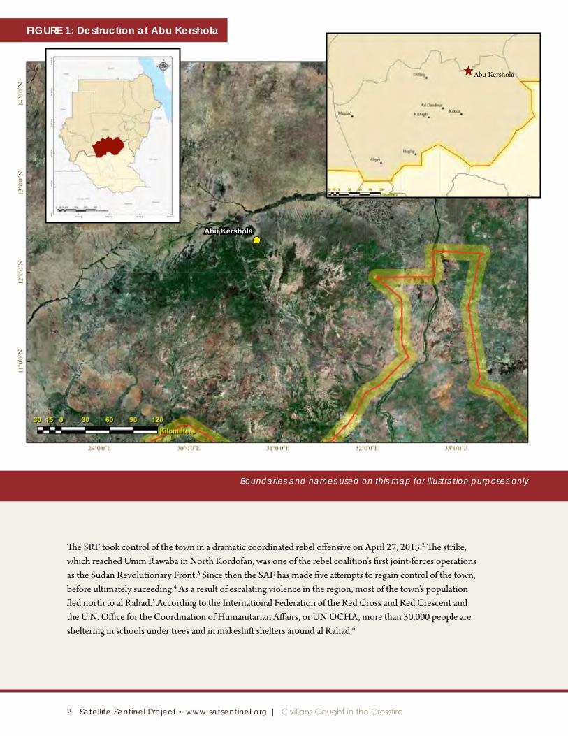
In recent weeks both the SAF and SRF have been trading escalating rhetoric about Abu Kershola, a strategic garrison town in South Kordofan.1 Home to approximately 45,000 people in the northeastern portion of South Kordofan in Sudan, Abu Kershola (see Figure 1) has become a symbol of the war raging on Sudan’s periphery.
2 Satellite Sentinel Project • www.satsentinel.org | Civilians Caught in the Crossfire
Boundaries and names used on this map for illustration purposes only
The SRF took control of the town in a dramatic coordinated rebel offensive on April 27, 2013.2 The strike, which reached Umm Rawaba in North Kordofan, was one of the rebel coalition’s first joint-forces operations as the Sudan Revolutionary Front.3 Since then the SAF has made five attempts to regain control of the town, before ultimately suceeding.4 As a result of escalating violence in the region, most of the town’s population fled north to al Rahad.5 According to the International Federation of the Red Cross and Red Crescent and the U.N. Office for the Coordination of Humanitarian Affairs, or UN OCHA, more than 30,000 people are sheltering in schools under trees and in makeshift shelters around al Rahad.6
Abu Kershola
Abu Kershola
Figure 1: Destruction at Abu Kershola
3 Satellite Sentinel Project • www.satsentinel.org | Civilians Caught in the Crossfire
Abu Kershola Area Overview, South Kordofan State, Sudan
Digitalglobe Color infrared image, May 15, 2013
N
Burned TukulsCentral Market Area
of Abu Kershola
Craters
Figure 2: Area Overview
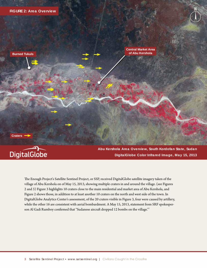
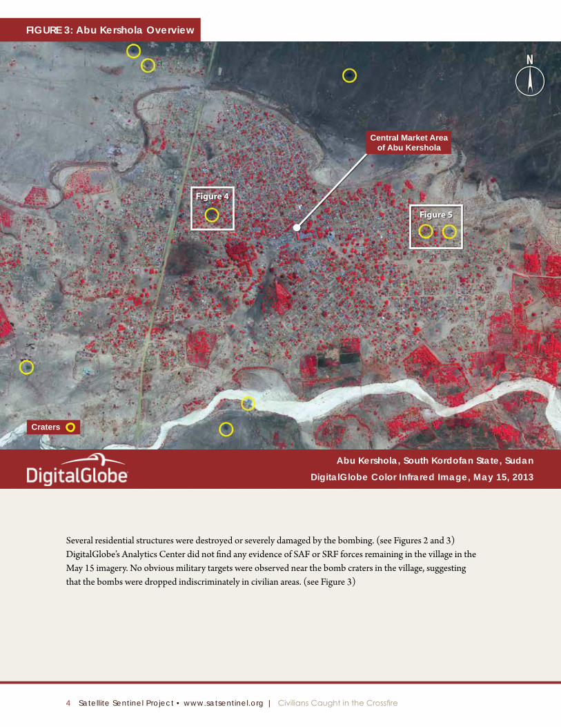
The Enough Project’s Satellite Sentinel Project, or SSP, received DigitalGlobe satellite imagery taken of the village of Abu Kershola on of May 15, 2013, showing multiple craters in and around the village. (see Figures 2 and 3) Figure 3 highlights 10 craters close to the main residential and market area of Abu Kershola, and Figure 2 shows those, in addition to at least another 10 craters on the north and west side of the town. In DigitalGlobe Analytics Center’s assessment, of the 20 craters visible in Figure 3, four were caused by artillery, while the other 16 are consistent with aerial bombardment. A May 15, 2013, statement from SRF spokesper-son Al Gadi Rumboy confirmed that “Sudanese aircraft dropped 12 bombs on the village.”7
4 Satellite Sentinel Project • www.satsentinel.org | Civilians Caught in the Crossfire
Abu Kershola, South Kordofan State, Sudan
Digitalglobe Color infrared image, May 15, 2013
Figure 4
Figure 5
Craters
Central Market Area of Abu Kershola
N
Figure 3: Abu Kershola Overview
Several residential structures were destroyed or severely damaged by the bombing. (see Figures 2 and 3) DigitalGlobe’s Analytics Center did not find any evidence of SAF or SRF forces remaining in the village in the May 15 imagery. No obvious military targets were observed near the bomb craters in the village, suggesting that the bombs were dropped indiscriminately in civilian areas. (see Figure 3)
5 Satellite Sentinel Project • www.satsentinel.org | Civilians Caught in the Crossfire
FigureS 4 & 5: Bomb Craters
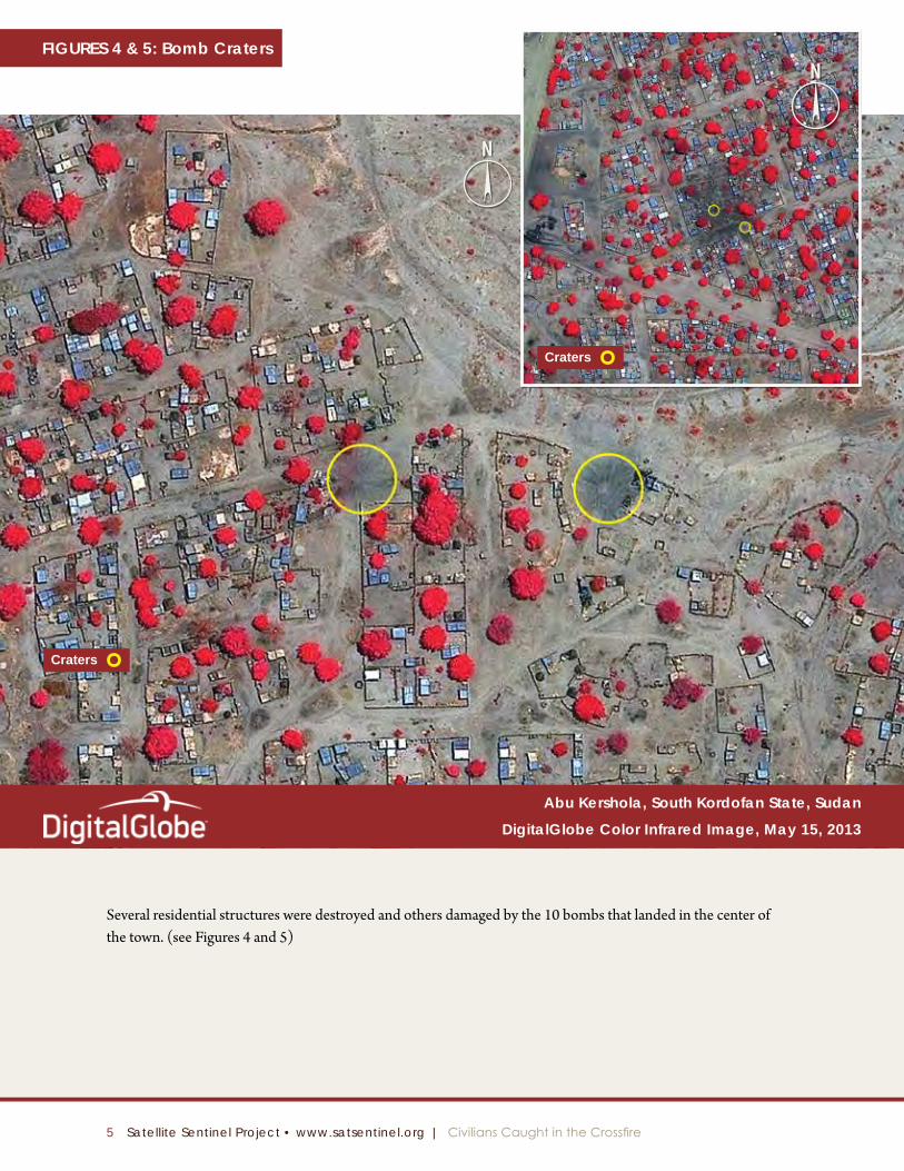
Several residential structures were destroyed and others damaged by the 10 bombs that landed in the center of the town. (see Figures 4 and 5)
Abu Kershola, South Kordofan State, Sudan
Digitalglobe Color infrared image, May 15, 2013
Craters
Craters
N
N
6 Satellite Sentinel Project • www.satsentinel.org | Civilians Caught in the Crossfire
West of Abu Kershola, South Kordofan State, Sudan
Digitalglobe Color infrared image, May 15, 2013
Possible Damaged Vehicle
Craters
Possible Damaged Vehicle
Example ofTank Tracks
NFigure 6: Bomb Craters and Tank Tracks
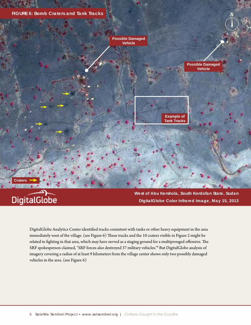
DigitalGlobe Analytics Center identified tracks consistent with tanks or other heavy equipment in the area immediately west of the village. (see Figure 6) These tracks and the 10 craters visible in Figure 2 might be related to fighting in that area, which may have served as a staging ground for a multipronged offensive. The SRF spokesperson claimed, “SRF forces also destroyed 37 military vehicles.”8 But DigitalGlobe analysis of imagery covering a radius of at least 9 kilometers from the village center shows only two possibly damaged vehicles in the area. (see Figure 6)
7 Satellite Sentinel Project • www.satsentinel.org | Civilians Caught in the Crossfire
Figure 7: Burned Tukuls
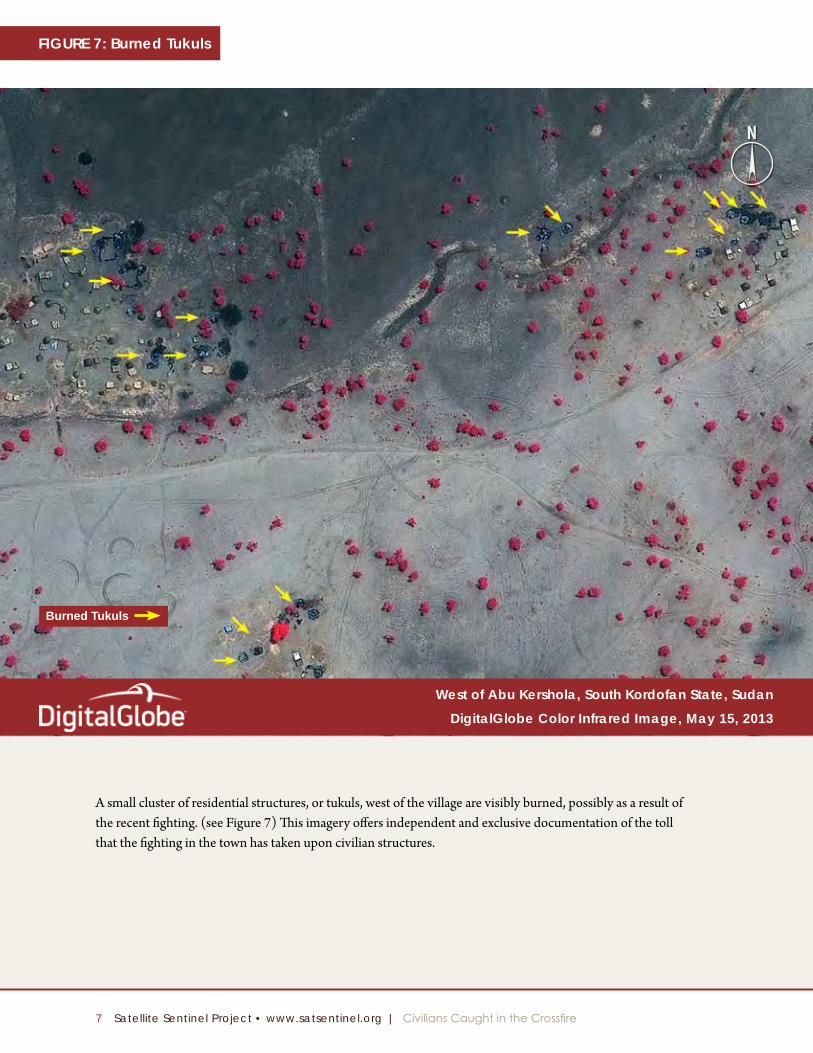
A small cluster of residential structures, or tukuls, west of the village are visibly burned, possibly as a result of the recent fighting. (see Figure 7) This imagery offers independent and exclusive documentation of the toll that the fighting in the town has taken upon civilian structures.
Burned Tukuls
West of Abu Kershola, South Kordofan State, Sudan
Digitalglobe Color infrared image, May 15, 2013
N

8 Satellite Sentinel Project • www.satsentinel.org | Civilians Caught in the Crossfire
Figure 8
el Obeid
The burning of Ad Dandour
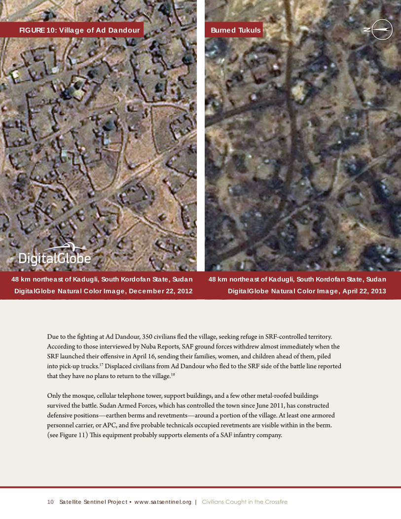
A “fierce” three-day battle over Ad Dandour (see Figure 8) in Sudan’s South Kordofan state likely led to the complete destruction of civilian structures in the garrison town.9
According to Nuba Reports, the village changed hands twice during the three-day period of April 15–17, 2013.10 On April 15 SRF, rebels launched an offensive and seized control of the strategically located village, which has been under SAF control since 2011.11 After hours of intense indiscriminate aerial bombardment, on April 16 the SRF retreated, allowing SAF to regain control of the town on April 17.12 DigitalGlobe’s analysis of satellite imagery taken of Ad Dandour on April 22, after the fighting ended, confirms that much of the town has been destroyed by fire.
ad Dandour
9 Satellite Sentinel Project • www.satsentinel.org | Civilians Caught in the Crossfire
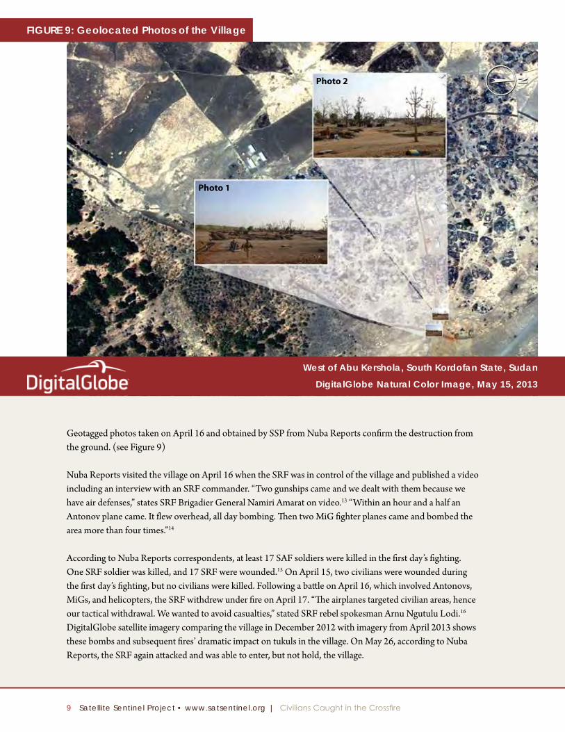
Geotagged photos taken on April 16 and obtained by SSP from Nuba Reports confirm the destruction from the ground. (see Figure 9)
Nuba Reports visited the village on April 16 when the SRF was in control of the village and published a video including an interview with an SRF commander. “Two gunships came and we dealt with them because we have air defenses,” states SRF Brigadier General Namiri Amarat on video.13 “Within an hour and a half an Antonov plane came. It flew overhead, all day bombing. Then two MiG fighter planes came and bombed the area more than four times.”14
According to Nuba Reports correspondents, at least 17 SAF soldiers were killed in the first day’s fighting. One SRF soldier was killed, and 17 SRF were wounded.15 On April 15, two civilians were wounded during the first day’s fighting, but no civilians were killed. Following a battle on April 16, which involved Antonovs, MiGs, and helicopters, the SRF withdrew under fire on April 17. “The airplanes targeted civilian areas, hence our tactical withdrawal. We wanted to avoid casualties,” stated SRF rebel spokesman Arnu Ngutulu Lodi.16 DigitalGlobe satellite imagery comparing the village in December 2012 with imagery from April 2013 shows these bombs and subsequent fires’ dramatic impact on tukuls in the village. On May 26, according to Nuba Reports, the SRF again attacked and was able to enter, but not hold, the village.
West of Abu Kershola, South Kordofan State, Sudan
Digitalglobe Natural Color image, May 15, 2013
Photo 2
Photo 1
NFigure 9: geolocated Photos of the Village
10 Satellite Sentinel Project • www.satsentinel.org | Civilians Caught in the Crossfire
Due to the fighting at Ad Dandour, 350 civilians fled the village, seeking refuge in SRF-controlled territory. According to those interviewed by Nuba Reports, SAF ground forces withdrew almost immediately when the SRF launched their offensive in April 16, sending their families, women, and children ahead of them, piled into pick-up trucks.17 Displaced civilians from Ad Dandour who fled to the SRF side of the battle line reported that they have no plans to return to the village.18
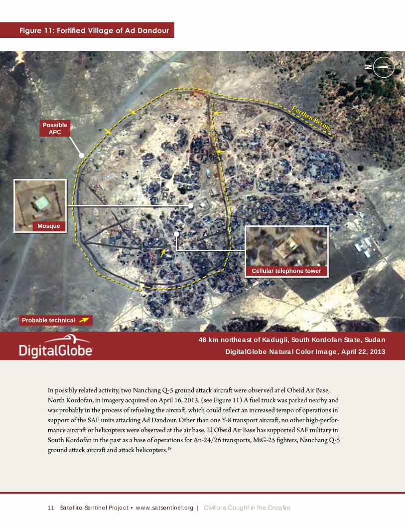
Only the mosque, cellular telephone tower, support buildings, and a few other metal-roofed buildings survived the battle. Sudan Armed Forces, which has controlled the town since June 2011, has constructed defensive positions—earthen berms and revetments—around a portion of the village. At least one armored personnel carrier, or APC, and five probable technicals occupied revetments are visible within in the berm. (see Figure 11) This equipment probably supports elements of a SAF infantry company.
48 km northeast of Kadugli, South Kordofan State, Sudan
Digitalglobe Natural Color image, April 22, 2013
48 km northeast of Kadugli, South Kordofan State, Sudan
Digitalglobe Natural Color image, December 22, 2012
Figure 10: Village of Ad Dandour Burned Tukuls N
11 Satellite Sentinel Project • www.satsentinel.org | Civilians Caught in the Crossfire
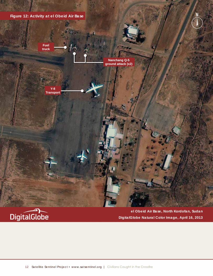
In possibly related activity, two Nanchang Q-5 ground attack aircraft were observed at el Obeid Air Base, North Kordofan, in imagery acquired on April 16, 2013. (see Figure 11) A fuel truck was parked nearby and was probably in the process of refueling the aircraft, which could reflect an increased tempo of operations in support of the SAF units attacking Ad Dandour. Other than one Y-8 transport aircraft, no other high-perfor-mance aircraft or helicopters were observed at the air base. El Obeid Air Base has supported SAF military in South Kordofan in the past as a base of operations for An-24/26 transports, MiG-25 fighters, Nanchang Q-5 ground attack aircraft and attack helicopters.19
Figure 11: Fortified Village of Ad Dandour
48 km northeast of Kadugli, South Kordofan State, Sudan
Digitalglobe Natural Color image, April 22, 2013
Cellular telephone tower
Possible APC
Mosque
Earthen Berms
Probable technical
N
12 Satellite Sentinel Project • www.satsentinel.org | Civilians Caught in the Crossfire
Figure 12: Activity at el Obeid Air Base
el Obeid Air Base, North Kordofan, Sudan
Digitalglobe Natural Color image, April 16, 2013
Fueltruck
Nanchang Q-5ground attack (x2)
Y-8Transport
N
13 Satellite Sentinel Project • www.satsentinel.org | Civilians Caught in the Crossfire
N
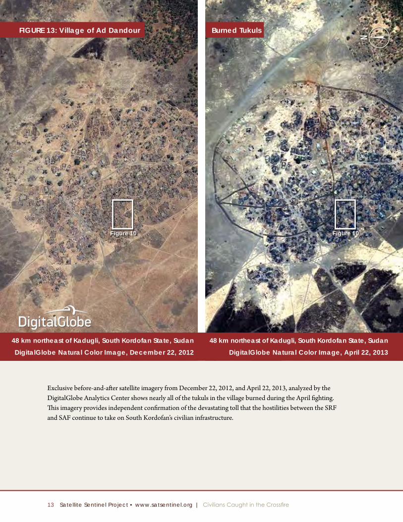
Figure 10 Figure 10
Exclusive before-and-after satellite imagery from December 22, 2012, and April 22, 2013, analyzed by the DigitalGlobe Analytics Center shows nearly all of the tukuls in the village burned during the April fighting. This imagery provides independent confirmation of the devastating toll that the hostilities between the SRF and SAF continue to take on South Kordofan’s civilian infrastructure.
48 km northeast of Kadugli, South Kordofan State, Sudan
Digitalglobe Natural Color image, April 22, 2013
48 km northeast of Kadugli, South Kordofan State, Sudan
Digitalglobe Natural Color image, December 22, 2012
Figure 13: Village of Ad Dandour Burned Tukuls
14 Satellite Sentinel Project • www.satsentinel.org | Civilians Caught in the Crossfire
1 “Sudanese President Pledges to Soon Retake South Kordo-fan Town,” Sudan Tribune, May 13, 2013, available at http://allafrica.com/stories/201305141107.html.
2 “Sudan city stormed by Darfur rebels,” Al Jazeera, April 27, 2013, available at http://www.aljazeera.com/news/africa/2013/04/2013427143845319920.html.
3 Ibid.
4 “Sudan army increasing security around Abu-Kershola perimeter, Sudan Tribune, May 30, 2013, available at http://www.sudantribune.com/spip.php?article46757.
5 “Abu Kershola IDPs Receive Relief Aid,” Sudan Vision, May 15, 2013, available at http://news.sudanvisiondaily.com/details.html?rsnpid=222604.
6 International Federation of the Red Cross and Red Crescent Societies, “Disaster relief emergency fund (DREF) Sudan / North Kordofan and South Kordofan Population Movement” (2013), available at http://www.ifrc.org/docs/Appeals/13/MDRSD017.pdf; U.N. Office for the Coordination of Hu-manitarian Affairs, “Weekly Humanitarian Bulletin” (2013), available at http://reliefweb.int/sites/reliefweb.int/files/resources/OCHA_Sudan_Weekly_Humanitarian_Bulletin_Is-sue_17_(22-28_April_2013).pdf.
7 “SRF: ‘Sudan’ air raid kills three in Abu Karshola, South Kordofan,” Radio Dabanga, May 14, 2013, available at http://www.radiodabanga.org/node/48915.
8 Ibid.
9 “Sudan SPLA-N claims control of Dandor garrison near Kadugli,” Radio Dabanga, April 16, 2013, available at http://www.radiodabanga.org/node/46743.
10 Nuba Reports, “Surge in Fighting As Humanitarian Negotia-tions Begin” (2013), available at http://www.nubareports.org//reports/surge-fighting-humanitarian-negotiations-begin.
11 “Sudan S.Kordofan rebels ‘control’ army base,” Agence France-Presse, April 16, 2013, available at http://www.glo-balpost.com/dispatch/news/afp/130416/sudan-skordofan-rebels-control-army-base.
12 “Sudan Army Regains Control of Kordofan Garrison, Capital Shelled,” Hilversum Radio Dabanga, April 17, 2013, available at http://allafrica.com/stories/201304180127.html.
13 Nuba Reports, “Frontlines: Dandur,” April 25, 2013, available at http://www.youtube.com/watch?feature=player_embedded&v=jDb7hZKXM9A#!.
14 Ibid.
15 Nuba Reports correspondent, interview with author, April 25, 2013.
16 Ibid.
17 Ibid.
18 Ibid.
19 Tristan McConnell, “Part 3: Sudan’s rebels uniting to topple Bashir’s Islamic regime,” Globalpost, May 7, 2012, available at http://www.globalpost.com/dispatch/news/regions/af-rica/120507/sudan-s-rebels-uniting-topple-bashir-s-islamic-regime.
Endnotes
Satellite Sentinel Project
conducts regular, intensive
monitoring of Sudan
to assess the current
human security situation
and identify potential
threats to civilians.
Satellite Sentinel Projectsatsentinel.org