City of Seattle Shoreline Master Program Update · Proposal Summary January 2011 I. INTRODUCTION...
43
City of Seattle Shoreline Master Program Update Proposal Summary January 2011 I. INTRODUCTION The City of Seattle’s Department of Planning and Development (DPD) is comprehensively updating Seattle’s Shoreline Master Program (SMP) for the first time since 1987. The SMP constitutes the policies and regulations governing development and uses on and adjacent to marine and freshwater shorelines. This includes the waters of Puget Sound, Lake Washington, Lake Union/Ship Canal, Duwamish River, Green Lake, as well as associated wetlands and floodplains. These policies and regulations affect land uses and activities, building bulk, scale and setbacks, public access requirements, bulkheads, docks, piers and construction practices. Updating the SMP is a state mandated requirement under the State of Washington’s Shoreline Management Act (SMA), which was created by citizen referendum in 1972. The SMA establishes policy goals for the management of shorelines and the SMP guidelines establish the requirements on how to achieve the policy goals, with flexibility to acknowledge local concerns and conditions. The SMA establishes three major policy goals for SMPs: • Preferred Shoreline Uses: The SMA establishes a preference for uses that are water- oriented and that are appropriate for the environmental context (such as port facilities, shoreline recreational uses, and water-dependent businesses). Single-family residences are also identified as a preferred use when developed in a manner consistent with protection of the natural environment. • Environmental Protection: The Act requires protections for shoreline natural resources, including “… the land and its vegetation and wildlife, and the water of the state and their aquatic life …” to ensure no net loss of ecological function. • Public Access: The Act promotes public access to shorelines by mandating inclusion of a public access element in local SMPs and requiring provisions to ensure that new development maintains public access features. The goal of the update process is to improve Seattle’s SMP to both comply with the new SMA guidelines developed by the Washington State Department of Ecology (Ecology) in 2003 and better implement citizens’ vision for Seattle’s shorelines. A. STATE REQUIREMENTS
Transcript of City of Seattle Shoreline Master Program Update · Proposal Summary January 2011 I. INTRODUCTION...
City of Seattle Shoreline Master Program Update
Proposal Summary
January 2011
I. INTRODUCTION
The City of Seattle’s Department of Planning and Development (DPD) is comprehensively updating Seattle’s Shoreline Master Program (SMP) for the first time since 1987. The SMP constitutes the policies and regulations governing development and uses on and adjacent to marine and freshwater shorelines. This includes the waters of Puget Sound, Lake Washington, Lake Union/Ship Canal, Duwamish River, Green Lake, as well as associated wetlands and floodplains. These policies and regulations affect land uses and activities, building bulk, scale and setbacks, public access requirements, bulkheads, docks, piers and construction practices. Updating the SMP is a state mandated requirement under the State of Washington’s Shoreline Management Act (SMA), which was created by citizen referendum in 1972. The SMA establishes policy goals for the management of shorelines and the SMP guidelines establish the requirements on how to achieve the policy goals, with flexibility to acknowledge local concerns and conditions. The SMA establishes three major policy goals for SMPs:
• Preferred Shoreline Uses: The SMA establishes a preference for uses that are water-oriented and that are appropriate for the environmental context (such as port facilities, shoreline recreational uses, and water-dependent businesses). Single-family residences are also identified as a preferred use when developed in a manner consistent with protection of the natural environment.
• Environmental Protection: The Act requires protections for shoreline natural resources, including “… the land and its vegetation and wildlife, and the water of the state and their aquatic life …” to ensure no net loss of ecological function.
• Public Access: The Act promotes public access to shorelines by mandating inclusion of a public access element in local SMPs and requiring provisions to ensure that new development maintains public access features.
The goal of the update process is to improve Seattle’s SMP to both comply with the new SMA guidelines developed by the Washington State Department of Ecology (Ecology) in 2003 and better implement citizens’ vision for Seattle’s shorelines.
A. STATE REQUIREMENTS

February 2011 2
Ecology’s 2003 SMP Guidelines require that local jurisdictions comprehensively update their SMPs. The main components of the update include:
1. Shoreline Inventory and Characterization. DPD inventoried the shoreline ecological environment and assessed the ecological conditions of the shoreline. A Shoreline Characterization report was produced that rated the ecological condition with five ratings from least impaired to most impaired. The information on the ecological condition of the shorelines will serve as the baseline conditions by which DPD measures impacts and restoration on the shoreline after the new regulations are implemented.
2. Public Participation Plan. DPD produced a public participation plan that included a website, an open house, a public survey of Seattle citizens and seven visioning workshops, a Visioning Report that summarized the public survey and visioning workshops and the formation of a Citizen Advisory Committee (CAC) with a report that summarized the work of the CAC.
3. Shoreline Environments. DPD evaluated existing shoreline environment designations and compared these designations with Ecology’s new requirements for protection of shoreline ecological functions while providing for the preferred uses and public access of the shoreline.
4. Shoreline goals, policies and regulations. DPD has proposed updated shoreline goals and polices in the Comprehensive Plan and shoreline regulations in Chapter 23.60 of the Seattle Municipal Code to:
a. Protect areas of the shoreline that have higher ecological functions based on the results of the Shoreline Characterization report.
b. Require that all uses on waterfront parcels be water dependent unless a study shows that the demand by water-dependent uses is less than the supply of available land for such uses. Single family residential use is also a preferred use and therefore can be allowed on waterfront parcels if developed in a manner consistent with protection of the natural environment.
c. Require that all impacts to the shoreline environment meet “no net loss” of ecological functions.
5. Cumulative Impact Analysis. DPD analyzed the draft regulations to determine if the regulations, when implemented, meet “no net loss” of ecological functions. A Cumulative Impact Analysis report detailing the findings of this analysis will be completed in March of 2011.
6. Shoreline Restoration Report. DPD wrote a draft shoreline restoration plan that identifies the type of restoration that will increase ecological functions along Seattle’s shorelines. The shoreline is divided into reaches and within each reach, specific actions are identified that will increase ecological functions along the reach. This restoration plan is non-regulatory and plans for the improvement of ecological functions of the shoreline over time. All SMP update documents may be accessed on DPD’s website under the SMP draft and supporting materials page at: http://www.seattle.gov/dpd/Planning/ShorelineMasterProgramUpdate/Overview/default.asp.
B. PUBLIC PARTICIPATION The SMA requires that local governments actively encourage participation by the public. To this end DPD has implemented the following to engage and inform the public on the SMP update:

February 2011 3
B.1 Website and ListServ
DPD established a website and a ListServ in the fall of 2007. The website provides information on the shoreline update process, announces dates and times of public meetings, including CAC meetings, and posts all documents that have been prepared for the SMP update. Information regarding public meetings and the release of documents are sent to the Listserv so that constituents requesting specific notice are kept informed of the SMP update progress.
B.2 Public Meetings
Table 1. Shoreline Master Program Public Meetings 2007 - 2010
Group Date Purpose General public November 7, 2007 Open House - to inform the public that
DPD was beginning the SMP update process and to provide background information on the existing SMP and Ecology’s requirements for the SMP update, as well as to inform the public of the process for the SMP update
General public Seven meetings were held between March 6 and March 25, 2008
Visioning Meetings – to develop the vision of the future of Seattle’s shorelines. See subsection B.3 for additional details.
Citizen Advisory Committee and the general public
Eleven meetings were held between May 2008 and June 2009.
CAC Meetings – to discuss major issues with shoreline stakeholders. See subsection B.4 for additional information
League of Women’s Voters
November, 2008. To provide general information on the SMP and ECA regulations.
North Seattle Industrial Association
February 2009, March 2009, May 2010.
To provide information regarding the SMP update at certain milestones, including the release of the Shoreline Characterization report and completion of the CAC meetings and CAC report.
Lake Union Association
March, 2009. To provide specific information regarding proposed regulations in the Shoreline District in the Lake Union area.
Citizen Advisory Committee and the general public
September 6, 2008. Boat Tour - to bring CAC members and other interested members of the public onto the water to discuss shoreline issues in the context of the existing shoreline environment. See subsection B.5 for additional information.

February 2011 4
B.3 Visioning Process
As part of the Visioning element required by the SMP guidelines, DPD undertook a community visioning process to develop an overall vision for Seattle shorelines and to establish the intent of future shoreline policy. This Visioning process identified a range of visions and views for the city as a whole, as well as each of six shoreline sub-regions (Elliott Bay, Duwamish River, Lake Union/Ship Canal, Lake Washington, Puget Sound and Green Lake). The community visioning process consisted of: 1) a telephone survey conducted by Elway Research, Inc.; 2) a series of seven visioning workshops in the shoreline sub-regions attended by 117 participants; and 3) comments provided online via the city’s SMP Update web site (http://www.seattle.gov/dpd/Planning/ShorelineMasterProgramUpdate). The telephone survey was designed to quantify general public opinion about Seattle’s shorelines. 400 randomly selected Seattle residents were asked fourteen questions. The results of the survey are statistically valid, with a 95% probability that the results are within 5% of what would have been obtained by interviewing all city residents. The community visioning workshops were designed to generate more in-depth conversation about shorelines and competing values. Workshops were structured around the following questions: What do we want our shorelines to be like in the future? What are the different visions for shoreline management that exist within each community? How well are competing uses being balanced? What unique conditions exist in each section of shoreline? A Visioning Report provided a summary of the rich and diverse input provided through this visioning process and concluded that Seattle’s shorelines play an important role in how we work and recreate, and they are one of the features that make Seattle a world-class city. The public survey and visioning process demonstrated that citizens of Seattle place a high value on shorelines and that water-dependent businesses, public access, and environmental protection are all priorities for the future. Through this public visioning process, the public helped DPD review and update the City’s SMP. Responses to the telephone survey, the visioning workshops, and via the online comment form are available on the City’s SMP Update web site.
B.4 Citizen Advisory Committee DPD convened a Citizens Advisory Committee (CAC). The CAC’s charge was to review, discuss and make recommendations to influence and guide DPD in its consideration of revisions, additions and other changes during the development of an updated SMP. DPD developed a list of potential stakeholders to serve on the CAC, asked for and received nominations from the public. Nominees were interviewed by Triangle Associates (which also provided meeting facilitation for the CAC and the Community Visioning Workshops). Triangle worked with DPD to develop and

February 2011 5
present recommendations to the DPD Director, who made final selection as to who would sit on the CAC. The objective was to provide a wide range of perspectives, not a proportionately representational group (a list and biosketches of CAC members are included as an appendix to the final CAC report). The CAC members also participated in an interactive visioning exercise. The result was a consensus vision statement to guide the CAC’s deliberations as they discussed, debated and expressed their viewpoints on the issues. The full record of the CAC’s visioning exercise is attached to the final CAC report as an appendix. The vision statement reads as follows: The SMP Update Citizens Advisory Committee envisions a future for Seattle’s shorelines in which the Shoreline Management Act’s three major co-equal policy goals (protecting preferred uses, providing environmental protection, and promoting public access) are truly balanced. This means that the opportunity for citizens to experience and interact with the shoreline in a wide variety of ways will not be limited by a lack of public access points or views. It means that the shoreline’s ability to sustain diverse plants and animals will be both protected and restored. It means that existing historic, diverse and active uses of Seattle’s shorelines will be maintained. And it means ensuring that Seattle remains a place where marine businesses thrive and make an important contribution to both the economy and our unique character. The major issue areas that were discussed at the CAC meetings were:
• Shoreline Environmental Designations • Residential Development Standards • Commercial and Industrial Development Standards • Shoreline Modifications (including dredging, shoreline stabilization and overwater
structures) • Shoreline Mitigation • Public Access and Views • Floating Homes • Urban Stable/Urban Mixed Use Development and Use Standards • Non-Conforming Structures and Uses
Three documents were prepared for each of the issue areas identified above, to document the CAC’s review and discussion. Prior to each meeting, DPD prepared a policy paper that outlined existing standards and explained how the state’s guidelines in the Washington Administrative Code (WAC) applied to the subject at hand, as well as a list of issues that needed to be addressed under that specific issue area. CAC members discussed each policy paper at the meetings, and were asked to identify areas of agreement, as well as provide statements of support or concern where there was not broad agreement. CAC members were also encouraged to provide written comments on the issue areas between meetings. After each meeting, a summary was prepared by Triangle Associates, to describe areas of agreement and disagreement, clarify where and why there was disagreement and to state points of view fairly and clearly.

February 2011 6
DPD then developed response papers for each issue, containing a summary of the proposals DPD presented to the CAC, views expressed by CAC members, and DPD’s responses to these comments. All of these documents are provided as appendices to the final CAC report.
B.5 Boat Tour In September of 2008 DPD organized a boat tour of Seattle’s shorelines to provide the members of the CAC and the public an opportunity to view the shorelines from the water and to hear about the history of Seattle’s shorelines from Dr. Lorraine McConaghy, the historian at the Museum of History and Industry. Additionally the boat tour provided the opportunity for broad discussions regarding the ecological functions and the industrial, commercial, residential and recreational uses of the shoreline. Judith Noble, a Strategic Advisor for Seattle Public Utilities provided information on the environmental and industrial aspects of the shoreline focusing on the Duwamish River and Elliott Bay and Eric Hanson, the manager of Seaport Planning for the Port of Seattle provided information regarding the Port’s roll in providing both economic and environmental benefits to Seattle. Attendees on the tour included Councilmember Jean Godden, ten CAC members, 29 community members, DPD consultants and staff from the Seattle Department of Transportation (SDOT), Office of Economic Development (OED), Seattle Public Utilities (SPU) and DPD. II. REVIEW PROCESS The SMA requires that local governments actively encourage participation of federal, state and other local agencies in updating SMPs. Therefore, DPD staff organized four meetings with the staff of the Washington Department of Fish and Wildlife, the Washington Department of Natural Resources, NOAA Fisheries, U.S. Fish and Wildlife Service and the Army Corps of Engineers during the months of August and September, 2009. Staff from the Muckleshoot Tribe were invited but could not attend the meetings because of time constraints. These meetings were held after completion of CAC meetings so that the discussions could focus on how proposed regulations would address the major issues that were discussed at the CAC meetings. No major concerns were identified during these meetings. DPD is now releasing the DPD recommended draft regulations for public and Department of Ecology review for a six week comment period. DPD will provide a summary of the comments received and how those comments were addressed, after which the Mayor will submit his recommendations to City Council in the Spring of 2011 for their review and approval. III. ANALYSIS & RECOMMENDATIONS
A. SHORELINE ENVIRONMENT DESIGNATIONS Shoreline environments separate Seattle’s shorelines into distinct geographic areas based on environmental conditions, land use patterns, and zoning. In updating shoreline environments and designations, DPD assessed the overall framework of goals, policies and locational criteria and determined that the existing eleven shoreline designations reflect the unique goals and

February 2011 7
characteristics of the shorelines and meet state guidelines; therefore, the existing eleven shoreline environments are proposed to remain subject to the following changes:
• The name of the Urban Stable (US) shoreline environment (Lake Union/Ship Canal) will change to Urban Commercial (UC) to better describe the type of development that characterizes this shoreline environment.
• All the management policies from the environmental designation provisions of the SMP will be moved to Comprehensive Plan. This change will combine overarching policies and integrate these policies with other existing shoreline goals and policies.
• The policy of “no net loss of ecological function” and water quality protection will be specifically included in the SMP as an over-arching policy for all shoreline environments.
Shoreline environment designations were then reviewed against updated goals, policies, and locational criteria based on current conditions, to determine where the designations could be changed. Five sources of information were used in this analysis:
1. Land use data collected in the 2007 Land Use Inventory 2. Ecological conditions collected by the 2009 Shoreline Characterization Report 3. Underlying zoning designations 4. Comments from the public and the SMP Citizen Advisory Committee
Based on this analysis, changes to the environment designations are proposed in 21 locations. Details of these proposed changes are shown on the map in Appendix A and listed below:
A.1 General Proposal
• Based on the characterization report, apply the most appropriate environmental designations to publicly-owned land with high quality habitat or high potential for restoration. The proposed changes include re-designating areas 1, 7, 8, 13, 17, 18 and 19 to Conservation Preservation (CP).
• Expand the shoreline jurisdiction to include shoreline-associated wetlands, as authorized by WAC 173-26. Designate newly-added wetland areas as CP (2, 9, 12 and 20).
• Re-designate certain areas in the former US environment (now UC) based on current uses and site characteristics. The proposed changes include areas 3 and 5.
• Adjust boundaries of existing shoreline environments where they conflict with the regulations of underlying land use zones (4, 6).
• Change parks with boat ramps and no major overwater boat storage from Conservancy Management (CM) to Conservancy Recreation (CR) to more clearly differentiate between CM and CR (9, 10 and 11).
• Change dry land at Elliott Bay Marina to CM for consistency with other marinas (14). • Change Elliott Bay parks from CM to CR to recognize the new waterfront trails and
restored ecological functions (15, 16). • Change parks in the Urban Industrial (UI) shoreline environment to CR to recognize
recently created public access and restored ecological functions (17). • Change land containing multifamily residential development from CM to Urban
Residential (UR) or UC for consistency (19).
February 2011 8
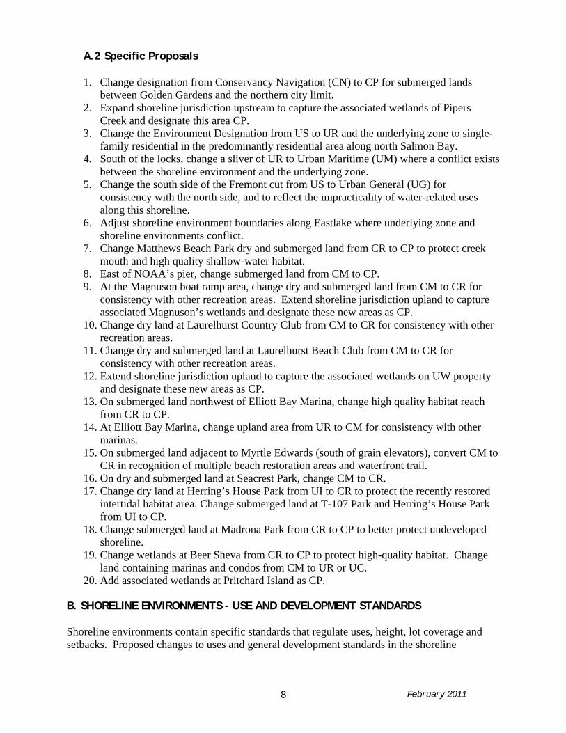
A.2 Specific Proposals
1. Change designation from Conservancy Navigation (CN) to CP for submerged lands between Golden Gardens and the northern city limit.
2. Expand shoreline jurisdiction upstream to capture the associated wetlands of Pipers Creek and designate this area CP.
3. Change the Environment Designation from US to UR and the underlying zone to single-family residential in the predominantly residential area along north Salmon Bay.
4. South of the locks, change a sliver of UR to Urban Maritime (UM) where a conflict exists between the shoreline environment and the underlying zone.
5. Change the south side of the Fremont cut from US to Urban General (UG) for consistency with the north side, and to reflect the impracticality of water-related uses along this shoreline.
6. Adjust shoreline environment boundaries along Eastlake where underlying zone and shoreline environments conflict.
7. Change Matthews Beach Park dry and submerged land from CR to CP to protect creek mouth and high quality shallow-water habitat.
8. East of NOAA’s pier, change submerged land from CM to CP. 9. At the Magnuson boat ramp area, change dry and submerged land from CM to CR for
consistency with other recreation areas. Extend shoreline jurisdiction upland to capture associated Magnuson’s wetlands and designate these new areas as CP.
10. Change dry land at Laurelhurst Country Club from CM to CR for consistency with other recreation areas.
11. Change dry and submerged land at Laurelhurst Beach Club from CM to CR for consistency with other recreation areas.
12. Extend shoreline jurisdiction upland to capture the associated wetlands on UW property and designate these new areas as CP.
13. On submerged land northwest of Elliott Bay Marina, change high quality habitat reach from CR to CP.
14. At Elliott Bay Marina, change upland area from UR to CM for consistency with other marinas.
15. On submerged land adjacent to Myrtle Edwards (south of grain elevators), convert CM to CR in recognition of multiple beach restoration areas and waterfront trail.
16. On dry and submerged land at Seacrest Park, change CM to CR. 17. Change dry land at Herring’s House Park from UI to CR to protect the recently restored
intertidal habitat area. Change submerged land at T-107 Park and Herring’s House Park from UI to CP.
18. Change submerged land at Madrona Park from CR to CP to better protect undeveloped shoreline.
19. Change wetlands at Beer Sheva from CR to CP to protect high-quality habitat. Change land containing marinas and condos from CM to UR or UC.
20. Add associated wetlands at Pritchard Island as CP. B. SHORELINE ENVIRONMENTS - USE AND DEVELOPMENT STANDARDS Shoreline environments contain specific standards that regulate uses, height, lot coverage and setbacks. Proposed changes to uses and general development standards in the shoreline

February 2011 9
environments are discussed below. Specific changes applicable to uses for each shoreline environment are indicated in Tables 2 through 12 of Appendix B.
B.1 Common Elements in the Shoreline Environments In all shoreline environments the following proposed changes are recommended:
• Aquaculture, where allowed, is proposed as a conditional use because of concerns regarding the impacts of this use on the aquatic environment including water quality.
• Cemeteries are included as a listed use and are prohibited in all shoreline environments. • Live-work units are included as a listed use and are prohibited in all Conservancy
shoreline environments; are allowed on waterfront and upland lots in the Urban Commercial shoreline environment, allowed on upland lots in the Urban Harborfront shoreline environment and prohibited in all other Urban shoreline environments.
• Research uses and Restoration and Enhancement uses are new uses that are regulated and allowed in all shoreline environments.
• Surface water heating cooling pumps are new uses that are regulated and allowed as conditional use in the Conservancy Management, Conservancy Recreation and Urban Shoreline environments.
• Redevelopment on lots with little or no dry land would be allowed as follows: If the dry land portion of the lot from ordinary high water mark to the landward
lot line is less than 65 feet, but at least 30 feet, the replacement structure can be no farther waterward from the landward lot line than 30 feet and must be located outside of the shoreline setback to the extent reasonable.
If the dry land portion of the lot from OHW to the landward lot line is less than 30 feet, the replacement structure can be rebuilt within the shoreline setback to the existing footprint of the structure or overwater to the extent reasonable and no larger than the existing footprint of the structure.
B.2 Urban Commercial Environment
The current Urban Stable (US) environment is located in Lake Union, the Ship Canal, Lake Washington near Leschi, and in some areas along Seaview Avenue NW. These areas represent a unique environment within Seattle that accommodates high density development of commercial and residential uses as well as a mix of water-dependent and water-related commercial and recreational uses. Many of the lots have only small areas of dry land, with the majority of each parcel comprised of submerged lands. These lots support buildings that extend over-water on piers and most, but not all, existed before the SMA was enacted. The following changes to regulations in this shoreline environment are proposed:
• Rename the existing US environment to Urban Commercial environment to better describe this area.
• Define Lake Union as the area between the Fremont Bridge and the University Bridge. • Establish a 15 feet buffer with required landscaping standards and an additional 20 feet
building setback, which will result in the following: development in buffer would be prohibited excluding water access no buildings would be allowed in the setback, but limited development would be
allowed for low-intensity uses;

February 2011 10
structures that exist in the setback will become non-conforming structures and repair and maintenance of these structures is allowed within the setback and expansion of these structures is allowed outside the setback, which is consistent with the regulations for non-conforming structures in all areas of the City.
• Allow for exceptions to the previous standard that reduce or eliminate the setback required on lots with little or no dry land. See last bullet in subsection B.1 for the specific allowances.
• Continue to allow residential, office and mixed non-water-dependent commercial uses on the dry land portion of waterfront lots in limited quantity; retain existing provisions with the following proposed changes:
Either provide public access, which is allowed in the existing regulations or provide ecological improvements, a new option, when permitting a non-water dependent commercial use. The public access requirement is for a major open space including a waterfront walkway instead of other public access options that are currently allowed, unless it is infeasible due to parcel size or incompatibility with water-dependent uses. The ecological improvement option is for a project that substantially improves the shoreline condition based on the number of habitat units provided. Habitat units are described in subsection D.4.
Allow counting the vegetated buffer in the calculation for the size of a major open space where required.
Apply existing commercial use floor area ratio (FAR) & parking limits to residential uses.
Increase the minimum percent of water dependent use required to escape public access or ecological improvement requirements from 40% to 50%.
• Allow certain uses that are not water-dependent or water-related over water in existing buildings and require 14 habitat units per square foot of gross floor area of the new use to meet other goals of the Shoreline Management Act. Habitat units are described in subsection D.4.
• Allow residential, office and non-water-dependent commercial uses on upland lots. • Change major durable retail sales from a conditional use to a prohibited use on waterfront
lots. • Consider potential incentives to encourage a reduction in the number of overwater
buildings as opportunities arise, after the adoption of the SMP to the extent that resources allow.
• Consider the development of a fee-in-lieu program to allow off-site public access to meet the public access requirements in areas where there is a Public Access Plan that comprehensively plans for public access in a specific geographic area, after the adoption of the SMP to the extent that resources allow.
All proposed changes to existing shoreline uses in the Urban Commercial shoreline environment are shown in Table 2 in Appendix B.
B.3 Urban General, Urban Harborfront, Urban Industrial and Urban
Maritime Environments Urban General, Urban Harborfront, Urban Industrial, and Urban Maritime shoreline environments are the heavy commercial and industrial shorelines of the city. These areas contain

February 2011 11
the bulk of water-dependent and water-related uses that occur in Seattle, particularly marine industrial uses, and they play a critical role in the economic vitality of the city. Proposed changes in these shoreline environments are as follows:
• Maintain the requirement for water-dependent and water-related uses on waterfront lots, but allow greater flexibility on upland lots.
• Require a 15-ft building setback in the UH, UI and UM shoreline environments to provide some protection to the shoreline and provide the opportunity for shoreline vegetation where it does not compete with the allowed use on the property. The size of this setback is reduced to to facilitate the use of this land by water-dependent and water-related uses.
• Require a 35 foot shoreline setback in the UG shoreline environment. This shoreline environment contains lots that are separated from the shoreline and there is no access to the water; therefore, water-dependent uses are generally not located in this shoreline environment. Allow for an exception to this requirement on lots that have water access and contain a water-dependent use.
• Structures, including docks, piers, loading facilities and equipment necessary to accommodate access to the water by water-dependent uses are allowed within the 15 feet shoreline setback.
• Allow for reduced or no shoreline setback on lots with little or no dry land. See last bullet in subsection B.1 for the specific allowances.
• Continue to seek re-vegetation as part of mitigation plans to increase vegetation in these areas.
The state requires that uses on waterfront lots be water-dependent unless the demand by water-dependent uses is less than the supply of land available for such uses. Some waterfront property owners are concerned that their properties are vacant because there is no demand for the use of their property by water-dependent users. DPD commissioned a study by Easton and Associates to determine the demand and availability of waterfront land for water-dependent uses in order to understand whether the current inventory of land is adequate. Results of the study indicated that the demand for use of shoreline property by water dependent businesses is not less than the supply of shoreline property, however, the location and size of the shoreline property does not always meet the needs of the water-dependent businesses. Additionally, the study identified non-water dependent businesses that support water-dependent and water-related businesses that could help the economic viability of water-dependent and water-related uses if they were allowed to be located on the shoreline property. Based on this information and with the goal of ensuring an adequate supply of land for water-dependent and water-related uses while accommodating the efficient and profitable use of shoreline property the following change to the uses is proposed:
• Allow for 20% of a waterfront shoreline property to be used for the uses identified in the Shoreline Market study. The identified uses include material suppliers, grocery suppliers, hardware stores and machine shops.

February 2011 12
Additional proposed changes to the uses in these shoreline environments are as follows: • Allow water-related museums on upland lots in the UM environment. • Allow certain commercial and institutional uses overwater on existing wharf structures. • Allow existing recreational marinas and yacht boat and beach clubs in the UI and UM
shoreline environments and prohibit new recreational marinas and yacht boat and beach clubs in these two environments. Non-conforming uses will not be created from this proposal and future conflicts between recreational use and industrial use of the water will be prevented. Note that recreational moorage will continue to be allowed in commercial marinas.
• Prohibit bus bases and overwater parking in the UH environment. • Provide clearer definitions of “water-dependent” uses and “water-related” uses to meet
the SMP update requirements.
All proposed changes to existing shoreline uses in the Urban General, Urban Harborfront, Urban Industrial and Urban Management shoreline environments are shown in Tables 2 through 5 in Appendix B.
B.4 Residential Environments The Urban Residential environment represents the only explicitly residential environment in the Shoreline District. Floating homes primarily occur in the UR environment but are discussed separately and in more detail in Section F of this report. Proposed changes are as follows:
• No substantial changes are proposed for use, height, and lot coverage standards. A variety of residential and limited institutional uses will continue to be allowed in this environment, similar to underlying residential zones. Height and lot coverage will continue to be consistent with underlying zoning.
• Extend existing 25 foot shoreline setback for primary structures to 35 feet and expand setback to include accessory structures, including garages, pools, decks, etc. DPD considered keeping the existing 25 foot setback; however the best available science regarding the impacts of development on aquatic habitat indicates that the minimum setback for protection of the aquatic environment is 35 feet. In order to provide minimum protection the restriction is needed for all structures and impervious surface. Structures that exist in the setback will become non-conforming structures and repair and maintenance of these structures is allowed within the setback and expansion of these structures is allowed outside the setback, which is consistent with non-conforming structure regulations in all areas of the City.
• Allow for reduced or no shoreline setback on lots with little or no dry land. See last bullet in subsection B.1 for the specific allowances.
• The existing residential view setback, which prevents new homes from being located waterward of adjacent residences, will remain in effect.
• Implement new shoreline landscaping requirements when redevelopment or expansion of a development occurs. The landscaping requirements will be proportionate to the size of the redevelopment or expansion.
All proposed changes to existing shoreline uses in the Urban Residential shoreline environment are shown in Table 7 in Appendix B.

February 2011 13
B.5 Conservancy Environments The SMP contains five conservancy environments: Conservancy Management, Conservancy Navigation, Conservancy Preservation, Conservancy Recreation, and Conservancy Waterway. These environments include areas of high ecological value and submerged and aquatic lands that play important roles in providing navigation, recreation, or major public works such as the Hiram M. Chittenden Locks and the West Point treatment plant. The common change to all Conservancy shoreline environments is to establish a shoreline setback of 35 feet based on the best available science. A limited amount of development including trails to provide public access is allowed in the shoreline setback. Proposed changes to uses allowed in the Conservancy shoreline environments include:
• Allow, as a Special Use, certain commercial and institutional uses in existing buildings located in designated historic districts in the CM shoreline environment.
• Allow, as a conditional use, utility service uses in the CR shoreline environment. • Require water-related uses to provide public access as required by Ecology. • Remove public access requirement for waterways where the dry-land portion of the lot is
used for industrial purposes. • Clarify when public access is allowed overwater.
All proposed changes to existing shoreline uses in the Conservancy shoreline environments are shown in Tables 7 through 11. C. SHORELINE MODIFICATIONS A new section is proposed to be added to address shoreline modifications as required by the State. Shoreline modifications are structures or activities that permanently change the physical configuration or quality of the shoreline, particularly at the point where land and water meet, or over tidelands. Shoreline modifications include, but are not limited to the following: dredging; filling; shoreline armoring; bulkhead installment, repair and replacement; overwater structures such as piers and vegetation and impervious surface management. Each of these shoreline modifications are discussed below (houseboats and overwater residences are addressed under the “Floating Homes” and “Urban Stable/Urban Commercial Use” sections of this report). C.1 Dredging and Filling
• Make minor changes to the existing location standards for dredging and filling to ensure that these modifications are only permitted where necessary for access to water-dependent uses, transportation projects of state-wide significance, environmental mitigation or enhancement, cleanup of contaminated materials, and installation of utilities and bridges.
• Prohibit dredging accessory to residential docks and piers in the CR and UR environments.
February 2011 14
• Add clarification on the types of best management practices that are required to address existing standards regarding dredged material containment, turbidity generation, dewatering of dredge materials and identification of contaminated materials.
• Allow dredging and filling for environmental mitigation or enhancement in all shoreline environments.
C.2 Shoreline Stabilization Shoreline stabilization includes actions taken to impede erosion of land at the shoreline. Shoreline erosion is a natural process that provides the building blocks for essential aquatic habitat. Shoreline stabilization impacts property and structures. These actions can include structural (“hard engineering” or “armoring”) and nonstructural methods (“soft engineering”). “Hard” structural stabilization measures refer to those with solid, hard surfaces, such as concrete bulkheads or rip rap. “Soft” structural measures rely on softer materials such as vegetation, sand and gravel, and drift logs. Nonstructural methods may also include building setbacks, relocation of structures to be protected, storm water management and other planning or regulatory measures to avoid the need for structural stabilization. Proposed changes include:
• Provide ongoing exemptions for repair and replacement of existing shoreline armoring. • Provide ongoing exemptions for beach nourishment and bioengineering. • Revise existing shoreline stabilization standard to allow new or replacement of “hard
engineering” only where it is demonstrated that principal structures or uses are threatened. A geotechnical study must demonstrate why softer solutions are not feasible for new or expanded bulkheads and that adjacent properties with soft shorelines will not be harmed by the installation of a new or expanded bulkhead.
C.3 Overwater Structures Overwater structures include piers (fixed, pile supported structures and floating structures connected to the shoreline) and floats (floating structures that are moored, anchored or otherwise secured in the water and not connected to the shoreline). Floating homes and overwater buildings are also overwater structures and are discussed here in the context of the amount of overwater coverage that is allowed in each shoreline environment. A more in-depth analysis of floating homes and overwater buildings is included in the “Floating Homes” and “Urban Stable/Urban Commercial” sections of this report. Overwater structures typically require permits from local, state and federal agencies. Proposed changes for commercial/industrials uses include:
• Continue to regulate primarily through submerged lot coverage regulation, which are not proposed to change.
• Clarify that new overwater coverage is allowed for the components of water-dependent uses that are necessary to provide access to the water or necessary for use of the water such as piers, floats and loading equipment.
• Require that all principal residential and recreational moorage facilities locate ells and boat moorage areas a minimum of 30 feet waterward from the ordinary high water mark, in saltwater and Lake Washington.

February 2011 15
• Require that principal residential and recreational moorage facilities locate ells and boat moorage areas 15 feet waterward of the ordinary high water mark, in Lake Union.
• Require that commercial moorage locate ells and boat moorage areas 15 feet waterward of the ordinary high water mark where doing so does not interfere with the function of water-dependent and water-related uses. Commercial moorage can be located closer than 15 feet if required for the operation of the water-dependent use.
For residential uses, DPD was encouraged by the Department of Ecology to revise the residential pier standards to meet the US Army Corps of Engineer’s residential pier standards. DPD considered this change; however, there were concerns raised over this approach because the Army Corps of Engineers often modifies their standards on a case by case basis. An alternative to using the Army Corps of Engineers residential pier standards was considered. This alternative included using less prescriptive standards in the SMP regulations for residential piers and relying on the review by the Army Corps of Engineers for the final determination of the configuration of a proposed pier structure. DPD analyzed this alternative and based on discussions with the Ecology, this approach would not meet the state requirements and DPD believes that this would lead to a less clear permit process for DPD applicants. Therefore, DPD’s proposal is to update the existing regulations for new piers based on the best available science, as follows: Table 13. Existing and Proposed Residential Pier Regulations Current Regulations Proposed Regulations Length A pier cannot extend farther than a
water depth of 8 feet or the subtended line between two adjacent piers, whichever is greater. Limited to a maximum length of 100 feet, except through a variance.
Minimum distance - 30 feet from the shoreline. Maximum distance - 100 feet from shoreline; except when the depth of water at 100-ft is less than 6-ft in which case the maximum distance is the distance to which the depth of the water is 6-ft deep.
Width Maximum – 6 feet Maximum - 4 feet for single resident piers. Maximum - 6 feet for shared piers including multifamily residential development.
Height A Pier cannot exceed 5 feet in height above ordinary high water.
A Pier cannot exceed 5 feet in height above ordinary high water. The bottom of a pier structure except floats must be at least 1.5 feet above ordinary high water.
Overwater Projection (ells, T or spur pier, angled extension, float or platform)
Overwater projections can be no greater than 100 sq ft per dwelling unit for single family, duplex and triplex development and 100 sq. ft per each two dwelling units for multifamily development of 4 or more.
Overwater projections can be no greater than 100 sq ft per dwelling unit for single family, duplex and triplex development and 100 sq. ft per each two dwelling units for multifamily development of 4 or more.

February 2011 16
Current Regulations Proposed Regulations For shared piers, one overwater project of 150 square feet is allowed for each dwelling unit.
For shared piers, one overwater project is allowed for each dwelling unit.
Boat Lifts Boat lifts in scale with the pier are allowed
Two boat lifts are allowed for single family residences. For shared piers no more than twp boat lifts are allowed per dwelling unit.
Pier Grating No prescriptive standards exist. 60 % grating is required as part of mitigation requirements.
Piers and ramps must be fully grated with at least 60% light permeability. Floats must contain the maximum grating feasible.
Materials No prescriptive standards exist. General mitigation requirement prohibits use of treated wood for pier decks and piling except under unusual circumstances.
No treated wood shall be used for pier decks or piling.
Location of boat moorage and overwater projections
Not specifically regulated Boat moorage, overwater projections and boat lifts are required to be located in a water depth of 8 feet or greater, with the following exceptions: Minimum distance - 30 feet from the shoreline Maximum distance - 100 feet from shoreline; except when the depth of water at 100-ft is less than 6-ft in which case the maximum distance is the distance to which the depth of the water is 6-ft deep.
Existing docks may be maintained and repaired, but when a non-conforming dock is replaced or undergoes “substantial improvement,” it is proposed that it must either meet the new standards or reduce the overwater coverage of the dock by 20%. Substantial improvement means maintenance, renovations, repairs or alterations where the cost of the work in any five year period, beginning from the date of this ordinance, equals or exceeds 60% of the market value of the non-conforming portion of the development, prior to undertaking the work.
C.4 VEGETATION AND IMPERVIOUS SURFACE MANAGEMENT
A new section is added to address the state requirement for vegetation management. To meet state requirements, DPD has proposed a vegetation and impervious surface management section

February 2011 17
that includes the vegetation management requirements from the current environmentally critical areas regulations as follows:
• Native vegetation removal is prohibited in the shoreline setback; and • Native vegetation removed or an increase in impervious surface is required to
replace the function of the native vegetation or pervious surface to meet the no net loss of ecological function requirement.
D. DEVELOPMENT STANDARDS
Development standards are similar across all shoreline environments and include standards for public access, view corridors and parking. Regulating environmentally critically areas through the SMP and meeting “no net loss” of ecological functions through mitigation are new state requirements. These new regulations are located in the Development Standards sections of the regulations. Changes to existing development standards and a description of new development standards are proposed as follows:
D.1 PUBLIC ACCESS AND VIEWS Public access to shorelines is one of the three major goals of the SMA. Seattle currently provides public access to shorelines through a combination of parks, trails, bikeways, street ends and easements on private property. Generally, Seattle’s goals for improving public access are to add new public access where the state requires local SMPs to include policies and regulations to protect and enhance both physical and visual access and to provide specific standards for improving public access for water-related, water-enjoyment and non-water-dependent developments. Proposed changes include:
• Expand existing public access requirements to include new water-related uses in the Urban Commercial shoreline environment.
• Include a policy in the Comprehensive Plan to encourage the preparation of Shoreline Public Access Plans, to implement an integrated system of shoreline access throughout the city to the extent that resources allow.
• Develop a public access plan for the Lake Union and Duwamish shoreline areas that will include fee-in-lieu programs to allow off-site public access improvements in the Urban Commercial, Urban Industrial and Urban Maritime shoreline environments.
• Establish new development standards in the Urban Harborfront environment to improve public access over water and promote higher-quality shoreline improvements.
• Implement a new SMA requirement for public access as part of subdivision applications for creation of 4 or more lots. This new provision requires a single public access pathway 10 feet wide or greater as part of new subdivisions.
D.2 PARKING New parking over water is prohibited to meet the intent of state guidelines. D.3. ENVIRONMENTALLY CRITICAL AREAS
February 2011 18
The state requires that environmentally critical areas (ECA) be regulated in the SMP regulations; therefore, to implement this requirement DPD has proposed to regulate the ECAs within the SMP through reference to the current ECA regulations with changes to meet the state requirements. These proposed changes are as follows:
• The process for evaluating and granting ECA exceptions will be through the Shoreline Variance process.
• Exceptions for development in steep slopes would be limited on feeder bluffs and waterfront parcels.
• Small project waivers would not be allowed in the shoreline setback area. D.4 NO NET LOSS OF ECOLOGICAL FUNCTIONS/SHORELINE MITIGATION Mitigation is the process of reducing environmental impacts caused by development. Mitigation measures are ranked in order of priority: 1. Avoid the impact; 2. Minimize and reduce the impact; and 3. Compensate for the impact of development. The existing SMP requires that impacts to the shoreline environment be mitigated; therefore, DPD currently requires mitigation for impacts to the shoreline caused by development. The SMA mandates that environmental impacts must be mitigated to ensure “no net loss of ecological function.” The “no net loss of ecological function” is a new standard for mitigation that requires quantification of the impacts. To meet this requirement, DPD reviewed the current SMP and determined that the existing regulations do not provide enough specificity to meet the intent and direction of the new SMP requirements to achieve no net loss of ecological function. Therefore, to meet the requirements the following changes are proposed:
• Where possible, include the types of mitigation required for specific impacts in the regulations.
• Implement a new prescriptive mitigation system based on the Shoreline Alternative Mitigation Plan (SAMP). SAMP was developed for the Lake Union/Ship Canal area to identify specific impacts from shoreline development and to determine the appropriate types and quantity of mitigation necessary to lessen the impacts of proposed development. The SAMP system calculates the impact of proposed development using habitat units as the metrics and provides a list of mitigation actions in the form of habitat units. Off-site mitigation is allowed through a fee-in-lieu program for water-dependent and water-related businesses. Additional information on the SAMP can be found at: http://www.seattle.gov/DPD/Planning/Shoreline_Alternative_Mitigation_Plan/Overview/
E. STANDARDS APPLICABLE TO SPECIFIC USES
Standards for specific uses are similar across all environments and include standards for floating homes, marinas, signs and yacht, boat and beach clubs. New standards are added to the code to address uses that have not been regulated in the past and include standards for vessel moorage and live-aboards. The proposed changes to the existing development standards are described as follows. E.1 FLOATING HOMES

February 2011 19
The Seattle Comprehensive Plan recognizes the value and importance of the floating home community by stating the need to “preserve the existing floating homes.” The State’s guidelines address “overwater residences, including houseboats, and have determined that they are not a preferred use and should be prohibited” (WAC 173-26-241[3] [j]). However, the SMA also states: “It is recognized that certain existing communities of floating and/or over-water homes exist and should be reasonably accommodated to allow improvements associated with life safety matters and property rights to be addressed provided that any expansion of existing communities is the minimum necessary to assure consistency with constitutional and other legal limitations that protect private property.” To meet the Comprehensive Plan goals, WAC requirements and protect ecological functions, DPD is proposing the following:
• Continue to regulate floating homes as a conforming use. • Continue to allow the maintenance, repair, replacement and expansion, within
development standards, of existing floating homes. • Consolidate existing floating home regulations into one standard. The intent of this policy
is to simplify these standards which currently require historical research to implement and combine the standards in a manner that maintains standards for “conforming” homes and prevents increasing non-conformity of non-conforming homes.
• Prohibit the construction of new floating homes. • Prohibit new floating home basements.
E.2 Vessel Moorage To meet the WAC requirements and protect ecological functions, DPD is proposing that the owners of vessels use Best Management Practices to keep pollutants out of the water. E.3 Uses on Vessels The existing SMP regulates uses on vessels except for the live-aboard use of vessels. The state requires that the impacts of live-aboards on the shoreline be addressed; therefore, DPD has proposed standards for moorages that allow live-aboard uses. DPD has modeled the regulations for live-aboards after the Port of Seattle regulations for live-aboards at Shilshole Bay Marina and proposes the following standards to meet State requirements:
• Live-aboards are allowed where moorage is allowed and the number of vessels that can be used as a live-aboard cannot exceed 25% of the moored vessels that are allowed at the site.
• When a site provides moorage for live-aboards the following facilities are required: Shower facilities Bathroom facilities The requirement that the live-aboard vessel demonstrate the appropriate handling
of black water through the use of a pump-out facility or a pump-out service. F. NON-CONFORMING USES & STRUCTURES

February 2011 20
A non-conforming use is a pre-existing use on a property that, while it may have been legal at the time it was established, is not allowed under current regulations. One example is an industrial use in a residential environment. A non-conforming structure is a pre-existing structure that is non-conforming to specific development standards such as height, lot coverage, setback or parking. A property may be non-conforming to use standards, structure development standards or both. A legal non-conforming use or structure is a use or structure that was legally built under previous regulations, but does not meet existing standards. An illegal non-conforming use or structure is a use or structure created in violation of existing regulations at the time it was created. Illegal non-conforming uses or structures are violations and do not have the same rights as legal non-conforming uses. For the purposes of this section, the discussion is limited to legal non-conforming use and structures. Proposed changes include:
• For areas outside of shoreline setbacks, allow more flexibility by making the current non-conforming language more consistent with the regulations in the Land Use code.
• For areas within shoreline setbacks or over-water: o strengthen existing language on non-conforming structures to require compliance
with existing code when substantial improvements are undertaken. (See subsection C.3 for the definition of substantial improvement.) Continue to allow non-conforming structures where meeting the code would prevent reasonable use of the property.
o continue to prohibit replacement of non-conforming uses with other non-conforming uses.
• Allow certain non-water-dependent uses in existing non-conforming structures in the Urban Commercial environment where water-dependent businesses are not in high demand if the specific non-water dependent uses provide ecological restoration in order to meet other goals of the SMP.
IV. COUNCIL AND DEPARTMENT OF ECOLOGY ADOPTION PROCESS The Mayor will submit legislation to amend the SMP, Chapter 23.60, of the Seattle Municipal Code, to City Council in the spring of 2011. City Council will provide additional opportunities for public participation and will review and adopt the legislation. After City Council adopts the new SMP, DPD will submit the SMP to Ecology for final review and approval. Ecology will review the SMP for consistency with WAC 173-26. If Ecology determines that Seattle’s SMP is consistent with WAC 173-26 the SMP will be enacted. If Ecology determines that Seattle’s SMP is inconsistent with WAC 173-26 Ecology will require changes to the SMP and these changes will need to be approved by City Council before the final document is approved by Ecology and the SMP regulations are enacted. V. CONCLUSION The proposed SMP regulations meet the requirements of WAC 173-26 and effectively balance the three main goals of the Shoreline Management Act. The recommended provisions strike the necessary balance among these goals.

February 2011 21
APPENDIX A

February 2011 22

February 2011 23
APPENDIX B

February 2011 24
Use Table Caveats February 2011 The following numbers correspond with the numbers located in Tables 2 through 12 and explain additional conditions required of the corresponding use. 1. WD 2. WDWR 3. non-WD 4. non-WDWR 7. Necessary to service lots in the Shoreline District 8. If no reasonable alternative location exists; 9. The following residential uses: 1. Residences on dry land when the underlying zoning is Residential Commercial (RC) and when the residential use is located above the ground floor of a structure containing nonresidential uses on the ground floor, 2. Existing residences on dry land provided there is no increase in the number of units, 3. Existing over-water single-family residences provided there is no additional water coverage, 10. New dwellings may be allowed on the dry land portion of the lot when: a. Not located near uses which are normally incompatible with residential use because of factors such as noise, air and water pollutants, or aesthetic values protected by this chapter, b. Located above the ground floor of a structure containing nonresidential uses on the ground floor, except that single-family residences along Seaview Avenue Northwest between 34th Avenue Northwest and Northwest 60th Street may be located on the ground floor, c. Located near other residences on waterfront lots, d. Not located on a lot or in an area which would make the lot suitable for use by water-dependent or water-related use by having any of the following characteristics: (1) Existing piers or other structures suitable for use by a water-dependent use, (2) Adequate amounts of submerged and dry lands, or (3) Adequate water depth and land slope, 2. Reserved. 3. Floating home moorages in Lake Union or Portage Bay when: a. After considering the nature and condition of nearby structures and uses the Director determines that the immediate environs are not incompatible with residential use, b. The residential use will not usurp land better suited to water-dependent, water-related or associated industrial or commercial uses, c. The structural bulk of the floating home development will not adversely affect surrounding development, and d. When the floating home development is buffered by distance, screening or an existing recreational marina from adjacent nonresidential uses and vacant lots; 11. Constructed partially or wholly over water and meeting the following conditions: 1. If located on a residentially zoned and privately owned lot established in the public records of the County or City prior to March 1, 1977 by deed, contract of sale, mortgage, platting, property tax segregation or building permit; and 2. If the lot has less than thirty (30) feet but at least fifteen (15) feet of dry land calculated as provided for in measurements Section 23.60.956; and 3. If the development is limited to the dry-land portion of the site, to the greatest extent possible, and particularly to the most level and stable portions of the dry-land area.
February 2011 25
12. Development standards of the underlying zone applicable to the single-family use in a CR environment may be waived or modified by the Director to minimize the amount of development over submerged lands. 15. If following criteria are satisfied: 1. The use is for takeoff and landing of helicopters which serve a public safety, news gathering or emergency medical care function, is part of an approved transportation plan and is a public facility, or is part of an approved transportation plan and located at least two thousand (2,000) feet from a residential zone; 2. The use is located so as to minimize adverse physical environmental impacts on lots in the surrounding area, and on public parks and other areas where substantial public gatherings may be held; 3. The lot is of sufficient size that operations of the use and flight paths of helicopters can be buffered from the surrounding area; 4. Open areas and landing pads shall be hardsurfaced; and 5. The use meets all federal requirements including those for safety, glide angles and approach lanes. 16 Regulations on water incentive (see 23.60.666) 17. These non-water-dependent uses shall only be permitted on the dry land portions of waterfront lots when a water-dependent use occupies forty (40) percent (50% percent for proposed regulations) of the dry-land portion of the lot or the development provides one (1) or more of the following facilities or amenities in addition to regulated public access: a. Facilities for the moorage, restoration, or reconstruction of one (1) or more historic vessels, b. Terminal facilities for one (1) or more cruise ships, harbor tour boats, or foot passenger ferries, c. More than five hundred (500) lineal feet of moorage for commercial fishing vessels at rates equivalent to that charged at public moorage facilities, d. Facilities for a maritime museum or waterfront interpretive center that is a separate nonprofit organization existing at time of application, e. More than one thousand five hundred (1,500) lineal feet of saltwater moorage for recreational vessels, f. A major public open space, occupying at least one-third ( 1/3) of the dry-land lot area, which includes a public walkway with benches and picnic tables along the entire water frontage, and connecting public walkways to adjacent sites and any nearby public parks or other public facilities. The Director shall require adequate signed parking for the open space, or g. Other facilities or amenities similar to those listed above which provide an opportunity for substantial numbers of people to enjoy the shoreline, when approved by the Director. Offices in the Lake Union using this provision shall be limited to those that are above the ground floor of a structure when permitted uses other than office or residential uses occupy the ground floor level and parking on the ground floor level is limited to required parking. 18. Only when non-water-dependent uses located over water on lots with a depth of less than 50 feet (35 feet proposed) of dry land. Eating and drink establishment must also meet the following requirements: a water-dependent use occupies forty (40) percent (50% percent for proposed regulations) of the dry-land portion of the lot or the development provides one (1) or more of the following facilities or amenities in addition to regulated public access: a. Facilities for the moorage, restoration, or reconstruction of one (1) or more historic vessels, b. Terminal facilities for one (1) or more cruise ships, harbor tour boats, or foot passenger ferries, c. More than five hundred (500) lineal feet of moorage for commercial fishing vessels at rates equivalent to that charged at public moorage facilities, d. Facilities for a maritime museum or waterfront interpretive center that is a separate nonprofit organization existing at time of application, e. More than one thousand five hundred (1,500) lineal feet of saltwater moorage for recreational vessels, f. A major public open space, occupying at least one-third ( 1/3) of the dry-land lot area,

February 2011 26
which includes a public walkway with benches and picnic tables along the entire water frontage, and connecting public walkways to adjacent sites and any nearby public parks or other public facilities. The Director shall require adequate signed parking for the open space, or g. Other facilities or amenities similar to those listed above which provide an opportunity for substantial numbers of people to enjoy the shoreline, when approved by the Director. 21. The following non-water-dependent uses associated with a recreational marina may be permitted when meeting the following criteria in subsection: a. The use is associated with a recreational marina with at least nine thousand (9,000) lineal feet of moorage, b. The size and location of the use will not restrict efficient use of the site for water-dependent recreation or public access, and c. The use is located on dry land, provided the use may be located over water if the lot has a depth of less than fifty (50) feet and a dry land location is not feasible; 22. The following non-water-dependent uses may be permitted on an historic ship when a. The use is located on a ship designated as historic by the Landmarks Preservation Board or listed on the National Register of Historic Places, b. The use is compatible with the existing design and/or construction of the ship without significant alteration, c. Other uses permitted outright or as special uses are not practical, because of ship design or such uses cannot provide adequate financial, support necessary to sustain the ship in a reasonably good physical condition, d. A Certificate of Approval has been obtained from the Landmarks Preservation Board, and e. No other historic ship containing restaurant or retail uses is located within one-half (1/2) mile of the proposed site; 23. The following Non-water-dependent uses associated with a public park may be permitted when meeting the following criteria: a. The use is associated with a public park; b. The use is located on a lot which does not exceed two thousand four hundred (2,400) square feet in area, and c. All personal and household goods sold or rented are for use on the lot or immediate adjacent waters. Subsections a, b and c of this number 23 are not required in the existing CR environment and are not proposed to be required in any shoreline environment in the new regulations. 24. The following non-water-dependent uses are allowed and may be relocated on a lot when meeting the following criteria: a. The total of non-water-dependent uses occupy no more than 10 percent (20 proposed) of the dry-land portion of the lot; and b. The non-water-dependent uses are located to accommodate any water-dependent or water-related uses on the lot. 25. In the Duwamish Manufacturing/Industrial Center only 26. In the Ballard Interbay Northend Manufacturing/Industrial Center only 28. When located above wharf level, 29. At street level 30. See existing 23.60.196 and 23.60.600.A.4 31. Outside the Lake Union area

February 2011 27
32. Except of historic ships 33. For historic ships 35. Yacht, boat, and beach clubs which do not have eating and drinking establishments and recreational marinas when: 1. a. Not located where frequent interference with the turning basins or navigational areas of large vessels or other conflict with shipping is likely to occur, and b. Not located where likely to conflict with manufacturing uses because of dust, noise or other environmental factors, or parking and loading access requirements or other safety factors; and 2. If located outside the Duwamish area, the yacht, boat or beach club or marina is located on a lot not suitable for a water-dependent or water-related manufacturing use, or for permitted water-dependent commercial uses because of: a. Shallow water depth, or b. An inadequate amount of dry land; provided that yacht, boat or beach clubs may have non-water-dependent facilities over water only when: (1) The dry-land portion of the lot is less than fifty (50) feet in depth, and (2) The location of such facilities on the dry-land portion of the lot is not feasible. 37. Existing uses 38. New facilities or uses only 42. Maritime museums only 48. Permitted on dry land when:
a. The non-water-dependent commercial uses occupy no more than ten (10) percent of the dry-land area of the lot except that when the lot provides more than nine thousand (9,000) lineal feet of moorage for commercial vessels, the non-water-dependent commercial uses may occupy up to twenty (20) percent of the dry-land area of the lot, b. The total of all non-water-dependent commercial and manufacturing uses occupy no more than twenty (20) percent of the dry land area of the lot, and c. The uses are located on site to accommodate water-dependent or water-related uses on site, 3. The uses listed in subsection B1 are permitted on dry land or over water when: a. The lot has less than fifty (50) feet of dry land and, if located over water, a dry-land location of the uses is not feasible, b. The non-water-dependent commercial uses occupy no more than five (5) percent of the total lot area including submerged lands, c. The total of all non-water-dependent commercial and manufacturing uses occupy no more than ten (10) percent of the total lot area including submerged land, and d. The non-water-dependent uses are located to accommodate the water-dependent or water-related uses on site, 4. The uses permitted in subsection B1 may be relocated on a lot provided the requirements of subsection B2 or B3 are met;
49. C. Multifamily residential and research and development laboratory uses when:
1. The lot abuts a lot designated Urban Residential: 2. All Urban Stable Development Standards are met; 3. The facilities or amenities required by Section 23.60.600 C are provided;
February 2011 28
4. Residential uses are limited to locations on dry land and above the ground floor of a structure; and 5. Not located within one hundred (100) feet of an abutting lot designated Urban Industrial.
50. In structures designated as Landmarks, pursuant to Chapter 25.12, Landmarks Preservation on dry land 56 – Moorage shall be limited to hourly use if accessory to an abutting conforming use and is limited to seven days for major and minor vessel repair that will occur on the abutting property and 24 hours for all other abutting uses Check to see if this is correct for all #56. 57 – Use that reasonably require a shoreline location only 59 – Adult motion picture theaters and panoramas 60 – Residential use in UC
E. Existing artist studio/dwellings, multifamily structures, and single-family dwelling
units are allowed provided there is no increase in the number of units. 62- Eating and drinking establishments, entertainment uses, office uses, and institutional uses are prohibited, except these uses are allowed in existing buildings within designated historic districts as a shoreline conditional use if other uses allowed or allowed as special uses are not practical, because of building design or because such uses cannot provide adequate financial support necessary to sustain the building in a reasonably good physical condition. 64. Research - Scientific, historic, cultural and educational research uses are prohibited except such uses are allowed as a special use if: 1. no permanent structures or erected on or in the water; and 2. no interference with navigation occurs. 65. Restoration and enhancement uses are allowed, allowed as a special use or allowed as a shoreline conditional use as required by each component of the restoration and enhancement project. 66. Bridges containing rail transit facilities in the CP shoreline environment or bridges containing rail transit facilities, streets or railroads in the CN shoreline environment. 68. Utility lines are allowed on dry land as a special use and are allowed in water as a shoreline conditional use if no reasonable alternative location exists. 70. 1. Single family dwelling units constructed partially over water are allowed as a shoreline conditional use if the following conditions are met:
a. There is no existing principle use on the lot; and b. The lot on which the dwelling unit is to be located:

February 2011 29
1) is a residentially zoned and privately owned lot established in the public records of the County or City prior to March 1, 1977, by deed, contract of sale, mortgage, platting, property tax segregation or building permit; and
2) has a lot area that is less than 1,200 square feet of dry-land and a dry-land lot depth that is less than 30 feet but at least 15 feet as calculated pursuant to Section 23.60.956; and
c. The development is limited to the greatest extent reasonable to the level and stable, dry-land portions of the site; and
d. The development standards of the underlying zone applicable to the single-family use in a CR Environment may be waived or modified by the Director to minimize the amount of development over submerged lands; and 2. Existing single family dwelling units constructed partially over water may be maintained, repaired, structurally altered, substantially improved, or replaced, but may not change location or configuration in a manner that increases adverse environmental impacts and decks located overwater shall be reduced to 150 square feet or less when either the dwelling unit or deck structure is substantially improved or replaced.
71. Bridges for pedestrians that provide public access across the waterway if they connect parts of a public park. 72. Allowed in existing structures as a shoreline conditional use if the lot depth is less than 35 feet measured from OHW mark to the landward lot line and fourteen habitat units per square foot of gross floor area of a new use are provided within the same Geographic Area as the proposed project. 74. Principal parking is allowed if located in a structure and the street front is occupied by a use other than parking. All other principal parking is prohibited. 75. The following uses are prohibited on submerged land, except they are allowed on existing pier structures at existing terminals if water-dependent, water-related or an accessory office as provided below and the uses are sited to accommodate water-dependent or water-related uses on site: 1.Cargo terminal; 2. Passenger terminal; 3. Food processing and craft work use; 4. Light manufacturing; 5. Warehouse Storage; and 6. Accessory offices less than 1000 square feet for water-dependent uses allowed, or allowed as a special use or a shoreline conditional use provided in Section 23.60.482. 77. If the storage is for non-motorized boats otherwise prohibited. 78. Except mortuaries. 79. Uses connected to a major institution and permitted by an approved master plan, otherwise prohibited.

February 2011 30
80. Minor vessel repair is allowed if repair work is limited to non-motorized vessels, there is no painting involved with the repair work and no boatsheds are a part of the development and are otherwise prohibited.

February 2011 31
Urban Shoreline Environment Tables Indicating Changes to Uses
Table 2. Proposed changes to uses allowed in the Urban Commercial (former Urban Stable) Shoreline Environment.
Uses UC
Existing Waterfront
Proposed Waterfront
Existing Upland
Proposed Upland
A. AGRICULTURAL - - - - A.1. Animal husbandry X X X A A.2. Aquaculture A CU A A B. CEMETERIES n/a X n/a X C. COMMERCIAL - - - - C.2. Eating and drinking establishments
A 17, CU 18, CU 22
A 17, CU 18, CU 22, CU 72 A A
C.3. Entertainment uses A 17, CU 18 A 17, CU 18, CU 22, CU 72 A A
C.4. Food processing and craft work uses. - - - - C.4.a. Food processing A 2, X 4 A 1, X 3 A 2, X 4 A
C.4.b. Custom and craft work A 17, CU 18 A 17, CU 18, CU 22, CU 72 A A
C.10. Sales and services, general A 17, CU 18,
CU 22 A 17, CU 18, CU 22, CU 72 A A
C.11. Sales and service uses, heavy - - - - C.11.c. Retail sales, major
durables A 17, CU 22 X A A C.12. Sales and services, marine - - - -
C.12.a. Marine service station A, CU 18 A A A C.12.b. Sale or rental of large
boats, A, CU 18 A, CU 18, CU
72 A A C.12.c. Sale or rental of small
boats, boat parts, or accessories A, CU 18, CU
22 A, CU 18,
CU 22, CU 72 A A C.12.d. Vessel repair, major A, CU 18 A A A C.12.e. Vessel repair, minor A, CU 18 A A A
E. INSTITUTIONAL USES - - - - E.1. Adult care centers A 2, X 4 X A A E.2. Child care centers A 2, X 4 X A A E.3. Colleges A 2, X 4 A 1 A A E.4. Community Center or Club - - - - E.4.b. Community yacht, boat & beach clubs A A2 A A E.5. Family support center A 2, X 4 X A A E.6. Hospitals A 2, X 4 X A A E.7. Institute for advanced study A 2, X 4 A 1, X 3 A A E.8. Library A 2, X 4 X A A E.9. Major institutions A 2, X 4 A 1, X 3 A A E.10. Museum A 2, X 4 A 1, X 3 A A E.11. Private Club - - - - E.11.a. Private yacht, boat & beach clubs A A 2 A A E.12. Religious facilities A 2, X 4 X A A

February 2011 32
Uses UC
Existing Waterfront
Proposed Waterfront
Existing Upland
Proposed Upland
E.13. Schools, elementary or secondary A 2, X 4 X A A E.14. Vocational or fine arts schools A 2, X 4 A 1, X 3 A A F. LIVE-WORK UNITS n/a X n/a X K. RESIDENTIAL USES X 38 - - - K.1. Accessory Dwelling Unit A 9 X A 9 A K.2. Adult Family Homes A 9 X A 9 A K.3. Artist studio/dwelling A 9, CU 10 A 60, CU 10 A 9 A K.4. Assisted Living Facilities A 9 X A 9 X K.5.Caretaker Quarters A 9 X A 9 A K.6.Congregate residences A 9 X A A K.7. Detached Accessory Dwelling Unit A 9 X A 9 X K.8. Domestic Violence Shelter n/a X n/a X K.9. Floating home moorage CU, A 30 A 37 n/a n/a K.10. Mobile Park Home A 9 X A 9 X K.11. Multifamily residences A 9, CU 10 A 60, CU 10 A A K.12. Nursing homes A 9 X A A K.13. Single-family dwelling units A 9, CU 10 A 60, CU 10 A A L. RESTORATION AND ENHANCEMENT USES n/a A 65 n/a A 65
Table 2 Key A = Allowed A(U) = Allowed on upland lots only CU = Conditional Use CCU = Council Conditional Use SU = Special Use WD = Water-dependent uses only WDWR = Water-dependent or water-related uses only Table 3. Proposed changes to uses allowed in the Urban General Shoreline Environment.
Uses UG
Existing Waterfront
Proposed Waterfront
Existing Upland
Proposed Upland
A. AGRICULTURAL - - - - A.1. Animal husbandry X A X A A.2. Aquaculture A CU A CU A.3. Horticulture X A X A B. CEMETERIES n/a X n/a X C. COMMERCIAL - - - - C.7. Medical services A 78 A A A F. LIVE-WORK UNITS n/a X n/a X K. RESIDENTIAL USES - - - - K.1. Accessory Dwelling Unit A 37, X X A 37, X X K.2. Adult Family Homes X X X X K.3. Artist studio/dwelling CU SU SU SU K.4. Assisted Living Facilities X X X X K.5.Caretaker Quarters X X X X K.6.Congregate residences X X X X

February 2011 33
Uses UG
Existing Waterfront
Proposed Waterfront
Existing Upland
Proposed Upland
K.7. Detached Accessory Dwelling Unit X X X X K.8. Domestic Violence Shelter X X X X K.9. Floating home moorage X X X X K.10. Mobile Park Home X X X X K.11. Multifamily residences A 37, X X A 37, X X K.12. Nursing homes X X X X K.13. Single-family dwelling units A 37, X X A 37, X X L. RESTORATION AND ENHANCEMENT USES n/a A 65 n/a A 65 N. TRANSPORTATION FACILITY USES - - - - N.2. Cargo terminals, A 2, X 4 A 2, X 4 A 2, X 4 A N.3. Moorage - - - - N.3.a Boat moorage n/a CU n/a CU N.3.b. Dry boat storage n/a A n/a A N.5. Passenger terminal A 2, X 4 A 2, X 4 A 2, X 4 A N.7. Transportation Facilities, Air - - - - N.9.Tugboat services n/a A n/a A O. UTILITY USES - - - - O.4. Recycling X A 2, X 4 X A 2, X 4
Table 3 Key A = Allowed A(U) = Allowed on upland lots only CU = Conditional Use CCU = Council Conditional Use SU = Special Use WD = Water-dependent uses only WDWR = Water-dependent or water-related uses only Table 4. Proposed changes to uses allowed in the Urban Harborfront Shoreline Environment.
Uses UH Existing Waterfront
Proposed Waterfront
Existing Upland
Proposed Upland
A. AGRICULTURAL - - - - A.2. Aquaculture A CU A CU B. CEMETERIES n/a X n/a X C. COMMERCIAL - - - - C.1. Animal shelters and kennels X X X A C.2. Eating and drinking establishments A, CU 22 A, CU 22 & 72 A A
C.3. Entertainment uses A, X 59 A, X 59, CU
72 A, X 59 A, X 59 C.4. Food processing and craft work uses - - - -
C.4.b. Custom and craft work A A, CU 72 A A C.5. Laboratories, research and development A 1, CU 3 A 1 A 1, CU 3 A C.10. Sales and services, general A, CU 22 A, CU 22 & 72 A A

February 2011 34
Uses UH Existing Waterfront
Proposed Waterfront
Existing Upland
Proposed Upland
C.11. Sales and service uses, heavy - - - - C.11.c. Retail sales, major durables CU 22 X A A C.12. Sales and services, marine - - - -
C.12.a. Marine service station A X A X C.12.b. Sale or rental of large
boats, A CU A CU C.12.d. Vessel repair, major A X A X C.12.e. Vessel repair, minor A A 80 A A 80
E. INSTITUTIONAL USES - - - - E.1. Adult care centers n/a X A A E.2. Child care centers A 28, X 29 A 28 A A E.8. Library n/a X A A E.9. Major institutions n/a A 2, CU 4 A A
E.10. Museum A 42, CU A 2, CU 4, CU
72 A A F. LIVE-WORK UNITS n/a X n/a A H. PARKS AND OPEN SPACE USES - - - - H.1 General X A n/a A L. RESTORATION AND ENHANCEMENT USES n/a A 65 n/a A 65 M. STORAGE USES - - - - M.3. Warehouses CU 2 CU 2 A CU 2 N. TRANSPORTATION FACILITY USES N.3. Moorage - - - - N.3.b. Dry boat storage A A 77 A A 77 N.4. Parking, principal use X X A A 74 N.7. Transportation Facilities, Air - - - - N.7.d. Helistops CCU 15 X CCU 15 X N.8. Vehicle storage and maintenance - - - - L.8.e. Transportation services, personal X X A X O. UTILITY USES - - - - P. UTILITY LINES SU SU SU A Water Dependent Incentives CCU 16 CCU 16 CCU 16 CCU 16
Table 4 Key A = Allowed A(U) = Allowed on upland lots only CU = Conditional Use CCU = Council Conditional Use SU = Special Use WD = Water-dependent uses only WDWR = Water-dependent or water-related uses only Table 5. Proposed changes to uses allowed in the Urban Industrial Shoreline Environment.
Uses UI
Existing Waterfront
Proposed Waterfront
Existing Upland
Proposed Upland

February 2011 35
Uses UI
Existing Waterfront
Proposed Waterfront
Existing Upland
Proposed Upland
A. AGRICULTURAL - - - - A.2. Aquaculture A CU A CU B. CEMETERIES n/a X n/a X C. COMMERCIAL - - - - C.4. Food processing and craft work uses. A 2, CU 24 A 2, A 24, A 75 A A C.5. Laboratories, research and development A A 2, CU 3 A A C.10. Sales and services, general CU 24 A 24 A A C.11. Sales and service uses, heavy - - - - C.11.a. Commercial sales, heavy CU 24 CU 24 A A C.11.b. Commercial services, heavy X - - - C.11.b.1 Commercial laundry X X A A C.11.c. Retail sales, major durables X CU 24 A A C.11.d. Retail sales and services, non-household X CU 24 A A C.11.e. Wholesale showroom A A 24 A A C.12. Sales and services, marine - - - - C.12.c. Sale or rental of small boats, boat parts, or accessories CU 24 A A A E. INSTITUTIONAL USES - - - - E.4. Community Center or Club - - - - E.4.a. Community yacht, boat & beach clubs CU 35 X CU 35 X E.9. Major institutions X X A 79 A 2, X 4
E.11. Private Club - - - - E.11.a. Private yacht, boat & beach clubs CU 35 X CU 35 X F. LIVE-WORK UNITS n/a X n/a X
G. MANUFACTURING USES - - - -
G.1. Light manufacturing A 2, CU 24 A 2, A 4, 24, A
75 A 2, CU
24 A
G.2. General manufacturing A 2, CU 24 A 2, A 4, 24 A 2, CU
24 A
G.3. Heavy manufacturing A 2, CU 24 SU 1, CU 24 A 2, CU
24 SU H. PARKS AND OPEN SPACE USES - - - - K. RESIDENTIAL USES - - - - K.1. Accessory Dwelling Unit A 37, X X A 37, X X K.2. Adult Family Homes X X X X K.3. Artist studio/dwelling CU X CU X K.4. Assisted Living Facilities X X X X K.5.Caretaker Quarters X X X X K.6.Congregate residences X X X X K.7. Detached Accessory Dwelling Unit X X X X K.8. Domestic Violence Shelter X X X X

February 2011 36
Uses UI
Existing Waterfront
Proposed Waterfront
Existing Upland
Proposed Upland
K.9. Floating home moorage X X X X K.10. Mobile Park Home X X X X K.11. Multifamily residences A 37, X X A 37, X X K.12. Nursing homes X X X X K.13. Single-family dwelling units A 37, X X A 37, X X L. RESTORATION AND ENHANCEMENT USES n/a A 65 n/a A 65 M. STORAGE USES - - - -
M.1. Mini-warehouses CU 24, 25, X
26 A24, 25, X 26 A A M.2. Storage, outdoor A A 2, A 24 A A M.3. Warehouses A A 2, A 24, A 75 A A N. TRANSPORTATION FACILITY USES - - - - N.2. Cargo terminals, A 2, X 4 A 2, A 75, X 4 A 2, X 4 A N.3. Moorage - - - - N.3.a Boat moorage - - - - N.3.a.2 Recreational marina CU 35 A 37 CU 35 X N.5. Passenger terminal A 2, X 4 A 2, A 75, X 4 A 2, X 4 A 2, X 4 N.7. Transportation Facilities, Air - - - - N.8. Vehicle storage and maintenance - - - -
Table 5 Key A = Allowed A(U) = Allowed on upland lots only CU = Conditional Use CCU = Council Conditional Use SU = Special Use WD = Water-dependent uses only WDWR = Water-dependent or water-related uses only

February 2011 37
Table 6. Proposed changes to uses allowed in the Urban Maritime Shoreline Environment.
Uses UM Existing Waterfront
Proposed Waterfront
Existing Upland
Proposed Upland
A. AGRICULTURAL - - - - A.2. Aquaculture A CU A CU B. CEMETERIES n/a X n/a X C. COMMERCIAL - - - - C.5. Laboratories, research and development CU 49, X A 2, X 4 A A C.8. Offices CU 48 CU 48 A 31, CU CU C.11. Sales and service uses, heavy - - - - C.11.a. Commercial sales, heavy CU 48 CU 48 A A C.11.b. Commercial services, heavy - - - - C.11.b.1 Commercial laundry X X X X C.11.b.2 Construction services CU 48 X A A 48 C.11.b.3 Building maintenance services CU 48 X A A 48 C.11.c. Retail sales, major durables CU 48 CU 48 A A C.11.d. Retail sales and services, non-household CU 48 CU 48 A A C.11.e. Wholesale showroom A2, CU4, 48 A2, A 4, 48 A A E. INSTITUTIONAL USES - - - - E.4. Community Center or Club - - - - E.4.a. Community yacht, boat & beach clubs CU 35 X
CU 35, CU 50 CU 50
E.10. Museum X X CU 50 A2, CU 50 E.11. Private Club - - - - F. LIVE-WORK UNITS n/a X n/a X G. MANUFACTURING USES - - - - G.1. Light manufacturing A2, CU 48 A2, A48 A A G.2. General manufacturing A2, CU 48 A2, A 48 A A G.3. Heavy manufacturing SU2, CU 48 A2, A 48 SU SU H. PARKS AND OPEN SPACE USES - - - - H.1 General X X X A
K. RESIDENTIAL USES CU 49 X CU 49, CU 50 CU 50
L. RESTORATION AND ENHANCEMENT USES n/a A 65 n/a A 65 M. STORAGE USES - - - - M.1 Mini-warehouses CU 48 CU 48 A A M.2. Storage, outdoor CU 48 A2, A 48 A A M.3. Warehouses CU 48 A2, A 48 A A N. TRANSPORTATION FACILITY USES - - - - N.3. Moorage - - - - N.3.a Boat moorage - - - - N.3.a.2 Recreational marina CU 35 A 37 CU35 A 37 O. UTILITY USES - - - - O.4. Recycling X A 2, X 4 A A

February 2011 38
Table 6 Key A = Allowed A(U) = Allowed on upland lots only CU = Conditional Use CCU = Council Conditional Use SU = Special Use WD = Water-dependent uses only WDWR = Water-dependent or water-related uses only Table 7. Proposed changes to uses allowed in the Urban Residential Shoreline Environment.
Uses UR
Existing Waterfront
Proposed Waterfront
Existing Upland
Proposed Upland
B. CEMETERIES n/a X n/a X F. LIVE-WORK UNITS n/a X n/a X K. RESIDENTIAL USES - - - - K.1. Accessory Dwelling Unit n/a A n/a A K.2. Adult Family Homes n/a X n/a A K.3. Artist studio/dwelling n/a X n/a A K.4. Assisted Living Facilities n/a X n/a A K.5.Caretaker Quarters n/a X n/a A K.8. Domestic Violence Shelter n/a X n/a X K.9. Floating home moorage A A 37 A A K.10. Mobile Park Home n/a X n/a X L. RESTORATION AND ENHANCEMENT USES n/a A 65 n/a A 65 N. TRANSPORTATION FACILITY USES - - - - N.1. Bridges and tunnels A SU A A N.10. Railroads A SU A A
Table 7 Key A = Allowed A(U) = Allowed on upland lots only CU = Conditional Use CCU = Council Conditional Use SU = Special Use WD = Water-dependent uses only WDWR = Water-dependent or water-related uses only

February 2011 39
Conservancy Shoreline Environment Tables Indicating Proposed Changes Table 8. Proposed changes to uses allowed in the Conservancy Management Shoreline Environment.
Uses CM Existing Proposed A. AGRICULTURAL - - A.2. Aquaculture A CU B. CEMETERIES n/a X C. COMMERCIAL - -
C.2. Eating and drinking establishments X, CU 21, CU 22, CU
23
X, CU 21, CU 22, CU 23, SU 62
C.3. Entertainment uses X SU 62 C.8. Offices X SU 62
C.10. Sales and services, general X, CU 22, CU 23
X, CU 22,CU 23, SU 62
C.11. Sales and service uses, heavy - X
C.11.c. Retail sales, major durables X, CU 22, CU 23 X
C.12.c. Sale or rental of small boats, boat parts, or accessories X, CU 21, 22, 23 SU
E. INSTITUTIONAL USES - - E.1. Adult care centers A(U), X(W) SU 62, A(U), X(W)
E.2. Child care centers A(U), X(W) SU 62, A(U), X(W)
E.3. Colleges A(U), X(W) SU 62, A(U), WD(W)
E.4. Community center or club - -
E.4.a Yacht, Boat and Beach Clubs SU 38, A 37 SU 62, A(U), SU(W)
E.4.b Other Community centers or clubs X SU 62, A(U), X(W)
E.5. Family support center A(U), X(W) SU 62, A(U), X(W)
E.6. Hospitals A(U), X(W) SU 62, A(U), X(W)
E.7. Institute for advanced study A (U), SU 2 SU 62, A(U), WD(W)
E.8. Library A(U), X(W) SU 62, A(U), X(W)
E.9. Major institutions A(U), X(W) SU 62, A(U), X(W)
E.10. Museum A(U), SU 2 SU 62, A(U), WD(W)
E.11. Private club - -
E.11.a Private yacht, boat and beach clubs SU 38, A 37 SU 62, A(U), SU(W)
E.11.b Other private clubs X SU 62, A(U), X(W)
E.12. Religious facilities A(U), X(W) SU 62, A(U), X(W)
E.13. Schools, elementary or secondary A(U), X(W) SU 62, A(U), X(W)
E.14. Vocational or fine arts schools A(U), X(W) SU 62, A(U), WD(W)
F. LIVE-WORK UNITS A(U), X(W) X H. PARKS AND OPEN SPACE USES - - H.1 General X A(U), X(W)
J. RESEARCH USES n/a A 64
L. RESTORATION AND ENHANCEMENT USES n/a 65
Table 8 Key

February 2011 40
A = Allowed CU = Conditional Use SU = Special Use (U) = Upland lots (W) = Waterfront lots WD = Water-dependent uses only Table 9. Proposed changes to uses allowed in the Conservancy Navigation Shoreline Environment.
Uses CN Existing Proposed A. AGRICULTURAL - - A.1. Animal Husbandry n/a X A.2. Aquaculture SU CU B. CEMETERIES n/a X F. LIVE-WORK UNITS n/a X J. RESEARCH USES n/a A 64 L. RESTORATION AND ENHANCEMENT USES n/a A 65 N. TRANSPORTATION FACILITY USES - - N.2. Cargo terminals, n/a X N.3. Moorage n/a X N.3.a Boat moorage n/a X N.3.a.1 Commercial marina n/a X N.3.a.2 Recreational marina n/a X N.3.b. Dry boat storage n/a X N.4. Parking, principal use n/a X N.5. Passenger terminal n/a X N.6. Rail Transit Facilities A A, SU 66 N.8. Transportation Facilities, Air - - N.8.a. Airports, Land-based n/a X N.8.b. Airports, water-based n/a X N.8.c. Heliports n/a X N.8.d. Helistops n/a X N.9. Vehicle storage and maintenance n/a X N.10.Tugboat services n/a X N.11. Railroads X SU 66 N.12. Streets X SU 66
Table 9 Key A = Allowed CU = Conditional Use SU = Special Use (U) = Upland lots (W) = Waterfront lots WD = Water-dependent uses only

February 2011 41
Table 10. Proposed changes to uses allowed in the Conservancy Preservation Shoreline Environment.
Uses CP Existing Proposed A. AGRICULTURAL - - A.2. Aquaculture SU CU B. CEMETERIES n/a X L. RESTORATION AND ENHANCEMENT USES n/a A 65 N. TRANSPORTATION FACILITY USES - - N.1. Bridges and tunnels CU CU 66 N.2. Cargo terminals, n/a X N.3. Moorage n/a X N.3.a Boat moorage n/a X N.3.a.1 Commercial marina n/a X N.3.a.2 Recreational marina n/a X N.3.b. Dry boat storage n/a X N.4. Parking, principal use n/a X N.5. Passenger terminal n/a X N.7. Transportation Facilities, Air n/a X N.7.a. Airports, Land-based n/a X N.7.b. Airports, water-based n/a X N.7.c. Heliports n/a X N.7.d. Helistops n/a X N.8. Vehicle storage and maintenance n/a X N.9.Tugboat services n/a X N.10. Railroads CU X N.11. Streets CU CU 7 & 8
P. UTILITY LINES SU 8 SU and CU 8, 68
Table 10 Key A = Allowed CU = Conditional Use SU = Special Use (U) = Upland lots (W) = Waterfront lots WD = Water-dependent uses only
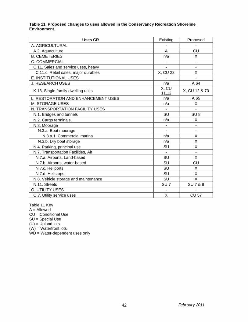
February 2011 42
Table 11. Proposed changes to uses allowed in the Conservancy Recreation Shoreline Environment.
Uses CR Existing Proposed A. AGRICULTURAL - - A.2. Aquaculture A CU B. CEMETERIES n/a X C. COMMERCIAL - - C.11. Sales and service uses, heavy - - C.11.c. Retail sales, major durables X, CU 23 X E. INSTITUTIONAL USES - - J. RESEARCH USES n/a A 64
K.13. Single-family dwelling units X, CU 11,12 X, CU 12 & 70
L. RESTORATION AND ENHANCEMENT USES n/a A 65 M. STORAGE USES n/a X N. TRANSPORTATION FACILITY USES - - N.1. Bridges and tunnels SU SU 8 N.2. Cargo terminals, n/a X N.3. Moorage - - N.3.a Boat moorage - - N.3.a.1 Commercial marina n/a X N.3.b. Dry boat storage n/a X N.4. Parking, principal use SU X N.7. Transportation Facilities, Air - - N.7.a. Airports, Land-based SU X N.7.b. Airports, water-based SU CU N.7.c. Heliports SU X N.7.d. Helistops SU X N.8. Vehicle storage and maintenance SU X N.11. Streets SU 7 SU 7 & 8 O. UTILITY USES - - O.7. Utility service uses X CU 57
Table 11 Key A = Allowed CU = Conditional Use SU = Special Use (U) = Upland lots (W) = Waterfront lots WD = Water-dependent uses only

February 2011 43
Table 12. Proposed changes to uses allowed in the Conservancy Waterway Shoreline Environment.
Uses CW Existing Proposed B. CEMETERIES n/a X C. COMMERCIAL - - C.11. Sales and service uses, heavy - X C.11.c. Retail sales, major durables CU 22 X C.12. Sales and services, marine - - C.12.d. Vessel repair, major X 32 CU 33 X C.12.e. Vessel repair, minor SU CU 33 H. PARKS AND OPEN SPACE USES - - J. RESEARCH USES n/a A 64 L. RESTORATION AND ENHANCEMENT USES n/a See 65 N. TRANSPORTATION FACILITY USES - - N.1. Bridges and tunnels A 71 SU 71 N.2. Cargo terminals, n/a X N.3. Moorage - - N.3.a Boat moorage - - N.3.a.1 Commercial marina SU SU 56 N.3.a.2 Recreational marina X SU 56 N.5. Passenger terminal n/a X N.7. Transportation Facilities, Air - - N.10. Railroads n/a X N.11. Streets n/a X Table 12 Key A = Allowed CU = Conditional Use SU = Special Use (U) = Upland lots (W) = Watefront lots WD = Water-dependent uses only WDWR = Water-dependent or water-related uses only


![WELCOME [waterfrontseattle.org] · Plan, endorsed by the Mayor and City Council in 2012 The City of Seattle’s Office of the Waterfront leads design and engineering for the Program](https://static.fdocuments.net/doc/165x107/5adbcc8f7f8b9a6d7e8e7d38/welcome-endorsed-by-the-mayor-and-city-council-in-2012-the-city-of-seattles.jpg)