City of Meridian Fields Subarea Plan
53
Fields Subarea Plan CITY OF MERIDIAN 33 E Broadway Ave., Ste 102 Meridian, ID 83642 Phone: (208) 884-5533 www.meridiancity.org/planning/fields Adopted by Resolution # XY-ABCD On Month Day, Year
Transcript of City of Meridian Fields Subarea Plan
Fields Subarea PlanCity of Meridian
33 E Broadway Ave., Ste 102Meridian, ID 83642Phone: (208) 884-5533www.meridiancity.org/planning/fields
Adopted by Resolution # XY-ABCDOn Month Day, Year

www.meridiancity.org/planning/fields
AcknowledgementsMayor and City CouncilRobert Simison, MayorTreg Bernt, PresidentJoe BortonLuke Cavener Brad Hoaglun, Vice PresidentJessica Perreault Liz Strader
Planning and Zoning CommissionBill Cassinelli Nick GroveMaria Lorcher Rhonda McCarvelAndrew SealNate Wheeler Steven Yearsley
Stakeholders Rodney Ashby, City of NampaMike Barton, City of MeridianJason Boal, Ada County Clay Carley, Old Boise, LLCDoug Critchfield, City of Nampa Greg Curtis, Nampa-Meridian Irrigation District Marci Horner, West Ada School DistrictTyler Johnson, Launch Development Finance Advisors Justin Lucas, Ada County Highway DistrictBecky McKay, Engineering SolutionsEmily Mueller, Mark Bottles Real Estate Deb Peterson, Boise Valley Church of the Brethren
Sharolyn Ririe, Subarea Property Owners Warren Ririe, Subarea Property Owners Kent Rock, Launch Development Finance AdvisorsDuane Schwisow, Subarea Property Owners Steve Siddoway, City of MeridianWarren Stewart, City of MeridianBob Taunton, Urban Land InstituteClair Waite, Subarea Property OwnersJon Wardle, Brighton CorporationMike Wardle, Brighton CorporationAnne Wescott, Galena Consulting Technical Analysis and Support TeamCameron Arial, Community Development DirectorMike Barton, Parks SuperintendentVictoria Cleary, Economic Development Administrator Caleb Hood, AICP, Planning Division ManagerBrian McClure, AICP, Comprehensive Associate Planner
Consultant TeamLogan SimpsonLeland Consulting Group
ii

www.meridiancity.org/planning/fields
4
123
ContentsIntroduction 1-1
■ Overview . . . . . . . . . . . . . . . . . . . . . . . . . . . . . . . . . . . . . . . . . . . . . . . .1-1 ■ Plan Purpose and Scope . . . . . . . . . . . . . . . . . . . . . . . . . . . . . . . . . .1-2 ■ Guide to the Plan . . . . . . . . . . . . . . . . . . . . . . . . . . . . . . . . . . . . . . . .1-2 ■ Background and Site Description . . . . . . . . . . . . . . . . . . . . . . . . . . .1-3
Public Process 2-1 ■ Overview . . . . . . . . . . . . . . . . . . . . . . . . . . . . . . . . . . . . . . . . . . . . . . . .2-1 ■ Stakeholder Roundtables . . . . . . . . . . . . . . . . . . . . . . . . . . . . . . . . .2-1 ■ Concept Refinement Charrettes . . . . . . . . . . . . . . . . . . . . . . . . . . . 2-4
The Plan: Our Vision 3-1 ■ Overview . . . . . . . . . . . . . . . . . . . . . . . . . . . . . . . . . . . . . . . . . . . . . . . .3-1 ■ Illustrative Framework Plan . . . . . . . . . . . . . . . . . . . . . . . . . . . . . . . .3-2 ■ Transportation Framework . . . . . . . . . . . . . . . . . . . . . . . . . . . . . . . .3-3 ■ Parks and Pathways Framework . . . . . . . . . . . . . . . . . . . . . . . . . . . .3-5 ■ Economic Framework . . . . . . . . . . . . . . . . . . . . . . . . . . . . . . . . . . . . .3-7 ■ Character Framework . . . . . . . . . . . . . . . . . . . . . . . . . . . . . . . . . . . .3-10 ■ Star/McMillan Center . . . . . . . . . . . . . . . . . . . . . . . . . . . . . . . . . . . .3-15
Implementation 4-1 ■ Overview . . . . . . . . . . . . . . . . . . . . . . . . . . . . . . . . . . . . . . . . . . . . . . . .4-1 ■ Implementation Priorities . . . . . . . . . . . . . . . . . . . . . . . . . . . . . . . . 4-2 ■ Critical Path Items . . . . . . . . . . . . . . . . . . . . . . . . . . . . . . . . . . . . . . . 4-3 ■ Implementation Sequencing . . . . . . . . . . . . . . . . . . . . . . . . . . . . . . 4-4 ■ Implementation Financing Considerations . . . . . . . . . . . . . . . . . . 4-5 ■ Available Infrastructure Funding Tools . . . . . . . . . . . . . . . . . . . . . 4-6 ■ Implementation Actions . . . . . . . . . . . . . . . . . . . . . . . . . . . . . . . . .4-10
iii

11IntroductionOverviewThe Fields Area, bound by Ustick Road, McDermott Road, Chinden Boulevard and Can-Ada Road, presents an incredible opportunity to plan for one of the City’s last growth areas, in a way that aligns with the Vision described in the Meridian Comprehensive Plan; continues to grow the employment base; and integrates high-quality neighborhoods, parks and pathways, and schools . A central mixed-use activity center will serve as a hub for surrounding neighborhoods, and integrates neighborhood-scale retail and services, office, civic, and park space in the very center of the Area .
The recommendations within this Plan add to, but do not replace, those of the Comprehensive Plan and development ordinances . Additional coordination and analysis will be necessary to ensure appropriate timing and integration of development in this area . This chapter discusses some of the major issues that need to be considered or resolved as development proceeds . Any proposed development is anticipated to be consistent with this Plan, the Comprehensive Plan, the Unified Development Code, and state/federal regulations .
Owyhee
Storm
Avenue
Owyhee
Storm
Avenue
Ustick RoadUstick Road
McDerm
ott Ro
ad
McDerm
ott Ro
ad
Star Road
Star Road
Can-Ada Ro
adCan-A
da Road
McMillan RoadMcMillan Road
US Hwy 20/26/Chinden Boulevard
US Hwy 20/26/Chinden BoulevardIntermountain Gas Intermountain Gas
FacilityFacility
SH-16SH-16
Below: Birdseye aerial of the existing four square mile Fields Area, looking northwest from approximately the intersection of McDermott and Ustick Roads
1-1
City
of M
erid
ian
Fiel
ds S
ubar
ea P
lan
| In
trod
uctio
nIn
trod
uctio
n
www.meridiancity.org/planning/fields

Plan Purpose and ScopeThe Fields Subarea Plan builds upon the vision and intent of the 2019 City of Meridian Comprehensive Plan . Subsequent to the Comprehensive Plan adoption, City Council prioritized The Fields Area for detailed planning that would make it more development-ready . As the City continues to grow, and with the attractiveness of a new high school, planned fire and police station, and scheduled funding for new sewer infrastructure, investment and development interest in the area has accelerated . This Plan will help ensure consistent, integrated development . The Plan builds on the City’s Comprehensive Plan and Future Land Use Map and Ada County Highway District’s (ACHD) Master Street Map .
The purpose of this Plan is to ensure that The Fields Area implements the vision of the Comprehensive Plan, and is vibrant, self-sufficient, and distinctly Meridian. All of the unique location-specific circumstances and challenges are opportunities when consistently channeled and furthered within the context of this Plan .
Guide to the Plan The Fields Subarea Plan is structured in four chapters:
» Chapter 1. Introduction outlines the plan purpose and scope, details guiding information, and illustrates key site features and constraints .
» Chapter 2. Public Process illustrates the development of the Plan through coordination with stakeholders and the community .
» Chapter 3. The Plan describes an overall illustrative plan; details land use, transportation, and park frameworks; lays out a possible design scenario for the Star/McMillan center, and illustrates the anticipated built character .
» Chapter 4. Implementation outlines an overall process and next steps, and key funding mechanisms .
Above: Regional context of The Fields AreaBelow: Future Land Use for The Fields Area
1-2
IDAHOIDAHO
UTNV
ORWY
MTWA
CA
BOISE
KUNA
EAGLESTAR
GARDEN CITY
NAMPA
CALDWELL
MIDDLETON
PARMA
WILDERGREENLEAF
MELBA
NOTUS
MERIDIANCA
NYO
N C
OUN
TYAD
A CO
UNTY
£26
¬44
¬55
¬55
¬69
¬45
¬44
¬16
§̈184
£26£26£26
§̈84
§̈84
§̈84
£26¬19
£26
£95 ¬55
¬21
FIELDS FIELDS SUBAREASUBAREA
City
of M
erid
ian
Fiel
ds S
ubar
ea P
lan
| In
trod
uctio
nIn
trod
uctio
n
www.meridiancity.org/planning/fields

Background and Site DescriptionThe Fields Area is an approximately four-square mile area located at the northwest corner of Meridian and bounded by Ustick Road on the south, Can-Ada Road on the west, Chinden Boulevard/US Highway 20/26 on the north, and McDermott Road/State Highway 16 (SH-16) on the east (see page 1-4) . The area abuts the City Impact Areas of Star to the north and Nampa to the south and west .
Land Use. As shown on the Comprehensive Plan’s Future Land Use Map, the Fields Area is primarily designated for future residential development, with a mixed use community center at the southeast corner of Star and McMillan, and multiple school and park sites . Interchange and regional mixed use designations are incorporated along both Ustick Road and Chinden Boulevard, generally from the SH-16 extension to Star Road . The southwest corner of the Subarea has been reserved for expanded industrial and non-residential mixed use area within the southwest quadrant, and is aligned with the existing Intermountain Gas Facility, currently located on Can-Ada Road . Through the Comprehensive Plan, the land use accommodated a 1,000-foot safety buffer for the facility, allowing only no-residential uses within that buffer. Lighting, and air sirens need to be taken into account for any adjacent development, and open space and pathways should be located to help mitigate these nuisances .Transportation. Star, Ustick, Can-Ada, and McMillan Roads are all owned and maintained by ACHD . The ACHD Transportation and Land Use Integration Plan classifies each of these four streets as “residential mobility” arterials . Star, Ustick, and Can-Ada Roads are proposed for five lanes, and McMillan Road for three lanes .Chinden Boulevard and the SH-16 extension are under Idaho Transportation Department (ITD) jurisdiction . SH-16 is planned to extend south, paralleling McDermott Road, from its current terminus at Chinden Boulevard, to Interstate 84
at the south . Two future interchanges are planned: one at Chinden Boulevard and one at Ustick Road .
The area’s only existing collector street, Owyhee Storm Avenue, has recently been constructed, from Ustick Road north to the Owyhee High School . This collector is planned to continue further north to Chinden Boulevard, and is anticipated to include a pathway .
Schools and Pathways. Owyhee High School is located at the southeast corner of the Subarea, just south of a future elementary school site . Two additional school sites have been designated on the Future Land Use Map in this area, in coordi-nation with the West Ada School District, but siting has not yet been determined . The Five Mile Creek and Feeder, Phyllis Canal, West Tap Sublateral, and Sky Pilot Drain are all anticipated to include proposed pathways along their alignments .Irrigation. Multiple irrigation drains, feeders, and laterals cross the area, most notably the Five Mile Creek, which con-tinues further east through the City . The numerous ditches and laterals that traverse The Fields Area, create both an opportunity for water-oriented green space and a challenge for future development due to high ground water . With pathway improvements, Five Mile Creek has the opportunity to connect The Fields Area to the rest of Meridian, and into a regional system connecting west through Nampa, and north through Star and to the Boise River .Utilities. Currently, the area is only able to be served with sanitary sewer service as far west as Owyhee Storm Avenue . Future development located further to the west requires the Can-Ada Lift Station, pressure line, and gravity trunk lines, anticipated to begin design in the near future .Water is available along Ustick and McMillan Roads, west to Owyhee Storm Avenue . Portions of Owyhee Storm have mainlines installed, though extensions west will be required to serve additional areas . A future, additional well will be necessary to serve the four square mile area .
1-3
City
of M
erid
ian
Fiel
ds S
ubar
ea P
lan
| In
trod
uctio
nIn
trod
uctio
n
www.meridiancity.org/planning/fields

1-4
City
of M
erid
ian
Fiel
ds S
ubar
ea P
lan
| In
trod
uctio
nIn
trod
uctio
n
0 1/8 mile 1/4 mile 1/2 mile0 1/8 mile 1/4 mile 1/2 mile NorthNorth
Five Mile Creek/DrainFive Mile Creek/Drain
Five Mile Feeder CanalFive Mile Feeder CanalSky Pilot Drain
Sky Pilot Drain
McFadden DrainMcFadden Drain
Phyllis
Cana
lPh
yllis
Cana
l
Five Mile Creek/DrainFive Mile Creek/Drain
Intermountain Gas Intermountain Gas Facility and Safety BufferFacility and Safety Buffer
Eight Mile LateralEight Mile Lateral
West Tap SublateralWest Tap Sublateral
Phylli
s Canal
Phylli
s Canal Owyhee Owyhee
High SchoolHigh School
Future Elementary Future Elementary School SiteSchool Site
Ow
yhee Storm Ave
Ow
yhee Storm Ave
Future SH-16 Extension AlignmentFuture SH-16 Extension AlignmentGander CreekGander Creek
Gander CreekGander Creek
LDRLDR
LDRLDR
Five Mile Creek PathwayFive Mile Creek Pathway
N Baylor LnN Baylor Ln
W Ledgerwood LnW Ledgerwood Ln
W Lazy Diamond C Ln
W Lazy Diamond C Ln
MDRMDR
MDRMDR
MDRMDRMDRMDR
MDRMDR
MDRMDR
MDRMDR
MDRMDR
MU-IMU-I
MU-RMU-R
MU-NRMU-NR
INDIND
MU-CMU-C
MU-CMU-C
M-HDRM-HDR
M-HDRM-HDRM-HDRM-HDR
M-HDRM-HDR
5.17 Lateral5.17 Lateral
5.5 Lateral5.5 Lateral
5.3 Lateral5.3 Lateral
Potential Future Potential Future School AreaSchool Area
Potential Future Potential Future Park AreaPark Area
Potential Future Potential Future Park AreaPark Area
Potential Future Potential Future School AreaSchool Area
Future Pathway
Future Pathway
Future PathwayFuture Pathway
Futur
e Pa
thway
Futur
e Pa
thwayFu
ture Co
llecto
rFu
ture Co
llecto
rFu
ture Co
llecto
rFu
ture Co
llecto
r
Can-Ada Can-Ada Lift Station Lift Station (future)(future)
Existing Ponds and Existing Ponds and 100-Year Floodplain Area100-Year Floodplain Area
Williams Gas Pipeline
Williams Gas Pipeline
Existing Existing CemeteryCemetery
Existing Site Features Map
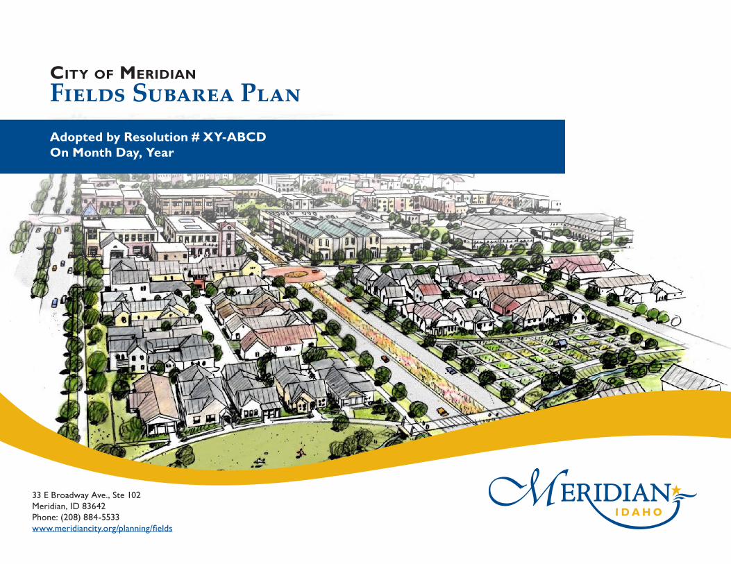
2Public ProcessOverviewThe Fields is a unique area of Meridian’s Area of City Impact, in that it is generally removed from much of the remaining City . It is an extension of the City bound on three sides by other municipalities, and it will be further separated from the City by the future extension of SH-16 . While much of the land is controlled by development interests, and many more land owners are interested in selling, meaningful public engagement is still paramount to development and adoption of this Plan .
Public engagement for this plan began as the Comprehensive Plan was developed, and continued through the development of this Subarea Plan . Each phase built upon the findings from the prior phase to dive deeper into the vision and desires of stakeholders and the community to mold and shape The Fields Plan . This chapter describes each phase in detail and discusses the process and the findings from each.
Stakeholder RoundtablesAs part of the Subarea Plan, the City met in-person, on-site, and at City Hall, and virtually with approximately 25 individuals representing a variety of public agencies, the development community, and property owners to review background information and refine preliminary draft concepts for the area . Since future land uses had been previously discussed with stakeholders in 2017 and again in 2019 as part of the Comprehensive Plan, the focus of these roundtables was to discuss implementation and the more prescriptive design elements within the central Star/McMillan area . The team reviewed background and guiding information from the Comprehensive Plan, and refined the concepts with more affected stakeholders prior to broader public engagement .
Three concepts (on the following page) focusing on the Star/McMillan Center were reviewed to refine opportunities and begin the discussion on implementation steps and feasibility for the mixed-use activity area .
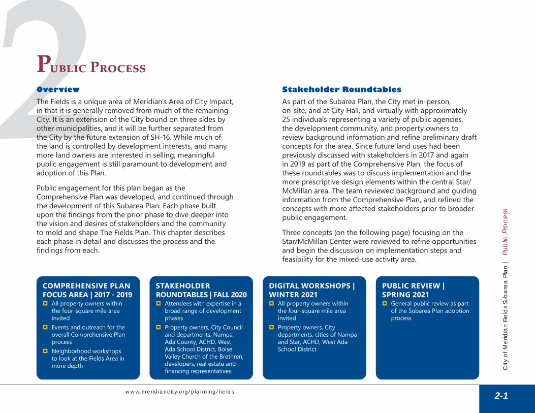
STAKEHOLDER ROUNDTABLES | FALL 2020
� Attendees with expertise in a broad range of development phases
� Property owners, City Council and departments, Nampa, Ada County, ACHD, West Ada School District, Boise Valley Church of the Brethren, developers, real estate and financing representatives
PUBLIC REVIEW | SPRING 2021
� General public review as part of the Subarea Plan adoption process
DIGITAL WORKSHOPS | WINTER 2021
� All property owners within the four-square mile area invited
� Property owners, City departments, cities of Nampa and Star, ACHD, West Ada School District
COMPREHENSIVE PLAN FOCUS AREA | 2017 - 2019
� All property owners within the four-square mile area invited
� Events and outreach for the overall Comprehensive Plan process
� Neighborhood workshops to look at the Fields Area in more depth
2-1
City
of M
erid
ian
Fiel
ds S
ubar
ea P
lan
| P
ublic
Pro
cess
Publ
ic P
roce
ss
www.meridiancity.org/planning/fields

Concept 1: Central Civic Area » North-south oriented ‘Main
Street’ » Focus on usable civic area/park
alongside greenway » Parallel north-south access from
Star Road, combined into one boulevard at the south end of the civic area/greenway
» Two greenway crossings » Focus on pathways converging in
the central civic area
Concept 2: Interior ‘Main Street’ » Access from McMillan Road and
Star Road » One main greenway crossing;
other access points focus on usable park space at termini
» Main greenway crossing has an off-street pathway; three east-west street/pathway connections to high school and future elementary school
» Main greenway crossing works as a buffer for higher density ‘Main Street’ from mixed use area south to the east-west road between the schools
» Narrowest greenway, with pockets of activity/park space at key locations along the corridor
Concept 3: Lake Front Retail » Primary access from Star Road,
with visibility from Star Road along greenway and across lake front
» Secondary access from McMillan Road
» Opportunity for retail/office to take advantage of direct lake access
» ‘Main Street’ continues from Star Road across greenway and south to Ustick Road
» Possible secondary roadway connection across greenway east of mixed use area to connect McMillan Road to east-west road into future school site
» Additional park space at the west side, west of Star Road
2-2
City
of M
erid
ian
Fiel
ds S
ubar
ea P
lan
| P
ublic
Pro
cess
Publ
ic P
roce
ss
www.meridiancity.org/planning/fields
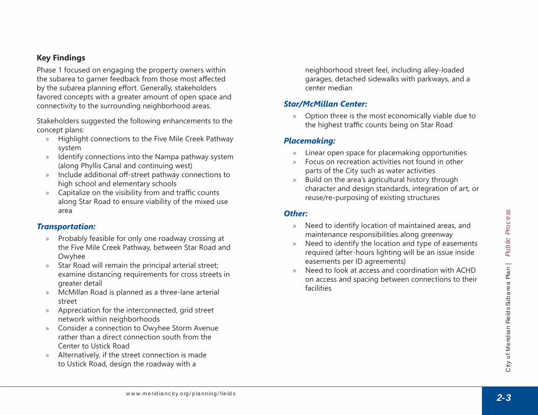
Key FindingsPhase 1 focused on engaging the property owners within the subarea to garner feedback from those most affected by the subarea planning effort. Generally, stakeholders favored concepts with a greater amount of open space and connectivity to the surrounding neighborhood areas .
Stakeholders suggested the following enhancements to the concept plans:
» Highlight connections to the Five Mile Creek Pathway system
» Identify connections into the Nampa pathway system (along Phyllis Canal and continuing west)
» Include additional off-street pathway connections to high school and elementary schools
» Capitalize on the visibility from and traffic counts along Star Road to ensure viability of the mixed use area
Transportation: » Probably feasible for only one roadway crossing at
the Five Mile Creek Pathway, between Star Road and Owyhee
» Star Road will remain the principal arterial street; examine distancing requirements for cross streets in greater detail
» McMillan Road is planned as a three-lane arterial street
» Appreciation for the interconnected, grid street network within neighborhoods
» Consider a connection to Owyhee Storm Avenue rather than a direct connection south from the Center to Ustick Road
» Alternatively, if the street connection is made to Ustick Road, design the roadway with a
neighborhood street feel, including alley-loaded garages, detached sidewalks with parkways, and a center median
Star/McMillan Center: » Option three is the most economically viable due to
the highest traffic counts being on Star Road
Placemaking: » Linear open space for placemaking opportunities » Focus on recreation activities not found in other
parts of the City such as water activities » Build on the area’s agricultural history through
character and design standards, integration of art, or reuse/re-purposing of existing structures
Other: » Need to identify location of maintained areas, and
maintenance responsibilities along greenway » Need to identify the location and type of easements
required (after-hours lighting will be an issue inside easements per ID agreements)
» Need to look at access and coordination with ACHD on access and spacing between connections to their facilities
2-3
City
of M
erid
ian
Fiel
ds S
ubar
ea P
lan
| P
ublic
Pro
cess
Publ
ic P
roce
ss
www.meridiancity.org/planning/fields
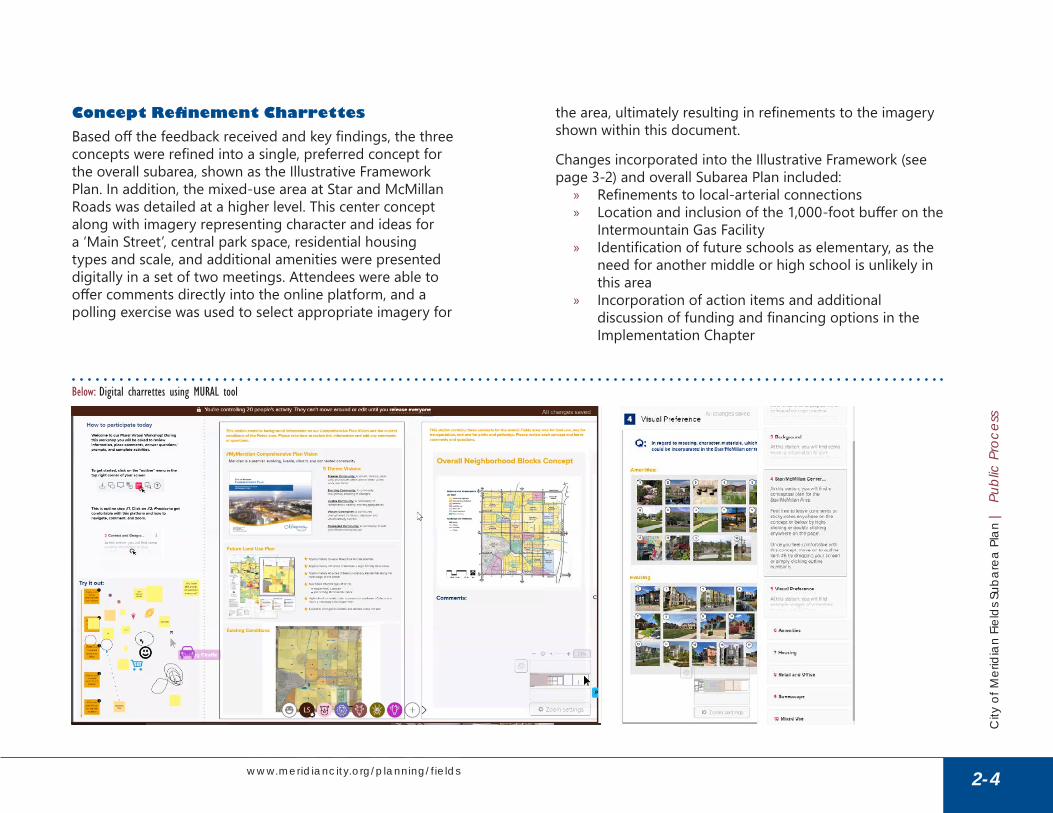
Concept Refinement CharrettesBased off the feedback received and key findings, the three concepts were refined into a single, preferred concept for the overall subarea, shown as the Illustrative Framework Plan . In addition, the mixed-use area at Star and McMillan Roads was detailed at a higher level . This center concept along with imagery representing character and ideas for a ‘Main Street’, central park space, residential housing types and scale, and additional amenities were presented digitally in a set of two meetings . Attendees were able to offer comments directly into the online platform, and a polling exercise was used to select appropriate imagery for
the area, ultimately resulting in refinements to the imagery shown within this document .
Changes incorporated into the Illustrative Framework (see page 3-2) and overall Subarea Plan included:
» Refinements to local-arterial connections » Location and inclusion of the 1,000-foot buffer on the
Intermountain Gas Facility » Identification of future schools as elementary, as the
need for another middle or high school is unlikely in this area
» Incorporation of action items and additional discussion of funding and financing options in the Implementation Chapter
Below: Digital charrettes using MURAL tool
2-4
City
of M
erid
ian
Fiel
ds S
ubar
ea P
lan
| P
ublic
Pro
cess
Publ
ic P
roce
ss
www.meridiancity.org/planning/fields

3The Plan: Our VisionOverviewThe Fields will accommodate a series of great neighborhoods for the City, focused on a community-oriented, mixed-use center and connected by an amenitized greenway and pathway system, and increasing the City’s job base through a range of employment areas.
The Star and McMillan mixed-use center will be focused around a traditional Main Street and highly integrated pedestrian-oriented environment . The center will include a central green and connection to the Five Mile Creek Pathway . A variety of residential types including vertically integrated, live-work, and other medium-high-density residential products will provide the rooftops necessary to
support and activate destination community services for the center .
The Fields Business Park will serve as a hub for light industrial and flex uses, at the northeast corner of Can-Ada and Ustick Roads, with connections to SH-16, and walkable connections into surrounding neighborhoods and along regional pathway systems .
Additional mixed-use commercial areas along Ustick Road and Chinden Boulevard will provide areas of high visibility, but lower trips, and are anticipated as uses that would not compete with the smaller-scale neighborhoods services and commercial at the core .
3-1
City
of M
erid
ian
Fiel
ds S
ubar
ea P
lan
| T
he P
lan
The
Plan
www.meridiancity.org/planning/fields
0 1/8 mile 1/4 mile 1/2 mile0 1/8 mile 1/4 mile 1/2 mile North
Five Mile Creek PathwayFive Mile Creek Pathway
Sky Pilot Pathway
Sky Pilot Pathway
McFadden PathwayMcFadden PathwayPh
yllis
Cana
l Region
al Pa
thway
Phyllis
Cana
l Region
al Pa
thway
Five Mile Creek PathwayFive Mile Creek Pathway
Intermountain Gas Intermountain Gas FacilityFacility
Eight Mile PathwayEight Mile Pathway
West Tap SublateralWest Tap Sublateral
Phylli
s Canal
Region
al Pathw
ay
Phylli
s Canal
Region
al Pathw
ay
Owyhee Owyhee High SchoolHigh School
Future Elementary Future Elementary School SiteSchool Site
owyhee Storm AveNue
owyhee Storm AveNue
Future SH-16 Extension AlignmentFuture SH-16 Extension Alignment
Preservation and Transition of Preservation and Transition of Existing Rural NeighborhoodsExisting Rural Neighborhoods
Five Mile Creek Pathway Connection
Five Mile Creek Pathway Connection
N Baylor LnN Baylor Ln
W Ledgerwood LnW Ledgerwood Ln
Residential Residential NeighborhoodsNeighborhoods
Interchange Area Interchange Area CommercialCommercial
Regional Regional CenterCenter
Business ParkBusiness Park
Industrial Industrial ParkPark
Mixed Use Mixed Use CenterCenter
Star/McMillan Star/McMillan CenterCenterHigher Density Higher Density
HousingHousing
5.17 Lateral5.17 Lateral
5.5 Lateral5.5 Lateral
5.3 Lateral5.3 Lateral
Higher Density Higher Density Housing Along UstickHousing Along Ustick
CAN-AdA roAdCAN-AdA roAd
StAr roAdStAr roAd
ChiNdeN BoulevArd/uS 20/26ChiNdeN BoulevArd/uS 20/26
mCmillAN roAdmCmillAN roAd
uStiCk roAduStiCk roAd
Regional CityRegional CityParkPark
Higher Density Higher Density HousingHousing
Residential Residential NeighborhoodsNeighborhoods
Potential Civic Site Potential Civic Site (school, church, etc.)(school, church, etc.)Potential Potential
Civic Site (school, Civic Site (school, church, etc.)church, etc.)
Residential Residential NeighborhoodsNeighborhoods
Residential Residential NeighborhoodsNeighborhoods
Residential Residential NeighborhoodsNeighborhoods
Higher Density Higher Density HousingHousing
New ColleCtor roAd
New ColleCtor roAd
New ColleCtor roAdNew ColleCtor roAd
New ColleCtor roAdNew ColleCtor roAd
Neighborhood Neighborhood ParkPark
ParkPark
Neighborhood ParkNeighborhood Park
New ColleCtor roAdNew ColleCtor roAd
Higher Density Higher Density Housing Along UstickHousing Along Ustick
City of Nampa Area of City ImpactCity of Nampa Area of City Impact
City of Star Area of City ImpactCity of Star Area of City Impact
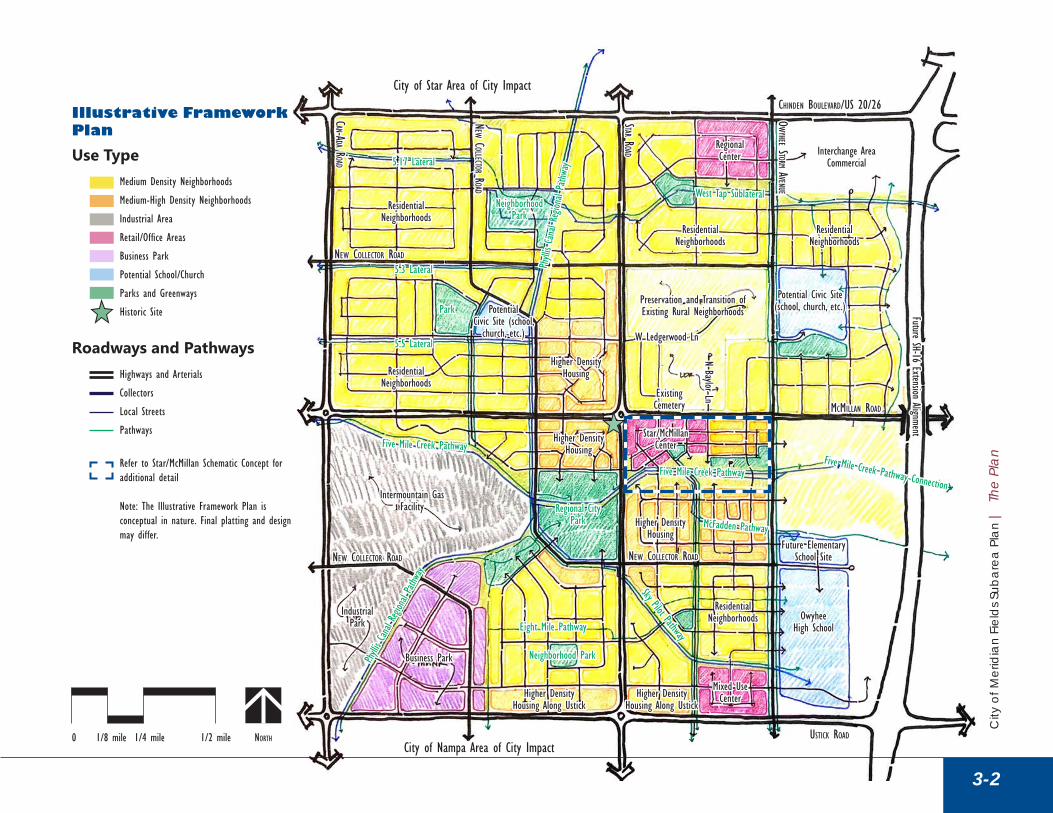
Illustrative Framework PlanUse Type
Medium Density Neighborhoods
Medium-High Density Neighborhoods
Industrial Area
Retail/Office Areas
Business Park
Potential School/Church
Parks and Greenways
Historic Site
Roadways and PathwaysHighways and Arterials
Collectors
Local Streets
Pathways
Refer to Star/McMillan Schematic Concept for additional detail
Note: The Illustrative Framework Plan is conceptual in nature. Final platting and design may differ.
Existing Existing CemeteryCemetery
3-2
City
of M
erid
ian
Fiel
ds S
ubar
ea P
lan
| T
he P
lan
The
Plan

Transportation FrameworkThe transportation framework is based on ITD’s expansion plans for SH-16, and ACHD’s existing arterial and proposed collector system detailed in the ACHD Master Street Map .
Further definition for the future local street network and connectivity is shown within the Illustrative Framework Plan, though final design will likely be different. The Illustrative Framework Plan is intended to demonstrate character and connectivity intent regardless of final design. A key goal will be to ensure walkability between neighborhoods and centers, safe routes to schools, and equity in distribution of, and distance to, parks and recreation amenities .
» SH-16 is planned to be extended from its current termination at Chinden Boulevard south to I-84 . The planned, ultimate extension is anticipated to be limited access, with interchanges at Chinden Boulevard and Ustick Roads, and an underpass at McMillan Road . The design for this extension is completed, but the construction timeline and phasing has not yet been identified.
» Chinden Boulevard (US 20/26) borders the north edge of the Fields Area . Recently, there have been requests to ITD to amend the Environmental Analysis for Chinden Boulevard, in order to support and allow mid-mile accesses along Chinden, between Can-Ada Road and SH-16 .
» Principal and minor arterials are constructed and maintained by ACHD and include Ustick, Star, McMillan, and Can-Ada Roads . All except for McMillan are planned to eventually be widened to five lanes. McMillan is planned for three lanes.
» Collectors on-site include the semi-constructed Owyhee Storm Avenue, and multiple planned collectors connecting neighborhoods to the arterials . Generally, the collectors run on a half-mile grid .
» Local streets have been included in the Illustrative Framework, as potential options but actual development is likely to differ. Local streets should offer a high level of connectivity between neighborhoods and amenities; prioritize access to collector roadways, not arterials; and be coordinated with off-street pathway systems.
3-3
City
of M
erid
ian
Fiel
ds S
ubar
ea P
lan
| T
he P
lan
The
Plan
www.meridiancity.org/planning/fields
Above: A residential neighborhood street

0 1/8 mile 1/4 mile 1/2 mile0 1/8 mile 1/4 mile 1/2 mile North
Five Mile Creek PathwayFive Mile Creek Pathway
Sky Pilot Pathway
Sky Pilot Pathway
Phyllis
Cana
l Region
al Pa
thway
Phyllis
Cana
l Region
al Pa
thway
Five Mile Creek PathwayFive Mile Creek Pathway
Existing Existing Intermountain Gas Intermountain Gas
FacilityFacility
Phylli
s Canal
Region
al Pathw
ay
Phylli
s Canal
Region
al Pathw
ay
Owyhee Owyhee High SchoolHigh School
Future Elementary Future Elementary School SiteSchool Site
owyhee Storm AveNue
owyhee Storm AveNue
Future SH-16 Extension AlignmentFuture SH-16 Extension Alignment
Interchange Area Interchange Area CommercialCommercial
Business ParkBusiness Park
Industrial Industrial ParkPark
Mixed Use Mixed Use CenterCenter
Star/McMillan Star/McMillan CenterCenter
CAN-AdA roAd (PlANNed 5-lANe roAd)CAN-AdA roAd (PlANNed 5-lANe roAd)
StAr roAd (PlANNed 5-lANe roAd)StAr roAd (PlANNed 5-lANe roAd)
ChiNdeN BoulevArd/uS 20/26ChiNdeN BoulevArd/uS 20/26(PlANNed 5-lANe roAd)(PlANNed 5-lANe roAd)
mCmillAN roAdmCmillAN roAd
uStiCk roAd uStiCk roAd (PlANNed 5-lANe roAd)(PlANNed 5-lANe roAd)
Existing Existing NeighborhoodsNeighborhoods
New ColleCtor roAd
New ColleCtor roAd
New ColleCtor roAdNew ColleCtor roAd
New ColleCtor roAdNew ColleCtor roAdNew ColleCtor roAdNew ColleCtor roAd
Mixed Use Mixed Use CenterCenter
City of Nampa Area of City ImpactCity of Nampa Area of City Impact
City of Star Area of City ImpactCity of Star Area of City Impact
Transportation Framework Roadways and Pathways
State Highways (ITD)
Principal and Minor Arterials, 96’ ROW (ACHD)
Minor Arterials, 70’ ROW (ACHD)
Collectors, 60 - 90’ ROW (ACHD)
Primary Local Streets
Primary Pathways (Five Mile Creek and Phyllis Canal Pathways)
Valley Connect 2.0, Secondary Route
Valley Connect 2.0, Employer Express Route
Refer to Star/McMillan Schematic Concept for additional detail
Note: The Transportation Framework is conceptual in nature. Final layout and design of the street network may differ.
3-4
City
of M
erid
ian
Fiel
ds S
ubar
ea P
lan
| T
he P
lan
The
Plan
www.meridiancity.org/planning/fields

Parks and Pathways FrameworkThe pathway network is one of the organizing features of The Fields Area, with an extension of the Five Mile Creek Pathway and a north-south connection along the Phyllis Canal offering regional access and connection to the rest of the City, the surrounding region, and north to the Boise River . Secondary proposed pathways run adjacent to many of the water conveyance facilities within The Fields Area, and will require coordination with both Nampa-Meridian Irrigation District and Settlers Irrigation to determine feasibility and/or location of pathways and bridges . Aside from the Five Mile Creek Pathway, pathways are anticipated to be maintained by HOAs, with an easement for public use .
In regard to parks, this area of the City is currently under-served, there are no planned park capital improvements, and SH-16 improvements will reduce connectivity to public parks east of McDermott Road . The nearest existing public parks are Seasons Neighborhood Park, or Keith Bird Legacy Neighborhood Park, and both are far outside a preferred half-mile walkability radius . The Illustrative Framework Plan is intended to demonstrate general size, location, and connectivity of future parks and pathways .
» A City regional park is proposed just southwest of the intersection of Star and McMillan Roads, at the intersection of the Five Mile Creek Pathway and proposed Phyllis Canal pathway . Relatively central to The Fields Area, the park needs to be community-serving, but may be accommodated in an original way and include the linear park . The general placement of the park serves as a buffer between the Intermountain Gas Facility and neighborhoods .
» A City linear greenway and park run east from the regional park, south of the Star/McMillan Center, and offer the opportunity for uses within the Center and supporting residential to build off this open space area along the Five Mile Creek Pathway .
» Multiple one- to ten-acre neighborhood parks will be distributed throughout The Fields Area, central to neighborhoods, and integrated with proposed pathways where possible . These smaller parks will likely be developer-constructed and HOA-maintained . Partnerships should be explored between the City, West Ada School District, or other entities for public uses in co-developed and shared spaces .
3-5
City
of M
erid
ian
Fiel
ds S
ubar
ea P
lan
| T
he P
lan
The
Plan
www.meridiancity.org/planning/fields
Above: An example of integrated pathway and open space through residential neighborhoods

0 1/8 mile 1/4 mile 1/2 mile0 1/8 mile 1/4 mile 1/2 mile North
Five Mile Creek PathwayFive Mile Creek Pathway
Sky Pilot Pathway
Sky Pilot Pathway
McFadden PathwayMcFadden PathwayPh
yllis
Cana
l Region
al Pa
thway
Phyllis
Cana
l Region
al Pa
thway
Five Mile Creek PathwayFive Mile Creek Pathway
Existing Existing Intermountain Gas Intermountain Gas
FacilityFacility
Eight Mile PathwayEight Mile Pathway
West Tap SublateralWest Tap Sublateral
Phylli
s Canal
Region
al Pathw
ay
Phylli
s Canal
Region
al Pathw
ay
Owyhee Owyhee High SchoolHigh School
Future Elementary Future Elementary School SiteSchool Site
owyhee Storm AveNue
owyhee Storm AveNue
Future SH-16 Extension AlignmentFuture SH-16 Extension Alignment
Existing Rural Existing Rural NeighborhoodsNeighborhoods
Residential Residential NeighborhoodsNeighborhoods
Interchange Area Interchange Area CommercialCommercial
Business ParkBusiness Park
Industrial Industrial ParkPark
Higher Density Higher Density HousingHousing
5.17 Lateral5.17 Lateral
5.5 Lateral5.5 Lateral
5.3 Lateral5.3 Lateral
CAN-AdA roAdCAN-AdA roAd
StAr roAdStAr roAd
ChiNdeN BoulevArd/uS 20/26ChiNdeN BoulevArd/uS 20/26
mCmillAN roAdmCmillAN roAd
uStiCk roAduStiCk roAd
Higher Density Higher Density HousingHousing
Residential Residential NeighborhoodsNeighborhoods
Residential Residential NeighborhoodsNeighborhoods
Residential Residential NeighborhoodsNeighborhoods
New ColleCtor roAd
New ColleCtor roAd
Regional ParkRegional Park
City of Nampa Area of City ImpactCity of Nampa Area of City Impact
City of Star Area of City ImpactCity of Star Area of City Impact
Parks and Pathways FrameworkUse Type
Parks and Greenways (City)
Potential Elementary School/Civic Facility
Parks (HOA)
Roadways and PathwaysOff-Street Pathways
On-Street Pathways
1/4-mile walk distance1/4-mile walk distance
1/2-mile walk distance1/2-mile walk distance
Refer to Star/McMillan Schematic Concept for Refer to Star/McMillan Schematic Concept for additional detailadditional detail
Note: The Parks and Pathways Framework is conceptual in nature. Final location, size, and design of included parks and pathways may differ.
3-6
City
of M
erid
ian
Fiel
ds S
ubar
ea P
lan
| T
he P
lan
The
Plan
www.meridiancity.org/planning/fields

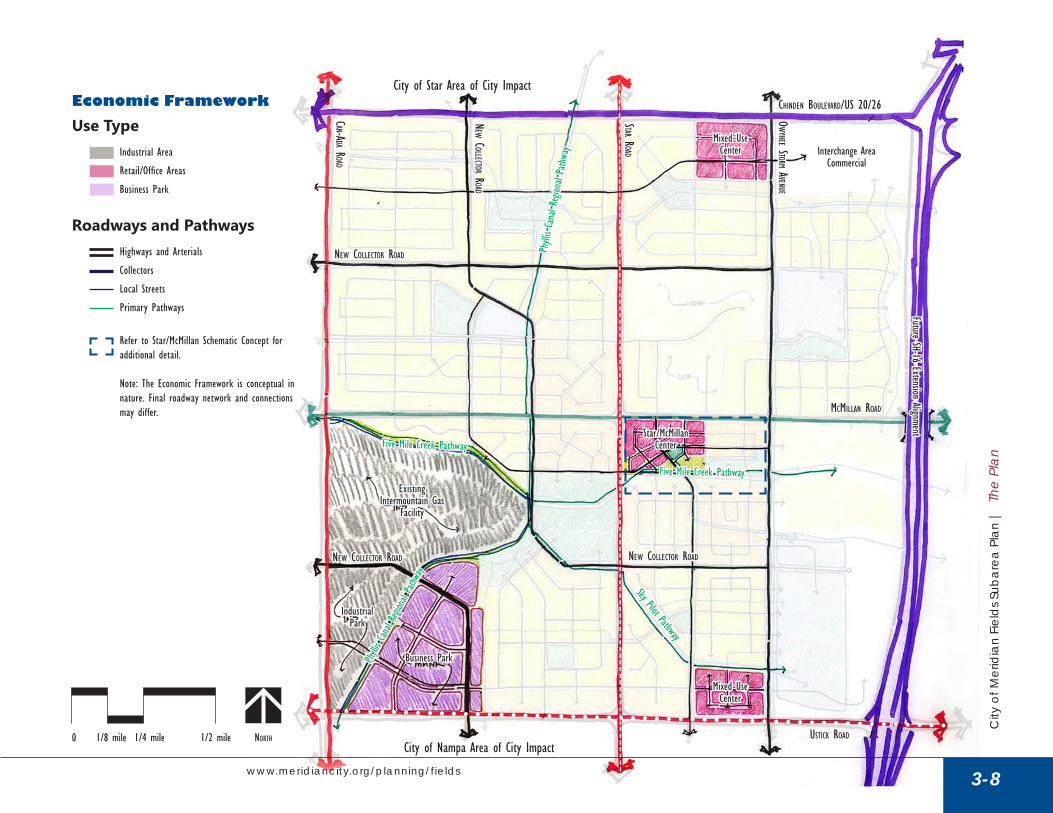
Economic FrameworkPreserving land for an expanding job base for the City is important within The Fields Area . While much of the four square miles are anticipated to be residential neighborhoods, key areas along arterials are anticipated to be utilized for mixed-use, industrial, and business areas . A local supply of family-wage jobs is essential not only for the City’s overall jobs/housing balance, but in preserving the transportation network, reducing regional pass-through traffic, and in providing employment opportunities close to homes . If land uses are deemed necessary to change, areas within the larger area and/or larger City must be identified to mitigate that loss of employment area within the Fields Area .
» The southwest corner of The Fields Area along Can-Ada Road includes an Industrial Area, building off the existing Intermountain Gas Facility, and offering
direct access to Can-Ada Road, which provides a separation between the industrial areas and planned residential to the west .
» Adjacent to the Industrial Area, but separated by the Phyllis Canal and Pathway system, lies a future Business Park area, intended to accommodate non-residential mixed uses, and serving as a transitional area between industrial and residential neighborhoods along Ustick Road . Ancillary food and retail uses may support the business park employees .
» Along both Chinden Boulevard and Ustick Road are two Mixed-Use Areas anticipated to accommodate retail and office space typical to larger arterials within the area . These mixed-use areas are anticipated to be much different and must not compete with the Star/McMillan Center, further described later in this document .
3-7
City
of M
erid
ian
Fiel
ds S
ubar
ea P
lan
| T
he P
lan
The
Plan
www.meridiancity.org/planning/fields
Above: A commercial building integrated into residential neighborhoods beyond
0 1/8 mile 1/4 mile 1/2 mile0 1/8 mile 1/4 mile 1/2 mile North
Five Mile Creek PathwayFive Mile Creek Pathway
Sky Pilot Pathway
Sky Pilot Pathway
Phyllis
Cana
l Region
al Pa
thway
Phyllis
Cana
l Region
al Pa
thway
Five Mile Creek PathwayFive Mile Creek Pathway
Existing Existing Intermountain Gas Intermountain Gas
FacilityFacility
Phylli
s Canal
Region
al Pathw
ay
Phylli
s Canal
Region
al Pathw
ay
owyhee Storm AveNue
owyhee Storm AveNue
Future SH-16 Extension AlignmentFuture SH-16 Extension Alignment
Interchange Area Interchange Area CommercialCommercial
Business ParkBusiness Park
Industrial Industrial ParkPark
Mixed Use Mixed Use CenterCenter
Star/McMillan Star/McMillan CenterCenter
CAN-AdA roAdCAN-AdA roAd
StAr roAdStAr roAd
ChiNdeN BoulevArd/uS 20/26ChiNdeN BoulevArd/uS 20/26
mCmillAN roAdmCmillAN roAd
uStiCk roAduStiCk roAd
New ColleCtor roAd
New ColleCtor roAd
New ColleCtor roAdNew ColleCtor roAd
New ColleCtor roAdNew ColleCtor roAdNew ColleCtor roAdNew ColleCtor roAd
Mixed Use Mixed Use CenterCenter
City of Nampa Area of City ImpactCity of Nampa Area of City Impact
City of Star Area of City ImpactCity of Star Area of City ImpactEconomic FrameworkUse Type
Industrial Area
Retail/Office Areas
Business Park
Roadways and PathwaysHighways and Arterials
Collectors
Local Streets
Primary Pathways
Refer to Star/McMillan Schematic Concept for additional detail.
Note: The Economic Framework is conceptual in nature. Final roadway network and connections may differ.
3-8
City
of M
erid
ian
Fiel
ds S
ubar
ea P
lan
| T
he P
lan
The
Plan
www.meridiancity.org/planning/fields

Table 4a: Overall Development Program
Land Use Designation
Residential Commercial
Approx. Acreage
Allowable Density Range Total Units
Average Approx. Acreage FAR SF
Low High Low High
Medium-High Density Residential 180 8 12 1,440 2,160 1,800 - - -
Medium Density Residential 800 3 8 2,400 6,400 4,400 - - -
Low Density Residential 70 0 3 40 60 50 - - -
Parks & Open Space 225 - - - - - - - -
Schools (Civic) 125 - - - - - - - -
Mixed-Use Community 30 6 15 180 450 315 40 0 .35 610,000
Mixed-Use Regional 10 6 40 60 400 230 40 0 .25 436,000
Mixed-Use Interchange - - - - - - 70 0 .15 458,000
Mixed-Use Non-Residential - - - - - - 60 0 .10 262,000
Industrial - - - - - - 160 0 .05 349,000
Totals 1,440 - - 4,120 9,470 6,795 370 - 2,115,000
Assumptions: The Star/McMillan Center and Star/Ustick center assume 40% residential; Chinden centers assume 20% residential. Commercial uses are broken down as follows: MU-C and MU-R assumes 90% commercial and 10% governmental/other; MU-NR assumes 50% office, 40% office/flex, and 10% other; and MU-I assumes 50% office, 30% governmental/other, and 20% flex.
Development ProgramAs shown in the development program above, estimated square footage for retail and office uses are expected to take nearly 50 years to fully build out, while industrial and flex space markets could be built out in only 15 years. The City should consider this in development proposals and monitor near-term residential demand and development to preserve opportunities for the lagging, long-term employment demand .
Absorption PotentialThough somewhat dependent on the SH-16 extension, economic analysis indicates that the Fields Area could potentially see the following ten-year demand:
Conservative Aggressive
Retail 143,000 SF 213,000 SF
Office 77,000 SF 96,000 SF
Industrial 176,000 SF 220,000 SF
3-9
City
of M
erid
ian
Fiel
ds S
ubar
ea P
lan
| T
he P
lan
The
Plan
www.meridiancity.org/planning/fields

Character FrameworkUnique character and high-quality design will help ensure that The Fields Area contributes to the City’s overall goal of creating high-quality and family-friendly neighborhoods . The character and identity of neighborhoods, commercial areas, and parks and open space areas can allow this area to become a unique destination within the City and the larger region .
3-10
City
of M
erid
ian
Fiel
ds S
ubar
ea P
lan
| T
he P
lan
The
Plan
www.meridiancity.org/planning/fields
Above: Single-family housing illustrating desired character elements for the Fields Area

Housing
3-11
Low-density, detached single-family
City
of M
erid
ian
Fiel
ds S
ubar
ea P
lan
| T
he P
lan
The
Plan
www.meridiancity.org/planning/fields
Above-garage accessory dwelling unit
Alley-loaded, detached single-familyTwo-story townhomes with central, shared yard
Three-story, open-space oriented apartments/condos Three-story courtyard apartments/condos
Detached single-family
Live/work units
Three-story apartments
Single-family housing Open-space oriented townhomes
One-story, attached patio homes

Character FrameworkAmenities
3-12
City
of M
erid
ian
Fiel
ds S
ubar
ea P
lan
| T
he P
lan
The
Plan
www.meridiancity.org/planning/fields
Natural areas restoration
Water features/splash pads
Amphitheater area
Amenitized trailheads
Natural areas/pedestrian bridges and pathway Agricultural-themed park amenities/playgrounds
Festival/market areas
Integrated water play/ natural area
Shelters and gathering areas
Sports fields
Community gardens

Character FrameworkStreetscape
3-13
City
of M
erid
ian
Fiel
ds S
ubar
ea P
lan
| T
he P
lan
The
Plan
www.meridiancity.org/planning/fields
On-street, bike lanes
Curbless street
Curb-separated bike lanes
Wide, paved pathway network
Low-water plants within drainage swale Enhanced pedestrian crossings/crosswalks
Natural surface trails
Painted, on-street bike lanes
Street with bollard lights and street trees Soft-surface pathway
Street with fencing and street trees

Character FrameworkRetail/Commercial
3-14
City
of M
erid
ian
Fiel
ds S
ubar
ea P
lan
| T
he P
lan
The
Plan
www.meridiancity.org/planning/fields
Neighborhood center/community space
Agricultural-oriented retail//restaurant
Small-scale office
Recreation center
Two-story market and restaurants Two-story office
Agricultural-themed pedestrian areas and plazas
Industrial/flex space
Convenience commercial
Industrial
Community facilities/library

Star/McMillan Center OverviewThe Star/McMillan Center is envisioned to be a vibrant, neighborhood center with destination retail and placemaking uses. The center itself should be internal-facing, and not a typical commercial development oriented around arterial-facing, big-box retail and supporting uses. While the center itself could be designed and built out in many different ways, key concepts should build on the central ideas within this plan and frameworks, including:
» utilize the Five Mile Creek Pathway and linear parks space to both integrate and promote adjacent commercial;
» connect the center into neighborhoods in multiple ways to provide the primary users of the center direct access;
» incorporate a density and verticality of uses that create an active pedestrian-oriented environment as a central feature of the center;
» focus pedestrian, bike, and vehicular access internally; and
» incorporate a diversity of housing types throughout the Center, and accommodate both higher and lower density housing along the Five Mile Creek Pathway and linear park;
» create a seamless connection north-south between the linear park, Main Street and central green area, and the McMillan Road greenway;
» ensure morning, day, and evening vibrancy and activity through a combination of office, civic, daily services, niche retail, and numerous restaurants with multiple, direct neighborhood connections . Shared public and quasi-public spaces should be featured in vibrant, destination site design that are common gathering spaces for all stakeholders .
Center ComponentsThe Star/McMillan Center is composed of two major non-residential components:
» Commercial buildings fronting Star and McMillan Roads that take advantage of the higher traffic counts and greater visibility along arterial streets . Off-street parking lots are located behind these commercial buildings . An anchor user such as a community grocer, farm, lawn and garden store, or other neighborhood supportive user is needed near the intersection corner . These users should support and enhance vibrancy of the Center, and create visibility for other uses by drawing visitors into the site .
» Main Street-style, two- to three-story mixed-use buildings fronting a curved street running east-west, with on-street parking, and that would house retail or office on the ground floor, and with residential and some office uses above. This area will have a pedestrian-oriented streetscape, with generously-sized sidewalks that can accommodate outdoor seating, and ground floor building transparency that enriches the pedestrian experience by allowing people to see activity inside and outside a building . A centrally-located park space is provided with southern exposure that makes the area more comfortable and usable year-round .
The balance of uses will be residential rooftops to support the Center, with a variety of housing types ranging from townhomes to apartments that have common green spaces, oriented north-south and that are connected to the Five Mile Creek Pathway .
» This balance of uses will likely not occur early in development stages, but ultimate buildout should achieve a balance of commercial and residential units to create a vibrant environment .
3-15
City
of M
erid
ian
Fiel
ds S
ubar
ea P
lan
| T
he P
lan
The
Plan
www.meridiancity.org/planning/fields

0 187.5’ 375’ 750’0 187.5’ 375’ 750’ North
Star/McMillan Center Schematic Concept
Use TypeCommercial
Mixed Use (retail, office, and/or housing)
Housing
Parks, Open Space, and Greenways
Civic (e.g. recreation center, library)
Roadways and PathwaysRoadways (access control to be determined)
Pathways
McFadden PathwayMcFadden Pathway
Five Mile Creek Five Mile Creek Pathway and GreenwayPathway and Greenway
owyhee Storm AveNue
owyhee Storm AveNue
mAiN Street mixed uSemAiN Street mixed uSe
N Baylor LnN Baylor Ln
Higher Density, Higher Density, Greenway-Oriented Greenway-Oriented
HousingHousing
StAr roAdStAr roAd
mCmillAN roAdmCmillAN roAd
Higher Density, Higher Density, Greenway-Oriented Greenway-Oriented
HousingHousingPotential Potential
Civic Site (e.g. recreation/Civic Site (e.g. recreation/community center, library)community center, library)
Anchor Anchor CommercialCommercial
Mixed Use Mixed Use Urban Housing (e.g. Urban Housing (e.g. apartments, condos, lofts)apartments, condos, lofts)
Higher Density, Higher Density, Greenway-Oriented Greenway-Oriented
HousingHousing
New ColleCtor roAdNew ColleCtor roAd
Pathway along expanded GreenwayPathway along expanded Greenway
Central Central CommonsCommons
ParkingParking
Medium Density Medium Density NeighborhoodsNeighborhoods
Medium Density Medium Density NeighborhoodsNeighborhoods
loCAl roAd (limited ACCeSS to StAr)loCAl roAd (limited ACCeSS to StAr)
Urban Housing (e.g. Urban Housing (e.g. apartments, condos, lofts)apartments, condos, lofts)
ParkingParking
ParkingParking
Higher Density Higher Density HousingHousing
Higher Density Higher Density HousingHousing
Higher Density Higher Density HousingHousingHigher Density Higher Density
HousingHousing
Higher Density Higher Density HousingHousing
Higher Density, Higher Density, Greenway-Oriented Greenway-Oriented
HousingHousing
3-16
City
of M
erid
ian
Fiel
ds S
ubar
ea P
lan
| T
he P
lan
The
Plan
www.meridiancity.org/planning/fields

Star/McMillan Center Character
3-17
City
of M
erid
ian
Fiel
ds S
ubar
ea P
lan
| T
he P
lan
The
Plan
www.meridiancity.org/planning/fields
Outdoor eating areas and plazas
Pathway-integrated commercial and eating areas
Roadway connections across greenway into center
Vertical mixed use buildings
Pedestrian-oriented Main Street Adjacent greenway and pathway
Agricultural oriented amenities
Materials reflect agricultural history
Agricultural oriented plazas
Public art/music
Planters/themed landscape

Star RoadStar Road
Regional Park SpaceRegional Park Space
Star/McMillan Center Character
3-18
City
of M
erid
ian
Fiel
ds S
ubar
ea P
lan
| T
he P
lan
The
Plan
www.meridiancity.org/planning/fields
Anchor Anchor CommercialCommercial
Potential Civic Site (e.g. Potential Civic Site (e.g. recreation/community recreation/community center, library)center, library)
Mixed Use Mixed Use
Expanded G
reenway alo
ng McMillan
Expanded G
reenway alo
ng McMillan
ParkingParking
Urban and Greenway-Urban and Greenway-Oriented Housing (e.g. Oriented Housing (e.g.
apartments, condos, lofts)apartments, condos, lofts)
McMillan R
oad
McMillan R
oad
ParkingParking
Main S
treet
Main S
treet
Connection to Residential Connection to Residential NeighborhoodsNeighborhoods
Gateway Gateway RoundaboutRoundabout
Main Street Main Street Mixed-UseMixed-Use
Central CommonsCentral Commons
Five Mile Creek Five Mile Creek Pathway and GreenwayPathway and Greenway

3-19
City
of M
erid
ian
Fiel
ds S
ubar
ea P
lan
| T
he P
lan
The
Plan
www.meridiancity.org/planning/fields
Rooftop usage and patio areasRooftop usage and patio areas
Colored, textured pedestrian crosswalks Colored, textured pedestrian crosswalks
Retail, restaurants at ground floorRetail, restaurants at ground floor
Residential units on second floorResidential units on second floor
Street trees and landscaping areasStreet trees and landscaping areas
Themed wayfinding and signageThemed wayfinding and signage
Themed furnishings (e.g. lighting, benches, and Themed furnishings (e.g. lighting, benches, and planters)planters)Planted mediansPlanted medians
Suggested building Suggested building materials and elementsmaterials and elements

3-20
City
of M
erid
ian
Fiel
ds S
ubar
ea P
lan
| T
he P
lan
The
Plan
www.meridiancity.org/planning/fields
Thematic elements such as lighting and fencing to Thematic elements such as lighting and fencing to transition from Main Streettransition from Main Street
Colored, textured pedestrian crosswalksColored, textured pedestrian crosswalks
Variety of residential housing including apartments, Variety of residential housing including apartments, condominiums, and townhomescondominiums, and townhomes
Street trees and landscaping areasStreet trees and landscaping areas
Connection to linear park and greenwayConnection to linear park and greenway
Thematic elements to match Main StreetThematic elements to match Main Street
Corner of Main Street, with outdoor Corner of Main Street, with outdoor eating areas and small-scale commercialeating areas and small-scale commercial

4ImplementationOverviewImplementation refers to those actions that the City should take to promote and shape development until the area is fully built out . Most physical construction in the area will be carried out by the private sector and will take place largely at the time and pace of stakeholder readiness, market demand of planned elements, and infrastructure availability . The City’s ability to influence desired development outcomes must come through the use of general categories of partnership/cooperation, policy/regulation, and public infrastructure .
Before laying out a framework of potential implementation steps for The Fields, it is useful to revisit elements from the City’s Comprehensive Plan that will help guide future development . The Comprehensive Plan document includes five general focus areas, each with goals, specific objectives, and action items . Implementation steps later in this Chapter highlight key actions, high-level anticipated costs, and potential responsibility . The policies in these tables build on those within the Comprehensive Plan . This discussion will help drive recommendations for the selection and timing of potential City actions . Refer to the City of Meridian Comprehensive Plan for overall vision, goals, and objectives for each focus area .
4-1
City
of M
erid
ian
Fiel
ds S
ubar
ea P
lan
| Im
plem
enta
tion
Impl
emen
tatio
n
www.meridiancity.org/planning/fields

Implementation PrioritiesAt a large-scale, there is a hierarchy of three implementation options or packages to ensure the viability of the Star/McMillan center, and its success as a vibrant, community-oriented place: Conventional Plan, Targeted Participation, and Enhanced Participation .
These differing levels of City-involvement have been highlighted below, including a range of participation techniques to be undertaken by the City and its leadership .
Conventional PlanThe first option focuses on the character of the Star/McMillan Center, and looks to develop and implement design and character standards for commercial areas, streetscapes, and public rights-of-way, including areas along the Five Mile Creek Pathway .
Adopted City standards would be applied during the review of development submittals within the Star/McMillan area . This option generally includes limited funding sources and limited City partnership .
Targeted ParticipationBuilding on the Conventional Plan option, this option also includes the development of standards for the Center, but increases the level of City partnership around the Five Mile Creek Pathway . Increased City funding options and partnerships would be used to acquire, design, construct, and maintain the Five Mile Creek Pathway and Linear Park between Owyhee Storm Avenue and Star Road . Funding options could include general fund allocations, partnership in a CID, or other options . This option preserves the opportunity for commercial areas and green space while residential rooftops build out, and supports the commercial center in the long-term by providing a destination amenity for The Fields Area and City as a whole .
Enhanced Participation to Achieve the City’s VisionThe last option is inclusive of the prior two, and includes expanded City partnership and involvement in funding options for the City Regional Park, including parkland acquisition, design, construction, and maintenance . This option would help increase the City’s Level of Service Standards for parks space and proximity to residents, as well as provide a key amenity and anchor in this disconnected area of Meridian .
The City intends to move forward with this option, exploring all opportunities to secure park space and in supporting a vibrant neighborhood center within the heart of this Subarea Plan. Without this level of effort, the Fields Area may not achieve the same quality and sense of place that other areas of the City have achieved .
4-2
City
of M
erid
ian
Fiel
ds S
ubar
ea P
lan
| Im
plem
enta
tion
Impl
emen
tatio
n
www.meridiancity.org/planning/fields

Critical Path ItemsCritical path items are actions that should be abided by prior to and as development occurs . These items include the following:
Employment/Commercial Areas: � Retain the area specified or overall acreage of the
Industrial, Mixed Use Non-Residential, and the Interchange Commercial land use designations to ensure continued expansion of the City’s economy and job base .
� Do not consider any land use change that would result in a change to the jobs/housing mix within these areas unless a comprehensive transportation and market analysis is completed, and a study undertaken to identify where these anticipated jobs could be located elsewhere within the City and how the transportation network will be affected.
� Areas identified as mixed use areas along Ustick and Chinden are dependent on the timeframe of the SH-16 extension and interchange build out . These areas are likely at least a 20-year build out, and will likely rely on an increasing trade area of at least 5,000 homes .
Star/McMillan Center: � Ensure that residential or office space are
incorporated within the center in a mixed use capacity, on the 2nd and 3rd stories of mixed use buildings .
� Support local street access from both Star and McMillan Roads in order to ensure the circulation necessary for a viable Star/McMillan Center . This includes two local street entrances from McMillan Road, and one from Star Road . Locate collector
access to Star Road, south of the Five Mile Creek Pathway crossing .
� It may take years for area rooftops to fully support a destination neighborhood center that is critically central to this Plan . If interim residential is proposed in the near-term, incorporate for-rent, first floor residential uses built at commercial standards, and utilize as residential in the near-term until the market can support a transition to commercial .
Parks and Pathways: � Retain the appropriate acreage for a regional park
within this four square miles to help meet the City’s increased level of service standard of four acres per 1,000 persons, and a radius of .5 miles per component for walkability .
� The park location as identified on the map, could be shifted, however, the location as shown achieves the following:
� Buffers residential along Star Road from the Intermountain Gas Facility
� Allows access to two potential regional pathway systems including the Phyllis Canal and the Five Mile Creek Pathway
� Incorporates existing ponds and low-lying areas which could be used as park amenities
� Is located along a potential collector roadway � Allows for heavily lighted fields adjacent to
commercial and industrial areas instead of residential to mitigate conflicts
4-3
City
of M
erid
ian
Fiel
ds S
ubar
ea P
lan
| Im
plem
enta
tion
Impl
emen
tatio
n
www.meridiancity.org/planning/fields

Implementation SequencingWhile hard to identify exact timeframe for development and improvements to happen within The Fields Area, it is important to identify the necessary steps involved, and overall progress in achieving the vision for the area . Key implementation steps in regard to setting up funding districts, annexation, and identifying, and implementing key amenities are included below .
Coordination with property owners regarding land
provided for parks, open space and trails
Development Plan (PUD, Subdivision)
documentation, review and approval showing
parkland and open space dedication
Annexation of contiguous property by either property owners or City and assignment
of zoning.
Creation of CID including legal
description and issuance of bonds (GO, special assessment or
revenue)
Valuation determined through appraisal of properties within the
proposed CID.
Parks, open space and/or pathways improved
through CID-generated funds.
Park or open space dedication on
subdivision plat or by separate instrument.
1 2 3 4
5 6 7
4-4
City
of M
erid
ian
Fiel
ds S
ubar
ea P
lan
| Im
plem
enta
tion
Impl
emen
tatio
n
www.meridiancity.org/planning/fields
Implementation Financing ConsiderationsThree general categories or scales of infrastructure, listed below, require different approaches to and sources of funding (e .g ., City or developer) .
» “Local” or “on-site” infrastructure; » “Framework” or “district” infrastructure; and » “Major off-site” infrastructure.
Local or On-Site Infrastructure “Local” or “on-site” infrastructure is located on or adjacent to a development property and largely serves existing or proposed development on the site . This infrastructure may be of any type, including transportation, sanitary sewer, water, stormwater, or parks . Local infrastructure is typically of the minimum size required by the City for development plan approval . This may include facilities such as local or collector streets or eight-inch sewer laterals .
Meridian’s policy is consistent with most other jurisdictions in that this infrastructure is built and largely paid for by developers . The City may become involved in funding for some limited ‘oversized’ components, or where the larger community benefits; however, these are not common for local infrastructure improvements .
Framework Infrastructure“Framework” or “district” infrastructure is typically larger than local infrastructure, more costly, and likely to serve multiple properties or development projects within the same overall planning area (and same municipal jurisdiction) . For example, a lift station to pump wastewater to an elevation suitable for serving multiple areas of development would be an example of framework infrastructure—benefitting the overall Plan Area and with benefits unlikely to be confined to a single developer’s property . A City park or major trail connection allowing
future developments to tie into existing City pathways could also be considered framework infrastructure elements .
Because framework infrastructure facilities tend to span multiple ownership entities, entail higher project costs, and provide benefits that may be difficult to quantify and apportion, their cost sharing arrangements are usually more complicated . The structure of funding arrangement can vary considerably and depends on type of facility, ownership patterns within the service area of that facility, and goals of the City (or other jurisdiction involved) .
Major Regional or Off-Site Infrastructure In less common cases, there may be infrastructure improvements important to The Fields Area that do not fit neatly into either local or framework infrastructure categories . These could include major regional facilities built within the Plan Area to serve the future needs of Planning Area users but that would likely benefit users outside the Area to a substantial degree, such as a large recreation center or a large detention reservoir . Although the Illustrative Framework does not currently include such facilities, they may be contemplated in the future .
Similarly, a major off-site infrastructure facility located near, but not within, The Fields Area (such as interchanges for the SH-16 extension) will be very important to future Fields Area stakeholders, but also serve a broad geography of diverse regional users . Funding responsibility for these elements tends to be broad-based, only indirectly drawing on City or developer support . Planning for such improvements are typically cooperative efforts involving both the City of Meridian and state or regional bodies (e .g . IDT, ACHD, COMPASS) . The City should work with Planning Area developers and other stakeholders to encourage participation in those planning processes in ways that further The Fields Area vision and goals .
4-5
City
of M
erid
ian
Fiel
ds S
ubar
ea P
lan
| Im
plem
enta
tion
Impl
emen
tatio
n
www.meridiancity.org/planning/fields

Available Infrastructure Funding ToolsAppropriate funding strategies for local and framework infrastructure are relatively straightforward (developer and CIP funding, respectively) . For framework infrastructure, the added complexity of balancing concentrated near-term costs (e .g ., for a park on one developer’s property) and dispersed, long-term benefits (to property owners, developers, and future residents throughout the study area), often calls for more nuanced funding mechanisms, such as those described below .
Development Impact Fees (DIFs)The 1992 Idaho Development Impact Fee Act (Impact Fee Act) introduced a new mechanism for funding the infrastructure costs of growth, giving cities, towns and counties the authority to levy impact fees on new development, as a condition of development approval, to pay for a proportionate share of the cost of the system improvements needed to serve that development . Development impact fees (DIFs) are generally defined as one-time assessments used to recover the capital costs borne by local governments due to new growth .
Meridian currently uses impact fees for parks, police, and fire protection-related capital facilities only, although the Impact Fee Act enables the collection of DIFs across a wide variety of other infrastructure categories, including electric, water, wastewater, storm drainage, and transportation facility . Collector and arterial roads in Meridian and unincorporated Ada County are built and maintained by the Ada County Highway Department (ACHD), which collects its own DIFs from new development to that end .
In general, impact fees are calculated by: 1) determining the anticipated cost of expanded or additional public facilities and services projected to be required as a result of anticipated growth from future development; and 2)
proportionately allocating these costs to new development in order to keep the same level of service set by that jurisdiction (e .g ., park acres and policing services to overall population; or a given response time for fire services).
In Meridian, DIFs are set forth in a fee schedule that is subject to periodic change . Currently, residential units pay one of five flat fee amounts based on the size of unit, while non-residential developments pay a DIF based on building square footage, across two categories of uses: commercial (primarily retail and dining) and “other” (office, industrial, and other non-residential) .
A new facility must be included in the City’s Five-Year Capital Improvement Plan (CIP) to be eligible for funding through DIFs, and any equipment or facility funded must have a functional lifespan of at least ten years . The City has an Impact Fee Advisory Committee which advises City Council on the subject .
Local Improvement DistrictsA Local Improvement District (LID) is similar to a Community Infrastructure District (CID, and described below) in that it is a mechanism by which the cost of infrastructure that benefits multiple property owners is divided among those property owners in an equitable manner and paid by an assessment . LIDs may be initiated by property owners or the City . One or more LIDs could be used in the Plan Area in conjunction with or in place of CIDs .
As with CIDs, an LID is often formed with a “latecomer agreement” formally included to ensure that initial property owners are not unfairly burdened with infrastructure costs in cases where new developers/owners may enter the district at a later time . Some key features of LIDs:
» In Idaho, 60 percent of resident owners (or 2/3 of property owners, regardless of residence) must sign a
4-6
City
of M
erid
ian
Fiel
ds S
ubar
ea P
lan
| Im
plem
enta
tion
Impl
emen
tatio
n
www.meridiancity.org/planning/fields

petition in support of initiating the district . Naturally, this requires the support of property owners, and outreach and discussion among property owners may require considerable time .
» Alternatively, an LID may be formed by majority vote of City Council (so long as proposed infrastructure facilities can be shown as directly benefiting district landowners) .
» Assessments may be paid in a lump sum or financed over time at the property owner’s discretion . Assessments are due upon allocation of costs . As noted above, fees are typically due later in a reimbursement district, when property owners seek public works permits .
» The LID creates a lien against each individual’s property until all assessments are paid in full . This is seen as a negative by lenders, whose strong preference is that there be no other claims on the property on which they are making a loan, and often by property owners . This is a positive since the lien creates a secure income stream against which the City can issue bond debt . Whether an LID is initiated by property owners or the City, LID debt is always issued by a government agency, and thus usually take advantage of lower interest rates .
Community Infrastructure District (CID)Since 2008, municipalities in Idaho can establish one or more community infrastructure districts (CID) within their city boundaries (or impact areas) to administer the allocation of shared capital infrastructure costs . CIDs are very similar to LIDs and increasingly common in Idaho . Recent Treasure Valley examples include the utilization of CIDs on Harris Ranch and Avimor . They are intended to distribute the costs of infrastructure facility construction across a number of property owners that stand to benefit from that infrastructure . A district can be initiated by petition signed by all district land owners or two-thirds of resident landowners . The geography of a CID may include non-contiguous areas .
A key benefit of CIDs is the oversight afforded to local governments without some the risk that comes with URD and LID .
Urban Renewal/Reimbursement District (URD)Since the mid-1960s, Idaho State Code has allowed municipalities to undertake redevelopment activities within URDs established in deteriorating and underdeveloped areas . When a government agency creates a URD, new tax revenue that would have been distributed to other taxing entities, excluding schools and ACHD, flows to the URD . Increases in property tax revenue beyond the base levels, referred to as tax increment, can be invested towards certain infrastructure improvements within those districts . Typically, developers are called on to front the cost of infrastructure development (which is often, in turn, bonded), with an agreement to be reimbursed once increment revenues become available . Once a URD sunsets (typically after 20 years), taxes return to regular taxing entities .
4-7
City
of M
erid
ian
Fiel
ds S
ubar
ea P
lan
| Im
plem
enta
tion
Impl
emen
tatio
n
www.meridiancity.org/planning/fields

Importantly, urban renewal agencies in Idaho can fund improvements only on publicly-owned land, for the benefit of the public, and agencies are prohibited from backing loans or bonds used to finance private development. Unlike some other states, Idaho does not allow tax increment proceeds to be transferred to private parties in any way (except through sale of public property to private parties through competitive bidding) .
Meridian already has established several URDs including downtown Meridian and a portion of the Ten Mile Road interchange, both administered by the Meridian Development Corporation, its local urban renewal authority . Of the existing Meridian urban renewal districts, the one at Ten Mile and I-84 is most similar to what would be possible for The Fields Area, in that the land in question is primarily rural/agricultural in use .
URDs afford municipalities a high degree of influence over potentially large areas where future development may occur, with powerful funding mechanisms and abilities to aid in land assembly . The primary disadvantages to this approach to funding include the relatively onerous bureaucratic and political steps necessary to establish new urban renewal areas, along with strong political resistance to the process among some voters and land-owners . Given the relatively recent establishment of the Ten Mile Urban Renewal District, and the political difficulties associated with its adoption in an area of primarily open land, the use of urban renewal for an even further-out area of open/agricultural land may face heightened political challenges .
Other Approaches to Framework Infrastructure In addition to the URD, CID and LID funding tools described above, the following tools often help with the funding of framework infrastructure in new growth areas:
» Direct Capital Improvement Plan (CIP) investments . As described elsewhere, the City could potentially fund additional projects or portions of projects through the CIP . An analysis of each infrastructure component may be appropriate to determine if doing so would require deferring or reprioritizing other projects already on the list .
» Development Agreements/Reimbursement Agreements . Like many other municipalities in Idaho and elsewhere, the City of Meridian typically enters into formal development agreements with major developers seeking annexation and/or entitlements for future construction in the City . These negotiated legal arrangements may contain agreements wherein a developer agrees to construct and fund certain infrastructure elements (often roadway or water/sewer facilities) and be reimbursed over time as connection fees are paid for individual homes or businesses . In some cases, these take the form somewhat complex intergovernmental agreements involving Meridian and other jurisdictions such ACHD or the State .
» Expansion of the types of facilities that are already considered eligible for DIF funding by the City . Trail or park improvements already budgeted in Meridian’s CIP east of the Plan Area could potentially be expanded westward without having to add a new approved CIP project .
4-8
City
of M
erid
ian
Fiel
ds S
ubar
ea P
lan
| Im
plem
enta
tion
Impl
emen
tatio
n
www.meridiancity.org/planning/fields

Table 4a: Comparison of Infrastructure Cost-Sharing Mechanisms
Community Infrastructure District (CID)
Local Improvement District (LID)
Urban Renewal District (Tax Increment/Revenue Allocation)
Development Impact Fees (DIF)
Typical Use Financing construction of local infrastructure
Financing construction (or repair) of local infrastructure
Incentivizing redevelopment of deteriorating areas (also allows districts of primarily open/ag land under certain
conditions)
Construction of public infrastructure
Jurisdiction Type City or County City (including Comprehensive Planning
Area)
Separate legal entity operating within a defined
district within a city or county
City or County (including ACHD)
District Formation Petition of all district land owners or 2/3 of resident
landowners (no council vote option)
Petition of 2/3 of all land owners or 60% of resident
owners, OR majority vote of council (as long as district benefits ALL land owners)
Findings of deterioration approved by council (see narrative for other details)
Not a district per se, so not applicable . Enabled by State
law .
Administration City council (3 members only)
City council Council-appointed board Not a separate district/entity
Use of Funds Wide range of infrastructure facilities (excluding
irrigation) . CID proceeds may also be used to pay DIFs .
Wide range of infrastructure facilities, but excludes DIF
payments .
Wide range of spending and construction typically for
public facilities, property or ROW
Meridian currently limits to fire, police, and parks, but state law allows most
other types of public improvements .
Funding Sources Special assessment bonds, revenue bonds, or general
obligation (GO) bonds
Special assessment bonds Tax-increment financing (TIF) and TIF bonds
Paid by property owners on issuance of building permits . Other district types can be
set up to repay DIFs .Council Vote/Hearing Requirements Must vote if used with GO
bonds (hearing only for special assessment bonds)
Hearing required for special assessment bonds
None (handled by urban renewal authority, a separate
entity)
May require vote to change fee structure or
add categories eligible for funding (within list of State-
allowed expenditures)Point of Payment Property tax levy Property tax levy
Sources: Development Impact Fees: Idaho Code Chapter 82, Title 67; and https://meridiancity.org/building/fees; Urban Renewal Districts; Idaho Code Chapter 29, Title 50; Local Improvement Districts; Idaho Code Chapter 17, Title 50; CIDs; Chapter 31, Title 50
4-9
City
of M
erid
ian
Fiel
ds S
ubar
ea P
lan
| Im
plem
enta
tion
Impl
emen
tatio
n
www.meridiancity.org/planning/fields

Implementation ActionsActions outline steps for further implementation of the Fields Area until the area is fully built out, and provide guidance for both preparation of and in review of development submittals . Responsibility and anticipated timeframes are included to help guide continued internal work on policy and regulatory changes, coordination between developers and agencies, and construction of key infrastructure and services .
Actions are organized by the following elements: » Housing; » Education and Community Services; » Economic Development; » Growth and Population/Future Land Use; » Utilities and Infrastructure; » Paths and Parkways;
» Stewardship; » Public Safety; » Character, Design, and Identity; and » Transportation and Streets .
Because the Comprehensive Plan covers a wide range of inter-related topics, there is overlap across goals and objectives . For example, the Housing focus area includes objectives related to parks and open space, but those topics are covered more directly under the Parks and Pathways focus area .
4-10
City
of M
erid
ian
Fiel
ds S
ubar
ea P
lan
| Im
plem
enta
tion
Impl
emen
tatio
n
www.meridiancity.org/planning/fields

Housing Housing diversity is a citywide concept that may not be fully realized in each of the City’s subareas . With its edge location, housing in The Fields Area will likely skew towards lower densities, relative to more central Meridian locations .
Single-family housing demand will likely be the prevailing market driver until the SH-16 expansion is nearer to completion, and the area becomes attractive to prospective renters drawn by convenient access to employment in
Canyon and Ada counties . There may be some demand for multifamily in mixed use areas until single-family rooftops can support additional commercial opportunities, but the City should seek to limit traffic and density impacts where community services are not available .
Over time, providing a variety of pricing and own/rent housing options, while ensuring the continuation of high quality development and quality of life amenities in The Fields Area will become increasingly important to employers considering development in the area .
Recommended Action Items Timing Responsibility
Limit single-family developments per planned land use designations to ensure sufficient land for higher density housing as market demand matures .
Long-term (4 - 20 years)
Community Development
Codify or adopt stronger standards for a maximum percentage of land area dedicated for residential within mixed use areas, to ensure land is preserved for the City’s job base .
Short-term (1 - 3 years)
Community Development
Consider incentives for developers to build workforce affordable housing. Long-term (4 - 20 years)
Community Development
Consider incentives for developers considering neighborhood-integrated, multi-family housing, especially in support of future retail around McMillan Road and Star Road intersection, as shown in this Plan .
Long-term (4 - 20 years)
Community Development
Encourage developer dedications of land for park and pathway amenities to support adjacent residential uses, consistent with this Plan, and especially in period of high residential demand/profitability.
Short-term (1 - 3 years) to Long-term (4 - 20 years)
Community Development
Ensure that new residential developments enhance and further community identity through contemporary rural thematic elements .
» Include architectural and landscape design features in monuments, signage, fencing, open space, and landscape features that reflect a “modern rural” thematic.
» Ensure that residential areas are designed around highly visible and accessible open space and pathway elements, and that reinforce view corridors and frame points of interest .
» Integrate new developments adjacent to existing estate homes or commercial uses through density transitions or separation through purposeful and usable open space buffers.
Ongoing Community Development
4-11
City
of M
erid
ian
Fiel
ds S
ubar
ea P
lan
| Im
plem
enta
tion
Impl
emen
tatio
n
www.meridiancity.org/planning/fields
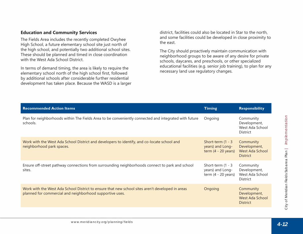
Education and Community ServicesThe Fields Area includes the recently completed Owyhee High School, a future elementary school site just north of the high school, and potentially two additional school sites . These should be planned and timed in close coordination with the West Ada School District .
In terms of demand timing, the area is likely to require the elementary school north of the high school first, followed by additional schools after considerable further residential development has taken place . Because the WASD is a larger
district, facilities could also be located in Star to the north, and some facilities could be developed in close proximity to the east .
The City should proactively maintain communication with neighborhood groups to be aware of any desire for private schools, daycares, and preschools, or other specialized educational facilities (e .g . senior job training), to plan for any necessary land use regulatory changes .
Recommended Action Items Timing Responsibility
Plan for neighborhoods within The Fields Area to be conveniently connected and integrated with future schools .
Ongoing Community Development, West Ada School District
Work with the West Ada School District and developers to identify, and co-locate school and neighborhood park spaces .
Short-term (1 - 3 years) and Long-term (4 - 20 years)
Community Development, West Ada School District
Ensure off-street pathway connections from surrounding neighborhoods connect to park and school sites .
Short-term (1 - 3 years) and Long-term (4 - 20 years)
Community Development, West Ada School District
Work with the West Ada School District to ensure that new school sites aren’t developed in areas planned for commercial and neighborhood supportive uses .
Ongoing Community Development, West Ada School District
4-12
City
of M
erid
ian
Fiel
ds S
ubar
ea P
lan
| Im
plem
enta
tion
Impl
emen
tatio
n
www.meridiancity.org/planning/fields

Economic DevelopmentThe expansion of SH-16 on The Fields’ eastern edge boosts the potential for this area to provide high-quality employment .
With the expansion of SH-16, The Fields will naturally emerge as a go-to location for employment in the long-term as those areas of town build out . There should also be mid-term potential for employment that is sufficiently differentiated from Ten Mile and downtown, such as
logistics-related businesses requiring a more central location to the greater Treasure Valley market .
The open space and agricultural status of The Fields Area provides an opportunity to accommodate major proposed destination uses as they arise . Currently, the plan does not assume any major stand-alone destination-type public development . Commercial land use designations in the plan should be sufficiently large to accommodate private-sector destination tenants .
Recommended Action Items Timing Responsibility
Work with regional cities and BVEP to explore the opportunity to establish an Economic Development District . Develop a regional strategy or CEDS to assist with application for future US EDA grants . (See Meridian Economic Development Strategy)
» Proactively prepare site information for target industries and share with BVEP to share with potential businesses .
» Track industry market trends to identify shifting land and space needs for identified target industries .
Long-term (4 - 20 years)
Community Development
Preserve land for the employment areas necessary to support the Fields Sub Area Plan jobs, transportation, and land use diversity purpose and goals .
» Reserve employment areas southwest of the future SH-16 and Chinden for Mixed Use-Interchange .
» Reserve employment areas east of Can-Ada Road, between Ustick and McMillan Roads for industrial and an employment-related mix of commercial uses (NR-MU) .
» Reserve employment areas at key arterial intersections for neighborhood- and community-serving retail and related uses (per this Plan) .
Short-term (1 - 3 years) and Long-term (4 - 20 years)
Community Development
4-13
City
of M
erid
ian
Fiel
ds S
ubar
ea P
lan
| Im
plem
enta
tion
Impl
emen
tatio
n
www.meridiancity.org/planning/fields

Growth and Population/Future Land UseThe Fields area is a key asset for accommodating future growth . Maintaining level-of-service and quality standards may present funding challenges as the City expands . The City’s current policy of fronting costs of major infrastructure elements may need to be modified through funding mechanisms that fairly spread timing and risk of capital costs while preserving for and facilitating unique opportunities .
Opening a large fringe area to growth presents efficiency challenges, including potentially undesirable leapfrog development, and especially given the location of the future regional wastewater lift station on the far western edge . Only a small portion of The Fields Area is annexed into the City, while the remainder is included in the City’s Impact Area . Future annexation (appropriately timed) will help to avoid enclave issues in Ada County .
The Fields currently contains a mix of developer-owners actively assembling land, along with long-time resident/owners . Some residents are happy as-is and intending to remain long term, and others are holding out until a later time, potentially for optimal pricing or those that are just
reluctant to sell . Most of those who engaged with the City, during the engagement process for the Comprehensive Plan and with this sub-area plan, recognized the area was primed for development . Future decisions as to funding mechanisms, especially those requiring the formation of special districts, should consider the desires and rights of these segments, in part because different districts have different voting and petition requirements with formation.
The gas storage facility in the southwest area of The Fields presents a potential land use incompatibility . This facility presents safety concerns and nuisance impacts such as noise, light, and visibility extending well beyond the 1,000-foot safety buffer, generally lessening the quality and sense of place elements important to Meridian residents . This area must not be relegated to lesser residential uses, or intended for those who can afford less. Mitigation improvements would consume acreage and require improvements at the cost of other amenities and features . Focusing this area on non-residential uses avoids costly improvements, does not detract from quality of life, avoids equity issues with some residential product types, and works to balance jobs and transportation impacts .
Recommended Action Items Timing Responsibility
Residential. Consider proximity to community open space and connectivity with adjacent residential entitlements .
» Balance open space requirements with new developments by requiring more further from public spaces, and less adjacent to or directly interconnected with larger public spaces .
» Support open space partnerships between developments or with the City that provide more consolidated open spaces .
» Support innovative neighborhood serving employment and service uses along arterial roadways » Encourage and support shared or small-scale office spaces along visible residential districts on
arterial roadways .
Ongoing Community Development
4-14
City
of M
erid
ian
Fiel
ds S
ubar
ea P
lan
| Im
plem
enta
tion
Impl
emen
tatio
n
www.meridiancity.org/planning/fields

Recommended Action Items Timing Responsibility
Neighborhood Center. Maintain and support a vibrant neighborhood center by carefully considering the uses, design, and timing of entitlement approvals .
» Remain consistent with the purpose and general layout of the neighborhood center » Promote and wait for community supportive commercial uses that reduce the need for more trips
at further distances by residents and stakeholders . » Ensure that development requests support the neighborhood center through use siting, layout,
enhanced connectivity, centralized shared spaces, and that promote the main street concept . » Explore opportunities to attract and site a community grocer or neighborhood farm/yard store to
anchor the neighborhood center . » Enhance and further main street as a destination and community-oriented space for live, work,
and play . » Site and design development to make use of shared and highly visible personal and community
spaces . Closer to main street, spaces should include hardscape, tree canopy, seating, and places for eating, work, and leisure .
» Locate surface parking lots to the sides and rear of structures located along the main street . » Provide open space connections between the Five Mile Creek Pathway and Main Street .
Ongoing Community Development
Mixed Use Non-residential, Mixed Use Interchange, Industrial. Promote employment areas that encourage local family-wage jobs and discourage community services and goods .
» Sustain employment areas by limiting site development which prioritizes encroaching strip and drive-through commercial uses .
» Ensure opportunities for economic concentration benefits formed by a diverse array of clustered employment uses in close proximity .
» Understand all land use decisions, and especially those that may limit or create market pressures that disrupt or devalue employment uses .
Ongoing Community Development
Mixed Use Regional/Community (not Neighborhood Center) /Mixed Use Interchange. Support a diverse range of regional services and employment opportunities .
» Limit large or dense residential density developments absent of supportive services and infrastructure, or that may otherwise limit the provision of future services from developing .
» Support development plans that provide flex use spaces in areas that do not compete with prime, higher visibility commercial opportunities . Consider reduced development standards for site and structural improvements .
» Support development plans that provide opportunities for uses such as gyms, churches, and other community services in areas that do not compete with prime, higher visibility commercial opportunities . Consider reduced development standards for aesthetic and site and building improvements .
Ongoing Community Development
4-15
City
of M
erid
ian
Fiel
ds S
ubar
ea P
lan
| Im
plem
enta
tion
Impl
emen
tatio
n
www.meridiancity.org/planning/fields

Utilities and InfrastructureMuch of the utility infrastructure to be built in The Fields Area will occur several years in the future, as development pressure moves westward across Meridian . However, the area’s topography precludes gravity-fed wastewater outflow to the City’s treatment facilities for all but a small area near McDermott and Ustick Road . The City is already planning to construct a new lift station near Can-Ada Road that will be capable of serving most of The Fields Area (along with a force-main line to pump wastewater eastward towards existing trunk lines . While this is a necessary addition to the City’s wastewater system for any significant development to occur in the Fields, it runs the risk of spurring premature developer interest further west than would be efficient.
The City should be cognizant of entitlement impacts and encourage efficient growth east to west, or provide the right partnerships to improve the efficiency/benefit. Leapfrog development closer to the future lift station but further from other City services is discouraged .
Meridian charges developer impact fees (DIFs), as allowed by the state, to pay for public safety and other infrastructure related to new growth . The enabling legislation for DIFs also allows for most other infrastructure expenditures to be paid through the same mechanism . However, because payment of DIFs is an allowed expenditure category for community infrastructure districts (CIDs) and other potential cost-sharing mechanisms, the two can be overlaid, shifting collection back to property tax levy .
Recommended Action Items Timing Responsibility
Favor development that proceeds east-to-west in approvals and entitlement decisions . Short-term (1 - 3 years)
City Council, Community Development
Coordinate with developer groups to assist in creation of a Community Infrastructure District or, alternatively, a Local Infrastructure District .
Short-term (1 - 3 years) or Long-term (4 - 20 years)
Community Development
4-16
City
of M
erid
ian
Fiel
ds S
ubar
ea P
lan
| Im
plem
enta
tion
Impl
emen
tatio
n
www.meridiancity.org/planning/fields

Parks and PathwaysThe Fields plan includes a combination of a regional and smaller neighborhood parks, along with linear pathways along creeks and canals, creating connections east to Meridian’s existing pathway network, and west and north into surrounding municipalities .
This recreation infrastructure will be an important amenity for residential development throughout the plan area and will be particularly important for placemaking efforts and activating the center early in development of the Star/McMillan Center . As such, the City should work with adjacent builders and property owners on land dedications and coordinate on the timing of improvements .
In general, parks and pathways should be implemented to coincide with, but not precede, private sector development . One possible exception could include City-constructed pathway improvements at the eastern edge of the subarea as an incentive to encourage more efficient westward progression of overall development .
In Meridian, parks and open space infrastructure spending can be paid for through development impact fees (DIFs) . Typically, but not always, pathways are either constructed with new development, or by the City and paid for through the general fund . Developers may also dedicate land for park use and are credited for that through reduced DIF amounts .
Recommended Action Items Timing Responsibility
Plan for and work with property owners on funding options and/or land purchase/partnership/dedication, and incorporate a regional park within The Fields Area .
» Integrate a variety of park features along the Five Mile Creek Pathway/Greenway system, and integrated with the Star/McMillan Center .
» Work with developers as neighborhoods are platted to identify specific facilities and uses for each neighborhood park and to ensure diversity .
Short-term (1 - 3 years) and Long-term (4 - 20 years)
Community Development, Parks & Recreation
Expand the Five Mile Creek Pathway » Plan for an integrated pathway through the Star/McMillan center and the regional park, and
intersect with the Phyllis Canal regional pathway system to connect with the rest of the Meridian, adjacent areas, and the Boise River .
Short-term (1 - 3 years) or Long-term (4 - 20 years)
Parks & Recreation
Improve the Five Mile Creek Pathway in the neighborhood center with a pathway and linear open space . » Explore opportunities to advance construct pathway, open space, and parking improvements for
immediate resident use, and to activate and maximize potential for adjacent community centered commercial activities .
» Explore opportunities to activate linear open space with passive and recreational amenities .
Short-term (1 - 3 years)
Parks & Recreation
4-17
City
of M
erid
ian
Fiel
ds S
ubar
ea P
lan
| Im
plem
enta
tion
Impl
emen
tatio
n
www.meridiancity.org/planning/fields
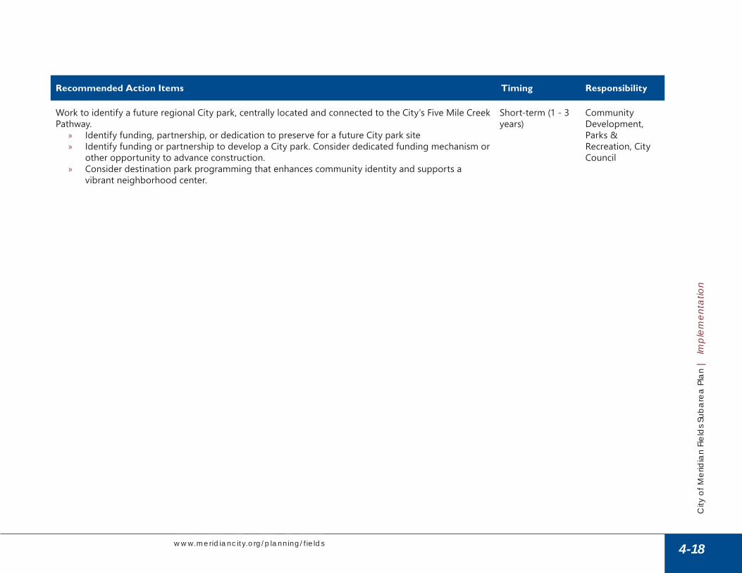
Recommended Action Items Timing Responsibility
Work to identify a future regional City park, centrally located and connected to the City’s Five Mile Creek Pathway .
» Identify funding, partnership, or dedication to preserve for a future City park site » Identify funding or partnership to develop a City park . Consider dedicated funding mechanism or
other opportunity to advance construction . » Consider destination park programming that enhances community identity and supports a
vibrant neighborhood center .
Short-term (1 - 3 years)
Community Development, Parks & Recreation, City Council
4-18
City
of M
erid
ian
Fiel
ds S
ubar
ea P
lan
| Im
plem
enta
tion
Impl
emen
tatio
n
www.meridiancity.org/planning/fields

Stewardship and Public SafetyMany implementation considerations relating to stewardship goals and objectives are subsumed in land use and utilities discussions . A few action items are listed below for both elements .
Recommended Action Items Timing Responsibility
Integrate existing water conveyance facilities (i .e . irrigation facilities, drains, laterals, etc .) as part of the character and parks and pathways system in new development within the area .
Short-term (1 - 3 years)
Community Development, NMID, Pioneer Irrigation District
For life-safety, ensure compatible development types around and within 1,000 feet from the Intermountain Gas Facility. Areas outside and adjacent to this buffer should appropriately buffer, screen, and generally mitigate for all other off-site impacts, including light, noise, and visual aspects.
Short-term (1 - 3 years) and Long-term (4 - 20 years)
Community Development, Economic Development
4-19
City
of M
erid
ian
Fiel
ds S
ubar
ea P
lan
| Im
plem
enta
tion
Impl
emen
tatio
n
www.meridiancity.org/planning/fields

Character, Design, and IdentityUnique character and high-quality design will help ensure that The Fields Area contributes to the City’s overall goal of creating high-quality and family-friendly neighborhoods . The character and identify of the Star/McMillan Center and the parks and open space areas can allow this area to
become a unique destination within the City and the larger region, offering something different from other commercial areas, and amenities . Refer to the Character Framework in Chapter 3.
Recommended Action Items Timing Responsibility
Elevate a distinct community identity by creating design standards for the Star/McMillan Center, adjacent residential areas, linear park and greenway and regional park, including a contemporary rural thematic throughout commercial structures and public facilities .
» Incorporate gabled roofs, exposed trusses and rafters, covered porches, oversized architectural hardware, transitional landscape walls, gates, railings, chimneys, dormers, brackets, corbels, belly band board trim, posts, masonry piers, or other thematic elements into commercial structures .
» Incorporate stone, cultured stone, or brick masonry; horizontal lap siding, vertical board and batten siding, beadboard paneling, and taper sawn shingles; corten and/or wrought iron, or other local thematic materials into commercial structures .
» Discourage or allow only a very limited use of pre-cast concrete, EIFS, PVC or plastic materials, metal siding, plywood or pressed-board materials, or composition siding into commercial structures .
» Incorporate distinct architectural elements into monuments, signage, building addressing, and structural infrastructure within landscape buffers, parking lots, and open space that enhances primary structure architectural features .
Short-term (1 - 3 years) and Long-term (4 - 20 years)
Community Development, Economic Development
As development applications are submitted and approved, the City will maintain a repository of information on design and character that can be used as a resource for future development .
Short-term (1 - 3 years)
Community Development
Integrate open space into all developments to create the appearance of more expansive, deeper spaces . » Integrate usable open spaces into commercial projects such as protected (sheltered) seating
areas, gathering areas, or other flex spaces for shared use and activities. » Strategically link and join open space between landscape buffers, structures, and developments
to enhance the appearance of more expansive, planned open spaces . » Promote no mow fescues, naturalized plants, dry creek materials, split rail fencing, and other rural
landscape elements in landscape buffers and open space.
Ongoing Community Development, Parks & Recreation
4-20
City
of M
erid
ian
Fiel
ds S
ubar
ea P
lan
| Im
plem
enta
tion
Impl
emen
tatio
n
www.meridiancity.org/planning/fields

Recommended Action Items Timing Responsibility
Encourage partnerships to build and share open spaces . » Explore opportunities with both private development and public institutions to centralize and
co-develop shared open spaces .
Ongoing Community Development, Parks & Recreation
Preserve and integrate historic buildings and elements into the design of the Fields Area to celebrate the area’s history and identity .
Ongoing Community Development
4-21
City
of M
erid
ian
Fiel
ds S
ubar
ea P
lan
| Im
plem
enta
tion
Impl
emen
tatio
n
www.meridiancity.org/planning/fields