City of Kitchener - Esri Canada · System Environment for 3D Modeling •Software -Esri ArcMap,...
31
City of Kitchener Evolution of 3D Modeling Presented by: Mike Elliott Adam Clark
Transcript of City of Kitchener - Esri Canada · System Environment for 3D Modeling •Software -Esri ArcMap,...

City of Kitchener Evolution of 3D Modeling
Presented by:
Mike Elliott
Adam Clark


Project Description
• There has been a building interest from the public and staff in
exploring 3D mapping or modeling
• There was an opportunity to use the 2D base data we have as a
strong starting point for the development of 3D visualization
products
• 3D modeling for use in communication, marketing and scenario
development

System Environment for 3D Modeling
• Software
- Esri ArcMap, ArcScene, CityEngine as well as SketchUp, VRay,
Photoshop, and Adobe Suite
• Data
- City data maintained in a SDE central database
- Using City Engine required the creation of a geodatabase
- Importing data into SketchUp required the creation of DWG and
KML/Collada files
• Hardware
- Requires ‘super user’ computer with increased RAM, and robust
graphics card

System Environment for 3D Modeling

• Planning Department project called for the creation of an
advanced representative 3D City Model
- Scale of modeling project: over 19,000 individual buildings,
covering more than 16 sq. km. of the city
- Increased and consistent quality of model
- Continuous built context
- Increased speed of modeling to meet tight deadlines
- Set graphic and production standards for modeling, keep all
assets flexible, multi-purpose, internally sourced
- Led to the creation of the Design & Visualization Analyst
position
Planning Around Rapid Transit (PARTS)

Background in Architecture and Urban Design
- Multi-Disciplinary Design Challenges
• Requirements to create Representative model
- Multi-purpose hardware and software requirements
• Coordination with GIS for the creation of the Model
- Parcel fabric
- Roads
- Building envelopes (of course)
- Geospatial Integrity
Design & Visualization Analyst


Enter Esri – City Engine
• Our ability to make creative informative 3D modeling products
was further realized when we combined the context model and
GIS data in Esri CityEngine
• Our initial experiments with City Engine were to combine KML
models with procedurally generated buildings to visualize a
new development proposal
• City Engine also allowed for the dynamic creation of a new
road to illustrate what the site would look like if the proposal
was realized.
• Primarily for communication ‘in house’ with staff


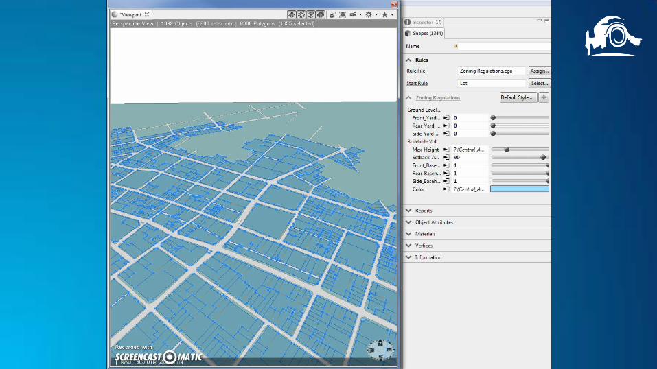
More City Engine
• For one of the PARTS project first public meeting, City Engine
was used to create some visualization of city zoning
envelopes, and development scenarios
• These were exported to web-scenes published to a Esri Story
map that was made available to the public to view and
comment on
• These web-scenes were also used during the public meeting
to help demonstrate the development scenarios in an
interactive way


Future Plans
• We plan to expand the use of CityEngine, using some of it’s
more complicated rules and procedural modeling to help
communicate future building massing and to inform “Tall
Building” discussions
• We will actively look for 3D visualization applications and
‘pitch’ them to internal staff (clients) to expand it’s use and
appreciation/application


Benefits of our 3D Modeling Approach
• Integrated
- Using the city of Kitchener context model as input into CityEngine
and in combination with other features created in ArcScene or
ArcMap has created effective 3D products for communication, not
only with the public, but with internal staff
• Keeping the work Internal
- has allowed us the flexibility to develop new 3D products as the
projects evolve and respond to data input changes
• Synergistic
- Each piece of data on it’s own is not necessarily going to make an
impression with stakeholders, but combining it in this way and
presenting through web-scenes, animations, and other products
does

Lesson Learned
- It is challenging to incorporate new presentation visualization
methods and materials into existing project structures/pre-existing
staff expectations
- With more lead time, we are able to develop better, more
imaginative 3D visualization products as deliverables can require
significant problem solving and procedure adaptation
- A lag between developing technical capacity for new technology
and visualization techniques and their adoption by internal staff,
project stakeholders, and the general public…this has been an
iterative process

• City Engine is unique in that there is no dynamic link between
your shapefiles and the ‘imported’ feature
- If you update or edit the feature in geodatabase, the change will
not be reflected in the City Engine scene.
• Commenting on web-scenes requires log in credentials
- May be limiting when engaging the general public
- Required a work around using another survey style commenting
form.
Lesson Learned

Links
• City of Kitchener - Parts Central Story Map

© 2015 Esri Canada Limited. All rights reserved. Trademarks
provided under license from Environmental Systems
Research Institute, Inc. Other product and company names
mentioned herein may be trademarks or registered
trademarks of their respective owners. Errors and omissions
excepted.