City of Benton Zoning Ordinance - Amazon Web … of Benton . Zoning Ordinance . Adopted by Ordinance...
88
City of Benton Zoning Ordinance Adopted by Ordinance 14 of 2017 Adopted on March 27, 2017
Transcript of City of Benton Zoning Ordinance - Amazon Web … of Benton . Zoning Ordinance . Adopted by Ordinance...

City of Benton
Zoning Ordinance
Adopted by Ordinance 14 of 2017
Adopted on March 27, 2017

Ordinance 14-2017 1
TABLE OF CONTENTS
Section Page
CHAPTER I – Authority, Jurisdiction and Purpose 2 CHAPTER II - Definitions 3 CHAPTER III - Administrative Procedures and Enforcement 10 CHAPTER IV - Conformity 13 CHAPTER V - Zoning Districts 15 CHAPTER VI - Uses 17
• Use matrix 18 • Conditional Uses 19 • Temporary Uses 23 • Home Occupations 24 • Accessory Uses 25 • Accessory dwelling Units 26
CHAPTER VII - District Regulations 27 • R1 - Single Family Residential District Regulations 28 • R2 - Single Family Residential District Regulations 29 • Cluster Subdivision Regulations 31 • R3 - Single Family Residential District Regulations 33 • R4 - Single Family Residential District Regulations 34 • R5 - Multi-Family Residential District Regulations 36 • R6 - Multi-Family Residential District Regulations 37 • R7 - Multi-Family Residential District Regulations 39 • R8 - Multi-Family Residential District Regulations 41 • TC1 - Town Center District Regulations 43 • TC2 - Town Center District Regulations 44 • TC3 - Town Center District Regulations 46 • C1 - Commercial District Regulations 48 • C2 - Commercial District Regulations 50 • C3 - Commercial District Regulations 55 • LI - Light industrial District Regulations 57 • HI - Heavy Industrial District Regulations 59 • A - Agricultural District Regulations 61 • M - Mining District Regulations 62 • OS - Open Space District Regulations 64 • S - School District Regulations 64 • PUD – Planned Urban development 65
CHAPTER VIII - Parking and Loading 70 CHAPTER IX – Landscaping and Screening Requirements 75 CHAPTER X - Manufactured Housing 82 CHAPTER XI - Site Plan Review 84

Ordinance 14-2017 2
CHAPTER I - AUTHORITY, JURISDICTION AND PURPOSE Section 1.001 - Authority These regulations are adopted under the authority granted to cities by Arkansas Code Annotated 14-56-401 et seq., as from time to time amended. Section 1.002 - Jurisdiction The provisions of this Ordinance shall apply to all land and structures within the territorial jurisdiction, as defined by Arkansas Code Annotated 14-56-413 as from time to time may be amended, of the City of Benton, Arkansas, as they now or may hereafter exist. Section 1.003 - Purpose This zoning ordinance is adopted for the purpose of promoting and advancing the health, safety, and general welfare of the people of Benton. It is designed to protect and stabilize some areas of the city while guiding new development in others. More specifically, these regulations divide the corporate area into zones and within these zones the regulations prescribe the use of land, the density of population, and also prescribe the use, character, bulk, and location of buildings. The regulations in this zoning ordinance attempt:
A. To ensure future development enhances the livability of the community B. To separate conflicting types of traffic C. To protect natural resources D. To promote sustainable land development practices E. To protect streets, utilities, and community facilities from overloading F. To insure development accommodates pedestrians as well as automobiles G. To ensure that viable opportunities exist for members of the community who do not have
access to automobiles H. To conserve and stabilize property values I. To promote the general welfare of the city
Section 1.004 - Conflict with Other Regulations In the case of conflict between these regulations and other covenants and regulations in force in the Corporate Area, the highest standard shall apply. These regulations are not intended to abrogate or annul easements, covenants, or private agreements. Section 1.005 - Severability The provisions of these regulations are severable. If any section, paragraph, sentence, or clause shall be declared invalid, the remainder of the regulations shall not be affected.

Ordinance 14-2017 3
CHAPTER II – DEFINITIONS Section 2.001 – CONSTRUCTION Words in the present tense include the future tense and words in the singular include words in the plural. Shall is mandatory and may is permissive. Underlined definitions are use categories appearing on the zoning use matrix in Chapter VI. Section 2.002 -- DEFINITIONS The following are definitions of terms used in this zoning ordinance. Accessory Dwelling Unit (ADU) – An additional living quarters on a single-family lot that is independent of the primary dwelling unit. To be considered an accessory dwelling unit a living space must have separate entry ways from the primary dwelling unit. An ADU may be attached or detached from the primary dwelling unit. ADUs shall contain less than 30% of the square footage of the primary dwelling unit and shall contain no more than 5% of the square footage of the parcel the ADU is located on. No more than one accessory dwelling unit is allowed per lot in any zoning district. Accessory Structure – A subordinate use or structure located on the same lot with the main use or structure and customarily associated with the main use or structure. Administrative Officer – City Official appointed by the City Council to be responsible for the administration of the Zoning Ordinance. The Director of the Department of Community Development is appointed. Attached Single Family Residential Unit – Residential construction consisting of two or more dwelling units which physically adjoin one another on at least one side. The dwelling units shall be separated by a firewall, or other physical partitions built along the property line. Two or more attached dwelling units may not share the same lot in single family zoning districts (R1, R2, and R3). Attached dwelling units in single family zoning districts may consist of townhouses, duplexes, triplexes, or other adjoining configurations in which there is only one dwelling unit per lot. Attached dwelling units cannot be stacked vertically in single family zoning districts (R1, R2, R3). Condominium or cooperative arrangements are not allowed in single family zoning districts (R1, R2, R3) for attached dwelling units. Bed and Breakfast – An owner occupied dwelling unit which rents rooms on a nightly basis and may additionally provide meals for lodgers. The operator of the bed and breakfast must live on the premises or in adjacent premises. Guest rooms shall not have cooking facilities. Lodgers at bed and breakfasts are charged daily rates. Board of Adjustment (or Board) – The Board of Adjustment of the City of Benton, Arkansas. Building or Structure – Anything constructed or erected with a fixed location on the ground or attached to something having a fixed location on the ground. Building Articulation – The extrusion and/or indentation of a building’s facade. (See below). Building articulation is required for the primary frontages of large format structures.

Ordinance 14-2017 4
Building Height – The vertical distance between the highest base elevation of a structure and the highest point of the roof line of the structure as measured from the front architectural elevation of a structure. Building height excludes parapets, steeples, spires, bell towers, domes, and other similar architectural elements. Mechanical equipment, such as water tanks, ventilators, chimneys, and stairwells are also excluded from building height calculations. (See below)
Bulk Storage – The storage of liquids, agricultural products, raw materials, or other commodities in tanks, silos, elevators, or other similar structures. Chemical Processing – the processing, treatment, or creation of chemicals for either wholesale or for distribution to other facilities. Church – An institution that people regularly attend to participate in religious services, meetings, and other non-profit activities. City Council – The legislative body of the City of Benton, Arkansas.

Ordinance 14-2017 5
Clinic – A facility for medical examination and treatment on an out-patient basis. Club or Lodge – A structure used for the assembly of persons affiliated with a group or organization for non-profit purposes. Cluster Subdivision - A type of subdivision in which housing units are clustered on reduced size lots. Common open space must be set aside of an area equal to or greater than the cumulative reduction in lot size below the districts otherwise allowed minimum lot size. Commission – The Planning Commission of the City of Benton, Arkansas. Conditional Use – A non-conforming use permitted by the City Council provided that specified conditions of development are met. Corporate Area – That area that is within the city limits of the City of Benton Daycare – A state licensed child care facility, or any place engaging in the regular supervision of 6 or more pre-school age children in return for compensation. Detached Single Family Residential Unit – Residential construction consisting of free standing single family housing units. A detached dwelling unit may not adjoin any other dwelling unit unless one unit qualifies as an accessory dwelling unit, and meets all front, side, and rear setback requirements, as set forth in the zoning district regulations. Distribution Terminal – A warehouse facility designed to facilitate the shipment of goods or commodities. Distribution terminals contain facilities for the loading of goods onto semi-trailers, trucks, vans, or rail for transport to other locations. A warehouse containing 4 or more loading bays will be considered a distribution terminal. District or Zone – An area of the City of Benton, Arkansas, to which uniform zoning regulations apply. Duplex – A residence for two families with separate cooking and housekeeping facilities, and separate entrances for each. Dwelling Unit – A building or portion thereof designed exclusively for residential purposes, including one-family, two-family, three-family, multiple dwellings and manufactured homes; but not including hotels, apartment hotels, boarding and lodging houses, fraternity and sorority houses, rest homes, nursing homes, and child care nurseries. Dwelling unit does not include recreational vehicles. Gas Station – Any business with facilities for the dispensing of gasoline or other fuels. Gas Station uses may include convenience stores or other businesses. Gas stations incorporating service bays for auto maintenance will be considered a Vehicle Service / Repair use. General Retail – A business engaging in the sale of goods or commodities. Heavy Manufacturing - The production of objects as part of a repetitive process which attempts to produce objects to set specifications. Manufacturing uses may produce external impacts, including noise, vibrations, emissions, and odors which may be subject to specific regulations.

Ordinance 14-2017 6
Home Occupation or Professions – A non-residential use carried on within a dwelling which is clearly subordinate to the residential use and which does not outwardly change the residential character of the use, lot or structure. Hotel/Motel – An overnight lodging building intended for stays in which lodgers are charged daily, weekly, or monthly rates. A hotel must have a staffed lobby. Intensive Agriculture – The large scale cultivation of crops. Intensive agriculture may involve the use of mechanized farm equipment, as well as the widespread use of pesticides and fertilizers. Large Footprint Retail – A retail building with a footprint over 40,000 square feet. Only square footage on the first floor is counted towards this total. Light Manufacturing – The process of fitting together parts into a finished product. Light assembly uses produce no externally apparent noise, vibration, emissions, or odors. Lot – A parcel of land with space for the permitted uses or structures plus the open spaces required by these regulations. Lot of Record – A legally described lot recorded in the office of the County Recorder. Manufactured Housing – a dwelling unit constructed in a factory in accordance with the federal standards and meeting the definitions set forth in the federal standards and under Arkansas Code Annotated Section 20-25-102, the same being a structure, transportable in one (1) or more sections, which in the traveling mode is eight (8) body feet or more in width or forty (40) body feet or more in length or, when erected on site, is three hundred twenty square feet (320 sq. ft) or more and is built on a permanent chassis and designed to be used as a dwelling with or without a permanent foundation when connected to the required utilities. Mini-storage – A structure containing separate and private storage spaces which are leased or rented on individual leases for the purpose of storing items. Individual storage facilities may not be used for habitation. Multi-Family Building – A building containing four or more residential units on a single parcel of land, exclusive of accessory dwelling units. Non-Conforming Use of Land or Structure – Any use of land or structure which does not conform to the use provisions of these regulations at the effective date of their adoption or amendment. Non-Conforming Lot – Any lot that does not conform to the requirements of these regulations at the effective date of their adoption or amendment. Non-Conforming Structure – Any structure that does not conform to the requirements of these regulations at the effective date of their adoption or amendment. Nursing Home/Assisted Living - A facility which houses multiple residents for any length of time and which provides either nursing care, rehabilitation care, housekeeping, or food service for residents. This definition shall also include an independent living facility which also provides

Ordinance 14-2017 7
nursing care, and/or assisted living care. Facilities treating residents for substance abuse, providing housing for parolees, treating psychiatric problems, or facilities housing juveniles are not considered as a nursing home/assisted living use. Office – A place of work in which business, clerical, or professional activities are conducted. Off-Street Loading Space – A space on private property for the loading or off-loading of trucks. Off-Street Parking Space – A space on private property for the storage of an automobile plus space for maneuvering. Open Display Retail - A business engaging in the sale of goods or commodities which primarily require outdoor display or storage. Open Space – Areas which are inappropriate for development due to physical constraints, which act as buffers between incompatible uses, or areas which are to be protected as parkland or greenways. Outdoor Advertising Signs – A sign that directs attention to a business, profession, product, service, event, entertainment, meeting, or election conducted, offered, or sold elsewhere than on the premises. Overlay District - A zone that is placed on the official zoning map over the existing zoning districts. An overlay designation is not a separate district classification. It is attached to an existing zoning designation and identifies an area subject to supplemental regulations. Lands affected by an overlay zone are subject to the regulations of the underlying zoning district, as well as the rules of the overlay zone. The overlay may modify or eliminate regulations of the underlying zone, or it may introduce additional regulations for the overlay district. Parking Buffer – A minimum 10 foot wide landscaped area between parking lots and the right of way line. Minimum spacing of street trees in a parking buffer is established in the parking section of these regulations. Permitted Use – Any use or accessory use permitted in any given district with or without conditions. Personal Services – A business providing non-medical related services to individuals or households. Planting Buffer – A minimum 10 foot wide landscaped strip abutting parking lots. Planting Island – A landscaped island within a parking lot. Primary Street – The street bordering a parcel of land which has the highest classification as determined by the City of Benton Master Street Plan. Raw Material Processing – Any processing of ores which results in the creation of tailings; raw material processing also includes the proportioning, blending and grinding of earthen material.

Ordinance 14-2017 8
Required Build-to Line (RBTL) – A requirement that the front facade of a building is built at a designated distance from the front lot line. The RBTL may be coincident with the front lot line. Portions of the front facade may be set back from the RBTL, for example to allow for recessed entry ways or angled corner entrances to buildings. See below.
Resource Extraction – The mining of earthen material through use of open pits, quarries, alluvial dredging, or underground mines. Restaurant with Drive-thru – A business establishment that sells prepared foods to customers and which has facilities to service customers in motor vehicles. The business may utilize drive thru window(s) and/or outdoor communication device(s) allowing customers to order food while seated in motor vehicles. Restaurant without Drive-thru – A business establishment which sells prepared foods to customers. This type of business does not have drive-thru windows or any other facilities to deliver foods to customers seated in motor vehicles, nor does the business have outdoor communication devices allowing customers to order food while seated in motor vehicles. Right-of-Way (ROW) – A parcel or strip of land, whether or not dedicated to the public, and accepted by state, city or county government, and intended for use as a street, walkway, railroad, utility or other public use, or belonging to the public by prescriptive right of use. Setback – A line across a lot establishing the minimum open space to be provided between the buildings and structures and property line. This measurement shall be to the nearest vertical wall or support column of the building or structure. Eaves and open porches cannot extend more than 24 inches beyond the building setback line. Where the rear line of a lot abuts an alley the setback may be measured from the center of the alley. School – A public or private facility that provides a curriculum of academic or vocational instruction. Sight Proof Fence/Wall – A fence or wall built to block view from all sides of trash collection areas or other areas requiring visual screening. Sight proof fences or walls must be a minimum of six feet tall and a minimum of two feet taller than any trash receptacles being screened. Gates to screened areas must also be sight proof.

Ordinance 14-2017 9
Surface Parking Lot – A ground level parking lot which is not located in a multi-level parking structure. Theater – A building used for the presentation to an audience of staged performances or for the presentation of motion pictures or other projected media to an audience. Urban farming – The cultivation of crops for the purpose of resale on an area of land smaller than 5,000 ft2, without use of mechanized farm equipment. Urban Frontage - Urban frontages are building facades which are flush with a sidewalk and have either shop front windows or other types of fenestration which is scaled for passing pedestrians. Urban frontages often utilize awnings, colonnades, or arcades. Buildings built flush with a sidewalk but with less than 40% of the total facade width covered in glazing shall not be considered urban frontages. Vehicle Service / Repair – Any business whose primary source of revenue is the repair or service of motor vehicles. All businesses having auto service bays intended for use by the public and in which the service bays constitute more than 30% of the length of any facade of the building will be considered a vehicle service / repair use. Warehousing – The use of an indoor or outdoor space for storing and distributing inventory with no retail sales of merchandise on the premises. Zone – See “District or Zone” in this Chapter.

Ordinance 14-2017 10
CHAPTER III - ADMINISTRATIVE PROCEDURES AND ENFORCEMENT Section 3.001 - Limitations on Land and Structures No land shall be used or occupied and no structure shall be erected, altered, enlarged, moved, used or occupied except in conformity with these regulations. This regulation is not retroactive for uses of structures existing or for which building permits have been issued prior to the adoption this zoning code. Section 3.002 - Annexation In newly annexed areas, building permits shall be granted only for those uses conforming to the Land Use Plan for Benton, Arkansas, until the City Council has zoned the area. Section 3.003 - Building Permits No building permit shall be issued until the application for the building permit has been approved by the Office of Community Development as meeting the requirements of these regulations. The Planning Commission may impose conditions or time limits on such permits under the terms of these regulations. The building permit shall be revoked in writing by the Director of Community Development if the conditions of the permit are not complied with; or if construction has not been started six months after the permit is issued. Section 3.004 - Plot Plans All applications for building permits shall be in writing and each application shall be accompanied by a plot plan showing the lot, structures, driveways, parking spaces, setbacks, easements, drainage, advertising signs, and other improvements with locations and dimensions. The Office of Community Development shall maintain a public record of applications and plot plans along with a notation of any action taken, in accordance with the City of Benton Documentation Retention Policy. Section 3.005 - Occupancy Permits No land or structure for which a building permit has been issued shall be used or occupied unless a certificate of occupancy for such use has been issued by the Office of Community Development stating that the structure or use complies with these regulations. A record of all certificates of occupancy shall be kept on file in the Office of Community Development. Occupancy permits shall be revoked, in writing, when it is found that the use of land or buildings does not conform to these regulations, Certificates of occupancy shall be kept in accordance with the City of Benton Documentation Retention Policy. Section 3.006 Violations and Enforcement Any person, firm or corporation who uses land or structures or who builds structures in violation of these regulations is guilty of a misdemeanor and shall be subject to a fine. Each day’s violation shall constitute a separate offense. The maximum fine for each day of violation of the provisions of this ordinance shall be in accordance with the City of Benton Fee Ordinance

Ordinance 14-2017 11
Section 3.007 - Amendments to the Regulations and Map Changes to the zoning regulations and map may be initiated by the City Council, the Planning Commission, or by persons owning the subject property, or their authorized agent, by written request to the Planning Commission.
A. All applications for amending the zoning ordinance shall be submitted in writing to the Director of Community Development for referral to the Planning Commission for public hearing, review, and recommendation to the City Council. An application for amendment to the zoning map shall be accompanied by data and drawings to indicate that the proposed amendment conforms to the Land Use Plan of Benton, Arkansas.
B. The applicant shall send or cause to be sent, a notice of public hearing to all persons required to receive notice and to all persons that own property within 300 feet of a proposed zoning map change. Notice shall be in accordance with Arkansas Code Annotated 14-56-422, as from time to time amended, and shall be given a minimum of 15 days prior to the public hearing.
C. The Planning Commission may meet once each quarter to set public hearings on zoning map changes. Notice of public hearings shall be advertised in accordance with Arkansas Code Annotated 14-56-422, as from time to time amended.
D. Within 15 days after the public hearing, the Planning Commission shall make a recommendation on the proposed zoning amendment to the City Council. A copy of the recommendations shall go to the applicants. If the Planning Commission fails to make a recommendation within 15 days, the applicant may ask the City Council to take appropriate action. The final decision on all matters related to amending the zoning ordinance is made by the City Council.
E. No application for a change of the zoning map may be resubmitted within 12 months from the denial unless the Planning Commission finds that a substantial change in conditions has occurred.
F. A map of current zone boundaries shall be kept on public display in the Office of Community Development.
G. The applicant shall submit a fee in an amount as specified in the City of Benton Fee Ordinance.
Section 3.008 - Appeals of decisions by the Office of Community Development Appeals of decisions by the Office of Community Development are made to the Board of Adjustment Section 3.009 – Board of Adjustment
A. The Board of Adjustment shall consist of five members to be appointed by the City Council, with one member to be a member of the Planning Commission. The first appointments shall be 2 for one year, 2 for two years and 1 for three years by lot, and thereafter, appointments shall be for 3-year terms.
1. The Board of Adjustment shall elect a chairman and secretary annually, adopt rules for the conduct of its business, establish a quorum and procedure, and keep a written public record of all findings and decisions.
Ordinance 14-2017 12
2. Meetings shall be at the call of the chairman. Each session of the Board of Adjustment shall be a public meeting with public notice of said meeting and business to be published in a newspaper of general circulation in the City of Benton, Arkansas, at least one time seven (7) days prior to the meeting. The Public notice shall give a description of the property concerned along with an explanation of the appeal. Public notice shall be at the expense of the applicant.
B. The Board of Adjustment shall hear appeals from the decision of the appointed
administrative officer in respect to the enforcement and application of this Regulation; and may affirm or reverse, in whole or in part said decision of the administrative officer
1. Appeals to the Board of Adjustment may be made in writing by any person or
agency affected by the decision of the Office of Community Development within 30 days after said decision. The appeal shall be accompanied by enough data and drawings to describe the grievance and appeal.
2. The Board of Adjustment shall call a meeting on an appeal within 20 days after an appeal has been received by the Office of Community Development.
3. The applicant shall submit a fee with the appeal sufficient to pay for public notice and meeting.
C. The Board of Adjustment shall hear requests for variances from the setback and area
provisions of the zoning ordinance in instances where strict enforcement of the zoning ordinance would, cause undue hardship due to circumstances unique to the individual property under consideration, and grant such variances only when it is demonstrated that such action will be in keeping with the spirit and intent of the provisions of the zoning ordinance. The Board of Adjustment shall not decide matters of property use. The Board of Adjustment may impose conditions in the granting of a variance to insure compliance and to protect adjacent property.
D. Decisions of the Board of Adjustment in respect to the above shall be subject to appeal only to a court of record having jurisdiction.

Ordinance 14-2017 13
CHAPTER IV - CONFORMITY Section 4.001 - Access Each permitted use or lot shall have access to a public street or road; the Planning Commission may permit a use on land without access to a public street or road, provided that it is connected to a public street by an easement at least 30’ wide. Section 4.002 - Conformity No land shall be used or occupied, no structure shall be erected, moved, converted, altered, enlarged, used or occupied, and no use shall be operated, unless it is in conformity with the regulations herein prescribed for the district in which such structure or land is located. This provision shall not be construed to affect any uses of land or structures that existed prior to the adoption of this zoning ordinance. Section 4.003 - Reduction of Required Spaces
A. No open space required by these regulations for a particular structure or use shall be claimed at the same time as open space for another structure or use.
B. No lot, open space, parking or loading space shall be reduced in area or dimension below that required by these regulations, except where a variance in keeping with the powers and duties of the Board of Adjustment is granted by the Board of Adjustment.
Section 4.004 - Continuation of Existing Nonconforming Uses Any use of structure or land lawfully existing or one for which a permit has been lawfully issued at the effective date of these regulations may be continued, so long as it remains otherwise lawful, subject to the following conditions:
A. No non-conforming use may be enlarged beyond the area devoted to the use at the date of adoption of this Zoning Code.
B. A nonconforming use of land may be changed to a Conforming use. Once it is changed to a conforming use, it may not be changed back to a nonconforming use.
C. A nonconforming use of land shall not be restored to a nonconforming use after such use has been discontinued for 6 months.
D. A nonconforming structure shall not be reconstructed and a nonconforming use shall not be restored if more than 50% of the value of such structure is destroyed.
E. Repairs to lawful nonconforming structures are permitted to maintain the structure in a safe condition.
F. Neither a nonconforming structure nor a nonconforming use may be expanded. G. Non-conforming uses of land, whether subterranean, surface or air rights or any
combination thereof shall conform to all applicable State and Federal environmental regulations.

Ordinance 14-2017 14
Section 4.005 - Elimination of Nonconforming Uses
A. The following nonconforming uses and structures shall be discontinued and removed from their sites within three (3) years from the effective date of this ordinance. 1. A non-conforming use which does not occupy a structure. 2. A non-conforming sign or outdoor advertising structure according to the Benton Sign
Ordinance. B. Any uses which were nonconforming uses as of the passage of Ordinance #6 of 1967, have
now been fully amortized in accordance with the terms of the said Ordinance #6 of 1967, as from time to time amended. All such nonconforming uses shall be discontinued and abated.
C. Any uses which are nonconforming uses as of the passage of this Ordinance, shall be discontinued, abated, completely removed or altered and converted to a conforming status in accordance with the following amortization schedule. 1. If the use was nonconforming pursuant to Ordinance 22 of 1992, as amended, the period
of amortization shall begin on the date the use first became nonconforming. 2. If the use is nonconforming pursuant to the passage of this Ordinance, the period of
amortization shall begin on the effective date of this Ordinance. 3. This amortization schedule is deemed to provide for the amortization of the affected
uses.
Type of Construction Period of Amortization (Uniform Building Code) Type I and II 40 Years Type III and IV 30 Years Type V 25 Years D. When said nonconforming use is removed, at or before the end of the amortization period,
every future use shall be in conformity with the provisions of this Regulation. Repairs necessary to maintain a nonconforming use shall not be construed as lengthening the amortization period set forth by this section.
E. Whenever a use or structure becomes nonconforming because of a change of zoning district boundaries or a change of regulations for the district in which the site is located, the period of time prescribed in this section for the elimination of the use shall be computed from the effective date of the change of district or regulations.
F. The use of land, whether subterranean, surface or air rights or any combination thereof shall conform to all applicable State and Federal environmental regulations. Evidence of compliance with such regulations may be required to secure City of Benton approval.
G. In the case of conflict between these regulations and other covenants and regulations in force within the city limits of the City of Benton or within the extraterritorial planning jurisdiction thereof, the highest standard shall apply. These regulations are not intended to abrogate or annul easements, covenants, or private agreements.
H. The provision of these regulations are severable. If any section, paragraph, sentence, or clause shall be declared invalid, the remainder of the regulations shall not be affected

Ordinance 14-2017 15
CHAPTER V - ESTABLISHMENT OF DISTRICTS Section 5.001 – Zoning Districts For the purpose of this ordinance the City of Benton, Arkansas, is divided into the following Zoning Districts: RESIDENTIAL DISTRICTS
• R1 • R2 • R3 • R4 • R5 • R6 • R7 • R8
TOWN CENTER DISTRICTS
• TC1 • TC2 • TC3
COMMERCIAL ZONES
• C1 • C2 • C3
INDUSTRIAL ZONES
• LI • HI
ADDITIONAL ZONES
• PUD • A • M • OS • S

Ordinance 14-2017 16
Section 5.002 - Zoning Map
A. A map of current zone district boundaries shall be kept on public display in the Office of Community Development and a copy of said map shall also be available on the city’s website.
B. The boundaries of these districts are shown on the map entitled “Zoning Map, City of Benton, Arkansas” which is a part of this Regulation.
C. Where uncertainty exists as to the boundaries of districts as shown on the Zoning Map, the
following rules shall apply:
1. Boundaries indicated as approximately following the centerlines of streets, highways and alleys shall be construed as following such centerlines.
2. Boundaries indicated as approximately following public land survey lines shall be construed as following such land survey lines.
3. Boundaries indicated as approximately following platted lot lines shall be construed as following such lot lines.
4. Boundaries indicated as approximately following city limits shall be construed as following city limits.
5. Boundaries indicated as following railroad lines shall be construed to be midway between the main tracks.
6. Boundaries indicated as parallel to or extensions of features mentioned in the preceding rules shall be so construed.
7. Where district boundaries cross unplatted property the location of the boundaries shall be determined by the scale of the map or previously determined dimensions.
8. In circumstances not covered by the preceding rules, the Planning Commission shall interpret the district boundaries on the Zoning Map when the location of such boundaries cannot be clearly ascertained from the Zoning Map, or when the exact location of a boundary is in dispute.

Ordinance 14-2017 17
CHAPTER VI - USES Section 6.001 – Allowable Uses Examples of allowable uses for each zoning district are listed in the use matrix found at Section 6.002. It is the intention of this zoning ordinance to encourage mixed use development in appropriate areas. Multiple allowable uses or conditionally approved uses may exist in the same structure or on the same property.
A. In some districts uses may be regulated by floor. For example, residential uses may be permitted above other uses, but not on the ground floor. Uses limited by floor or location on a property will be indicated in the zoning district regulations.
B. The use matrix found at Section 6.002 includes the most commonly occurring uses. The use
matrix is not intended to be either exhaustive or inclusive.
C. Definitions of all uses listed in the use matrix are included in Section 2.002 and specific regulations for all uses are included in Chapter VII.
Section 6.002 – Use Matrix – Matrix on next page.

Ordinance 14-2017 18

Ordinance 14-2017 19
Section 6.003 - Conditional Uses
A. Uses which do not fit the use descriptions found in Chapter VII, and uses identified as conditionally permitted in a specific zoning district in the use matrix require conditional use permits.
B. General Purpose:
1. A Conditional Use Permit may be given for a use that conforms to the intent of the comprehensive plan for a specific area but is not allowable by right at any location. The use may represent potential problems with respect to its impact on neighboring property or to the city as a whole, or it may dominate the surrounding area by its size or intensity. For these reasons, conditional use permits require a careful review of their location, design, configuration, and spatial impact to determine the desirability of allowing them on a particular site.
2. The Conditional Use Permit process does not allow an applicant to secure a use variance as a means to circumvent the intent of the comprehensive plan or zoning code. Building configurations, footprints, and outlines should be compatible with other uses permitted for a district. Whether a proposed use is appropriate in a particular location depends upon a careful evaluation of the impacts to the neighborhood and the city by the Planning Commission and a weighing of conditions and methods proposed by the commission or by the applicant to ameliorate those impacts.
C. Standards for Conditional Use Permits
1. The Planning Commission may approve, deny, defer, or modify a Conditional
Use request based on findings of fact with regard to the standards set forth below. The appropriateness of these standards shall be determined at the discretion of the Planning Commission for each specific Conditional Use location.
2. In carrying out the purpose of this section, the Commission's consideration shall
include, but will not be limited to, the following development standards and design specifics. The appropriateness of these standards shall be determined at the discretion of the Planning Commission for each specific Conditional Use location.
a. The proposed use is so designed, located and proposed to be operated in a
manner that the public health, safety and welfare will be protected. b. The proposed land use is compatible with and will not adversely affect other
property in the area where it is proposed to be located. c. The proposed use conforms to all applicable provisions of this code for the
zoning district in which it is to be located, and the use facilitates public convenience at that location.
d. The size and shape of the site, and the size, shape and arrangement of the proposed structures, are in keeping with the intent of the comprehensive plan and this code.
e. The internal street system, ingress or egress, off-street parking, loading and pedestrian ways will be efficient and safe.

Ordinance 14-2017 20
f. Safeguards, including, but not limited to, hours and methods of operation, landscaping and screening, controlling noxious or offensive emissions, including lighting, noise, glare, dust and odor, are satisfactory.
g. Landscaping, fencing and open space will be properly maintained by the owner/developer.
h. Proposed signs will be appropriate for the location and in accordance with the requirements of the current City of Benton Sign Ordinance.
i. Public utilities are, or will be, available and will not be overloaded.
D. Conditions imposed by the Planning Commission
1. The Planning Commission may impose conditions and restrictions upon the premises benefited by a Conditional Use Permit as may be necessary to reduce or minimize the injurious effects of the Conditional Use Permit use, insure compatibility with the surrounding property, and carry out the general intent of this ordinance.
2. Conditions imposed as part of the Conditional Use Permit may be of two types.
a. Threshold Conditions are those that must be met by all proposed developments before an application for a Conditional Use Permit will be forwarded to the Planning Commission.
b. Implicit Conditions are those conditions that the Planning Commission may apply during the review of an individual case.
3. In no case shall the Planning Commission authorize relief from the minimum requirements of the ordinance relating to height, area, or screening. However, applicants may be directed to the Board of Adjustment for variances.
E. Procedures for authorizing a Conditional Use permit
1. Application: Application for a Conditional Use Permit shall be made by the
property owner or authorized agent for the owner. The application shall be submitted to the Community Development Department, which will process all applicable surveys, site plans and other supporting information pertinent to this review process and make recommendations to the Planning Commission.
2. Public notice: Notice of the Conditional Use Permit application shall be
published at least one time, not less than fifteen (15) days prior to the date of the public hearing in a newspaper of general circulation. The applicant shall give notice of such hearing by posting a suitable and pertinent sign, provided by the city, on the property involved not less than fifteen (15) days prior to the hearing. The applicant shall notify all adjacent property owners no less than fifteen (15) days prior to the public hearing.
3. Development plan requirements: The development plan requirements for a
Conditional Use Permit shall include a graphic representation drawn to scale of what is proposed and a general statement as to the intent of the use. The graphic representation shall include the following:
a. The location, size and use of buildings, signs, land and improvements
Ordinance 14-2017 21
b. The location, size and arrangement of off street parking space, neighboring on street parking space, loading spaces, driveways, and street access
c. The existing topography with proposed grading and drainage plans. (This requirement may be waived in the case of existing structures.)
d. Proposed screening and landscaping e. The use of adjoining property f. Scale, north arrow and vicinity map of sufficient scale and detail to
accurately locate the property within the City. g. Any additional information needed by the staff because of conditions
peculiar to the development.
4. Development plan review: The Community Development staff shall review the proposed Conditional Use and report to the Commission on its relation to and probable effect on the surrounding area, as well as its compliance with the requirements of this Code and shall make recommendations to the Planning Commission.
5. Planning Commission Action: The Planning Commission shall review
Conditional Use Permit applications at its regularly scheduled monthly meeting, at which time interested persons may appear and offer information in support of, or against the proposed Conditional use. The Planning Commission shall then make one of the following determinations: approve the Conditional Use as requested; approve the Conditional Use with modifications; defer the Conditional Use; or deny the Conditional Use.
a. The Planning Commission may impose conditions and restrictions upon
the premises benefited by a Conditional Use Permit as may be necessary to reduce or minimize the injurious effects of the Conditional Use, insure compatibility with the surrounding property and carry out the general intent of the comprehensive plan, appropriate neighborhood plans and this code.
b. In no case shall the Planning Commission authorize reduction from the minimum requirements of the ordinance relating to height, area, or parking screening. However, the Applicant may be directed to the Board of Adjustment for variances under the Zoning Code.
6. Appeal: Any applicant or other affected party aggrieved by a decision of the
Planning Commission as it relates to the Conditional Use Permit process shall have the right to appeal to the City Council. Such appeal must be filed in writing with the City Clerk within ten days after the Planning Commission takes final action on such a request. The City Council may affirm, modify, or deny said appealed action of the Planning Commission.
7. City Council Action: Conditional Use Permits are subject to ratification by the
City Council by ordinance.
8. Status of Conditions: Once any portion of the Conditional Use which has been authorized is utilized, all such conditions pertaining to such authorization shall become immediately operative. The violation of any condition so imposed shall

Ordinance 14-2017 22
constitute grounds for revocation of the Conditional Use Permit. Such conditions may include time limits for exercise of such authorization and must commence within a reasonable time.
9. The Board of Adjustment is not authorized to grant a variance from conditions
imposed by the commission in connection with a Conditional Use. However, the Board of Adjustment may grant variances as provided by the Zoning Code.
10. Amendments or major changes to a Conditional Use authorization must follow
the same process as the original Conditional Use; however, the Planning Commission may delegate to Community Development Staff authority to approve minor modifications to the conditions approved, including modifications to an approved development plan. No building permit shall be issued except in conformance with the provisions of this section.
11. A Conditional Use Permit is a part of the Zoning Code and shall run with the
land upon which the use is located.
12. Before any action shall be taken as provided in this section, the petitioner shall deposit with the City an application fee as established or may hereafter be adopted by resolution of the City Council. Under no condition shall said sum or any part thereof be refunded for failure of said permit to be approved by the Planning Commission.
13. Conditional Use applications and rezoning applications for the same lot, parcel,
or development site may be processed by the city concurrently. However, the Conditional Use cannot begin operation until the City Council has adopted an ordinance rezoning the property to an appropriate zone that would allow the Conditional Use, and the adopting ordinance has taken effect.

Ordinance 14-2017 23
Section 6.004 – Temporary use permits
A. Certain uses which are temporary in nature are not considered allowable uses or conditional uses but may be permitted with a temporary use permit.
B. General Purpose: The purpose of this section is to provide a method of control over
temporary structures, uses and review procedures that allow for determination of appropriateness within the neighborhood for which proposed.
C. Application Procedure: The procedure shall be the same as the procedure for an
Accessory Use Permit.
D. Uses requiring temporary use permits: The following temporary building, structures and uses shall be permitted as temporary uses when they conform to the height, setback requirements, and lot coverage restrictions of this zone: (1) Model homes, (2) Subdivision Sales Offices when located in Model Homes. These uses are subject to the approval of the Director of Community Development and are subject to the following provisions:
1. Such Model Homes and/or Subdivision Sales Offices shall be located in a
subdivision which is owned by or held in trust with the subdivision developer proposing to erect a model home and/or proposing to operate the sales office.
2. Subdivision Sales Offices and/or Model Homes shall not be permitted to exceed thirty-six (36) months from the granting of such temporary use by the Director of Community Development.
3. The Director of Community Development may grant not more than one permit to extend the time limit allowed in Paragraph (2) above, not to exceed an additional thirty-six (36) months.
4. The Subdivision Sales Office shall be removed and the Model Homes shall be discontinued as a Model Home on or before the termination date set forth in Paragraph (2) above or upon expiration of the extension granted pursuant to Paragraph (3) or after six (6) months following sale or occupancy of all lots in the subdivision other than the Model Homes, whichever occurs first.
5. For the purpose of Paragraphs (1) and (4) above, the term subdivision shall mean all land included within a plat submitted to, and approved by, the City of Benton.

Ordinance 14-2017 24
Section 6.005 - Home Occupation
A. Home occupations may be permitted in all residential districts as long as they do not conflict with Section C.
B. Home Occupations are where residents use their home as a place of work. A home occupation permit is available from the City Clerk, but must be approved by Community Development.
C. Non-permitted home occupations: Home occupations shall not be permitted that will:
1. Change the outside appearance of the dwelling or provide product display visible
from the street. 2. Generate traffic, parking, noise, sewage, or water use in excess of what is normal in
the residential neighborhood. 3. Create a hazard to person or property, results in electrical interference or becomes a
nuisance. 4. Result in outside storage or display of any material or product. 5. Involve accessory dwelling units and/or accessory structures.

Ordinance 14-2017 25
Section 6.006 – Accessory Use Permits A. The purpose of an accessory use permit is to provide a method of control over certain types of
land uses which do not require the full review process of conditional use permits, but do require some review procedures which allow for determination of their appropriateness within the neighborhood for which they are proposed and for public comment.
B. Application Procedure: The property owner or his/her authorized agent shall apply for an
accessory use permit under the guidelines provided by the Office of Community Development. An administrative hearing on the accessory use permit will be held by the Director of Community Development in the manner provided by guidelines. Appeals from determinations of the Director may be filed with the Planning Commission. No activity which requires an accessory use permit shall be conducted prior to issuance of the permit.
C. Uses Requiring Accessory Use Permits: The following subordinate uses or structures are
permitted to be located on the same lot with the main use or structure and require an accessory use permit:
1. Buildings, such as private garages for personal vehicle parking, and storage facilities for
normal household goods and yard maintenance. 2. Accessory dwelling units 3. Private greenhouses 4. Private recreational facilities, such as swimming pools, tennis courts and similar
recreational facilities. D. Applicable Districts for Accessory Use Permits
• R1 District • R2 District • R3 District • R4 District • R5 District • R6 District • TC1 District • TC2 District
E. Transfer of Permits: Accessory use permits shall not be transferable in any manner. A permit
cannot be passed from owner to owner, location to location or use to use.

Ordinance 14-2017 26
Section 6.007 - Accessory Dwelling Units A. Accessory dwelling units are allowed in the R1, R2 and TC1 districts. No more than one
accessory dwelling unit is allowed per lot in any zoning district. Attached dwelling units in the R-2 district are not permitted to have accessory dwelling units. Accessory dwelling units may be attached or detached from the primary residence.
B. Requirements. Accessory dwelling units shall: 1. Contain less than 30% of the square footage of the primary dwelling unit. 2. Be a maximum of 5% of the square footage of the lot they are located on.
3. Fit within all setbacks of the zoning district they are located in and shall be located no closer to a street than the primary residence.
4. Shall respect the look and scale of the primary residence. 5. Shall respect the look and scale of the neighborhood. 6. Shall be site built. 7. Shall be built only after an occupancy permit has been issued for the primary
residence. C. Accessory Dwelling Unit Permissible Siting

Ordinance 14-2017 27
CHAPTER VII - DISTRICT REGULATIONS Section 7.001 – District Regulations Diagrams Purpose Specific regulations for each zoning district are presented in the following sections. Regulated items are shown in plan view and additionally in perspective view, with subsequent tables giving the values for each regulated item (front setbacks, minimum lot sizes, etc.). Architectural styles depicted in diagrams are non-regulatory in nature and are presented for example only. The graphics in the following form diagrams do not represent the only possible building/site configurations. They are included as a guide to help readers better understand regulated elements.
Ordinance 14-2017 28
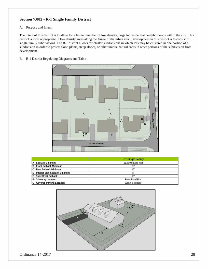
Section 7.002 - R-1 Single Family District A. Purpose and Intent
The intent of this district is to allow for a limited number of low density, large lot residential neighborhoods within the city. This district is most appropriate in low density areas along the fringe of the urban area. Development in this district is to consist of single family subdivisions. The R-1 district allows for cluster subdivisions in which lots may be clustered in one portion of a subdivision in order to protect flood plains, steep slopes, or other unique natural areas in other portions of the subdivision from development. B. R-1 District Regulating Diagrams and Table
R-1 Single FamilyA - Lot Size Minimum 11,500 square feetB - Front Setback Minimum 20'C - Rear Setback Minimum 10'D - Interior Side Setback Minimum 8'E - Side Street Setback 15'F - Driveway Location Front/Rear/SideG - Covered Parking Location Within Setbacks

Ordinance 14-2017 29
Section 7.003 - R-2 Single Family District Detached Housing A. Purpose and Intent
The intent of this district is to promote and protect medium density residential neighborhoods consisting of single family housing. Housing in this district may be either detached or attached. The R2 district is intended to be flexible enough to allow for increasingly sustainable neighborhood designs to be incorporated into large portions of the city. The district allows for alley accessible single family homes with smaller lot sizes and alley accessible attached single family homes to be incorporated into neighborhoods in large portions of the city, while still providing a district which accommodates traditional suburban homes. Residences with 6,000 square foot lots must have alley loaded driveways. B. Detached Housing: R-2 District regulating diagrams and table for detached housing
Standards for R-2 District (Detached) R-2 (7,000 Square Foot Minimum) 1 R-2 (6,000 Square Foot Minimum) 2
A - Lot Size Minimum 7,000 Square Feet 6,000 Square FeetB - Front Setback Minimum 15' 15'C - Rear Setback Minimum 10' 10'D - Interior Side Setback Minimum 5' 5'E - Side Street Setback 15' 15'F - Driveway Location Front/Rear/Side RearG - Covered Parking Location Within Setbacks Rear 50% of LotH - Alley Access Not Required Required
* See page 28 for conservation subdivision regulations
R-2 Lot with no alley access R-2 Lot with alley access

Ordinance 14-2017 30
C. Attached housing
1. Attached residences are only available in subdivisions platted after the adoption of this ordinance. 2. Construction of all residential units in each complex of townhouses shall be completed before occupancy permits are
issued for any unit. 3. R-2 District regulating diagrams and table for attached housing
Standards for R-2 District (Attached)
R-2 (Attached Single Family)
A - Lot Size Minimum 2,500 square feetB - Lot Width at Building Line 25'C - Lot Depth Minimum 100'D - Front Setback Minimum 15'E - Rear Setback Minimum 10'F - Interior Side Setback Minimum 0'G - Side Street Setback 10'H - Driveway Location Rear / Alley accessible onlyI - Parking Location Rear 50% of the LotJ - Building Height Maximum 35'K - Row End Setback Midblock 5'L - Row Length 4 Units Minimum / 8 Units or 200' maximum
R-2 Attached Single Family lots.

Ordinance 14-2017 31
Section 7.004 - Cluster Subdivisions A. Purpose and Intent
A cluster subdivision is a type of subdivision in which housing units are clustered on reduced size lots. Common open space must be set aside of an area equal to or greater than the cumulative reduction in lot size below the districts otherwise allowed minimum lot size. Minimum lot sizes in the R-1 and R-2 districts may be decreased in subdivisions to allow for more common open space within the subdivision. B. Allowable Lot Size reduction Lots sizes may be decreased below district minimum lot size standards for detached homes only. The maximum allowable decrease in lot size below the district wide standards is 10% for homes without alley accessible parking and 20% for homes with alley accessible parking. The overall density of a cluster subdivision may not exceed the density that would be allowed for a subdivision without the clustering of houses. The amount of common open space provided shall equal or exceed the total cumulative reduction in area of the subdivision’s residential lots below the zoning district’s minimum standards.
Spatially Defined Open Space Greenway
Spatially defined Open Space GreenwayA - Availability R-2 zone, minimum subdivision size 2.5 acres R-2 zone subdivions bordering city designated greenways
or planned bicycle paths, minimum subdivsion size is 2.5 acres
B - Minimum Open Space Total open space must equal or exceed the combined area of the reduction in lots sizes below base district standards, each public open space must be over .25 acres to count towards total open space requirement
Total open space must equal or exceed the combined area of the reduction in lots sizes below base district standards, each public open space must be over .25 acres to count towards total open space requirement
C - Landscaping Irrigated landscaping including locally appropriate shade trees, a minimum of 1 shade tree for each 30 feet of open space perimeter footage is required
Natural vegetation, addional landscaping may be required
D - Walkways Minimum of ADA compliant walkways around the perimeter of each open space which is counted towards the open space total area, walkways may have a planting strip between the walkway and the road
Multi-use trail built to bikeplan standards with connections to neighborhood streets
E - Housing Orientation Fronting Open Space Not required to front open space

Ordinance 14-2017 32
C. Design and preservation of common open space in cluster subdivisions. Common open space must be provided as a condition to the approval of a cluster subdivision. No open area may be delineated or accepted as common open space under the provisions of this section unless it meets the following standards:
1. Common open space must be usable for recreational purposes or must provide visual, aesthetic and environmental amenities. The common open space must be appropriate to the scale and character of the residential development, considering its size, density, expected population, topography, and the number and type of dwellings to be provided.
2. Common open space must be suitably improved for its intended use, but open space containing natural features worthy of preservation may be left unimproved if the area protects a city designated greenway. Any buildings, structures and improvements to be located in the common open space must be appropriate to the uses which are authorized therefor, and must conserve and enhance the amenities of the common open space. Parking lots shall not be considered open space. Septic and well systems are prohibited in public open spaces. Utility easements, public rights of way, and stormwater management basins shall not count towards open spaces requirements.
3. Open space must be in the form of a neighborhood square, green, or plaza, unless the open space protects a city designated greenway. Houses in cluster subdivisions shall front and help to frame greens and squares. Each open space shall be a single undivided parcel.
4. In no event shall final plat approval be given for a subsequent phase of a multi-phase development unless and until the open space which is part of prior phases has been improved. A multi-phase project shall not exceed allowable densities for any phase.
5. No plat shall be approved unless the Planning Commission has determined that the character and quality of the open space makes it suitable for the purpose for which it is intended. The Planning Commission may give consideration to the size and character of the dwellings to be constructed within the cluster subdivision, the topography and existing trees, the ground cover and other natural features, the manner in which the open space is to be improved and maintained for recreational or amenity purposes, and the existence of public parks or other public recreational facilities in the vicinity.
6. Maintenance of open spaces must include continuous operations of weed removal, mowing, trimming, edging, cultivation, reseeding, plant replacement, and appropriate fertilization.
7. All land shown on the plat as common open space must be either: a. Conveyed to the city, if the city agrees to accept conveyance and to maintain the
common open space and any buildings, structures or improvements which have been placed on it; or
b. Conveyed to a homeowners' association or some party responsible for maintaining common buildings, areas and land within the planned residential development. The common open space must be conveyed subject to covenants. The Planning Commission shall approve only those provisions of the covenants which restrict the common open space to public recreational uses and which provide for the maintenance of the common open space in a manner which ensures its maintenance for its intended purpose.

Ordinance 14-2017 33
Section 7.005 - R-3 Single Family District A. Purpose and Intent
The intent of this district is to allow for walkable medium density residential neighborhoods within the city. Development in this district is to consist of single family residences on small lots and may contain both attached and detached single family residences. All homes in a R-3 district should have alley accessible driveways and parking when feasible.
B. R-3 District regulating diagrams and table
Standards for R-3 district*
R-3 Single FamilyA - Lot Size Minimum 3,500 square feetD - Front Setback Minimum 15'E - Rear Setback Minimum 10'F - Interior Side Setback Minimum 5'G - Side Street Setback 15'H - Driveway Location Rear Preferred / Front or side permittedI - Parking Location Rear 50% of the Lot Preferred
*Attached single family home standards are the same as R2 single family attached home standards (p.30)
R-3 Single family lot with alley (Preferred) R-3 Lot without alley access (Permitted)

Ordinance 14-2017 34
Section 7.006 - R-4 Single Family District A. Purpose and Intent
The R-4 residential district is a single family residential district which permits both site built and manufactured housing. The R-4 district is the only zoning district in the city in which manufactured housing residences may be located. B. R-4 District regulating diagrams and table
Standards for R-4 district R-4 Single Family
A - Lot Size Minimum 3,500 square feetD - Front Setback Minimum 15'E - Rear Setback Minimum 10'F - Interior Side Setback Minimum 5'G - Side Street Setback 15'H - Driveway Location Rear if alley accesible, front or side permissible if notI- Foundation Permanent foundation/Underpinning RequiredJ - Building Orientation Same as predominant building orientation of the street
R-4 Single-family lot.
Ordinance 14-2017 35
C. All manufactured homes moved into the City of Benton after the effective date of this Ordinance shall have been manufactured after October 25, 1994, and shall have been manufactured in accordance with all federal standards, and shall meet the standards set forth under Arkansas Code Annotated Section 20-25-102, as from time to time amended.
D. All manufactured homes shall be installed in accordance with the currently adopted Benton building code.
E. No more than one manufactured home is allowed per individual lot in the R-4 district. F. No accessory dwelling units are allowed in the R-4 zoning district. G. Off street parking areas shall be hard surfaced in the R-4 zoning district. H. Additional regulations applying to manufactured housing are listed in Chapter X.

Ordinance 14-2017 36
Section 7.007 - R-5 Multi-Family District A. Intent and Purpose
The intent of this district is to allow for a variety of small scale multi-family developments within the city. It is intended that this zone be dispersed throughout the city to provide needed multi-family housing to a wide segment of the population. Examples of development which are allowed in this district include duplexes, triplexes, and quadplexes. A maximum of four housing units are allowed on an R-5 multi-family property. B. R-5 District regulating diagrams and table
Standards for R-5 District
R-5 Multi-familyA - Lot Size Minimum 5,000 square feetD - Front Setback Minimum 15'E - Rear Setback Minimum 10'F - Interior Side Setback Minimum 5'G - Side Street Setback 15'H - Driveway Location Alley if available, front or side permissable if notI - Parking Location Rear if alley accesible, front or side permissable if notJ - Maximum stories 2 stories (excluding unfinished attics and basements)L - Maximum units 4
R-5 Multi-family lot.

Ordinance 14-2017 37
Section 7.008 - R-6 Medium Density Multi-Family District A. Intent and Purpose
The intent of this district is to allow for a variety of small scale multi-family developments within the city. It is intended that this zone be dispersed throughout the city to provide needed multi-family housing to a wide segment of the population. Examples of development which are allowed in this district include multi-family buildings, such as courtyard apartments and stacked flats; loft apartments; condominium buildings; multi-family town homes; duplexes, and other housing types in which more than one housing unit occupies one parcel of land. B. R-3 District regulating diagrams
Standards for R-6 District R-6 Multi-family
B- Density 8 Units per acreD - Front Setback Minimum 15'E - Rear Setback Minimum 15'F - Interior Side Setback Minimum 15'G - Side Street Setback 15'H - Driveway Location Alley if available, front or side permissable if notI - Parking Location To the rear or side of the lot, no closer to the street than the front façadeJ - Building Height Maximum 45'K - Building Entrance One building entrance on primary street (preferred but not required)N - Unit Access Access to units above the ground floor shall only be from either interior corridors
or from recessed stairwells, ground floor access to units shall be only from interior corridors or from breezeway, courtyard side, or rear side of building
O - Parking Shared parking access for multi-family buildings on adjoining R6 parcelsP - Parking Screen 4' high opaque along street frontages and along adjoining R1,R2, R3 parcels
*Detached multi-family buildings. See also diagram on next page.

Ordinance 14-2017 38
R-6 Multi-Family District (continued)
R-6 Multi-family
Standards for R-6 District (Table repeated from previous page)
R-7 Multi-familyB - Density 8 units per acreD - Front Setback Minimum 15'E - Rear Setback Minimum 15'F - Interior Side Setback Minimum 15'G - Side Street Setback 15'H - Driveway Location Alley if available, front or side permissable if notI - Parking Location To the rear or side of the lot, no closer to the street than the front
façadeJ - Building Height Maximum 45'K - Building Entrance One building entrance is required on primary streetN - Unit Access Access to units above the ground floor shall only be from either interior
corridors or from recessed stairwells, ground floor access to units shall be only from interior corridors or from breezeway, courtyard side, or rear side of building
O - ParkingShared parking access for multi-family buildings on adjoiing R6 parcels
P - Parking Screen4' high opaque along street frontages and along abutting R1,R2, R3 parcels
*Detached multi-family buildings

Ordinance 14-2017 39
Section 22-52 - R-7 Medium Density Multi-Family District A. Intent and Purpose
The intent of this district is to allow for a variety of small scale multi-family developments within the city. It is intended that this zone be dispersed throughout the city to provide needed multi-family housing to a wide segment of the population. Examples of development which are allowed in this district include multi-family buildings, such as courtyard apartments and stacked flats; loft apartments; condominium buildings; multi-family town homes; duplexes, and other housing types in which more than one housing unit occupies one parcel of land. B. R-3 District regulating diagrams
Standards for R-7 District R-7 Multi-family
B- Density 16 Units per acreD - Front Setback Minimum 15'E - Rear Setback Minimum 15'F - Interior Side Setback Minimum 15'G - Side Street Setback 15'H - Driveway Location Alley if available, front or side permissable if notI - Parking Location To the rear or side of the lot, no closer to the street than the front façadeJ - Building Height Maximum 45'K - Building Entrance One building entrance on primary street (preferred but not required)N - Unit Access Access to units above the ground floor shall only be from either interior corridors
or from recessed stairwells, ground floor access to units shall be only from interior corridors or from breezeway, courtyard side, or rear side of building
O - Parking Shared parking access for multi-family buildings on adjoining R7 parcelsP - Parking Screen 4' high opaque along street frontages and along adjoining R1,R2, R3 parcels
*Detached multi-family buildings. See also diagram on next page.

Ordinance 14-2017 40
R-7 Multi-Family District (continued)
R-7 Multi-family
Standards for R-7 District (Table repeated from previous page)
R-7 Multi-familyB - Density 16 units per acreD - Front Setback Minimum 15'E - Rear Setback Minimum 15'F - Interior Side Setback Minimum 15'G - Side Street Setback 15'H - Driveway Location Alley if available, front or side permissable if notI - Parking Location To the rear or side of the lot, no closer to the street than the front
façadeJ - Building Height Maximum 45'K - Building Entrance One building entrance is required on primary streetN - Unit Access Access to units above the ground floor shall only be from either interior
corridors or from recessed stairwells, ground floor access to units shall be only from interior corridors or from breezeway, courtyard side, or rear side of building
O - Parking Shared parking access for multi-family buildings on adjoiing R4 parcels
P - Parking Screen4' high opaque along street frontages and along abutting R1,R2, R3 parcels
*Detached multi-family buildings

Ordinance 14-2017 41
Section 7.010 - R-8 Multi-Family District A. Intent and Purpose
The intent of this district is to allow for medium to high density multi-family developments. The R-7 district allows for larger multi-family complexes than are permissible in the R-5 or R-6 multi-family districts. Large scale apartment complexes located in the R-7 district can help provide needed affordable housing to a variety of populations who either cannot afford to or who choose not to live in single family housing. Multi-family developments in R-7 district should be designed to integrate multi-family complexes into surrounding neighborhoods, to provide for pedestrian and vehicular accessibility, and should be of an urban design which helps the complex contribute to the urban fabric of the city. B. R-8 District regulating diagrams and table
Standards for R-8 District R-8 Multi-family
A - Site Size 2 acres minimumB - Density 32 units per acre maximumC - Building Orientation Buildings should front and help frame external streets, as well as internal streetsD - Building setback (External) 15' minimumE - Building Build-to (Internal) A consistent internal build-to line along internal streets is encouragedF - Building Entrances Where feasible buildings should have entrances, accessible from external streets and internal
streets, in addition to the entrances accessible from parking areasG - Site Access Internal street circulation should align with external street grid (existing and planned)H - Internal Circulation Circulation should utilize an internal street network separated from parking lots I - Parking Parking lots should be separated from internal circulation to the greatest extent possibe, and may be
supplemented with on street parking J - Sidewalks ADA compliant sidewalks required on all perimeter streets, and along all residential sides of internal
streets, internal and perimeter sidewalks shall be connectedK - Open Space A minimum of .01 acre of common open space per apartment unit is required, rights of way do not
count towards open space total
See also diagram on next page.

Ordinance 14-2017 42
R-8 Multi-Family District (continued)
A perspective view of an apartment complex is shown above. The regulated items shown are the same as those shown on the plan view on the previous page.
Standards for R-8 District (Table repeated from previous page) R-8 Multi-family
A - Site Size 2 acres minimumB - Density 32 units per acre maximumC - Building Orientation Buildings should front and help frame external streets, as well as internal streetsD - Building setback (External) 15' minimumE - Building Build-to (Internal) A consistent internal build-to line along internal streets is encouragedF - Building Entrances Where feasible buildings should have entrances, accessible from external streets and internal
streets, in addition to the entrances accessible from parking areasG - Site Access Internal street circulation should align with external street grid (existing and planned)H - Internal Circulation Circulation should utilize an internal street network separated from parking lots I - Parking Parking lots should be separated from internal circulation to the greatest extent possibe, and may be
supplemented with on street parking J - Sidewalks ADA compliant sidewalks required on all perimeter streets, and along all residential sides of internal
streets, internal and perimter sidewalks shall be connectedK - Open Space A minimum of .01 acre of common open space per apartment unit is required, rights of way do not
count towards open space total

Ordinance 14-2017 43
Section 7.011 - TC-1 - Town Center Zone A. Intent and Purpose
The intent of the TC1 district is to allow for increased use flexibility in neighborhoods surrounding downtown, while preserving the existing built character of these neighborhoods. Allowable form for structures in this zone is similar to the R2 residential district, but non-residential uses may be conditionally allowed to increase the vitality and walkability of this central area of the city. B. TC-1 District regulating diagrams and table
Standards for TC-1 District
TC-1A - Lot Size Minimum 6,000 square feetB - Front Setback Minimum 15' or consistent with adjacent propertiesC - Rear Setback Minimum 10'D - Interior Side Setback Minimum 5'E - Side Street Setback 15'F - Driveway Location Front/Rear/SideG - Covered Parking Location Within SetbacksX - Pedestrian Elements Sidewalk shall meet or exceed minimum ADA requirements

Ordinance 14-2017 44
Section 7.012 - TC-2 - Town Center Zone A. Intent and Purpose
The intent of this district is to encourage walkable mixed use development in strategic areas near downtown Benton, while preserving the existing built character of the neighborhood. The regulations of the TC2 zone ensure development is pedestrian scaled. These regulations attempt to contribute to the economic redevelopment of downtown Benton by allowing more people to live in close proximity to downtown and by strengthening the sense of place along corridors leading to downtown. Mixed use development is encouraged throughout the TC-2 zone. B. TC-2 District regulating diagrams
Standards for TC-2 District
TC-2 Town Center ZoneA - Lot Size Minimum 2,000 square feetB - Lot Width Minimum at Building Line 20C - Lot Depth Minimum 100D - Front Setback 0' Minimum - 15' MaximumE - Rear Setback Minimum 15'F - Interior Side Setback Minimum 0' from non single family / 5' when bordering lots with single family homesG - Side Street Setback 0' Minimum - 15' MaximumH - Driveway Location Side street for corner lots, front permissable for non-corner lotsI - Parking Location No surface parking between the principal building and abutting streets, Parking
behind principal building is prefered option, parking sited on non-corner side of structure is permissable
J - Building Height Maximum 45' maximum. For each additional 1' of height over 35' an additional 1' foot side setback is required when adjacent to an existing single family home
K - Building Entrance One building entrance is required on primary streetO - Parking Shared parking access recquired on adjoining TC-2 parcelsP - Parking Screen 4' along street frontages and along adjoining R1,R2, R3, TC-1 parcelsX - Pedestrian Elements Minimum 5' sidewalk (meeting or exceeding all ADA requirements)
See also diagram on next page

Ordinance 14-2017 45
Standards for TC-2 District (Table repeated from previous page) TC-2 Town Center Zone
A - Lot Size Minimum 2,000 square feetB - Lot Width Minimum at Building Line 20C - Lot Depth Minimum 100D - Front Setback 0' Minimum - 15' MaximumE - Rear Setback Minimum 15'F - Interior Side Setback Minimum 0' from non single family / 5' when bordering lots with single family homesG - Side Street Setback 0' Minimum - 15' MaximumH - Driveway Location Side street for corner lots, front permissable for non-corner lotsI - Parking Location No surface parking between the principal building and abutting streets, Parking
behind principal building is prefered option, parking to non-corner side of structure is permissable
J - Building Height Maximum 45' maximum. For each additional 1' of height over 35' an additional 1' foot side setback is required when adjacent to an existing single family home
K - Building Entrance One building entrance is required on primary streetO - Parking Shared parking access recquired on adjoining TC-2 parcelsP - Parking Screen 4' along street frontages and along adjoining R1,R2, R3, TC-1 parcelsX - Pedestrian Elements Minimum 8' sidewalk (meeting all ADA requirements)

Ordinance 14-2017 46
Section 7.013- TC-3 - Town Center Zone
A. Intent and Purpose
The intent of this district is create a vibrant mixed use downtown for Benton by ensuring future development is of appropriate form for downtown. The TC-3 zone allows for the densest development of any town center zone. The regulations of the TC3 zone ensure development is pedestrian scaled and contributes to the economic redevelopment of downtown Benton. Mixed use development is encouraged within the town center zone. Ground floors should contain active uses which generate foot traffic for downtown businesses; upper floors may contain other commercial or residential uses. While the TC-3 zone is flexible in terms of allowable uses, building form is more regulated than in other zoning districts. The form requirements for the TC-3 zone are an attempt to ensure that future development is compatible with the form of existing buildings in the downtown historic district, but are flexible enough to allow modern interpretations of historic main street architecture. Additional historic district regulations may also apply to developments in the TC3 District. B. TC-3 District regulating diagrams and table
Table on next page.

Ordinance 14-2017 47
Standards for TC-3 District (Diagrams below and on previous page)
TC-3 Town CenterA - Lot Size Minimum 2,000 square feetB - Lot Width Minimum at Building Line 20'C - Lot Depth Minimum 100'D - Front Setback 0' Required Build-to Line. If 0' RTBL does not align with the existing
street wall, then the required build-to-line shall match the existing streetwall
E - Rear Setback Minimum 10' feet if abutting alley F - Interior Side Setback Maximum 0'G - Side Street Setback 0' Required Build-to Line. If 0' RTBL does not align with the existing
street wall, then the required build to line shall match the existing streetwall
H - Parking Location On Street - No surface parking allowedI - Buildout along frontage 80% minimum, Recessed entry allowdK- Building Entrance 1 on each street frontage of over 50'L - Building Height Maximum 4 Floors, Minimum 24' to parapetM - First Floor Clear Height 14'N - Frontage Type Shopfront and AwningO - Glazing - First Floor 60% minimum along primary frontageP - Glazing - Upper Floors 40% minimum along primary frontageQ - Awning Projection 6' Minimum - Sidewalk width maximum X - Pedestrian Elements Minimum 10' sidewalk (meeting all ADA requirements) extending curb
to R.B.T.L.
C. Parcels required to maintain access to wagon yards for rear access to properties may be exempted from
side setback requirements. However, no more than one property per block may be exempted.
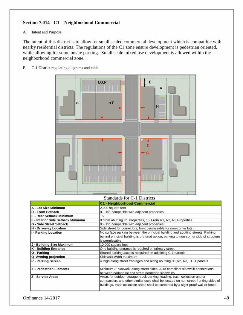
Ordinance 14-2017 48
Section 7.014 - C1 – Neighborhood Commercial A. Intent and Purpose
The intent of this district is to allow for small scaled commercial development which is compatible with nearby residential districts. The regulations of the C1 zone ensure development is pedestrian oriented, while allowing for some onsite parking. Small scale mixed use development is allowed within the neighborhood commercial zone. B. C-1 District regulating diagrams and table
Standards for C-1 Districts
C1 - Neighborhood CommercialA - Lot Size Minimum 2,000 square feetD - Front Setback 0' - 15', compatible with adjacent propertiesE - Rear Setback Minimum 15'F - Interior Side Setback Minimum 0' from abutting C1 Properties, 15' From R1, R2, R3 PropertiesG - Side Street Setback 0' - 15', compatible with adjacent propertiesH - Driveway Location Side street for corner lots, front permissable for non-corner lotsI - Parking Location No surface parking between the principal building and abutting streets, Parking
behind principal building is prefered option, parking to non-corner side of structure is permissable
J - Building Size Maximum 10,000 square feetK - Building Entrance One building entrance is required on primary streetO - Parking Shared parking access recquired on adjoining C-1 parcelsQ- Awning projection Sidewalk width maximumP - Parking Screen 4' high along street frontages and along abutting R1,R2, R3, TC-1 parcels
X - Pedestrian Elements Minimum 8' sidewalk along street sides, ADA compliant sidewalk connections between parking lot and street bordering sidewalks
Z - Service Areas Areas for outdoor storage, truck parking, loading, trash collection and or compaction, and other similar uses shall be located on non street fronting sides of buildings, trash collection areas shall be screened by a sight-proof wall or fence

Ordinance 14-2017 49
Standards for C-1 Districts. (Table repeated from previous page) C1 - Neighborhood Commercial
A - Lot Size Minimum 2,000 square feetD - Front Setback 0' - 15', compatible with adjacent propertiesE - Rear Setback Minimum 15'F - Interior Side Setback Minimum 0' from abutting C1 Properties, 15' From R1, R2, R3 PropertiesG - Side Street Setback 0' - 15', compatible with adjacent propertiesH - Driveway Location Side street for corner lots, front permissable for non-corner lotsI - Parking Location No surface parking between the principal building and abutting streets, Parking
behind principal building is prefered option, parking to non-corner side of structure is permissable
J - Building Size Maximum 10,000 square feetK - Building Entrance One building entrance is required on primary streetL - Building Height 2 Stories MaximumO - Parking Shared parking access recquired on adjoining C-1 parcelsQ- Awning projection Sidewalk width maximumP - Parking Screen 4' high along street frontages and along abutting R1,R2, R3, TC-1 parcels
X - Pedestrian Elements Minimum 8' sidewalk along street sides, ADA compliant sidewalk connections between parking lot and street bordering sidewalks
Z - Service Areas Areas for outdoor storage, truck parking, loading, trash collection and or compaction, and other similar uses shall be located on non street fronting sides of buildings, trash collection areas shall be screened by a sight-proof wall or fence

Ordinance 14-2017 50
Section 7.015 - C2 – General Commercial A. Intent and Purpose
The intent of this district is to allow for general commercial development throughout the city. Development in this district should include enough parking to ensure that trips by motorists are convenient and do not interfere with traffic patterns, while also avoiding site designs which are hostile to pedestrians. The use of landscape buffers and landscaped islands is required for larger surface parking lots. The use of liner buildings is encouraged to help frame streets and help create a sense of place. Mixed use development is encouraged within this district and multi-family residential development may be incorporated into developments above retail uses or behind street fronting retail liner buildings. Retail buildings are limited to a maximum of 90,000 square feet in this zone. B. C-2 District regulating diagrams and table
Table on next page.

Ordinance 14-2017 51
Standards for C-2 Districts. See diagrams on previous and following page. C2-General Commercial
A - Lot Size Minimum 2,000 square feetD - Front Setback Minimum Minimum 15' from property line, and no closer than 15' to abutting road rights of wayE - Rear Setback Minimum 15' from TC, C, and I zones, 25' from R zonesF - Interior Side Setback Minimum 0' from TC2, TC3, C zones, and I zones; 25' from R zonesG - Side Street Setback Minimum 15' from property line, and no closer than 15' to abutting road rights of wayH - Driveways/Internal Circulation For corridors without access management plans only. Driveways shall be a minimum of 50 feet
from intersections*, Maximum of 1 curb cut per 100 linear feet of street frontage per parcel, On-site circulation should be designed so as to preclude any spill back of traffic from on-site circulation onto the roadway system
I - Parking Location To non-corner side or rear of primary building, no parking closer to the street than the primary street frontage, parking may be located between street and buildings if liner buildings front streets
J- Maximum Square Footage of Retail Building Footprint
90,000 square feet per retail business
O - Parking Connected parking lots are recquired on adjoing parcels with parking lots over .5 acresP - Parking Buffer Minimum 10 foot landscaped and irrigated buffer between street and parking lots
Q - Parking Landscaping Greenspace must cover a minimum of 5% of total parking lot area for all parking lots over .5 acres
R - Corner Site Layout No driveways, exclusive of one drive-thru lane, and no parking between building and streets on corner side. When site layout and drive-thru funtional requirements permit drivethru windows, drivethru access lanes, and stacking lanes should be placed on one side of site. Drive-thru lanes should be integrated into internal circulation and shall not have a separate driveway connection/exit (See pages 48-49)
S- Auto Bay Orientation Auto bays and/or garage doors shall be oriented perpendicular to the street for mid block sites
T - Building Orientation Parking to one side or behind building only, unless liner buildings front street
U - Large Retail Facade Minimum 3% building articulation for a minimum of 30% of the facade length for primary building elevations over 100 feet. Street fronting facades must incorporate arcades, colonades, display windows, awnings, entrance ways, or other architectural elements along a minimum of 50% of the facade; parapets must be tall enough to block view of all rooftop equipment, building designs withouth parapets shall have screened rooftop equipment
V - Large Footprint Retail Entrance One entrance within 30% of building closest to the streetW - Liner Building Orientation Fronting and aligned with primary street, or liner buildings may front both sides of an entrance
drive which is perpendicular to the street, in this configuration a maximum of one row of parking per liner building is allowed, the combined primary facades of liner buildings must equal 60% of the facade length of a large footprint retail building in order for the large footprint building to provide parking in front of the store
X - Pedestrian Elements Connecions from sidewalk network to main entrance required for all sites. 8' minimum width sidewalks required between liner buildings and large footprint retail buildings. 8' minimum width sidewalk required between all parking lots and large footprint retail facades. Minimum 8' sidewalk along streets
Y - Residential Use Location Residential uses are permitted above ground floor non-residential uses, residential uses are also permitted on a lot with non-residential liner buildings fronting bordering streets.
Z - Service Areas Areas for outdoor storage, truck parking, loading, trash collection and or compaction, and other similar uses shall be located on non street fronting sides of buildings, trash collection areas shall be screened by a sight-proof wall or fence
See also diagrams on next two pages.

Ordinance 14-2017 52
Standards for general sites in C-2 zones. See table on preceding page.
Standards for large footprint retail businesses in C-2 zones. See table on preceding page.
.

Ordinance 14-2017 53
C. C2 District diagram and table of preferred arrangement for sites with automobile drive-thrus.
Preferred drive-thru business site layout in C2 and C3 zones.
Preferred Drive-thru Business Site LayoutA - Drive Thru Location Locate drive-thru windows and drive thru lanes on non-street fronting sides of buildingB - Building Orientation Long axis of building parallel to primary streetC -Building Entrances Sidewalk connections to entrances along all bordering streetsD - Glazing Maximize glazing on street fronting sidesE - Parking Location Locate parking on non-primary street fronting side of the buildingF - Service Areas, loading, garbage Locate to minimize visibility from streetsR - Corner Site Layout No driveways, exclusive of one drive-thru lane, and no parking between building and
streets on corner side. When site layout and drive-thru funtional requirements permit drivethru windows, drivethru access lanes, and stacking lanes should be placed on one side of site. Drive-thru lanes should be integrated into internal circulation and shall not have a separate driveway connection/exit.
The preferred site arrangement for businesses with drive-thrus is for the drive-thru window and drive thru lane to be located on the side of the building which does not face the primary street. The building should be located close to the front setback line along the primary street. On corner sites, the building should be sited on the corner side of the site, close to the primary and secondary street setbacks. Parking should be located on the back side of the building. The long axis of the building should be parallel to the primary street with glazing along street fronting sides maximized. Entrances with sidewalk connections should be provided from all abutting streets. The above diagram shows one possible drive-thru configuration in which the drive thru lane encircles the parking on the non-primary street fronting side of the building.
R

Ordinance 14-2017 54
D. Convenience site \ gas station site layout
Option 1a - Preferred Option 1b – Permitted
The preferred site arrangement for businesses with canopy covered gas pumps is for the main building’s front facade to be oriented perpendicular to the street. No parking should be located between the building and the street. Parking should be located along the front facade of the building and along non-street fronting sides of the property. On corner sites the primary building may either back to the corner and have a landscaped buffer between the back and side of the building and adjacent sidewalks (Option 1a), or may face the secondary street with the canopy and pumps located between the building and secondary street (Option 1b). In both orientations the canopy is located in front of the primary facade of the primary building and no parking is located between the primary building and the primary street. Glazing and pedestrian entrances on street fronting sides of the primary building is encouraged, but are not required. A minimum ten foot landscaped buffer is required between all vehicular parking, standing, and circulating areas and the primary and secondary streets for both Option 1a and Option 1b.
Option 2 (Permitted corner sites only)
An alternative arrangement for corner sites (Option 2) is for the primary building to be located along the side setback line on the secondary street side of the property. The canopy and pumps are located between the front facade of the building and the primary street. Parking should be located along the front facade of the building and on non-street fronting sides of the property. No parking is allowed between the building and secondary street. A minimum ten foot landscaped buffer is required between all vehicular parking, standing, and circulating areas and the primary and secondary streets.

Ordinance 14-2017 55
Section 7.016 - C3 –Service Commercial A. Intent and Purpose The intent of this district is to allow for large scale commercial development in areas characterized by high traffic volumes. C3 sites may require a high level of vehicular ingress and egress. The C3 zone permits the open display of fully assembled merchandise. Large footprint retail businesses are not limited in size in this district. Development in the C-3 district should include enough parking to ensure that trips by motorists are convenient and do not interfere with traffic patterns, while also avoiding excessive surface parking and site designs which are hostile to pedestrians. The use of landscape buffers and landscaped islands is required for larger parking and display lots. The use of liner buildings is encouraged to help frame streets and help create a sense of place for those that visit or pass through the district. The placement of buildings on open display sites and auto-oriented business sites should be close to streets with auto service bays oriented perpendicular to fronting streets where possible. Service areas shall be limited to fully enclosed buildings. B. C-3 District regulating diagrams and table
See table on next page.

Ordinance 14-2017 56
Standards for C-3 Districts. See diagram on preceding page. C3 - Open Display \ Service Commercial
A - Lot Size Minimum 2,000 square feetD - Front Setback Minimum 15' from property line, and no closer than 15' to abutting road rights of wayE - Rear Setback Minimum 15' from TC, C, and I zones, 25' from R zonesF - Interior Side Setback Minimum 15' Minimum TC2, TC3, C zones, and I zones; 25' from R zonesG - Side Street Setback Minimum 15' from property line, and no closer than 15' to abutting road rights of wayH - Driveway For corridors without access management plans only, no driveways within 50' of intersections,
maximum of 1 driveway per 100 feet of street frontage per parcelI - Parking Location To side or rear of primary building, no parking closer to the street than the principal building
frontage, parking may be located between street and buildings if liner buildings front streets
J- Maximum Retail Square Footage No maximum
O - Parking Connected parking lots required on adjoining parcels with parking lots over .5 acresP - Parking Buffer Minimum 10 foot landscaped buffer between street and parking lots for lots over .5 acre, standard
also applies to display lots in addition of R.O.W.Q - Parking Landscaping Greenspace must cover a minimum of 5% of total parking stall coverage area for all parking lots
over .5 acres, Standard also applies to display lots
R - Corner Site Layout No driveways, exclusive of one drive-thru lane, and no parking between building and streets on corner side. When site layout and drive thru functional requirements permit drive-thru windows, drivethru access lanes, and stacking lanes should be placed on one side of site. Drive-thru lanes should be integrated into internal circulation and shall not have a separate driveway connection/exit (See pages 48-49)
S- Auto Bay\Storage Door Orientation Auto Bays and/or garage doors, (including mini storage doors) must be oriented perpendicular to the street for mid block sites, or be screened by liner buildings
U - Large Footprint Retail Facade Minimum 3% building articulation for a minimum of 30% of the facade length for primary building elevations over 100 feet; street fronting facades must incorporate arcades, colonades, display windows, awnings, entrance ways along a minimu of 50% of the facade; parapets must be tall enough to block view of all rooftop equipment
X - Pedestrian Elements Connections from sidewalk network to main entrance required for all sites, 8' minimum width internal connections required between any liner buildings and large format retail buildings, 10' minimum width sidewalk required between all parking lots and large format retail facades, minimum 8' sidewalk along streets
Y - Residential use location Residential uses are permitted only above non-residential use, residential uses are also permitted on a lot with non-residential liner buildings
Z - Service Areas Areas for outdoor storage, truck parking, loading, trash collection and or compaction, and other similar uses shall be located on non street fronting sides of buildings, trash collection areas shall be screened by a sight-proof wall or fence
C. Preferred drive-thru and gas stations sites layouts in C-3 zones are the same as for the C-2 zone. See pages 49-50 for diagrams and tables.

Ordinance 14-2017 57
Section 7.017 - LI - Light Industrial A. Intent and Purpose
This light industrial district provides a zoning district for clean, quiet industries on landscaped sites with sufficient room for parking and loading. Light industrial sites produce minimal noise, odor, gas, smoke, vibrations, dust, dirt, or other emissions detectable at surrounding property lines. Light industrial districts are compatible neighbors to nearby commercial, residential and agricultural areas. The establishment of light industrial parks is encouraged to attract high tech industries to the city. Evidence must be shown that all applicable State and Federal environmental protection laws are being complied with in order to secure a building permit for an industrial business. B. LI District Regulating diagrams and table
Table on next page.

Ordinance 14-2017 58
Standards for LI districts. See diagram on previous page. LI - Light Industrial
A - Lot Size Minimum 10,000 square feetD - Front Setback 15' MinimumE - Rear Setback Minimum 15' minimum, 30' from R and TC districtsF - Interior Side Setback Minimum 15' minimum, 30' from R and TC districtsG - Side Street Setback 15' Minimum H - Driveway Location For corridors without access management plans only, no driveways
within 50' of intersections, maximum of 1 driveway per 100 feet of street frontage per parcel
P - Landscape Buffers Minimum 10 foot landscaped buffer between street and parking lots, standard also applies to display lots; a minimum 10' width landscaped strip is required along all blank facades over 100' feet in length which front streets; Storage facilities with outdoor access to storage units must be screened from primary street by a minimum 10' foot wide landscaped strip
Q - Parking Landscaping Greenspace must cover a minimum of 5% of total parking lot coverage area for parking lots over 1 acre which are used for employee or customer parking, this standard also applies to display lots
X - Pedestrian Elements Buildings fronting streets must provide pedestrian connections to sidewalks
Z - Service Areas Areas for outdoor storage, truck parking, loading, trash collection and or compaction, and other similar uses shall be located on non street fronting sides of buildings where possible; trash collection areas shall be screened by a sight-proof wall and be a minimum of 50' feet from back of curb, loading docks must be a minimum of 50' from back of curb
ZA - Building Arrangement In buildings containing office uses, office areas should be located closest to the street
ZC - Residential screening and lighting requirements
A permanent opaque screening fence or wall shall be constructed along any side or rear property line which abuts property zoned for residential purposes. Any lighting visible from outside the site shall be designed to reflect away from adjacent areas zoned for residential purposes.

Ordinance 14-2017 59
Section 7.018 - HI - Heavy Industrial
A. Intent and Purpose This zone is reserved for more intensive industries and those making products from raw materials. Industries located in this zone may produce external impacts which are not compatible with residential uses. Heavy industrial sites are best suited to large flat sites with access to rail and interstate or major highways. To protect these sites for future industrial development, which aids in the economic development of the city, allowable non industrial uses are limited. Evidence must be shown that all applicable State and Federal environmental protection laws are being complied with in order to secure a building permit for an industrial business. B. HI Regulating Diagrams and Table
Table on next page

Ordinance 14-2017 60
Standards for HI districts. See diagram on previous page. HI - Heavy Industrial
A - Lot Size Minimum 22,500 square feet for sites producing no odors, vibrations, audible noise or glare detectable at the property line, releasing no gaseous emissions, producing no dust or air borne paritculates, and handling no hazardous materials. All other sites 1 acre minimum area.
D - Front Setback 30' MinimumE - Rear Setback Minimum 30' Minimum, 100' from R and TC districtsF - Interior Side Setback Minimum 30' Minimum, 100' from R and TC districtsG - Side Street Setback 30' Minimum H - Driveway Location For corridors without access management plans only, no driveways
within 50' of intersections, maximum of 1 driveway per 100 feet of street frontage per parcel
I - Parking Parking lots used by employees and visitors to sites shall be separate from lots used for loading, storage and other activities related to industrial uses
P - Landscape Buffers Minimum 10 foot landscaped buffer between street and parking lots, minimum 20 foot landscape strip along any non industrial zoning district
Q - Parking Landscaping Standard applies to employees and visitor lots only. Landscaped islands must cover a minimum of 5% of total parking lot coverage area for all parking lots of 1 acre or larger.
X - Pedestrian Elements Buildings fronting streets must provide pedestrian connections to sidewalks. Designated pedestrians connections from employee lots to primary building are required
Z - Service Areas Areas for outdoor storage, truck parking, loading, trash collection and or compaction, and other similar uses shall be located on non street fronting sides of buildings where possible; trash collection areas shall be screened by a sight-proof wall or fence and be a minimum of 50' feet from back of curb, loading docks must be a minimum of 50' from back of curb
ZA - Building Arrangement In buildings containing office uses, office areas should be located closest to the street, industrial uses away from streets
ZB - Site Arrangement Tanks, bulk storage facilities, and other unenclosed industrial facilites shall be located on the site so as to maximize the distance between these facilites and abutting streets and non industrial zones.

Ordinance 14-2017 61
Section 22- 7.019 – A – Agricultural District A. Intent and Purpose
The agricultural district protects low density areas of a primarily rural nature from immediate development. Areas zoned agricultural may not be suitable for more intensive development due to a lack of infrastructure or because of physical constraints. Low intensity agricultural uses are allowed in these areas. The agricultural zone may be used as a temporary buffer to more urbanized areas of the city to prevent subdivision development from outpacing the city’s extension of infrastructure and ability to provide services. Single family residences are allowed in the Agricultural District, but the district is not intended for new residential subdivisions. All livestock kept in the Agricultural district shall conform to all regulations of the City of Benton Animal Control Ordinance. B. A-Agricultural District Regulating Diagrams and Table
Standards for structures in the A- Agricultural district
AA - Lot Size Minimum 11,500 square feetB - Front Setback Minimum 15'C - Rear Setback Minimum 15'D - Interior Side Setback Minimum 15'E - Side Street Setback 15'

Ordinance 14-2017 62
Section 7.020 - M – Mining District A. Intent and Purpose Mining includes the extraction of various natural resources including: bauxite, sand, gravel, limestone, granite, nepheline syenite, coal, and others. It is the intent of the M district to allow the mining and utilization of these resources, but not to permit the disfiguration or pollution of land beyond the point of reasonable recovery. The M district is designed to assure that these resources be properly managed so as not to create a hazard or nuisance which either immediately or in the future adversely affects the health, safety or general welfare of the community. The intent of the mining district zoning designation is:
1. To allow for the most efficient and effective utilization of extracted or quarried natural resources while minimizing detrimental impact on adjacent properties.
2. To minimize the conflict between urban land uses, extractive land uses and rural land uses by protecting areas suitable and desirable for mining uses from the intrusion of incompatible uses.
3. To protect non-mining uses located near mining areas form the undesirable effects of mining operations.
B. Dumping of trash, waste or other offensive materials of any kind is prohibited unless officially
approved as a governmental or private landfill C. Any mining, extraction or quarrying operation must comply with the permitting provisions of
The Arkansas Open-Cut Land Reclamation Act of 1977 (A.C.A. Section 15-57-301 et seq.) and subsequent revisions or amendments.
D. Mining activities shall not create a hazard or nuisance which either immediately or at any time in the future will adversely affect the health, safety or general welfare of the community, including but not limited to, the emission of vibration, noise, odor, smoke or dust outside of the boundaries of the site.
E. Mining activities shall not contaminate the land or water in any way, and shall leave the land in a state that is readily reclaimable for other uses in the future.
F. Any mining, extraction or quarrying operation which complies with the bulk and area provisions of this section along with the necessary accessory structures required for said operations shall be permitted in the M Mining district.
G. Remediation, reclamation, restoration, conservation, and research including water and solid waste collection, transfer, storage, treatment and discharge are permitted in the M Mining district.
H. For the purpose of this district, mining will not preclude any individual from filling, landscaping, terracing or grading any lot for development or redevelopment
M-Mining district regulations continued on next page

Ordinance 14-2017 63
M - Mining continued
G. M-Mining district regulating diagram and table
Standards for structures in the M-mining district M
A - Lot Size Minimum 10 AcreB - Lot Width Minimum 250'C - Lot Depth Minimum 250'D - Front Setback Minimum 50'E - Rear Setback Minimum 35'D - Interior Side Setback Minimum 35'E - Side Street Setback 50'

Ordinance 14-2017 64
Section 7.021 - OS – Open Space A. Intent and Purpose
The open space district protects areas which are inappropriate for development due to physical constraints, as well as areas which are to be protected as parkland. B. The Open Space district is to apply to:
1. Public and private parks which comprise a significant component of the cities open space network. 2. Greenways identified on the comprehensive plan. 3. Buffer zones between incompatible uses. 4. Areas which are inappropriate for urban development due to physical constraints, such as areas with
steep slopes or wetland areas. C. Accessory buildings used for recreation or maintenance of open spaces in non-city owned open spaces
may cover no more than 10% of the area of the open space. Section 7.022 - S – School A. Intent and Purpose The school zoning district is reserved for lands owned by public school systems and which are used for school related activities. The school zoning district is intended to provide a zone with the flexibility to allow for the variety of activities associated with school properties, including but not limited to rooms for class room instruction, offices for administration, student assembly facilities, cafeterias, sporting facilities, and maintenance facilities. The layout of school properties should attempt to optimize the learning experience and safety of students, while also maximizing compatibility with surrounding neighborhoods and local traffic patterns. The S-School zoning district shall not be applied to school district owned properties which do not contain educational facilities for students. B. Site plan approval process Site plan approval by the Planning Commission will be required for all improvements having significant impacts on districts abutting the S-School district. The determination of which improvements require site plan approval by the Planning Commission will be made by the Director of Community Development. The Planning Commission shall make a recommendation to the City Council to either approve, approve with modification, defer, or deny a S-School site plan.

Ordinance 14-2017 65
Section 7.023 - PUD - Planned Unit Development A. Described A Planned Unit Development (PUD) is a means of land regulation that promotes flexibility in land development by permitting a combination of varied and compatible land uses within one contained development. It is a separate and distinct zoning designation and as such, its creation is by city ordinance and must follow the same procedures as are designated by the City of Benton for a rezoning of property. In concept, the PUD process is a unified review process of both subdivision regulation and zoning regulations and as such, the rezoning shall include the adoption of a specific master development plan and development standards. Once the PUD is approved by city ordinance, the PUD’s site plan becomes a separate and distinct zoning district and development must follow the site plan exactly. Minor changes or modifications to the PUD’s site plan, subsequent to the approval by the City Council, must follow the procedures outlined below and be approved by the Planning Commission prior to the changes being made. B. Purpose The purpose of a PUD is to allow flexibility in design of infill and large scale projects; and to encourage mixed-use development and innovative site designs in any combination, including multiple combinations of commercial, office or residential uses. A PUD is appropriate only when the proposed development will not fit within the parameters of a single zoning designation and the proposed development is believed to be beneficial to the community. A PUD may not be used solely as a method of avoiding zoning regulations of existing zoning districts. Projects proposed must have a community benefit greater than a project which would be allowable without the PUD zoning designation. C. Appropriateness of development for PUD designation The rezoning of property to the PUD may be deemed appropriate if the Planning Commission determines that the development proposed for the district can accomplish one or more of the following goals:
1. The PUD will allow the development of infill parcels in the developed portion of the City that could not be made productive under normal zoning regulations.
2. The PUD would further the City’s goal of providing housing for all economic segments of the City and its Planning Area Boundary.
3. The PUD involves a large parcel in excess of five acres in which flexibility would allow high quality or innovative urban design.
4. The PUD would aid in the elimination of substandard housing and blight within the City and its Planning Area Boundary.
5. The PUD design results in a minimum of 30 percent of the total development being reserved as permanent open space.
6. The PUD will create a desirable and stable environment. 7. The PUD provides a more efficient and economic arrangement of varied land use, buildings,
circulation systems and facilities. D. Size requirements There is no minimum size requirement for a PUD submittal; however, the Planning Commission shall consider requests for sites less than one acre only in cases where it advances specific benefits to the health, safety and public welfare.
Ordinance 14-2017 66
E. PUD Design Regulations The following regulations do not supersede any state or federal codes or regulations, including the Arkansas Fire code, nor is the Planning Commission empowered to grant any variances or waivers from such state or federal codes or regulations.
1. Lot Size. No minimum district size is established. Housing can be clustered or otherwise concentrated or arranged in locations on the site to take advantage of its natural resources. The proposed lots and the type of development (i.e. housing, mixed use, commercial) for each shall be clearly depicted.
2. Open yard Reservation. Land not used by buildings, accessory structures, and yards, but part of the PUD shall be maintained as open space for the purpose of providing parks, recreational facilities, ways of pedestrian movement and circulation and conserving visually pleasing elements of the environment. Prior to the sale of any lot, site, home or other structure, a performance guarantee of sufficient surety determined by the City shall be posted with the City for completion of said open space improvements. The site plan shall clearly depict the amount of land to be maintained as permanent open space.
3. Development Density. The site plan shall clearly depict the proposed density by land use category. 4. Property Owners Association. The developer shall submit a set of covenants running with the land,
providing for an automatic membership in the Property Owners Association, to be an incorporated nonprofit organization, operating under recorded land agreements designed and intended to exist in perpetuity, through which each property owner in the PUD is automatically subject to a charge for an appropriate proportionate share of the expenses for maintaining the common property, open space and/or other activities of the Association. Once established, the covenants shall continue and remain in force during the entire existence of the Planned Unit Development
5. Responsibility for Open Space. Nothing in this Section shall be construed as assigning or assuming any responsibility or liability on the part of the City of Benton, for maintenance of any private open areas, parks or recreational facilities. A hold harmless clause shall be incorporated in the covenants running with the land to this effect. It shall be provided further, however, that when an owner of a PUD desires to dedicate certain land areas to the City for public parks and recreational facilities, and the City approves the nature and location of such lands, and accepts the dedicated areas, the City shall be responsible for the operation and maintenance of these lands and properties thereafter.
6. Common Open Spaces. The size, shape, dimension and location of the common open spaces shall be considered by the Planning Commission with consideration being given to the size and extent of the proposed development and the physical characteristics, including the topography of the land being developed. Consideration should also be given in providing parks, recreational facilities, both active and passive, and pedestrian walkways. Common open space shall be guaranteed by a restrictive covenant, describing the open space and its maintenance and improvement, running with the land for the benefit of the residents and employees of the Planned Unit Development. The developer shall file, at the time the approved final site plan is filed, legal documents that will produce the aforesaid guarantees and, in particular, will provide for restricting the use of common open spaces for the designated purpose.
7. Preservation Plan. In order to minimize the disturbance of the natural environment, a general preservation plan shall be required at the time of preliminary plat submission; this shall show the specific type, size and nature of the preservation area. The Planning Commission shall review the preservation plan in conjunction with the review of the site plan. The preservation of the Natural amenities within the PUD, including topography, trees, ground cover, natural bodies of water and other significant natural features, shall be given due consideration. Existing trees shall be considered when planning the common open space, location of buildings, underground services, walks, paved areas, playgrounds, parking areas and finished grade levels. Excessive site clearing of

Ordinance 14-2017 67
topsoil, trees and natural features before the commencement of building operations is be discouraged. The applicant shall provide evidence as how these objectives are to be met.
8. Transportation. The vehicular circulation system shall be designed so as to permit smooth traffic flow with minimum hazards to pedestrian traffic. The pedestrian circulation system and its related walkways shall be protected as reasonably as possible from the vehicular movement. If the owners in the future should request that the private streets be changed to public, the owners will bear the full expense of reconstruction or any other action necessary to make the streets fully conform to the requirements applicable to public streets, prior to dedication and acceptance. The owners also shall agree that these streets shall be dedicated to public use without compensation to the owners.
9. Land Subdivision. In the construction and installation of all subdivision improvements in the PUD, said improvements shall conform to all requirements as set forth in the City’s Subdivision Regulations, unless exception to the requirements is recommended and approved by the Planning Commission.
10. Nothing in these regulations shall be construed to prohibit the creation of a Maintenance Improvement District in addition to a property owner(s) association within the PUD.
F. Application Process The applicant for a Planned Unit Development permit shall be the landowner(s) of the property or the party designated to act as agent for the landowner(s). In addition to the procedures outlined in Arkansas Code Ann. 14-56-422 the procedure for the review and approval of a PUD are as follows:
1. Pre-application Conference. Each prospective applicant shall confer with the Planning Commission in connection with the preparation of the application prior to the formal submittal. The purpose of this conference is to determine if the proposed PUD would generally meet at least one of the goals outlined above under Section 7.023-C. At this conference, the following information and data shall be considered.
a) The boundaries of the property. b) Existing easements affecting the property. c) Physical characteristics such as drainage, topography, vegetation and existing
structures. d) Development characteristics such as surrounding land uses, existing streets and
availability of utilities. e) Elements of the proposed layout such as land uses, open spaces, community facilities,
densities, traffic flow and estimated impact on traffic and adjacent land uses
2. Pre-Submission to the Planning Commission: The applicant may also elect to present a sketch of the proposed PUD to the City of Benton Planning Commission. Pre-submission of the sketch plat to the Planning Commission is strictly to receive comments and/or suggestions from the Commission and to identify potential problems or deficiencies. Concurrence in the sketch plat by the Commission shall not necessarily imply the approval of the final submission.
3. Site Plan Submittal: No less than thirty (30) days prior to the Planning Commission meeting at which the proposed PUD is to be reviewed, the applicant shall deliver the proposed site plan to the Community Development Department of the City of Benton. Any application that is incomplete in any respect will be returned to the applicant for appropriate corrections. Any required corrections must be returned to the Community Development Department at least 10 days prior to the Planning Commission meeting. The Commission will not review an incomplete application. Site Plan Submittals must include:
Ordinance 14-2017 68
a) A site plan drawn to scale. Survey information shall be prepared by a professional surveyor
(P.S.). Drainage and utility calculations shall be prepared by a Professional Engineer (P.E.). The stamps of the individuals responsible for the various elements shall be affixed to the drawing.
b) Building footprints for the individual buildings to be included in the PUD. c) Topographic contours at 2 foot intervals. d) All easements, existing or proposed. e) All drives, access-ways, alleys, parking lots, sidewalks, pedestrian facilities, and any streets
proposed to be dedicated. f) Proposed landscaping. g) Open space and community facilities, if any, proposed as part of the PUD. h) Location of all existing and proposed private and public utilities. i) Name of the landowner of the proposed project and their agent, if any. j) Zoning classifications of adjoining properties. k) Site improvement drawings as necessary to support the proposals outlined in the site plan.
G. Review Process The Planning Commission shall review the proposed PUD after submittal of all documents. In reviewing any proposal, the Planning Commission shall determine that the PUD will:
1. Provide Public Benefits that would not be achievable through the normal zoning regulations. 2. Be consistent with the City’s Land Use Plan. 3. Not endanger the public health, welfare or safety. 4. Be of a character and contain such uses that are needed in the area of the proposed project. 5. Not interfere with existing traffic in the vicinity and not lower the level of service on any
adjacent street. 6. Not represent such a departure in design and intensity of use as to adversely impact the
value of adjacent and nearby properties. H. Public Hearing: After Review of the Proposed PUD, the Planning Commission shall conduct a public hearing to receive input from the public on the proposed PUD. Notice of the public hearing shall be advertised in accordance with Ark. Code Ann. 14-56-422, at the expense of the applicant. In addition, the applicant shall send or cause to have sent, a notice of public hearing to all persons that lease or own property within 300 feet of a proposed boundary of the PUD by certified mail or by delivered notice, proof of which shall be deposited with the Community Development Department at least fifteen (15) days prior to the public hearing. I. Recommendation by the Planning Commission to the City Council. After the public hearing has been completed, the Planning Commission shall make a recommendation to the City Council to either approve the PUD or to not approve the PUD. J. Development. All further development on the property shall conform to the standards adopted for the site, regardless of any change in ownership. Approval of the PUD shall run with the land and apply to successor owners.

Ordinance 14-2017 69
Any proposed changes to the approved standards shall be treated as amendments to the zoning regulations and must be considered in accordance with the procedures set forth in the city of Benton Zoning Regulations. K. Amendments Following City Council approval the Planning Commission may approve minor revisions to the site plan if:
1. No changes are made to either access to or egress from the PUD. 2. Any changes to internal traffic arteries do not alter overall traffic patterns, size of streets, or
functional classification of streets. 3. No new streets are proposed for dedication. 4. No new private streets are proposed. 5. Overall density has not increased. 6. Overall drainage patterns are not altered. 7. No additional loads are placed on municipal utilities. 8. No open space is dedicated for public maintenance.

Ordinance 14-2017 70
Chapter VIII - Parking Section 8.001 - Parking requirements Minimum parking space requirements by zoning district are shown in Table 8-1. The parking minimums shown in the table below are subject to review by the Office of Community Development and by the Benton Planning Commission. Additional parking above what is listed in Table 8.1 may be required. Table 8-1
RESIDENTIAL USE PARKING MINIMUMS Attached Single Family Residential 2 Spaces minimum
Detached Single Family Residential 2 Spaces minimum
Multi-Family Building 1 Space for each 1 Bedroom + 1.5 spaces per 2 bedroom or more unit Manufactured Housing 2 Spaces Minimum TC-1 and TC-2 Residential 1 Space Minimum
COMMERCIAL USE PARKING MINIMUMS
General Retail (10,000 ft2Max) 1 space per 600 square feet of floor area or 1 space per 800 square feet in C1 and TC2
General Retail (90,000 ft2Max) 1 space per 500 square feet of floor area General Retail (90,000 ft2 +) 1 space per 400 square feet of floor area Open Display Retail 1 space per 400 square feet of floor area Office 1 space per 200 square feet of floor area Clinic 2 spaces per patient room
Restaurant Without Drive-thru 1 space for each 4 seats or 1 space per 500 square feet of building space in C1, TC1, TC2
Restaurant With Drive-thru 1 space for each 4 seats
Gas Station No minimum if pumps and attendant only, General Retail requirements apply to convenience stores
Vehicle Service / Repair 1 space per service bay
Personal Services 1 space per 500 square feet of floor area or 1 space per 800 square feet in C1 and TC2
Theater 1 space for each 8 seats Mini-Storage No Minimum Lodge/Club One space for each 200 square feet of building space
Bed & Breakfast One space for each 4 guest beds + 2 additional spaces if also a residence
Hotel One space for each hotel room or suite Daycare One space for each 3 employees Nursing Home\Assisted Living One space for each 4 beds
Church One space for each 4 seats, may be reduced by joint parking agreements with neighboring uses
School Subject to review INDUSTRIAL USE PARKING MINIMUMS
Warehousing One space for each 1.5 employees of the maximum working shift Light Manufacturing One space for each 1.5 employees of the maximum working shift Heavy Manufacturing One space for each 1.5 employees of the maximum working shift Bulk Storage One space for each 1.5 employees of the maximum working shift
Table continued on next page

Ordinance 14-2017 71
Table continued from previous page
Distribution Terminal One space for each 1.5 employees of the maximum working shift Resource Extraction One space for each 3 employees of the maximum working shift Raw Material Processing One space for each 3 employees of the maximum working shift Chemical Processing One space for each 1.5 employees of the maximum working shift
AGRICULTURAL USE PARKING MINIMUMS Intensive Agriculture No minimum Urban Farming No minimum Parking for uses determined not to fit in above categories by the community development office shall be determined during conditional use review Surface parking is not permitted in TC3 zone; there are no minimum requirements for structured parking or below grade parking in the TC3 zone Minimum Parking requirements for single structures housing multiple uses shall be cumulative and based on use requirements
Section 8.002 - Design requirements for off-street parking facilities:
A. All parking areas shall have adequate ingress and egress to a street or alley. Sufficient room for
turning and maneuvering vehicles shall be provided on site. B. Entrance and exit locations shall be approved by the Director of Community Development. C. Each full size space shall be no less than 9 feet wide by18 feet long, and each compact car space
shall be no less than 8 feet wide by 16 feet long. D. A maximum of 10 percent of spaces may be compact car spaces E. Illumination of lots shall be directed so as to minimize glare on abutting residential properties.
Maximum light spillage shall not exceed 3 foot-candles at the property line. F. Abutting properties with parking lots over .5 acres shall provide cross access between parking
lots. G. All parking shall comply with all American with Disabilities Act requirements for parking and
passenger loading zones. H. All required off-street parking shall be hard surfaced. Permeable hard surfaced parking surfaces
may be used when practical. Examples include porous asphalt, porous concrete, and open jointed paving blocks. Where use of porous pavers is not practical for an entire surface lot, they may be used for parking stalls.
I. Hard surfaced areas devoted to parking, loading, stacking, and on-site traffic circulation shall not exceed 50% lot coverage in R, C, and TC zones. New surface parking lots are prohibited in the TC3 zone.
J. All surface parking lots should be located on non-street fronting sides of buildings when practical. When locating a parking lot on a non-street fronting side of a building is not practical, then locating parking to the side of the building should be a second option. Locating parking between buildings and the street should be avoided when alternative parking configurations are practical. Specific requirements for parking location are included in the zoning district regulating diagrams included in this chapter, if applicable to a particular zone.
K. Permitted parking configurations for large floorplate retail buildings are shown in Section 8.004. No parking is permitted between the front façade of a large floorplate retail building and a primary street without liner buildings. Liner buildings may front and be aligned with the primary street, or liner buildings may front both sides of an entrance drive which is perpendicular to the street, in this configuration a maximum of one row of parking per liner building is allowed, the combined primary facades of liner buildings must equal 60% of the facade length of a large footprint retail building in order for the large footprint building to provide parking in front of the building.

Ordinance 14-2017 72
Section 8.003 – Diagram and table of regulated elements for surface parking lots. Additional parking lot landscaping requirements are in Section 9.007 A.
A - Planting buffer Minimum 12' planting strip required around edges (site perimeter requirements still apply)
B - Row End Landscaped Islands Minimum 8' wide landscaped island required at each end of every parking rowC - Mid Row Planting Islands 8' wide planting Island required every 12 parking spacesF - Internal landscape Buffer Internal 12' landscaped buffer required every 4th row of cars at minimumG - Screening Minimum 36" earthen berm, wall, or evergreen vegetative screening along R.O.W. and
residential properties H- AisleWidth 22' minimum' for 90 degree parking - 14' minimum for 45 degree parkingI - Parking Space Dimensions 9' x 18' minimum, except 8' x 16' for spots marked compact car onlyJ - Cross lot access Cross lot access required for lots over .5 acres on adjoining lots

Ordinance 14-2017 73
Section 8.004 – Diagram of permitted parking lot site layouts for large floor plate retail.
Permitted parking configurations for large floor plate retail buildings. Section 8.005 – Additional parking regulations
A. The use of green parking lot design incorporating bio-swales, planting strips, porous pavers and other run-off reducing features are encouraged.
B. Landscaping requirements and requirements for driveway location, covered parking location, and parking lot configuration are included in the zoning district regulating diagrams included in this chapter, if applicable to a particular zone

Ordinance 14-2017 74
C. Parking will be considered as part of the site plan review process for conditional uses. Site plan designs which may result in parking conflicting with on street traffic patterns may be disapproved. However, the availability of on street parking and shared parking shall be considered during the site plan review. Developments which will utilize on-street parking to meet anticipated parking demand shall provide an estimate of current and planned on street parking capacity within one quarter mile of the site, and agreements for shared parking access.
Section 8.006 - Off-Street Loading
A. Off-street loading areas shall be hard surfaced and located on non-street facing sides of buildings when practical.
B. Properties in the LI and HI zoning districts shall provide sufficient hard surfaced space for
loading, unloading, and standing to occur on site without interfering with traffic on surrounding streets.

Ordinance 14-2017 75
Chapter IX – Landscaping and Screening Section 9.001 – Intent and Purpose The intent of these requirements is:
A. To enhance the visual appearance of the City of Benton. B. To enhance the quality of life of residents and encourage economic development within the city of
Benton. C. To maintain and protect property values. D. To improve air quality and minimize the urban heat island effect. E. To screen automobiles and vehicular use areas, dumpsters, loading areas and otherwise enhance the
appearance of the public right of ways. F. To break up large parking lots and other expanses of impervious surface. G. To provide a transition between and improve the compatibility of abutting land uses. H. To preserve, existing native vegetation, tree canopy and significant trees. I. To promote energy efficiency and conservation in site design, building construction, and
landscaping. J. To serve as buffers that reduce wind, noise, and glare. K. To reduce storm water runoff.
Section 9.002 – Applicability The provisions of this chapter apply in all zoning districts within the city of Benton with exception of single family residential districts and the M, AG, and OS Districts. Section 9.003 – General Requirements
A. All areas not covered by structures, service yards, walkways, driveways, patios, and parking spaces shall be landscaped.
B. Landscaping shall be provided which is sufficient to provide soil stability and suitable drainage. 1. Trees, shrubs, groundcover, and grass shall be placed and retained in such a manner as to
reduce runoff and/or erosion. 2. Graded areas shall be re-vegetated to ensure erosion control by seeding, mulching, and
fertilizing. Disturbed areas shall be planted with suitable plant materials. 3. Landscape fabric or erosion blankets should be provided on slopes exceeding 50% while
ground cover is being established. C. The current property owner shall properly maintain all required landscaping.
1. The property owner shall be responsible for maintaining all landscaping within the boundaries of the site so as to present a healthy, neat, and orderly appearance.
2. Any dead plant material shall be replaced in accordance with the approved landscaping plan. 3. All landscaping shall be irrigated with a professionally installed irrigation system.
D. Native Species should be used when possible in order to minimize watering. E. Benton Utilities should be contacted for any plantings in utility easements. F. A landscape plan and plantings list is required for all commercial, industrial, mixed-use, school,
and multi-family residential development sites.

Ordinance 14-2017 76
Section 9.004 – Preservation
A. It is strongly encouraged that all landscaping plans attempt to incorporate existing on-site landscape features and vegetation.
B. Where possible and reasonable, all existing mature, “significant” trees, rock outcroppings, and riparian corridors shall be preserved and incorporated into landscaping plans.
C. Where healthy plant material exists on the site prior to development and the provision is made to preserve and incorporate that plant material on a permanent basis, then credit may be given against all pertinent city landscaping requirements, so long as the existing plant material meets the purpose and intent of said requirements.
Section 9.005 – Landscaping Requirements
A. Landscaping requirements will be determined in part by a structures frontage. Frontages will be
classified as either urban or non-urban. Urban frontages are building facades which are flush with a sidewalk and have either shop front windows or other types of fenestration which is scaled for passing pedestrians. Urban frontages often utilize awnings, colonnades, or arcades. Buildings built flush with a sidewalk but with less than 40% of the total facade width covered in glazing shall not be considered urban frontages.
B. Developments with urban frontages shall incorporate streetscape improvements consisting of a planting strip of deciduous trees planted along all public streets. The landscaping strip should be situated in the public right of way where possible and on the side of the sidewalk closest to the street. The planting strip shall consist of site and regionally appropriate street trees planted in tree grates, tree wells, or in a continuous planting strip. Trees should be spaced at a minimum interval of one per thirty feet. Street trees should be planted a minimum of 2 feet from the back of curb on collector and local streets. Along streets classified as minor arterial and above a determination of the appropriate location of the planting strip shall be made by the office of Community Development or may be referred to the Planning Commission. Along high traffic volume streets additional landscaping buffers may be required between the street and the sidewalk clear zone. Street trees should be planted a minimum of two feet from utilities. In the event overhead obstructions exist which would prohibit the use of canopy trees, understory trees shall be required.
C. For non-urban frontages a landscaping strip around the base of structures should be planted with vegetation dense enough to sufficiently lessen the impact of an otherwise bulky appearance where a structure meets the ground. The landscaping strip shall be a minimum of 3’ wide on all sides of structures visible from abutting streets, driveways, and parking lots. Frontages with shop front windows bordering parking lots or driveways shall have a planting strip between the parking lot and the sidewalk. The planting strip shall consist of trees planted a minimum of one every 30 linear feet of frontage bordering the parking lot. A minimum of one shrub per 6 linear feet of frontage shall be planted either in the landscaping strip or in raised landscaping beds along the frontage. Trees and shrubs may be grouped, but must meet the minimum total of trees and shrubs required for the frontage as calculated by the length of the frontage and required planting ratios.
D. The landscaping strip along the structures perimeter should be increased in width and planting density as necessary to meet its intent of aesthetically softening and screening the structures base.
E. Deviation from these standards may be allowed under special circumstances. Special circumstances that could justify deviation from standards include:
1. Conflict with utilities 2. Special security considerations 3. Preservation of significant trees or habitats 4. Traffic safety considerations

Ordinance 14-2017 77
F. Landscaping standards for urban frontages
A - Street Trees Site and regionally appropriate street trees required along abutting streetsB - Street Tree Spacing Minimum 30' tree spacing requiredC - Planting Strip Street Trees can be planted in tree wells or in a continous planting strip. D - Planting Strip width Minimum 4' widthE - Non-urban frontages Plantings consisting of trees and shrubs required along base of structure along non
street facing sides when building is not built to the property line F - Sidewalk clear zone A minimum 5' wide clear zone for pedestrians, free of plantings, tree wells, tree pits, or
tree grates and street furniture must be maintainedG - Building base landcaping Plantings of trees and shrubs are required along the building perimeter on sides
without shopfront windows. Plantings in raised beds are encouraged.H - Clear Sigtht Areas At street intersections and driveway entrances an area extending 20 feet from the back
of street curbs and 15 feet from driveway edges shall not be planted with sight line obstructing vegetation. Pruned street trees maintained with no lower branches can be planted in this zone
I - Additional Landscaping Additional landscaping and street furniture is encouraged but must be placed outside of the sidewalk clear zone

Ordinance 14-2017 78
G. Landscaping standards for non-urban frontages
A - Street Trees Site and regionally appropriate street trees required along abutting streetsB - Street Tree Spacing Minimum 30' tree spacing requiredC - Planting Strip Street trees are planted in a continous landscaping stripD - Planting Strip width Minimum 4' widthE - Building Base Landscaping Plantings consisting of trees and shrubs required along base of structure and along
non street facing sides when building is not built to the property line F - Clear Sigtht Areas At street intersections and driveway entrances an area extending 20 feet from the back
of the street curb(s) and 15 feet from driveway edges shall not be planted with sight line obstructing vegetation. Pruned street trees can be planted in this zone provided they are mainhtained with no lower branches. This applies only to intersections and does not apply to the length of a street or driveway.
Ordinance 14-2017 79
Section 9.006 – Additional Site Perimeter Landscaping Requirements
A. The perimeter of a site shall be landscaped to provide a buffer for adjacent uses as well as an attractive view from the street.
B. Non-Street Fronting Property lines 1. A perimeter landscape strip at least six feet in width shall be provided along all property lines
adjoining nonresidential areas. This provision is waived where neighboring structures adjoin. 2. A perimeter landscape strip at least 12 feet in width shall be provided along all property lines
adjoining any residential area. 3. There shall be at least one canopy tree every thirty feet, one decorative tree every fifteen feet, or
one shrub every six feet along all boundaries of the site which do not abut streets. Up to 25% of these plantings may be grouped.
4. Existing vegetation which meets, in whole or in part, the purposes of perimeter landscaping described above any be applied toward these requirements.
Section 9.0007 - Sign Landscaping
A. There shall be a landscaped area around the base of all ground mounted signs for the site regardless of being on premise or off-premise. This strip shall have a minimum width of four (4) feet.
B. The sign landscaping strip should be increased in width and planting density as necessary to meet its intent, this is most often based upon the overall bulk and scale of the sign.

Ordinance 14-2017 80
Section 9.008: Parking Lot Landscaping and screening A. Table of required parking lot landscaping elements
A - Planting buffer Minimum 12' planting strip required around edges (site perimeter requirements still apply)
B - Row End Landscaped Islands Minimum 8' wide landscaped island required at each end of every parking rowC - Mid Row Planting Islands 8' wide planting Island required every 12 parking spacesD - Canopy Tree along street sides 1 canopy tree required for every 30' of street frontageE - Canopy Trees Minimum of 1 canopy tree required for every 12 parking spacesF - Internal landscape Buffer Internal 12' landscaped buffer required every 4th row of cars at minimumG - Screening Minimum 35' earthen bem, wall, or evergreen vegetative screening along R.O.W. and
residential properties B. Parking areas and cars should not be the dominant visual element of the site or streetscape. C. Trees shall be planted within the paved parking area so that each parking space is no more than 60
feet from the nearest tree. Perimeter trees may be used to satisfy this requirement. D. In parking lots with 24 spaces or more, no more than 12 continuous parking spaces are permitted
without a landscape island so as to provide a ratio of no less than one tree for each twelve spaces throughout the lot. 1. A landscape island shall be provided at the end of each parking lot aisle. 2. Each island shall contain at least one tree. Each tree shall be maintained to provide a minimum
vertical clearance of 8 feet. 3. All islands shall be a minimum of 150 square feet of unpaved landscaped area and a minimum
of 8 feet in total width and a minimum length equal to the total length of abutting parking spaces.
4. All islands shall be sodded, seeded, or mulched. Applicants are required to plant additional shrubs, annuals, perennials, ornamental grass, and/or groundcover.
5. All islands shall be protected by a 6 inch concrete curb.

Ordinance 14-2017 81
E. In addition to the above, parking lots with 200 or more parking spaces shall be divided by landscape “buffer” areas to prevent large expanses of asphalt or concrete. 1. With the exception of driveways which may cross them, these areas shall extend the width or
depth of the parking lot. 2. There shall be a minimum of one landscape buffer every fourth row of parking 3. This buffer shall be a minimum of 12 feet wide and include a pedestrian walkway of no less 6
feet. 4. A sodded, seeded, or mulched landscaped strip of at least 3 feet in width shall be placed along
both sides of the walkway to form a buffer to pedestrians. F. Internal landscaping should be aligned to create green edges necessary to define access, circulation,
and parking areas. G. All parking lots shall be screened from adjacent residential properties. Screening measures shall be
instituted in accordance with the standards below. 1. Any screening measure shall be a minimum of 35 inches above the average finish elevation of
the adjacent streets, parking lots, and of the ground floors of all structures on the site. 2. Where earth berms are used they shall conform to the following: Berms shall be gently rolling
in nature and undulate so as to appear natural. If the berm does not reach the height needed for screening, then plantings may be included on top.
3. Where shrubs are used, they shall be evergreen in nature, be at least 30 inches tall at the time of planting and be spaced closely enough so as to create a seamless row of hedging.
4. Where fences or walls are used they shall be constructed from a durable material and shall avoid a stockade appearance. Additional landscaping shall be provided along the length of both sides of walls or fences. Screening shall not be implemented in a manner which impairs the sight line of drivers.

Ordinance 14-2017 82
CHAPTER X- MANUFACTURED HOUSING AND OTHER OFF-SITE BUILT STRUCTURES This chapter lists requirements for manufactured housing. Manufactured housing shall be placed only on the site of existing manufactured housing, subject to the provisions below, or in the R-4 zoning district. Additional requirements are placed on manufactured housing placed in the R-4 zoning district. Section 10.001– In general
A. Hereafter, no mobile home may be located within the City of Benton. B. Provisions of this chapter are not intended to apply to modular buildings. Modular
buildings are defined as a factory-built structure produced in accordance with state or local construction codes and standards.
Section 10.002 - Replacement of Existing Mobile Home or Manufactured Home Notwithstanding Section 10.001, an existing mobile home or manufactured home may be replaced with a manufactured home if such replacement occurs within 6 months of the removal of the structure. Section 10.003 - Standards for Manufactured Housing
A. All manufactured homes moved into the City of Benton after the effective date of this Ordinance shall have been manufactured after October 25, 1994, the same being the effective date of the Federal Construction and Safety Standards incorporating revised specifications for fire safety requirements as codified at 24 CFR 3280.203.
B. All manufactured homes shall be installed in accordance with the installation instructions
provided by the manufacturer and the rules and regulations of the State of Arkansas, including: site preparation, pier foundations-footings, pier-support columns and anchoring. Towing devices must be removed. In addition, connections to required utilities and construction of all decks, landings, steps, porches and exterior appendages shall comply with the applicable building and premise codes.
C. Additionally, the City Building Inspector or Community Development Supervisor will inspect
previously owned or occupied manufactured housing units prior to being installed on site to ensure compliance with the following standards. No such previously owned or occupied manufactured home may be occupied until a Certificate of Occupancy has been issued by the appropriate city official.
1. All roofing material shall be secure without gaps or damaged shingles. 2. All windows shall be operative without broken panes or damaged trim or screening. 3. All exterior siding shall be in place and undamaged. No dented, torn, burned, loose or
mildewed siding shall be allowed. 4. All kitchen and bathroom facilities shall be fully operational and all mechanical equipment
shall be in good working order. 5. Any attached gutters shall be secure and functional. 6. All cornice materials shall be in place and undamaged. 7. Paint shall be uniform and unblemished.

Ordinance 14-2017 83
8. Doors shall be plumb and fully operational. No damaged screening or door fixtures shall be allowed.
9. All flooring shall be structurally undamaged and secure. Holes in the flooring, or flooring that is missing, dented, broken, or in a state of damage or decay will not be allowed.
Section 10.004 - Medical Hardships Medical hardships, which granted permission to individuals to locate a mobile home or manufactured home on property within the City, which would not have otherwise been allowed, are hereby abolished. Section 10.005 - Temporary Permit A temporary permit for location of a manufactured home may be given to individuals desiring to live in the manufactured home while a permanent structure is being built on the site. The individual must apply for a temporary permit from the Director of Community Development for a period of up to 6 months. The permit may be extended for no more than 6 additional months in the case of extreme delays in construction. Once a Certificate of Occupancy has been issued on the permanent structure, the manufactured home must be removed from the property. Section 10.006 - Commercial Uses
A. Manufactured or mobile homes shall not be permitted as either a permanent or temporary use as any:
1. Accessory facility to a commercial building 2. Temporary office or commercial facility (including financial institutions) 3. Temporary or permanent additions to churches, hospitals, or other such institutions 4. Any other similar uses to those outlined above
B. Manufactured homes may be utilized for temporary construction offices in commercial or
industrial zones during the term of construction activity for which a valid building permit has been issued and maintained.
C. Manufactured homes may be used as a sales office for a manufactured housing
dealership. Section 10.007 - Educational Uses Any public school district operating a campus within the city limits of Benton may use a portable buildings as their needs may require.

Ordinance 14-2017 84
CHAPTER XI - SITE PLAN REVIEW Section 11.001 – General Purpose and Review The purpose of this section is to set forth the types of projects that will require review by the Planning Commission in order to obtain a building permit, and to establish the procedure for processing such site plans. Site Plan Review is a development review process that provides for case-by-case consideration of project particulars including the provision of parking and landscaping, siting of buildings, and the compatibility of the proposed development with adjacent uses. All development shall be designed in such a way as to minimize any potential deleterious impact on the surrounding area. Special attention shall be given to buffering commercial developments from adjacent single-family areas. Design of the internal street system ingress and egress, off-street parking, loading and pedestrian ways shall be sensitive to such conditions as safety, convenience, separation of vehicular and pedestrian traffic, general attractiveness, areas of dwelling units, and the proper relationship of different land uses. Landscaped areas shall be provided to reduce erosion, heat and glare, and said areas shall be maintained in an attractive condition. Existing trees on a development site shall be retained where possible. Screening, open space, or other buffer may be required to give adequate separation between uses which are not compatible and shall also be provided for the beautification and enhancement of the property. Handicapped parking and accessibility shall be indicated on the plan per ADA requirements. Section 11.002 – Procedure and Authority
A. Site plan review may be initiated by the owner or other person having a contractual interest in the property for which site plan approval is requested or by the authorized agent of such owner or person.
B. Site plans will be reviewed by the Planning Commission under the following circumstances. All
other site plans shall be considered minor site plans and shall be reviewed by the staff.
1. Buildings or developments placed on a plot of real property of two acres or larger, except that A single family residence on two acres or more shall be reviewed by Community Development Staff.
2. Any development containing a building with a combined square footage of 10,000 square feet or more.
3. All multi-family housing developments containing ten or more units. 4. Any building or development storing, using or selling petroleum products, flammable products
or hazardous materials. 5. All conditional uses 6. Any project referred by the city staff. 7. Any project requiring site plan review by the Subdivision Ordinance.
C. The Site Plan Review process occurs when a building permit is requested. The Community
Development Supervisor or Building Inspector and the Planning Commission shall review site plans prior to the issuance of a building permit. At that time, the plan will be assessed for compatibility with standards and criteria provided herein. Public review of a site plan proposal shall take place at regularly scheduled monthly Planning Commission meetings, at which time interested persons may appear and offer information in support of or against the proposed site plan. The Community
Ordinance 14-2017 85
Development Supervisor or Building Inspector will make recommendations to the full Planning Commission at said public hearing and said Commission will then take one of the following steps: approve the site plan as submitted; approve the site plan with modifications; defer the site plan for future review; or deny the site plan. In addition to the special requirements of this section, the Planning Commission may impose on a site plan such additional requirements as are necessary to safeguard the public health, safety and general welfare. The Planning Commission may require the applicant to submit a revised site plan incorporating the imposed requirements and modifications. Such revised site plans shall have priority over new applications in the review process. The Planning Commission may deny a Site Plan and recommend reducing the zoning classification of any parcel which requires a Site Plan if it does not carry out the general purpose of this section. In those instances where a variance from district standards is requested as a part of the submittal request, the Planning Commission may modify or waive standards. A variance may be allowed only after demonstration of a hardship unique to the development proposal filed. Pecuniary difficulties shall not be deemed to constitute a hardship.
Section 11.003 - Site Plan Submission Requirements A. The submission requirements for the review of a site plan preceding the receipt of the building permit shall include the items from Section 11.003 B. The Director of Community Development or designated
City Staff may require additional data or reports as deemed necessary for project review. B. Site Plans Submissions shall include the following:
1. Payment in full of applicable fees for processing the application 2. A digital and hardcopy of the Site Plan drawing with all information in AutoCAD format. 3. Names, addresses, zoning and property lines of all property owners adjacent to the exterior
boundaries of the project (including individual lots across streets and right-of-way) shall be located on the plat at the correct location.
4. Name(s), address(es) and telephone numbers of owner(s) of record, developer and project representative.
5. North arrow, scale (graphic and written), date of preparation, zoning classification and proposed use.
6. Title block located in the lower right hand corner indicating the name and type of project, scale, firm or individual preparing drawing, date and revisions.
7. A complete and accurate legend. 8. A vicinity map of the project with a radius of 1.5 miles from the project. This shall include any
public streets as well as the 100-year flood plain boundary. 9. Street right-of-way lines clearly labeled. The drawing shall depict any future right-of-way needs as
determined by AHTD or the Benton Master Street Plan. Future as well as existing right-of-way and centerlines should be shown and dimensioned.
10. The location of all existing structures. 11. Site coverage note indicating the percentage of site that is covered by both building and impervious
surfaces. 12. Written legal description that reads clockwise and includes area in square feet or acres. 13. Boundary survey of the property shown on the plat. The surveyor shall seal, sign, and date the
survey. The survey shall be tied to Arkansas state plane coordinates. 14. Point-of-beginning from a permanent well-defined reference point. 15. Curve data for any street which forms a project boundary.

Ordinance 14-2017 86
16. 100-year floodplain and/or floodway and base flood elevations. Reference the FIRM panel number and effective date.
17. Note regarding wetlands, if applicable. Note if Army Corp of Engineers determination is in progress.
18. Existing and proposed topographic information annotated. a. Two-foot contour interval for ground slope between level and ten percent. b. Five-foot contour interval for ground slope exceeding ten percent.
19. Spot elevation at grade breaks, existing road centerlines, gutter lines and top of curbs of pavement. 20. Contours of adjacent land within 50 feet of the project shall be shown. 21. Landscape proposals for parking lots shall include proposed plants and size. State the plant material
and the method for irrigating the plant material on the plan. 22. Show all known on-site and off-site existing utilities and easement. 23. Existing easements shall show the name of the easement holder, purpose of the easement, and the
book and page number of the easement. 24. Show all storm sewer structures, sanitary sewer structures and drainage structures:
a. Provide structures / locations and types. b. Provide pipe types and sizes.
25. Sanitary sewer systems: a. Provide pipe locations, sizes, and types. b. Manhole locations of rim and invert elevations.
26. If a septic system is to be utilized, provide a table of acreage and percolation rates, along with a letter from Arkansas Department of Health approving the septic system and size of lot.
27. Water system on or near the site 28. Underground or surface utility transmission lines: 29. State the width, location and purpose of all proposed easements or right of way for utilities,
drainage, sewers, flood control, ingress/egress or other public purpose within and adjacent to the project.
30. The location, widths, grades and names of all existing and proposed streets, alleys, paths, and other right-of-ways, whether public or private.
31. The location of all existing and proposed street lights. 32. Provide a note of any known existing erosion problems on-site or within 300' downstream of the
property. 33. The location of known existing or abandoned water wells, sumps, cesspools, springs, water
impoundments, and underground structures within the project. 34. The location of known existing or proposed ground leases or access agreements, if known. 35. The location and size of existing and proposed signs, if any. 36. Location and width of curb cuts and driveways. Dimension all driveways and curb cuts from side
property line and surrounding intersections. 37. Draft of covenants, conditions and restrictions, if any. 38. A written description of requested waivers from any City requirements. 39. Show required building setbacks. Provide a note on the plat of the current setback requirements for
the subdivision. A variance is necessary from the Board of Adjustments for proposed setbacks less than those set forth in the zoning district.
40. Preliminary grading and drainage plans and reports as required in the City Engineer's office. 41. Placement of fire hydrants (According to the specifications of the Arkansas Fire Prevention Code.) 42. Any other data or reports as deemed necessary for project review by the City Planner, City Engineer
or Planning Commission. 43. Provide sidewalks along streets as required. 44. List any variances being requested.

Ordinance 14-2017 87
45. As-Built Plans will be provided to the City and Benton Utilities before a Certificate of Occupancy will be issued. The As-Built plans will be both in hardcopy and digital formats and will show all applicable easements and rights of way. Digital format will be AutoCAD compatible.
Section 11.004 – Standards for site plan disapproval The Planning Commission shall not disapprove an application for a site plan except on the basis of findings directed to one or more specified particular of the following standards:
A. The proposed site plan is incomplete or contains or reveals violations of this Code or applicable district regulations which the applicant has, after written request, failed or refused to supply or correct.
B. The proposed site plan interferes unnecessarily with easements, roadways, rail lines, utilities, and other public or private rights-of-way.
C. The proposed pedestrian and vehicular circulation systems incorporated in the site plan create hazards to safety on or off the site.
D. The proposed site plan does not conform to the minimum drainage requirements found in the Subdivision Ordinance, Drainage Ordinance, or other applicable ordinances.
E. The proposed site plan violates the basic intent of this Code or does not comply with those conditions which were stipulated at the time of rezoning.
Section 11.005 - Effect of site plan approval A. An approved site plan shall be binding on the applicants and their successors and assignees. No building permit shall be issued for any building or structure not in conformance with the site plan. The construction, location, use, or operation of all land and structures within the site plan shall be in
accordance with all conditions and limitations set forth in the site plan. No structure, use or other element of an approved site plan shall be eliminated, altered or provided in another manner unless an amendment is approved in accordance with this section, provided, however, that the Building Inspector may approve such minor changes in the site plan as will not cause any of the following circumstances to occur:
1. Any change in the allowable use of the development. 2. An increase of greater than five percent in the number of dwelling units, but not to exceed the total
allowable dwelling units in the respective zoning classification. 3. Any modification compounding the problems of vehicular circulation, safety, and provision of
public utilities. 4. Any modification having an adverse impact on adjacent property. 5. Any reduction of the off-street parking and loading requirements below those specified in this Code. 6. Any change in the allowable size, lighting, or orientation of signs. 7. Whenever the individual responsible for the reviewing building permits finds that any proposed
construction or occupancy will not, in their opinion, comply with the approved site plan, they shall refer the question to the Planning Commission for review.
B. The holder of an approved site plan may request modification of the site plan or the conditions of
approval by submitting an amended site plan which shall be filed and processed in the same manner as the original application.
C. If construction does not begin within one year after approval the site plan must be resubmitted