Citadel of the Ho Dynasty (Vietnam) No 1358 Viet Nam ...
16
211 Citadel of the Ho Dynasty (Vietnam) No 1358 Official name as proposed by the State Party Citadel of the Ho Dynasty Location Vinh Loc District, Thanh Hoa Province Socialist Republic of Vietnam Brief description Located in accordance with feng shui principles in a river plain of scenic beauty formed by limestone mountains and lakes between the rivers Ma and Buoi, the Inner Citadel of the Ho Dynasty is constructed of large limestone blocks, quarried from the surrounding hills, and surrounded by a moat. It is aligned with dominant mountains to the north- west and the imperial altar to heaven on Don Son hill to the south-east, all encircled by an outer earthen embankment. Within the landscape are caves and viewpoints imbued with legends of the Ho Dynasty, as well as numerous rural hamlets and villages connected to the period. The Citadel of the Ho Dynasty testifies to a flowering of neo-Confucianism in late 14 th century Vietnam at a time when it was spreading throughout East Asia to become a major philosophical influence on government in the region. Category of property In terms of categories of cultural property set out in Article I of the 1972 World Heritage Convention, this is a site. 1 Basic data Included in the Tentative List 21 June 2006 International Assistance from the World Heritage Fund for preparing the Nomination None Date received by the World Heritage Centre 28 January 2010 Background This is a new nomination. Consultations ICOMOS has consulted its International Scientific Committee on Archaeological Heritage Management and several independent experts. Literature consulted (selection) Bézacier, Louis, Conception du plan des anciennes citadelles- capitales du Nord Vietnam, in Journal Asiatique, 140 (1952), pp. 185-95. Huard, Pierre, and Durand, Maurice, Viet Nam Civilisation and Culture, École française d’Extrême-Orient, Hanoi, nd. Logan, William, Hanoi: Biography of a City, UNSW Press, Sydney, 2000. Rawson, Philip, The Art of Southeast Asia, Thames and Hudson, London, 1967. Shatzman Steinhardt, Nancy, Chinese Imperial City Planning, University of Hawaii Press, Honolulu, 1990. Ung, Mai - Hung, Dao, Hue: Monuments of an Ancient Capital. The Gioi Publishers, Hanoi, 1993. Technical Evaluation Mission An ICOMOS technical evaluation mission visited the property from 27 to 30 September 2010. Additional information requested and received from the State Party Additional information was requested from the State Party on 27 September 2010 regarding: the location of Nen Vua excavation area; clarification of reasons for the location of the property boundaries; clarification of the responsibility of the Ho Citadel Management Board in relation to the La Thanh outer wall. A response was received on 8 November 2010 including a map showing the location of Nen Vua and other excavation areas; justification for the location of the property boundaries, and clarification regarding the status of the La Thanh outer wall. The completed Management Plan was also provided. The information is included under the relevant sections below. Date of ICOMOS approval of this report 10 March 2011 2 The property Description The nominated property covers a total of 155.5 ha in three areas surrounded by a buffer zone of 5,078.5 ha. The citadel was sited in accordance with geomantic principles in a landscape of great scenic beauty. It is located on an axis joining a group of mountains (Tuong Son) to the north-west with Don Son mountain to the south-east, in a plain between the Ma and the Buoi rivers, which converge south of Don Son mountain. The surrounding buffer zone includes all the area between the two rivers from where they meet south of Don Son mountain to a line north of the three front (southern) peaks of the northern group of mountains and then aligned outside and parallel to the
Transcript of Citadel of the Ho Dynasty (Vietnam) No 1358 Viet Nam ...

211
Citadel of the Ho Dynasty (Vietnam) No 1358 Official name as proposed by the State Party Citadel of the Ho Dynasty Location Vinh Loc District, Thanh Hoa Province Socialist Republic of Vietnam Brief description Located in accordance with feng shui principles in a river plain of scenic beauty formed by limestone mountains and lakes between the rivers Ma and Buoi, the Inner Citadel of the Ho Dynasty is constructed of large limestone blocks, quarried from the surrounding hills, and surrounded by a moat. It is aligned with dominant mountains to the north-west and the imperial altar to heaven on Don Son hill to the south-east, all encircled by an outer earthen embankment. Within the landscape are caves and viewpoints imbued with legends of the Ho Dynasty, as well as numerous rural hamlets and villages connected to the period. The Citadel of the Ho Dynasty testifies to a flowering of neo-Confucianism in late 14th century Vietnam at a time when it was spreading throughout East Asia to become a major philosophical influence on government in the region. Category of property In terms of categories of cultural property set out in Article I of the 1972 World Heritage Convention, this is a site.
1 Basic data Included in the Tentative List 21 June 2006 International Assistance from the World Heritage Fund for preparing the Nomination None Date received by the World Heritage Centre 28 January 2010 Background This is a new nomination. Consultations ICOMOS has consulted its International Scientific Committee on Archaeological Heritage Management and several independent experts.
Literature consulted (selection) Bézacier, Louis, Conception du plan des anciennes citadelles-capitales du Nord Vietnam, in Journal Asiatique, 140 (1952), pp. 185-95. Huard, Pierre, and Durand, Maurice, Viet Nam Civilisation and Culture, École française d’Extrême-Orient, Hanoi, nd. Logan, William, Hanoi: Biography of a City, UNSW Press, Sydney, 2000. Rawson, Philip, The Art of Southeast Asia, Thames and Hudson, London, 1967. Shatzman Steinhardt, Nancy, Chinese Imperial City Planning, University of Hawaii Press, Honolulu, 1990. Ung, Mai - Hung, Dao, Hue: Monuments of an Ancient Capital. The Gioi Publishers, Hanoi, 1993.
Technical Evaluation Mission An ICOMOS technical evaluation mission visited the property from 27 to 30 September 2010. Additional information requested and received from the State Party Additional information was requested from the State Party on 27 September 2010 regarding: the location of Nen Vua excavation area; clarification of reasons for the location of the property
boundaries; clarification of the responsibility of the Ho Citadel
Management Board in relation to the La Thanh outer wall.
A response was received on 8 November 2010 including a map showing the location of Nen Vua and other excavation areas; justification for the location of the property boundaries, and clarification regarding the status of the La Thanh outer wall. The completed Management Plan was also provided. The information is included under the relevant sections below. Date of ICOMOS approval of this report 10 March 2011
2 The property Description The nominated property covers a total of 155.5 ha in three areas surrounded by a buffer zone of 5,078.5 ha. The citadel was sited in accordance with geomantic principles in a landscape of great scenic beauty. It is located on an axis joining a group of mountains (Tuong Son) to the north-west with Don Son mountain to the south-east, in a plain between the Ma and the Buoi rivers, which converge south of Don Son mountain. The surrounding buffer zone includes all the area between the two rivers from where they meet south of Don Son mountain to a line north of the three front (southern) peaks of the northern group of mountains and then aligned outside and parallel to the

212
outer citadel embankment along the north-east to meet the Buoi River. The buffer zone comprises a cultural landscape with topographical features forming part of the feng shui context of the Citadel. It also includes lakes, caves and places of scenic beauty imbued with legends of the Ho Dynasty as well as numerous rural hamlets and villages strongly connected to the period of the Ho Dynasty containing nationally, provincially and locally listed heritage buildings such as traditional residences, pagodas, temples, communal houses and a church. The property is nominated as three separate areas which are remnant parts of the total Ho Citadel site: Inner Citadel The Inner Citadel dating from 1397 is a square, stone-walled enclosure measuring approximately 880m each side, oriented on a north-west to south-east axis with barrel-vaulted, stone gateways located in the centre of each side, and the remains of an encircling moat. The southern gateway has three barrel-vaulted entrances; the other three each have one. Paved roads linking these gates can be traced across the interior of the enclosure, and a paved road, the Imperial Way, connected the South Gate to the Nam Giao (Heaven-worshipping) Altar on Don Son mountain 2.5km to the south-east. The nominated boundary for the Inner Citadel component of the property is located parallel to and 120m from the north-west citadel wall, parallel to and 164m from the north-east citadel wall, parallel to and 152m from the south-west citadel wall and parallel to and 156m from the south-east citadel wall. This component of the property covers 142.2ha. The citadel wall is constructed in coursed masonry on a battered, solidly compacted earth and rubble core. The wall is up to 21.365m thick at ground level, tapering to 15m thick at the top. The stonework is made up of large, limestone blocks cut from the nearby mountains, shaped to provide a sloping face but horizontal joint and carefully fitted together. The average block size is 2.2mx1.5mx1.2m, but some blocks are as large as 5.1mx1mx1.2m and weigh up to 26.7 tons. Excavations at the South Gate revealed a paved area both inside and outside as well as the paved road leading to Nam Giao. Remains of the moat can be traced on the north, east and south sides of the citadel, as well as the small channel that linked the moat to the Buoi River from the south-east corner of the citadel. Literary sources indicate that the interior of the citadel included palaces for the King, his father and the Queen; the temple for worshipping Ho ancestors on the east side; the temple for worshipping Tran ancestors (the King’s maternal side) on the west side; and the Xa Tac Altar for honouring the gods of land and grain. A network of stone-paved paths linked these together. By the beginning of the 20th century visitors noted that ancient wooden palaces and other structures had disappeared. A pair of stone dragons survives without their heads at the centre of the citadel. They belonged to a set of nine stone steps and are symbols of royal power. There are remains of four
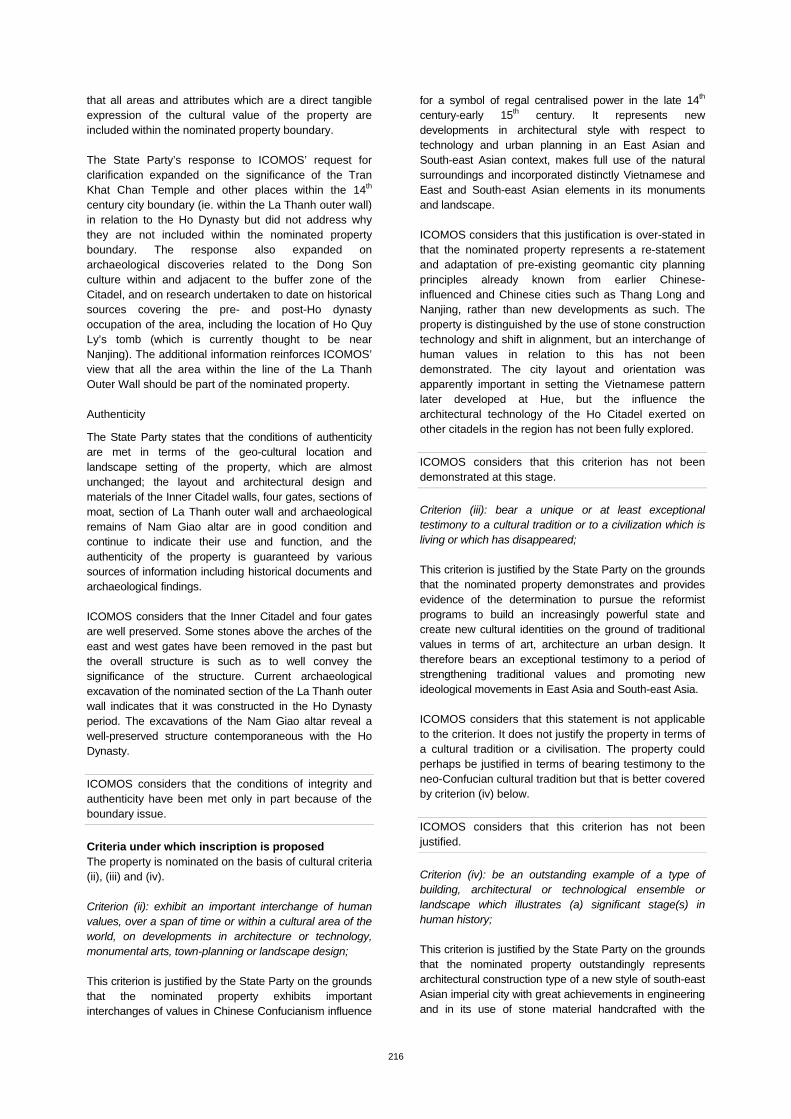
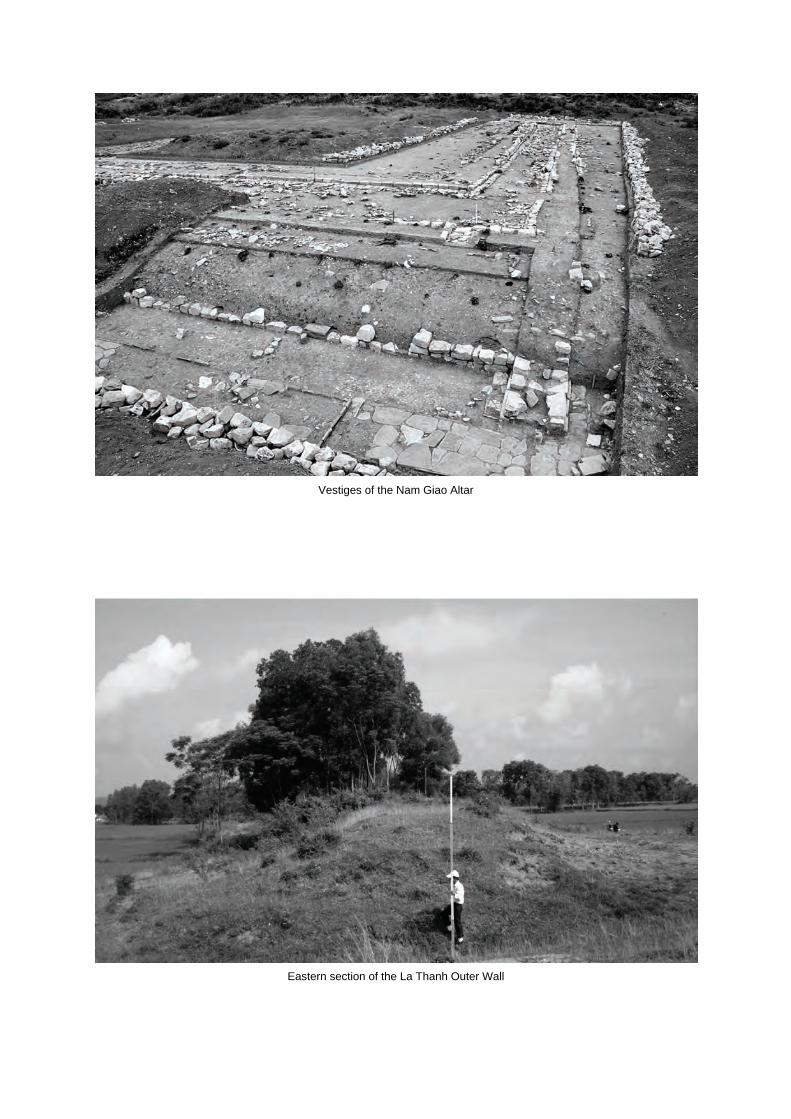
lakes in the four quadrants of the citadel interior that are also described in early documents. Archaeological excavations in the central area called Nen Vua (Foundation of the King) revealed brick tiled floors, pillar foundations, drains and a stone pillar base with lotus relief sculpture, together with a large amount of construction material and terra cotta, porcelain and metal objects. This material suggests that most structures can be dated to the end of the 14th century, but there is also evidence in the form of glazed pottery and stoneware dated to the 15th and 16th-17th centuries indicating reuse and reconstruction in the Le period. La Thanh Outer Wall La Thanh Outer Wall is the outer embankment about 10km long that encircled the citadel at a distance varying from one to three km. It was constructed in 1399 in compacted earth to connect naturally occurring hills and mounds around the eastern side to create a protective rampart linking Don Son mountain in the south with Tho Tuong Son (also known as Voi mountain) in the north, via Beo hill and Mo hill. The segment nominated as part of the Ho Citadel property is 2,051.9m long, about 5m high, 37m thick at its base and 9.2m thick at the top and covers 9ha. It is located 400m from Beo village towards Doi Mo village in the north-east. The nominated area is 9.0ha. Nam Giao Altar Historical sources record that the Nam Giao Altar was constructed in 1402. It is located on a high terrace between the two peaks of Don Son mountain, within the La Thanh wall and about 2.5km from the South Gate of the inner citadel. The site is nearly square; 120m along the east-west and 130m along the north-south. The nominated property boundary encloses 4.3ha. Excavations at the site have revealed a series of ascending terraces; the highest is 21.7m above sea level, polygonal in shape and paved with square and rectangular bricks. The terraces are varied in plan shape but centre on the same point at the rear of the altar base on the north-east side. The remains of a processional way 3.6m wide lead to the altar from the centre of the south-west side of the upper terrace. Excavated material included layers of broken stones, bricks and tiles, indicating that a wooden structure with a tiled roof may once have existed there. Limestone and schist were used for the embanking foundation, walls and lower terrace paving. The outer walls are constructed of limestone blocks and slope inwards towards the top. At the south-east corner at the lower level is a square well with steps, still full of water. It has been identified as the ‘Jade Well’ but is known to local people as the ‘Well of the King’. Ceramic bowls, plates and pots and metal objects are among the artefacts found there. History and development In the late period of the Tran dynasty (14th century), the Dai Viet state was in crisis. Impoverished farmers revolted against the government, which was also being harassed by foreign invaders from both north and south who attacked and burnt the capital Thang Long (now Hanoi)
213
three times. Ho Quy Ly, a relative of the King on his mother’s side, was appointed Prime Minister in 1395 and in an effort to improve the situation introduced a series of reforms, including limitation of Buddhist and Taoist influences, expanding the Confucian vision, setting a system of competitive examinations, limiting the amount of land owned by individuals, issuing paper currency and reinforcing the military forces. At the same time he relocated the capital city from Thang Long to Thanh Hoa district, his motherland. The capital was established at the present site of Ho Citadel in 1397. The location was less vulnerable militarily, suitable for land and river transport, and more centrally located for keeping control throughout the state from north to south. Creating a new capital city also enabled him to form and consolidate a centralised, bureaucratic monarchy monopolised by a group of Confucian scholars, in order to continue his reform agenda. It is notable that the Ho Citadel continued traditions brought from Thang Long, including the bringing and reuse of materials from destroyed palaces and the reliance on earlier artistic traditions and building techniques, as well as in following the geomantic traditions of siting the citadel in the landscape, the construction of the Nam Giao Altar, the Xa Tac Altar to soils and grains, ancestors’ temples, the positioning of the King-Father’s (Ho Quy Ly’s) palace in the west and the King’s palace (for Ho Quy Ly’s son) in the east. However scholars have detected in the recovered artefacts a new trend in art, seen in decorative motifs of dragons, human faces, and floral designs; and see this as a drive for innovation and cultural exchange which was interrupted by the fall of the Ho dynasty and re-emerged under the Le from 1427 onwards. In terms of the social and political reforms instigated by Ho Quy Ly, he can be seen as laying the groundwork for the next great Vietnamese dynasty, founded by the resistance leader Le Loi in 1428.
The Ho Citadel was the capital of the Tran dynasty from 1398-9 and of the Ho dynasty from 1400 when Ho Quy Ly put his son on the throne by marrying him to a Tran princess, until 1407. As well as instigating reforms, the Ho dynasty built roads and canals connecting the citadel with the rest of the state. In 1407 the national army led by Ho Quy Ly was conquered by the Chinese Ming army who then occupied the citadel. Insurgent troops from nearby Lam Son retook the citadel in 1427 and independence was regained by the Le dynasty, who subsequently re-established their capital at Thang Long. Archaeological evidence testifies to the continued occupation of the Ho Citadel, which possibly became a political centre. Power struggles within the royal family at the capital Thang Long led to a member of the Le family using Ho Citadel as a base from which to attack the capital in 1516. From 1527 both the Ho Citadel and Thang Long were occupied by the Mac dynasty. The Le family set up in opposition from 1533 under Le Trung Hung and regained the Ho Citadel in 1543. The citadel became an important military seat of the Le Trung Hung dynasty for the next half century, to 1593, while the Mac dynasty was
based at Thang Long. Ho Citadel developed into the political and cultural centre of the Le Trung Hung. In 1591 the Le and Trinh families defeated the Mac dynasty and regained Thang Long citadel. Ho Citadel was then more or less abandoned. A late 18th century description recorded that the citadel was still in existence although there were many unoccupied spaces. By the beginning of the 20th century the Ho Citadel was a subject of great interest for historians of the Nguyen dynastic period. The Nguyen dynasty was undertaking its own revival of Confucianism and built a new capital at Hue, following similar geomantic principles as at the Ho Citadel. The Inner Citadel and its moat were classified as a National Monument Site in 1962. Excavations were undertaken in 2004 and 2008 at the Inner Citadel and the Nam Giao Altar. The Nam Giao Altar was protected and categorised as National Heritage in 2007. The Ho Citadel Management Board was set up in 2007 in order to strengthen management, protection and promotion of the nominated sites. The Management Board is currently finalising the nomination file on La Thanh Outer Wall for National Heritage in order to add it to the complex of the Citadel of the Ho Dynasty.
3 Outstanding Universal Value, integrity and authenticity
Comparative analysis The State Party has compared the Ho Citadel with other royal cities that appeared earlier and later in Vietnam, China and East Asia, noting that in this geo-cultural region they reflect a concept of royal power based on the adoption of Confucian philosophy within a predominantly Buddhist culture. Key features on which the comparison is based are: The plan of the Citadel and its relationship to the wider
landscape; The use of feng shui and geomancy in setting out the
plan; The use of the capital (citadel, wider city area and
Nam Giao Altar) to demonstrate an enhanced concept of royal power based on the adoption of Confucianism within the predominantly Buddhist culture;
The use of massive, well-executed masonry for the defences of the Citadel;
The extent to which the evidence survives. Key comparisons within Vietnam are Thang Long (1010-1802), the citadel of Hanoi which was inscribed on the World Heritage List this year (2010) and Hue Citadel (1802-1945), inscribed on the World Heritage List in 1993. Thang Long, as the administrative and ceremonial centre of imperial power in Vietnam during the four centuries prior to Ho Quy Ly’s reign, was the essential model for the Ho Citadel as described above. The inscribed Thang Long property however, does not today retain its wider features.

214
The former Nam Giao altar located about 2km south-east of Thang Long is subsumed in modern Hanoi, its site is not part of the inscribed property, and only one gate and a small extent of citadel walls remain. The Hue Citadel, for which the Ho Citadel was in its turn the model, has been inscribed as the ‘Complex of Hue Monuments’ but the inscribed property does not include all the geomantic elements associated with the monuments. Its citadel had three walls, the inner one enclosing the royal palaces and the outer one adopting a defensive design derived from Vauban. The particular type of stone construction of the Ho Citadel walls distinguishes it from Thang long and Hue, and it represents a definite stage of development in Vietnamese city planning linking those two. Also the Ho Citadel contextual landscape of great scenic beauty still contains remnants of the wider city within the outer wall and together with the geomantic features is preserved in an easily readable form today, unlike the contexts of Thang Long and Hue. Comparisons with earlier Chinese royal cities include Chang An (Xian), Shanxi and Bianliang, Kaifeng. The most immediate model for the Ho Citadel was probably Nanjing, the first capital of the Ming Dynasty from 1368, which received frequent visits from Vietnamese envoys. It was laid out according to feng shui principles in a mountainous area adjacent to waterways. But the citadel contained an inner walled palace, with altars of soil and grain and the ancestral temple located outside the south entrance to the palace either side of the imperial way leading southwards beyond the citadel wall. The whole was enclosed in an extensive outer wall connecting hilly surrounds in a similar manner to the La Thanh outer wall at Ho Citadel. It is suggested that the impressively solid stonework construction of the Ho Citadel wall is probably why there is no internal wall around the palace area there, making the Ho Citadel distinctive in this respect. The World Heritage listed Forbidden City in Beijing (1406-1420) (1987, criteria (i), (ii), (iii) and (iv)) was constructed a few years after the Ho Citadel by the Yongle emperor of the Ming Dynasty involving Vietnamese artisans and engineers. It is noted that the city wall there tapers towards the top in a similar way to the Ho Citadel, but that the construction is rammed earth faced with three layers of mortared bricks, unlike the immense stonework of the Ho Citadel. The Heaven-worshipping altar (Temple of Heaven) can also be compared with the Ho Citadel’s Nam Giao altar. It is located on an artificial mound to the south of the Forbidden City, but differs in layout and design. Comparison is also made with Korean royal citadels including Shilla Wangeong in Gyeongju Historic Areas (2000, criteria (ii) and (iii)) of the 7th-10th centuries, now an archaeological site which appears to have derived elements from the Chinese capital at Chang An; the Changdeokgung Palace Complex (1997, criteria (ii), (iii) and (iv)) begun in 1405 by the first emperor of the Joseon dynasty, which exhibits similar stonework to the Ho Citadel but is a palace complex in a garden rather than a citadel; and with Kaesong City, Democratic People’s Republic of Korea. Kaesong was the capital of the Koryo
dynasty (9th-14th centuries), which established the first unified state in the Korean peninsula. The outer wall was constructed 1009-1029 enclosing the whole city and following the topography of the valley and the surrounding ridges – in a similar way to the La Thanh outer wall of the Ho Citadel. It was built partly in stone and partly in earth and clay. But there the similarity ends. The Inner Fort was constructed in stone 1391-1393 on a half moon plan shape, with one fortified gateway. The property has also been compared with Angkor Thom (1181-1215) and the slightly later Angkor Wat in Cambodia (1992, criteria (i), (ii), (iii) and (iv)). Although constructed using similar stonework technology, these walled city/temple complexes are quite different in architecture and layout. As pointed out in the nomination dossier, Angkor Thom was the city of a Buddhist ruler and encloses the home of the divinity in a centrally located temple, whereas the neo-Confucian layout has the place of communication with the divinity, the Nam Giao altar, outside the Inner Citadel on axis to the south-east (but still within the outer wall). Angkor Wat is a Hindu temple complex, oriented east-west, with a very different religious function and layout. The nomination dossier also discusses the Vat Phou and Associated Ancient Settlements within the Champasak Cultural Landscape (2001, criteria (iii), (iv) and (vi)) from the 11th-13th centuries in Laos, laid out on an east-west axis from river bank to mountain top with a geometric pattern of temples, shrines and waterworks extending over some 10km. The plan expresses the Hindu practice of kingly worship, which it is noted, often included a Devaraja ceremony on the holy mountain. There is similarity with the Ho Citadel in the use of heavy stone for construction. The State Party concludes that the Citadel of the Ho Dynasty shares many common features with other imperial cities of Vietnam and East Asia in the geomantic selection of location and use of natural landscape to set out the plan in accordance with neo-Confucian principles. As such it derives from China and differs from the Hindu-based philosophy adopted by the Khmer elsewhere in South-east Asia. It is argued that the Ho Citadel demonstrates a specifically Vietnamese approach to the manifestation of royal power, which was later copied at Hue. The key difference with the Chinese, as argued in the nomination dossier, was a greater flexibility of approach, demonstrated by setting the axis north-west to south-east to fit with the existing topography, and the exploitation of local stone resources for construction. Unlike many other royal citadel sites in China, East Asia and Vietnam, Ho Citadel and its environs has not been overlain by later developments and the use of strong masonry has led to a greater level of preservation. ICOMOS considers that a major factor distinguishing the Ho Citadel is that it can be easily ‘read’ in the landscape, and retains numerous associated elements in addition to the Nam Giao altar in the surrounding landscape that together demonstrate the value of a neo-Confucian city of

215
the late 14th century. The neo-Confucian state centralisation and strengthening was a pre-requisite for creating the highly organised and disciplined workforce needed to construct a citadel of huge blocks of stone in such a short time, as well as building canals to link the citadel area to the sea. The use of large stone blocks was a response to the invention of gunpowder in China. The shift of the main axis away from the normal Chinese north-south alignment seems to have begun with the Ho Citadel. According to Louis Bézacier, from the École francaise d’Extrême-Orient, this shift in alignment did not occur in the earlier Co Loa Citadel but occurs in other Vietnamese citadels built later than the Ho Citadel. The comparative analysis shows that the citadel wall design, tapering towards the top on the exterior from a massively thick base to give an inwardly sloping face influenced the design of the Forbidden City walls in Beijing, although not in stone construction. No link has been proposed between the use of stone walls at the Ho Citadel and that at Angkor Wat. The influence of the design of the citadel on other citadels of the region could be further explored. The comparative analysis has not been used to show whether the nominated property exhibits an important interchange of human values.
ICOMOS considers that the comparative analysis could be deepened to further explore the influence of the design of the citadel on other citadels of the region.
Justification of Outstanding Universal Value The nominated property is considered by the State Party to be of Outstanding Universal Value as a cultural property for the following reasons:
A symbol of royal power in the late 14th – early 15th centuries, exhibiting important interchanges in Sino-Vietnamese Confucianism.
Represents new development in architectural technology and urban planning in an East Asian and South-east Asian context.
Represents an example of a brief but seminal period of neo-Confucianism in Vietnam combined with the exceptional administrative and logistical skills of one man.
Bears an exceptional testimony to a critical period in Vietnamese and South-east Asian history when traditional concepts of kingship and Buddhist values were giving way to new trends in technology, commerce and centralised administration.
ICOMOS considers that this justification is only partly appropriate. The Citadel of the Ho Dynasty represents the flowering of neo-Confucianism in Vietnam at a time when it was spreading throughout East Asia to become a major philosophical influence on government in the region. The geomantic layout of the city demonstrating the neo-Confucian city concept can be easily perceived today within the landscape. The state of preservation means that the property is capable of exemplifying the form of an East Asian imperial city. But the influence of
the city as a new development in architectural technology and urban planning could be further explored. Integrity and authenticity Integrity
The State Party states that the integrity of the property is guaranteed by the nominated areas of the three major components which represent the characteristics of the Citadel of the Ho Dynasty: the Inner Citadel, the Nam Giao altar and part of La Thanh outer wall. These elements reflect the presence of a citadel that has remained almost intact, with massive stone walls within a landscape setting that is easily recognisable. As well, excavations have demonstrated a rich source of archaeological evidence preserved underground below the present rice and other crops within the nominated boundaries of the three components. The lack of development and the state of preservation of the property means there are no adverse effects on its cultural value. ICOMOS considers that the three components demonstrate the most important planning values of the property as claimed. However ICOMOS notes that the Imperial Way from the Inner Citadel’s south gate to the Don Son hill and Nam Giao altar, which still exists beneath the existing road, is not included within the property boundaries. The State Party responded to ICOMOS’ request for clarification on this that while excavations at the South gate of the Inner Citadel have exposed part of the paved road, testifying to its existence some 0.5m-0.6m below the current surface, the road extends over 2 kilometres to Mount Don Son and since it has not been excavated comprehensively, the understanding of the road is currently incomplete and inadequate. 160metres of it near the south gate are within the property boundary of the Inner Citadel and the remainder is considered to be well protected below the existing road. The State Party’s response stated that it would consider including the remaining section of the road as an expansion of the nominated area once archaeological excavation has been conducted and protective measures have been prepared. ICOMOS also notes that the nomination dossier states that the nominated buffer zone includes all cultural elements that were part of a large imperial city during the late 14th-early 15th century, including religious monuments, traditional villages, common houses, ancient roads, markets, landing places and scenic beauty spots. Details are given in Annex III of the nomination dossier. Temples and other structures have been repaired and rebuilt many times, but their links to historical accounts are verified by the retention of their place names. For instance a partial map included in the nomination dossier (ill. 67, p.74) indicates the royal landing place (Ben Ngu) and the stone landing place (Ben Da) on the Ma River as preserved in existing place names. On the basis of the Operational Guidelines paragraph 100 therefore, ICOMOS does not consider
216
that all areas and attributes which are a direct tangible expression of the cultural value of the property are included within the nominated property boundary. The State Party’s response to ICOMOS’ request for clarification expanded on the significance of the Tran Khat Chan Temple and other places within the 14th century city boundary (ie. within the La Thanh outer wall) in relation to the Ho Dynasty but did not address why they are not included within the nominated property boundary. The response also expanded on archaeological discoveries related to the Dong Son culture within and adjacent to the buffer zone of the Citadel, and on research undertaken to date on historical sources covering the pre- and post-Ho dynasty occupation of the area, including the location of Ho Quy Ly’s tomb (which is currently thought to be near Nanjing). The additional information reinforces ICOMOS’ view that all the area within the line of the La Thanh Outer Wall should be part of the nominated property. Authenticity
The State Party states that the conditions of authenticity are met in terms of the geo-cultural location and landscape setting of the property, which are almost unchanged; the layout and architectural design and materials of the Inner Citadel walls, four gates, sections of moat, section of La Thanh outer wall and archaeological remains of Nam Giao altar are in good condition and continue to indicate their use and function, and the authenticity of the property is guaranteed by various sources of information including historical documents and archaeological findings. ICOMOS considers that the Inner Citadel and four gates are well preserved. Some stones above the arches of the east and west gates have been removed in the past but the overall structure is such as to well convey the significance of the structure. Current archaeological excavation of the nominated section of the La Thanh outer wall indicates that it was constructed in the Ho Dynasty period. The excavations of the Nam Giao altar reveal a well-preserved structure contemporaneous with the Ho Dynasty.
ICOMOS considers that the conditions of integrity and authenticity have been met only in part because of the boundary issue.
Criteria under which inscription is proposed The property is nominated on the basis of cultural criteria (ii), (iii) and (iv). Criterion (ii): exhibit an important interchange of human values, over a span of time or within a cultural area of the world, on developments in architecture or technology, monumental arts, town-planning or landscape design; This criterion is justified by the State Party on the grounds that the nominated property exhibits important interchanges of values in Chinese Confucianism influence
for a symbol of regal centralised power in the late 14th century-early 15th century. It represents new developments in architectural style with respect to technology and urban planning in an East Asian and South-east Asian context, makes full use of the natural surroundings and incorporated distinctly Vietnamese and East and South-east Asian elements in its monuments and landscape. ICOMOS considers that this justification is over-stated in that the nominated property represents a re-statement and adaptation of pre-existing geomantic city planning principles already known from earlier Chinese- influenced and Chinese cities such as Thang Long and Nanjing, rather than new developments as such. The property is distinguished by the use of stone construction technology and shift in alignment, but an interchange of human values in relation to this has not been demonstrated. The city layout and orientation was apparently important in setting the Vietnamese pattern later developed at Hue, but the influence the architectural technology of the Ho Citadel exerted on other citadels in the region has not been fully explored.
ICOMOS considers that this criterion has not been demonstrated at this stage.
Criterion (iii): bear a unique or at least exceptional testimony to a cultural tradition or to a civilization which is living or which has disappeared; This criterion is justified by the State Party on the grounds that the nominated property demonstrates and provides evidence of the determination to pursue the reformist programs to build an increasingly powerful state and create new cultural identities on the ground of traditional values in terms of art, architecture an urban design. It therefore bears an exceptional testimony to a period of strengthening traditional values and promoting new ideological movements in East Asia and South-east Asia. ICOMOS considers that this statement is not applicable to the criterion. It does not justify the property in terms of a cultural tradition or a civilisation. The property could perhaps be justified in terms of bearing testimony to the neo-Confucian cultural tradition but that is better covered by criterion (iv) below.
ICOMOS considers that this criterion has not been justified.
Criterion (iv): be an outstanding example of a type of building, architectural or technological ensemble or landscape which illustrates (a) significant stage(s) in human history; This criterion is justified by the State Party on the grounds that the nominated property outstandingly represents architectural construction type of a new style of south-east Asian imperial city with great achievements in engineering and in its use of stone material handcrafted with the

217
science and the technological conditions of Vietnam, East Asia and South-east Asia during the period of the late 14th-early 15th centuries. ICOMOS considers that the justification is not well stated. The Ho Citadel is an outstanding example of an architectural ensemble in a landscape setting which illustrates a flowering of neo-Confucianism in late 14th century Vietnam at a time when it was spreading throughout East Asia to become a major philosophical influence on government in the region. The use of large blocks of stone testifies to the organisational power of the neo-Confucian state, and the shift in the main axis distinguishes the Citadel layout from the Chinese norm.
ICOMOS considers that this criterion could be justified if the property boundaries are expanded to include all the attributes carrying the Outstanding Universal Value of the property.
In conclusion, ICOMOS considers that the nominated property could meet criterion (iv) and meets conditions of authenticity and integrity in part, and that Outstanding Universal Value could be demonstrated if the property boundary was extended to include all the elements of the landscape setting which illustrate a flowering of neo-Confucianism in late 14th century Vietnam. Further work on the history and development of the city layout and architectural technology and its influence on other citadels in the region through deepening the comparative analysis could enable justification of criterion (ii).
4 Factors affecting the property Development pressures
The total number of inhabitants in the area of the property and buffer zone in 2009 was 54,405 divided into 10 communes, with average population growth of 2.27%. The property has been vulnerable to the natural growth of the population leading to increasing household settlement in the proximity of the citadel walls. Small shops and restaurants have been opened beside the Inner Citadel. The construction of private houses has narrowed the moat. Agricultural activities have caused damage to the archaeological remains within the walls. Local people have re-used stone paving slabs from the roads and paths within the walls as well as bricks from former structures there in their own houses, and have collected other artefacts from the site over the years. Openings have been made through the Inner Citadel walls in order to gain easier access to fields and gardens within. The moat system has been largely filled in and levelled for rice cultivation. The outer embankment is vulnerable to agricultural development including construction of transport routes and dikes. The State Party is dealing with these issues by resettlement of private households outside the nominated areas; attention to civil planning including enforcement of
regulations diverting traffic on highway No. 217 that passes through the Citadel to the new bypass road; relocation of productive activities to avoid damage and further transformation of the environment and landscape, and regulation of civil construction and people’s livelihoods so as to limit the impacts of development on the preservation of the property. The limestone mountains are still quarried for civil construction purposes. The State Party notes that it is necessary to control and prohibit this in order to protect the natural and cultural landscape of the property. ICOMOS notes that a part of each village outside the East, West and South gate is included within the property boundary of the Inner Citadel. The relocation of people living in those parts within the property boundary is being considered by the authority. ICOMOS considers that the present village settlements and landscape are in harmony with the nominated property and that it is not necessary to relocate people while the present agricultural activity continues. The houses that were built adjacent to the Inner Citadel, narrowing the moat, were relocated in early 2010. The shops and restaurants are not adjacent to the citadel itself but along the road leading to the South gate from outside the Citadel. ICOMOS notes that the local people have a good relationship with and cooperate with the local authority, and that their involvement in protection and management of the property should be encouraged. Tourism pressures
Tourism infrastructure for the area is limited and most tourists stay at Thanh Hoa city overnight. There were 19,000 tourists in 2008 and 20,000 in 2009. It is expected that tourist numbers will increase and Vinh Loc District is developing a comprehensive plan for the site. The town of Vinh Loc located about 1k south-east of the Citadel, straddling the Imperial Way, has four guesthouses and more than ten restaurants. Currently there are limited visitor/tourist facilities at the Inner Citadel South gate. Environmental pressures
Vinh Loc District is in a tropical and monsoonal zone with a temperature range of 41.5˚C to 2˚C, a rainy season up to six months with annual rainfall of 1,500mm -1,700mm. The area is also subject to the hot and dry south-west wind and long periods of drought. Past changes in the course of the rivers have washed away mounds and parts of the outer embankment. Flooding of the Buoi River is a possible threat to the most intact section of the outer embankment along the north-east of the site. The remains of the stone walls of the Citadel are vulnerable to damage from vegetation overgrowth and to lack of drainage around the foundations. The latter has caused instability of the south-west corner. The Nam Giao site is vulnerable to collapse due to landslides caused by rains and flood.

218
Lack of sewerage and waste disposal systems have resulted in people living near the Inner Citadel pouring sewerage into the moat area. ICOMOS considers a flood mitigation strategy is required. ICOMOS also considers that attention is required to solid and liquid waste management. Natural disasters
No earthquake has been recorded in the area over the past 600 years. Storms causing floods and lightening damage are mentioned in the historical records. A fire prevention and response plan will be developed as part of the future management of the property. ICOMOS considers that a strategy is required to deal with possible landslides at the Nam Giao altar site in the case of storms and heavy rain. Impact of climate change
The most likely impacts of climate change for northern Vietnam are increase in temperature and the number of tropical storms causing increased rain and floods. ICOMOS recommends that the natural risk management plan should address precautions against erosion and collapse of vulnerable parts of the property.
ICOMOS considers that the main threats to the property are storms causing landslides at the Nam Giao altar site, floods affecting the La Thanh outer wall, and uncontrolled vegetation growth and the lack of waste management at the Inner Citadel. Urban development in Vinh Loc town could be a threat to the important visual axis between the Inner Citadel and Don Son mountain with the Nam Giao altar if height limits are not carefully controlled.
5 Protection, conservation and management
Boundaries of the nominated property and buffer zone The boundaries of the three nominated areas are adequate to protect those elements. However, the Imperial Way from the Citadel’s South gate to the Don Son hill and Nam Giao altar, which still exists in part beneath the existing road through Vinh Loc town, is not included as part of the nominated property. Also, the nomination dossier states that the nominated buffer zone includes all cultural elements that were part of a large imperial city during the late 14th- early 15th century, including religious monuments, traditional villages, common houses, ancient roads, markets, landing places, stone quarries etc. As elements integrally related to the Citadel of the Ho Dynasty these are attributes carrying the Outstanding Universal Value of the property.
ICOMOS therefore considers that the nominated property boundary is not adequate. It should include all these attributes. Ideally the property boundary should follow and include the line of the La Thanh outer wall as shown on the map Ill. 41, p.49 of the nomination dossier, and the buffer zone should be extended accordingly.
In conclusion, ICOMOS considers that the boundaries of the nominated property and of its buffer zone are not appropriate.
Ownership The property is in government ownership. Protection Legal Protection
The Inner Citadel and Nam Giao Altar are designated since 1962 as national heritage by Decision of the Ministry of Culture of the Democratic Republic of Vietnam and protected under the Law on Cultural Heritage of 29/06/2001, approved by the National Assembly of the Socialist Republic of Vietnam. The nominated section of La Thanh Outer Wall is in the process of being similarly protected. ICOMOS considers that the process of achieving national heritage protection for the La Thanh Outer Wall section should be completed as soon as possible. Other Decisions cover the Master Plan to Preserve and Promote Cultural and Natural Heritage until 2020; the Regulation and Revitalisation of Cultural and Natural Heritage; and the establishment of the Management Board of the Citadel of the Ho Dynasty. The property is specifically protected by the ‘Regulation on the Management, Protection and Promotion of the Values of the Ho Dynasty’s Imperial Citadel Heritage and Adjoining Relics’. For the Inner Citadel, the Regulation promulgated by Decision 2298/QĐ-UBND on 2 August 2007, article 4, Para. 1 and 2, “strictly prohibit any individual or agency from infringing the structure and the landscape of the area within the citadel, such as grounding, constructing ponds or mining”. The area inside the Inner Citadel is to be “only used for short-term agricultural production. Ploughing should not be more than 0.3m deep to protect the ground”. For the Nam Giao Altar, the Regulation promulgated by Decision 11/2007/QĐ-BVHTTDL on 18 October 2007 (Annex I), Article 6, para. 2, strictly prohibits “burying, dumping industrial and agricultural wastes, constructing farming structures, digging ponds, wells, making roads, herding, or planting unregulated long-term trees that are harmful to the ground, the sanity and the landscape of the heritage site”. It strictly prohibits “individuals and agencies

219
to excavate for artifacts or mineral resources without permission”. For the La Thanh Outer Wall the Regulation prohibits “leveling up the ground which may infringe the structure and authentic elements. Prohibition of grounding to build houses, cemeteries, digging ponds, wells. Prohibition of using the La Thanh's area for agricultural production, for dumping wastes, storing agricultural preservatives or industrial materials” (Article 6, para. 1). The buffer zone including the mountains and their beauty spots, caves and lakes is protected by the Law on Environmental Protection of the Socialist Republic of Vietnam, number 52/2005/QH11, Chapter 4, Article 31 of 2005 and the Mineral Law, Article 14 which allows the government to announce areas where mining areas are prohibited. Quarrying has been specifically stopped in three areas of the buffer zone by Decision numbers 3045/QD-UBND, 3046/QD-UBND and 3047/QD-UBND dated 27 August 2010. The rivers and dykes associated with the property, including the vestiges of the La Thanh Outer Wall are protected by the Ordinance on Dykes, chapter III, Article 11. In the buffer zone, all the land, except zones protected by the Law of Cultural Heritage, is managed by local government, according to the Law on Land of the Socialist Republic of Vietnam. The Management Plan has established borders for the protected zoning areas covering the three nominated property components. Effectiveness of protection measures
ICOMOS considers that the legal protection regime is not yet satisfactory in relation to the nominated property components, since the La Thanh Outer Wall is not yet designated as National Heritage. The Management Plan covers future development within the nominated Buffer Zone by establishing various zones (in addition to the ‘Strictly Protected Zone’ covering the nominated components), with principles for each zone. However it is not clear how these principles will be enforced under the protection regime as described above in the immediate term. ICOMOS recommends that regulation of future development be prioritised.
In conclusion, ICOMOS considers that the legal protection will be appropriate when La Thanh Outer Wall is designated as National Heritage, and requires augmentation to regulate development within the nominated buffer zone.
Conservation Inventories, recording, research
The Management Board has collaborated with national and international bodies to undertake research and conservation. In 2004 the Nen Vua (Foundation of the King) area within the Inner Citadel was excavated by the Showa University of Japan and the Hanoi University of
Social Sciences and Humanities. The South gate area was excavated by the Vietnam Institute of Archaeology in 2008. The Nam Giao site was excavated 2004-2008 and a second program is being undertaken 2009-2011. The walls of the Inner Citadel have been recorded in detail by drawings and photographs, and the site has been surveyed for relevant artefacts. Inventories are being made of artefacts kept in local households. A cooperative study program is being organised between the Showa University of Japan, the National Culture Heritage Conservation Institute of Japan and the Vietnam Cultural Exchange and Research Centre (currently the Institute of Vietnamese Studies and Development Sciences). ICOMOS notes that the La Thanh outer wall is currently being excavated (2010). ICOMOS also notes that discussions are in progress about the excavation of a section of the Imperial Way connecting the South gate with Mount Don Son, which still exists beneath the existing road through Vinh Loc town. It is possible that some section may be excavated and conserved for presentation to visitors. However ICOMOS considers that it is most important to protect the line of the Imperial Way and to ensure there are no visual intrusions between the South Gate and Mount Don Son. ICOMOS further considers that a strategic archaeological investigation program is required, directed at understanding drainage problems in the Inner Citadel and elements embodying the Outstanding Universal Value of the property together with a systematic survey and documentation of the temples, caves, villages and other places such as the royal landing place, stone landing place and imperial tombs and associated folklore within the nominated buffer zone that have connections with the Ho Dynasty. These also embody the Outstanding Universal Value of the Ho Citadel. Present state of conservation
Inner Citadel The stone walls and four stone gates are generally in good condition. Structures that were once located above the four gates have disappeared, but the locations of columns and balusters are marked by holes in the top ashlar blocks. The wing walls of the gateways have disappeared and only traces of stairways remain. There has been damage in some areas due to drainage problems and the breaking through in collapsed sections of access ways by the local people. The south-east and north-west wall corners are lost. No standing structures remain inside the walls, but buildings are indicated by higher mounds among the rice fields on both sides of the central north-west to south-east axis. The underlying structures have been disrupted by

220
irrigation systems, division into fields and gardens, and levelling for cultivation. There are several extant lakes and ponds. The two main cross roads can still be traced. La Thanh Outer Wall The line of the La Thanh Outer Wall/embankment has been traced through historical records, but many sections do not exist today, possibly due largely to the effects of changing river currents in the vicinity of the Ma and Buoi rivers. The most intact segment located to the north-east, which is nominated as one of the three components of the property, has a stable earth base and is covered by wild grass. This segment is away from residential zones so has not suffered encroachment. The outer wall embankment was formed by an earth rampart connecting with surrounding mountains, hills and mounds. These are largely unchanged.
Nam Giao Excavations have exposed the stone platforms and layout of the Nam Giao Altar. The area is threatened by landslides due to rain and flood. ICOMOS notes that research is required to understand the drainage system within and around the Inner Citadel in order to deal adequately with conservation problems. Active Conservation measures
At the Inner Citadel, infringing structures are being cleared away and trees have been removed from the walls. At the Nam Giao site, temporary protection measures have been taken to conserve the excavated remains. These include removal of adjacent trees; drainage of excavated areas; fencing the site; backfilling excavations with excavated soil, and removing artefacts to storage for study. ICOMOS notes that a Conservation Centre for Ho Citadel has been established by the Management Board near the South gate. This manages the conservation program and documentation of excavated materials as well as planning excavations within the nominated area in co-ordination with the Vietnam Institute of Archaeology. Maintenance
The Management Plan includes the establishment of maintenance programs for the nominated areas and the standing monument sites in the buffer zone. ICOMOS recommends the implementation of a regular maintenance regime in conjunction with the monitoring program. Effectiveness of conservation measures
ICOMOS notes that some damage has occurred to the northern wall of the Inner Citadel, but that this can be rectified. Conservation measures undertaken so far are not extensive.
In conclusion, ICOMOS considers that appropriate research is underway but notes that considerably more is required (as provided for in the Management Plan), including a strategic archaeological investigation program and a systematic survey and documentation of the temples, caves, villages and other places such as the royal landing place, stone landing place and imperial tombs and associated folklore within the nominated buffer zone that have connections with the Ho Dynasty and comprise attributes of the Outstanding Universal Value of the Ho Citadel.
Management Management structures and processes, including traditional management processes
The property is directly managed by the People’s Committees of the relevant communes for the particular component sites, under the Management Board of the Citadel of the Ho Dynasty established by Decision 2264/QD-UBND (30 July 2007). The land within the Inner Citadel is assigned to farmers for agricultural production by means of short term crops. The Management Board is responsible for managing and preserving the technical aspects of the Inner Citadel. Regulations prohibit construction and mining and ploughing more than 0.3m deep. The Nam Giao Altar site is the responsibility of the Management Board for management, preservation and study. Regulations prohibit the burying or dumping of waste, construction, planting inappropriate trees and any excavation without a permit. La Thanh Outer Wall does not at present come under the Management Board, but the Board works closely with the People’s Committees of the relevant communes to manage and protect the wall. Regulations prohibit levelling the ground, construction, excavation, agriculture, dumping waste or storing agricultural or industrial materials. In response to ICOMOS’ request for clarification on this, the State party has advised that responsibility for management of the section nominated as a component of the World Heritage property will be legally transferred to the Management Board in 2011. ICOMOS notes that an agreement between local government and private sector efforts is lacking. Policy framework: management plans and arrangements, including visitor management and presentation
A comprehensive five–year Management Plan for the property was submitted in November 2010. It was prepared for the property through a process involving government agencies and relevant commune administrations together with technical consultants, and covers land management; landscape management; artefact management; sustainable social and economic

221
development; preservation and promotion, financial resources; human resources; tourism and monitoring. The stated vision of the Management Plan is to: conserve, enhance and present the Outstanding
Universal Value of the property locally and internationally;
balance the needs of conservation, access, and interest of the local community including the achievement of sustainable economic growth through tourism at the site and other site-compatible activities;
to engage with and bring benefits to the local communities around the nominated property, to attract visitors to the area, to develop opportunities for education and learning, and to create the opportunities for the people to generate income that adds to the local economy which is partly reinvested in the running of the nominated property.
Capacities for tourism are currently being assessed in order to develop strategies to meet future tourism demands appropriate to the heritage property. At present there are five tourist guides and various leaflets and books. The property is part of the Thanh Hoa tourist route that takes in Sam Son beach, the Ho Citadel, Lam Kinh and the Cam Luong fish stream. A tourism management plan is proposed as part of the Management Plan. The Management Plan divides the property and its buffer zone into five zones, each with its own set of principles: 1 strictly protected (the three nominated World
Heritage components); 2 historical village and standing monument
protected (the three villages at the east, west and south gates of the Inner Citadel, and individual monuments scattered throughout the nominated buffer zone which are protected at national, provincial or local levels);
3 mountainous landscape protected (the north-west and south-east mountains and the hills to the south-west and north-east of the Inner citadel);
4 eco-agricultural (the whole area within the nominated buffer zone boundary excluding the other zones);
5 urban development controlled (the area around Vinh Loc town which straddles the Imperial Way connecting the Inner Citadel with the Nam Giao altar).
Principles established in the Management Plan for each zone include height limits of 12m in Zone 2 and 20m (Vinh Loc Town) and 15m (suburb area) in Zone 5. Revision of regulations to accommodate such principles is scheduled to happen within five years (Action Plan section 4.4.1-3). ICOMOS notes that apart from the three villages at the east, west and south gates of the Inner Citadel, the old villages containing the individually protected monuments do not appear to be protected as part of Zone 2.
Clarification of this is required from the State Party. ICOMOS considers that the key issue for implementation of the Management Plan is the future character of urban development near the Inner Citadel, in Vinh Loc town particularly along the axis between the Inner Citadel and Mount Don Son, and in the buffer zone generally, so as to protect all view lines along axes between topographical features, and views within the area enclosed by the line of the outer wall and the Ma and Buoi rivers. Failure to achieve full protection of the ability to read the layout of the Ho Dynasty city in the landscape would threaten the Outstanding Universal Value of the property as exemplifying the form of an East Asian imperial city. The relevant section of the Action Plan in relation to this as noted above should be implemented as the highest priority. Risk preparedness
This is proposed to be developed as part of the Management Plan. ICOMOS considers that a risk management strategy is required to deal with severe storm events and the possible repercussions of floods and landslides. Involvement of the local communities
This is proposed do be developed as part of the Management Plan, which expects that the development of tourism will generate more job opportunities for local people, especially the development of local businesses, such as handicrafts, hotels and restaurants and farm produce. The Management Plan has still to go through a consultation process in order for the local people to understand the implications of World Heritage listing and consequent guidelines on development. It is expected that village patriarchs will contribute their experience and knowledge to the conservation of the property and that young people will be given incentives to pursue cultural studies and relevant jobs at the property. This will be organised through involving local associations such as the Association of the Elderly, the Women’s Association, the Youth Union, the Avant-garde Pioneers, Buddhist Association, Catholic Parish and the Council of Teachers at secondary schools, and through co-ordinating with local festivals held on commemorative days. ICOMOS considers that the local people should be encouraged to be actively involved in the protection and management of the property and this appears to be the strong intention of the Management Plan. There also appears to be a need for a negotiating framework between local government and the private sector regarding possible development initiatives. Resources, including staffing levels, expertise and training
According to the Management Plan, funding for the management of the property will be primarily by an annual budgetary allocation from the Ministry of Culture, Sports

222
and Tourism (MOCST). This will cover the basic operating costs of the MP including staff, office expenses and the cost of maintenance and upkeep, development control and site monitoring. Funds for specific conservation projects will be sought from the MOCST as required, and also from external sources. No quantitative annual amount has been given, but government funding is expected to amount to 70% of the funds required for the period 2010-2020. The Management Board comprises a Technical Office, a Security Unit and a Sanitation Unit. Resources include twelve qualified members of staff with degrees in archaeology (the Board Director has a PhD); history (4); museum studies (1); linguistics (2); classic Chinese and Vietnamese languages (1); cultural tourism (2) and accountancy (1).
The Management Board supports its staff to participate in national and international higher education programs, intensive training courses, and study tours on heritage management in China and Thailand. Effectiveness of current management
ICOMOS considers the current management to be more-or-less effective as a regime with the proviso that local people should be involved in such a way as to encourage them to protect and preserve the property. The Management Plan needs review in relation to Zone 2, and implementation of regulations to protect view lines and control urban development.
In conclusion, ICOMOS considers that special attention is needed for development of a risk preparedness and management strategy and a strategy for involving local people in the protection and management of the property. A key issue is the future character of urban development near the Inner Citadel, in Vinh Loc town particularly along the axis between the Inner Citadel and Mount Don Son, and in the buffer zone generally, so as to protect all view lines along axes between topographical features, and views within the area enclosed by the line of the outer wall and the Ma and Buoi rivers.
6 Monitoring A monitoring program has been developed as part of the Management Plan, which will be used to assess the implementation of the action plan against key indicators. It will also assess the rate of erosion of the Inner Citadel walls and their stability, as well as the rate of erosion of the excavated areas. The monitoring program will also cover the buffer zone and assess the number of monuments that need to be conserved; changes in the environment including changes of land use and stone quarrying in the mountains; numbers of new permitted construction of buildings and
infrastructure, and the number of buildings constructed without permission. Responsibility for monitoring lies with the Department of Cultural Heritage under the Ministry of Culture, Sport and Tourism at the national level, and with the Thanh Hoa People’s Committee, Thanh Hoa Department of Culture Sport and Tourism, Management Board of Cultural Sites and Beauty Spots at the local level. The Management Board of the Citadel of the Ho Dynasty Heritage has responsibility for direct management and supervision of the monitoring program. Other participating agencies include the Institute of Heritage Conservation and the Institute of Urban and Rural Architectural Planning within the Ministry of Construction. Previous reporting exercises include a number of research study reports into the history and possible conservation methods for the Citadel, and geological and chemical analysis of materials.
ICOMOS considers that the monitoring system is adequate with the proviso that its effectiveness in the buffer zone will depend on the adequacy of the documentary research, survey and inventory of attributes in the nominated buffer zone.
7 Conclusions Conditions of integrity and authenticity have been met only in part, because the property boundary needs to encompass attributes in the nominated buffer zone. If the property boundary is extended to encompass the landscape setting in which the Ho Citadel is located, including the Imperial Way from the South gate of the Inner Citadel to the Nam Giao altar on the axis from Tuong Son mountain to Mount Don Son, as well as traditional villages, religious monuments, ancient roads, markets, landing places, imperial tombs, caves and scenic view points within the line of and including the La Thanh outer wall, it is considered that the nominated property has the potential to meet criteria (ii) and (iv) and that Outstanding Universal Value would be demonstrated. The buffer zone would then need to be extended appropriately. A key issue is the future character of urban development near the Inner Citadel, in Vinh Loc town particularly along the axis between the Inner Citadel and Mount Don Son, and in the surrounding landscape generally, so as to protect all view lines along axes between topographical features, and views within the area enclosed by the line of the La Thanh outer wall and the Ma and Buoi rivers.

223
Recommendations with respect to inscription ICOMOS recommends that the examination of the nomination of the Citadel of the Ho Dynasty, Socialist Republic of Vietnam, to the World Heritage List be deferred in order to allow the State Party to:
Further justify criterion (ii) through deepening the comparative analysis;
Extend the property boundary to encompass the
landscape setting of the Ho Citadel, including the Imperial Way from the South gate of the Inner Citadel to the Nam Giao altar on the axis from Voi mountain to Don Son hill, as well as traditional villages religious monuments, ancient roads, markets, landing places, imperial tombs, caves and scenic view points within the line of the La Thanh outer wall;
Extend the buffer zone accordingly; Undertake a systematic inventory of the temples,
caves, villages and other places such as the royal landing place, stone landing place and imperial tombs and associated folklore that have connections with the Ho Dynasty and comprise attributes of Outstanding Universal Value;
Undertake a strategic archaeological
investigation program directed at understanding drainage problems in the Inner Citadel and elements embodying the Outstanding Universal Value of the property, including validation of the line of the Imperial Way;
Complete the designation of La Thanh Outer
Wall as National Heritage; Clarify the composition of the Management Plan
Zone 2: Historical village and standing monument protected zone;
Develop regulations to control the height and
character of future urban development near the Inner Citadel, in Vinh Loc town particularly along the axis between the Inner Citadel and Mount Don Son, and in the surrounding landscape generally, so as to protect all view lines along axes between topographical features, and views within the area enclosed by the line of the La Thanh outer wall and the Ma and Buoi rivers;
Review the Management Plan in relation to the
expanded property boundary and amend accordingly.
ICOMOS considers that any revised nomination would need to be considered by an expert mission to the site.
ICOMOS further recommends that the State Party consider the following:
Develop a risk preparedness and management strategy in the event of storms causing landslides at the Nam Giao altar site and floods affecting the La Thanh outer wall and other sites;
Set up a waste management system at the Inner
Citadel; Encourage involvement of local people in the
protection and management of the property.

Map showing the boundaries of the nominated property

The Inner Citadel, view of the South Gate
The Inner Citadel, external surface of the Northern Wall
Vestiges of the Nam Giao Altar
Eastern section of the La Thanh Outer Wall