Cigar Lake Operation Northern Saskatchewan, Canada · Cigar Lake Operation Northern Saskatchewan,...
164
Cigar Lake Operation Northern Saskatchewan, Canada National Instrument 43-101 Technical Report Effective Date: December 31, 2015 Date of Technical Report: March 29, 2016 PREPARED FOR CAMECO CORPORATION BY: C. SCOTT BISHOP, P. ENG. ALAIN G. MAINVILLE, P. GEO. LESLIE D. YESNIK, P. ENG.
Transcript of Cigar Lake Operation Northern Saskatchewan, Canada · Cigar Lake Operation Northern Saskatchewan,...

Cigar Lake Operation Northern Saskatchewan, Canada National Instrument 43-101 Technical Report Effective Date: December 31, 2015 Date of Technical Report: March 29, 2016
PREPARED FOR CAMECO CORPORATION BY:
C. SCOTT BISHOP, P. ENG.
ALAIN G. MAINVILLE, P. GEO.
LESLIE D. YESNIK, P. ENG.

i
Table of Contents
1 SUMMARY ........................................................................................................................................... 1 1.1 Preamble .................................................................................................................................... 1
1.2 Introduction ................................................................................................................................. 2
1.3 Property tenure ........................................................................................................................... 2
1.4 Location and site description ...................................................................................................... 3
1.5 Geology and mineralization ........................................................................................................ 3
1.6 Exploration of Cigar Lake deposit ............................................................................................... 4
1.7 Mineral resources and mineral reserves ..................................................................................... 4
1.8 Mining ......................................................................................................................................... 7
1.9 Processing .................................................................................................................................. 9
1.10 Environmental assessment and licensing ................................................................................... 10
1.11 Cigar Lake water inflow incidents and remediation .................................................................... 11
1.12 Current status of development ................................................................................................... 12
1.13 Production plan .......................................................................................................................... 12
1.14 Economic analysis and costs ..................................................................................................... 14
1.15 Mining and milling risks .............................................................................................................. 14
1.16 Conclusions and recommendations ........................................................................................... 14
2 INTRODUCTION ................................................................................................................................ 18 2.1 Introduction and purpose ............................................................................................................ 18
2.2 Report basis ............................................................................................................................... 18
3 RELIANCE ON OTHER EXPERTS ............................................................................................. 20
4 PROPERTY DESCRIPTION AND LOCATION ....................................................................... 21 4.1 Location ...................................................................................................................................... 21
4.2 Mineral tenure ............................................................................................................................ 23
4.3 Surface tenure ............................................................................................................................ 25
4.4 Royalties ..................................................................................................................................... 27
4.5 Known environmental liabilities .................................................................................................. 27
4.6 Permitting ................................................................................................................................... 27
5 ACCESSIBILITY, CLIMATE, LOCAL RESOURCES, INFRASTRUCTURE AND PHYSIOGRAPHY .......................................................................... 28 5.1 Access ........................................................................................................................................ 28
5.2 Climate ....................................................................................................................................... 30
5.3 Physiography .............................................................................................................................. 30
5.4 Local resources .......................................................................................................................... 30
5.5 Mine and infrastructure ............................................................................................................... 31

ii
6 HISTORY ............................................................................................................................................... 34 6.1 Ownership .................................................................................................................................. 34
6.2 Exploration and development history ......................................................................................... 35
6.3 Historical mineral resource and mineral reserve estimates ........................................................ 36
6.4 Historical production ................................................................................................................... 36
7 GEOLOGICAL SETTING AND MINERALIZATION .............................................................. 37 7.1 Regional geology ........................................................................................................................ 37
7.2 Local geology ............................................................................................................................. 37
7.3 Property geology ........................................................................................................................ 41
7.4 Mineralization ............................................................................................................................. 44
8 DEPOSIT TYPES .............................................................................................................................. 45
9 EXPLORATION ................................................................................................................................................... 46 9.1 AREVA 1980 – present .............................................................................................................. 46
9.2 Cameco 2007 – present ............................................................................................................. 51
10 DRILLING ............................................................................................................................................ 52 10.1 Surface drilling ............................................................................................................................ 52
10.2 Underground drilling ................................................................................................................... 57
10.3 Factors that could materially affect the accuracy of the results .................................................. 59
11 SAMPLE PREPARATION, ANALYSES AND SECURITY .................................................. 60 11.1 Sample density and sampling methods ...................................................................................... 60
11.2 Core recovery ............................................................................................................................. 60
11.3 Sample quality and representativeness ...................................................................................... 61
11.4 Sample preparation by Cameco employees ............................................................................... 61
11.5 Sample preparation .................................................................................................................... 61
11.6 Assaying ..................................................................................................................................... 62
11.7 Radiometric surveying ................................................................................................................ 63
11.8 Density sampling ........................................................................................................................ 63
11.9 Quality assurance / quality control .............................................................................................. 64
11.10 Adequacy of sample preparation, assaying, QA/QC and security .............................................. 68
12 DATA VERIFICATION ..................................................................................................................... 70
13 MINERAL PROCESSING AND METALLURGICAL TESTING ......................................... 71 13.1 Cigar Lake processing metallurgical test work ........................................................................... 71
13.2 McClean Lake processing metallurgical test work ...................................................................... 71
iii
14 MINERAL RESOURCE ESTIMATES ......................................................................................... 73 14.1 Definitions ................................................................................................................................... 73
14.2 Key assumptions, parameters and methods .............................................................................. 73
14.3 Geological modelling .................................................................................................................. 76
14.4 Compositing ............................................................................................................................... 80
14.5 Block modelling .......................................................................................................................... 81
14.6 Validation .................................................................................................................................... 83
14.7 Mineral resource classification ................................................................................................... 84
14.8 Factors that could materially affect the mineral resource estimate ............................................. 89
15 MINERAL RESERVE ESTIMATES ............................................................................................. 90 15.1 Definitions ................................................................................................................................... 90
15.2 Key assumptions, parameters and methods .............................................................................. 90
15.3 Mineral reserves estimation and classification ........................................................................... 93
15.4 Factors that could materially affect the mineral reserves estimate ............................................. 95
16 MINING METHOD ............................................................................................................................. 96 16.1 Design parameters ..................................................................................................................... 96
16.2 Mine design ................................................................................................................................ 100
16.3 Mine production .......................................................................................................................... 109
17 RECOVERY METHODS .................................................................................................................. 115 17.1 Overview .................................................................................................................................... 115
17.2 Cigar Lake flowsheet .................................................................................................................. 115
17.3 Processing at McClean Lake ...................................................................................................... 117
17.4 McClean Lake mill flowsheet ..................................................................................................... 117
17.5 Mill recovery ............................................................................................................................... 118
18 PROJECT INFRASTRUCTURE ................................................................................................... 119
19 MARKET STUDIES AND CONTRACTS ................................................................................... 121 19.1 Markets ....................................................................................................................................... 121
19.2 Material contracts for property development .............................................................................. 122
19.3 Uranium price assumptions used for economic analysis ............................................................ 124
iv
20 ENVIRONMENTAL STUDIES, PERMITTING AND SOCIAL OR COMMUNITY IMPACT ................................................................................ 126 20.1 Regulatory framework ................................................................................................................ 126
20.2 Licences and permits ................................................................................................................. 126
20.3 Environmental assessment ........................................................................................................ 126
20.4 Environmental aspects ............................................................................................................... 128
20.5 Decommissioning and reclamation ............................................................................................. 130
20.6 Known environmental liabilities .................................................................................................. 130
20.7 Social and community factors ..................................................................................................... 131
21 CAPITAL AND OPERATING COSTS ........................................................................................ 133 21.1 Capital and other costs ............................................................................................................... 133
21.2 Operating cost estimates ............................................................................................................ 135
22 ECONOMIC ANALYSIS .................................................................................................................. 138 22.1 Economic analysis ...................................................................................................................... 138
22.2 Sensitivities ................................................................................................................................ 140
22.3 Payback ...................................................................................................................................... 140
22.4 Mine life ...................................................................................................................................... 140
22.5 Taxes .......................................................................................................................................... 141
22.6 Royalties ..................................................................................................................................... 141
23 ADJACENT PROPERTIES ............................................................................................................ 142
24 OTHER RELEVANT DATA AND INFORMATION ................................................................. 143 24.1 Cigar Lake water inflow incidents ............................................................................................... 143
24.2 Mining and milling risks .............................................................................................................. 143
24.3 Caution about forward-looking information ................................................................................. 145
25 INTERPRETATION AND CONCLUSIONS ............................................................................... 148
26 RECOMMENDATIONS .................................................................................................................... 151
27 REFERENCES ................................................................................................................................... 153
28 DATE AND SIGNATURE PAGE .................................................................................................. 155

v
Tables
Table 1-1 Cigar Lake mineral resources – December 31, 2015 .................................................................. 5
Table 1-2 Cigar Lake mineral reserves – December 31, 2015 .................................................................... 6
Table 3-1 Reliance on other experts ............................................................................................................ 20
Table 6-1 Historical mill production from Cigar Lake ................................................................................... 36
Table 9-1 Summary of exploration outside of ML-5521 ............................................................................... 49
Table 14-1 Summary of Phase 1 search parameters for SGS model (U3O8 and density) ............................. 82
Table 14-2 Summary of Phase 2 search parameters for ID2 model .............................................................. 82
Table 14-3 Reconciliation of production and model ....................................................................................... 83
Table 14-4 Cigar Lake mineral resources – December 31, 2015 .................................................................. 88
Table 14-5 Changes in mineral resources ..................................................................................................... 89
Table 15-1 Mineral resource to mineral reserve conversion parameters ....................................................... 90
Table 15-2 Cigar Lake mineral reserves – December 31, 2015 .................................................................... 93
Table 15-3 Changes in mineral reserves ....................................................................................................... 94
Table 16-1 Underground mining equipment .................................................................................................. 108
Table 16-2 Cigar Lake 2016 – 2028 planned production schedule summary ................................................ 113
Table 19-1 2015 world uranium production ................................................................................................... 121
Table 19-2 Expected average realized uranium prices by year ..................................................................... 125
Table 21-1 CLJV capital and other costs forecast by year ............................................................................ 134
Table 21-2 CLJV operating cost forecast by year .......................................................................................... 137
Table 22-1 CLJV economic analysis – Cameco’s share ................................................................................ 139

vi
Figures
Figure 1-1 Mine production ........................................................................................................................... 13
Figure 1-2 Mill production ............................................................................................................................. 13
Figure 4-1 Cigar Lake mineral property, location .......................................................................................... 22
Figure 4-2 Mineral lease and mineral claims ................................................................................................ 24
Figure 4-3 Map of mine facilities and surface lease ...................................................................................... 26
Figure 5-1 Cigar Lake site – regional location and roads .............................................................................. 29
Figure 5-2 Site plan of existing surface facilities ........................................................................................... 33
Figure 7-1 Geological map of northern Saskatchewan ................................................................................. 38
Figure 7-2 Cigar Lake – regional basement geology .................................................................................... 40
Figure 7-3 Basement geology of the Cigar Lake Phase 1 area relative to mineralization ............................. 42
Figure 7-4 Cigar Lake Phase 1 deposit – schematic cross section looking west .......................................... 43
Figure 9-1 Exploration work areas outside of ML-5521 ................................................................................ 48
Figure 10-1 Cigar Lake deposit – surface drillhole locations (Phases 1 & 2) .................................................. 54
Figure 10-2 Cigar Lake deposit – surface freezehole locations (Phase 1) ...................................................... 55
Figure 10-3 Cigar Lake geological cross section – looking east ..................................................................... 56
Figure 10-4 Underground geotechnical diamond drillhole location map – Phase 1 ........................................ 58
Figure 11-1 Cigar Lake Phase 1: BL5, CL-2 and CL-3 standard .................................................................... 65
Figure 11-2 Cigar Lake Phase 2: BL5, USTD5 and BL3 standard .................................................................. 66
Figure 11-3 Phase 1 pulp duplicate AR-ICP results ....................................................................................... 67
Figure 11-4 Phase 2 pulp duplicate AR-ICP results ....................................................................................... 68
Figure 14-1 Mineral resource and mineral reserve estimates – December 31, 2015 ..................................... 75
Figure 14-2 Isometric view of Phase 1 mineralized pods ................................................................................ 76
Figure 14-3 Plan view – Phase 1 internal high-grade domains within primary east and west pods ................ 77
Figure 14-4 Vertical section looking west – Phase 1 mineralized domains ..................................................... 77
Figure 14-5 Isometric view of Phase 2 mineralized pods ................................................................................ 79
Figure 14-6 Vertical section looking west – Phase 2 mineralized pods .......................................................... 79
Figure 14-7 Histogram and summary statistics of all Phase 1 % U3O8 and density composites ..................... 80
Figure 14-8 Histogram and summary statistics of all Phase 2 % U3O8 and density composites ..................... 81
Figure 14-9 Phase 1 mineral resource classification – plan view ................................................................... 85
Figure 14-10 Phase 2 mineral resource classification – plan view ................................................................... 87

vii
Figure 15-1 Phase 1 estimated JBS cavity grade distribution – plan view ...................................................... 92
Figure 16-1 Geotechnical domains of the 480 mine level with interpreted fault zones ................................... 97
Figure 16-2 Geotechnical schematic cross section – looking west ................................................................. 98
Figure 16-3 Three-dimensional general mine layout – looking northwest ....................................................... 101
Figure 16-4 Freezehole arrangement – schematic vertical section looking north ........................................... 106
Figure 16-5 Schematic vertical section of the JBS mining method ................................................................. 111
Figure 16-6 Mine production ........................................................................................................................... 114
Figure 16-7 Mill production ............................................................................................................................. 114
Figure 17-1 Cigar Lake ore processing activities – block diagram .................................................................. 116
Figure 22-1 Cigar Lake operation sensitivity analysis ..................................................................................... 140
viii
Units of measure and abbreviations
3D three-dimensional
a annum (year)
% percent
° degrees
°C degrees Celsius CLJV Cigar Lake joint venture
cm centimetres
d day
eU3O8 equivalent uranium oxide
g grams
g/cm3 grams per cubic centimetre
g/m3 grams per cubic metre
g/L grams per Litre
h hour(s)
ha hectares (10,000 square metres)
hp horsepower
Hwy highway
IRR internal rate of return JBS jet boring system
K thousand
kg kilograms
km kilometres
km/h kilometres per hour
km2 square kilometres
kV kilovolts
kW kilowatts
L litre
lbs pounds
M million
Mt million tonnes
m metres
m2/t/d square metres per tonne per day (thickening)
m3 cubic metres
m3/h cubic metres per hour
m3/s cubic metres per second
m%U metres times per cent uranium
m%U3O8 metres times per cent uranium oxide
masl metres above sea level (elevation) MLJV McClean Lake joint venture
mm millimetres
MPa megapascal
Mt/a million dry tonnes per year
MW megawatts
N newton
NPV net present value
Pa pascal (Newtons per square metre)
ppm parts per million
P80 80% passing (particle size nomenclature)
st short tons
SX solvent extraction
t tonnes (metric)
t/h tonnes per hour
t/d tonnes per day
t/a tonnes per year
U uranium
% U percent uranium (% U x 1.179 = % U3O8)
U3O8 uranium oxide (yellowcake)
% U3O8 percent uranium oxide (% U3O8 x 0.848 = % U)
Cdn$ Canadian dollars
Cdn$ M million Canadian dollars
US$ US dollars
US$ M million US dollars
$/t Canadian dollars per tonne
US$/lb US dollars per pound
US$/t US dollars per tonne
wt% percent solids by weight
> greater than
< less than

2016 CIGAR LAKE TECHNICAL REPORT 1
1 Summary
1.1 Preamble
This technical report is based on the information and experience gained since the previous technical report, filed in February of 2012 (2012 Technical Report). It includes an update of the activities that have taken place since that report, including bringing the mine into production, commissioning and initial rampup progress. Key highlights include:
• estimated pre-tax net present value (NPV) at an 8% discount rate to Cameco of $2.1 billion for its share of current mineral reserves
• estimated pre-tax internal rate of return (IRR) of 9.5%, using Cameco’s share of the total capital invested, along with the operating and capital cost estimates for the remainder of mineral reserves
• increase in estimated average cash operating costs per pound—from $18.57 to $18.75
• increase in Cameco’s share of remaining estimated capital cost from $150 million in the 2012 Technical Report to $619 million due to general cost escalation and changes made based on mining and milling experience gained since the 2012 Technical Report
• addition of data from over 600 surface freezeholes for the interpretation and grade estimation of the eastern part of the deposit (Phase 1)
• completion and commissioning of the Seru Bay discharge infrastructure
• successful commissioning and deployment of the first three jet boring system (JBS) machines in October 2013, April 2014 and June 2015
• mining rates and cycle time sustainability congruent with underlying project assumptions first demonstrated in the fourth quarter of 2014
• first ore slurry milestone achieved in March 2014, and the first packaged yellowcake milestone in October 2014
• commercial production declared in May 2015
• at year-end 2015, total packaged uranium production of 11.6 million pounds U3O8 since the first ore cavity mined in December 2013
• adoption of the New Austrian Tunnelling Method (NATM) as the primary method of developing new production crosscuts, replacing the former Mine Development System (MDS); successful completion to date of two legacy tunnel (MDS) retrofits and two entirely new tunnels using this method
• adoption of surface freezing as the exclusive means to freeze the orebody for the remainder of the life of mine, significantly reducing the quantity of underground development required
• substantial completion of the JEB tailings management facility (TMF) optimization in 2013
• re-start of the McClean Lake mill in 2014
• construction and commissioning of modifications to the McClean Lake leaching circuit to mitigate the production of hydrogen
• completion of modifications required to produce 24 million pounds per year from the McClean Lake mill, including: new solvent extraction circuit, expanded tailings neutralization circuit (currently under construction), new yellowcake centrifuge, and additional carbon columns for molybdenum removal

2016 CIGAR LAKE TECHNICAL REPORT 2
• full annual production of 18 million pounds is expected to be achieved in 2017, compared to 2018 in the 2012 Technical Report
1.2 Introduction PROFILE Located in northern Saskatchewan’s Athabasca Basin, Cigar Lake is the world’s highest grade uranium mine. The uranium grades of the mineral reserves are over 100 times the world average for uranium deposits.
Cigar Lake is owned by Cigar Lake Joint Venture (CLJV) partners:
• Cameco Corporation (Cameco) (50.025%)
• AREVA Resources Canada Inc. (AREVA) (37.100%)
• Idemitsu Canada Resources Ltd. (Idemitsu) (7.875%)
• TEPCO Resources Inc. (TEPCO) (5.000%)
Cameco has been the operator of Cigar Lake since January 2002.
BACKGROUND In December 2004, the CLJV decided to proceed with development of the Cigar Lake mine and received a construction licence from the Canadian Nuclear Safety Commission (CNSC) that same month. Construction began in January 2005, but development was delayed due to water inflows in April and October 2006, and an additional water inflow in August 2008.
In October 2009, Cameco successfully sealed the August 2008 inflow, and the underground workings were dewatered in February 2010. Safe access to the 480 metre and 500 metre levels was restored and the restoration of underground mine systems and infrastructure was completed in 2011.
With the mine re-entry and remediation milestone attained, construction of the permanent underground infrastructure began and was substantially complete in 2013. Staged commissioning of the JBS machine and supporting underground circuits began shortly thereafter, with the first commissioning cavity mined in barren rock in October 2013, and first ore cavity mined in December 2013.
The first shipment of ore slurry to McClean Lake occurred in March 2014, and the first yellowcake was packaged in October 2014. With the completion of commissioning of all circuits attained and sustainable, and acceptable performance demonstrated, commercial production was declared in May 2015. Since that time, mine operation has been focused on achieving the production rampup to full nameplate capacity.
1.3 Property tenure The mineral property consists of one mineral lease ML-5521 (Mineral Lease or ML-5521) and 25 mineral claims, Nos. S-106540 to 106564 inclusive (Mineral Claims), totalling 93,048 hectares. The Mineral Lease and Mineral Claims are contiguous.
The Cigar Lake deposit is located in the area subject to the Mineral Lease, totalling 308 hectares. The right to mine this uranium deposit was acquired under this Mineral Lease. The current Mineral Lease expires December 1, 2021, with the right to renew for successive 10-year terms, absent a default by the CLJV.
Surrounding the Cigar Lake deposit, there are 25 Mineral Claims, totalling 92,740 hectares. A mineral claim grants the holder the right to explore for minerals within the claim lands and to apply for a mineral lease.
2016 CIGAR LAKE TECHNICAL REPORT 3
The surface facilities and mine shafts for the Cigar Lake operation are located on lands owned by the Province of Saskatchewan. The CLJV acquired the right to use and occupy the lands under a surface lease agreement with the Province. The most recent surface lease took effect in July 2011. The term of this surface lease expires in May 2044. The Cigar Lake surface lease covers a total area of 1,042 hectares of Crown land.
See Section 4.2 for further detail.
1.4 Location and site description The Cigar Lake minesite is located near Waterbury Lake, approximately 660 kilometres north of Saskatoon. The McClean Lake mill is located 69 kilometres northeast of the minesite by road.
The property is accessible by an all-weather road and by air. Site activities occur year round, including supply deliveries.
The topography and the environment are typical of the taiga forested lands common to the Athabasca Basin area of northern Saskatchewan. The area is covered with 30 to 50 metres of overburden. The surface facilities are at an elevation of approximately 490 metres above sea level.
The site is connected to the provincial electricity grid with a 138-kilovolt overhead power line. There are standby generators in case of grid power interruption.
Personnel are recruited on a preferential basis from northern Saskatchewan. Development and construction work is tendered to a number of contractors.
More information is available in Section 4.
1.5 Geology and mineralization The Cigar Lake deposit is located approximately 40 kilometres west of the eastern margin of the Athabasca Basin. It is an unconformity related uranium deposit—occurring at the unconformity contact between rock of the Athabasca Group and underlying lower Proterozoic Wollaston Group metasedimentary gneiss and plutonic rocks. In this way, it is similar to the Key Lake, McClean Lake, Collins Bay and McArthur River deposits. As a result, Cigar Lake shares many geological similarities with these deposits, including general structural setting, mineralogy, geochemistry, host rock association and the age of the mineralization. However, the Cigar Lake deposit is distinguished from other similar deposits by its size, high grade, the intensity of its alteration process, and the high degree of associated hydrothermal clay alteration.
The Cigar Lake deposit is similar to the McArthur River deposit in that sandstone overlies the basement rock and contains large volumes of water at significant pressure, but unlike McArthur River, this deposit is flat lying.
The Cigar Lake deposit is approximately 1,950 metres long, 20 to 100 metres wide, and ranges up to 13.5 metres thick, with an average thickness of about 5.4 metres. It occurs at depths ranging between 410 and 450 metres below surface.
Two distinct styles of mineralization occur within the Cigar Lake deposit:
• high-grade mineralization at the unconformity (“unconformity” mineralization), which includes all of the mineral resources and mineral reserves
• fracture controlled, vein-like mineralization, which is located either higher up in the sandstone (“perched” mineralization) or in the basement rock mass
The body of high-grade mineralization located at the unconformity contains the bulk of the total uranium metal in the deposit, and currently represents the only economically viable style of mineralization, in the context of the selected mining method and ground conditions. It is characterized by massive clays and high-grade uranium concentrations.

2016 CIGAR LAKE TECHNICAL REPORT 4
The unconformity mineralization consists primarily of three dominant rock and mineral facies occurring in varying proportions: quartz, clay (primarily chlorite with lesser illite) and metallic minerals (oxides, arsenides, sulphides). In the two higher grade pods of Phase 1, the ore consists of approximately 50% clay matrix, 20% quartz and 30% metallic minerals, visually estimated by volume. In this area, the unconformity mineralization is overlain by a weakly mineralized contiguous clay cap 1 to 10 metres thick. In the lower grade western lenses of Phase 2, the proportions change to approximately 20% clay, 60% quartz and 20% metallic minerals.
See Section 7 for further detail.
1.6 Exploration of Cigar Lake deposit The Cigar Lake uranium deposit was discovered in 1981 on lands now covered by ML-5521. The discovery was a result of initial airborne and ground geophysical surveys followed by a regional program of diamond drill testing. Delineation of the deposit occurred via surface drilling from 1982 to 1986, and several small campaigns of drilling for geotechnical and infill holes to 2007. Additional drilling campaigns were conducted between 2007 and 2012, which targeted a broad range of technical objectives, including geotechnical, geophysical, delineation and ground freezing.
Since 2012, drilling has mainly focused on underground geotechnical and surface ground freezing programs. The central portion of Phase 1 has been further delineated by surface freezeholes on a nominal 6 x 6 metre pattern.
The higher grade Phase 1 area was discovered in 1983. Drilling in the eastern part of the deposit was initially done at a nominal drillhole grid spacing of 50 metres east-west by 20 metres north-south. A surface drill program was conducted from 2010 to 2012 to tighten up the spacing in areas with gaps in coverage.
Diamond core drilling from underground locations has been done primarily to ascertain rock mass characteristics in advance of development and mining. Underground geotechnical drilling has occurred since 1989, with the exception of the period from 2007 to 2009, during which time the mine was flooded.
Since 2006, a number of geophysical surveys over the Cigar Lake deposit provided additional knowledge of geological structures and fault zones. A multi-year surface delineation drilling program over Phase 2 began in 2016 to better define the mineral resource and to assess its economic viability.
More information on exploration and drilling can be found in Sections 9 and 10.
1.7 Mineral resources and mineral reserves The known mineralization at Cigar Lake is divided into two areas at mine easting 10405: the eastern area is denoted as Phase 1 and the western area is denoted as Phase 2. Surface delineation drill programs have extended Phase 1 mineralization slightly onto the Phase 2 side of the property. These additional mineral resources and mineral reserves are reported with, and have been estimated in precisely the same method, as the Phase 1 mineral resources and mineral reserves. All of the proven and probable mineral reserves are within this expanded Phase 1 portion. This portion also includes minor amounts of measured, indicated and inferred mineral resources. Phase 2 has had less drilling, and all resources in this area are in the inferred mineral resource category. The known mineralization in Phase 1 is generally thicker and higher grade than that in Phase 2.
The Phase 1 mineral resource and reserve estimate is based on 641 mineralized underground surface diamond drillholes and surface freezeholes. The Phase 2 mineral resource estimate is based on 41 mineralized surface diamond drillholes.

2016 CIGAR LAKE TECHNICAL REPORT 5
The Cigar Lake mineral resources, exclusive of mineral reserves, with an effective date of December 31, 2015, are presented in Table 1-1. Alain G. Mainville, P. Geo. with Cameco, is the qualified person within the meaning of National Instrument 43-101 Standards of Disclosure for Mineral Projects (NI 43-101) for the purpose of the mineral resource estimates.
TABLE 1-1: CIGAR LAKE MINERAL RESOURCES – DECEMBER 31, 2015
Category Area Total tonnes (x 1,000)
Grade % U3O8
Total M lbs U3O8
Cameco’s share M lbs U3O8
Measured and indicated
Measured Phase 1 2.7 6.06 0.4 0.2
Indicated Phase 1 17.5 7.59 2.9 1.5
Total measured and indicated 20.3 7.38 3.3 1.6
Inferred
Inferred Phase 1 42.4 11.17 10.4 5.2
Inferred Phase 2 242.4 17.35 92.7 46.4
Total inferred 284.7 16.43 103.1 51.6
Notes: (1) Cameco reports mineral reserves and mineral resources separately. Reported mineral resources do not include amounts identified as mineral reserves. Totals may not add up due to rounding.
(2) Cameco’s share is 50.025% of total mineral resources.
(3) Inferred mineral resources are estimated on the basis of limited geological evidence and sampling sufficient to imply—but not verify—geological and grade continuity. They have a lower level of confidence than that applied to an indicated mineral resource and cannot be directly converted to a mineral reserve.
(4) Mineral resources have been estimated with a minimum mineralization thickness of 1 metre and a cut-off grade of 1.0% U3O8, based on the use of the JBS mining method combined with bulk freezing of the orebody.
(5) The mineralized domains have been interpreted from drillhole information on vertical cross-sections or with 3-dimensional (3D) implicit modelling, and validated on plan views and in 3D.
(6) Mineral resources have been estimated with no allowance for mining dilution and mining recovery.
(7) Mineral resources were estimated using 3D block models.
(8) There are no known environmental, permitting, legal, title, taxation, socio-economic, political, marketing or other relevant factors that could materially affect the above estimate of mineral resources.
(9) Mineral resources that are not mineral reserves do not have demonstrated economic viability.
(10) Phase 1 mineral resources are inclusive of a small proportion of Phase 2 mineral resources situated west of the Phase 1/Phase 2 boundary.
The Cigar Lake mineral reserves estimates, with an effective date of December 31, 2015, are shown in Table 1-2. C. Scott Bishop, P. Eng., Alain G. Mainville, P. Geo., and Leslie D. Yesnik, P. Eng., each with Cameco, are the qualified persons within the meaning of NI 43-101 for the purpose of the mineral reserve estimates.

2016 CIGAR LAKE TECHNICAL REPORT 6
TABLE 1-2: CIGAR LAKE MINERAL RESERVES – DECEMBER 31, 2015
Category Area Total tonnes (x 1,000)
Grade % U3O8
Total M lbs U3O8
Cameco’s share M lbs U3O8
Proven Broken 2.4 24.56 1.3 0.6
Phase 1 223.7 21.91 108.1 54.1
Total proven 226.1 21.93 109.3 54.7
Probable Phase 1 375.7 13.55 112.3 56.2
Total probable 375.7 13.55 112.3 56.2
Total reserves 601.8 16.70 221.6 110.9
Notes: (1) Cameco reports mineral reserves and mineral resources separately. Totals may not add up due to rounding.
(2) Total pounds U3O8 are those contained in mineral reserves and are not adjusted for the estimated mill recovery of 98.5%.
(3) Cameco’s share is 50.025% of total mineral reserves.
(4) Mineral reserves have been estimated on the basis of designed JBS cavities containing greater than 9,000 pounds of recovered uranium.
(5) The mineralized domains have been interpreted from drillhole information on vertical cross-sections or with 3D implicit modelling and validated on plan views and in 3D.
(6) Mineral reserves have been estimated with an average allowance of 26% dilution at 0% U3O8, inclusive of 0.5 metres of dilution material above and below the planned cavity.
(7) Mineral reserves have been estimated based on 90% mining recovery.
(8) Mineral reserves were estimated based on the use of the JBS mining method combined with bulk freezing of the orebody. Jet boring produces an ore slurry with initial processing consisting of crushing and grinding underground, and leaching and yellowcake production at the McClean Lake mill. Mining rate assumed to vary between 100 and 200 tonnes per day, and a full mill production rate of approximately 18 million pounds U3O8 per year. The reference point at which mineral reserves are defined is the McClean Lake mill.
(9) Mineral reserves were estimated using a 3D model.
(10) An average uranium price of $58.69 per pound (US) U3O8 with a $1.00 US = $1.16 Cdn fixed exchange rate was used to estimate the mineral reserves. The price assumption is based on independent industry and analyst estimates of spot prices and the corresponding long-term prices, and reflects Cameco’s committed and uncommitted sales volumes. For committed sales volumes, the spot and term price assumptions were applied in accordance with the terms of the agreements. For uncommitted sales volumes, the same price assumptions were applied using a spot-to-term price ratio of 60:40.
(11) Phase 1 mineral reserves are inclusive of a small proportion of Phase 2 mineral reserves situated west of the Phase 1/Phase 2 boundary.
(12) Other than the challenges related to water inflows, jet boring and geotechnical issues described in Section 15.4, there are no known mining, metallurgical, infrastructure, permitting, or other relevant factors that could materially affect the above estimate of mineral reserves.
CHANGES TO MINERAL RESOURCE AND RESERVE ESTIMATES The updated mineral resource and mineral reserve estimates (December 31, 2015) reflect changes from the 2014 year-end estimates that are mainly due to:
• addition of 150 surface freezeholes in portions of Phase 1

2016 CIGAR LAKE TECHNICAL REPORT 7
• removal of all historic underground freeze drillholes (186 historic underground freeze and temperature drillholes) due to redundancy and data quality concerns
• reinterpretation of the mineralized envelope of Phase 1
• revised mine layout and dilution assumptions
• reclassification of the mineral resources and mineral reserves based on drillhole spacing, geological and grade continuity, estimation confidence and reconciliation of mined production to the end of 2015
• removal of the reserve estimates for the mined cavities contributing to the mill feed to December 31, 2015
• incorporation of new freezehole data
• updated operating cost estimates
• metal price and exchange rate assumptions
More information on mineral reserves and mineral resources is available in Sections 14 and 15.
1.8 Mining JET BORING MINING SYSTEM The jet boring mining system, a non-entry mining method, has been selected to mine the Cigar Lake deposit because of the challenges associated with mining the deposit, including control of groundwater, weak rock formations, radiation protection, water inflow and relatively thin, flat-lying mineralization. This method was selected after many years of exploration and test mining activities following the discovery of the deposit in 1981.
The JBS mining method consists of cutting cavities out of frozen ore using a high-pressure water jet. Access to the orebody is achieved by drilling boreholes upwards from the production crosscuts below and then inserting specialized jetting tools to the ore horizon. Jetting begins at the top of a cavity and retreats vertically downward in thin slices, resulting in a cylindrical void with a height corresponding to the thickness of the orebody (up to 13.5 metres) and a diameter of 4.5 to 6 metres. The resulting void is tightly backfilled with concrete, and the cycle is repeated to recover adjacent ore.
This non-entry method was developed and adapted specifically for the Cigar Lake deposit, and does not directly expose personnel to the ore. The mining process is controlled from headings located in barren basement rock below the orebody, where the levels of radiation exposure to workers are very low. Radiation protection is further enhanced through the containment of the ore cuttings within cuttings collection and hydraulic conveyance systems, and via the application of ground freezing which limits the mobility of potentially radon-bearing water. These unique properties of the mining method have proven very effective at minimizing workers’ exposure to radiation.
The mine equipment fleet is currently comprised of three JBS units, plus other equipment to support mine development, drilling and other services, and is sufficient to meet the needs of the mine plan for the next few years. The current mine plan, with its underlying productivity assumptions, assumes that a fourth JBS unit is required later in the mine life. Cameco is currently investigating if productivity improvements could negate the need for the fourth JBS unit.
MINE DEVELOPMENT Mine development for construction and operation uses two basic approaches: for good quality, competent rock mass, drill and blast with conventional ground support is applied; for poor quality, weak rock mass, NATM is applied. Most permanent areas of the mine, which contain the majority of the installed equipment and infrastructure, are hosted in competent rock mass and are excavated

2016 CIGAR LAKE TECHNICAL REPORT 8
and supported conventionally. The production tunnels immediately below the orebody are primarily in poor, weak rock mass and are excavated and supported following NATM principles.
NATM, as applied at Cigar Lake, involves a multi-stage sequential mechanical excavation, extensive external ground support and a specialized shotcrete liner. The liner system incorporates yielding elements which permit controlled deformation required to accommodate additive pressure from mining and ground freezing activities. The production tunnels have an inside diameter of 5 metres and are circular in profile.
Cameco plans its mine development to take place away from known groundwater sources whenever possible. In addition, Cameco assesses all planned mine development for relative risk and applies extensive additional technical and operating controls for all higher risk development.
MINE ACCESS The main access to the mine is via Shaft No. 1, a circular concrete-lined shaft, 4.9 metres in diameter which extends to a depth of 500 metres below the surface and provides direct access to the working level on the 480 metre level. Shaft No. 1 is used as the main access and services shaft, and as a route for delivery of fresh ventilation underground.
Shaft No. 2 is a circular lined shaft, 6.1 metres in diameter, also sunk to a depth of 500 metres. This shaft is located 90 metres south of Shaft No. 1 and provides access to the 480 metre level. It is divided into two compartments by a central airtight partition: one compartment serves as the main path for exhaust air from the mine; the second compartment is used to downcast additional fresh ventilation air, as well as provide secondary egress and a number of additional services. The primary ventilation system has been designed to supply a volume of up to 240 m3/s of fresh air to the mine.
MINE LEVELS – 480 m AND 500 m There are two main levels in the mine: the 480 metre and 500 metre levels. Both levels are located in the basement rocks below the unconformity. Mining is conducted from the 480 metre level, which is located about 40 metres below the ore zone. The main underground processing and infrastructure facilities are also located on this level. The 500 metre level is accessed via a ramp from the 480 metre level. The main ventilation exhaust drift for the mine, the mine dewatering sump and additional processing facilities are located on the 500 metre level.
FREEZING Cameco bulk freezes the ore zone and surrounding ground prior to mining an area. This system freezes the deposit and underlying basement rock in two to four years, depending on water content and geological conditions.
Freezing is key to the success of mining the deposit, and results in several enhancements to mining conditions, including: (1) increasing the stability of the area being mined; (2) minimizing the risk of water inflows into the mine from the water-bearing rock above the unconformity; and (3) reducing the radiation resulting from radon dissolved in the water.
As described in the 2012 Technical Report, ground freezing was to be accomplished using a hybrid freeze strategy of underground and surface freezing. However, based on additional studies and experience gained in the last few years, the CLJV decided in 2015 to pursue a strategy of freezing exclusively from surface. Expected benefits of this strategy include:
• reducing risk to mine development
• allowing ground freezing to start before development of underground production tunnels
• simplifying mining operations, since ground freezing infrastructure and activities are located on surface

2016 CIGAR LAKE TECHNICAL REPORT 9
Artificial ground freezing is accomplished by drilling a systematic grid of boreholes through the orebody from surface. A network of supply and return pipes on surface convey a calcium chloride brine to and from each hole. The warmed brine returning from each hole is chilled to a temperature of approximately -30ºC at the surface freeze plant and recirculated.
The Cigar Lake production schedule relies upon the ground being sufficiently frozen prior to the start of JBS mining.
WATER MANAGEMENT A minewater handling strategy was developed which includes increasing the mine’s water-handling capabilities for routine and potential non-routine inflows above the existing capability previously assessed by Cameco in its 2004 environmental assessment. In addition to treating all routine water inflows (both seepage and process water) prior to releasing to the environment, water from any non-routine inflow will also be treated prior to releasing to the environment until such time as the inflow can be mitigated at the source.
As of early 2012, the installed mine dewatering capacity has been increased to 2,500 240 m3/h. Minewater treatment capacity has been increased to 2,550 m3/h, and regulatory approval to discharge routine and non-routine treated water to Seru Bay is in place. See Sections 1.10, 16.2 and 20.4 for more details.
Cameco believes it has sufficient pumping, water treatment and surface storage capacity to handle the estimated maximum inflow.
The Cigar Lake orebody contains elements of concern with respect to water quality and the receiving environment. The distribution of elements such as arsenic, molybdenum, selenium and others is non-uniform throughout the orebody, and this could result in complications in attaining the effluent concentrations included in the licensing basis. Cameco continues to optimize the water treatment process to attain effluent quality consistent with the licensing basis.
Further information on mining at Cigar Lake is available in Section 16.
1.9 Processing Cigar Lake ore is processed at two locations. Size reduction is conducted underground at Cigar Lake, and leaching, purification and final yellowcake production and packaging occurs at the McClean Lake mill. The ore is trucked as a slurry from Cigar Lake to the McClean Lake mill in purpose-built containers identical to those used successfully to transport McArthur River ore slurry to the Key Lake mill.
The McClean Lake mill is owned by the McClean Lake Joint Venture (MLJV) and operated by AREVA. The MLJV partners are:
• AREVA (70.0%)
• Denison Mines Inc. (22.5%)
• OURD (Canada) Co., Ltd. (7.5%)
The milling arrangements are subject to the terms and conditions of a toll milling agreement made effective January 1, 2002 between the CLJV and the MLJV, and amended and restated effective November 30, 2011 (JEB Toll Milling Agreement).
In order to accommodate processing all of Cigar Lake’s current mineral reserves and ramp up to the target production rate of 18 million pounds U3O8 per year, the McClean Lake mill requires expansion and a licence increase, which is currently set at 13 million pounds U3O8 per year. Construction to expand the facility is currently underway and expected to be completed in 2016.
2016 CIGAR LAKE TECHNICAL REPORT 10
AREVA has submitted an application to the CNSC to increase the mill’s licensed production capacity from 13 million pounds to 24 million pounds U3O8 per year.
During processing at McClean Lake mill, tailings are generated. The residue is treated in the McClean Lake mill tailings neutralisation area. An upgraded tailings neutralization area is currently under construction and expected to be complete before the end of 2016. Neutralised tailings are pumped to the existing tailings management facility. Subject to a capped contribution from the CLJV of $4.6 million, the MLJV is responsible for all capital costs required to ensure that the TMF can receive and accommodate tailings from processing all of the current Cigar Lake mineral reserves. The facility has regulatory approval to store all of the tailings generated from Phase 1 ore.
See Section 20.4 for a discussion of the TMF and the related licensing, and Section 19.2 for a discussion of the JEB Toll Milling Agreement. See Section 17 for information on processing at the McClean Lake mill.
1.10 Environmental assessment and licensing The Cigar Lake operation has regulatory obligations to both the federal and provincial governments. Classified as a nuclear facility, primary regulatory authority resides with the federal government and its agency, the CNSC. The main regulatory agencies that issue permits / approvals and inspect the Cigar Lake operation are: the CNSC (federal), Fisheries and Oceans Canada (federal), Environment Canada (federal), Transport Canada (federal), Saskatchewan Ministry of Labour Relations and Workplace Safety (provincial), and Saskatchewan Ministry of Environment (provincial) (SMOE). Environment Canada, specifically, is responsible for administering the federal Metal Mines Effluent Regulations (MMER) and approves environmental effects monitoring programs required under MMER.
There are three key permits that are required to operate the mine. Federally, Cigar Lake holds a “Uranium Mine Licence” from the CNSC with a corresponding Licence Conditions Handbook (LCH). Provincially, Cigar Lake holds an “Approval to Operate Pollutant Control Facilities” from the SMOE and a “Water Rights Licence to Use Surface Water and Approval to Operate Works” from the Saskatchewan Watershed Authority. These documents are current. The CNSC licence was issued for an eight-year term in June 2013 and expires on June 30, 2021. The SMOE Approval to Operate Pollutant Control Facilities was renewed in 2012 and expires on December 31, 2017. The Saskatchewan Watershed Authority water rights licence was obtained in 1988 and was last amended in July 2011. It is valid for an undefined term.
The current Cigar Lake LCH authorizes an annual production rate up to 18 million pounds U3O8.
The current SMOE approval to operate pollutant control facilities sets conditions on the discharge of treated effluent to the environment. This provincial approval also contains conditions associated with the management of hazardous substances required for, and waste materials generated from, mining activities.
The LCH for the McClean Lake operation, issued by the CNSC in 2012, authorizes the processing of Cigar Lake ore in the mill and the production of up to 13 million pounds U3O8 annually.
Construction of upgrades to the mill to accommodate processing of all Cigar Lake ores commenced in 2013 and is expected to be completed in 2016. In 2016, AREVA submitted an application to increase the authorized annual production of the mill to 24 million pounds U3O8.
Current regulatory approval allows placement of 100% of tailings from Phase 1 ore. The first stage of the TMF optimization project was completed in 2013. Minimal additional work involving increasing the installed height of the liner by four metres is required in the period from 2022 to 2024 to complete the project. See Section 20.4 for a discussion of the TMF and the related licensing.

2016 CIGAR LAKE TECHNICAL REPORT 11
Previous environmental assessments (EAs) completed for Cigar Lake form the basis for the current CNSC licence, LCH, and SMOE approval to operate. A detailed history of Cigar Lake EAs is provided in Section 20.3.
The Cigar Lake project Environmental Impact Statement (EIS) was submitted to the Joint Federal-Provincial review panel on Uranium Mining Developments in Northern Saskatchewan in 1995 (the Panel). In 1997, the Panel recommended that, pending identification of a suitable waste rock disposal location, the project should proceed. The Canadian and Saskatchewan governments both accepted the Panel’s recommendation, and in 1998 both government bodies approved the project in principle.
The Disposal of Cigar Lake Waste Rock Environmental Impact Statement (2001 EIS) was submitted in August 2001 under the harmonized federal-provincial environmental assessment process. This 2001 EIS also assessed the future construction of a permanent access road to the Cigar Lake site and the future transportation of waste rock to the Sue C pit at McClean Lake operation over that access road. In August 2003, the CNSC concluded that the 2001 EIS and associated documents met the requirements of the Canadian Environmental Assessment Act (CEAA), and that the licensing/permitting processes for the Sue C pit as a waste rock disposal site and construction of the permanent access road could proceed.
In February 2004, Cameco submitted an environmental assessment study report (2004 EASR) for the Cigar Lake mine portion of the project under CEAA due to a perceived uncertainty regarding the use of the transitional provisions of CEAA. The 2004 EASR assessed the potential effects from the construction, operation and decommissioning of the Cigar Lake mine. The 2004 EASR did not reassess the transportation of the ore to the McClean Lake mill, milling of the ore, or the management of tailings. The 2004 EASR was accepted by the CNSC as meeting the requirements of CEAA and, therefore, the licensing/permitting processes for the Cigar Lake project could proceed.
As a result of the October 2006 and August 2008 water inflow incidents, Cameco reviewed the emergency mine dewatering strategy. It was determined that one of the safest ways to mitigate the impact of potential future mine inflows is to increase the mine’s dewatering capacity and corresponding ability to treat and release treated effluent to the environment. An environmental impact statement detailing the revised Cigar Lake water management strategy was submitted in 2011. Following receipt of the necessary regulatory approvals to proceed with construction and operation of the new water management infrastructure, final commissioning was completed in 2012, and the discharge of treated water commenced in the summer of 2013.
1.11 Cigar Lake water inflow incidents and remediation Over the period 2006 through 2008, Cigar Lake suffered setbacks as a result of three water inflows.
The first occurred in April of 2006, resulting in the flooding of the then partially completed Shaft No. 2. The two subsequent incidents involved inflows in the mine workings connected to Shaft No. 1 and resulted in flooding of the mine workings completed to that point in time.
Cameco developed and successfully executed recovery and remediation plans for all three inflows.
Through 2010 and 2011, Cameco developed a comprehensive plan and successfully proceeded with remediation to restore the underground workings at Cigar Lake.
Successful re-entry into the main mine workings was achieved in early 2010 and work to secure the mine was completed in 2011.
The mine is fully remediated, and entered commercial production in 2015. Lessons learned from the inflows have been applied to the subsequent mine plan and development in order to reduce the

2016 CIGAR LAKE TECHNICAL REPORT 12
risk of future inflows and improve Cameco’s ability to manage water inflows. These improvements are detailed in sections throughout the report.
1.12 Current status of development Construction of all major permanent underground development and process facilities required for the duration of the Phase 1 mine life is complete. A number of underground access drifts and production crosscuts remain to be driven as part of ongoing mine development to sustain production rates.
On surface, construction of all permanent infrastructure required to achieve nameplate capacity has been completed. As mine production progresses, a significant expansion to the surface freeze plant capacity will be required. It is planned to be completed in 2018.
The McClean Lake mill is being expanded to process and package all Cigar Lake ore. Construction of the expanded facility began in 2013 and is expected to be completed in 2016. Mill operation will continue during the construction stages in order to meet the Cigar Lake production schedule.
1.13 Production plan The remaining mine life based on current mineral reserves will be approximately 13 years, with estimated full annual production of 18 million pounds U3O8 recovered from the mill. The mine plan is for Cigar Lake to produce less than the full annual production in 2016 and the latter years of the mine life.
The following is a general summary of the Cigar Lake production schedule, based on current remaining mineral reserves:
• total mill production of 218.3 million pounds U3O8, based on an overall milling recovery of 98.5%
• total remaining mine production of 599,400 tonnes of ore (excluding mineral reserves already mined)
• average mill feed grade of 16.7% U3O8
• remaining mine operating life of approximately 13 years
• variable mining rate to achieve a constant production level of U3O8 (the average mine production varies annually from 100 to 200 tonnes per day during peak production, depending on the grade of ore being mined)
• expectation of ramping up to the full production rate by the end of 2016, with full annual production of 18 million pounds U3O8 achieved in 2017
The mine and mill production schedules for Cigar Lake are shown in Figures 1-1 and 1-2, respectively.
See Section 16 for more information on the production plan.

2016 CIGAR LAKE TECHNICAL REPORT 13
FIGURE 1-1: MINE PRODUCTION
FIGURE 1-2: MILL PRODUCTION
0
10
20
30
40
50
60
70
80
2016
2017
2018
2019
2020
2021
2022
2023
2024
2025
2026
2027
2028
Ore
min
ed (d
ilute
d to
nnes
x 1
,000
)
Year
0
2
4
6
8
10
12
14
16
18
20
2016
2017
2018
2019
2020
2021
2022
2023
2024
2025
2026
2027
2028
Mill
pro
duct
ion
(M lb
s U3O
8)
Year

2016 CIGAR LAKE TECHNICAL REPORT 14
1.14 Economic analysis and costs The economic analysis for the Cigar Lake operation is based on the current mine plan, which contemplates the mining and milling of the current estimated mineral reserves. The financial projections do not contain any estimates relating to the potential mining and milling of mineral resources. Only mineral reserves have demonstrated economic viability. Accordingly, expenditures required to bring any of the mineral resources into production or to identify additional mineral reserves and mineral resources have not been included.
The CLJV’s investment, on a 100% basis, to the time of first production in March 2014 at Cigar Lake was approximately $2.9 billion for construction, remediation and standby costs.
The economic analysis resulted in an estimated pre-tax NPV (at a discount rate of 8%) to Cameco of $2.1 billion for its share of the current Cigar Lake mineral reserves. Using the total capital invested to March 2014, along with the operating and capital cost estimates for the remainder of the mineral reserves, the pre-tax IRR has been estimated to be 9.5%.
Operating costs are estimated to be $18.75 per pound U3O8 over the life of the current mineral reserves. This is an increase from the 2012 Technical Report, which showed estimated operating costs of $18.57 per pound U3O8. The operating cost projections are stated in 2016 constant dollars and assume the throughput described in Section 1.13 and in more detail in Section 16.3.
The total remaining estimated life-of-mine capital cost for Cigar Lake mine and McClean Lake mill is $1.2 billion (Cameco’s share – $619 million), compared to $300 million (Cameco’s share – $150 million) shown in the 2012 Technical Report. The increase in capital requirements is mostly attributable to general cost escalation, changes made based on mining and milling experience gained since the 2012 Technical Report, and the inclusion of certain capital costs related to mine development and freezing that were classified as operating costs in the previous technical report. See Section 21.1 for more details.
Payback for Cameco, including total capital invested, is expected to be achieved in 2022, on an undiscounted pre-tax basis. All future capital expenditures are forecasted to be covered by operating cash flow.
1.15 Mining and milling risks Cigar Lake is a challenging deposit to develop and mine. These challenges include, but are not limited to, variable or unanticipated ground conditions, ground movement and cave-ins, water inflows, performance of the water treatment system, variable dilution, recovery values, mining productivity, equipment reliability and other mining-related challenges. Additionally, the realization of risks associated with processing the ore at AREVA’s McClean Lake mill would adversely affect production at Cigar Lake.
Specific mining and milling risks are described in more detail in Section 24.2.
1.16 Conclusions and recommendations The Cigar Lake operation outlined in this report represents a significant economic source of feed material for the McClean Lake mill. With an estimated remaining operating mine life of 13 years, Cigar Lake is expected to produce approximately 218.3 million pounds U3O8. At the forecast average realized uranium price over this 13-year period, it is estimated that Cameco will receive substantial positive net cash flows from its share of Cigar Lake production.
MILESTONES Since the 2012 Technical Report was issued, a number of milestones have been achieved:

2016 CIGAR LAKE TECHNICAL REPORT 15
• installation and commissioning of infrastructure and equipment was completed, including the JBS system and associated processing circuits
• all necessary licences and permits were obtained to allow completion of the Cigar Lake project and mine production to begin
• AREVA successfully restarted the McClean Lake mill and was able to ramp up to sufficient production rates to meet ore slurry deliveries
• bulk ground freezing was successfully advanced and mine development crosscut tunnel stability challenges under the ore zone were successfully addressed by deploying NATM
• Cameco declared commercial production in May 2015
ECONOMIC ANALYSIS AND COSTS (100% BASIS) At the time of first production in March 2014, the CLJV invested approximately $2.9 billion in construction, remediation and standby costs. This is an increase of approximately $300 million over the cost estimate disclosed in the 2012 Technical Report.
Operating costs for the Cigar Lake operation, as a whole, are estimated to be $18.75 per pound U3O8 over the life of the mineral reserves only. This is an increase from the 2012 Technical Report, which estimated operating costs of $18.57 per pound U3O8.
The total remaining estimated life-of-mine capital cost for the Cigar Lake mine and McClean Lake mill is $1.2 billion (Cameco’s share – $619 million), compared to $300 million (Cameco’s share – $150 million) over the same period in the 2012 Technical Report.
The Cigar Lake operation shows relatively low sensitivity to changes in its operating or capital cost projections. The relative sensitivity to changes in uranium price and ore grade realized is significantly higher due in part to the relatively high-grade nature of the deposit and the price estimates being used.
The economic analysis results in an estimated pre-tax NPV (at a discount rate of 8%) to Cameco, for net cash flows January 1, 2016 forward, of $2.1 billion for its share of the Cigar Lake mineral reserves. Using Cameco’s share of the total capital invested, along with its share of the operating and capital cost estimates for the remainder of the mineral reserves, the pre-tax IRR is estimated to be 9.5%.
ENVIRONMENTAL PERFORMANCE The Cigar Lake orebody contains elements of concern with respect to water quality and the receiving environment. The non-uniform distribution of elements such as arsenic, molybdenum, selenium and others in the orebody can result in complications in attaining the effluent concentrations included in the licensing basis.
It is recommended that Cameco continues to optimize the minewater treatment process to attain the effluent concentrations that form part of the licensing basis, including detailed technical works, as required.
MINE PLAN The decision in 2015 to proceed with ground freezing exclusively from the surface enabled a number of modifications to the mine plan. Cameco will continue to optimize the mine plan, building on the lessons learned through the successful inflow remediation, geotechnical, geological, hydrogeological assessments, experience gained from operating to date, and learnings from other Cameco operations.
The installed mine ventilation volume of 240 m3/s provides sufficient airflow through the mine for use of diesel equipment and radiation protection at the designed sustained production rate of approximately 18 million pounds U3O8 per year.
2016 CIGAR LAKE TECHNICAL REPORT 16
One of the challenges of mining the Cigar Lake deposit is radiation control due to its high grade. The incorporation of designs and practices proven to be successful at McArthur River significantly reduces the risk at Cigar Lake operation.
In 2015, a surface geophysical and geotechnical drill program was conducted over the western portion of the Phase 1 deposit. It is recommended that information from the program be used to further optimize the mine plan for this portion of the deposit.
JBS MINING METHOD AND RAMPUP Since the 2012 Technical Report, comprehensive JBS testing and commissioning was completed to advance three JBS units to full production successfully. Actual results since the start of production suggest the projections for jet boring productivity are realistic.
It is recommended to continue process and equipment optimization to realize the full potential of this mining method. As Cameco ramps up to full production capacity, there may be some technical challenges which could affect Cameco’s production plan. See Section 24.2, Mining and milling risks for more information.
FREEZE INFRASTRUCTURE OPTIMISATION Cameco successfully tested and has implemented an innovative surface freeze strategy. Additional freeze capacity is required to sustain production for the life of mine.
Due to the capital intensity associated with freeze projects, it is recommended that trade-off studies be completed to ensure optimal capital spending.
NATM To date, NATM has proven effective at controlling ground movement in the production tunnels. At least nine more NATM tunnels are called for in the life-of-mine plan, representing a significant portion of the total future capital spend.
It is recommended that opportunities to reduce the cost of NATM tunnelling and minimize the time and cost associated with rehabilitation be pursued.
OPERATIONAL EXCELLENCE / RELIABILITY Cigar Lake has successfully commissioned all new equipment and has demonstrated target production throughput.
It is recommended to integrate industry best-practice elements of asset management to ensure equipment reliability.
MCCLEAN LAKE MILL The McClean Lake mill was successfully restarted in 2014, and modifications to the mill required to achieve the rampup to the required production rate are on schedule. The existing operating licence for the mill only authorizes annual production to 13 million pounds, and AREVA has submitted an application to increase the authorized annual limit to 24 million pounds in 2016.
Metallurgical test work was used to design the McClean Lake mill circuits and associated modifications relevant to Cigar Lake ore. A sampling and metallurgical test work campaign combined with full scale mill operation with increasing production rates verified the consistency of recoveries at the McClean Lake mill. However, samples used for metallurgical test work may not be representative of the deposit as a whole. There is a risk that elevated arsenic concentration in the mill feed may result in increased leaching circuit solution temperatures.
It is recommended that plant-scale testing be completed to confirm leach circuit performance, and that the reliability of the arsenic block model be monitored.

2016 CIGAR LAKE TECHNICAL REPORT 17
MINERAL RESOURCES AND MINERAL RESERVES After incorporating into the block model the data from 150 additional surface freezeholes on a nominal 6 x 6 metre pattern, and after processing 11.6 million pounds of mill feed, the change to total mineral reserves from the 2014 year-end amounts to a decrease of 13.3 million pounds. This indicates that results of surface freeze drilling did not lead to significant changes to the interpretation of the mineralization and to the estimated average uranium grade. On the other hand, the dense drillhole spacing allows for representative local grade estimates.
Reconciliation of the reserve model with mill feed and inventories showing variances of 7%, 5% and 2% on tonnage, grade and pounds of U3O8, respectively, lends confidence to the quality and reliability of the model. There are no known issues with respect to mining, metallurgical, infrastructure, environmental, permitting, legal, title, taxation, socio-economic, political, marketing or other relevant factors that are currently expected to materially affect the mineral resource or reserve estimates.
Inferred resources at Cigar Lake, of which 90% are in Phase 2, are estimated to be 103 million pounds at an average grade of 16.4% U3O8, and represent a target for further delineation drilling. A multi-year surface delineation drilling program over Phase 2 began in 2016 with the purpose of better defining the mineral resource and of assessing its economic viability. Cameco reports mineral reserves and mineral resources separately. Reported mineral resources do not include amounts identified as mineral reserves. Mineral resources that are not mineral reserves do not have demonstrated economic viability.
The production profile presented in this report calls for a 13-year mine life. Given the long timelines associated with exploring, designing, permitting and developing new uranium deposits, and given the estimated pounds U3O8 and average grade of the inferred mineral resources at Phase 2, it is recommended that resources continue to be allocated to advance and complete the delineation drilling initiated in early 2016, and to initiate the appropriate engineering studies within the planned timeframe to assess the economic viability of this part of the deposit.
For more information on conclusions and recommendations, see Sections 25 and 26.
2016 CIGAR LAKE TECHNICAL REPORT 18
2 Introduction
2.1 Introduction and purpose This technical report has been prepared for Cameco by internal qualified persons in support of disclosure of new scientific and technical information about the Cigar Lake operation as contained in Cameco's annual Management’s Discussion and Analysis for the year ended December 31, 2015, Cameco’s Annual Information Form and 40-F for the year ended December 31, 2015, and Cameco’s press release dated February 5, 2016. This new information is the result of progress at Cigar Lake, combined with experience gained since the 2012 Technical Report.
This report has an effective date of December 31, 2015, and has been prepared in accordance with NI 43-101 by the following individuals:
• C. Scott Bishop, P. Eng., Manager, Technical Services, Cameco Corporation
• Alain G. Mainville, P. Geo., Director, Mineral Resources Management, Cameco Corporation
• Leslie D. Yesnik, P. Eng., General Manager, Cigar Lake Operation, Cameco Corporation
These individuals are the qualified persons responsible for the content of this report. All three qualified persons have visited the Cigar Lake site.
Mr. Bishop, from October 2004 to September 2010, was the Chief Mine Engineer of the Cigar Lake project and was present at the site at least several times a month for periods extending up to seven days. Since 2010, Mr. Bishop has been directly and indirectly involved in a number of projects and technical reviews of specific Cigar Lake mine design and operational practices. Mr. Bishop’s last personal inspection of the Cigar Lake operation occurred from October 19 to 21, 2015, and included tours of both the surface and underground facilities.
Mr. Mainville has been involved with the Cigar Lake operation since 2000 as a geologist, and has visited the site on numerous occasions. Mr. Mainville’s last personal inspection of the minesite took place from December 14 to 16, 2015, and included an underground tour of the mining and processing areas, drillhole signoff, equipment calibration, grade and density correlations, mill and model reconciliation, and year-end mineral resources and reserves. During the last 12 months, Mr. Mainville supervised numerous geologists assisting the site and participated in multiple discussions with respect to Cigar Lake.
Mr. Yesnik has been the General Manager of the Cigar Lake Operation since January 2015 and is present at the site generally weekly for periods extending up to four days. Mr. Yesnik’s last personal inspection of the Cigar Lake mine was on March 16 and 17, 2016. His last personal inspection of the McClean Lake mill was on October 20, 2015. Prior to joining Cigar Lake, Mr. Yesnik was General Manager, Key Lake Operation for eight years.
2.2 Report basis This report has been prepared with available internal Cameco data and information, and data and information prepared for the CLJV. Technical and certain financial information for processing Cigar Lake ore at the McClean Lake mill was provided to Cameco by AREVA.
The principal technical documents and files relating to the Cigar Lake operation and the McClean Lake mill that were used in preparation of this report are listed in Section 27.
All monetary references in this technical report are expressed in Canadian dollars, unless otherwise indicated. Illustrations (Figures) in this report are from Cameco, and are dated December 31, 2015, unless otherwise specified.

2016 CIGAR LAKE TECHNICAL REPORT 19
Within this technical report, three different coordinate systems are used: latitudes/longitudes, Universal Transverse Mercator (UTM) coordinates and mine grid. The UTM coordinates are calculated using the latest World Geodetic System (WGS) standard WGS 84. The conversion from mine grid to UTM coordinates is as follows: UTM Northing = Mine Northing + 6426697.9 UTM Easting = Mine Easting + 516518.7 UTM Elevation = Mine Elevation + 1000 = masl + 1000
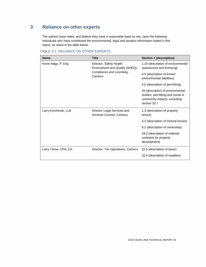
2016 CIGAR LAKE TECHNICAL REPORT 20
3 Reliance on other experts
The authors have relied, and believe they have a reasonable basis to rely, upon the following individuals who have contributed the environmental, legal and taxation information stated in this report, as noted in the table below.
TABLE 3-1: RELIANCE ON OTHER EXPERTS
Name Title Section # (description)
Kevin Nagy, P. Eng Director, Safety Health Environment and Quality (SHEQ), Compliance and Licensing, Cameco
1.10 (description of environmental assessment and licensing)
4.5 (description of known environmental liabilities)
4.6 (description of permitting)
20 (description of environmental studies, permitting and social or community impact), excluding section 20.7
Larry Korchinski, LLB Director Legal Services and General Counsel, Cameco
1.3 (description of property tenure)
4.2 (description of mineral tenure)
6.1 (description of ownership)
19.2 (description of material contracts for property development)
Larry Tehse, CPA, CA Director, Tax Operations, Cameco 22.5 (description of taxes)
22.6 (description of royalties)

2016 CIGAR LAKE TECHNICAL REPORT 21
4 Property description and location
4.1 Location The Cigar Lake minesite is located near Waterbury Lake, approximately 660 kilometres north of Saskatoon, at latitude 580 04' 14" north and longitude 1040 32' 18'' west, and about 40 kilometres inside the eastern margin of the Athabasca Basin region in northern Saskatchewan. See Figure 4-1.
The minesite is in close proximity to two uranium milling operations: McClean Lake is 69 kilometres northeast by road and Rabbit Lake is 87 kilometres east by road. The McArthur River mine is 46 kilometres southwest by air from the minesite.

2016 CIGAR LAKE TECHNICAL REPORT 22
FIGURE 4-1: CIGAR LAKE MINERAL PROPERTY, LOCATION

2016 CIGAR LAKE TECHNICAL REPORT 23
4.2 Mineral tenure • One mineral lease: ML-5521 (Mineral Lease)
• 25 mineral claims: S-106540 to 106564 inclusive (Mineral Claims)
• Total contiguous area: 93,048 hectares
The Cigar Lake deposit is located in the area subject to the Mineral Lease, totalling 308 hectares. The right to mine this deposit was granted by the Province of Saskatchewan under the Crown Minerals Act (Saskatchewan) through the Mineral Lease, effective December 1, 2001. The term of the current Mineral Lease is for 10 years and expires on December 1, 2021, but is subject to a right to renew for successive ten-year terms, absent a default by the CLJV. The Province of Saskatchewan may only terminate the lease if the CLJV breaches a provision of the lease or fails to satisfy any of its obligations under The Crown Minerals Act (Saskatchewan) or associated regulations, or in the event that any prescribed environmental concerns arise.
Surrounding the Cigar Lake deposit, there are 25 Mineral Claims which were also granted by the Province of Saskatchewan under The Crown Minerals Act (Saskatchewan), totalling 92,740 hectares. These Mineral Claims grant the CLJV the right to explore for minerals within the claim lands, and to convert a mineral claim into a mineral lease if the CLJV remains in good standing. Surface exploration work of a mineral claim requires additional government approval.
There is an annual requirement of $2.3 million, either in work or cash to retain title to the 25 Mineral Claims. Based on previous work submitted and approved by the Province of Saskatchewan, title is secured until 2023.
Under the Cigar Lake Joint Venture Agreement and related agreements, made effective January 1, 2002, the Mineral Lease and the 25 Mineral Claims noted above were divided into the Cigar Lake lands, consisting of ML-5521 and claim S-106558, and the Waterbury Lake lands, consisting of the remaining 24 claims. AREVA is the operator of the Waterbury Lake lands and is also contract exploration operator of the Cigar Lake lands other than the area on ML-5521 from which the mineral reserves are being mined. Cameco has been the mine operator for the Cigar Lake lands with respect to ML-5521 since 2002.
Figure 4-2 shows the Cigar Lake Mineral Lease and Mineral Claims as currently registered with the Province of Saskatchewan.
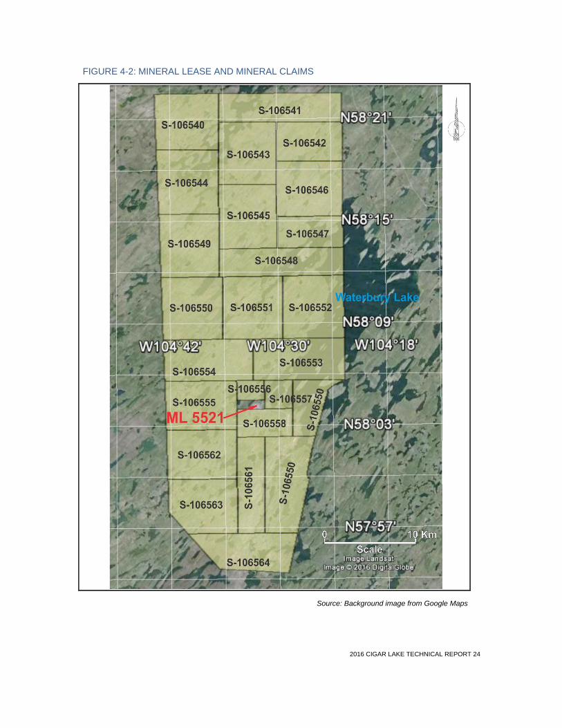
2016 CIGAR LAKE TECHNICAL REPORT 24
FIGURE 4-2: MINERAL LEASE AND MINERAL CLAIMS
Source: Background image from Google Maps

2016 CIGAR LAKE TECHNICAL REPORT 25
4.3 Surface tenure • Total area: 1,042 hectares of Crown land
• Covers a portion of ML-5521, along with portions of claims S-106555 to 106560, inclusive,and S-106562
The surface facilities and mine shafts for the Cigar Lake mine are located on lands owned by the Province of Saskatchewan. The CLJV partners acquired the right to use and occupy these lands for the purpose of developing and mining the Cigar Lake deposit under a surface lease agreement with the Province of Saskatchewan. The most recent surface lease was signed to be effective July 2011, and expires May 31, 2044.
The Province of Saskatchewan uses surface leases as a mechanism to achieve certain environmental protection and socio-economic objectives. As a result, the Cigar Lake surface lease contains certain undertakings from the CLJV in that regard, including annual reporting on the status of the environment, land development and progress on northern Saskatchewan employment and business development.
Figure 4-3 shows the general site arrangement with the outline of the surface lease.
In 2015, annual rent was approximately $200,000 for the surface lease, together with taxes of approximately $3,400,000 in respect thereof.
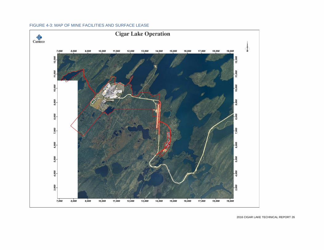
2016 CIGAR LAKE TECHNICAL REPORT 26
FIGURE 4-3: MAP OF MINE FACILITIES AND SURFACE LEASE

2016 CIGAR LAKE TECHNICAL REPORT 27
4.4 Royalties For a discussion of royalties, see Section 22.6.
4.5 Known environmental liabilities For a discussion of known environmental liabilities, see Section 20.6.
4.6 Permitting For a discussion of permitting, see Section 20.2.

2016 CIGAR LAKE TECHNICAL REPORT 28
5 Accessibility, climate, local resources, infrastructure and physiography
5.1 Access The property is accessible by an all-weather road and by air. Supplies are transported by truck and can be shipped from anywhere in North America through Cameco’s transit warehouse in Saskatoon. Trucks travel north from Saskatoon on a paved provincial road through Prince Albert and La Ronge and further north along the gravel surfaced Provincial Road 905, and finally to the minesite via a 52-kilometre long two-lane gravel road. The latter section is accessible to the public from the intersection with Provincial Road 905 to the access gate near the Cigar Lake airstrip, situated approximately six kilometres from the minesite. Ore is shipped from Cigar Lake to McClean Lake by truck year round. Yellowcake is shipped from the McClean Lake mill by truck to Saskatoon. Figure 5-1 shows the regional location of the Cigar Lake site and local roads.
An unpaved airstrip is located east of the minesite, allowing flights to and from the Cigar Lake property.
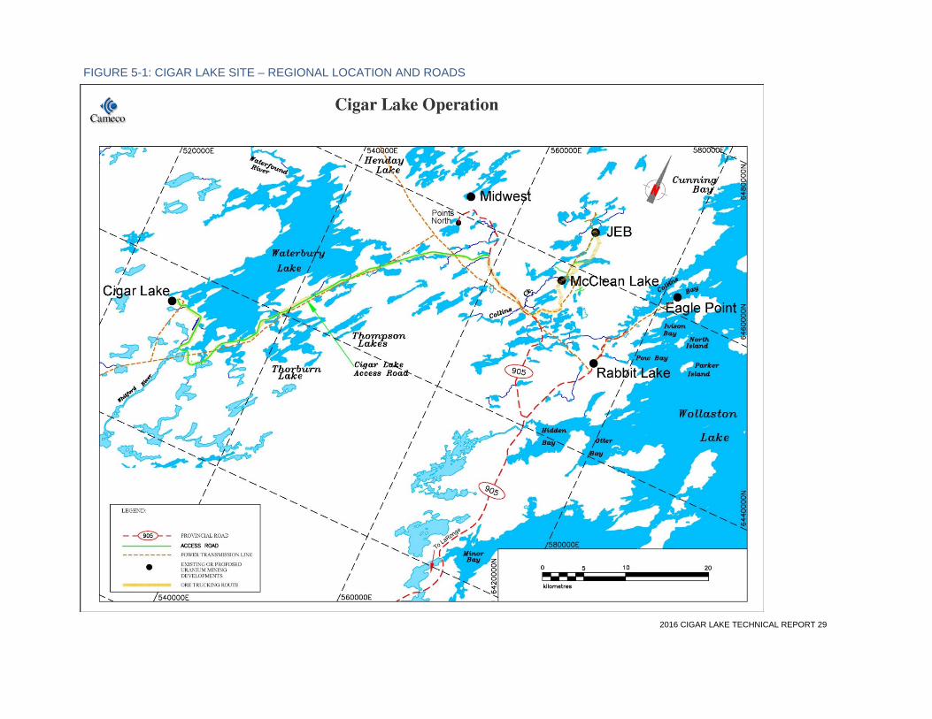
2016 CIGAR LAKE TECHNICAL REPORT 29
FIGURE 5-1: CIGAR LAKE SITE – REGIONAL LOCATION AND ROADS

2016 CIGAR LAKE TECHNICAL REPORT 30
5.2 Climate The climate is typical of the continental sub-arctic region of northern Saskatchewan. Summers are short and rather cool, even though daily temperatures can reach above 30°C on occasion. Mean daily maximum temperatures of the warmest months are around 20°C and only three months on average have mean daily temperature of 10°C or more. The winters are cold and dry with mean daily temperature for the coldest month below -20°C. Winter daily temperatures can reach below -40°C on occasion.
Freezing of surrounding lakes, in most years, begins in November and breakup occurs around the middle of May. The average frost-free period is approximately 90 days.
Average annual total precipitation for the region is approximately 450 millimetres, of which 70% falls as rain, more than half occurring from June to September. Snow may occur in all months but rarely falls in July or August. The prevailing annual wind direction is from the west with a mean speed of 12 kilometres per hour.
Site operations are carried out year round, despite cold winter conditions. The fresh air necessary to ventilate the underground working areas is heated during winter months using propane-fired burners.
5.3 Physiography The topography and vegetation at the Cigar Lake property are typical of the taiga forested lands common to the Athabasca Basin area of northern Saskatchewan. The area is covered with between 30 and 50 metres of overburden. The terrain is gently rolling and characterized by forested sand and dunes. Vegetation is dominated by black spruce and jack pine. Occasional small stands of white birches may occur in more productive and well-drained areas. Lowlands are generally well drained, but can also contain some muskeg and poorly drained bog areas, with vegetation varying from wet, open non-treed vistas to variable density stands of primarily black spruce and tamarack, depending on moisture and soil conditions. Productive lichen growth is common to this boreal landscape, mostly associated with mature coniferous stands and treed bogs.
The minesite elevation is approximately 490 metres above sea level and Waterbury Lake is approximately 455 metres above sea level. The body of water known as Cigar Lake which, in part, overlays the deposit, is approximately 464 metres above sea level.
5.4 Local resources The closest inhabited site is Points North Landing, 56 kilometres northeast by road from the Cigar Lake minesite, close to where the site access road connects to Provincial Road 905. The community of Wollaston Lake is approximately 80 kilometres by air east of the Cigar Lake site.
The Cigar Lake site is in close proximity to two other uranium milling operations: AREVA’s McClean Lake operation is approximately 69 kilometres northeast by road, and Cameco’s Rabbit Lake operation is approximately 87 kilometres east by road.
Athabasca Basin community resident employees and contractors fly from various pick-up points in smaller airplanes to the minesite. Southern resident employees and contractors fly to site from Saskatoon with stop-over pick-up points in Prince Albert and La Ronge. Most company employees are on a week-in and week-off schedule. Contractor employees are generally on a longer work schedule. Personnel are recruited on a preferential basis from northern Saskatchewan.
Site activities, such as mine development and construction work, are tendered to a number of northern owned or joint venture contractors, and major contractors that have the ability to hire qualified personnel from the major mining regions across Saskatchewan and Canada.

2016 CIGAR LAKE TECHNICAL REPORT 31
The Cigar Lake site is linked by road and by air to the rest of the province of Saskatchewan, facilitating easy access to any population centre for purchasing of goods at competitive prices. Saskatoon is a major population centre some 660 kilometres south of the Cigar Lake operation, with highway, rail and air links to the rest of North America.
5.5 Mine and infrastructure Cigar Lake is a developed producing property with sufficient surface rights to meet its current mining operation needs. The Cigar Lake minesite contains all the necessary services and facilities to operate a remote underground mine, including personnel accommodation, access to water, airport, site roads and other necessary buildings and infrastructure.
SITE FACILITIES
• an underground mine with two shafts
• access road joining the provincial highway and McClean Lake
• site roads and site grading
• airport and terminal
• employee residence and construction camp
• Shaft No. 1 and No. 2 surface facilities
• freeze plants and brine distribution equipment
• surface freeze pads
• water supply, storage and distribution for industrial water, potable water and fire suppression
• propane, diesel and gasoline storage and distribution
• electrical power substation and distribution
• emergency power generating facilities
• compressed air supply and distribution
• minewater storage ponds and water treatment
• sewage collection and treatment
• surface and underground pumping system installation
• waste rock stockpiles
• garbage disposal landfill
• administration, maintenance and warehousing facilities
• underground tunnels
• ore load out facility
• concrete batch plant
• Seru Bay pipeline
Water and electricity The Cigar Lake minesite has access to sufficient water from nearby Waterbury Lake for all planned industrial and residential activities. The site is connected to the provincial electricity grid with a 138-kilovolt overhead power line, and there are standby generators in case of power outages.
Tailings and waste No tailings are stored at the Cigar Lake site since all ore mined is transported to AREVA’s McClean Lake mill for processing. The processing facility at the McClean Lake site is discussed in Section 17, and the tailings management facility is discussed in Sections 20.2 and 20.4.

2016 CIGAR LAKE TECHNICAL REPORT 32
Waste rock piles from the excavation of the two shafts and all underground development are confined to a small footprint within the surface lease. The waste piles have been segregated into four separate areas: two clean waste piles, one mineralized waste pile (>0.03% U3O8), and one potentially acid-generating waste pile. The latter two stockpiles are contained on lined pads; however, no significant mineralized waste has been identified in development to date. Waste rock management is further discussed in Section 20.6.
A site plan of the existing surface facilities is shown in Figure 5-2.

2016 CIGAR LAKE TECHNICAL REPORT 33
FIGURE 5-2: SITE PLAN OF EXISTING SURFACE FACILITIES
2016 CIGAR LAKE TECHNICAL REPORT 34
6 History
6.1 Ownership There have been numerous changes in ownership of participating interests in the joint venture that governs Cigar Lake. The current owners and their participating interests in the CLJV are as follows:
• Cameco (50.025%)
• AREVA (37.100%)
• Idemitsu (7.875%)
• TEPCO (5.000%)
1976
• Original joint venture established between Canadian Kelvin Resources Ltd. and Asamera Oil Corporation Ltd (Asamera) to explore the Keefe Lake area
o Operator: Asamera
1977
• Saskatchewan Mining Development Corporation (SMDC) acquires 50% interest
1979
• Keefe Lake Joint Venture divides the Keefe Lake area into three separate project areas of Dawn Lake, McArthur River and Waterbury Lake (which includes a portion of the lands now known as Cigar Lake)
1980
• Joint venture agreement entered into to govern exploration of the Waterbury Lake area
o Operator: SERU (predecessor to Cogema Canada Ltd. (Cogema))
1985
• Waterbury Lake Joint Venture Agreement terminated and replaced by a new joint venture agreement, which divided the Waterbury Lake area into the Waterbury Lake lands and the Cigar Lake lands
o Participating interests: SMDC (50.75%), Cogema (32.625%), Idemitsu (12.875%), Corona Grande Exploration Corporation (3.75%)
o Operator (Waterbury Lake lands): Cogema
o Operator (Cigar Lake lands): Cigar Lake Mining Corporation
1988
• Eldorado Resources Limited and SMDC merge to form Cameco
2002
• Cigar Lake reorganization takes place and three agreements are entered into:
o CLJV established to govern further exploration, development and production from the Waterbury Lake lands and the Cigar Lake lands
Joint venture owners: Cameco (50.025%), AREVA (37.1%), Idemitsu (7.875%), TEPCO (5%)
Operator (Waterbury Lake lands, includes claims No. S-106540 to 106557 and 106559 to 106564): AREVA
o Mine Operating Agreement established as part of reorganization, which engages Cameco as mine operator for the Cigar Lake mine property (which includes ML-5521, the Cigar Lake surface lease and the mine)

2016 CIGAR LAKE TECHNICAL REPORT 35
o Contract Exploration Agreement established, which engages AREVA as contract exploration operator to operate the Cigar Lake exploration property (Claim No. 106558 as well as the area of ML-5521 from which mineral reserves are not mined)
6.2 Exploration and development history 1976 to 1979
• Asamera (operator of the Keefe Lake Joint venture) conducts exploration work:
o lake sediment and water geochemistry, airborne magnetic and Input (Questor) surveys, airborne radiometric and VLF (Geoterrex) surveys, gravimetric (Kenting) and seismic surveys
• After the division of the Keefe Lake area into three separate projects, Cogema, (operator of the Waterbury joint venture) revisits all field survey results and conducts complementary exploration work:
o lake-bottom sediment geochemistry and airborne high resolution magnetic (Geoterrex) surveys, regional geology photo-interpretation as well as outcrop and overburden mapping and sampling activities conducted across the mineral property
o ground geophysical surveys allowed depth and conductivity evaluation of geological formations using electromagnetic frequency (Geoprobe EMR-16) and time (Crone DEEPEM) methods
1980s
• Definition drilling programs conducted throughout the 1980s
• 1980 – 81: during the winter months, detailed DEEPEM work activity intensifies, targeting several Waterbury Lake zones with conductor structures previously identified, which are systematically drilled
• May 9, 1981: high-grade mineralized core is recovered from hole WQS2-015, which was the last hole planned to be drilled for the winter program
• October 21, 1987: test mine proposal to assess conditions and to field test new mining methods approved
• 1987 – 1992: test mining, including the sinking of Shaft No. 1 to a depth of 500 metres and lateral development on three levels takes place
1990s
• September 1992: Government Environmental Review Panel guidelines are issued for the Cigar Lake project by the Joint Federal-Provincial Panel (the Panel) on Uranium Mining Developments in Northern Saskatchewan. Later the same year, consulting firms are hired to perform engineering studies and, at the same time, metallurgical and environmental testing programs are launched
• 1993: minesite activities are placed on a care and maintenance basis and initial engineering studies for development and operation of the property based on the jet boring mining method are started. These and other engineering studies are completed between 1993 and 1996. Several additions and improvements to site infrastructure are also performed
• 1997: detailed engineering studies are undertaken for the purpose of developing a feasibility study of the mining project. In addition, testing of a specially designed tunnel boring machine with capability to install a high-strength concrete liner (or mine development system) is conducted. In conjunction with this work, significant mine development is also carried out
• 1998: after an environmental review, carried out from 1996 to 1997, the Panel issues recommendations to the federal and provincial governments and the CLJV that the project

2016 CIGAR LAKE TECHNICAL REPORT 36
proceed to the next stage of licensing. In April 1998, both governments respond favourably to the recommendations
• 1999: the specially designed jetting tools for the jet boring machine are successfully tested within a three-metre diameter culvert lined raise, filled with simulated ore
2000s
• 2000: activities at the minesite are focused on the testing of several tools and systems forming the basis of the future mining method, and the jet boring system is successfully tested in waste and frozen ore
• December of 2000: the minesite is again placed on a care and maintenance basis
• May 2001: feasibility study is completed, targeting peak annual production of 18 million pounds U3O8 during Phase 1
• 2002: Cameco becomes mine operator
• December 2004: the CLJV approves development of Cigar Lake and construction of the project begins in January 2005
6.3 Historical mineral resource and mineral reserve estimates There are no historical estimates within the meaning of NI 43-101 to report.
6.4 Historical production Historical mine production from the Cigar Lake deposit results from test mining in ore conducted during three separate test mining programs and comprising five separate mining tests as follows:
• boxhole boring of two cavities in 1991
• jet boring tests No. 1, 2 and 3 in 1992
• jet boring industrial tests in 2000: four cavities in waste and four cavities in ore
The mineralized material from the historical production tests, amounting to 767 tonnes at 17.4% U3O8, has mostly been sent to the McClean Lake mill and processed. A total of 53 tonnes of high-grade mineralization remaining from the test mining is stored on the surface storage pad at Cigar Lake.
McClean Lake mill production from Cigar Lake to year-end 2015 is shown in the table below.
TABLE 6-1: HISTORICAL MILL PRODUCTION FROM CIGAR LAKE
Year Mill feed (t)
Feed grade (% U3O8)
Production (M lbs U3O8)
2014 3,650 5.8 0.3
2015 24,300 21.7 11.3
Totals 27,950 19.6 11.6
2016 CIGAR LAKE TECHNICAL REPORT 37
7 Geological setting and mineralization
7.1 Regional geology The Cigar Lake uranium deposit is located approximately 40 kilometres west of the eastern margin of the Athabasca Basin of northern Saskatchewan (Figure 7-1). Like other major uranium deposits of the basin, it is located at the unconformity contact separating late Paleoproterozoic to Mesoproterozoic sandstone of the Athabasca Group from middle Paleoproterozoic metasedimentary gneiss and plutonic rocks of the Wollaston Group.
The Athabasca Group appears largely undeformed and its maximum preserved thickness is about 1,500 metres. The Manitou Falls (MF) formation, within the Athabasca Group, was deposited in an intra-continental sedimentary basin that was filled by fluviatile terrestrial quartz sandstone and conglomerate. On the eastern side of the basin, the sandstone units of the Manitou Falls formation, and the Wollaston Group metasedimentary gneiss that unconformably lie immediately beneath them, host most of the uranium mineralization.
The Lower Pelitic unit of the Wollaston Group, which lies directly on the Archean granitoid basement, is considered to be the most favourable unit for uranium mineralization. During the Hudsonian orogeny (1800 – 1900 million years), the group underwent polyphase deformation and upper amphibolite facies metamorphism, with local greenschist facies retrograde metamorphism. The Hudsonian orogeny was followed by a long period of erosion and weathering along with the development of a paleoweathering profile that is preserved on, and beneath, the unconformity.
7.2 Local geology In the Cigar Lake Joint Venture property area (Figure 7-1), the Manitou Falls Formation is 250 to 500 metres thick and corresponds to members MFd, MFc, and MFb. The MFb member hosts the Cigar Lake deposit, which is positioned atop an east-west trending 20-metre basement high. Overburden in the project area ranges up to a thickness of 50 metres.
Two major lithostructural domains are present in the metamorphic basement of the larger Waterbury/Cigar Lake property. These are as follows (Figure 7-1):
• Wollaston Domain: a southern area composed mainly of metasedimentary gneiss overlying Archean granitoids, with an overall northeast-trending structural orientation
• Mudjatik Domain: a northern area with large Archean granitoid domes and lesser inliers of metasedimentary gneiss with a dome and basin structural morphology

2016 CIGAR LAKE TECHNICAL REPORT 38
FIGURE 7-1: GEOLOGICAL MAP OF NORTHERN SASKATCHEWAN

2016 CIGAR LAKE TECHNICAL REPORT 39
The Cigar Lake east-trending psammopelitic to pelitic unit, which underlies the deposit, is located in the transitional zone between the two basement domains. The metamorphic basement rocks in this unit consist mainly of biotite and graphite gneiss with lesser calc-silicate gneiss, which are inferred to be part of the Wollaston Group’s Lower Pelitic sequence. Graphite and pyrite-rich “augen gneiss,” an unusual facies within the graphitic pelite gneiss, occur primarily below the Cigar Lake deposit.
The mineralogy and geochemistry of the graphitic gneiss suggest that they were originally carbonaceous shales. The abundance of magnesium in the intercalated carbonate layers indicates an evaporitic origin.
The structural framework in the Cigar Lake mine area is dominated by large northeast-trending lineaments and wide east-trending mylonitic corridors. The unconformable contact between these mylonites, which contain the augen gneiss, and the overlying Athabasca sandstone, are considered to be the most favourable features for the concentration of uranium mineralization, specifically where graphitic basement fault zones were locally reactivated as brittle faults after sandstone deposition.
The regional basement geology in the southern Cigar Lake area is shown in Figure 7-2.
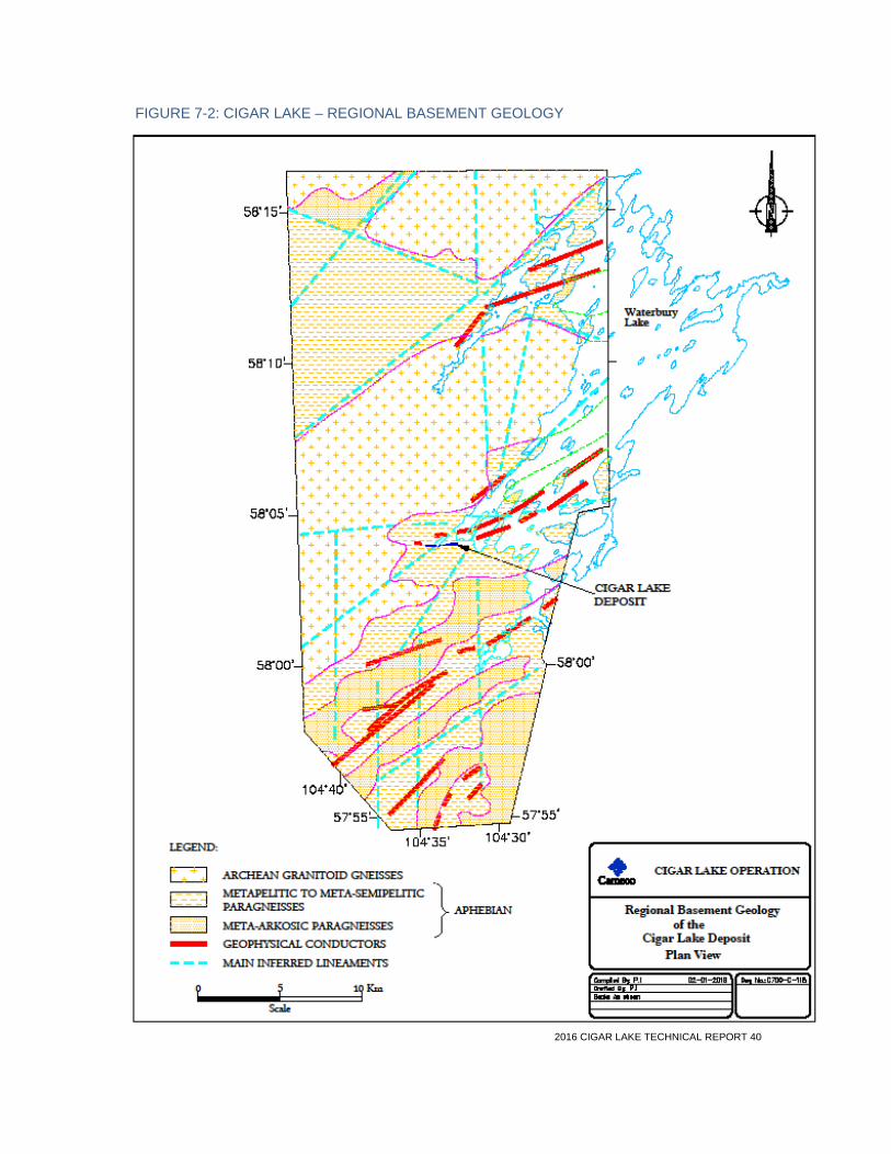
2016 CIGAR LAKE TECHNICAL REPORT 40
FIGURE 7-2: CIGAR LAKE – REGIONAL BASEMENT GEOLOGY

2016 CIGAR LAKE TECHNICAL REPORT 41
7.3 Property geology The Cigar Lake uranium deposit, which has no direct surface expression, is located at the unconformity between the middle Paleoproterozoic Wollaston Group metasediments and the late Paleoproterozoic to Mesoproterozoic Athabasca Group, between 410 and 450 metres below surface. It has the shape of a flat, elongated lense, approximately 1,950 metres in total length, 20 to 100 metres in width, and ranges up to 13.5 metres thick, with an average thickness of about 5.4 metres. It shows longitudinal and lateral geological continuity. It has a crescent-shaped cross-sectional outline that closely reflects the topography of the unconformity. The deposit is subdivided into the eastern Phase 1 and western Phase 2 zones. Phase 1 is further divided into the east and west pods.
The deposit and host rocks consist of three principal geological and geotechnical elements:
• the deposit itself
• the overlying sandstone
• the underlying metamorphic basement rocks
The Manitou Falls Formation is 420 to 445 metres thick. The basement lithological domains consist of:
• a variably graphitic pelite unit located directly below the deposit
• a calc-silicate rich unit labeled as “Meta-Arkose”
• a biotite pelite unit located to the south of the deposit area within which most of the mine access infrastructure is located
The graphitic pelite unit has been further divided into two sub-domains, including a graphite and sulphide-rich portion located directly below the uranium mineralization that has undergone variable and locally significant shear deformation, and a lesser graphite-rich portion that contains significantly less sulphides and shows less shear deformation. Figure 7-3 depicts the basement lithological domains in the immediate vicinity of the Phase 1 mineralization.
The structural framework in the Phase 1 area is dominated by an east-west trending protomylonitic to locally mylonitic zone containing numerous steeply dipping, east-striking fault zones. Directly below the Phase 1 zone, these east-striking faults consist of graphitic breccia zones that are up to several metres wide and largely coincide with the 20-metre basement high, along which the uranium mineralization is located. Several steeply dipping northwest- and northeast-striking fault zones are located in this area and intersect the east-striking fault corridor in the central area of the Phase 1 mineralization. This area of intersecting faults controls the most extensive clay alteration observed within the Phase 1 area, both at the mineralized horizon and down to the 480 metre mining level.
The Phase 1 deposit is surrounded by a strong alteration halo affecting both sandstone and basement rocks, characterized by extensive development of Mg-Al rich clay minerals (illite-chlorite). This alteration halo in the sandstone is centred on the deposit and reaches up to 200 metres in width and 250 metres in height, tapering with elevation. In the basement rocks, this zone extends in the range of 200 metres in width and as much as 100 metres in depth below the deposit. The mineralization is hosted principally by the Athabasca Group and consists mainly of uraninite and pitchblende along with nickel and cobalt arsenides.
Figure 7-4 shows a schematic geological cross-section of the Cigar Lake Phase 1 deposit that illustrates the shape of the deposit, fault structures, the main fracture zone and the clay alteration halo in the sandstone and the basement rocks.

2016 CIGAR LAKE TECHNICAL REPORT 42
FIGURE 7-3: BASEMENT GEOLOGY OF THE CIGAR LAKE PHASE 1 AREA RELATIVE TO MINERALIZATION

2016 CIGAR LAKE TECHNICAL REPORT 43
FIGURE 7-4: CIGAR LAKE PHASE 1 DEPOSIT – SCHEMATIC CROSS SECTION LOOKING WEST

2016 CIGAR LAKE TECHNICAL REPORT 44
7.4 Mineralization Two distinct styles of mineralization occur within the Cigar Lake deposit:
• high-grade mineralization at the unconformity (“unconformity” mineralization), which includes all of the mineral resources and mineral reserves
• fracture controlled, vein-like mineralization which is located either higher up in the sandstone (“perched” mineralization) or in the basement rock mass
The high-grade mineralization located at the unconformity contains the bulk of the total uranium metal in the deposit and currently represents the only economically viable style of mineralization, in the context of the selected mining method and ground conditions. It is characterized by the occurrence of massive clays and very high-grade uranium concentrations.
The unconformity mineralization consists primarily of three dominant rock and mineral facies occurring in varying proportions. These are quartz, clay (primarily chlorite with lesser illite) and metallic minerals (oxides, arsenides, sulphides). In the relatively higher grade Phase 1 area, the ore consists of approximately 50% clay matrix, 20% quartz and 30% metallic minerals, visually estimated by volume. In this area, the unconformity mineralization is overlain by a weakly mineralized contiguous clay cap 1 to 10 metres thick. In the relatively lower grade Phase 2 zone, the proportion changes to approximately 20% clay, 60% quartz and 20% metallic minerals.
While pre- and post-mineralization faulting played major roles in creating preferential pathways for uranium-bearing fluids and, to some extent, in remobilizing uranium, the internal distribution of uranium within the unconformity mineralization has likely been largely controlled by geochemical processes. This is reflected in the continuity and homogeneity of the mineralization and its geometry, particularly in the eastern part of the deposit. A very sharp demarcation exists between well mineralized and weakly mineralized rocks, both at the upper and particularly at the lower surface of the deposit.
Uranium oxide in the form of uraninite and pitchblende occurs in both a sooty form and as botryoidal, metallic masses. It occurs as disseminated grains in aggregates ranging in size from millimetres to decimetres, and as massive metallic lenses up to a few metres thick floating in a matrix of sandstone and clay. Coffinite (uranium silicate) is estimated to form less than 3% of the total uranium mineralization. The mineralized rock is variably black, red and/or green in colour.
Uranium grades of the unconformity mineralization range up to 82% U3O8 for a 0.5 metre interval from a drillhole intersection within the mining area. Geochemically, the deposit contains quantities of the elements nickel, copper, cobalt, lead, zinc, molybdenum and arsenic, but in non-economic concentrations. Higher concentrations of these elements are associated with massive pitchblende or massive sections of arseno-sulphides. Primary age of the unconformity mineralization has been estimated at 1.3 billion years.
The deposit has been subjected to faulting subsequent to its formation, which has contributed to the formation of vein-type mineralization that has been termed “perched” within the sandstone and vein-type mineralization within the basement. These mineralized bodies form, volumetrically, a very small part of the total mineralized rock and are of no economic significance at this time.
2016 CIGAR LAKE TECHNICAL REPORT 45
8 Deposit types
Cigar Lake is the world’s highest grade uranium mine, with reserve grades 100 times the world average.
Cigar Lake is an unconformity-related uranium deposit. Deposits of this type are believed to have formed through an oxidation-reduction reaction at a contact where oxygenated fluids meet with reducing fluids. That contact broadly coincides with the unconformity surface. The Cigar Lake deposit occurs at the unconformity contact between rock of the Athabasca Group and underlying Wollaston Group, an analogous setting to the Key Lake, McClean Lake, Collins Bay and McArthur River deposits. It shares many similarities with these deposits, including general structural setting, mineralogy, geochemistry, host rock association and the age of the mineralization; however, it is distinguished by its size, the intensity of its alteration process, the high degree of associated hydrothermal clay alteration and the presence of massive, extremely rich, high-grade uranium mineralization.
The Cigar Lake deposit is similar to the McArthur River deposit in that the sandstone that overlies the basement rock contains large volumes of water at significant pressure. Unlike McArthur River, however, this deposit is flat lying.
2016 CIGAR LAKE TECHNICAL REPORT 46
9 Exploration
The Cigar Lake deposit is located within ML-5521, which is surrounded by 25 Mineral Claims. AREVA is responsible for all exploration activity on these claims, as per the CLJV agreements. Section 9.1 is a synopsis of exploration activities on the 25 Mineral Claims. For the purpose of the discussion in that section, the 25 Mineral Claims are called the Waterbury Lake lands. Section 9.2 is a summary discussion of geophysical programs that have been conducted by Cameco on behalf of the CLJV within ML-5521 since the October 2006 water inflow.
Drilling activity is described in Section 10.
9.1 AREVA 1980 – present From 1980 to 1986, SERU (which became Cogema in 1984, and subsequently AREVA in 2006) completed various airborne and ground geophysical programs, lake sediment and water sampling programs and substantial diamond drilling. The Cigar Lake uranium deposit was discovered in 1981, on lands now covered by ML-5521, by a regional program of diamond drill testing of geophysical anomalies (electromagnetic conductors) located by airborne and ground geophysical surveys.
All exploration activities ceased after the 1986 field season for a period of 12 years until work on the Waterbury Lake lands recommenced in 1999. After initially focussing upon data compilation and a review of all work conducted to date, new exploration has focussed upon developing further understanding of the Cigar trend, and developing knowledge of the large, unexplored parts of the project. Concurrent with this new work, a program of reboxing, relogging and sampling of historical exploration drillholes was undertaken to develop a further understanding of the Cigar Lake mineralization, alteration processes and structural setting to aid with near-mine and greenfields exploration on the project.
Electromagnetic (EM) and resistivity surveys have been used as the primary exploration geophysical tools with a variety of surveys conducted. EM surveys starting with an airborne GEOTEM survey in 1999 have consisted of Moving Loop UTEM, Fixed Loop TEM, moving loop transient electromagnetic induction coil (ML-TEM), and Moving Loop SQUID transient EM. ML-SQUID TEM has been the dominant EM survey type since 2011. A pseudo 3D resistivity survey was completed along a portion of the Cigar trend; however, due to the grid spacing, the results are not considered definitive. Dipole-pole-dipole DC resistivity has been conducted on one line across the Eastern Cigar area and three additional survey grids were completed along the Powerline Grid between 2012 and 2014. Ground geophysics has been completed on a number of grids and has produced drill-ready targets. These areas include: Cigar West, Cigar Southwest, Contact Conductor, Powerline East, Powerline Central, Powerline West, and portions of the Eastern Cigar Trend. Airborne anomalies primarily identified from the GEOTEM and regional magnetics data sets, which require ground geophysics for future target generation include Andrew Lake SW, Jigger North, Jigger West, Kelly Bay, Waterbury Central, and Waterbury North.
Numerous spectral clay and geochemistry sampling, core reviews and core box replacement programs have been completed throughout the history of the project. These have included both reconnaissance exploration drill holes and numerous drill fences through the Cigar Lake orebody.
A property-wide boulder lithogeochemistry survey was completed in 2000.
In 2006, drill hole WC-244 discovered the Cigar East zone that is located outside ML-5521, approximately 650 metres east of Phase 1 mineralization. Further exploration has been conducted in this area since 2006 and has delineated a zone of unconformity style uranium mineralization

2016 CIGAR LAKE TECHNICAL REPORT 47
approximately 210 metres in length and 30 metres in width. No mineral resource has been reported for the Cigar East zone.
A figure displaying the location of all current exploration work areas outside of ML-5521 is included as Figure 9-1. A list of all work completed outside of ML-5521 between 1980 and 2015 is included as Table 9-1.
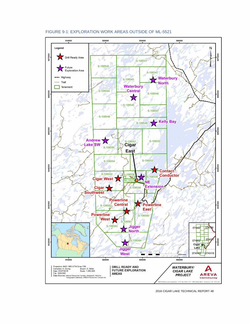
2016 CIGAR LAKE TECHNICAL REPORT 48
FIGURE 9-1: EXPLORATION WORK AREAS OUTSIDE OF ML-5521
Cigar East

2016 CIGAR LAKE TECHNICAL REPORT 49
TABLE 9-1: SUMMARY OF EXPLORATION OUTSIDE OF ML-5521
Year Diamond drillholes Airborne geophysics Ground geophysics Other exploration
# holes
Metres drilled Type Line km Type Line km Type
1980
Magnetic VLF and radiometric survey Project-wide
EM soundings DEEPEM 60
1981 13 5,208 DEEPEM 134 Lake sediment sampling
1982 4 1,845 DEEPEM 588 Lake sediment sampling
EM-37 28
Gravity 59
1983 4 2,616 INPUT 2,685 km DEEPEM 545 Lake sediment sampling
1984 4 1,657
1985 14 7,132 DEEPEM 120 Lake sediment sampling
1986 17 8,113
38 2,138 DEEPEM 135 Shallow geochemistry
1987-1998 No exploration activities
1999
Data compilation, structural study, re- logging and resampling of historical drill core
2000 GEOTEM 3,587 km
Boulder lithogeochemistry on most of the property
2001 Moving Loop EM 26
Fixed Loop EM 57
Pole-pole DC 2D Resistivity 5
2002 2 1,150 Pole-pole 2D Resistivity 16
EScan Pole-pole DC3D Resistivity 51
2003 4 1,790 UTEM Moving Loop EM 11
Historical drillcore logging and resampling
2004 Moving Loop EM 29
Historical drillcore logging and resampling
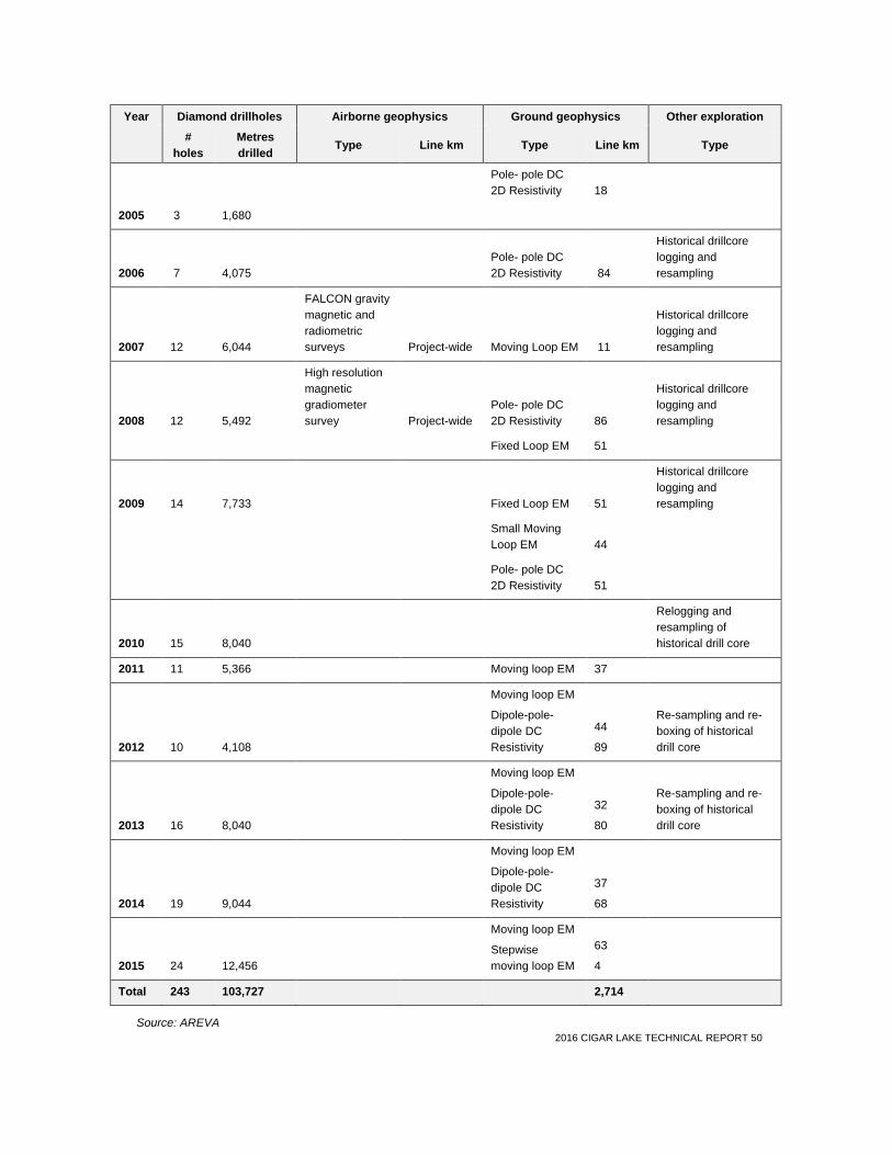
2016 CIGAR LAKE TECHNICAL REPORT 50
Year Diamond drillholes Airborne geophysics Ground geophysics Other exploration
# holes
Metres drilled Type Line km Type Line km Type
Pole- pole DC 2D Resistivity 18
2005 3 1,680
2006 7 4,075 Pole- pole DC 2D Resistivity 84
Historical drillcore logging and resampling
2007 12 6,044
FALCON gravity magnetic and radiometric surveys Project-wide Moving Loop EM 11
Historical drillcore logging and resampling
2008 12 5,492
High resolution magnetic gradiometer survey Project-wide
Pole- pole DC 2D Resistivity 86
Historical drillcore logging and resampling
Fixed Loop EM 51
2009 14 7,733 Fixed Loop EM 51
Historical drillcore logging and resampling
Small Moving Loop EM 44
Pole- pole DC 2D Resistivity 51
2010 15 8,040
Relogging and resampling of historical drill core
2011 11 5,366 Moving loop EM 37
2012 10 4,108
Moving loop EM
Dipole-pole-dipole DC Resistivity
44
89
Re-sampling and re-boxing of historical drill core
2013 16 8,040
Moving loop EM
Dipole-pole-dipole DC Resistivity
32
80
Re-sampling and re-boxing of historical drill core
2014 19 9,044
Moving loop EM
Dipole-pole-dipole DC Resistivity
37
68
2015 24 12,456
Moving loop EM
Stepwise moving loop EM
63
4
Total 243 103,727 2,714
Source: AREVA
2016 CIGAR LAKE TECHNICAL REPORT 51
9.2 Cameco 2007 – present After the 2006 water inflow events, it was recognized that more detailed geophysical information in the immediate deposit area was required. The initial focus was to gain an understanding of the structure associated with the Shaft No. 2 inflow. Ground surveys, including gravity, TITAN (DC/IP resistivity and magnetotelluric survey), and VLF electromagnetic surveys were conducted in the summer of 2007 over a portion of the Phase 1 area of the deposit.
In the fall of 2007, a supplementary geophysical program was conducted over a portion of the Phase 1 area of the deposit to identify major structures within the sandstone column. The survey was conducted in six boreholes to produce three vertical seismic profiles and six single-hole side-scan seismic surveys around the minesite to meet these objectives. Both of these survey designs are best for optimally imaging vertical to sub-vertical structures at various scales based on their input frequencies.
The knowledge gained of structures and fault zones, identified through the correlation of all the geophysical datasets—particularly seismic—with geological mapping and engineering parameters has allowed for better mine planning and mitigation of potential risk.

2016 CIGAR LAKE TECHNICAL REPORT 52
10 Drilling
10.1 Surface drilling Surface drilling on the Waterbury Lake lands conducted by AREVA and its predecessor companies since 1981 is presented in Table 9-1. Initial exploration activities by SERU were conducted in the southern region of the Waterbury Lake lands near Jigger Lake. Thirteen exploration drillholes (totalling 5,208 metres) were completed prior to the discovery hole during the first drilling campaign in 1981, eight of which were drilled on the Q17 grid (Jigger Lake). The last drillhole (WQS2-015), completed to a depth of 563 metres in 1981, was located on the QS-2 grid south of Cigar Lake and was the discovery hole for the Cigar Lake uranium deposit.
The deposit was subsequently delineated by surface diamond drilling during the period 1982 to 1986, and was followed by several small campaigns of drilling for geotechnical and infill holes to 2007. Additional drilling campaigns were conducted by Cameco between 2007 and 2012, which targeted a broad range of technical objectives, including geotechnical, geophysical, delineation and ground freezing. Since 2012, diamond drilling managed by Cameco has mainly focused on underground geotechnical and surface ground freezing programs on Phase 1.
In 2015, Cameco conducted a geotechnical drill program consisting of nine surface diamond holes (drilled to a vertical depth of 525 metres) over the western portion of the Phase 1 deposit. Down-hole cross-well seismic was done within these boreholes in an attempt to image major fault structures and geotechnical characteristics of this portion of the deposit.
Drillhole location maps are provided in Figures 10-1 and 10-2, which depict the locations for surface delineation and surface freezeholes, respectively. Average drill depths for surface delineation holes range from approximately 460 to 500 metres, with the majority of surface freezeholes drilled to a depth of approximately 462 metres.
The higher grade Phase 1 area was discovered in 1983. Drilling in the eastern part of the deposit was initially done at a nominal drillhole grid spacing of 50 metres east-west by 20 metres north-south. A surface drill program was conducted from 2010 to 2012 to tighten up the spacing in areas with gaps in coverage. The central portion of Phase 1 has been further delineated by surface freezeholes on a nominal 6 x 6 metre pattern. Figure 10-3 provides a representative geological cross-section along mine grid easting 10781, depicting the predominant lithological domains, location of the orebody and uranium grade distribution.
The Phase 2 area has been outlined through several exploration drilling campaigns conducted between 1981 and 2012. As depicted in Figure 10-1, drillhole coverage in this area is sparser than Phase 1, with drillhole fences and clusters variably spaced 20 to 200 metres apart. Cameco has initiated a delineation drilling program from surface to confirm and upgrade resources contained in Phase 2. Approximately 65,000 metres of diamond drilling is planned over a three-year period, which started in early 2016, in order to complete a detailed geological and geotechnical interpretation, a resource estimate and a technical study for the western portion of the deposit.
The orientation and shape of the deposit was recognized at an early stage of the exploration drilling. It was soon learned that the bulk of the mineralization was high grade and positioned at and sub parallel to the unconformity, although vein-like bodies of mineralized rock were also present. Subsequently, almost all drilling was completed using vertical drillholes rather than inclined drillholes because it was recognized that vertical intersections were essentially normal to the dominant orientation of the deposit. These intersections, therefore, represent the true thickness of the flat-lying deposit (Figure 10-3).

2016 CIGAR LAKE TECHNICAL REPORT 53
Well established drilling industry techniques were used in the drilling programs, including wireline core drilling. Core recovery was generally very good; in some areas where ground conditions dictated, triple tube drilling to maximize core recovery was done. Wedging techniques were used in some areas to obtain step-out intersections without the expense of collaring additional holes. A total of 70 wedged holes have been completed.
All pre-2007 holes were surveyed for direction using single shot or multi-shot surveying tools. Holes drilled since January 2007 have been surveyed either with a gyroscope or a Reflex tool. The collar locations of drillholes within the area of the surface infrastructure footprint have been surveyed by Cameco and their locations confirmed.
The more recent surface delineation drillholes (since 1988) have been grouted in their entirety. Holes drilled prior to 1988 were plugged in the range of 250 to 350 metres by mechanical plugs and/or cement plugs up to 10 metres thick.
In almost all cases, gamma surveys have been conducted through the mineralization in these holes. For further discussion see Section 11.7.
Drilling results have been used to delineate and interpret the 3D geometry of the mineralized areas, the litho-structural settings, the geotechnical conditions, and to estimate the distribution and content of uranium and other elements within the Phase 1 mineral resource and reserve, and the Phase 2 mineral resource.
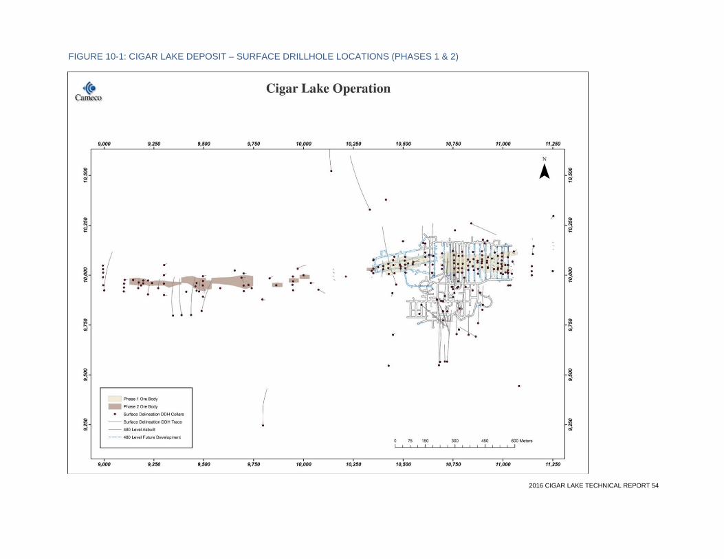
2016 CIGAR LAKE TECHNICAL REPORT 54
FIGURE 10-1: CIGAR LAKE DEPOSIT – SURFACE DRILLHOLE LOCATIONS (PHASES 1 & 2)
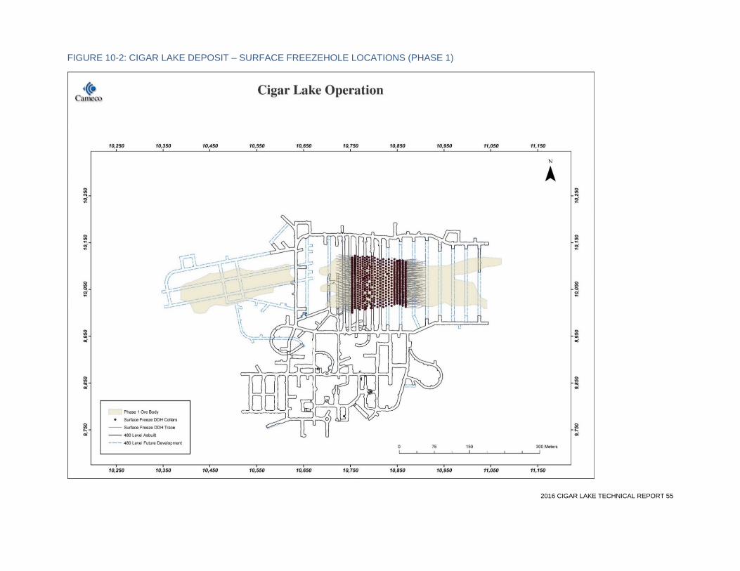
2016 CIGAR LAKE TECHNICAL REPORT 55
FIGURE 10-2: CIGAR LAKE DEPOSIT – SURFACE FREEZEHOLE LOCATIONS (PHASE 1)
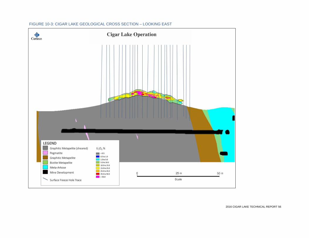
2016 CIGAR LAKE TECHNICAL REPORT 56
FIGURE 10-3: CIGAR LAKE GEOLOGICAL CROSS SECTION – LOOKING EAST

2016 CIGAR LAKE TECHNICAL REPORT 57
10.2 Underground drilling Diamond core drilling from underground locations is primarily to ascertain rock mass characteristics in advance of development and mining. Cigar Lake Mining Company and Cameco have conducted underground geotechnical drilling at Cigar Lake since 1989, with the exception of the period from 2007 to 2009 during which time the mine was flooded. Holes drilled prior to 2001 were surveyed for down-hole deviation using a single shot or multi-shot survey tool. Since 2001, holes have been surveyed for down-hole deviation using a Reflex survey tool.
Freezeholes were drilled into the deposit for the purposes of freezing the ground prior to mining. A total of 83 holes at a spacing of 1 to 1.5 metres were drilled in two periods of drilling in 1991 and again in 1999. Generally, these upward holes were rotary drilled holes from which no core was recovered; however, in a limited number of cases, core was recovered and sampled and, in almost all cases, gamma surveys of the holes were done through the deposit.
Freezehole drilling started up again in late 2004 with the start of the construction phase of development. During this phase, a total of 347 freeze and temperature monitoring holes were drilled, of which 182 have been gamma surveyed. The latter freezeholes were all drilled by percussion methods so no core was available for assays. The gamma surveys show the mineralization to generally conform with the projected ore outline. A gyro tool was used for directional surveying in the 2004 to 2006 phase of freezehole drilling. No underground freezeholes have been drilled since 2006.
The locations of the underground geotechnical holes in Phase 1 are shown in Figure 10-4. Underground freezeholes are not shown in this figure.

2016 CIGAR LAKE TECHNICAL REPORT 58
FIGURE 10-4: UNDERGROUND GEOTECHNICAL DIAMOND DRILLHOLE LOCATION MAP – PHASE 1

2016 CIGAR LAKE TECHNICAL REPORT 59
10.3 Factors that could materially affect the accuracy of the results Except for the underground freezeholes, there are no known drilling, sampling or core recovery factors that could materially affect the accuracy and reliability of the results. Underground freezeholes were not used in the 2015 mineral resource estimate due to data quality concerns and their redundancy given the presence of overlapping surface freezehole data. For a further discussion of sampling and core recovery factors, see Section 11.

2016 CIGAR LAKE TECHNICAL REPORT 60
11 Sample preparation, analyses and security
11.1 Sample density and sampling methods
Delineation drilling in the Phase 1 area, 670 metres long by 100 metres wide, has been done at a nominal drillhole fence spacing of 25 to 50 metres (east-west), with holes at 20 to 25 metres (north-south) spacing on the fences. However, the central portion of the Phase 1 deposit has had surface freezeholes installed at a nominal 6 x 6 metre pattern.
The Phase 2 area, 1,280 metres long by 75 metres wide, was historically drilled at a nominal drillhole fence spacing of 200 metres, with holes at 20 metres spacing on the fences. An additional 32 infill drillholes were completed in 2011 and 2012 by Cameco for select areas of Phase 2, locally reducing the drillhole spacing down to an approximate 15 x 15 metre pattern. Geological, geotechnical and hydrological information was collected and assessed.
Across the deposit, all surface holes were core drilled and gamma probed when possible. In-hole gamma surveys and hand-held scintillometer surveys were used to guide sampling of core for assay purposes. After recognition of the significance of the deposit and its geometry in 1982, sampling of core was thereafter primarily concerned with ensuring that all core within the mineralized zone containing at least 0.10% U3O8 was sampled and assayed. An Automess GmbH gamma detector was used to determine the outer limits of sampling.
In the early stages of exploration drilling, sampling of mineralized intervals was done on a geological basis, whereby sample limits were determined based on geological differences in the character of the mineralization. Samples were of various lengths, up to 50 centimetres. Beginning in 1983, sampling intervals for core from the deposit have been fixed at the property standard 50 centimetres. Subsequently, all sample results have been composited to the standard interval of 50 centimetres for mineral resource estimation purposes.
On each of the upper and lower contacts of the mineralized zone, at least one additional 50-centimetre sample was taken to ensure that the zone was fully sampled at the 0.10% U3O8 cut-off.
Sampling was done only after all other geological logging, including photography of the core, was done. Historically, sampling was done in a separate room (laboratory) attached to the core shack, in order to maintain cleanliness in the laboratory area and to reduce radiation levels in the core logging area. Since 2012, all core logging and sampling of uranium mineralized drill core has been conducted in a separate core logging facility.
The typical sample collection process included the following procedures:
• marking the sample intervals on the core boxes at the nominal 50-centimetre sample length by a geologist
• collection of the samples in plastic bags, taking the entire core
• documentation of the sample location, including assigning a sample number and description of the sample, including radiometric values from a hand-held device
• bagging and sealing, with sample tags inside bags and sample numbers on the bags
• placement of samples in steel drums for shipping
11.2 Core recovery Reliance for uranium grade determinations in surface delineation drillholes has been placed primarily on chemical assays of drill core. Core recovery through the ore zone has generally been very good. Where necessary, uranium grade determinations have been supplemented by down-

2016 CIGAR LAKE TECHNICAL REPORT 61
hole radiometric probing. However, approximately 79% of surface freezeholes rely solely on equivalent grade determinations from down-hole radiometric probing.
For mineral resource and reserve estimation purposes, where core recovery was above 75%, the assayed value was deemed representative of the whole interval. If the core recovery was below 75%, the sample was replaced by probing values. These replacement values account for a small portion of the overall sample database.
From about 1983 onward, all drilling and sampling procedures have been standardized and documented. This has imparted a high degree of confidence in the accuracy and reliability of results of all phases of the work.
11.3 Sample quality and representativeness The majority of exploration and delineation drilling completed by Cameco on the surface of the mineral lease consists of wireline diamond drilling recovering NQ size (47.6 millimetres) drill core. All surface freezehole core is of PQ size (85.0 millimetres). Except for some of the earliest sampling in 1981 and 1982, the entire core from each sample interval was taken for assay. This was done to reduce the variability inherent in sampling, given the high-grade nature and variability of the grades of the mineralization, and to minimize human exposure to gamma radiation and radon gas during the sampling process. Some of the core remains available for viewing at the site in a gated compound.
11.4 Sample preparation by Cameco employees None of the samples sent to testing laboratories prior to January 1, 2002 were prepared by an employee, officer or director of Cameco; however, limited assaying was carried out at Cameco’s Rabbit Lake mill laboratory, as discussed in Section 11.6. All samples for Cigar Lake prior to this date were prepared by employees of AREVA or its predecessor companies or Cigar Lake Mining Corporation (CLMC). This would include samples used in the mineral resource and mineral reserve estimates.
From 2009 to 2015, numerous surface delineation and surface freezeholes were drilled through the Phase 1 and Phase 2 deposits. Drill cores selected for assaying were sampled by Cigar Lake personnel.
Since January 2009, the qualified person for this section has been involved with providing support and guidance for sampling of mineralization.
11.5 Sample preparation The majority of historical samples used for the mineral resource estimate were prepared and analysed by Loring Laboratories Ltd. (Loring), which is located in Calgary, Alberta, and is independent of the CLJV partners.
Sample preparation at Loring consisted of drying the sample if necessary, followed by primary (jaw) and secondary (cone) crush, homogenization, and cutting the sample using a Jones-type riffle splitter down to 25 to 300 gram portions for pulp preparation. The material was then pulverized in a TM Vibratory Pulverizer to maintain a 95% passing 150 mesh sieve. Samples were then rolled 100 times on a rolling mat to ensure total homogeneity and placed in a numbered sample bag ready for analysis. Any particulates created from sample preparation were carefully swept up from all areas and placed in a separate container for return to the property site, along with all pulps and reject material after the sample had been analyzed.
Since 2002, sample preparation has been done at Saskatchewan Research Council Geoanalytical Laboratories (SRC), which is located in Saskatoon, Saskatchewan, and is independent of the CLJV partners. It involves jaw crushing to 60% passing at less than 2 millimetres and splitting out a 100
2016 CIGAR LAKE TECHNICAL REPORT 62
to 200 gram sub-sample using a riffle splitter. The sub-sample is pulverized to 90% passing at less than 106 microns using a puck and ring grinding mill. The pulp is then transferred to a labelled plastic snap top vial.
11.6 Assaying Assaying of drill core for uranium and multi-elements has been performed at four different commercial laboratories and Cameco’s Rabbit Lake laboratory since 1981.
As referenced in Section 11.5, Loring did all the assaying for uranium between 1983 and 1994. They were not certified by any standards association at that time.
Cameco’s Rabbit Lake mill laboratory has carried out limited assaying since 1994, and SRC was used after 2001. The Rabbit Lake laboratory was not formally certified at that time; however, between July 1994 and July 1997, there were inter-laboratory tests on uranium determination (Rabbit Lake, Key Lake, Cluff Lake, Rio Algom, and SRC laboratories participated). Different analytical methods were used in the comparison studies. The results from the Rabbit Lake laboratory were within the accepted limits. The Rabbit Lake laboratory was accredited to International Standard ISO/IEC 17025:2005 on July 28, 2006 by the Canadian Association for Environmental Analytical Laboratories.
Records indicate that SERU deemed the assay results from two commercial laboratories, from drilling done in 1982, were not calibrated properly. As a result, the assay results from this period were adjusted in 1983 based upon a systematic comparison of laboratory results and cross checks. These adjusted grades applied to only three holes (38, 39, 39A) out of 641 holes used for the Phase 1 uranium block model. Nineteen of the 23 holes affected were from the Phase 2 portion of the mineralization. These 23 holes have not been re-assayed and are included in the mineral resource and mineral reserve estimates.
Assaying by Loring was done by both the fluorimetric method and the volumetric method (volumetric ferrous iron reduction in phosphoric acid). All samples assaying greater than 5% U3O8 as determined by fluorimetry were re-assayed using the volumetric method. Chemical standards were systematically assayed on a regular basis to ensure the accuracy of the assaying procedure. Senior staff of the operator at the time (CLMC) visited Loring on a regular basis to view and discuss laboratory procedures with Loring.
Assaying at the Rabbit Lake mill was done by the fluorimetric method for low-grade samples, and by a combination of titration and x-ray fluorescence for high-grade samples, collected for metallurgical purposes in 1998.
Sample analysis since 2002 has been conducted by SRC. SRC is licensed by the Canadian Nuclear Safety Commission (CNSC) for possession, transfer, import, export, use and storage of designated nuclear substances under CNSC Licence Number: 01784-1-09.3. As such, SRC is closely monitored and inspected by the CNSC for compliance. SRC is an accredited testing laboratory assessed by the Standards Council of Canada under the requirements of ISO/IEC 17025:2005 (CAN_P_4E), General Requirements for the Competence of Mineral Testing and Calibration Laboratories. Assaying by SRC involved digesting an aliquot of pulp in a 100 millilitre volumetric flask in concentrated 3:1 HCI:HNO3, on a hot plate for approximately one hour. The lost volume is then made up using deionized water prior to analysis by ICP-OES. Instruments used in the analysis are calibrated using certified commercial solutions.
Chemical assay results were systematically checked against radiometric results to ensure their accuracy. Sample pulps and reject materials are retained and systematically catalogued. Check assays were done on an as-required basis.

2016 CIGAR LAKE TECHNICAL REPORT 63
11.7 Radiometric surveying For drillholes completed prior to 2011, the reliance on down-hole radiometric probing for determination of uranium grades for mineral resource estimation is minimal. Boreholes completed prior to 2011 were consistently sampled to obtain U3O8 chemical assays when uranium mineralization was encountered. In areas of poor core recovery or missing sample intervals, equivalent %U3O8 grades from down-hole radiometric data were used to supplement the assay data. However, this accounts for a very small proportion of the grade data for holes completed prior to 2011.
Since 2011, down-hole radiometric data provides the majority of grade data used for mineral resource estimation in areas where freezeholes have been installed. To the end of 2015, 619 surface freezeholes have been completed at Cigar Lake, and approximately 79% of these rely on equivalent grade data obtained from down-hole probing.
Cigar Lake uses a high-flux (HF) gamma probe designed and constructed by alphaNUCLEAR (aN), a member of the Cameco group of companies. This HF gamma probe utilizes two Geiger Mϋller (GM) tubes to detect the amount of gamma radiation emanating from the surroundings. The count rate obtained from the high-flux probe is compared against chemical assay results to establish a correlation to convert corrected probe count rates into equivalent %U3O8 grades. The consistency between probe data and chemical assays demonstrates that secular equilibrium exists within the deposit.
In 2014, Cigar Lake completed a thorough test program of its HF probes to demonstrate consistent count rates were being obtained between probes. A total of eight surface freezeholes were probed multiple times with each HF probe to compare count rates. This test demonstrated that probes with the same equipment configurations and GM tubes produced very consistent count rates. The reliability of aN HF probe readings was last confirmed in January 2015 by comparison with the results of an independent non-Cameco test using a series of probes built by a different manufacturer.
A standard quality assurance/quality control (QA/QC) practice employed at Cigar Lake is to conduct monthly checks of probe equipment by probing a mineralized borehole multiple times with each high-flux gamma probe to ensure consistent count rates are obtained. If calibration issues are identified through this exercise, the probe in question is sent out for immediate repair and recalibration, and its past radiometric measurements are reviewed.
11.8 Density sampling Density sampling and analysis has occurred at Cigar Lake since the initial exploration campaign in the early 1980s. Historical density analysis was performed using two methodologies:
• competent drill core samples were oven dried, weighed in air, then submersed in water and weighed again
• less competent and/or altered core samples were oven dried, and the volume of the sample was determined by measuring the length and diameter of the sample
Since 2010, density sampling and analysis has been conducted at SRC using a dry bulk method. For this method, samples are weighed dry, then coated with an impermeable layer of wax and re-weighed. Samples are then submersed in water and weighed. Weights are recorded into a database and rock densities are calculated for the samples.
Comparison of recent and historical density estimates has demonstrated there is good correlation between the two datasets. Therefore, historical measurements are deemed reliable for use in further studies.

2016 CIGAR LAKE TECHNICAL REPORT 64
11.9 Quality assurance / quality control From 1983 to 1994, assaying was done by Loring. For uranium assays up to 5% U3O8, 12 standards and two blanks were run with every sample batch (certified standards were used). For uranium assays over 5% U3O8, a minimum of four standards were analyzed with each run.
Quality control for the more recent assaying at SRC includes the preparation and analysis of standards, duplicates and blanks. Prior to June 2013, standards used included BL2a, BL-3, BL-4a and BL-5, all from CANMET, and in-house samples, UHU-1 and USTD5. In June 2013, five new standards were developed at the SRC from Cigar Lake ore (CL-1, CL-2, CL-3, CL-4 and CL-5) to provide more robust quality control and assurance due to the high-grade nature of the Cigar Lake deposit.
A standard is prepared and analyzed for each batch of samples, and one out of every 40 samples is analyzed in duplicate using an aqua regia (AR) digestion followed by ICP. See Figures 11-1, 11-2, 11-3 and 11-4 for results of standards and pulp duplicates from Phase 1 and Phase 2 sample batches. Except for one result on standard CL-3 in early 2014, all quality control results are within specified limits, otherwise corrective action was taken. Note that the change in expected values for standard USTD5 observed in Figure 11-2 was implemented following a quality control review.

2016 CIGAR LAKE TECHNICAL REPORT 65
FIGURE 11-1: CIGAR LAKE PHASE 1: BL5, CL-2 AND CL-3 STANDARD

2016 CIGAR LAKE TECHNICAL REPORT 66
FIGURE 11-2: CIGAR LAKE PHASE 2: BL5, USTD5 AND BL3 STANDARD

2016 CIGAR LAKE TECHNICAL REPORT 67
FIGURE 11-3: PHASE 1 PULP DUPLICATE AR-ICP RESULTS

2016 CIGAR LAKE TECHNICAL REPORT 68
FIGURE 11-4: PHASE 2 PULP DUPLICATE AR-ICP RESULTS
To validate the core depths, the radiometric survey results were compared to hand-held scintillometer surveys on core.
The QA/QC program results have not identified issues with the analytical procedures. The qualified person for this section has reviewed the data and is of the opinion that it is of adequate quality to be used for mineral resource and mineral reserve estimation purposes. Supporting this opinion is the fact that since 2014, the mineral reserves estimate is within 7% on tonnage, 5% on grade and 2% on uranium content of the mill feed and inventories, as presented in Section 14.6.
11.10 Adequacy of sample preparation, assaying, QA/QC and security Current sampling protocols dictate that all samples are collected and prepared under the close supervision of a qualified geoscientist in a restricted core processing facility. The core samples are collected and transferred from the core boxes to high-strength plastic sample bags, then sealed. The sealed bags are then placed in steel drums and shipped under the Transport of Dangerous Goods regulations through the Cameco warehouse facilities directly to the laboratory.

2016 CIGAR LAKE TECHNICAL REPORT 69
The qualified person for this section is satisfied with all aspects of sample preparation and assaying. The sampling records are meticulously documented and samples were whole core assayed to reduce bias. The assaying was done to a high standard and the QA/QC procedures employed by the laboratories were adequate. In regards to the 23 holes, predominantly in Phase 2, that had their grades adjusted in 1983 by SERU, the qualified person for this section is satisfied that the mineral resources classification for the general area they cover reflects the degree of uncertainty attached to the grade.
The qualified person for this section is not aware of the historic security measures in place at the time of the deposit delineation, from 1981 to 1986. Sample security is largely defined by regulation, and since 1987 all samples have been stored and shipped in compliance with regulations. The qualified person believes that the sample security was and is maintained throughout the process. There has been no indication of significant inconsistencies in the data used for the latest update of the mineral reserve and resource estimates.

2016 CIGAR LAKE TECHNICAL REPORT 70
12 Data verification
The original database, which forms part of the database used for the current mineral resource and mineral reserve estimates, was compiled by previous operators. Many of the original signed assay certificates are available and have been reviewed by Cameco geologists.
In 2013, Cigar Lake implemented an SQL server based centralized geological data management system to manage all drillhole and sample related data. All core logging, sample collection, down-hole probing and sample dispatching activities are carried out and managed within this system. All assay and geochemical analytical results obtained from the external laboratory are uploaded directly into the centralized database, thereby mitigating potential for manual data transfer errors.
Additional data verification measures taken on the data collected at Cigar Lake is as follows:
• surveyed drillhole collar coordinates and down-hole deviations were entered into the database and visually validated and compared to the planned location of the holes
• all holes for the Phase 1 mineral resource estimate were subjected to random survey spot checks of drillhole collar locations
• all Phase 2 holes drilled in 2011 and 2012 have been resurveyed between the summer of 2012 and summer of 2015
• using the Maptek Vulcan software package, a validation query was developed that checks for data entry errors such as overlapping intervals and out of range values
• down-hole radiometric probing results were compared with radioactivity measurements made on the core and drilling depth measurements
• equivalent %U3O8 grades based on radiometric probing were validated with sample assay results
A discussion of quality assurance and quality control measures relating to assay and radiometric results is included in Sections 11.6, 11.7, 11.8 and 11.10. The geotechnical information collected from drilling was validated visually in excavated areas underground. Validity of the metallurgical samples is discussed in Section 13.2.
The qualified person for this section supervised three professional geoscientists who verified the data at the site and at the corporate office. He was involved in reviewing a portion of the assay and probing results, as well as the correlations between radioactivity and uranium grade, and between density and multi-elements. He attended internal peer reviews on the litho-structural data and interpretation, and communicated weekly with the Mine Chief Geologist. In consideration of the above, the qualified person for this section is satisfied with the quality of the data and considers it valid for use in the estimation of the mineral resources and mineral reserves. Comparison of life-of-mine production with the reserve model supports this opinion.

2016 CIGAR LAKE TECHNICAL REPORT 71
13 Mineral processing and metallurgical testing
13.1 Cigar Lake processing metallurgical test work The design for processing ore at Cigar Lake was largely based on the experience gained at McArthur River, including modifications and improvements incorporated since that operation was commissioned in early 2000. The primary difference between the two sites is that mining at McArthur River is carried out using dry methods, while high-pressure water is used to mine the deposit at Cigar Lake. As a result, coarse low density slurry is pumped at Cigar Lake from the discharge of the JBS mining machines to the underground ore storage facilities.
Several pump and pipeline testing programs were conducted between 1996 and 1999, utilizing simulated Cigar Lake ore at Saskatchewan Research Council’s (SRC) Pipeline Research Centre to establish design criteria for this system. Samples used for metallurgical test work may not be representative of the deposit as a whole. The key findings from these test programs included the determination of minimum slurry velocities and practical pump box designs. In 2011, further pumping tests were done at the centre to ensure that large, heavy particles could be transported by pipeline. In the tests, different sizes, shapes and densities of particles were pumped in pipes that were sloped between 0 and 90 degrees. A report of these tests was prepared by SRC.
In addition, wet crushing test work on simulated Cigar Lake ore was carried out in 1998 by Cron Metallurgical Engineering Ltd. on a prototype of a reduced size version of a Nordberg water flush cone crusher. Capacities exceeding 40 tonnes per hour were achieved on a maximum 75- millimetre feed to produce a product suitable for grinding in a ball mill.
In the case of the water flush cone crusher tests, the feed was prepared to a target size range utilizing a mixture of clay and coarse rock in gravel and high compressive strength cement. For the 1996 to 1999 SRC test work, slurries in the 1 to 4 % solids by weight range were produced using solids consisting of clay, selected size fractions of rock, and various sizes and shapes of steel pieces. The 2011 SRC test work utilized a range of densities, shapes and sizes of metal pieces.
13.2 McClean Lake processing metallurgical test work Extensive metallurgical test work was performed on core samples of Cigar Lake ore over a seven-year period from 1992 to 1999. This work was used to design the McClean Lake mill circuits relevant to Cigar Lake ore and associated modifications. Samples used for metallurgical test work may not be representative of the deposit as a whole. Additional test work, completed in 2012 with the drill core samples, verified that a high uranium recovery rate could be achieved regardless of the variability of the ore. Test work also concluded that more hydrogen gas evolution took place than previously anticipated, which resulted in modifications to the leaching circuit. Leaching modifications began in 2013 and were completed in 2014, with mill start-up in September 2014. Additional test work is planned for 2016 to confirm how the mill process will respond to periods with elevated arsenic in the mill feed.
The 1992 to 1999 work was performed in France at AREVA’s (formerly Cogema) SEPA test centre. The results of this test work have provided the core process criteria for the design of the additions and modifications required at the McClean Lake mill for processing Cigar Lake ore. A range of ore grades, as high as 26% U, have been processed at the McClean Lake milling facility. Based on the test results and 2015 mill performance, an overall uranium recovery of 98.5% is expected. Anticipated losses are distributed as follows:
• leach residue loss: 0.5% – 0.8%
• counter current decantation soluble loss: 0.3 – 0.5%
• solvent extraction loss: 0.2 – 0.4%

2016 CIGAR LAKE TECHNICAL REPORT 72
This recovery is similar to that achieved at Cameco’s other Saskatchewan operations. For reference, historically the Key Lake mill treating McArthur River mine ore achieves an overall recovery of approximately 98.7%, and the Rabbit Lake mill treating Eagle Point mine ore achieves a recovery of approximately 97.0%. The lower recovery at the Rabbit Lake mill is due to the lower feed grade from the mine to the mill as compared to the McArthur River ore feeding the Key Lake mill.
For a further discussion of ore processing at Cigar Lake, see Section 17. A high-level operation flow sheet of the ore processing activities is shown in Figure 17-1.
2016 CIGAR LAKE TECHNICAL REPORT 73
14 Mineral resource estimates
A mineral resource estimate of the Phase 1 unconformity mineralization was completed in late 2015 using the latest drilling results and a re-interpretation of the mineralized envelopes. A mineral resource estimate of the Phase 2 unconformity mineralization was completed in early 2012, with drilling results following the 2011 to 2012 surface delineation program. Methodologies, assumptions and parameters used for these estimates are described in this section.
14.1 Definitions The Cigar Lake mineral resource estimates have been updated and reviewed by Cameco. Peer reviews have been conducted internally. No independent verification of the current mineral resource estimate has been performed.
The Phase 1 and 2 mineral resources do not include allowances for dilution and mining recovery.
The classification of mineral resources and their subcategories conform to the definitions adopted by the Canadian Institute of Mining, Metallurgy and Petroleum Council on May 10, 2014, which are incorporated by reference in NI 43-101. Cameco reports mineral reserves and mineral resources separately. The amount of reported mineral resources does not include those amounts identified as mineral reserves. Mineral resources, which are not mineral reserves, do not have demonstrated economic viability.
14.2 Key assumptions, parameters and methods As illustrated in Figure 14-1, the known mineralization at Cigar Lake has been divided into two areas (defined by the JEB Toll Milling Agreement). The Phase 1 area extends from grid easting 10405E to grid easting 11035E. The Phase 2 area covers the western region between grid easting 9120E to 10405E. Surface delineation programs have extended Phase 1 mineralization slightly onto the Phase 2 side of the project. These additional mineral resources and mineral reserves are reported with, and have been estimated in precisely the same method as, the Phase 1 mineral resources and mineral reserves.
The key assumptions, parameters and methods used to estimate the mineral resources are as follows:
Key assumptions
• mineral resources do not include allowances for dilution and mining recovery
Key parameters
• uranium grades at Cigar Lake are extremely variable and range from hundreds of parts per million to more than 80% U3O8 over a standard sample length
• grades of U3O8 were obtained from chemical assaying of drill core or from equivalent %U3O8 grades obtained from radiometric probing results. In areas of poor core recovery (< 75%) or missing samples, the grade was determined from probing
• a correlation between uranium, nickel, cobalt and clay content and density was applied where the density was not directly measured for each sample
• the density of the samples varies widely, from about 1.2 grams per cubic centimetre to 6.5 grams per cubic centimetre, due to the intensity of the clay alteration, the variable presence of the heavy minerals pitchblende, and various arsenic-nickel-cobalt sulphides

2016 CIGAR LAKE TECHNICAL REPORT 74
• mineral resources have been estimated using a minimum mineralization thickness of 1.0 metre and a minimum grade of 1.0% U3O8
• mineral resources have been estimated on the basis of mining with the JBS method
• reasonable expectation for eventual economic extraction of the mineral resources is based on the long-term forecast uranium price, the average grade of the mineralized areas and the proximity of surface and mining infrastructure on the site
Key methods
• the geological interpretation of the orebody was done on section and plan views, and in 3D derived from drillhole information
• mineral resources were estimated using a 3D block model. Geostatistical conditional simulation (with sequential Gaussian simulation) and inverse distance squared were used to estimate the grade and density of the different areas
• the mining applications used were Maptek Vulcan and Leapfrog Geo
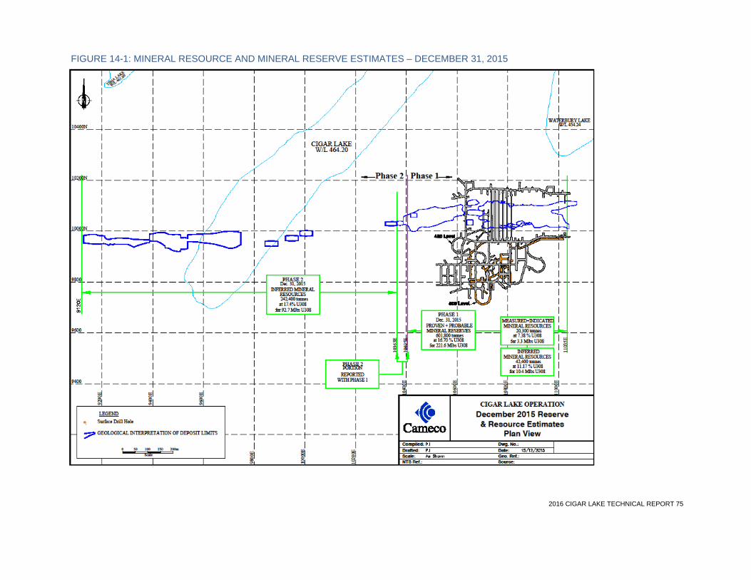
2016 CIGAR LAKE TECHNICAL REPORT 75
FIGURE 14-1: MINERAL RESOURCE AND MINERAL RESERVE ESTIMATES – DECEMBER 31, 2015

2016 CIGAR LAKE TECHNICAL REPORT 76
14.3 Geological modelling PHASE 1 A 3D model of Phase 1, based on the latest drillhole data, was created in 2015 using a combination of ARANZ Geo’s Leapfrog Geo (version 2.2.1) and Maptek Vulcan (version 9.1.3) mining software. This model was created from the geological interpretation of mineralized domains using lithological, structural and uranium grade information. The primary mineralized domains have been interpreted on 5 to 25 metre spaced north-south oriented vertical cross-sections and validated on plan views and in 3D. The cut-off grade used in the interpretations was 1.0% U3O8 over 1 metre vertical width, and mineralization was extended half way to the next un-mineralized drillhole or up to a maximum of 12.5 metres lateral distance.
The mineralization is interpreted as two primary (east and west) and 25 secondary pods as shown in the figure below.
FIGURE 14-2: ISOMETRIC VIEW OF PHASE 1 MINERALIZED PODS

2016 CIGAR LAKE TECHNICAL REPORT 77
Encapsulated within the primary east and west pods are high-grade domains which were interpreted using cut-off grades of 35% U3O8 and 30% U3O8, respectively (see Figure 14-3 and Figure 14-4).
FIGURE 14-3: PLAN VIEW – PHASE 1 INTERNAL HIGH-GRADE DOMAINS WITHIN PRIMARY EAST AND WEST PODS
High grade shown in orange, primary east and west pods shown in gold.
FIGURE 14-4: VERTICAL SECTION LOOKING WEST – PHASE 1 MINERALIZED DOMAINS
Section 10831E (+/- 2 m) showing internal high-grade domain (red) within primary east pod (gold) relative to drill composite grades and unconformity surface (grey).
The west pod high-grade domain was interpreted using an explicit modelling approach from polylines digitized on sections similar to the one used for the lower grade outer primary pods. The east pod high-grade domain was developed using an implicit modelling technique, with Leapfrog indicator interpolant workflow. In this workflow, the unconformity surface and other interpreted polylines were used as structural trends to impose an overprinting control on the interpolation parallel to these features.
The Phase 1 model was developed from 801 drillholes, of which 641 intersected mineralization above the specified cut-off criteria. These holes are comprised of underground and surface diamond drillholes as well as surface freezeholes. Underground freezeholes were not used in the

2016 CIGAR LAKE TECHNICAL REPORT 78
2015 mineral resource estimate due to data quality concerns and their redundancy given the presence of overlapping surface freezehole data.
PHASE 2 The Phase 2 area was originally defined by 19 mineralized drillholes prior to the 2011 to 2012 drilling program, which targeted the interpreted higher grade western portion. The program added another 32 surface drillholes, of which 25 intersected significant mineralization. Due to the relatively wide spaced drilling information and limited understanding of the mineralization controls, the interpretation used structural information and geological concepts from Phase 1 and similar unconformity deposits.
The majority of the Cigar Lake Phase 2 mineralization has been interpreted to be vertically stratified in two separate lenses proximal and adjacent to the unconformity surface, and appears to be offset horizontally and vertically in several pods. The two main lenses are separated by up to 3 metres of barren rock. A number of secondary perched domains above the unconformity were modelled as part of the 2012 update and may have different controls than the main zones. The cut-off grade used in the interpretations was 1.0% U3O8 over 1 metre vertical width.
For Phase 2, the boundaries of the model were extrapolated halfway to the next section to a maximum of 25 metres along strike and 12.5 metres across strike. The model was interpreted using an explicit modelling approach built in Maptek Vulcan (version 8.1.3) from polylines digitized on north-south oriented vertical sections spaced approximately 12.5 to 25 metres apart. The interpretation was validated on plan views and in 3D.
The Cigar Lake Phase 2 mineralization was interpreted into 21 pods, either at the unconformity or perched domains and two “secondary” domains (Figure 14-5 and Figure 14-6). The unconformity pods are the primary zones of mineralization, while the other pods are more variable and of lower grade. Due to the limited drill density in most pods and the spatial segregation of mineralization styles and types, it was determined that internal high-grade domaining was not warranted at this time.

2016 CIGAR LAKE TECHNICAL REPORT 79
FIGURE 14-5: ISOMETRIC VIEW OF PHASE 2 MINERALIZED PODS
FIGURE 14-6: VERTICAL SECTION LOOKING WEST – PHASE 2 MINERALIZED PODS
Section 9170E (+/- 8 m) showing unconformity (gold) and perched (blue) pods, relative to drill composite grades and unconformity (grey).
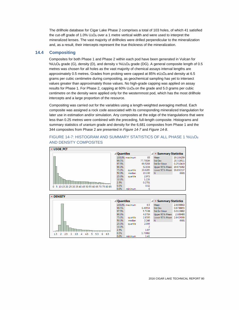
2016 CIGAR LAKE TECHNICAL REPORT 80
The drillhole database for Cigar Lake Phase 2 comprises a total of 103 holes, of which 41 satisfied the cut-off grade of 1.0% U3O8 over a 1 metre vertical width and were used to interpret the mineralized lenses. The vast majority of drillholes were drilled perpendicular to the mineralization and, as a result, their intercepts represent the true thickness of the mineralization.
14.4 Compositing Composites for both Phase 1 and Phase 2 within each pod have been generated in Vulcan for %U3O8 grade (G), density (D), and density x %U3O8 grade (DG). A general composite length of 0.5 metres was chosen for all holes as the vast majority of chemical assays interval lengths are approximately 0.5 metres. Grades from probing were capped at 85% eU3O8 and density at 6.5 grams per cubic centimetre during compositing, as geochemical sampling has yet to intersect values greater than approximately those values. No high-grade capping was applied on assay results for Phase 1. For Phase 2, capping at 60% U3O8 on the grade and 5.0 grams per cubic centimetre on the density were applied only for the westernmost pod, which has the most drillhole intercepts and a large proportion of the resource.
Compositing was carried out for the variables using a length-weighted averaging method. Each composite was assigned a rock code associated with its corresponding mineralized triangulation for later use in estimation and/or simulation. Any composites at the edge of the triangulations that were less than 0.25 metres were combined with the preceding, full-length composite. Histograms and summary statistics of uranium grade and density for the 6,681 composites from Phase 1 and the 344 composites from Phase 2 are presented in Figure 14-7 and Figure 14-8.
FIGURE 14-7: HISTOGRAM AND SUMMARY STATISTICS OF ALL PHASE 1 %U3O8 AND DENSITY COMPOSITES
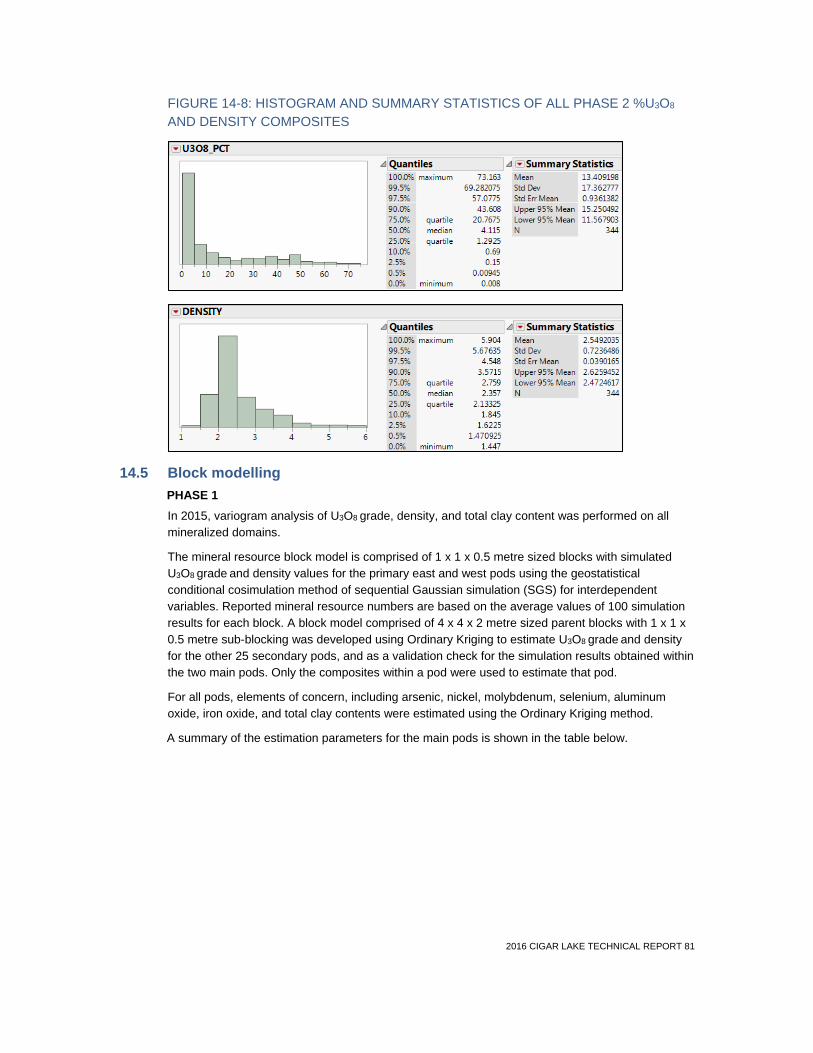
2016 CIGAR LAKE TECHNICAL REPORT 81
FIGURE 14-8: HISTOGRAM AND SUMMARY STATISTICS OF ALL PHASE 2 %U3O8 AND DENSITY COMPOSITES
14.5 Block modelling PHASE 1 In 2015, variogram analysis of U3O8 grade, density, and total clay content was performed on all mineralized domains.
The mineral resource block model is comprised of 1 x 1 x 0.5 metre sized blocks with simulated U3O8 grade and density values for the primary east and west pods using the geostatistical conditional cosimulation method of sequential Gaussian simulation (SGS) for interdependent variables. Reported mineral resource numbers are based on the average values of 100 simulation results for each block. A block model comprised of 4 x 4 x 2 metre sized parent blocks with 1 x 1 x 0.5 metre sub-blocking was developed using Ordinary Kriging to estimate U3O8 grade and density for the other 25 secondary pods, and as a validation check for the simulation results obtained within the two main pods. Only the composites within a pod were used to estimate that pod.
For all pods, elements of concern, including arsenic, nickel, molybdenum, selenium, aluminum oxide, iron oxide, and total clay contents were estimated using the Ordinary Kriging method.
A summary of the estimation parameters for the main pods is shown in the table below.

2016 CIGAR LAKE TECHNICAL REPORT 82
TABLE 14-1: SUMMARY OF PHASE 1 SEARCH PARAMETERS FOR SGS MODEL (U3O8 and DENSITY)
West pod outer West pod high grade
East pod outer East pod high grade
U3O8 Density U3O8 Density U3O8 Density U3O8 Density
Bearing 080 080 080 080 100 100 100 100
Dip 0 0 0 0 0 0 0 0
Plunge 0 0 0 0 0 0 0 0
Major axis (m) 60 70 60 70 80 70 75 80
Semi-major axis (m)
30 30 30 30 20 20 20 30
Minor axis (m) 4 5 4 5 4 4 5.5 5
PHASE 2 The 3D mineralization wireframes, created for each of the 21 pods, were used to assign numeric code values to the block model and limit the composite influences to their respective domains. The block model is comprised of 16 x 12 x 3 metre parent blocks and sub-blocks, with a minimum block size of 1 x 1 x 0.5 metres to accurately reflect the interpreted limits and volumes of the mineralization. Drillhole spacing and selective mining unit considerations were also taken into account. A multi-variable density regression curve, which was developed from measured drill core density values from the Phase 1 area was used to calculate the density for each sample in the estimation.
Given that reasonable variograms could not be generated due to the relatively sparse amount of drilling data, the inverse distance squared interpolation method was used to estimate G, D and DG. The final grade for each block was calculated by dividing the estimated DG by the estimated D to account for the density impact of high-grade mineralization. The estimates were constrained by the wireframe of each domain. The search parameters were based on information from the 2011 Cigar Lake Phase 1 estimate.
TABLE 14-2: SUMMARY OF PHASE 2 SEARCH PARAMETERS FOR ID2 MODEL
Bearing 090
Dip 0
Plunge 0
Major axis (m) 60
Semi-major axis (m) 30
Minor axis (m) 10

2016 CIGAR LAKE TECHNICAL REPORT 83
14.6 Validation Block models were validated as per Cameco standard procedures involving several methods, including but not limited to: visual review, statistical checks, spatial distribution plots, stage-gate peer reviews and estimation via alternative methods. The methodology, parameters and results of the SGS estimation method were discussed and reviewed by an expert from an external consulting firm. Further supporting the resource estimate parameters and methodologies is the fact that the mineral reserves estimate reconciles to within 7% on tonnage, 5% on grade and 2% on uranium content with the mill feed and inventories for 2014 and 2015 as shown in the table below.
TABLE 14-3: RECONCILIATION OF PRODUCTION AND MODEL
Mill feed & inventories Mineral reserves model % difference production vs
mineral reserves
Year(s) Tonnes (x 1,000)
Grade % U3O8
U3O8
(M lbs) Tonnes (x1,000)
Grade % U3O8
U3O8
(M lbs) Tonnes Grade Lbs U3O8
2014 - 2015 30.3 20.0 13.390 28.4 21.0 13.159 7% -5% 2%

2016 CIGAR LAKE TECHNICAL REPORT 84
14.7 Mineral resource classification The criteria for classification of mineral resources are predicated on the confidence within the geological interpretation and continuity of uranium mineralization between sample locations, the estimation confidence and the drilling density. The general criteria for each mineral resource category are as follows:
Measured resources: detailed drillhole spacing (<10 metres on average between drillholes with assay or probing results) supported by surface freezehole drilling and have demonstrated both geological and grade continuity between drillholes (i.e. high level of confidence in, and understanding of, the geology and controls of the mineral deposit and no significant geological uncertainties remain that could greatly alter the current interpretation).
Indicated resources: good drillhole spacing (10 to 35 metres on average between drillholes), demonstrate good geological continuity (i.e. some geological questions remain that could alter the current interpretation but to a lesser degree) and moderate grade variability between drillhole intercepts.
Inferred resources: sparse drillhole spacing (>35 metres on average between drillholes or a pod defined by limited drillhole intercepts) with uncertain geological continuity (i.e. geological questions remain that could lead to large changes in the current interpretation) and a high degree of grade variability between drillhole intercepts.
PHASE 1 AREA The mineral resource classification for Phase 1 is shown in Figure 14-9.
There are a total of two main (east and west) and 25 secondary pods comprising the resource model. All are included in the mineral resource. The increased proportion of measured resources in the current classification, when compared to the previous mineral resource estimate, is due to the detailed geological information obtained from surface freeze drilling in the Phase 1 area.

2016 CIGAR LAKE TECHNICAL REPORT 85
FIGURE 14-9: PHASE 1 MINERAL RESOURCE CLASSIFICATION – PLAN VIEW

2016 CIGAR LAKE TECHNICAL REPORT 86
PHASE 2 AREA The mineral resource classification for Phase 2 is shown in Figure 14-10.
There are 21 pods comprising the geological model for the Phase 2 area; however, three of these pods are deemed too geologically uncertain to be included within the inferred resource category. The final mineral resource is composed of 18 pods.
The Phase 2 area has been classified as inferred mineral resources. Locally, some areas of the deposit have drilling density of approximately 10 to 30 metre spacing; however, geological uncertainties remain given the absence of a robust geological model. There are no measured or indicated mineral resources for Phase 2 beyond the small portion that is reported with Phase 1 as previously discussed.
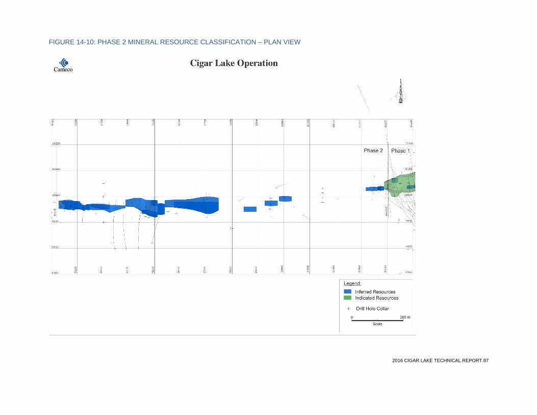
2016 CIGAR LAKE TECHNICAL REPORT 87
FIGURE 14-10: PHASE 2 MINERAL RESOURCE CLASSIFICATION – PLAN VIEW

2016 CIGAR LAKE TECHNICAL REPORT 88
The Cigar Lake mineral resources, exclusive of mineral reserves, with an effective date of December 31, 2015, are presented in Table 14-4. Alain G. Mainville, P. Geo. with Cameco, is the qualified person within the meaning of NI 43-101 for the purpose of the mineral resource estimates.
TABLE 14-4: CIGAR LAKE MINERAL RESOURCES – DECEMBER 31, 2015
Category Area Total tonnes (x 1,000)
Grade % U3O8
Total M lbs U3O8
Cameco’s share M lbs U3O8
Measured and indicated
Measured Phase 1 2.7 6.06 0.4 0.2
Indicated Phase 1 17.5 7.59 2.9 1.5
Total measured and indicated 20.3 7.38 3.3 1.6
Inferred
Inferred Phase 1 42.4 11.17 10.4 5.2
Inferred Phase 2 242.4 17.35 92.7 46.4
Total inferred 284.7 16.43 103.1 51.6
Notes: (1) Cameco reports mineral reserves and mineral resources separately. Reported mineral resources do not include amounts identified as mineral reserves. Totals may not add up due to rounding.
(2) Cameco’s share is 50.025% of total mineral resources.
(3) Inferred mineral resources are estimated on the basis of limited geological evidence and sampling, sufficient to imply—but not verify—geological and grade continuity. They have a lower level of confidence than that applied to an indicated mineral resource and cannot be directly converted to a mineral reserve.
(4) Mineral resources have been estimated with a minimum mineralization thickness of 1 metre and a cut-off grade of 1.0% U3O8, based on the use of the JBS method combined with bulk freezing of the orebody.
(5) The mineralized domains have been interpreted from drillhole information on vertical cross-sections or with 3D implicit modelling and validated on plan views and in 3D.
(6) Mineral resources have been estimated with no allowance for mining dilution and mining recovery.
(7) Mineral resources were estimated using 3D block models.
(8) There are no known environmental, permitting, legal, title, taxation, socio-economic, political, marketing or other relevant factors that could materially affect the above estimate of mineral resources.
(9) Mineral resources that are not mineral reserves do not have demonstrated economic viability.
(10) Phase 1 mineral resources are inclusive of a small proportion of Phase 2 mineral resources situated west of the Phase 1/Phase 2 boundary.
CHANGES TO MINERAL RESOURCE ESTIMATE The differences between the 2015 and the 2014 year-end mineral resource estimates reflect changes mainly due to:
• addition of 150 surface freezeholes in portions of the Phase 1 area
• removal of all historic underground freeze drillholes (186 historic underground freeze and temperature drillholes) due to redundancy and data quality concerns
• re-interpretation of the mineralized envelopes of the Phase 1 area

2016 CIGAR LAKE TECHNICAL REPORT 89
• reclassification of the mineral resources
The mineral resource classification is based on the criteria laid out in Section 14.2. A summary of the changes in mineral resources is shown in Table 14-5.
TABLE 14-5: CHANGES IN MINERAL RESOURCES
Year-end 2014 Year-end 2015 Change
Category Total
tonnes (x 1,000)
Grade
% U3O8
Total
M lbs U3O8
Total
tonnes (x 1,000)
Grade
% U3O8
Total
M lbs U3O8
Total
M lbs U3O8
Cameco’s share
M lbs U3O8
Measured 4.7 12.00 1.2 2.7 6.06 0.4 -0.8 -0.4
Indicated 19.6 8.09 3.5 17.5 7.59 2.9 -0.6 -0.3
Total measured and indicated
24.2 8.84 4.7 20.3 7.38 3.3 -1.4 -0.7
Inferred
293.7
16.22
105.0
284.7
16.43
103.1
-1.9
-1.0
Notes: (1) Cameco reports mineral reserves and mineral resources separately. Reported mineral resources do not include amounts identified as mineral reserves. Totals may not add up due to rounding.
(2) Cameco’s share is 50.025% of total mineral resources.
(3) Inferred mineral resources are estimated on the basis of limited geological evidence and sampling, sufficient to imply—but not verify—geological and grade continuity. They have a lower level of confidence than that applied to an indicated mineral resource and cannot be directly converted to a mineral reserve.
14.8 Factors that could materially affect the mineral resource estimate In the Phase 2 area, where there is still relatively sparse drilling density, weaker apparent geological continuity, and a high degree of uranium grade variability, drilling to date is not sufficient to represent this part of the deposit well enough to permit the classification of indicated or measured mineral resources. Future drilling in the Phase 2 area has potential to result in a change in the Phase 2 mineral resources, given the relatively limited amount of drillhole information informing the geological model. A drilling program began in 2016 to better define the resource.
The Cigar Lake drillhole database is considered to be very reliable. Any potential errors which may be present are not expected to cause any significant changes to the mineral resource model.
As is the case for most mining projects, the extent to which the estimate of mineral resources may be affected by environmental, permitting, legal, title, taxation, socio-economic, political, marketing or other relevant factors could vary from material gains to material losses. The qualified person responsible for the mineral resource estimate is not aware of relevant factors that could materially affect the mineral resource estimate.

2016 CIGAR LAKE TECHNICAL REPORT 90
15 Mineral reserve estimates
15.1 Definitions The Cigar Lake mineral reserve estimate has been updated and reviewed by Cameco. Internal peer reviews have been conducted. No independent verification of the current mineral reserve estimate was performed.
The mineral reserves include allowances for dilution and mining recovery. Stated mineral reserves are derived from estimated quantities of mineral resources recoverable by a proven mining method. Mineral reserves include material in place and stored on surface and underground. Only mineral reserves have demonstrated economic viability. Only Phase 1 indicated and measured mineral resources are considered for conversion to mineral reserves. Phase 2, with only inferred mineral resources, has no mineral reserves.
The classification of mineral reserves and the subcategories of each conform to the definitions adopted by the Canadian Institute of Mining, Metallurgy and Petroleum (CIM) Council on May 10, 2014, which are incorporated by reference in NI 43-101.
15.2 Key assumptions, parameters and methods Mineral reserves are based upon estimated quantities of uranium recoverable by the jet boring mining method combined with bulk freezing of the orebody. Jet boring produces an ore slurry, with initial processing consisting of crushing and grinding underground at Cigar Lake followed by leaching and yellowcake production at the McClean Lake mill.
The economic basis used to define the mineral reserve is based on the incremental cost of mining and the full cost of mill processing to produce U3O8. The incremental costs chosen were used to define the minimum number of pounds of recoverable uranium in a JBS cavity. The incremental costs include jet boring costs, backfilling, underground crushing and grinding, ore slurry hoisting, trucking costs from Cigar Lake to the McClean Lake mill and the full cost of processing the ore slurry to final U3O8 (yellowcake), including toll milling fees.
Incremental costs were chosen over full costs on the basis that all remaining underground mining costs and all surface costs were considered as fixed, meaning that the same costs would be incurred regardless of production rate or mined grade.
A summary of economic factors used to derive the mineral reserve conversion parameters is shown in the table below.
TABLE 15-1: MINERAL RESOURCE TO MINERAL RESERVE CONVERSION PARAMETERS
Uranium price $58.69 per pound (US)
Exchange rate $1.00 US = $1.16 Cdn
Mining dilution Overall average dilution of 26%, inclusive of 0.5 metres of dilution above and below the mineralization within the cavity, pilot hole dilution and backfill dilution
Mine recovery 90%
Process recovery 98.5%
The value of the ore for the purposes of calculating minimum pounds per cavity represents the value from uranium only. Trace metals such as nickel, copper, cobalt and molybdenum are considered to have no economic value. The minimum number of recoverable pounds of uranium in a cavity was estimated to be 9,000 for that cavity to be included in the mineral reserve.

2016 CIGAR LAKE TECHNICAL REPORT 91
The process for converting mineral resources to mineral reserves involved the following:
• JBS cavities were designed over the full extent of the indicated and measured mineral resources
• dilution and mining recovery parameters were assigned to each cavity to determine diluted and recovered ore tonnes and metal content in each cavity
• cavities not meeting minimum recovered metal content criteria were excluded from the mineral reserves
Figure 15-1 shows the diluted grade distribution of the JBS cavities for the Phase 1 portion of the deposit after application of the cut-off criteria. The key assumptions, parameters and methods used to estimate the mineral reserves are as follows:
Key assumptions
• mineral reserves have been estimated with an average allowance of 26% dilution at 0% U3O8, inclusive of 0.5 metres of dilution material above and below the planned cavity, and dilution contributions from pilot holes and adjacent backfill
• mineral reserves have been estimated based on 90% mining recovery, with a mill recovery factor of 98.5%. Mineral resources do not include such allowances
• mining rates are assumed to vary between 100 and 200 tonnes per day, and a full mill production rate is assumed to be approximately 18 million pounds U3O8 per year
• areas being mined must meet specific ground freezing requirements before jet boring begins
• an average uranium price of $58.69 (US) per pound with a $1.00 US to $1.16 Cdn fixed exchange rate was used to estimate the mineral reserves
Key parameters
• mineral reserves have been estimated on the basis of designed JBS cavities containing greater than 9,000 pounds of recovered uranium
Key methods
• the mining applications used were Maptek Vulcan and Leapfrog Geo

2016 CIGAR LAKE TECHNICAL REPORT 92
FIGURE 15-1: PHASE 1 ESTIMATED JBS CAVITY GRADE DISTRIBUTION – PLAN VIEW

2016 CIGAR LAKE TECHNICAL REPORT 93
15.3 Mineral reserves estimation and classification In order to convert mineral resources to mineral reserves, a viable mine layout and realistic allowances for recovery and dilution must be applied. The current mining project has been designed to extract the mineral reserves in Phase 1. Further drilling and mining studies are needed before the remaining Phase 1 mineral resources can be better evaluated.
The mineral reserves classification follows CIM definitions, where economically mineable measured and indicated resources can be converted to proven and probable reserves, but inferred resources cannot be reported as mineral reserves. The Cigar Lake mineral reserves are defined by applying factors for mining recovery and dilution to the indicated and measured resources. Mill recovery of 98.5% has been applied in the economic model.
The Cigar Lake mineral reserves estimates, with an effective date of December 31, 2015, are shown in Table 15-2. C. Scott Bishop, P. Eng., Alain G. Mainville, P. Geo., and Leslie D. Yesnik, P. Eng., each with Cameco, are the qualified persons within the meaning of NI 43-101 for the purpose of the mineral reserve estimates.
TABLE 15-2: CIGAR LAKE MINERAL RESERVES – DECEMBER 31, 2015
Category Area Total tonnes (x 1,000)
Grade % U3O8
Total M lbs U3O8
Cameco’s share M lbs U3O8
Proven Broken 2.4 24.56 1.3 0.6
Phase 1 223.7 21.91 108.1 54.1
Total proven 226.1 21.93 109.3 54.7
Probable Phase 1 375.7 13.55 112.3 56.2
Total probable 375.7 13.55 112.3 56.2
Total reserves 601.8 16.70 221.6 110.9
Notes: (1) Cameco reports mineral reserves and mineral resources separately. Totals may not add up due to rounding.
(2) Total pounds U3O8 are those contained in mineral reserves and are not adjusted for the estimated mill recovery of 98.5%.
(3) Cameco’s share is 50.025% of total mineral reserves.
(4) Mineral reserves have been estimated on the basis of designed JBS cavities containing greater than 9,000 pounds of recovered uranium.
(5) The mineralized domains have been interpreted from drillhole information on vertical cross-sections or with 3D implicit modelling and validated on plan views and in 3D.
(6) Mineral reserves have been estimated with an average allowance of 26% dilution at 0% U3O8, inclusive of 0.5 metres of dilution material above and below the planned cavity.
(7) Mineral reserves have been estimated based on 90% mining recovery.
(8) Mineral reserves were estimated based on the use of the JBS mining method combined with bulk freezing of the orebody. Jet boring produces an ore slurry with initial processing consisting of crushing and grinding underground, and leaching and yellowcake production at the McClean Lake mill. Mining rate assumed to vary between 100 and 200 tonnes per day, and a full mill production rate of approximately 18 million pounds U3O8 per year. The reference point at which mineral reserves are defined is the McClean Lake mill.
(9) Mineral reserves were estimated using a 3D model.

2016 CIGAR LAKE TECHNICAL REPORT 94
(10) An average uranium price of $58.69 per pound (US) U3O8 with a $1.00 US = $1.16 Cdn fixed exchange rate was used to estimate the mineral reserves. The price assumption is based on independent industry and analyst estimates of spot prices and the corresponding long-term prices, and reflects Cameco’s committed and uncommitted sales volumes. For committed sales volumes, the spot and term price assumptions were applied in accordance with the terms of the agreements. For uncommitted sales volumes, the same price assumptions were applied using a spot-to-term price ratio of 60:40.
(11) Phase 1 mineral reserves are inclusive of a small proportion of Phase 2 mineral reserves situated west of the Phase 1/Phase 2 boundary.
(12) Other than the challenges related to water inflows, jet boring and geotechnical issues described in Section 15.4, there are no known mining, metallurgical, infrastructure, permitting, or other relevant factors that could materially affect the above estimate of mineral reserves.
CHANGES TO MINERAL RESERVE ESTIMATE The differences between the 2015 and the 2014 year-end mineral reserve estimates are mainly due to:
• removal of the reserve estimates for the mined cavities contributing to the mill feed to December 31, 2015
• incorporation of new surface freezehole data
• re-interpretation of the mineralized envelopes of Phase 1
• revised mine layout and dilution assumptions
• reclassification of the mineral resources and mineral reserves, based on drillhole spacing, geological and grade continuity, estimation confidence and reconciliation of mined production to the end of 2015
• updated mine operating cost estimates
• metal price and exchange rate assumptions
A summary of the changes in mineral reserves is shown in the table below.
TABLE 15-3: CHANGES IN MINERAL RESERVES
Year-end 2014 Year-end 2015 Change Mill feed (year-end
2015)
Category
Total tonnes (x 1,000)
Grade
% U3O8
Total M lbs U3O8
Total tonnes (x 1000)
Grade
% U3O8
Total M lbs U3O8
Total M lbs U3O8
Cameco’s share M lbs U3O8
Total M lbs U3O8
Proven 205.6 24.0 108.8 226.1 21.9 109.3 0.5 0.3 12.1
Probable 391.6 14.6 126.1 375.7 13.5 112.3 -13.8 -6.9 0
Total proven and probable
597.2 17.8 234.9 601.8 16.7 221.6 -13.3 6.7 12.1
Notes: (1) Cameco reports mineral reserves and mineral resources separately. Totals may not add up due to rounding.
(2) Cameco’s share is 50.025% of total pounds U3O8.
2016 CIGAR LAKE TECHNICAL REPORT 95
15.4 Factors that could materially affect the mineral reserves estimate There are no relevant factors known to the authors of this section that could materially affect the mineral reserve estimate, except as follows:
WATER INFLOWS A significant risk to development and production is from water inflows. The sandstone overlying the basement rock at Cigar Lake contains large volumes of water at significant pressure. Despite the important mitigation measures Cameco has put in place, there remains a possibility of a water inflow during mine development and JBS mining. The consequences of another water inflow will depend upon the magnitude, location and timing of any such event, but could include a significant delay in Cigar Lake’s development or production, a material increase in costs, a loss of mineral reserves, or require Cameco to give notice to many of its customers that it is declaring an interruption in planned uranium supply. Such consequences could have a material adverse impact on Cameco. Water inflows are generally not insurable.
MODIFYING FACTORS ASSOCIATED WITH JET BORING One area of uncertainty with the mineral reserve estimate is associated with mining and the jet boring mining method, which prior to 2014 had not been used on a large production scale basis. Values for factors such as mine recovery and dilution have been based on mining experience to date; however, these may change based on additional production experience as Cigar Lake ramps up to full production. Similarly, mining and production costs, which directly impact minimum recovered pounds of uranium per cavity, are based on production experience to date, and may change with further production experience. Nevertheless, it is considered that reasonable assumptions have been used based on production values to the end of 2015.
The jet boring mining method and the overall mining and freezing plans for Cigar Lake have been developed specifically to mitigate the mining challenges, such as the low strength of the rock formation, the groundwater and the high level radiation, and to mine the deposit in a safe and economic manner. Unexpected geological or hydrological conditions or adverse mining conditions could lead to losses of mineral reserves. These issues could also delay production and increase costs.
GEOTECHNICAL CHALLENGES Challenging geotechnical conditions combined with additional ground stress induced by artificial ground freezing and proximal development has resulted in unplanned rehabilitation work on the production tunnel liners, which results in a production interruption from the affected tunnel. Rehabilitation-induced production interruptions of a moderate nature are factored into the overall production plan. However, there is a risk that more extensive work may be required should deterioration trends worsen compared to historic levels. The requirement for extensive rehabilitation work on the New Austrian Tunnelling Method (NATM) tunnel liners could result in production deferral, and potentially the partial loss of mineral reserves.
The extent to which mineral reserves may be affected by the foregoing issues could vary from material gains to material losses.

2016 CIGAR LAKE TECHNICAL REPORT 96
16 Mining method
16.1 Design parameters This section describes the technical aspects of the planned underground mine, including geotechnical and hydrogeological parameters, test mining activities, selection of mining method, mine design, mine development requirements, mine production, backfilling and mine equipment requirements.
GEOTECHNICAL CHARACTERISTICS OF THE DEPOSIT Two of the primary geotechnical challenges in constructing the mine are control of groundwater and ground support in areas of weak rock. These challenges occur in proximity to the deposit within the altered overlying sandstone and underlying basement lithology, particularly in areas where fault zones and/or major fracture zones are located.
On the basis of drilling and mapping of mine development completed to the end of 2015, a geotechnical rockmass interpretation has been developed for the Phase 1 area of the Cigar Lake deposit. Three main geotechnical domains have been defined using Bieniawski’s Rock Mass Rating (RMR89) System, as illustrated in Figure 16-1. These domains consist of the following categories:
• RM1 Domain: RMR rating between 0 and 20, a very weak rockmass associated with intense to strong clay alteration of the host lithology
• RM2 Domain: RMR rating between 20 and 45, locally weak to moderately competent rockmass associated with moderate to locally strong clay alteration and moderate to strong fracturing of the host lithology
• RM3 Domain: RMR rating > 45, a competent rockmass consisting of weak to no clay alteration and weak to moderate fracturing
Clay alteration, a defining criteria of the RMR domains, is closely associated with major fault zones located within the deposit area. Four major fault orientations, all steeply dipping, have been delineated within the Cigar Lake deposit area, consisting of:
• east-west trending structures, including:
o shears zones (protomylonites)
o semi-brittle faults zones
o graphitic fault (breccia) zones
o non-graphitic fault zones
• northwest fracture/dissolution zone
• northeast trending faults
• north trending faults
The main east-west fault zones consist of graphitic breccia zones that are up to several metres wide and coincide with the basement high along which the deposit is located. The northwest and northeast trending fault zones intersect the main east-west structural corridor in the central portion of the Phase 1 area, and this intersection locale controls the most extensive clay alteration observed at the ore horizon and the main mining horizon. A schematic geological vertical section depicting the clay alteration profile is provided in Figure 16-2.

2016 CIGAR LAKE TECHNICAL REPORT 97
FIGURE 16-1: GEOTECHNICAL DOMAINS OF THE 480 MINE LEVEL WITH INTERPRETED FAULT ZONES

2016 CIGAR LAKE TECHNICAL REPORT 98
FIGURE 16-2: GEOTECHNICAL SCHEMATIC CROSS SECTION – LOOKING WEST

2016 CIGAR LAKE TECHNICAL REPORT 99
HYDROGEOLOGY The deposit and sandstone are highly fractured. Post-mineralization fracturing is the dominant control of hydraulic conductivity, and where it transects the deposit, fracturing acts as conduits for water. The basement rocks are much tighter, with very minimal groundwater flow, although there are localized areas of poor ground conditions that are susceptible to higher rates.
Hydrogeological studies have been completed in conjunction with geotechnical investigations. A 3D groundwater flow model was constructed in 2013 based on an interpreted geological model developed from data collected from diamond drill core, mine development and geophysical investigations.
The most permeable zones occur in the fractured sandstones surrounding the deposit. Within the basement rock mass, the hydraulic conductivity is entirely fracture controlled and two to three orders of magnitude below that of sandstone, typically due to the tightness of the fracturing and the clay and chlorite alteration of fracture surfaces.
The primary risk associated with the highly fractured rock mass surrounding the deposit is the potential for high and uncontrolled groundwater inflow into the underground workings arising from mining activities, particularly:
• falls of ground that make connection with the overlying water-bearing zones
• holes drilled from the basement rocks that connect with the water-bearing zones
• intersections of faults or areas of weak (highly permeable) ground connecting to the water-bearing zones
Three water inflows, including the October 2006 inflow on the 465 metre level and the August 2008 inflow on the 420 metre level, which resulted in the flooding of the mine, resulted in a re-evaluation and revision of the mine design and practices to minimize water inflow risk. The minewater management system is described in Section 16.2.
TEST MINING ACTIVITIES The boxhole boring and the jet boring mining methods were both successfully field tested at Cigar Lake during the initial test mining program. Both methods were able to utilize a non-entry approach, as mining was conducted from headings located below the orebody. The ore was collected at the bottom of the access drillholes and contained within a cuttings collection system. Ground freezing stabilized the water saturated weak rock mass in which the orebody occurs, and effectively prevented any possible inrush of groundwater. Through the application of non-entry mining methods, the containment of the ore cuttings within cuttings collection systems, and the application of ground freezing, the levels of radiation exposure to workers were acceptable and below regulatory limits. Experience with non-entry raisebore mining of high-grade uranium ore at Cameco’s McArthur River mine has demonstrated the effectiveness of this mining approach to manage radiation exposures.
Following the completion of the test mining programs, the jet boring method was selected over boxhole boring as the safest and most viable economic method of mining in the Phase 1 area of the orebody. Overall, the test mining programs were considered successful, with the initial objectives achieved. An estimated total of 767 tonnes of mineralized material with an average grade of 17.4% U3O8 was mined during the various mining tests.
Today, mining rates and cycle time sustainability congruent with underlying project assumptions have been demonstrated. Overall performance of the jet boring method has met all criteria. Cameco continues to assess the full potential of the mining method and seeks to improve upon established performance levels.

2016 CIGAR LAKE TECHNICAL REPORT 100
16.2 Mine design OVERVIEW Facilities and services required for the mine generally include:
• two service shafts for mine access and ventilation
• access drifts and production crosscuts
• ore processing facilities
• support facilities, including maintenance shop, electrical substations, sumps, pump stations and storage areas
• ground freezing infrastructure and equipment (surface)
The orebody is mined using a series of crosscuts and access drifts on the 480 metre level. A strategy of bulk freezing the orebody was adopted to minimize the risk of large water inflows, control radiation resulting from radon being released from flowing water, and increase the strength of the rock to be mined. Freezing has been undertaken from both the 480 metre level and from surface. After an extensive freeze study conducted by Cameco and peer reviewed by external freezing consultants, the CLJV decided in 2015 to continue exclusively with surface freezing for the entire extent of the Cigar Lake Phase 1 orebody. All production mining is planned to occur from the 480 metre level using the jet boring mining method.
Mined ore from the jet bore units is pumped to the run of mine ore receiving facility on the 480 metre level. From there, the ore is put through an underground crushing, grinding and clarification circuit before being pumped to surface through one of two ore slurry pipe lines installed in Shaft No. 2. More detail about ore processing can be found in Section 17.
Figure 16-3 provides a 3D view of the existing and planned development for the Cigar Lake mine. The layout is a function of the jet boring method and the need to freeze the orebody due to ground conditions and groundwater and radon control issues. The layout is also a function of overall ventilation, radiation protection and support services requirements.
The following subsections describe in more detail the infrastructure and development activities planned as part of the Phase 1 life-of-mine plan.

2016 CIGAR LAKE TECHNICAL REPORT 101
FIGURE 16-3: THREE-DIMENSIONAL GENERAL MINE LAYOUT – LOOKING NORTHWEST

2016 CIGAR LAKE TECHNICAL REPORT 102
MINE ACCESS Shaft No. 1
• purposes: main access to mine workings, main service and access shaft during production, provides fresh air to underground
• depth: surface to depth of 500 metres
• internal diameter: 4.9 metres
• characteristics: circular, concrete lined with a hydrostatic liner
• a drift connecting the shaft bottom and 500 metre level facilitates maintenance and removal of spillage from waste rock hoisting
Shaft No. 2
• purposes: access for personnel and materials to 480 metre level, ventilation, secondary egress, ore slurry hoisting
• location: ~90 metres south of Shaft No. 1
• depth: surface to depth of 500 metres
• internal diameter: 6.1 metres
• characteristics: circular, non-hydrostatic liner to depth of ~368 metres and between the 480 and 500 metre levels; remainder has hydrostatic liner comprised of cast-iron tubbing and concrete
o central airtight partition divides the shaft into two independent compartments: one serves as the main path for exhaust air from the mine, and the second is used as a downcast of additional fresh air, while also housing the service cage used for secondary egress
o shaft services: ore slurry pipes, concrete slick lines, power cables, communication cable
MINE DEVELOPMENT There are two main levels in the mine: the 480 and 500 metre levels. Both levels are located in the basement rocks below the unconformity. The 420 metre level, located in the sandstone above the basement rock, no longer has a use in the updated mine plan and has been backfilled to reduce the likelihood of another inflow event similar to that of August 2008. The 465 metre level is also no longer required as part of the mine plan, and has been backfilled to reduce the likelihood of further ground failure or inflow on that horizon.
480 metre level
• provides access to production area below orebody
• typically more than 25 metres below the ore zone
• location of:
o ore recovery and reclaim water facilities, clarifier, clarifier underflow pachuca
o main underground processing and infrastructure facilities: heat exchanger room, high- pressure pump room, laboratory, electrical rooms and maintenance shops
o main mine dewatering pump station and associated electrical facilities
In the production area of the 480 metre level, access drifts will be extended on the north and south sides of the orebody. Additional production tunnels using the New Austrian Tunnelling Method (NATM) technique will be developed on 16 to 28 metre centres in a north-south orientation for the east pod of Phase 1, and east-west orientation for the west pod of Phase 1 to facilitate JBS production. Various storage facilities for mine production equipment will also be excavated off of the access drifts.
500 metre level
• access: two ramps from the 480 metre level
2016 CIGAR LAKE TECHNICAL REPORT 103
• location of:
o recycled water tank, clean and dirty sump, ball mill, base of the clarifier underflow pachuca and the ore slurry hoisting pump
o main ventilation exhaust drift (connected to 480 metre level via Shaft No. 2, the second ramp excavated on the east side of the 480 metre level, and through various ventilation boreholes drilled from the production crosscuts)
A heading has been excavated from the 500 metre level Shaft No. 1 access drift to the main mine sump, providing for expanded sump capacity and ease of operation and maintenance of the mine dewatering system.
DEVELOPMENT REQUIREMENTS DURING OPERATION Excavations still required to be completed to support production during the remainder of the mine life:
• nine production crosscuts for east pod
• access and production drifts for west pod
• various storage and service areas on the 480 metre level west pod
• west ramp to 500 metre level to connect west pod development with the existing exhaust ventilation drift
• exhaust ventilation raises between the 480 and 500 metre levels east pod
In total, approximately 7,400 metres of lateral and vertical excavation is planned to be developed over the life of the mine. As of December 31, 2015, approximately 3,900 metres of development has been completed, leaving an additional 3,500 metres required for the remainder of the mine life. The majority of the excavation work will occur on the 480 and 500 metre levels, which together represent the main operating area of the mine.
EXCAVATION AND GROUND SUPPORT METHODS Mine development for construction and operation uses two basic development approaches:
• drill and blast with conventional ground support
• NATM: this development method replaces the MDS method previously used. The NATM method includes a 5.6 metre diameter full face mechanical or drill and blast excavation, with a 300 millimetre thick sprayed shotcrete liner with embedded engineered yielding elements and lattice girders for ground support
With the exception of the NATM headings, the infrastructure excavations and the access drifts are being developed using conventional drill and blast mining methods. Geotechnical drilling and analysis of ground conditions is completed prior to confirming permanent infrastructure locations.
Cameco plans its mine development to take place away from known groundwater sources whenever possible. In addition, Cameco assesses all planned mine development for relative risk and applies extensive additional technical and operating controls for all higher risk development.
Conventional drill and blast development A drill and blast method, utilizing full face advance, is being applied in the competent ground, primarily for access drifts surrounding the orebody and for infrastructure excavations. Grouted rebar and shotcrete are used as the primary support system. Wire mesh and straps are used locally, as required. Rockbolt spacing and shotcrete thickness vary with localized ground conditions. Spiling installed ahead of the excavation is used locally in poor ground. Cable bolts, typically five metres in length, are also being installed in the back of large excavations, such as the clarifier and ball mill room, as well as at most intersections. Modified excavation techniques or additional ground
2016 CIGAR LAKE TECHNICAL REPORT 104
support, such as steel arches, will be applied in areas of poor ground conditions in the access drifts.
NATM Since 2010, when the mine was dewatered, Cameco identified significant spalling, cracking and deterioration of the tunnel segments in all four crosscuts excavated with the former MDS tunnel boring technique. Cameco has taken steps to halt the deterioration and has reinforced the affected area. Cameco retained two geotechnical consultants to provide advice on the need for any possible further tunnel reinforcement or change in excavation and ground support methodology. Based on their recommendations, Cameco has retrofitted the 781 and 737 production tunnels using NATM techniques, which effectively extended their life to allow the safe recovery of the ore above them. The remaining two MDS crosscuts will be permanently decommissioned and backfilled in 2016. They were originally intended to be used for ground freezing and are no longer required.
The NATM excavation and ground support technique currently used at Cigar Lake consists of the mechanical excavation of a 5.6 metre diameter full face tunnel, which is lined with a 0.3 metre thick flexible shotcrete liner, incorporating engineered yielding elements, rockbolts and lattice girders. The advantage of this excavation technique is that deformations due to ground loading around the opening can be accommodated and controlled. The rehabilitation of these tunnels is faster and more practical in case the deformations cause clearance issues for the JBS mining unit.
Mechanical excavation is being executed using two Terex Excavators (Tunnel Heading and Loading Machine).
GROUND FREEZING Experience and modelling studies have demonstrated the advantages of ground freezing over other potential ground conditioning methods. These advantages include minimization of groundwater inflows while mining, attenuation of radon release, and stabilizing the weak ore and the surrounding ground. The ground to be frozen includes the orebody, the water-bearing sandstone above the ore, as well as a zone extending both laterally away from the orebody and beneath it.
The freezing strategy is to bulk freeze the ore zone and the surrounding area, as noted above, prior to start of mining in a given area. Temperature holes installed in the area to be frozen are used to determine when the ground has reached its required temperature. Where required, the ground above tunnels may be frozen prior to development as there is a potential risk of inflow from historical unsecured surface diamond drillholes. Localized ground freezing may also be used to allow development of access drifts to take place in areas of weak ground away from the orebody.
Cameco plans to use surface freezing to freeze the ground for the production panels for the planned mine life. Included within this plan is to maintain an inventory of frozen ground equivalent to approximately one year of production ahead of mining to ensure annual production targets are achieved.
Freeze system The ground freezing system consists of ammonia refrigeration plants on surface connected to the surface brine distribution piping system and in-situ freeze pipes. The freeze plants have a current capacity of approximately 2,200 tonnes refrigerant at -30°C. This system freezes the deposit and surrounding rock to between -5°C and -15°C in two to four years, depending on freeze pipe geometry and ground properties such as water content and thermal conductivity.
For the surface freeze system, the calcium chloride brine is circulated to the collars of the freezeholes from the freeze plant via insulated pipes. As of November 1, 2015, over 600 surface freeze and temperature holes have been drilled and all freezeholes have been outfitted with brine circulation tubes. As of the end of 2015, there are 297 freezeholes actively circulating brine, and

2016 CIGAR LAKE TECHNICAL REPORT 105
over 50 have already been mined through and/or deactivated. Activations of new holes and deactivations of holes that have served their purpose will continue for the life of mine.
Freezing from surface As described in the 2012 Technical Report, ground freezing was to be accomplished using a hybrid freeze strategy of underground and surface freezing. However, based on additional studies and experience gained over the last few years, Cameco has decided to pursue a strategy of freezing exclusively from surface. The expected benefits of this change in strategy include:
• reducing risk to mine development • allowing ground freezing to start before development of underground production tunnels • simplifying mining operations since ground freezing infrastructure and activities are located on
surface
The decision to proceed with ground freezing exclusively from the surface enabled a number of modifications to the mine plan. These modifications included a reduction in the number of crosscuts beneath the orebody, re-orientation of the production tunnels beneath the west pod, and improvements to the ventilation design. The reduction and re-orientation of the production tunnels will have the added benefit of improving ground stability, reducing tunnel rehabilitation requirements and reducing the volume of waste rock that needs to be placed on surface.
Freeze and temperature holes were drilled initially on a 5 x 5 metre pattern to accelerate freeze development in the initial ore production area, and was expanded to 6 x 6 metres outside this area. Further changes in pattern size will be implemented as schedule and ground conditions dictate (refer to Figure 16-4 for a current freeze pattern schematic).
Drilling is currently done with diamond drills, although other drill rigs may be used in an attempt to improve drilling costs and productivities. Holes are being drilled to a depth of approximately 462 metres, which is approximately 15 metres below the bottom of the ore zone. A pipe delivers chilled brine to the bottom of the freezehole where it returns up the annulus between the delivery pipe and an outer freeze pipe to a depth of approximately 400 metres. A reduction adaptor is then used in the return pipe so that more heat removal occurs in the bottom portion of the hole.

2016 CIGAR LAKE TECHNICAL REPORT 106
FIGURE 16-4: FREEZEHOLE ARRANGEMENT – SCHEMATIC VERTICAL SECTION LOOKING NORTH

2016 CIGAR LAKE TECHNICAL REPORT 107
VENTILATION The mine ventilation system has been designed to supply fresh air to the working areas, remove contaminated air from the mine and reduce the potential for radon gas build-up. The designed mine ventilation volume of 240 m3/s provides sufficient airflow through the mine for use of diesel equipment and radiation protection at a sustained production rate of approximately 18 million pounds per year U3O8.
Primary system
• supplies up to 240 m3/s fresh air to the mine
• Shaft No. 1:
o fresh air intake equipped with two mine air heaters with four burners and two 250-hp fans
• Shaft No. 2:
o three 800-hp fans on surface draw contaminated mine air up through exhaust compartment
o three 200-hp fans (with mine air heaters) supply fresh air to mine via second compartment
• the mine air heaters are used during the winter months to heat the ventilating air to approximately 5°C. The heaters are direct-fired propane heaters installed at the ventilation intake locations at both Shaft No. 1 and Shaft No. 2
Auxiliary system
• draws air from the primary circuit
• uses fans and ducting to provide appropriate ventilation to the production and development headings, as well as other work areas and facilities
• local air extraction systems to remove potentially contaminated air installed at a number of locations
• once captured inside a duct, the radon contaminated air is discharged directly into a dedicated exhaust drift or raise, or ducted directly into Shaft No. 2 and discharged to surface
MINING EQUIPMENT The mining equipment list reflects the planned mining equipment requirements for mine operation and production. All of the mine equipment for mine operation is owned by Cameco, with the exception of diamond drilling equipment.
Production-related mining equipment includes three JBS units supported with two concrete pumps for backfilling purposes. A decision will be made to confirm if a fourth JBS is required before advancing to the west portion of Phase 1 orebody. Ongoing mine development is completed using conventional drilling and blasting equipment for access drifts, and NATM beneath the ore zone.
During mine operation, all freeze drilling is planned to occur from surface. A fleet of up to five freeze drills will be required to ensure freeze drilling and ground freezing is completed sufficiently ahead of planned mining activities.
Other mining equipment, such as scissor lifts and utility vehicles, are used to support the mine development and production activities.
Table 16-1 shows a list of the key underground mining equipment required for development and production.
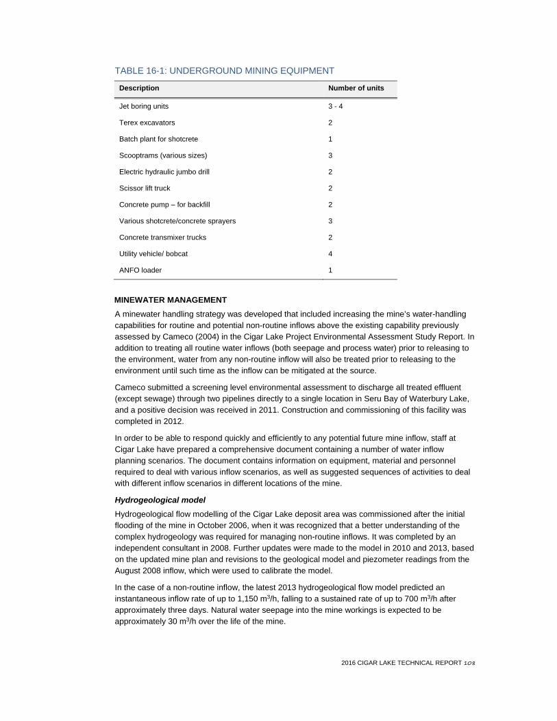
2016 CIGAR LAKE TECHNICAL REPORT 108
TABLE 16-1: UNDERGROUND MINING EQUIPMENT
Description Number of units
Jet boring units 3 - 4
Terex excavators 2
Batch plant for shotcrete 1
Scooptrams (various sizes) 3
Electric hydraulic jumbo drill 2
Scissor lift truck 2
Concrete pump – for backfill 2
Various shotcrete/concrete sprayers 3
Concrete transmixer trucks 2
Utility vehicle/ bobcat 4
ANFO loader 1
MINEWATER MANAGEMENT A minewater handling strategy was developed that included increasing the mine’s water-handling capabilities for routine and potential non-routine inflows above the existing capability previously assessed by Cameco (2004) in the Cigar Lake Project Environmental Assessment Study Report. In addition to treating all routine water inflows (both seepage and process water) prior to releasing to the environment, water from any non-routine inflow will also be treated prior to releasing to the environment until such time as the inflow can be mitigated at the source.
Cameco submitted a screening level environmental assessment to discharge all treated effluent (except sewage) through two pipelines directly to a single location in Seru Bay of Waterbury Lake, and a positive decision was received in 2011. Construction and commissioning of this facility was completed in 2012.
In order to be able to respond quickly and efficiently to any potential future mine inflow, staff at Cigar Lake have prepared a comprehensive document containing a number of water inflow planning scenarios. The document contains information on equipment, material and personnel required to deal with various inflow scenarios, as well as suggested sequences of activities to deal with different inflow scenarios in different locations of the mine.
Hydrogeological model Hydrogeological flow modelling of the Cigar Lake deposit area was commissioned after the initial flooding of the mine in October 2006, when it was recognized that a better understanding of the complex hydrogeology was required for managing non-routine inflows. It was completed by an independent consultant in 2008. Further updates were made to the model in 2010 and 2013, based on the updated mine plan and revisions to the geological model and piezometer readings from the August 2008 inflow, which were used to calibrate the model.
In the case of a non-routine inflow, the latest 2013 hydrogeological flow model predicted an instantaneous inflow rate of up to 1,150 m3/h, falling to a sustained rate of up to 700 m3/h after approximately three days. Natural water seepage into the mine workings is expected to be approximately 30 m3/h over the life of the mine.

2016 CIGAR LAKE TECHNICAL REPORT 109
Mine dewatering & treatment system The mine dewatering system was designed and constructed to handle both routine and non-routine inflows. In 2012, Cameco increased installed mine dewatering capacity to 2,500 m3/h and increased minewater treatment capacity to 2,550 m3/h. In addition, regulatory approval to discharge routine and non-routine treated water to Seru Bay was received and the system commissioned.
The mine dewatering system is comprised of three main pumping systems:
• the primary system has a designed capacity of 700 m3/h, and handles the daily routine dewatering requirements. It will also be used in the event of a non-routine inflow
• the contingency mine dewatering system has installed pumping capacity of 800 m3/h provided by high-speed multistage centrifugal pumps located in a pump room on the 480 metre level
• the third system is comprised of four borehole pumps, installed and controlled from surface, with a designed pumping capacity of 1,000 m3/h
All three pumping systems draw water from central collection sumps on the 500 metre level, the lowest working level in the mine. All of the systems are routinely tested to ensure they are operating within their required capacities.
The water treatment plant (WTP) has a capacity to treat and release mine effluent at a rate of 550 m3/h. In the case of a minewater inflow exceeding this amount, a contingency water treatment system will be activated. This system is comprised of a 90,000 m3 holding pond for water clarification and a 10,000 m3 pond for surge capacity and two reagent addition buildings with capacities of 1,000 m3/h each. The WTP currently releases treated mine effluent into Seru Bay.
With this infrastructure in place, Cameco believes it has sufficient pumping, water treatment and surface storage capacity to handle the estimated maximum inflow.
The Cigar Lake orebody contains elements of concern with respect to water quality and the receiving environment. The non-uniform distribution of elements such as arsenic, molybdenum, selenium and others varies throughout the orebody, and this can result in complications in attaining the effluent concentrations included in the licensing basis.
16.3 Mine production MINING METHOD SELECTION Jet boring has never been used as a primary extraction method at a mining operation for any commodity, so the JBS had to be developed and adapted, and continues to be refined, specifically for the Cigar Lake deposit. Selection and optimization of a mining method capable of extracting the ore efficiently and economically required addressing several geotechnical and hydrogeological challenges such as:
• the low strength of the rock formations encompassing and underlying the orebody, and necessary ground support required to stabilize these formations
• the presence of large volumes of groundwater expected to be encountered while mining the ore or drilling in the overlying sandstone rock formation (including for freezehole drilling) and the potential for a water inflow
• the high level of radiation build-up from the ore and the associated radon gas from the water in contact with the ore, necessitating containment and isolation to protect the workers
The JBS mining method and overall mining plan for Cigar Lake have been developed specifically to mitigate these challenges and mine the deposit in a safe and economic manner.
A description of the test mining activities undertaken to develop the JBS mining method can be found in Section 16.1.

2016 CIGAR LAKE TECHNICAL REPORT 110
JET BORING MINING METHOD The JBS mining method consists of cutting cavities out of frozen ore using a high-pressure water jet. Access to the orebody is achieved by drilling boreholes upwards from the production crosscuts below and then inserting specialized jetting tools to the ore horizon. Jetting begins at the top of a cavity and retreats vertically downward in thin slices, resulting in a cylindrical void with a height corresponding to the thickness of the orebody (up to 13.5 metres) and a diameter of 4.5 to 6 metres. The resulting void is tightly backfilled with concrete, and the cycle is repeated to recover adjacent ore. The advantages of jet boring as a mining method at Cigar Lake are:
• It is a non-entry mining method. Personnel do not enter the ore zone and operators can control the equipment remotely. These are two essential requirements for radiation control during mining of the high-grade deposit.
• The cutting of ore with high-pressure water produces a slurry which is pumped in pipelines. This provides the complete containment necessary for minimizing radiation exposure to workers while utilizing a relatively simple and cost effective method for pumping the slurry away from the mining area.
• The generation of airborne dust is eliminated since the cutting and material transport are both wet and contained processes. This is a significant advantage for radiation control of the mining of high-grade uranium ore.
• Water jets provide the opportunity to excavate ore next to a backfilled cavity without incurring significant dilution from concrete with careful control, through in-hole cavity monitoring.
• Jet boring incorporates a fan pattern for drilling the jet bore holes from the production crosscuts, resulting in a design with a reasonable spacing of these headings considering geotechnical stability and economics.
The jet boring mining method is illustrated in Figure 16-5.

2016 CIGAR LAKE TECHNICAL REPORT 111
FIGURE 16-5: SCHEMATIC VERTICAL SECTION OF THE JBS MINING METHOD
Figure not to scale
2016 CIGAR LAKE TECHNICAL REPORT 112
BACKFILL SYSTEM The JBS cavity backfill system and the concrete mix design were tested during the test mining phase. The concrete mix is designed to achieve high early strength in frozen ground. During the initial three years of testing, commissioning and production (2013 – 2015), it was demonstrated that the concrete backfill remained intact while jetting an adjacent cavity, with little measureable dilution from the concrete. The concrete mix design for cavity backfill was developed on-site by the mine engineering department and has been successfully used to date.
Concrete is prepared on surface in a concrete batch plant and delivered underground through a concrete slickline to a receiving station. It is transported from the receiving station to the production crosscut in a truck or pumped directly from the receiving station to a re-mix station before being pumped to the production crosscut. From there, concrete is pumped directly into each mined-out JBS cavity using a conventional concrete pump. Every JBS cavity is filled with concrete backfill to enhance ground stability and prevent orebody erosion while mining an adjacent cavity.
A concrete batch plant and two slicklines in Shaft No. 2 are currently in place. Cameco is reviewing the feasibility of replacing the existing batch plant to improve reliability and ensure sufficient future capacity.
Costs for these activities are included in the mine capital and operating cost estimates in Section 21.
PRODUCTION SCHEDULE The current design criteria and scheduling assumptions for jet boring have been developed based on actual operational experience.
Cameco has divided the orebody into production panels, and at least three production panels need to be frozen at one time to achieve the full annual production rate of 18 million pounds U3O8. One JBS machine is located in each frozen panel and the three JBS machines required are currently in operation. Due to limitations on the availability of high-pressure water, two machines can be actively mining at any given time while the third is moving, setting up, or undergoing maintenance. The current mine plan, with its underlying productivity assumptions, assumes that a fourth JBS unit is required later in the mine life. Cameco is currently investigating if productivity improvements could negate the need for the fourth JBS unit.
The mine life based on current mineral reserves will be approximately 13 years, with an estimated full annual production of 18 million pounds U3O8 recovered from the mill. The mine plan is for Cigar Lake to produce less than the full annual production in 2016 and in the latter years of the mine life.
The following is a general summary of the production schedule based on current mineral reserves (January 1, 2016 to end of mine life):
• total mill production of 218.3 million pounds U3O8, based overall milling recovery of 98.5%
• total remaining mine production of 599,400 tonnes of ore (excluding mineral reserves already mined)
• average mill feed grade of 16.7% U3O8
• remaining mine operating life of approximately 13 years
• variable mining rate to achieve a constant production level of U3O8 (the average mine production varies annually from 100 to 200 tonnes per day during peak production, depending on the grade of ore being mined)
• expectation of ramping up to the full production rate by the end of 2016, with full annual production of 18 million pounds U3O8 achieved in 2017
The mine and mill production schedules are shown in Table 16-2 and Figures 16-6 and 16-7, respectively.

2016 CIGAR LAKE TECHNICAL REPORT 113
TABLE 16-2: CIGAR LAKE 2016 – 2028 PLANNED PRODUCTION SCHEDULE SUMMARY
Description 2016 2017 2018 2019 2020 2021 2022 2023 2024 2025 2026 2027 2028 Total or Mean
Mill packaged production (M lbs U3O8) 16.3 18.1 18.2 18.2 18.2 18.2 18.2 18.2 18.2 18.2 18.2 16.7 3.4 218.3 Mine production (t x 1,000) 36.1 38.9 37.1 37.8 34.4 42.6 36.2 50.3 61.1 70.7 59.8 70.2 25.3 599.4 Mill feed grade (% U3O8) 21.6 21.4 22.6 22.1 24.2 19.4 22.9 16.5 13.5 11.7 13.9 10.7 6.2 16.7 Note: Totals may not add up due to rounding.

2016 CIGAR LAKE TECHNICAL REPORT 114
FIGURE 16-6: MINE PRODUCTION
FIGURE 16-7: MILL PRODUCTION
0
10
20
30
40
50
60
70
80
2016
2017
2018
2019
2020
2021
2022
2023
2024
2025
2026
2027
2028
Ore
min
ed (d
ilute
d to
nnes
x 1
,000
)
Year
0
2
4
6
8
10
12
14
16
18
20
2016
2017
2018
2019
2020
2021
2022
2023
2024
2025
2026
2027
2028
Mill
pro
duct
ion
(M lb
s U3O
8)
Year

2016 CIGAR LAKE TECHNICAL REPORT 115
17 Recovery methods
17.1 Overview Cigar Lake ore is processed at two locations. Size reduction is conducted underground at Cigar Lake, and leaching, purification, concentration and final yellowcake production and packaging occurs at the McClean Lake mill. The ore is trucked as a slurry from Cigar Lake to the McClean Lake mill in purpose-built containers identical to those used successfully to transport McArthur River ore slurry to the Key Lake mill.
17.2 Cigar Lake flowsheet Mined ore and drill cuttings are piped into local pump boxes as a slurry for transfer to run of mine ore storage sumps. Partially dewatered ore is reclaimed from the sumps by an overhead crane mounted clamshell and fed by a screw feeder through a water flush cone crusher. Crusher discharge reports mostly to a ball mill operating in closed circuit with classification cyclones. Grinding circuit product is dewatered in an underground thickener and then reports to an underground ore slurry storage pachuca tank. From there, the ore slurry is pumped by positive displacement pumps through slurry pipelines up Shaft No. 2 to ore storage pachucas located on the surface. Thickened ore slurry is loaded into 5 m3 containers (four containers per truck) for shipment by road to the McClean Lake mill.
As much as reasonably possible, untreated water is recirculated in the underground process. Excess water is pumped to surface and treated in a conventional two-stage water treatment plant. Treated water is recycled in the mining and processing circuits where required. The excess treated water is released to the environment via a monitoring pond system similar to that used successfully at other facilities such as McArthur River and Key Lake. Precipitated solids from the water treatment process are dewatered and stored on-site for future underground disposal.
A high-level operation block diagram of the ore processing activities is shown in Figure 17-1.

2016 CIGAR LAKE TECHNICAL REPORT 116
FIGURE 17-1: CIGAR LAKE ORE PROCESSING ACTIVITIES – BLOCK DIAGRAM

2016 CIGAR LAKE TECHNICAL REPORT 117
17.3 Processing at McClean Lake In accordance with the JEB Toll Milling Agreement, the McClean Lake mill was expanded to process and package all of Cigar Lake’s current mineral reserves. Originally, the mill had a production capacity of 12 million pounds U3O8 per year. In order to process all of Cigar Lake’s current mineral reserves and other ores at McClean Lake, projects were identified to increase the total production capacity at the mill to 22.3 million pounds U3O8 per year. Construction of the expanded facility began in 2012 and is scheduled to be completed in 2016. Mill operation continues during the construction stages at sufficient rate to meet the Cigar Lake production schedule.
All of the 18 million pounds U3O8 annual output from Cigar Lake will be converted to yellowcake at the McClean Lake mill. For further discussion of the McClean Lake mill and the amended JEB Toll Milling Agreement, see Sections 18 and 19.2, respectively.
17.4 McClean Lake mill flowsheet Finely ground ore slurry is trucked from Cigar Lake by B-trains carrying four 5 m3 slurry containers to the receiving facility located at McClean Lake. This facility was modelled on the Key Lake ore slurry receiving facility, with enhancements. The slurry is off-loaded by vacuum, thickened and pumped to storage pachuca tanks.
The previous two-stage near-atmospheric pressure leach circuit was reconfigured to a one-stage atmospheric leach circuit to allow ore to be leached to the target leach recovery (99.5%). Leach cooling and hydrogen gas concentration control have been added to deal with the exothermic reaction and potential for hydrogen to be produced from leaching Cigar Lake high-grade ore. The leached solution is fed to the primary thickener. The overflow reports directly to the clarification area, and the underflow is washed in the counter current decantation (CCD) circuit. Additional wash capacity is available in the new counter current cyclone (CCC) circuit if required. Additional clarification and storage capacity is provided for pregnant leach solution. The washed and clarified uranium solution is fed to two parallel solvent extraction (SX) plants. The old 12 million pound U3O8 per year circuit capacity is supplemented by a new 14 million pound U3O8 per year SX circuit to provide a total capacity of 26 million pounds U3O8 per year. The pregnant strip solution from the SX circuits is fed to two parallel molybdenum removal carbon column circuits comprised of two new columns in addition to the old six. An additional precipitation reaction tank and barren strip sand filter to increase retention times and improve barren strip clarification have been constructed and commissioned. A new centrifuge provides yellowcake dewatering requirements, with the old centrifuge available as a backup spare if required. Existing calciner and new packaging facilities are used to provide the packaged, calcined product. The new packaging system was installed in 2013 to accommodate increased production rates with improved control of fugitive dust.
Construction of the new and modified facilities required at McClean Lake for processing of all of Cigar Lake’s current mineral reserves is scheduled to be completed in 2016. Further to the changes mentioned above, a third ammonia reagent supply tank was added for solvent extraction and precipitation. An additional ammonium sulphate crystallization plant similar in size to the existing plant was installed as well. Modifications to the existing acid plant were partially completed. The remaining scope of this project was deferred until additional acid is required. A new tailings neutralisation circuit is being constructed to provide the retention times required for full production rates.
Cameco believes the McClean Lake mill will have access to sufficient water, power and process supplies necessary to process all of Cigar Lake’s current mineral reserves. For further discussion of the McClean Lake mill infrastructure, see Section 18.

2016 CIGAR LAKE TECHNICAL REPORT 118
17.5 Mill recovery Based on the test results and 2015 mill performance, an overall uranium process mill recovery of 98.5% is expected. The processing of ore is described further in Section 13 and details of the anticipated process losses are listed in Section 13.2.
This recovery is similar to that achieved at Cameco’s other Saskatchewan operations. For reference, historically the Key Lake mill treating McArthur River mine ore achieves a recovery of approximately 98.7%, and the Rabbit Lake mill treating Eagle Point mine ore achieves a recovery of approximately 97.0%. The lower recovery at the Rabbit Lake mill is due to the lower feed grade from the mine to the mill as compared to the McArthur River ore feeding the Key Lake mill.

2016 CIGAR LAKE TECHNICAL REPORT 119
18 Project infrastructure
The Cigar Lake minesite includes the following infrastructure:
• an underground mine with two shafts
• access road joining the provincial highway and the McClean Lake site
• site roads and site grading
• airstrip and terminal
• employee residence and construction camp
• Shaft No. 1 and No. 2 surface facilities
• freeze plants and brine distribution equipment
• surface freeze pads
• water supply, storage and distribution for industrial water, potable water and fire suppression
• propane, diesel and gasoline storage and distribution
• electrical power substation and distribution
• emergency power generating facilities
• compressed air supply and distribution
• minewater storage ponds and water treatment
• sewage collection and treatment
• surface and underground pumping system installation
• waste rock stockpiles
• garbage disposal landfill
• administration, maintenance and warehousing facilities
• underground tunnels
• ore load out facility
• concrete batch plant
• Seru Bay pipeline
Cigar Lake ore is transported to the McClean Lake site by means of slurry transport containers via the access road.
The McClean Lake operation is a milling facility that has been operating more than 10 years. Its infrastructure includes mine, mill and camp complexes, as well as a tailings management facility. Specific to processing the Cigar Lake ore slurry, the following infrastructure was built:
• ore slurry offloading facility to receive ore slurry containers from Cigar Lake mine
• reconfigured leach circuits with leach coolers and hydrogen gas concentration monitoring and control
• an oxygen plant with two 20 tonnes per day VPSA units
• CCC circuit to supplement the CCD circuit for liquid-solid separation
• miscellaneous additional equipment and tankage in the mill to process the Cigar Lake slurry
• a second SX circuit to accommodate the increased uranium pregnant aqueous flow
• expansion of the ammonium sulphate crystallization (CX) plant to handle the increased ammonium sulphate flow
• a new powerhouse with six 2,250-kilowatt diesel generators to provide emergency power in the event of a loss of electricity from SaskPower
2016 CIGAR LAKE TECHNICAL REPORT 120
Infrastructure still to be completed at McClean Lake consists of expansion of the downstream circuits. The main items are:
• an expanded tailings neutralization circuit to be housed in a new building located between the ore slurry offloading facility and the tailings thickener
• future modifications to the existing acid plant to increase its capacity from 125 to 300 tonnes per day
• upgrades to the existing Sue Site water treatment plant to accommodate potentially reactive waste rock deposition (expect completion in 2019)
• additional leaching capacity for increased mill feed tonnage (completion expected in 2022) • optimization of the existing tailings management facility (completion expected 2022 – 2024)
For a discussion concerning the management of tailings at the McClean Lake mill, see Section 20.4.
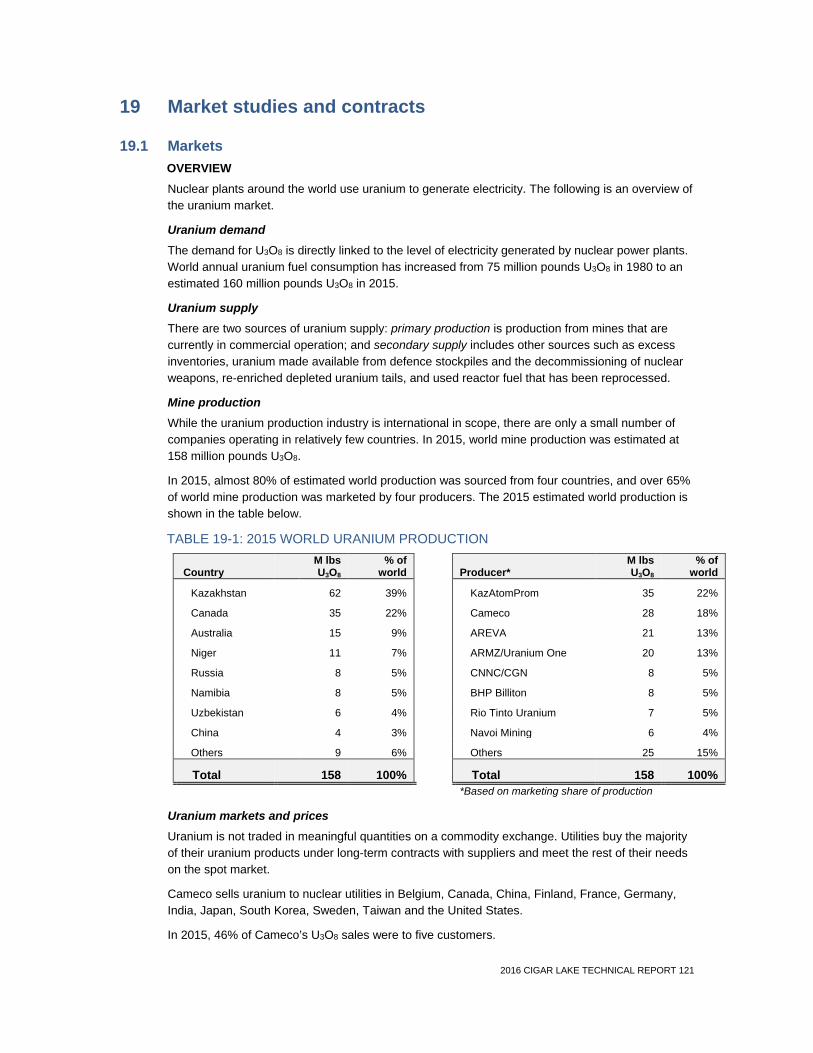
2016 CIGAR LAKE TECHNICAL REPORT 121
19 Market studies and contracts
19.1 Markets OVERVIEW Nuclear plants around the world use uranium to generate electricity. The following is an overview of the uranium market.
Uranium demand The demand for U3O8 is directly linked to the level of electricity generated by nuclear power plants. World annual uranium fuel consumption has increased from 75 million pounds U3O8 in 1980 to an estimated 160 million pounds U3O8 in 2015.
Uranium supply There are two sources of uranium supply: primary production is production from mines that are currently in commercial operation; and secondary supply includes other sources such as excess inventories, uranium made available from defence stockpiles and the decommissioning of nuclear weapons, re-enriched depleted uranium tails, and used reactor fuel that has been reprocessed.
Mine production While the uranium production industry is international in scope, there are only a small number of companies operating in relatively few countries. In 2015, world mine production was estimated at 158 million pounds U3O8.
In 2015, almost 80% of estimated world production was sourced from four countries, and over 65% of world mine production was marketed by four producers. The 2015 estimated world production is shown in the table below.
TABLE 19-1: 2015 WORLD URANIUM PRODUCTION
Country M lbs U3O8
% of world Producer*
M lbs U3O8
% of world
Kazakhstan 62 39% KazAtomProm 35 22%
Canada 35 22% Cameco 28 18%
Australia 15 9% AREVA 21 13%
Niger 11 7% ARMZ/Uranium One 20 13%
Russia 8 5% CNNC/CGN 8 5%
Namibia 8 5% BHP Billiton 8 5%
Uzbekistan 6 4% Rio Tinto Uranium 7 5%
China 4 3% Navoi Mining 6 4%
Others 9 6% Others 25 15%
Total 158 100% Total 158 100%
*Based on marketing share of production
Uranium markets and prices
Uranium is not traded in meaningful quantities on a commodity exchange. Utilities buy the majority of their uranium products under long-term contracts with suppliers and meet the rest of their needs on the spot market.
Cameco sells uranium to nuclear utilities in Belgium, Canada, China, Finland, France, Germany, India, Japan, South Korea, Sweden, Taiwan and the United States.
In 2015, 46% of Cameco’s U3O8 sales were to five customers.

2016 CIGAR LAKE TECHNICAL REPORT 122
Cameco currently has commitments to supply approximately 190 million pounds U3O8 under long-term contracts with 41 customers worldwide. Cameco’s five largest customers account for 47% of future commitments, and 31% of Cameco’s committed sales volume is attributed to purchasers in the Americas (United States, Canada and Latin America), 49% in Asia and 20% in Europe.
Uranium spot market The industry average spot price (TradeTech and UxC) on December 31, 2015 was $34.23 (US) per pound U3O8, down 4% from $35.50 (US) per pound U3O8 on December 31, 2014.
Long-term uranium market The industry average long-term price (TradeTech and UxC) on December 31, 2015 was $44.00 (US) per pound U3O8, down 11% from $49.50 (US) per pound U3O8 on December 31, 2014.
CAMECO MARKET STUDIES AND ANALYSES Cameco prepares a uranium supply and demand forecast which reflects its view of supply from all known sources as well as demand from all of the existing and planned reactors in the world. Cameco maintains detailed models tracking supplies by source—production as well as secondary supplies—and demand by reactor. In the preparation of this forecast, Cameco reviews detailed supply and demand models published by industry, such as the World Nuclear Association, tracks public announcements about supplies and reactors, then applies its own expertise and develops a forecast.
The qualified persons for Sections 14, 15, 21 and 22 have reviewed the studies and analyses underlying Cameco’s uranium supply and demand forecast and confirm that the results of these studies and analyses support the assumptions used for the portions of the technical report such qualified persons are responsible for.
19.2 Material contracts for property development There are no contracts material to Cameco that are required for development and operation of Cigar Lake other than:
• the JEB Toll Milling Agreement
• the agreement to manufacture and supply the JBS units
• the potentially reactive waste rock disposal agreement
The sections below contain descriptions of these agreements, as well as Cameco’s uranium sales contract portfolio.
JEB TOLL MILLING AGREEMENT Cigar Lake ore is processed at the mill located at AREVA’s McClean Lake operation, 69 kilometres to the northeast. The MLJV owns the McClean Lake operation, including the mill, and AREVA is the operator of the MLJV. The milling arrangements are subject to the terms and conditions of the JEB Toll Milling Agreement described below.
The JEB Toll Milling Agreement sets out the terms and conditions by which the MLJV will process Cigar Lake ore delivered to the McClean Lake mill into uranium concentrates.
The JEB Toll Milling Agreement:
(a) provides that all Phase 1 Cigar Lake ore will be processed at the McClean Lake mill and the MLJV will dedicate the necessary mill capacity to process 18 million pounds per annum;
(b) provides that the CLJV will be responsible to pay for the additional capital costs to modify the mill to process Phase 1 ore, excluding the capital costs associated with the JEB tailings management facility;
2016 CIGAR LAKE TECHNICAL REPORT 123
(c) subject to a capped capital contribution from the CLJV of $4.6 million, provides that the MLJV will be responsible for all capital costs required to ensure that the JEB tailings management facility can receive and accommodate tailings from processing all of the Phase 1 ore; and
(d) contemplates that if an expansion of the JEB tailings management facility is required in order for other ores to be processed at the McClean Lake mill, the CLJV may be required to pay a portion of the capital costs for such expansion.
For the toll milling and related services, the CLJV pays the MLJV toll milling charges comprising the CLJV’s share of mill expenses and a toll milling fee.
The JEB Toll Milling Agreement requires the MLJV to modify and expand the mill to process all of the current Cigar Lake mineral reserves. Construction of the expanded facility is expected to be completed in 2016. See Sections 17.3 and 18 for discussion on McClean Lake mill modifications and expansion. See Section 20.4 for discussion of the additional work required for the McClean JEB tailings facility.
The CLJV partners are parties to a November 2011 cost confirmation and sharing agreement whereby Cameco and AREVA are responsible to fund capital costs of the initial modifications of the McClean Lake mill in excess of a cap of $74.5 million negotiated by the CLJV partners as their proportionate share. The cap relating to the McClean Lake mill modifications has been met. Cameco’s share of the total initial mill modifications to the McClean Lake mill is $43.6 million.
The MLJV is responsible for all costs of decommissioning the mill.
Cameco believes the terms and conditions of the JEB Toll Milling Agreement are within industry norms.
AGREEMENT TO MANUFACTURE AND SUPPLY JBS UNITS Cameco has chosen to single source the manufacturing and supply of one additional JBS unit to a European based, global mining and tunnelling equipment supplier. The supplier worked closely with Cameco through the past two decades of research, development and testing of the JBS mining method and associated equipment and process. Cameco believes the terms and conditions of its 2011 agreement with this European equipment supplier are within industry norms.
POTENTIALLY REACTIVE WASTE ROCK DISPOSAL AGREEMENT The potentially reactive waste rock disposal agreement entered into between the MLJV and CLJV provides that the potentially acid generating waste rock at the Cigar Lake minesite will be transported to and disposed of at the McClean Lake facility. Cameco believes the terms and conditions of this agreement are within industry norms.
URANIUM SALES CONTRACTS Uranium sales contracts portfolio Cameco has a long-term uranium sales contract portfolio where it commits to supply uranium to its customers. This uranium is projected to come from Cameco’s operating mines, mines under development and from Cameco’s spot and long-term uranium purchase contracts. The commercial terms under these contracts are confidential.
Cameco targets a ratio of 40% fixed-pricing and 60% market-related pricing in its portfolio of long-term contracts. Fixed-price contracts are typically based on the industry long-term price indicator at the time the contract is accepted and escalated over the term of the contract. Market-related contracts are different from fixed-price contracts in that they may be based on either the spot price or the long-term price, and that price is as quoted at the time of delivery rather than at the time the contract is accepted. These contracts sometimes provide for small discounts, often include floor prices, and some include ceiling prices, all of which are also escalated over the term of the contract.

2016 CIGAR LAKE TECHNICAL REPORT 124
Uranium contract terms generally reflect market conditions when the contracts are negotiated. After a contract is accepted, deliveries under a long-term contract do not begin for several years. Cameco believes the terms of its long-term uranium sales contracts generally reflect industry norms.
As a result of Cameco’s contracting strategy Cameco’s average realized price for uranium sales in 2015 was $45.19 (US) per pound U3O8. The industry average spot price (TradeTech and UxC) during 2015 was $36.55 (US) per pound U3O8. The industry average long-term uranium price (TradeTech and UxC) during 2015 was $46.29 (US) per pound U3O8.
19.3 Uranium price assumptions used for economic analysis A spot price projection of $35.00 (US) per pound U3O8 in 2016 increasing to $60.00 (US) per pound U3O8 in 2020 onwards has been incorporated into the realized price projection for the purpose of the economic analysis. The term price premium is projected at 15% in all years. The current price projection is generally consistent with various independent forecasts of supply and demand fundamentals. To the extent the independent forecasts did not extend their projections to cover the entire expected mine life of Cigar Lake, the projections have been extrapolated forward to the end of the anticipated mine life.
Cameco has historically sold U3O8 under long-term contracts with its customers at prices that reflect the market conditions at the time the contract is accepted. Cameco has committed a significant quantity of its future production and purchased material to be delivered through its existing portfolio of long-term sales contracts. The remaining future production will be sold under yet-to-be-negotiated arrangements. For the purposes of the economic analysis, Cameco’s portion of Cigar Lake production is assumed to be allocated into a mix of committed sales volumes and uncommitted sales volumes in the same proportion that Cameco expects to sell based on its current level of committed sales relative to its total sales targets.
Table 19-2 outlines the projected average realized prices, taking into account Cameco’s current level of sales commitments and the independent spot price projections. The price projections are stated in constant 2016 dollars. The economic analysis assumes an average realized price of $68.01 (Cdn) per pound U3O8.
In preparing the cash flow analysis included in Section 22 of this report, the impact of Cameco’s forward uranium sales strategy has been taken into account.

2016 CIGAR LAKE TECHNICAL REPORT 125
TABLE 19-2: EXPECTED AVERAGE REALIZED URANIUM PRICES BY YEAR
Price assumptions 2016 2017 2018 2019 2020 2021 2022 2023 2024 2025 2026 2027 2028
Cigar Lake average price $US/lb 43 46 50 56 61 63 63 64 64 64 64 64 64
Cigar Lake average price $Cdn/lb 54 55 58 64 70 72 72 74 74 74 74 74 74
Exchange rate $1.00 US = $Cdn 1.25 1.20 1.15 1.15 1.15 1.15 1.15 1.15 1.15 1.15 1.15 1.15 1.15
Notes: (1) Average price is partly based on committed volumes, which are derived from Cameco’s current contract portfolio commitments.
(2) The projected average price is weighted to the proportion of committed and uncommitted sales volume at the respective committed price and market prices for each year. Average prices included in this table have been rounded.
(3) Cameco’s sales volume targets assume no interruption in the company’s supply from its production or third-party sources.
(4) The projections are stated in constant 2016 dollars.

2016 CIGAR LAKE TECHNICAL REPORT 126
20 Environmental studies, permitting and social or community impact
20.1 Regulatory framework The Cigar Lake mine has regulatory obligations to both the federal and provincial governments. Being a nuclear facility, primary regulatory authority resides with the federal government and its agency, the Canadian Nuclear Safety Commission (CNSC). Provincial regulatory authority is generally described in the approval to operate pollutant control facilities as well as the surface lease agreement between the Province of Saskatchewan and the CLJV.
In many cases, there is coordination amongst the federal and provincial regulatory authorities, but each agency retains responsibility for administering its own regulations, approvals, licences and permits where required. The main regulatory agencies that issue permits / approvals and inspect Cigar Lake are: the CNSC (federal), Fisheries and Oceans Canada (federal), Environment Canada (federal), Transport Canada (federal), Saskatchewan Ministry of Labour Relations and Workplace Safety (provincial), and Saskatchewan Ministry of Environment (provincial) (SMOE). Environment Canada, specifically, is responsible for administering the federal Metal Mine Effluent Regulations (MMER) and approves environmental effects monitoring (EEM) programs required under the MMER.
20.2 Licences and permits There are three key permits that are required to operate the mine. Cigar Lake holds a “Uranium Mine Licence” from the CNSC, an “Approval to Operate Pollutant Control Facilities” from the SMOE, and a “Water Rights Licence to Use Surface Water and Approval to Operate Works” from the Saskatchewan Watershed Authority. These permits are current.
The CNSC licence was issued for an eight-year term in June 2013, allowing Cameco to: complete the final stages of construction and commissioning of Cigar Lake, transition into operations, and commence shipping of slurry to McClean Lake. Valid until June 30, 2021, this licence and associated Licence Conditions Handbook (LCH), authorizes an average annual production rate up to 18 million pounds U3O8.
The SMOE Approval to Operate Pollutant Control Facilities was renewed in 2012 and expires on December 31, 2017. The Saskatchewan Watershed Authority water rights licence was obtained in 1988 and was last amended in July 2011. It is valid for an undefined term.
The LCH for the McClean Lake operation, issued by the CNSC in 2012, authorizes the processing of Cigar Lake ore in the mill and the production of up to 13 million pounds U3O8 annually. Construction of upgrades to the mill to accommodate processing of all Cigar Lake ores commenced in 2013 and is expected to be completed in 2016. In 2016, AREVA submitted an application to increase the authorized annual production of the mill to 24 million pounds U3O8.
20.3 Environmental assessment Cigar Lake was assessed for regulatory approval purposes, including the Cigar Lake mine and associated minesite infrastructure, the processing of the recovered ore at the McClean Lake mill, and the road infrastructure that connects Cigar Lake to the existing road network. Construction, operation and decommissioning of the Cigar Lake mine have been evaluated as part of several environmental assessments going back to 1987. All aspects of Cigar Lake have undergone the required environmental assessment and regulatory approval to allow for the current licensing of the Cigar Lake mine. In 2008, Cameco completed an environmental assessment process that included consideration of the processing of Cigar Lake pregnant aqueous solution at the Rabbit Lake mill.

2016 CIGAR LAKE TECHNICAL REPORT 127
However, for commercial reasons the CLJV partners have since agreed to process all Cigar Lake ore at the McClean Lake mill. A brief summary of these assessments and approvals follows.
In 1995, the Cigar Lake project Environmental Impact Statement (1995 EIS) was submitted to the Joint Federal-Provincial review panel on Uranium Mining Developments in Northern Saskatchewan (the Panel). The 1995 EIS evaluated the operation of a high-grade uranium mine at Cigar Lake, producing ore over a 40-year period, with ore being transported by truck to the nearby McClean Lake mill for processing. In 1997, the Panel recommended that pending identification of a suitable waste rock disposal location, the project should proceed. The Canadian and Saskatchewan governments both accepted the Panel’s recommendation and, in 1998, both government bodies approved the project in principle.
A 1999 review of the waste rock disposal options concluded that the Sue C pit at McClean Lake operation was the best waste rock disposal option. The Disposal of Cigar Lake Waste Rock Environmental Impact Statement (2001 EIS) was submitted in August 2001, under the harmonized federal-provincial environmental assessment process. This 2001 EIS also assessed the future construction of a permanent access road to the Cigar Lake site and the future transportation of waste rock over that access road. In August 2003, the CNSC concluded that the 2001 EIS and associated documents met the requirements of the Canadian Environmental Assessment Act (CEAA) and that the licensing/permitting processes for the Sue C pit as a waste rock disposal site and construction of the permanent access road could proceed (Cameco EASR, 2004).
In January 2003, the CNSC informed Cameco that due to a perceived uncertainty regarding the use of the transitional provisions of CEAA, the CNSC would require a new environmental assessment of the Cigar Lake mine portion of the project to support construction and operation licence decisions. However, Saskatchewan Environment (now referred to as the Saskatchewan Ministry of Environment) indicated that the assessment requirements under the Saskatchewan Environmental Assessment Act had been fully met by the 1995 EIS and 2001 EIS submission and approval processes.
In February 2004, Cameco submitted an environmental assessment study report (2004 EASR) for the Cigar Lake mine portion of the project under CEAA to meet the above requirement. In the 2004 EASR, the CNSC was identified as the sole “Responsible Authority.” The 2004 EASR assessed the potential effects from the construction, operation and decommissioning of the Cigar Lake mine. The 2004 EASR did not reassess the transportation of the ore to the McClean Lake mill, milling of the ore, or the management of tailings. The 2004 EASR was accepted by the CNSC as meeting the requirements of CEAA and, therefore, the licensing/permitting processes for the Cigar Lake project could proceed.
AREVA is the operator of the McClean Lake mill on behalf of the MLJV. The processing of all the ore slurry from the Cigar Lake mine occurs at the McClean Lake mill. This was assessed and approved as part of the 1995 EIS. The Licence Conditions Handbook for the McClean Lake operation, issued by the CNSC in 2013, authorizes the processing of Cigar Lake ore in the mill.

2016 CIGAR LAKE TECHNICAL REPORT 128
In December 2008, Cameco submitted to the CNSC a project description for implementing measures intended to better manage the increased quantities of water inflow that could potentially be experienced during the construction and operation of Cigar Lake. Specifically, this project involved establishing infrastructure to allow for the discharge of treated water directly to Seru Bay of Waterbury Lake. A positive decision on this screening level environmental assessment was received in 2011, with construction and commissioning of the associated infrastructure completed in 2012. Discharge of treated water to Seru Bay commenced in the summer of 2013.
20.4 Environmental aspects ORE PROCESSING AND TAILINGS MANAGEMENT
The McClean Lake mill processes the Cigar Lake ore slurry in a dedicated leach circuit separate from other ores that may be concurrently processed. The combined residue from both ores is treated in the McClean Lake mill tailings neutralisation area. Construction of an upgraded tailings neutralization circuit is scheduled to be complete in 2016. Neutralised tailings are pumped to the existing tailings management facility (TMF) (see Sections 17.2 and 17.4).
In 2010, AREVA received regulatory approval for the tailings management facility optimization project, and has since completed the first stage of the work, which involved improving slope stability and the placement of a bentonite amended liner. Additional work involving increasing the elevation of the liner by four metres in the period from 2022 to 2024 is required. With the liner extended, the TMF will have the capacity to receive tailings from processing all of Cigar Lake’s current mineral reserves.
During the processing of Cigar Lake ore, tailings are generated at the McClean Lake mill. The JEB Toll Milling Agreement manages the financial liabilities associated with these tailings. For discussion of the JEB Toll Milling Agreement, refer to Section 19.2.
WASTE ROCK MANAGEMENT Waste rock generated at the Cigar Lake minesite is currently stored on-site in one of four waste rock piles, depending on the nature of the waste rock. The first two of these are the clean waste stockpiles, which will remain at the minesite. The third is mineralized waste (>0.03% U3O8) contained on a lined pad, which is planned to be disposed of underground at the Cigar Lake mine. The fourth is potentially acid generating waste rock, which will be temporarily stored at site on a lined pad and will be eventually transported to the Sue C pit at the McClean Lake facility for permanent disposal. The costs of the eventual disposal of Cigar Lake’s potentially acid generating waste rock in Sue C pit, as described in the Waste Rock EIS noted above, is covered by the Potentially Reactive Waste Rock Disposal Agreement between the MLJV and CLJV dated January 1, 2002. The cost of this disposal is included in the Cigar Lake mine operating cost estimate.
Slimes generated from the drilling of surface freezeholes are collected and stored in lined storage areas. Slimes material generated from mine development activity is brought to surface and stored within one of four lined slimes ponds, mixed with waste rock and stored on a lined pad, or bagged and stored within lined storage areas. Plans are underway to construct an additional slimes pond on surface to hold slimes generated from underground development and surface drilling activities. The current plan is to have slimes material from all storage ponds slurried and pumped underground for disposal upon final decommissioning of the facility.
WATER TREATMENT AND EFFLUENT DISCHARGE The water treatment/effluent discharge system employed at Cigar Lake has been designed based both on the results of metallurgical test work programs and Cameco’s experience at other facilities. The design is intended for both routine and non-routine water treatment and effluent discharge scenarios. The current system, as described below, is approved and licensed by the CNSC and SMOE.

2016 CIGAR LAKE TECHNICAL REPORT 129
The Cigar Lake orebody contains elements of concern with respect to water quality and the receiving environment. The distribution of elements such as arsenic, molybdenum, selenium and others is non-uniform throughout the orebody, and can result in complications in attaining the effluent concentrations included in the licensing basis. Cameco continues to optimize the water treatment process to attain effluent quality consistent with the licensing basis.
Retained surface water and recovered groundwater from the mine are pumped to the water treatment plant (WTP). The WTP uses a two-stage treatment process. Both stages involve chemical addition, precipitation and filtration.
Under normal operating conditions, treated water from the WTP is designed to be discharged to the environment on a batch discharge basis. In accordance with the design, treated water from the WTP is discharged to one of four lined ponds. The water in these ponds is tested prior to release to the environment. Results from these tests are reviewed to confirm if the water meets requirements for discharge, or if it is necessary to recycle back to the WTP. All water that fails to meet licence/operating approval requirements is returned to the WTP for re-treatment. Two ponds are located adjacent to the WTP to allow for the safe storage of excess water.
The WTP is designed to be able to treat water up to 550 m3/h; however, normal operating conditions are expected to average up to only 135 m3/h. The treatment is complemented by additional surface storage capacity of approximately 100,000 m3. In addition, to ensure all water is treated prior to discharge, contingency treatment capacity can be activated to match the planned pumping capacity of the mine.
As a result of the October 2006 and August 2008 water inflows, Cameco reviewed the emergency mine dewatering strategy. It was determined that one of the safest ways to mitigate the impact of potential future mine inflows is to increase the mine’s dewatering capacity. Doing so requires an enhancement to the mine’s ability to treat and release treated effluent to the environment. Cameco, therefore, re-evaluated options to address potential mine effluent discharge restrictions in the event of any future inflow scenarios. Specifically, the risk of erosion in the Aline Creek system was evaluated. In December 2008, an application was made to move the discharge point and to discharge treated effluent directly to Seru Bay of Waterbury Lake. This is where the Aline Creek system currently enters Waterbury Lake. This application triggered under CEAA a joint federal/provincial screening level environmental assessment, which was accepted in 2011, after which approval to proceed with construction was received. Construction and commissioning of the new pipeline and associated infrastructure was completed in 2012 and discharge of treated water to Seru Bay commenced in the summer of 2013.
Cameco believes that it has sufficient capacity to handle an estimated maximum inflow and, as noted in this report, has installed additional capacity to assure the long-term success of the project.
For a further discussion on the minewater management, see Section 16.2.
In respect of the McClean Lake mill, all water must be treated before it is released to the environment. All water that fails to meet licensing/operating approval requirements is returned to the water treatment plant for re-treatment.
ENVIRONMENTAL EFFECTS MONITORING Comprehensive environmental effects monitoring programs are in place at Cigar Lake to determine the full extent and nature of any environmental effects taking place within the sphere of influence of these facilities. The most significant component of this monitoring is the EEM program that Cameco performs and is required under its operating licences. The EEM includes the monitoring of water, fish health, benthic invertebrate monitoring, sediment, fish tissue, plants and animals. It is designed to incorporate the requirements of Environment Canada’s MMER, CNSC requirements, and SMOE requirements. In general terms, the environmental monitoring programs have shown that the

2016 CIGAR LAKE TECHNICAL REPORT 130
environmental effects are generally in line with the predictions contained within the previously completed environmental assessments.
20.5 Decommissioning and reclamation The Cigar Lake Preliminary Decommissioning Plan (PDP) and Preliminary Decommissioning Costs Estimate (PDCE) were initially completed in May 2002 and most recently revised in 2012 as part of the licensing that occurred in 2013. The PDP discusses the approach to addressing the liabilities that are associated with mining. The future liabilities will be addressed in subsequent revisions to the PDP. This systematic update and review of previous PDPs and PDCEs is designed to capture all changes to known liabilities and improvements in decommissioning as an operation matures.
Periodic reviews of the PDP and PDCE are required at least every five years as per provincial requirements. The current PDP considers the environmental liabilities up to the end of the construction and commissioning of the facility and its transition into full operations, including the management of ore and any associated wastes estimated to the end of 2018. This PDP was approved by both federal and provincial regulatory agencies and is supported by a financial assurance based on the current PDCE of $49.2 million. The financial assurance is posted with the SMOE in the form of irrevocable standby letters of credit.
The documents are developed as per the CNSC and SMOE guide documents (G-219, Decommissioning Planning for Licensed Activities, 2000; G-206, Financial Guarantees for the Decommissioning of Licensed Activities, 2000; EPB 381, Guidelines for Northern Mine Decommissioning and Reclamation, 2008). Any changes from prior versions reflect changes to the facilities, potential increases in costs associated with current market conditions in western Canada and the allowance for an escalation factor over the next five-year review period.
The reclamation and remediation activities associated with Cigar Lake waste rock and/or tailings disposal at the McClean Lake facility are covered by the related PDP and PDCE.
20.6 Known environmental liabilities The core generic estimates and assumptions made in mill and minesite decommissioning plans which are considered to have the greatest impact on cost to complete the work are as follows (note that these assumptions apply to all Cameco mine and mill facilities):
• correct understanding of the geochemical and geotechnical properties of waste materials—these properties are used to provide long-term performance modelling estimates of the wastes, and are key to regulatory acceptance of the final decommissioning plans
• degree of required isolation of waste rock piles from leaching by precipitation and groundwater transport
• degree of required isolation of tailings from leaching by precipitation and groundwater transport
• negotiated contaminant loading and concentration limits, along with locations where these criteria apply
• correct length of any forecasted “pump and treat” period needed to generate acceptable contaminant flux rates from tailings and waste rock
• correct length associated with required thaw and consolidation of tailings facilities
• cost of “deconstruction” of surface facilities
• magnitude of potential groundwater contamination generated underneath surface facilities during the operating phase that require remediation prior to site release
• decommissioning phase environmental assessment costs, along with post-release performance verification monitoring costs

2016 CIGAR LAKE TECHNICAL REPORT 131
• correct assumptions regarding the degree of institutional control required for the post-decommissioned site, ranging from on-going perpetual care and maintenance to totally passive controls
Listed below is a description of site-specific assumptions built into the PDPs and PDCEs which are the subject of this technical report. All known environmental liabilities associated with Cigar Lake are discussed in the current PDP and are accounted for within the PDCE. The PDP and PDCE are conceptual in design and detail. They are developed to address known environmental liabilities of the facility at that time in a ‘decommission tomorrow’ scenario, such that reasonable financial assurance requirements for the benefit of the Crown can be defined. This does not preclude formal regulatory processes which are followed prior to implementing actual decommissioning. Therefore, it is possible that following such final approval processes, the liabilities understood in the PDP and PDCE may vary from the final approved decommissioning. This uncertainty is addressed through the conservatism built into the documents and the regulatory acceptance process. In general, the significant liabilities associated with Cigar Lake are accounted for in the PDP and PDCE as follows:
Underground facilities and surface shaft installation: The main long-term liabilities are primarily from a safety perspective. These are addressed by the capping of the shaft collars. Environmentally, there are limited liabilities associated with potential soil contamination, addressed with removal and disposal underground.
Ancillary facilities such as the shop/office complex, slurry loadout, water treatment plant and residence: Environmental liabilities are associated with potential soil and groundwater contamination. These are addressed by removal of contaminated materials and disposal underground or, if appropriate, at another approved facility.
Mineralized waste and potentially acid generating waste rock piles: The long-term environmental liability associated with these piles is potential groundwater contamination. This would be mitigated during decommissioning through underground disposal of mineralized waste and disposal of potentially acid generating waste rock at the Sue C pit at the McClean Lake facility.
Slimes currently stored on surface within slimes ponds: The long-term environmental liability associated with slimes is potential groundwater contamination. This would be mitigated during decommissioning through underground disposal of these materials.
Clean waste rock piles: The long-term environmental liability associated with these piles is potential erosion impacting surface waters in the immediate area. This is addressed by contouring and stabilizing these piles with natural vegetation. A portion of these piles may also be utilized as a source of fill to promote the establishment of stable drainage courses on the reclaimed development footprint.
Haul road to McClean Lake: As this is a good, all-weather road, it is not expected that should the Cigar Lake mine cease to operate the Province would expect the road to be decommissioned. However, for completeness, this liability is carried in the PDP and PDCE. The primary environmental liability would be associated with erosion of the roadway, resulting in impacts being realized at various stream crossings along its corridor. Mitigation involves re-vegetation to stabilize these areas and removal of stream crossings (bridges, abutments and culverts).
20.7 Social and community factors Cameco is committed to building long-lasting and trusting relationships with the local Aboriginal communities in which it operates. This commitment is implemented through a five pillar corporate responsibility strategy which aims to build relationships, strengthen partnerships and secure the support of the communities with whom Cameco works with. It was initially developed, in part, to fulfill some of the socio-economic obligations contained in surface lease agreements with the Saskatchewan government. However, over time, the bulk of the strategy has evolved to be much

2016 CIGAR LAKE TECHNICAL REPORT 132
more, as a result of the value-added benefits Cameco has seen from ensuring strong support among local communities where it operates.
The closest community of Hatchett Lake Dene First Nation/ Wollaston Lake is approximately 80 kilometres by air to the east of the Cigar Lake mine site, and is part of the Athabasca Dene who still hunt, fish and trap in the region. Cameco signed an Impact Management Agreement in 1999 with the seven Athabasca Dene communities. As part of that agreement, an environmental program was established which saw community members, as part of the Athabasca Working Group, participating in environmental monitoring. This was one of the first environmental programs of its kind established in Canada.
As part of this agreement, employees are recruited with first preference being given to residents within the Athabasca Dene communities, then secondly to residents of northern Saskatchewan. Cameco has also established a northern preferred supplier program, which provides preference to majority-owned aboriginal companies and helps establish long-term relationships between northern contractors and Cameco.

2016 CIGAR LAKE TECHNICAL REPORT 133
21 Capital and operating costs
21.1 Capital and other costs The cost estimates in this section are on a 100% basis.
In the 2012 Technical Report, Cameco showed expected capital, remediation and standby costs to the end of construction of approximately $2.6 billion. At the time of first production in March 2014, approximately $2.9 billion was invested in construction, remediation and standby costs. The majority of the cost increase was the result of general cost escalation, a better understanding of freezing requirements, and increased costs to upgrade and expand the McClean Lake mill. Additional expenditures were capitalized at Cigar Lake until such time that commercial production was achieved on May 1, 2015.
The remaining capital cost estimate as of December 31, 2015 for the CLJV is summarized in Table 21-1. The capital and other cost projections are stated in constant 2016 dollars.

2016 CIGAR LAKE TECHNICAL REPORT 134
TABLE 21-1: CLJV CAPITAL AND OTHER COSTS FORECAST BY YEAR
Capital costs ($Cdn M) 2016 2017 2018 2019 2020 2021 2022 2023 2024 2025 2026 2027 2028 Total
Cigar Lake mine development $ 13.1 $ 74.6 $ 56.0 $ 62.1 $ 66.3 $ 43.2 $ 52.1 $ 24.9 $ 10.0 $ 14.0 $ 15.4 $ 4.5 $ 2.3 $ 438.5
Cigar Lake mine capital
Sustaining capital $ 13.7 $ 15.3 $ 28.7 $ 24.1 $ 30.7 $ 15.9 $ 13.2 $ 12.1 $ 9.2 $ 11.9 $ 3.7 $ 2.2 $ 1.0 $ 181.5
Capacity replacement capital 44.6 40.9 30.2 63.0 33.4 25.1 27.1 4.6 6.9 6.7 4.6 - - 287.1
Growth capital 7.8 7.2 - - - - - - - - - - - 15.0
Reclamation 0.3 - 0.1 - 0.9 0.4 0.1 - - - - - - 1.7
Total mine capital $ 79.5 $ 138.0 $ 114.9 $ 149.2 $ 131.3 $ 84.5 $ 92.5 $ 41.6 $ 26.0 $ 32.6 $ 23.7 $ 6.7 $ 3.3 $ 923.8
McClean Lake mill modifications $ 53.6 $ 1.0 $ 23.3 $ 5.0 $ - $ - $ 21.7 $ 1.1 $ - $ - $ - $ - $ - $ 105.6
McClean Lake mill sustaining capital 18.8 11.8 11.9 11.8 11.9 12.1 18.1 20.2 20.5 20.0 19.1 18.5 14.0 208.7
Total mill capital $ 72.4 $ 12.8 $ 35.1 $ 16.8 $ 11.9 $ 12.1 $ 39.8 $ 21.3 $ 20.5 $ 20.0 $ 19.1 $ 18.5 $ 14.0 $ 314.4
Total capital costs $ 151.9 $ 150.8 $ 150.0 $ 166.0 $ 143.1 $ 96.7 $ 132.3 $ 62.8 $ 46.5 $ 52.6 $ 42.8 $ 25.2 $ 17.4 $ 1,238.2
Note: Presented as total cost to the CLJV.
2016 CIGAR LAKE TECHNICAL REPORT 135
The CLJV’s remaining estimated capital cost is approximately $1.2 billion (Cameco’s share – $619 million), and includes sustaining capital for the Cigar Lake mine and McClean Lake mill, as well as underground development at Cigar Lake to bring the remaining mineral reserves into production.
The total remaining estimated life-of-mine capital cost at Cigar Lake is $924 million compared to $138 million over the comparable period in the 2012 Technical Report. Overall, the largest remaining capital cost at Cigar Lake is surface freeze drilling and brine distribution infrastructure, estimated at $453 million over the life of the mine. Other significant capital includes tunnel outfitting and mine development costs of approximately $226 million.
The cost of ground freezing at Cigar Lake increased by $273 million over the remaining life of the mine, primarily due to general cost escalation, as well as a better understanding of the freezing requirements. Cameco is now exclusively freezing from surface, and the net impact of this strategy compared to the previous hybrid freeze strategy is similar financially, with surface freezing also providing added benefits. These benefits include eliminating underground freeze tunnels, which results in reduced mine development, less waste rock handling and greater ground stability. In addition, congestion is reduced and underground development for freeze infrastructure is no longer a critical path mine activity.
Based on experience with ground movement and mining conditions at Cigar Lake, it was determined that the New Austrian Tunnelling Method (NATM) was a more suitable option than the previously utilized MDS tunnel boring technique, and it has been adopted as the primary method of developing new production crosscuts. NATM helps accommodate and control the natural deformation of the rock, and allows faster and more practical rehabilitation of the tunnel in the event that the deformations cause a clearance issue for the JBS mining unit. Development using NATM comes at a higher cost per metre, although the decrease in the metres of required mine development related to the change to surface freezing partially offsets the increase. In addition, although tunnel rehabilitation is faster and productivity is improved using NATM when compared to the MDS technique, the overall cost of tunnel rehabilitation is more significant than assumed in the 2012 Technical Report. The net impact is, therefore, an increase of $82 million in related capital costs over the remaining life of the mine.
In addition to the capital cost increases described above, the information and mining experience acquired since the 2012 Technical Report has resulted in an increase to the expected sustaining capital, including certain mine development and freezing costs that were classified as operating costs in the 2012 Technical Report being reclassified as sustaining capital.
At the McClean Lake mill, remaining capital costs are estimated to be $314 million compared to $162 million in the 2012 Technical Report for the same period. Capital expenditures of $54 million are required in 2016 to allow the mill to reach full annual production of 18 million pounds. The rest of the increase is due to additional mill upgrades required over the remaining mine life and an overall increase in sustaining capital due to general cost escalation.
21.2 Operating cost estimates Estimated operating expenditures for the underground mining operation and for toll milling charges and fees are presented in Table 21-2.
Operating costs consist of annual expenditures at Cigar Lake to mine the ore and treat it underground, including crushing, grinding and density control, followed by pumping the resulting slurry to surface for transportation to McClean Lake.
Operating costs at McClean Lake consist of the cost of offloading and leaching of the Cigar Lake ore slurry into uranium solution and further processing into calcined U3O8 product.

2016 CIGAR LAKE TECHNICAL REPORT 136
To the extent that the McClean Lake mill is co-processing ore from other minesites, the JEB Toll Milling Agreement has provisions addressing the sharing of operating costs with the CLJV. Co-processing of ore from other minesites has not been reflected in operating cost estimates.
Operating costs for the Cigar Lake operation are estimated to be $18.75 per pound U3O8 over the remaining life of the current mineral reserves. The 2012 Technical Report showed estimated operating costs to be $18.57 per pound U3O8. The current operating cost projections have incorporated increases based on operational experience gained since the 2012 Technical Report. Major contributors to the increased operating costs are additional labour requirements, implementation of an underground rehabilitation program, as well as increases in electricity rates and property tax assessments. The operating cost projections are stated in constant 2016 dollars and assume the throughput outlined in the production schedule in Section 16.3.

2016 CIGAR LAKE TECHNICAL REPORT 137
TABLE 21-2: CLJV OPERATING COST FORECAST BY YEAR
Operating costs ($Cdn M) 2016 2017 2018 2019 2020 2021 2022 2023 2024 2025 2026 2027 2028 Total
Cigar Lake mining
Site administration $ 52.1 $ 50.9 $ 50.1 $ 49.1 $ 49.1 $ 49.6 $ 50.1 $ 49.9 $ 50.3 $ 50.7 $ 49.6 $ 49.8 $ 48.6 $ 650.0
Mining costs 91.8 89.1 86.0 84.5 83.0 86.1 87.2 94.5 96.1 99.0 94.4 98.5 95.8 1,185.9
Process 16.9 16.8 16.2 15.9 15.8 16.1 15.9 16.2 16.6 16.9 16.5 16.9 12.6 209.1
Corporate overhead 10.8 12.4 11.6 12.4 11.8 10.5 10.8 9.5 9.1 9.4 8.9 8.6 8.2 134.0
Total mining costs $ 171.6 $ 169.2 $ 163.8 $ 161.9 $ 159.8 $ 162.3 $ 163.9 $ 170.0 $ 172.1 $ 175.9 $ 169.5 $ 173.7 $ 165.2 $ 2,179.0
McClean Lake milling Administration $ 36.9 $ 39.3 $ 39.2 $ 39.3 $ 39.2 $ 39.3 $ 39.2 $ 39.3 $ 39.4 $ 39.4 $ 39.4 $ 39.4 $ 38.3 $ 507.6
Milling costs 74.2 77.7 78.8 78.6 79.2 81.8 81.3 94.6 96.9 93.5 87.7 84.1 56.2 1,064.6
Corporate overhead 5.8 4.5 4.6 4.6 4.6 4.7 4.7 5.2 5.2 5.1 4.9 4.8 3.8 62.6
Toll milling 25.5 25.8 25.9 25.9 25.9 25.9 25.9 25.9 24.6 15.3 15.3 14.1 3.2 279.5
Total milling costs $ 142.4 $ 147.4 $ 148.6 $ 148.4 $ 148.9 $ 151.7 $ 151.2 $ 165.1 $ 166.1 $ 153.4 $ 147.3 $ 142.4 $ 101.5 $ 1,914.3
Total operating costs $ 314.0 $ 316.6 $ 312.4 $ 310.3 $ 308.7 $ 314.0 $ 315.1 $ 335.1 $ 338.1 $ 329.3 $ 316.8 $ 316.1 $ 266.8 $ 4,093.4
Total operating costs per lb U3O8
$ 19.31 $ 17.47 $ 17.17 $ 17.05 $ 16.97 $ 17.26 $ 17.32 $ 18.42 $ 18.59 $ 18.10 $ 17.41 $ 18.88 $ 78.46 $ 18.75
Note: Presented as total cost to the CLJV.

2016 CIGAR LAKE TECHNICAL REPORT 138
22 Economic analysis
22.1 Economic analysis The following economic analysis as shown in Table 22-1 for the Cigar Lake operation is based on the current mine plan, which contemplates the mining and milling of all of the current estimated mineral reserves. The analysis does not contain any estimates involving the potential mining and milling of mineral resources. Expenditures required to bring any of the mineral resources into production or to identify additional mineral reserves and mineral resources, have not been included. Mineral resources that are not mineral reserves have no demonstrated economic viability.
The analysis provided is from the point of view of Cameco, which owns 50.025% of the CLJV, and incorporates Cameco’s projected sales revenue from its proportionate share of the related production, less its share of the related operating and capital costs of the CLJV, as well as all royalties and resource surcharges that will be payable on the sale of the concentrates.

2016 CIGAR LAKE TECHNICAL REPORT 139
TABLE 22-1: CLJV ECONOMIC ANALYSIS – CAMECO’S SHARE
Economic analysis ($Cdn M) 2016 2017 2018 2019 2020 2021 2022 2023 2024 2025 2026 2027 2028 Total
Production volume (000's lbs U3O8) 8,135 9,067 9,101 9,101 9,101 9,101 9,101 9,101 9,101 9,101 9,101 8,377 1,701 109,187
Sales revenue $ 437.2 $ 500.5 $ 523.3 $ 586.1 $ 638.4 $ 659.4 $ 659.4 $ 669.8 $ 669.8 $ 669.8 $ 669.8 $ 616.5 $ 125.2 $ 7,425.3
Operating costs 157.1 158.4 156.3 155.2 154.4 157.1 157.7 167.6 169.2 164.7 158.5 158.1 133.5 2,047.7
Capital costs 76.0 75.4 75.0 83.1 71.6 48.4 66.2 31.4 23.3 26.3 21.4 12.6 8.7 619.4
Basic royalty 18.6 21.3 22.2 24.9 27.1 28.0 28.0 28.5 28.5 28.5 28.5 26.2 5.3 315.6
Resource surcharge 13.1 15.0 15.7 17.6 19.2 19.8 19.8 20.1 20.1 20.1 20.1 18.5 3.8 222.8
Profit royalty 26.4 35.2 39.0 47.4 57.1 63.3 60.6 65.8 66.8 67.1 68.7 62.5 (1.7) 658.2
Net pre-tax cash flow $ 146.1 $ 195.1 $ 215.0 $ 257.9 $ 309.0 $ 342.8 $ 327.2 $ 356.4 $ 362.0 $ 363.2 $ 372.6 $ 338.6 $ (24.3) $ 3,561.6
Notes: (1) As Cameco files a consolidated Saskatchewan royalty return, the recovery of profit royalties in 2028 will be realized as a reduction of profit royalties payable on Cameco’s mines other than Cigar Lake.
(2) Expected royalties and annual resource surcharge in this table are on Cameco's share of production only. Cameco reports on a pre-tax basis since it is not practical to allocate a resulting income tax cost to Cameco’s portion of Cigar Lake as Cameco’s tax expense is a function of several variables, most of which are independent of the investment in Cigar Lake.
.

2016 CIGAR LAKE TECHNICAL REPORT 140
The economic analysis results in an estimated pre-tax NPV (at a discount rate of 8%) to Cameco, for net cash flows from January 1, 2016 forward, of $2.1 billion for its share of the Cigar Lake mineral reserves. Using the total capital invested, along with the operating and capital cost estimates for the reminder of mineral reserves, the pre-tax IRR has been estimated to be 9.5%.
22.2 Sensitivities The graph in Figure 22-1 illustrates the operation’s sensitivity to changes in uranium grade, capital cost, operating cost, and uranium prices (including the mitigating effects of Cameco’s level of committed sales through its sales contract portfolio). The graph illustrates the variability around the base case pre-tax (see Section 22.5) net present value of $2.1 billion, using sensitivities of plus and minus 10% on all variables, except for uranium price. The high and low cases represent a plus or minus $10 deviation from the average spot price projections incorporated in the base case realized prices as shown in Table 19-2.
FIGURE 22-1: CIGAR LAKE OPERATION SENSITIVITY ANALYSIS
The analysis shows relatively low sensitivity to changes in its operating or capital cost projections. The relative sensitivity to changes in uranium price and ore grade realized is significantly higher due in part to the relatively high-grade nature of the deposit and the price estimates being used, which are a reflection of the current U3O8 market environment.
22.3 Payback Payback for Cameco, including total capital invested, is expected to be achieved in 2022, on an undiscounted pre-tax basis. All future capital expenditures are forecasted to be covered by operating cash flow.
22.4 Mine life The remaining mine life for Cigar Lake is based on current mineral reserves, which are expected to produce 218.3 million pounds U3O8 from the McClean Lake mill. The expected life of current estimated mineral reserves is approximately 13 years of sustained production based on planned annual production of approximately 18 million pounds of U3O8. As part of the mine plan, Cigar Lake is expected to produce less than the full annual production in 2016 and in the latter years of the mine life.
$0
$500
$1,000
$1,500
$2,000
$2,500
$3,000
Low Base Case High
$Cdn M NPV Sensitivity 8%
Price
Capital Costs
Operating Costs
Grade

2016 CIGAR LAKE TECHNICAL REPORT 141
If mineral resources are upgraded and converted to mineral reserves through a positive feasibility study, this could extend the mine life. Mineral resources that are not mineral reserves have no demonstrated economic viability.
22.5 Taxes Cigar Lake operates as an unincorporated joint venture and is, therefore, not subject to direct income taxation at the joint venture level. Cameco, as the mine operator, operates the mine on behalf of the CLJV and distributes the resulting U3O8 production to the CLJV partners in proportion to their joint venture interests.
Cameco is subject to federal and provincial (Saskatchewan and Ontario) income tax in Canada. Royalties are fully deductible for income tax purposes.
For the purposes of the economic analysis, the projected impact of income taxes has been excluded due to the nature of the required calculations. Taxable income for Cameco is comprised of results from several discrete operations, which are combined to determine Cameco’s taxable income and its related tax liabilities. It is not practical to allocate a resulting income tax cost to Cameco’s portion of Cigar Lake as Cameco’s tax expense is a function of several variables, most of which are independent of the investment in Cigar Lake.
22.6 Royalties Cameco pays royalties on the sale of all uranium extracted at our mines in the province of Saskatchewan. Two types of royalties are paid: • basic royalty: this royalty is calculated as 5% of gross sales of uranium, less the Saskatchewan
resource credit of 0.75% • profit royalty: a 10% royalty is charged on profit up to and including $22.70 per kilogram U3O8
($10.30 per pound), and a 15% royalty is charged on profit in excess of $22.70 per kilogram U3O8. Profit is determined as revenue less certain operating, exploration, reclamation and capital costs. Both exploration and capital costs are deductible at the discretion of the producer
As a resource corporation in Saskatchewan, Cameco also pays a corporate resource surcharge of 3.0% of the value of resource sales. The projected future impact of the Saskatchewan corporate resource surcharge is included in the economic analysis.
During the period from 2013 to 2015, transitional rules for the new profit royalty regime were applied whereby only 50% of capital costs were deductible. The remaining 50% was accumulated and will now be deductible beginning in 2016. In addition, the capital allowance related to Cigar Lake under the previous system was grandfathered and is also now deductible beginning in 2016.
Both the basic and profit royalties have been included in the economic analysis.
Table 22-1 sets out the royalties and annual resource surcharge that Cameco expects to incur on its share of production from Cigar Lake. The projected royalties and annual resource surcharge are based on the realized prices set out in Table 19-2 and are quoted in constant 2016 dollars.
The economic analysis related to profit royalties excludes the benefit of the deduction of the costs restricted under the transitional rules (both the 50% of 2013 to 2015 capital costs related to Cigar Lake and the grandfathered capital allowance) that are deductible beginning in 2016. As Cameco files a consolidated Saskatchewan royalty return, these costs will be available as deductions to reduce profit royalties payable on all of Cameco’s mines, including Cigar Lake.

2016 CIGAR LAKE TECHNICAL REPORT 142
23 Adjacent properties
Information on adjacent properties is not applicable to this technical report since there are no adjacent properties with exploration results of note.

2016 CIGAR LAKE TECHNICAL REPORT 143
24 Other relevant data and information
24.1 Cigar Lake water inflow incidents Over the period 2006 through 2008, the project had setbacks as a result of three water inflow incidents.
The first occurred in April of 2006, resulting in the flooding of the then partially completed Shaft No. 2. The two subsequent incidents involved inflows in the mine workings connected to Shaft No. 1, and resulted in flooding of the mine workings completed to that point in time.
Cameco developed and successfully executed recovery and remediation plans for all three inflows. This culminated in the resumption of sinking of Shaft No. 2 in the first half of 2011 and the successful break through to the 480 metre level of the main mine workings in early 2012, as well as the commencement and completion of underground remediation and restoration of the Shaft No. 1 workings in 2010 and 2011.
Throughout the water inflow remediation and rehabilitation that successfully addressed all three incidents, Cameco identified and incorporated the lessons learned into all facets of the project. This was specifically done to ensure the implications not only to short-term project design, construction and startup were understood and addressed, but also to ensure the long-term success of operation. These lessons included changes to the water management strategy, mine design, operational procedures and work management, project and operational leadership.
24.2 Mining and milling risks Cigar Lake is a challenging deposit to develop and mine. These challenges include control of groundwater, weak rock formations, deployment of the JBS mining method, radiation protection, environmental protection, water inflow, performance of the water treatment system, equipment reliability and other mining-related challenges. Additionally, the realization of risks associated with processing the ore at AREVA’s McClean Lake mill would adversely affect production at Cigar Lake.
MITIGATION Cameco has undertaken a number of initiatives to mitigate the risks associated with mining the Cigar Lake deposit and to mine the deposit in a safe and economic manner, including, but not limited to, using the JBS mining method, bulk freezing the orebody and surrounding ground, lowering the production horizon further away from the water-bearing formation and increasing mine dewatering and treatment capacity. Cameco applies its operational experience and the lessons learned about water inflows at McArthur River and Cigar Lake to reduce risk.
WATER INFLOWS A significant risk to development and production is from water inflows. The sandstone overlying the basement rock at Cigar Lake contains large volumes of water at significant pressure. Despite the important mitigation measures Cameco has put in place, there remains a possibility of a water inflow during mine development and JBS mining. The consequences of another water inflow will depend upon the magnitude, location and timing of any such event, but could include a significant delay in Cigar Lake’s development or production, a material increase in costs, a loss of mineral reserves, or require Cameco to give notice to many of its customers that it is declaring an interruption in planned uranium supply. Such consequences could have a material adverse impact on Cameco. Water inflows are generally not insurable.
GROUND FREEZING Freezing the orebody and the surrounding ground results in several reductions to the mining risk profile, including: (1) minimizing the risk of water inflows from saturated rock above the

2016 CIGAR LAKE TECHNICAL REPORT 144
unconformity; (2) reducing radiation exposure from radon dissolved in the groundwater; and (3) increasing rock stability. However, freezing only reduces, it does not eliminate, these challenges.
To manage the risks and meet the production schedule, the areas being mined must meet specific ground freezing requirements before jet boring begins. Cameco has identified greater variation of the freeze rates of different geological formations encountered in the mine, based on new information obtained through surface freeze drilling. To the extent that we encounter further variations as mining progresses, there is a risk that the freeze rate could differ from the model. To mitigate the risk, we have increased the site freeze capacity in order to facilitate the extraction of ore cavities as planned, and we have introduced a strategy of ensuring sufficient frozen ground is available ahead of mining to allow for ore blending and to minimize any effects of variable freeze times.
GEOTECHNICAL CHALLENGES As development takes place on the 480 and 500 metre levels, it is expected that localized areas of challenging ground conditions may be encountered which require modifications to the mine plan and development schedules. Cameco has built a diverse inventory of tools and techniques intended to address a wide range of potential geotechnical challenges. Challenging geotechnical conditions combined with additional ground stress induced by artificial ground freezing and proximal development has resulted in unplanned rehabilitation work on the production tunnel liners which results in a production interruption from the affected tunnel. Rehabilitation-induced production interruptions of a moderate nature are factored into the overall production plan. However, there is a risk that more extensive work may be required should deterioration trends worsen compared to historic levels. The requirement for extensive rehabilitation work on the NATM tunnel liners could result in production deferral, and potentially the partial loss of mineral reserves.
JBS MINING METHOD AND RAMPUP As Cameco ramps up production, there may be some technical challenges related to the JBS mining method, which could affect the production plan. Potential sources of interruption include, but are not limited to, variable or unanticipated ground conditions, ground movement and cave-ins, water inflows and variable dilution, recovery values and mining productivity at the ore horizon, and equipment reliability. Even though enhancements have been made to the design of the JBS unit, there is a risk that the rampup to the full production rate may not be achieved on a sustained and consistent basis.
The mine equipment fleet includes three JBS units with sufficient capacity to meet the production planned for the next few years. This mine plan, with its underlying productivity assumptions, assumes that a fourth JBS unit is required later in the mine life. Cameco has chosen to single source the manufacturing and supply of the JBS equipment to a European based, global mining and tunnelling, equipment supplier. There is a risk to the current production plan if delivery does not take place as scheduled. Cameco is currently investigating if there are opportunities for productivity improvements that could negate the need for a fourth JBS unit.
TONNAGE THROUGHPUT To maintain uranium production rates, the production profile includes increased tonnage throughput later in the mine life to make up for declining uranium grades. There is a risk that annual production of 18 million pounds U3O8 may not be sustainable due to unknown limitations at tonnage throughput levels not yet tested. Failure to sustain the required tonnage throughput would result in deferred production and increased capital and operating costs.
ENVIRONMENTAL PERFORMANCE The Cigar Lake orebody contains elements of concern with respect to water quality and the receiving environment. The distribution of elements such as arsenic, molybdenum, selenium and others is non-uniform throughout the orebody, and this can result in complications in attaining the

2016 CIGAR LAKE TECHNICAL REPORT 145
effluent concentrations included in the licensing basis. Materialization of this risk could result in potential deferral of production and additional capital and operating expenses required to modify the water treatment process to ensure environmental performance.
MILL MODIFICATIONS Metallurgical test work has been used to design the McClean Lake mill circuits and associated modifications relevant to Cigar Lake ore. Samples used for metallurgical test work may not be representative of the deposit as a whole. There is a risk that elevated arsenic concentration in the mill feed may result in increased leaching circuit solution temperatures. This could result in a reduction in mill feed rates and additional capital and operating expense to modify the leaching process.
The MLJV is required to further modify and expand the McClean Lake mill to process and package all of Cigar Lake’s Phase 1 mineral reserves and the CLJV has agreed to pay for the capital costs to do so. Construction of the expanded facility began in 2012 and is expected to be completed in 2016. Failure to complete construction of the expanded facility as planned could impact planned production and increase costs.
MILL LICENSING AREVA has submitted an application to permit annual production of up to 24 million pounds U3O8
from the McClean Lake mill. The production schedule and costs presented in this report assume the application is approved before the fourth quarter of 2016. Failure to receive approval could result in deferred production and increased costs.
LABOUR The current collective agreement between AREVA and unionized employees at the McClean Lake mill expires in 2016. There is a risk to the production plan if AREVA is unable to reach an agreement and there is a labour dispute.
COSTS Section 21 of this report contains estimates of capital and other costs, including the capital costs associated with the modification and expansion of the McClean Lake mill. Actual costs may vary from estimates for a variety of reasons and there can be no assurance that cost estimates included in this report will be achieved.
24.3 Caution about forward-looking information This technical report includes statements and information about expectations for the future that are not historical facts. When we discuss Cameco’s strategy, plans and future financial and operating performance, or other things that have not yet taken place, we are making statements considered to be forward-looking information or forward-looking statements under Canadian and US securities laws. We refer to them in this technical report as forward-looking information.
Key things to understand about the forward-looking information in this technical report:
• It typically includes words and phrases about the future, such as believe, estimate, anticipate, expect, plan, intend, goal, target, forecast, project, scheduled, potential, strategy and proposed or variations (including negative variations) of such words and phrases or may be identified by statements to the effect that certain actions, events or results, may, could, should, would, will be or shall be taken, occur or be achieved.
• It is based on a number of material assumptions, including those we have listed below, which may prove to be incorrect.
• Actual results and events may be significantly different from what is currently expected because of the risks associated with the project and Cameco’s business. We list a number of these material risks below. We recommend you also review other parts of this document,

2016 CIGAR LAKE TECHNICAL REPORT 146
including Section 24.6, which outlines a number of mining and milling risks, Cameco’s Annual Information Form for the year ended December 31, 2015 under the headings “Caution about forward-looking information” and “Risks that can affect our business” and Cameco’s annual Management’s Discussion and Analysis for the year ended 2015 under the headings “Caution about forward-looking information” and “Uranium Operating Properties – Cigar Lake – Managing our risks,” which include a discussion of other material risks that could cause actual results to differ from current expectations.
Forward-looking information is designed to help you understand current views of the qualified persons and management of Cameco. It may not be appropriate for other purposes. Cameco and the qualified persons will not necessarily update this forward-looking information unless required to by securities laws.
Examples of forward-looking information in this technical report
• Cameco’s plans and expectations for the Cigar Lake mine and McClean Lake mill
• results of the economic analysis, including but not limited to forecasts of uranium price, net present value, internal rate of return, cash flows and sensitivity analysis
• estimates of capital, operating, sustaining and mine reclamation and closure costs
• mineral resource and mineral reserve estimates
• forecasts relating to mining, development and other activities including but not limited to mine life, and mine and mill production
• Cameco’s expectation that all necessary regulatory permits and approvals will be obtained to meet its future annual production targets
• future royalty and tax payments and rates
• timing for completion of the McClean Lake mill expansion and modifications
Material assumptions
• there is no material delay or disruption in Cameco’s plans as a result of ground movements, cave-ins, additional water inflows, a failure of seals or plugs used for previous water inflows, natural phenomena, delay in acquiring critical equipment, equipment failure or other causes
• there are no labour disputes or shortages
• all necessary contractors, equipment, operating parts, supplies, regulatory permits and approvals are obtained when they are needed
• processing plants are available and function reliably as designed and sufficient tailings capacity is available
• Cameco’s mineral resource and mineral reserve estimates and the assumptions they are based on are reliable (see Sections 14.2 and 15.2)
• Cigar Lake development, mining and production plans succeed and the deposit freezes as planned
• equipment required for mining, slurry preparation and shipment to the mill operate reliably at required rates of production
• Cameco’s expectation that the jet boring mining method will continue to be successful at required productivity rates
• modification and expansion of the McClean Lake mill are completed as planned and the mill is able to process Cigar Lake ore at rates expected
• production increase at McClean Lake is approved by the regulator and there is no labour dispute at the McClean Lake mill
2016 CIGAR LAKE TECHNICAL REPORT 147
Material risks
• an unexpected geological, hydrological, underground condition or an additional water inflow delays or disrupts production
• ground movements and cave-ins
• the necessary regulatory permits or approvals cannot be obtained or maintained
• natural phenomena, labour disputes, equipment failure, delay in obtaining the required contractors, equipment, operating parts and supplies or other reasons cause a material delay or disruption in production
• processing plants are not available or do not function as designed and sufficient tailings facility capacity is not available
• mineral resource and mineral reserve estimates are not reliable
• Cameco’s development, mining or production plans for Cigar Lake are delayed or do not succeed for any reason, including as a result of any difficulties with freezing the deposit to meet production targets, or any difficulties with the McClean Lake mill modifications or expansion, or milling of Cigar Lake ore
• the production increase approval at the McClean Lake mill is delayed or not obtained
• the current collective agreement between AREVA and unionized employees at the McClean Lake operation expires in May 2016. There is risk to the production plan for Cigar Lake if AREVA is unable to reach an agreement and there is a labour dispute

2016 CIGAR LAKE TECHNICAL REPORT 148
25 Interpretation and conclusions
The Cigar Lake operation outlined in this report represents a significant economic source of feed material for the McClean Lake mill. With an estimated operating mine life of 13 years, Cigar Lake is expected to produce approximately 218.3 million pounds U3O8. At the forecast average realized uranium price over this 13-year period, it is estimated that Cameco will receive substantial positive net cash flows from its share of Cigar Lake production.
MILESTONES Since the previous technical report was issued, a number of milestones have been achieved:
• installation and commissioning of infrastructure and equipment was completed, including the JBS system and associated processing circuits
• all necessary licences and permits were obtained to allow completion of the Cigar Lake project and mine production to begin
• AREVA successfully restarted the McClean Lake mill and was able to ramp up to sufficient production rates to meet ore slurry deliveries
• bulk ground freezing was successfully advanced and mine development crosscut tunnel stability challenges under the ore zone were successfully addressed by deploying the New Austrian Tunnelling Method
• Cameco declared commercial production in May 2015
ECONOMIC ANALYSIS AND COSTS At the time of first production in March 2014, on a 100% basis, the CLJV invested approximately $2.9 billion in construction, remediation and standby costs. This is an increase of approximately $300 million over the cost estimate disclosed in the 2012 Technical Report. The majority of the cost increase was a result of general cost escalation, a better understanding of the freezing requirements, and increased costs to upgrade and expand the McClean Lake mill.
The economic analysis results in an estimated pre-tax NPV (at a discount rate of 8%) to Cameco, for net cash flows January 1, 2016 forward, of $2.1 billion for its share of the Cigar Lake mineral reserves. Using Cameco’s share of the total capital invested, along with its share of the operating and capital cost estimates for the remainder of the mineral reserves, the pre-tax IRR is estimated to be 9.5%.
Operating costs for the Cigar Lake operation are estimated to be $18.75 per pound U3O8 over the life of the current mineral reserves only. This is an increase from the 2012 Technical Report, which estimated operating costs of $18.57 per pound U3O8. The increase is primarily due to increases in estimates for employee, flight and camp costs, underground tunnel rehabilitation costs, electricity rates and property taxes.
The total remaining estimated life-of-mine capital cost for the Cigar Lake mine and McClean Lake mill is $1.2 billion (Cameco’s share – $619 million), compared to $300 million (Cameco’s share – $150 million) over the same period in the 2012 Technical Report. The capital cost increase is primarily the result of general cost escalation, changes made based on mining and milling experience gained since the 2012 Technical Report, and the inclusion of certain capital costs related to mine development and freezing that were classified as operating costs in the 2012 Technical Report.
The Cigar Lake operation shows relatively low sensitivity to changes in its operating or capital cost projections. The relative sensitivity to changes in uranium price and ore grade realized is significantly higher due in part to the relatively high-grade nature of the deposit and the price estimates being used.

2016 CIGAR LAKE TECHNICAL REPORT 149
MINE PLAN The decision in 2015 to proceed with ground freezing exclusively from the surface enabled a number of modifications to the mine plan. These modifications included a reduction in the number of crosscuts beneath the orebody, re-orientation of the production tunnels beneath the west pod and improvements to the ventilation design. The reduction and re-orientation of the production tunnels will have the added benefit of improving ground stability, reducing tunnel rehabilitation requirements and reducing the volume of waste rock that needs to be placed on surface. Cameco will continue to optimize the mine plan, building on the lessons learned through the successful inflow remediation, geotechnical, geological, hydrogeological assessments, experience gained from operating to date, and learnings from other Cameco operations. The modified mine layout is shown in Figure 16-3.
The installed mine ventilation volume of 240 m3/s provides sufficient airflow through the mine for use of diesel equipment and radiation protection at the designed sustained production rate of approximately 18 million pounds U3O8 per year.
One of the challenges of mining the Cigar Lake deposit is radiation control due to its high grade. The incorporation of designs and practices proven to be successful at McArthur River significantly reduces the risk at the Cigar Lake operation. To date, radiation controls have been effective at maintaining exposures below regulatory and Cameco internal standards.
JBS MINING METHOD AND RAMPUP Since 2012, comprehensive JBS testing and commissioning was completed to advance three JBS units to full production successfully. Actual results since the start of production suggest the projections for jet boring productivity are realistic.
Enhancements have been made to the design of the JBS unit to mitigate the risk associated with ramp up to full consistent production rates. However, as Cameco ramps up to full production capacity, there may be some technical challenges which could affect Cameco’s production plan, including, but not limited to, variable or unanticipated ground conditions, ground movement and cave-ins, water inflows and variable dilution, recovery values and mining productivity.
MCCLEAN LAKE MILL The McClean Lake mill was successfully restarted in 2014, and modifications to the mill required to achieve the rampup to the required production rate are on schedule. The existing operating licence for the mill only authorizes annual production to 13 million pounds, and AREVA has submitted an application to increase the authorized annual limit to 24 million pounds in 2016.
Metallurgical test work was used to design the McClean Lake mill circuits and associated modifications relevant to Cigar Lake ore. A sampling and metallurgical test work campaign combined with full scale mill operation with increasing production rates verified the consistency of recoveries at the McClean Lake mill. However, samples used for metallurgical test work may not be representative of the deposit as a whole. There is a risk that elevated arsenic concentration in the mill feed may result in increased leaching circuit solution temperatures.
MINERAL RESOURCES AND MINERAL RESERVES After incorporating into the block model the data from 150 additional surface freezeholes on a nominal 6 x 6 metre pattern, and after processing 11.6 million pounds of mill feed, the change to total mineral reserves from the 2014 year-end amounts to a decrease of 13.3 million pounds. This indicates that results of surface freeze drilling did not lead to significant changes to the interpretation of the mineralization and to the estimated average uranium grade. On the other hand, the dense drillhole spacing allows for representative local grade estimates.
Reconciliation of the reserve model with mill feed and inventories showing variances of 7%, 5% and 2% on tonnage, grade and pounds of U3O8, respectively, lends confidence to the quality and

2016 CIGAR LAKE TECHNICAL REPORT 150
reliability of the model. There are no known issues with respect to mining, metallurgical, infrastructure, environmental, permitting, legal, title, taxation, socio-economic, political, marketing or other relevant factors that are currently expected to materially affect the mineral resource or reserve estimates.
Inferred resources at Cigar Lake, of which 90% are in Phase 2, are estimated to be 103 million pounds at an average grade of 16.4% U3O8, and represent a target for further delineation drilling. A multi-year surface delineation drilling program over Phase 2 began in 2016 with the purpose of better defining the mineral resource and of assessing its economic viability. Cameco reports mineral reserves and mineral resources separately. Reported mineral resources do not include amounts identified as mineral reserves. Mineral resources that are not mineral reserves do not have demonstrated economic viability.
On the Waterbury Lake lands of the CLJV, exploration work is in progress in an effort to replace the Cigar Lake mineral reserves as they are depleted and to ensure future growth.
2016 CIGAR LAKE TECHNICAL REPORT 151
26 Recommendations
OPERATIONAL EXCELLENCE / RELIABILITY Cigar Lake has demonstrated notable success in achieving target productivity using the JBS equipment. It is recommended to continue process and equipment optimization to realize the full potential of this mining method. Early indications suggest cavity diameter can be further increased, and jetting productivity and cycle time can be further improved. Effort should be extended towards improving cavity excavation control with the objective of increasing recovery and reducing dilution. Cigar Lake has successfully commissioned all new equipment and has demonstrated target production throughput. It is recommended to integrate industry best practice elements of asset management to ensure equipment reliability is sustained for the life of mine.
ENVIRONMENTAL PERFORMANCE The non-uniform distribution of elements such as arsenic, molybdenum, selenium and others in the orebody can result in complications in attaining the effluent concentrations included in the licensing basis. It is recommended that Cameco continues to optimize the minewater treatment process to attain the effluent concentrations that form part of the licensing basis, including detailed technical work, as required.
There is a risk that elevated arsenic concentration in the mill feed may result in increased leaching circuit solution temperatures. It is recommended that plant scale testing be completed to confirm leach circuit performance and that the reliability of the arsenic block model be monitored.
FREEZE INFRASTRUCTURE OPTIMISATION Cameco successfully tested and has implemented an innovative surface freeze strategy to further assure successful production. Additional freeze capacity is required to sustain production for the life of mine. Due to the capital intensity associated with freeze projects (plants, brine distribution, drilling), it is recommended that thorough trade-off studies are completed to ensure optimal capital spending.
MINE PLAN In 2015, a surface geophysical and geotechnical drill program was conducted over the western portion of the Phase 1 deposit. It is recommended that information from the program be used to further optimize the mine plan for this portion of the deposit.
NEW AUSTRIAN TUNNELLING METHOD (NATM) To date, NATM has proven effective at controlling ground movement in the production tunnels. The advantage of this excavation technique is that deformations due to ground loading around the opening can be accommodated and controlled. At least nine more NATM tunnels are called for in the life-of-mine plan, representing a significant portion of the total future capital spend. It is recommended to pursue opportunities to reduce the cost of NATM tunnelling and minimize the time and cost associated with rehabilitation.
PHASE 2 AND EXPLORATION The production profile presented in this report calls for a 13-year mine life. The timelines associated with exploring, designing, permitting and developing new uranium deposits are long. And, given the estimated pounds U3O8 and average grade of the inferred mineral resources at Phase 2, it is recommended that resources continue to be allocated to advance and complete the delineation drilling initiated in early 2016, and to initiate the appropriate engineering studies within the planned timeframe to assess the economic viability of this deposit.
Subject to annual reviews of ongoing exploration results, it is recommended that Cameco continues, for the foreseeable future, to invest in further exploration on the Waterbury Lake lands.

2016 CIGAR LAKE TECHNICAL REPORT 152
REPORT AUTHORS The authors of this technical report recommend that the CLJV proceed with the recommendations above, as the expenditures to do so are not material.
In order to execute the Cigar Lake life-of-mine plans while mitigating risks, the proposed expenditures set out in Tables 21-1, 21-2 and 21-3 of this report are necessary and endorsed by the authors of this technical report.
The authors of this technical report concur with, and recommend that Cameco proceed with, the foregoing plans and actions.

2016 CIGAR LAKE TECHNICAL REPORT 153
27 References
Bishop, C.S., Goddard, G.J.H., Mainville, A.G., and Paulsen, E., 2012: Cigar Lake Project, Northern Saskatchewan, Canada, National Instrument 43-101 Technical Report prepared for Cameco Corporation, effective date December 31, 2011.
Bishop, C.S., Goddard, G.J.H., Mainville, A.G., and Schwartz, L.D., 2010: Cigar Lake Project, Northern Saskatchewan, Canada, National Instrument 43-101 Technical Report prepared for Cameco Corporation, effective date December 31, 2009.
Bruneton P., Geology of the Cigar Lake Uranium Deposit, From Economic Minerals of Saskatchewan (pages 99 – 119), 1983.
Cameco Corporation and AREVA for the Cigar Lake Joint Venture, Rabbit Lake Solution Processing Project – Environmental Impact Statement, January 2008.
Cameco Corporation, Cigar Lake Phase 1 Mineral Resource Estimation Report, March 2016.
Cameco Corporation, Cigar Lake Phase 2 Mineral Resource Estimation Report, November 2012.
Cameco Corporation, Cigar Lake Project, Inflow Abatement Guide, 2013.
Cameco Corporation, Cigar Lake Project – Preliminary Decommissioning Cost Estimate, 2012.
Cameco Corporation, Cigar Lake Project – Preliminary Decommissioning Plan, Revision 3, December 2012.
Cameco Corporation, Cigar Lake Project, Water Inflow Management Project – Project Description – December 2008.
Cameco Corporation, Cogema Resources Inc., Idemitsu Uranium Exploration Canada Ltd. and TEPCO Resources Inc. and Cameco Corporation (as Mine Operator), Mine Operating Agreement, effective January 1, 2002, as amended.
Cameco Corporation, Cogema Resources Inc., Idemitsu Uranium Exploration Canada Ltd. and TEPCO Resources Inc., 2001 Cigar Lake Joint Venture Agreement dated January 1, 2002.
Canadian Nuclear Safety Commission, Licence Conditions Handbook – Cigar Lake Operation Uranium Mine Licence, Revision 1, January 23, 2014.
Canadian Nuclear Safety Commission, Licence Conditions Handbook – McClean Lake Operation Uranium Mine Licence, Revision 2, April 23, 2014.
Canadian Nuclear Safety Commission, Record of Proceedings, Including Reasons for Decision, Cameco Corporation, Environmental Assessment Guidelines (Scope of Project and Assessment) for the Proposed Cigar Lake Water Inflow Management Project, December 11, 2009.
Canadian Nuclear Safety Commission, Record of Proceedings, Including Reasons for Decision, in the Matter of Cameco Corporation, Application to Construct the Cigar Lake Uranium Mine Project, December 20, 2004.
Canadian Nuclear Safety Commission, Record of Proceedings, Including Reasons for Decision, in the Matter of Cameco Corporation, Environmental Assessment Screening Report for the Cigar Lake Water Inflow Management Project, June 28, 2011.
Caumartin, P., Learn, J., St.-Jean, R., Schimann, K., Waterbury Lake Project: Drilling 1983: Volume 1 of 2, SERU Nucleaire Canada Limitee, October 1983.
Caumartin, P., Waterbury Lake Project/Cigar Lake Area: 1984. Drilling and Compilation Report: Volume 1 of 7, Cogema Canada Limited, 1984.

2016 CIGAR LAKE TECHNICAL REPORT 154
Cigar Lake Joint Venture, 2004 Environmental Assessment Study Report (EASR): Construction, Operation and Decommissioning, January 2004.
Cigar Lake Joint Venture Owners, 2011 Cigar Lake Joint Venture Milling Restructuring Confirmation Agreement, dated November 30, 2011.
Cigar Lake Joint Venture Owners and the McClean Lake Joint Venture Owners, First Amended and Restated JEB Mill Toll Milling Agreement, effective November 30, 2011.
Cigar Lake Joint Venture Owners and the McClean Lake Joint Venture Owners, Potentially Reactive Waste Rock Disposal Agreement, dated January 1, 2002, as amended effective November 30, 2011.
Cigar Lake Mining Corporation, The Cigar Lake Project Environmental Impact Statement, July 1995.
Cogema (now AREVA), five SEPA reports between 1992 and 1999.
Cogema Resources Inc. and Cigar Lake Mining Corporation, Disposal of Cigar Lake Waste Rock – Environmental Impact Statement, August 2001.
Itasca Denver, Inc., Model Update and Prediction of Groundwater Inflow to Future Underground Mine Workings at Cigar Lake Mine, June 2013.
Lavoie, S., Cogema Canada Limited/Cigar Lake Project: Final Report on 1987 Diamond Drilling, Cogema Canada Limited, June 1987.
Lavoie, S., Bruneton, P., St.-Jean, R., Koch, R., Cogema Canada Limited/Cigar Lake Project: 1986 Final Report: Volume 1 of 8, Cogema Canada Limited, November 1986.
Learn, J., Caumartin, P., Morin, A., Waterbury Lake Project: Quality Control of Probing Data: ST22-2T-FC and SNC-36 Probes, 1983-1984, Cogema Canada Limited, January 1985.
Learn, J., Caumartin, P., Waterbury Lake Project, Interlaboratory Comparisons of Chemical Assays, Cogema Canada Limited, SERU Nucleaire Canada Limitee, October 1983.
Learn, J., St.-Jean, R., Bruneton, P., Laidlaw, D., Cogema Canada Limited/Cigar Lake Project: Final Report 1985. Volume 1 of 5, Cogema Canada Limited, January 1986.
Learn, J., Waterbury Lake Project: Report of Activities, 1982 Drilling (Second Half of 1982) Volume 1 of 2, SERU Nucleaire Canada Limitee, December 1982.
Mainville, A.G., Schmitke, B.W., McIlveen D.G., and Edwards, C.R., 2007: Cigar Lake Project, Northern Saskatchewan, Canada, National Instrument 43-101 Technical Report prepared by Cameco Corporation, effective date March 30, 2007.
Schimann, K., Waterbury Lake Project: Report of Activities, 1983, SERU Nucleaire (Canada) Limited, November 1983.
SRC Mining and Minerals Division, Pipe Flow Technology Centre, Lump Transport in Vertical, Horizontal and Inclined 100 mm Diameter Pipe Flow: Cigar Lake JBS Slurry Transport System, December 2011.
SRC Process Development Branch, Slurry Pumping System Test for Cigar Lake Ore Transport, December 1999.
The Government of Saskatchewan, Cameco Corporation, AREVA Resources Canada Inc., Idemitsu Canada Resources Ltd. and TEPCO Resources Inc., Cigar Lake Surface Lease Agreement 2011, effective July 13, 2011.

28 Date and signature page
This technical report titled “Cigar Lake Operation, Northern Saskatchewan, Canada” dated March 29, 2016, with an effective date of December 31, 2015, has been prepared by or under the supervision of the undersigned qualified persons within the meaning of NI 43-101.
Signed,
“signed and sealed”
C. Scott Bishop, P.Eng.
Cameco Corporation
March 29, 2016
“signed and sealed”
Alain G. Mainville, P.Geo.
Cameco Corporation
March 29, 2016
“signed and sealed”
Leslie D. Yesnik, P.Eng.
Cameco Corporation
March 29, 2016