China – UK, WRDMAP Integrated Water Resources Management ... · Integrated Water Resources...
56
Integrated Water Resources Management Documents TP2.6/1 1. WRA China – UK, WRDMAP Integrated Water Resources Management Document Series 2. IWRM 3. Demand Manage- ment Thematic Paper 2.6/1: Groundwater Management May 2010 4. Permitting 5. Economic Tools 6. Water Saving Society 7. Conflict Resolution 8. Inform- ation Exchange People Technology Integration Participation Collaboration Agreement Consensus Acceptance
Transcript of China – UK, WRDMAP Integrated Water Resources Management ... · Integrated Water Resources...
Integrated Water Resources Management Documents TP2.6/1
1.
WR
A China – UK, WRDMAP
Integrated Water Resources Management Document Series
2.
IWR
M
3.
Dem
and
Man
age-
men
t
Thematic Paper 2.6/1: Groundwater Management May 2010
4.
Per
mitt
ing
5.
Eco
nom
ic
Tool
s
6.
Wat
er
Sav
ing
Soc
iety
7.
Con
flict
R
esol
utio
n
8.
Info
rm-
atio
n E
xcha
nge
People Technology
Integrat ion Part icipat ion Collaborat ion
Agreement Consensus Acceptance
Integrated Water Resources Management Documents TP2.6/1
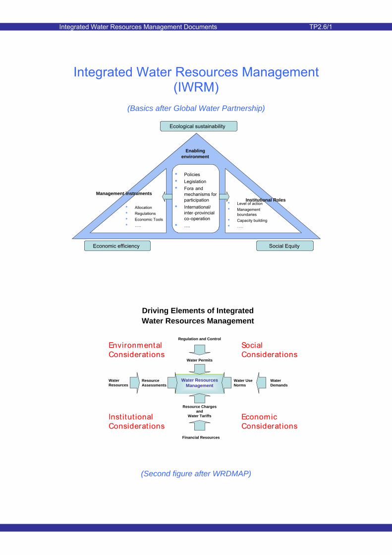
Enabling environment
• Allocation • Regulations • Economic Tools• …..
Management instruments Institutional Roles
Ecological sustainability
Economic efficiency Social Equity
• Policies• Legislation• Fora and
mechanisms for participation
• International/ inter-provincial co-operation
• ….
• Level of action• Management
boundaries• Capacity building• …..
Integrated Water Resources Management (IWRM)
(Basics after Global Water Partnership)
Driving Elements of Integrated Water Resources Management
Water ResourcesManagement
Resource Chargesand
Water Tariffs
Water Permits
Regulation and Control
Water UseNorms
WaterDemands
ResourceAssessments
Financial Resources
WaterResources
EnvironmentalConsiderat ions
SocialConsiderat ions
EconomicConsiderat ions
Inst itut ionalConsiderat ions
(Second figure after WRDMAP)
Integrated Water Resources Management Documents TP2.6/1
Page 1 of 51
1 Introduction In areas where groundwater is an important component of a water resource system, strong and effective management is of crucial importance. This is particularly the case where groundwater plays an important role in the wellbeing of both humans and the environment. Effective groundwater management results in sustainable long term use and avoidance of negative impacts of such use, both in relation to human society and the environment.
This paper aims at helping groundwater managers to obtain insight into the groundwater management process and its components. This insight can be strengthened through exposure to both Chinese and international practice in groundwater management and several examples of both are highlighted in this paper.
It is assumed that the readers will have familiarity with the terminology related to groundwater. Where relevant, reference is given to thematic and advisory notes, which provide more detail on specific aspects of groundwater and its related management components.
2 An International Perspective
2.1 IWRM
Integrated Water Resources Management (IWRM) is seen as an improved approach to water resources management and is being adopted in different forms and levels in many parts of the world. IWRM is being promoted by MWR for adoption throughout China.
Summary: This paper provides an introduction to groundwater management and is aimed at water resources management staff at central, provincial and county levels. The Paper highlights the important components of the groundwater management process and the inter-relationships between those components, both at technical and non-technical levels. Where relevant, reference is made to international and local experience; the latter focuses on the important findings that have resulted from the WRDMAP Case Studies in Gansu Province. International practice in groundwater management is described and aimed at highlighting the important lessons learned during the progress towards best practice. The current status of groundwater management in China is summarised and options for possible strengthening of the management process are presented. This Thematic Paper comprises:
• International perspective on groundwater management, in the context of IWRM
• Main management components • China perspective on groundwater
management (with experience from WRDMAP Case Studies)
• Recommendations for best
practices
• International experience
This document is one of a series covering topics on sustainable water resources planning, allocation and management. Details are given in the bibliography.
The Ministry of Water Resources have supported the Water Resources Demand Management Assistance Project (WRDMAP) to develop this series to support WRD/WAB at provincial, municipal and county levels in their efforts to achieve sustainable water use.
Integrated Water Resources Management Documents TP2.6/1
Page 2 of 51
A brief overview of IWRM is given below, in general and in the context of groundwater.
One of the definitions of Integrated Water Resources Management (IWRM) is as follows:
IWRM is a process which promotes the co-ordinated development and management of water, land and related resources, in order to maximise the resultant economic and social welfare in an equitable manner without compromising the sustainability of vital ecosystems.
‘Integration’ in IWRM relates to many aspects of the land and water system, such as:
• Land and water management
• Surface water and groundwater management
• Quantity and quality in water resources management
• Upstream and downstream water-related interests
• Water and wastewater management
• Integration of all stakeholders in planning & decision process
• The natural system and the human system:
mainstreaming water in the national economy
ensuring coordination between sectors
ensuring partnership between public and private sector management
involving all stakeholders
Groundwater is often an integral part of the water resources system in a river basin. It often plays an important part
in economic and socio-economic development. For example, groundwater is abstracted for irrigation purposes and is thus an important contributor to the livelihoods of rural farmers. It can also serve as an important source for public and industrial water supply, often for reasons of water quality and of accessibility.
Some of the advantages of groundwater over surface water as a usable resource is that it is generally conveniently located to the ‘demand centre’, its availability is not prone to climatic variability, and it is normally of good quality thus requiring little treatment before urban or industrial use.
However, humans are not the only users of groundwater. The water needs of the natural environment can also place demands on the groundwater resource. Rivers can be reliant on groundwater to maintain flows (particularly base flows), while wetland areas or groundwater dependent ecosystems (GWDE) rely on groundwater for their wellbeing. In desert oasis areas, shallow groundwater levels have for centuries maintained the natural vegetation in such areas and averted the encroachment of the desert. Groundwater for human use obviously competes with the requirements for the natural environment. Overuse by humans can lead to severe environmental degradation and even the destruction of inhabited areas.
Human activity also forms a threat to the quality of the groundwater resource. The use of fertilisers and pesticides/herbicides in agriculture forms a threat of diffuse pollution, which becomes particularly alarming when groundwater is used for human
Integrated Water Resources Management Documents TP2.6/1
Page 3 of 51
consumption. Industrial activity and accidental spillage of poisonous substances can be a severe source of point pollution and a clear threat to groundwater quality. If undetected, it can form a serious threat to human health, particularly when contaminated groundwater is used for human consumption.
The use of groundwater inevitably leads to changes in the dynamic behaviour of a groundwater system. This can lead to the lowering of groundwater levels and also the deterioration of groundwater quality, particularly an increase in salinity.
There is clearly a need for balancing the needs of humans and the natural environment, and a need for sustainable management of the groundwater resource so that future generations as well as the environment do not suffer the consequences of uncontrolled use of groundwater.
Problems associated with overuse of limited groundwater resources are evident throughout the world. The realisation that sustainable use is a clear requirement has led to legislation related to various aspects of groundwater resources management. Internationally, such legislation places more and more emphasis on the protection of the natural environment and on the need to protect the groundwater resource from the threats of pollution and salinisation.
There is also a growing realisation that the groundwater resource challenges cannot be successfully overcome by the use of technical solutions only. Access to groundwater resources is basically open to all and thus control of abstraction and usage is often more difficult than for surface water resources.
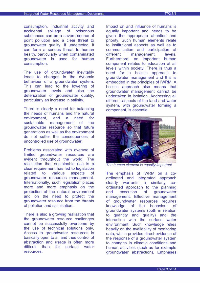
Impact on and influence of humans is equally important and needs to be given the appropriate attention and priority. Such human elements relate to institutional aspects as well as to communication and participation at different management levels. Furthermore, an important human component relates to education at all levels within society. There is thus a need for a holistic approach to groundwater management and this is embedded in the principles of IWRM. A holistic approach also means that groundwater management cannot be undertaken in isolation. Addressing all different aspects of the land and water system, with groundwater forming a component, is essential.
The human element is equally important
The emphasis of IWRM on a co-ordinated and integrated approach clearly warrants a similarly co-ordinated approach to the planning and execution of groundwater management. Effective management of groundwater resources requires knowledge of the behaviour of groundwater systems (both in relation to quantity and quality) and the interaction with the surface water environment. Such knowledge relies heavily on the availability of monitoring data, which provides direct evidence of the response of a groundwater system to changes in climatic conditions and human activities (such as for example groundwater abstraction). Emphases
Integrated Water Resources Management Documents TP2.6/1
Page 4 of 51
and responsibilities will differ depending on the management level and on the significance of groundwater to humans and the environment.
2.2 World Bank GW•MATE Briefing Notes
The World Bank has issued briefing notes related to groundwater. To date, fifteen GW•MATE Briefing Notes have been issued in addition to an overview note. The notes can be downloaded from www.worldbank.org/gwmate.
The notes provide an introduction to the theory and practice of groundwater resources management and protection. They provide useful guidance for water resources and environmental executives with limited experience of groundwater, as well as to groundwater specialists with limited exposure to water resources and environmental management.
The content of the Briefing Notes conforms with the World Bank Water Resources Sector Strategy 2003 since they represent a ‘pragmatic but principled approach that respects the concepts of efficiency, equity and sustainability but recognizes that management can be intensely political and that reform requires prioritized, sequenced, practical and patient interventions’.
2.3 Groundwater management in England
In major parts of England, groundwater plays an important role in the provision of potable water. To a lesser extent, and particularly in the east of England, it is used for irrigation.
Fully integrated water resources management and regulation is practised in the United Kingdom. The
responsibility for administrative, technical and economic regulation resides with the Environment Agency (EA). The EA is the leading public body for protecting and improving the environment in England and Wales. Their mission statement is the following:
‘It's our job to make sure that air, land and water are looked after by everyone in today's society, so that tomorrow's generations inherit a cleaner, healthier world’
As part of IWRM, fully integrated regulation is practised by the Environment Agency. It is driven by the Water Framework Directive, which is a European legislative directive and which is implemented by the regulating authorities in all European Union countries.
The Water Framework Directive (also known as the WFD or Directive 2000/60/EC) is a legislative framework to protect and improve the quality of all water resources within the European Union such as rivers, lakes, groundwater, transitional and coastal water.
3 Groundwater Management Components
3.1 Introduction
The effective management of groundwater has a number of important and fundamental components. In particular these relate to:
• Legislation
• Regulation related to both economic and administrative aspects
Integrated Water Resources Management Documents TP2.6/1
Page 5 of 51
• Good technical understanding and technical competence
• Institutional and administrative strength
• Proactive communication and sharing of data and knowledge/experience
Groundwater management should be seen as an integral part of overall water resource and environmental management in all the above components.
The following sections outline the numerous aspects of effective groundwater management. Where appropriate, reference is made briefly to international and local experience, while more detailed reference is given in Section 6.
3.2 Legislation
In many countries legislation has been introduced to regulate and control groundwater development and to constrain activities that could affect groundwater availability and quality in a negative way.
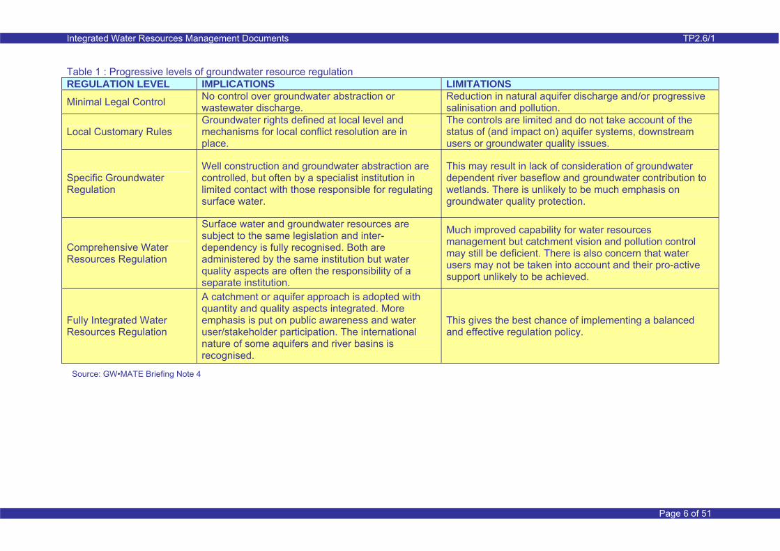
The increasing conflict and competition between groundwater users, which includes both human society and the environment, has in many countries led to an evolution in legislation from a piecemeal approach to a fully integrated approach. This evolutionary approach is illustrated in Table 1 below. It is clear the pressure on groundwater resources creates a necessity for a more integrated management approach.
Modern legislation considers a unified vision of water resources, including both surface water and groundwater. It also calls for specific consideration of groundwater systems and their relationship with land use.
Modern groundwater legislation should be flexible, enabling and enforceable. Generally the basic legislation is restricted to fundamental powers and concepts, while detail is considered in associated regulations and implementation plans.
Legislation and associated regulation may relate to the following:
• Groundwater abstraction and use rights (regulatory instruments)
• Waste water discharge licensing
• Controlling well construction activities
• Catchment or aquifer level resource planning
• Conjunctive use of surface water and groundwater
• Land surface zoning for groundwater conservation and protection
• Facilitating water user and stakeholder participation
• Provision of groundwater monitoring
• Economic instruments
Integrated Water Resources Management Documents TP2.6/1
Page 6 of 51
Table 1 : Progressive levels of groundwater resource regulation REGULATION LEVEL IMPLICATIONS LIMITATIONS
Minimal Legal Control No control over groundwater abstraction or wastewater discharge.
Reduction in natural aquifer discharge and/or progressive salinisation and pollution.
Local Customary Rules Groundwater rights defined at local level and mechanisms for local conflict resolution are in place.
The controls are limited and do not take account of the status of (and impact on) aquifer systems, downstream users or groundwater quality issues.
Specific Groundwater Regulation
Well construction and groundwater abstraction are controlled, but often by a specialist institution in limited contact with those responsible for regulating surface water.
This may result in lack of consideration of groundwater dependent river baseflow and groundwater contribution to wetlands. There is unlikely to be much emphasis on groundwater quality protection.
Comprehensive Water Resources Regulation
Surface water and groundwater resources are subject to the same legislation and inter-dependency is fully recognised. Both are administered by the same institution but water quality aspects are often the responsibility of a separate institution.
Much improved capability for water resources management but catchment vision and pollution control may still be deficient. There is also concern that water users may not be taken into account and their pro-active support unlikely to be achieved.
Fully Integrated Water Resources Regulation
A catchment or aquifer approach is adopted with quantity and quality aspects integrated. More emphasis is put on public awareness and water user/stakeholder participation. The international nature of some aquifers and river basins is recognised.
This gives the best chance of implementing a balanced and effective regulation policy.
Source: GW•MATE Briefing Note 4

Integrated Water Resources Management Documents TP2.6/1
Page 7 of 51
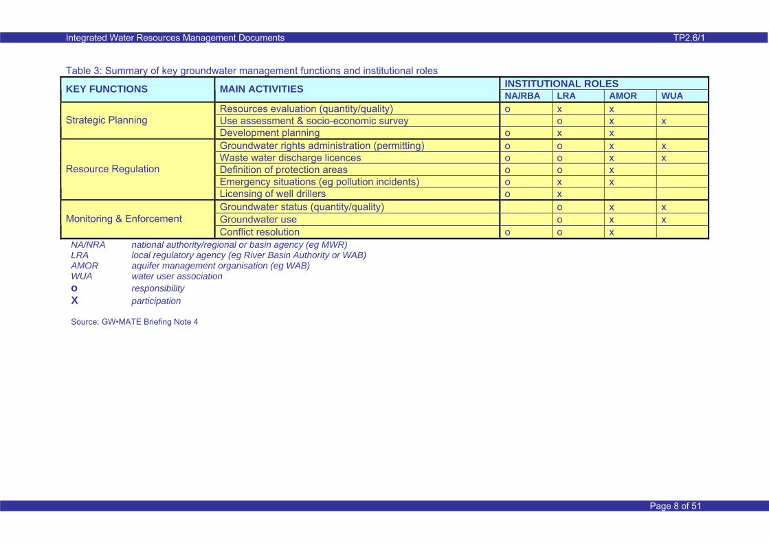
Legislation normally calls for specific legislative provisions in different administrative areas and levels, as illustrated in Table 2 above. The table shows that strategic resource planning resides with national or provincial management authorities, while the responsibility for implementation and administration of legislation lies with lower level management authorities. The table also indicates the need for appropriate administrative setup for the implementation and enforcement of legislation.
Table 3 provides a summary of groundwater management functions and institutional roles at different management levels. The table shows key functions and activities relevant to groundwater management with responsibilities related to different management levels. It is important to note that lower management levels should play an important role through active participation.
Table 2: Management levels
ADMINISTRATIVE SETUP (legal basis for)
National authority or inter-ministerial coordinating commission (integration of quantity/quality aspects) Provincial and/or basin agencies
Procedures for interaction with local authorities Aquifer management organisations Water user associations Licensing of water well drillers
(NATIONAL LEVEL) (LOWEST APPROPRIATE LEVEL*)
STRATEGIC PLANNING LAND USE MANAGEMENT Procedures for groundwater protection
zones Provisions for aquifer recharge area conservation
REGULATION OF WATER USES
Provision for aquifer resource/vulnerability assessment Design and implementation of national/regional/basin groundwater policies Definition of protection (conservation or control) area policy Mandate for drought or emergency actions Status of groundwater plans and use priorities
* depending on size of country or other factors
Administration of abstraction/use rights Administration of waste water discharge permits Promotion of user/stakeholders associations Appeal and sanction procedures
Source: GW•MATE Briefing Note 4
Integrated Water Resources Management Documents TP2.6/1
Page 8 of 51
Table 3: Summary of key groundwater management functions and institutional roles INSTITUTIONAL ROLES KEY FUNCTIONS MAIN ACTIVITIES NA/RBA LRA AMOR WUA
Resources evaluation (quantity/quality) o x x Use assessment & socio-economic survey o x x Strategic Planning Development planning o x x Groundwater rights administration (permitting) o o x x Waste water discharge licences o o x x Definition of protection areas o o x Emergency situations (eg pollution incidents) o x x
Resource Regulation
Licensing of well drillers o x Groundwater status (quantity/quality) o x x Groundwater use o x x Monitoring & Enforcement Conflict resolution o o x
NA/NRA national authority/regional or basin agency (eg MWR) LRA local regulatory agency (eg River Basin Authority or WAB) AMOR aquifer management organisation (eg WAB) WUA water user association o responsibility X participation Source: GW•MATE Briefing Note 4

Integrated Water Resources Management Documents TP2.6/1
Page 9 of 51
3.3 Resource quantification
Useable groundwater resides in aquifers, which are defined as sub-surface reservoirs of unconsolidated sands and gravels or consolidated fissured rock formations. Within an aquifer groundwater moves under natural or induced hydraulic gradients both in horizontal and vertical directions.
In their natural state, groundwater systems are replenished by recharge from a variety of sources, including infiltration from precipitation or flood water and recharge from surface water bodies such as rivers and lakes. Groundwater will move from recharge to discharge zones, which are located at lower elevations. Discharge is in the form of baseflow to rivers, spring discharge and diffuse outflow from a shallow groundwater table (through evaporation and transpiration). Recharge from and discharge to adjacent and connected groundwater systems can also be relevant, while in coastal areas outflow to the sea can be an important discharge component.
Illustration of discharge and recharge zones
Recharge is often directly or indirectly controlled by climate, which determines precipitation and river flows.
Aquifers located near the surface are often unconfined or partially confined (by low permeability surface deposits). The ability for replenishment of such aquifers often depends on the ability of the surface layers to transmit water to the groundwater table.
Confined aquifers are located at a much greater depth than unconfined or partially confined aquifers. Such aquifers may contain substantial quantities of groundwater, though this water is not naturally replenished.
A non-natural state of an aquifer implies that there is influence of man-made activity on the behaviour of the groundwater system. Groundwater abstraction often results in a lowering of groundwater levels, thus changing groundwater flow direction and reducing natural discharge. Lowering of the groundwater table could, on the other hand, induce more natural recharge from precipitation and/or inflow from rivers. If the quantity of groundwater abstraction exceeds recharge, then the groundwater table will continue to lower with time and may not reverse until abstraction is reduced. Groundwater abstraction from deep confined aquifers can result (due to limited recharge) in irreversible lowering of the groundwater table. Conversely, when surface water irrigation is practised, enhanced groundwater recharge occurs. With limited groundwater abstraction, this results in a rise in groundwater levels often causing problems with water logging and salinisation.
Effective groundwater management requires the ability to quantify the available groundwater resource. Groundwater resource quantification requires an understanding of the behaviour of the groundwater system and its interaction with the surface
Integrated Water Resources Management Documents TP2.6/1
Page 10 of 51
water environment. An effective monitoring system for collecting and sharing groundwater related data is a crucial part of this process. It is vital to use technical capabilities to analyse the data, build up a conceptual understanding of the groundwater system, and quantify the available resources.
Failure to correctly estimate the groundwater resource (or the failure to control abstraction from the resource to agreed levels) results in over-abstraction, which if unchecked can destroy local economies, livelihoods and the ecosystem.
The results of over-abstraction can be many-fold and can include:
• Continuous lowering of groundwater levels resulting in ever increasing cost of abstraction, and eventually the inability of some or many abstraction units to pump groundwater (the process is unsustainable). This then results in the collapse of groundwater based irrigated agriculture and possibly urban water supply systems.
• Deterioration of groundwater quality, due either to an imbalance between inputs and outputs of chemical constituents or the intrusion of saline groundwater.
• The deterioration or even the total destruction of ecosystems due to lowering of the groundwater table, reduction in groundwater contribution to rivers or reduction of groundwater discharge to wetlands and groundwater dependent ecosystems (GWDE). In arid regions, the destruction of natural vegetation is often
irreversible, leading to desert encroachment which is a major threat to a desert oasis.
• Land subsidence
Quantifying the recharge process
One of the most important aspects of groundwater resource quantification is a thorough understanding of the recharge process and the ability to quantify recharge.
The basis for assessment of recharge is thus both a solid understanding of the recharge components and the availability of data relevant to the estimation of quantity.
Recharge from precipitation is variable depending on a large number of controlling parameters. First of all it requires climatic data both in a spatial and time-variant context, and in particular rainfall (or snow fall) and potential evapotranspiration. The second set of parameters relates to landforms, soils and land use (which influences precipitation runoff and infiltration) and evapotranspiration of the infiltrating water in the upper zone of the soil profile. This upper zone can either be a thin zone where soils are bare, or the effective root zone of crops and natural vegetation.
Surplus water within the upper soil zone will percolate down to the groundwater table. This downward flow can be constrained by geology and the ability of deeper horizons to transmit water (such as for example clay layers). This can result in so called ‘rejection’ of surplus water in the form of interflow and outflow to drainage systems.
Precipitation recharge can be constrained by shallow groundwater table conditions and ‘rejection’ of part
Integrated Water Resources Management Documents TP2.6/1
Page 11 of 51
or all of the potential recharge (the recharge that would occur if the groundwater table is deep) is possible. Such rejection can be in the form of drainage, interflow or evaporation from the shallow groundwater table.
Surface runoff is controlled by land surface slope and soil surface infiltration capacity. Runoff may re-infiltrate when it encounters more permeable ground surface conditions.
Natural recharge is often quantified using soil moisture balance models and/or spatially distributed hydrological models.
Rivers can also contribute to recharge when river levels are higher than the level of groundwater underneath and adjacent to the river. Recharge from rivers can be both spatially and time variable. The quantity of recharge depends on the river bed hydraulic properties, the nature of the underlying geology and the difference between river level and groundwater level.
Lateral groundwater movement from adjacent groundwater bodies can also be considered as a form of recharge.
The quantity of such flow is determined by the aquifer transmissivity and hydraulic gradient.
Impact of water use on recharge
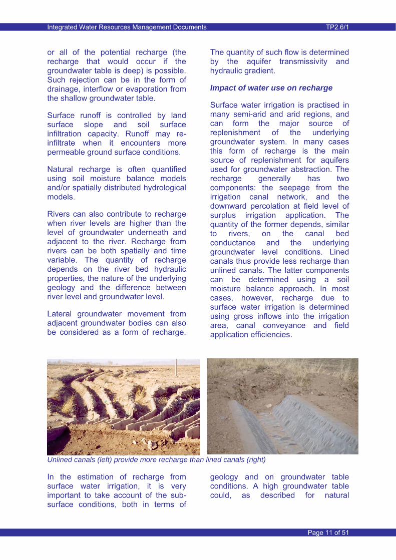
Surface water irrigation is practised in many semi-arid and arid regions, and can form the major source of replenishment of the underlying groundwater system. In many cases this form of recharge is the main source of replenishment for aquifers used for groundwater abstraction. The recharge generally has two components: the seepage from the irrigation canal network, and the downward percolation at field level of surplus irrigation application. The quantity of the former depends, similar to rivers, on the canal bed conductance and the underlying groundwater level conditions. Lined canals thus provide less recharge than unlined canals. The latter components can be determined using a soil moisture balance approach. In most cases, however, recharge due to surface water irrigation is determined using gross inflows into the irrigation area, canal conveyance and field application efficiencies.
Unlined canals (left) provide more recharge than lined canals (right) In the estimation of recharge from surface water irrigation, it is very important to take account of the sub-surface conditions, both in terms of
geology and on groundwater table conditions. A high groundwater table could, as described for natural
Integrated Water Resources Management Documents TP2.6/1
Page 12 of 51
recharge, result in ‘rejection’ of potential recharge.
The above discussion has already indicated the potential for recharge being a dynamic process that depends on the underlying groundwater conditions. Where shallow groundwater table conditions occur, groundwater level lowering (eg. due to artificial drainage or groundwater abstraction) would result in enhancement of recharge.
In urban areas significant recharge can occur due to leakage losses from water supply distribution systems and, possibly also, from urban drainage and sewage systems. Such form of recharge can be significant and in some major cities around the world has resulted in undesirable rise in groundwater levels (for example, in London, England and Riyadh, Saudi Arabia). On the other hand, urbanisation often leads to a reduction in natural recharge, due to the increase in impermeable surface.
Recharge can be artificially enhanced through creation of infiltration ponds or other means of enhancing infiltration of surplus rainfall, river flow and runoff. One aspect related to this (and that has received considerable attention in many developed countries) is the adoption of sustainable urban drainage systems. Such systems collect urban runoff and encourage collected water to recharge the groundwater. They often have a dual purpose to also enhance the natural environment within urban areas.
For more detail on recharge processes and quantification reference is made to Thematic Paper 1.2 ‘Groundwater Resources Quantity Assessment’.
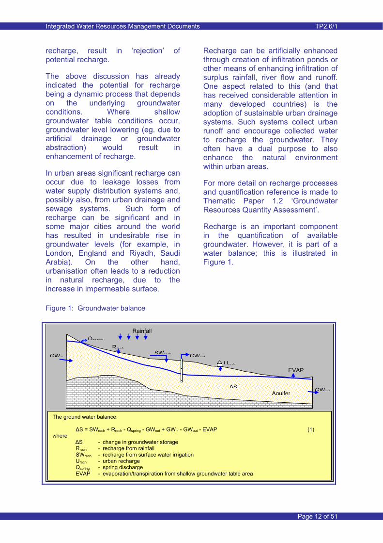
Recharge is an important component in the quantification of available groundwater. However, it is part of a water balance; this is illustrated in Figure 1.
Figure 1: Groundwater balance
The ground water balance: ΔS = SWrech + Rrech - Qspring - GWnet + GWin - GWout - EVAP (1) where ΔS - change in groundwater storage
Rrech - recharge from rainfall SWrech - recharge from surface water irrigation Urech - urban recharge Qspring - spring discharge EVAP - evaporation/transpiration from shallow groundwater table area
Impermeable rock
Rainfall
AquiferΔS
SWrech
GWout
GWin GWnet
Rrech
EVAP
Qspring
Urech

Integrated Water Resources Management Documents TP2.6/1
Page 13 of 51
3.4 Groundwater modelling
Groundwater models have been used since the 1970’s as a tool to assist in groundwater resource estimation and quantification. With the advances in computer technology, groundwater models have become more advanced and also more detailed. And with the development of powerful data processing and visualisation tools, groundwater models are nowadays often used within a GIS environment.
Groundwater models are commonly used for the following reasons:
• Models provide a common management framework open to critical review.
• Conceptual and numerical models provide a high level of understanding of groundwater and surface water flow systems.
• The predictive capability of well constructed models is much better than traditional non-modelling approaches. A good model combined with good documentation and understandable output provides both confident and defensible decision making.
Groundwater modelling is used to quantify the water resource availability in complex, dynamic groundwater and surface water systems. Increasingly models are used to assess the environmental impacts of abstraction and climate variability/change.
A model must be technically sound and be an agreed representation of the combined groundwater and surface water system. It needs to be based on a shared understanding (the conceptual model) of groundwater system behaviour and its interactions with the surface water environment. A
numerical model should adequately represent this conceptual understanding before it is used as a predictive tool for resources planning and management.
Thematic Paper 1.1’Groundwater Flow Modelling’ provides detail on the whole process of groundwater modelling and Section 6.2 summarises the modelling process. Groundwater modelling should therefore not just be seen as a numerical exercise, but rather as a holistic process aimed at fully understanding a groundwater system and its inter-relationships with the surface water environment.
Groundwater resource assessment processes and tools can become components of the management information system (MIS) that is being developed by MWR.
Groundwater models have often been used in the past (and often still in the present) as a one-off means to provide groundwater resource response to a planned resource development. Such models, if not maintained, lose their value quickly. This is particularly the case when documentation on the process of model build and access to the computer programs is limited.
Groundwater models (and now more and more common, integrated groundwater and surface water models) are nowadays considered as major contributors to effective groundwater management. They are seen as capital investments and as products that need to be regularly updated and maintained. They thus have a lifetime of many years and can provide significant and continued benefits to the groundwater management process.
Integrated Water Resources Management Documents TP2.6/1
Page 14 of 51
Groundwater flow modelling
International experience on groundwater modelling is highlighted in Section 6 and relates to the National and Regional Frameworks for Groundwater Modelling in the UK, which have been implemented over the past 10 years in many parts of the United Kingdom.
3.5 Groundwater quality
Groundwater is generally only of value to human and environmental use when its quality conforms to certain standards. Groundwater used for drinking water needs to be of a quality set by international and/or national
standards. Quality (in particular salinity) of groundwater used for irrigation impacts crop production and irrigation water requirements (more salinity implies more leaching). Quality standards should equally apply to groundwater used for industry.
Maintaining good groundwater quality and avoiding groundwater pollution/ deterioration is an important component of good groundwater management. As for groundwater resource quantification, it requires a sound conceptual understanding of the groundwater flow system and adequate monitoring data in both space and time. It furthermore requires an understanding of the potential sources of pollution, particularly when these are of human origin.
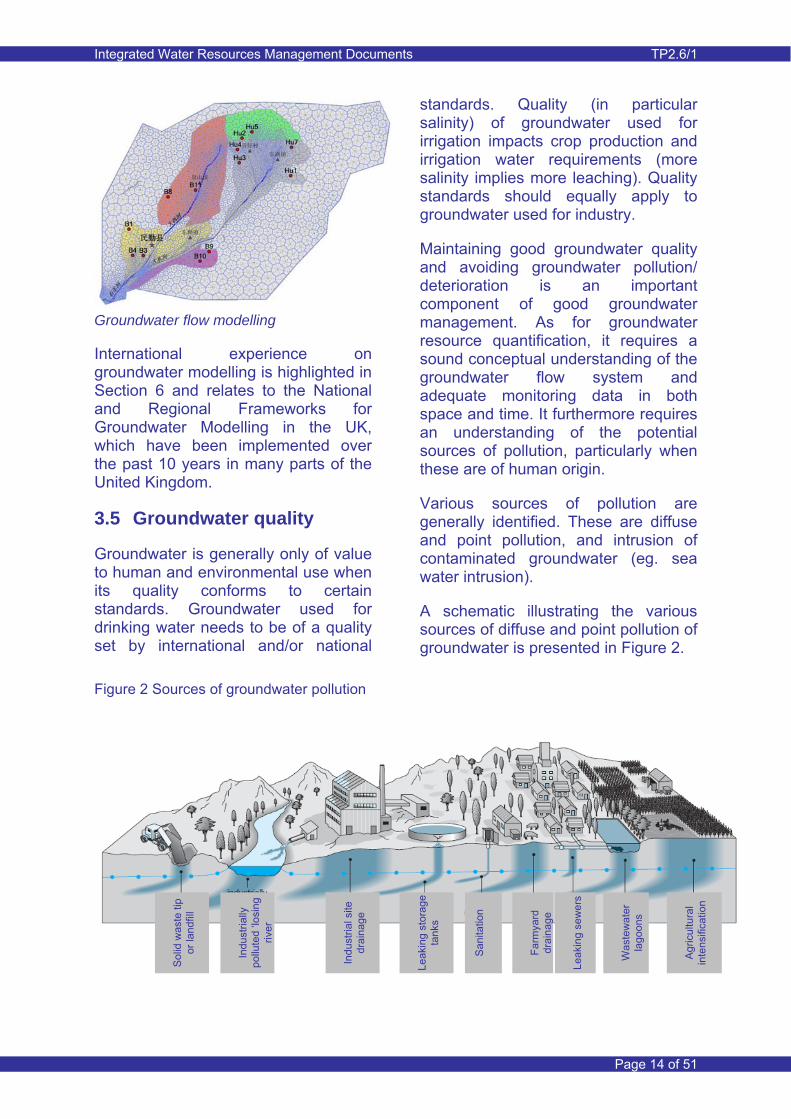
Various sources of pollution are generally identified. These are diffuse and point pollution, and intrusion of contaminated groundwater (eg. sea water intrusion).
A schematic illustrating the various sources of diffuse and point pollution of groundwater is presented in Figure 2.
Figure 2 Sources of groundwater pollution
Sol
id w
aste
tip
or la
ndfil
l
Indu
stria
lly
pollu
ted
‘losi
ng
river
Indu
stria
l site
dr
aina
ge
Leak
ing
stor
age
tank
s
San
itatio
n
Farm
yard
dr
aina
ge
Leak
ing
sew
ers
Was
tew
ater
la
goon
s
Agr
icul
tura
l in
tens
ifica
tion
Integrated Water Resources Management Documents TP2.6/1
Page 15 of 51
Diffuse pollution of groundwater can be caused by application of fertilisers (particularly nitrates) and pesticides. There is a risk that this may become more of a threat as countries develop; as agriculture becomes intensified and commercialised there is a subsequent increase in fertiliser and pesticide application. In the United Kingdom nitrate pollution is becoming a growing problem for drinking water supply. Treatment is expensive and high nitrate levels are a threat to human health. The problem originated during the intensification of agriculture and excessive use of fertiliser in the 1960’s and 1970’s. The nitrate problem has only become apparent years later, since the pollutant moves slowly from the surface to the underlying aquifer. Lessons can obviously be learned from challenges faced in other parts of the world and some of these are illustrated in Section 6.
It is important to consider that the pollution of groundwater can be an extremely slow process, particularly in areas where the groundwater table is deep or in areas where low permeability confining layers are present. Pollution may not become evident until it is too late to easily remediate.
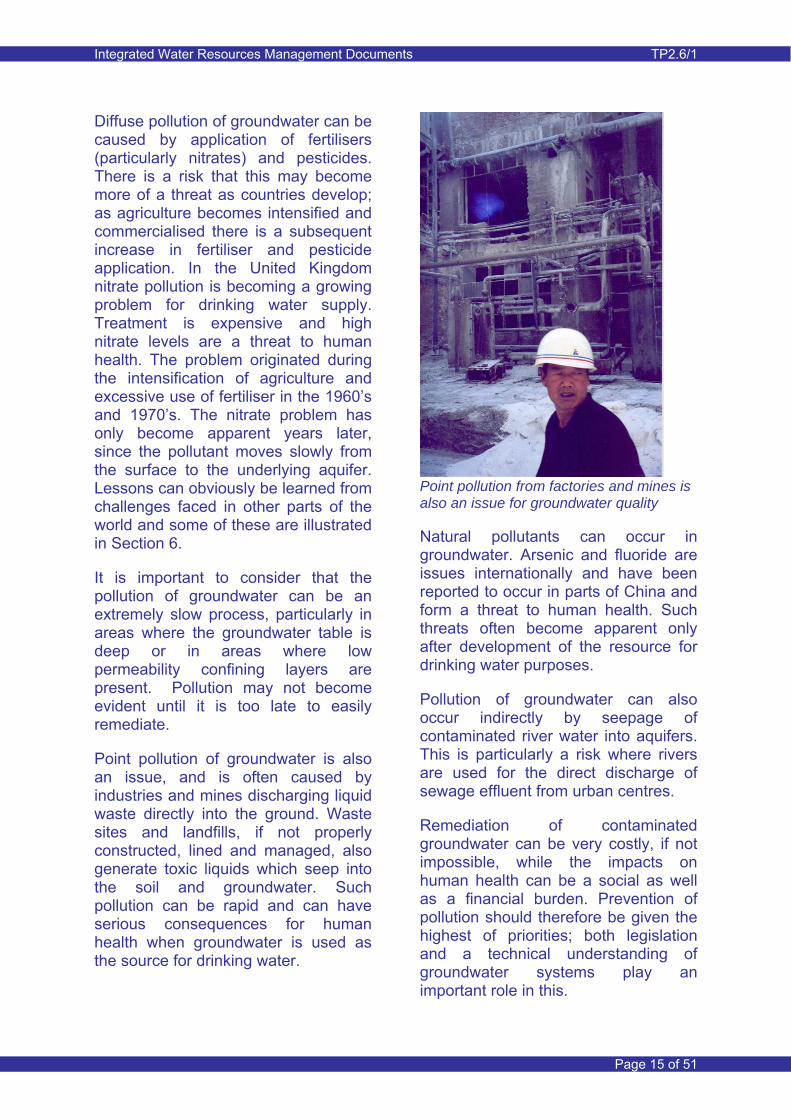
Point pollution of groundwater is also an issue, and is often caused by industries and mines discharging liquid waste directly into the ground. Waste sites and landfills, if not properly constructed, lined and managed, also generate toxic liquids which seep into the soil and groundwater. Such pollution can be rapid and can have serious consequences for human health when groundwater is used as the source for drinking water.
Point pollution from factories and mines is also an issue for groundwater quality
Natural pollutants can occur in groundwater. Arsenic and fluoride are issues internationally and have been reported to occur in parts of China and form a threat to human health. Such threats often become apparent only after development of the resource for drinking water purposes.
Pollution of groundwater can also occur indirectly by seepage of contaminated river water into aquifers. This is particularly a risk where rivers are used for the direct discharge of sewage effluent from urban centres.
Remediation of contaminated groundwater can be very costly, if not impossible, while the impacts on human health can be a social as well as a financial burden. Prevention of pollution should therefore be given the highest of priorities; both legislation and a technical understanding of groundwater systems play an important role in this.
Integrated Water Resources Management Documents TP2.6/1
Page 16 of 51
Chalk
Sand
water table
rainfall
recharge
riverbog
acid fen
saturated
Salinity is an issue when groundwater is used for agriculture. Increased salinity leads to higher irrigation water requirements (increased leaching) and reduces crop yields. Introduction of more salt-tolerant crops should only be seen as a short to medium term solution.
There is also the issue of saline intrusion. This does not necessarily only relate to coastal areas, it can also occur in areas where ancient saline groundwater is mobilised by abstraction of fresh groundwater. The extent of saline intrusion depends on the mobility of the saline water and the ease at which saline water from an external source can replace the body of fresh water. In unconfined aquifers in coastal regions, the groundwater can be in direct contact with the sea and thus accommodate sea water inflow into the aquifer.
3.6 Ecosystems
There are many ecosystems that depend directly or indirectly on groundwater. These are known as “groundwater dependent ecosystems” (GWDE). Some rely on shallow groundwater table conditions so that vegetation has a continuous supply of water. Others rely on surface water that is fed from shallow groundwater. Estuarine and marine ecosystems may also require inflow of fresh groundwater.
Desert oases have long been recognised as important GWDE and particularly the shelter belts of grass, shrubs and trees that protect vulnerable agricultural land from desert encroachment. Such areas can have national or international designations for their importance to migratory birds and animals or for endemic species.
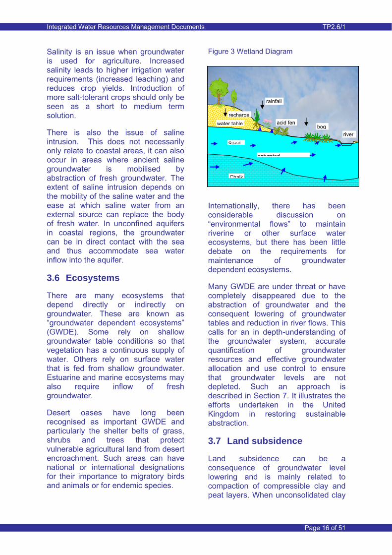
Figure 3 Wetland Diagram
Internationally, there has been considerable discussion on “environmental flows” to maintain riverine or other surface water ecosystems, but there has been little debate on the requirements for maintenance of groundwater dependent ecosystems.
Many GWDE are under threat or have completely disappeared due to the abstraction of groundwater and the consequent lowering of groundwater tables and reduction in river flows. This calls for an in depth-understanding of the groundwater system, accurate quantification of groundwater resources and effective groundwater allocation and use control to ensure that groundwater levels are not depleted. Such an approach is described in Section 7. It illustrates the efforts undertaken in the United Kingdom in restoring sustainable abstraction.
3.7 Land subsidence
Land subsidence can be a consequence of groundwater level lowering and is mainly related to compaction of compressible clay and peat layers. When unconsolidated clay
Integrated Water Resources Management Documents TP2.6/1
Page 17 of 51
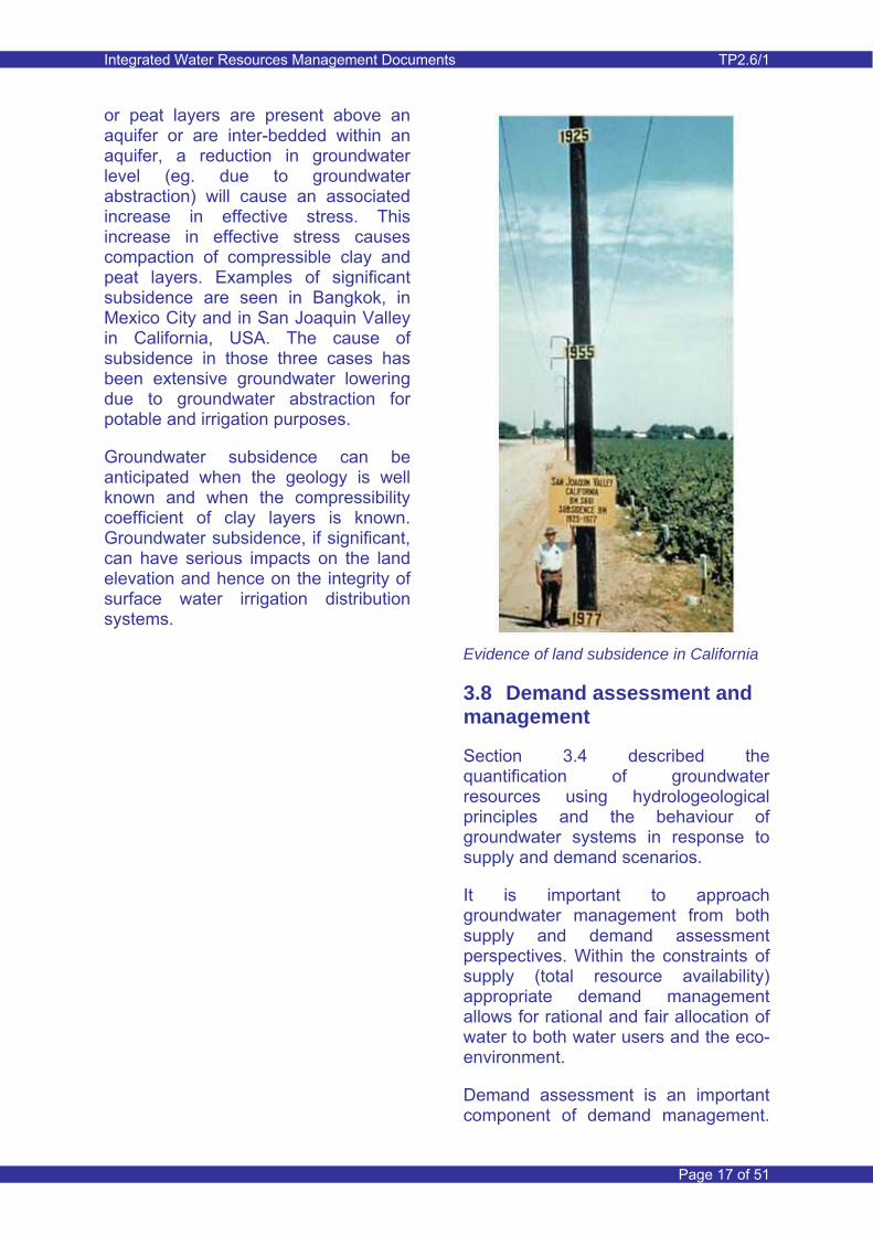
or peat layers are present above an aquifer or are inter-bedded within an aquifer, a reduction in groundwater level (eg. due to groundwater abstraction) will cause an associated increase in effective stress. This increase in effective stress causes compaction of compressible clay and peat layers. Examples of significant subsidence are seen in Bangkok, in Mexico City and in San Joaquin Valley in California, USA. The cause of subsidence in those three cases has been extensive groundwater lowering due to groundwater abstraction for potable and irrigation purposes.
Groundwater subsidence can be anticipated when the geology is well known and when the compressibility coefficient of clay layers is known. Groundwater subsidence, if significant, can have serious impacts on the land elevation and hence on the integrity of surface water irrigation distribution systems.
Evidence of land subsidence in California
3.8 Demand assessment and management
Section 3.4 described the quantification of groundwater resources using hydrologeological principles and the behaviour of groundwater systems in response to supply and demand scenarios.
It is important to approach groundwater management from both supply and demand assessment perspectives. Within the constraints of supply (total resource availability) appropriate demand management allows for rational and fair allocation of water to both water users and the eco-environment.
Demand assessment is an important component of demand management.
Integrated Water Resources Management Documents TP2.6/1
Page 18 of 51
An assessment is required of all the potential users of the groundwater resource. This involves quantifying current and projected water use of industries, farmers, commercial enterprises, household water users (in rural and urban and municipalities) and the eco-environment. It also involves the prioritisation of water use.
Domestic water demand is based on per capita water use norms. Similarly for irrigation, requirements are derived for particular crops depending upon climate, soil types, agronomic practices and irrigation technologies. In this context, demand management approaches need to be considered to reduce the stress on the groundwater resource.
Water savings in urban/municipal water use can result in significant reduction in demand. Water wastage can be avoided by improving the water supply infrastructure (leakage control) and avoiding unnecessary losses within buildings by setting more stringent building standards. Awareness and education need to play a more prominent role in reducing the water needs of people (wise use of water). In addition to behavioural changes, more advanced approaches include the use of ‘grey’ water, or wastewater from domestic activities. Improved and increased re-use is becoming more important in water-constrained systems.
Reduction in industrial water use can be achieved through adoption of improved water use techniques and through the re-use of waste water.
Nevertheless, most of the above measures tend to reduce recharge to groundwater and such factors need to be taken into account.
When undertaking a demand assessment, t is also important to consider water needs for salinity management in the irrigation sector (eg. additional water use to make up for leaching).
3.9 Conjunctive use
There are different reasons for the conjunctive use of groundwater and surface water. The first reason is the control of shallow groundwater table conditions in irrigated areas. Shallow groundwater conditions develop in areas irrigated with surface water and where natural drainage is insufficient to keep groundwater levels at sufficient depth below ground surface. Shallow groundwater table conditions cause water logging and salinity in the root zone of crops and can render irrigated areas unsuitable for further cultivation.
Examples of water logging and salinity problems are available from many parts of the world and even go back to historical times. In modern times the planners of large scale surface water irrigation schemes have sometimes given insufficient attention to the longer-term need for drainage to avoid shallow groundwater table conditions. Groundwater levels may have been deep originally and insufficient groundwater assessment was undertaken to recognise the problem.

Integrated Water Resources Management Documents TP2.6/1
Page 19 of 51
Conjunctive use of surface water and groundwater Groundwater abstraction can be used for groundwater level control. If groundwater is of poor quality, then artificial drainage systems need to be in place to export water from the area. Such a system is, for example, in place on the left bank of the River Indus in Pakistan, where groundwater system conditions favoured the use of vertical drainage. If the groundwater is of good or acceptable quality, it can be used in combination with surface water for irrigation and possible other uses. This reduces the demand for surface water. Examples of this type of conjunctive use can be found in the Tarim Basin in Xinjiang Autonomous Region and in the Nile Valley in Egypt.
A second reason for using conjunctive use of groundwater and surface water is the control of declining groundwater levels in areas where groundwater abstraction has exceeded groundwater recharge. This situation is very common in many parts of Northern China. The use of surface water needs to be sufficient so that recharge to the aquifer balances the net groundwater abstraction. Total resource availability needs to be known and also the variability in the availability of surface water, both over medium time periods
with respect to natural variability, and in terms of the longer term with respect to the possible impacts of climate change. Conjunctive use schemes of this type help buffer the effects of surface water drought because groundwater use can be increased during the periods of reduced surface water supply. During periods of surplus surface water, groundwater use can be decreased and the groundwater resource allowed to replenish through enhanced recharge from surface water deliveries. However, a critical issue is the ability to ensure delivery of surface water to the location that will enable conjunctive use (supply) to be undertaken.
Both cases of conjunctive use involving abstraction of fresh groundwater have the inherent risk of long-term deterioration of groundwater quality. This risk is most pronounced in areas where natural outflow of groundwater and dissolved solids does no longer occur, or is too limited.
The short-term consequences of implementing conjunctive use schemes are often reasonably easy to establish. Assessing the consequences on the long-term
Integrated Water Resources Management Documents TP2.6/1
Page 20 of 51
changes in groundwater quality is more difficult, yet requires appropriate attention. The salinity issue is often ignored because of the slow change in groundwater salinity over time, but may eventually become a serious problem. Assessing groundwater salinity and its changes over time, requires both effective monitoring and the use of salt balance assessment approaches. Integrated groundwater flow and water quality models could also be considered for addressing the longer term salinity changes.
The success of conjunctive use schemes depends to a large extent on the ability to evaluate the response of the aquifer system to the change in water use and water delivery. Appropriate monitoring systems need to be established so that the changes in groundwater levels and groundwater quality can be evaluated both spatially and with time. Water use and delivery, both surface water and groundwater, also need to be monitored. In addition to monitoring facilities, effective groundwater resource assessment tools need to be developed so that, with feedback from the monitoring, continuous improvements to the schemes can be achieved.
3.10 Administrative regulation
Water abstraction permitting allows for control of the amount of groundwater used for different purposes. It is thus a means of avoiding over-abstraction. Generally the permitted quantity is derived from hydrogeological assessments of groundwater systems and on an assessment of other sources of water, such as direct precipitation and surface water.
Abstraction permitting or licensing (as it is sometimes referred to) is an
important management tool used internationally to ensure sustainable use of water resources (surface water and groundwater), including safeguarding environmental water requirements. For example, in England and Wales all wells that abstract more than 20m3/day are licensed. The responsibility of licence administration resides with the government’s Environment Agency. Section 7 provides more detail of this Note provides further detail.
An effective abstraction permit system also allows for easier identification of illegally operated wells and as such enables legal action to ensure closure of such wells or to force the well owner to buy/acquire a legal permit if resource availability allows for this.
Groundwater permits are not necessarily fixed maximum quantities that can be taken from a well. Where this is the case, groundwater is generally the only source of water and often this applies to wells used for supply of drinking water. In arid regions the aim for sustainable groundwater use requires the introduction of conjunctive use schemes. Since surface water availability can be variable and dependent on climatic variability (precipitation in the catchment area of a river for example) the allocated amount of groundwater needs to be specified on an annual basis, or possibly over a longer period in conjunction with surface water supply allocations to meet a total demand.
In some countries (as part of the permitting system for groundwater abstraction) criteria established for the minimum distances between well locations, the density of wells (or aggregated abstractions) from a particular area and sometimes the
Integrated Water Resources Management Documents TP2.6/1
Page 21 of 51
maximum permitted depth of a well for a particular purpose. Such systems need close control and the management of an abstraction permit system through a GIS facilitates this process.
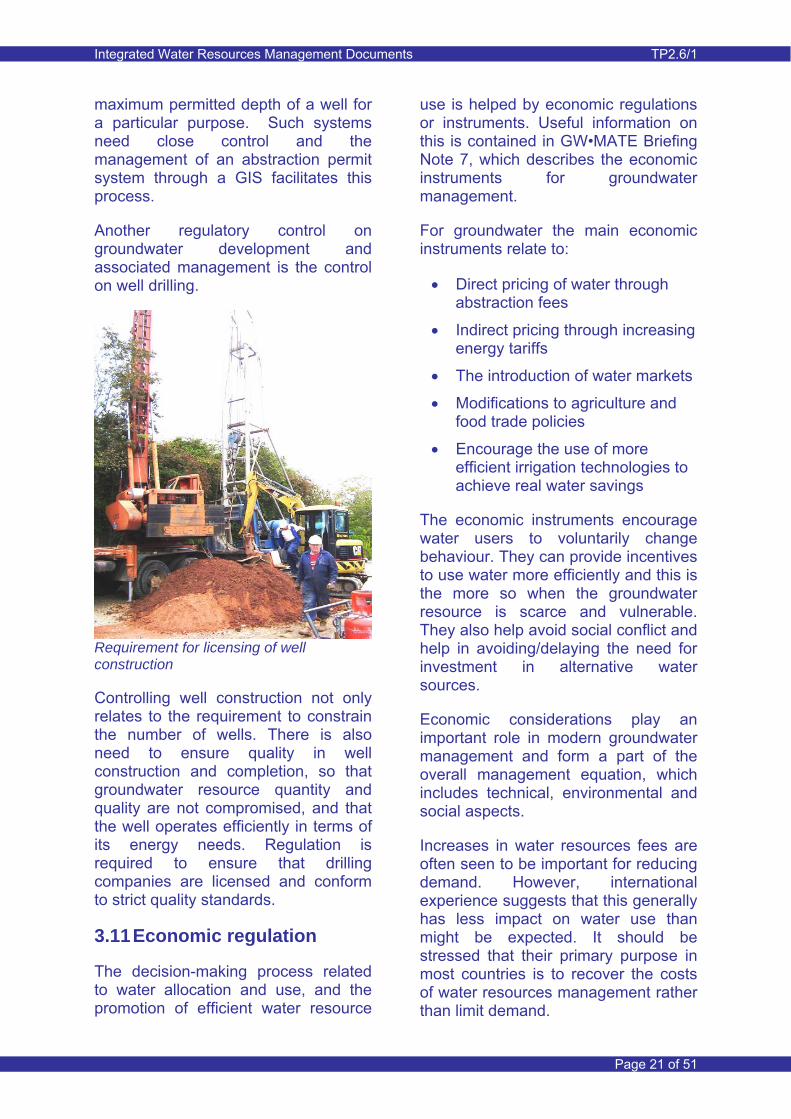
Another regulatory control on groundwater development and associated management is the control on well drilling.
Requirement for licensing of well construction
Controlling well construction not only relates to the requirement to constrain the number of wells. There is also need to ensure quality in well construction and completion, so that groundwater resource quantity and quality are not compromised, and that the well operates efficiently in terms of its energy needs. Regulation is required to ensure that drilling companies are licensed and conform to strict quality standards.
3.11 Economic regulation
The decision-making process related to water allocation and use, and the promotion of efficient water resource
use is helped by economic regulations or instruments. Useful information on this is contained in GW•MATE Briefing Note 7, which describes the economic instruments for groundwater management.
For groundwater the main economic instruments relate to:
• Direct pricing of water through abstraction fees
• Indirect pricing through increasing energy tariffs
• The introduction of water markets
• Modifications to agriculture and food trade policies
• Encourage the use of more efficient irrigation technologies to achieve real water savings
The economic instruments encourage water users to voluntarily change behaviour. They can provide incentives to use water more efficiently and this is the more so when the groundwater resource is scarce and vulnerable. They also help avoid social conflict and help in avoiding/delaying the need for investment in alternative water sources.
Economic considerations play an important role in modern groundwater management and form a part of the overall management equation, which includes technical, environmental and social aspects.
Increases in water resources fees are often seen to be important for reducing demand. However, international experience suggests that this generally has less impact on water use than might be expected. It should be stressed that their primary purpose in most countries is to recover the costs of water resources management rather than limit demand.

Integrated Water Resources Management Documents TP2.6/1
Page 22 of 51
However, well-financed water administration enables better management and hence water use efficiency. Fees also give a clear indication to organisations and water users that water has a value and should be used efficiently. Thus there is some scope for water savings through well structured and effectively implemented fees, particularly if the existing management does not give priority to optimising water use.
3.12 Groundwater protection
Pollution of groundwater is often a slow process, particularly in areas where the groundwater table is deep or in areas where low permeability confining layers are present. It may not become evident that there is a problem until the pollution has spread across the aquifer by which time it is too late and too costly to remove the cause of the pollution. Remediation and thus improvement of groundwater quality can be an even slower process.
The costs of the remediation/ treatment process can be enormous and full remediation often impossible, while the impacts on human health can be a social and well as a financial burden. These costs can far outweigh the ‘benefits’ of reduced cost derived from a non-prevention approach by orders of magnitude.
Prevention of pollution should therefore be given a high priority in groundwater management. Effective pollution prevention requires a technical understanding of the groundwater system as well as clear regulations and strict enforcement of these regulations at all levels
Groundwater protection zoning is an approach that is used internationally to prevent pollution of groundwater sources. The approach to groundwater
protection in the UK is presented in Section 7 of this Note.
Groundwater source protection zones (SPZs) are established around water supply wells to ensure that water for domestic and commercial use does not become contaminated. Within these zones certain activities that have a potential to pollute the underlying groundwater (and subsequently contaminate the water abstracted) are restricted or even forbidden. These activities might include dumping of solid waste, discharging of livestock waste and industrial waste, or use of fertilisers and pesticides on farmland. With respect to the latter, nitrate vulnerable zones (NVZ) can be set up, within which there is restriction on the use of fertilisers.
Source protection zones from the UK’s Environment Agency
The definition of a SPZ is often based on the understanding of the groundwater system and numerical models can be used to define the zones. History has shown that developers have contested the validity of the SPZ and in some cases have undertaken studies to substantiate their claims. It clearly points to the need for water managers to have the tools available to define the behaviour of groundwater systems in the best possible way, so that any claims by
Integrated Water Resources Management Documents TP2.6/1
Page 23 of 51
developers will be difficult to substantiate.
Groundwater quality protection is not simply concerned with preventing the direct discharge of pollutants on to the ground surface. It is also important to prevent the pollution of rivers from which water seeps into the groundwater system. Rivers often become polluted through discharge of domestic sewage and industrial waste. Prevention of such pollution is possible through the issuance of discharge permits, which include requirements for the quality of the discharged water. An effective discharge permitting system requires strict law enforcement.
3.13 Salinity management
One can reach a quantitative balance between inflows into a groundwater system and outflows (such as groundwater abstraction), but that does not automatically mean that a balance between inflow and outflow of dissolved solids is achieved.
Heavy groundwater pumping can result in the inflow of saline groundwater from adjacent geological formations or sea water in coastal areas.
In an arid environment one may aim at balancing the recharge from surface water irrigation against net groundwater abstraction. Irrigation results in accumulation of salts near the ground surface and subsequent migration (particularly during leaching) to the underlying saturated aquifer. A gradual increase in groundwater salinity in the aquifer generally results. Although one would achieve stable groundwater level conditions in this way (Figure 4), this would not be the case with dissolved solids. If no natural outflow of such dissolved solids exists,
then concentrations in the groundwater will gradually increase.
The issue of gradual salinisation of aquifers described above needs serious attention with focus on long-term planning. Adaptation of cropping to a gradual increase in groundwater salinity is possible for many years, but eventually the groundwater will become unsuitable for irrigation.
Figure 4 Groundwater level trends
70
75
80
85
90
95
100
105
110
115
120
Date
Wat
er L
evel
mA
OD
Natural conditionUnsustainable groundwater declineTemporary groundwater level decline
An additional and more immediate problem is related to the use of groundwater for domestic use, because salinity levels need to be much lower for water used for human consumption.
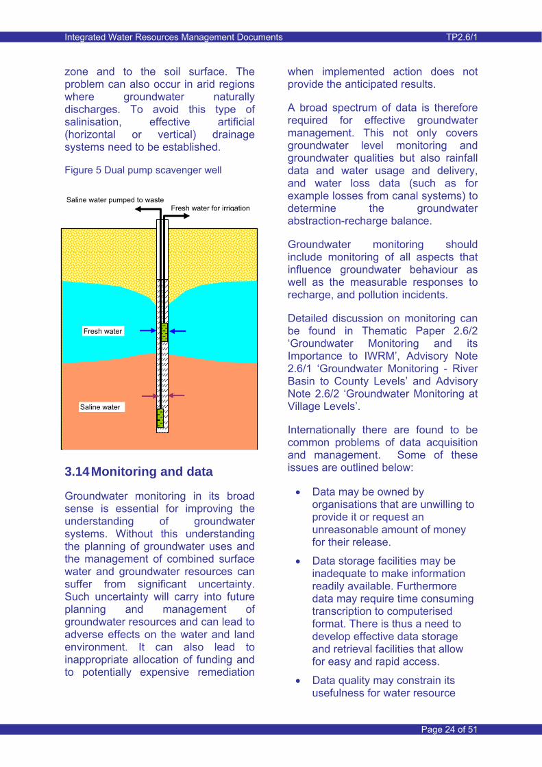
Groundwater salinity (often associated water logging) is a serious problem in many irrigated areas in arid and semi-arid regions where surface water is the only (or main) source for irrigation supply. If natural drainage is insufficient to keep the groundwater table at a low level, upward capillary movement will carry salts into the root
Integrated Water Resources Management Documents TP2.6/1
Page 24 of 51
zone and to the soil surface. The problem can also occur in arid regions where groundwater naturally discharges. To avoid this type of salinisation, effective artificial (horizontal or vertical) drainage systems need to be established.
Figure 5 Dual pump scavenger well
3.14 Monitoring and data
Groundwater monitoring in its broad sense is essential for improving the understanding of groundwater systems. Without this understanding the planning of groundwater uses and the management of combined surface water and groundwater resources can suffer from significant uncertainty. Such uncertainty will carry into future planning and management of groundwater resources and can lead to adverse effects on the water and land environment. It can also lead to inappropriate allocation of funding and to potentially expensive remediation
when implemented action does not provide the anticipated results.
A broad spectrum of data is therefore required for effective groundwater management. This not only covers groundwater level monitoring and groundwater qualities but also rainfall data and water usage and delivery, and water loss data (such as for example losses from canal systems) to determine the groundwater abstraction-recharge balance.
Groundwater monitoring should include monitoring of all aspects that influence groundwater behaviour as well as the measurable responses to recharge, and pollution incidents.
Detailed discussion on monitoring can be found in Thematic Paper 2.6/2 ‘Groundwater Monitoring and its Importance to IWRM’, Advisory Note 2.6/1 ‘Groundwater Monitoring - River Basin to County Levels’ and Advisory Note 2.6/2 ‘Groundwater Monitoring at Village Levels’.
Internationally there are found to be common problems of data acquisition and management. Some of these issues are outlined below:
• Data may be owned by organisations that are unwilling to provide it or request an unreasonable amount of money for their release.
• Data storage facilities may be inadequate to make information readily available. Furthermore data may require time consuming transcription to computerised format. There is thus a need to develop effective data storage and retrieval facilities that allow for easy and rapid access.
• Data quality may constrain its usefulness for water resource
Saline water pumped to waste Fresh water for irrigation
Saline water
Fresh water
Integrated Water Resources Management Documents TP2.6/1
Page 25 of 51
assessment and management purposes. Organisations may be concerned about the quality of their data and may not want this fact to be disclosed to others. Data checking is important and quality assured data guarantees its value for further use.
• Spatial and/or temporal coverage of data may be inadequate. Such shortcomings in the database need to be addressed. The need for new data needs to be considered in terms of its additional value to resource assessment and in terms of cost. The identification of such shortcomings may guide field investigation and monitoring programmes. Identification of shortcomings in temporal data coverage may lead to the adoption of techniques for data infilling.
• Lack of knowledge of data availability can constrain its use in resource assessment. It points towards the need to have systems in place that allow for effective communication and knowledge dissemination.
• Data collection/monitoring programmes need a recurrent (annual) budget for an organisation. Freely giving information away can thus seem like an opportunity lost.
4 China Perspective
4.1 Introduction
In China, groundwater is categorised in terms of its hydrogeological nature into unconfined and confined systems. Unconfined systems are readily replenished, while confined groundwater is considered to comprise
deeply confined aquifers where natural replenishment is slow. The confined groundwater is considered a strategic resource that should not be exploited.
The unconfined groundwater systems do, however, comprise sequences of unconfined and confined aquifers normally utilised for agricultural, domestic and industrial use.
The total groundwater resource is reported to be 821.9 billion m3 split into 245.9 and 576 billion m3 for the northern and southern parts of China respectively. The average annual available amount is estimated to be 123.5 billion m3, with 99.5 and 24 billion m3 for the northern and southern parts respectively.
Groundwater use in rural areas
Large scale utilisation of groundwater in China started during the second half of the 1970’s. The abstraction from the unconfined groundwater system in the plains areas increased by 69% between 1980 and 2000, from 55.7 to 94 billion m3/year. Due to strict regulation introduced after 2000, the
Integrated Water Resources Management Documents TP2.6/1
Page 26 of 51
abstraction rate has reportedly started to stabilise.
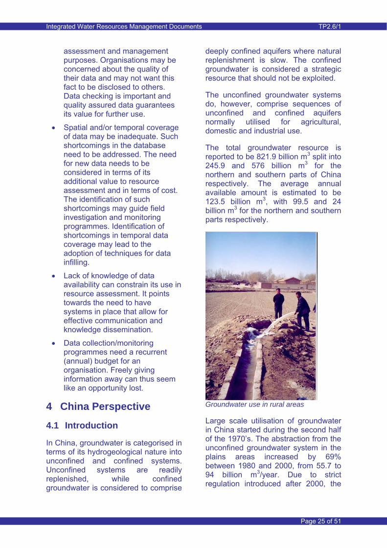
Groundwater is an important source for domestic water supply with total abstraction for rural and domestic use nationwide being 13.5 and 9.5 billion m3/year respectively. This comprises 44% and 27% of total domestic water supply respectively. In addition, supply from groundwater in 400 of the 661 municipalities amounts to 28 billion m3/year for a total municipal population of 120 million.
In 2007 the gross water supply in China was estimated at 582 billion m3/year, of which 107 billion m3/year (18.4%) was from groundwater.
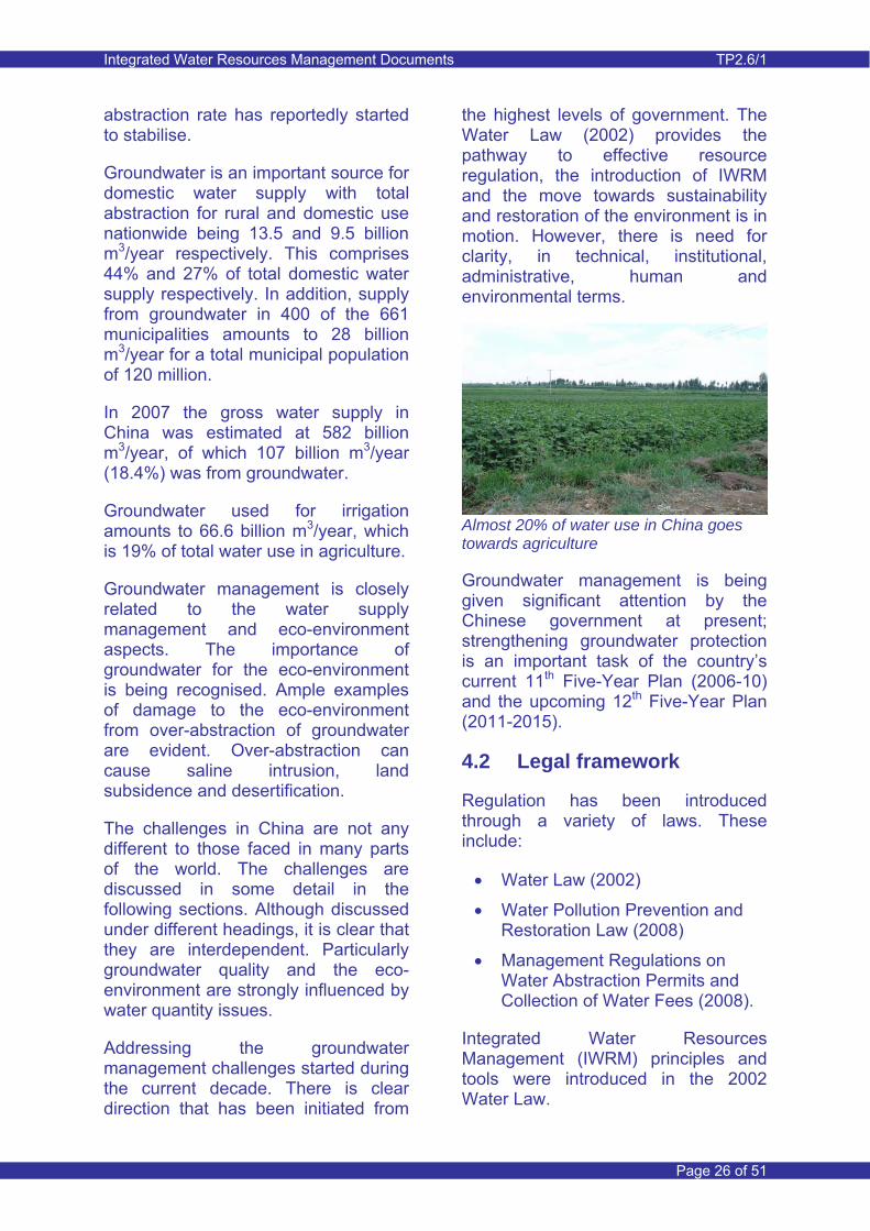
Groundwater used for irrigation amounts to 66.6 billion m3/year, which is 19% of total water use in agriculture.
Groundwater management is closely related to the water supply management and eco-environment aspects. The importance of groundwater for the eco-environment is being recognised. Ample examples of damage to the eco-environment from over-abstraction of groundwater are evident. Over-abstraction can cause saline intrusion, land subsidence and desertification.
The challenges in China are not any different to those faced in many parts of the world. The challenges are discussed in some detail in the following sections. Although discussed under different headings, it is clear that they are interdependent. Particularly groundwater quality and the eco-environment are strongly influenced by water quantity issues.
Addressing the groundwater management challenges started during the current decade. There is clear direction that has been initiated from
the highest levels of government. The Water Law (2002) provides the pathway to effective resource regulation, the introduction of IWRM and the move towards sustainability and restoration of the environment is in motion. However, there is need for clarity, in technical, institutional, administrative, human and environmental terms.
Almost 20% of water use in China goes towards agriculture
Groundwater management is being given significant attention by the Chinese government at present; strengthening groundwater protection is an important task of the country’s current 11th Five-Year Plan (2006-10) and the upcoming 12th Five-Year Plan (2011-2015).
4.2 Legal framework
Regulation has been introduced through a variety of laws. These include:
• Water Law (2002)
• Water Pollution Prevention and Restoration Law (2008)
• Management Regulations on Water Abstraction Permits and Collection of Water Fees (2008).
Integrated Water Resources Management (IWRM) principles and tools were introduced in the 2002 Water Law.
Integrated Water Resources Management Documents TP2.6/1
Page 27 of 51
At present, Chinese regulation falls between ‘Comprehensive Water Resources Regulation’ and ‘Fully Integrated Water Resources Regulation’ as described in Table 1: Progressive Levels of Groundwater Resource Regulation. This is largely attributed to different ministries having responsibility for different aspects of groundwater resource management.
4.3 Management structure
There are three principal ministries involved in groundwater management:
The Ministry of Water Resources (MWR)
• Formulation of water-related policies, development strategies and medium and long-term development plans
• Enabling legislation and design of water-related regulatory frameworks
• Implementation of integrated management of water resources
• Formulation of water resource protection plans
• Formulation of economic regulatory measures for the water sector
• Drafting and supervision of the execution of technical standards for the water sector
• Provision of guidance to activities related to rural water resources
• Organization of water and soil conservation nationwide, included related monitoring
• Responsibility for drought relief
The Ministry of Land Resources (MLR)
• Supervision of hydrogeological, engineering geological exploration and evaluation
• Supervision of monitoring and prevention of over-extraction and contamination of groundwater
• Groundwater exploration in areas where water is seriously deficient in the western region of China
• Groundwater monitoring in major cities
• Subsidence monitoring
The Ministry of Environmental Protection (MEP)
• Implementation of laws, rules and regulations on pollution prevention and control
• Develop general policies and development strategies for national environmental protection
• Conduct environment impact assessment
Aspects of groundwater quantity are largely the responsibility of the Ministry of Water Resources (MWR), while groundwater quality and pollution aspects, and also environmental aspects related to groundwater are the responsibility of the Ministry of Environmental Protection (MEP). The role of the Ministry of Land Resources (MLR) is less clear and involves aspects of groundwater monitoring. Although coordination between Ministries is aimed for, in practice there can be difficulties, particularly in relation to information exchange. At provincial and local levels coordination is variable.
Although there has been a shift in responsibilities for groundwater management to the MWR (principally
Integrated Water Resources Management Documents TP2.6/1
Page 28 of 51
from the MLR), the fact that there have been confusing and overlapping responsibilities in the past has resulted in groundwater management being probably less well developed and performed by the MWR (and local level WRDs) than surface water management. This Note aims at helping to address this issue.
Improved regulations relating to groundwater are required to set out clear responsibilities for different aspects of groundwater management, and improved coordination and collaboration between the different government departments.
Fully integrated water resources legislation ideally requires the overall responsibility of groundwater regulation and management to reside within a single authority. This allows for an integrated approach to water quantity and quality, and environmental management, monitoring and resource assessment.
MEP Action Plan for Environment and Health, 2007-2015
• Establish all-round cooperative mechanism between environment and health departments
• Establish a platform for sharing information
• Mobilize all sections of society to participate in the work of environment and health
• Set up information share service systems
• As a systematic program, environment and health work requires wide participation among various departments, enthusiastic support from different academic fields and good coordination among all social circles
4.4 Resource quantification and over abstraction
Over-abstraction of groundwater is currently seen as the main cause for water quantity problems. The following is an outline of the situation as of 2008:
• There are currently 164 over-abstraction areas in China, while there were only 56 in the early 1980’s.
• The over-abstraction areas have increased from 87000 to 190 thousand km2 from the early 1980’s.
• The annual over-abstraction amount is 11.7 billion m3, of which 4.3 billion m3 is from confined aquifers.
• Over-abstraction results in continuous groundwater level decline and large areas with depressed groundwater levels.
It is evident that over-abstraction has occurred and is still occurring in China and in particular in Northern China. Overcoming the challenges caused by over-abstraction is a major task for the responsible authorities. The process of addressing over-abstraction has started during this decade. For it to be halted or hopefully reversed requires major efforts and will require adaptation to advanced resource management practices.
The results of over-abstraction of groundwater as described in Section 3.4 are evident in many parts of the north of the country.
The largest quoted problem at the provincial and municipality level is a lack of knowledge on how to quantify groundwater resources, available groundwater use and sustainable groundwater abstraction volumes. This
Integrated Water Resources Management Documents TP2.6/1
Page 29 of 51
is particularly a concern at the local level where most groundwater management is undertaken.
Often groundwater flow models are used to aid resource quantification. Past groundwater modelling practice in China has been largely case specific and little standardisation in terms of type of model and modelling practice has been introduced. Modelling studies are commonly undertaken by specialists, often linked to universities. The studies are largely target orientated and do not involve significant stakeholder participation during the modelling study. The models often suffer from a lack of comprehensive data, due to problems of access to historical data. In addition, completed models are not handed over to the institutions that are responsible for water resources management and are often, once completed, not used again, and this may be for lack of capacity to use a complicated model. The models are thus static tools and are not subjected to gradual improvement as more data become available and understanding of the water resource system is enhanced. Thematic Paper 1.1 ‘Groundwater Flow Modelling’ provides detail on the modelling process.
Groundwater Assessment: WRDMAP
An interlinked surface water model (WEAP) and a groundwater model (Tsinghua Groundwater Model) has been developed for the Shiyang Basin (Gansu Province) during the implementation of WRDMAP. The model covers all of the river basin and is used to assess alternative water resources management scenarios. In the course of the modelling study, further data requirements have been identified and have resulted in the establishment of additional monitoring facilities.
4.5 Groundwater quality
There are many issues related to groundwater quality and these require adequate consideration in groundwater resource management.
Salinisation is a problem in areas where the groundwater table has risen to near ground surface due to surface water irrigation. Shallow groundwater and associated salinisation may also occur in areas that act as natural groundwater discharge areas. Shallow groundwater salinisation occurs in parts of Inner Mongolia and Ningxia provinces.
Over-abstraction has led to a gradual deterioration in groundwater quality (gradual increase in salinity, diffuse and point pollution). Without adequate alternative sources of potable water and/or inadequate treatment facilities, polluted groundwater can be a threat to human health.
Serious groundwater pollution occurs in more than 50% of the municipalities in China, with pollution ranging from minor to serious (Yan Yong, Dec 2008).
In Minqin County, Gansu Province (WRDMAP study area) mercury pollution has reportedly led to increased incidence of deaths from cancer. The cause of the pollution has not been identified and would most likely be difficult to identify without incurring high cost. The problem has been addressed by using groundwater for drinking water supply from deeper aquifers that are not contaminated. Prevention of such kind of pollution should be possible and requires strict law enforcement and sanctions against the polluter.
Integrated Water Resources Management Documents TP2.6/1
Page 30 of 51
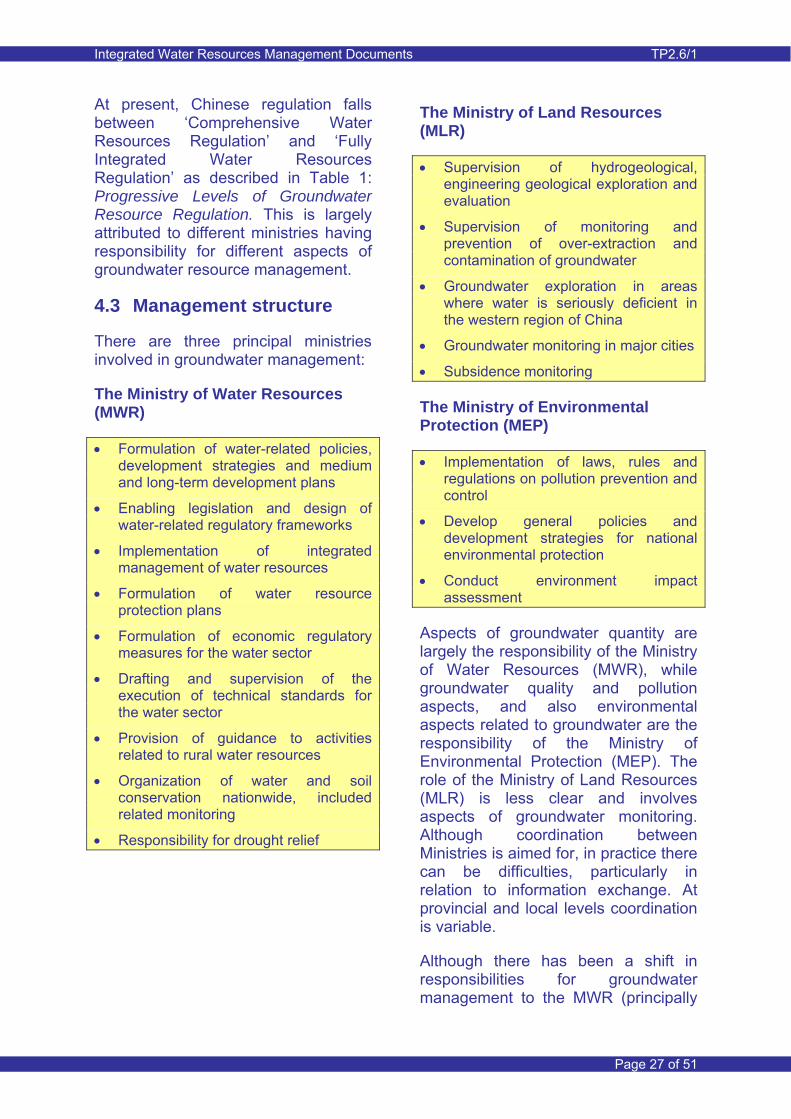
Degradation of the eco-environment – Minqin, Shiyang River Basin
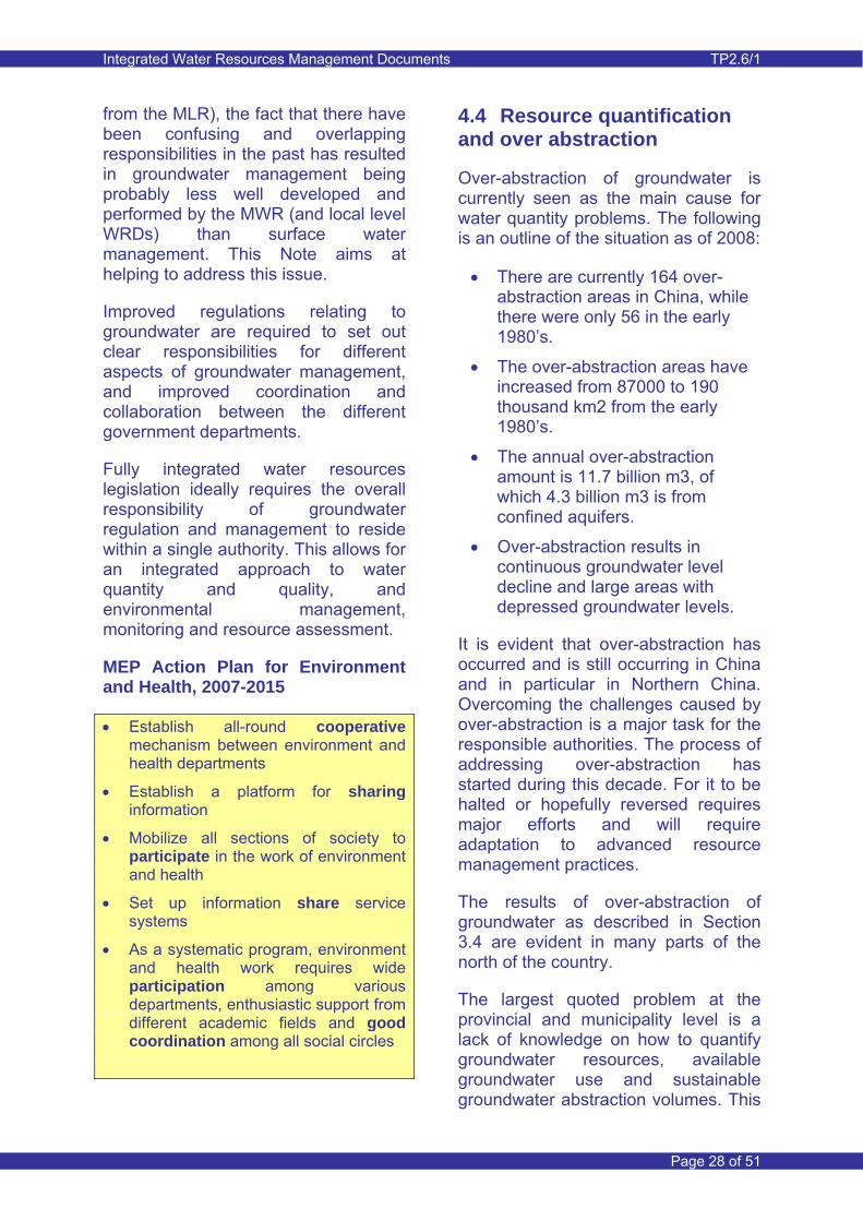
Also in Minqin County, Gansu Province, the records show a gradual rise in salinity, which is caused by over-abstraction of groundwater and continuous return flow of salts through the irrigation recharge process. This has led to abandonment of villages in the northern part of the Minqin oasis, because of the health risks posed by the saline groundwater and the lack of alternative fresh water sources for drinking water.
Minqin, Shiyang River Basin
In Beipiao, urban water supply wells were contaminated by effluent discharges entering the nearby natural drainage system. The groundwater wells were tapping the adjacent contaminated alluvial aquifer.
These are just a few instances of groundwater pollution which were found to be occurring during the course of the WRDMAP activities in the case study areas. It is not believed that these are isolated instances.
4.6 Ecosystems
MWR classifies the challenges related to the eco-environment to include land subsidence, saline water intrusion and land desertification. Saline intrusion was discussed in the previous section. Land desertification relates largely to reduction in groundwater availability to natural vegetation in oasis areas in the arid regions of northern China..
The water demands of the environment are likely to play an ever more important role in groundwater management in China.
4.7 Demand management
For several decades, there has been a focus on supply led means of meeting projected demands with little consideration for demand management. Only within the last ten years has there been focus on the establishment of water saving societies. Elements of this are synonymous with demand management. See Thematic Paper 3.2 ‘Urban Water Supply Demand Management’.
However, there are still major inefficiencies in all sectors in relation to water use. Consequently, in many semi-desert areas there is significant groundwater recharge from these inefficient systems to groundwater. Although improving water use efficiency will/could reduce abstraction demands on groundwater resources, recharge will also be reduced.
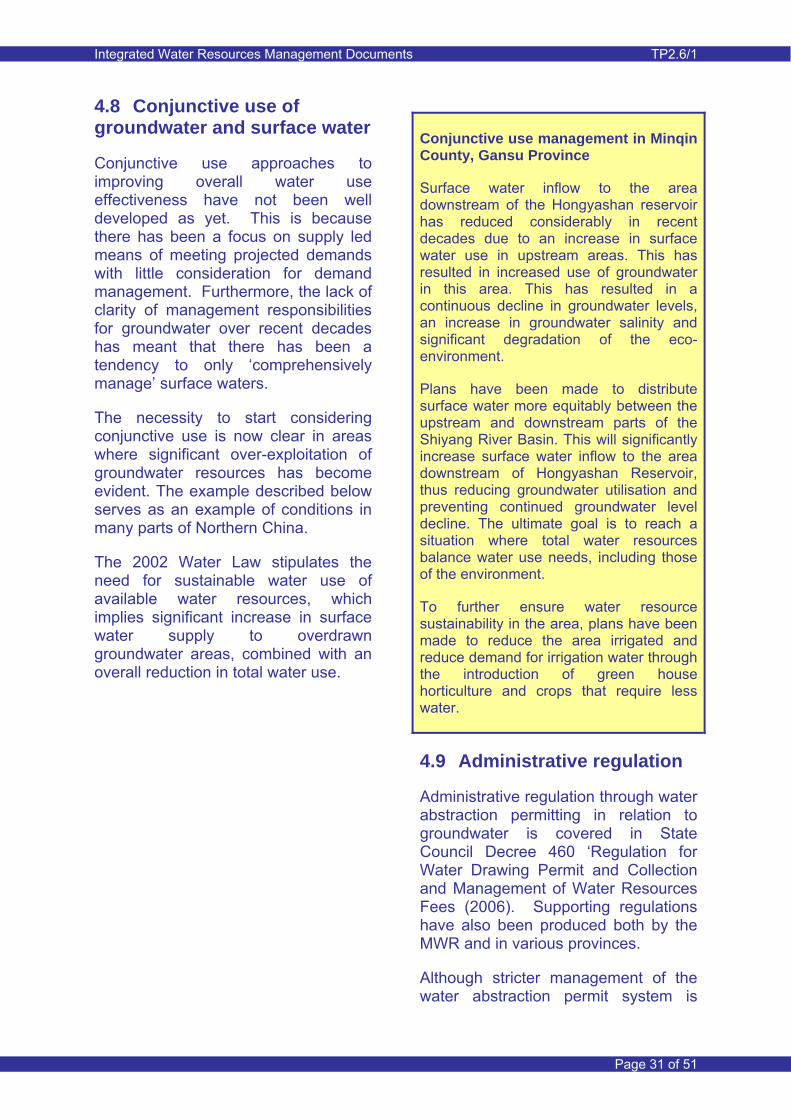
Integrated Water Resources Management Documents TP2.6/1
Page 31 of 51
4.8 Conjunctive use of groundwater and surface water
Conjunctive use approaches to improving overall water use effectiveness have not been well developed as yet. This is because there has been a focus on supply led means of meeting projected demands with little consideration for demand management. Furthermore, the lack of clarity of management responsibilities for groundwater over recent decades has meant that there has been a tendency to only ‘comprehensively manage’ surface waters.
The necessity to start considering conjunctive use is now clear in areas where significant over-exploitation of groundwater resources has become evident. The example described below serves as an example of conditions in many parts of Northern China.
The 2002 Water Law stipulates the need for sustainable water use of available water resources, which implies significant increase in surface water supply to overdrawn groundwater areas, combined with an overall reduction in total water use.
Conjunctive use management in Minqin County, Gansu Province
Surface water inflow to the area downstream of the Hongyashan reservoir has reduced considerably in recent decades due to an increase in surface water use in upstream areas. This has resulted in increased use of groundwater in this area. This has resulted in a continuous decline in groundwater levels, an increase in groundwater salinity and significant degradation of the eco-environment.
Plans have been made to distribute surface water more equitably between the upstream and downstream parts of the Shiyang River Basin. This will significantly increase surface water inflow to the area downstream of Hongyashan Reservoir, thus reducing groundwater utilisation and preventing continued groundwater level decline. The ultimate goal is to reach a situation where total water resources balance water use needs, including those of the environment.
To further ensure water resource sustainability in the area, plans have been made to reduce the area irrigated and reduce demand for irrigation water through the introduction of green house horticulture and crops that require less water.
4.9 Administrative regulation
Administrative regulation through water abstraction permitting in relation to groundwater is covered in State Council Decree 460 ‘Regulation for Water Drawing Permit and Collection and Management of Water Resources Fees (2006). Supporting regulations have also been produced both by the MWR and in various provinces.
Although stricter management of the water abstraction permit system is
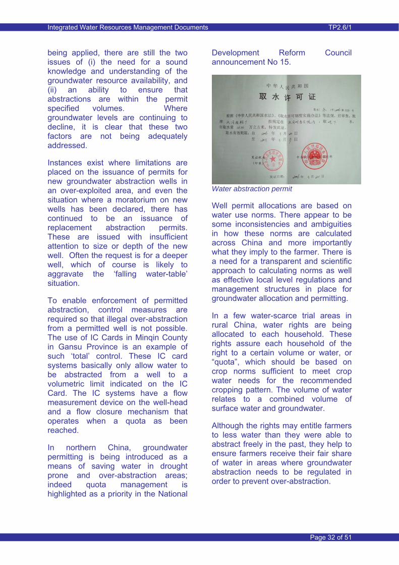
Integrated Water Resources Management Documents TP2.6/1
Page 32 of 51
being applied, there are still the two issues of (i) the need for a sound knowledge and understanding of the groundwater resource availability, and (ii) an ability to ensure that abstractions are within the permit specified volumes. Where groundwater levels are continuing to decline, it is clear that these two factors are not being adequately addressed.
Instances exist where limitations are placed on the issuance of permits for new groundwater abstraction wells in an over-exploited area, and even the situation where a moratorium on new wells has been declared, there has continued to be an issuance of replacement abstraction permits. These are issued with insufficient attention to size or depth of the new well. Often the request is for a deeper well, which of course is likely to aggravate the ‘falling water-table’ situation.
To enable enforcement of permitted abstraction, control measures are required so that illegal over-abstraction from a permitted well is not possible. The use of IC Cards in Minqin County in Gansu Province is an example of such ‘total’ control. These IC card systems basically only allow water to be abstracted from a well to a volumetric limit indicated on the IC Card. The IC systems have a flow measurement device on the well-head and a flow closure mechanism that operates when a quota as been reached.
In northern China, groundwater permitting is being introduced as a means of saving water in drought prone and over-abstraction areas; indeed quota management is highlighted as a priority in the National
Development Reform Council announcement No 15.
Water abstraction permit
Well permit allocations are based on water use norms. There appear to be some inconsistencies and ambiguities in how these norms are calculated across China and more importantly what they imply to the farmer. There is a need for a transparent and scientific approach to calculating norms as well as effective local level regulations and management structures in place for groundwater allocation and permitting.
In a few water-scarce trial areas in rural China, water rights are being allocated to each household. These rights assure each household of the right to a certain volume or water, or “quota”, which should be based on crop norms sufficient to meet crop water needs for the recommended cropping pattern. The volume of water relates to a combined volume of surface water and groundwater.
Although the rights may entitle farmers to less water than they were able to abstract freely in the past, they help to ensure farmers receive their fair share of water in areas where groundwater abstraction needs to be regulated in order to prevent over-abstraction.
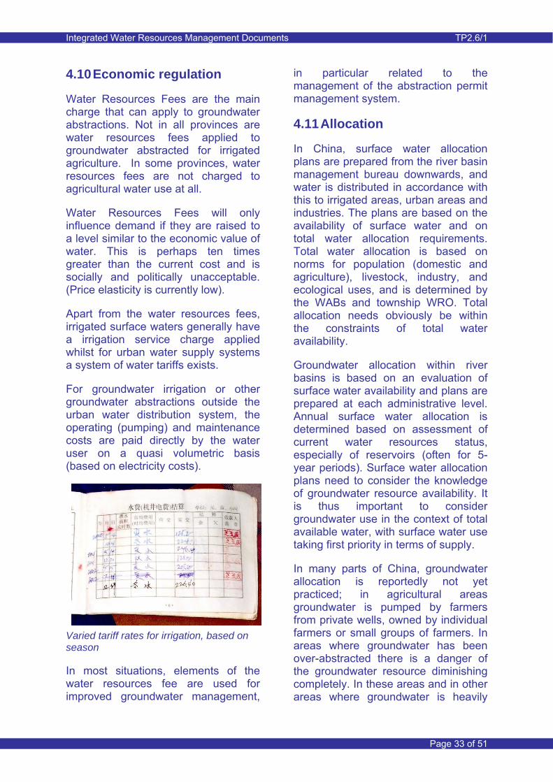
Integrated Water Resources Management Documents TP2.6/1
Page 33 of 51
4.10 Economic regulation
Water Resources Fees are the main charge that can apply to groundwater abstractions. Not in all provinces are water resources fees applied to groundwater abstracted for irrigated agriculture. In some provinces, water resources fees are not charged to agricultural water use at all.
Water Resources Fees will only influence demand if they are raised to a level similar to the economic value of water. This is perhaps ten times greater than the current cost and is socially and politically unacceptable. (Price elasticity is currently low).
Apart from the water resources fees, irrigated surface waters generally have a irrigation service charge applied whilst for urban water supply systems a system of water tariffs exists.
For groundwater irrigation or other groundwater abstractions outside the urban water distribution system, the operating (pumping) and maintenance costs are paid directly by the water user on a quasi volumetric basis (based on electricity costs).
Varied tariff rates for irrigation, based on season
In most situations, elements of the water resources fee are used for improved groundwater management,
in particular related to the management of the abstraction permit management system.
4.11 Allocation
In China, surface water allocation plans are prepared from the river basin management bureau downwards, and water is distributed in accordance with this to irrigated areas, urban areas and industries. The plans are based on the availability of surface water and on total water allocation requirements. Total water allocation is based on norms for population (domestic and agriculture), livestock, industry, and ecological uses, and is determined by the WABs and township WRO. Total allocation needs obviously be within the constraints of total water availability.
Groundwater allocation within river basins is based on an evaluation of surface water availability and plans are prepared at each administrative level. Annual surface water allocation is determined based on assessment of current water resources status, especially of reservoirs (often for 5-year periods). Surface water allocation plans need to consider the knowledge of groundwater resource availability. It is thus important to consider groundwater use in the context of total available water, with surface water use taking first priority in terms of supply.
In many parts of China, groundwater allocation is reportedly not yet practiced; in agricultural areas groundwater is pumped by farmers from private wells, owned by individual farmers or small groups of farmers. In areas where groundwater has been over-abstracted there is a danger of the groundwater resource diminishing completely. In these areas and in other areas where groundwater is heavily
Integrated Water Resources Management Documents TP2.6/1
Page 34 of 51
used, local government authorities have introduced well permits to allocate groundwater for different purposes and thereby to control its abstraction and use.
Feedback from the groundwater level monitoring programme is an essential part of the allocation planning.
Water allocation control – Shiyang River Basin, Gansu Province
Long term water allocation strategies have been developed by the Shiyang River Basin Management Bureau (SRBMB). The plan aims at long term sustainable use of water resources (both surface water and groundwater) and satisfying demands for socio-economic activities and the eco-environment. The long term water allocation and use strategy is set out in the SRB management plan. The allocation of surface water for irrigation is determined from an analysis of available reservoir storage capacity and projected surface water inflow to the reservoirs. The distribution of surface water within the basin is in line with the strategy set out in the management plan.
On this basis and in line with the basin management plan, Water Affairs Bureaus (WAB) (Municipality/County/Districts) control the allocation of surface water to irrigation command areas. The WABs also inform WUAs of the availability of surface water and, on the basis of total permitted quantities determine the allowable quantities of groundwater abstraction.
WUAs have responsibility for co-ordinating the allocation of water within their WUA area, taking consideration of total permitted quantity and ensuring that all surface water available is effectively used.
When allocating groundwater it is important to reconcile the “demand-side” and “supply-side” approaches to
groundwater management. As discussed in Section 4.9, groundwater permits in rural areas are based on assessment of available resources and medium to long term planning of conjunctive use of surface water and groundwater. Permitting over such periods is influenced by the long term aim to achieve sustainable use of available water resources.
Water allocation quotas are based on available (total permitted) water and on an equitable distribution amongst the water users, taking consideration of priorities in water use.
4.12 Amount control
Control of water use allocation is important in ensuring sustainable water use. Such controls are exercised at different management levels. This is illustrated in an example of water allocation control for a small ‘internalised’ river basin within which conjunctive use of surface water and groundwater will increasingly take place.
Coordinated management requires good communication between management levels and the establishment of effective communication channels.
4.13 Well closure and controlling well construction
Solving the problem of over-abstraction requires reductions in water use. Such reduction can, in part, be achieved through demand management using water saving techniques, but generally also requires a reduction in groundwater abstraction and an alternative water source to satisfy demand. In many water-short areas in Northern China, allocations to households are gradually being

Integrated Water Resources Management Documents TP2.6/1
Page 35 of 51
reduced. Where a significant imbalance exists between groundwater recharge and groundwater abstraction, three measures are required. Firstly the total water use needs to be reduced to a sustainable level. Secondly groundwater abstraction needs to be balanced by recharge, resulting from surface water irrigation. Thirdly, irrigated areas need to be reduced so that crop water demands can be realistically met from available supply. The three measures result in significant reduction in groundwater use and in closure of irrigation wells. Closure furthermore provides security against the over-use of groundwater.
The WRDMAP example presented below is typical of situations in many parts of the arid and semi-arid regions in northern China.
Minqin County well closures
Long term water shortages in Minqin have meant that farmers are required to reduce the area irrigated (a crop area of 2.5 mu/person is envisaged). This has lead to changes in land use such as conversion of agricultural land to grazing land, to well closures and changes in canal management.
A programme of well closure is being implemented where 3,000 wells are to be closed by 2010, with a concomitant reduction in agricultural land use of 0.7 million m.
The livelihoods of farmers are to be protected mainly by facilitating greenhouse construction, which will reduce the cultivated area in the land converted to greenhouses to 35% of the original area (for each 2 mu, 1 mu will be left fallow and 0.3 mu occupied by walls etc). Water use will be approximately 50% less, depending on the crops grown.
4.14 Monitoring and data
Effective groundwater management requires monitoring data, such as groundwater levels and groundwater quality. Apart from a sensible coverage of a monitoring network, monitoring should also be designed to focus on existing and potential problem areas in terms of groundwater over-abstraction or groundwater contamination risk.
Apart from the obvious groundwater data elements, the need to have good information on water abstraction, water usage and system losses are also important to effective groundwater management.
Monitoring is not just a technical issue and in China there is a clear need for integration of monitoring at the different management levels, with clear

Integrated Water Resources Management Documents TP2.6/1
Page 36 of 51
lines of communication, active participation and a pro-active approach to data dissemination and sharing. It is also important to consider groundwater monitoring in the context of financial constraints.
Access to water related data in particular should be seen as an important water management issue in China. Data is of little value when it is not accessible or cannot be made available for groundwater resource assessment. Lack of access to data can severely limit the value of resource assessment tools used in water resources planning and management. International experience shows that the duties of the regulator can only be implemented when access to data is unrestricted.
In China, data access can be somewhat problematic and exchange between different organisations and even sometimes between departments in the same organisation is often limited. The reasons for the restricted access are sometimes not clear and can be many. Many of the common data acquisition and data management issues outlined in Section 3.15 are encountered in China in relation to groundwater management. Such issues require consideration and attention and should lead to concerted action.
5 MWR Initiatives
5.1 Introduction
The key goals to be achieved by 2015 for groundwater management include:
• Establishing groundwater abstraction targets and groundwater level control
• Establishing groundwater monitoring systems in at least
90% of areas where groundwater is used for urban, industrial and domestic use, and at least 40% of irrigated areas.
• Establishing groundwater management policies and regulations
• Reducing (by 50%) groundwater over-abstraction, while abstraction from deep confined aquifers should not be allowed.
• Establishing a management and policy framework for use of groundwater in emergencies and the strategic storage of groundwater.
MWR pumping station
Key goals to be achieved by 2020 for groundwater management include:
• Establishing a comprehensive national groundwater management system.
• Containing the trends of groundwater over-abstraction, and improve the ecological environment in areas which are suffering from serious over-abstraction.
• Completing the groundwater monitoring network, so that 100% of urban areas are covered and 90% of rural areas.
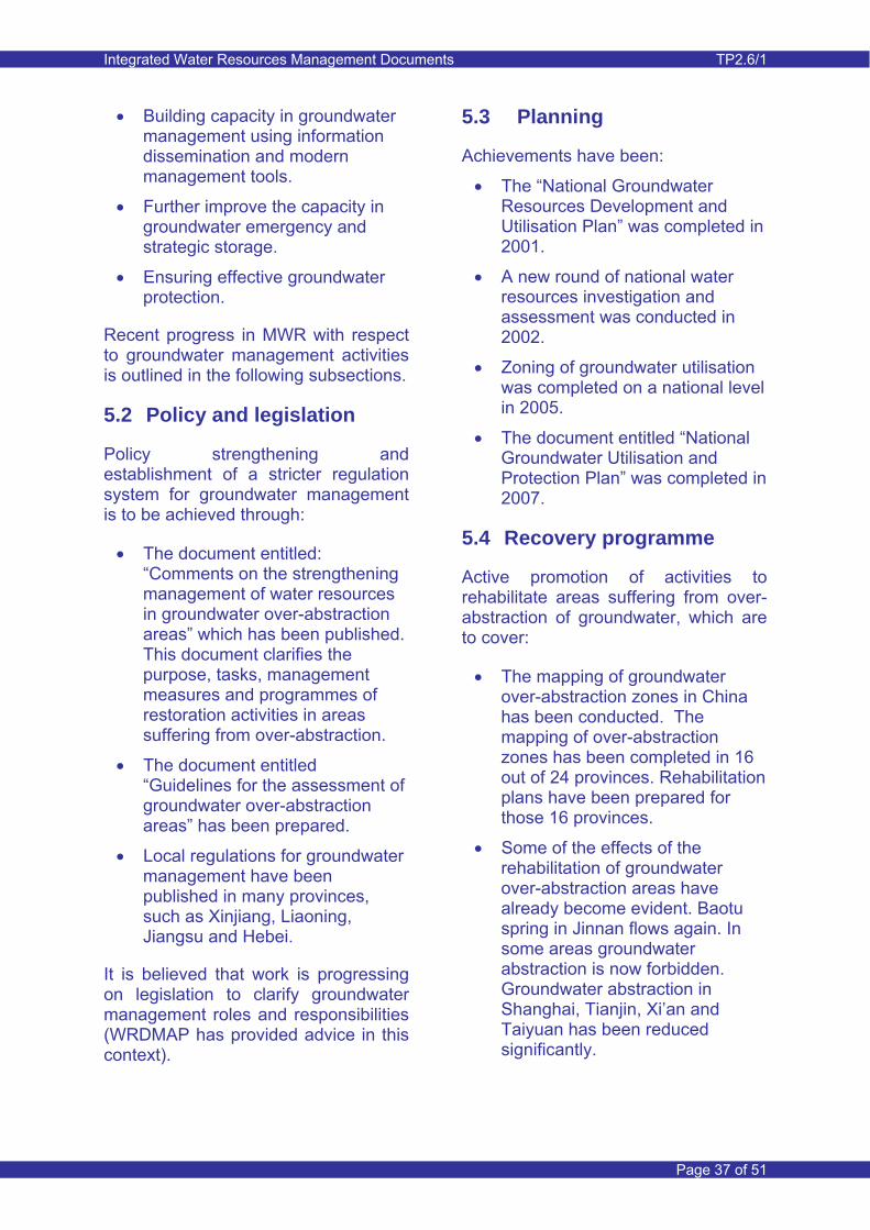
Integrated Water Resources Management Documents TP2.6/1
Page 37 of 51
• Building capacity in groundwater management using information dissemination and modern management tools.
• Further improve the capacity in groundwater emergency and strategic storage.
• Ensuring effective groundwater protection.
Recent progress in MWR with respect to groundwater management activities is outlined in the following subsections.
5.2 Policy and legislation
Policy strengthening and establishment of a stricter regulation system for groundwater management is to be achieved through:
• The document entitled: “Comments on the strengthening management of water resources in groundwater over-abstraction areas” which has been published. This document clarifies the purpose, tasks, management measures and programmes of restoration activities in areas suffering from over-abstraction.
• The document entitled “Guidelines for the assessment of groundwater over-abstraction areas” has been prepared.
• Local regulations for groundwater management have been published in many provinces, such as Xinjiang, Liaoning, Jiangsu and Hebei.
It is believed that work is progressing on legislation to clarify groundwater management roles and responsibilities (WRDMAP has provided advice in this context).
5.3 Planning
Achievements have been:
• The “National Groundwater Resources Development and Utilisation Plan” was completed in 2001.
• A new round of national water resources investigation and assessment was conducted in 2002.
• Zoning of groundwater utilisation was completed on a national level in 2005.
• The document entitled “National Groundwater Utilisation and Protection Plan” was completed in 2007.
5.4 Recovery programme
Active promotion of activities to rehabilitate areas suffering from over-abstraction of groundwater, which are to cover:
• The mapping of groundwater over-abstraction zones in China has been conducted. The mapping of over-abstraction zones has been completed in 16 out of 24 provinces. Rehabilitation plans have been prepared for those 16 provinces.
• Some of the effects of the rehabilitation of groundwater over-abstraction areas have already become evident. Baotu spring in Jinnan flows again. In some areas groundwater abstraction is now forbidden. Groundwater abstraction in Shanghai, Tianjin, Xi’an and Taiyuan has been reduced significantly.
Integrated Water Resources Management Documents TP2.6/1
Page 38 of 51
5.5 Abstraction management
Introduction of strict groundwater abstraction management encompassing:
• Enhanced management of approvals for groundwater abstraction permits.
• Forbid or limit abstraction in areas of over-abstraction.
• Strengthened criteria for the collection of groundwater resources fees - this optimises the resources allocation and makes the resources development more rational by using it as an economic lever.
5.6 Monitoring and data
Strengthening of groundwater monitoring and information dissemination is to be achieved by:
• Advancing the establishment of groundwater monitoring networks.
In their planned work for the future, MWR will implement the planned “National Protection of Groundwater”, with focus on the following tasks:
A) Establishment of a water resources management system
B) Conservation and protection of groundwater
C) The exploitation and management of ecological restoration
D) Construction of the strategic reserve of underground water and emergency water supply
E) Water resources management capacity-building
F) The improvement of groundwater education and public participation.
6 Adopting Best Practice
6.1 Sustainability
Groundwater Resource Usage Sustainability is the overriding aim of groundwater management and should feature strongly in all aspects of groundwater management (and in water management as a whole).
Sustainability can be seen in different ways such as:
• Sustainability in quantitative terms, which implies a balance between average inflow and outflow of water over a sufficiently long time period.
• Sustainability in both quantitative and qualitative terms. Sustainability in quantitative terms can not guarantee the long term sustainability of groundwater quality, because outflow of groundwater and dissolved solids may not be guaranteed.
• Sustainability in water and environmental terms requires the allocation of water to satisfy environmental demands. This may require an intermediate period to enable restoration of sustainable environmental conditions (for example the raising of groundwater levels to shallow depths so that natural vegetation can thrive).
• Sustainability in water, environmental and human terms is the ultimate goal and requires clear balancing of priorities and a large degree of flexibility and adaptability. The recent history in China has clearly shown the
Integrated Water Resources Management Documents TP2.6/1
Page 39 of 51
transient nature of socio-economic development and this can significantly influence the demands on the water environment.
Groundwater abstraction should as far as possible be balanced (in terms of long-term averages) against water inflows into the groundwater system. It does not mean that one aims at establishing completely natural conditions as this could impact on the livelihoods of water users.
To achieve a balance between inflows from non-groundwater sources (such as precipitation and surface water irrigation) and groundwater abstraction, the current conditions and the extent to which these current conditions are acceptable, need to be considered. For example, groundwater levels may have declined over time due to an imbalance between recharge and abstraction. The declining trend would continue if no action were taken and as such create an unsustainable future. One may accept the past declines in groundwater level and create a sustainable future with groundwater levels maintained at that lower level.
An example is the desert oasis of Minqin in Gansu Province where the management aim is to balance recharge (mainly from surface water irrigation and to a limited extent also from lateral groundwater inflow) with net groundwater abstraction. Since there is currently limited natural groundwater outflow from the oasis area, a gradual increase in groundwater salinity will result. Sustainability in the broad sense would thus not be achieved and one would have to consider the acceptability of such a situation.
Well in Minqin County
Achieving sustainability can take a long time and requires considerable interventions, particularly in areas where historical groundwater development has shown adverse impacts on groundwater levels, groundwater quality and the eco-environment. For example, one may want to restore shallow groundwater levels to create buffer zones where vegetation can thrive in areas vulnerable to desertification. This would require enhancing surface water inputs to the groundwater system until the desired conditions are established.
Reaching sustainability may have a serious impact on livelihoods. One needs to consider lead-in times and accommodate changes in the livelihood structure so that adaptation to a sustainable water future can be achieved without compromising livelihoods. Lead-in periods during which a water imbalance still exists may need to be considered.
Under some conditions, replenishment may no longer be feasible and the groundwater resource could consciously be mined. In this situation, an irreversible downward trend in groundwater level is created and the resource is only available for a limited time period. This approach is therefore only acceptable if it is certain that there
Integrated Water Resources Management Documents TP2.6/1
Page 40 of 51
would be no serious impacts as a result.
As part of the ‘Planned Protection of Groundwater’, MWR (Yan Yong, Dec 2008) will establish a water resource management system, which aims at establishing sustainable groundwater use. This will be achieved through the following:
• The establishment of a control system for groundwater level and volume. Provinces and autonomous regions will implement the control system and use it for management of over-abstraction.
• Strict supervision and management of groundwater. A registration system for groundwater water projects is to be established at national level.
• Measures to strengthen supervision and management of groundwater water. This includes the management of water resources fee collection with focus on the city-owned water supply wells and irrigation wells.
• Supporting laws and regulations and paying close attention to the development of "water resources management regulations" and related regulations.
There is clearly a need to develop a time frame for the planned system. There is also the need to consider how sustainable groundwater use is achieved and how effective it is going to be.
6.2 Resource assessment
In order to make a sound assessment of the groundwater resources available for sustainable abstraction it is critical to have an in-depth understanding of
the behaviour of the groundwater system, including how it interacts with the surface water environment. Characterising the groundwater system is the first step to groundwater resource assessment.
There are a number of steps which are important in characterising a groundwater system and which may lead to the eventual development of a groundwater model. But even without a groundwater model, they improve the understanding of the groundwater system significantly. The steps are outlined below.
(i) Data is required for the characterisation of aquifer systems and also for the understanding of its dynamic response to both natural and anthropogenic influences. Data may be categorised into spatially variable but time independent characteristics of the interlinked groundwater and surface system, and spatially variable and time dependent characteristics. The components of each category are summarised as follows, with the time variant information broken down into two sub-categories:
• Time independent data relates to the geological and hydrogeological characterisation of the groundwater system, to geomorphology (including location of rivers), soil characteristics, etc. Strictly speaking such parameters are also time variant, but can generally be considered as non-time variant if relatively short resource assessment periods are used. If changes are rapid, such as for example the influence of desert encroachment on geomorphology, such time variance may need to be considered.
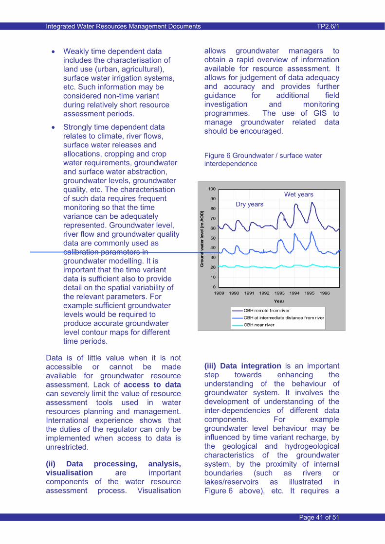
Integrated Water Resources Management Documents TP2.6/1
Page 41 of 51
• Weakly time dependent data includes the characterisation of land use (urban, agricultural), surface water irrigation systems, etc. Such information may be considered non-time variant during relatively short resource assessment periods.
• Strongly time dependent data relates to climate, river flows, surface water releases and allocations, cropping and crop water requirements, groundwater and surface water abstraction, groundwater levels, groundwater quality, etc. The characterisation of such data requires frequent monitoring so that the time variance can be adequately represented. Groundwater level, river flow and groundwater quality data are commonly used as calibration parameters in groundwater modelling. It is important that the time variant data is sufficient also to provide detail on the spatial variability of the relevant parameters. For example sufficient groundwater levels would be required to produce accurate groundwater level contour maps for different time periods.
Data is of little value when it is not accessible or cannot be made available for groundwater resource assessment. Lack of access to data can severely limit the value of resource assessment tools used in water resources planning and management. International experience shows that the duties of the regulator can only be implemented when access to data is unrestricted.
(ii) Data processing, analysis, visualisation are important components of the water resource assessment process. Visualisation
allows groundwater managers to obtain a rapid overview of information available for resource assessment. It allows for judgement of data adequacy and accuracy and provides further guidance for additional field investigation and monitoring programmes. The use of GIS to manage groundwater related data should be encouraged.
Figure 6 Groundwater / surface water interdependence
0
10
20
30
40
50
60
70
80
90
100
1989 1990 1991 1992 1993 1994 1995 1996
Year
Gro
und
wat
er le
vel (
m A
OD
)
OBH remote from river
OBH at intermediate distance from river
OBH near river
(iii) Data integration is an important step towards enhancing the understanding of the behaviour of groundwater system. It involves the development of understanding of the inter-dependencies of different data components. For example groundwater level behaviour may be influenced by time variant recharge, by the geological and hydrogeological characteristics of the groundwater system, by the proximity of internal boundaries (such as rivers or lakes/reservoirs as illustrated in Figure 6 above), etc. It requires a
Dry years Wet years
Integrated Water Resources Management Documents TP2.6/1
Page 42 of 51
systematic approach and a broad understanding of the relationships between groundwater and the influences exerted on its behaviour. It thus requires experienced hydrogeologists with a broad experience of topics relevant to groundwater such as geology, geotechnics, water supply, irrigation, river engineering, wastewater and drainage.
(iv) The tasks related to data analysis and data integration lead to a conceptual understanding of the behaviour of the groundwater system and its interaction with the surface water environment. The understanding of changes to the groundwater environment as a consequence of natural and anthropogenic influences (over a sufficiently long historical period) allows for identification of trends and offers a first opportunity to make judgement of possible future changes in the groundwater environment.
(v) Preliminary water balance analysis allows for judgement of the significance of individual water balance components and their links to related data. It allows for judgement of the importance of certain data items and therefore of the influence of data uncertainty on the quantification of the groundwater balance components.
(vi) An important component of the water balance analysis is the estimation of recharge. Sub-components of recharge include natural recharge from precipitation, seepage from irrigation canals and return flows from field irrigation. Inflows to groundwater related to river seepage and lateral groundwater inflows are generally treated as separate water balance components. Natural recharge from precipitation is
minor in arid areas and is often considered to be fully absorbed by vegetation, or evaporated before entering far into the soil profile. Such recharge may, however, be of some significance in desert areas, particularly during extreme rainfall events that cause runoff and local accumulation of water. Recharge from surface water irrigation is normally determined from gross allocations to canal systems, field delivery and relevant canal and field application efficiency factors. Recharge is a major inflow component of the groundwater balance. The amount of recharge is also dependent upon the soil infiltration capacity and vertical permeability of the upper strata.
(vii) Use of appropriate resource assessment tools. A numerical model of the integrated surface water and groundwater system is not strictly necessary if management decisions can be based on the conceptual understanding of the groundwater system. However, numerical models are used more frequently because of their ability to represent integrated surface water and groundwater systems accurately and in a high degree of detail. Improved computer power has facilitated the use of models. One should be careful though and models are not necessarily useful if the understanding of the groundwater system and the supporting data have not been developed to an acceptable degree of accuracy.
Further insight can be gained from Thematic Paper 1.1 ‘Groundwater Flow Modelling’ and Thematic Paper 1.2 ‘Groundwater Resource Quantity Assessment’.
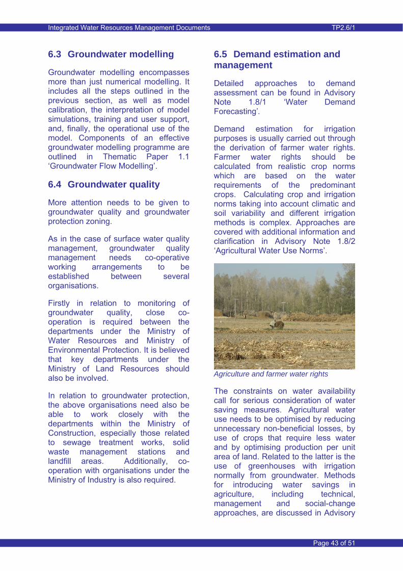
Integrated Water Resources Management Documents TP2.6/1
Page 43 of 51
6.3 Groundwater modelling
Groundwater modelling encompasses more than just numerical modelling. It includes all the steps outlined in the previous section, as well as model calibration, the interpretation of model simulations, training and user support, and, finally, the operational use of the model. Components of an effective groundwater modelling programme are outlined in Thematic Paper 1.1 ‘Groundwater Flow Modelling’.
6.4 Groundwater quality
More attention needs to be given to groundwater quality and groundwater protection zoning.
As in the case of surface water quality management, groundwater quality management needs co-operative working arrangements to be established between several organisations.
Firstly in relation to monitoring of groundwater quality, close co-operation is required between the departments under the Ministry of Water Resources and Ministry of Environmental Protection. It is believed that key departments under the Ministry of Land Resources should also be involved.
In relation to groundwater protection, the above organisations need also be able to work closely with the departments within the Ministry of Construction, especially those related to sewage treatment works, solid waste management stations and landfill areas. Additionally, co-operation with organisations under the Ministry of Industry is also required.
6.5 Demand estimation and management
Detailed approaches to demand assessment can be found in Advisory Note 1.8/1 ‘Water Demand Forecasting’.
Demand estimation for irrigation purposes is usually carried out through the derivation of farmer water rights. Farmer water rights should be calculated from realistic crop norms which are based on the water requirements of the predominant crops. Calculating crop and irrigation norms taking into account climatic and soil variability and different irrigation methods is complex. Approaches are covered with additional information and clarification in Advisory Note 1.8/2 ‘Agricultural Water Use Norms’.
Agriculture and farmer water rights
The constraints on water availability call for serious consideration of water saving measures. Agricultural water use needs to be optimised by reducing unnecessary non-beneficial losses, by use of crops that require less water and by optimising production per unit area of land. Related to the latter is the use of greenhouses with irrigation normally from groundwater. Methods for introducing water savings in agriculture, including technical, management and social-change approaches, are discussed in Advisory
Integrated Water Resources Management Documents TP2.6/1
Page 44 of 51
Note 6.1/1 ‘Role of Water Use Associations in Water Saving in Groundwater’. Recommendations for involving farmers in groundwater savings are outlined in Advisory Note 6.1/2 ‘Farmers Guide to Groundwater Water Use Associations’.
6.6 Conjunctive use
The short-term consequences of implementing conjunctive use schemes are often reasonably easy to establish. This can be done with relative ease using the type of groundwater assessment approaches described in Thematic Paper 1.2 ‘Groundwater Resource Quantity Assessment’.
In irrigation districts where conjunctive use is to be introduced, priority should be given to surface water allocation in order to ensure that groundwater is not depleted. Groundwater allocation should be just sufficient to make up the shortfall between the total water allocation for the district (based on total water availability and on crop water requirements) and the surface water allocation (based on the current’s year’s plan and the previous year’s delivery). Farmers should not be entitled to substitute groundwater for their allocation of surface water.
Current practice is to determine the total or gross amount of irrigation water required on an annual basis. However, consideration could be given to allocate permitted quantities for a longer period of time, say for a five year period. An average annual total water resource availability and surface water and groundwater quantities would be based on an assessment of total supply and irrigation quotas for the given period. Also specified is a maximum allocation for an individual year and this would accommodate
water needs during drought years, when water demand from irrigation sources is larger than average. This implies that less total water would be available for wetter years. Such water allocation strategy would allow for greater flexibility in ensuring that water availability is sufficient to satisfy the irrigation needs. Longer term water allocation planning requires greater flexibility in the allocation of groundwater and therefore requires greater responsibility in water management for different management levels.
There is scope for increasing local participation in the conjunctive use process, via farmer water user associations (WUAs), both to strengthen the planning process and to increase local commitment and understanding. This could include involving the WUAs to work more closely with the local WAB and Township in the preparation of crop plans (and hence water use needs) and surface water allocation plans. Informal federations of WUAs at secondary canal level would be needed to ensure effective participation at this level.
6.7 Administrative regulation
Water users and rural communities have an important role to play in helping to manage water rights, and this is described further in Advisory Note 6.1/1 ‘Role of Water Use Associations in Water Saving in Groundwater’.
Groundwater abstraction from wells needs to be monitored and recorded. Such monitoring systems as well as the system for permit application must be transparent; farmers need to be sure that the regulations are being applied to everyone and that all
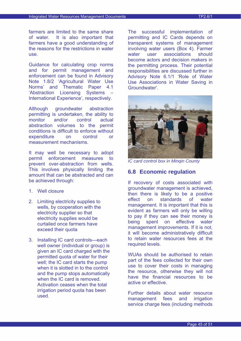
Integrated Water Resources Management Documents TP2.6/1
Page 45 of 51
farmers are limited to the same share of water. It is also important that farmers have a good understanding of the reasons for the restrictions in water use.
Guidance for calculating crop norms and for permit management and enforcement can be found in Advisory Note 1.8/2 ‘Agricultural Water Use Norms’ and Thematic Paper 4.1 ‘Abstraction Licensing Systems – International Experience’, respectively.
Although groundwater abstraction permitting is undertaken, the ability to monitor and/or control actual abstraction volumes to the permit conditions is difficult to enforce without expenditure on control or measurement mechanisms.
It may well be necessary to adopt permit enforcement measures to prevent over-abstraction from wells. This involves physically limiting the amount that can be abstracted and can be achieved through:
1. Well closure
2. Limiting electricity supplies to wells, by cooperation with the electricity supplier so that electricity supplies would be curtailed once farmers have exceed their quota
3. Installing IC card controls—each well owner (individual or group) is given an IC card charged with the permitted quota of water for their well; the IC card starts the pump when it is slotted in to the control and the pump stops automatically when the IC card is removed. Activation ceases when the total irrigation period quota has been used.
The successful implementation of permitting and IC Cards depends on transparent systems of management involving water users (Box 4). Farmer water user associations should become actors and decision makers in the permitting process. Their potential responsibilities are discussed further in Advisory Note 6.1/1 ‘Role of Water Use Associations in Water Saving in Groundwater’.
IC card control box in Minqin County
6.8 Economic regulation
If recovery of costs associated with groundwater management is achieved, then there is likely to be a positive effect on standards of water management. It is important that this is evident as farmers will only be willing to pay if they can see their money is being spent on effective water management improvements. If it is not, it will become administratively difficult to retain water resources fees at the required levels.
WUAs should be authorised to retain part of the fees collected for their own use to cover their costs in managing the resource, otherwise they will not have the financial resources to be active or effective.
Further details about water resource management fees and irrigation service charge fees (including methods
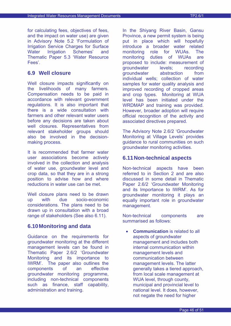
Integrated Water Resources Management Documents TP2.6/1
Page 46 of 51
for calculating fees, objectives of fees, and the impact on water use) are given in Advisory Note 5.2 ‘Formulation of Irrigation Service Charges for Surface Water Irrigation Schemes’ and Thematic Paper 5.3 ‘Water Resource Fees’.
6.9 Well closure
Well closure impacts significantly on the livelihoods of many farmers. Compensation needs to be paid in accordance with relevant government regulations. It is also important that there is a wide consultation with farmers and other relevant water users before any decisions are taken about well closures. Representatives from relevant stakeholder groups should also be involved in the decision-making process.
It is recommended that farmer water user associations become actively involved in the collection and analysis of water use, groundwater level and crop data, so that they are in a strong position to advise how and where reductions in water use can be met.
Well closure plans need to be drawn up with due socio-economic considerations. The plans need to be drawn up in consultation with a broad range of stakeholders (See also 6.11).
6.10 Monitoring and data
Guidance on the requirements for groundwater monitoring at the different management levels can be found in Thematic Paper 2.6/2 ‘Groundwater Monitoring and its importance to IWRM’. The paper also outlines the components of an effective groundwater monitoring programme, including non-technical components such as finance, staff capability, administration and training.
In the Shiyang River Basin, Gansu Province, a new permit system is being put in place which will hopefully introduce a broader water related monitoring role for WUAs. The monitoring duties of WUAs are proposed to include: measurement of groundwater levels; recording groundwater abstraction from individual wells; collection of water samples for water quality analysis and improved recording of cropped areas and crop types. Monitoring at WUA level has been initiated under the WRDMAP and training was provided. However, broader adoption will require official recognition of the activity and associated directives prepared.
The Advisory Note 2.6/2 ‘Groundwater Monitoring at Village Levels’ provides guidance to rural communities on such groundwater monitoring activities.
6.11 Non-technical aspects
Non-technical aspects have been referred to in Section 2 and are also discussed in some detail in Thematic Paper 2.6/2 ‘Groundwater Monitoring and its Importance to IWRM’. As for groundwater monitoring it plays an equally important role in groundwater management.
Non-technical components are summarised as follows:
• Communication is related to all aspects of groundwater management and includes both internal communication within management levels and communication between management levels. The latter generally takes a tiered approach, from local scale management at WUA level, through county, municipal and provincial level to national level. It does, however, not negate the need for higher
Integrated Water Resources Management Documents TP2.6/1
Page 47 of 51
management levels to be aware of local level issues. The preparation of comprehensive communication plans is important, such as done for the WRDMAP case studies in Liaoning and Gansu Provinces. More important is to put such communication plans into action and adapt them if necessary with time to improve the effectiveness of communication.
• Water user and stakeholder participation leads to more effective groundwater management and thus needs to be facilitated and encouraged. Participation is closely linked with communication and it is therefore advisable to develop combined communication and participation strategies at different management levels.
• Administrative effectiveness is an important aspect of groundwater management. It forms part of institutional strengthening at the different management levels. Good administration leads to efficiency and quality assurance in all aspects of groundwater management.
• Strong management at all levels is related to technical, non-technical and financial aspects of groundwater management.
• Capacity building applies to both technical and non-technical aspects of groundwater management. It requires adequate institutional capacity and financial resources. Training is an important component of capacity building.
• Education and outreach programmes that convey important issues related to
groundwater use and management issues to the community.
Working with the local community
7 International Experience
7.1 Introduction
This section presents international experience on a number of groundwater management aspects. There is bias towards experience from the United Kingdom, although there is commonality with management aspects in other parts of Europe.
The international experience relates to the management elements described in Section 3 of this Note.
7.2 Resource regulation
Groundwater resource regulation in the United Kingdom and in the European Union at large is at a regulation level described in Table 1 as: Fully Integrated Resources Regulation. This approach embraced a catchment or whole aquifer approach with water quantity and quality aspects integrated. In England and Wales the Environment Agency of England and Wales (EA) is the main regulator for the environment and this includes responsibility for groundwater resources management.
Thus a single authority is the guardian of the water environment. The EA associates with data providers,

Integrated Water Resources Management Documents TP2.6/1
Page 48 of 51
particularly the Meteorological Office, which provides climate data that is essential for resource assessment. The EA works actively with both water providers (mainly the large water companies) and with organisations with responsibility for the environment (for example Natural England). Stakeholder consultation and participation features very strongly in the agenda of the EA.
Much of the regulation has a European basis and is thus relevant to all European Union countries. Examples include amongst others the Water Framework Directive, the Birds and Habitats Directive and the Nitrate Directive. These are regulatory directives that are issued by the European Union. Their implementation is mandatory and has strict deadlines for compliance and completion of a variety of stages. Local adjustment of directives is possible, depending on local or country specific conditions.
The Water Framework Directive is an example of fully integrated regulation (also known as the WFD or Directive 2000/60/EC). It is a legislative framework to protect and improve the quality of all water resources within the European Union such as rivers, lakes, groundwater, transitional and coastal water up to one sea mile (and for the chemical status also territorial waters (which may extend up to 12 sea miles) from the territorial baseline of a Member State, independent of the size and the characteristics.
Article 2 of the Directive relate to maintaining a good status of groundwater bodies. ‘Good groundwater status’ means the status achieved by a groundwater body when both its quantitative status and its chemical status are at least ‘good’. With regard to groundwater,
‘groundwater bodies’ are the units that will be used for reporting and assessing compliance with the Directive’s principal environmental objectives. The WFD has been translated into Chinese (www.waterpub.com.cn and www.euchinarivers.org).
The European Groundwater Directive (DIRECTIVE 2006/118/EC) is a ‘sister’ directive of the WFD with specific focus on the protection of groundwater against pollution and deterioration. A Chinese guidebook on the directive was issued in October 2009 by the MWR. The guidebook is part of the ongoing dialogue between Europe and China in the filed of integrated river basin management. It provides a high level summary of the approach to groundwater protection and management set out in the directive in combination with the WFD.
The Conservation (Natural Habitats) Regulations 1994, which implement the Birds 97/48/EC and Habitats Directives 97/62/EC in the UK, aim to ensure the comprehensive conservation of natural habitats and fauna and flora on land and at sea, by ensuring the strict protection of specially designated sites. These sites are known as Special Areas of Conservation (SACs) and Special Protection Areas (SPAs) under the Habitats and Birds Directives respectively. Collectively these sites form a Europe-wide network known as ‘Natura 2000’.
At country level similar approaches as for the Habitats Directive are implemented for ecologically important sites that are not designated as ‘European’ sites. In England and Wales the National Environment Programme (NEP) is the water companies’ five-yearly environmental
Integrated Water Resources Management Documents TP2.6/1
Page 49 of 51
improvement programme. Improvements relate in particular to finding solutions to alleviate negative environmental impact of water company activity at designated sites of national ecological importance.
Within England and Wales, numerous regulatory programs are in place. Most noteworthy are the CAMS and RSA programmes.
A detailed description of the CAMS process is contained in the document entitled ‘Managing Water Abstraction – The Catchment Abstraction Management Strategy’ issued in updated form by the Environment Agency UK in July 2002 and available from their website (www.environment-agency.gov.uk/cams). An interim update was issued in March 2005. The objectives of CAMS are stated in this document as:
• To make information publicly available on water resource availability and licensing (permitting) within a catchment;
• To provide a consistent and structured approach to local water resources management, recognising both abstractors reasonable needs for water and environmental needs;
• To provide the opportunity for greater public involvement in the process of managing abstraction at a catchment level;
• To provide a framework for managing time-limited licences; and
• To facilitate licence trading.
The EA’s principal aim is to contribute to sustainable development, considering the needs of abstractors alongside those of fisheries, recreation and navigation, as well as the need to
protect water quality and conserve the water environment.
A commitment has been made by the UK Government at the May 1997 Government’s Water Summit to reverse any damage caused by decisions and activities in the past. The RSA (Restoring Sustainable Abstraction) Programme was initiated by the EA to address the problems caused by unsustainable abstraction. This includes the Habitats Directive and NEP programmes, which relate to conservation sites of international and national importance respectively. The RSA Programme addresses sustainability in an integrated manner, considering the water resources situation on a catchment/sub-catchment scale.
7.3 Groundwater resource quantification
In England and Wales, the government’s Environment Agency (EA) has introduced a national framework for groundwater modelling. The models are of a regional scale, but have sufficient refinement to address local scale issues. The national framework is implemented in different regions using a standard approach in accordance with detailed guidance. The approach is comprehensive and is described in Thematic Paper 1.1 ‘Groundwater Flow Modelling’.
The models generally cover whole river basins or combine a number of smaller river basins. The models are used to support the EA in groundwater resources management and their duties related to groundwater management and the linked surface water environment. Completed models are stored in a centralised National Groundwater Modelling System, including the data that forms the input
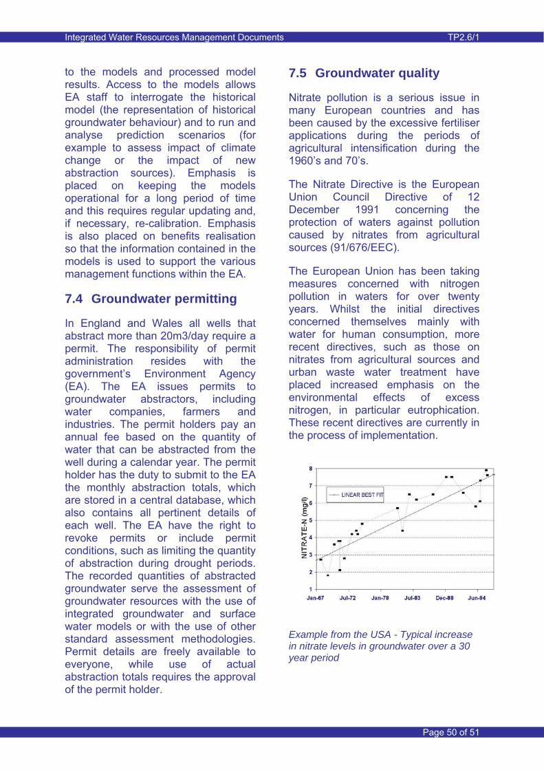
Integrated Water Resources Management Documents TP2.6/1
Page 50 of 51
to the models and processed model results. Access to the models allows EA staff to interrogate the historical model (the representation of historical groundwater behaviour) and to run and analyse prediction scenarios (for example to assess impact of climate change or the impact of new abstraction sources). Emphasis is placed on keeping the models operational for a long period of time and this requires regular updating and, if necessary, re-calibration. Emphasis is also placed on benefits realisation so that the information contained in the models is used to support the various management functions within the EA.
7.4 Groundwater permitting
In England and Wales all wells that abstract more than 20m3/day require a permit. The responsibility of permit administration resides with the government’s Environment Agency (EA). The EA issues permits to groundwater abstractors, including water companies, farmers and industries. The permit holders pay an annual fee based on the quantity of water that can be abstracted from the well during a calendar year. The permit holder has the duty to submit to the EA the monthly abstraction totals, which are stored in a central database, which also contains all pertinent details of each well. The EA have the right to revoke permits or include permit conditions, such as limiting the quantity of abstraction during drought periods. The recorded quantities of abstracted groundwater serve the assessment of groundwater resources with the use of integrated groundwater and surface water models or with the use of other standard assessment methodologies. Permit details are freely available to everyone, while use of actual abstraction totals requires the approval of the permit holder.
7.5 Groundwater quality
Nitrate pollution is a serious issue in many European countries and has been caused by the excessive fertiliser applications during the periods of agricultural intensification during the 1960’s and 70’s.
The Nitrate Directive is the European Union Council Directive of 12 December 1991 concerning the protection of waters against pollution caused by nitrates from agricultural sources (91/676/EEC).
The European Union has been taking measures concerned with nitrogen pollution in waters for over twenty years. Whilst the initial directives concerned themselves mainly with water for human consumption, more recent directives, such as those on nitrates from agricultural sources and urban waste water treatment have placed increased emphasis on the environmental effects of excess nitrogen, in particular eutrophication. These recent directives are currently in the process of implementation.
Example from the USA - Typical increase in nitrate levels in groundwater over a 30 year period
Integrated Water Resources Management Documents TP2.6/1
Page 51 of 51
7.6 Groundwater protection
In England and Wales, groundwater protection zones have been derived for most of the public water supply wells. Where appropriate, groundwater models have been used to derive inner zones (50 day travel time), outer zones (400 day travel time) and total zones. The travel time is the time it takes for groundwater to move from the edge of the zone to the water supply well. The “total zone” covers the area over which rainfall recharge contributes to water abstracted from the well. The zones are assigned varying degrees of vulnerability, depending on hydrogeological conditions. Within the various zones, restriction on development is set out in a legal framework and enforced by the regulator, the UK Environment Agency (EA).
Nitrate vulnerable areas have also been mapped by the EA and control the application of fertiliser. This has been introduced to try to halt the increasing trends in nitrate in groundwater over the past decades, particularly in unconfined aquifers. The EA has a dialogue with farming communities and sets out agreements with them on fertiliser application
7.7 Environmental protection
Under the RSAP (Restoring Sustainable Abstraction Programme), the Environment Agency in the UK considers the protection of groundwater dependent ecosystems and wetlands that rely on groundwater contribution (directly or indirectly via rivers) on their ecological well-being. The programme has resulted in the assessment of groundwater abstraction (on both a regional scale and on a local scale) from wells located close to the sensitive sites.
Where necessary it has resulted in either a reduction in the licensed quantity or in a reduction in abstraction during droughts. Further details on ground water dependent ecosystems can be found in Advisory Note 2.4/2 ‘Environmental Water Allocation’
Integrated Water Resources Management Documents TP2.6/1
Document Reference Sheet
Glossary:
GWDE groundwater dependent ecosystems
SPZs
source protection zones
Bibliography:
SL documents 183-2005 Groundwater monitoring technical standards
GW•MATE Briefing Note 1 Groundwater Resource Management
GW•MATE Briefing Note 2 Characterization of Groundwater Systems
GW•MATE Briefing Note 4 Groundwater Legislation and Regulatory Provision
GW•MATE Briefing Note 7 Economic Instruments for Groundwater Management
GW•MATE Briefing Note 8 Groundwater Quality Protection
GW•MATE Briefing Note 9 Groundwater Monitoring Requirements
Integrated Water Resources Management Documents TP2.6/1
Document Reference Sheet
Related materials from the MWR IWRM Document Series:
Thematic Paper 1.1 Groundwater Flow Modelling
Thematic Paper 1.2 Groundwater Resources Quantity Assessment
Advisory Note 1.8/1 Water Demand Forecasting
Advisory Note 1.8/2 Agricultural Water Use Norms
Advisory Note 2.4/2 Environmental Water Allocation
Thematic Paper 2.6/2 Groundwater Monitoring and its Importance to IWRM
Thematic Paper 3.2 Urban Water Supply Demand Management
Thematic Paper 4.1 Abstraction Licensing Systems – International Experience
Advisory Note 5.2 Formulation of ISCs for Surface Water Irrigation Schemes
Thematic Paper 5.3 Water Resource Fees
Advisory Note 6.1/1 Role of WUAs in Water Saving in Groundwater
Advisory Note 6.1/2 Farmers Guide to Groundwater WUAs
Where to find more information on IWRM – recommended websites:
Ministry of Water Resources: www.mwr.gov.cn
Global Water Partnership: www.gwpforum.org
WRDMAP Project Website: www.wrdmap.com
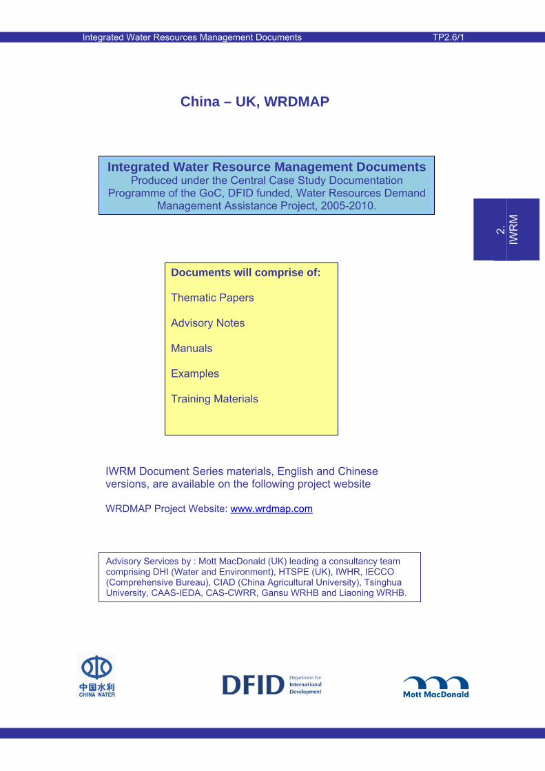
Integrated Water Resources Management Documents TP2.6/1
1.
W
RA
2.
IW
RM
3.
D
eman
d M
anag
e-m
ent
4.
P
erm
ittin
g
5.
E
cono
mic
To
ols
6.
W
ater
S
avin
g S
ocie
ty
7.
C
onfli
ct
Res
olut
ion
8.
Info
rm-
atio
n E
xcha
nge
China – UK, WRDMAP
Integrated Water Resource Management Documents Produced under the Central Case Study Documentation
Programme of the GoC, DFID funded, Water Resources Demand Management Assistance Project, 2005-2010.
IWRM Document Series materials, English and Chinese versions, are available on the following project website WRDMAP Project Website: www.wrdmap.com
Documents will comprise of: Thematic Papers Advisory Notes Manuals Examples Training Materials
Advisory Services by : Mott MacDonald (UK) leading a consultancy team comprising DHI (Water and Environment), HTSPE (UK), IWHR, IECCO (Comprehensive Bureau), CIAD (China Agricultural University), Tsinghua University, CAAS-IEDA, CAS-CWRR, Gansu WRHB and Liaoning WRHB.