Chicago Heights Brownfield Mariana Carbajal, Oalia Rodriguez, Shamel Henderson, Kenan Jones,...
52
Chicago Heights Brownfield Mariana Carbajal, Oalia Rodriguez, Shamel Henderson, Kenan Jones, Ja’Twuan Branch
-
Upload
marylou-golden -
Category
Documents
-
view
219 -
download
2
Transcript of Chicago Heights Brownfield Mariana Carbajal, Oalia Rodriguez, Shamel Henderson, Kenan Jones,...

Chicago Heights Brownfield
Mariana Carbajal, Oalia Rodriguez, Shamel Henderson, Kenan Jones, Ja’Twuan Branch

Property Location
• Northwest corner center &14th street (Lincoln Highway)
• 209-221East 14th street, Chicago Hts. IL
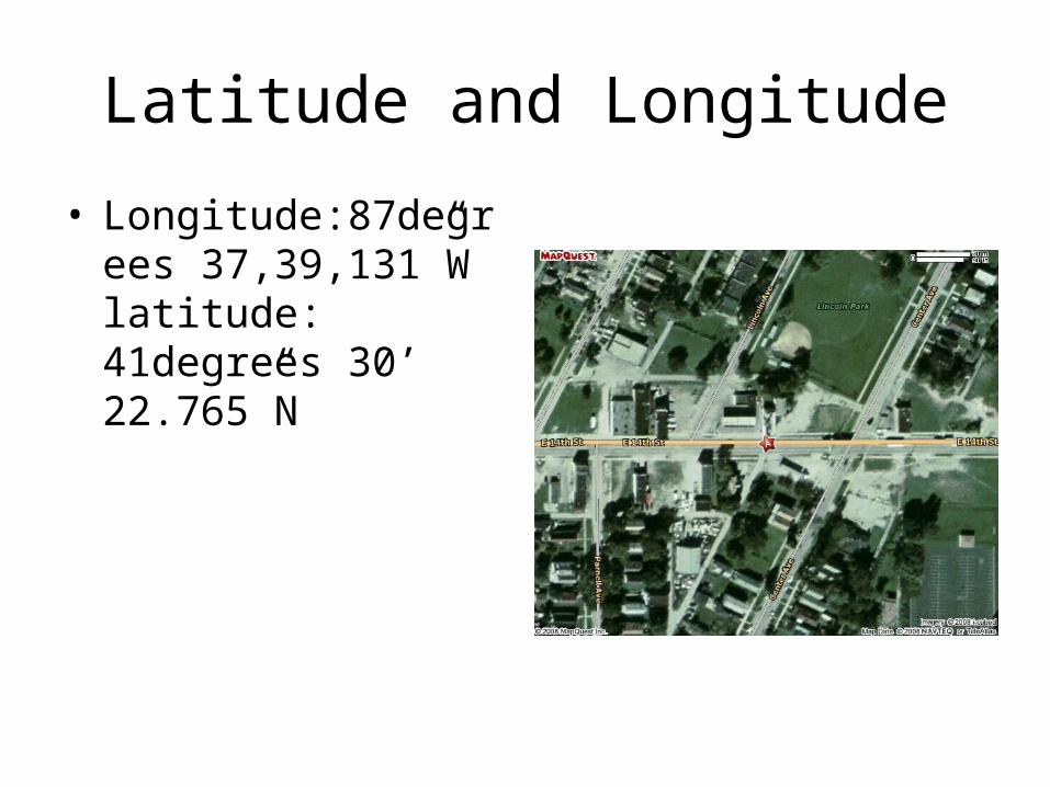
Latitude and Longitude
• Longitude:87degrees 37,39,131”W latitude: 41degrees 30’ 22.765”N

Size in acres
• 1/3 acre(140’x 187x61’x104

Potential Hazardous Substances
• A tin fabricating business, with potential of presence of metal debris and industrial cleaning solvents.

Neighboring Properties
• The parcel contained Baker Heating & sheet metal, a thin fabricating business, with potential of presence of metal debris and industrial cleaning solvents.

Who owns the site?
• The city of Chicago Heights.

Review of Records
• The properties at 209-221 East 14th Street, were abandoned as of 1984.

Review of Records
• The properties were obtained by the city of Chicago Heights in tax sale resulting in deed in 9/1995.

Review of Records
• The property is along a major thoroughfare (U.S. Route 30).

Review of Records
• The property is adjacent to Martin Luther King Park to the North

Is this property a brownfield?
• Yes, this property is a Brownfield.

Development
• Yes, there is a development plan for this site.

Phase I ESA
Environmental Site Assessment

Purpose
• To provide a professional opinion

Detailed Scope-of-Service
• Performed under a United States Environmental Protection Agency Brownfield’s Assessment Grant for hazardous materials

Significant Assumptions
• No significant assumptions

Limitations and Exceptions
• No limitations and exceptions

Special Terms and Conditions
• No special terms and conditions

User Reliance
• The report shall not be relied upon by or transferred to any other party without the express written authorization of URS.

Location and Legal Description
• 209-211 East 14th street
• The property is included in the EDR Liens Report

Subject Property and Vicinity Characteristics
• Bordered to the North by Kings Park
• To the East by Center Avenue
• Surrounded by vacant properties and also single family residence

Physical Settings
• Approximately 650 ft. above msl.
• The site area runoff travels to surrounding roadways

Descriptions of Structures, Roads, and Other Improvements
• Vacant gravel
• Grassy land
• Approximately 0.33 acre parcel
• Bordered by alleys from North and West
• Paved sidewalks from East and South

Current Adjoining Property Uses
• North- By Kings Park with a baseball field and recreational use land
• East- Commercial property “Discount Food, Liquor & Beauty Supply”
• South- Single family residence
• West- Single family residence

Title Records
• Title records were not provided

Environmental Liens Use Limitations
• No environmental liens, or use limitations

Specialized Knowledge
• No specialized knowledge

Owner, Site Manager, and Occupant Information
• Owned by COCH

Reason for ConductingPhase I ESA
• No specific Redevelopment

Other Information
• No previous reports were provided to URS for review.

Standard Environmental Records
• A regulatory database search report was prepared for subject property by EDR on March 4,2008.

Additional Environmental Records
• URS attempted to conduct file reviews on interviews at applicable state.

Historical Use
• The structure was occupied by a tin fabricating business, baker heating & sheet metal.

Aerial Photographs
• The aerial photographs were reviewed to identify potential sources of visible contaminations.

Topographic Maps
• Based on a review of historical topographic maps no RECS were identified.

Sanborn Fire Insurance Maps
• URS reviewed Sanborn Fire Insurance maps for the subject property provided from EDR.

City Directories
• The city directory information included a review of historical city directories from 1971 to 2006 reviewed at approximately 5 year intervals.

Methodology and Limiting Conditions
• Weather conditions at the time of the site reconnaissance were rainy, cloudy, and 35 degrees Fahrenheit, and did not pose any limitations to the inspection.

Interior and Exterior Observations
• The 0.33 acre subject property was vacant gravel and grassy land wit no structures at the time of URS site reconnaissance.

Hazardous Substances and Petroleum Products
• Hazardous substances and petroleum products were not observed at the subject property during the site reconnaissance.

Underground/ Aboveground Storage Tanks
• URS observed no evidence of USTs (i.e., vent pipes, fill ports, manways, etc.)

PCB-Containing and Hydraulic Equipment
• The URS observed no electricity transformers, electricity devices or hydraulic equipment.

Solid and Hazardous Wastes
• The subject property is currently vacant, no solid waste is currently generated.

Drains and Sumps
• No drains or sumps were observed.

Waste Water
• No progress or sanitary waste water is generated on site.

Utilities
• This property is vacant and therefore thus does not receive utility services.

Wells
• No wells were observed or reported on or adjacent to the subject property during the site reconnaissance.

Pits, Ponds, Lagoons
• No pits, ponds, or lagoons were observed on the subject property during the property visit.

Other Physical Evidence of Contamination
• No other physical evidence of contaminations was observed on the subject property during the URS site reconnaissance with the exception of scattered household-type debris that was observed on the subject property.

Conclusions
• No HRECs or other environmental issues were identified.

Environmental Professionals Involved
•Jennifer M. Schuch, CHMM -Principal environmental scientist
•Sarah Rubin , CHMM -Principal Geologist