Chester River - National Oceanic and Atmospheric … Chester River NOAA Chart 12272 A reduced -scale...
16
BookletChart ™ Chester River NOAA Chart 12272 A reduced-scale NOAA nautical chart for small boaters When possible, use the full-size NOAA chart for navigation.
Transcript of Chester River - National Oceanic and Atmospheric … Chester River NOAA Chart 12272 A reduced -scale...
BookletChart™ Chester River NOAA Chart 12272
A reduced-scale NOAA nautical chart for small boaters When possible, use the full-size NOAA chart for navigation.

2
Published by the National Oceanic and Atmospheric Administration
National Ocean Service Office of Coast Survey
www.NauticalCharts.NOAA.gov 888-990-NOAA
What are Nautical Charts?
Nautical charts are a fundamental tool of marine navigation. They show water depths, obstructions, buoys, other aids to navigation, and much more. The information is shown in a way that promotes safe and efficient navigation. Chart carriage is mandatory on the commercial ships that carry America’s commerce. They are also used on every Navy and Coast Guard ship, fishing and passenger vessels, and are widely carried by recreational boaters.
What is a BookletChart?
This BookletChart is made to help recreational boaters locate themselves on the water. It has been reduced in scale for convenience, but otherwise contains all the information of the full-scale nautical chart. The bar scales have also been reduced, and are accurate when used to measure distances in this BookletChart. See the Note at the bottom of page 5 for the reduction in scale applied to this chart.
Whenever possible, use the official, full scale NOAA nautical chart for navigation. Nautical chart sales agents are listed on the Internet at http://www.NauticalCharts.NOAA.gov.
This BookletChart does NOT fulfill chart carriage requirements for regulated commercial vessels under Titles 33 and 44 of the Code of Federal Regulations.
Notice to Mariners Correction Status
This BookletChart has been updated for chart corrections published in the U.S. Coast Guard Local Notice to Mariners, the National Geospatial Intelligence Agency Weekly Notice to Mariners, and, where applicable, the Canadian Coast Guard Notice to Mariners. Additional chart corrections have been made by NOAA in advance of their publication in a Notice to Mariners. The last Notices to Mariners applied to this chart are listed in the Note at the bottom of page 7. Coast Pilot excerpts are not being corrected.
For latest Coast Pilot excerpt visit the Office of Coast Survey website at http://www.nauticalcharts.noaa.gov/nsd/searchbychart.php?chart=12272.
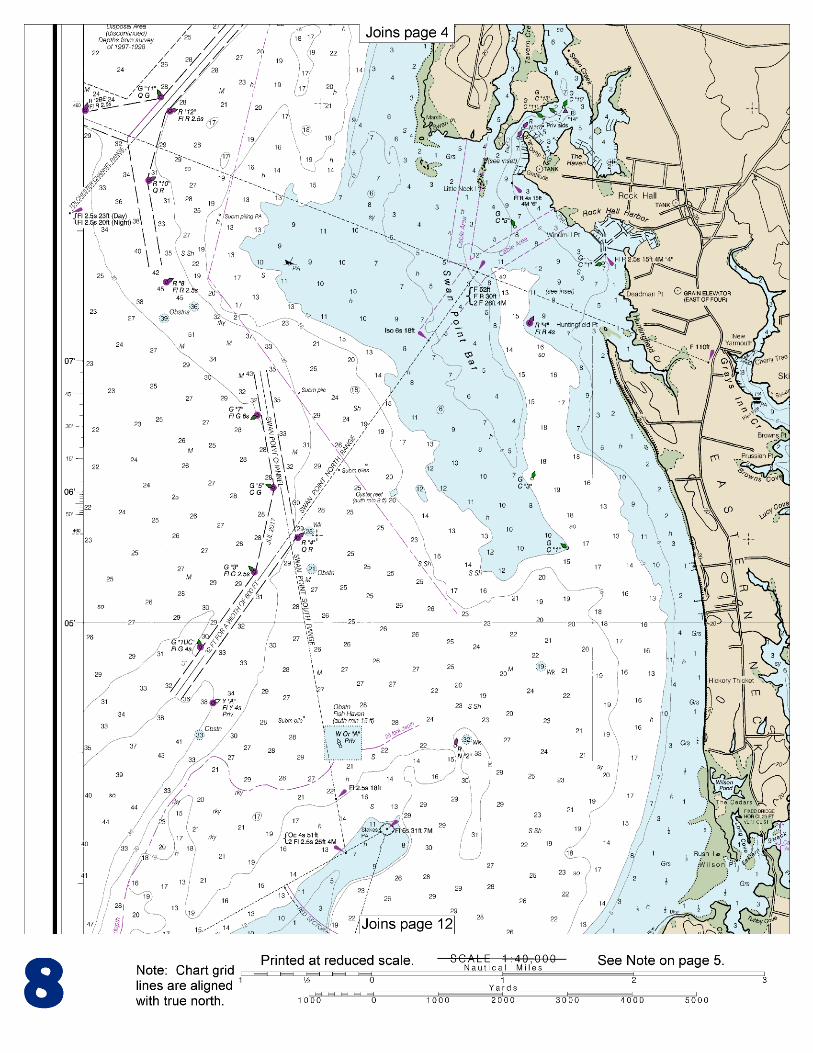
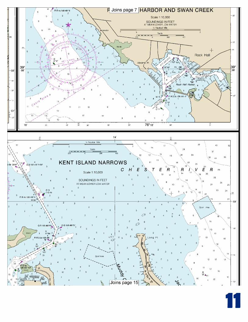
(Selected Excerpts from Coast Pilot) Love Point Light (39°03'25"N., 76°16'59"W.), 35 feet above the water, is shown from a skeleton tower, with a red and white diamond-shaped daymark, 1.4 miles northeast of Love Point. The main entrance to Chester River is between Love Point, the northern end of Kent Island, and Eastern Neck Island, 3 miles to the eastward. The approach is northward and eastward of Love Point Light.
A fish haven, marked by a buoy, is in the approach to Chester River about 0.8 mile north-northwest of Love Point Light. Light-draft vessels can also enter from Eastern Bay and Miles River on the southward by way of Kent Island Narrows. Traffic on the river
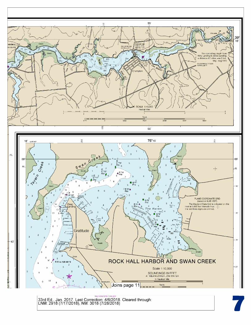
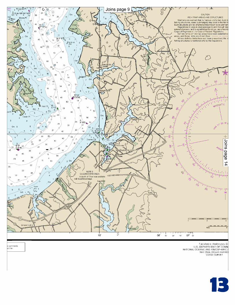
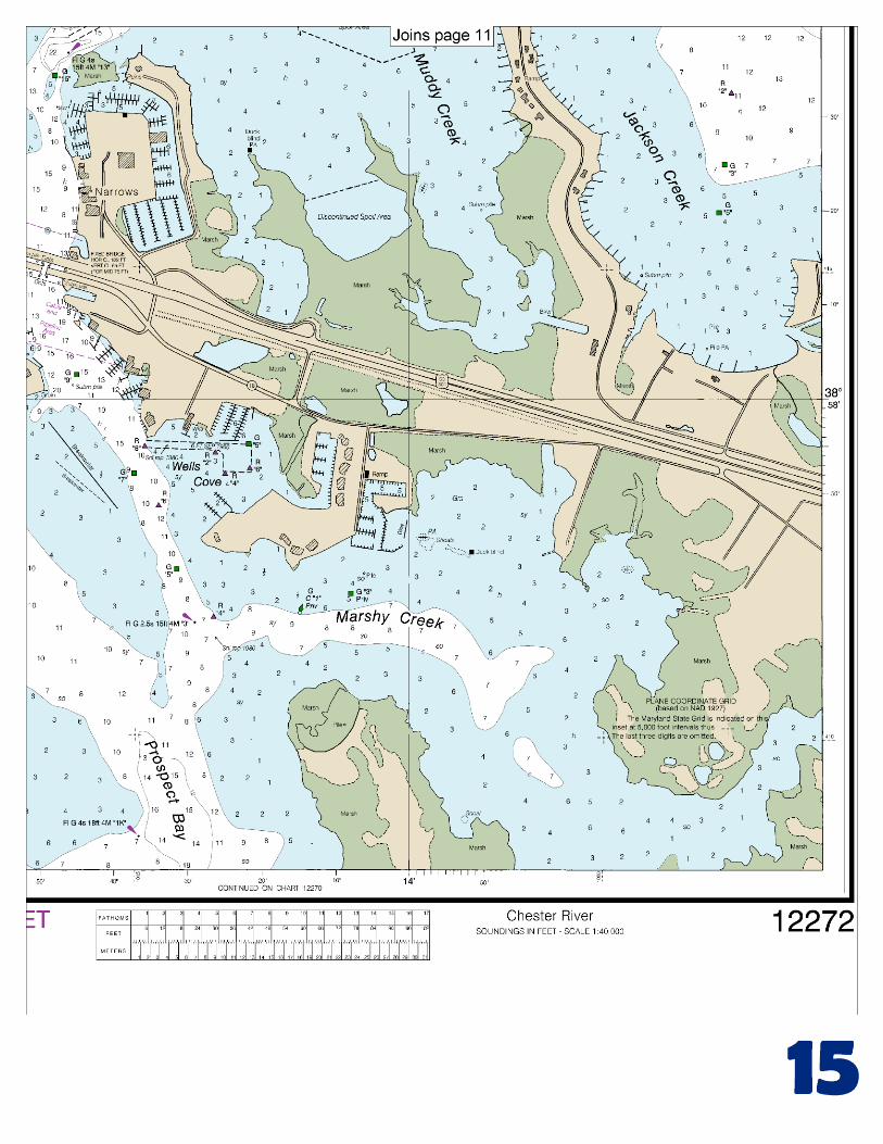
consists chiefly of petroleum products and shellfish. Mileages on Chester River are designated Mile 7S, 11W, etc., which are the nautical miles above the entrance. The letters N, S, E, or W, following the numerals indicate the side of the river by compass point direction where each feature is located. Chester River has channel depths of 13 feet or more to Chestertown, thence 7 feet to Crumpton, and thence 5 feet to Kirby Landing, Mile 35.2S. The channel is marked for about 32 miles to Crumpton. Above Chestertown, deepest water is difficult to follow except with local knowledge and extreme caution. Currents.–The current velocity is less than 1.0 knot. The river is usually closed to navigation by ice for extended periods during ordinary winters; in mild winters the channel is kept clear most of the time by powerboats. The river water is fresh above Chestertown. Love Point is a village on the point on the west side of the entrance to Chester River. Shells are received by barge at the old railroad pier on the river side of the village. Eastern Neck Island, on the east side of the entrance, is about 3 miles long in a northwest-southeast direction. The island is sparsely wooded with extensive grassy flats along the south shore. It is connected with the mainland on the north by a fixed highway bridge, clearance 6 feet, over Eastern Neck Narrows, which is very narrow and little used. At Mile 2.7S, a privately marked channel leads to a basin with a marina on its south side. In 2004, 8.0 feet was reported in the approach and 6.0 feet alongside. Gasoline, diesel fuel, berths, electricity, water, ice, some marine supplies, and a pump-out station are available. Kent Island Narrows entrance is at Mile 4.0S. A marked channel, leads from Chester River to Prospect Bay; the chart is the guide. In 2010, the controlling depth was 3.9 feet (4.8 feet at midchannel). Very heavy traffic can be expected through the channel during the summer months, especially on weekends. The State Route 50/301 highway bridge over the narrows has a fixed span with a clearance of 65 feet. Immediately south of the fixed highway bridge is the MD ROUTE 18 (old State Route 50/301) bascule bridge with a 48-foot span and a clearance of 18 feet. The bridgetender monitors VHF-FM channel 16 and works on channels 13 and 68; call sign KXE-254. (See 117.1 through 117.59 and 117.561, chapter 2, for drawbridge regulations.) The nearby overhead power cable has a clearance of 85 feet. Temporary mooring areas for vessels awaiting bridge openings have been established by the State of Maryland on the west side of the channel about 50 yards north of the bridge, and 100 yards and 650 yards south of the bridge Jackson Creek, Mile 5S, has depths of 2 to 7 feet at the entrance and is used as an anchorage by oyster boats; the channel is marked. The bottom is covered with grass. Queenstown Creek, Mile 6.1E, is entered through a marked channel which leads to a turning basin at Queenstown, on the southeast side of Little Queenstown Creek. In 2009, the controlling depths were 3.8 feet in the east half and 1.5 feet in the west half of the channel to a point about 200 yards above Buoy 5, thence 6.1 feet to the basin with 5.5 feet in the basin. Grays Inn Creek, Mile 10.7W, has depths of 8 feet for 2.3 miles to a small settlement on the west side, then shoals gradually to 1 foot. About 1.8 miles above the mouth, a marina on Skinners Neck has a marine railway that can haul out craft up to 45 feet for repairs; gasoline is available.
U.S. Coast Guard Rescue Coordination Center 24 hour Regional Contact for Emergencies
RCC Norfolk Commander
5th CG District (575) 398-6231 Norfolk, VA

G
NOAA’s navigation managers serve as ambassadors to the maritime community. They help identify navigational challenges facing professional and recreational mariners, and provide NOAA resources and information for safe navigation. For additional information, please visit nauticalcharts.noaa.gov/service/navmanagers
To make suggestions or ask questions online, go to nauticalcharts.noaa.gov/inquiry. To report a chart discrepancy, please use ocsdata.ncd.noaa.gov/idrs/discrepancy.aspx.
Lateral System As Seen Entering From Seaward on navigable waters except Western Rivers
PORT SIDE
ODD NUMBERED AIDS
GREEN LIGHT ONLY
FLASHING (2)
PREFERRED CHANNEL
NO NUMBERS – MAY BE LETTERED
PREFERRED CHANNEL TO
STARBOARD
TOPMOST BAND GREEN
PREFERRED CHANNEL
NO NUMBERS – MAY BE LETTERED
PREFERRED CHANNEL
TO PORT
TOPMOST BAND RED
STARBOARD SIDE
EVEN NUMBERED AIDS
RED LIGHT ONLY
FLASHING (2)
FLASHING FLASHING
OCCULTING GREEN LIGHT ONLY RED LIGHT ONLY OCCULTING QUICK FLASHING QUICK FLASHING
ISO COMPOSITE GROUP FLASHING (2+1) COMPOSITE GROUP FLASHING (2+1) ISO
"1"
Fl G 6s
G "9"
Fl G 4s
GR "A"
Fl (2+1) G 6s
RG "B"
Fl (2+1) R 6s
"2"
Fl R 6s
8
R "8"
Fl R 4s
LIGHT
G
C "1"
LIGHTED BUOY
G
"5"
GR
"U"
GR
C "S"
RG
N "C"
RG
"G"
LIGHT
6
R
N "6"
LIGHTED BUOY
R
"2
"
CAN DAYBEACON
CAN NUN NUN
DAYBEACON
For more information on aids to navigation, including those on Western Rivers, please consult the latest USCG Light List for your area.
These volumes are available online at http://www.navcen.uscg.gov
Navigation Managers Area of Responsibility
Northeast
Lt. Meghan McGovern
Northwest and
Pacific Islands
Crescent Moegling
Great Lakes Region
Tom Loeper
Chesapeake and
Delaware Bay
Steve Soherr
California
Jeff Ferguson
[email protected] Mid-Atlantic
Lt. Ryan Wartick
Alaska
Lt. Timothy M. Smith
Western Gulf Coast
Alan Bunn
Central Gulf Coast
Tim Osborn
[email protected] South Florida
Puerto Rico
U.S. Virgin Islands
Michael Henderson
Southeast
Kyle Ward
2
2 C U 5
1


VHF Marine Radio channels for use on the waterways:Channel 6 – Inter-ship safety communications.Channel 9 – Communications between boats and ship-to-coast.Channel 13 – Navigation purposes at bridges, locks, and harbors.Channel 16 – Emergency, distress and safety calls to Coast Guard and others, and to initiate calls to other
vessels. Contact the other vessel, agree to another channel, and then switch.Channel 22A – Calls between the Coast Guard and the public. Severe weather warnings, hazards to navigation and safety warnings are broadcast here.Channels 68, 69, 71, 72 and 78A – Recreational boat channels.
Getting and Giving Help — Signal other boaters using visual distress signals (flares, orange flag, lights, arm signals); whistles; horns; and on your VHF radio. You are required by law to help boaters in trouble. Respond to distress signals, but do not endanger yourself.
EMERGENCY INFORMATION
Distress Call Procedures
• Make sure radio is on.• Select Channel 16.• Press/Hold the transmit button.• Clearly say: “MAYDAY, MAYDAY, MAYDAY.”• Also give: Vessel Name and/or Description;Position and/or Location; Nature of Emergency; Number of People on Board.• Release transmit button.• Wait for 10 seconds — If no responseRepeat MAYDAY call.
HAVE ALL PERSONS PUT ON LIFE JACKETS!
This Booklet chart has been designed for duplex printing (printed on front and back of one sheet). If a duplex option is not available on your printer, you may print each sheet and arrange them back-to-back to allow for the proper layout when viewing.
QR
Quick ReferencesNautical chart related products and information - http://www.nauticalcharts.noaa.gov
Interactive chart catalog - http://www.charts.noaa.gov/InteractiveCatalog/nrnc.shtmlReport a chart discrepancy - http://ocsdata.ncd.noaa.gov/idrs/discrepancy.aspx
Chart and chart related inquiries and comments - http://ocsdata.ncd.noaa.gov/idrs/inquiry.aspx?frompage=ContactUs
Chart updates (LNM and NM corrections) - http://www.nauticalcharts.noaa.gov/mcd/updates/LNM_NM.html
Coast Pilot online - http://www.nauticalcharts.noaa.gov/nsd/cpdownload.htm
Tides and Currents - http://tidesandcurrents.noaa.gov
Marine Forecasts - http://www.nws.noaa.gov/om/marine/home.htm
National Data Buoy Center - http://www.ndbc.noaa.gov/
NowCoast web portal for coastal conditions - http://www.nowcoast.noaa.gov/
National Weather Service - http://www.weather.gov/
National Hurrican Center - http://www.nhc.noaa.gov/
Pacific Tsunami Warning Center - http://ptwc.weather.gov/
Contact Us - http://www.nauticalcharts.noaa.gov/staff/contact.htm
NOAA’s Office of Coast Survey The Nation’s Chartmaker
For the latest news from Coast Survey, follow @NOAAcharts
NOAA Weather Radio All Hazards (NWR) is a nationwide network of radio stations broadcasting continuous weather information directly from the nearest National Weather Service office. NWR broadcasts official Weather Service warnings, watches, forecasts and other hazard information 24 hours a day, 7 days a week. http://www.nws.noaa.gov/nwr/