ChCATA/1; - Cartography Unchained
21
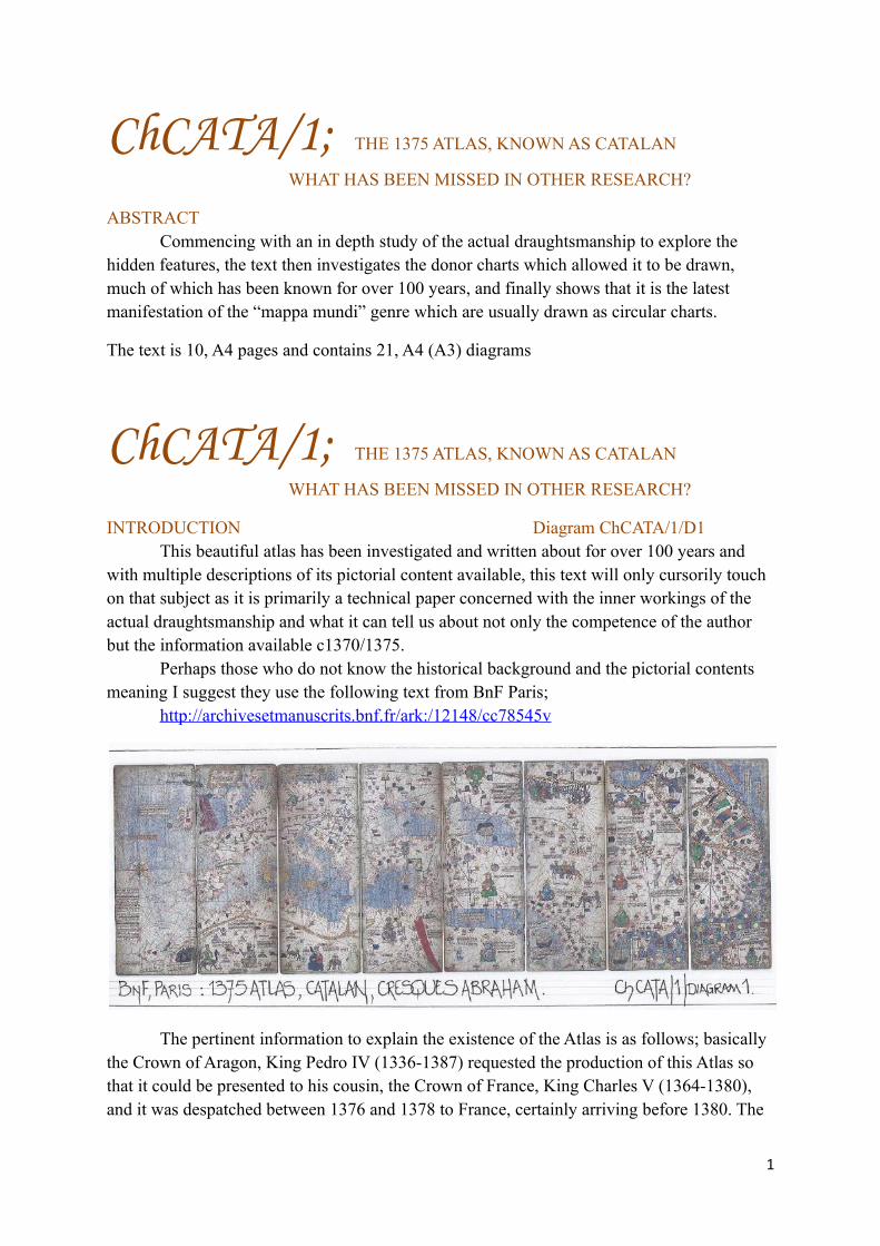
ChCATA/1; THE 1375 ATLAS, KNOWN AS CATALAN WHAT HAS BEEN MISSED IN OTHER RESEARCH? ABSTRACT Commencing with an in depth study of the actual draughtsmanship to explore the hidden features, the text then investigates the donor charts which allowed it to be drawn, much of which has been known for over 100 years, and finally shows that it is the latest manifestation of the “mappa mundi” genre which are usually drawn as circular charts. The text is 10, A4 pages and contains 21, A4 (A3) diagrams ChCATA/1; THE 1375 ATLAS, KNOWN AS CATALAN WHAT HAS BEEN MISSED IN OTHER RESEARCH? INTRODUCTION Diagram ChCATA/1/D1 This beautiful atlas has been investigated and written about for over 100 years and with multiple descriptions of its pictorial content available, this text will only cursorily touch on that subject as it is primarily a technical paper concerned with the inner workings of the actual draughtsmanship and what it can tell us about not only the competence of the author but the information available c1370/1375. Perhaps those who do not know the historical background and the pictorial contents meaning I suggest they use the following text from BnF Paris; http://archivesetmanuscrits.bnf.fr/ark:/12148/cc78545v The pertinent information to explain the existence of the Atlas is as follows; basically the Crown of Aragon, King Pedro IV (1336-1387) requested the production of this Atlas so that it could be presented to his cousin, the Crown of France, King Charles V (1364-1380), and it was despatched between 1376 and 1378 to France, certainly arriving before 1380. The 1
Transcript of ChCATA/1; - Cartography Unchained
ChCATA/1; THE 1375 ATLAS, KNOWN AS CATALAN
WHAT HAS BEEN MISSED IN OTHER RESEARCH?
ABSTRACTCommencing with an in depth study of the actual draughtsmanship to explore the
hidden features, the text then investigates the donor charts which allowed it to be drawn, much of which has been known for over 100 years, and finally shows that it is the latest manifestation of the “mappa mundi” genre which are usually drawn as circular charts.
The text is 10, A4 pages and contains 21, A4 (A3) diagrams
ChCATA/1; THE 1375 ATLAS, KNOWN AS CATALAN
WHAT HAS BEEN MISSED IN OTHER RESEARCH?
INTRODUCTION Diagram ChCATA/1/D1This beautiful atlas has been investigated and written about for over 100 years and
with multiple descriptions of its pictorial content available, this text will only cursorily touch on that subject as it is primarily a technical paper concerned with the inner workings of the actual draughtsmanship and what it can tell us about not only the competence of the author but the information available c1370/1375.
Perhaps those who do not know the historical background and the pictorial contents meaning I suggest they use the following text from BnF Paris;
http://archivesetmanuscrits.bnf.fr/ark:/12148/cc78545v
The pertinent information to explain the existence of the Atlas is as follows; basically the Crown of Aragon, King Pedro IV (1336-1387) requested the production of this Atlas so that it could be presented to his cousin, the Crown of France, King Charles V (1364-1380), and it was despatched between 1376 and 1378 to France, certainly arriving before 1380. The
1

extant first two pages are textual and we find the date of the Atlas is given several times on the page which is considered a circular astronomical calendar surrounded by several texts. The page of cosmographic text is borrowed from “Imago Mundi of Honorius Augustodenensis”. Those two pages are mounted back to back, hence there are only five pages 645 x 500mm.There are then four pages of the actual chart/atlas which extends from the Atlantic Islands to the east coast of China. Thus at present there are actually six pages which have been split into two sections where they joined and each half now measures 645 x 250 mm. The base material is parchment which has been glued to wooden boards, with as stated one set being double sided, and thus there are only five doubles, and that is the presentation now seen in the BnF Paris, and as clearly shown on the Gallica website with the description. But is it correct?
BASIC INFORMATION; SETTING OUT Diagrams ChCATA/1/D2; D3; D4 & D5The four double panels illustrated have been set out by BnF on the website to mimic
the original format prior to the sections being split in two. This destruction by slicing the join line on the hinge of the parchment has of course not helped in the visual assessment of each page as can be clearly seen by the illustrations.
2
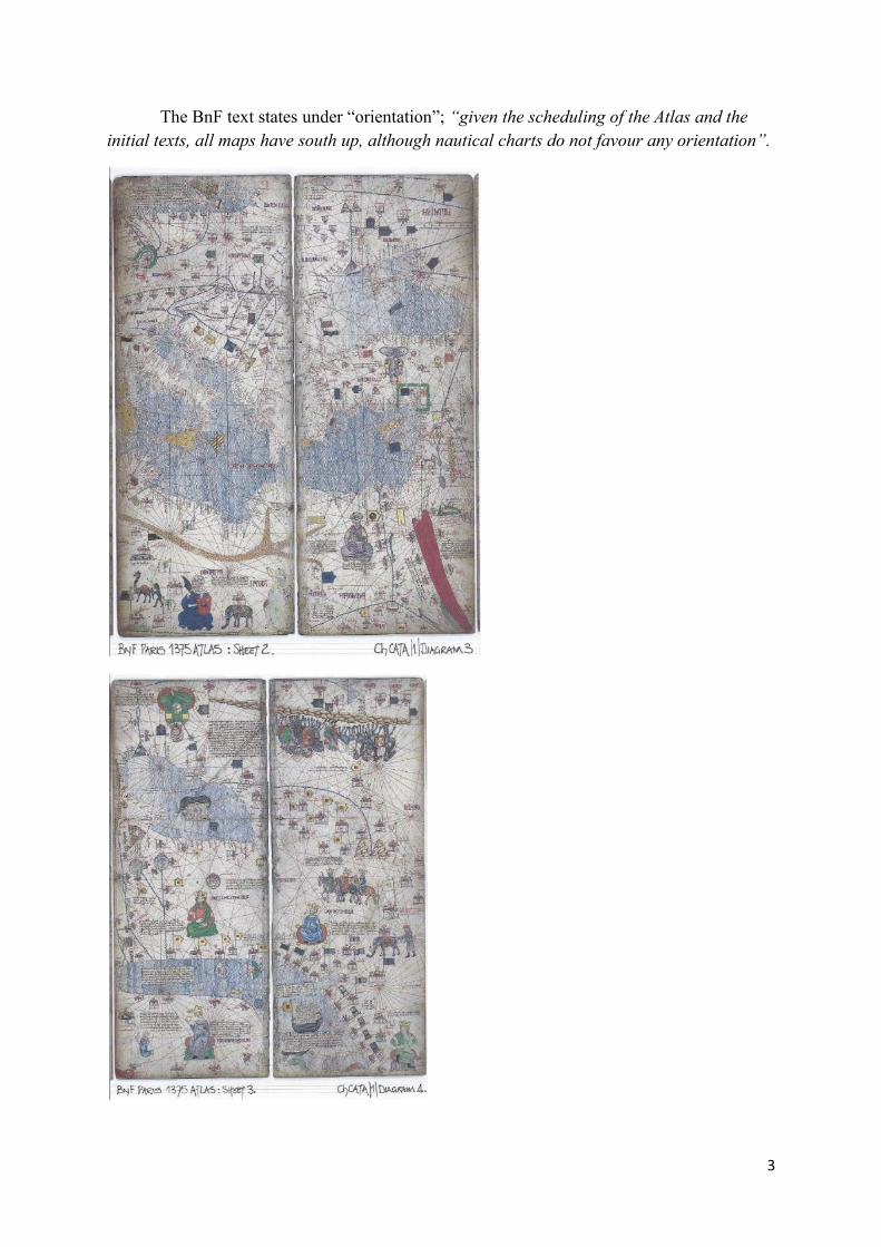
The BnF text states under “orientation”; “given the scheduling of the Atlas and the initial texts, all maps have south up, although nautical charts do not favour any orientation”.
3
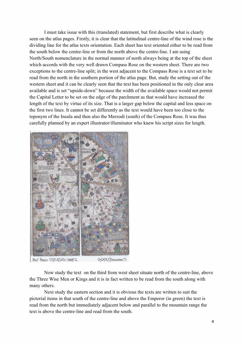
I must take issue with this (translated) statement, but first describe what is clearly seen on the atlas pages. Firstly, it is clear that the latitudinal centre-line of the wind rose is thedividing line for the atlas texts orientation. Each sheet has text oriented either to be read from the south below the centre-line or from the north above the centre-line. I am using North/South nomenclature in the normal manner of north always being at the top of the sheet which accords with the very well drawn Compass Rose on the western sheet. There are two exceptions to the centre-line split; in the west adjacent to the Compass Rose is a text set to be read from the north in the southern portion of the atlas page. But, study the setting out of the western sheet and it can be clearly seen that the text has been positioned in the only clear areaavailable and is set “upside-down” because the width of the available space would not permit the Capital Letter to be set on the edge of the parchment as that would have increased the length of the text by virtue of its size. That is a larger gap below the capital and less space on the first two lines. It cannot be set differently as the text would have been too close to the toponym of the Insula and then also the Merzodi (south) of the Compass Rose. It was thus carefully planned by an expert illustrator/illuminator who knew his script sizes for length.
Now study the text on the third from west sheet situate north of the centre-line, abovethe Three Wise Men or Kings and it is in fact written to be read from the south along with many others.
Next study the eastern section and it is obvious the texts are written to suit the pictorial items in that south of the centre-line and above the Emperor (in green) the text is read from the north but immediately adjacent below and parallel to the mountain range the text is above the centre-line and read from the south.
4
But also throughout the four pages there are texts set at 90 degrees to the centre-line and thus I conclude they are all pragmatic decisions regarding orientation and placement. That is an obvious fact as with a page 645mm high it is so much easier to write texts from a position which does not require leaning over the whole page, well over two statute feet when half the page at 322mm is little larger than an A4 page at 297mm and easy to use.
Thus the latest manifestation of the Atlas may well be with south at the top, but that could just be the whim of one of the later conservators, who have ignored the Compass Rose and certainly ignored the fact that VIRTUALLY ALL PORTOLAN CHARTS are orientated to geographical north through the wind rose setting out as my texts ChWr/1 and ChWr/2 clearly illustrate.
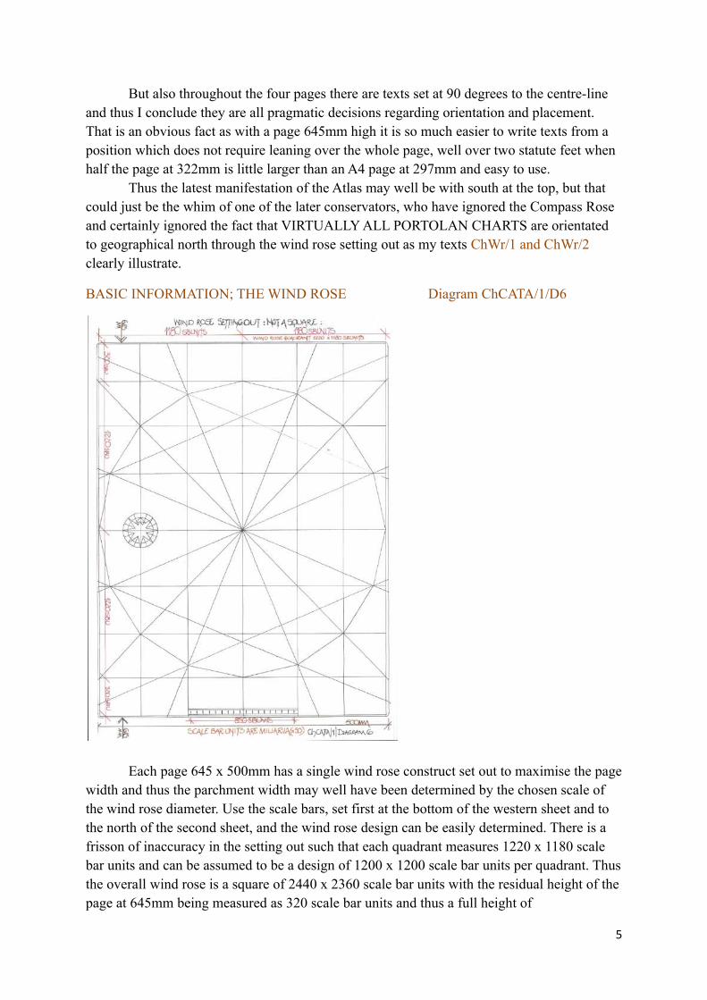
BASIC INFORMATION; THE WIND ROSE Diagram ChCATA/1/D6
Each page 645 x 500mm has a single wind rose construct set out to maximise the pagewidth and thus the parchment width may well have been determined by the chosen scale of the wind rose diameter. Use the scale bars, set first at the bottom of the western sheet and to the north of the second sheet, and the wind rose design can be easily determined. There is a frisson of inaccuracy in the setting out such that each quadrant measures 1220 x 1180 scale bar units and can be assumed to be a design of 1200 x 1200 scale bar units per quadrant. Thusthe overall wind rose is a square of 2440 x 2360 scale bar units with the residual height of thepage at 645mm being measured as 320 scale bar units and thus a full height of
5
320+1220+1220+320 scale bar units equals 645mm, but the width of the page is undoubtedlymeant to be 2400 scale bar units, but is slightly less than that actually required; but why? I amalso slightly perturbed by the thought that the draughtsman did not understand the fact that the Windrose should be based upon a square and may have compensated for the width shortfall by adding it to the height of the Windrose construct, when it could well have been a perfect square of 1180 scale bar units.
RAISON D’ETRE FOR THE WIND ROSE MESAUREMENTBut, hidden in the figures is a perfect Windrose design which unfortunately as I have
surmised the draughtsman did not understand.Petrus Vesconte designed the perfect Windrose to be drawn without the aid of
compasses, as is shown from the 1318 atlas page which sets out the construction and includesa scale bar for all to understand how. If as I think I have proven, Petrus Vesconte trained A Dulceti in the art of constructing a Portolan Chart, then that included the mathematics of the Windrose which is amply explained in my texts ChWr/1 and Wr/2. It is predicated upon a simple quadrant square of 92 units, generally from the scale bar as multiples.
Now look at the mathematics of the 1375 atlas Windrose, which is either, 1180 sbu’s, 1220 sbu’s or as is so very obvious a design or drafting measure of 1200 x 1200 sbu’s. Now look at the basic geometrical construct of the wind rose based upon 92 units and thus the 1375 atlas has a quadrant of 92 x 13 = 1196 sbu’s and the subdivisions which are 35/30/20/7 are easily measured as 455/390/260/91 = 1196 sbu’s. A perfect construct! Q.E.D.
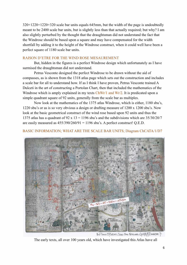
BASIC INFORMATION; WHAT ARE THE SCALE BAR UNITS; Diagram ChCATA/1/D7
The early texts, all over 100 years old, which have investigated this Atlas have all
6
included one simple fact; the Mediterranean Sea Basin as drawn is a direct copy of the 1339 A. Dulceti Portolan chart, which again can simply be proven by using a tracing overlay of thetwo with the scale bars equalized. A necessary fact as the charts are all published at different sizes of magnification. Proof of the scale bar measurement is a simple exercise as follows; thewestern coast of Iberia from Cape St Vincent to Cape Finistere is from 37N to 43N latitudinaldegrees and thus if measured will indicate the length of a latitudinal degree. But as I have shown on numerous occasions this measurement will normally produce a figure of 75 scale bar units which in fact reflects the Roman Degree of 75 Roman Miles and is a basic mistake by Medieval Cartographers who have transferred distance measurement from a Roman Mile to a miliaria. A Roman Degree of 75 Roman Miles is in fact 90 Miliaria and what happened in the distant past is that the two have been confused and the 75 taken as Miliaria not Roman Miles. We can confirm the measurement of the Miliaria as follows; from Cape St Vincent to the Gulf of Issus is 45 degrees longitude and if this is measured on the Portolan Charts and this Atlas it will be found to be a distance of 3240 Miliaria which of course means each longitudinal degree is 72 Miliaria the perfect 4/5ths of 90 Miliaria, the cosine ratio used in antiquity and Medieval times. The scale bar is a basic 50 Miliaria subdivision unit.
Immediately, therefore, we have a physical measurement with which to determine the length of the oikumene as drawn on this Atlas.
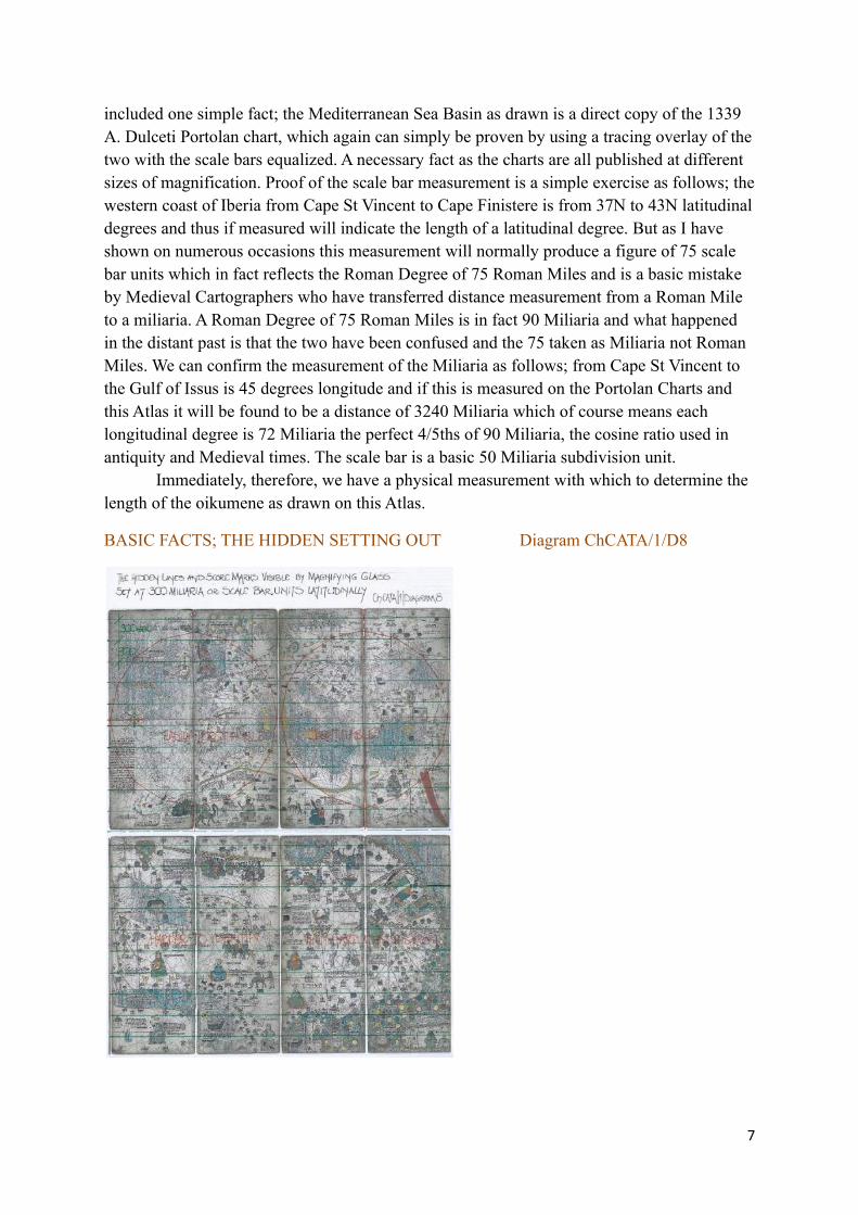
BASIC FACTS; THE HIDDEN SETTING OUT Diagram ChCATA/1/D8
7
I think it will be obvious to all that the wind rose should have measured a perfect 1200 x 1200 scale bar units per quadrant. The 1220 x 1180 quadrant gives angles of 44/46/90 degrees instead of 45/45/90 degrees, and was probably not even noticed by the draughtsman as the wind rose is set out by measurement and not by the scribing of a circle to give accuracy. We must also remember that the scale bar on the Atlas page may not be precisely the scale bar used to drawn the wind rose and thus small inaccuracies must be allowed for.
But, study the western sheet very carefully, use a magnifying glass and you will clearly see a series of latitudinal lines drawn across the Atlas page and by using the scale bar these will be found to be an accurate 300 unit spacing set out from just below the northern node point of the wind rose construct to just below the southern node point. This is a perfect confirmation of the actual wind rose dimension which we can now state is 1200 miliaria per quadrant. But, look at the other Atlas pages and the setting out of these 300 unit lines continues across them all but lessens to a degree the further east you progress as the diagram illustrates. This is another pointer to me that the original Atlas was drawn with North at the top of the pages as the western page has a complete 300 latitudinal grid and thus the first.
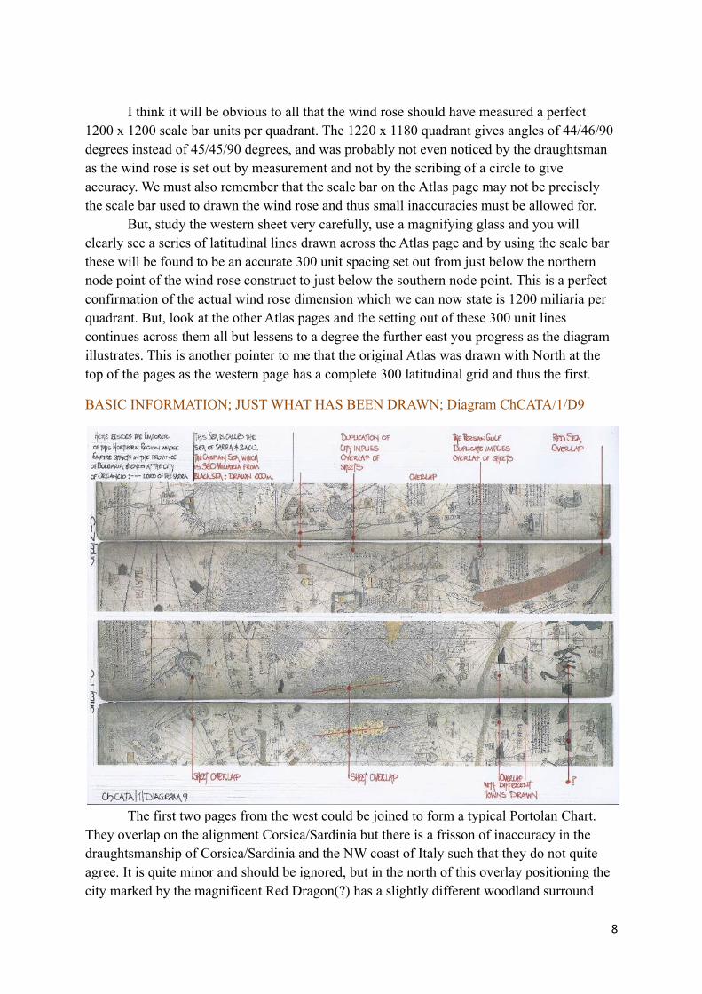
BASIC INFORMATION; JUST WHAT HAS BEEN DRAWN; Diagram ChCATA/1/D9
The first two pages from the west could be joined to form a typical Portolan Chart. They overlap on the alignment Corsica/Sardinia but there is a frisson of inaccuracy in the draughtsmanship of Corsica/Sardinia and the NW coast of Italy such that they do not quite agree. It is quite minor and should be ignored, but in the north of this overlay positioning the city marked by the magnificent Red Dragon(?) has a slightly different woodland surround
8

and the two differing emblems at this point would overlap and confuse. But please note that this Red Dragon Emblem appears again on the City of Alexandria in Issus and then again on the fourth sheet, three times on cities to the north of Illa Iana, in what could be considered theIndian Sub-continent, but that must be just a possibility as will be discussed. Rather strange as these emblems denote a cities allegiance and could be as the BnF text intimates regarding Hungary, but rather farfetched in this position. Thus we read a chart of the Mediterranean Seabasin and Black Sea extended to the Baltic in the north and the Canary Islands/Atlantic Islands in the west, some known some idealised which is a standard Portolan format.
When we study the junction between the second and third sheets, it is obvious there isa very good attempt to ensure the features of both match across the sheet junction, which I should here add is not the wind rose alignment, but the actual parchment border, some of which is possibly missing as I concluded that several lines are so close to the sheet edge as to be practically impossible to draw, as well as pictographs touching the very edge of the sheet.
Thus I think the pages have all been carefully reduced in size, when is another matter and it is unlikely to have been immediately after its drawing as the edges are not reminiscent of +600 year old parchment sheets. However if you study the western end of the Persian Gulfit has been drawn upon the second sheet and the third sheet with a town in the NW corner being replicated but drawn in a different format. Thus an attempt has been made to allow these sheets to be joined correctly but in the methodology it has gone seriously awry.
To the north, the Black Sea and Caspian Sea are separated by a mountain range whichdoes not link across the two sheets, although a river appears to do so. The Caspian Sea is drawn much too far west and orientated east/west as per Claudius Ptolemy, when it is a north/south alignment, but it does have a spectacular Volga River drawn.
The Persian Gulf is inexplicably massive with Arabia Sebba merely a horizontal east/west block of land from the Red Sea extension to the massive Strait of Hormuz.
BASIC INFORMATION; THE 3rd to 4th SHEET JUNCTION; Diagram ChCATA/1/D10
9
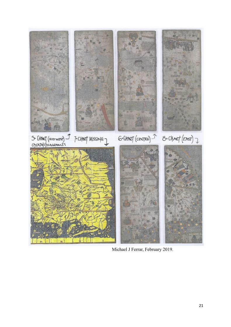
This junction just does not exist!Place the two sheets side by side and note that in the north and south at the joint the Oceans depicted do not carry across the joint as it appears they should from their format. In the centreof the fourth sheet the Lake City of “Yisical” clashes with a city positioned in the same latitude on the third sheet. They are not compatible!
Hence I believe there is a sheet 645 x 500mm missing from this atlas in this position and in fact as I will discuss later, I believe there is another sheet missing also. However if youstudy this junction, there appears to be the option of it not being meant to be seen as the mountains in the north are incomplete and this is probably because the missing sheet overlapped these adjoining sheets, much as sheets 1 to 2 indicate.
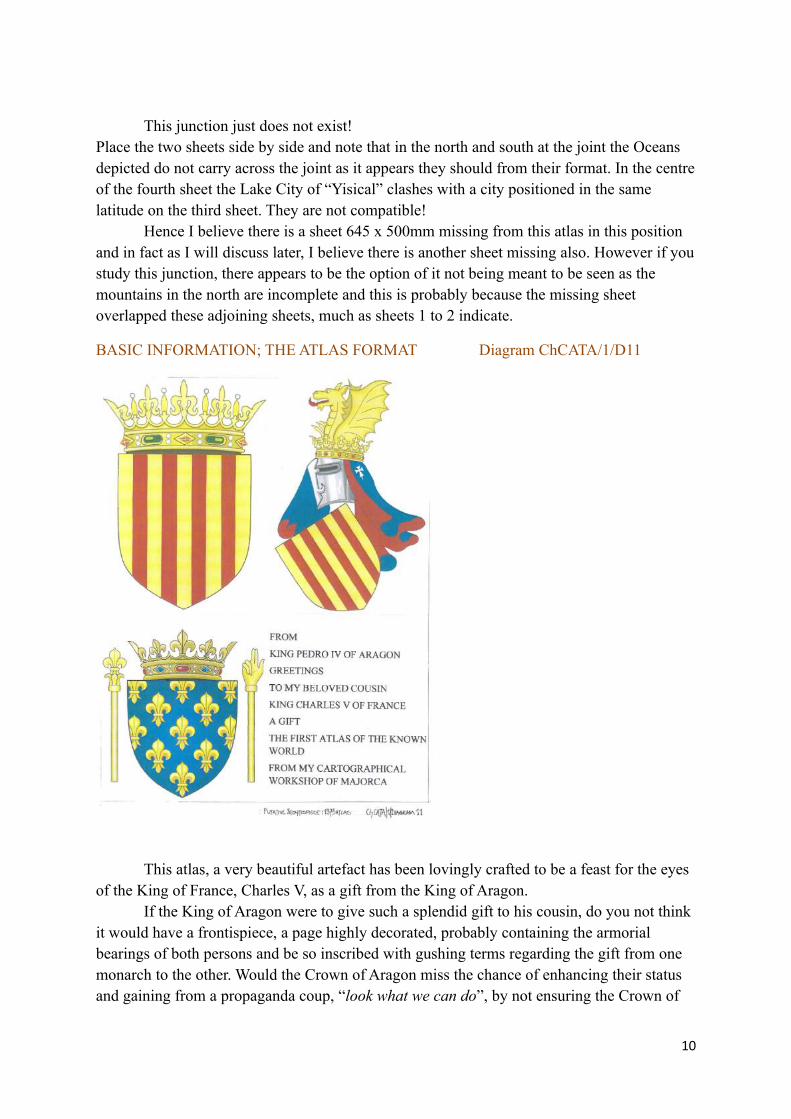
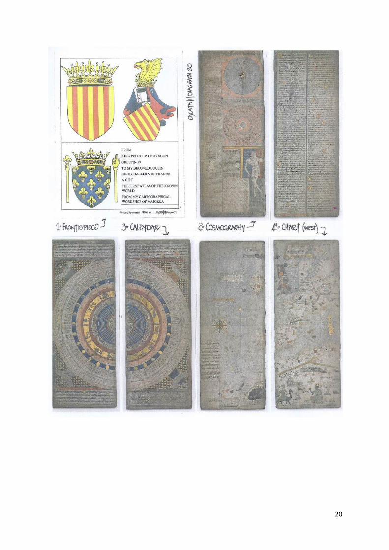
BASIC INFORMATION; THE ATLAS FORMAT Diagram ChCATA/1/D11
This atlas, a very beautiful artefact has been lovingly crafted to be a feast for the eyes of the King of France, Charles V, as a gift from the King of Aragon.
If the King of Aragon were to give such a splendid gift to his cousin, do you not think it would have a frontispiece, a page highly decorated, probably containing the armorial bearings of both persons and be so inscribed with gushing terms regarding the gift from one monarch to the other. Would the Crown of Aragon miss the chance of enhancing their status and gaining from a propaganda coup, “look what we can do”, by not ensuring the Crown of
10
France and all there who viewed this Atlas knew full well who had made the gift and provided that which in that age France would not have seen the like.
I doubt very much a frontispiece as I describe would not have been attached.
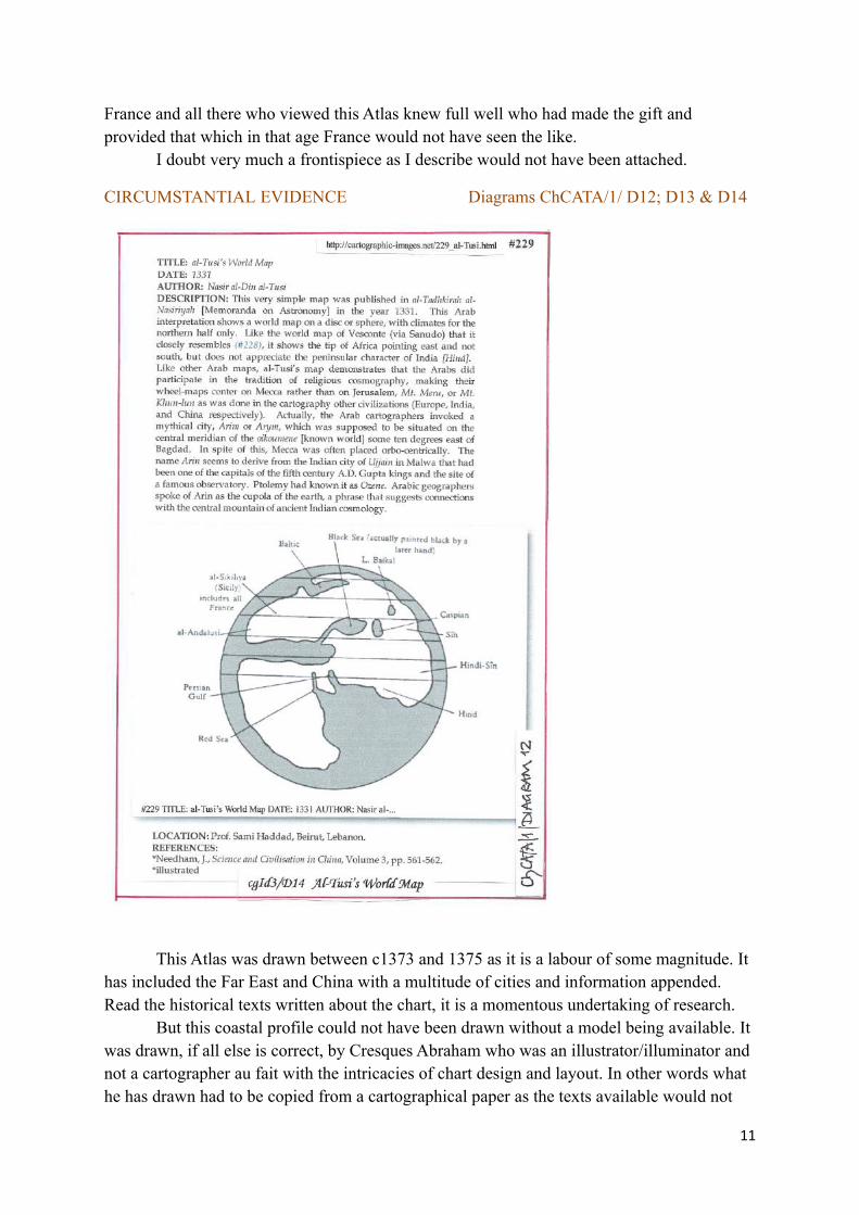
CIRCUMSTANTIAL EVIDENCE Diagrams ChCATA/1/ D12; D13 & D14
This Atlas was drawn between c1373 and 1375 as it is a labour of some magnitude. It has included the Far East and China with a multitude of cities and information appended. Read the historical texts written about the chart, it is a momentous undertaking of research.
But this coastal profile could not have been drawn without a model being available. It was drawn, if all else is correct, by Cresques Abraham who was an illustrator/illuminator and not a cartographer au fait with the intricacies of chart design and layout. In other words what he has drawn had to be copied from a cartographical paper as the texts available would not
11
have given the correct or any real coastal profile to be so drawn. We know the sheets west one and two are really no more that the 1339 A. Dulceti Portolan chart onto which has been grafted the Far East and China, which must have been taken from or been prepared for copying by a cartographical draughtsman.
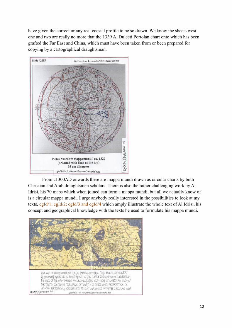
From c1300AD onwards there are mappa mundi drawn as circular charts by both Christian and Arab draughtsmen scholars. There is also the rather challenging work by Al Idrisi, his 70 maps which when joined can form a mappa mundi, but all we actually know of is a circular mappa mundi. I urge anybody really interested in the possibilities to look at my texts, cgId/1; cgId/2; cgId/3 and cgId/4 which amply illustrate the whole text of Al Idrisi, his concept and geographical knowledge with the texts he used to formulate his mappa mundi.
12

If you study the examples here-in (see later also) of the circular mappa mundi the concept of Asia as drawn on the 1375 Atlas is quite easy to ascertain. But the major item they do all show is a coastal section from the Persian Gulf eastwards which encompasses the Indian sub-continent from Persia/Pakistan to Malaysia and thence to China. The format is stylised and can be attributed to Al Idrisi who has used the work produced by Claudius Ptolemy.
Now re-study the circular mappa mundi as presented here-in and note the geometry ofthose maps and their very similar setting out with a 162 degree longitude oikoumene.
1375 ATLAS INTERLUDE Diagram ChCATA/1/D15
I have already indicated that the 1375 Atlas has a series of 2400 miliaria pages which enable the measurement of the Atlas oikoumene starting with the coast of Iberia to the coast of China. From the coast of Iberia, subtracting the Corsica/Sardinia overlap we have 1200 miliaria on sheet one and then three sheets of 2400 miliaria giving a total distance of 8400 miliaria. We know that at 36N each degree’s measurement is 72 miliaria and this actually comes from the 1339 A. Dulceti chart as well as most Portolan charts in existence. Thus the distance in degrees from Iberia to China is 8400 divided by 72 is 116.6 degrees. But the overall measurement of the four pages is actually 4 x 2400 = 9600 equal to 132 degrees.
However, I believe there is a page missing between the extant pages 3 and 4 which would indicate the Indian sub-continent, the Himalaya Range at 36N and the far north to the Arctic Ocean.
13
INTERLUDE TAKEN FROM TEXT CgId/3, DIAGRAMS D12, D13 AND D14 REFER AL-TUSI, WORLD MAP, 1331 Diagram cgId3/D14
This map with its accompanying text already appended is included as the text discusses both the mythical Arin or Arym, the supposed place which delineates the central meridian, as well as the fact that Arab Geographers placed Mecca orbo-centrically.
The text also leads into a discussion of Western circular world maps.
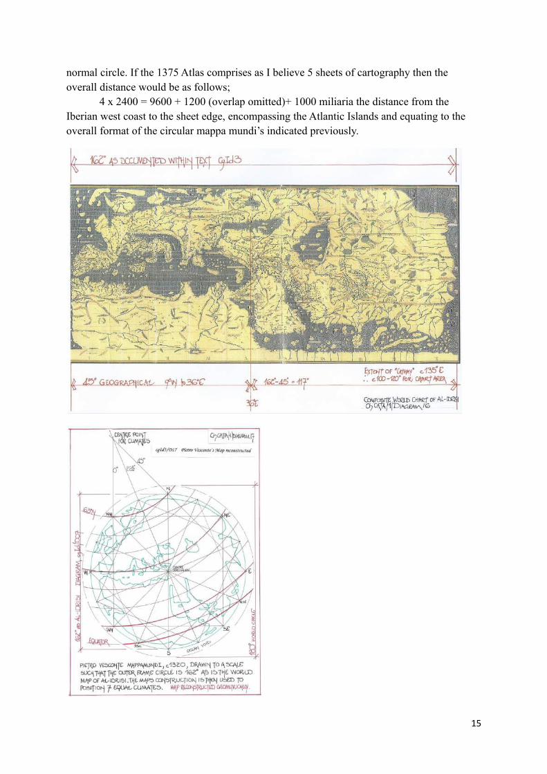
PIETRO VESCONTE MAPPAMUNDI, c1320AD. Diagrams cgId3/D15,/D16, & /D17.It is unusual in western cartography, other than for a religious base map, to find a
circular world map with what may be described as rhumb lines, sailing directions appended. Pietro Vesconte’s other maps are chiefly sea-charts and thus this circular map has a continuation of the typical look of a sea-chart.
Thus we see a realistic portrayal of the North Sea coast, the Mediterranean coast, the Black Sea and the two gulfs. But the most striking feature is the use of the 16 cardinal points of the compass and their use to insert the “rhumb line” squares on to the world circle.
However, the map does not have the Climate lines from which a direct comparison with the preceding Arabic circular maps can be made. But it is a simple geometric exercise to insert the climate lines upon the map. Simple that is if the copy map available was perfectly preserved and not distorted.
There are two possibilities as diagrams cgId3/D16 and cgId3/D17 illustrate.Using the copy of the map available, as presented on line, it does not portray a perfect
circle, it is either 162 degrees or 163 degrees diameter NSEW with 164 degrees diameter NE/SW. Therefore as diagram cgId3/D16 indicates the positioning of the climate lines is veryslightly askew from a NNW/SSE alignment. In fact, instead of the 22.5 degrees alignment, the centre line is set at 24 degrees which of course is the notional ecliptic angle. But, with such distortion it is unlikely.
However, there is a significant match to the main compass points and thus the solution.
Therefore an accurate circle and compass point was drawn, 162 degrees in diameter asdiagram cgId3/D17 illustrates and the map of Pietro Vesconte inserted into the true circle.
The obvious centre line for the climate centre NNW/SSE was extended as well as the N to E and NW/SW lines. Thus there were meeting at one point a 0, 22.5 and 45 degree line as the centre point.
The climates were therefore easy to determine, being firstly two arcs, one 63N extending from N to NW and the second the equatorial line extending from ESE to SSW.
The six lines forming the 7 climates were then inserted at equal centres and as with the previous diagram cgId3/D16, it appeared that the major compass points and alignments were the setting out foci for the actual climates.
Finally, a 180 degree circle was appended representing the world circle, as it was so apparent that the circle used by Pietro Vesconte is the inner circle or oikoumene circle as usedby Al-Idrisi on the circular world map in his text.
THE 162 DEGREE OIKOUMENE Diagram Ch CATA/1/D16 and D17The circular mappa mundi indicate an oikoumene of 162 degrees set in a 180 degree
14
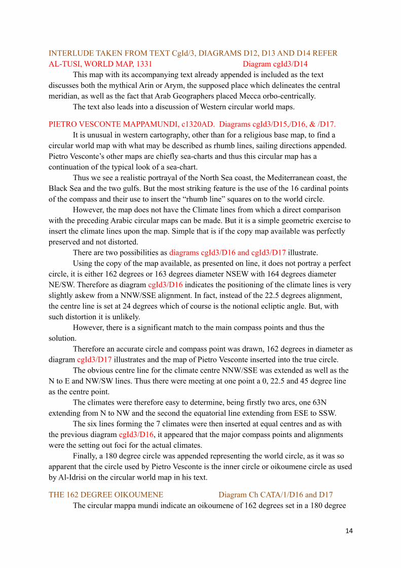
normal circle. If the 1375 Atlas comprises as I believe 5 sheets of cartography then the overall distance would be as follows;
4 x 2400 = 9600 + 1200 (overlap omitted)+ 1000 miliaria the distance from the Iberian west coast to the sheet edge, encompassing the Atlantic Islands and equating to the overall format of the circular mappa mundi’s indicated previously.
15
Thus the total is 11800 miliaria from east to west, which at 36N is a calculated 163.8 degrees and thus I do not think the 1.8 degree difference is relevant to the Atlas construction.
The reason I am convinced that the 72 miliaria, 36N distance measure is correct is the fact that the Atlas east/west centre-line is set at the Gulf of Issus which is set at a geographical 36N and provides for a logical zero point for latitudes as no other indication is available on the Atlas.
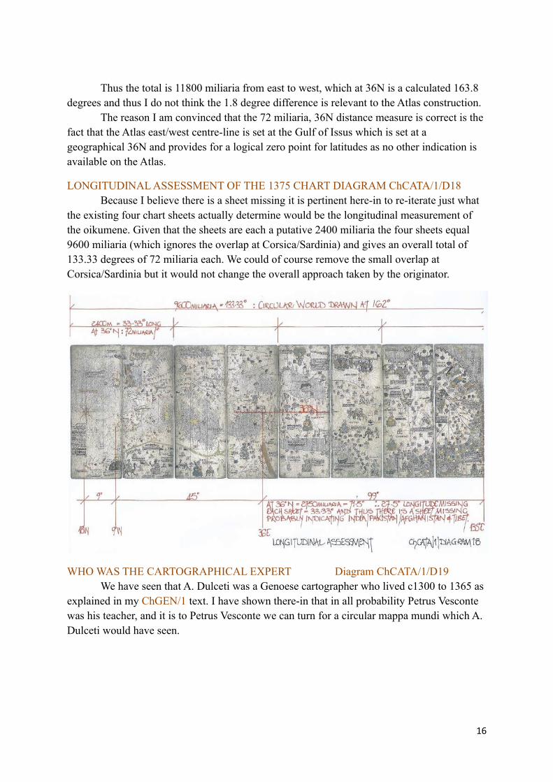
LONGITUDINAL ASSESSMENT OF THE 1375 CHART DIAGRAM ChCATA/1/D18Because I believe there is a sheet missing it is pertinent here-in to re-iterate just what
the existing four chart sheets actually determine would be the longitudinal measurement of the oikumene. Given that the sheets are each a putative 2400 miliaria the four sheets equal 9600 miliaria (which ignores the overlap at Corsica/Sardinia) and gives an overall total of 133.33 degrees of 72 miliaria each. We could of course remove the small overlap at Corsica/Sardinia but it would not change the overall approach taken by the originator.
WHO WAS THE CARTOGRAPHICAL EXPERT Diagram ChCATA/1/D19We have seen that A. Dulceti was a Genoese cartographer who lived c1300 to 1365 as
explained in my ChGEN/1 text. I have shown there-in that in all probability Petrus Vesconte was his teacher, and it is to Petrus Vesconte we can turn for a circular mappa mundi which A. Dulceti would have seen.
16
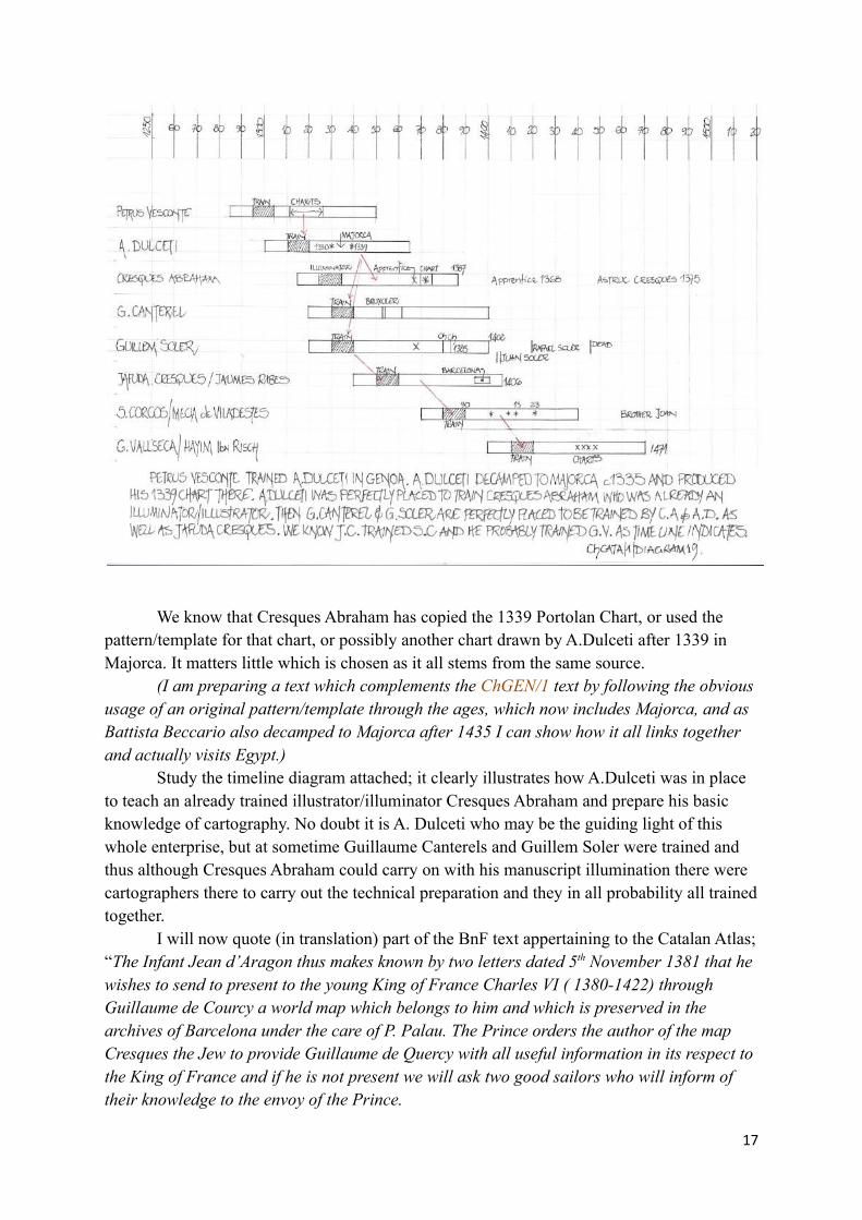
We know that Cresques Abraham has copied the 1339 Portolan Chart, or used the pattern/template for that chart, or possibly another chart drawn by A.Dulceti after 1339 in Majorca. It matters little which is chosen as it all stems from the same source.
(I am preparing a text which complements the ChGEN/1 text by following the obvioususage of an original pattern/template through the ages, which now includes Majorca, and as Battista Beccario also decamped to Majorca after 1435 I can show how it all links together and actually visits Egypt.)
Study the timeline diagram attached; it clearly illustrates how A.Dulceti was in place to teach an already trained illustrator/illuminator Cresques Abraham and prepare his basic knowledge of cartography. No doubt it is A. Dulceti who may be the guiding light of this whole enterprise, but at sometime Guillaume Canterels and Guillem Soler were trained and thus although Cresques Abraham could carry on with his manuscript illumination there were cartographers there to carry out the technical preparation and they in all probability all trainedtogether.
I will now quote (in translation) part of the BnF text appertaining to the Catalan Atlas;“The Infant Jean d’Aragon thus makes known by two letters dated 5th November 1381 that he wishes to send to present to the young King of France Charles VI ( 1380-1422) through Guillaume de Courcy a world map which belongs to him and which is preserved in the archives of Barcelona under the care of P. Palau. The Prince orders the author of the map Cresques the Jew to provide Guillaume de Quercy with all useful information in its respect tothe King of France and if he is not present we will ask two good sailors who will inform of their knowledge to the envoy of the Prince.
17

As early as 1891, E.T.Hamy had already pointed out that the world map mentioned in this document could not be the Catalan Atlas which was then already in the library of Charles V. Nevertheless the numerous documents concerning a certain “Cresques Abraham” suggest that the Catalan Atlas was realised if not by him, at least in his close circle, and that no map has reached us with his signature.”
A PREVIOUS TEXT DISCUSSEDChCr/1; Atelier of Cresques Abraham of Majorca
Chart Ms XII.D.104, Naples, Italy, analysedThis text analyses an anonymous chart, supposedly Catalan and referenced as C19 in
L.C.P. and it has been judged as from the atelier of Cresques Abraham of Majorca c1375/1400. It is obviously another copy of the A. Dulceti 1339 Portolan Chart.
This chart is therefore similar to that discussed above, but if presented to the King of France in Paris; it must have been part of an entourage to Naples at a later date. There are three charts including the Naples chart which are dated 1375/1400 attributed to Cresques Abraham or his atelier all held in Italy. However the Guillem Soler chart which is signed is held in the BnF Paris, but they also hold a Cresques Abraham normal portolan chart, reference C22 in L.C.P. dated c1400 (BnF AA 751). Given that King Charles VI is dated 1380-1422 it is quite possible for many to be the mysterious chart.
It has also been assumed by researchers that King Jean of Aragon in his letters writtenon the death of Cresques Abraham in 1387 when he says that a “Christian Teacher” who says that he is strong enough in such work (cartography) must finish a map that he had ordered in case Cresques had left it unfinished. In or after 1387 this can only be Guillem Soler, the only “Christian” then producing charts on Majorca. As shown he was alive until c1402 and probably trained as I have already indicated with Cresques Abraham and Guillaume Canterel.
CONCLUSIONCresques Abraham trained as an illustrator/illuminator of manuscripts and in all
probability was very highly accomplished in the art when A.Dulceti arrived on Majorca, c1335 as probably the first Portolan Chart cartographer. By time-line that would be the end ofa nominal 10 year apprenticeship for Cresques Abraham if we apply the nominal three score and ten years given in the Jewish Bible. But Guillaume Canterel and Guillem Soler as well asJafuda Cresques (son of Cresques Abraham) would be accomplished Bruxolers or cartographical draughtsman by c1360 with plenty of time to form an Atelier which could include of course Cresques Abraham as the lead figure.
Thus I believe the 1375 Atlas is a work composed by cartographers and executed by an accomplished illustrator/illuminator. The historical content was gathered slowly by the atelier, particularly Arab Texts which it appears Cresques Abraham knew of and could read, and this included the work of Al-Idrisi as the crown of Aragon captured Majorca c1229 and later Sicily in c1302. Hence there is no reason why the Al-Idrisi documents should not have been available and in various languages as they were all translated simultaneously.
Add in the story told by Marco Polo and other adventures which were doing the rounds and the historical texts appended are equally explained.
But given the anomalies I have indicated; the precision of the measurements and the
18
hidden graticule (latitudinal) I believe this is an attempt to quantify the oikoumene using the circular mappa mundi as a basis and producing thus a Portolan Chart surpassing the Al-Idrisi construct which can be achieved by joining all 70 maps into one chart. I also believe the time scale of at least two years, 1373 to 1375 was a minimum for the execution of the actual draughtsmanship after all the data had been compiled which would have occupied several years prior to actual work commencing.
Thus the commission from Pedro IV, King of Aragon must have been given c1370 at the earliest, bearing in mind he had been on the throne since 24th January 1336 ( until 5/1/1387) and Charles V of France reigned from 8/4/1364 to 16/9/1380. It did make me wonder if as they were cousins and no doubt in constant contact if Pedro knew Charles was ailing c 1370 and wanted to ensure the gift was presented a.s.a.p, bearing in mind Pedro was not a young man either. They were both late in years and cartography was in its infancy and thus there was possibly an imperative for them both to be seen as up-to-date and availed of the latest geographical information.
Historically I have just questions which I fear cannot be answered, but, cartographically I think this beautiful Atlas was an attempt to surpass the only extant data, that of Al-Idrisi, and it comes at a time of turmoil in the Arab/Jewish communities and is also a chance for the “Christian Kings” to show their dominance of the world. Using a Jewish illustrator/illuminator was obviously pragmatic but in all probability stems from the fact that at the time only Majorca in the Aragonese world had a cartographer, A. Dulceti.
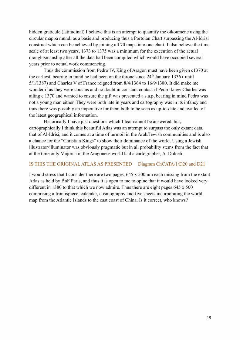
IS THIS THE ORIGINAL ATLAS AS PRESENTED Diagram ChCATA/1/D20 and D21
I would stress that I consider there are two pages, 645 x 500mm each missing from the extant Atlas as held by BnF Paris, and thus it is open to me to opine that it would have looked very different in 1380 to that which we now admire. Thus there are eight pages 645 x 500 comprising a frontispiece, calendar, cosmography and five sheets incorporating the world map from the Atlantic Islands to the east coast of China. Is it correct, who knows?
19
20
Michael J Ferrar, February 2019.
21