Charlotte Area Transit System TRANSIT...
13
Charlotte Area Transit System TRANSIT VISION
-
Upload
truongkhanh -
Category
Documents
-
view
216 -
download
0
Transcript of Charlotte Area Transit System TRANSIT...

Charlotte Area Transit SystemTRANSIT VISION

Over the past decade, Charlotte has become one of the fastest growing areas in the United States
expanding to over 1.8 million people. The next 25 years will continue to bring growth to our region which
is projected to expand by an additional 1 million people. Fueling this population growth is the Charlotte
region’s economic engine; a catalyst for business and one that competes in a global market.
With growth come problems of increased congestion, poor air quality and lost efficiencies due to longer
commute times. A critical element in our region’s ability to remain competitive is the free flow of goods
and materials to support local, regional and global businesses, and the ability of people to have easy
access to higher learning, excellent health care and entertainment venues.
Providing increased mobility options for our residents, businesses and employees through a balanced
transportation network of roads, sidewalks, bike lanes and public transportation is needed to provide
alternatives and solutions to improve air quality, alleviate traffic congestion and improve the overall
quality of life in the Charlotte region.
The transit and land-use vision initiated in 1998 was designed specifically to address these issues. Since
1998 significant investments and progress has been achieved in addressing these mobility needs. These
investments have increased access and mobility options for many neighborhoods through the expansion
of the bus service, enhancing customer amenities at stops, creating pedestrian-friendly neighborhoods
in close proximity to light rail stations, and revitalized the Historic South End District.
But there is more to accomplish, and CATS is committed to advancing the shared vision approved by
the voters in 1998 and reaffirmed in 2007 by 70% of Mecklenburg County citizens. And we invite you
to come along for the ride.
Rapid Growth

Resulted in Resulted in
Increased property valuesin South End Charlotte
New property taxrevenue from growth
Increased benefits for the community
Community Investments
CONNECTING TRANSIT AND LAND USEThe integration of transit and land use is a key component in moving the region forward. Successful
transit oriented developments (TOD) offer a pedestrian-oriented environment in which residents
can live, work, shop and play in places accessible by transit. The primary benefits of TOD include:
• Reducingsprawlandprotectingexistingneighborhoods
• Reducingcommutetimesandtrafficcongestion
• Improvingenvironmentalqualityandopenspacepreservation
• Encouragingpedestrianactivityanddiscouragingautomobiledependency
Since 2005, retail, office, and residential units within ½ mile of the LYNX Blue Line have grown
substantially. These investments bring in new tax revenues to the city and county which are
reinvested in education, police, fire, roads and other public programs other than transit.

CONNECTING TO THE PAST
Community Improvements
In 1998, after an extensive public involvement process and thoughtful consideration, the citizens
of Mecklenburg County approved the half-cent local sales and use tax to support the vision as
outlined in the 2025 Integrated Transit/Land Use Plan. This plan serves as a vision, focusing
growth along five transportation corridors, linking our area’s key centers of economic activity.
• Increasedridershipfrom11.8MinFY1998to26.1MinFY2013
• Increasedthenumberofbusroutesby75%
• Createdfundingpartnershipswiththesurroundingcountiestocreateregionalexpress
bus service
• Expandedservicehours,improvedservicefrequencyandreliability
• 100%Wheelchairaccessiblebusandrailfleet
• 3,400busstopswithtimepointinformation
• 100%bikerackfleet
• Builtthreecommunitytransitcenters
• Installedover77newbenchesand217newshelters
• Builtandoperatethestate’sfirstlightraillinecarryingmorethan15,000eachweekday
• Startedtheregion’sfirstenhancedbusservicefromCenterCitytoCharlotteDouglas
International Airport
• BeganconstructionoftheLYNXBlueLineExtension
• BuiltfourCATSownedandoperatedparkandridefacilitieswithover1,137newparking
spaces
• Expandedthefleettoover530bus,railandvanpoolvehicles
Since the passage of this tax, CATS has made investments to better the community and provide
greater connectivity for the citizens of the region. These improvements include:
2014

Transit Modes
The Transit Corridor System Plan In2006,theMetropolitanTransitCommission(MTC)adoptedthe2030TransitCorridorSystem
Plan, furthering the vision outlined in the 2025 Integrated Transit/Land Use Plan.
The2030TransitCorridor SystemPlan consists ofmultiple transitmodes in five corridors, a
series of improvements in Charlotte’s Center City and bus service and facility improvements to
link our area’s key centers of economic activity.
Once completed, this plan will encompass 25 miles of commuter rail, 19 miles of light rail,
16milesofstreetcar,andanexpandednetworkofbusesandothertransitservices.
LYNX Red Line• 25-mile commuter rail line• 10 stations• 9 park and rides
LYNX Blue Line Extension• 9.3-mile light rail line• 11 stations• 4 park and rides• Estimated completion: 2017
CityLYNX Gold Line• 10-mile streetcar line• 27 stops
LYNX Blue Line• 9.6-mile light rail line• 15 stations• 7 park and rides• Cost: $462.7 million
Sprinter Enhanced Bus• 8-mile ehanced bus line
LYNX Silver Line• 13.5-mile bus rapid transit line• 16 stations• 7 park and ride lots• Under re-evaluation
LYNX Blue LineLYNX Blue Line ExtensionProposed LYNX Red LineProposed LYNX Silver LineProposed CityLYNX Gold LineSprinter Enhanced BusProposed Sprinter Enhanced Bus
Stations/Stops
Community Transit Centers
Municipalites
Freedom D
r.
West Blvd
.
Nor
th T
ryon
St.
Central Ave.
CityLYNX Gold Line• 6.4-mile streetcar line• 10 stops
– MAIN
/UNC CHARLOTTE
LYNX Red LineNorth CorridorCenter City to Mount Mourne25-mile commuter rail line
LYNX Blue LineSouth CorridorCenterCitytoI-485atSouthBlvd9.6-milelightrailline
LYNX Blue Line ExtensionNortheast CorridorCenter City to UNC Charlotte – Main9.3-milelightrailline
CityLYNX Gold LineWest Corridor6.4-milestreetcarline
CityLYNX Gold LineCenter City10-mile streetcar line
Sprinter Enhanced BusWest Corridor8-mile enhanced bus line
LYNX Silver LineSoutheast CorridorCenter City to CPCC Levine Campus13.5-milebusrapidtransitline
CONNECTING THE VISION LYNX System Map

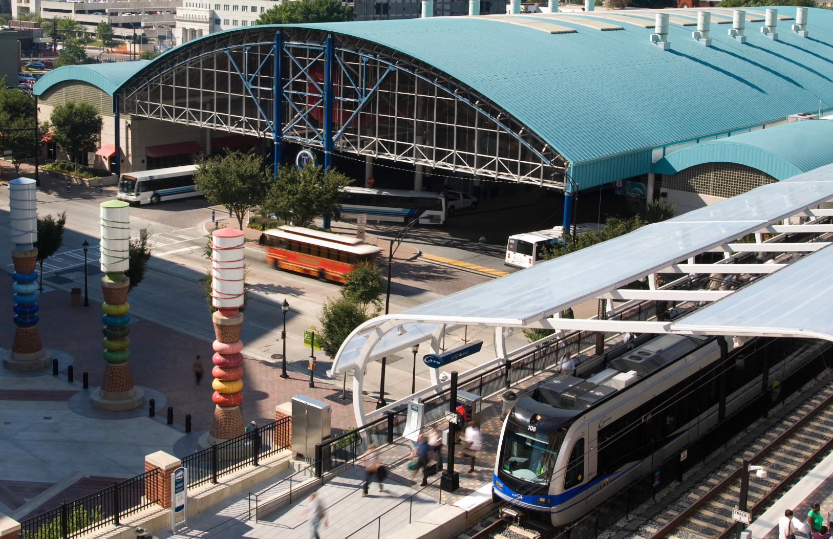
LYNX Blue Line In 2007, the Charlotte region entered a new era in public transportation with the opening of North
Carolina’s first light rail line, the LYNX Blue Line. In its first year of operation, ridership exceeded
initialprojectionsby56%.Infact,over72%ofcurrentridersusedtodrivealone.TheLYNXBlue
Line averages over 15,000 riders each weekday and was named one of the safest new-start light rail
systems in the United States, with only one preventable accident since the service started.
TheBlueLineoffersfast,quiet,convenientlight-railservicebetweenUptownCharlotteandI-485at
South Boulevard. With service every 10 minutes during rush hour, the LYNX Blue Line provides a
25 minute congestion-free commute, and dozens of bus routes are timed to connect with trains at
Blue Line stations.
The LYNX Blue Line is integrated with land-use policies that promote more compact, pedestrian
friendly development that encourage a mix of residential, retail, employment, and civic developments
at or near the light rail line to support sustainable communities.
Since its ground-breaking in 2005, The LYNX
Blue Line has helped to invigorate businesses
and residential areas along South Boulevard.
In addition to attracting riders, Charlotte’s
SouthEnd has generated over $1.4 billion in
actual and proposed corridor development
planned through 2015. Other City of Charlotte
investments in the area include road,
sidewalk, storm drainage, and beautification
improvements along South Boulevard, Old
PinevilleRoadandadjacentneighborhoods.
CONNECTING TODAY
I-485/South Blvd
Sharon Rd West
Arrowood
Scaleybark
7th St
Charlotte TransportationCenter/Arena3rd St/
ConventionCenter
Archdale
Tyvola
Woodlawn
New Bern
East/West Blvd
StonewallCarson
Bland St
Sout
h Bl
vd
SOUTHPARK
CENTER CITY
LYNX Blue Line
Station
Park and Ride
NewBernat3030South
Before
After
South End at Morehead
After
Before
LYNX Blue Line Highlights
Center City to I-485 atSouth Boulevard•9.6miles
•15stations
•7parkandridelots
•3,500parkingspaces
•Service:5:30a.m.–2:00a.m.;7daysaweek
•15,000weekdayridership
•Checkers•Hornets•Knights•NASCARHallofFame•Panthers
•BechtlerMuseum•BlumenthalPerformingArtsCenter•DiscoveryPlace•HarveyB.GanttCenter•ImaginOn•MintMuseum
•UNCCharlotteCenterCityCampus
•5,630newresidentialunits
•465,395sq.ft.ofnewofficespace•419,379st.ft.ofretailspace
Destinations
Community Investments by 2015

LYNX Blue Line ExtensionCurrently under construction, the LYNX Blue Line Extension will run from 7th Street in Center City to
the University of North Carolina at Charlotte.
The LYNX Blue Line Extension Project will provide a consistent commute along the congested I-85/
US29corridor,wherepopulationandemploymentareanticipatedtoincreasesignificantlyby2035.
This project will improve transit service to regional employment, entertainment, cultural and retail
destinations, including Center City Charlotte, professional sports and entertainment facilities, the
CharlotteConventionCenter,theNASCARHallofFame,andlinkUNCCharlotte’sUniversityCityand
Uptown campuses.
Upon completion, the LYNX Blue Line Extension will connect many neighborhoods including: NoDa,
Hidden Valley, Belmont, Optimist Park and Hampton Hills.
This project is also spurring growth along the corridor. Current projections include 12,000 new
housingunits,3.8millionsquarefeetofnewofficespaceandover1.3millionsquarefeetofretail
spaceby2035.
Center City to I-485 atNorth Tryon Street
7th St9th St
25th St36th St
Parkwood
Sugar CreekOld Concord Rd
Tom HunterUniversity City Blvd
McCulloughJW Clay Blvd/UNC Charlotte
UNC Charlotte – Main
N Tryon S
t
CENTER CITY
LYNX Blue Line Extension
Station
Park and Ride
• 9.3miles
• 11stations
• 4parkandridelots
• 3,000parkingspaces
• Service:5:30a.m.–1:30a.m.;7daysaweek
• 24,500estimateddailyridershipby2035
• Estimatedcompletiondate:2017
•Over12,400newhousingunits
•Over3.8millionsq.ft.ofnewoffice
•Over1.3millionsq.ft.ofnewretail
•$4.4billioninnewdevelopmentandproperty
CONNECTING THE FUTURE
LYNX Blue Line Extension Highlights
•Checkers•Hornets•Knights•NASCARHallofFame•Panthers
•BechtlerMuseum•BlumenthalPerformingArtsCenter•DiscoveryPlace•HarveyB.GanttCenter•ImaginOn•MintMuseum
•UNCCharlotteCenterCityCampus•UNCCharlotteMainCampus
•CarolinasMedicalCenter–University
Destinations
Community Investments by 2035

LYNX Red LineFrombustlingCenterCitytothebeautifulLakeNormanareatoroaringRaceCity,USA,theLYNXRed
Line will provide passengers with commuter rail service between Charlotte and Mooresville. The LYNX
RedLinewillconnectthetownsofDavidson,CorneliusandHuntersvilletoCenterCityCharlotteat
theproposedmultimodalstation,CharlotteGatewayStation.OnceattheCharlotteGatewayStation,
customers will have access to the arts, sports, cultural and employment opportunities through
connectionsontheCityLYNXGoldLine,CATSbusroutesandintercityrailandbuslines.
CONNECTING THE FUTURE Center City to Mount Mourne•25miles
•10stations
•9parkandridelots
•1,200parkingspaces
•4,600estimateddailyridershipby2030
•16,391newresidentialunits
•3.1millionsq.ft.newofficespace
•2.3millionsq.ft.newretailspace
•$5.4billiontransitorienteddevelopment
•CPCCHuntersville•DavidsonCollege
•LowesCorporateHeadquarters
•LakeNormanRegionalMedicalCenter•Novant-HuntersvilleHospital
Destinations
Community Investments by 2035
CENTER CITY
HUNTERSVILLE
CORNELIUS
DAVIDSON
Mount Mourne
Davidson
Cornelius
Sam Furr
Huntersville
Hambright
East�eld
Harris/NC 115
Derita
CharlotteGateway
Station
Gra
ham
St
Old
Sta
tesv
ille
Rd
/NC
115
LYNX Red Line
Station
LYNX Red Line Highlights

CONNECTING THE FUTURE
LYNX Silver Line Highlights
LYNX Silver LineTheSilverLine(SoutheastCorridor)extendsapproximately13.5milesfromCharlotte’sCenterCityto
the border of Mecklenburg and Union counties, terminating at Central Piedmont Community College’s
LevineCampus.OriginallydesignatedtouseamodeofBusRapidTransit,whilepreservingtheability
tomigratetoLightRailTransit,arecentstudybyUrbanLandInstituteproposesanalternativetothe
corridor using express bus and Sprinter style service along Independence Boulevard in HOT lanes
andrailserviceonMonroeRoad,similartotheCityLYNXGoldLineserviceproposedforCentralAve.
This alternative provides for auto-oriented retail on Independence Boulevard while the rail service
alongMonroeRoadservesneighborhoodsandallowsmixed-usedevelopment.
MONROE
MATTHEWS
CENTER CITY
Independence Pointe Pkwy
Sardis Rd North
Village Lake
Conference
Sharon Amity
Amity GardensBriar Creek
Pecan
Alexander St(Government Center)
Church St/Tryon St
CPCC Levine Campus
CPCC CentralCampus
CharlotteTransportation
Center/Arena
CharlotteGateway Station
Matthews TOD
NC 51
Independence Blvd
LYNX Silver Line
Station
Center City to CPCC Levine Campus•13.5miles
•16stations
•7parkandridelots
•3,350parkingspaces
•15,500estimateddailyridershipby2030
•OvensAuditorium•BojanglesColiseum
•CPCCCentralCampus•CPCCLevineCampus
•Novant-MatthewsHospital
Destinations

CityLYNX Gold LineTheCityLYNXGoldLine isa10-milestreetcarsystemthat isan integralpartof the2030Transit
Plan and is being built in phases. Once completed, it will connect east and west Charlotte with key
destinations throughout Uptown. The alignment will connect with all current and future rapid transit
lines,includingtheLYNXBlueLine,RedLine,SilverLineandtheWestCorridor.TheCityLYNXGold
Linewill servewestCharlottebeginningat theRosaParksPlaceCommunityTransitCenter and
continuealongBeattiesFordRoadtoTradeStreet.ItwillproceedeasttoElizabethAvenueextending
along Hawthrone Lane to Central Avenue and end at the Eastland Community Transit Center.
Construction of phase 1 began December 2012. This 1.5 mile route from Center City will serve the
Charlotte Transportation Center, CPCC and Novant Hospital. Phase 1 will have six stops, including a
connection to the LYNX Blue Line. Completion is scheduled for 2015.
Phase2oftheCityLYNXGoldLineextendstheprojectfromtheCharlotteTransportationCenterwest
to French Street beyond Johnson C. Smith University and east from Novant Hospital to Sunnyside
Ave.Constructionofphase2isplannedfor2016withananticipatedservicestartdateof2019.
Sunnyside Ave
Charlotte
Gateway
Center
CPCC
McDow
ell StDav
idson St
Johnson & Wale
s
Mint St
Tryon St
Irwin Ave
Governmen
t
Center
Elizabeth &Hawthorne
CENTER CITY
Eastland CommunityTransit Center
Winter�eld PlaceSheridan Dr
Eastway DrEastway Crossing
Briar Creek RdArnold Dr
Morningside Dr
Hawthorne & 8th
Clement AveThe Plaza
Saint Julien StIris Dr
Landsdale Dr/Rosehaven Dr
Darby Acres
Montana DrLaSalle St
Russell AveBooker Ave/Oaklawn
Hawthorne atBarnhardt
Rosa ParksPlace
French StJohnson C Smith
UniversityBurns St
WesleyHeights Way
Centra
l Ave
Beatties Ford Rd
Charlotte
Transp
ortatio
n
Center
/Arena
CityLYNX Gold Line
Station
CONNECTING THE FUTURECenter City• 10miles
• 37stops
• Service:5:00a.m.–1:00a.m.;7daysaweek
• 16,000projecteddailyridershipby2030
• NovantHospitaltoCharlotteTransportation
Center in 2015
•2,000smallbusinesseswithin1/4mileofline
•Propertytaxvaluesincreaseupto$7M
•21,800sq.ft.newretailspace
•276,700sq.ft.newofficespace
•Checkers•Hornets•Knights•NASCARHallofFame•Panthers
•BechtlerMuseum•BlumenthalPerformingArtsCenter•DiscoveryPlace•HarveyB.GanttCenter•ImaginOn•MintMuseum
•CPCCCentralCampus•Johnson&WalesUniversity•JohnsonC.SmithUniveristy•NortheasternUniversity•UNCCharlotteCenterCityCampus•WakeForestUniversity
Destinations
Community Investments by 2035
CityLYNX Gold Line Highlights

Sprinter Enhanced BusWhether you’re meeting friends at the local coffee shop for a java boost or a business executive
heading out of town for a meeting, service on the West Corridor will get you there. In 2009, CATS
introduced its first enhanced bus service, the Sprinter. Sprinter includes limited stops, branded-
identity, hybrid vehicles, improved passenger amenities and digital schedule information. This service,
which operates along Wilkinson Boulevard, provides convenient and frequent door to door service to
Charlotte Douglas International Airport.
CityLYNX Gold LineForthelongterm,theCityLYNXGoldisplannedtooperateprimarilyalongWestMoreheadStreet
and Wilkinson Boulevard. This investment will improve transit service and enhance economic
development opportunities along the corridor.
West Corridor•8miles
•17stops
•Phase1:CenterCitytoWilkinsonBlvd.totheairportopenedinSeptember2009
•Phase2:FreedomDr.by2012andWestBlvd.by2014
CENTER CITY
Charlotte TransportationCenter/Arena
Wilkinson Blvd
Freedom Dr
West Blvd Sprinter
Station
CONNECTING THE FUTURE
West Corridor•6.4miles
•10stops
•Service:7daysaweek
•3,800projecteddailyridershipby2034
CENTER CITYLittle Rock
Morris F
ield
Ashley
Remount
Summit
Cedar Stadium
Tryon Charlotte TransportationCenter/Arena
Charlotte GatewayStation
Morton
Wilkinson Blvd
CityLYNX Gold Line
Station
www.ridetransit.org704-336-RIDE (7433) • 866-779-CATS (2287)
3/14