CHARACTERISTICS Segment...
13
SR 503 I-5/WOODLAND AREA IN COWLITZ COUNTY CHARACTERISTICS Segment Description: This section of SR 503 is from I-5 to North Goerig Street in the City of Woodland. County/Counties: Cowlitz Cities/Towns Included: The segment runs through the city of Woodland. Number of lanes in the corridor: 2 to 4 Lane width: 11 to 12 feet. Speed limit: 30 to 35 mph. Median width: 4 to 4 feet. Shoulder width: 0 to 8 feet. Highway Characteristics: This corridor has regional significance (Non-HSS) and is not part of the National Highway System. Its state functional class is R2 - rural, minor arterial. The corridor is located in the City of Woodland. Speed Limit is 30 to 35 mph in both directions. Parking is permitted on both sides. Special Use Lane Information (HOV, Bicycle, Climbing): There is a two way turn lane from milepost 54.02 to 54.24. Access Control Type(s): There is non limited access control on this corridor. Terrain Characteristics: There is generally level terrain throughout the limits of the corridor analysis. This corridor lies primarily within the flood plain of the Lewis River. Natural Features: This section of SR 503 is located within the flood plain of and runs parallel to the Lewis River. This segment of SR 503 provides major access to recreational areas and reservoirs including access to the southern flank of the Mount Saint Helen's National Volcanic Monument. Adjacent Land Description: Urbanized land. This section is adjacent to the freeway service commercial area in the City of Woodland, the land is urbanized. Environmental Issues: The primary environmental concerns are related to potential impacts to the Lewis River by the highway facilities and impact to the highway from the river due to the potential of flooding. Other environmental issues may include unknown underground storage tanks and hazardous material hotspots. No wetlands were found in the immediate area of the I-5 interchange or SR 503 North through the Woodland urban area. Projects that involve changes to Lewis River Road and the associated bridge over the North Fork Lewis River may involve a minor amount of wetland and riparian impact. Major Economic Issues: The Port of Woodland operates two industrial parks with good access to Interstate 5. These facilities are located west of the congested corridor segment of SR 503. The economic activity within the congested corridor is primarily service commercial for the local community and recreation related traffic. Truck and freight movement along the corridor is delivery oriented. CA032 5/17/2007
Transcript of CHARACTERISTICS Segment...

SR 503 I-5/WOODLAND AREA IN COWLITZ COUNTY
CHARACTERISTICSSegment Description:This section of SR 503 is from I-5 to North Goerig Street in the City of Woodland.
County/Counties: CowlitzCities/Towns Included: The segment runs through the city of Woodland.Number of lanes in the corridor: 2 to 4Lane width: 11 to 12 feet.Speed limit: 30 to 35 mph.Median width: 4 to 4 feet.Shoulder width: 0 to 8 feet.
Highway Characteristics:This corridor has regional significance (Non-HSS) and is not part of the National Highway System. Its state functional class is R2 -rural, minor arterial. The corridor is located in the City of Woodland. Speed Limit is 30 to 35 mph in both directions. Parking ispermitted on both sides.
Special Use Lane Information (HOV, Bicycle, Climbing):There is a two way turn lane from milepost 54.02 to 54.24.
Access Control Type(s):There is non limited access control on this corridor.
Terrain Characteristics:There is generally level terrain throughout the limits of the corridor analysis. This corridor lies primarily within the flood plain of theLewis River.
Natural Features:This section of SR 503 is located within the flood plain of and runs parallel to the Lewis River. This segment of SR 503 provides majoraccess to recreational areas and reservoirs including access to the southern flank of the Mount Saint Helen's National VolcanicMonument.
Adjacent Land Description:Urbanized land. This section is adjacent to the freeway service commercial area in the City of Woodland, the land is urbanized.
Environmental Issues:The primary environmental concerns are related to potential impacts to the Lewis River by the highway facilities and impact to thehighway from the river due to the potential of flooding. Other environmental issues may include unknown underground storage tanksand hazardous material hotspots.No wetlands were found in the immediate area of the I-5 interchange or SR 503 North through the Woodland urban area. Projects thatinvolve changes to Lewis River Road and the associated bridge over the North Fork Lewis River may involve a minor amount ofwetland and riparian impact.
Major Economic Issues:The Port of Woodland operates two industrial parks with good access to Interstate 5. These facilities are located west of thecongested corridor segment of SR 503. The economic activity within the congested corridor is primarily service commercial for thelocal community and recreation related traffic. Truck and freight movement along the corridor is delivery oriented.
CA032 5/17/2007

Begin MP: 53.95
End MP: 54.38
ClarkCounty
5
503
Woodland
November, 2006
Corridor Location
HSP Corridor Series
Characteristics
Milepost Markes
HSP Corridor Location
U.S. Interstate
U.S. Highway
State Route
Local Roads
Railroad
Wetlands
Military Reservation
Tribal Lands
City Limits
Urban Area
County Line
HSP CongestedCorridor Analysis
Usage
Solutions
Characteristics
Needs
Assets
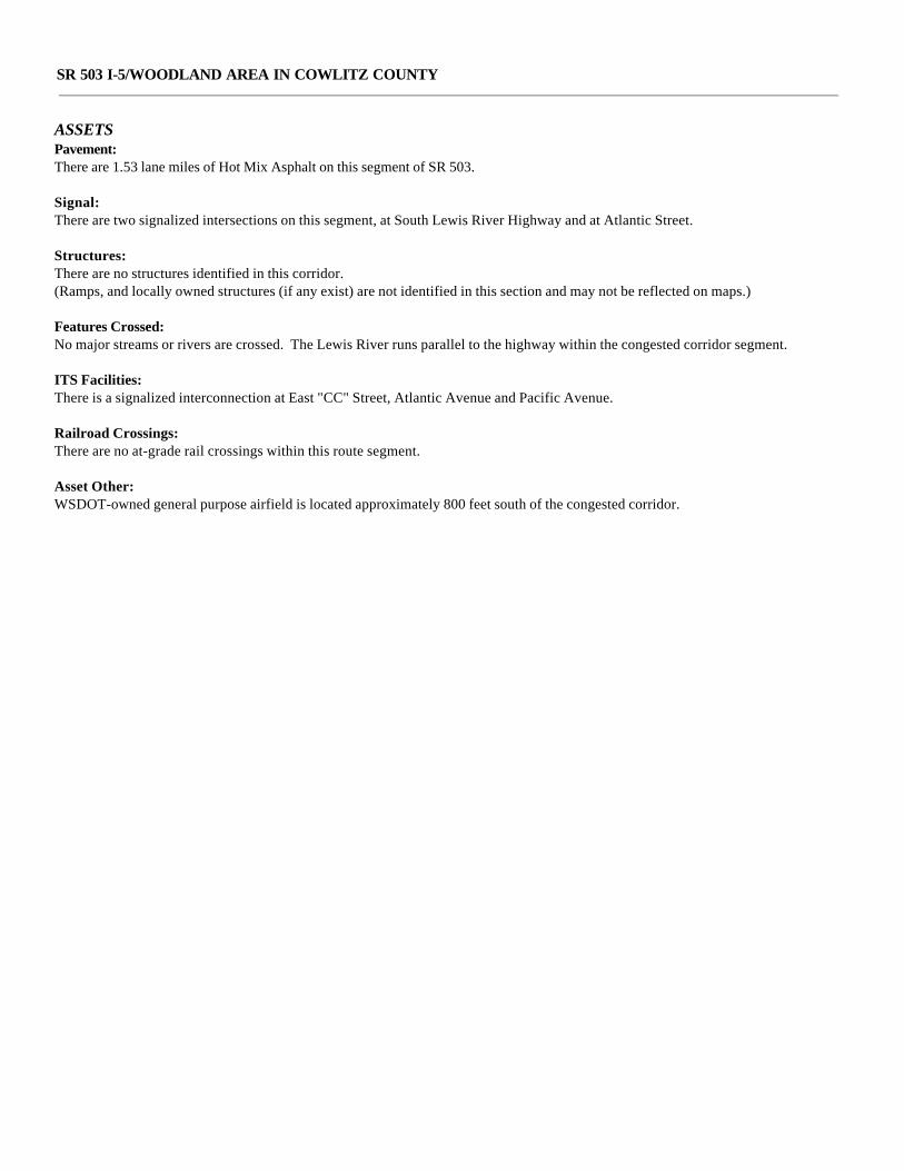
SR 503 I-5/WOODLAND AREA IN COWLITZ COUNTY
ASSETSPavement:There are 1.53 lane miles of Hot Mix Asphalt on this segment of SR 503. Signal:There are two signalized intersections on this segment, at South Lewis River Highway and at Atlantic Street.
Structures:There are no structures identified in this corridor.(Ramps, and locally owned structures (if any exist) are not identified in this section and may not be reflected on maps.)
Features Crossed:No major streams or rivers are crossed. The Lewis River runs parallel to the highway within the congested corridor segment.
ITS Facilities:There is a signalized interconnection at East "CC" Street, Atlantic Avenue and Pacific Avenue.
Railroad Crossings:There are no at-grade rail crossings within this route segment.
Asset Other:WSDOT-owned general purpose airfield is located approximately 800 feet south of the congested corridor.

Le
wi
s
R .
Begin MP: 53.95
End MP: 54.38
ClarkCounty
CowlitzCounty
5
503
Woodland
November, 2006
HSP Corridor Location
AssetsSignalized Intersection
At Grade Railroad Crossings
Bridge
FerryTerminals
Ferry Route
Park and Ride
WeighStations
Rest Area Sites
Corridor Pavement TypeHMA
BST
PCCP
Other FeaturesU.S. Interstate
U.S. Highway
State Route
Local Roads
Railroad
Military Reservation
Tribal Lands
City Limits
Urban Area
Airport
County Line
HSP Corridor SeriesAssetsHSP Congested
Corridor Analysis
Usage
Solutions
CharacteristicsNeedsAssets

SR 503 I-5/WOODLAND AREA IN COWLITZ COUNTY
USAGEGeneral Origin and Destination Travel Characteristics:The highway segment serves local access, commute and recreational traffic. Commuter traffic includes local employment as well asemployment destinations south of Woodland in Clark and Multnomah Counties and to the north in Kalama, Kelso and Longview.
Snow/ice Issues:There are no sections within this corridor which present a problem for normal snow/ice control.
Annual Average Daily Traffic:Ranges from 8,600 to 18,100.
Significant Seasonal Average Annual Daily Traffic Changes:There is a minor increase in annual average daily traffic in the summer months due to recreational traffic.
General Description of Major Average Annual Daily Traffic Locations:Between Evergreen Lane to Valley Way intersections the annual average daily traffic is 8,600. At the I-5 Ramp the annual averagedaily traffic is 18,100.
Freight: Freight Classification: T4 Yearly Tonnage: 0.2M Truck Percentage of Annual Average Daily Traffic: 10.3%
Additional Usage Comments:There are no additional comments.
Average Annual Societal Cost of All Collisions: Approximately $0.23M
Collisions: Severe No of Collisions: 0 Less Severe No of Collisions: 37 List Data Years: 2003 to 2005

Le
wi
s
R .
Begin MP: 53.95
End MP: 54.38
ClarkCounty
CowlitzCounty
5
503
Woodland
HSP Corridor Series
Usage
November, 2006
HSP Corridor Location
Safety Analysis AreasPAL Spot 07-09
PAL Corridor 07-09
HAC 07-09
HAL Corridor 07-09
HAL Spot 07-09
Freight ClassificationT-1
T-2
T-3
Traffic Sections AADT< 3,000
3,001 - 10,000
10,001 - 20,000
20,001 - 40,000
40,001 - 80,000
80,001 - 100,000
100,001 - 120,000
> 120,000
Trucks 10% and Over
Other FeaturesU.S. Interstate
U.S. Highway
State Route
Local Roads
Railroad
Tribal Lands
Military Reservation
City Limits
Urban Area
HSP CongestedCorridor Analysis
Usage
Solutions
Characteristics
Needs
Assets

SR 503 I-5/WOODLAND AREA IN COWLITZ COUNTY
NEEDS AND STRATEGIESPreservation
Pavement Condition and Needs:The existing pavement in this corridor is hot mix asphalt.
The pavement in the corridor outside of the I-5 interchange area is in good condition.
The pavement in the corridor within the I-5 interchange area is in need of rehabilitation.
Pavement Management Strategies:The pavement type for this corridor will remain hot mix asphalt. Southwest region Materials Lab has identified MP 54.28 to MP54.40 as a potential candidate for a concrete intersection.
Estimated pavement life is 15 years; the section of the corridor outside of the I-5 interchange area will be due for Hot Mix Asphaltpaving in 2020.
The pavement in the corridor within the I-5 interchange area will be paved with hot mix asphalt in 2008. Estimated pavement life is15 years. This section will then be due for Hot Mix Asphalt paving in 2023.
Structures Condition and Needs:There are 2 pre-tensioned concrete beam structures with composite timber piles in this corridor that are both functionallyobsolete. (This may include ramps and locally owned structures if any exist.)
Structures Management Strategies:Information on the Interstate 5 bridge at SR 503 Woodland replacement can be found within the Interstate corridors analysis.
Additional Condition and Needs:There are none identified.
Additional Management Strategies:There are none identified.
ImprovementMobility Condition and Needs:Currently this congested segment of SR 503 experiences delay for a variety reasons, including: growth east of the city center andInterstate 5; seasonal recreational traffic; adjacent land uses and geometrics. The close proximity of the Lewis River, the city'swastewater treatment facility and the State owned airport are additional constraints leading to an inefficient local system.Interstate 5 is an additional barrier to mobility within the west and east sides of the community.
Mobility Management Strategies:Within the corridor several strategies have been proposed to improve mobility. Lower cost improvements include restripingmedian lane curbing, improved and coordinated signal timing, and left turn channelization. Medium cost solutions includerealignment of East "CC" Street to join "A" street. This would include signalization. Medium cost solutions that would increasethroughput also include the study and implementation of intersection improvements at Lewis River Road, Pacific Avenue andGoerig Street. This solution would provide benefits to the year 2021 if established within the first three to six years of thisHighway System Plan. Maximum cost solutions include rebuilding the interchange with Interstate 5 to a modified urban type andestablishing a freeway crossing at West and East Scott Avenues. These improvements will enhance the cross community trafficand would lessen the dependency to use SR 503 for local trips.
Safety Condition and Needs:Reduce and prevent deaths, the frequency and severity of disabling injuries, and reduce the societal costs of accidents. This SR503 corridor experiences 38% rear end accidents, 24% single vehicle run off road, 19% T-bone, 4% mainline opposite direction,and 15% other. Under 23 United State Code-Section 409, this data cannot be used in discovery or as evidence at trial in anyaction for damages against the WSDOT or the State of Washington. This disclaimer is for all accident data mentioned in thisreport.

SR 503 I-5/WOODLAND AREA IN COWLITZ COUNTY
Safety Management Strategies:Expand access control through median curbing and other measures. Build new or improve existing intersections, increase spacefor and number of transition lanes and ensure clear and consistent direction of traffic through technology (IntelligentTransportation Systems, ITS). Widen Lewis River Rd. Beyond fixes in this plan, monitor corridor for future high accidentlocations and high accident corridors. Review accidents as they occur and develop solutions commensurate to the severity andcauses.
Environmental Condition and Needs:No fish barriers or unstable slopes are located within the congested corridor. The corridor runs parallel to the Lewis River, on theeast, and to the river's associated riparian and wetland areas that provide habitat for vegetation, fish and wildlife. Horseshoe Lakeis located in close proximity to the corridor to the southwest and may have lost connectivity to the Lewis River when the roadwaywas built. There are no known stormwater outfalls located along this corridor.
Environmental Management Strategies:None identified at this time. Environmental activities shall comply with WSDOT adopted procedures and standards as outlinedby the Environmental Procedures Manual MS-31-11. Proposed improvement solutions will take into consideration the existingenvironmental conditions of the corridor and make every effort to minimize any potential adverse impacts.
Restrictions:There are none identified.
50-Year Configuration:Growth will occur along the entire SR 503 corridor influence area. Along this highway segment the configuration may include themaximum solutions: replacement of the freeway interchange (I-5 and SR 503), a freeway crossing for local traffic circulation atWest and East Scott Avenues, median curbing and access control. The city's zoning map indicates that a significant inventory oflow and medium density residential land is located northeast of the congested corridor segment. To handle the anticipatedincrease in peak hour trips to the Interstate 5 mainline, the Dike Access Road between Pacific Highway South and Insel Roadcould be developed to accommodate the peak hour commuter trips resulting from growth.

Le
wi
s
R .
Begin MP: 53.95
End MP: 54.38
ClarkCounty
CowlitzCounty
5
503
Woodland
November, 2006
HSP Corridor Series
Needs
HSP Corridor Location
Bridge PrioritiesReplacement
Special
Seismic
Scour
Painting
Miscellaneous
Bridge Deck
Other Bridge Issues2 Lane BW Narrow Bridge
Restricted Bridge
Posted Bridge
Vert. Clearance < 15.5'
Unstable SlopeDebris Flow
Erosion
Landslide
Rockfall
Settlement
Fish Passage Barriers
Require Repair
Little Gain
Undetermined
Paving DuePast Due
2005 - 2007
2008 - 2009
2010 - 2011
2012 - 2026
Other FeaturesU.S. Interstate
U.S. Highway
State Route
Local Roads
Railroad
Military Reservation
Tribal Lands
City Limits
Urban Area
County Line
HSP CongestedCorridor Analysis
Usage
Solutions
CharacteristicsNeeds
Assets

SR 503 I-5/WOODLAND AREA IN COWLITZ COUNTY
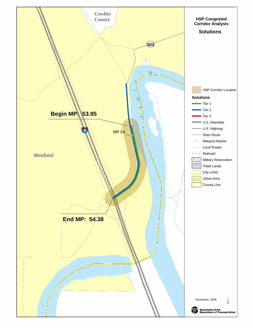
TIERED PROPOSED SOLUTIONSMinimum Fix
Description:ARM 53.97, realign and grade East CC Street to Millard Street and signalize intersection at Millard Street (B/C Ratio = 3.65).ARM 54.06, construct dual left turns from westbound 503 to southbound Pacific Avenue I-5 on-ramp (BC Ratio 5.17). ClosedCircuit Television (CCTV) & data stations at interchange: 2 closed circuit television (CCTV) and 1 data station. Control access,install median curb (B/C = 3.36, note: only safety benefits are included)
Delay Reduction: 23% to 50%
Collision Reduction: 10% or aboveDeficient Concrete Lane Miles: None identified.Total Estimate Cost: $4.8 M
Cost Estimate Explanation:Using Mobility Project Prioritization Process (MPPP) program, assume 2 arterial lanes added, 2 lane realignment, 2 shoulderwidening, 1 intersection channelized, 1 traffic signal. Using MPPP program, assumes adding 1 lane for .1 miles. Informationprovided by the SW Region traffic office. Median curb costs $50 per linear foot.
Minimum Fix Benefits:Low cost solutions potentially will reduce delay as high as 50% depending on the type of improvement selected. Overallcollision reduction is estimated to be approximately 10%.
Project (1): Benefit Cost ratio (B/C): 3.65; Delay Reduction: 50%. With the new alignment, East CC Street joins A Street. Thisrealignment would eliminate the East CC Street intersection that is closely spaced with the NB off ramp/Atlantic Streetintersection. The intersection at A Street and SR 503 would become signalized. Only the PM peak hour was modeled in Synchro(software). The total time savings from the PM peak is multiplied by 2 to get a rough, conservative estimate of the total benefitsof the improvement.
Project (2): B/C: 5.17; Delay Reduction: 23%. The purpose of this project is to decrease delay as well as queuing betweensignalized intersections. A more detailed study is needed to determine how long this fix will last before the intersections fail.
Project (3): Depending on the location, benefits for Intelligent Transportation System (ITS) facilities vary. Overall it is widelyacknowledged that ITS has positive impacts on mobility, safety, and environment.
Project (4): B/C: 3.36. Only safety benefits are included in the BC analysis.
Moderate FixDescription:Project (1) ARM 53.97, intersection improvements, possible roundabout, at East "CC" Street and Atlantic Avenue. ARM 54.06,intersection improvements, possible roundabout, at Lewis River Road, Pacific Avenue and Goerig Street (Costs: $5.9 Million;Benefit Cost Ratio 2.32. Note that the roundabout performs at LOS F in 2026. There is an acceptable LOS through the year 2021.A transportation study led by Cowlitz Whatcom Council of Governments (CWCOG) will address those intersections.) and Project(2) ARM 53.46 to 54.11, widen to five lanes from Lewis River Highway to I-5 (Costs: $4.8 Million)
Delay Reduction: 50% to 52%Collisions Reduction: 30% to 76%Deficient Concrete Lane Miles: None identified. Total Estimate Cost: $11 M
Cost Estimate Explanation:Project (1): A rough estimate based on the cost of the Chamber Way Roundabouts project. That project budget is $5 Million for4 roundabouts. 2 of those roundabouts are single lane. Since both of the possible roundabouts for Woodland are 2 lane, and theAtlantic side will have 5 approaches, the average cost of these roundabouts will be higher than for Chamber Way. Aconservative estimate is that the total project construction costs will be $4 Million, $2 Million per roundabout.Project (2): Based on per lane widening costs in Mobility Project Prioritization Process (MPPP) spreadsheet. Right of way costs
SR 503 I-5/WOODLAND AREA IN COWLITZ COUNTY
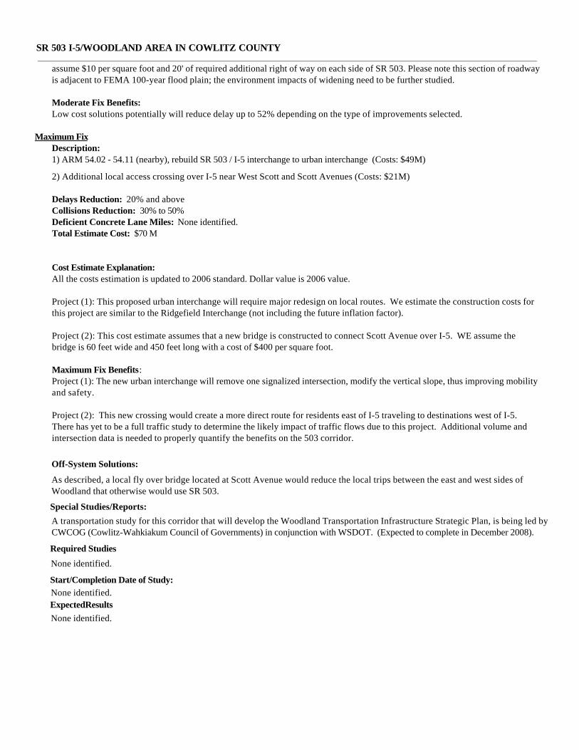
assume $10 per square foot and 20' of required additional right of way on each side of SR 503. Please note this section of roadwayis adjacent to FEMA 100-year flood plain; the environment impacts of widening need to be further studied.
Moderate Fix Benefits:Low cost solutions potentially will reduce delay up to 52% depending on the type of improvements selected.
Maximum FixDescription:1) ARM 54.02 - 54.11 (nearby), rebuild SR 503 / I-5 interchange to urban interchange (Costs: $49M)
2) Additional local access crossing over I-5 near West Scott and Scott Avenues (Costs: $21M)
Delays Reduction: 20% and aboveCollisions Reduction: 30% to 50%Deficient Concrete Lane Miles: None identified. Total Estimate Cost: $70 M
Cost Estimate Explanation:All the costs estimation is updated to 2006 standard. Dollar value is 2006 value.
Project (1): This proposed urban interchange will require major redesign on local routes. We estimate the construction costs forthis project are similar to the Ridgefield Interchange (not including the future inflation factor).
Project (2): This cost estimate assumes that a new bridge is constructed to connect Scott Avenue over I-5. WE assume thebridge is 60 feet wide and 450 feet long with a cost of $400 per square foot.
Maximum Fix Benefits:Project (1): The new urban interchange will remove one signalized intersection, modify the vertical slope, thus improving mobilityand safety.
Project (2): This new crossing would create a more direct route for residents east of I-5 traveling to destinations west of I-5.There has yet to be a full traffic study to determine the likely impact of traffic flows due to this project. Additional volume andintersection data is needed to properly quantify the benefits on the 503 corridor.
Off-System Solutions:
As described, a local fly over bridge located at Scott Avenue would reduce the local trips between the east and west sides ofWoodland that otherwise would use SR 503.
A transportation study for this corridor that will develop the Woodland Transportation Infrastructure Strategic Plan, is being led byCWCOG (Cowlitz-Wahkiakum Council of Governments) in conjunction with WSDOT. (Expected to complete in December 2008).
Special Studies/Reports:
Start/Completion Date of Study: None identified.
None identified.
Required Studies
None identified.ExpectedResults

SR 503 I-5/WOODLAND AREA IN COWLITZ COUNTY
Washington State Highway System Plan: 2003-2022, dated February 2002GIS Environmental and Transportation WorkbenchCapital Improvement and Preservation ProgramTransportation Data OfficeWashington State Highway Log 2005BWSDOT Kelso Area Engineering OfficeWSDOT Southwest Region Environmental Service OfficeWSDOT Southwest Region Real Estate OfficeWSDOT Southwest Region Traffic OfficeSouthwest Regional Transportation Council Travel Demand ModelWashington State Pavement Management System, 2005
Data Sources and Contacts used:
None identified.
Additional Comments:
Funded Projects within Corridor LimitsTitleProject No
None identified.
L e
w
i
s R .
Begin MP: 53.95
End MP: 54.38
ClarkCounty
CowlitzCounty
5
503
Woodland
MP 54
MP 53
November, 2006
HSP CongestedCorridor Analysis
Solutions
HSP Corridor LocationSolutions
Tier 1Tier 2Tier 3U.S. InterstateU.S. HighwayState RouteMilepost MarkerLocal RoadsRailroadMilitary ReservationTribal LandsCity LimitsUrban AreaCounty Line