CHARACTER APPRAISAL AND MANAGEMENT … Council’s performance in designating conservation areas,...
30
FROXFIELD CONSERVATION AREA CHARACTER APPRAISAL AND MANAGEMENT PROPOSALS February 2007 Page 1 of 30
Transcript of CHARACTER APPRAISAL AND MANAGEMENT … Council’s performance in designating conservation areas,...

FROXFIELD CONSERVATION AREA
CHARACTER APPRAISAL AND MANAGEMENT PROPOSALS
February 2007
Page 1 of 30

Froxfield was first designated a Conservation Area in 1993 in recognition of its architectural and historic character. Its special quality is summarised in the following way. Froxfield is an attractive and generally well-maintained village within the North Wessex Downs Area of Outstanding Natural Beauty on the eastern edge of Wiltshire. Its position astride the arterial London to Bath road has brought benefits and problems. The route no longer has strategic status and in recent years limits to the speed of through traffic have helped reduce its impact on the environment of the Conservation Area. Froxfield is modest in scale but has a high proportion of historic buildings which mainly consist of thatched cottages or terraced houses. The elegant quadrangle of brick almhouses, known as The College, however dominates the eastern end of the Conservation Area. Some conservation areas are in a state of relative economic decline, and suffer from a lack of investment. More often, the qualities that make conservation areas appealing also help encourage over-investment and pressure for new development. Froxfield however is in a reasonable state of equilibrium where the long established rural character survives and significant change in the future is not anticipated. Where in-filling or replacement of existing properties takes place in the future it will be important to ensure that special regard is given to the historic and physical contexts in which the new development will fit. Front cover : Looking south from the churchyard
Page 2 of 30

FROXFIELD CONSERVATION AREA 1. INTRODUCTION 1.1 Background Historic areas are now extensively recognised for the contribution they make to our cultural inheritance, economic well-being and quality of life. Public support for the conservation and enhancement of areas of architectural and historic interest is well established. The government requires local planning authorities to determine which parts of its area are areas of special architectural or historic interest worthy of designation as Conservation Areas. The Froxfield Conservation Area was first designated on 25th March 1993. Government policy stresses the need for authorities to define and record the special interest, character and appearance of all designated areas in their districts, and the Kennet Local Plan refers to the Council’s intention to prepare up-to-date Designation Statements for each of 69 Conservation Areas within the District. Change is inevitable in most conservation areas; the challenge is to manage change in ways that maintain and, if possible, reinforce an area’s special qualities. The character of a conservation area is rarely static and is susceptible to incremental, as well as dramatic, change. Some areas of are in a state of relative economic decline, and suffer from lack of investment. More often, the qualities that make conservation areas appealing also help to encourage over-investment and pressure for new development. English Heritage recommends that positive management is essential if such pressure for change, which tends to alter the very character that made the areas attractive in the first place, is to be limited. The Council’s performance in designating conservation areas, defining the special interest that warrants designation through up-to-date character appraisals, and publishing management proposals is now the subject of a three-part “Best Value Performance Indicator”. The Council has made some progress in defining the architectural and historic character of areas, and a number of Conservation Area Statement have were adopted during the period 2002-2005. 1.2 Purpose of the document The following character appraisal and management proposals for Froxfield are intended to replace a short Statement that was adopted by the Council at the time of the original designation in 1993. The purpose of this new document is to identify and record those special qualities of Froxfield that make up its architectural and historic character. This is important in providing a sound basis for planning policies and decisions on development, as well as for the formulation of proposals for the preservation and enhancement of the character or appearance of the area. Beyond their use as planning tools, appraisals also have a wider application as educational and informative documents for the local community.
Page 3 of 30

The document is intended for all those with an interest in Froxfield, or undertaking work on the buildings, landscape, roads or public spaces. It is also essential reading for anyone contemplating new development within the area. By drawing attention to the distinctive features of Froxfield it is intended that its character will be protected and enhanced for the benefit of current and future generations. The remainder of the document is divided into three further main sections – the character appraisal, future management proposals, and community involvement. The survey work for the appraisal was carried out during 2006. The character appraisal commences with a short description of the planning context and is followed by an analysis of Froxfield’s special architectural and historic interest. This represents the core of the appraisal. The Conservation Area is complex and, although priority has been given to highlighting significant features, omission of items from the text or from illustrations should not be regarded as an indication that they are unimportant in terms of conserving the character of the area.
Page 4 of 30

Key to Maps: Conservation Area boundary
Trees subject to Tree Preservation Orders
Article 4 (2) Direction
Important trees and hedges
Listed Buildings
Archaeological Alert Zone
Unlisted buildings with townscape merit
Unlisted boundary walls with townscape merit
North is at the top of all maps The following applies to all maps in this document : © Crown copyright. All rights reserved. Kennet District Council, Licence No. 100017656, 2007 The information given on listed buildings and boundaries is correct at the date of publication. However, designations may change through time and up to date enquiries may be necessary.
Page 5 of 30

2. FROXFIELD CONSERVATION AREA APPRAISAL Map 1 The Froxfield Conservation Area
© Crown copyright. All rights reserved. Kennet District Council, Licence No. 100017656, 2007
2.1 Location and context Froxfield lies on the A4 London to Bath road where its route temporarily leaves the course of the River Kennet and follows a cleft in the chalk downs. Its location is relatively remote with Hungerford about 4 miles to the east, and Marlborough 7 miles to the west. Ramsbury lies 4 miles away over the downs to the north. A parish church, community hall and a pub are found at Froxfield but travel to one of the larger towns is necessary for more extensive services.
Page 6 of 30
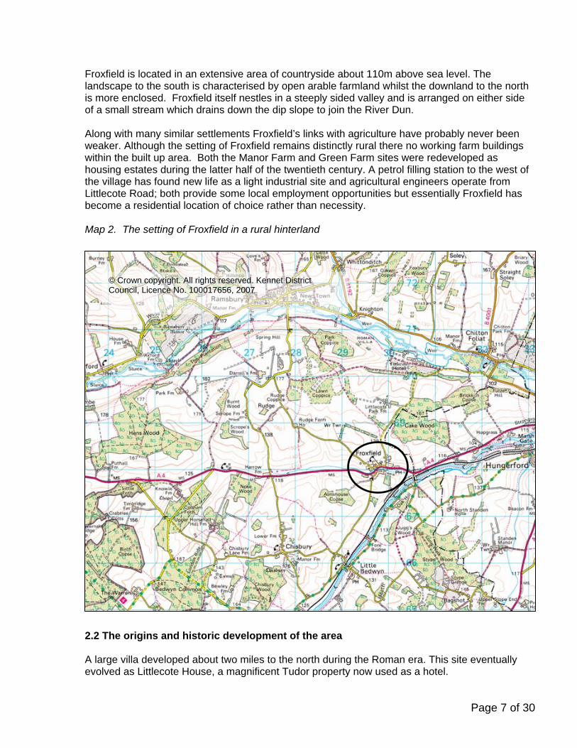
Froxfield is located in an extensive area of countryside about 110m above sea level. The landscape to the south is characterised by open arable farmland whilst the downland to the north is more enclosed. Froxfield itself nestles in a steeply sided valley and is arranged on either side of a small stream which drains down the dip slope to join the River Dun. Along with many similar settlements Froxfield’s links with agriculture have probably never been weaker. Although the setting of Froxfield remains distinctly rural there no working farm buildings within the built up area. Both the Manor Farm and Green Farm sites were redeveloped as housing estates during the latter half of the twentieth century. A petrol filling station to the west of the village has found new life as a light industrial site and agricultural engineers operate from Littlecote Road; both provide some local employment opportunities but essentially Froxfield has become a residential location of choice rather than necessity. Map 2. The setting of Froxfield in a rural hinterland
© Crown copyright. All rights reserved. Kennet District Council, Licence No. 100017656, 2007
2.2 The origins and historic development of the area A large villa developed about two miles to the north during the Roman era. This site eventually evolved as Littlecote House, a magnificent Tudor property now used as a hotel.
Page 7 of 30

Pre-conquest Froxfield proper is likely to have been a very modest settlement and during the early years of the medieval period it may have consisted of not much more than a farmstead, church and a few cottages. The core of the church is believed to date from the 12th century at which time the village was connected with the Friary at Easton in the Vale of Pewsey. The village green appears to be part of the low-lying pastures that follow the valley floor. Indeed is thought that the village name emanates from the valley of the frog’s bourne. Reverend Barley, writing in the 1930s, however speculated that the name might derive from Frocx, the Saxon for nightingale. Photo 1. The church of All Saints
Fortunes may have slowly picked up with the development of traffic between London and Bath but right up until the 17th century an alternative route via Ramsbury was preferred by travellers. Following the dissolution, the village passed into the hands of the Seymour family and it was one of their number Sarah, Dowager Duchess of Somerset that first established a substantial group of almshouses for clergy and lay widows. The Somerset Hospital is now usually referred to as The College. This large quadrangle of two storey buildings, which dominates the eastern end of the Conservation Area was started in about 1690. The choice of the east – west road through Froxfield for turnpiking as early as 1726 was a major turning point. A number of inns sprung up as improvements to the road lead to the development of stage coaching. A smithy was known to been in existence and a bakehouse developed at the foot of Brewhouse Hill, whose name implies the presence of a small brewery.
Page 8 of 30

The Kennet and Avon canal and later the Great Western railway competed for traffic on the Bath to London route and after about 1840 the population of Froxfield began to decline. At that time the parish population was 625, of which 423 lived in the village including 85 at The College. A Vicarage was built to replace the Rectory near the church in the 19th century – both buildings survive and now have Old as their suffix. A splendid new house for manor farm was built at the bottom of Littlecote Road in 1849 but the Victorian period did not see much other permanent improvement until a small school became established and eventually housed in purpose-built building near the church in 1910. A Primitive Methodist Chapel was built in Brewhouse Hill the previous year. During the 20th century the A4 through the village was designated a trunk route and through traffic grew sharply. The route was subject to various phases of improvement and Froxfield suffered as a consequence of widening and resultant increases in the speed of through traffic. The downgrading of the A4 following the construction of the M4 motorway in the 1970s has however eased the volume of traffic passing through the village. The population decline experienced during the Victorian and Edwardian periods bottomed-out during the First World War, and since the census of 1921 the population has grown by about 100 persons. This is partly accounted for by the redevelopment of Manor and Green Farms for new housing. Photo 2. The stream near the water meadow on the south side of the main road
Page 9 of 30

2.3 The boundary The Conservation Area takes in a large part of the settlement but excludes modern developments at Green Farm Rise, River View, Manor Park and the Brendon Care Home (see Map 1.). The latter three are built in contrasting styles to the historic part of the village. The boundary takes in the village green and the other pastures on the open valley floor, all properties fronting these open areas including the Duchess of Somerset’s Hospital, and the main lanes leading out of the valley, namely Brewhouse Hill, Church Road, and Littlecote Road. The external boundary is closely drawn and, apart from the meadow on the south side of the church, there are no ‘buffer zones’ beyond the core of the settlement. Apart from new developments at Green Farm Rise there has been little significant physical change since the date of the original designation and it is considered the current boundary of the Conservation Area is appropriately drawn. 2.4 General character and plan form The quintessential character of the Froxfield Conservation Area is of a small rural community. It is part of a rural parish with a total population of about 369. The Conservation Area contains 103 households of which almost half are located within the Somerset Hospital. As well as the main road running along the valley, steep lanes converge from Ramsbury, Bedwyn and Rudge. The village green appears to have been created out of part of the low-lying pastures that follow the valley floor. The green lies at the centre of the settlement and the regular arrangement of property boundaries around the green hints at late medieval planning. The group of buildings at the Somerset Hospital dominates the east end of the Conservation Area but the remainder of the historic village is essentially made up of brick and flint cottages, many with thatched roofs. The church and memorial hall are the main non-residential focal points of activity. 2.5 The character of spaces within the area The village green may be considered the heart of the Conservation Area. Development on the north side has a fairly formal relationship with the open space; dwellings front towards the green and main roof ridges are parallel to the secondary service road. The main road however slices through and is divisive. The usable public open space is contained on the north west side of the main road whilst the undeveloped water meadow on the south east side is dominated by the flood plain of the stream, and riparian woodland. A fairly conventional downland village is arranged on around the green on both sides of the valley. To the north west and the south west of the green Church Road and Brewhouse Hill ascend to higher land. In Brewhouse Hill cottages, and some later infilling, spreads outward towards the top of the hill. In Church Lane the spacing of buildings is slightly more spacious around a number of high status properties. The comparatively large spaces and gardens around most houses are as important as the buildings in defining the quality.
Page 10 of 30

Photo 3 – A timber framed cottage with brick and flint panels in Brewhouse Hill
In contrast to the main road, through traffic is not a major problem in the aforementioned lanes which have a quiet, rural character and for the most part have soft verges and grassy banks. The absence of formal kerb lines and separate footways in these areas is a key factor in defining the special character of the public realm. 2.6 Identification of independent character zone – The College By linking historical development with the physical relationships found within the Conservation Area it is possible to identify a distinct sub-zone at The College. It is slightly separated from the core of the village by the group of trees in the grounds of The Manor House and is constructed in a distinctive and formal architecture style. It stands on a high bank and is regarded as one of the very grandest of 17th century almshouses. The eastern half was constructed in 1694 with the western section added in 1775 in a mirror image. An imposing archway leads into the internal quadrangle which contains a small Gothick chapel of 1813 surrounded by immaculate lawns and colourful flower borders. Both the College and the Chapel are listed Grade II*. The external grounds are mainly contained behind substantial brick walls, whilst opposite the archway stands the porter’s lodge of 1833.
Page 11 of 30

Photos 4 & 5 - The south front of The College and the Gothic Chapel inside the courtyard
Map 3. The College Character Zone
© Crown copyright. All rights reserved. Kennet District Council, Licence No. 100017656, 2007 2.7 Key views and vistas Within the Conservation Area views of the south facing front of The College dominate the east end of the village. Views of the properties north of the green are also essential ingredients in defining the character of the village. There are also key vistas from the higher land on either side of the village where the cottages are seen nestling on the floor of the valley. The roofs of the properties, including the church, are particularly prominent in these long distance prospects.
Page 12 of 30

Photo 6 - The College with dominant clock tower over the central gatehouse, viewed from the west.
Map 4. Key vistas
© Crown copyright. All rights reserved. Kennet District Council, Licence No. 100017656, 2007
Page 13 of 30

Photos 6,7,8, & 9. Thacketts on The Green (top left), The setting of All Saints church (top right) The roofscape from Brewhouse Hill (bottom left), and Brewhouse Hill from the churchyard (bottom right)
2.8 Architectural Character Most of the buildings in the Conservation Area, and their means of enclosure, help to shape its character in a positive way. Froxfield has a rich surviving architectural heritage spanning over eight centuries. The underlying geology of the locality is an important determinant of the essential character of the Conservation Area. The surrounding uplands do not provide plentiful supplies of high quality building stone but early builders were pleased to use any hard materials they could lay their hands on. Flint is unlike any other stone in colour or texture and at Froxfield it is used in irregular nodules picked up from the surrounding fields. The amorphous shape of the flints require the addition of a regular material to enable them to be used for precise building work, hence it is usually laced in with brickwork which is also used at corners and window reveals. All Saints Church is a surviving medieval structure constructed of flintwork.
Page 14 of 30

Timber framing however evolved as the usual form of wall construction for domestic buildings in the medieval and immediate post medieval periods. The surrounding chalk downs were also ideal for the growing of cereals and wheat straw has developed the dominant roofing material. A number of timeless timber framed cottages with thatched roofs can be found throughout the village. Some appear to survive from the 1600s. A concentration of slightly later cottages with flint with brick dressings can be found in Brewhouse Hill. Here the traditional houses and cottages are typically small scale with narrow front to back spans and simple roof lines. Architectural ornamentation is also simple; plank doors and flush fitting casement windows are important characteristics. From the 17th century clay overlaying some areas of the chalk was also exploited for the manufacture of handmade bricks and plain clay tiles which became significant building materials. The construction of The College from the end of the 17th century confirmed the primacy of brick and plain clay tiles for most subsequent building work in the Conservation Area. Brickwork is usually laid in lime mortar with contrasting vitrified brick bands or in diaper patterns. Photo 10 – Roughly coursed flint nodules found at All Saints church The arrival of a number of more formal, grander buildings in the 19th century saw the influence of national trends and the use of some materials from further afield. Polite buildings were erected using tile hanging techniques for walls and Welsh slates for roofs. Bath stone laid in ashlar was used for the construction of the Chapel in the quad at The College in 1813. Photos 11 & 12. The Manor (left) and the Old Vicarage (right)
Page 15 of 30

Flint however was still used for vernacular buildings and lesser structures such as boundary walls. Indeed it is has been used successfully right up until the present day to provide relief in the design of new buildings. Photo 13 - Flint boundary walls fronting The Green.
Although the architectural character of the village is distinctly rural there is a surprisingly high proportion of terraced properties. They bear witness to the rapid period of expansion when Froxfield was a staging post on the Old Bath Road and the shortage of flat land not subject to flooding. These are generally well maintained and add considerably to the atmosphere of the place.
Photo 14. Terrace of houses on Bath Road
Page 16 of 30

Twelve buildings are listed as having national architectural or historic importance and are shown on the composite Map No. 5. The list is now almost twenty years old and a number of additional buildings are close to meeting current day criteria for inclusion on the statutory list. In addition a number of other buildings can be identified that contribute positively to the character of the Conservation Area. In total thirty nine structures or properties of particular townscape merit have been noted. These are also shown on Map No. 5 and in Appendix 1. Typical cases are the former Methodist Chapel and The Old Rectory.
Photo 15. The former Primitive Methodist Chapel of 1909 on Brewhouse Hill.
Photo 16. The Old Rectory in Church Road
Page 17 of 30

The extensive use of vitrified brickwork and tile hanging produces a character distinct from most other parts of the District. The prevalence of these materials highlights Froxfield’s location on the very edge of Wiltshire and the South West region. The architectural character corresponds more closely with counties further to the east. In this sense Froxfield is in the frontier zone found between the home counties to the east and the building traditions of the west country. 2.9 Landscape and the contribution made by greenery and green spaces The surrounding countryside in the immediate vicinity of Froxfield comprises pasture, arable, alluvial and marshy land, with larger woodland blocks and pockets of trees on the higher land. The Conservation Area is located entirely within the North Wessex Downs Area of Outstanding Natural Beauty. The field hedgerows leading in to the village from the west are generally very strong. Farmland hedgerows around the church and paddocks in the immediate vicinity tend to be weaker. Elm is still a strong component of the hedgerow make up but Dutch elm disease is clearly prevalent and some younger 5-7m trees showing signs of decline. The properties on the southern side of Bath Road on the western edge of the Conservation Area front directly onto the main road with steep gardens to the rear and only limited conifer and elm hedging exists in this vicinity. The properties in Brewhouse Hill have stronger boundary hedging, with a good number of small to medium sized trees located mainly within the rear gardens, which form a strong boundary with the open countryside beyond. Native hedging on the north side of the Bath Road meets ornamental garden conifer boundary hedging, forming an almost continuous green road side screen leading to the area of the village green. Good tree cover of mature pollarded willow and younger ash, beech and cherry within the grounds of the village hall strengthen this boundary at the point where the stream passes under the road. The section of the village green north of the main road is at the geographic and visual centre of the Conservation Area. This contains a maturing sycamore towards the eastern edge with a number of smaller Norway maple, cherry, hawthorn and crab apple along the northern edge. Approximately four early mature Horse chestnut trees have been recently removed due to poor structural form and disease. The southern section of marshy water meadows contains a large number of mature trees comprising white poplar, white willow, weeping willow, hybrid black poplar, alder and other species. There is a mown strip alongside the footpath but otherwise appears to be left as a wild unmanaged area. Further to the east The Lodge is bounded by a mixture hedging and trees with a large prominent Lombardy poplar standing adjacent to the road. Few trees exist within the more formal surroundings of the Somerset Hospital although there is prominent yew and conifer may be the remnant of former gardens at the eastern end. A prominent
Page 18 of 30

copper beech, larch and mature birch stand on the edge of a parking area to the rear of the listed buildings, and a mature and over mature silver birch stand near the bungalow on Littlecote Road. On the opposite of Littlecote Road the grounds of The Manor are a key feature of the Conservation Area. The trees and boundary hedging form a strong and important feature in the setting of the village. A number the best trees are protected by Tree Preservation Orders but there are other notable specimens such as young cut leaf beech along the eastern boundary, and an avenue of limes stretching up the drive. The majority of the properties on the north side of the small grassed verge north of the A4 and the village green have limited tree and hedge cover due to restricted room. Flint and bricks walls serve as the dominant form of boundary treatment although some small groups of trees exist where space allows. Notably a small section of pleached lime hedge exists at the front of No.12. A significant yew stands within the grounds of Green Farm where it is seen in the context of important, albeit slightly dilapidated, boundary walls and railings. Photo 17 - The yew tree at Green Farmhouse
In Church Road walling and fencing continues as the main boundary treatment but larger trees trees, sycamore, silver birch, willow and lime standing within the gardens of 20 Froxfield and the Old Vicarage. The hedging on the way out of the village on this stretch is strong with the exception of some close boarded fencing. The Old Rectory contains a large number of mature tree and shrubs within the grounds with a very prominent lime in the south east corner adjoining the church. The churchyard is relatively open although an extremely significant sycamore stands to the south of the church. The paddock on the south side of the churchyard plays an important part in the setting of the church and the white fronted Old Rectory on slightly higher ground behind.
Page 19 of 30

© Crown copyright. All rights reserved. Kennet District Council, Licence No. 100017656, 2007
Map 5 – Listed Buildings, Significant Unlisted Structures, and Significant Trees and Hedges 2.10 General condition Dues its attractive rural location the settlement is outwardly prosperous and the physical condition of its historic buildings and other heritage assets are in generally good condition. At the present time there are no listed buildings that could be said to be at risk. However, the uplift for Green Farmhouse anticipated when the farmyard was redeveloped has not followed through. It is now in poor condition and still facing an uncertain future. The original Conservation Area Statement of 1993 noted that traffic speeds were inappropriate and offered encouragement to the provision of lower limits. Since that time there has been success in the introduction of a set of new regulations. The whole settlement now falls within a 50 mph limit. Nesting within this is a 40 mph speed limit on the main road through the Conservation Area, and a 30 mph limit on the secondary lanes. Although the main road remains a dominant
Page 20 of 30
feature of the Conservation Area safety and amenity have certainly been improved as a result of the new restrictions. The general condition of the surface of the lanes appear to be in reasonably good order, and there are no further planned traffic management schemes affecting the Conservation Area. As with most Conservation Areas there are a few minor negative factors. In general, however, property owners have cherished the Area and the emphasis needs to be on keeping it this way rather than removing eyesores. The extension and alteration of traditional buildings can often be difficult to handle sympathetically and, due to the prominence of many small cottages, Froxfield is proving no exception. In one or two cases isolated cases the renewal of windows and doors has been out of character with the host building. Also, there has been a recent trend noted in respect of the thatched cottages to provided a block cut or highly decorative ridge detail. These are incongruous on a small thatched building and do not reflect good value for money when compared to a simple flush ridge detail. The horse chestnut trees on the green have been removed in the recent past due to their poor health but fortunately the Parish Council have replanting proposals in hand. The appearance of the green and some other parts of the village is slightly marred by overhead telegraph wires. The green is also vulnerable to over-running by vehicles. As car ownership levels have grown this is a potential issue on the north and west sides 2.11 Future pressures and capacity for change In considering the future of the Conservation Area it is important to make an assessment of significance, and some analysis of how that significance is vulnerable to change. There has been some incremental loss of character due to minor alterations to unlisted buildings which can take place outside of planning control. Nevertheless the character of Froxfield as a traditional settlement still shines through. The loss of boundary features in order to accommodate the motor car can lead to a loss of rural character and an increase in suburban qualities. Similarly, the recent drive for exploiting more sustainable sources of energy can lead to a conflict with the conservation of historic character. Solar panels formed of reflective materials and sited on prominent roof slopes, and wind turbines, could easily weaken the character of the Froxfield Conservation Area. Having regards to general planning policy there are unlikely to be any major changes to the Conservation Area in the foreseeable future but where the replacement of non-descript existing buildings is under consideration it will be important to ensure that designs have regard to their historic and physical contexts. 2.12 Acknowledgements The main sources of information used in the preparation of the draft appraisal : Marlborough and Eastern Wiltshire – John Chandler, Hobnob Press ISBN 0-946418-07-1 The King’s England Wiltshire – Arthur Mee, Hodder and Stroughton ISBN 0 340 00107 0 Englamd’s Thousand Best Houses – Simon Jenkins, Penguin ISBN 0-141-00625-0 The Advice of Mr T Dazell, Chairman of the Parish Council
Page 21 of 30

APPENDIX 1 TO FROXFIELD CONSERVATION AREA APPRAISAL Locally important ‘unlisted’ buildings and structures The Old Rectory, Church Road 2 no. outbuildings at The Old Rectory, Church Road The Old Vicarage, Church Road Outbuilding at The Old Vicarage, Church Road Truant House, Church Road Front boundary walls between Flint House and Sunnydene, north side of The Green 13 Froxfield 14 Froxfield 15 Froxfield 16 Froxfield 22 Froxfield 23 Froxfield 24 Froxfield Boundary walls near 24 Froxfield and the Memorial Hall Brookside Cottage 27 Froxfield 28 Froxfield 29 Froxfield 30 Froxfield 31 Froxfield 32-33 Froxfield 34 Froxfield 37-38 Froxfield Boundary walls between 34 and 37-38 Froxfield 39 Froxfield 40-41 Froxfield 1 The Limes 2 The Limes 3 The Limes Boundary wall at The Manor Outbuilding adjacent Littlecote Road at Somerset Hospital Boundary walls surrounding Somerset Hospital The Lodge, A4 Outbuilding at The Lodge, A4 The Old Bakehouse Boundary wall at The Old Bakehouse Outbuilding at The Old Bakehouse Former Methodist Chapel, Brewhouse Hill Hill House, Brewhouse Hill These structures are shown on Map 5
Page 22 of 30

3. FROXFIELD CONSERVATION AREA MANAGEMENT PROPOSALS 3.1 Relationship with the Character Appraisal For the designation of a conservation area to be effective it is important that consistent judgements are made in determining its special qualities and local distinctiveness, as well as its value to the local community. Such judgements should be based on a thorough understanding of the area in its wider context, reached through the detailed appraisal of its character. The above appraisal should be regarded as the first step in a dynamic process, the aim of which is to preserve and enhance the character and appearance of the designated area - and to provide a basis for making sustainable decisions about its future through the development of management proposals. Now that the appraisal has been drafted, proposals for the future management of the area will need to be developed. Logically these will take the form of a mid- to long-term strategy for preserving and enhancing the conservation area, addressing any issues arising from the appraisal and identifying any further or detailed work needed for their implementation. The strategy needs to be realistic, bearing in mind the staff and financial resources likely to be available. At the present time the Council has no dedicated funds for grant aiding building repairs or enhancement work, although minor grants may be available for some tree planting schemes. Only a ‘light touch’ approach can be justified for most of the rural Conservation Areas within the District. 3.2 The Planning Context The procedures governing the protection of listed buildings are widely understood and mainly focus on the protection of individual structures. Conservation Area designation, however, is the main instrument to give effect to conservation policies for a particular neighbourhood or settlement. Designation introduces a general control over the demolition of most buildings, and tree felling / surgery. The scale of extensions that may be added to existing dwellings as “permitted development” is also limited. Designation has some resource implications for the local authority and the owners and occupiers of property within the area, because of increased statutory controls and particular requirements for the repair or alteration of existing, and construction of new, buildings. For many owners, however, these implications may be outweighed by the cachet of designation, and the tendency of controls aimed at maintaining the character of the area to sustain, or enhance, the value of property within it. Designation also provides the basis for policies designed to preserve or enhance all the aspects of character or appearance that define an area’s special interest. The general planning policy for Froxfield is currently set out in the Kennet Local Plan 2011. Froxfield is not recognised (Chapter 2) as a settlement suitable for new housing development. Here new housing development will be restricted to infilling, the replacement of existing dwellings, or the re-use of existing buildings or the redevelopment of existing buildings provided that the development : a) is within the existing built up area of the village; b) does not consolidate an existing sporadic, loose knit area of development; and c) the development is in harmony with the village in terms of its scale and character.
Page 23 of 30
The Local Plan also sets out (Chapter 6) a range of generic policies relating to new development proposals within Conservation Areas. The government has recently introduced a new kind of planning system in which the focus is on flexibility, sustainability, and the use of evidence to underpin the core strategies. Local planning authorities will in future produce local development frameworks consisting of a portfolio of local development documents. It is unlikely that the fundamental planning policy for Froxfield will change significantly under the new regime. It is probable that the core strategy will be supported by supplementary planning documents (SPD) giving greater specific guidance, for example on development control matters relating to conservation areas. The legislation relating to Conservation Areas runs parallel with general planning legislation and there will be a need to ensure that appropriate linkages are in place. It is anticipated that this will be achieved by new Heritage SPD which will in turn be supported by adopted and published character appraisals and management proposals for individual Conservation Areas. This is where this document fits in. The intention is that a clear definition of those elements which contribute to the special architectural or historic interest of a place will enable the development of a robust policy framework for the future management of the area, on which applications for planning permission can be considered. A local authority's reasoning for designating a Conservation Area, as set out in a formal character appraisal published in support of a supplementary planning document, will be taken into account by the Secretary of State for Communities and Local Government and the Planning Inspectorate in considering related planning appeals. 3.3 General Approach of the Council towards Development Proposals In addition to the usual need to obtain planning permission for most forms of new development there is a requirement for applications to be made for conservation area consent for the demolition of unlisted buildings, and notifications to be submitted for the felling or lopping of trees need to be notified In exercising its planning powers, the Council has a duty to pay special attention to the desirability of preserving or enhancing the character or appearance of the conservation area. For most proposals in the Conservation Area the Council will require detailed plans and drawings of new development, including elevations which show the proposed development in its setting, before considering a planning application. The Council will advertise all applications for planning permission for development that would affect the character or appearance of conservation areas. 3.4 General Approach of the Council towards Conservation Areas The Council’s general planning policies towards development is set out in Policies HH4 (Historic Landscapes), HH5 (Development in Conservation Areas), and HH6 (Demolition in Conservation Areas). It is also essential that a flexible approach is taken to the requirements of the Building Regulations and Fire Precautions Act and that rigorous application of general planning and highway policies
Page 24 of 30

should be relaxed where they would be in conflict with the preservation or enhancement of the area’s character or appearance. 3.5 Special Considerations at Froxfield Applications for planning permission, conservation area consent, and tree works will be assessed with reference to the Conservation Area Appraisal. There will be a presumption in favour of conserving key unlisted buildings, trees and hedges and views that have been identified. Following on from the above, at Froxfield the preferred policy of conservation will lie with the preservation of the established ‘status quo’ rather than specific proposals for change. Where proposals for change occur the intention is to provide a framework to allow this to be carefully considered and managed in a positive way to reinforce the existing character and appearance of the area. 3.5.1 Archaeology As noted in the appraisal Froxfield has been subject to occupation and alteration over many generations. The County Archaeology Service, in conjunction with the Council, has prepared archaeological zone maps for the district. These zones have been established following an analytical procedure for identifying and scoring archaeological sites and landscapes. The area, around the church, and Church Road, is identified as the core of the original Anglo-Saxon settlement. This zone has a high degree of archaeological potential and preliminary consultation with the Archaeology Service is therefore recommended for prospective developers within the area. The water meadows running alongside Bath Road, south of the church are undisturbed and proposals for development here are likely to bring forth an archaeological objection. Map 6. Archaeological Alert Zones
© Crown copyright. All rights reserved. Kennet District Council, Licence No. 100017656, 2007
Page 25 of 30

3.5.2 Infilling and Redevelopment At Froxfield new large-scale, comprehensive or ‘estate’ forms of development are unlikely to be acceptable. Planning policy anticipates that new building development proposals are only likely to be in the form of individual proposals for infilling, re-use or replacement of existing buildings. Where such proposals are acceptable in terms of general planning policy the Council will require proposals to have regard to the historic and physical context of the Conservation Area. In considering new buildings it will be particularly important to maintain generous spacing between building blocks, and to avoid destroying the verges, and walls and hedges fronting onto the lanes. 3.5.3 Design of New Buildings in the Conservation Area New development in the Conservation Area should aspire to a quality of design and execution, related to its context, so that it may be valued in the future. This in itself does not imply nor preclude working in traditional or new ways, but will normally involve respecting values established through assessment of the significance of the area. The aim of design guidance therefore is to encourage new development that complements the established grain or settlement pattern, whilst representing the time in which it is built and the culture it accommodates. When considering proposals for new development, the local planning authority’s principal concern will be the appropriateness of the overall mass or volume of the building, its scale (the expression of size indicated by the windows, doors, floor/ceiling heights, and other identifiable units), and its relationship to its context - whether it sits comfortably on its site. A new building should be in harmony with, or complementary to, its neighbours. The footprint of new buildings should respect the existing building pattern or grain. The use of materials generally matching in appearance or complementary to those that are historically dominant in the area is important, as is ensuring that materials, detailing and finishes are all of high quality. Within these criteria, new development should aim to achieve creative design solutions, whether contemporary or traditional in style. Photos 18 & 19. A new terrace of houses at Green Farm Rise (left) and a new house fronting The Green that have fitted in well.
In designing proposals owners and their architects are therefore advised to look carefully how their proposal will fit into its physical and historic context. Where construction work is involved particular care should be taken in the choice of building materials and whenever possible should seek to reinforce local distinctiveness.
Page 26 of 30

The palette of established materials at Froxfield include : Roof coverings - Wheat thatch, plain clay tiles Walling - Timber framing, mellow red stock brickwork with dark glazed headers,
flintwork 3.5.4 Extensions Relatively small proposals can cumulatively alter the character of the Conservation Area. It is important therefore that extensions to buildings do not dominate the host structure. Generic advice on the considerations to be taken into account in designing an extension is set out in a Residential Extension Design Guide. This is available free of charge from the Planning Services Unit at Kennet District Council. Thatched roofs are an important characteristic of the Conservation Area. Although thatch is a comparatively cheap method of roofing and entirely consistent with sustainable building techniques it does give rise to certain issues that are not always fully understood by designers. It is hoped that following advice will assist in the design for extensions involving the use of thatch. • Extensions to existing buildings in thatch should respect certain principles: Thatch should be pitched at 50 degrees or more and should continue the local tradition of wheat straw laid in the ‘Long Straw’ or Combed Wheat method. • The layout plan should be of simple rectangular form without irregularities or acute angles. Round or curved plans are practicable in thatch but any inside radius must be generous. • The creation of valleys and large or gabled dormer windows should be avoided. • Single storey extensions added to the rear of a 2-storey building may be covered by a continuation of the main slope or a ‘catslide’. The span of the extension must be limited to allow the pitch of the thatch to continue consistently down. • Rainwater drips from a higher roof should not shed onto a lower thatched roof. • Thatch should not rest on an existing flat roof surface. Clear ventilation and drip space under eaves is important. • Mortar weatherings to chimneys are preferred by thatchers to those formed in lead. • Balanced flue outlets should not be positioned so as to emerge from walls under a thatched eaves or close under a gable verge. An unfortunate loss of historic ridge detail to a number of historic thatched roofs has also been noted. The provision of flush wrap-over ridges is preferred on cottage roofs. The Council has published Supplementary Planning Guidance on Rethatching and this is available on-line in the conservation pages of www.kennet.gov.uk or free of charge from the address given below. . 3.5.5 Additional Controls In certain circumstances, the Council can apply additional controls to bring minor developments under restraint. This is particularly useful in cases of terraced development where thoughtless alterations can disrupt the harmony of several properties. Following the adoption of the 1993 Conservation Area Statement the Council served an Article 4 (2) Direction on Nos. 28-33 in Bath Road. This traditional terrace was considered to be vulnerable
Page 27 of 30

to misguided home ‘improvements’. It retained a unified character and was very much part of the cherished local scene. The Direction has the effect of bringing minor alterations under control. The removal of chimneys, alteration of roof tiles, external rendering, the alteration of front windows and doors and the proviso of external porches, etc now require planning permission. Map 7 Properties covered by an Article 4 (2) Direction
© Crown copyright. All rights reserved. Kennet District Council, Licence No. 100017656, 2007
Careful control of cumulative alterations should ensure that the cohesive character of the terrace survives into the future. 3.5.6 Care with maintenance and minor alterations Listed buildings are already subject to additional controls, but in order to maintain the character of the Conservation Area the Council will also encourage the owners of all unlisted properties to take care with maintenance and minor alterations. In particular the Council encourages the repair rather than replacement of original features. Where replacement of key architectural features such as windows and doors is unavoidable then care should be taken to accurately copy original styles and details. Conservation of the historic environment lies at the heart of sustainability principles. However, the growing trend towards the generation of domestic-scale energy sources by the use of micro wind turbines and solar panels can conflict with the preservation of historic character. Although the Council will be generally sympathetic to these initiatives care needs to be taken to ensure that only visually unobtrusive locations are agreed.
Page 28 of 30

The Council also encourages the long term maintenance of trees, shrubs and hedges identified in the appraisal. The planting of non-indigenous evergreen hedges and trees or close-boarded fencing in prominent positions is however discouraged. As no listed buildings have been noted as being immediately at risk from decay, action under the Urgent Works or Repairs Notices procedures is not considered to be necessary at this stage. The condition of Green Farmhouse, however, is noted as deteriorating. Therefore the Council will monitor the situation annually and seek to work with the owner to conserve this important protected building. 3.5.7 Enhancement of the Public Realm Where resources are limited, a balance will obviously need to be struck and priority given to key issues. There are only limited problems at Froxfield. The replanting of diseased trees on The Green is already in hand by the Parish Council. The large willows and poplars on the water meadows opposite The Green need to be regularly monitored to assess their overall health and condition. New planting would also be prudent to ensure the tree stocks and amenity afforded by the trees is maintained. At the time of writing the District Council operates a discretionary grant scheme which may assist in this respect. 4. COMMUNITY INVOLVEMENT AND REVIEW 4.1 Community Involvement Involving the community and raising public awareness is an integral part of the appraisal process. Publicity provides an opportunity to test and consolidate public support. However, with limited resources and 69 Conservation Areas (at the time of writing) within its remit, the Council has to strike a balance. Lengthy public participation can be very expensive and create delays in the adoption of appropriate controls, policies and guidance. The Council’s priority is the provision of these elements within a short timescale. In view of the magnitude of the overall project, and the relatively short period for completion, the Council is adopting the following model. Notifications of the commencement of the Conservation Area review was sent to community representatives (including the Froxfield Parish Council), statutory organisations, and relevant amenity groups. An informal discussion took place with the Parish Council chairman in September 2006. Copies of a draft version of the Appraisal and Management Proposals were then sent to the same consultees together with a feedback form. A copy of the draft document has also been placed on the Council’s publicly accessible web site, a press release issued, and a poster placed on the village noticeboards. Opinions were particularly canvassed on whether the boundary still adequately reflected the area of special interest, whether the appraisal contains any inaccuracies or omissions in respect of the character of the historic environment, and whether the management proposals are suitable and appropriate for the conservation of Froxfield. During the deposit period members of the Council’s conservation team were prepared to contribute to a briefing session, walkabout, or public meeting. The document was placed on deposit for eight weeks from the 3rd October 2006. Very few responses were submitted but those received are summarised below. Although a number adjustments have been made to the Consultative Draft as a result of the responses it is
Page 29 of 30

not considered that any amendments were of major or strategic importance and the revisions have not been re-advertised. Finally, it is proposed that the appropriate Committee of the Council will adopt the document. It will be subsequently published and distributed to consultees, and placed on the web site. 4.2 Adoption The revised document was finally formally adopted on 1st February 2007 by the Planning Policies Executive Committee on behalf of the District Council as its strategy for the Froxfield Conservation Area. Amongst other things the document is intended to provide additional information on the interpretation and implementation of policies and proposals contained in the Development Plan. The character appraisal in particular will form an important role as part of the evidence base for the Local Development Framework, and for the purposes of Development Control. The final document has been published and distributed to consultees, and placed permanently on the Council’s web site. It is also being made available for viewing on the Parish Council’s web page. Hard copies of the document may also be purchased from the address given below. 4.3 Implementation The need for reference to the character appraisal will be on-going. Similarly the implementation of the management strategy will require continuing monitoring, action and care. The adoption of the document is thus not intended to be the end of the story. In addition to its use in exercising its planning functions the Council will also try to influence other agencies in the protection of the Area. 4.4 Review Once the Appraisal and Management Plan has been adopted there will be a need to keep it up to date and relevant. The Council will therefore aim to ensure that 75% of all Conservation Area Appraisals and Management Plans have been reviewed within the past five years. This booklet is one in a series of Conservation Area Statements, and Appraisals and Managements Plans, and other general policy, technical and information leaflets produced by the Conservation Team at Kennet District Council. For an up to date list, please contact :
The Conservation Section. Planning Services, Kennet District Council, Browfort, Bath Road, Devizes, SN10 2AT
Tel : 01380 724911 Email : conserve@kennet. gov.uk www.kennet.gov.uk
Page 30 of 30