CHAPTER2 Himalayan Geo-Environment and Human Dynamics...
31
CHAPTER2 Himalayan Geo-Environment and Human Dynamics 2.1 Introduction The basic purpose of this chapter is to offer a brief overview of general geography of the Himalayan region. Regrettably, there is no recent systematic treatment and hence is difficult to produce a justified regional breakdown (Ives and Messerli 1989). The chapter, nevertheless, attempts to briefly indicate the region's complexity by summarising some of the important attributes of physical and human geography. By doing so, the chapter is not attempting geography per se but is trying to provide selected background material to support the discussion that forms the central part of this study. · 2.2 Geographical Location Geographical location of the Himalaya has to be seen in the context of its geological 1 and geomorphological attributes. Taking into account its geological character and the geomorphic processes operating therein 'the Himalayan arc. extends between latitudes 26° 20' and 35°40' ,. North, and between longitudes 74°50' and 95°40' East' (lves and Messerli 1989, Ives 2004, Rao and Saxena 1994). lt is that great ranges of mountains that separate lndia, along its north-central and north-eastern frontier, from China (Tibet). The Himalaya extend from the Indus Trench below Nanga Parbat (8,125 m) in the west to the Yarlungtsangpo-Brahmaputra gorge below Namche Barwa (7,756 m) in the east, a west-northwest to east-southeast distance of about 2,500 km and a width of 200 - 300 km (ibid). Tentatively, such a 1 The geographical boundary of the Himalaya is still a disputed discourse. We will consider only that part of the mountains that qualify the geological considerations applied to the Himalaya. Hence, other mountains that share their boundary with the Himalaya will not form the integral part of our study, although we may refer to them as and when we feel necessary.
Transcript of CHAPTER2 Himalayan Geo-Environment and Human Dynamics...

CHAPTER2 Himalayan Geo-Environment and Human Dynamics
2.1 Introduction
The basic purpose of this chapter is to offer a brief overview of general geography of the
Himalayan region. Regrettably, there is no recent systematic treatment and hence is difficult
to produce a justified regional breakdown (Ives and Messerli 1989). The chapter,
nevertheless, attempts to briefly indicate the region's complexity by summarising some of the
important attributes of physical and human geography. By doing so, the chapter is not
attempting geography per se but is trying to provide selected background material to support
the discussion that forms the central part of this study. ·
2.2 Geographical Location
Geographical location of the Himalaya has to be seen in the context of its geological 1 and
geomorphological attributes. Taking into account its geological character and the geomorphic
processes operating therein 'the Himalayan arc. extends between latitudes 26° 20' and 35°40' ,.
North, and between longitudes 74°50' and 95°40' East' (lves and Messerli 1989, Ives 2004,
Rao and Saxena 1994). lt is that great ranges of mountains that separate lndia, along its
north-central and north-eastern frontier, from China (Tibet). The Himalaya extend from the
Indus Trench below Nanga Parbat (8,125 m) in the west to the Yarlungtsangpo-Brahmaputra
gorge below Namche Barwa (7,756 m) in the east, a west-northwest to east-southeast
distance of about 2,500 km and a width of 200 - 300 km (ibid). Tentatively, such a
1 The geographical boundary of the Himalaya is still a disputed discourse. We will consider only that part of
the mountains that qualify the geological considerations applied to the Himalaya. Hence, other mountains that
share their boundary with the Himalaya will not form the integral part of our study, although we may refer to
them as and when we feel necessary.

definition2 includes, politically, the independent kingdoms of Nepal, Bhutan and Jndian
states of Jammu and Kashmir, Himachal Pradesh, Uttaranchal, Sikkim, Dmjeeling region of
West Bengal, Arunachal Pradesh and some hill districts of northern Assam. The region
directly provides life-support base for over 65 3 million mountain people. Furthermore,
Himalayan environment indirectly affects the densely populated Jndo-Gangetic and
Brahmaputra plains.
Map 2.1 GEOGRAPHICAL LOCATION OF THE HIMALAYA
78'E.
u··E 84-'E. 1------t 32"' N
A •~:e rovert'<.i rllt'il
o 10& z-:>:· ~oc ,,l.t
Source: Adopted from WWF 2005: 29
~ Mention should, however, be made here that the Himalayan environmentsupp011s and affects a much larger
geographical area, covering India. Pakistan. Afghanis1an. Nepal. Bhutan, Bangladesh and Burma, than its
actual geographical stretch. 3 As of Mid-2006.
34

2.3 The Geology4
The Himalaya is a complex of sub-parallel structural units produced by the northward thrust
of the Indian tectonic plate beneath the Central Asian plate. A unique geo-feature of the
planet, Himalaya is considered to be the youngest mountain system (Rao and Sexena, 1994)
on the planet. The Himalaya is the representative of the recent-most epoch in the orogenic
history of the earth causing uplift of Archaean to Mesozoic accumulations in the geosyncline
(about 25-60 million years ago) (Singh 1971: 5). According to the modem theory of plate
tectonics, its formation is a result of a continental collision or orogeny along the convergent
boundary between the Indo-Australian Plate and the Eurasian Plate. The collision began in
the Upper Cretaceous period about 70 mi11ion years ago, when the north-moving Indo
Australian Plate, moving at about 15 em/year, collided with the Eurasian Plate. By about 50
million years ago this fast moving Indo-Australian plate had completely closed the Tethys
Ocean, whose existence has been determined by sedimentary rocks settled on the ocean floor
and the volcanoes that fringed its edges. Since these sediments were light, they crumpled into
mountain ranges rather than sinking to the floor. The Indo-Australian plate continues to be
driven horizontally below the Tibetan plateau, which forces the plateau to move upwards.
The Indo-Australian plate is still moving at 67 mm/year, and over the next 10 million years it
will travel about 1,500 km into Asia. Further, it is also argued that its movement is not
simply due north but it is turning slightly in an anti-clockwise direction (Ives 2004). About 2
em/year of the India-Asia convergence is absorbed by thrusting along the Himalaya southern
front. This leads to the Himalaya rising by about 5 mm/year, making them geologically
active. The movement of the Indian plate into the Asian plate also makes this region
seismically active, leading to earthquakes from time to time. Seismological studies delineate
the Himalayan zone including Assam as highly sensitive (Singh 1971:5). Susceptibility of
geologic hazards, [however], varies considerably within the region (Rao and Saxena 1994:
44).
4 Detail examination of geological history of the Himalaya is beyond the scope of this study.
35

Tibetan Plateau
Great Himalaya N Main Central Thrust (MCT)
Main Boundary Thrust (MBT) r Lesser Himalaya
Outer Himalaya
Indo-Gangetic Plain
Source: developed by the author
2.4 Physiographic Division
The Himalaya is not a single continuous chain or range of mountains but a series of more or
Jess para11e1 or converging ranges intersected by numerous va11eys and extensive plateaus.
One of the most striking aspects of the Himalayan orogeny. is the lateral continuity of its
major tectonic elements. Similar to the geographical boundary, the physiographic divisions
of the Himalaya too are not without dispute. Scholars across the disciplines have approached
the physiography of the Himalaya differently at different points of time. However,
geographers were among the pioneers to attempt physical divisions/regionalisaton of the
Himalaya. Nevertheless, even within the subject of geography, scholars are far away from
arriving at consensus with regard to the standard and universal physiographic div.isions of the
Himalaya. More recently, we have been gradually deviating from engaging ourselves with
the everlasting problems of spatial distribution of geographic phenomena. ln lieu of that, we
are concentrating more on the examination of the processes, both natural and anthropogenic,
operating within.
For the sake of understanding of the general physiography of the Himalaya5 this study
foJJows the divisions as delineated by R.L Singh (1971: 6-7). Singh divides the Himalaya
5The purpose here is not to document different types of regionalisation attempted by scholars but to understand
the general physical divisions of the Himalaya so that it becomes easier to understand the problems when
environmental security issues are dealt in subsequent chapters.
36

into three major tectonic units on the basis of its geological and geomorphological
characteristics. Shiwaliks, Himanchal and Himadri represent them, extending almost
uninterrupted throughout its length.
2.4.1 Sub-Himalaya or Outer Himalaya or Shiwaliks
The Sub-Himalaya forms the foothills of the Himalayan Range and is essentially composed
of Shiwalik (Miocene to Pleistocene molassic) sediments derived from the erosion of the
Himalaya. They are basically the newer and river borne deposits brought down by the rivers
coming from the Himalaya (Ganges, Indus, Brahmaputra and others.) and represent the most
recent phase of the Himalayan orogeny. The system roughly has the appearance of hogback
with a steeply sloping southern and a gently sloping northern face. The wide longitudinal
valleys in between the lesser Himalaya and the Shiwaliks are called 'Duns' in western and
central Himalaya and 'Dwars' in eastern Himalaya. The region is characterised by fault
scarp, anticlinal valleys and synclinal ranges. The width of the sub-Himalayan tract varies
between 5-30 km and elevation between 300-1000 m.
South of the foothills lies the Terai and Duars plains. The southern part of the Terai and
Duars plains is heavily farmed. The northern part was forest inhabited by wild animals until
about the 1950s. Most of the forests of this region have been destroyed, and much of the land
has been reclaimed for agriculture.
2.4.2 Lesser Himalaya or Himanchal
The Himanchal forms the central chain and composed mainly of highly compressed and
altered rocks varying from Algonkian or pre-Cambrian to Eocene in age. 1t is formed
basically of detrital sediments fi·om the passive Indian margin intercalated with some granites
and acid volcanics. These low-grade sediments are thrust over the Sub-Himalaya along the
Main Boundary Thrust (MBT). The Lesser Himalaya often appears in tectonic windows
(Kishtwar or Latji-Kulu-Rampur windows) within the High Himalaya CrystaJJine Sequence.
Its asymmetrical structures at places provide it a more or less hogback look. In general, the
alternating ranges and va11eys acquire an elevation of about 5000 m and 1000 m respectively.
37

It differs from the Himadri in its more regular and lower elevations. It has a width of about
80 km and borders the Great Himalayan range on the south. Some of the ranges of the
Middle Himalaya include the Nag Tibba, the Dhaola Dhar, the Pir Panjal, and the
Mahabharat.
Except for the major vaHey centers such as Srinagar, Kangra and Kathmandu, and hill towns
such as Simla, Mussoorie, Da:rjeeling and Gangtok, the region is moderately populated.
Within the Lesser Himalaya the intervening mountain ranges tend to separate the densely
populated vaHeys.
2.4.3 Great Himalaya or High Himalaya or Himadri
It forms the backbone of the Himalayan orogeny and encompasses the areas with the highest
topographical relief. This range has a granitic core flanked by metamorphosed sediments.
Along with the Karakoram Range, Himadri has the credit of having the world's 14 highest
peaks ranging between Janu (7710 m) and the Everest (8848 m). As the highest zone, it
consists of a huge line of snowy peaks with an average height exceeding 6100 m. The width
of this zone is about 24 km. Spurs from the Great Himalaya project southwards into the
Middle Himalaya in an irregular fashion. To the north of the Great Himalaya stretch out
several ranges such as the Zaskar, Ladakh, and the Kailas. The Karakoram Range lies on the
Tibetan side of the Great Himalaya.
The Himadri is one of the few remaining isolated and inaccessible areas in the world today.
Some high va11eys in the Great Himalaya are occupied by small c1ustered settlements.
Extremely cold winters and a short growing season limit the farmers to one crop per year,
most commonly potatoes or barley.
38

2.5 Regional Divisions
Apart from the above tectonic/longitudinal subdivisions, the Himalaya also exhibit notable
regional geographical characteristics. Following regions can, hence, be identified based on its
regional heterogeneity6•
The Kashmir Himalaya with its borders touching Afghanistan in the northwest, Pakistan in
the west and China in the north and east represents the westernmost part of the Himalaya and
occupies a strategic location. It is situated between 32°1 T and 36 ° 58' north latitude and 73 °
26' and 80 °30' east longitude. The major world powers keep up their deep interest in the
region mainly because of its strategic location and notorious reputation as one of the most
conflict ravaged region on the planet The Kashmir region as a whole covers an area of
222,800 sq km but with the dec1aration of Cease-Fire (1-1-1949), 83,808 sq km of the area
has gone under the illegal and forcible possession of Pakistan, and since 1962, 41,500 km2 of
the area has been occupied by China through aggression (Singh 1971 :348).
Himachal Himalaya corresponding to the state of Himachal Pradesh has an area of 55,673 sq.
km. lt is situated between 30° 22' 40" to 33° 12' 40" north latitude and 75° 45' 55" to 79° 04'
20" east longitude. It lies to the south of Kashmir, to the north east of Punjab plain, to the
north west of Uttaranchal and to the west of Tibet. Being a border state of India it is an area
of high strategic _importance.
Uttaranchal Himalaya corresponds to the newly carved Indian state of Uttarankhand.
Himachal Pradesh borders it in the west, Uttar Pradesh in the south and Nepal in the east.
Starting from the foothills in the south, the region extends up to the snow-clad peaks ofthe
Himadri, marking the Indo-Tibetan boundary. It covers an area of about 51,125 sq km.
6 This study is based on the regional heterogeneity of the reg1on rather than tectonic sub-divisions as
environmental problems are more pronounced at regional levels governed by different regional administrative
unites and characterised by heterogeneous social groups with different levels of development and consequent
impact on the environment.
39

Table 2.1 REGIONAL DIVISIONS OF THE HIMALAYA Regional Area
Sub-Division Geographical Extent Division (Sq Km)
32°17' to 36°58' north and 73°26' to
Western Kashmir Himalaya
80°30' east 222,800
Himalaya 30° 22' 40" to 33° 12' 40" north and 75° Himachal Himalaya
45' 55" to 79° 04' 20" east 55,673
Central Uttaranchal Himalaya
28° 53' 24" to 31 o 27' 50" north and 77°
34' 27" to 81° 02' 22" east 51,125
Himalaya 26° 12' to 30° 27' north and 80° 4' to 88° Nepal Himalaya
12' east 147,181
Sikkim Himalaya 27° 5' to 28° 9' north and 87° 59' to 88°
56' east. 7,096
26° 31' to 2JCI3' north and 87° 59' to 88°
Eastern Datjeeling Himalaya
53' east "' 3,149
Himalaya Bhutan Himalaya
26°45' to 28°10' north and 88°45' to 92°
25' east. 47,000
Arunachal Himalaya 26°30' to 29°30' north and 91 °30' to 97°
30' east. 83,743
Source: compiled by the author
Nepal is a landlocked and isolated landscape located on the centre of the Himalaya. It is
bordered on the west, south, and east by India, and on the north by the Tibet region of China.
Itcomprises a total of 147,181 sq km of1and.
Darjeelim! Himalaya roughly corresponding to Dmjeeling district of West Bengal has a
geographical area of3,149 sq km. It is bounded in the north by Sikkim and Bhutan and in the
west by Nepal; on the south lie the district of Pumea and West Dinajpur while on the east,
Bangladesh and the Jalpaiguri district bound it.
40

Plate 2.1: General View ofDarjeeling-Sikkim Himalaya [Photo: Virna! Khawas, Oct. 2006]
Plate 2.2: River Relli flows down the Darjeeling Himalaya [Photo: Virna! Khawas, Oct. 2006]
Great Himalayan range (Kanchenjanga massif)
Lesser Himalaya
41

Sikkim is a part of Eastern Himalaya and lies between latitudes 27° 5' north to 28° 9' north
and longitudes 87° 59' east to 88° 56' east. It is wedged between Nepal in the west and
Bhutan in the east and China in the north and northeast. In the south it shares its Indian
border with the state ofWest Bengal. It has a total area of7,096 sq km.
Bhutan Himalaya is situated on the eastern slope of the Himalaya. It is bordered by Tibet on
the north and east and on the south, west and east by Assam, Sikkim and Arunachal Pradesh
of India, respectively. The landscape consists of a succession of lofty and rugged mountains
and deep valleys. It covers an area of 47,000 sq km.
Arunachal Himalaya is situated in the northeastern part of India with an area of 83,743 sq.
km. It represents the easternmost section of the Himalaya. It has a long international border
with Bhutan to the west (160 km), China to the north and north-east (1,080 km) and
Myanmar to the east (440 km). It stretches from snow-capped mountains in the north to the
plains of Brahmaputra valley in the south. It is situated. between latitude 26° 30' and 29° 30 '
north and longitude 91 o 30' and 97° 30' east.
2~6 Ecological Setup and Environmental Resource Base
The Himalaya has with it the most striking and distinctive features on the earth's surface and
effects to varying degree the dimate, water resource, soil condition, biodiversity, economy
and overall life and prosperity of the countries encompassed.
2.6.1 Climate and Natural Vegetation
Himalaya exhibits one of the most complex c1imatic patterns and it is virtual1y far from
possible to come to a dear pattern of climatic set up in the region. Owing to its extreme
diversity in its various sub-ecological locations, elevation, and topography the region is
featured by extreme variants of climate. Two main climatic characteristics of the region are
the seasonal rhythm of weather and the vertical zoning. The climatic conditions vary from
hot sub-humid tropical in the southern low tracts to temperate, cold alpine and glacial in the
northern high mountains.
42

The temperature of the region varies spatially- both vertically and horizontally. April-May
provides the highest temperatures, with maximum exceeding 40°C at many lowland stations
(Ives and Messerli 1989) while mean monthly temperature is lowest in January (Singh 1971)
deeping over -20°C in much of the higher Himalaya. The lowest recorded temperature in this
connection has been recorded in Leh with -28.3° C while exceptionally high temperature has
been recorded in Jammu with 47.2° C (Singh 1971). As a whole, climate ranges from
subtropical in the southern foothills, with average summer temperatures of about 30° C and
average winter temperatures of about 18° C; warm temperate conditions in the Middle
Himalayan valleys, with average summer temperatures of about 25° C and cooler winters;
cool temperate conditions in the higher parts of the Middle Himalayas, where average
summer temperatures are 15 to 18° C and winters are below freezing; to a cold alpine climate
at higher elevations, where summers are cool and winters severe (Karan [undated]). At
elevations above 4880 m the climate is very cold with below freezing temperatures and the
area is permanently covered with snow and ice (Karan [undated]).
Of the total annual precipitation, 70-85 percent falls during June-September, depending upon
location (Ives and Messerli 1989). According to available records the highest precipitation
occur between the Annapuma massif (lbid ) and the eastern Himalaya. The highest amounts
are recorded north of the Bay of Bengal in Dmjeeling-Sikkim, Assam Hills and Arunachal
Pradesh. 7 With increasing distance along the Himalayan front toward the west-northwest,
total annual precipitation decreases and the occasional winter westerly disturbances become
more important (lves and Messerli 1989). The lower va11eys and gorges are very dry and
local agriculture is dependent upon snowmelt and glacial-melt irrigation commonly called
Kuhl in Himachal Pradesh. Summer monsoon influences here are slight or absent. This over
aU trend was noted by Troll (1938, 1939) while mapping altitudinal vegetation transects in
the Nanga Parbat area (lves and Messerli 1989). Tro11's work was greatly expanded by
Schweinfurth (1957), who produced the first composite vegetation map for the entire
Himalaya. This map, a fundamental research resource to this day, reHects the pmallelism
between the climate and vegetation trends from north to south and from east to west (lbid).
1 Excluding the Northeastern hills.
43

This same pattern is also important in terms of the region's glacio-hydrology and the
associated variation in water source and availability throughout the year (Young 1982, Ives
and Messerli 1989). The eastern Himalaya, in general, provides moisture surpluses from
direct runoff of the abundant summer monsoon rainfa11; the snowmelt contribution is
comparatively insignificant. With increasing distance toward the west-northwest, melt water
becomes critically important. A particularly heavy summer monsoon, for instance, which
produces excess water (and flooding) in the eastern half of the region, may only serve to
lower the summer flow of the western rivers since the increased cloud cover (with little or no
rain/snow) wilJ serve to reduce incoming solar radiation and thus limit melt water production
(Ives and Messerli 1989). A general lack of systematic studies in glacio-hydrology is
observed to be a serious deficiency in view of the great importance attached to hydroelectric
and irrigation potentials of the region.
The importapce of the Himalaya in directing overall climatic pattern in and around the sub
continent may briefly be summerised as follows: It has a profound effect on the c1imate of
the Indian subcontinent and the Tibetan Plateau. It prevents frigid, dry Arctic winds from
blowing south into the subcontinent, which keeps South Asia much warmer than
corresponding temperate regions in the other continents. It also forms a barrier for the
monsoon winds, keeping them from traveling northwards, and causing heavy rainfall in the
Terai region. The Himalaya is also believed to play an important part in the formation of
Central Asian deserts such as the Taklamakan and Gobi deserts. Further, due to the presence
of mighty mountain_ ranges, the western disturbances that appear from Iran during winter are
prevented from travehng any further, resulting in snow in Kashmir and rainfall for parts of
Punjab and northern India. Despite being a barrier to the cold northerly winter winds, the
Brahmaputra vaiJey receives part of the frigid winds, thus lowering the temperature in the
Northeastern Indian states and Bangladesh. These winds also cause the north-east monsoon
during this season in these parts.
44

Table 2.2 BIOGEOGRAPHY OF THE HIMALAYA Biotic Province Biomes Forest Types
Tundra Zone
Western Alpine Zone Cold Temperate and Alpine Forest (2400-3600 m)
Himalaya Temperate Zone Warm Temperate Forests (1500-2400)
Sub-Tropical Zone
Alpine Zone Sub-Tropical Forests (750-1500 m)
Central Himalaya Temperate Zone
Sub-Tropical Zone Tropical Forests (up to 900 m)
Alpine Zone
Eastern Himalaya Temperate Zone
Sub-Tropical Zone
Source: Adopted (with some modlficatJOns) from Bu· 1993, Khoshoo 1993
Distribution of natural vegetation in the Himalaya has to be seen in the context of its
biogeography. Rodgers (1985) classified the Himalaya as a boreal zone and identified several
biomes within it. Accordingly, five major types of forest can be identified across the biomes
of the Himalaya. They are Alpine forest, cold temperate forest, warm temperate forest, sub
tropical forest, and tropical forest. With the increase in elevation and microclimate, change in
the vegetation type is observed. Further, as one moves from the west towards eastern flanks
of th~ Himalaya, differentiation in nature and pattern of the vegetation is observed.
Natural vegetation belts range from tropical monsoon ram forest (Shorea robusta = sal
forests) in the south, through a series of forest belts, to the upper timberline at approxin1ately
4,000 4,500 m (lves and Messerli 1989). Above this a rhododendron-shrub belt gives out
onto alpine meadows, a sub-rival beh of extensive bare ground and scattered dwarf plants,
mosses, and lichens, and finally, at 5,000-5,500 m, permanent ice and snow with steep rock
outcrops (lbid). Jves and Messerli ( 1989) foJJowing Joshi (1986) and Numata (198 1) give the
foJJowing generalised pattern of vegetation belts for the central part ofNepal.
45

Table 2.3 GENERALISED PATTERN OF VEGETATION BELTS FOR THE CENTRAL PART OF NEPAL
Vegetation Belt
Nival belt
Alpine belt
Rhododendron-Juniperus belt
Betula-Abies belt
Acerbelt
Quercus belt
Schima belt
Shorea robusta belt
Source: lves and Messerli 1989
Altitude
Above 5,500 metres
4,500-5,500
3,700 -4,500
2,900-3,700
2,500-2,900
I ,900-2,500
I ,000-1 ,900
0-1,000
The western Himalayan ranges are much wider and colder with drier climate, while the .
eastern ranges ·are among the wettest regions i~ the world (Khoshoo, I993) with tremendous
biodiversity. Consequently, the western ranges have vegetation that is cold loving and
drought resistant. Large gregarious populations of conifers like chir and blue pines, deodar,
fir and spruce feature the region. As we move toward the east conifers are not a dominant
species, although they have their presence. Rhododendrons dominate the plant life of the
region (lbid). The difference in the distribution of vegetation across spaces of the Himalaya
is the result of a number of factors. For instance, the western ranges lie at 36-degree north
latitude and are an are~ of low rainfall affecting the tree line that is at 3600 m altitude. At the
other extreme the eastern ranges lie at 27-degree north latitude and are among the wettest
regions in the world. Tree line is higher at 4570 m (ibid). As a result, the western Himalaya is
species deficient while eastern Himalaya is species rich. The average figure of total forest
cover in the Himalaya (including Nepal, Bhutan and India) in relation to its geographical area )l
comes to around 35 per cent'.
2.6.2 Water Resource
The Himalaya is often regarded as 'water tower' of South Asia. It is the storehouse of fresh
water and source of mighty rivers hke Indus, Ganges and Brahmaputra. These antecedent
s The figure is adopted after examining the forest related data of the relevant countries.
46
rivers that originate from th_e great glaciers of the Himalaya and Trans-Himalaya travel south
of the Himalaya cutting across deep gorges, valleys, and hills defying the Himalayan
orogeny. Numerous smaller rivers and streams join them, majority of which are glacier fed,
perennial and antecedent in nature. They form three major rivers systems of South Asia
namely, Indus river system, Ganges river system and Brahmaputra river system.
The Ganges system includes the catchment of the enormous Ganga river system that
embraces much of the Himalaya, as far as West Bengal in the east, a densely populated
Gangetic plain of India, and a part of Bangladesh. The western-most section of the Himalaya
is drained by the Jhelum, Chenab, and Sutlej, major tributaries of the Indus, as well as by the
upper Indus itself. The Brahmaputra is the Hindu name for that section of the other main
trans-Himalayan river (Yarlungtsangpo-Brahmaputra) from the point where it enters Indian
Territory. It rises high on the Tibetan Plateau in longitude 82° east, remarkably close to the
main headstream of the Indus, and flows eastward for more than 1,200 krn north of the
Himalayan crest-line before making its spectacular tum to cut through the mountains in one
of the world's most impressive gorges (Ives and Messer1i 1989). 1t enters India through
Arunachal Pradesh and flows roughly westward across Assam and Bangladesh before turning
south again to produce a network of distributaries that merge with those of the Ganges, and
eventuaJiy enters the Bay ofBengal through the great delta.
The Himalaya has approximately 23000-km2 areas under glaciers making it one of the largest
concentrations of glacier-stored water outside the Polar regions (Sharma 2004:322). 1t stores
about 5000 km3 of permanent snow and ice (Upadhyay 1995). While glaciers cover 10-20 per
cent of the total surface area of high mountains in Himalaya, 30-40 per cent has seasonal
snow cover (ibid). Hence, the melt water has a great contribution to overa11 water yields in
the river systems. However, the importance of melt water contribution diminishes from cold
and arid western Himalaya to warm and humid eastern counterpart. Accordingly, the
contribution of snow to the runoff of major rivers of the Eastern Himalaya is about I 0 per
cent (Sharma 1993, 2004) and more than 60 per cent in the \Vcstem Himalaya (Vohra 1981,
Sharma 2004). The more availability of water in mountains due to orographic lifting of
moisture is evident in terms of higher specific water yields for mountain watershed compared
to whole river basins (Table 2.5). The meJt water forms important source of water in the
47

north Indian rivers during critical summer 11_10riths. The distribution of runoff produced from
ice, snow and rain is such in the Himalayan Rivers that flow is observed in them round the
year. The water yield from the high Himalayan catchments are roughly double the yields
from the same size of catchments in peninsular India due to additional snow and ice melt
contributions (Shanna 2004).
Table 2.4 WATER RESOURCE OF MAJOR RIVER SYSTEM IN THE HIMALAYAN REGION
Category Indus Ganges Brahmaputra
Water resource potential (km3) 73.3 525 537.2
Utilisable surface water (km3) 46.0 250 24.0
Groundwater potential (km3) 25.5 171.7 27.9
Per capita annual availability of water (m3) 1757 1473 18417
Per hectare of culturable area annual 7600 8727 44232
availability (m3)
Source: ewe 1993
Table 2.5 SPECIFIC WATER YIELD FROM MOUNTAINOUS AND WHOLE RIVER BASIN (MM)
River Basin
Indus
Ganges
Brahmaputra
Source: Alford 1985
2.6.3 Land/Soil Resource
Mountainous watershed
460
975
1039
Whole basin
163
473
922
The diversity in its geological, physiographic, climatic and vegetation characteristics have
given rise to a variety of soil types in the Himalaya. The fonnation of soils is the result of
climatic factors and geomorphic processes supported by geo-lithology. The soil cover
becomes thinner as we move higher in elevation towards alpine climate. Hence, thick soil
covers are confined only to va1Jey bottoms and terraces. As per the soil maps on 1 :250,000
developed under a national project on Soil Resource Mapping of different states of India,
majority of the Himalayan soils belong to Entisols and lnceptisols {Table 2.6). The fom1er
48

are dominant in the Western and Central Himalayan belt wl).ile both are more balanced in
their distribution in the Eastern Himalaya. In Northeastern Hills (Purvachal) the latter are
found extensively. The Ultisols too occupy a considerable area ofPurvachal.
Table 2.6 SOILS OF THE HIMALAYAN REGION {AREA '000 HA} States Alfisols Entisols lnceptisols Ultisols Miscellaneous
Jammu 100.0 (0.5) 7572.6 (34.1) 147.2 (6.4) 47.7 (0.2)
&Kashmir
Himachal Pradesh 238.0 (0.4) 2584.3 (51.3) I 099.9 (19.8) 400.0 (0.8)
Uttaranchal 8.8 (0.2) 3026.3 (56.5) 1623.2 (30.3) 11.1 (0.21)
Sikkim 231.7 (42.5) 239.8 (42.9) 816.5 (14.6)
Arunachal Pr. 25.1 (0.3) 2981.2 (35.6) 3123.6 (37.3) 1189.1 (14.2) I 055.1 (12.6)
Source: NBSSLUP 2004
2.7 Cultural Setting
Complicated, as the physical geography of Himalayan region is, the present-day cultural
setting, economic and ethnic patterns resist easy description. This in turn is partly due to the
influence of the physical base and partly a result of the very long and complicated history
(Ives and Messerli 1989). However, human settlement and economic pattern in the
Himalayan region are greatly influenced by the physiography/topography and climatic
condition. The climatic provision is, in fact, one of the main facto~s that have directed
population settlements across the region since historic past. Extreme climatic condition has in
many cases imposed restrictions on the living conditions and movement I communication of
the people.
Knowledge with regard to the pattern and extent of prehistoric settlement in the Himalaya,
based upon archaeological evidence, remains very sparse. Consequently, attempts to
reconstruct the social and inte11ectual forces that have shaped contemporary society in
northern India and the Himalaya rely heavily upon the great body of Sanskrit epic literature,
the earliest fragments of which date from 1200 BC (Ives and Messerli 1 989). Much of this
literature is derived from an oral tradition that had been continuaJly modified over several
thousand years before being committed to writing (O'Flaherty 197 5, Jves and Messerli 1989).
49

The history of India, especially the Hindu eptcs and Puranas tell us th(!t the original
inhabitants of the Himalaya were the Kinnars, Kilinds, and Kiratas. History9 also mentions
the names of Khasas and the Darads inhabiting the Himalayan region. The evolution of
present human settlements across the Himalaya is, however, not easy to reconstruct as the
information in this regard is scarce and often fragmented. However as of today, three
different macro social groups, mainly, form the Himalayan population. They are the
Negroids, Mongoloids and the Aryans. Ives and Messerli (1989) thus summarises:
'This somewhat fragmentary 'history' of settlement can be summed up with the
statement that the northwestern part of the region evolved under Muslim influence,
the southern flanks of the centre and east under Hindu influence, and the northern
fringe under Buddhist influence. This broadly sweeping overlay conceals
innumerable small ethnic groupings and says little about the independent entities such
as Hunza, the great complexity of settlement of the Arunachal Pradesh Himalaya, and
the several dozen distinct ethnic and linguistic groups of the Hengduan Mountains,
which were eventually infiltrated along the main valleys by Han agricultural settlers
and traders'.
Looking from south to north, the Hindus of Indian ongm mainly dominate the Sub
Himalayan and Middle Himalayan valleys. While in the Great Himalayan region, it is mainly
the Tibetan Buddhists who dominate the scene. From west to east the geographical .. distribution of the population may be summarised as fo11ows- in places like eastern Kashmir
and Nepal it is mostly Hindu population that dominate the area. However, in central Nepal,
both Indian (mainly Hindu) and Tibetan cultures have blend together, producing a mixed
culture of Indian and Tibetan traits. In the eastern Himalaya human diversity is much
pronounced. Datjeeling-Sikkim region is a mixture of both Hindu and Tibetan culture while
Bhutan has historica11y been a region of Tibetan culture. The Arunachal region of eastern
Himalaya, along with some of its neighbouring hills, reflects the religion and culture similar
to those living in Yunnan province in China while some of the northeastern states of India
practice religion and culture of northern Myanmar. Further, a notable proportion of
9 Readers may refer to lves and Messerli 1989 for detailed history of the region.
50

(converted) Christians also live in Dmjeeling Hills, Arunachal Pradesh and neighbouring
North-East Indian Hills. Muslims are mostly seen in western Kashmir and their culture is
similar to the population of Pakistan, Iran and Afghanistan.
Human population of the Himalayan region, as of today, crosses 65 million 10. They are
mainly scattered across the lower and middle Himalayan region. The present ethnic pattern of
the human settlement in the Himalaya has to be seen in the context of different political
entities therein. Table 2.7 summarises general ethnic composition of the Himalaya.
Table 2.7 MAJOR ETHNIC COMPOSITIONS IN THE HIMALAYA Region Major Ethnic Community
Bhutan Bhote, Ethnic Nepali, Indigenous and migrant groups
Nepal Chettri, Brahmin, Magar, Tamang, Newar, Kami, Yadav, Muslim, others
Jammu and Dogra, Gujjar, Gaddi, Kashmiri Pundit (Brahmin), Sunni- Shia- Hanji and
Kashmir Dard Muslims, Baltis, Ladakhi, others
Himachal Rajput, Brahmin, Ghirat, Mahajan, Sood, Chahang, Saini, Air, Darni, Lahar,
Pradesh Tarkhan, Nai, Dusali, Doomna, Chamar, Julaha, others
Uttaranchal Kol or Kolta, Rajputs, Brahmin, Jaunsari, Bhotia, Buksha, Tharu, others
Dmjeeling Lepcha, Ethnic Nepali, Ethnic Bhutia/Tibetan, others
Sikkim Lepcha, Ethnic Nepali, Ethnic Bhutia/Tibetan, others
Amnachal Monpa, Sherdukpen, Memba, Khamba, Khampti, Singpho, Adi, Aka,
Pradesh Apatani, Bangni, Nishing, Mishmi, Miji, Tangsa, Nocte, Wancho, others
Source: compiled by the author
Majority of the indigenous groups living in remote valleys and slopes of the Himalayan
region have generally conserved their traditional cultural identities and institutions. However,
often scattered and gradual improvements in communication and transportation system are
slowly improving the lifestyle of the people Jiving in many locations, mainly urban areas, of
the Himalaya. Penetration of modernisation and associated forces has Jed to the gradual but
steady deterioration of traditional-cultural and social systems in such locations.
1° Calculated by the author (see table 4.1)
51

Plate 2.3: Bhujel Women of the Himalaya [Photo Vimal Khawas, October 2006]
Plate 2.4: Pradhans/Newars of the Himalaya [Photo Virna! Khawas, October 2006]
52

2.8 Economic Arrangement
Agriculture and animal husbandry is the mainstay of the Himalayan population engaging
large chunk of them in this sector. Agriculture is the primary driver of the economy 1 1• Over
85 per cent of the population is directly or indirectly dependent on agriculture .for its
livelihood. The varied topographic and agro-climatic conditions permit the cultivation of a
wide variety of crops and fruits ranging from sub-tropical to cool temperate. The cropping
pattern reflects the varying conditions of altitude, climate and soil on the one hand and on
other the various agronomic and cultural practices and traditions evolved over the centuries
such as elaborative terracing, crop rotation and very efficient traditional irrigation system 12•
The region is also ideal for horticulture and fruit orchards.
The Himalayan region has been the source of several species of cereals, pulses, fruits, oil
yielding plants, spices and tuberous vegetables and sugar yielding plants and their wild
relatives. Added to it is a whole range of medicinal and aromatic plants some of which have
gone into commerce and have their centre of origin in the Himalaya. Bamboo wealth of the
Himalaya, ·particularly eastern region, needs special mention. Many species of bamboo
extend up to western Himalaya, except Kashmir VaHey. The Himalayan region harbours
many wild and domesticated animal species whose abode falJs on this region.
Agriculture is concentrated mainly on the Siwaliks and on the va11eys of the Middle
Himalaya. At some cases, however, patches of agricultural land have also been carved out in
the high mountain areas. Rice is the principal crop in the weB-watered valleys while maize is
also an important rain-fed crop on the hillsides. Other cereal crops are wheat; mi1Jet, barley,
and buckwheat. sugarcane, tea, oilseeds, and potatoes are other major crops. Mixed farming
is widely practiced in the Himalayan region. The general crop production association under
mixed farming across diverse locations and elevations in the Himalaya are: 'barley-wheat-
11 Jhum, the local word for shifting cultivation in Eastern Himalaya, which was widely practised in Arunachal
Pradesh among the tribal groups, has come to be less practiced. 12 Such irrigation system is called Kuhl in Himachal. Cui in lJttaranchal and Ku!o in Darjeeling-Sikkim.
Further, in regions like Uttaranchal and Himachal Pradesh it also provides water for small water mills.
53

pulses, wheat-maize-rice, wheat-rice-ragi, maize-wheat-rice, maize-millet-rice, rice-millet
rice' (based on available Himalayan literature).
Table 2.8 ECONOMIC ARRANGEMENT IN THE HIMALAYA Region
Jammu
Kashmir
Himachal
Pradesh
Uttaranchal
Dmjeeling
Sikkim
Arunachal
Pradesh
Nepal
Bhutan
Major Economic Activity Other Sources of Economy
& Agriculture and allied activity Household industry, Manufacturing,
(about 70%) Tourism
Agriculture and allied activity Forest, Hydropower, Tourism
(about 90%)
Agriculture and allied activity
(more than 80%)
Agriculture and allied activity
(about 26%)
Agriculture and allied activity
(more than 85%)
Forest, Hydropower, Tea, Tourism,
Small scale & cottage industry,
Tea, Tourism, Forest
Hydropower, Tea, Tourism, Forest,
Agriculture and allied activity Forest, Hydropower, Tourism, Cottage
(more than 90%) industry & handicrafts
Agriculture and allied activity
(more than 91 %)
Forest, Hydropower, Tourism,
Manufacturing, Household Industry.
Agriculture & allied activity Forest, Hydropower, Tourism
(93%)
Source: compiled by the author
However, Food production in the Himalaya has not kept up with the population growth.
Agriculture is handicapped by steep and hil1y terrain, climatic hazards, small and scattered
holdings, thin stony soils, limited irrigation and small cultivated area. The scope for
increasing cultivated area is not much. Physical environment restricts the cultivated land to a
large extent in the area hence exhibiting acute shortage of arable land. It has further infused a
high degree of adaptive skill and uncommon physical vigour among the people to cope with
the inhospitality of the environment. To secure agricultural land, rugged terrains are
arduously terraced even on such steep slopes where the land should be left under pasture or
forest. 'Since aJtemative sources of 1ive1ihood other than agriculture are limited, the
54
peasantry has to eke out its existence under difficult conditions where nature is a stern
mother' (Singh 1971: 412).
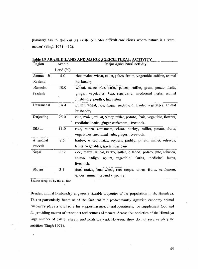
Table 2.9 ARABLE LAND AND MAJOR AGRICULTURAL ACTIVITY Region
Jammu &
Kashmir
Himachal
Pradesh
Uttaranchal
Dmjeeling
Sikkim
Arunachal
Pradesh
Nepal
Bhutan
Arable
Land(%)
5.0
10.0
14.4
25.0
11.0
2.5
20.2
3.4
Source: compiled by the author
Major Agricultural activity
rice, maize, wheat, millet, pulses, fruits, vegetable, saffron, animal
husbandry
wheat, maize, nee, barley, pulses, milJet, gram, potato, fruits,
ginger, vegetables, kuth, sugarcane, medicinal herbs, animal
husbandry, poultry, fish culture
miJJet, wheat, rice, ginger, sugarcane, fruits, vegetables, anima]
husbandry
rice, maize, wheat, barley, miJJet, potato, fruit, vegetable, flowers,
medicinal herbs, ginger, cardamom, livestock.
rice, maize, cardamom, wheat, barley, miJlet, potato, fruits,
vegetables, medicinal herbs, ginger, livestock.
barley, wheat, maize, soybean, paddy, potato, mi11et, oilseeds,
fruits, vegetables, spices, sugarcane
rice, maize, wheat, barley, millet, oilseed, potato, jute, tobacco,
cotton, indigo, opmm, vegetable, fmits, medicinal herbs,
livestock.
rice, mai;2e, buck-wheat, root crops, citrus fruits, cardamom,
spices, animal husbandry, poultry.
Besides, animal husbandry engages a sizeable proportion of the population in the Himalaya.
This is particularly because of the fact that in a predominantly agrarian economy animal
husbandry plays a vital role for supporting agricultural operations, for supplement food and
for providing means of transport and sources of manure. Across the societies of the Himalaya
large number of cattle, sheep, and goats are kept. However, they do not receive adequate
nutrition (Singh 1971 ).
55

Table 2.10 CROP WISE AREA, PRODUCTION AND YIELD (1999-2000) IN ARUNACHAL PRADESH
Crop Total Area (%) Total Production (MT) Yield (Qtl I Hect)
Rice 50.9 134807 11.0
Maize 14.8 48346 13.6
Millet 8.2 17123 8.6
Wheat 1.6 5096 13.0
Pulses 2.7 6634 10.1
Total food crops 78.2 211979 11.2
Potato 2.1 32434 65.4
Ginger 1.8 34890 79.3
Oil seeds 11.5 27228 9.8
Turmeric 0.2 1473 36.5
Chilli 0.6 1696 11.3
Sugarcane 0.3 16219 20.0
Seasonal vegetables 5.3 37060 20.0
Total commercial
crops 21.8 151000 28.7 Source: Department of Agriculture, Government of Arunachal Pradesh
Table 2.1 1 ECOLOGICAL SUB-REGION, ALTITUDE AND MAJOR CROPS GROWN IN UTT ARANCHAL HIMALAYA
Ecological sub-region
Lower Dun, Terai
Upper Dun, Bhabar,.
Lower shivaliks
Middle Garhwal-Kumaon
Upper Garhwal-Kumaon
Cold Zone
Source: Sati 2005:84
Altitude (m)
300-600
600-1200
1200-1800
1800-2400
2400-3600
Chief Crops
wheat, rice, and sugarcane
wheat, rice, mandua, jhangora, chaulai,
and maize
wheat, rice, mandua, jhangra, cheena
(panicu:rri miliaceum), potato, and
barley
wheat, barley, potato, chaulai, cheena, . "<': .. :. ~ . .
phaphra (Fagopyum tataricum)
SUMMER: wheat, barley, potato,
phaphra, chaulai, kauni. ogal, kodo
(fagopyum escu1entum), uva
(hoyceJeum himalayanse)
56

Table 2.121RRIGATED AREA IN THE HIMALAYA Region Net cultivated area (sq. km)
Uttaranchal 662.4
Himachal Pradesh
Nepal
Bhutan
Source: compiled by the author
580.0
Irrigated area (%)
33.9
17.9
38.2
25.0
Himalaya, although has with it sufficient resource potential, is one of the least industrialised
regions in the world. Very smaJJ percentage (less than 10 %) of Himalayan population is
engaged in industrial and its associated sector. Remoteness, unfavourable geographical
conditions, inadequate transportation and related infrastructure facilities, and unique
historical forces have played prominent role in the regard.
The region has a large hydel power potential but we have not been able to tap this resource
adequately. Further, although in recent times several hyde] projects are under their ways
there have often been stiff resistance from environmental groups and academia in view of the
unsustainable ways water resource is tapped.
Table 2.13 HYDEL POWER POTENTIAL OF HIMACHAL HIMALAYA Name of River Basin Hyde] Power Potential (MW)
Chenab 760.0
Ravi 499.8
Beas 3009.1
Sutlej 3465.6
Yamuna 795.1
Source: Singh 1971:427
Apart from that, sma11-scale and rural industries have developed in several parts of the
Himalaya and have the potential to grow in future. Rich and diversified histories of the
region and the resultant socio-cultural mosaic have Jed the way to diversify tmditional rurnl
57

cotta.ge industries. Several kinds of handicrafts and such other cultural items contribute
significantly to the economy of the region 13•
Tourism is yet another area where Himalaya has a comparative advantage. It is a growing
industrial sector and it is growing relatively faster. However, it is surprising to know that the
region remained isolated for long. Tourism is not a very old phenomenon in the area. It
picked up only after the 1950s but it picked up relatively fast. This sector is yet to be
properly regulated and efficiently diversified. Of late massive mass tourism pouring across
spaces of the Himalaya coupled with weak arrangements for regulatory mechanism and
inadequate institutions have been the serious cause of concern. Diversification of the sector
into nature tourism, eco-tourism, adventure tourism, cultural tourism, religious tourism, etc is
a welcome step ifrationa]]y planned and scientificaJJy managed.
As a whole, the economy of the Himalaya is poor with low per capita income. Most of the
population is dependent on agriculture, primarily subsistence agriculture as modem
industries are Jacking. Agricultural land is mainly concentrated in the foothills and valleys.
Food production in the Himalaya has not kept up with the population growth (Karan
[undated]). Recently, however, trade and commerce had played a vital role in the lives of the
people living in frontier villages of the region 14• Although strategic importance of the
northern frontiers has accelerated the development of transportation and communication in
the region after 1 962 15 the isolation in most of the parts is yet to be broken. Commercial
crops including horticulture and floriculture have been stimulated wherever modem roads
and such other infrastructure facilities have reached.
2.9 Conclusion
To sum up the discussion, the Himalayan geography, to varying degree, affects the climate,
biodiversity, water resources, soil condition, socio-cultural pattern, economy and overall life
and prosperity of the countries encompassed and their immediate surroundings. As a major
13 A visit to Delhi Hat of New Delhi provides one a good example in this connection. 14
Mainly in Himachal Pradesh, Ladakh, Kumaon and Garhwal. 15 The lndo-Chinese War of 1962 accelerated the strategic importance of the Himalaya.
58

resource-zone of South Asia it provides numerous goods and services to the people of both
the uplands and the lowlands and thus performs the role of prime source of regional
environment and human security. The importance of Himalaya in the context of regional
environmental security and the resultant human-wellbeing is beyond ordinary human
perception. The region is crucial for the people living both inside the region and vast
lowlands spreading across South Asia as it acts:
I. As a regulator and monitor of the regional environment
2. As a centre of ecosystem and biological diversity
3. As perennial sources of rivers and streams
4. As a great interceptor of monsoon wind causing heavy rainfall
5. As the home and storehouse of a vast number of economicaJiy important plants, animals
and micro organisms
6. As an invaluable gene pool ~hich faci1itates evolution of new species of plants and
animals
7. As a defence barrier against aggression by enemies
8. As a great storehouse of materials for education and scientific research
9. As an object of unexcelled scenic beauty
I 0. As an ideal region for the purpose of mountaineering as a sport
II. As a cradle of very rich ancient culture and civilisation
I2. As an _ideal hermitage of spiritual contemplation and deeper pursuits
The goods and services provided by the Himalaya to those living in the region as well as to
populations in lowlands may be listed as fo11ows-
Goods
I. Water (for consumption, irrigation, energy production);
2. Food (crops, domesticated and wild animals);
3. Wood (for energy and construction);
4. Non-timber forest products (fibres, foodstuffs, medicinal plants);
5. Minerals.
59

Services·
I. Maintenance of soil fertility and structure, and associated limitation of soil erosion
(particularly oflocal benefit);
2. Downstream movement of soil nutrients (upstream loss, downstream gain);
3. A voidance/mitigation of damaging impacts of disastrous events, such as floods,
landslides, avalanches (ofboth local and downstream benefit);
4. Provision of landscape as amenity (mainly of benefit to extra-regional tourists and
recreationists, but also to local amenity migrants and those depending on tourist
economy);
5. Biodiversity (oflocal benefit, but also of extra-regional value in terms of existence value
and genetic potential);
6. Cycling and storage of carbon and soil nutrients (of importance at the global scale).
60

Plate 2.5: Ploughing the Terraced Field [Photo: Manita Khawas, January 2005]
Plate 2.6: Thrashing the Harvested Paddy [Photo: Virna! Khawas, December 2002]
61

Plate 2.7: Paddy cultivation on Irrigated Terraces [Photo: Vimal Khawas, Oct. 2006]
Plate 2.8: Mixed farming on Un-Irrigated Terraces [Photo: Vimal Khawas, Dec. 2002]
62

Plate 2.9: Ripening Oranges [Photo: Vimal Khawas, Oct. 2006]
Plate 2.10: Ginger cultivation on Un-Irrigated Terraces [Photo: Vimal Khawas, Oct. 2006]
63