Chapter IV A PROFILE OF THE STUDY AREA 4.1 Introduction 4.2 Maharashtra...
21
76 Chapter IV A PROFILE OF THE STUDY AREA 4.1 Introduction 4.2 Maharashtra 4.3 Pune District 4.4 Pune City 4.5 Pune Papad Branch of SMGULP
Transcript of Chapter IV A PROFILE OF THE STUDY AREA 4.1 Introduction 4.2 Maharashtra...

76
Chapter IV
A PROFILE OF THE STUDY AREA
4.1 Introduction
4.2 Maharashtra
4.3 Pune District
4.4 Pune City
4.5 Pune Papad Branch of SMGULP

77
Chapter IV
PROFILE OF THE STUDY AREA
4.1 Introduction
Pune city is located in the state of Maharashtra. This chapter focuses the brief
overview of the Maharashtra state and Pune district, followed by a explanation of the
growth and characteristics of Pune city.
4.2 Maharashtra
Maharashtra is one of the 28 states that constitute the Union of India. It lies on
the western coast of the Indian peninsula, almost in the centre of the country.1 The
present state of Maharashtra was formed on 1st May 1960. Marathi speaking people
largely inhabits it and it is an expression of their cultural, linguistic and social
homogeneity. This state forming a considerable portion of the Indian peninsula
occupies a central place in We stern India. Maharashtra state has three broad physical
divisions i.e. The Konkan Coastland, Western Ghats or Sahyadris and Plateau Region.
For administrative convenience the state is divided in to six divisions namely
Mumbai, Pune, Nasik, Aurangabad, Amravati and Nagpur, which together are having
35 districts and 315 tahsils.
4.2.1 Geography
The State of Maharashtra can be divided into four physical regions – (a) The
coastal region (Konkan), (b) The Sahyadri Mountains, (c) The plateau region and (d)
The Satpura Mountains and the Tapi-Purna Valley2. Pune lies in the plateau region.
4.2.2 Population
The population of Maharashtra was 11,23,72,972 in 20113. The urban
population increased from 28.22 per cent in 1961 to 42.43 per cent in 2001, thus
making Maharashtra the second most urbanized state in India.4 The literacy rates for
males and females was 89.82 per cent and 75.48 per cent, thus giving an overall
literacy rate of 82.91 per cent in 2011.5
4.2.3 Economic Situation in Maharashtra
Maharashtra’s Gross State Domestic Product (GSDP) in 2009-10 at constant
(2004- 05) prices was Rs. 7, 01,550 crore, an increase of 8.7 per cent over the
previous year. The Gross State Domestic Product at current prices in 2009-10 was Rs.
9, 01,330 cr. and the Net State 68.
78
Domestic Product at current prices was Rs. 8, 17,891 cr. The per capita
income of the state at current prices was Rs. 74,027 in 2009-10, the second highest
among all states after Haryana6. Maharashtra’s contribution to the national economy
is high. It contributed to 9.4 per cent of the total population but accounted for nearly
25 per cent of the gross value produced in India’s industrial sector and 14.7 per cent
of India’s Gross Domestic Product in 2009-107. The state has achieved high levels of
industrialization, demonstrated by the fact that the secondary and tertiary sectors
provided 89.5 per cent and agriculture and allied activities 10.5 per cent of
Maharashtra’s GSDP in 2009-10 as compared to the national average of 65.4 per cent
contribution from the secondary and tertiary sectors8.
4.2.4 Administration
The state is divided into 6 divisions for administrative convenience. These
divisions are further divided unto 35 districts and 355 tahsils. According to the 2001
Census, there were 378 urban centres in the state and 43,711 villages9. Appropriate
initiatives on the part of the government are required to encourage private
participation for construction of quality roads and their maintenance’10. Interurban
road connectivity in the state, however, is fairly good11.
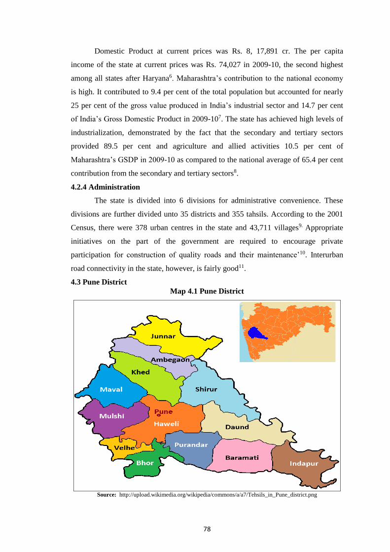
4.3 Pune District
Map 4.1 Pune District
Source: http://upload.wikimedia.org/wikipedia/commons/a/a7/Tehsils_in_Pune_district.png

79
4.3.1 Location
Pune district is located in central-western Maharashtra. It is triangular in
shape, as shown in above Map, with its base along the Sahyadri Mountains that run
from north to south along its western boundary and its apex in its southeast corner. It
is located between 17º 54' and 19º 24' North latitude and between 73º 19' and 75º 10'
East longitude. It occupies an area of 15,643 sq. kms. on the western edge of the
Deccan Plateau12.
4.3.2 Population
In 2011, the population of the district was 9,426,959, a growth of 30.34 per
cent over 2001. The population density was 603 persons per sq. km. Literacy were
87.19 per cent in 2011, with 92.72 per cent males and 81.13 per cent females being
literate. Rural population was 39.11 per cent and urban population was 60.89 per cent
in 2011.13 In fact, 89 per cent of the urban population lives in the cities of Pune and
Pimpri-Chinchwad14.
4.3.3 Agriculture
Wheat, Rice, Gram, Jowar, Bajra, Sugarcane, Groundnuts, Chillies, Pulses,
vegetables, fruits and flowers are the major crops. Both rabi and kharif crops are
grown since several parts of the district are well irrigated 15
4.3.4 Industry
Pune is one of the most industrialized districts of Maharashtra. Extensive
industrialization has been made possible because of the availability of road, rail and
air transport. The important large-scale industries here are sugar, automobiles,
textiles, pharmaceuticals, engineering goods, etc. Agricultural tools, pumps, textile,
rubber, plastic, electronics, etc. are the important small-scale industries. There are also
several establishments of the central government that manufacture arms and
ammunition16. The Maharashtra Industrial Development Corporation (MIDC) has a
strong presence in the district with large industrial estates at Bhosari, Pimpri 73
Chinchwad, Baramati, Jejuri and Kurkumbh. In December 2008, there were 3785
factories under Factories Act, 1948, employing 2,05,002 workers 17.
4.3.5 Services
Pune district is an important centre for education and health facilities. There
are 911 bank branches throughout the district. Up to March 2009, 1792 villages had
been electrified. The district administration implements various welfare schemes,
especially for the tribal population.18

80
4.3.6 Income and Per Capita Income of Pune District
The gross district domestic product at constant (2004-05) prices was rs 79,923
cr. In 2009-10 and the net district domestic product was Rs. 71,974 cr. The district
domestic product had a share of 22.1 per cent in the state income, just below the 22.6
per cent share of Mumbai district. The per capita income at current prices in 2009-10
was Rs. 1,11,637, which was higher than the average per capita income of
Maharashtra which was Rs. 74, 027.19
4.3.7 Administrative Set up
Pune is one of the 35 districts in the state of Maharashtra. The 2001 Census
shows 1866 villages and 25 towns in the district.20 For administrative purposes the
district is divided into 5 sub-divisions of Pune, Maval, Baramati, Junnar and Bhor.
The 14 tahsils in the district are grouped into these 5 sub-divisions. The city of Pune
is the headquarters of the Pune District.21
4.3.8 Local Government
There are separate institutions for self-government in rural and urban areas in
the district. Rural local government consists of the Gram Panchayat, Panchayat Samiti
and the Zilla Parishad. Urban local governments are the Municipal 75 Corporations in
the large cities and Municipal Councils in the towns. The number of local
governments in Pune District in 2010 was as follows: 2 Municipal Corporations, 11
Municipal Councils, 3 Cantonment Boards, 1 Zilla Parishad, 13 Panchayat Samitis
and 1407 Gram Panchayats. These local governments provide various essential
services to the local population and implement various developmental schemes
sponsored by the central or state government.22
4.4 Pune City
This part includes origin, establishment, historical perspective, geographical
setting and atmosphere, socio - economic background, industrial and entrepreneurship
development, cultural and educational development of Pune city, demography of the
study area etc. Thus this part gives overall information about the profile of Pune city.
It also includes reason for the selection of Pune Papad Branch for the study.
Pune, the nature – gifted city, is popularly recognized as the Queen of the
Deccan. Pune peculiarly esteemed as the cultural capital of Maharashtra and is
situated just 160 kms from the state capital city Mumbai. It has a glorious history over
thousands years. Thus Pune city has historical as well as cultural importance. After
independence, Pune city has developed as an industrial city.

81
Map 4.2: Pune City
Source: http://www.mapsofindia.com/maps/maharashtra/Pune.htm
4.4.1 Socio-Economic Background of Pune City
The exact date of the establishment of Pune is not known, but its existence
dates from ancient times. In Sanskrit references it is mentioned as Punyapur. It was
also known as Punnaka (150 AD) and later as Poorna Nagar.23 The earliest historical
records in which there is a reference to Pune are two copper plates dating from the 8th
century A.D., which show that the Rashtrakuta dynasty was then ruling over this area,
then known as Punyavishaya or Punakvishaya and the city itself is referred to as
Punakawadi.24 There is a theory that the original name of the city may have been
Punyapur because it stood near the confluence of the Mutha and Mula rivers, since
such places were regarded as holy. It is generally now agreed that the modern variant
'Pune’ came into use as early at the 13th century when small settlement was named
Kasba Pune by its Arab commandant.25 Pune seems, in the beginning, to have been
the headquarters of a region (vishaya) which was neither densely populated nor rich in

82
agricultural resources. The location of the town seems to have been determined by the
site of the ford on the Mutha River and its proximity to the fort of Kondana (later
renamed as Sinhagad).26 For the next eight hundred years, several different rulers
ruled over this area which was consequently subjected to almost continuous warfare.
During one such conflict in 1631, Pune was completely destroyed. Around the same
time there was a severe drought in this area and the population moved away. In 1636,
this area was given to Shahaji Bhosale by the then ruler of Bijapur and in 1637, his
deputy Dadodi Konddev resettled the city which at that time consisted of four peths,
the original nucleus called Kasba Peth and three new ones, Shaniwar, Somwar and
Raviwar. Agriculture again started, trade and commerce also developed and soon
Pune became the centre of the emerging Maratha Kingdom. Shivaji started his efforts
at building an independent State from Pune around 1656 and the city remained a part
of the Maratha Kingdom until 1818. The economic life of Pune was not much
developed till the Peshwa rule. The Peshwas, who were the administrators of the
Maratha Empire, made Pune their capital. Naturally, there was a spurt in both
economic activities and in the population. Trade was the major economic activity,
especially trade in all kinds of luxury goods. However, the prosperity and growth of
the city received a major setback with the fall of the Peshwas in 1818 when Pune
came under British rule.
By the 1840s, the city slowly revived with the establishment of the
Cantonment, construction of a railway line and post office and the establishment of
several schools and colleges such as the Deccan College and the Science College
(presently College of Engineering) in 1865 and Fergusson College in 1885, making
the city a centre for education. Most importantly, the first local government of the
city, the Poona Municipal Council was established in 1858. Till the end of the 19th
century Pune was an important centre for education and also the centre of the freedom
movement and of social reform due to the presence of Lokmanya Tilak and other
reformers. During the early 20th century, the area of the city expanded considerably
and some industries started, the first of which was Kirloskar Oil Engines Ltd.in 1946.
Soon after independence, in 1950, the Pune Municipal Corporation was established as
were several national level organisations like the National Chemical Laboratory and
the Pune University. From the 1950s there was a rapid growth of industries, especially
along the Pune- Mumbai Road. In 1962, industrial estates were set up by the
Maharashtra Industrial Development Corporation (MIDC) at Bhosari, Pimpri and

83
Chinchwad. Pune changed from an educational centre to an industrial hub with
various kinds of industries locating in and around the city.The process of
industrialization continued at a fast pace up to the 1980s. Most of the industries
established during this period were manufacturing industries, with a concentration of
engineering industry. From the 1990s, there was a fast growth of the Information
Technology industry, which is largely non-polluting. The setting up of the IT Park at
Hinjewadi in 1999 gave a fillip to the growth of the IT sector in Pune. At present, the
industry in Pune is dominated by IT companies and the services sector which includes
large numbers of doctors, lawyers, chartered accountants, tax consultants, etc.
Pune has always been at the forefront of cultural activities. Several newspapers and
magazines are being published from the pre-independence period and there are many
excellent libraries. A large number of authors, musicians and other artists and several
cultural organisations have enriched the city.27 Several Pune-based industrialists such
as Kirloskar, Garware, Bajaj, etc., have spread their industrial empires throughout the
world from this city. The people, institutions and industries in Pune have contributed
towards the development of the country and hence Pune has achieved an important
place in the economic development of India.28
4.4.2. Location
The city of Pune is located on the western margin of the Deccan Plateau at 18o
31' north latitude and 73 o 51’east longitude, about 160 kms south-east of Mumbai. It
lies on the leeward side of the Sahyadri range, 1850 feet above sea level. As seen in
Map No. 4, the city lies around the banks of and the confluence of two rivers, the
Mula and Mutha, which after joining are known as the Mula-Mutha. Two other rivers,
the Pavana and the Indrayani flow through the north eastern outskirts of the Pune
urban area. All these rivers are tributaries of the Bhima River. The city lies on an
extensive plain, surrounded by hills on the east and south, from 1900 to 2300 feet
high. The highest of these hills is the Sinhagad-Bhuleshwar range, which includes the
Sinhagad Fort. The Sinhagad-Katraj-Dive Ghat range is the southern boundary of the
urban area.29
4.4.3 Climate
The climate of the city is mild. Average temperatures range between 11º C and
41º C. The southwest monsoons bring rain to this area between June and October. The
average rainfall in Pune during this period varied between 661 mm. and 669 mm. per

84
year. The variation in the rainfall can be observed, with rainfall much above the
average in 1991, 2005 and 2006, and drought in 2000 and 2001.30
4.4.4 Geographical setting
The geographical location of Pune city is 18.31°latitude and 74.51º longitude.
Pune is a district place in the state of Maharashtra. Geographically it is located in the
Western part of Maharashtra. The population of Pune city was 3115431 as per the
census report of 2011. Geologically the study area is a part of the Deccan plateau. It is
mainly made from Basalt Rock. Volcanic Eruptions created it during cretaceous
period. Due to this geological setting, soil type is predominantly black color soil.
Physiographical, Pune city is located near the Western Ghat. Western Ghat
extended north-south direction in western part of Pune District. It consists of
offshoots of Sahyadri, characterized by small mountains and hilly ranges stretching
eastwards. These hilly ranges separated by the river valleys. Pune city has been spread
over in these valleys along with plenty of hills. Therefore, it is also called city of hills.
These hills are famous by local names like Taljai-Pathar, Parvati, Katraj, and
Ambegaon Pathar etc. The top of most of the hills are covered by the dense forest and
slops are interestingly barren. The efforts of forest department and NGOs have
maintained the forest cover of these hills. The location of Pune city is near to Mumbai
Metropolitan city and the coastal area of Konkan. It has an easy access to these areas
by roads or railways passing through various Ghats of Sahyadri Ranges.
Two major rivers that are Mula and Mutha and their tributaries drain Pune
city. Number of dams are constructed on both the rivers e.g. Khadakwasala, Panshet,
Varasgaon, Temghar, Mulashi etc. These dams become the permanent source of water
for drinking and industrial need of Pune city.
The climate of the study area is a part of monsoon type of climate. It is divided
in the following seasons: (1) Cold season-from November to February. December is
generally the coldest month showing daily maximum at about 12ºc to 13ºc. (2) Hot
season- from March to mid of June. The hot weather is on peak at the middle of the
month May. Maximum temperature observed in May is around 41ºc. 3) Monsoon
season-from June to September. The main source of rain in the study area is from the
southeast monsoon. Climatologically, this study area is located in rain shadow zone
due to Western Ghat. Thus, rainfall decreases from the Ghat region towards Pune city.
The average rainfall of Pune city is 65 cm... Towards the end of monsoon season in
September and in October, there is a slight increase in day temperature. However, the

85
night becomes progressively cooler. Overall the climate of Pune city is considered
healthy. It is also one of the geographical reasons the city becomes the hub of
educational, cultural and industrial center of the country.
4.4.5 Growth in Area
The area of Pune city has been steadily growing as the city has expanded in all
directions from the initial settlement on the banks of the Mula-Mutha Rivers. When
the British captured the city in 1817, its area was barely 5 sq. kms. The city gradually
expanded during the British rule with the formation of the Pune Municipality and the
establishment of Pune, Khadki and Dehu Road cantonments. At the time of the
formation of the municipality in 1858, the area of the city was 15.54 sq. kms. By
1935, the surrounding villages were merged and the area grew to 34.59 sq. kms. The
area of the city continued to grow with the inclusion of more & more surrounding
areas from time to time. In the post independence period the city experienced
explosive growth as did the surrounding urban area. There was a large growth in the
area of the city when the Corporation was formed in 1950 with the merging of the
Poona Municipal Committee and the Poona Suburban Municipal Committee. By
1962, the area of the city had increased to 139.70 sq. kms. In 1983, the area was
146.11 sq. kms.
The next large expansion of the limits of the city took place in 1997 with the
inclusion of 38 fringe villages in the area of the Corporation. Consequently the area
under the Corporation increased to 368.89 sq. kms. However, in 2001, fifteen villages
were removed from the Corporation and the area came down to 244.84 sq. kms which
has remained unchanged till the present.31 The total area of Pune City at present,
including the 14.2 sq. kms of Khadki Cantonment and 14.9 sq. kms of Pune
Cantonment, is 270.94 sq. kms.32
4.4.6 Administration
Pune City is the district headquarters of Pune district. It is also a fully urban
tahsil of Pune district. In Pune city, the statutory urban local bodies are the Pune
Municipal Corporation, Pune Cantonment and Khadki Cantonment. For
administrative purposes the city is divided into 4 zones and 14 administrative
divisions.33
4.4.7. Population
The population of Pune city according to the 2011 census is 31,15, 431 and
that of Pune Metropolitan Region is 50,49,968.34 The following table brings out the

86
rapid growth in the population of Pune city area, which includes the Khadki
Cantonment Board, the Pune Cantonment Board and Pune Municipal Corporation
areas, Population of Pune city given in table 4.1.
Table 4.1: Growth of Population of Pune City
Year
Khadki
Cantonment
Board
Pune
Cantonment
Board
Pune
Municipal
Corporation
Pune City
Growth
Rate
per cent)
1 2 3 1+2+3
1901 10,797 - 1,53,320 1,64,117 --
1911 14,028 - 1,58,856 1,72,884 5.34
1921 - - 1,98,543 1,98,543 14.84
1931 16,302 35,807 1,98,078 2,50,187 26.01
1941 26,285 40,447 2,57,554 3,24,286 29.62
1951 48,552 59,011 4,88,419 5,95,982 84.78
1961 58,496 65,838 6,06,777 7,31,111 22.67
1971 65,497 77,774 8,56,105 9,99,376 36.69
1981 80,835 85,986 12,03,351 13,70,172 37.10
1991 78,323 82,139 15,66,651 17,27,113 26.05
2001 77,473 79,965 25,38,473 26,95,911 56.09
2011 NA NA NA 31,15,431 21.40
Source: 1) District Census Handbook, Census 2001, Pune District pp. 654 to 657.
2) census2011.co.in/census/city/375-Pune.html.
Table 4.1 indicates that the very small growth in the population between 1901
and 1911 was due to five epidemics of plague in which 30,000 people died. The
population of the Pune Municipal Corporation area showed a marginal fall in the 1931
census, but started growing steadily from 1931 onwards. With growth in the
population of the two Cantonments as well, the population of Pune City as a whole
grew continuously. During the 1940s, the population registered the highest growth
rate so far both because there were no health problems and also due to the
employment created by the establishment of several government offices, industries,
research and educational institutions and defense establishments, attracting a large
inflow of population from all parts of the country. Another important reason was the
influx of refugees from Punjab and Sind provinces after the partition in 1947. Lastly,
seven adjoining villages and Pune Suburban Municipal Committee were merged with
87
the Pune city at the time of the formation of the Pune Municipal Corporation in
1950.35
From the 1960s to the 1980s, growth of population can be mainly attributed to
the rapid growth of industry in and around Pune. Even though many industrial units
were located in Bhosari and Pimpri-Chinchwad, their employees chose to live in Pune
city, thus contributing to a steady rise in population at over 35 per cent per decade.36
The fast growth of population after 1991 was primarily due to the even faster growth
in the economy. The rapid expansion of the Information Technology industry and
other service sector organizations and tremendous growth in the small scale industrial
units caused large scale in-migration. During the period 1981 to 1991 about 4.1 lakh
people migrated to the city, and this figure went up to 7.4 lakhs between 1991 and
2001. Migration accounted for about 13-20 per cent of the population of the city. It
was observed that about 50 per cent of the growth in population was due to
migration.37
It may be observed that between 1981 and 2001, the population in the two
Cantonment areas has shown some decline, but this has been more than compensated
by the growth of population in the PMC area, leading to overall growth in the
population of the city, which has crossed 3 million in 2011.
4.4.8 Density of Population and Number of Households
The density of population as per the Census 2001 was 5,903 individuals per
Sq. km. in the Pune Municipal Corporation area.38 The number of households within
PMC limits was 555,771 at the time of the 2001 census.39
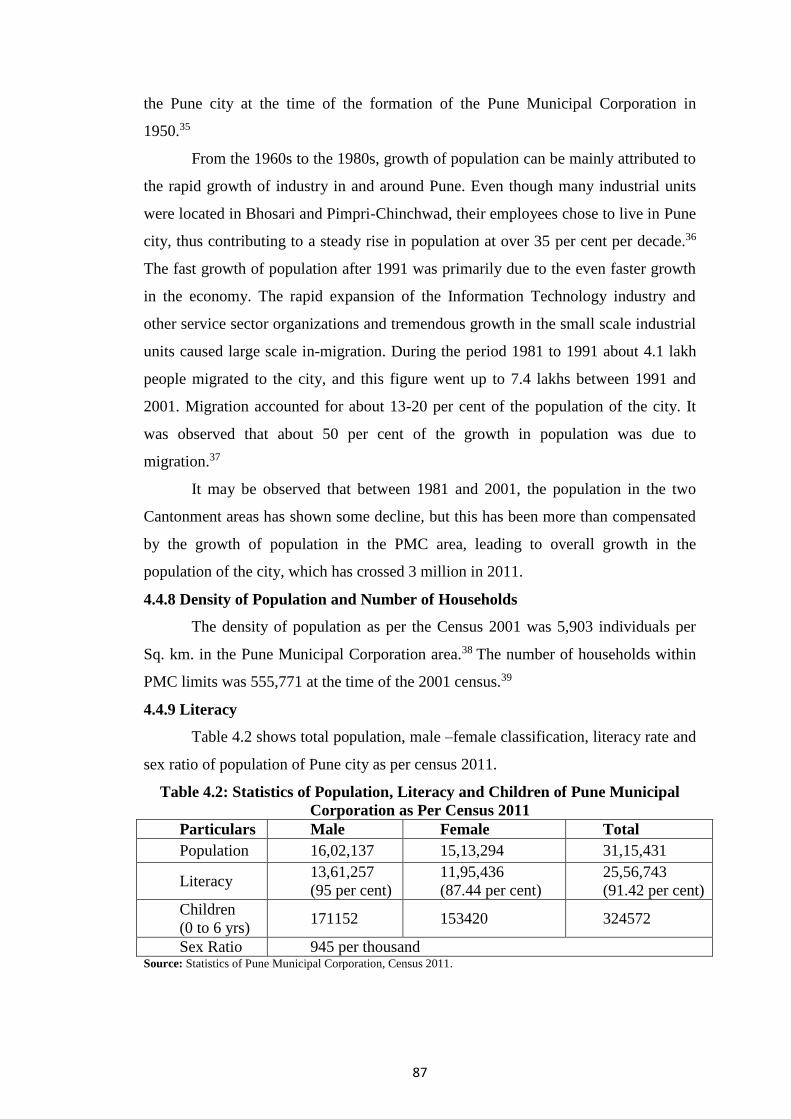
4.4.9 Literacy
Table 4.2 shows total population, male –female classification, literacy rate and
sex ratio of population of Pune city as per census 2011.
Table 4.2: Statistics of Population, Literacy and Children of Pune Municipal
Corporation as Per Census 2011
Particulars Male Female Total
Population 16,02,137 15,13,294 31,15,431
Literacy 13,61,257
(95 per cent)
11,95,436
(87.44 per cent)
25,56,743
(91.42 per cent)
Children
(0 to 6 yrs) 171152 153420 324572
Sex Ratio 945 per thousand Source: Statistics of Pune Municipal Corporation, Census 2011.

88
Table 4.2 indicates that the 2001 Census estimated that the literacy rate of the
population in Pune was 77 per cent. The literacy rate for female was 72.2 per cent and
for male it was a little higher at 81.4 per cent. In 2011, the overall literacy rate for
Pune was 82.07 per cent, with 84.96 per cent males and 79.00 per cent females being
literate.40
4.4.10 Occupation Structure
The Pune Municipal Corporation has estimated that 3 per cent of the
population is directly or indirectly dependent on agriculture and 97 per cent of the
population is engaged in professional or business activities. Out of the working
population, about 23 per cent (2.25 lakh) individuals are employed in the Information
Technology industry.41
4.4.11 Per Capita Income
The average per capita annual income of Pune City was estimated to have
been Rs.36, 500 in 2004-05. This figure increased almost 1.8 times in five years, to
about Rs.60, 000 in 2008-09.
4.4.12 Pune City - The Industrial destination
Pune city, being located in Mumbai Pune Industrial belt, is one of the
important industrial centers in the country. Numbers of industries ranging from small
scale to large-scale are situated in and around Pune. Pune is one of the premier
industrial centers of India. Pune city has various types of small, medium and large
industries such as Automobile, electronic, electrical and food.
Among the large corporate headquartered in the city are: Atlas Copco, Bajaj Auto,
Bajaj Allianz, Bajaj Tempo, Cummins India, Deepak Fertilizers and Petrochemicals,
Kirloskar Oil Engineers, Kinetic Engineers, Mercedes Benz India, SKF Bearings,
Sandvik Asia, Tetrapak India, Thermax, Zensar… Multinationals Flat, Whirlpool, and
Sharp are some of the big brick’s mortar names that have made huge investment near
Pune in the recent past.
There are various research institutes like National Chemical Laboratory,
Automotive Research Association of India, and Central Institute for Road Transport
etc. in this city. There are very important Defense Research and Development
Organization laboratories such as Institute of Armament Technology, High Explosive
Material Research Laboratory, Armament Research and Development Establishment,
R & D Engineers, Ordinance Factory etc. situated here.

89
Pune is an alluring home to the well-known giants of the Indian software
industry like Wipro, Infosys, Satyam, Tata Technologies, TCS, Kanbay, Veritas,
Cognizant, PCS, and Mahindra British Telecom. The another feather in the cap of
Pune, is the Indian Institute of Software Engineering coming up in association with
Carnegie Mellon University, USA. Growth in the Number of Manufacturing Units
and their Turnover in Pune District shows in table 4.3.
Table 4.3: Growth in the Number of Manufacturing Units and their Turnover in
Pune District
Year Number of Units Turnover (Rs. Crores)
1985 4,529 2,749
1990 6,766 5,445
1995 5,838 15, 655
2000 6,670 28,026
2007 9,500 52,000
Source: Table Nos. 26 and 32, MCCIA (2008), pp- 128 and 135
Table 4.3 shows growth in the number of manufacturing units and their
turnover in Pune district. There was a continuous growth in the number of industries
(except in the early 1990s), rapid growth took place after the recession of 1997-2002
was over. During the recession, many large units cut workforce and reduced working
hours, forcing many Small and Medium Enterprises (SMEs) to shut down. When the
recovery started from 2002 onwards, the larger units stepped up production to meet
the growing global demand and this had a definite multiplier effect on the SME
growth. The investments made by the large manufacturers have grown at least four
times between 2000 and 2007. The number of industrial units, their turnover and
employment grew after 2002 as a result of this expansion.42
The location pattern of these industrial units showed that over 12 per cent of
these industries are located within Pune city and over 70 per cent units are located
around the city in all directions, including Pimpri-Chinchwad and further along the
Bombay- Pune road, Chakan, Hadapsar, Pirangut, etc.43 The MCCIA report has
observed that although a large number of industries are located outside the city, a
majority of the employees live in the Pune Municipal Corporation area which has
better amenities. Therefore, there is great demand for transport services (i.e., roads
and vehicles) for both goods and passenger transport. The IT and BT (Biotechnology)

90
industries have emerged as the new driving force of the economy and have
significantly grown by almost 26 times, from a turnover of Rs.250 crore to Rs.6,500
crore, between 2000 and 2008. The IT sector from Pune contributes to about 10 per
cent of national software exports. With over 600 IT companies and about 50 medium
and 50 big BPO centres, besides many smaller ones, the IT sector, which is labour
intensive like the SME sector, has generated a large number of new jobs, attracting
people from all over the country, thus contributing to growth of population.44 Most of
the industries within Pune City limits fall in the category of engineering and allied
activities. There were 12 large/medium industrial units and 876 small units in the
PMC area in 2010.
4.4.13 Pune the Centre of Learning
With the advent of the British Rule, the British Educational-system of the
formal schools and colleges had been started. Pune Sanskrit College was started in
Vishrambagwada. This, later on, was transformed into the existing Deccan College
(1851). Tilak, Agarkar, Bhandarkar, G. K. Gokhale and other leaders of the nineteenth
century of Maharashtra were educated at the Deccan College. Students of the Deccan
College, after realizing the importance of national education, started New English
School (1880), Fergusson College (1885), Nutan Marathi Vidyalaya (1883), High
School for Indian Girls (1884), MES Society’s Bhave High School, Shivaji Maratha
High School, and Sarasvati Mandir. Many such devoted and historical institutions laid
down the solid foundation of today’s successful higher educational institutions. Poona
College of Engineering was started in 1854, Course for Medical Education was
started at Sassoon Hospital later on converted into B.J. Medical College, and Law
College was started in 1925. Poona Agriculture College was started in 1908 with
British Principals-the leading agricultural educational institute of Pune. S.P. College,
S.N.D.T. College for Women and Modern Education Society’s Nowrosjee Wadia
College (1932) were started locating in different parts of city. These colleges have
been catering to the needs of expanding Pune. Thousands of students from outside
Pune get admission to these institutions and after the completion of their education get
settled in their lives through the length and breadth of India. They owe their
prosperity to the education in Pune.
After independence, the University of Pune came on the city’s educational
path and started functioning on 10th February 1949. Under the umbrella of this
university, there was rapid progress of the higher education in Pune in particular.

91
Similarly, we find the establishment of institutions of national importance like NCL,
IUCAA, C-DAC, and IAT, which are recognized for the research work by the Poona
University for award of Doctoral degrees. Apart from these institutions Tilak
Maharashtra Vidyapeeth, Deccan College, Gokhale Institute of Politics and
Economics, and the Modern Education Society are the most renowned institutions
very popular among the foreign students. Pune has attracted students not only from
Maharashtra but also from other states in India and especially from the Afro-Asian
Countries.
4.4.14 Trade and Commerce
The city of Pune is an important a trading centre because of good
communication, banking and other necessary facilities. The city has good road and
rail links to the rest of the country which has facilitated the growth of trading
activities. The area around Pune city is mainly agrarian. Therefore, Pune city is
regarded as one of the most important market places for the trade of agricultural
produce. The city is also considered an authentic market for the trade in food grains,
clothes, leather goods, gold and silver etc., not only for the urban residents but also
for the customers from the surrounding semi-urban area.
4.2.15 Changing Pune
Pune, in narrow recent, is developed as the preferred INFO City. The IT Parks
and the Auto Component’s Hubs are established in the parts of Pune. People of
different religions and languages are attracted towards Pune for education and
employment opportunities. South Indians have formed their neighborhood in Rasta
Peth, Sindhis have settled in Pimpri, Christains have centered in Camp Area, whereas,
the Muslims in majority reside in Ganj and Nana Peth of the eastern Pune. Gujarathis,
Marwadi, and Jains have majority in Bhavani, Shukrawar and Nana Peths. The Sikhs
have founded their Gurudwara in Ganesh Peth, whereas Marathas and Brahmins are
almost found everywhere.
There is a tremendous increase in house-building sector in Pune. The quick
erection of plazas, arcades, apartments, and the co-operative housing societies have
been considered as the face-lifting improvement in conservative Pune. However, in
fact, a large population still lives in slums and it is increasing drastically day by day.
Women of Pune are educated and are comprehensively employed in the fields like the
government departments, education field, computer field, call-centers, and shops. The
traditional female-costume is changing remarkably to the suitable-modern attire,
92
though Pune-ladies prefer customary sarees on festivals and religious occasions.
Pune-women have resorted to family planning and can move safely on Pune roads
with peace and security. Women of Pune are emerging as popular writers. They have
performed well in professions like Music, Dance, Acting [in cinema or TV and
drama], Journalism, Research, and even in Computer science. In disciplines like
Architecture, Interior Design, Dentistry, and Medicine, their number is ever
increasing. They drive two and four-wheelers sophistically with confidence.
Hotels and eating lovers are increasing and the taste of Pune people is changing.
There is an increasing attitude for outside-eating. Hence dining halls are flourishing.
Many prefer readymade things-may be chapattis or modak or puranpoli. Modern
Pizza Huts, Mc-Donald’s, and the Mall-culture have attracted the youth and the
mature in recent times.
4.5 Pune Papad Branch of SMGULP
Shri Mahila Griha Udyog Lijjat Papad was established on 15March 1959.
Pune Papad Branch is one of important and actively running branch established on 8th
December 1968 at Prabhat Road, Pune-04. Gradually, considering the business
turnover, opportunity of expansion and availability of sister members it has started its
second centre at Vadgaon Dhayari on 4th June 1998. Afterwards, Hadapsar sub centre
was started on 18th July 2011. Thus, as on the date all the three centres are running
efficiently. As on the date 1634 sister actively working in these three centres. The
brief information of these centres is as follows.
Prabhat Road centre is located at 33/16, Raj Laxmi, Prabhat Road, Lane No. 04, Pune
-04. Smt. Suman Darekar is the Sanchalika of Prabhat Road Centre. In this centre 807
sister members are working.
Vadgaon Dhayari centre of SMGULP was started on 4th June 1998. It is
located at 143/01/02, Chakankar Estate, Sinhgad Road, Dhayari, Pune-41. Smt.
Chetana Nahar is the Sanchalika of this centre. As on the date 687 sister members are
working.
Hadapsar Sub Centre was started 18 July 2011; it is located at 211, Vidhya
Vihar Colony, New D. P. Road, Malvadi, Pune-28. In this centre 140 sister members
are working. This sub centre is working under Prabhat road centre.45
Area selected for the study was Pune city which has great importance as far as
its historical perspectives, geographical setting, socio economic environment and
industrial development was concerned. Pune Papad Branch was in Pune city with the

93
reason that there was historical and industrial background and potential for overall
development of the business. According to census 2011, total population of female of
Pune city was more than 15 lacks which shows significant percentage in total
population of Pune city. There was need to provide employment opportunities to this
female population in general and unskilled female in particular. SMGULP has been
playing an important role in providing employment opportunities to these sister
members. Thus, this topic gives overall information about profile of study area and
brief quantitative information of Shri Mahila Griha Udyog Lijjat Papad.

94
References
1. Government of Maharashtra (2008): Handbook of Basic Statistics of
Maharashtra State - 2008, Directorate of Economics and Statistics, Planning
Department, Mumbai, p-14.
2. Iibid, 14-16.
3. www.censusindia.gov.in/2011-prov-results/Chapter4.pdf
4. Government of Maharashtra (2010): Handbook of Basic Statistics of
Maharashtra State - 2010, Directorate of Economics and Statistics, Planning
Department, Mumbai, p-18.
5. www.censusindia.gov.in-chapter 6.pdf.
6. Government of Maharashtra (2011): Handbook of Basic Statistics of
Maharashtra State - 2011, Directorate of Economics and Statistics, Planning
Department, Mumbai, p-9.
7. Ibid., 7.
8. Ibid., p-20.
9. Directorate of Census Operations, Maharashtra (2007): op. cit, p-30
10. Government of Maharashtra (2007): Handbook of Basic Statistics of
Maharashtra State - 2007, Directorate of Economics and Statistics, Planning
Department,Mumbai, pp-148-149.
11. Government of Maharashtra (2010): Op. Cit. p-139.
12. Directorate of Census Operations, Maharashtra (2007): op. cit, pp-4-10.
13. www.census2011.co.in/census/district/351-Pune.html.
14. Government of Maharashtra (2009): Handbook of Basic Statistics of
Maharashtra State - 2009, Directorate of Economics and Statistics, Planning
Department, Mumbai, p-3.
15. Directorate of Census Operations, Maharashtra (2007): op.cit, p-13.
16. Ibid, p-15.
17. Government of Maharashtra (2011): op.cit, p-IX.
18. Government of Maharashtra (2009): op.cit, pp-6-7.
19. Government of Maharashtra (2011): op.cit, pp-21 & 31.
20. Directorate of Census Operations, Maharashtra (2007): op. cit, p-05
21. Directorate of Census Operations, Maharashtra (2007): op. cit, p-06

95
22. Government of Maharashtra (2011): op.cit, p-44
23. Palande, P S (1981): The Fiscal System and Problems of Municipal
Corporations - A Case Study of the Finances of the Pune Municipal
Corporation, Ph.D. Thesis submitted to the Pune University, Pune.
24. Directorate of Census Operations, Maharashtra (2007): op. cit,.p-04
25. Gupta, Jaymala and Smita Diddee (2000): Pune-Queen of the Deccan, Elephant
Design Pvt. Ltd., Pune.p.19.
26. Gadgil, D R (1952): op. cit, p-1
27. Mahajan SG (2004): Pune Shaharacha Dnyan Kosh, Volume I, Pune
Shaharacha Dnyankosh Pratishthan, Pune, pp-18-24.
28. Mahajan SG (2000): Pune City : Its History, Growth and Development (750 to
1998 AD), Mahajan Prakashan, Pune, p-34
29. Gadgil, D R (1952): Poona - A Socio-Economic Survey Part II, Publication
No.25, Gokhale Institute of Politics and Economics, Pune. p-12
30. Government of Maharashtra, District Socio-Economic Reviews, Pune District,
1985 to 2010, Table No. 2.1.
31. Model Development Plan 2001 to 2021, For Areas Included in PMC Limits),
Pune Municipal Corporation, Pune.pp-6-7.
32. Directorate of Census Operations, Maharashtra (2007): op. cit, p-XXVI
33. Ibid, p-79
34. www.census2011.co.in a /census/city/375-Pune.html.
35. Mangudkar, MP (1960): Pune Nagarsanstha Shatabdi Grantha, Pune Municipal
Corporation, Pune,p-31.
36. Palande, P S (1981): The Fiscal System and Problems of Municipal
Corporations - A Case Study of the Finances of the Pune Municipal
Corporation, Ph.D. Thesis submitted to the Pune University, Pune.p-78.
37. PMC (2009): Environmental Status Report 2008-09, Pune Municipal
Corporation, Pune. pp- 3 and 4.
38. Directorate of Census Operations, Maharashtra (2007): op. cit, p-657
39. Ibid, p- 656.
40. www.census2011.co.in a /census/city/375-Pune.html.
41. PMC (2009): Environmental Status Report 2008-09, Pune Municipal
Corporation, Pune.

96
42. MCCIA (2008): Profile and Analysis of Pune Manufacturing Inc., an
Intelligence Report on the Growth of Pune Industries, Maratha Chamber of
Commerce, Industries and Agriculture, Pune, p-128.
43. Ibid, p-140.
44. MCCIA (2005-06): Pune IT - One Stop Guide to the IT World, Maratha
Chamber of Commerce, Industries and Agriculture, Pune pp-27-43.
45. Lijjat Address Card (April 2014), Head office of Lijjat, Mumbai.