Chapter E2 | Stormwater and Flood Risk Management · Chapter E2 Stormwater and Flood Risk...
45
Chapter E2 Stormwater and Flood Risk Management Part E General Controls for All Development CHAPTER E2 APPROVED ON 27 APRIL 2015 AND COMMENCED ON 23 MAY 2015
Transcript of Chapter E2 | Stormwater and Flood Risk Management · Chapter E2 Stormwater and Flood Risk...

Chapter E2
Stormwater and Flood Risk Management
Part E General Controls for All Development
CHAPTER E2 APPROVED ON 27 APR IL 2015
AND COMMENCED ON 23 MAY 2015


Part E | General Controls for All Development E2 | Stormwater and Flood Risk Management
23 May 2015 Woollahra Development Control Plan 2015
Chapter E2
Stormwater and Flood Risk Management
Contents
E2.1 INTRODUCTION ........................................................................................ 1
E2.1.1 Land and development to which this chapter applies .................................. 1
E2.1.2 Development types to which this chapter applies ...................................... 1
E2.1.3 Objectives ...................................................................................... 1
E2.1.4 Definitions ...................................................................................... 2
E2.2 STORMWATER DRAINAGE MANAGEMENT CONTROLS ........................................... 3
E2.2.1 Introduction .................................................................................... 3
E2.2.2 Water sensitive urban design ............................................................... 4
E2.2.3 Stormwater treatment ....................................................................... 6
E2.2.4 On site detention (OSD) of stormwater ................................................... 8
E2.2.5 Connection to Council’s drainage systems ............................................... 11
E2.2.6 Diversion of Council’s drainage ............................................................ 14
E2.2.7 Structures over or near drainage lines and easements ................................ 15
E2.2.8 Connection to Council’s parks, reserves, bushland and natural waterways; Sydney Harbour; and Sydney Water channels .................................................... 16
E2.2.9 Low level properties and easements ..................................................... 17
E2.2.10 Groundwater (hydrogeology) ............................................................. 20
E2.2.11 Absorption systems ......................................................................... 21
E2.2.12 Pump and sump systems ................................................................... 22
E2.2.13 Charged or siphonic systems .............................................................. 24
E2.2.14 Activities on a public road ................................................................ 24
E2.3 FLOOD RISK MANAGEMENT CONTROLS ......................................................... 25
E2.3.1 Introduction ................................................................................... 25
E2.3.2 Information available from Council ....................................................... 25
E2.3.3 Flood planning levels ........................................................................ 26
E2.3.4 Flood controls ................................................................................. 29
APPENDIX 1 – DEFINITIONS ................................................................................. 34
APPENDIX 2 – DESIGN RAINFALL INTENSITIES........................................................... 39

Part E | General Controls for All Development E2 | Stormwater and Flood Risk Management
23 May 2015 Woollahra Development Control Plan 2015 E2 pg.1
E2.1 Introduction
This chapter outlines provisions related to two key interrelated components:
the management of stormwater drainage collected on and discharged from new
developments; and
the minimisation of flood related risks to person and property associated with the
development and use of land.
In preparing an application for a development, both components must be considered.
E2.1.1 Land and development to which this chapter appl ies
Stormwater drainage
This chapter applies to all land within the Woollahra Municipality.
Flood risk management
The flood risk management component of this chapter applies to all land within the Woollahra
Municipality that is within a “flood risk precinct”.
E2.1.2 Development types to which th is chapter appl ies
This chapter applies to all development that requires consent.
This includes complying development under the NSW General Housing Code, and complying
development for secondary dwellings under the State Environmental Planning Policy
(Affordable Rental Housing) 2009.
E2.1.3 Objectives
The objectives of this chapter are:
O1 To encourage ecologically sustainable stormwater management and the use of water
sensitive urban design.
O2 To maintain existing natural drainage patterns.
O3 To ensure that adequate provision has been made for the disposal of stormwater from land
proposed to be developed.
O4 To ensure the controlled release of stormwater to public stormwater systems without
adversely impacting on adjoining or downstream properties.
O5 To protect Sydney Harbour and its waterways from stormwater pollution.

E2 | Stormwater and Flood Risk Management Part E | General Controls for All Development
23 May 2015 E2 pg.2 Woollahra Development Control Plan 2015
O6 To minimise flood risk and damage to people and property by setting appropriate
development controls.
O7 To ensure that flood levels are not increased by development.
E2.1.4 Defin it ions
The definitions in Appendix 1 of this chapter define words and expressions for the purpose of this
chapter.
These definitions apply in addition to the definitions in Part A Chapter A3 of the DCP, and any
other terms referred to in Australian Rainfall and Runoff (Institution of Engineers, Australia,
1987), the Floodplain Management Manual (New South Wales Government, January 2011),
the Environmental Planning and Assessment Act 1979 (EP&&Act) or the Woollahra Local
Environmental Plan 2014 (LEP).

Part E | General Controls for All Development E2 | Stormwater and Flood Risk Management
23 May 2015 Woollahra Development Control Plan 2015 E2 pg.3
E2.2 Stormwater dra inage management controls
E2.2.1 Introduction
In assessing development applications for stormwater drainage management, Council will
consider each of the matters listed below and each matter must be addressed by the applicant.
The response to these matters, plus any other relevant statutory and policy matters, will be
considered by Council when assessing the acceptability of the development.
For each matter, specific objectives are given together with the controls to achieve those
objectives. Alternative ways to achieve the stated objectives will be considered when, in the
opinion of Council, the outcome is better in terms of the impact on the public domain or
adjacent properties than strict compliance with the stated controls.
High quality submissions greatly aid the assessment process and it is recommended that
information regarding the matters below be prepared by a suitably qualified practitioner.
Stormwater drainage management is generally achieved through the provision of a
stormwater drainage concept plan, which should address the following management
measures (where applicable):
water sensitive urban design;
stormwater treatment;
on site detention (OSD) of stormwater;
connection to Council’s drainage systems;
diversion of Council’s drainage;
structures over or near drainage lines and easements;
connection to Council’s parks, reserves, bushland and natural waterways; connection to
Sydney Harbour; and connection to Sydney Water channels;
low level properties and easements;
groundwater (or hydrogeology);
absorption systems;
pump and sump systems;
charged or siphonic systems; and
activities on a public road.
Information regarding these matters does not necessarily have to be of a standard and level of detail that is construction ready. In most cases a concept plan only is required at DA stage, with the detailed stormwater drainage design and specifications required prior to the issue of a Construction Certificate. The exception to this is stormwater works impacting on easements, where detailed stormwater drainage design and specifications are required at the DA stage.
E2 | Stormwater and Flood Risk Management Part E | General Controls for All Development
23 May 2015 E2 pg.4 Woollahra Development Control Plan 2015
E2.2.2 Water sensit ive urban design
Objectives
O1 To ensure development is designed, constructed and maintained so as to minimise impacts
on the natural water cycle.
O2 To reduce peak stormwater flows and total stormwater runoff volume.
O3 To utilise water resources more efficiently.
O4 To reduce the flood risk in urban areas.
O5 To reduce erosion of waterways, slopes and banks.
O6 To control stormwater pollution and improve water quality in Sydney Harbour, waterways
and drainage systems.
Controls
Pervious surfaces
C1 In areas with suitable ground conditions, the use of pervious surfaces is encouraged.
Rainwater tanks
C2 The use of rainwater tanks for non-potable water uses is encouraged.
C3 Rainwater tanks only collect roof water.
C4 Rainwater tanks are connected to all external non-potable water uses including
landscaping. Tanks may be connected to internal non-potable water uses including toilet
flushing and washing machines.
C5 Where OSD is required onsite (see Section E2.2.4), overflow from rainwater tanks is
directed to the OSD system.
C6 Where OSD is not required onsite, overflow from rainwater tanks is directed to Council’s
drainage network.
C7 Rainwater tanks are located to minimise their visual impact. Above-ground rainwater tanks
are located behind the building line and suitably screened. Slimline rainwater tanks at the
side of buildings or under hardstand areas such as driveways are preferred.
Note:
Rainwater tanks must be installed by a licenced plumber in accordance with AS3500 National
Plumbing and Drainage Code, HB230 Rainwater Tank Design and Installation Handbook, other
relevant codes and the manufacturer’s specifications
A positive covenant will be required for maintenance of rainwater tanks.

Part E | General Controls for All Development E2 | Stormwater and Flood Risk Management
23 May 2015 Woollahra Development Control Plan 2015 E2 pg.5
Greywater reuse
C8 The reuse of domestic greywater for non-potable water uses is encouraged (e.g. water
discharged from washing machines).
Notes:
A report on the appropriate treatment to allow for the safe reuse of domestic greywater must
be prepared by a suitably qualified practitioner and the design must be in accordance with
appropriate industry standards.
Industry standards include HB 326 Urban Greywater Installation Handbook and the guidelines
prepared by the NSW Department of Primary Industries (Office of Water), the NSW
Department of Health and the Federal Department of Sustainability, Environment, Water,
Population and Communities.
A positive covenant will be required for maintenance of systems to reuse domestic greywater.
Green roofs
C9 The use of green roofs is encouraged.
Note:
Green roofs must be designed by a suitably qualified practitioner and in accordance with
appropriate industry standards.
Industry standards include the Building Code of Australia and the City of Sydney Council
Green Roof Resource Manual guidelines.
A positive covenant will be required for maintenance of green roofs.
E2 | Stormwater and Flood Risk Management Part E | General Controls for All Development
23 May 2015 E2 pg.6 Woollahra Development Control Plan 2015
E2.2.3 Stormwater treatment
Objectives
O1 To minimise the discharge of pollutants (litter, sediment, suspended solids, nutrients, oil,
grease and toxants) from paved and other impermeable surfaces into Sydney Harbour,
waterways and drainage systems.
Controls
Stormwater treatment
C1 Stormwater treatment is required for:
a) all properties with connections to Sydney Harbour, waterways and open watercourses;
b) all new commercial developments and residential flat buildings; and
c) all major alterations and additions to commercial developments and residential flat
buildings.
C2 The stormwater treatment system, such as a gross pollutant trap (GPT), meets the
specifications outlined in the water quality targets below (see control C7 below).
C3 All stormwater treatment systems are located wholly on private property.
Note: A positive covenant will be required for maintenance of the stormwater treatment
system.
Rain gardens
C4 Rain gardens are required for:
a) new developments where the total site area is more than 500m²;
b) developments involving alterations and additions where the additional gross impervious
area is greater than 40m and the total site area is more than 500m²; and
c) developments where the car park has four or more above ground parking spaces.
C5 Rain gardens are sized as follows:
a) 10m² per 1000m² of site area for sites between 500m² and 2,000m²; and
b) for sites greater than 2,000m², the size of the required rain garden is to be determined
by a study completed by a suitably qualified practitioner.
C6 Council may consider a reduction in the size of the required rain garden if the applicant
provides a detailed study by a suitably qualified practitioner. The study is to demonstrate
that an integrated approach to water sensitive urban design has been undertaken and that
the development meets Council’s water quality targets. As a consequence, Council may
require the OSD minimum site storage requirements to be increased to 25m³ per 1,000m².
See Section 2.2.4 below for OSD requirements.
Part E | General Controls for All Development E2 | Stormwater and Flood Risk Management
23 May 2015 Woollahra Development Control Plan 2015 E2 pg.7
Notes:
Rain gardens are to be designed by a suitably qualified practitioner and must be designed in
accordance with appropriate industry standards.
Industry standards include the Monash University’s Facility for Advancing Water Biofiltration
Adoption Guidelines and the NSW Government’s Catchment Management Authority Water
Sensitive Urban Design Program.
A positive covenant will be required for maintenance of the rain garden.
Water quality targets
C7 Water quality measures are installed that meet the following environmental targets for
stormwater runoff leaving the site:
a) 90% removal of gross pollutants (> 5mm);
b) 85% removal of total suspended solids;
c) 65% removal of total phosphorous; and
d) 45% removal of total nitrogen.
C8 For developments creating high levels of pollutants, pollution modelling may be required.
Note:
Pollution modelling may be undertaken with programs such as MUSIC - the Model for Urban
Stormwater Improvement Conceptualisation.
Discharge from car wash down bays, fire sprinkler test waters, trade wastes and wastes from
air conditioning cooling towers are to be treated to Sydney Water’s requirements and
discharged to the sewer.

E2 | Stormwater and Flood Risk Management Part E | General Controls for All Development
23 May 2015 E2 pg.8 Woollahra Development Control Plan 2015
E2.2.4 On site detention (OSD) of stormwater
Objectives
O1 To reduce and mitigate the peak stormwater flow from a developed site and allow the
controlled release of stormwater to the public stormwater system.
O2 To reduce flood risk in urban areas.
Controls
Where this applies
C1 OSD is required for:
a) new developments where the total site area is more than 500m²; and
b) developments involving alterations and additions where the additional gross impervious
area is greater than 40m and the total site area is more than 500m².
C2 Properties, regardless of the development type, located within Council’s OSD exemption
area are not required to install OSD.
Note: The map of Council’s OSD exemption area is available on Council’s website.
Requirements
C3 OSD storage is designed in accordance with the storage/discharge relationships as shown in
the table below.
OSD requirements per 1,000m² of the total site area
Permissible site
discharge (l/s)
Minimum site storage
requirements (m³)
ARI
(year)
24 4 1 in 2
34 20 1 in 100
Note: The above OSD requirements are based on a simplified design approach which has
been prepared using preliminary permissible site discharge and site storage requirement
values. This simplified design approach will provide benefits to developers by reducing the
cost of detailed engineering calculations, remove ambiguity in design approaches and
assumptions, provide a simple geometric approach and allow Council to easily review
designs with the intent of reducing development assessment times.
C4 Council may consider independent assessment for on-site detention requirements.
The applicant is to submit to Council an OSD assessment report including all modelling and
design calculations. Any alternative methodology must be prepared by a suitably qualified
practitioner.
C5 Where possible, the drainage system is designed to direct runoff from the entire site to the
OSD system.
Part E | General Controls for All Development E2 | Stormwater and Flood Risk Management
23 May 2015 Woollahra Development Control Plan 2015 E2 pg.9
C6 Where OSD is required for alterations and additions, OSD is provided for the entire site, not
only the area of new works.
C7 All OSD systems drain by gravity to Council’s drainage system.
C8 An overland flow path, to convey water to the street in the event of a blockage or failure
of the OSD outlet, is provided and is clearly identified in the design.
C9 All OSD systems have a discharge limiter which is an appropriately sized short length of
reduced diameter pipe or a non-removable orifice plate. The discharge limiter is enclosed
by a rustproof screen or wire cage to protect against blockage.
OSD location
C10 OSD storage is located as close as possible to the lowest point of the site and if possible at
the property frontage so that any surcharge will overflow to the street.
C11 Separate OSD is provided for each Torrens title dwelling.
C12 For strata and subdivided properties, the OSD requirements outlined in controls C1 and C3
above apply to the property as a whole. OSD is generally located in common areas for
strata title or community title subdivision.
C13 The OSD structure is not established across property boundaries.
Above ground storage
C14 The OSD system is visually unobtrusive and sympathetic with the development. It must not
cause hazard or inconvenience to pedestrian or vehicle access.
C15 A minimum 20% of the OSD storage requirement is incorporated as below ground storage.
C16 OSD storage in landscaped areas requires an extra 20% volume to compensate for
vegetation growth.
C17 Pedestrian access paths are maintained above the 1 in 100 ARI operating level for any non-
enclosed storage. Ponded water depths do not exceed 200mm in parking/ driveway areas,
and 300mm in courtyards/grass/landscape areas.
C18 Adequate subsoil drainage is provided in the above ground OSD storage to retain the
amenity of the area after a rainfall event.
Below ground storage
C19 The structural design of the OSD storage is certified by a suitably qualified practitioner
including the following design issues:
a) all structures in the zone of influence of the excavation are checked for
structural adequacy;
b) buoyancy of the OSD storage is taken into consideration; and
c) the OSD structure is designed to all relevant Australian Standards and industry
standards; and
E2 | Stormwater and Flood Risk Management Part E | General Controls for All Development
23 May 2015 E2 pg.10 Woollahra Development Control Plan 2015
d) A minimum slope of 1% is provided on the floor of the OSD storage.
Note: Industry standards include AS 2865 Safe Working in a Confined Space and any
Work Cover requirements.
Maintenance
C20 The OSD system provides for easy access for inspection and maintenance.
Generally, grated access points are preferred.
C21 A silt/ litter arrestor pit is located before the OSD storage and fitted with screens that can
be easily removed for routine maintenance. The screen is of expanded steel mesh (e.g.
Maximesh or similar). To assist in shedding debris, the screen is positioned no less than 45
to the horizontal. Pits are a minimum size of 0.6m x 0.6m.
Note: A positive covenant will be required for the maintenance of the OSD system.
Alternatives to OSD requirements
C22 A rainwater tank may be installed as an alternative to all or part of the OSD requirements
for any development type. The capacity of the rainwater tank is 1.5 times the OSD volume
requirements. See Section E2.2.2 for rainwater tank requirements.
C23 A green roof may be installed as an alternative to part of the OSD requirements for any
development type. The OSD requirements may be reduced by 50% if a roof garden is
provided on-site. The roof garden covers at least 50% of the development’s total roof
area. See Section E2.2.2 for green roof requirements.
Note: Where there are discrepancies between the volume of OSD storage required in this
chapter and the volume of OSD storage required in BASIX, the total storage requirements is
the higher of the two volumes.

Part E | General Controls for All Development E2 | Stormwater and Flood Risk Management
23 May 2015 Woollahra Development Control Plan 2015 E2 pg.11
E2.2.5 Connect ion to Counci l ’s drainage systems
Objectives
O1 To maintain existing natural drainage patterns and to not move water from one catchment
to another.
O2 To minimise erosion and allow for sediment control.
O3 To avoid the flooding of properties.
O4 To protect existing Council drainage assets.
O5 To discharge stormwater at the lowest point feasible within the same catchment.
Controls
General
C1 Concept plans for the on-site stormwater system showing the location of major elements of
the proposed system are provided.
C2 Full details of the proposed connection to Council’s drainage system are provided.
C3 Where an overland flow system is not available, the drainage system is designed to cater to
a minimum 1 in 100 ARI event.
C4 Where an overland flow system is available, the drainage system is designed to cater to a
minimum 1 in 20 ARI event; and the drainage system, in combination with the overland
flow system, is designed to cater to a minimum 1 in 100 ARI event.
C5 All stormwater discharge to Council’s drainage system is gravity fed (for low level
properties see also Section E2.2.9).
C6 Stormwater discharge to the sewer is not permitted.
C7 The potential for failure of components of the stormwater drainage system (e.g. blockage
or structural damage) is considered and provision made for the safe conveyance of flows
should failure occur.
C8 Private drainage is installed in accordance with the appropriate industry standards.
C9 All works within the road reserve or Council owned property comply with Council’s
“Specification for Road Works, Drainage and Miscellaneous Works”.
C10 Pumps for the disposal of stormwater runoff are not be permitted except in the
circumstances set out in Section E2.2.12.
Note:
Where works, including stormwater works, are within a public roadway (including the
footpath and nature strip areas), approval is subject to a separate application under
Section 138 of the Roads Act 1993.

E2 | Stormwater and Flood Risk Management Part E | General Controls for All Development
23 May 2015 E2 pg.12 Woollahra Development Control Plan 2015
All construction costs associated with connection of the private stormwater discharge to
Council’s drainage system must be met by the applicant. The location of Council’s drainage
infrastructure is available by contacting Council’s Drainage Engineer. The applicant is
responsible for investigating and confirming the presence and suitability of Council’s drainage
system for connection. The applicant is responsible for investigating and confirming the
presence of services and utilities within the road reserve (e.g. electricity, gas and water).
Private drainage industry standards include AS3500 National Plumbing and Drainage Code,
other relevant codes and the manufacturer’s specifications.
Connection to Council’s below ground drainage
Where this applies
C11 In general, the stormwater drainage discharge from development sites is connected to
Council's below ground drainage system.
C12 Where there is no Council drainage system located adjacent to the site, the applicant must
extend Council’s drainage system to the site in order to permit the below ground
connection.
Requirements
C13 The connection from the development site to Council’s below ground drainage system is a
direct route and is generally laid perpendicular to the line of the kerb and gutter.
C14 Stormwater drainage lines are located under the kerb and gutter where possible.
C15 All connection pits are constructed in accordance with the appropriate industry standards.
C16 No portion of the connection pipe intrudes into Council’s pipe.
C17 All stormwater pipes within the road carriageway are designed and installed to meet
Council’s specifications.
C18 A standard Council double grated gully pit with 1.8m kerb lintel is constructed over the
new line where it intersects with the private stormwater line. A capped pipe stub is
provided to enable future extension of the line upstream.
Notes:
Connection pit industry standards include AS3500 National Plumbing and Drainage Code, other
relevant codes and the manufacturer’s specifications.
A closed circuit television (CCTV) inspection of any new connection must be carried out
and submitted to Council with a works-as-executed plan.
All stormwater pipes within the road carriageway must be at a minimum Class 2, 375mm
diameter and have bedding to standard HS3, in accordance with AS3725 Loads on Buried
Concrete Pipes. Rubber ring joints are required.

Part E | General Controls for All Development E2 | Stormwater and Flood Risk Management
23 May 2015 Woollahra Development Control Plan 2015 E2 pg.13
Exemptions
C19 An exemption from the requirement to discharge directly into Council’s below ground
drainage system may be considered where the required extension of Council’s system is
excessive. This exemption will be considered on a merit based assessment and factors to
be considered include the magnitude of the development, extent of required works and the
suitability of an alternative option.
Connection to Council’s kerb and gutter
Where this applies
C20 Only dwelling houses and developments involving alterations and additions, where the
additional gross impervious area is less than 40m2, may discharge stormwater to the kerb
and gutter.
Requirements
C21 The connection from the development site to Council’s kerb and gutter is a direct route.
C22 A maximum discharge rate of 20 l/s is permitted.
C23 A maximum of one stormwater outlet per property is permitted.
C24 Drainage conduits, across footpath areas that are discharging to the kerb, are designed and
installed to meet Council’s specifications.
C25 Where the existing kerb is sandstone, the drainage discharge point is cored. The kerb is
reinstated to match the existing form (e.g. bullnose, brick and sandstone).
Note: Drainage conduits, across footpath areas that are discharging to the kerb, must be
125mm x 75mm galvanised box or 65mm to 100mm sewer grade PVC pipes.
A kerb adaptor must be provided for 80mm and 100mm PVC pipes.
Subsoil drainage
C26 All below ground structures with habitable or non-habitable floor spaces are fully tanked
and do not require permanent dewatering.
C27 All below ground structures are designed and installed in accordance with Council’s Guide
for preparing Geotechnical and Hydrogeological Reports.
C28 Subsoil drainage does not discharged to Council’s stormwater network, including
stormwater pipes, pits and/or kerb and gutter.

E2 | Stormwater and Flood Risk Management Part E | General Controls for All Development
23 May 2015 E2 pg.14 Woollahra Development Control Plan 2015
E2.2.6 Diversion of Counci l ’s dra inage
Objectives
O1 There is to be no adverse impact on upstream or downstream properties.
O2 There is to be no adverse impact on Council’s drainage system.
Controls
C1 If an applicant proposes to divert Council’s drainage the application is accompanied by a
report, prepared by a suitably qualified practitioner, on the impacts of the diversion.
C2 Where an overland flow system is not available, the diverted drainage system is designed
to cater to a minimum 1 in 100 ARI event.
C3 Where an overland flow system is available, the diverted drainage system is designed to
cater to a minimum 1 in 20 ARI event; and the drainage system, in combination with the
overland flow system, is designed to cater to a minimum 1 in 100 ARI event.
C4 If Council’s existing drainage system is diverted onto private land, an easement is created
in favour of Council (see Section E2.2.9).
Notes:
A dilapidation report including a CCTV inspection of all drainage lines being impacted or
diverted must be submitted with the construction certificate application. If the existing
drainage line is in poor condition the drainage line is to be renewed and/ or refurbished.
The location of the diverted drainage system must be fully accessible for future maintenance.

Part E | General Controls for All Development E2 | Stormwater and Flood Risk Management
23 May 2015 Woollahra Development Control Plan 2015 E2 pg.15
E2.2.7 Structures over or near drainage l ines and easements
Objectives
O1 To provide for future maintenance activities on drainage lines.
O2 To provide and maintain adequate overland flow paths.
Controls
C1 Generally, new buildings, structures and overhanging structures are not permitted over
existing or proposed drainage lines and easements.
C2 All structural foundations adjoining an easement or drainage line have a minimum depth
lower than the invert of the adjacent drainage line. Additional depth is required for
foundations adjoining natural water courses. All foundations are designed by a suitably
qualified practitioner.
C3 Overland flow paths are maintained over drainage lines and easements. Driveways and
landscaped areas may be located on overland flow paths.
Note:
Applications must include plans and details relating to structures near a Council drainage line
or easement.
A dilapidation report including a CCTV inspection of all drainage lines within 3m of any
development structure must be submitted with the construction certificate application. If the
existing drainage line is in poor condition the drainage line is to be renewed and/or
refurbished.
The applicant is to submit details on the proposed construction methodology to ensure that
Council’s drainage system is protected and supported during any works.
FIGURE 1 Typical section showing the zone of influence
E2 | Stormwater and Flood Risk Management Part E | General Controls for All Development
23 May 2015 E2 pg.16 Woollahra Development Control Plan 2015
E2.2.8 Connect ion to Counci l ’s parks, reserves, bushlan d and natural waterways;
Sydney Harbour; and Sydney Water channels
Objectives
O1 To manage, conserve and protect Council parks, reserves, bushland and natural waterways.
O2 To maintain existing natural drainage patterns.
O3 To minimise erosion of waterways, slopes and banks.
O4 To control stormwater pollution and improve water quality in streams and groundwater.
Controls
General
C1 Stormwater discharge to a natural watercourse or Council below ground drainage line
within a Council park, reserve or bushland may be permitted subject to a merits based
assessment of the proposal by Council’s Open Space and Trees Department.
C2 An environmental impact assessment is submitted addressing the impact on the park,
reserve or bushland during and after construction, environmental sensitivity, erosion
potential and weed invasion potential.
C3 Stormwater pipes and other structures are not visible on public land. Outlet structures are
designed to blend in with the surrounds and should be constructed of natural materials,
such as rock.
Note: Access through Council’s park land and/ or storage of material on Council park land
during construction will not be permitted unless prior written approval has been obtained
from Council’s Open Space and Trees Department.
Discharge directly to Sydney Harbour
C4 Written approval from the Waterways Authority to discharge stormwater into Sydney
Harbour is required.
Note: The applicant must seek this approval. The stormwater system must be designed in
accordance with this DCP and any requirements of the Waterways Authority.
Discharge to Sydney Water channels
C5 Written approval from Sydney Water to discharge stormwater from the subject property
directly into Sydney Water drainage channels is required.
Note: The applicant must seek this approval. The stormwater system must be designed in
accordance with this DCP and any requirements of Sydney Water.
Part E | General Controls for All Development E2 | Stormwater and Flood Risk Management
23 May 2015 Woollahra Development Control Plan 2015 E2 pg.17
E2.2.9 Low level propert ies and easements
Objectives
O1 To maintain existing natural drainage patterns.
O2 To ensure drainage discharge associated with new developments is gravity fed and does not
require pumps to function.
O3 To avoid nuisance and flooding.
O4 To provide effective overland flow paths.
O5 To protect existing Council drainage assets.
O6 To discharge stormwater at the lowest point feasible within the same catchment.
Controls
Requirements
C1 Drainage discharge to Council’s stormwater system is gravity fed. This may require the
creation of an easement through the downstream property to discharge stormwater from
the subject property.
C2 Where an overland flow system is not available, the drainage system is designed to cater to
a minimum 1 in 100 ARI event.
C3 Where an overland flow system is available, the drainage system is designed to cater to a
minimum 1 in 20 ARI event; and the drainage system, in combination with the overland
flow system, is designed to cater to a minimum 1 in 100 ARI event.
Easements
C4 Where easement consent is granted:
a) The easement is created on the certificate of title for all impacted properties.
b) The private drainage easement is of sufficient width to allow the required pipe to be
installed and maintained.
Note: Any costs associated with investigating or establishing the easement are the
responsibility of the applicant.
The applicant is responsible for negotiating with the downstream property owner to
obtain a private drainage easement. It is not Council’s role or within Council’s
jurisdiction to adjudicate on amounts of compensation. It is recommended that
independent legal advice be sought.
Possible options available to acquire a private drainage easement include:
E2 | Stormwater and Flood Risk Management Part E | General Controls for All Development
23 May 2015 E2 pg.18 Woollahra Development Control Plan 2015
by direct negotiation
Section 88K of the Conveyancing Act 1919
Section 40 of the Land and Environment Court Act 1979
The applicant must make a reasonable attempt to provide a gravity feed system to drain
the site. The applicant must make formal approaches to all possible downstream
property owners.
The applicant must attach a copy of the formal consent from the owner(s) of the
intervening downstream property(s) with the development application.
The applicants must also engage a registered surveyor to prepare a plan of survey and
the application for the easement must be lodged with the Land Titles Office with any
necessary fees. Woollahra Council must be annotated as the Prescribed Authority on
the Section 88K Instrument. A copy of the lodgement details must be provided to
Council prior to operation of any development consent or activity application.
The requirement to obtain an easement may be waived if:
written documentary evidence of refusal to permit an easement by the downstream
owner has been provided to Council; and
written documentary evidence of all reasonable attempts undertaken by the
applicant to obtain an easement through the downstream property; and/or
evidence is provided of any physical constraint that precludes a route for a
downstream system.
For larger developments or developments in areas with known drainage problems,
Council may require the applicant to pursue the acquisition of a downstream easement
through the Land and Environment Court.
If an easement is not obtainable, it may be possible to connect to Council’s
below ground stormwater system if the Council system is extended to the site.
See Section 2.2.5 above for requirements.
Part E | General Controls for All Development E2 | Stormwater and Flood Risk Management
23 May 2015 Woollahra Development Control Plan 2015 E2 pg.19
Easement alternatives
C5 Easement alternatives will be considered only where the development involves alterations
and additions to a dwelling house; and where the development increases the impervious
area of the site by less than 40m².
C6 The following easement alternatives may be considered in the following circumstances:
a) Where all roof drainage is drained to a rain tank designed to hold a volume of water and
the tank only overflows once a year, on average. The minimum acceptable tank size is
60m² per 1,000m² of site area.
Note: The applicant must submit full water balance calculations prepared by a suitably
qualified practitioner.
b) Where an absorption dispersal system downstream of the rain tank and any paved areas
is provided, and the absorption system is designed for a 20 year ARI storm. The rain
tank is to be assumed to be full. See Section E2.2.11 for absorption system
requirements.
c) Where the area is unsuitable for an absorption system, 20% extra storage volume is
provided in the rain tank and a pump system may be installed. See Section E2.2.12 for
pump system requirements.
Note: Council may reduce the storage requirements in heritage conservation areas if space
is limited. This will be assessed on the merits of the application.
Relationship to other properties
C7 Where surface runoff from adjoining properties currently flows onto the subject site, such
flows are catered for within the development. Obstructions that cause damming and
backwater effects on upstream properties will not be permitted.
C8 Surface runoff from the subject site is not concentrated onto downstream properties.
Existing Council stormwater
C9 Council will require the creation of an easement to its benefit over existing Council
stormwater pipes, boxes or channels on private land.
E2 | Stormwater and Flood Risk Management Part E | General Controls for All Development
23 May 2015 E2 pg.20 Woollahra Development Control Plan 2015
E2.2.10 Groundwater (hydrogeology )
Objectives
O1 To ensure that there are no adverse hydrogeological impacts on any surrounding properties
and infrastructure, both during and after construction.
O2 To maintain the existing groundwater level, both during and after construction.
Controls
Where this applies
C1 Unless site specific information exists to the contrary, excavations deeper than 1m are
assumed to have a potential impact on groundwater.
Note: Where the groundwater level is high, any proposed development with below-ground
structures must consider the sub-surface conditions and the impacts of construction on
adjacent properties.
Below-ground structures which are likely to extend below the level of seasonal fluctuations
in the groundwater table, must also consider the impact of any changes induced in the
sub-surface water levels and the groundwater flow patterns on adjacent properties.
Requirements
C2 All below-ground structures are fully waterproofed and “tanked”.
C3 Groundwater does not discharged to Council’s stormwater network, including stormwater
pipes, pits and/or kerb and gutter.
Notes:
The hydrogeological report must include a site specific risk assessment matrix with
appropriate definitions for qualitative measures of likelihood and consequences for
assessing the risk of damage to existing developments by the new development.
All below-ground works must also comply with the requirements of the NSW Department of
Primary Industries Office of Water.
A positive covenant will be required for the maintenance of any approved groundwater
drainage system.
DAs must include a hydrogeological report, a design statement and supporting drawings (if
required) that detail the measures proposed to ensure that there will be no adverse
hydrogeological impacts. The report must be prepared by an experienced hydrogeological
engineer, in accordance with Council’s Guide for preparing Geotechnical and
Hydrogeological Reports. The design statement must confirm that the design of the below-
ground structure has been undertaken in accordance with the relevant Australian Standards
where applicable.
Part E | General Controls for All Development E2 | Stormwater and Flood Risk Management
23 May 2015 Woollahra Development Control Plan 2015 E2 pg.21
E2.2.11 Absorpt ion systems
Objectives
O1 To ensure development is designed, constructed and maintained so as to minimise impacts
on the natural water cycle.
O2 To reduce peak stormwater flows and total stormwater runoff volume.
O3 To reduce the flood risk in urban areas.
O4 To minimise stormwater impacts on downstream properties.
Controls
Where this applies
C1 Absorption systems may only be utilised where it is not possible to discharge drainage to
Council’s stormwater system by gravity.
C2 Absorption systems will not be considered if easements, inter-allotment drains or drainage
reserves are available to provide gravity feed access to Council’s stormwater system.
Requirements
C3 Absorption systems are designed to adequately contain the difference between inflow and
outflow rates, depending on the permeability of the soil.
C4 Generally the minimum soil depth to rock is 1.5m. However, in harbourside locations, a
lesser value may be accepted. This will be assessed on the merits of the application.
C5 Properties seeking to install an absorption system also install a rainwater tank in
accordance with Section 2.2.2. The rainwater tank is at least 6m³ per 100m² of impervious
area across the site. The purpose of the rainwater tank is to reduce the quantity of water
going to the absorption system.
C6 The design addresses the impact of increased subsoil flow on properties downstream of the
absorption trench, and details of the impact of the absorption pit on the downstream
catchment are submitted.
C7 Approval will not be provided where the nominal absorption rate is less than 0.1
litres/m²/s strata of impermeable or low permeability material are present, or where the
water table is less than 2m from the base of the pit.
Notes: Applications for an absorption system must be accompanied by a concept plan
showing the location, dimensions and levels of the proposed system. Applications for
absorption systems must be prepared by a suitably qualified practitioner and comply with
Council’s Guide for preparing Geotechnical and Hydrogeological Reports.
Applications for an absorption system must be accompanied by a Geotechnical Report to
accurately determine the following soil characteristics: the soil type/s to a depth of at
least 2m, the nominal absorption rate, the depth to an identification of any strata through
the soil and the depth of the water table. The soil characteristics must be determined
using appropriate field tests.
E2 | Stormwater and Flood Risk Management Part E | General Controls for All Development
23 May 2015 E2 pg.22 Woollahra Development Control Plan 2015
E2.2.12 Pump and sump systems
Objectives
O1 To mitigate the impacts of pumping water to areas that would normally not
receive discharge.
O2 To avoid the flooding of properties.
O3 To protect existing Council drainage assets.
Controls
Where this applies
C1 Pump and sump systems will only be considered where the development involves
alterations and additions to a dwelling house, and where the development increases the
impervious area of the site by less than 40m².
C2 The pump and sump system may only be utilised for the development additions. That is, a
pump and sump system may not be retrofitted to the component or sections of the building
which are existing.
Requirements
C3 The collection system for the pump and sump arrangement is designed in accordance with
the design criteria for gravity drainage in this chapter.
C4 The pump and sump system are designed by a suitably qualified practitioner and designed
and installed in accordance with the appropriate industry standards.
C5 Properties seeking to install a pump and sump system also install a rainwater tank in
accordance with Section E2.2.2. The rainwater tank is at least 6m³ per 100m² of
impervious area across the site. The purpose of the rainwater tank is to reduce the
quantity of water going to the pump and sump system.
C6 The tank has an automatic pump which meets the following requirements:
a) The pump may only commence pumping a minimum of 1 hour after rain has ceased.
b) The pump may only operate when the rainwater tank is over 50% full.
c) The pump may only pump out the top 50% of the rainwater tank (the remaining water is
to be available for reuse).
d) At a minimum, the pump out system must consist of dual alternating pumps and be
connected to an uninterrupted power supply.
C7 Discharge from the site does not exceed the permissible site discharge as outlined in
Section 2.2.4 control C3.
C8 In the event of the failure of both pumps, an overland flow path and/or surcharge and
pondage area is identified and provided.
Part E | General Controls for All Development E2 | Stormwater and Flood Risk Management
23 May 2015 Woollahra Development Control Plan 2015 E2 pg.23
C9 Discharge from the system passes through a stilling pit, located within the site boundary.
Discharge to Council’s underground stormwater system is via a concrete pipe with a
minimum diameter of 375mm and a new stormwater junction pit located in the
public road.
C10 The pump and sump system is protected from backflow from Council’s drainage system.
C11 All electrical fittings and supply are 500mm above the maximum water level and/or any
overland flow paths.
Location
C12 Pressured pipes are only permitted on the applicant’s property. Council will not approve
the use of pressurised pipe systems within the road reserve or Council owned property.
Note: Industry standards include AS3500 National Plumbing and Drainage Code, other
relevant codes and the manufacturer’s specifications.
A positive covenant will be required for the maintenance of the pump and sump system.

E2 | Stormwater and Flood Risk Management Part E | General Controls for All Development
23 May 2015 E2 pg.24 Woollahra Development Control Plan 2015
E2.2.13 Charged or s iphonic systems
Objectives
O1 To protect existing Council drainage assets.
Controls
Where this applies
C1 Non-mechanical pressurised (charged or siphonic) systems will only be considered where it
is not possible to discharge drainage to Council’s stormwater system by gravity.
Requirements
C2 The charged or siphonic system is designed by a suitably qualified practitioner and
designed and installed in accordance with the appropriate industry standards.
C3 In general, the discharge from charged or siphonic systems are connected to Council's
below ground drainage system.
C4 Only dwelling houses and developments involving alterations and additions, where the
additional gross impervious area is less than 40m2, may discharge from the charged or
siphonic systems to the kerb and gutter.
C5 Discharge from the system passes through a stilling pit, located within the site boundary.
C6 The system is protected from backflow from Council’s drainage system.
Note: Industry standards include AS3500 National Plumbing and Drainage Code, other
relevant codes and the manufacturer’s specifications.
E2.2.14 Activ it ies on a publ ic road
Objective
O1 To protect Council’s road assets.
O2 To ensure works carried out on Council’s road and stormwater assets meet Council’s
required standard.
Controls
C1 All works, including stormwater works, within a public roadway are in accordance
with Council’s “Specification for Road Works, Drainage and Miscellaneous Works”.
Note: Where works, including stormwater works, are within a public roadway (including
the footpath and nature strip areas), approval is subject to a separate application under
Section 138 of the Roads Act 1993. The nominated principal certifying authority cannot
legally give approval for works under Section 138 of the Roads Act. Approval must be
granted by Council.
Part E | General Controls for All Development E2 | Stormwater and Flood Risk Management
23 May 2015 Woollahra Development Control Plan 2015 E2 pg.25
E2.3 Flood r isk management controls
E2.3.1 Introduction
In assessing development applications for flood risk management within “flood risk precincts”,
Council will consider each of the matters listed below and each matter must be addressed by the
applicant. The response to these matters, plus any other relevant statutory and policy matters,
will be considered by Council when assessing the acceptability of the development.
For each matter, specific objectives are given together with the controls to achieve those
objectives. Alternative ways to achieve the stated objectives, will be considered when, in the
opinion of Council, the outcome is better in terms of the impact on the public domain or
adjacent properties than strict compliance with the stated controls.
The flood risk planning controls reflect the recommendations of the Woollahra Coastal Zone
Management Plan, and the Floodplain Risk Management Plans for Double Bay, Rose Bay and
Rushcutters Bay and the Updated Flood Study for Watsons Bay, prepared in accordance with the
State Government Flood Prone Lands Policy and the Floodplain Development Manual.
E2.3.2 Information avai lab le from Counci l
Council will make available information on flooding, coastal inundation and the Council drainage
system, where it is available, on the express understanding that Council is not liable for the
accuracy of the information or the consequences of it being used.
There are four main floodplains within the Woollahra Municipality:
Rushcutters Bay
Double Bay
Rose Bay
Watsons Bay.
Each of the floodplains can be classified based on different levels of potential flood risk. Flood
information, including flood levels as derived from significant historical flood events, is available
on each of these floodplain areas. This information may be found on Council’s website.
A Woollahra Coastal Zone Management Plan Stage 1 report has been prepared for the Woollahra
Municipality. Estuary Planning Levels have been developed for those properties subject to
coastal inundation.
The applicant must confirm the accuracy of information by inspection, survey and/or study.
Where existing flood or coastal inundation information is not available but flooding and/or
coastal inundation is considered by Council to be a potential issue, a site specific study may
be required.

E2 | Stormwater and Flood Risk Management Part E | General Controls for All Development
23 May 2015 E2 pg.26 Woollahra Development Control Plan 2015
E2.3.3 Flood planning levels
Flood planning levels (FPLs) set the floor level height for development in areas which are
subject to flooding. The FPLs vary depending on the relative flood risk and the proposed
development type.
FPLs consist of the following:
a flood level which has been determined from a flood study (see Section E2.3.2); plus
a freeboard that compensates for uncertainties in the estimation of flood levels across
the floodplain.
Foreshore developments subject to coastal inundation
Foreshore developments subject to coastal inundation must give consideration to two factors:
flood planning levels (FPLs); and
estuary planning levels (EPLs).
EPLs consist of the following:
a still water level which has been determined from a coastal inundation study
(see Section E2.3.2); plus
a local wind and wave setup height which has been determined from a coastal inundation
study (see Section E2.3.2); plus
a wave run-up/overtopping height which has been determined from a coastal inundation
study (see Section E2.3.2); plus
a sea level rise factor; plus
a freeboard that compensates for uncertainties in the estimation of coastal inundation levels
across the coastal zone.
Note: The NSW Chief Scientist has advised that the sea level rise benchmarks (measured as an
increase above 1990 mean sea levels) of 40cm by 2050 and 90cm by 2100 are adequate in light of
evolving understanding of the complex issues surrounding future sea levels.
All EPLs should be based on the 2100 benchmark.
Objectives
O1 To minimise risk to people and property.
O2 To reduce the long term risks associated with coastal inundation, elevated sea levels
and/or waves overtopping foreshore defences.
O3 To maintain Council’s streetscape objectives in existing commercial and heritage areas.
Part E | General Controls for All Development E2 | Stormwater and Flood Risk Management
23 May 2015 Woollahra Development Control Plan 2015 E2 pg.27
Controls
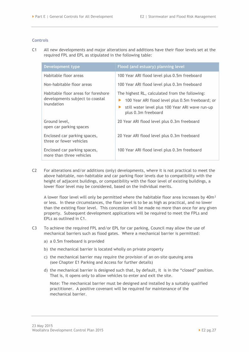
C1 All new developments and major alterations and additions have their floor levels set at the
required FPL and EPL as stipulated in the following table:
Development type Flood (and estuary) planning level
Habitable floor areas 100 Year ARI flood level plus 0.5m freeboard
Non-habitable floor areas 100 Year ARI flood level plus 0.3m freeboard
Habitable floor areas for foreshore
developments subject to coastal
inundation
The highest RL, calculated from the following:
100 Year ARI flood level plus 0.5m freeboard; or
still water level plus 100 Year ARI wave run-up
plus 0.3m freeboard
Ground level,
open car parking spaces
20 Year ARI flood level plus 0.3m freeboard
Enclosed car parking spaces,
three or fewer vehicles
20 Year ARI flood level plus 0.3m freeboard
Enclosed car parking spaces,
more than three vehicles
100 Year ARI flood level plus 0.3m freeboard
C2 For alterations and/or additions (only) developments, where it is not practical to meet the
above habitable, non-habitable and car parking floor levels due to compatibility with the
height of adjacent buildings, or compatibility with the floor level of existing buildings, a
lower floor level may be considered, based on the individual merits.
A lower floor level will only be permitted where the habitable floor area increases by 40m²
or less. In these circumstances, the floor level is to be as high as practical, and no lower
than the existing floor level. This concession will be made no more than once for any given
property. Subsequent development applications will be required to meet the FPLs and
EPLs as outlined in C1.
C3 To achieve the required FPL and/or EPL for car parking, Council may allow the use of
mechanical barriers such as flood gates. Where a mechanical barrier is permitted:
a) a 0.5m freeboard is provided
b) the mechanical barrier is located wholly on private property
c) the mechanical barrier may require the provision of an on-site queuing area
(see Chapter E1 Parking and Access for further details)
d) the mechanical barrier is designed such that, by default, it is in the “closed” position.
That is, it opens only to allow vehicles to enter and exit the site.
Note: The mechanical barrier must be designed and installed by a suitably qualified
practitioner. A positive covenant will be required for maintenance of the
mechanical barrier.
E2 | Stormwater and Flood Risk Management Part E | General Controls for All Development
23 May 2015 E2 pg.28 Woollahra Development Control Plan 2015
C4 Filling of the site, where acceptable to Council, may change the flood and/or coastal
inundation risk for the subject land. The FPL and/or EPL controls is based on the new flood
and/or coastal inundation risk as determined by the new site levels.
Special consideration
C5 All FPLs and EPLs represent the minimum standard required for the development type. An
applicant may seek to lower the minimum FPL and/or EPL. Such requests will be assessed
on their merits. A Flood Risk Management Report and/or a Coastal Inundation Assessment,
prepared by a suitably qualified practitioner, will be required.
Note:
A Flood Risk Management Report and/or Coastal Inundation Assessment must be prepared
by a suitably qualified practitioner and at a minimum it should include the following:
acknowledgement that the proposed development seeks to lower the minimum
standard FPL and/or EPL required by Council’s Stormwater Drainage and Flood Risk
Management Development Control Plan;
proposed risk management measures to minimise the impact of flooding and/or
coastal inundation;
demonstration that the risk management measures will not adversely affect other
properties;
an Emergency Management Plan that includes an evacuation strategy.
C6 For ground level shop fronts in commercial and mixed-use developments, a lower the FPL
and/or EPL may be considered to allow the development to match into existing longitudinal
street levels, to optimise retail potential and/or to provide acceptable access for persons
with disabilities. Such requests will be assessed on their merits. Driveway and footpath
gradients must comply with Council’s specifications.
C7 For heritage conservation properties, a lower FPL and/or EPL may be considered, for the
heritage component of the building only, to remain sympathetic with the heritage values of
the property. In general, any alterations and additions will be required to meet the FPL
and/or EPL as outlined in conditions C1, C2, C3 and C4. Such requests will be assessed on
their merits.
Part E | General Controls for All Development E2 | Stormwater and Flood Risk Management
23 May 2015 Woollahra Development Control Plan 2015 E2 pg.29
E2.3.4 Flood contro ls
Objectives
O1 To minimise risk to people and property.
O2 To ensure that development does not cause flood levels to rise or exacerbate flooding on
the surrounding floodplain.
O3 To ensure existing overland flow paths are maintained and to ensure new structures do not
obstruct the free flow of floodwaters.
O4 To increase flood hazard awareness.
O5 To reduce the long term risks associated with tidal inundation, elevated sea levels and/or
waves overtopping foreshore defences.
O6 To maintain Council’s streetscape objectives in existing commercial and heritage areas.
Controls
General controls which apply to all developments
Note: A plan must accompany the application and provide information on any earthworks or
filling of land (with suitable contour intervals) and the location of existing and proposed fences,
retaining walls and/or any other barriers.
General
C1 All structures have flood compatible building components below the 100 Year ARI level plus
0.5m freeboard.
C2 All electrical equipment (e.g. air conditioners and pool pumps) is located or protected to
above the 100 Year ARI level plus 0.5m freeboard.
C3 All storage areas such as shelving are above the 100 Year ARI level plus 0.5m freeboard.
C4 The structure is built to withstand the forces of floodwater, debris and buoyancy up to and
including the 100 Year ARI level plus 0.5m freeboard.
C5 Reliable evacuation access for pedestrians is provided from the lowest habitable floor area
to a refuge area above the PMF level and designed to withstand PMF water forces.
C6 Suitable flood protection (e.g. a crest up before descent on an access driveway) is provided
within the subject site. Council will not generally allow alteration to existing levels on the
public road or its property to achieve flood protection.
Note: The Building Code of Australia 2013 has requirements relating to minimum
construction standards for specified building classifications in flood hazard areas.
Reference should be made to the Code for further information.
E2 | Stormwater and Flood Risk Management Part E | General Controls for All Development
23 May 2015 E2 pg.30 Woollahra Development Control Plan 2015
Fencing
C7 Fencing is constructed in a manner which does not change the nature or level of flood
waters in the area. Fencing is of a permeable/open type design, however, existing solid
fences may be replaced by new solid fences.
C8 Fencing is adequately constructed so as to withstand the forces of floodwaters.
C9 The flood impact of the development is considered to ensure that the development will not
increase flood effects elsewhere. Where a significant change in use of the site is proposed,
a flood impact assessment is required.
Overland flow paths
C10 All overland flow paths are free of structures which prevent the free passage of overland
flow.
C11 All overland flow paths are designed to convey the 1 in 100 ARI event.
C12 All existing overland flow paths are maintained and the hydraulic capacity of the openings
between buildings is maintained.
C13 Overland flow paths are provided on all properties that have upstream contributing
catchments of 1,000m or greater.
C14 All overland flow paths are designed to a low hazard classification if possible.
C15 Overland flow paths are designed such that they do not increase velocity or concentrate
water on any adjacent property.
C16 In overland flow paths, fencing is generally not be permissible. However, in low and
medium flood risk precincts permeable/open type fences may be approved where it can be
demonstrated that there will be no adverse impact on flooding to the subject land or
surrounding properties.
C17 Any structure located in an overland flow path is designed to be structurally sound in all
flood events. A flood study may be required. Structures are designed by a suitably
qualified practitioner.
C18 If an overland flow path is not achievable, a 1 in100 ARI drainage system may be accepted
as an alternative.
C19 Overland flow paths are grass turfed.
C20 In (sandy) areas with high risk erosion potential, overland flow paths are designed to limit
velocity and/or protect against scour.
Note: Provisional hazard classifications are defined in Appendix L of the
Floodplain Development Manual.
Part E | General Controls for All Development E2 | Stormwater and Flood Risk Management
23 May 2015 Woollahra Development Control Plan 2015 E2 pg.31
Time limit consents
C21 Where an applicant cannot increase EPLs to take into account the sea level rise planning
benchmarks, Council may consider imposing time-limited consent to provide the potential
to remove, replace or adapt development in the future. The consent will require the
development to cease and all structures to be demolished and removed and the site to be
reinstated to a sustainable landscaped form unless a further consent is obtained allowing
for the continuation of the development in its originally approved or modified form.
Council will consider the appropriateness of such developments on the merits of individual
applications.
Note: It is likely that Council would impose a condition which identifies an appropriate and
specific trigger which would require the removal of the development. For example, if the
sea level were to reach a specified height or the erosion of an escarpment receding to a
specified distance from the property boundary.
High flood risk precincts
Note: The high flood risk precinct is where high flood damages, potential risk to life and/or
evacuation problems would be anticipated or where development would significantly or adversely
alter flood behaviour. Development in this precinct requires detailed risk management strategies
and careful design to reduce the risk to life and property to an acceptable level.
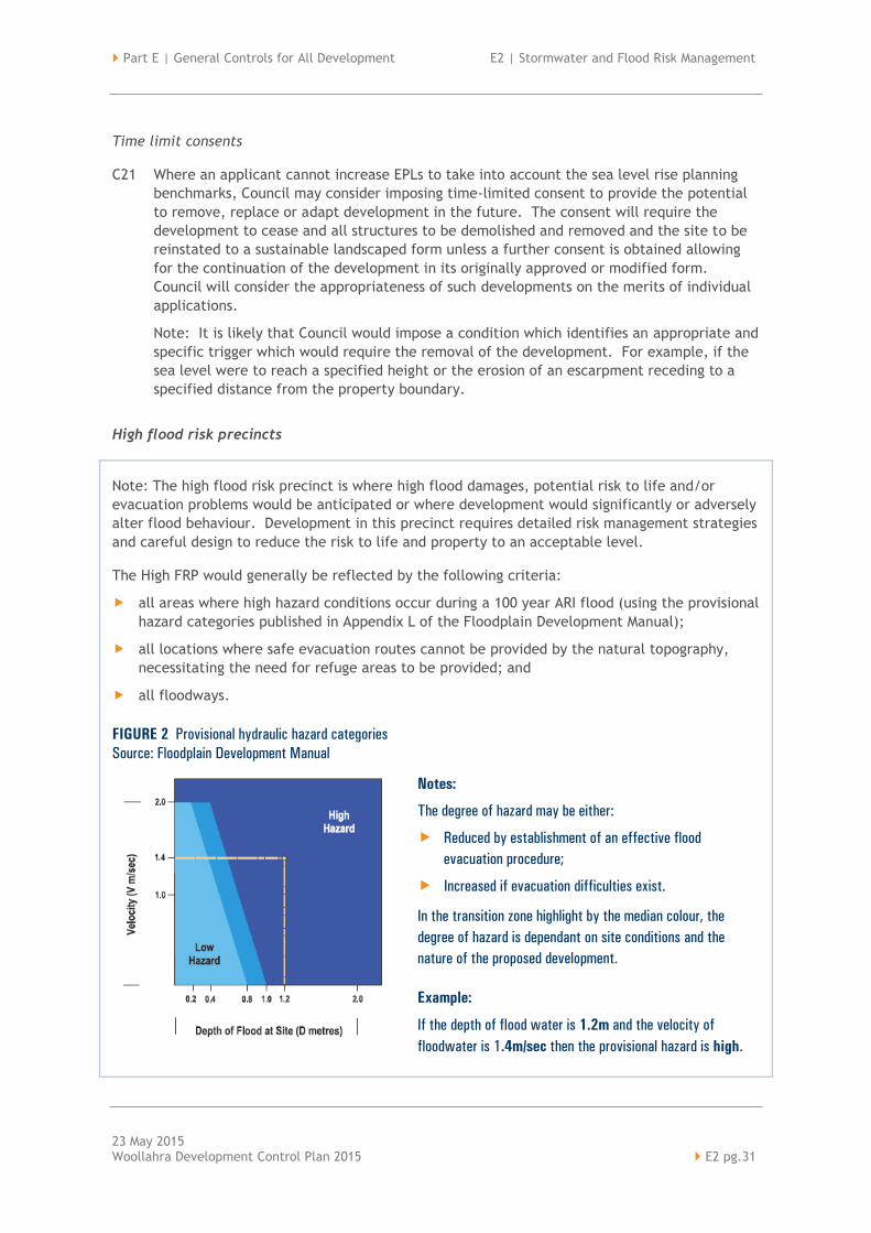
The High FRP would generally be reflected by the following criteria:
all areas where high hazard conditions occur during a 100 year ARI flood (using the provisional
hazard categories published in Appendix L of the Floodplain Development Manual);
all locations where safe evacuation routes cannot be provided by the natural topography,
necessitating the need for refuge areas to be provided; and
all floodways.
FIGURE 2 Provisional hydraulic hazard categories
Source: Floodplain Development Manual
Notes:
The degree of hazard may be either:
Reduced by establishment of an effective flood
evacuation procedure;
Increased if evacuation difficulties exist.
In the transition zone highlight by the median colour, the
degree of hazard is dependant on site conditions and the
nature of the proposed development.
Example:
If the depth of flood water is 1.2m and the velocity of
floodwater is 1.4m/sec then the provisional hazard is high.

E2 | Stormwater and Flood Risk Management Part E | General Controls for All Development
23 May 2015 E2 pg.32 Woollahra Development Control Plan 2015
C22 Properties within a high flood risk precinct are unsuitable for all development (except
alterations and additions (only) developments) unless a Flood Risk Management Report has
been prepared, by a suitably qualified practitioner, outlining appropriate risk management
measures.
C23 Buildings or structures constructed in high flood risk precincts are designed to withstand
the PMF event.
C24 No new fencing of any type is permitted in high flood risk precincts unless it can be
demonstrated, by a suitably qualified practitioner, that there will be no adverse impact on
flooding to the subject land or surrounding properties.
Medium flood risk precincts
Note: The medium risk precinct includes all land that is inundated by the 100 year ARI flood that
is not classified as high risk. Areas on the edge of the identified 100 year ARI floodplain where
the topography provides low hazard rated excavation routes (using the provisional hazard criteria
published in Appendix L of the Floodplain Development Manual) would generally be classified as
medium risk.
C25 Properties within a medium flood risk precinct are generally unsuitable for critical and
sensitive use development. Such developments will be considered on their merits, taking
into account any proposed risk management measures.
C26 In medium flood risk precincts, impervious and continuous fencing is not permissible unless
it can be demonstrated that there will be no adverse impact on flooding to the subject
land or surrounding land.
Low flood risk precincts
Note: In the low flood risk precinct the likelihood of damages, occurring from flooding, is low.
This area can be identified as land within the floodplain that is above the 100 year ARI flood but
below the extent of the PMF.
C27 For critical and sensitive developments in low flood risk precincts, all habitable and non-
habitable floor levels are no lower than the PMF flood level.
C28 For critical and sensitive developments in low flood risk precincts, all structures have flood
compatible building components below the PMF flood level.
C29 For critical and sensitive developments in low flood risk precincts, the applicant is to
demonstrate that any structure can withstand the forces of floodwater, debris and
buoyancy up to and including the PMF flood level.

Part E | General Controls for All Development E2 | Stormwater and Flood Risk Management
23 May 2015 Woollahra Development Control Plan 2015 E2 pg.33
Other flood prone properties
Note: There are four main floodplains within the Woollahra Municipality: Rushcutters Bay,
Double Bay, Rose Bay and Watsons Bay. A property may be flood prone if it is outside of the
identified four floodplains, but subject to overland flows due to one of the following
characteristics:
the property is on the low side of the road and/ or the boundary levels are below the level
of Council’s kerb;
the property is lower than surrounding properties;
the property is in a natural low point, gully or depression; or
the property is adjacent to or contains a flow path, open channel, watercourse or
drainage line.
A property may also be flood prone if it is outside of the identified four floodplains, but subject
to one of the following characteristics:
the property fronts Sydney Harbour with any part of the land below RL 3.35m AHD;
the development includes underground habitable areas; or
the development includes a low level driveway or an underground car park.
C30 Where a property is outside of the four flood plains, but identified as flood prone,
a site specific assessment is required. A flood analysis may be requested to determine the
level of flood risk and to allow the setting of FPLs.
Note: A Flood Risk Management Report prepared, by a suitably qualified practitioner,
outlining appropriate risk management measures may be required.
E2 | Stormwater and Flood Risk Management Part E | General Controls for All Development
23 May 2015 E2 pg.34 Woollahra Development Control Plan 2015
Appendix 1 – Definit ions
The definitions in this appendix define words and expressions for the purpose of this chapter.
Other terms may be defined in other parts of the DCP, the Woollahra LEP 2014, and other
publications including the NSW Government’s Floodplain Management Manual: The Management
of Flood Liable Land.
absorption system an excavation that has been filled with material or prefabricated void
units that are conducive to the drainage of stormwater and which are
designed to drain vertically or side-ways, into adjacent sub-surface in-
situ void or fill material.
alterations and
additions (only)
developments
applies to the following developments:
residential development where the proposed development is an
addition and/or alteration to an existing dwelling of not more than
40m² or 10% (whichever is the lesser) of the habitable floor area
which existed at the date of commencement of this DCP;
development other than residential where the proposed development
is an addition to existing buildings of not more than additional 100m²
or 10% (whichever is the lesser) of the floor area which existed at the
date of commencement of this DCP (whichever is the lesser).
charged or siphonic
systems
use the height of the building to create a pressurised stormwater system.
This allows the system to draw water out of the gutters at higher
velocities and flow rates. The drainage line permanently holds water.
coastal inundation is the storm-related flooding of coastal lands by ocean waters due to
elevated still water levels (storm surge) and wave run-up.
commercial and
mixed-use
development
applies to all properties zoned Neighbourhood Centre, Local Centre,
Mixed Use in Woollahra LEP 2014.
critical and sensitive
developments
applies to the following types of developments: Emergency services
facilities; public administration building that may provide an important
contribution to the notification or evacuation of the community during
flood events (e.g. SES Headquarters and Police Stations); hospitals;
community facility; telecommunications facility; institutions; educational
establishments; child care facilities; liquid fuel depot; public utility
undertaking (including electricity generating works; sewerage treatment
plant; sewerage system; telecommunications facility; utility installations
and water treatment facility) which are essential to evacuation during
periods of flood or if affected would unreasonably affect the ability of
the community to return to normal activities after flood events;
residential care facility; school and seniors housing.
Part E | General Controls for All Development E2 | Stormwater and Flood Risk Management
23 May 2015 Woollahra Development Control Plan 2015 E2 pg.35
developments
creating high levels
of pollutants
may include, but is not limited to the following: service stations; motor
repair shops; panel beaters; miscellaneous automotive; marinas;
boatsheds; marine repairs; shipbuilders; commercial slipways;
miscellaneous retailers and manufacturers involving chemicals, solvents,
hazardous waste and containers; miscellaneous retailers and
manufacturers involving garden and building materials; vehicle depots;
and car parks.
enclosed car parking car parking which is potentially subject to rapid inundation, which
consequently increases danger to human life and property damage (such
as basement of bunded car parking areas). The following criteria apply
for the purposes of determining what is enclosed car parking:
flooding of surrounding areas may raise water levels above the
perimeter which encloses the car park (normally the entrance),
resulting in rapid inundation of the car park to depths greater than
0.8m, and
drainage of accumulated water in the car park has an outflow
discharge capacity significantly less than the potential inflow
capacity.
Epoch for determining design flood levels refers to a year in the future for
which flood level probabilities are calculated. For example, the notation
100 Year ARI 2050 refers to the 100 year ARI flood level (or 1% AEP flood
level) at the Year 2050 Epoch. This is a prediction made now (based on
the best available information) of the flood level which has a 1%
probability of occurring or being exceeded in 2050. Similarly, the
Year 2100 Epoch refers to the flood level which has a 1% probability
of occurring or being exceeded in 2100.
flood evacuation
strategy
the proposed strategy for the evacuation of flood prone areas.
flood risk precincts
(FRPs)
are a categorisation of a site’s flood risk for land-use planning purposes.
All property within a floodplain falls into one of three classifications:
low, medium or high.
foreshore
developments
includes all properties with any part of their land below RL 3.35m AHD.
foreshore inundation the inundation of land occurring when water from Sydney Harbour
overflows the natural or human-made foreshore boundary. All properties
with any part of their land below RL 3.35m AHD may be impacted by
foreshore inundation.

E2 | Stormwater and Flood Risk Management Part E | General Controls for All Development
23 May 2015 E2 pg.36 Woollahra Development Control Plan 2015
freeboard a factor of safety typically used in relation to the setting of flood
planning levels. It compensates for uncertainties in the estimation of
flood levels across the floodplain, such as wave action, localised
hydraulic behaviour and impacts that are specific event related,
such as levee and embankment settlement, and other effects such as
sea level rise.
green roofs a roof system, with a dual function. It designed to promote the growth
of various forms of vegetation on the top of buildings. It is also designed
to support various forms of renewable energy and water collection
technology to assist in supplying power and water to the occupants of
the building.
habitable floor area as defined in the Floodplain Development Manual: The Management of
Flood Liable Land.
local overland
flooding
as defined in the Floodplain Development Manual: The Management of
Flood Liable Land.
Note: All properties containing a Council owned pipe and/ or a drainage
easement are subject to local overland flooding. All properties with low
level driveways, footpaths or where their boundary levels are below the
level of Council’s kerb are subject to local overland flooding.
low level property any property where the property falls away from the road reserve. That
is, the grade or level of the land generally falls from the front to rear
boundary. Stormwater from the property generally falls towards a
neighbour’s property at the side or rear (rather than to Council’s road).
mainstream flooding as defined in the Floodplain Development Manual: The Management of
Flood Liable Land.
Note: Properties that are situated adjacent to an open or covered
channel or watercourse may be impacted by mainstream flooding.
major alterations
and additions
applies to the following developments:
residential development where the proposed development is an
addition and/or alteration to an existing dwelling of more than an
additional 40m² or 10% (whichever is the lesser) of the habitable
floor area which existed at the date of commencement of this DCP;
development other than residential where the proposed development
is an addition to existing buildings of more than an additional 100m²
or 10% (whichever is the lesser) of the floor area which existed at the
date of commencement of this DCP (whichever is the lesser).
Part E | General Controls for All Development E2 | Stormwater and Flood Risk Management
23 May 2015 Woollahra Development Control Plan 2015 E2 pg.37
on-site detention
systems
holding ponds that temporarily store stormwater to control and reduce
downstream flow rates. They are designed to retard stormwater during
intense rainfall and to empty once the peak of the storm has passed.
overland flow paths above ground drainage paths that form a critical part of the drainage
system. They convey stormwater when the stormwater volume is greater
than the designed pipe systems capacity.
pervious surface a paving system that allows water to infiltrate through pores in the
pavement and is stored in voids until it can percolate through the natural
ground. Pervious surfaces include, but are not limited to, porous
asphalt, porous concrete and modular pavers.
pump and sump
systems
a pump that is used to remove water that has accumulated in a sump
basin, often in underground areas such as car parks. The sump pump is
used to send water away from the house.
rain garden a planted depression that captures rainwater runoff from impervious
urban areas such as car parks. The rain garden serves two main
purposes. It reduces stormwater runoff through absorption into the
ground and transpiration. Secondly, the plants grown within the rain
gardens capture pollutants and reduce the amount of pollution which is
then released to Council’s stormwater system.
refuge area an area of land located above the PMF that provides reasonable shelter
for the likely occupants of the development commensurate with the
period of time that refuge is likely to be required in floods up to
the PMF.
residential
development
applies to all properties zoned Low Density Residential and Medium
Density Residential in Woollahra LEP 2014.
site emergency
response flood plan
a management plan that demonstrates the ability to safely evacuate
persons and includes a strategy to move goods above the flood level
within the available warning time. This Plan must be consistent with any
relevant flood evacuation strategy, flood plan or similar plan.
stormwater untreated rain water that runs off the land onto which it falls.
suitably qualified
practitioner
a professional with the appropriate qualifications, experience and skills
to undertake the task. All suitably qualified practitioners should have
appropriate professional indemnity insurance.

E2 | Stormwater and Flood Risk Management Part E | General Controls for All Development
23 May 2015 E2 pg.38 Woollahra Development Control Plan 2015
wave run-up and
overtopping
the process where a wave reaches the foreshore, and an “uprush” of
water onto the foreshore will occur. The height of wave run-up is
affected by the nature of the foreshore. In some instances a wave may
propagate over the foreshore edge and further landward, which is called
wave overtopping. Wave run-up cannot occur up a vertical seawall and
in these cases the hazard is related exclusively to wave overtopping.
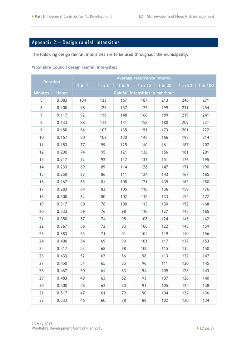
Part E | General Controls for All Development E2 | Stormwater and Flood Risk Management
23 May 2015 Woollahra Development Control Plan 2015 E2 pg.39
Appendix 2 – Design rainfa l l intensit ies
The following design rainfall intensities are to be used throughout the municipality.
Woollahra Council design rainfall intensities
Duration Average recurrence interval
1 in 1 1 in 2 1 in 5 1 in 10 1 in 20 1 in 50 1 in 100
Minutes Hours Rainfall intensities in mm/hour
5 0.083 104 133 167 187 213 246 271
6 0.100 98 125 157 175 199 231 254
7 0.117 92 118 148 166 189 219 241
8 0.133 88 112 141 158 180 209 231
9 0.150 84 107 135 151 173 201 222
10 0.167 80 102 130 146 166 193 214
11 0.183 77 99 125 140 161 187 207
12 0.200 74 95 121 136 156 181 201
13 0.217 72 92 117 132 151 176 195
14 0.233 69 89 114 128 147 171 190
15 0.250 67 86 111 124 143 167 185
16 0.267 65 84 108 121 139 162 180
17 0.283 64 82 105 118 136 159 176
18 0.300 62 80 102 115 133 155 172
19 0.317 60 78 100 113 130 152 168
20 0.333 59 76 98 110 127 148 165
21 0.350 57 74 95 108 124 145 162
22 0.367 56 72 93 106 122 143 159
23 0.383 55 71 91 104 119 140 156
24 0.400 54 69 90 101 117 137 153
25 0.417 53 68 88 100 115 135 150
26 0.433 52 67 86 98 113 132 147
27 0.450 51 65 85 96 111 130 145
28 0.467 50 64 83 94 109 128 143
29 0.483 49 63 82 93 107 126 140
30 0.500 48 62 80 91 105 124 138
31 0.517 47 61 79 90 104 122 136
32 0.533 46 60 78 88 102 120 134

E2 | Stormwater and Flood Risk Management Part E | General Controls for All Development
23 May 2015 E2 pg.40 Woollahra Development Control Plan 2015
Duration Average recurrence interval
1 in 1 1 in 2 1 in 5 1 in 10 1 in 20 1 in 50 1 in 100
Minutes Hours Rainfall intensities in mm/hour
33 0.550 46 59 77 87 101 118 132
34 0.567 45 58 75 86 99 117 130
35 0.583 44 57 74 84 98 115 128
36 0.600 43 56 73 83 96 113 126
37 0.617 43 55 72 82 95 112 125
38 0.633 42 55 71 81 94 110 123
39 0.650 42 54 70 80 92 109 121
40 0.667 41 53 69 79 91 107 120
41 0.683 40 52 68 78 90 106 118
42 0.700 40 52 67 77 89 105 117
43 0.717 39 51 67 76 88 103 115
44 0.733 39 50 66 75 87 102 114
45 0.750 38 50 65 74 86 101 113
46 0.767 38 49 64 73 85 100 111
47 0.783 37 48 63 72 84 99 110
48 0.800 37 48 63 71 83 97 109
49 0.817 37 47 62 70 82 96 108
50 0.833 36 47 61 70 81 95 106
51 0.850 36 46 60 69 80 94 105
52 0.867 35 46 60 68 79 93 104
53 0.883 35 45 59 67 78 92 103
54 0.900 35 45 59 67 77 91 102
55 0.917 34 44 58 66 77 90 101
56 0.933 34 44 57 65 76 89 100
57 0.950 33 43 57 65 75 89 99
58 0.967 33 43 56 64 74 88 98
59 0.983 33 42 56 63 74 87 97
60 1 32 42 55 63 73 86 96
90 1.5 25 33 43 49 57 67 75
120 2 21 27 36 41 47 56 63
180 3 16 21 27 31 36 43 48
240 4 13 17 22 26 30 35 39
300 5 11 15 19 22 26 30 34
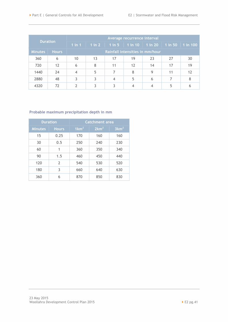
Part E | General Controls for All Development E2 | Stormwater and Flood Risk Management
23 May 2015 Woollahra Development Control Plan 2015 E2 pg.41
Duration Average recurrence interval
1 in 1 1 in 2 1 in 5 1 in 10 1 in 20 1 in 50 1 in 100
Minutes Hours Rainfall intensities in mm/hour
360 6 10 13 17 19 23 27 30
720 12 6 8 11 12 14 17 19
1440 24 4 5 7 8 9 11 12
2880 48 3 3 4 5 6 7 8
4320 72 2 3 3 4 4 5 6
Probable maximum precipitation depth in mm
Duration Catchment area
Minutes Hours 1km2 2km2 3km2
15 0.25 170 160 160
30 0.5 250 240 230
60 1 360 350 340
90 1.5 460 450 440
120 2 540 530 520
180 3 660 640 630
360 6 870 850 830