Chapter 9 · 2.2 Identification and analysis of the potential impacts ... economic activities...
24
Page intentionally left blank Chapter 9 adaptive management 9. Adaptive management ..............................303 9.1 Introduction ................................................303 9.2 Adaptive management ...............................304 9.3 Ecologically sustainable development .......306 9.4 Governance ...............................................307 9.5 Compliance ................................................308 9.6 Monitoring ..................................................312 9.7 Reporting...................................................321 9.8 Independent scientific input.......................323 9.9 The way forward ......................................323
Transcript of Chapter 9 · 2.2 Identification and analysis of the potential impacts ... economic activities...

Page intentionally left blank
Chapter 9adaptive management
9. Adaptive management ..............................3039.1 Introduction ................................................3039.2 Adaptive management ...............................3049.3 Ecologically sustainable development .......3069.4 Governance ...............................................3079.5 Compliance ................................................3089.6 Monitoring ..................................................3129.7 Reporting...................................................3219.8 Independent scientific input.......................3239.9 The way forward ......................................323

Page intentionally left blank
Extract from Great Barrier Reef Coastal Zone Strategic Assessment terms of reference2.2 Identification and analysis of the potential impactsThe Strategic Assessment Report must describe how potential future impacts of activities taken under the Program are identified and taken into account in relevant decision making processes, in the context of past and existing impacts as described in Section 2.1 above.……… In doing so, the Strategic Assessment Report must:……… (f) describe how social and economic impacts and issues are considered and assessed……… 2.3 Measures to avoid, mitigate and offset impactsThe Strategic Assessment Report must describe the avoidance, mitigation and offsetting measures that are proposed for future activities taken under the Program and analyse the effectiveness of these measures in protecting and enhancing MNES including OUV. This analysis may use demonstration cases to illustrate the application and effectiveness of particular measures and approaches and must include, but not be limited to:……… (f) analysing resourcing, monitoring, evaluation and compliance regimes.……… 3 Promoting Ecologically Sustainable DevelopmentThe Strategic Assessment Report must describe how the principles of ecologically sustainable development have been applied in the Program.4 Adaptive management: addressing uncertainty and managing riskThe Strategic Assessment Report must identify the key adaptive management measures addressing uncertainties and risks inherent in the decision making process. Uncertainties could include knowledge gaps in scientific understanding and the timing, effectiveness, or capacity to implement, maintain, operate and enforce management measures.The Strategic Assessment Report must describe how the adaptive management strategies will be implemented under the Program to ensure MNES including OUV are effectively protected over the life of the Program. This includes:(a) how the monitoring of MNES including OUV will occur, how the monitoring will be analysed throughout the life of the Program and how the results of the monitoring will influence the Program(b) how new information relating to MNES, OUV or the Program is to be assessed and accounted for in management of the area affected by the Program.5 Auditing and reportingThe Strategic Assessment Report must describe:(a) a monitoring, review and public reporting process to ensure implementation of the Program continues to adequately protect MNES including OUV(b) the parties responsible for undertaking the monitoring, review, reporting and implementation of the activities arising.6 Review, modification or abandonmentThe Strategic Assessment Report must identify and analyse the likely circumstances and procedures that may result in the review, modification or abandonment of the Program. This is to include a discussion of how any commitments under the Program will continue to be met under these situations.

GREAT BARRIER REEF COASTAL ZONE STRATEGIC ASSESSMENT9-303 Strategic Assessment Report
CHAP
TER
9 l a
dapt
ive
man
agem
ent
Strategic Assessment Report
9. Adaptive management
Values Management
1. Background
2. Social and economic context
3. Assessment approach
4. Condition & trend
5. Pressures
6. Projected condition
7. Program summary
8. Program effectiveness
9. Adaptive management
10. Recommended changes
STRATEGIC ASSESSMENT REPORT
9.1 Introduction
Adaptive management involves continually monitoring a process to evaluate its effectiveness, and improving the process based on this evaluation. It requires transparent planning systems and implementation strategies, and a strong emphasis on monitoring and reviewing to ensure emerging information is reflected in future planning. The Queensland Government is committed to the principles of adaptive management and the continuous improvement of the Queensland Government Program to protect MNES. To ensure ongoing protection and management within the GBR coastal zone, the Queensland Government will continue to base its management on using the best available information, with the capacity to make continual improvements as new information emerges.
The Program includes a regulatory framework which provides a wide range of monitoring, audit, compliance, and enforcement powers. Complementing the regulatory management framework are long-term monitoring and reporting programs reporting at different spatial scales – from those covering the entire GBR to those working at regional and/or value specific scales. Together these monitoring activities improve the effectiveness of the Program as a whole to improve outcomes for MNES. The monitoring program is enhanced further by ensuring that the findings of scientific and other research is considered when adapting Program components. This chapter details how adaptive management has been applied in the Queensland Government Program. This includes the use of compliance, monitoring, auditing, review and reporting processes to inform and allow for the continued effectiveness of

GREAT BARRIER REEF COASTAL ZONE STRATEGIC ASSESSMENT9-304 Strategic Assessment Report
CHAP
TER
9 l a
dapt
ive
man
agem
ent
Strategic Assessment Report
the Program. The information gathered from monitoring activity will then be used to update the Program components to better identify, protect and manage MNES. The application of the principles of ESD in the development of the Queensland’s Program is also outlined in this chapter. Information from the adaptive management process is also used to update the knowledge underpinning ESD within the Program.
Figure 9.2 1 Adaptive management process applied by the Queensland Government Source: State of Environment, 2012
9.2 Adaptive management
Adaptive management allows for best practice environmental management to be implemented as technologies develop over time. Adaptive management frameworks are widely used to address unknown and unintended impacts when making important management decisions. Figure 9.2 1 below illustrates the stages involved in adaptive management.

GREAT BARRIER REEF COASTAL ZONE STRATEGIC ASSESSMENT9-305 Strategic Assessment Report
CHAP
TER
9 l a
dapt
ive
man
agem
ent
Strategic Assessment Report
The Queensland Government has a history of adaptive management in environmental management and has demonstrated the capacity to address emerging issues over the last three decades, for example the introduction during the 1990s of legislation to improve the ongoing protection of the environment (see section 1.5). Continued adaptive management will be underpinned by the best available information from a range of sources.The 2009 Outlook Report identified a number of deficiencies in the management of coastal development. These concerns have been addressed through the evolution of Queensland’s highly sophisticated planning system and more recently the draft Queensland Ports Strategy and State Planning Policy.
The management systems in place include mechanisms to ensure management adapts to new information. The effectiveness varies across the management components. For example, clearer mechanisms are in place for adaptive management of the Wet Tropics WHA compared to other MNES. Nevertheless, stakeholders are regularly engaged in management decisions as they relate to MNES. Public reporting mechanisms such as state of the environment reporting underpin management decisions. As with any adaptive management system, there are often delays between the collection of new information (e.g. recovery actions for threatened species) and implementation of new actions to improve the management effectiveness of the Queensland programs.
9.2.1 Summary of effectiveness
Management effectiveness component
Grading Confidence Trend Summary of evidence
Demonstrated ability to adapt system over time to incorporate new knowledge
Partially effective
Limited Improving There have been demonstrated examples of the Queensland Government responding to new information and adapting management. The forward commitments outlined in the strategic assessment provide further evidence of this. Governance arrangements are relatively strong across the management components but could be strengthened in some areas such as coastal management.
Partially effective: Management systems provide some guidance, but are not consistently delivering around implementation of management actions, stakeholder engagement, adaptive management or reporting.

GREAT BARRIER REEF COASTAL ZONE STRATEGIC ASSESSMENT9-306 Strategic Assessment Report
CHAP
TER
9 l a
dapt
ive
man
agem
ent
Strategic Assessment Report
9.3 Ecologically sustainable development
Coastal development represents one of the most challenging areas in which to balance the principles of ESD. The GBR coastal zone includes a range of unique biodiversity values that need to be protected, and it is also a mixed use area where almost one million people live, many people visit and a range of economic activities occur. While much of the GBR coastline remains in excellent condition or is well protected, maintaining a balance between coastal development and environmental protection is a challenge.Queenslanders expect governments to ensure that there is continuing economic, social and environmental well-being in the GBR coastal zone. The Queensland Government Program is designed to allow economic development to occur in a balanced and incremental way, whilst maintaining strong protection for the key values in the GBR coastal zone. The endorsement criteria for an EPBC Act strategic assessment require the principles of ESD to be considered as part of the assessment process. The way in which the Queensland Government Program achieves the principles of ESD is outlined below:3A (a) decision-making processes should effectively integrate both long-term and short-term economic, environmental, social and equitable considerations.The Program demonstrates the effective integration of economic, environmental and social considerations in an equitable manner for the short- and long-term by identifying a range of outcomes that provide for economic, social and environmental benefits. The environmental benefits include a strong plan to concentrate development around key nodes and to avoid significant high value areas critical to MNES. The strategic assessment approach is considered to be far more effective in identifying, planning and supporting environmental outcomes than individual, project-by-project assessments.The GBR coastal zone contains important supply chain links inland to Queensland’s rich resource deposits. Efficient, well connected ports are vital to Queensland’s export reliant economy, and to the Australian economy. The coal industry alone exported $31 billion through Queensland ports in 2011-12 . The liquefied natural gas industry is projected to export a further $3.2 billion 138 out of Queensland ports. Currently 34 000 people are directly employed by the coal industry, and the LNG industry is projected to support an additional 18 000 jobs by 2020 138.While Queensland major bulk commodity ports are located along the GBR coast, maintenance of a healthy and resilient GBRWHA will also underpin the tourism industry which generates over $5.7 billion per year to the Queensland economy and more than 54 000 jobs directly 138.
Activities within the catchments adjacent to the GBR are also important to the Queensland economy, with the beef, sugarcane and horticulture industries contributing approximately $3.7 billion a year in gross value of production, and supporting significant regional employment 35.Recreational fishing provides an important social and economic benefit to Queenslanders and helps support the tackle and boating industry. In addition, recreational fishing provides an economic stimulus to local businesses which benefit when recreational fishers visit their local area. An estimated 600 000 recreational fishing days occur in GBR coastal waters. In fishing regions adjacent to the GBR, coral trout, redthroat emperor, morwong and sweetlip form a key part of the harvest. More than 400 000 coral reef fin fish were caught by recreational fishers in the GBR coastal waters, with approximately half of these being released back into the water.The Queensland Government Program provides an equitable approach to ensure sustainable development can occur, in balance with appropriate environmental protection. 3A (b) if there are threats of serious or irreversible environmental damage, lack of full scientific certainty should not be used as a reason for postponing measures to prevent environmental degradation (the Precautionary Principle)The precautionary principle is enshrined in Queensland’s planning system and provides guidance for all future land use planning decision-making (at state, regional and local levels) under the Queensland Government Program. In particular, applying the precautionary principle in decision-making processes, such as when preparing a planning instrument, is required in order to advance the purpose of the SP Act. In application, the Program will ensure that where there is scientific uncertainty, the Queensland Government will seek to use the best available evidence to inform decision-making, including advice through public consultation. The Queensland Government is actively seeking to improve the consideration of cumulative impacts and will work closely with the GBRMPA and the Australian Government to develop a robust and consistent methodology.Scientific knowledge of the key risks are presented in the State of the Environment Report every four years. The Queensland Government will seek to ensure that this reporting will specifically capture information on MNES in the future. 3A (c) the principle of inter-generational equity – that the present generation should ensure that the health, diversity and productivity of the environment is maintained or enhanced for the benefit of future generationsThe principle of intergenerational equity is enshrined in Queensland’s planning system.

GREAT BARRIER REEF COASTAL ZONE STRATEGIC ASSESSMENT9-307 Strategic Assessment Report
CHAP
TER
9 l a
dapt
ive
man
agem
ent
Strategic Assessment Report
The Queensland Government Program will seek to manage impacts on MNES in the GBR coastal zone by having a strong hierarchy of identifying, avoiding, mitigating and offsetting likely impacts. A more strategic approach to offsets will ensure that there is net gain of MNES, that the values underpinning MNES are protected and enhanced for future generations, and that the services they provide will continue.The Queensland Government will continue to invest in programs addressing the legacy of past land use, such as the Reef Water Quality Protection Plan, which presents one of the most valued opportunities to improve the condition of the GBR coastal zone for future generations.3A (d) the conservation of biological diversity and ecological integrity should be a fundamental consideration in decision-making Environmental considerations, including maintaining the OUV of the WHAs, are fundamentally integrated into Queensland’s planning development and managementsystems. The availability of mapping in relation to environmental matters is a valuable tool that can be used and integrated into state and local decision-making. Forward commitments under the Queensland Government Program will require consideration of important biodiversity values by state and local government in planning activities, to support the protection of biological diversity and ensure the integrity of the GBR environment.The Program will deliver substantial conservation outcomes, particularly by concentrating development around key nodes and offsetting unavoidable impacts in a way that will achieve net gain of MNES. 3A (e) Improved valuation, pricing and incentive mechanisms should be promotedThe strategic assessment represents a significant positive incentive for development to occur in an ecologically sustainable manner. It identifies the environmental values that could be affected and the systems for managing potential impacts of certain proposed actions, and provides incentives for responsible development to occur in well planned areas where impacts can be avoided, minimised of offset. Improvements to the offsets policy, including strategic offsets and the more effective use of monetised offsets will deliver more strategic outcomes and will seek to achieve net gain of MNES.
9.4 Governance
Coastal management is a highly complex jurisdictional issue, with all levels of government involved, as well as a wide variety of stakeholders including industry, conservation groups and landcare, and regional NRM bodies. Stakeholders are regularly engaged in decision-making through a range of forums and there
are arrangements between the Queensland and Australian governments which focus on various management areas. The Great Barrier Reef Intergovernmental Agreement 2009 between the Australian and Queensland governments establishes the governance arrangements for the protection and management of the GBR. The Agreement provides an opportunity to ensure collaborative and complementary management arrangements for the GBR and facilitates ongoing joint adaptive management. Similarly, the intergovernmental agreement for the Wet Tropics WHA facilitates the same adaptive management for that area.The complexity of management in the GBR coastal zone and the uniqueness of the collaborative arrangements established under the Intergovernmental Agreement were noted in a report by the House of Representatives Joint Standing Committee on Climate Change, Water, Environment and the Arts assessing Australia’s preparedness to manage the coast in a changing climate 152. Recommendations were made that these arrangements be investigated as a pilot for improved integrated coastal zone management in Australia. As part of a project funded through the National Environmental Research Program, Dale et al. 31, undertook a preliminary risk assessment of the governance arrangements in place for the GBR. Broadly, Dale et al. 31 found that there are strong governance arrangements in place for fisheries management, water resource planning and research. There are also a number of areas where governance arrangements have stabilised in recent years including reef water quality and regional NRM programs. Some management areas are finely balanced on the divide between significant risk of failure or potential success, where the consequences of system failure are important but not catastrophic. This includes the reef protection regulations, agricultural property planning and Indigenous governance. Dale et al. 31 identified that there are some areas where there is a risk of governance failure and recommend there needs to be a clearer cumulative impact assessment, more streamlined and coordinated assessment processes, integrated monitoring programs, and a market framework for ecosystem services.Building on the learnings from the Reef Plan, and as an outcome from the strategic assessment, the Queensland and Australian governments are scoping a GBR Long Term Sustainability Plan to guide joint management. This will ensure a coordinated approach to adaptive management, address some of the potential governance risks, and in part respond to the World Heritage Committee’s recommendations for a sustainable development plan for the GBRWHA.The Queensland Government agencies responsible for various aspects of the Program are provided in chapter 6 of the program report.

GREAT BARRIER REEF COASTAL ZONE STRATEGIC ASSESSMENT9-308 Strategic Assessment Report
CHAP
TER
9 l a
dapt
ive
man
agem
ent
Strategic Assessment Report
9.5 Compliance
Each piece of Queensland’s legislation has built in compliance mechanisms. DEHP undertakes the majority of compliance activities in relation to environmental matters and uses a regulatory compliance program to achieve Queensland’s legislated obligations. It is founded on a targeted and transparent approach to compliance, supported by a modern and strong enforcement program. DEHP carries out two main types of compliance activity to ensure risks are being managed appropriately:• Reactive compliance: DEHP responds to reports about
incidents that affect the environment and natural resources. These reports can come from members of the public, industry self-reporting or from monitoring programs. This responsive work drives remedial and/or enforcement action on a site-by-site basis.
• Proactive compliance: DEHP plans a variety of compliance activities throughout the year aimed at addressing risks before they become problems, many of which would be irreversible.
Major compliance incidents are those regarded as severe and become priority matters for the Queensland Government. The distribution of major incidents across the state varies according to the types of industries, their potential risks, and the environmental impacts of the activities that are undertaken. As part of the strategic assessment, the Queensland Government will continue to engage in proactive compliance activities targeted towards addressing emerging, large scale, or ongoing environmental threats. These activities are: • Regulating environmentally relevant activities – mining and
energy development, waste, water, sewage, chemical storage, motor vehicle workshops, and oil and gas processes. Consequently, the major activities requiring environmental approvals are mining and energy extraction, transport and treatment of regulated waste, chemical storage, sewage treatment, and compost manufacturing and fuel burning activities.
• Annual Compliance Plans set out the proactive compliance activities in each of the areas that it regulates. The plans include programs linked to the key regulatory areas of coastal and inland waters, environmental management, Queensland heritage conservation, Indigenous heritage conservation, land management, estate management, vegetation management, wildlife and ecosystems, and water supply.
• Planned compliance inspections are conducted at a number of sites licensed under the EP Act. These comprise localities undertaking activities considered to be high risk, where the
environmental significance demands particular attention and emerging problems or trends pose new risks which need to be managed. The public interest and concerns raised also demand focused attention. Inspections are concentrated on certain catchments, particular industrial estates’ activities and certain licensable activities. For example, hazardous wastes activities such as recycling, storage, transport and disposal of regulated wastes around the Cairns, Gold Coast, Mackay, and Townville areas. During 2010-2011, the Queensland Government undertook 1131 planned inspections of licensed activities, focusing primarily on inspections of licensed sites posing the greatest environmental risk.
• Compliance under the Program is performed by a number of Queensland state agencies including:
• Department of Environment and Heritage Protection (DEHP)• Department of State Development, Infrastructure and
Planning (DSDIP)• Department of Natural Resources and Mines (DNRM)• Department of Agriculture, Fisheries and Forestry (DAFF).A number of Program components have compliance requirements and these are outlined below.
9.5.1 Environmental Protection Act and
Economic Development Act
The EP Act provides for compliance and enforcement penalties and is administered by DEHP. In 2011–12, the department secured a range of penalties and more than $2.2 million in fines and costs. The department’s Service Delivery Statement also included as a service standard the number of sites engaging in activities regulated under the EP Act inspected for compliance under the following levels: • Level A (Basic inspections)• Level B (Condition audit)• Level C (Performance audit).
GREAT BARRIER REEF COASTAL ZONE STRATEGIC ASSESSMENT9-309 Strategic Assessment Report
CHAP
TER
9 l a
dapt
ive
man
agem
ent
Strategic Assessment Report
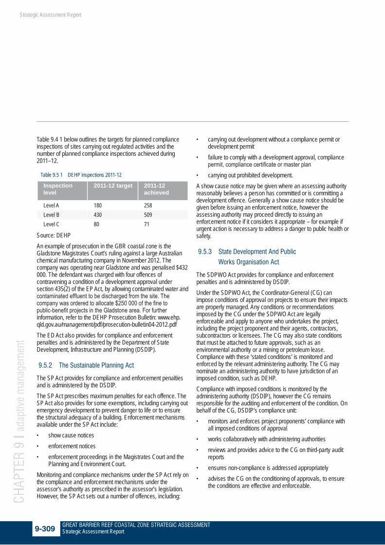
Table 9.4 1 below outlines the targets for planned compliance inspections of sites carrying out regulated activities and the number of planned compliance inspections achieved during 2011–12.
Table 9.5 1 DEHP inspections 2011-12
Inspection level
2011-12 target 2011-12 achieved
Level A 180 258Level B 430 509Level C 80 71
Source: DEHPAn example of prosecution in the GBR coastal zone is the Gladstone Magistrates Court’s ruling against a large Australian chemical manufacturing company in November 2012. The company was operating near Gladstone and was penalised $432 000. The defendant was charged with four offences of contravening a condition of a development approval under section 435(2) of the EP Act, by allowing contaminated water and contaminated effluent to be discharged from the site. The company was ordered to allocate $250 000 of the fine to public-benefit projects in the Gladstone area. For further information, refer to the DEHP Prosecution Bulletin: www.ehp.qld.gov.au/management/pdf/prosecution-bulletin04-2012.pdfThe ED Act also provides for compliance and enforcement penalties and is administered by the Department of State Development, Infrastructure and Planning (DSDIP).
9.5.2 The Sustainable Planning Act
The SP Act provides for compliance and enforcement penalties and is administered by the DSDIP. The SP Act prescribes maximum penalties for each offence. The SP Act also provides for some exemptions, including carrying out emergency development to prevent danger to life or to ensure the structural adequacy of a building. Enforcement mechanisms available under the SP Act include:• show cause notices• enforcement notices • enforcement proceedings in the Magistrates Court and the
Planning and Environment Court. Monitoring and compliance mechanisms under the SP Act rely on the compliance and enforcement mechanisms under the assessor’s authority as prescribed in the assessor’s legislation. However, the SP Act sets out a number of offences, including:
• carrying out development without a compliance permit or development permit
• failure to comply with a development approval, compliance permit, compliance certificate or master plan
• carrying out prohibited development. A show cause notice may be given where an assessing authority reasonably believes a person has committed or is committing a development offence. Generally a show cause notice should be given before issuing an enforcement notice, however the assessing authority may proceed directly to issuing an enforcement notice if it considers it appropriate – for example if urgent action is necessary to address a danger to public health or safety.
9.5.3 State Development And Public
Works Organisation Act
The SDPWO Act provides for compliance and enforcement penalties and is administered by DSDIP. Under the SDPWO Act, the Coordinator-General (CG) can impose conditions of approval on projects to ensure their impacts are properly managed. Any conditions or recommendations imposed by the CG under the SDPWO Act are legally enforceable and apply to anyone who undertakes the project, including the project proponent and their agents, contractors, subcontractors or licensees. The CG may also state conditions that must be attached to future approvals, such as an environmental authority or a mining or petroleum lease. Compliance with these ‘stated conditions’ is monitored and enforced by the relevant administering authority. The CG may nominate an administering authority to have jurisdiction of an imposed condition, such as DEHP.Compliance with imposed conditions is monitored by the administering authority (DSDIP), however the CG remains responsible for the auditing and enforcement of the condition. On behalf of the CG, DSDIP’s compliance unit:• monitors and enforces project proponents’ compliance with
all imposed conditions of approval• works collaboratively with administering authorities• reviews and provides advice to the CG on third-party audit
reports• ensures non-compliance is addressed appropriately• advises the CG on the conditioning of approvals, to ensure
the conditions are effective and enforceable.
GREAT BARRIER REEF COASTAL ZONE STRATEGIC ASSESSMENT9-310 Strategic Assessment Report
CHAP
TER
9 l a
dapt
ive
man
agem
ent
Strategic Assessment Report
DSDIP uses a range of compliance measures to ensure project proponents comply with the CG’s imposed conditions of approval for a project. Non-compliance with imposed conditions is addressed through:• education• remediation• enforcement actions.Additionally, project proponents are required to engage an independent and suitably qualified person/s to conduct a third-party audit of compliance with imposed conditions. The audit reports must be submitted to the CG for review. The frequency of project auditing varies, but they are generally conducted every 6 to 12 months during the conditioned audit period. The audit period can be for the life of the project.
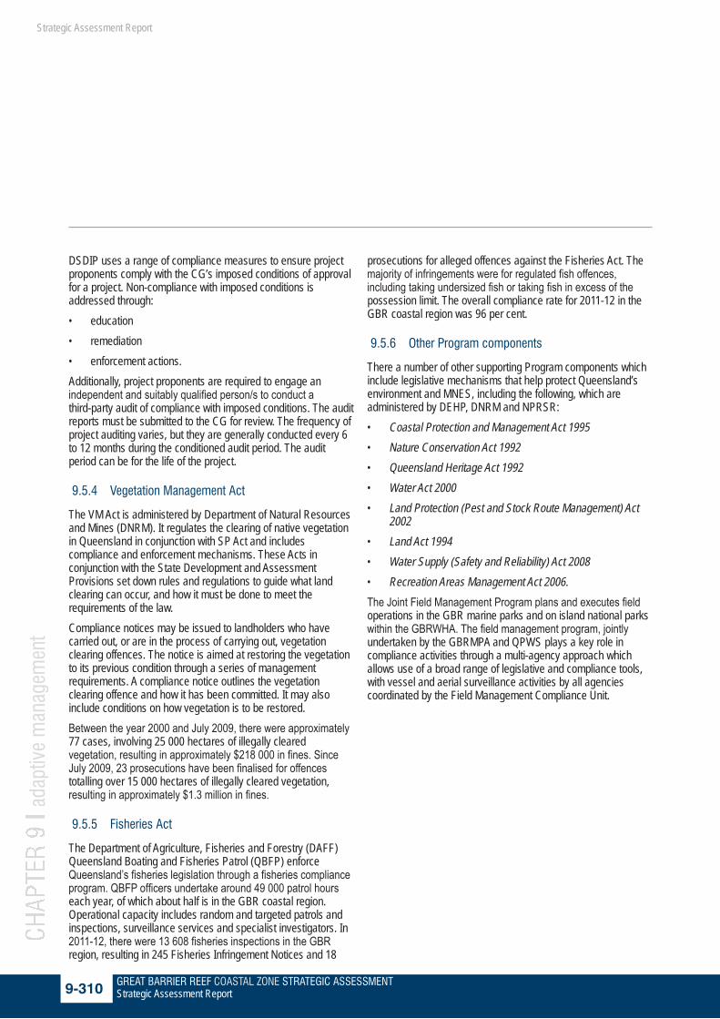
9.5.4 Vegetation Management Act
The VM Act is administered by Department of Natural Resources and Mines (DNRM). It regulates the clearing of native vegetation in Queensland in conjunction with SP Act and includes compliance and enforcement mechanisms. These Acts in conjunction with the State Development and Assessment Provisions set down rules and regulations to guide what land clearing can occur, and how it must be done to meet the requirements of the law. Compliance notices may be issued to landholders who have carried out, or are in the process of carrying out, vegetation clearing offences. The notice is aimed at restoring the vegetation to its previous condition through a series of management requirements. A compliance notice outlines the vegetation clearing offence and how it has been committed. It may also include conditions on how vegetation is to be restored. Between the year 2000 and July 2009, there were approximately 77 cases, involving 25 000 hectares of illegally cleared vegetation, resulting in approximately $218 000 in fines. Since July 2009, 23 prosecutions have been finalised for offences totalling over 15 000 hectares of illegally cleared vegetation, resulting in approximately $1.3 million in fines.
9.5.5 Fisheries Act
The Department of Agriculture, Fisheries and Forestry (DAFF) Queensland Boating and Fisheries Patrol (QBFP) enforce Queensland’s fisheries legislation through a fisheries compliance program. QBFP officers undertake around 49 000 patrol hours each year, of which about half is in the GBR coastal region. Operational capacity includes random and targeted patrols and inspections, surveillance services and specialist investigators. In 2011-12, there were 13 608 fisheries inspections in the GBR region, resulting in 245 Fisheries Infringement Notices and 18
prosecutions for alleged offences against the Fisheries Act. The majority of infringements were for regulated fish offences, including taking undersized fish or taking fish in excess of the possession limit. The overall compliance rate for 2011-12 in the GBR coastal region was 96 per cent.
9.5.6 Other Program components
There a number of other supporting Program components which include legislative mechanisms that help protect Queensland’s environment and MNES, including the following, which are administered by DEHP, DNRM and NPRSR: • Coastal Protection and Management Act 1995• Nature Conservation Act 1992• Queensland Heritage Act 1992• Water Act 2000• Land Protection (Pest and Stock Route Management) Act
2002• Land Act 1994• Water Supply (Safety and Reliability) Act 2008• Recreation Areas Management Act 2006.The Joint Field Management Program plans and executes field operations in the GBR marine parks and on island national parks within the GBRWHA. The field management program, jointly undertaken by the GBRMPA and QPWS plays a key role in compliance activities through a multi-agency approach which allows use of a broad range of legislative and compliance tools, with vessel and aerial surveillance activities by all agencies coordinated by the Field Management Compliance Unit.

GREAT BARRIER REEF COASTAL ZONE STRATEGIC ASSESSMENT9-311 Strategic Assessment Report
CHAP
TER
9 l a
dapt
ive
man
agem
ent
Strategic Assessment Report
9.5.7 Summary of effectiveness
As part of its commitment to transparency, DEHP publishes compliance and enforcement-related information. The compliance update e-newsletter is regularly sent to subscribers to increase their awareness of important compliance and enforcement information.DEHP seeks to ensure voluntary compliance with its environmental legislation by working with industry and individuals to promote sustainable behaviours. However, DEHP will pursue enforcement action against those ignoring their legal obligations to the environment and other natural resources. The enforcement pyramid below (see Figure 9.4 1) demonstrates the path of escalation. The department has a strong record of enforcement and prosecution where there are significant breaches of legislation.Compliance resourcing is strong: DEHP has approximately 180 environmental officers involved in frontline environmental compliance work, three times as many as four years ago. These officers comprise one part of the department’s full contingent of approximately 380 authorised environmental officers, who are all able to identify and respond to instances of non-compliance across the state. In 2010-11, the Queensland Government invested $23.4 million into frontline environmental compliance services. This funding was used to recruit environmental officers, technical specialists, investigators, lawyers and other staff. In 2011-2012, this funding increased to $25.4 million, in recognition of the extra resources required to be committed to the expanding mining, coal seam gas and liquified natural gas sectors.
Figure 9.4 1 DEHP Enforcement Guidelines Source: adapted from a model provided by Ayers and Braithwaite
9.5.8 Summary of effectiveness Management effectiveness component
Grading Confidence Trend Summary of evidence
Resourcing and compliance
Effective Limited Improving Queensland has a strong compliance system in place supported by appropriate funding and staffing resources. There are demonstrated examples of effective enforcement and prosecutions.
Effective: Financial and staffing resources are mostly adequate to address management issues, but may not be secure. Biophysical and socioeconomic information is available to inform decisions, although there may be deficiencies in some areas. Systems are in place for enforcement and compliance.
GREAT BARRIER REEF COASTAL ZONE STRATEGIC ASSESSMENT9-312 Strategic Assessment Report
CHAP
TER
9 l a
dapt
ive
man
agem
ent
Strategic Assessment Report
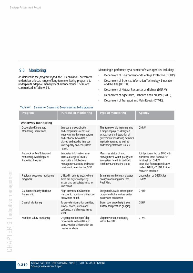
9.6 Monitoring
As detailed in the program report, the Queensland Government undertakes a broad range of long-term monitoring programs to underpin its adaptive management arrangements. These are summarised in Table 9.5 1.
Monitoring is performed by a number of state agencies including:• Department of Environment and Heritage Protection (DEHP)• Department of Science, Information Technology, Innovation
and the Arts (DSITIA)• Department of Natural Resources and Mines (DNRM)• Department of Agriculture, Fisheries and Forestry (DAFF)• Department of Transport and Main Roads (DTMR).
Table 9.6 1 Summary of Queensland Government monitoring programs
Prpgram Purpose of monitoring Type of monitoring Agency
Waterway monitoringQueensland Integrated Monitoring Framework
Improve the coordination and comprehensiveness of waterway monitoring programs and enhance how data is shared and used to improve water quality and ecosystem health.
The framework is implementing a range of projects designed to advance the integration of government monitoring activities in priority regions as well as addressing statewide issues
DNRM
Paddock to Reef Integrated Monitoring, Modelling and Reporting Program
Integrates information from across a range of scales to provide a link between management actions and water quality outcomes for the GBR
Measures status of land management, water quality and ecosystem health in paddock, catchment and marine areas
Joint program led by DPC with significant input from DEHP, funding from DNRM Input also from regional NRM bodies, DAFF, CSIRO & other research providers
Regional waterway monitoring programs
Utilised in priority areas where there are significant policy issues and associated risks to waterways
Estuarine monitoring and water quality monitoring under the Reef Plan.
Undertaken by DSITIA for DNRM
Gladstone Healthy Harbour Partnership
Align activities in Gladstone Harbour to monitor and improve ecosystem health
Integrated Aquatic investigation program which monitors water quality and fish health
GHHP
Coastal Monitoring To provide information on tides, waves, floods, storms and cyclones, and changes in sea level
Storm tide, wave height, sea surface temperature gauging
DEHP
Maritime safety monitoring Ongoing monitoring of ship movements in the GBR and ports. Provides information on marine incidents
Ship movement monitoring within the GBR
DTMR

GREAT BARRIER REEF COASTAL ZONE STRATEGIC ASSESSMENT9-313 Strategic Assessment Report
CHAP
TER
9 l a
dapt
ive
man
agem
ent
Strategic Assessment Report
Prpgram Purpose of monitoring Type of monitoring Agency
Vegetation MonitoringRegional Ecosystem Mapping Mapping on the extent
of vegetation used for a wide range of purposes by both government and non-government agencies. Central to Queensland’s vegetation management framework
Fine scale maps showing the extent of 85% of the state’s vegetation communities and contains information on the extent of vegetation pre and post-clearing
Undertaken by DSITIA for DEHP and DNRM
Statewide Land Cover and Tree Study (SLATS)
To inform vegetation management, planning and compliance, and for greenhouse gas inventory purposes
Vegetation monitoring initiative using satellite imagery over Queensland to estimate wooded vegetation cover and woody land cover change information. Provides the base data for RE mapping (see below)
Undertaken by DSITIA (with funding from DNRM)
BioCondition Assessment Manual
Vegetation condition assessed against benchmarks, and monitored as part of various land management regulatory processes and offset programs
Site based method assessing the condition of native vegetation. Outlines a framework for measuring how a terrestrial ecosystem is functioning for the maintenance of biodiversity values
DEHP
Species MonitoringRoutine monitoring of threatened species
Species level monitoring and tracking of threatened species.
Methods currently vary, and include annual population census, tagging animals for recapture, and satellite tracking to find out more about movement patterns
Undertaken by DSITIA for DEHP
Strandnet Strandings information on whales, seals, sealions, dugong and turtle
Records information on where sick, injured, dying and dead animals are found
DEHP
Fisheries monitoring Outline information on the operation of the fishery, trends in catch and fishing effort, impacts on ecosystems and management regimes in place
Annual Fisheries status reporting.Data regularly collected from fishery dependent and fishery independent sources including daily logbooks from fishing boats, regular recreational fisher surveys, long term biological monitoring to collect data for scientific assessment of key species
DAFF

GREAT BARRIER REEF COASTAL ZONE STRATEGIC ASSESSMENT9-314 Strategic Assessment Report
CHAP
TER
9 l a
dapt
ive
man
agem
ent
Strategic Assessment Report
Prpgram Purpose of monitoring Type of monitoring Agency
Land MonitoringQueensland Land Use Mapping Program (QLUMP)
Ongoing monitoring of land use and land management practices that can affect water quality and catchment, soil erosion, acidification, nutrient decline and carbon losses
Ongoing provision of mapping Undertaken by DSITIA (with funding from DNRM)
Community SurveysQueensland Parks and Wildlife surveys
Aim to understand the motivations, visitation patterns, annual visitor estimates, needs and values of the Queensland community in relation to national parks and the performance of the Queensland Parks and Wildlife Service
Survey NPRSR
Some of these comprehensive monitoring programs are delivered through the collaborative efforts of a number of state agencies (Table 9.5 1). A number of these are discussed below
9.6.1 Waterway monitoring
9.6.1.1 Queensland Integrated Waterway Monitoring Framework
The Queensland Integrated Waterway Monitoring Framework aims to improve the coordination and comprehensiveness of waterway monitoring programs and enhance how data is shared and used to improve water quality and ecosystem health. The framework is led by DNRM, together with DEHP, DSITIA, DAFF and also the GBRMPA. Key legislative and policy drivers for Queensland waterways monitoring include Australian and Queensland government legislation, government agreements and specific strategies to protect particular waterways such as the GBR catchments. The framework is implementing a range of projects to advance the integration of government monitoring activities in priority regions, as well as addressing statewide issues, such as information management and reporting.There are six long-term Queensland waterway monitoring programs that form part of the integrated framework. These are: • Surfacewater Water Quality Network• Stream Gauging Station Network• Stream and Estuary Assessment Program (SEAP)
• Environmental Flows Assessment Program (EFAP)• Groundwater Water Levels Network• Groundwater Water Quality Network.Regional monitoring programs are supported in priority areas where there are significant policy issues and associated risks to waterways. These programs include the estuarine monitoring programs from the Fitzroy to Tin Can Bay and the Burnett–Mary. Coordinated monitoring and evaluation of water quality in the GBR catchments and lagoon is crucial for measuring the success of other government driven management initiatives such as the Reef Plan.
9.6.1.2 Paddock to reef monitoringThe Paddock to Reef Integrated Monitoring, Modelling and Reporting Program (Paddock to Reef program) integrates information from across a range of scales to provide a link between management actions and water quality outcomes for the GBR. The Paddock to Reef program measures the status of land management, water quality and ecosystem health in paddock, catchment and marine areas. Progress towards the goals and targets of the Reef Plan are assessed through the program and form the basis of the Annual Reef Report Card. The Paddock to Reef program is based on a philosophy of continuous improvement which will help improve data confidence over time. The design of the Paddock to Reef program as part of the Reef Plan will ensure alignment of monitoring and modelling

GREAT BARRIER REEF COASTAL ZONE STRATEGIC ASSESSMENT9-315 Strategic Assessment Report
CHAP
TER
9 l a
dapt
ive
man
agem
ent
Strategic Assessment Report
at different scales and locations, improve paddock scale water quality monitoring to measure effectiveness of management practices and ensure the strategic location of monitoring sites in key areas.The Paddock to Reef Program is led by DPC. DSITIA, DNRM, regional NRM bodies, DAFF, CSIRO and other research providers undertake components of the program. Funding for the paddock and marine components is through the Australian Government (via Reef Rescue). The Queensland Government provides funding through DNRM.
9.6.1.3 Gladstone Healthy Harbour PartnershipThe Queensland Government is committed to ensuring that the Gladstone region, at the southern end of the GBR, can continue its role as a key economic base with a sustainable and healthy environment. Gladstone comprises the single largest concentration of major industry and port facilities in Queensland. On 4 May 2012, the Queensland Premier announced a partnership agreement would be established to ensure the ongoing monitoring and improvement of Gladstone Harbour and surrounding catchments. The GHHP includes representatives from national, state and local government, industry, research and community interests. The purpose of the GHHP is to align activities, harness the co-investment potential, implement an adaptive management framework and deliver a shared vision for a healthy Gladstone Harbour. The GHHP will agree strategic directions and leverage the benefits of streamlined monitoring, targeted management and expert science advice and deliver a shared vision for a healthy Gladstone Harbour through adaptive management.An independent science panel has been established to inform the decisions made by the GHHP. In turn, the partnership will be responsible for the Gladstone Healthy Harbour Report Card and any actions needed to address its findings.Gladstone Integrated Aquatic Investigation ProgramThe Integrated Aquatic Investigation Program for Gladstone Harbour was an expanded integrated program aimed at applying further monitoring and research towards understanding the causes of the fish health issues reported in Gladstone Harbour in 2011.Key elements of this program included:• building on the existing monitoring effort by testing well-
formed hypotheses and conceptual models about potential causal factors and to improve our understanding of aquatic ecosystems. This also included expanded fish health and water quality monitoring investigations.
• commissioning and reviewing scientific research to inform
the above studies, and investigating the use of alternative testing methodologies where appropriate
• Ensuring collaboration and integration with existing institutional, industry and community based research and monitoring such as the Port Curtis Integrated Monitoring Program (PCIMP)
The program involved regular public reporting, including:• regular progress reports at stakeholder meetings• status updates/report cards published in brochure format• publication of reports on the water quality and fish health
investigation.Formal program investigations were completed in September 2012 and the Gladstone Harbour Integrated Aquatic Investigation Program 2012 Report was released in January 2013 summarising the key findings to date and acknowledging that a wide range of fish, crustacean and mollusc species were still undergoing more detailed studies. These studies have now been finalised and two reports have been released. These are:• An Analysis of Water Quality in Relation to Fish Health in
Gladstone Harbour and Waterways September 2011–September 2012
• The Gladstone Harbour Fish Health Investigation 2011–2012.
Results of the fish health investigation indicated that flooding, combined with a significant introduction of fish from Lake Awoonga into Gladstone Harbour and adjacent waterways, stressed the ecosystem. While it is possible that dredging and associated turbidity put additional stress on the ecosystem, it was not the primary cause. Reports from the investigation can be found at http://www.ehp.qld.gov.au/gladstone

GREAT BARRIER REEF COASTAL ZONE STRATEGIC ASSESSMENT9-316 Strategic Assessment Report
CHAP
TER
9 l a
dapt
ive
man
agem
ent
Strategic Assessment Report
Case study:GLADSTONE HARBOUR AQUATIC INVESTIGATION
After significant rainfall in the summer of 2010–2011, Gladstone Harbour experienced some abnormal occurrences associated with fish and health of the marine environment. In August 2011, concerns for human health and the health of fish in Gladstone waterways were raised with the Queensland Government.In response an investigation program was set up, working closely with key interest groups to understand the extent and nature of the issue. The program aimed at identifying any specific causes for the fish and marine environment health issues and included extensive fish, water quality and sediment sampling and testing in and around Gladstone Harbour as well as interviews and testing of human health issues. Gladstone Harbour and surrounding areas were also closed to fishing for a three week period in response to the concerns about human health and the possible transfer of disease between fish and humans and entry into the food chain.The initial government response was reviewed by the independent Gladstone Fish Health Scientific Advisory Panel, which acknowledged and supported ongoing investigation and noted the progress already made. After an extensive review of available data and literature, the panel released its final report in January 2012. The report confirmed there was no risk to human health but there was no conclusive view on the cause of the fish conditions observed in Gladstone Harbour. Further monitoring and research was recommended while noting that:• identifying the cause(s) of the disease(s) and prevalence of parasites on fish in Gladstone Harbour was a complex and difficult
task, further complicated by significant rainfall in the summer of 2010–2011 and the historical and ongoing industrial development of the harbour
• determining conclusively whether any environmental changes have anything to do with the reported fish health problems is a formidable and perhaps impossible undertaking
• the Queensland Government has already acted upon some of its recommendations including undertaking analysis of dissolved metals but notes that there is no evidence of metal impacts on fish.
Following the panel’s recommendation for further research, the Queensland Government set up the ‘Integrated Aquatic Investigation Program for Gladstone Harbour’ to expand on the work already undertaken. As part of the program regular monitoring reports were published on DEHP and DAFFs’ websites.Formal program investigations were completed in September 2012 and the Gladstone Harbour Integrated Aquatic Investigation Program 2012 Report was released in January 2013 summarising the key findings to date and acknowledging that a wide range of fish, crustacean and mollusc species were still undergoing more detailed studies. These studies have now been finalised and two reports have been released. These are:• An Analysis of Water Quality in Relation to Fish Health in Gladstone Harbour and Waterways September 2011 – September 2012• The Gladstone Harbour Fish Health Investigation 2011–2012.

GREAT BARRIER REEF COASTAL ZONE STRATEGIC ASSESSMENT9-317 Strategic Assessment Report
CHAP
TER
9 l a
dapt
ive
man
agem
ent
Strategic Assessment Report
9.6.1.4 Coastal monitoringA network of 25 storm tide gauges along Queensland’s coastline monitor flooding from the sea, usually associated with storm surge during tropical cyclones. The storm tide gauges record the rise and fall of the tide automatically at regular time intervals providing sea level information in near real time. This network is vital in helping communities to prepare for extreme events.A number of Waverider buoys are used to measure the height of waves along the Queensland coast. Wave reports are generated ‘on-line’, describing wave conditions at various locations along the Queensland coast. Wave data are collected, stored and analysed to help short and long-term investigations of natural coastal processes, including accretion (deposition of sediments) and erosion (loss of sediments). Sea surface temperature is collected at the same time as wave height and direction. When a cyclone is approaching the coast, advice is provided to the State Counter Disaster Organisation on the potential impact of waves on coastal communities, while maritime organisations use wave data to plan port activities and to support navigational information.
9.6.1.5 Maritime safety monitoring The Department of Transport and Main Roads (DTMR) plans, manages and delivers Queensland’s integrated transport system to achieve sustainable transport solutions for road, rail, air and sea. The department is committed to environmental management and improving its environmental performance including, atmosphere, land, water, noise and cultural heritage. Maritime Safety Queensland (MSQ) is a division of the DTMR responsible for waterways. MSQ is responsible for: • improving maritime safety for shipping and small craft
through regulation and education• minimising vessel-sourced pollution and responding to
marine pollution• providing essential maritime services such as pilotage for
regional ports and aids to navigation• encouraging and supporting innovation in the maritime
industry.MSQ, in conjunction with the Australian Maritime Safety Authority (AMSA), operates the GBR and Torres Strait Vessel Traffic Service (REEFVTS) that tracks and monitors ship movements within areas of the GBR and Torres Strait. Since 1997 Australia has had a mandatory ship reporting system (REEFREP) to improve navigational safety, reduce the risk of shipping incidents and minimise any resulting ship-sourced pollution in the GBR and the Torres Strait. Since this time Australia has improved the delivery of services in the region through a range of measures. These measures led to the introduction of REEFVTS in 2004.
After the Shen Neng 1 ran aground in the GBR in April 2010, the measures for mitigating risks associated with shipping activity in the GBR were reassessed. In December 2010 the International Maritime Organization (IMO) approved Australia’s submission to extend the mandatory ship reporting requirements of REEFREP to the southern boundary of the GBR Marine Park effective from 1 July 2011.MSQ also provides summary information of current shipping movements in Queensland ports. Information provided includes ships in a particular port and movements in the port from a day prior, to seven days ahead of a specified date. The monthly ship movement reports show the numbers and gross tonnage of ships that use Queensland ports, including arrivals and departures by port. The reports are available at the MSQ website http://www.msq.qld.gov.au/Shipping/Shipping-movements.aspx.MSQ produces annual reports on marine incidents in accordance with Section 127 of the Transport Operations (Marine Safety) Act 1994. This provides a valuable summary of the more serious marine incidents in Queensland waters and a factual basis for informed consideration of how the safety risks associated with boating activities might be better managed in the future.
9.6.2 Vegetation monitoring
9.6.2.1 Regional ecosystems mappingQueensland is the only Australian jurisdiction to have a statewide, vegetation-mapping program at a regional scale. RE mapping provides the foundation for biodiversity conservation in Queensland. These are fine scale maps (1:100 000) showing the extent of 85 per cent of the state’s vegetation communities 153, containing information on the extent of vegetation both pre- and post-clearing. This foundation information layer is used for a wide range of purposes by both government and non-government agencies and is central to Queensland’s vegetation management framework.
9.6.2.2 Statewide land-cover and tree studyThe Statewide Land-cover and Tree Study (SLATS) is a major vegetation monitoring initiative. It uses satellite imagery over the entire state to estimate wooded vegetation cover and woody land cover change to inform vegetation management, planning and compliance and for greenhouse gas inventory purposes.
9.6.2.3 The BioCondition assessment manual Compared with vegetation extent, the assessment of vegetation condition is considerably less well documented in Queensland. BioCondition is a vegetation condition assessment tool to measure how well a terrestrial ecosystem is maintaining biodiversity values at a local or property scale. In BioCondition, vegetation condition is described in comparison to the same

GREAT BARRIER REEF COASTAL ZONE STRATEGIC ASSESSMENT9-318 Strategic Assessment Report
CHAP
TER
9 l a
dapt
ive
man
agem
ent
Strategic Assessment Report
vegetation in its reference state. The assessment provides vegetation condition assessed against benchmarks, and monitored as part of various land management regulatory processes and offset programs. Benchmark documents have been developed and are available for a subset of REs. Where benchmarks are not available, the reference site manual describes a methodology to derive them. The BioCondition information is helpful to inform developmental approvals, incentive payments and market-based investments, as well as NRM programs.
9.6.3 Species monitoring
9.6.3.1 Routine monitoring of threatened species The Back on Track species prioritisation framework (Back on Track) is an initiative of the Queensland Government that:• prioritises Queensland’s native species to guide
conservation management and recovery• enables the strategic allocation of limited conservation
resources for achieving greatest biodiversity outcomes• increases the capacity of government, NRM bodies and
communities to make informed decisions by making information widely accessible.
Back on Track actions for biodiversity documents identify research and monitoring actions to improve the recovery of priority species for conservation management. The monitoring methods vary, and include annual population census, tagging animals for recapture, and satellite tracking to find out more about movement patterns.At a species level, there is routine monitoring of threatened species, including estuarine crocodiles and marine turtles.
Case study:QUEENSLAND TURTLE CONSERVATION PROGRAM
Queensland’s marine turtle conservation program has been running for more than 40 years. Over this time turtle populations have been monitored through annual censuses at key nesting beaches along Queensland’s coast and by tagging turtles for recapture in later years. Turtles have also been fitted with satellite transmitters to learn more about local and regional movement patterns. At other times of the year, turtles have been captured and tagged at shallow water turtle feeding sites, where growth and survival data contribute to the understanding of these species and how they have been responding to management interventions.Information from the work has provided a basis for strong management changes, such as the introduction of turtle exclusion devices that became compulsory in 2001 for the east coast trawl and northern prawn fisheries. Evidence generated by the research is used to change local management practices, such as avoiding street lighting near turtle nesting beaches and zoning plans for Queensland marine parks. A number of ‘go slow’ zones have been created to reduce the rate of boat strikes in key turtle habitats in marine parks.This work contributes to a better understanding of the state of marine ecosystems. Turtles are indicators of water quality and respond to large scale events, such as floods, as well as localised impacts from changes in water quality. Following the flooding that occurred in 2011, surveys have confirmed that at least parts of Queensland’s immature east coast turtle population was experiencing extreme stress and had poor body condition. Improvements in water quality and reduction of sediment run-off are central to improving the resilience of inshore marine habitats and MNES to future extreme weather events

GREAT BARRIER REEF COASTAL ZONE STRATEGIC ASSESSMENT9-319 Strategic Assessment Report
CHAP
TER
9 l a
dapt
ive
man
agem
ent
Strategic Assessment Report
9.6.3.2 StrandNetDEHP maintains StrandNet, a database of marine wildlife strandings and deaths. The primary focus of the database is to record information on where sick, injured, dying and dead marine cetaceans (whales and dolphins), pinnipeds (seals and sea lions), dugong and turtles have been found in Queensland and assess causes of injury and death, if possible. Incidental information on sharks, rays, seabirds and other marine animals is also recorded.
Data collected and collated in the strandings database is summarised in annual reports. The information published as at November 2012 data for dugongs and turtles in included in Table 9.5 2 and Table 9.5 3.
Table 9.6 2 Reported dugong strandings 2009-2012
Year 2012 2011 2010 2009All of Queensland 51 total (including
4 released alive)186 79 56
Hervey Bay, 25° 6 20 8 11Gladstone, 23° 9 12 3 1Mackay, 21° 1 4 2 1Townsville, 19° 5 54 19 11
Cairns, 16° 6 13 17 10Remainder of Qld 24 83 30 22
Source: 154
Table 9.6 3 Reported marine turtle strandings 2009-2012
Year 2012 2011 2010 2009All of Queensland 1187 verified
on StrandNet (including 211 released alive)111 require verification
1611 740 855
Hervey Bay, 25° 123 136 72 102Gladstone, 23° 57 304 48 43Mackay, 21° 23 79 14 19Townsville, 19° 298 286 82 43
Cairns, 16° 74 43 17 11Remainder of Qld 612 763 507 637
Source: 155

GREAT BARRIER REEF COASTAL ZONE STRATEGIC ASSESSMENT9-320 Strategic Assessment Report
CHAP
TER
9 l a
dapt
ive
man
agem
ent
Strategic Assessment Report
9.6.3.3 Fisheries monitoringDAFF has a number of monitoring and management measures relevant to MNES. The measures outline information on the operation of the fishery, trends in catch and fishing effort, impacts on ecosystems and management regimes.Science plays a key role in ensuring that harvesting of valuable fish from Queensland’s ecosystems is sustainable. Relevant information about fish stocks and the fisheries they support is continuously collected to enhance their sustainability. Data are regularly collected from fishery-dependent and fishery-independent sources including:• daily logbook returns from all commercial fishing boats,
documenting target and by-product species and species of conservation interest
• regular recreational fisher surveys• a long-term biological monitoring program collecting
fishery-dependent and independent data for scientific assessment of key species.
Annual fisheries status reports outline information on the operation of the fishery, trends in catch and fishing effort, impacts on ecosystems and management regimes.An example of this is the Queensland logbook system. Since 1988, commercial fishers operating in Queensland’s state-managed fisheries are required to complete daily catch and effort logbooks. The logbook collects details on where, when and how fishing took place, and what was caught. The Commercial Fisheries Information System (CFISH) is a database which stores the fishing information from the logbooks of all licensed operators. CFISH helps Fisheries Queensland assess the status of Queensland’s fisheries resources. The information is also valuable in developing fisheries management plans and helping determine the effectiveness of measures already in place. Today CFISH represents one of the most comprehensive fisheries information systems in Australia. It continues to expand and improve thanks to the cooperation of fishers, researchers, managers and logbook section staff.Further logbooks and reporting requirements exist for the various fisheries managed by Fisheries Queensland, reflecting the unique characteristics of each fishery. Fisheries Queensland has monitoring programs to collect biological information for a range of species. These programs involve either dedicated scientific surveys or the community collecting information from their fisheries. Of particular importance is the Species of Conservation Interest (SOCI) logbook which has been required by commercial fishers since 2005. The ability to report on a fleet-wide basis will greatly assist Fisheries Queensland in its efforts to comply with Australian Government requirements for the ecological sustainability of Queensland’s fisheries.
9.6.4 Land monitoring
9.6.4.1 Queensland land use mapping program The DNRM’s soil and land mapping, modelling and monitoring are critical to understanding land productivity and land degradation risk. The Queensland Land Use Mapping Program (QLUMP) provides for the ongoing monitoring of land use and land management practices that can affect water quality and catchment, soil erosion, acidification, nutrient decline and carbon losses. It has also helped in assessing agricultural productivity and opportunities for diversification, conducting cost benefit-analyses for major natural resource investments and trade-offs from land use change, developing solutions for sustainable land management, and using integrated modelling to predict the behaviour of a catchment under different management options. The DNRM also provides ASS maps and coastal hazard maps to inform land use planning and development decisions. Since 1995, the department has initiated a number of projects to identify the extent, location, and risk level of ASS in Queensland. The DNRM also has in place the Queensland Acid Sulfate Soils Investigation Team (QASSIT) which has advised on many coastal development proposals and provided technical advice on management of ASS for developments totalling in excess of $3 billion.
9.6.5 Integrated monitoring framework
As identified above, within the GBR coastal zone monitoring is undertaken by a wide range of agencies. In addition to Queensland Government monitoring programs, there are a number of other research and monitoring providers such as AIMS, CSIRO, the GBRMPA and universities, as well as community based monitoring programs. A recent review of existing monitoring programs in the GBRWHA, undertaken as part of the Integrated Monitoring Framework project, identified more than 65 privately and publicly funded monitoring programs that are relevant to MNES31. While some of these monitoring programs have been specifically designed to meaningfully inform management of MNES values (e.g. the Paddock to Reef Program), there is no overarching framework to ensure these various programs are aligned with each other so that their findings can be integrated to better inform management of the property. There are gaps in existing monitoring both spatially and in regards to some of the identified monitoring priorities. For example, the far northern GBR is generally poorly covered by monitoring, as are deep water portions of seagrass meadows and deep water reefs. Furthermore, for many cause-effect interactions, only the cause or the effect is monitored; there are
GREAT BARRIER REEF COASTAL ZONE STRATEGIC ASSESSMENT9-321 Strategic Assessment Report
CHAP
TER
9 l a
dapt
ive
man
agem
ent
Strategic Assessment Report
very few instances where both the pressure and the value are adequately monitored. Some values, such as coral reefs, are the focus of multiple monitoring programs with differing objectives. There is an opportunity to better draw together, evaluate, interpret and report the relevant results for these groups of programs and achieve efficiencies in monitoring and reporting. Through the project, the monitoring needs for management, legacy of past monitoring programs and the capacity of existing
monitoring programs are being brought together by a multi-disciplinary, multi-institutional, effort to provide a blueprint for an integrated approach to monitoring the GBR. The draft framework explicitly links management objectives, monitoring objectives and monitoring programs in a driver, pressure, state, impact and response framework to provide a solid foundation for considering an Integrated Monitoring Program for the GBRWHA.
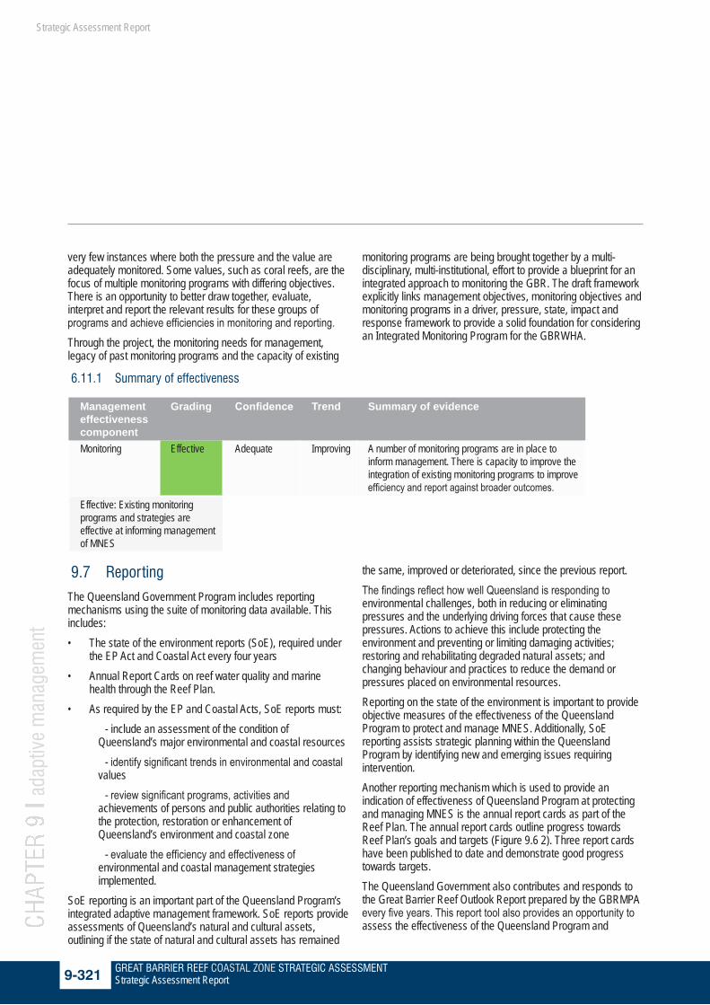
6.11.1 Summary of effectiveness
Management effectiveness component
Grading Confidence Trend Summary of evidence
Monitoring Effective Adequate Improving A number of monitoring programs are in place to inform management. There is capacity to improve the integration of existing monitoring programs to improve efficiency and report against broader outcomes.
Effective: Existing monitoring programs and strategies are effective at informing management of MNES
9.7 Reporting
The Queensland Government Program includes reporting mechanisms using the suite of monitoring data available. This includes:• The state of the environment reports (SoE), required under
the EP Act and Coastal Act every four years• Annual Report Cards on reef water quality and marine
health through the Reef Plan.• As required by the EP and Coastal Acts, SoE reports must:
- include an assessment of the condition of Queensland’s major environmental and coastal resources
- identify significant trends in environmental and coastal values
- review significant programs, activities and achievements of persons and public authorities relating to the protection, restoration or enhancement of Queensland’s environment and coastal zone
- evaluate the efficiency and effectiveness of environmental and coastal management strategies implemented.
SoE reporting is an important part of the Queensland Program’s integrated adaptive management framework. SoE reports provide assessments of Queensland’s natural and cultural assets, outlining if the state of natural and cultural assets has remained
the same, improved or deteriorated, since the previous report. The findings reflect how well Queensland is responding to environmental challenges, both in reducing or eliminating pressures and the underlying driving forces that cause these pressures. Actions to achieve this include protecting the environment and preventing or limiting damaging activities; restoring and rehabilitating degraded natural assets; and changing behaviour and practices to reduce the demand or pressures placed on environmental resources. Reporting on the state of the environment is important to provide objective measures of the effectiveness of the Queensland Program to protect and manage MNES. Additionally, SoE reporting assists strategic planning within the Queensland Program by identifying new and emerging issues requiring intervention.Another reporting mechanism which is used to provide an indication of effectiveness of Queensland Program at protecting and managing MNES is the annual report cards as part of the Reef Plan. The annual report cards outline progress towards Reef Plan’s goals and targets (Figure 9.6 2). Three report cards have been published to date and demonstrate good progress towards targets.The Queensland Government also contributes and responds to the Great Barrier Reef Outlook Report prepared by the GBRMPA every five years. This report tool also provides an opportunity to assess the effectiveness of the Queensland Program and

GREAT BARRIER REEF COASTAL ZONE STRATEGIC ASSESSMENT9-322 Strategic Assessment Report
CHAP
TER
9 l a
dapt
ive
man
agem
ent
Strategic Assessment Report
Figure 9.6 1 2011 Report Card resultsSource: 36
GREAT BARRIER REEF COASTAL ZONE STRATEGIC ASSESSMENT9-323 Strategic Assessment Report
CHAP
TER
9 l a
dapt
ive
man
agem
ent
Strategic Assessment Report
address issues facing the GBR and refocus joint management between the governments.
9.8 Independent scientific input
Underpinning Queensland’s environmental management systems is robust scientific knowledge and evidence gathering. Both short-term intensive studies to understand specific events or processes, as well as long-term continuous monitoring programs are needed to understand cumulative impacts occurring over timescales from years to decades. Using the best available science is important in the adaptive management process of the Queensland Program, by providing robust knowledge and information needed to refine the Program components to protect and manage MNES.Scientific efforts relevant to the GBR coastal zone include data collected under the Reef Plan and GHHP.A key feature of Reef Plan is the Independent Science Panel which provides independent scientific advice on water quality issues for the GBR. This includes advice on knowledge gaps, science priorities and delivery associated with the overall implementation of the Reef Plan. The panel:• conducts scientific reviews of the Reef Plan activities and
initiatives, including annual and other reports, and makes specific recommendations about the direction, content and details of future activities
• provides timely independent scientific advice and review to ensure Reef Plan implementation, monitoring and reporting.
As previously mentioned, in 2012 the Queensland Government established a partnership agreement to ensure the ongoing monitoring and improvement of Gladstone Harbour and surrounding catchments.The GHHP includes representatives from government, industry, research, community and other interests. The purpose of the partnership is to align activities, harness co-investment potential, implement an adaptive management framework and deliver a shared vision for a healthy Gladstone Harbour. The GHHP will focus on best practice collaborative monitoring and management of the harbour. It is envisaged that industry, the Australian Government, Queensland Government, local government, universities and research institutions will partner in investment to agree on the strategic directions and leverage the benefits of streamlined monitoring, targeted management and expert science advice.An independent science panel will inform the decisions made by the GHPP. In turn, the GHHP will be responsible for the
Gladstone Healthy Harbour Report Card and any actions needed to address its findings. By implementing collaborative actions, the GHHP will maintain and continuously improve harbour health. A number of information gaps have been highlighted in this strategic assessment report. The forward commitments will address many of these during the life of the Program, improving certainty and directly contributing to improving the management of the GBR coastal zone. A range of research and development programs are in place to increase knowledge of the GBR coastal zone ecosystem and ultimately significantly improve its management,these include:• a water quality risk assessment, which will identify priority
pollutants and areas• the e-reefs project which will better link catchment runoff to
marine ecosystem health through a receiving waters model• an updated 2013 scientific consensus statement on water
quality that will inform the next update of the Reef Plan• conservation planning in the coastal zone, funded through
the National Environmental Research Program (NERP).
9.9 The way forward
The Queensland Government recognises that continuous improvement in monitoring and reporting activities are required to provide the best environmental outcomes for the GBR. Adaptive management involves using compliance, monitoring and reporting outcomes to continually improve the Program. The process focuses on clear planning and implementation, with an emphasis on monitoring, reporting and reviewing to ensure that as new information emerges it is embedded in future planning.The Program will evolve over its 25 year lifespan in accordance with adaptive management, as new information emerges and new procedures are introduced. The Queensland Government Program’s regulatory framework, supported by compliance mechanisms and long-term monitoring and reporting programs, such as the SoE Report and Reef Plan Report Cards, will ensure the Program is adapted to reflect any changes and achieve improved outcomes for MNES. The Queensland Government undertakes a statutory review process for all regulatory mechanisms as well as regular review of long-term plans and programs, such as the components of the Queensland Government Program. The statutory review is to ensure continuous improvement towards achieving the desired outcomes. Through the mechanisms detailed in this chapter the Queensland Government will continue to monitor and review the effectiveness of the Program in achieving its objectives to protect and manage MNES in the GBR coastal zone. Especially
GREAT BARRIER REEF COASTAL ZONE STRATEGIC ASSESSMENT9-324 Strategic Assessment Report
CHAP
TER
9 l a
dapt
ive
man
agem
ent
Strategic Assessment Report
important is improving the baseline data used to develop management strategies and actions at the regional and reef-wide levels to provide for improved environmental outcomes. The Queensland Government also recognises and supports industry initiatives such as the Abbot Point Cumulative Impact Assessment which can be used to inform monitoring and reporting programs being undertaken by the Government. Further information and analysis of the Abbot Point CIA is provided in the demonstration case at Appendix I. The Queensland Government will continue to work with the GBRMPA and the Australian Government, through the joint field management program and other initiatives, in revising and/or establishing new activities to achieve shared agreed objectives for MNES in the GBR. Implementation arrangements for the Program are outlined in the program report and include a commitment to report to the Great Barrier Reef Ministerial Forum annually on implementation of the Program. The Australian and Queensland governments are also working together to develop a Long Term Sustainability Plan for the Great Barrier Reef World Heritage Area. The plan will inform future development by drawing together the marine and coastal components of the comprehensive strategic assessment, providing an over-arching framework to guide the protection and management of the GBRWHA from 2015 to 2050. It will target the identified areas of action from the strategic assessments and seek to address gaps important for future management of the WHA. Queensland Government expects that changes to the Program will be achievable under the endorsed Program and within the scope of the conditions provided under Section 146B of the EPBC Act. Other variations may require amendment of those conditions. This would occur pursuant to Section 143 of the EPBC Act. Changes will take into account the best available scientific information. The forward commitments and recommended improvements to the Program are discussed in chapter 10.