Chapter 7. Social Resources 7.1. Cultural Resources · Chapter 7. Social Resources 7.1. Cultural...
64
Draft Environmental Impact Report California Marine Life Protection Act Initiative Central Coast Marine Protected Areas Project 7-1 November 2006 J&S 06682.06 Chapter 7. Social Resources 7.1. Cultural Resources This section describes the setting and potential cultural resources impacts of the Proposed Project. Specifically, it describes existing conditions related to cultural resources and summarizes the overall regulatory framework for cultural resources that would affect implementation of the Proposed Project. This section then analyzes the potential impacts of the Proposed Project and its alternatives on cultural resources and identifies mitigation measures to address significant impacts, where appropriate. Cultural resource is the term used to describe several different types of properties: prehistoric and historical archaeological sites; architectural properties such as buildings, bridges, and infrastructure; and resources of importance to Native Americans. Historical resource is a CEQA term that includes buildings, sites, structures, objects, or districts, each of which may have historical, prehistoric, architectural, archaeological, cultural, or scientific importance, and is eligible for listing or is listed in the California Register of Historical Resources (CRHR). 7.1.1. Environmental Setting Cultural resources are those locations, structures, and objects that have importance to the identity of a certain people or place and/or that can educate others and connect them to the important events of the human past. Coastal California possesses a rich prehistory and history of human occupation—by some accounts dating back to 13,000 years before present. The regional prehistory is represented by archaeological sites and artifacts, and its history is represented by surviving documents, structures, and submerged shipwrecks. 7.1.1.1. Ethnographic/Prehistorical Setting The study region encompasses the traditional home of (from north to south) the Ohlone, Salinan, and Chumash tribes. The Ohlone, formerly known as the Costanoan, occupied the coast from the San Francisco Bay in the north to just beyond present-day Carmel in the south, and as much as 60 miles inland. The Ohlone are a linguistically-defined group, speaking eight different but related languages and composed of several smaller, autonomous groups. The Ohlone languages, together with Miwok, comprise the Utian language family of the Penutian stock. They were hunter-gatherers, utilizing only the native flora and fauna for subsistence and tool-making, and practicing a rudimentary form of agriculture. Acorns and various seafoods formed the basis of their diet, with a wide range of other foods exploited to a lesser extent, including assorted seeds, buckeye, berries, roots, land and sea mammals, waterfowl, reptiles, and insects. Their early agricultural practices entailed pruning and seasonally re-seeding locally occurring plants to optimize production.
Transcript of Chapter 7. Social Resources 7.1. Cultural Resources · Chapter 7. Social Resources 7.1. Cultural...
Draft Environmental Impact Report California Marine Life Protection Act Initiative Central Coast Marine Protected Areas Project
7-1November 2006
J&S 06682.06
Chapter 7. Social Resources
7.1. Cultural Resources
This section describes the setting and potential cultural resources impacts of the Proposed Project. Specifically, it describes existing conditions related to cultural resources and summarizes the overall regulatory framework for cultural resources that would affect implementation of the Proposed Project. This section then analyzes the potential impacts of the Proposed Project and its alternatives on cultural resources and identifies mitigation measures to address significant impacts, where appropriate.
Cultural resource is the term used to describe several different types of properties: prehistoric and historical archaeological sites; architectural properties such as buildings, bridges, and infrastructure; and resources of importance to Native Americans.
Historical resource is a CEQA term that includes buildings, sites, structures, objects, or districts, each of which may have historical, prehistoric, architectural, archaeological, cultural, or scientific importance, and is eligible for listing or is listed in the California Register of Historical Resources (CRHR).
7.1.1. Environmental Setting
Cultural resources are those locations, structures, and objects that have importance to the identity of a certain people or place and/or that can educate others and connect them to the important events of the human past. Coastal California possesses a rich prehistory and history of human occupation—by some accounts dating back to 13,000 years before present. The regional prehistory is represented by archaeological sites and artifacts, and its history is represented by surviving documents, structures, and submerged shipwrecks.
7.1.1.1. Ethnographic/Prehistorical Setting
The study region encompasses the traditional home of (from north to south) the Ohlone, Salinan, and Chumash tribes.
The Ohlone, formerly known as the Costanoan, occupied the coast from the San Francisco Bay in the north to just beyond present-day Carmel in the south, and as much as 60 miles inland. The Ohlone are a linguistically-defined group, speaking eight different but related languages and composed of several smaller, autonomous groups. The Ohlone languages, together with Miwok, comprise the Utian language family of the Penutian stock. They were hunter-gatherers, utilizing only the native flora and fauna for subsistence and tool-making, and practicing a rudimentary form of agriculture. Acorns and various seafoods formed the basis of their diet, with a wide range of other foods exploited to a lesser extent, including assorted seeds, buckeye, berries, roots, land and sea mammals, waterfowl, reptiles, and insects. Their early agricultural practices entailed pruning and seasonally re-seeding locally occurring plants to optimize production.
California Department of Fish and Game Social Resources
Draft Environmental Impact Report California Marine Life Protection Act Initiative Central Coast Marine Protected Areas Project
7-2November 2006
J&S 06682.06
Acorns were among several of the foods stored for months at a time. Controlled burning of vast areas of land was carried out to promote the growth of seed-bearing annuals and to increase the available grazing areas for deer, elk, and antelope (CDFG 2005a).
The Salinan Indians inhabited parts of San Luis Obispo, Monterey, and perhaps San Benito Counties, with their territory extending from the sea to the main ridge of the Coast range and from the head of the Salinas drainage to a short distance above Soledad. They hunted more than they fished, but depended for their subsistence principally on vegetal food, such as acorns and grass seed. They used stone mortars and coiled baskets, and buried or burned the dead. Year-round villages with conical shelters of willow and grass or rushes were built along major rivers and streams of the homeland. Villages were comprised of family groups (Access Genealogy 2006; Taylor 2006).
The traditional Chumash Indian homeland lies along the coast of California between Paso Robles in the north and Malibu in the south and including the Northern Channel Islands off Santa Barbara southeast of the study region. Before Spanish occupation of California, the Chumash lived in 150 independent villages with a total population of about 18,000 people. The area was first settled about 13,000 years ago and, over time, the population increased and the people adapted their lifestyles to the local environment. Villages along the coastline, on the islands and in the interior, had access to different resources, which they traded with one another. Trade was enabled in part by the people’s seagoing plank canoe, or tomol, which is thought to have been invented about 2,000 years ago. The last Chumash tomols used for fishing were made about 1850 (CDFG 2002). Many archaeological artifacts have been found in the waters of the study region. Archaeologists have also predicted that “…more important sites remain to be discovered, particularly those related to submerged prehistoric living sites.” (CDFG 2002)
7.1.1.2. Historical Setting
The first recorded European encounter of the California coast was Juan Rodriguez Cabrillo’s Spanish voyage in 1542, which landed in San Diego. Sir Francis Drake—and Englishman who, like Cabrillo, was searching for the fabled northwest passage to Asia across North America—sailed into what is now Drake’s Bay north of San Francisco in 1579. The Spanish continued to explore the northern and southern American continents throughout the 16th and 17th centuries, claiming lands for the Spanish crown and in constant search for gold. Throughout this period, Spanish ships frequented the California coast following a trans-Pacific trade route via Manila that was opened in 1565, although their efforts were more concentrated in South America, present-day Mexico, and the present-day eastern United States. (Rawls 1998; Taylor 2006) Russian fur trappers, having established permanent settlements in Alaska in the late 18th century, soon moved south in search of additional fur resources, trade partners, and potential settlements. They established what became Fort Ross north of Bodega Bay in 1812 and set up an agricultural operation and trade depot to augment their Alaskan base (Hague [n.d.]).
California Department of Fish and Game Social Resources
Draft Environmental Impact Report California Marine Life Protection Act Initiative Central Coast Marine Protected Areas Project
7-3November 2006
J&S 06682.06
Another wide-spread European occupation of California began in the late 18th
century with the mission system, which constructed a series of religious establishments reporting to the Catholic church in Spain. The missions were usually established near the coast and often with military outposts (presidios) and/or agricultural- and trade-based colonist settlements (pueblos) nearby.
California briefly existed as the northwestern edge of the Mexican state between the years of Mexico’s independence from the Spanish crown in 1821 and the signing of the Treaty of Guadalupe Hidalgo in 1848, which ended the Mexican-American War and ceded California and other territories to the United States. Americans gradually settled the state and continued to develop the agricultural and trade-based economy inherited from the Mexican period. The Gold Rush of 1849 drastically increased trade ship traffic along the California coast, bringing about a significant increase in the population of Americans of European ancestry. Trade transport remained primarily maritime until the completion of the first trans-continental railroad in 1869 and the proliferation of the rail web throughout the west. Maritime trade focused on the San Francisco Bay due to its proximity to the gold reserves being exploited and the subsequent population and economic boom in the surrounding area, although smaller ports such as Monterey also became economic and residential hubs and served as major destinations along the route.
Since the Gold Rush era, the commercial fishing industry has been one of the oldest and primary industries along the California coastline (Tony and Carol Anello, 2006) California’s squid fishery was initiated by Chinese fisherman in 1863 in Monterey Bay. Dungeness crab fishermen first began harvesting crab in 1848, while an oyster fishery began during the 1850s with the arrival of settlers from the traditional oyster fishing areas on the east coast (CSC 2006). An abalone fishery, which became closely associated with Monterey Bay area, dates from the 1860s period (CSC 2006). The arrival of highly-skilled Japanese and European immigrant fishermen from Portugal, Italy, former Yugoslavia, and Scandinavia in the early twentieth century brought a substantial increase in the productivity and commercial success of California fisheries, including record catches of halibut (1919) and swordfish (1927) (CSC 2006). Recreational ocean fishing also saw a substantial increase during the late nineteenth and early twentieth centuries, including the innovation of designing fishing barges for use by enthusiasts. These vessels existed betwenn 1921 and 1998, when the last fishing barge was decommissioned (Ries 2006).
Competition and the desire for greater commercial success has been marked by on-going technological change in the design of commercial fishing boats, fishing equipment and techniques. These adaptations have had ripple effects on the design and operation of fishing-related business activities such as fish processing, ship/boatmaking, fishing equipment manufacturing, as well as with respect to geographical placement and displacement. The result has been a continuing cycle of innovation and obsolescence that provides rich potential commercial and recreational fishing industry-related cultural resource material comprised of buildings, ships,
California Department of Fish and Game Social Resources
Draft Environmental Impact Report California Marine Life Protection Act Initiative Central Coast Marine Protected Areas Project
7-4November 2006
J&S 06682.06
structures and objects. This process is ongoing today as the fishing industry continues adapting to continually changing environmental and regulatory factors.
Historical Marine Protected Areas
In 1907, the California Legislature established one of the state’s earliest MPAs with Monterey Bay (Stats 1907, Chapter 416). This “act to create a preserves for shellfish and invertebrate animals” prohibited the commercial take of all invertebrates between Point Pinos and the town of Seaside. This was the earliest “preserve,” or MPA, established in the state. In 1913, the shellfish preserve language was amended to allow the take of “squid and devilfish” in the area (Stats. 1913, Chapter 569). The same year, a similar provision was enacted which prohibited the use of lampara, paranzella, and trawl nets of any kind within Monterey Bay (Stats 1913, Chapter 567). While not a formal MPA, this provision additionally restricted fishing (primarilly commercial) within Monterey Bay and would have prevented any significant take of squid using net gear. A variety of other protected areas were established in California between 1909 and 1913, most of which focused on restricting commercial harvest. All of these historical MPAs were repealed by the same legislation that created the Fish and Game Code in 1933 [AB 310 (Scudder), Stats 1933, Chapter 73]. While it is not clear why the 1933 legislation did not move the historical MPAs into the new Code, it has been suggested by some fishermen that a need for inexpensive protein sources in the era between World War I and World War II created a relaxation in commercial fishing laws (J. Ugoretz, pers. comm.).
7.1.1.3. Physical Setting
Because underwater development has not occurred and due to the difficulties of working underwater, extensive archaeological investigation of underwater cultural resources has not taken place. The inaccessibility of underwater sites and the difficulties posed by their investigation and recording have also meant that California’s underwater archaeological record is not as extensive and complete as its land-based record. However, the state’s rich maritime and coastal history (and prehistory) has produced a variety of sites and artifacts.
The rise in sea level over the past 10,000 years has submerged many formerly land-based archaeological sites pertaining to the coastal activities of native inhabitants. Prehistorical sites and artifacts include ceremonial sites; stone and shell tools; and shell and ceramic middens, shell mounds, and rock milling features that indicate food processing sites or larger inhabitation sites.
Shipwrecks are the most prominent historical artifacts that lie beneath the water. California’s first recorded shipwreck is that of the San Augustin, which was driven ashore in 1595 at Drake’s Bay, north of the study region near Point Reyes. Since then, thousands of vessels have wrecked off California’s rocky coast; the remains of many of these ships have yet to be discovered (Foster 2006). Chinese junks, Russian and Mexican sailing ships, American coastal traders, and Gold Rush-era steamships have
California Department of Fish and Game Social Resources
Draft Environmental Impact Report California Marine Life Protection Act Initiative Central Coast Marine Protected Areas Project
7-5November 2006
J&S 06682.06
all sunk in study region waters. Among the more than 140 shipwrecks dating from 1853 to 1980 that have been documented in the study region only approximately 20 sites have been located to date (CDFG 2002).
In preparing an environmental review document for the Coastal California National Monument project in 2005, Jones & Stokes reviewed a 2001 inventory search of the California Historical Resources Information System that was prepared by a United States Department of the Interior Bureau of Land Management (BLM) archaeologist that encompassed the entire California coast. For this project, BLM also corresponded with Native American tribes, groups, and individuals with known or possible interest in the coastal areas and compiled a list of recorded and non-recorded cultural resources, including traditional cultural properties (TCPs). The BLM listing shows seven sites or artifacts recorded in the central coast study region, including a large Native American habitation site near the Monterey Peninsula, shell middens, milling feature locations, one Gold Rush-era shipwreck, and the lighthouse keeper’s house at Año Nuevo. This listing was compiled in 2001; it is possible that additional sites have been listed in the years since the list’s compilation.
It should also be noted that there are likely many submerged resources, including prehistorical artifacts and sites, shipwrecks, and other historical sites lying beneath the water that have not been discovered or recorded due to the general lack of investigation. For instance, the California Department of Parks and Recreation states on their website that 12 sea vessels are reportedly located within the underwater park (limitedly accessible to divers) at the Point Lobos State Reserve near Monterey, with another three within the underwater park at the Julia Pfeiffer Burns State Park. Due to the sensitivity of known underwater resources and to prevent looting or other damage (intentional or unintentional) to the artifacts and sites, their precise locations are not disclosed in this document.
The study region does not contain any known, recorded TCPs; however, TCPs such as sacred fishing grounds important to the heritage of local Native American tribes may exist in the area.
7.1.2. Regulatory Setting
7.1.2.1. Federal Regulations
The National Historic Preservation Act (NHPA) of 1966, as amended, is the primary mandate governing projects under federal jurisdiction that may affect cultural resources. If improvements implemented as a part of this Proposed Project were funded by the federal government or were part of a federal action, then this statute would apply. Section 106 of the National Historic Preservation Act requires that all federal agencies review and evaluate how their actions or undertakings may affect historic properties, including those already listed in national registers or that have not yet been reviewed and considered for such. The regulations implementing Section 106 are codified at 36 CFR Part 800 (2001). Because the Proposed Project is not federally funded and does
California Department of Fish and Game Social Resources
Draft Environmental Impact Report California Marine Life Protection Act Initiative Central Coast Marine Protected Areas Project
7-6November 2006
J&S 06682.06
not involve a federal action, the NHPA is not applicable to the Proposed Project or its alternatives.
7.1.2.2. State Regulations
CEQA provides extensive guidance on archaeological and historical resources management, as discussed below. In addition to CEQA, other state laws governing cultural resources and pertinent to the Proposed Project include California Public Resources Code (PRC) Section 5097.9 et seq. (Native American heritage) and California Health and Human Safety Code Section 7050.5 et seq. (human remains).
Records about Native American graves, cemeteries, and sacred places, as well as information about the location of archaeological sites, are exempt from being disclosed to the public under the California Public Records Act (California Government Code Section 6254.10).
California Environmental Quality Act
CEQA is the primary mandate governing projects under state jurisdiction that may affect cultural resources. Local agencies are required to consider potential significant environmental impacts to cultural resources as a result of Proposed Projects. CEQA Guidelines define three ways that a property may qualify as a historical resourcefor the purposes of CEQA review:
The resource is listed in or determined eligible for listing in the CRHR.
The resource is included in a local register of historical resources, as defined in Section 5020.1(k) of the PRC or identified as significant in a historical resource survey that meets the requirements of Section 5024.1(g) of the PRC, unless the preponderance of evidence demonstrates that it is not historically or culturally significant.
The lead agency determines the resource to be significant as supported by substantial evidence in light of the whole record.
A cultural resource is eligible for inclusion in the CRHR if it:
Is associated with events that have made a significant contribution to the broad patterns of California’s history and cultural heritage;
Is associated with the lives of persons important in our past;
Embodies the distinctive characteristics of a type, period, region, or method of construction, or represents the work of an important creative individual, or possesses high artistic values; or
California Department of Fish and Game Social Resources
Draft Environmental Impact Report California Marine Life Protection Act Initiative Central Coast Marine Protected Areas Project
7-7November 2006
J&S 06682.06
Has yielded, or may be likely to yield, information important in prehistory or history.
CEQA defines a unique archaeological resource as an archaeological artifact, object, or site that contains information needed to answer important scientific research questions, has a special and particular quality such as being the oldest of its type or the best available example of its type, or is directly associated with a scientifically recognized important prehistoric or historic event or person.
Regulations on Native American Heritage
PRC 5097.9 states that no public agency or private party on a public property shall “interfere with the free expression or exercise of Native American Religion.” It also states that “No such agency or party [shall] cause severe or irreparable damage to any Native American sanctified cemetery, place of worship, religious or ceremonial site, or sacred shrine…”
Regulations on Human Remains
The disturbance of human remains without authority of law is considered a felony (California Health and Safety Code Section 7052). If human remains are Native American in origin, they are within the jurisdiction of the NAHC (California Health and Safety Code Section 7052.5c, PRC 5097.98).
According to state law (California Health and Safety Code Section 7050.5, PRC 5097.98), if human remains are discovered or recognized in any location other than a dedicated cemetery, there shall be no further excavation or disturbance of the site or any nearby area reasonably suspected to overlie adjacent human remains until:
the county coroner has been informed and has determined that no investigation of the cause of death is required, and
if the remains are of Native American origin,
o the descendants from the deceased Native Americans have made a recommendation to the land owner or person responsible for the excavation work for means of treating or disposing of with appropriate dignity the human remains and any associated grave goods as provided in PRC 5097.98, or
o Native American Heritage Commission (NAHC) was unable to identify a descendent or the descendent failed to make a recommendation within 24 hours after being notified.
California Department of Fish and Game Social Resources
Draft Environmental Impact Report California Marine Life Protection Act Initiative Central Coast Marine Protected Areas Project
7-8November 2006
J&S 06682.06
According to the California Health and Safety Code, six or more human burials at one location constitute a cemetery (Section 8100), and disturbance of Native American cemeteries is a felony (Section 7052).
7.1.3. Impact Analysis
7.1.3.1. Methodology
Due to the Proposed Project’s scope and defined geographical boundaries, environmental analysis is limited to those resources that may be present within the water or buried beneath the sea floor; no consideration is given for land-based resources that exist in on-shore areas, as the project will not physically affect adjacent land. Cultural resources analysis also considers TCPs or areas associated with cultural practices or beliefs of a living community. Technical cultural resources investigation was not performed for this project because of its limited potential to adversely affect any resources that may be present in the area. Instead, this generalized discussion relies on publicly available documents and incorporates a recent records review conducted for a project proposed along the whole of the California coast.
7.1.3.2. Criteria for Determining Significance
Significance thresholds for assessment of cultural resources-related impacts for the Proposed Project are based on the criteria presented in Appendix G of the State CEQA Guidelines. The Proposed Project would result in significant impacts to cultural resources if it:
causes a substantial adverse change in the significance of a historic resource as defined in Section 150654.5 of the CEQA Guidelines;
causes a substantial adverse change in the significance of an archaeological resource pursuant to 15064.5 (CEQA Guidelines); or
destroys directly or indirectly a unique paleontological resource or site or unique geologic feature.
7.1.3.3. Environmental Impacts
Maritime cultural resources are comprised of underwater resources, including prehistoric and historic artifacts, and shipwrecks, as well as above-ground historic resources, including ships, boats, structures and objects associated with the fishing industry (both related commercial and recreational/consumptive fishing uses).
California Department of Fish and Game Social Resources
Draft Environmental Impact Report California Marine Life Protection Act Initiative Central Coast Marine Protected Areas Project
7-9November 2006
J&S 06682.06
Impact CR-1: Adverse Effects on Archaeological or Paleontological Resources.
Proposed Project: No Impact
The creation of a network component of MPAs would not have an adverse effect on underwater cultural resources existing within the study region, whether they be recorded, known but unrecorded, or yet unknown. The project proposes no physical alteration to the ocean floor or the bottom of relevant bays or estuaries, and therefore would not disturb any resources present. Restrictions proposed by the project would have a minor beneficial impact to any underwater resource that may exist within or beneath the MPAs by limiting fishing activity and thereby reducing the potential for accidental damage to resources. Current regulations prohibit all salvage and extraction of artifacts. The proposed MPA network component would not change this regulation.
The Proposed Project would not have an adverse effect on any TCPs that may exist in the study region. In accordance with California PRC 5097.9, the Department will not interfere with the free expression or exercise of any Native American religious rites, and will not otherwise restrict traditional Native American cultural activities within the MPAs as long as those cultural activities do not include the take of living resources.
Mitigation – No mitigation is required because there would be no impact.
Alternative 1: No Impact
Potential effects associated with Alternative 1 would be the same as those described above for the Proposed Project. There would be no impacts to archaeological or paleontological resources associated with Alternative 1.
Mitigation – No mitigation is required because there would be no impact.
Alternative 2: No Impact
Potential effects associated with Alternative 2 would be similar to those described above for the Proposed Project. There would be no impacts to archaeological or paleontological resources associated with Alternative 1.
Mitigation – No mitigation is required because there would be no impact.
Impact CR-2: Adverse Effects on Maritime-Related Historical Resources
The establishment of the proposed MPA network component could potentially result in the loss of some existing consumptive uses (both commercial and sport fishing) that, in theory, could lead to an indirect loss of fishing industry-related historic resources. Such a loss would only occur if substantial fishing business failure was triggered throughout the industry by new MPA regulations. In this scenario, impacts to
California Department of Fish and Game Social Resources
Draft Environmental Impact Report California Marine Life Protection Act Initiative Central Coast Marine Protected Areas Project
7-10November 2006
J&S 06682.06
historic resources would occur only if historically significant buildings and structures were demolished or altered, and if no measures were formulated and implemented by maritime preservation organizations, planning or cultural institutions to preserve the threatened resources. This scenario is highly speculative. Furthermore, such an indirect effect is unlikely as the network component of MPAs proposed as part of the project would not impose significant new restrictions that are likely to substantially impair the fishing industry. The commercial fishing industry is currently well regulated (Hankin and Warner 2001), and even a conservative economic analysis of the proposed MPA regulations does not support a finding of significant adverse impact to the fishing industry (Wilen and Abbott 2006) such as would cause economic failure and the decay and loss of maritime properties.
Proposed Project: No Impact
The potential for substantial loss of fishing industry businesses, even on a localized level, leading to substantial decay or loss of maritime-related historic resources is speculative, and is not supported by economic analysis completed to date (Wilen and Abbott, 2006). Therefore, the Proposed Project would not result in an impact to maritime-related historical resources.
Mitigation – No mitigation is required because there would be no impact.
Alternative 1: No Impact
Potential effects associated with Alternative 1 would be similar to those described above for the Proposed Project. While this alternative also would result in displacement of fishing effort within the central coast study region, this effect would be less than that of the Proposed Project; therefore, the potential for losses of maritime-related historic resources would be less than that of the Proposed Project. As such, Alternative 1 would not result in an impact to maritime-related historical resources.
Mitigation – No mitigation is required because there would be no impact.
Alternative 2: No Impact
Potential effects associated with Alternative 2 would be similar to those described above for the Proposed Project; however, this alternative potentially results in a slightly greater displacement of fishing effort. As mentioned above, the potential for substantial loss of businesses within the fishing industry, even on a localized level, is speculative, and not supported by economic analysis completed to date (Wilen and Abbott 2006). As such, Alternative 2 would not result in an impact to maritime-related historical resources.
Mitigation – No mitigation is required because there would be no impact.
California Department of Fish and Game Social Resources
Draft Environmental Impact Report California Marine Life Protection Act Initiative Central Coast Marine Protected Areas Project
7-11November 2006
J&S 06682.06
7.2. Population and Housing
This section describes the existing setting and potential population and housing impacts of the Proposed Project and its alternatives. Specifically, it describes existing conditions related to population and housing within the affected counties as it relates to the ocean economy and industries. This section then analyzes the potential impacts of the Proposed Project and its alternatives on population and housing, focusing on the potential of the project to result in urban decay or blight.
7.2.1. Environmental Setting
California’s marine and coastal environments form part of the state’s identity and support important economies that depend on healthy ocean resources. Economic and social conditions affect marine resource use patterns, coastal livelihoods, and human activities. A brief overview of coastal population, ocean economy, and resource use in the region is provided as regional context. A detailed discussion of socioeconomic considerations with respect to consumptive uses (i.e., commercial and recreational fishing) can be found in Chapter 4 of this EIR.
7.2.1.1. Population Projections
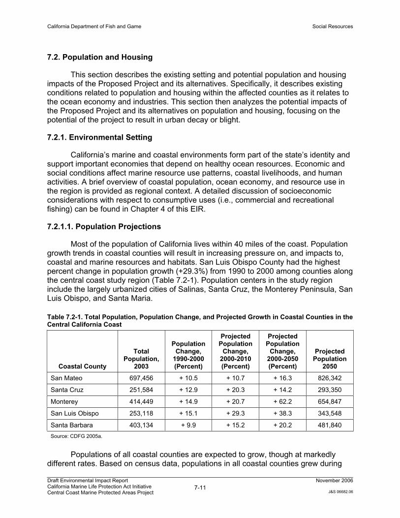
Most of the population of California lives within 40 miles of the coast. Population growth trends in coastal counties will result in increasing pressure on, and impacts to, coastal and marine resources and habitats. San Luis Obispo County had the highest percent change in population growth (+29.3%) from 1990 to 2000 among counties along the central coast study region (Table 7.2-1). Population centers in the study region include the largely urbanized cities of Salinas, Santa Cruz, the Monterey Peninsula, San Luis Obispo, and Santa Maria.
Table 7.2-1. Total Population, Population Change, and Projected Growth in Coastal Counties in the Central California Coast
Coastal County
TotalPopulation,
2003
PopulationChange,
1990-2000 (Percent)
Projected Population
Change, 2000-2010 (Percent)
Projected Population
Change, 2000-2050 (Percent)
Projected Population
2050
San Mateo 697,456 + 10.5 + 10.7 + 16.3 826,342
Santa Cruz 251,584 + 12.9 + 20.3 + 14.2 293,350
Monterey 414,449 + 14.9 + 20.7 + 62.2 654,847
San Luis Obispo 253,118 + 15.1 + 29.3 + 38.3 343,548
Santa Barbara 403,134 + 9.9 + 15.2 + 20.2 481,840
Source: CDFG 2005a.
Populations of all coastal counties are expected to grow, though at markedly different rates. Based on census data, populations in all coastal counties grew during
California Department of Fish and Game Social Resources
Draft Environmental Impact Report California Marine Life Protection Act Initiative Central Coast Marine Protected Areas Project
7-12November 2006
J&S 06682.06
the period between 1990 and 2000. Based on a demographic model that incorporates fertility, migration, and survival rates, population projections for the year 2050 indicate that Monterey County will have population increases greater than 50% and San Luis Obispo County close to 40%. Rapid growth is occurring in the counties where the average population density is currently the lowest (CDFG 2005a).
7.2.1.2. Ocean Economy
California is the most visited state in the U.S., and travel and tourism comprise the fourth-largest industry and employer in the state. Tourism and recreation are economic drivers in central coast counties. The counties within the central coast region boast some of the “Top Ten” most popular destinations in the state, including the Monterey Bay Aquarium and the Santa Cruz Beach and Boardwalk.
Data from the National Ocean Economics Program were compiled for each county and are discussed below. Data are from five ocean industry sectors, and include the number of people employed and wages paid. The ocean industry sectors are:
1. Construction - marine construction.
2. Living Resources - aquaculture, seafood harvesting and processing.
3. Ship and Boat Building
4. Tourism and Recreation - recreational fishing, amusement and recreation services, boat dealers, eating and drinking places, hotels and motels, marinas, recreational vehicle parks and campgrounds, sporting good retailers, zoos and aquaria.
5. Transportation - deep sea freight transportation, marine transportation services, petroleum and natural gas pipelines, search and navigation equipment, warehousing.
Monterey County
Monterey County includes approximately 100 miles of California’s coast. There are two main commercial harbors and ports and one small landing facility in the Monterey County region. The commercial harbors are Moss Landing and Monterey, and the landing facility is at Mill Creek in the southern end of the county. Monterey is also the third-highest agricultural producing county in the state. Twenty-one percent of all county residents are employed in agriculture and it is the largest industry in the county (CDFG 2005a).
Population projections predict rapid growth to over 650,000 residents by 2050. Job growth will be mainly in services, government, and retail trade sectors. Unemployment in 2002 was 10.4 % where the average in California was 6.7%.
California Department of Fish and Game Social Resources
Draft Environmental Impact Report California Marine Life Protection Act Initiative Central Coast Marine Protected Areas Project
7-13November 2006
J&S 06682.06
Seasonal jobs in agriculture and tourism, the mainstay of the economy, create seasonal unemployment (CDFG 2005a).
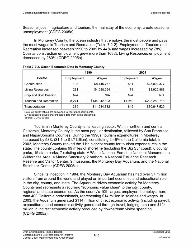
In Monterey County, the ocean industry that employs the most people and pays the most wages is Tourism and Recreation (Table 7.2-2). Employment in Tourism and Recreation increased between 1990 to 2001 by 44% and wages increased by 78%. Coastal construction employment grew more than 168%. Living Resources employment decreased by 280% (CDFG 2005a).
Table 7.2-2. Ocean Economic Data in Monterey County
1990 2001
Sector Employment Wages Employment Wages
Construction 198 $8,145,767 531 $25,092,377
Living Resources 281 $4,038,264 74 $1,920,888
Ship and Boat Building N/A N/A N/A N/A
Tourism and Recreation 8,271 $134,042,893 11,950 $238,280,718
Transportation 339 $11,284,332 849 $30,647,529
Note: All dollar values are converted to year 2000 equivalents. D = Disclosure issues prevent these data from being presented. Source: CDFG 2005a.
Tourism in Monterey County is its leading sector. Within northern and central California, Monterey County is the most popular destination, followed by San Francisco and Napa/Sonoma Counties. During the 1990s, tourism expenditures in Monterey increased by 58% ($1.1 to $1.7 billion), constituting 2.46% of the California total. In 2003, Monterey County ranked the 11th highest county for tourism expenditures in the state. The county contains 99 miles of shoreline (including the Big Sur coast), 6 county parks, 15 state parks, 7 existing state MPAs, a National Forest, a National Monument, a Wilderness Area, a Marine Sanctuary,2 harbors, a National Estuarine Research Reserve and Visitor Center, 9 museums, the Monterey Bay Aquarium, and the National Steinbeck Center (CDFG 2005a).
Since its inception in 1984, the Monterey Bay Aquarium has had over 37 million visitors from around the world and played an important economic and educational role in the city, county, and state. The Aquarium drives economic activity for Monterey County and represents a recurring "economic value chain" to the city, county, regional and state economies. As the county's 10th largest employer, it employs more than 400 California professionals, representing $14 million in salaries and wages. In 2003, the Aquarium generated $114 million of direct economic activity (including payroll, expenditures, and economic activity generated through travel, lodging, etc.) and $124 million in indirect economic activity produced by downstream visitor spending (CDFG 2005a).
California Department of Fish and Game Social Resources
Draft Environmental Impact Report California Marine Life Protection Act Initiative Central Coast Marine Protected Areas Project
7-14November 2006
J&S 06682.06
San Luis Obispo County
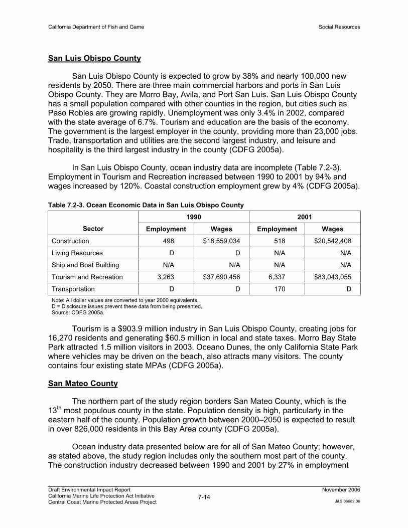
San Luis Obispo County is expected to grow by 38% and nearly 100,000 new residents by 2050. There are three main commercial harbors and ports in San Luis Obispo County. They are Morro Bay, Avila, and Port San Luis. San Luis Obispo County has a small population compared with other counties in the region, but cities such as Paso Robles are growing rapidly. Unemployment was only 3.4% in 2002, compared with the state average of 6.7%. Tourism and education are the basis of the economy. The government is the largest employer in the county, providing more than 23,000 jobs. Trade, transportation and utilities are the second largest industry, and leisure and hospitality is the third largest industry in the county (CDFG 2005a).
In San Luis Obispo County, ocean industry data are incomplete (Table 7.2-3). Employment in Tourism and Recreation increased between 1990 to 2001 by 94% and wages increased by 120%. Coastal construction employment grew by 4% (CDFG 2005a).
Table 7.2-3. Ocean Economic Data in San Luis Obispo County
1990 2001
Sector Employment Wages Employment Wages
Construction 498 $18,559,034 518 $20,542,408
Living Resources D D N/A N/A
Ship and Boat Building N/A N/A N/A N/A
Tourism and Recreation 3,263 $37,690,456 6,337 $83,043,055
Transportation D D 170 D
Note: All dollar values are converted to year 2000 equivalents. D = Disclosure issues prevent these data from being presented. Source: CDFG 2005a.
Tourism is a $903.9 million industry in San Luis Obispo County, creating jobs for 16,270 residents and generating $60.5 million in local and state taxes. Morro Bay State Park attracted 1.5 million visitors in 2003. Oceano Dunes, the only California State Park where vehicles may be driven on the beach, also attracts many visitors. The county contains four existing state MPAs (CDFG 2005a).
San Mateo County
The northern part of the study region borders San Mateo County, which is the 13th most populous county in the state. Population density is high, particularly in the eastern half of the county. Population growth between 2000–2050 is expected to result in over 826,000 residents in this Bay Area county (CDFG 2005a).
Ocean industry data presented below are for all of San Mateo County; however, as stated above, the study region includes only the southern most part of the county. The construction industry decreased between 1990 and 2001 by 27% in employment
California Department of Fish and Game Social Resources
Draft Environmental Impact Report California Marine Life Protection Act Initiative Central Coast Marine Protected Areas Project
7-15November 2006
J&S 06682.06
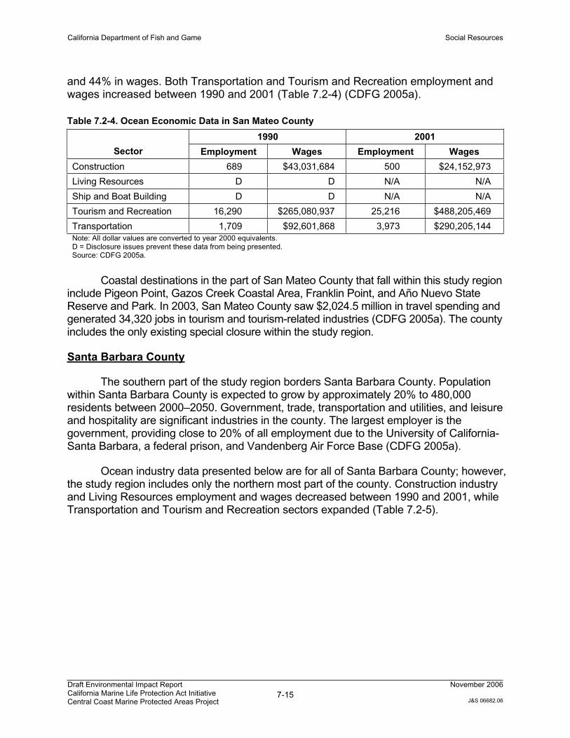
and 44% in wages. Both Transportation and Tourism and Recreation employment and wages increased between 1990 and 2001 (Table 7.2-4) (CDFG 2005a).
Table 7.2-4. Ocean Economic Data in San Mateo County
1990 2001
Sector Employment Wages Employment Wages
Construction 689 $43,031,684 500 $24,152,973
Living Resources D D N/A N/A
Ship and Boat Building D D N/A N/A
Tourism and Recreation 16,290 $265,080,937 25,216 $488,205,469
Transportation 1,709 $92,601,868 3,973 $290,205,144 Note: All dollar values are converted to year 2000 equivalents. D = Disclosure issues prevent these data from being presented. Source: CDFG 2005a.
Coastal destinations in the part of San Mateo County that fall within this study region include Pigeon Point, Gazos Creek Coastal Area, Franklin Point, and Año Nuevo State Reserve and Park. In 2003, San Mateo County saw $2,024.5 million in travel spending and generated 34,320 jobs in tourism and tourism-related industries (CDFG 2005a). The county includes the only existing special closure within the study region.
Santa Barbara County
The southern part of the study region borders Santa Barbara County. Population within Santa Barbara County is expected to grow by approximately 20% to 480,000 residents between 2000–2050. Government, trade, transportation and utilities, and leisure and hospitality are significant industries in the county. The largest employer is the government, providing close to 20% of all employment due to the University of California-Santa Barbara, a federal prison, and Vandenberg Air Force Base (CDFG 2005a).
Ocean industry data presented below are for all of Santa Barbara County; however, the study region includes only the northern most part of the county. Construction industry and Living Resources employment and wages decreased between 1990 and 2001, while Transportation and Tourism and Recreation sectors expanded (Table 7.2-5).

California Department of Fish and Game Social Resources
Draft Environmental Impact Report California Marine Life Protection Act Initiative Central Coast Marine Protected Areas Project
7-16November 2006
J&S 06682.06
Table 7.2-5. Ocean Economic Data in Santa Barbara County
1990 2001
Sector Employment Wages Employment Wages
Construction 227 $9,605,311 216 $12,077,178
Living Resources 11 $202,858 15 $357,587
Ship and Boat Building 12 $315,663 N/A N/A
Tourism and Recreation 8,889 $119,728,107 13,915 $229,331,940
Transportation 2,393 $122,402,300 2,546 $147,835,455 Note: All dollar values are converted to year 2000 equivalents. D = Disclosure issues prevent these data from being presented. Source: CDFG 2005a.
In 2003, Santa Barbara County experienced $1,219 million in travel spending and 15,310 jobs in the tourism industry. The county includes many heavily visited county and state beaches, and contains one existing state MPA within the study region (CDFG 2005a).
Santa Cruz County
Santa Cruz is the second smallest county in California with just 440 square miles of land. The county expects population growth through 2050 of about 40,000 residents to a total population of 293,000. There is one main harbor in the county (primarily used by recreational boaters), Santa Cruz Harbor. Capitola Pier also has private and rental boat facilities. Unemployment is higher in this county than other counties due to the seasonal variations of employment in the main industries of agriculture, recreation, and tourism. Government, including federal, state, and local, and service sectors are the largest areas of growth. The southern part of the county incorporates more fertile lands of Pajaro Valley, which is a productive agricultural community (CDFG 2005a).
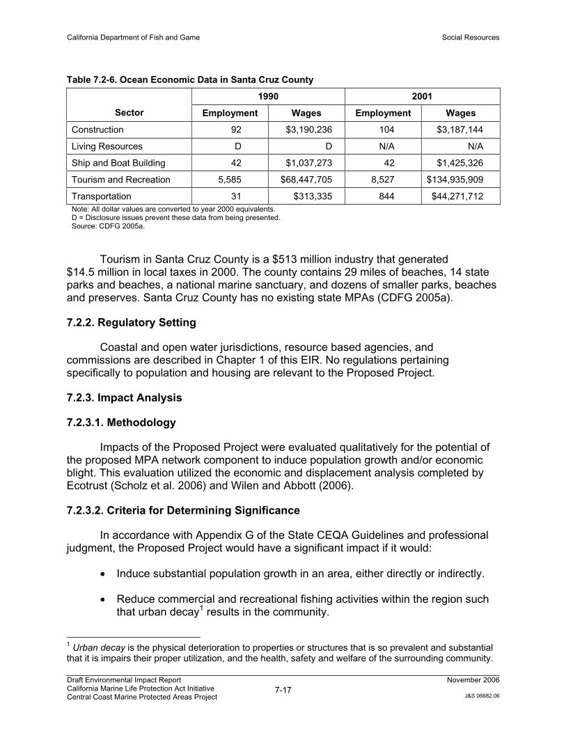
In Santa Cruz County, the ocean industry that employs the most people and pays the most wages is Tourism and Recreation (Table 7.2-6). Employment in Tourism and Recreation increased between 1990 to 2001 by 53% and wages increased by 97%. Transportation employment grew more than 2622%. Employment in Ship and Boat Building remained stable between 1990 and 2001, although wages increased (CDFG 2005a).
California Department of Fish and Game Social Resources
Draft Environmental Impact Report California Marine Life Protection Act Initiative Central Coast Marine Protected Areas Project
7-17November 2006
J&S 06682.06
Table 7.2-6. Ocean Economic Data in Santa Cruz County
1990 2001
Sector Employment Wages Employment Wages
Construction 92 $3,190,236 104 $3,187,144
Living Resources D D N/A N/A
Ship and Boat Building 42 $1,037,273 42 $1,425,326
Tourism and Recreation 5,585 $68,447,705 8,527 $134,935,909
Transportation 31 $313,335 844 $44,271,712 Note: All dollar values are converted to year 2000 equivalents. D = Disclosure issues prevent these data from being presented. Source: CDFG 2005a.
Tourism in Santa Cruz County is a $513 million industry that generated $14.5 million in local taxes in 2000. The county contains 29 miles of beaches, 14 state parks and beaches, a national marine sanctuary, and dozens of smaller parks, beaches and preserves. Santa Cruz County has no existing state MPAs (CDFG 2005a).
7.2.2. Regulatory Setting
Coastal and open water jurisdictions, resource based agencies, and commissions are described in Chapter 1 of this EIR. No regulations pertaining specifically to population and housing are relevant to the Proposed Project.
7.2.3. Impact Analysis
7.2.3.1. Methodology
Impacts of the Proposed Project were evaluated qualitatively for the potential of the proposed MPA network component to induce population growth and/or economic blight. This evaluation utilized the economic and displacement analysis completed by Ecotrust (Scholz et al. 2006) and Wilen and Abbott (2006).
7.2.3.2. Criteria for Determining Significance
In accordance with Appendix G of the State CEQA Guidelines and professional judgment, the Proposed Project would have a significant impact if it would:
Induce substantial population growth in an area, either directly or indirectly.
Reduce commercial and recreational fishing activities within the region such that urban decay1 results in the community.
1 Urban decay is the physical deterioration to properties or structures that is so prevalent and substantial that it is impairs their proper utilization, and the health, safety and welfare of the surrounding community.
California Department of Fish and Game Social Resources
Draft Environmental Impact Report California Marine Life Protection Act Initiative Central Coast Marine Protected Areas Project
7-18November 2006
J&S 06682.06
7.2.3.3. Environmental Impacts
Impact PH-1: Induce Substantial Population Growth.
Proposed Project: Less than Significant
Population in all counties in the central coast region is expected to grow in the coming decades. Of the five coastal counties adjacent to the study region, Monterey County is expected to have the largest increase in population change by the year 2050 (CDFG 2005a). The Tourism and Recreation industry employs the highest number of people in each of the five counties.
Proposed MPAs are unlikely to have any direct effect on population or housing due to their nature as protection areas for underwater habitats. Potential indirect impacts from MPA establishment could include long-term increases in Tourism and Recreation employment as fishery resources improve and additional recreational boating, diving, and viewing activities are subsequently undertaken. These potential increases in employment could result in increased housing demand from new employees. However, the Tourism and Recreation industry within the central coast region is expected to continue growing independent of MPA establishment, and attributing potential growth to the Proposed Project is speculative.
The Proposed Project would not directly induce substantial population growth within the study region. Consequently, this potential impact is considered less than significant.
Mitigation - No mitigation is required because impacts are not significant.
Alternative 1: Less than Significant
Potential effects associated with Alternative 1 would be the same as those described above for the Proposed Project; therefore, impacts to population growth associated with Alternative 1 would be less than significant.
Mitigation - No mitigation is required because impacts are not significant.
Alternative 2: Less than Significant
Potential effects associated with Alternative 2 would be the same as those described above for the Proposed Project; therefore, impacts to population growth associated with Alternative 2 would be less than significant.
Physical deterioration includes, but is not limited to, abnormally high business vacancies, abandoned buildings, boarded doors and windows, parked trucks and long-term unauthorized use of properties and parking lots, extensive or offensive graffiti painted on buildings, dumping of refuse or overturned dumpsters on properties, dead trees and shrubbery and uncontrolled weed growth or homeless encampments.
California Department of Fish and Game Social Resources
Draft Environmental Impact Report California Marine Life Protection Act Initiative Central Coast Marine Protected Areas Project
7-19November 2006
J&S 06682.06
Mitigation - No mitigation is required because impacts are not significant.
Impact PH-2: Urban Decay Due to Decline of the Commercial Fishing Industry
Urban decay involves physical deterioration of other properties due to implementation of the Proposed Project. Urban decay is a compounding phenomenon that can result from extended vacancy, deferred maintenance, and abandonment of commercial buildings.
Proposed Project: Less than Significant
The ocean economies in the five central coast counties are based primarily in the Tourism and Recreation industry. Although the establishment of MPAs might discourage some commercial fisherman from continuing work (along with the factors listed in Chapter 4 of this EIR), the business opportunities surrounding recreational boating, diving, and viewing activities may increase adjacent to and within MPA boundaries. The potential losses that might occur on a local level from a few individuals leaving the commercial fishing industry would not represent a substantial impact to the local economy. Furthermore, the potential for substantial loss of businesses within the fishing industry, even on a localized level, is not supported by economic analysis completed to date (Wilen and Abbott 2006).
Additionally, protection of fisheries within the MPAs, coupled with the use of traditional fishery management tools, would likely contribute to sustainable fisheries populations in the long term. Following recovery of rockfish stocks, commercial and recreational fishing may improve along the boundaries of some MPA areas. Contrary to urban decay, such recovery may contribute to the sustainability of the commercial fishing industry along the central California coast. Potential short-term decline in commercial vessels docked within ports and harbors in the study region is unlikely to result in high vacancy rates or abandonment of port facilities. As stated above, the tourism industry is expected to continue substantial growth along the central coast and harbor slips would likely be filled within fishing and non-fishing vessels.
Therefore, the Proposed Project would not result in urban decay within the central coast region, and the Proposed Project’s impact to the ocean economy and related industries would be less than significant.
Mitigation - No mitigation is required because impacts are not significant.
Alternative 1: Less than Significant
Potential effects associated with Alternative 1 would be similar to those described above for the Proposed Project. While this alternative also would result in displacement of fishing effort within the central coast study region, the effect would be less than
California Department of Fish and Game Social Resources
Draft Environmental Impact Report California Marine Life Protection Act Initiative Central Coast Marine Protected Areas Project
7-20November 2006
J&S 06682.06
expected for the Proposed Project; therefore, potential urban decay impacts associated with Alternative 1 would be less than significant.
Mitigation - No mitigation is required because impacts are not significant.
Alternative 2: Less than Significant
Potential effects associated with Alternative 2 would be similar to those described above for the Proposed Project; however, this alternative potentially results in a slightly greater displacement of fishing effort, thereby slightly increasing the potential for economic losses within the fishing industry. As mentioned above, the potential for economic decay resulting from substantial business losses within the fishing industry, even on a localized level, is speculative, and not supported by economic analysis completed to date (Wilen and Abbott 2006). Therefore, potential urban decay impacts associated with Alternative 2 would be less than significant.
Mitigation - No mitigation is required because impacts are not significant.
7.3. Public Services and Utilities
This section describes the existing setting and potential public services and utilities impacts of the Proposed Project and its alternatives. Specifically, it describes existing conditions related to public services and utilities; analyzes the potential impacts of the Proposed Project and alternatives on public services and utilities; and identifies mitigation measures to address significant impacts, as appropriate.
7.3.1. Environmental Setting
Proposed MPAs are not currently served by public services and utilities due to their nature as protection areas for underwater habitats. Establishment of MPAs along the central California coast would not impact provision of the following public services and utilities; therefore, these services and utilities are not addressed in this chapter.
Water supply, wastewater treatment, or storm drainage facilities;
Solid waste disposal;
Gas and electric, cable, and communications utilities.
However, establishment of the MPAs could potentially disrupt or impact provision of law enforcement and/or emergency response services by increasing the demand for such services in and around MPAs. This is discussed further in the following setting and impact sections.
California Department of Fish and Game Social Resources
Draft Environmental Impact Report California Marine Life Protection Act Initiative Central Coast Marine Protected Areas Project
7-21November 2006
J&S 06682.06
7.3.1.1. Law Enforcement Assets
The Department’s Master Plan for Marine Protected Areas (CDFG 2006) notes that a lack of law enforcement resources is one of the reasons existing MPAs fall short of their potential to protect resources. This lack of law enforcement resources is not unique to the MPA context, and is true across all marine management activities in California. To remedy this, the MLPA requires that the Marine Life Protection Program provide for adequate enforcement [FGC Section 2853(b)(5)] and include appropriate enforcement measures for all MPAs in the system [FGC Section 2853(c)(2)]. The MLPA includes in this the use, to the extent practicable, of advanced technology and surveillance systems. Because of the added emphasis on MPAs established by the MLPA and the clear need for increased enforcement resources, additional assets will be required.
The Department works closely with the enforcement programs of the U.S. Fish and Wildlife Service, NOAA Fisheries NMFS, the U.S. Coast Guard, the National Park Service, and the California Department of Parks and Recreation on matters of mutual enforcement interest (see below). Though these programs often provide financial or logistical support, they do not provide significant staff resources statewide, especially for offshore patrols or patrols of areas not adjacent to their own facilities. As part of seeking new cooperative agreements, the Department will make efforts to acquire more direct assistance from appropriate agencies.
California Department of Fish and Game
The Department has management authority for all marine fishes, invertebrates, and plants within state waters. The Department’s enforcement staff is charged with enforcing marine resource management laws and regulations over an area encompassing approximately 1,100 miles of coastline and out to sea. Department staff also provide enforcement of federal laws and regulations within state and federal waters. Enforcement duties include all commercial and sport fishing statutes and regulations contained in the Fish and Game Code and Title 14, California Code of Regulations, marine water pollution incidents, homeland security, and general public safety. General fishing regulations and other restrictions apply within MPAs but are superseded by specific MPA restrictions.
A federal Cooperative Enforcement Agreement with NOAA deputizes the Department to enforce the Magnuson Stevens Fishery Conservation and Management Act, the Endangered Species Act, the Marine Mammal Protection Act, the National Marine Sanctuaries Act, and the Lacey Act. Department enforcement patrols regularly extend into federal waters between 3 and 12 nautical miles from shore as well as the rest of the EZZ beyond 12 nautical miles. A significant portion of both commercial and recreational fishing effort, and subsequently enforcement effort, occurs outside state waters in the EEZ. The existing patrol effort beyond state waters and outside MPAs must also be considered in the Master Plan. How effectively state and federal
California Department of Fish and Game Social Resources
Draft Environmental Impact Report California Marine Life Protection Act Initiative Central Coast Marine Protected Areas Project
7-22November 2006
J&S 06682.06
regulations are enforced within and around the MPAs will affect the success of MPAs in conserving and protecting marine resources.
The Department maintains a fleet of seven large patrol boats in the 54- to 65-foot class stationed at major ports throughout the state. A cadre of 22 officers, and 5 support personnel staffs these patrol boats. The Department also has 8 patrol boats in the 24- to 30-foot range, and another 15 patrol skiffs stationed at ports and harbors throughout the state. One large patrol boat is primarily responsible for the Channel Islands marine protected areas law enforcement patrols. Two large patrol boats are within the central coast study region. Overall, the Department has approximately 230 wardens in the field, responsible for a combination of both inland and marine patrol. Some of these wardens have a “marine emphasis” focusing primarily on ocean enforcement but also enforcing inland regulations. In the central coast study region, there are presently 30 to 40 wardens in the field. Of these, only about 15 have a marine emphasis and are responsible for enforcing regulations over more than 1,100 square miles of state waters within the study region.
The Department’s SOU consists of enforcement officers who are tasked with conducting statewide covert investigations primarily dealing with the commercialization of fish and/or wildlife. SOU investigations investigate large poaching operations that are severely impacting California’s fish and wildlife resources. The SOU reports directly to the Marine Assistant Chief out of Sacramento Headquarters. The unit has no uniform patrol responsibility anywhere in the state. The investigations conducted by SOU are varied, and include commercialization of recreationally caught or illegally taken bear, deer, turkey, abalone, lobster, sturgeon, salmon and steelhead, and a variety of other marine and wildlife species. The SOU may be used to assist with major MPA violations.
U.S. Fish and Wildlife Service
The USFWS monitors and implements programs that manage migratory birds and fish, national wildlife refuges, national fish hatcheries, and endangered species. The USFWS has management authority over marine birds and sea otters. USFWS agents and officers have the statutory authority to enforce the Marine Mammal Protection Act, Endangered Species Act and Lacey Act.
NOAA Fisheries
The Department has a Joint Enforcement Agreement with NOAA Fisheries. NOAA Fisheries provides funding to the state to enforce federal regulations in state waters, federal offshore waters and in bays, estuaries, rivers and streams.
National Marine Fisheries Service
NMFS, a division of NOAA Fisheries, manages living marine resources and Essential Fish Habitat between 3 and 200 miles seaward of the U.S. coast, outside of state waters. NMFS has management jurisdiction for pinnipeds and cetaceans. NMFS
California Department of Fish and Game Social Resources
Draft Environmental Impact Report California Marine Life Protection Act Initiative Central Coast Marine Protected Areas Project
7-23November 2006
J&S 06682.06
boats and aircraft are available for law enforcement patrols in all California sanctuaries. Currently, there are several sanctuary officers within the central coast area, patrolling the Monterey Bay National Marine Sanctuary. Law enforcement agreements coordinate enforcement efforts, share physical resources, cross deputize state officers and provide federal funds for state operations.
U.S. Coast Guard
U.S. Coast Guard is the primary maritime law enforcement agency. The statutory authority for the Coast Guard law enforcement mission is given in 14 USC 2 and 14 USC 89, which authorizes Coast Guard personnel to enforce federal law on waters subject to U.S. jurisdiction and in international waters. The U.S. Coast Guard has a primary role in protecting natural resources under the Oil Pollution Act of 1990, the Rivers and Harbors Act of 1899, and the Marine Plastic Pollution and Control Act. The U.S. Coast Guard works directly with the Department’s Office of Spill Prevention and Response (OSPR) on oil pollution incidents. They also provide limited support for state and federal fisheries regulation enforcement.
National Park Service
The National Park Service has enforcement personnel stationed at various federal parks along the California coast and at some of the off-shore islands.
California Department of Parks and Recreation
The Department of Parks and Recreation manages approximately one-third of the California coastline and has law enforcement personnel stationed in park units throughout California, many with water patrol capability. These officers have the authority to enforce CDFG statutes.
Harbor Police, City Police, and Sheriffs
Local harbor districts, sheriff and police departments often employ peace officers to conduct on-water patrols within their jurisdictions.
7.3.1.2. MPA Enforcement Considerations
The level and type of enforcement activity in an individual MPA depends upon the objectives of the individual MPA and its accompanying regulations. In some cases, MPAs may be enforced without direct contact of individual vessels, such as in state marine reserves where a vessel is obviously not engaged in fishing. In limited-take areas, the specific regulations may require close examination of individual vessels to determine whether fishing activities comply with the regulations.
Beyond the MPA classification, other elements of MPA design have implications for an effective enforcement plan. The following factors facilitate enforcement of MPAs:
California Department of Fish and Game Social Resources
Draft Environmental Impact Report California Marine Life Protection Act Initiative Central Coast Marine Protected Areas Project
7-24November 2006
J&S 06682.06
Straight line offshore boundaries which follow lines of latitude and longitude - more easily recognized by users and enforcement is simplified.
Larger shoreline lengths - provide a buffer against unintentional boundary infractions.
Proximity to cities - enhances the ability to enforce as more assets are readily available and deployment of staff and equipment is easier; however may pose problems for level of use (see below).
Distant from heavily used areas - areas near urban development are often more heavily visited and require more enforcement effort to ensure compliance.
Fewer points of public access - Increased numbers of access points to an MPA (e.g., multiple shoreside access points versus only offshore access) require increased monitoring efforts and increased staffing.
Adjacent to the shoreline - enforceable using smaller vessels and shoreside patrol when compared to offshore MPAs with no shoreline connection.
Adjacent to onshore facilities - existing staff (e.g., state park rangers) can assist in enforcement and monitoring.
The number of and distance between MPAs also impacts the Department’s ability to enforce the MPA regulations. If MPAs are too far from one another, individual patrols are not able to enforce multiple areas. If MPAs are too numerous, individual patrols are not able to reach all areas. Each case would require additional enforcement personnel to cover the entire network component of MPAs. Finally, the enforcement plan must consider natural barriers to enforcement. MPAs established in areas with normally rough conditions may be difficult to patrol or access. Offshore MPAs require larger vessels and dedicated at-sea patrol. MPAs located farther offshore or more distant from ports have higher patrol costs in both time and expenses. Though MPAs in very remote and difficult-to-access areas will naturally have fewer visitors and a decreased chance of unintentional infractions, they are also uniquely suited for unobserved intentional infractions.
7.3.1.3. Emergency Response Services
The U.S. Coast Guard, the primary maritime law enforcement agency, currently provides emergency response within existing MPAs. Search and Rescue (SAR) is one of the Coast Guard's oldest missions. Coast Guard SAR response involves multi-mission stations, cutters, aircraft, and boats linked by communications networks. Emergency response services include distress monitoring, communications, provision of medical advice, initial medical assistance, and/or medical evacuation. The Coast Guard develops, establishes, maintains and operates rescue facilities for the promotion of
California Department of Fish and Game Social Resources
Draft Environmental Impact Report California Marine Life Protection Act Initiative Central Coast Marine Protected Areas Project
7-25November 2006
J&S 06682.06
safety on, under, and over international waters and waters subject to U.S. jurisdiction, conducts safety inspections of most merchant vessels, and investigates marine casualties.
7.3.2. Regulatory Setting
Coastal and open water jurisdictions, resource based agencies and commissions are described in Chapter 1 of this EIR.
7.3.2.1. Marine Protected Areas Enforcement Plans
The MLPA identifies adequate enforcement as a program goal [FGC Section 2853(c)(2)]. To this end, the Department will prepare enforcement plans for the proposed MPAs once established. The primary purpose of an MPA enforcement plan is to ensure compliance with regulations designed to achieve the individual MPA objectives. The objectives of the enforcement plan include the following four primary categories:
1. Provide an effective and comprehensive operational ability.
2. Maintain and enhance cooperative efforts with other agencies.
3. Ensure public awareness of regulations and rationale.
4. Provide outreach and education.
Priorities are to be developed based on the potential for resource impact, level of use, and potential for infractions. High priority areas include habitats that are particularly vulnerable to damage, areas with high aggregations of critical species or species at low abundance, and areas where infractions are likely to occur or have occurred at high rates in the past.
7.3.3. Impact Analysis
7.3.3.1. Methodology
Impacts of the Proposed Project were evaluated qualitatively, based on the potential for MPA establishment to disrupt existing utilities and services.
7.3.3.2. Criteria for Determining Significance
Based on Appendix G of the State CEQA Guidelines and professional judgment, it was determined that the Proposed Project would result in a significant impact on public services if it would:
California Department of Fish and Game Social Resources
Draft Environmental Impact Report California Marine Life Protection Act Initiative Central Coast Marine Protected Areas Project
7-26November 2006
J&S 06682.06
Significantly increase the need for enforcement of federal, state, and/or local laws and regulations.
Result in the need for new or physically altered governmental facilities, in order to maintain acceptable service ratios, response times, or other performance objectives for police, fire, or emergency response.
7.3.3.3. Environmental Impacts
Impact PSU-1: Increased Demand on Law Enforcement Services.
Proposed Project: Less than Significant
New limitations on extractive activities established by the MPAs represent new regulations that would likely result in the need for additional enforcement, particularly in the short-term as these become implemented. In order to adequately enforce MPA regulations, the Department would prioritize areas of particular concern or at particular risk and emphasize patrol of these areas. Patrols would be needed to keep fishing boats from illegally taking species from within designated MPAs. Regular, visible, and consistent patrol would be needed to ensure compliance, in addition to adequate outreach to ensure public knowledge of regulations and areas. The need for increased patrol efforts would be greater initially upon implementation of the new regulations, and would likely decrease over time as public knowledge of the regulations and areas becomes more widespread.
The agencies that currently provide law enforcement services for the central coast would continue to patrol the MPA areas. Increased use of inter-agency cooperative agreements may also facilitate enforcement and will be addressed in the MLPA program enforcement plan. Since existing law enforcement resources would not be redirected from patrol services elsewhere in the state, potential impacts to public services would be less than significant2.
Mitigation - No mitigation is required because impacts are not significant.
Alternative 1: Less than Significant
Potential effects associated with Alternative 1 would be similar to those described above for the Proposed Project. Due to the reduced MPA network component area provided in Alternative 1, demand for additional law enforcement would be less than that of the Proposed Project. Impacts to enforcement services associated with Alternative 1 would be less than significant.
2 Enforcement actions by regulatory agencies, such as law enforcement activities by peace officers acting under any law that provides a criminal sanction, are categorically exempt under CEQA (Public Resources Code Sections 21083 and 21087).
California Department of Fish and Game Social Resources
Draft Environmental Impact Report California Marine Life Protection Act Initiative Central Coast Marine Protected Areas Project
7-27November 2006
J&S 06682.06
Mitigation - No mitigation is required because impacts are not significant.
Alternative 2: Less than Significant
Potential effects associated with Alternative 2 would be similar to those described above for the Proposed Project. Due to a slightly larger MPA area, demand for additional law enforcement could be comparably greater than that of the Proposed Project. However, impacts to enforcement services associated with Alternative 2 would be less than significant with implementation of the mandated MLPA enforcement plan.
Mitigation - No mitigation is required because impacts are not significant.
Impact PSU-2: Increased Demand on Emergency Response Services.
Proposed Project: No Impact
Establishing MPAs would be unlikely to create additional demand for emergency response services along the coast. Designating some portions of the coast as MPAs would likely shift commercial and recreational anglers to other areas with fewer restrictions. Although implementation of SMRs would reduce potentially risky behavior within those boundaries, continued commercial and recreational fishing would shift Coast Guard SAR activities to areas adjacent to MPA boundaries.
Demand for emergency response services will likely remain stable following implementation of the proposed MPAs; therefore, there would be no impact to emergency response services.
Mitigation - No mitigation is required because there would be no impact.
Alternative 1: No Impact
Potential effects associated with Alternative 1 would be similar to those described above for the Proposed Project. There would be no impacts to emergency response services.
Mitigation - No mitigation is required because there would be no impact.
Alternative 2: No Impact
Potential effects associated with Alternative 2 would be similar to those described above for the Proposed Project. There would be no impacts to emergency response services.
Mitigation - No mitigation is required because there would be no impact.

California Department of Fish and Game Social Resources
Draft Environmental Impact Report California Marine Life Protection Act Initiative Central Coast Marine Protected Areas Project
7-28November 2006
J&S 06682.06
7.4. Recreation
This section describes the existing setting and potential recreational impacts of the Proposed Project and its alternatives. Specifically, it describes existing conditions related to recreational opportunities and facilities, and summarizes the overall federal, state, and regional/local regulatory framework for recreational resources that would affect implementation of an MPA network component. This section also analyzes the potential impacts of the Proposed Project on recreational resources and identifies mitigation measures to address significant impacts, as appropriate.
Recreational resources within this section focus on non-consumptive recreational uses (e.g., diving, wildlife viewing, kayaking, etc.). Consumptive recreational uses (i.e., fishing) are described in Chapter 4 – Consumptive Uses and Socioeconomic Considerations.
7.4.1. Environmental Setting
7.4.1.1. Recreational Activities
In 1999 and 2000, more than 43% of all Americans participated in some form of marine recreation. Americans flock to beaches and shores to swim, fish, boat, and view the natural scenery. While the proportion of the population that participates in marine recreation is expected to decline over the coming decade, population growth in the coastal zone is expected to offset this trend (for a discussion of population trends, please refer to the California Marine Life Protection Act [MLPA] Initiative Regional Profile of the Central Coast Study Region [Pigeon Point to Point Conception, CA][CDFG 2005a]. Overall, the total number of people participating in all forms of marine recreation is expected to increase with the largest increases expected for beach going activities. California ranks second to only Florida in the number of participants in coastal recreation (17.6 million participants). While California also ranks second to Florida in the percent of its population that participates in marine recreation (10.7% for Florida, 8.7 % for California), its large population places California first in the nation in the number of residents that participate in marine recreation annually (12.2 million; Table 7.4-1) (CDFG 2005a).
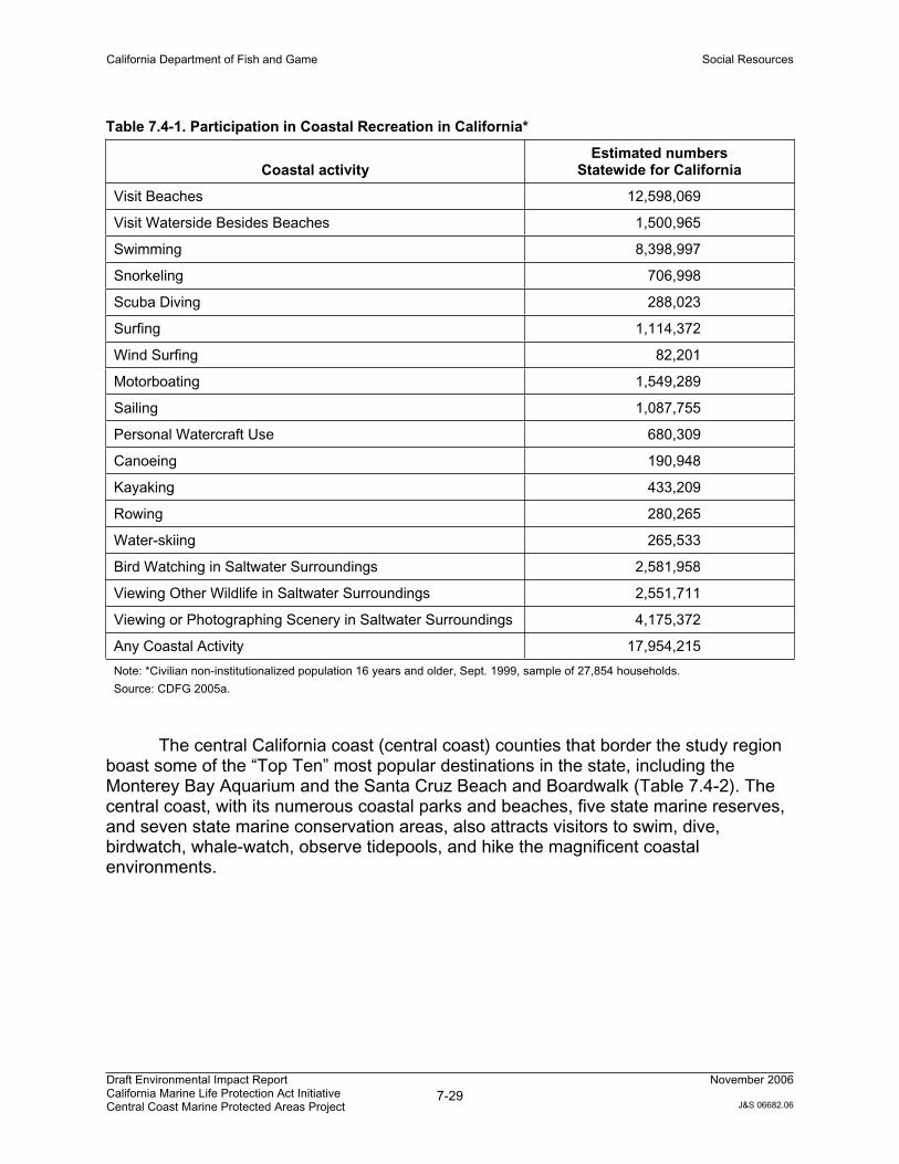
California Department of Fish and Game Social Resources
Draft Environmental Impact Report California Marine Life Protection Act Initiative Central Coast Marine Protected Areas Project
7-29November 2006
J&S 06682.06
Table 7.4-1. Participation in Coastal Recreation in California*
Coastal activity Estimated numbers
Statewide for California
Visit Beaches 12,598,069
Visit Waterside Besides Beaches 1,500,965
Swimming 8,398,997
Snorkeling 706,998
Scuba Diving 288,023
Surfing 1,114,372
Wind Surfing 82,201
Motorboating 1,549,289
Sailing 1,087,755
Personal Watercraft Use 680,309
Canoeing 190,948
Kayaking 433,209
Rowing 280,265
Water-skiing 265,533
Bird Watching in Saltwater Surroundings 2,581,958
Viewing Other Wildlife in Saltwater Surroundings 2,551,711
Viewing or Photographing Scenery in Saltwater Surroundings 4,175,372
Any Coastal Activity 17,954,215
Note: *Civilian non-institutionalized population 16 years and older, Sept. 1999, sample of 27,854 households.
Source: CDFG 2005a.
The central California coast (central coast) counties that border the study region boast some of the “Top Ten” most popular destinations in the state, including the Monterey Bay Aquarium and the Santa Cruz Beach and Boardwalk (Table 7.4-2). The central coast, with its numerous coastal parks and beaches, five state marine reserves, and seven state marine conservation areas, also attracts visitors to swim, dive, birdwatch, whale-watch, observe tidepools, and hike the magnificent coastal environments.
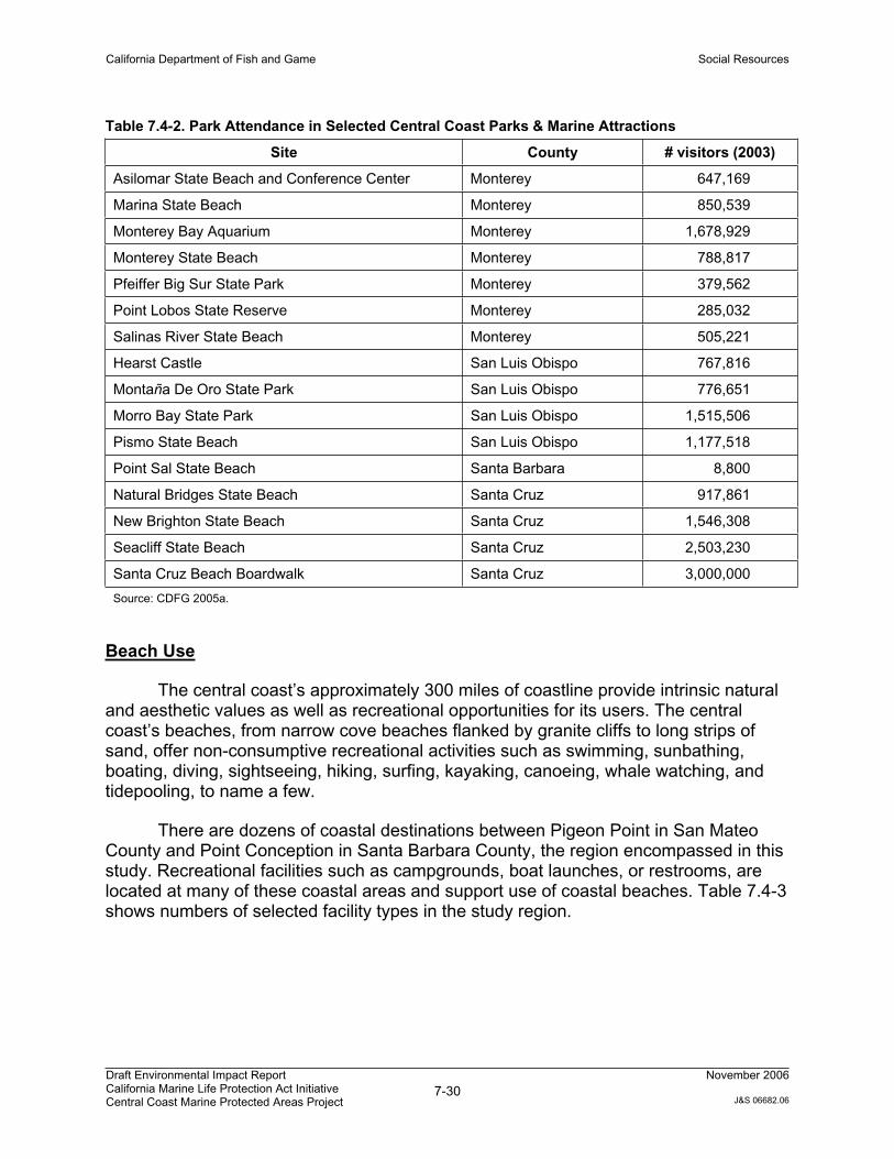
California Department of Fish and Game Social Resources
Draft Environmental Impact Report California Marine Life Protection Act Initiative Central Coast Marine Protected Areas Project
7-30November 2006
J&S 06682.06
Table 7.4-2. Park Attendance in Selected Central Coast Parks & Marine Attractions
Site County # visitors (2003)
Asilomar State Beach and Conference Center Monterey 647,169
Marina State Beach Monterey 850,539
Monterey Bay Aquarium Monterey 1,678,929
Monterey State Beach Monterey 788,817
Pfeiffer Big Sur State Park Monterey 379,562
Point Lobos State Reserve Monterey 285,032
Salinas River State Beach Monterey 505,221
Hearst Castle San Luis Obispo 767,816
Montaña De Oro State Park San Luis Obispo 776,651
Morro Bay State Park San Luis Obispo 1,515,506
Pismo State Beach San Luis Obispo 1,177,518
Point Sal State Beach Santa Barbara 8,800
Natural Bridges State Beach Santa Cruz 917,861
New Brighton State Beach Santa Cruz 1,546,308
Seacliff State Beach Santa Cruz 2,503,230
Santa Cruz Beach Boardwalk Santa Cruz 3,000,000
Source: CDFG 2005a.
Beach Use
The central coast’s approximately 300 miles of coastline provide intrinsic natural and aesthetic values as well as recreational opportunities for its users. The central coast’s beaches, from narrow cove beaches flanked by granite cliffs to long strips of sand, offer non-consumptive recreational activities such as swimming, sunbathing, boating, diving, sightseeing, hiking, surfing, kayaking, canoeing, whale watching, and tidepooling, to name a few.
There are dozens of coastal destinations between Pigeon Point in San Mateo County and Point Conception in Santa Barbara County, the region encompassed in this study. Recreational facilities such as campgrounds, boat launches, or restrooms, are located at many of these coastal areas and support use of coastal beaches. Table 7.4-3 shows numbers of selected facility types in the study region.
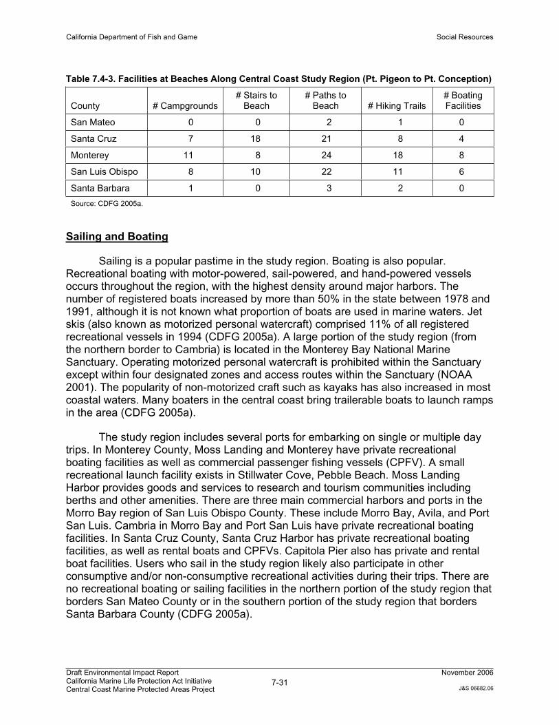
California Department of Fish and Game Social Resources
Draft Environmental Impact Report California Marine Life Protection Act Initiative Central Coast Marine Protected Areas Project
7-31November 2006
J&S 06682.06
Table 7.4-3. Facilities at Beaches Along Central Coast Study Region (Pt. Pigeon to Pt. Conception)
County # Campgrounds # Stairs to
Beach# Paths to
Beach # Hiking Trails # Boating Facilities
San Mateo 0 0 2 1 0
Santa Cruz 7 18 21 8 4
Monterey 11 8 24 18 8
San Luis Obispo 8 10 22 11 6
Santa Barbara 1 0 3 2 0
Source: CDFG 2005a.
Sailing and Boating
Sailing is a popular pastime in the study region. Boating is also popular. Recreational boating with motor-powered, sail-powered, and hand-powered vessels occurs throughout the region, with the highest density around major harbors. The number of registered boats increased by more than 50% in the state between 1978 and 1991, although it is not known what proportion of boats are used in marine waters. Jet skis (also known as motorized personal watercraft) comprised 11% of all registered recreational vessels in 1994 (CDFG 2005a). A large portion of the study region (from the northern border to Cambria) is located in the Monterey Bay National Marine Sanctuary. Operating motorized personal watercraft is prohibited within the Sanctuary except within four designated zones and access routes within the Sanctuary (NOAA 2001). The popularity of non-motorized craft such as kayaks has also increased in most coastal waters. Many boaters in the central coast bring trailerable boats to launch ramps in the area (CDFG 2005a).
The study region includes several ports for embarking on single or multiple day trips. In Monterey County, Moss Landing and Monterey have private recreational boating facilities as well as commercial passenger fishing vessels (CPFV). A small recreational launch facility exists in Stillwater Cove, Pebble Beach. Moss Landing Harbor provides goods and services to research and tourism communities including berths and other amenities. There are three main commercial harbors and ports in the Morro Bay region of San Luis Obispo County. These include Morro Bay, Avila, and Port San Luis. Cambria in Morro Bay and Port San Luis have private recreational boating facilities. In Santa Cruz County, Santa Cruz Harbor has private recreational boating facilities, as well as rental boats and CPFVs. Capitola Pier also has private and rental boat facilities. Users who sail in the study region likely also participate in other consumptive and/or non-consumptive recreational activities during their trips. There are no recreational boating or sailing facilities in the northern portion of the study region that borders San Mateo County or in the southern portion of the study region that borders Santa Barbara County (CDFG 2005a).
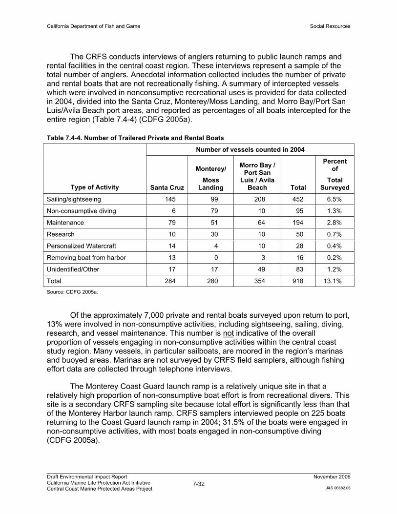
California Department of Fish and Game Social Resources
Draft Environmental Impact Report California Marine Life Protection Act Initiative Central Coast Marine Protected Areas Project
7-32November 2006
J&S 06682.06
The CRFS conducts interviews of anglers returning to public launch ramps and rental facilities in the central coast region. These interviews represent a sample of the total number of anglers. Anecdotal information collected includes the number of private and rental boats that are not recreationally fishing. A summary of intercepted vessels which were involved in nonconsumptive recreational uses is provided for data collected in 2004, divided into the Santa Cruz, Monterey/Moss Landing, and Morro Bay/Port San Luis/Avila Beach port areas, and reported as percentages of all boats intercepted for the entire region (Table 7.4-4) (CDFG 2005a).
Table 7.4-4. Number of Trailered Private and Rental Boats
Number of vessels counted in 2004
Type of Activity Santa Cruz
Monterey/
MossLanding
Morro Bay / Port San
Luis / Avila Beach Total
Percent of
TotalSurveyed
Sailing/sightseeing 145 99 208 452 6.5%
Non-consumptive diving 6 79 10 95 1.3%
Maintenance 79 51 64 194 2.8%
Research 10 30 10 50 0.7%
Personalized Watercraft 14 4 10 28 0.4%
Removing boat from harbor 13 0 3 16 0.2%
Unidentified/Other 17 17 49 83 1.2%
Total 284 280 354 918 13.1%
Source: CDFG 2005a.
Of the approximately 7,000 private and rental boats surveyed upon return to port, 13% were involved in non-consumptive activities, including sightseeing, sailing, diving, research, and vessel maintenance. This number is not indicative of the overall proportion of vessels engaging in non-consumptive activities within the central coast study region. Many vessels, in particular sailboats, are moored in the region’s marinas and buoyed areas. Marinas are not surveyed by CRFS field samplers, although fishing effort data are collected through telephone interviews.
The Monterey Coast Guard launch ramp is a relatively unique site in that a relatively high proportion of non-consumptive boat effort is from recreational divers. This site is a secondary CRFS sampling site because total effort is significantly less than that of the Monterey Harbor launch ramp. CRFS samplers interviewed people on 225 boats returning to the Coast Guard launch ramp in 2004; 31.5% of the boats were engaged in non-consumptive activities, with most boats engaged in non-consumptive diving (CDFG 2005a).
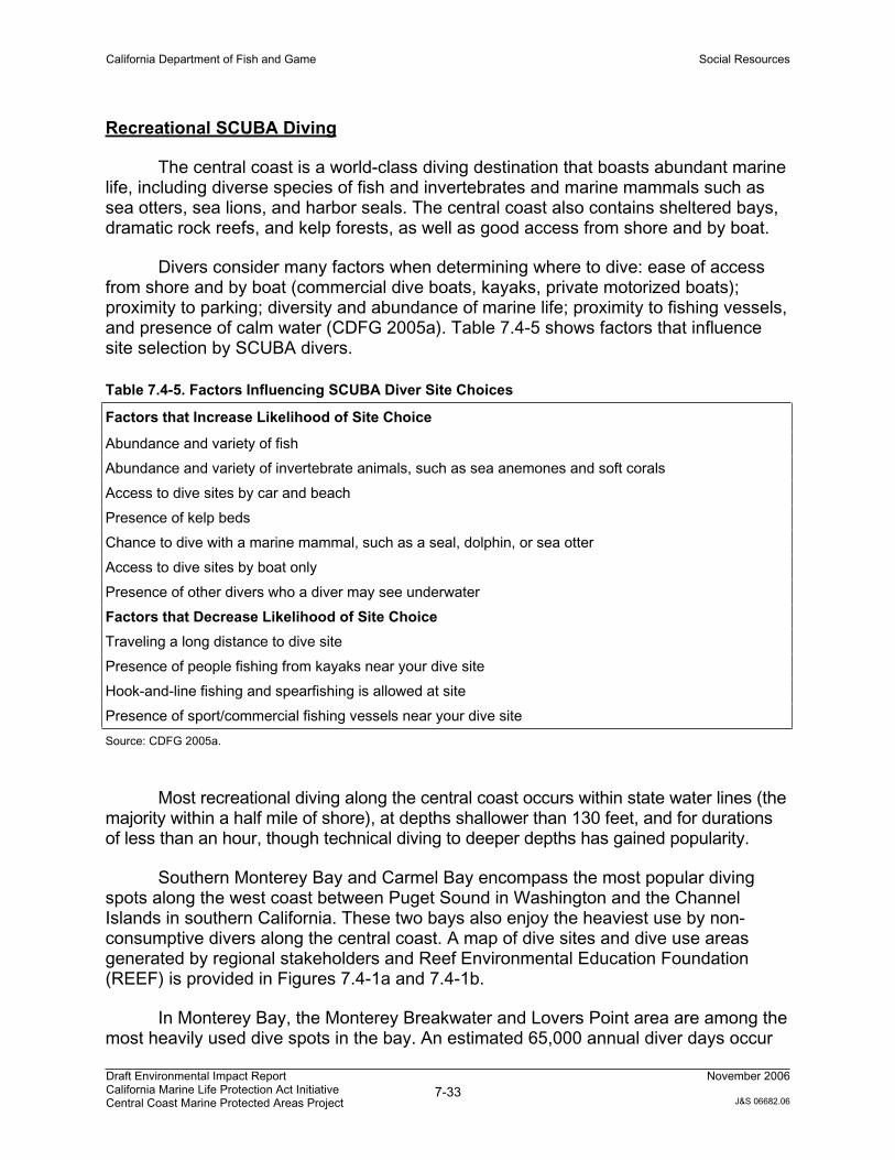
California Department of Fish and Game Social Resources
Draft Environmental Impact Report California Marine Life Protection Act Initiative Central Coast Marine Protected Areas Project
7-33November 2006
J&S 06682.06
Recreational SCUBA Diving
The central coast is a world-class diving destination that boasts abundant marine life, including diverse species of fish and invertebrates and marine mammals such as sea otters, sea lions, and harbor seals. The central coast also contains sheltered bays, dramatic rock reefs, and kelp forests, as well as good access from shore and by boat.
Divers consider many factors when determining where to dive: ease of access from shore and by boat (commercial dive boats, kayaks, private motorized boats); proximity to parking; diversity and abundance of marine life; proximity to fishing vessels, and presence of calm water (CDFG 2005a). Table 7.4-5 shows factors that influence site selection by SCUBA divers.
Table 7.4-5. Factors Influencing SCUBA Diver Site Choices
Factors that Increase Likelihood of Site Choice
Abundance and variety of fish
Abundance and variety of invertebrate animals, such as sea anemones and soft corals
Access to dive sites by car and beach
Presence of kelp beds
Chance to dive with a marine mammal, such as a seal, dolphin, or sea otter
Access to dive sites by boat only
Presence of other divers who a diver may see underwater
Factors that Decrease Likelihood of Site Choice
Traveling a long distance to dive site
Presence of people fishing from kayaks near your dive site
Hook-and-line fishing and spearfishing is allowed at site
Presence of sport/commercial fishing vessels near your dive site
Source: CDFG 2005a.
Most recreational diving along the central coast occurs within state water lines (the majority within a half mile of shore), at depths shallower than 130 feet, and for durations of less than an hour, though technical diving to deeper depths has gained popularity.
Southern Monterey Bay and Carmel Bay encompass the most popular diving spots along the west coast between Puget Sound in Washington and the Channel Islands in southern California. These two bays also enjoy the heaviest use by non-consumptive divers along the central coast. A map of dive sites and dive use areas generated by regional stakeholders and Reef Environmental Education Foundation (REEF) is provided in Figures 7.4-1a and 7.4-1b.
In Monterey Bay, the Monterey Breakwater and Lovers Point area are among the most heavily used dive spots in the bay. An estimated 65,000 annual diver days occur
California Department of Fish and Game Social Resources
Draft Environmental Impact Report California Marine Life Protection Act Initiative Central Coast Marine Protected Areas Project
7-34November 2006
J&S 06682.06
in the area between the Breakwater (San Carlos Beach) and Lovers Point in Monterey Bay alone. Monterey Breakwater is also the most popular training dive site for open water scuba certification in the U.S. The Breakwater and surrounding waters support a diverse assemblages of fishes with more than 90 fish species reported by REEF fish surveys conducted by volunteer divers (more than any other west coast REEF survey site), and similar results reported by professional marine biologists. Because of its accessibility, the Breakwater offers students and beginning divers the potential of a rich experience even on their first dive (CDFG 2005a).
Besides the Breakwater, other popular shore diving entry points include Del Monte Beach, MacAbee Beach, Lovers Cove, Otter Cove, Coral Street Cove, and Point Pinos along Monterey Bay; and Stillwater Cove, Butterfly House, Stewart’s Point, Monastery Beach, and Point Lobos along Carmel Bay. Boat-accessed dive sites are by necessity within small craft distance from boat launching ramps located at Monterey Harbor, Stillwater Cove, and Point Lobos. Figures 7.4-1a and 7.4-1b show the names and locations of recreational and technical dive sites along with coastal access points (CDFG 2005a).
While Monterey and Carmel Bays are the main dive destinations for non-consumptive recreational SCUBA divers, diving does occur in other areas of the central coast study region. Divers also travel by boat southward beyond Carmel Bay to visit sites along the north Big Sur coast, from Point Lobos south to Point Sur. Along the south Big Sur coast, divers also access dive sites primarily by boat, with one commercial dive boat company conducting a few multi-day dive trips each year. One major shore dive site on the Big Sur coast is Jade Cove, where divers go for touring and underwater photography, as well as the recreational extraction of jade by hobbyists. Julia Pfeiffer Burns State Park and Garrapata Park also have beach entry dive sites. South from San Simeon and Cambria, several dive sites, ranging from Point Estero to Point Conception, each have a mix of non-consumptive uses, and underwater photography (CDFG 2005a).
Other Recreational Activities
More than a half-million people participated in some form of kayaking in California in 1999, 2.5 million people participated in wildlife viewing, and more than 4 million people took photos at the beach. Kayaking, whale watching, and nature observation have all increased in popularity. Areas of importance for kayaking, whale-watching, and tidepooling are shown on Figure 7.4-2.
Kayaking
Factors influencing launch and route choice by 16 interviewed kayakers are summarized in Table 7.4-6.
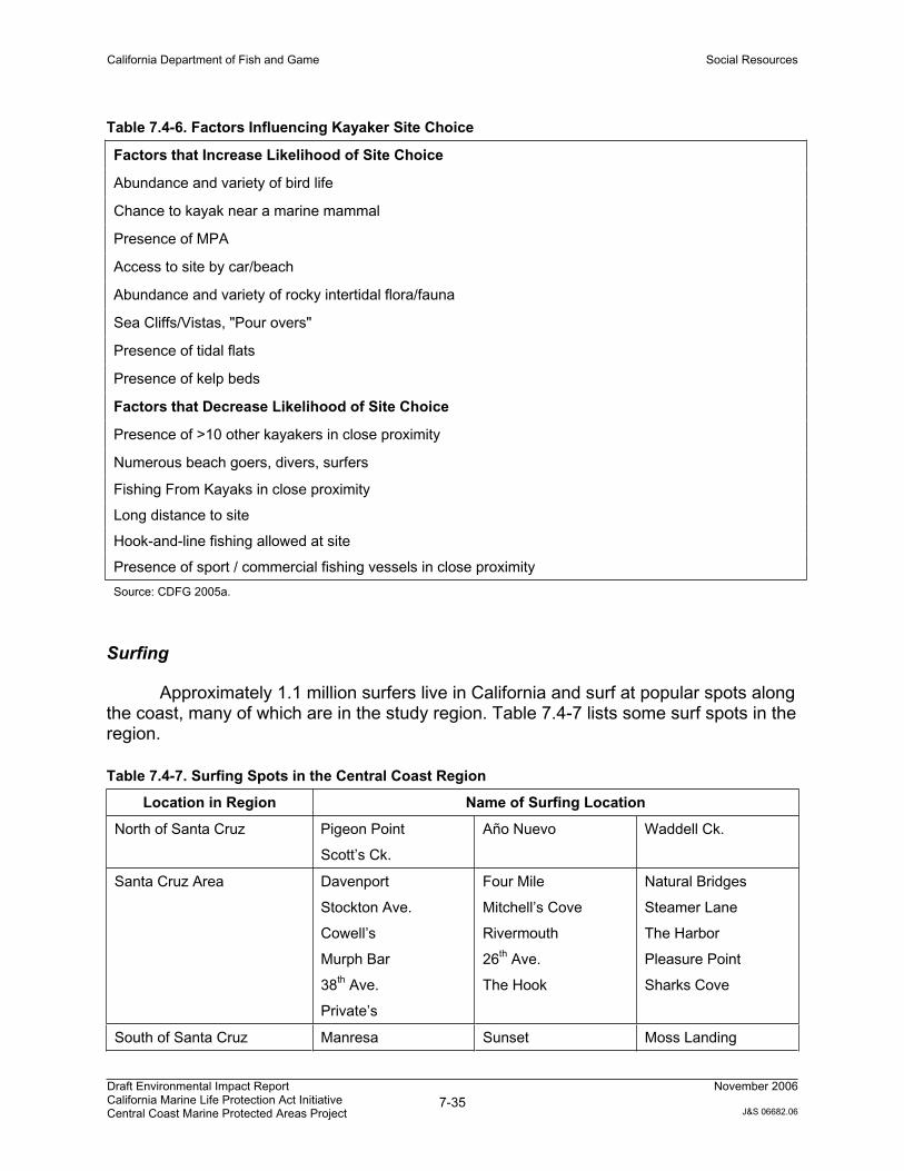
California Department of Fish and Game Social Resources
Draft Environmental Impact Report California Marine Life Protection Act Initiative Central Coast Marine Protected Areas Project
7-35November 2006
J&S 06682.06
Table 7.4-6. Factors Influencing Kayaker Site Choice
Factors that Increase Likelihood of Site Choice
Abundance and variety of bird life
Chance to kayak near a marine mammal
Presence of MPA
Access to site by car/beach
Abundance and variety of rocky intertidal flora/fauna
Sea Cliffs/Vistas, "Pour overs"
Presence of tidal flats
Presence of kelp beds
Factors that Decrease Likelihood of Site Choice
Presence of >10 other kayakers in close proximity
Numerous beach goers, divers, surfers
Fishing From Kayaks in close proximity
Long distance to site
Hook-and-line fishing allowed at site
Presence of sport / commercial fishing vessels in close proximity
Source: CDFG 2005a.
Surfing
Approximately 1.1 million surfers live in California and surf at popular spots along the coast, many of which are in the study region. Table 7.4-7 lists some surf spots in the region.
Table 7.4-7. Surfing Spots in the Central Coast Region
Location in Region Name of Surfing Location
North of Santa Cruz Pigeon Point
Scott’s Ck.
Año Nuevo Waddell Ck.
Santa Cruz Area Davenport
Stockton Ave.
Cowell’s
Murph Bar
38th Ave.
Private’s
Four Mile
Mitchell’s Cove
Rivermouth
26th Ave.
The Hook
Natural Bridges
Steamer Lane
The Harbor
Pleasure Point
Sharks Cove
South of Santa Cruz Manresa Sunset Moss Landing
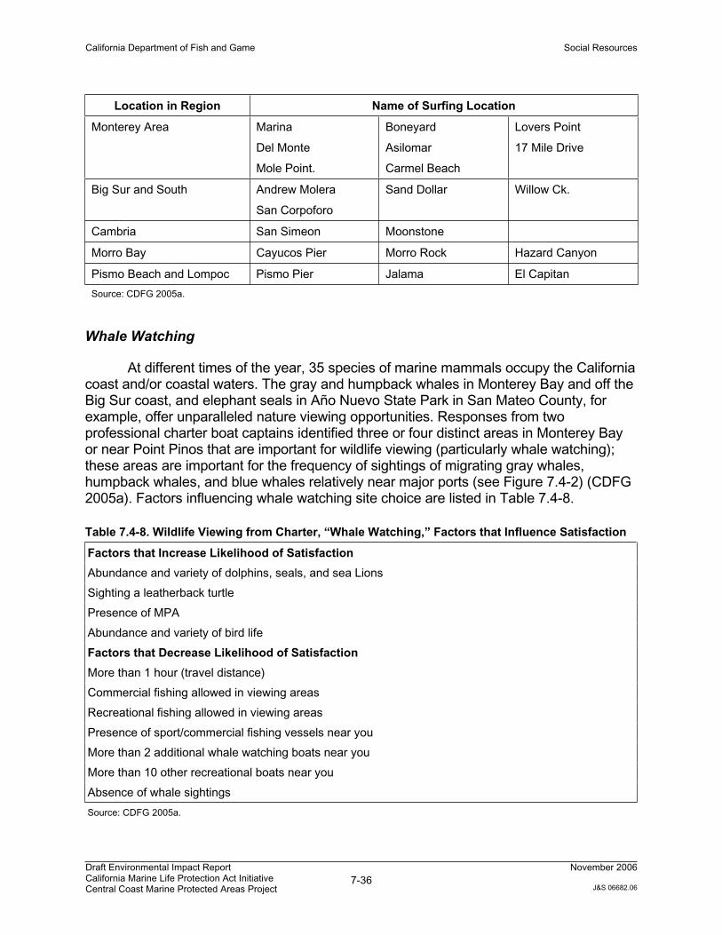
California Department of Fish and Game Social Resources
Draft Environmental Impact Report California Marine Life Protection Act Initiative Central Coast Marine Protected Areas Project
7-36November 2006
J&S 06682.06
Location in Region Name of Surfing Location
Monterey Area Marina
Del Monte
Mole Point.
Boneyard
Asilomar
Carmel Beach
Lovers Point
17 Mile Drive
Big Sur and South Andrew Molera
San Corpoforo
Sand Dollar Willow Ck.
Cambria San Simeon Moonstone
Morro Bay Cayucos Pier Morro Rock Hazard Canyon
Pismo Beach and Lompoc Pismo Pier Jalama El Capitan
Source: CDFG 2005a.
Whale Watching
At different times of the year, 35 species of marine mammals occupy the California coast and/or coastal waters. The gray and humpback whales in Monterey Bay and off the Big Sur coast, and elephant seals in Año Nuevo State Park in San Mateo County, for example, offer unparalleled nature viewing opportunities. Responses from two professional charter boat captains identified three or four distinct areas in Monterey Bay or near Point Pinos that are important for wildlife viewing (particularly whale watching); these areas are important for the frequency of sightings of migrating gray whales, humpback whales, and blue whales relatively near major ports (see Figure 7.4-2) (CDFG 2005a). Factors influencing whale watching site choice are listed in Table 7.4-8.
Table 7.4-8. Wildlife Viewing from Charter, “Whale Watching,” Factors that Influence Satisfaction
Factors that Increase Likelihood of Satisfaction
Abundance and variety of dolphins, seals, and sea Lions
Sighting a leatherback turtle
Presence of MPA
Abundance and variety of bird life
Factors that Decrease Likelihood of Satisfaction
More than 1 hour (travel distance)
Commercial fishing allowed in viewing areas
Recreational fishing allowed in viewing areas
Presence of sport/commercial fishing vessels near you
More than 2 additional whale watching boats near you
More than 10 other recreational boats near you
Absence of whale sightings
Source: CDFG 2005a.
California Department of Fish and Game Social Resources
Draft Environmental Impact Report California Marine Life Protection Act Initiative Central Coast Marine Protected Areas Project
7-37November 2006
J&S 06682.06
Nature observation is popular in the study region. For example, the Point Pinos intertidal zone along the shore of the city of Pacific Grove in Monterey County receives approximately 50,000 visitors annually, with an estimated 10,000 being K-12 children. The region’s scenic beauty, diversity of marine life, ease of access, clean environment, and proximity to other attractions in the area encourage visitors to go to this area to relax and engage in many nature activities, including seeing the tidepools (CDFG 2005a).
7.4.2. Regulatory Framework
Coastal and open water jurisdictions, resource-based agencies, and commissions are described in Chapter 1 of this EIR. Regulations pertaining specifically to recreational resources are described further below.
7.4.2.1. National Park Service
The National Park Service (NPS) was established to conserve the natural scenery, wildlife, and natural and historic objects of the area. In addition, the NPS provides for the management of these resources for future generation. The agency manages national parks, monuments, historic sites, and recreation areas by developing and implementing park management plans. While their responsibilities are not specifically ocean or coastal oriented, NPS manages four coastal and recreational parks in California.
7.4.2.2. U.S. Bureau of Land Management
The U.S. BLM administers 262 million surface acres of America's public lands, located primarily in 12 Western States. The BLM was established to sustain the health, diversity, and productivity of public lands under its jurisdiction for the use and enjoyment of present and future generations. Among other holdings, BLM manages lands within the National Landscape Conservation System through development and implementation of resource management plans. While most of its lands are not located along the coast, BLM does manage several on-shore coastal properties and the CCNM, which encompasses more than 20,000 offshore rocks and small islands above mean high tide within 12 nm of the coast. To effectively manage these lands, BLM has formed numerous partnerships with federal, state and local entities, including the Department and the California Department of Parks and Recreation. BLM’s management goals for the CCNM emphasize protection of the biological, geological, aesthetic, and cultural resources of the rocks and islands.
7.4.3. Impact Analysis
7.4.3.1. Methodology
Effects to recreational facilities were assessed by evaluating the potential change in use patterns resulting from the proposed MPA network component relative to known
California Department of Fish and Game Social Resources
Draft Environmental Impact Report California Marine Life Protection Act Initiative Central Coast Marine Protected Areas Project
7-38November 2006
J&S 06682.06
“hot spots” for non-consumptive recreational users. These potential changes were evaluated for their potential to impact existing recreational facilities and infrastructure.
7.4.3.2. Criteria for Determining Significance
Based on Appendix G of the State CEQA Guidelines and professional judgment, the project would have a significant impact on recreational resources if it:
Would increase the use of coastal waters with MPAs or other recreational facilities such that substantial physical deterioration of coastal waters or other recreational facilities would occur or be accelerated.
Would include recreational facilities or require the construction or expansion of recreational facilities that might have an adverse effect on the environment.
Would decrease recreational opportunities.
7.4.3.3. Environmental Impacts
Impact REC-1: Physical Deterioration of Coastal Waters or Other Recreational Facilities
As discussed in the environmental setting, “hot spots”3 for non-consumptive recreational uses in the study region include southern Monterey Bay (Monterey Breakwater, Lovers Point, Monterey Coast Guard Launch), Carmel Bay, and the Big Sur Coast (Point Lobos to Point Sur, including Garrapata State Park, Julia Pfeiffer Burns State Park, Mill Creek, Jade Cove). Implementation of the Proposed Project or its alternatives could result in potential impacts to coastal waters and beaches at these hot spots, including related recreational facilities such as piers, boat launches, parking lots, restrooms if such implementation results in a shift in users at these hot spot locations or a substantial shift in users to new locations lacking sufficient recreational facilities and infrastructure.
Two factors that influence site selection by non-consumptive divers, kayakers, and wildlife viewers is proximity to fishing vessels and distance to site. The more fishing vessels in an area, and/or the farther away a site, the less likely that a site will be selected for each given activity (see Tables 7.4-5, 7.4-6, and 7.4-8). Designation of MPAs will prohibit or reduce the level of fishing allowed in the MPAs, resulting in reduced fishing vessel traffic and potentially encouraging more recreational users to utilize MPAs that are located in close proximity to currently utilized recreation sites. This redistribution may lead to increased use of recreational facilities including beaches, parking lots, restroom, and other amenities that are located adjacent or near to MPAs.
3 Referring to the most popular locations for various recreational uses.
California Department of Fish and Game Social Resources
Draft Environmental Impact Report California Marine Life Protection Act Initiative Central Coast Marine Protected Areas Project
7-39November 2006
J&S 06682.06
Proposed Project: No Impact
Much of the southern Monterey Bay coastline has some degree of protection within the existing Pacific Grove SMCA and Hopkins SMR. Implementation of the Proposed Project would split the existing Pacific Grove SMCA into part of the Hopkins SMR, the Pacific Grove Marine Gardens SMCA and part of the Asilomar SMR. It would also increase the size of the existing Hopkins SMR (by incorporating part of the existing Pacific Grove SMCA) and add a new SMCA (Edward F. Ricketts) at the eastern end of the Hopkins SMR. Given that an SMCA and SMR are already designated for much of this area, and that sites not currently in the existing SMCA and SMR are already highly utilized, it is not expected that expansion of the MPAs in southern Monterey Bay would result in a substantial redistribution of users to different access points. For instance, the San Carlos Beach parking lot, which provides access to Breakwater and Cannery Row dive sites, is often at maximum capacity during summer and fall weekends, and thus the number of divers using this area is unlikely to increase significantly. Therefore, impacts to recreational facilities are not expected to increase over existing conditions.
Much of Carmel Bay is currently protected by the Carmel Bay SMCA and the Point Lobos SMR at the southern end of Carmel Bay. Implementation of the Proposed Project would increase the size of the Point Lobos SMR. A new SMCA (Point Lobos) would be established to the west of the Point Lobos SMR. Given that much of Carmel Bay is already protected through existing MPAs, it is not expected that usage patterns by recreational users would substantially change in Carmel Bay; therefore, impacts to recreational facilities are not expected to increase over existing conditions.
The Big Sur coast, broadly described as the area south of Carmel Bay to San Simeon Point, currently has several designated MPAs including the Julia Pfeiffer Burns SMCA and the Big Creek SMR. New MPAs proposed by the project include the Point Sur SMR, Point Sur SMCA, an expanded Big Creek SMR, and Big Creek SMCA. The existing Julia Pfeiffer Burns SMCA would be deleted and the Big Creek SMR would be expanded in size and extended offshore to the state waters boundary. Recognized hot spots for recreational use in this area include Garrapata State Park, Julia Pfeiffer Burns State Park, and Jade Cove. Only Julia Pfeiffer Burns State Park is currently encompassed by or adjacent to an existing MPA; therefore, impacts to recreational facilities are not expected to increase over existing conditions.
Garrapata State Park is located approximately 4 miles south of the existing Point Lobos SMR. With implementation of the Proposed Project, Garrapata State Park would be approximately 3 miles away from the enlarged Point Lobos SMR. Although there would be increased proximity of a hot-spot to an MPA, it is not expected that designation of an enlarged Point Lobos SMR would result in a substantially changed usage pattern or increased demand on existing recreational facilities, as this SMR is already fairly close to Garrapata State Park.
The Mill Creek and Jade Cove hot spots are located approximately 10 to 12 miles south of the existing Big Creek SMR. Although not a primary hot spot, Willow
California Department of Fish and Game Social Resources
Draft Environmental Impact Report California Marine Life Protection Act Initiative Central Coast Marine Protected Areas Project
7-40November 2006
J&S 06682.06
Creek Picnic Area is within a few miles of Mill Creek and Jade Cove. All three of these sites are relatively close together (within 5 miles of each other) and are located in a relatively remote area (approximately 30 miles south of Big Sur and 35 miles north of San Simeon). Consequently, it is not expected that designation of an enlarged Big Creek SMR and SMCA would result in substantially changed usage patterns or increased demand on existing recreational facilities at these hot spot sites.
Based on these findings, the Proposed Project would neither cause substantial physical deterioration of coastal waters or other recreational facilities to occur or be accelerated, nor require the construction or expansion of recreational, scientific or educational facilities.
Mitigation – No mitigation is required because there would be no impact.
Alternative 1: No Impact
The Alternative 1 network component of MPAs in relationship to known hot-spots would be similar to that of the Proposed Project. In southern Monterey Bay, implementation of Alternative 1 would increase the size of the existing Pacific Grove SMCA and Hopkins SMR, as well as create a new SMCA (Edward F. Ricketts) at the east end of Hopkins SMR. In Carmel Bay, the size of the Point Lobos SMR would be increased, and a new SMCA (Point Lobos) would be established to the west of the Point Lobos SMR. New MPAs proposed along the Big Sur coast would include the Point Sur Deep Reef SMCA, Julia Pfeiffer Burns SMR, Julia Pfeiffer Burns Offshore SMCA, Julia Pfeiffer Burns Offshore SMR, Alder Creek SMCA, and Alder Creek SMR. The existing Julia Pfeiffer Burns SMCA would be replaced by the Julia Pfeiffer Burns MPAs listed above and the Big Creek SMR would remain unchanged. Garrapata State Park would be approximately 3 miles away from an enlarged Point Lobos SMR. The existing Julia Pfeiffer SMR would be expanded to the south. Mill Creek and Jade Cove would be approximately 2 miles from the Alder Creek SMR. In all instances, Alternative 1 would not result in a substantially changed usage pattern or increased demand on existing recreational facilities.
Based on these findings, Alternative 1 would neither cause substantial physical deterioration of coastal waters or other recreational facilities to occur or be accelerated, nor require the construction or expansion of recreational, scientific or educational facilities.
Mitigation – No mitigation is required because there would be no impact.
Alternative 2: No Impact
The Alternative 2 network component of MPAs in relationship to known hot spots would be similar to that of the Proposed Project. In southern Monterey Bay, Alternative 2 would split the existing Pacific Grove SMCA into the Pacific Grove SMCA and the Asilomar SMR. It would also increase the size of the existing Hopkins SMR and add a
California Department of Fish and Game Social Resources
Draft Environmental Impact Report California Marine Life Protection Act Initiative Central Coast Marine Protected Areas Project
7-41November 2006
J&S 06682.06
new SMCA (Edward F. Ricketts) and SMR (Edward C. Cooper) at the eastern end of the Hopkins SMR. At Carmel Bay, Alternative 2 would increase the size of the Carmel Bay SMCA and the Point Lobos SMR. A new SMCA (Point Lobos) would be established to the west of the Point Lobos SMR, and a new SMR (Carmel Pinnacles) would be established to the west of Carmel Bay SMCA. Along the Big Sur coast, new MPAs would include the Point Sur SMR, Julia Pfeiffer Burns SMR, Big Creek SMR, and Big Creek SMCA. The existing Julia Pfeiffer Burns SMCA and the Big Creek SMR would both be expanded in size and extended to the boundary of state waters. Garrapata State Park would be approximately 3 miles away from an enlarged Point Lobos SMR. The existing Julia Pfeiffer SMR would be expanded to the south and west. The Big Creek SMR and SMCA would be enlarged. In all instances, Alternative 2 would not result in a substantially changed usage pattern or increased demand on existing recreational facilities.
Based on these findings, Alternative 2 would neither cause substantial physical deterioration of coastal waters or other recreational facilities to occur or be accelerated, nor require the construction or expansion of recreational, scientific or educational facilities.
Mitigation – No mitigation is required because there would be no impact.
Impact REC-2: Effects on Recreational Opportunities
Proposed Project: Less than Significant Impact
For the most part, impacts associated with implementation of the proposed MPA network component would be beneficial for non-consumptive recreational users and the scientific and educational community, as these uses would not be prohibited or reduced. Implementation of the Proposed Project would result in an increase in diversity of wildlife, and abundance of fish and invertebrates; components of a fulfilling recreational experience.
Implementation of the MPA network component would place restrictions on recreational fishing including some no-take areas or areas restricting take of certain species; but recreational fishermen would still have many options remaining available to them inside certain MPAs and outside of MPAs for a fulfilling recreational experience. While there may be some recreational fishing high use areas located within proposed no-take MPAs, on the whole, the Proposed Project avoids many desired locations identified in the California Recreational Fisheries Survey (CDFG 2005a). It is much more likely that recreational fishermen will adjust their transit to destinations equally easy to access versus electing to transit longer distances and travel times for a comparable fishing experience. Therefore, the impact to recreational fishing activities would be less than significant.
Mitigation – No mitigation is required because impacts are not significant.
California Department of Fish and Game Social Resources
Draft Environmental Impact Report California Marine Life Protection Act Initiative Central Coast Marine Protected Areas Project
7-42November 2006
J&S 06682.06
Alternative 1: Less than Significant Impact
Potential effects associated with Alternative 1 would be the similar to those described above for the Proposed Project, though Alternative 1 would result in slightly fewer no-take areas or areas with restricted recreational fishing. Therefore, Alternative 1 would result in a less than significant impact.
Mitigation – No mitigation is required because impacts are not significant.
Alternative 2: Less than Significant Impact
Potential effects associated with Alternative 2 would be the comparable to those described above for the Proposed Project; though Alternative 2 would result in slightly more no-take areas or areas with restricted recreational fishing. Therefore, Alternative 2 would result in a less than significant impact.
Mitigation – No mitigation is required because impacts are not significant.
7.5. Research and Education
This section describes the existing setting and potential research and education impacts of the Proposed Project and its alternatives. Specifically, it describes existing conditions related to research and educational opportunities and facilities, and summarizes the overall federal, state, and regional/local regulatory framework for research and education resources that would affect implementation of an MPA network component. This section also analyzes the potential impacts of the Proposed Project on research and educational resources and identifies mitigation measures to address significant impacts, as appropriate.
The physical setting and regional marine biodiversity make the Central Coast study region, and particularly Monterey Bay and Monterey Canyon, a global center for marine research and education.
7.5.1. Environmental Setting
7.5.1.1. Major Institutions in the Central Coast Study Region
Eighteen marine laboratories and education centers operate around Monterey Bay alone. More than 40 institutions and organizations in the greater Monterey Bay Area currently conduct research on various aspects of the marine environment. Major institutions include California State University at Monterey Bay, Hopkins Marine Station of Stanford University, Monterey Bay Aquarium Research Institute, University of California at Santa Cruz Center for Ocean Health, Monterey Bay Aquarium, and Center for Coastal Marine Science of Cal Poly San Luis Obispo. Figure 7.5-1 shows institutions compiled from a list of Monterey Bay National Marine Sanctuary Integrated Monitoring
California Department of Fish and Game Social Resources
Draft Environmental Impact Report California Marine Life Protection Act Initiative Central Coast Marine Protected Areas Project
7-43November 2006
J&S 06682.06
Network (SIMoN) partners in California and the Monterey Bay Crescent Ocean Consortium partners (MBCORC) (CDFG 2005a).
7.5.1.2. Scientific Research and Collecting
The scientific research within the central coast study region is diverse, ranging from water quality and fisheries management to deep sea biology, kelp forest ecology, and ocean conservation. Major marine monitoring programs in the region include Cooperative Research and Assessment of Nearshore Ecosystems (CRANE), Partnership for Interdisciplinary Studies of Coastal Oceans (PISCO), Central and Northern California Ocean Observing System (CeNCOOS), SIMoN, and Center for Integrative Coastal Observation, Research and Education (CI-CORE), to name a few (see Table 7.5-1). These organizations implement diverse marine research programs.
Many concentrated studies take place near marine stations, including the following: marine mammal studies at Terrace Point by Long Marine Lab, evolutionary physiology, biomechanics, and ecology studies at Point Cabrillo by Hopkins Marine Station, and fishery and fish population studies at Big Creek State Marine Reserve. PISCO focuses on long-term ecological and oceanographic monitoring to inform ocean conservation and management. Long term Monitoring Program & Experiential Training for Students (LIMPETS) trains middle- and high-school students and volunteer groups to monitor the rocky intertidal, sandy shore and offshore areas of Monterey Bay and Channel Islands to increase public awareness and influence policy makers. Elkhorn Slough National Estuarine Research Reserve’s (ESNERR) monitoring programs target water quality and weather. The Santa Cruz Laboratory, part of the Southwest Fisheries Science Center of the NMFS focuses on Pacific coast groundfish and salmon. NOAA maintains the National MPA Center and the Fisheries Lab. These examples illustrate the importance and diversity of marine research along the Central Coast. Figure 7.5-1 provides location information for marine monitoring sites in and around the central coast study region from the CeNCOOS, PISCO, LIMPET, and Multi-Agency Rocky Intertidal Network (MARINe) programs (see Table 7.5-1).

California Department of Fish and Game Social Resources
Draft Environmental Impact Report California Marine Life Protection Act Initiative Central Coast Marine Protected Areas Project
7-44November 2006
J&S 06682.06
Table 7.5-1. Research and Monitoring Programs in the Study Region
CRANE
The CRANE program includes divers from the Department of Fish and Game, various universities, private organizations, and government programs. CRANE collaborators developed a common field protocol for surveying invertebrates and fish, which was modeled on techniques used by the University of California affiliates of PISCO. Scuba surveys inside and outside MPAs will help provide necessary information on how the areas are performing and whether management goals are being met. CRANE monitoring sites cover areas between Monterey and San Diego, including offshore islands. These sites continue to be monitored by various programs and will likely have increased funding for expanded monitoring in response to the Proposed Project.
CeNCOOS
The Central California Ocean Observing System is a new initiative and part of the national ocean observing system, the Integrated Ocean Observing System (IOOS). There are no monitoring sites established yet. (http://www.cencoos.org/)
LiMPETS
LiMPETS is for middle school, high school, and other volunteer groups to monitor the rocky interidal, sandy shore and offshore areas of the five west coast National Marine Sanctuaries. (http://limpets.noaa.gov/)
MARINe
Scientists from federal, state, and local government agencies, universities, and private and volunteer organizations have formed MARINe to monitor important shoreline resources. The network is currently being supported by 23 organizations. Sites are monitored from San Luis Obispo County to San Diego County on the mainland and offshore Channel Islands. (http://www.marine.gov)
MBCORC
The mission of MBCORC is to promote the scientific understanding of coastal and marine systems and to facilitate the application of that knowledge for public policy, environmental awareness, and decision making. MBCORC achieves its objectives by creating, coordinating, promoting, and endorsing research, education, and outreach activities, using the Monterey Bay as a natural laboratory. (http://www.mbcorc.org/)
PISCO
PISCO is a large-scale marine research program that focuses on understanding the nearshore ecosystems of the U.S. West Coast. PISCO integrates long-term monitoring of ecological and oceanographic processes at dozens of coastal sites with experimental work in the lab and field. (http://www.piscoweb.org/research/community/subtidal/index.html)
SIMoN
The SIMoN network is composed of many institutions and agencies that perform monitoring activities in the Monterey Bay National Marine Sanctuary and share their summary information with SIMoN. (http://www.mbnms-simon.org/)
7.5.2. Regulatory Framework
Coastal and open water jurisdictions, resource-based agencies, and commissions are described in Chapter 1 of this EIR. Regulations pertaining specifically to research and education are described further below.
California Department of Fish and Game Social Resources
Draft Environmental Impact Report California Marine Life Protection Act Initiative Central Coast Marine Protected Areas Project
7-45November 2006
J&S 06682.06
7.5.2.1. Federal Plans, Programs, and Policies
National Park Service
The NPS conducts research to improve resource management, including for example, issuing permits for research on natural resources and archaeology, and monitoring resources and ecosystems within managed areas.
7.5.2.2. State Plans, Programs, and Policies
California Department of Fish and Game
Scientific Collecting
Commission regulation (14 CCR § 650) authorizes the take or possession of marine plants or animals for scientific, educational, or propagation purposes with a permit issued by the California Department of Fish and Game. Permits may be issued to:
Employees of local, state and federal agencies who take specimens in connection with their official duties.
Faculty, professional staff, college level students of, or individuals hired by; public or private companies, educational institutions, zoological gardens or aquariums, in or out of state.
Individuals who take wildlife or marine plants for other permittees or pursuant to environmental protection documents required by law.
Individuals who possess a valid federal Bird Marking and Salvage Permit. Holders of this federal permit are not required to obtain a state permit to take migratory birds, other than raptorial birds.
There are three types of permits: resident, non-resident, and student; resident and non-resident permits are valid for 2 years, and student permits are valid for 1 year. Each permit is reviewed and approved on a case-by-case basis. In some areas, such as in marine protected areas, additional specific restrictions may be applied. Scientific collecting may be allowed on a case-by-case basis in all three classifications of state MPAs.
Permit requestors must indicate on their application the following components:
1. species and numbers to be collected
2. collection locations
California Department of Fish and Game Social Resources
Draft Environmental Impact Report California Marine Life Protection Act Initiative Central Coast Marine Protected Areas Project
7-46November 2006
J&S 06682.06
3. methods/techniques
4. purpose for collecting
5. disposition of specimens
7.5.3. Impact Analysis
7.5.3.1. Methodology
Effects to scientific and educational facilities were assessed by evaluating the potential change in research and education use patterns resulting from the proposed MPA network component.
7.5.3.2. Criteria for Determining Significance
Based on Appendix G of the State CEQA Guidelines and professional judgment, the project would have a significant impact on research and education oriented resources if it:
Would include scientific or educational facilities or require the construction or expansion of scientific or educational facilities that might have an adverse effect on the environment.
Would decrease research and educational opportunities.
Basic data collection, research, experimental management, and resource evaluation activities which do not result in a serious or major disturbance to an environmental resource, are categorically exempt under CEQA (Public Resources Code Sections 21083 and 21087).
7.5.3.3. Environmental Impacts
Impact RES-1: Effects on Scientific Research or Education Opportunities
Proposed Project: No Impact to Potentially Beneficial Impact
One of the goals of the MLPA is to support scientific and educational activities, thereby increasing research and educational opportunities. Existing research activities include various monitoring programs that would benefit from the establishment of an MPA network component because it would eliminate human consumptive uses within these areas, and thereby remove one variable that may affect the outcome of the research study. Educational activities would be supported within the proposed MPA network component if directed at improving the general or technical understanding and appreciation of marine resources and habitats and scientific methodology, and to assist researchers in making observations and measurements. For example, educational
California Department of Fish and Game Social Resources
Draft Environmental Impact Report California Marine Life Protection Act Initiative Central Coast Marine Protected Areas Project
7-47November 2006
J&S 06682.06
activities such as tidepool and intertidal surveys, and various sampling tows (bottom grabs, midwater trawls, plankton tows), which are used to assess and study the marine environment, may be allowable within the proposed MPAs if part of an approved scientific research, and are carefully planned to avoid disruption to other critical habitats. Therefore, educational activities and research that contribute to the management and enhancement of marine species would be compatible with the purposes of the proposed MPAs, and are likely to occur. While marine-oriented monitoring is necessary for understanding the changes within MPAs over time, the construction or expansion of scientific or education facilities is not required as part of the Proposed Project, and it’s occurrence as a result of project implementation is speculative. Should additional land-based facilities be developed at some time in the future, they would be subject to independent CEQA and land planning review by local land use authorities. Therefore, the Proposed Project would not result in an impact associated with construction and expansion of such facilities.
Educational and study opportunities are improved by the presence of MPAs near research institutions. MPAs that include some established monitoring sites within their boundaries while leaving others outside allow for both a baseline of data to determine change over time and comparison with non-MPA areas. The proposed project includes 15 state marine reserves or high-level protection state marine conservation areas within 15 miles of major marine research institutions [University of California, Santa Cruz Long Marine Laboratory; Monterey Bay Aquarium Research Institute; Hopkins Marine Station (Stanford University); Cal Poly San Luis Obispo]. The proposed project also expands protection around existing MPAs with a long history of scientific study and evaluation (e.g., Lovers Point SMR adjacent to Hopkins Marine Station and Big Creek SMR). Additionally the proposed project includes an approximately equal number of existing monitoring sites (e.g., PISCO, CRANE, MARINe) within new or expanded MPAs compared to those outside MPAs for comparative purposes. These factors lead to a potentially beneficial impact to existing research and education activities.
Mitigation - No mitigation is required because there would be no impact.
Alternative 1: No Impact to Potentially Beneficial Impact
Potential impacts on the ability to conduct existing research or to the construction of new facilities associated with Alternative 1 would be the same as those described above for the Proposed Project. Therefore, Alternative 1 would not result in a negative impact. Alternative 1 includes fewer state marine reserves or high-level protection state marine conservation areas within 15 miles of major marine research institutions than the Proposed Project (13 high protection MPAs). Alternative 1 includes far fewer existing monitoring sites within MPAs than outside MPAs, in particular with regards to MARINe intertidal study sites. This might make future comparison and research harder to accomplish than with the Proposed Project.
Mitigation – No mitigation is required because there would be no impact.
California Department of Fish and Game Social Resources
Draft Environmental Impact Report California Marine Life Protection Act Initiative Central Coast Marine Protected Areas Project
7-48November 2006
J&S 06682.06
Alternative 2: No Impact to Potentially Beneficial Impact
Potential impacts on the ability to conduct existing research or to the construction of new facilities associated with Alternative 2 would be the same as those described above for the Proposed Project. Therefore, Alternative 2 would not result in a negative impact. Alternative 2 includes the same number of state marine reserves and high-level protection state marine conservation areas within 15 miles of major marine research institutions as the Proposed Project. Alternative 2 includes slightly more existing monitoring sites within MPAs than outside MPAs, in particular with regards to MARINe intertidal study sites. This might make future comparison and research slightly harder to accomplish, though to a lesser degree than if too many existing sites were outside new MPAs.
Mitigation – No mitigation is required because there would be no impact.
7.6. Vessel Traffic
This section describes the existing setting and potential vessel traffic impacts of the Proposed Project and its alternatives. Specifically, it describes existing conditions related to vessel traffic; summarizes the overall federal, state, and regional/local regulatory framework for vessel traffic that would affect implementation of an MPA network component; analyzes the potential impacts of the Proposed Project and its alternatives on vessel traffic; and identifies mitigation measures to address significant impacts, as appropriate.
7.6.1. Environmental Setting
Major considerations for the environmental setting include the locations of major ports and other transportation nodes, types and numbers of commercial and recreational vessels, and their associated movement in and around the study region.
7.6.1.1. Major Ports and Transportation Nodes
The major ports within the study region include the following (see Figure 7.6-1):
Santa Cruz. Santa Cruz Harbor, in Santa Cruz County, has commercial fishing vessels, CPFVs and recreational boating facilities. From 1999 to 2004, estimated annual commercial landings from Santa Cruz Harbor averaged 580,000 pounds (CDFG 2005a).
Moss Landing. Located in Monterey County, the Moss Landing port features commercial fishing vessels, CPFVs, and private recreational boating facilities. From 1999 to 2004, estimated annual commercial landings from Moss Landing averaged 54.5 million pounds (CDFG 2005a).
California Department of Fish and Game Social Resources
Draft Environmental Impact Report California Marine Life Protection Act Initiative Central Coast Marine Protected Areas Project
7-49November 2006
J&S 06682.06
Monterey. The Monterey Harbor, in Monterey County, features commercial fishing vessels, CPFVs, and private recreational boating facilities. From 1999 to 2004, estimated annual commercial landings from Monterey Harbor averaged 8.7 million pounds (CDFG 2005a).
Morro Bay. Located in San Luis Obispo County, the Morro Bay port is a commercial harbor that features commercial fishing vessels, CPFVs, and private recreational boating facilities. From 1999 to 2004, estimated annual commercial landings from Morro Bay averaged 2.4 million pounds (CDFG 2005a).
Port San Luis. Located at Avila Beach in San Luis Obispo County, Port San Luis is a small craft harbor that features commercial fishing vessels, CPFVs, and private recreational boating facilities. From 1999 to 2004, estimated annual commercial landings from Port San Luis averaged 1.9 million pounds (CDFG 2005a).
Minor harbors or launches in the study area include the following.
Capitola Pier. Capitola Pier, in Santa Cruz County, has private and rental recreational boating facilities.
Mill Creek and Willow Creek. Located in Monterey County, the Mill Creek and Willow Creek landing facilities feature recreational boating.
Cambria and San Simeon. Located in San Luis Obispo County, Cambria (Leffingwell’s) and San Simeon landing facilities have private recreational boating.
Additionally, the following are the nearest adjacent harbors outside the central coast study region from which fishing vessels could access the region.
Half Moon Bay. Half Moon Bay is located in San Mateo County, directly north of the study region.
Santa Barbara. Santa Barbara Harbor is located in Santa Barbara County to the south and east of the study region.
Oil Platforms, Plants, and Refineries
A total of 27 oil and gas platforms exist off the California coastline; 23 in federal waters and 4 in state waters. Predominantly located in southern California, the platforms are between 1.2 and 10.5 miles from shore and in water depths from 35 to 1,198 feet (CAREP 2006). The majority of processing plants and oil refineries are located beyond state waters and typically are oriented around the San Francisco Bay, the Santa Barbara Channel, and the greater Los Angeles metropolitan area. Facilities accessed
California Department of Fish and Game Social Resources
Draft Environmental Impact Report California Marine Life Protection Act Initiative Central Coast Marine Protected Areas Project
7-50November 2006
J&S 06682.06
from coastal waters within the central coast study region include the following (EIA 2004).
ConocoPhillips Santa Maria Facility. The ConocoPhillips facility is a refinery and carbon plant located in Arroyo Grande, San Luis Obispo County.
Greka Santa Maria Refinery. The Greka energy facility is a crude refinery located in Santa Maria, Santa Barbara County.
7.6.1.2. Vessel Types
The following sections describe the major types of vessels that venture out from central coast ports or that transit within the central coast study region.
Commercial and Recreational Fishing Vessels
Commercial and recreational fishing vessels can be categorized into three basic modes:
Commercial fishing vessels
Commercial passenger fishing vessels (CPFV)
Private and rental skiffs
Commercial Fishing Vessels
Within the central coast study region, commercial fishing vessels can generally be placed into the following five categories.
Purse Seine vessel. Purse seiners catch salmon, herring and squid by encircling them with a long net and drawing (pursing) the bottom closed to capture the fish. Purse seiners are sleek, cabin-forward vessels.
Trap vessel. Trap vessels target Dungeness crab, rock crab, spot prawn, nearshore finfish, or sablefish using twine or wire-meshed, steel or plastic pots (traps), either attached in strings or fished separately. Trap vessels come in a variety of sizes and configurations, up to 50 feet or more in length.
Troll vessel. Trollers catch salmon by “trolling” bait or lures through feeding concentrations of fish. Trollers come in a variety of sizes and configurations, up to 50 feet or more in length.
Trawl vessel. Trawlers typically catch large quantities of midwater species and bottomfish by towing a large cone-shaped net. Trawlers are generally
California Department of Fish and Game Social Resources
Draft Environmental Impact Report California Marine Life Protection Act Initiative Central Coast Marine Protected Areas Project
7-51November 2006
J&S 06682.06
large vessels, up to 600 feet long. While not allowed to fish within the study regions, trawlers transit the region to offshore fishing grounds.
Longline vessel. Longliners catch bottomfish (primarily halibut, blankcod, lingcod, and rockfish) via a long line that is laid on the bottom, with attached leaders and baited hooks. Longliners are typically 50 to 100 feet in length.
Gill net vessel. Gill net vessels catch salmon by setting curtain-like nets perpendicular to the direction in which the fish are traveling as they migrate along the coast toward their natal streams. Gill net vessels are usually 30 to 40 feet long. While not permitted to fish within the study region, gillnetters may transit the region to fish in other areas.
Other hook-and-line vessel. These vessels use fewer hooks on shorter lines or “stick” gear to catch primarily nearshore and shelf finfishes. Most hook-and-line vessels are less than 50 feet in length.
Commercial Passenger Fishing Vessels
CPFVs, also called party boats, carry recreational anglers to ocean fishing locations for a fee. CPFVs have the greatest range of any recreational fishing mode and are generally limited by travel time, and less so by weather or other considerations. CPFVs may carry up to 40–50 anglers, although a passenger load of 10–30 is more common; some small CPFVs are known as “six-packs” due to their reduced passenger-carrying ability (CDFG 2005a).
CPFVs operate out of all five major ports in the study area: Santa Cruz, Moss Landing, Monterey, Morro Bay, and Port San Luis. CPFVs from Santa Cruz regularly fish as far north as Point Año Nuevo. Monterey-based CPFVs travel as far south as Point Sur. Morro Bay and Port San Luis CPFVs generally fish between Purisima Point and Piedras Blancas on single day trips, while some Morro Bay vessels conduct multi-day trips as far north as Point Sur. CPFV operators from the port of Princeton, north of the central coast study area, occasionally run single-day trips as far south as Point Año Nuevo (CDFG 2005a).
Statewide registration of CPFVs demonstrates significant fluctuation in recreational fishing over the last two decades. The number of registered CPFVs increased by more than 60% from 1980 to 1989, declined by almost 50% during the next 4 years, and has shown a steady and modest increase during the past decade. Some CPFVs have converted from recreational fishing to whale-watching trips. The trend for central coast CPFVs mirrored that of the statewide registration until 1997; after that point, the number of active central coast CPFVs was variable but showed no trend, while the number of registered CPFVs statewide showed a gradual but steady increase (CDFG 2005a).
California Department of Fish and Game Social Resources
Draft Environmental Impact Report California Marine Life Protection Act Initiative Central Coast Marine Protected Areas Project
7-52November 2006
J&S 06682.06
Private and Rental Skiffs
Private and rental skiffs, with some exceptions, generally fish closer to port or launch ramp areas than CPFVs, although albacore anglers may travel considerable distances. Private and rental boats operate out of all five major ports in the study region, as well as the smaller Capitola Pier and Cambria landings. In general, the most important areas for private recreational boat fishing are within 10 miles of the marinas and launch ramps of Santa Cruz, Moss Landing, Monterey, Cambria, Morro Bay, and Port San Luis. However, albacore and salmon fishermen often travel farther, and during fair weather other anglers will venture in excess of 20 miles from major ports (CDFG 2005a).
Recreational boating with motor-powered, sail-powered, and hand-powered vessels also occurs throughout the central coast study region, with the highest density around major harbors. The number of registered boats in the state increased by more than 50% between 1978 and 1991. However, it is not known what proportion of boats is used in marine waters. Jet skis (also known as motorized personal watercraft) comprised 11% of all registered recreational vessels in 1994. The popularity of non-motorized craft such as kayaks has also increased in most coastal waters. Many recreational boaters in the central coast use trailers to tow their boats to launch ramps in the area (CDFG 2005a).
7.6.1.3. Vessel Counts
The following sections report vessel counts from the California Recreational Fisheries Survey, CDFG’s vessel permitting data, and Harbor Master estimates for the five major ports in the study area.
California Recreational Fisheries Survey
The CRFS conducts interviews of anglers returning to public launch ramps. These interviews represent a sample of the total number of anglers. Anecdotal information collected includes the distribution of recreational, commercial, and non-consumption trips taken by surveyed vessels (Table 7.6-1). CRFS samplers intercepted approximately 7,000 private and rental boats upon return to port; 83% fished or intended to fish recreationally. Approximately 4% were commercial fishing vessels. According to the CRFS survey, the remaining 13% were involved in non-consumptive activities, including sightseeing, sailing, diving, research, and vessel maintenance (CDFG 2005a).
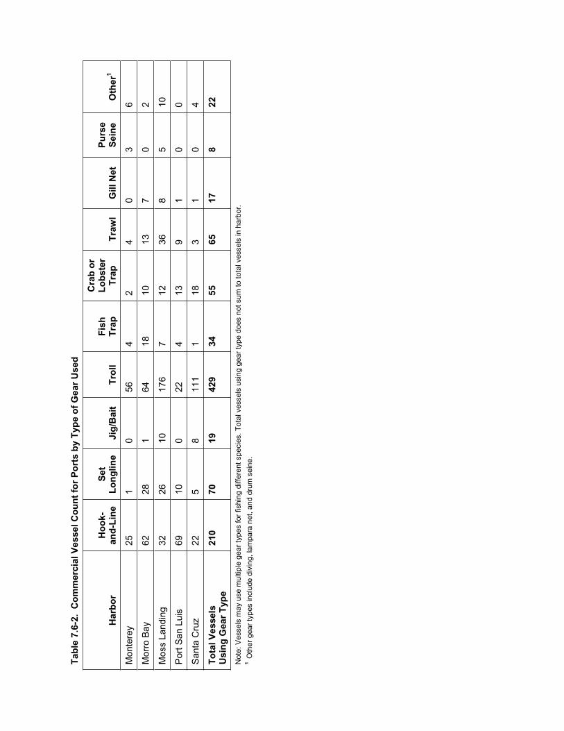
Tab
le 7
.6-2
. C
om
mer
cial
Ves
sel C
ou
nt
for
Po
rts
by
Typ
e o
f G
ear
Use
d
Har
bo
r H
oo
k-an
d-L
ine
Set
Lo
ng
line
Jig
/Bai
t T
roll
Fis
hT
rap
Cra
b o
r L
ob
ster
Tra
pT
raw
l G
ill N
et
Pu
rse
Sei
ne
Oth
er1
Mon
tere
y 25
1
0 56
4
2 4
0 3
6
Mor
ro B
ay
62
28
1 64
18
10
13
7
0 2
Mos
s La
ndin
g 32
26
10
17
6 7
12
36
8 5
10
Por
t San
Lui
s 69
10
0
22
4 13
9
1 0
0
San
ta C
ruz
22
5 8
111
1 18
3
1 0
4
To
tal V
esse
ls
Usi
ng
Gea
r T
ype
210
70
19
429
34
55
65
17
8 22
Not
e: V
esse
ls m
ay u
se m
ultip
le g
ear
type
s fo
r fis
hing
diff
eren
t spe
cies
. Tot
al v
esse
ls u
sing
gea
r ty
pe d
oes
not s
um to
tota
l ves
sels
in h
arbo
r.1
Oth
er g
ear
type
s in
clud
e di
ving
, lam
para
net
, and
dru
m s
eine
.
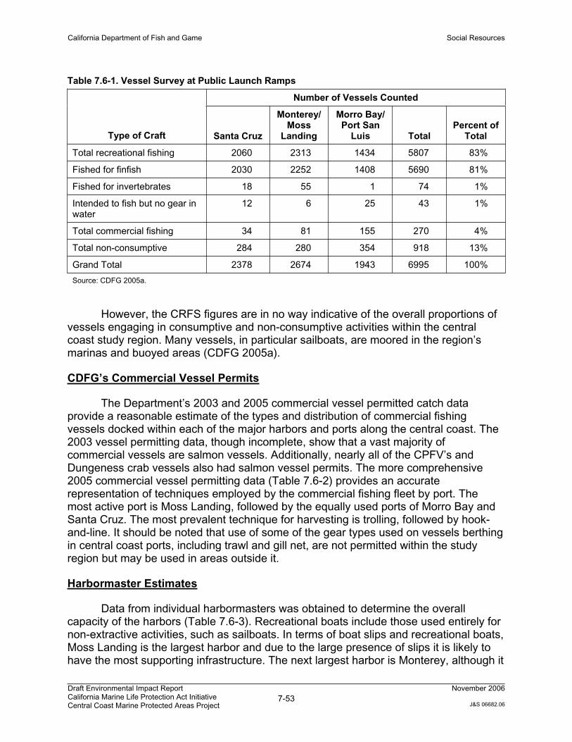
California Department of Fish and Game Social Resources
Draft Environmental Impact Report California Marine Life Protection Act Initiative Central Coast Marine Protected Areas Project
7-53November 2006
J&S 06682.06
Table 7.6-1. Vessel Survey at Public Launch Ramps
Number of Vessels Counted
Type of Craft Santa Cruz
Monterey/Moss
Landing
Morro Bay/ Port San
Luis TotalPercent of
Total
Total recreational fishing 2060 2313 1434 5807 83%
Fished for finfish 2030 2252 1408 5690 81%
Fished for invertebrates 18 55 1 74 1%
Intended to fish but no gear in water
12 6 25 43 1%
Total commercial fishing 34 81 155 270 4%
Total non-consumptive 284 280 354 918 13%
Grand Total 2378 2674 1943 6995 100%
Source: CDFG 2005a.
However, the CRFS figures are in no way indicative of the overall proportions of vessels engaging in consumptive and non-consumptive activities within the central coast study region. Many vessels, in particular sailboats, are moored in the region’s marinas and buoyed areas (CDFG 2005a).
CDFG’s Commercial Vessel Permits
The Department’s 2003 and 2005 commercial vessel permitted catch data provide a reasonable estimate of the types and distribution of commercial fishing vessels docked within each of the major harbors and ports along the central coast. The 2003 vessel permitting data, though incomplete, show that a vast majority of commercial vessels are salmon vessels. Additionally, nearly all of the CPFV’s and Dungeness crab vessels also had salmon vessel permits. The more comprehensive 2005 commercial vessel permitting data (Table 7.6-2) provides an accurate representation of techniques employed by the commercial fishing fleet by port. The most active port is Moss Landing, followed by the equally used ports of Morro Bay and Santa Cruz. The most prevalent technique for harvesting is trolling, followed by hook-and-line. It should be noted that use of some of the gear types used on vessels berthing in central coast ports, including trawl and gill net, are not permitted within the study region but may be used in areas outside it.
Harbormaster Estimates
Data from individual harbormasters was obtained to determine the overall capacity of the harbors (Table 7.6-3). Recreational boats include those used entirely for non-extractive activities, such as sailboats. In terms of boat slips and recreational boats, Moss Landing is the largest harbor and due to the large presence of slips it is likely to have the most supporting infrastructure. The next largest harbor is Monterey, although it
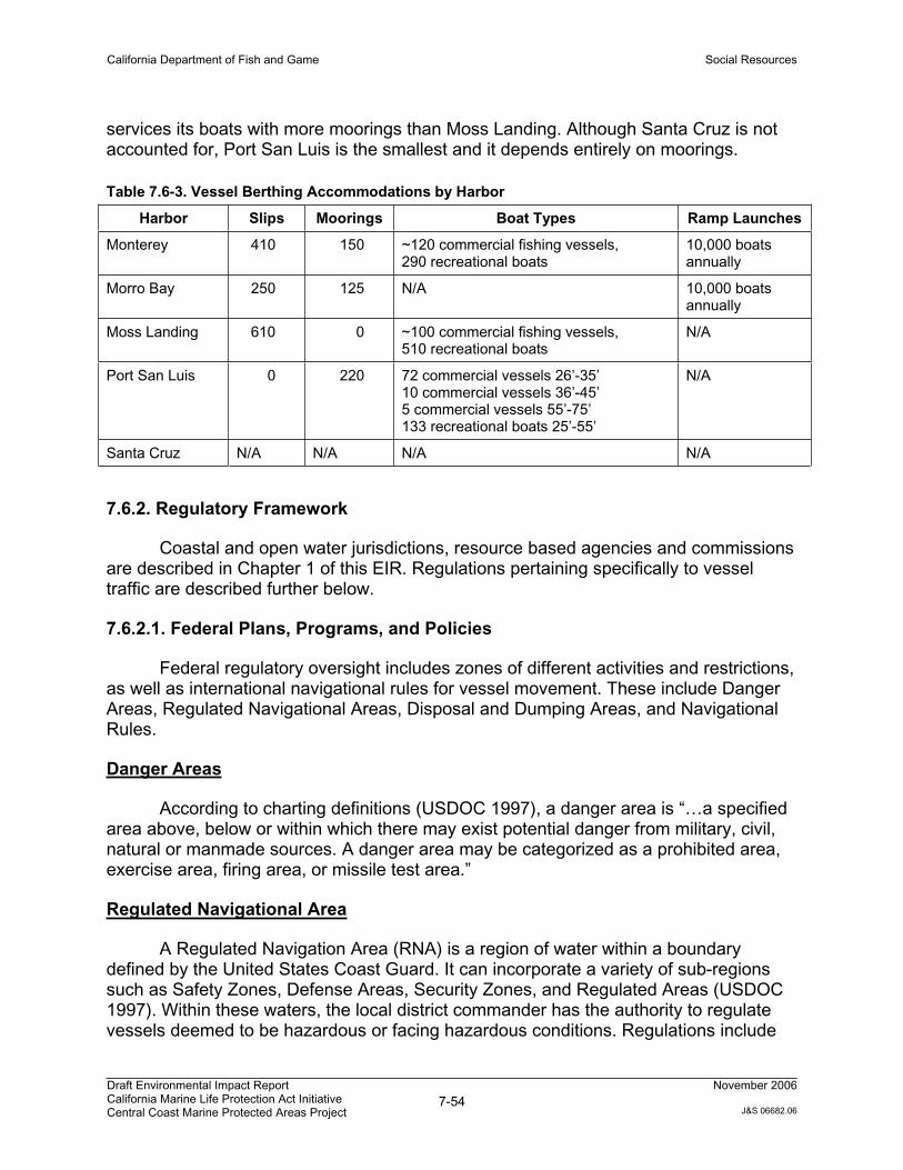
California Department of Fish and Game Social Resources
Draft Environmental Impact Report California Marine Life Protection Act Initiative Central Coast Marine Protected Areas Project
7-54November 2006
J&S 06682.06
services its boats with more moorings than Moss Landing. Although Santa Cruz is not accounted for, Port San Luis is the smallest and it depends entirely on moorings.
Table 7.6-3. Vessel Berthing Accommodations by Harbor
Harbor Slips Moorings Boat Types Ramp Launches
Monterey 410 150 ~120 commercial fishing vessels, 290 recreational boats
10,000 boats annually
Morro Bay 250 125 N/A 10,000 boats annually
Moss Landing 610 0 ~100 commercial fishing vessels, 510 recreational boats
N/A
Port San Luis 0 220 72 commercial vessels 26’-35’ 10 commercial vessels 36’-45’ 5 commercial vessels 55’-75’ 133 recreational boats 25’-55’
N/A
Santa Cruz N/A N/A N/A N/A
7.6.2. Regulatory Framework
Coastal and open water jurisdictions, resource based agencies and commissions are described in Chapter 1 of this EIR. Regulations pertaining specifically to vessel traffic are described further below.
7.6.2.1. Federal Plans, Programs, and Policies
Federal regulatory oversight includes zones of different activities and restrictions, as well as international navigational rules for vessel movement. These include Danger Areas, Regulated Navigational Areas, Disposal and Dumping Areas, and Navigational Rules.
Danger Areas
According to charting definitions (USDOC 1997), a danger area is “…a specified area above, below or within which there may exist potential danger from military, civil, natural or manmade sources. A danger area may be categorized as a prohibited area, exercise area, firing area, or missile test area.”
Regulated Navigational Area
A Regulated Navigation Area (RNA) is a region of water within a boundary defined by the United States Coast Guard. It can incorporate a variety of sub-regions such as Safety Zones, Defense Areas, Security Zones, and Regulated Areas (USDOC 1997). Within these waters, the local district commander has the authority to regulate vessels deemed to be hazardous or facing hazardous conditions. Regulations include
California Department of Fish and Game Social Resources
Draft Environmental Impact Report California Marine Life Protection Act Initiative Central Coast Marine Protected Areas Project
7-55November 2006
J&S 06682.06
vessel size, speed, draft limitations and other operating conditions, as well as times of entry, exit, and specific movements. The district commander’s authority includes a formalized Traffic Separation Scheme (TSS) that helps to maintain and control commercial and large vessel two-way movements through series of designated and adjoining lanes and turnabout locations. Vessel Traffic Services (VTS) is a complementary program that provides advice, control and management of participating vessels. A primary distinction between the two programs is that the TSS is a physically mapped suite of locations subject to Rule 10 of the International Navigation Rules, while the VTS is a staffed facility that communicates with crews of the vessels to facilitate their safe passage.
Disposal and Dumping Areas
The disposal and dumping areas were established for various purposes related to dumping of toxic wastes (no longer allowed) and/or depositing of dredged materials. They may constitute hazards to navigation. There are three primary types: 1) the dumping areas established by the EPA, 2) the dumping areas established by the Navy, and 3) the spoil, disposal and dumping grounds established by the US Army Corps of Engineers. The proposed MPA network component would not be located in known disposal or dumping areas.
Navigation Rules for Avoiding Collisions at Sea
International Navigation Rules (Rules) were formalized in the Convention on the International Regulations for Preventing Collisions at Sea, 1972, and were adopted by Congress as the International Rules Act of 1977. The Rules (commonly called 72 COLREGS) are part of the Convention, and vessels flying the flags of states ratifying the treaty are bound to the rules (U.S. Coast Guard 2006). The United States has ratified this treaty and all United States flag vessels must adhere to these Rules where applicable. The COLREGS include rules on steering and sailing, look-out, safe speed, risk of collision and actions to avoid collision, traffic separation schemes, conduct of vessels in sight of one another, and conduct of vessels in restricted visibility. The Rules also include specific requirements for vessels engaged in fishing, and vessels restricted in their maneuverability. The International Rules in the Navigation Rules book is published by the Coast Guard. These Rules are applicable on waters outside of established navigational lines of demarcation. The lines are called COLREGS Demarcation Lines and delineate those waters upon which mariners shall comply with the Inland and International Rules. COLREGS Demarcation lines are contained in Title 33 of the Code of Federal Regulations, part 80 (33 CFR 80), the Navigation Rules manual.
7.6.2.2. State Plans, Programs, and Policies
State regulatory oversight includes implementation of the Oil Spill Prevention and Response Act (OSPRA).
California Department of Fish and Game Social Resources
Draft Environmental Impact Report California Marine Life Protection Act Initiative Central Coast Marine Protected Areas Project
7-56November 2006
J&S 06682.06
Lempert-Keene-Seastrand Oil Spill Prevention and Response Act
The California State Legislature enacted OSPRA (SB 2040; Statutes of 1990, chapter 1248) at Government Code Section 8670.1 et seq. The goals of OSPRA are to improve the prevention, removal, abatement, response, containment, and clean up and mitigation of oil spills in the marine waters of California. The Act (SB 2040) created harbor safety committees for the major harbors of the State of California to plan “for the safe navigation and operation of tankers, barges, and other vessels within each harbor…(by preparing)…a harbor safety plan, encompassing all vessel traffic within the harbor” The legislation also established the California Office of Spill Prevention and Response to provide protection of natural resources from oil and other deleterious materials in areas through prevention, preparation, response, and restoration.
7.6.3. Impact Analysis
7.6.3.1. Methodology
Effects to vessel traffic were qualitatively assessed by evaluating the proposed MPA locations in relationship to known navigational rules such as Traffic Separation Schemes.
7.6.3.2. Criteria for Determining Significance
Based on Appendix G of the State CEQA Guidelines and professional judgment, it was determined that the Proposed Project would result in a significant impact on vessel traffic if it would:
Substantially increase oceanic hazards, in particular due to changes in vessel traffic concentration (i.e., congestion).
Result in disruption of existing vessel traffic patterns and marine navigation.
7.6.3.3. Environmental Impacts
Impact VT-1: Increase in Vessel Density and Oceanic Hazards
Proposed Project: Less than Significant
The proposed MPA network component establishes MPAs that have certain restrictions in terms of allowable activities; however, vessels would not be restricted from transiting through them. The primary vessel groups that would be potentially impacted by the proposed MPAs are those engaged in commercial and recreational fishing. These user groups may be displaced from some of the new MPAs, thereby forcing them to conduct their activities at the periphery of MPA boundaries or in other locations with fewer restrictions. This could result in an increased competition for resources in locations outside of MPAs, and potential increased concentration (i.e., congestion) in such
California Department of Fish and Game Social Resources
Draft Environmental Impact Report California Marine Life Protection Act Initiative Central Coast Marine Protected Areas Project
7-57November 2006
J&S 06682.06
locations. A secondary user group potentially impacted by the Proposed Project would be divers and scientific researchers attracted to the reserve’s underwater habitats. Both within and outside of the proposed MPAs, there may be a minor increase in concentration of vessel traffic attributed to the primary and secondary user groups, which could conceivably create a hazard from having more boats operating in a smaller area.
However, captains and operators of each individual vessel would still be under the same international navigational rules as before the implementation of the MPAs. These rules place the responsibility upon individuals to pilot their vessels in a safe manner. Consequently, potential impacts related to vessel density and oceanic hazards from the Proposed Project would be less than significant.
Mitigation – No mitigation is required because impacts are not significant.
Alternative 1: Less than Significant
Potential effects associated with Alternative 1 would be similar to those described above for the Proposed Project. Impacts to vessel density and oceanic hazards associated with Alternative 1 would be less than significant.
Mitigation – No mitigation is required because impacts are not significant.
Alternative 2: Less than Significant
Potential effects associated with Alternative 2 would be similar to those described above for the Proposed Project. Impacts to vessel density and oceanic hazards associated with Alternative 2 would be less than significant.
Mitigation – No mitigation is required because impacts are not significant.
Impact VT-2: Disruption of Existing Marine Navigation
Proposed Project: No Impact
The commercial vessel TSS will not be altered by the Proposed Project, nor would RNAs, VTSs, or International rule of navigation. The Proposed Project does not alter existing mainland ports and harbors. The proximity of MPAs to ports or major access points has been thought to cause problems to vessel traffic, particularly if vessels are required to travel over greater distances, or in dangerous conditions. However, as long as the vessels do not intend to extract resources, the MPAs do not restrict access and/or through passage.
Because vessel safety in emergencies and foul weather is critical, transit through and anchoring in MPAs is allowed in all of the proposed MPAs alternatives. Each alternative contains two areas where boating and anchoring are restricted or limited to specific areas (Pt. Lobos State Marine Reserve and Big Creek State Marine Reserve).

California Department of Fish and Game Social Resources
Draft Environmental Impact Report California Marine Life Protection Act Initiative Central Coast Marine Protected Areas Project
7-58November 2006
J&S 06682.06
Transit, however, is allowed and anchoring in emergency situations is always permitted pursuant to federal law. Since these restrictions exist in the present MPAs in these locations, the Proposed Project and alternative will not change existing use patterns.
While commercial fishing vessels may be required to travel slightly longer distances to fish beyond MPA boundaries, non-consumptive marine navigation will not be disrupted by the Proposed Project; therefore, there would be no impact to existing marine routes and navigation resulting from the Proposed Project.
Mitigation – No mitigation is required because there would be no impact.
Alternative 1: No Impact
Potential effects associated with Alternative 1 would be similar to those described above for the Proposed Project. There would be no impacts to marine navigation associated with Alternative 1.
Mitigation – No mitigation is required because there would be no impact.
Alternative 2: No Impact
Potential effects associated with Alternative 2 would be similar to those described above for the Proposed Project. There would be no impacts to marine navigation associated with Alternative 2.
Mitigation – No mitigation is required because there would be no impact.
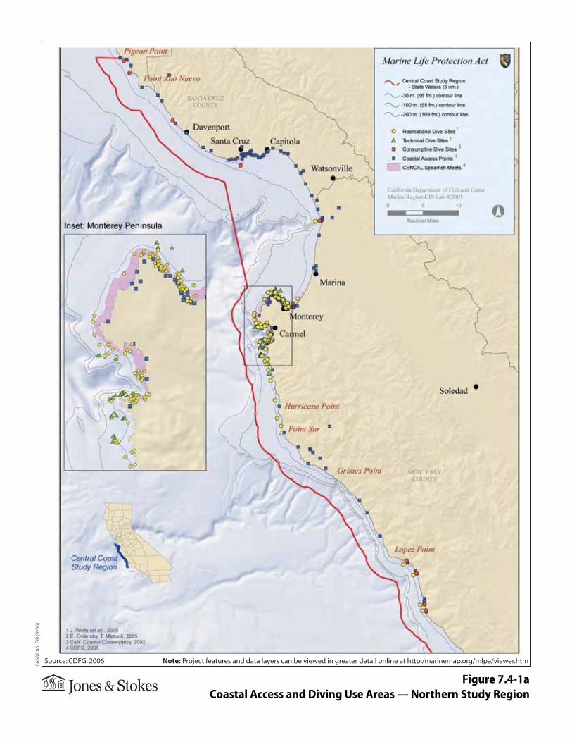
Figure 7.4-1aCoastal Access and Diving Use Areas — Northern Study Region
0668
2.06
EIR
(9/0
6)
Source: CDFG, 2006 Note: Project features and data layers can be viewed in greater detail online at http:/marinemap.org/mlpa/viewer.htm
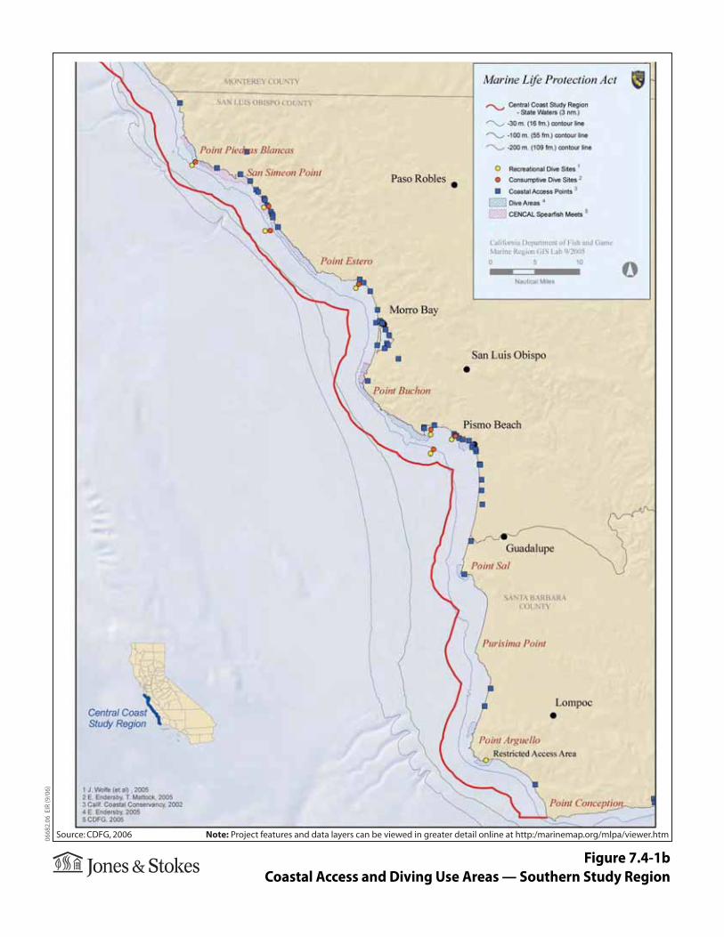
Figure 7.4-1bCoastal Access and Diving Use Areas — Southern Study Region
0668
2.06
EIR
(9/0
6)
Source: CDFG, 2006 Note: Project features and data layers can be viewed in greater detail online at http:/marinemap.org/mlpa/viewer.htm
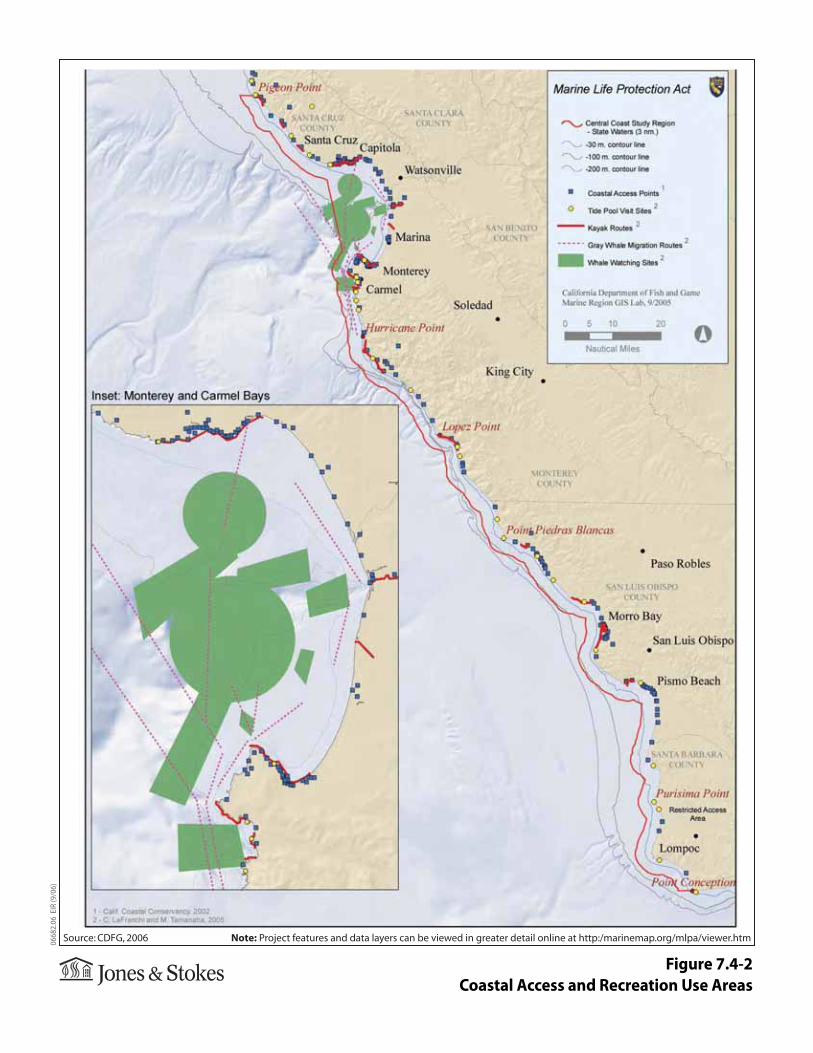
Figure 7.4-2Coastal Access and Recreation Use Areas
0668
2.06
EIR
(9/0
6)
Source: CDFG, 2006 Note: Project features and data layers can be viewed in greater detail online at http:/marinemap.org/mlpa/viewer.htm
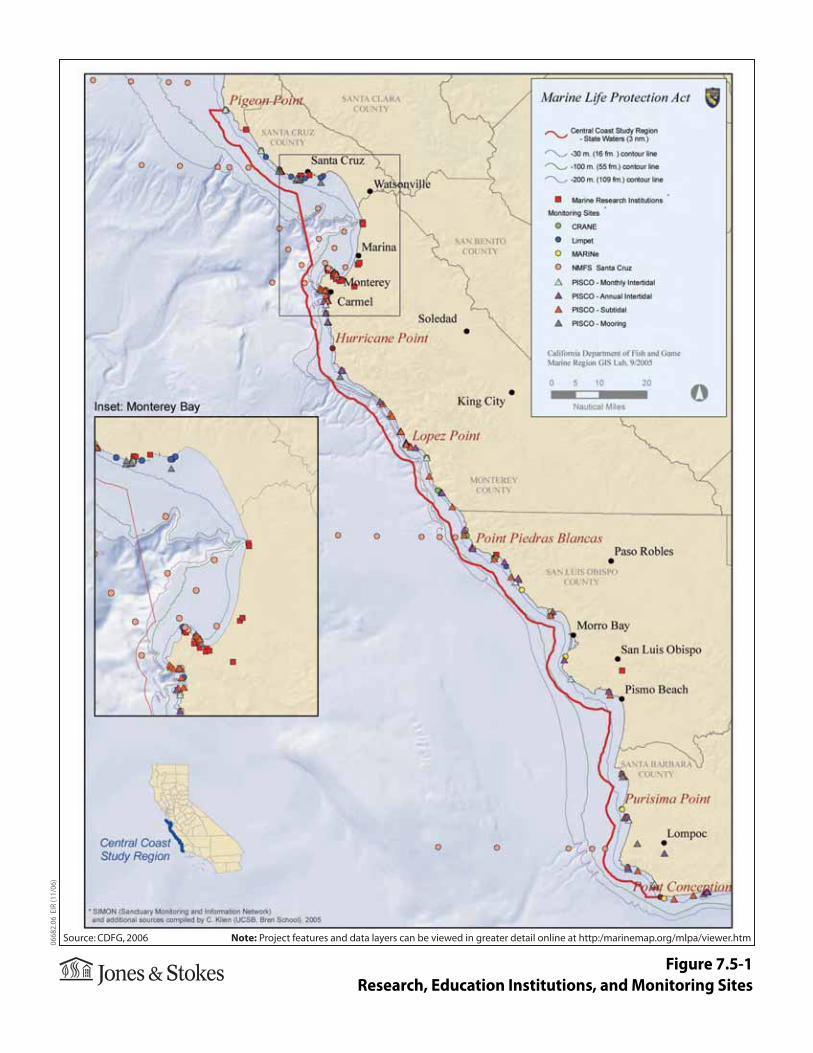
Figure 7.5-1Research, Education Institutions, and Monitoring Sites
0668
2.06
EIR
(11/
06)
Source: CDFG, 2006 Note: Project features and data layers can be viewed in greater detail online at http:/marinemap.org/mlpa/viewer.htm
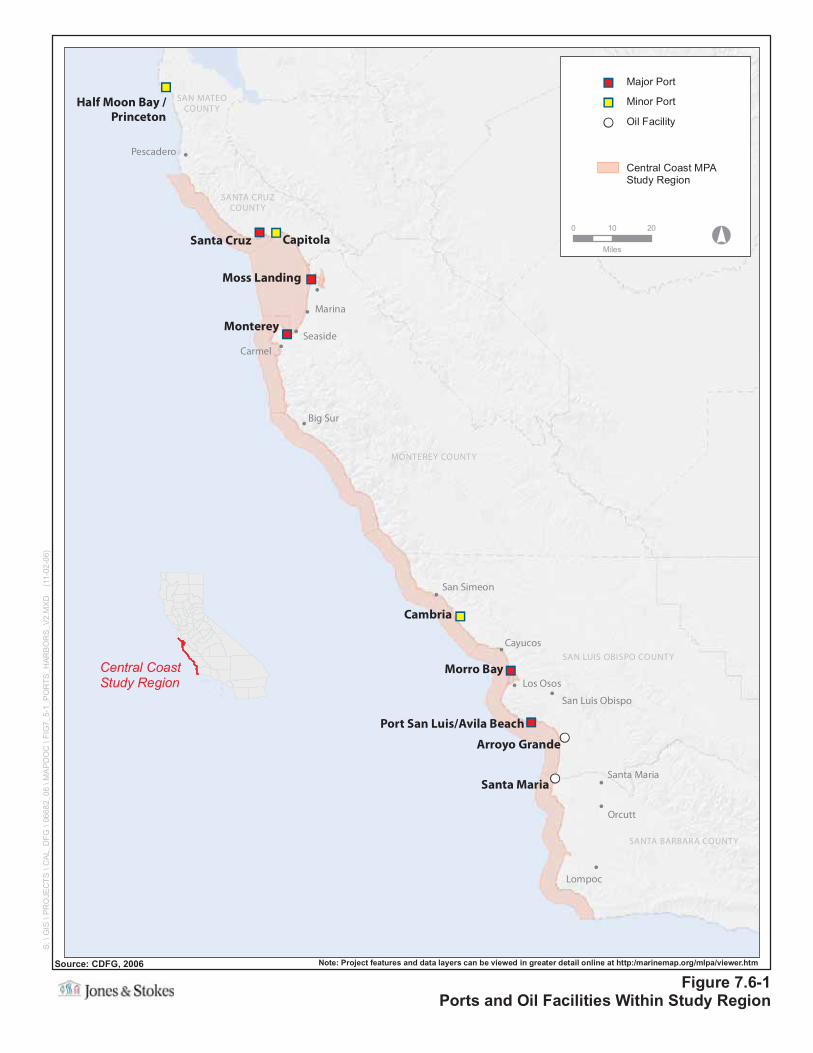
""
""
!!
""
""
""
""
""
""
!!
!
!
!
!
!
!
!
!
!
!
!
!
!
SAN MATEOCOUNTY
SANTA CRUZCOUNTY
MONTEREY COUNTY
SAN LUIS OBISPO COUNTY
SANTA BARBARA COUNTY
Pescadero
Marina
Seaside
Carmel
Big Sur
San Simeon
Cayucos
Los Osos
San Luis Obispo
Santa Maria
Orcutt
Lompoc
Cambria
Arroyo Grande
Monterey
Capitola
Morro Bay
Santa Cruz
Santa Maria
Moss Landing
Port San Luis/Avila Beach
Half Moon Bay /Princeton
Figure 7.6-1Ports and Oil Facilities Within Study Region
S:\
GIS
\PR
OJE
CT
S\C
AL_
DF
G\0
6682
_06
\MA
PD
OC
\FIG
7_5-
1_P
OR
TS
_HA
RB
OR
S_V
2.M
XD
(11-
02-0
6)
Central CoastStudy Region
Source: CDFG, 2006 Note: Project features and data layers can be viewed in greater detail online at http:/marinemap.org/mlpa/viewer.htm
°0 10 20
Miles
Central Coast MPAStudy Region
!! Oil Facility
"" Major Port
"" Minor Port