CHAPTER 6 SAFETY ELEMENT - City of Glendora
38
GLENDORA COMMUNITY PLAN 2025 SAFETY ELEMENT Glendora Community Plan 2025 ▸ 1 ◂ Safety Element CHAPTER 6 SAFETY ELEMENT 1.0 INTRODUCTION The aim of the Safety Element is “to reduce the potential risk of death, injuries, property damage, and economic and social dislocation resulting from fires, floods, earthquakes, landslides and other hazards”. 1 It serves as a guide for the City government and public for understanding the hazards facing the City of Glendora and how to reduce the impacts of these hazards. 2.0 AUTHORITY FOR THE ELEMENT California Government Code Section 65302(g) requires that a General Plan include: “...a safety element for the protection of the community from any unreasonable risks associated with the effects of seismically induced surface rupture, ground shaking, ground failure, tsunami, seiche, and dam failure; slope instability leading to mudslides and landslides; subsidence, liquefaction and other seismic hazards identified pursuant to Chapter 7.8 (commencing with Section 2690) of the Public Resources Code, and other geologic hazards known to the legislative body; flooding; and wild land and urban fires.” The following Federal and State regulations provide the legal framework to the Safety Element of a General Plan. These programs provide minimum requirements/criteria that must be complied with. Cities have the ability to adopt stricter requirements if desired. 2.1 CALIFORNIA ALQUIST-PRIOLO EARTHQUAKE FAULT ZONING ACT The Alquist-Priolo Earthquake Fault Zoning Act was signed into law in 1972 with its primary purpose being to mitigate the hazard of fault rupture by prohibiting the location of structures for human occupancy across the trace of an active fault. The Act requires the State Geologist to delineate “Earthquake Fault Zones” along faults that are “sufficiently active” and “well defined.” The Act dictates that cities and counties withhold development permits for projects within an Earthquake Fault Zone within their jurisdiction until geologic investigations demonstrate that the projects are not threatened by surface displacements from future faulting. Projects include all land divisions and most structures for human occupancy. State law exempts single-family wood-frame and steel-frame dwellings that are less than three stories and are not part of a development of four units or more. However, local agencies can be more restrictive than the State. 1 Source: State of California, Governor’s Office of Planning and Research, 2003 General Plan Guidelines, October 2003, page 90.
Transcript of CHAPTER 6 SAFETY ELEMENT - City of Glendora
GLENDORA COMMUNITY PLAN 2025
SAFETY ELEMENT
Glendora Community Plan 2025 ▸ 1 ◂ Safety Element
CHAPTER 6 SAFETY ELEMENT
1.0 INTRODUCTION The aim of the Safety Element is “to reduce the potential risk of death, injuries, property damage, and economic and social dislocation resulting from fires, floods, earthquakes, landslides and other hazards”.1 It serves as a guide for the City government and public for understanding the hazards facing the City of Glendora and how to reduce the impacts of these hazards.
2.0 AUTHORITY FOR THE ELEMENT California Government Code Section 65302(g) requires that a General Plan include: “...a safety element for the protection of the community from any unreasonable risks associated with the effects of seismically induced surface rupture, ground shaking, ground failure, tsunami, seiche, and dam failure; slope instability leading to mudslides and landslides; subsidence, liquefaction and other seismic hazards identified pursuant to Chapter 7.8 (commencing with Section 2690) of the Public Resources Code, and other geologic hazards known to the legislative body; flooding; and wild land and urban fires.” The following Federal and State regulations provide the legal framework to the Safety Element of a General Plan. These programs provide minimum requirements/criteria that must be complied with. Cities have the ability to adopt stricter requirements if desired.
2.1 CALIFORNIA ALQUIST-PRIOLO EARTHQUAKE FAULT ZONING ACT
The Alquist-Priolo Earthquake Fault Zoning Act was signed into law in 1972 with its primary purpose being to mitigate the hazard of fault rupture by prohibiting the location of structures for human occupancy across the trace of an active fault. The Act requires the State Geologist to delineate “Earthquake Fault Zones” along faults that are “sufficiently active” and “well defined.” The Act dictates that cities and counties withhold development permits for projects within an Earthquake Fault Zone within their jurisdiction until geologic investigations demonstrate that the projects are not threatened by surface displacements from future faulting. Projects include all land divisions and most structures for human occupancy. State law exempts single-family wood-frame and steel-frame dwellings that are less than three stories and are not part of a development of four units or more. However, local agencies can be more restrictive than the State. 1 Source: State of California, Governor’s Office of Planning and Research, 2003 General Plan Guidelines, October 2003, page 90.

GLENDORA COMMUNITY PLAN 2025
SAFETY ELEMENT
Glendora Community Plan 2025 ▸ 2 ◂ Safety Element
2.2 CALIFORNIA SEISMIC HAZARDS MAPPING ACT The goal of the Seismic Hazards Mapping Act of 1990 is to minimize loss of life and property by identifying and mitigating seismic hazards. The act addresses nonsurface fault rupture earthquake hazards, including strong ground shaking, liquefaction and seismically induced landslides. The State agency charged with implementation of the Act is the California Geological Survey (CGS). The CGS prepares and provides local governments with seismic hazard zone maps that identify areas susceptible to amplified shaking, liquefaction, earthquake-induced landslides, and other ground failures. The seismic hazard zones delineated by the CGS are referred to as “zones of required investigation,” because site-specific geological hazard investigations are required for construction projects located within these areas. 2.3 REAL ESTATE DISCLOSURE REQUIREMENTS Pursuant to the Natural Hazards Disclosure Act, since June 1, 1998, sellers of real property and their agents are required to provide prospective buyers with a “Natural Hazard Disclosure Statement” when the property being sold lies within one or more State mapped hazard areas, such as within an Alquist-Priolo Earthquake Fault Zone or a Seismic Hazard Zone. 2.4 CALIFORNIA ENVIRONMENTAL QUALITY
ACT The California Environmental Quality Act (CEQA) was passed in 1970 to insure that local governmental agencies consider and review the environmental impacts of development projects within their jurisdictions. CEQA requires that an Environmental Impact Report (EIR) be prepared for projects that may have significant effects on the environment. EIRs are required to identify geologic and seismic hazards, and to recommend potential mitigation measures, giving the local agency the authority to regulate private development projects in the early stages of planning. 2.5 CALIFORNIA BUILDING CODE The California Building Code (CBC), which is included in Title 24 of the California Administrative Code, provides “minimum standards to safeguard life or limb, health, property and public welfare by regulating and controlling the design, construction, quality of materials, use and occupancy, location and maintenance of all buildings and structures.” These documents are historically updated every three years. The most recent version of the CBC is the 2001 edition, based on the 1997 edition of the Uniform Building Code. The City of Glendora has adopted the 2001 CBC edition with local amendments.
GLENDORA COMMUNITY PLAN 2025
SAFETY ELEMENT
Glendora Community Plan 2025 ▸ 3 ◂ Safety Element
2.6 UNREINFORCED MASONRY LAW The Unreinforced Masonry Law of 1986 requires all cities and counties in Seismic Zone 4 (CBC, 1998) to identify hazardous unreinforced masonry (URM) buildings in their jurisdictions. Owners of such buildings must be notified of the potential earthquake hazard, and mitigation must be performed. The mitigation method, which may include retrofitting or demolition, is left to the local jurisdiction. Chapter 19.03 of the Municipal Code pertains to seismic strengthening provisions for unreinforced masonry bearing wall buildings. All URM buildings within the City have been identified and upgraded to meet current requirements. 2.7 NATIONAL FLOOD INSURANCE ACT AND FLOOD
DISASTER PROTECTION ACT The Federal Emergency Management Agency (FEMA) is mandated by the National Flood Insurance Act of 1968 and the Flood Disaster Protection Act of 1973 to evaluate flood hazards and provide Flood Insurance Rate Maps (FIRMs) for local and regional planners to promote sound land use and floodplain development. Further, the Flood Disaster Protection Act requires owners of all structures in identified Special Flood Hazard Areas to purchase and maintain flood insurance as a condition of receiving Federal or federally related financial assistance, such as mortgage loans from federally insured lending institutions. The National Flood Insurance Reform Act of 1994 further strengthened the National Flood Insurance Program (NFIP) by providing a grant program for State and community flood mitigation projects. The act also established a system (Community Rating System - CRS) for crediting communities that implement measures to protect the natural and beneficial functions of their floodplains, as well as managing the erosion hazard. Glendora does not currently participate in the NFIP since the City is located within Zone X, as identified on the FIRM. Zone X is areas of moderate or minimal hazard from the principal source of flood in the area 2.8 FIRE REGULATIONS Assembly Bill 337 (the Bates Bill, adopted September 29, 1992) was passed as a direct result of the great loss of lives and homes in the Oakland Hills “Tunnel Fire” of 1991. The Bates Bill Process is used to identify Very High Fire Hazard Severity Zones (VHFHSZs). Under Assembly Bill 3819, passed in 1994 (AB 3819 – Willie Brown), “Class A” roofing, minimum clearances of 30 feet around structures, and other fire defense improvements are required in VHFHSZs. Assembly Bill 6 (AB 6) requires that fire hazard areas be disclosed in real estate transactions. Civil Code Section 1103(c)(6) also requires real estate sellers to inform prospective buyers whether or not a property is located within a wildland area that could contain substantial fire risks and hazards.

GLENDORA COMMUNITY PLAN 2025
SAFETY ELEMENT
Glendora Community Plan 2025 ▸ 4 ◂ Safety Element
Public Resources Code Section 4290 requires minimum statewide fire safety standards pertaining to:
Road standards for fire equipment access; Standards for signs identifying streets, roads, and buildings; Minimum private water supply reserves for emergency fire use; and Fuel breaks and greenbelts.
Wildland fire areas are also subject to Public Resources Code Sections 4291 through 4299, which require property owners in such areas to conduct maintenance in order to reduce the fire danger. Section 18.04.010 of the City’s Municipal Code adopts by reference, the Uniform Fire Code 2000 Edition. 2.9 STANDARDIZED EMERGENCY MANAGEMENT SYSTEM LAW The Standardized Emergency Management System (SEMS) is described by the Petris Bill (SB 1841), and is contained in Chapter 1 of Division 2 of Title 19 of the California Code of Regulations. It requires all jurisdictions within the State of California to participate in the establishment of a standardized statewide emergency management system. The California Emergency Services Act, Section 8568, states that “the State Emergency Plan shall be in effect in each political subdivision of the State, and the governing body of each political subdivision shall take such action as may be necessary to carry out the provision thereof.” The act provides the basic authorities for conducting emergency operations following the proclamations of emergencies by the Governor or appropriate local authority, such as a City Manager. 2.10 EMERGENCY PLANNING AND COMMUNITY RIGHT-TO-KNOW ACT
(EPCRA) The primary purpose of the Federal Emergency Planning and Community Right-To-Know Act (EPCRA) is to inform communities and citizens of chemical hazards in their areas. Sections 311 and 312 of the EPCRA require businesses to report to state and local agencies the locations and quantities of chemicals stored on-site. Section 313 of the EPCRA requires manufacturers to report the release to the environment of any of more than 600 designated toxic chemicals. These reports help communities prepare to respond to chemical spills and similar emergencies. EPCRA mandates that Toxic Release Inventory (TRI) reports be made public. The TRI is a database that contains information on toxic chemical releases and other waste management activities reported annually by certain industry groups as well as federal facilities. This inventory was established in 1986 under the EPCRA and expanded by the Pollution Prevention Act of 1990.

GLENDORA COMMUNITY PLAN 2025
SAFETY ELEMENT
Glendora Community Plan 2025 ▸ 5 ◂ Safety Element
2.11 HAZARDOUS MATERIALS DISCLOSURE PROGRAM In 1986, Congress passed the Superfund Amendments and Reauthorization Act (SARA). Title III of this legislation requires that each community establish a Local Emergency Planning Committee (LEPC). This committee is responsible for developing an emergency plan that outlines steps to prepare for and respond to chemical emergencies in that community. Several California statutes require the emergency notification of a hazardous chemical release. These include: Health and Safety Codes Section 25270.7, Section 25270.8 and Section 25507; Vehicle Code Section 23112.5; Public Utilities Code Section 7673; Government Codes Section 51018, Section 8670.25.5(a); Water Codes Section 13271 and Section 13272; and California Labor Code Section 6409.1(b)10. The Safe Drinking Water and Toxic Enforcement Act of 1986, better known as Proposition 65, and Section 9030 of the California Labor Code also has specific reporting requirements.
3.0 SUMMARY OF EXISTING CONDITIONS 3.1 CITY PLANS AND PROGRAMS 3.1.1 Multi-Hazard Functional Plan The Standardized Emergency Management System (SEMS), California Code of Regulations, Title 19, Division 2, Section 2443, requires compliance with the SEMS to.... “be documented in the areas of planning, training, exercise, and performance." To be in compliance, emergency plans should address five SEMS functions:
Management; Operations; Logistics; Planning/Intelligence; and Finance/Administration.
The plan also addresses mutual aid, operational areas and multi/inter-agency coordination. Glendora has prepared a Multi-Hazard Functional Plan (MHFP) for emergency response within the City. The Plan meets the SEMS requirements of State law. The City also complies with the Los Angeles County Emergency Management Plan. The City’s MHFP is divided into three parts. Part One – Basic Plan, provides the overall organizational and operational concepts relative to response and recovery, as well as an overview of potential hazards. Part Two – Emergency Organization Functions, provides a description of the emergency response organization and emergency action checklists. Part Three provides the supporting and legal documents to the SEMS MHFP. Emergency response and threats are

GLENDORA COMMUNITY PLAN 2025
SAFETY ELEMENT
Glendora Community Plan 2025 ▸ 6 ◂ Safety Element
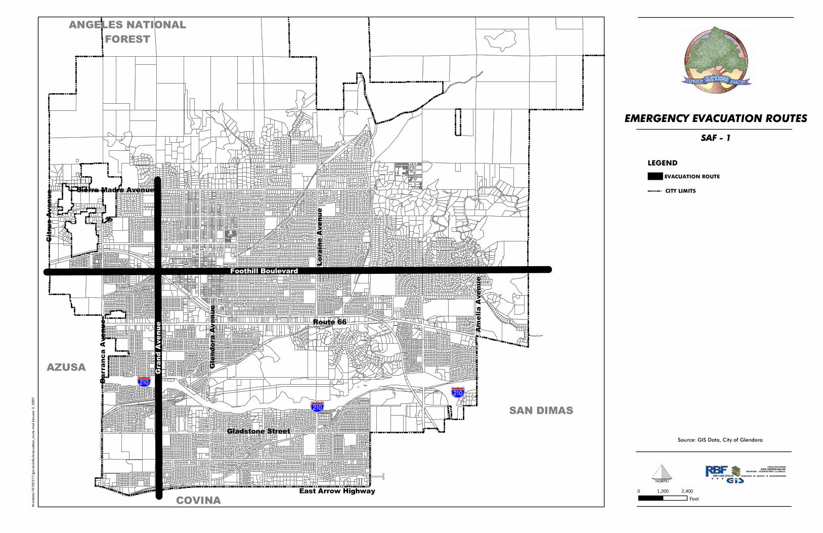
thoroughly described and outlined in the MHFP. Key points of the plan include the identification of critical areas in the City that represent both dangers, as well as areas for meeting and staging in an emergency event, communications and emergency evacuation. The MHFP addresses the City’s planned response to emergencies associated with natural disasters and technological incidents. It provides an overview of operational concepts, identifies components of the City’s emergency management organization within the SEMS and describes the overall responsibilities of Federal, State and county entities and the City for protecting life and property and assuring the overall well being of the population. The City maintains an Emergency Operations Center (EOC) at the Glendora Police Department at 150 South Glendora Avenue and an alternate EOC is located at the Youth Center (159 North Cullen Avenue) to coordinate City services during an emergency. During an emergency, the centralized command center houses personnel from the City, emergency responders and other appropriate agencies. Emergency evacuation routes have been identified as shown in Exhibit SAF-1, Emergency Evacuation Routes. 3.1.2 Natural Hazard Mitigation Plan In October 2004, the City of Glendora adopted a Natural Hazard Mitigation Plan. The Natural Hazard Mitigation Plan includes resources and information to assist City residents, public and private sector organizations, and others interested in participating in planning for natural hazards. The mitigation plan provides a list of activities that may assist the City of Glendora in reducing risk and preventing loss from future natural hazard events. The action items address multi-hazard issues, as well as activities for earthquakes, earth movements, flooding, wildfires and windstorms. The action items are a listing of activities in which City agencies and citizens can be engaged to reduce risk. Each action item includes an estimate of the time line for implementation. Short-term action items are activities that City agencies may implement with existing resources and authorities within one to two years. Long-term action items may require new or additional resources or authorities, and may take between one and five years (or more) to implement. The action items are organized within a matrix, which lists all of the multi-hazard and hazard-specific action items included in the mitigation plan. The matrix includes the following information for each action item:
Coordinating Organization. The coordinating organization is the public agency with regulatory responsibility to address natural hazards, or that is willing and able to organize resources, find appropriate funding, or oversee activity implementation, monitoring, and evaluation.
GLENDORA COMMUNITY PLAN 2025
SAFETY ELEMENT
Glendora Community Plan 2025 ▸ 7 ◂ Safety Element
Exhibit SAF-1 Emergency Evacuation Routes
%&g(
%&g(%&g(
Bar
ranc
a A
venu
e
Am
elia
Ave
nue
Lor
aine
Ave
nue
Gle
ndor
a A
venu
e
Route 66
SAN DIMAS
AZUSA
COVINA
ANGELES NATIONALFOREST
Cit
rus
Ave
nue
Sierra Madre Avenue
Gladstone Street
East Arrow Highway
Foothill Boulevard
Gra
nd A
venu
e
M:m
dat
a/1
01
02
31
7/g
is/a
rcin
fo/e
vacu
atio
n_ro
ute
.mxd
Jan
uar
y 3
, 20
07
EVACUATION ROUTE
Source: GIS Data, City of Glendora
LEGEND
EMERGENCY EVACUATION ROUTES
SAF - 1
CITY LIMITS
0 2,4001,200Feet

GLENDORA COMMUNITY PLAN 2025
SAFETY ELEMENT
Glendora Community Plan 2025 ▸ 8 ◂ Safety Element
Time Line. Each action item includes an estimate of the time line for implementation. The timing is defined as short-term (one to two years) or long-term (between one and five years or more).
Ideas for Implementation. Each action item includes ideas for implementation and potential
resources, which may include grant programs or human resources.
Plan Goals Addressed. The plan goals addressed by each action item are included as a way to monitor and evaluate how well the mitigation plan is achieving its goals once implementation begins.
Constraints. Any applicable constraints for the action items are noted. Constraints may
include a lack of city staff, lack of funds, or vested property rights, which might expose the City to legal action as a result of adverse impacts on private property.
3.1.3 City of Glendora Capital Improvement Program The City of Glendora conducts an annual review and update of its Capital Improvement Program (CIP). The Capital Improvement Program provides the primary planning and budget mechanism for improvement projects throughout the City. The CIP must provide consistency with City policies as set forth in the City’s General Plan. Projects within the CIP typically include water, recycled water, sewer, storm drains and public right-of-way improvements. 3.1.4 Glendora Municipal Code The Glendora Municipal Code contains all Ordinances adopted by the Glendora City Council. Many of these chapters provide direct relevance to policies and programs in the Safety Element. Relevant Code sections include:
Title 6: Health and Sanitation; Title 9: Public Peace, Safety and Morals; Title 11: Emergency Preparedness, Title 14: Water, Title 18: Fire, and Title 19: Buildings and Construction.
GLENDORA COMMUNITY PLAN 2025
SAFETY ELEMENT
Glendora Community Plan 2025 ▸ 9 ◂ Safety Element
3.2 EXISTING CONDITIONS The Safety Element specifically addresses both natural and man-made hazards. Natural hazards include:
Geologic Hazards (Seismic) – fault rupture, landslides, liquefaction, ground shaking, Geologic Hazards (Soils) – geologic and soil instability; and Flood Hazards – associated with rivers and streams, debris flows, and dam failure.
Man-made hazards include:
Fire, Crime, Hazardous materials, and Aircraft overflight
This section of the Safety Element addresses the existing conditions of these hazards and the programs currently in place to address them. 3.2.1 Natural Hazards Geologic, hydrologic, seismic and soil conditions present in the City have been evaluated in order to identify potential seismic hazards, such as surface faulting (ground rupture), ground shaking, liquefaction, ground lurching, differential compaction, ground cracking and seismically induced landslides. These data were used to evaluate potential seismic hazards to existing public and private facilities, and future land development. 3.2.1.1 Geology Glendora is located at the foothills of the San Gabriel Mountains, bounded by the Angeles National Forest to the north, city of Azusa to the west, city of Covina to the south and the city of San Dimas to the east. Two predominant terrain types are located within Glendora: alluvial fan and foothill. The alluvial fan portion of the City is characterized by gently to moderately sloping areas within the City where a vast majority of urban development has already occurred. The foothill portion of the City is characterized by moderate to very steep hillsides predominantly located along the northern boundary adjacent to the Angeles National Forest. In addition, a small area known as “South Hills” located in the southern portion of the City is also characterized by foothill terrain. The City is located in the Transverse Range Geomorphic Province of southern California. This province is characterized by an east-west trending mountain range (San Gabriel Mountains), which have been uplifted and folded as a result of compression. This compression is the result of the tectonic movements associated with the San Andreas, Cucamonga, Sierra Madre, and San Fernando

GLENDORA COMMUNITY PLAN 2025
SAFETY ELEMENT
Glendora Community Plan 2025 ▸ 10 ◂ Safety Element
Fault Zones. These faults have shaped the landscape of southern California. Within the City, the dominant geologic feature is the Sierra Madre Fault Zone, which has shaped the landscape in the area. The geologic units underlying the City can be categorized into two general categories: bedrock and alluvium. The bedrock units within the City consist of three main types: (1) sedimentary units of sandstone and siltstone, (2) volcanic units composed of tuff, lava, and mixtures of both, and (3) an igneous-metamorphic complex of crystalline rocks. The alluvium units within the City consist of old and young alluvial deposits that are derived from the surrounding bedrock units. These deposits consist of sand, silt, and gravels, with the youngest deposits located within active drainage courses. Refer to Exhibit SAF-2, Regional Geologic Map. Groundwater depths within the City range between 100 and 150 feet beneath the surface in the areas underlain by alluvium. The depth to groundwater has lowered over the last couple of decades due to domestic water production, which relies on pumping groundwater from the Glendora Basin aquifer. 3.2.1.2 Seismic Hazards The following section describes seismic hazards present in the City of Glendora including earthquake faults, surface rupture, ground shaking, liquefaction, hazardous buildings and seismic response. Earthquake Faults Southern California is considered a seismically active region that is dominated by earthquake faults. In the Transverse Range Geomorphic Province, these faults typically trend east-west, following the general alignment of the San Gabriel Mountains. One major fault zone is located within the City of Glendora. This zone is known as the Sierra Madre Fault Zone, which runs along the southern margin of the San Gabriel Mountains and is related to the Cucamonga Fault to the east and San Fernando Fault Zone to the west. In addition, to these faults, several other faults are located within the region that could have an impact on the City. The San Andreas Fault is approximately 20 miles northeast of the City, and is considered the most seismically active fault in the southern California region. A map illustrating the location of faults in the vicinity of the City is shown in Exhibit SAF-3, Regional Fault Map. Earthquakes that could affect the City would most likely originate from the Sierra Madre, Cucamonga, or San Andreas Fault Zones. These faults are close enough in proximity or expected to generate strong enough shaking that could affect the City. Geologic conditions within the foothill portions of the City could be impacted more severely due to the steep topography within this portion of the City and the relative instability of some of the geologic units in this portion of the City. The level of seismicity in Glendora, both as to maximum credible earthquake intensity and likely earthquake occurrences, is considered to be approximately the same as for the Los Angeles Basin.

GLENDORA COMMUNITY PLAN 2025
SAFETY ELEMENT
Glendora Community Plan 2025 ▸ 11 ◂ Safety Element
Exhibit SAF-2 Regional Geologic Map

Barra
nca Av
enue Am
elia Av
enue
Lorain
e Aven
ueFoothill Boulevard
Glendo
ra Ave
nue Route 66
Grand
Avenue
SAN DIMAS
AZUSA
COVINA
ANGELES NATIONALFORESTCit
rus Av
enue Sierra Madre Avenue
Gladstone Street
East Arrow Highway
Q
Tv
grMz
grMzpCc
M
pCc
M
Tv
M
pCc
pCc
M
Tv
waterM:m
data/1
010231
7/gis/a
rcinfo/
geolog
y.mxd
Janua
ry 3, 2
007
REGIONAL GEOLOGY MAP
Source: GIS Data, City of Glendora Department of Conservation, Division of Mines and Geology
LEGEND
0 2,8001,400Feet
SAF - 2
CITY LIMITS
Undivided pre-Cenozoic metasedimentary and metavolcanicrocks of great variety. Mostly slate, quartzite, hornfels, chert,phyllite, mylonite, schist, gneiss, and minor marble.M
Mesozoic granite, quatrz monzonite, granodiorite,and quartz diorite.grMz
WaterTertiary volcanic flow rocks; minor pyroclastic depositsTv
Alluviium, lake, playa, and terrace deposits; unconsolidatedand semi-consolidated. Mostly nonmarine, but includesdeposits near the coast.Q
Complex of Precambrian igneous and metamorphic rocks.Mostly gneiss and schist intruded by igneous rocks; maybe Mesozic in part.pCc

GLENDORA COMMUNITY PLAN 2025
SAFETY ELEMENT
Glendora Community Plan 2025 ▸ 12 ◂ Safety Element
Exhibit SAF-3 Regional Fault Map

N. BRANCH SIERRA MADRE FAULT
%&g(
%&g(
%&g(Bar
ranc
a A
venu
e
Am
elia
Ave
nue
Lon
e H
ill A
venu
e
Lora
ine
Ave
nue
Foothill Boulevard
Gle
ndor
a A
venu
e
Route 66
Gra
nd A
venu
e
SAN DIMASAZUSA
COVINA
ANGELES NATIONALFOREST
Cit
rus
Ave
nue
Sierra Madre Avenue
Gladstone Street
East Arrow Highway
M:m
da
ta/1
01
02
31
7/g
is/a
rcin
fo/p
refe
rre
d_a
lte
rna
tive.m
xd
Au
gu
st 3
1,
20
06
REGIONAL FAULT MAP
Source: GIS Data, City of Glendora 2001 ESRI Data and Maps Media Kit
0 1,200 2,400Feet
SAF - 3
LEGEND
HOLOCENE fault displacement(during past 10,000 years) withouthistoric record.
LATE QUATERNARY fault discplacement(during past 700,000 years)
QUATERNARY fault(age undifferentiated)
CITY LIMITS

GLENDORA COMMUNITY PLAN 2025
SAFETY ELEMENT
Glendora Community Plan 2025 ▸ 13 ◂ Safety Element
Sierra Madre Fault Zone. The Sierra Madre Fault Zone consists of east-west trending faults and folds, which extends along the southern margin of the San Gabriel Mountains. This fault zone is approximately 55 km in length and terminates at Dalton Canyons to the east and at the San Fernando Fault to the west. This fault is composed of five individual segments, which range in activity. Currently portions of this fault are located within Alquist Priolo Special Study zones (AP Zone), however the segments within the City are not considered active. Data gathered on this fault suggests that the slip rate ranges from 0.36 to 4 millimeters per year and this fault is expected to generate earthquakes with a magnitude of 6.0-7.0 on the Richter scale.2 Faults that are associated with this fault system include:
Cucamonga Fault; Duarte Fault; San Fernando Fault; San Gabriel Fault; Clamshell-Sawpit Canyon Fault; and Raymond Fault.
Cucamonga Fault. The Cucamonga fault extends 24 miles from the east side of Dalton Canyons to the San Jacinto fault. The eastern portions of this fault in the vicinity of the communities of Upland and Rancho Cucamonga have been identified within an AP Zone. However evidence of recent faulting has not been uncovered along the portions of this fault within the City of Glendora. Data gathered on this fault suggests that this fault has a slip rate between 5 and 14 millimeters per year and could generate earthquakes of 6.0-7.0 Mw on the Richter scale.3 3.2.1.3 Liquefaction Hazards Liquefaction is a phenomenon in which the strength and stiffness of a soil is reduced by earthquake shaking or other events. Liquefaction occurs in saturated soils, which are soils in which the space between individual soil particles is completely filled with water. This water exerts a pressure on the soil particles that influences how tightly the particles themselves are pressed together. Prior to an earthquake, the water pressure is relatively low. However, earthquake shaking can cause the water pressure to increase to the point where the soil particles can readily move with respect to each other. Because liquefaction only occurs in saturated soil, its effects are most commonly observed in low-lying areas. Typically liquefaction is associated with shallow groundwater, which is less than 50 feet beneath the earth’s surface. Available data indicates that groundwater levels beneath the City range between 100 to 150 feet deep. Certain locations however have shallow groundwater conditions and could be susceptible to liquefaction. According to the Seismic Hazard Zone Maps for the Baldwin Park, Azusa, San Dimas, and Glendora Quadrangles (March 1999) prepared by the California Geological Survey (CGS; formerly California Division of Mines and Geology), there are several locations within the City that
2 Data obtained from the Southern California Earthquake Center, www.scec.org, accessed on March 3, 2006. 3 Ibid.
GLENDORA COMMUNITY PLAN 2025
SAFETY ELEMENT
Glendora Community Plan 2025 ▸ 14 ◂ Safety Element
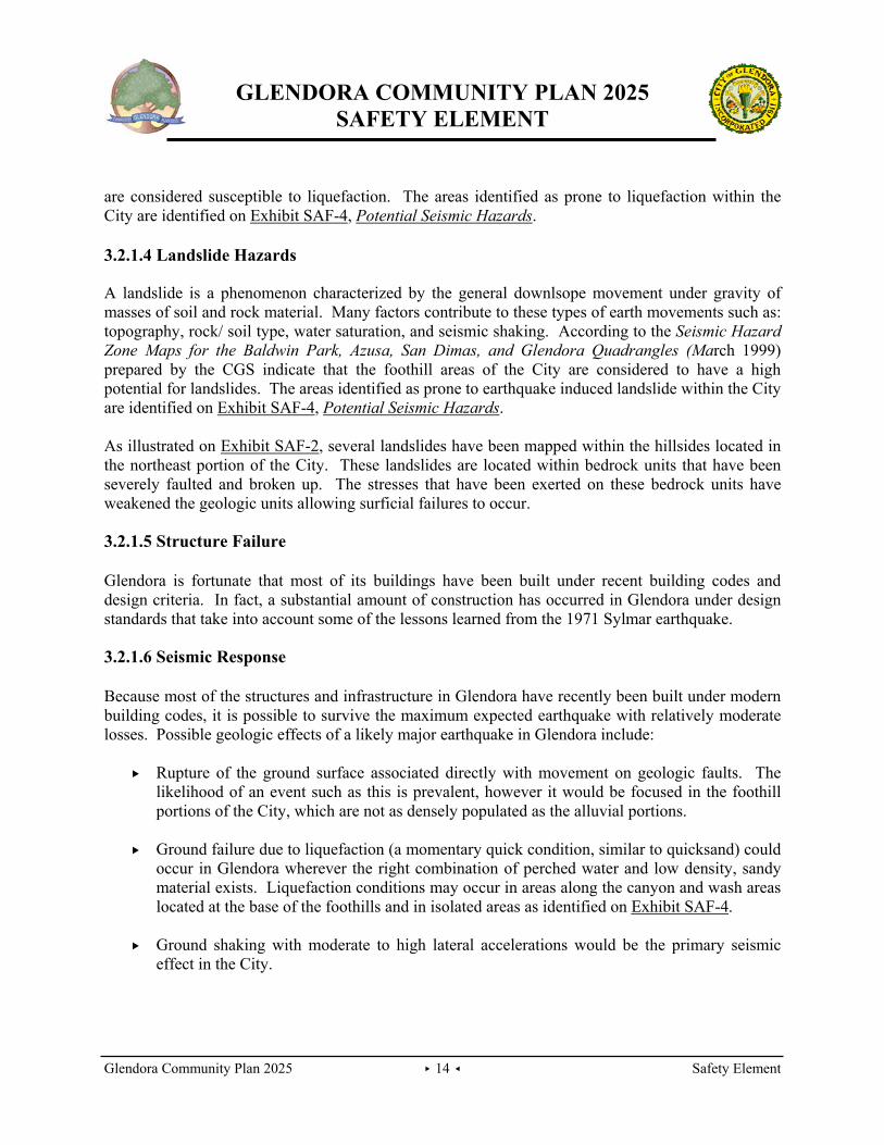
are considered susceptible to liquefaction. The areas identified as prone to liquefaction within the City are identified on Exhibit SAF-4, Potential Seismic Hazards. 3.2.1.4 Landslide Hazards A landslide is a phenomenon characterized by the general downlsope movement under gravity of masses of soil and rock material. Many factors contribute to these types of earth movements such as: topography, rock/ soil type, water saturation, and seismic shaking. According to the Seismic Hazard Zone Maps for the Baldwin Park, Azusa, San Dimas, and Glendora Quadrangles (March 1999) prepared by the CGS indicate that the foothill areas of the City are considered to have a high potential for landslides. The areas identified as prone to earthquake induced landslide within the City are identified on Exhibit SAF-4, Potential Seismic Hazards. As illustrated on Exhibit SAF-2, several landslides have been mapped within the hillsides located in the northeast portion of the City. These landslides are located within bedrock units that have been severely faulted and broken up. The stresses that have been exerted on these bedrock units have weakened the geologic units allowing surficial failures to occur. 3.2.1.5 Structure Failure Glendora is fortunate that most of its buildings have been built under recent building codes and design criteria. In fact, a substantial amount of construction has occurred in Glendora under design standards that take into account some of the lessons learned from the 1971 Sylmar earthquake. 3.2.1.6 Seismic Response Because most of the structures and infrastructure in Glendora have recently been built under modern building codes, it is possible to survive the maximum expected earthquake with relatively moderate losses. Possible geologic effects of a likely major earthquake in Glendora include:
Rupture of the ground surface associated directly with movement on geologic faults. The likelihood of an event such as this is prevalent, however it would be focused in the foothill portions of the City, which are not as densely populated as the alluvial portions.
Ground failure due to liquefaction (a momentary quick condition, similar to quicksand) could
occur in Glendora wherever the right combination of perched water and low density, sandy material exists. Liquefaction conditions may occur in areas along the canyon and wash areas located at the base of the foothills and in isolated areas as identified on Exhibit SAF-4.
Ground shaking with moderate to high lateral accelerations would be the primary seismic
effect in the City.

GLENDORA COMMUNITY PLAN 2025
SAFETY ELEMENT
Glendora Community Plan 2025 ▸ 15 ◂ Safety Element
Exhibit SAF-4 Potential Seismic Hazards
Barra
nca Av
enue
Amelia
Avenu
e
Lorain
e Aven
ueFoothill Boulevard
Glendo
ra Ave
nue Route 66
Grand
Avenue
SAN DIMASAZUSA
COVINA
ANGELES NATIONALFORESTCit
rus Av
enue Sierra Madre Avenue
Gladstone Street
East Arrow Highway
AREA
NOT
SURV
EYED
M:mdat
a/101
0231
7/gis/a
rcinfo/
seism
ic_haz
ards.m
xd Ja
nuary 3
, 200
7
LEGEND
POTENTIAL SEISMIC HAZARDS
EARTHQUAKE - INDUCED LANDSLIDES
LIQUEFACTION
Areas where previous occurrence of landslidemovement, or local topographical, geological,geotechnical, and subsurface water conditionsindicated a potential for permanent grounddisplacements.
Areas where historic occurrence of liquefactionof local geological, geotechnical and groundwaterconditions indicate a potential fore permanentground displacement.
Source: GIS Data, City of Glendora Source: California Department of Conservation, Division of Mines and Geology, March 1999 (http://gmw.consrv.ca.gov/shmp/)
0 2,8001,400 Feet
SAF - 4
CITY LIMITS

GLENDORA COMMUNITY PLAN 2025
SAFETY ELEMENT
Glendora Community Plan 2025 ▸ 16 ◂ Safety Element
In general, complete collapse of buildings is not likely to occur and building damage is likely to be only moderate. However, partial to total collapse could occur among the very few pre-1933 buildings still existing, and partial collapse of some tilt-up and concrete block buildings built prior to March 1972 must be counted as a possibility, based on the evidence of the Sylmar earthquake. The majority of construction has been under modern building codes. Where current state-of-the-art seismic evaluations can enter into all future development, and where disaster preparedness is being maintained, it is possible to survive the maximum expected earthquake with relatively moderate losses.
Possible impacts to the City from a major seismic event include:
Injuries and loss of life; Economic losses; Property damage; Economic disruption – loss of jobs, loss of productive time, interference with trade,
transportation, communication and other utilities; Social disruption; Housing dislocation; Interference with community activities and services; Emergency welfare requirements – shelter, food, communications, financial assistance; or Psychological trauma – especially among young children.
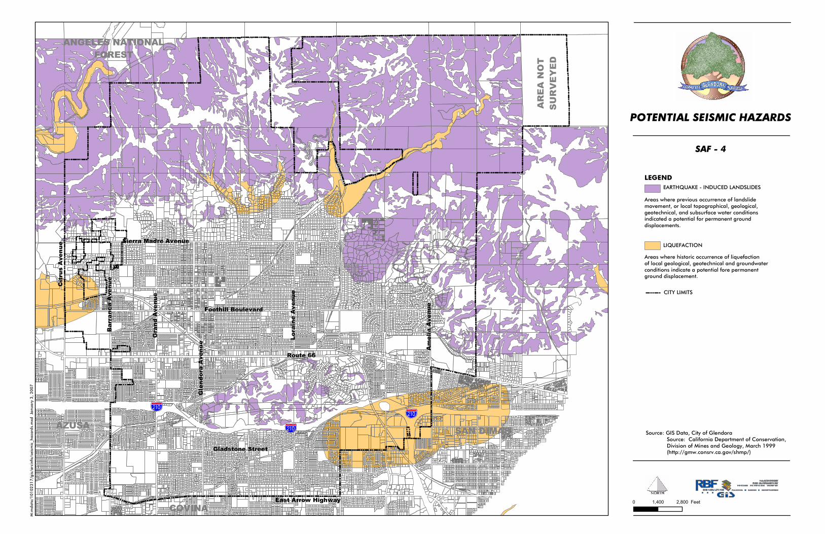
However, the full extent of these impacts will be influenced by many factors. 3.2.1.7 Flooding According to Federal Guidelines from the Federal Emergency Management Agency (FEMA), the built areas of the City are in Flood Zone X, meaning that the area is not located within a 100-year flood plain. FEMA maps showing areas that require flood insurance are maintained at City Hall. Three flood channels traverse through the City: the Little Dalton Wash, Big Dalton Wash, and San Dimas Wash. All three channels are concrete-lined channels designated as floodways to serve the region. Access to these channels is limited at all times for public safety. 3.2.1.8 Dam Inundation Dam inundation is flooding that occurs due to structural failure of a dam. Failure of a dam may be caused by seismic activity, severe flooding that causes water to exceed the capacity of the dam or landslides that flow into a reservoir displacing the water. The City of Glendora faces a potential hazard from dam inundation resulting from the failure of either of two dams: Big Dalton Dam and San Dimas Dam. It is considered unlikely that either dam would fail during a catastrophic event. The SEMS Multi-Hazard Functional Plan prepared by the City of Glendora outlines the City’s response for dam failure.

GLENDORA COMMUNITY PLAN 2025
SAFETY ELEMENT
Glendora Community Plan 2025 ▸ 17 ◂ Safety Element
Big Dalton Dam. This dam is located in Big Dalton Canyon, four miles northeast of Glendora. Completed in 1929, this dam is owned and operated by the Los Angeles County Flood Control District. This dam stores approximately 960 acre feet (over 312 million gallons) of water. Should a breach occur, the water would flow south westerly out of Big Dalton canyon via the Big Dalton Wash. The areas between the South Hills and San Gabriel foothills surrounding this wash, would be inundated by the waters from this flood. The affected area is mostly comprised of residential with some commercial, and industrial uses as well. Exhibit SAF-5, Dam Inundation Areas, shows the area that would be affected by a dam failure. San Dimas Dam. The San Dimas Dam is owned and operated by the Los Angeles County Flood Control District. It is located east of the City in the foothills above the City of San Dimas. Built in 1922, this dam stores approximately 1,500 acre-feet (488 million gallons) of water. Should a breach occur, the water would flow southwest along the San Dimas wash inundating the portions of the City located south of the 210 Freeway. Land uses that would be affected by this inundation mainly include residential, commercial, and industrial. Exhibit SAF-5, Dam Inundation Areas, shows the areas that would be affected by a dam failure. 3.2.2 MAN-MADE HAZARDS 3.2.2.1 Hazardous and Toxic Materials Hazardous materials are any substance or combination of substances, which because of quantity, concentration, or characteristics, may cause or significantly contribute to an increase in death or serious injury, or pose substantial hazards to humans and/or the environment. Local governments have little control over the production and use of these materials because they are part of our society. Even household wastes can be hazardous materials. Emergency response plans are in place with the City per the SEMS Multi-Hazard Functional Plan in the case that a hazardous or toxic materials event occurs. In addition, the County of Los Angeles Fire Department provides emergency response to hazardous materials. The County provides two engines, one hazardous materials task force, one squad and a battalion chief that directly respond to hazardous materials incidents. 3.2.2.2 Transport of Hazardous Materials In Glendora, a hazardous chemical release would most likely occur as a result of either transportation of chemicals by railroad or truck, use of chemicals at a business or illegal dumping of chemical waste. Interstate 210 is heavily traveled by trucks and thus, represent the most likely location of a release. Exhibit SAF-5

GLENDORA COMMUNITY PLAN 2025
SAFETY ELEMENT
Glendora Community Plan 2025 ▸ 18 ◂ Safety Element
Dam Inundation Areas
%&g(
%&g(
%&g(Bar
ranc
a A
venu
e
Am
elia
Ave
nue
Lon
e H
ill A
venu
e
Lora
ine
Ave
nue
Foothill Boulevard
Gle
ndor
a A
venu
e
Route 66
Gra
nd A
venu
e
SAN DIMASAZUSA
COVINA
ANGELES NATIONALFOREST
Cit
rus
Ave
nue
Sierra Madre Avenue
Gladstone Street
East Arrow Highway
Big Dalton DamInundation Area
Big DaltonDebris Basin
Inundation Area
Big DaltonDebris Basin
Inundation Area
M:m
da
ta/1
01
02
31
7/g
is/a
rcin
fo/D
am
Inu
nd
ati
on
.mxd
Ja
nu
ary
4,
20
07
DAM INUNDATION AREAS
Source: GIS Data, City of Glendora
0 1,200 2,400Feet
SAF - 5
LEGEND
LITTLE DALTON DEBRIS BASIN INUNDATION AREA
BIG DALTON DEBRIS BASIN INUNDATION AREA
BIG DALTON DAM INUNDATION AREA
CITY LIMITS

GLENDORA COMMUNITY PLAN 2025
SAFETY ELEMENT
Glendora Community Plan 2025 ▸ 19 ◂ Safety Element
Fixed Facility. The second most likely threat from hazardous materials comes from the potential of an accidental spill and/or incident at one of the approximately 150 known facilities that manufacture, warehouse and process toxic chemicals and/or generate hazardous waste materials within or next to the City. This potential also exists at former facilities, such as abandoned service stations or industrial businesses. The threat is significantly lessened though, because of required plan contingency and evacuation plans. Clandestine Dumping. Clandestine dumping of hazardous materials is a criminal act and could pose a threat. The City anticipates that there will be an increase in dumping as costs to legally dump materials at designated hazardous waste disposal sites increases, but cannot anticipate if or when such an act would occur. Pipelines. Two water pipelines traverse the City. There are no oil or gas lines or lines that carry hazardous materials within the City. Household Hazardous Waste. Household hazardous waste poses a risk to the City. Glendora participates in the Los Angeles County sponsored monthly Household Hazardous Waste Roundups for County residents. 3.3 CRIME, FIRE AND MEDICAL EMERGENCIES Crime and fire hazards have the potential to lead to property damage, injury, and even death. , and can affect the sense of comfort within the community. Fire and police departments are prepared to service most emergencies with quick and effective response times. In addition, various programs for citizen education and community involvement encourage unity and enhance safety. 3.3.1 FIRE PROTECTION Los Angeles County Fire Department provides fire protection and emergency service to the City of Glendora. Three fire stations located within the City serve the City of Glendora: Fire Station 85 located at 650 East Gladstone, Fire Station 86 located at 520 South Amelia Avenue and Fire Station 151 located at 231 West Mountain View Avenue (refer to Table SAF-1, Fire Stations in Glendora). Water is provided by five different sources throughout the City: the South Hills and Glendora Water are the primary sources.

GLENDORA COMMUNITY PLAN 2025
SAFETY ELEMENT
Glendora Community Plan 2025 ▸ 20 ◂ Safety Element
TABLE SAF-1 FIRE STATIONS IN GLENDORA
Station No./
Address Number of Personnel
Equipment
Station No. 85 650 East Gladstone
17 3 Captains 3 Firefighter Specialists 9 Firefighters 1 Engine 1 EST (2 person unit)
Station No. 86 520 South Amelia Avenue
21 6 Captains 3 Firefighter Specialists 12 Firefighters 1 Engine 1 Truck
Station No. 151 231 West Mountain View Avenue
17 3 Captains 3 Firefighter Specialists 9 Firefighters/Paramedics 1 Engine I Nurse Educator
Source: Captain Joel Douty, Station 85, March 2006 Captain Gomez, Station 86, March 2, 2006 Captain Morando, Station 151, March 2, 2006
Medical The County of Los Angeles Fire Department provides an Emergency Response Service (EMS). Although none of the stations located within Glendora have this section it is accessible through other stations in the county. The EMS section is responsible for paramedic training, certification, equipment, and quality improvement. However, each station is staffed with qualified emergency medical training (EMT) firefighters. In addition, Station 85 has an Emergency Service Team, which serves similar functions, and Station 151 is equipped with a paramedic unit. This means that the nine firefighters are also trained paramedics. Response Times The Los Angeles County Fire Protection District has no official adopted standards for response. For the City of Glendora, the average response time is 4.38 minutes. Community Relations and Services Safety Inspections- The Los Angeles County Fire Protection District provides annual safety review of all occupations in Glendora except single-family dwellings. Personnel at the three fire stations work together to conduct these inspections with regard to fire prevention and ordinance compliance.

GLENDORA COMMUNITY PLAN 2025
SAFETY ELEMENT
Glendora Community Plan 2025 ▸ 21 ◂ Safety Element
Education – The County Fire Protection District offers various programs with the purpose of public education. This encompasses fire prevention, hazardous waste disposal, earthquake preparedness, event safety tips, first aid and more. Other Services – Station 151 provides plan check services for residents to insure new construction plans are to code. Weed abatement services are also available at cost to all individuals, or citizens who fail to meet the obligation. 3.3.2 POLICE PROTECTION Police protection is provided by Glendora Police Department located at 150 South Glendora Avenue. The police department has 59 sworn officers and 42 civilian employees. Sworn officers include one chief, one captain, five lieutenants, five sergeants, six corporals and 41 officers. In addition to the full-time officers and civilian employees, Glendora has a reserve officer force. The reserve officer force provides additional, equally qualified officers on a flexible, part-time status that provide valuable aid to the department. These seven reserve members assist the department in fulfilling their mission and provided a total of 2,500 service hours in 2006. Community Relations and Emergency Services School Resource Officer - A law enforcement office is located at Glendora High School. Duties include: handling campus related problems, providing referrals, assisting school district with security planning & investigating crimes and detaining offenders (Glendora High School, Whitcomb Continuation High School, Sandburg Middle School and Goddard Middle School) Community Relations/Public Information - Duties include: public presentations (including school presentations and news media), police facility tours, coordination of several community programs, city liaison with various community groups, and city code enforcement task force. Emergency Services Bureau - Started in September 2001, the unit trains and prepares City staff, City departments and the community to properly respond to and recover from emergencies and disasters. Animal Control - Animal control services are offered Monday through Saturday at the Glendora Police Department. The office provides licensing, vaccinations and sterilizations, kennel services, transportation services and dead animal pick up. Services are offered for a subsidized fee supported by the Animal Control Program. Response Times Quick and effective response to citizen emergencies and concerns are important to the city. These are measured based on the time the dispatcher receives a call for service from the public to the time the responding officer arrives at the location of the call. Call types are defined below, and Table SAF-2, Police Response Times, illustrates the Department’s average response times for 2006.

GLENDORA COMMUNITY PLAN 2025
SAFETY ELEMENT
Glendora Community Plan 2025 ▸ 22 ◂ Safety Element
Emergency: Officer responding with red lights and siren. Immediate: Officer needed as soon as possible, obey all traffic laws. Alarm: Officer needed to respond to an alarm activation. Non-Emergency: Beat officer needed when available. Report: Beat officer needed to take a report when available.
TABLE SAF-2 POLICE RESPONSE TIMES
Call Type 2006 Average Response Time Target Response Time Emergency 00:04:25 00:4:00 Immediate 00:12:00 00:10:00 Alarm 00:11:42 00:10:00 Non-Emergency 00:16:31 00:15:00 Report 00:19:06 00:20:00 Source: City of Glendora Police Department - March, 2007,
3.4 COMMUNITY SAFETY SERVICES Volunteering Glendora residents are also valuable resources in maintaining a safe community. Assistance can be in the form of generous donations to various programs offered or performed by the fire and police department. Qualified citizens also have the opportunity to donate their time through volunteer programs that exist within the city police department and county fire stations in Glendora. Community Emergency Response Team (CERT) The CERT program educates citizens in the community about disaster preparedness and train the public in basic disaster response skills. The program includes a 20 hour FEMA approved training course provided through the Emergency Services Bureau of the police department. Volunteer Photographer The county fire department utilizes citizen volunteers willing and authorized to assist the department with documenting major incidents and minor events in the city. Auxiliary Volunteers Auxiliary volunteers assist the Police Department by performing a variety of non-hazardous tasks that would otherwise require the time of full-time staff. These duties range from providing additional
GLENDORA COMMUNITY PLAN 2025
SAFETY ELEMENT
Glendora Community Plan 2025 ▸ 23 ◂ Safety Element
manpower at events throughout the community to assistance with fires, traffic accidents, business patrols and more. Volunteers who prefer to donate their time and skills in the office staff the front desk, animal control center and perform various other clerical duties throughout the police department. The Auxiliary organization was created in 1970 and currently consists of 25 officers, who in 2006 contributed over 7,000 hours of service. Citizen’s Academy The Citizen’s Academy is an outreach program which doubles as a basic course for persons who wish to become part of the Auxiliary Volunteers. Participants are exposed to the various duties and actives performed by the police department and criminal justice system. This eleven-week course is held twice a year free of charge to Glendora residents.
Law Enforcement Exploring The City of Glendora Police Department, headed by members of the department, provides an opportunity for high school students, ages 14 to 18, to experience firsthand the challenge of a law enforcement career. The program includes hands on training, ride-a-longs and other aspects of police work. It is possible for students to earn school credit through the Regional Occupational Program (ROP) for their participation in the program.
Police Chaplains Program The city of Glendora began the Police Chaplain Program in 2002. The chaplains’ role is to assist employees of the police department in time of death, injury or personal distress. This service also extends to members of the community during instances of crisis. In 2006, the program included two appointed volunteer chaplains who are pastors and active community residents. Their services have contributed over 1,000 hours of service to the community. 3.5 CRIME PREVENTION THROUGH ENVIRONMENTAL
DESIGN Crime Prevention Through Environmental Design (CPTED) resolves around restoring public safety and creating “defensible space.” The concept of defensible space is applicable to community and site planning, as well as building design. CPTED approaches the problem of creating a defensible environment by addressing both the physical and psychological aspects of design. Security concerns are addressed during the design stage of a project, rather than added after the development is constructed. CPTED Approaches to Security Physical Planning Process. Crime prevention is an important consideration in the physical planning process. Conditions for public safety can be enhanced and property loss reduced by utilizing land

GLENDORA COMMUNITY PLAN 2025
SAFETY ELEMENT
Glendora Community Plan 2025 ▸ 24 ◂ Safety Element
use planning and site design techniques to deter criminal activity. Carefully planned development can serve to minimize the opportunity of unlawful activity, and thus lower the actual occurrence of crime. Crime Prevention Through Physical Planning. The use of physical planning may be one of the least costly and most successful means of crime prevention. The key is to establish design criteria that will affect community control by members of the community. Improving the observational capability of residents to residents to visually survey their residential environment through design considerations is aimed at reducing the workload of law enforcement agencies and enhancing community orientation. Street, Building, and Landscaping Design. The design of streets, buildings, and landscaping can influence the way people regard spatial use. Architectural alteration of entrances can change a space once considered public into a semi-private one that is shared by a limited number of people. In large multi-family complexes with one or two entrances, people are able to enter the building without notice or challenge. Multi-family buildings designed to provide a separate common entrance for six to eight families allow a higher level of surveillance by the occupants. Families soon become acquainted with their neighbors’ normal day-to-day activities and are able to recognize their most frequent visitors. Streets are typically designed and considered as public space allowing free and ready access into any neighborhood by anyone. By siting residential structures in relation to their lots and the street, a degree of neighborhood control or territoriality may be established. The designed use of symbolic or psychological barriers through landscaping can have an apparent differentiation to public versus private space. Typical examples of these symbolic barriers are a small hedge, a long walkway, or a set of steps between the public sidewalk and the house. These design features tend to identify the end of the public space and the beginning or a more selective space use. Landscaping features can also facilitate neighborhood control by providing observable “barriers” beyond which other residents of the area would take note and potentially challenge. Here landscaping can be used to define space use by visually delineating area for their private space use from public space use. An attractively landscaped front yard can be considered the object of the resident’s pride of ownership. With neighbors reinforcing this aspect of private domain, they soon develop a sense of identity to and responsibility for others’ front yards. Landscaping treatment should be used in a manner that enhances an area’s or project’s setting without obstructing the visibility of walkways or entrances from the streets or other residences. Community Identity and Control. The design of physical space can augment community identity and control. Visibility alone is not enough; there must be a reason before a person will challenge inappropriate behavior. If a person feels he/she has a stake in a neighborhood or community, there is ample reason to question the potentially unlawful behavior of others. The use of design in the physical planning process can encourage residents to assert a psychological identity over their immediate neighborhood, and thus to deter crime by reducing the opportunity for

GLENDORA COMMUNITY PLAN 2025
SAFETY ELEMENT
Glendora Community Plan 2025 ▸ 25 ◂ Safety Element
unlawful activity. Strongly defined areas of influence, real and psychological barriers, and improved opportunities for surveillance can assist a community in exerting a meaningful level of crime prevention and control by its residents. CPTED Strategies CPTED incorporates several strategies to create a defensible space, such as surveillance, territoriality, natural access control, and physical security. Surveillance. This concept promotes maximizing the visibility of people, parking areas, and building entrances. Features to implement this concept could include doors and windows that look out onto streets and parking areas, pedestrian-friendly sidewalks and streets, front porches, and adequate nighttime lighting. Territoriality. Creating gateways to clearly indicate public routes, and using structural or design elements to discourage access to private areas. Physical Security. This concept seeks to make it more difficult and time consuming to enter a location, but not make the location a fortress. This concept is achieved by installing window locks, dead bolts for doors, and interior door hinges. For outdoor areas, create an environment where entryways are exposed and well designed, and include landscaping features that deter intruders and increase security around the home a sense of territory is important as it encourages individuals to take control of their environment and defend it against becoming a potential target of attack. The concept of territoriality incorporates design features that define property lines and distinguish private spaces from public spaces using landscape plantings, pavement designs, gateway treatments, and fences. Natural Access Control. This concept clearly distinguishes public areas and private areas, thus reducing access to potential targets and increasing the deterrent to potential offenders. This concept is achieved by designing streets, sidewalks, building entrances, and neighborhood gateways to clearly indicate public routes, and using structural or design elements to discourage access to private areas. Physical Security. This concept seeks to make it more difficult and time consuming to enter a location, but not make the location a fortress. This concept is achieved by installing window locks, dead bolts for doors, and interior hinges. For outdoor areas, create an environment where entryways are exposed and well designed, and include landscaping features that deter intruders and increase security around the home.
GLENDORA COMMUNITY PLAN 2025
SAFETY ELEMENT
Glendora Community Plan 2025 ▸ 26 ◂ Safety Element
3.6 AIRCRAFT OVERFLIGHT While the City of Glendora is not within the direct flight paths of any particular airport, aircraft fly over the City throughout the day and night. A majority of these flights are from small private aircraft originating out of local airports. The closest airports in the area are: Bracket Airport in Pomona/ La Verne and Cable Airport in the City of Upland. The nearest commercial airport is Ontario International Airport located in the City of Ontario, which is approximately 20 miles east of Glendora. The City of Glendora Multi-Hazard Functional Plan provides the policies and procedures addressing emergency response to air disasters. Regardless of where a air crash occurs, the resulting explosions and fires have the potential to cause injuries, fatalities and the destruction of property at and adjacent to the impact point. The time of day when the crash occurs may also have a profound affect on the number of fatalities or wounded. Damage assessment and disaster relief efforts associated with an air crash incident will require support from other local governments, private organizations and in certain instances from the State and Federal governments. 4.0 PLANNING CONSIDERATIONS, GOALS, AND POLICIES FLOOD HAZARDS Planning Consideration: Glendora is particularly susceptible to flooding due to its location adjacent to the San Gabriel Mountains. Significant flooding events have occurred periodically and have had a demonstrated impact on the safety and property of Glendora residents. To reduce the potential impacts of flooding to the safety and economic integrity of the City’s residents, it is important to ensure disaster planning is coordinated with local planning decisions. Goal SAF-1 Protection from potential flood hazards, including dam
inundation. Policies SAF-1.1 Coordinate with the Los Angeles County Flood Control District to
ensure that flood control facilities under their jurisdiction are adequately operated and maintained.
SAF-1.2 Utilize the City’s capital improvement process to identify
necessary storm drain improvements to minimize potential flood damage.
SAF-1.3 Provide an annual review of the Standardized Emergency
Management System Multi-Hazard Functional Plan to ensure evacuation routes are sufficient in the event of flooding.

GLENDORA COMMUNITY PLAN 2025
SAFETY ELEMENT
Glendora Community Plan 2025 ▸ 27 ◂ Safety Element
SAF-1.4 Continue the maintenance of City-owned flood control facilities
within Glendora to ensure their efficient operation and work with Los Angeles County, as needed, to transfer the maintenance of existing and new facilities.
SAF-1.5 Evaluate new development within the City to assess the
development’s exposure to potential flooding hazards and ensure that habitable structures and infrastructure are not located within the 100-year flood plain.
SAF-1.6 Coordinate with Los Angeles County to ensure that storm drain
and flood protection facilities built in conjunction with new development are maintained by the County.
FIRE HAZARDS Planning Consideration: The City’s location adjacent to national forest lands and areas of natural open space and vegetation, when combined with long dry seasons, significantly increase risks of wildland fires and urban fires. The establishment of policies and procedures to mitigate potential impacts of wildfires and urban fires will contribute to the protection of life and property of Glendora’s residents. Goal SAF-2 Reduced incident of damage to life and property from wildland
fires. Policies SAF-2.1 Require all proposed developments to prove that the development
can adequately be served by fire flows. SAF-2.2 Maintain low density/intensity land use designations in the hillside
areas. SAF-2.3 Require fire resistant building materials for structures in the
hillside areas. SAF-2.4 Require proposed developments to comply with access
requirements of the Los Angeles County Fire Department and Glendora Police Department.
SAF-2.5 Continue to implement brush-clearance requirements in areas
subject to wildland fire hazards.

GLENDORA COMMUNITY PLAN 2025
SAFETY ELEMENT
Glendora Community Plan 2025 ▸ 28 ◂ Safety Element
SAF-2.6 Evaluate all new development to be located in or adjacent to wildland areas to assess its vulnerability to fire and its potential as a source of fire.
Goal SAF-3 Reduced incident of damage to life and property from urban fires. Policies SAF-3.1 Enforce the installation of fire alarm systems, smoke detectors
and/or sprinklers to protect life and property. SAF-3.2 Provide education and outreach to residents regarding fire safety
and prevention. SAF-3.3 Continue to implement and enforce the latest edition of the
Uniform Fire Codes.
SEISMIC HAZARDS Planning Consideration: Glendora is located within a highly active seismic region. To ensure the safety of Glendora residents and the City’s economic integrity, demonstrated efforts must be undertaken to protect residents from the potential loss of life and property due to seismic events. The City seeks to coordinate citywide planning policies to reduce potential hazards associated with a seismic event. Goal SAF-4 Protection from loss of life and property during seismic events. Policies SAF-4.1 Require that new development and infrastructure avoid on-site
seismic hazards such as faults, liquefaction zones and landslide areas.
SAF-4.2 Adopt building regulations that minimize effects from seismic
events in building construction. SAF-4.3 Provide instructional materials, classes and other educational
resources to ensure residents and the daytime population are knowledgeable of the risks and methods to reduce such risks, as well as involve the residents and community groups in the City’s annual emergency preparedness event.

GLENDORA COMMUNITY PLAN 2025
SAFETY ELEMENT
Glendora Community Plan 2025 ▸ 29 ◂ Safety Element
Goal SAF-5 Protection from landslides. Policies SAF-5.1 Ensure that development within landslide prone areas meets the
City’s Hillside Development Criteria and Hillside Development Strategy.
SAF-5.2 Require proposed developments located within areas identified by
California Department of Conservation Seismic Hazard Maps (dated March 25, 2999 or as revised) to prepare a geotechnical investigation report.
POLICE PROTECTION Planning Consideration: Glendora residents have enjoyed lower incidence of crime and this is reflected in the community’s perception that Glendora is a safe place to live. The City of Glendora seeks to maintain and enhance its low crime rates through the coordination of public safety issues and police protection with physical planning. Goal SAF-6 Coordinated public safety and community planning. Policies SAF-6.1 Consult the Glendora Police Department to identify and address
impacts of proposed development on police services.
SAF-6.2 Ensure police services are not impacted by development, traffic congestion and other growth related issues.
Goal SAF-7 High quality police protection. Policies SAF-7.1 Deploy human and financial resources to ensure adequate and
equitable distribution of police services. SAF-7.2 Conduct periodic reviews of calls for service and response times to
ensure adequate emergency response.
SAF-7.3 Continue to promote citizen involvement in crime prevention and public safety through programs and education.
SAF-7.4 Continue to support police involvement with youths, youth
organizations and school activities.

GLENDORA COMMUNITY PLAN 2025
SAFETY ELEMENT
Glendora Community Plan 2025 ▸ 30 ◂ Safety Element
Goal SAF-8 Reduced incidence of crime to persons and property. Policies SAF-8.1 Inform and educate Glendora residents and business owners on
crime trends within the community and opportunities to increase their safety.
SAF-8.2 Encourage the organization of neighborhoods and businesses to
promote crime prevention through programs such as Neighborhood Watch and Business Watch.
DISASTER PREPAREDNESS Planning Consideration: Recent events including wildfires and floods have demonstrated the need to ensure disaster planning is coordinated with local planning decisions. The concerns over physical safety of Glendora residents and the potential impacts to life and property should, therefore, be a consideration in all citywide planning decisions. Goal SAF-9 Minimized loss of life, injury or property during disaster
events. Policies SAF-9.1 Maintain and update the City’s adopted Natural Hazard Mitigation
Plan and Multi-Functional Disaster Plan. SAF-9.2 Implement the strategies and plans in the City’s Multi-Hazard
Functional Disaster Plan. SAF-9.3 Implement the strategies and plans in the City’s Natural Hazard
Mitigation Plan. SAF-9.4 Require new developments to incorporate appropriate development
features and project mitigation measures that avoid natural and man-made hazards.
SAF-9.5 Prepare for and support multi-jurisdictional emergency response. SAF-9.6 Continue to work cooperatively with adjacent jurisdictions and
regional agencies to address emergency preparedness. SAF-9.7 Ensure compliance with the Los Angeles County Emergency
Management Plan.

GLENDORA COMMUNITY PLAN 2025
SAFETY ELEMENT
Glendora Community Plan 2025 ▸ 31 ◂ Safety Element
SAF-9.8 Coordinate with Regional, State and Federal Agencies to prepare for and respond to potential terrorism threats.
SAF-9.9 Ensure the community is aware of home-based emergency preparedness procedures.
Goal SAF-10 Community outreach for disaster preparedness. Policies SAF-10.1 Provide education and outreach to Glendora residents and business
owners on the City’s emergency plan. SAF-10.2 Work in conjunction with neighboring cities and regional
jurisdictions to address emergency preparedness. COMMUNITY SAFETY Planning Consideration: Overall community safety is a real and perceived issue that relates the physical environment with safety through design of the built environment. The design of physical features of the community, such as roadways, parking areas and street lighting, can make a significant contribution to safety. Glendora residents seek to establish a real and perceived sense of safety through the incorporation of physical improvements and community participation. Goal SAF-11 Reduced traffic safety hazards. Policies SAF-11.1 Minimize the potential for accidents involving railways,
automobiles, pedestrians, and cyclists by working closely with the Glendora Police Department, Los Angeles County Metropolitan Transportation Authority, California Highway Patrol, and all applicable transportation and/or railroad companies to identify safety problems and implement corrective measures.
SAF-11.2 Use technology to improve safety at grade crossings that cause the
least environmental harm (e.g., automated horn systems). SAF-11.3 Ensure new infrastructure and development projects are designed
according to accepted traffic engineering principles. Goal SAF-12 Improved community safety and reduced opportunities for
criminal activity through appropriate physical design. Policies SAF-12.1 Maximize natural surveillance in all new development through
physical design features that promote visibility.
GLENDORA COMMUNITY PLAN 2025
SAFETY ELEMENT
Glendora Community Plan 2025 ▸ 32 ◂ Safety Element
SAF-12.2 Promote land use and design policies and regulations that
encourage a mixture of compatible land uses to promote the safety of public use areas and of pedestrian travel.
SAF-12.3 Involve the Glendora Police Department in the development
review process of public areas relative to building and site plan vulnerability to criminal activities.
SAF-12.4 Encourage new developments to incorporate the principles of
Crime Prevention Through Environmental Design to create defensible space.
Goal SAF-13 Community outreach related to safety and crime prevention. Policies SAF-13.1 Continue to promote citizen involvement in crime prevention and
public safety through programs, education and other methods. SAF-13.2 Maintain community outreach, education and training programs
that raise personal, neighborhood and community safety awareness.
SAF-13.3 Support cooperative arrangements between the Glendora Police
Department and local organizations, such as schools, business organizations and other appropriate groups.
TOXIC AND HAZARDOUS MATERIALS Planning Consideration: Glendora is aware hazardous waste is produced as the by-product of a variety of industrial activities and is present in many common household products. The potential threat to the community by these hazards must be addressed through precautionary actions and contingency plans. Goal SAF-14 Safe transport, use, storage and disposal of toxic and/or
hazardous materials. Policies SAF-14.1 Encourage the proper disposal of household hazardous waste
through the dissemination of information through educational and outreach activities.

GLENDORA COMMUNITY PLAN 2025
SAFETY ELEMENT
Glendora Community Plan 2025 ▸ 33 ◂ Safety Element
SAF-14.2 Monitor facilities or businesses that utilize, store or handle hazardous materials to ensure practices and procedures will reduce the threat of damage to life and property.
SAF-14.3 Enforce Federal, State, and local laws and regulations relating to
the use, storage, transport and cleanup of toxic, explosive and other hazardous materials to prevent unauthorized discharges.
SAF-14.4 Identify specific routes, both street and railroad systems, for the
safe transport of hazardous materials in and through the City.