
Chapter 6: Developing Web applications with...
92
6 Developing Web applications with Java ArcGIS Server includes an Application Developer Framework (ADF)—built with the Java 2 Platform Enterprise Edition (J2EE) standard JavaServer Faces (JSF)—that allows you to integrate GIS functionality into your Web applications.The ArcGIS Server Java ADF includes a set of custom Web controls and templates that you’ll use to build your Web applications. You can start building your Web application with one of several predefined templates, including the Map Viewer template that offers basic map navigation and display, the Search template that finds features by attributes, and the Geocoding template that locates places by address. Alternatively, use the Web controls directly to create your own specialized application in a style that conforms to your existing Web site. This chapter describes how to create Web applications using the ArcGIS Server ADF for Java. Many of the topics discussed in this chapter assume you have already read the previous chapters of this book. At a minimum, you should read Chapter 4,‘Developing ArcGIS Server applications’. Topics covered in this chapter include: • an overview of the ADF • creating Web applications from templates and Web controls • programming guidelines • Web control reference
Transcript of Chapter 6: Developing Web applications with...

6Developing
Web applicationswith Java
ArcGIS Server includes an Application Developer Framework (ADF)—built with the
Java 2 Platform Enterprise Edition (J2EE) standard JavaServer Faces (JSF)—that
allows you to integrate GIS functionality into your Web applications. The ArcGIS
Server Java ADF includes a set of custom Web controls and templates that you’ll
use to build your Web applications. You can start building your Web application with
one of several predefined templates, including the Map Viewer template that
offers basic map navigation and display, the Search template that finds features
by attributes, and the Geocoding template that locates places by address.
Alternatively, use the Web controls directly to create your own specialized
application in a style that conforms to your existing Web site.
This chapter describes how to create Web applications using the ArcGIS Server
ADF for Java. Many of the topics discussed in this chapter assume you have
already read the previous chapters of this book. At a minimum, you should read
Chapter 4, ‘Developing ArcGIS Server applications’.
Topics covered in this chapter include:
• an overview of the ADF • creating Web applications from templates and Web
controls • programming guidelines • Web control reference
ch06.pmd 10/12/2004, 3:53 PM227

228 • ArcGIS Server Administrator and Developer Guide
THE ARCGIS SERVER APPLICATION DEVELOPER FRAMEWORK
In the previous chapters of this book, you learned about the ArcGIS Serverarchitecture, administration, and programming practices. You’ve probably alreadyadded a map to your GIS server and previewed it in ArcCatalog. This chapter willshow you how to integrate that map or a locator into a Web application. You’llfind that whatever type of Web application you want to build—from basic mapdisplay and query to sophisticated GIS editing and analysis—the ArcGIS ServerADF for Java allows you to utilize all of ArcObjects in a Web environment.
Creating Web applications that access your GIS server ultimately involves pro-gramming ArcObjects. The Java ADF is built on top of JSF, using this standardto create new classes that support a set of custom Web controls and provideaccess to ArcGIS Server and, subsequently, ArcObjects. The diagram to the leftshows how the Java ADF fits into the overall development environment.
You can think of the Java ADF as:
• A set of custom Web controls exposed as JavaServer Pages (JSP) tags.
• A set of templates to be used as starting points for your Web application.
• An API for building client applications that access a GIS server.
• A J2EE Connector Architecture (JCA) compliant resource adapter thatallows Enterprise JavaBeans (EJB) to call and work with ArcGIS Serverobjects.
This chapter describes the Web controls, Web templates, and programming prac-tices for building applications that access a GIS server. Information and discus-sion regarding the JCA resource adapter and EJBs can be found in Appendix C,‘Developing applications with EJBs’.
In the most basic sense, the Java ADF provides you with an additional set ofobjects to program with. This chapter focuses on how to create Web applicationsthat access a GIS server with the Java ADF objects. The Java ADF delivers theseobjects to you as Web controls.
The Web controls expose a set of properties and methods that allow you tointeract with the GIS server objects, for example, helping you manage connec-tions to the server, access the SOM, and retrieve server objects. Actually, youdon’t have to use the Java ADF at all to create your Web applications. You candirectly access ArcGIS Server objects—and thus, ArcObjects—through the JavaAPI. However, you’ll find that the Java ADF encapsulates many of the details ofprogramming directly with the ArcGIS Server objects and exposes a rich,mapping-centric user interface through the Web controls.
The templates help you start building your Web applications. Each templateincorporates the Web controls into its user interface and addresses a particularGIS task—for example, map display and query. While you can use the templatesout of the box and simply connect them to your GIS server and server objects,they are primarily intended as a starting point for building your own Web applica-tion. All the code for the templates is provided to you, so you can easily custom-ize a template to suit your needs or cut and paste JSP code fragments into yourown application. The templates also serve as a great learning tool for buildingyour own applications because all the code is there to guide you.
The ArcGIS Server Application DeveloperFramework for Java sits at the top of the various
programming components.
The Java ADF, as described in this chapter,was developed with JSF version 1.0. For the
latest information on supported servletengines and application servers as well assoftware and documentation updates, visit
the ESRI Support Web site at http://support.esri.com. For more information about
JSF, visit http://java.sun.com/j2ee/javaserverfaces.
ArcGIS Server ADF for Java
JSFFramework
ArcGIS Server
ArcObjects
ch06.pmd 10/12/2004, 3:53 PM228

Chapter 6 • Developing Web applications with Java• 229
AN OVERVIEW OF THE TEMPLATES AND WEB CONTROLS
WEB TEMPLATES
The Java ADF includes a set of templates you can use as a starting point forcreating an application.
Each template utilizes a set of Web controls that is part of the Java ADF. Forexample, those templates that display a map utilize the map control. The primaryadvantage of building your Web application with one of the templates is thatmuch of the commonly used functionality is already programmed into them soyou don’t have to program it yourself. For example, the Map Viewer templatedisplays a toolbar that contains the common map navigation tools for panningand zooming around the map.
As with any template, the look of it serves as a starting point for your Webapplication. You can customize the layout of the controls on the template andchange things such as fonts and colors to suit your needs. If you plan to integratethe application you create into an existing Web site, you also might add compo-nents, such as company logos and site navigation tools, so that it looks similar toyour existing Web pages and integrates seamlessly into your Web site.
Most likely, you’ll want to extend the functionality provided in a particulartemplate and incorporate your own custom operations. That’s when you’ll startprogramming with the server API and ArcObjects.
Each template included with the Java ADF is described below. Later in thischapter, you’ll see how to use one to build your own Web application.
Map Viewer templateThe Map Viewer template provides basic map display capabilities. It consists of amain map, an overview map, a table of contents (legend), a North arrow, and ascale bar. The template also contains a toolbar with built-in tools for panning andzooming. For any map-centric application, the Map Viewer template offers agood starting point.
Search templateThe Search template provides a search-centric interface for finding features on amap. The look of the template is similar to what you might see on the Web for asearch engine. Enter a search string and click GO to yield a list of features thatmatch the search string. Click the result you’re interested in to get more detailsabout it or to reveal a map that highlights the particular feature.
The Search template searches for matching values in the attribute tables of thelayers on the map you incorporate into your application. Thus, the list of resultsreturned is restricted to the features on your map. When creating your applica-tion, you may want to clearly indicate the types of values that can be searched.
Page Layout templateThe Page Layout template displays the entire page layout of a map. It shows allthe data frames on the map as well as any map surrounds on the layout, such asthe map title, legend, North arrow, and scale bar. This template provides the sameview of a map as you’d see in layout view in ArcMap. The toolbar included in thetemplate allows you to pan and zoom each data frame on the map and also panand zoom around the page layout itself.
Search template
Page Layout template
Map Viewer template
ch06.pmd 10/12/2004, 3:53 PM229

230 • ArcGIS Server Administrator and Developer Guide
Thematic templateThe Thematic template adds thematic mapping symbolization capabilities on topof the Map Viewer template. Outwardly, the map display in this template looksthe same as that of the Map Viewer template. This template, however, allows theend user to dynamically change how individual layers are drawn by classifying thedata in the layer. This template actually modifies the underlying map server objectand, thus, requires that you configure it with a non-pooled object.
The Thematic template provides the following classification schemes:
• Natural Breaks
• Equal Interval
• Quantile
Geocoding templateThe Geocoding template provides an interface for finding map locations byaddress. Enter the address that you want to find and click Locate. You’ll bepresented with a list of candidates that match the address. Click the result you’reinterested in to reveal a map that shows the address location. The interfacedisplayed in the template changes depending on the address style you specify.
Buffer Selection templateThe Buffer Selection template allows you to find features in one layer based ontheir location relative to features in another layer. For instance, suppose you wantto determine how many homes a recent flood affected, given that the rivers in thearea overflowed their banks by 1,000 meters. An application created from thistemplate can perform the spatial query and identify which residences were af-fected by the flooding.
Performing this sort of spatial query involves creating a buffer at a specifieddistance around a set of features—for example, rivers—and finding other fea-tures based on their spatial relationship to the buffered area. The Buffer Selectiontemplate provides options for finding features that are completely within orintersect the buffered area.
Web Service Catalog templateThe Web Service Catalog template provides a way to organize related serverobjects into groups and make them accessible over the Internet via HTTP as Webservices. Use Web service catalogs with ArcGIS Desktop to give people access tothe specific server objects they need. For example, you might choose to organize aseries of maps used by a particular group of people in a Web service catalog.Alternatively, as a Web developer, you can use the services provided by the Webservice catalog in Web applications.
ArcGIS Desktop users can connect to a Web service catalog via the GIS Serversentry in ArcCatalog. When connecting, provide the URL address of the Webservice catalog created through this template, for example,http://www.esri.com/webcatalog/default.jsp. Web developers can reference the Webservice catalog with the following:http://www.esri.com/webcatalog/default.jsp?wsdl.
This chapter describes how to create a Webservice catalog using the template provided withthe Java ADF. For general information about Webservice catalogs, see the section titled ‘Program-
ming Web services’ in Chapter 4.
Thematic template
Geocoding template
Buffer Selection template
AN OVERVIEW OF THE TEMPLATES AND WEB CONTROLS
ch06.pmd 10/12/2004, 3:53 PM230

Chapter 6 • Developing Web applications with Java• 231
The Web Service Catalog template is unlike the other templates in that it presentsno user interface to an end user. Instead, running the template creates a Webservice that can be consumed by client applications such as ArcGIS Desktop.When you build the template, you can choose the particular server objects youwant to incorporate into your Web service catalog. Once you select them, simplydeploy the template to make the Web service catalog available for client access.
WEB CONTROLS
As mentioned earlier, the Java ADF comes with a set of Web controls that you’lluse while building your Web applications. The Web controls are analogous to thekinds of controls—such as buttons, labels, and text boxes—you see in any Webapplication, except in this case, they represent components commonly found on amap, such as the map itself and a legend (also referred to as a table of contents).You can think of the set of Web controls as the user interface component and itsassociated data object the part that does most of the GIS work.
As you might expect, the Web controls have attributes such as height, width,visibility, border style, and so on. In addition, the Web controls can respond toclient actions, such as a control being clicked, and perform an appropriate action.For instance, in the case of a map control, the client action might be the draggingof a box and the associated server-side event might be to zoom in to the extentspecified by the box or to select all the map features that are contained by thebox. The Java ADF includes tools, command buttons, and listeners. Tools interactwith a control, for example, clicking a feature on the map control. A commandbutton directly executes a server-side action. A listener responds to an eventpassed from a command button. You’ll find descriptions of tools, commandbuttons, and listeners later in this chapter. You can also learn more about the JavaADF listeners in the ArcGIS Server Java ADF Listeners and Actions documenta-tion in the ArcGIS Developer Help.
The Web controls provide listeners and actions for common mapping operations,such as panning and zooming a map or buffering features, but they don’t attemptto reproduce all of the functionality of ArcObjects. What they do provide,however, is entry points into the ArcGIS Server and ArcObjects APIs. For ex-ample, in the code you write, you’ll be able to programmatically access a specificmap server object from the map control. From there, you’ll start programmingArcObjects to implement the specific functionality your application requires—forexample, you may want to add new layers to the map or change how the layersare symbolized.
The following sections provide a brief description of each Web control and alook at how each tag is used in the templates. For a complete description of thetags and attributes, see the Java ADF tag library in the ArcGIS Developer Help.You’ll find coding examples along with more detailed information about theinteraction of a particular Web control later in this chapter. In addition, view theJava ADF object model diagram accessed from the ArcGIS Developer Help.
Data objects are discussed in more detail laterin this chapter.
AN OVERVIEW OF THE TEMPLATES AND WEB CONTROLS
ch06.pmd 10/12/2004, 3:53 PM231

232 • ArcGIS Server Administrator and Developer Guide
Context controlThe context control establishes and maintains a connection with the GIS server.In the context tag, the resource attribute specifies the GIS server machine and theserver object. All controls must be nested within a context tag. Nesting other tagswithin the context tag links them together and allows all the controls to share thesame context. For example, you put a map tag and a toc tag in the same context toindicate that they work with each other. The example below is based on the tagsin the Map Viewer template’s mapviewer.jsp file. As you read through the remain-ing sections that describe the other controls, refer to this code to understand howthe tags are structured.<ags:context id="mapContext" resource="world@localhost"> <ags:map ... /> <ags:overview ... /> <ags:toc ... /> <ags:north_arrow ... /> <ags:scale_bar ... /></ags:context>
Map controlBecause the map control displays the map, it will often be the main visual compo-nent of your Web application. The map control displays one particular data frameof a map document. Like the ArcMap data view, you can choose which dataframe to display in the map control at a given time. You can change the dataframe by setting the dataFrame attribute of the map tag.
The Java ADF provides listeners and actions for panning and zooming the map.Listeners and actions are discussed later in this chapter and described in theArcGIS Developer Help.
Page layout controlThe page layout control displays the layout of a map and is analogous to layoutview in ArcMap. The page layout control, represented by the pageLayout tag,displays all the map elements, including data frames and any map surrounds. Thisexample is based on the tags in the Page Layout template’s pageLayout.jsp.<ags:context id="mapContext" resource="world@localhost"> <ags:pageLayout id="PageLayout0" left="233" top="115" width="535" height="408" activeTool="PageMapZoomIn" .../> <ags:toc ... /></ags:context>
The Java ADF provides listeners and actions for panning and zooming the pagelayout or individual data frames on the layout.
PAGE LA
To learn more about the attributes of thesetags, refer to the Java ADF tag library documen-
tation in the ArcGIS Developer Help.
AN OVERVIEW OF THE TEMPLATES AND WEB CONTROLS
ch06.pmd 10/12/2004, 3:53 PM232

Chapter 6 • Developing Web applications with Java• 233
Overview controlThe overview control is similar to the map control in that it displays a particulardata frame of a map server object. However, the purpose of an overview map isto provide a point of reference for the area displayed on its associated mapcontrol. The overview control, represented by the overview tag, always shows itsdata frame at full extent. A small area of interest box on the overview maprepresents the currently displayed area on its associated map control. You caninteractively move this box around to pan the area displayed in the map control.
Like the other controls, the overview tag should be nested in a context tag to link itto a particular map control. But the overview tag is different in that it has a resourceattribute that allows you to specify a different server object (from the map) forthe overview map.
Table of contents controlThe table of contents control is equivalent to the table of contents you see inArcMap. The table of contents control, represented by the toc tag, lists the layerson the map and shows what the features represent. Checking a layer in the tableof contents will draw it on the map or page layout. You can choose to show thetable of contents for all data frames in the map server object or just the dataframe being displayed in the associated map control.
North arrow controlThe North arrow control displays the North arrow of a map control. This controluses a default symbol from the ESRI North TrueType font. You can specify acharacter index, using the north_arrow tag’s charIndex attribute, if you want tochange the North arrow symbol.
Scale bar controlThe scale bar control displays the scale bar of a map control. You can change theappearance of the scale bar control, such as the font, color, or size, and set otherproperties, such as the units and number of divisions, by editing the attributes ofthe scale_bar tag.
AN OVERVIEW OF THE TEMPLATES AND WEB CONTROLS
ch06.pmd 10/12/2004, 3:53 PM233
234 • ArcGIS Server Administrator and Developer Guide
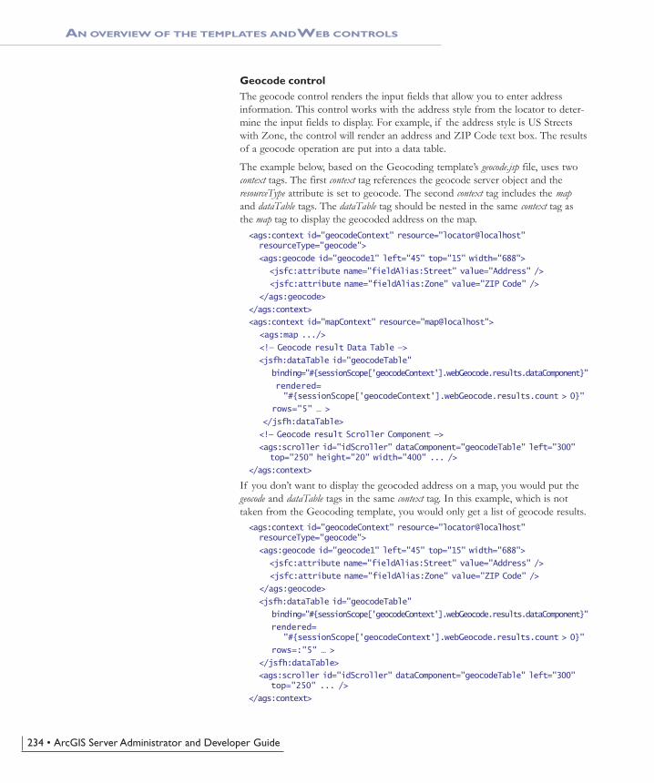
Geocode controlThe geocode control renders the input fields that allow you to enter addressinformation. This control works with the address style from the locator to deter-mine the input fields to display. For example, if the address style is US Streetswith Zone, the control will render an address and ZIP Code text box. The resultsof a geocode operation are put into a data table.
The example below, based on the Geocoding template’s geocode.jsp file, uses twocontext tags. The first context tag references the geocode server object and theresourceType attribute is set to geocode. The second context tag includes the mapand dataTable tags. The dataTable tag should be nested in the same context tag asthe map tag to display the geocoded address on the map.<ags:context id="geocodeContext" resource="locator@localhost" resourceType="geocode">
<ags:geocode id="geocode1" left="45" top="15" width="688">
<jsfc:attribute name="fieldAlias:Street" value="Address" />
<jsfc:attribute name="fieldAlias:Zone" value="ZIP Code" />
</ags:geocode>
</ags:context>
<ags:context id="mapContext" resource="map@localhost">
<ags:map .../>
<!— Geocode result Data Table —>
<jsfh:dataTable id="geocodeTable"
binding="#{sessionScope['geocodeContext'].webGeocode.results.dataComponent}"
rendered= "#{sessionScope['geocodeContext'].webGeocode.results.count > 0}"
rows="5" … >
</jsfh:dataTable>
<!— Geocode result Scroller Component —>
<ags:scroller id="idScroller" dataComponent="geocodeTable" left="300" top="250" height="20" width="400" ... />
</ags:context>
If you don’t want to display the geocoded address on a map, you would put thegeocode and dataTable tags in the same context tag. In this example, which is nottaken from the Geocoding template, you would only get a list of geocode results.<ags:context id="geocodeContext" resource="locator@localhost" resourceType="geocode">
<ags:geocode id="geocode1" left="45" top="15" width="688">
<jsfc:attribute name="fieldAlias:Street" value="Address" />
<jsfc:attribute name="fieldAlias:Zone" value="ZIP Code" />
</ags:geocode>
<jsfh:dataTable id="geocodeTable"
binding="#{sessionScope['geocodeContext'].webGeocode.results.dataComponent}"
rendered= "#{sessionScope['geocodeContext'].webGeocode.results.count > 0}"
rows=:"5" … >
</jsfh:dataTable>
<ags:scroller id="idScroller" dataComponent="geocodeTable" left="300" top="250" ... />
</ags:context>
AN OVERVIEW OF THE TEMPLATES AND WEB CONTROLS
ch06.pmd 10/12/2004, 3:53 PM234

Chapter 6 • Developing Web applications with Java• 235
Identify results controlThe identify results control renders the results of an identify, the action of click-ing a map feature (or features) to return its attributes. You would use an identifytool to perform the action of clicking a map feature.
This sample shows a map, an identify tool, and the identifyResults tag.<ags:context id="mapContext" resource="world@localhost"> <ags:map ... /> <ags:identifyResults cssClass="identifyClass" /> <IMG id="imgIdentify" name="imgIdentify" src="images/identify.gif" MapPoint('Map0', 'Identify')></ags:context>
Scroller controlThe scroller control implements paging for a data table of results, such as theresults from a search or buffer operation. A listener displays search results in adata table. The data table that displays those results has an id attribute. You canassociate a scroller control with a data table by passing the value of the id at-tribute to the scroller tag’s dataComponent attribute.
This example is based on the Search template; it shows the data table for a set offind results and the scroller control attached to this data table.<!— Find results Data table —>
<jsfh:dataTable id="findTable"
binding="#{sessionScope['searchContext']. attributes['esriAGSFindResults'].dataComponent}"
var="result"
rows="5"
rendered="#{sessionScope['searchContext']. attributes['esriAGSFindResults'].count > 0}" …>
<jsfh:column id="colHeader">
<jsfc:facet name="header"><jsfh:outputText value="Field" /> </jsfc:facet>
<jsfh:outputText value="#{result.field}" />
</jsfh:column>
…
</jsfh:dataTable>
<!— Find result Scroller Component —>
<ags:scroller id="idScroller" dataComponent="findTable" left="300" top="240" ... />
AN OVERVIEW OF THE TEMPLATES AND WEB CONTROLS
ch06.pmd 10/12/2004, 3:53 PM235

236 • ArcGIS Server Administrator and Developer Guide
BUILDING YOUR FIRST WEB APPLICATIONS
JSF technology offers the ability to build a Java Web application by dragging anddropping controls to design an interface. Using an IDE that integrates with JSF,you could drag the Java ADF map or page layout control onto a form, the wayyou would a text box or button. When this book was written, no IDE with thesecapabilities was available, and thus, there is no drag and drop support with theJava ADF. However, you can use an IDE, such as JBuilder, to write the JSP filesfor your application.
In this section, you’ll start learning about how to build Web applications with theJava ADF. The following four examples explain step-by-step how to create thesample applications.
• Creating your first Web application with a template
• Creating a Web service catalog
• Creating a Web application with the Web controls
• Accessing ArcObjects from a Web application
Each set of steps is followed by a detailed explanation of the code.
When you start using the Java ADF, located at <installlocation>\DeveloperKit\Templates\Java, you will find a series of folders namedafter the templates described earlier. The build and deployment tool used by theJava ADF is Another Neat Tool (Ant), a commonly used build and deploymenttool for Java applications. Ant is part of the Java ADF installation and is invokedwith the arcgisant commands. Do not edit the files associated with the templatesfound in the <install location>\DeveloperKit\Templates\Java folder. Afterrunning the arcgisant build command, a Web application with the name you speci-fied is created for you at <install location>\DeveloperKit\Templates\Java\build. It is the JSP file found in this Web application’s folder that you will edit.
As you build these sample applications, you’ll be exposed to the various controlsimplemented in the Java ADF and see some of the attributes, actions, events, andlisteners that are used. Chapter 7, ‘Developer scenarios’, presents more sophisti-cated examples of Web applications that focus on a particular GIS activity. For acomplete reference of all the controls in the Java ADF, refer to the ArcGISDeveloper Help.
To code and deploy the examples yourself, you need to have access to a workingGIS server with at least one map server object running on it. See Chapter 3,‘Administering an ArcGIS Server’, for information on starting a map serverobject. In addition, you will need to understand how your application will accessthe GIS server and server objects before building your first application with theJava ADF. The ArcGIS Server administrator should add your account into theArcGIS Server users group, agsusers. You will enter that account along with itsdomain and password when you are creating your Web application. Accessing aGIS server is described in more detail later in this chapter.
Also, verify that you followed the instructions in the ArcGIS Server Java ADFinstallation guide for configuring the Java ADF. You will need to set some envi-ronment variables and edit a common.properties file.
ch06.pmd 10/12/2004, 3:53 PM236

Chapter 6 • Developing Web applications with Java• 237
CREATING YOUR FIRST WEB APPLICATION WITH A TEMPLATE
One of the easiest ways to create a Web application is to start from a template.This example shows you how to create an application from the Map Viewertemplate provided with the Java ADF.
1. Open a command window and navigate to<install_location>\DeveloperKit\Templates\Java.
2. In the command window, type:arcgisant build
3. In the dialog, type the name of your application. In this example, you can callit “map”.
4. Type the name of the GIS server you want to use.
5. Type the domain, username, and password of an account that has access tothat GIS server.
6. Click Connect.
7. Choose the Map Viewer template from the list.
8. Choose a map server object from the list for the Map.
9. Choose a map server object from the list for the Overview Map.
In general, you can use any map server object for the overview map as long asits geographic extent includes the geographic extent of the server objectshown in the map control. If not, you will not see the area of interest box onthe overview map.
10. Click OK.
You can navigate to <installlocation>\DeveloperKit\Templates\Java\build\map to see your application.
Once created, you need to deploy your application. The deployment com-mand will depend on the servlet engine you are using.
In this example, Tomcat is the servlet engine and the Web server’s port num-ber is 8080.
11. To deploy your application, verify that your command window is in the<install_location>\DeveloperKit\Templates\Java directory. Type:arcgisant tomcat-deploy
12. In the command window, type the name of your application. In this example,it is named ‘map’.
13. Stop and restart Tomcat.
14. View your application in a Web browser.http://myserver:8080/map/index.html
As you can see, you can quickly build a Web application from a template. Tryexperimenting with some of the other templates to see how they work and whatfunctionality they provide. In general, you’ll follow the same steps to build anddeploy the other templates. The next section takes a look at how you woulddesign an application’s look and feel.
This URL assumes that your Web server isrunning on port 8080.
The username and password must have previ-ously been granted access to the GIS server. If
your machine is not running on a domain, enterthe machine name as the domain.
Before deploying Java ADF applications, verifythat you edited the common.properties file for
your servlet engine or application server. Thecommon.properties file is found in the
<installlocation>\DeveloperKit\Templates\Java folder. Information on how to
install and configure the Java ADF is found in theArcGIS Server Java ADF installation guide.
Type “arcgisant -projecthelp” to see the helpfor arcgisant. Unlike the arcgisant build com-mand, the arcgisant deploy command doesn’t
open a dialog; you’ll enter the required informa-tion for the deploy into the command window.
BUILDING YOUR FIRST WEB APPLICATIONS
When experimenting with the other templates,remember that you can only use non-pooledserver objects for the map in the Thematic
template. The Geocoding template requires ageocode server object and a map server object.
ch06.pmd 10/12/2004, 3:53 PM237

238 • ArcGIS Server Administrator and Developer Guide
Customizing the presentationWhen building an application with the arcgisant command, you only set a fewproperties: a connection to a host and a server object for the map, page, overviewmap, or geocode controls. Setting these properties is enough to get started with aJava ADF template, but as you proceed with your application development, youwill want to change the presentation of the application. For example, you maywant to choose a particular data frame to display in the map, set a tooltip for themap, or turn off the overview map. The Java ADF provides three ways to cus-tomize the presentation:
• Edit the application’s JSP to set new values for tag attributes.
• Edit the variables in the application’s Extensible Stylesheet Language (XSL)file to set style attributes. If a conflicting value is set in the JSP and the XSL,the JSP tag attributes take precedence over the XSL variables.
• Edit the application’s Cascading Style Sheet (CSS) file to set the style at-tributes. If a conflicting value is set in the JSP, XSL, and CSS, the JSP hashighest precedence, followed by the XSL, then the CSS.
Although there is some overlap, the JSP, XSL, and CSS do not offer the same setof customization options. Refer to the ArcGIS Server Java ADF AttributeComparison documentation in ArcGIS Developer Help for a chart showingwhich aspects of the application’s presentation can be changed in the JSP, XSL,or CSS. Editing JSP tags, XSL variables, or CSS attributes is a common practicewhen customizing Web applications. You may want to reference other materialsin addition to this section if these technologies are not familiar to you.
What you get with a Java ADF templateTake a look at what you get when you create an application from a Java ADFtemplate. The files of interest to you are:
• The JSP file, in the main application folder, is the starting point of the tem-plate. This JSP includes the tags for each Web control and the HTML toolsand command buttons that make up the template’s toolbar.
• The two CSS files, in the css folder, define styles used in the template. TheCSS named in accordance with the type of template—for example,mapviewer.css—defines the style attributes for the template. The other CSS,webcontrols.css, defines the styles for the controls.
• The XSL files, in the xsl folder, contain variables for setting the display of thetemplate. There is an XSL for each Web control as well as a common.xsl. Thecommon.xsl specifies elements shared by all of the controls.
• The default.xml file in the tools folder defines the default set of tools used bythe template. These tools correspond to functions in the JavaScript libraryprovided with the Java ADF.
The other file that you may need to edit is the arcgis_webapps.properties file.This file stores the username, password, and domain of the account for con-necting to the GIS server as well as other properties of the controls.
You can navigate to the map application built in the previous example to see theother files that make up a Java ADF template.
BUILDING YOUR FIRST WEB APPLICATIONS
ch06.pmd 10/12/2004, 3:53 PM238

Chapter 6 • Developing Web applications with Java• 239
Customizing an application’s JSPThe JSP file created for applications built from Java ADF templates can beconsidered the main file of the application. You will find the context, map, overview,toc, pageLayout, and other Java ADF tags toward the top of the JSP file. Someattributes are already specified for each tag.
Take a look at an example of how you would edit the JSP tags. Most of thetemplates use the map control. The map tag, as specified in the Map Viewertemplate’s JSP, is:<ags:map id="Map0" left="233" top="115" ... />
If you wanted to add some copyright text to the map, you could add thecopyrightText attribute and set it to display your text.<ags:map id="Map0" left="233" top="115" ... copyrightText="This is the copyright text for my map." />
The following sections show you how to use the XSL variables and CSS styles tocustomize the presentation of the Java ADF templates. Unlike the XSL or CSSwhich simply change the look and feel of the application, you can edit the JSP toadd functionality to your application, such as changing an existing tool or addinga new tool.
Customizing an application’s XSLThe Java ADF uses XSL to convert XML, returned from a processed JSP tag, intoHTML for final display in a Web browser. An XSL file can also be regarded as atransformation file where the input XML is transformed, using ExtensibleStylesheet Language Transformation (XSLT), into something else, such as anotherXML or HTML file. Each Web control in the Java ADF has a corresponding XSLfile. The goal of this section is to explain how to modify the XSL variables tocustomize the final display for each Web control.
If you are not familiar with XSL, there are many Web sites where you can learnabout it, such as http://www.w3schools.com/xsl/xsl_intro.asp.
Here’s how you can edit the XSL of the map control to change the border colorand border style of the map and add a tooltip to it. To edit the XSL for the mapcontrol, navigate to <install location>\DeveloperKit\Templates\build\<application name>\WEB-INF\classes\xsl and open map.xsl in a text editor.You will see the list of variables at the top of the file. If you want to add atooltip to the map, which instructs the users of your Web site on how to use theZoom In tool, you would change the customToolTip variable. Suppose you alsowant to change the color of the map border to blue and its style to dotted. Hereare the variables with the suggested changes.<xsl:variable name="customCssClass"></xsl:variable>
<xsl:variable name="customBorderColor">Blue</xsl:variable>
<xsl:variable name="customBorderStyle">Dotted</xsl:variable>
<xsl:variable name="customDragBoxColor"></xsl:variable>
<xsl:variable name="customDragLineWidth"></xsl:variable>
<xsl:variable name="customToolTip">Drag a box on the map</xsl:variable>
You would follow a similar practice to change the other variables.
Refer to the JSP tag library documentation inthe ArcGIS Developer Help for more information
on the tags and their attributes.
A description of how to add a measure tool toyour application is in the section titled ‘Map
control’ later in this chapter.
BUILDING YOUR FIRST WEB APPLICATIONS
ch06.pmd 10/12/2004, 3:53 PM239

240 • ArcGIS Server Administrator and Developer Guide
If you want to see the XML created by the controls, you can change the log_levelproperty in the application’s arcgis_webapps.properties file. By setting this prop-erty to “FINE”, the XML generated by the controls is output to your servletengine or application server log. Here is an example of the map control’s XML:<?xml version="1.0" encoding="UTF-8"?>
<map>
<client>ie</client>
<common-resources-registered>false</common-resources-registered>
<form-id>frmMap</form-id>
<resource-bundle-name>D:\WEB-INF\classes\res\Res.xml</resource-bundle-name>
<first-time>true</first-time>
<id>Map0</id>
<css-class>mapClass</css-class>
<image-url>mimedata?id=map22472173</image-url>
<width>503</width>
<height>376</height>
<left>249</left>
<top>131</top>
<border-width>16</border-width>
<tool>
<tool-key>ZoomIn</tool-key>
<client-action>MapDragRectangle</client-action>
</tool>
</map>
In addition to setting variables in the XSL to control the presentation of the Webcontrols, use the XSL to output to a markup language other than HTML. XMLcan be transformed into any markup language supported by XSL, such as HTML,XHTML, or PDF.
If you want your map in XHTML format, you could write a generateXHTML.xslthat renders the map control into XHTML. When using your own XSL, youwould set the xslFile attribute of the map tag to, for example,generateXHTML.xsl. The ArcGIS Developer Help includes a sample on how torender the contents of a page in XHTML format.
Customizing an application’s CSSCSS is a language for adding display styles to HTML. You can edit the CSS in-cluded with a Java ADF application to change the display of the Web controls.
To edit the CSS for the map control, navigate to <installlocation>\DeveloperKit\Templates\build\<application name>\css and openwebcontrols.css in a text editor. The map control is listed at the top of the file:div.mapClass { border-color: #B0C4DE; border-style: Solid; }
The color values are in hexadecimal. The value for the map’s border color is thehexadecimal value for LightSteelBlue. You can change the map border to a darkred color with the following code:div.mapClass { border-color: #B22222; border-style: Solid; }
The CSS files specific to each template are also found in the css folder. For a MapViewer template, open the mapviewer.css, to edit styles for items such as the titleand logo.
If you make a mistake while editing the XSL,the errors are sent to your servlet engine or
application server log.
Refer to the JSP tag library documentation inthe ArcGIS Developer Help for more details on
the xslFile attribute.
A Web site for finding hexadecimal color codes ishttp://www.december.com/html/spec/
color.html.
BUILDING YOUR FIRST WEB APPLICATIONS
ch06.pmd 10/12/2004, 3:53 PM240

Chapter 6 • Developing Web applications with Java• 241
CREATING A WEB SERVICE CATALOG
The Web Service Catalog template provides a way to organize related serverobjects into groups and make them accessible over the Internet via HTTP as Webservices. One of the primary advantages of creating a Web service catalog is thatArcGIS Desktop users can directly connect to a Web service catalog and utilizethe server objects exposed through it and, for example, add a map server objectto ArcMap. You can include whichever server objects you want to in a Webservice catalog. Thus, you might create a Web service catalog for each departmentin your organization with only the specific server objects to which they needaccess.
The Java ADF Web Service Catalog template allows you to quickly create a Webservice catalog. Follow the steps below to create one.
1. Open a command window and navigate to <installlocation>\DeveloperKit\Templates\Java.
2. In the command window, type:arcgisant build
3. Type the name of your application; in this example, you can call it“webservicecatalog”.
4. Type the name of the GIS server you want to use.
5. Type the domain, username, and password of an account that has access tothat GIS server.
6. Click Connect.
7. Choose the Web Service Catalog template from the list.
8. Check the server objects you want to include in the Web service catalog.
9. Click OK.
10. In the command window, type:arcgisant tomcat-deploy
11. In the command window, type the name of your application. This is thename you entered in the first input box, Application Name, on the Ant dialogduring the build process. For this example, type “webservicecatalog”.
12. Stop and restart Tomcat.
You now have a Web service catalog to which you can connect. In ArcCatalog,specify the URL for the Web service catalog as shown below:
http://myserver:8080/webservicecatalog/default.jsp
See Chapter 3, ‘Administering an ArcGIS Server’, for more information on con-necting to Web service catalogs from ArcCatalog.
You can also access Web service catalogs programmatically using standard Webprotocols. As a developer, you can consume the Web service catalog with thefollowing reference:http://myserver:8080/webservicecatalog/default.jsp?wsdl
You can navigate to <installlocation>\DeveloperKit\Templates\Java\build
\webservicecatalog to see your application.
For more information on adding capabilities toyour Web service catalog, see the section titled‘Guidelines for creating your own Web applica-
tions’ later in this chapter.
BUILDING YOUR FIRST WEB APPLICATIONS
ch06.pmd 10/12/2004, 3:53 PM241
242 • ArcGIS Server Administrator and Developer Guide
For more information on consuming Web service catalogs from a Web applica-tion, see the section titled ‘Programming Web services’ in Chapter 4.
CREATING A WEB APPLICATION WITH THE WEB CONTROLS
Whether you choose to start building your Web application from a template orfrom scratch utilizing the Web controls directly, you’ll soon have to write yourown custom code to implement the specific functionality you want to incorpo-rate in your application. As you read at the beginning of this chapter, writingcustom code means programming with the Java ADF, ArcGIS Server, andArcObjects. Through the Java ADF, you’ll be able to access the server objectsand, in turn, ArcObjects.
In this example, you’ll see how you can use the map control to access all the mapserver objects on a specific GIS server. Then, you’ll see how you can add tools tointeract with the map control.
In addition to the files included with an application built with the Java ADF Webcontrols, you will create a JSP file called serverlist.jsp and a Java file calledContextUtil.java. The serverlist.jsp is the page displayed to the Web applicationuser. The page shows an input box and button for connecting to a host, a list boxof server objects, a map, and map navigation tools. The Java code inContextUtil.java is in a bean. The serverlist.jsp file will call the Java code withthe useBean tag.
Building the Web controls applicationYou will use the arcgisant command to create an application called serverlist.
1. Open a command window and navigate to <installlocation>\Java\webcontrols.
2. In the command window, type:arcgisant build
3. Type the name of the GIS server you want to use.
4. Type the domain, username, and password of an account that has access tothat GIS server.
5. Click Check Connection.
6. For the name of the application, type “serverlist”.
7. In this example, Tomcat is used, so the directory is Apache Group\Tomcat4.1\webapps. Click OK.
Browse to the Apache Group\Tomcat 4.1\webapps\serverlist directory to re-view the files that have been created as part of this Java ADF Web controlsapplication. The structure of the Web application is the same as one created froma Java ADF template, but the contents of the Web application are different.You’ll notice that you do not have a JSP file in the main folder. You will createserverlist.jsp file in this location. In addition, the css folder only contains a CSSfor the Web controls, whereas an application built with a Java ADF templateincludes a CSS file for the template.
The domain, username, and password entered into the arcgisant build dialog isstored in the arcgis_webapps.properties file. The application has been created for
If you are not using Tomcat, you’ll typically useyour servlet engine or application server’s
working directory.
BUILDING YOUR FIRST WEB APPLICATIONS
ch06.pmd 10/12/2004, 3:53 PM242
Chapter 6 • Developing Web applications with Java• 243
that account. The serverlist.jsp includes an input box and button for connectingto a host. The host can be any GIS server that recognizes this account.
Getting the list of server objects1. Navigate to your application’s WEB-INF directory and create this folder
structure: classes\com\esri\arcgis\webcontrols\samples. CreateContextUtil.java in the samples directory.
2. Add the following import statements to the top of the file.package com.esri.arcgis.webcontrols.samples;
import java.util.*;
import com.esri.arcgis.webcontrols.util.WebUtil;
import com.esri.arcgis.webcontrols.ags.data.AGSWebContext;
import com.esri.arcgis.webcontrols.ags.data.AGSWebMap;
import com.esri.arcgis.webcontrols.ags.data.AGSResource;
import com.esri.arcgis.server.IEnumServerObjectConfigurationInfo;
import com.esri.arcgis.server.IServerObjectConfigurationInfo;
import com.esri.arcgis.carto.IMapLayerInfos;
import com.esri.arcgis.carto.IMapLayerInfo;
import com.esri.arcgis.geodatabase.IFields;
import javax.faces.context.FacesContext;
import java.util.logging.*;
3. Declare the class as ContextUtil.public class ContextUtil {
...
}
4. Add the following variables:private static Logger logger =
Logger.getLogger(ContextUtil.class.getName());
private String host;
private List serverObjects = new ArrayList();
private String serverObject;
5. Add the getChangeOperation and changeOperation methods.public String getChangeOperation() {
changeOperation();
return "";
}
public void changeOperation() {
Map rMap = FacesContext.getCurrentInstance(). getExternalContext().getRequestParameterMap();
String operation = (String)rMap.get("operation");
if(operation == null || operation.equals(""))
return;
if(operation.equals("userHost")) {
setHost((String)rMap.get("txtHost"));
return;
}
if(operation.equals("serverObject")) {
BUILDING YOUR FIRST WEB APPLICATIONS
ch06.pmd 10/12/2004, 3:53 PM243

244 • ArcGIS Server Administrator and Developer Guide
setServerObject((String)rMap.get("selServerObject"));
return;
}
}
6. Add the methods to set, then return the name of the GIS server.public void setHost(String value) {
host = value;
serverObjects.clear(); getServerObjects();
setServerObject(serverObjects.size() > 0 ? (String)serverObjects.get(0) : "");
}
public String getHost() { return host; }
7. Add the methods to set, then return the selected server object.public void setServerObject(String value) {
this.serverObject = value;
}
public String getServerObject() { return serverObject; }
8. Add the method to return the list of server objects on the GIS server.public List getServerObjects() {
if(serverObjects.size() > 0)
return serverObjects;
AGSResource resource = null;
try {
resource = new AGSResource(host, "");
IEnumServerObjectConfigurationInfo configs = resource.getServerObjectManager().getConfigurationInfos();
configs.reset();
IServerObjectConfigurationInfo config;
while ((config = configs.next()) != null) {
if (!config.getTypeName().equalsIgnoreCase("MapServer"))
continue;
serverObjects.add(config.getName());
}
return serverObjects;
}
catch (Exception e) {
logger.log(Level.WARNING, "Unable to get server objects.", e);
return serverObjects;
}
finally {
if (resource != null)
resource.destroy();
}
}
9. Save ContextUtil.java, compile it, and verify that the class file is in the WEB-INF\classes\com\esri\arcgis\webcontrols\samples directory.
BUILDING YOUR FIRST WEB APPLICATIONS
ch06.pmd 10/12/2004, 3:53 PM244

Chapter 6 • Developing Web applications with Java• 245
Take a look at ContextUtil.java.
You have added methods to the bean to get the name of the GIS server and thelist of server objects running on that host.
getChangeOperation and changeOperation methodsThe getChangeOperation method is called when the page is loaded. ThegetChangeOperation method calls the changeOperation method to determine if thehost, server object, data frame, or layer has been set. The first time this applica-tion is run, the changeOperation method does nothing. However, if the applicationuser enters a new host name or selects a new server object, the changeOperationmethod calls the setHost and setServerObject methods. This case of finding a previ-ously entered host is only valid for the same browser session. Once the browser isclosed, the connection to the host is released.
setHost and getHost methodsThe setHost method sets the name of the GIS server. The getHost method returnsthe name of the GIS server.
setServerObject, getServerObject, and getServerObjects methodsThe setServerObject method sets the selected server object. The getServerObjectmethod returns the name of the currently selected server object. ThegetServerObjects method returns the list of all the map server objects on the GISserver.
Displaying the list of server objectsIn this section, you’ll add an input box, a button, a list box, a context control,and a map control to the application. The input box is for entering the name of aGIS server. The list box will display the map server objects running on the GISserver. Selecting a server object from the list will display it on the map control.
1. Browse to the Apache Group\Tomcat 4.1\webapps\serverlist folder andcreate a file named serverlist.jsp.
2. Add this tag to set the content type and character set for the page.<%@ page contentType="text/html; charset=ISO-8859-1" %>
3. Add references to the following tag libraries. These tag libraries are requiredfor any Java ADF application.<%@ taglib uri="http://www.esri.com/arcgis/webcontrols" prefix="ags" %>
<%@ taglib uri="http://java.sun.com/jsf/core" prefix="jsfc" %>
<%@ taglib uri="http://java.sun.com/jsf/html" prefix="jsfh" %>
4. Add a reference to the JavaServer Pages Standard Tag Library (JSTL). JSTL isa commonly used tag library in JSP applications.<%@ taglib uri="http://java.sun.com/jstl/core" prefix="c" %>
5. Add the useBean and setProperty tags to reference the bean in theContextUtil.java file. If localhost is not your GIS server, replace localhostwith the name of your GIS server.
BUILDING YOUR FIRST WEB APPLICATIONS
ch06.pmd 10/12/2004, 3:53 PM245

246 • ArcGIS Server Administrator and Developer Guide
<jsp:useBean id="contextUtil" class="com.esri.arcgis.webcontrols.samples.ContextUtil" scope="session">
<jsp:setProperty name= "contextUtil" property="host" value="localhost" />
</jsp:useBean>
6. Add opening and closing tags for the view tag and add the getProperty tag.<jsfc:view>
<jsp:getProperty name="contextUtil" property="changeOperation" />
...
</jsfc:view>
7. Add opening and closing tags for the html, head, title, htmlBase, and noCachetags to the view tag.<html>
<head>
<title>Getting Started with the Java ADF</title>
<ags:htmlBase />
</head>
<ags:noCache />
...
</html>
8. Add the JavaScript changeOperation function inside the noCache tag. This func-tion is called when a server object is selected from the list.<script language="Javascript">
function changeOperation(operation) {
var theForm = document.forms[0];
theForm.operation.value = operation;
theForm.submit();
}
</script>
9. Add opening and closing tags for the body and form tags. The form tag enclosesall controls that display or collect data.<body>
<jsfh:form id="frmServerList">
...
</jsfh:form>
</body>
10. Add the input box and button for connecting to a host and a list box for theserver objects. When a server object is selected from the list, thechangeOperation JavaScript function is called.<div id="host" style="position:absolute;left:50px;top:50px;">
<b>Host </b>
<input name="txtHost" value="<c:out value='${sessionScope.contextUtil.host}'/>" />
<input type="BUTTON" value="Connect" onclick="javascript:changeOperation('userHost');"/>
</div>
<div id="serverobject" style="position:absolute;left:50px;top:100px;">
BUILDING YOUR FIRST WEB APPLICATIONS
ch06.pmd 10/12/2004, 3:53 PM246

Chapter 6 • Developing Web applications with Java• 247
<input type="HIDDEN" name="operation"><b>Server Objects </b>
<select name="selServerObject" onchange= "javascript:changeOperation('serverObject');">
<c:forEach var="item" items= "${sessionScope.contextUtil.serverObjects}">
<option value='<c:out value="${item}"/>' <c:if test='${sessionScope.contextUtil.serverObject == item}'>selected="true"</c:if>><c:out value='${item}'/></option>
</c:forEach>
</select>
</div>
11. Add the context tag. ContextUtil.java has two methods, getServerObject andgetHost, which are used to set the resource attribute of the context tag.<ags:context id="sampleContext"resource='<%=(contextUtil.getServerObject() + "@" + contextUtil.getHost())%>' >
...
</ags:context>
12. Add the map tag to the context tag. The map tag will display a 400 x 400 mapwith a solid border.<ags:context id="sampleContext"resource='<%=(contextUtil.getServerObject() + "@" + contextUtil.getHost())%>' >
<ags:map id="Map0" left="450" top="100" width="400" height="400" />
...
</ags:context>
13. Save serverlist.jsp.
Take a look at serverlist.jsp.
As mentioned above, the first three tag libraries referenced in this application arerequired for any Java ADF application.<%@ taglib uri="http://www.esri.com/arcgis/webcontrols" prefix="ags" %>
<%@ taglib uri="http://java.sun.com/jsf/core" prefix="jsfc" %>
<%@ taglib uri="http://java.sun.com/jsf/html" prefix="jsfh" %>
The first tag library, http://www.esri.com/arcgis/webcontrols, is the core ArcGIS Webcontrols tag library. It includes such controls as the context, map, and TOC. Thenext two tag libraries reference JSF. The core JSF tag library is http://java.sun.com/jsf/core. It contains the essential tags for building any JSF Web appli-cation. The standard JSF components tag library ishttp://java.sun.com/jsf/html. These standard components are rendered as HTMLwidgets, such as forms, text fields, or check boxes. They are associated with theirserver-side components by the JSF technology.
The fourth tag library is the JSTL.<%@ taglib prefix="c" uri="http://java.sun.com/jstl/core" %>
JSTL is a commonly used tag library in JSP applications. In this application, JSTLis used to iterate a collection of server objects in order to populate a list.
This may be your first time using the view tag from the core JSF tag library.<jsfc:view>
...
</jsfc:view>
BUILDING YOUR FIRST WEB APPLICATIONS
ch06.pmd 10/12/2004, 3:53 PM247

248 • ArcGIS Server Administrator and Developer Guide
When you reference JSF tags from within a JSP page, you must enclose them inthe view tag. You can enclose other content, such as HTML and other JSP tags,within the view tag as well.
The next section of code uses the htmlBase tag.<ags:htmlBase />
The htmlBase tag is from the core ArcGIS Web controls tag library. Before a JSFapplication can launch a JSP page, the Web application must invoke theFacesServlet to begin the JSF application’s life cycle. To do this, “faces” must beincluded in the URL path. The URL for this serverlist application is http://localhost/serverlist/faces/serverlist.jsp. With this as the URL, the default base ofthe page is http://localhost/serverlist/faces/. If any image or any other resourceon the page is accessed as <img src="images/image.gif">, the browser will re-solve this as http://localhost/serverlist/faces/images/image.gif. However, thereis no physical resource that corresponds to “faces”, so this URL would show abroken link. To prevent this problem, the utility htmlBase tag has been includedwith the Java ADF, which will explicitly set the base of the page to the root ofthe Web application, that is, http://localhost/serverlist.
When a new server object is selected from the list, the changeOperation JavaScriptfunction is called. This function calls the bean’s getServerObject and getHost meth-ods to set the name of the GIS server and the selected server object.
The context and map tags, from the ArcGIS Web controls tag library, expose thecontext and map controls. When a map server object is chosen from the list, themap control displays the selected map.
Adding a Full Extent button and Zoom In and Pan toolsIn this section, you’ll add a command button to display the map at its full extentand tools for zooming in and panning the map.
1. Open serverlist.jsp.
2. Add Zoom In and Pan tools within the context tag.<div id="button" style="position:absolute;left:550px;top:50px;">
<input type="button" value="Zoom In" title="Zoom In" onclick="MapDragRectangle('Map0', 'ZoomIn');" />
<input type="button" value="Pan" title="Pan" onclick="MapDragImage('Map0','Pan');" />
...
</div>
3. Add a Full Extent button to the div tag added in the previous step. Thisbutton is associated with the ZoomFullExtentListener.<jsfh:commandButton id="idZoomFullExtent" value="Zoom Full Extent" title="Full Extent">
<jsfc:actionListener type= "com.esri.arcgis.webcontrols.ags.faces.event.ZoomFullExtentListener" />
</jsfh:commandButton>
The context tag should look like this:
BUILDING YOUR FIRST WEB APPLICATIONS
ch06.pmd 10/12/2004, 3:53 PM248

Chapter 6 • Developing Web applications with Java• 249
<ags:context id="sampleContext"resource='<%=(contextUtil.getServerObject() + "@" + contextUtil.getHost())%>' >
<div id="button" style="position:absolute;left:550px;top:50px;">
<input type="button" value="Zoom In" title="Zoom In" onclick="MapDragRectangle('Map0', 'ZoomIn');" />
<input type="button" value="Pan" title="Pan" onclick="MapDragImage('Map0','Pan');" />
<jsfh:commandButton id="idZoomFullExtent" value="Zoom Full Extent" title="Zoom Full Extent">
<jsfc:actionListener type= "com.esri.arcgis.webcontrols.ags.faces.event.ZoomFullExtentListener"
/>
</jsfh:commandButton>
</div>
<ags:map id="Map0" left="450" top="100" width="400" height="400" />
</ags:context>
4. Save serverlist.jsp.
5. Stop and restart Tomcat.
6. If you do not want to use localhost as your GIS server, verify that you addedyour GIS server to the value attribute of the setProperty tag.<jsp:useBean id="contextUtil" class="com.esri.arcgis.webcontrols.samples.ContextUtil" scope="session">
<jsp:setProperty name= "contextUtil" property="host" value="localhost" />
</jsp:useBean>
From the application, you can connect to any GIS server that recognizes theaccount you used when building the application with the arcgisant build com-mand.
In a Web browser, type “http://localhost/serverlist/faces/serverlist.jsp”.
The application you created looks like this:
BUILDING YOUR FIRST WEB APPLICATIONS
ch06.pmd 10/12/2004, 3:53 PM249

250 • ArcGIS Server Administrator and Developer Guide
You can click the Zoom In tool and drag a box over the map to zoom in. Clickthe Pan tool and drag the map image to a new location. Click the Full Extentbutton to return to the full extent of the map.
Take a look at these additions to serverlist.jsp.
A toolbar can contain two types of items—tools and commands. Tools have aclient-side action as well as a server-side action. Tools interact with the mapcontrol—for example, dragging a box to zoom in—before executing a server-sideevent. Commands directly execute a server-side event. Full Extent is imple-mented as a JSF command button, but Zoom In and Pan are tools.
In the example above, you specified MapDragRectangle as the JavaScript functionfor the Zoom In tool.<input type="button" value="Zoom In" title="Zoom In"onclick="MapDragRectangle('Map0', 'ZoomIn');" />
MapDragRectangle enables the drawing of a rectangle over the map control. Whenthis client-side action completes, a request is sent to the server passing the argu-ments of the MapDragRectangle function: the ID of the control and the tool key.In this example, the ID of the control is “Map0” and the tool key is “ZoomIn”.The map control parses these arguments and delegates processing to the server-side action class associated with the tool’s key. The Zoom In tool is associatedwith the ZoomInToolAction class.
Commands, on the other hand, directly execute server-side actions. JSF hasstandard command components, such as buttons and hyperlinks. These commandcomponents are associated with listeners. When a command is clicked, a server-side event is triggered, calling the associated listeners to process the event. TheJava ADF includes a series of listeners for common mapping operations, such asdisplaying the map at full extent or panning the map in a particular direction. Youcan learn more about the Java ADF listeners in the ArcGIS Developer Help.
BUILDING YOUR FIRST WEB APPLICATIONS
ch06.pmd 10/12/2004, 3:53 PM250

Chapter 6 • Developing Web applications with Java• 251
ACCESSING ARCOBJECTS FROM A WEB APPLICATION
The Java ADF exposes a great deal of GIS functionality through its API. In theprevious example, you used the map tag with the ZoomFullExtentListener to displaythe map at its full extent and the Zoom In and Pan tools for zooming in to andpanning the map. Similar tools are available for changing the extent of the pagelayout. The Java ADF has additional tools for identifying or selecting features.
The Java ADF does not duplicate all of the functionality in ArcObjects. To domore than the basic GIS operations provided in the Java ADF, you’ll need towrite code directly against ArcObjects. The goal of this example is to show youhow to access the ArcGIS Server and ArcObjects API from the Java ADF.
This example describes how to add code to the ContextUtil.java and serverlist.jspfiles created in the previous example in order to display the data frames, layers,and fields of a server object. The first additional list box displays the list of dataframes for a selected map server object. The next list box displays the list oflayers in the selected data frame. The final list box displays the attribute fields ofthe selected layer. As you make selections from the list boxes, the other list boxeswill update to reflect the current selection. For example, if you select a new dataframe, the layers and fields list boxes will update to reflect the change.
Getting the data frames, layers, and fields for a server object1. Open ContextUtil.java created in the previous example.
2. Add four variables to the list of variables.private static Logger logger =Logger.getLogger(ContextUtil.class.getName());
private String host;
private List serverObjects = new ArrayList();
private String serverObject;
private Map layers = new Hashtable();
private String layer;
private List fields = new ArrayList();
private String contextId;
3. Add the conditional checks to the changeOperation function for the data framesand layers.public void changeOperation() {
Map rMap = FacesContext.getCurrentInstance().getExternalContext() .getRequestParameterMap();
String operation = (String)rMap.get("operation");
if(operation == null || operation.equals(""))
return;
if(operation.equals("userHost")) {
setHost((String)rMap.get("txtHost"));
return;
}
if(operation.equals("serverObject")) {
setServerObject((String)rMap.get("selServerObject"));
return;
}
if(operation.equals("dataFrame")) {
BUILDING YOUR FIRST WEB APPLICATIONS
ch06.pmd 10/12/2004, 3:53 PM251

252 • ArcGIS Server Administrator and Developer Guide
setDataFrame((String)rMap.get("selDataFrame"));
return;
}
if(operation.equals("layer")) {
setLayer((String)rMap.get("selLayer"));
return;
}
}
4. Add code to set the data frame to the setServerObject method.public void setServerObject(String value) {
this.serverObject = value;
setDataFrame(null);
}
5. Add the methods to set and return the selected data frame.public void setDataFrame(String value) {
if(value != null) {
AGSWebContext agsContext = getAGSWebContext();
((AGSWebMap)agsContext.getWebMap(true)).setFocusMapName(value);
agsContext.refresh();
}
layers.clear(); setLayer(null);
}
public String getDataFrame() {
try {
return ((AGSWebMap)getAGSWebContext().getWebMap(true)).getFocusMapName();
}
catch(Exception e) {
logger.log(Level.WARNING, "Unable to find the current data frame.", e);
return null;
}
}
6. Add the method to return the collection of data frames.public Collection getDataFrames() { return getAGSWebContext().getDataFrames();
}
7. Add the methods to set the selected layer, return the selected layer, andreturn the list of layers for a data frame.public void setLayer(String value) {
this.layer = value;
fields.clear();
}
public String getLayer() { return layer; }
public Map getLayers() {
if(layers.size() > 0)
return layers;
if(getDataFrame() == null) {
layer = null; layers.clear(); fields.clear();
BUILDING YOUR FIRST WEB APPLICATIONS
Insert this code after the getServerObjectsmethod.
ch06.pmd 10/12/2004, 3:53 PM252

Chapter 6 • Developing Web applications with Java• 253
return layers;
}
try {
IMapLayerInfos infos = ((AGSWebMap)getAGSWebContext().getWebMap(true)). getFocusMapServerInfo().getMapLayerInfos();
IMapLayerInfo info;
for (int i = 0; i < infos.getCount(); i++) {
info = infos.getElement(i);
layers.put(Integer.toString(info.getID()), info.getName());
}
if(layers.size() > 0)
setLayer((String)layers.keySet().iterator().next());
return layers;
}
catch (Exception e) {
logger.log(Level.WARNING, "Unable to get layers", e);
return layers;
}
}
8. Add the methods to return the fields for the selected layer.public List getFields() {
if(fields.size() > 0)
return fields;
if(layer == null) {
fields.clear();
return fields;
}
try {
IFields iFields = ((AGSWebMap)getAGSWebContext().getWebMap(true)). getFocusMapServerInfo().getMapLayerInfos(). getElement(Integer.parseInt(layer)).getFields();
if (iFields != null) {
for (int i = 0; i < iFields.getFieldCount(); ++i)
fields.add(iFields.getField(i).getName());
}
return fields;
}
catch (Exception e) {
logger.log(Level.WARNING, "Unable to get fields.", e);
return fields;
}
}
9. Add the getContextId, setContextId, and getAGSWebContext methods.public String getContextId() { return contextId; }
public void setContextId(String value) { contextId = value; }
private AGSWebContext getAGSWebContext() {
return (AGSWebContext)WebUtil.getWebContext(FacesContext.getCurrentInstance(), contextId);
}
BUILDING YOUR FIRST WEB APPLICATIONS
ch06.pmd 10/12/2004, 3:53 PM253

254 • ArcGIS Server Administrator and Developer Guide
10. Save ContextUtil.java and compile it.
Displaying the list of server objects, data frames, layers, and fieldsYou’ll add list boxes for the list of data frames, layers, and fields to serverlist.jsp.
1. Add code to set the contextId property to the value used in the context tag.<jsp:useBean id="contextUtil" class="com.esri.arcgis.webcontrols .samples.ContextUtil" scope="session">
<jsp:setProperty name= "contextUtil" property="host" value="localhost" />
<jsp:setProperty name="contextUtil" property="contextId" value="sampleContext" />
</jsp:useBean>
2. Open serverlist.jsp in a text editor. Add this code to the context tag.<ags:context id="sampleContext"resource='<%=(contextUtil.getServerObject() + "@" +contextUtil.getHost())%>'>
<div id="dataFrame" style="position:absolute;left:50px;top:150px;">
<b>DataFrames </b>
<select name="selDataFrame" onchange="javascript:changeOperation('dataFrame');">
<c:forEach var="item" items="${sessionScope.contextUtil.dataFrames}">
<option value='<c:out value='${item}'/>' <c:if test="${sessionScope.contextUtil.dataFrame == item}">selected='true'</c:if> > <c:out value="${item}"/> </option>
</c:forEach>
</select>
</div>
<div id="layer" style="position:absolute;left:50px;top:200px;">
<b>Layers </b>
<select name="selLayer" onchange="javascript:changeOperation('layer');">
<c:forEach var="item" items="${sessionScope.contextUtil.layers}">
<option value='<c:out value="${item.key}"/>' <c:if test="${sessionScope.contextUtil.layer == item.key}">selected="true"</c:if> > <c:out value="${item.value}"/></option>
</c:forEach>
</select>
</div>
<div id="fields" style="position:absolute;left:50px;top:250px;">
<b>Fields </b><br>
<c:forEach var="item" items="${sessionScope.contextUtil.fields}">
<c:out value="${item}"/><br>
BUILDING YOUR FIRST WEB APPLICATIONS
ch06.pmd 10/12/2004, 3:53 PM254

Chapter 6 • Developing Web applications with Java• 255
</c:forEach>
</div>
<div id="button" style="position:absolute;left:550px;top:50px;">
<input type="button" value="Zoom In" title="Zoom In" onclick="MapDragRectangle('Map0', 'ZoomIn');" />
<input type="button" value="Pan" title="Pan" onclick="MapDragImage('Map0','Pan');" />
<jsfh:commandButton id="idZoomFullExtent" value="Zoom Full Extent" title="Zoom Full Extent">
<jsfc:actionListener type= "com.esri.arcgis.webcontrols.ags.faces.event. ZoomFullExtentListener" />
</jsfh:commandButton>
</div>
<ags:map id="Map0" left="450" top="100" width="400" height="400" />
</ags:context>
3. Save serverlist.jsp.
4. Stop and restart your servlet engine. You are ready to view the application. Ina Web browser, type “http://localhost/serverlist/faces/serverlist.jsp”.
The application you just created looks like this:
Take a look at how this example works.
setDataFrame, getDataFrame, and getDataFrames methodsThe setDataFrame method calls the AGSWebMap’s setFocusMapName method to setthe selected data frame. Similarly, the getDataFrame method calls theAGSWebMap’s getFocusMapName method and returns the selected data frame. ThegetDataFrames method returns the collection of data frames.
BUILDING YOUR FIRST WEB APPLICATIONS
ch06.pmd 10/12/2004, 3:53 PM255
256 • ArcGIS Server Administrator and Developer Guide
BUILDING YOUR FIRST WEB APPLICATIONS
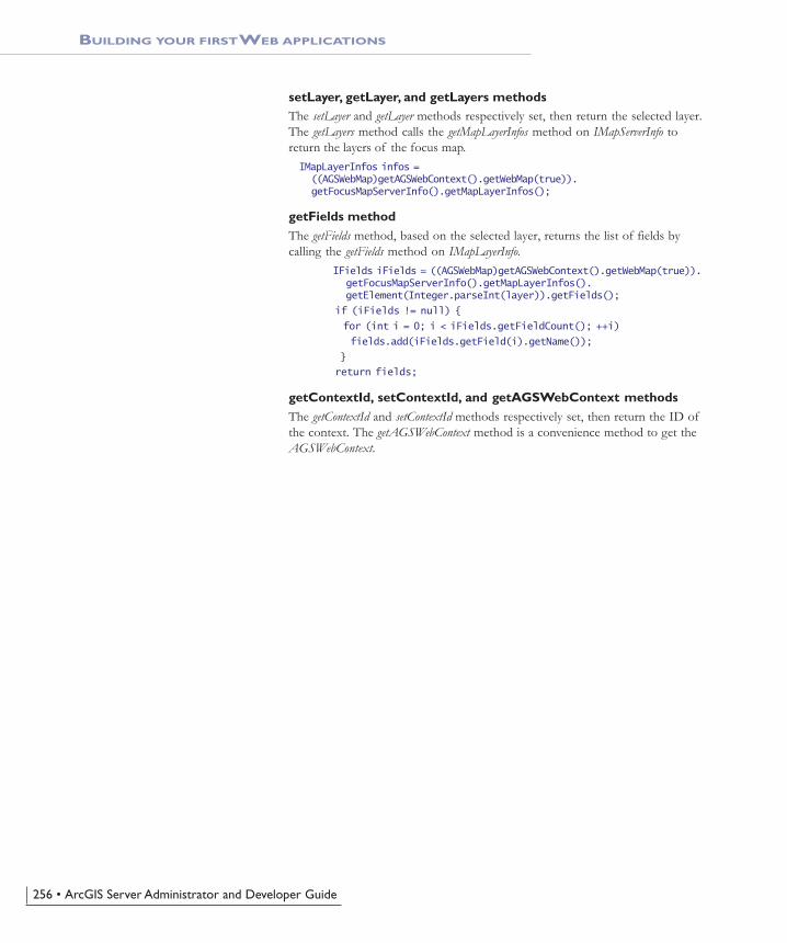
setLayer, getLayer, and getLayers methodsThe setLayer and getLayer methods respectively set, then return the selected layer.The getLayers method calls the getMapLayerInfos method on IMapServerInfo toreturn the layers of the focus map.IMapLayerInfos infos = ((AGSWebMap)getAGSWebContext().getWebMap(true)). getFocusMapServerInfo().getMapLayerInfos();
getFields methodThe getFields method, based on the selected layer, returns the list of fields bycalling the getFields method on IMapLayerInfo.
IFields iFields = ((AGSWebMap)getAGSWebContext().getWebMap(true)). getFocusMapServerInfo().getMapLayerInfos(). getElement(Integer.parseInt(layer)).getFields();
if (iFields != null) {
for (int i = 0; i < iFields.getFieldCount(); ++i)
fields.add(iFields.getField(i).getName());
}
return fields;
getContextId, setContextId, and getAGSWebContext methodsThe getContextId and setContextId methods respectively set, then return the ID ofthe context. The getAGSWebContext method is a convenience method to get theAGSWebContext.
ch06.pmd 10/12/2004, 3:53 PM256

Chapter 6 • Developing Web applications with Java• 257
GUIDELINES FOR CREATING YOUR OWN WEB APPLICATIONS
As you read through this chapter, you’re probably already thinking about how toapply what you’ve learned to your own project. This section describes some ofthe things you’ll need to think about as you begin building your own Web applica-tions. Some of the information presented here is discussed in more detail in otherchapters of this book; however, it’s worth reviewing this information to ensureyou have a clear picture of how to build your Web application.
ORGANIZING YOUR DATA AND CREATING SERVER OBJECTS
Presumably, most—if not all—of the GIS functionality you build into your Webapplications will be provided through the server objects you host on your GISserver. How many server objects a single Web application utilizes depends onhow you organize your server objects and what functionality you want to buildinto the Web application. Often, a Web application utilizes more than one serverobject and these server objects need to have some correlation between them. Forexample, if you want to build an application that locates places by address, thatapplication will at minimum access a geocode server object to find the addresslocation and a map server object to display the location. The map and geocodeserver object need to reference the same geographic location; otherwise thegeocoded points won’t draw on the map. Similarly, the geographic area displayedin an overview map needs to match that of its associated main map.
As map server objects are based on map documents (.mxd files), you have someflexibility as to how you organize the data contained within a given map serverobject. For instance, suppose you’re creating an application that displays threemaps. Should you create one map document resulting in one map server objectwith three data frames in it? Or should you create three map documents—andthree server objects—with one data frame each?
As a general rule, you should organize the data in a map server object according tohow your Web applications will use it. For example, you would create one mapserver object that contains all the data required for a Web application. The serverobject would have, for example, one data frame for the main map control andone data frame for the overview map. Later, if you build another Web applica-tion that can share the overview map with the first application, you may chooseto host the data for the overview map in its own server object.
DATA ACCESS CONSIDERATIONS
Ensure that the following holds true for your map server objects.
• The map document and all data must be accessible to the SOM machine andall container machines.
• The ArcGIS Server Container account you established during thepostinstallation should have read access to any shared network directories.
• File-based data (for example, coverages and shapefiles) should be placed onshared networked drives and saved in the map documents using UNCpathnames.
• ArcSDE connections must be saved in the map document before being addedto the server.
ch06.pmd 10/12/2004, 3:53 PM257

258 • ArcGIS Server Administrator and Developer Guide
ACCESSING A GIS SERVER FROM YOUR WEB APPLICATION
You need to consider two levels of security when building a Web application thataccesses a GIS server. First, you need to consider who will access your applica-tion. Does the application contain sensitive information that is not meant forgeneral consumption? If so, you’ll probably want to restrict access to it in someway. Second, you need to consider how the Web application itself accesses andworks with the GIS server because the server has its own access control mecha-nism that your Web application must implement.
In order to restrict access to a Web application, you need to identify who isattempting to access the Web site. This process, called authentication, challenges auser to prove who they are, usually by requiring them to provide some securitycredentials that only they and the resource they are trying to access know about.For example, to access your bank account through an ATM, you identify yourselfwith your ATM card and your personal identification number. Without both, youare not granted access to the account.
For Web applications, security credentials are commonly expressed in the form ofan account and a password. If the account and password are valid, the user isauthenticated and subsequently granted access to the Web site. There are manyways you can authenticate users and grant them access to a Web application. Adiscussion of these methods is beyond the scope of this book. However, whetheryou choose to restrict access to your Web application or not, you do need toconsider the second level of security, which governs how the Web applicationaccesses the GIS server. This is the main focus of this section.
As you read in the previous chapters, access to a GIS server—and the serverobjects running on it—is managed by two operating system user groups: ArcGISServer users (agsusers) and ArcGIS Server administrators (agsadmin). To accessthe server objects, an application must connect to the server as an account in theagsusers group. To additionally administer the GIS server—for example, add andremove server objects—an application must connect as an account in theagsadmin group.
First, take a look at how you access a GIS server through ArcCatalog. When youconnect to your GIS server in ArcCatalog, if the account you’re currently loggedin as is a member of the ArcGIS Server administrators group, you will see addi-tional menu choices that let you manage the server. For instance, you can add,remove, start, and stop server objects. However, if your account is only a mem-ber of the ArcGIS Server users group, you will not see any menu choices formanaging server objects and can instead only view the server objects running onthe server. Further, if your account is not a member of either of these usergroups, you won’t have any access to the server.
Access to a GIS server is managed in a similar way with Web applications. A Webapplication can connect to the GIS server as a particular account through aprocess called impersonation. With impersonation, the Web application assumes theidentity of a particular account and, thus, has all the privileges the account isentitled to. As long as this account is part of the appropriate group, for example,agsusers, the Web application will have access to the server objects running on theGIS server. So what account should your Web application connect to the serveras? The answer to this question depends on how you choose to set up access tothe GIS server itself.
GUIDELINES FOR CREATING YOUR OWN WEB APPLICATIONS
ch06.pmd 10/12/2004, 3:53 PM258

Chapter 6 • Developing Web applications with Java• 259
Your application will connect to the GIS server as a specific account. You essen-tially hard code the account into your Web application. You can view theusername and encrypted password that your Web application uses in thearcgis_webapps.properties file, located at <installlocation>\DeveloperKit\Templates\Java\build\<Web applicationname>\WEB-INF\classes. The ArcGIS Server administrator will either add youraccount or give you an existing account to use. Either way, the account is amember of the agsusers group.
Most likely the application will impersonate an account that is a member of theagsusers group rather than the agsadmin group. As a member of the agsusersgroup, the application will have complete access to the server objects. Thus, youcan write code that works with the object in a stateless or stateful manner. Youcan do anything except manage the server objects themselves. If you want towrite an application that manages the server, the application will have to imper-sonate an account in the agsadmin group.
Refer to the ‘Context control’ section later in this chapter for more guidelines onworking with the server context, pooled versus non-pooled objects, and makingfine-grained ArcObjects calls in your Java ADF applications.
CHOOSING CAPABILITIES FOR YOUR WEB SERVICE CATALOG
Web service catalogs may contain both MapServer and GeocodeServer Webservices. Each Web service includes functionality that your users can exerciseusing ArcMap and you can exercise in your applications. The functionality pro-vided by a particular Web service can be limited to, for example, allow consumersof the Web service to draw the map but not to query the data sources of thelayers in the map.
The set of functionality that a Web service supports is called its capabilities. Thecapabilities for MapServer and GeocodeServer Web services are organized intocapability groups. The IRequestHandler ::HandleStringRequest method supported byMapServer and GeocodeServer takes a string parameter named capabilities,whose value is a comma-delimited list of capabilities, such asHandleStringRequest(“map,query,data”, <inputSOAP>, <outputSOAP>).
The capability groups and the methods included in each group for MapServerWeb services are:
Map:
• get_DocumentInfo
• get_MapCount
• get_MapName
• get_DefaultMapName
• GetServerInfo
• ExportMapImage
• GetSupportedImageReturnTypes
• GetLegendInfo
GUIDELINES FOR CREATING YOUR OWN WEB APPLICATIONS
ch06.pmd 10/12/2004, 3:53 PM259

260 • ArcGIS Server Administrator and Developer Guide
• ToMapPoints
• FromMapPoints
Query:
• Identify
• QueryFeatureCount
• QueryFeatureIDs
• QueryHyperlinks
• ComputeScale
• ComputeDistance
• GetSQLSyntaxInfo
Data:
• Find
• QueryFeatureData
By default, the Web service catalog template assigns “map” as the capabilities forall MapServer Web services. Therefore, by default, consumers of the MapServerWeb service, including ArcMap, will not be able to identify or query layers in themap. You can add additional capability groups, query, and data by editing the JSPfile created for each server object in the Web service catalog. For example, if twoMapServer objects named canada and mexico were added to the Web servicecatalog, and you wanted to add query and data capabilities, you would edit thecanada_MapServer.jsp and mexico_MapServer.jsp files. Edit the following lineof code to include query and data:String agsCapabilities="map,query,data";
The capability groups and the methods included in each group for GeocodeServerWeb services are:
Geocode:
• GeocodeAddress
• GeocodeAddresses
• StandardizeAddress
• FindAddressCandidates
• GetAddressFields
• GetCandidateFields
• GetIntersectionCandidateFields
• GetStandardizedFields
• GetStandardizedIntersectionFields
• GetResultFields
GUIDELINES FOR CREATING YOUR OWN WEB APPLICATIONS
ch06.pmd 10/12/2004, 3:53 PM260

Chapter 6 • Developing Web applications with Java• 261
• GetDefaultInputFieldMapping
• GetLocatorProperties
Reverse geocode:
• ReverseGeocode
By default, the Web service catalog template assigns “geocode,reversegeocode” asthe capabilities for all GeocodeServer Web services. You can remove a capabilitygroup, geocode, or reversegeocode by editing the JSP file created for each serverobject in the Web service catalog. For example, if a GeocodeServer object namedlocator was added to the Web service catalog, and you wanted to remove thereverse geocoding capability, you would edit the locator_GeocodeServer.jsp file.Edit the following line of code to remove the reversegeocode capability:String agsCapabilities="geocode";
GUIDELINES FOR CREATING YOUR OWN WEB APPLICATIONS
ch06.pmd 10/12/2004, 3:53 PM261

262 • ArcGIS Server Administrator and Developer Guide
Throughout this chapter, you’ve seen how the various Java ADF Web controlsget used in Web applications. The remaining sections of this chapter describe eachcontrol in more detail, examining the classes with which each Web control is builtand highlighting those methods that you’ll find particularly useful. In addition,you will see how the Java ADF works with the JSF standard, how to implementnew classes for tool actions and listeners, and the basics of the Java ADF objectmodel. This chapter, however, does not serve as a complete reference for all theobjects in the Java ADF. You can find a complete description of the packages,classes, and methods in the ArcGIS Developer Help. In addition, you can viewthe Java ADF object model diagram in the ArcGIS Developer Help.
EXPLORING THE WEB CONTROL OBJECT MODEL
The Java ADF Web controls extend the JSF Framework. Controls that acceptevents extend the UICommand class and implement ActionListener, enabling themto respond to action events and invoke listeners. The other controls extend fromUIComponentBase. In addition to the JSF classes mentioned, other concepts fromJSF will be referred to throughout this section. If you are not familiar with JSF,you may want to visit http://java.sun.com/j2ee/javaserverfaces.
The diagram below presents a conceptual object model diagram of the Java ADFWeb controls.
MORE ABOUT WEB CONTROLS
Control Objects Overview
PageLayout-Control
Overview-Control
Action-ListenerUICommandUIComponent-
Base
MapControl
TocControl
Geocode-Control
NorthArrow-Control
Context-Control
ScaleBar-Control
Identify-ResultsControl
ch06.pmd 10/12/2004, 3:53 PM262

Chapter 6 • Developing Web applications with Java• 263
JAVA ADF PACKAGES
Packages group classes with similar functionality. Accordingly, the classes distrib-uted with the Java ADF are organized as Java packages. The base package of theJava ADF is com.esri.arcgis.webcontrols. This section lists the packages thatcomprise this base package.
faces.component packageAll of the Java ADF Web controls are contained in the faces.component package.A Web control is a JSF custom component. If the component responds to clientactions, it is created by extending the UICommand class and implementingActionListener. Otherwise, the component extends the UIComponentBase class.The context, North arrow, and scale bar controls are examples of controls thatdo not respond to client-side action events.
faces.event packageThe faces.event package contains event argument objects for some of the Webcontrols. It also contains:
• ClientActionArgs subclasses representing client actions such as dragging a rect-angle or an image.
• IMapToolAction and IPageLayoutToolAction interfaces that you can use to imple-ment your own map or page layout tools.
• Classes that act as descriptors for the map and page layout tools.
faces.renderkit.xml packageThe faces.renderkit.xml package contains classes for the custom renderers associ-ated with each Web control. These renderers output XML. This XML then goesthrough an XSLT transformation to a markup language, such as another XML orHTML, specified in an XSL file. The Java ADF’s processing of XML is describedin more detail in the section titled ‘Building your first Web applications’ earlier inthis chapter.
faces.taglib packageAll the tag handler classes that wrap the Web controls are stored in thefaces.taglib package. For example, the MapTag class exposes the functionality ofthe map control. These tag handler classes extend from the JSF UIComponentTagclass.
faces.validator packageThe faces.validator package contains custom validator classes that validate userinputs. When an input is considered invalid, a validator throws aValidatorException with a FacesMessage. This message shows the reason theinput wasn’t validated. When an input is considered invalid, no events in thatrequest are executed.
MORE ABOUT WEB CONTROLS
ch06.pmd 10/12/2004, 3:53 PM263

264 • ArcGIS Server Administrator and Developer Guide
MORE ABOUT WEB CONTROLS
data packageThe data package contains the data classes that work with the Web controls.Some examples of classes in this package include WebMap, WebOverview, andWebPageLayout. These classes are typically abstract and require concrete implemen-tations for use with their respective Web controls. The default implementationsof these abstract classes, to be used with a GIS server, can be found in thecom.esri.arcgis.webcontrols.ags.data package. Each of these classes stores proper-ties that reflect the type of control they represent. The WebMap class, for ex-ample, can retrieve information about the map such as width, height, data frame,and image format.
ags.data packageThe ags.data package comprises the default implementations of the abstractbusiness classes defined in the com.esri.arcgis.webcontrols.data package and containsobjects that store data in the ADF. For example, AGSBuffer stores buffer dataand AGSMapResource stores information pertaining to the server connection.Classes that represent a GIS server’s resources and other helper classes are alsoincluded in this package.
ags.faces.event packageThe ags.faces.event package has implementations of the Java ADF server-sidetool actions and listeners.
ags.util packageThe ags.util package contains the AOUtil class, which provides ArcObjects helpermethods.
util packageThe util package contains utility helper classes. The WebUtil class gives you quickaccess to the WebContext and information about your WebApplication andWebSession. The ApplicationProperties class reads and stores information pertainingto the arcgis_webapps.properties file. The XMLUtil class provides access to XMLfunctions for tasks such as creating documents or elements. This package also hasclasses that implement the MIME data servlet, the servlet context listener, andthe session time-out servlet filter.
ch06.pmd 10/12/2004, 3:53 PM264

Chapter 6 • Developing Web applications with Java• 265
The context control establishes a working environment with a GIS server. Byspecifying a value for the context tag’s resource and resourceType attributes, a con-nection to a GIS server is established and maintained.
The diagram above illustrates how the ContextControl works with an abstractWebContext class. By default, the ContextControl provides a concrete subclass ofWebContext called AGSWebContext that has been designed to work with a GISserver. The ContextTag class wraps the functionality of the ContextControl andenables the use of the context tag in a JSP page.
The AGSWebContext works with the ContextControl to take care of various tasksessential to working with a GIS server. AGSWebContext does the following:
• Establishes and maintains a connection with a GIS server.
• Detects the pooling method of a server object.
• When working with non-pooled server objects, connects to a GIS server whenthe session starts and persists the server context for the entire session.
• When working with pooled server objects, establishes a server context with aGIS server when a request is received and releases the server context once therequest has been serviced.
• When working with pooled server objects, serializes the changed MapDescrip-tion and persists this even after the server context has been released. When theserver context is released, the client’s view of the server context must bepersisted. For example, if a map is zoomed, the changed extent needs to bepersisted on the client. The server context is re-created when a connection tothe GIS server is reestablished on receipt of the next request and the MapDe-scription is reapplied.
• Maintains relationships with all the controls within its scope.
CONTEXT CONTROL
Stores the informationpertinent to aWeb session.
Stores information forthe currentWeb application.
Maintains communicationwith a GIS server andmanages controls withinits scope.
Tag handler class for theJSP context tag.
An abstract classrepresenting acontext control.
The defaultimplementation ofWebContext toaccess a GIS resource.
Context Control Objects
WebSessionContext-ControlWebContext
Web-ApplicationContextTagAGSWeb-
Context
ch06.pmd 10/12/2004, 3:53 PM265

266 • ArcGIS Server Administrator and Developer Guide
CONTEXT CONTROL
WORKING WITH THE CONTEXT CONTROL
The ContextControl acts as a container for all other controls. The first task of thecontext control is to create a WebContext for the current WebSession by passing inthe resource, the resource type (map or geocode), the default data frame, and aclass name for the implementation of the abstract WebContext. The default imple-mentation of WebContext is AGSWebContext. This new WebContext object isstored in session scope and is accessible by invoking the following code. In thisexample, CONTEXTID is the user-assigned identifier for the context control.WebUtil.getWebContext(facesContext, CONTEXTID)
During the initialization phase of AGSWebContext, new objects are created basedon the resource type of the context. If the type is map, a new AGSMapResourceand AGSWebMap are created. These objects work with the map control. If thetype is geocode, new AGSGeocodeResource and AGSWebGeocode objects are cre-ated to work with the geocode control. The WebMap and WebGeocode objects canbe retrieved by calling WebContext.getWebMap or WebContext.getWebGeocode.
You can ask for data objects used by the other controls, for example,WebPageLayout, WebToc, and WebOverview. These objects are automatically createdand stored on the WebContext when the controls are placed on the page.
All other data objects are stored as request attributes to the WebContext and areonly accessible by calling the getAttribute method. These objects are instantiated onan as-needed basis and are classified as managed context attributes. For example,the identify tool uses a data object called AGSWebIdentifyResults to store theresults of an identify. To use AGSWebIdentifyResults you must first initialize theobject so that you can call the setLocation method. The setLocation method sets thex,y point to use for the identify action. Once the setLocation method has beencalled, call fetchResults to return the results of the identify. The code for an iden-tify is:AGSWebIdentifyResults results = (AGSWebIdentifyResults)context.getAttribute (AGSWebIdentifyResults.WEB_CONTEXT_ATTRIBUTE_NAME);
results.setLocation(new AGSPoint (wMap.toMapPoint(clientPoint.getX(), clientPoint.getY())));
results.fetchResults();
The first line of code in this example asks for the AGSWebIdentifyResults objectstored under its WEB_CONTEXT_ATTRIBUTE_NAME. Because this is thefirst time you are calling the getAttribute method, the attribute does not currentlyexist. The Java ADF checks to see if this object is a managed context attributespecified in the WEB-INF\classes\managed_context_attributes.xml file. If it islisted in this file, a new AGSWebIdentifyResults object is instantiated and storedunder the appropriate attribute name.
The data objects of the other controls aredescribed in the following sections.
ch06.pmd 10/12/2004, 3:53 PM266

Chapter 6 • Developing Web applications with Java• 267
CONTEXT CONTROL
If you need to add a custom object to the managed_context_attributes.xml file,you would use the following syntax:<managed-context-attribute>
<name>esriWebIdentifyResults</name>
<attribute-class> com.esri.arcgis.webcontrols.ags.data.AGSWebIdentifyResults </attribute-class>
<description> Results as a result of the identify tool operation. </description>
</managed-context-attribute>
On initialization or change of the WebContext, objects are automatically createdor updated. In order to have objects that are managed context attributes updatedby the context control, the objects must implement an interface calledWebContextInitialize and provide an implementation of the init method.
Another important interface is WebContextObserver. This interface requires animplementation of the update method. When the current context is refreshed, theWebContext calls the update method for all registered observers. To become aregistered observer, call the WebContext.addObserver method. The refresh methodcan also take an optional args argument. You would use the args argument if, forexample, you wanted the observer to refresh only if the map has changed.
As mentioned earlier, a WebContext is part of a WebSession. A WebSession containsa WebApplication. The responsibilities of the WebApplication are:
• Read the arcgis_webapps.properties file in order to initialize impersonation.
• Load the collection of tool items.
• Load the collection of managed context attributes.
• Provide access to the resource bundle, enabling the lookup of localizedstrings.
• Specify a directory for file caching of MIME data.
METHODS
Every control works with an abstract class and a concrete implementation of thisabstract class to enable access to the business logic. The ContextControl can retrievethe associated class by calling the getWebContext method, which then returns aWebContext object. The default implementation of WebContext is AGSWebContext.The AGSWebContext contains methods to:
• Create server objects.
• Retrieve the server context, map and layer descriptions, and data frames.
• When working with pooled server objects, load and save objects to a string.
• Retrieve the business objects associated with the AGSWebContext by callingmethods such as getWebMap or getWebOverview.
• Refresh the WebContext and all controls registered as a WebContextObserver tothe context.
ch06.pmd 10/12/2004, 3:53 PM267

268 • ArcGIS Server Administrator and Developer Guide
CONTEXT CONTROL
The diagrams below show the methods available from WebContext andAGSWebContext.
Take a look at some examples on how you would use AGSWebContext. In theseexamples, you’ll see that each must start with this line of code that retrieves thecontext from the JSF Faces context. In this example, CONTEXTID should bereplaced with the identifier of the context control.AGSWebContext context = (AGSWebContext)WebUtil. getWebContext(FacesContext.getCurrentInstance(), CONTEXTID);
In a Java ADF application, if the overview control extent changes, the mapcontrol refreshes to that new extent as well because the map is registered as anobserver to the context. In this code example, the WebContext and all the observercontrols are refreshed.AGSWebContext context = (AGSWebContext)WebUtil. getWebContext(FacesContext.getCurrentInstance(), CONTEXTID);
context.refresh();
AGSWebContextcom.esri.arcgis.webcontrols.ags.data
AGSWebContext ( ) Class constructor method.
createServerObject(progId: String): Object
getDataFrames( ): CollectiongetLayerDescription(mapName: String,layerID: int) com.esri.arcgis.carto. ILayerDescriptiongetMapDescription(mapName: String): com. esri.arcgis.carto.IMapDescriptiongetMapDescriptions( ): com.esri.arcgis.carto. IMapDescriptionsgetServer( ): com.esri.arcgis.carto. IMapServergetServerConnection ( ): com.esri.arcgis. server.IServerConnectiongetServerContext( ): com.esri.arcgis.server. IServerContextgetServerObjectManager( ): com.esri.arcgis. server.IServerObjectManagergetWebGeocode(create: boolean): WebGeocodegetWebMap(create: boolean): WebMapgetWebOverview(create: boolean): WebOverviewgetWebPageLayout(create: boolean): WebPageLayoutgetWebToc (create: boolean): WebTocisStateful( ): booleanloadObject(xml: String): ObjectsaveObject(persistObj: Object): String
getAGSResource( ): AGSMapResourceCreates the AGS object within the server context.Returns the associated AGSResource.Returns the collection of data frame names.Returns the layer description for the layer ID of the given map.
Returns the map description for the given map.
Returns all the map descriptions of a server object.
Returns the IMapServer object from the GIS server.Returns the IServerConnection object from the GIS server.
Returns the IServerContext object from the GIS server.
Returns the IServerObjectManager object from the GIS server.
Returns the WebGeocode object, creating a new one if specified.Returns the WebMap object, creating a new one if specified.Returns the WebOverview object, creating a new one if specified.Returns the WebPageLayout object, creating a new one if specified.Returns the WebToc object, creating a new one if specified.Indicates if the context is non-pooled.Deserializes the text string to its object.Serializes an object to a text string.
WebContextcom.esri.arcgis.webcontrols.data
WebContext ( )
resource: StringresourceType: Stringsession: WebSession
addObserver(observer: WebContextObserver)getAttribute(name: String): ObjectgetAttributes( ): Maprefresh ( )refresh(arg: Object)
setAttribute(name: String, value: Object)
Class constructor method.
Gets the resource string for the server object and host.Gets the type of resource, map, or geocode.Gets the WebSession that maintains the context.
Registers the WebContextObserver with this context.Returns the custom object stored in this attribute name.Returns all of the attributes stored in this context.Refreshes the WebContext for all observers.Refreshes the WebContext for all observers of the passed AGSRefreshId.Sets the custom object as an attribute stored by passed name.
In this code example as well as others in theremainder of this chapter, CONTEXTID is aplaceholder for the identifier of the context
control. For example, if the context tag specifiesthe id="mapContext", then CONTEXTID would
be replaced with "mapContext".
ch06.pmd 10/12/2004, 3:53 PM268
Chapter 6 • Developing Web applications with Java• 269
CONTEXT CONTROL
This example shows how to retrieve objects for the SOM, server context, andserver object’s map descriptions and data frames.AGSWebContext context = (AGSWebContext)WebUtil. getWebContext(FacesContext.getCurrentInstance(), CONTEXTID);
IServerObjectManager som = context.getServerObjectManager();
IServerContext srvContext = context.getServerContext();
IMapDescriptions descriptions = context.getMapDescriptions();
Collection dataFrames = context.getDataFrames();
In this example, a new server object is created within the server context.AGSWebContext context = (AGSWebContext)WebUtil. getWebContext(FacesContext.getCurrentInstance(), CONTEXTID);
IPolyline pLine = new IPolylineProxy(context.createServerObject(Polyline.getClsid()));
In this example, a request attribute is stored in the WebContext.AGSWebContext context = (AGSWebContext)WebUtil. getWebContext(FacesContext.getCurrentInstance(), CONTEXTID);
context.setAttribute("newAttribute", MyObject)
ACCESSING OBJECTS THROUGH REQUEST SCOPE
The WebContext is stored in session scope and is available for the duration of theclient session. Earlier you saw how to retrieve the WebContext in Java code bycalling the getWebContext method. Now take a look at how to retrieve theWebContext from session within a JSP page. The previous example stored a re-quest attribute on the WebContext called newAttribute and set the value toMyObject.
To retrieve the WebContext and access a property on it, use the following JSTLsyntax:${sessionScope['CONTEXTID'].attributes['newAttributeName'].myProperty}
If you want to use this request attribute within a JSF component, you mustfollow the JSF value binding expression syntax. The syntax of a value bindingexpression is syntactically the same as JSP 2.0 variable references defined in theirexpression language. A value binding must be referenced using #{Value}. Tochange the previous example to use value binding expression syntax, change the“$” to a “#” to reference the attribute stored in the WebContext.#{sessionScope['CONTEXTID'].attributes['newAttribute'].myProperty}
In this example, variables are set using JSTL to store the resource and resourcetype used in the WebContext.<c:set var="res" value="${sessionScope['CONTEXTID'].resource}"/>
<c:set var="resType" value="${sessionScope['CONTEXTID'].resourceType}"/>
In this example, the value of the context’s resource string is output using the JSFoutputText tag.<jsfh:outputText value="#{sessionScope['CONTEXTID'].resource }"
The other Java ADF Web controls are discussed in the remainder of this chapter.For each control, look for a section titled ‘Accessing objects throughWebContext’ to see examples of how to access other objects stored in theWebContext.
As mentioned, the context control establishes a working environment with a GIS
ch06.pmd 10/12/2004, 3:53 PM269

270 • ArcGIS Server Administrator and Developer Guide
CONTEXT CONTROL
server. Now that you have learned how to use the context control, the followingsections describe how the context control takes care of using pooled and non-pooled server objects. Also included in the remainder of this section is a discus-sion on how the context control provides access to ArcObjects components thatallow more advanced customization of your Web applications.
GETTING AND RELEASING SERVER CONTEXTS
In the Java ADF, all Web controls work within the context control. The contextcontrol takes care of working with the server context. This means you do notneed to make coding considerations for pooled versus non-pooled objects; therelease of the server context is taken care of by the context control.
How the context control works with the server contextIf you want to write a new class that requires saving state between requests for apooled object, then you will need to implement the WebLifecycle interface andprovide activate and passivate methods. The WebContext calls activate and passivatefor any object that is an instance of WebLifecycle if it is stored as an attribute tothe WebContext.
Take a look at the coding considerations you need to make when writing a newclass.
When you work with AGSWebMap, AGSWebPageLayout, or AGSWebGeocode, youare indirectly working with a server context because these classes are associatedwith an AGSResource or AGSGeocodeResource object. AGSResource establishescommunication with a MapServer context based on the pooling model.AGSResource utilizes the WebLifecycle interface and implements two importantmethods: activate and passivate. The activate method does the following:
• Creates a new ServerConnection and connects to the server
• Creates a new server context
• Retrieves the server object from the server context
The passivate method releases the server context.
If the server object is pooled, activate is called when a request is received andpassivate is called when the response has been generated. If the server object isnon-pooled, activate is called once and maintained for the duration of the sessionor until explicitly released by calling passivate.
Maintaining state using WebLifecycleIn addition, WebLifecycle can be used to maintain any state needed betweenrequests. The WebContext calls the activate and passivate methods as needed forevery object registered. In the case of AGSWebMap, the state of the map ismaintained between requests by storing the MapDescription and ImageDescriptionobjects.
This code shows how the activate and passivate methods save these objects: public void activate() {
try {
if (null != xImageDesc)
ch06.pmd 10/12/2004, 3:53 PM270

Chapter 6 • Developing Web applications with Java• 271
imageDesc = newIImageDescriptionProxy(agsContext.loadObject(xImageDesc));
if (null != xCopyrightSymbol)
copyrightSymbol = newIFormattedTextSymbolProxy(agsContext.loadObject(xCopyrightSymbol));
}
catch(Exception e) {
logger.log(Level.SEVERE, "Cannot activate map.", e);
}
finally {
xImageDesc = null;
xCopyrightSymbol = null;
}
}
public void passivate() {
try {
if (null != imageDesc)
xImageDesc = agsContext.saveObject(imageDesc);
if (null != copyrightSymbol)
xCopyrightSymbol = agsContext.saveObject(copyrightSymbol);
}
catch(Exception e) {
logger.log(Level.SEVERE, "Cannot passivate map.", e);
}
finally {
imageDesc = null;
copyrightSymbol = null;
}
}
WORKING WITH FINE-GRAINED ARCOBJECTS
The Java ADF provides a set of classes that allow you to create Web applicationsthat incorporate GIS functionality. While the Java ADF exposes many of thecommon GIS operations, it doesn’t attempt to duplicate all of the functionalityof ArcObjects. What the Java ADF does provide, however, is a mechanism foraccessing ArcObjects directly. This is referred to in this book as working with thefine-grained ArcObjects that comprise a server object. This section describes someof the things you need to be aware of when working with fine-grainedArcObjects.
AGSWebContext and AGSWebMap expose a getServer method that provides accessto the IMapServer interface of the MapServer coclass. Through IMapServer, you canaccess the fine-grained ArcObjects that make up the map document being servedon your GIS server. When you call any of the methods on the MapServer coclass’sinterface, the state of the fine-grained ArcObjects in the server object instance isnot permanently changed. Rather, the MapDescription is applied for the durationof the method, and the state of the fine-grained ArcObjects returns to the previ-ous state at the end of the request. The same holds true for the PageDescriptionwhen using IMapServerLayout, retrieved using the getServerLayout method onAGSWebPageLayout. However, when you work with fine-grained ArcObjects, thestate of the server object instance may be permanently changed, depending on
CONTEXT CONTROL
AGSWebMap and AGSWebPageLayout arediscussed in detail later in this chapter.
ch06.pmd 10/12/2004, 3:53 PM271
272 • ArcGIS Server Administrator and Developer Guide
CONTEXT CONTROL
what methods you call. For this reason, you should work with non-pooled serverobjects if you want to make calls to fine-grained ArcObjects that change the stateof the object.
You may have noticed that when you work with the Java ADF Web controls, theWeb controls appear to maintain things such as layer visibility and the currentmap extent. This information is stored in session state as part of the Web applica-tion itself. The actual server object instance running on the GIS server is unal-tered. Whenever a request gets sent to the server, this state information is re-applied to the server object instance for the duration of the request.
The map and overview controls store their state in the MapDescription object. TheMapDescription gets applied to the map server object on every draw and queryrequest. The page layout control stores its state in the PageDescription object,which also gets applied to the map server object on every draw request.
Because the map, overview, and page layout controls store some properties thatdefine their state, it means that these properties get applied to the map serverobject and will override any changes you may make directly to the fine-grainedArcObjects in the server object instance.
For example, suppose you access the IActiveView interface to the data frameyou’re working with and change IActiveView.setExtent. If you subsequently callWebContext.refresh, you might expect that the data frame will be drawn with theextent you set on IActiveView. This will not happen because the MapDescriptionstored by the map control also has an extent property, which you can access viaMapDescription.setMapArea, and this property overrides the underlying changes tothe extent made through IActiveView. This behavior applies to every property ofthe MapDescription coclass for the map and overview controls and every propertyof the PageDescription coclass for the page layout control.
The following steps outline how you can make changes to the fine-grainedArcObjects and also see them reflected in your Web application.
1. Call AGSWebContext.applyDescriptions to apply the current state of the map,page, and layer descriptions to the underlying server object.
2. Make any changes to the server object instance that you need to, for example,adding or removing a layer, modifying the extent, or changing layer rendering.
3. Call AGSWebContext.reloadDescriptions to refresh the map description andreload the Web controls with these changes held by the fine-grainedArcObjects in the server instance.
The following code illustrates this approach:AGSWebContext context =
(AGSWebContext)WebUtil.getWebContext(event.getComponent());
AGSWebMap webMap = (AGSWebMap)context.getWebMap();
// Step 1: Apply the descriptions.
context.applyDescriptions();
// Step 2: Modify the extent.
IActiveView map =
new IActiveViewProxy(mapServerObjects.getMap(webMap.getFocusMapName()));
IEnvelope extent =
You can learn more about MapDescription inChapter 4, ‘Developing ArcGIS Server applica-
tions’.
ch06.pmd 10/12/2004, 3:53 PM272

Chapter 6 • Developing Web applications with Java• 273
CONTEXT CONTROL
new IEnvelopeProxy(context.createServerObject(Envelope.getClsid()));
extent.putCoords(6837437,1854359,6849844,1842728);
map.setExtent(extent);
// Step 3: Refresh the map description and reload the Web controls.
context.reloadDescriptions();
ch06.pmd 10/12/2004, 3:53 PM273

274 • ArcGIS Server Administrator and Developer Guide
MAP CONTROL
The map control provides the display functionality of the ArcMap data view fora map document served using ArcGIS Server. As with data view, a map controldisplays a single data frame in the map document. Using the map control, you cannavigate the data frame, for example, pan and zoom, and access the fine-grainedArcObjects that comprise it.
The diagram above illustrates the relationships between the map control and itsassociated business objects. The MapControl works with an abstract WebMapobject. The AGSWebContext creates a new AGSWebMap object, which is a sub-type of the WebMap. The MapControl then associates itself with the WebMapobject. The MapRenderer class renders the control to the appropriate markup, andthe MapTag class exposes the control as a JSP custom tag named map. In addition,events are exposed through MapEventArgs, and various map tool actions can beperformed on the control.
An abstract classrepresenting a map control.
Displays a map andmanages events that occur.
Tag handler class for theJSP map tag.
Performs a pan on themap tool action.
Renders the mapcontrol.
Performs an identifytool action.
Performs a zoom intool action.
The default implementationof WebMap to accessinformation about a map.
Performs a selectionof feature's tool action.
Performs a zoom outtool action.
An object representing themap arguments passedfrom a client action.
The interface for all map tool actions.
Map Control Objects
WebSession
MapControl
WebMap
MapEvent-Args
IMap-ToolAction
WebSession ContextTagMap-Renderer
MapTag
AGSWebMap
WebSession
ZoomOut-ToolAction
Selection-ToolAction
WebSession ContextTagIdentify-ToolAction
PanTool-Action
ZoomIn-ToolAction
ch06.pmd 10/12/2004, 3:53 PM274
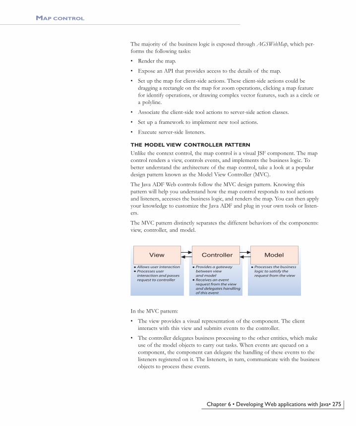
Chapter 6 • Developing Web applications with Java• 275
MAP CONTROL
The majority of the business logic is exposed through AGSWebMap, which per-forms the following tasks:
• Render the map.
• Expose an API that provides access to the details of the map.
• Set up the map for client-side actions. These client-side actions could bedragging a rectangle on the map for zoom operations, clicking a map featurefor identify operations, or drawing complex vector features, such as a circle ora polyline.
• Associate the client-side tool actions to server-side action classes.
• Set up a framework to implement new tool actions.
• Execute server-side listeners.
THE MODEL VIEW CONTROLLER PATTERN
Unlike the context control, the map control is a visual JSF component. The mapcontrol renders a view, controls events, and implements the business logic. Tobetter understand the architecture of the map control, take a look at a populardesign pattern known as the Model View Controller (MVC).
The Java ADF Web controls follow the MVC design pattern. Knowing thispattern will help you understand how the map control responds to tool actionsand listeners, accesses the business logic, and renders the map. You can then applyyour knowledge to customize the Java ADF and plug in your own tools or listen-ers.
The MVC pattern distinctly separates the different behaviors of the components:view, controller, and model.
In the MVC pattern:
• The view provides a visual representation of the component. The clientinteracts with this view and submits events to the controller.
• The controller delegates business processing to the other entities, which makeuse of the model objects to carry out tasks. When events are queued on acomponent, the component can delegate the handling of these events to thelisteners registered on it. The listeners, in turn, communicate with the businessobjects to process these events.
Allows user interactionProcesses userinteraction and passesrequest to controller
Provides a gatewaybetween viewand modelReceives an eventrequest from the viewand delegates handlingof this event
Processes the businesslogic to satisfy therequest from the view
View Controller Model
ch06.pmd 10/12/2004, 3:53 PM275

276 • ArcGIS Server Administrator and Developer Guide
MAP CONTROL
• The model objects maintain the data and provide methods that aid in theactual business processing.
• Once the business task is finished, the view once again renders the control tothe client.
The diagram below illustrates how the MVC paradigm maps to the Java ADF:
ViewIn a JSP usage, the map control is placed on the page using the following code:<ags:context id="mapContext" resource="ServerObject@MyHost" >
<ags:map id="Map0" left="0" top="0" width="400" height="300" />
<ags:context />
The map tag is invoked using the MapTag handler class. The MapTag uses theMapRenderer to generate the markup—XML translated to HTML—and to displaythe map. On the client-side, the map is set up for various JavaScript operations,such as zoom, pan, and identify. After a client-side action is performed, theMapRenderer decodes the request and passes it on to the MapControl.
ControllerThe MapControl processes the request. First, the MapControl creates an eventargument object, MapEventArgs, to represent the event in an object form. TheMapControl has tool actions associated with it. Based on the operation that theclient performed, the map control next delegates the business processing to theappropriate tool action object. For example, if the client performed a ZoomInaction, the map control would forward the MapEventArgs to the ZoomInToolActionclass. The tool action then derives the necessary information from the eventarguments—in the case of ZoomIn, the x,y coordinates of the zoom rectangle.The mapping business objects, such as WebMap and AGSWebMap, use this infor-mation to perform the task. Finally, on completion of the task, the MapRendererdisplays the changed map and the whole cycle repeats.
View Controller Model
HT
ML
Clie
ntS
erve
r
MapRenderer MapControl
IMapToolAction WebMap
AGSWebMapZoomIn-
ToolActionPan-
ToolAction
MapEventArgs
ch06.pmd 10/12/2004, 3:53 PM276

Chapter 6 • Developing Web applications with Java• 277
MAP CONTROL
ModelThe business objects, WebMap and AGSWebMap, interface with the GIS serverand the necessary ADF objects to perform GIS tasks for the map control. Oninitialization of AGSWebContext, a new AGSWebMap is created, which is a sub-type of the WebMap. The MapControl associates itself with this WebMap object.
This diagram shows the methods available from WebMap and AGSWebMap.
The AGSWebMap is the gateway to information about the map displayed in themap control.
The default implementation of WebMap.AGSWebMapcom.esri.arcgis.webcontrols.ags.data
AGSWebMap(agsContext: AGSWebContext)
focusMapExtent: com.esri.arcgis. geometry.IEnvelopefocusMapName: String
createServerObject(progId: String): ObjectgetFeatureLayers(mapName: String): HashtablegetFocusMapDescription( ):com.esri. arcgis.carto.IMapDescriptiongetFocusMapFeatureLayers( ): HashtablegetFocusMapFullExtentScale( ): doublegetFocusMapScale( ): doublegetFocusMapServerInfo ( ): com.esri.arcgis.carto.IMapServerInfogetFocusMapUnits( ): intgetFocusMapUnitsString( ): StringgetImageDescription( ): com.esri.arcgis.carto.IImageDescriptiongetImageUrl ( ): String
getMapFullExtentScale(mapName: String): doublegetMapScale(mapName: String): doublegetMapUnitsOptions( ): ArrayListgetServer( ): com.esri.arcgis.carto. IMapServer
fromMapPoint(point: com.esri.arcgis. geometry.IPoint): int[ ]
toMapPoint(x: int, y: int): com.esri.arcgis. geometry.IPoint
setHeight(height: int)setImageFormat(imageFormat: String)setWidth(width: int)
Class constructor method
Gets/sets the extent of the focus map.
Gets/sets the name of the focus map.
Creates the AGS object represented by the progId.Returns the feature layers for a given map.
Returns the focus map's map description.
Returns the feature layers of the focus map.Returns the scale of the focus map when it is at full extent.Returns the current scale of the focus map.Returns the focus map's IMapServerInfo object.
Returns the units of the focus map.Returns the units of the focus map as descriptive text.Returns the image description for the map.
Returns the URL of the map to be displayed by the map control.Returns the scale of the given map when it is at full extent.
Returns the current scale of the given map.Calls AOUtil.getUnits() to return the options for map units.Returns the IMapServer object from the server.
Sets the height of the map.Sets the image format of the returned map image.Sets the width of the map.Converts a map point to screen coordinates.
Converts the screen coordinates to a map point.
WebMapcom.esri.arcgis.webcontrols.data
WebMap(context: WebContext)
copyrightText: Stringdpi: intheight: intimageFormat: Stringwidth: int
Class constructor method.
Gets/sets the copyright text on the map.Gets/sets the dots per inch of the map image.Gets/sets the height of the map image.Gets/sets the image format of the map.Gets/sets the width of the map image.
Returns the WebContext associated with this WebMap.Indicates whether the control returns MIME data.Indicates whether the map is visible.Sets the control to return MIME data.Sets the visibility of the map.
getWebContext( ): WebContext
isVisible( ): boolean
setVisible(visible: boolean)
isMimeData( ): boolean
setUseMIMEData(useMIMEData: boolean)
ch06.pmd 10/12/2004, 3:53 PM277

278 • ArcGIS Server Administrator and Developer Guide
MAP CONTROL
Take a look at some code that works with AGSWebMap.
The following code shows how to access information about the map.AGSWebMap wMap = (AGSWebMap)context.getWebMap();
Double mapScale = wMap.getMapScale("dataframe1");
System.out.println("The map scale is: " + mapScale);
ArrayList featureLayers = wMap.getFeatureLayers();
for (int i=0; i<featureLayers.size(); i++)
System.out.println("Layer name: " + featureLayers.get(i));
The following code shows how to change the current extent of the map. Use thetoMapPoint method to convert from screen coordinates to map coordinates.AGSWebMap wMap = (AGSWebMap)context.getWebMap();
IEnvelope extent = wMap.getFocusMapExtent();
extent.centerAt(wMap.toMapPoint(20), wMap.toMapPoint(20));
wMap.setFocusMapExtent(extent);
context.refresh (com.esri.arcgis.webcontrols.ags.data.AGSRefreshId.MAP_OPERATION);
The following code shows how to change the image format for the map.AGSWebMap wMap = (AGSWebMap)context.getWebMap();
wMap.setImageFormat("JPG");
The following code shows how to access objects on the GIS server withAGSWebMap.AGSWebMap wMap = (AGSWebMap)context.getWebMap();
IMapServerInfo serverInfo = wMap.getFocusMapServerInfo();
int mapUnits = serverInfo.getMapUnits();
System.out.println("Map units: " + AOUtil.getUnitsString(mapUnits,
agsContext));
INTERACTING WITH THE MAP CONTROL USING TOOLS
When you interact with a map control, an action happens on the client thattriggers an action on the server. The client-side action is what allows you to, forexample, draw a box over the control. The server-side action is what allows youto use the coordinates of the box and, for example, zoom in.
During every interaction with a map control, two things happen:
• An end user interacts with the map control on the client.
The client-side action is controlled by a JavaScript function that executes onthe client without any requests being sent to the server. The Java ADF in-cludes JavaScript code for common interactions, such as drawing a box.
• The server executes an action based on the client interaction.
Once the client-side action is completed, the client sends a request to theserver to execute the server-side action. The MapRenderer decodes the requestand passes the FacesContext to the MapControl. The FacesContext contains therequest parameters and the tool key, for example, ZoomIn. The MapControlthen creates a MapEventArgs object that holds the tool action and the clientarguments for that tool action. Last, an ActionEvent is fired and the mapcontrol’s processAction method retrieves the appropriate IMapToolAction, forexample, ZoomInToolAction, and calls the execute method with the
ch06.pmd 10/12/2004, 3:53 PM278

Chapter 6 • Developing Web applications with Java• 279
MAP CONTROL
MapEventArgs. The ZoomInToolAction retrieves the arguments and performs thezoom in.
A ToolItemCollection consists of one or more ToolItem objects. ToolItem stores thetool key, the client-side action, and the server-side action class, IToolAction. Thediagram below shows the methods on the ToolItem object.
As a Web application developer, you build functionality into your Web applica-tion by defining a set of client-side actions and associated server-side actions.
By default, the Java ADF initializes the ToolItemCollection object with the fol-lowing map tool items:Key Server ToolAction JavaScript method
ZoomIn ZoomInToolAction MapDragRectangle
ZoomOut ZoomOutToolAction MapDragRectangle
Pan PanToolAction MapDragImage
Identify IdentifyToolAction MapPoint
Selection SelectionToolAction MapDragRectangle
The tool actions are found in the com.esri.arcgis.webcontrols.ags.faces.eventpackage, and the JavaScript is located in the Web application’s js directory. Youcan change an existing tool provided by the Java ADF or add a new tool.
Tools are listed in the default.xml file found in your application’s WEB-INF\classes\tools directory. You can edit the existing default.xml file or writeyour own XML file. If you choose to write your own, you either need to nameyour file default.xml or set the map tag’s toolItemCollection attribute to the name ofyour new XML file. The only requirement is that the file be placed in the WEB-INF\classes\tools directory.
Adding a toolTo add a tool, a new tool item must be added to the default.xml file. The codebelow is a tool item for a measure tool.<tool-item>
<key>Measure</key>
<action-class> com.esri.arcgis.webcontrols.ags.faces.event.MeasureToolAction</action- class>
<client-action>MapPolyline</client-action>
</tool-item>
This new tool item sets the client-side action and the server-side action class. TheJava ADF JavaScript library has a MapPolyline client action. The MapPolyline clientaction allows the drawing of multiple line segments on the map and finds thetotal distance of those segments. For the server-side action, the next sectiondescribes how you would write an action class called MeasureToolAction.
ToolItem-Collection
ToolItem
ToolItemcom.esri.arcgis.webcontrols.faces.event
ToolItem(key: String, actionClass: String, clientAction:String)
getClientAction( ): StringgetKey( ): String
getToolClass( ): StringgetToolAction( ): IToolAction
Class constructor method.
Returns the client action to perform.Returns the tool key.Instantiates an IToolAction object with the name toolClass.Returns the class name to invoke for the tool.
A ToolItemCollection consists of one or moreToolItem objects.
ch06.pmd 10/12/2004, 3:53 PM279

280 • ArcGIS Server Administrator and Developer Guide
MAP CONTROL
Creating a server-side action classA common task when working with the Java ADF will be to create a new server-side tool action class. In the previous section, you added a tool item for a measuretool. Now, implement the code for the MeasureToolAction class.
Create MeasureToolAction.java and add the following code.package com.esri.arcgis.webcontrols.ags.faces.event;
import com.esri.arcgis.webcontrols.faces.event.*;
import com.esri.arcgis.webcontrols.ags.data.AGSWebMap;
import com.esri.arcgis.webcontrols.ags.data.AGSWebContext;
import com.esri.arcgis.geometry.*;
public class MeasureToolAction implements IMapToolAction {
public static final String MEASURE_REQUEST_ATTRIBUTE_NAME = "esriMeasureDistance";
public void execute(MapEventArgs args) throws Exception {
PolylineArgs polyLineArgs = (PolylineArgs)args.getClientActionArgs();
ClientPoint[] points = polyLineArgs.getPoints();
AGSWebContext agsContext = (AGSWebContext)args.getWebContext();
AGSWebMap wMap = (AGSWebMap)agsContext.getWebMap();
IPolyline pLine = new IPolylineProxy(wMap.createServerObject("Polyline.getClsid()));
IPointCollection collection = new IPointCollectionProxy(pLine);
for(int i = 0; i < points.length; ++i) {
collection.addPoint(wMap.toMapPoint(points[i].getX(),
points[i].getY()), null, null);
}
agsContext.setAttribute(MEASURE_REQUEST_ATTRIBUTE_NAME,
Double.toString(pLine.getLength()));
}
}
Look at this code in more detail.
All map tool action classes must implement IMapToolAction and the execute ab-stract method.public class MeasureToolAction implements IMapToolAction {
public void execute(MapEventArgs args) throws Exception {
}
}
As mentioned previously, the MapEventArgs object was provided to the MapCon-trol by the MapRenderer; the MapRenderer received this information from theclient’s action request.
ch06.pmd 10/12/2004, 3:53 PM280

Chapter 6 • Developing Web applications with Java• 281
MAP CONTROL
To implement the execute method, follow these steps:
1. Retrieve the client action arguments from the MapEventArgs object. In thecase of the measure tool, the client action arguments are the line segmentsdrawn on the map to measure a distance.
The Java ADF has several classes representing the available ClientActionArgs.The table below describes the default action mappings for the map control.Client Action ClientActionArgs
MapPoint PointArgs
MapDragImage DragImageArgs
MapDragRectangle DragRectangleArgs
MapPolyline PolylineArgs
MapLine LineArgs
MapPolygon PolygonArgs
MapCircle CircleArgs
MapOval OvalArgs
You can add to the default collection of action argument classes by callingthis code:ClientActionArgs.addClientActionArgs("actionName", "argsClassName");
In this example, the PolylineArgs class, from the default collection, is usedbecause the client-side action is MapPolyline.PolylineArgs polyLineArgs = (PolylineArgs)args.getClientActionArgs();
ClientPoint[] points = polyLineArgs.getPoints();
Now, all the points are accessible to write some ArcObjects code to calculatethe length of the polyline.
2. Retrieve the WebMap object.AGSWebContext agsContext = (AGSWebContext)args.getWebContext();
AGSWebMap wMap = (AGSWebMap)agsContext.getWebMap();
3. Use the createServerObject method on the WebContext to create any new serverobjects within the server context.IPolyline pLine = new IPolylineProxy(agsContext.createServerObject("Polyline.getClsid()));
4. Convert the points from screen coordinates to map points by using thetoMapPoint method on the WebMap.IPointCollection collection = new IPointCollectionProxy(pLine);
for(int i = 0; i < points.length; ++i) {
collection.addPoint(wMap.toMapPoint(points[i].getX(),points[i].getY()), null, null);
}
A collection of points is stored in the pLine object. The length of the line can bedetermined by using pLine.getLength. The length of the polyline is then stored asan attribute to the WebContext so it can be retrieved in the JSP page.agsContext.setAttribute(MEASURE_REQUEST_ATTRIBUTE_NAME,
Double.toString(pLine.getLength()));
Now that you have completed the code for MeasureToolAction.java, navigate toyour application’s WEB-INF directory and create this structure:classes\com\esri\arcgis\webcontrols\ags\faces\event. Compile the file and placethe class file in the event directory.
ch06.pmd 10/12/2004, 3:53 PM281

282 • ArcGIS Server Administrator and Developer Guide
MAP CONTROL
To add the measure tool to the JSP, edit your JSP file to include this code thatwill display the measure tool as well as text that reports the measure distance.<ags:context id="mapContext" resource="world@localhost">
<ags:map ... />
<input type="button" value="Measure" onclick="MapPolyline('Map0', 'Measure');" />
<div style="position:absolute;left:233px;top:600px;">
Measured Distance: <font color="red"><c:out value="${sessionScope ['mapContext'].attributes['esriMeasureDistance']}"/></font>
</div>
</ags:context>
To use the measure tool, click Measure and click the map at the points you wantto measure. Double-click to end measuring; the measure distance, reported inmap units, will be displayed under the map.
INTERACTING WITH THE MAP CONTROL USING LISTENERS
Not all actions performed on the map require a client-side action. In some cases,you may want to implement custom server-side functionality invoked by a usercommand. JSF ships with some standard command components, such as buttonsand hyperlinks. These command components can be associated with listeners.When the command component is clicked, the JSF framework triggers a server-side event and calls the associated listeners to process the event.
The Java ADF provides these listeners as part of thecom.esri.arcgis.webcontrols.ags.faces.event package for the map:
• DirectionalPanListener
• FixedZoomListener
• ZoomRelativeToFullExtentListener
• ZoomFullExtentListener
You can get more details about the listeners provided with the Java ADF in theArcGIS Developer Help.
To program a listener in JSF, you must implement thejavax.faces.event.ActionListener interface. This interface requires an implementationof the following abstract method:public void processAction(ActionEvent event)
This example shows the JSP code for the FixedZoomListener. The purpose of thislistener is to zoom a map in or out by a fixed factor. In this example, the zoomfactor is 50 percent.<jsfh:commandButton id="zoom" image="images/zoom.gif">
<jsfc:actionListener type= "com.esri.arcgis.webcontrols.ags.faces.event.FixedZoomListener" />
<jsfc:attribute name="factor" value="0.5" />
</jsfh:commandButton>
The JSF commandButton component, when clicked, sends the event to the listenerassociated with the actionListener tag. The factor attribute is passed to theFixedZoomListener, and the server-side event is handled.
ch06.pmd 10/12/2004, 3:53 PM282
Chapter 6 • Developing Web applications with Java• 283
MAP CONTROL
This is the implementation of the listener code.package com.esri.arcgis.webcontrols.ags.faces.event;
import javax.faces.event.*;
import com.esri.arcgis.webcontrols.util.WebUtil;
import java.util.logging.*;
import com.esri.arcgis.webcontrols.data.*;
import com.esri.arcgis.geometry.*;
import com.esri.arcgis.webcontrols.ags.data.*;
public class FixedZoomListener implements ActionListener {
private static Logger logger = Logger.getLogger(FixedZoomListener.class.getName());
public static final String FACTOR = "factor";
public void processAction(ActionEvent event) throws javax.faces.event.AbortProcessingException {
try {
AGSWebMap wMap = (AGSWebMap)WebUtil.getWebContext(event.getComponent()).getWebMap();
double factor = Double.parseDouble((String)event.getComponent().getAttribute(FACTOR));
IEnvelope extent = wMap.getFocusMapExtent();
extent.expand(factor, factor, true);
IEnvelope fullExtent = wMap.getFocusMapServerInfo().getFullExtent();
if(extent.getWidth() > fullExtent.getWidth() || extent.getHeight() > fullExtent.getHeight())
extent = fullExtent;
wMap.setFocusMapExtent(extent);
wMap.getWebContext().refresh(AGSRefreshId.MAP_OPERATION);
}
catch(Exception e) {
logger.log(Level.WARNING, "Unable to process action for FixedZoomListener.", e);
}
}
}
The first step in implementing a listener is to implement from the ActionListenerinterface.public class FixedZoomListener implements ActionListener {
}
As mentioned, ActionListener requires the implementation of the abstract method,processAction. This method gets invoked from the client’s command action. Referto the code comments for more details about this code.public static final String FACTOR = "factor";
public void processAction(ActionEvent event) throwsjavax.faces.event.AbortProcessingException {
try {
ch06.pmd 10/12/2004, 3:53 PM283

284 • ArcGIS Server Administrator and Developer Guide
MAP CONTROL
// The WebMap, retrieved from the WebContext, can return// the AGSWebMap object using the getWebMap method on WebContext.
AGSWebMap wMap = (AGSWebMap)WebUtil.getWebContext(event.getComponent()).getWebMap();
// Get the factor attribute provided to the listener.
double factor = Double.parseDouble((String)event.getComponent().getAttribute(FACTOR));
// Get the focus map extent from the WebMap and store this extent.
IEnvelope extent = wMap.getFocusMapExtent();
// Using ArcObjects IEnvelope expand method, stretch the// current extent by the factor specified.
extent.expand(factor, factor, true);
// If the new extent is greater than the full extent of// the focus map, set the new extent to the full extent.
IEnvelope fullExtent = wMap.getFocusMapServerInfo().getFullExtent();
if(extent.getWidth() > fullExtent.getWidth() || extent.getHeight() > fullExtent.getHeight())
extent = fullExtent;
// Set the calculated extent to the new extent.
wMap.setFocusMapExtent(extent);
// Update the context and tell all the observers of the context// that the map has changed and they may need to update.
wMap.getWebContext().refresh(AGSRefreshId.MAP_OPERATION);
}
catch(Exception e ) {
logger.log(Level.WARNING, "Unable to process action for FixedZoomListener.", e);
}
}
The JSF listeners (working within the JSF framework) eliminate the need foryou, as the Web developer, to take care of when and how the server-side event istriggered.
INTERACTING WITH THE MAP CONTROL USING ACTIONMETHODS
A JSF component can trigger events by associating itself to a JavaBeans method.The Java ADF refers to these as action methods. For a list of the available actionmethods see the ArcGIS Server Java ADF Listeners and Actions documentationin the ArcGIS Developer Help.
Now take a look at an example of how you would create one of these actionmethods. In the previous section, a FixedZoomListener was created. Now you willimplement this functionality using an action method.
1. Implement the bean class AGSFixedZoom and the doFixedZoom action method.package com.esri.arcgis.webcontrols.ags.data;
import com.esri.arcgis.webcontrols.data.WebContext;
import com.esri.arcgis.webcontrols.data.WebContextInitialize;
import java.util.logging.Logger;
import java.util.logging.Level;
import com.esri.arcgis.geometry.*;
ch06.pmd 10/12/2004, 3:53 PM284

Chapter 6 • Developing Web applications with Java• 285
// Implement WebContextIntialize to update this class with// the current WebContext.
public class AGSFixedZoom implements WebContextInitialize {
private static Logger logger = Logger.getLogger(AGSFixedZoom.class.getName());
private AGSWebContext m_agsContext;
// Set a default zoom factor.
double factor = .5;
// Update the value of WebContext on initialization or change.
public void init(WebContext agsContext){
if(agsContext == null || !(agsContext instanceof AGSWebContext))
throw new IllegalArgumentException (“WebContext is null or is not an instance of AGSWebContext.”);
this.m_agsContext = (AGSWebContext)agsContext;
}
// Sets the zoom factor.
public void setFactor(double factor){
this.factor = factor;
}
// Returns the zoom factor.
public double getFactor(){
return this.factor;
}
// Implement the doFixedZoom action method.
// Retrieve the WebMap and determine the extent of the focus map.
// Expand the IEnvelope by the set factor in both directions. Change // the WebMap to use the new map extent and refresh the WebContext.
public String doFixedZoom(){
try {
AGSWebMap wMap = (AGSWebMap)m_agsContext.getWebMap();
IEnvelope extent = wMap.getFocusMapExtent();
extent.expand(factor, factor, true);
IEnvelope fullExtent = wMap.getFocusMapServerInfo().getFullExtent();
if(extent.getWidth() > fullExtent.getWidth() || extent.getHeight() > fullExtent.getHeight())
extent = fullExtent;
wMap.setFocusMapExtent(extent);
wMap.getWebContext().refresh(AGSRefreshId.MAP_OPERATION);
}
catch(Exception _) {
logger.log(Level.WARNING, "Unable to do fixed zoom", _);
}
return null;
}
}
2. Add the AGSFixedZoom class as a managed context attribute. Edit the Webapplication’s managed_context_attributes.xml file with the entry below. Thenew bean is referenced as esriAGSFixedZoom.<managed-context-attribute>
MAP CONTROL
Managed context attributes are discussed inmore detail in the ‘Working with the context
control’ section earlier in this chapter.
ch06.pmd 10/12/2004, 3:53 PM285

286 • ArcGIS Server Administrator and Developer Guide
MAP CONTROL
<name>esriAGSFixedZoom</name>
<attribute-class>com.esri.arcgis.webcontrols.ags.data.AGSFixedZoom </attribute-class>
<description>Performs a fixed zoom on the map.</description>
</managed-context-attribute>
3. Write JSP code to access the doFixedZoom action method and dynamically setthe factor using a JSF inputText box.<ags:context id="mapContext" resource="world@localhost">
<ags:map id="Map0" left="233" top="115" width="535" height="408" ... />
<table cellpadding="0" cellspacing="1" class="tblToolBar">
<tr>
<td>
<jsfh:inputText id="factor" value="#{sessionScope['mapContext'] .attributes['esriAGSFixedZoom'].factor}" />
</td>
<td>
<jsfh:commandButton id="cmdFixed" value="Fixed Zoom" action="#{sessionScope['mapContext'] .attributes['esriAGSFixedZoom'].doFixedZoom}" />
</td>
</tr>
</table>
</ags:context>
ACCESSING OBJECTS THROUGH WEBCONTEXT
As mentioned in the section titled ‘Context control’, the WebMap object is acces-sible through the WebContext and can be retrieved using the following Java code:AGSWebContext context = (AGSWebContext) WebUtil.getWebContext(FacesContext.getCurrentInstance(), CONTEXTID);
AGSWebMap map = (AGSWebMap)context.getWebMap();
// The WebPageMap, retrieved from the WebContext,// can be used to retrieve the name of the focus map.
String focusMapName = map.getFocusMapName();
The name of the focus map can also be retrieved in JSP code:${requestScope['esriWebContext'].webMap.focusMapName}:
<c:set var="focusMapName"value="${sessionScope['CONTEXTID'].webMap.focusMapName}" />
The above code sets a focusMapName variable, with the value retrieved from thegetFocusMapName method on AGSWebMap.
Take a look at a few more examples that relate to the buffer operation on a map.
The following code shows how to display a JSF inputText box to set a bufferdistance. A buffer distance must be set before a buffer operation can be per-formed.<jsfh:inputText value="#{sessionScope['CONTEXTID'].attributes
['esriAGSBuffer'].bufferDistance}"/>
The following code uses the JSF selectitems tag to display a dropdown list ofchoices for setting the map units. The selectOneMenu tag automatically callsAGSBuffer.setBufferUnits with the value selected.
ch06.pmd 10/12/2004, 3:53 PM286

Chapter 6 • Developing Web applications with Java• 287
MAP CONTROL
<jsfh:selectOneMenu id="selBufferUnit" value= "#{sessionScope['CONTEXTID'].attributes['esriAGSBuffer'].bufferUnits}">
<jsfc:selectItems id="selBufferUnitOption" value= "#{sessionScope['CONTEXTID'].webMap.mapUnitsOptions}"/>
</jsfh:selectOneMenu>
The following code shows how to display the details of a buffer result by usingthe JSF dataTable. First, the ArrayList of details is associated to the value at-tribute. Then for each result detail, the field and value are accessed via the itemvariable. The rendered attribute of the dataTable ensures that there are bufferresult details available to print out.<jsfh:dataTable id="detailsTable" value="#{sessionScope['CONTEXTID']
.attributes['esriAGSBufferResults'].detailsResult.details}"
var="item"
rendered="#{sessionScope['CONTEXTID'] .attributes['esriAGSBufferResults'].detailsResult != null}" … >
<jsfh:column>
<jsfc:facet name= "header"><jsfh:outputText value="Field" /></jsfc:facet>
<jsfh:outputText value="#{item[0]}" />
</jsfh:column>
<jsfh:column>
<jsfc:facet name= "header"><jsfh:outputText value="Value" /></jsfc:facet>
<jsfh:outputText value="#{item[1]}" />
</jsfh:column>
</jsfh:dataTable>
ch06.pmd 10/12/2004, 3:53 PM287

288 • ArcGIS Server Administrator and Developer Guide
PAGE LAYOUT CONTROL
The page layout control provides the display functionality of the ArcMap layoutview for a map document served using ArcGIS Server. Using the page layoutcontrol, you can view a map server object’s layout, navigate it, navigate the mapswithin the layout, and access the fine-grained ArcObjects that comprise it.
The diagram above illustrates the relationships between the page layout controland its associated business objects. The PageLayoutControl works with an ab-stract WebPageLayout object. The actual WebPageLayout object is created by the
An abstract class representinga page layout control.
Displays a page layout andmanages events that occur.
An object representing the pagelayout arguments passed froma client action.
Renders the pagelayout control.
The interface for all pagelayout tool actions.
Performs a zoom outon the page layout.
Performs a zoom inon the page layout.
Performs a pan onthe page layout.
Performs a zoom outon the page layout's map.
Performs a zoom inon the page layout's map.
Performs a pan on thepage layout's map.
The default implementationof WebPageLayout.
The interface for allmap tool actions.
Tag handler class forthe JSP pageLayout tag.
Page Layout Control Objects
PageLayout-Control
WebPage-Layout
PageLayout-EventArgs
IPageLayout-ToolAction
PageLayout-Renderer
Page-LayoutTag
AGSWeb-PageLayout
WebSessionPageLayout-
ZoomIn-ToolAction
PageLayout-PanToolAction
PageLayout-ZoomOut-ToolAction
IMap-ToolAction
WebSessionPageMap-ZoomIn-
ToolAction
PageMap-PanToolAction
PageMap-ZoomOut-ToolAction
ch06.pmd 10/12/2004, 3:53 PM288

Chapter 6 • Developing Web applications with Java• 289
PAGE LAYOUT CONTROL
parent context control, and by default, a new AGSWebPageLayout is initialized.The PageLayoutControl also accepts map tool actions for the maps on the page.In addition, the PageLayoutControl responds to events on the page itself byexecuting actions of type IPageLayoutToolAction. The PageLayoutRenderer classrenders the control to the appropriate markup, and the PageLayoutTag class ex-poses the control as a JSP custom tag named pageLayout. AGSWebPageLayoutperforms these important functions for the PageLayoutControl:
• Renders the page layout.
• Exposes an API that provides access to the details of the page layout and map.
• Sets up the page layout for client-side actions on the map and the page. Theseclient-side actions could be dragging a rectangle to do a page zoom or draggingan image to pan the page.
• Associates the client-side tool actions to server-side action classes.
• Sets up a framework to implement new tool actions.
• Executes server-side listeners.
The diagram below shows some of the methods available on WebPageLayout.
WebPageLayoutcom.esri.arcgis.webcontrols.data
WebPageLayout(context: WebContext)
dpi: intheight: intimageFormat: Stringwidth: int
getWebContext( ): WebContextisMimeData( ): booleanisVisible( ): booleansetUseMIMEData(useMIMEData: boolean)setVisible(visible: boolean)
Class constructor method.
The dots per inch (DPI) of the page layout.The height of the page layout.The image format of the page layout.The width of the page layout.
Returns the WebContext associated with this WebPageLayout.Indicates whether the control returns MIME data.Indicates whether the page layout is visible.Sets whether the control returns MIME data.Sets the visibility of the page layout.
ch06.pmd 10/12/2004, 3:53 PM289

290 • ArcGIS Server Administrator and Developer Guide
PAGE LAYOUT CONTROL
The diagram below shows some of the methods available on AGSWebPageLayout.
The AGSWebPageLayout provides you with an API to access information aboutthe page layout and control its behavior. The examples below illustrate somecommon usages.
The following code shows how to change the current page extent of the layoutand refresh all observers of the WebContext.AGSWebPageLayout wPage = (AGSWebPageLayout)context.getWebPageLayout();
IEnvelope extent = wPage.getPageExtent();
extent.centerAt(wPage.toPagePoint(50),wPage.toPagePoint(50));
wPage.setPageExtent(extent);
context.refresh(AGSRefreshId.PAGE_LAYOUT_OPERATION);
The following code shows how to access objects on a GIS server withAGSWebPageLayout. This code also retrieves the map images contained in thelayout and prints out the URL to the first map.AGSWebPageLayout wPage = (AGSWebPageLayout)context.getWebPageLayout();
IPageDescription pageDesc = wPage.getPageDescription();
IImageDescription imageDesc = wPage.getImageDescription();
The default implementation of WebPageLayout.AGSWebPageLayoutcom.esri.arcgis.webcontrols.ags.data
AGSWebPageLayout(agsContext: AGSWebContext)
pageExtent: com.esri.arcgis. geometry.IEnvelope
createServerObject(progId: String): ObjectgetDataFrameName(index: int): StringgetFullExtent( ): AGSExtentgetImageDescription( ): com.esri.arcgis. carto.IImageDescriptiongetImageRectangle(mapName: String): ImageRectanglegetImageRectangles( ): ImageRectangle[ ]getImageUrl( ): StringgetMapDescriptions( ): com.esri.arcgis. carto.IMapDescriptionsgetMapExtent(mapName: String): com. esri.arcgis.geometry.IEnvelope
getMapServerInfo(mapName: String): com.esri.arcgis.carto.IMapServerInfogetPageDescription( ): com.esri.arcgis.carto.IPageDescriptiongetServerLayout( ): com.esri.arcgis.carto.IMapServerLayout
fromMapPoint(point: com.esri.arcgis. geometry.Ipoint, mapName: String): int[ ]toMapPoint(x: int, y: int, mapName: String): com.esri.arcgis.geometry.IPointfromPagePoint(point: com.esri.arcgis. geometry.IPoint): int[ ]toPagePoint(x: int, y: int): com.esri.arcgis.geometry.IPoint
setHeight(height: int)setImageFormat(imageFormat: String)setMapExtent(extent: com.esri.arcgis. geometry.IEnvelope, mapName: String)setWidth(width: int)
Class constructor method.
The extent of the page.
Creates the AGS object represented by the progId.Returns the data frame name based on an integer index.Returns the full extent of the page layout.Returns the image description for the page layout.
Returns the data frame location in screen coordinates.
Return all data frame locations in screen coordinates.Returns the URL of the page layout.Returns the map descriptions for the page layout.
Returns the extent of the given data frame.
Returns the IMapServerInfo object based on data frame name.Returns the page description for the page layout.
Returns the IMapServerLayout object from the server.
Sets the height of the page layout.Sets the image format for the page layout.Sets the extent for the given data frame name.
Sets the width of the page layout.Converts a map point to screen coordinates.
Converts a screen coordinate to a map point.
Converts a page point to screen coordinates.
Converts the screen coordinates to a page point.
ch06.pmd 10/12/2004, 3:54 PM290

Chapter 6 • Developing Web applications with Java• 291
ILayoutImage srvLayout = wPage.getServerLayout() .exportLayout(pageDesc,imageDesc);
IMapImages images = srvLayout.getMapImages();
System.out.println("The first map: " + images.getElement(0).getURL());
The following code shows how to perform operations on a map in the pagelayout. This code sets the map to its full extent and refreshes the display.AGSWebPageLayout wPage = (AGSWebPageLayout)context.getWebPageLayout();
wPage.setMapExtent(wPage.getMapServerInfo("dataframe1"). getFullExtent(), "dataframe1");
context.refresh(AGSRefreshId.MAP_OPERATION);
The following code shows how to query the page layout to determine if theimage is returned as a URL or as MIME data. If the server object is set up asMIME Only, the isMIMEData method will return True even ifPageLayoutControl.setUseMIMEData set it to False.AGSWebPageLayout wPage = (AGSWebPageLayout)context.getWebPageLayout();
System.out.println("MIME is set to: " + wPage.isMIMEData());
INTERACTING WITH THE PAGE LAYOUT CONTROL USING TOOLS
The page layout control interacts with tools in the same way that the map controlinteracts with tools. The only difference between the two is that the page layoutcontrol can process both map and page tool actions.
In addition to the tool items for the map control, the ToolItemCollection object ispopulated with tool items for the page layout control. Below is the listing of thetool items specific to the page layout control and their client-side and server-sidemappings.Key Server ToolAction JavaScript method
PageLayoutZoomIn PageLayoutZoomInToolAction PageDragRectangle
PageLayoutZoomOut PageLayoutZoomOutToolAction PageDragRectangle
PageLayoutPan PageLayoutPanToolAction PageDragImage
PageMapZoomIn PageMapZoomInToolAction PageMapDragRectangle
PageMapZoomOut PageMapZoomOutToolAction PageMapDragRectangle
PageMapPan PageMapPanToolAction PageMapDragImage
The PageLayoutRenderer decodes the request and passes the FacesContext to thePageLayoutControl. The FacesContext contains the request parameters and thetool key for that request. The PageLayoutControl then creates an EventArgsobject that holds the tool action and the tool action’s client arguments. If theToolAction is for a map, it creates a MapEventArgs. If the ToolAction is for a page, itcreates a PageEventArgs. An ActionEvent is fired, and the page layout control’sprocessAction method retrieves the appropriate IToolAction and calls the executemethod with the EventArgs. In the case of a zoom in on the page, thePageLayoutZoomInToolAction parses the arguments and performs the zoom in on thepage.
Look at creating a new tool for the page layout. The steps here are similar to thesteps taken to create a new tool for the map control. In this example, the newtool’s client-side action is PagePoint. The server-side action takes the point fromthe client and zooms in relative to that point by a factor of 50 percent.
PAGE LAYOUT CONTROL
ch06.pmd 10/12/2004, 3:54 PM291

292 • ArcGIS Server Administrator and Developer Guide
PAGE LAYOUT CONTROL
1. Change the application's default.xml file to add a new tool, PageFixedZoomIn.<tool-item>
<key>PageFixedZoomIn</key>
<action-class> com.esri.arcgis.webcontrols.ags.faces.event.PageFixedZoomInToolAction </action-class>
<client-action>PagePoint</client-action>
</tool-item>
The ClientActionArgs mapping for the page layout control is below. ThePagePoint action maps to the PointArgs object on the server.Client Action ClientActionArgs
PagePoint PointArgs
PageDragRectangle DragRectangleArgs
PageDragImage DragImageArgs
PageMapPoint PointArgs
PageMapDragRectangle DragRectangleArgs
PageMapDragImage DragImageArgs
2. Create PageFixedZoomInToolAction.java.
3. Add the following code to PageFixedZoomInToolAction.java. The code belowhas comments describing the implementation.package com.esri.arcgis.webcontrols.ags.faces.event;
import com.esri.arcgis.webcontrols.faces.event.*;
import com.esri.arcgis.webcontrols.ags.data.AGSWebPageLayout;
import com.esri.arcgis.webcontrols.ags.data.AGSWebContext;
import com.esri.arcgis.webcontrols.ags.data.AGSRefreshId;
import com.esri.arcgis.geometry.*;
// Implement from the IPageLayoutToolAction interface.
public class PageFixedZoomInToolAction implements IPageLayoutToolAction {
// Zoom in by a fixed factor of 50%.
protected static final double ZOOM_IN_FACTOR = 0.5;
// Implement the execute method to perform the task.
public void execute(PageLayoutEventArgs args) throws Exception {
// The PagePoint method maps to PointArgs. Extract the client action
// arguments and cast it to PointArgs.
PointArgs pointArgs = (PointArgs)args.getClientActionArgs();
// Retrieve the WebContext and WebPageLayout.
AGSWebContext agsContext = (AGSWebContext)args.getWebContext();
AGSWebPageLayout wPage = (AGSWebPageLayout)agsContext.getWebPageLayout(true);
// Get the current page’s extent from the WebPageLayout.
IEnvelope extent = wPage.getPageExtent();
ch06.pmd 10/12/2004, 3:54 PM292

Chapter 6 • Developing Web applications with Java• 293
PAGE LAYOUT CONTROL
// Extract the x,y coordinate point from PointArgs. Convert both of these
// screen points to page points using the toPagePoint method.
// Center the new extent of the page at the new point and expand it 50%.
extent.centerAt(wPage.toPagePoint(pointArgs.getPoint().getX(), pointArgs.getPoint().getY()));
extent.expand(ZOOM_IN_FACTOR, ZOOM_IN_FACTOR, true);
// Set the new page extent to the expanded extent.
wPage.setPageExtent(extent);
// Refresh the context and update those controls that listen for
// changes to the page layout.
agsContext.refresh(AGSRefreshId.PAGE_LAYOUT_OPERATION);
}
}
4. Now that you have completed the code forPageFixedZoomInToolAction.java, navigate to your application’s WEB-INFdirectory and create this directory structure:classes\com\esri\arcgis\webcontrols\faces\event
Compile the file, and place the class file in the event directory.
5. To add the button for zooming the page layout to the JSP, edit your JSP fileto include this code that will display the new button. The button’s onclickevent is set to execute the PagePoint JavaScript method and pass the identifierof the page layout control and the tool key.
<ags:context id="mapContext" resource="world@localhost">
<ags:pageLayout ... />
<input type="button" value="Page Fixed Zoom" onclick="PagePoint('PageLayout0', 'PageFixedZoomIn', 'false');" />
</ags:context>
INTERACTING WITH THE PAGE LAYOUT CONTROL USINGLISTENERS
Like the map control, listeners can be associated with JSF command components.Refer to the section titled ‘Interacting with the map control using listeners’ fordetails on how to implement a new listener and attach listeners to commands.
The Java ADF provides these listeners, as part of thecom.esri.arcgis.webcontrols.ags.faces.event package, for the page layout:
• PageLayoutDirectionalPanListener
• PageLayoutZoomFullExtentListener
• PageLayoutZoomFullSizeListener
Refer to the ArcGIS Server Java ADF Listeners and Actions documentation inthe ArcGIS Developer Help for more details on each listener.
The third parameter is an optional Boolean tospecify whether you want to see the loading
image while the request is processing; thedefault is true.
ch06.pmd 10/12/2004, 3:54 PM293

294 • ArcGIS Server Administrator and Developer Guide
PAGE LAYOUT CONTROL
ACCESSING OBJECTS THROUGH WEBCONTEXT
The WebPageLayout can be retrieved through the WebContext by using the follow-ing Java code:AGSWebContext context = (AGSWebContext) WebUtil.getWebContext(FacesContext.getCurrentInstance(), CONTEXTID);
AGSWebPageLayout page = (AGSWebPageLayout)context.getWebPageLayout();
// The WebPageLayout, retrieved from the WebContext,// can be used to retrieve the width and height of the page.
int width = page.getWidth();
int height = page.getHeight();
The width and height of the page can also be retrieved using the following JSPcode:<c:set var="pageWidth" value=
"${sessionScope['CONTEXTID'].webPageLayout.width}" />
<c:set var=”pageHeight” value=
"${sessionScope['CONTEXTID'].webPageLayout.height}" />
ch06.pmd 10/12/2004, 3:54 PM294

Chapter 6 • Developing Web applications with Java• 295
OVERVIEW CONTROL
The overview control is similar to a map control in that it displays a particulardata frame of a map server object. However, the purpose of the overview map isto provide a point of reference for the area displayed on its associated mapcontrol. The overview control can show its data frame at full extent or the lastextent at which the file was saved. A small box on the overview map representsthe currently displayed area on its associated map control. You can interactivelymove this box around to pan the area displayed in the map control.
The diagram above illustrates the relationships between the overview control andits associated business objects, WebOverview and AGSWebOverview. The overviewcontrol works with an abstract WebOverview. The actual WebOverview object iscreated by the parent context control, and by default, a new AGSWebOverview isinitialized. The OverviewEventArgs object is used by the control to extract thepoint on the overview map to center at. The OverviewRenderer class renders thecontrol to the appropriate markup, and the OverviewTag class exposes the controlas a JSP custom tag named overview. AGSWebOverview performs these importantfunctions for the overview control:
• Renders the overview map
• Exposes an API to retrieve information about the overview map
• Sets up the overview map to handle events for panning the area of interest
• Updates the map based on an overview map event
An abstract class representingan overview map control.
Displays an overview mapand manages events that occur.
Tag handler class for theJSP overview tag.
Renders the overviewmap.
The default implementationof WebOverview.
An object representing themap arguments passedfrom a client.
Overview Control Objects
WebSession
Overview-Control
WebOverview
Overview-EventArgs
WebSession ContextTagOverview-Renderer
OverviewTag
AGSWeb-Overview
ch06.pmd 10/12/2004, 3:54 PM295

296 • ArcGIS Server Administrator and Developer Guide
OVERVIEW CONTROL
The diagram below shows some of the methods available from WebOverview andAGSWebOverview.
The AGSWebOverview provides you with an API to access information about theoverview and control its behavior. The examples below illustrate some commonusages.
The following code shows how to generate the overview map image and retrievea reference to it; this reference could be a URL or a MIME data string.AGSWebOverview wOverview = (AGSWebOverview)context.getWebOverview();
String ovMap = wOverview.getImageUrl();
The following code shows how to determine the width and height of the area ofinterest box on the overview map.AGSWebOverview wOverview =(AGSWebOverview)context.getWebOverview();
ImageRectangle rect = wOverview.getImageRectangle();
System.out.println("The width: " + rect.getX1() – rect.getX2());
System.out.println("The height: " + rect.getY1() – rect.getY2());
The following code shows how to set a new data frame to display in the over-view map.AGSWebOverview wOverview =(AGSWebOverview)context.getWebOverview();
wOverview.setDataFrame("newDataFrame");
context.refresh();
WebOverviewcom.esri.arcgis.webcontrols.data
WebOverview(map: WebMap)
dataFrame: Stringdpi: intheight: intimageFormat: Stringresource: Stringwidth: int
getWebMap( ): WebMapisMimeData( ): booleanisVisible( ): booleansetUseMIMEData(useMIMEData: boolean)setVisible(visible: boolean)
Class constructor method.
Gets/sets the data frame to use for the overview map.Gets/sets the dots per inch of the overview map image.Gets/sets the height of the overview map.Gets/sets the image format of the overview map.Gets/sets the resource to be used in the overview map.Gets/sets the width of the overview map.
Returns the associated WebMap object.Indicates whether the control returns MIME data.Indicates whether the overview map is visible.Sets whether the control returns MIME data.Sets the visibility of the overview map.
The default implementation of WebOverview.AGSWebOverviewcom.esri.arcgis.webcontrols.ags.data
AGSWebOverview(agsMap: AGSWebMap)
getImageRectangle( ): ImageRectanglegetImageUrl(): String
fromMapPoint(point: com.esri.arcgis. geometry.IPoint,mapDesc: com.esri.arcgis.carto.IMapDescription): int[ ]
setDataFrame(dataFrame: String)setImageFormat(imageFormat: String)setResource(resource: String)
Class constructor method.
Returns the current extent rectangle in screen coordinates.Returns the URL to be displayed by the Overview Control.Sets the data frame to be displayed in the overview map.Sets the image format for the overview map.Sets the resource to be displayed in the overview map.Converts a map point on the overview map to screen coordinates.
Converts the screen coordinates to the overview map point.toMapPoint (x: int, y: int): com.esri.arcgis. geometry.IPoint
ch06.pmd 10/12/2004, 3:54 PM296

Chapter 6 • Developing Web applications with Java• 297
INTERACTING WITH THE OVERVIEW CONTROL
The overview control automatically handles two events on the client. Thesefunctions can be found in the overview_functions.js file included with Java ADFapplications.
• OVClick—A single mouse click to center the area of interest.
• OVDragUp—A drag rectangle up event to define a new area of interest.
After either of these two events occurs on the client, the center x,y value isposted back to the server and received by the OverviewRenderer. The rendererdecodes the center coordinate and passes these values to the OverviewControl forcreation of an OverviewEventArgs object. An action event is then fired on thecontrol to update the map control accordingly. Below is the code for thehandleEvent method on AGSWebOverview:public void handleEvent(OverviewEventArgs args) throws Exception {
IEnvelope extent = agsMap.getFocusMapExtent();
extent.centerAt(toMapPoint(args.getCenterX(), args.getCenterY()));
agsMap.setFocusMapExtent(extent);
agsMap.getWebContext().refresh(AGSRefreshId.MAP_OPERATION);
}
The OverviewEventArgs object is passed to the handleEvent method by the frame-work, and the x,y coordinate is extracted using getCenterX and getCenterY. The x,ycenter is converted to map units, and the new extent is set on the WebMap. TheWebContext is refreshed to update all observers that the map extent has changed.
ACCESSING OBJECTS THROUGH WEBCONTEXT
The WebOverview can be retrieved through the WebContext using the following Javacode:AGSWebContext context = (AGSWebContext) WebUtil.getWebContext(FacesContext.getCurrentInstance(), CONTEXTID);
AGSWebOverview overview = (AGSWebOverview)context.getWebOverview();
// The WebOverview, retrieved from the WebContext, can be// used to retrieve the resource string used with the overview map.
String resource = overview.getResource();
The same information can be accessed in JSP code using:<c:set var="resource" value= "${sessionScope['CONTEXTID'].webOverview.resource}"/>
The above code sets a variable, resource, with the value retrieved from theWebOverview.getResource method.
OVERVIEW CONTROL
ch06.pmd 10/12/2004, 3:54 PM297

298 • ArcGIS Server Administrator and Developer Guide
TOC CONTROL
The Toc control—or table of contents control—displays the contents of a mapand allows an end user to turn layers on and off. The Toc control functions in thesame manner as the table of contents in ArcMap: it presents a hierarchical list ofdata frames, layers, and symbols displayed on the map.
The diagram above shows the relationships between the TocControl and itsbusiness objects, WebToc and AGSWebToc. The TocControl works with an ab-stract WebToc object. The actual WebToc object is created by the parent contextcontrol, and by default, a new AGSWebToc is initialized. The TocRenderer classrenders the control to the appropriate markup, and the TocTag class exposes thecontrol as a JSP custom tag named toc. The AGSWebToc performs the followingtasks:
• Renders the table of contents
• Exposes an API to retrieve information about the table of contents
• Sets up the table of contents to handle events for toggling layer visibility andchanging data frames
An abstract classrepresenting a Toc control.
Displays a table of contentsand manages events that occur.
The defaultimplementationof WebToc.
An object representing thetable of contents argumentspassed from a client action.
Renders the table ofcontents control.
The layer name on theToc control.
The data frame on theToc control.
The box that shows thesymbol on the Toc control.
The heading on theToc control.
Tag handler class for the JSP toc tag.
Represents a single nodeof the TocControl.
Represents content fora single node ofthe TocControl.
Table of Contents Objects
TocControl
WebToc
TocEventArgs
TocNode
TocNode-Content
TocRendererTocTag
AGSToc-DataFrame
AGSToc-SymbolPatch
AGSTocLayerAGSToc-HeadingPatch
AGSWebToc
ch06.pmd 10/12/2004, 3:54 PM298

Chapter 6 • Developing Web applications with Java• 299
TOC CONTROL
• Updates the map or page layout based on a Toc event
WORKING WITH THE TOC TREE
The table of contents is made up of a collection of TocNode objects. A TocNodestores content, maintains hierarchical relationships, and responds to an event thatoccurs at that node. To store content, a TocNode requires a TocNodeContent objectto encapsulate the content at that node. A TocNode handles its own expand orcollapse event and delegates the check box event—for layer visibility—and thenode operation—when node content is clicked—to the TocNodeContent’s eventhandling methods:public void handleCheckedEvent(TocEventArgs args)
public void handleNodeEvent(TocEventArgs args)
The diagram below shows you some of the methods available from WebToc andAGSWebToc.
In general, you will only work with these methods if you want to change the waythe existing TocControl works in order to write a new tree control. An exampleof this in the Java ADF is the IdentifyResultsControl, which uses the Toc objects todisplay the results of an identify in tree form. When a result is clicked in the tree,the attributes are shown.
The AGSWebToc provides you with an API to access information about the tableof contents and control its behavior. The AGSWebToc utilizes additional dataobjects to build the TOC structure. Each of these data objects extendsTocNodeContent.
• AGSTocDataFrame—Represents the content for a data frame
• AGSTocHeadingPatch—Represents the content of the symbol patch node
The default implementation of WebToc.AGSWebToccom.esri.arcgis.webcontrols.ags.data
AGSWebToc(agsMap: AGSWebMap)
getDataFrames( ): Collectionreload( )setImageFormat(imageFormat: String)
Class constructor method.
Gets the TocNodes for the top-level data frames.Reloads the TOC control.Sets the image format for the TOC control.
WebToccom.esri.arcgis.webcontrols.data
WebToc(map: WebMap)
expandLevel: intimageFormat: StringshowAllDataFrames: boolean
useMIMEData: booleanvisible: boolean
findNode(key: String): TocNodegetWebMap( ): WebMapisMimeData( ): booleanisShowAllDataFrames( ): boolean
isVisible( ): booleansetShowAllDataFrames (showAllDataFrames: boolean)setUseMIMEData(useMIMEData: boolean)setVisible(visible: boolean)
Class constructor method.
The number of levels for the TOC to be expanded.The format of the TOC images.Indicates whether to show all data frames or only the default data frame.Indicates whether MIME data is used.Indicates whether the TOC is visible.
Returns a TocNode from the TOC tree.Returns the associated WebMap object.Indicates whether the control returns MIME data.Indicates whether to show all data frames or only the default data frame.Indicates whether the TOC is visible.Sets whether to show all data frames or only the default data frame.Sets whether the control returns MIME data.Sets the visibility of the TOC.
ch06.pmd 10/12/2004, 3:54 PM299

300 • ArcGIS Server Administrator and Developer Guide
TOC CONTROL
• AGSTocLayer—Stores the content for the layer in the TocNode
The examples below illustrate how to use these business objects for the TOC.
The following code shows how to loop through all the data frames in the TOCand collapse all the nodes.AGSWebToc wToc = (AGSWebToc)context.getWebToc();
Object obj;
for(java.util.Iterator dataFrames = wToc.getDataFrames().iterator(); dataFrames.hasNext();) {
obj = dataFrames.next();
if(!(obj instanceof TocNode))
continue;
((TocNode)obj).setExpanded(false);
}
This diagram shows the methods available from TocNodeContent.
The following code shows how to find a node in the TOC and retrieve informa-tion about its content.AGSWebToc wToc = (AGSWebToc)context.getWebToc();
TocNode firstNode = wToc.findNode("0");
System.out.println("The text on the node: " + firstNode.getContent().getText());
System.out.println("Is the node checked? " + firstNode.getContent().isChecked());
The following code shows how to create a data frame node and add the layers ofthe data frame as children (TocNodeContent) to that node.TocNode dataFrameNode;
TocNode node;
IMapLayerInfos lInfos;
IMapLayerInfo info;
String mapName = "map1";
IMapServer server = null;
AGSWebToc wToc = (AGSWebToc)context.getWebToc();
AGSWebMap agsMap = (AGSWebMap)context.getWebMap();
server = agsMap.getServer();
lInfos = server.getServerInfo(mapName).getMapLayerInfos();
// Create data frame node.
TocNodeContentcom.esri.arcgis.webcontrols.data
TocNodeContent( )
getImageUrl( ): String
isCheckable( ): booleanisChecked( ): booleanisDisabled( ): booleanisSelected( ): booleanisUrl( ): boolean
getText( ): StringReturns the image URL for the content of the TOC node.Returns the text of the node.Indicates whether the node is checkable.Indicates whether the node is checked.Indicates whether the node should be shown as disabled.Indicates whether the node is selected.Indicates whether the node has a URL.
Class constructor method.
ch06.pmd 10/12/2004, 3:54 PM300

Chapter 6 • Developing Web applications with Java• 301
TOC CONTROL
dataFrameNode = new TocNode(new AGSTocDataFrame(mapName, agsMap), 0);
// Add layers to the data frame node.
for(int j = 0; j < lInfos.getCount(); ++j) {
info = lInfos.getElement(j);
if(info.getParentLayerID() != -1)
continue;
node = dataFrameNode.addChild (new AGSTocLayer(info, mapName, agsMap));
addLayerChildren(node, info, mapName, lInfos);
}
The following code shows how to reload the TOC.AGSWebToc wToc = (AGSWebToc)context.getWebToc();
wToc.reload();
INTERACTING WITH THE TOC CONTROL
The TocRenderer controls how the TocControl is displayed on the page and man-ages the events for the table of contents. The TocRenderer decodes the followingrequest parameters from the FacesContext:
• nodeKey—The key of the node responsible for the operation
• nodeOperation—The operation to be performed on the node, which is eitherclick or expandCollapse
The TocRenderer also retrieves all of the available node key parameter names andbuilds a HashMap of checked and unchecked key values. The TocRenderer thencalls the TocControl’s setEventArgs method with the nodeKey, nodeOperation, andcheckedNodeKeys. A new TocEventArgs is constructed with this information, and anaction event is fired on the control to process the event. The processAction eventfor the control does the following using the TocEventArgs object:
• Retrieves the node where the event occurred
• Calls node.handleNodeEvent with the arguments
• Iterates through all the checked nodes and calls each node’s handleCheckedEventmethod
By default, the TocNodeContent can respond to events two ways:
• AGSTocDataFrame—The handleNodeEvent method receives the click event forchanging a data frame. A new focus map is set and the TOC is redrawn.
• AGSTocLayer—The handleCheckedEvent method toggles the layer visibility andthe map is redrawn automatically if the autoPostBack attribute is set to true.
IMMEDIATE POSTBACK UPON CHECKING A BOX
In ArcMap, when you check on a layer in the table of contents, that layer drawsimmediately. By default, when you associate a TocControl with a map or pagelayout control, you’ll see the same behavior in your Java ADF application. How-ever, with Web applications, you may not want to send a request back to theserver every time the end user of your Web application interacts with the
The autoPostBack attribute is discussed in thenext section.
ch06.pmd 10/12/2004, 3:54 PM301

302 • ArcGIS Server Administrator and Developer Guide
TOC CONTROL
TocControl. Round-trips to the server consume server resources and take time toprocess.
Instead, you can disable this automatic postback behavior by setting theautoPostBack attribute to false in the toc tag. With this setting, when an end userchecks layers on or off, the map display won’t update until a postback occurs.The TOC keeps track of any user interaction when a postback does occur, andany changes to the checked layers will be reflected on the map control. When theautoPostBack attribute is set to false, you might add a JSF command button andattach a listener to that button to refresh the context for the current view of theTOC. For example, the processAction method of the listener would look like this:public void processAction(ActionEvent event) throws javax.faces.event.AbortProcessingException {
try {
WebUtil.getWebContext(event.getComponent()).getWebMap().refresh();
}
catch(Exception e) {
logger.log(Level.WARNING, “Unable to process action for RefreshTocListener.”, e);
}
}
CONTROLLING LAYER DRAWING
A TocControl is associated with a map or page layout control by nesting it withinthe same context control. You can customize the presentation or client-sideactions of the TocControl by modifying the toc.xsl. For example, if you wouldlike to remove the ability to toggle a layer’s visibility, you would remove thepresentation logic that allows you to check that box. To accomplish this, there aretwo places in toc.xsl where code needs to be removed.
First, remove this entire section of code:<!— Add the checkbox based on checked attribute —>
<xsl:call-template name="fcheckbox">
<xsl:with-param name="ischecked" select="content/@checked"/>
<xsl:with-param name="isdisabled" select="content/@disabled"/>
<xsl:with-param name="level" select="level"/>
<xsl:with-param name="id" select="$id"/>
<xsl:with-param name="key" select="$key"/>
<xsl:with-param name="autopostback" select="/toc/auto-post-back"/>
</xsl:call-template>
Second, remove the fcheckbox function:<xsl:template name="fcheckbox">
…
</xsl:template>
ch06.pmd 10/12/2004, 3:54 PM302

Chapter 6 • Developing Web applications with Java• 303
TOC CONTROL
After this change, your Web application will no longer display check boxes forcontrolling the layer visibility.
ACCESSING OBJECTS THROUGH WEBCONTEXT
The WebToc can be retrieved through the WebContext by using the following Javacode:AGSWebContext context = (AGSWebContext) WebUtil.getWebContext(FacesContext.getCurrentInstance(), CONTEXTID);
AGSWebToc toc = (AGSWebToc)context.getWebToc();
// The WebToc has been retrieved from the WebContext in order to
// test if the TOC is visible.
boolean isVisible = toc.isVisible();
And the WebToc can be retrieved through the WebContext to test if the TOC isvisible by using the following JSP code:<c:set var="initialVisibility" value="${sessionScope['CONTEXTID'].webToc.visible}"/>
The above code sets a variable, initialVisibility, with the value retrieved from theWebToc.isVisible method.
ch06.pmd 10/12/2004, 3:54 PM303

304 • ArcGIS Server Administrator and Developer Guide
The North arrow control displays a North arrow on the page. The North arrowmatches the North direction for the data frame in the map control. You can setthe North Arrow symbol and size.
The diagram above shows the relationship between the associated North arrowobjects to the NorthArrowControl. The NorthArrowControl works with an abstractWebNorthArrow object. The default implementation of WebNorthArrow isAGSWebNorthArrow. The NorthArrowRenderer class renders the control, and theNorthArrowTag class exposes the control as a JSP custom tag named northArrow.
The diagram below shows the methods available from WebNorthArrow.
NORTH ARROW CONTROL
An abstract class representinga North arrow control.
Displays a North arrow.
Tag handler class forthe JSP northArrow tag.Renders the North
arrow control.
The default implementationof WebNorth Arrow.
North Arrow Control Objects
NorthArrow-Control
WebNorth-Arrow
AGSWeb-NorthArrow
North-ArrowTag
NorthArrow-Renderer
WebNorthArrowcom.esri.arcgis.webcontrols.data
WebNorthArrow( )
blue: intcharIndex: intdpi: intfont: Stringgreen: intheight: intimageFormat: Stringred: intwidth: int
isMimeData( ): booleanisVisible( ): booleansetUseMIMEData(useMIMEData: boolean)setVisible(visible: boolean)
Class constructor method.
The blue shade of the North arrow.The character index of the North arrow symbol.The dots per inch of the North arrow.The font of the North arrow.The green shade of the North arrow.The height of the North arrow.The image format of the North arrow.The red shade of the North arrow.The width of the North arrow.
Indicates whether the control returns MIME data.Indicates whether the North arrow is visible.Sets whether the control returns MIME data.Sets the visibility of the North arrow.
ch06.pmd 10/12/2004, 3:54 PM304

Chapter 6 • Developing Web applications with Java• 305
NORTH ARROW CONTROL
The diagram below shows the methods available from AGSWebNorthArrow.
AGSWebNorthArrow performs the following tasks:
• Displays the map’s North arrow
• Exposes an API to control the appearance of the North arrow
The AGSWebNorthArrow provides you with an API to access information aboutthe North arrow and control its appearance on the page. The diagrams aboveshow some of the methods on AGSWebNorthArrow and WebNorthArrow.
The WebNorthArrow is stored as a request attribute of the WebContext. The codebelow retrieves the WebNorthArrow from the WebContext by asking for the objectstored in WebNorthArrow.WEB_CONTEXT_ATTRIBUTE.(AGSWebNorthArrow)context.
getAttribute(WebNorthArrow.WEB_CONTEXT_ATTRIBUTE_NAME);
Take a look at what can be accomplished using the WebNorthArrow API.
The following code shows how to retrieve information about the appearance ofthe North arrow.AGSWebNorthArrow northarrow = (AGSWebNorthArrow)context.
getAttribute(WebNorthArrow.WEB_CONTEXT_ATTRIBUTE_NAME);
int arrowSize = northarrow.getSize();
int characterIndex = northarrow.getCharIndex();
int size = northarrow.getImageFormat();
The following code shows how to change the character index, color, and size ofthe North arrow.AGSWebNorthArrow northarrow = (AGSWebNorthArrow)context.
getAttribute(WebNorthArrow.WEB_CONTEXT_ATTRIBUTE_NAME);
northarrow.setSize(60);
northarrow.setCharIndex(177);
northarrow.setFont("ESRI North");
context.refresh();
The default font for the North arrow is ESRI North. This font contains theNorth arrows used in ArcGIS Desktop. Within this font, you specify the particu-lar charIndex of the North arrow you want to use. The default charIndex is 177.In the ESRI North font, character indexes range from 33 to 125 and 161 to 218.
The default implementation of WebNorthArrow.AGSWebNorthArrowcom.esri.arcgis.webcontrols.ags.data
AGSWebNorthArrow( )
getImageUrl(): String
init (agsContext: WebContext)setCharIndex(charIndex: int)setFont(font: String)setImageFormat(imageFormat: String)
Class constructor method.
Returns the URL of the North arrow.Initializes the object with the associated WebContext.Sets the character index of the North arrow symbol.Sets the font of the North arrow.Sets the image format of the North arrow.
ch06.pmd 10/12/2004, 3:54 PM305

306 • ArcGIS Server Administrator and Developer Guide
NORTH ARROW CONTROL
You can use the Microsoft Windows Character Map to view the fonts.
To obtain an appropriate value for charIndex, convert the hexadecimal number—displayed in the lower left corner of the dialog box—to decimal and use thedecimal value as the charIndex. In the figure above, the hexadecimal value of 4Erepresents a decimal value of 78. You would use 78 as the charIndex.
Alternatively, you can use ArcMap to view character indexes directly. Just add aNorth arrow in ArcMap, then display the properties of the North arrow.
Click the Character button on the dialog box to display the symbols. In the lowerleft corner, you’ll see character index. In the figure below, the charIndex is 78.
ACCESSING OBJECTS THROUGH WEBCONTEXT
The previous code examples showed you how to access WebNorthArrow throughthe WebContext using:AGSWebContext context = (AGSWebContext) WebUtil
.getWebContext(FacesContext.getCurrentInstance(), CONTEXTID);
(AGSWebNorthArrow) context.getAttribute(WebNorthArrow.WEB_CONTEXT_ATTRIBUTE_NAME);
The example below shows you how to access information about the size, charac-ter index, and image format of the North arrow using JSP code:<c:set var="size" value="${sessionScope['CONTEXTID'].
attributes['esriWebNorthArrow'].size}"/>
<c:set var="charIndex" value="${sessionScope['CONTEXTID'].
attributes['esriWebNorthArrow'].charIndex}"/>
<c:set var="imageFormat" value="${sessionScope['CONTEXTID'].
attributes['esriWebNorthArrow'].imageFormat}"/>
ch06.pmd 10/12/2004, 3:54 PM306

Chapter 6 • Developing Web applications with Java• 307
SCALE BAR CONTROL
The scale bar control displays the scale bar of a map control. You can change theappearance of the scale bar control, such as the font, color, or size.
The diagram above shows the relationship between the associated scale barobjects to the ScaleBarControl. The scale bar control works with an abstractWebScalebar object. The default implementation of WebScalebar isAGSWebScaleBar. The ScaleBarRenderer class renders the control, and theScaleBarTag class exposes the control as a JSP custom tag named scaleBar.
The diagram below shows the methods available from WebScaleBar.
An abstract class representinga scale bar control.
Displays a scale bar.
Tag handler class forthe JSP scaleBar tag.Renders the scale bar
control.
The default implementationof WebScaleBar.
Scale Bar Control Objects
ScaleBar-Control
WebScaleBar
AGSWeb-ScaleBar
ScaleBarTagScaleBar-Renderer
WebScaleBarcom.esri.arcgis.webcontrols.data
WebScaleBar(context: WebContext))
blue: intdpi: intfontName: StringfontSize: intgreen: intheight: intimageFormat: Stringred: inttype: Stringunits: Stringwidth: int
isMimeData( ): booleanisVisible( ): booleansetUseMIMEData(useMIMEData: boolean)setVisible(visible: boolean)
Class constructor method.
The blue shade of the scale bar.The dots per inch of the scale bar.The font name of the scale bar.The font size of the scale bar.The green shade of the scale bar.The height of the scale bar.The format of the scale bar image.The red shade of the scale bar.The type of scale bar.The units of the scale bar.The width of the scale bar.
Indicates whether the control returns MIME data.Indicates whether the scale bar is visible.Sets whether the control returns MIME data.Sets the visibility of the scale bar.
ch06.pmd 10/12/2004, 3:54 PM307

308 • ArcGIS Server Administrator and Developer Guide
SCALE BAR CONTROL
The diagram below shows the methods available from AGSWebScaleBar.
AGSWebScaleBar performs the following tasks:
• Displays the map’s scale bar
• Registers itself as a WebContextObserver and updates itself for any map changes
• Exposes an API to control the appearance of the scale bar
The AGSWebScaleBar provides you with an API to access information about thescale bar and control its appearance on the page.
The WebScaleBar is stored as a request attribute of the WebContext. The codebelow retrieves the WebScaleBar from the WebContext by asking for the objectstored in WebScaleBar.WEB_CONTEXT_ATTRIBUTE.(AGSWebScaleBar)context.getAttribute (WebScaleBar.WEB_CONTEXT_ATTRIBUTE_NAME);
Take a look at what can be accomplished using the WebScaleBar API.
The following code shows how to get information about the appearance of thescale bar.AGSWebScaleBar scalebar = (AGSWebScaleBar)context. getAttribute(WebScaleBar.WEB_CONTEXT_ATTRIBUTE_NAME);
int fontSize = scalebar.getFontSize();
String fontName = scalebar.getFontName();
int format = scalebar.getImageFormat();
The following code shows how to change the units, type, color, and text font(bold) for the scale bar.AGSWebScalebar scalebar = (AGSWebScaleBar)context. getAttribute(WebScaleBar.WEB_CONTEXT_ATTRIBUTE_NAME);
scalebar.setUnits("Kilometers");
scalebar.setType("SteppedScaleLine");
scalebar.setFontBold();
scalebar.setRed(255);
scalebar.setGreen(0);
scalebar.setBlue(0);
context.refresh();
The default implementation of WebScaleBar.AGSWebScaleBarcom.esri.arcgis.webcontrols.ags.data
AGSWebScaleBar( )
getImageUrl(): String
setHeight(height: int)
setUnits(units: String)setWidth(width: int)
setImageFormat(imageFormat: String)
setDpi(dpi: int)init (agsContext: WebContext)
Class constructor method.
Returns the URL of the scale bar.Initializes the object with the associated WebContext.Sets the dots per inch of the scale bar.Sets the height of the scale bar.Sets the image format of the returned scale bar.Sets the units of the scale bar.Sets the width of the scale bar.
The type attribute sets the style of the scalebar. From top to bottom: Alternating,
DoubleAlternating, Hollow, SingleDivision,ScaleLine, and SteppedScaleLine.
ch06.pmd 10/12/2004, 3:54 PM308

Chapter 6 • Developing Web applications with Java• 309
SCALE BAR CONTROL
ACCESSING OBJECTS THROUGH WEBCONTEXT
The previous examples showed how to access WebScaleBar through theWebContext using:AGSWebContext context = (AGSWebContext) WebUtil
.getWebContext(FacesContext.getCurrentInstance(), CONTEXTID);
(AGSWebScaleBar)context.getAttribute(WebScaleBar.WEB_CONTEXT_ATTRIBUTE_NAME);
The example below shows you how to access information about the font size,font name, and image format of the scale bar using JSP code:<c:set var="fontSize" value="${sessionScope['CONTEXTID'].
attributes['esriWebScaleBar'].fontSize}"/>
<c:set var="fontName" value="${sessionScope['CONTEXTID'].
attributes['esriWebScaleBar'].fontName}"/>
<c:set var="imageFormat" value="${sessionScope['CONTEXTID'].
attributes['esriWebScaleBar'].imageFormat}"/>
ch06.pmd 10/12/2004, 3:54 PM309

310 • ArcGIS Server Administrator and Developer Guide
GEOCODE CONTROL
The geocode control renders the input fields to be displayed for entering theaddress information. This control works with the specified address style to deter-mine which input fields to display. For example, if the address style is US Streetswith Zone, the control will render an address and ZIP Code text box. If theaddress style is simply US Streets, only an address input box will be rendered.
As with the other controls, the geocode control must work within a contextcontrol. The geocode control is different in that the context control specifies alocator resource instead of a map resource. The geocode control performs thegeocode operation and stores the results in the AGSGeocodeResults object.
The diagram above shows the relationship between the associated geocode ob-jects to the GeocodeControl. The GeocodeControl works with an abstract WebGeocodeobject. The default implementation of WebGeocode is AGSWebGeocode. TheGeocodeRenderer class renders the control, and the GeocodeTag class exposes thecontrol as a JSP custom tag named geocode.
An abstract class representinga geocode control.
Displays the result of ageocode operationon the map.
Tag handler class forthe JSP geocode tag.
Renders the geocodecontrol.
The default implementationof WebGeocode.
The data object representingthe geocode results.
The data object representinga geocode result.
Geocode Control Objects
Geocode-Control
WebGeocode
AGSWeb-Geocode
AGSGeocode-Results
AGSGeocode-Result
GeocodeTagGeocode-Renderer
ch06.pmd 10/12/2004, 3:54 PM310

Chapter 6 • Developing Web applications with Java• 311
GEOCODE CONTROL
AGSWebGeocode performs the following tasks:
• Establishes a connection with the GeocodeServer
• Retrieves the address fields
• Retrieves the locator properties, such as minimum candidate score and mini-mum match score
• Performs a geocode operation
• Exposes an API to manage the results of a geocode operation
The AGSWebGeocode provides you with an API to geocode a location and accessthe results. The WebGeocode object is accessible through the WebContext by callingthe getWebGeocode method.
Take a look at what can be accomplished using the WebGeocode API.
The following code shows how to perform a geocode operation and set propertiesto control the type of results returned. The code assumes that the address fieldsand values to geocode have already been set for AGSWebGeocode to access.AGSWebGeocode geocode = (AGSWebGeocode)context.getWebGeocode();
geocode.setMinimumMatchScore(75);
geocode.setMinimumCandidateScore(75);
geocode.setShowAllCandidates(true);
geocode.geocodeAddresses();
The default implementation of WebGeocode.AGSWebGeocodecom.esri.arcgis.webcontrols.ags.data
AGSWebGeocode(agsContext: AGSWebContext,resource: AGSGeocodeResource)
geocodeAddresses( )createServerObject(progId: String): Object
setAddressFieldValue(fieldName: String, fieldValue: String)
getAddressFields( ): Collection
getResource( ): AGSGeocodeResource
getAddressFieldValue (fieldName: String): String
getResults( ): AGSGeocodeResultsgetServer( ): com.esri.arcgis.location. IGeocodeServer
Class constructor method.
Creates the AGS object represented by the progId.Returns the addresses.Returns a collection of address field names.Returns the value associated with a given address field name.
Returns the associated AGSGeocodeResource for the AGSGeocode.Returns the geocoded results from a server request.Returns the IGeocodeServer associated with this resource.
Sets the value of an address field.
WebGeocodecom.esri.arcgis.webcontrols.data
WebGeocode(context: WebContext))
context: WebContextminimumCandidateScore: int
minimumMatchScore: int
isShowAllCandidates( ): booleangetWebContext( ): WebContext
isVisible( ): boolean
setVisible (visible: boolean)
setShowAllCandidates(showAllCandidates: boolean)
Class constructor method.
The WebContext in which the geocode control is associated.The minimum score a result must have to be considered a candidate.The minimum score a result must have to be considered a match.
Returns the WebContext associated with this WebGeocode.Indicates whether to show all candidates for geocoding.Indicates whether the geocode control is visible.Sets whether to show all candidates.
Sets the visibility of the geocode control.
The diagrams below show the methods available from WebGeocode andAGSWebGeocode.
ch06.pmd 10/12/2004, 3:54 PM311

312 • ArcGIS Server Administrator and Developer Guide
GEOCODE CONTROL
The following code shows how to access the geocode server object throughAGSWebGeocode and get information about the locator.AGSWebGeocode geocode = (AGSWebGeocode)context.getWebGeocode();
IGeocodeServer server = geocode.getServer();
// Get the minimum candidate score property.
int score =Integer.parseInt(properties.getProperty("MinimumCandidateScore").toString());
// Fetch all the address fields.
IFields fields = server.getAddressFields();
int count = fields.getFieldCount();
String fieldName;
for(int i = 0; i < count; ++i) {
fieldName = fields.getField(i).getName();
System.out.println("Field name: " + fieldname);
}
INTERACTING WITH THE GEOCODE CONTROL
The geocode control renders input fields for geocoding and a button to submitthe geocode request. The request is passed to the GeocodeRenderer, which retrievesthe field values set in the control. A collection of field name and value pairs areset using WebGeocode.setAddressFieldValue (fieldName, fieldValue). An ActionEvent isthen fired on the geocode control, and WebGeocode.geocodeAddresses is invoked.Then the AGSGeocodeResults are available for display.
WORKING WITH THE RESULTS OF A GEOCODE
As mentioned before, the geocode control populates the AGSGeocodeResultsobject with the results of a geocode operation. The diagram below shows themethods available on AGSGeocodeResults and AGSGeocodeResult.
AGSGeocodeResultcom.esri.arcgis.webcontrols.ags.data
AGSGeocodeResult(row:com.esri.arcgis. geodatabase.IRow, id: results: AGSGeocodeResults)
Class constructor method.
getCenterX( ): StringgetCenterY( ): StringgetFieldsValues( ): HashtablegetLocation( ): AGSPointgetValue(fieldName: String): String
Returns the x coordinate of the geocode result.Returns the y coordinate of the geocode result.Returns field names and values for a geocode result.Returns the location of the geocode result.Returns the value of a given field for a geocode result.
AGSGeocodeResultscom.esri.arcgis.webcontrols.ags.data
AGSGeocodeResults( ) Class constructor method.
clearResults( )fetchResults( )getDisplayResult( ): AGSGeocodeResultgetAddressFields( ): CollectiongetAddressString( ): StringgetCount( ): int
getResultRows( ): CollectionisResultsFetched( ): booleansetDisplayResult(displayResult: AGSGeocodeResult
getDataComponent( ): UIData
Clears the geocode results.Fetches the results and stores them in AGSGeocodeResults.Returns one display result.Returns the address fields of the geocode results.Returns the address string for the geocode operation.Returns the count of the geocode results.Returns the UIData component for displaying results.Returns the number of rows of the geocode results.Indicates if the geocode results were retrieved.Sets one display result for the geocode results.
ch06.pmd 10/12/2004, 3:54 PM312

Chapter 6 • Developing Web applications with Java• 313
GEOCODE CONTROL
AGSGeocodeResults performs the following tasks:
• Renders a list of results for an associated geocode control
• For each geocode result, stores the x,y location and the field name/value pairs
• Maintains a list of geocode results and information about those results
The AGSGeocodeResults provides you with an API to access the results of ageocode operation. The diagram above shows the methods available fromAGSGeocodeResults. The AGSGeocodeResults object is accessible through theWebContext by calling WebContext.getAttribute.
Look at how to work with the AGSGeocodeResults API.
The following code shows how to retrieve the results of a geocode operation anditerate through all the address fields and results.AGSGeocodeResults results = (AGSGeocodeResults)context. getAttribute(AGSGeocodeResults.WEB_CONTEXT_ATTRIBUTE_NAME);
int totalRows = results.getCount();
Collection rows = results.getResultRows();
// Get all the address fields.
Collection addressFields = results.getAddressFields();
for (Iterator iterator = addressFields.iterator(); iterator.hasNext();)
System.out.println("Address field is: " + (String) iterator.next());
// Get all the values for each address field.
String value;
AGSGeocodeResult[] result = (AGSGeocodeResult[])rows.toArray(new AGSGeocodeResult[0]);
for(int i = 0; i < totalRows; i++) {
for(Iterator iterator = addressFields.iterator(); iterator.hasNext();) {
val = (String)iterator.next();
System.out.println ("Value of address field: " + result[i].getValue(value));
}
}
Binding geocode results to a data tableYou can use a data table to access information about AGSGeocodeResults anddisplay the geocode results. The following code shows the dataTable tag:<ags:context id="geocodeContext" resource="locator@localhost" resourceType="geocode">
<ags:geocode id="geocode1" left="45" top="15" width="688">
<jsfc:attribute name="fieldAlias:Street" value="Address" />
<jsfc:attribute name="fieldAlias:Zone" value="ZIP Code" />
</ags:geocode>
<jsfh:dataTable id="geocodeTable" binding= "#{sessionScope['geocodeContext'].webGeocode.results.dataComponent}" rendered= "#{sessionScope['geocodeContext'].webGeocode.results.count > 0}" rows="5"...>
</jsfh:dataTable>
A data table can be used to displayAGSFindResults and AGSBufferResults as well.
For more information on how to use a datatable, refer to the JSF documentation.
ch06.pmd 10/12/2004, 3:54 PM313

314 • ArcGIS Server Administrator and Developer Guide
GEOCODE CONTROL
<ags:scroller id="idScroller" dataComponent="geocodeTable" left="300" top="250" height="20" width="400" ... />
</ags:context>
The dataTable tag allows you to access the properties of AGSGeocodeResultsdirectly using the following syntax:#{sessionScope['geocodeContext'].results}
In this example, geocodeContext is the ID of the context control that establisheda connection to the locator.
The binding attribute of the dataTable tag must point to a UIData componentaccessible through the getDataComponent method on AGSGeocodeResults. ThisUIData component is populated by the fetchResults method when AGSWebGeocodeperforms the geocode operation. If you want the geocode results to display onthe map, you place the dataTable tag within a map context.
The following line shows the exact syntax:binding="#{sessionScope['geocodeContext'].webGeocode.results.dataComponent}"
The rendered attribute of the dataTable tag allows you to control when the datatable is rendered. In the example below, AGSGeocodeResults is checked to deter-mine if it has any entries.rendered="#{sessionScope['geocodeContext'].webGeocode.results.count > 0}"
Other attributes of the dataTable tag allow you to control the table output. Forexample, the rows attribute can be set to control the number of rows displayed. Ifthe rows attribute is used in conjunction with the scroller tag, you can implementpaging of results. The scroller tag takes the ID of the data table in itsdataComponent attribute and automatically works with data table to page theresults. The dataTable tag exposes attributes to set the style of the header androws.
ACCESSING OBJECTS THROUGH WEBCONTEXT
The WebGeocode can be retrieved through the WebContext using the following Javacode:AGSWebContext context = (AGSWebContext) WebUtil.getWebContext(FacesContext.getCurrentInstance(), CONTEXTID);
AGSWebGeocode geocode = (AGSWebGeocode)context.getWebGeocode();
// The WebGeocode, retrieved from the WebContext, can be// used to retrieve the address string.
String addressStr = geocode.getResults().getAddressString();
Now, the same information can be accessed in JSP code using:<c:set var="addressStr" value= "${sessionScope['CONTEXTID'].webGeocode.results.addressString}" />
The above code sets a variable, addressStr, with the value retrieved fromWebGeocode.results.addressString.
ch06.pmd 10/12/2004, 3:54 PM314

Chapter 6 • Developing Web applications with Java• 315
IDENTIFY RESULTS CONTROL
The identify results control renders results of an identify, the action of clicking amap feature (or features) to return the feature’s attributes. Initially, the controlrenders the features found for the topmost layer. A dropdown list at the top ofthe identify dialog allows you to identify features in the topmost layer, visiblelayers, all layers, or a specified layer. After clicking a map feature, the identifyresults control lists the feature and its layer name.
The diagram above shows the relationship between the associated identify resultsobjects to the IdentifyResultsControl. The IdentifyResultsControl works with aWebIdentifyResults object, which is a collection of WebIdentifyResult objects. Thedefault implementation of WebIdentifyResults is AGSWebIdentifyResults. TheIdentifyResultsRenderer class renders the control, and the IdentifyResultsTag classexposes the control as a custom JSP tag named identifyResults.
An abstract class representingan identify results control.
Represents a result ofan identify operation.
Lists the results of anidentify operation.
Represents a layernode in the identifyresults Toc.
The identify result for thecurrent table of contents node.
An object representing theidentify results argumentspassed from a client.
An object representing theidentify table of contentsarguments passed froma client action.
The defaultimplementation ofWebIdentifyResults.
Tag handler for theJSP identifyResults tag.
Renders the results ofan identify operation.
The defaultimplementation ofWebIdentifyResult.
Identify Results Objects
AGSWeb-IdentifyResult
WebIdentify-Result
Identify-ResultsTag
IdentifyResults-EventArgs
IdentifyResults-Renderer
TocEvent-Args
TocNode-Content
Identify-ResultsControl
WebIdentify-Results
AGSWeb-IdentifyResults
AGSIdentify-TocResult
AGSIdentify-TocLayer
ch06.pmd 10/12/2004, 3:54 PM315

316 • ArcGIS Server Administrator and Developer Guide
IDENTIFY RESULTS CONTROL
The diagram below shows the methods available from WebIdentifyResults andAGSWebIdentifyResults.
AGSWebIdentifyResults performs the following tasks:
• Renders a list of results from the identify tool action or event on the control
• Maintains a list of results and information about those results
• Exposes an API to manipulate the results
The AGSWebIdentifyResults provides you with an API to access the results of anidentify. The diagram above shows some of the methods available onAGSWebIdentifyResults. The WebIdentifyResults object is accessible through theWebContext by retrieving the attribute stored in request scope.
Take a look at how to work with the WebIdentifyResults API.
The following code shows how to implement the identify tool action’s executemethod and adds a loop through the selected identify result.public void execute(MapEventArgs args) throws Exception {
// Retrieve the x,y coordinate of the identify tool action.
PointArgs pointArgs = (PointArgs)args.getClientActionArgs();
ClientPoint clientPoint = pointArgs.getPoint();
// Retrieve the WebContext and WebMap from the map's event arguments.
AGSWebContext wContext = (AGSWebContext)args.getWebContext();
AGSWebMap wMap = (AGSWebMap)wContext.getWebMap();
// Retrieve the identify results from the WebContext // stored in request scope.
AGSWebIdentifyResults results = (AGSWebIdentifyResults)wContext.
getAttribute(WebIdentifyResults.WEB_CONTEXT_ATTRIBUTE_NAME);
WebIdentifyResultscom.esri.arcgis.webcontrols.data
WebIdentifyResults( ) Class constructor method.
Stores whether the identify results are visible.The name by which this object is referenced in webContext.The current identify option.The currently selected identify result.
Populates the nodes of the identify results tree.Finds the TocNode identified by this key. Indicates whether the identify results are visible.Sets the visibility of the identify results..
fetchResults( )findNode(key: String): TocNodeisVisible( ): booleansetVisible(visible: boolean)
selectedResult: WebIdentifyResult
visible: booleanWEB_CONTEXT_ATTRIBUTE_NAME: StringidentifyOption: int
clearResults( )
getIdentifyOptions( ): MapfetchResults( )
getLayers( ): CollectiongetMapName( ): StringgetWebContext( ): AGSWebContext
The default implementation of WebIdentifyResults.AGSWebIdentifyResultscom.esri.arcgis.webcontrols.ags.data
AGSWebIdentifyResults( )
location: AGSPoint
init (agsContext: WebContext)
Class constructor method.
The location point used to identify features.
Clears the identify results. Fetches the identify results.Returns the available identify options.Returns the top-level layer nodes for the identify results.Returns the map name.Returns the associated WebContext.Initializes the object with the associated WebContext.
ch06.pmd 10/12/2004, 3:54 PM316

Chapter 6 • Developing Web applications with Java• 317
IDENTIFY RESULTS CONTROL
// Set the location of the client's point for the result set.
results.setLocation(new AGSPoint(wMap.toMapPoint(clientPoint.getX(), clientPoint.getY())));
// Change the identify option to use all visible layers // (default is topmost).
results.setIdentifyOption(new Integer (esriIdentifyOption.esriIdentifyVisibleLayers));
// Populate AGSWebIdentifyResults with the matching // results based on the identify option and client point.
// Fetch results calls results.clearResults() to clear // any previous results.
results.fetchResults();
// Loop through the selected identify result.
WebIdentifyResult result = results.getSelectedResult();
if(result != null) {
String[] field;
// Retrieve the collection of field names and values and iterate.
for (Iterator iterator = result.getProperties().iterator(); iterator.hasNext(); ) {
field = (String[])iterator.next();
System.out.println("Field name is: " + field[0]);
System.out.println("Value of field is: " + field[1]);
}
}
}
INTERACTING WITH THE IDENTIFY RESULTS CONTROL
The identify results control is set up to handle three operations:
• Clicking a layer name in the tree to expand or collapse the display of identifiedfeatures
• Displaying the selected identify result’s field name and value by clicking afeature result in the tree
• Changing the identify option to select features and fetching a list of newresults
The identifyResults.xsl utilizes the identifyNodeFunc JavaScript method—in theidentify_functions.js—to pass information about the node key representing theselected layer and the node operation (click or expandCollapse).
The identifyResults.xsl also defines the dropdown list of identify options and setsthe value of the _identifyOption parameter. The _hide parameter can also be set tocontrol the current visibility of the control.
The IdentifyResultsControl creates a new IdentifyResultsEventArgs and passes aWebIdentifyResult to perform the node operation for the selected layer or thechanging of the identify option. An ActionEvent is then fired on the control,which does the following:
• Retrieves the TocNode for the event. If there is an event to perform, it callsthe handleNodeEvent method on TocNode with the necessary arguments.
ch06.pmd 10/12/2004, 3:54 PM317

318 • ArcGIS Server Administrator and Developer Guide
IDENTIFY RESULTS CONTROL
• Retrieves the current identify option and fetches the results based on thisoption.
• Checks the _hide parameter. If true, it sets the visibility of the control to false.
ACCESSING OBJECTS THROUGH WEBCONTEXT
The WebIdentifyResults can be retrieved through the WebContext with the followingJava code:AGSWebContext context = (AGSWebContext) WebUtil.getWebContext(FacesContext.getCurrentInstance(), CONTEXTID);
AGSWebIdentifyResults results = (AGSWebIdentifyResults)wContext.
getAttribute(WebIdentifyResults.WEB_CONTEXT_ATTRIBUTE_NAME);
// The WebIdentifyResults, retrieved from the WebContext, can// be used to retrieve the map name for the identified results.
results.getMapName();
The same information can be accessed in JSP code using:<c:set var="mapName" value="${sessionScope['CONTEXTID'] .attributes['esriWebIdentifyResults'].mapName}"/>
ch06.pmd 10/12/2004, 3:54 PM318


![3 Možnosti využití ArcObjects pro návrh aplikačního rozhraníold.gis.zcu.cz/.../Reinwartova_Intro2ArcObjects.pdf · 3.1 Porozumění ArcObjects ArcObjects jsou podle [3] softwarové](https://static.fdocuments.net/doc/165x107/604f0842d04f1a13936b2a40/3-monosti-vyuit-arcobjects-pro-nvrh-aplikanho-rozhranoldgiszcuczreinwartova.jpg)


