Chapter 4 Global Climates and Biomes - The Bio Edge 4 Global Climates and Biomes Thursday, September...
76
Chapter 4 Global Climates and Biomes Thursday, September 21, 17
Transcript of Chapter 4 Global Climates and Biomes - The Bio Edge 4 Global Climates and Biomes Thursday, September...
Chapter 4Global Climates and Biomes
Thursday, September 21, 17
Climates and Biomes
• Climate The average weather that occurs in a given region over a long period of time.
• Weather The short-term conditions of the atmosphere in a local area, which include temperature, humidity, clouds, precipitation, and wind speed.
Thursday, September 21, 17
Module 9 The Unequal Heating of Earth
After reading this module you should be able to
• identify the five layers of the atmosphere.
• discuss the factors that cause unequal heating of Earth.
• describe how Earth’s tilt affects seasonal differences in temperatures.
Thursday, September 21, 17
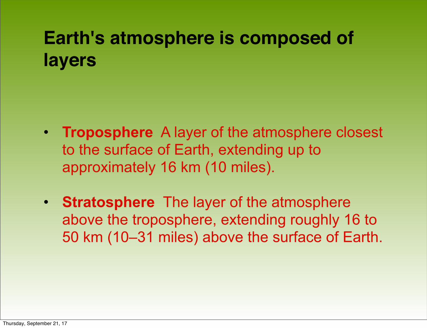
Earth's atmosphere is composed of layers
• Troposphere A layer of the atmosphere closest to the surface of Earth, extending up to approximately 16 km (10 miles).
• Stratosphere The layer of the atmosphere above the troposphere, extending roughly 16 to 50 km (10–31 miles) above the surface of Earth.
Thursday, September 21, 17
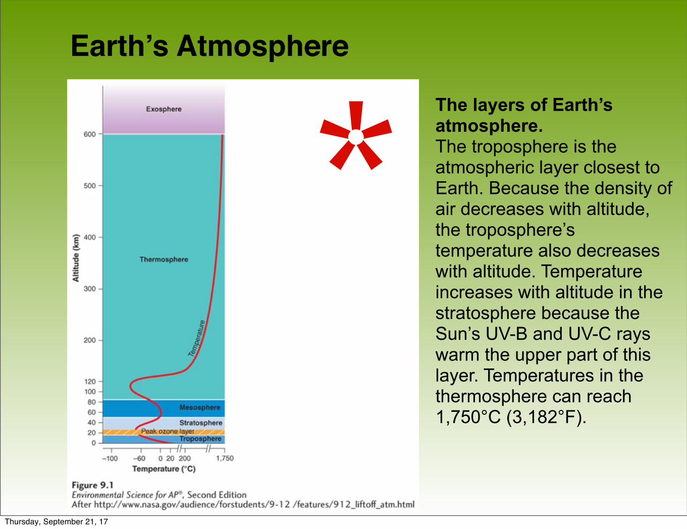
Earth’s Atmosphere
The layers of Earth’s atmosphere.The troposphere is the atmospheric layer closest to Earth. Because the density of air decreases with altitude, the troposphere’s temperature also decreases with altitude. Temperature increases with altitude in the stratosphere because the Sun’s UV-B and UV-C rays warm the upper part of this layer. Temperatures in the thermosphere can reach 1,750°C (3,182°F).
**Thursday, September 21, 17
The amount of solar energy reaching Earth varies with location
As the Sun's energy passes through the atmosphere and strikes land and water, it warms the surface of Earth. But this warming does not occur evenly across the planet because:
• The angle at which the Sun's rays strike varies.
• The amount of surface area over which the Sun's rays are distributed varies.
• Some areas of Earth reflect more solar energy than others.
Thursday, September 21, 17
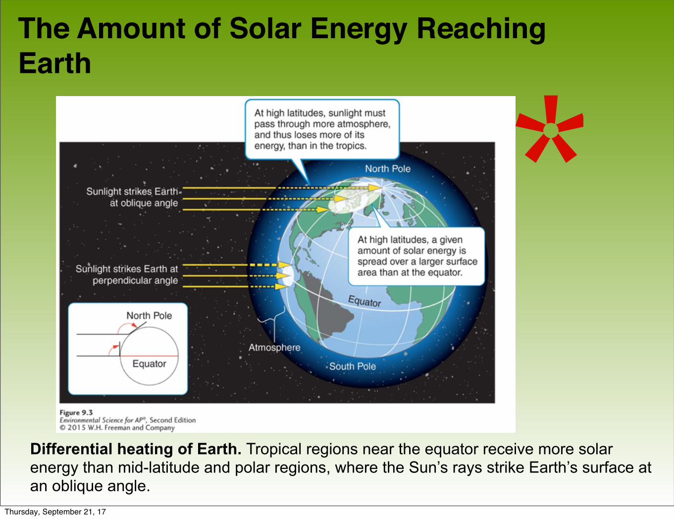
The Amount of Solar Energy Reaching Earth
Differential heating of Earth. Tropical regions near the equator receive more solar energy than mid-latitude and polar regions, where the Sun’s rays strike Earth’s surface at an oblique angle.
*Thursday, September 21, 17
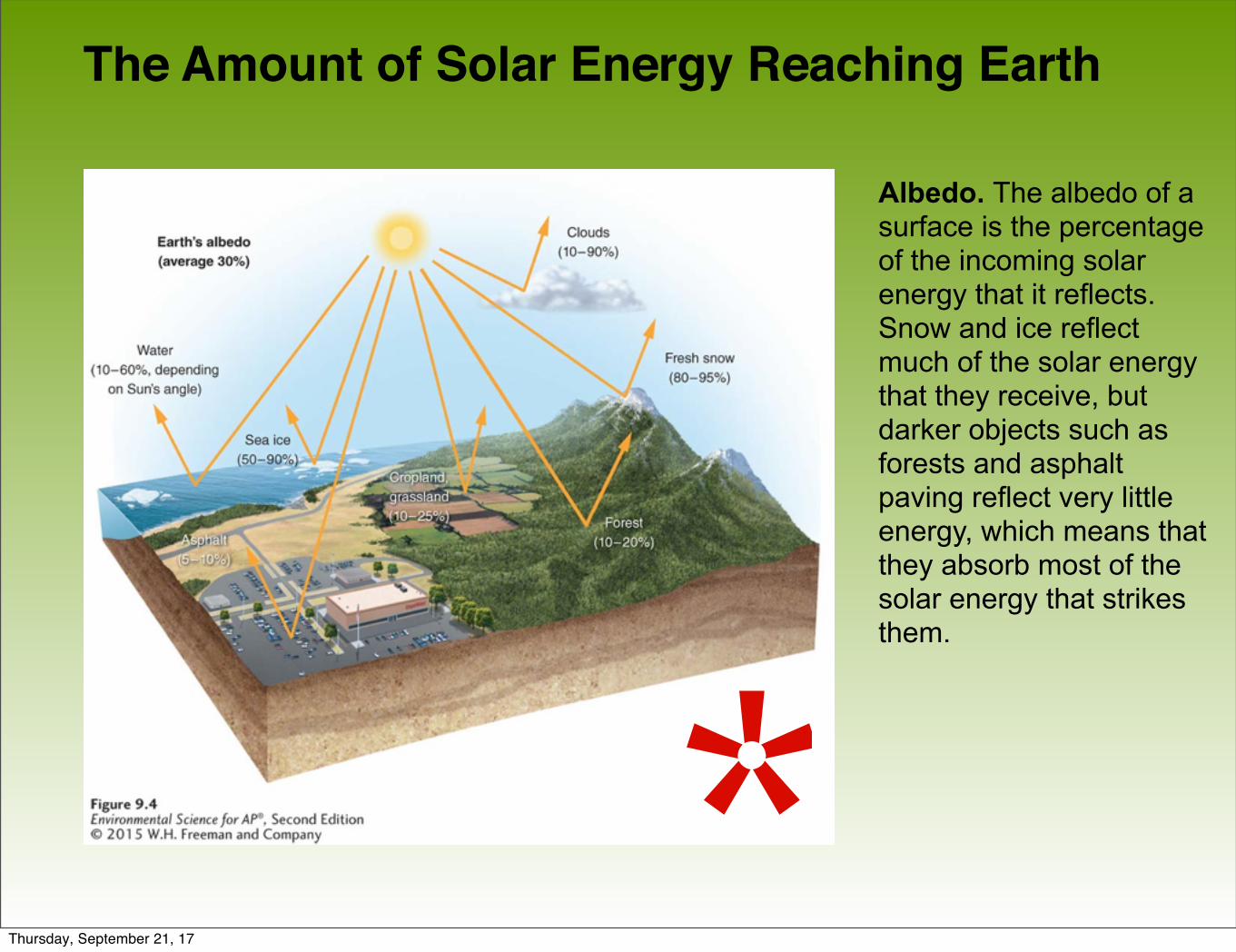
The Amount of Solar Energy Reaching Earth
Albedo. The albedo of a surface is the percentage of the incoming solar energy that it reflects. Snow and ice reflect much of the solar energy that they receive, but darker objects such as forests and asphalt paving reflect very little energy, which means that they absorb most of the solar energy that strikes them.
*Thursday, September 21, 17
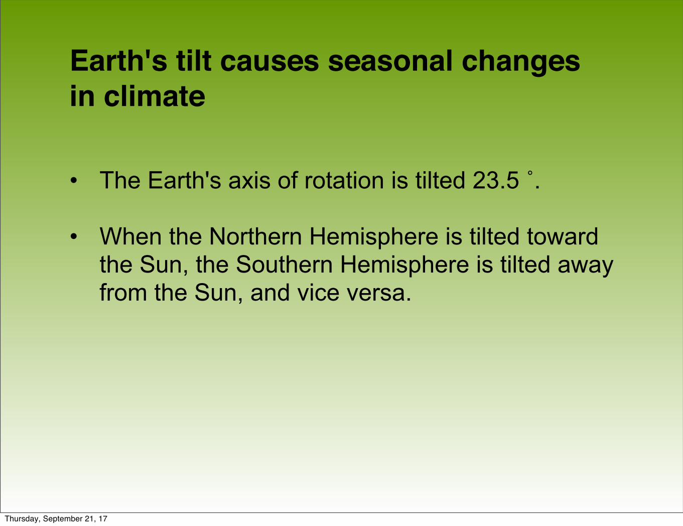
Earth's tilt causes seasonal changes in climate
• The Earth's axis of rotation is tilted 23.5 ˚.
• When the Northern Hemisphere is tilted toward the Sun, the Southern Hemisphere is tilted away from the Sun, and vice versa.
Thursday, September 21, 17
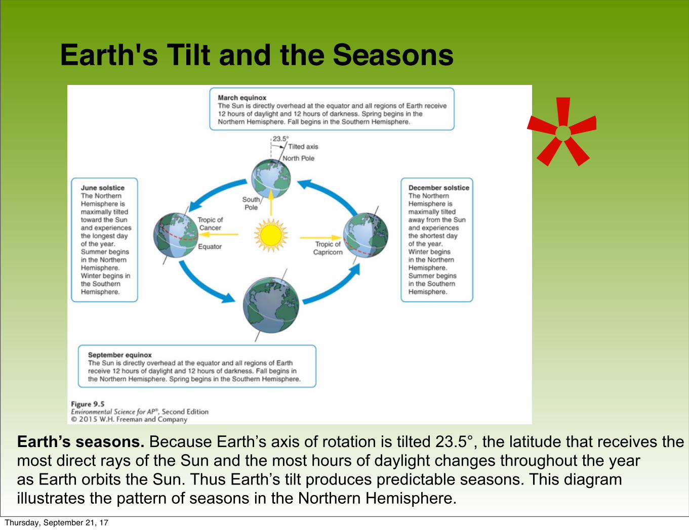
Earth's Tilt and the Seasons
Earth’s seasons. Because Earth’s axis of rotation is tilted 23.5°, the latitude that receives the most direct rays of the Sun and the most hours of daylight changes throughout the yearas Earth orbits the Sun. Thus Earth’s tilt produces predictable seasons. This diagram illustrates the pattern of seasons in the Northern Hemisphere.
*Thursday, September 21, 17
Module 10Air Currents
After reading this module you should be able to
• explain how the properties of air affect the way it moves in the atmosphere.
• identify the factors that drive atmospheric convection currents.
• describe how Earth’s rotation affects the movement of air currents.
Thursday, September 21, 17
Air has several important properties that determine how it circulates in the atmosphere• Saturation point The maximum amount of water
vapor in the air at a given temperature.
• Adiabatic cooling The cooling effect of reduced pressure on air as it rises higher in the atmosphere and expands.
• Adiabatic heating The heating effect of increased pressure on air as it sinks toward the surface of Earth and decreases in volume.
• Latent heat release The release of energy when
Thursday, September 21, 17
Atmospheric convection currents move air and moisture around the globe
• Atmospheric convection current Global patterns of air movement that are initiated by the unequal heating of Earth.
Thursday, September 21, 17

Atmospheric Convection Currents
Atmospheric currents.Warming at Earth’s surfacecauses air to rise up into the atmosphere where itexperiences lower pressures,adiabatic cooling, and latent heat release. The cool air near the top of the atmosphere is then displaced horizontally before it sinks back to Earth. As it sinks,the air experiences adiabaticheating and then moveshorizontally along the surface of Earth to complete the cycle.
Thursday, September 21, 17
Atmospheric Convection Currents
• Hadley cell A convection current in the atmosphere that cycles between the equator and 30° N and 30° S.
• Intertropical convergence zone (ITCZ) The latitude that receives the most intense sunlight, which causes the ascending branches of the two Hadley cells to converge.
• Polar cell A convection current in the atmosphere, formed by air that rises at 60° N and 60° S and sinks at the poles, 90° N and 90° S.
• Ferrell cell A convection current in the atmosphere that lies between Hadley cells and polar cells.
Thursday, September 21, 17
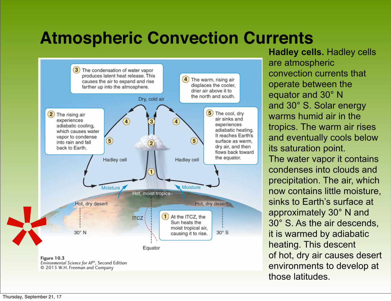
Atmospheric Convection CurrentsHadley cells. Hadley cells are atmosphericconvection currents that operate between the equator and 30° Nand 30° S. Solar energy warms humid air in the tropics. The warm air rises and eventually cools below its saturation point.The water vapor it containscondenses into clouds andprecipitation. The air, which now contains little moisture, sinks to Earth’s surface at approximately 30° N and 30° S. As the air descends, it is warmed by adiabatic heating. This descentof hot, dry air causes desertenvironments to develop at those latitudes.*
Thursday, September 21, 17
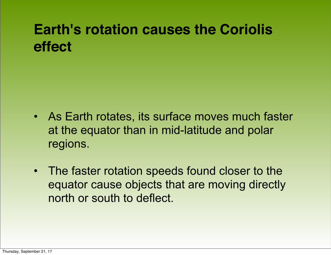
Earth's rotation causes the Coriolis effect
• As Earth rotates, its surface moves much faster at the equator than in mid-latitude and polar regions.
• The faster rotation speeds found closer to the equator cause objects that are moving directly north or south to deflect.
Thursday, September 21, 17

The Coriolis Effect
• Coriolis effect The deflection of an object’s path due to the rotation of Earth.
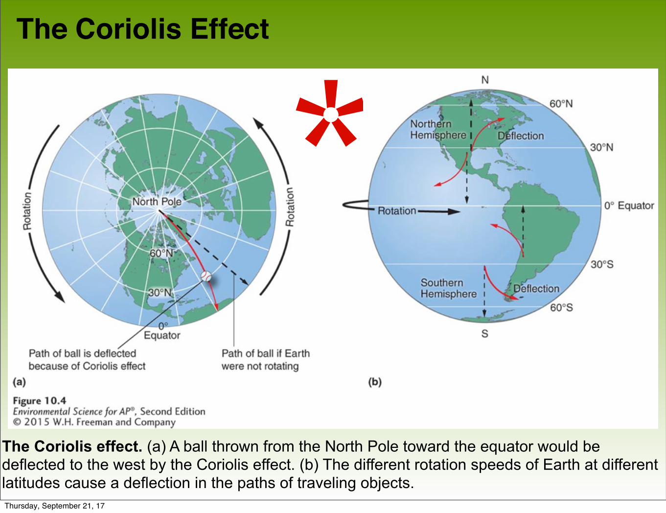
• The prevailing winds of the world are produced by a combination of atmospheric convection currents and the Coriolis effect.
Thursday, September 21, 17
The Coriolis Effect
The Coriolis effect. (a) A ball thrown from the North Pole toward the equator would be deflected to the west by the Coriolis effect. (b) The different rotation speeds of Earth at different latitudes cause a deflection in the paths of traveling objects.
*Thursday, September 21, 17
The Coriolis Effect Prevailing wind patterns. Prevailing wind patterns around the world are produced by a combination ofatmospheric convection currents and the Coriolis effect.
Wind patterns. Slowing move warm air and moisture from the tropics to the poles, they are largely responsible for the locations of biomes.
Thursday, September 21, 17
Thursday, September 21, 17
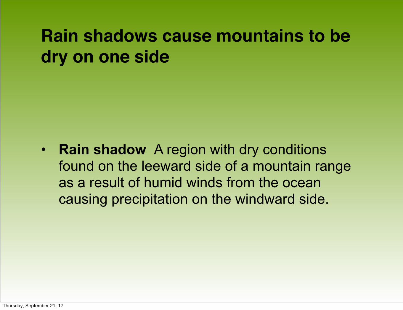
Rain shadows cause mountains to be dry on one side
• Rain shadow A region with dry conditions found on the leeward side of a mountain range as a result of humid winds from the ocean causing precipitation on the windward side.
Thursday, September 21, 17
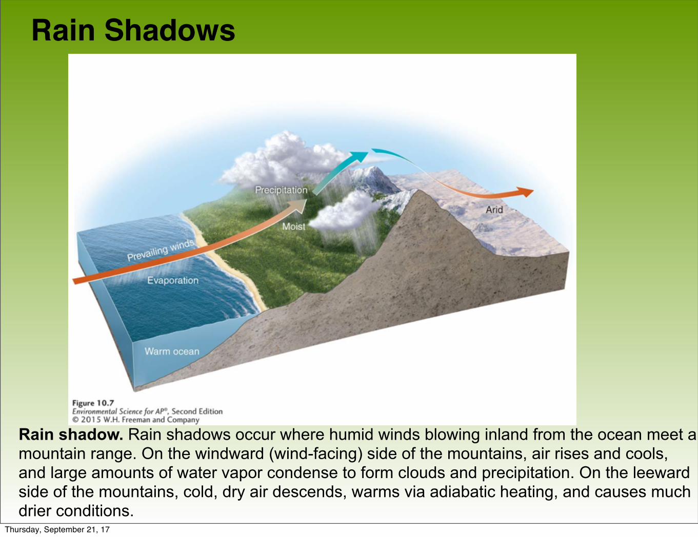
Rain Shadows
Rain shadow. Rain shadows occur where humid winds blowing inland from the ocean meet a mountain range. On the windward (wind-facing) side of the mountains, air rises and cools, and large amounts of water vapor condense to form clouds and precipitation. On the leeward side of the mountains, cold, dry air descends, warms via adiabatic heating, and causes much drier conditions.
Thursday, September 21, 17
• Air moving inland from the ocean contains a large amount of water vapor. When it meets the windward side of a mountain range (the side facing the wind), it rises and begins to experience adiabatic cooling.
• Because water vapor condenses as air cools, clouds form and precipitation falls.
• The presence of the mountain range causes large amounts of precipitation to fall on its windward side.
• The cold, dry air then travels to the other side of the mountain range (the leeward side), where it descends and experiences higher pressures, which cause adiabatic heating.
Rain Shadows
Thursday, September 21, 17
Module 11 Ocean Currents
After reading this module you should be able to
• describe the patterns of surface ocean circulation.
• explain the mixing of surface and deep ocean waters from thermohaline circulation.
• identify the causes and consequences of the El
Thursday, September 21, 17
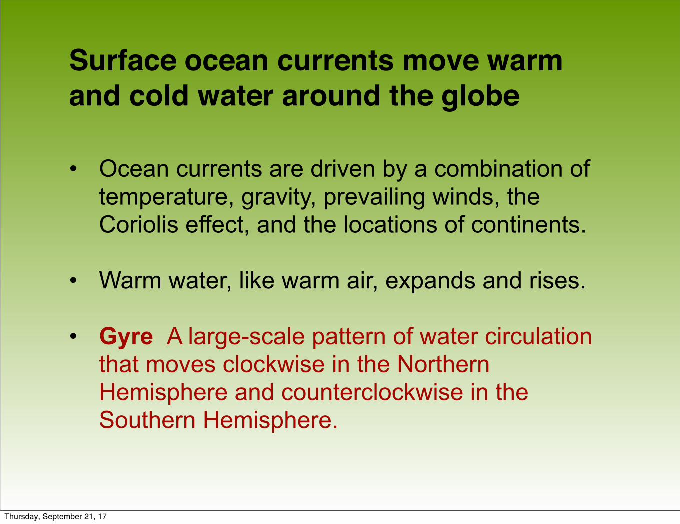
Surface ocean currents move warm and cold water around the globe
• Ocean currents are driven by a combination of temperature, gravity, prevailing winds, the Coriolis effect, and the locations of continents.
• Warm water, like warm air, expands and rises.
• Gyre A large-scale pattern of water circulation that moves clockwise in the Northern Hemisphere and counterclockwise in the Southern Hemisphere.
Thursday, September 21, 17
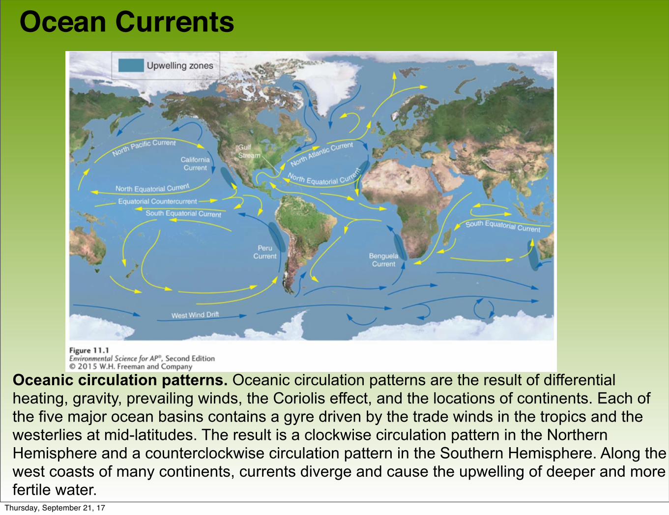
Ocean Currents
Oceanic circulation patterns. Oceanic circulation patterns are the result of differential heating, gravity, prevailing winds, the Coriolis effect, and the locations of continents. Each of the five major ocean basins contains a gyre driven by the trade winds in the tropics and the westerlies at mid-latitudes. The result is a clockwise circulation pattern in the Northern Hemisphere and a counterclockwise circulation pattern in the Southern Hemisphere. Along the west coasts of many continents, currents diverge and cause the upwelling of deeper and more fertile water.
Thursday, September 21, 17
Ocean Currents
• Upwelling The upward movement of ocean water toward the surface as a result of diverging currents.
• This upward movement of water brings nutrients from the ocean bottom that supports the large populations of producers, which in turn support large populations of fish.
Thursday, September 21, 17
Deep water currents circulate ocean water over long time periods
• Thermohaline circulation An oceanic circulation pattern that drives the mixing of surface water and deep water.
• Scientists believe this process is crucial for moving heat and nutrients around the globe.
• Thermohaline circulation appears to be driven by surface waters that contain unusually large amounts of salt.
Thursday, September 21, 17
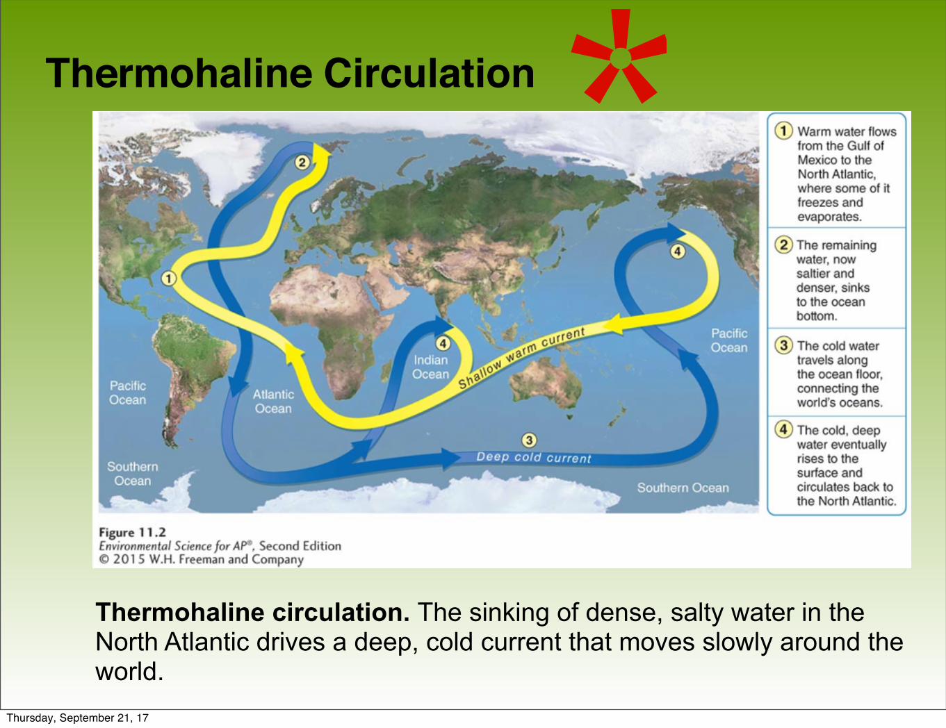
Thermohaline Circulation
Thermohaline circulation. The sinking of dense, salty water in the North Atlantic drives a deep, cold current that moves slowly around the world.
*
Thursday, September 21, 17
Deep ocean currents circulate ocean water over long time periods
• Some of the water that flows from the Gulf of Mexico to the North Atlantic freezes or evaporates, and the salt that remains behind increases the salt concentration of the water.
• This cold, salty water is relatively dense, so it sinks to the bottom of the ocean, mixing with deeper ocean waters.
• These two processes create the movement necessary to drive a deep, cold current that slowly moves past Antarctica and northward to
Thursday, September 21, 17
The El-Niño Southern Oscillation is caused by a shift in ocean currents
• El Niño–Southern Oscillation (ENSO) A reversal of wind and water currents in the South Pacific.
Thursday, September 21, 17
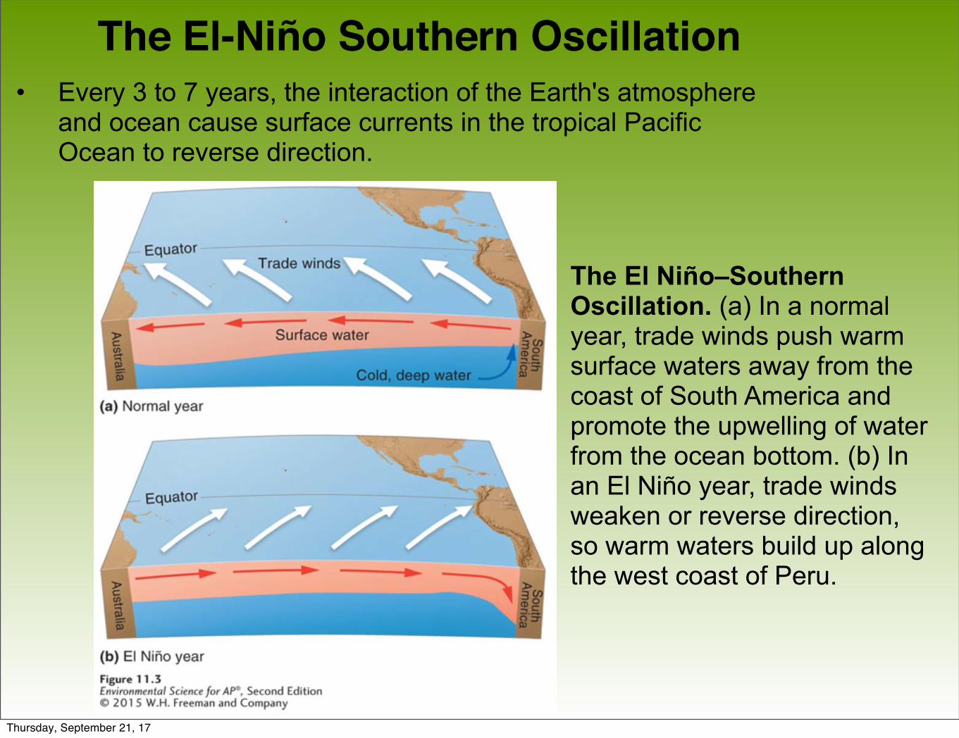
The El-Niño Southern Oscillation• Every 3 to 7 years, the interaction of the Earth's atmosphere
and ocean cause surface currents in the tropical Pacific Ocean to reverse direction.
The El Niño–Southern Oscillation. (a) In a normal year, trade winds push warm surface waters away from the coast of South America and promote the upwelling of water from the ocean bottom. (b) In an El Niño year, trade winds weaken or reverse direction, so warm waters build up along the west coast of Peru.
Thursday, September 21, 17
Thursday, September 21, 17
The El-Niño Southern Oscillation
• First, the trade winds near South America weaken.
• This weakening allows warm equatorial water from the western Pacific to move eastward toward the west coast of South America.
• The movement of warm water and air toward South America suppresses upwelling off the coast of Peru and decreases productivity there, reducing fish populations near the coast.
• These periodic changes in wind and ocean currents are collectively called the El-Niño Southern Oscillation, or ENSO.
Thursday, September 21, 17
Module 12 Terrestrial Biomes
After reading this module you should be able to
• explain how we define terrestrial biomes.
• interpret climate diagrams.
• identify the nine terrestrial biomes.
Thursday, September 21, 17
Terrestrial biomes are defined by dominant plant growth forms
• Terrestrial biome A geographic region categorized by a particular combination of average annual temperature, annual precipitation, and distinctive plant growth forms on land.
• Aquatic biome An aquatic region characterized by a particular combination of salinity, depth, and water flow.
Thursday, September 21, 17
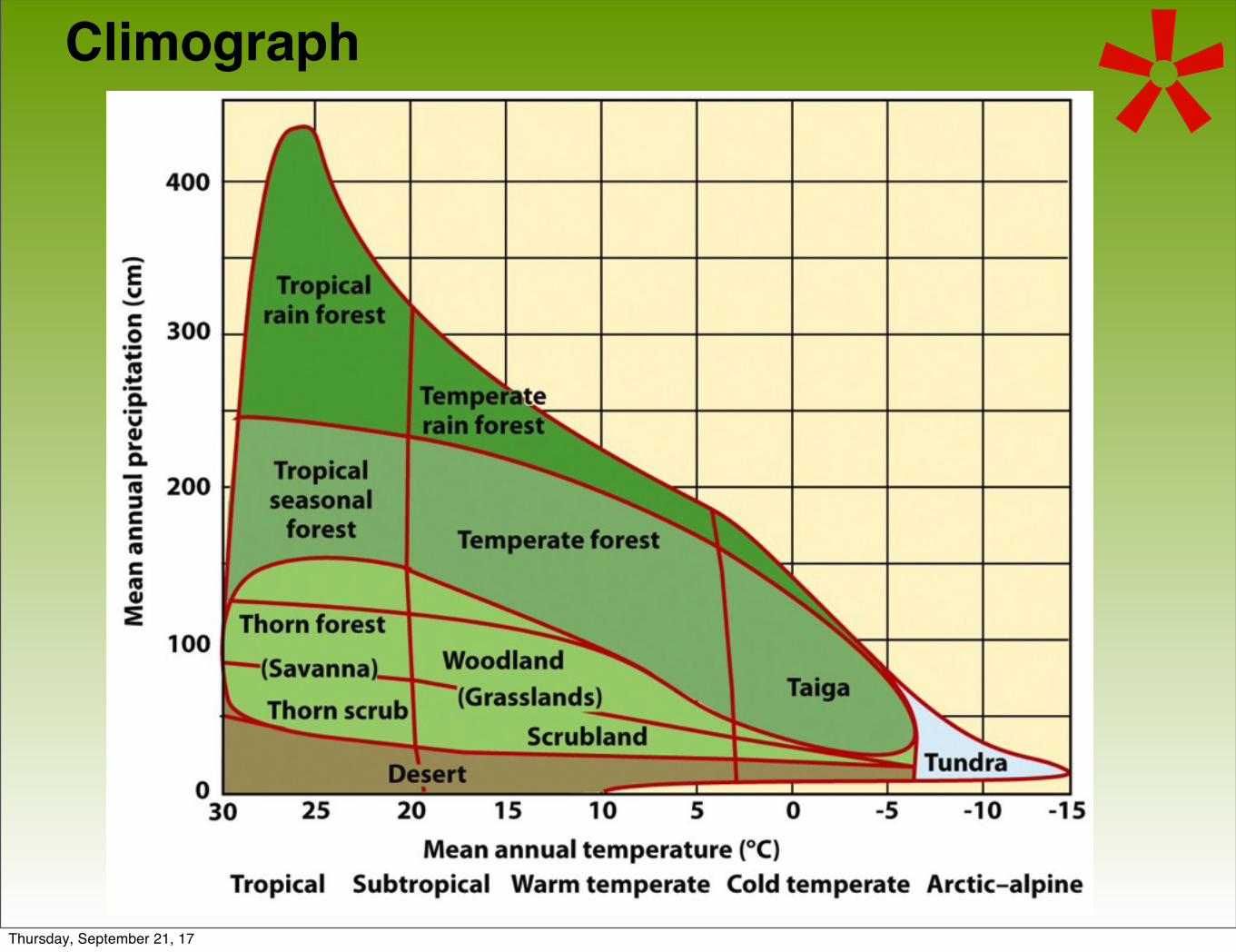
Climograph *
Thursday, September 21, 17
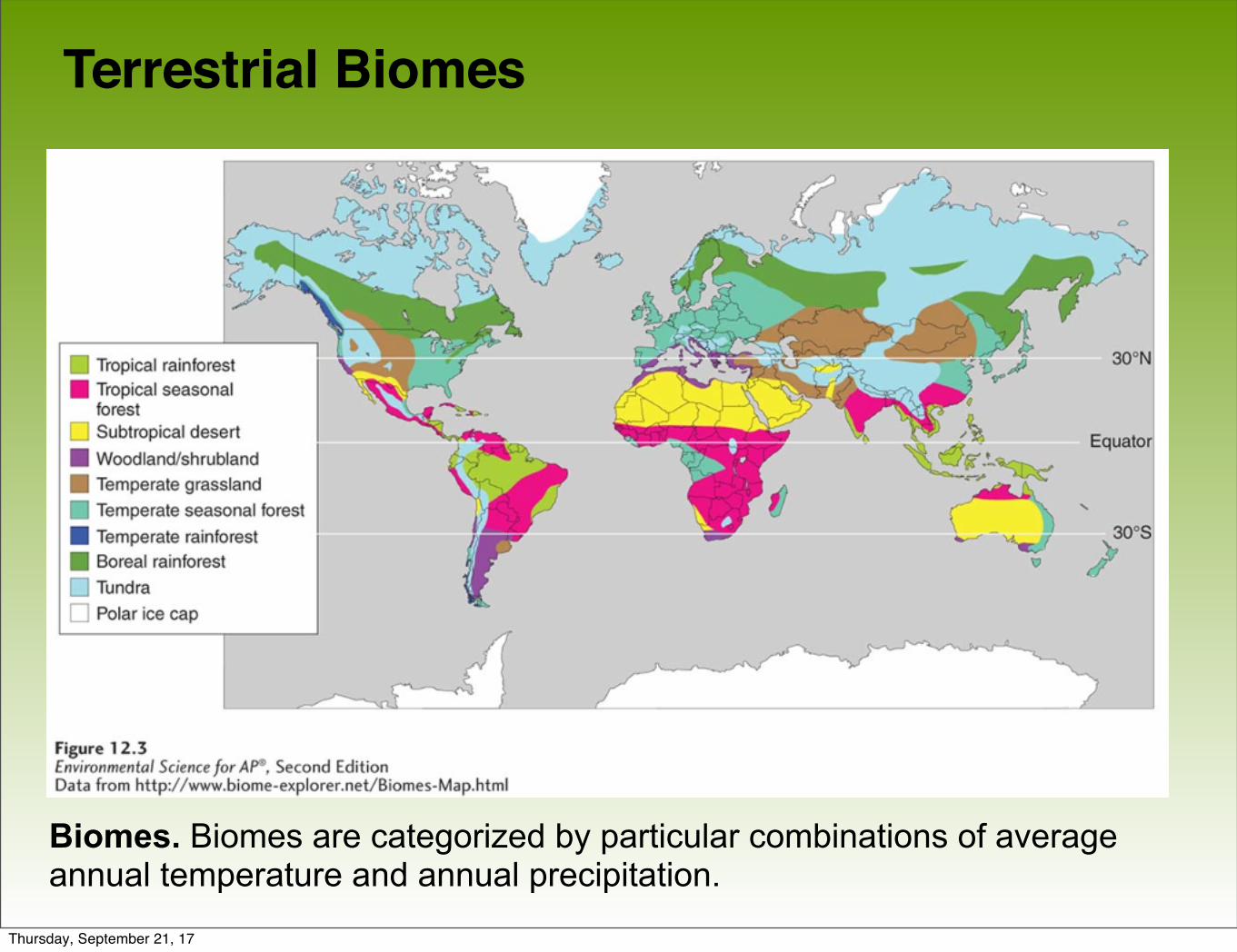
Terrestrial Biomes
Biomes. Biomes are categorized by particular combinations of average annual temperature and annual precipitation.
Thursday, September 21, 17
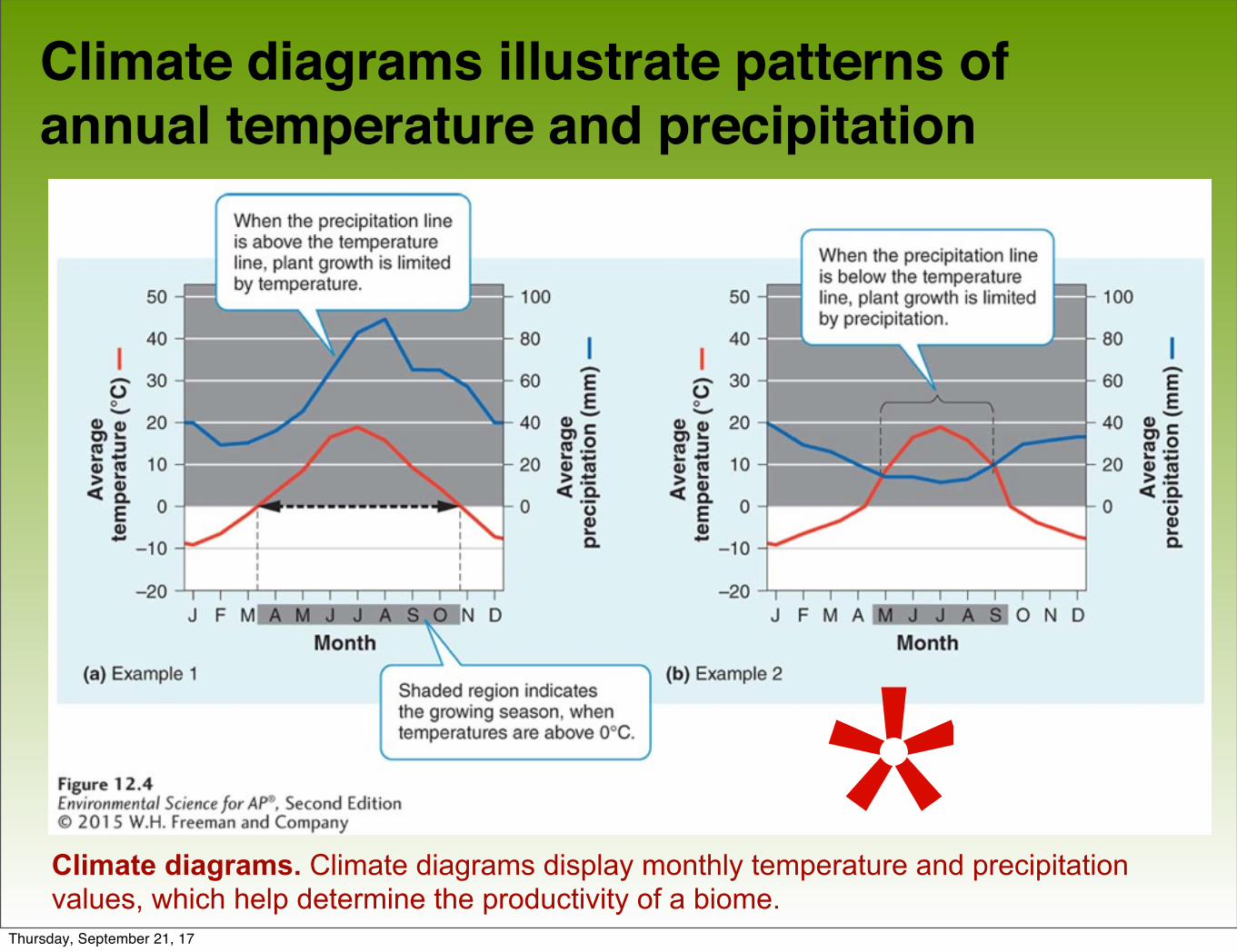
Climate diagrams illustrate patterns of annual temperature and precipitation
Climate diagrams. Climate diagrams display monthly temperature and precipitationvalues, which help determine the productivity of a biome.*Thursday, September 21, 17
Terrestrial biomes range from tundra to tropical forests
There are nine terrestrial biomes:
• Tundra
• Boreal Forest
• Temperate rainforest
• Temperate seasonal forest
• Woodland/shrubland
• Temperate grassland/cold desert
• Tropical rainforest
Thursday, September 21, 17
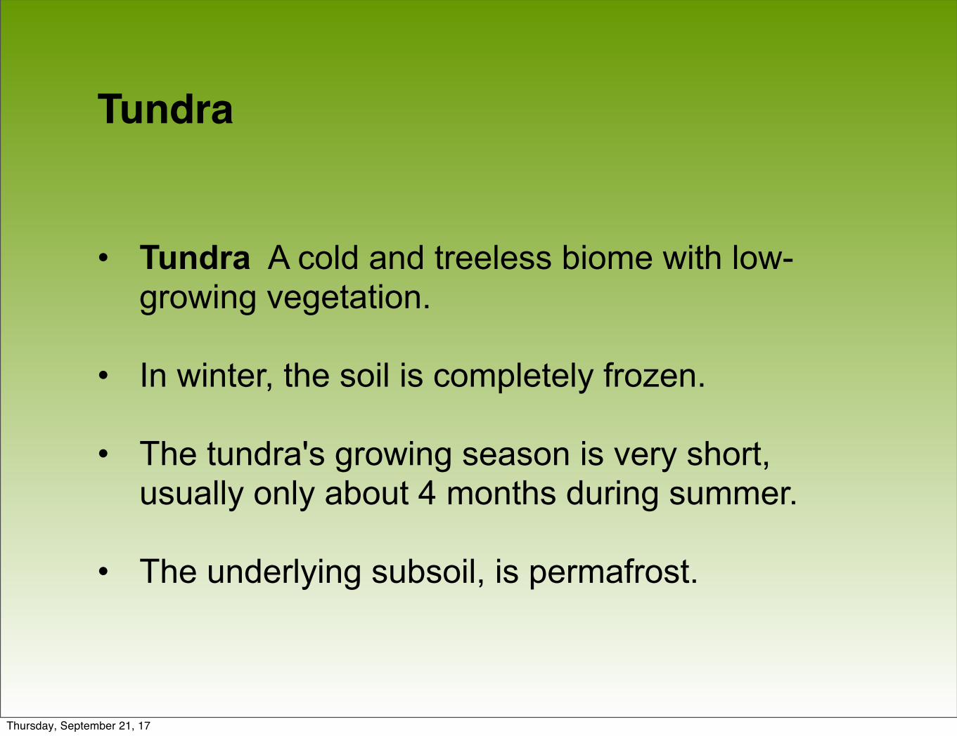
Tundra
• Tundra A cold and treeless biome with low-growing vegetation.
• In winter, the soil is completely frozen.
• The tundra's growing season is very short, usually only about 4 months during summer.
• The underlying subsoil, is permafrost.
Thursday, September 21, 17
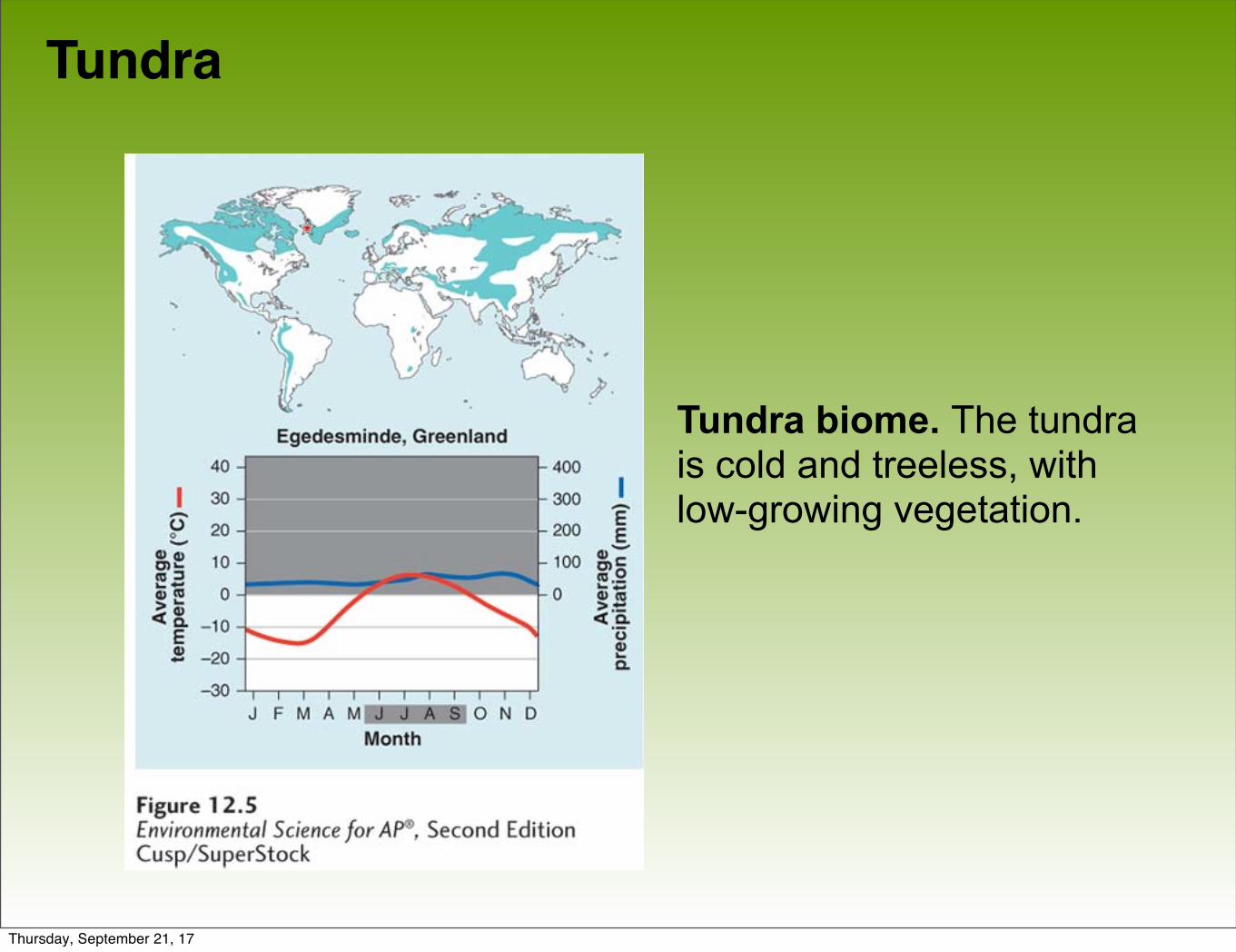
Tundra
Tundra biome. The tundra is cold and treeless, with low-growing vegetation.
Thursday, September 21, 17
Boreal Forest
• Boreal forest A forest biome made up primarily of coniferous evergreen trees that can tolerate cold winters and short growing seasons.
• Boreal forests are found between about 50˚ and 60˚ N in Europe, Russia and North America.
• This subarctic biome has a very cold climate, and plant growth is more constrained by temperature than precipitation.
• The soil is nutrient-poor due to slow decomposition.
Thursday, September 21, 17
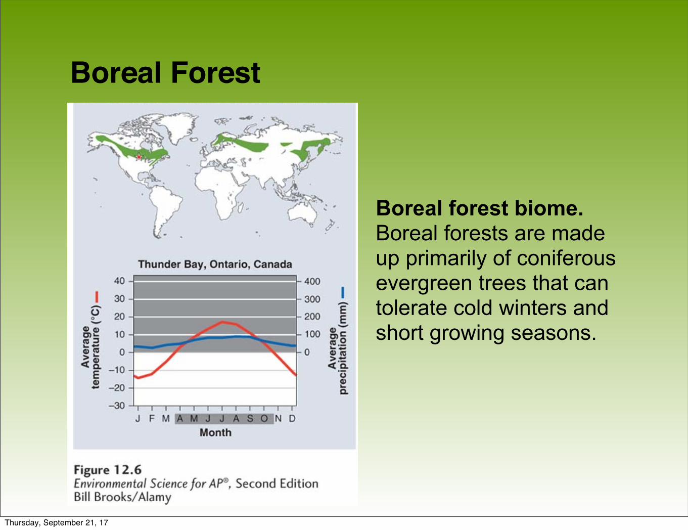
Boreal Forest
Boreal forest biome. Boreal forests are madeup primarily of coniferous evergreen trees that can tolerate cold winters and short growing seasons.
Thursday, September 21, 17
Temperate Rainforest• Temperate rainforest A coastal biome typified by moderate
temperatures and high precipitation.
• Coastal biome found along the west coast of North America from northern California to Alaska, in southern Chile, on the west coast of New Zealand, and on the island of Tasmania.
• Ocean currents moderate temperature fluctuations and provide a source of water vapor.
• Nearly 12-month growing season where winters are rainy and summers are foggy.
• Mild temperatures and high precipitation support growth of very large trees.
Thursday, September 21, 17
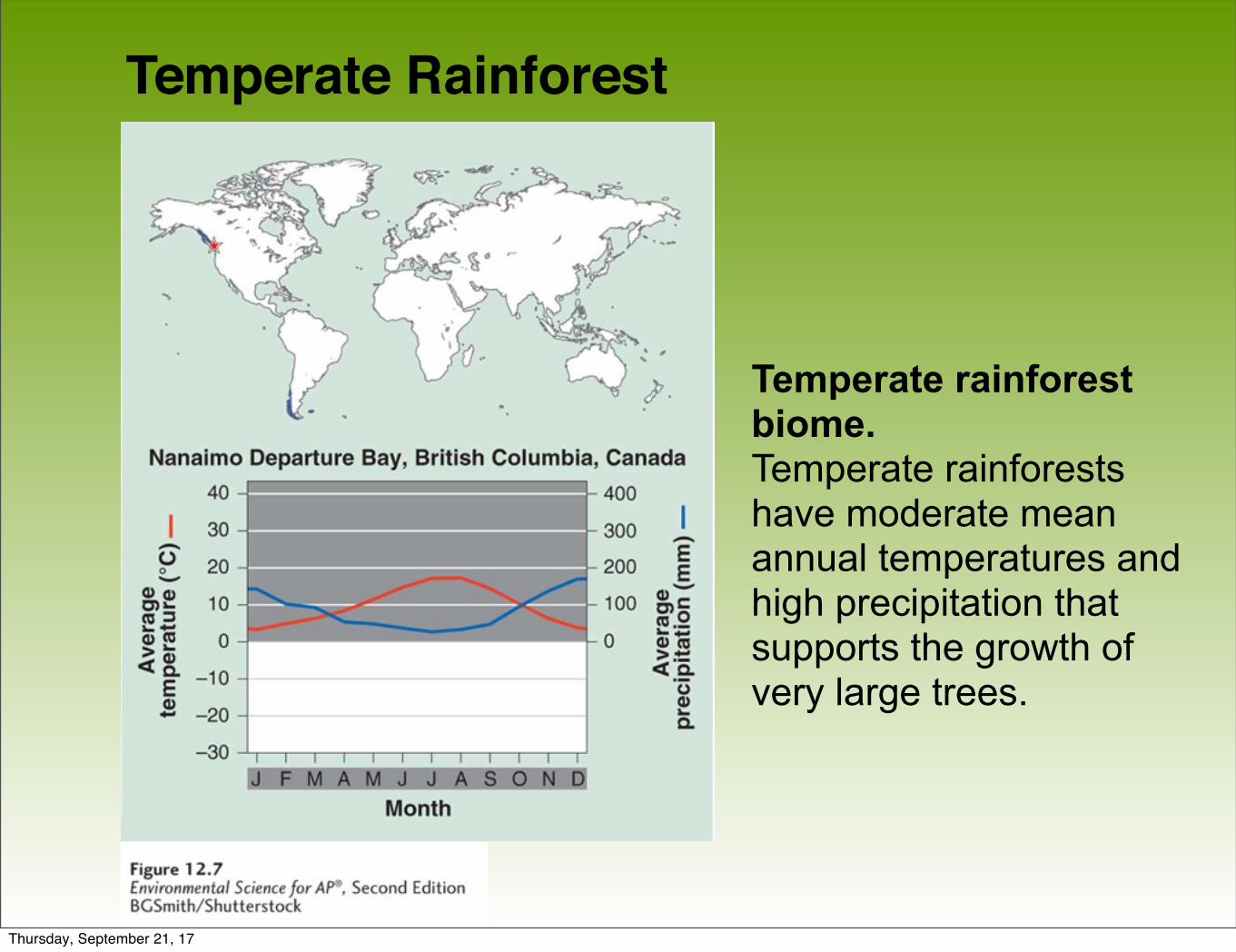
Temperate Rainforest
Temperate rainforest biome. Temperate rainforests have moderate mean annual temperatures and high precipitation that supports the growth of very large trees.
Thursday, September 21, 17
Temperate Seasonal Forest
• Temperate seasonal forest A biome with warm summers and cold winters with over 1 m (39 inches) of precipitation annually.
• Receives over 1 m (39 inches) of precipitation annually.
• Found in the eastern United States, Japan, China, Europe, Chile and eastern Australia.
• Dominated by broadleaf deciduous trees such as beech, male, oak and hickory.
• Warmer summer temperatures favor decomposition; soils generally contain more nutrients than those of boreal forests.
Thursday, September 21, 17
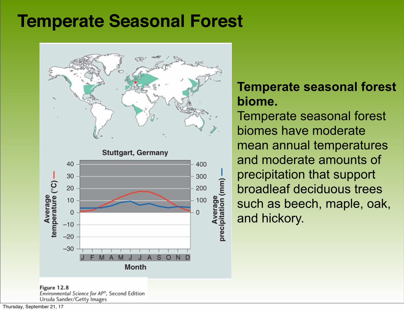
Temperate Seasonal Forest
Temperate seasonal forest biome.Temperate seasonal forestbiomes have moderatemean annual temperaturesand moderate amounts ofprecipitation that supportbroadleaf deciduous trees such as beech, maple, oak, and hickory.
Thursday, September 21, 17
Woodland/Shrubland
• Woodland/shrubland A biome characterized by hot, dry summers and mild, rainy winters.
• Found on the coast of southern California, southern Australia, southern Africa and in the area surrounding the Mediterranean Sea.
• There is a 12-month growing season, but plant growth is constrained by low precipitation in summer and by relatively low temperatures in winter.
Thursday, September 21, 17
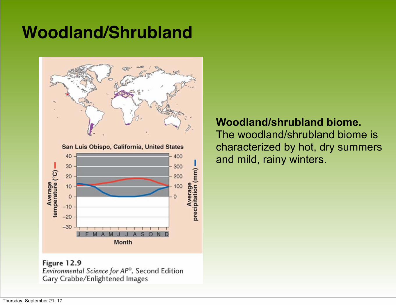
Woodland/Shrubland
Woodland/shrubland biome. The woodland/shrubland biome is characterized by hot, dry summers and mild, rainy winters.
Thursday, September 21, 17

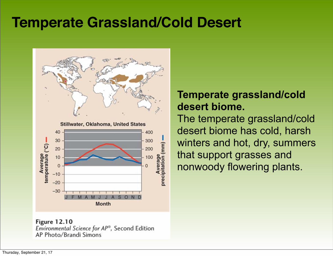
Temperate Grassland/Cold Desert
• Temperate grassland/cold desert A biome characterized by cold, harsh winters, and hot, dry summers.
• Lowest average annual precipitation of any temperate biome.
• Found in the Great Plains of North America, in South America, and in central Asia and eastern Europe.
• Plant growth constrained by both insufficient precipitation in summer and cold temperatures in winter.
• Plants include grasses and non woody flowering plants well-adapted to wildfires and frequent grazing by animals.
Thursday, September 21, 17
Temperate Grassland/Cold Desert
Temperate grassland/cold desert biome.The temperate grassland/cold desert biome has cold, harsh winters and hot, dry, summers that support grasses and nonwoody flowering plants.
Thursday, September 21, 17
Tropical Rainforest
• Tropical rainforest A warm and wet biome found between 20° N and 20° S of the equator, with little seasonal temperature variation and high precipitation.
• Average annual temperatures exceed 20˚C.
• Found in Central and South America, Africa, Southeast Asia, and northeastern Australia.
• Precipitation occurs frequently; warm and wet with little temperature variation.
• Contain more biodiversity per hectare than any other terrestrial biome; contain up to two-thirds of Earth's terrestrial species.
Thursday, September 21, 17
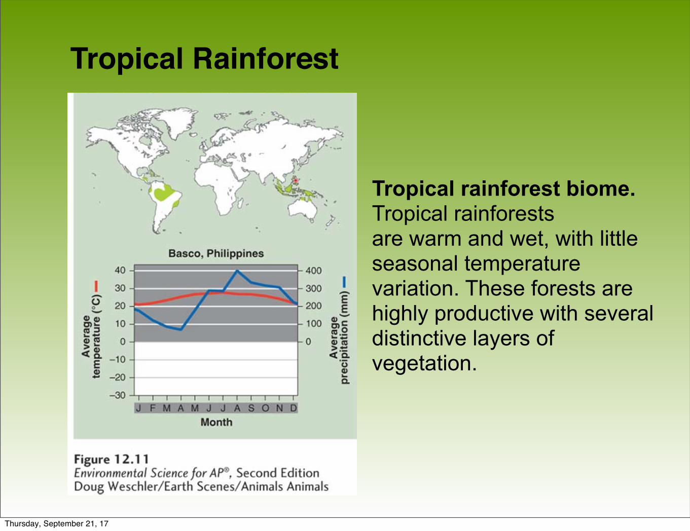
Tropical Rainforest
Tropical rainforest biome. Tropical rainforestsare warm and wet, with little seasonal temperature variation. These forests are highly productive with several distinctive layers ofvegetation.
Thursday, September 21, 17
Tropical Seasonal Forest/ Savanna
• Tropical seasonal forest/savanna A biome marked by warm temperatures and distinct wet and dry seasons.
• Tropical seasonal forests are common in much of Central America, on the Atlantic coast of South America, in southern Asia, in northwestern Australia, and in sub-Saharan Africa.
• Soil in this biome is fairly fertile and can be farmed due to high decomposition rates, but the low amount of precipitation constrains plants from using the soil nutrients that are released.
• Grasses and scattered deciduous trees are common.
Thursday, September 21, 17
Tropical Seasonal Forest/ Savanna
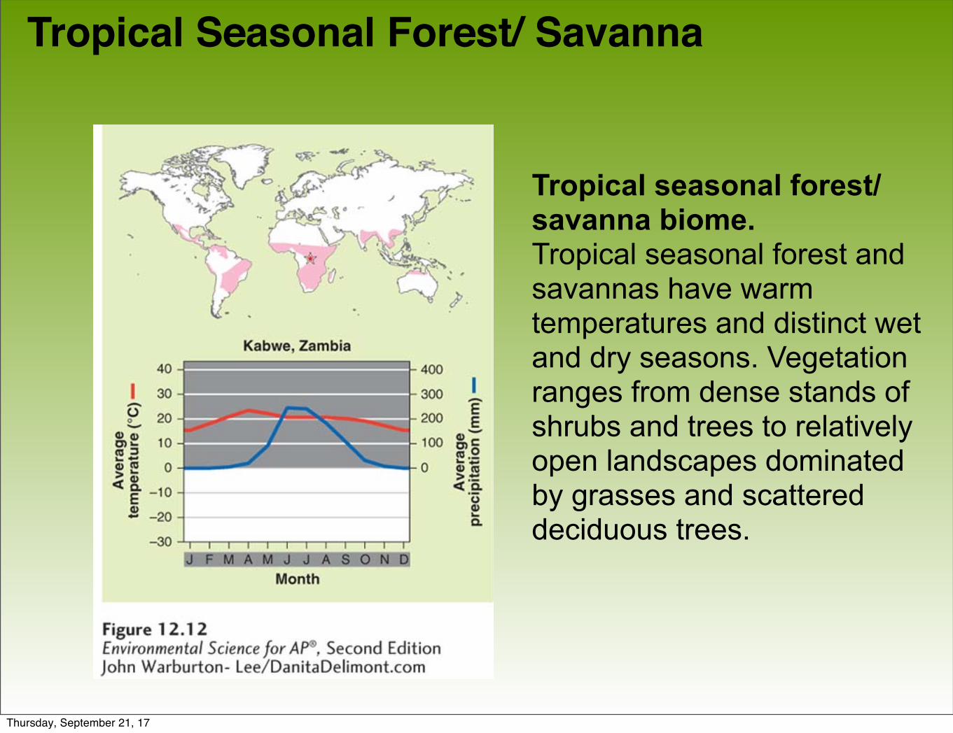
Tropical seasonal forest/savanna biome. Tropical seasonal forest and savannas have warmtemperatures and distinct wet and dry seasons. Vegetation ranges from dense stands of shrubs and trees to relatively open landscapes dominated by grasses and scattered deciduous trees.
Thursday, September 21, 17
Subtropical Desert
• Subtropical desert A biome prevailing at approximately 30° N and 30° S, with hot temperatures, extremely dry conditions, and sparse vegetation.
• The Mojave Desert in the southwestern United States, the Sahara in Africa, the Arabian Desert of the Middle East and the Great Victoria Desert of Australia are all subtropical deserts.
• Cacti, euphorbs and succulent plants are well adapted to this biome.
Thursday, September 21, 17
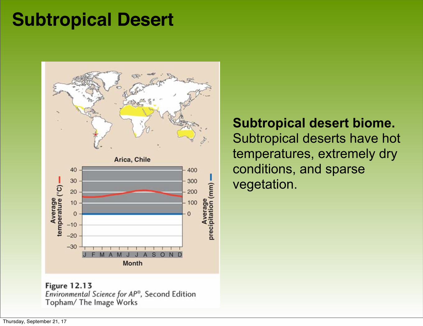
Subtropical Desert
Subtropical desert biome. Subtropical deserts have hot temperatures, extremely dry conditions, and sparsevegetation.
Thursday, September 21, 17
Module 13 Aquatic Biomes
After reading this module you should be able to
• identify the major freshwater biomes.
• identify the major marine biomes.
Thursday, September 21, 17
Freshwater biomes have low salinity
Freshwater biomes include:
• Streams and rivers
• Lakes and ponds
• Freshwater wetlands
Thursday, September 21, 17
Streams and Rivers
• Flowing fresh water that may originate from underground springs or as runoff from rain or melting snow.
• Streams are typically narrow and carry relatively small amounts of water where rivers are usually wider and carry larger amounts of water.
Thursday, September 21, 17
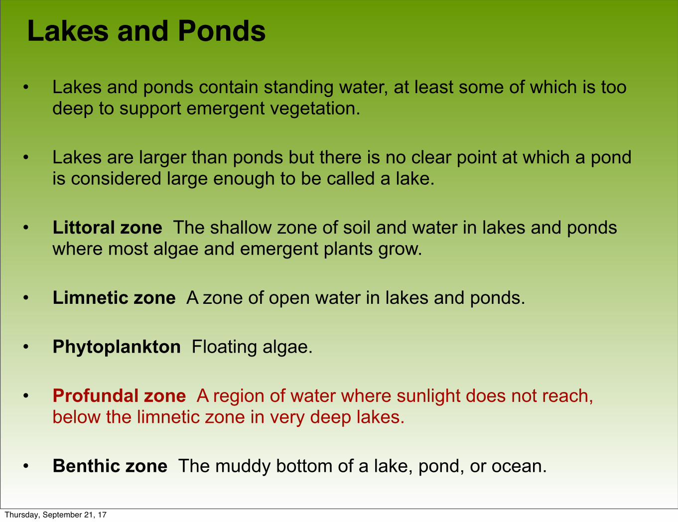
Lakes and Ponds• Lakes and ponds contain standing water, at least some of which is too
deep to support emergent vegetation.
• Lakes are larger than ponds but there is no clear point at which a pond is considered large enough to be called a lake.
• Littoral zone The shallow zone of soil and water in lakes and ponds where most algae and emergent plants grow.
• Limnetic zone A zone of open water in lakes and ponds.
• Phytoplankton Floating algae.
• Profundal zone A region of water where sunlight does not reach, below the limnetic zone in very deep lakes.
• Benthic zone The muddy bottom of a lake, pond, or ocean.
Thursday, September 21, 17
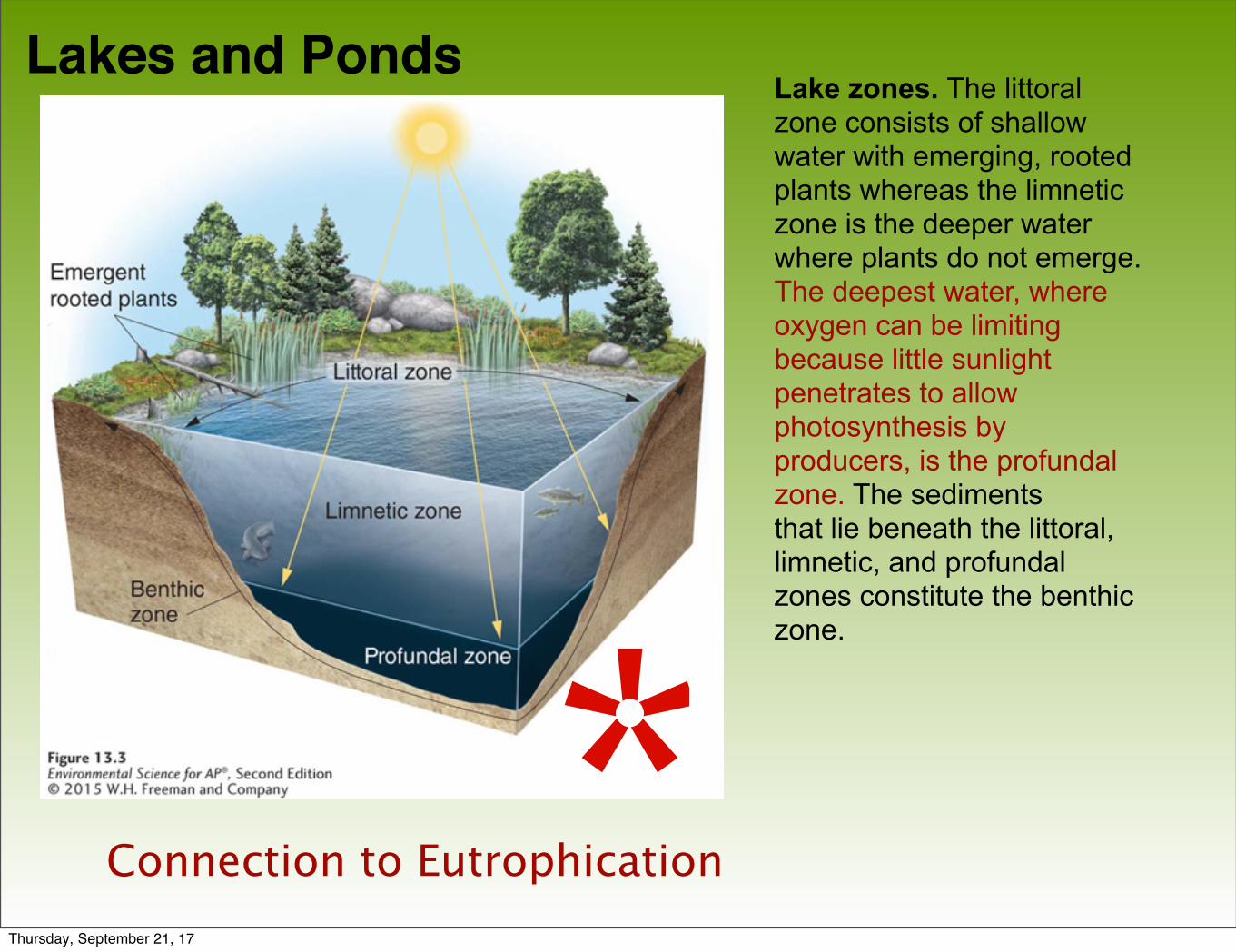
Lakes and PondsLake zones. The littoral zone consists of shallowwater with emerging, rooted plants whereas the limnetic zone is the deeper water where plants do not emerge. The deepest water, where oxygen can be limiting because little sunlight penetrates to allowphotosynthesis by producers, is the profundal zone. The sedimentsthat lie beneath the littoral, limnetic, and profundal zones constitute the benthic zone.
*Connection to EutrophicationThursday, September 21, 17
Lakes and Ponds
Lakes are classified by their level of primary productivity.
• Oligotrophic Describes a lake with a low level of productivity.
• Mesotrophic Describes a lake with a moderate level of productivity.
• Eutrophic Describes a lake with a high level of
Thursday, September 21, 17
Freshwater Wetlands
• Freshwater wetlands An aquatic biome that is submerged or saturated by water for at least part of each year, but shallow enough to support emergent vegetation.
• Freshwater wetlands are among the most productive biomes on Earth.
• Freshwater wetlands provide several ecosystem services. (ie. lessen the severity of floods and droughts, filter water, recharge groundwater supplies
Thursday, September 21, 17
Marine biomes have high salinity
There are five marine biomes:
• Salt marsh
• Mangrove swamp
• Intertidal zone
• Coral reefs
Thursday, September 21, 17
Salt Marsh
• Salt marsh A marsh containing nonwoody emergent vegetation, found along the coast in temperate climates.
• Found along the coast in temperate climates.
• The salt marsh is one of the most productive biomes in the world.
Thursday, September 21, 17
Mangrove Swamp
• Mangrove swamp A swamp that occurs along tropical and subtropical coasts, and contains salt tolerant trees with roots submerged in water.
• Mangrove trees are salt tolerant and help protect the coastlines from erosion and storm damage.
Thursday, September 21, 17
Intertidal Zone
• Intertidal zone The narrow band of coastline between the levels of high tide and low tide.
• Waves that crash onto the shore in this biome can make it a challenge for organisms to hold on and not get washed away.
Thursday, September 21, 17
Open Ocean
• Open ocean Deep ocean water, located away from the shoreline where sunlight can no longer reach the ocean bottom.
• Photic zone The upper layer of ocean water in the ocean that receives enough sunlight for photosynthesis.
• Aphotic zone The deeper layer of ocean water that lacks sufficient sunlight for photosynthesis.
• Chemosynthesis A process used by some
Thursday, September 21, 17
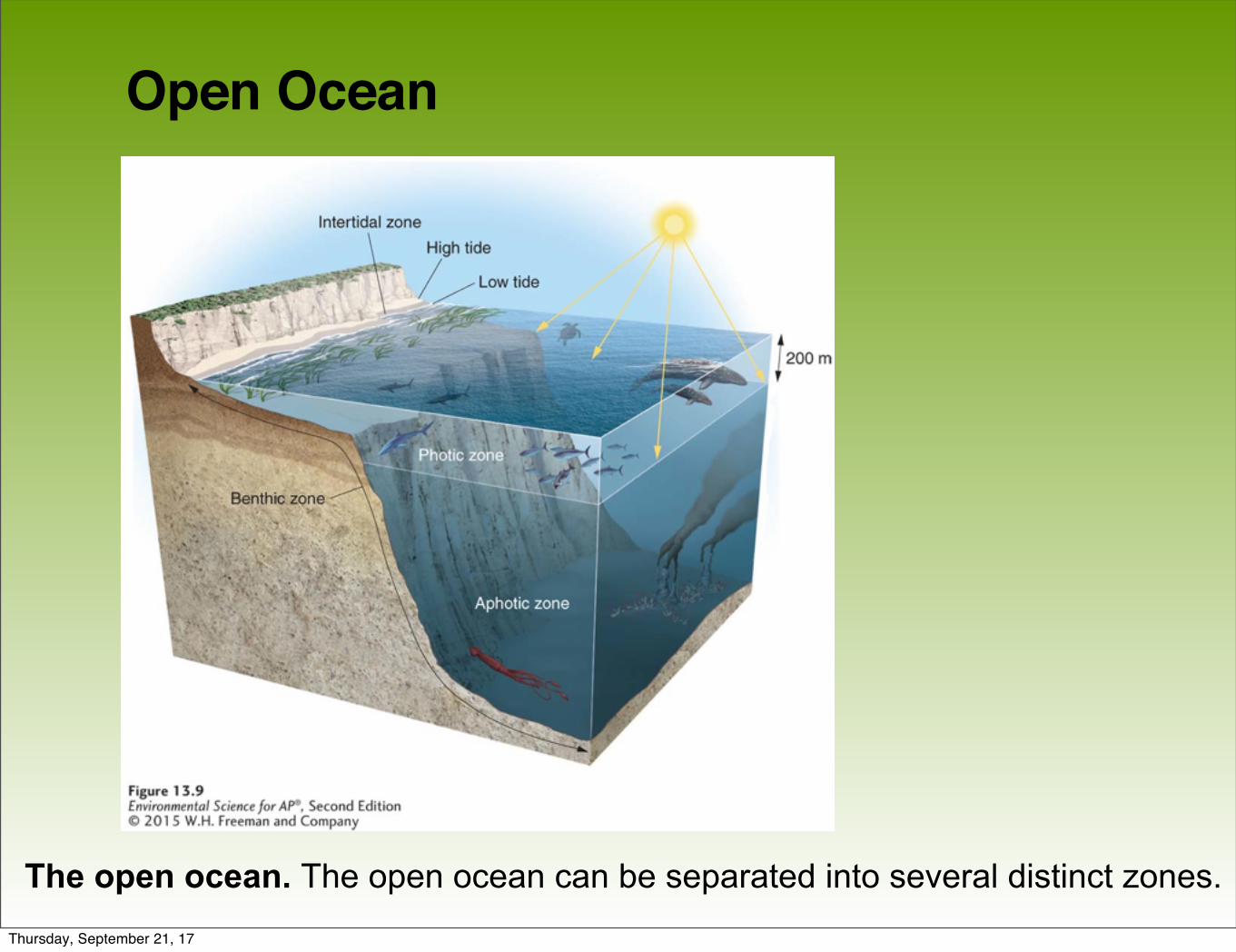
Open Ocean
The open ocean. The open ocean can be separated into several distinct zones.Thursday, September 21, 17
Coral Reefs
• Coral reef The most diverse marine biome on Earth, found in warm, shallow waters beyond the shoreline.
• Earth's most diverse marine biome even though coral reefs are found in water that is relatively poor in nutrients and food.
• Coral bleaching A phenomenon in which algae inside corals die, causing the corals to turn white.
Thursday, September 21, 17
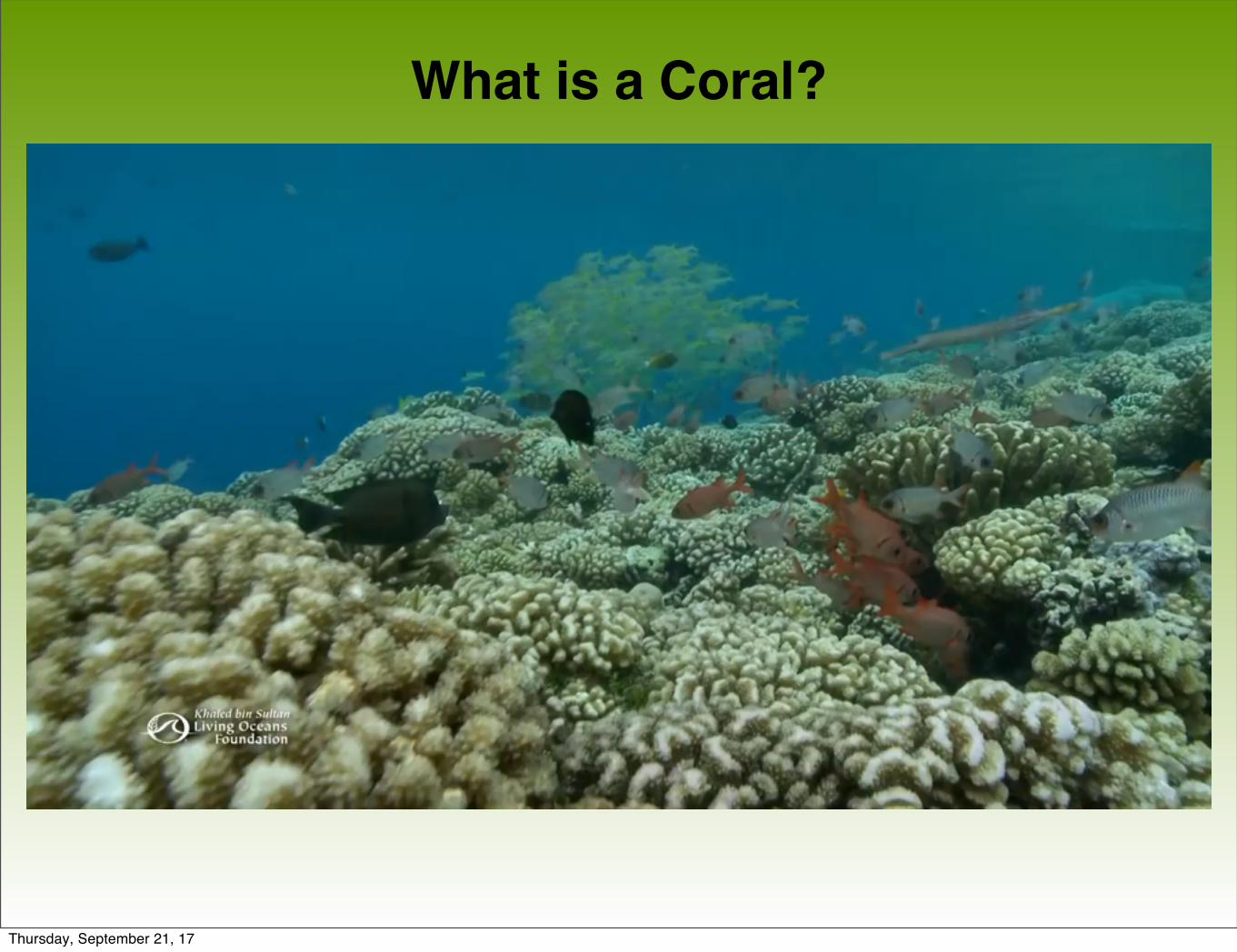
What is a Coral?
Thursday, September 21, 17

Coral Bleaching
Thursday, September 21, 17

Why Does it Matter? :50 to the end
Thursday, September 21, 17