CHAPTER 4 DESCRIPTION OF SOILS
12
Chapter 4 Page 4.1 CHAPTER 4 DESCRIPTION OF SOILS 4.1 INTRODUCTION The aim of this chapter is to present the physical, mineralogical and geotechnical properties of the soils in the study area, as determined during field work and subsequent laboratory investigations. Chemical properties of the soils are discussed in Chapters 5 and 6. The soil sequence along the investigated transect is described and the variations in grading, geotechnical and mineralogical properties within and between the different soil units are shown. 4.2 METHODOLOGY 4.2.1 Field work Fieldwork was carried out intermittently between January 1998 and June 1998. Twenty-eight test pits along a transect were excavated by means of a truck-mounted backactor (the positions of the test pits are shown in Figure 3.1). The test pits were excavated to a maximum depth of 2,40 m to detennine depth to bedrock, pedological conditions and the possible presence of perched ground water bodies. All test pits were logged according to the MCCSSO (moisture, colour, consistency, structure, soil type and origin) method proposed by Jennings, Brink & Williams (1973). Eighty-eight disturbed samples were taken from individual horizons from the test pits for geotechnical, mineralogical and geochemical testing. Seven shallow holes were excavated to a depth not exceeding 0,60 m to take soil samples from the upper soil profile. 4.2.2 Laboratory work Eighty-eight samples were tested for their geotechnical properties. Thirty samples are from the tailings and the remaining fifty-eight are from the underlying soils. A schedule of the routine Chapter 4 Description of soils
Transcript of CHAPTER 4 DESCRIPTION OF SOILS

Chapter 4 Page 4.1
CHAPTER 4 DESCRIPTION OF SOILS
4.1 INTRODUCTION
The aim of this chapter is to present the physical, mineralogical and geotechnical properties of
the soils in the study area, as determined during field work and subsequent laboratory
investigations. Chemical properties of the soils are discussed in Chapters 5 and 6. The soil
sequence along the investigated transect is described and the variations in grading, geotechnical
and mineralogical properties within and between the different soil units are shown.
4.2 METHODOLOGY
4.2.1 Field work
Fieldwork was carried out intermittently between January 1998 and June 1998. Twenty-eight test
pits along a transect were excavated by means ofa truck-mounted backactor (the positions of the
test pits are shown in Figure 3.1). The test pits were excavated to a maximum depth of 2,40 m
to detennine depth to bedrock, pedological conditions and the possible presence of perched
ground water bodies. All test pits were logged according to the MCCSSO (moisture, colour,
consistency, structure, soil type and origin) method proposed by Jennings, Brink & Williams
(1973). Eighty-eight disturbed samples were taken from individual horizons from the test pits for
geotechnical, mineralogical and geochemical testing. Seven shallow holes were excavated to a
depth not exceeding 0,60 m to take soil samples from the upper soil profile.
4.2.2 Laboratory work
Eighty-eight samples were tested for their geotechnical properties. Thirty samples are from the
tailings and the remaining fifty-eight are from the underlying soils. A schedule of the routine
Chapter 4 Description ofsoils
Chapter 4 Page 4.2
soils testing and the methods used appears in Table 4.1.
Table 4.1 Schedule ofthe routine soils testing and test methods.
Soil property Standard / Method / Equipment
Grain size distribution ASTM, D 422 & D4318-95 (1996)
Atterberg limits TMH I (1990)
Soil classification Unified Soil Classification System (ASTM, D2487 - 1969,
(1970»
Degree of expansiveness Van der Merwe (1964)
Mineralogical analyses Quantitative XRD analyses with Philips XRD unit and
Ziemans difrac 80 software
A summary of the grain size distribution analyses, Atterberg test results, soil classification and
degree ofexpansiveness is presented in Table Al in Appendix A
4.3 SOILS
Twenty-eight test pits were excavated along a transect as shown in Figure 3.1. The soils along
the transect comprise sandy colluvial material between Test Pits 28 to 16, and clayey alluvial
material between Test Pits 15 to L The alluvial soils were deposited by the Kromdraai Spruit,
a seasonal stream which forms the south-eastern boundary of the study area.
4.3.1 Colluvial soil descriptions and geotechnical properties
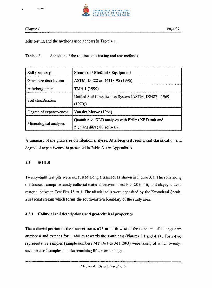
The colluvial portion of the transect starts ±7 5 m north west of the remnants of tailings dam
number 4 and extends for ± 480 m towards the south east (Figures 3.1 and 4.1) . Forty-two
representative samples (sample numbers MT 1611 to MT 28/3) were taken, of which twenty
seven are soil samples and the remaining fifteen are tailings.
Chapter 4 Description ofsoils
Chapter 4 Page 4.4
Two distinct soil units occur in the transect underneath the tailings (Figure 4.1). Between Test
Pit 28 and 24 the tailings occur as in situ paddocked materiaL Towards Test Pit 16, the tailings
occur as eaolian and sheetwash redistributed material. The two tailings units are discussed
together as unit TC. Unit CU is a sandy colluvial topsoil unit which is normally underlain by a
nodular ferruginised colluvial unit (CF). Unit CF is sometimes underlain by residual dolomite
or hard rock dolomite of the Monte Christo Formation. Soil descriptions (after Jennings et.
al.1979) and Unified Soil Classes of each unit are shown in Table 4.2
The sheetwash I aeolian reworked tailings is mainly composed of sand-sized particles, having
on average 67 per cent sand, while the paddocked tailings is mainly composed of silt-sized
particles, with silt constituting on average 58 per cent of the samples. Units CU and CF are
mainly composed of sandy material with only the nodular ferrugenized unit (CF) having a
considerable gravel component (19 per cent on average) consisting of iron I manganese
concretions (nodules). All the soil units have a low expansiveness index, indicating that the soils
are not prone to swelling.
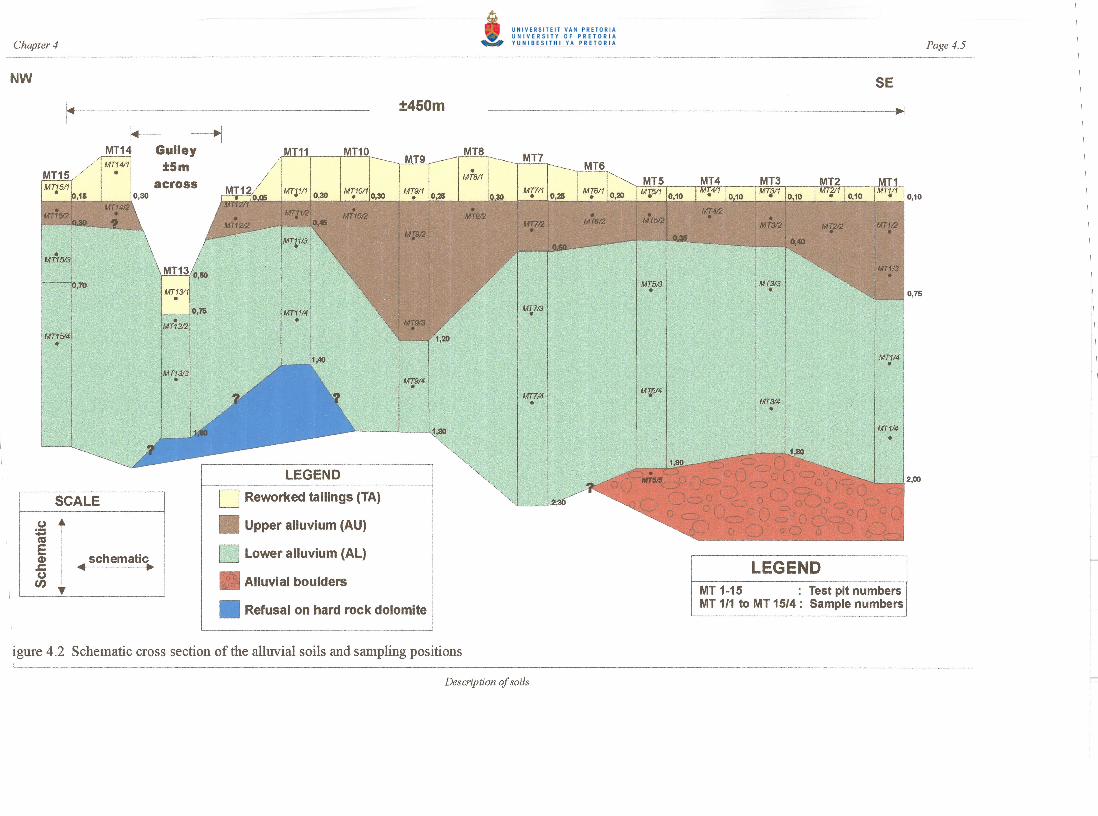
4.3.2 Alluvial soils description and geotechnical properties
The alluvial soils overlain by reworked gold mine tailings were investigated by means of eight
deep test pits and seven shallow test pits (Figure 4.2). The deeper test pits (Test Pits 1, 3, 5, 7,
9, 11, 13 and 15) serve to identify the underlying soils and accommodate sampling, while the
remaining shallow test pits were excavated to a depth not exceeding 0,60 m for sampling the
upper soil units. This portion starts ±230 m south east of the remnants of tailings dam number
4, progressing ± 480 m south east and terminating on the bank ofthe Kromdraai Spruit (Figure
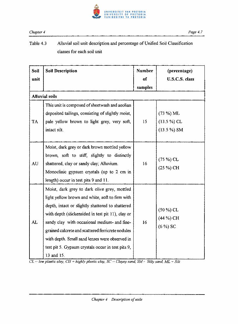
3.1). Three characteristic soil units were identified (Figure 4.2) from which thirty-one soil
samples and fifteen tailings samples (sample numbers MTlIl to MT15/4) were taken. Unit TA
represents the reworked tailings while AU is an alluvial topsoil unit. Unit AL represents alluvial
subsoil which occurs underneath unit AU. Profile descriptions and Unified Soil Classes of each
unit are shown in Table 4.3.
Chapter 4 Description ofsoils

Chapter 4 Page 4.6
Table 4.2 Colluvial soil unit description and percentage of Unified Soil Classification classes for each soil unit
Soil unit
Soil Description Number of
samples
(percentage) U.S.C.S. class
Colluvial soils
Slightly moist, pale yellow brown to light grey, (60 %) SM
TC very soft, intact silt; Paddocked or sheetwash 15
and aeolian deposited tailings. (40 %) ML
Slightly moist, red brown to dark red brown,
loose to occasionally medium dense, voided, (75 %) SC - SM
CU silty to clayey sand; Colluvium. Unit CU is 12 (17%) SM
absent from test pits 22 and 28 indicating these
to be disturbed soils.
(8 %) SC
Abundant coarse-, medium- and fine-grained,
sub-rounded to rounded iron I manganese (50 %) SC - SM
nodules in slightly moist to moist, pale yellow (36%) SM CF 14
brown or red brown, clayey sand; Nodular
ferruginised colluvium. The overall consistency
is loose.
(14 %) SC
SC = Clayey sand, SM = Silty sand. SC - SM = Silty clayey sand. ML = Silt
Chapter 4 Description o/soils
Chapter 4 Page 4.7
Table 4.3 Alluvial soil unit description and percentage of Unified Soil Classification
classes for each soil unit
Soil
unit
Soil Description Number
of
samples
(percentage)
u.s.C.S. class
Alluvial soils
T A
This unit is composed ofsheetwash and aeolian
deposited tailings, consisting of slightly moist,
pale yellow brown to light grey, very soft,
intact silt.
15
(73 %) ML
(13.5 %) CL
(13.5 %) SM
AU
Moist, dark grey or dark brown mottled yellow
brown, soft to stiff, slightly to distinctly
shattered, clay or sandy clay; Alluvium.
Monoclinic gypsum crystals (up to 2 cm in
length) occur in test pits 9 and 11.
16 (75 %) CL
(25 %) CH
AL
Moist, dark grey to dark olive grey, mottled
light yellow brown and white, soft to firm with
depth, intact or slightly shattered to shattered
with depth (slickensided in test pit 11), clay or
sandy clay with occasional medium- and fine
grained calcrete and scattered ferricrete nodules
with depth. Small sand lenses were observed in
test pit 5. Gypsum crystals occur in test pits 9,
13 and 15.
16
(50 %) CL
(44%) CH
(6 %) SC
CL = low plastiC clay, CH = highly plastiC clay, SC Clayey sand, SM = Silty sand, ML = Slit
Chapter 4 Description ofsoils
Chapter 4 Page 4.8
The tailings unit (TA) is mainly composed of silt-sized particles, having on average 17,35 per
cent clay, 53,89 per cent silt and 28,67 per cent sand. The alluvial topsoil unit AU is composed
ofapproximately equal parts of clay, silt and sand, having on average 36,02 per cent clay, 29,67
per cent silt and 33,49 per cent sand. The alluvial subsoil (unit AU) has however a higher clay
content, being on average 43,87 per cent. All the soil units usually have medium to high
expansiveness indices, showing the material to be prone to swelling and shrinkage as soil
moisture content varies.
4.4 TAXONOMIC CLASSIFICATION AND GENERAL DESCRIPTION OF THE
SOILS
According to the South African soil classification system (Soil Classification Working Group,
1991) the colluvial soils are classified in either the Bainsvlei form (profiles MT2I, 23, 24 and
25) or the Westleigh form (profiles MTI8, 19 and 27». The diagnostic horizon sequence for the
Bainsvlei form is Orthic A / Red apedal B / Soft plinthic B. The Orthic A horizon is just an
ordinary topsoil with no special features. The Red apedal B horizon is a structureless to weakly
structured well aerated horizon. The Soft plinthic B horizon is a horizon with abundant high
chroma (bright red and / or yellow) mottles and / or iron or iron / manganese concretions
(nodules) in a soil matrix having at least some grey colours. The Soft plinthic B horizon indicates
a layer in which a fluctuating water table, and consequently alternating reducing and oxidizing
conditions, is found. In the South African Highveld it has been observed that very intensive
lateral movement ofwater occurs in this layer and that large quantities ofdissolved ions are also
transported laterally in the process (MC Laker, personal communication). The latter is especially
the case for elements which become more soluble in the reduced state. According to the USDA's
Soil Taxonomy (Soil Survey Staff, 1975), one of the two international reference soil
classification systems, the Bainsvlei and Westleigh soils are both classified as Plintustalfs.
The soils on the alluvial terrace of the Kromdraai Spruit are classified as Rensburg soils
according to the South African soil classification system (Soil Classification Working Group,
1991). The diagnostic horizon sequence for the Rensburg form is Vertic A horizon / G horizon.
Chapter 4 Description ofsoils

Chapter 4 Page 4.9
A Vertic A horizon is a topsoil which has a high content of swelling clays. A G horizon is a
sticky clay horizon with dull colours reflecting permanent waterlogging, i.e. a permanent
condition of poor aeration (reducing conditions). In the USDA's Soil Taxonomy it is classified
as a Vertic Haplaquept.
4.5 MINERALOGICAL COMPOSITION
The mineralogical compositions of the some tailings as well as alluvial and colluvial samples are
contained in Table B.l in Appendix B. Sixty one samples were analysed for their mineralogical
composition. These samples include all the alluvial soils and a portion of the colluvial and
tailings samples. The averaged mineralogical compositions of the tailings, alluvial and colluvial
soils are shown in Table 4.4.
Table 4.4 Average mineralogical compositions of the some tailings, colluvial and alluvial
soil samples.
Soil unit n Ca D Sid BIG J G T M P Q Mi C S liS
TC,TA 20 0,1 0,1 ° ° 3,6 0,1 ° ° 0,1 84,9 4,3 0,8 1,2 4,7
CU S ° ° ° 1,2 ° ° 1,2 1,2 ° 89,4 0,6 ° ° 6,8
CF 4 ° ° ° S,3 ° ° 14 ° ° 70,3 ° ° ° 13,7
AU 16 ° 0,2 ° ° ° 3,4 ° 0,9 0,4 78,8 0,3 ° 13,4 2,6
AL 16 0,9 ° 0,2 ° ° 0,1 ° ° 0,1 80,8 0,1 ° 16,4 1,4
n = number ofsamples, Ca calcite, D = dolomIte, S = siderrte, HIG = haematite I goethite, J = jarosite, G =
gypsum, T = todorokite, M = microc/ine, P plagioclase, Q = quartz, Mi = mica, C chlorite, S = smectite,
liS = Illite I smectite interstratification
The tailings material, units TC and T A, is mainly composed of quartz, mica, jarosite and illite
/ smectite interstratification with calcite, dolomite, gypsum, plagioclase, chlorite and smectite
present in trace quantities. The presence of jarosite (3[KFe3+(OH)6(S04)2] indicates that the
tailings produce sulphate, as would be expected during acid mine drainage.
Chapter 4 Description ofsoils

Chapter 4 Page 4.10
The colluvial topsoil, unit CU (representing Orthic A and Red Apedal B horizons), consists
mostly of quartz with lesser amounts of haematite / goethite, todorokite, micro cline, mica and
clay minerals reported as illite / smectite interstratification. The underlying nodular
concretionary layer, unit CF (represents Soft plinthic B horizons), shows higher haematite /
goethite, todorokite and clay mineral content in the form ofillite / smectite inter stratifications,
as could be expected from a Soft plinthic horizon. Haematite and goethite are Fe-oxide minerals
(Fez0 3 and a-FeOOH respectively) while todorokite is a Mn-oxide mineral (NaMn60 12'3H20).
The Mn-oxide mineral content in the concretions / nodular ferricrete exceeds the Fe-oxide
mineral content. The latter is not unexpected in view of the Mn rich dolomite underlying the
study area.
The alluvial topsoil, unit AU (representing the Vertic A horizon), is mostly composed ofquartz
and smectite with lesser quantities ofgypsum. Dolomite, micro cline, plagioclase and mica occur
in trace concentrations. The presence ofgypsum, ( 4[CaS04'2HzO]), in excess of20 per cent in
the alluvial topsoil samples MTl1l2 and MT13/2, indicates that sufficient sulphate is produced
in the tailings to enable the crystallization of gypsum in the topsoil. The underlying alluvial
subsoils (unit AL) has less gypsum but increased concentrations of quartz and smectite as well
as increased trace quantities of calcite. The presence of calcite (CaC03) indicates an increase in
Ca2 + with depth in the alluvial soils. Siderite (Fez+C03) occurs in MT3/4, showing that reducing
conditions occur with depth in Test Pit MT3. Unit AL represents G-horizons (i.e gleyed soil
material). A G-horizon indicates practically permanent wetness and consequently poor aeration.
The typical G-colours indicate that iron is in the ferrous (reduced) condition, which facilitates
the formation of siderite. It is also logical to have less gypsum, which is relatively soluble, under
such wet conditions.
4.6 SUMMARY
SOIL PROPERTIES
• The colluvial soils classify as Westleigh and Bainsvlei soil forms while the alluvium
Chapter 4 Description ofsoils

Chapter 4 Page 4.11
classifies as a Rensburg soil form according to the South African taxonomic soil
classification system. According to the USDA's Soil Taxonomy the Bainsvlei and
Westleigh soils are both classified as Plintustalfs while the Rensburg soil is classified
as a Vertic Haplaquept.
GEOTECHNICAL PROPERTIES
• The tailings deposited on the colluvial soils show a higher sand fraction (50 - 74 per cent)
when compared to the paddocked tailings (13 - 60 per cent) and the tailings deposited
on the alluvial soils (4 - 60 per cent). This may indicate that the tailings deposited nearest
to the remnants of tailings dam 4 has a greater aeolian component than the tailings
deposited on the floodplain ofthe Kromdraai Spruit. The tailings on the floodplain shows
a decrease in sand content towards the Kromdraai Spruit which is consistent with the
aeolian and sheetwash depositioning processes where finer material are deposited farthest
away from the source (Reading, 1996).
• The colluvial soils are sandy, having an average clay content of 10 per cent and an
average sand component of 59 per cent. The alluvial soils are however clayey with an
average clay content of 37 per cent and an average sand content of 33 per cent.
• The soil profiles at Test Pits MT22 and MT28 are disturbed as the colluvial topsoil unit
(CT) is not present. The colluvial topsoil is characterized by a lateral increase in clay
content towards the alluvial soils ( Test Pit MT15). There is also a decrease in sand
content and an increase in gravel content with depth as the nodular ferruginised unit (CF)
is encountered. Unit CF usually exhibits a slightly increased clay content when compared
with the overlying soils.
• The alluvial soils usually show an increase in clay content with depth with a
corresponding decrease in sand-sized particles. Unit AU (alluvial topsoil) shows a lateral
increase in clay content towards the Kromdraai Spruit.
Chapter 4 Description ofsoils

Chapter 4 Page 4.12
MINERALOGICAL COMPOSITION
• The tailings is mainly composed of quartz, mica, jarosite and illite / smectite
interstratification while calcite, dolomite, gypsum, plagioclase, chlorite and smectite are
present in trace quantities.
• Unit CU consists mostly ofquartz with lesser amounts ofhaematite / goethite, todorokite,
micro cline, mica and undifferentiated clay minerals. Unit CF has a higher haematite /
goethite, todorokite and clay mineral content than unit CU. The Mn - oxide content
(todorokite) exceeds the Fe-oxide mineral content in unit CF.
• Unit AU is mostly composed of quartz and smectite, while it contains lesser quantities
of gypsum and dolomite, microcline, plagioclase and trace concentration of mica. The
underlying unit AL has less gypsum, but increased concentrations of quartz and smectite
as well as increased trace quantities ofcalcite .
Chapter 4 Description ofsoils