Chapter 4: Circulation and Infrastructure Element Arcadia/Development Services/general...
48
Arcadia General Plan – November 2010 Circulation and Infrastructure Element | 4-1 Chapter 4: Circulation and Infrastructure Element Arcadia General Plan 4 x Introduction From streets to storm drains to water and sewer lines, development citywide requires well-developed and well-maintained circulation and infrastructure systems to support daily activities. This element addresses both the transportation network that allows people to move in and through Arcadia, and the utilities infrastructure that provides necessary urban services to residences, businesses, and institutions. This element sets forth objectives for the following systems that support the land use plan: Circulation Infrastructure Street Network Transit Bikeways Pedestrian Ways Truck Routes Water Storage and Distribution Recycled Water Distribution Sewage Collection and Disposal Storm Drains/Flood Control Solid Waste Management Telecommunications
Transcript of Chapter 4: Circulation and Infrastructure Element Arcadia/Development Services/general...

Arcadia General Plan – November 2010 Circulation and Infrastructure Element | 4-1
Chapter 4: Circulation and Infrastructure Element A r c a d i a G e n e r a l P l a n
4 x
Introduction From streets to storm drains to water and sewer lines, development citywide requires well-developed and well-maintained circulation and infrastructure systems to support daily activities. This element addresses both the transportation network that allows people to move in and through Arcadia, and the utilities infrastructure that provides necessary urban services to residences, businesses, and institutions. This element sets forth objectives for the following systems that support the land use plan:
Circulation Infrastructure
Street Network Transit Bikeways Pedestrian Ways Truck Routes
Water Storage and Distribution Recycled Water Distribution Sewage Collection and Disposal Storm Drains/Flood Control Solid Waste Management Telecommunications

4-2 | Circulation and Infrastructure Element Arcadia General Plan - November 2010
The circulation component addresses an integrated circulation system that will meet the current and future needs of all Arcadia residents, businesses, and visitors. That system will be multi-modal, efficient, and effective for all users, and focused on achieving the following key goals:
Providing and maintaining an efficient roadway system serving all parts of the City and all transportation modes, that also balances with planned land uses
Maximizing the efficiency of the street system Improving local and regional transit service Providing a connected, balanced, and integrated transportation
system of bicycle and pedestrian networks that enable residents to walk and bike
Minimizing adverse traffic effects, and protecting residential neighborhoods from traffic intrusion
Coordinating with other jurisdictions on regional transportation issues
Similarly, the infrastructure systems are planned to support the land use types, intensities, and patterns citywide, and to allow Arcadia residents, businesses, and institutions to continue to enjoy the high level of City services that are a hallmark of Arcadia.
Achieving Our Vision Arcadia’s vision is a City with mobility choices—choices for getting to work, to school, to parks, to services, and to restaurants and shops. The City’s transportation network will consist of a system of complete streets that provide for a balanced integration of all transportation modes. Traffic should flow smoothly and efficiently, and at safe speeds, and traffic impacts on residential neighborhoods will be minimized. Alternative modes―transit, bicycling, and walking―will be available and convenient for all. Arcadia also understands that local infrastructure systems support the level of development appropriate for Arcadia. Arcadia envisions water, sewer, and solid waste management and services to be sustainable, environmentally sound, and capable of responding to modest growth. Arcadia will also look to adapt to new technology, and develop a telecommunications infrastructure can support the evolving needs of local business to stay competitive and residents to be connected. In addition, this plan strengthens the City’s commitment to ongoing assessment and adjustments of existing infrastructure plans and services in order to maintain a high-quality infrastructure system. The following Guiding Principles promote this vision:
Balanced Growth and Development The General Plan establishes a balance and mix of land uses that promotes economic growth and maintains a high quality of life for Arcadia residents. Our development decisions reflect Smart Growth principles and strategies that move us toward enhanced

Arcadia General Plan – November 2010 Circulation and Infrastructure Element | 4-3
mobility, more efficient use of resources and infrastructure, and healthier lifestyles.
Connectivity Arcadia has a balanced, integrated, multi-modal circulation system —which includes streets, sidewalks, bikeways, and trails—that is efficient and safe, and that connects neighborhoods to jobs, shopping, services, parks, and open space areas.
City Services The high-quality services the City provides are a source of civic pride and bring us together as a community. We adjust service needs in response to demographic changes, and we take actions to provide funding to support these services.
Scope of this Element State law (Government Code Section 65302[b]) requires that the General Plan include “a circulation element consisting of the general location and extent of existing and proposed major thoroughfares, transportation routes, terminals, any military airports and ports, and other local public utilities and facilities, all correlated with the land use element of the plan.” As of January 2011, circulation elements are also required to include “a plan for a balanced, multimodal transportation network that meets the needs of all users of streets, roads, and highways for safe and convenient travel in a manner that is suitable to the rural, suburban, or urban context of the general plan. ‘Users of streets, roads, and highways’ means bicyclists, children, persons with disabilities, motorists, movers of commercial goods, pedestrians, users of public transportation, and seniors.” 1 This element address the complete streets concept by identifying a hierarchy of travel corridors in the City, defining a citywide transit plan, setting the framework for a citywide bicycle network, and highlighting pedestrian enhancement zones. These multiple transportation modes will connect all parts of the City and all destinations: neighborhoods, schools, parks, employment centers, community and civic facilities, and retail and commercial centers. Consistent with the objectives of SB 375, this element coordinates transportation planning with land use and resource sustainability strategies, toward broad statewide goals of reducing greenhouse gas emissions and local objectives of minimizing traffic congestion.
1As of 2010, State guidelines for complete streets approaches had not been published. The City’s complete streets plan is based on best available information and the principle that streets should support all transportation modes where feasible and consistent with roadway type and surrounding land uses.
A complete street can accommodate more than one travel mode. Photo credit: www.completestreets.org

4-4 | Circulation and Infrastructure Element Arcadia General Plan - November 2010
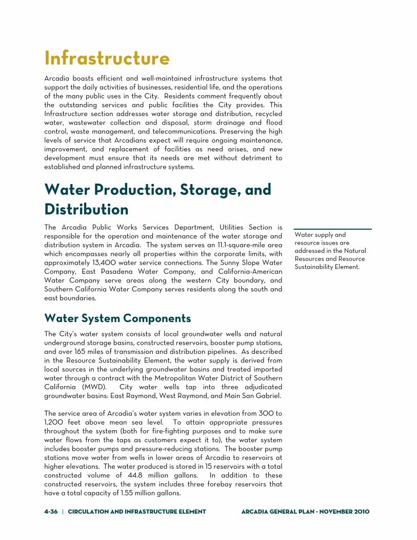
This element addresses infrastructure and services that support the day-to-day operations of the City. Arcadia recognizes the importance of infrastructure and its role as the backbone of the City and its ability to meet the needs and demands of potential residential and commercial growth. This element underscores the importance of many of the existing infrastructure plans that are currently in place (Water Master Plan, Sewer Master Plan, Capital Improvement and Equipment Plan, etc.) and identifies the necessity to constantly update and evaluate these plans, as well as current services, as to provide the highest quality water, sewer, storm water, and waste services that will meet the needs of a dynamic Arcadia. This element also explores the development of a telecommunications network that meets the City’s requirements without aesthetic disturbance.
Circulation Plan A Plan for Mobility Arcadia had its modern beginnings as a railroad town, when City founder Elias “Lucky” Baldwin convinced the Santa Fe Railroad to extend a line through his rancho to connect the area to Los Angeles. The town of Arcadia built up around the railroad station; the original rail alignment and surrounding grid street pattern are evident in today’s Downtown. Passenger rail via the Pacific Red Car, which ran within the wide median of Huntington Drive, also connected early residents to Los Angeles and places in between. As automobile ownership and use became more prevalent and the desire to live in a quiet suburban environment grew, Pacific Red Car usage declined and the company ultimately ceased operations. In response to these changes, Arcadia’s neighborhoods and street system developed. The City’s road network from its inception was well planned, with primary north-south corridors such as Baldwin Avenue and Santa Anita Avenue, and east-west routes such as Foothill Boulevard and Duarte Road, developed to accommodate traffic to and through Arcadia without intruding into the neighborhoods.
Regional access was improved with the opening of Interstate 210 in the 1970s, but the freeway also brought increased traffic into the San Gabriel Valley, and I-210 now experiences chronic congested conditions during commute hours. Traffic congestion continues to be the key complaint of Arcadia residents, associated with both I-210 and arterial roadways. Other circulation concerns include traffic conditions around local schools, seasonal traffic from Santa Anita Park and the regional mall, lack of good bike routes, pedestrian accommodation, and limited transit service. This Circulation Plan looks to address these concerns by coordinated planning of a multi-modal mobility system. This will be accomplished in part by designating and using streets for per their primary functions (illustrated in Figure CI-1), expanding transit access, and enhancing bicycle and pedestrian mobility. Identified streets will function as:

Arcadia General Plan – November 2010 Circulation and Infrastructure Element | 4-5
Principal Travel Corridors, which have the capacity to carry the highest volumes of vehicles (in the range of 22,000 to 35,000 daily), generally connect between adjacent cities, and are typically four-lane streets.
Secondary Travel Corridors, which are more locally oriented, with
the exception of Duarte Road, also are typically four-lane roadways, and experience daily vehicle volumes from 10,000 to 18,000, with up to 24,000 in one or two locations in Arcadia.
A system of local travel corridors supports and provides access to the Primary and Secondary Corridors. Local streets support local travel within the City and between neighborhoods, generally have two lanes, and carry less that 8,000 vehicles per day.
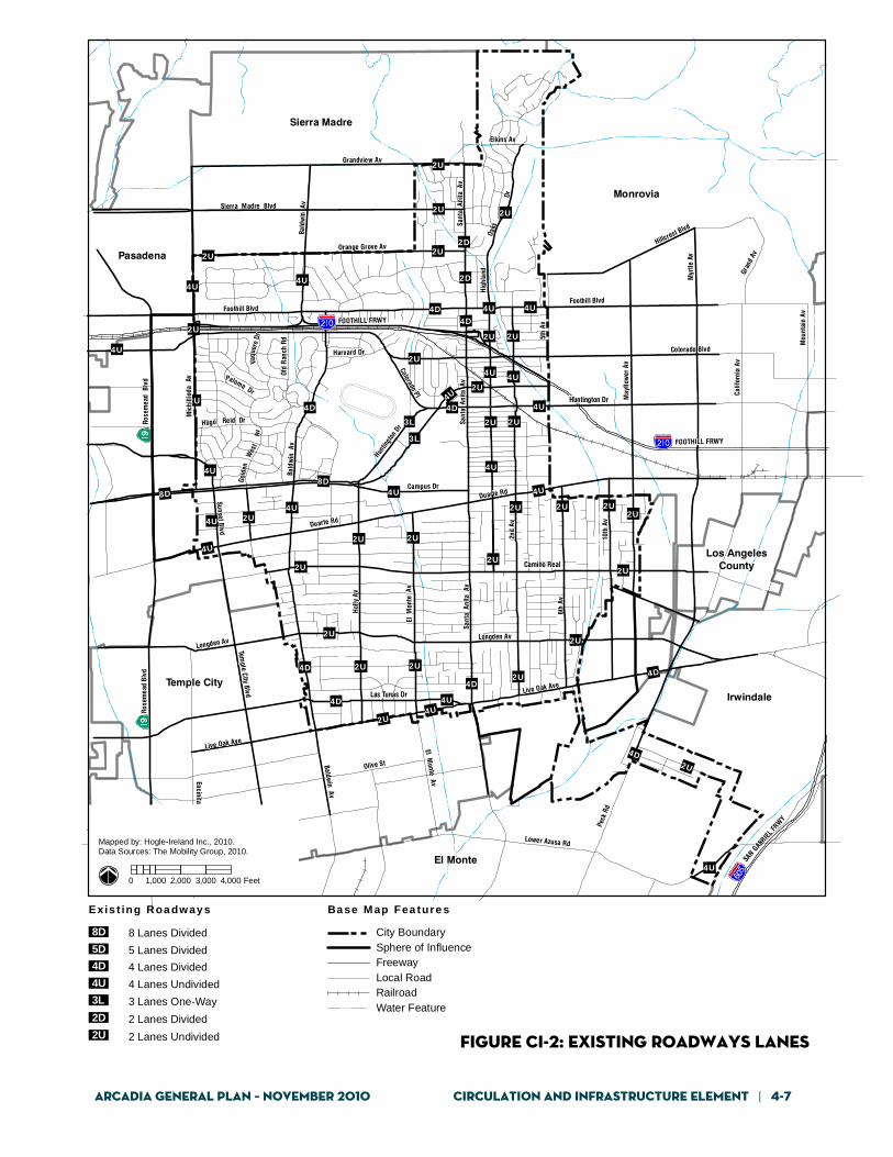
Street Network The street system in Arcadia and its primary functions, as described above, are well defined. Figure CI-2 shows the number of travel lanes on key City roadways. The well-established grid network shown in Figure CI-2 allows traffic to flow well in Arcadia, with few problems and only isolated congestion at certain intersections, as described below.
Although not part of the City’s street network but a key regional travel corridor, Interstate 210, also called the Foothill Freeway, runs east-west through the northern part of the City, with local interchanges at Baldwin Avenue and Santa Anita Avenue. Two interchanges just beyond Arcadia—Michillinda Avenue/Rosemead Boulevard to the west and Huntington Drive to the east—provide access to arterial roads serving the City.
The principal travel corridors—Foothill Boulevard, Huntington Drive, Las Tunas Drive/Live Oak Avenue, Baldwin Avenue, and Santa Anita Avenue—are typically four-lane streets (except for Huntington Drive, which has eight lanes) and carry the highest traffic volumes.
The secondary travel corridors are Colorado Street/Place, Duarte Road, Sunset Boulevard, parts of Baldwin Avenue, Santa Anita Avenue north of Foothill Boulevard, and Second Avenue between Duarte Road and Huntington Drive. With the exception of Duarte Road, these corridors are more locally oriented. They typically have four lanes, although certain locations may have two lanes.
The local travel corridors referenced above are Orange Grove Avenue, Camino Real, Longden Avenue, Holly Avenue, El Monte Avenue, First Avenue, Second Avenue, Sixth Avenue, Tenth Avenue, and Mayflower Avenue.

4-6 | Circulation and Infrastructure Element Arcadia General Plan - November 2010
Monrovia
El Monte
Temple CityIrwindale
Sierra Madre
Pasadena
Los AngelesCounty
Duarte Rd
Live Oak Ave
Baldwin Av
Longden Av
Foothill Blvd
Myr
tle A
v
Peck
Rd
Olive St
6th
Av
Hol
ly A
v
Las Tunas Dr
10th
Av
Bald
win
Av
FOOTHILL FRWY
SAN G
ABRIE
L FRW
Y
Colorado Blvd
Encinita Av
Mou
ntai
n Av
Calif
orni
a Av
Temple City Blvd
Mic
hilli
nda
Av
5th
Av
Sierra Madre Blvd
Grandview Av
May
flow
er A
v
Orange Grove Av
El Monte Av
Sant
a A
nita
Av
Duarte Rd
2nd
Av
Sant
a A
nita
Av
Live Oak Ave
Foothill Blvd
FOOTHILL FRWY
Hillcrest Blvd
Campus Dr
Gran
d Av
Sunset Blv d
Hugo
Oaks
Gold
en
Elkins Av
Colorado Pl
Harvard Dr
Rose
mea
d Bl
vd
Old
Ran
ch R
d
Hig
hlan
d
B ald
win
Av
El M
onte
Av
Lower Azusa Rd
Camino Real
Rose
mea
d B
lvd
Sant
a A
nita
Av
Dr
Reid Dr
Wes
tAv
Vaqu
ero
Dr
Paloma Dr
Huntin
gton
Dr
Huntington Dr
Longden Av
0 1,000 2,000 3,000 4,000 Feet
Mapped by: Hogle-Ireland Inc., 2010.Data Sources: The Mobility Group, 2010.
City BoundarySphere of InfluenceFreewayLocal RoadRailroadWater Feature
Principal Travel Corridor
Secondary Travel Corridor
Local Travel Corridor
Ba se Map Fea ture sTrav el Corr ido rs
Note: See Master Plan of Roadways for actual Roadway Classifications and Cross Section Details. Figure CI-1: Travel Corridors
Arcadia General Plan – November 2010 Circulation and Infrastructure Element | 4-7
Figure CI-2: Existing Roadways Lanes
4U
4U4U 2U
4U
8D8D
4U
3L
3L
4D
4U
4D2U
4U
4D
4U2U
4D 4U
2U4D 2U2U
4D2U
2U2U
2U
2U
2U
2U 2U
2U 2U
2U
4U
2U
2U
4U4U
2U
4U 4U
2U
2U 2U
4U4U4D
4U
2U
4U
2U
4U
2U
2U
2U
2D
2D
2U4D
4D
2U
2U
Monrovia
El Monte
Temple CityIrwindale
Sierra Madre
Pasadena
Los AngelesCounty
Duarte Rd
Live Oak Ave
Baldwin Av
Longden Av
Foothill Blvd
Myr
tle A
v
Peck
Rd
Olive St
6th
Av
Hol
ly A
v
Las Tunas Dr
10th
Av
Bald
win
Av
FOOTHILL FRWY
SAN G
ABRIEL
FRW
Y
Colorado Blvd
Encinita Av
Mou
ntai
n Av
Calif
orni
a Av
Temple City Blvd
Mic
hilli
nda
Av
5th
Av
Sierra Madre Blvd
Grandview Av
May
flow
er A
v
Orange Grove Av
El Monte Av
Sant
a A
nita
Av
Duarte Rd
2nd
Av
Sant
a A
nita
Av
Live Oak Ave
Foothill Blvd
FOOTHILL FRWY
Hillcrest Blvd
Campus Dr
Gran
d Av
Sunset Blvd
Hugo
Oaks
Gold
en
Elkins Av
Colorado Pl
Harvard Dr
Rose
mea
d Bl
vd
Old
Ran
ch R
d
Hig
hlan
d
Bald
win
Av
El M
onte
Av
Lower Azusa Rd
Camino Real
Rose
mea
d B
lvd
Sant
a A
nita
Av
Dr
Reid Dr
Wes
tAv
Vaqu
ero
Dr
Paloma Dr
Huntin
gton
Dr
Huntington Dr
Longden Av
0 1,000 2,000 3,000 4,000 Feet
Mapped by: Hogle-Ireland Inc., 2010.Data Sources: The Mobility Group, 2010.
City BoundarySphere of InfluenceFreewayLocal RoadRailroadWater Feature
Ba se Map Fea ture sExis t ing Roa dway s
2U 2 Lanes Undivided
2D 2 Lanes Divided
3L 3 Lanes One-Way
4U 4 Lanes Undivided
4D 4 Lanes Divided5D 5 Lanes Divided
8 Lanes Divided8D

4-8 | Circulation and Infrastructure Element Arcadia General Plan - November 2010
These descriptions of the street hierarchy provide a general description only in order to explain the movement of people within the City, and to complement the transit and bicycle network diagrams. The actual classification of City streets and associated street standards are described in more detail in the Circulation Plan and Roadway Standards below.
Level of Service Objectives To describe how a roadway functions in terms of moving traffic, traffic conditions are typically rated using the concept of Level of Service, or LOS. The LOS expresses the relationship between the capacity of a given street and the amount of traffic that the street carries (Volume to Capacity Ratio). Levels of service describe a range of roadway operating conditions from LOS A (excellent conditions) to LOS F (very poor conditions). Table CI-1 indicates the conditions associated with each service level. Arcadia’s goal is to ensure mobility within and through the City by maintaining LOS D or better along most roadways where feasible. LOS D is commonly used by cities throughout the nation, and has been used in project-level review by the City of Arcadia. Establishment of the LOS D standard recognizes that some congestion will occur during peak hours, but that roadways will function at much better levels of service during the balance of the day. Many cities also recognize that at certain locations, such as in major commercial districts or near freeway interchanges, LOS D may not always be practical because street widening would take too much land from the urban fabric of the adjacent commercial areas, negatively impact the pedestrian environment in commercial districts, and be cost prohibitive. LOS E conditions will be accepted at specific locations set forth below due to regional traffic loads and seasonal traffic associated with Santa Anita Park and the regional mall (see Policy CI-1.3). The LOS D performance standard will apply citywide, except at the following locations, where LOS E is permitted:
Intersections/roadways at or adjacent to freeway ramps Intersections/roadways adjacent to Santa Anita Park and all
roadway links intended to carry race-related traffic during racing season
Intersections/roadways at or adjacent to the Downtown, Baldwin Avenue, and Live Oak Avenue commercial and mixed-use districts
These performance standards may require, but are not intended to mandate, the widening of roadways and/or intersections. They represent goals used to monitor traffic conditions and to assess traffic impacts of development projects. Because LOS standards apply only to vehicular mobility and do not account for enhanced pedestrian movement or other modes, the City will not use them as the sole criteria for judging transportation system performance. Pedestrian convenience, neighborhood and district character, transit access and operations, urban aesthetics, and other factors will be considered.
LOS D is the established service level objective for most roadways in Arcadia.

Arcadia General Plan – November 2010 Circulation and Infrastructure Element | 4-9
Table cI-1: level of service descriptors
Level of Service Description Volume to Capacity Ratio
A Excellent 0peration
All approaches to the intersection appear quite open, turning movements are easily made, and nearly all drivers find freedom of operation.
<0.600
B Very Good Operation
Many drivers begin to feel somewhat restricted within platoons of vehicles. This represents stable flow. An approach to an intersection may occasionally be fully utilized, and traffic queues start to form.
0.601 - 0.700
C Good Operation
Occasionally drivers may have to wait more than 60 seconds, and backups may develop behind turning vehicles. Most drivers feel somewhat restricted.
0.701 – 0.800
D Fair Operation
Cars are sometimes required to wait more than 60 seconds during short peaks. There are no long-standing traffic queues. This level is typically associated with design practice for peak periods.
0.801 - 0.900
E Poor Operation
Some long-standing vehicular queues develop on critical approaches to intersections. Delays may be up to several minutes.
0.901 – 1.000
F Forced Flow
Represents jammed conditions. Backups from locations downstream or on the cross street may restrict or prevent movement of vehicles out of the intersection approach lanes; therefore, volumes carried are not predictable. Potential for stop-and-go type traffic flow.
Over 1.001

4-10 | Circulation and Infrastructure Element Arcadia General Plan - November 2010
Where it is not feasible to achieve roadway cross sections that meet these objectives, the City will consider other methods of improving roadway operations such as implementing parking restrictions, driveway consolidation, and other operational measures.
Key Traffic Concerns Because of Arcadia’s location, the east-west streets of Foothill Boulevard, Huntington Drive, Duarte Road, and Las Tunas Drive/Live Oak Avenue carry regional traffic that passes through Arcadia generally without stopping at local destinations. These flows can increase—particularly on Foothill Boulevard and Huntington Drive—when traffic problems occur on I-210 and drivers detour to local streets. Two major local destinations—Santa Anita Park and the regional mall—generate substantial traffic volumes. This traffic usually occurs on weekends rather than during weekday peak hours. However, these two destinations also generate significant traffic and backups during peak shopping periods and/or during large-attendance events at the race track. During racing season, manual control of intersections by City Police is used on large race days to increase the effective carrying capacity of area roadways, allowing race track traffic to both enter and leave the race track in the most efficient manner possible. Although the amount of race track traffic has decreased due to declining patronage, even with manual traffic control, nuisance problems remain as race track-related traffic runs adjacent to neighborhoods north of Santa Anita Park and along Holly Avenue through residential neighborhoods south of the race track. Residents along the primary routes to and from the race track experience reduced mobility during the peak hours when track patrons enter and leave. Although race track parking rates are nominal, some visitors choose to park outside the race track and walk into the facility, impacting nearby residential neighborhoods, the County Arboretum and Botanic Gardens, and Arcadia County Park. The proximity of the regional mall to the race track requires that mall and race track traffic use the same access roads. Congestion occurs when special promotional events occurring at Santa Anita Park coincide with peak shopping days. In particular, congestion problems occur on December 26, which is one of the year’s primary shopping days, as well as opening day at Santa Anita Park. Of more general concern is traffic around schools and through residential neighborhoods. With the curtailing of school bus service over the years, parents have opted to drive their children to school, which creates temporary congestion for short periods. With regard to cut-through traffic concerns, neighborhoods near primary travel corridors sometimes experience non-local traffic as drivers look to avoid congestion along the primary routes. Strategies to address these issues are described below under Addressing Neighborhood Traffic Issues.

Arcadia General Plan – November 2010 Circulation and Infrastructure Element | 4-11
Transportation Master Plan The City prepared a Transportation Master Plan in 2005 that included traffic traffic forecasts and identified potential roadway system deficiencies for the year 2030. The plan also identified a comprehensive set of transportation improvements at 20 intersections to address the future deficiencies. These improvements include measures such as restriping of roadway lanes, providing additional roadway lanes, and traffic signal system improvements. The City intends to update this plan on a regular basis.
Roadway Plan The Roadway Plan, which sets the framework for long-term circulation system enhancments, is shown in Figure CI-3 and includes the following functional classification of streets:
Major Arterial Modified Major Arterial Primary Arterial
Secondary Arterial Enhanced Collector Collector
Table CI-2 identifies the key features of each street classification with respect to number of lanes, street curb-to-width width, and right-of-way width. Characteristics for Local streets are not indicated, as they vary substantially throughout the City. Varying standards are included in the City’s street standards manual. Figure CI-4 shows the typical cross sections of each street type. TABLE CI-2: Street classification and characteristics
Street Type Number of Lanes
Right-of-Way Width
Divided? Curb-to-Curb Width
Major Arterial 8 220 ft Yes 160-180 ft
Major Modified
(one-way)
3 80-88 ft No 56-64 ft
Primary Arterial 4/6 100-108 ft Yes 84 ft
Secondary Arterial 4 84-92 ft No 60-68 ft
Enhanced Collector 2 80-88 ft No 54-64 ft
Collector 2 64-72 ft No 40-48 ft

4-12 | Circulation and Infrastructure Element Arcadia General Plan - November 2010
Monrovia
El Monte
Temple CityIrwindale
Sierra Madre
Pasadena
Los AngelesCounty
Duarte Rd
Live Oak Ave
Baldwin Av
Longden Av
Foothill Blvd
Myr
tle A
v
Peck
Rd
Olive St
6th
Av
Hol
ly A
v
Las Tunas Dr
10th
Av
Bald
win
Av
FOOTHILL FRWY
SAN G
ABRIEL
FRW
Y
Colorado Blvd
Encinita Av
Mou
ntai
n Av
C alif
orni
a Av
Temple City Blvd
Mic
hilli
nda
Av
5th
Av
Sierra Madre Blvd
Grandview Av
May
flow
er A
v
Orange Grove Av
El Monte Av
Sant
a A
nita
Av
Duarte Rd2n
d Av
Sant
a A
nita
Av
Live Oak Ave
Foothill Blvd
FOOTHILL FRWY
Hillcrest Blvd
Campus Dr
Gran
d Av
Sunset Blvd
Hugo
Oaks
Gold
en
Elkins Av
Colorado Pl
Harvard Dr
Rose
mea
d Bl
vd
Old
Ran
ch R
d
Hig
hlan
d
Bald
win
Av
El M
onte
Av
Lower Azusa Rd
Camino Real
Rose
mea
d B
lvd
Sant
a A
nita
Av
Dr
Reid Dr
Wes
tAv
Vaqu
ero
Dr
Paloma Dr
Huntin
gton
Dr
Huntington Dr
Longden Av
0 1,000 2,000 3,000 4,000 Feet
Mapped by: Hogle-Ireland Inc., 2010.Data Sources: The Mobility Group, 2010.
City BoundarySphere of InfluenceFreewayLocal RoadRailroadWater Feature
Major Arterial
Major Arterial 1-Way
Primary Arterial
Secondary Arterial
Enhanced Collector
Collector
Enhanced Intersection Location
Base Map Fea turesRo ad wa y P lan
Figure CI-3: roadway plan

Arcadia General Plan – November 2010 Circulation and Infrastructure Element | 4-13
Figure CI-4: Street Cross Sections

4-14 | Circulation and Infrastructure Element Arcadia General Plan - November 2010
To achieve desired circulation objectives over the long term, only minor modifications to the established street system will be needed. The City’s intent is to monitor traffic and circulation conditions and to move forward with the modifications only when deemed necessary. Colorado Boulevard, between Santa Anita Avenue and Fifth Avenue This section of Colorado Boulevard will be restriped from two to four lanes. No roadway widening will be needed. Mid-block on-street parking will be retained on one side of the street. Left-turn lanes will be provided at intersections. These improvements will provide additional east-west traffic capacity through the downtown area to help alleviate traffic loads on Huntington Drive. Santa Clara Street, between Santa Anita Avenue and Fifth Avenue This section of Santa Clara Street will be restriped from two to four lanes. No roadway widening will be needed. On-street parking will be prohibited. This will provide additional east-west traffic capacity through the downtown area to help alleviate traffic loads on Huntington Drive. Santa Anita Avenue, between Santa Clara Avenue and Colorado Boulevard This section of Santa Anita Avenue will be restriped from four to six lanes. On-street parking will be prohibited in peak periods. Enhanced Intersections Certain intersections in the City are identified as enhanced intersections (Figure CI-3). These are where the roadway width may exceed the regular standards and additional right-of-way may be needed. Typically this would allow for dual left-turn lanes. It could also allow for an exclusive right-turn lane. The additional lanes may be installed on any approach but not necessarily on all approaches. Again, these are not needed in the short term but will eventually be necessary as land development approaches General Plan capacity. Future Study Areas Three roadway segments have been identified for future monitoring and study. Foothill Boulevard, between Santa Anita Avenue and Fifth Avenue: The traffic volumes on eastbound side of this segment of Foothill Boulevard are currently higher than the General Plan standard for the capacity of a four-lane roadway in the P.M. peak hour, and will increase in the future. This stretch of roadway carries regional traffic passing through the Arcadia, as well as local Arcadia traffic, so traffic conditions are not entirely under the control of the City. A potential solution is to enhance the intersections at Second Avenue and Fifth Avenue to provide additional turn lanes. However, this would require street widening and possible narrowing of sidewalks or requiring additional right-of-way, and would not be compatible with other General Plan goals of enhancing the pedestrian environment along this corridor. The traffic volumes and conditions on this portion of Foothill Boulevard will therefore be monitored, and future studies will be

Arcadia General Plan – November 2010 Circulation and Infrastructure Element | 4-15
conducted to identify the potential for feasible solutions. These could include enhanced intersections, roadway restriping and/or widening, or other measures to reduce vehicle trips, as appropriate. Holly Avenue, between Duarte Road and Huntington Drive: As development approaches the identified land use capacity, traffic volumes on the northbound side of Holly Avenue will approach the General Plan standard for the capacity of a two-lane roadway in the P.M. peak hour. The roadway is not wide enough to provide four lanes without widening and additional right-of-way. The traffic volumes and conditions on this portion of Holly Avenue will therefore be monitored, and future studies will be conducted to identify needed and feasible solutions. These could include enhanced intersections at Huntington Drive and/or Duarte Road, providing two northbound lanes and one southbound lane; potential roadway widening; or other measures as feasible and appropriate. First Avenue between California Street and Duarte Road: This section of First Avenue between California Street and Duarte Road will be converted from four to two lanes. The traffic volumes on this segment do not justify four travel lanes, and the Land Use and Community Design Element calls for mixed-use development with a pedestrian orientation. Narrowing the travel path for cars, maintaining parallel on-street parking, and installing Class II bike lanes will change the street character to be more appropriate for pedestrian activity, consistent with character of First Avenue between Huntington Drive and California Street. As part of the change, any impacts to emergency vehicle response (Genoa Street and First Avenue intersection along this section is a primary response intersection for the Fire Department) will be thoroughly evaluated and mitigated. Huntington Drive, between Santa Clara Street and Fifth Avenue: The section of Huntington Drive between Santa Clara Street and Fifth Avenue through downtown carries high volumes of traffic, and over the long term, forecast volumes for morning and evening peak periods are expected to approach the General Plan standard for capacity of a four-lane roadway, without measures being taken to provide additional east-west roadway capacity in the downtown. This section of Huntington Drive should therefore be the subject of continuing traffic monitoring and future studies. For the near term, the Roadway Plan and element policies and implementation programs provide a number of measures to enhance the east-west roadway capacity through downtown to relieve pressures on Huntington Drive. These include:
converting Santa Clara Street between Santa Anita Avenue and Fifth Avenue from a two-lane to a four-lane street to provide additional east-west capacity,
installing directional approach signage to encourage use of Santa Clara Street,
possible reconfiguration of certain intersections to facilitate use of Santa Clara Street,

4-16 | Circulation and Infrastructure Element Arcadia General Plan - November 2010
improving the connection between Santa Clara Street and Huntington Drive at the east end of downtown along Fifth Avenue. and
adjusting signal timing.
All of these measures will encourage the use of Santa Clara Street as an alternate route through downtown between Santa Anita Avenue and FIfth Avenue. Over the longer term, studies could address the concept of a one-way couplet through downtown between Colorado Street and Fifth Avenue, where Huntington Drive could be one-way eastbound and Santa Clara Street could be one-way westbound. This would be a low-speed and traffic-calmed couplet with extensive pedestrian-oriented urban design. It could extend the existing urban design features of Huntington Drive to Santa Clara Street, thereby better integrating Santa Clara Street and the Gold Line Station into an expanded and walkable downtown. Vehicular turn conflicts would be reduced with the one-way system, and vehicular-pedestrian conflicts would be reduced with the fewer vehicular turning movements. Transit circulation in the downtown would also be enhanced. On-street parking could be retained on both sides of Huntington Drive and at least one side of Santa Clara Street, and wider sidewalks could be provided on Huntington Drive.
ITS Master Plan One of the most effective means of improving traffic flow is to make traffic signals more demand responsive and synchronized. The traffic signal system citywide will be upgraded to provide state-of-the-art traffic control strategies to enhance arterial street system operations through better traffic management. The City’s Intelligent Transportation Systems (ITS) Master Plan includes installation of fiber optic communications cable on several key arterials, video detection at intersections, closed circuit television, changeable message signs, and a traffic management center workstation. The system will include ITS elements at 59 intersections, with communications and monitoring along the intervening streets. Arcadia coordinates its signal system with two larger efforts: the Los Angeles County Information Exchange Network (IEN) and the Regional Integration of Intelligent Transportation Systems (RIITS). The IEN is a coordinated network for sharing information and control of the various traffic control systems along I-210 and is intended to improve coordination between member agencies’ traffic control systems as well as improve incident response and management activities. By sharing second-by-second intersection data, there is improved coordination between systems along the arterials, thus improving response management in the event of a problem with special events or incidents along the freeway or surface streets along I-210 corridor. The RIITS network is composed of Caltrans, the City of Los Angeles Department of Transportation, the California Highway Patrol, Long Beach Transit, Foothill Transit, and the Los Angeles County Metropolitan

Arcadia General Plan – November 2010 Circulation and Infrastructure Element | 4-17
Transportation Authority (Metro). RIITS is a communication network that supports the real-time exchange of information to help manage the regional transportation system. The RIITS network provides real-time, multi-modal transportation information to system managers and travelers to improve mobility, safety, and air quality in Los Angeles County.
Improvements Associated with Major Developments As noted above, Santa Anita Park and the regional mall generate substantial traffic volumes during peak periods. The Land Use Plan addresses future redevelopment to portions of the race track property that would add traffic to the roadway system. To address long-term mobility objectives surrounding these major users, the Transportation Master Plan provides for the following physical enhancements:
The ITS system described above Installation of new traffic signals Making turn and travel lanes modifications at up to 14 intersections
In addition, major development projects will be required to implement measures such as provision of dedicated shuttle service to the Gold Line Station, enhanced pedestrian and bicycle access and mobility, and transportation demand management programs that reduce vehicle trips. The combined pursuit of all circulation system improvements described above, in combination with City strategies regarding transit, bicycle, and pedestrian mobility, will allow the City to balance the circulation system with the Land Use Plan.
Measures to Address Neighborhood Traffic Issues The most effective strategy for keeping through traffic out of residential neighborhoods is appropriately managing traffic on the arterial roadway system and limiting incentives for traffic to divert through neighborhoods. The Roadway Plan shown in Figure CI-2 and the City’s initiative to use ITS methods to manage traffic flow will help in this regard. The City can also offer a menu of traffic-calming approaches, recognizing that solutions must reflect specific local neighborhood circumstances, not generic measures. Thus, policies call for developing a formalized process and procedures for implementing neighborhood traffic management programs where necessary and appropriate in residential neighborhoods and around schools and parks. With regard to school traffic in particular, concerns cited by parents include congestion, questionable driving practices, and limited pedestrian accommodation in some areas. The key contributor to these problems is the fact that many parents drive their children to school, either due to public safety concerns or for convenience. The City’s goal is to partner with the Arcadia Unified School District to identify strategies to encourage more

4-18 | Circulation and Infrastructure Element Arcadia General Plan - November 2010
children to walk or bike to school, to address congestion during pick-up and drop-off hours (for example, staggered school schedules or improved access/flow), and to improve drivers’ behavior with increased police presence or other approaches.
Transit Bus Service Both Metro and Foothill Transit provide bus service to and through Arcadia as part of their regional systems. Metro operates five lines, with Foothill Transit operating four lines, as shown in Figure CI-5. Buses do not run along all arterial streets in Arcadia; the routes are focused along travel ways with regional links. The highest concentration of bus service occurs on Huntington Drive, which has up to three routes. The routes primarily serve commercial districts and corridors in the City, and large portions of residential neighborhoods are some distance from bus service. The City operates Arcadia Transit, which provides a curb-to-curb demand response service. The service is open to the general public and operates to all destinations within the City limits. With an increased regional emphasis on improving public transit over the long term, the City anticipates that the public will demand improvements in transit service and local geographic coverage. This will necessitate coordination with both Foothill Transit and Metro as the regional transit operators, and will involve evaluation by these agencies for new service routes or increases in service frequencies based on service standards and other operational criteria. Figure CI-6, Transit Corridors, identifies the City’s expectations and plans for these enhancements. A Primary Transit Corridor is a street which is expected to carry the highest levels of transit service, particularly regional service, with the most bus routes and the highest frequency of service. A Secondary Transit Corridor is a street that is expected to carry lower but still significant levels of transit service, and probably with a greater orientation to local rather regional bus routes. In both cases the design and operation of the streets need to reflect and accommodate transit vehicles. The City anticipates three major transit corridors in the City—an east-west transit spine along Huntington Drive and a north-south transit spine along Santa Anita Avenue—that will form the backbone of bus transit service in the City, along with an east-west corridor along Las Tunas Drive/Live Oak Avenue in the south of the City.

Arcadia General Plan – November 2010 Circulation and Infrastructure Element | 4-19
Figure CI-5: Transit Routes
M 268
M 487 F 49
4
F 187
M 264
M 78/378
M 267
F 492
M 79
M 264
F 184
Monrovia
El Monte
Temple CityIrwindale
Sierra Madre
Pasadena
Los AngelesCounty
Duarte Rd
Live Oak Ave
Baldwin Av
Longden Av
Foothill Blvd
Myr
tle A
v
Peck
Rd
Olive St
6th
Av
Hol
ly A
v
Las Tunas Dr
10th
Av
Bald
win
Av
FOOTHILL FRWY
SAN G
ABRIE
L FRW
Y
Colorado Blvd
Encinita Av
Mou
ntai
n Av
Calif
orni
a Av
Temple City Blvd
Mic
hilli
nda
Av
5th
Av
Sierra Madre Blvd
Grandview Av
May
flow
er A
v
Orange Grove Av
El Monte Av
Sant
a A
nita
Av
Duarte Rd2n
d Av
Sant
a A
nita
Av
Live Oak Ave
Foothill Blvd
FOOTHILL FRWY
Hillcrest Blvd
Campus Dr
Gran
d Av
Sunset Blvd
Hugo
Oaks
Gold
en
Elkins Av
Colorado Pl
Harvard Dr
Rose
mea
d Bl
vd
Old
Ran
ch R
d
Hig
hlan
d
Bald
win
Av
El M
onte
Av
Lower Azusa Rd
Camino Real
Rose
mea
d B
lvd
Sant
a A
nita
Av
Dr
Reid Dr
Wes
tAv
Vaqu
ero
Dr
Paloma Dr
Huntin
gton
Dr
Huntington Dr
Longden Av
M 4
87F
492
F 187
F 49
4
M 2
68
M 2
67
0 1,000 2,000 3,000 4,000 Feet
Mapped by: Hogle-Ireland Inc., 2010.Data Sources: The Mobility Group, 2010.
Base Ma p Feat uresCi ty BoundarySphere o f In f luenceFreewayLocal RoadRai l roadWate r Featu re
Footh i l l Tran si t Route s
F 184
F 187
F 492
F 494
Metro Tra ns i t Rou tes
M 78/378
M 79
M 264
M 267
M 268
M 487

4-20 | Circulation and Infrastructure Element Arcadia General Plan - November 2010
Figure CI-6: Transit Corridors
Monrovia
El Monte
Temple CityIrwindale
Sierra Madre
Pasadena
Los AngelesCounty
Duarte Rd
Live Oak Ave
Baldwin Av
Longden Av
Foothill Blvd
Myr
tle A
v
Peck
Rd
Olive St
6th
Av
Hol
ly A
v
Las Tunas Dr
10th
Av
Bald
win
Av
FOOTHILL FRWY
SAN G
ABRIEL
FRW
Y
Colorado Blvd
Encinita Av
Mou
ntai
n Av
Cali f
orni
a Av
Temple City Blvd
Mic
hilli
nda
Av
5th
Av
Sierra Madre Blvd
Grandview Av
May
flow
er A
v
Orange Grove Av
El Monte Av
Sant
a A
nita
Av
Duarte Rd
2nd
Av
Sant
a A
nita
Av
Live Oak Ave
Foothill Blvd
FOOTHILL FRWY
Hillcrest Blvd
Campus Dr
Gran
d Av
Sunset Blvd
Hugo
Oaks
Gold
en
Elkins Av
Colorado Pl
Harvard Dr
Rose
mea
d Bl
vd
Old
Ran
ch R
d
Hig
hlan
d
Bald
win
Av
El M
onte
Av
Lower Azusa Rd
Camino Real
Rose
mea
d B
lvd
Sant
a A
nita
Av
Dr
Reid Dr
Wes
tAv
Vaqu
ero
Dr
Paloma Dr
Huntin
gton
Dr
Huntington Dr
Longden Av
TC
0 1,000 2,000 3,000 4,000 Feet
Mapped by: Hogle-Ireland Inc., 2010.Data Sources: The Mobility Group, 2010.
City BoundarySphere of InfluenceFreewayLocal RoadRailroadWater Feature
Primary Transit Corridor
Secondary Transit Corridor
Gold Line Corridor
Gold Line Station
Ba se Map Fea ture s
Bus Transit CenterTC
Tran sit Corr idors
Note: Local circulator system will connect neighborhoods to regional transit network, schools, parks, commercial centers, downtown, and Gold Line Station.

Arcadia General Plan – November 2010 Circulation and Infrastructure Element | 4-21
The provision of bus rapid transit (BRT) service on these key corridors may be explored by Metro and Foothill Transit. BRT is a rapidly developing form of enhanced bus transit that offers more frequent service, fewer stops, and higher average speeds than traditional bus service. BRT uses higher-capacity vehicles with low floors and specially designed station platforms for quick boarding. In some areas, bus travel is provided in exclusive lanes for greater mobility through high-demand areas. In other areas, buses travel in mixed flow lanes but may receive signal priority treatment over other vehicles. Metro continues to implement bus transit routes on key corridors throughout Los Angeles County, most notably the popular Orange Line through the San Fernando Valley with connections to downtown Los Angeles. The City supports routes through Arcadia that may be added as transit ridership and patterns dictate, provided that BRT works in concert with the City’s efforts to smooth overall traffic flow. To complement light rail service, a Bus Transit Center (where regional and local routes may converge, transfers between bus routes are provided, and bus passengers can transfer to/from the Gold Line light rail line) is identified at Santa Clara Street and First Avenue, adjacent to the Gold Line Station. The Transit Plan also calls for localized internal circulator transit service within Arcadia, connecting key population centers to schools, parks, commercial centers, regional transit, and key destinations such as Downtown, the medical center, the civic center, and the regional mall. Such local service could be operated by the City, Foothill Transit, Metro, and/or through a joint effort with surrounding jurisdictions. The feasibility and funding sources for local service will continue to be explored, with emphasis on fixed-route service with smaller vehicles and routes that follow collector and/or local streets. The service will feed into and support regional fixed-route service, thereby significantly enhancing transit access for Arcadians. This community transit service could be implemented in stages based on available funding and projected ridership levels. Rail Service The Gold Line Construction Authority is responsible for the construction of the Gold Line Foothill extension. The Gold Line Construction Authority plans to extend the Gold Line light rail line east from Pasadena through Arcadia to Montclair. In Arcadia, station plans are underway in the Downtown at Santa Clara Street and First Avenue. This will provide significant opportunities for increased transit use, and will allow development in Downtown to consist of more compact, mixed-use patterns that encourage walking and use of the train. The Arcadia station will be located at the northwest corner of the Santa Clara Street and First Avenue intersection. The station will be at grade, with the rail line passing diagonally through the intersection, which is also at grade. Approaching the station from the west, the rail line will be elevated above Santa Anita Avenue to allow continued flow along this arterial. A 300-space park-and-ride garage will be located
The Arcadia Gold Line Station will consist of a platform and structured parking for patrons. Photo credit: Metro

4-22 | Circulation and Infrastructure Element Arcadia General Plan - November 2010
Biking is a great way to exercise and make local trips. Photo credit: www.peopleonbikes.com
on the southwest corner of the Santa Clara Street and First Avenue intersection. The structure will be designed to accommodate up to 800 spaces once the Gold Line reaches its projected capacity. Both Santa Clara Street and First Avenue will function as Transit Access Corridors to the Gold Line station. An on-street Transit Center can be located at Santa Clara Street and First Avenue. The Transit Center will accommodate Foothill Transit and Metro buses serving the station, and would provide an excellent transfer point for local bus service as well.
Accommodating Bicycles Arcadia has not previously prepared or adopted a bikeway master plan, nor has the City emphasized construction or designation of bike paths, bike lanes, or bike routes. However, the City continues to explore the coordination of better bike routes and facilities by the potential development of a Bicycle Plan shown in Figure CI-7. This Bicycle Plan, which will link to the extensive Rio Hondo bike path system that has a trailhead in the south of the City, near the border with El Monte, responds to desires for recreation routes and a comprehensive system that links community destinations to residential neighborhoods and transit access locations. The Bikeway Plan identifies a proposed bikeway system to be implemented in the City. The Bicycle Plan explores key components like the use of flood control channels along the east side of Arcadia, a Class I (see description below) loop around the Santa Anita Golf Course and Arcadia County Park, Class II access to the Gold Line station, and protected access across the regional mall and Santa Anita Park properties. The next step is to adjust and further develop the proposed Bicycle Plan to determine the class and locations of routes that would best fit the City. Although the routes primarily occur along City streets, implementation of the Bicycle Plan will require coordination with regional agencies such as the Los Angeles County Department of Public Works and Department of Parks and Recreation, as well as private landowners.

Arcadia General Plan – November 2010 Circulation and Infrastructure Element | 4-23
Figure CI-7: Bikeway Plan
Monrovia
El Monte
Temple CityIrwindale
Sierra Madre
Pasadena
Los AngelesCounty
Duarte Rd
Live Oak Ave
Baldwin Av
Longden Av
Foothill Blvd
Myr
tle A
v
Peck
Rd
Olive St
6th
Av
Hol
ly A
v
Las Tunas Dr
10th
Av
Bald
win
Av
FOOTHILL FRWY
SAN G
ABRIEL
FRW
Y
Colorado Blvd
Encinita Av
Mou
ntai
n Av
Calif
o rni
a A v
Temple City Blvd
Mic
hilli
nda
Av
5th
Av
Sierra Madre Blvd
Grandview Av
May
flow
er A
v
Orange Grove Av
El Monte Av
Sant
a A
nita
Av
Duarte Rd2n
d Av
Sant
a A
nita
Av
Live Oak Ave
Foothill Blvd
FOOTHILL FRWY
Hillcrest Blvd
Campus Dr
Gran
d Av
Sunset Blvd
Hugo
Oaks
Gold
en
Elkins Av
Colorado Pl
Harvard Dr
Rose
mea
d Bl
vd
Old
Ran
ch R
d
Hig
hlan
d
B ald
win
Av
El M
onte
Av
Lower Azusa Rd
Camino Real
Rose
mea
d B
lvd
Sant
a A
nita
Av
Dr
Reid Dr
Wes
tAv
Vaqu
ero
Dr
Paloma Dr
Huntin
gton
Dr
Huntington Dr
Longden Av
0 1,000 2,000 3,000 4,000 Feet
Mapped by: Hogle-Ireland Inc., 2010.Data Sources: The Mobility Group, 2010.
City BoundarySphere of InfluenceFreewayLocal RoadRailroadWater Feature
Class I Bike Path
Potential Class I Bike Path
Class II Bike Lane
Class III Bike Lane
Ba se Map Fea turesBi ke Clas si f ica t ion

4-24 | Circulation and Infrastructure Element Arcadia General Plan - November 2010
Class I
BIKE PATHNO MOTORVEHICLES
ORMOTORIZEDBICYCLES
2'2'
Outer EdgeCompact Soils
Primary SurfaceConcrete
8' Minimum
Outer EdgeCompact Soils
Class II
Class III
14' MinimumShared Lane
BIKE ROUTE
Bicycle Facility Types The Bicycle Plan is comprised of three different classes of bicycle facilities: Class I - Bike Path or Bike Trail Class I facilities are bicycle trails or paths that are essentially off street and separated from motor vehicles. They are a minimum of eight feet in width for two-way travel, and include bike lane signage and designated street crossings where needed. A Class I bike path may parallel a roadway (within the parkway) or may be a completely separate right-of-way that meanders through a neighborhood or along a flood control channel or utility right-of-way. The City of Arcadia currently has one Class I bike path. The path is the beginning of the extensive Rio Hondo bike path system and is located in the south of the City. It begins just inside the City’s border with El Monte, and links into the Los Angeles River bike path. Class II - Bike Lane Class II bikeways are located next to the curb or edge of paved roadways or adjacent to a travel lane, and consist of a designated bike lane. Minimum width is five feet (four feet bike lane, one foot for curb/gitter), and the lane has bike lane signage, special lane lines, and other pavement markings identifying the designated use of bicycles. Class III – Bike Street This is a signed street providing for shared use of a street by motor vehicles and bicyclists. While bicyclists have no exclusive use or priority, the signage—both on the side of the street and with large bicycle symbols stenciled on the roadway surface—warns motorists of bicyclists sharing the roadway space and that the street is an official bike route. Bike Streets are typically lower-volume streets, and are enhancements of the standard Class III bike route which is only indicated by small wayside signs. They are identified in the Bicycle Plan at locations where Class II Bike Lanes are not feasible but where necessary to provide connections in the bicycle network. The signage—both by the side of the street and on the street surface itself—will clearly identify such roadway sections as being on the bike network. Traffic calming measures may also be implemented to facilitate bicycles crossing major arterials along the route.
Figure CI-8: Types of Bike Facilities

Arcadia General Plan – November 2010 Circulation and Infrastructure Element | 4-25
Shade trees, wide sidewalks, and interesting shops make for a pleasant pedestrian experience.
Over time, streets that are designated as Class III should be improved to Class II bicycle lanes as and where it becomes feasible and where sufficient right-of-way exists.
Pedestrians
A pedestrian-friendly environment is a key City goal, as walking is encouraged both as a means to reduce auto travel and as healthy exercise. The City looks to provide sidewalks on all arterial roadways as funding allows, and to improve pedestrian amenities and reducing walking impediments (e.g. uneven surfaces, utility structures, newspaper racks) along sidewalks on streets that are key pedestrian routes and districts. Amenities include benches, street trees, trash receptacles, and pedestrian scaled lighting. Focus areas have been identified for an enhanced pedestrian environment. These are primarily in local commercial districts, such as Downtown and along Baldwin Avenue’s restaurant row, as well as the Gold Line Station, where the goal is to make streets friendlier to pedestrians and improve walkability in mixed use areas. These areas are shown in Figure CI-9 and include:
Foothill Boulevard corridor near Santa Anita Avenue (between Rodeo Road and Fifth Avenue)
Downtown connecting to the proposed transit center, and extending south along First Avenue
Baldwin Avenue between Huntington Drive and Camino Real Live Oak Avenue/Las Tunas Drive around Santa Anita Avenue,
from El Monte Avenue to Sixth Avenue Along the edges of Arcadia County Park and the Santa Anita
County Golf Course, including connections to Downtown and adjacent neighborhoods, as well as along Campus Drive by Arcadia High School.
The improvements to sidewalks adjacent to the park and golf course should be combined into a multi-purpose trail/facility with the proposed bike paths around the park. These combined facilities will greatly enhance the accessibility and utility of the park. Typical pedestrian enhancements will include wider sidewalks, ensuring sufficient space and clearance on sidewalks available for walking, improved lighting, seating, enhanced landscaping, shade trees, distinctive sidewalk paving, sidewalk bulb-outs or similar treatments at intersections where feasible, wider crosswalks, and pedestrian signage. From a zoning perspective, regulations can require entrances to be well marked and welcoming to pedestrians and pedestrian-scale signage.

4-26 | Circulation and Infrastructure Element Arcadia General Plan - November 2010
Figure CI-9: Enhanced Pedestrian Environments
Monrovia
El Monte
Temple CityIrwindale
Sierra Madre
Pasadena
Los AngelesCounty
Duarte Rd
Live Oak Ave
Baldwin Av
Longden Av
Foothill Blvd
Myr
tle A
v
Peck
Rd
Olive St
6th
Av
Hol
ly A
v
Las Tunas Dr
10th
Av
Bald
win
Av
FOOTHILL FRWY
SAN G
ABRIEL
FRW
Y
Colorado Blvd
Encinita Av
Mou
ntai
n Av
Calif
o rni
a A v
Temple City Blvd
Mic
hilli
nda
Av
5th
Av
Sierra Madre Blvd
Grandview Av
May
flow
er A
v
Orange Grove Av
El Monte Av
Sant
a A
nita
Av
Duarte Rd2n
d Av
Sant
a A
nita
Av
Live Oak Ave
Foothill Blvd
FOOTHILL FRWY
Hillcrest Blvd
Campus Dr
Gran
d Av
Sunset Blv d
Hugo
Oaks
Gold
en
Elkins Av
Colorado Pl
Harvard Dr
Rose
mea
d Bl
vd
Old
Ran
ch R
d
Hig
hlan
d
Bald
win
Av
El M
onte
Av
Lower Azusa Rd
Camino Real
Rose
mea
d B
lvd
Sant
a A
nita
Av
Dr
Reid Dr
Wes
tAv
Vaqu
ero
Dr
Paloma Dr
Huntin
gton
Dr
Huntington Dr
Longden Av
0 1,000 2,000 3,000 4,000 Feet
Mapped by: Hogle-Ireland Inc., 2010.Data Sources: The Mobility Group, 2010.
City BoundarySphere of InfluenceFreewayLocal RoadRailroadWater Feature
Ba se M ap Fea ture s
Enhanced Pedestrian Environments

Arcadia General Plan – November 2010 Circulation and Infrastructure Element | 4-27
Truck Routes The City Council, by resolution, establishes truck routes to minimize the impact of truck travel on residential areas and near parks and schools, and to help with the planning and maintenance of the street network. Streets that bear a higher level of truck traffic typically require more durable road bases and more frequent repair. Truck routes are limited to Major and Secondary Arterials. Figure CI-10 identifies those routes, which will continue to apply unless amended by subsequent City Council resolution.

4-28 | Circulation and Infrastructure Element Arcadia General Plan - November 2010
Figure CI-10: Truck Routes
Monrovia
El Monte
Temple CityIrwindale
Sierra Madre
Pasadena
Los AngelesCounty
Duarte Rd
Live Oak Ave
Baldwin Av
Longden Av
Foothill Blvd
Myr
tle A
v
Peck
Rd
Olive St
6th
Av
Hol
ly A
v
Las Tunas Dr
10th
Av
Bald
win
Av
FOOTHILL FRWY
SAN G
ABRIEL
FRW
Y
Colorado Blvd
Encinita Av
Mou
ntai
n Av
Calif
o rni
a A v
Temple City Blvd
Mic
hilli
nda
Av
5th
Av
Sierra Madre Blvd
Grandview Av
May
flow
er A
v
Orange Grove Av
El Monte Av
Sant
a A
nita
Av
Duarte Rd2n
d Av
Sant
a A
nita
Av
Live Oak Ave
Foothill Blvd
FOOTHILL FRWY
Hillcrest Blvd
Campus Dr
Gran
d Av
Sunset Blvd
Hugo
Oaks
Gold
en
Elkins Av
Colorado Pl
Harvard Dr
Rose
mea
d Bl
vd
Old
Ran
ch R
d
Hig
hlan
d
Bald
win
Av
El M
onte
Av
Lower Azusa Rd
Camino Real
Rose
mea
d B
lvd
Sant
a A
nita
Av
Dr
Reid Dr
Wes
tAv
Vaqu
ero
Dr
Paloma Dr
Huntin
gton
Dr
Huntington Dr
Longden Av
0 1,000 2,000 3,000 4,000 Feet
Mapped by: Hogle-Ireland Inc., 2010.Data Sources: The Mobility Group, 2010.
City BoundarySphere of InfluenceFreewayLocal RoadRailroadWater Feature
Truck Routes
Ba se M ap Fea ture s

Arcadia General Plan – November 2010 Circulation and Infrastructure Element | 4-29
Circulation Goals and Policies The fundamental guiding principal with regard to mobility is to provide a multi-modal transportation environment in Arcadia that provides transportation choices and reduces trips made and vehicles miles traveled by private automobile. Policy CI-1.3 sets forth roadway performance standards which may require, but are not intended to mandate, the widening of roadways and/or intersections. However, these standards represent only a policy goal, and will be used to monitor traffic conditions in the City and to assess the impacts of new development. Because level of service standards apply only to vehicular mobility and do not account for walkability or other modes, they shall not be the sole criteria for judging transportation system performance. Pedestrian movement and convenience, livability, transit access and operability, and urban aesthetics will also be used.
Goal CI-1: An efficient roadway system that serves all of Arcadia, supports all transportation modes, and balances the roadway system with planned land uses
Policy CI-1.1: Pursue enhancements to the roadway network
consistent with the Figure CI-3, Master Plan of Roadway, and the Transportation Master Plan.
Policy CI-1.2: Implement street design standards on arterial
corridors consistent with the Master Plan of Roadways to address bicycle facilities, sidewalks, and on-street parking that are context sensitive to adjacent land uses and districts, and to all roadway users, where appropriate.
Policy CI-1.3: Maintain a maximum Level of Service (LOS) D
throughout the City, except that LOS E may be permitted in the following circumstances: Intersections/roadways at, or adjacent to
freeway ramps Intersections/roadways adjacent to Santa
Anita Park during racing season Intersections/roadways at or adjacent to
designated Downtown, Baldwin Avenue, and Live Oak Avenue commercial and mixed-use districts

4-30 | Circulation and Infrastructure Element Arcadia General Plan - November 2010
These performance standards may require, but are not intended to mandate, roadway and/or intersection widenings. They represent goals used to monitor traffic conditions and to assess traffic impacts of development projects. Because LOS standards apply only to vehicular mobility and do not account for enhanced pedestrian movement or other modes, the City will not use them as the sole criteria for judging transportation system performance. Pedestrian convenience, transit access and operations, urban aesthetics, and other factors will be considered.
Policy CI-1.4: Require the cost of transportation mitigation and improvements necessitated by new development be borne by new development—including non-automobile solutions—through the Traffic Impact Fee Program.
Policy CI-1.5: Update the Transportation Master Plan and the
Traffic Impact Fee Program on a regular basis. Policy CI-1.6: Develop and maintain adequate funding
sources for the ongoing maintenance and upkeep of the City’s transportation infrastructure.
Policy CI-1.7 Continue Capital Improvement Programs (CIP)
funding for transportation improvements.
Goal CI-2: Maximized operational efficiency of the street system
Policy CI-2.1: Implement traffic management and traffic
signal operations measures, where feasible, to:
Minimize delay and congestion for all modes, without adversely impacting transit, bicycles, and pedestrians, and
Focus traffic onto arterial streets, and minimize intrusion into residential neighborhoods.
Policy CI-2.2: Design and operate arterials and intersections
for the safe operation of all modes, including transit, bicyclists, and pedestrians.
Policy CI-2.3: Develop and enhance the Traffic Management
Center to continue to coordinate and manage the City’s traffic signal system, provide signal

Arcadia General Plan – November 2010 Circulation and Infrastructure Element | 4-31
synchronization, integrate transit operations on City streets (including transit priority as appropriate), and continue participation with the RIITS and Los Angeles IEN.
Policy CI-2.4: Implement intelligent transportation system
measures and advanced traffic management technologies where appropriate as a means of reducing traffic and improving emergency response times.
Policy Cl-2.5 Use rubberized asphalt in streets and/or latest
technology for “green streets.”
Goal CI-3: Enhanced local and regional transit service
Policy CI-3.1: Work with the Los Angeles County Metropolitan Transportation Authority (Metro) and Foothill Transit to maintain and improve the coverage and frequency of transit service in Arcadia.
Policy CI-3.2: Support Metro’s and Foothill Transit’s
expansion of rapid bus service in the region, and particularly on routes serving the City.
Policy CI-3.3: Work with Metro and Foothill Transit to provide
attractive and convenient bus stops, including shade/weather protection, seats, transit information, and bus shelters.
Policy CI-3.4: Enhance local transit circulator service,
particularly to link neighborhoods to commercial districts, and Downtown to all areas.
Policy CI-3.5: Investigate the feasibility of working with
surrounding cities to establish circulator bus service that serves business districts and key destinations in those communities.
Policy CI-3.6: Cooperate with Metro and the Gold Line
Authority to bring light rail service to Arcadia as soon as possible.
Policy CI-3.7: Establish transit hubs at the planned Gold Line
Station at Santa Clara Street and First Avenue, and other locations as appropriate, including possibly the race track property and regional mall.

4-32 | Circulation and Infrastructure Element Arcadia General Plan - November 2010
Policy CI-3.8: Encourage private efforts to connect Gold Line riders to local places of employment.
Policy CI-3.9: Require all new and substantially renovated
office, retail, industrial, and multifamily developments to install and implement transit amenities, including bus turnouts, transit shelters, and other streetscape elements, as appropriate.
Goal CI-4: Connected, balanced, and integrated bicycle and pedestrian networks that provide viable alternatives to use of the car
Policy CI-4.1: Develop and maintain the citywide bicycle
network of off-street bike paths, on-street bike lanes, and bike streets identified in Figure CI-7. Development of this plan will include use of easements and flood control channel rights-of-way.
Policy CI-4.2: Establish bike hubs (centralized locations with
convenient bike parking for trip destinations or transfer to other transportation modes) at key transit and commercial nodes.
Policy CI-4.3: Encourage the establishment of secure bike
parking facilities throughout the City. Policy CI-4.4: Support transit programs that provide bike
racks on buses and trains.
Policy CI-4.5: Develop and implement a comprehensive pedestrian circulation plan that includes, among other components: 1) enhanced pedestrian crossings of streets, 2) sidewalk improvement plans, 3) pedestrian amenities on sidewalks on major streets that are key pedestrian routes, including the benches, street trees, trash cans, and pedestrian scaled lighting 4) ADA-compliant crossings, 5) convenient crossing of arterials with landscaped medians, particularly in the vicinity of schools, and 6) strategies to remove barriers to pedestrian movement (for example, news racks, utility poles and boxes).
Policy CI-4.6: Provide sidewalks on all arterial roadways. Policy CI-4.7: Ensure that intersections and development at
intersections are designed and maintained to provide for pedestrian safety.

Arcadia General Plan – November 2010 Circulation and Infrastructure Element | 4-33
Policy CI-4.8: Require that development projects within
commercial districts provide pedestrian-focused access independent from vehicle entrances, as feasible.
Policy CI-4.9: Enhance pedestrian and bicycle access to local
and regional transit, including connections to bus routes and the light rail station.
Policy CI-4.10: Coordinate the provision of the bicycle and
pedestrian networks with adjacent jurisdictions to maximize connectivity.
Policy CI-4.11: Encourage walking, biking, and use of transit
through a variety of supportive land use development and urban design measures, including site planning that promotes safety, pedestrian-friendly design, and access to transit facilities.
Policy CI-4.12: Require new and substantially renovated office,
retail, industrial, and multifamily developments to include bicycle and pedestrian amenities in the vicinity of the development to facilitate bicycling and walking, including on-site bike paths where appropriate, sidewalk improvements, benches, and pedestrian signal push-buttons at nearby signals.
Policy CI-4.13: Require new and major renovations to office,
industrial, and institutional developments to provide secure off-street bicycle parking, and encourage such developments to provide bicycle facilities, such as showers and changing rooms.
Goal CI-5: Limited cut-through traffic in residential neighborhoods
Policy CI-5.1: Develop a process or program for developing
neighborhood traffic management programs, where appropriate, in residential neighborhoods and around schools, parks, and community centers.
Policy CI-5.2: Develop and implement traffic-calming
programs and management measures on local and collector streets, where determined to be necessary, to discourage traffic from diverting into or taking short-cuts through residential

4-34 | Circulation and Infrastructure Element Arcadia General Plan - November 2010
neighborhoods, and to control the volume and speed of traffic to appropriate levels consistent with adjacent land uses on local streets, near schools, and along streets with a significant amount of residential development.
Policy CI-5.3: Continue to focus truck traffic onto appropriate
arterial corridors. Retain and strengthen ordinances restricting truck travel in residential neighborhoods.
Policy CI-5.5: Require that on-site loading facilities be located
and designed to avoid interference with traffic on the street system and internal site circulation.
Goal CI-6: Reduced auto traffic and improved traffic management around schools
Policy CI-6.1: Coordinate with the Arcadia Unified School
District to identify traffic issues in the vicinity of all District schools within the City, and to develop workable traffic relief plans such as possible designated student pick-up times and pick-up zones.
Policy CI-6.2: Look for ways to enhance pedestrian and
bicycle facilities in the vicinity of schools. Policy CI-6.3: Establish a zero-tolerance and aggressive
citation policy for traffic violations in the vicinity of schools.
Policy CI-6.4: Promote Safe Route to School programs and
policies. Policy CI-6.5: Work with the Arcadia Unified School District
and parents of local school children to implement innovative strategies that increase the number of children walking and riding bikes to school.
Goal CI-7: Parking facilities that support diverse parking needs
Policy CI-7.1: Ensure that parking requirements in the City’s
zoning regulations appropriately reflect the needs of businesses, residents, and institutions, and the evolving nature of personal transportation (for example, electric or other

Arcadia General Plan – November 2010 Circulation and Infrastructure Element | 4-35
alternative fuel vehicles, car sizes, increased bicycle use).
Policy CI-7.2: Accommodate shared use of public and private
parking facilities within business districts and where joint use of parking lots is appropriate given the uses sharing the facilities.
Goal CI-8: Effective coordination with other jurisdictions and agencies on regional transportation issues
Policy CI-8.1: Actively pursue federal, State, and regional
funds for local and regional roadway improvements.
Policy CI-8.2: Maintain consistency with the South Coast Air
Quality Management District air quality mandates, the Los Angeles Congestion Management Program, and SCAG Regional Mobility Plan requirements.
Policy CI-8.3: Work with adjacent jurisdictions to mitigate
traffic impacts in surrounding communities resulting from development in Arcadia, as well as to mitigate impacts in Arcadia associated with development in surrounding communities.
Policy CI-8.4: Work with Caltrans, SCAG, Metro, the Gold
Line Authority, Foothill Transit, Los Angeles County, and the cities of Pasadena, Sierra Madre, Monrovia, Irwindale, El Monte, and Temple City to coordinate regional transportation facilities, continue participation in RIITS and Los Angeles County IEN, and to pursue federal and State funds for local and regional traffic improvements.
Policy CI-8.5: Provide a regularly scheduled report, with an
objective of producing the report every two years, detailing the City’s implementation status of regional transportation policies.
4-36 | Circulation and Infrastructure Element Arcadia General Plan - November 2010
Infrastructure Arcadia boasts efficient and well-maintained infrastructure systems that support the daily activities of businesses, residential life, and the operations of the many public uses in the City. Residents comment frequently about the outstanding services and public facilities the City provides. This Infrastructure section addresses water storage and distribution, recycled water, wastewater collection and disposal, storm drainage and flood control, waste management, and telecommunications. Preserving the high levels of service that Arcadians expect will require ongoing maintenance, improvement, and replacement of facilities as need arises, and new development must ensure that its needs are met without detriment to established and planned infrastructure systems.
Water Production, Storage, and Distribution The Arcadia Public Works Services Department, Utilities Section is responsible for the operation and maintenance of the water storage and distribution system in Arcadia. The system serves an 11.1-square-mile area which encompasses nearly all properties within the corporate limits, with approximately 13,400 water service connections. The Sunny Slope Water Company, East Pasadena Water Company, and California-American Water Company serve areas along the western City boundary, and Southern California Water Company serves residents along the south and east boundaries.
Water System Components The City’s water system consists of local groundwater wells and natural underground storage basins, constructed reservoirs, booster pump stations, and over 165 miles of transmission and distribution pipelines. As described in the Resource Sustainability Element, the water supply is derived from local sources in the underlying groundwater basins and treated imported water through a contract with the Metropolitan Water District of Southern California (MWD). City water wells tap into three adjudicated groundwater basins: East Raymond, West Raymond, and Main San Gabriel. The service area of Arcadia’s water system varies in elevation from 300 to 1,200 feet above mean sea level. To attain appropriate pressures throughout the system (both for fire-fighting purposes and to make sure water flows from the taps as customers expect it to), the water system includes booster pumps and pressure-reducing stations. The booster pump stations move water from wells in lower areas of Arcadia to reservoirs at higher elevations. The water produced is stored in 15 reservoirs with a total constructed volume of 44.8 million gallons. In addition to these constructed reservoirs, the system includes three forebay reservoirs that have a total capacity of 1.55 million gallons.
Water supply and resource issues are addressed in the Natural Resources and Resource Sustainability Element.

Arcadia General Plan – November 2010 Circulation and Infrastructure Element | 4-37
For the purposes of meeting short-term emergency water supply needs, the City’s water system has interconnections with adjacent water systems. Connections include one-way connections, whereby Arcadia’s water system can help supply outside sources, and two-way connections that allow water to both enter and leave the City’s water system. In addition, the City has a connection to MWD pipelines as an emergency supply source and to facilitate replacement/auxiliary water purchases from MWD.
Water System Maintenance and Upgrades Maintenance and improvements to the City’s water system are coordinated through the Water Master Plan. Updated every five years,2 the Water Master Plan helps the Public Works Services Department and the City Council evaluate and assess operational and planning issues associated with the water system. The master plan assesses water system reliability, infrastructure rehabilitation needs, and restoration considerations of various water facilities. Actualization of maintenance and rehabilitation needs identified in the master plan is implemented through the five-year Capital Improvement and Equipment Plan. Most of the improvements described in the master plan consist of ongoing projects such as replacing old and deteriorating water lines and retrofitting obsolete controls and related equipment. The City has also identified reductions in water pumping capacities due in part to the lowering of aquifer levels, as well the possible need to replace existing reservoirs due to age and adjusting pressure-reducing stations to augment fire flows at higher elevations. The Land Use Plan provides for a modest level of growth over time, with activity to occur largely within the focus areas identified in the Land Use and Community Design Element. The Water Master Plan anticipates modest growth with regard to facility sizing and ongoing maintenance needs. For larger-scale development projects such as that could occur on the Santa Anita Park property, developers will be required to fund on-site improvements and any system-wide upgrades needed to support the level of development. With regard to Downtown and the Live Oak corridor, mixed-use developments will occur incrementally, with the City able to plan for and fund minor facilities improvements through subsequent Water Master Plan updates and thereby provides adequate daily, fire flow, and emergency storage capabilities. Interestingly, the replacement of older buildings and plumbing fixtures will provide opportunities to reduce demands with modern water-saving plumbing features. Also, the City has committed resources to reduce burdens on the system due to age and new demands by implementing water-savings programs, such as plumbing retrofit initiatives and conservation pricing.
2 At the time this element was updated in 2008-10, the Water Master Plan was dated 2008.

4-38 | Circulation and Infrastructure Element Arcadia General Plan - November 2010
Recycled Water Given Southern California’s Mediterranean climate with periods of limited rainfall and even drought, the ever-growing population of the region, and reductions in the availability of imported water supplies, potable water resources have become increasingly strained. Like many cities throughout the State, Arcadia has adopted water-savings practices and programs. Even with these programs, however, Arcadia and other jurisdictions have recognized that new methods of supplying water will be needed to meet long-term demand. One potential source that continues to be investigated and implemented at some level is recycled water, that is, treated effluent from sewage treatment plants. In 2006, the City conducted a recycled water feasibility study to assess the need for and potential costs of using recycled water to meet overall long-term water demands. While the study indicated that potable water supplies are sufficient to meet demand through year 2025 (the study’s horizon year), “the use of recycled water may be more economical than use of replacement, treated imported, and cyclic storage water.”3 Recycled water can be used for non-potable purposes, which largely means landscape irrigation. Arcadia has several large open space areas that are candidates for recycled water use: Santa Anita Park grounds, Arcadia County Park, the Santa Anita and Par 3 golf courses, street medians, Caltrans rights-of-way, City parks, and school play fields. In addition, recycled water can be used by car wash businesses. According to the feasibility study, potential limitations on use include: 1) some golf courses could limit recycled water use because certain turf may be sensitive to salt content in reclaimed irrigation water, 2) State regulatory agencies require specific distances be maintained between housing and recycled water irrigation spray, and 3) water quality may be of concern to certain end users. Other uses for recycled water include injection of highly treated water into local groundwater basins for blending with groundwater sources. The water is monitored for compliance with health standards and then pumped for potable use. The Orange County Water District’s Groundwater Replenishment Program represents a significant example of such an approach, whereby treated effluent from regional sewage treatment plants is injected or percolated into large groundwater basins. OCWD reports that the quality of the recycled water is better than that of the groundwater basins and actually improves the overall quality of water delivered to consumers. The proximity of the Whittier Narrows Reclamation Plant (operated by the Los Angeles County Sanitation Districts) and other regional treatment facilities creates potential opportunities for use of recycled water in Arcadia and surrounding communities. A recycled water system is
3 City of Arcadia Recycled Water Feasibility Study. Stetson Engineers, Inc. November 2006

Arcadia General Plan – November 2010 Circulation and Infrastructure Element | 4-39
technically feasible, although expensive. The key consideration in establishing a system will continue to be the cost of system construction and over the long term, the cost of recycled water versus local and imported sources.
Wastewater Collection and Treatment Wastewater—also called sewage—is the water that drains from our sinks, toilets, and showers into the sewer system. The Arcadia Public Works Services Department, Utilities Section oversees the local sewage collection system, which consists of approximately 138 miles of pipelines and support booster stations. Sewage generated in Arcadia flows into regional trunk lines operated by the County Sanitation Districts of Los Angeles. Arcadia lies within District No. 15, which also serves the cities of Sierra Madre, Temple City, Rosemead, El Monte, San Gabriel, La Puente, and Baldwin Park and adjacent unincorporated areas. The Sanitation Districts manage a joint sewer outfall system that conveys collected sewage to treatment plants located in Whittier (San Jose Creek West Water Reclamation Plant) and Carson (Carson Joint Water Pollution Control Plant).
Sewer System Maintenance and Upgrades The City updates its Sewer Master Plan and Hydraulic Modeling Report on an approximate 10-year basis to evaluate the adequacy of the local wastewater collection system infrastructure.4 The report helps with identification of system deficiencies and prioritization of maintenance and rehabilitation needs. Ongoing efforts to keep the system operating properly include activities to identify, repair, and prevent sewer system damage, including monitoring by closed circuit television. Common system problems occur over time due to root intrusion from vegetation, grease buildup, and structural deterioration. These proactive efforts and the funding of upgrades pursuant to the Capital Improvement and Equipment Plan generally avoid problems. As noted above with regard to water supply infrastructure, ongoing City efforts to reduce water consumption by requiring low-flow plumbing fixtures have modestly reduced overall sewage flows into the system. From a systems maintenance and planning perspective, however, key issues of concern are peak flows and the character of the flows. System components must respond to peak volumes, and monitoring and maintenance activities
4 At the time of the 2008-10 General Plan update, the sewer master plan was dated 2005. Areas of peak-load deficiencies were reported at Huntington Drive/Campus Drive, Huntington Drive/Colorado Place, portions of Sixth Avenue, on Old Ranch Road south of the Arboretum, and along Baldwin Avenue near Duarte Road.

4-40 | Circulation and Infrastructure Element Arcadia General Plan - November 2010
With increasing requirements placed on cities to reduce pollutant loads in stormwater runoff, development practices have come to include on-site retention features. A commonly used feature is a bioswale, which captures runoff in a landscaped depression or swale. The added benefit is percolation of runoff into groundwater basins.
will need to continue to address the sewage qualities associated with, for example, restaurants. New development activity within the land use focus areas has the potential to result in increased sewage flows and peak flows. The Sewer Master Plan and Hydraulic Modeling Report does not identify any system-wide deficiencies, and known peak-load deficiencies at particular locations are remedied through implementation of the City’s Capital Improvement and Equipment Plan. Through regular updates to the Sewer Master Plan and Hydraulic Modeling Report, the City will be able to monitor conditions over time and plan for system enhancements as needed.
Stormwater Management Stormwater refers to precipitation and irrigation runoff that collects on streets and in gutters, along with any other particles and substances that the runoff carries along with it. Considerable stormwater volumes can be generated during a significant rain storm, potentially resulting in the runoff overwhelming the local collection and conveyance infrastructure. Arcadia’s location at the base of the San Gabriel Mountains exposes it to the storm flows that come down the canyons. The Rio Hondo watershed, a sub-watershed of the Los Angeles River watershed, originates in the mountains and encompasses all of Arcadia. Rain water and snow, along with any debris and sediment carried by runoff, are conveyed through the watershed by many natural creeks and concrete flood control channels. To protect the urban areas below the San Gabriel Mountains from flooding and debris flows, the Los Angeles County Department of Public Works has developed an extensive system of control infrastructure in the foothills and cities below. In Arcadia, five constructed washes are part of this system (see Figure CI-10):
Eaton Wash Arcadia Wash Santa Anita Wash Sierra Madre Wash Sawpit Wash
The County’s Santa Anita Basin north of I-210 and the Peck Road Spreading Basin (Peck Road Water Conservation Park), located at the juncture the Sawpit and Santa Anita washes, serve the dual purposes of runoff/debris collection and groundwater recharge. As discussed in the Safety Element, these stormwater control facilities and the channels protect Arcadia from flooding. City-maintained stormwater management facilities consist of street gutters, catch basins, and over four miles of underground storm drains that connect to regional flood control and runoff conveyance facilities. As it has for water and sewer infrastructure, the City has prepared a drainage system master plan to identify deficiencies (such as ponding areas or catch basins that can be overwhelmed by
Stormwater quality issues are addressed in the Natural Resources and Resource Sustainability Element.

Arcadia General Plan – November 2010 Circulation and Infrastructure Element | 4-41
intense runoff) and to establish priorities for addressing them; projects focused on eliminating identified ponding issues occur consistent with the Capital Improvement and Equipment Plan. Long-term implementation of land use policy will focus new development within Downtown, along Live Oak Avenue, and on the Santa Anita Park property. Development projects within the identified focus area—and any new project at any location in Arcadia—will be required to implement any site-specific drainage improvements needed to minimize and control flows into the storm drain system, as directed by the City’s Public Works Services Department.
Waste Management The City contracts with private waste haulers for refuse pick up and recycling services citywide, and these franchisers dispose of materials at local landfills. Single-family residential households are provided with containers for standard household trash, green waste, and recyclables. Generally, several commercial waste haulers are contracted to give businesses and owners of multifamily rental housing a choice of companies for their refuse and recycling needs. Container size and location is determined by the building owner/manager in consultation with City staff. Several local and regional landfills accept household and commercial waste from the private haulers, although landfill capacity within the Los Angeles region has been diminishing. In response to State directives for waste reduction (described below), the City and its contracted haulers have coordinated efforts to reduce the volume of refuse entering the waste stream. Arcadia Reclamation, Inc. still operates an inert materials landfill adjacent to I-605 in Arcadia. This former quarry site accepts concrete, asphalt, clean dirt, brick, block, rock, sand, rebar, stucco, and reinforced concrete pipe, most of which generally can be classified as construction debris. Once filled, the site can be remediated for reuse and development with industrial and/or commercial uses consistent with its Commercial/Light Industrial land use designation.
Reduction, Reuse, and Recycling Waste reduction, reuse, and recycling programs are essential to reducing pressures on regional landfills, encouraging consumers and businesses to be mindful of the environmental consequences of wasteful practices, and helping the City remain complaint with State laws regarding waste diversion. In 1989, the California legislature passed AB 939, which requires that all cities in California divert 50 percent of their trash away from landfills. Discussion of AB 939 can be found in the Resource Sustainability Element. Minimizing the volume of trash that enters landfills conserves resources and protects the environment from the negative impacts associated with waste disposal. Reducing landfill waste is also strategy for addressing

4-42 | Circulation and Infrastructure Element Arcadia General Plan - November 2010
climate change concerns, as wastes in landfills decompose anaerobically and produce methane, which has a more harmful greenhouse gas effect than CO2. Construction and building demolition debris produces large quantities of solid waste, much of which can be recycled or processed for reuse. One of the basic principles of “green building,” which is discussed in the Resource Sustainability Element, is to use recycled and reused materials in new construction. The City and the contracted residential waste hauler have implemented residential programs that help reduce the amount of waste sent to local landfills consistent with AB 939 objectives. These programs include fully automated green waste collection and recycling, weekly recyclables collection, extensive consumer education and information on the City’s website, composting assistance, and a refuse-to-energy program for multifamily residences. Waste collected from multifamily residences are taken to the Commerce Refuse-to-Energy Facility in the city of Commerce. At the facility, burned refuse is converted to energy, with the byproduct being ash. The ash is then mixed with water and concrete, and used for roadways at local landfills. Unlike traditional recycling, processing solid waste at the Refuse-to-Energy Facility has the ability to count 100 percent of the multifamily solid waste as diversion. Two areas that continually need addressing are: 1) increasing recycling efforts by commercial and industrial businesses and institutions and 2) strategies to reduce source materials, such as excessive goods packaging and use of non-recyclable packaging materials. The City can address the first through its contracts with contracted waste haulers. The second, however, requires coordinated efforts of consumers and lawmakers.
Household Hazardous Waste and Electronic Waste A considerable amount of solid waste is made up of hazardous materials. Paint, batteries, electronic waste (televisions, computers, cell phones, etc.) cleaning products, motor oil, and household and commercial insecticides and herbicides are all hazardous waste that can pose a health and safety hazard if disposed of incorrectly. Disposing of incompatible household chemicals in the trash can cause hazardous fumes or ignite fires. The City offers curbside pickup service of household hazardous waste. In addition, Los Angeles County sponsors a Household Hazardous Waste program, which educates the public about toxic household waste dangers and proper disposal, and provides collection events where people can bring their hazardous waste for disposal. Hazardous waste and materials are addressed in more detail in the Safety Element.
See the Safety Element for detailed discussion of hazardous wastes.
Arcadia residents can purchase discounted composting bins from the City to help with reduce the amount of kitchen trash going to landfills. Residents may also purchase worms for vermicomposting.
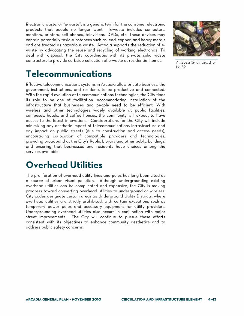
Arcadia General Plan – November 2010 Circulation and Infrastructure Element | 4-43
A necessity, a hazard, or both?
Electronic waste, or “e-waste”, is a generic term for the consumer electronic products that people no longer want. E-waste includes computers, monitors, printers, cell phones, televisions, DVDs, etc. These devices may contain potentially toxic substances such as lead, copper, and heavy metals and are treated as hazardous waste. Arcadia supports the reduction of e-waste by advocating the reuse and recycling of working electronics. To deal with disposal, the City coordinates with its private solid waste contractors to provide curbside collection of e-waste at residential homes.
Telecommunications Effective telecommunications systems in Arcadia allow private business, the government, institutions, and residents to be productive and connected. With the rapid evolution of telecommunications technologies, the City finds its role to be one of facilitation: accommodating installation of the infrastructure that businesses and people need to be efficient. With wireless and other technologies widely available at public facilities, campuses, hotels, and coffee houses, the community will expect to have access to the latest innovations. Considerations for the City will include minimizing any aesthetic impact of telecommunications infrastructure and any impact on public streets (due to construction and access needs), encouraging co-location of compatible providers and technologies, providing broadband at the City’s Public Library and other public buildings, and ensuring that businesses and residents have choices among the services available.
Overhead Utilities The proliferation of overhead utility lines and poles has long been cited as a source of urban visual pollution. Although undergrounding existing overhead utilities can be complicated and expensive, the City is making progress toward converting overhead utilities to underground or wireless. City codes designate certain areas as Underground Utility Districts, where overhead utilities are strictly prohibited, with certain exceptions such as temporary power poles and accessory equipment for utility providers. Undergrounding overhead utilities also occurs in conjunction with major street improvements. The City will continue to pursue these efforts consistent with its objectives to enhance community aesthetics and to address public safety concerns.

4-44 | Circulation and Infrastructure Element Arcadia General Plan - November 2010
Electric Power and Natural Gas Arcadia businesses and residents receive electric power and natural gas services from private companies: Southern California Edison and the Southern California Gas Company, respectively. The City supports these companies’ ongoing programs to make operations more efficient, pursue “green” energy technologies, and encourage reduced energy consumption by Arcadians.
Infrastructure Goals and Policies Maintaining infrastructure capacity to meet the current and future local needs will be an ongoing priority. Areas already identified, through documents such as the City’s Water Master Plan, as needing improvements must be addressed. Equally important, infill development citywide and focused growth in Downtown Arcadia, along Live Oak Avenue, and on the Santa Anita Park property will create new service demands and needs for enhanced infrastructure.
Goal CI-9: A water production, storage, and distribution system that provides quality service equally to all areas of Arcadia, allows the City to maximize use of local water sources, and includes use of recycled water
Policy CI-9.1: Continue to meet customer demands for the
efficient and quality delivery of water services. Policy CI-9.2: Pursue water system upgrades and efficiencies
that can reduce water waste. Policy CI-9.3: Increase water system redundancy for supply,
transmission, storage, and control. Policy CI-9.4: Update the Water Master Plan on a regular
basis, with the objective of a five-year update cycle.
Policy CI-9.5: Use the annual capital planning and funding
process to identify immediate, near-term, and longer-term funding priorities for water system improvements.
Policy CI-9.6: Require developers to pay the full costs
associated with water system improvements
See the Resource Sustainability Element for discussion of energy resources.

Arcadia General Plan – November 2010 Circulation and Infrastructure Element | 4-45
needed specifically to service their development, as well as fair-share costs for enhancements identified in the Water Master Plan and Capital Improvement and Equipment Plan.
Policy CI-9.7: Look for grant opportunities for funding water
system improvements. Policy CI-9.8: Continue to implement programs that require
use of low-flow plumbing fixtures and other water conservation features as a means of optimizing existing water production, storage, and transmission infrastructure, and to reduce volumes of wastewater entering the sewage collection system.
Policy CI-9.9: Continue to investigate the time-frame and
funding opportunities needed to provide recycled water or other non-potable source water for irrigation and other acceptable applications.
Policy CI-9.10: Support regional efforts to use recycled water
to recharge groundwater basins.
Goal CI-10: A local wastewater collection system that provides quality service equally to all areas of Arcadia
Policy CI-10.1: Update the Sewer Master Plan and Hydraulic
Modeling Report on a regular basis. Policy CI-10.2: Provide adequate capacity to convey all
sewage flows. Policy CI-10.3: Minimize frequency of sanitary sewer overflows,
with an objective of zero per year. Policy CI-10.4: Properly manage, operate, and maintain all
parts of the wastewater collection system. Policy CI-10.5: Require developers to pay the full costs
associated with sewer system improvements needed specifically to service their development, as well as fair-share costs for enhancements identified in the Capital Improvement and Equipment Plan.
Policy CI-10.6: Maintain aggressive and effective business
inspection programs that help reduce the

4-46 | Circulation and Infrastructure Element Arcadia General Plan - November 2010
volume of grease and other detrimental materials from entering sewer lines.
Goal CI-11: Storm drain infrastructure that minimizes regional and localized flood hazards
Policy CI-11.1: Use the annual capital planning and funding
process to identify immediate, near-term, and longer-term funding priorities for storm drain system improvements.
Policy CI-11.2: Continue to consult and coordinate local storm
drain system improvement projects with the Los Angeles County Department of Public Works.
Policy CI-11.3: Improve storm drainage infiltration, including
collection and infiltration of water down Santa Anita Canyon and collection and infiltration of water down surface streets.
Policy CI-11.4: Provide detention basins under streets and use
permeable asphalt or similar paving for City parking lots for infiltration into the ground.
Policy CI-11.5: Require developers to pay the full costs
associated with storm drain system improvements needed specifically to service their development, as well as fair-share costs for enhancements identified in the Capital Improvement and Equipment Plan.
Goal CI-12: Waste management practices that provide efficient and cost-effective services to Arcadia residents, businesses, and institutions, and that include an emphasis on waste reduction and recycling
Policy CI-12.1: Contract waste management services with
companies that can help the City achieve waste reduction goals mandated by the State and local objectives for minimizing the volumes of waste that enter landfills.
Policy CI-12.2: Decrease overall community consumption of
non-local, non-renewable, and non-recyclable materials.
Policy CI-12.3: Encourage sustainable procurement and
extended producer responsibility.
See related policies in the Safety Element.

Arcadia General Plan – November 2010 Circulation and Infrastructure Element | 4-47
Policy CI-12.5: Continue to educate consumers about the
importance of proper disposal of hazardous materials and e-waste.
Goal CI-13: Private telecommunications and utilities infrastructure and services responsive to consumer demands and consistent with City aesthetic objectives
Policy CI-13.1: Work with telecommunications service
providers to meet the needs and demands of businesses, residents, and institutions for high-quality and state-of-the-art telecommunications infrastructure and services, including the provision of top-level signal quality and cell phone services throughout the City.
Policy CI-13.2: Continue to enforce City ordinances that
facilitate the placement of utilities and telecommunications facilities in a manner that minimizes visual impact.
Policy CI-13.3: Continue to require the placement of utilities
underground for all new developments.

4-48 | Circulation and Infrastructure Element Arcadia General Plan - November 2010
This page intentionally left blank.