Chapter 3: Refuge Environment · Niagara Falls in New York. In other words, the same layer of rock...
53
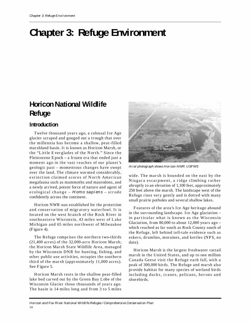
Chapter 3: Refuge Environment Horicon and Fox River National Wildlife Refuges / Comprehensive Conservation Plan 14 Chapter 3: Refuge Environment Horicon National Wildlife Refuge Introduction Twelve thousand years ago, a colossal Ice Age glacier scraped and gouged out a trough that over the millennia has become a shallow, peat-filled marshland basin. It is known as Horicon Marsh, or the “Little Everglades of the North.” Since the Pleistocene Epoch – a frozen era that ended just a moment ago in the vast reaches of our planet’s geologic past – momentous changes have swept over the land. The climate warmed considerably, extinction claimed scores of North American megafauna such as mammoths and mastodons, and a newly arrived, potent force of nature and agent of ecological change – Homo sapiens – strode confidently across the continent. Horicon NWR was established for the protection and conservation of migratory waterfowl. It is located on the west branch of the Rock River in southeastern Wisconsin, 43 miles west of Lake Michigan and 65 miles northwest of Milwaukee (Figure 4). The Refuge comprises the northern two-thirds (21,400 acres) of the 32,000-acre Horicon Marsh; the Horicon Marsh State Wildlife Area, managed by the Wisconsin DNR for hunting, fishing, and other public use activities, occupies the southern third of the marsh (approximately 11,000 acres). See Figure 5. Horicon Marsh rests in the shallow peat-filled lake bed carved out by the Green Bay Lobe of the Wisconsin Glacier those thousands of years ago. The basin is 14 miles long and from 3 to 5 miles wide. The marsh is bounded on the east by the Niagara escarpment, a ridge climbing rather abruptly to an elevation of 1,100 feet, approximately 250 feet above the marsh. The landscape west of the Refuge rises very gently and is dotted with many small prairie potholes and several shallow lakes. Features of the area’s Ice Age heritage abound in the surrounding landscape. Ice Age glaciation – in particular what is known as the Wisconsin Glaciation, from 80,000 to about 12,000 years ago – which reached as far south as Rock County south of the Refuge, left behind tell-tale evidence such as eskers, drumlins, moraines, and kettles (NPS, no date). Horicon Marsh is the largest freshwater cattail marsh in the United States, and up to one million Canada Geese visit the Refuge each fall, with a peak of 300,000 birds. The Refuge and marsh also provide habitat for many species of wetland birds including ducks, cranes, pelicans, herons and shorebirds. Arial photograph shows Horicon NWR. USFWS
Transcript of Chapter 3: Refuge Environment · Niagara Falls in New York. In other words, the same layer of rock...
Chapter 3: Refuge Environment
Chapter 3: Refuge Environment
Horicon National Wildlife RefugeIntroduction
Twelve thousand years ago, a colossal Ice Age glacier scraped and gouged out a trough that over the millennia has become a shallow, peat-filled marshland basin. It is known as Horicon Marsh, or the “Little Everglades of the North.” Since the Pleistocene Epoch – a frozen era that ended just a moment ago in the vast reaches of our planet’s geologic past – momentous changes have swept over the land. The climate warmed considerably, extinction claimed scores of North American megafauna such as mammoths and mastodons, and a newly arrived, potent force of nature and agent of ecological change – Homo sapiens – strode confidently across the continent.
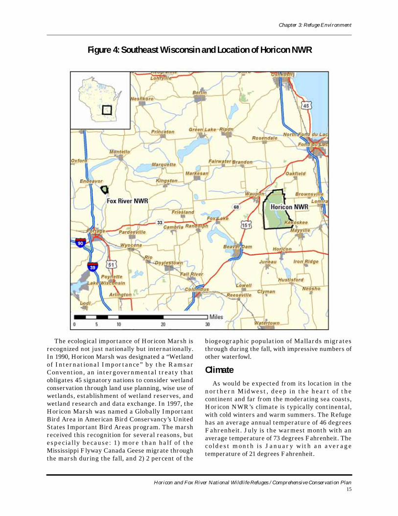
Horicon NWR was established for the protection and conservation of migratory waterfowl. It is located on the west branch of the Rock River in southeastern Wisconsin, 43 miles west of Lake Michigan and 65 miles northwest of Milwaukee (Figure 4).
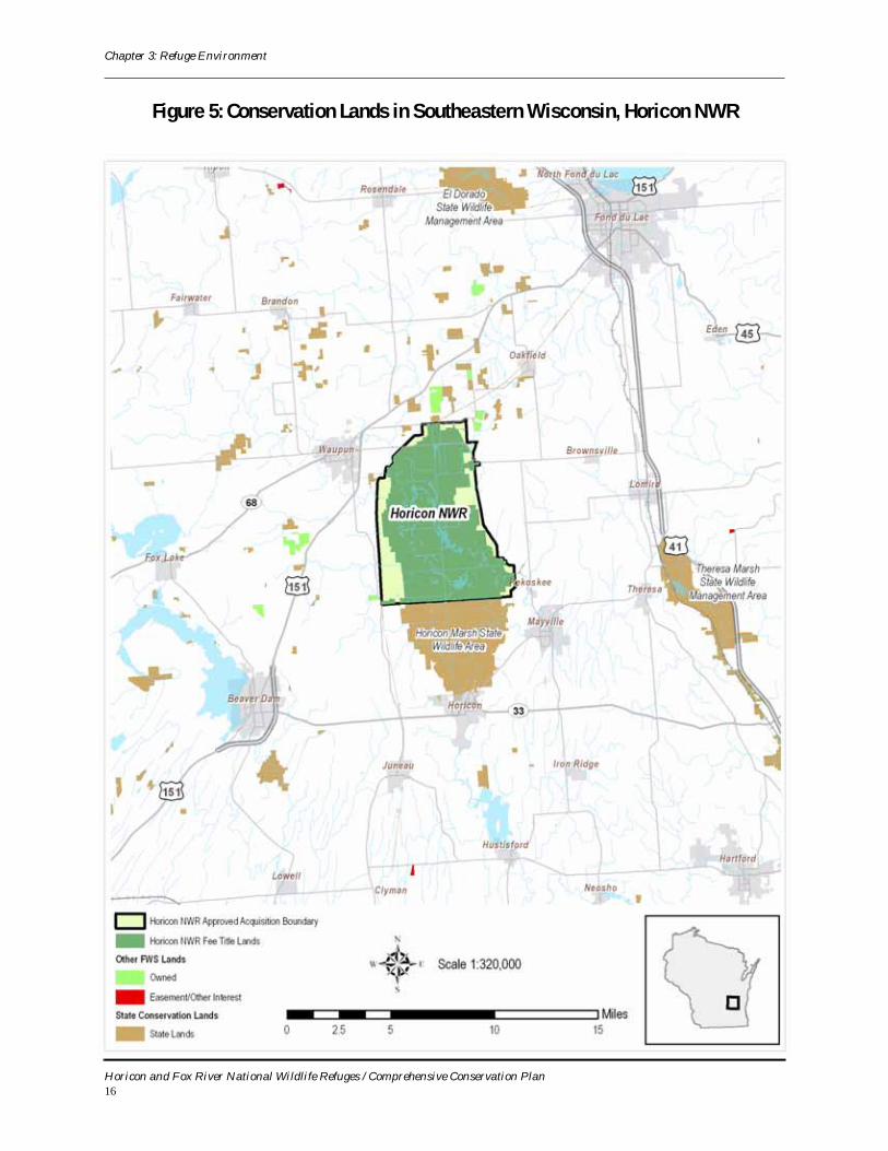
The Refuge comprises the northern two-thirds (21,400 acres) of the 32,000-acre Horicon Marsh; the Horicon Marsh State Wildlife Area, managed by the Wisconsin DNR for hunting, fishing, and other public use activities, occupies the southern third of the marsh (approximately 11,000 acres). See Figure 5.
Horicon Marsh rests in the shallow peat-filled lake bed carved out by the Green Bay Lobe of the Wisconsin Glacier those thousands of years ago. The basin is 14 miles long and from 3 to 5 miles
wide. The marsh is bounded on the east by the Niagara escarpment, a ridge climbing rather abruptly to an elevation of 1,100 feet, approximately 250 feet above the marsh. The landscape west of the Refuge rises very gently and is dotted with many small prairie potholes and several shallow lakes.
Features of the area’s Ice Age heritage abound in the surrounding landscape. Ice Age glaciation – in particular what is known as the Wisconsin Glaciation, from 80,000 to about 12,000 years ago – which reached as far south as Rock County south of the Refuge, left behind tell-tale evidence such as eskers, drumlins, moraines, and kettles (NPS, no date).
Horicon Marsh is the largest freshwater cattail marsh in the United States, and up to one million Canada Geese visit the Refuge each fall, with a peak of 300,000 birds. The Refuge and marsh also provide habitat for many species of wetland birds including ducks, cranes, pelicans, herons and shorebirds.
Arial photograph shows Horicon NWR. USFWS
Horicon and Fox River National Wildlife Refuges / Comprehensive Conservation Plan14
Chapter 3: Refuge Environment
The ecological importance of Horicon Marsh is recognized not just nationally but internationally. In 1990, Horicon Marsh was designated a “Wetland of International Importance” by the Ramsar Convention, an intergovernmental treaty that obligates 45 signatory nations to consider wetland conservation through land use planning, wise use of wetlands, establishment of wetland reserves, and wetland research and data exchange. In 1997, the Horicon Marsh was named a Globally Important Bird Area in American Bird Conservancy’s United States Important Bird Areas program. The marsh received this recognition for several reasons, but especially because: 1) more than half of the Mississippi Flyway Canada Geese migrate through the marsh during the fall, and 2) 2 percent of the
biogeographic population of Mallards migrates through during the fall, with impressive numbers of other waterfowl.
ClimateAs would be expected from its location in the
northern Midwest , deep in the heart of the continent and far from the moderating sea coasts, Horicon NWR’s climate is typically continental, with cold winters and warm summers. The Refuge has an average annual temperature of 46 degrees Fahrenheit. July is the warmest month with an average temperature of 73 degrees Fahrenheit. The co ldest month i s January wi th an average temperature of 21 degrees Fahrenheit.
Figure 4: Southeast Wisconsin and Location of Horicon NWR
Horicon and Fox River National Wildlife Refuges / Comprehensive Conservation Plan15
Chapter 3: Refuge Environment
Figure 5: Conservation Lands in Southeastern Wisconsin, Horicon NWR
Horicon and Fox River National Wildlife Refuges / Comprehensive Conservation Plan16
Chapter 3: Refuge Environment
Annual precipitation is about 28 inches, with approximately 20 inches of this occurring between April and September, and falling as rain. Snowfall averages 34 inches annually. Freezing usually begins around October 1 and lasts until May 12, making the length of the growing season an average of 142 days. Wind speeds average about 10.6 miles per hour throughout the year. March, April, and November have the highest wind speeds with an average of 12 miles per hour. Winds are normally from the south in the summer and the west in the winter (USFWS, 1995).
Geology and GlaciationThe Niagara Escarpment is a layer of bedrock
that consists of limestone cliffs and talus slopes. It abuts the eastern edge of Horicon Marsh and extends further south; north of Horicon Marsh, it reaches into the town of Oakfield and continues all along the eastern shore of Lake Winnebago to Green Bay and Door County. Overall, the Niagara Escarpment extends for a distance of 230 miles in Wisconsin.
The escarpment cont inues beneath Lake Michigan, Lake Huron, Lake Erie, and the State of Michigan, and reappears as a surface feature at Niagara Falls in New York. In other words, the same layer of rock that forms the gentle hills to the east of the marsh extends 500 miles to the east and is the same rock layer over which the Niagara River plunges at Niagara Falls. It has been said that residents of eastern Wisconsin live, work, and play on the backside of Niagara Falls.
The escarpment, or “Ledge,” is up to 250 feet high, but the maximum thickness of this rock layer varies from 450 to 800 feet. The Ledge’s rock – dolomitic limestone – is more than 400 million years old. In comparison, the Appalachian Mountains are about 480 million years old and the Rockies about 70 million. However, the Ledge can be considered even younger because it was reformed at its current location by the last glacier, which receded from this area about 12,000 years ago.
The durability of the Ledge is due to the erosion-resistant sedimentary rocks that form it: limestones and dolomites laid down in the Silurian Period from 443 to 417 million years ago. Dolomite, the main ingredient, was formed by calcium and magnesium c a r b o n a t e [ C a M g ( C O 3 ) 2 ] d e p o s i t e d f r o m decomposing shells and skeletons of primitive sea life that lived in a subtropical coral reef. At the
time, this ancient inland sea’s basin covered all of what is now lower Michigan, Lake Michigan and eastern Wisconsin.
A soft, impermeable layer called Maquoketa shale lies beneath the Ledge. It was formed during the Ordovician Period (about 480 million years ago) when thick deposits of mud were laid down from erosion in the Appalachian Mountains rising to the east as North America collided with Africa to form the supercontinent of Pangea. Today, this shale erodes quickly where it is exposed, allowing the dolomite to continually break off and form a new cliff face, the same process can be measured at Niagara Falls in miles per century. It is in part because of this relatively soft shale layer that Horicon Marsh was later formed by glacial action.
It is also partly because of this impermeable shale bed that many crystal-clear springs form at the base of the Ledge. Fed by precipitation, water flows down slope at and beneath the surface of the Ledge through the dolomite, which is highly fractured into perpendicular horizontal and vertical joints. Springs form at the base of the Ledge where
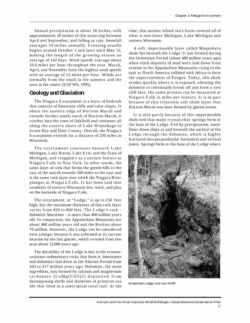
Breakneck Ledge, Horicon NWR
Horicon and Fox River National Wildlife Refuges / Comprehensive Conservation Plan17
Chapter 3: Refuge Environment
glaciers deposited drift consisting in part of impermeable clays. Water eventually drains into Horicon Marsh or Lake Winnebago.
Besides ancient marine life and the resulting upwarping, glacial ice also molded the Ledge. In some places successive glaciers obliterated it, making it a difficult landscape feature to trace in southern Wisconsin. In other places, glaciers created huge fissures and crevasses. The Ledge would certainly be higher and sharper without the impacts of glacial scouring and bulldozing (USFWS, no date-a).
Vast continental glaciers altered Wisconsin’s landscape many times during a series of glacial periods over at least the last one million years through four different Ice Ages. Named for the location of their most southerly advance, those Ice Ages are called the Nebraskan, Kansan, Illinoisan, and Wisconsin. The Horicon Marsh that we see today was most a f fected by the Wiscons in Glaciation, the most recent of the Ice Age advances.
The Wisconsin Glaciation lasted from 80,000 years ago to about 12,000 years ago, leaving behind a terminal moraine 900 miles in length throughout the state. The enormous glaciers, more than a mile thick in places, did not simply come and go, leaving no trace of their existence. Rather, they advanced and retreated gradually and on majestic scale, and in so doing shaped the landscape of today’s Wisconsin and the other Great Lakes states. The five Great Lakes themselves, also a product of the extensive glaciation, are visible from the moon. While not visible from the moon, other glacial features such as bogs, fens, lakes, marshes, erratics, moraines, kames, eskers, drumlins, potholes, and kettles, are quite evident to earth-bound observers and serve as constant reminders of Horicon Marsh’s icy past.
The Green Bay lobe of the Wisconsin Glaciation gripped eastern Wisconsin and scoured out Green Bay, the Fox River, Lake Winnebago, Horicon Marsh, and the Rock River basin reaching as far south as Janesville and Madison. As the glacier lobes receded, flowing meltwater pooled, forming large lakes where silt and clay collected. In the Fox River valley, Green Bay, and Lake Winnebago are small remnant depressions of one such huge lake, Glacial Lake Oshkosh (Attig et al., 2005).
The g l ac ier re ce de d in s tages , c r eat ing recessional moraines that mark a temporary, icy delay in their retreat. The City of Horicon on the
south end of the Marsh is built on such a recessional moraine. For awhile, it acted as an earthen dam, holding back melting ice waters into Glacial Lake Horicon, 51 square miles in size, and five times larger than Lake Mendota. The headwaters of the Rock River formed near this lake. Rising glacial melt waters eventually wore a path over and down through the moraine. Over time, water flow broke through the dam, and water levels on the lake lowered, draining the lake. The lowering of the glacial lake level stopped abruptly, when the Rock River reached the hard Galena-Dolomite rock strata (layer) in its bed at Hustisford Rapids, 7 miles downstream from Horicon Marsh. This solid rock strata has acted as a natural dam, maintaining a fairly constant level of water, north to the Fond du Lac County line. As crushed gravel, sand, fine silts and clays were deposited in the Glacial Lake Horicon basin, it evolved into the marsh it is today.
Today, Horicon Marsh is considered an extinct glacial lake. The manmade dam on the Rock River in the City of Horicon is located conveniently within the recessional moraine that once held back the meltwaters for Glac ia l Lake Hor icon . The headquarters for the Horicon Marsh State Wildlife Area is built on a large drumlin (an elongated hill or ridge of glacial drift or till), with many more drumlins in a fan-shaped pattern to the south of the City of Horicon in Dodge and Jefferson Counties. Other moraines occur on the northeast and northwest corners of Horicon NWR. Glacial erratics – boulders carried away from their place of origin and deposited elsewhere as the glacier melted – dot the landscape and are especially noticeable after prescribed fires (USFWS, no date-b).
SoilsThe major factors in soil formation are parent
material, climate, relief, topography, vegetation, and time. Soils in the Horicon NWR area are the result of atmospheric, chemical, and organic forces modifying the surface of the glacial deposits. The glacial deposits consist of unsorted sand, gravel, boulders, clay, fragments of local limestone and sandstone bedrock, and igneous and metamorphic rock from outside the region. Soils include those of a glacial deposit origin and vary between poorly drained peat and muck types, transition silty loam soils interspersed with sandy loam and clay, to excellent agricultural soils being intensively farmed. Topsoil depths range from 10 to 14 inches. Soil types around the Refuge include Houghton
Horicon and Fox River National Wildlife Refuges / Comprehensive Conservation Plan18
Chapter 3: Refuge Environment
muck and peat soils, which cover about 90 percent of the Refuge and other soils that cover upland areas and margins surrounding the marsh. Soil groups associated with the margins of the marsh include the following:
# Stoney land wet and maumee sandy loams – found around drainage ways and on foot slopes of moraines on the east side of the Refuge. They are very poorly drained sandy soils with rounded glacial stones 1 to 2 feet in diameter. Depth of groundwater is 0 to 3 feet.
# Pella – Virgil silt loams – transition soils located between the marsh and the uplands. They are gently sloping somewhat poorly drained silty loam soils underlain by sandy loam glacial till at depths of 3 to 4 feet. These soils have seasonally high groundwater table and may be inundated for short periods of time.
# LeRoy – Theresa silt loams – consisting of deep, gently sloping to steep, well-drained soils located in the upland areas. These soils are typical of the farmlands surrounding the Refuge. Groundwater on these soils is at a depth of 6 feet or greater.
# Beecher – Morley silt loams – prominent on the uplands along the central eastern border and the northern tip of the Refuge. These soils are poorly to well-drained, level to steep silt loams underlain by calcareous silty clay loam till. Depth to groundwater is 1 to 3 feet.
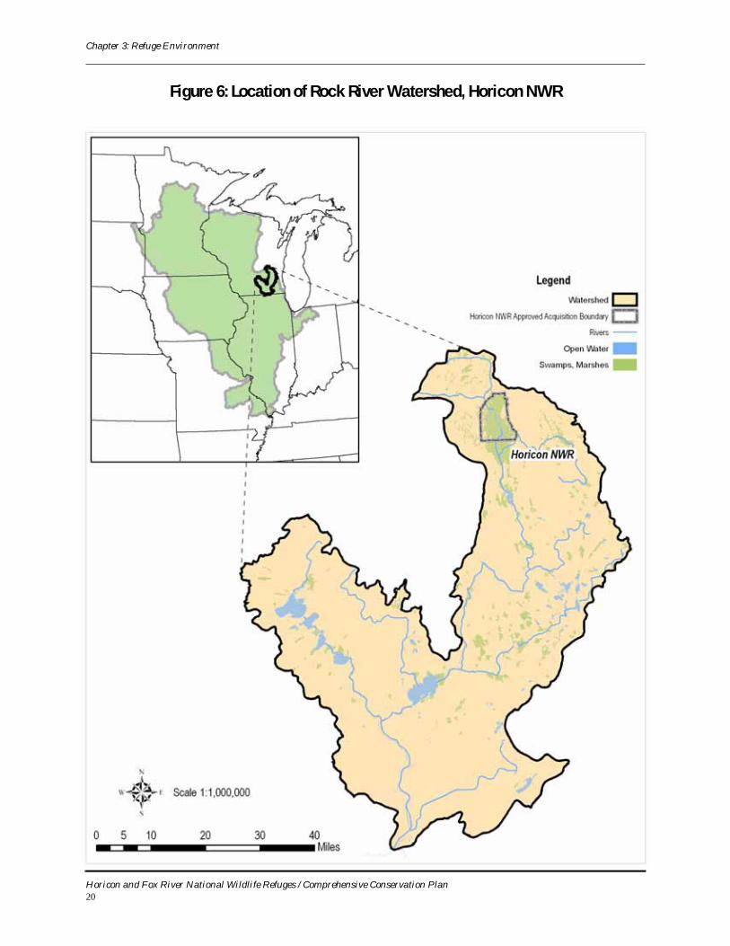
Surface HydrologyHoricon Marsh is located in the headwater
region of the Upper Rock River Watershed (Figure 6). The marsh occupies a long north-south trending valley excavated by glacial action, with
steeply rising terrain of the Niagara escarpment to the east and gently rolling glacial deposits to the north and west. The Rock River rises less than 30 miles north of the marsh and discharges into the Mississippi River at Rock Island, Illinois. The Upper Rock River Watershed drains a total of 266.5 square miles (Wisconsin Wetlands Inventory, 1978-1979).
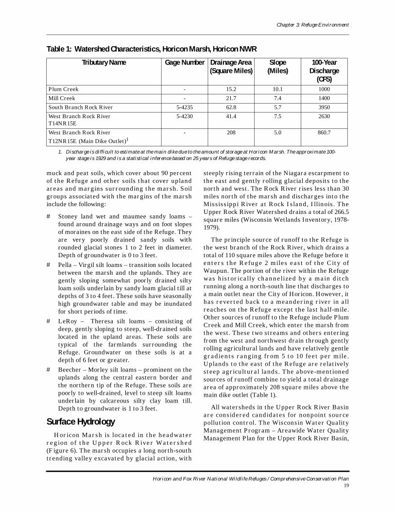
The principle source of runoff to the Refuge is the west branch of the Rock River, which drains a total of 110 square miles above the Refuge before it enters the Refuge 2 miles east of the City of Waupun. The portion of the river within the Refuge was historically channelized by a main ditch running along a north-south line that discharges to a main outlet near the City of Horicon. However, it has reverted back to a meandering river in all reaches on the Refuge except the last half-mile. Other sources of runoff to the Refuge include Plum Creek and Mill Creek, which enter the marsh from the west. These two streams and others entering from the west and northwest drain through gently rolling agricultural lands and have relatively gentle gradients ranging from 5 to 10 feet per mile. Uplands to the east of the Refuge are relatively steep agricultural lands. The above-mentioned sources of runoff combine to yield a total drainage area of approximately 208 square miles above the main dike outlet (Table 1).
All watersheds in the Upper Rock River Basin are considered candidates for nonpoint source pollution control. The Wisconsin Water Quality Management Program – Areawide Water Quality Management Plan for the Upper Rock River Basin,
Table 1: Watershed Characteristics, Horicon Marsh, Horicon NWR
Tributary Name Gage Number Drainage Area (Square Miles)
Slope(Miles)
100-Year Discharge
(CFS)Plum Creek - 15.2 10.1 1000
Mill Creek - 21.7 7.4 1400
South Branch Rock River 5-4235 62.8 5.7 3950
West Branch Rock RiverT14NR15E
5-4230 41.4 7.5 2630
West Branch Rock RiverT12NR15E (Main Dike Outlet)1
- 208 5.0 860.7
1. Discharge is difficult to estimate at the main dike due to the amount of storage at Horicon Marsh. The approximate 100-year stage is 1929 and is a statistical inference based on 25 years of Refuge stage records.
Horicon and Fox River National Wildlife Refuges / Comprehensive Conservation Plan19
Chapter 3: Refuge Environment
Figure 6: Location of Rock River Watershed, Horicon NWR
Horicon and Fox River National Wildlife Refuges / Comprehensive Conservation Plan20
Chapter 3: Refuge Environment
1989 (Plan) outlines 11 management activities that should be undertaken to reduce water quality impacts from nonpoint sources. They are:
# Nonpoint source water resource monitoring needs;
# Reduce cropland erosion in areas likely to be affecting water quality;
# Reduce bank erosion on adversely impacted lakes and streams;
# Reduce the water quality impacts of livestock concentration areas including barnyards, feedlots, rest areas, and grazed woodlots, pastures, and streambanks;
# Minimize the water quality impacts of construction site erosion and runoff;
# Develop and carry out a program to control erosion along roadsides;
# Minimize the impact of urban stormwater discharges on lake and stream water quality;
# Reduce the impact of hydrologic modifications such as stream straightening and dams;
# Give priority for nonpoint source monitoring and evaluation to priority watersheds and watersheds being considered for priority watershed selection;
# Seek additional means of financing nonpoint source pollution abatement work; and
# Counties in the basin should identify failing septic systems and require their replacement.
In the watershed upstream of Horicon Marsh, eros ion and sedimentat ion assoc iated with agricultural land uses are an issue for the Refuge b ec a u se t h e se s e d i m e n t s a re t ra n s po r t e d downstream by the Rock River and deposited in the low-gradient, low-kinetic energy marsh.
Wilderness ReviewAs part of the CCP process, lands within the leg-
islative boundaries of both Refuges were reviewed for wilderness suitability. No lands were found suit-able for designation as Wilderness as defined by the Wilderness Act of 1964. With the possible exception of the Main Pool impoundment on Horicon NWR, the Refuges do not contain 5,000 contiguous road-less acres, nor do they have any units of sufficient size to make their preservation practicable as Wil-derness. Lands acquired for both refuges have been substantially affected by humans, particularly through agriculture and transportation infrastruc-ture.
Archeological and Cultural Values Land in the area of Horicon NWR and Fox River
NWR was important to prehistoric peoples and to Euro-American settlers. Horicon Marsh has been an exceptionally rich resource for subsistence cul-tures since the glaciers left, and this long and heavy use by prehistoric people is recorded in the numer-ous archeological sites on and around the marsh. For Euro-Americans, the marsh and its outlet were important resources for commercial and light indus-trial development, and later for commercial and rec-reational hunting.
The cultures of the prehistoric and early historic periods at Horicon and Fox River refuges are basi-cally the same although the Horicon Marsh area appears to have supported a larger amount of human use.
An archeological site near the Refuge in Fond du Lac County shows evidence of people during the late PaleoIndian period. The PaleoIndian period extends from 10000 B.C. to about 8000 B.C. and rep-resents the culture of the earliest known peoples in Wisconsin. The evidence for these people is usually associated with mega-fauna (i.e., bison) kill and butchering sites. Any sites containing evidence of people from this period would be considered very important.
Several archeological sites on and near the Ref-uges contain evidence of people from the next cul-tural period, known as the Archaic, covering the period 8000 to 1000 B.C. These people appear to have been hunters and gatherers, making a seasonal round of subsistence resource locations. Late in the period (or early in the next cultural period) these people began burying their dead in natural mounds and commenced using pottery. Very little is known about this long and early culture, so intact sites con-taining Archaic period material could be very important. During the altithermal, a hot and dry period extending from 4700 to 3000 B.C., people appear to have clustered around the few remaining (and shrunken) bodies of water such as Horicon Marsh. But overall, populations grew substantially as the people exploited increasingly varried habi-tats.
The Woodland period extended from 1000 B.C. to A.D. 1600. Most archeological sites on and around the Refuges contain Woodland period components. The people of this culture are mostly identified by their burial mounds and by their use of pottery. Late in the period they began using the bow and
Horicon and Fox River National Wildlife Refuges / Comprehensive Conservation Plan21
Chapter 3: Refuge Environment
arrow; prior to that time “arrowheads” were spear-points. Although hunting and gathering continued with its seasonal round of resource areas, they also had larger permanent seasonal villages and grew corn, beans, and squash in gardens.
The Mississippian culture centered in the St. Louis, Missouri, vicinity, covered the period A.D. 1000 to 1600. Wisconsin was in the northern periph-ery and just two sites near Horicon NWR are reported to contain evidence of this late prehistoric culture.
European arrival in the Carribean and on the Atlantic coast introduced Western culture and resulted in severe disruption of the prehistoric cul-tures in Wisconsin long before the first European entered Wisconsin. European-introduced diseases spread ahead of Caucasian population advances and decimated the native populations with reports of up to 90% mortality. Horses and guns made some tribes powerful and led to westward movements of eastern tribes. The fur trade with Europeans fur-ther disrupted native cultures. These and many other events led to consolidation and disintegration and relocation of Indian tribes so that identifying historical tribal antecedents in the archeological record is almost impossible.
The historic period tribes encountered by Euro-peans in Wisconsin generally and in the Horicon NWR area specifically included the Winnebago (some of which are known as the Ho-Chunk) as well as the Potowatomi and Menominee. Other tribes within Wisconsin that may have visited the Refuge area include the Ottawa, Huron, Fox, Sauk, Miami, Mascouten, and Ojibwa. Historic tribal archeologi-cal sites are located on and near Horicon NWR.
For the historic period, human activities in each Refuge area were different.
The first Western culture settlement appears to have been in the town of Horicon vicinity. Joel Doolittle built the first cabin in 1845. The first dam at Horicon Marsh was probably built in 1845, replaced a year later by a higher dam that raised the marsh water level by nine feet, and led to fur-ther settlement and a sawmill, grist mill, blacksmith shop, stores, and the Horicon Hotel; the owners removed the dam in 1869. Other towns originating during this period included Burnett, Waupun, and Mayville. From the time of the first dam Euro-Americans manipulated Horicon Marsh water levels for floating logs downstream to St. Louis and other places in the 1850s; and farmers drained, ditched,
and plowed the marsh commencing in the 1870s. Recreational hunting became important in the late 19th and early 20th century as hunting clubs acquired land and built low head dams and hunting lodges. In 1930 another dam was built and water levels elevated for waterfowl habitat, then lowered for farming. Thus for the past 150 years the Hori-con Marsh has been subjected to a variety manipu-lations to support commercial, recreational, and agricultural activities.
The Fox River was part of one of the most impor-tant transportation routes, from the Great Lakes to the Mississippi River and to the Gulf of Mexico, dur-ing the 17th and 18th centuries. The first steam boat came up the Fox River in 1851. Nevertheless the Refuge area was agricultural until acquired by the FWS. Immediately east of the Refuge is Foun-tain Lake Farm, the John Muir Farmstead, that is listed on the National Register of Historic Places.
The two Refuges have 16 completed cultural resources (archeological) studies. Based on these studies and information from the Wisconsin Historic Preservation Database and other sources, known and reported cultural resources on the two Refuges can be summarized.
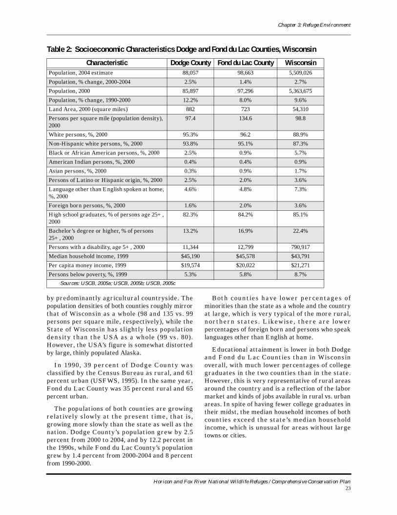
Social and Economic ContextMost of Horicon NWR is located in Dodge
County, Wisconsin, with a small portion in the north located in Fond du Lac County, Wisconsin. Table 2presents social and economic indicators of these two counties in comparison with the State of Wisconsin as a whole.
Both Dodge and Fond du Lac Counties are characterized by a mixture of rural and urban areas, that is, small towns and villages surrounded
Otter tracks, Horicon NWR
Horicon and Fox River National Wildlife Refuges / Comprehensive Conservation Plan22
Chapter 3: Refuge Environment
by predominantly agricultural countryside. The population densities of both counties roughly mirror that of Wisconsin as a whole (98 and 135 vs. 99 persons per square mile, respectively), while the State of Wisconsin has slightly less population density than the USA as a whole (99 vs. 80). However, the USA’s figure is somewhat distorted by large, thinly populated Alaska.
In 1990, 39 percent of Dodge County was classified by the Census Bureau as rural, and 61 percent urban (USFWS, 1995). In the same year, Fond du Lac County was 35 percent rural and 65 percent urban.
The populations of both counties are growing relatively slowly at the present time, that is, growing more slowly than the state as well as the nation. Dodge County’s population grew by 2.5 percent from 2000 to 2004, and by 12.2 percent in the 1990s, while Fond du Lac County’s population grew by 1.4 percent from 2000-2004 and 8 percent from 1990-2000.
Both counties have lower percentages of minorities than the state as a whole and the country at large, which is very typical of the more rural, northern states . Likewise , there are lower percentages of foreign born and persons who speak languages other than English at home.
Educational attainment is lower in both Dodge and Fond du Lac Counties than in Wisconsin overall, with much lower percentages of college graduates in the two counties than in the state. However, this is very representative of rural areas around the country and is a reflection of the labor market and kinds of jobs available in rural vs. urban areas. In spite of having fewer college graduates in their midst, the median household incomes of both counties exceed the state’s median household income, which is unusual for areas without large towns or cities.
Table 2: Socioeconomic Characteristics Dodge and Fond du Lac Counties, Wisconsin
Characteristic Dodge County Fond du Lac County WisconsinPopulation, 2004 estimate 88,057 98,663 5,509,026
Population, % change, 2000-2004 2.5% 1.4% 2.7%
Population, 2000 85,897 97,296 5,363,675
Population, % change, 1990-2000 12.2% 8.0% 9.6%
Land Area, 2000 (square miles) 882 723 54,310
Persons per square mile (population density), 2000
97.4 134.6 98.8
White persons, %, 2000 95.3% 96.2 88.9%
Non-Hispanic white persons, %, 2000 93.8% 95.1% 87.3%
Black or African American persons, %, 2000 2.5% 0.9% 5.7%
American Indian persons, %, 2000 0.4% 0.4% 0.9%
Asian persons, %, 2000 0.3% 0.9% 1.7%
Persons of Latino or Hispanic origin, %, 2000 2.5% 2.0% 3.6%
Language other than English spoken at home, %, 2000
4.6% 4.8% 7.3%
Foreign born persons, %, 2000 1.6% 2.0% 3.6%
High school graduates, % of persons age 25+, 2000
82.3% 84.2% 85.1%
Bachelor’s degree or higher, % of persons 25+, 2000
13.2% 16.9% 22.4%
Persons with a disability, age 5+, 2000 11,344 12,799 790,917
Median household income, 1999 $45,190 $45,578 $43,791
Per capita money income, 1999 $19,574 $20,022 $21,271
Persons below poverty, %, 1999 5.3% 5.8% 8.7%Sources: USCB, 2005a; USCB, 2005b; USCB, 2005c
Horicon and Fox River National Wildlife Refuges / Comprehensive Conservation Plan23
Chapter 3: Refuge Environment
It is of note that both counties have more than 10,000 residents with at least one disability, which underscores the importance of Horicon NWR having accessible facilities.
Several geographic features are important to the local economy. Mineral resources are extracted and sold, the high quality soil contributes to the success of agriculture, and the climate affords opportunities for many economic activities and causes limitations for others. The surrounding landscape consists of gently rolling hills, flat agricultural land, drained and cropped wetlands, and patches of deciduous forest. Upland sites are dominated by agriculture, espec ia l ly da iry farming, and conta in n ine communities with populations from approximately 200 to more than 8,000 people. Little of the native forest cover remains in the two-county area. The main forest species are oak, elm, maple, and other hardwoods. There is limited economic potential from the remaining woodlots since they tend to be sma l l and wide ly scat tered . Many conta in residential development and some are located on public lands (USFWS, 1995).
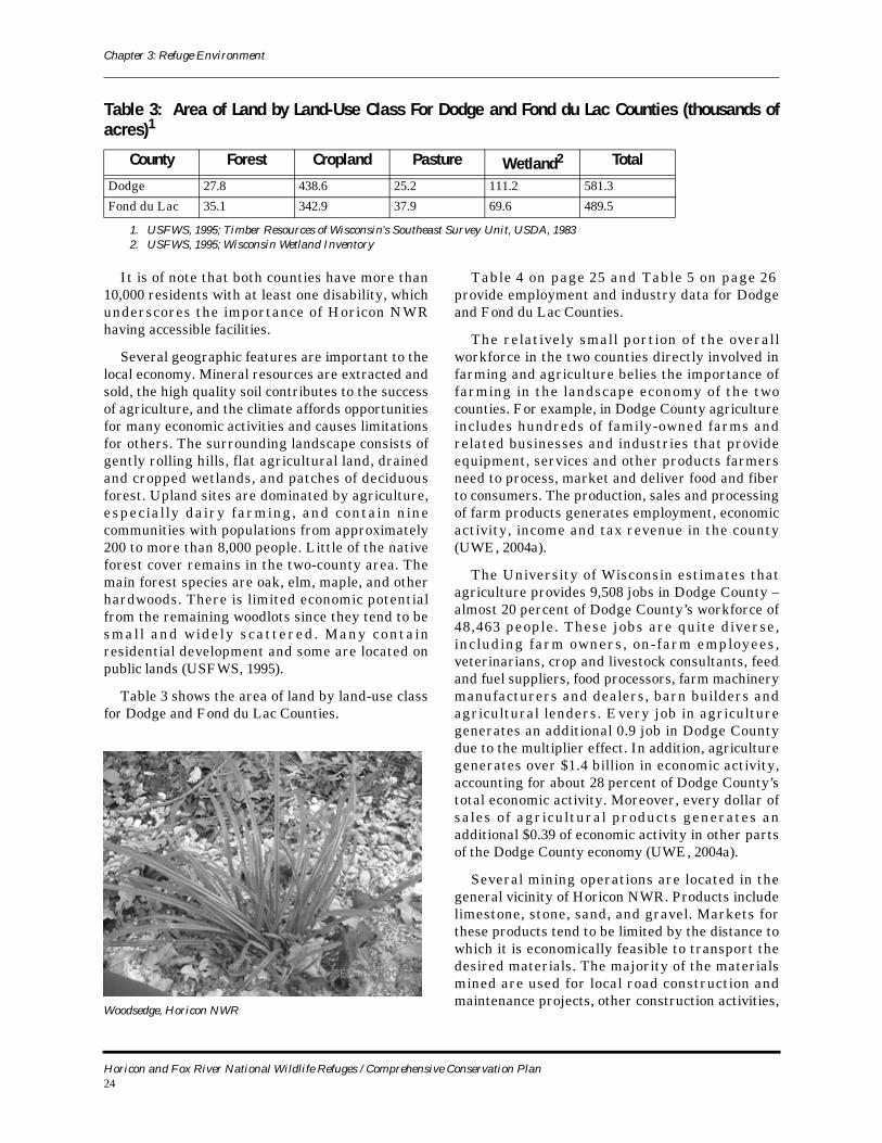
Table 3 shows the area of land by land-use class for Dodge and Fond du Lac Counties.
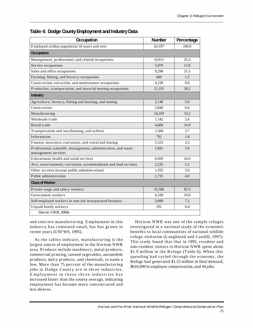
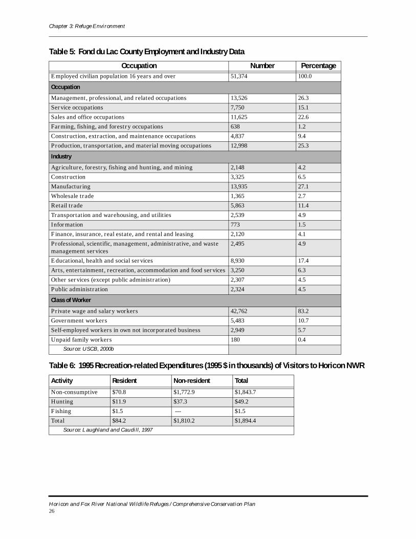
Table 4 on page 25 and Table 5 on page 26provide employment and industry data for Dodge and Fond du Lac Counties.
The relatively small portion of the overall workforce in the two counties directly involved in farming and agriculture belies the importance of farming in the landscape economy of the two counties. For example, in Dodge County agriculture includes hundreds of family-owned farms and related businesses and industries that provide equipment, services and other products farmers need to process, market and deliver food and fiber to consumers. The production, sales and processing of farm products generates employment, economic activity, income and tax revenue in the county (UWE, 2004a).
The University of Wisconsin estimates that agriculture provides 9,508 jobs in Dodge County – almost 20 percent of Dodge County’s workforce of 48,463 people. These jobs are quite diverse, including farm owners, on-farm employees, veterinarians, crop and livestock consultants, feed and fuel suppliers, food processors, farm machinery manufacturers and dealers, barn builders and agricultural lenders. Every job in agriculture generates an additional 0.9 job in Dodge County due to the multiplier effect. In addition, agriculture generates over $1.4 billion in economic activity, accounting for about 28 percent of Dodge County’s total economic activity. Moreover, every dollar of sales of agricultural products generates an additional $0.39 of economic activity in other parts of the Dodge County economy (UWE, 2004a).
Several mining operations are located in the general vicinity of Horicon NWR. Products include limestone, stone, sand, and gravel. Markets for these products tend to be limited by the distance to which it is economically feasible to transport the desired materials. The majority of the materials mined are used for local road construction and maintenance projects, other construction activities,
Table 3: Area of Land by Land-Use Class For Dodge and Fond du Lac Counties (thousands of acres)1
County Forest Cropland Pasture Wetland2 Total
Dodge 27.8 438.6 25.2 111.2 581.3
Fond du Lac 35.1 342.9 37.9 69.6 489.5
1. USFWS, 1995; Timber Resources of Wisconsin’s Southeast Survey Unit, USDA, 19832. USFWS, 1995; Wisconsin Wetland Inventory
Woodsedge, Horicon NWR
Horicon and Fox River National Wildlife Refuges / Comprehensive Conservation Plan24
Chapter 3: Refuge Environment
and concrete manufacturing. Employment in this industry has remained small, but has grown in recent years (USFWS, 1995).
As the tables indicate, manufacturing is the largest source of employment in the Horicon NWR area. Products include machinery, metal products, commercial printing, canned vegetables, automobile products, dairy products, and chemicals, to name a few. More than 75 percent of the manufacturing jobs in Dodge County are in three industries. Employment in these three industr ies has increased faster than the county average, indicating employment has become more concentrated and less diverse.
Horicon NWR was one of the sample refuges investigated in a national study of the economic benefits to local communities of national wildlife refuge visitation (Laughland and Caudill, 1997). This study found that that in 1995, resident and non-resident visitors to Horicon NWR spent about $1.9 million in the Refuge (Table 6). When this spending had cycled through the economy, the Refuge had generated $1.53 million in final demand, $616,000 in employee compensation, and 44 jobs.
Table 4: Dodge County Employment and Industry Data
Occupation Number PercentageEmployed civilian population 16 years and over 43,197 100.0
Occupation
Management, professional, and related occupations 10,911 25.3
Service occupations 5,979 13.8
Sales and office occupations 9,298 21.5
Farming, fishing, and forestry occupations 660 1.5
Construction, extraction, and maintenance occupations 4,158 9.6
Production, transportation, and material moving occupations 12,191 28.2
Industry
Agriculture, forestry, fishing and hunting, and mining 2,148 5.0
Construction 2,840 6.6
Manufacturing 14,359 33.2
Wholesale trade 1,142 2.6
Retail trade 4,668 10.8
Transportation and warehousing, and utilities 1,584 3.7
Information 792 1.8
Finance, insurance, real estate, and rental and leasing 1,523 3.5
Professional, scientific, management, administrative, and waste management services
1,691 3.9
Educational, health and social services 6,929 16.0
Arts, entertainment, recreation, accommodation and food services 2,235 5.2
Other services (except public administration) 1,555 3.6
Public administration 1,731 4.0
Class of Worker
Private wage and salary workers 35,568 82.3
Government workers 4,339 10.0
Self-employed workers in own not incorporated business 3,099 7.2
Unpaid family workers 191 0.4Source: USCB, 2000a
Horicon and Fox River National Wildlife Refuges / Comprehensive Conservation Plan25
Chapter 3: Refuge Environment
Table 5: Fond du Lac County Employment and Industry Data
Occupation Number PercentageEmployed civilian population 16 years and over 51,374 100.0
Occupation
Management, professional, and related occupations 13,526 26.3
Service occupations 7,750 15.1
Sales and office occupations 11,625 22.6
Farming, fishing, and forestry occupations 638 1.2
Construction, extraction, and maintenance occupations 4,837 9.4
Production, transportation, and material moving occupations 12,998 25.3
Industry
Agriculture, forestry, fishing and hunting, and mining 2,148 4.2
Construction 3,325 6.5
Manufacturing 13,935 27.1
Wholesale trade 1,365 2.7
Retail trade 5,863 11.4
Transportation and warehousing, and utilities 2,539 4.9
Information 773 1.5
Finance, insurance, real estate, and rental and leasing 2,120 4.1
Professional, scientific, management, administrative, and waste management services
2,495 4.9
Educational, health and social services 8,930 17.4
Arts, entertainment, recreation, accommodation and food services 3,250 6.3
Other services (except public administration) 2,307 4.5
Public administration 2,324 4.5
Class of Worker
Private wage and salary workers 42,762 83.2
Government workers 5,483 10.7
Self-employed workers in own not incorporated business 2,949 5.7
Unpaid family workers 180 0.4Source: USCB, 2000b
Table 6: 1995 Recreation-related Expenditures (1995 $ in thousands) of Visitors to Horicon NWR
Activity Resident Non-resident Total
Non-consumptive $70.8 $1,772.9 $1,843.7
Hunting $11.9 $37.3 $49.2
Fishing $1.5 --- $1.5
Total $84.2 $1,810.2 $1,894.4Source: Laughland and Caudill, 1997
Horicon and Fox River National Wildlife Refuges / Comprehensive Conservation Plan26
Chapter 3: Refuge Environment
The study concluded that Horicon NWR had a net economic value of $1,840,200. Every dollar of budget expenditure at the Refuge generated economic effects of $10.12. While the Refuge is a small part of the regional economy, Horicon NWR and the marsh it protects help define the region’s character and maintain its quality of life, and thus are important for the promotion of a diverse regional economy (Laughland and Caudill, 1997).
Natural Resources
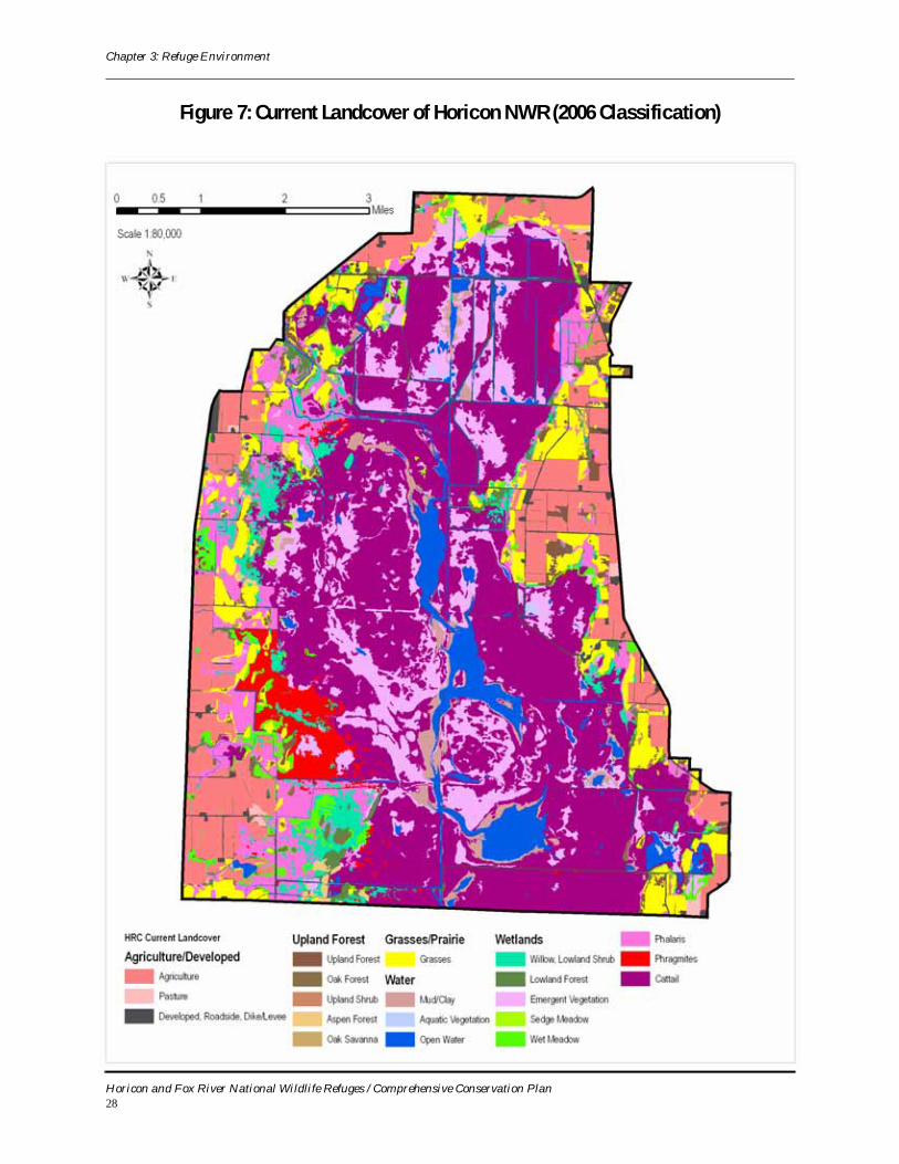
HabitatsHoricon NWR includes over 15,500 acres of
marsh and 5,600 acres of associated upland habitat (Figure 7 ) . Marsh habi tat i s seasonal ly to permanently flooded and dominated by cattail, river bulrush, common reed grass (phragmites), sedges, and reed canary grass. Uplands include nearly 3,600 acres of grasslands and 2,000 acres of woodlands (USFWS, 1995).
Of the nearly 16,000 acres of wetlands on the Refuge, approximately 3,000 acres are seasonally flooded (Type I) basins, 12,000 acres are deep (Type IV) freshwater marshes, and 1,000 acres are sub-impoundments. Roughly half of the Refuge consists of dense stands of cattails, either in solid stand or mixed with other species. Other species include soft-stemmed bulrush, hard-stemmed bulrush, slender bulrush, river bulrush, burreed, various sedges, smartweeds, chufas, pigweeds, millets, and sagittaria. There are approximately 2,000 acres of moist soil plants found in and around the edges of the water areas during drawdown condition. These include chufas, smartweeds, pigweeds, etc. About half of the aquatic areas consist of fairly deep lakes, ditches, and other water areas in which stands of submersed aquatics are found. These include various pondweeds, coontail, elodea, duckweeds, and milfoil (USFWS, 1995).
Grasslands consist of approximately 57 percent introduced grasslands, 24 percent forbs, 17 percent are native grasslands, and 3 percent are wet meadows. Woodlands are willow-dominated (55 percent), mixed hardwoods (22 percent), aspen-dominated (12 percent), willow-cattail (8 percent), and oak savanna (3 percent). From these figures, it is evident that almost two-thirds (63 percent) of the Refuge’s woodlands are lowland or bottomland and a little more than one-third (37 percent) are upland woodlands.
Resource management at the Refuge involves using a variety of techniques to preserve and enhance habitats for wildlife, with programs both in m a r s h a n d up l a n d m a n a g e m e n t . M a r s h management involves the manipulation of water levels to achieve a desired succession of wetland plant communities to meet the seasonal needs of wildlife populations. Upland management includes establishing and maintaining grasslands to provide nesting habitat for ducks, Sandhill Cranes, and various song birds. Management objectives include waterfowl production and migratory bird use, with Redhead ducks being emphasized.
WildlifeWaterfowl
Horicon Marsh is a major migratory stop-over point for waterfowl (ducks, geese, and swans) of the Mississippi Flyway, with use-days reaching six to 12 million annually. Waterfowl production averages about 3,000 ducklings per year.
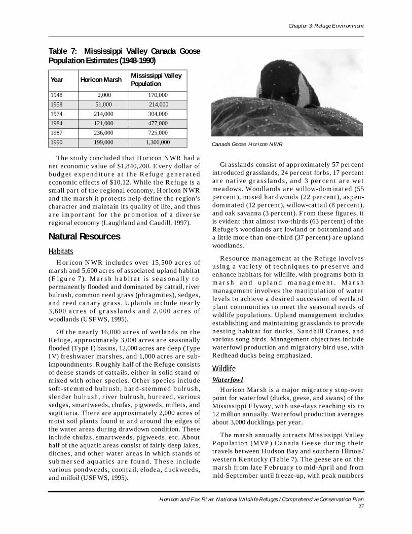
The marsh annually attracts Mississippi Valley Population (MVP) Canada Geese during their travels between Hudson Bay and southern Illinois/western Kentucky (Table 7). The geese are on the marsh from late February to mid-April and from mid-September until freeze-up, with peak numbers
Table 7: Mississippi Valley Canada Goose Population Estimates (1948-1990)
Year Horicon Marsh Mississippi Valley Population
1948 2,000 170,000
1958 51,000 214,000
1974 214,000 304,000
1984 121,000 477,000
1987 236,000 725,000
1990 199,000 1,300,000 Canada Goose, Horicon NWR
Horicon and Fox River National Wildlife Refuges / Comprehensive Conservation Plan27
Chapter 3: Refuge Environment
Figure 7: Current Landcover of Horicon NWR (2006 Classification)
Horicon and Fox River National Wildlife Refuges / Comprehensive Conservation Plan28
Chapter 3: Refuge Environment
in mid-October. The marsh is an important staging area which fuels their journey north and furnishes energy for reproduction.
Up to 1 million Canada Geese migrate through the Refuge each fall. On a peak fall day, there could be as many as 300,000 geese in the area. Most of the Canada Geese that stop at Horicon Marsh fly to their winter range in the area where the Ohio River joins the Mississippi River, about 450 miles away. The rest of the Mississippi Valley population of Canada Geese that migrate through Michigan, Ohio, and Indiana join these birds on the wintering grounds located in southern Illinois, western Kentucky, Tennessee, and Missouri. From about the middle of March until the end of April the birds pass through Horicon Marsh once more to rest and fatten up for the flight to the nesting grounds near Hudson Bay in Canada (USFWS, no date-d).
The geese eat about a half-pound of food per day per bird when they are at Horicon NWR. They are grazers – they like soft shoots, leaves, and buds from meadow plants, grasses, wild rice, and cultivated crops. Goslings eat many insects as a supply of protein for rapid body growth. They also eat grain and other seed crops where they can find them. When geese are present for long periods of time in extremely large numbers they can cause a severe problem for some land owners. Geese will feed on the very same crops farmers in east-central Wisconsin grow – corn, alfalfa, and winter wheat. Assistance to farmers is provided by the U.S. Department of Agriculture and the State of Wisconsin through a program that charges a surtax on hunting licenses. The surtax is used to partially pay land owners for damage caused by geese. This program is administered by county governments.
Mallards are the principle species of ducks using the area, but Green-winged and Blue-winged Teal, American Wigeon, Redheads, Northern Pintails, Gadwalls, Wood Ducks, scaup, and Ruddy Ducks are also abundant, with peak duck numbers tradit ionally reaching 60,000. The marsh is especially important to Redheads, which have experienced a population decline nationwide. The marsh is the largest nesting area for Redhead Ducks east of the Mississippi River, with estimated 2,000-3,000 birds using the marsh for this purpose. Histor ica l ly , a major i ty o f the cont inent ’s Canvasback population used the region during nesting or migration (Kahl, 1985).
Marsh BirdsFor centuries, marsh birds in particular have
descended upon food-rich wetland stopover sites during their annual migration between Central and South America and their northern U.S., Canadian and Arctic breeding grounds. Horicon Marsh has provided an important link in their journey.
Common marsh and water birds on the Refuge include the Pied-billed Grebe, American Bittern, Great Blue Herons, Black-crowned Night Herons, Great Egrets, Common Moorhen, Sora and Virginia Rails, and Sandhill Cranes. Tremendous numbers of shorebirds use low water pools with counts of a single species typically numbering over 5,000 (USFWS, 1995).
Other BirdsHoricon NWR has documented 267 species of
birds on the Refuge (see Appendix C for a complete list), including resident, migratory, and accidental species (USFWS, no date-e). Of the 267 species recorded on the Refuge, 223 are expected to be present while 44 birds are listed as “accidental,” meaning they are not normally expected to be present. Many birds are present for less than all four seasons, and they may be abundant, common, uncommon, or rare.
Although most famous as a fall stopover for hundreds of thousands of interior Canada Geese, the vitality and versatility of the marsh is much better represented by the diversity of birds that use the Refuge and the marsh. An equal number of birds use the marsh in the spring as in fall, and some species are partial to grassland or upland habitats.
MammalsThe marsh supports an array of resident
mammals including white-tailed deer, woodchucks, red fox, squirrels, raccoons, muskrat, skunk, mink, otter, opossum, and coyote. Mammals tend to be most abundant in and around the wetland habitat due to the abundant food and cover available. Muskrats play an important role in striking a balance between the stands of cattail and the open water zones.
Upland mammals of Horicon NWR, and their abundance (abundant, common, or uncommon), include the following:
# Opossum – common # Eastern Cottontail Rabbit – common
Horicon and Fox River National Wildlife Refuges / Comprehensive Conservation Plan29
Chapter 3: Refuge Environment
# Meadow Vole – abundant # Field mice – abundant # 13-Lined Ground Squirrel – common # Eastern Chipmunk – common # Eastern Gray Squirrel – common # Fox Squirrel – uncommon # Woodchuck – common # Little Brown Bat – common # Big Brown Bat – common # Striped Skunk – common # Red Fox – common # Coyote – common # White-tailed Deer – common # Raccoon – abundant
Lowland mammals at Horicon NWR include the following:
# Muskrat – abundant # Beaver – uncommon # River Otter – uncommon # Mink – common
FishAt one t ime Hor icon Marsh supported a
population of game fish that included northern pike, crappie, bluegill, and bass. However, due to habitat degradation associated with turbidity and filling in o f t h e m a rs h , g a m e f i s h p op u l a t i o n s h a v e dramatically declined.
Carp populations have become a serious problem in the marsh due to their high number, aquatic plant diet, and habit of markedly increasing water turbidity during feeding. Carp are extremely prolific, spawning semi-annually, with females producing as many as 60,000 eggs per pound of fish. They retard the growth of aquatic vegetation by consuming it and by roiling the water so that increased turbidity reduces photosynthetic efficiency, which is essential for wetland food chains . Current management strategies at controlling carp include physical removal, water level manipulation, chemical eradication, and stocking of predators, especially northern pike (USFWS, 1995).
Amphibians and Reptiles Amphibians and reptiles are two natural and
distinct classes of vertebrates common to the area. Several species of turtles and snakes are found in the area. Salamanders, newts, toads, and frogs depend on quality wetland habitat for their survival.
Amphibians recorded at Horicon NWR include the following:
# Western Chorus Frog – uncommon # Leopard Frog – common# American Toad – abundant # Spring Peeper # Eastern Gray Treefrog # Bullfrog
# Green Frog # Wood Frog # Tiger Salamander
Reptiles recorded at Horicon NWR include the following:
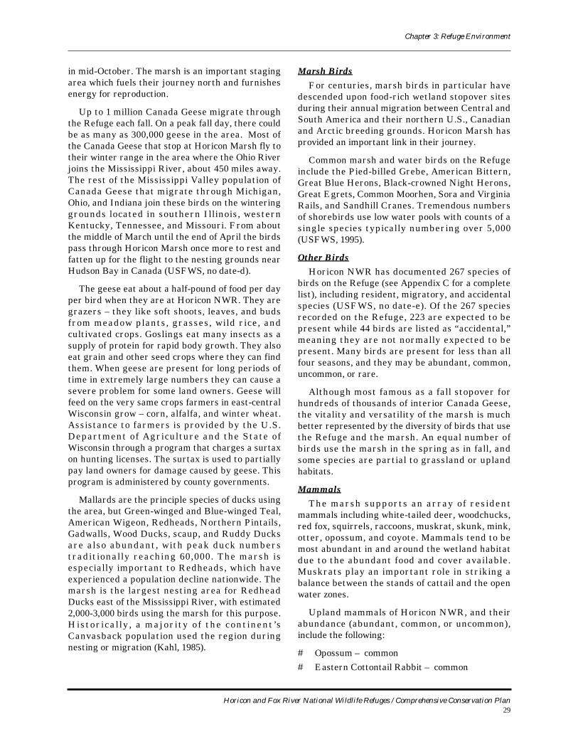
# Painted Turtle – common # Snapping Turtle – common# Red-Bellied Snake – common # Garter Snake – common # Milk Snake – rare
Threatened and Endangered SpeciesAt present, the only Federally-listed threatened
or endangered wildlife species that uses the marsh is the Bald Eagle. Bald Eagles were placed on the Federal Endangered Species list in 1973, and are protected by both state and federal laws. Since
Snapping turtle, Horicon NWR
Horicon and Fox River National Wildlife Refuges / Comprehensive Conservation Plan30
Chapter 3: Refuge Environment
Wisconsin’s eagle population was higher and more stable than that of most other states, the federal government listed the state’s eagles as "threatened" in 1978. In 1991, 414 active Bald Eagle territories were located, exceeding the recovery goal of 360.
The formerly listed Peregrine Falcon has also been observed at Horicon NWR (listed as “rare” in spring, fall, and winter), but in a conservation success story, it was de-listed in 1999 due to continent-wide improvements in the status of peregrine populations, from 324 breeding pairs in 1975 to 2,000-3,000 breeding pairs by the late 1990s (USFWS, no date-f).
State-listed endangered species at Horicon NWR include the Osprey, Forster’s Tern, and Barn Owl.
Migratory Bird Conservation InitiativesSeveral migratory bird conservation plans have
been published over the last decade that can be used to help guide management decisions for the refuges. Bird conservation planning efforts have evolved from a largely local, site-based orientation to a more regional , even inter-cont inental , landscape-oriented perspective. Several trans-national migratory bird conservation initiatives have emerged to help guide the planning and implementation process. The regional plans relevant to Horicon NWR and Fox River NWR are:
# The Upper Mississippi River/Great Lakes Joint Venture Implementation Plan of the North American Waterfowl Management Plan;
# The Partners in Flight Boreal Hardwood Transition [land] Bird Conservation Plan;
# The Upper Mississippi Valley/Great Lakes Regional Shorebird Conservation Plan; and
# The Upper Mississippi Valley/Great Lakes Regional Waterbird Conservation Plan.
All four conservation plans will be integrated under the umbrella of the North American Bird Conservation Initiative (NABCI) in the Prairie Potholes, Eastern Tallgrass and Prairie Hardwood Transition Bird Conservation Regions (BCR 11, 22 and 23). Each of the bird conservation initiatives has a process for designating priority species, modeled to a large extent on the Partners in Flight method of computing scores based on independent assessments of global relative abundance, breeding and wintering distribution, vulnerability to threats, area importance, and population trend. These scores are often used by agencies in developing lists of priority bird species. The Service based its 2001
list of Non-game Birds of Conservation Concern primarily on the Partners in Flight, shorebird, and waterbird status assessment scores.
Wildlife Species of Management Concern
Appendix G summarizes information on the status and current habitat use of important wildlife species found on lands administered by Horicon NWR. Individual species, or species groups, were chosen because they are l isted as Regional Resource Conservation Priorities or State-listed threatened or endangered species. Other species are listed due to their importance for economic or recreational reasons, because the Refuge or its partners monitor or survey them, or for their status as an overabundant or invasive species.
Horicon NWR Current Refuge Programs: Where We Are Today
Consistent with its authorizing legislation, Hori-con NWR conducts a broad array of wildlife man-agement activities on the Refuge. Horicon NWR’s Master Plan, completed in 1978, developed a list of planned activities consistent with the purpose of the Refuge:
# Waterfowl Production – Diver and dabbler ducks
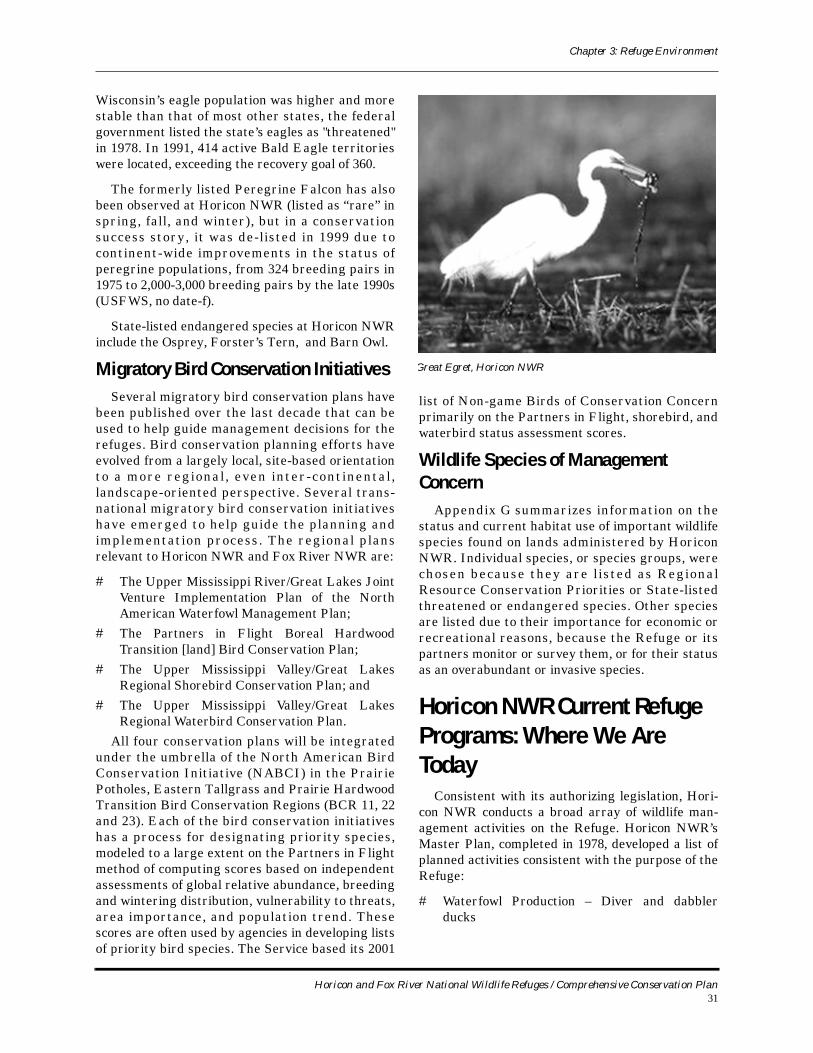
Great Egret, Horicon NWR
Horicon and Fox River National Wildlife Refuges / Comprehensive Conservation Plan31
Chapter 3: Refuge Environment
# Waterfowl Maintenance – Diver and dabbler ducks, geese
# Environmental Preservation# Special Recognition Species – marsh birds,
shorebirds, and raptors# Threatened Species Maintenance – Bald Eagle,
Osprey, Cormorant# Wildlife/Wildlands Observation# Wildlife Trails (non-motorized)# Tour Routes (motorized)# Interpretive Center# Interpretive Exhibits/Demonstrations# Environmental Education# Hunting – Migratory waterfowl, coot, big game,
upland game# Fishing
In the quarter-century since publication of the Master Plan, Refuge management has made signifi-cant progress in implementing these planned activi-ties and products. Refuge planning and management, however, are a continual work in pro-cess that evolves over time depending on feedback and monitoring as well as changing values, needs, and priorities in wildlife management at the Refuge, regional, and national scale. Hence the value of a new plan – this CCP – which updates and modifies Horicon NWR’s management emphasis.
This section summarizes current management programs, operations, and facilities at Horicon NWR. It also describes the participation and coop-eration of Refuge staff and management activities with our partnering agencies and stakeholders in the wider community on efforts to balance compet-ing demands for natural resources, wildlife, and pro-tection from environmental hazards like flooding.
Habitat RestorationMany of the current management efforts on the
Refuge focus on restoring valuable wildlife habitats that have declined regionally since the advent of intensive habitat modification and destruction wrought by Euro-American settlement, agricultural development and drainage projects. Horicon NWR staff carries out wetland and upland habitat restora-tion projects on the Refuge.
Habitat Restoration on the RefugeHabitat restoration efforts at Horicon NWR
focus on both upland and wetland habitats. Within the last year, upland habitat restoration has focused on improving the quality and quantity of oak savanna habitats. Brush and other tree species have choked out oak savanna habitat. Several methods are used to remove the brush and other trees to allow for the resurgence of oaks. Refuge staff issue firewood-cutting permits to remove larger trees that have encroached on the historic oak savannah openings. Staff and contractors will also remove larger trees. Staff will use specialized equipment to mow brushy areas to reclaim the grass component of the oak savannah habitat. Staff will also be exper-imenting with particularly hot prescribed burns as a means of restoring and maintaining oak savanna.
Efforts are also under way to restore native prai-rie grasslands on the Refuge. Restoration typically involves treatment of degraded grasslands, those that have become dominated by non-native, inva-sive, or woody species like willows. Fields with non-native or invasive species are sprayed with the her-bicides Round-Up and 2-4D. The area is then burned to provide good seed-to-ground contact. The seed mix includes 21 forb species and five grass spe-cies, all Wisconsin Genotype. The seedings are usu-ally initiated in late fall or early winter, dependant
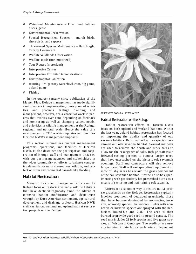
Black-eyed Susan, Horicon NWR
Horicon and Fox River National Wildlife Refuges / Comprehensive Conservation Plan32
Chapter 3: Refuge Environment
on a light snow cover. A seed blower attached to the hitch of a vehicle is used to plant the seed. Fields invaded by small woody vegetation are mowed using a Fecon mower. Most upland fields on the Refuge have been invaded and dominated with reed canary grass, sweet clover or wild parsnip.
Although native to North America, reed canary grass has hybridized with introduced European strains to create a highly aggressive and invasive strain that is spreading at the expense of other native species. Reed canary grass is flood-tolerant, resistant to burning, a prolific seed producer, spreads rapidly through rhizomes, and quickly forms monocultures in wet meadows by shading out native grasses and forbs. Control requires aggres-sive measures. Horicon NWR is experimenting with using grazing as a tool to reduce the amount of reed canary grass. This is a form of adaptive manage-ment, and in the spirit of adaptive management, we are always experimenting with different methods to enhance native grasslands.
Managed impoundments give opportunities to restore wetland habitat to more desirable condi-tions. Currently, a project is under way removing the functionality of ditches in the Main Pool of the Refuge. By creating long ditch plugs in several areas of the ditch, staff are trying to reestablish sheet flow of water and prevent ground and surface water flow from being transported down the ditches.
Habitat ManagementAs our knowledge and understanding of wildlife
ecology evolves over time, and as circumstances and values “on the ground” change, the direction of wild-life management tends to change as well. Two exam-ples of changing philosophies and approaches are evident at Horicon NWR and many other national wildlife refuges, with regard to the “edge effect” and the value of diverse warm season seed mix for wildlife. The conventional wisdom among wildlife managers in the late 1970s and early 1980s was that it was valuable to maximize edges between different vegetation communities. The justification was that since wildlife species that depend on one or the other, or both, of two adjoining habitats could occur near the edge between the two habitats, these edges tend to have higher species diversity than locations set deep within any one habitat type. Thus, increas-ing the length of edges was deemed desirable.
Twenty-five years later, however, as more infor-mation became available from long-term studies, biologists now believe that the advance of civiliza-tion has whittled away large contiguous blocks of habitat, and the species that depend on them are in jeopardy. Biological diversity is best served by reducing fragmentation and increasing the areas of habitat blocks, as well as by increasing the connec-tivity between blocks of similar habitat, so that organisms may move along these corridors and maintain genetic fitness and variability, and thus population viability.
Similarly, for decades wildlife biologists (particu-larly waterfowl managers) encouraged the planting of dense nesting cover for waterfowl nesting. This method of seeding planted a very thick stand of warm season grass, usually only one or two species with little forb diversity. However, by the late 1990s, wildlife biologists generally and the U.S. Fish and Wildlife Service specifically were adopting more holistic approaches to wildlife management. They realized that these plantings were too thick for nest-ing and that waterfowl preferred a diverse struc-ture of forbs and grasses for nesting.
In recent years, the management philosophy at Horicon NWR, paralleling that of other refuges around the country, has become more oriented toward fostering or simulating natural processes (like wildland fire) to achieve desired landscapes and to restore scarce habitats that were prevalent prior to Euro-American settlement in the region. Given the highly manipulated environments in which Horicon NWR and most other refuges occur, this often means actively intervening in natural plant community succession and hydrologic pro-cesses rather than passively allowing nature to “run its course.” In order for the Refuge to effectively pursue its purpose and meet the expectations of the American public, Refuge staff actively manage the various habitats through a variety of techniques and procedures discussed in the following paragraphs.
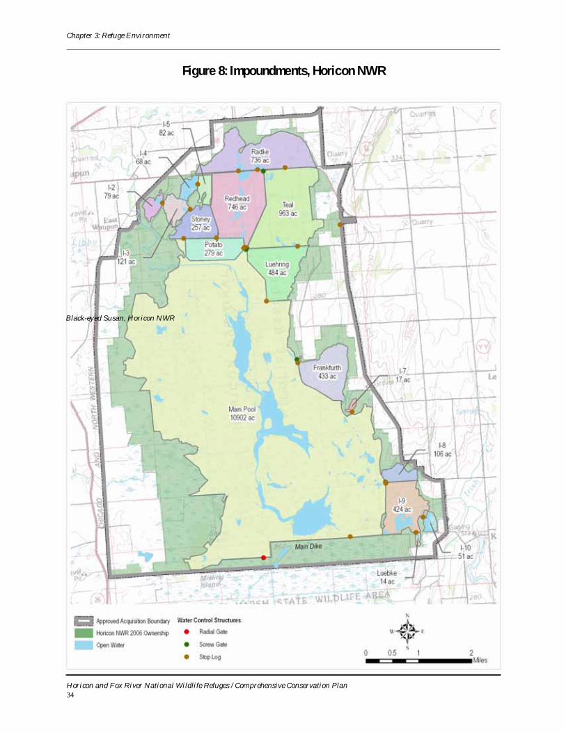
Managing Water Impoundments and Moist Soil Units
Horicon NWR’s water management program is very complex and involves 17 impoundments (Figure 8). Pools are frozen for about 4 months of the year, from December to April. During periods of “ice-out,” May to November, water management not only must balance competing considerations of wild-life and habitats on the Refuge itself, but it must deal with the requests of off-Refuge neighbors
Horicon and Fox River National Wildlife Refuges / Comprehensive Conservation Plan33
Chapter 3: Refuge Environment
Figure 8: Impoundments, Horicon NWR
Black-eyed Susan, Horicon NWR
Horicon and Fox River National Wildlife Refuges / Comprehensive Conservation Plan34
Chapter 3: Refuge Environment
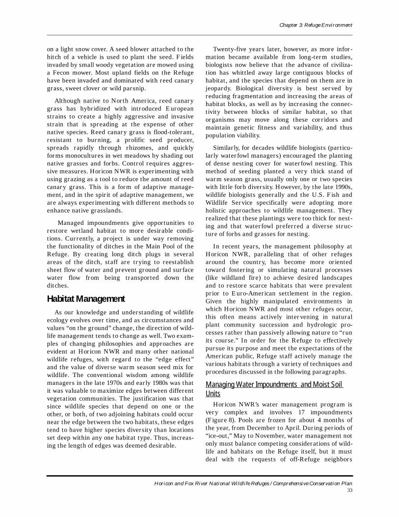
downstream as well as other township, county, state, watershed, and flood control agencies. Regulating water levels – whether at maximum pool levels or in drawdown (emptying pools almost entirely of water) – is a vital management tool for waterfowl, shore-birds, and wading birds. Over the years, water man-agement has been further complicated by increased land clearing and development on private lands upstream of the Refuge, which increase nutrient and sediment transport onto the Refuge. Within the last 2 years, the Refuge has experienced severe flooding, which results in rapid pool level increase, or “bounce,” of 2 to 3 feet. Bounces during the breeding season negatively affect nesting efforts of many species. For instance, the flood that began in May of 2004 essentially wiped out a production year for many species. Managers must be cognizant of conditions throughout the watershed, exercise good judgment, and at times be willing to deviate tempo-rarily from Refuge objectives when downstream cit-ies and towns are experiencing extreme flooding events.
Horicon NWR’s Marsh and Water Management Plan (1993) guides management of the Refuge’s marshes, open water, water levels and discharges. The plan states that production and maintenance of waterfowl are the primary objectives at Horicon NWR, and that to fully achieve these objectives, a diversity of habitats must be provided to meet the life history requirements of waterfowl for nesting, brood rearing, and migration. The presence or absence of water, its depth, and the seasonal timing of water depth fluctuations are all manipulated to produce various stages of marsh habitats on which different water-dependent birds rely.
An annual marsh and water management plan is written every winter. This plan summarizes opera-tions during the previous year, describes major water management problems, and documents con-struction and rehabilitation projects. It also identi-fies proposed pool elevations for the upcoming years along with stated objectives for each management unit. Main Pool, by far the largest on the Refuge, serves as an example. Its spillway elevation is 858 feet above mean sea level (MSL), its drawdown ele-vation is 851 feet MSL, it was last drawn down in 1999 and 2005. Objectives were to maintain and reestablish hardstem bulrush and limit the increase of cattails by flooding out new plants.
Refuge management is continually adjusting scheduled water manipulation in response to the vagaries of the weather or maintenance of water
control structures. For instance, in 2004 a leak in the culvert leading to the pump house in the Potato impoundment was discovered. Potato then had to be drained to fix the problem, resulting in an unex-pected drawdown. Continual maintenance and repair of aging water control facilities such as gates, pilings, gauges, dikes, bridges, riprap, and channels are necessary to keep facilities and controls opera-ble, and thus to meet water and marsh habitat man-agement objectives.
Annual outflows have a wide range of fluctuation at Horicon NWR, depending on precipitation. Out-flow can range from 10 cubic feet per second (cfs) discharge from the Refuge into the Rock River dur-ing dry years to over 1,000 cfs in wet years with one or more large storms.
There have been persistent flooding problems within the watershed, downstream of the Refuge, and on the Refuge itself. Possible solutions have been investigated and explored for a number of years. One possibility is that the current water con-trol structure for Main Pool would be enlarged or several new ones installed along Main Dike Road in conjunction with a new emergency spillway. During flood events, water from Refuge pools and the Rock River could theoretically be discharged faster after the flood peak, to the benefit of the Refuge and its marsh habitats and agricultural areas immediately downstream of the Refuge. It would also allow more flexibility in managing water on the Main Pool impoundment. At present, this proposal has advanced beyond the concept stage and is currently in the developmental stage.
Moist Soil management on the Refuge is con-ducted annually. The I-5 impoundment has been drawn down for several years during spring and summer to promote emergent vegetation. During the fall and winter of 1997 to 1999 all the emergent vegetation was wiped out due to reflooding of the
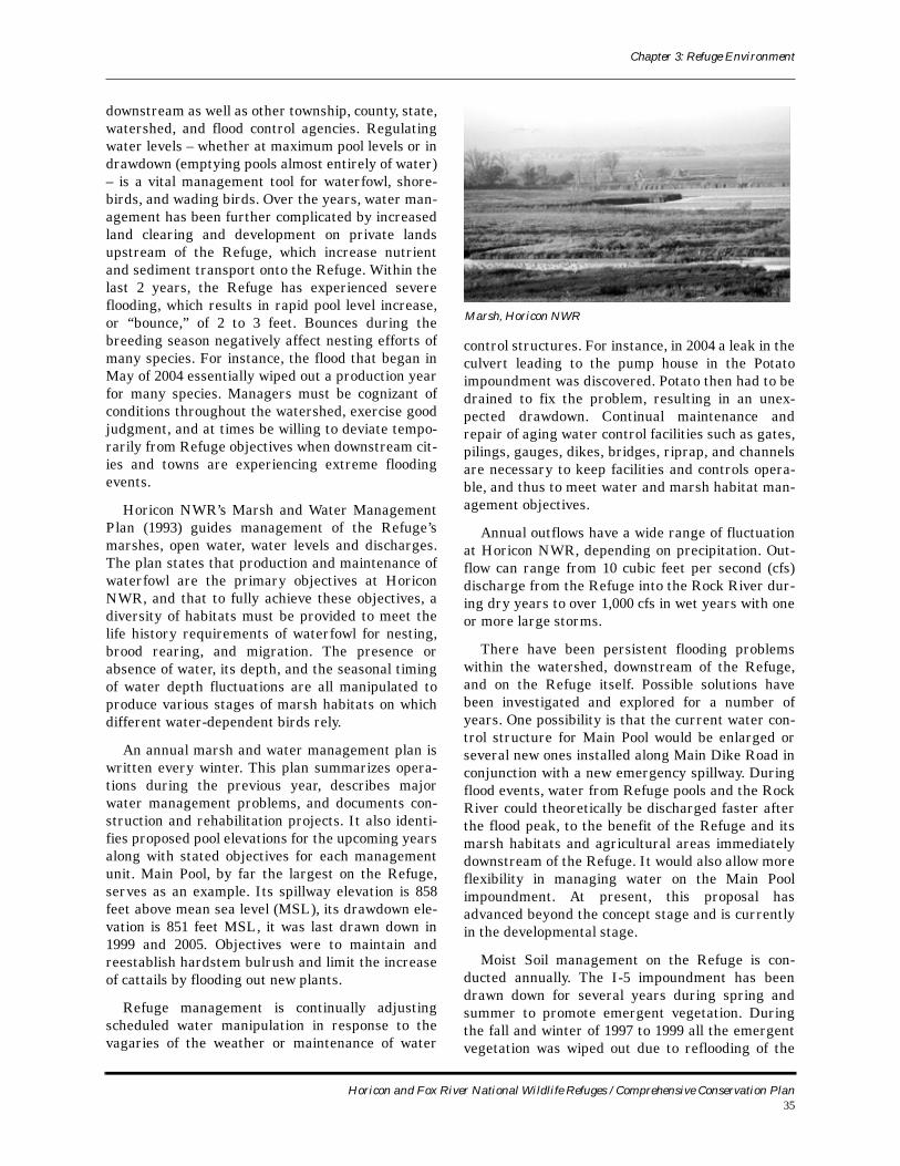
Marsh, Horicon NWR
Horicon and Fox River National Wildlife Refuges / Comprehensive Conservation Plan35
Chapter 3: Refuge Environment
unit. In 2000, the unit was drawn down for the fall and winter as well, in hopes of sustaining an emer-gent vegetation cover and compacting the very deep mud layer that may have been the cause of the vege-tation decline after reflooding.
Mowing on Grasslands and Wet MeadowsMowing is used in grasslands and certain wet-
lands like sedge meadow to cut willows and prevent their encroachment. If left alone, hardy, aggressive willows would invade and dominate nearly all wet-land areas on the Refuge except for the cattail marsh areas. Mowing maintains a mosaic of willow age classes, ensuring winter browse for deer. It also reduces the willow canopy layer and improves the understory of sedges and grasses that foster deeper penetration of fire into willow stands. Increased wil-low control and better cover for nesting marsh and upland birds that use these areas are the ultimate result of this mowing. Typically, about 100 acres a year are mowed on the Refuge.
Haying on GrasslandsThe Refuge has a small haying program with
three benefits:
# Reduces seed source of reed canary grass.# Reduces thick litter layer that inhibits nesting.# It attracts visually impressive birds like
Sandhill Cranes, and concentrations of waterfowl to areas where they can be observed by the public.
In a typical year, 30 to 40 acres of reed canary grass is hayed and removed from the Refuge, pro-viding grazing areas for waterfowl and other ani-mals.
Prescribed Fire on Uplands and WetlandsFires were once a natural disturbance that
helped maintain upland prairies and lowland marshes by decreasing the presence of harmful invading plants. Today prescribed fires are used to setback woody and herbaceous plants that invade prairies and wetlands. The suppression of fire that naturally occurred prior to European settlement allows undesirable fire intolerant species to exist where they otherwise would not have. Many native species of plants and trees are fire resistant, while others require fire to exist. By using prescribed fire as a management tool we can mimic a natural eco-system function helping to maintain the habitat characteristics which our local plants and animals have evolved from.
Today prescribed fire is one of Horicon NWR’s most useful tools for maintaining prairie and marsh vegetative characteristics. Since many upland birds and waterfowl require open areas for nesting, pre-scribed fire helps maintain habitat necessary for migratory species. By choosing burn units based on needs of the wildlife habitat we can maintain a com-bination of prairie, savanna, marsh, sedge meadow and woodland habitats required by native wildlife species.
Prescribed fires can help reduce the danger of uncontrolled wildfires by reducing the buildup of hazardous fuel loads in and around the Refuge.
Horicon NWR has a fire management plan that facilitates prescribed burns in the spring and fall seasons. In fiscal year 2005, prescribed fire was used on 21 units totaling 3,230 acres. The spring season was exceptionally successful in terms of acreage and most importantly ecological objectives. The annual average over the last 10 years has been 826 acres. Burns are scheduled on a 3- to 5-year rotation and timed to meet specific vegetative goals. Post-fire monitoring is conducted to measure the success of each burn in ecological terms. The National Fire Plan has provided increased emphasis on fire planning, management, and suppression at the national level. Horicon NWR has added one per-manent seasonal Range Technician to meet the demands of the new fire program.
Wildfire PreparednessWildfires occur on the Refuge annually. In 2005,
there were four fires on the Refuge. Additionally, Refuge staff assisted the state on four fires locally. The Refuge is prepared with staff and equipment for wildfire activity and is available to assist both local and national firefighting efforts.
Most summers Horicon NWR firefighters go on western wildfire details to assist other refuges and agencies when wildfire danger is high.
Controlling Invasive PlantsEvery year, Horicon NWR submits a Refuge
Annual Planning Report to the Regional Office doc-umenting the status of invasives on the Refuge and efforts to control their spread. The exotic and inva-sive species of most concern and the extent of their infestation on the Refuge are wild parsnip (600 acres), reed canary grass (1,900 acres), purple loos-estrife (100 acres) and leafy spurge (3 acres).
Horicon and Fox River National Wildlife Refuges / Comprehensive Conservation Plan36
Chapter 3: Refuge Environment
Wild ParsnipWild parsnip (Pastinaca sativa) is an aggressive,
Eurasian weed that frequently invades and modifies a variety of open habitats. Wild parsnip slowly invades an area in waves following initial infestation. Once the population builds, it spreads rapidly. Wild parsnip can cause phytophotodermatitis to the skin. If the plant juices come in contact with skin in the presence of sunlight, a rash and/or blistering can occur, as well as skin discoloration that may last sev-eral months. Staff has had a difficult time control-ling the spread of this invasive. Fire has no effect on wild parsnip since plants simply resprout. Due to the large acreage that is affected, hand pulling is not an option. In 2005, mowing fields just as the seed heads turned color, had mixed results. Some fields had effective control while others were mowed too early and the wild parsnip resprouted and flowered. Staff is continuing to make adjustments and moni-tor the spread.
Reed Canary Grass Reed canary grass (Phalaris arundinace), as
mentioned earlier, is native to North America, but has hybridized with introduced European strains to create a highly aggressive and invasive strain that is expanding at the expense of other native species. It is flood-tolerant, resistant to burning, produces seeds prolifically, spreads rapidly via rhizomes, and quickly forms virtual monocultures in wet meadows by shading out native grasses and forbs. Aggressive measures are needed to control it.
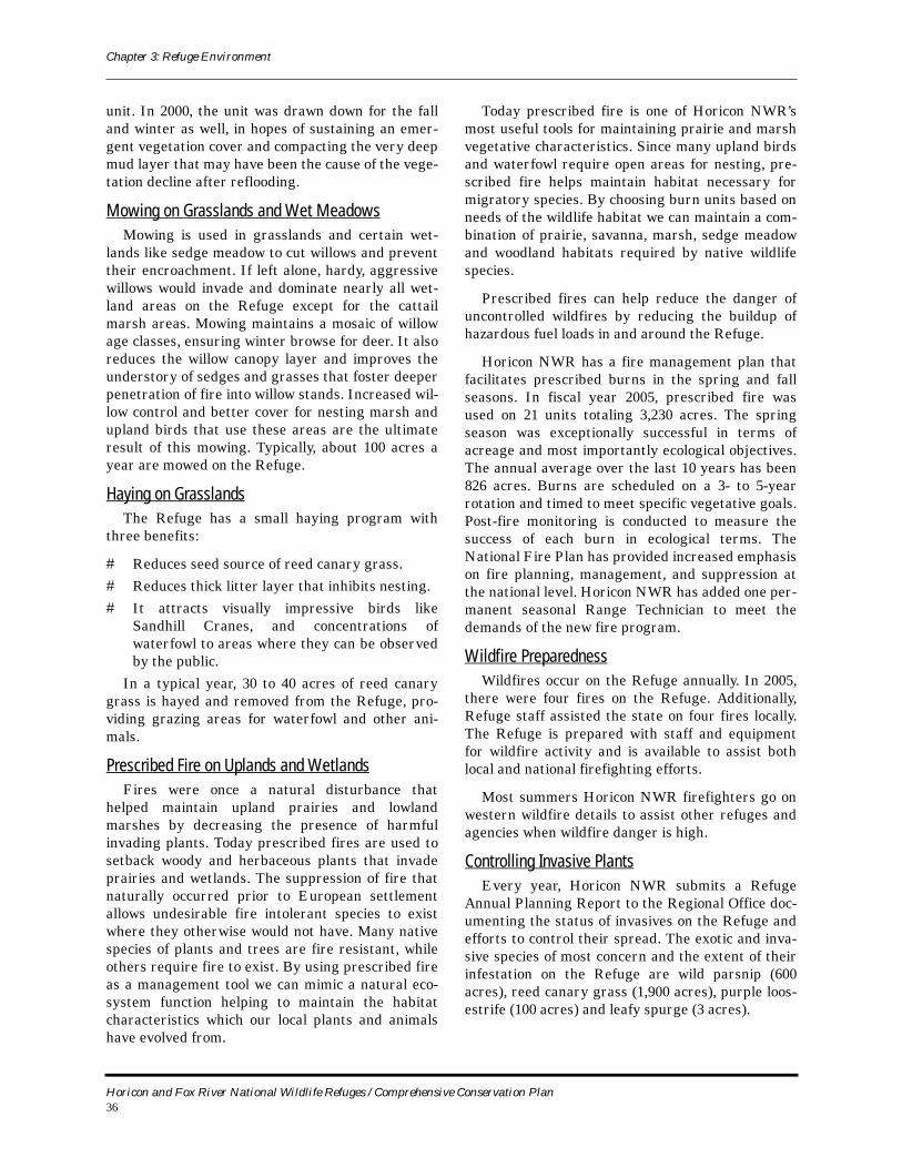
Purple LoosestrifePurple loosestrife (Lythrum salicaria) is a wet-
land herb that was introduced as a garden perennial from Europe during the 1800s. It is still promoted by some horticulturists for its beauty as a landscape plant, and by beekeepers for its nectar-producing capability. By law, purple loosestrife is a nuisance species in Wisconsin. It is illegal to sell, distribute, or cultivate the plants or seeds, including any of its cultivars. Purple loosestrife can spread rapidly, eventually taking over an entire wetland and almost entirely eliminating the open water habitat. Purple loosestrife displaces native wetland vegetation and degrades wildlife habitat. The Refuge continues to monitor the purple loosestrife infestation. Refuge staff stopped raising Galerucella spp beetles several years ago. Several beetle surveys in early spring showed poor survival of beetles in the areas of origi-nal release. It was hoped that the beetles would be self-sustaining and that some of the beetles could be translocated to new areas of infestation. Refuge
staff will continue to monitor the changes around the Refuge where beetles were released to see if additional beetles will need to be raised and released to combat the purple loosestrife. The origi-nal release sites have shown encouraging results over the last 6 years.
Leafy SpurgeLeafy spurge (Euphorbia esula) is an aggressive,
exotic, perennial weed that is especially pernicious in western grasslands. It out-competes desirable native vegetation, growing in dense clumps with one or more shoots emerging from a woody root crown. This weed contains irritating chemicals that many animals avoid eating. Previous measures to control the leafy spurge included spraying it with the herbi-cide Plateau, however the weed can be resistant to chemical control. It has a pervasive root system and appears able to block the downward movement of herbicides. Still another problem with chemicals is that herbicides sprayed to kill spurge also kill desir-able broadleaved plants. It should be noted that pre-scribed fire does not control leafy spurge. In 2005, biological control of the leafy spurge was initiated. Several species of beetles totaling 100,000 speci-mens were collected from the Trempealeau NWR. This included three varieties of Aphthona flea bee-tles: Aphthona nigriscutis, Apthona cyparissiae,
Purple loosetrife, Horicon NWR
Horicon and Fox River National Wildlife Refuges / Comprehensive Conservation Plan37
Chapter 3: Refuge Environment
Apthona czwalinae and a long-horned stem miner called Oberea erythrocephala. Monitoring of leafy spurge and beetle survival continues.
Other species: There are several other plant spe-cies, both on and off the Refuge, that threaten the vegetative integrity of the Refuge. On the Refuge, the spread of common reed or phragmites (Phrag-mites australis) is of concern. The use of fire and chemical treatment using HABITAT are methods of control being explored. European buckthorn (Rhamnus cathartica) has a very rapid growth rate and resprouts vigorously after being cut. Typical of several non-native understory shrub species, buck-thorns leaf out very early and retain their leaves late in the growing season, thereby shading out native wildflowers. Currently, management of this species includes pulling young seedlings and/or cut-ting and spraying stumps with 2-4D. Garlic mustard (Alliaria petiolata) is a rapidly spreading woodland weed that is displacing native woodland wildflowers in Wisconsin. A combination of pulling and spraying is a management tool for controlling this invasive. Also, spotted knapweed (Centaurea maculosa), an aggressive, non-native invader of grasslands, grows on roadsides near the Refuge.
Habitat Monitoring
Aerial Infrared – GIS Technology Horicon NWR has had aerial infrared photogra-
phy taken in 1996, 1999, 2000, 2001 and annually since 2003. The 2005 photos were digitized into a vegetation classification. The primary purpose of the photos is monitoring habitat changes that occur either naturally or due to management. In the past, visual comparisons of photos between years were done to make these evaluations. In 1999, Horicon NWR used a Geographic Information System (GIS) to make quantitative evaluations of open water to cattail growth and germination. GIS technology is used to compare infrared photos taken in different years to determine the changes in habitat that are taking place due to management activities such as water level manipulation and prescribed burning.
Grassland Surveys The annual grassland surveys, initiated in 2001
using plant community associations at point count sites, continue. These surveys were developed and tested in 1999 on several points at Horicon NWR based on a similar grassland survey conducted at J. Clark Salyer NWR. In addition to several associa-tion changes based on local habitat, visual obstruc-
tion readings (VOR) using a Robel pole and litter depths were taken at each site. It is hoped that eventually the grassland survey will be correlated to grassland bird surveys and guide the Refuge grass-land management program including prescribed burning. Many staff days and hours are required to monitor each site every year. In 2004, only three of the plots were completed. All three sites were on the Hishmeh tract near Luehring Lake. A prescribed burn was conducted on this area in 2005. Survey methods are being reviewed to see if they can be simplified to reduce the time involved on each plot by reducing the individual points down from 800 per plot.
Prescribed BurningSix photo stations were established on units that
were planned for burning in 2004 to provide a photo-graphic record of changes in habitat. Photos were taken annually in 2004 and 2005 and comparisons in the changes in vegetative cover will be made with the photos. In addition, future plans include addi-tional monitoring, including vegetation and organic substrate surveys.
Wildlife Monitoring and ResearchTwo basics types of inventories and investigations
are conducted at Horicon NWR:
# surveys and censuses of selected species or species groups, which are typically made on an annual basis.
# basic research into wildlife biology and ecology, which have no specific schedule.
Snowy Plover, Horicon NWR
Horicon and Fox River National Wildlife Refuges / Comprehensive Conservation Plan38
Chapter 3: Refuge Environment
The surveys and censuses are generally made by staff and volunteers, and consist of organized sur-veys and/or censuses, or a compilation of observa-tions and recorded sightings made over the course of the year.
Research studies are usually undertaken in coop-eration with university professors and their stu-dents or other agencies, often with the direct participation and cooperation of Refuge staff and assisted by volunteers.
Surveys and CensusesSurveys and censuses at Horicon NWR are
guided by a 1990 Wildlife Inventory Plan.
Endangered and/or Threatened Species – Two federally listed threatened species are found on the Refuge, the Bald Eagle and Whooping Crane. Visual observations of eagles and Whooping Cranes are recorded. Bald Eagle nests are monitored annu-ally to determine nest success. In 2005, one nest was active; it was located in a tall cottonwood tree.
Amphibians – Horicon NWR has been part of the Nationwide Malformed Amphibian Survey Project conducted by the Bloomington Ecological Services Field Office. The Refuge was part of this study from 2001-2003.
In 2000, a volunteer initiated a frog survey as part of the Marsh Monitoring Program sponsored by Bird Studies Canada and Environment Canada to study wetland amphibians and birds in the Great Lakes basin. Eight stations were set up and sam-pled three times a year. Volunteers continue to con-duct these surveys. Seven species of frogs and toads have been identified by their calls on the Refuge: green frog, wood frog, chorus frog, northern leop-ard frog, American toad, gray treefrog, and bull-frog.
Raptors – Staff compile observations of rare and uncommon raptors at the Refuge, including the Snowy Owl and the formerly listed Peregrine Fal-con.
Waterfowl – Breeding waterfowl, including Can-ada Geese and ducks, are inventoried every spring and summer. By using waterfowl surveys and brood surveys Refuge staff are able to estimate the num-ber of ducks and geese present as well as an esti-mate of production. Numbers of several species of waterfowl are also estimated during the fall migra-
tion, including Mallard, Blue-winged Teal, Green-winged Teal, Ruddy and Ring-necked Ducks and Canada and Snow Geese.
Bird banding has been a tool of wildlife managers for decades. Banding enables biologists to identify and track movement and timing patterns of migra-tory bird populations. Metal bands or rings with identification information are affixed to the leg of the bird. The bird must be recaptured or killed and held in hand to record the information on the band. Horicon NWR has an annual banding quota of 400 Mallard Ducks. In past years, it has been difficult to reach the established quota. In 2005, 50 Mallards and 82 Wood Ducks were also banded.
Marsh Birds, Shorebirds, Gulls and other Migratory Birds – Horicon NWR conducts cen-suses and observations of many water-dependent avian species. Estimates of nest numbers are obtained for the three predominant colonial nesting birds (i.e., birds that nest in colonies) on the Refuge: White Pelican, Black-crowned Night-heron, and Double Crested Cormorant. Over the years, aver-ages of 350 pairs of White Pelicans, 100 pairs of Black-crowned Night-herons, and 150 pairs of Dou-ble Crested Cormorants have nested at Horicon NWR.
Six species of marsh birds – American Bittern, Least Bittern, Sora, Virginia Rail, Yellow Rail and King Rail – are typically surveyed several times a year using passive call and call playback techniques.
Point counts are also made of migratory song-birds during the breeding season. Seven of 32 sites were surveyed in 2005 with 44 species found. Hen-slow’s Sparrows continue to be found on the sur-veys, as well as an increased numbers of Bobolinks. No Meadowlarks were found on the 2005 survey, which is of great concern.
During years when management activities create extensive mudflats and moist soil units, Horicon NWR is a popular stopover area for shorebirds. These birds are often observed in the spring and/or summer by volunteer birding enthusiasts. Fifteen to 20 species of shorebirds and thousands of individual birds have been observed by staff and visitors.
The 29th Annual Crane count, sponsored by the International Crane Foundation (ICF) in Baraboo, Wisconsin, continues as an annual survey, both on and off the Refuge. For the first time in 2004, Ref-uge staff did not coordinate the count. ICF could not find anybody to replace the county coordinator, so
Horicon and Fox River National Wildlife Refuges / Comprehensive Conservation Plan39
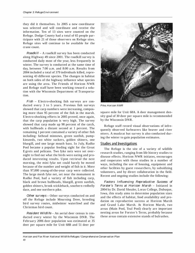
Chapter 3: Refuge Environment
they did it themselves. In 2005 a new coordinator was selected and will coordinate and receive the information. Ten of 13 sites were counted on the Refuge. Dodge County had a total of 65 people par-ticipate with 21 of those observers on Refuge sites. Refuge sites will continue to be available for the crane count.
Roadkill – A roadkill survey has been conducted along Highway 49 since 2001. The roadkill survey is conducted daily most of the year, less frequently in winter. The survey is conducted at the same time of day, between 7:00 a.m. and 8:00 a.m. Results from 2004 included a total of 379 individuals killed, repre-senting 43 different species. The changes in habitat on both sides of the highway influence what species are using the area. The Friends of Horicon NWR and Refuge staff have been working toward a solu-tion with the Wisconsin Department of Transporta-tion.
Fish – Electro-shocking fish surveys are con-ducted every 3 to 5 years. Previous fish surveys showed that carp numbers were increasing, compos-ing more than 95 percent of the fish in the marsh. Electro-shocking efforts in 2005 proved, once again, that the carp population is very high. The survey showed that carp made up 98 percent of the catch, with bullheads a distant second at 1 percent. The remaining 1 percent contained a variety of other fish including: fathead minnows, green sunfish, pump-kinseeds, two white suckers, golden shiners, one bluegill, and one large mouth bass. In July, Radke Pool became a popular feeding sight for the Great Egrets and pelicans. Two fyke nets were set over-night to find out what the birds were eating and pro-duced interesting results. Upon retrieval the next morning, the mini fyke net could barely be moved because of the number and weight of fish in it. More than 97,000 young-of-the-year carp were collected. The large mesh fyke net, set near the monument in Radke Pool, had a variety of fish including carp, black and brown bullheads, bluegill, green sunfish, golden shiners, brook stickleback, southern redbelly dace, and one northern pike.
Other surveys – Other surveys conducted on and off the Refuge include Mourning Dove, breeding bird survey routes, midwinter waterfowl and the Christmas bird count.
Resident Wildlife – An aerial deer census is con-ducted every winter by the Wisconsin DNR. The February 2006 deer population was estimated at 35 deer per square mile for Unit 68B and 51 deer per
square mile for Unit 68A. A deer management den-sity goal of 30 deer per square mile is recommended by the Wisconsin DNR.
Refuge staff record visual observations of infre-quently observed furbearers like beaver and river otters. A muskrat hut survey is also conducted dur-ing the winter to gain population estimates.
Studies and InvestigationsThe Refuge is the site of a variety of wildlife
research studies, ranging from life history studies to disease effects. Horicon NWR initiates, encourages and cooperates with these studies in a number of ways, including the use of housing, equipment and other facilities by guest researchers, by subsidizing volunteers, and by direct collaboration in the field. Recent and ongoing studies include the following:
Factors Influencing Reproductive Success of Forster’s Terns at Horicon Marsh – Initiated in 2004 by Dr. David Shealer, Loras College, Dubuque, Iowa, this study aims to determine population sizes and the effects of habitat, food availability and pre-dation on reproductive success at Horicon Marsh and Grand Lake Marsh. At Horicon Marsh, two areas (Main Pool, Teal Pool) clearly are important nesting areas for Forster’s Terns, probably because these areas contain extensive stands of bulrushes.
Pike, Horicon NWR
Horicon and Fox River National Wildlife Refuges / Comprehensive Conservation Plan40
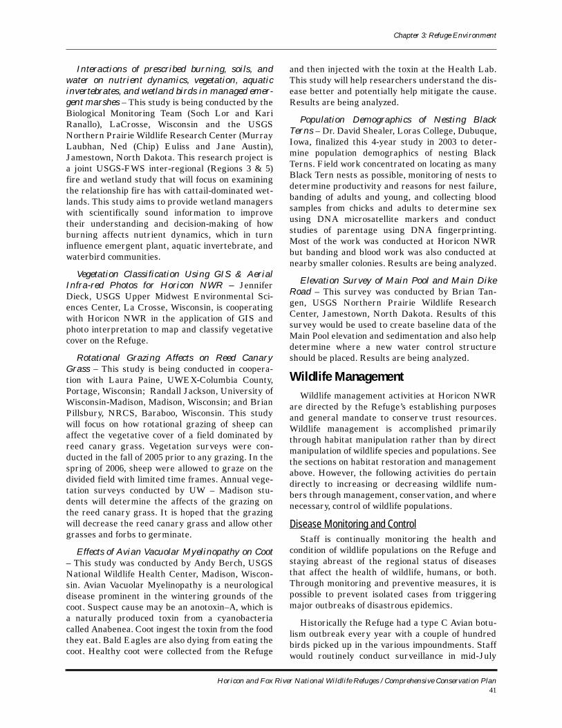
Chapter 3: Refuge Environment
Interactions of prescribed burning, soils, and water on nutrient dynamics, vegetation, aquatic invertebrates, and wetland birds in managed emer-gent marshes – This study is being conducted by the Biological Monitoring Team (Soch Lor and Kari Ranallo), LaCrosse, Wisconsin and the USGS Northern Prairie Wildlife Research Center (Murray Laubhan, Ned (Chip) Euliss and Jane Austin), Jamestown, North Dakota. This research project is a joint USGS-FWS inter-regional (Regions 3 & 5) fire and wetland study that will focus on examining the relationship fire has with cattail-dominated wet-lands. This study aims to provide wetland managers with scientifically sound information to improve their understanding and decision-making of how burning affects nutrient dynamics, which in turn influence emergent plant, aquatic invertebrate, and waterbird communities.
Vegetation Classification Using GIS & Aerial Infra-red Photos for Horicon NWR – Jennifer Dieck, USGS Upper Midwest Environmental Sci-ences Center, La Crosse, Wisconsin, is cooperating with Horicon NWR in the application of GIS and photo interpretation to map and classify vegetative cover on the Refuge.
Rotational Grazing Affects on Reed Canary Grass – This study is being conducted in coopera-tion with Laura Paine, UWEX-Columbia County, Portage, Wisconsin; Randall Jackson, University of Wisconsin-Madison, Madison, Wisconsin; and Brian Pillsbury, NRCS, Baraboo, Wisconsin. This study will focus on how rotational grazing of sheep can affect the vegetative cover of a field dominated by reed canary grass. Vegetation surveys were con-ducted in the fall of 2005 prior to any grazing. In the spring of 2006, sheep were allowed to graze on the divided field with limited time frames. Annual vege-tation surveys conducted by UW – Madison stu-dents will determine the affects of the grazing on the reed canary grass. It is hoped that the grazing will decrease the reed canary grass and allow other grasses and forbs to germinate.
Effects of Avian Vacuolar Myelinopathy on Coot – This study was conducted by Andy Berch, USGS National Wildlife Health Center, Madison, Wiscon-sin. Avian Vacuolar Myelinopathy is a neurological disease prominent in the wintering grounds of the coot. Suspect cause may be an anotoxin–A, which is a naturally produced toxin from a cyanobacteria called Anabenea. Coot ingest the toxin from the food they eat. Bald Eagles are also dying from eating the coot. Healthy coot were collected from the Refuge
and then injected with the toxin at the Health Lab. This study will help researchers understand the dis-ease better and potentially help mitigate the cause. Results are being analyzed.
Population Demographics of Nesting Black Terns – Dr. David Shealer, Loras College, Dubuque, Iowa, finalized this 4-year study in 2003 to deter-mine population demographics of nesting Black Terns. Field work concentrated on locating as many Black Tern nests as possible, monitoring of nests to determine productivity and reasons for nest failure, banding of adults and young, and collecting blood samples from chicks and adults to determine sex using DNA microsatellite markers and conduct studies of parentage using DNA fingerprinting. Most of the work was conducted at Horicon NWR but banding and blood work was also conducted at nearby smaller colonies. Results are being analyzed.
Elevation Survey of Main Pool and Main Dike Road – This survey was conducted by Brian Tan-gen, USGS Northern Prairie Wildlife Research Center, Jamestown, North Dakota. Results of this survey would be used to create baseline data of the Main Pool elevation and sedimentation and also help determine where a new water control structure should be placed. Results are being analyzed.
Wildlife ManagementWildlife management activities at Horicon NWR
are directed by the Refuge’s establishing purposes and general mandate to conserve trust resources. Wildlife management is accomplished primarily through habitat manipulation rather than by direct manipulation of wildlife species and populations. See the sections on habitat restoration and management above. However, the following activities do pertain directly to increasing or decreasing wildlife num-bers through management, conservation, and where necessary, control of wildlife populations.
Disease Monitoring and ControlStaff is continually monitoring the health and
condition of wildlife populations on the Refuge and staying abreast of the regional status of diseases that affect the health of wildlife, humans, or both. Through monitoring and preventive measures, it is possible to prevent isolated cases from triggering major outbreaks of disastrous epidemics.
Historically the Refuge had a type C Avian botu-lism outbreak every year with a couple of hundred birds picked up in the various impoundments. Staff would routinely conduct surveillance in mid-July
Horicon and Fox River National Wildlife Refuges / Comprehensive Conservation Plan41
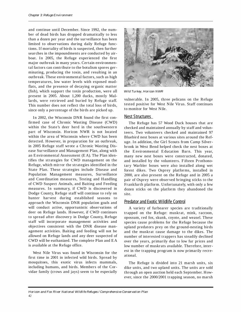
Chapter 3: Refuge Environment
and continue until December. Since 1992, the num-ber of dead birds has dropped dramatically to less than a dozen per year and the surveillance has been limited to observations during daily Refuge func-tions. If mortality of birds is suspected, then further searches in the impoundments are conducted by air-boat. In 2005, the Refuge experienced the first major outbreak in many years. Certain environmen-tal factors can contribute to the botulism spores ger-minating, producing the toxin, and resulting in an outbreak. These environmental factors, such as high temperatures, low water levels with exposed mud-flats, and the presence of decaying organic matter (fish), which support the toxin production, were all present in 2005. About 1,200 ducks, mostly Mal-lards, were retrieved and buried by Refuge staff. This number does not reflect the total loss of birds, since only a percentage of the birds are picked up.
In 2002, the Wisconsin DNR found the first con-firmed case of Chronic Wasting Disease (CWD) within the State’s deer herd in the southwestern part of Wisconsin. Horicon NWR is not located within the area of Wisconsin where CWD has been detected. However, in preparation for an outbreak, in 2005 Refuge staff wrote a Chronic Wasting Dis-ease Surveillance and Management Plan, along with an Environmental Assessment (EA). The Plan iden-tifies the strategies for CWD management on the Refuge, which mirror the strategies identified in the State Plan. These strategies include Disease and Population Management measures, Surveillance and Coordination measures, Testing and Handling of CWD Suspect Animals, and Baiting and Feeding measures. In summary, if CWD is discovered in Dodge County, Refuge staff will continue to rely on hunter harvest during established seasons to approach the Wisconsin DNR population goals and will conduct active, opportunistic observations of deer on Refuge lands. However, if CWD continues to spread after discovery in Dodge County, Refuge staff will incorporate management activities and objectives consistent with the DNR disease man-agement activities. Baiting and feeding will not be allowed on Refuge lands and any deer suspected of CWD will be euthanized. The complete Plan and EA is available at the Refuge office.
West Nile Virus was found in Wisconsin for the first time in 2001 in infected wild birds. Spread by mosquitoes, this exotic virus infects mammals, including humans, and birds. Members of the Cor-vidae family (crows and jays) seem to be especially
vulnerable. In 2005, three pelicans on the Refuge tested positive for West Nile Virus. Staff continues to monitor for West Nile.
Nest Structures The Refuge has 57 Wood Duck houses that are
checked and maintained annually by staff and volun-teers. Two volunteers checked and maintained 97 Bluebird nest boxes at various sites around the Ref-uge. In addition, the Girl Scouts from Camp Silver-brook in West Bend helped check the nest boxes at the Environmental Education Barn. This year, many new nest boxes were constructed, donated, and installed by the volunteers. Fifteen Prothono-tary Warbler boxes were also installed along wet forest dikes. Two Osprey platforms, installed in 2000, are also present on the Refuge and in 2005 a pair of Osprey were observed bringing sticks to the Frankfurth platform. Unfortunately, with only a few dozen sticks on the platform they abandoned the site.
Predator and Exotic Wildlife ControlA variety of furbearer species are traditionally
trapped on the Refuge: muskrat, mink, raccoon, opossum, red fox, skunk, coyote, and weasel. These species cause problems for the Refuge because the upland predators prey on the ground-nesting birds and the muskrat cause damage to the dikes. The number of interested trappers has steadily declined over the years, primarily due to low fur prices and low number of muskrats available. Therefore, inter-est in the trapping program is now primarily recre-ational.
The Refuge is divided into 21 marsh units, six dike units, and two upland units. The units are sold through an open auction held each September. How-ever, since the 2000/2001 trapping season, no marsh
Wild Turkey, Horicon NWR
Horicon and Fox River National Wildlife Refuges / Comprehensive Conservation Plan42
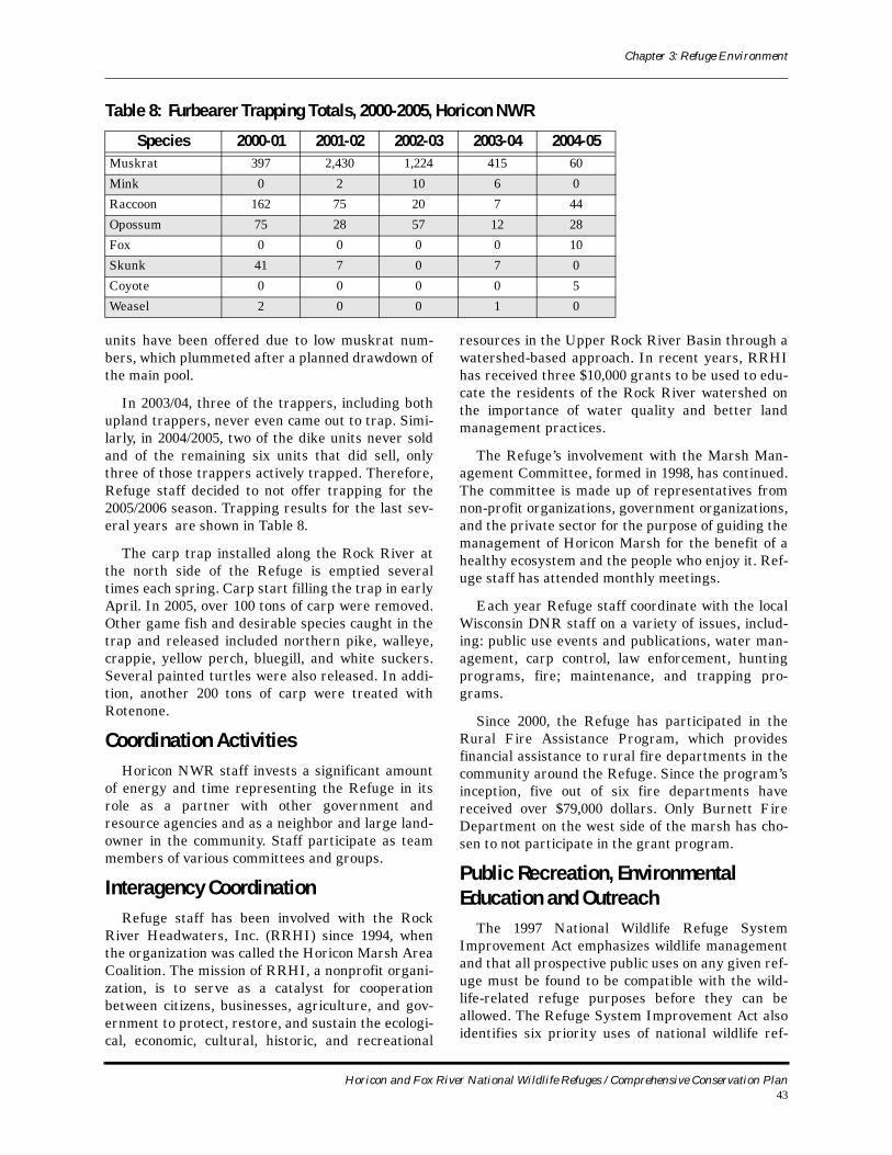
Chapter 3: Refuge Environment
units have been offered due to low muskrat num-bers, which plummeted after a planned drawdown of the main pool.
In 2003/04, three of the trappers, including both upland trappers, never even came out to trap. Simi-larly, in 2004/2005, two of the dike units never sold and of the remaining six units that did sell, only three of those trappers actively trapped. Therefore, Refuge staff decided to not offer trapping for the 2005/2006 season. Trapping results for the last sev-eral years are shown in Table 8.
The carp trap installed along the Rock River at the north side of the Refuge is emptied several times each spring. Carp start filling the trap in early April. In 2005, over 100 tons of carp were removed. Other game fish and desirable species caught in the trap and released included northern pike, walleye, crappie, yellow perch, bluegill, and white suckers. Several painted turtles were also released. In addi-tion, another 200 tons of carp were treated with Rotenone.
Coordination ActivitiesHoricon NWR staff invests a significant amount
of energy and time representing the Refuge in its role as a partner with other government and resource agencies and as a neighbor and large land-owner in the community. Staff participate as team members of various committees and groups.
Interagency CoordinationRefuge staff has been involved with the Rock
River Headwaters, Inc. (RRHI) since 1994, when the organization was called the Horicon Marsh Area Coalition. The mission of RRHI, a nonprofit organi-zation, is to serve as a catalyst for cooperation between citizens, businesses, agriculture, and gov-ernment to protect, restore, and sustain the ecologi-cal, economic, cultural, historic, and recreational
resources in the Upper Rock River Basin through a watershed-based approach. In recent years, RRHI has received three $10,000 grants to be used to edu-cate the residents of the Rock River watershed on the importance of water quality and better land management practices.
The Refuge’s involvement with the Marsh Man-agement Committee, formed in 1998, has continued. The committee is made up of representatives from non-profit organizations, government organizations, and the private sector for the purpose of guiding the management of Horicon Marsh for the benefit of a healthy ecosystem and the people who enjoy it. Ref-uge staff has attended monthly meetings.
Each year Refuge staff coordinate with the local Wisconsin DNR staff on a variety of issues, includ-ing: public use events and publications, water man-agement, carp control, law enforcement, hunting programs, fire; maintenance, and trapping pro-grams.
Since 2000, the Refuge has participated in the Rural Fire Assistance Program, which provides financial assistance to rural fire departments in the community around the Refuge. Since the program’s inception, five out of six fire departments have received over $79,000 dollars. Only Burnett Fire Department on the west side of the marsh has cho-sen to not participate in the grant program.
Public Recreation, Environmental Education and Outreach
The 1997 National Wildlife Refuge System Improvement Act emphasizes wildlife management and that all prospective public uses on any given ref-uge must be found to be compatible with the wild-life-related refuge purposes before they can be allowed. The Refuge System Improvement Act also identifies six priority uses of national wildlife ref-
Table 8: Furbearer Trapping Totals, 2000-2005, Horicon NWR
Species 2000-01 2001-02 2002-03 2003-04 2004-05Muskrat 397 2,430 1,224 415 60
Mink 0 2 10 6 0
Raccoon 162 75 20 7 44
Opossum 75 28 57 12 28
Fox 0 0 0 0 10
Skunk 41 7 0 7 0
Coyote 0 0 0 0 5
Weasel 2 0 0 1 0
Horicon and Fox River National Wildlife Refuges / Comprehensive Conservation Plan43
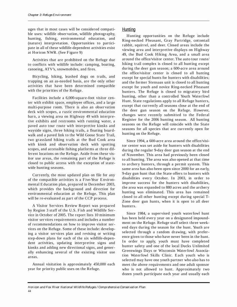
Chapter 3: Refuge Environment
uges that in most cases will be considered compati-ble uses: wildlife observation, wildlife photography, hunting, fishing, environmental education, and (nature) interpretation. Opportunities to partici-pate in all of these wildlife-dependent activities exist at Horicon NWR. (See Figure 9)
Activities that are prohibited on the Refuge due to conflicts with wildlife include: camping, boating, canoeing, ATV’s, snowmobiles, and fires.
Bicycling, hiking, leashed dogs on trails, and trapping on an as-needed basis, are the only other activities that have been determined compatible with the priorities of the Refuge.
Facilities include a 6,000-square-foot visitor cen-ter with exhibit space, employee offices, and a large multi-purpose room. There is also an observation deck with scopes, a rustic environmental education barn, a viewing area on Highway 49 with interpre-tive exhibits and restrooms with running water, a paved auto tour route with interpretive kiosks and wayside signs, three hiking trails, a floating board-walk and a paved link to the Wild Goose State Trail, two grassland hiking trails at the Bud Cook area with kiosk and observation deck with spotting scopes, and accessible fishing platforms at three dif-ferent locations on the Refuge. Aside from these vis-itor use areas, the remaining part of the Refuge is closed to public access with the exception of state-wide hunting seasons.
Currently, the most updated plan on file for any of the compatible activities is a Five-Year Environ-mental Education plan, prepared in December 2003, which provides the background and direction for environmental education at the Refuge. This plan will be re-evaluated as part of the CCP process.
A Visitor Services Review Report was prepared by Region 3 staff of the U.S. Fish and Wildlife Ser-vice in October of 2005. The report lists 10 minimum visitor services requirements and includes a number of recommendations on how to improve visitor ser-vices on the Refuge. Some of these include: develop-ing a visitor services plan and revising or writing step-down plans for each of the six wildlife-depen-dent activities, updating interpretive signs and kiosks and adding new directional signs, and gener-ally enhancing several of the existing visitor use areas.
Annual visitation is approximately 450,000 each year for priority public uses on the Refuge.
HuntingHunting opportunities on the Refuge include
Ring-necked Pheasant, Gray Partridge, cottontail rabbit, squirrel, and deer. Closed areas include the viewing area and interpretive displays on Highway 49, the Bud Cook Hiking Area, and a small area around the office/visitor center. The auto tour route/hiking trail complex is closed to all hunting except during the deer gun season; a 600-acre area around the office/visitor center is closed to all hunting except for special hunts for hunters with disabilities; and the former Stensaas unit is closed to all hunting except for youth and novice Ring-necked Pheasant hunters. The Refuge is closed to migratory bird hunting, other than a controlled Youth Waterfowl Hunt. State regulations apply to all Refuge hunters, except that currently all seasons close at the end of the deer gun season on the Refuge. However, changes were recently submitted to the Federal Register for the 2006 hunting season. All hunting seasons on the Refuge will coincide with the State seasons for all species that are currently open for hunting on the Refuge.
Since 1994, a 600-acre area around the office/visi-tor center was set aside for hunters with disabilities during the regular 9-day deer gun season at the end of November. This area had previously been closed to all hunting. The area was also opened at that time to archery hunters, through a permit system. This same area has also been open since 2000 for an early, 9-day gun hunt that the State offers to hunters with disabilities every October. In 2003, in order to improve success for the hunters with disabilities, the area was expanded to 880 acres and the archery hunting was eliminated. This area has remained closed to all other hunting except during special T-Zone deer gun hunts, when it is open to all deer hunters.
Since 1984, a supervised youth waterfowl hunt has been held every year on a designated impound-ment on the Refuge. Refuge staff select three week-end days during the season for the hunt. Youth are selected through a random drawing, with prefer-ence given to those who have never been in the hunt. In order to apply, youth must have completed hunter safety and one of the local Ducks Unlimited Greenwings Days or Wisconsin Waterfowl Associa-tion Waterfowl Skills Clinic. Each youth who is selected may have one youth partner who also has to meet the above requirements and one adult sponsor who is not allowed to hunt. Approximately two dozen youth participate each year and usually each
Horicon and Fox River National Wildlife Refuges / Comprehensive Conservation Plan44

Chapter 3: Refuge Environment
Figure 9: Existing Visitor Facilities, Horicon NWR
Horicon and Fox River National Wildlife Refuges / Comprehensive Conservation Plan45
Chapter 3: Refuge Environment
party is successful in harvesting at least one duck. In 2005, the drought was so severe that the youth hunt was cancelled for the first time due to lack of water.
FishingFishing opportunities are limited due to shallow
water conditions and the absence of a variety of game fish. Boats are not allowed on the Refuge. Bank fishing in accordance with Wisconsin State fishing regulations is permissible on the Refuge at three locations: Main Dike Road, Ledge Road and Peachy Road. Main Dike Road and Ledge Road have accessible fishing piers on location but lack welcome kiosks. The Peachy Road access is cur-rently in the planning process for reconstruction. Game fish are stocked each year at various locations throughout the Refuge. One youth fishing event is held on the Refuge during the summer in celebra-tion of National Fishing Week. This event involves a morning of interactive stations that cover safety, bait and lure selection, casting, and fish biology and management with free merchandise such as hats, sunglasses, lures and tackle, followed by an after-noon of staff-led fishing at various sites on the Ref-uge.
Wildlife ObservationWildlife observation is a popular activity at the
Refuge. At least 267 different species of birds have been documented on the Refuge over the years. The Refuge is recognized as both a state and globally important bird area. Between mid-September and mid-November, visitation is at its peak due to the fall migration of over one million geese that use the Refuge as a stopping point in their nearly 850-mile migration to southern wintering areas. The 3-mile paved Horicon Ternpike Auto Tour Route is an excellent place for wildlife observation and receives the highest annual visitation of any sites throughout the Refuge. Many public events and interpretive programs occur on the Refuge that focus on wildlife observation, mainly bird-watching, such as the Horicon Marsh Bird Festival, guided birding tours, and Marsh Melodies.
Wildlife PhotographyConsistent with the opportunities to view wildlife,
many Refuge visitors also photograph the many birds, mammals, and other creatures that they observe on the Refuge. No photo blinds have been constructed at this time but future locations are being considered.
Wildlife InterpretationThe Refuge lacks a Visitor Services Plan and a
primary interpretive theme to provide guidance for Refuge management and staff on matters related to visitor services. Developing a plan and interpretive themes was one of the recommendations outlined in the 2005 visitor services review report. The plan, when developed, will provide interpretive methods and concepts, specify compatible forms of wildlife-dependent recreation, and identify existing and pro-posed public use areas and facilities for the Refuge. Currently, numerous interpretive programs are con-ducted on and off the Refuge for ages ranging from pre-school children to adults. Primary topics include the history of Horicon Marsh, habitat management and resource issues.
Environmental EducationEnvironmental education is the most developed
component of the visitor services program to date. The Refuge piloted the Rhythms of the Refuge cur-riculum for Region 3 and has used activities found in the curriculum in numerous programs for local pub-lic, private and home-schooled groups, Scouts groups and community-based service organiza-tions. Program participants range from preschool to adult, with the majority being elementary and mid-dle school students. Activities are conducted at the visitor center, the Environmental Education barn, the Egret Trail and boardwalk, off-site in the class-room and through distance learning sessions. All programs are free and are led by trained volunteers and Refuge staff.
Students working on nature journals, Horicon NWR
Horicon and Fox River National Wildlife Refuges / Comprehensive Conservation Plan46
Chapter 3: Refuge Environment
In addition to the standard curriculum, Refuge volunteers participate in the Rolling Readers liter-acy program and lead classroom activities relating to the Refuge. The Refuge also offers a variety of educational trunks and materials available for check-out such as the wildlife discovery trunk, prai-rie trunk, aquatic exotics, songbird trunk and wet-land trunk.
Volunteer and Friends ContributionsThe Refuge friends group, Friends of Horicon
National Wildlife Refuge, is heavily involved in the operation of the Refuge’s visitor services program. The group runs a gift shop, Coot’s Corner, in the vis-itor center, provides funding for educational sup-plies and services and provides volunteers for many environmental education and interpretive pro-grams, events, and outreach activities for the Ref-uge. In addition to the Friends group there are also approximately 100 other volunteers, both individual and groups, that donate time to the Refuge to assist with providing information to the public at the visi-tor center and other sites during peak visitation, habitat restoration, environmental education, inter-pretive and outreach programs, and administrative and maintenance tasks.
OutreachOutreach is an important component of Refuge
operations. In addition to off-site interpretive and environmental education programs, the Refuge sends out monthly news releases pertaining to rec-reational opportunities and resource issues and maintains a website with links to: the Rhythms of the Refuge environmental education curriculum and teacher resources, news releases, current habitat
conditions, historical information about the marsh, maps, regulations, and a calendar of events listing interpretive programs. The Refuge also maintains a Traveler Information System (TIS) with monthly updates and also a weekly waterfowl numbers phone recording.
Refuge staff and volunteers reach a wider audi-ence by partnering with other natural resource agencies and local community service groups to offer regional educational and recreational events such as the Horicon Marsh Bird Festival, Marsh Melodies, Ducks Unlimited Outdoor Show, and many other events.
Archaeological and Cultural ResourcesCultural resources management in the Service is
the responsibility of the Regional Director and is not delegated for the Section 106 process when his-toric properties could be affected by Service under-takings, for issuing archeological permits, and for Indian tribal involvement. The Regional Historic Preservation Officer (RHPO) advises the Regional Director about procedures, compliance, and imple-mentation of cultural resources laws. The Refuge Manager assists the RHPO by informing the RHPO about Service undertakings, by protecting archeo-logical sites and historic properties on Service man-aged and administered lands, by monitoring archeological investigations by contractors and per-mittees, and by reporting violations.
Law EnforcementHoricon NWR is dedicated to safeguarding the
resources under its jurisdiction, including natural resources, cultural resources, and facilities. Resource management on the Refuge includes both protective and preventive functions. Protection is safeguarding the visiting public, staff, facilities and natural and cultural resources from criminal action, accidents, negligence and acts of nature such as wildfires. Preventing incidents from occurring is the best form of protection and requires a known and visible law enforcement presence as well as other proactive steps to address potential threats and nat-ural hazards.
Over the years, the most common violations on the Refuge have been vandalism and trespass. Van-dalism incidents have included damage to signs and other structures and dumping on the west side roads, which are all township roads that dead-end at the Refuge boundary. Trespass violations have usu-ally involved visitors who wander into closed areas.
Muskrat, Horicon NWR
Horicon and Fox River National Wildlife Refuges / Comprehensive Conservation Plan47
Chapter 3: Refuge Environment
Other incidents have included hunting violations, shining on the Refuge, drug problems, arson, and taking protected plants and animals from the Ref-uge.
Fox River National Wildlife RefugeIntroduction
Fox River NWR encompasses 1,004 acres of wetland and upland habitat along the Fox River in Marquette County, approximately 35 miles west of Horicon NWR. Fox River NWR was established in 1979 under the U. S. Fish and Wildlife Service’s Unique Wildlife Ecosystem Program to protect an area known as the Fox River Sandhill Crane Marsh from further drainage and to preserve associated upland habitat. The Refuge protects an important breeding and staging area for the Sandhill Crane. The majority of the Refuge contains sedge meadow, wet prairie, and shallow marsh wetlands (Figure 10and Figure 11). Fox River NWR is managed by staff from Horicon NWR.
The Refuge is unique not only because of its importance to nesting Sandhill Cranes, but because of the diversity of wildlife within this wetland/upland complex. The Refuge has 10 distinct plant communities ranging from upland coniferous and deciduous woodlands to five wetland communities. This diversity of vegetation communities is responsible for the presence of about 150 different species of wildlife. Wildlife diversity to this extent within such a relatively small, confined area is not encountered elsewhere in Wisconsin (USFWS, 1987).
Fox River NWR is located directly across the road (County Highway F) from John Muir Memorial Park, a county park named after the famous conservationist and founder of the Sierra Club. During part of his boyhood years, Muir lived near the county park and Fox River NWR. Although he settled in California, explored the High Sierra and wilderness Alaska, and traveled all over the world, John Muir never forgot this humbler land, and tried several times to purchase and preserve parts of it. He remarked:
…even if I should never see it again, the beauty of its lilies and orchids is so pressed into my mind I shall always enjoy looking back at them
in imagination even across seas and continents and perhaps after I am dead.
ClimateAs would be expected, given its proximity to
Horicon NWR, Fox River NWR’s continental climate, characterized by cold winters and warm summers, is very similar to that of Horicon NWR. In the nearby county seat of Montello, July is the warmest month with average highs of 78 degrees Fahrenheit and January the coldest month with average lows of 4 degrees Fahrenheit. Annual precipitation is about 32 inches, with April through September the wettest months. Average snowfall is approximately 40 inches. The median growing season is 144 days (Wisconline, 2005).
Topography and SoilsLocal relief is quite gentle, sloping to the Fox
River and adjacent marshes. Elevations range from the river at 770 feet above mean sea level to an upland hi l l that r ises to 816 feet . Soi ls are predominantly muck and peat underlain by sandy alluvium deposited by the Fox River. The island and upland edges have sandy soils, ranging from loamy sand to sandy loam (USFWS, 1979; USFWS, 2003).
Surface HydrologyT h e s ur fa c e h y d ro l og y o f th e R ef u ge i s
dominated by the Fox River, which bisects it. The majority of habitats on the Refuge consist of sedge meadow, wet prairie, and shallow marsh wetlands, dominated by many species of sedges, grasses, and cattail. These are all considered wetland habitats and many would qualify as “jurisdictional wetlands” or “waters of the United States.” That is, these areas are under the jurisdiction of Section 404 of the Clean Water Act and the Army Corps of Engineers for the purpose of actions that might deposit fill in these waters/wetlands or otherwise alter their values and functions.
Archeological and Cultural Values Much of the general discussion of Horicon
NWR’s pre-history and history would also be applicable to Fox River NWR. See “Archeological and Cultural Values” on page 21 for a combined history of the two refuges.
Horicon and Fox River National Wildlife Refuges / Comprehensive Conservation Plan48
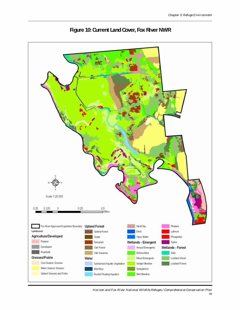
Chapter 3: Refuge Environment
Figure 10: Current Land Cover, Fox River NWR
Horicon and Fox River National Wildlife Refuges / Comprehensive Conservation Plan49
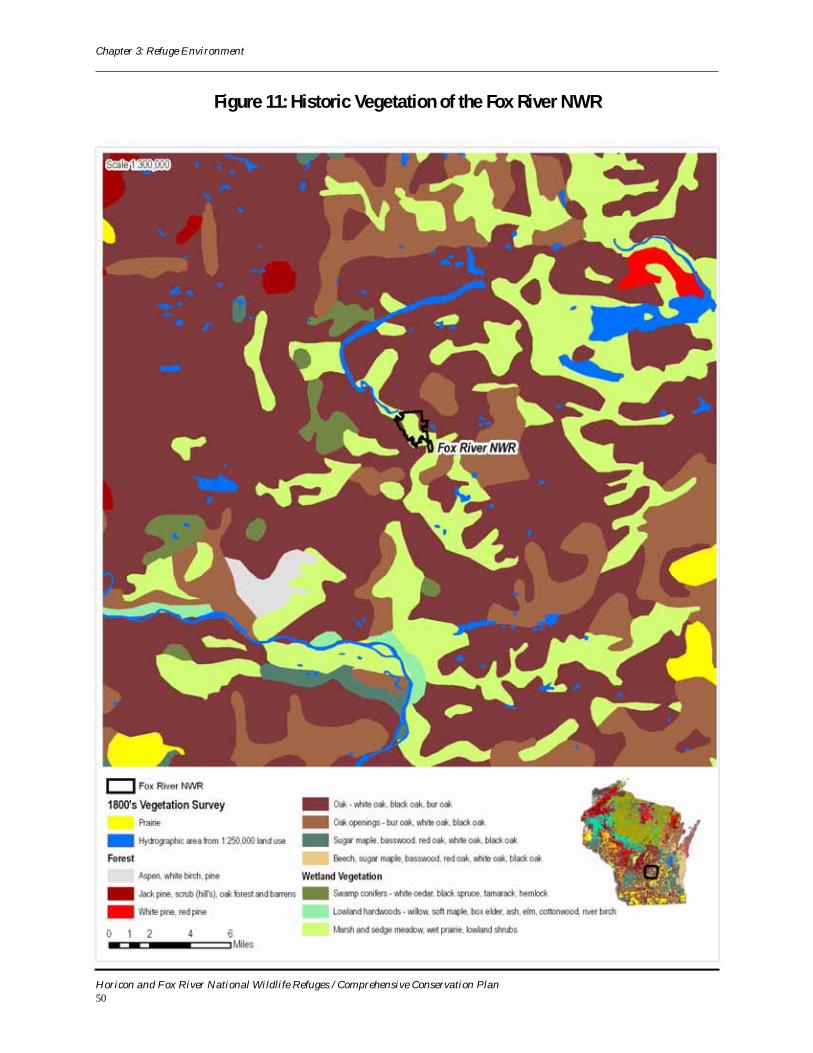
Chapter 3: Refuge Environment
Figure 11: Historic Vegetation of the Fox River NWR
Horicon and Fox River National Wildlife Refuges / Comprehensive Conservation Plan50
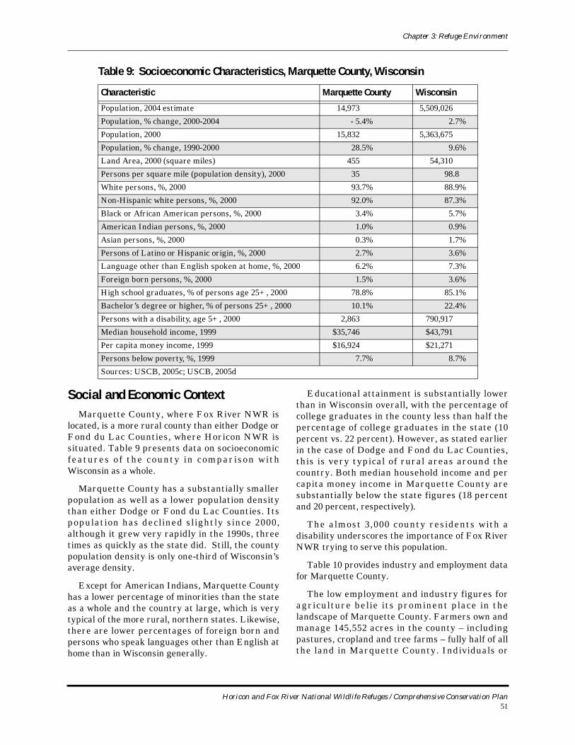
Chapter 3: Refuge Environment
Social and Economic ContextMarquette County, where Fox River NWR is
located, is a more rural county than either Dodge or Fond du Lac Counties, where Horicon NWR is situated. Table 9 presents data on socioeconomic features o f the county in compar ison wi th Wisconsin as a whole.
Marquette County has a substantially smaller population as well as a lower population density than either Dodge or Fond du Lac Counties. Its population has decl ined sl ightly since 2000, although it grew very rapidly in the 1990s, three times as quickly as the state did. Still, the county population density is only one-third of Wisconsin’s average density.
Except for American Indians, Marquette County has a lower percentage of minorities than the state as a whole and the country at large, which is very typical of the more rural, northern states. Likewise, there are lower percentages of foreign born and persons who speak languages other than English at home than in Wisconsin generally.
Educational attainment is substantially lower than in Wisconsin overall, with the percentage of college graduates in the county less than half the percentage of college graduates in the state (10 percent vs. 22 percent). However, as stated earlier in the case of Dodge and Fond du Lac Counties, this is very typical of rural areas around the country. Both median household income and per capita money income in Marquette County are substantially below the state figures (18 percent and 20 percent, respectively).
The almost 3,000 county residents with a disability underscores the importance of Fox River NWR trying to serve this population.
Table 10 provides industry and employment data for Marquette County.
The low employment and industry figures for agriculture bel ie its prominent place in the landscape of Marquette County. Farmers own and manage 145,552 acres in the county – including pastures, cropland and tree farms – fully half of all the land in Marquette County. Individuals or
Table 9: Socioeconomic Characteristics, Marquette County, Wisconsin
Characteristic Marquette County Wisconsin
Population, 2004 estimate 14,973 5,509,026
Population, % change, 2000-2004 - 5.4% 2.7%
Population, 2000 15,832 5,363,675
Population, % change, 1990-2000 28.5% 9.6%
Land Area, 2000 (square miles) 455 54,310
Persons per square mile (population density), 2000 35 98.8
White persons, %, 2000 93.7% 88.9%
Non-Hispanic white persons, %, 2000 92.0% 87.3%
Black or African American persons, %, 2000 3.4% 5.7%
American Indian persons, %, 2000 1.0% 0.9%
Asian persons, %, 2000 0.3% 1.7%
Persons of Latino or Hispanic origin, %, 2000 2.7% 3.6%
Language other than English spoken at home, %, 2000 6.2% 7.3%
Foreign born persons, %, 2000 1.5% 3.6%
High school graduates, % of persons age 25+, 2000 78.8% 85.1%
Bachelor’s degree or higher, % of persons 25+, 2000 10.1% 22.4%
Persons with a disability, age 5+, 2000 2,863 790,917
Median household income, 1999 $35,746 $43,791
Per capita money income, 1999 $16,924 $21,271
Persons below poverty, %, 1999 7.7% 8.7%
Sources: USCB, 2005c; USCB, 2005d
Horicon and Fox River National Wildlife Refuges / Comprehensive Conservation Plan51
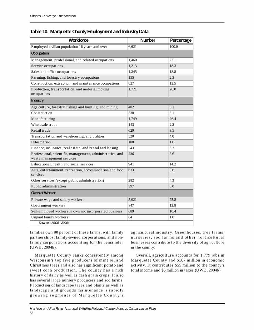
Chapter 3: Refuge Environment
families own 90 percent of these farms, with family partnerships, family-owned corporations, and non-family corporations accounting for the remainder (UWE, 2004b).
Marquette County ranks consistently among Wisconsin’s top five producers of mint oil and Christmas trees and also has significant potato and sweet corn production. The county has a rich history of dairy as well as cash grain crops. It also has several large nursery producers and sod farms. Production of landscape trees and plants as well as landscape and grounds maintenance is rapidly gr ow in g s eg m en t s o f M a rq ue t t e C ou n t y ’ s
agricultural industry. Greenhouses, tree farms, nurseries, sod farms and other horticultural businesses contribute to the diversity of agriculture in the county.
Overall, agriculture accounts for 1,779 jobs in Marquette County and $167 million in economic activity. It contributes $55 million to the county’s total income and $5 million in taxes (UWE, 2004b).
Table 10: Marquette County Employment and Industry Data
Workforce Number PercentageEmployed civilian population 16 years and over 6,621 100.0
Occupation
Management, professional, and related occupations 1,460 22.1
Service occupations 1,213 18.3
Sales and office occupations 1,245 18.8
Farming, fishing, and forestry occupations 155 2.3
Construction, extraction, and maintenance occupations 827 12.5
Production, transportation, and material moving occupations
1,721 26.0
Industry
Agriculture, forestry, fishing and hunting, and mining 402 6.1
Construction 538 8.1
Manufacturing 1,749 26.4
Wholesale trade 143 2.2
Retail trade 629 9.5
Transportation and warehousing, and utilities 320 4.8
Information 108 1.6
Finance, insurance, real estate, and rental and leasing 243 3.7
Professional, scientific, management, administrative, and waste management services
236 3.6
Educational, health and social services 941 14.2
Arts, entertainment, recreation, accommodation and food services
633 9.6
Other services (except public administration) 282 4.3
Public administration 397 6.0
Class of Worker
Private wage and salary workers 5,021 75.8
Government workers 847 12.8
Self-employed workers in own not incorporated business 689 10.4
Unpaid family workers 64 1.0Source: USCB, 2000c
Horicon and Fox River National Wildlife Refuges / Comprehensive Conservation Plan52
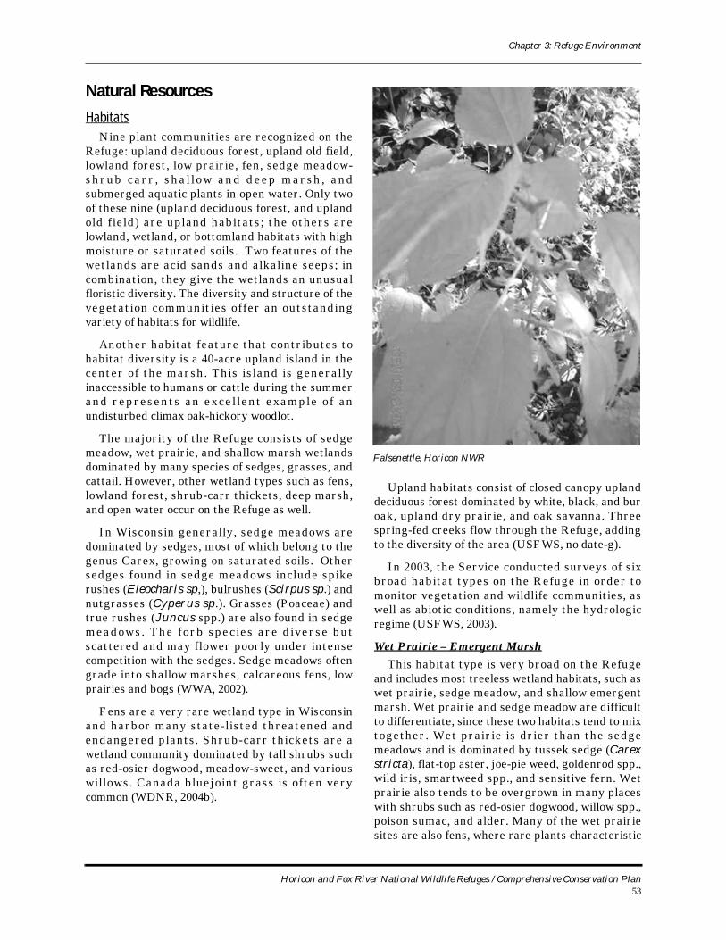
Chapter 3: Refuge Environment
Natural Resources
HabitatsNine plant communities are recognized on the
Refuge: upland deciduous forest, upland old field, lowland forest, low prairie, fen, sedge meadow-sh r u b c a r r , s h a l l o w a n d d ee p m a rs h , a n d submerged aquatic plants in open water. Only two of these nine (upland deciduous forest, and upland old field) are upland habitats; the others are lowland, wetland, or bottomland habitats with high moisture or saturated soils. Two features of the wetlands are acid sands and alkaline seeps; in combination, they give the wetlands an unusual floristic diversity. The diversity and structure of the vegetation communities offer an outstanding variety of habitats for wildlife.
Another habitat feature that contributes to habitat diversity is a 40-acre upland island in the center of the marsh. This island is generally inaccessible to humans or cattle during the summer and represents an excel lent example of an undisturbed climax oak-hickory woodlot.
The majority of the Refuge consists of sedge meadow, wet prairie, and shallow marsh wetlands dominated by many species of sedges, grasses, and cattail. However, other wetland types such as fens, lowland forest, shrub-carr thickets, deep marsh, and open water occur on the Refuge as well.
In Wisconsin generally, sedge meadows are dominated by sedges, most of which belong to the genus Carex, growing on saturated soils. Other sedges found in sedge meadows include spike rushes (Eleocharis sp,), bulrushes (Scirpus sp.) and nutgrasses (Cyperus sp.). Grasses (Poaceae) and true rushes (Juncus spp.) are also found in sedge meadows. The forb species are diverse but scattered and may flower poorly under intense competition with the sedges. Sedge meadows often grade into shallow marshes, calcareous fens, low prairies and bogs (WWA, 2002).
Fens are a very rare wetland type in Wisconsin and harbor many state-listed threatened and endangered plants. Shrub-carr thickets are a wetland community dominated by tall shrubs such as red-osier dogwood, meadow-sweet, and various willows. Canada bluejoint grass is often very common (WDNR, 2004b).
Upland habitats consist of closed canopy upland deciduous forest dominated by white, black, and bur oak, upland dry prairie, and oak savanna. Three spring-fed creeks flow through the Refuge, adding to the diversity of the area (USFWS, no date-g).
In 2003, the Service conducted surveys of six broad habitat types on the Refuge in order to monitor vegetation and wildlife communities, as well as abiotic conditions, namely the hydrologic regime (USFWS, 2003).
Wet Prairie – Emergent MarshThis habitat type is very broad on the Refuge
and includes most treeless wetland habitats, such as wet prairie, sedge meadow, and shallow emergent marsh. Wet prairie and sedge meadow are difficult to differentiate, since these two habitats tend to mix together. Wet prairie is drier than the sedge meadows and is dominated by tussek sedge (Carex stricta), flat-top aster, joe-pie weed, goldenrod spp., wild iris, smartweed spp., and sensitive fern. Wet prairie also tends to be overgrown in many places with shrubs such as red-osier dogwood, willow spp., poison sumac, and alder. Many of the wet prairie sites are also fens, where rare plants characteristic
Falsenettle, Horicon NWR
Horicon and Fox River National Wildlife Refuges / Comprehensive Conservation Plan53
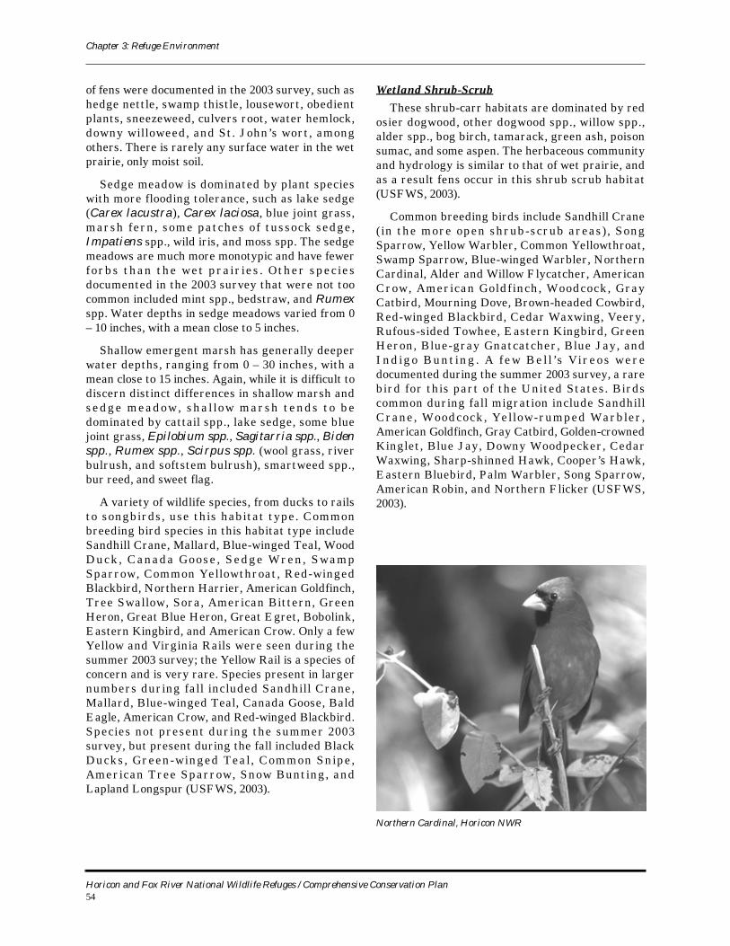
Chapter 3: Refuge Environment
of fens were documented in the 2003 survey, such as hedge nettle, swamp thistle, lousewort, obedient plants, sneezeweed, culvers root, water hemlock, downy willoweed, and St. John’s wort, among others. There is rarely any surface water in the wet prairie, only moist soil.
Sedge meadow is dominated by plant species with more flooding tolerance, such as lake sedge (Carex lacustra), Carex laciosa, blue joint grass, marsh fern, some patches of tussock sedge, Impatiens spp., wild iris, and moss spp. The sedge meadows are much more monotypic and have fewer forbs than the wet pra ir ies . Other spec ies documented in the 2003 survey that were not too common included mint spp., bedstraw, and Rumex spp. Water depths in sedge meadows varied from 0 – 10 inches, with a mean close to 5 inches.
Shallow emergent marsh has generally deeper water depths, ranging from 0 – 30 inches, with a mean close to 15 inches. Again, while it is difficult to discern distinct differences in shallow marsh and sedge meadow, sh a l low marsh tends to be dominated by cattail spp., lake sedge, some blue joint grass, Epilobium spp., Sagitarria spp., Biden spp., Rumex spp., Scirpus spp. (wool grass, river bulrush, and softstem bulrush), smartweed spp., bur reed, and sweet flag.
A variety of wildlife species, from ducks to rails to songbirds, use this habitat type. Common breeding bird species in this habitat type include Sandhill Crane, Mallard, Blue-winged Teal, Wood Duck, Canada Goose , Sedge Wren, Swamp Sparrow, Common Yellowthroat, Red-winged Blackbird, Northern Harrier, American Goldfinch, Tree Swallow, Sora, American Bittern, Green Heron, Great Blue Heron, Great Egret, Bobolink, Eastern Kingbird, and American Crow. Only a few Yellow and Virginia Rails were seen during the summer 2003 survey; the Yellow Rail is a species of concern and is very rare. Species present in larger numbers during fall included Sandhill Crane, Mallard, Blue-winged Teal, Canada Goose, Bald Eagle, American Crow, and Red-winged Blackbird. Species not present during the summer 2003 survey, but present during the fall included Black Ducks, Green-winged Teal , Common Snipe, American Tree Sparrow, Snow Bunting, and Lapland Longspur (USFWS, 2003).
Wetland Shrub-ScrubThese shrub-carr habitats are dominated by red
osier dogwood, other dogwood spp., willow spp., alder spp., bog birch, tamarack, green ash, poison sumac, and some aspen. The herbaceous community and hydrology is similar to that of wet prairie, and as a result fens occur in this shrub scrub habitat (USFWS, 2003).
Common breeding birds include Sandhill Crane ( in the more open shrub-scrub areas), Song Sparrow, Yellow Warbler, Common Yellowthroat, Swamp Sparrow, Blue-winged Warbler, Northern Cardinal, Alder and Willow Flycatcher, American Crow, American Goldfinch, Woodcock, Gray Catbird, Mourning Dove, Brown-headed Cowbird, Red-winged Blackbird, Cedar Waxwing, Veery, Rufous-sided Towhee, Eastern Kingbird, Green Heron, Blue-gray Gnatcatcher, Blue Jay, and I n d i g o B un t i n g . A f ew B e l l ’ s V i r eo s w e re documented during the summer 2003 survey, a rare bird for this part of the United States. Birds common during fall migration include Sandhill Crane, Woodcock, Yellow-rumped Warbler, American Goldfinch, Gray Catbird, Golden-crowned Kinglet, Blue Jay, Downy Woodpecker, Cedar Waxwing, Sharp-shinned Hawk, Cooper’s Hawk, Eastern Bluebird, Palm Warbler, Song Sparrow, American Robin, and Northern Flicker (USFWS, 2003).
Northern Cardinal, Horicon NWR
Horicon and Fox River National Wildlife Refuges / Comprehensive Conservation Plan54

Chapter 3: Refuge Environment
Wetland ForestDominant trees in this habitat type include
tamarack, green ash, swamp white oak, red maple, elm spp., and to a lesser extent, bur oak. Mid-canopy trees and shrubs include those mentioned previously, dogwood spp., bog birch, poison sumac, alder spp., and willow spp. The herbaceous layer was dominated by moss spp., carex spp., grass spp., wild raspberry, fern spp., Impatiens spp., and nettle spp. Little, if any, surface water is present in wetland forest, but soil is very moist (USFWS, 2003).
In terms of bird use, this is possibly the most diverse habitat type on the Refuge. Common breeding species in this habitat type include Veery, House Wren, American Robin, Cedar Waxwing, Yellow Warbler, Common Yellowthroat, Blue-winged Warbler, Red-bellied Woodpecker, Pileated Woodpecker, Rose-breasted Grosbeak, Downy Woodpecker, Indigo Bunting, Willow and Alder Flycatcher, Gray Catbird, Baltimore Oriole, Northern Flicker, Blue Jay, Eastern Wood-pewee, Red-eyed Vireo, Ovenbird, Northern Cardinal, Mourning Dove, Yellow-throated Vireo, Black-capped Chickadee, and Blue-gray Gnatcatcher. Species present in larger numbers during fall inc l ude Amer ica n Rob in , Cedar Waxwin g , American Goldfinch, Black-capped Chickadee, Yellow-rumped Warbler, White-throated Sparrow, White-breasted Nuthatch, Fox Sparrow, and American Crow. In the 2003 survey, a Long-eared Owl was documented in a tamarack forest in October (USFWS, 2003).
Upland PrairieIn the 2003 survey, only four points were located
in upland prairie (old agriculture fields). These points were dominated by monotypic cool season grass stands consisting of mainly smooth brome, quack grass, and Kentucky bluegrass. Goldenrod spp. and common mullein were the only common forbs found.
In contrast to wetland forest, upland prairie likely had the lowest number of bird species surveyed in 2003. The habitat was very monotypic, likely causing low bird species richness. Bird species documented in upland prairie included Bobolink, Northern Bobwhite, Wild Turkey, Common Yellowthroat, Tree Swallow, Eastern Bluebird, Field Sparrow, Song Sparrow, Eastern Kingbird, Sandhill Crane, and European Starling (USFWS, 2003).
Upland SavannaUpland savanna is similar to upland prairie on
the Refuge, the only difference being that these sites have been invaded by small red cedar and white pine, thus creating an old field savanna. This savanna is not the goal of management and restoration efforts – the goal is true oak savanna. In the 2003 survey, these old field savannas did contain some good native plant species (in a l imited amount) not found on upland prairie sites, such as big bluestem, little bluestem, whorled, common, and sand milkweed, Carex spp., wild raspberry, aster spp., western ragweed, bush clover, needle grass, Cyperus spp., horsemint, blazing star, and butterfly milkweed.
Upland savanna has more species than upland prairie, likely because of the presence of small cedar and white pine in the prairie. In the 2003 survey, these species included Sandhill Crane ( feeding) , Chipping Sparrow, Clay-colored S p a r ro w , H en s l ow ’ s S p a rr o w , C o m m on Yellowthroat, American Robin, Field Sparrow, Rufous-sided Towhee, Mourning Dove, American Goldfinch, Song Sparrow, Eastern Bluebird, Tree Swallow, Savanna Sparrow, Barn Swallow, Eastern Kingbird, Bobolink, Turkey Vulture, Red-tailed Hawk, and Brown-headed Cowbird (USFWS, 2003).
Upland ForestAll of the upland forest on the Refuge was
historically oak savanna, dominated by white, black, and bur oak. Now, it is a closed canopy forest with many tree species that are not fire tolerant. Many remnant savanna trees exist in these forests, obviously open grown, with broad, spreading, drooping crowns. Dominant tree species were white oak, black oak, bur oak, black cherry, red cedar, elm spp., northern red oak, shagbark hickory, sugar maple, and some green ash. Mid-canopy trees and shrubs consisted of those dominant trees mentioned previously, plus mulberry, grape spp, winterberry, and dogwood spp. The herbaceous layer was dominated by huckleberry spp., wild raspberry, garlic mustard (not good), avans, nettle spp., grass spp., and burdock.
This habitat type is also very diverse in terms of bird use. Just a few of the most common breeding birds seen in the 2003 survey were Pileated, Red-Bellied, and Downy Woodpecker, White-breasted Nuthatch, Scarlet Tanager , Rose-breasted Grosbeak, Ovenbird, Eastern-wood Pewee, Black-capped Chickadee, Northern Cardinal, Gray
Horicon and Fox River National Wildlife Refuges / Comprehensive Conservation Plan55
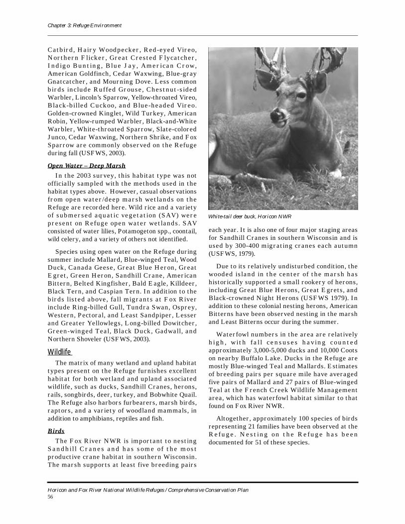
Chapter 3: Refuge Environment
Catbird, Hairy Woodpecker, Red-eyed Vireo, Northern Flicker, Great Crested Flycatcher, Indigo Bunt ing, Blue Jay, American Crow, American Goldfinch, Cedar Waxwing, Blue-gray Gnatcatcher, and Mourning Dove. Less common birds include Ruffed Grouse, Chestnut-sided Warbler, Lincoln’s Sparrow, Yellow-throated Vireo, Black-billed Cuckoo, and Blue-headed Vireo. Golden-crowned Kinglet, Wild Turkey, American Robin, Yellow-rumped Warbler, Black-and-White Warbler, White-throated Sparrow, Slate-colored Junco, Cedar Waxwing, Northern Shrike, and Fox Sparrow are commonly observed on the Refuge during fall (USFWS, 2003).
Open Water – Deep MarshIn the 2003 survey, this habitat type was not
officially sampled with the methods used in the habitat types above. However, casual observations from open water/deep marsh wetlands on the Refuge are recorded here. Wild rice and a variety of submersed aquatic vegetation (SAV) were present on Refuge open water wetlands. SAV consisted of water lilies, Potamogeton spp., coontail, wild celery, and a variety of others not identified.
Species using open water on the Refuge during summer include Mallard, Blue-winged Teal, Wood Duck, Canada Geese, Great Blue Heron, Great Egret, Green Heron, Sandhill Crane, American Bittern, Belted Kingfisher, Bald Eagle, Killdeer, Black Tern, and Caspian Tern. In addition to the birds listed above, fall migrants at Fox River include Ring-billed Gull, Tundra Swan, Osprey, Western, Pectoral, and Least Sandpiper, Lesser and Greater Yellowlegs, Long-billed Dowitcher, Green-winged Teal, Black Duck, Gadwall, and Northern Shoveler (USFWS, 2003).
Wildlife The matrix of many wetland and upland habitat
types present on the Refuge furnishes excellent habitat for both wetland and upland associated wildlife, such as ducks, Sandhill Cranes, herons, rails, songbirds, deer, turkey, and Bobwhite Quail. The Refuge also harbors furbearers, marsh birds, raptors, and a variety of woodland mammals, in addition to amphibians, reptiles and fish.
BirdsThe Fox River NWR is important to nesting
Sandhi l l Cranes and has some o f the most productive crane habitat in southern Wisconsin. The marsh supports at least five breeding pairs
each year. It is also one of four major staging areas for Sandhill Cranes in southern Wisconsin and is used by 300-400 migrating cranes each autumn (USFWS, 1979).
Due to its relatively undisturbed condition, the wooded island in the center of the marsh has historically supported a small rookery of herons, including Great Blue Herons, Great Egrets, and Black-crowned Night Herons (USFWS 1979). In addition to these colonial nesting herons, American Bitterns have been observed nesting in the marsh and Least Bitterns occur during the summer.
Waterfowl numbers in the area are relatively h i g h , w i t h f a l l c e n s u s e s h a v i n g c o u n t e d approximately 3,000-5,000 ducks and 10,000 Coots on nearby Buffalo Lake. Ducks in the Refuge are mostly Blue-winged Teal and Mallards. Estimates of breeding pairs per square mile have averaged five pairs of Mallard and 27 pairs of Blue-winged Teal at the French Creek Wildlife Management area, which has waterfowl habitat similar to that found on Fox River NWR.
Altogether, approximately 100 species of birds representing 21 families have been observed at the R ef u g e . N e s t i n g o n t h e R e f u g e h a s b e en documented for 51 of these species.
White-tail deer buck, Horicon NWR
Horicon and Fox River National Wildlife Refuges / Comprehensive Conservation Plan56
Chapter 3: Refuge Environment
MammalsAbout 26 spec ies o f mammals have been
r ec or d e d a t t h e R e f u g e . O n e o f t h e m i s Richardson’s squirrel, typically a western prairie species. Furbearers include mink, muskrats, beaver, and raccoon. Marquette County has had high densities of white-tailed deer, up to 60 deer per square mile (USFWS, 1979).
Amphibians and ReptilesAt least 15 species of amphibians and reptiles
have been identified at the Refuge. This tally includes six species of frogs, five species of turtles, and four species of snakes (USFWS, 1979).
Aquatic LifeFox River and nearby Buffalo Lake contain an
abundance and diversity of fresh water aquatic plant and animal life. Portions of the river and the lake have been chemically treated at times to remove undesirable non-game fish and excessive aquatic vegetation. Game fish included perch, bass and northern pike. Six species of freshwater clams have been reported at the Refuge, providing food for many wildlife species (USFWS, 1979).
Threatened and Endangered SpeciesNo species on the federal threatened and
endangered species list are known to exist at Fox River NWR. However, several state-listed species are present , inc lud ing the Double-crested Cormorant, Great Egret, Red-shouldered Hawk, wood turtle and Blanding’s turtle.
Fox River NWR Current Refuge Programs: Where We Are Today
This section summarizes current management programs, operations, and facilities at Fox River NWR. It also describes the participation and coop-eration of Refuge staff and management activities with our partnering agencies and stakeholders in the wider community on efforts to balance compet-ing demands for natural resources, wildlife, and pro-tection from environmental hazards like flooding.
Habitat ManagementMany of the current management efforts on the
Refuge focus on restoring valuable wildlife habitats that have declined regionally since the advent of intensive habitat modification and destruction
wrought by Euro-American settlement, agricultural development and drainage projects. The staff located at Horicon NWR staff carries out wetland and upland habitat restoration projects on the Ref-uge.
Habitat RestorationVirtually all the work completed on Fox River
NWR to date has been some kind of habitat restora-tion. After completion of wetland and upland resto-ration activities, Fox River NWR will provide wonderful examples of habitats present before European settlement of the area in 1850. The area will then be managed primarily by periodic pre-scribed burning, mowing, and monitoring/evalua-tion.
General Land Office (GLO) records for the area and old aerial photos have provided a glimpse into what the area used to look like. For example, a GLO surveyor in December 1832 described seeing what we call today oak savanna along a section line that runs through the Refuge: “land rolling, second rate, thinly timbered with oak.” In the wetlands, the sur-veyor did not give much detail, only statements such as “land level and marshy, no trees.” However, the fact that the surveyors did not see any trees in the marsh is very notable as today, large blocks of tama-rack, aspen, green ash, willow, and a variety of shrubs such as red osier dogwood exist in the former treeless marsh. This observation tells us that fire was likely present to keep the woody vege-tation out of the marsh (most woody vegetation that can tolerate wet conditions is not fire tolerant).
Other sources of information include old aerial photos from the 1930s to the 1950s. These photos depict the current day Fox River NWR with oak savanna still present on the uplands (very little closed canopy forest as is seen today) and a nearly treeless marsh.
Wetland RestorationIn 2004, funding was received for a wetland resto-
ration project on the Refuge from (a) the NAWCA Small Grants Program ($17,500), (b) Ducks Unlim-ited ($12,500 as a match for the NAWCA grant), (c) Wisconsin Waterfowl Association ($10,000), and (d) the Service’s Cooperative Conservation Initiative (CCI), two grants of $20,000 and $2,500. Elevation surveys were conducted throughout the project area in order to determine water flow patterns and post-construction water depths. The wetland resto-ration involved filling and plugging ditches (via earthen and sheet piling plugs) that drain approxi-
Horicon and Fox River National Wildlife Refuges / Comprehensive Conservation Plan57
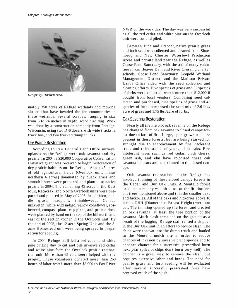
Chapter 3: Refuge Environment
mately 350 acres of Refuge wetlands and mowing shrubs that have invaded the fen communities in these wetlands. Several scrapes, ranging in size from 6 to 24 inches in depth, were also dug. Work was done by a construction company from Portage, Wisconsin, using two D-6 dozers with wide tracks, a track hoe, and two tracked dump trucks.
Dry Prairie RestorationAccording to 1832 General Land Office surveys,
uplands on the Refuge were oak savanna and dry prairie. In 2004, a $20,000 Cooperative Conservation Initiative grant was received to begin restoration of dry prairie habitats on the Refuge. About 45 acres of old agricultural fields (Overlook unit, minus northern 6 acres) dominated by quack grass and smooth brome were prepared and planted to native prairie in 2004. The remaining 45 acres in the East Muir, Rataczak, and North Overlook units were pre-pared and planted in May of 2005. In addition, nee-dle grass, leadplant, thimbleweed, Canada milkvetch, white wild indigo, yellow coneflower, ros-inweed, compass plant, cup plant, and prairie dock were planted by hand on the top of the hill north and east of the section corner in the Overlook unit. By the end of 2005, the 12-acre Spring Unit and the 8-acre Homestead unit were being sprayed in prepa-ration for seeding.
In 2004, Refuge staff led a red cedar and white pine cutting day to cut and pile invasive red cedar and white pine from the Overlook prairie restora-tion unit. More than 65 volunteers helped with the project. These volunteers donated more than 260 hours of labor worth more than $3,900 to Fox River
NWR on the work day. The day was very successful as all the red cedar and white pine on the Overlook unit were cut and piled.
Between June and October, native prairie grass and forb seed was collected and cleaned from Shoe-nberg and New Chester Waterfowl Production Areas and private land near the Refuge, as well as Goose Pond Sanctuary, with the aid of many volun-teers from Beaver Dam and River Crossing charter schools. Goose Pond Sanctuary, Leopold Wetland Management District, and the Madison Private Lands Office aided with the seed collection and cleaning efforts. Five species of grass and 32 species of forbs were collected, worth more than $12,000 if bought from local vendors. Combining seed col-lected and purchased, nine species of grass and 42 species of forbs comprised the seed mix of 2.6 lbs./acre of grass and 1.75 lbs./acre of forbs.
Oak Savanna RestorationNearly all the historic oak savanna on the Refuge
has changed from oak savanna to closed canopy for-est due to lack of fire. Large, open grown oaks are present in these forests, but are being starved for sunlight due to encroachment by fire intolerant trees and thick stands of young black oaks. Fire intolerant trees such as red cedar, black cherry, green ash, and elm have colonized these oak savanna habitats and contributed to the closed can-opy.
Oak savanna restoration on the Refuge has involved thinning of these closed canopy forests in the Cedar and Bur Oak units. A Montello forest products company was hired to cut the fire intoler-ant trees mentioned above and thin the smaller oaks and hickories. All of the oaks and hickories above 16 inches DBH (Diameter at Breast Height) were not cut. The thinning opened up the forest and created an oak savanna, at least the tree portion of the savanna. Much slash remained on the ground as a result of the logging. Refuge staff rented a chipper in the Bur Oak unit in an effort to reduce slash. The chips were thrown into the dump truck and hauled to the Montello mulch site in order to reduce chances of invasion by invasive plant species and to enhance chances for a successful prescribed burn next year (piles of chips don’t burn very well). The chipper is a great way to remove the slash, but requires extensive labor and funds. The need for prairie grass and forb seeding will be evaluated after several successful prescribed fires have removed much of the slash.
Dragonfly, Horicon NWR
Horicon and Fox River National Wildlife Refuges / Comprehensive Conservation Plan58
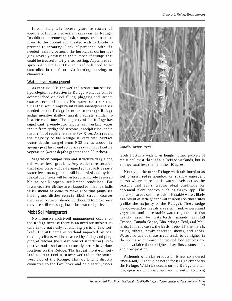
Chapter 3: Refuge Environment
It will likely take several years to restore all aspects of the historic oak savannas on the Refuge. In addition to removing slash, stumps need to be cut lower to the ground and treated with herbicide to prevent re-sprouting. Lack of personnel with the needed training to apply the herbicides during log-ging severely restricted the number of stumps that could be treated shortly after cutting. Aspen has re-sprouted in the Bur Oak unit and will need to be controlled in the future via burning, mowing, or chemicals.
Water Level ManagementAs mentioned in the wetland restoration section,
hydrological restoration in Refuge wetlands will be accomplished via ditch filling, plugging and stream course reestablishment. No water control struc-tures that would require intensive management are needed on the Refuge in order to manage Refuge sedge meadow/shallow marsh habitats similar to historic conditions. The majority of the Refuge has significant groundwater inputs and surface water inputs from spring fed streams, precipitation, and a natural flood regime from the Fox River. As a result, the majority of the Refuge is very wet. Surface water depths ranged from 0-30 inches above the spongy peat layer and some areas even have floating vegetation (water depths greater than 30 inches).
Vegetation composition and structure vary along this water level gradient. Any wetland restoration that takes place will be designed so that only passive water level management will be needed and hydro-logical conditions will be restored as closely as possi-ble to pre-European settlement conditions. For instance, after ditches are plugged or filled, periodic visits should be done to make sure that plugs are holding and ditches remain filled. Stream courses that were restored should be checked to make sure they are still coursing down the restored paths.
Moist Soil ManagementNo intensive moist-soil management occurs on
the Refuge because there is no need for infrastruc-ture in the naturally functioning parts of this wet-land. The 400 acres of wetland impacted by past ditching efforts will be restored by filling and plug-ging of ditches (no water control structures). Pro-ductive moist-soil areas naturally occur in various locations on the Refuge. The largest moist-soil wet-land is Crane Pool, a 10-acre wetland on the south-west side of the Refuge. This wetland is directly connected to the Fox River and as a result, water
levels fluctuate with river height. Other pockets of moist-soil exist throughout Refuge wetlands, but in all they total less than another 10 acres.
Nearly all the other Refuge wetlands function as wet prairie, sedge meadow, or shallow emergent marsh where more stable water levels across the seasons and years creates ideal conditions for perennial plant species such as Carex spp. The moist-soil areas seem to lack this stable water, likely as a result of little groundwater inputs on these sites (unlike the majority of the Refuge). These sedge meadow/shallow marsh areas with native perennial vegetation and more stable water regimes are also heavily used by waterbirds, namely Sandhill Cranes, Canada Geese, Blue-winged Teal, and Mal-lards. In many cases, the birds “roto-till” the marsh, eating tubers, newly sprouted shoots, and seeds. Waterbird use of these areas tends to be higher in the spring when more habitat and food sources are made available due to higher river flows, snowmelt, and precipitation.
Although wild rice production is not considered “moist-soil,” it should be noted for its significance on the Refuge. Wild rice occurs on the Refuge in shal-low, open water areas, such as the outlet to Long
Cattails, Horicon NWR
Horicon and Fox River National Wildlife Refuges / Comprehensive Conservation Plan59
Chapter 3: Refuge Environment
Lake, in most Refuge streams and ditches with water flow, in the old Fox River channel slough on the northwest side of the Refuge, and along the shoreline of oxbow lake and the active Fox River channel. It is estimated that approximately 20 acres of wild rice exist either on or adjacent to the Refuge. Wild rice sites are extremely attractive to fall migrating waterfowl. Mallards, Blue-winged Teal, Wood Ducks, and Black Ducks are seen in sizeable numbers in the fall utilizing these wild rice stands. Dabbling ducks also use stands of wild rice during the breeding season for brood rearing areas.
Prescribed FireFire was an integral part of the oak savanna and
sedge meadow wetland habitats historically present on the Refuge. Fire greatly reduced the abundance of fire intolerant woody and herbaceous vegetation, thus effectively maintaining the savannas and marshes. General Land Office notes describe Ref-uge wetlands in 1832 as “wet marsh, no trees.” Due to fire suppression efforts after human settlement, frequency of fire greatly diminished. Open forests became closed forests, treeless marshes became dominated by lowland forests or shrubs on the higher elevations, and dry prairies were invaded by woody vegetation. In order to reduce this woody component and aid in the process of restoring native habitats, prescribed burns are needed for the entire Refuge. Burn units were identified for the entire Refuge and a burn schedule discussed so each unit is burned on a recurring 3-4 year schedule.
Prescribed fire is one of Fox River NWR’s most useful tools for maintaining prairie and marsh vege-tative characteristics. Since many upland birds and waterfowl require open areas for nesting, pre-scribed fire helps maintain habitat necessary for migratory species. By choosing burn units based on needs of the wildlife habitat we can maintain a com-bination of prairie, savanna, marsh, sedge meadow and woodland habitats required by native wildlife species.
HayingHistorically permits were issued for haying the
units that border County Road F. In recent years, no haying has been done on the Refuge. Refuge staff has mowed fields in preparation for native grass plantings.
Controlling Invasive Plants The Refuge is very unique in that the abundance
of exotic and invasive plants is extremely low as compared to other sites. Only small, scattered patches of exotic plants occur within a sea of native plants. Most of the quack grass and brome domi-nated fields were sprayed in 2004 and 2005 as part of the prairie restoration project. Monitoring is needed for reed canary grass, phragmites, purple loosestrife, and garlic mustard and aspen. The most important invasive plant species is loosestrife. Areas of reed canary grass are spreading and taking over native sedge meadow; Refuge staff is attempting to identify the best control techniques for this exotic species to control it in the worst areas before the problem intensifies. It is important to closely moni-tor the areas recently disturbed by logging and wet-land restoration. Equipment brought into these areas has increased the potential for invasive spe-cies introduction.
In 2005, Refuge staff collected purple loosestrife beetles from an area west of Winona, Minnesota. A total of approximately 750 beetles were released on and around Fox River NWR where purple loos-estrife was present.
Vegetation Surveys
Vegetation and Habitat Surveys The majority of the Refuge is sedge meadow, wet
prairie, and shallow marsh wetlands dominated by many species of sedges, grasses, and cattail. How-ever, other wetland types such as fens, lowland for-est, shrub-carr thickets, deep marsh, and open water occur on the Refuge as well.
As discussed previously, 100 survey points were randomly placed in six broad habitat types on the Refuge in 2003 in order to monitor vegetation and wildlife communities, as well as abiotic conditions, namely the hydrologic regime. At this point, the data have not been entered or analyzed. These sur-veys will provide good insight into the effects of management and restoration efforts on habitat and wildlife.
Wildlife ManagementWildlife management activities at Fox River
NWR are directed by the Refuge’s establishing pur-poses and general mandate to conserve trust resources. This is accomplished primarily through habitat manipulation rather than by direct manipu-lation of wildlife species and populations. See the
Horicon and Fox River National Wildlife Refuges / Comprehensive Conservation Plan60
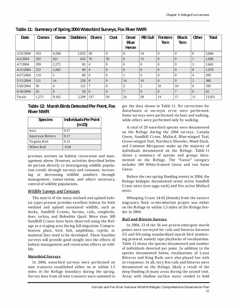
Chapter 3: Refuge Environment
Table
Da al
3/25/2
4/2/20
4/7/20
4/15/2
4/27/2
5/11/2
5/26/2
6/18/2
Totals 1
previous sections on habitat restoration and man-agement above. However, activities described below do pertain directly to investigating wildlife popula-tion trends through surveys and censuses, increas-ing or decreasing wildlife numbers through management, conservation, and where necessary, control of wildlife populations.
Wildlife Surveys and CensusesThe matrix of the many wetland and upland habi-
tat types present provides excellent habitat for both wetland and upland associated wildlife, such as ducks, Sandhill Cranes, herons, rails, songbirds, deer, turkey, and Bobwhite Quail. More than 300 Sandhill Cranes have been observed using the Ref-uge as a staging area during fall migration. Compre-hensive plant, bird, fish, amphibian, reptile, or mammal lists need to be developed. These baseline surveys will provide good insight into the effects of habitat management and restoration efforts on wild-life.
Waterbird SurveysIn 2004, waterbird surveys were performed on
nine transects established either on or within 1.5 miles of the Refuge boundary during the spring. Survey data from all nine transects were summed to
get the data shown in Table 11. No corrections for disturbance or surveyor error were performed. Some surveys were performed via boat and walking, while others were performed only by walking.
A total of 29 waterbird species were documented on the Refuge during the 2004 surveys. Canada Geese, Sandhill Crane, Mallard, Blue-winged Teal, Green-winged Teal, Northern Shoveler, Wood Duck, and Common Merganser make up the majority of individuals documented on the Refuge. Table 11shows a summary of species and groups docu-mented on the Refuge. The “Geese” category includes 100 White-fronted Geese and two Snow Geese.
Before the two spring flooding events in 2004, the Refuge biologist documented seven active Sandhill Crane nests (two eggs each) and five active Mallard nests.
Whooping Crane 14-02 (female) from the eastern migratory flock re-introduction project was either on the Refuge or within 1.5 miles of the Refuge bor-der in 2004.
Rail and Bittern SurveysIn 2004, 13 of the 56 wet prairie-emergent marsh
points were surveyed for rails and bitterns between 5/5 and 6/4 using standardized marsh bird monitor-ing protocol, namely tape playbacks of vocalizations. Table 12 shows the species documented and number of individuals detected per point. In addition to the species documented below, vocalizations of Least Bitterns and King Rails were also played but with no responses. In all, very few rails and bitterns were documented on the Refuge, likely a result of the deep flooding of many areas during the second visit. Areas with shallow surface water tended to hold
11: Summary of Spring 2004 Waterbird Surveys, Fox River NWR
te Cranes Geese Dabblers Divers Coot Great Blue
Heron
RB Gull Forsters Tern
Black Tern
Other Tot
004 163 4,584 1,033 50 0 0 14 0 0 0 5,844
04 292 621 643 76 50 0 13 0 0 1 1,696
04 299 2,272 85 4 0 0 0 0 0 3 2,663
004 222 1,665 89 0 0 0 0 0 0 0 1,976
004 119 5 80 0 0 1 0 0 0 4 209
004 121 14 220 0 0 14 10 4 0 3 386
004 39 4 121 7 0 2 2 10 10 0 195
004 20 0 28 0 0 7 0 0 7 0 62
: 1,275 9,165 2,299 137 50 24 39 14 17 11 13,03
Table 12: Marsh Birds Detected Per Point, Fox River NWR
Species Individuals Per Point (n=23)
Sora 0.57
American Bittern 0.17
Virginia Rail 0.13
Yellow Rail 0.04
Horicon and Fox River National Wildlife Refuges / Comprehensive Conservation Plan61
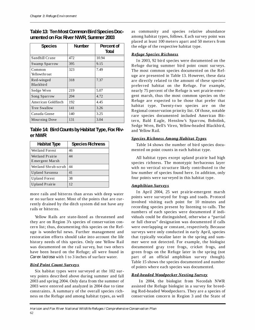
Chapter 3: Refuge Environment
more rails and bitterns than areas with deep water or no surface water. Most of the points that are cur-rently drained by the ditch system did not have any rails or bitterns.
Yellow Rails are state-listed as threatened and they are on Region 3’s species of conservation con-cern list; thus, documenting this species on the Ref-uge is wonderful news. Further management and restoration efforts should take into account the life history needs of this species. Only one Yellow Rail was documented on the rail survey, but two others have been heard on the Refuge; all were found in Carex laciosa with 1 to 3 inches of surface water.
Bird Point Count SurveysSix habitat types were surveyed at the 102 sur-
vey points described above during summer and fall 2003 and spring 2004. Only data from the summer of 2003 were entered and analyzed in 2004 due to time constraints. A summary of the overall species rich-ness on the Refuge and among habitat types, as well
as community and species relative abundance among habitat types, follows. Each survey point was placed at least 100 meters apart and 50 meters from the edge of the respective habitat type.
Refuge Species RichnessIn 2003, 92 bird species were documented on the
Refuge during summer bird point count surveys. The most common species documented on the Ref-uge are presented in Table 13. However, these data are directly related to the amount of these species’ preferred habitat on the Refuge. For example, nearly 75 percent of the Refuge is wet prairie-emer-gent marsh, thus the most common species on the Refuge are expected to be those that prefer that habitat type. Twenty-two species are on the Regional conservation priority list. Of those, notable rare species documented included American Bit-tern, Bald Eagle, Henslow’s Sparrow, Bobolink, Sedge Wren, Bell’s Vireo, Yellow-headed Blackbird, and Yellow Rail.
Species Richness Among Habitat TypesTable 14 shows the number of bird species docu-
mented on point counts in each habitat type.
All habitat types except upland prairie had high species richness. The monotypic herbaceous layer with no vertical structure likely contributed to the low number of species found here. In addition, only four points were surveyed in this habitat type.
Amphibian SurveysIn April 2004, 25 wet prairie-emergent marsh
points were surveyed for frogs and toads. Protocol involved visiting each point for 10 minutes and recording species present by listening to calls. The numbers of each species were documented if indi-viduals could be distinguished, otherwise a “partial or full chorus” designation was documented if calls were overlapping or constant, respectively. Because surveys were only conducted in early April, species that typically vocalize later in the spring and sum-mer were not detected. For example, the biologist documented gray tree frogs, cricket frogs, and green frogs on the Refuge later in the spring (not part of an official amphibian survey though). Table 15 shows the species documented and number of points where each species was documented.
Red-headed Woodpecker Nesting Survey In 2004, the biologist from Necedah NWR
assisted the Refuge biologist in a survey for breed-ing Red-headed Woodpeckers. They are a species of conservation concern in Region 3 and the State of
Table 13: Ten Most Common Bird Species Doc-umented on Fox River NWR, Summer 2003
Species Number Percent of Total
Sandhill Crane 472 10.94
Swamp Sparrow 395 9.15
Common Yellowthroat
323 7.49
Red-winged Blackbird
318 7.37
Sedge Wren 219 5.07
Song Sparrow 204 4.72
American Goldfinch 192 4.45
Tree Swallow 141 3.26
Canada Goose 140 3.25
Mourning Dove 131 3.04
Table 14: Bird Counts by Habitat Type, Fox Riv-er NWR
Habitat Type Species RichnessWetland Forest 46
Wetland Prairie Emergent Marsh
44
Wetland Shrub-scrub 44
Upland Savanna 41
Upland Forest 38
Upland Prairie 12
Horicon and Fox River National Wildlife Refuges / Comprehensive Conservation Plan62
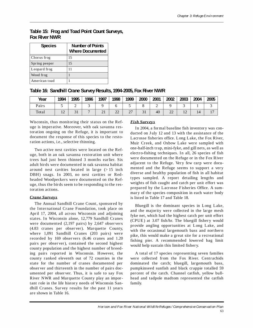
Chapter 3: Refuge Environment
Wisconsin, thus monitoring their status on the Ref-uge is imperative. Moreover, with oak savanna res-toration ongoing on the Refuge, it is important to document the response of this species to the resto-ration actions, i.e., selective thinning.
Two active nest cavities were located on the Ref-uge, both in an oak savanna restoration unit where trees had just been thinned 3 months earlier. Six adult birds were documented in oak savanna habitat around nest cavities located in large (>15 inch DBH) snags. In 2003, no nest cavities or Red-headed Woodpeckers were documented on the Ref-uge, thus the birds seem to be responding to the res-toration actions.
Crane SurveysThe Annual Sandhill Crane Count, sponsored by
the International Crane Foundation, took place on April 17, 2004, all across Wisconsin and adjoining states. In Wisconsin alone, 12,779 Sandhill Cranes were documented (2,197 pairs) by 2,647 observers (4.83 cranes per observer). Marquette County, where 1,091 Sandhill Cranes (203 pairs) were recorded by 169 observers (6.46 cranes and 1.20 pairs per observer), contained the second highest county population and the highest number of breed-ing pairs reported in Wisconsin. However, the county ranked eleventh out of 72 counties in the state for the number of cranes documented per observer and thirteenth in the number of pairs doc-umented per observer. Thus, it is safe to say Fox River NWR and Marquette County play an impor-tant role in the life history needs of Wisconsin San-dhill Cranes. Survey results for the past 11 years are shown in Table 16.
Fish SurveysIn 2004, a formal baseline fish inventory was con-
ducted on July 12 and 13 with the assistance of the Lacrosse fisheries office. Long Lake, the Fox River, Muir Creek, and Oxbow Lake were sampled with one-half-inch trap, mini-fyke, and gill nets, as well as electro-fishing techniques. In all, 26 species of fish were documented on the Refuge or in the Fox River adjacent to the Refuge. Very few carp were docu-mented and the Refuge seems to support a very diverse and healthy population of fish in all habitat types sampled. A report detailing lengths and weights of fish caught and catch per unit effort was prepared by the Lacrosse Fisheries Office. A sum-mary of the species composition in each water body is listed in Table 17 and Table 18.
Bluegill is the dominant species in Long Lake, and the majority were collected in the large mesh fyke net, which had the highest catch per unit effort (CPUE) at 3.07 fish/hr. The bluegill fishery would provide angling opportunities at Long Lake, and with the occasional largemouth bass and northern pike, this would make a great site for a recreational fishing pier. A recommended lowered bag limit would help sustain this limited fishery.
A total of 17 species representing seven families were collected from the Fox River. Centrachids dominated the catch; bluegill, largemouth bass, pumpkinseed sunfish and black crappie totalled 59 percent of the catch. Channel catfish, yellow bull-head and tadpole madtom represented the catfish family.
Table 15: Frog and Toad Point Count Surveys, Fox River NWR
Species Number of Points Where Documented
Chorus frog 15
Spring peeper 15
Leopard frog 11
Wood frog 1
American toad 1
Table 16: Sandhill Crane Survey Results, 1994-2005, Fox River NWR
Year 1994 1995 1996 1997 1998 1999 2000 2001 2002 2003 2004 2005Pairs 5 2 3 9 6 5 8 2 9 3 1 3Total 12 31 7 21 22 27 31 40 22 12 14 17
Horicon and Fox River National Wildlife Refuges / Comprehensive Conservation Plan63
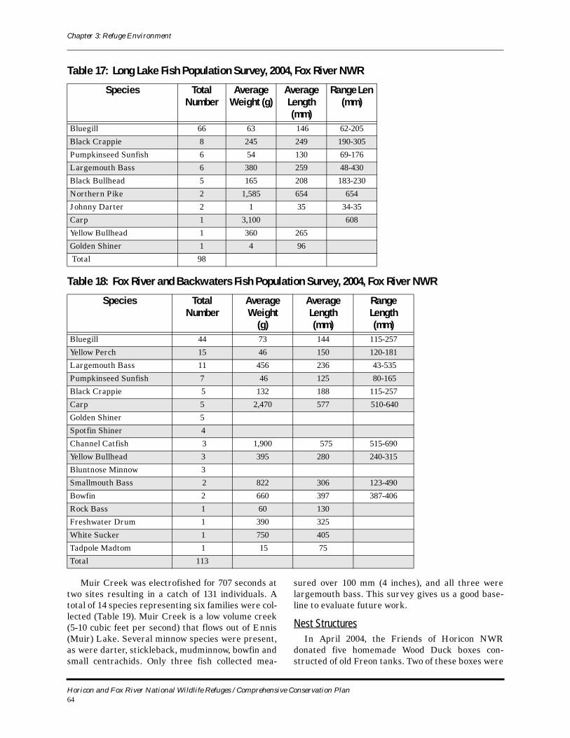
Chapter 3: Refuge Environment
Muir Creek was electrofished for 707 seconds at two sites resulting in a catch of 131 individuals. A total of 14 species representing six families were col-lected (Table 19). Muir Creek is a low volume creek (5-10 cubic feet per second) that flows out of Ennis (Muir) Lake. Several minnow species were present, as were darter, stickleback, mudminnow, bowfin and small centrachids. Only three fish collected mea-
sured over 100 mm (4 inches), and all three were largemouth bass. This survey gives us a good base-line to evaluate future work.
Nest StructuresIn April 2004, the Friends of Horicon NWR
donated five homemade Wood Duck boxes con-structed of old Freon tanks. Two of these boxes were
Table 17: Long Lake Fish Population Survey, 2004, Fox River NWR
Species Total Number
Average Weight (g)
Average Length (mm)
Range Len (mm)
Bluegill 66 63 146 62-205
Black Crappie 8 245 249 190-305
Pumpkinseed Sunfish 6 54 130 69-176
Largemouth Bass 6 380 259 48-430
Black Bullhead 5 165 208 183-230
Northern Pike 2 1,585 654 654
Johnny Darter 2 1 35 34-35
Carp 1 3,100 608
Yellow Bullhead 1 360 265
Golden Shiner 1 4 96
Total 98
Table 18: Fox River and Backwaters Fish Population Survey, 2004, Fox River NWR
Species Total Number
Average Weight
(g)
Average Length(mm)
Range Length(mm)
Bluegill 44 73 144 115-257
Yellow Perch 15 46 150 120-181
Largemouth Bass 11 456 236 43-535
Pumpkinseed Sunfish 7 46 125 80-165
Black Crappie 5 132 188 115-257
Carp 5 2,470 577 510-640
Golden Shiner 5
Spotfin Shiner 4
Channel Catfish 3 1,900 575 515-690
Yellow Bullhead 3 395 280 240-315
Bluntnose Minnow 3
Smallmouth Bass 2 822 306 123-490
Bowfin 2 660 397 387-406
Rock Bass 1 60 130
Freshwater Drum 1 390 325
White Sucker 1 750 405
Tadpole Madtom 1 15 75
Total 113
Horicon and Fox River National Wildlife Refuges / Comprehensive Conservation Plan64
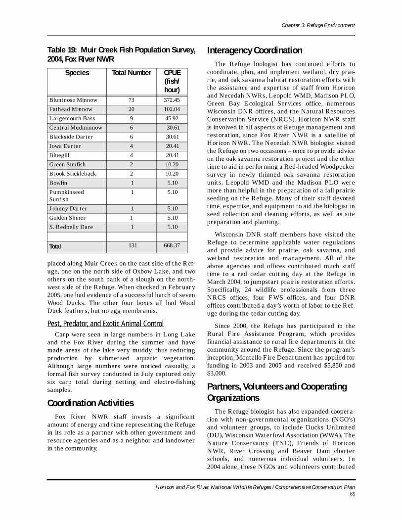
Chapter 3: Refuge Environment
placed along Muir Creek on the east side of the Ref-uge, one on the north side of Oxbow Lake, and two others on the south bank of a slough on the north-west side of the Refuge. When checked in February 2005, one had evidence of a successful hatch of seven Wood Ducks. The other four boxes all had Wood Duck feathers, but no egg membranes.
Pest, Predator, and Exotic Animal ControlCarp were seen in large numbers in Long Lake
and the Fox River during the summer and have made areas of the lake very muddy, thus reducing production by submersed aquatic vegetation. Although large numbers were noticed casually, a formal fish survey conducted in July captured only six carp total during netting and electro-fishing samples.
Coordination ActivitiesFox River NWR staff invests a significant
amount of energy and time representing the Refuge in its role as a partner with other government and resource agencies and as a neighbor and landowner in the community.
Interagency CoordinationThe Refuge biologist has continued efforts to
coordinate, plan, and implement wetland, dry prai-rie, and oak savanna habitat restoration efforts with the assistance and expertise of staff from Horicon and Necedah NWRs, Leopold WMD, Madison PLO, Green Bay Ecological Services office, numerous Wisconsin DNR offices, and the Natural Resources Conservation Service (NRCS). Horicon NWR staff is involved in all aspects of Refuge management and restoration, since Fox River NWR is a satellite of Horicon NWR. The Necedah NWR biologist visited the Refuge on two occasions – once to provide advice on the oak savanna restoration project and the other time to aid in performing a Red-headed Woodpecker survey in newly thinned oak savanna restoration units. Leopold WMD and the Madison PLO were more than helpful in the preparation of a fall prairie seeding on the Refuge. Many of their staff devoted time, expertise, and equipment to aid the biologist in seed collection and cleaning efforts, as well as site preparation and planting.
Wisconsin DNR staff members have visited the Refuge to determine applicable water regulations and provide advice for prairie, oak savanna, and wetland restoration and management. All of the above agencies and offices contributed much staff time to a red cedar cutting day at the Refuge in March 2004, to jumpstart prairie restoration efforts. Specifically, 24 wildlife professionals from three NRCS offices, four FWS offices, and four DNR offices contributed a day’s worth of labor to the Ref-uge during the cedar cutting day.
Since 2000, the Refuge has participated in the Rural Fire Assistance Program, which provides financial assistance to rural fire departments in the community around the Refuge. Since the program’s inception, Montello Fire Department has applied for funding in 2003 and 2005 and received $5,850 and $3,000.
Partners, Volunteers and Cooperating Organizations
The Refuge biologist has also expanded coopera-tion with non-governmental organizations (NGO’s) and volunteer groups, to include Ducks Unlimited (DU), Wisconsin Waterfowl Association (WWA), The Nature Conservancy (TNC), Friends of Horicon NWR, River Crossing and Beaver Dam charter schools, and numerous individual volunteers. In 2004 alone, these NGOs and volunteers contributed
Table 19: Muir Creek Fish Population Survey, 2004, Fox River NWR
Species Total Number CPUE (fish/hour)
Bluntnose Minnow 73 372.45
Fathead Minnow 20 102.04
Largemouth Bass 9 45.92
Central Mudminnow 6 30.61
Blackside Darter 6 30.61
Iowa Darter 4 20.41
Bluegill 4 20.41
Green Sunfish 2 10.20
Brook Stickleback 2 10.20
Bowfin 1 5.10
Pumpkinseed Sunfish
1 5.10
Johnny Darter 1 5.10
Golden Shiner 1 5.10
S. Redbelly Dace 1 5.10
Total 131 668.37
Horicon and Fox River National Wildlife Refuges / Comprehensive Conservation Plan65
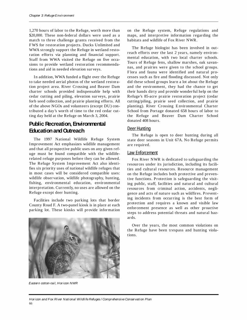
Chapter 3: Refuge Environment
1,270 hours of labor to the Refuge, worth more than $20,000. These non-federal dollars were used as a match to three challenge grants received from the FWS for restoration projects. Ducks Unlimited and WWA strongly support the Refuge in wetland resto-ration efforts via planning and financial support. Staff from WWA visited the Refuge on five occa-sions to provide wetland restoration recommenda-tions and aid in needed elevation surveys.
In addition, WWA funded a flight over the Refuge to take needed aerial photos of the wetland restora-tion project area. River Crossing and Beaver Dam charter schools provided indispensable help with cedar cutting and piling, elevation surveys, prairie forb seed collection, and prairie planting efforts. All of the above NGOs and volunteers (except DU) con-tributed a day’s worth of time to the red cedar cut-ting day held at the Refuge on March 3, 2004.
Public Recreation, Environmental Education and Outreach
The 1997 National Wildlife Refuge System Improvement Act emphasizes wildlife management and that all prospective public uses on any given ref-uge must be found compatible with the wildlife-related refuge purposes before they can be allowed. The Refuge System Improvement Act also identi-fies six priority uses of national wildlife refuges that in most cases will be considered compatible uses: wildlife observation, wildlife photography, hunting, fishing, environmental education, environmental interpretation. Currently, no uses are allowed on the Refuge except deer hunting.
Facilities include two parking lots that border County Road F. A two-panel kiosk is in place at each parking lot. These kiosks will provide information
on the Refuge system, Refuge regulations and maps, and interpretive information regarding the habitats and wildlife of Fox River NWR.
The Refuge biologist has been involved in out-reach efforts over the last 2 years, namely environ-mental education, with two local charter schools. Tours of Refuge fens, shallow marshes, oak savan-nas, and prairies were given to the school groups. Flora and fauna were identified and natural pro-cesses such as fire and flooding discussed. Not only did these school groups learn a lot about the Refuge and the environment, they had the chance to get their hands dirty and provide wonderful help on the Refuge’s 85-acre prairie restoration project (cedar cutting/piling, prairie seed collection, and prairie planting). River Crossing Environmental Charter School from Portage donated 658 hours of labor to the Refuge and Beaver Dam Charter School donated 408 hours.
Deer HuntingThe Refuge is open to deer hunting during all
state deer seasons in Unit 67A. No Refuge permits are required.
Law EnforcementFox River NWR is dedicated to safeguarding the
resources under its jurisdiction, including its facili-ties and cultural resources. Resource management on the Refuge includes both protective and preven-tive functions. Protection is safeguarding the visit-ing public, staff, facilities and natural and cultural resources from criminal action, accidents, negli-gence and acts of nature such as wildfires. Prevent-ing incidents from occurring is the best form of protection and requires a known and visible law enforcement presence as well as other proactive steps to address potential threats and natural haz-ards.
Over the years, the most common violations on the Refuge have been trespass and hunting viola-tions.
Eastern cotton-tail, Horicon NWR
Horicon and Fox River National Wildlife Refuges / Comprehensive Conservation Plan66