CHAPTER 3 Project Description - Newport Beach,...
19
3-1 City of Newport Beach General Plan Update EIR CHAPTER 3 Project Description 3.1 ENVIRONMENTAL SETTING AND LOCATION Located in the Southern California region, Newport Beach is at the western edge of Orange County, adjacent to the Pacific Ocean, as shown in Figure 3-1. Generally, Newport Beach, a charter City with approximately 83,120 residents, is bordered by Costa Mesa to the northwest, Huntington Beach to the west, Irvine to the northeast, and unincorporated portions of Orange County to the southeast. Regional access to the City is provided by several freeways. The 405 Freeway runs north to south within Southern California, and intersects both State Routes 73 (San Joaquin Hills Transportation Corridor [SJHTC]) and State Route 55. State Route 55 extends south from State Route 91 and terminates in the City of Newport Beach. State Route 73 extends along the northern boundary of the City, connecting the 55 and 405 Freeways with Interstate 5. Highway 1 (Coast Highway) runs along the California coast and all the way through Newport Beach. The entire Planning Area includes the existing City boundaries and its sphere of influence (SOI). 1 The current City boundaries total 13,062 acres, excluding waterways. Approximately 53 acres of the area known as Banning Ranch is within the City boundaries, with another 361 acres of this property in the City’s SOI, subject to Orange County jurisdiction. The entire property is surrounded by a one-foot strip within the City’s jurisdiction. The Planning Area is illustrated in Figure 3-2. The City of Newport Beach General Plan Technical Background Report (TBR) provides existing data for the entire Planning Area. The TBR was published June 2004 2 and is available for review at the Planning Department and Central Library. The General Plan Update provides comprehensive land use, housing, circulation and infrastructure, public service, resource conservation, and public safety policies for the entire city and is intended to be a comprehensive update from the City’s current General Plan, last updated in 1988. While proposed General Plan Update contains policies regarding future land use and development addressed from a citywide perspective, the majority of the proposed land use changes are limited to nine primary study areas, which cover about 10.5 percent of the City’s land area. Accordingly, the EIR will comprehensively address the impacts of all policies throughout the City and, additionally, focus on those areas in which the most significant land use changes could occur. These areas are illustrated in Figure 3-3. 1 The term “sphere of influence” means an area outside a city where the probable physical boundaries and service area of a local agency might be expected to grow. 2 The TBR was published in June 2004 but relies on 2002 data.
Transcript of CHAPTER 3 Project Description - Newport Beach,...
3-1City of Newport Beach General Plan Update EIR
CHAPTER 3 Project Description
3.1 ENVIRONMENTAL SETTING AND LOCATION Located in the Southern California region, Newport Beach is at the western edge of Orange County, adjacent to the Pacific Ocean, as shown in Figure 3-1. Generally, Newport Beach, a charter City with approximately 83,120 residents, is bordered by Costa Mesa to the northwest, Huntington Beach to the west, Irvine to the northeast, and unincorporated portions of Orange County to the southeast.
Regional access to the City is provided by several freeways. The 405 Freeway runs north to south within Southern California, and intersects both State Routes 73 (San Joaquin Hills Transportation Corridor [SJHTC]) and State Route 55. State Route 55 extends south from State Route 91 and terminates in the City of Newport Beach. State Route 73 extends along the northern boundary of the City, connecting the 55 and 405 Freeways with Interstate 5. Highway 1 (Coast Highway) runs along the California coast and all the way through Newport Beach.
The entire Planning Area includes the existing City boundaries and its sphere of influence (SOI).1 The current City boundaries total 13,062 acres, excluding waterways. Approximately 53 acres of the area known as Banning Ranch is within the City boundaries, with another 361 acres of this property in the City’s SOI, subject to Orange County jurisdiction. The entire property is surrounded by a one-foot strip within the City’s jurisdiction. The Planning Area is illustrated in Figure 3-2. The City of Newport Beach General Plan Technical Background Report (TBR) provides existing data for the entire Planning Area. The TBR was published June 20042 and is available for review at the Planning Department and Central Library.
The General Plan Update provides comprehensive land use, housing, circulation and infrastructure, public service, resource conservation, and public safety policies for the entire city and is intended to be a comprehensive update from the City’s current General Plan, last updated in 1988. While proposed General Plan Update contains policies regarding future land use and development addressed from a citywide perspective, the majority of the proposed land use changes are limited to nine primary study areas, which cover about 10.5 percent of the City’s land area. Accordingly, the EIR will comprehensively address the impacts of all policies throughout the City and, additionally, focus on those areas in which the most significant land use changes could occur. These areas are illustrated in Figure 3-3.
1 The term “sphere of influence” means an area outside a city where the probable physical boundaries and service area of a local agency might be expected to grow. 2 The TBR was published in June 2004 but relies on 2002 data.

3-2
Chapter 3 Project Description
City of Newport Beach General Plan Update EIR
3.1.1 Background
General Plan The General Plan is a state-required legal document (Government Code Section 65300) that provides guidance to decision makers regarding the conservation of resources and the future physical form and character of development for the city. It is the official statement of the jurisdiction regarding the extent and types of development of land and infrastructure that will achieve the community’s physical, economic, social, and environmental goals. The General Plan expresses the City’s goals and articulates the City’s intentions with respect to the rights and expectations of the general public, property owners, community interest groups, prospective investors, and business interests. Although the General Plan consists of individual sections, or “elements,” that address a specific area of concern, it also embodies a comprehensive and integrated planning approach for the jurisdiction.
Under state law, each General Plan must contain seven elements: Land Use CirculationHousingConservationOpen Space NoiseSafety
Provisions of Orange County’s Measure M require jurisdictions to adopt a Growth Management Element describing how public services and facilities will be provided to residents and businesses within each community. The City’s has incorporated Growth Management policies into the Circulation Element to meet Measure M requirements.
Table 3-1 includes a list of current elements of the General Plan and when they were last revised.
Table 3-1 Current Elements of the General Plan Current Elements Date of Adoption/Update
Land Use 1988 with several amendments since Housing 2003 with amendments and re-certification in 2005 Recreation and Open Space 1998 Conservation of Natural Resources 1974 Circulation 1998 Public Safety 1975 Noise 1994 Growth Management 1992 Harbor and Bay 2001

City of Newport Beach
Legend
CITY of NEWPORT BEACHGENERAL PLAN UPDATE EIR
REGIONALLOCATION
SourceS: City of Newport Beach, City Boundary, May 2003; Counties, May 2003; US Census Bureau, Other City Boundaries, 2000; ESRI, Major Roads, February 2002; USGS, Hydrology, May1997; and EIP Associates, GIS Program, November 14, 2003.
N
Miles
0.5 10

Legend
CITY of NEWPORT BEACHGENERAL PLAN UPDATE EIR
PLANNINGAREA
Sources: City of Newport Beach, Parcels, July 2003, City Boundary, May 2003, Counties, May 2003; US Census Bureau, Other City Boundies, 2000; ESRI, Major Roads, February 2002; and EIP Associates, GIS Program, February, 2004.
N
Miles
0.5 10
City of Newport Beach

CITY of NEWPORT BEACHGENERAL PLAN UPDATE EIR
PLANNING
Sources: City of Newport Beach, City Boundary, May 2003, Roads, October 2003; Statistical Areas, August 2005; Subareas, October 2005, and EIP Associates Subareas, September, 2003.
N
Miles
0.5 10
City of Newport Beach
Legend

3-9
Chapter 3 Project Description
City of Newport Beach General Plan Update EIR
It is important to note that all land use regulations, capital improvements, and other City actions pertaining to the physical development of the City must be consistent with the adopted General Plan. The General Plan policies for the SOI, however, are only advisory to Orange County as to the City’s intentions for development; the County still maintains jurisdictional authority over the SOI areas unless they are annexed to the City.
3.2 STATEMENT OF OBJECTIVES The project seeks to achieve the objectives identified by the community during the extensive public outreach and participation process, as expressed in the Visioning Statement developed by the General Plan Advisory Committee (GPAC) and approved by the Planning Commission and the City Council.
Preserve and enhance Newport Beach’s character as a beautiful, unique residential community. Reflect a conservative growth strategy that
› Balances needs for housing, jobs and services › Limits land use changes to a very small amount of the City’s land area › Directs land use changes to areas where residents have expressed a willingness to consider
change and where sustainable development can occur › Protects natural resources, open space, and recreational opportunities
Protect and enhance water quality. Protect and enhance recreational opportunities and public access to open space and natural resources.Modify land uses, densities, and intensities so that traffic generation is controlled. Improve traffic flow without changing the character of the City. Preserve and enhance parks, art, cultural and education facilities and programs that contribute to residents’ quality of life. Ensure the City has adequate municipal revenue to provide first rate municipal services, such as police, fire, lifeguard, library, recreation, refuse collection and recycling, and infrastructure maintenance. Attract visitors to Newport Beach’s harbor, beaches, hotels, restaurants, and shops with as little impact as possible on residents and natural resources. Encourage revitalization of older and economically challenged commercial areas so that the areas continue to be community resources and have a positive impact on the value of nearby property and the local economy. Maintain Newport Harbor as one of the premier small boat recreational boating harbors in the world, while causing little or no impact on the environment. Control and contain noise and traffic impacts from operations at John Wayne Airport to protect the residents’ quality of life and property values. Modify the Land Use Element and other elements to reflect changes in the law and planning practices that have occurred in the 17 years since the last comprehensive amendments were approved.Provide effective means to ensure compliance with Section 423 of the Charter.

3-10
Chapter 3 Project Description
City of Newport Beach General Plan Update EIR
3.3 PROJECT CHARACTERISTICS
3.3.1 Elements and Components of the Proposed General Plan Update
The proposed General Plan Update is a comprehensive update of the current General Plan. Elements of the existing General Plan have been re-organized by thematic topic for clarity and to avoid redundancy, as encouraged by the state’s General Plan Guidelines. The updated City of Newport Beach General Plan is organized into the following elements:
Land Use HousingCirculationRecreationNatural Resources SafetyNoiseHistoric Resources Arts and Cultural Resources Harbor and Bay
Growth Management Element goals and policies are incorporated into the Circulation/Mobility Element. Goals and polices for the protection of the City’s open spaces, currently found in the Recreation and Open Space Element, are incorporated into the Natural Resources Element.
3.3.2 Updated General Plan Potential Land Use Changes Existing land uses by major category and potential land use changes resulting from the update of the General Plan are described below.
Existing Land Uses Information regarding existing land uses and potential development within Newport Beach is presented below. More detail regarding the existing uses is presented in the General Plan TBR. The City of Newport Beach Planning Area contains 26,676 acres or 41.7 square miles. These are net acres and do not include streets and roadways, which account for approximately 20 percent of the total gross land acreage. Approximately 42 percent (11,119 acres) of the Planning Area is water, which includes the Upper and Lower Newport Bay and its channels, and the Pacific Ocean. The following discussion pertains to the 13,062 acres of developed and undeveloped land in the Planning Area.
Existing land uses in the Planning Area have been classified into seven primary categories: Residential—Residential uses include a mix of housing developed at varying densities and types. Residential uses in the Planning Area include single-family, multiple-family, condominium, mobile, and senior housing.

3-11
Chapter 3 Project Description
City of Newport Beach General Plan Update EIR
Commercial/Office—This category includes commercial uses that offer goods for sale to the public (retail) and service and professional businesses housed in offices (accountants, architects, etc). Retail and commercial businesses include those that serve local needs, such as restaurants, neighborhood markets and dry cleaners, and those that serve community or regional needs, such as auto dealers and furniture stores. Visitor-serving retail uses such as regional shopping centers and hotels are also included in this category. Industrial—The industrial category includes a mix of manufacturing and light industrial uses, some of which are found in business, research, and development parks. Light industrial activities include warehousing and some types of assembly work. This category also includes wholesaling and warehousing.Governmental, Educational, and Institutional Facilities (GEIF)—Government buildings, libraries, schools and other public institutions are found in this category. Uses in this category support civic, cultural, and educational needs of residents. Open Space—This category encompasses public and private recreational spaces, local and regional parks, and beaches. Recreational areas, such as golf courses, also contribute to open space uses in the Planning Area. Vacant—Vacant lands are undeveloped lands (as of June 2003) that are not preserved in perpetuity as open space or for other public purposes. Water—The bay, harbor, channels and reservoirs are included in this category.
Existing land uses are listed below in Table 3-2.
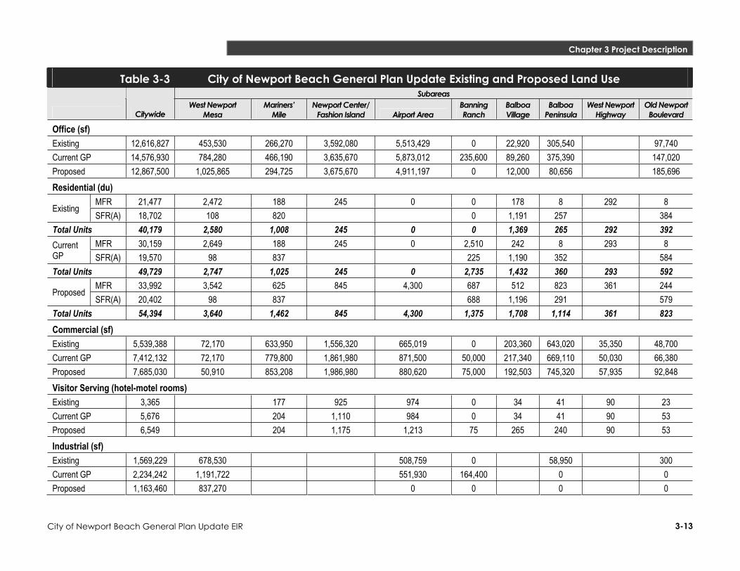
Proposed Land Use Changes Table 3-3 presents the proposed land uses for Newport Beach. As shown, City-wide changes would occur in the following land use categories: Residential (single- and multi-family), Commercial, Office, Industrial, Visitor Serving, Institutional, and Parks. In addition to the land uses listed in Table 3-3, 300 acres of Banning Ranch would be preserved as open space.
Newport Beach is almost fully developed. Therefore, the General Plan focuses on how limited population and employment growth can be strategically accommodated to preserve the distinguishing and valued qualities of the community. For most of the City, the updated General Plan conserves the existing pattern of uses and establishes policies for protection and long-term maintenance of established neighborhoods.
Generally, new development in accordance with the updated General Plan would result as re-use of economically underperforming properties and obsolete development, conversion of uses in response to market demand (e.g., office and industrial to residential) and more intense use of land in defined areas. Several subareas within Newport Beach determined to have special planning considerations were the subjects of special study during the update process. These areas are described below. The land use changes in each of the special study subareas, and citywide totals are presented in Table 3-3. It should be noted that the amount of development that could occur within the subareas does not add up to the citywide total because the subareas represent only 10.5% of the total land area of the City.

3-12
Chapter 3 Project Description
City of Newport Beach General Plan Update EIR
Table 3-2 Existing Land Use Land Use Acres Percent of City's Total
Residential 5,436.0 41.6% Single-Family Detached 3,932.8 Single-Family Attached 625.3 Two-Family Residential 360.9 Multi-Family Residential 480.0 Mixed Residential 37.0 Commercial 1,154.6 8.8% Retail 382.0 Administrative, Professional, and Financial 473.0 Marine and Auto Related 73.7 Visitor-serving 225.9 Industrial 114.4 0.9% Industrial 68.9 Multi-Tenant Industrial 20.5 Industrial Business Park 25.0 Other 6,356.7 — Government, Educational, Institutional Facilities 446.6 3.4%
Quasi-Public 53.5 0.4% Right of Way/Undesignated 4.8 <1%
Recreation & Environmental Open Space 4,516.4 34.6%Vacant Land a 1,260.2 9.6%Water 75.2 0.6%
Total 13,061.7 100% SOURCE: EIP Associates GIS 2003 a The majority of the vacant land represented in this table is within the Banning Ranch subarea.
Subareas
The proposed Land Use Element identifies the special study subareas as districts or corridors, depending on their physical form, functional role, and how they relate to the land or water adjoining them.
Districts
Districts are uniquely identifiable by their common functional role, mix of uses, density/intensity, physical form and character, and/or environmental setting. Generally, they encompass areas that extend equally in length and breadth. While Newport Beach contains many subareas, the General Plan policies in the following areas focus on those that are likely to change over the next 20 years as existing viable land uses are enhanced, underperforming properties are revitalized, and opportunities are provided to accommodate the City’s fair share of regional housing needs. Policies are directed to the management of these changes to assure that they complement the characteristics that are valued by Newport Beach’s residents.
3-13
Chapter 3 Project Description
City of Newport Beach General Plan Update EIR
Table 3-3 City of Newport Beach General Plan Update Existing and Proposed Land Use Subareas
Citywide West Newport
Mesa Mariners’
Mile Newport Center/
Fashion Island Airport Area Banning Ranch
BalboaVillage
BalboaPeninsula
West Newport Highway
Old Newport Boulevard
Office (sf) Existing 12,616,827 453,530 266,270 3,592,080 5,513,429 0 22,920 305,540 97,740Current GP 14,576,930 784,280 466,190 3,635,670 5,873,012 235,600 89,260 375,390 147,020Proposed 12,867,500 1,025,865 294,725 3,675,670 4,911,197 0 12,000 80,656 185,696Residential (du)
MFR 21,477 2,472 188 245 0 0 178 8 292 8 Existing
SFR(A) 18,702 108 820 0 1,191 257 384Total Units 40,179 2,580 1,008 245 0 0 1,369 265 292 392
MFR 30,159 2,649 188 245 0 2,510 242 8 293 8 CurrentGP SFR(A) 19,570 98 837 225 1,190 352 584Total Units 49,729 2,747 1,025 245 0 2,735 1,432 360 293 592
MFR 33,992 3,542 625 845 4,300 687 512 823 361 244 Proposed
SFR(A) 20,402 98 837 688 1,196 291 579Total Units 54,394 3,640 1,462 845 4,300 1,375 1,708 1,114 361 823 Commercial (sf) Existing 5,539,388 72,170 633,950 1,556,320 665,019 0 203,360 643,020 35,350 48,700 Current GP 7,412,132 72,170 779,800 1,861,980 871,500 50,000 217,340 669,110 50,030 66,380 Proposed 7,685,030 50,910 853,208 1,986,980 880,620 75,000 192,503 745,320 57,935 92,848 Visitor Serving (hotel-motel rooms) Existing 3,365 177 925 974 0 34 41 90 23 Current GP 5,676 204 1,110 984 0 34 41 90 53 Proposed 6,549 204 1,175 1,213 75 265 240 90 53 Industrial (sf) Existing 1,569,229 678,530 508,759 0 58,950 300Current GP 2,234,242 1,191,722 551,930 164,400 0 0Proposed 1,163,460 837,270 0 0 0 0

3-14
Chapter 3 Project Description
City of Newport Beach General Plan Update EIR
Table 3-3 City of Newport Beach General Plan Update Existing and Proposed Land Use Subareas
Citywide West Newport
Mesa Mariners’
Mile Newport Center/
Fashion Island Airport Area Banning Ranch
BalboaVillage
BalboaPeninsula
West Newport Highway
Old Newport Boulevard
Institutional (sf) Existing 694,820 886,270 99,410 100,000 86,096 21,710Current GP 893,213 1,235,797 105,260 105,000 97,000 32,010Proposed 853,413 1,235,797 105,260 105,000 96,996 96,710Parks (acres) Existing 133.5 0.2 0 Current GP 178.8 0.2 0 Proposed 254.7 1 30

3-15
Chapter 3 Project Description
City of Newport Beach General Plan Update EIR
West Newport Mesa
The Plan allows for the establishment of a number of distinct and cohesive districts. Adjoining Hoag Hospital and on the Newport Technology Center site, properties would be designated for medical-related uses including offices, labs, convalescent and long-term care facilities, and limited retail sales. At its northern edge abutting the City of Costa Mesa, properties would be encouraged to retain light manufacturing and research and development uses. Multi-family housing would be maintained and newly developed on underutilized residential, commercial, and industrial properties between these nodes.
Newport Center/Fashion Island
The Plan allows for expanded retail opportunities at Fashion Island, including an additional anchor department store and ancillary shops, another hotel or additions to existing hotels, and 600 additional housing units. Limited new capacity for office development (40,000 square feet) would be limited to minor expansion of existing buildings and could not be converted to retail use. Plan policies encourage improved pedestrian connections and streetscape amenities connecting the area’s diverse districts
John Wayne Airport Area
The Plan allows for the maintenance and/or limited expansion of the currently developed mix of uses, including office, airport-supporting commercial, hotel, and public uses. Additionally, it allows the opportunity for the development of new residential neighborhoods as replacement of existing and allowed future uses and, in some cases, on underutilized surface parking lots. Policies establish criteria for the development of cohesive residential neighborhoods oriented around neighborhood parks and local-serving convenience commercial facilities and interconnected by a network of pedestrian-oriented streets.
Banning Ranch
The updated General Plan prioritizes the retention of the Banning Ranch property as open space, consolidating existing oil operations, restoring wetlands and habitat, and development of a community park with active playfields to serve adjoining neighborhoods. Should the property not be acquired for open space, the Plan considers the possible development of a mixed-density residential village, with housing oriented around a neighborhood park, convenience commercial, and small hotel, and preservation of the majority of the site as open space. Policies stipulate that any development would have to be located and designed to protect views, the bluffs, natural drainage, and important habitat.
Balboa Peninsula
The Plan differentiates Balboa Peninsula into a series of commercial, residential, mixed-use, and water-oriented districts. The Plan encourages enhancement of Lido Village as a pedestrian-oriented district of small retail shops, bay supporting uses, small lodging facilities (bed-and-breakfast and inns), and mixed-use buildings that integrate housing with retail uses. Properties inland of the bay front in Cannery Village containing a fragmented mix of housing, commercial, and industrial uses could be re-used as a primarily residential village of two family and townhome residential, with mixed-use and live/work structures at
3-16
Chapter 3 Project Description
City of Newport Beach General Plan Update EIR
intersections. Bay fronting properties east of Lafayette Avenue would continue to support water-dependent and marine-related uses. The Plan supports the retention of McFadden Square as an ocean and pier-oriented village containing visitor-serving retail, small overnight lodging facilities, and mixed-use buildings. The Newport Boulevard Corridor would contain retail commercial and mixed-use buildings. Policies provide for the development of improved streetscapes and a waterfront promenade to link the districts. Cumulatively, the updated General Plan would allow for reductions in the area’s commercial and industrial capacity, which would be replaced by opportunities for new housing. For Balboa Village, the General Plan would allow for the consolidation of commercial uses to enhance the area’s economic vitality, which would be replaced by medium density housing (including townhomes and small-lot, attached single family) and mixed-use structures that would integrate housing with ground-level retail uses. Bay-fronting properties would be prioritized for marine-related and water-dependent uses. Programs for streetscape enhancements would be continued.
Corridors
Corridors share common characteristics of districts by their identifiable functional role, land use mix, density/intensity, physical form and character, and/or environmental setting. They differ in their linear configuration, generally with shallow depth parcels located along arterial streets. They are significantly impacted by traffic, often inhibiting access during peak travel periods. While the City is crossed by a number of commercial corridors, the General Plan’s policies focus on those in which change is anticipated to occur during the next 20 years. Additionally, they provide guidance for the maintenance of corridors in which it is the objective to maintain existing types and levels of development.
West Newport Highway
Visitor- and neighborhood-serving commercial uses would be allowed in the area concentrated on the Pacific Coast Highway, near the Orange and Prospect Avenue intersections, with the intervening highway fronting properties developed for multi-family housing. The Plan encourages properties at the entry to the City to be enhanced as a “gateway” for amenities supporting Orange County River Park and/or new multi-family residential.
Old Newport Boulevard
The Plan allows for a mix of medical office and retail uses supporting Hoag Hospital, convenience retail, and mixed-use buildings that integrate housing with ground level retail or office uses on Old Newport Boulevard.
Mariners’ Mile
The Plan provides for the differentiation of Mariners’ Mile into distinct commercial, water-related, and mixed-use districts. Bayfronting properties would be prioritized for water-dependent and marine-related uses, including restaurants and service uses, with the development of housing on a limited portion of the properties. The Coast Highway frontages of all inland properties would be restricted to community-serving and marine-related commercial uses. Interior sites, generally between Riverside Avenue and the extension of Irvine Avenue, would be developed for neighborhood-serving commercial uses, mixed-use
3-17
Chapter 3 Project Description
City of Newport Beach General Plan Update EIR
buildings with housing above retail, and multi-family residential buildings. Streetscape improvements are proposed to enhance the area’s pedestrian character, as well as its identity along Coast Highway. Policies also support the relocation of the City’s parking lot and the Postal Distribution Center.
Corona del Mar
The Plan encourages development along this corridor to include a pedestrian-oriented “village” serving as the center of community commerce, culture, and social activity and providing identity for Corona del Mar.
Other Land Use Changes
While land use changes are proposed for other areas of the City by the updated General Plan, these areas would retain the basic land use character of existing uses. The area bounded by Irvine Avenue, 15th
Street, St. Andrews Road, and Coral Place is currently designated for multi-family and is developed with a mix of housing units, including older apartments, small lot units, and single-family detached units. The proposed General Plan Update would re-designate this area as single-family residential to allow for consistency with the current development trend in the area replacing higher-density apartments with small-lot residential and detached units.
Along the southern frontage of Westcliff Drive, east of Irvine Avenue, and the western frontage of Dover Drive, south of Westcliff Drive the area would be re-designated from Administrative, Professional, and Financial Commercial uses to mixed use, allowing a mix of office and multi-family residential uses. Any new residential development in this area would be compatible with the existing residential uses behind these properties.
The Caltrans Remnant property, bounded by the SR 73, MacArthur Boulevard, and University Drive is currently a vacant property and would be re-designated for commercial use under the proposed General Plan Update.
The north side of San Miguel Drive, east of San Joaquin Hills Road, and west of Newport Hills Drive, which is currently a single parcel formerly used as a child care facility, abutting multi-family residential uses, would be re-designated as multiple-family residential to be consistent with adjacent land uses.
The property west of Big Canyon Reservoir, north of Pacific View Drive is currently developed with institutional (church) and senior affordable housing. Under the proposed General Plan Update, this area would be re-designated as multi-family residential also to promote consistency with adjacent land uses.
3.3.3 Transportation Improvements Several transportation-related improvements are included in the proposed General Plan Update. The improvements listed below in Table 3-4 would be implemented under the proposed General Plan Update to ensure that impacts resulting from buildout of the General Plan Update are minimized.

3-18
Chapter 3 Project Description
City of Newport Beach General Plan Update EIR
Table 3-4 Transportation Improvements under Proposed General Plan Update Intersection Additional Intersection Improvements with Project
1. Bluff Rd. (NS) at Coast Hw. (EW) Provide two SB left-turn lanes and two SB right-turn lanes (2nd with overlap phase). Provide two EB left-turn lanes. Provide one WB right-turn lane.
2. 15th St. (NS) at Coast Hw. (EW) Provide 2nd SB right turn lane with overlap phase. Provide 2nd EB left turn lane. 3. Newport Bl. (NS) at Hospital Rd. (EW) Provide 2nd NB left turn lane. 4. Riverside Av. (NS) at Coast Hw. (EW) Provide 3rd EB through lane.
5. MacArthur Bl. (NS) at Campus Dr. (EW) Provide 2nd NB left turn lane. Restripe SB to provide 3.5 through lanes and 1.5 right turn lanes.
6. Von Karman Av. (NS) at Campus Dr. (EW) Provide 2nd EB left turn lane.
7. Jamboree Rd. (NS) at Campus Dr. (EW) Provide NB 1st right turn lane with overlap phase. Provide 4th SB through lane. Provide WB right turn overlap phase for current right turn lane.
8. Campus Dr. (NS) at Bristol St. N (EW) Provide 5th WB through lane.
9. Irvine Av. (NS) at Mesa Dr. (EW)—FundedImprovements University Dr. (EW)
Provide 3rd NB through lane. Provide 3rd SB through lane. Provide 1st EB right turn lane. Provide 2nd WB left turn lane. Construct funded improvements, but EB right turn lane not necessary. Provide 3rd NB through lane. Provide 3rd SB through lane. Restripe EB to include 1.5 left turn lanes, 1.5 through lanes, and 1 right turn lane.
10. Dover Dr. (NS) at Coast Hw. (EW) Provide 4th WB through lane. 11. MacArthur Bl. (NS) at Jamboree Rd. (EW) Provide 4th EB through lane. Provide 3rd WB left turn lane. 12. Jamboree Rd. (NS) at Bristol St. S (EW) Provide 6th NB through lane. Provide 4th SB through lane.
13.MacArthur Bl. (NS) at Ford Rd./Bonita Canyon Dr. (EW) and San Joaquin Hills Rd. (EW)
Provide 3rd SB left turn lane. Provide 3rd SB left turn lane. Provide 3rd EB left turn lane. Provide 4th NB through lane.
3.3.4 Goals and Policy Changes The General Plan Update includes new policies in the Land Use Element, the Circulation Element, the Safety Element, the Natural Resources Element, and the Recreation Element. The new policies are briefly described below.
Land Use Element The Land Use Element contains new General Plan policies related to Community Character. These policies encourage maintenance and enhancement of Newport Beach’s residential neighborhoods, commercial districts, employment centers, corridors, and open spaces, and help assure that new development complements and reinforces these characteristics.
New policies related to Urban Form are also contained in this Element. These policies establish and reinforce a particular area’s scale and development pattern. These policies are included in the General Plan Update to help establish or maintain physical and visual continuity and a sense of complete and identifiable neighborhoods and established strategies for areas of the City that require enhancement and revitalization.

3-19
Chapter 3 Project Description
City of Newport Beach General Plan Update EIR
Circulation Element The Circulation Element contains new General Plan policies related to water transportation services and waterfront walkways. These policies encourage enhancement and maintenance of public water transportation services and expanded public water transportation uses and land support facilities. Policies related to waterfront walkways include encouraging the development of walkways along the Lido Marina Village boardwalk, along Rhine Channel, between Lido Village and Mariners’ Mile, and along the Mariners’ Mile waterfront. In addition, LOS policies for the intersections operating at unacceptable levels of service in the new Circulation Element are more clearly laid out compared to the Circulation Element of the existing General Plan.
Recreation Element The Recreation Element contains new General Plan policies related to coastal recreation and support facilities. These policies encourage protection and enhancement of a wide range of recreational opportunities along the coast and beaches as well as the provision of adequate support facilities serving recreational opportunities within the coastal zone. The Recreation Element also contains policies that encourage the provision and maintenance of marine recreation related facilities that enhance the enjoyment of the City’s natural resources and the provision and maintenance of public access for recreational purposes to the City’s coastal resources. Many of these policies are in the existing Harbor and Bay element.
Safety Element New General Plan policies related to hazardous materials, disaster planning, and coastal hazards are contained in the Safety Element. Policies related to hazardous materials minimize exposure of people and the environment to hazardous materials associated with methane gas extraction, oil operations, leaking underground storage tanks, and hazardous waste generators. Policies related to disaster planning include measures for effective emergency response to natural or human-induced disasters that minimizes the loss of life and damage to property, while also reducing disruptions in the delivery of vital public and private services during and following a disaster. Policies related to coastal hazards are included to ensure that adverse effects of coastal hazards related to tsunamis and rogue waves to people and property are minimized.
Natural Resources Element New General Plan policies related to water quality are contained in the Natural Resources Element. These policies establish the goal of enhancing and protecting the water quality of all natural water bodies, including coastal waters, creeks, bays, harbors, and wetlands. Additionally, the General Plan Update contains new policies related to management of the Upper Newport Bay. These policies help achieve the goal of protection and management of Upper Newport Bay commensurate with the standards applicable to our nation’s most valuable natural resources. Many of these policies are in the existing Harbor and Bay Element. Other new policies in this element include measures related to air quality, archaeology and
3-20
Chapter 3 Project Description
City of Newport Beach General Plan Update EIR
paleontology, and energy conservation. Air Quality policies serve to reduce mobile source emissions, reduce air pollution emissions from stationary sources, and reduce air pollution emissions from aircraft.
Harbor and Bay The goals and policies in the existing Harbor and Bay Element will be retained as a separate element, and will also incorporate policies in the Land Use, Circulation, Recreation, Safety, and Natural Resources Elements of the General Plan Update. The goals and policies pertaining to Harbor and Bay issues are intended to guide the content of regulations related to development of, and the activities conducted on, the water. Additional goals and policies recognize the important component of land use decisions related to waterfront property around Newport Harbor. The aim of Harbor and Bay related goals and policies is to preserve the diversity and charm of existing uses without unduly restricting the rights of the waterfront property owner. Goals and policies related to the Harbor and Bay have been organized to address both water and land related issues.
Historical Resources Element This new Element addresses the protection and sustainability of Newport Beach’s historic and paleontological resources. Goals and policies presented within this Element are intended to recognize, maintain, and protect the community’s unique historical, cultural, and archaeological sites and structures.
Arts and Cultural Resources Element The goals and policies of the new Arts and Cultural Element are intended to be a guide for meeting the future cultural needs of the community. This Element is intended to serve as a mechanism for integrating these resources in order to provide improved and expanded arts and cultural facilities and programs to the community.
AlternativesIn accordance with Section 15126.6 of the CEQA Guidelines, alternatives to the proposed General Plan Update are analyzed. Four alternatives that would feasibly attain the most basic project objectives while avoiding or substantially lessening some of the significant effects of the project were analyzed. An environmentally superior alternative is also identified. These alternatives include the following:
Alternative 1: No Project/No Development—With this alternative, development under the proposed General Plan Update would not occur. The Planning Area would remain developed with existing land uses. Alternative 2: No Project/No Action (Existing General Plan)—With this alternative, development under the proposed General Plan Update would not occur. Development would be guided by continued implementation of the existing General Plan. Alternative 3: GPAC Recommendations—With this alternative, development under the General Plan would consist of the land use recommendations formulated by GPAC. The Alternatives Chapter of the EIR will provide a detailed breakdown of the proposed land uses under this Alternative.

3-21
Chapter 3 Project Description
City of Newport Beach General Plan Update EIR
Alternative 4: Subarea Only Minimum—With this alternative, development under the General Plan would consist of a mixture of land-use intensities for the various subareas. The Alternatives Chapter of the EIR will provide a detailed breakdown of the proposed land uses under this Alternative.