
Chapter 3 Pipeline Construction in Wetland · PDF filePipeline Construction in Wetland Areas...
55
Pipeline Construction in Wetland Areas Sakhalin Energy Investment Company EIA Addendum 1 of 1 0000-S-90-04-P-7069-03-E Chapter 3 Pipeline Construction in Wetland Areas 3.1 INTRODUCTION This supplemental information on pipeline construction in wetland areas is provided in order to address specific issues raised by stakeholders to the Project following the publication of the international style Environmental Impact Assessment (EIA) in 2003, and as such forms a component of the EIA addendum (EIA-A). In brief, the focus of the additional information comprises the following: • Further information on the nature and location of the wetland areas required and confirmation that none of the areas to be crossed by the pipeline are unique; • Additional information on the likely ecological impacts of pipeline construction work in wetlands, other than those linked to potential hydrological change should be highlighted and discussed; • How will TEOC commitments be monitored and closed out during and after construction and operational phases. Some aspects, such as restoration of vegetation following pipeline installation remain an issue and need to be further detailed, either in the EIA addendum or other relevant project documentation; • Justification as to why the pipeline route crosses a relatively large area of wetland habitat should be provided; • Further information on design commitments related to pipeline laying in wetland areas would be useful in demonstrating what mitigation measures will be used in offsetting potential impacts; • Greater information on the scope and level of monitoring during and after the construction work is required (e.g. how long is natural recovery of vegetation expected to take place and what actions would be taken if recovery does not occur). The following text provides a response to the issues raised. This takes the form of a general discussion of the nature of wetland habitat the specific types of wetlands encountered along the pipeline route, the construction methodology to be employed in crossing these areas and proposed mitigation and monitoring measures.
Transcript of Chapter 3 Pipeline Construction in Wetland · PDF filePipeline Construction in Wetland Areas...
Pipeline Construction in Wetland Areas
Sakhalin Energy Investment Company EIA Addendum 1 of 1
0000-S-90-04-P-7069-03-E
Chapter 3 Pipeline Construction in Wetland Areas 3.1 INTRODUCTION
This supplemental information on pipeline construction in wetland areas is provided in order to address specific issues raised by stakeholders to the Project following the publication of the international style Environmental Impact Assessment (EIA) in 2003, and as such forms a component of the EIA addendum (EIA-A). In brief, the focus of the additional information comprises the following:
• Further information on the nature and location of the wetland areas
required and confirmation that none of the areas to be crossed by the pipeline are unique;
• Additional information on the likely ecological impacts of pipeline construction work in wetlands, other than those linked to potential hydrological change should be highlighted and discussed;
• How will TEOC commitments be monitored and closed out during and after construction and operational phases. Some aspects, such as restoration of vegetation following pipeline installation remain an issue and need to be further detailed, either in the EIA addendum or other relevant project documentation;
• Justification as to why the pipeline route crosses a relatively large area of wetland habitat should be provided;
• Further information on design commitments related to pipeline laying in wetland areas would be useful in demonstrating what mitigation measures will be used in offsetting potential impacts;
• Greater information on the scope and level of monitoring during and after the construction work is required (e.g. how long is natural recovery of vegetation expected to take place and what actions would be taken if recovery does not occur).
The following text provides a response to the issues raised. This takes the form of a general discussion of the nature of wetland habitat the specific types of wetlands encountered along the pipeline route, the construction methodology to be employed in crossing these areas and proposed mitigation and monitoring measures.
Pipeline Construction in Wetland Areas
Sakhalin Energy Investment Company EIA Addendum 2 of 2
0000-S-90-04-P-7069-03-E
3.2 DEFINITION OF WETLAND HABITATS
Wetlands are generally considered important habitats on account of the roles that they perform in function (World Bank, 1991). Typically, a wetland area can be defined using a combination of three key parameters (Wetlands Delineation Manual, US Army Corps of Engineers 1987) as set out below: 1. Soils Soils are present and classified as hydric, or they possess characteristics that are associated with reducing soil conditions. 2. Hydrology The area is inundated either permanently or periodically at mean water depths ≤ 2m, or the soil is saturated to the surface at some time during the growing season of the prevalent vegetation. 3. Vegetation The prevalent vegetation consists of macrophytes that are typically adapted to areas having hydrologic and soil conditions described in the preceding definitions. Hydrophytic species, due to morphological, physiological, and/or reproductive adaptation, have the ability to grow, effectively compete, reproduce, and/or persist in anaerobic soil conditions. Natural or anthropogenically induced variation in these parameters and the way in which they interact gives rise to a huge range of conditions and wetland types, which may occur at widely varying spatial and temporal scales. Despite this variation, it is possible to broadly classify vegetated wetland areas into a number of groupings that reflect generic physical and biological criteria and their interactions.
3.3 CHARACTERISTICS OF VEGETATED WETLAND HABITATS ALONG THE
PIPELINE ROUTE 3.3.1 Survey scope and data
A total of 19 baseline surveys for flora and fauna have been executed between 1998 and 2004. Of these baseline surveys, the surveys containing specific data related to flora and fauna in wetland areas are presented in Table 3.1. For the purposes of classifying and describing wetland habitats, it is the vegetation associations and communities that are of most relevance. The following sections therefore concentrate on describing the scope and basic methodologies of the key floral surveys and the vegetational characteristics of the main wetland habitats present along the pipeline route.
Table 3.1. List of key baseline ecological surveys undertaken for SEIC
along the pipeline route 1998-2004
Contractor and survey Scope of work
Sakhalin Botanical Garden of the Far East Branch of the Russian Academy of Sciences, 1999.
Characterisation and evaluation of the condition of vegetation before the start of the pipeline construction, determination
Pipeline Construction in Wetland Areas
Sakhalin Energy Investment Company EIA Addendum 3 of 3
0000-S-90-04-P-7069-03-E
Contractor and survey Scope of work State of flora and vegetation prior to construction of the primary oil and gas pipeline on Sakhalin Island.
of areas of distribution of rare (Russian RF Red Book), endemic and industrially valuable species. Literature review Field survey August 15 - November 25 1998
Far Eastern State University, 2000. Onshore Environmental Survey along the pipeline corridor, part A. Flora and Vegetation survey of the pipeline corridor.
Literature review Field study 2000
Far Eastern State University, 2002. Flora and vegetation survey along the pipeline route.
Literature review Field study 2000 (200 m zone along pipeline route) Field study 2001 (three altered segments of the pipeline route and 14 sections surveyed before for additional data).
Sakhalin State University, 2004. Research Of Rare And Protected Plant Species Along Onshore Pipeline Route.
Field study (200 m zone along 7 sections of pipeline route in Makarov, Dolinsk and Korsakov district).
Far Eastern State University, 2000. Onshore ecological survey along the pipeline route, Part B. Fauna � Invertebrates, terrestrial amphibians, reptiles and mammals survey results in the pipeline corridor.
Summer and fall expedition work in 2000 Literature review Interviews with hunters
Far Eastern State University, 2001. Field and desktop background survey of amphibians, reptiles, mammals in pipeline corridor for Sakhalin-2 project.
Field study 2001 (sites designated for LNG/OET, compressor station Gastello, OPF, construction camps and laydown areas).
Fauna Information and Research Centre, 1998. Current condition of the population of aquatic, rare and protected species of birds on the territory of the pipeline.
Literature review Field research (north-eastern coast of Sakhalin, in the Lunsky bay from April, 10 till June 28 and from August 15 to November 9 1989, from June 1 till October 10 1990, from May 1 till July 16 and from September 20 till October 22 1991). Episodic visits to the bays in 1993, 1995 and 1997, as well as research conducted along the pipeline route from September 26 - October 17 1998.
Fauna Information & Research Centre, 2000. Avifauna on Pipeline Route, Field studies.
Field research at the five inner-sections of the pipeline.
Far Eastern State University, 2002. Environmental Survey for Sakhalin-2 project, Report Field and Desktop
Desk top study Field research: target specific collection of data based on the information of the
Pipeline Construction in Wetland Areas
Sakhalin Energy Investment Company EIA Addendum 4 of 4
0000-S-90-04-P-7069-03-E
Contractor and survey Scope of work study of Avifauna along pipeline route. desk top study.
Far Eastern State University, 2002. Expert judgement of avifauna status in the corridor of Botasino altered lateral pipeline route section.
Desk top and field research in the Botasino section, in specific Chaivo Bay
With respect to the recording and description of vegetation communities of wetland habitats along the pipeline route, the three key surveys were undertaken by Sakhalin Botanic Garden (1998), and FESTU (2000, 2002). The methodologies employed and coverage of these three surveys are described in more detail below, along with a brief summary of the classification and distribution of wetland areas recorded by each survey.
Sakhalin Botanic Garden (1998) This study involved two components, namely initial research and survey planning and fieldwork. The initial research comprised a literature review, analysis of available mapped data and aerial and satellite imagery to identify vegetation complexes and field reconnaissance to determine optimum approaches to undertaking detailed field surveys. This initial reconnaissance, conducted August-September 1998, provided information on the general geobotanical characteristics, species diversity and vegetation distribution along the proposed pipeline route. The main field survey, undertaken between September - November 1998, comprised a detailed assessment of the geobotanical units identified along the route. The vegetational characteristics were determined through the selection of representative plots within each of the geobotanical units (40x40m for forest habitats and 10x10m for all others). Plots were confined to an area within 100m either side of the centre of the pipeline corridor. Maps showing the distribution of the geobotanical units (480 in total) along the route were produced as well as a list of the recorded flora (864 species of vascular plants, 48 species of moss and 25 species of lichen). Wetland/peatland areas were classified as eutrophic, mesotrophic or oligotrophic, although it was recognised that defining the transition between eutrophic and mesotrophic was somewhat arbitrary. The report does not provide any definitive or systematic breakdown of the wetland geobotanical units, but describes the main vegetation communities of the key peatland types and their distribution on the Island. FESTU 2000 A survey of the vegetation of the pipeline route was undertaken between July and September 2000. This included reconnaissance, development of a sampling strategy for the different ecosystems, and description and sampling of more than 300 plant communities. Data were collected in order to classify and describe plant communities and plant complexes (i.e. community associations) for the purpose of vegetation mapping along the pipeline corridor. Sample plots (20x20m) were located in areas of uniform vegetation stands (i.e. relatively similar floristic composition and structure) and the vegetation
Pipeline Construction in Wetland Areas
Sakhalin Energy Investment Company EIA Addendum 5 of 5
0000-S-90-04-P-7069-03-E
and physical attributes described. All plant species present within the plot were identified and their cover estimated. All communities of the area along the pipeline route were classified into 10 classes, 10 orders, 13 alliances, 20 associations and 23 sub-associations. Classification units were grouped into four categories: forests, meadows, wetlands, and artificial communities. A number of wetland communities are described including four Sphagnum associations and several forest and meadow alliances in which wetland flora dominates. The broad distribution of these associations across the Island, rather than with respect to the pipeline route per se is described. FESTU 2002 Existing data from a variety of sources, including survey data from 2000, were supplemented with additional information from a dedicated field survey undertaken between August and September 2001, which covered a 4km corridor (2 km either side of the route). Three pipeline re-route sections were also surveyed and the vegetation described. Similar samples were objectively grouped using TWINSPAN analysis and then sorted by conventional methods of phytosociological tabulation. Vegetation samples (over 600 including data from previous studies) were then assigned to phytosociological units at three hierarchical levels - alliances, associations and sub-associations. Broader geobotanical units (than those of the phytosociological association) were derived from GIS-analysis of satellite imagery covering the 4km corridor centred on the pipeline route. These units were used as the basis for mapping the vegetation along the length of the 4km route corridor. A total of 5 wetland/peatland vegetation complexes were identified and their distribution mapped along the route of the pipeline. These are shown in Table 3.2 and described in more detail in the following section. Table 3.2. Defined wetland/peatland vegetation complexes present along
the pipeline route. From FESTU (2002).
Description of vegetation complex Abbrev. name
Waterlogged open larch forests (Larix gmelinii) with reed-grass, sedges (Calamagrostis langsdorffii, Carex schmidtii), cotton-grass (Eriophorum russeolum), peat mosses (Sphagnum girgensohnii, S. squarrosum, S. teres, S. fallax, S. fimbriatum, S. capillifolium), hygrophilous shrubs (Ledum palustre, Oxycoccus palustris) on low weakly drained waterlogged river terraces.
Mr_Lg_Sg
Waterlogged larch (Larix gmelinii) open woodlands (�mires�) with ledum and dwarf shrubs (Ledum palustre, Chamaedaphne calyculata, Vaccinium uliginosum) on plots of flood lands and on flat weakly drained plots.
Mr_Lg_Lp
Combination of hygrophytic meadows and herb bogs (Carex schmidtii, Carex limosa, Osmundastrum asiaticum) on very weakly drained river terraces.
Bg_Sp_Sg
Oligotrophic peat moss bogs (Sphagnum palustre, S. magellanicum, S. riparium) with bog dwarf shrubs (Oxycoccus palustris, Andromeda polifolia, Rubus chamaemorus).
Bg_Sp_Ap
Combination of peat moss (Sphagnum russowii, S. capillifolium, S. girgensohnii, S. fuscum), shrub (Myrica tomentosa, Betula middendorffii, Chamaedaphne calyculata), and herbs (Carex
Bg_Sp_Sh
Pipeline Construction in Wetland Areas
Sakhalin Energy Investment Company EIA Addendum 6 of 6
0000-S-90-04-P-7069-03-E
globularis, Rubus chamaemorus, Menyanthes trifoliata) bogs on very weakly drained cold river and marine terraces.
3.3.2 Type and location of wetland habitat
The majority of wetlands on Sakhalin are peatlands (wetland ecosystems which accumulate dead organic matter, where the depth of organic matter is generally greater than 30cm). Conservation of peatland systems have been the subject of recent focus worldwide, largely due to the significant loss of this habitat type due to peat extraction and drainage for agriculture. In Sakhalin, and with specific reference to the pipeline route, peatland areas have been broadly classified into three groupings:
• True peat bogs with peat thicknesses of 1.5 to 5m or greater, frequently water saturated, with vegetation in various states of decomposition;
• Peaty soils, frequently found on floodplains or in incised valleys associated with the many rivers and streams that intersect the ROW;
• Alluvial boggy soils, exhibiting various stages of hydromorphism, which are also associated with river and stream flood plains that intersect the ROW.
A detailed survey of the soils present along the pipeline route, including peatland areas or areas supporting wetland vegetation, has not been undertaken, largely due to the logistical problems posed by such a survey (e.g. terrain and access). However, a description of the soils of the peatland/wetland areas along the route, in relation to their engineering properties (based on weight bearing capacity) and classification into one of three classes under Russian Federation (RF) regulations (SNiP III 42-80) has been undertaken. Further information on this is presented in Section 3.4.1 and the full classification of the wetland/peatland sites present along the pipeline route is provided in Appendix A. Large areas of wetland habitat have developed since the last ice age on the alluvial plains and fans that flank the main mountain chains along either side of the Island and in the inter-montane basins (e.g. the Poronai lowlands). These alluvial deposits have formed through the deposition of sediment eroded from more mountainous areas by mass transport and fluvial processes. Baseline surveys carried out for the TEOC identified that over 19% of the pipeline ROW crosses peatlands (TEOC, VOLUME 3, BOOK 8, PART 1.2). Reroutes have reduced this number to less than 15% of the ROW. The relatively high percentage of peatland habitat through which the planned pipeline route crosses is largely a function of the topographic and environmental characteristics of the Island in combination with the technical requirements for pipeline construction. For example, it eliminates much of the need for rock blasting to create shallow pipeline gradients. Given the length of the pipeline along the axis of the Island, it is therefore not unexpected that a relatively high percentage of the pipeline traverses the inter-mountain valley areas and coastal lowland areas where wetland areas are located.
Pipeline Construction in Wetland Areas
Sakhalin Energy Investment Company EIA Addendum 7 of 7
0000-S-90-04-P-7069-03-E
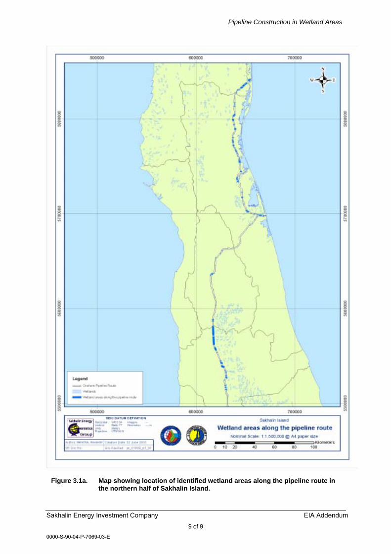
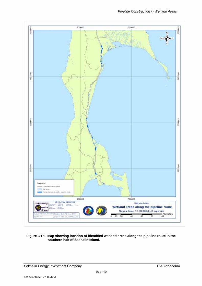
In total, 289 wetlands or peatlands are crossed by the pipeline. Crossing lengths vary between a few meters to a couple of kilometres. Seventy percent (70%) of the wetlands are less than 500 meters long where they are crossed by the pipeline. Depths along the pipeline axis vary from 0.2m to 13m. Wetland habitat also occurs within the footprint of the Offshore Processing Facility (OPF) and slightly inshore of the Beach Landing Facility and its associated infrastructure. Along the pipeline route all wetlands or peatlands are noted as being in their natural (or undisturbed) state (TEOC, VOLUME 3, BOOK 8, PART 1.2). However, it should be noted that several of the peatland areas along the northern section of the pipeline have been crossed by pipelines associated with other project infrastructure and where practical the ROW through wetland areas parallels existing road, communications or electricity transmission rights-of-way. The location of areas of peatland and wetland habitat are known, both from existing Federal Mapping and from the extensive survey work undertaken by SEIC since 1998 (see list of surveys in Table 3.1). On the basis of this information, SEIC has developed a series of 1:25,000 maps for the entire pipeline route, with areas of wetlands within the ROW identified on the basis of soil sampling (using the SNIP classification system). Using this mapped data the extent of wetland habitat along the entire route of the pipeline has been calculated (see above) and can also be graphically represented, as shown in Figure 3.1.
3.3.3 Ecological characteristics Vegetation From an ecological perspective the peatland and wetland areas along the pipeline route can be categorised into oligotrophic, mesotrophic and eutrophic types � fundamentally on account of their hydrology and hydrochemistry. In reality, there is a continuum in the physical and biological parameters and processes across these wetland types and definitive �type� classification may not be applicable to all of the wetlands present. The situation is also confused by the fact that oligotrophic-eutrophic conditions may be exhibited within an individual wetland area. However, broadly, there is a north to south change in the predominance of wetland type, with a shift from oligotrophic in the north to mesotrophic-eutrophic in the south. This change largely reflects climatic attributes and is mirrored by the overall change in the composition of the dominant vegetation types (from north to south), as set out below. Larch forest sub-zone. Above latitude 51.3N, larch (Larix sp.) replaces spruce (Picea ajanensis) as the dominant tree species. Other significant components of the flora include Japanese stone pine (Pinus pumila) and lichens (Cladonia spp.), which are abundant in open woodland on the dry, sandy soils. Small wetland areas may be fringed by Siberian alder (Alnus hirsuta). True moss dark coniferous forests with spruce sub-zone. From the Dolinsk area northwards to latitude 51.3N, P. ajanensis is the dominant tree species. East Asian species disappear, and species of Manchurian distribution type reach their northern limits, e.g. Juglans ailanthifolia, Quercus
Pipeline Construction in Wetland Areas
Sakhalin Energy Investment Company EIA Addendum 8 of 8
0000-S-90-04-P-7069-03-E
mongolica and Ulmus japonica. Successional broadleaved woodlands occur on river terraces. Dark coniferous forest sub-zone with fir. Plakor1 soils in the southern part of Sakhalin support dark coniferous forests (largely of secondary origin) with Sakhalin fir (Abies sachalinensis) and P. ajanensis. Species of eastern Asian sub-oceanic distribution (e.g. bamboo Sasa spp.), and Kamchatka bilberry (Vaccinium praestans) often form important components of the forest vegetation. In basins between mountains Larix spp. dominate with some Picea ajanensis and Abies sachalinensis.
(1) 1 Plakor is a vegetational zonation concept developed in Russia based on climatic delineation of vegetation patterns. It is usually applied in situations where physiography and soils do not strongly influence the vegetation (e.g. well-drained horizontal or slightly inclined areas with loamy to clayey soils).
Pipeline Construction in Wetland Areas
Sakhalin Energy Investment Company EIA Addendum 9 of 9
0000-S-90-04-P-7069-03-E
Figure 3.1a. Map showing location of identified wetland areas along the pipeline route in
the northern half of Sakhalin Island.
Pipeline Construction in Wetland Areas
Sakhalin Energy Investment Company EIA Addendum 10 of 10
0000-S-90-04-P-7069-03-E
Figure 3.1b. Map showing location of identified wetland areas along the pipeline route in the southern half of Sakhalin Island.
Pipeline Construction in Wetland Areas
Sakhalin Energy Investment Company EIA Addendum 11 of 11
0000-S-90-04-P-7069-03-E
Within the context of this broad zonation in the dominant vegetation types a number of wetland types in which peat formation is prevalent can be identified. These wetlands occur at various points along the route of the pipeline and can be characterized by a combination of vegetation community, hydrology and physical location. The key vegetative characteristics of each of the main peatland and wetland types, together with information on their distribution along the pipeline route is described in the following sections. Waterlogged open larch forests (Larix gmelinii) This plant community is present on low weakly drained waterlogged river terraces and is typified by the presence of reedgrass (Calamagrostis langsdorffii), sedge Carex schmidtii, cottongrass (Eriophorum russeolum), mosses (Sphagnum girgensohnii, S. Squarrosum, S. teres, S. Fallax, S. Fimbriatum and S. Capillifolium) and hygrophilous shrubs (e.g. marsh tea, Ledum palustre and cranberry Oxycoccus palustris). This wetland community is only crossed by the pipeline route at one location, in the area of the shore-crossing at Lunsky Bay, where it occupies a shallow sloping swampy surface of one of the high marine terraces to the south of Protochnoye Lake, forming a tract approximately 500×700m. Waterlogged larch (Larix gmelinii) open woodlands (“mires”) with Ledum and dwarf shrubs This community type commonly occurs in inter-montane lowlands and depressions with poorly drained, wet soils on high river terraces, mainly in middle and northern Sakhalin. The forest stand is medium-closed, non-coniferous, dominated by larch. The shrub layer is well developed with birch (Betula middendorffii), bilberry (Vaccinium uliginosum), leatherleaf (Chamaedaphne calyculata), Spirea (Spiraea beauverdiana), western mountain ash (Sorbus sambucifolia) and P. pumila. The grass and dwarf woody plant layer is also well developed with diagnostic species such as C. langsdorffii, L. palustre and cloudberry (Rubus chamaemorus). Peat moss vegetation is distinct, occurring as Polytrichum commune dominated patches. Wetland vegetation of this type is distributed in most districts crossed by the pipeline route, excepting the more mountainous Makarovsky and Korsakovsky districts. In the northern part of the route, this community is present in the southern part of Nogliksky District, from Nogliki to the Nysh Rail Road Station, where it occupies waterlogged areas in the low undulating hills and plain. In the Tymovsky District the community occurs sporadically, although it is more prevalent in the very south of the area where there are some plots, up to 1×2.5km in size, in the valleys of the Taulan River and tributaries of the Dalgadanka River. In the Smirnykhovsky District, due to the great development of waterlogged plain areas of the Tym-Poronayskaya Depression, this wetland type is common and widely distributed. Here, the pipeline route passes through a 53km section between the Severnaya Khandasa River and the settlement of Smirnykh where areas of wetland vegetation regularly occur in plots approximately 200-300m x 500-1500m in size, occupying flat alluvial and gently sloping alluvial fans at the foot of the hills.
Pipeline Construction in Wetland Areas
Sakhalin Energy Investment Company EIA Addendum 12 of 12
0000-S-90-04-P-7069-03-E
Further to the south, in the vicinity of Firsovo (Dolinsky District) the community occurs as small areas (300 x 400m) over the low marine and alluvial-marine terraces. Larger areas of wetland habitat of this type are present on the low marine terrace adjacent to the shore of the Lebyazhiya lagoon, on the alluvial-marine terrace of the Susunayskaya Depression, on the right bank of the Naiba River, and to the west of the village of Sokol. Hygrophytic meadows and ‘herb’ bogs Communities of this type are commonly found on excessively soggy neutral soils, in floodplains and medium sized depressions on marine terraces. Typically areas may be groundwater fed, with water levels remaining above the soil surface for the majority of the growing season. This wetland type occurs mainly in northern and central Sakhalin, although occasionally, similar associations occur in the south of the Island. Major species are C. langsdorffii, the fern Osmundastrum asiaticum and L. palustre. Other important grass stand elements are the horsetail Equisetum sylvaticum, sedges (e.g. Carex schmidtii and Carex limosa), false lily-of-the-valley (Maianthemum dilatatum) and bunchberry dogwood (Chamaepericlymenum canadense). Rock cranberry (Rhodococcum vitis-idaea) is also a frequently occurring species as is blueberry. Along the pipeline route this wetland community is encountered only in the northern section in the regions of Okhinsky, Nogliksky and Tymovsky. Large stands (2.7km × 5.5km) are to be found on the low marine terrace in the vicinity of Lunsky Bay. Here, the meadow and herb bogs occupy the numerous depressions among the thickets of Japanese stone pine. In Nogliksky District this kind of vegetation is distributed, mostly to the south of Nogliki in the valley of the Tym River, where it is present in the low, undulating plain to the west of Nabilsky lagoon. There are also some large areas (up to1.5km × 4km) located on the flat and gently sloping marine terraces between the Vazi River and the coast. Oligotrophic peat moss bogs Oligotrophic peat bogs occur all along the pipeline route, commonly in association with a number of other vegetation communities in complex mosaics of wetland habitats. Oligotrophic conditions often predominate in wetland clearings within larch or spruce forest. In these situations areas of oligotrophic bog can often be recognised by the sparse and stunted tree growth that they support. Typically, communities of this type occur in floodplains, depressions in marine terraces and on marshy alluvial plains. The water table is invariably at a shallow depth and water levels usually remain above the soil surface for the greater part of the growing season. Relatively �pure� stands of this vegetation type can be divided into two main associations on the basis of their key vegetation assemblages, although Sphagnum species are common to both. In the central part of Sakhalin, sphagnum bogs with dwarf woody plants occur extensively in the lowlands of the Tym-Poronaiskaya basin, with the most extensive peat formation occurring in the southern part of this area, including the Poronai River and its valley. Here, only the forested floodplains of some
Pipeline Construction in Wetland Areas
Sakhalin Energy Investment Company EIA Addendum 13 of 13
0000-S-90-04-P-7069-03-E
river valleys remain peat-free. In the north of Smirnykhovsky District between the Verkhnyaya Dalgadanka River and the Severnaya Khandasa River there is a significant area of this vegetation type occupying the gently sloping plain at the base of the hills, which is crossed by numerous rivers. Generally, the second river floodplain terraces of the basin exhibit a greater degree of peat formation, with deposits typically being 3-4m thick and sometimes 5-6m. The grass and dwarf woody plant layer is dominated by L. palustre, sweetgale (Myrica tomentosa) and crowberry Empetrum sibiricum. Other prominent species of this vegetation layer include cotton grasses Eriophorum gracile and/or Eriophorum vaginatum, birch trees Betula exilis and B. middendorffii, Parnassus grass (Parnassia palusris), loose-flowered sedge (Carex rariflora), R. chamaemorus, M. dilatatum and C. canadense. The mosses Sphagnum fuscum, S. palustre, S. magellanicum and the rarer S. anqustifolium form the dominant groundcover. In the southern part of Sakhalin the vegetation of oligotrophic bogs is often characterised by the presence of the sedge Carex schmidtii and reedgrass, which between them may represent up to 60% of the grass layer. Other important elements of the grass layer include the fern O. asiaticum, Japanese burnet (Sanguisorba tenuifolia), M. dilatatum and C. canadense. Mesotrophic-Eutrophic peat bogs In the south of the Island, particularly in the Yuzhno-Sakhalinsk area, bogs with higher nutrient levels (mesotrophic-eutrophic) commonly occur and are also present, to a lesser extent, in the central part of the Island. In reality there is a continuum between oligotrophic and eutrophic conditions and many bogs exhibit a range of nutrient levels. Changes in nutrient status are usually well reflected by the plant species assemblages that are present within the bogs. In eutrophic conditions, cotton alder (Alnus hirsuta) is a characteristic species and is often associated with white skunk-cabbage (Lysichiton camtschatcense), blue flag (Iris setosa), kneeling angelica (Angelica genuflexa), Kamchatka thistle (Cirsium kamtschaticum), meadowsweet (Filipendula kamschatica), Aleutian ragwort (Senecio cannabifolius), flat-leaved nettle (Urtica platyphylla) and a number of species of sedge (e.g. Carex rostrata and C. laevirostris). Mosses adapted to the more nutrient-rich conditions prevail, including several species of Sphagnum (S. squarrosum, S. fimbriiatum and S. girgensohnii) and a number of other characteristic forest mosses such as Pleurozium schrebri, Hylocomium proliferum and Ptilium crista castrensis. Under more mesotrophic conditions, bogs typically support larch (18-21m high) with a shrub layer comprising L. palustre, V. uliginosum, sedges (Carex spp.), horsetail (E. arvense), M. trifoliata, Eriophorum spp. and Calamagrostis spp. Mosses such as Sphagnum obtusum, S. riparium and Hypnum spp. form the groundcover. Bogs of this type are widely distributed, but largely occur in the south and central sections of the Island. Fauna of wetland and peatland areas The fauna of wetland areas along the pipeline route has not been as well documented as the vegetation and flora. A number of baseline studies (see
Pipeline Construction in Wetland Areas
Sakhalin Energy Investment Company EIA Addendum 14 of 14
0000-S-90-04-P-7069-03-E
Table 3.1) provide information on the occurrence of invertebrates, amphibians, reptiles, birds and mammals along the route. These studies were conducted on the basis of the identification of vertebrate assemblages associated with identified vegetation types present along the pipeline route. With respect to wetland habitats, birds, amphibians and mammals were described as being associated with two main vegetation complexes � wet sedge meadows (effectively covering all non-forested, sedge/small shrub dominated peatlands) and larch-ledum marshland (encompassing the waterlogged open larch vegetation complexes discussed above), (FESTU 2000; see Table 3.1). Surveys undertaken along the pipeline route between 1998-2002 (as detailed in Table 3.1) have provided information on the characteristic bird assemblages of wetland areas. This data indicates that the peatlands of northern Sakhalin and many of the river plains support a relatively impoverished breeding bird fauna in comparison to other habitats in the area, with 5-7 species that can be definitively linked to this habitat. Species such as lanceolated grasshopper warbler (Locustella lanceolata), Middendorff�s grasshopper warbler (Locustella ochotensis), green-headed wagtail (Motacilla taivana) and yellow-breasted bunting (Emberiza aureola) dominate the assemblage. These typical wetland species are complemented by other species found in adjacent and transitional habitats (open water, shrub, grassland and forest), giving rise to an overall assemblage with about 10-15 representative species (FESTU 2000). Areas of open water and stands of reed/emergent vegetation within the peatlands may also provide habitat for a range of other characteristic species such as ducks, waders, grebes etc. Of particular note is the potential for this habitat to support rare species such as Japanese snipe (Gallinago hardwickii) and Schrenk�s little bittern (Ixobrichus eurhythmus), both of which are listed in the Sakhalin Red Data Book. The waterlogged larch-ledum complex is one of the most widely represented habitat types along the pipeline route and supports a characteristic bird assemblage, often comprising an inter-mixture of species from several associated habitats. The presence of larch means that representative species from larch forests are often encountered in these marshy areas, notably nuthatch (Sitta europea), Siberian bluechat (Tarsiger cyanurus), Pallas�s willow warbler (Phylloscopus proregulus), coal tit (Parus ater) and Mugimaki flycatcher (Ficedula mugimaki). These species primarily inhabit the periphery of the marshland areas where this habitat merges into larch forest or the tree density increases. Other species typical of open ground usually occur within the main marsh areas and include species such as yellow-breasted bunting, brown shrike (Lanius cristatus), stonechat (Saxicola torquata), dusky willow warbler (Phylloscopus fuscatus) and lanceolate grasshopper warbler. On the coast, both the above habitat types may also support a number of other breeding species that are characteristic coastal specialists. These include the Sakhalin subspecies of dunlin (Calidris alpina actities) and the rare spotted greenshank (Tringa guttifer), which inhabits sparse waterlogged larch forest close to the lagoons of the north-east coast. Both species are listed in the Sakhalin Red Data Book (RDB). Areas of open water within the coastal wetland complex also provide habitat for several species of duck (e.g. teal (Anas acuta), mallard (Anas platyrhynchos)), grebes and divers. The coastal wetlands of the north-east coast are particularly important during the spring and autumn when large numbers of waterbirds (ducks, swans and waders) congregate here en route to breeding or wintering grounds.
Pipeline Construction in Wetland Areas
Sakhalin Energy Investment Company EIA Addendum 15 of 15
0000-S-90-04-P-7069-03-E
The mammal fauna of wetland areas is of low diversity and typified by Laxmann�s shrew (Sorex caecutiens), large-toothed shrew (Sorex daphaenodon) and grey-sided vole (Clethrionomys rufocans). In the north of Sakhalin, reindeer (Rangifer tarandus) is often found in or adjacent to wetland areas. In both the larch-ledum marshland and sphagnum peatlands, the most common amphibian species is Siberian salamander (Salamandrella keyserlingii). Asiatic grass frog (Rana chensinensis) is also common as is viviparous lizard (Lacerta vivipara).
3.3.4 Summary of wetland habitat characteristics Vegetation and fauna surveys commissioned by SEIC show that the pipeline route crosses a significant number of wetland areas from the landfall at Piltun to the LNG plant at Prigorodnoye (see Section 3.3.2.). For the purposes of defining the potential impacts of pipeline construction and implementing appropriate mitigation measures these wetlands can be classified into several types on the basis of both their ecological characteristics and engineering (soil) properties. While it is apparent that, from a construction perspective, classification is relatively simple (see Section 3.4.1 below), the available survey data shows that although the wetland areas can be broadly grouped, there is a wide range of variation within and between them. Such ecological variation along the pipeline route would be expected given the significant north-south climatic gradient, variability in physiography, changes in geology, soils and hydrology and human influence/management. When considered at both an Island level, and within the wider context of the Russian Far East, such wetland types are not considered unique as they have a wide distribution and extent (FESTU 2002). In terms of overall significance and sensitivity of interests, it is perhaps the coastal wetlands of the north-east coast that are of most importance. This significance results from a combination of factors, but largely relates to the presence and use of the wetlands as breeding habitats by several rare species of coastal birds. The ecological importance of this area is recognised by its inclusion on the shadow list of Russian Federation sites for potential designation under the Ramsar Convention as a Wetland of International Importance (Krivenco 2000). However, it should be noted, that the route of the pipeline(s) and the location of the OPF has been planned to avoid significant areas of wetland habitat (e.g. lagoons and fringing wetlands) of ornithological importance along the north-east coast of the Island, as illustrated in Figure 3.1, which shows the key wetland areas on the island in relation to the pipeline route. Where areas of wetland habitat are encountered in the north-east coastal strip, then the footprint of the pipeline and associated facilities has been minimised as far as practical and works have been undertaken to avoid sensitive periods for breeding and migrating birds. The techniques described below have also been designed and will be implemented to minimise the longer-term effects of pipeline construction within any wetland/peatland areas and potential impacts upon ecological processes, vegetation and associated fauna. The basic conclusion that can be drawn from this brief assessment of the ecological characteristics of wetland habitats along the pipeline route is that while not unique (apart from ornithological interest of the coastal wetlands) it is apparent that these locally variable wetland areas represent an important component of the overall ecological interest of Sakhalin Island. As such, it is imperative that each one is treated as a sensitive receptor and appropriate measures are taken during design, construction and operation of the pipeline
Pipeline Construction in Wetland Areas
Sakhalin Energy Investment Company EIA Addendum 16 of 16
0000-S-90-04-P-7069-03-E
to ensure that their ecological integrity is maintained intact. These aspects are discussed in the following sections.
3.4 CONSTRUCTION METHODOLOGIES AND TECHNIQUES 3.4.1 Wetland classification for construction purposes
Under RF regulations wetlands can be divided into 3 groups, based upon the bearing capacity of the soil (Engineering definitions: SNiP 111-42-80): Type I � Bogs completely full with peat allowing work and movement of low ground pressure equipment with a unit pressure of 0.02-0.03 Mpa (0.2-0.3 kgf/sm2) or operation of ordinary equipment by means of shields, timber flooring and roads, which reduce unit pressure on the surface peat crust to no more than 0.02 Mpa (0.2 kgf/sm2); Type II � Bogs completely full with peat allowing the operation and movement of construction equipment only by means of shields, timber flooring and roads reducing unit pressure at the surface to no more than 0.01 Mpa (0.1 kgf/sm2); Type III � Peat bogs with peat crust floating on water allowing the operation of special equipment on pontoons or ordinary equipment from floating platforms only. This classification is based on load bearing capacity only, and does not include any ecological criteria. SEIC will comply with reducing the unit pressure at the surface, in line with RF regulation. There is clearly a preference to make crossings in winter, but some crossings might be constructed in summer. Mitigation measures have been developed to deal with the potential ecological issues associated with wetland crossings, as discussed in section 3.7. The distinction between Type I and II in the field can be difficult to determine due to the mosaic nature of many wetland areas and in reality there is a full range of gradation between them, for instance, using the SNiP classification, wetlands of Type II are often enclosed by wetlands of Type I. Using data on the location and engineering classification of the peatlands encountered along the route the following statements can be made: • Type I bogs comprising peaty and hydromorphic soils are assumed to be
capable of supporting a board/timber road and as such can be crossed at all times of the year. A total of 196 wetland areas (a total of 74 km) of this type are classified along the pipeline route;
• A total of 42.4 km of the pipeline route crosses Type II swamps (comprising 90 classified wetland areas). These are generally assumed to be smaller eutrophic or mesotrophic peat bogs and often bounded by Type I wetlands. The largest bog is 1.7 km long, but the majority are less than 400 meters long;
• Survey information shows that the pipeline route crosses a total distance of 1.9km of Type III swamps (3 areas in total), which are present on pipeline spreads 2 and 4. Each of these bogs contain peat to depth greater than 5m, which means that in this situation the pipe would remain in the lower bog area, rather than the mineral subsoil.
Pipeline Construction in Wetland Areas
Sakhalin Energy Investment Company EIA Addendum 17 of 17
0000-S-90-04-P-7069-03-E
3.4.2 General construction issues The installation of the onshore pipeline, from its landfall at Piltun to the LNG plant in Aniva Bay, poses particular problems with respect to construction through wetland areas where these are present along the route (see broad description of locations in Section 3.3). Effectively, the construction of the pipeline through wetland areas requires the use of a combination of techniques and methods that are used as standard along the rest of the pipeline route and that are specifically designed to minimise impact within these hydrologically and ecologically sensitive areas. The objective of the development and implementation of these techniques is to ensure that the actual construction process incorporates the required measures to ensure that the integrity of the wetland habitats along the route is maintained. It should also be noted that additional ecological mitigation techniques will be utilised, where practical, during construction and as informed by survey data. This includes the avoidance of RDB plant populations in wetland areas, where survey data has revealed their presence. This combination of techniques (generic and specific) are highlighted and discussed in the following sections. SEIC have produced design guidelines (Environmental Design Guidelines - Onshore Construction) which form part of the onshore pipelines EPC contract. Specific measures considered as industry good practice and contained within the United States Federal Energy Regulatory Commission (FERC) Wetland and Waterbody Construction and Mitigation Procedures will also be utilised during construction (see Section 3.7 for more details and Appendix B, where the relevant wetland section of the FERC is reproduced). The following text has been included within the Environmental Design Guidelines and sets out the general issues that need consideration during construction in wetland areas: “Pipeline design and construction will include measures to protect wetlands and marsh areas and to minimise the impact to the environment. It is not the intent of this document to address engineering concerns. This document provides guidance on environmental concerns associated with pipeline construction, specifically in wetlands and marsh areas. The following issues are addressed: • Extra work areas and access roads; • Crossing procedures; • Temporary sediment controls; • Trench dewatering; • Subsurface drainage control; • Wetland restoration; and • Post-construction maintenance.”
The SEIC design guidelines also stipulate “At least one Environmental Inspector having knowledge of the wetlands, marsh, and water body conditions in the project area is required for each construction section”. To address the generic issues common to most wetland/peatland areas, a general construction methodology has been developed by the EPC contractor in a Method Statement for wetland/peatland crossings. The general Method Statement will be underpinned by location-specific detailed alignment sheets,
Pipeline Construction in Wetland Areas
Sakhalin Energy Investment Company EIA Addendum 18 of 18
0000-S-90-04-P-7069-03-E
which have been prepared by the EPC contractor. These alignment sheets contain the necessary construction drawings and technical detail to translate design intent (including mitigation measures) into actions on the ground. The generic issues referred to above and for which construction guidelines have been produced are listed below, while the more specific measures (which also address, in part, aspects listed above) are set out in the following sections: ROW clearance and operation
• Limit construction equipment operating in wetland areas to that needed to
clear the construction right of way, dig the trench, fabricate and install the pipeline, backfill the trench, and restore the construction right of-way;
• Cut vegetation just aboveground level, leaving existing root systems in place, and remove it from the wetland for disposal;
• Limit pulling of tree stumps and grading activities to directly over the trench line. Do not grade or remove stumps or root systems from the rest of the construction right of way in wetlands unless SEIC and the Environmental Inspector determine that safety related construction constraints require grading or the removal of tree stumps from under the working side of the construction right of way;
• Do not use rock, soil imported from outside the wetland, tree stumps, or brush riprap to support equipment on the construction right of way;
• If standing water or saturated soils are present, or if construction equipment causes ruts or mixing of the topsoil and subsoil in wetlands, use low-ground-weight construction equipment, or operate normal equipment on timber riprap, prefabricated equipment mats, or terra mats;
• Do not cut trees outside of the approved construction work area to obtain timber for riprap or equipment mats;
• Remove all project-related material used to support equipment on the construction right of way upon completion of construction.
Temporary Sediment Control
• Install sediment barriers across the entire construction right of way at all
wetland crossings where necessary to prevent sediment flow into the wetland. Removable sediment barriers can be removed during actual construction, but must be re-installed after construction has stopped for the day and/or when heavy precipitation is imminent;
• Where wetlands are adjacent to the construction right of way and the ROW slopes toward the wetland, install sediment barriers along the edge of the ROW as necessary to contain spoil and prevent sediment flow into the wetland. These sediment barriers should be removed during the ROW cleanup following pipeline installation.
Trench Dewatering
• Dewater the trench (either on or off the construction right of way) in a
manner that does not cause erosion and does not result in heavily silt-laden water flowing into any wetland. Remove the dewatering structures as soon as possible after the completion of dewatering activities.
Pipeline Construction in Wetland Areas
Sakhalin Energy Investment Company EIA Addendum 19 of 19
0000-S-90-04-P-7069-03-E
3.5 CONSTRUCTION METHODOLOGY FOR WETLANDS IN WINTER
The following specific construction process will be implemented for the installation of the pipeline in peatlands in winter. The following general assumptions apply: • No more trench than can be closed in one day will be opened;
• Trench fill and the trench itself will not freeze to the base in less than 6 hours;
• Progress across peat bogs would be no more than 450m/day.
The points below set out the basic construction process:
• Plank/ice roads will be constructed on either one side of the pipe centreline or both depending on the situation;
• The pipe will be strung, welded, joints non-destructively tested and if necessary repaired then retested, coated, CP circuits installed. (i.e. made completely ready for operation except for hydrotesting);
• Track hoe moves mat in place to begin digging trench;
• Blocks of frozen bog surface will be lifted out (if possible) for storage beyond the future spoil pile on the spoil storage side of the ROW;
• The pipeline trench will be dug using a track hoe to an appropriate depth below the peat � mineral soil interface, unless this is not technically feasible or could cause trench instability;
• Underlying peat material will be excavated and stored in a linear pile;
• Mineral soil (if encountered) will be excavated and stored in a separate linear pile within the boundary of the ROW;
• Pipe will be lowered into the ditch;
• Small dozer will push mineral soil (first) into trench around the pipe;
• Track hoe/dozer will replace peat back in excavated trench; and
• Track hoe will lift ice/sphagnum moss (if present) block back into trench in original position/orientation.
At the end of each working day it is likely that a short section of open trench will remain which will freeze overnight. This is unavoidable, as a certain length of trench will be required from which to raise and stabilize the pipe on skids, ready to begin work the following day. Prior to trenching work beginning the following day, the ice plug formed in the trench will be excavated and removed.
3.5.1 Use of ice roads To support winter wetland construction activity ice roads will be constructed. Each ice road will have a complete set of design documents and will be approved by the Oblast Administration, State Ecology Committee, Ministry of Natural Resources, in line with Russian requirements. The ice road will be constructed using the following basic methodology:
Pipeline Construction in Wetland Areas
Sakhalin Energy Investment Company EIA Addendum 20 of 20
0000-S-90-04-P-7069-03-E
• A portable pump will be used to spray water over the route of the proposed
road surface;
• Incremental layering will be used, with each ice-layer being 3-5cm thick, to a thickness at which plant can be safely supported. A new layer will only be applied once the previous one has frozen;
• Wood planking or tree trunks along with compacted snow may be added to increase the load-bearing capacity and enable a more rapid build-up of the road.
In order to ensure the safe movement of vehicles on the ice road, the necessary ice thickness will be calculated to support the expected weight at a specific temperature. Road signs indicating maximum load bearing capacity, speed of traffic and spacing between vehicles will be put in place. Before commencing any activity testing will be conducted to insure that equipment can be safely transported across the wetland.
3.5.2 Stringing and welding Welding of the pipe may be accomplished in one of two ways, depending on the conditions. If feasible, the preferred approach would be to string the pipe along the ditch edge of the ice/plank roads using pipe trucks. The pipe would be aligned using pipe clamps, welded and then placed on skids for lowering in to the trench. If crossing of a wetland area cannot be undertaken using the above method then a push-pull technique may be used. This would involve the construction of a platform at each end of the wetland section to be crossed on which all of the equipment required to place the pipe in the trench would be positioned. Floats would be fixed on the pipe, which would then be pushed on rollers into the trench full of water. When the entire pipeline length has been pushed into the trench of the section the straps on the floats would be cut in order to sink the pipe in bottom of the trench.
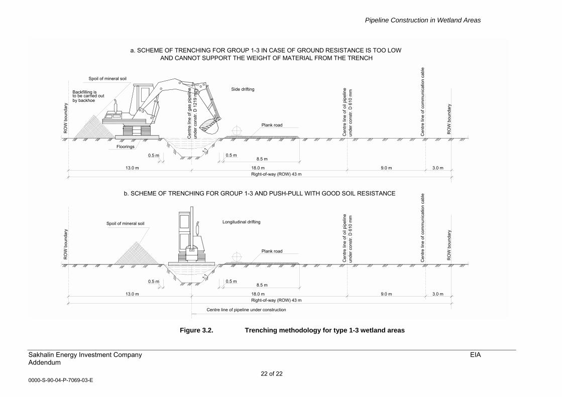
3.5.3 Trenching The pipeline trench will be excavated with a trac-hoe working from a movable plank footing. The method used would depend on the weight-bearing capacity of the wetland soil. Where soil resistance is relatively high and could bear the weight of the trac-hoe then excavation would be undertaken along the central line of the trench. Where ground resistance is too low, then excavation from the side of the trench-line would be undertaken using moveable footings. These two techniques are illustrated in Figure 3.2.
3.5.4 Lowering, hydrotesting and backfilling
The pipe sections will be welded, the joints coated and the coating repaired if required on the plank or ice road. In areas were the pipe is not completely or partially buried in a mineral substrate it will be suspended in the peat layer/water column using buoyancy control measures to produce a neutrally buoyant pipeline. As such the sort of mitigation suggested in the TEOC (e.g. installation of pipeline on piles) is not foreseen. Instead, the stability of a buoyant pipeline in saturated ground will be controlled by the addition of

Pipeline Construction in Wetland Areas
Sakhalin Energy Investment Company EIA Addendum 21 of 21
0000-S-90-04-P-7069-03-E
concrete collar weights to provide negative buoyancy in accordance with SNiP calculation requirements. Finally, Cathodic Protection (CP) connections will be added and cable strung. In general, hydrotesting will be undertaken during the summer months as low winter temperatures would necessitate use of an antifreeze (glycol). There may be a need to provide antifreeze for the relatively short pipe sections that will be installed during winter and as the pre-hydrotesting for these areas will be done in the winter it is likely that an antifreeze will need to be employed. In this situation, SEIC will use antifreeze, with all due consideration to toxicity, product stability, and disposability and apply for the necessary permits and compliance requirements as stipulated under RF regulations. Further details on hydrotest requirements in wetlands are provided in the HSESAP, Part 2, Table 2.5, Land Management. The lowering operation will be undertaken using a side boom. The pipeline trench will be back-filled, immediately after lowering-in, by replacing the excavated materials in the same sequence that they were originally encountered.
Pipeline Construction in Wetland Areas
Sakhalin Energy Investment Company EIA Addendum
22 of 22 0000-S-90-04-P-7069-03-E
Spoil of mineral soil
Cen
tre li
ne o
f gas
pip
elin
e un
der c
onst
r. D
121
9 m
m
Cen
tre li
ne o
f oil
pipe
line
Floorings
13.0 m
0.5 m
1:1
0.5 m
Right-of-way (ROW) 43 m18.0 m
8.5 m
Plank road
9.0 m
unde
r con
str.
D 6
10 m
mSide drifting
Cen
tre li
ne o
f com
mun
icat
ion
cabl
e
RO
W b
ound
ary
3.0 m
RO
W b
ound
ary
Backfilling is to be carried out by backhoe
3.0 m9.0 m18.0 m13.0 mRight-of-way (ROW) 43 m
RO
W b
ound
ary
0.5 m
1:1
0.5 m
unde
r con
str.
D 6
10 m
mC
entre
line
of o
il pi
pelin
e
8.5 m
Plank road
RO
W b
ound
ary
Cen
tre li
ne o
f com
mun
icat
ion
cabl
e
Spoil of mineral soil
Centre line of pipeline under construction
Longitudinal drifting
AND CANNOT SUPPORT THE WEIGHT OF MATERIAL FROM THE TRENCHa. SCHEME OF TRENCHING FOR GROUP 1-3 IN CASE OF GROUND RESISTANCE IS TOO LOW
b. SCHEME OF TRENCHING FOR GROUP 1-3 AND PUSH-PULL WITH GOOD SOIL RESISTANCE
Figure 3.2. Trenching methodology for type 1-3 wetland areas

Pipeline Construction in Wetland Areas
Sakhalin Energy Investment Company EIA Addendum 23 of 23
0000-S-90-04-P-7069-03-E
3.6 CONSTRUCTION METHODOLOGY FOR WETLANDS DURING THE NON-WINTER PERIOD
For construction activities carried out over peatland/wetland areas outside of the winter period a timber rip-rap or a plank road will be constructed to ensure that equipment can be transported and travel across the wetland for the duration of construction activity. It is currently the intent to remove all roads constructed during undertaking wetland crossings. However, consideration will be being given to the longer term use of some sections of wetland roads during operation and maintenance, subject to agreement with RF authorities and taking into account SEIC policies and commitments with respect to managing access to previously undisturbed or ecologically important areas. Trenching work will be undertaken using a track-hoe positioned on movable mats to minimize surface disturbance. Temporary drainage may be required to support pipeline construction in wetland areas. This may take the form of open �V� ditches cut on both sides of the working width to divert water away from the construction area. Cross ditches, or flume pipes, may also need to be installed to control water levels. Water entering the pipeline trench in wetland areas would be retained in the trench in order to avoid trench collapse. Dewatering pumps would be used to evacuate any accumulated water in the trench prior to the pipe being laid in the trench. The amount of time between excavation of the trench and back-filling operations would be minimized as far as practically possible. Drains and flume pipes would remain in place until construction work had ceased and natural drainage would be reinstated. Regular inspections would be made to ensure that drains and flume pipes remain in good condition throughout the construction period.
3.7 IMPACTS AND MITIGATION MEASURES The main mitigating action recommended within the Onshore Construction Environmental Design Guidelines is to avoid wetlands where possible or route the pipeline through wetlands at the most favourable angle. Wherever possible the pipeline route parallels existing electric and gas/oil transmission lines to minimize potential impact on existing areas of wetland habitat and other environmental interests. However, where for technical routing purposes the pipeline encroaches on or passes across wetland areas then the potential for change to the hydrological regime and ecology exists. The most significant of these are listed below and discussed in more detail in the following sections:
• Disruption to active layer water flow within a bog surface, which may lead to
waterlogging (increase in water levels) in some areas or localised changes in rates of water filtration;
• Compaction of the surface layer and the underlying peat;
• Direct disturbance of vegetation and upper bog surface during pipelaying;
• Alteration of the vegetation community due to the invasion of opportunistic species as a result of disturbance;
Pipeline Construction in Wetland Areas
Sakhalin Energy Investment Company EIA Addendum 24 of 24
0000-S-90-04-P-7069-03-E
• Changes to the thermal regime within the bog due to both the presence of the pipeline and mechanical break-up of the bog surface, which could lead to intensification of frost penetration during the winter and subsequent erosion during the summer (freeze-thaw);
• The potential impacts of hydrocarbon spills, measures to prevent their occurrence, and contingency planning in the event that an accident does occur.
The in-built design mitigation measures, construction methodologies and associated mitigation are also set out in the FERC Wetland and Waterbody Construction and Mitigation Procedures. This document provides a synopsis of all of the relevant measures applicable to minimising environmental impacts in wetland areas and how they are being applied (where appropriate) within the project (e.g. incorporation into relevant project plans, documents and/or responsibilities). The section of the FERC specifically produced for wetland crossings is reproduced in Appendix B.
3.7.1 Changes in Hydrology
Installation of the pipeline within a wetland area may alter the existing hydrological regime, largely as a result of localised interception and/or disruption to flow within the peat, but also due to the effects of compaction and temperature change in the soil immediately around the pipeline. A change to the hydrological regime of a wetland may not represent an adverse impact in its own right. However, given that hydrological conditions are one of the prime controls on vegetation characteristics, it is important for maintaining ecological integrity that hydrological change is minimised or avoided. In order to minimise potential effects on hydrology standard procedures in the Russian Federation are to investigate/determine the hydrological regime and then design the pipeline (or infrastructure) to minimise disruption and/or change. Hydrological investigation, at the spatial scale required for large infrastructure projects, is usually performed using aerial photography and ground investigation where appropriate (e.g. use of boreholes). Aerial photography of the pipeline route was undertaken in 2002 and 2003. Data gathered from the photography is being used in developing alignment sheets for the entire pipeline for use during the detailed design phase. These alignment sheets contain the necessary construction drawings and technical detail to translate design intent (including mitigation measures) into actions on the ground and will be approved by SEIC prior to construction. Key mitigation measures to minimise hydrological change that could be integrated into the routing of the pipeline or the overall design include the installation of drainage channels or cut-off ditches and culverts. Taking into account information gained from survey work and the inclusion of specific design measures, the pipeline will be laid along descending and ascending slopes of wetland margins, below the main zone of water movement. Water movement in the peat lands is very slow and will continue around the top (and bottom) of the pipeline. Consequently the requirement for drainage channels and culverts etc is not envisaged. Nevertheless, if specific drainage requirements are identified, SEIC is committed to including appropriate mitigation in the design to reduce potential impacts. If necessary, recommendations will be made for
Pipeline Construction in Wetland Areas
Sakhalin Energy Investment Company EIA Addendum 25 of 25
0000-S-90-04-P-7069-03-E
construction teams to include wetland specialists to assist in fine-tuning the design in the field. Compaction The vehicles and heavy equipment needed during construction could result in compaction of the peat layer, thus affecting the water filtration coefficient within the peat layer. To minimise compaction, peatlands that are deep and have low bearing capacity will be crossed in winter by means of an ice road. For wetlands that can be crossed in summer time, a plank road or timber rip-rap will be used in order to minimise bearing pressure, in line with the Russian SNiP requirements. Hydrological integrity SEIC has committed to bury both the oil and gas pipelines lines as deeply as is practical in low weight bearing surface peat areas (Types I, II, or III). The objective is to ensure that, where practical, the pipeline will be buried in the mineral soil underlying peat deposits to remove the potential for the pipeline to impede water flow within the peat layer, thereby ensuring that the hydrological integrity of the surface deposits is retained. Defrosting of wetland surface during the winter Though oil pumped from the platforms will cool prior to reaching landfall, its temperature will be higher than ambient ground (at surface) and air temperatures during the winter. However, the freezing depth in peat areas varies between 30 cm to 80 cm, and the pipeline is buried below this depth, at a minimum depth, to top of pipe, of 1.2 meters. Furthermore, the peat itself provides an insulation that minimises the radiation of the heat. As a result, defrosting of the soil is considered to be very unlikely. Invariably, until vegetation recovery is complete, the broken ground will have a different albedo. The thermal properties of this ground will probably (temporarily) produce noticeable differences in snow cover and freeze/thaw characteristics and possibly vegetation. These effects are expected to be minor and will be monitored to ensure erosion effects do not occur.
3.7.2 Ecological change Potential ecological change to wetland habitat as a result of the installation of the pipeline includes the majority of the impacts generally associated with clearance of the ROW and construction activity (e.g. disturbance to fauna due to human activity, temporary/permanent loss of habitat). However, in the case of wetland sites construction activity may have a greater influence on some ecological components, largely as a result of potential change to the hydrological regime. Peatland vegetation communities and the fauna associated with them are adapted to specific hydrological conditions. While the majority of species present in peatland areas are tolerant, to a certain degree, of change in hydrological parameters, significant change would be likely to result in alteration of factors such as; species presence/absence, abundance and distribution. Some plant species are particularly sensitive to shifts in or disturbance to the physical framework to which they are adapted and for these species even small changes may be adverse. In order to ensure that the ecological integrity of wetlands is not compromised (i.e. that vegetation communities, existing species abundance,
Pipeline Construction in Wetland Areas
Sakhalin Energy Investment Company EIA Addendum 26 of 26
0000-S-90-04-P-7069-03-E
diversity and distribution is maintained) it is therefore important to ensure that the hydrological regime is not affected by the installation of the pipeline. As discussed in the previous section, where the pipeline passes close to or through wetland areas it has been aligned to minimise hydrological effects and a number of mitigation measures to limit hydrological change have been incorporated into the construction methodology. Because of the strong functional linkages between hydrology and ecology, these measures also act as mechanisms for reducing the potential adverse effect of the installation of the pipeline on biological communities in the wetland areas. There are however, a number of other aspects associated with the pipeline construction work that could impact upon the ecology of the wetland areas and which may therefore require mitigation. These ecological effects are briefly highlighted below, along with potential mitigation measures that could be utilised to minimise impact. Disturbance to surface soil layers, removal of existing vegetation communities and exposure of bare soil following pipeline installation may provide beneficial conditions for opportunistic and invasive plant species to take hold. If this occurs then potentially re-establishment and re-development of former communities may either be hindered or may not occur, resulting in changes to the ecological structure and species composition of the wetland area along the route. The establishment of invasive species along the ROW and within wetland areas may also lead to change outside of the ROW in the longer term. Studies of cutover peatlands in North America and Europe stress that remaining peat deposits usually have no or very limited viable seed banks. Exposure of peat surfaces therefore either favours the establishment of invasive species or surfaces may remain fallow for significant periods of time without the re-establishment of any vegetation. To reduce the possibility of longer-term change to wetland vegetation along the ROW once the pipeline has been installed, it is intended that affected surface vegetation (e.g. Sphagnum communities) will be removed, stored separately from peat and mineral soil and then reinstated as close to their original position as possible. This measure should reduce the possibility for opportunistic/invasive species to take hold. When construction in wetlands takes place during the winter months, replacement of surface vegetation may be assisted by the fact that the surface layer should be frozen, thus maintaining vegetation as an integral block for replacement.
3.7.3 Fire risk Construction in areas of peat vegetation may increase the risk of ignition, particularly during the summer months. To minimise the potential risk of this occurring, special fire protection measures will be implemented at the welding and construction sites. These will include the use of fire-fighting vehicles and fire extinguishers at specified locations. Smoking will only be allowed in specific areas.
3.7.4 Soil erosion The Soil Reclamation and Erosion Prevention Plan (SREPP), prepared by SEIC, identifies measures to be implemented to protect soil resources. The generic SREPP provides a framework for the future development of specific SREPPs for
Pipeline Construction in Wetland Areas
Sakhalin Energy Investment Company EIA Addendum 27 of 27
0000-S-90-04-P-7069-03-E
each project component. Measures to combat soil erosion are also included within the FERC Wetland and Waterbody Construction Mitigation Procedures (see Appendix B). The main mitigation measures associated with soil resources include using physical structures such as slope breakers and energy dissipaters, vegetative techniques such as reseeding and planting and controlling sediments through the use of sediment traps, and settlement ponds. Other standard industry practices also promote management of soil resources such as using existing tracks, minimising the width of the ROW and scheduling activities efficiently. The reinstated working areas will be designed and managed to ensure that erosion problems, especially on slopes and at water crossings, do not suffer erosion as this would threaten pipeline integrity as well as cause environmental impacts. The SREPP will be implemented over a number of years following completion of construction, and therefore the time scale for judging its success needs to reflect the time anticipated for recovery. The issue of reseeding in wetland/peatland sections of the ROW is discussed below. In circumstances where reseeding is advocated (i.e. there is significant potential for soil erosion to occur without stabilisation of the exposed soil surface), it cannot be undertaken wherever backfill activities occur during winter. The EPC contractor will therefore be required to come back to that section once prevailing climatic conditions allow reseeding to take place. Invariably, until vegetation recovery is complete, the disturbed ground will have a different albedo and thermal properties to surrounding areas, probably leading to noticeable differences in snow cover and freeze/thaw characteristics. These effects will need to be monitored to ensure that erosion of the surface (e.g. through frost heave and ablation) does not occur and that conditions for vegetation re-establishment are maintained.
3.7.5 Vegetation restoration The recovery of vegetation communities in higher-latitude wetland systems can be relatively slow because of the short growing season and low annual production of nutrients. Nutrients may be a limiting factor (hence the oligotrophic nature of many of the bogs in the north of the Island) since the combination of low temperatures and frequent waterlogged conditions reduces microbial activity in the soil. Loss of vegetation affects nutrient cycles, removes the organic litter layer, accelerates the rate of soil loss through erosion and reduces the availability of habitat for wildlife. Relevant data documenting the re-establishment of peatland vegetation and Sphagnum communities following pipeline installation is limited. However, extensive studies have been undertaken on the restoration of vegetation over areas of cut peat in North America and Europe and the information gained from this work is of relevance to the issue of restoration of the pipeline ROW in Sphagnum dominated peatlands. While not entirely comparable, there are sufficient similarities between the two situations to suggest suitable restoration practices for the pipeline ROW through areas of peatland vegetation. Data from North America show that even after several decades post-abandonment, little spontaneous vegetation may occur on mined peat fields. The spontaneous colonisation of wetland plants on mined peat sites is often constrained by a lack of suitable propagules, as residual peat is usually devoid of
Pipeline Construction in Wetland Areas
Sakhalin Energy Investment Company EIA Addendum 28 of 28
0000-S-90-04-P-7069-03-E
plants and a viable seed bank (Salonen 1987). In addition, following peat mining, the environmental conditions of an abandoned field are extremely harsh for plant re-establishment (Campbell et al. 2003), largely due to the unfavourable microclimatic conditions caused by an absence of vegetation cover. Over time the peat surface may form impenetrable crusts, which prevent seed germination and plant growth and which are prone to frost heaving. The physical properties of peat (e.g. ability to hold water and nutrients) further deteriorate as a result of long-term drainage and compression from peat mining operations. The restoration of peatland vegetation communities has typically focused on Sphagnum-based peat surfaces (Rochefort et al. 2003). For these communities a number of techniques have been identified which, when applied to cut peat surfaces, significantly improve the chance of revegetation. These techniques aim to create the environmental conditions that match the biological requirements of the target species or community. Typically they include: • Rewetting of the peat surface (e.g. through the blocking of drainage canals
and the creation of bunds); • The application of mulches to improve the microclimatic conditions and
promote Sphagnum growth by moderating the surface temperatures and increasing the relative humidity and soil moisture;
• The introduction of donor diaspore material from other areas of wetland
vegetation. The possibility of long-term natural regeneration of cut peat surfaces has also been evaluated and documented at a number of sites. For example, in what might be considered rather favourable conditions for restoration, Soro et al. (1999) compared plots from the surface of a pristine bog in east-central Sweden with plots in a number of shallow, hand-dug peat trenches, mostly 0.5�1.0m deep, from 11 similar bogs nearby where mining had been abandoned for 36�60 years (mean 50 years). Even though surface wetness was greater in the trenches than at the untouched bog, the Sphagnum cover was much less, despite the presence, on average, of five more species. Most of the additional species that had invaded the bare peat were characteristic of fens, despite the strong acidity of the trench waters. Work on commercially worked peatlands shows that if harvested by cutting, rapid colonisation by typical peatland species occurs in comparison to vacuum-harvested sites. However, in both cases, sphagnum mosses are rare, a situation that can be explained by unfavourable hydrological conditions. Harvested sites rarely return to functional ecosystems after abandonment because drainage and peat extraction lower the water table and expose relatively decomposed peat, which is hydrologically unsuitable for Sphagnum moss re-establishment. Some natural regeneration of Sphagnum may occur in isolated pockets on traditionally harvested (block-cut) sites, probably in situations where natural functions that regulate runoff and evaporation are retained. Van Seters and Price (2001) evaluated the water balance of a naturally regenerated cutover bog with that of a nearby natural bog of similar size and origin. Analytical results indicated that evapotranspiration was the major water loss from the harvested bog, although values were similar from the natural bog. However, run off from the worked site was significantly greater (up to 24% of annual precipitation) than for the natural bog (negligible run off). Van Seters and Price (2001) therefore concluded that the cutover bog, although abandoned over 25 years ago, had not regained its

Pipeline Construction in Wetland Areas
Sakhalin Energy Investment Company EIA Addendum 29 of 29
0000-S-90-04-P-7069-03-E
hydrological function, which was both a cause and effect of its inability to support renewed Sphagnum regeneration. Applying the above findings from peatland revegetation and restoration studies to the pipeline ROW situation on Sakhalin suggests that a number of steps could be taken to enable restoration of the wetland vegetation, and in particular Sphagnum communities. These are: • Following excavation of the pipeline trench ensure that the surface vegetation
and underlying peat is replaced in stratified sequence. This should enhance the potential for vegetation regrowth by; allowing adult plants to re-establish, maintaining seed and propagules in the surface soil layer, reducing exposure of decomposed peat at the surface and providing a natural surface vegetation mulch which will maintain microclimatic conditions suitable for plant growth during the spring/summer�;
• Ensure that measures are undertaken during the excavation works to maintain the hydrological integrity of wetland habitats. Available evidence suggests that maintenance, or re-establishment of, hydrological regime is the most important aspect in promoting Sphagnum regeneration on exposed peatland surfaces. The construction methodology for pipeline installation (e.g. burial in mineral soil underlying peat where feasible) and the design of the route itself have been developed specifically to reduce the potential effects on hydrological integrity. It is therefore considered that if these measures are fully implemented that the hydrology of the wetland systems should be maintained intact, thus significantly facilitating the potential for full recovery of the vegetation.
Implementing these measures should optimise the potential for natural recovery following the trenching operations and negate the need for seeding of the exposed soil. However, the recovery of vegetation along the route should be monitored and where re-vegetation is observed not to be occurring then remedial measures should be implemented. Work on cut peatlands indicates that a significant number of characteristic bog species can be established in 3�5 years and, with the development of a stable high water table, a functional ecosystem that accumulates peat in perhaps 30 years. With the maintenance of hydrological integrity, both re-colonisation by characteristic species and the re-establishment of functional peat production along the disturbed ROW should be achievable over correspondingly shorter time periods. In some instances along the ROW where significant erosion of surface material may occur or erosion of the surface may have other detrimental environmental impacts (e.g. wetlands adjacent to Type II and III rivers or streams) then re-seeding following installation may be required. For winter-installed pipeline this can only be undertaken in the following spring when the ground has thawed and suitable conditions for germination are established. The use of a seed mix comprising native wetland species would be advocated. However, it is considered unlikely that such a seed mixture is available and therefore a suitable non-invasive, wetland-tolerant species may have to be utilised.
3.8 RESIDUAL IMPACTS SEIC recognises the sensitivity of wetland habitats that are present along the route of the pipeline and their occurrence has been documented in the TEOC, mapped at 1:25,000 scale and marked on the ground with poles. In keeping with
Pipeline Construction in Wetland Areas
Sakhalin Energy Investment Company EIA Addendum 30 of 30
0000-S-90-04-P-7069-03-E
TEOC requirements, SEIC is committed to designing each wetland crossing for the pipeline or any other infrastructure. This is currently underway in terms of the development of documentation containing appropriate method statement and alignment sheets for SEIC�s approval. Special construction techniques for wetlands have already been prepared and will be applied to the wetlands or any other grounds vulnerable to disturbance. These will be included as appropriate, and built on in the Construction Method Statement. The objective is to produce a constructible, stable, maintainable and safe ROW that, taking into account technical practicalities, minimises environmental impact within wetland areas. The general methods proposed for crossing wetlands, have been designed to minimise the footprint, the degree of intrusion and physical disturbance during construction and reinstatement has been designed to maintain drainage and water flow characteristics. All of these factors combined will enhance the degree of recovery in an environment where natural recovery from disturbance events may be slow. Despite the development and implementation of the mitigation measures discussed above it is apparent that the construction process will cause ecological disturbance and adverse impact in the short term to wetland habitats along the pipeline route. The duration of this period of disturbance cannot be defined with any certainty, but on the basis of evidence from other construction works in wetland/peatland habitats, the re-establishment of vegetation may occur relatively rapidly under conditions of natural re-vegetation (Burgess and Tarnocai 1997). However, this is dependent on the hydrological regime being maintained intact in order to ensure that conditions favour recovery and regrowth of existing species. Where the hydrological regime is altered (e.g. lowering of water table) then recovery can take many years or a site may not recover its original vegetation communities. Adopting and successfully implementing the mitigation measures highlighted above is therefore crucial in ensuring that the integrity and function of the wetland habitats along the pipeline route is maintained. Monitoring of the effectiveness of mitigation measures during and post-construction (see Section 3.9) and the undertaking of remedial measures should developed restoration practices not be initially successful will limit the potential for significant long-term damage to wetland areas along the route.
3.9 MONITORING During construction, there shall be at least two environmental monitors per pipeline section with the required competency skills and experience to ensure that environmental mitigation measures are being implemented and appropriate action is taken where potentially adverse environmental impacts are highlighted through monitoring and surveillance. In addition to these, SEIC shall also have at least one environmental monitor per section, who shall report to the SEIC site construction manager. The actual number and experience of environmental monitors assigned to each construction section should be appropriate for the length of the spread and the numbers/significance of potentially affected environmental resources. These monitoring personnel shall undertake site inspection visits prior to work being undertaken on sections and shall be responsible for identifying and ensuring that the appropriate suite of mitigation measures identified in the TEO-C and the HSESAP (in particular those measures detailed in Part 2, Table 2.5 Land
Pipeline Construction in Wetland Areas
Sakhalin Energy Investment Company EIA Addendum 31 of 31
0000-S-90-04-P-7069-03-E
Management and Table 2.3 Onshore Biodiversity) are implemented during construction. The monitoring personnel shall also be responsible for monitoring the implementation of these measures and assessing whether they are achieving their intended objectives. The post-construction monitoring will be the responsibility of SEIC. Ecological monitoring will take place on an annual basis, for a minimum of three years. After this period, the need for continued monitoring will be evaluated. This analysis will be largely determined on the vegetated condition of the ROW and re-establishment of characteristic plant species/assemblage. Results from the monitoring programme will be used to determine the need for remedial action should revegetation of the ROW to specified requirements not occur.
3.10 CONCLUSION The pipeline route passes across significant areas of wetland habitat between Piltun and the LNG plant at Prigorodnoye in Aniva Bay. In total, less than 15% by length of the route passes across areas that, on the basis of their soil conditions, can be classified as wetland. Data from a number of specific ecological surveys show that all of the wetland habitat encountered can be classified as belonging to several broad groups. While these wetland habitats constitute an important component of the overall suite of ecosystems found on Sakhalin, none of the areas encountered along the route are considered, on the basis of available information, to be unique. In order to ensure that disturbance to the wetlands is minimised and opportunities for restoration are maximised a number of mitigation measures are to be implemented for the pipeline crossing of these areas. These measures have been built into both the design (e.g. avoidance of wetland areas) and construction stage (e.g. winter laying) and incorporated into construction method statements and alignment sheets. Essentially the mitigation measures have been developed to limit effects on the hydrological regimes of wetland areas, and hence ecological change, as a result of the construction process and presence of the pipeline during operation. Specific mitigation measures including the installation of trench plugs, burying the pipeline below freezing depth, and reinstatement of the vegetation layer, as well as the adoption of the U.S. FERC Wetland and Waterbody Construction and Mitigation Procedures will minimise the residual impact on vegetation and hydrology. Monitoring will take place to evaluate the reinstatement process and if necessary additional measures will be taken.
Pipeline Construction in Wetland Areas
Sakhalin Energy Investment Company EIA Addendum 32 of 32
0000-S-90-04-P-7069-03-E
3.11 REFERENCES AND BIBLIOGRAPHY
Burgess M. M. and Tarnocai C. (1997) Peatlands in the discontinuous permafrost zone along the Norman Wells Pipeline, Canada: Their characteristics and response to pipeline-related environmental change. Proceedings of the International Symposium on Physics, Chemistry and Ecology of Seasonally Frozen Soils, CRREL Special Report 91-10, Fairbanks, Alaska. 417-424. Krivenko, V.G., ed. (2000) Wetlands in Russia, Volume 3: Wetlands on the Ramsar Shadow List. Wetlands International Global Series No. 6, 409 pp. Rochefort L., Quinty F., Campeau S., Johnson K. and Malterer T. (2003) North American approach to the restoration of Sphagnum dominated peatlands. Wetlands Ecology and Management 11: pp. 3�20. Salonen, V. (1987) Relationship between the seed rain and the establishment of vegetation in two areas abandoned after peat harvesting. Holarctic Ecol. 10: 171�174. Soro, A., Sundberg, S. and Rydin, H. (1999) Species diversity, niche metrics and species associations in harvested and undisturbed bogs. J. Veg. Sci. 10: 549�560. Van Seters T. E. and Price J. S. (2001) The impact of peat harvesting and natural regeneration on the water balance of an abandoned cutover bog, Quebec. Hydrol. Process. 15, pp. 233�248. US Army Corps of Engineers (1987) Wetlands Delineation Manual. World Bank (1991) Environmental Assessment Sourcebook. Vol. 1: Policies, Procedures, and Cross-Sectoral Issues.
Pipeline Construction in Wetland Areas
Sakhalin Energy Investment Company EIA Addendum 33 of 33
0000-S-90-04-P-7069-03-E
APPENDIX A Description of soil conditions for wetland areas encountered along the pipeline route from Piltun landfall to the OPF (From TEOC Volume 3, Book 8, Part 2.1 � Section 7, Protection and Efficient Use of Soils and Section 7.3 � Developed Land Soil Conditions). The KPs listed below represent the situation at the time of the production of the TEOC and provide an indication of the types of soil conditions encountered along the pipeline route. KP 0-12.1 Low coastal terrace of the flat valley type with a slightly wavy relief. Quaternary organogenic (mire) and alluvial deposits are found in stream valleys. Swamp deposits are of peat at different decomposition stages from slightly to strongly decayed, with layer thickness from 1.5 � 3 m to 4.1 � 4.8 m. Peaty soils prevail in floodplains, swamp-podzol � in the valleys and podzols in watersheds. Ground-water aquifers can be found in peat. Underground water depth in floodplains and on valley slopes is 1 � 3 m. KP 12.1-12.4 Yessei River valley. Soil formation elements include organogenic (peat) deposits. Ground-water aquifers can be found in peat at depths from 0.2-0.3 to 2-3 m. Peaty and peaty-podzol gley soils are prevailing in soil cover. KP 12.4-20.1 Interfluves with relief complicated by stream valleys and drain lets. Quaternary swamp deposits can be found. Floodplain facies are of peat with peltic and fine-grained sand foundation. Ground-water level in flood planes varies from 0.2-0.3 to 1-3 m. Peaty and swamp-podzol soils are prevailing in the valleys. KP 20.1-20.3 Noutov River valley. Soil formation elements are peats and alluvial deposits. Ground-water level varies from 0.2-0.3 m of depth in floodplains. Peaty and peaty-podzol gley soils are prevailing in soil cover. KP 20.3-22.6 Interfluves (watershed) area. Soil formation elements are quaternary-Neogene deposits. Ground-water level is 6-10 m. Swamp-podzol soils are prevailing in the soil cover. KP 22.6-22.7 Maly Goromai River valley. In floodplains there are swamp deposits. Peaty and peaty-podzol soils are prevailing in soil cover. KP 22.7-27.8 Interfluves area with relief complicated by floodplains. Peaty and swamp-podzol soils are prevailing in the valleys.
Pipeline Construction in Wetland Areas
Sakhalin Energy Investment Company EIA Addendum 34 of 34
0000-S-90-04-P-7069-03-E
KP 27.8-28.3 Goromai River valley. Geological section is partially composed of Holocene organogenic deposits. Organogenic deposits are found in floodplains. They are composed of peat layer 2.3 m thick. Superficial water level varies from 0.0-0.3 m of depth in floodplains. Peaty and peaty-podzol soils are prevailing in soil cover. KP 28.3-37.8 Interfluves area with relief complicated by shallow stream floodplains. Organogenic Holocene deposits are found in floodplains of streams. These are water-saturated peats of small to medium decay level of 1.0 - 2.2 m depth. Superficial water level is located at the depth of 0.0 to 0.3 m in the floodplain areas. Peaty soils are developed in floodplains, swamp-podzols on the slopes. KP 37.8-38.0 Khanduga River valley. The valley is composed of organogenic and alluvial deposits of quaternary period. Ground waters are found in both sand and peat. Water level is at the depth 0.0 - 0.3 m in floodplain areas. Peaty and peaty-podzol soils are prevailing in soil cover. KP 38.0-46.2 Interfluves region with few stream valleys. Soil formation elements are quaternary-Neogene deposits. Organogenic deposits in floodplains are composed of peat of up to 1.6 m thickness. The peat is somewhat decayed and saturated with water. Ground waters are found in sands of various grain sands and in peat. Water level in stream valleys is found at the depths of 0.0 to 3.0 m. Peaty soils prevail in soil cover in stream valleys. KP 46.2-49.2 Terracing valley of Val River. Organogenic deposit of Holocene period are part of the soil forming elements. Terraces and floodplains located on the north River bank are swampy. In the upper part of this region the peat layer is found of 1.0 - 1.3 to 2.8 - 3.0 m thickness. Ground water level in floodplains and swampy terraces varies at the depth 0.0 - 0.3 m. Peaty and swampy-podzol soils are prevailing in soil cover. KP 49.2-52.2 Interfluves area. Encountered rarely in temporary canals are Holocene period organogenic deposits. These are represented with peat of layer thickness 2.8 to 5.0 m. Ground waters are found in clay sands and peat at the depth of 0.0 - 0.3 m in floodplains. Peaty soils prevail in soil cover in floodplains. KP 52.2-53.2 Askasai River valley. Organogenic and alluvial deposits of medium-modern Pleistocene. Organogenic deposits are found in the floodplain. These are represented with water-saturated peat of medium decay. Peat layer thickness varies from 3.0 to 4.5 m. Ground water level constitutes 0.0 to 0.3 m depth in floodplain. Peat soils prevail in the floodplain soil cover, swampy-podzol ones on vaults, and complex of swampy-podzol and podzol soils on watersheds.
Pipeline Construction in Wetland Areas
Sakhalin Energy Investment Company EIA Addendum 35 of 35
0000-S-90-04-P-7069-03-E
KP 53.2-58.2 Interfluves plain area. Organogenic and alluvial deposits of quaternary period are found in the valley of Plesovy stream, organogenic deposits in the River floodplain. The peat is decayed to a small or medium degree, its layer depth is 2 - 4 m. Alluvial deposits are found on valley vaults and in stream beds. These are composed of floodplain facies and, more rarely, peat. Ground waters are found in floodplain at the depth 0.0 to 0.3 m. At stream vaults this water level constitutes 1.0 - 3.0 m, and at interfluves, 6.0 to 10.0 - 20.0 m. Peat soils prevail in the floodplain soil cover, swampy ones on vaults, and complex of swampy-podzol and podzol soils at watersheds. KP 58.2-60.2 Watershed. Complex of swampy-podzol and podzol soils prevails at watershed. KP 60.2-63.2 Terracing valley of Evay River. Soil forming elements are organogenic and alluvial deposits of quaternary period. Organic deposits are found in the River floodplain and in swampy areas of terraces. Deposits are represented with water-saturated peat of various grades of decay. Peat layer thickness varies from 2.2 to 4.8 m. Ground water level in the floodplain is 0.0 - 0.3 to 0.5m. Peaty soils prevail in floodplain soil cover, swampy-podzol ones at vaults. KP 63.2-75.2 Interfluves plain area; the relief is complicated by stream valleys. In the stream valleys, organogenic and alluvial deposits of quaternary period are found. Floodplain facies is represented by peat. Ground water level is 0.0 to 3.0 m depth in stream valleys. Peat soils prevail in valley soil cover. KP 75.2-77.2 Dagi River valley. In the stream valleys, organogenic and alluvial deposit form the quaternary section. Floodplain facies is represented by peat section with alluvial sand, slit and clay in the base. The ground water level is found at the depth of 0.0 - 3.0 m in stream valleys. Peaty soils prevail in the stream valley soil cover. KP 77.2-79.2 Watershed with flat sloped vaults. Complex of swampy-podzol and podzol soils prevails on watersheds. KP 79.2-80.7 Terracing valley of Tomi River. Sediments are alluvial and organogenic deposits of quaternary period. Ground waters are found at the depth of 0.0 to 0.3 m in floodplain and 1.0 to 3.0 m at vaults; complex of peat and swampy-podzol soils are found at vaults. KP 80.7-82.6 Interfluves area on the plane; the relief is complicated with stream valleys. Soil forming elements are sand and clay deposits of quaternary-Neogene period. Vaults and floodplains in stream valleys consist of alluvial and organogenic deposits. Floodplain facies is represented with peat with clayey fine-grained sand
Pipeline Construction in Wetland Areas
Sakhalin Energy Investment Company EIA Addendum 36 of 36
0000-S-90-04-P-7069-03-E
and clay in the base. The peat is decayed to a low to medium extent and is water-saturated. Swampy deposit layer thickness is within the range of 1.0 - 2.5 m to 4.5 to 5.6 m. Ground waters in stream valleys are found at the depth of 0.0 to 0.3 m. Peaty soils prevail in the soil cover. KP 82.6-83.3 Bauri River valley. Sediments here include organogenic, swampy deposits of modern period. Swampy deposits are found in floodplain part of the valley and are feature abundant peat with layer thicknesses of 0.5 - 0.8 m to 4.5 m. The peat is water-saturated and decayed from a small to great extent. Ground water level in the floodplain is at the depth of 0.0 - 1.0 m, that on valley vaults at 2.0 to 5.0 m. Peaty soils prevail in the soil cover. KP 83.3-97.2 Plain interfluves; relief is complicated with stream valleys. Stream valleys consist of quaternary-Neogene period organogenic and alluvial deposits. Organogenic deposits are composed from peat and clay sand with moderate hard slit in the base. Peat layer thickness varies from 2.0 - 2.8 to 5.0 m. Ground water levels in stream valleys range from 0.0 to 1.0 m depth. Peaty soils prevail in the soil cover of valleys, podzol ones at watersheds. KP 97.2-98.2 Veni River valley. River floodplain consists of organogenic and alluvial deposits of quaternary period. Upper facies of the floodplain consists of swampy deposits up to 2.2 - 3.2 m depth. These exhibit an abundance of water-saturated peat that has suffered considerable decay. Ground water level is located at depth 1.0 to 2.0 m in floodplain. Prevailing soils are alluvial swampy in floodplain and swampy-podzol on vaults. KP 98.2-99.2 Region of watershed (interfluves). Complex of podzol and swampy-podzol soils prevails in soil cover. KP 99.2-99.7 Bolshaya Veni River valley. Floodplain facies from top to bottom is featured with swampy (organogenic), alluvial-swampy and alluvial deposits. In the top part of water-saturated section peat is found having suffered decay of low to medium extent. Peat layer thickness varies from 2.2 to 2.8 m. Ground water level in floodplain is found at the depth from 0.0 to 0.3. Peaty soils prevail in soil cover. KP 99.7-110.2 Undulating interfluves ground; the relief is cut with stream valleys. Organogenic and alluvial deposits are found in stream valleys. The peat is water-saturated and suffered decay of low to moderate extent. Peat layer thickness varies from 0.4 - 0.5 to 1.8 - 3.5 m. Ground water level in stream valleys is at the depth from 0.2 to 1.0 m. Peaty soils prevail in valleys, complex of swampy-podzol and peaty ones at watersheds. KP 110.2-111.2
Pipeline Construction in Wetland Areas
Sakhalin Energy Investment Company EIA Addendum 37 of 37
0000-S-90-04-P-7069-03-E
Jimdan river valley. In the river floodplain, the top of section consists of organogenic water-saturated peat having suffered decay. Peat level thickness varies from 3.0 to 3.7 m. Ground water level in the floodplain is located at the depth of 0.0 to 0.8 m. Peat soils prevail. KP 111.2-117.2 Interfluve area with undulating ground; the relief is complicated with stream valleys. Peat layer thickness varies in floodplain from 1.5 to 2.0 m. Ground water level is located at the depth of 0.5 to 1.5 m. In stream valleys, the ground water level can reach the surface. Peat soils prevail in soil cover. KP 117.2-122.8 Swampy valley of Tym River. The geologic section consists of organogenic deposit of modern period and alluvial deposits of middle Pleistocene - modern period. Top of floodplain facies is represented with water-saturated peat having suffered medium to high extent decay. Peat layer thickness varies from 1.5 to 5.3 m. Ground water level is located at the depth of 0.0 to 0.3 m. Peaty soils prevail in soil cover. KP 122.8-125.2 Terracing vault of Tym River. Soil forming elements are clay and sand alluvial deposits. Ground waters are found at the depth of 0.3 to 3.5 m. Soil cover consists of complex of peaty, swampy-podzol and podzol soils. Lunskoye Landfall to onshore processing facility (OPF). KP 0-1.4 km Sloping seashore and ancient face terrace. Podzol and swampy-podzol soils predominate in the topsoil. KP 1.4-46.0 km Terrain changes to a terrace of marine sediments towering above terraces of denuded marine sediments and aggradational depressions with high and moderately high terraces. Relief � from flat to rugged. Soil-forming rocks are marine, alluvial, alluvial-deluvial and organic sediments of the Quaternary. The thickness of water saturated peat is 1 - 3.5 m and occasionally from 0.4 to 0.5 m. The level of ground waters in swamps and back swamp is 0.2-0.3 m and sometimes comes to the surface. In river and stream valleys ground waters occur at the depth of 1.0-3.0 m. Peaty soils predominate in the topsoil. OPF to Prigorodnoye Detailed geological data, geomorphological description and hydrological characteristics are lacking for the ninth segment 19.84 km in extension. Data on soils in this segment will be obtained in the course of field soil investigations. KP 5-12 Spurs of the Nabyl mountain ridge (foothills). No organogenic deposits or peat soils.
Pipeline Construction in Wetland Areas
Sakhalin Energy Investment Company EIA Addendum 38 of 38
0000-S-90-04-P-7069-03-E
KP 12-63 Valley of the Tym River is a high floodplain terrace. The level of ground waters is found at depths from 0.5-1.5 to 3.0-4.0 m. Boggy-podzol soils predominate in the topsoil. KP 63-66 Flood plain of the Tym River valley. Soil-forming rocks are alluvial sediments. Ground waters are found at the depth of 0.3-1.5 m. Alluvial meadow and boggy soils predominate in the topsoil. KP66-83.5 Foothills (slope of the Tym River valley) Soil-forming rocks are alluvial-proluvial and alluvial sediments. The level of ground waters is at depths from 1.0-1.5 m to 3.0-4.0 m. Boggy-podzol soils predominate in the topsoil. KP 79-83.5 No peat, peaty soils or hydromorphism identified. KP 83.5-84.5 Valley of the Armudanka River. Soil-forming rocks are alluvial sediments with 3.0-6.0 m layer thickness and ground water levels of 0.3-1.5 m. Alluvial meadow and bog soils predominate in the topsoil. KP 84.5-93.5 No peat, peaty soils or hydromorphism identified. KP 93.5-105.5 Valley of the Tym River. Soil-forming rocks are alluvial sediments. Ground waters occur at the depth of 0.3-1.5 m. Alluvial meadow and bog soils predominate in the topsoil. KP 105.5-115 No peat, peaty soils or hydromorphism identified. KP 115-117 No peat, peaty soils or hydromorphism identified. KP 117-128 No peat, peaty soils or hydromorphism identified. KP 128-138 No peat, peaty soils or hydromorphism identified. KP 138-140 Left-bank terrace of the Taulan-River and floodplain of the Taulanka River. Ground waters are found at depths from 0.3 to 1.5 m. and sometimes reach the surface. Topsoil is composed of peaty and alluvial boggy soils. KP 140-145
Pipeline Construction in Wetland Areas
Sakhalin Energy Investment Company EIA Addendum 39 of 39
0000-S-90-04-P-7069-03-E
Inter-stream area between the Taulan and Taulanka Rivers; boggy terrain. Soil-forming rocks are organogenic sediments of the Holocene (peat). Ground waters are found at depths between 0.3-0.5 m and occasionally can come to the surface. Topsoil is composed of boggy soils. KP 145-148 No peat, peaty soils or hydromorphism identified. KP 148-157 Boggy floodplain terrace over the Tym River and tributaries (the Dalganka, Tenistaya and Severnaya Khondosa). Soil-forming rocks are peats with underlying silt. The level of ground waters is found at the depth of 0.3-0.5 m and comes sometimes to the surface. Topsoil is composed of peaty and alluvial boggy soils. KP 157-159.5 No peat, peaty soils or hydromorphism identified. KP 156-159.5 Swampy terrain. Soil-forming rocks are biogenic Holocene sediments (peats). Ground waters are found at the depths of 0.3-0.5 m and sometimes come to the surface. Topsoil is composed of boggy soils. KP 159.5-175 No peat, peaty soils or hydromorphism identified. KP 175-177.5 Swamps and slopes of the Yuzhnaya Khondosa River. Soil-forming rocks are organogenic and alluvial-proluvial sediments. Ground waters are found at depths from 0.5-1.5 m and occasionally up to 3.0 m. Alluvial boggy soils predominate in the topsoil. KP 177.5-204 Western slopes of the Poronai River. Soil-forming rocks are alluvial and alluvial-proluvial sediments. Ground waters are found at the depth of 0.3-1.5 m. Alluvial boggy soils predominate in the topsoil. KP 204-205 Left-bank terrace of the Orlovka River and floodplain. The greater part of the terrace is a swamp. Soil-forming rocks are alluvial and alluvial-proluvial sediments of the Quaternary covered with a layer of modern organogenic sediments. Topsoil is composed of boggy soils. KP 205-206.5 Floodplain of the Orlovka River. Soil-forming rocks are modern alluvial sediments of various granulometric composition. Ground waters are found at the depth of 0.3-1.5 m. Topsoil is composed of sod alluvial and alluvial boggy soils. KP 206.5-261.5
Pipeline Construction in Wetland Areas
Sakhalin Energy Investment Company EIA Addendum 40 of 40
0000-S-90-04-P-7069-03-E
Slope of the Poronai River valley; inter-stream area of the Orlovka, Elniya and Malaya Orlovka Rivers. In the floodplains the level of ground waters is found at the depth of 0.3-1.5 m. In the floodplains � sod alluvial soils of various degrees of bogginess. KP 261.5-272.5 Valley of the Leonidovka River. Soil-forming rocks are Holocene alluvium and alluvial-proluvial sediments. Ground waters occur at depths from 1.0-1.6 m. Sod alluvial soils of various degrees of hydromorphism predominate in the topsoil. KP 272.5-278.5 Slope of the Poronai River valley (the Leonidovka River); Soil-forming rocks are alluvial-proluvial sediments of the Quaternary. Ground waters occur at depths from 0.5-1.5 up to 3.0-5.0 m. Alluvial boggy, peaty-gley soils predominate in the topsoil including those reclaimed. KP 278.5-300.5 The Poronai River valley and marine terrace of the Bay of Terpeniya valley. Soil-forming rocks are alluvial-proluvial sediments of the Quaternary. Ground waters occur at the depth of 3.0-6.0 m. Alluvial soils predominate in the topsoil including those reclaimed. KP 300.5-307.2 Marine terrace of the Bay of Terpeniya and foothill area. Soil-forming rocks are alluvial-proluvial sediments of the Quaternary. Ground waters occur at the depth of 0.5-3.0 m or 5.0 m or deeper. Brown forest gleyey soils predominate in the topsoil including those reclaimed. KP 307.2-312.5 Wide boggy valley of the Goryanka and Maniya-Abakan Rivers. Soil-forming rocks are alluvial-proluvial sediments of the Quaternary. Thickness of sediments layer of the floodplain facies is 3.0-6.0 m. Ground waters occur at depths of 0.3-1.5 m. but within 2.0-3.0 m in the valley slope area. Alluvial boggy, peaty-gley soils predominate in the topsoil including those reclaimed. KP 312.5-318 Marine terrace of the Bay of Terpeniya and foothill area. Soil-forming rocks are alluvial-proluvial sediments of the Quaternary. Ground waters occur at the depth from 0.5-1.5 m to 3.0-6.0 m. Brown forest and brown forest gley soils predominate in the topsoil. KP 318-323.5 Wide, partly boggy valley of the Chulimka, the Nitui River and its tributaries. Geological cross-section is composed of alluvial and alluvial-proluvial sediments of the Quaternary. Peaty-gley and alluvial boggy soils predominate in the topsoil including those reclaimed. KP 323.5-339 Foothill area of marine terrace and the Gornaya River valley. The terrace is composed of alluvial-proluvial sediments. The alluvial sediments of the
Pipeline Construction in Wetland Areas
Sakhalin Energy Investment Company EIA Addendum 41 of 41
0000-S-90-04-P-7069-03-E
floodplains are composed of silt and sand with inter-layers of boulders and gravel. Impregnations and streaks of silt and clay are found in the sand. The thickness of alluvial sediments layer is 3.0-6.0 m. Ground waters occur at the depths of 0.3-1.5 m. Alluvial sod-gley soils predominate in the topsoil. KP 339-341.5 Foothill area. Soil-forming rocks are alluvial-proluvial boulder sediments. Ground waters occur at the depths from 3.0-6.0 m to 18.0 m. Alluvial sod soils. KP 341.5-367.5 Mountainous area. Thickness of the Quaternary sediments layer ranges from 0.5-1.0 to 2.0 m. The layer thickness increases as slopes go down in height and reaches in colluvial sediments 6.0 m. Ground waters (interstitial water and rarely water in porous sediments) occur at the depth from 10.0-18.0 to 40.0-60.0 m. Brown forest eroded soils predominate on the pipeline route. KP 367.5-375.5 Mountainous area in the upper reaches of the Lesnaya and Lazovaya Rivers. The geological cross-section is composed of the Neogenic shale, aleurite and less frequently of slate clay with bands of chalk. The Neogenic rocks are covered with colluvial-deluvial sediments of the Quaternary. The Quaternary sediment thickness is up to 1-1.5 m, less frequently up to 3 m. Ground waters (interstitial water and water in porous sediments) occur at the depth of 2.0-18 to 32 m. Topsoil is represented by brown forest eroded soils. KP 375.5-388.5 The Lazovaya River valley, mostly near the valley slopes. Depth of alluvial sediments is from 5.0-10.0 to 20 m. Colluvial-deluvial sediments containing rock debris, gruss with blocks and silt occur near the valley slopes. Layer thickness of the colluvial-deluvial sediments is 1.0-6.0 m in areas near the valley slopes and up to 20.0 m on the slopes. Brown forest gley meadow-sod alluvial soils predominate in the topsoil. KP 388.5-439.8 (No peat, peaty soils or hydromorphism identified.) The pipeline route runs across the area from the Lazovaya River to the Manui River through an intermountain saddle, moreover river valleys are present to make things more complicated. The floodplains (of the Pugachyov, Travyanaya, Pridorozhnaya Tikhaya, Duet, and Mill Rivers) are composed of alluvial-deluvial sediments. KP 439.8-442.5 The Manui River valley. Soil-forming rocks are alluvial and alluvial-proluvial sediments of the Quaternary. Thickness of sediments layer is 3.0-6.0 m. Ground waters (water in porous sediments and porous sediments with fissures) occur at depths from 0.5-0.2 m to 3.0-5.0 m in areas near the valley slopes. The topsoil is composed of alluvial sod soils with various degrees of soil hydromorphism.
Pipeline Construction in Wetland Areas
Sakhalin Energy Investment Company EIA Addendum 42 of 42
0000-S-90-04-P-7069-03-E
KP 442.5-452.5 Spurs of the mountain ridge of Yuzhno-Kamyshnovy. No peat, peaty soils or hydromorphism identified. KP 452.5-453 Marine terrace. No peat, peaty soils or hydromorphism identified. KP 453-473 Northern spurs of the Dolinsky mountain ridge. No peat, peaty soils or hydromorphism identified. KP 473-474 The Firsovka River valley. Soil-forming rocks are the Quaternary alluvial sediments. Ground waters occur at the depths of 0.5-3.0 and 3.0-5.0 m near the valley slopes. Topsoil is alluvial sod soils of various degrees of hydromorphism. KP 474-484 Marine terrace. No peat, peaty soils or hydromorphism identified. KP 484-501.5 Marine terrace. The pipeline route cuts multiple floodplains of stream valleys composed of modern alluvial boggy sediments. Thickness of organogenic horizons does not exceed 0.8 m. Ground waters occur at the depth of 0.3-0.5 m or less and occasionally come to the surface. In the floodplains � alluvial boggy soils. KP 501.5-506.6 Chain of mountain feet. No peat, peaty soils or hydromorphism identified. KP 506.5-513.2 The Lebyazhya and Naida Rivers. Soil-forming rocks are the Quaternary alluvial and boggy sediments. Thickness of the alluvial sediments is from 3.0 to 6.0 m. Thickness of peat deposits is 0.5-3.0 m. Level of ground waters is at the depth of 0.3-0.5 m or reaches the surface. Alluvial meadow-boggy and alluvial-boggy soils predominate in the topsoil. KP 513.2-519.5 Slopes of the Bolshoi Tokai River valley (high terrace over the floodplains). No peat, peaty soils or hydromorphism identified. KP 519.5- 520.8 Terrace on the swampy left-bank of the Maly Tokai River. Soil-forming rocks are modern boggy and alluvial sediments. Boggy sediments include partially disintegrated, water saturated peat with thickness ranging from 0.5-1.5 m, occasionally up to 2.0-3.0 m. At the base of the peat lies plastic silt and fine-grained water saturated sand of medium compactness. Thickness of the alluvial layers is 3.0-6.0 m. Ground waters occur at the depth of 0.3-0.5 m or come to the surface. Alluvial meadow-boggy and alluvial-boggy soils predominate in the topsoil.
Pipeline Construction in Wetland Areas
Sakhalin Energy Investment Company EIA Addendum 43 of 43
0000-S-90-04-P-7069-03-E
KP 520.8-526.5 High terrace over the floodplain on the right-bank of the Maly Tokai River and the left-bank of the Bolshoi Tokai River. No peat, peaty soils or hydromorphism identified. KP 526.5-538.5 Pipeline route runs along the valley slopes in area of the Khit and Susunai valley of the Tokai River. No peat, peaty soils or hydromorphism identified. KP 538.5-540.1 Section of the pipeline route is confined to the left bank of the Bereznyaki River and is composed of a terrace over the floodplain and a floodplain. Thickness of the alluvial sediments is 1.0-5.0 m. In porous layers ground waters occur at the depth of 0.2-1.5 m. Topsoil is represented with various types of alluvial soils and boggy alluvial soils. KP 540.1-540.8 Section of the pipeline route is confined to the right-bank of the Bereznyaki River and is composed of a floodplain and a terrace over the floodplain. Soil-forming rocks are boggy and the Quaternary alluvial sediments. Boggy sediments include partially disintegrated, water saturated peat with thickness ranging from 0.5-1.5 m. At the base of the peat lies plastic silt and occasionally fine-grained water saturated sand of medium compactness. Ground waters occur at the depth of 0.3-0.5 m or saturate the surface. Topsoil is represented with various types of boggy peaty soils. KP 540.8-543.8 Flat watershed. No peat, peaty soils or hydromorphism identified. KP 548.5-543.8 Area of the Susui River near the valley slopes. No peat, peaty soils or hydromorphism identified. KP 548.5-573.5 Mountain section (spurs of the Susunai mountain range). No peat, peaty soils or hydromorphism identified. KP 573.5-593.5 Plain. No peat, peaty soils or hydromorphism identified. KP 593.5-595.4 Plain. No peat, peaty soils or hydromorphism identified. KP 595.4-598 Depositional denudational plain (marine terrace) and the Mereya River valley. No peat, peaty soils or hydromorphism identified.
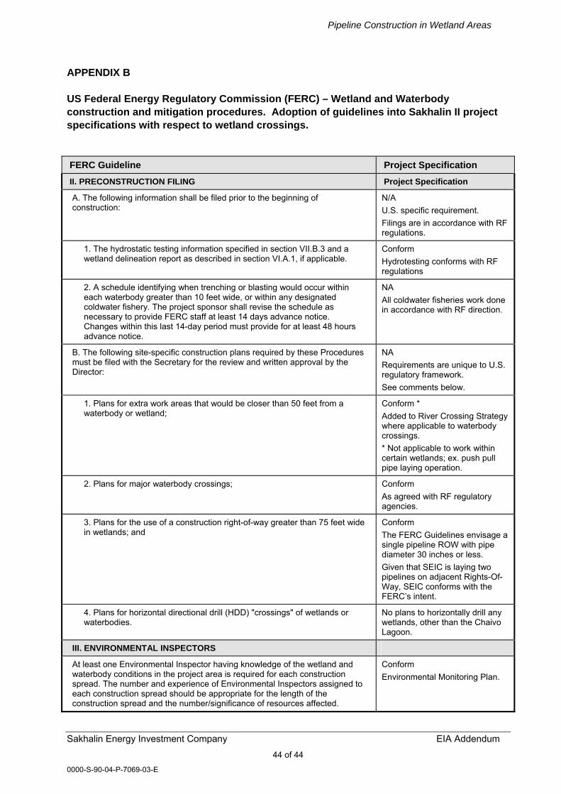
Pipeline Construction in Wetland Areas
Sakhalin Energy Investment Company EIA Addendum 44 of 44
0000-S-90-04-P-7069-03-E
APPENDIX B US Federal Energy Regulatory Commission (FERC) – Wetland and Waterbody construction and mitigation procedures. Adoption of guidelines into Sakhalin II project specifications with respect to wetland crossings. FERC Guideline Project Specification II. PRECONSTRUCTION FILING Project Specification
A. The following information shall be filed prior to the beginning of construction:
N/A U.S. specific requirement. Filings are in accordance with RF regulations.
1. The hydrostatic testing information specified in section VII.B.3 and a wetland delineation report as described in section VI.A.1, if applicable.
Conform Hydrotesting conforms with RF regulations
2. A schedule identifying when trenching or blasting would occur within each waterbody greater than 10 feet wide, or within any designated coldwater fishery. The project sponsor shall revise the schedule as necessary to provide FERC staff at least 14 days advance notice. Changes within this last 14-day period must provide for at least 48 hours advance notice.
NA All coldwater fisheries work done in accordance with RF direction.
B. The following site-specific construction plans required by these Procedures must be filed with the Secretary for the review and written approval by the Director:
NA Requirements are unique to U.S. regulatory framework. See comments below.
1. Plans for extra work areas that would be closer than 50 feet from a waterbody or wetland;
Conform * Added to River Crossing Strategy where applicable to waterbody crossings. * Not applicable to work within certain wetlands; ex. push pull pipe laying operation.
2. Plans for major waterbody crossings; Conform As agreed with RF regulatory agencies.
3. Plans for the use of a construction right-of-way greater than 75 feet wide in wetlands; and
Conform The FERC Guidelines envisage a single pipeline ROW with pipe diameter 30 inches or less. Given that SEIC is laying two pipelines on adjacent Rights-Of-Way, SEIC conforms with the FERC�s intent.
4. Plans for horizontal directional drill (HDD) "crossings" of wetlands or waterbodies.
No plans to horizontally drill any wetlands, other than the Chaivo Lagoon.
III. ENVIRONMENTAL INSPECTORS
At least one Environmental Inspector having knowledge of the wetland and waterbody conditions in the project area is required for each construction spread. The number and experience of Environmental Inspectors assigned to each construction spread should be appropriate for the length of the construction spread and the number/significance of resources affected.
Conform Environmental Monitoring Plan.

Pipeline Construction in Wetland Areas
Sakhalin Energy Investment Company EIA Addendum 45 of 45
0000-S-90-04-P-7069-03-E
FERC Guideline Project Specification B. The Environmental Inspector's responsibilities are outlined in the Upland Erosion Control, Revegetation and Maintenance Plan (Plan).
Conform Environmental Monitoring Plan.
IV. PRECONSTRUCTION PLANNING
A. A copy of the Stormwater Pollution Prevention Plan (SWPPP) prepared for compliance with the U.S. Environmental Protection Agency's (EPA) National Stormwater Program General Permit requirements must be available in the field on each construction spread. The SWPPP shall contain Spill Prevention and Response Procedures that meet the requirements of state and Federal agencies.
N/A U.S. specific Conforming to RF regulations
1. It shall be the responsibility of the project sponsor and its contractors to structure their operations in a manner that reduces the risk of spills or the accidental exposure of fuels or hazardous materials to waterbodies or wetlands. The project sponsor and its contractors must, at a minimum, ensure that:
Conform
a. All employees handling fuels and other hazardous materials are properly trained;
Conform
b. All equipment is in good operating order and inspected on a regular basis;
Conform
c. Fuel trucks transporting fuel to on-site equipment travel only on approved access roads;
Conform
d. All equipment is parked overnight and/or fuelled at least 100 feet from a waterbody or in an upland area at least 100 feet from a wetland boundary. These activities can occur closer only if the Environmental Inspector finds, in advance, no reasonable alternative and the project sponsor and its contractors have taken appropriate steps (including secondary containment structures) to prevent spills and provide for prompt cleanup in the event of a spill;
Conform wherever possible. Some of the wetland crossings are quite long and it will be difficult to move the equipment every evening and reposition the next day.
e. Hazardous materials, including chemicals, fuels, and lubricating oils, are not stored within 100 feet of a wetland, waterbody, or designated municipal watershed area, unless the location is designated for such use by an appropriate governmental authority. This applies to storage of these materials and does not apply to normal operation or use of equipment in these areas;
Conform
f. Concrete coating activities are not performed within 100 feet of a wetland or waterbody boundary, unless the location is an existing industrial site designated for such use.
N/A. There will be no concrete pipe coating.
2. The project sponsor and its contractors must structure their operations in a manner that provides for the prompt and effective cleanup of spills of fuel and other hazardous materials. At a minimum, the project sponsor and its contractors must:
Conform
a. Ensure that each construction crew (including cleanup crews) has on hand sufficient supplies of absorbent and barrier materials to allow the rapid containment and recovery of spilled materials and knows the procedure for reporting spills;
Conform
b. Ensure that each construction crew has on hand sufficient tools and material to stop leaks;
Conform
c. Know the contact names and telephone numbers for all local, state, and Federal agencies that must be notified of a spill; and
Conform
d. Follow the requirements of those agencies in cleaning up the spill, in excavating and disposing of soils or other materials contaminated by a spill, and in collecting and disposing of waste generated during spill cleanup.
Conform
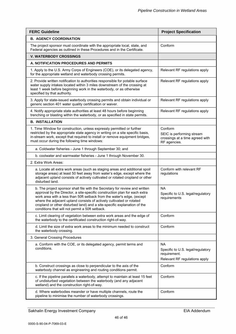
Pipeline Construction in Wetland Areas
Sakhalin Energy Investment Company EIA Addendum 46 of 46
0000-S-90-04-P-7069-03-E
FERC Guideline Project Specification B. AGENCY COORDINATION
The project sponsor must coordinate with the appropriate local, state, and Federal agencies as outlined in these Procedures and in the Certificate.
Conform
V. WATERBODY CROSSINGS
A. NOTIFICATION PROCEDURES AND PERMITS
1. Apply to the U.S. Army Corps of Engineers (COE), or its delegated agency, for the appropriate wetland and waterbody crossing permits.
Relevant RF regulations apply
2. Provide written notification to authorities responsible for potable surface water supply intakes located within 3 miles downstream of the crossing at least 1 week before beginning work in the waterbody, or as otherwise specified by that authority.
Relevant RF regulations apply
3. Apply for state-issued waterbody crossing permits and obtain individual or generic section 401 water quality certification or waiver.
Relevant RF regulations apply
4. Notify appropriate state authorities at least 48 hours before beginning trenching or blasting within the waterbody, or as specified in state permits.
Relevant RF regulations apply
B. INSTALLATION
1. Time Window for construction, unless expressly permitted or further restricted by the appropriate state agency in writing on a site specific basis, in-stream work, except that required to install or remove equipment bridges, must occur during the following time windows:
Conform SEIC is performing stream crossings at a time agreed with RF agencies.
a. Coldwater fisheries - June 1 through September 30; and
b. coolwater and warmwater fisheries - June 1 through November 30.
2. Extra Work Areas:
a. Locate all extra work areas (such as staging areas and additional spoil storage areas) at least 50 feet away from water�s edge, except where the adjacent upland consists of actively cultivated or rotated cropland or other disturbed land.
Conform with relevant RF regulations
b. The project sponsor shall file with the Secretary for review and written approval by the Director, a site-specific construction plan for each extra work area with a less than 50ft setback from the water's edge, (except where the adjacent upland consists of actively cultivated or rotated cropland or other disturbed land) and a site-specific explanation of the conditions that will not permit a 50ft setback.
NA Specific to U.S. legal/regulatory requirements
c. Limit clearing of vegetation between extra work areas and the edge of the waterbody to the certificated construction right-of-way.
Conform
d. Limit the size of extra work areas to the minimum needed to construct the waterbody crossing.
Conform
3. General Crossing Procedures
a. Conform with the COE, or its delegated agency, permit terms and conditions.
NA Specific to U.S. legal/regulatory requirement. Relevant RF regulations apply
b. Construct crossings as close to perpendicular to the axis of the waterbody channel as engineering and routing conditions permit.
Conform
c. If the pipeline parallels a waterbody, attempt to maintain at least 15 feet of undisturbed vegetation between the waterbody (and any adjacent wetland) and the construction right-of-way.
Conform
d. Where waterbodies meander or have multiple channels, route the pipeline to minimise the number of waterbody crossings.
Conform
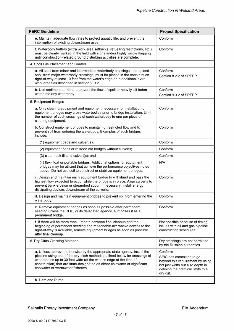
Pipeline Construction in Wetland Areas
Sakhalin Energy Investment Company EIA Addendum 47 of 47
0000-S-90-04-P-7069-03-E
FERC Guideline Project Specification e. Maintain adequate flow rates to protect aquatic life, and prevent the interruption of existing downstream uses.
Conform
f. Waterbody buffers (extra work area setbacks, refuelling restrictions, etc.) must be clearly marked in the field with signs and/or highly visible flagging until construction-related ground disturbing activities are complete.
Conform
4. Spoil Pile Placement and Control
a. All spoil from minor and intermediate waterbody crossings, and upland spoil from major waterbody crossings, must be placed in the construction right-of-way at least 10 feet from the water's edge or in additional extra work areas as described in section V.B.2.
Conform. Section 8.2.2 of SREPP.
b. Use sediment barriers to prevent the flow of spoil or heavily silt-laden water into any waterbody.
Conform Section 9.3.2 of SREPP.
5. Equipment Bridges
a. Only clearing equipment and equipment necessary for installation of equipment bridges may cross waterbodies prior to bridge installation. Limit the number of such crossings of each waterbody to one per piece of clearing equipment.
Conform
b. Construct equipment bridges to maintain unrestricted flow and to prevent soil from entering the waterbody. Examples of such bridges include:
Conform
(1) equipment pads and culvert(s); Conform
(2) equipment pads or railroad car bridges without culverts; Conform
(3) clean rock fill and culvert(s); and Conform
(4) flexi-float or portable bridges. Additional options for equipment bridges may be utilized that achieve the performance objectives noted above. Do not use soil to construct or stabilize equipment bridges.
N/A
c. Design and maintain each equipment bridge to withstand and pass the highest flow expected to occur while the bridge is in place. Align culverts to prevent bank erosion or streambed scour. If necessary, install energy dissipating devices downstream of the culverts.
Conform
d. Design and maintain equipment bridges to prevent soil from entering the waterbody.
Conform
e. Remove equipment bridges as soon as possible after permanent seeding unless the COE, or its delegated agency, authorises it as a permanent bridge.
Conform
f. If there will be more than 1 month between final cleanup and the beginning of permanent seeding and reasonable alternative access to the right-of-way is available, remove equipment bridges as soon as possible after final cleanup.
Not possible because of timing issues with oil and gas pipeline construction schedules.
6. Dry-Ditch Crossing Methods Dry crossings are not permitted by the Russian authorities.
a. Unless approved otherwise by the appropriate state agency, install the pipeline using one of the dry-ditch methods outlined below for crossings of waterbodies up to 30 feet wide (at the water's edge at the time of construction) that are state-designated as either coldwater or significant coolwater or warmwater fisheries.
Conform SEIC has committed to go beyond this requirement by using not just width but also depth in defining the practical limits to a dry cut.
b. Dam and Pump
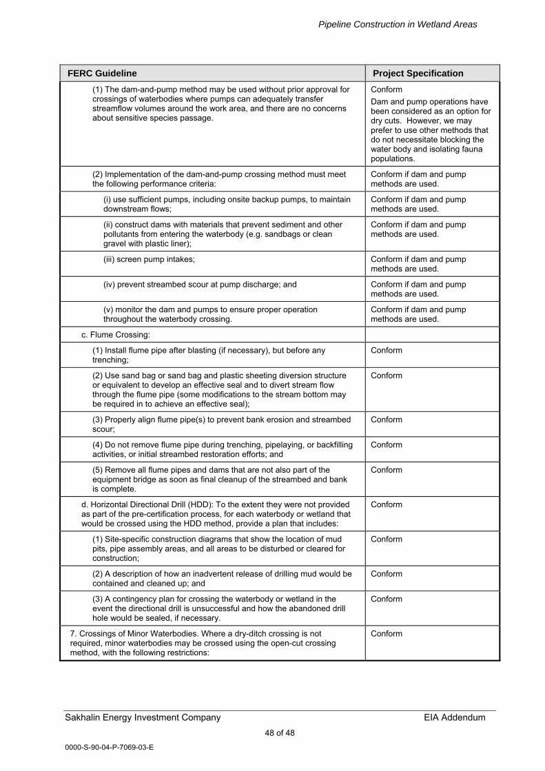
Pipeline Construction in Wetland Areas
Sakhalin Energy Investment Company EIA Addendum 48 of 48
0000-S-90-04-P-7069-03-E
FERC Guideline Project Specification (1) The dam-and-pump method may be used without prior approval for crossings of waterbodies where pumps can adequately transfer streamflow volumes around the work area, and there are no concerns about sensitive species passage.
Conform Dam and pump operations have been considered as an option for dry cuts. However, we may prefer to use other methods that do not necessitate blocking the water body and isolating fauna populations.
(2) Implementation of the dam-and-pump crossing method must meet the following performance criteria:
Conform if dam and pump methods are used.
(i) use sufficient pumps, including onsite backup pumps, to maintain downstream flows;
Conform if dam and pump methods are used.
(ii) construct dams with materials that prevent sediment and other pollutants from entering the waterbody (e.g. sandbags or clean gravel with plastic liner);
Conform if dam and pump methods are used.
(iii) screen pump intakes; Conform if dam and pump methods are used.
(iv) prevent streambed scour at pump discharge; and Conform if dam and pump methods are used.
(v) monitor the dam and pumps to ensure proper operation throughout the waterbody crossing.
Conform if dam and pump methods are used.
c. Flume Crossing:
(1) Install flume pipe after blasting (if necessary), but before any trenching;
Conform
(2) Use sand bag or sand bag and plastic sheeting diversion structure or equivalent to develop an effective seal and to divert stream flow through the flume pipe (some modifications to the stream bottom may be required in to achieve an effective seal);
Conform
(3) Properly align flume pipe(s) to prevent bank erosion and streambed scour;
Conform
(4) Do not remove flume pipe during trenching, pipelaying, or backfilling activities, or initial streambed restoration efforts; and
Conform
(5) Remove all flume pipes and dams that are not also part of the equipment bridge as soon as final cleanup of the streambed and bank is complete.
Conform
d. Horizontal Directional Drill (HDD): To the extent they were not provided as part of the pre-certification process, for each waterbody or wetland that would be crossed using the HDD method, provide a plan that includes:
Conform
(1) Site-specific construction diagrams that show the location of mud pits, pipe assembly areas, and all areas to be disturbed or cleared for construction;
Conform
(2) A description of how an inadvertent release of drilling mud would be contained and cleaned up; and
Conform
(3) A contingency plan for crossing the waterbody or wetland in the event the directional drill is unsuccessful and how the abandoned drill hole would be sealed, if necessary.
Conform
7. Crossings of Minor Waterbodies. Where a dry-ditch crossing is not required, minor waterbodies may be crossed using the open-cut crossing method, with the following restrictions:
Conform

Pipeline Construction in Wetland Areas
Sakhalin Energy Investment Company EIA Addendum 49 of 49
0000-S-90-04-P-7069-03-E
FERC Guideline Project Specification a. Except for blasting and other rock breaking measures, complete instream construction activities (including trenching, pipe installation, backfill, and restoration of the streambed contours) within 24 hours. Streambanks and unconsolidated streambeds may require additional restoration after this period;
Conform
b. Limit use of equipment operating in the waterbody to that needed to construct the crossing; and
Conform
c. Equipment bridges are not required at minor waterbodies that do not have a state-designated fishery classification (e.g., agricultural or intermittent drainage ditches). However, if an equipment bridge is used it must be constructed as described in section V.B.5.
Conform
8. Crossings of Intermediate Waterbodies. Where a dry-ditch crossing is not required, intermediate waterbodies may be crossed using the open-cut crossing method, with the following restrictions:
a. Complete instream construction activities (not including blasting and other rock breaking measures) within 48 hours, unless site-specific conditions make completion within 48 hours infeasible;
Conform
b. Limit use of equipment operating in the waterbody to that needed to construct the crossing; and
Conform
c. all other construction equipment must cross on an equipment bridge as specified in section V.B.5.
Conform
9. Crossings of Major Waterbodies
Before construction, the project sponsor shall file with the Secretary for the review and written approval by the Director a detailed, site-specific construction plan and scaled drawings identifying all areas to be disturbed by construction for each major waterbody crossing (the scaled drawings are not required for any offshore portions of pipeline projects). This plan should be developed in consultation with the appropriate state and Federal agencies and should include extra work areas, spoil storage areas, sediment control structures, etc., as well as mitigation for navigational issues. The Environmental Inspector may adjust the final placement of the erosion and sediment control structures in the field to maximize effectiveness.
Conform RF equivalent of this instruction applies.
10. Temporary Erosion and Sediment Control
Install sediment barriers (as defined in section IV.F.2.a. of the Plan) immediately after initial disturbance of the waterbody or adjacent upland. Sediment barriers must be properly maintained throughout construction and reinstalled as necessary (such as after backfilling of the trench) until replaced by permanent erosion controls or restoration of adjacent upland areas is complete. Temporary erosion and sediment control measures are addressed in more detail in the Plan; however, the following specific measures must be implemented at stream crossings.
Conform As per River Crossing Strategy
a. Install sediment barriers across the entire construction right-of-way at all waterbody crossings, where necessary to prevent the flow of sediments into the waterbody. In the travel lane, these may consist of removable sediment barriers or driveable berms. Removable sediment barriers can be removed during the construction day, but must be re-installed after construction has stopped for the day and/or when heavy precipitation is imminent;
b. Where waterbodies are adjacent to the construction right-of-way, install sediment barriers along the edge of the construction right-of-way as necessary to contain spoil and sediment within the construction right-of-way; and
c. Use trench plugs at all waterbody crossings, as necessary, to prevent diversion of water into upland portions of the pipeline trench and to keep any accumulated trench water out of the waterbody.
Pipeline Construction in Wetland Areas
Sakhalin Energy Investment Company EIA Addendum 50 of 50
0000-S-90-04-P-7069-03-E
FERC Guideline Project Specification 11. Trench Dewatering
Dewater the trench (either on or off the construction right-of-way) in a manner that does not cause erosion and does not result in heavily silt-laden water flowing into any waterbody. Remove the dewatering structures as soon as possible after the completion of dewatering activities.
Conform
C. RESTORATION
1. Use clean gravel or native cobbles for the upper 1 foot of trench backfill in all waterbodies that contain coldwater fisheries.
Conform As per River Crossing Strategy
2. For open-cut crossings, stabilize waterbody banks and install temporary sediment barriers within 24 hours of completing instream construction activities. For dry-ditch crossings, complete streambed and bank stabilization before returning flow to the waterbody channel.
Conform
3. Return all waterbody banks to preconstruction contours or to a stable angle of repose as approved by the Environmental Inspector.
Conform
4. Application of riprap for bank stabilization must Conform with COE, or its delegated agency, permit terms and conditions.
Conform In accordance with relevant RF regulations
5. Unless otherwise specified by state permit, limit the use of riprap to areas where flow conditions preclude effective vegetative stabilization techniques such as seeding and erosion control fabric.
Conform In accordance with relevant RF regulations
6. Revegetate disturbed riparian areas with conservation grasses and legumes or native plant species, preferably woody species.
Conform In accordance with relevant RF regulations
7. Install a permanent slope breaker across the construction right-of-way at the base of slopes greater than 5 percent that are less than 50 feet from the waterbody, or as needed to prevent sediment transport into the waterbody. In addition, install sediment barriers as outlined in the Plan. In some areas, with the approval of the Environmental Inspector, an earthen berm may be suitable as a sediment barrier adjacent to the waterbody.
Conform As per Method Statement
8. Sections V.C.3. through V.C.6. above also apply to those perennial or intermittent streams not flowing at the time of construction.
Conform
D. POST-CONSTRUCTION MAINTENANCE
1. Limit vegetation maintenance adjacent to waterbodies to allow a riparian strip at least 25 feet wide, as measured from the waterbody's mean high water mark, to permanently revegetate with native plant species across the entire construction right-of-way. However, to facilitate periodic pipeline corrosion/leak surveys, a corridor centred on the pipeline and up to 10 feet wide may be maintained in a herbaceous state. In addition, trees that are located within 15 feet of the pipeline that are greater than 15 feet in height may be cut and removed from the permanent right-of-way.
Conform
2. Do not use herbicides or pesticides in or within 100ft of a waterbody except as allowed by the appropriate land management or state agency.
Conform
VI. WETLAND CROSSINGS
A. GENERAL
1. The project sponsor shall conduct a wetland delineation using the current Federal methodology and file a wetland delineation report with the Secretary before construction. This report shall identify:
Conform Have delineated wetlands according to RF requirements (�swamp inventory�).
a. by milepost all wetlands that would be affected; Conform
b. the National Wetlands Inventory (NWI) classification for each wetland; N/A
c. the crossing length of each wetland in feet; and Conform (in meters)

Pipeline Construction in Wetland Areas
Sakhalin Energy Investment Company EIA Addendum 51 of 51
0000-S-90-04-P-7069-03-E
FERC Guideline Project Specification d. the area of permanent and temporary disturbance that would occur in each wetland by NWI classification type.
Conform SEIC has made calculations to RF classification standards
The requirements outlined in this section do not apply to wetlands in actively cultivated or rotated cropland. Standard upland protective measures, including workspace and topsoiling requirements, apply to these agricultural wetlands.
Conform
2. Route the pipeline to avoid wetland areas to the maximum extent possible. If a wetland cannot be avoided or crossed by following an existing right-of-way, route the new pipeline in a manner that minimizes disturbance to wetlands. Where looping an existing pipeline, overlap the existing pipeline right-of-way with the new construction right-of-way. In addition, locate the loop line no more than 25 feet away from the existing pipeline unless site-specific constraints would adversely affect the stability of the existing pipeline.
Conform ROW to the extent possible follows existing power, pipeline, or transport ROW down the island.
3. Limit the width of the construction right-of-way to 75 feet or less. Prior written approval of the Director is required where topographic conditions or soil limitations require that the construction right-of-way width within the boundaries of a federally delineated wetland be expanded beyond 75 feet. Early in the planning process the project sponsor is encouraged to identify site-specific areas where existing soils lack adequate unconfined compressive strength that would result in excessively wide ditches and/or difficult to contain spoil piles.
Conform The FERC Guidelines envisage a single pipeline ROW with pipe diameter 30 inches or less. Given that SEIC is laying two pipelines on adjacent ROW, we are conforming with the FERC�s intent.
4. Wetland boundaries and buffers must be clearly marked in the field with signs and/or highly visible flagging until construction-related ground disturbing activities are complete.
Conform Swamp Crossing Method Statement
5. Implement the measures of sections V and VI in the event a waterbody crossing is located within or adjacent to a wetland crossing. If all measures of sections V and VI cannot be met, the project sponsor must file with the Secretary a site-specific crossing plan for review and written approval by the Director before construction. This crossing plan shall address at a minimum:
NA U.S. specific.
a. spoil control; b. equipment bridges; c. restoration of waterbody banks and wetland hydrology; d. timing of the waterbody crossing; e. method of crossing; and f. size and location of all extra work areas.
Conform RF equivalent of this instruction applies.
6. Do not locate aboveground facilities in any wetland [except where the location of such facilities outside of wetlands would prohibit compliance with U.S. Department of Transportation regulations.]
Conform There will be no above-ground facilities within significant wetlands.
B. INSTALLATION
1. Extra Work Areas and Access Roads
a. Locate all extra work areas (such as staging areas and additional spoil storage areas) at least 50 feet away from wetland boundaries, except where the adjacent upland consists of actively cultivated or rotated cropland or other disturbed land.
Conform Forms a component of the Swamp Crossing Method Statement. It will not be possible to conform if the push-pull method of pipe welding and stringing is used. However, this point is largely irrelevant as most work will be done in winter when both upland and lowland areas are frozen.
Pipeline Construction in Wetland Areas
Sakhalin Energy Investment Company EIA Addendum 52 of 52
0000-S-90-04-P-7069-03-E
FERC Guideline Project Specification b. The project sponsor shall file with the Secretary for review and written approval by the Director, a site-specific construction plan for each extra work area with a less than 50-foot setback from wetland boundaries (except where adjacent upland consists of actively cultivated or rotated cropland or other disturbed land) and a site-specific explanation of the conditions that will not permit a 50-foot setback.
N/A Conform with relevant RF regulations.
c. Limit clearing of vegetation between extra work areas and the edge of the wetland to the certificated construction right-of-way.
Conform
d. The construction right-of-way may be used for access when the wetland soil is firm enough to avoid rutting or the construction right-of-way has been appropriately stabilized to avoid rutting (e.g., with timber riprap, prefabricated equipment mats, or terra mats). In wetlands that cannot be appropriately stabilized, all construction equipment other than that needed to install the wetland crossing shall use access roads located in upland areas. Where access roads in upland areas do not provide reasonable access, limit all other construction equipment to one pass through the wetland using the construction right-of-way.
Conform Forms a component of the Swamp Crossing Method Statement. Peat bogs will be crossed in winter when frozen. Other low ground pressure areas, peaty soils or saturated soils exhibiting various stages of hydromorphism will be crossed as appropriate, when frozen or when non- frozen on timber mats.
e. The only access roads, other than the construction right-of-way, that can be used in wetlands without Director approval, are those existing roads that can be used with no modification and no impact on the wetland.
N/A Conform with relevant RF regulations.
2. Crossing Procedures
a. Conform with COE, or its delegated agency, permit terms and conditions Conform with relevant RF regulations.
b. Assemble the pipeline in an upland area unless the wetland is dry enough to adequately support skids and pipe.
Conform Work will be accomplished mostly in winter or from timber roads/mats.
c. Use "push-pull" or "float" techniques to place the pipe in the trench where water and other site conditions allow.
Conform
d. Minimize the length of time that topsoil is segregated and the trench is open.
N/A. RF regulations do not require the segregation of wetland topsoils.
e. Limit construction equipment operating in wetland areas to that needed to clear the construction right-of-way, dig the trench, fabricate and install the pipeline, backfill the trench, and restore the construction right-of- way.
Conform (Swamp Crossing Method Statement)
f. Cut vegetation just aboveground level, leaving existing root systems in place, and remove it from the wetland for disposal.
Conform (Swamp Crossing Method Statement)
g. Limit pulling of tree stumps and grading activities to directly over the trenchline. Do not grade or remove stumps or root systems from the rest of the construction right-of-way in wetlands unless the Chief Inspector and Environmental Inspector determine that safety related construction constraints require grading or the removal of tree stumps from under the working side of the construction right-of-way.
Conform (Swamp Crossing Method Statement)
h. Segregate the top 1 foot of topsoil from the area disturbed by trenching, except in areas where standing water is present or soils are saturated or frozen. Immediately after backfilling is complete, restore the segregated topsoil to its original location
Conform Conform with relevant RF regulations. In peat bogs, the Contractor will segregate upper sphagnum moss cover. (Swamp Crossing Method Statement).
Pipeline Construction in Wetland Areas
Sakhalin Energy Investment Company EIA Addendum 53 of 53
0000-S-90-04-P-7069-03-E
FERC Guideline Project Specification i. Do not use rock, soil imported from outside the wetland, tree stumps, or brush riprap to support equipment on the construction right-of-way.
Conform (Swamp Crossing Method Statement)
j. If standing water or saturated soils are present, or if construction equipment causes ruts or mixing of the topsoil and subsoil in wetlands, use low-ground-weight construction equipment, or operate normal equipment on timber riprap, prefabricated equipment mats, or terra mats.
Conform (Swamp Crossing Method Statement)
k. Do not cut trees outside of the approved construction work area to obtain timber for riprap or equipment mats.
Conform (Swamp Crossing Method Statement)
l. Attempt to use no more than two layers of timber riprap to support equipment on the construction right-of-way.
Conform (Swamp Crossing Method Statement)
m. Remove all project-related material used to support equipment on the construction right-of-way upon completion of construction.
Conform (Swamp Crossing Method Statement)
3. Temporary Sediment Control
Install sediment barriers (as defined in section IV.F.2.a. of the Plan) immediately after initial disturbance of the wetland or adjacent upland. Sediment barriers must be properly maintained throughout construction and reinstalled as necessary (such as after backfilling of the trench). Except as noted below in section VI.B.3.c., maintain sediment barriers until replaced by permanent erosion controls or restoration of adjacent upland areas is complete. Temporary erosion and sediment control measures are addressed in more detail in the Plan.
Conform (Swamp Crossing Method Statement)
a. Install sediment barriers across the entire construction right-of-way at all wetland crossings where necessary to prevent sediment flow into the wetland. In the travel lane, these may consist of removable sediment barriers or driveable berms. Removable sediment barriers can be removed during the construction day, but must be re-installed after construction has stopped for the day and/or when heavy precipitation is imminent.
Conform (Swamp Crossing Method Statement)
b. Where wetlands are adjacent to the construction right-of-way and the right-of-way slopes toward the wetland, install sediment barriers along the edge of the construction right-of-way as necessary to prevent sediment flow into the wetland.
Conform (Swamp Crossing Method Statement)
c. Install sediment barriers along the edge of the construction right-of-way as necessary to contain spoil and sediment within the construction right-of-way through wetlands. Remove these sediment barriers during right-of-way cleanup.
Conform (Swamp Crossing Method Statement)
4. Trench Dewatering
Dewater the trench (either on or off the construction right-of-way) in a manner that does not cause erosion and does not result in heavily silt-laden water flowing into any wetland. Remove the dewatering structures as soon as possible after the completion of dewatering activities.
Conform (Swamp Crossing Method Statement)
1. Where the pipeline trench may drain a wetland, construct trench breakers and/or seal the trench bottom as necessary to maintain the original wetland hydrology.
Conform (Swamp Crossing Method Statement)
2. For each wetland crossed, install a trench breaker at the base of slopes near the boundary between the wetland and adjacent upland areas. Install a permanent slope breaker across the construction right-of-way at the base of a slopes greater than 5% where the base of the slope is less than 50 feet from the wetland, or as needed to prevent sediment transport into the wetland. In addition, install sediment barriers as outlined in the Plan. In some areas, with the approval of the Environmental Inspector, an earthen berm may be suitable as a sediment barrier adjacent to the wetland.
Conform (Swamp Crossing Method Statement)
Pipeline Construction in Wetland Areas
Sakhalin Energy Investment Company EIA Addendum 54 of 54
0000-S-90-04-P-7069-03-E
FERC Guideline Project Specification 3. Do not use fertilizer, lime, or mulch unless required in writing by the appropriate land management or state agency.
Conform (Swamp Crossing Method Statement)
4. Consult with the appropriate land management or state agency to develop a project-specific wetland restoration plan. The restoration plan should include measures for re-establishing herbaceous and/or woody species, controlling the invasion and spread of undesirable exotic species (e.g., purple loosestrife and phragmites), and monitoring the success of the revegetation and weed control efforts. Provide this plan to the FERC staff upon request.
N/A, as U.S. specific Contractors are aware of the need to consult with local land management agencies.
5. Until a project-specific wetland restoration plan is developed and/or implemented, temporarily revegetate the construction right-of-way with annual ryegrass at a rate of 40 pounds/acre (unless standing water is present).
N/A SREPP details how revegetation will be carried out. It has been agreed with Oblast agricultural agencies to use meadow fescue grass mix for temporary revegetation.
6. Ensure that all disturbed areas successfully revegetate with wetland herbaceous and/or woody plant species.
Conform SREPP
7. Remove temporary sediment barriers located at the boundary between wetland and adjacent upland areas after upland revegetation and stabilization of adjacent upland areas are judged to be successful as specified in section VII.A.5 of the Plan.
Conform A requirement of the SREPP
D. POST-CONSTRUCTION MAINTENANCE
1. Do not conduct vegetation maintenance over the full width of the permanent right-of-way in wetlands. However, to facilitate periodic pipeline corrosion/leak surveys, a corridor centred on the pipeline and up to 10 feet wide may be maintained in a herbaceous state. In addition, trees within 15 feet of the pipeline that are greater than 15 feet in height may be selectively cut and removed from the permanent right-of-way.
Conform
2. Do not use herbicides or pesticides in or within 100 feet of a wetland, except as allowed by the appropriate land management agency or state agency.
Conform
3. Monitor and record the success of wetland revegetation annually for the first 3 years after construction or until wetland revegetation is successful. At the end of 3 years after construction, file a report with the Secretary identifying the status of the wetland revegetation efforts. Include the percent cover achieved and problem areas (weed invasion issues, poor revegetation, etc.). Continue to file a report annually until wetland revegetation is successful.
Conform RF regulations apply.
4. Wetland revegetation shall be considered successful if the cover of herbaceous and/or woody species is at least 80 percent of the type, density, and distribution of the vegetation in adjacent wetland areas that were not disturbed by construction. If revegetation is not successful at the end of 3 years, develop and implement (in consultation with a professional wetland ecologist) a remedial revegetation plan to actively revegetate the wetland. Continue revegetation efforts until wetland revegetation is successful.
Conform
VII. HYDROSTATIC TESTING
A. NOTIFICATION PROCEDURES AND PERMITS
1. Apply for state-issued water withdrawal permits, as required. Conform
2. Apply for National Pollutant Discharge Elimination System (NPDES) or state-issued discharge permits, as required.
N/A (U.S. specific)
3. Notify appropriate state agencies of intent to use specific sources at least 48 hours before testing activities unless they waive this requirement in writing.
Conform with relevant RF Law

Pipeline Construction in Wetland Areas
Sakhalin Energy Investment Company EIA Addendum 55 of 55
0000-S-90-04-P-7069-03-E
FERC Guideline Project Specification B. GENERAL
1. Perform non-destructive testing of all pipeline section welds or hydrotest the pipeline sections, before installation under waterbodies or wetlands.
Conform Contractor is committed to 100% X-ray of welds.
2. If pumps used for hydrostatic testing are within 100 feet of any waterbody or wetland, address the operation and refuelling of these pumps in the project�s Spill Prevention and Response Procedures.
Conform Will be addressed in the hydrotest Plan. RF regulations stipulate 25 meters water protection zone in which no refuelling is allowed.
3. The project sponsor shall file with the Secretary before construction a list identifying the location of all waterbodies proposed for use as a hydrostatic test water source or discharge location.
Conform with relevant RF Law
C. INTAKE SOURCE AND RATE
1. Screen the intake hose to prevent entrainment of fish. Conform Will be addressed in the Hydrotest Plan.
2. Do not use state-designated exceptional value waters, waterbodies which provide habitat for federally listed threatened or endangered species, or waterbodies designated as public water supplies, unless appropriate Federal, state, and/or local permitting agencies grant written permission.
Conform Will be addressed in the Hydrotest Plan.
3. Maintain adequate flow rates to protect aquatic life, provide for all waterbody uses, and provide for downstream withdrawals of water by existing users.
Conform Will be addressed in the Hydrotest Plan.
4. Locate hydrostatic test manifolds outside wetlands and riparian areas to the maximum extent practicable.
Conform Will be addressed in the Hydrotest Plan.
D. DISCHARGE LOCATION, METHOD, AND RATE
1. Regulate discharge rate, use energy dissipation device(s), and install sediment barriers, as necessary, to prevent erosion, streambed scour, suspension of sediments, or excessive streamflow.
Conform Will be addressed in the Hydrotest Plan.
2. Do not discharge into state-designated exceptional value waters, waterbodies which provide habitat for federally listed threatened or endangered species, or waterbodies designated as public water supplies, unless appropriate Federal, state, and local permitting agencies grant written permission.
Conform All discharges of untreated water will be to the ground surface away from surface waters. If antifreeze becomes necessary in the winter, we will develop a plan before any hazardous materials are introduced to hydrotest activities.