Chapter 3 - Alaska Department of Natural...
327
PUBLIC REVIEW DRAFT Chapter 3 – Table of Contents Bristol Bay Area Plan July 2004 3 – i Chapter 3 1 Land Use Designations and 2 Management Policies for Planning 3 Regions and Management Units 4 5 Introduction ............................................................................................................. 1 6 Introduction ................................................................................................................................ 1 7 Land Use Designations and Management Intent Planning Tools .............................................. 2 8 Plan Structure ............................................................................................................................. 7 9 Figure 3.1: Planning Area with Map Extents ................................................................................... 10 10 Summary of the Regions .......................................................................................................... 13 11 Local and Federal Plans ........................................................................................................... 21 12 Management Summary ............................................................................................................ 23 13 Region 2 – Kuskokwim, Kanektok, and Goodnews .......................................... 29 14 Summary of Resources and Uses in the Region ...................................................................... 29 15 Management Considerations: Local and State Plans and Special Use Area ........................... 34 16 Management Summary: Uplands ............................................................................................ 35 17 Management Summary: Tidelands and Submerged Lands ..................................................... 38 18 Resource Allocation Table for Upland Management Units - Region 2 ................................... 40 19 Resource Allocation Table for Tideland Management Units - Region 2................................. 43 20 Region 3 – Togiak, Igushik................................................................................... 45 21 Summary of Resources and Uses in the Region ...................................................................... 45 22 Management Considerations: Local and State Plans and Special Use Area ........................... 50 23 Management Summary: Uplands ............................................................................................ 51 24 Management Summary: Tidelands and Submerged Lands ..................................................... 53 25 Resource Allocation Table for Upland Management Units - Region 3 ................................... 56 26 Resource Allocation Table for Tideland Management Units - Region 3................................. 59 27 Region 5 – Dilingham, Snake Lake, Nushagak Bay .......................................... 61 28 Summary of Resources and Uses in the Region ...................................................................... 61 29 Management Considerations: Local and State Plans and Special Use Area ........................... 66 30 Management Summary: Uplands ............................................................................................ 67 31 Management Summary: Tidelands and Submerged Lands ..................................................... 71 32 Resource Allocation Table for Upland Management Units - Region 5 ................................... 73 33 Resource Allocation Table for Tideland Management Units - Region 5................................. 87 34 Region 6 – Nushagak, Mulchatna........................................................................ 91 35 Summary of Resources and Uses in the Region ...................................................................... 91 36 Management Considerations: Local and State Plans and Special Use Area ........................... 97 37 Management Summary: Uplands ............................................................................................ 98 38 Resource Allocation Table for Upland Management Units - Region 6 ................................. 103 39
Transcript of Chapter 3 - Alaska Department of Natural...

PUBLIC REVIEW DRAFT Chapter 3 – Table of Contents
Bristol Bay Area Plan July 2004 3 – i
Chapter 3 1
Land Use Designations and 2
Management Policies for Planning 3
Regions and Management Units 4 5 Introduction.............................................................................................................1 6
Introduction ................................................................................................................................1 7 Land Use Designations and Management Intent Planning Tools ..............................................2 8 Plan Structure .............................................................................................................................7 9
Figure 3.1: Planning Area with Map Extents ...................................................................................10 10 Summary of the Regions ..........................................................................................................13 11 Local and Federal Plans ...........................................................................................................21 12 Management Summary ............................................................................................................23 13
Region 2 – Kuskokwim, Kanektok, and Goodnews ..........................................29 14 Summary of Resources and Uses in the Region ......................................................................29 15 Management Considerations: Local and State Plans and Special Use Area...........................34 16 Management Summary: Uplands ............................................................................................35 17 Management Summary: Tidelands and Submerged Lands.....................................................38 18 Resource Allocation Table for Upland Management Units - Region 2 ...................................40 19 Resource Allocation Table for Tideland Management Units - Region 2.................................43 20
Region 3 – Togiak, Igushik...................................................................................45 21 Summary of Resources and Uses in the Region ......................................................................45 22 Management Considerations: Local and State Plans and Special Use Area...........................50 23 Management Summary: Uplands ............................................................................................51 24 Management Summary: Tidelands and Submerged Lands.....................................................53 25 Resource Allocation Table for Upland Management Units - Region 3 ...................................56 26 Resource Allocation Table for Tideland Management Units - Region 3.................................59 27
Region 5 – Dilingham, Snake Lake, Nushagak Bay ..........................................61 28 Summary of Resources and Uses in the Region ......................................................................61 29 Management Considerations: Local and State Plans and Special Use Area...........................66 30 Management Summary: Uplands ............................................................................................67 31 Management Summary: Tidelands and Submerged Lands.....................................................71 32 Resource Allocation Table for Upland Management Units - Region 5 ...................................73 33 Resource Allocation Table for Tideland Management Units - Region 5.................................87 34
Region 6 – Nushagak, Mulchatna........................................................................91 35 Summary of Resources and Uses in the Region ......................................................................91 36 Management Considerations: Local and State Plans and Special Use Area...........................97 37 Management Summary: Uplands ............................................................................................98 38 Resource Allocation Table for Upland Management Units - Region 6 .................................103 39

Chapter 3 – Table of Contents PUBLIC REVIEW DRAFT
3 – ii July 2004 Bristol Bay Area Plan
Region 7 – Upper Mulchatna and Upper Hoholitna .......................................127 1 Summary of Resources and Uses in the Region ....................................................................127 2 Management Considerations: Local and State Plans ............................................................130 3 Management Summary: Uplands ..........................................................................................131 4 Resource Allocation Table for Upland Management Units - Region 7 .................................135 5
Region 8 – Lake Clark, Newhalen .....................................................................145 6 Summary of Resources and Uses in the Region ....................................................................145 7 Management Considerations: Local and State Plans ............................................................148 8 Management Summary: Uplands ..........................................................................................149 9 Resource Allocation Table for Upland Management Units - Region 8 .................................153 10
Region 9 – Eastern Iliamna Lake ......................................................................157 11 Summary of Resources and Uses in the Region ....................................................................157 12 Management Considerations: Local and State Plans ............................................................159 13 Management Summary: Uplands ..........................................................................................160 14 Resource Allocation Table for Upland Management Units - Region 9 .................................163 15
Region 10 – Western Iliamna Lake, Kvichak River ........................................167 16 Summary of Resources and Uses in the Region ....................................................................167 17 Management Considerations: Local and State Plans and Special Use Site ..........................171 18 Management Summary: Uplands ..........................................................................................173 19 Resource Allocation Table for Upland Management Units - Region 10 ...............................177 20
Region 11 – Bristol Bay Borough Area .............................................................183 21 Summary of Resources and Uses in the Region ....................................................................183 22 Management Considerations: Local and State Plans ............................................................187 23 Management Summary: Uplands ..........................................................................................188 24 Management Summary: Tidelands and Submerged Lands...................................................191 25 Resource Allocation Table for Upland Management Units - Region 11 ...............................193 26 Resource Allocation Table for Tideland Management Units - Region 11.............................197 27
Region 12 – Egegik, Becharof ............................................................................199 28 Summary of Resources and Uses in the Region ....................................................................199 29 Management Considerations: Local and State Plans ............................................................203 30 Management Summary: Uplands ..........................................................................................204 31 Management Summary: Tidelands and Submerged Lands...................................................206 32 Resource Allocation Table for Upland Management Units - Region 12 ...............................208 33 Resource Allocation Table for Tideland Management Units - Region 12.............................210 34
Region 13 – Ugashik Lakes ................................................................................213 35 Summary of Resources and Uses in the Region ....................................................................213 36 Management Considerations: Local and State Plans ............................................................215 37 Management Summary: Uplands ..........................................................................................216 38 Resource Allocation Table for Upland Management Units - Region 13 ...............................219 39
Region 14 – Ugashik Bay Area ..........................................................................221 40 Summary of Resources and Uses in the Region ....................................................................221 41 Management Considerations: Local, State, and Federal Plans ..............................................223 42 Management Summary: Uplands ..........................................................................................224 43 Management Summary: Tidelands and Submerged Lands...................................................225 44

PUBLIC REVIEW DRAFT Chapter 3 – Table of Contents
Bristol Bay Area Plan July 2004 3 – iii
Resource Allocation Table for Upland Management Units - Region 14 ...............................227 1 Resource Allocation Table for Tideland Management Units - Region 14.............................229 2
Region 15 – Cinder River, King Salmon River................................................231 3 Summary of Resources and Uses in the Region ....................................................................231 4 Management Considerations: Local and State Plans ............................................................234 5 Management Summary: Uplands ..........................................................................................235 6 Management Summary: Tidelands and Submerged Lands....................................................237 7 Resource Allocation Table for Upland Management Units - Region 15 ...............................239 8 Resource Allocation Table for Tideland Management Units - Region 15.............................241 9
Region 16 – Port Heiden.....................................................................................243 10 Summary of Resources and Uses in the Region ....................................................................243 11 Management Considerations: Local and State Plans ............................................................245 12 Management Summary: Uplands ..........................................................................................246 13 Management Summary: Tidelands and Submerged Lands...................................................248 14 Resource Allocation Table for Upland Management Units - Region 16 ...............................250 15 Resource Allocation Table for Tideland Management Units - Region 16.............................252 16
Region 17 – Chignik, Perryville.........................................................................255 17 Summary of Resources and Uses in the Region ....................................................................255 18 Management Considerations: Local and State Plans ............................................................258 19 Management Summary: Uplands ..........................................................................................259 20 Management Summary: Tidelands and Submerged Lands...................................................261 21 Resource Allocation Table for Upland Management Units - Region 17 ...............................263 22 Resource Allocation Table for Tideland Management Units - Region 17.............................265 23
Region 18 – Cape Seniavin, Seal Islands ..........................................................267 24 Summary of Resources and Uses in the Region ....................................................................267 25 Management Considerations: Local and State Plans ............................................................269 26 Management Summary: Uplands ..........................................................................................270 27 Management Summary: Tidelands and Submerged Lands...................................................272 28 Resource Allocation Table for Upland Management Units - Region 18 ...............................274 29 Resource Allocation Table for Tideland Management Units - Region 18.............................276 30
Region 19 – Herendeen Bay, Port Moller and Shumagin Islands..................279 31 Summary of Resources and Uses in the Region ....................................................................279 32 Management Considerations: Local and State Plans ............................................................282 33 Management Summary: Uplands ..........................................................................................282 34 Management Summary: Tidelands and Submerged Lands...................................................285 35 Resource Allocation Table for Upland Management Units - Region 19 ...............................287 36 Resource Allocation Table for Tideland Management Units - Region 19.............................289 37
Region 21 – Nelson Lagoon, Moffet Lagoon ....................................................293 38 Summary of Resources and Uses in the Region ....................................................................293 39 Management Considerations: Local, State, and Federal Plans .............................................296 40 Management Summary: Uplands ..........................................................................................297 41 Management Summary: Tidelands and Submerged Lands...................................................299 42 Resource Allocation Table for Upland Management Units - Region 21 ...............................302 43 Resource Allocation Table for Tideland Management Units - Region 21.............................305 44

Chapter 3 – Table of Contents PUBLIC REVIEW DRAFT
3 – iv July 2004 Bristol Bay Area Plan
Region 22 – Lower Alaska Peninsula – Unimak & Krenitzin Islands...........309 1 Summary of Resources and Uses in the Region ....................................................................309 2 Management Considerations: Local and State Plans ............................................................311 3 Management Summary: Uplands ..........................................................................................312 4 Management Summary: Tidelands and Submerged Lands...................................................314 5 Resource Allocation Table for Upland Management Units - Region 22 ...............................316 6 Resource Allocation Table for Tideland Management Units - Region 22.............................318 7
Navigable Rivers And Lakes..............................................................................323 8 Management Intent of Navigable Water Bodies ....................................................................323 9
Table 3.1: Some Navigable Waters -- Bristol Bay Area Plan........................................................ 326 10 11 12 13 14

PUBLIC REVIEW DRAFT Chapter 3 – Land Use Designations and Management Policies for Planning Regions and Management Units
Bristol Bay Area Plan July 2004 3 - 1
Chapter 3 1
Land Use Designations and 2
Management Policies for Planning 3
Regions and Management Units 4
5
Introduction 6 7 This chapter presents specific land management policies for all state uplands, tidelands and 8 submerged lands, and shorelands within the planning area. Information on state lands is 9 organized by region. There are twenty Regions and the numbering system from the 1984 10 Bristol Bay Area Plan has been retained for the convenience of the users. These twenty Regions 11 include a total of 221 upland management units, 45 tideland management units, and 7 tideland 12 resource management zones. Within the planning area, there are approximately 12 million acres 13 of uplands and 8 million acres of tidelands and submerged lands. The management 14 requirements of this area plan do not apply to non-state lands, which include University of 15 Alaska lands, Mental Health Trust Authority lands, and state parks. The management 16 requirements of this area plan also do not apply to other state owned lands directly administered 17 by the ADOT/PF and governed by a separate set of regulations. 18 19 Organization of Chapter 20 The chapter is organized into the following sections: 21 22
• Land Use Designations and Management Intent. This section describes land use 23 designations, management intent and management guidelines, and policies pertaining to 24 the disposal and retention of state land. 25
26 • Plan Structure. This section describes the regions and management units used in the 27
area plan, the types of plan maps used and their limitations, and the attributes that are 28 identified for management units in the Resource Allocation Tables of Chapter 3. 29
30 • Description of the Planning Area. This section provides a generalized description of 31
the Bristol Bay Planning Area. State lands are described, to include their size (acreages), 32 access, physical attributes, resources and uses. Both tidelands and uplands are 33 discussed. 34
35 • Local and Federal Plans. This section describes relevant community, state, and 36
Federal agency plans that were considered in developing this plan. 37

Chapter 3 - Introduction PUBLIC REVIEW DRAFT
3 - 2 July 2004 Bristol Bay Area Plan
• Management Summary. This section describes how the state-owned and state-selected 1 uplands and tidelands are to be generally managed in the future under the Area Plan. 2
3 • Region Descriptions. This section provides a generalized description of each region 4
within the planning area, general management intent for state uplands and tidelands, and 5 specific land use designations and management intent requirements for each 6 management unit within a region. 7 8
• Navigable Rivers and Lakes. This section explains the concept of the Public Trust 9 Doctrine and describes the management intent and designations for navigable waters 10 within federal conservation units and state-owned and state-selected land. A table listing 11 the principal navigable waters within the planning area and their corresponding plan 12 designations is also provided. 13
14
Land Use Designations and Management Intent 15
Planning Tools 16 17 A land use designation recognizes uses or resources that are of major importance in a particular 18 management unit. Management unit designations are based on current and projected future use 19 patterns and the most significant resources identified in each management unit. DNR will 20 manage activities in the management unit to encourage, develop, or protect the uses or resources 21 for which the unit is designated. 22 23 When the plan assigns a designation to a management unit, the designation is accompanied by 24 region-wide management guidelines and management intent specific to that unit. These three 25 pieces of information – designations, management guidelines, and statement of intent – promote 26 the most beneficial use and set conditions for allowing for non-designated uses. 27 28 Primary designated use. Many management units have a primary designated use (versus units 29 designated General Use). Primary designated uses may take precedence over other uses. 30 Generally, however, DNR allows multiple uses on state land. DNR initially presumes that all 31 other uses are compatible with the primary use. However, if DNR determines that a use conflict 32 exists and that the proposed use is incompatible with the primary use, the proposed use shall not 33 be authorized or it shall be modified so that the incompatibility no longer exists (from 34 11 AAC 55.040 (c)). The plan may assign a designation to ensure a future use that will best 35 serve the public interest, even if that use is not imminent. 36 37 Co-designated use. Where a management unit has two or more designated uses, DNR will 38 avoid or minimize conflicts between designated uses by applying the management intent 39 statement and guidelines for the unit, the regional intent, and the Chapter 2 guidelines from this 40 plan together with existing statutes, regulations, and procedures. Only those co-designations 41 that are generally complementary to, or compatible with, each other are included in this plan. 42 Co-designated uses should, therefore, be viewed as compatible unless, at the time the 43 department is considering an authorization, specific conditions exist that indicate otherwise. 44

PUBLIC REVIEW DRAFT Chapter 3 - Introduction
Bristol Bay Area Plan July 2004 3 - 3
Designations Used in This Plan 1 The following land use designations are used in one or more management units in this Area 2 Plan. Other types of plan designations exist but were not applied. The selected plan 3 designations convey the intent of future state land management. Designations may be applied to 4 uplands, shorelands, tidelands and submerged lands unless indicated otherwise. 5 6 Gu - General Use. This designation is applied to land that contains a variety of resources, none 7 of which is sufficiently high value to merit designation as a primary use, or is large enough to 8 accommodate a variety of uses with appropriate siting and design considerations. General use 9 may also apply where there is a lack of resource, economic, or other information with which to 10 assign a specific land use designation, and/or where there is a lack of current demand implying 11 that development is unlikely within the planning period. Uplands with this classification are 12 available for conveyance to municipalities unless stated otherwise in the unit's management 13 intent, but cannot be sold to individuals. Tidelands with this designation cannot be conveyed 14 except to municipalities under AS 38.05.820 and AS 38.05.825. 15 16 The General Use designation would apply to tidelands, shorelands and submerged lands not 17 designated in tideland management units or tideland resource management zones for specific 18 habitat, harvest, economic, or recreation functions. These areas are generally considered 19 appropriate for a wide variety of uses such as setnet sites, mariculture facilities, or other typical 20 uses of tidelands. Whether and how a tideland area designated General Use is to be managed 21 will be decided through formal state and federal permitting procedures. Tidelands and 22 submerged lands fall within the purview of the Alaska Coastal Zone Management Program, and 23 most development proposals require a Coastal Zone Consistency Determination before a use or 24 facility can be authorized. In instances where the Coastal Zone Management Program does not 25 apply, tideland use will be decided by DNR permitting actions. Most tidelands and submerged 26 lands within the planning area are recognized to contain important subsistence, recreational, or 27 commercial fisheries. Areas not specifically identified with a designation on the plan maps, not 28 otherwise classified in this plan, or that are acquired by the state subsequent to the approval date 29 of this plan, are designated General Use (unless circumstances of the acquisition dictate 30 otherwise). 31 32 Ha – Habitat. This designation applies to areas of varied size for fish and wildlife species 33 during a sensitive life-history stage where alteration of the habitat or human disturbance could 34 result in a permanent loss of a population or sustained yield of a species. This land will remain 35 in state ownership. 36 37 Hv – Harvest. Fish and wildlife harvest areas are subsistence, recreational and/or community 38 harvest areas of varied size where alteration of habitat could permanently limit sustained yield 39 to traditional users; or are areas of intense harvest where the level of harvest has reached, or is 40 projected to reach, the harvestable surplus for the resource. This land will remain in state 41 ownership. 42 43 Ma – Materials. Sites suitable for extraction of materials which include common varieties of 44 sand, gravel, stone, peat, pumice, pumicite, cinders, clay, and sod. Management units 45

Chapter 3 - Introduction PUBLIC REVIEW DRAFT
3 - 4 July 2004 Bristol Bay Area Plan
designated Materials are closed to new mineral location at the time the plan is signed. This land 1 will remain in state ownership until the material on the site is no longer required for state 2 purposes (such as road construction and maintenance, materials storage, and public or state 3 facilities) after which these lands may be conveyed to municipalities. These lands cannot be 4 sold without redesignation and reclassification although some sites may be suitable for 5 settlement after material resources are exhausted. This designation applies to uplands only. 6 7 Mi – Minerals. Areas associated with significant resources, either measured or inferred, that 8 may experience minerals exploration or development during the planning period are designated 9 Minerals. This is a designation that includes surface uses in support of minerals exploration and 10 development, including tailings deposition, waste rock disposal, mineral processing facilities, 11 administrative facilities, and residential living quarters. Land designated Minerals is to be 12 retained in state ownership. 13 14 Pr – Public Facilities-Retain. These sites are reserved for specific infrastructure to serve state 15 interests. Land with this designation is to remain in state ownership except that it is selectable 16 by municipalities under the special provisions of AS 38.05.810. This designation applies to 17 uplands only. 18 19 Rd – Public Recreation and Tourism-Dispersed. This designation applies to those areas that 20 offer or have a high potential for dispersed recreation or tourism and where desirable recreation 21 conditions are scattered or widespread rather than localized. Developed facilities are generally 22 not necessary other than trails, trail signs, primitive campsites, and other minor improvements. 23 Land in this designation may be conveyed to municipalities depending on the management unit's 24 management intent and the relative value of the recreation resources for which the unit was 25 designated. These lands cannot be sold to individuals. 26 27 This designation can also apply to tidelands. If used as a tideland designation, it applies to areas 28 that are widely used for recreation by either commercial recreation operators or the public, and 29 are usually associated with the use of fisheries or the viewing of a unique or scenic area. Use 30 patterns are dispersed over a fairly large area, and few public facilities are provided other than 31 boat launches, docks, and mooring buoys. Tidelands can be conveyed to municipalities under 32 certain conditions, but cannot be transferred to individuals. 33 34 Rp – Public Recreation and Tourism–Public Use Site. These are areas used by 35 concentrations of recreationists or tourists compared to the rest of the planning area, or areas 36 with high potential to attract concentrations of recreationists and tourists. These areas offer 37 localized attractions, or ease of access, or developed facilities. Examples include camping sites, 38 marinas, cabins, lodges, anchorages, scenic overlooks, and road-accessible shore locations that 39 are used for picnicking, sports and fishing. The recreation and tourism uses for which these 40 units are designated may be either public or commercial. The primary management intent is to 41 protect the opportunity of the public to use these sites, and their resource values for recreation. 42 This land will remain in state ownership unless otherwise noted in the management intent for 43 the management unit. 44 45

PUBLIC REVIEW DRAFT Chapter 3 - Introduction
Bristol Bay Area Plan July 2004 3 - 5
Se – Settlement. This designation applies to state uplands suitable for sale, leasing, or 1 permitting to allow private recreational or residential use. This designation will generally be 2 used for areas appropriate for land offerings and for residential uses. Unsettled or unsold land in 3 the management unit will be managed for uses compatible with settlement. This may include 4 uses such as selling additional lots, laying out new subdivisions, identifying greenbelts through 5 subdivisions, reserving materials sites for subdivision roads and building lots, placing easements 6 on access routes, or reserving lots for community facilities and open space. Areas designated 7 Settlement or Settlement-Commercial should be closed to mineral entry prior to sale. This land 8 may be conveyed to municipalities and individuals. 9 10 Sc – Settlement-Commercial. This designation applies to uplands suitable for sale, leasing, or 11 permitting of state lands to allow private commercial, industrial, recreational, or community use. 12 Residential use may also be appropriate in portions of an area designated Settlement-13 Commercial. This designation will generally be used for areas appropriate for land offerings for 14 industrial or commercial uses. Unsettled or unsold land in the management unit will be 15 managed for uses compatible with eventual commercial or industrial activities. Areas 16 designated Settlment–Commercial should be closed to mineral entry prior to sale. This land 17 may be conveyed to municipalities and to individuals. 18 19 Wd – Waterfront Development. This designation applies to areas of tidelands, submerged 20 lands, or shorelands for water-dependent or water-related facilities, usually for industrial or 21 commercial purposes. Waterfront development includes: piers, wharves, harbors, mineral 22 transfer facilities, seafood processing facilities, commercial recreation facilities, and other 23 resource development support facilities except for activities related to forestry, which is covered 24 by the Forestry designation. Approving authorizations in these areas will be conducted in 25 compliance with the coastal development standards in the Alaska Coastal Management Act 26 (6 AAC 80.040). This land may be available for conveyance to municipalities under 27 AS 38.05.820 and AS 38.05.825 but cannot be sold to individuals. 28 29 Land Use Designations and Minerals 30 Except where state land is closed to mineral entry, DNR will treat mining as if it were a co-31 designated use. This is important to note because DNR plans do not always apply mineral 32 resource designations to large areas. The problems in locating and measuring subsurface 33 resources make it difficult and potentially misleading for a plan to apply designations to 34 subsurface resources in the same way they are applied to surface resources. However, in a few 35 locations, where drilling results and resource estimates are available, management units 36 designated as Mineral Lands have been identified in this plan. Chapter 2, Mineral Resources, 37 also includes additional guidelines and a summary of statutes regulating mining and reclamation 38 activities. 39 40 Management Intent 41 The plan can provide management guidance for a resource without designating it. For example, 42 the plan may address the resource by providing management intent for a specific area, or 43 through areawide guidelines. In addition, other state, federal, or local regulations will determine 44 the conditions for using undesignated resources. 45

Chapter 3 - Introduction PUBLIC REVIEW DRAFT
3 - 6 July 2004 Bristol Bay Area Plan
In some cases, the management intent for a management unit discourages specific uses because 1 these uses may create conflicts with designated uses. Discouraged uses may be allowed if 2 DNR determines that the use does not conflict with the management intent, designated uses, and 3 the management guidelines. Discouraged uses include activities that should not be authorized 4 or will not be allowed if there are feasible and prudent alternatives. If DNR determines that the 5 discouraged use conflicts with the management intent or designated uses, and cannot be made 6 compatible by following the management guidelines, DNR will allow it only through a plan 7 amendment. 8 9 The plan also identifies prohibited uses. These are uses that have significant conflicts with 10 other uses or resources and will not be permitted without a plan amendment. Prohibitions are 11 rare because the plan seeks to minimize land use conflicts through plan guidelines and intent 12 rather than through prohibitions. 13 14 Management intent statements for each management unit refer only to state management of state 15 land. While these statements accommodate certain proposed uses on tidelands and submerged 16 lands, there is no guarantee that other regulatory agencies will issue permits necessary for the 17 proposed use. All proposed development uses referenced in the management intent statements 18 are assumed to employ best management practices in siting and operating the proposed use. 19 20 Disposal or Retention in State Ownership. Certain land use classifications, by statute, allow 21 land to be conveyed to municipalities under the municipal entitlement program. The same 22 statute identifies those land classifications that may not be conveyed.1 Another portion of 23 statute (AS 38.04.015) identifies the general public interests in retaining areas of state land in 24 public ownership. These principles were applied in developing the recommendations for 25 retaining of state land that are identified for specific management units. 26 27 In this plan, the land use designation and classification is the general indicator of whether land 28 should be retained in state ownership or be made available for disposal. In some cases specific 29 recommendations for the disposal of state land are identified in the management intent for a 30 management unit. Also, some management units have management intent that precludes 31 disposal although the designation and classification might otherwise allow disposal. This 32 includes management units already under management by another state agency or that contain 33 certain unique or sensitive uses or resources that merit retention by the state. In addition, 34 management units already under management agreements with other state agencies are usually 35 not available for conveyance. In no case can DNR convey the subsurface estate to 36 municipalities or individuals. Submerged lands, tidelands, and shorelands must be retained in 37 state ownership unless law requires conveyance or the conveyance is to a political subdivision 38 of the state. These conveyances are subject to the Public Trust Doctrine, described in this 39 chapter in the Navigability section. 40 41 1 AS 29.65.130 identifies those land use classifications that permit conveyance under the Municipal Entitlement
Act. In this area plan, the designations of General Use, Settlement, and Settlement/Commercial are considered appropriate for the conveyance of lands out of state ownership. These convert to the classifications of Resource Management Land and Settlement Land, respectively.

PUBLIC REVIEW DRAFT Chapter 3 - Introduction
Bristol Bay Area Plan July 2004 3 - 7
Tidelands, Submerged Lands, and Shorelands. DNR will provide reasonable access across 1 state tidelands to upland owners. Upland access across state tidelands, including developed 2 access facilities, may be allowed within all land use designations where DNR determines the 3 proposed facilities are consistent with the management intent and applicable guidelines of the 4 plan. However, state tideland use designations do not give the public access rights to adjacent 5 private uplands. 6 7 Management Guidelines 8 Most state lands will be managed for multiple uses. Exceptions are lands that will be offered for 9 private lease or ownership, and recreation sites that are less than 640 acres. For this reason, the 10 plan establishes management guidelines that allow various uses to occur without serious 11 conflicts. Management guidelines can direct the timing, amount, or specific location of 12 different activities to make the permitted uses compatible. For example, the plan provides 13 guidelines that require land disposals to be designed to protect public access and recreational 14 opportunities. 15 16 Duration and Flexibility of Plan 17 This plan guides land uses for the next 20 years, subject to periodic reviews for areas with 18 designations involving settlement, industrial or commercial uses, mining, or other forms of 19 economic or community development. 20 21 The land use designations shown on the maps and identified in the Resource Allocation Tables 22 in this chapter are intended to be flexible. DNR may permit uses not originally designated if 23 DNR determines they are consistent with the management intent for the management unit and 24 consistent with applicable management guidelines. 25 26 This plan will not provide direct answers to many of the site-specific issues frequently 27 encountered by state land managers. The plan can, however, clarify the general management 28 objectives for the area and thereby provide the basis for a more informed decision. 29 30 Boundaries of land-use designations shown on the following maps may be modified through 31 implementation activities, such as site planning or disposal, as long as modifications adhere to 32 the intent of the plan and follow the guidance in Chapter 4 under the section Types of Plan 33 Changes. 34 35 Glossary 36 Definitions of terms used frequently in the plan are found in the Glossary, Appendix A. 37 38
Plan Structure 39 40 Plan Regions 41 Within the boundary of the Bristol Bay Area Plan are twenty planning Regions. Regions are 42 typically large geographic areas with generally similar characteristics that occupy a defined 43 spatial unit. This plan revision uses the same planning regions and numbering system as those 44

Chapter 3 - Introduction PUBLIC REVIEW DRAFT
3 - 8 July 2004 Bristol Bay Area Plan
employed in the original 1984 Area Plan; the boundaries of these Regions generally correspond 1 with large drainage basins. These are numbered 2 through 19, and 21 and 22. However, this 2 (current) plan revision includes both tidelands and submerged lands in addition to uplands 3 within a region. Some lands within the Bristol Bay Area Plan are not part of any of the twenty 4 planning Regions. These include certain lands in the northeastern part of the planning area 5 covered by Lake Clark National Park and Preserve, some lands in the eastern part of the 6 planning area within Katmai National Park and Preserve, and all lands within the Aniakchak 7 National Monument and Preserve. These areas were added to the planning area in order to 8 classify state-owned shorelands and tidelands. Neither the original Bristol Bay Area Plan 9 (1984) nor the draft Kodiak Area Plan and Kenai Area Plan include these areas within their 10 planning boundaries. 11 12 Management Units2 13 In the area plan, portions of state uplands and tideland have been separated into smaller 14 geographic units called management units. State resource management is specific to this level. 15 Management units may be large or small but usually have generally similar attributes. 16 Management units may be specific legal management units, like a tract within a residential 17 subdivision, or they might be a discrete area of state land affected by a management agreement 18 that is to be administered for a public purpose, like a port, vehicle storage facility or airport. 19 20 All management units have a discrete identifying number (i.e., unit number). These are 21 depicted on the plan maps and are included in the Resource Allocation Tables specific to each 22 region. Essentially this number provides a cross-reference between the plan maps and the tables 23 containing information about the management unit. The Tables contain information on 24 management unit designation, management intent, management guidelines, and management 25 unit resources and uses. 26 27 Management unit numbers consist of a two-part identifier where the first part indicates the 28 Region in which the unit is located and the second part is the unit number. Generally, 29 management units are numbered from north to south and from west to east within the regions. 30 Upland management unit identifiers start with “R” and are followed by the Region number; the 31 final part is the specific management unit number (such as R06-22). With tideland management 32 units, ‘RT’ is used in the first part of the identifier to indicate it is a tideland management unit 33 (such as R03T-09). In some cases tidelands management units may incorporate upland areas if 34 a particular resource is found in both tidelands and adjoining upland areas. 35 36 Region Descriptions 37 Each Region of the Bristol Bay Area Plan is described separately. The format is similar for 38 each, with a description of the characteristics of the Region followed by a section on its 39 resources and their uses, a section on land use management, a map or maps, and a resource 40 allocation table. Components of each Region usually include: 41 42
2 Sometimes also referred to as “parcel”.

PUBLIC REVIEW DRAFT Chapter 3 - Introduction
Bristol Bay Area Plan July 2004 3 - 9
Region Boundary: This part describes how the region’s boundaries are defined and provides a 1 general description of the region and its important features. 2 3 State Lands: Ownership and Acreage: The distribution of state lands within the region is 4 explained in this part, including tideland management units. Estimated acreages are given for 5 uplands and tidelands/submerged lands. Land status is also specified (Tentative Approval, 6 Patent, or Selection status). 7 8 Physical Geography: The geography and physical characteristics of the Region are described 9 along with important geographic features such as peaks, rivers, and lakes. 10 11 Climate: Characteristics of the Region’s climate are described such as temperature averages and 12 minimums and maximums, snowfall, etc. 13 14 Other: Useful information such as the topographic quadrangles that contain the Region, and 15 where the Region is situated with respect to the organized Boroughs and Regional Native 16 corporations. 17 18 Access: This component describes how access is gained to the Region and the nature of the 19 transportation and its infrastructure. 20 21 Resources and Uses: The current uses of state land, both uplands and tidelands, as well as their 22 resources, are described. Descriptions of cultural and historic, economic, recreational, mineral, 23 oil and gas, materials, forestry, and fish and wildlife resources and uses are provided, to the 24 extent that they are present in the Region and information exists to adequately describe a 25 resource or use. 26 27 Management Considerations – Local and State Plans: This component describes the local, state, 28 and federal land and resource plans affecting each Region. 29 30 Municipal Entitlements: A general description of the location any municipal selections is 31 provided, should the Region be within an organized Borough that has selections pending 32 adjudication. 33 34 Management of State Land: This section describes the way that state uplands, tidelands, and 35 submerged lands are to be generally managed. It also provides information on plan designation 36 and management for certain categories of management units as well as specific management 37 considerations. 38 39 Resource Allocation Table: A table is included that provides detailed information on specific 40 management units within the Region, to include land use designation, resources and uses, and 41 management guidelines. 42 43 Region Plan Maps 44 Plan maps (O-1 through O-5) show land ownership, management unit numbers, and identify 45 land use designations (Fig 3.1). The land use designations provide the general management 46
47

2
3
6 4
5
22
12
7
10
9
11
15
18 17
2119
16
8
1314
Ani
ak R
.
Wide Bay
Hol
itna
R.
Kanetok R.
Bering Sea
Taylor Mts.
Unimak Pass
Bristol Bay
Unga Island
Cape Newenham
Kuskokwim Bay
Etolin Strait
Unimak Island
Sanak Islands
Chirkof Island
Semidi Islands
Cape Constantine
Shumagin Islands
Hagemeister Island
Woo
d R
iver
Mou
ntai
ns
MAP O-1
MAP O-2
MAP O-3
MAP O-4
DraftFigure 3.1
Bristol Bay Area PlanPlanning Area with Map Extents
0 60 120 180 24030Miles
Chapter 3 - Figure 3.1: Planning Area with Map Extents public review draft
3 - 10 July 2004 Bristol Bay Area Plan

PUBLIC REVIEW DRAFT Chapter 3 - Introduction
Bristol Bay Area Plan July 2004 3 - 11
intent for each management unit. However, they must be considered together with the 1 statements of management intent and guidelines (management unit and area-wide) for a 2 complete explanation of the management policy affecting particular units. This is essential in 3 order to get a comprehensive understanding of the overall management intent of the area plan. 4 The management guidelines contained in Chapter 2 are particularly critical and must be 5 consulted in adjudication decisions affecting individual management units of state land. 6 7 Land Status Depicted In Plan Maps 8 The maps referred to in this chapter (O-1 through O-4) are not intended to be detailed land 9 ownership maps. Instead, they are a representation of state and federal land records current to 10 the time of the plans formulation. Land status for management units are derived from the 11 Department’s land status records and Geographic Information System coverages. This 12 information is generalized and for this reason the land status for a particular land area can be 13 misleading. In the category labeled “private”, there may be lands of uncertain ownership. The 14 Department has tried to make general land status on the plan maps to be as accurate as possible, 15 but the ownership patterns of other entities may be incorrect. The location of state-selected land 16 information comes from federal Master Title Plat records and the Department’s land records. 17 The plan attempts to accurately portray the status and spatial boundaries of these areas but 18 because state land status changes with time caution exists for these areas as well. For complete 19 information, consult the land records of the Department of Natural Resources, Fish and Wildlife 20 Service, National Park Service, Bureau of Land Management, Native corporations, and the 21 boroughs. 22 23 The plan maps (O-1 through O-4) show general patterns of land ownership by color. This 24 includes the various types of federal ownership (National Wildlife Refuges, National Parks, 25 Preserves, and Monuments, BLM, and military lands), the various types of state land (general 26 grant and other state land, Legislatively Designated Areas, limited state holdings, lands under 27 management agreement to another state agency), as well as municipal, Native corporation, 28 Native-selected, and private lands. Because of the way that GIS maps are created, which entails 29 a decision hierarchy on what land status to represent in priority sequence, the colors that 30 represent an ownership pattern may not coincide with the actual pattern of such ownership. 31 32 Resource Allocation Table 33 Within each Region, a Resource Allocation Table provides information on specific upland and 34 tideland management units. It follows the plan text and plan map(s), and includes the land use 35 designation and the management intent for each specific upland or tideland, and is directly 36 related to the plan maps by the use of the management unit identifier. If present, a description 37 of tideland management units follows that of the upland units. Essentially, the Table details the 38 generalized description of state management intent included under "Region and Areas 39 Summary". 40 41 For each management unit the table gives the unit identification number; general geographic 42 name; general location by Meridian, Township, and Range (some sections); and size expressed 43 in acreage. Also included is a description of the resources and uses of a management unit, the 44 designation(s), management intent, and specific management guidelines. 45

Chapter 3 - Introduction PUBLIC REVIEW DRAFT
3 - 12 July 2004 Bristol Bay Area Plan
More specifically, the tables include: 1 2 Identifier - Each management unit of state land has a unique identifier with characters that 3 indicate the Region and unit number and contain a “T” if it is a tideland unit. 4 5 Management Unit Name - Each management unit has a name that is geographic in nature and 6 can be used to identify it. 7 8 MTRS - The Meridian, Township, Range and Section is indicated if it is a small management 9 unit; large management units refer to the map. In all cases the Seward Meridian applies. The 10 data provide only information on the general location of the unit and it is not intended to 11 constitute a legal description. 12 13 Acreage - The approximate acreage in each management unit is indicated. 14 15 Land Use Designation - Land use designations indicate the primary and co-primary uses and 16 resources for each management unit. There may be only one designation (primary) for a given 17 management unit although there may be two (termed "co-designations"). Where co-18 designations have been used, the uses reflected in the designations are believed to be generally 19 compatible and complementary to each other. There are instances where various parts of a 20 single management unit are given specific designations. 21 22 Management Intent - This column indicates the management direction for a specific 23 management unit. It is consistent with the recommended designation, but includes more 24 information on how state land is to be managed. In some small-sized management units, the 25 management intent is likely to be brief since the designation itself is often sufficient to indicate 26 the management intent. This is not the case with large management units, and, in these 27 instances, the management intent statement is critical to an understanding of how the various 28 resources within the management unit are to be managed. This section also indicates if the 29 management unit is to be retained in state ownership, if it is appropriate for transfer to a city or 30 borough, and those unit resources that must be taken into consideration for land disposals or 31 other forms of development or use. In some instances the development of a management unit is 32 not appropriate during the planning period, and this is identified. 33 34 Resources, Uses, and Additional Information - This column summarizes the resources and uses 35 for which the management unit is designated and which are considered important in the 36 management unit. It also provides a generalized description of the unit, and may indicate the 37 presence (or absence) of certain other resources that are important to land management 38 decisions. Typical among this type of information is whether the management unit contains (or 39 lacks) a heritage site or significant concentration of wildlife, fisheries, or habitat(s), the current 40 use of the management unit, adjacent land ownership, and applicable local zoning or 41 comprehensive plan requirements, if known. 42 43

PUBLIC REVIEW DRAFT Chapter 3 - Introduction
Bristol Bay Area Plan July 2004 3 - 13
Summary of the Regions 1 2 Description of the Planning Area 3 The Bristol Bay area plan encompasses the Lake and Peninsula Borough, the Aleutians East 4 Borough, the Bristol Bay Borough, and much of the Dillingham census area. It includes those 5 drainage basins in southwest Alaska that flow into Kuskokwim Bay and Bristol Bay and all of 6 the Alaska Peninsula. The planning area has been divided into twenty Regions that are based 7 mostly on drainage boundaries and commonalities of habitat, and to a lesser extent on political 8 boundaries. In the description that follows, state uplands and tidelands have been described in 9 general along with those management requirements that apply to all Regions. This description 10 is meant to be brief, focusing on general geographic themes, with general management strategy. 11 More detailed information on state lands, including plan designations and management intent, is 12 provided in the individual Region descriptions that follow in this Chapter. 13 14 State Lands 15 Uplands. State-owned and state-selected uplands in the Bristol Bay Area total approximately 16 12 million acres3. Although terrain varies greatly, the majority of these lands are not 17 mountainous and consist of rolling hills and lowlands. State land occurs in two mostly 18 contiguous blocks – a large block in the Nushagak-Mulchatna-Iliamna Lake drainage and a 19 large swath of acreage along the Bristol Bay side of the Alaska Peninsula. These two areas are 20 mostly in separate physiographic regions. The northern block of state land is part of the Bristol 21 Bay Lowlands and Lime Hills ecoregions; the southern block of state land is part of the Bristol 22 Bay lowlands and the Alaska Peninsula ecoregions. The uplands contain a broad range of 23 resources and uses including fish and wildlife, minerals, recreation and tourism, oil and gas, 24 cultural and historic, and settlement; they support an economy heavily dependent upon these 25 natural resources. 26 27 The majority of lands in the Bristol Bay planning area are owned by the federal government and 28 the vast majority of these are within federal conservation system units (19 million acres out of a 29 total of 21 million acres). These include: the Yukon Delta NWR, Togiak NWR, Alaska 30 Maritime NWR, Becharof NWR, Alaska Peninsula NWR, Izembek NWR, Lake Clark National 31 Park and Preserve, Katmai National Park and Preserve, and Aniakchak National Monument and 32 Preserve. The State of Alaska also has created a number of Legislatively Designated Areas, a 33 status of protection established in Alaska Statute. These include: Wood-Tikchik State Park (the 34 largest public State Park in the United States), several state game refuges (Cape Newhenham 35 and Izembeck), the Walrus Islands State Game Sanctuary, the Bristol Bay Fisheries Reserve, 36 and a number of Critical Habitat Areas, including the Egegik, Pilot Point, Port Moller, Cinder 37 River, Port Heiden, and Ugashik Bay. Accordingly, there exists a large amount of land 38 dedicated to the protection of fish and wildlife as well as recreational resources. 39 40 Tidelands. The state owns the tide and submerged lands to three miles out from the mean high 41 water line on the coast. State tidelands and submerged lands occur in those Regions that have 42
3 Not including Wood-Tikchik State Park (1.6 million acres) or major lakes like Iliamna and Becharof.
Chapter 3 - Introduction PUBLIC REVIEW DRAFT
3 - 14 July 2004 Bristol Bay Area Plan
coastlines along Kuskokwim Bay, Bristol Bay, or the southeast (Pacific or Gulf) side of the 1 Alaska Peninsula. Many tideland areas front National Wildlife Refuges, Parks, Preserves, and 2 Monuments4. Another significant concentration of tidelands occurs within protected state areas, 3 including state game refuges, critical habitat areas, and state game sanctuaries which are 4 scattered throughout the planning area. There are over 270,000 acres of tidelands within 5 protected state areas. Another significant amount of state tidelands occur in areas that adjoin 6 private, municipal, Native, other federal, and state land (about 6.7 million acres). 7 8 Most of the particularly sensitive and biologically productive tideland areas either occur 9 adjacent to Federal Conservation Units or within protected state areas, found in state game 10 refuges (SGR), state game sanctuaries (SGS), or critical habitat areas (CHA). There are nine 11 state owned or managed protected areas: the Egegik, Pilot Point, Cinder River, Port Heiden, 12 and Port Moeller CHAs; the Izembek and Cape Newenham SGRs; and the Walrus Island SGS. 13 Both federal and state protected areas are depicted on Region plan maps. The purpose of the 14 state protected areas is generally to “protect and preserve habitat areas especially critical to the 15 perpetuation of fish and wildlife, and to restrict all other uses not compatible with that primary 16 purpose.” Use of these areas may be permitted, but the submittal of plans and specifications of 17 the proposed use and construction work is required, and the ADF&G Commissioner must 18 approve all such plans or specifications. The Izembek and Cape Newenham SGRs are 19 designated, under AS 16.20.030 as SGRs, to coincide with similar Federal National Wildlife 20 Refuges; both lands and waters are included in the SGRs. 21 22 These tidelands provide habitat for walrus rookeries and haulouts, harbor seal and spotted seal 23 haulout concentrations, sea otter pupping and rearing areas, seasonal concentrations of 24 waterfowl, whale calving areas (beluga), Pacific herring spawning and rearing areas, and for a 25 wide variety of pelagic, diving, and seabirds, many of which group in colonies of large size. 26 Many of these tideland areas consist of shallow tidal flats, which contain significant 27 concentrations of eelgrass or salt marsh. Most kelp beds occur in offshore environments, 28 typically adjacent to islands that are part of the Alaska Maritime NWR, the Izembek NWR, and 29 the Port Moller CHA. 30 31 The distribution of these resources is uneven within these protected areas. Pacific herring 32 spawning areas occur along northern Bristol Bay adjacent to the Togiak NWR and within the 33 CHAs that occupy intertidal areas south of Pilot Point in Bristol Bay, and also on the Pacific 34 side of the Alaska Peninsula adjacent to the Alaska Peninsula and Alaska Maritime NWRs. Sea 35 otters collocate with kelp beds, and both are extensive around the offshore islands of the Alaska 36 Maritime NWR and within the Izembek SGR and the various CHAs of southern Bristol Bay 37 unaffected by winter ice scour, generally south of Port Moller. Walrus rookeries and haulouts 38 concentrate within the Walrus Islands State Game Refuge south of Togiak and on the north side 39 of the Alaska Peninsula at Amak Island, which is within the Alaska Maritime NWR. A 40 significant concentration also occurs on state land at Cape Seniavin. Most seabird colonies, 41 including the larger of these colonies, are situated along the southern Alaska Peninsula coast and 42
4 Included are the Togiak, Becharof, Alaska Peninsula, Alaska Maritime, and Izembek National Wildlife Refuges, and Aniakchak National Monument and Preserve.

PUBLIC REVIEW DRAFT Chapter 3 - Introduction
Bristol Bay Area Plan July 2004 3 - 15
its offshore islands within the Alaska Peninsula and Alaska Maritime NWRs. Another 1 concentration of seabird colonies occurs on the islands south of the Togiak NWR within the 2 Walrus Islands SGS. Other marine resources are somewhat more evenly distributed throughout 3 the planning area. Harbor seal haulouts, waterfowl, and the various types of birds characteristic 4 of tideland areas (shorebirds and diving) occur in the northern part of Bristol Bay adjacent to the 5 Togiak NWR and within CHAs that occupy sheltered intertidal areas along southern Bristol 6 Bay. 7 8 Other less sensitive areas exist that are not within these protected tideland areas, but they are 9 more scattered and smaller in number. Whale calving (beluga) occurs in Kvichak and Nushagak 10 Bays in northern Bristol Bay. Harbor seal haulout concentrations occur in eastern and central 11 Kvichak Bay and in several protected embayments near CHAs in southern Bristol Bay (Port 12 Heiden, Egegik, and Pilot Point). Harbor seal haulouts are also concentrated at the Seal Islands, 13 situated south of the Port Heiden CHA in a protected lagoon. Spring brown bear concentrations 14 occur south of the Port Heiden, Cinder River and Egegik CHAs and in the area of the Seal 15 Islands. Seasonal concentrations of waterfowl are common throughout the planning area. 16 17 There are other sensitive areas, but these occupy comparatively small sites and are associated 18 with walrus haulouts, particularly at Cape Seniavin and at several sites east of Port Moller. 19 20 A special management area [Bristol Bay State Fisheries Reserve [(AS 38.05.140(f)]] affects the 21 offshore waters of eastern Bristol Bay. No surface entry permit or tideland lease to develop an 22 oil or gas lease or oil and gas exploration license may be issued on state owned or controlled 23 land until the legislature specifically finds that the entry will not constitute a danger to the 24 fishery. Tideland resources within the federal and state protected areas vary, reflecting the 25 extensive size of the planning region, the configuration and bathymetry of the coast, the 26 presence of sea ice, and unique local conditions. 27 28 Acreage 29 Acreage estimates for the state upland and tideland management units are given below: 30 31 Geographic Areas Acreage 32 33 Upland Management units – State-Owned 10,330,000 34 Upland Management units – State-Selected 1,585,000 35 Tidelands and Submerged Lands 7,003,000 36 37 Access 38 The Bristol Bay planning area is huge and distances between communities are great. For 39 instance, the distance between Akutan and Port Alsworth is 600 miles; the distance between 40 Quinhagak and Port Alsworth is 263 miles. This far flung region hosts forty-seven populated 41 settlements, four have first class city status and sixteen are second class cities. The population 42 fluctuates from summer to winter within the planning area but consists of approximately 10,600 43 residents. The majority of travel in or out of the area is by air from Anchorage. Iimportant air 44 transport facilities are located at King Salmon, Dillingham, and Cold Bay. 45

Chapter 3 - Introduction PUBLIC REVIEW DRAFT
3 - 16 July 2004 Bristol Bay Area Plan
Air and marine transportation are the mainstays of access to the Bristol Bay Planning Area and 1 this is likely to remain so for the foreseeable future. For those in coastal areas or on navigable 2 waterways, travel between communities is usually accomplished by boat. In winter, snow 3 machines are utilized to range over wide areas and between settlements. Air transportation is 4 the principal mode of year-round access to and between communities. The planning area has 5 sixty-eight air transportation facilities recognized by the Department of Transportation and 6 Public Facilities. Of these sixty-eight, fifty-six are landing strips, eleven are seaplane facilities, 7 and one is a recognized heliport. The Alaska Marine Highway system provides access to 8 Chignik, Sand Point, King Cove, Cold Bay, False Pass, and Akutan. 9 10 Except for state land, management units situated in the vicinity of Dillingham, Naknek, and 11 King Salmon, some of which can be reached by road, all other management units must be 12 accessed by floatplane, wheeled aircraft, boat, off-road vehicles, or snow machine. 13 14 There is a road that extends into the planning area from Cook Inlet – the Wiliamsport-Pile Bay 15 road - which is used to transport Bristol Bay fishing boats and supplies to Iliamna Lake where 16 the boats are off-loaded and ply the waters of the Lake and down the Kvichak River to Bristol 17 Bay. This road is considered difficult to use. A new road and hovercraft transport is slated for 18 construction start in 2003 to join King Cove and Cold Bay. 19 20 Physical Features: Uplands 21 The Bristol Bay area is quite varied, extending from the coastal lowlands of Kuskokwim Bay on 22 the Bering Sea to the Kilbuk and Ahklun Mountains, whose summits rise to 2,000 to 5,000 feet. 23 From these mountain ranges, which are separated by broad, flat valleys, lying in a northeast-24 southwest alignment, the Togiak River and its tributaries flow south into Bristol Bay, and the 25 Kanektock and Goodnews Rivers flow west into Kuskokwim Bay. 26 27 The Wood-Tikchik Lakes system is composed of long, narrow glacial lakes separated by steep-28 walled mountains ranging in elevation from 3,000 to 5,000 feet. The lakes and rivers of the area 29 drain into Bristol Bay via the Wood, Nuyakuk, and Nushagak Rivers. 30 31 The Nushagak Hills, Taylor Mountains, and Big River Hills comprise a low rolling terrain that 32 forms the northern border of the area. These hills, and the Alaska-Aleutian Range within Lake 33 Clark National Park, surround the Nushagak and Kvichak River basins which drain into Bristol 34 Bay. The Nushagak River Basin is broad and relatively flat, containing many ponds and lakes 35 that increase in number as they near the coast. The Kvichak River drains Iliamna Lake and all 36 of its tributaries. Iliamna Lake is the largest lake in Alaska, 80 miles long by 20 miles wide, and 37 the second largest in the United States. 38 39 The Alaska Peninsula consists of coastal lowlands on the Bristol Bay side, from which the 40 terrain rises into the Aleutian Mountains on the Pacific Ocean side. These coastal lowlands are 41 dotted by thousands of small lakes and ponds and laced with meandering rivers that flow into 42 extensive estuaries as they meet Bristol Bay. Naknek, Becharof, and Upper and Lower Ugashik 43 Lakes are four large bodies of water on the northern peninsula. The peaks of the Aleutian 44 Mountains generally average from 1,000 to 4,000 feet but may rise to volcanic peaks such as 45

PUBLIC REVIEW DRAFT Chapter 3 - Introduction
Bristol Bay Area Plan July 2004 3 - 17
Mount Chiginagak (6,900 feet), Mount Veniaminof (8,225 feet), and Mount Pavlof (8,261 feet). 1 Several other active and inactive volcanoes are also found along the Alaska Peninsula. The 2 rivers and streams flowing into the Pacific Ocean are short and steep, emptying into small bays. 3 The Pacific shoreline is imbricate, very rugged, and steep with many cliffs, offshore spires, and 4 islets, in contrast to much of the Bristol Bay coastline which is smooth, of low relief, and 5 characterized by wide beaches. 6 7 Unimak and the Krenitzen Islands are separated from the Alaska Peninsula, Unimak by the 8 narrow and treacherous waters of False Pass. Unimak is dominated by five volcanoes including 9 Shishaldin Volcano (9,387 feet) and Isanotski Peaks (8,025). Between Unimak Island and the 10 Krenitzen Islands is Unimak Pass, a deep 10 to 20-mile wide strait between the Pacific Ocean 11 and the Bering Sea that provides passage for fish, marine mammals, waterfowl, and seabirds, as 12 well as for commercial vessels. 13 14 Over 56% of the uplands in the Bristol Bay area are covered by various types of tundra – 15 shrub/grass, open heath or grass, or lichen shrub tundra. Approximately 7% of the area is 16 marsh-very wet bog or wet bog-meadow. Ten percent of the area is vegetated by miscellaneous 17 deciduous vegetation such as birch, cottonwood, and tall, low, or dwarf willow. Forest 18 comprises less than 5% of the uplands and occurs mostly along major lakes and rivers in the 19 Nushagak-Wood River drainages and in the eastern Iliamna Lake and Lake Clark drainages. 20 Common forest species include black spruce, white spruce, quaking aspen, balsam poplar, and 21 white birch. There are essentially no trees south of the Naknek River. The remaining uplands 22 are lichen covered, snow covered, or barren. 23 24 Hydrology 25 Latitude, position with respect to the ocean, and elevation play significant roles in determining 26 climate. Most of the planning area is affected by maritime climatic influences but transition 27 zones in the northern parts of the planning area are impacted by continental influences. In 28 winter, as sea ice forms in northern Bristol Bay, the coastal areas are less influenced by marine 29 climatic conditions and continental influences are felt. 30 31 Non-Marine Hydrology: The largest rivers in the planning area include the Nushagak, Togiak, 32 Kvichak, Naknek, Egegik and Ugashik Rivers. The Nushagak is the largest with a drainage area 33 of 14,100 square miles and a length of nearly 300 miles. Generally, rivers in the region are 34 short to moderate in length, and often have a lake storage component within the basin. The 35 lakes serve to store runoff and moderate runoff to streams. Although glaciers are present, 36 outside of a few exceptions, regionally they do not significantly affect storage or runoff due to 37 limited size and distribution. Streams without lakes in the drainage experience peak flows at 38 spring breakup, a summer drop in flow, and a secondary peak during late summer and early fall 39 in response to rainfall events. Streams with lakes usually have a spring flow peak during the 40 late summer early fall rainy season. Local variations in this pattern are common due to 41 differences is aspect, geology, and precipitation. 42 43

Chapter 3 - Introduction PUBLIC REVIEW DRAFT
3 - 18 July 2004 Bristol Bay Area Plan
Mean annual runoff for the region varies but usually averages between 2 and 4 cfs/mi2. Mean 1 annual peak runoff averages 10 cfs.mi2 in the lowland areas and up to 25-50 cfs.mi2 in the more 2 upland areas. 3 4 Most rivers and streams in the planning region freeze over by December and remain in the 5 frozen state until April or May. Stream flow usually begins a steady decline in October after the 6 rainy late summer early fall period, and continues to decline until March or April, with 7 discharges increasing dramatically with the onset of breakup in April or May. Peak annual 8 flows generally occur in June when snowmelt is at its highest, with secondary peaks in response 9 to high precipitation/runoff events in late summer and early fall. Winter flooding in upland 10 streams is possible from extreme channel icing. 11 12 Storage provided by lakes is an important feature to many stream systems in the Bristol Bay 13 region. Of the approximately 90 lakes in Alaska that exceed 10 square miles in size, 33 of them 14 occur in the Bristol Bay area, including the state’s two largest lakes – Iliamna and Becharof. 15 Geomorphically, lakes in the Bristol Bay area are of three primary types. Most of the larger 16 lakes are in glacially carved basins that may be dammed by glacial moraines; these are 17 commonly elongated and deep such as the Wood River Lakes. The second type are lowland 18 tundra lakes, which are usually small, shallow, and often unnamed. The third type of lakes, that 19 display no inlet or outlet, are uncommon. 20 21 Marine Hydrology: Southwest Alaska is bordered by the Bering Sea, the North Pacific Ocean, 22 and the Gulf of Alaska. Ocean Basin topography, current, the extent of sea ice, water 23 temperature and other factors greatly influence the marine ecosystem. Currents in the Gulf of 24 Alaska are driven by the counterclockwise flow of the Alaska Current. Currents from the North 25 Pacific move through passes in the Aleutian Chain into the Bering Sea creating a complex but 26 generally counterclockwise pattern. 27 28 Ocean basin topography consists of three principal features: (1) a shallow expanse of the 29 continental shelf (<5,000 feet deep) extending from east of Kodiak, across Bristol Bay and 30 including the Bering Sea and down the Aleutian Chain; (2) south of the Aleutians the 31 topography deepens until dropping into the Aleutian Trench which has depths greater than 32 13,000 feet; and (3) north of the Aleutians the Bering Sea drops into the enormous Aleutian 33 Basin with depths ranging between 5,000 and 13,000 feet. 34 35 Sea ice in the Bering Sea advances into Bristol Bay, arcing from Goodnews Bay to just south of 36 Egegik. The maximum winter advance of sea ice extended as far south as Unimak Island. 37 Recent fluctuations in the advance of sea ice have been difficult to predict. 38 39 Tidal action and variation is not as great in Southwest Alaska as it is in other region of Alaska. 40 The highest mean tidal variations occur in the Naknek River area (18.5 feet); Port Moller has a 41 mean of 7.6 feet whereas the mean tidal variation is only 3.2 feet at Izembek Lagoon. Tidal 42 variations tend to be greatest at river outlets and at a minimum on the Aleutian islands. 43 44

PUBLIC REVIEW DRAFT Chapter 3 - Introduction
Bristol Bay Area Plan July 2004 3 - 19
Resources and Uses: Uplands 1 Forestry – There are no commercial forests in the planning area. The forests are largely a mix 2 of spruce, birch, and aspen that occur along the major drainages north of the Naknek River. 3 Uses are restricted largely to heating fuel although some trees are large enough for house logs. 4 5 Cultural and Historic – The Native people of Alaska have occupied coastal and river areas for 6 millennia. The area has a complex and poorly understood history and over time cultures 7 intermixed and expanded and contracted. The area contains Eskimoan, Athabascan, and Aleut 8 influences. European contact came in the mid to late 1700’s and the area still shows the cultural 9 influences of its early Russian occupation. The planning area contains approximately 1,207 10 cataloged archeological and historic sites, a number that continues to grow as new sites are 11 discovered and reported. The majority of the sites are in coastal areas and along the major 12 rivers. 13 14 Economic – Economic resources are several including commercial fishing, tourism and 15 recreation, government, subsistence, and transportation. Historically, use of fish and wildlife 16 resources has been the economic mainstay of the area through commercial fishing, trapping, and 17 subsistence. In recent times the commercial fishing industry has suffered from unpredictable 18 returns and declining fish prices. Public recreation and tourism is a growing sector of the 19 economy and has assumed a greater relative importance in local economies. 20 21 Recreation, Tourism, and Scenic – Use of these resources is primarily related to outdoors 22 activities. Fishing and hunting are perhaps the most significant but others such as river rafting, 23 flight-seeing, and wildlife viewing are growing in importance. Most of the recreation and 24 tourism activities occur in the north central and central part of the area and are related to Wood-25 Tikchik State Park, Katmai National Park and Preserve, and Lake Clark National Park and 26 Preserve. Commercial sport fishing is especially concentrated in the Dillingham, King Salmon, 27 and Iliamna regions. Recreational river use is most prevalent in the major drainages to 28 Kuskokwim Bay, the Wood River drainage, and the Nushagak-Mulchatna drainage basin. 29 30 Minerals – Historically, significant mineral production has come from gold placers in the Nyac 31 district and platinum-gold placers in the Goodnews Bay district. However, the area has 32 experienced exploration success at a number of sites. Important deposits include the Pebble 33 Copper copper-gold-molybdenum deposit, the Shotgun gold deposit, and the Kamishak 34 prospect. Others include the Kemuk iron-titanium deposit which may have significant platinum 35 potential and the Sleitat tin-tungsten deposit. The Pebble Copper deposit is presently 36 undergoing advanced exploration and studies are underway to ascertain the economic viability 37 of developing the resource which is estimated to contain one of the world’s largest low-grade 38 copper-gold concentrations. Mineral sands occur on beaches along the northwest side of the 39 Alaska Peninsula at a number of locations. Important occurrences, prospects, and deposits 40 occur elsewhere on private lands including the Fog Lake gold prospect. Interest in developing 41 mineral resources in the planning area has increased in recent years, especially on the large 42 areas of state-owned lands in the northwest portion of the area. 43 44

Chapter 3 - Introduction PUBLIC REVIEW DRAFT
3 - 20 July 2004 Bristol Bay Area Plan
Coal – Coal bearing stratigraphy is present beneath large areas on the northwest side of the 1 Alaska Peninsula and in the lower Nushagak area. Two coal basins with estimated reserves and 2 modest historical production occur in the central portion of the Alaska Peninsula – the 3 Herendeen Bay and Chignik coal basins. 4 5 Oil and Gas – The lower Nushagak and western Alaska Peninsula have significant hydrocarbon 6 potential related to the north Aleutian-Bristol Bay-Nushagak Basins. A thick sequence of 7 Tertiary and Mesozoic sedimentary rocks occurs in the subsurface and scattered drilling on the 8 Peninsula indicates showings of gas and oil. DNR is currently initiating a program of oil and 9 gas licensing and leasing for on-shore lands with oil and gas potential. 10 11 Fish and Wildlife – The area is richly endowed with fish and wildlife resources. These 12 resources are well protected in a series of state and federal conservation units that total 13 approximately 20 million acres. All anadromous fish species found in the state are present here. 14 The Bristol Bay region supports one of the largest sockeye salmon runs in the world. Salmon 15 support subsistence, commercial, and sports fisheries. Caribou occur throughout most of the 16 planning area and five herds are recognized; the Mulchatna/Kilbuk herd is largest and was 17 estimated at 150,200 animals in 2000. Moose have been expanding their range in the area for 18 decades both southward and westward. Brown bear are numerous especially so in the eastern 19 and northeastern portion of the Alaska Peninsula. The Bristol Bay Lowlands and northwest side 20 of the Alaska Peninsula have extensive areas replete with lakes, ponds, and marshes which 21 provide important habitat for a wide variety of waterfowl. 22 23 Physical Features: Tidelands 24 Tidelands in the Bristol Bay planning area are rich in habitat and marine resources making this a 25 desirable area for commercial and subsistence harvest as well as public recreational activities. 26 The tidelands along the entire coastline within the planning area are utilized in some manner for 27 marine harvest. However, commercial harvest occurs more frequently in the vicinity of bays 28 and lagoons that support the densest population of marine life. 29 30 Bristol Bay. In the Bristol Bay area commercial harvest consists almost entirely of all varieties 31 of salmon, with some harvest of herring roe which occurs in and around major bays and 32 estuaries, and to the greatest extent throughout Nushagak and Kvichak Bays. Public and 33 commercial docks, boat harbors, seaplane bases and other tideland facilities in support of the 34 fishing industry are prevalent near the communities where the most extensive commercial 35 harvest occurs. Tideland facilities also provide for shipping and transportation. The 36 communities of Dillingham and King Salmon serve as the transportation and service center for 37 the salmon industry and also serve recreational visitors to the area. Sportfishing occurs 38 frequently around the mouths of the Nushagak and Kvichak Rivers. Subsistence harvest in 39 Bristol Bay occurs most often in the areas around communities and villages. However, 40 residents often migrate long distances to summer fish camps. Salmon is by far the most 41 common subsistence staple, but residents also subsist on other fish such as herring, smelt or cod. 42 In addition, subsistence harvest includes sea mammals (seal, sea lion, walrus, and occasionally 43 whale) and waterfowl or waterfowl eggs. Clams are also harvested in Egegik Bay area. 44 45

PUBLIC REVIEW DRAFT Chapter 3 - Introduction
Bristol Bay Area Plan July 2004 3 - 21
Alaska Peninsula and offshore islands. The Alaska Peninsula and offshore islands are sparsely 1 populated so commercial harvesting ranges over longer distances than in Bristol Bay. 2 Concentration of resources is also more scattered. Along the northern coast of the Alaska 3 Peninsula, commercial fishing includes salmon, yellowfin sole, cod, herring, and herring roe. 4 Subsistence harvesting concentrates around the few communities on the peninsula and includes 5 salmon and other fish, seals, and waterfowl and eggs. Clams are harvested in the Port Heiden 6 area, King Cove and False Pass. 7 8 Along the Pacific coast of the Alaska Peninsula commercial harvest of fish includes salmon, 9 halibut, herring, herring sac roe (food/bait), cod, pollock, and bottomfish. Fishing fleets are 10 extensive and range long distances. Commercial crab harvest takes place all along this coastline 11 as well and includes red king, tanner and dungeness crab. The highest concentrations of crab 12 occur in bays and lagoon. The richest crab harvest of red King crab and dungeness crab occurs 13 around the Krenitzen Island group and the southern shores of Unimak Island. Shrimp is 14 harvested in Chignik Bay and Mitrofani Bay. Fishing Fleets are based in only a few major 15 processing or service centers; Chignik, Sand Point, King Cove, Cold Bay and Akutan. Public 16 and commercial docks, boat harbors, seaplane bases, and other tideland facilities in support of 17 the fishing industry are prevalent near these communities. Tideland facilities also support 18 shipping and water transportation. These communities serve recreational visitors in addition to 19 the fishing industry and serve as ferry stops on the Alaska Marine Highway. Sportfishing 20 occurs in the Pacific Coast tidelands and around the various Pacific islands adjacent to the 21 Alaska Peninsula. 22 23 The few communities on the Pacific side of the Alaska Peninsula depend almost exclusively on 24 commercial fishing for their livelihood and only engage in a small amount of subsistence 25 harvest in the off-season. Subsistence harvest where it occurs, consists almost exclusively of 26 salmon, but in some areas includes small amounts of halibut, clams, seal and waterfowl (birds 27 and eggs). 28 29
Local and Federal Plans 30 31 A variety of state, local, and federal plans exist that affect all or parts of the planning area. The 32 authority of each is specific to the jurisdiction to which it applies, except for the two coastal 33 district plans, which affect private, local, state, and federal actions in those instances when a 34 permit is required for some type of federal action. 35 36 Local Comprehensive Plans and District Coastal Zone Management Plans 37 Local plans consist of the comprehensive plans of a number of communities and those of the 38 boroughs. The following cities have local comprehensive plans, but all are quite old: Sand 39 Point (published 1981), King Cove (1981), Akutan (1982), and Dillingham (1985). The 40 Aleutians East Borough has a comprehensive plan and the Bristol Bay Borough, an economic 41 development plan that also serves as a comprehensive land use plan. Both plans were consulted 42 during plan preparation. These plans, plus recommendations from the municipalities within the 43

Chapter 3 - Introduction PUBLIC REVIEW DRAFT
3 - 22 July 2004 Bristol Bay Area Plan
planning boundary, were used extensively in the formulation of tideland management and 1 tideland designations for tideland management units in and near these municipalities. 2 3 District Coast Zone Management Plans exist for extensive areas within the planning area, 4 coinciding in area with the jurisdictions having such plans: Aleutians East Borough, Lake and 5 Peninsula Borough, Bristol Bay Borough, and the two CRSAs -- Bristol Bay and Cenaliulriit. 6 The Enforceable Policies of these District Plans are extensive and typically include policies 7 pertaining to anadromous streams, marine mammal haulout sites, sea bird colonies, bald eagle 8 nests, oil and gas development, mining and material extraction, settlement, geotechnical 9 hazards, wetlands and water quality, as well as other resource features. The Enforceable 10 Policies of these plans were consulted during the preparation of the Area Plan and formed the 11 basis for certain of the management standards in Chapter 2. Please see the web site 12 www.alaskacoast.state.ak.us/ for more information on Enforceable Policies and for the coastal 13 zone boundaries of the various District Plans. 14 15 State Management Plans 16 There are two primary state management plans that affect resource use and development: the 17 DNR Bristol Bay Area Plan (1986) and the Nushagak and Mulchatna Rivers Recreation 18 Management Plan (1990), also prepared by DNR. There are a wide variety of fisheries 19 management plans for the management of the Bristol Bay fisheries and DNR has also prepared a 20 number of Site Specific Plans that affect small geographic areas. Neither the site specific nor 21 fisheries management plans are relevant to large-scale, diverse resource and land use 22 management. 23 24 The Bristol Bay Area Plan affects all state lands in the planning area, which includes uplands, 25 shore lands, tidelands, and submerged lands, and navigable waters (rivers and lakes). This plan 26 is and has been the basis for the management of state land since its adoption in 1986. The large 27 planning area is broken up into 22 regions. Land use designations and management standards 28 are identified for each Region; in addition, the plan provides management standards for the 29 variety of resources that the Department administers in this planning area. This plan can be 30 view at www.dnr.state.ak.us/mlw/planning/ . The Nushagak and Mulchatna Rivers Recreation 31 Management Plan guides state land management in the Nushagak and Mulchatna drainages and 32 guides coastal consistency review by serving as an AMSA plan for the Bristol Bay CRSA. As 33 such, it provides management direction for the 25 management units and public use sites in 34 these drainages, and identifies specific management policies for long-term uses (over 14 days). 35 This plan was adopted as an element of the Bristol Bay Area Plan and serves as the management 36 plan for the drainage areas encompassed by the River Management Plan. 37 38 Federal Management Plans: National Wildlife Refuges, Katmai National 39 Park and Preserve, and Aniakchak National Monument and Preserve 40 The management of National Wildlife Refuges occurs through a Comprehensive Conservation 41 Plan (CCP), which provides broad policy guidance and establishes management direction. Each 42 of the NWRs are to be managed consistent with the purposes of ANILCA, which include, as 43 primary purposes, conservation of fish and wildlife populations and habitats in their natural 44 diversity, provision of the opportunity for continued subsistence of local residents, maintenance 45

PUBLIC REVIEW DRAFT Chapter 3 - Introduction
Bristol Bay Area Plan July 2004 3 - 23
of water quality and quantity, and satisfaction of international treaty obligations. All of these 1 plans were reviewed for applicability. The Alaska Peninsula and Becharof National Wildlife 2 Refuge (NWR) Comprehensive Conservation Plan (CCP) applies to lands along the Alaska 3 Peninsula within the Becharof NWR and the Alaska Peninsula NWR. This CCP, which is in the 4 process of revision, recommends ‘Wilderness’ and ‘Minimal Management’ as the principal 5 management themes; these emphasize the protection of existing fish and wildlife populations 6 and habitats. The Alaska Maritime NWR is administered under a CCP which manages the 7 islands and islets of the NWR to protect habitat values and fisheries and wildlife resources. The 8 Togiak CCP is in the process of being revised; the current management plan recommends that a 9 similar type of resource management as used in the other CCPs. The Izembek NWR is 10 administered according to a CCP that emphasizes the maintenance of the Refuge in an 11 undeveloped state. This CCP is to be revised beginning in year 2004. A tidelands management 12 zone, which identifies those uses of state tidelands that are consistent with ANILCA 13 requirements, affects the tidelands adjacent to these national wildlife refuges. 14 15 The Katmai National Park Resource Management Plan (1994) and its General Management 16 Plan (1986) are used to provide guidance to federal management of this National Park. Federal 17 policy toward the management of state tidelands and submerged lands is described in the 18 General Management Plan. It states that the National Park Service will work cooperatively with 19 the state to ensure that existing and future activities occurring in the areas adjacent to the park 20 boundary “are compatible with the purposes for which the park was established.” 21 22
Management Summary 23 24 Uplands 25 Uplands are to be managed according to the specific land use designations and management 26 intent in the Resource Allocation Table, following, and according to the Areawide Management 27 Policies in Chapter 2. 28 29 Areas with Specific Designations: 30 General Use (Gu). Most upland management units situated in remote, mountainous terrain or 31 adverse soil conditions (usually associated with wetlands), and generally inaccessible areas are 32 designated General Use (Gu), a multiple use designation. Large portions of almost every 33 Region contain areas of this type designated General Use. Management units for which there 34 was insufficient information, or for which there was no apparent economic use or need, or 35 where a number of uses could satisfactorily exist because of management unit size, were also 36 designated General Use. These areas are to be managed to allow for a variety of uses, consistent 37 with the management intent statement for a specific management unit and with the specific 38 requirements for habitat protection, land disposals, and subdivision development identified in 39 Chapter 2. Areas that are identified as having important wildlife, fisheries, or habitat values in 40 the management intent statement of a management unit description are to be managed to protect 41 and maintain these resources. 42 43

Chapter 3 - Introduction PUBLIC REVIEW DRAFT
3 - 24 July 2004 Bristol Bay Area Plan
Habitat (Ha). These areas are to be managed to protect the fisheries, wildlife, and habitat 1 values that are associated with a particular management unit. Areas designated Habitat occur at 2 Cape Senevin, an important walrus haulout, and within the Muklung Hills situated in the far 3 southwestern part of Region 6. If known, the resource values are identified for each 4 management unit designated Habitat in the Resource Allocation Tables. 5 6 Minerals (Mi). Areas designated Minerals are to be managed to accommodate activities related 7 to mineral exploration, development, and operation. The five areas that are designated Minerals 8 are associated with known subsurface resources. Areas designated Minerals are recognized to 9 include uses and structures associated with mineral development, including settlement directly 10 related to mining operations. 11 12 Public Facilities – Retain (Pr). This designation is applied to areas of small size that perform 13 or may perform public functions, including but not limited to airports, airstrips, and community 14 schools. Areas affected by this designation are to be retained in state ownership and managed 15 consistent with the Management Agreement or ILMA that governs their use. Land from this 16 designation may leave state ownership is a reverter clause exists and is exercised. 17 18 Public Recreation and Tourism – Dispersed (Rd). Areas designated Public Recreation and 19 Tourism - Dispersed (Rd) are to be managed to provide continued opportunities for dispersed 20 recreation by the public. Other uses may occur in these areas, but only to the extent that they 21 are compatible with the principal use of dispersed recreation. Large portions of state uplands 22 and shoreland are affected by this designation. River systems used by the public for both 23 personal and commercial use are designated Rd, including the Mulchatna, Nushagak, Alagnak, 24 and Kvichak Rivers. The areas of state land recommended for inclusion in the state park system 25 (Wood Tikchik State Park) as well as uplands areas with extensive dispersed recreation use, 26 particularly that area of intensive sport fishing adjacent to and northwest of Lake Iliamna, are 27 designated Rd. Major lakes within federal conservation units as well as many lakes adjoining 28 state land are also designated Rd, reflecting this use. Although other areas of state land 29 accommodate public recreation, they have other uses and are designated General Use. 30 31 Settlement (Se) and Settlement/Commercial(Sc). Areas designated Settlement are 32 appropriate for development or disposal for the purposes of settlement during the planning 33 period. Areas designated Settlement are distributed throughout the planning area with 34 concentrations occurring in the central northern part of this area in Regions 5, 6, and 9. Certain 35 of these management units are affected by municipal entitlement selections of the Lake and 36 Peninsula, Bristol Bay, and Aleutians East Borough. Such areas are considered appropriate for 37 conveyance to a borough, subject to a separate, subsequent DNR Best Interest Finding. 38 39 Tidelands 40 State tidelands and submerged lands will be managed according to the designation and 41 management intent given in the Resource Allocation Table or as part of a specific tidelands and 42 submerged lands resource management zone. These areas are also subject to Alaska coastal 43 management standards and to the state permitting system that is used to apply these standards. 44 45

PUBLIC REVIEW DRAFT Chapter 3 - Introduction
Bristol Bay Area Plan July 2004 3 - 25
Areas with Specific Plan Designations: 1 State tidelands are to be managed to protect sensitive tideland resources; maintain opportunities 2 for commercial, recreational, and subsistence harvest; and ensure the continuation of important 3 recreational activities. They will also be managed to allow for shoreline development in areas 4 adjacent to communities where residential or commercial/industrial uses are considered 5 appropriate by the local unit of government or appropriate land manager, or at specific sites 6 where some form of development occurs or is planned. 7 8 Habitat (Ha). State tidelands designated Habitat (Ha) will be managed to protect sensitive 9 habitats and areas important as fish and shellfish habitat, marine mammal concentration sites, 10 wildlife movement corridors, and subsistence areas. Habitat designations are often applied to 11 estuarine areas, the mouths of anadromous streams, special management areas that contain a 12 rich diversity and concentration of fishery and wildlife resources, and to certain rocks and 13 islands used for marine mammal rookeries and haulouts. They are also used as a co-designation 14 with Public Recreation-Dispersed in the Tideland Resource Management Zones for tidelands 15 and tide and submerged lands adjacent to federal conservation system units. The Habitat 16 designation is also applied to areas within CHAs. Development authorizations may be granted 17 in areas designated Habitat, but their sensitive fisheries or wildlife resources must be protected. 18 Development authorizations within CHAs must meet the specific standards identified in 19 AS 16.20.530. 20 21 Harvest (Hv). State tidelands are also to be managed to ensure the continuation of recreational 22 and commercial harvest and subsistence uses. Many submerged and tideland areas within the 23 Bristol Bay region are important at some time during the year for harvest activities. Individual 24 tideland management units that are designated Habitat (Ha) are also co-designated as Harvest 25 (Hv) if some form of harvest activity takes place. Development authorizations issued on 26 tidelands affected by the Harvest designation must consider impacts to the various forms of 27 harvest and are to mitigate impacts from this activity. This requirement pertains to individual 28 tideland management units designated Harvest, management units co-designated Harvest with 29 another designation, and to areas designated General Use where some form of harvest occurs. 30 31 Public Recreation and Tourism – Dispersed (Rd). State tidelands important for some public 32 recreational purpose have been designated Public Recreation-Dispersed (Rd). This designation 33 is applied as a co-designation with Habitat in the Tideland Resource Management Zone that 34 adjoins federal conservation units. Development authorization may be granted in areas 35 designated Rd but must ensure that public trust doctrine resources and public recreation values 36 are maintained. Prior to issuing an authorization, DNR should consult with federal agency staff. 37 38 Waterfront Development (Wd). State tidelands adjacent to communities will be managed to 39 accommodate that development considered appropriate in local land use plans or zoning maps 40 and are designated Waterfront Development (Wd). The Wd designation is applied in tidelands 41 with intensive commercial or industrial uses, where such uses can be expected, or where 42 tidelands are adjacent to uplands with a residential land use pattern, or where such uses can be 43 anticipated. 44 45

Chapter 3 - Introduction PUBLIC REVIEW DRAFT
3 - 26 July 2004 Bristol Bay Area Plan
General Use (Gu). Tidelands and submerged lands not included within a tideland management 1 unit or a Tideland Resource Management Zone are designated General Use (Gu). Large areas 2 of state tidelands and submerged lands are affected by this designation, since all areas that are 3 not identified as important for specific habitat, harvest, or recreation protection, included in 4 tidelands resource management zone, or intended for development, are affected by the Gu 5 designation. The state coastal zone permitting system is used to determine which uses are 6 appropriate within these areas and is to establish any particular site or operational requirements. 7 8 Areas Affected by Tideland Resource Management Zone: 9 A Tidelands Resource Management Zone (TRMZ) applies to tideland and submerged lands 10 adjacent to federal uplands under some form of protected status. The TRMZ consists of the tide 11 and submerged lands adjacent to five National Wildlife Refuges (Togiak, Izembek, Becharof, 12 Alaska Peninsula, and Alaska Maritime), and the Aniakchak National Monument and Preserve. 13 The TRMZ extends one half-mile from mean high water from the coast and is co-designated 14 Public Recreation – Dispersed and Habitat. These designations convert, respectively, to the 15 classifications of Wildlife Habitat land and Public Recreation Land. Plan maps for the regions 16 fronting Bristol Bay or the Pacific Ocean depict the TRMZ. 17 18 A Tideland Resource Management Zone is used if there is a concentration of significant marine 19 resources or public uses within a specific area, or if individual tideland management units 20 cannot capture the diversity and intensity of these resources within a contiguous area. It is also 21 used when there is common upland property ownership, usually of a large area that is under a 22 protected status, such as a state or national wildlife refuge, national park, or state park. The 23 TRMZs of the Bristol Bay Area Plan are all of the latter type. The management objectives of 24 this zone are to protect the habitats and wildlife that characterize this area and allow certain 25 consumptive uses, which would include foraging, and the taking of fish and wildlife for 26 personal, recreational, commercial, and subsistence purposes. The management intent is 27 twofold: 1) to protect sensitive fisheries habitat, marine mammal concentration areas, shorebird 28 and waterfowl concentration areas, anadromous streams and areas of estuarine wetlands, kelp or 29 eelgrass areas, as well as intertidal areas important for brown bears, and 2) to limit those uses 30 and structures on tide and submerged lands to those that would generally be consistent with 31 upland uses. Management plans exist for nearly all the upland areas and should be consulted to 32 determine management standards. For more information on special management areas, refer to 33 item 'D'; Management Guidelines: ‘Special Management Areas’ in the Fish and Wildlife 34 Habitat section of Chapter 2. 35 36 National Wildlife Refuges and National Monuments. The areas of state tide and submerged 37 lands adjacent to the National Wildlife Refuges and the National Monument affected by the 38 TRMZ will be managed for uses and structures that support subsistence, personal, recreational, 39 and commercial activities that are consistent with these management objectives or that are 40 authorized under ANILCA. ANILCA provides for temporary structures and facilities directly 41 and necessarily related to the taking of fish and wildlife and for the construction of new 42 permanent cabins and maintenance or replacement of existing cabins. Temporary structures and 43 facilities include temporary subsistence, commercial and personal campsites, tent platforms, 44 shelters and other temporary facilities. Permanent structures include public use cabins, 45

PUBLIC REVIEW DRAFT Chapter 3 - Introduction
Bristol Bay Area Plan July 2004 3 - 27
commercial set net cabins, subsistence cabins, and other commercial cabins. ANILCA also 1 allows for the construction of new cabins that are necessary for the protection of public health 2 and safety. DNR may also authorize, with appropriate siting and design, docks in support of 3 commercial, recreation and subsistence activities, float plane bases, onshore support facilities 4 for offshore oil and gas development, and other structures and facilities consistent with the basic 5 management objective of a TRMZ. 6 7 Uses that DNR should not authorize include residential float homes, float lodges, or floating 8 camps, or other types of residential, commercial or industrial uses of the tidelands inconsistent 9 with the types of uses allowed under the ANILCA subsistence provisions. Certain types of 10 mariculture facilities may be authorized if consistent with the management objectives of this 11 zone and the management guidelines for these facilities in Chapter 2; see Management 12 Guideline B under ‘Aquatic Farming’. In addition, certain types of governmental, commercial, 13 or research floating facilities may be authorized if consistent with these objectives and the 14 management guideline for these facilities in Chapter 2; see Management Guideline F under 15 ‘Floating Facilities’. In general however, the intent is to minimize the number of authorizations, 16 limit any authorizations to those that are allowed under the Management Guidelines noted 17 above, and avoid the siting of all other structures on state tide and submerged lands if they are 18 visually intrusive or are inconsistent with the management objectives of the TRMZ. DNR shall 19 consult with federal agency staff before authorizing uses on state tidelands and submerged 20 lands5. 21 22
23

PUBLIC REVIEW DRAFT Chapter 3 – Region 2: Kuskokwim, Kanektock, and Goodnews
Bristol Bay Area Plan July 2004 3 - 29
Region 2 1
Kuskokwim, Kanektok, and 2
Goodnews 3
4
Summary of Resources and Uses in the Region 5 6 Region Boundary 7 Region 2 is the largest of the regions in the area plan but it contains a relatively small amount of 8 state land. Most of the land in the Region is in federal ownership and located within the Togiak, 9 Yukon Delta, and Cape Newenham National Wildlife Refuges. See Map O-1. 10 11 The boundaries of Region 2 are defined on the southwest by the Bering Sea, on the northwest 12 and north by the Kuskokwim Area Plan, on the northeast by Wood-Tikchik State Park, and on 13 the southwest and south by the drainage divide between the Kanektok and Togiak River 14 systems. The boundaries are nearly the same as the original (1984) Bristol Bay Area Plan. 15 16 Region 2 includes coastal lands along Kuskokwim Bay from Cape Newenham to the Kanetok 17 River encompassing the Ahklun Mountains and portions of the Kilbuk Mountains. This 18 includes all or major portions of the drainages of the westerly flowing Goodnews, Kanektok, 19 Eek, Kisaralik, Fog, and Tuluksak Rivers. Elevations range from sea level to 4,068 feet. Major 20 settlements in Region 2 include Quinhagak (pop. 567) and Goodnews Bay (pop. 263); 21 settlements in the Region are all coastal and the interior portion of the Region is largely 22 unpeopled. The population of Region 2 is approximately 871. 23 24 State Lands: Ownership and Acreage 25 State-owned lands are contained mostly within approximately 368,640 acres in sixteen 26 townships in the central west portion of Region 2. Blocks of state-selected lands occur in the 27 northern Kilbuk Mountains, in the vicinity of Nyac, and in a block northeast of Goodnews Bay. 28 The plan applies to 775,619 acres of state-owned and state-selected uplands and 261,064 acres 29 of state-owned tidelands in this region. The plan also applies to state-owned shorelands 30 (acreages of shorelands have not been calculated). 31 32 Physical Geography 33 Several mountains systems, part of the greater Kuskokwim Mountains, extend from southwest 34 to northeast through the Region; these include the Ahklun, Eek, and Kilbuk Mountains. The 35 drainage pattern reflects the southwest to northeast structural grain of the mountains and rivers 36

Chapter 3 – Region 2: Kuskokwim, PUBLIC REVIEW DRAFT Kanektock, and Goodnews
3 - 30 July 2004 Bristol Bay Area Plan
flow generally from southeast to northwest to the Kuskokwim River or southwest towards 1 Kuskokwim Bay. The greatest relief is found in the northeastern portion of the region; VABM 2 Gravel is at an elevation of 4, 068 feet and the valleys below it containing the Kusarlik River are 3 at elevations of approximately 1,200 feet – providing almost 2,900 feet of relief. This area 4 shows enough elevation to display some lingering effects of Pleistocene glaciation – U-shaped 5 valleys, hanging valleys, and cirque lakes. Considerable relief also occurs in the Kilbuk 6 Mountains in the vicinity of the old mining center of Nyac. Mount Hamilton attains an 7 elevation of 3,645 feet and Marvel Dome peaks at 3,768 feet; the surrounding valleys are at an 8 elevation of only a few hundred feet, making for relief of 3,500 feet. 9 10 The Region displays a variety of landscapes, including mountain crags, fast-flowing rivers, deep 11 lakes, tundra, marshy lowlands, ponds, estuaries, coastal lagoons, and sea cliffs. The broad 12 glacial valleys of the Ahklun Mountain range cut the tundra uplands, opening into coastal 13 plains. Trees are largely restricted to a few major river valleys such as the Tuluksak, Kisaralik, 14 Kwethluk, and Kanektok Rivers. The sea coast north of Goodnews Bay has little relief whereas 15 to the south headlands and cliffs extend to the sea; significant headlands occur at Cape 16 Newenham and Red Mountain. 17 18 Climate 19 Climate conditions are variable depending upon proximity to the ocean. The settlements of 20 Quinhagak, Goodnews Bay, and Platinum have a marine climate with annual precipitation of 22 21 inches with 43 inches of snowfall; summer high temperatures average 41° to 57° and winters 22 lows average from 6° to 24°. Extremes are from 82° to -34°. Interior conditions are commonly 23 somewhat drier and with greater differences in temperature extremes. At Nyac the average 24 annual precipitation is 23 inches but with 70 inches of snowfall. The Region is underlain by 25 ground with either discontinuous permafrost or ground with isolated masses of permafrost. The 26 areas with discontinuous permafrost are generally those with elevations greater than 500 to 27 1,000 feet. North facing slopes are more likely to be underlain by permafrost than south facing 28 mountain slopes. 29 30 Other 31 Region 2 is within the Russian Mission, Bethel, Goodnews, and Hagemeister Island 32 Quadrangles. It lies almost entirely within the boundaries of the Calista Regional Native 33 Corporation Boundary. The boundary between the Calista and the Bristol Bay Native 34 Corporations is somewhat similar to the eastern boundary of Region 2. 35 36 Access 37 The settlements are highly dependent upon air transportation. There are six gravel airstrips in 38 the Region at Quinhagak (2,600’), Goodnews Bay (2,850’), Nyac (3,650’), Cape Newenham 39 (3,950’), Platinum (3,640’), and the private strip at the Platinum Mine (2,000’ gravel). 40 Although coastal, there are no significant port facilities although a harbor and dock exist at 41 Quinhagak. There is no road access to the Region although a number of trails extend from and 42 between settlements. Trails extend into the Nyac portion of the Region from Tuluksak and 43 Aniak paralleling the Tuluksak and Aniak Rivers. Many of these are old mining trails which 44 were used to transport personnel and equipment into the Nyac camp to support gold mining 45

PUBLIC REVIEW DRAFT Chapter 3 – Region 2: Kuskokwim, Kanektock, and Goodnews
Bristol Bay Area Plan July 2004 3 - 31
activities. A coastal trail connects Platinum with Goodnews Bay and Quinhagak and extends 1 northward to Bethel. Goodnews Bay is connected to Togiak by a trail which extends overland 2 between the two communities. Short sections of road extend south from Platinum for 6.8 miles 3 to the platinum ore fields of the Salmon River and to the northeast from Goodnews Bay for 12.6 4 miles. A trail also extends from the north shore of Goodnews Bay across the upper reaches of 5 Carter Creek, Indian River, and Jacksmith Creek to the Faro and Keno Creek area of the Arolik 6 River. 7 8 Resources and Uses 9 Cultural and Historic: Archaelogical evidence indicates that areas within the Region have been 10 continuously occupied for at least 2,000 years. Historically the Region was peopled by the 11 Kukowogamiut, who occupied the area from the Kuskowkim River south to Chagvan Bay and 12 to perhaps some extent by the Togiagamuit who live in the area from Nanvak Bay east to Cape 13 Constantine. The people of Nanvak, Osviak, and Chagvan Bay were known as Chingigumiut or 14 Cape people, and are considered a branch of the Togiagamiut. The present Native peoples are 15 collectively known as Yup’ik. 16 17 The first European contact with the Native peoples of the Region took place during the 18 expedition of Captain James Cook when his group encountered a group of Natives in kayaks 19 north of Cape Newenham on July 16, 1778. The Russians established a fur trading business in 20 this fur-rich area centered around a fort at Nushagak which handled up to 4,000 pelts annually. 21 The discovery of gold in Alaska in the 1890’s brought a significant influx of people to Alaska 22 and a discovery in the vicinity of Goodnews Bay brought a stampede of miners from Nome in 23 1900-1901 reindeer herding was established at Goodnews and Quihagak in 1904-1905 but a 24 series of extreme conditions in the mid-1940’s exterminated most of the reindeer. In 1926 25 platinum was first discovered in the valley of the Salmon River and bucket-wheel dredging took 26 place there until 1975. 27 28 The state Office of History and Archeology lists 245 sites in Region 2 – 181 prehistoric, 47 29 historic, and 17 of mixed origin; however, new sites are discovered periodically and added to 30 the list as reported. The majority of the prehistoric sites are situated along the major river 31 drainages, especially the Goodnews, upper Kanektok, and Kwethluk Rivers. New sites are 32 discovered periodically and added to the Alaska Heritage Resource Database when reported. 33 34 Economic: Most of the employment is with the school, government services or commercial 35 fishing. Trapping, basket weaving, skin sewing and ivory carving also provide income. 36 Subsistence remains an important part of the livelihood; subsistence upon salmon, seal, walrus, 37 birds, berries, moose and bear is an integral part of the lifestyle. In Quinhagak and Goodnews 38 Bay many residents hold commercial fishing permits for salmon net and herring roe fisheries. A 39 sea food processing plant is located in Quinhagak and processes halibut and salmon. Platinum 40 is a major supplier of gravel to area villages; the community desires to develope a marine repair 41 facility and dry dock, a seafood processing plant, specialty seafoods venture, or herring roe 42 aquaculture project. 43 44

Chapter 3 – Region 2: Kuskokwim, PUBLIC REVIEW DRAFT Kanektock, and Goodnews
3 - 32 July 2004 Bristol Bay Area Plan
Recreation: Recreation in the Region is primarily related to outdoor activities such as hunting 1 and sport fishing, wildlife viewing, photography, hiking and backpacking, river rafting and 2 kayaking, as well as flightseeing. Sportfishing is especially prevalent on the Kisaralik, 3 Kanektok, Arolik, and Goodnews Rivers. Data from the Alaska Department of Fish and Game 4 show that in 2001 approximately 14,357 days were spent on fishing in fresh waters of the 5 Region. The Kanektok drainage shows the most fishing pressure with 9,063 days fished. 6 Recreational fishing lodges in the Region include the Alaska West facilities near Quinhagak and 7 Goodnews River Lodge near Goodnews Bay. Recreational float trips on the rivers in Region 2 8 are gaining in popularity. Charter Services for these trips are available at Aniak, Bethel, and 9 Dillingham. Check the for details at the website (www.sf.adfg.state.ak.us/region3/area/kusk). 10 Trips vary in length from three to seven days. Difficulty varies from novice to intermediate 11 with the most difficult stretches typed as Class III rapids (on the Kisaralik River). 12 13 Minerals: The Region encompasses portions of the Goodnews Bay, Bethel, Aniak, and Bristol 14 Bay mining districts and has been an important producer of platinum and gold. From 1928 to 15 1975 the Goodnews Bay area was the United State’s only primary producer of platinum, mostly 16 from placer deposits dredged from the Salmon River; the district produced at least 650,000 troy 17 ounces of platinum group metals and 72,600 ounces of gold. A number of Offshore Prospecting 18 Permit applications have been filed on Goodnews Bay and outside waters on the basis of 19 potential for platinum and gold in the marine sediments. Placer gold has also been produced 20 from dredges in the Nyac area where total production exceeds 500,000 ounces of gold. State-21 owned land in Region 2 contains a number of placer and lode metal occurrences including the 22 Rocky Creek gold and mercury placers and the Kisaralik placer gold and tin occurrence. Lode 23 occurrences of gold and silver are known at Gold Lake, as well as a nearby unnamed prospect, 24 in the upper reaches of the Kisaralik River drainage. Calista Corporation has selected 25 considerable acreage in the Nyac district with the aim of developing precious metal deposits. 26 Nyac Mining Company is currently (2003) placer mining on Spruce Creek under a lease 27 agreement with Calista Corporation. The state has selected approximately 332 sections 28 (212,480 acres) in the district. 29 30 Most of the mineral potential in Region 2 is for the precious, base, and platinum group metals. 31 The potential for rare, industrial minerals, mineral sands, or coal is not known. However, 32 narrow seams of lignite coal have been reported along the banks of the upper Kanetktock River 33 (1938; MR-195-18). 34 35 Materials: There are active material sites in the vicinity of Quinhagak. 36 37 Forestry: Only a few percent of the Region is forested. Narrow bands of riparian, black spruce-38 hardwood, mixed black spruce-balsam poplar, and balsam poplar woodlands extend along the 39 major rivers and their tributaries. None of the wooded areas contain commercially harvestable 40 timber. Lightning-caused wildfires occur every year in the Region, but the vast majority of the 41 land is low-lying tundra interspersed with lakes and rivers. Fires rarely exceed a few acres. 42 Forestry resources are generally insufficient to provide a dependable fuel source for year round 43 residents. Some local residents harvest driftwood which is particularly abundant in the 44 Kuskokwim Bay area due to large quantities of driftwood coming from the Kuskokwim River. 45

PUBLIC REVIEW DRAFT Chapter 3 – Region 2: Kuskokwim, Kanektock, and Goodnews
Bristol Bay Area Plan July 2004 3 - 33
Fish and Wildlife: Fish and Wildlife resources are very important resources and support a mix 1 of subsistence, recreational, and commercial economies. Species of major importance include 2 caribou, bear, beaver, anadromous fish, and trout. Furbearers considered most important species 3 include wolf, red fox, marten, beaver, lynx, wolverine, river otter, coyote, and mink. Important 4 habitat for seabirds, shorebirds, and waterfowl also occur in the Region. 5 6 Fish and wildlife habitat in Region 2 is largely protected by inclusion in the Togiak and Yukon 7 Delta National Wildlife Refuges. The Cape Newenham State Game Refuge also exists, 8 focusing on the protection of resources within Chagvan Bay. The refuges provide some of the 9 nation's most productive subarctic goose habitat. Although most noted for waterfowl and other 10 migratory bird habitat, the refuges also support muskox, caribou, brown and black bears, 11 wolves, and moose. These species are harvested by subsistence hunters. 12 13 A large portion of the Region is a vast, flat wetland/tundra complex dotted by countless ponds, 14 lakes, and meandering rivers. The most productive wildlife habitat is the coastal region 15 bordering the Bering Sea. This narrow strip of land is highly productive goose nesting habitat. 16 The refuges support one of the largest aggregations of water birds in the world. Over one 17 million ducks and half a million geese breed here annually and in some summers, up to a third 18 of the continent's Northern Pintails can be found on the refuges. In addition, nearly 40,000 19 loons, 40,000 grebes, 100,000 swans and 30,000 cranes return to the refuge each spring to nest. 20 Millions of shorebirds use the refuge for both breeding and staging. In terms of both density 21 and species diversity, the delta is the most important shorebird nesting area in the country, and 22 the vast intertidal zone is the most important wetland for post-breeding shorebirds on the west 23 coast of North America. 24 25 The refuges host approximately 80% of the continental breeding population of black brant and 26 nearly all emperor geese. Cackling Canada and Pacific greater white-fronted geese number over 27 175,000 and 420,000, respectively. Principal species of ducks that occur on the refuges include 28 northern pintail, greater scaup, and wigeon. Harlequin ducks breed in many of the watersheds 29 draining the Kuskokwim Mountains, as well as other suitable habitats. Common eiders are 30 locally "common" in the vicinity of some brant colonies. The formerly abundant spectacled 31 eiders have declined precipitously over the last 25 years. 32 33 Nineteen species of raptors have been recorded on the refuges, including golden eagles, bald 34 eagles, and peregrine falcons. The Kisaralik River is among the most important of areas for 35 nesting raptors, and supports one of the densest breeding populations of breeding golden eagles 36 in North America. 37 38 Region 2 is mostly within the range of the Mulchatna and Kilbuck caribou herds, estimated in 39 2000 at 150,200 animals. Historically, caribou occurred in large numbers and were the most 40 abundant ungulate. Numbers peaked in the 1860's and during this period, caribou ranged over 41 much of the area. Caribou subsequently disappeared from the region with the exception of 42 small, remnant herds in the Kilbuck and Andreafsky Mountains. In recent years, up to 40,000 43 animals from the Mulchatna Caribou Herd have migrated onto Region during the fall and winter 44 period. 45

Chapter 3 – Region 2: Kuskokwim, PUBLIC REVIEW DRAFT Kanektock, and Goodnews
3 - 34 July 2004 Bristol Bay Area Plan
Including the Bering Sea, the waters provide habitat for at least 40 species of fish. The Yukon 1 and Kuskokwim rivers, support significant salmon fisheries. Other important freshwater 2 resident species include several species of whitefish, sheefish, Alaska blackfish, burbot, 3 northern pike, Dolly Varden, rainbow trout, and grayling. 4 5 Bering Sea marine mammals provide a vital subsistence resource for coastal villages. 6 7 Trapping is an important part of the culture and economy of the residents of southwest Alaska. 8 Trapping was one of the main sources of cash income before prices paid for commercially 9 caught salmon increased during the early 1980's. Furbearers still provide an important source of 10 income for trappers and many furs are used domestically in the production of garments and 11 handicrafts. Additionally, the meat from some species, particularly beaver, is highly valued as 12 food. Commonly trapped furbearers include: beaver, red fox, river otter, wolf, wolverine, and 13 Arctic ground (parka) squirrel. Little trapping effort is directed at the other furbearers occurring 14 such as: mink, muskrat, Arctic fox, coyote, lynx, marten, short-tailed weasel, least weasel, red 15 squirrel, and hoary marmot. Trapping seasons generally reflect the period of pelt primeness and 16 typically begin in early November and finish at the end of February or March. Most trappers 17 access their areas via snowmachines. Open water or lack of adequate snow may prohibit access 18 and thus reduce trapping effort. 19 20
Management Considerations: Local and State 21
Plans and Special Use Area 22 23 A number of local, state, and federal management plans were considered in the development of 24 this plan. Local plans include the Cenaliulriit CRSA Coastal Management Plan and the Bristol 25 Bay CSRA Coastal Management Plan. The Bristol Bay Area Plan (1984) is the only state plan 26 affecting this Region although a Special Use Designation is used to manage certain land uses 27 within the planning area. Federal plans include the Togiak National Wildlife Refuge 28 Comprehensive Conservation Plan. 29 30 Region 2 is situated partly within the Cenaliulriit CRSA CMP and the Bristol Bay CRSA CMP. 31 State-owned land falls within each of these coastal management plans. The Enforceable and 32 Administrative Policies of these Coastal Management Plans are extensive; policies affecting 33 anadromous fish streams, bald eagle nests, oil and gas development, material extraction, and 34 mining can be applicable, under certain circumstances, to state land. Please see the web site 35 www.alaskacoast.state.ak.us/ for more information on enforceable policies. These policies 36 should be consulted by the DNR prior to issuing an authorization. 37 38 The Bristol Bay Area Plan (1984) affected all state lands in the Region. This plan stated that 39 Region 2 was to be managed for two co-designated land uses – a combination of fish and 40 wildlife-recreation-minerals and a combination of fish and wildlife-recreation. The 41 management intent for state lands in the Upper Kisaralik/Kwethluk River drainages was for 42

PUBLIC REVIEW DRAFT Chapter 3 – Region 2: Kuskokwim, Kanektock, and Goodnews
Bristol Bay Area Plan July 2004 3 - 35
production of fish and wildlife and for recreation. This revision supercedes the original Area 1 Plan. 2 3 The State of Alaska has designated a Special Use Area (SUA) for the Togiak National Wildlife 4 Refuge and the Lower Goodnews River (May 10, 1991; ADL 226851). It applies to those lands 5 generally described as shorelands within Togiak National Wildlife Refuge and lower Goodnews 6 River as described in the Togiak National Wildlife Refuge Public Use Management Plan and 7 Environmental Assessment. Setting up and using a camp is allowed as provided in 8 11 AAC 96.020 (a)(4)A), except that the period of use is limited to three consecutive days at 9 any one site. The period of use may be extended by permit. As part of the current collaborative 10 Togiak NWR planning process, the state has agreed to review the existing SUA and has 11 proposed several alternatives to the current three day camping limit. The alternatives only 12 address length of stay and will be labeled as State of Alaska alternatives for management of the 13 shorelands. The proposed State of Alaska alternatives will be incorporated into the table of 14 alternatives presented in the Public Review Draft CCP text. The state will determine if the 15 current SUA needs to be revised based on public comment, resource issues, and management 16 goals. 17 18 Region 2 is within the Togiak and Yukon Delta National Wildlife Refuges. Both of these 19 refuges have Comprehensive Conservation Plans and the Togiak Refuge plan is in the process 20 of revision. 21 22
Management Summary: Uplands 23 24 State land in Region 2 is to be managed for a variety of multiple uses, including the 25 maintenance of sensitive wildlife habitats, dispersed public recreation, minerals exploration and 26 development, materials extraction, and public facilities development. The majority of state-27 owned land in Region 2 is designated General Use (Gu). In addition, all state-selected lands in 28 Region 2 are designated as General Use. Five townships (management unit R02-03) located 29 adjacent to Wood-Tikchik State Park are designated Public Recreation and Tourism-Dispersed 30 (Rd); these areas have been recommended for inclusion in the Park by the DNR’s Wood-31 Tikchik State Park Management Plan (2002). Anadromous fish streams on state-owned land are 32 co-designated habitat (Ha) and dispersed recreation (Rd). Navigable waters in Federal lands are 33 designated either habitat (Ha), dispersed recreation (Rd), General Use (Gu), or are co-designated 34 habitat and dispersed recreation (Ha, Rd). A few small management units of land at the public 35 airports are designated Public Facilities-Retain (Pr). No state lands are designated for 36 Settlement in Region 2. 37 38 Plan Designations and Management Intent 39 The plan designations that are used within this Region have the following management intent. 40 The policies and management intent guidelines described in Chapter 2 affect all DNR 41 authorizations. Refer especially to those guidelines relating to Habitat and Wildlife 42 Management. See also the descriptions of the plan designations in the first part of this Chapter; 43

Chapter 3 – Region 2: Kuskokwim, PUBLIC REVIEW DRAFT Kanektock, and Goodnews
3 - 36 July 2004 Bristol Bay Area Plan
this section indicates which lands can be conveyed out of state ownership and those that must be 1 retained. 2 3
• General Use (Gu). Within this Region, lands that contain one or more resource values, 4 none of which is of sufficiently high value to merit designation as a primary use, and 5 areas that are unlikely to be developed during the planning period, are designated 6 General Use. This land is to be managed for a variety of uses including protection of 7 fish and wildlife habitat and harvest, dispersed public recreation, minerals, oil and gas 8 exploration and development, and protection of heritage resources. It is anticipated that 9 state-selected land in the Nyac area (management unit R02-01) may be the locus of 10 mineral exploration and development activities during periods of lucrative precious 11 metal prices. Similarly lands selected by the state (management unit R02-05) in the 12 Goodnews Bay area are likely to receive minerals interest when platinum prices are 13 elevated. Mineral exploration and development are considered appropriate uses within 14 areas designated General Use. It is expected that little development will occur in these 15 areas during the planning period, and it is not intended as a matter of policy that 16 intensive forms of development occur in these areas other than at occasional and specific 17 sites. Areas designated General Use may be conveyed to a borough, should one be 18 formed, under the Municipal Entitlement program. 19
20 • Habitat (Ha). Generally, this designation applies to areas of varied size that are 21
important for fish and wildlife species during a sensitive life-history stage where 22 alteration of the habitat or human disturbance could result in a permanent loss of a 23 population or sustained yield of a species. In Region 2 this designation is applied to 24 streams and shorelands cataloged by the Alaska Department of Fish and Game as 25 anadromous (http://gis.sf.adfg.state.ak.us/AWC_IMS/viewer.htm). These lands are to be 26 retained in state ownership. 27
28 • Public Recreation-Dispersed (Rd). Lands with the designation of Public Recreation-29
Dispersed are to be managed so that their public recreation values are protected and 30 maintained. Within these areas the primary surface uses are intended to be those related 31 to hiking, hunting, fishing, wildlife viewing, and the like. A small tract of state land 32 adjoining the Wood-Tikhik State Park is recommended for inclusion in this Park and is 33 designated Rd (Wood-Tikchik State Park Management Plan, October 2002, p. 11-3 and 34 Map 11-1). 35
36 • Public Recreation-Dispersed and Habitat (Co-designation). Certain navigable 37
waterbodies (lakes and streams) are co-designated Fish and Wildlife Habitat (Ha) and 38 Public Recreation-Dispersed (Rd). Authorizations within these waterbodies should not 39 interfere with important habitat or public recreation values. See the table in the 40 Navigability section of this Chapter for a listing of these streams. Note: Certain 41 waterbodies may be (only) designated Public Recreation–Dispersed, (Rd), Habitat (Ha), 42 General Use (Gu). 43
44

PUBLIC REVIEW DRAFT Chapter 3 – Region 2: Kuskokwim, Kanektock, and Goodnews
Bristol Bay Area Plan July 2004 3 - 37
• Public Facilities-Retain (Pr). This designation applies to sites that are reserved for a 1 specific public infrastructure requirement. They are to be retained in state or public 2 ownership. In this Region, this designation applies to lands containing public facilities, 3 commonly airports or schools. Only a small amount of acreage is affected by this 4 designation. 5
6 Specific Management Considerations 7 8
• Generally Allowed Uses. The Generally Allowed Uses in 11 AAC 96.030 can occur 9 throughout the Region except for the area affected by a Special Use Designation. The 10 Togiak National Wildlife Refuge and Lower Goodnews River are a special use area. 11 Setting up and using a camp is allowed as provided in 11 AAC 96.020 (a)(4)(A), except 12 that the period of use is limited to three consecutive days at any one site. The period of 13 use may be extended by permit. For users going to the Kanektok River, there is a one 14 day limit at the outlet of Pegati Lake due to its frequent use. 15
16 • Addition to State Park. Management unit R02-03, which includes five townships 17
adjacent to Wood-Tikchick State Park, is to be managed for the purposes of dispersed 18 recreation and is designated Public Recreation and Tourism-Dispersed (Rd). This 19 management unit is part of a larger package of land that the DNR recommended for 20 inclusion into the Park in the Wood-Tikchick State Park Management Plan. This 21 management unit is to be managed consistent with that of the adjoining parkland as 22 provided for in the Wood-Tikchik State Park Management Plan (Wood-Tikchik State 23 Park Management Plan, October 2002, p. 11-3 and Map 11-1). 24
25 • Mineral Closing Orders. Except for areas closed to mineral entry under existing Mineral 26
Closing Orders, all state lands within the Region are open to mineral entry. No 27 additional MCOs are recommended. No leasehold location orders are recommended. 28 See the Minerals section in Chapter 2 for more detail on subsurface management 29 requirements. 30
31 • Retained Lands. Other than several small management units that are designated Public 32
Facilities – Retain, no state lands are designated to be retained. 33 34
• Municipal Selections. Areas designated General Use within this Region are considered 35 appropriate for conveyance to a Borough in the event that one is formed. 36
37 See the Resource Allocation Table for more details on the upland management units. 38 39 40 41 42 43 44

Chapter 3 – Region 2: Kuskokwim, PUBLIC REVIEW DRAFT Kanektock, and Goodnews
3 - 38 July 2004 Bristol Bay Area Plan
Management Summary: Tidelands and 1
Submerged Lands 2 3 Tidelands within this area either adjoin federal lands administered by BLM, federal lands within 4 the Togiak National Wildlife Refuge (NWR), or private (Native) lands, many of which adjoin 5 Goodnews Bay. Sensitive tideland resources concentrate in three areas: Goodnews Bay, 6 Chagvan Bay, and along the coastal promontory called Cape Newenham.6 These areas contain a 7 wide variety of wildlife and coastal resources, including pelagic birds, waterfowl and 8 shorebirds, seabird colonies, and Pacific herring spawning and rearing areas. Less sensitive 9 areas, primarily associated with spawning areas of Pacific herring and waterfowl concentrations 10 (spring and fall concentrations) and occasional seabird colonies, are situated along the coast 11 throughout the Region. 12 13 At Quinhagak and Goodnews Bay a high percentage of residents are engaged in commercial 14 fishing for salmon and herring roe, but only a small number in the community of Platinum. 15 Subsistence harvest occurs around these three communities consisting of marine mammals (seal 16 and walrus), salmon, and some waterfowl and eggs. Marine mammals provide a vital resource. 17 Pacific walruses, spotted seals, ringed seals and Pacific bearded seals are hunted on the ice in 18 spring and some seal hunting continues during summer in bays and estuaries. 19 20 Plan Designations and Management Intent 21 Coastal Tidelands. The coast in that part of the Region not adjacent to the Togiak NWR 22 consists of mixed sand and gravel beaches interspersed with areas of gravel beaches. Pacific 23 herring spawning areas and waterfowl concentrations occur along this coast. Pelagic birds are 24 also present. This area is designated General Use (Gu). Development authorizations are 25 considered appropriate in these tidelands subject to the protection of sensitive resources and 26 areas. There are a number of offshore prospecting permits along the coast south of Goodnews 27 Bay that were located for platinum and gold deposits. Tideland authorizations to support 28 mineral exploration and development in this area are considered appropriate. Tideland 29 authorizations for material sites (gravel extration) are also appropriate in this area. 30 31 Tidelands adjacent to Togiak National Wildlife Refuge (R02T-01). The area north of 32 Goodnews Bay that is part of the Togiak NWR is less productive than the Cape Newehman area 33 to the south. Pacific herring spawning areas and waterfowl concentrations occur along this part 34 of the coast. The Cape Newenham area provides habitat for seals, sea lions, walruses and a 35 variety of birds, such as pelagic and diving birds, seabirds, and waterfowl. A concentration of 36 bird colonies is present at Bird Rock. Sea lion and walrus haulouts occur at scattered sites. 37 Tidelands adjacent to the Togiak NWR are affected by a Tidelands Resource Management Zone 38 (TMRZ). TRMZs are designated Habitat and Public Recreation and extend one-half mile from 39 the coast. See ‘Management Summary, Tidelands’ in Chapter 3 for a description of these zones. 40 41 6 Private and Native lands adjoin Goodnews Bay. Chagvan Bay is included within both the National Wildlife Refuge and Cape Newenham State Game Refuge. Cape Newenham lies completely within the NWR.

PUBLIC REVIEW DRAFT Chapter 3 – Region 2: Kuskokwim, Kanektock, and Goodnews
Bristol Bay Area Plan July 2004 3 - 39
Tidelands within Goodnews Bay (R02T-02, R02T-03). The tidelands within Goodnews Bay 1 (R02T-02) provide a rich and varied habitat for Pacific herring spawning, seabird colonies, and 2 waterfowl concentrations. The bay mainly consists of mud and sand with areas of sheltered 3 tidal flats containing a high biomass. The management unit is designated Habitat (Ha) except 4 for areas adjacent to the community of Goodnews Bay and sites that may be required for 5 mineral transfer. 6 7 The area adjacent to the Goodnews Bay community is designated Waterfront Development 8 (R02T-03). Mineral development of areas to the south of Goodnews Bay may require a 9 transshipment site. Such a facility is considered appropriate and, when ultimately sited, is 10 designated Waterfront Development. The management intent within areas designated Habitat is 11 to protect Pacific herring spawning areas, seabird colonies, and waterfowl concentrations. 12 Authorizations to support community or mineral development are considered appropriate within 13 areas designated Waterfront Development and may also be appropriate within areas designated 14 Habitat, subject to the protection of sensitive resources and areas. 15 16 Tidelands within Chagvan Bay (R02T-04). This bay is included within the Togiak NWR and 17 the Cape Newenham State Game Refuge. Chagvan Bay consists of mud and sand with areas of 18 sheltered tidal flats having a high biomass. Eelgrass is present throughout the bay. The bay 19 provides habitat for Pacific herring spawning areas and is known for its waterfowl 20 concentrations. Waterfowl concentrations occur during the spring and fall and include an area 21 of molting concentration. This area is designated Habitat and development authorizations are 22 prohibited unless authorized under AS 16.20.070. ADF&G shall be consulted before any 23 authorizations are issued. 24 25 See the Resource Allocation Table for more detail on the tideland management units. 26 27 28

Resource Allocation Table for Upland Units - Region 2 DRAFT
Name MTRSDesignation(s) Management Intent Resources, Uses, Additional InfoAcres /Unit #: /
NyacMap O-1
Gu -- General UseIf these lands are conveyed by the Federal government they are to be managed for a variety of uses including mineral exploration and development, the protection of anadromous fish and other fish and wildlife resources, and dispersed recreation and tourism. Development authorizations may be appropriate subject to the protection of these resources and the requirements of Chapter 2. See specific management requirements for anadromous streams and caribou calving areas in this Chapter. Because of its remote location and lack of accessibility, it is not intended that Intensive development occur within this unit during the planning period except for occasional, specific locations, although mineral development is considered appropriate. The unit is not considered suitable for settlement. This is considered a medium priority selection.
This unit is comprised of various areas of state-selected land. The lands are situated in and around the Nyac mining district which is an important producer of placer gold. The lands have significant mineral potential for both lode and placer gold deposits. The area is mountainous and cut by the Tuluksak, Fog, and upper reaches of the Aniak Rivers; moist tundra and shrubs are the main vegetation types present. The area is also utilized for hunting and fishing and contains anadromous fish streams. The unit is accessed by a number of established trails including the Marvel Creek Cat trail, the Bear Creek-Saw Pit Creek trail, the Ophir Creek-Bear Creek trail, and the upper landing-Bear Creek trail.
204,807R02-01
Kisaralik RiverMap O-1
Gu -- General UseThis unit is designated General Use (Gu). These lands should be managed for a variety of uses including potential minerals exploration and development, the protection of fish and wildlife and their associated habitat, and dispersed recreation and tourism. Development authorizations may be appropriate subject to the protection of these resources and the requirements of Chapter 2. See specific management requirements for bald eagles, anadromous streams, and caribou calving areas in this Chapter. Because of its remote location and lack of accessibility, it is not intended that Intensive development occur within this unit during the planning period except for occasional, specific locations, although mineral development is considered appropriate. The unit is not considered suitable for settlement.
This unit occupies a fairly mountainous area drained by the west-flowing anadromous Kisaralik and Kwithluk Rivers. It is bounded by Bulldog Creek and the Cripple Mountains to the north, Crooked Mountain and Milk Creek to the south, unit R02-03 to the east, and the Kilbuck Mountains to the west. Vegetation is primarily tall and low shrubs as well as alpine tundra. This scenic area has significant mineral potential, is utilized for recreation, and is used for hunting and fishing. Numerous nesting sites for raptors are reported on the western margin of the area and caribou are reported to calve on the eastern margins of the unit. Bears utilize anadromous fish streams in the drainages of Kisaralik and Kwithluk Rivers. The Alaska Heritage Resources Survey (AHRS) reports many heritage sites in this unit.
252,330R02-02
3 - 40Bristol Bay Area Plan July 2004

Name MTRSDesignation(s) Management Intent Resources, Uses, Additional InfoAcres /Unit #: /
Kisaralik LakeMap O-1
Rd -- Public Recreation and Tourism-Dispersed
This unit is designated Rd and is to be managed, generally, for the purposes of dispersed recreation and the protection of fish and wildlife. This unit is to be retained by the state and is recommended for eventual inclusion in the Wood-Tikchik State Park. DNR authorizations should be limited to those that are consistent with the eventual use of this area as part of the State Park. The management of this unit should be similar to that of the adjoining area of the State Park. Consult the management requirements of Management Unit 2 (Upper Tikchik Lakes) in the State Park Plan for specific guidance.
This unit is comprised of five townships adjacent to Wood-Tikchik State Park. The unit occupies a fairly scenic, mountainous area that extends from the North Fork Lakes and the North Fork of the Kisaralik River south to Milk Creek and Cascade Lake. It is primarily vegetated in tall shrubs and alpine tundra. The unit is reported to contain caribou calving areas. Bears utilize anadromous fish streams in the drainages of Kisaralik and Kwithluk Rivers. These lands contain Kisaralik Lake which is used by float planes and recreationists that float the Kisaralik River. The Wood-Tikchik State Park Management Plan (2002) recommended that the area encompassed by this unit be retained by the state and eventually added to the State Park.
114,544R02-03
Quinhagak Airport S5S74W Sec. 9
Map O-1Pr -- Public Facilities-Retain
This unit is to be managed by ADOT/PF according to the conditions of the Management Right (ADL 221550) and retained in state ownership as a limited state holding (LSH 237).
This unit contains public airport facilities adjacent to the community of Quinhagak and is managed by ADOT/PF according to the conditions of ADL 221550 and LSH 237.
77R02-04
Goodnews RiverMap O-1
Gu -- General UseThis unit is designated General Use (Gu). If these lands are conveyed by the Federal government they are to be managed for a variety of uses including mineral exploration and development, the protection of anadromous fish and other fish and wildlife resources, and dispersed recreation and tourism. Development authorizations may be appropriate subject to the protection of these resources and the requirements of Chapter 2. See specific management requirements for anadromous streams and caribou calving areas in this Chapter. Because of its remote location and lack of accessibility, it is not intended that Intensive development occur within this unit during the planning period except for occasional, specific locations, although mineral development is considered appropriate. This is considered a medium to high priority selection.
This state-selected unit is located generally north and northwest of Goodnews Bay with a portion of the Goodnews River and the headwaters of the Arolik River flowing through the unit. The lands are in an area with significant mineral potential for platinum group metals and gold with modest potential for chromite and asbestos. The greater area has had significant past production of platinum and gold from placer deposits. For many years the Goodnews district was the only platinum producing area in the United States. The area is also utilized for commercial recreation along the anadromous Arolik and Goodnews Rivers and for hunting and fishing. The Alaska Heritage Resources Survey (AHRS) reports a number of heritage sites in this unit. The unit is accessible by the Goodnews-Arolik trail.
203,770R02-05
3 - 41Bristol Bay Area Plan July 2004

Name MTRSDesignation(s) Management Intent Resources, Uses, Additional InfoAcres /Unit #: /
Goodnews Bay Airport
S12S73W Sec. 21,22,28
Map O-1Pr -- Public Facilities-Retain
This unit is to be managed by ADOT/PF according to the guidelines in the Management Agreements (ADLs 22380, 22381) and is to retained in state ownership as limited state holdings (LSH 269 and LSH 270).
This unit contains public airport facilities adjacent to Goodnews Bay and the community situated there. It is managed by ADOT/PF under management agreement (ADLs 22380, 22381) and limited state holding (LSH 269, 270).
91R02-06
3 - 42Bristol Bay Area Plan July 2004

Resource Allocation Table for Tideland Units - Region 2 DRAFTUnit # /Name MTRSDesignation(s) Management Intent Resources, Uses, Additional Info
Acres /
R02T-01Tidelands adjacent to Togiak NWR
Ha, Rd -- Habitat and Public Recreation and Tourism-Dispersed
Tidelands adjacent to the Togiak National Wildlife Refuge (NWR) are affected by a Tidelands Resource Management Zone (TRMZ). TRMZs are designated Habitat and Public Recreation and extend one half mile from the coast. See ‘Management Summary, Tidelands’ in Chapter 3 for a description of these zones.
Most of the tidelands in Region 2 adjoin the Togiak National Wildlife Refuge. Areas north of Goodnews Bay that adjoin the Togiak NWR consist of mixed sand gravel beaches interspersed with areas of gravel beaches. Pacific herring spawning areas and waterfowl concentrations occur along this coast. Pelagic birds are also present. The Cape Newenham area, situated in the southern part of this region, is an especially significant coastal habitat and is associated with a rocky headland. This area, which consists of exposed rocky headlands and wave cut platforms, provides habitat for seals, sea lions, walruses, and bird colonies at Bird Rock, as well as a variety of birds. Pelagic and diving birds, seabirds, and waterfowl are present. Sea lion and walrus haulouts occur at scattered sites.
Harvest: A limited amount of commercial fishing and subsistence harvest occurs along this coastline. The exception is the area around Quinhagak where the residents are engaged in commercial fishing for salmon and herring roe. The village of Quinhagak provides a harbor and docking facilities for fishing boats. Subsistence harvest in this area consists of salmon, seal, walrus and some waterfowl and their eggs.
17,650 Map O-1
R02T-02Goodnews Bay S13S75W,
S13S74W, S13S73W
Ha, Hv -- Habitat and Harvest
Because of the varied and widespread resources of Goodnews Bay, this unit is designated Habitat except for areas that may be required in the future for possible mineral transfer. Mineral development of areas to the south of Goodnews may require a transshipment site; such a facility is considered appropriate and, when ultimately sited, is designated Waterfront Development.
Management Intent: Within areas designated Habitat, protect Pacific herring spawning areas, seabird colonies, and waterfowl concentrations. Protect areas of estuarine wetlands and anadromous streams. Authorizations to support community or mineral development is considered appropriate within areas designated Waterfront Development.
The tidelands within Goodnews Bay provide a rich and varied habitat for Pacific herring spawning, seabird colonies, and waterfowl concentrations that occur in the spring and fall. Numerous anadromous streams empty into the bay. The bay mainly consists of mud and sand with areas of sheltered tidal flats having a high biomass. Estuarine wetlands occur in some areas.
Harvest: Commercial fishing occurs throughout Goodnews Bay for salmon and herring roe. Subsistence harvest in this area consists of salmon, seal, walrus and some waterfowl and waterfowl eggs.
34,912 Map O-1
Bristol Bay Area Plan July 2004 3 - 43

Unit # /Name MTRSDesignation(s) Management Intent Resources, Uses, Additional Info
Acres /
R02T-03Goodnews Bay Community (Goodnews)
Wd -- Waterfront Development
The area, adjacent to the small community of Goodnews, is designated Waterfront Development. Authorizations to support community or mineral development is considered appropriate within areas designated Waterfront Development.
This is a small tideland Unit intended to accommodate tideland structures necessary for commercial, industrial, or other forms of intensive development.
193 Map O-1
R02T-04Chagvan Bay S16S75W,
S16S74WHa -- Habitat
This unit is designated Habitat. Development authorizations are prohibited unless authorized under AS 16.20.070. Alaska Department of Fish and Game (ADFG) shall be consulted prior to granting any authorizations.
Management Intent: Protect habitat for Pacific herring spawning, areas of waterfowl concentration, and areas of eelgrass. These resources are extensive throughout the unit and any authorization that may be considered must take into account effects upon each resource.
Chagvan Bay is included within the Togiak NWR and the Cape Newenham State Game Refuge. Chagvan Bay consists of mud and sand with areas of sheltered tidal flats having a high biomass. Eelgrass is present throughout the bay. The bay provides habitat for Pacific herring spawning areas and is known for its waterfowl concentrations. Waterfowl concentrations occur there during the spring and fall, including an area for molting concentration.
8,262 Map O-1
R02T-05Offshsore Submerged Lands
Gu -- General UseManage for a variety of uses and resources. Protect important concentrations of pelagic birds, sea birds, and waterfowl. Maintain opportunities for commercial harvest.
This tideland unit covers the area between the three mile seaward limit of state owned submerged land and the Tideland Resource Management Zone (R02T-01). There are very few such gaps; consult Plan Map 0-1. See the 'Resources, Uses, and Additional Information' of R-03T-01 for an indication of the resources that may exist in these areas, which are believed to be primarily associated with pelagic birds, sea birds, and waterfowl. There may be limited harvest of the resources described in R02T-01.
261,064 Map O-1
Bristol Bay Area Plan July 2004 3 - 44

PUBLIC REVIEW DRAFT Chapter 3 – Region 3: Togiak, Igushik
Bristol Bay Area Plan July 2004 3 - 45
Region 3 1
Togiak, Igushik 2
3
Summary of Resources and Uses in the Region 4 5 Region Boundary 6 The boundaries of Region 3 are defined on the south by the shores of Bristol Bay, on the west 7 and northwest and north by the drainage divide between the Kuskokwim and Kuskokwim Bay 8 drainages and those of Bristol Bay; the eastern boundary is defined partly by the drainage divide 9 between the Igushik and Weary River Systems and lands within or proposed for inclusion 10 within Wood-Tickhick State Park. The boundaries are nearly the same as the original (1984) 11 Bristol Bay Area Plan. Region 3 includes coastal lands along northwest Bristol Bay from Cape 12 Newenham to the Snake River encompassing portions of the Ahklun Mountains and of Wood 13 Mountains. This includes all of the southerly flowing Togiak and Igushik Rivers as well as 14 smaller drainages such as the Osviak, Matogak, Quigmy, Negukthlik, Ungalikthluk, Kulukak, 15 Kanik, and Tunuing Rivers. This Region encompasses the Nushagak Peninsula and the uplands 16 of Hagemeister and the Walrus Islands. Elevations range from sea level to 4,795 feet (Crooked 17 Mountain). Major settlement in Region 3 includeTogiak (pop. 762) with nearby Twin Hills 18 (pop. 59) and Manokotak (pop. 387). Togiak is a coastal community whereas Manokotak is 19 situated approximately twelve miles inland on the Igushik River. For the most part, the interior 20 portion of the Region is largely unpeopled. The population of Region 3 is approximately 1,208. 21 Almost all of the land in the Region is in federal ownership and located within the Togiak 22 National Wildlife Refuge as well as the Alaska Maritime National Wildlife Refuge which 23 encompasses Hagemeister Island. The boundaries of Region 3 also includes the Walrus Islands 24 State Game Sanctuary. (See Map O-1.) 25 26 State Lands: Ownership and Acreage 27 State-owned lands comprise a very small part of the Region and are contained mostly within 28 portions of four townships in the extreme northern portion of the Region, adjacent to the Wood-29 Tikchik State Park, and a portion of a township approximately eight miles north of Manokotak. 30 The state also has ownership of the Walrus Islands which are within Walrus Island State Game 31 Sanctuary. There are no significant blocks of state-selected land in the Region. The plan 32 applies to 58,727 acres of state-owned uplands and 732,004 acres of state-owned tidelands in 33 this region. The plan also applies to state-owned shorelands (acreages of shorelands have not 34 been calculated). 35 36

Chapter 3 – Region 3: Togiak, Igushik PUBLIC REVIEW DRAFT
3 - 46 July 2004 Bristol Bay Area Plan
Physical Geography 1 Several mountains systems, part of the greater Kuskokwim Mountains, extend from southwest 2 to northeast through the Region; these include the Ahklun, and Wood River Mountains. The 3 drainage pattern reflects the southwest to northeast structural grain of the mountains and rivers 4 flow generally from southeast to northwest to the Kuskokwim River or southwest towards 5 Kuskokwim Bay. The greatest relief is found in the northern portions of the region; Crooked 6 Mountain is at an elevation of 4,795 feet and the valleys below it containing the Heart Lake and 7 Milk Creek are at elevations of approximately 1,430 feet – providing almost 3,400 feet of relief. 8 This area shows enough elevation to display some lingering effects of Pleistocene glaciation – 9 U-shaped valleys, hanging valleys, and cirque lakes. Considerable relief also occurs in area 10 around Togiak Lake. VABM Wanda is at an elevation of 2,975 feet and Pistuk Peak tops out at 11 4,305 feet; the surrounding valleys are at an elevation of only a few hundred feet making for 12 relief of over 4,000 feet. 13 14 The Region displays a variety of landscapes, including mountain crags, fast-flowing rivers, deep 15 lakes, tundra, marshy lowlands, ponds, estuaries, coastal lagoons, and sea cliffs. The broad 16 glacial valleys of the Ahklun Mountain Range cut the tundra uplands, opening into coastal 17 plains. Tree covered areas occur only sparingly are largely restricted to patches in the Togiak 18 River valley. Most of the uplands are vegetated with low to tall shrubs and low lying areas with 19 low shrub and lichen tundra. At the highest elevations, mostly above 3,000 feet, vegetation is 20 lacking or consists of a thin cover of alpine tundra. The sea coast is not rugged, however, 21 significant headlands occur at Cape Newenham and where the Wood River Mountains meet 22 Bristol Bay in the vicinity of Right Hand Point and Kulukak Bay. The Nushagak Peninsula and 23 lower Igushik River area is low-lying marshes, lakes, and wetlands as is much of the central and 24 lower valley of the Togiak River. 25 26 Climate 27 Climate conditions are variable depending upon proximity to the ocean. The settlements of 28 Togiak and Twin Hills have a marine climate with annual precipitation of 20 to 26 inches with 29 52 inches of total snowfall; summer temperatures range from 37° to 66° and winter temperatures 30 average from 4° to 30°. Extremes are from 82° to 34°. Fog and high winds are prevalent during 31 the winter and Togiak Bay is ice-free from June through mid-November. The Region is 32 underlain by ground with either discontinuous permafrost or ground with isolated masses of 33 permafrost. The areas with discontinuous permafrost are generally those with elevations greater 34 than 500 to 1,000 feet. Of course, north facing slopes are more likely to be underlain by 35 permafrost than south facing mountain slopes. 36 37 Other 38 Region 3 is within the Bethel, Goodnews, Hagemeister Island, and Togiak Quadrangles. It lies 39 almost entirely within the boundaries of the Bristol Bay Regional Native Corporation. The 40 boundary between the Calista and the Bristol Bay Native Corporations is somewhat similar to 41 the western boundary of Region 3. 42 43

PUBLIC REVIEW DRAFT Chapter 3 – Region 3: Togiak, Igushik
Bristol Bay Area Plan July 2004 3 - 47
Access 1 The settlements are highly dependent upon air transportation and to a lesser extend by boat. 2 There are three major state-owned, lighted, gravel airstrips in the Region at Togiak (4,400’), 3 Twin Hills (3,000’), and Manokotak (2,720’); Manikotak also boasts a 5,000-foot-long seaplane 4 base. Although coastal, there are no significant port or dock facilities. In summer months 5 supplies brought by boat or barged can be lightered ashore. There is no road access to the 6 Region and ground transportation is largely served by snowmachine and ATVs. A number of 7 trails extend from and between settlements. Togiak, Twin Hills, and Manokotak are linked to 8 the Goodnews-Togiak and Togiak-Nushagak Trails which extend east-west from Dillingham to 9 Goodnews Bay. Air taxis based in Dillingham provide daily air service to each of these 10 communities. 11 12 Resources and Uses 13 This region supports important herring and salmon fisheries that provide for commercial and 14 subsistence users. The Togiak River also provides salmon for sports users. Waterfowl is an 15 important wildlife resource for subsistence users in the area; there are also many seabirds in the 16 Region. Recreational resource potential is high along the Togiak River, Togiak Lake, Amanka 17 Lake, and the Igushik River for fishing and float trips. The Nushagak Peninsula has modest 18 potential for shallow oil and gas as well as coal bed methane. The Region also provides 19 important habitat for Beluga whales; calving grounds are present in the vicinity of the mouth of 20 the Igushik River. 21 22 Cultural and Historic: Archaelogical evidence indicates that areas within the Region have been 23 continuously occupied for at least 2,000 years. Historically the Region was peopled by the 24 Togiagamuit who live in the area from Nanvak Bay east to Cape Constantine and to perhaps 25 some extent by the Kukowogamiut and who occupied the area from the Kuskowkim River south 26 to Chagvan Bay. The people of Nanvak, Osviak, and Chagvan Bay were known as 27 Chingigumiut or Cape people, and were considered a branch of the Togiagamiut. The present 28 Native peoples are collectively known as Yup’ik. 29 30 The first European contact with the Native peoples of the Region took place during the 31 expedition of Captain James Cook when his group encountered a group in kayaks north of Cape 32 Newenham on July 16, 1778. The Russians established a fur trading business in this fur-rich 33 area centered around a fort at Nushagak which handled up to 4,000 pelts annually. The 34 discovery of gold in Alaska in the 1890’s brought a significant influx of people to Alaska and a 35 discovery in the vicinity of Goodnews Bay brough a stampede of miners from Nome in 1900-36 1901. Reindeer herding was established at Togiak and Nushagak in 1904-1905 but a series of 37 extreme conditions in the mid-1940’s exterminated most of the reindeer. In 1926 platinum was 38 first discovered in the valley of the Salmon River and bucket-wheel dredging took place until 39 1975. 40 41 The state Office of History and Archeology lists 123 sites in Region 3 – 74 prehistoric, 27 42 historic, and 22 of mixed origin; however, new sites are discovered periodically and added to 43 the list as reported. The majority of the prehistoric sites are situated along the main branch of 44 the Togiak River, the upper Igushik River, and along the coast. Sites are also known on the 45

Chapter 3 – Region 3: Togiak, Igushik PUBLIC REVIEW DRAFT
3 - 48 July 2004 Bristol Bay Area Plan
Walrus Islands and on northern Hagemeister Island. New sites are discovered periodically and 1 added to the Alaska Heritage Resource Database when reported. 2 3 Economic: Steady employment is restricted to a few government jobs. The economic base is 4 primarily commercial salmon and herring fisheries. Many residents hold commercial fishing 5 permits; fishermen use flat-bottom boats for the shallow waters of Togiak Bay. There is one 6 onshore fish processor and several floating processing facilities near Togiak. Most people 7 depend heavily on subsistence activities. Salmon, herring, seal, sea lion, whale, walrus, moose 8 and caribou are among the species harvested. A few residents trap. Togiak Fisheries and other 9 cash buyers provide a market for fishermen. The community depends heavily on subsistence 10 activities for various food sources. Seal, sea lion, walrus, whale, salmon, clams, geese, and 11 ducks are harvested. Most villagers leave Manokotak during the fishing season. Everyone 12 depends heavily on fishing and subsistence activities, and usually move to Igushik or Ekuk each 13 summer. An exchange relationship exists between Twin Hills, Togiak and Manokotak. Seal oil 14 is exchanged for blackfish and handicrafts also supplement incomes. 15 16 Recreation: Recreation in the Region is primarily related to outdoor activities such as hunting 17 and sport fishing, wildlife viewing, photography, hiking and backpacking, river rafting and 18 kayaking, as well as flightseeing. Sport fishing is especially prevalent on the Togiak River 19 drainage. Recent (2002) estimates show the Togiak drainage with approximately 2,193 days 20 fished; this would be considered moderate for the Bristol Bay area. By comparison the Naknek 21 and the Kvichak drainages show approximately 24,401 and 12,461 fishing days, respectively, 22 for the same period. Some of the finest salmon and trout sport fishing waters in Alaska are on 23 Togiak National Wildlife Refuge. The coastal portion of the refuge provides excellent 24 opportunities for photography and wildlife viewing. River rafting is popular on several rivers. 25 Non-guided and commercially guided opportunities are available for sport fishing, hunting, 26 flightseeing, river rafting, and wildlife viewing. 27 28 Minerals: Region 3 contains no known major mineral deposits. Placer gold occurs on the upper 29 Togiak River drainage on Trail Creek which had a small amount of production. Formation of 30 placers on Trail Creek has been disrupted by glaciation and the deposits proved discontinuous 31 and difficult to work. Placer gold is also reported on the lower Togiak River and on the lower 32 reaches of the Slug River. Base metals, principally copper, occur at Togiak Lake and associated 33 with nickel in the ultramaphics of the Newenham Peninsula. Asbestos is also known in this 34 area. Occurrences of chromite, gold, manganese, and copper are reported along Hagemeister 35 Strait at a location four miles southwest of the mouth of the Osviak River. 36 37 Oil and Gas: Three potentially important oil and gas provinces are found in the greater Bristol 38 Bay area: (1) the Nushagak Basin, including the northwestern lowlands of the Alaska 39 Pensinusla; (2) the extension of the Cook Inlet Mesozoic Province extending along the 40 southeastern region of the Peninsula; and (3) the Bristol Bay or Northern Aleutians Basin on the 41 northwest side of the Peninsula. This bodes well for the oil and gas potential of the Nushagak 42 Peninsula. In addition, the minerals terrain map of Alaska suggests that the Nushagak Peninsula 43 has potential for coal or coal-bearing units. As such, the area also has modest potential for 44 shallow gas or coal-bed methane. State and Native land owners are currently pursuing a new 45

PUBLIC REVIEW DRAFT Chapter 3 – Region 3: Togiak, Igushik
Bristol Bay Area Plan July 2004 3 - 49
hydrocarbon exploration licensing and leasing program. The Alaska Department of Natural 1 Resources, Lake and Peninsula, Bristol Bay, and Aleutians East Borough have signed a 2 memorandum of understanding (MOU) in support of oil and gas lease sales and licensing of 3 state land in the Bristol Bay and Alaska Peninsula region (March 17, 2004). Similar MOUs are 4 in effect between the DNR and The Aleut Corporation (December 18, 2003) and the DNR and 5 Bristol Bay Native Corporation (July 10, 2003). 6 7 Materials: There are no active material sites in Region 2. 8 9 Forestry: Only a minor percentage of the Region is forested. Narrow bands of riparian, black 10 spruce-hardwood, mixed black spruce-balsam poplar, and balsam poplar woodlands extend 11 along the major rivers and their tributaries. None of the wooded areas contain commercially 12 harvestable timber. The two major stands of noncommercial forest occur in the middle section 13 of the Togiak River drainage, including Togiak Lake, and in the area around Manakotak. The 14 Togiak area forest resources are considered to have a very low suitability for personal use; those 15 around Manakotak vary from low to high suitability. 16 17 Fish and Wildlife: Fish and wildlife resources are very important resources in this region as 18 they support a mix of subsistence, recreational, and commercial economies. Species of major 19 importance include caribou, moose, bear, beaver, anadromous and resident fish species. 20 Furbearers considered the most important species include wolf, red fox, marten, beaver, lynx, 21 wolverine, river otter, coyote, and mink. Important habitat for seabirds, shorebirds, and 22 waterfowl also occur in the Region. 23 24 Togiak National Wildlife Refuge, which occupies most of Region 3, conserves habitat for at 25 least 214 staging, migrating, or breeding bird species. Bird species groups include landbirds, 26 shorebirds, seabirds (including common murres), raptors, and waterfowl. Birds from the North 27 American Pacific Flyway and several Asiatic routes funnel through the area. 28 29 The Togiak River drainage contains five species of Pacific salmon – Chinook (king), sockeye 30 (red), coho (silver), pink (humpy), chum (dog) – as well as rainbow trout, Dolly Varden, Arctic 31 char, and Arctic grayling. The sport fishery, however, primarily targets king and coho salmon. 32 Peak use of the river takes place from the first part of July (king season), and all of August 33 through mid- September (coho season). 34 35 Caribou are an important resource in the area. The Mulchatna caribou herd has been increasing 36 in size and expanding its range since the 1930’s. Serious efforts to conduct a census of the herd 37 has taken place since 1973; between 1981 and 1996, the Mulchatna caribou herd increased from 38 19,000 to 200,000. The herd is presently estimated at approximately 150,000 individuals 39 (http://www.wildlife.alaska.gov/pubs/techpubs/mgt.cfm). Caribou were reintroduced to the 40 Nushagak Peninsula in February 1988, largely to re-establish caribou in an area where they had 41 been an important subsistence resource for local residents. The herd grew rapidly from 146 to 42 over 1,200 animals following their reintroduction, due largely to excellent habitat conditions 43 and the cooperation between interested parties. The herd has since declined and stabilized at 44

Chapter 3 – Region 3: Togiak, Igushik PUBLIC REVIEW DRAFT
3 - 50 July 2004 Bristol Bay Area Plan
approximately 700 caribou. A limited federal subsistence hunt was initiated in 1995 for 1 residents of six local villages. 2 3 Moose are relatively new to the Bristol Bay area, possibly moving into the area from the middle 4 Kuskokwim drainages during the last 100 years. During the previous twenty years, moose 5 numbers have increased and moose are now common along the Nushagak/Mulchatna Rivers and 6 all of their major tributaries. They also occur throughout the Wood/Tikchik Lake area and have 7 extended their range westward into the Togiak and Kulukak River drainages where a viable 8 population has established itself since 1994 9 (http://www.wildlife.alaska.gov/pubs/techpubs/mgt.cfm). 10 11 Brown bears are common in the Region and most sightings occur during the summer in 12 conjunction with salmon spawning season, especially in the Togiak drainage. There is no 13 objective data on the status of the brown bear population. Black bears are fairly rare with most 14 sightings along the northern edge of Togiak Refuge. 15 16 Trapping has been an important part of the economy and culture of northern Bristol Bay and at 17 one time was the main supplier of cash to many local people prior to the growth of commercial 18 fishing. Historically beaver have been the most important furbearer in the Region. Population 19 trends of furbearers in the Region are favorable – either stable or increasing. This is true for 20 important species found in Region 3 such as land otter, wolverine, and red fox, although 21 populations of the latter can fluctuate greatly due to outbreaks of rabies. 22 23
Management Considerations: Local and State 24
Plans and Special Use Area 25 26 Region 3 is situated partly within the Bristol Bay CRSA CMP. Most state-owned land falls 27 within the CSRA but is on land outside the coastal zone. The Enforceable and Administrative 28 Policies of these Coastal Management Plans are extensive; policies affecting anadromous fish 29 streams, bald eagle nests, oil and gas development, material extraction, and mining can be 30 applicable, under certain circumstances, to state land. Please see the web site 31 www.alaskacoast.state.ak.us/ for more information on enforceable policies. These policies 32 should be consulted by the DNR prior to issuing an authorization. 33 34 The Bristol Bay Area Plan (1984) affected all state lands in the Region. This plan stated that 35 Region 3 was to be managed for two co-designated land uses – a combination of fish and 36 wildlife-recreation-minerals and a combination of fish and wildlife-recreation. The 37 management intent for state lands in the Upper Togiak-Wood-Tikchik River drainages was for 38 protection of fish and wildlife and for recreation. This revision (2004) supercedes the original 39 Area Plan. 40 41 The State of Alaska has designated a Special Use Area (SUA) for the Togiak National Wildlife 42 Refuge and the Lower Goodnews River (May 10, 1991; ADL 226851). It applies to those lands 43

PUBLIC REVIEW DRAFT Chapter 3 – Region 3: Togiak, Igushik
Bristol Bay Area Plan July 2004 3 - 51
generally described as shorelands within Togiak National Wildlife Refuge and lower Goodnews 1 River as described in the Togiak National Wildlife Refuge Public Use Management Plan and 2 Environmental Assessment. Setting up and using a camp is allowed as provided in 3 11 AAC 96.020 (a)(4)A), except that the period of use is limited to three consecutive days at 4 any one site. The period of use may be extended by permit. As part of the current collaborative 5 Togiak NWR planning process, the state has agreed to review the existing SUA and has 6 proposed several alternatives to the current three day camping limit. The alternatives only 7 address length of stay and will be labeled as State of Alaska alternatives for management of the 8 shorelands. The proposed State of Alaska alternatives will be incorporated into the table of 9 alternatives presented in the Public Review Draft CCP text. The state will determine if the 10 current SUA needs to be revised based on public comment, resource issues, and management 11 goals. 12 13 Region 3 is largely within the Togiak National Wildlife Refuge. The refuge has a 14 Comprehensive Conservation Plan which is in the process of revision. 15 16
Management Summary: Uplands 17 18 State land in Region 3 is to be managed for a variety of multiple uses, including the 19 maintenance of sensitive wildlife habitats, dispersed public recreation, minerals exploration and 20 development, materials extraction, and public facilities development. There is very little state 21 land in Region 3 but the majority of it is designated Public Recreation and Tourism-Dispersed 22 (Rd). A strip of land, approximately three miles wide and twenty-four miles long (management 23 unit R03-01) located adjacent to Wood-Tikchik State Park is to be managed for dispersed public 24 recreation; these lands have been recommended for inclusion in the Park by the DNR’s Wood-25 Tikchik State Park Management Plan (2002). Approximately four sections of state land 26 (management unit R03-05), eight miles north of Manokotak, are designated General Use (Gu). 27 Anadromous fish streams on state-owned land are co-designated habitat (Ha) and dispersed 28 recreation (Rd). Navigable waters in Federal lands are designated either habitat (Ha), dispersed 29 recreation (Rd), General Use (Gu), or are co-designated habitat and dispersed recreation (Ha, 30 Rd). A few small management units of land at the public airports are designated Public 31 Facilities-Retain (Rp). No state lands are designated for Settlement in Region 3. 32 33 Plan Designations and Management 34 The plan designations that are used within this Region have the following management intent. 35 The policies and management intent guidelines described in Chapter 2 affect all DNR 36 authorizations. Refer especially to those guidelines relating to Habitat and Wildlife 37 Management and Settlement. See also the description of plan designations in the first part of 38 this Chapter; this section explains aspects of resource management and defines when state lands 39 can be conveyed out of state ownership. 40 41
• General Use (Gu). Within this Region, lands that contain one or more resource values, 42 none of which is of sufficiently high value to merit designation as a primary use, and 43 areas that are unlikely to be developed during the planning period are designated General 44

Chapter 3 – Region 3: Togiak, Igushik PUBLIC REVIEW DRAFT
3 - 52 July 2004 Bristol Bay Area Plan
Use. The land is to be managed for a variety of uses including protection of fish and 1 wildlife habitat and harvest, dispersed public recreation, minerals, oil and gas 2 exploration and development, and protection of heritage resources. It is expected that 3 little development will occur in these areas during the planning period, and it is not 4 intended as a matter of policy that intensive forms of development occur in these areas 5 other than at occasional and specific sites. Areas designated General Use may be 6 conveyed to a borough, should one be formed, under the Municipal Entitlement 7 program. 8
9 • Habitat (Ha). Generally, his designation applies to areas of varied size that are important 10
for fish and wildlife species during a sensitive life-history stage where alteration of the 11 habitat or human disturbance could result in a permanent loss of a population or 12 sustained yield of a species. In Region 3 this designation is applied to streams and 13 shorelands cataloged by the Alaska Department of Fish and Game as anadromous 14 (http://gis.sf.adfg.state.ak.us/AWC_IMS/viewer.htm). These lands are to be retained in 15 state ownership. 16
17 • Public Recreation-Dispersed (Rd). Lands with the designation of Public Recreation-18
Dispersed are to be managed so that their public recreation values are protected and 19 maintained. Within these areas he primary surface uses are intended to be those related 20 to hiking, hunting, fishing, wildlife viewing, and the like. A management unit (R03-01) 21 of state land adjoining the Wood-Tikchik State Park is recommended for inclusion in 22 this Park and is designated Rd (Wood-Tikchik State Park Management Plan, October 23 2002, p. 11-3 and Map 11-1). 24
25 • Public Recreation-Dispersed and Habitat (Co-designation). Certain navigable 26
waterbodies (lakes and streams) are co-designated Fish and Wildlife Habitat (Ha) and 27 Public Recreation-Dispersed (Rd). Authorizations within these waterbodies should not 28 interfere with important habitat or public recreation values. See the table in the 29 Navigability section of this Chapter for a listing of these streams. Note: Certain 30 waterbodies may only be designated Public Recreation–Dispersed (Rd), Habitat (Ha), 31 General Use (Gu). 32
33 • Public Facilities-Retain (Pr). This designation applies to sites that are reserved for a 34
specific public infrastructure requirement. They are to be retained in state or public 35 ownership. In this Region, this designation applies to lands containing public facilities, 36 commonly airports or schools. Only a small amount of acreage is affected by this 37 designation. 38
39 Specific Management Considerations 40 41
• Generally Allowed Uses. The Generally Allowed Uses in 11 AAC 96.030 can occur 42 throughout the Region. The Togiak National Wildlife Refuge and Lower Goodnews 43 River are a special use area. Setting up and using a camp is allowed as provided in 44 11 AAC 96.020 (a)(4)(A), except that the period of use is limited to three consecutive 45
PUBLIC REVIEW DRAFT Chapter 3 – Region 3: Togiak, Igushik
Bristol Bay Area Plan July 2004 3 - 53
days at any one site. The period of use may be extended by permit. For users going to 1 the Kanektok River, there is a one day limit at the outlet of Pegati Lake due to its 2 frequent use. 3
4 • Addition to State Park. Management unit R03-01, five townships adjacent to Wood-5
Tikchick State Park, is to be managed for the purposes of dispersed recreation and is 6 designated Public Recreation and Tourism-Dispersed (Rd). This management unit is 7 part of a larger package of land that the DNR has recommended for inclusion into the 8 Park. This management unit is to be managed consistent with that of the adjoining park 9 land as provided for in the Wood-Tikchik State Park Management Plan (Wood-Tikchik 10 State Park Management Plan, October 2002, p. 11-3 and Map 11-1). 11
12 • It is intended that all uplands in the Walrus Islands State Game Sanctuary (SGS) be 13
managed for the protection of fish and wildlife resources consistent with the sanctuary’s 14 management plan. Development authorizations are prohibited within the SGS 15 (AS 16.20.096) except for the exploration and development of oil and minerals. State 16 land may only be leased as mineral land (AS 16.20.098). See also tideland management 17 unit R03T-02; this management unit provides management intent for the waters 18 surrounding these islands. 19
20 • Mineral Closing Orders. Except for those areas closed to mineral entry under existing 21
Mineral Closing Orders, all state lands within the Region are open to mineral entry. No 22 additional MCOs are recommended. No leasehold location orders are recommended. 23 See the Minerals section in Chapter 2 for more detail on subsurface management 24 requirements. 25
26 • Mineral Order No. 791 is an interim order (as of July 11, 2003) that precludes shallow 27
natural gas leasing and oil and gas exploration licensing. This order has no effect on 28 locatable minerals or leaseable minerals other than shallow natural gas leasing and oil 29 and gas exploration licensing. The order affects portions of the Nushagak Peninsula. 30
31 See the Resource Allocation Table for more detail on the uplands management units. 32 33
Management Summary: Tidelands and 34
Submerged Lands 35 36 Tidelands within this Region are extensive, stretching from Cape Newenham in the west to 37 Nushagak Bay in the east. Several important offshore islands are also included within this 38 Region. Most tidelands adjoin federal lands within the Togiak National Wildlife Refuge7 and 39 Native-owned land at and near the community of Togiak. Although a diverse set of tideland 40 marine resources exist throughout the Region, the several offshore islands (Hagemeister and 41
7 The exception is Hagemeister Island, which is within the Alaska Maritime NWR.

Chapter 3 – Region 3: Togiak, Igushik PUBLIC REVIEW DRAFT
3 - 54 July 2004 Bristol Bay Area Plan
Walrus Islands) contain, by far, the richest concentration of marine mammals within the 1 planning area. There are no tideland units at the community of Togiak because of the inland 2 orientation of that community. 3 4 The geomorphology of the coast consists of several rocky headlands, marshlands at the mouths 5 of major streams, and extensive stretches of curvilinear coast. Rocky headlands occur at Cape 6 Newenham, Cape Pierce, and Right Hand Point. Spits with accompanying enclosed waters, 7 often containing extensive wetlands, occur at the principal rivers, Osviak, Kulukak, and Togiak. 8 Sheltered tidal flats with a high biomass content occur at some river mouths. Other portions of 9 the coast are characteristically curvilinear in form and consist primarily of mixed sand and 10 gravel beaches or gravel flats. 11 12 This is an area of diverse and high biological productivity. Pelagic birds, seabirds, waterfowl, 13 and diving birds are common throughout large parts of the Region. Pacific herring spawning 14 areas occur at a number of isolated locations west of Togiak Bay, but are extensive on the east 15 side of Togiak Bay and the east side of Kulukak Bay. Marine mammals, primarily harbor seals, 16 are present throughout the Region. The largest concentration of walruses within the planning 17 area occurs at Summit, Crooked, High, and Round Islands, situated within the Walrus Islands 18 State Game Sanctuary. This Sanctuary includes adjacent tidelands as well as the islands 19 themselves. The only permanent walrus haulout in North America occurs at Round Island. A 20 sea lion haulout also occurs on Round Island. 21 22 Sac roe harvest occurs along the entire coast of this region from the beginning of Hagemeister 23 Strait and including Togiak Bay and Kulukak Bay. Offshore leases for set net harvest occur 24 along the northern coastline in Hagemeister Strait and along the eastern coastline of Togiak Bay 25 for pink, chum, sockeye, coho and chinook salmon. A smaller number of set net leases are 26 situated around Togiak Community. Set net harvest occurs along the west coastline of Kulukak 27 Bay and drift (gill) net harvest occurs throughout the bay for pink, chum, sockeye, coho and 28 chinook salmon. Subsistence harvest occurs throughout Togiak Bay for salmon, herring, seal, 29 sea lion, whale and walrus. 30 31 Plan Designation and Management Intent 32 Coastal Tidelands. This area includes those tidelands adjacent to Native–owned or private 33 lands, and not within the Togiak NWR or Alaska Maritime NWR (R03T-01), or the Walrus 34 Islands State Game Sanctuary (R03T-02). These tidelands are designated General Use, and are 35 intended to accommodate a variety of residential, commercial, and industrial uses. 36 Authorizations are considered appropriate in areas designated General Use, subject to the 37 protection of sensitive resources and areas. 38 39 Tidelands adjacent to Togiak or Alaska Maritime NWR (R03T-01). The Tideland Resource 40 Management Zone affects these areas. TRMZs are designated Habitat and Public Recreation 41 and extend one half-mile from the coast. See ‘Management Summary, Tidelands’ in Chapter 3 42 for a description of these zones. Except for Hagemeister Island, which is included within the 43 Alaska Maritime NWR, all other areas affected by the TRMZ adjoin the Togiak NWR. 44 45

PUBLIC REVIEW DRAFT Chapter 3 – Region 3: Togiak, Igushik
Bristol Bay Area Plan July 2004 3 - 55
Tidelands Adjacent to Walrus Islands State Game Sanctuary (R03T-02). This critical sea lion 1 and walrus haulout area (as described in AS 16.20.092) is designated Habitat. Development 2 authorizations are prohibited within the SGS (AS 16.20.096) except for the exploration and 3 development of oil and minerals. State land may only be leased as mineral land (AS 16.20.098). 4 Consult with ADF&G prior to issuing tideland authorizations in the SGS. 5 6 See the Resource Allocation Table for more detail on the tideland management units. 7 8 9

Resource Allocation Table for Upland Units - Region 3 DRAFT
Name MTRSDesignation(s) Management Intent Resources, Uses, Additional InfoAcres /Unit #: /
Wood River Mountains
S1S58W-S4S58W, W 1/2 of each township
Map O-1Rd -- Public Recreation and Tourism-Dispersed
This unit is designated Rd and is to be managed, generally, for the purposes of dispersed recreation and the protection of fish and wildlife. This unit is to be retained by the state and is recommended for eventual inclusion in the Wood-Tikchik State Park. DNR authorizations should be limited to those that are consistent with the eventual use of this area as part of the State Park. The management of this unit should be similar to that of the adjoining area of the State Park. Consult the management requirements of Management Unit 3 (Lower Tikchik Lakes) in the State Park Plan for specific guidance.
This mountainous unit is bounded by Wood-Tikchik State Park on the east, Togiak National Wildlife Refuge on the west, the Chikuminuk Glacier to the north, and the northern edge of Mount Waskey to the south. It is an area vegetated primarily in tall and low shrubs. The area is recommended for inclusion in the State Park by the Wood-Tikchik State Park Management Plan (2002). It contains significant scenic values and contains the headwaters of streams draining east into Wood-Tikchik State Park into Lake Kulik, Nuyakuk Lake, and Chauekuktuli Lake.
45,660R03-01
Twin Hills Airport S13S66W Sec. 3,10
Map O-1Pr -- Public Facilities-Retain
This land is to be retained by the state and managed by ADOT/PF consistent with FAA standards and stipulations in the conveyance documents (OSL 1103).
This unit is comprised of state land (OSL 1103) owned and managed by ADOT/PF at the Twin Hills public airport. The special warranty deed from the Twin Hill Native Corporation conveyed (only) the Surface Estate to ADOT/PF.
65R03-02
Togiak Airport S13S67W Sec. 12
Map O-1Pr -- Public Facilities-Retain
This unit is to be managed by ADOT/PF consistent with the FAA standards and the requirements of the Management Agreements (ADL 221532, 221549) and limited state holdings (LSH 241).
This unit contains airport facilities adjacent to the community of Togiak. Much of the state land is owned by ADOT/PF (OSL 923) and/or managed by them under arrangement agreement (ADL 221532, 221549) and a limited state holding (LSH 241) for the purposes of administering the airport facility. The Alaska Heritage Resources Survey (AHRS) reports several heritage sites in the vicinity of this unit.
227R03-03
Togiak erosion control
S13S67W Sec. 11,12,13,14
Map O-1Pr -- Public Facilities-Retain
Unit is designated Pr, is to be retained by the state for public purposes, and is to be managed consistent with the requirements of the existing easement.
This small unit of state land (OSL 1033) is adjacent to Nushagak Bay and near the Togiak airport. The unit is affected by an easement held by the City of Togiak for a wooden sheet pile wall (ADL 221444) that is intended to control erosion.
2.33R03-04
3 - 56Bristol Bay Area Plan July 2004

Name MTRSDesignation(s) Management Intent Resources, Uses, Additional InfoAcres /Unit #: /
Weary River S12S58WMap O-1
Gu -- General UseThese lands are to be managed for a variety of uses including recreation and tourism and hunting and fishing, protection of fish and wildlife and their associated habitat. Development authorizations may be appropriate subject to the protection of these resources and the requirements of Chapter 2. Because of its remote location and lack of accessibility, it is not intended that intensive development occur within this unit during the planning period except at occasional, specific locations.
This small unit is situated approximately eight miles north of Manokotak, adjacent to the Togiak NWR just east of Amanka Lake. It is an area of tall shrub vegetation. The area is west of the divide between the Weary River and Amanka Lake drainages.
3,178.34R03-05
Manokotak Airport S14S58WMap O-1
Pr -- Public Facilities-Retain
This unit is to be retained by the state and is to be managed by ADOT/PF consistent with the FAA standards and with the conditions of the Management Agreements (ADL 220566, 220567) and conveyance documents (OSL 817, 818).
This unit contains the airport facility adjacent to the community of Manokotak. The state land is owned by ADOT/PF (OSL 818, 817) and/or managed by them under management agreement (ADL 220566, 220567) for the purposes of administering an airport facility.
254R03-06
Manokotak townsite S14S58WMap O-1
Pr -- Public Facilities-Retain
This unit is designated Pr and is to be managed by the Department of Education for the purposes of the Manokotak school site consistent with the requirements of the Management Agreement (ADL 200426) and limited state holding (LSH 129).
This small unit of land is located within the community of Manokotak and is comprised of other state land (OSL 697) and a limited state holding (LSH 129). This area is dedicated for a school site and is managed by the Department of Education under a Management Right (ADL 200426).
2.83R03-07
3 - 57Bristol Bay Area Plan July 2004

Name MTRSDesignation(s) Management Intent Resources, Uses, Additional InfoAcres /Unit #: /
Walrus IslandsMap O-1
Ha -- Fish and Wildlife Habitat
The State Game Sanctuary is to be managed by ADFG consistent with the purposes described in AS 16.20.090, which focus on the protection of fish and wildlife resources and their associated habitat. Development authorizations are prohibited within the SGS (AS 16.20.096) except for the exploration and development of oil and minerals. State land may only be leased as mineral land (AS 16.20.098). Consult with ADF&G and US FWS prior to issuing any authorization. The tidelands adjacent to the islands are included as a unit (RT-02) and are to be managed in a similar manner. See Resource Allocation Table for specific management requirements.
This unit includes all uplands in the Walrus Island State Game Sanctuary, a Legislatively Designated Area under AS 16.20.090. The Walrus Islands State Game Sanctuary, a group of seven craggy islands and their adjacent waters located in northern Bristol Bay, is world famous for its unique summer concentrations of walruses. Red foxes are regularly seen on Round Island, often feeding on seabirds, eggs, chicks, voles, shrews, and beach-cast carcasses. Each summer, thousands of seabirds also return to the islands to nest and raise their young. This includes common murres, black-legged kittiwakes, pelagic cormorants, parakeet auklets, horned and tufted puffins, pigeon guillemots, and glaucous-winged gulls. Development authorizations are prohibited within the SGS (AS 16.20.096) except for the exploration and development of oil and minerals. State land may only be leased as mineral land (AS 16.20.098).
9,337R03-08
3 - 58Bristol Bay Area Plan July 2004

Resource Allocation Table for Tideland Units - Region 3 DRAFTUnit # /Name MTRSDesignation(s) Management Intent Resources, Uses, Additional Info
Acres /
R03T-01Tidelands adjacent to Togiak NWR
Ha, Rd -- Habitat and Public Recreation and Tourism-Dispersed
Tidelands adjacent to the Togiak National Wildlife Refuge (NWR) are to be managed to protect sensitive habitat values, fisheries and wildlife resources, and the public recreation resources of the National Refuge. A Tidelands Resource Management Zone (TRMZ) affects these tidelands. Hagemeister Island is included in the Alaska Maritime NWR and the tidelands around this island are also affected by a TRMZ. See 'Magement Summary, Tidelands' in Chapter 3 for a more detailed description of TRMZs and the management intent and requirements for such zones. Consult with Togiak NWR, US Fish and Wildlife Service (USFWS), and National Marine Fisheries Service (NMFS) prior to issuing authorizations. Ensure that authorizations within the portions affected are consistent with the requirements of the Bristol Bay Fisheries Reserve.
Most of the tidelands in this Region adjoin the Togiak National Wildlife Refuge. Tidelands around the Nushagak Peninsula from just east of Right Hand Point on the west coast of the peninsula to the Snake River on the east side of the peninsula are affected by the Bristol Bay Fisheries Reserve.
The geomorphology of the coast consists of several rocky headlands, marshlands at the mouths of major streams, and extensive stretches of curvilinear coast. Rocky headlands occur at Cape Pierce and Right Hand Point. Spits with accompanying enclosed waters, often containing extensive wetlands occur at the principal rivers -- Osviak, Kulukak, and Togiak. Sheltered tidal flats with a high biomass content occur at some river mouths. Other portions of the coast are characteristically curvilinear in form and consist primarily of mixed sand and gravel beaches or gravel flats.
This is an area of diverse and high biological productivity. Pelagic birds, seabirds, waterfowl, and diving birds are common throughout many parts of the tideland unit. Pacific herring spawning areas occur at a number of isolated locations west of Togiak Bay, but are extensive on the east side of Togiak Bay and the west side of Kulukak Bay. Marine mammals, primarily harbor seals, are present. There are no known concentrations of sea lion or walrus haulouts in the tideland unit; most of these occur on offshore islands, particularly associated with the Walrus Island State Game Sanctuary. There are a large number of sea bird colonies, with principal concentrations occurring at Hagemeister Island and along the coast east and west of Right Hand Point, in the eastern part of this tideland unit.
Harvest: Sac roe harvest occurs along the entire coast of this region from the western extent of Hagemeister Strait and throughout Togiak Bay and Kulukak Bay; offshore leases for set net harvest occur along the northern coastline in Hagemeister Strait and the eastern coastline of Togiak Bay for pink, chum, sockeye, coho and chinook salmon. Subsistence harvest occurs throughout Togiak Bay for salmon, herring, seal, sea lion whale and walrus.
95,231 Map O-1
Bristol Bay Area Plan July 2004 3 - 59

Unit # /Name MTRSDesignation(s) Management Intent Resources, Uses, Additional Info
Acres /
R03T-02Walrus Islands State Game Sanctuary (SGS)
S17S66W, S17S67W, S17S68W
Ha -- HabitatThe (SGS) is designated Habitat. Development authorizations are prohibited within the SGS (AS 16.20.096) except for the exploration and development of oil and minerals. State land may only be leased as mineral land (AS 16.20.098). Consult with ADFG prior to issuing tideland authorizations in the SGS.
This critical sea lion and walrus haulout area is legislatively designated a State Game Sanctuary (under AS 16.20.092) and has a use designation of Habitat.
153,424 Map O-1
R03T-03Offshore Submerged Land
Gu -- General UseManage for a variety of uses and resources. Protect important concentrations of pelagic birds, sea birds, and waterfowl. Maintain opportunities for commercial harvest.
This tideland unit covers the area between the three mile seaward limit of state owned submerged land and the Tideland Resource Management Zone (R03T-01). There are very few such gaps; consult Plan Map 0-1. See the 'Resources, Uses, and Additional Information' of R-03T-01 for an indication of the resources that may exist in these areas, which are believed to be primarily associated with pelagic birds, sea birds, and waterfowl. There may be limited harvest of the resources described in R03T-01. There is a moderate amount of harvest for salmon and herring in this unit and is governed by the requirements of the Bristol Bay Fisheries Reserve.
732,004 Map O-1
Bristol Bay Area Plan July 2004 3 - 60

PUBLIC REVIEW DRAFT Chapter 3 – Region 5: Dillingham, Snake Lake, Nushaga Bay
Bristol Bay Area Plan July 2004 3 - 61
Region 5 1
Dillingham, Snake Lake, Nushagak 2
Bay 3
4
Summary of Resources and Uses in the Region 5 6 Region Boundary 7 Region 5 encompasses a portion of the southeastern Wood River Mountains including the lake 8 system of the Weary and Snake Rivers and much of the Wood River. The boundaries of the 9 Region are defined by the drainage divide of the Wood River on the west, Wood-Tikchik State 10 Park on the north, the divide of the Nushagak and the Kvichak Rivers on the east, and the shores 11 of Kvichak and Nushagak Bays on the south (Map O-1 and O-2). Elevations range from sea 12 level to slightly in excess of 2,800 feet. The Region includes the southern two lakes of the 13 Wood River lake system and the lower portion of the Nushagak River. It is the most populated 14 Region within the boundary of the Bristol Bay Area Plan. This includes the major settlement of 15 Dillingham (pop. 2,252) as well as Alegnagik (pop. 226); approximately 60% of the inhabitants 16 are Natives. The total population of the Region is approximately 2,600 but this increases greatly 17 during the summer fishing season. The boundary of Region 5 is virtually the same as that of the 18 original (1984) Bristol Bay Area Plan. 19 20 State Lands: Ownership and Acreage 21 Most of the state-owned land in Region 5 is located in the northwest part, south of Wood-22 Tikchik State Park and in the central northern part. The majority of land in Region 5 is Native 23 owned. The plan applies to 409,552 acres of state-owned and state-selected uplands and 24 165,568 acres of state-owned tidelands in this region. The plan also applies to state-owned 25 shorelands (acreages of shorelands have not been calculated). 26 27 Physical Geography 28 The northwestern portion of the Region lies within the Ahklun Mountains Physiographic 29 Province and the remainder is in the Bristol Bay Lowlands. The northwest portion of the 30 Region, especially the western part that encompasses the Wood River Mountains, is mostly 31 mountainous and rugged. The drainage system in the northwest is dominated by the Snake and 32 Wood Rivers and the high country displays the results of alpine glaciation which produced a 33 series of east-west trending valleys and ridges having considerable relief (2,800 feet). Two 34 major Lakes, Lake Aleknagik and Nunavaugaluk Lake occupy major valleys. The Bristol Bay 35 Lowlands portion of the Region is dominated by the meandering Nushagak River which is 36

Chapter 3 – Region 5: Dillingham, PUBLIC REVIEW DRAFT Snake Lake, Nushaga Bay
3 - 62 July 2004 Bristol Bay Area Plan
subject to tidal influences for forty miles upstream from its mouth at Kanakanak. Relief in the 1 Bristol Bay lowlands is very modest – only a couple of hundred feet. In the Wood River 2 Mountains portion of the Region the peaks are between two and three thousand feet high. The 3 greatest relief is found south of Ice Creek where an unnamed peak has an elevation of 2,802 4 feet. Twelve miles southwest is Mable Mountain at 2,426 feet. Major drainages include the 5 Weary River, a tributary to the Snake River, the Muklung and Little Muklung Rivers, the Wood 6 River, and the Lower Nushagak River which includes Portage Creek and Clark Slough. 7 8 The Region displays a variety of landscapes, including mountain crags, fast-flowing rivers, deep 9 lakes, tundra, marshy lowlands, ponds. The broad glacial valleys of the Ahklun Mountain 10 Range cut the tundra uplands, opening into coastal plains. Tree covered areas occur only 11 sparingly such as along the south shore of Aleknagik Lake and the upper reaches of the Snake 12 River. Most of the uplands are vegetated with low to tall shrubs and low lying areas with low 13 shrub and lichen tundra. The Nushagak valley is covered by low shrub and lichen tundra. 14 15 Climate 16 The climate of Region 5 is transitional from the maritime influence of Bristol Bay to more 17 continental weather to the northwest. As distance from the coast increases temperature 18 variations increase whereas cloudiness, humidity, and precipitation tend to decrease. The 19 weather is generally cool and moist with relatively persistent cloud cover and occasional periods 20 of fog. At Dillingham summer temperatures range from 37° to 66° and average winter 21 temperatures range from 4° to 30°; annual precipitation is 26 inches with 65 inches of snow. 22 Heavy fog is common in July and August. Winds of up to 60-70 miles per hour may occur 23 between December and March. The Nushagak River is ice free from June through November. 24 Aleknagik Lake and River are also ice-free from June through mid November. The Region is 25 predominantly underlain by ground with isolated masses of permafrost; the northwest portion of 26 the Region is underlain by discontinuous permafrost and the valley of the Nushagak River is 27 generally free of ground ice. The areas with discontinuous permafrost are generally those with 28 elevations greater than 1,000 feet. North facing slopes are more likely to be underlain by 29 permafrost than south facing mountain slopes. Winds throughout the area are usually moderate, 30 prevailing from the southwest in summer and from the north and east in winter. 31 32 Other 33 Region 5 is within the Goodnews, Dillingham, Naknek, and Nushagak Bay Quadrangles. It is 34 entirely within the boundaries of the Bristol Bay Regional Native Corporation. 35 36 Access 37 Settlements in the Region include Dillingham, Alegnagik, Clark’s Point, Ekuk, and Portage 38 Creek. Access to Region 5 is predominantly through air or transportation via Dillingham. 39 There are eleven facilities that support air transport – two seaplane bases, a heliport, and eight 40 airports. Dillingham has a state-owned airport that provides a 6,404-foot paved runway and has 41 regular jet flights from Anchorage. A privately owned seaplane base is available three miles 42 west of Dillingham at Shannon’s Pond. A heliport is available at Kanakanak Hospital. 43 Dillingham is also reached by sea. There is a City-operated small boat harbor with 320 slips, a 44 dock, barge landing, two boat launches, and boat haul-out facilities. The harbor is a tidal harbor 45

PUBLIC REVIEW DRAFT Chapter 3 – Region 5: Dillingham, Snake Lake, Nushaga Bay
Bristol Bay Area Plan July 2004 3 - 63
and only used seasonally. Two barge lines make scheduled trips from Seattle. The state 1 Department of Transportation maintains a gravel road that covers the 23 miles to Aleknagik. 2 Winter trails extends west to Manokatok and east to Portage Creek and thence Naknek. 3 4 Resources and Uses 5 The Nushagak and Wood Rivers support a large salmon run that provides for commercial 6 fishing and fish processing and subsistence use. The lakes and streams are intensively used for 7 recreation. Good access throughout the Region adds to its high recreational resource potential. 8 The Region has moderate potential for oil and gas development. Agricultural uses are primarily 9 for small gardens around inhabited areas. An important forest resource occurs north and 10 northeast of Dillingham. Community expansion potential is high due to the presence of 11 services, infrastructure, and industry in the area surrounding Dillingham. 12 13 Cultural and Historic: Archaelogical evidence indicates that areas within the Region 5 have 14 been continuously occupied for at least 2,000 years. Traditionally a Yup'ik Eskimo area, the 15 area is now a highly mixed population of non-Natives and Natives. The outstanding 16 commercial fishing opportunities in the Bristol Bay area are the focus of the local culture. The 17 area was inhabited by both Eskimos and Athabascans and became a trade center when Russians 18 erected the Alexandrovski Redoubt (Post) in 1818. Local Native groups and Natives from the 19 Kuskokwim Region, the Alaska Peninsula and Cook Inlet mixed together as they came to visit 20 or live at the post. See footnote for additional details on community history.8 The state Office 21 of History and Archeology lists 108 sites in Region 5 – 10 prehistoric, 89 historic, and 9 of 22 mixed origin. The majority of these sites are situated along the east shore of Nushagak Bay and 23 along the Wood River. New sites are discovered periodically and added to the Alaska Heritage 24 Resource Database when reported. 25 26 Economic: The Dillingham district is the economic, transportation, and public service center for 27 western Bristol Bay. Commercial fishing, fish processing, cold storage and support of the 28 fishing industry are the primary activities. Icicle, Peter Pan, Trident and Unisea operate fish 29 processing plants. Many residents hold commercial fishing permits. During spring and 30 summer, the population of Dillingham doubles; the city's role as the regional center for 31 government and services helps to stabilize seasonal employment. Many residents depend on 32 subsistence activities and some trap of beaver, otter, mink, lynx and fox to provide additional 33 cash income. Salmon, grayling, pike, moose, bear, caribou, and berries are harvested. In the 34 more remote Portage Creek area, everyone depends to some extent on subsistence activities for 35 various food sources. Most Portage Creek families have fish camps at Ekuk or Lewis Point. 36 Salmon, moose, caribou, duck, geese and berries are harvested. An exchange relationship exists 37
8 The community was known as Nushagak by 1837, when a Russian Orthodox mission was established. In 1881 the U.S. Signal Corps established a meteorological station at Nushagak. In 1884 the first salmon cannery in the Bristol Bay region was constructed by Arctic Packing Co., east of the site of modern-day Dillingham. Ten more were established within the next seventeen years. The post office at Snag Point and town were named after U.S. Senator Paul Dillingham in 1904, who had toured Alaska extensively with his Senate subcommittee during 1903. The 1918-19 influenza epidemic struck the region, and left no more than 500 survivors. A hospital and orphanage were established in Kanakanak after the epidemic, 6 miles from the present-day City Center. The Dillingham townsite was first surveyed in 1947 and the city was incorporated in 1963.

Chapter 3 – Region 5: Dillingham, PUBLIC REVIEW DRAFT Snake Lake, Nushaga Bay
3 - 64 July 2004 Bristol Bay Area Plan
between Portage Creek and the coastal communities; walrus, seal, and herring roe are sought. 1 The Portage Creek General Store and Lodge operate during the summer months. The Nushagak 2 commercial fishery is one of the important fisheries in Bristol Bay. In 2002 the Nushagak 3 fishery had an actual run of 4,538,000 sockeye salmon. The commercial harvest was 2,816,000 4 fish or approximately 26% of the Bristol Bay harvest; the 1982-2001 annual average harvest for 5 the Nushagak fishery is 3,836,000 sockeye. 6 7 Recreation: Region five contains significant recreation resources, primarily for outdoor 8 activities related to fishing, hunting, boating, camping, hiking, and wildlife viewing. The state 9 manages the Lake Alegnagik State Recreation Site, located at the lower end of Lake Aleknagik, 10 which boasts a boat launch, parking area, and ranger station. The management plan for the 11 recreation site is found within the Wood-Tikchik State Park Management Plan (October 2002). 12 In many respects, Dillingham is the gateway to Wood-Tikchik State Park and many users travel 13 to Dillingham to take charters to the interior of the Park. 14 15 At least half a dozen recreation lodges are located in the lake district northwest of Dillingham. 16 By comparison, more than four times that many seasonal commercial sports fishing camps are 17 located along the lower Nushagak River on Native lands. Many of these camps support fly-in 18 day use. The Nushagak and Mulchatna Rivers Recreation Management Plan (1990) identifies 19 five public use sites (no. 1-5) along the lower Nushagak River in Region 5. Caribou hunting is 20 also an important component of the recreation scene. Current (1999-2000) estimates show that 21 just over one half (56%) of the reporting hunters in the greater Bristol Bay area are nonresidents 22 of Alaska. Alaska residents from outside the region comprise a little over one third (35%) of the 23 hunters and residents are 8% of those reporting. 24 25 Minerals: Bedrock in the area is mostly interbedded, very fine- to very coarse-grained 26 graywacke, calcareous graywacke, and siltstone. These rocks are probably correlative with 27 Jurassic clastic sedimentary rocks like those in the southeast part of the Hagemeister Island. 28 29 Region 5 contains at least five mineral prospects. Most of these are clustered in the Marsh 30 Mountain area and are dominated by mercury occurrences and mines. These mercury deposits 31 developed after Mesozoic clastic rocks of the area had been deformed and intruded by 32 Cretaceous or Tertiary granitic plutons. The most significant of the mercury deposits is the Red 33 Top Mine. The Red Top mercury mine is located on the top of the southern peak of Marsh 34 Mountain 3.1 miles east of the village of Aleknagik. The mine has a small amount of 35 production from veins which host cinnabar; production probably totals about 100 flasks of 36 mercury. Mercury also occurs six miles west of the Red Top mine. This location represents an 37 area of occurrences on the southwest shore of Lake Aleknagik, including occurrences at the 38 mouth of Yako Creek. 39 40 Minor placers are associated with the mercury deposits. The Iris placer gold prospect is located 41 near the Reg Top mine on the flanks of Marsh Mountain. Mercury has also accumulated in 42 placer deposits on the Wood River as at the Wood River occurrence located approximately four 43 miles below the confluence of the Wood and Muklung Rivers. Placer gold also occurs on the 44 Nushagak River, notably near Portage Creek at a location known as Keffer’s Bar. 45

PUBLIC REVIEW DRAFT Chapter 3 – Region 5: Dillingham, Snake Lake, Nushaga Bay
Bristol Bay Area Plan July 2004 3 - 65
Oil and Gas: Much of Region 5 is underlain by the Bristol Bay (Nushagak) Basin which is one 1 of two basins in the Bristol Bay Area (along with the North Aleutians-Alaska Peninsula basin). 2 The Alaska Peninsula-Bristol Bay oil and gas basin form a region 500 miles long and up to 100 3 miles wide. In Region 5 (the northwestern part of the peninsula) the basin is underlain by up to 4 18,000 feet of Tertiary sediments that thicken to the south and thin to the north. The offshore 5 Bristol Bay basin is a sediment-filled structural depression that underlies the northern 6 continental shelf of the Alaska Peninsula. No oil and gas drilling has been conducted in 7 Region 5. Oil seeps north of Dillingham are reported by local inhabitants. 8
On a regional basis, northern coastal plain hydrocarbon potential is moderate to locally high for 9 gas and low to moderate for oil, in structural and stratigraphic traps. Oil and gas seeps occur 10 along the peninsula's southeastern flank, some along large anticlinal crests. Source rock data 11 indicate that the Tertiary organic shales are prone to carry gas. Oil may be derived from deeper 12 Mesozoic strata. Tertiary and Mesozoic sandstone reservoir characteristics are locally 13 conducive to hydrocarbon production. 14 State and Native land owners are currently pursuing a new hydrocarbon exploration licensing 15 and leasing program. The Alaska Department of Natural Resources, Lake and Peninsula, 16 Bristol Bay, and Aleutians East Borough have signed a memorandum of understanding (MOU) 17 in support of oil and gas lease sales and licensing ofstateland in the Bristol Bay and Alaska 18 Peninsula region (March 17, 2004). Similar MOUs are in effect between the DNR and The 19 Aleut Corporation (December 18, 2003) and the DNR and Bristol Bay Native Corporation (July 20 10, 2003). 21 22 Materials: There are at least thirty active and inactive materials sites located in the Region, 23 principally along the Dillingham-Alegnagik road. 24 25 Forestry: Only a minor percentage of the Region is forested. However, local forestry resources 26 north and northeast of Dillingham are an important source of house logs, saw logs, and fuel. 27 Region 5 contains three types of forest resources – (1) Bottomland Spruce-Poplar (along the 28 Nushagak River); (2) Upland Spruce-hardwood (mostly north of Dillingham); and (3) Lowland 29 Spruce-Hardwood (northeast of Dillingham at elevations above the Nushagak River floodplain). 30 31 Upland mixed forests occur to the north of Aleknagik. These mixed forests are primarily open 32 spruce and birch forests with numerous interspersed bogs. The most valuable of these forest 33 resources for local use are located between Dillingham and Aleknagik. 34 35 Fish and Wildlife: All five species of Pacific salmon – Chinook (king), sockeye (red), coho 36 (silver), pink (humpy), and chum (dog) -- spawn in the Wood River and Tikchik systems. 37 Sockeye are the most important commercially. Freshwater sport fish are generally prolific 38 throughout the area. Rainbow trout, Arctic grayling, lake trout, Arctic char, Dolly Varden, and 39 northern pike abound. Whitefish are an important subsistence species in the area. 40 41 Caribou are an important resource in the area. The Mulchatna caribou herd has been increasing 42 in size and expanding its range since the 1930’s. Serious efforts to conduct a census of the herd 43 has taken place since 1973; between 1981 and 1996, the Mulchatna caribou herd increased from 44

Chapter 3 – Region 5: Dillingham, PUBLIC REVIEW DRAFT Snake Lake, Nushaga Bay
3 - 66 July 2004 Bristol Bay Area Plan
19,000 to 200,000. The herd is presently estimated at approximately 150,000 individuals 1 (http://www.wildlife.alaska.gov/pubs/techpubs/mgt.cfm). 2 3 Moose are relatively new to the Bristol Bay area, possibly moving into the area from the middle 4 Kuskokwim drainages during the last 100 years. During the previous twenty years, moose 5 numbers have increased and moose are now common along the Nushagak/Mulchatna Rivers and 6 all of their major tributaries. They also occur throughout the Wood/Tikchik Lake area and have 7 extended their range westward. 8 9 Brown bears are common throughout the north Bristol Bay area and are seasonally abundant 10 along salmon spawning areas in the Nushagak, Mulchatna River drainages as well as long the 11 Wood River Lakes. These bears are also observed near aggregations of the Mulchatna caribou 12 herd. 13 14 Birds nesting in the area include a wide variety of waterfowl, gulls, bald eagle, golden eagle, 15 arctic tern, various loons, spotted and least sandpipers, semi-palmated plover, willow ptarmigan, 16 and spruce grouse. Numerous transients pass through as well. 17 18 Trapping has been an important part of the culture and economy of the northern Bristol Bay area 19 and provided a ready means to acquire cash prior to development of the commercial fishing 20 industry. Until recently, large numbers of trappers from around the area would come to 21 Dillingham to tag and sell pelts at the annual “Beaver Roundup” in March. Fur buyers 22 purchased thousands of pelts during the weeklong rendezvous and celebration. Historically 23 beaver have been the most important furbearer in the Region. Population trends of furbearers in 24 the Region are favorable – either stable or increasing. Reported harvests in recent years are only 25 a fraction of the past, largely due to less harvest acitivity than in earlier years. 26 27
Management Considerations: Local and State 28
Plans and Special Use Area 29 30 A number of local, state, and federal management plans were considered in development of this 31 plan. Local plans include the Bristol Bay Coastal Zone Management Plan, the Nushagak and 32 Mulchatna Rivers Recreation Management Plan, the Southwest Alaska Economic Development 33 Strategy, and the City of Dillingham Comprehensive Plan. State plans include the Bristol Bay 34 Area Plan, the Wood-Tikchik State Park Management Plan, the Lake Aleknagik State 35 Recreation Site Plan, the Nushagak and Mulchatna Rivers Recreation Plan, the Southwest 36 Alaska Transportation Plan, and a state Special Use Area for the Togiak NWR. Federal plans 37 include the Togiak National Wildlife Refuge Comprehensive Conservation Plan. 38 39 Region 5 is within the Bristol Bay CRSA Coastal Management Plan. Most state-owned land 40 falls within the CSRA but is outside the coastal zone. The Enforceable and Administrative 41 Policies of these Coastal Management Plans are extensive; policies affecting anadromous fish 42 streams, bald eagle nests, oil and gas development, material extraction, and mining can be 43

PUBLIC REVIEW DRAFT Chapter 3 – Region 5: Dillingham, Snake Lake, Nushaga Bay
Bristol Bay Area Plan July 2004 3 - 67
applicable, under certain circumstances, to state land. Please see the web site 1 www.alaskacoast.state.ak.us/ for more information on enforceable policies. These policies 2 should be consulted by the DNR prior to issuing an authorization. 3 4 The Bristol Bay Area Plan (1984) affected all state lands in the Region; this plan was amended 5 in 1990 by adoption of the Nushagak and Mulchatna Rivers Recreation Management Plan. The 6 1984 Area Plan stated that Region 5 was to be managed to accommodate increased development 7 while maintaining fish and wildlife habitats. The other DNR plan affecting this Region is the 8 Nushagak and Muchatna Recreation Rivers Plan (RRMP) (1990), which manages recreational 9 uses and identifies a number of public use sites. In this (current) revision of the Bristol Bay 10 Area Plan, the requirements of the RRMP continue to apply in Region 5. 11 12 The State of Alaska has designated a Special Use Area for the Togiak National Wildlife Refuge 13 and the Lower Goodnews River (May 10, 1991; ADL 226851). It applies to those lands 14 generally described as shorelands within Togiak National Wildlife Refuge and lower Goodnews 15 River as described in the Togiak National Wildlife Refuge Public Use Management Plan and 16 Environmental Assessment. Setting up and using a camp is allowed, as provided in 17 11 AAC 96.020 (a)(4)A), except that the period of use is limited to three consecutive days at 18 any one site. The period of use may be extended by permit. 19 20 The Southwest Alaska Transportation Plan (ADOT/PF, November 2002) identified a 21 Dillingham/Bristol Bay Area Transportation Corridor which in general extends from Levelock 22 to Dillingham connecting with the communities of Ekwok and Aleknagik. It includes a crossing 23 of the Wood River at Aleknagik and a major crossing of the Nushagak River. There are several 24 possible tie-in locations to the Bristol Bay to Cook Inlet corridor. The plan also considers a 25 corridor from Aleknagik to Igiugig via Levelock. 26 27 The western portion of Region 5 encompasses part of the Togiak National Wildlife Refuge. The 28 refuge has a Comprehensive Conservation Plan which is in the process of revision. 29 30
Management Summary: Uplands 31 32 State land in Region 5 is to be managed for a variety of multiple uses, including settlement, 33 materials extraction, public facilities development, dispersed public recreation, mineral 34 exploration and development, and maintenance of sensitive wildlife habitats. Oil and gas 35 potential, although only of moderate potential, is also appropriate within the Region. The 36 majority of lands are designated Settlement (Se) and General Use (Gu). Because of the 37 generally good topographic conditions and relatively good accessibility of certain of these lands, 38 large tracts of state land have been designated Settlement (Se). Much of this Settlement land is 39 intended to facilitate the expansion of the Dillingham community. Other, more remote and 40 generally less desirable areas, are designated General Use (Gu). Areas near the Wood-Tikchik 41 State Park, and Lake Aleknagik State Recreation Site are designated Public Recreation–42 Dispersed. Public Use Sites, used for recreation have been designated Public Recreation and 43 Tourism-Public Use Sites (Rp). A large number of small management units associated with 44

Chapter 3 – Region 5: Dillingham, PUBLIC REVIEW DRAFT Snake Lake, Nushaga Bay
3 - 68 July 2004 Bristol Bay Area Plan
facilities are designated Public Facilities-Retain (Pr). A management unit adjacent to the 1 Togiak NWR is designated Fish and Wildlife Habitat (Ha). Active materials sites are 2 designated Materials (Ma). 3 4 Plan Designations and Management 5 The plan designations that are used within this Region have the following management intent. 6 The policies and management intent guidelines described in Chapter 2 affect all DNR 7 authorizations. Refer especially to those guidelines relating to Habitat and Wildlife 8 Management and Settlement. See also the descriptions of the plan designations in the first part 9 of this Chapter; this section indicates which lands can be conveyed out of state ownership and 10 those that must be retained. 11 12
• General Use (Gu). Within this Region, lands that contain one or more resource values, 13 none of which is of sufficiently high value to merit designation as a primary use, and 14 areas that are unlikely to be developed during the planning period are designated General 15 Use. The land is to be managed for a variety of uses including protection of fish and 16 wildlife habitat and harvest, dispersed public recreation, minerals, oil and gas 17 exploration and development, and protection of heritage resources. It is expected that 18 little development will occur in these areas during the planning period, and it is not 19 intended as a matter of policy that intensive forms of development occur in these areas 20 other than at occasional and specific sites. These lands may be appropriate for 21 conveyance to a Borough should one be formed in the Region. 22
23 • Habitat (Ha). Generally, his designation applies to areas of varied size that are important 24
for fish and wildlife species during a sensitive life-history stage where alteration of the 25 habitat or human disturbance could result in a permanent loss of a population or 26 sustained yield of a species. In Region 5 this designation is applied to streams and 27 shorelands cataloged by the Alaska Department of Fish and Game as anadromous 28 (http://gis.sf.adfg.state.ak.us/AWC_IMS/viewer.htm). 29
30 • Materials (Ma). Lands designated materials are those where active or inactive materials 31
sites are present. These can include common varieties of sand, gravel, and stone or are 32 site associated with materials extraction that contain conveyors, crushing, sizing, and 33 other processing equipment. Until the materials have been exhausted, material sites are 34 to be retained in state ownership; thereafter, other forms authorizations or disposals may 35 be appropriate. Authorizations or disposals are should be done in consultation with the 36 Department of Transportation and Public Facilities. 37
38 • Public Recreation-Dispersed (Rd). Lands with the designation of Public Recreation-39
Dispersed are to be managed so that their public recreation values are protected and 40 maintained. Within these areas the primary surface uses are intended to be those related 41 to hiking, hunting, fishing, wildlife viewing, and the like. A small tract of state land 42 adjoining the Wood-Tikhik State Park is recommended for inclusion in this Park and is 43 designated Rd (Wood-Tikchik State Park Management Plan, October 2002, p. 11-3 and 44 Map 11-1). 45

PUBLIC REVIEW DRAFT Chapter 3 – Region 5: Dillingham, Snake Lake, Nushaga Bay
Bristol Bay Area Plan July 2004 3 - 69
1 • Public Recreation-Dispersed and Habitat (Co-designation). Certain navigable 2
waterbodies (lakes and streams) are co-designated Fish and Wildlife Habitat (Ha) and 3 Public Recreation-Dispersed (Rd). Authorizations within these waterbodies should not 4 interfere with important habitat or public recreation values. See the table in the 5 Navigability section of this Chapter for a listing of these streams. Note: Certain 6 waterbodies may only be designated Public Recreation–Dispersed, (Rd), Habitat (Ha), 7 General Use (Gu). This co-designation is applied to the river corridors within the 8 Nushagak and Mulchatna Rivers Recreation Management Plan. In Region 5 this 9 includes a portion of the corridor of the Iowithla River. 10
11 • Public Facilities-Retain (Pr). This designation applies to sites that are reserved for a 12
specific public infrastructure requirement. They are to be retained in state or public 13 ownership. In this Region, this designation applies to lands containing public facilities, 14 commonly airports or schools. Only a small amount of acreage is affected by this 15 designation. 16
17 • Public Recreation and Tourism-Public Use Site (Rp). This designation applies to areas 18
with a concentration of recreational users or tourists or that are likely to have such 19 concentrations. Within this Region this designation applies to specific recreation sites – 20 the Aleknagik State Recreation Site and the public use sites identified in the Nushagak 21 and Mulchatna Rivers Recreation Management Plan. Unless otherwise indicated in the 22 Resource Allocation Table, these sites are to be retained by the state. In some instances 23 they may be conveyed to the Bristol Bay Borough, subject to the Borough retaining them 24 in public ownership and ensuring that they remain available for public use. 25
26 • Settlement (Se). This designation applies to state uplands suitable for sale, leasing, or 27
permitting to allow private recreational or residential use. Within this Region four large 28 areas of state land are considered appropriate for settlement and have been designated as 29 such. These occur between the Nushagak River and Iowithla Creek, in the vicinity of 30 Etolin Point, in an area along and east of the Wood River, and in the vicinity of Snake 31 Lake and the Snake River. These areas are intended for Community Settlement; see 32 Chapter 2 for specific requirements for this form of settlement. Settlement lands are 33 appropriate for conveyance to a Borough should one be formed in the Region. 34
35 Specific Management Considerations 36 37
• Generally Allowed Uses. The Generally Allowed Uses in 11 AAC 96.030 can occur 38 throughout the Region. 39
40 • Proposed Transportation Corridor. The area identified on the Region Map as a 41
“Potential Transportation Corridor” should be retained by thestateduring the planning 42 period. Authorizations granted by DNR within or adjacent to this corridor should not 43 preclude the future development of transportation access. Authorizations or disposals 44

Chapter 3 – Region 5: Dillingham, PUBLIC REVIEW DRAFT Snake Lake, Nushaga Bay
3 - 70 July 2004 Bristol Bay Area Plan
within and adjacent to this corridor should only be allowed after consultation with 1 ADOT/PF. 2
3 • Addition to State Park. State and adjacent to Wood-Tikchik State Park (R05-01) is 4
recommended for inclusion in Wood-Tikchik State Park. Until included within the Park, 5 this land is to be managed for dispersed public recreation and is designated Public 6 Recreation-Dispersed (Rd). 7
8 • Except for areas closed to mineral entry under existing Mineral Closing Orders, all 9
statelands within Region 5 are open to mineral entry. No additional MCOs are 10 recommended; the only exception applies to the areas to be disposed of by DNR for 11 purposes of Community Settlement. Closure to mineral entry is recommended at or 12 before plat adoption. No leasehold location orders are recommended. See the 13 Subsurface section in Chapter 2 for more detail on subsurface management 14 requirements. 15
16 • Mineral Closing and Opening Orders. This revision of the Bristol Bay Area Plan retains 17
the mineral closing and opening orders largely implemented by DNR at the time of 18 original plan adoption. These MCOs either close a proposed settlement area or close a 19 number of major streams to mineral location. These include the following: 20
21 o MCO 304 – Snake Lake Settlement Area 22 o MCO 305 – Weary River Settlement Area 23 o MCO 196 – Warehouse Mountain Settlement Area 24 o MCO 443 – Wood River-Aleknagik Road 25 o MOO 702 -- Warehouse Mountain Settlement Area (Mineral Opening Order) 26 27
• Mineral Order. Mineral Order #791 is retained by this revision as an interim order (as of 28 July 11, 2003) that precludes shallow natural gas leasing and oil and gas exploration 29 licensing. This order has no effect on locatable minerals or leaseable minerals other than 30 shallow natural gas leasing and oil and gas exploration licensing. The order affects 31 portions of the Nushagak Peninsula and the vicinity of Etolin Point. 32
33 • Retained Lands. There are no state lands within this Region that are designated to be 34
retained except for those that are recommended for inclusion in the Wood-Tikchik State 35 Park, that are reserved as a ‘Potential Transportation Corridor’, and those designated 36 Public Facilities – Retain (Pr) or Public Recreation–Dispersed (Rd). Note: Certain 37 management units that are designated Rd may be conveyed out of state ownership and to 38 a Borough, should one be formed, as part of the Municipal Entitlement Act - providing 39 the land conveyed remains public land and the public retains access to the public use 40 site. 41
42 • Navigable Waters. Shorelands (rivers and lakes) that are believed to be navigable are 43
listed in the table of the Navigability section of this Chapter. Authorizations in these 44 waters must ensure the continued use of a waterway by the public for purposes of trade, 45

PUBLIC REVIEW DRAFT Chapter 3 – Region 5: Dillingham, Snake Lake, Nushaga Bay
Bristol Bay Area Plan July 2004 3 - 71
travel, and commerce. Note: These waterbodies are assigned a plan designation of 1 Habitat or a co-designation of Habitat and Public Recreation. Authorizations issued by 2 DNR are to maintain the habitat and public recreation values of these waterbodies. 3
4 See the Resource Allocation Table for more detail on the upland management units. 5 6
Management Summary: Tidelands and 7
Submerged Lands 8 9 Tidelands in this Region are extensive, extending from the Snake River on the east side of 10 Nushagak Bay to the Kvichak River, situated at the head of Kvichak Bay. The community of 11 Dillingham is situated at the head of Nushagak Bay, a little more than six miles from the river 12 mouth on the Nushagak River. Although not part of a tideland area proper, the Nushagak River 13 is tidally influenced at the location of Dillingham and normally this area would be treated, in 14 terms of designation and management intent, in this section. However, the Dillingham 15 community is fronted by privately owned tidelands and additional tideland designations are not 16 required. Natives own, for the most part, the uplands that adjoin the coast. Small portions of 17 the uplands are owned by the state. 18 19 Marshes are common on the east side of Nushagak Bay, while mixed sand and gravel beaches 20 are typical between Nushagak Bay and Kvichak Bay. Eroding peat scarps, sheltered tidal flats 21 (high biomass content) and marshes are common along the west side of Kvichak Bay. 22 Waterfowl and shorebirds are common as are whales (beluga) and other marine mammals. 23 Other marine mammals are almost entirely harbor seals, although there are some spotted seals as 24 well. There are no major sea bird colonies, sea otter concentrations, or either walrus or sea lion 25 haulouts in this Region. A small harbor seal haulout occurs in a portion of Kvichak Bay and the 26 central portion of Nushagak Bay is a harbor seal/spotted seal haulout concentration area. Both 27 Kvichak and Nushagak Bays are known beluga whale calving areas. The Bristol Bay Fisheries 28 Reserve affects Nushagak and Kvichak Bays. 29 30 The commercial harvest of pink, sockeye, chinook, chum and coho salmon occurs throughout 31 Nushagak Bay (purse seine and drift net). Offshore leases for set net harvesting form an almost 32 continuous line along both east and west coastlines of Nushagak Bay, concentrating south of 33 Dillingham and around Clarks's point and Ekuk, and continuing south of Ekuk on the eastern 34 side of the bay. Drift (gill) net harvest occurs throughout the bay for pink, chum, sockeye, coho 35 and chinook salmon. Chinook salmon are harvested (drift net) at Etolin Point. Subsistence 36 harvest of fish around Dillingham consists primarily of salmon but grayling and pike are 37 harvested to a lesser extent. Clark's Point residents range long distances if necessary for 38 subsistence harvest which includes salmon smelt and some waterfowl. A number of Bristol Bay 39 residents migrate to Ekuk during the summer for subsistence harvest of salmon. 40 41 The commercial harvest of pink, sockeye, chinook, chum and coho salmon occurs throughout 42 Kvichak Bay (purse seine and drift net). Set net permits occur all along the upper Kvichak Bay, 43

Chapter 3 – Region 5: Dillingham, PUBLIC REVIEW DRAFT Snake Lake, Nushaga Bay
3 - 72 July 2004 Bristol Bay Area Plan
both east and west coastlines. The densest concentrations of set net permits occur along the 1 eastern coastline near the mouth of the Naknek River and south of Naknek. The subsistence 2 harvest of red salmon as a food staple in Kvichak Bay is intensive. 3 4 Plan Designations and Management Intent 5 Coastal Tidelands. These tidelands9 are designated General Use. Development authorizations 6 are considered appropriate subject to the protection of sensitive resources and areas. 7 8 Nushagak Bay (R05T-01). This tideland management unit is designated Habitat. Beluga whale 9 feeding and calving occur throughout most of Nushagak Bay (R05T-01). The Habitat 10 designation also includes the areas of harbor seal haulout concentration at the mouth of 11 Nushagak Bay around Nichols Spit and Protection Point. Development authorizations may be 12 appropriate in this tideland management unit but must avoid or minimize impacts to the beluga 13 whale population during the calving life-cycle stage and to the harbor seal/spotted seal haulout 14 concentration areas. 15 16 Kvichak Bay, (R05T-02)10. Kvichak Bay borders on both Region 5 and Region 11, but is being 17 addressed as one management unit (R05T-02) in order that it can be managed as one unit. Both 18 the Kvichak and the Naknek Rivers flow into this bay at it's head. The area around the river 19 mouths consists of extensive shallow and exposed tidal flats having high biomass content. 20 Large areas of exposed tidal flats are also common south of the Naknek River. This bay 21 provides feeding concentration areas for Beluga whales, and is also an important beluga whale 22 calving habitat. Harbor seals are common at Graveyard Point near the mouth of the Kvichak 23 River. Shorebirds occur near the mouths of the Kvichak and Naknek Rivers, and both 24 shorebirds and waterfowl are present along the coast south of the Naknek River. The 25 headwaters of the Naknek River support particulary high densities of staging swans and geese 26 during the spring. Development authorizations may be considered appropriate but must avoid 27 or minimize impacts to the beluga whale population during that part of their life-cycle involving 28 calving and to the area of the harbor seal haulout at 'Deadman Sands'. See also, Region 11. 29 30 See the Resource Allocation Table for more detail on the tideland management units. 31 32 33
9 Tidelands along the coast not included in R05T-01 or R05T-02. 10 The tideland unit for Kvichak Bay consists of only one management unit (R05T-02) but the description of the eastern portion of this tideland unit is provided again in Region 11 to ensure that the tideland resources of Kvichak Bay are properly understood.

Resource Allocation Table for Upland Units - Region 5 DRAFT
Name MTRSDesignation(s) Management Intent Resources, Uses, Additional InfoAcres /Unit #: /
Upper Aleknagik Lake
S9S58W Sec. 2-13
Map O-1Rd -- Public Recreation and Tourism-Dispersed
This unit is designated Rd and is to be managed, generally, for the purposes of dispersed recreation and the protection of fish and wildlife. It is to be retained by the state and is recommended for eventual inclusion in the Wood-Tikchik State Park. DNR authorizations should be limited to those that are consistent with the eventual use of this area as part of the State Park. The management of this unit should be similar to that of the adjoining area in the State Park. Consult the management requirements of Management Unit 7 (Lake Nerka) in the State Park Plan for specific guidance. Refer also to the specific management requirements for calving areas in the Fish and Wildlife Habitat section of Chapter 2.
This unit of approximately 12 sections of state land is situated south of Wood-Tikchik State Park, along the southwest shores of Lake Aleknagik, and is bisected by Youth Creek. It is an area vegetated in tall shrub. This unit has been recommended for inclusion into Wood-Tikchik State Park by the Wood-Tikchik State Park Management Plan. The unit includes moose calving areas, bear denning sites, and anadromous fish streams and areas utilized for recreation. The unit is affected in part by MCO 718.
10,523R05-01
Nunavaugaluk LakeMap O-1
Gu -- General UseThe unit is General Use and is to be managed for a variety of resources, including dispersed recreation, fish and wildlife protection, and habitat protection. Development authorizations may be appropriate subject to the protection of these resources and the requirements of Chapter 2. Because of its somewhat remote location and lack of accessibility, it is not intended that Intensive development occur within this unit during the planning period except for occasional, specific locations. The unit is not considered suitable for settlement and additional uses of this type are expected, instead, in nearby areas designated Settlement or in areas already conveyed to private individuals or native corporations.
This unit is a large noncontiguous area of land that includes Ice Creek and Nunvak Mountain in its northern extent, the Weary River along the western and southern extents, and Lake Aleknagik and Nunanagaluk Lake on the eastern side. The area is vegetated mostly in tall shrubs. The unit contains several anadromous fish streams, which are utilized by bear during the spawning season, and is used by moose for calving. Parts of the unit are affected by MCO 305.
61,466R05-02
3 - 73Bristol Bay Area Plan July 2004

Name MTRSDesignation(s) Management Intent Resources, Uses, Additional InfoAcres /Unit #: /
Table MountainMap O-1
Gu -- General UseThis unit is designated General Use (Gu). These lands should be managed for a variety of uses including the protection of fish and wildlife and their associated habitat, anadromous fish streams, and dispersed recreation and tourism. Development authorizations may be appropriate subject to the protection of these resources and the requirements of Chapter 2. Intensive development is not expected within this unit during the planning period except for occasional, specific locations. The unit is not considered suitable for Settlement.
This is a unit comprised of state land and state-selected land. It is a fairly mountainous area with tall and low shrub vegetation. Jackknife Mountain makes up the very western extent of the unit with Table Mountain to the south, Lake Nerka and Wood-Tikchik State Park to the north, and the Muklung river on the eastern boundary. The unit contains anadromous fish streams and supports moose calving areas. The eastern part of the unit is affected by MCO 393.
20,421R05-03
Snake LakeMap O-1
Se -- SettlementThe unit is designated Settlement (Se) and is considered appropriate for disposal during the planning period. Development is to conform to the Management Guideline pertaining to 'Remote Settlement' in the Settlement section and to those of the 'Caribou and Moose Rutting and Calving Area' Management Guideline in the Fish and Wildlife Habitat section, both of which are found within Chapter 2.
This unit mostly surrounds Nunavaugaluk Lake and is in turn encompassed by unit R05-02. The area includes hills and lowlands vegetated in tall shrub types. The state has offered and patented land various units in this area through the land sales program. The area is used for recreation, hunting and fishing, and contains anadromous fish streams, bear denning sites, and moose. Portions of this unit, along Nunavaugaluk Lake are affected by MCO 304.
28,339R05-04
Lake Aleknagik S1S56W Sec. 18,28, 29
Map O-1Se -- Settlement
If conveyed by the Federal government, these lands are considered suitable for Settlement and are appropriate for disposal during the planning period. Disposals should conform to the requirements of a 'Community Settlement Area' in the Settlement section of Chapter 2. Buffers along anadromous fish streams should conform to the management guidelines in Chapter 2. This is considered a high priority selection.
This unit is comprised of two noncontiguous portions of state-selected land on the southwest shore of Lake Aleknagik. One unit is situated east of Mable Mountain and the other, northeast of Mable Mountain. Both occupy areas of level terrain with tall shrubs, and are considered suitable for settlement. The northern unit has lake front access and is close to Aleknagik. Anadromous fish streams, Bear Creek and Yake Creek, exist between and south of the units. Bears use these streams when salmon are spawning.
1,284R05-05
Lake Aleknagik S1S56W Sec. 25,36
Map O-1Rp -- Public Recreation and Tourism-Public Use Site
If these lands are conveyed by the Federal government they are to be managed for public recreation and tourism. Authorizations related to commercial recreation uses may be appropriate subject to the protection of these resources and the requirements of Chapter 2. Intensive development is not intended during the planning period except at occasional, specific locations. If conveyed, the unit is to be retained in state ownership. This is considered a high priority selection.
This unit is comprised of two noncontiguous portions of state-selected land along the eastern shore of the lower end of Lake Aleknagik. It is an area of level terrain and tall shrub vegetation. The area is utilized for public recreation, hunting, and fishing and is adjacent to the Aleknagik State Recreation Site. The Alaska Heritage Resources Survey (AHRS) reports several heritage sites in or near this unit.
554R05-06
3 - 74Bristol Bay Area Plan July 2004

Name MTRSDesignation(s) Management Intent Resources, Uses, Additional InfoAcres /Unit #: /
Alegnagik Airport S1S55W Sec. 19,30
Map O-1Pr -- Public Facilities-Retain
This unit is to be managed by ADOT/PF consistent with FAA standards and the conditions of the Management Agreements (ADL 220386, 220387) and limited state holdings (LSH 178, 179).
This unit contains airport facilities situated near the community of Aleknagik. It is managed by ADOT/PF under Management Agreement (ADL 220386, 220387) and limited state holding stipulations (LSH 178, 179).
67.90R05-07
Lake Alegnagik S1S55W Sec. 31
Map O-1Rp -- Public Recreation and Tourism-Public Use Site
This small unit is adjacent to the Aleknagik Lake State Recreation Area and is to be managed consistent with the management plan for the recreation area as provided for in the Wood-Tikchik State Park Management Plan (2002). The unit is to be retained in public ownership. See also the Management Guideline for Public Use Sites in the Recreation section of Chapter 2.
This land (OSL 1170) is located on the south shore of the east end of Lake Aleknagik adjacent to Aleknagik Lake State Recreation Area. It is an area of tall shrub vegetation and level terrain. The area has important recreational values.
1.02R05-08
Alegnagik State Recreation Site
S1S56W Sec. 36
Map O-1Rp -- Public Recreation and Tourism-Public Use Site
This unit is to be managed as Lake Aleknagik State Recreation Area by DPOR under the stipulations of the ILMA (ADL 227395) and in accordance with provisions in the Wood-Tikchik State Park Management Plan (2002). The unit is to be retained in public ownership. See also the Management Guideline for Public Use Sites in the Recreation section of Chapter 2.
This land (OSL 1112) is located on the south shore of the east end of Lake Aleknagik. Along with the shorelands of the lake, it forms Aleknagik Lake State Recreation Area under an ILMA issued to DPOR (ADL 227395). It is an area of level terrain and tall shrub vegetation.
5.75R05-08a
Aleknagik Research Station
S1S55W Sec. 32
Map O-1Pr -- Public Facilities-Retain
This unit is to be retained in state ownership and managed to accommodate a field research station. Public access to the river is to be maintained by way of a 50-foot stream access buffer and a building set back of 150 feet is to be maintained.
This state-selected unit is located at the east end of Lake Aleknagik situated on the south bank of the Wood River, an anadromous fish stream. There is an ANILCA 906(k) concurrence (ADL 17883) issued to ADF&G for the site to be utilized as a Bristol Bay Fisheries field research station. The Alaska Heritage Resources Survey (AHRS) reports several heritage sites in or near this unit.
5.61R05-09
3 - 75Bristol Bay Area Plan July 2004

Name MTRSDesignation(s) Management Intent Resources, Uses, Additional InfoAcres /Unit #: /
Weary RiverMap O-1
Se -- SettlementThe unit is designated Settlement (Se) and is considered appropriate for disposal during the planning period. Development is to conform to the requirements of 'Remote Settlement' and those for the 'Caribou and Moose Rutting and Calving Area', both of which are described in the Settlement and Fish and Wildlife sections, respectively, of Chapter 2. Buffers along anadromous fish streams must also conform to the management guidelines in Chapter 2.
This unit occupies an area of rolling hills and lowlands between the Weary River on the west and Nunavaugaluk Lake to the east. This area is considered suitable for settlement and the state has offered and patented portions of the unit through the land sales program. The area is utilized for recreation including hunting and fishing. The unit partly includes anadromous portions of Eagle Creek and is close to the anadromous Weary and Snake Rivers. The area contains wintering areas for moose; bear utilized the anadromous fish streams during the salmon runs. Much of this unit is affected by MCO 305; also see MCO 304.
16,054R05-10
Nuyakuk S11S56W Sec. 19,20
Map O-1Se -- Settlement
The unit is designated Settlement (Se) and is considered appropriate for disposal during the planning period. Development shall conform to the requirements of Chapter 2, particularly those found in the Settlement section.
This unit consists of two sections of land immediately east of the Otter Creek drainage and two to fours miles east of Nunavaugaluk Lake. The terrain is vegetated primarily in tall shrub-type plants. The land contains both level and steep components. Otter Creek is cataloged as anadromous downstream from the unit
1,270R05-11
Silver Salmon Creek
S11S56W Sec. 1,2,15, 23,34,35
Map O-1Se -- Settlement
If conveyed by the Federal government, the unit is appropriate for settlement and should be considered for disposal during the planning period. Development is to conform to the requirements of Remote Settlement of Chapter 2. Buffers along anadromous fish streams must also conform to the management guidelines in Chapter 2. This is considered a high priority selection.
This unit is made up of several portions of state-selected land located south of Silver Salmon Creek and north of Otter Creek. The Aleknagik-Dillingham road passes through the east part of the unit. It is an area of fairly level terrain, low and tall shrub, and moist tundra vegetation that is considered suitable for settlement.
3,840R05-11a
3 - 76Bristol Bay Area Plan July 2004

Name MTRSDesignation(s) Management Intent Resources, Uses, Additional InfoAcres /Unit #: /
Wood River/Aleknagik Road
Map O-1Se -- Settlement
The unit is designated Settlement (Se) and is considered appropriate for disposal during the planning period. Disposals should conform with the Management Guideline 'Community Settlement Area' in Chapter 2. The Bristol Bay transportation corridor transects the unit; the actual position of the road alignment has yet to be determined. No authorizations or disposals should be considered that are within or near the corridor until the road alignment is known or without consultation with the ADOT/PF.
This is a large unit of state-owned and state-selected land situated east of the Dillingham-Aleknagik Road. It is a level lowland area vegetated in low shrub and moist tundra types along the Wood and Muklung Rivers that is suitable for settlement. The City of Dillingham been conveyed land by the state and established a landfill (ADL 227310) adjacent to the lower southwest corner of this unit. The Wood and Muklung Rivers are cataloged as anadromous fish streams. They are utilized by bear when the salmon are spawning. The unit has good access along the rivers, is near the road system, and has high recreation values. The Alaska Heritage Resources Survey (AHRS) reports several heritage sites in or near this unit. The unit is affected in part by MCO 443 and in part by MCO 393.
34,481R05-12
Muklung Hills S11S54W Sec. 11,15, 24,25,36;S12S54W Sec. 1,12, 13,14,23
Map O-1Gu -- General Use
This unit is designated General Use (Gu). These lands should be managed for a variety of uses including protection of fish and wildlife, protection of fish and wildlife habitat, minerals exploration and development, and dispersed recreation and tourism. The unit is not suitable for Settlement. Development authorizations may be appropriate subject to the protection of these resources and the requirements of Chapter 2. Intensive development is not intended within this unit during the planning period except for occasional, specific locations. The Bristol Bay transportation corridor transects the unit; the actual position of the road alignment has yet to be determined. No authorizations or disposals should be considered that are within or near the corridor until the road alignment is known or without consultation with the ADOT/PF.
This unit is made up of state-owned and state-selected land along the border with region 6, one to four miles west of the Little Muklung River. It is a lowland area of wet tundra along the edge of the Muklung Hills. The Little Muklung River is not cataloged as anadromous and few fish and wildlife resources are identified on the unit. The unit has low scenic and recreational values. The area is utilized for caribou and moose hunting.
6,385R05-13
3 - 77Bristol Bay Area Plan July 2004

Name MTRSDesignation(s) Management Intent Resources, Uses, Additional InfoAcres /Unit #: /
Dillingham Road S12S56W portions of Sec. 1,12, 13,24,25
Map O-1Se -- Settlement
The unit is designated Settlement (Sc) and is considered appropriate for disposal during the planning period. Because of its proximity to the Dillingham-Aleknagik Road the unit may have potential for a variety of uses. The potential for other uses than residential should be evaluated prior to creating a land disposal. Disposals should conform to the requirements for 'Community Settlement Area' in the Settlement section of Chapter 2.
This unit is comprised of three noncontiguous areas located along the west side of the Dillingham-Aleknagik road. This area of rolling lowlands is vegetated primarily in shrub tundra types. It is considered suitable for settlement. This unit has relatively good access and portions may be of high value and are potentially suitable for commercial property or subdivision. It contains a materials potential, and could be developed for a variety of uses, including commercial, industrial, and/or residential. The Alaska Heritage Resources Survey (AHRS) reports a heritage site in or near this unit.
840R05-14
Snake RiverMap O-1
Se -- SettlementThe unit is designated Settlement (Se) and is considered appropriate for disposal during the planning period. Development is to conform to the requirements of 'Remote Settlement' and those for 'Caribou and Moose Rutting and Calving Area', both of which are described in the Settlement and Fish and Wildlife sections, respectively, of Chapter 2. Buffers along anadromous fish streams must also conform to the management guidelines in Chapter 2.
This land is located generally south of Nunavaugaluk Lake with the Snake River flowing through the northeastern portion of the unit and the Weary River flowing through the very southwestern corner of the unit. The area is vegetated in tall and low shrubs and considered suitable for settlement. Both the Weary and Snake Rivers are cataloged as anadromous and bears utilized these streams during the salmon runs. Moose over winter in the Snake River drainage and near the outlet to Nunavaugaluk (Snake) Lake.
15,963R05-15
Warehouse Mountain
Map O-1Se -- Settlement
The unit is designated Settlement (Se) and is considered appropriate for disposal during the planning period. Development is to conform to the requirements of 'Remote Settlement' and those for 'Caribou and Moose Rutting and Calving Area', both of which are described in the Settlement and Fish and Wildlife sections, respectively, of Chapter 2. Buffers along anadromous fish streams must also conform to the management guidelines in Chapter 2.
This land is located generally between the Snake River and the Dillingham-Aleknagik road in terrain drained by Otter Creek. The unit, vegetated in tall and low shrub types, is comprised of state land and state selected lands. Because of its topography and proximity to the road system and river, it is considered suitable for settlement. The state has offered and patented many areas within the unit through the land sales program. The Snake River is cataloged as an anadromous fish stream, and the area is utilized by both bear and moose. This unit is affected by MCO 196 and by MOO 702.
16,061R05-16
3 - 78Bristol Bay Area Plan July 2004

Name MTRSDesignation(s) Management Intent Resources, Uses, Additional InfoAcres /Unit #: /
Lower Wood River/Dillingham
S13S55W Sec 7,15,16; S13S56W Sec. 13
Map O-1Gu -- General Use
This unit is designated General Use (Gu). If these lands are conveyed by the Federal government they are to be managed for a variety of uses including mineral exploration and development, the protection of anadromous fish and other fish and wildlife resources, and dispersed recreation and tourism. Intensive development is not intended during the planning period except for occasional, specific locations related to minerals or commercial recreation. This is considered to be a high value selection.
This unit consists of several areas of state-selected land near the City of Dillingham. This is state-selected land approximately one mile northwest and east of the Dillingham airport. The areas are flat to rolling terrain dotted with small lakes and creeks with low shrub and moist tundra vegetation. The Alaska Heritage Resources Survey (AHRS) reports several heritage sites in or near this unit. The unit is affected in part by MCO 393.
2,517R05-17
Dillingham Airport S13S55W Sec. 17,18, 19
Map O-1Pr -- Public Facilities-Retain
Unit is to be managed by ADOT/PF consistent with FAA standards and the conditions given in the Management Agreement (ADL 17963), conveyance documents (OSL 36), and limited state holdings (LSH 46). Unit is to be retained in state ownership.
This unit of land contains airport facilities situated adjacent to the City of Dillingham. It is comprised of a limited state holding (LSH 46) and state land (OSL 36) managed by ADOT/PF under ILMT (ADL 17963) and the stipulations of the LSH and OSL.
84R05-18
Downtown Dillingham
S13S55W Sec. 16,21
Map O-1Pr -- Public Facilities-Retain
This land is designated as Public Facilities - Retained (Pr). A portion of this unit is to be managed by ADF&G under a Management Agreement (ADL 224662). Another portion is to be managed by ADOT/PF under an ILMT (ADL 61051) for a maintenance camp site. The remainder the unit is to be managed by DNR as commercial property for lease or rent.
This unit is comprised of state land (OSL 72, 165, 115, 312) located in Dillingham. A portion of the unit has an ILMT (ADL 61051) issued to ADOT/PF for the purposes of a maintenance camp site. A portion of this unit is to be managed by ADF&G under management agreement (ADL 224662).
9.92R05-19
3 - 79Bristol Bay Area Plan July 2004

Name MTRSDesignation(s) Management Intent Resources, Uses, Additional InfoAcres /Unit #: /
Nushagak River S13S54W; andS13S53W Sec. 18,19, 20,25
Map O-1Gu -- General Use
The unit is designated General Use (Gu) and is to be managed for a variety of uses, including the protection of fish and wildlife resources and their associated habitats, mineral exploration and development, and dispersed recreation. Some forms of recreation use, including commercial recreation, may be appropriate if these recreational uses are found to be compatible with the management intent for adjacent river corridors designated Ha-Rd or Rd in the Area Plan. Development authorizations may be appropriate subject to the protection of these resources, consistency with the recreation uses specified in the RRMP, and the specific requirements of Chapter 2; see particularly the requirements for Management Guideline J, ‘Nushagak & Mulchatna Rivers Recreation Management Plan’, in the Recreation section of Chapter 2. For convenience, Table 2.2 contains a listing of allowed, prohibited, and conditional (recreational) uses by RRMP Management Unit. Management Guideline J in the Recreation specifically defines the relationship between the RRMP and the BBAP, and must be consulted in adjudication decisions. Intensive development is not expected within this unit during the planning period except occasionally and at specific locations associated with recreation uses and mineral exploration and development. Settlement is not considered an appropriate use.
This unit is made up of areas of state-owned and state-selected land straddling the Nushagak River east of Dillingham. The area north of the Nushagak River is drained by the Little Muklung River and by Black Slough. It is a flat wetland area vegetated in low shrub and lichen tundra types. The unit is affected by MCO 393 which closes the Nushagak River to mineral location. The unit can be accessed by the Dillingham-Lewis Point trail which extends across the unit from west to east. The Togiak-Nushagak trail also extends into the unit.
23,326R05-20
Scandanavian Slough
Map O-1Se -- Settlement
The unit is designated Settlement (Se) and is considered appropriate for disposal during the planning period. Development is to conform to the requirements of Remote Settlement and those for the 'Caribou and Moose Rutting and Calving Area', both of which are described in the Settlement and Fish and Wildlife sections of Chapter 2. Buffers along anadromous fish streams must also conform to the management guidelines in Chapter 2.
This unit of state-owned and state-selected land located north of the Nushagak River and Scandinavian Slough and south of the Iowithla River occupies an area of fairly flat to rolling terrain vegetated in low shrub and moist tundra that is suitable for settlement. Trails extend to the unit from Dillingham and a number of lakes are navigable. Lands not part of the unit, along the Nushagak and Iowithla Rivers is used by moose for calving; both rivers are anadromous.
59,979R05-21
3 - 80Bristol Bay Area Plan July 2004

Name MTRSDesignation(s) Management Intent Resources, Uses, Additional InfoAcres /Unit #: /
Corridor of the Iowithla River
Map O-1Rd and Ha -- Recreation and Tourism-Dispersed, and Habitat
This unit, which consists of the navigable portions of the Iowithla River and its adjoining uplands as depicted in Map O-2, is co-designated Public Recreation -- Dispersed (Rd) and Habitat (Ha). Unit is to be retained by the state and managed to maintain the recreational uses of the Iowithla River and the adjoining upland corridor, its fish and wildlife resources, and public recreation values. The management requirements of the Nushagak & Mulchatna Rivers Recreation Management Plan (RRMP) are to be followed by DNR in the granting of authorizations related to certain types of recreational uses and structures. See the Management Intent and Management Guidelines in the RRMP for Management Unit 2. For convenience, Table 2.2 contains a listing of allowed, prohibited, and conditional uses by RRMP management unit. Management Guideline J in the Recreation section of Chapter 2, which more specifically defines the relationship between the RRMP and the BBAP, also applies and should be consulted in adjudication decisions.
In general, authorizations should not be issued for non-recreational uses that are incompatible with the management intent of this unit and the management objectives of the RRMP. Oil, gas, and mineral exploration and development are considered appropriate uses if compatible with the management intent for this unit or if in the best interest of the state.
The unit is the corridor of the Iowithla River as depicted in the Nushagak and Mulchatna Rivers Recreation Management Plan (RRMP). The unit consists of that portion of RRMP Management Unit 2 within state-owned lands in Region 5. The width of the corridor varies, and may be up to four miles in width, measured from each side of the river system. Vegetation consists of lichen tundra and low shrub. The Iowithla River is cataloged as an anadromous fish stream and is utilized by Brown bear, especially during the salmon spawning season. The river corridor is used as a calving area by moose. Note: This corridor is continued in Region 6.
4,949R05-22
3 - 81Bristol Bay Area Plan July 2004
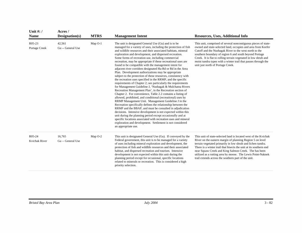
Name MTRSDesignation(s) Management Intent Resources, Uses, Additional InfoAcres /Unit #: /
Portage CreekMap O-1
Gu -- General UseThe unit is designated General Use (Gu) and is to be managed for a variety of uses, including the protection of fish and wildlife resources and their associated habitats, mineral exploration and development, and dispersed recreation. Some forms of recreation use, including commercial recreation, may be appropriate if these recreational uses are found to be compatible with the management intent for adjacent river corridors designated Ha-Rd or Rd in the Area Plan. Development authorizations may be appropriate subject to the protection of these resources, consistency with the recreation uses specified in the RRMP, and the specific requirements of Chapter 2; see particularly the requirements for Management Guideline J, ‘Nushagak & Mulchatna Rivers Recreation Management Plan’, in the Recreation section of Chapter 2. For convenience, Table 2.2 contains a listing of allowed, prohibited, and conditional (recreational) uses by RRMP Management Unit. Management Guideline J in the Recreation specifically defines the relationship between the RRMP and the BBAP, and must be consulted in adjudication decisions. Intensive development is not expected within this unit during the planning period except occasionally and at specific locations associated with recreation uses and mineral exploration and development. Settlement is not considered an appropriate use.
This unit, comprised of several noncontiguous pieces of state-owned and state-selected land, occupies and area from Keefer Cutoff and the Nushagak River to the west north to the southern boundary of region 6 and south beyond Portage Creek. It is flat to rolling terrain vegetated in low shrub and moist tundra types with a winter trail that passes through the unit just north of Portage Creek.
42,561R05-23
Kvichak RiverMap O-2
Gu -- General UseThis unit is designated General Use (Gu). If conveyed by the Federal government, this unit is to be managed for a variety of uses including mineral exploration and development, the protection of fish and wildlife resources and their associated habitat, and dispersed recreation and tourism. Intensive development is not expected within this unit during the planning period except for occasional, specific locations related to minerals or recreation. This is considered a high priority selection.
This unit of state-selected land is located west of the Kvichak River on the eastern margin of planning Region 5 on level terrain vegetated primarily in low shrub and lichen tundra. There is a winter trail that bisects the unit at its southern end near Squaw Creek and King Salmon Creek. The has been utilized as a rutting area by moose. The Lewis Point-Naknek trail extends across the southern part of the unit.
16,765R05-24
3 - 82Bristol Bay Area Plan July 2004

Name MTRSDesignation(s) Management Intent Resources, Uses, Additional InfoAcres /Unit #: /
Togiak NWR S14S56W Sec. 6,7,18, 19,30
Map O-1Ha -- Fish and Wildlife Habitat
If conveyed by the Federal government, this unit is to be managed for the protection of fish and wildlife habitat and the maintenance of dispersed recreation. It is designated Habitat and is to be retained in state ownership. Development authorizations may be appropriate but only if the resources and values of the unit are maintained. Consult with the Togiak NWR prior to issuing any authorization. This is considered to be a low-priority selection.
This state-selected land is situated between the Nushagak Bay and the Snake River, and borders the Togiak National Wildlife Refuge. It is an area of low-lying, flat poorly-drained terrain with low shrub vegetation. Because of its remote land isolated location, development of the unit is considered difficult. Since it adjoins the Togiak NWR, the management of this unit should focus on habitat protection and the maintenance of dispersed recreation.
3,076R05-25
PU1/ Blood Beach S14S52W Sec. 27,34
Map O-1Rp -- Public Recreation and Tourism-Public Use Site
This unit is designated Public Tourism and Recreation-Public Use Site (Rp) and is to be managed for public recreation and tourism. The unit is to be retained in state ownership. See also the Management Guideline for Public Use Sites in the Recreation section of Chapter 2.
This unit is located along the southern shore of the Nushagak River just west of the Scandinavian Slough and is primarily used for angling. It is identified in the Nushagak & Mulchatna Rivers Recreation Management Plan, August 1990, as a public use site (PU 1).
230R05-26
PU5/Keefer Cutoff S14S51W Sec. 25
Map O-1Rp -- Public Recreation and Tourism-Public Use Site
This unit is designated Public Recreation and Tourism-Public Use Site (Rp) and is to be managed for public recreation and tourism. The unit is to be retained in public ownership. See also the Management Guideline for Public Use Sites in the Recreation section of Chapter 2.
This is a shoreland area on Keefer Cutoff and the Nushagak River north of Portage Creek used for camping and angling. It is identified in the Nushagak & Mulchatna Rivers Recreation Management Plan, August 1990, as a public use site (PU 6).
80R05-27
PU3/Keefer Cutoff S14S51W Sec. 25
Map O-1Rp -- Public Recreation and Tourism-Public Use Site
This unit is designated Public Recreation and Tourism-Public Use Site (Rp) and is to be managed for public recreation and tourism. The unit is to be retained in public ownership. See also the Management Guideline for Public Use Sites in the Recreation section of Chapter 2.
This is a shoreland area on Keefer Cutoff and the Nushagak River north of Portage Creek. It is identified in the Nushagak & Mulchatna Rivers Recreation Management Plan, August 1990, as a public use site (PU 3).
41R05-28
3 - 83Bristol Bay Area Plan July 2004

Name MTRSDesignation(s) Management Intent Resources, Uses, Additional InfoAcres /Unit #: /
PU4/N. Portage Creek
S14S51W Sec. 25
Map O-1Rp -- Public Recreation and Tourism-Public Use Site
This unit is designated Public Recreation and Tourism-Public Use Site (Rp) and is to be managed for public recreation and tourism. The unit is to be retained in public ownership. See also the Management Guideline for Public Use Sites in the Recreation section of Chapter 2.
This is a shoreland area adjacent to upland site designated by Choggiung Ltd as a public camping site. It lies north of Portage Creek on Keefer Cutoff and the Nushagak River. It is identified in the Nushagak & Mulchatna Rivers Recreation Management Plan, August 1990, as a public use site (PU 4).
41R05-29
PU2/ Keefer Cutoff S15S51W Sec. 2
Map O-1Rp -- Public Recreation and Tourism-Public Use Site
This unit is designated Public Recreation and Tourism-Public Use Site (Rp) and is to be managed for public recreation and tourism. The unit is to be retained in public ownership. See also the Management Guideline for Public Use Sites in the Recreation section of Chapter 2.
This unit is located along the Nushagak River in a braided section west of the Portage Creek airport primarily used for angling. It is identified in the Nushagak & Mulchatna Rivers Recreation Management Plan, August 1990, as a public use site (PU 2).
117R05-30
Portage Creek Airport
S15S51W Sec. 1
Map O-1Pr -- Public Facilities-Retain
This unit is to be managed by ADOT/PF consistent with FAA standards and the conditions given in Management Agreements (ADL 221494, 221495, 224242) and limited state holdings (LSH 231, 234, 309). The land is to be retained in state ownership.
This unit of land hosts the airport facilities located near the community of Portage Creek. The unit is located on land managed by ADOT/PF under the stipulations of limited state holdings (LSH 231, 234, 309) and management agreements (ADL 221494, 221495, 224242).
85R05-31
3 - 84Bristol Bay Area Plan July 2004

Name MTRSDesignation(s) Management Intent Resources, Uses, Additional InfoAcres /Unit #: /
Scandanavian Slough
S15S52W Sec. 23,24, 25
Map O-1Gu -- General Use
The unit is designated General Use (Gu) and is to be managed for a variety of uses, including the protection of fish and wildlife resources and their associated habitats, mineral exploration and development, and dispersed recreation. Some forms of recreation use, including commercial recreation, may be appropriate if these recreational uses are found to be compatible with the management intent for adjacent river corridors designated Ha-Rd or Rd in the Area Plan. Development authorizations may be appropriate subject to the protection of these resources, consistency with the recreation uses specified in the RRMP, and the specific requirements of Chapter 2; see particularly the requirements for Management Guideline K, 'Caribou and Moose Calving and Rutting Areas', in the Fish and Wildlife Habitat section and with Management Guideline J, ‘Nushagak & Mulchatna Rivers Recreation Management Plan’, in the Recreation section of Chapter 2. For convenience, Table 2.2 contains a listing of allowed, prohibited, and conditional (recreational) uses by RRMP Management Unit. Management Guideline J in the Recreation specifically defines the relationship between the RRMP and the BBAP, and must be consulted in adjudication decisions. Intensive development is not expected within this unit during the planning period except occasionally and at specific locations associated with recreation uses and mineral exploration and development. Settlement is not considered an appropriate use.
This land consists of three sections of state-selected lands south of the Nushagak River and southeast of Portage Creek. The unit occupies an area of level terrain and low shrub and lichen tundra vegetation. The unit is in an area used by moose for calving.
1,920R05-32
Clarks Point Airport S15S55W Sec. 25,26, 36
Map O-1Pr -- Public Facilities-Retain
This unit is to be managed consistent with the stipulations of the limited state holding (LSH 265) and is to be retained in state ownership.
This unit of land contains the public airport facilities adjacent to the community of Clark's Point. It is to be managed by ADOT/PF under the stipulations of a limited state holding (LSH 265) for the purposes of administering an airport facility. The Alaska Heritage Resources Survey (AHRS) reports several heritage sites in or near this unit.
70R05-33
3 - 85Bristol Bay Area Plan July 2004

Name MTRSDesignation(s) Management Intent Resources, Uses, Additional InfoAcres /Unit #: /
Etolin Point S17S54W; S18S54W; S18W53W
Map O-1Se -- Settlement
The unit is designated Settlement (Se) and is considered appropriate for disposal during the planning period. Development is to conform to the requirements of Remote Settlement and those for the 'Caribou and Moose Rutting and Calving Area', both of which are described in the Settlement and Fish and Wildlife sections, respectively, of Chapter 2. Buffers along anadromous fish streams must also conform to the management guidelines in Chapter 2.
This unit extends north from the shores of Nushagak and Kvichak Bays and includes Etolin Point to the west. It is an area of fairly flat terrain and low shrubs that is suitable for settlement. The unit contains several large navigable lakes and opens onto Nushagak and Kvichak Bay. The area is largely surrounded by Native-owned lands; some of these are 12b village pool lands that have been designated for development purposes by the Bristol Bay Native Association.
36,139R05-34
3 - 86Bristol Bay Area Plan July 2004

Resource Allocation Table for Tideland Units - Region 5 DRAFTUnit # /Name MTRSDesignation(s) Management Intent Resources, Uses, Additional Info
Acres /
R05T-01Nushagak Bay S14S56W,
S16S56W, S17S55W-58W, S18S55W-58W
Ha and Hv -- Habitat and Harvest
Nushagak Bay, with its numerous and varied marine and fishery resources, is designated Habitat. Management intent: Tideland development authorizations are considered appropriate, but must avoid or minimize impacts to the beluga whale population during the calving life-cycle stage. Consult with NMFS before issuing authorizations. Ensure that any authorizations are consistent with the requirements of the Bristol Bay Fisheries Reserve.
This large bay includes calving areas for beluga whales and is used by waterfowl as a concentration area.
Commercial harvest of pink, sockeye, chinook, chum and coho salmon occurs throughout Nushagak Bay (purse seine and drift net). Offshore leases for set net harvesting are continuous along both the east and west coastlines of Nushagak Bay, concentrating south of Dillingham, around Clark's Point to Ekuk and extending south of Ekuk on the eastern side of the bay. Drift net harvest occurs throughout the bay for pink, chum, sockeye, coho and chinook salmon. Chinook salmon are harvested (drift net) at Etolin Point. Subsistence harvest of fish around Dillingham consists of primarily salmon, but grayling and pike are harvested to a lesser extent. Clark's Point residents range long distances if necessary for subsistence harvest which includes salmon, smelt and some waterfowl. A number of Bristol Bay residents migrate to Ekuk for subsistence harvest of salmon. The western coastal tidelands of Nushagak Bay are adjacent to the Togiak NWR and are affected by a TRMZ (See R02T-01). All of Nushagak Bay is affected by the Bristol Bay Fisheries Reserve.
82,480 Map O-1
Bristol Bay Area Plan July 2004 3 - 87

Unit # /Name MTRSDesignation(s) Management Intent Resources, Uses, Additional Info
Acres /
R05T-02Kvichak Bay S16S47W,
S17S47W-50W, S18S48W-53W
Ha and Hv -- Habitat and Harvest
Kvichak Bay is designated Habitat. Although the eastern part of Kvichak Bay contains extensive areas of sheltered tidal flats and is only considered moderately productive biologically, the remainder of the bay is a sensitive habitat area. Tideland development authorizations may be appropriate but must avoid or minimize impacts to the beluga whale population during the calving life cycle stage and to harbor seal haulout concentration areas. Consult with the NMFS and USFWS before issuing authorizations. Management Intent: Protect beluga whale population, harbor seal haulout concentrations, anadromous streams, areas of estuarine wetlands, and areas of waterfowl concentration. Ensure that any authorizations are consistent with the requirements of the Bristol Bay Fisheries Reserve.
Habitat: Kvichak Bay fronts on both Regions 5 and 11. Eroding peat scarps, sheltered tidal flats, and marshes are common along the west side of Kvichak Bay. The eastern part of Kvichak Bay, extending from its mouth to the mouth of the Naknek River, consists of extensive shallow areas of exposed tidal flats having high biomass content. Large areas of exposed tidal flats are also common south of the Naknek River, but are considered to be of only moderate biomass. Both the Kvichak and Naknek Rivers empty into the Bay; the communities of King Salmon and Naknek are situated on the Naknek River. See Region 11 for descriptions of these communities.
The Kvichak River is an important anadromous stream, provides habitat for waterfowl during the spring and fall, is used by belugas for both feeding and calving, and contains numerous harbor seal haulout concentrations. Kvichak Bay merges imperceptibly into this river. The bay provides somewhat similar habitat to Kvichak River and is important as a beluga whale feeding and calving concentration area, the belugas arriving in the bay in May. While in this area, some feed in shallow tidal flats while others ascend the rivers, traveling as far as 10-20 miles inland. They depart Kvichak Bay in August. This bay also contains areas important for harbor seal haulouts and spring waterfowl concentrations. The area of 'Deadman Sands', situated in the central part of Kvichak Bay generally within or near sections 1, 2, 11, 12, 13, 14, 23, and 24 of T17SR50W, is especially important as a harbor seal haulout concentration. Another harbor seal haulout concentration area occurs west of Graveyard Point on the east side of the bay. The highest density of shorebirds and diving and dabbling ducks on the north coast of the Alaska Peninsula occurs in this bay. Kvichak Bay is affected by the Bristol Bay Fisheries Reserve.
Harvest: Commercial harvest of pink, sockeye, chinook, chum and coho salmon occurs throughout Kvichak Bay (purse seine and drift net). Set net permits occur all along the upper Kvichak Bay, both east and west coastlines. The densest concentration of set net permits exist along the eastern coastline near the mouth of the Naknek River and south of Naknek. There is intense subsistence harvest of red salmon as a food staple in Kvichak Bay.
26,920 Map O-1
Bristol Bay Area Plan July 2004 3 - 88

Unit # /Name MTRSDesignation(s) Management Intent Resources, Uses, Additional Info
Acres /
R05T-03Tidelands and Offshore Submerged Lands
Gu -- General UseManage for a variety of uses and resources. Protect areas with concentrations of seabirds and waterfowl. Consult with NMFS to determine if whales or other marine mammals are present prior to issuing an authorization. Maintain opportunities for personal and commercial harvest. This unit is included within the Bristol Bay Fisheries Reserve.
This tideland unit occupies the area between Nushagak Bay and Kvichak Bay. The more sensitive resources within this Region are associated with these bays and are to be managed according to the requirements listed for tideland units R05T-01 (Nushagak Bay) and R05T-02 (Kvichak Bay). The tidelands in this units as well as R05T-01 and 02 are governed by the restrictions of the Bristol Bay Fisheries Reserve.
The area encompassed by this tideland unit is characterized by mixed sand and gravel beaches. Eroding peat scarps, some sheltered tidal flats, and marshes occur near Kvichak Bay, and marshes occur near Nashagak Bay. Watefowl and shorebirds are common throughout the unit, and both whales and marine mammals are known to be present, but not at the concentration levels experienced in either R05T-01 and R05T-02.
The commercial harvest of pink, sockeye, and chinook, chum, and coho salmon occurs within parts of this unit by purse seine and drift net. Set nets are present as well. There is also some subsistence harvest of salmon and herring in this unit.
165,569 Map O-1
Bristol Bay Area Plan July 2004 3 - 89

PUBLIC REVIEW DRAFT Chapter 3 – Region 6: Nushagak, Mulchatna
Bristol Bay Area Plan July 2004 3 - 91
Region 6 1
Nushagak, Mulchatna 2
3
Summary of Resources and Uses in the Region 4 5 Region Boundary 6 Region 6 is the second largest of the planning regions in the Bristol Bay Plan and encompasses 7 the most state-owned Land. See Plan Map O-2. The Region includes much of the Nushagak 8 and Mulchatna River drainages. The boundaries of the Region are defined by Wood-Tikchik 9 State Park on the west, the drainage divide to the Kuskokwim (Holitna and Aniak Rivers) on the 10 north, and the divide between the Nushagak River system and the Kvichak on the southeast. 11 The eastern boundary is somewhat arbitary and attempts to separate the upper Mulchatna River 12 drainage from the Region. Elevations range from less than 200 feet in the south to over 3,000 13 feet in the Shotgun Hills. However, the Region is not very mountainous; it encompasses the 14 southern portion of the Shotgun Hills and Nushagak Hills in the north and the Muklung Hills in 15 the southwest. There are few settlements in the Region; the largest is New Stuyahok (pop. 452). 16 The boundary of Region 6 is virtually the same as that of the original (1984) Bristol Bay Area 17 Plan. 18 19 State Lands: Ownership and Acreage 20 The majority of land within Region 6 is owned by the State of Alaska. Much of the land along 21 the middle and lower Nushagak River is Native-owned, flanked by Federal lands. The plan 22 applies to 4,340,384 acres of state-owned and state-selected uplands. 23 24 Physical Geography 25 The Region is within four physiographic provinces: the central and southern portion is 26 dominated by the Bristol Bay Lowlands; the northwest portion is within the Ahklin Mountain 27 Province; the north part is within the Kuskowkim Mountain physiographic province; and the 28 northeast portion is part of the Lime Hills province. The Nushagak-Mulchatna drainage basin is 29 large and incorporates the east flowing rivers from Wood-Tikchik State Park such as the 30 Towithla, Kokwok, Nuyakuk, Klutuspak, and King Salmon Rivers. Northern tributaries include 31 the Klutapak, Chichitnok, and Mosquito Rivers. Eastern and Southeastern tributaries include 32 the Swan, Koktuli, and Stuyahok Rivers. Topographic relief is modest with most of it 33 developed in the west and north. The highest elevations occur in the glaciated Shotgun Hills 34 where over 2,000 feet of relief is present. Most other mountainous areas of the Region show 35 relief of less than 1,500 feet. 36
Chapter 3 – Region 6: Nushagak, Mulchatna PUBLIC REVIEW DRAFT
3 - 92 July 2004 Bristol Bay Area Plan
The Region displays a variety of landscapes, including mountains, fast-flowing rivers, tundra, 1 marshy lowlands, and ponds. The glacial valleys of the Wood River Mountains and the Shotgun 2 Hills open into the broad rolling Bristol Bay lowlands. Tree covered areas occur only sparingly; 3 they are found at restricted locales in the western margins of the Region, near the border with 4 Wood-Tikchik State Park and in the eastern-southeastern portion of the Region at higher 5 elevations near the drainage divide which separates Region 6 and Region 10. Most terrain 6 above 1,000 feet in elevation is vegetated with tall shrubs. Terrain below 1,000 feet is largely 7 covered by low shrub and or lichen tundra with low lying areas marked by wet sedge tundra. 8 9 Climate 10 The climate of Region 6 is transitional from the maritime influence of Bristol Bay to the 11 influence of continental weather to the north. As distance from the coast increases, temperature 12 variations increase whereas cloudiness, humidity, and precipitation tend to decrease. The 13 settlement of New Stuyahok is located in a climatic transition zone. The primary influence is 14 maritime, although a continental climate affects the weather. Average summer temperatures 15 range from 37° to 66°; winter temperatures average 4° to 30°. Annual precipitation ranges from 16 20 to 35 inches. Fog and low clouds are common during the summer and strong winds often 17 preclude access during the winter. The Nushagak River at New Stuyahok is generally ice-free 18 from June through mid-November. Most of the Region is underlain by isolated masses of 19 permafrost. Generally the areas immediately under or adjacent to the main course of the 20 Nushagak and Mulchatna Rivers are free of permafrost. 21 22 Other 23 Region 6 is within the Dillingham, Taylor Mountains, Lake Clark, and Iliamna Quadrangles. It 24 is entirely within the boundaries of the Bristol Bay Regional Native Corporation. The eastern 25 portion of the Region is within the Lake and Peninsula Borough. 26 27 Access 28 Settlements in Region 6 include Ekwok, New Stuyahok, and Koliganek. Access to the Region 29 is predominantly through air or river transportation. Region 6 contains airstrips at each of the 30 three settlements: a state-owned 1,800-foot lighted gravel airstrip at New Stuyahok; a new 31 3,000-foot state-owned runway at Koliganek; and a state-owned 2,720-foot-long gravel strip at 32 Ekwok. During summer months goods can be lightered to all three communities from 33 Dillingham but no good docking facilities are present. Skiffs, ATV’s, and snowmachines are 34 prevalent forms of local transportation. There are no improved trails linking the settlements. 35 36 Resources and Uses 37 The Nushagak and Mulchatna River drainages support a major salmon resource for subsistence 38 and recreational harvest. Caribou, moose, and some brown bear are also used heavily by 39 subsistence and recreational hunters. Over one quarter of the caribou harvested annually in 40 Alaska are taken from the Mulchatna caribou herd. Exploration by mining companies has 41 brought about the development of significant metal resources at Pebble Copper and Shotgun; the 42 Region contains significant mineral potential for base, precious, rare, and strategic minerals. 43 Part of the Nushagak oil and gas basin extends into the southern part of the area; it is currently 44

PUBLIC REVIEW DRAFT Chapter 3 – Region 6: Nushagak, Mulchatna
Bristol Bay Area Plan July 2004 3 - 93
the locus of renewed interest in oil and gas exploration. Recreation use is heaviest along the 1 Nushagak, Mulchatna, Koktuli, Nuyakuk, King Salmon, Stuyahok, and Mosquito Rivers. There 2 is little in the way of agricultural resources within the Region except for village gardens. There 3 are no commercial forestry activities but the resource does support uses for house logs and fuel. 4 In the past sawmills were located at Ekwok, New Stuyahok, and Nondalton. 5 6 Cultural and Historic: Hunting and fishing camps along the Naknek River date from 3,000 to 7 4,000 B.C. In 1818, the first Russian traders arrived. The Russians explored and maintained 8 dominance of the area until the U.S. purchase of Alaska in 1867. U.S. interests were directed 9 primarily at the fur and fishery potential of the region. In 1883, the first salmon cannery in 10 Bristol Bay was opened which brought an influx of non-Native fishermen and cannery workers. 11 A flu epidemic in 1918 was tragic to the Native population. Reindeer were introduced to assist 12 the survivors, but the experiment eventually failed. The stateOffice of History and Archeology 13 lists 39 sites in Region 6 – 15 historic, 7 prehistoric and 5 of mixed origin. The majority of 14 these sites are located along the Nushagak and Mulchatna Rivers. 15 16 New Stuyahok is located on the Nushagak River, about 12 miles upriver from Ekwok and 52 17 miles northeast of Dillingham. The present location is the third site that villagers can remember. 18 The village moved downriver to the Mulchatna area from the "Old Village" in 1918. During the 19 1920s and 30s, the village was engaged in herding reindeer for the U.S. government. However, 20 by 1942 the herd had dwindled to nothing; the village had been subjected to flooding; and the 21 site was too far inland even to receive barge service. So in 1942, the village moved downriver 22 again to its present location. Stuyahok appropriately means "going downriver place." The first 23 school was built in 1961. 24 25 Koliganek is located on the left bank of the Nushagak River, and lies 65 miles northeast of 26 Dillingham. It is an Eskimo village first listed in the 1880 Census as "Kalignak." The name is 27 local, recorded by the U.S. Geological Survey in 1930. Since that time, the village has moved 28 four miles downstream from the original site. 29 30 Ekwok is the oldest continuously occupied Yup'ik Eskimo village on the river. During the 31 1800s, the settlement was used in the spring and summer as a fish camp, and in the fall as a base 32 for berry-picking. By 1923, it was the largest settlement along the river. In 1930, a BIA school 33 was constructed. Mail was delivered by dog sled from Dillingham until a post office opened in 34 1941. Many of the earliest homes in Ekwok were located in a low, flat area near the riverbank. 35 After a severe flood in the early 1960s, villagers relocated on higher ground, to the current 36 location. 37 38 Economic: The primary economic base is the salmon fishery; many residents hold commercial 39 fishing permits. Many people trap as well. The entire community relies upon subsistence 40 foods. Subsistence items are often traded between communities. Salmon, moose, caribou, 41 rabbit, ptarmigan, duck and geese are the primary sources of meat and fowl. 42 43 Recreation: Recreation and tourism is experiencing modest growth in the Region. In general, 44 southwest Alaska shows the lowest level of tourism compared to all other areas of the state. 45

Chapter 3 – Region 6: Nushagak, Mulchatna PUBLIC REVIEW DRAFT
3 - 94 July 2004 Bristol Bay Area Plan
Approximately 17% of visitors report traveling to Southwest and only 3% report that southwest 1 Alaska is their sole destination; the majority of these visits are to Katmai National Park and 2 Wood-Tikchik State Park. Tourism in Region 6 is primarily related to sport hunting and fishing. 3 Most recreational or back-country lodges and camps are located on the lower Nushagak River 4 below Ekwok. This lower stretch of the Nushagak River experiences the most commercial 5 recreational activity of the Region. One commercial lodge site is located on the upper 6 Mulchatna River. In general, most recreational activity in Region 6 is concentrated along the 7 major drainage corridors and is primarily related to river rafting and floating or sportfishing 8 activities. 9 10 Minerals: Region 6 geology consists several tectonic-stratigraphic terranes; the northern portion 11 of the Region is underlain by Cretaceous flysh of the Kuskokwim Group. The southeast portion 12 of the Region is underlain by a mixture of Late Cretaceous to Tertiary granitic rocks and middle 13 Tertiary volcanics. Much of the central and southern portions of the Region are underlain by 14 Tertiary clastic sedimentary rocks which thicken southwards as part of the Bristol Bay oil and 15 gas basin. Region 6 contains a significant mineral endowment. It has a number of important 16 base and precious metal deposits and prospects; these include deposits such as the Shotgun gold 17 deposit, which has in excess of one million ounces of contained gold, and the Pebble Copper 18 deposit which contains over a billion tons of low-grade copper-gold mineralization. Other 19 significant mineral potential occurs at Kemuk Mountain for iron, titanium, and platinum group 20 metals and Sleitat Mountain for tin and tungsten with associated arsenic and zinc. 21 22 The Shotgun prospect is located in the south part of the Shotgun Hills, a rugged, glaciated 23 upland at the divide between the King Salmon and Kogrukluk/Holitna River drainages. A large 24 granitic pluton makes up the core of the Shotgun Hills and Shotgun is located in hornfels 25 adjacent to the granitic rocks. Novagold Resources Inc. (2000) made the following resource 26 estimates: using a cutoff pf 0.018 ounce of Au per ton, the resource is 32,765,000 tons grading 27 0.033 ounce of Au per ton; using a cutoff of 0.026 ounce of Au per ton, the resource is 28 16,550,000 tons grading 0.045 ounce of Au per ton; using a cutoff of 0.035 ounce of Au per ton, 29 the resource is 11,650,000 tons grading 0.05 ounce of gold per ton. 30 31 Pebble Copper is located in the extreme eastern part of Region 6 in hills drained by the upper 32 reaches of the Koktuli River. The Pebble porphyry copper-gold-molybdenum deposit was 33 discovered and generally outlined by Cominco American through drilling on the property to 34 1997. Recent geochemical and geophysical surveys have substantiated that the Pebble deposit 35 is only part of a much larger series of metal-rich, coalescing hydrothermal sulfide systems11. 36 The mineralized zone is approximately 1.7 kilometers by 1.3 kilometers in size. A recently-37 completed (2003) independent mineral resource estimate has established the Pebble deposit as 38 one of the world's largest gold and copper resources, containing 13.1 million ounces of gold and 39 6.8 billion pounds of copper12. 40
11 The deposit consists of disseminated chalcopyrite and molybdenite, accompanied by minor to trace galena, sphalerite, and arsenopyrite in a stockwork vein system. This mineralization is hosted in early Tertiary granodiorite porphyry that intrudes Tertiary dacite tuffs, lahars, and breccia. 12 The mineral inferred resources include 1.0 billion tonnes grading 0.61% copper-equivalent (0.40 grams gold per tonne, 0.30% copper, and 0.015% molybdenum above a cut-off grade of 0.30% copper-equivalent). Importantly,

PUBLIC REVIEW DRAFT Chapter 3 – Region 6: Nushagak, Mulchatna
Bristol Bay Area Plan July 2004 3 - 95
The Kemuk deposit is located 12 miles east-northeast of the summit of Kemuk Mountain. The 1 site is at the south end of the boundary between sections 19 and 20, T 5 S, R 49 W, (Seward 2 Meridian). This is an area of extensive surficial deposits with few conspicuous topographic 3 features. Buried below 90 to 140 feet of unconsolidated Quaternary deposits, the deposit 4 consists of a large, composite ultramafic and mafic pluton. This prospect is believed to contain 5 2.6 billion tons averaging 15 to 17 percent total iron. The average grade is 10.5 to 12 percent 6 magnetic iron and 15 to 17 percent total iron. The platinum-group metal (PGM) potential of this 7 prospect is unknown but may be significant. 8 9 The Sleitat prospect is centered on a saddle at an elevation of 1,725 feet, between the two high 10 peaks of Sleitat Mountain (1,979 and 1,903 feet elevation). Sleitat Mountain is the highest part 11 of northeast-southwest trending uplands between the valleys of Harris Creek and the Nushagak 12 River. The occurrence of granite and peripheral gold-bearing quartz gash veins was reported as 13 early as 1938, but subsequent exploration has shown that the principal mineral deposit is a tin-, 14 tungsten-, and silver-bearing sheeted greisen system. A bulk sample contained 0.37 percent tin, 15 0.04 percent tungsten, and 17 ppm silver; the Sleitat deposit is estimated to contain a total of 16 28.6 million tons with the average grade of this bulk sample. This size and grade is consistent 17 with that found in other large cassiterite-bearing greisen deposits around the world. 18 19 Oil and Gas: The southwestern portion of Region 6 is underlain by the Nushagak Basin, which 20 is one of two basins in the Bristol Bay Area (along with the Bristol Bay basin). The Alaska 21 Peninsula-Bristol Bay basin is 500 miles long and up to 100 miles wide. In Region 5 (the 22 northwestern part of the peninsula) the basin is underlain by up to 18,000 feet of Tertiary 23 sediments that thicken to the south and thin to the north. The offshore Bristol Bay basin is a 24 sediment-filled structural depression that underlies the northern continental shelf of the Alaska 25 Peninsula. 26 Northern coastal plain hydrocarbon potential is moderate to locally high for gas and low to 27 moderate for oil; both are believed to occur in structural and stratigraphic traps. Oil and gas 28 seeps occur along the peninsula's southeastern flank; some along large anticlinal crests. Source 29 rock data indicate gas prone Tertiary organic shales. Oil may be derived from deeper Mesozoic 30 strata. Tertiary and Mesozoic sandstone reservoir characteristics are locally conducive to 31 hydrocarbon production. 32 33 State and Native landowners are currently pursuing a new hydrocarbon exploration licensing 34 and leasing program. The Alaska Department of Natural Resources, Lake and Peninsula, 35 Bristol Bay, and Aleutians East Borough have signed a memorandum of understanding (MOU) 36 in support of oil and gas lease sales and licensing of stateland in the Bristol Bay and Alaska 37 Peninsula region (March 17, 2004). Similar MOUs are in effect between the DNR and The 38
Snowden estimates that the Pebble deposit contains significant amounts of high-grade resources: 141 million tonnes of 0.67 grams gold per tonne, 0.48% copper and 0.019% molybdenum, or 0.97% copper-equivalent above a cut-off grade of 0.80% copper-equivalent. The resource estimate it based on approximately 18,353 meters of drilling in 110 core holes. During 2003 North Dynasty Minerals conducted an additional 30,000 feet of drilling in 18 holes at Pebble and other nearby prospects.

Chapter 3 – Region 6: Nushagak, Mulchatna PUBLIC REVIEW DRAFT
3 - 96 July 2004 Bristol Bay Area Plan
Aleut Corporation (December 18, 2003) and the DNR and Bristol Bay Native Corporation (July 1 10, 2003). 2 3 Materials: There are few active materials sites in the Region except for those found near 4 villages such as New Stuyahok. 5 6 Forestry: Region 6 and 7 contain most of the forest resources of the Bristol Bay Area. These 7 non commercial forests are found primarily in the Nushagak-Mulchatna drainages. The trees 8 are largely concentrated in the river valleys and consist of spruce, birch, and aspen. Some are 9 large enough for house and saw logs. Most resources are for personal use to meet some modest 10 building needs and for fuel. Upland mixed forests occur in the Muklung Hills and east of the 11 Wood River Mountains. The most valuable of the forest resources for local use are located in 12 the lower Nushagak area near New Stuyahok, Ekwok, and Portage Creek; in the Nushagak and 13 Nuyakuk River above Koliganek; and the Mulchatna River. 14 15 Fish and Wildlife: All five species of Pacific salmon – chinook (king), sockeye (red), pink, 16 coho (silver), pink (humpy), and chum (dog) -- spawn in the Nushagak-Muchatna River 17 systems. Sockeye are the most important commercially. Freshwater sport fish including 18 rainbow trout, Arctic grayling, lake trout, Arctic char, Dolly Varden, and northern pike are 19 generally prolific throughout the area. 20 21 Caribou are an important resource in the area. The Mulchatna caribou herd has been increasing 22 in size and expanding its range since the 1930’s. Serious efforts to conduct a census of the herd 23 has taken place since 1973; between 1981 and 1996, the Mulchatna caribou herd increased from 24 19,000 to 200,000. The herd is presently estimated at approximately 150,000 individuals 25 (http://www.wildlife.alaska.gov/pubs/techpubs/mgt.cfm). Important areas for Caribou include 26 the calving area which extends from the upper Koktuli drainage south to Iliamna Lake and from 27 Kemuck Mtn. east to the Nushagak River. 28 29 Moose are relatively new to the Bristol Bay area, possibly moving into the area from the middle 30 Kuskokwim drainages during the last 100 years. During the previous twenty years, moose 31 numbers have increased and moose are now common along the Nushagak/Mulchatna Rivers and 32 all of their major tributaries. They also occur throughout the Wood/Tikchik Lake area and have 33 extended their range westward. 34 35 Brown bears are common throughout the north Bristol Bay area and are seasonally abundant 36 along salmon spawning areas in the Nushagak, Mulchatna River drainages as well as long the 37 Wood River Lakes. These bears are also observed near aggregations of the Mulchatna caribou 38 herd. Important denning areas occur in the Muklung Hills and the Shotgun Hills. 39 40 Birds nesting in the area include a variety of waterfowl, gulls, bald eagle, golden eagle, arctic 41 tern, various loons, willow ptarmigan, and spruce grouse. Numerous transients pass through as 42 well. Eagle nests occur only sporadically along the Nushagak River; nesting sites for eagles and 43 other raptors are slightly more abundant on the Mulchatna and lower Koktuli Rivers. 44 45

PUBLIC REVIEW DRAFT Chapter 3 – Region 6: Nushagak, Mulchatna
Bristol Bay Area Plan July 2004 3 - 97
Trapping has been an important part of the culture and economy of the Northern Bristol Bay 1 area and provided a ready means to acquire cash prior to development of the commercial fishing 2 industry. Historically beaver have been the most important furbearer in the Region. Population 3 trends of furbearers in the Region are favorable – either stable or increasing. This is true for 4 important species found in Region 6 such as land otter, wolverine, and red fox, although 5 populations of the latter can fluctuate greatly due to outbreaks of rabies. 6 7
Management Considerations: Local and State 8
Plans and Special Use Area 9 10 A number of local, state, and federal management plans were considered in development of this 11 plan. Local plans include the Bristol Bay CRSA Coastal Zone Management Plan, the Lake and 12 Peninsula Borough Coastal Zone Management Plan, the Lake and Peninsula Borough 13 Comprehensive Plan, the Nushagak and Mulchatna Rivers Recreation Management Plan, and 14 the Southwest Alaska Economic Development Strategy. State plans include the Bristol Bay 15 Area Plan, the Wood-Tikchik State Park Management Plan, the Nushagak and Mulchatna 16 Rivers Recreation Plan, and the Southwest Alaska Transportation Plan. Federal plans include 17 the Nushagak and Wood Rivers Flood Plain Management Study. 18 19 Region 6 is within the Bristol Bay CRSA Coastal Zone Management Plan. Most state-owned 20 land falls within the CSRA but is on land outside the coastal zone. The Enforceable and 21 Administrative Policies of these Coastal Management Plans are extensive; policies affecting 22 anadromous fish streams, bald eagle nests, oil and gas development, material extraction, and 23 mining can be applicable, under certain circumstances, to state land. Please see the web site 24 www.alaskacoast.state.ak.us for more information on enforceable policies. These policies 25 should be consulted by the DNR prior to issuing an authorization. 26 27 The eastern portion of Region 6 is located within the boundaries of the Lake and Peninsula 28 Borough. Both the Comprehensive Plan and the District Coastal Management Plan of the Lake 29 and Peninsula Borough apply to this portion of Region 6. The Comprehensive Plan focuses on 30 economic and infrastructure development issues and does not contain specific land use 31 standards or a land use map. The Enforceable Policies of the District Coastal Management Plan 32 are extensive; policies affecting anadromous stream, bald eagle nests, oil and gas development, 33 material extraction and mining can be applicable, under certain instances, to state lands. See 34 www.alaskacoast.state.ak.us/ for more information on enforceable policies. These policies 35 should be consulted by DNR prior to issuing an authorization. 36 37 Region 6 is also subject to the Nushagak and Mulchatna Rivers Recreation Management Plan 38 (RRMP; August 1990). This plan treats recreation uses on the two river systems and was 39 adopted as an amendment to the Bristol Bay Area Plan (1984) and as part of the Coastal Zone 40 Management Plan. The RRMP provides the basis for the management of recreation use in areas 41 co-designated Habitat and Public Recreation – Dispersed within the Nushagak-Mulchantna 42 drainage. 43

Chapter 3 – Region 6: Nushagak, Mulchatna PUBLIC REVIEW DRAFT
3 - 98 July 2004 Bristol Bay Area Plan
Region 6 is also within the area covered by the Southwest Alaska Comprehensive Economic 1 Development Strategy 2003-2008 which was developed for the U.S. Department of Commerce 2 Economic Development Administration by the Southwest Alaska Municipal Conterence (July 3 2003). This document developed a number of goals, objectives, and strategies to facilitate and 4 support efforts that retain and grow the region’s wealth, including diversitying the economic 5 base. 6 7 The Bristol Bay Area Plan (1984) affected all state lands in the Region. This version of the area 8 plan stated that Region 6 was to be managed in conjunction with Region 7 for fish and wildlife 9 habitat and harvest and for recreation. Land use designations in Region 7 included fish and 10 wildlife habitat, minerals, and recreation. This revision supercedes the 1984 area plan. The 11 Area Plan (2004) provides the basis for the management of all state land within the Region 12 except for recreational uses, which are managed under auspices of the RRMP. 13 14 The Southwest Alaska Transportation Plan (ADOT/PF, November 2002) identified a 15 Dillingham/Bristol Bay Area Transportation Corridor which in general extends from Levelock 16 to Dillingham connecting with the communities of Ekwok and Aleknagik. It includes a crossing 17 of the Wood River at Aleknagik and a major crossing of the Nushagak River. There are several 18 possible tie-in locations to the Bristol Bay to Cook Inlet transportation corridor. The plan 19 models a corridor from Aleknagik to Igiugig via Levelock. 20
The State of Alaska has issued a Special Use Area (ADL 226852) defining three Public Use 21 sites on the Nushagak River at the mouth of the Isowithla River (PU6), near Ekwok (PU9), and 22 at New Stuyuhok (PU21). These public use sites limit uses not requiring a permit to seven 23 consecutive days. 24 25 Municipal Selections 26 Muncipal selections by the Lake and Peninsula Borough occur along the Mulchatna River, in 27 the upper Koktuli drainage, and at an unnamed lake in the upper Stuyahok River drainage. 28 These selections total approximately 11,705 acres in Region 6 and are distributed along streams 29 and lakes with attractive recreation and development features. See Map O-2, Appendix C, and 30 the Municipal Entitlement section of Chapter 4. 31 32
Management Summary: Uplands 33 34 State land in Region 6 is to be managed for a variety of multiple uses, including settlement, 35 materials extraction, public facilities development, dispersed public recreation, mineral 36 exploration and development, and maintenance of sensitive wildlife habitats. Oil and gas 37 potential, although only of moderate to low potential, is also appropriate within the Region. The 38 majority of lands in Region 6 are designated General Use (Gu). Most of the major river 39 corridors have been co-designated Fish and Wildlife Habitat (Ha) and Public Recreation and 40 Tourism-Dispersed (Rd); they mostly correspond to the river corridors as defined in the 41 Nushagak and Mulchatna Rivers Recreation Management Plan. The Minerals (Mi) land use 42 designation has been applied to four areas where mineral resources are known and activity is 43

PUBLIC REVIEW DRAFT Chapter 3 – Region 6: Nushagak, Mulchatna
Bristol Bay Area Plan July 2004 3 - 99
expected during the planning period. A management unit adjacent to the Wood-Tikchik State 1 Park in the Muklung Hills is designated Fish and Wildlife Habitat (Ha). A small amount of land 2 has been designated Settlement (Se); this Settlement land is intended to facilitate recreation in 3 the Nuyakuk River area. The corridor of the Mulchatna River, within the Lake and Peninsula 4 Borough, is designated dispersed recreation (Rd); this sole designation is used in order to 5 facilitate conveyance of the Borough’s municipal selections in this area. Public Use Sites that 6 were identified in the Nushagak and Mulchatna Rivers Recreation Management Plan which are 7 used for recreation have been designated Public Recreation and Tourism-Public Use Sites (Rp). 8 A large number of small management units associated with airport or other such facilities are 9 designated Public Facilities-Retain (Pr). Active materials sites are designated Materials (Ma). 10 11 Plan Designations and Management 12 The plan designations that are used within this Region have the following management intent. 13 The policies and management intent guidelines described in Chapter 2 affect all DNR 14 authorizations. Refer especially to those guidelines relating to Habitat and Wildlife 15 Management and Settlement. See also the descriptions of the plan designations in the first part 16 of this Chapter; this section indicates which lands can be conveyed out of state ownership and 17 those that must be retained. 18 19
• General Use (Gu). Within this Region, lands that contain one or more resource values, 20 none of which is of sufficiently high value to merit designation as a primary use, and 21 areas that are unlikely to be developed during the planning period are designated General 22 Use. The land is to be managed for a variety of uses including protection of fish and 23 wildlife habitat and harvest, dispersed public recreation, minerals, oil and gas 24 exploration and development, and protection of heritage resources. It is expected that 25 little development will occur in these areas during the planning period, and it is not 26 intended as a matter of policy that intensive forms of development occur in these areas 27 other than occasionally and at specific sites. Municipal land selections, under the 28 municipal entitlement program, are conveyable to the municipality subject to a Best 29 Interest Finding by the State. The Lake and Peninsula Borough has made a small land 30 selection on General Use lands in the vicinity of the south fork of the Koktuli River. 31
32 • Habitat (Ha). Generally, his designation applies to areas of varied size that are important 33
for fish and wildlife species during a sensitive life-history stage where alteration of the 34 habitat or human disturbance could result in a permanent loss of a population or 35 sustained yield of a species. In Region 6 this designation is applied to water bodies 36 cataloged by the Alaska Department of Fish and Game as anadromous 37 (http://gis.sf.adfg.state.ak.us/AWC_IMS/viewer.htm) and to an area important for 38 caribou, moose calving, and Brown bear denning in the Muklung Hills. The designation 39 is to be retained in stateownership. This designation is also applied as a co-designation 40 with Public Recreation – Dispersed in certain areas affected by the Nushagak and 41 Mulchatna Rivers Recreation Management Plan. 42
43 • Materials (Ma). Lands designated materials are those where active or inactive materials 44
sites are present. These can include common varieties of sand, gravel, and stone or are 45

Chapter 3 – Region 6: Nushagak, Mulchatna PUBLIC REVIEW DRAFT
3 - 100 July 2004 Bristol Bay Area Plan
site associated with materials extraction that contain conveyors, crushing, sizing, and 1 other processing equipment. Until the materials have been exhausted, material sites are 2 to be retained by the state; thereafter, other authorizations or disposals may be 3 appropriate. Authorizations should be done in consultation with the Department of 4 Transportation and Public Facilities. 5
6 • Minerals (Mi). Areas associated with significant resources, either measured or inferred 7
that may experience minerals exploration or development during the planning period are 8 designated Minerals. This is a designation that includes surface uses in support of 9 minerals exploration and development, including tailings deposition, waste rock 10 disposal, mineral processing facilities, administrative facilities, and residential living 11 quarters. Land designated Minerals is to be retained in stateownership. This designation 12 has been applied at the Shotgun, Sleitat, Kemuk, and Pebble Copper deposits. 13
14 • Public Recreation-Dispersed (Rd). Lands with the designation of Public Recreation-15
Dispersed are to be managed so that their public recreation values are protected and 16 maintained. Within these areas the primary surface uses are intended to be those related 17 to hiking, hunting, fishing, wildlife viewing, and the like. Selections on these lands may 18 be appropriate for conveyance to a Borough under the municipal entitlement program 19 (subject to a Best Interest Finding by the state). This designation is applied to a specific 20 section of the Mulchatna River that is affected by a municipal selection of the Lake and 21 Peninsula Borough. 22
23 • Public Recreation-Dispersed and Habitat (Co-designation). Certain navigable 24
waterbodies (lakes and streams) are co-designated Fish and Wildlife Habitat (Ha) and 25 Public Recreation-Dispersed (Rd). Authorizations within these waterbodies should not 26 interfere with important habitat or public recreation values. See the table in the 27 Navigability section of this Chapter for a listing of these streams. Note: Certain 28 waterbodies may (only) be designated Public Recreation–Dispersed, (Rd), Habitat (Ha), 29 General Use (Gu). This co-designation is applied to the river corridors within the 30 Nushagak and Mulchatna Rivers Recreation Management Plan. In Region 6 this 31 includes the corridors of the Iowithla, Kokwok, Nuyakuk, upper Nushagak, and 32 Mulchatna drainages. 33
34 • Public Facilities-Retain (Pr). This designation applies to sites that are reserved for a 35
specific public infrastructure requirement. They are to be retained in state or public 36 ownership. In this Region, this designation applies to lands containing public facilities, 37 commonly airports or schools. Only a small amount of acreage is affected by this 38 designation. 39
40 • Public Recreation and Tourism-Public Use Site (Rp). This designation applies to areas 41
with a concentration of recreational users or tourists or that are likely to have such 42 concentrations. Within this Region this designation applies to specific recreation sites – 43 such as the public use sites identified in the Nushagak and Mulchatna Rivers Recreation 44 Management Plan. Unless otherwise indicated in the Resource Allocation Table, these 45

PUBLIC REVIEW DRAFT Chapter 3 – Region 6: Nushagak, Mulchatna
Bristol Bay Area Plan July 2004 3 - 101
sites are to be retained by the state. In some instances they may be conveyed to a 1 Borough, subject to the Borough retaining them in public ownership and ensuring that 2 they remain available for public use. 3
4 • Settlement (Se). This designation applies to state uplands suitable for sale, leasing, or 5
permitting to allow private recreational or residential use. Within this Region one area 6 of stateland is considered appropriate for settlement and has been designated Settlement. 7 This occurs on either side of the Nuyakuk River corridor and is intended for remote 8 recreational use; see Chapter 2 for specific requirements for this form of settlement. 9 Settlement lands are appropriate for conveyance to a Borough should one be formed in 10 this part of the Region. 11
12 Specific Management Considerations 13 14
• Generally Allowed Uses. The Generally Allowed Uses in 11 AAC 96.030 can occur 15 throughout the Region. 16
17 • Proposed Transportation Corridor. The area identified on the Region Map as a 18
“Potential Transportation Corridor” should be retained by the state during the planning 19 period. Authorizations granted by DNR within or adjacent to this corridor should not 20 preclude the future development of transportation access. Authorizations or disposals 21 within and adjacent to this corridor should only be allowed after consultation with 22 ADOT/PF. 23
24 • Except for areas closed to mineral entry under existing Mineral Closing Orders, all state 25
lands within Region 6 are open to mineral entry. No additional MCOs are 26 recommended; the only exception applies to the areas to be disposed of by DNR for 27 purposes of Community Settlement. Closure to mineral entry is recommended at or 28 before plat adoption. No leasehold location orders are recommended. See the Minerals 29 section in Chapter 2 for more detail on subsurface management requirements. 30
31 • Mineral Closing and Opening Orders. This revision of the Bristol Bay Area Plan retains 32
the mineral closing and opening orders largely implemented by DNR at the time of 33 original plan adoption. These MCOs either close a proposed settlement area or close a 34 number of major streams to mineral location. These include the following: 35
36 o MCO 393 – Major streams in the Nushagak and Mulchatna drainage basin 37 o MCO 294 – Jack Rabbit Hills (T1R, R40W, Seward Meridian). 38
39 • Leasehold Location Orders. Leasehold Location Order No. 1 covers small portions of 40
Region 6, much of Region 7, portions of Region 8, and 9. Under this order, rights to 41 locatable minerals may be acquired only under the Leasehold Location System, 42 AS 38.05.205, and may not be acquired by locating a mining claim under AS 38.05.195. 43 In the affected area, an approved Plan of Operations for a mineral lease takes the place 44 of a Land Use Permit required for unleased land. If the proposed lease activities are 45

Chapter 3 – Region 6: Nushagak, Mulchatna PUBLIC REVIEW DRAFT
3 - 102 July 2004 Bristol Bay Area Plan
minor, a plan of operations is not required (11 AAC 86.800). The Plan of Operations 1 must show how the operator proposes to comply with the lease stipulations and other 2 pertinent guideline in this plan. 3
4 • Retained Lands. There are no state lands within this Region that are designated to be 5
retained except for those that are reserved as a ‘Potential Transportation Corridor’, and 6 those designated Public Facilities–Retain (Pr), Mineral (Mi), or Fish and Wildlife 7 Habitat (Ha). Note: Certain management units designated Pr in the Resource Allocation 8 Table may be conveyed out of state ownership and to a Borough, should one be formed 9 as part of the Municipal Entitlement Act, providing the land conveyed remains public 10 land and the public retains access to the public use site. 11
12 • Navigable Waters. Shorelands (rivers and lakes) that are believed to be navigable are 13
listed in the table of the Navigability section of this Chapter. Authorizations in these 14 waters must ensure the continued use of a waterway by the public for purposes of trade, 15 travel, and commerce. Note: These waterbodies are assigned a plan designation of 16 Habitat or a co-designation of Habitat and Public Recreation. Authorizations issued by 17 DNR are to maintain the habitat and public recreation values of these waterbodies. 18
19 See the Resource Allocation Table for more detail on the upland management units. 20 21 22

Resource Allocation Table for Upland Units - Region 6 DRAFT
Name MTRSDesignation(s) Management Intent Resources, Uses, Additional InfoAcres /Unit #: /
RRMP 14Map O-2
Gu -- General UseThe unit is designated General Use (Gu) and is to be managed for a variety of uses, including the protection of fish and wildlife resources and their associated habitats, mineral exploration and development, and dispersed recreation. Some forms of recreation use, including commercial recreation, may be appropriate if these recreational uses are found to be compatible with the management intent for adjacent river corridors designated Ha-Rd or Rd in the Area Plan. Development authorizations may be appropriate subject to the protection of these resources, consistency with the recreation uses specified in the RRMP, and the specific requirements of Chapter 2; see particularly the requirements for Management Guideline K, 'Caribou and Moose Calving and Rutting Areas', in the Fish and Wildlife Habitat section and with Management Guideline J, ‘Nushagak & Mulchatna Rivers Recreation Management Plan’, in the Recreation section of Chapter 2. For convenience, Table 2.2 contains a listing of allowed, prohibited, and conditional (recreational) uses by RRMP Management Unit. Management Guideline J in the Recreation specifically defines the relationship between the RRMP and the BBAP, and must be consulted in adjudication decisions. Intensive development is not expected within this unit during the planning period except occasionally and at specific locations associated with recreation uses and mineral exploration and development. Settlement is not considered an appropriate use.
The unit encompasses uplands in the upper Nushagak River, King Salmon River, and Chichinok River drainages and coincides with that of Management Unit 14 of the Nushagak and Mulchatna Rivers Recreation Management Plan. Vegetation consists primarily of tall shrublands. These major drainages are cataloged as anadromous and contain moose rutting areas (although not part of the unit) and Brown bear denning areas (in the Shotgun Hills). The management of this unit is governed by the requirements of the Bristol Bay Area Plan. (Previous to this revision, DNR authorizations relating to recreation uses and structures were guided by the Nushagak and Mulchatna Rivers Recreation Management Plan (RRMP)). The requirements of the RRMP have been carried over except for prohibitions on structures, trapping cabins, boat storage and docks.
754,027R06-01
3 - 103Bristol Bay Area Plan July 2004

Name MTRSDesignation(s) Management Intent Resources, Uses, Additional InfoAcres /Unit #: /
Corridor of the Nushagak River system
Map O-2Rd and Ha -- Recreation and Tourism-Dispersed, and Habitat
This unit, which consists of the navigable portions of the Nushakgak River and its adjoining uplands as depicted in Map O-2, is co-designated Public Recreation -- Dispersed (Rd) and Habitat (Ha). Unit is to be retained by the state and managed to maintain the recreational uses of the Nushakgak River and the adjoining upland corridor, its fish and wildlife resources, and public recreation values. The management requirements of the Nushagak & Mulchatna Rivers Recreation Management Plan (RRMP) are to be followed by DNR in the granting of authorizations related to certain types of recreational uses and structures. See the Management Intent and Management Guidelines in the RRMP for Management Units 10, 12, and 13. For convenience, Table 2.2 contains a listing of allowed, prohibited, and conditional uses by RRMP management unit. Management Guideline J in the Recreation section of Chapter 2, which more specifically defines the relationship between the RRMP and the BBAP, also applies and should be consulted in adjudication decisions.
In general, authorizations should not be issued for non-recreational uses that are incompatible with the management intent of this unit and the management objectives of the RRMP. Oil, gas, and mineral exploration and development are considered appropriate uses if compatible with the management intent for this unit or if in the best interest of the state.
This unit is the corridor of the upper Nushagak River as depicted in the Nushagak and Mulchatna Rivers Recreation Management Plan (RRMP). The unit consists of that portion of RRMP Management Units 10, 12, and 13 within state-owned lands in Region 6. The RRMP calls for these management units to be managed for either a 'primitive' or 'semi-primative' experience. The RRMP also specifies those recreational uses that are It includes the Nushagak, King Salmon, Chichinok River corridors as well as that of lower Vukpalik Creek. The width of the corridor varies, and may be up to four miles in width, measured from each side of the river system. Vegetation consists of lichen tundra and low and tall shrublands. The corridors contain streams cataloged as anadromous; these are utilized by Brown bear, especially during the salmon spawning season. Moose use the cooridors as calving areas. The Alaska Heritage Resources Survey (AHRS) reports many heritage sites in this unit. The unit is partly affected by MCO 393. This corridor does not include the specific public use sites identified in the River Management Plan. These are specific, individual units.
318,982R06-02
Shotgun S4N51W; S3N51W
Map O-2Mi -- Minerals
The land is designated Minerals (Mi) and is to be managed for the exploration and development of mineral deposits, subject to state permitting requirements. Unit is to be retained in state ownership. The Nushagak and Mulchatna Rivers Recreation Plan does not apply within this unit (p. 1-2; p.2-11). Refer to the Recreation section of Chapter 2 for a listing of allowed and prohibited uses. However, permanent facilities related to commercial recreation are prohibited in this unit.
This land is located in the Shotgun Hills. Vegetation is primarily tall shrubs and barren land. unit encompasses the Shotgun Hills mineral district, which consists of a number of known prospects, occurrences, and the Shotgun gold deposit. The Shotgun deposit has a drill measured resource of approximately 979,660 ounces of gold. Areas along the main valley of the King Salmon River, immediately south of the unit, are used by moose for calving. The area is utilized by brown bear for denning. Exploration and other mining related activities are permitted throughout the DNR's Annual Placer Mining Permit.
35,409R06-03
3 - 104Bristol Bay Area Plan July 2004

Name MTRSDesignation(s) Management Intent Resources, Uses, Additional InfoAcres /Unit #: /
PU20/Chichitnok River
S3N46WMap O-2
Rp -- Public Recreation and Tourism-Public Use Site
This unit is designated Public Recreation and Tourism-Public Use Site (Rp) and is to be managed for public recreation. It is to be retained in public ownership. See also the Management Guideline for Public Use Sites in the Recreation section of Chapter 2.
unit consists of a campsite at the mouth of the Chichitnok River. It is identified in the Nushagak & Mulchatna Rivers Recreation Management Plan, August 1990, as a public use site (PU 20).
206R06-04
RRMP 19Map O-2
Gu -- General UseThe unit is designated General Use (Gu) and is to be managed for a variety of uses, including the protection of fish and wildlife resources and their associated habitats, mineral exploration and development, and dispersed recreation. Some forms of recreation use, including commercial recreation, may be appropriate if these recreational uses are found to be compatible with the management intent for adjacent river corridors designated Ha-Rd or Rd in the Area Plan. Development authorizations may be appropriate subject to the protection of these resources, consistency with the recreation uses specified in the RRMP, and the specific requirements of Chapter 2; see particularly the requirements for Management Guideline K, 'Caribou and Moose Calving and Rutting Areas', in the Fish and Wildlife Habitat section and with Management Guideline J, ‘Nushagak & Mulchatna Rivers Recreation Management Plan’, in the Recreation section of Chapter 2. For convenience, Table 2.2 contains a listing of allowed, prohibited, and conditional (recreational) uses by RRMP Management Unit. Management Guideline J in the Recreation specifically defines the relationship between the RRMP and the BBAP, and must be consulted in adjudication decisions. Intensive development is not expected within this unit during the planning period except occasionally and at specific locations associated with recreation uses and mineral exploration and development. Settlement is not considered an appropriate use.
The unit encompasses uplands in the lower Mulchatna drainage basin and coincides with management unit 19 of the Nushagak and Mulchatna Rivers Recreation Management Plan. The unit contains anadromous fish streams whichi include Old Man Creek, Mosquito Creek, Keefer Creek, and the Swan River. Vegetation consists of scattered spruce woodlands and tall shrublands at higher elevations and low shrub and lichen tundra. The unit contains some moose calving areas, and tundra swans in the general vicinity of the Swan River. Considerable mineral potential is present and a large block of claims has been staked on state land east of the mouth of the Mulchatna River. The management of this unit is governed by the requirements of the Bristol Bay Area Plan. (Previous to this revision, DNR authorizations relating to recreation uses and structures were guided by the Nushagak and Mulchatna Rivers Recreation Management Plan (RRMP)). The requirements of the RRMP have been carried over except for prohibitions on permanent facilities and docks. Parts of the unit are affected by MCOs 393 and 249.
1,196,780R06-05
3 - 105Bristol Bay Area Plan July 2004

Name MTRSDesignation(s) Management Intent Resources, Uses, Additional InfoAcres /Unit #: /
PU33/Upper Mulchatna River
S4N37WMap O-2
Rp -- Public Recreation and Tourism-Public Use Site
This unit is designated Public Recreation and Tourism-Public Use Site (Rp) and is to be managed for public recreation and is to be retained in public ownership. See also the Management Guideline for Public Use Sites in the Recreation section of Chapter 2. Conveyance of the unit to the Lake and Peninsula Borough is appropriate with the stipulation that the unit remain in public ownership as a Public Use Site.
unit consists of a campsite and floatplane and wheeled plane landing area on the upper Mulchatna River 5 miles downstream from Springway Creek. It is identified in the Nushagak & Mulchatna Rivers Recreation Management Plan, August 1990, as a public use site (PU 33). The unit is part of a land selection by the Lake and Peninsula Borough under its municipal entitlement.
161R06-06
3 - 106Bristol Bay Area Plan July 2004

Name MTRSDesignation(s) Management Intent Resources, Uses, Additional InfoAcres /Unit #: /
Corridor Middle Mulchtana River
Map O-2Rd -- Public Recreation and Tourism-Dispersed
This unit, which consists of the navigable portions of the Mulchatna River and its adjoining uplands as depicted in Map O-2, is designated Public Recreation -- Dispersed (Rd). Except for those areas that may be conveyed under the Municipal Entitlement program, unit is to be retained by the state and managed to maintain the recreational uses of the Mulchatna River and the adjoining upland corridor, its fish and wildlife resources, and public recreation values. The management requirements of the Nushagak & Mulchatna Rivers Recreation Management Plan (RRMP) are to be followed by DNR in the granting of authorizations related to certain types of recreational uses and structures. See the Management Intent and Management Guidelines in the RRMP for Management Unit 20. For convenience, Appendix D contains a listing of allowed, prohibited, and conditional uses related to recreational facilities by RRMP Management Unit. Management Guideline J in the Recreation section of Chapter 2, which more specifically defines the relationship between the RRMP and the BBAP, also applies and should be consulted in adjudication decisions.
In general, authorizations should not be issued for non-recreational uses that are incompatible with the management intent of this unit and the management objectives of the RRMP. Oil, gas, and mineral exploration and development are considered appropriate if consistent with these management objectives or if in the best interest of the state. The municipal selections affecting this unit are considered appropriate for conveyance, subject to a separate and subsequent Best Interest Finding by DNR. If conveyed to the Borough, neither the requirements of the RRMP or the Area Plan will apply.
This unit consists of the uplands corridor adjacent to either side of the Mulchatna River upstream of the boundary of the Lake and Peninsula Borough and within Region 6. Its outer boundary corresponds to that of Management Unit 20 of the Nushagak and Mulchatna Rivers Recreation Management Plan (RRMP). The width of the corridor, adjacent to the streams, varies, and may be up to four miles in width, measured from each side of the river system. Vegetation consists of lichen tundra and low shrub, tall shrub, and scattered spruce-birch-alder woodlands. The river is cataloged as an anadromous fish stream and is utilized by brown bear, especially during the salmon spawning season. Moose utilize the area for calving. Raptors nest along the river. The unit is partly affected by MCO 393 and LLO 1. This corridor does not include the specific public use sites identified in the River Management Plan. These are specific, individual units. The unit contains a large number of land selections by the Lake and Peninsula Borough under the municipal entitlement program.
19,946R06-07
3 - 107Bristol Bay Area Plan July 2004

Name MTRSDesignation(s) Management Intent Resources, Uses, Additional InfoAcres /Unit #: /
PU32/Mulchtna River
S3N39WMap O-2
Rp -- Public Recreation and Tourism-Public Use Site
This unit is designated Public Recreation and Tourism-Public Use Site (Rp) and is to be managed for public recreation and is to be retained in public ownership. See also the Management Guideline for Public Use Sites in the Recreation section of Chapter 2.
unit consists of a campsite on the north bank of the Mulchatna River 2 miles southeast of Red Bluff. It is identified in the Nushagak & Mulchatna Rivers Recreation Management Plan, August 1990, as a public use site (PU 32).
173R06-08
Corridor of the Lower Mulchatna River
Map O-2Rd and Ha -- Recreation and Tourism-Dispersed, and Habitat
This unit, which consists of the navigable portions of the Mulchatna River and its adjoining uplands as depicted in Map O-2, is co-designated Public Recreation -- Dispersed (Rd) and Habitat (Ha). Unit is to be retained by the state and managed to maintain the recreational uses of the Mulchatna River and the adjoining upland corridor, its fish and wildlife resources, and public recreation values. The management requirements of the Nushakgak & Mulchatna Rivers Recreation Management Plan (RRMP) are to be followed by DNR in the granting of authorizations related to certain types of recreational uses and structures. See the Management Intent and Management Guidelines in the RRMP for Management Units 15, 18, and 20. For convenience, Table 2.2 contains a listing of allowed, prohibited, and conditional uses by RRMP management unit. Management Guideline J in the Recreation section of Chapter 2, which more specifically defines the relationship between the RRMP and the BBAP, also applies and should be consulted in adjudication decisions.
In general, authorizations should not be issued for non-recreational uses that are incompatible with the management intent of this unit and the management objectives of the RRMP. Oil, gas, and mineral exploration and development are considered appropriate uses if compatible with the management intent for this unit or if in the best interest of the state.
The unit is the corridor of the Lower Mulchatna River as depicted in the Nushagak and Mulchatna Rivers Recreation Management Plan (RRMP). The unit consists of that portion of RRMP Management Units 15, 18, and parts of 16, 17, and 20 within state-owned lands in Region 6. It includes the Mulchatna River up stream to the boundary of the Lake and Peninsula Borough and includes the corridors of the Stuyahok and lower Koktuli Rivers. The width of the corridor varies, and may be up to four miles in width, measured from each side of the river system. Vegetation consists of lichen tundra and low shrub in the lower reaches and tall shrubland and scattered spruce woodlands in the upper reaches of the river corridors. The rivers are cataloged as anadromous fish streams and utilized by brown bear for feeding, especially during the salmon spawning season. Moose utilize the river corridors as calving areas. Raptor nests occur along the main course of the Mulchatna River and especially along the lower reaches of the Koktuli River. The Alaska Heritage Resources Survey (AHRS) reports many heritage sites in this unit. The unit is partly affected by MCO 393. This corridor does not include the specific public use sites identified in the River Management Plan. These are specific, individual units.
199,246R06-09
3 - 108Bristol Bay Area Plan July 2004

Name MTRSDesignation(s) Management Intent Resources, Uses, Additional InfoAcres /Unit #: /
PU18/King Salmon River
S2N51WMap O-2
Rp -- Public Recreation and Tourism-Public Use Site
This unit is designated Public Recreation and Tourism-Public Use Site (Rp) and is to be managed for public recreation. It is to be retained in public ownership. See also the Management Guideline for Public Use Sites in the Recreation section of Chapter 2.
unit consists of a campsite and floatplane landing area on unnamed lake near the headwaters of the King Salmon River. It is identified in the Nushagak & Mulchatna Rivers Recreation Management Plan, August 1990, as a public use site (PU 18).
174R06-10
PU19/Nushagak River
S2N46WMap O-2
Rp -- Public Recreation and Tourism-Public Use Site
This unit is designated Public Recreation and Tourism-Public Use Site (Rp) and is to be managed for public recreation. It is to be retained in public ownership. See also the Management Guideline for Public Use Sites in the Recreation section of Chapter 2.
unit consists of a campsite on the east bank of the Nushagak River 2 miles north of the mouth of the King Salmon River. It is identified in the Nushagak & Mulchatna Rivers Recreation Management Plan, August 1990, as a public use site (PU 19).
157R06-11
PU15/King Salmon River
S2N46WMap O-2
Rp -- Public Recreation and Tourism-Public Use Site
This unit is designated Public Recreation and Tourism-Public Use Site (Rp) and is to be managed for public recreation. It is to be retained in public ownership. See also the Management Guideline for Public Use Sites in the Recreation section of Chapter 2.
unit consists of a campsite and floatplane landing area at the mouth of the King Salmon River. It is identified in the Nushagak & Mulchatna Rivers Recreation Management Plan, August 1990, as a public use site (PU 15).
161R06-12
3 - 109Bristol Bay Area Plan July 2004

Name MTRSDesignation(s) Management Intent Resources, Uses, Additional InfoAcres /Unit #: /
RRMP 11Map O-2
Gu -- General UseThe unit is designated General Use (Gu) and is to be managed for a variety of uses, including the protection of fish and wildlife resources and their associated habitats, mineral exploration and development, and dispersed recreation. Some forms of recreation use, including commercial recreation, may be appropriate if these recreational uses are found to be compatible with the management intent for adjacent river corridors designated Ha-Rd or Rd in the Area Plan. Development authorizations may be appropriate subject to the protection of these resources, consistency with the recreation uses specified in the RRMP, and the specific requirements of Chapter 2; see particularly the requirements for Management Guideline K, 'Caribou and Moose Calving and Rutting Areas', in the Fish and Wildlife Habitat section and with Management Guideline J, ‘Nushagak & Mulchatna Rivers Recreation Management Plan’, in the Recreation section of Chapter 2. For convenience, Table 2.2 contains a listing of allowed, prohibited, and conditional (recreational) uses by RRMP Management Unit. Management Guideline J in the Recreation specifically defines the relationship between the RRMP and the BBAP, and must be consulted in adjudication decisions. Intensive development is not expected within this unit during the planning period except occasionally and at specific locations associated with recreation uses and mineral exploration and development. Settlement is not considered an appropriate use.Unit is designated General Use (Gu) and is to be managed for a variety of uses, including the protection of fish and wildlife resources and their associated habitats, mineral exploration and development, and dispersed recreation. Some forms of recreation use, including commercial recreation, may be appropriate if these uses are are found to be compatible with the management intent for adjacent river corridors designated Rd. Development authorizations may be appropriate subject to the protection of these resources and the specific requirements of Chapter 2; see particularly the requirements for 'Caribou and Moose Calving and Rutting Areas' and Recreation Management Guideline J. Intensive development is not expected within this unit during the planning period except occassionally and at specific locations associated with recreation uses and mineral exploration and development. Settlement is not considered appropriate.
The unit encompasses uplands east and west of the Nushagak River generally in the drainages of the Klutuspak and Nuyakuk Rivers as well as Cranberry and Yukpalik Creeks. The unit coincides with that of Management Unit 11 of the Nushagak and Mulchatna Rivers Recreation Plan. Vegetation consists of tall shrub lands and lichen tundra. The unit contains moose calving areas; the major streams, including Klutuspak Creek are cataloged as anadromous. The management of this unit is governed by the requirements of the Bristol Bay Area Plan. (Previous to this revision, DNR authorizations relating to recreation uses and structures were guided by the Nushagak and Mulchatna Rivers Recreation Management Plan (RRMP). The requirements of the RRMP have been carried over except for prohibitions on permanent facilities and docks.
587,500R06-13
3 - 110Bristol Bay Area Plan July 2004

Name MTRSDesignation(s) Management Intent Resources, Uses, Additional InfoAcres /Unit #: /
PU16/Klutuspak Creek
S1N48WMap O-2
Rp -- Public Recreation and Tourism-Public Use Site
This unit is designated Public Recreation and Tourism-Public Use Site (Rp) and is to be managed for public recreation. It is to be retained in public ownership. See also the Management Guideline for Public Use Sites in the Recreation section of Chapter 2.
unit includes a wheeled airplane landing area on upper Klutuspak Creek. It is identified in the Nushagak & Mulchatna Rivers Recreation Management Plan, August 1990, as a public use site (PU 16).
197R06-14
PU17/Vukpalik Creek
S1N45WMap O-2
Rp -- Public Recreation and Tourism-Public Use Site
This unit is designated Public Recreation and Tourism-Public Use Site (Rp) and is to be managed for public recreation. It is to be retained in public ownership. See also the Management Guideline for Public Use Sites in the Recreation section of Chapter 2.
Wheeled plane landing area in uplands 3 miles southeast of Vukpalik Creek. It is identified in the Nushagak & Mulchatna Rivers Recreation Management Plan, August 1990, as a public use site (PU 17).
234R06-15
Upper Chulitna Area
Map O-2Gu -- General Use
Unit is designated General Use (Gu) and is to be managed for a variety of uses, including the protection of fish and wildlife resources and their associated habitat, oil and gas exploration and development, and dispersed recreation. Development authorizations may be considered appropriate subject to the protection of these resources and the specific requirements of Chapter 2. Intensive development is not expected within this unit during the planning period.
The unit encompasses portions of the upper Chulitna River in Region 6. Vegetation consists of tall and low shrublands and lichen tundra. The unit is partly affected by LLO 1. Note: Area is not included as part of the Recreation Rivers Management Plan.
107,402R06-16
PU14/Klutuspak Creek
S1S47WMap O-2
Rp -- Public Recreation and Tourism-Public Use Site
This unit is designated Public Recreation and Tourism-Public Use Site (Rp) and is to be managed for public recreation and tourism. The unit is to be retained in public ownership. See also the Management Guideline for Public Use Sites in the Recreation section of Chapter 2.
unit consists of a campsite on the Nushagak River at the mouth of Klutuspak Creek. It is identified in the Nushagak & Mulchatna Rivers Recreation Management Plan, August 1990, as a public use site (PU 14).
235R06-17
3 - 111Bristol Bay Area Plan July 2004

Name MTRSDesignation(s) Management Intent Resources, Uses, Additional InfoAcres /Unit #: /
SleitatMap O-2
Mi -- MineralsThe land is designated Minerals (Mi) and is to be managed for the exploration and development of mineral deposits. The unit is to be retained in state ownership. The Nushagak and Mulchatna Rivers Recreation Plan does not apply within this unit (p. 1-2; p.2-11). Refer to the Recreation section of Chapter 2 for a listing of allowed and prohibited uses. However, permanent facilities related to commercial recreation are prohibited in this unit.
This land is located east of the Nushagak River is the vicinity of Sleitat Mountain and Harris Creek. Vegetation consists of low shrub and lichen tundra. A tundra swan concentration is reported on the northern margin of the unit. The area is the locus of significant tin-tungsten-silver mineralization with peripheral gold. The Sleitat deposit has an inferred resources of 64,000 to 106,000 tons of tin contained in 29 million tons of ore. One drill hole intercept contains 85 feet averaging 1.8% tin and 0.4% tungsten.
73,099R06-18
Nuyakuk RiverMap O-2
Se -- SettlementThe unit is designated Settlement (Se) and is considered appropriate for disposal during the planning period. Development is to conform to the requirements of Remote Settlement and those for the 'Caribou and Moose Rutting and Calving Area', both of which are described in the Settlement and Fish and Wildlife sections, respectively, of Chapter 2. Buffers along anadromous fish streams must also conform to the management guidelines in Chapter 2.
This land is located adjacent to the middle Nuyakuk River east of Wood-Tikchik State Park. The unit is located on lands north and south of the River Management Plan recreation corridor. The Nuyakuk River is an anadromous fish stream and used by brown bear during the spawning season. The area is utilized by moose for calving. This is an important area for subsistence uses.
18,917R06-19
PU27/Koktuli River S2S40WMap O-2
Rp -- Public Recreation and Tourism-Public Use Site
This unit is designated Public Recreation and Tourism-Public Use Site (Rp) and is to be managed for public recreation and retained in public ownership. See also the Management Guideline for Public Use Sites in the Recreation section of Chapter 2.
unit consists of a campsite on the Koktuli River at the mouth of the Swan River. It is identified in the Nushagak & Mulchatna Rivers Recreation Management Plan, August 1990, as a public use site (PU 27).
80R06-20
PU23/Mulchatna River
S3S42WMap O-2
Rp -- Public Recreation and Tourism-Public Use Site
This unit is designated Public Recreation and Tourism-Public Use Site (Rp) and is to be managed for public recreation and retained in public ownership. See also the Management Guideline for Public Use Sites in the Recreation section of Chapter 2.
unit consists of a campsite and floatplane landing area on the Mulchatna River at the mouth of the Koktuli River. It is identified in the Nushagak & Mulchatna Rivers Recreation Management Plan, August 1990, as a public use site (PU 23).
87R06-21
3 - 112Bristol Bay Area Plan July 2004

Name MTRSDesignation(s) Management Intent Resources, Uses, Additional InfoAcres /Unit #: /
PU22/Mulchatna River
S3S42WMap O-2
Rp -- Public Recreation and Tourism-Public Use Site
This unit is designated Public Recreation and Tourism-Public Use Site (Rp) and is to be managed for public recreation. The unit is to be retained in state ownership. See also the Management Guideline for Public Use Sites in the Recreation section of Chapter 2.
unit consists of a campsite and floatplane landing area on the Mulchatna River 1.5 miles downstream from the mouth of the Koktuli River. It is identified in the Nushagak & Mulchatna Rivers Recreation Management Plan, August 1990, as a public use site (PU 22).
142R06-22
PebbleMap O-2
Mi -- MineralsThe land is designated Minerals (Mi) and is to be managed for the exploration and development of mineral deposits, subject to state permitting requirements. Unit is to be retained in state ownership. See also units R10-02 and unit R06-24 for management intent and other authorization requirements. The Pebble Copper road corridor transects the unit; the actual position of the road alignment has yet to be determined. No authorizations or disposals should be considered that are within or near the corridor until the road alignment is known or without consultation with the ADOT/PF. Notes: 1) The requirements of the Nushagak and Mulchatna Rivers Recreation Management Plan do not apply within this unit; the requirements of the Area Plan apply instead. Refer to Recreation Management Guideline J in Chapter 2 for a listing of allowed and prohibited uses. Permanent facilities related to commercial recreation are prohibited in this unit. 2) The habitat resources of the two stream corridors that traverse this unit (R06-24) are to be protected.
This land is located generally in the upper Koktuli River drainage in the area of Groundhog mountain and Sharp Mountain. The unit is adjacent to another minerals unit (R10-02) and is bisected by two stream corridors (R06-24). The terrain is of low to moderate relief and vegetation consists of low to tall shrub. The unit is host to several mineral deposits, prospects, and discoveries and hosts the Pebble Copper Deposit. The Pebble deposit is a very large copper-gold resource; the drill indicated resource is estimated at over 2 billion tons. Upper portions of the Koktuli River support anadromous fish. The area is also a calving area for caribou. Note to adjudicators: See units R06-24 and R10-02.
48,526R06-23
3 - 113Bristol Bay Area Plan July 2004

Name MTRSDesignation(s) Management Intent Resources, Uses, Additional InfoAcres /Unit #: /
Pebble StreamsMap O-2
Mi -- MineralsThe general resource management intent for the Pebble copper area is to accommodate mineral exploration and development. See plan designations and management intent for the two units that accommodate this deposit, R06-23 and R10-02. Mineral development within these units is to ensure that impacts to the anadromous and high value resident fish streams within R06-24 are avoided or reduced to levels deemed appropriate in the state/federal permitting processes related to mineral deposit development. Mineral exploration and development within the two streams encompassed by these two streams is not allowed, pursuant to MCO 393. Consult with ADF&G and other appropriate agencies to determine appropriate best management practices. This management intent replaces and supercedes the management requirements of the Nushagak and Mulchatna River Recreation Management Plan.
The unit consists of the two separate stream corridors that adjoin units R06-23 and R10-02, the Pebble copper deposit. The area of upper Talarik Creek is utilized by moose as a wintering area. Talarik Creek is an anadromous fish stream and supports a recreational sports fishery for trout. The area is used by caribou for calving. The unit is affected by MCO 393. The unit is part of the Pebble unit which contains the Pebble Copper copper-gold deposit -- a very large copper-gold resource; the drill indicated resource is estimated at over 2 billion tons. Note to adjudicators: The requirements of the Area Plan apply to these corridors, not the RRMP. The requirements of the 1990 Recreation Rivers Management Plan but has been incorporated into the revised Area Plan.
36,508R06-24
3 - 114Bristol Bay Area Plan July 2004

Name MTRSDesignation(s) Management Intent Resources, Uses, Additional InfoAcres /Unit #: /
Corridor of the Nuyakuk River
Map O-2Rd and Ha -- Recreation and Tourism-Dispersed, and Habitat
This unit, which consists of the navigable portions of the Nuyakuk River and its adjoining uplands as depicted in Map O-2, is co-designated Public Recreation -- Dispersed (Rd) and Habitat (Ha). Unit is to be retained by the state and managed to maintain the recreational uses of the Nuyakuk River and the adjoining upland corridor, its fish and wildlife resources, and public recreation values. The management requirements of the Nushakgak & Mulchatna Rivers Recreation Management Plan (RRMP) are to be followed by DNR in the granting of authorizations related to certain types of recreational uses and structures. See the Management Intent and Management Guidelines in the RRMP for Management Units 10, 12, and 13. For convenience, Table 2.2 contains a listing of allowed, prohibited, and conditional uses by RRMP management unit. Management Guideline J in the Recreation section of Chapter 2, which more specifically defines the relationship between the RRMP and the BBAP, also applies and should be consulted in adjudication decisions.
In general, authorizations should not be issued for non-recreational uses that are incompatible with the management intent of this unit and the management objectives of the RRMP. Oil, gas, and mineral exploration and development are considered appropriate uses if compatible with the management intent for this unit or if in the best interest of the state.
The unit is the corridor of the Nuyakuk River as depicted in the Nushagak and Mulchatna Rivers Recreation Management Plan (RRMP). The unit consists of that portion of RRMP Management Unit 8 within state-owned lands in Region 6. The width of the corridor varies, and may be up to four miles in width, measured from each side of the river system. Vegetation consists of lichen tundra, tall and low shrublands, as well as scattered spruce woodlands. The river is cataloged as an andaromous fish stream. Bown bear use the corridor for feeding, especially during the salmon spawning season. Moose use the corridor as a calving area. The Alaska Heritage Resources Survey (AHRS) reports a heritage site in this unit. The unit is partly affected by MCO 393.
40,319R06-25
3 - 115Bristol Bay Area Plan July 2004

Name MTRSDesignation(s) Management Intent Resources, Uses, Additional InfoAcres /Unit #: /
Corridor of the Lower Nushagak River
Map O-2Rd and Ha -- Recreation and Tourism-Dispersed, and Habitat
This unit, which consists of the navigable portions of the Nushakgak River and its adjoining uplands as depicted in Map O-2, is co-designated Public Recreation -- Dispersed (Rd) and Habitat (Ha). Unit is to be retained by the state and managed to maintain the recreational uses of the Nushakgak River and the adjoining upland corridor, its fish and wildlife resources, and public recreation values. The management requirements of the Nushagak & Mulchatna Rivers Recreation Management Plan (RRMP) are to be followed by DNR in the granting of authorizations related to certain types of recreational uses and structures. See the Management Intent and Management Guidelines in the RRMP for Management Units 1, 3, 5, and 7. For convenience, Table 2.2 contains a listing of allowed, prohibited, and conditional uses by RRMP management unit. Management Guideline J in the Recreation section of Chapter 2, which more specifically defines the relationship between the RRMP and the BBAP, also applies and should be consulted in adjudication decisions.
In general, authorizations should not be issued for non-recreational uses that are incompatible with the management intent of this unit and the management objectives of the RRMP. Oil, gas, and mineral exploration and development are considered appropriate uses if compatible with the management intent for this unit or if in the best interest of the state.
The unit consists of a number of scattered, non-contiguous small land blocks of state-selected lands along the lower Nushagak and lower Mulchatna Rivers and within the river corridor of the Nushagak and Mulchatna Rivers Recreation Management Plan (RRMP). One small selection is located on the Kokwok River corridor. The scattered land units are parts of the RRMP Management Units 4, 5, 15, 7, and 9. The area contains moose calving areas, anadromous fish streams, raptor nesting sites, and streams utilized by Brown bear. Some portions may be affected by MCO 393. Many cultural and historic sites are located along the river corridor.
12,495R06-26
PU21/Nushagak SUA
S4S43WMap O-2
Rp -- Public Recreation and Tourism-Public Use Site
This unit is designated Public Recreation and Tourism-Public Use Site (Rp) and is to be managed for public recreation, consistent with the requirements of the Special Use Designation. The unit is to be retained in state ownership. See also the Management Guideline for Public Use Sites in the Recreation section of Chapter 2.
This unit contains a campsite and floatplane landing area on the Mulchatna River at the mouth of the Stuyahok River. It is affected by a Special Use Area (ADL 226852), which limits use to personal, non-commercial uses for a period of seven consecutive days. It is identified in the Nushagak & Mulchatna Rivers Recreation Management Plan, August 1990, as a public use site (PU 21).
361R06-27
3 - 116Bristol Bay Area Plan July 2004

Name MTRSDesignation(s) Management Intent Resources, Uses, Additional InfoAcres /Unit #: /
PU28/Koktuli River S4S38WMap O-2
Rp -- Public Recreation and Tourism-Public Use Site
This unit is designated Public Recreation and Tourism-Public Use Site (Rp) and is to be managed for public recreation and is to be retained in public ownership. See also the Management Guideline for Public Use Sites in the Recreation section of Chapter 2. Conveyance of the unit to the Lake and Peninsula Borough is appropriate with the stipulation that the unit remain in public ownership as a Public Use Site.
unit consists of a wheeled plane landing area on the Koktuli River 1 mile downstream from the confluence of the north and south forks. unit is affected by a municipal selection of the Lake and Peninsula Borough. The unit is part of a land selection by the Lake and Peninsula Borough under its municipal entitlement.
161R06-28
PU29/Koktuli River S4S38WMap O-2
Rp -- Public Recreation and Tourism-Public Use Site
This unit is designated Public Recreation and Tourism-Public Use Site (Rp) and is to be managed for public recreation and is to be retained in public ownership. See also the Management Guideline for Public Use Sites in the Recreation section of Chapter 2.
unit consists of a campsite on the Koktuli River at the confluence of the north and south forks. It is identified in the Nushagak & Mulchatna Rivers Recreation Management Plan, August 1990, as a public use site (PU 29).
82R06-29
3 - 117Bristol Bay Area Plan July 2004

Name MTRSDesignation(s) Management Intent Resources, Uses, Additional InfoAcres /Unit #: /
Corridor Upper Koktuli River
Map O-2Rd -- Public Recreation and Tourism-Dispersed
This unit, which consists of the navigable portions of the Upper Koktuli River and its adjoining uplands as depicted in Map O-2, is designated Public Recreation -- Dispersed (Rd). Except for those areas that may be conveyed under the Municipal Entitlement program, unit is to be retained by the state and managed to maintain the recreational uses of the Koktuli River and the adjoining upland corridor, its fish and wildlife resources, and public recreation values. The management requirements of the Nushagak & Mulchatna Rivers Recreation Management Plan (RRMP) are to be followed by DNR in the granting of authorizations related to certain types of recreational uses and structures. See the Management Intent and Management Guidelines in the RRMP for Management Unit 17. For convenience, Table 2.2 contains a listing of allowed, prohibited, and conditional uses related to recreational facilities by RRMP Management Unit. Management Guideline J in the Recreation section of Chapter 2, which more specifically defines the relationship between the RRMP and the BBAP, also applies and should be consulted in adjudication decisions.
In general, authorizations should not be issued for non-recreational uses that are incompatible with the management intent of this unit and the management objectives of the RRMP. Oil, gas, and mineral exploration and development are considered appropriate if consistent with these management objectives or if in the best interest of the state.
This unit consists of the uplands corridor adjacent to either side of a portion of the Koktuli River. Its outer boundary corresponds to that of Management Unit 17 of the Nushagak and Mulchatna Rivers Recreation Management Plan (RRMP). The width of the corridor, adjacent to the streams, varies, and may be up to four miles in width, measured from each side of the river system. Vegetation consists of lichen tundra and low and tall shrublands. The river is cataloged as an anadromous fish stream. Moose over-winter in the area and caribou use the area as a calving ground. The unit is partly affected by MCO 393. This corridor does not include the specific public use sites identified in the River Management Plan. These are specific, individual units. The unit contains a land selection by the Lake and Peninsula Borough under the municipal entitlement program.
20,636R06-30
PU30/Koktuli River S4S37WMap O-2
Rp -- Public Recreation and Tourism-Public Use Site
This unit is designated Public Recreation and Tourism-Public Use Site (Rp) and is to be managed for public recreation and tourism. The unit is to be retained in public ownership. See also the Management Guideline for Public Use Sites in the Recreation section of Chapter 2. Conveyance of the unit to the Lake and Peninsula Borough is appropriate with the stipulation that the unit remain in public ownership as a Public Use Site.
unit consists of a floatplane landing area on unnamed lake 1 mile south of the upper Koktuli River and campsite on the Koktuli River, connected by a trail. unit is affected by a municipal selection of the Lake and Peninsula Borough. The unit is part of a land selection by the Lake and Peninsula Borough under its municipal entitlement.
491R06-31
3 - 118Bristol Bay Area Plan July 2004

Name MTRSDesignation(s) Management Intent Resources, Uses, Additional InfoAcres /Unit #: /
PU31/Upper Koktuli River
S4S35WMap O-2
Rp -- Public Recreation and Tourism-Public Use Site
This unit is designated Public Recreation and Tourism-Public Use Site (Rp) and is to be managed for public recreation and is to be retained in state ownership. See also the Management Guideline for Public Use Sites in the Recreation section of Chapter 2. Conveyance of the unit to the Lake and Peninsula Borough is not appropriate since the preponderance of land surrounding the unit is designated Minerals (Mi).
unit consists of a floatplane landing area on unnamed lake on the south side of the upper Koktuli River 2.5 miles northwest of Sharp Mountain. It is identified in the Nushagak & Mulchatna Rivers Recreation Management Plan, August 1990, as a public use site (PU 31). The unit is part of a land selection by the Lake and Peninsula Borough under its municipal entitlement.
241R06-32
PU13/Nuyakuk Creek
S4S47WMap O-2
Rp -- Public Recreation and Tourism-Public Use Site
This unit is designated Public Recreation and Tourism-Public Use Site (Rp) and is to be managed for public recreation. The unit is to be retained in public ownership. See also the Management Guideline for Public Use Sites in the Recreation section of Chapter 2.
This unit consists of a campsite and floatplane landing area on shorelands on the Nushagak River at the mouth of Nuyakuk Creek. It is identified in the Nushagak & Mulchatna Rivers Recreation Management Plan, August 1990, as a public use site (PU 13).
357R06-33
PU12/Kemuk Mountain
S6S53WMap O-2
Rp -- Public Recreation and Tourism-Public Use Site
This unit is designated Public Recreation and Tourism-Public Use Site (Rp) and is to be managed for public recreation. It is to be retained in public ownership. See also the Management Guideline for Public Use Sites in the Recreation section of Chapter 2.
Campsite and floatplane landing area on an unnamed lake 15 miles north of Okstukuk Lake. It is identified in the Nushagak & Mulchatna Rivers Recreation Management Plan, August 1990, as a public use site (PU 12).
161R06-34
3 - 119Bristol Bay Area Plan July 2004

Name MTRSDesignation(s) Management Intent Resources, Uses, Additional InfoAcres /Unit #: /
Corridor of the Kokwok River
Map O-2Rd and Ha -- Recreation and Tourism-Dispersed, and Habitat
This unit, which consists of the navigable portions of the Kokwok River and its adjoining uplands as depicted in Map O-2, is co-designated Public Recreation -- Dispersed (Rd) and Habitat (Ha). Unit is to be retained by the state and managed to maintain the recreational uses of the Kokwok River and the adjoining upland corridor, its fish and wildlife resources, and public recreation values. The management requirements of the Nushagak & Mulchatna Rivers Recreation Management Plan (RRMP) are to be followed by DNR in the granting of authorizations related to certain types of recreational uses and structures. See the Management Intent and Management Guidelines in the RRMP for Management Unit 4. For convenience, Table 2.2 contains a listing of allowed, prohibited, and conditional uses by RRMP management unit. Management Guideline J in the Recreation section of Chapter 2, which more specifically defines the relationship between the RRMP and the BBAP, also applies and should be consulted in adjudication decisions.
In general, authorizations should not be issued for non-recreational uses that are incompatible with the management intent of this unit and the management objectives of the RRMP. Oil, gas, and mineral exploration and development are considered appropriate uses if compatible with the management intent for this unit or if in the best interest of the state.
The unit is the corridor of the Kokwok River as depicted in the Nushagak and Mulchatna Rivers Recreation Management Plan (RRMP). The unit consists of that portion of RRMP Management Unit 4 within state-owned lands in Region 6. The width of the corridor varies, and may be up to four miles in width, measured from each side of the river system. Vegetation consists of lichen tundra and low shrub in the lower reaches and tall shrubland in the upper reaches of the river corridor. The drainage is cataloged as an anadromous fish stream. Brown bear utilize the upper reaches of the drainage for feeding during the salmon spawning season and moose use the upper reaches as a calving area. The Alaska Heritage Resources Survey (AHRS) reports a heritage site in this unit. The unit is partly affected by MCO 393. This corridor does not include the specific public use sites identified in the River Management Plan. These are specific, individual units.
85,089R06-35
KemukMap O-2
Mi -- MineralsThe land is designated Minerals (Mi) and is to be managed for the exploration and development of mineral deposits, subject to state permitting requirements. Unit is to be retained in state ownership. The Nushagak and Mulchatna Rivers Recreation Plan does not apply within this unit (p. 1-2; p.2-11). Refer to the Recreation section of Chapter 2 for a listing of allowed and prohibited uses. However, permanent facilities related to commercial recreation are prohibited in this unit.
This land is located generally west of Koliganek and on the upper reaches of Napotoli and Klutuk Creeks, in the east of Kemuk Mountain. This land is the locus of a mafic-ultramafic hosted iron deposits with potential for titanium, platinum group metals, and chromium.
108,390R06-36
3 - 120Bristol Bay Area Plan July 2004

Name MTRSDesignation(s) Management Intent Resources, Uses, Additional InfoAcres /Unit #: /
Koliganek Airport S5S47W Sec. 21,28
Map O-2Pr -- Public Facilities-Retain
This land is to be managed consistent with FAA and ADOT/PF guidelines for airport use and in accordance with the Management Right. Unit is to be retained in state ownership.
This unit is located at the Koliganek public airport and is managed by the Department of Transportation and Public Facilities (ADOT/PF) for airport use pursuant to Management Rights (ADL 200348 and 200341).
167R06-37
PU24/Stuyahok River
S5S41WMap O-2
Rp -- Public Recreation and Tourism-Public Use Site
This unit is designated Public Recreation and Tourism-Public Use Site (Rp) and is to be managed for public recreation and tourism and retained in public ownership. See also the Management Guideline for Public Use Sites in the Recreation section of Chapter 2.
unit consists of a wheeled plane landing area on the Stuyahok River 20 miles southeast of old Stuyahok. It is identified in the Nushagak & Mulchatna Rivers Recreation Management Plan, August 1990, as a public use site (PU 24).
445R06-38
PU25/Stuyahok River
S5S41WMap O-2
Rp -- Public Recreation and Tourism-Public Use Site
This unit is designated Public Recreation and Tourism-Public Use Site (Rp) and is to be managed for public recreation and retained in public ownership. See also the Management Guideline for Public Use Sites in the Recreation section of Chapter 2.
unit consists of a floatplane and wheeled plane landing area near the Stuyahok River on an unnamed lake 21 miles southeast of old Stuyahok. It is identified in the Nushagak & Mulchatna Rivers Recreation Management Plan, August 1990, as a public use site (PU 25).
432R06-39
PU26/Unnamed Lake
S5S40WMap O-2
Rp -- Public Recreation and Tourism-Public Use Site
This unit is designated Public Recreation and Tourism-Public Use Site (Rp) and is to be managed for public recreation and is to be retained in public ownership. See also the Management Guideline for Public Use Sites in the Recreation section of Chapter 2. Conveyance of the unit to the Lake and Peninsula Borough is appropriate with the stipulation that the unit remain in public ownership as a Public Use Site.
unit consists of a campsite and floatplane landing area on an unnamed lake drained by the Stuyahok River 23 miles southeast of old Stuyahok. It is identified in the Nushagak & Mulchatna Rivers Recreation Management Plan, August 1990, as a public use site (PU 26). The unit is part of a land selection by the Lake and Peninsula Borough under its municipal entitlement.
693R06-40
3 - 121Bristol Bay Area Plan July 2004

Name MTRSDesignation(s) Management Intent Resources, Uses, Additional InfoAcres /Unit #: /
Stuyahok Hills S5S40WMap O-2
Rd -- Public Recreation and Tourism-Dispersed
The unit is designated Public Recreation and Tourism-Dispersed (Rd). Land selections by the Lake and Peninsula Borough as part of it's municipal entitlement are considered appropriate for conveyance.
This relatively small unit consists of state-owned land south of the Stuyahok River in the vicinity of Public Use Site 26 as identified in the Nushagak and Mulchatna Rivers Recreation Management Plan. The Public Use site itself is a separate unit. Vegetation consists of spruce woodland. The unit contains a land selection by the Lake and Peninsula Borough under the municipal entitlement program.
2,109R06-41
RRMP 6Map O-2
Gu -- General UseThe unit is designated General Use (Gu) and is to be managed for a variety of uses, including the protection of fish and wildlife resources and their associated habitats, mineral exploration and development, and dispersed recreation. Some forms of recreation use, including commercial recreation, may be appropriate if these recreational uses are found to be compatible with the management intent for adjacent river corridors designated Ha-Rd or Rd in the Area Plan. Development authorizations may be appropriate subject to the protection of these resources, consistency with the recreation uses specified in the RRMP, and the specific requirements of Chapter 2; see particularly the requirements for Management Guideline K, 'Caribou and Moose Calving and Rutting Areas', in the Fish and Wildlife Habitat section and with Management Guideline J, ‘Nushagak & Mulchatna Rivers Recreation Management Plan’, in the Recreation section of Chapter 2. For convenience, Table 2.2 contains a listing of allowed, prohibited, and conditional (recreational) uses by RRMP Management Unit. Management Guideline J in the Recreation specifically defines the relationship between the RRMP and the BBAP, and must be consulted in adjudication decisions. Intensive development is not expected within this unit during the planning period except occasionally and at specific locations associated with recreation uses and mineral exploration and development. Settlement is not considered an appropriate use.
The unit consists of a number of non-contiguous upland blocks of state-owned and state-selected land in the lower Nushagak drainage that are part of Management Unit 6 in the Nushagak and Mulchatna Rivers Recreation Plan. The lagest area of state-owned land in the unit is located between the lower Nushagak River and Wood Tikchik State Park. Vegetation consists of tall and low shrub lands and lichen tundra. The uplands are within the Koksetna and Iowithla drainages. The unit includes moose calving and over wintering areas. The requirements of the RRMP have been carried over except for prohibitions on permanent facilities and docks. The management of this unit is governed by the requirements of the Bristol Bay Area Plan. (Previous to this revision, DNR authorizations relating to recreation uses and structures were guided by the Nushagak and Mulchatna Rivers Recreation Management Plan (RRMP). The requirements of the RRMP have been carried over except for prohibitions on permanent facilities and docks.
577,023R06-42
3 - 122Bristol Bay Area Plan July 2004

Name MTRSDesignation(s) Management Intent Resources, Uses, Additional InfoAcres /Unit #: /
PU11/Okstukuk Lake
S8S53WMap O-2
Rp -- Public Recreation and Tourism-Public Use Site
This unit is designated Public Recreation and Tourism-Public Use Site (Rp) and is to be managed for public recreation and tourism. The unit is to be retained in public ownership. See also the Management Guideline for Public Use Sites in the Recreation section of Chapter 2.
This unit contains a campsite and floatplane landing area near the outlet of Okstukuk Lake. It is identified in the Nushagak & Mulchatna Rivers Recreation Management Plan, August 1990, as a public use site (PU 11).
247R06-43
PU10/Kokwok River
S8S52WMap O-2
Rp -- Public Recreation and Tourism-Public Use Site
This unit is designated Public Recreation and Tourism-Public Use Site (Rp) and is to be managed for public recreation and tourism. The unit is to be retained in public ownership. See also the Management Guideline for Public Use Sites in the Recreation section of Chapter 2.
This unit consists of a campsite on the Kokwok River near the Okstukuk Hills. It is identified in the Nushagak & Mulchatna Rivers Recreation Management Plan, August 1990, as a public use site (PU 10).
161R06-44
New Stuyahok Airport
S8S47WMap O-2
Pr -- Public Facilities-Retain
The unit is to be managed consistent with FAA and ADOT/PF guidelines for airport use and in accordance with provisions of the Management Right (ADL 221465; OSL 900). The unit is to be retained in state ownership.
This unit of land is located at the New Stuyahok public airport and contains airport facilities managed by the ADOT/PF.
71R06-45
New Stuyahok School
S8S47W Sec. 29
Map O-2Pr -- Public Facilities-Retain
This land is to be managed consistent with the management right (ADL 201852; OSL 707) for a new school site. The unit is to be retained in state ownership.
This unit is located in New Stuyahok and is managed by the Department of Transportation and Public Facilities (DOT) and is a school site.
7.89R06-46
New Stuyahok S8S48W Sec. 29
Map O-2Ma -- Materials Site
This unit is designated Materials (Ma) and is to be managed consistent with Alaska regulations and the management guidelines for materials sites specified in Chapter 2. Unit is to be retained in state ownership.
This unit (ADL23739) is located in New Stuyahok on shorelands of the Nushagak River and has been used for the production or staging of material extraction.
41R06-47
3 - 123Bristol Bay Area Plan July 2004

Name MTRSDesignation(s) Management Intent Resources, Uses, Additional InfoAcres /Unit #: /
Iowithla RiverMap O-2
Ha -- Fish and Wildlife Habitat
The unit is designated Habitat (Ha) and is to be managed for the protection of fish and wildlife habitat. Development authorizations may be appropriate, subject to the protection of these resources and the requirements of Chapter 2. This is considered to be a low priority state selection.
This management unit is state-owned and state-selected land located generally in the Muklung Hills, both west and east of the Iowithla River. The Iowithla River is cataloged as an anadromous fish stream and is utilized by brown bear during the spawning season. Brown bear also use the area for denning. The area contains calving areas for moose and is used for subsistence and recreational fishing and hunting.
46,449R06-48
Corridor of the Iowithla River
Map O-2Rd and Ha -- Recreation and Tourism-Dispersed, and Habitat
This unit, which consists of the navigable portions of the Iowithla River and its adjoining uplands as depicted in Map O-2, is co-designated Public Recreation -- Dispersed (Rd) and Habitat (Ha). Unit is to be retained by the state and managed to maintain the recreational uses of the Iowithla River and the adjoining upland corridor, its fish and wildlife resources, and public recreation values. The management requirements of the Nushagak & Mulchatna Rivers Recreation Management Plan (RRMP) are to be followed by DNR in the granting of authorizations related to certain types of recreational uses and structures. See the Management Intent and Management Guidelines in the RRMP for Management Unit 2. For convenience, Table 2.2 contains a listing of allowed, prohibited, and conditional uses by RRMP management unit. Management Guideline J in the Recreation section of Chapter 2, which more specifically defines the relationship between the RRMP and the BBAP, also applies and should be consulted in adjudication decisions.
In general, authorizations should not be issued for non-recreational uses that are incompatible with the management intent of this unit and the management objectives of the RRMP. Oil, gas, and mineral exploration and development are considered appropriate uses if compatible with the management intent for this unit or if in the best interest of the state.
The unit is the corridor of the Iowithla River as depicted in the Nushagak and Mulchatna Rivers Recreation Management Plan (RRMP). The unit consists of that portion of RRMP Management Unit 2 within state-owned lands in Region 6. The width of the corridor varies, and may be up to four miles in width, measured from each side of the river system. Vegetation consists of lichen tundra and low shrub in the lower reaches and tall shrubland in the upper reaches of the river corridor. The Iowithla River is cataloged as an anadromous fish stream and is utilized by brown bear, especially during the salmon spawning season. The river corridor is used as a calving area by moose. The unit is partly affected by MCO 393. This corridor does not include the specific public use sites identified in the River Management Plan. These are specific, individual units. Note: This corridor continues into Region 5.
45,205R06-49
3 - 124Bristol Bay Area Plan July 2004

Name MTRSDesignation(s) Management Intent Resources, Uses, Additional InfoAcres /Unit #: /
PU8/Muklung Hills S10S53WMap O-2
Rp -- Public Recreation and Tourism-Public Use Site
This unit is designated Public Recreation and Tourism-Public Use Site (Rp) and is to be managed for public recreation. It is to be retained in public ownership. See also the Management Guideline for Public Use Sites in the Recreation section of Chapter 2.
unit contains a campsite and floatplane landing area on an unnamed lake near the Muklung Hills. It is identified in the Nushagak & Mulchatna Rivers Recreation Management Plan, August 1990, as a public use site (PU 8).
297R06-50
PU7/Iowithla River S10S53WMap O-2
Rp -- Public Recreation and Tourism-Public Use Site
This unit is designated Public Recreation and Tourism-Public Use Site (Rp) and is to be managed for public recreation. It is to be retained in public ownership. See also the Management Guideline for Public Use Sites in the Recreation section of Chapter 2.
This unit consists of wheeled plane landing area on the Iowithla River near the Muklung Hills. It is identified in the Nushagak & Mulchatna Rivers Recreation Management Plan, (August 1990)as a public use site (PU 16).
347R06-51
Ekwok Airport S9S49W Sec. 35,36
Map O-2Pr -- Public Facilities-Retain
This unit is to be managed consistent with FAA and DOT guidelines for airports and according to the Management Right and the Limited State Holding. It is to be retained in state ownership.
This land contains airport facilities at the Ekwok public airport and is managed by ADOT/PF under a Management Right (ADL 220376 and 224131) and requirements of the a Limited State Holding (LSH 268). (OSL 850)
94R06-52
Ekwok School S9S49W Sec. 35
Map O-2Pr -- Public Facilities-Retain
Unit is to be managed for public purposes and retained in state ownership.
This land (OSL 496) is located at Ekwok and utilized by the public school system.
5.66R06-53
3 - 125Bristol Bay Area Plan July 2004

Name MTRSDesignation(s) Management Intent Resources, Uses, Additional InfoAcres /Unit #: /
PU9/Nushagak SUA
S1S49W Sec. 19
Map O-2Rp -- Public Recreation and Tourism-Public Use Site
Unit is to be retained in state ownership and managed to support public recreation, consistent with the requirements of the Special Use Area. See also the Management Guideline for Public Use Sites in the Recreation section of Chapter 2.
This unit is located on the Nushagak River near the junction with the Kokwok River. This unit is a portion of a Special Use Area (ADL 226852). It is identified in the Nushagak & Mulchatna Rivers Recreation Management Plan, August 1990, as a public use site (PU 9).
147R06-54
PU6/Nushagak SUA
S5S5W Sec. 31
Map O-2Rp -- Public Recreation and Tourism-Public Use Site
This unit is designated Public Recreation and Tourism-Public Use Site (Rp) and is to be managed for public recreation, consistent with the requirements of the Special Use Designation. The unit is to be retained in state ownership. See also the Management Guideline for Public Use Sites in the Recreation section of Chapter 2.
This unit is located on the Nushagak River near the junction of the Iowithla River. It contains a campsite and floatplane landing area on shoreland at the mouth of the Iowithla River and is affected by a Special Use Designation (ADL226852). Personal, non-commercial use of the land is limited to seven consecutive days. The Nushagak & Mulchatna Rivers Recreation Management Plan (August 1990) identifies this unit as a public use site (PU 6). (Note: The location of this land is improperly shown in some state records; but is shown correctly in Plan Map 3-6).
40R06-55
3 - 126Bristol Bay Area Plan July 2004

PUBLIC REVIEW DRAFT Chapter 3 – Region 7: Upper Mulchatna and Upper Hoholitna
Bristol Bay Area Plan July 2004 3 - 127
Region 7 1
Upper Mulchatna and Upper 2
Hoholitna 3
4
Summary of Resources and Uses in the Region 5 6 Region Boundary 7 Region 7 is situated in the northeastern part of the Bristol Bay planning area and encompasses 8 the upper Mulchatna River basin. See Plan Map O-2. The boundaries of the Region are defined 9 on the north by the boundary of the Lake and Peninsula Borough, on the east by the boundary of 10 the Lake Clark Park and Preserve. The boundary is similar to that in the 1984 Bristol Bay Area 11 Plan but has been modified to correspond to the Lake and Peninsula boundary on the north and 12 thus encompasses slightly more land to the northwest than did the original area plan. Elevations 13 range from less than 300 feet in the Nikabuna Lakes area in the south to over 4,200 feet in the 14 Bonanza Hills. There are no settlements in the Region. The nearest settlement is Nondalton 15 (pop. 221), a few miles to the south. 16 17 State Lands: Ownership and Acreage 18 The majority of land within Region 6 is owned by the State of Alaska. Approximately two 19 townships are held by the Federal Government and approximately one and a half townships are 20 in possession of the Bristol Bay Native Corporation. The plan applies to 1,606,959 acres of 21 state-owned and state-selected uplands. 22 23 Physical Geography 24 Region 7 is within the Lime Hills ecological province. The upper Mulchatna drainage basin 25 includes the Chilikidronta, Chilchitna, Chulitna, and Koksetna Rivers. Other significant 26 drainages include Bonanza Creek, Ptarmigan Creek, and Black Creek. Due to the change in the 27 northwest boundary of Region 7, also included are upper portions of the Holitna drainage 28 including the South Fork of the Holitna River, Gnat Creek, McKinley Creek, and Weasel Creek. 29 Major lakes include Nikabuna, Long, Tutna, and Half Cabin Lakes. Named Mountains include 30 Groundhog Mountain in the south, Mesa Mountain in the central area and Marys and Halfway 31 Mountain in the north. Topographic relief is modest with most of it developed in the north and 32 east. The highest elevations occur in the Bonanza Hills where over 2,800 feet of relief is 33 present. 34 35

Chapter 3 – Region 7: Upper Mulchatna PUBLIC REVIEW DRAFT and Upper Hoholitna
3 - 128 July 2004 Bristol Bay Area Plan
The Region displays a variety of landscapes, including mountains, fast-flowing rivers, tundra, 1 marshy lowlands, and ponds. Higher elevations in the Bonanza Hills are marked by alpine 2 tundra and barrens. Tree covered areas occur along the valleys of the Mulchatna and Holitna 3 Rivers; these areas consist of spruce woodland and shrubs or at some locales an open spruce 4 forest-shrub-bog mosaic. Most terrain in the low-lying country of the Long Lake—Nikabuna 5 Lakes-Chulitna River area has cover consisting of low shrub and lichen tundra. At intermediate 6 elevations the spruce woodland and tundra give way to tall shrub vegetation. 7 8 Climate 9 Region 7 lies in the transitional climatic zone. Average summer temperatures range from 42° to 10 62°; winter temperatures average 6° to 30°. The record high is 91° and the record low is -47°. 11 Annual average rainfall is 26 inches, with 64 to 70 inches of snowfall. Most of the Region is 12 underlain by isolated masses of permafrost. Generally the areas immediately under or adjacent 13 to the main course of the Mulchatna and South Fork of the Holitna Rivers are free of 14 permafrost. 15 16 Other 17 Region 7 is within the Lake Clark and Iliamna Quadrangles. It is within the boundaries of the 18 Bristol Bay Regional and the CIRI Native Corporations. It is also within the Lake and 19 Peninsula Borough. 20 21 Access 22 Access to Region 7 is quite limited. There are no airports in the Region and no roads. An 23 unimproved trail, the Telaquana-Nondalton Trail (RST No. 291) extends through the southeast 24 portion of this planning region and connects with the Telaquana Trail (No. 1508) five miles 25 southwest of Twin Lakes within Lake Clark National Preserve. Of course float planes can 26 access many water bodies in the Region. 27 28 Resources and Uses 29 Cultural and Historic: There have been little in the way of excavation of prehistoric sites in the 30 Region. However, archeologists believe evidence suggests that people of the Paleoarctic 31 Tradition were active in the Lake Clark area about 6,000 years ago, and perhaps earlier. A site 32 near Twin Lakes and another along the Tazimina River suggest occupation as early as 8,000 33 B.C. Historically the principal native group in the area is the Tanaina Indian and evidence 34 indicates an indigenous Na-Dene population in the Lake area prior to Russian contact. No 35 archeological sites have been cataloged in Region 7. 36 37 Recreation: Most recreational uses in Region 7 are related to outdoor activities such as 38 sportfishing, hunting, camping, river travel, and wildlife viewing. Since the region borders 39 Lake Clark National Park and Preserve, recreational uses are similar to those of Park users. The 40 majority of activities are concentrated along the Mulchatna River. The upper reaches of the 41 Mulchatna and the Chilikadrotna Rivers, within the National Park, are designated with Wild and 42 Scenic River status; these extend partially into the Region and are the focus of recreational river 43 use. Where the Mulchatna River flows through the Bonanza Hills the shallow and rock river 44

PUBLIC REVIEW DRAFT Chapter 3 – Region 7: Upper Mulchatna and Upper Hoholitna
Bristol Bay Area Plan July 2004 3 - 129
channel is more suitable for rafts and kayaks than canoes; west of Bonanza Creek, where the 1 valley broadens, the river is gentle. The Chilikadrotna is a swift, twisting, narrow river most 2 suitable for rafts or kayaks. 3 4 Minerals: Region 7 is underlain by three principal rock packages: Cretaceous sedimentary 5 clastic rocks that are chiefly deep marine shale and conglomerate underlie the northwest portion 6 of the Region; the central portion of the Region is underlain by intermediate early Tertiary and 7 Late Cretaceous volcanic and associated plutonic rocks; the southeast portion of the Region is 8 underlain by middle Tertiary felsic volcanic rocks. The Alaska Resource Data Files compilation 9 by the U.S.G.S. shows thirteen mines, prospects, and occurrences in Region 7 and the MILS 10 database from the U.S. Bureau of Mines shows nine. Most of these locations indicate that gold 11 is the principal commodity of interest with one being silver and copper with minor gold. 12 13 The Bonanza Hills are the locus of a number of important mineralized areas. One of the most 14 significant mineral deposits is the Synneva (Scynneva) Creek placer gold mine located near the 15 confluence of Bonanza Creek and Synneva Creek. Production began in 1957 in the valley 16 alluvials; the principal commodity was gold but significant cassiterite and tungsten occur in the 17 concentrates. The valley alluvials are mostly uniform gravels with some boulders, interpreted as 18 reworked glacial deposits. The Bonanza Creek placer mine is located near the intersection of 19 Bonanza Creek and Little Bonanza Creek and the deposits extends from Gill’s camp at least 6 20 km upstream to above Cabin (or Cash) Creek and about 6 km downstream to Caribou Creek. 21 Bonanza Creek is both a placer and a gold-quartz vein occurrence. The Bonanza Creek placers 22 are also considered to be reworked glacial deposits. A number of quartz-veins and shear zones 23 are present in the bedrock, at least some of which contain free gold, minor arsenopyrite, and 5 to 24 6 % pyrite. Seventy four active mining claims and leasehold locations are on Little Bonanza 25 Creek. 26 27 Other gold occurrences in the Region include the Finnbear lode, an unnamed placer west of 28 Long Lake, Charlie Creek, Lambert’s Bar (at the confluence of the Mulchatna and Chilikadronta 29 Rivers), and the Mulchatna River placer occurrences (where the southeast flowing Springway 30 Creek enters the Mulchatna River). 31 32 Oil and Gas: Bedrock underlying Region 7 is composed chiefly of granitic rocks, metamorphic 33 aureoles surrounding these intrusives, volcanics, and Cretacous flysh. The oil and gas potential 34 of these rocks is considered very low. 35 36 Materials: There are no active materials sites in Region 7. 37 38 Forestry: Region 6 and 7 contain most of the forest resources of the Bristol Bay Area. These 39 noncommercial forests are found primarily in the Nushagak-Mulchatna drainages. Along the 40 Mulchatna River valleys are trees that can be used for house logs. Trees are largely 41 concentrated in the river valleys and consist of spruce, birch, and aspen. Timberline is found at 42 approximately 1,800 feet in Region 7. Spruce is the most common tree type and grows to 43 heights of 30 to 40 feet and up to ten or 12 inch diameter. Birch is common and some trees 44

Chapter 3 – Region 7: Upper Mulchatna PUBLIC REVIEW DRAFT and Upper Hoholitna
3 - 130 July 2004 Bristol Bay Area Plan
attain thicknesses of 8 to 10 inches. Perhaps the most extensive spruce forest in the Region is in 1 the Koksetna and Chulitna River drainages. 2 3 Fish and Wildlife: Region 7 contains important habitat for moose, along the river valleys, and 4 caribou. Many streams host returns of anadromous sockeye (red), Chinook (king), and coho 5 (silver) salmon. Eagles and other raptors nest along the Mulchatna River corridor and the lower 6 reaches of the Chilchitna River. The subsistence harvest is small and most hunting pressure on 7 fish and game is from sportsman. The majority of hunts are unguided though commercial 8 services commonly include transport to the field. 9 10 Moose are relatively new to the Bristol Bay area, possibly moving into the area from the middle 11 Kuskokwim drainages during the last 100 years. During the previous twenty years, moose 12 numbers have increased and moose are now common along the Nushagak/Mulchatna Rivers and 13 all of their major tributaries. 14 15 Caribou are an important resource in the area. The Mulchatna caribou herd has been increasing 16 in size and expanding its range since the 1930’s. Serious efforts to conduct a census of the herd 17 has taken place since 1973; between 1981 and 1996, the Mulchatna caribou herd increased from 18 19,000 to 200,000. The herd is presently estimated at approximately 150,000 individuals 19 (http://www.wildlife.alaska.gov/pubs/techpubs/mgt.cfm). Region 7 contains significant 20 numbers of caribou and contains areas that are important for calving. The area east of Tutna 21 Lake and extending northeast to Turquoise Lake has been identified as calving grounds in the 22 past. Recently calving has expanded throughout the upper Hoholitna River and northeastern 23 Nushagak Hills. 24 25 Brown bear occur throughout the area and the density can be considered high. Bear streams 26 include the Chilikadrotna drainage, the Mulchatna River, and the Chilchitna River. Spring 27 habitat is found along the lowermost reaches of the Koksetna River. 28 29
Management Considerations: Local and State 30
Plans 31 32 A number of local, state, and federal management plans were considered in development of this 33 plan. Local plans include the Lake and Peninsula Borough Coastal Zone Management Plan, the 34 Lake and Peninsula Borough Comprehensive Plan, the Nushagak and Mulchatna Rivers 35 Recreation Management Plan, and the Southwest Alaska Economic Development Strategy. 36 State plans include the Bristol Bay Area Plan and the Nushagak and Mulchatna Rivers 37 Recreation Plan. Federal plans include the Lake Clark National Park General Management Plan 38 (1984). 39 40 Region 7 is located within the boundaries of the Lake and Peninsula Borough. Both the 41 Comprehensive Plan and the District Coastal Management Plan of the Lake and Peninsula 42 Borough apply to this portion of Region 7. The Comprehensive Plan focuses on economic and 43

PUBLIC REVIEW DRAFT Chapter 3 – Region 7: Upper Mulchatna and Upper Hoholitna
Bristol Bay Area Plan July 2004 3 - 131
infrastructure development issues and does not contain specific land use standards or a land use 1 map. The Enforceable Policies of the District Coastal Management Plan are extensive; policies 2 affecting anadromous stream, bald eagle nests, oil and gas development, material extraction and 3 mining can be applicable, under certain instances, to state lands. See 4 www.alaskacoast.state.ak.us/ for more information on enforceable policies. These policies 5 should be consulted by DNR prior to issuing an authorization. 6 7 Region 7 is also subject to the Nushagak and Mulchatna Rivers Recreation Management Plan 8 (RRMP; August 1990). This plan manages recreation uses on the two river systems and was 9 adopted as an amendment to the Bristol Bay Area Plan (1984) and as part of the Coastal Zone 10 Management Plan. The RRMPcontinues to provide the basis for the management of state lands 11 affected by the designation of Public Recreation – Dispersed within the river corridors of the 12 Nushagak-Mulchatna system. The Area Plan forms the basis for the management of state lands 13 with different designations. 14 15 Region 7 is also within the area covered by the Southwest Alaska Comprehensive Economic 16 Development Strategy 2003-2008 which was developed for the U.S. Department of Commerce 17 Economic Development Administration by the Southwest Alaska Municipal Conference (July 18 2003). This document developed a number of goals, objectives, and strategies to facilitate and 19 support efforts that retain and grow the region’s wealth, including diversifying the economic 20 base. 21 22 The Bristol Bay Area Plan (1984) affected all state lands in the Region. This plan stated that 23 Region 7 was to be managed in conjunction with Region 6 for fish and wildlife habitat and 24 harvest and for river-oriented recreation. Mineral exploration and development was also 25 permitted, subject to leasehold location. This revision supercedes the original Area Plan. The 26 Nushagak and Mulchatna Rivers Recreation Management Plan is retained as an element of the 27 Area Plan in this revision. 28 29 Municipal Selections 30 Region 7 contains a large number of municipal selections by the Lake and Peninsula Borough. 31 The selections are distributed throughout the Region and total approximately 52,022 acres. A 32 number of selections are clustered along the Mulchatna River, Tutna Lake, Nikabuna Lakes, and 33 Weasel Creek. 34 35
Management Summary: Uplands 36 37 Plan Designations and Management 38 State land in Region 7 is to be managed for a variety of multiple uses, including settlement, 39 materials extraction, public facilities development, dispersed public recreation, mineral 40 exploration and development, and maintenance of sensitive wildlife habitats. Oil and gas 41 potential, although only of moderate to low potential, is also appropriate within the Region. The 42 majority of lands in Region 7 are designated General Use (Gu). A relatively large amount of 43 land has been designated Settlement (Se); this Settlement land is intended to facilitate recreation 44

Chapter 3 – Region 7: Upper Mulchatna PUBLIC REVIEW DRAFT and Upper Hoholitna
3 - 132 July 2004 Bristol Bay Area Plan
uses in the Nikabuna Lakes and Tutna Lake areas. Lands at Half Cabin Lakes, designated 1 Settlement in the 1984 Bristol Bay Area Plan, remain designated Settlement in this (current) 2 revision. Most of the major river corridors have been designated Public Recreation and 3 Tourism-Dispersed (Rd); they mostly correspond to the major river corridors as defined in the 4 Nushagak and Mulchatna Rivers Recreation Management Plan and include the Mulchatna and 5 Chilikadrotna Rivers. Public Use Sites that were identified in the Nushagak and Mulchatna 6 Rivers Recreation Management Plan which are used for recreation have been designated Public 7 Recreation and Tourism-Public Use Sites (Rp). 8 9 The plan designations that are used within this Region have the following management intent. 10 The policies and management intent guidelines described in Chapter 2 affect all DNR 11 authorizations. Refer especially to those guidelines relating to Habitat and Wildlife 12 Management and Settlement. 13 14
• General Use (Gu). Within this Region, lands that contain one or more resource values, 15 none of which is of sufficiently high value to merit designation as a primary use, and 16 areas that are unlikely to be developed during the planning period are designated General 17 Use. The land is to be managed for a variety of uses including protection of fish and 18 wildlife habitat and harvest, dispersed public recreation, minerals, oil and gas 19 exploration and development, and protection of heritage resources. It is expected that 20 little development will occur in these areas during the planning period, and it is not 21 intended as a matter of policy that intensive forms of development occur in these areas 22 other than occasionally and at specific sites. Municipal land selections, under the 23 municipal entitlement program, are conveyable to the municipality subject to a Best 24 Interest Finding by the state. The Lake and Peninsula Borough has made a number of 25 municipal selections of lands designated General Use; these are in Weasel Creek, the 26 Tutna Lake vicinity, and adjacent to Lake Clark National Park and Preserve. 27
28 • Habitat (Ha). Generally, his designation applies to areas of varied size that are important 29
for fish and wildlife species during a sensitive life-history stage where alteration of the 30 habitat or human disturbance could result in a permanent loss of a population or 31 sustained yield of a species. In Region 6 this designation is applied to streams and 32 shorelands cataloged by the Alaska Department of Fish and Game as anadromous 33 (http://gis.sf.adfg.state.ak.us/AWC_IMS/viewer.htm). The land use designation Ha is to 34 be retained in state ownership. 35
36 • Public Recreation-Dispersed (Rd). Lands with the designation of Public Recreation-37
Dispersed are to be managed so that their public recreation values are protected and 38 maintained. Within these areas the primary surface uses are intended to be those related 39 to hiking, hunting, fishing, wildlife viewing, and the like. Selections on these lands are 40 considered appropriate for conveyance to a Borough under the municipal entitlement 41 program (subject to a Best Interest Finding by the state). This designation is used along 42 the corridor of the Mulchatna River, the Chilikadrotna River, and the Tutna Lake 43 drainage. 44
45

PUBLIC REVIEW DRAFT Chapter 3 – Region 7: Upper Mulchatna and Upper Hoholitna
Bristol Bay Area Plan July 2004 3 - 133
• Public Recreation and Tourism-Public Use Site (Rp). This designation applies to areas 1 with a concentration of recreational users or tourists or that are likely to have such 2 concentrations. Within this Region this designation applies to the specific recreation 3 sites identified in the Nushagak and Mulchatna Rivers Recreation Management Plan. 4 Unless otherwise indicated in the Resource Allocation Table, these sites are to be 5 retained by the state. In some instances they may be conveyed to a Borough, subject to 6 the Borough retaining them in public ownership and ensuring that they remain available 7 for public use. The Lake and Peninsula Borough has made municipal selections on most 8 of the public use sites in Region 7. 9
10 • Settlement (Se). This designation applies to state uplands suitable for sale, leasing, or 11
permitting to allow private recreational or residential use Lands designated Settlement 12 occur at Half Cabin Lakes, the Tutna Lake vicinity, Nikabuna Lakes, and a unit of state-13 selected lands southeast of the Chulitna River. All are intended for remote recreational 14 use. The Lake and Peninsula Borough has a number of municipal selections on land 15 designated Settlement at Nikabuna Lakes and the Tutna Lake vicinity. Settlement lands 16 are appropriate for conveyance to the Borough under the municipal entitlement program. 17 See Chapter 2 for specific requirements for Remote Settlement. 18
19 Specific Management Considerations 20 The plan designations that are used within this Region have the following management intent. 21 The policies and management intent guidelines described in Chapter 2 affect all DNR 22 authorizations. Refer especially to those guidelines relating to Habitat and Wildlife 23 Management and Settlement. See also the descriptions of the plan designations in the first part 24 of this Chapter; this section indicates which lands can be conveyed out of state ownership and 25 those that must be retained. 26 27
• Generally Allowed Uses. The Generally Allowed Uses in 11 AAC 96.030 can occur 28 throughout the Region. 29
30 • Except for areas closed to mineral entry under existing Mineral Closing Orders, all state 31
lands within Region 6 are open to mineral entry. No additional MCOs are 32 recommended; the only exception applies to the areas to be disposed of by DNR for 33 purposes of Community Settlement. Closure to mineral entry is recommended at or 34 before plat adoption. No leasehold location orders are recommended. See the Minerals 35 section in Chapter 2 for more detail on subsurface management requirements. 36
37 • Mineral Closing and Opening Orders. This revision of the Bristol Bay Area Plan retains 38
the mineral closing and opening orders largely implemented by DNR at the time of 39 original plan adoption. These MCOs either close a proposed settlement area or close a 40 number of major streams to mineral location. This includes the following: 41
42 o MCO 393 – Major streams in the Nushagak and Mulchatna drainage basin 43
44

Chapter 3 – Region 7: Upper Mulchatna PUBLIC REVIEW DRAFT and Upper Hoholitna
3 - 134 July 2004 Bristol Bay Area Plan
• Leasehold Location Orders. Leasehold Location Order No. 1 covers small portions of 1 Region 6, much of Region 7, portions of Region 8, and 9. Under this order, rights to 2 locatable minerals may be acquired only under the Leasehold Location System, 3 AS 38.05.205, and may not be acquired by locating a mining claim under AS 38.05.195. 4 In the affected area, an approved Plan of Operations for a mineral lease takes the place 5 of a Land Use Permit required for unleased land. If the proposed lease activities a 6 minor, a plan of operations is not required (11 AAC 86.800). The Plan of Operations 7 must show how the operator proposes to comply with the lease stipulations and other 8 pertinent guideline in this plan. 9
10 • Municipal Selections. Those management units considered appropriate for conveyance 11
to the Lake and Peninsula Borough are identified in the Resource Allocation Table. 12 13
• Retained Lands. There are no state lands within this Region that are designated to be 14 retained except for those designated Fish and Wildlife Habitat (Ha). Note: Certain 15 management units that are designated Public Recreation and Tourism-Public Use Sites 16 (Rp) may be conveyed out of state ownership and to the Borough as part of the 17 municipal entitlement program -- providing the land conveyed remains public land and 18 the public retains access to the public use site. 19
20 • Navigable Waters. Shorelands (rivers and lakes) that are believed to be navigable are 21
listed in the table of the Navigability section of this Chapter. Authorizations in these 22 waters must ensure the continued use of a waterway by the public for purposes of trade, 23 travel, and commerce. Note: These waterbodies are assigned a plan designation of 24 Habitat, Public Recreation–Dispersed, or a co-designation of Habitat and Public 25 Recreation. Authorizations issued by DNR are to maintain the habitat and public 26 recreation values of these waterbodies. Adjacent to Region 7, this also includes the 27 navigable waters of Lake Clark National Park and Preserve. 28
29 See the Resource Allocation Table for more detail on the upland management units. 30 31 32

Resource Allocation Table for Upland Units - Region 7 DRAFT
Name MTRSDesignation(s) Management Intent Resources, Uses, Additional InfoAcres /Unit #: /
HoholitnaMap O-2
Gu -- General UseThe unit is designated General Use (Gu) and is to be managed for a variety of uses, including the protection of fish and wildlife resources and their associated habitat, oil and gas exploration and development, and dispersed recreation. Development authorizations may be considered appropriate subject to the protection of these resources and the specific requirements of Chapter 2. Intensive development is not expected within this unit during the planning period. Land selections by the Lake and Peninsula Borough are considered appropriate for conveyance, subject to a separate and subsequent Best Interest Finding.
This unit is located in the northwest portion of Region 7. It encompasses the headwaters of the South Fork of the Hoholitna River including Weasel Creek and Mckinley Creek. This unit is in an area previously part of the Kuskokwim Area Plan. It has been included as part of the Bristol Bay Area Plan in order to address municipal entitlement selections by the Lake and Peninsula Borough in the general vicinity of upper Weasel Creek. Vegetation consists of spruce, birch, and aspen woodlands with tall shrub at higher elevations. The South Fork of the Hohlitna River, Weasel Creek, McKinley Creek, Gnat Creek, and lower Killaw Creek are cataloged as anadromous fish streams. The Lake and Peninsula Borough has selected land in the unit as part of its municipal entitlement. Part of the unit is affected by LLO 1.
343,586R07-01
3 - 135Bristol Bay Area Plan July 2004

Name MTRSDesignation(s) Management Intent Resources, Uses, Additional InfoAcres /Unit #: /
RRMP 25Map O-2
Gu -- General UseThe unit is designated General Use (Gu) and is to be managed for a variety of uses, including the protection of fish and wildlife resources and their associated habitats, mineral exploration and development, and dispersed recreation. Some forms of recreation use, including commercial recreation, may be appropriate if these recreational uses are found to be compatible with the management intent for adjacent river corridors designated Ha-Rd or Rd in the Area Plan. Development authorizations may be appropriate subject to the protection of these resources, consistency with the recreation uses specified in the RRMP, and the specific requirements of Chapter 2; see particularly the requirements for Management Guideline K, 'Caribou and Moose Calving and Rutting Areas', in the Fish and Wildlife Habitat section and with Management Guideline J, ‘Nushagak & Mulchatna Rivers Recreation Management Plan’, in the Recreation section of Chapter 2. For convenience, Table 2.2 contains a listing of allowed, prohibited, and conditional (recreational) uses by RRMP Management Unit. Management Guideline J in the Recreation specifically defines the relationship between the RRMP and the BBAP, and must be consulted in adjudication decisions. Intensive development is not expected within this unit during the planning period except occasionally and at specific locations associated with recreation uses and mineral exploration and development. Settlement is not considered an appropriate use.
This unit is located in the upper Mulchatna River drainage and largely corresponds to Management Unit 25 from the Nushagak and Mulchatna Rivers Recreation Plan. The unit ecompasses the uplands area drainaged by the Mulchtna River, Chilikadrotna River, Chilchitna River, and the Tutna Lake streams which are cataloged as anadromous. The unit contains caribou calving grounds and moose wintering areas. Two land selections by the Lake and Peninsula Borough occur within the unit that are located generally west and east of Tutna Lake. The unit is affected by LLO 1. The management of this unit is governed by the requirements of the Bristol Bay Area Plan. (Previous to this revision, DNR authorizations relating to recreation uses and structures were guided by the Nushagak and Mulchatna Rivers Recreation Management Plan (RRMP)). The requirements of the RRMP have been carried over except for prohibitions on permanent facilities and docks.
565,591R07-02
PU38/Bonanza Creek
S8N33WMap O-2
Rp -- Public Recreation and Tourism-Public Use Site
This unit is designated Public Recreation and Tourism-Public Use Site (Rp) and is to be managed for public recreation and tourism. The unit is to be retained in public ownership. See also the Management Guideline for Public Use Sites in the Recreation section of Chapter 2. Conveyance of the unit to the Lake and Peninsula Borough is appropriate with the stipulation that the unit remain in public ownership as a Public Use Site.
Campsite on the Mulchatna River 5 miles upstream of the mouth of Bonanza Creek. It is identified in the Nushagak & Mulchatna Rivers Recreation Management Plan, August 1990, as a public use site (PU 38). The area is affected by LLO 1. The unit is part of a land selection by the Lake and Peninsula Borough under its municipal entitlement.
75R07-03
3 - 136Bristol Bay Area Plan July 2004

Name MTRSDesignation(s) Management Intent Resources, Uses, Additional InfoAcres /Unit #: /
Half Cabin LakeMap O-2
Se -- SettlementThe unit is designated Settlement (Se) and is considered appropriate for disposal during the planning period. Development is to conform to the requirements of Remote Settlement and those for the 'Caribou and Moose Rutting and Calving Area', both of which are described in the Settlement and Fish and Wildlife sections, respectively, of Chapter 2. Buffers along anadromous fish streams must also conform to the management guidelines in Chapter 2. A public use site (PU 40) is contained within the unit and will be retained in state ownership.
This land consists of three blocks located on the upper Mulchatna River drainage in the vicinity of Half Cabin Lake, generally east of the river and west of the Bonanza Hills. The terrain is modest with vegetation of spruce woodland (spruce, birch, and aspen) and shrub. Lakes in the unit provide excellent sites for floatplane landings. The unit also enjoys access to the upper Mulchatna River. There is a campsite and floatplane landing area at the outlet of Half Cabin Lake, a campsite and floatplane landing area at the outlet of an unnamed lake west of Loon Lake (local name), and a campsite and floatplane landing area at the outlet of Loon Lake. The main valley of the Mulchatna River contains wintering and calving areas for moose. Brown bear also utilize this stream especially during the spawning season of anadromous fish. Raptors also nest along the Mulchatna River valley. The state may offer land for remote settlement in this area. The unit is affected in part by MCO 393 and LLO 1.
12,666R07-04
PU49/Bonanza Hills S9N30WMap O-2
Rp -- Public Recreation and Tourism-Public Use Site
This unit is designated Public Recreation and Tourism-Public Use Site (Rp) and is to be managed for public recreation and retained in public ownership. See also the Management Guideline for Public Use Sites in the Recreation section of Chapter 2. Conveyance of the unit to the Lake and Peninsula Borough is appropriate with the stipulation that the unit remain in public ownership as a Public Use Site.
Campsite and floatplane landing area on an unnamed lake in the northern margin of the Bonanza Hills. It is identified in the Nushagak & Mulchatna Rivers Recreation Management Plan, August 1990, as a public use site (PU 49). The area is affected by LLO 1 and by a municipal conveyance of the Lake and Peninsula Borough. The unit is part of a land selection by the Lake and Peninsula Borough under its municipal entitlement.
40R07-05
3 - 137Bristol Bay Area Plan July 2004

Name MTRSDesignation(s) Management Intent Resources, Uses, Additional InfoAcres /Unit #: /
Corridor of the Upper Mulchatna River
Map O-2Rd -- Public Recreation and Tourism-Dispersed
This unit, which consists of the navigable portions of the Mulchatna River and its adjoining uplands as depicted in Map O-2, is designated Public Recreation -- Dispersed (Rd). Except for those areas that may be conveyed under the Municipal Entitlement program, unit is to be retained by the state and managed to maintain the recreational uses of the Mulchatna River and the adjoining upland corridor, its fish and wildlife resources, and public recreation values. The management requirements of the Nushagak & Mulchatna Rivers Recreation Management Plan (RRMP) are to be followed by DNR in the granting of authorizations related to certain types of recreational uses and structures. See the Management Intent and Management Guidelines in the RRMP for Management Units 20, 21, 22, and 23. For convenience, Table 2.2 contains a listing of allowed, prohibited, and conditional uses related to recreational facilities by RRMP Management Unit. Management Guideline J in the Recreation section of Chapter 2, which more specifically defines the relationship between the RRMP and the BBAP, also applies and should be consulted in adjudication decisions.
In general, authorizations should not be issued for non-recreational uses that are incompatible with the management intent of this unit and the management objectives of the RRMP. Oil, gas, and mineral exploration and development are considered appropriate if consistent with these management objectives or if in the best interest of the state. The municipal selections affecting this unit are considered appropriate for conveyance, subject to a separate and subsequent Best Interest Finding by DNR. If determine appropriate for conveyance, a public use easement of 200 feet measured from OHW shall be imposed. It is intended that this area shall remain vegetated and undisturbed, except for isolated sites necessary for public facilities or public recreation facilities. The purpose of this easement will be to protect resources and values of riverine areas, and provide for public access.
This unit consists of uplands adjacent to the rivers of the upper Mulchatna River drainage, including the Chilikadrotna River, and Tutna Lake drainage within Region 7 as depicted in the Nushagak and Mulchatna Rivers Recreation Management Plan (RRMP). The unit consists of RRMP Management Units 21 and 22 and part of 20. The width of the corridor, adjacent to the streams, varies, and may be up to four miles in width, measured from each side of the river system. Vegetation consists of lichen tundra and low shrub in the lower reaches and tall shrubland and scattered spruce-birch-aspen woodlands in the upper reaches of the river corridors. The corridors contain streams cataloged as anadromous; these are utilized by brown bear, especially during the salmon spawning season. Moose use the cooridors as calving areas and over-winter in the upper reaches of the Mulchatna River. Raptors nest along the main valley of the Muchatna. The unit is partly affected by MCO 393 and LLO 1. This corridor does not include the specific public use sites identified in the River Management Plan. These are specific, individual units. The unit contains a large number of land selections by the Lake and Peninsula Borough under the municipal entitlement program.
157,126R07-06
3 - 138Bristol Bay Area Plan July 2004

Name MTRSDesignation(s) Management Intent Resources, Uses, Additional InfoAcres /Unit #: /
PU37/Mulchatna River
S7N34WMap O-2
Rp -- Public Recreation and Tourism-Public Use Site
This unit is designated Public Recreation and Tourism-Public Use Site (Rp) and is to be managed for public recreation and retained in public ownership. See also the Management Guideline for Public Use Sites in the Recreation section of Chapter 2. Conveyance of the unit to the Lake and Peninsula Borough is appropriate with the stipulation that the unit remain in public ownership as a Public Use Site.
This unit consists of a campsite on the Mulchatna River 3 miles upstream of the mouth of Big Bonanza Creek. It is identified in the Nushagak & Mulchatna Rivers Recreation Management Plan, August 1990, as a public use site (PU 37). The area is affected by LLO 1 and a municipal selection of the Lake and Peninsula Borough. The unit is part of a land selection by the Lake and Peninsula Borough under its municipal entitlement.
171R07-07
PU47/Ptarmigan Creek drainage
S7N30WMap O-2
Rp -- Public Recreation and Tourism-Public Use Site
This unit is designated Public Recreation and Tourism-Public Use Site (Rp) and is to be managed for public recreation and retained in public ownership. See also the Management Guideline for Public Use Sites in the Recreation section of Chapter 2. Conveyance of the unit to the Lake and Peninsula Borough is appropriate with the stipulation that the unit remain in public ownership as a Public Use Site.
Floatplane landing area on unnamed lake in the Ptarmigan Creek drainage. It is identified in the Nushagak & Mulchatna Rivers Recreation Management Plan, August 1990, as a public use site (PU 47). The area is affected by LLO 1 and by a municipal conveyance of the Lake and Peninsula Borough. The unit is part of a land selection by the Lake and Peninsula Borough under its municipal entitlement.
227R07-08
PU35/Chilikadrotna River
S6N35WMap O-2
Rp -- Public Recreation and Tourism-Public Use Site
This unit is designated Public Recreation and Tourism-Public Use Site (Rp) and is to be managed for public recreation and retained in public ownership. See also the Management Guideline for Public Use Sites in the Recreation section of Chapter 2. Conveyance of the unit to the Lake and Peninsula Borough is appropriate with the stipulation that the unit remain in public ownership as a Public Use Site.
This unit consists of a campsite on the upper Mulchatna River at the mouth of the Chilikadrotna River. It is identified in the Nushagak & Mulchatna Rivers Recreation Management Plan, August 1990, as a public use site (PU 35). The area is affected by LLO 1 and a municipal selection of the Lake and Peninsula Borough. The unit is part of a land selection by the Lake and Peninsula Borough under its municipal entitlement.
162R07-10
PU42/Chilikadrtna River
S6N34WMap O-2
Rp -- Public Recreation and Tourism-Public Use Site
This unit is designated Public Recreation and Tourism-Public Use Site (Rp) and is to be managed for public recreation and retained in public ownership. See also the Management Guideline for Public Use Sites in the Recreation section of Chapter 2. Conveyance of the unit to the Lake and Peninsula Borough is appropriate with the stipulation that the unit remain in public ownership as a Public Use Site.
This unit consists of a campsite and floatplane landing area on the Chilikadrotna River at the mouth of an unnamed creek. It is identified in the Nushagak & Mulchatna Rivers Recreation Management Plan, August 1990, as a public use site (PU 42). The area is affected by LLO 1 and by a municipal conveyance of the Lake and Peninsula Borough. The unit is part of a land selection by the Lake and Peninsula Borough under its municipal entitlement.
151R07-11
3 - 139Bristol Bay Area Plan July 2004

Name MTRSDesignation(s) Management Intent Resources, Uses, Additional InfoAcres /Unit #: /
PU43/Chilikadrotna River
S6N32WMap O-2
Rp -- Public Recreation and Tourism-Public Use Site
This unit is designated Public Recreation and Tourism-Public Use Site (Rp) and is to be managed for public recreation and retained in public ownership. See also the Management Guideline for Public Use Sites in the Recreation section of Chapter 2. Conveyance of the unit to the Lake and Peninsula Borough is appropriate with the stipulation that the unit remain in public ownership as a Public Use Site.
This unit consists of a campsite and floatplane landing area on the Chilikadrotna River at the mouth of Ptarmigan Creek. It is identified in the Nushagak & Mulchatna Rivers Recreation Management Plan, August 1990, as a public use site (PU 43). The area is affected by LLO 1 and by a municipal conveyance of the Lake and Peninsula Borough. The unit is part of a land selection by the Lake and Peninsula Borough under its municipal entitlement.
160R07-12
PU44/Little Mulchatna River
S6N30WMap O-2
Rp -- Public Recreation and Tourism-Public Use Site
This unit is designated Public Recreation and Tourism-Public Use Site (Rp) and is to be managed for public recreation and retained in public ownership. See also the Management Guideline for Public Use Sites in the Recreation section of Chapter 2. Conveyance of the unit to the Lake and Peninsula Borough is appropriate with the stipulation that the unit remain in public ownership as a Public Use Site.
Campsite on the Chilikadrotna River at the mouth of the Little Mulchatna River. It is identified in the Nushagak & Mulchatna Rivers Recreation Management Plan, August 1990, as a public use site (PU 44). The area is affected by LLO 1 and by a municipal conveyance of the Lake and Peninsula Borough. The unit is part of a land selection by the Lake and Peninsula Borough under its municipal entitlement.
38R07-13
PU45/Chilikadrotna River
S6N30WMap O-2
Rp -- Public Recreation and Tourism-Public Use Site
This unit is designated Public Recreation and Tourism-Public Use Site (Rp) and is to be managed for public recreation and retained in public ownership. See also the Management Guideline for Public Use Sites in the Recreation section of Chapter 2. Conveyance of the unit to the Lake and Peninsula Borough is appropriate with the stipulation that the unit remain in public ownership as a Public Use Site.
Campsite on the Chilikadrotna River at the mouth of the creek which drains Snipe Lake. It is identified in the Nushagak & Mulchatna Rivers Recreation Management Plan, August 1990, as a public use site (PU 45). The area is affected by LLO 1 and by a municipal conveyance of the Lake and Peninsula Borough. The unit is part of a land selection by the Lake and Peninsula Borough under its municipal entitlement.
248R07-14
PU34/Chilchitna River
S5N36WMap O-2
Rp -- Public Recreation and Tourism-Public Use Site
This unit is designated Public Recreation and Tourism-Public Use Site (Rp) and is to be managed for public recreation and is to be retained in public ownership. See also the Management Guideline for Public Use Sites in the Recreation section of Chapter 2.
This unit consists of a campsite and floatplane landing area on the Mulchatna River below the mouth of the Chilchitna River. It is identified in the Nushagak & Mulchatna Rivers Recreation Management Plan, August 1990, as a public use site (PU 34). The area is affected by LLO 1 and by a municipal selection of the Lake and Peninsula Borough.
276R07-15
3 - 140Bristol Bay Area Plan July 2004

Name MTRSDesignation(s) Management Intent Resources, Uses, Additional InfoAcres /Unit #: /
RRMP 19Map O-2
Gu -- General UseThe unit is designated General Use (Gu) and is to be managed for a variety of uses, including the protection of fish and wildlife resources and their associated habitats, mineral exploration and development, and dispersed recreation. Some forms of recreation use, including commercial recreation, may be appropriate if these recreational uses are found to be compatible with the management intent for adjacent river corridors designated Ha-Rd or Rd in the Area Plan. Development authorizations may be appropriate subject to the protection of these resources, consistency with the recreation uses specified in the RRMP, and the specific requirements of Chapter 2; see particularly the requirements for Management Guideline J, ‘Nushagak & Mulchatna Rivers Recreation Management Plan’, in the Recreation section of Chapter 2. For convenience, Table 2.2 contains a listing of allowed, prohibited, and conditional (recreational) uses by RRMP Management Unit. Management Guideline J in the Recreation specifically defines the relationship between the RRMP and the BBAP, and must be consulted in adjudication decisions. Intensive development is not expected within this unit during the planning period except occasionally and at specific locations associated with recreation uses and mineral exploration and development. Settlement is not considered an appropriate use.
This unit consists of state-owned uplands generally located to the west of Tutna lake. It encompasses that portion of Management Unit 19 from the Nushagak and Mulchatna Mangement plan that extends into Region 7. It mostly includes lands that form the headwaters of Keefer Creek and an unnamed large creek northwest of Keefer Creek. Vegetation consists primarily of tall shrublands. Anadromous fish streams occur within the unit. The unit is affected by LLO 1. The management of this unit is governed by the requirements of the Bristol Bay Area Plan. (Previous to this revision, DNR authorizations relating to recreation uses and structures were guided by the Nushagak and Mulchatna Rivers Recreation Management Plan (RRMP)). The requirements of the RRMP have been carried over except for prohibitions on permanent facilities and docks.
40,343R07-16
PU36/Tutna Lake S3N35WMap O-2
Rp -- Public Recreation and Tourism-Public Use Site
This unit is designated Public Recreation and Tourism-Public Use Site (Rp) and is to be managed for public recreation and retained in public ownership. See also the Management Guideline for Public Use Sites in the Recreation section of Chapter 2. Conveyance of the unit to the Lake and Peninsula Borough is appropriate with the stipulation that the unit remain in public ownership as a Public Use Site.
This unit consists of a campsite and floatplane landing area on the north side of Tutna Lake. It is identified in the Nushagak & Mulchatna Rivers Recreation Management Plan, August 1990, as a public use site (PU 36). The area is affected by LLO 1 and a municipal selection of the Lake and Peninsula Borough. The unit is part of a land selection by the Lake and Peninsula Borough under its municipal entitlement.
348R07-17
3 - 141Bristol Bay Area Plan July 2004

Name MTRSDesignation(s) Management Intent Resources, Uses, Additional InfoAcres /Unit #: /
PU46/Chilichitna River
S4N34WMap O-2
Rp -- Public Recreation and Tourism-Public Use Site
This unit is designated Public Recreation and Tourism-Public Use Site (Rp) and managed for public recreation and retained in public ownership. See also the Management Guideline for Public Use Sites in the Recreation section of Chapter 2. Conveyance of the unit to the Lake and Peninsula Borough is appropriate with the stipulation that the unit remain in public ownership as a Public Use Site.
Floatplane landing area on unnamed lake drained by the Chilchitna River. It is identified in the Nushagak & Mulchatna Rivers Recreation Management Plan, August 1990, as a public use site (PU 46). The area is affected by LLO 1 and by a municipal conveyance of the Lake and Peninsula Borough. The unit is part of a land selection by the Lake and Peninsula Borough under its municipal entitlement.
82R07-18
ChulitnaMap O-2
Gu -- General UseThis unit is designated General Use (Gu). These lands should be managed for a variety of uses including protection of fish and wildlife and their associated habitats, dispersed recreation and tourism, and minerals exploration and development. The unit is not suitable for Settlement. Development authorizations may be appropriate subject to the protection of these resources and the requirements of Chapter 2. Intensive development is not intended within this unit during the planning period except for occasional, specific locations. Municipal selections are considered appropriate for disposal, subject to a separate and subsequent Best Interest Finding.
This unit consists of the majority of the state-owned uplands in the southern portion of Region 7. The terrain displays modest relief and is well dissected. Vegetation consists primarily of spruce, birch, and aspen woodlands, tall shrublands, and tundra at lower elevations. The unit encompasses uplands of drainages flowing into the Lake Clark system including the Koksetna and Chulitna drainages. There are few anadromous streams. Many of the major drainages are used as wintering areas for moose which also utilize the main course of the Mulchatna River as a calving area. A large area east of Tutna Lake has been used as calving grounds by the Mulchatna caribou herd. The Lake and Peninsula Borough has made a land selection in the unit, adjacent to Lake Clark National Park straddling the Koksetna River, as part of its municipal entitlement. The Telaquana-Nondalton trail passes through the eastern portion of the unit. The Alaska Heritage Resources Survey (AHRS) reports few sites within this unit but this likely represents remoteness and lack of surveys. Much of the unit is affected by LLO 1.
344,379R07-19
Tutna LakeMap O-2
Se -- SettlementThe unit is designated Settlement (Se) and is considered appropriate for disposal during the planning period. This land is considered appropriate for conveyance to the Lake and Peninsula Borough.
This management unit is located on the upper Mulchatna River drainage in the vicinity of Tutna Lake. The lands are located generally south of Mesa Mountain in the valley of Black Creek in terrain of low relief suitable for settlement. Vegetation consists of spruce woodlands and shrubs. Access is principally via waterways or floatplane. The area around Tutna Lake and Black Creek is used as a wintering area by moose. The Telaquana-Nondalton trail passes through the eastern part of the unit. The area is affected by LLO 1. Within the unit are four selections by the Lake and Peninsula Borough.
68,672R07-20
3 - 142Bristol Bay Area Plan July 2004

Name MTRSDesignation(s) Management Intent Resources, Uses, Additional InfoAcres /Unit #: /
Nikabuna LakesMap O-2
Se -- SettlementThe unit is designated Settlement (Se) and is considered appropriate for disposal during the planning period. This land is considered appropriate for conveyance to the Lake and Peninsula Borough.
This land is located on the upper Mulchatna River drainage in the vicinity of Nikabuna Lakes. The area is generally north and west of groundhog Mountain and west of Long Lake. The area has several large lakes that are accessible by floatplane. The area is used as a wintering area by moose. The Telaquana-Nondalton trail passes through the eastern part of the unit. The area is affected by LLO 1. Within this unit are three land selections by the Lake and Peninsula Borough.
63,692R07-21
Chulitna RiverMap O-2
Se -- SettlementIf these lands are conveyed by the Federal government, they are considered appropriate for Settlement and for disposal during the planning period. Development is to conform to the requirements of Remote Settlement of Chapter 2 and the other requirements of Chapter 2.
This state-selected land is located generally south of the Chulitna River approximately four miles east of Long Lake and adjacent to Lake Clark National Park and Preserve. The terrain is moderate with tall shrub woodlands. The area is utilized by moose for wintering, is near to a moose rutting area, and a raptor nesting area. The area is affected by LLO 1.
8,842R07-22
3 - 143Bristol Bay Area Plan July 2004

PUBLIC REVIEW DRAFT Chapter 3 – Region 8: Lake Clark, Newhalen
Bristol Bay Area Plan July 2004 3 - 145
Region 8 1
Lake Clark, Newhalen 2
3
Summary of Resources and Uses in the Region 4 5 Region Boundary 6 Region 8 is the smallest of the planning regions in the Bristol Bay Area Plan and is situated in 7 the area surrounding the Newhalen River and encompasses the communities of Nondalton 8 (pop. 221), Newhalen (pop. 177), and Iliamna (pop. 103). The boundaries are the same as the 9 1984 BBAP; it is largely defined by the drainage basin of the Newhalen River and the north 10 shore of lake Iliamna (see Map O-2). Elevations range from 47 feet at Lake Iliamna to 3,170 at 11 the summit of Roadhouse Mountain. Plan designations and management intent for state land in 12 the adjacent Lake Clark National Preserve are also included in this Region, for reasons of 13 convenience. 14 15 State Lands 16 The majority of land within Region 8 is Native-owned. Approximately two townships are held 17 by the state and 1.25 townships are in possession of the Federal Government. The plan applies 18 to 55,992 acres of state-owned and state-selected uplands. 19 20 Physical Geography 21 Region 8 is within the Lime Hills and Alaska Peninsula ecological provinces. The drainage 22 basin includes the Newhalen River and Bear and Eagle Bay Creeks. Other significant water 23 boadies include Sixmile Lake as well as the much smaller Alexcy, Negro, and Roadhouse 24 Lakes. Named Mountains include Roadhouse Mountain east of Iliamna and Groundhog 25 Mountain north of Nondalton. Topographic relief significant with over 3,100 feet from Lake 26 Iliamna to the top of Roadhouse Mountain, all developed within about six miles of the shore. 27 28 The Region displays a variety of landscapes, including vistas overlooking Iliamna Lake, the 29 largest lake in Alaska, mountains, fast-flowing rivers, tundra, marshy lowlands, and ponds. The 30 higher elevations of Roadhouse Mountains show evidence of glaciation and are marked by 31 alpine tundra and barrens; the summit of Groundhog basin is similarly barren. Tree covered 32 areas occur along the valley of the Newhalen River; these areas consist of spruce woodland and 33 shrubs or at some locales an open spruce forest-shrub-bog mosaic. Most terrain in the low lying 34 country of the Newhalen flood plain has cover consisting of low shrub and lichen tundra. At 35 intermediate elevations the spruce woodland and tundra give way to tall shrub vegetation. 36 37

Chapter 3 – Region 8: Lake Clark, Newhalen PUBLIC REVIEW DRAFT
3 - 146 July 2004 Bristol Bay Area Plan
Climate 1 The climate of Region 8 lies in the transitional climatic zone. Average summer temperatures 2 range from 42° to 62°; winter temperatures average 6° to 30°. The record high is 91° and the 3 record low is -47°. Annual average rainfall is approximately 26 inches, with 64 inches of 4 snowfall. Most of the Region is underlain only by isolated masses of permafrost. 5 6 Other 7 Region 8 is within the Lake Clark and Iliamna Quadrangles. It is entirely within the boundaries 8 of the Bristol Bay Regional Native Corporation. It is also within the Lake and Peninsula 9 Borough. 10 11 Access 12 Access to Region 8 is good. Airports are located at Nondalton and Newhalen-Iliamna. A state-13 owned 4,800-foot runway is located five miles north of Newhalen, between Newhalen and 14 Iliamna. A gravel road connects these communities and the aiport. Barges deliver bulk goods 15 via the Kvichak River, which are lightered to shore. Nondalton is serviced by a state-owned 16 2,800-foot gravel runway. An unimproved trail, the Iliamna-Pile Bay Trail (No. 2173) extends 17 along the north side of Iliamna Lake and connects the Newhalen and Iliamna communities with 18 Pedro Bay and Pile Bay Village. Pile Bay Village is connected to the Cook Inlet by road. The 19 following RS 2477 trails are partially or wholly within the Region: 20 21
• Newhalen River Portage (RST No. 1641) 22 • Iliamna-Pile Bay (RST No. 396) 23 • Telaquana-Nondalton (RST No. 291) 24
25 Resources and Uses 26 Cultural and Historic: There has been little in the way of excavation of prehistoric sites in the 27 Region. However, archeologists believe evidence suggests that people of the Paleoarctic 28 Tradition were active in the Lake Clark area about 6,000 years ago, and perhaps earlier. A site 29 near Twin Lakes and another along the Tazimina River suggest occupation as early as 8,000 30 B.C. Historically the Tanaina Indians were the principal native group in the area but there also 31 has been influence and occupation by the Ogulmiut Eskimo. There are two native settlements: 32 Iliamna and Nondalton. The state Office of History and Archeology lists twenty-five sites in 33 Region 8; eight of these are prehistoric, fifteen are historic, and two are of mixed origin. New 34 sites are discovered periodically and added to the Alaska Heritage Resource Database when 35 reported. 36 37 Prior to 1935, "Old Iliamna" was located near the mouth of the Iliamna River, a traditional 38 Athabascan village. A post office was established there in 1901. Around 1935, villagers moved 39 to the present location, approximately 40 miles from the old site. Iliamna's current size and 40 character can be attributed to the development of fishing and hunting lodges. The first lodge 41 opened in the 1930s. 42 43

PUBLIC REVIEW DRAFT Chapter 3 – Region 8: Lake Clark, Newhalen
Bristol Bay Area Plan July 2004 3 - 147
The 1890 census listed the Eskimo village of "Noghelingamiut," meaning "people of Noghelin," 1 at the present site of Newhalen. The “Newhalen” is an anglicized version of the original. The 2 village was established in the late 1800s due to the bountiful fish and game in the immediate 3 area. The village was originally located on the north shore of Six Mile Lake, but in 1940, wood 4 depletion in the surrounding area and growing mud flats caused the village to move to its 5 present location on the west shore. Nondalton formed an incorporated city government in 1971. 6 7 Economic: Commercial fishing, sportfishing, and tourism are the major sources of income for 8 the community. A number of residents hold commercial fishing permits, and many depart each 9 summer to fish in Bristol Bay. Lake Iliamna is the second largest lake in the U.S., and tourism 10 is increasing. Thousands of sport fishermen visit the area each summer for trophy rainbow trout 11 fishing on the lake. However, most lodge employees are hired from outside Alaska. Many 12 residents participate in subsistence hunting and fishing activities. Some families travel to fish 13 camp each summer. Salmon, trout, grayling, moose, caribou, bear, dall sheep, seal, porcupine 14 and rabbits are utilized. Northern Dynasty Minerals Ltd. is exploring the gold, copper and 15 molybdenum potential of the Pebble Deposit, 15 miles from Iliamna. 16 Recreation: The Lake Clark-Newhalen River area is an important recreation corridor for 17 outdoor recreation activities, especially sportfishing, river excursions, and wildlife viewing. 18 The corridor contains at least half a dozen commercial recreation lodges with up to a dozen 19 more located around Lake Clark itself. The Newhalen River is also utilized for commercial 20 rafting and jetboat tours. The Newhalen River Gorge is Class V+ water and provides a trilling 21 experience for those interested in white water adventure. The clear turquoise-colored waters of 22 the river contain all five species of anadromous Pacific salmon, trout, Arctic grayling, and Dolly 23 Varden. The corridor also is also used by wildlife such as eagles, other raptors, brown bear, 24 moose, and caribou. 25 Minerals: Region 8 is underlain principally by middle Tertiary felsic volcanics overlain by 26 Quaternary alluvium. One copper-gold-silver occurrence is known in the area -- the Millet 27 prospect, found near the shore of Iliamna Lake near the east boundary of the Region. Little is 28 known of the occurrence. However, due to the proximity of significant mineral occurrences, the 29 exploration potential of the area should be considered high. 30 31 Oil and Gas: The bedrock underlying Region 8 precludes a high potential for oil and gas. 32 33 Materials: There are no active materials sites in Region 8. 34 35 Forestry: Forestry resources are present in limited areas along Lake Clark; this resource is used 36 for houselogs and heating fuel by some of the villages. Most of the forestry resources in 37 Region 8 are considered to have a very low to low suitability for local personal use. 38 39 Fish and Wildlife: The Lake Clark drainage is a major sockeye salmon spawning area, and the 40 fisheries resources are used locally by both subsistence and recreation fishermen. The 41 Newhalen River is noteworthy for its clear water and good habitiat; the river and its tributaries 42 are important sockeye spawning grounds, contributing to 16 percent of the world’s commercial 43 wild red salmon harvest. All five Pacific salmon species are found, as are rainbow trout, Dolly 44

Chapter 3 – Region 8: Lake Clark, Newhalen PUBLIC REVIEW DRAFT
3 - 148 July 2004 Bristol Bay Area Plan
Varden, and Arctic grayling, caribou, moose, and brown bear are also important to subsistence 1 and recreational users. Eagles and other raptors are found in the Region. 2 3
Management Considerations: Local and State 4
Plans 5 6 A number of local, state, and federal management plans were considered in development of this 7 plan. Local plans include the Lake and Peninsula Borough Coastal Zone Management Plan, the 8 Lake and Peninsula Borough Comprehensive Plan, and the Southwest Alaska Economic 9 Development Strategy. State plans include the Bristol Bay Area Plan. Federal plans include the 10 Lake Clark National Park General Management Plan (1984). 11 12 Region 8 is located wholly within the boundaries of the Lake and Peninsula Borough. Both the 13 Comprehensive Plan and the District Coastal Management Plan of the Lake and Peninsula 14 Borough apply to this portion of Region 8. The Comprehensive Plan focuses on economic and 15 infrastructure development issues and does not contain specific land use standards or a land use 16 map. The Enforceable Policies of the District Coastal Management Plan are extensive; policies 17 affecting anadromous stream, bald eagle nests, oil and gas development, material extraction and 18 mining can be applicable, under certain instances, to state lands. See 19 www.alaskacoast.state.ak.us/ for more information on enforceable policies. These policies 20 should be consulted by DNR prior to issuing an authorization. 21 22 Region 8 is also within the area covered by the Southwest Alaska Comprehensive Economic 23 Development Strategy 2003-2008 which was developed for the U.S. Department of Commerce 24 Economic Development Administration by the Southwest Alaska Municipal Conference 25 (July 2003). This document developed a number of goals, objectives, and strategies to facilitate 26 and support efforts that retain and grow the region’s wealth, including diversifying the 27 economic base. 28 29 The Bristol Bay Area Plan (1984) affected all state lands in the Region until this revision. 30 Under the 1984 plan the Region was to be managed for fish and wildlife harvest and habitat. 31 Lake Cark and the Newhalen River were to be managed for recreation and fisheries production. 32 Some community expansion is encouraged in the Iliamna, Nondalton, and Newhalen areas. The 33 1984 Bristol Bay Area Plan for Region 8 includes land use designations for Fish and Wildlife, 34 Recreation, Minerals, and Remote Settlement. This revision supercedes the 1984 Area Plan. 35 36 The Southwest Alaska Transportation Plan (ADOT/PF, November 2002) identified a Cook Inlet 37 to Bristol Bay Transportation Corridor which in general extends from Cook Inlet to South 38 Naknek connecting with the communities of Pedro Bay, Iliamna, Newhalen, Igiugig, Levelock, 39 King Salmon, and Naknek. The transportation corridor connects the rich seafood resources and 40 communities in the Bristol Bay, as well as the Iliamna Lake communities, with resupply, 41 support and market centers in the Alaskan railbelt. It consists of a marine segment (Cook Inlet), 42 an intermodal transfer location at Williamsport or Iniskin Bay, and primarily overland and 43

PUBLIC REVIEW DRAFT Chapter 3 – Region 8: Lake Clark, Newhalen
Bristol Bay Area Plan July 2004 3 - 149
riverine routes along Iliamna Lake and the Kvichak River valley that terminate at the port town 1 of Naknek on Bristol Bay. A tie-in to the Pebble Copper mine is also a possibility. The 2 function of the route is primarily logistical. Transportation improvements along this corridor 3 would lower the cost of transport, thus yielding benefits to the quality of life residents and 4 helping to stimulate economic growth. Other ADOT/PF priorities in Region 8 include 5 completion of the Nondalton to Newhalen road and construction of the Newhalen River Bridge. 6 The Southwest Alaska Transportation Plan contains specific plans for the Nondalton-Newhalen 7 River corridor including a bridge over the Newhalen River. The proposed road to the Pebble 8 Copper deposit would branch from the Bristol Bay road in Region 8 but the exact location of a 9 bridge across the Newhalen River that is capable of handling heavy truck traffic is not known. 10 The Bristol Bay transportation corridor would transect Region 8 in the Iliamna-Newhalen area. 11 12 Municipal Selections 13 There are no municipal selections by the Lake and Peninsula Borough in Region 8. 14 15
Management Summary: Uplands 16 17 State land in Region 8 is to be managed for a variety of multiple uses, including settlement, 18 materials extraction, public facilities development, dispersed public recreation, mineral 19 exploration and development, and maintenance of sensitive wildlife habitats. Oil and gas 20 exploration and development, although of low potential, is also appropriate within the Region. 21 Although the majority of state lands are designated General Use (Gu), a large amount has been 22 designated Settlement (Se). This Settlement land (predominantly state-selected land) is 23 intended to facilitate recreation and community expansion in the area west of the Newhalen 24 River. The Newhalen River, Sixmile Lake and other anadromous streams have been co-25 designated Fish and Wildlife Habitat (Ha) and Public Recreation and Tourism-Dispersed (Rd). 26 Several small management units associated with airport or other such facilities are designated 27 Public Facilities-Retain (Pr). 28 29 Plan Designations and Management 30 The plan designations that are used within this Region have the following management intent. 31 The policies and management intent guidelines described in Chapter 2 affect all DNR 32 authorizations. Refer especially to those guidelines relating to Habitat and Wildlife 33 Management and Settlement. See also the descriptions of the plan designations in the first part 34 of this Chapter; this section indicates which lands can be conveyed out of state ownership and 35 those that must be retained. 36 37
• General Use (Gu). Within this Region, lands that contain one or more resource values, 38 none of which is of sufficiently high value to merit designation as a primary use, and 39 areas that are unlikely to be developed during the planning period are designated General 40 Use. The land is to be managed for a variety of uses including protection of fish and 41 wildlife habitat and harvest, dispersed public recreation, minerals, oil and gas 42 exploration and development, and protection of heritage resources. It is expected that 43 little development will occur in these areas during the planning period, and it is not 44

Chapter 3 – Region 8: Lake Clark, Newhalen PUBLIC REVIEW DRAFT
3 - 150 July 2004 Bristol Bay Area Plan
intended as a matter of policy that intensive forms of development occur in these areas 1 other than occasionally and at specific sites. Any municipal land selections under the 2 municipal entitlement program are conveyable to the municipality subject to a Best 3 Interest Finding by the state. However, the Lake and Peninsula Borough has made no 4 land selections on General Use lands in Region 8. 5
6 • Habitat (Ha). Generally, this designation applies to areas of varied size that are 7
important for fish and wildlife species during a sensitive life-history stage where 8 alteration of the habitat or human disturbance could result in a permanent loss of a 9 population or sustained yield of a species. In Region 6 this designation is applied to 10 streams and shorelands cataloged by the Alaska Department of Fish and Game as 11 anadromous (http://gis.sf.adfg.state.ak.us/AWC_IMS/viewer.htm). The designation is to 12 be retained in state ownership. 13
14 • Public Facilities-Retain (Pr). This designation applies to sites that are reserved for a 15
specific public infrastructure requirement. They are to be retained in state or public 16 ownership. In this Region, this designation applies to lands containing public facilities, 17 commonly airports or schools. Only a small amount of acreage is affected by this 18 designation. 19
20 • Public Recreation-Dispersed and Habitat (Co-designation). Certain navigable 21
waterbodies (lakes and streams) are co-designated Fish and Wildlife Habitat (Ha) and 22 Public Recreation-Dispersed (Rd). Authorizations within these waterbodies should not 23 interfere with important habitat or public recreation values. See the table in the 24 Navigability section of this Chapter for a listing of these streams. Note: Certain 25 waterbodies may (only) be designated Public Recreation–Dispersed, (Rd), Habitat (Ha), 26 General Use (Gu). 27
28 • Public Recreation-Dispersed (Rd). Lands with the designation of Public Recreation-29
Dispersed are to be managed so that their public recreation values are protected and 30 maintained. Within these areas the primary surface uses are intended to be those related 31 to hiking, hunting, fishing, wildlife viewing, and the like. There are no lands in 32 Region 8 with this designation, although a unit of state-selected land in the adjoining 33 Lake Clark National Park has been designated for dispersed Recreation. 34
35 • Settlement (Se). This designation applies to state uplands suitable for sale, leasing, or 36
permitting to allow private recreational or residential use. Within this Region one area 37 of state land is considered appropriate for settlement and has been designated Settlement. 38 This occurs on the west side of the Newhalen River (on mostly state-selected land) and 39 is intended for remote recreational use and community expansion; see Chapter 2 for 40 specific requirements for this form of settlement. Settlement lands are appropriate for 41 conveyance to a Borough should one be formed in this part of the Region. 42
43 44 45

PUBLIC REVIEW DRAFT Chapter 3 – Region 8: Lake Clark, Newhalen
Bristol Bay Area Plan July 2004 3 - 151
Specific Management Considerations 1 2
• Generally Allowed Uses. The Generally Allowed Uses in 11 AAC 96.030 can occur 3 throughout the Region. 4
5 • Proposed Transportation Corridor. The areas identified on the Region Map as a 6
“Potential Transportation Corridor” should be retained by the state during the planning 7 period. Authorizations granted by DNR within or adjacent to this corridor should not 8 preclude the future development of transportation access. Authorizations or disposals 9 within and adjacent to this corridor should only be allowed after consultation with 10 ADOT/PF. 11
12 • Except for areas closed to mineral entry under existing Mineral Closing Orders, all state 13
lands within Region 6 are open to mineral entry. No additional MCOs are 14 recommended; the only exception applies to the areas to be disposed of by DNR for 15 purposes of Community Settlement. Closure to mineral entry is recommended at or 16 before plat adoption. No leasehold location orders are recommended. See the Minerals 17 section in Chapter 2 for more detail on subsurface management requirements. 18
19 • Mineral Closing and Opening Orders. This revision of the Bristol Bay Area Plan retains 20
the mineral closing and opening orders largely implemented by DNR at the time of 21 original plan adoption. These MCOs either close a proposed settlement area or close a 22 number of major streams to mineral location. These include the following: 23
24 o MCO 393 – Newhalen River and tributaries to Iliamna Lake 25
26 • Leasehold Location Orders. Leasehold Location Order No. 1 covers small portions of 27
Region 6, much of Region 7, portions of Region 8, and 9. Under this order, rights to 28 locatable minerals may be acquired only under the Leasehold Location System, 29 AS 38.05.205, and may not be acquired by locating a mining claim under AS 38.05.195. 30 In the affected area, an approved Plan of Operations for a mineral lease takes the place 31 of a Land Use Permit required for unleased land. If the proposed lease activities a 32 minor, a plan of operations is not required (11 AAC 86.800). The Plan of Operations 33 must show how the operator proposes to comply with the lease stipulations and other 34 pertinent guideline in this plan. 35
36 • Retained Lands. There are no state lands within this Region that are designated to be 37
retained except for those that are reserved as a ‘Potential Transportation Corridor’, and 38 those designated Public Facilities–Retain (Pr) or Fish and Wildlife Habitat (Ha). Note: 39 Certain management units that are designated Rp may be conveyed out of state 40 ownership and to a Borough as part of the Municipal Entitlement Act -- providing the 41 land conveyed remains public land and the public retains access to the public use site. 42
43 • Navigable Waters. Shorelands (rivers and lakes) that are believed to be navigable are 44
listed in the table of the Navigability section of this Chapter. Authorizations in these 45

Chapter 3 – Region 8: Lake Clark, Newhalen PUBLIC REVIEW DRAFT
3 - 152 July 2004 Bristol Bay Area Plan
waters must ensure the continued use of a waterway by the public for purposes of trade, 1 travel, and commerce. Note: These waterbodies are assigned a co-designation of 2 Habitat and Public Recreation. Authorizations issued by DNR are to maintain the 3 habitat and public recreation values of these waterbodies. 4
5 • Three land management units are denoted LC-01, LC-02, and LC-03 and described more 6
fully in the Resource Allocation Table at the end of this section. 7 8 See the Resource Allocation Table for more detail on the upland management units. 9 10 11

Resource Allocation Table for Upland Units - Region 8 DRAFT
Name MTRSDesignation(s) Management Intent Resources, Uses, Additional InfoAcres /Unit #: /
Chulitna S2N31W Sec. 4,5,8,9,16-21,28-33
Map O-2Gu -- General Use
The unit is designated General Use (Gu) and is to be managed for a variety of uses including dispersed public recreation and tourism, fish and wildlife harvest, and protection of fish and wildlife habitat. Development authorizations may be considered appropriate subject to the protection of these resources and the specific requirements of Chapter 2.
The unit consists of state-owned (?) land within the boundaries of Lake Clark National Park and Preserve. It is located approximately six miles northwest of Chulitna Bay. The northern portion of the unit is in steep mountainous terrain and the southern part is within the flat valley of the Chulitna River. Vegetation is a mixture of tall and low shrub and wet sedge tundra. The unit contains areas utilized by caribou for calving and by moose for over-wintering. It contains areas considered essential for brown bear spring use.
8,196LC-01
Pickerel LakeMap O-2
Rd -- Recreation and Tourism-Dispersed
The unit is designated Public Recreation and Tourism-Dispersed. If the land is conveyed by the federal government it is to be consistent with
The unit consists of state-selected land within Lake Clark National Park and Preserve. It consists of approximately twelve sections of land located south of Pickerel Lake and north of the Tazimina River. The unit contains little topographic relief and includes the south end of Pickerel Lake and several unnamed lakes. Vegetation consists of low shrub and lichen tundra. The outlet of Pickerel Lake and the lower Tazimina River are anadromous streams that are utilized by Brown bear, especially during the spawning season.
7,680LC-02
Tazimina River S3S32WMap O-2
Pr -- Public Facilities-Retain
The unit is to be retained in state ownership (see ADL 226877).
This is a small unit of land within the boundaries of Lake Clark National Park and Preserve. It is located on the Tazimina River and contains a private easement to the Iliamna-Newhalen-Nondalton Electric Coop. for a channel control sill (ADL 226877).
10LC-03
3 - 153Bristol Bay Area Plan July 2004

Name MTRSDesignation(s) Management Intent Resources, Uses, Additional InfoAcres /Unit #: /
Groundhog Mountain
Map O-2Gu -- General Use
Unit is designated General Use (Gu) and is to be managed for a variety of uses, including the protection of fish and wildlife resources and their associated habitats, mineral exploration and development, and dispersed recreation. Some forms of recreation use, including commercial recreation may be appropriate. Development authorizations may be appropriate subject to the protection of these resources and the specific requirements of Chapter 2. See especially those requirements relating to Mineral Resources. Intensive development is not expected within this unit during the planning period except occasionally and at specific locations associated with recreation uses and mineral exploration and development. Settlement may be considered appropriate. The Bristol Bay transportation corridor transects the unit; the actual position of the road alignment has yet to be determined. No authorizations or disposals should be considered that are within or near the corridor until the road alignment is known or without consultation with the ADOT/PF. State land selections in this unit are considered to be a high level selection priority.
The unit consists of state-owned and state-selected uplands in two noncontiguous blocks west of the Newhalen River in Region 8. Vegetation consists of tall shrubland. The area has moderate to high exploration potential for base and precious metals. The unit is partly affected by LLO1. The proposed Pebble Copper road and transportation corridor extends through the unit.
23,284R08-01
NondaltonMap O-2
Se -- SettlementThe unit is designated Settlement (Se) and is considered appropriate for disposal during the planning period. Disposals are to conform to the requirements of 'Remote Settlement' and other applicable management guidelines in Chapter 2.
The unit consists of approximately three sections of state-owned land and one section of state-selected land located west of Nondalton. The moderate terrain supports a tall shrub woodland. Nearby waters support anadromous fish and raptors nest in the vicinity. The Newhalen River valley supports moose, caribou, and brown bear. The Alaska Heritage Resources Survey (AHRS) reports several heritage sites in or near this unit in the vicinity of Sixmile Lake. The Telquana-Nondalton trail extends through the unit.
2,552R08-02
Nondalton Airstrip S2S32W Sec. 19,20, 29,30
Map O-2Pr -- Public Facilities-Retain
This unit is to be managed by the ADOT/PF consistent with FAA and DOT guidelines for such use. The unit is to be retained in state ownership.
This unit of state land (OSL 1125) is located at the Nondalton public airport and managed by the Department of Transportation and Public Facilities (ADOT/PF). The area is affected by LLO 1.
82R08-03
3 - 154Bristol Bay Area Plan July 2004

Name MTRSDesignation(s) Management Intent Resources, Uses, Additional InfoAcres /Unit #: /
Nondalton S2S32W Sec. 30,31
Map O-2Pr -- Public Facilities-Retain
This unit is to be managed by the ADOT/PF for public purposes related to the airport and is to be retained in state ownership.
This management unit (OSL 686) is located near the Nondalton public airport and managed by the Department of Transportation and Public Facilities (ADOT/PF). The area is affected by LLO 1.
18.09R08-04
Newhalen RiverMap O-2
Se -- SettlementIf these lands are conveyed by the Federal government, they are considered suitable for Settlement. The unit is designated Settlement (Se) and is considered appropriate for disposal during the planning period. Development is to conform to the requirements of Remote Settlement of Chapter 2. The Pebble Copper road corridor transects the unit; the actual position of the road alignment has yet to be determined. No authorizations or disposals should be considered that are within or near the corridor until the road alignment is known or without consultation with the ADOT/PF.
This unit consists of state-selected land west of the Nondalton River. The unit contains several lakes that are accessible by floatplane. The moderate terrain is suitable for settlement and supports a tall shrub woodland. The area is partly affected by Leasehold Location Order LLO 1. [Bruce -- no anadromous fish, no caribou calving or moose calving or wintering areas, no brown bear denning, no raptors].
16,806R08-05
Roadhouse Mountain
Map O-2Gu -- General Use
Unit is designated General Use (Gu) and if conveyed by the Federal government is to be managed for a variety of uses, including the protection of fish and wildlife resources and their associated habitats, mineral exploration and development, and dispersed recreation. Some forms of recreation use, including commercial recreation may be appropriate. Development authorizations may be appropriate subject to the protection of these resources and the specific requirements of Chapter 2. Intensive development is not expected within this unit during the planning period except occassionally and at specific locations associated with recreation uses and mineral exploration and development. Settlement is not considerated appropriate. The land selection is considerate to be of moderate priority.
The unit consists of state-selected land in the Roadhouse Mountain area. Vegetation consists of tall shrubland. Moose overwinter in part of the unit. The unit is partly affected by LLO1.
11,622R08-06
3 - 155Bristol Bay Area Plan July 2004

Name MTRSDesignation(s) Management Intent Resources, Uses, Additional InfoAcres /Unit #: /
Iliamna Airport S5S33W Sec. 4,8,9, 16,17,12
Map O-2Pr -- Public Facilities-Retain
The unit is to be managed by ADOT/PF consistent with FAA and ADOT/PF guidelines for airport and ancillary facilities use. The land is to be retained in state ownership.
This land (OSL 321) is located at the Iliamna public airport and managed by the Department of Transportation and Public Facilities (ADOT/PF). This unit also includes land two miles east of the airport that is managed by DOT.
1,203R08-07
Iliamna S5S32W Sec. 12,13
Map O-2Se -- Settlement
If these lands are conveyed by the Federal government, they are considered appropriate for Settlement and disposal during the planning period. Development should follow the requirements of Remote Settlement in the Settlement section of Chapter 2.
The unit consists of small amounts of state-selected lands in the immediate vicinity of the community of Iliamna within sections 12 and 13. The unit has road access and may be appropriate for subdivision or other community expansion.
326R08-08
3 - 156Bristol Bay Area Plan July 2004

PUBLIC REVIEW DRAFT Chapter 3 – Region 9: Eastern Iliamna Lake
Bristol Bay Area Plan July 2004 3 - 157
Region 9 1
Eastern Iliamna Lake 2
3
Summary of Resources and Uses in the Region 4 5 Region Boundary 6 Region 9 encompasses the eastern portion of Iliamna Lake; the northern, eastern, and southern 7 borders are largely defined by the boundary of Lake Clark National Park and Preserve, by the 8 boundary of the Lake and Peninsula Borough, and by the boundary of Katmai National Park. 9 The Eastern Iliamna Lake Planning Region includes the communities of Pedro Bay (pop. 37), 10 Kokhanok (pop. 168), and Pope-Vannoy Landing (pop. 5). See Map O-2. 11 12 State Lands and Municipal Selections: Ownership and Acreage 13 The majority of land within Region 9 is state or Native owned13. The Region contains some 14 large land selections by the Lake and Peninsula Borough. State-owned and state-selected lands 15 total 690,645 acres. Most state lands occur in areas of steep topography and are situated some 16 distance away from Iliamna Lake. Municipality selected land (63,206 acres) coincides with 17 important river drainages or lakes scattered throughout the Region. Map O-2 depicts the 18 boundaries of this Region, generalized land status, and the distribution of state owned, state 19 selected, and municipality selected uplands. 20 21 Physical Geography 22 State land within Region 9 occurs in four large areas scattered throughout the Region. The 23 Region displays a variety of landscapes, including mountains, fast-flowing rivers, tundra, 24 marshy lowlands, and ponds. Most of this land is covered by, depending on elevation and 25 location, alpine tundra, low or tall shrubs, or areas of mixed broadleaf and spruce. 26 27 The Region is characterized by steep and mountainous terrain except for the major river 28 drainages and areas around the larger lakes. The drainage basins on the east end of Lake 29 Iliamna include the Pile, Iliamna and Copper Rivers as well as Chekok, Canyon, Knutson, 30 Chinkelyes, and Dennis Creeks. Major water bodies include east Lake Iliamna and Gilbraltar, 31 Kokhanok, Meadow, Moose, and Upper and Lower Copper Lakes. Significant topographic 32 relief is present; named peaks include Roadhouse, Knutson, Three Sisters Mountains as well as 33 Big Hill. Topographic relief is significant with over 4,600 feet from Lake Iliamana to the 34 summit of Three Sisters Mountain, all developed within about six miles of the shore. 35
13 Primarily the Bristol Bay Native Corporation.

Chapter 3 – Region 9: Eastern Iliamna Lake PUBLIC REVIEW DRAFT
3 - 158 July 2004 Bristol Bay Area Plan
Vegetation cover consists of alpine tundra and barrens at elevation, and a mixture of short and 1 tall shrub throughout the remainder of the Region except for riverine areas where there tends to 2 be a mix spruce and broadleaf forest. Several broad bands of the latter occupy the flat areas 3 next to the principal drainages east of Kakhonak Lake. 4 5 Climate 6 The climate of Region 9 is within the transitional climatic zone. Average summer temperatures 7 range from 40° to 64°; winter temperatures average 3° to 30°. The record high is 84° and the 8 record low is -47°. Annual precipitation is between 26 and 32 inches, with 64 to 89 inches of 9 snowfall. Most of the Region is underlain only by isolated masses of permafrost. 10 11 Access 12 Access to Region 9 is relatively good compared to other parts of the planning area. Pedro Bay 13 is accessible by air and water. There is a state-owned 3,000-foot gravel airstrip that is 14 undergoing improvements. Barge service is available from Naknek via Kvichak River. Goods 15 are also sent by barge from Homer to Iliamna Bay on the Cook Inlet side and portaged over a 16 fourteen-mile road to Pile Bay, ten miles to the east. Fishing vessels that fish the waters of 17 Bristol Bay are commonly transported by truck over this Williamsport-Pile Bay road to Iliamna 18 Lake where they travel across the Lake and down the Kvichak River to the waters of Bristol 19 Bay. At Kokhanok the state owns a 4,400-foot gravel airstrip and a seaplane base. Skiffs, 20 ATV’s and trucks are common forms of local transportation. 21 22 Resources and Uses 23 Most of use in the Region is associated with subsistence by the native peoples and dispersed 24 commercial recreation related to sport fishing during the summer. The population of the Region 25 is concentrated at the two villages of Pedro Bay and Kokhanok. Settlement potential is 26 considered relatively good because of the presence of attractions (streams, lakes, and recreation 27 opportunities), relatively good access and building terrain. Many areas within the Region are 28 affected by Municipal entitlement selections of the Lake and Peninsula Borough. There are no 29 known areas of state land with grazing, agriculture, or commercial timber harvest potential. 30 31 Cultural and Historic: The Dena'ina Indians have occupied this area historically. The Dena'ina 32 warred with Russian fur traders over trade practices in the early 1800s. There are a relatively 33 large number of historic and prehistoric uses within the Region. Most of these occur along the 34 shores of Lake Iliamna. There are 14 historic, 14 prehistoric, and 2 mixed historic/prehistoric 35 sites within the Region. 36 37 Economic: Most residents obtain summer employment in the Bristol Bay fishery or in Iliamna 38 Lake tourism services. Several back-country lodges operate in Pedro Bay. Commercial fishing 39 has declined since several limited entry permits were sold. Most families depend heavily on 40 subsistence activities, utilizing salmon, trout, moose, bear, rabbit and seal. 41 42 Recreation: Recreation resources and uses are primarily related to use of Iliamna Lake for 43 boating and fishing and to commercial and noncommercial sportfishing and hunting. A number 44 of sportfishing lodges are clustered in the Pedro Bay, Copper River, and Kokhanok areas. 45

PUBLIC REVIEW DRAFT Chapter 3 – Region 9: Eastern Iliamna Lake
Bristol Bay Area Plan July 2004 3 - 159
Minerals: Mineral resources associated with mafic intrusives occur north of Pedro Bay and east 1 of Kokhanok. A wide range of commodities is represented by the occurrences including copper, 2 molybdenum, gold, silver, and arsenic. The most significant mineral occurrence within 3 Region 9 is perhaps the Fog Lake (Fog Pond) gold prospect, considered to be a gold- and silver-4 bearing prospect with minor copper values. Significant amounts of exploration have been 5 conducted on the Kamishak prospect on the southern boundary of Region 9. Seventeen drill 6 holes totaling 3,755 feet of drilling has been completed on this porphyry copper-gold prospect. 7 8 Oil and Gas: The bedrock of the region consists predominantly of a mix of volcanic, intrusive, 9 and metamorphic terranes. Thus, there is little oil and gas potential. 10 11 Materials: There are no active materials sites in the Region. 12 13 Forestry: The forest resources found on the eastern shores of Iliamna Lake and Lake Clark are 14 the most concentrated and the most extensive in the Bristol Bay planning area. The forests 15 around Kakhanok, Kakhanok Lake, Pedro Bay, and Pile Bay include extensive stands of 16 conifers (white Spruce) and mixed forests (birch and white spruce) along the shoreline and 17 extending far up major drainages. 18 19 Fish and Wildlife: This Region has significant moose and caribou populations and contains 20 many water bodies utilized by anadromous fish. Moose rutting areas occur near Kokhanok, on 21 non-state lands, and moose calving areas, along the Pile River and both Knutson and Chekok 22 Creeks. The upper portions of these drainages occupy state land. Caribou frequent small 23 portions of the far western part of the Region, but there are no known calving or rutting areas 24 within the Region. All five species of Pacific salmon occur in the streams of the region; 25 sockeye are the most important species commercially. Brown bears concentrate along streams 26 throughout the Region during spawning periods. Freshwater sport fish are generally prolific 27 and, along with sockeye salmon, provide the basis for the commercial sport fishing industry. 28 29
Management Considerations: Local and State 30
Plans 31 32 Several local and state management plans affect this Region. These were reviewed during the 33 preparation of the Area Plan. 34 35 Both the Comprehensive Plan and the District Coastal Management Plan of the Lake and 36 Peninsula Borough apply to Region 9. The Comprehensive Plan focuses on economic and 37 infrastructure development issues and does not contain specific land use standards or a land use 38 map. The Enforceable Policies of the District Coastal Management Plan are extensive; policies 39 affecting anadromous streams, bald eagles nests, oil and gas development, material extraction 40 and mining can be applicable, under certain instances, to state land. See 41 www.alaskacoast.state.ak.us/ for more information on enforceable policies. These policies 42 should be consulted by DNR prior to issuing an authorization. 43

Chapter 3 – Region 9: Eastern Iliamna Lake PUBLIC REVIEW DRAFT
3 - 160 July 2004 Bristol Bay Area Plan
The two state management plans affecting this Region include the Bristol Bay Area Plan and the 1 Southwest Area Transportation Plan (SATP), prepared by ADOT/PF in 2002. The original 2 Bristol Bay Area Plan has affected the management of state lands throughout the Region since 3 its adoption in 1984. This revision replaces and supercedes the original plan. Many of the 4 settlement areas identified in the 1984 area plan are continued in this revision. The SATP 5 identifies needed access facilities, which includes a Bristol Bay Transportation Corridor. This 6 Corridor extends from Iniskin Bay in Cook Inlet over the Chigmit Mountains, and then 7 continues westward, paralleling the north shoreline of Lake until extending inland to the 8 northwest and eventually ending at the Pebble Copper deposit. 9 10 Municipal Selections 11 Municipal selections by the Lake and Peninsula Borough occupy extensive areas of state 12 uplands; these total approximately 63,206 acres and are distributed along streams and lakes with 13 attractive recreation and development features. See Plan Map O-2, Appendix C, and the 14 Municipal Entitlement section of Chapter 4. 15 16
Management Summary: Uplands 17 18 Region 9 is to be managed for a variety of multiple uses, including the maintenance of sensitive 19 habitats, wildlife, and fisheries; dispersed public recreation; and, in certain areas, remote 20 settlement. Because of the extent of the state land, the absence of discernible economic 21 patterns, and the potential to accommodate a variety of differing uses through siting and other 22 development requirements, most state land is designated General Use. Smaller parts of the 23 Region are designated Settlement, Public Recreation – Dispersed, and Minerals. 24 25 Plan Designations and Management 26 The plan designations that are used within this Region have the following management intent. 27 The policies and management intent guidelines described in Chapter 2 affect all DNR 28 authorizations. Refer especially to those guidelines relating to Habitat and Wildlife 29 Management, Subsurface Resources, and Settlement. 30
31 • General Use (Gu). Extensive areas throughout the Region (R09-01, R09-07) are 32
designated General Use, for the reasons given above. Such areas are typically remote, 33 inaccessible, and characterized by either steep or rolling terrain. Vegetation patterns are 34 typically low and tall shrubs, or alpine adapted vegetation. These areas are less suitable 35 for development than areas designated Settlement. Within areas designated General 36 Use, a variety of uses may occur; nonetheless, because of the inherent limitations to 37 development, it is expected that little development will occur during the planning period 38 and as a matter of policy it is not intended that intensive forms of development occur in 39 these areas other than at occasional and specific sites, usually associated with mining or 40 recreation. The requirements of section ‘Caribou and Moose Rutting and Calving Areas’ 41 in the Fish and Wildlife section of Chapter 2 are to be followed in development 42 authorizations. 43
44

PUBLIC REVIEW DRAFT Chapter 3 – Region 9: Eastern Iliamna Lake
Bristol Bay Area Plan July 2004 3 - 161
• Settlement (R09-02, R09-03, and R09-08) (Se). There are three separate areas of 1 varying size that are designated Settlement. These areas are appropriate for Remote 2 Settlement; see Chapter 2 for specific requirements on this form of settlement. 3 Settlement areas occur near areas of lakes and rivers that are surrounded with generally 4 flat to moderately rolling terrain. Portions of these areas are affected by Municipal 5 Entitlement selections. Areas designated Settlement are considered appropriate for 6 conveyance to the borough, subject to a separate, subsequent DNR Best Interest Finding. 7
8 • Public Facilities - Retain (R09-04, R09-05, R09-11, R09-12) (Pr). There are a number 9
of small management units that are designated Public Facilities – Retain. These are 10 either local or state structures or facilities of public importance (schools, airports, etc.). 11 These management units are to be retained in state ownership. 12
13 • Public Recreation and Tourism – Dispersed (R09-06) (Rd). Islands within Lake Illiamna 14
are designated Public Recreation – Dispersed. These management units, because of their 15 unique scenic and cultural values, are to be retained in state ownership. Development 16 authorizations, if issued, must ensure that public recreation and scenic values be 17 maintained. 18
19 • Habitat (Ha). Generally, this designation applies to areas of varied size that are 20
important for fish and wildlife species during a sensitive life-history stage where 21 alteration of the habitat or human disturbance could result in a permanent loss of a 22 population or sustained yield of a species. In Region 9 this designation is applied to 23 streams and shorelands cataloged by the Alaska Department of Fish and Game as 24 anadromous (http://gis.sf.adfg.state.ak.us/AWC_IMS/viewer.htm). The designation is to 25 be retained in state ownership. 26
27 • Minerals (R09-10) (Mi). The Fog Lake (Pond) area, a significant mineral occurrence 28
with gold and silver-bearing prospects is designated Mining and is to be retained in state 29 ownership. Authorizations related to mining and its associated facilities are considered 30 appropriate in these areas. 31
32 • Public Recreation - Dispersed and Habitat – Co-designation. The designations of Public 33
Recreation – Dispersed (Rd) and Habitat (Ha) apply to Lake Iliamna. The navigable 34 waters of this Lake are to be managed so that its public recreation and habitat values are 35 maintained. Development authorizations within these waters may be appropriate insofar 36 as essential habitat and public recreation values are maintained. This co-designation also 37 applies to the navigable rivers in this Region, which are listed in the table of the 38 Navigability section of this Chapter. Authorizations within these water bodies should 39 not interfere with navigability, important habitat values or recreational uses. 40
41 Consult the Resource Allocation Table for more information about these management units. 42 43 44 45

Chapter 3 – Region 9: Eastern Iliamna Lake PUBLIC REVIEW DRAFT
3 - 162 July 2004 Bristol Bay Area Plan
Specific Management Considerations: 1 2
• Generally Allowed Uses. The Generally Allowed Uses in 11 AAC 96.030 can occur 3 throughout the Region; there are no areas affected by 11 AAC 96.010 requiring a permit 4 before being authorized. 5
6 • Mineral Closing Orders and Leasehold Location Orders. Except for areas closed to 7
mineral entry under Mineral Closing Order #393 or Leasehold Location Order 1, all 8 lands within the Region are open to mineral entry. No additional MCO are 9 recommended; the only exception applies to the areas to be disposed of by DNR for 10 remote settlement purposes. In these instances, closure of the settlement area prior to 11 sale is required. The MCO in areas not selected for staking within three years of the 12 land sale are to revert to ‘open to mineral entry’. In addition, no additional leasehold 13 location orders are recommended. See the Mineral Resources section in Chapter 2 for 14 more detail on subsurface management requirements. 15
16 • Municipal Entitlement Selections. The municipal selections within this Region are 17
either designated General Use or Settlement which convert to the classifications of 18 Resource Management Land and Settlement Land, respectively. Both classifications are 19 conveyable to municipalities under the Municipal Entitlement Act. All lands so 20 designated are considered appropriate for disposal, subject to a separate and subsequent 21 Best Interest Finding. 22
23 • Proposed Transportation Corridors. The area identified on the Region Map as ‘Potential 24
Transportation Corridor’ shall be retained by the state during the planning period. 25 Authorizations granted by DNR within the area of this corridor shall not preclude the 26 opportunity for the development of access at some time in the future. Authorizations or 27 disposals within and adjacent to this corridor should only be allowed after consultation 28 with ADOT/PF. 29
30 • Retained Lands. There are few state lands within this Region that are designated by the 31
area plan to be retained other than the islands in Lake Iliamna or the upland areas that 32 are used as public facilities. Lands that are identified as a Proposed Transportation 33 Corridor are not to be conveyed out of state ownership unless ADOT/PF determines that 34 it is in excess of state needs. Lands within management unit R09-13 are to be retained in 35 state ownership and municipal selections within the unit are not considered appropriate 36 for conveyance. 37
38 • Navigable Waters. Shorelands (rivers and lakes) that are believed to be navigable are 39
listed in the table of the Navigability section of this Chapter. Authorizations in these 40 waters must ensure the continued use of a waterway by the public for purposes of trade, 41 travel, and commerce. Note: These waterbodies are assigned a plan designation of 42 Habitat, Public Recreation–Dispersed, a co-designation of Habitat and Public 43 Recreation, and, sometimes, General Use. Authorizations issued by DNR are to 44 maintain the habitat and public recreation values of these waterbodies. 45

Resource Allocation Table for Upland Units - Region 9 DRAFT
Name MTRSDesignation(s) Management Intent Resources, Uses, Additional InfoAcres /Unit #: /
Knutson Creek- Three Sisters Mt.
Map O-2Gu -- General Use
Unit is designated General Use (Gu) and is to be managed for a variety of uses, including the protection of fish and wildlife resources and their associated habitat, and dispersed recreation. Development authorizations may be considered appropriate subject to the protection of these resources and the specific requirements of Chapter 2. See particularly the requirements for 'Caribou and Moose Calving and Rutting Areas' in this Chapter. Intensive development is not expected within this unit during the planning period except for occasional, isolated sites.
Unit largely consists of mountainous terrrain between the Pile River and Chekok Creek drainages as well as similar terrain east of the Pile River. Vegetation consists of either alpine tundra and barrens or tall shrub in the less mountainous areas. Because of the steep topographic conditions, little development can be expected within this unit with the possible exception of the upper drainages of Knutson Creek. A moose rutting area occupies portions of this unit. Leasehold Location Order #1 affects parts of this unit.
183,905R09-01
Upper Chekok Creek
Map O-2Se -- Settlement
The unit is designated Settlement and is considered appropriate for disposal during the planning period. Development is to conform to the requirements of Remote Settlement and those for the 'Caribou and Moose Rutting and Calving Area', described in the Settlement and Fish and Wildlife sections of Chapter 2.
This land is located in the general vicinity of Chekok Lake and valley, a fairly flat area near the lake and river but increasing in elevation to the west and east. Vegetation cover is predominantly tall shrub. Chekok Creek and Chekok Lake are anadromous. Portions of a moose rutting area occupy parts of the unit. unit is affected by Municipal selections of the Lake and Peninsula Borough, some of which have already been conveyed in the northern part of the Upper Chekok Creek drainage. MCO 393 affects Chekok Creek.
25,022R09-02
Pile RiverMap O-2
Se -- SettlementThis land is designated Settlement and is considered appropriate for disposal during the planning period. Authorizations and disposals on land that is not conveyed to the Borough shall adhere to the requirements of Remote Settlement and 'Caribou and Moose Calving and Rutting Areas' in Chapter 2. The areas of municipal selection are considered appropriate for conveyance to the Lake and Peninsula Borough, subject to a separate and subsequent Best Interest Finding.
This unit is located in the valley of the Pile River, an anadromous stream with predominantly sockeye salmon. The terrain is gently rolling near the Pile River but increases quickly in elevation to the west and east. The vegetative cover is predominantly tall shrub. A moose calving area covers large portions of the unit. The lower portion of the Pile River drainage contains numerous ponds, lakes, and wetlands. MCO 393 affects the Pile River, and LLO 1 affects the entirety of the unit. Large portions of the unit are affected by municipal entitlement selections of the Lake and Peninsula Borough.
20,758R09-03
3 - 163Bristol Bay Area Plan July 2004

Name MTRSDesignation(s) Management Intent Resources, Uses, Additional InfoAcres /Unit #: /
Pedro Bay Airport S4S28W Sec. 29,32
Map O-2Pr -- Public Facilities-Retain
The unit is to be retained in state ownership and managed consistent with the requirements of the Management Right (ADL 221516).
This land (ADL 221516; OSL 915) is located at the Pedro Bay public airport and managed by the Department of Transportation and Public Facilities (ADOT/PF).
46R09-04
Pedro Bay School S4S28W Sec. 33
Map O-2Pr -- Public Facilities-Retain
The unit is to be retained by state and is to be managed consistent the terms and conditions of the lease and Management Right.
This unit (ADL221497) is located at Pedro Bay. The land is subject to a lease with the public school system and is affected by Management Right (ADL 221497).
0.92R09-05
Iliamna Lake Islands
Map O-2Rd -- Recreation and Tourism-Dispersed
These units are designated Public Recreation -- Dispersed, are to be managed for dispersed public recreation purposes, and are to be retained by the state.
This unit consists of over 10 islands in Lake Iliamna, all of which are vacant and undeveloped. They are of varying size, the largest being Tangle, Flat, and Porcupine Islands in the eastern part of Lake Iliamna.
19,833R09-06
Tommy Creek/Chigmit
Map O-2Gu -- General Use
Unit is designated General Use (Gu) and is to be managed for a variety of uses, including the protection of fish and wildlife resources and their associated habitat, and dispersed recreation. Development authorizations may be considered appropriate subject to the protection of these resources and the specific requirements of Chapter 2. See particularly the requirements for 'Caribou and Moose Calving and Rutting Areas' in this Chapter. Intensive development is not expected within this unit during the planning period except for occasional, isolated sites. Areas affected by Municipal selections of the Lake and Peninsula Borough are considered appropriate for conveyance, subject to a separate and subsequent Best Interest Finding.
This large unit consists of three separate parts: a mountainous area west of the Chigmit Mountains that is predominately covered by tall schrub, a similarily mountainous area centering on Tommy Creek south of Lake Iliamna, and an area that occupies both fairly flat to rolling terrain near Big Mountain and an area of similar topography but with numerous lakes situated generally south of the Kakhonak Rver and Lake. Low or tall shrub predominates throughout the two latter areas except for a few sites in the far eastern part which is comprised of closed spruce forest. A moose calving area occupies portions of lowlands generally near Denny Creek in the southwestern part of the unit. MCO 393 closes several streams to mineral entry. Portions of unit are affected by Municipal selections of the Lake and Peninsula Borough.
352,970R09-07
3 - 164Bristol Bay Area Plan July 2004

Name MTRSDesignation(s) Management Intent Resources, Uses, Additional InfoAcres /Unit #: /
Kokhanok Lake S6S28W-S8S28W;S7S29W-S8S29W
Map O-2Se -- Settlement
This unit is designated Settlement and is considered appropriate for disposal during the planning period. Development should conform to the requirements for Remote Settlement in the Settlement Section of Chapter 2. The lands selected by the Borough are considered appropriate for conveyance, subject to a separate and subsequent Best Interest Finding. The proximity of the Fog Lake gold prospect should be noted and authorizations should not be granted that will impede exploration or development efforts at Fog Lake. Authorizations shall be consistent with LLO 1.
This large unit is situated south of Iliamna Lake and occupies lands around and near Boot, Moose, Meadows, as well as portions of Kakhonak Lakes. Most of the land that adjoins this unit, as well as areas within the unit proper, are affected by municipal selections of the Lake and Peninsula Borough and some of these selection have been conveyed to the Borough. This area is considered suitable for remote settlement and has been designated Settlement since the original Bristol Bay Area Plan. Much of the land borders lakes or streams and is float to gently rolling. Depending on location, the vegetation is either tall shrub or mixed spruce and broadleaf forest, the latter predominating in the eastern portions of the unit. There are relatively few wetlands. Anadromous streams are common in the northern part of the unit. LLO 1 affects portions of this unit.
64,628R09-08
Copper River S7S29WMap O-2
Ha -- Fish and Wildlife Habitat
The unit is designated Habitat (Ha) and is to be managed for the protection of fish and wildlife habitat. Development authorizations may be appropriate, subject to the protection of these resources and the requirements of Chapter 2.
This management unit is located southeast of Iliamna Lake along the Copper River downstream of the falls. The Copper River is cataloged as an anadromous fish stream and has important fishery value. Brown bear also use the area.
921R09-09
Fog Lake S7S3W, S8S3W
Map O-2Mi -- Minerals
If conveyed by the Federal government, this unit is to be retained in state ownership and managed for the exploration and development of subsurface resources.
This unit encompasses state-selected land adjacent to the Fog Lake gold prospect, considered to be a gold- and silver-bearing prospect with minor copper values.
4,480R09-10
Kokhanok School S8S32W Sec. 32
Map O-2Pr-Public Facilities-Retain
The unit is to be retained by the state and is to managed according to the terms and conditions of the lease or its successors.
This unit is located in the community of Kokhanok. The land is subject to a lease (ADL 221395) with the public school system.
4.94R09-11
3 - 165Bristol Bay Area Plan July 2004

Name MTRSDesignation(s) Management Intent Resources, Uses, Additional InfoAcres /Unit #: /
Kokhanok Airport/Road
S8S32W;S8S33W;S9S33W
Map O-2Pr -- Public Facilities-Retain
The unit is to be retained by state and to is to be managed consistent with the Management Right (ADL 221396).
This unit (ADL 221396; LSH 200) is located at the Kokhanok public airport and managed by the Department of Transportation and Public Facilities (ADOT/PF) under a Management Right. Also included is a road, approximately 1.5 miles in length (ADL 221392; LSH 199).
111R09-12
Dennis S9S34-35Wmap O-2
Rd -- Public Recreation and Tourism-Dispersed
This unit is to be managed for dispersed recreation and the protection of fish and wildlife resources and their habitats. DNR authorizations shall consider siting requirements that avoid or minimize impacts to principal recreational use areas and other recreation values. Such authorizations shall also ensure that impacts to anadromous streams are minimized and are consistent with the requirements for such uses in Chapter 2. See Chapter 2 for guidelines dealing with moose rutting and calving areas.
The unit consists of state-owned land in the vicinity of Big Mountain, south of Iliamna Lake. Vegetation consists of low shrublands and tundra. The mouth of Dennis Creek, an anadromous fish stream, is within this unit. Streams are utilized by brown bear, especially during the salmon spawning season. Moose calving and rutting areas occur in the unit. Raptors are located in or near the unit. The unit is partly affected by LLO 1 and MCO 393.
2,268R09-13
KamishakMap O-2
Gu -- General UseThe unit is designated General Use (Gu) and is to be managed for a variety of uses including minerals exploration and development, dispersed public recreation and tourism, fish and wildlife harvest, and protection of fish and wildlife habitat. Development authorizations may be considered appropriate subject to the protection of these resources and the specific requirements of Chapter 2. The unit is not suitable for settlement.
The unit consists of a sliver of state-owned land between Katmai National Park and Preserve and the McNeil River State Game Refuge. It is located in the headwaters region of Dream Creek and the Lake Fork of the Pain River. The unit is within steep mountainous terrain but includes the valley of the Lake Fork and several lakes. The unit contains significant mineral potential; the Kamishak prospect occurs on the south edge of the unit and claims associated with the deposit overlap into the Bristol Bay Planning Area. The unit contains a number of other mineral prospects and occurrences.
15,698R09-14
3 - 166Bristol Bay Area Plan July 2004

PUBLIC REVIEW DRAFT Chapter 3 – Region 10: Western Iliamna Lake, Kvichak River
Bristol Bay Area Plan July 2004 3 - 167
Region 10 1
Western Iliamna Lake, Kvichak 2
River 3
4
Summary of Resources and Uses in the Region 5 6 Region Boundary 7 Region 10 encompasses the Western portion of Iliamna Lake and the Kvichak River to its 8 mouth in Bristol Bay (Map O-2). The eastern boundary is defined as a line from the point of 9 land near VABM Newhalen southeast through the peak of Pilot Plug; the southern boundary of 10 the Region follows the boundary of Katmai National Park and Preserve and the drainage divide 11 of the Alagnak River as well as the northern boundary of the Bristol Bay Borough. The western 12 and northern boundary of the Region largely follows the drainage divide between the Kvichak 13 and Nushagak-Mulchatna drainage basins. The communities of Igiugig (pop. 46) and Levelock 14 (pop. 115) are within Region 10. The Region has little to moderate topographic relief. 15 16 State Lands: Ownership and Acreage 17 The majority of land within Region 10 is in Federal ownership; Native-owned holdings are 18 extensive largely along the Kvichak and lower Alagnak River as well as along the west and 19 southern shores of Iliamna Lake. State-owned land is but a small part of the Region, mostly in 20 the center and in the Big Mountain area; however, the state has a large number of land 21 selections in the central part of Region 10. The plan applies to 783,904 acres of state-owned 22 and state-selected uplands. 23 24 Physical Geography 25 The eastern portion of Region 10 is within portions of the Alaska Peninsula ecological 26 provinces whereas the western portion is part of the Bristol Bay Lowlands. The drainage basins 27 on the west end of Lake Iliamna include the southwesterly flowing Kvichak River, which 28 discharges from Iliamna Lake, and the Alagnak River which flows from Kukalek Lake in 29 Katmai National Park and Preserve. Important tributaries to the Kvichak River include 30 Kaskanak, Yellow, and Bear Creeks; Pecks Creek and Ole Creek are major tributaries to the 31 Alagnak River. Drainages also within Region 10, that flow directly into Iliamna Lake include 32 Lower and Upper Talarik Creek and Pete Andrews Creek, on the north side of the lake, and 33 Belinda Creek on the south. Major water bodies include east Iliamna Lake. The Region as a 34 whole exhibits little topographic relief. However, the northeast portion of the region includes 35

Chapter 3 – Region 10: Western Iliamna PUBLIC REVIEW DRAFT Lake, Kvichak River
3 - 168 July 2004 Bristol Bay Area Plan
the southern slope of Groundhog Mountain (elev. 3074) and a feature known as Big Mountain 1 (elev. 2161). 2 3 The Region displays a variety of landscapes, including vistas overlooking Iliamna Lake, 4 mountains, rivers, tundra, marshy lowlands, and ponds. Lake Iliamna is a huge body of water – 5 75 miles long and 20 miles wide with a surface area of more than 1,000 square miles and a 6 water depth exceeding 2,000 feet in places. The highest elevations in Region 10 are marked by 7 tundra and barrens; elevations above 1,500 feet are sparsely vegetated. 8 9 Climate 10 The climate of Region 10 is mostly within the transitional climatic zone; however, it is maritime 11 on the west. Average summer temperatures range from 30° to 66°; winter temperatures average 12 4° to 30°. The record high is 91° and the record low is -47°. Annual precipitation is 26 inches, 13 with 70 inches of snowfall. The River is ice-free from June through mid-November. Most of 14 the Region west of Iliamna Lake wetlands and underlain by isolated masses of permafrost; the 15 floodplains of the lower Kvichak and Alagnak Rivers are generally free of permafrost. 16 17 Other 18 Region 10 is within the Dillingham, Iliamna, Naknek, and Mount Katmai Quadrangles. It is 19 within the boundaries of the Bristol Bay Regional Native Corporation and the Lake and 20 Peninsula Borough. 21 22 Access 23 Access to Region 10 is good utilizing river, lake, or air transport. There are five airport 24 facilities in the Region and a number of others nearby. Airports are located at the communities 25 of Igiugig and Levelock as well as at Big Mountain, Koggiung, and Kvichak/Diamond J. Of 26 course float planes and amphibious aircraft can land throughout the area. The state owns and 27 maintains a 3,000-foot gravel runway at Igiugig and a 1,900-foot lighted gravel runway with a 28 1,800-foot crosswind runway at Levelock. Barges negotiate the Kvichak River from 29 Dillingham and Naknek, delivering bulk items. Trails are present along the Kvichak River and 30 from the Big Mountain airstrip to the summit of Big Mountain. The Coffee Creek Channel-31 Kvichak River Trail and the Nakeen-Igiugig Winter Trail follow along the route of the Kvichak 32 River. Skiffs and ATV’s are common forms of local transportation. Bristol Bay boats ply the 33 water across Iliamna Lake from Pile Bay and down the Kvichak River for delivery to Bristol 34 Bay. The following RS 2477 designated trails are wholly or partially in the Region: 35 36
• Coffee Creek Channel-Kvichik River (RST No. 1215) 37 • Lewis Point-Naknek (RST No. 128) 38 • Nakeen-Igiugig Winter Trail (RST No. 90) 39
40 Resources and Uses 41 The Kvichak River System, including the Alagnak (Branch) River and Iliamna Lake, is the 42 single most important source of salmon in the Bristol Bay area. This resource provides for 43 commercial, subsistence, and sport users. Recreational potential is high; the Alagnak River is 44

PUBLIC REVIEW DRAFT Chapter 3 – Region 10: Western Iliamna Lake, Kvichak River
Bristol Bay Area Plan July 2004 3 - 169
designated a Wild and Scenic River. Most of Region 10 is part of the Nushagak oil and gas 1 basin and has recently been proposed for Exploration Licensing; the area has potential for oil 2 and gas as well as coal bed methane. Other important resources include caribou, beaver, 3 waterfowl, and brown bear. 4 5 Cultural and Historic: There have been little in the way of excavation of prehistoric sites in the 6 Region. However, archeologists believe evidence suggests that people of the Paleoarctic 7 Tradition were active in the Lake Clark area about 6,000 years ago, and perhaps earlier. 8 Cultural influences from the Bering Sea Coast can be seen in the presence on Paleoarctic sites at 9 Ugashik Lake and at the mouth of the Kvichak River. The Northern Archaic tradition appeared 10 in the area about 5,000 BP as indicated by archeological sites along the Kvichak River and in 11 Katmai National Park. There are two native settlements in the Region: Levelock, situated on 12 the west bank of the Kvichak River, and Igiugig, located on the south shore of the Kvichak 13 River. The state Office of History and Archeology lists fourteen sites in Region 10; two of 14 these are prehistoric, eleven are historic, and one is of mixed origin. Most of the historic and 15 archeological sites occur along the courses of the Kvichak and Alagnak Rivers. New sites are 16 discovered periodically and added to the Alaska Heritage Resource Database when reported. 17 18 Igiugig is located on the south shore of the Kvichak River, which flows from Iliamna Lake. 19 Kiatagmuit Eskimos originally lived on the north bank of the Kvichak River in the village of 20 Kaskanak, and used Igiugig as a summer fish camp. At the turn of the century, these people 21 moved upriver to the present site of Igiugig. Many locals can trace their roots back to the 22 Branch River village. 23 24 Levelock is located on the west bank of the Kvichak River, 10 miles inland from Kvichak Bay. 25 Early Russian explorers reported the presence of Levelock, which they called "Kvichak." The 26 smallpox epidemic of 1837 killed more than half of the residents of the Bristol Bay region, and 27 left entire villages abandoned. A measles epidemic hit the region in 1900. A 1908 survey of 28 Russian missions identified "Lovelock's Mission" at this site. The worldwide influenza 29 epidemic in 1918-19 again devastated area villages. Koggiung Packers operated a cannery at 30 Levelock in 1925-26. A large fire at the cannery threatened the entire village in 1926, but 31 residents dug fire lines which saved their homes. The fire depleted the scarce wood resources 32 used to heat homes. 33 34 Economic: As is typical for the area, salmon fishing is the mainstay of the economy. Many 35 residents hold commercial fishing permits; people commonly travel to Naknek each summer to 36 fish or work in the canneries. Subsistence is an important part of the residents' lifestyle. 37 Salmon, trout, whitefish, moose, caribou and rabbit are utilized. Some trapping occurs. Trophy 38 rainbow trout attract sport fishermen. There are seven commercial lodges that serve sports 39 fishermen and hunters seasonally in Igiugig. 40 41 Recreation: Sportfishing is an important seasonal resource in Region 10. Lower Talarik Creek 42 is popular for trout fishing and the Alagnak River area is renown for its stream fishing for 43 salmon and trout. Lower Talarik Creek is known for its large rainbow trout and is a fly-fishing 44 only stream. The Alagnak River is designated as a Wild and River. The Alagnak River rainbow 45

Chapter 3 – Region 10: Western Iliamna PUBLIC REVIEW DRAFT Lake, Kvichak River
3 - 170 July 2004 Bristol Bay Area Plan
trout fishery has a reputation of being a world-class fishery and therefore attracts large numbers 1 of anglers. It is considered to be one of the most popular fly-in fishing destinations in southwest 2 Alaska supporting important salmon (chinook, sockeye, pink, chum, and coho), Arctic grayling, 3 Arctic char, and lake trout sport fisheries. About a dozen commercial recreation fishing lodges 4 and camps are located on the Kvichak and Alagnak Rivers. Several lodges on the main stem of 5 the Alagnak, at the outlet of Nonvianuk Lake, and one on the Kulik River provide guided 6 fishing services. Together these lodges support the majority of the visitation for fishing. The 7 amount of use is a cause of concern to some users and managers. The Alaska Department of 8 Fish and Game reports that visitor use for fishing has increased from approximately 1,900 9 angler days per year (a 4-month fishing season) in 1981 to over 13,000 in 1995. This has since 10 fallen to 10,614 in 2002. 11 12 Minerals: Region 10 is underlain principally by middle Tertiary volcanics and a Tertiary on-lap 13 assemblage that is the northern extension (Nushagak basin) of the Bristol Bay Basin. The U.S. 14 Bureau of Mines MILS database lists but two mineral occurrences on opposite sides of Iliamana 15 Lake. The Anelon gold prospect is located near VABM Newhalen on the north side of the lake 16 and the Aukney gold prospect is located on the north flank of Big Mountain. Bedrock in these 17 two areas is composed primarily Tertiary volcanics. A large claim block has been staked in an 18 area 26 miles west of Igiugig and 16 miles northeast of Levelock as part of a recent exploration 19 effort. It is possible that that a significant geophysical anomaly (airborne and ground) is 20 present, representing buried intrusive rocks. The exploration target at the Iliamna project is a 21 gold-enriched porphyry deposit. Significant exploration potential occurs in the extreme 22 northeast portion of Region 10 in the Sheep Mountain-Talarik Creeks area due to the proximity 23 of the Pebble Copper deposit (see Region 6). 24 25 Oil and Gas: The Alaska Peninsula-Bristol Bay region is a frontier basin in southwest Alaska -- 26 500 miles long and up to 100 miles wide. The northwestern part of the peninsula is underlain by 27 up to 18,000 feet of Tertiary sediments that thicken northwestward into the Bristol Bay basin. 28 Gently folded Mesozoic and Tertiary sedimentary rocks, and Quaternary volcanic rocks crop out 29 on the southeastern peninsula. The offshore Bristol Bay basin is a sediment-filled structural 30 depression that underlies the northern continental shelf of the Alaska Peninsula. The shallow 31 portion of the basin which underlies the western and southern portion of Region 10 has potential 32 for coalbed methane and perhaps gas and oil. Most of the potential for oil and gas in Region 10 33 is in the area between Kvichak Bay and Lake Iliamna. 34 35 State and Native land owners are currently pursuing a new hydrocarbon exploration licensing 36 and leasing program. The Alaska Department of Natural Resources, Lake and Peninsula, 37 Bristol Bay, and Aleutians East Borough have signed a memorandum of understanding (MOU) 38 in support of oil and gas lease sales and licensing of state land in the Bristol Bay and Alaska 39 Peninsula region (March 17, 2004). Similar MOUs are in effect between the DNR and The 40 Aleut Corporation (December 18, 2003) and the DNR and Bristol Bay Native Corporation (July 41 10, 2003). 42 43 Materials: There are no active materials sites in the Region. 44 45

PUBLIC REVIEW DRAFT Chapter 3 – Region 10: Western Iliamna Lake, Kvichak River
Bristol Bay Area Plan July 2004 3 - 171
Forestry: The forestry resources in Region 10 are located primarily along the Kvichak and 1 Alagnak River valleys and along the side side of Iliamna Lake. These are non-commercial 2 forests and have very low suitability for local personal use. Most trees are too small for house 3 logs but can be used as a source of fuel. 4 5 Fish and Wildlife: All five species of Pacific salmon - king, sockeye, pink, silver, and chum - 6 spawn in the Kvichak and Alagnak river systems. Sockeyes are the most important 7 commercially. However, king and silver salmon are important to the recreational sportfishing 8 industry as are trout and char. The Alagnak River corridor and Ole, Belinda, and Dennis, and 9 Kaskanak Creeks are heavily used by bears. The south side of Iliamna Lake and the Alagnak 10 River drainage are moose calving and rutting areas. 11 12 Eagles and other raptors nest along the Alagnak River and on the west end of Iliamna Lake. 13 The lowlands west of Iliamna lake contains a plethora of lakes, ponds, and marshes that are used 14 by waterfowl; high concentrations of red-breasted mergansers, black scoters, scaup, mallards, 15 and tundra swans occur in this area. 16 17 Iliamna Lake is also home to this continent's sole population of freshwater seals. This 18 phenomenon only occurs in one other lake in the world, Lake Baikal in Russia. 19 20
Management Considerations: Local and State 21
Plans and Special Use Site 22 23 A number of local, state, and federal management plans were considered in development of this 24 plan. Local plans include the Bristol Bay CRSA Coastal Zone Management Plan, the Lake and 25 Peninsula Borough Coastal Zone Management Plan, the Lake and Peninsula Borough 26 Comprehensive Plan, and the Southwest Alaska Economic Development Strategy. State plans 27 include the Bristol Bay Area Plan and the Southwest Alaska Transportation Plan. Federal plans 28 include the Katmai National Park and Preserve and Aniakchak National Monument and 29 Preserve and Alagnak Wild River Compendium – 2003. 30 31 Most of Region 10 is located within the boundaries of the Lake and Peninsula Borough. Both 32 the Comprehensive Plan and the District Coastal Management Plan of the Lake and Peninsula 33 Borough apply to this portion of Region 10. The Comprehensive Plan focuses on economic and 34 infrastructure development issues and does not contain specific land use standards or a land use 35 map. The Enforceable Policies of the District Coastal Management Plan are extensive; policies 36 affecting anadromous stream, bald eagle nests, oil and gas development, material extraction and 37 mining can be applicable, under certain instances, to state lands. See 38 www.alaskacoast.state.ak.us/ for more information on enforceable policies. These policies 39 should be consulted by DNR prior to issuing an authorization. 40 41 Region 10 is also within the area covered by the Southwest Alaska Comprehensive Economic 42 Development Strategy 2003-2008 which was developed for the U.S. Department of Commerce 43

Chapter 3 – Region 10: Western Iliamna PUBLIC REVIEW DRAFT Lake, Kvichak River
3 - 172 July 2004 Bristol Bay Area Plan
Economic Development Administration by the Southwest Alaska Municipal Conterence (July 1 2003). This document developed a number of goals, objectives, and strategies to facilitate and 2 support efforts that retain and grow the region’s wealth, including diversifying the economic 3 base. 4 5 The Bristol Bay Area Plan (1984) affects all state lands in the Region. This version of the Area 6 Plan stated the Region is to be managed for fish and wildlife with an emphasis on fisheries 7 production and public recreation on the Talarik Creeks and the Kvichak and Alagnak Rivers. 8 9 The Southwest Alaska Transportation Plan (ADOT/PF, November 2002) identified a Cook Inlet 10 to Bristol Bay Transportation Corridor which in general extends from Cook Inlet to South 11 Naknek connecting with the communities of Pedro Bay, Iliamna, Newhalen, Igiugig, Levelock, 12 King Salmon, and Naknek. The transportation corridor connects the rich seafood resources and 13 communities in the Bristol Bay, as well as the Iliamna Lake communities, with resupply, 14 support and market centers in the Alaskan railbelt. It consists of a marine segment (Cook Inlet), 15 an intermodal transfer location at Williamsport or Iniskin Bay, and then primarily overland and 16 riverine routes along Iliamna Lake and the Kvichak River valley to the port town of Naknek on 17 Bristol Bay. A tie-in to the Pebble Copper mine is also a possibility. The function of the route 18 is primarily logistical. Transportation improvements along this corridor would lower the cost of 19 transport, thus yielding benefits to the quality of life residents and helping to stimulate economic 20 growth. 21 22 The Southwest Alaska Transportation Plan (ADOT/PF, November 2002) also identified a 23 Dillingham/Bristol Bay Area Transportation Corridor which in general extends from Levelock 24 to Dillingham connecting with the communities of Ekwok and Aleknagik. It includes a crossing 25 of the Wood River at Aleknagik and a major crossing of the Nushagak River. There are several 26 possible tie-in locations to the Bristol Bay to Cook Inlet corridor. The plan models a corridor 27 from Aleknagik to Igiugig via Levelock. 28 29 The state DNR established the Lower Talarik Creek Special Use Area (ADL 227445) in 1999 in 30 recognition that both the uplands and shorelands within the affected area of the SUA have a 31 high value for fish and wildlife habitat and harvest as well as recreation. Commercial recreation 32 activities are limited to day use only, if registration has been completed under 11 AAC 96.018. 33 Between August 1 and October 31, setting up and using a camp for personal, concommerical 34 use is allowed without a permit but only in a designated area that is adjacent to the Department 35 of Fish and Game cabin (in section 26) and for no more than five consecutive days. 36 37 Municipal Selections 38 Muncipal selections by the Lake and Peninsula Borough occur along the Lower Talarik Creek, 39 the northwestern shore of Iliamna Lake, and the Kvichak River. These selections total 40 approximately 26,745 acres and are distributed along streams and lake with attractive recreation 41 and development features. See Map O-2, Appendix C, and the Municipal Entitlement section of 42 Chapter 4. 43 44

PUBLIC REVIEW DRAFT Chapter 3 – Region 10: Western Iliamna Lake, Kvichak River
Bristol Bay Area Plan July 2004 3 - 173
Management Summary: Uplands 1 2 State land in Region 10 is to be managed for a variety of multiple uses, including settlement, 3 materials extraction, public facilities development, dispersed public recreation, mineral 4 exploration and development, and maintenance of sensitive wildlife habitats. Oil and gas 5 potential, although only of moderate to low potential, is also appropriate within the Region. The 6 majority of state-owned lands in Region 10 are designated Public Recreation and Tourism-7 Dispersed (Rd) and most of the state-selected land is designated (Rd) or General Use (Gu). 8 Most of the state-owned or state–selected land along the river corridors has been designated 9 dispersed recreation (Rd) and the anadromous streams and shorelands are co-designated Fish 10 and Wildlife Habitat (Ha) and Public Recreation and Tourism-Dispersed (Rd). Areas associated 11 with the Pebble Copper deposit that overlap into Region 10 are designated Minerals (Mi). A 12 small amount of land at Big Mountain remains designated Settlement (Se); this designation was 13 utilized in the original (1984) BBAP and the designation is retained in this revision. The Lower 14 Talarik Creek Special Use Area is designated Recreation and Tourism-Public Use Sites (Rp). A 15 number of small management units associated with airport or other such facilities are designated 16 Public Facilities-Retain (Pr). Active materials sites are designated Materials (Ma). 17 18 Plan Designations and Management 19 The plan designations that are used within this Region have the following management intent. 20 The policies and management intent guidelines described in Chapter 2 affect all DNR 21 authorizations. Refer especially to those guidelines relating to Habitat and Wildlife 22 Management and Settlement. See also the descriptions of the plan designations in the first part 23 of this Chapter; this section indicates which lands can be conveyed out of state ownership and 24 those that must be retained. 25 26
• General Use (Gu). Within this Region, lands that contain one or more resource values, 27 none of which is of sufficiently high value to merit designation as a primary use, and 28 areas that are unlikely to be developed during the planning period are designated General 29 Use. The land is to be managed for a variety of uses including the protection of fish and 30 wildlife habitat and harvest, dispersed public recreation, minerals, oil and gas 31 exploration and development, and the protection of heritage resources. It is expected 32 that little development will occur in these areas during the planning period, and it is not 33 intended as a matter of policy that intensive forms of development occur in these areas 34 other than at occasional and specific sites. Lands designated General Use may be 35 appropriate for conveyance to the Lake and Peninsula Borough under the municipal 36 entitlement program, subject to a Best Interesting Finding by the state. The Borough has 37 made a large municipal selection on lands designated Gu in the vicinity of Big 38 Mountain. 39
40 • Habitat (Ha). Generally, this designation applies to areas of varied size that are 41
important for fish and wildlife species during a sensitive life-history stage where 42 alteration of the habitat or human disturbance could result in a permanent loss of a 43 population or sustained yield of a species. In Region 10 this designation is applied to 44

Chapter 3 – Region 10: Western Iliamna PUBLIC REVIEW DRAFT Lake, Kvichak River
3 - 174 July 2004 Bristol Bay Area Plan
streams and shorelands cataloged by the Alaska Department of Fish and Game as 1 anadromous (http://gis.sf.adfg.state.ak.us/AWC_IMS/viewer.htm). 2
3 • Minerals (Mi). Areas associated with significant resources, either measured or inferred 4
that may experience minerals exploration or development during the planning period are 5 designated Minerals. This is a designation that includes surface uses in support of 6 minerals exploration and development, including tailings deposition, waste rock 7 disposal, mineral processing facilities, administrative facilities, and residential living 8 quarters. Land designated Minerals is to be retained in state ownership. This 9 designation has been applied to lands associated with potential developments at the 10 Pebble Copper deposit which overlap into Region 10. 11
12 • Public Recreation-Dispersed (Rd). Lands with the designation of Public Recreation-13
Dispersed are to be managed so that their public recreation values are protected and 14 maintained. Within these areas the primary surface uses are intended to be those related 15 to hiking, hunting, fishing, wildlife viewing, and the like. 16
17 • Public Recreation-Dispersed and Habitat (Co-designation). Certain navigable 18
waterbodies (lakes and streams) are co-designated Fish and Wildlife Habitat (Ha) and 19 Public Recreation-Dispersed (Rd). Authorizations within these waterbodies should not 20 interfere with important habitat or public recreation values. See the table of the 21 Navigability section of this Chapter for a listing of these streams. Note: Certain 22 waterbodies may (only) be designated Public Recreation–Dispersed, (Rd), Habitat (Ha), 23 General Use (Gu). 24
25 • Public Facilities-Retain (Pr). This designation applies to sites that are reserved for a 26
specific public infrastructure requirement. They are to be retained in state or public 27 ownership. In this Region, this designation applies to lands containing public facilities, 28 commonly airports or schools. Only a small amount of acreage is affected by this 29 designation. 30
31 • Public Recreation and Tourism-Public Use Site (Rp). This designation applies to areas 32
with a concentration of recreational users or tourists or that are likely to have such 33 concentrations. Within this Region this designation applies to specific recreation sites 34 such as the Lower Talarik Special Use Area (to be retained in state ownership). Unless 35 otherwise indicated in the Resource Allocation Table, these sites are to be retained by 36 the state. 37
38 • Settlement (Se). This designation applies to state uplands suitable for sale, leasing, or 39
permitting to allow private recreational or residential use. A single area of state land is 40 considered appropriate for residential settlement and has been designated Settlement. 41 This is an area near Big Mountain and is intended for either remote recreation use or 42 subdivision development, the type to be determined at the time when these areas are 43 considered for disposal by DNR. See Chapter 2 for specific requirements for these 44

PUBLIC REVIEW DRAFT Chapter 3 – Region 10: Western Iliamna Lake, Kvichak River
Bristol Bay Area Plan July 2004 3 - 175
forms of settlement. Settlement lands are appropriate for conveyance to the Lake and 1 Peninsula Borough through the municipal entitlement program. 2
3 Specific Management Considerations 4 5
• Generally Allowed Uses. The Generally Allowed Uses in 11 AAC 96.030 can occur 6 throughout the Region. 7
8 • Proposed Transportation Corridor. The area identified on the Region Map as a 9
“Potential Transportation Corridor” should be retained by the state during the planning 10 period. Authorizations granted by DNR within or adjacent to this corridor should not 11 preclude the future development of transportation access. Authorizations or disposals 12 within and adjacent to this corridor should only be allowed after consultation with 13 ADOT/PF. 14
15 • Except for areas closed to mineral entry under existing Mineral Closing Orders, all state 16
lands within Region 10 are open to mineral entry. No additional MCOs are 17 recommended; the only exception applies to the areas to be disposed of by DNR for 18 purposes of Community Settlement. Closure to mineral entry is recommended at or 19 before plat adoption. No leasehold location orders are recommended. See the Mineral 20 Resources section in Chapter 2 for more detail on subsurface management requirements. 21
22 • Mineral Closing and Opening Orders. This revision of the Bristol Bay Area Plan retains 23
the mineral closing and opening orders largely implemented by DNR at the time of 24 original plan adoption. These MCOs either close a proposed settlement area or close a 25 number of major streams to mineral location. These include the following: 26
27 o MCO 393 – Kvichak River, Peck’s Creek, and others draining into Iliamns Lake 28
29 • Leasehold Location Orders. Leasehold Location Order No. 1 covers small portions of 30
Region 10 within T9S 535W, T9S R36W, T10S R35W, and T10SR36W (Seward 31 Meridian). Under this order, rights to locatable minerals may be acquired only under the 32 Leasehold Location System, AS 38.05.205, and may not be acquired by locating a 33 mining claim under AS 38.05.195. In the affected area, an approved Plan of Operations 34 for a mineral lease takes the place of a Land Use Permit required for unleased land. If 35 the proposed lease activities a minor, a plan of operations is not required 36 (11 AAC 86.800). The Plan of Operations must show how the operator proposes to 37 comply with the lease stipulations and other pertinent guideline in this plan. 38
39 • Retained Lands. There are no state lands within this Region that are designated to be 40
retained except for those that are reserved as a ‘Potential Transportation Corridor’, and 41 those designated Public Facilities–Retain (Pr), Mineral (Mi), or Fish and Wildlife 42 Habitat (Ha), and the Lower Talarik Special Use Area (Rp). Note: Certain management 43 units that are designated Rp may be conveyed out of state ownership and to the Borough 44 as part of the Municipal Entitlement Act -- providing the land conveyed remains public 45

Chapter 3 – Region 10: Western Iliamna PUBLIC REVIEW DRAFT Lake, Kvichak River
3 - 176 July 2004 Bristol Bay Area Plan
land and the public retains access to the public use site. Management unit R11-13 (Rd) 1 is to be reatained in state ownership. 2
3 • Navigable Waters. Shorelands (rivers and lakes) that are believed to be navigable are 4
listed in the table of the Navigability section of this Chapter. Authorizations in these 5 waters must ensure the continued use of a waterway by the public for purposes of trade, 6 travel, and commerce. Note: These waterbodies are assigned a plan designation of 7 Habitat, Public Recreation–Dispersed, a co-designation of Habitat and Public 8 Recreation, and, sometimes, General Use. Authorizations issued by DNR are to 9 maintain the habitat and public recreation values of these waterbodies. 10
11 See the Resource Allocation Table for more detail on the upland management units. 12 13 14

Resource Allocation Table for Upland Units - Region 10 DRAFT
Name MTRSDesignation(s) Management Intent Resources, Uses, Additional InfoAcres /Unit #: /
Upper Talarik CreekMap O-2
Gu -- General UseThe unit is designated General Use (Gu) and is to be managed for a variety of uses including mineral exploration and development, public recreation and tourism, protection of anadromous fish and wildlife resources and habitat. Development authorizations may be appropriate subject to the protection of these resources and the requirements of Chapter 2. See specific management requirements for anadromous streams and caribou calving areas in this Chapter. The proposed Pebble Coppery transportation corridor transects the unit; the actual position of the road alignment has yet to be determined. No authorizations or disposals should be considered that are within or near the corridor until the road alignment is known or without consultation with the ADOT/PF. State land selections in this unit are considered to be a high level selection priority.
This unit consists of state-owned and state-selected land in the eastern portion of Region 10 in the generally vicinity of Upper Talarik Creek. Upper Talarik Creek is cataloged as an anadromous fish stream and is noted for its good sportsfishing. The area is used by moose for over-wintering and is a caribou calving area. Brown bear utilize the stream for feeding during the salmon spawning season. The unit has high exploration potential for base and precious metals. The proposed Pebble Copper transporation and road corridor extend through the middle of the unit. The unit is affected in part by MCO 393.
41,962R10-01
Pebble2Map O-2
Mi -- MineralsThe land is designated Minerals (Mi) and is to be managed for the exploration and development of mineral deposits. Impacts to anadromous and high value resident fish steams are to be avoided or reduced to levels deemed appropriate in the state/federal permitting processes related to mineral deposit development in the Pebble Copper block. Impacts to dispersed recreation along Talarik Creek should also be avoided. Mineral exploration and development within certain anadromous fish streams areas not allowed, pursuant to MCO 393. Consult with ADF&G and other appropriate agencies to determine appropriate best management practices. Permanent facilities related to commercial recreation are prohibited in this unit. The unit is to be retained in state ownership. See also unit R06-23 and unit R06-24.
This unit is the portion of the Pebble Copper unit that extend into Region 10 from Region 6. It includes a portion of Talarik Creek. The unit is adjacent to another minerals unit (R06-23). The terrain is of low to moderate relief and vegetation consists of low to tall shrub. The unit is host to several mineral deposits, prospects, and discoveries and hosts the Pebble Copper Deposit. The Pebble deposit is a very large copper-gold resource; the drill indicated resource is estimated at over 2 billion tons. Talarik Creek supports anadromous fish. The area is also a calving area for caribou. The unit is partly affected by MCO 393.
25,046R10-02
3 - 177Bristol Bay Area Plan July 2004

Name MTRSDesignation(s) Management Intent Resources, Uses, Additional InfoAcres /Unit #: /
Iliamna Lake NWMap O-2
Rd -- Public Recreation and Tourism-Dispersed
This unit is to be retained in state ownership and managed to maintain the recreational values and uses of this large area, although mineral exploration and development are considered appropriate within the unit. Such uses are to maintain the recreational values of this area to the maximum extent practicable. DNR authorizations shall consider siting requirements that avoid or minimize impacts to principal recreational use areas. Such authorizations shall also ensure that impacts to anadromous streams and Tundra Swan concentrations are minimized and are consistent with the requirements for such uses in Chapter 2. The Bristol Bay transportation corridor transects the unit; the actual position of the road alignment has yet to be determined. No authorizations or disposals should be considered that are within or near the corridor until the road alignment is known or without consultation with the ADOT/PF.
This large unit is situated on the northwest side of Iliamna Lake that includes the Lower Talarik Creek and Kaskanok Creek drainages. It contains many anadromous fish streams and raptor nesting areas; Lower Talarik Creek is noteworthy for its outstanding trout fishing. The recreational values of the unit are considered to be very high and are primarily related to sports fishing. An area of tundra swan concentration occurs in the central part of the unit. The area also has significant mineral potential, indicated by the proximity to the Pebble Copper deposit and other nearby prospects. The unit is partly affected by MCO 393.
171,321R10-03
Lower Talarik Creek
S6S37W Sec. 22,23, 24,25,26,27
Map O-2Rp -- Public Recreation and Tourism-Public Use Site
The unit is designated Public Recreation and Tourism-Public Use Site (Rp), managed consistent with the requirements of the Special Use Designation, and is to be retained in state ownership. See also the Management Guideline for Public Use Sites in the Recreation section of Chapter 2.
This unit coincides with the Special Use Area (ADL 227445) located on Lower Talarik Creek on the north shore of Iliamna Lake. Lower Talarik Creek is an anadromous fish stream and is noted for its recreational trout fishing. Under the requirements of the Special Use Area, setting up and using a camp for personal, noncommercial use is allowed between August 1 and October 31 without a permit only in a designated area adjacent to the Department of Fish and Game Cabin located in Section 26 and for no more than five consecutive days. Between August 1 and October 31, commercial recreation activities are limited to day use only, if registration has been completed under 11 AAC 96.018. This unit is affected by a municipal selection of the Lake and Peninsula Borough.
3,120R10-04
3 - 178Bristol Bay Area Plan July 2004

Name MTRSDesignation(s) Management Intent Resources, Uses, Additional InfoAcres /Unit #: /
Lower Talarik Creek SUA
S6S37WMap O-2
Rp -- Public Recreation and Tourism-Public Use Site
This unit is subject to cooperative agreement between the Department of Fish and Game, the Department of Natural Resources, and The Nature Conservancy and is to be managed in accordance with the conditions of the agreement. The land is subject to restrictions on camping as outlined in the Lower Talarik Creek Special Use Area. See also the Management Guideline for Public Use Sites in the Recreation section of Chapter 2. The unit is to be retained in state ownership.
This land (OSL 1285; LSH 419) is located at Lower Talarik Creek on the north shore of Iliamna Lake and within the Lower Talarik Creek Special Use Area (ADL 227445).
161R10-05
Kvichak RiverMap O-2
Gu -- General UseIf conveyed by the Federal government, this unit is to be managed for a variety of uses including mineral exploration and development, the protection of fish and wildlife resources and their habitats, dispersed recreation and tourism, and potential development of a transportation access corridor to mineral and other resources. Intensive development is not intended within during the planning period except for occasional, specific locations unless related to mineral development. The Bristol Bay transportation corridor transects the unit; the actual position of the road alignment has yet to be determined. No authorizations or disposals should be considered that are within or near the corridor until the road alignment is known or without consultation with the ADOT/PF. This is considered to be a high priority selection.
The unit consists of mostly of state-selected lands north of the Kvichak River along a potential transportation route. The terrain is mostly low-lying with little relief. Vegetation consists of lichen tundra, low shrub, and moist herbaceous tundra. The southwest portion of the unit is an area where moose are believed to rut. The unit contains anadromous fish streams including Yellow Creek. The unit contains significant mineral potential. A large number of claims have been staked in T9S R44W, T9S R43 W, and T10S R44 W (Seward Meridian).
265,565R10-06
3 - 179Bristol Bay Area Plan July 2004

Name MTRSDesignation(s) Management Intent Resources, Uses, Additional InfoAcres /Unit #: /
Kvichak/Alagnak Rivers
Map O-2Rd -- Recreation and Tourism-Dispersed
This unit, consisting of upland adjoining the Kvichak and Alagnak Rivers, is designated Dispersed Public Recreation -- Dispersed (Rd) and is to be managed to maintain the current recreational values and uses of these uplands. The unit contains several municipal selections, which are considered appropriate for conveyance to the Lake and Peninsula Borough subject to a separate and subsequent Best Interest Finding. Development authorizations may be appropriate subject to the requirements of Chapter 2 and with the management intent given above. Such authorizations shall be limited to those uses that are related to commercial recreation, public facilities, or other economic activities that are of a recreation type and are consistent with the management intent given above. Leases or disposals should be limited to those uses that are related to commercial recreation, public facilities, or other economic activities that are of a recreation type. It is intended that these disposals and leases be confined to areas no greater than 5 acres in size and that there be distance separation of at least three miles, unless site conditions warrant a lesser distance. Settlement is not considered suitable in this unit. The Bristol Bay transportation corridor transects the unit; the actual position of the road alignment has yet to be determined. No authorizations or disposals should be issued within or near the corridor until the road alignment is known or without consultation with the ADOT/PF.
The unit consists mostly of state-selected land along the Kvichak and Alagnak Rivers. This low-lying country receives heavy use by commercial and non commercial recreational recreationists and subsistence users. The Alagnak River is designated a Wild and Scenic River. Both rivers support large populations of anadromous fish and are important transit areas for anadromous fish as well. The Kvichak River is a navigable waterway utilized for shipping and barging. The area contains moose calving and rutting areas, streams essential to brown bears and areas used by raptors for nesting. The Alaska Heritage Resources Survey (AHRS) reports several heritage sites in or near this unit primarily scattered along the Kvichak and Alagnak Rivers. The unit encompasses part of the Nakeen-Iguigig trail.
187,025R10-07
Big MountainMap O-2
Gu -- General UseThis unit, including lands that may be eventually conveyed by the Federal government, are to be managed for a variety of uses including mineral or oil and gas exploration and development, the protection of fish and wildlife resources and their habitats, and dispersed recreation. See Chapter 2 for guidelines dealing with moose calving areas. Intensive development is not intended within during the planning period except occasionally and at specific locations. State land selections in this unit are is considered to be a medium level selection priority.
The unit consists of state-owned and state-selected land in the general vicinity of Big Mountain, south of Iliamna Lake. Vegetation consists of low shrublands and tundra. Several andaromous fish streams are present including Pecks Creek and Belinda Creek. These streams are utilized by brown bear, especially during the salmon spawning season. Moose calving and rutting areas occur in the unit. Raptor are located in or near the unit. The unit is partly affected by LLO 1 and MCO 393.
58,137R10-08
3 - 180Bristol Bay Area Plan July 2004

Name MTRSDesignation(s) Management Intent Resources, Uses, Additional InfoAcres /Unit #: /
Eagle Bluff S9S35WMap O-2
Rd -- Public Recreation and Tourism-Dispersed
This unit is to be managed for dispersed recreation and the protection of fish and wildlife resources and their habitats. DNR authorizations shall consider siting requirements that avoid or minimize impacts to principal recreational use areas and other recreation values. Such authorizations shall also ensure that impacts to anadromous streams are minimized and are consistent with the requirements for such uses in Chapter 2. See Chapter 2 for guidelines dealing with moose rutting and calving areas.
The unit consists of state-owned land in the vicinity of Big Mountain, south of Iliamna Lake. Vegetation consists of low shrublands and tundra. Streams are utilized by brown bear, especially during the salmon spawning season. Moose calving and rutting areas occur in the unit. Raptors are located in or near the unit. The unit is partly affected by LLO 1 and MCO 393.
2600R10-09
Big Mountain S9S36WMap O-2
Se -- SettlementThe unit is designated Settlement (Se) and is considered appropriate for disposal during the planning period. Development is to conform to the requirements of Remote Settlement and those for the 'Caribou and Moose Rutting and Calving Area', both of which are described in the Settlement and Fish and Wildlife sections of Chapter 2. Buffers along anadromous fish streams must also conform to the management guidelines in Chapter 2.
This unit is located on the south shore of Iliamna Lake and on the west flank of Big Mountain. The unit is accessible by boat or floatplane from Iliamna Lake. The road from Big Mountain airstrip is also close to the south end of the unit. The unit is utilized by moose as a rutting and calving area. The unit is affected by LLO 1 and in part by MCO 393.
1,455R10-10
Igiagig S1S39W Sec. 7,8
Map O-2Pr -- Public Facilities-Retain
The unit is to be managed consistent with FAA and ADOT/PF guidelines for public airport use.
This land (ADL 221403 and 224031) is located at the Igiagig public airport and managed by the Department of Transportation and Public Facilities (ADOT/PF). The use also includes an easement (ADL 226067) on the Newhalen River to protect the aircraft approach and departure path as well as the transitional slopes adjacent to the runway.
171R10-11
Alagnak RiverMap O-2
Gu -- General UseThis unit, if eventually conveyed by the Federal government, is to be managed for a variety of uses including mineral or oil and gas exploration and development, the protection of fish and wildlife resources and their habitats, and dispersed recreation. Intensive development is not intended within during the planning period except occasionally and at specific locations. The Bristol Bay transportation corridor transects the unit; the actual position of the road alignment has yet to be determined. No authorizations or disposals should be considered that are within or near the corridor until the road alignment is known or without consultation with the ADOT/PF. This is considered to be a medium level selection priority.
The unit consists of two noncontiguous blocks of state-selected uplands generally north and south of the Kvichak River. Lands in the unit have little relief and vegetation consists of tundra and low shrubland.
66,923R10-12
3 - 181Bristol Bay Area Plan July 2004

Name MTRSDesignation(s) Management Intent Resources, Uses, Additional InfoAcres /Unit #: /
Levelock Airport S12S45W Sec. 21,22, 27,28
Map O-2Pr -- Public Facilities-Retain
This land is designated Public Facilities-Retain and is to be managed by the ADOT/PF according to FAA and ADOT/PF guidelines for public airport use and in accordance with the Management Right (ADL 221434). The unit is to be retained in state ownership.
This land (ADL 221434; OSL 889) is located at the Levelock public airport and managed by the Department of Transportation and Public Facilities (ADOT/PF).
80R10-13
3 - 182Bristol Bay Area Plan July 2004

PUBLIC REVIEW DRAFT Chapter 3 – Region 11: Bristol Bay Borough Area
Bristol Bay Area Plan July 2004 3 - 183
Region 11 1
Bristol Bay Borough Area 2
3
Summary of Resources and Uses in the Region 4 5 Region Boundary 6 Region 11 includes the entire uplands portion of the Bristol Bay Borough and also additional 7 lands south and northeast of the Borough; it encompasses most of the Naknek River and King 8 Salmon and Pauls Creek drainages (Map O-2). The western boundary is Kvichak Bay and the 9 eastern boundary in Katmai National Park. The Principal communities are King Salmon 10 (pop. 478), Naknek (pop. 640), and South Naknek (149). The Region has little topographic 11 relief. 12 13 State Lands: Ownership and Acreage 14 The majority of land within Region 11 is state-owned although Native land holdings are almost 15 as great and are composed of the land surrounding the three principal communities. The 16 southeast portion of the Region is Federally owned and lies within the Becharof National 17 Wildlife Refuge. The plan applies to 325,902 acres of state-owned and state-selected uplands 18 and 69,615 acres of state-owned tidelands in this region. The plan also applies to state-owned 19 shorelands (acreages of shorelands have not been calculated). 20 21 Physical Geography 22 Most of Region 11 is within the Bristol Bay ecological province; a portion of the northeast and 23 southeast portion of the Region are in hilly country classified as part of the Alaska Peninsula 24 province. Drainage is generally westward towards Kvichak Bay and the principal water course 25 is that of the Naknek River which flows out of Naknek Lake. Important tributaries of the 26 Naknek River are the southwestward flowing King Salmon and Pauls Creeks as well as the 27 northward flowing Smelt and Chimenchun Creeks. The Region as a whole exhibits little 28 topographic relief. However, the northeast portion of the region includes hills of the upper King 29 Salmon Creek drainage which have peak elevations of 2,442 feet. Most of the Region west of 30 Naknek Lake is wetlands and underlain by only isolated masses of permafrost. Most of the 31 country is tundra covered although some areas northeast of King Salmon support spruce 32 woodland. 33 34 Climate 35 The climate of Region 11 is mostly maritime, characterized by cool, humid, and windy weather. 36 Average summer temperatures range from 62° to 63°; winter temperatures average 29° to 44°. 37

Chapter 3 – Region 11: Bristol Bay Borough Area PUBLIC REVIEW DRAFT
3 - 184 July 2004 Bristol Bay Area Plan
The record high is 88° and the record low is -47°. Annual precipitation is 2 inches, with 45 1 inches of snowfall. Fog is common in the summer months. The River is ice-free from June 2 through mid-November. 3 4 Other 5 Region 11 is almost entirely within the Naknek Quadrangle. It is within the boundaries of the 6 Bristol Bay Regional Native Corporation and includes the Bristol Bay Borough – Alaska’s first 7 borough, formed in 1962. 8 9 Access 10 Access to Region 11 is very good since marine, river, road, and air transport are available. 11 Despite the small size of the region, it contains seven airport facilities, and a number of others 12 are nearby. King Salmon is a transportation hub for Bristol Bay. Formerly an Air Force Base, 13 the state-owned airport offers an 8,500-foot paved and lighted runway and sports a 4,000-foot 14 asphalt/gravel crosswind runway, and an FAA air traffic control tower. A 4,000-foot stretch of 15 the Naknek River is designated for float planes. Four docks are available on the Naknek River; 16 these are owned by the U.S. National Park Service, U.S. Fish and Wildlife Service, Alaska State 17 Troopers, and the Bristol Bay Borough. Cargo goods are delivered to Naknek by barge and 18 trucked upriver to King Salmon via a fifteen-mile connecting road. During winter, an ice road 19 provides access to South Naknek. Vehicles are the primary means of local transportation; skiffs 20 are utilized during summer. 21 22 The Port of Bristol Bay, with the main facility in Naknek, remains the largest commercial 23 freight dock in Bristol Bay and a "hub" for Southwestern Alaska cargo. It has maintained a 24 steady growth since beginning operations in 1983. During 1995, the port's cargo handling 25 placed 10th in volume and 4th in dollars in exports (fish) out of all ports in the United States. 26 Cargo operations have kept the port in the Top 25 Ports by volume and by dollars for at least the 27 last decade. 28 29 A dirt road extends east of King Salmon to Lake camp on the edge of Katmai National Park. 30 Lake Camp provides boat access to Naknek Lake. Trails extend northeast a few miles from 31 King Salmon towards the King Salmon Creek drainage. Two RS 2477 trails extend north and 32 south; this includes the following: 33 34
• Lewis Point-Naknek (RST No. 128) 35 • Naknek-Egegik (RST No. 148) 36
37 Resources and Uses 38 Cultural and Historic: This area was settled over 6,000 years ago by Yup'ik Eskimos and 39 Athabascan Indians and was historically Sugpiaq Aleut territory. The Sugpiaqs traveled 40 between Katmai and the Naknek River, pursuing seasonal food sources. In 1821, the original 41 Eskimo village of "Naugeik" was noted by Capt. Lt. Vasiliev. By 1880, the village was called 42 Kinuyak. It was later spelled Naknek by the Russian Navy. The Russians built a fort near the 43 village and fur trappers inhabited the area for some time prior to the U.S. purchase of Alaska. 44 South Naknek was settled permanently after the turn of the century as a result of salmon 45

PUBLIC REVIEW DRAFT Chapter 3 – Region 11: Bristol Bay Borough Area
Bristol Bay Area Plan July 2004 3 - 185
cannery development. Some villagers relocated from New and Old Savonoski, near the "Valley 1 of Ten Thousand Smokes." South Naknek is one of the many villages along the coast where 2 Laplanders were brought in to herd reindeer. The herds were purchased in the 1930s by the BIA 3 for the local Native economy. 4 The first salmon cannery opened on the Naknek River in 1890. By 1900, there were 5 approximately 12 canneries in Bristol Bay. The Homestead Act enabled canneries to acquire 6 land for their plants, and also made land available to other institutions and individuals. The 7 management unit owned by the Russian Orthodox Church on the north bank of the River was 8 the first land recorded in Naknek. Squatters built shelters on the church property and were 9 eventually sold lots in what became the center of Naknek. A post office was established in 10 1907. 11 In the 1930s, an air navigation silo was built at the site of present-day King Salmon. At the 12 beginning of World War II, the U.S. built an Air Force base. It was maintained by the Federal 13 Aviation Administration throughout the war. In 1949, a post office was established, and the 14 U.S. Army Corps of Engineers constructed a road to Naknek. Other government quarters, such 15 as National Park Service, Fish & Game, and the weather bureau, were developed. The 16 community has grown as a government, transportation, and service center for the commercial 17 red salmon and recreational visitor industries. The air force base was closed in 1993. 18 19 The state Office of History and Archeology lists fifty-two sites in Region 11; thirty-five of these 20 are historic, eight are prehistoric, and nine are of mixed origin. Most of the historic and 21 archeological sites occur along the course of the Naknek River. New sites are discovered 22 periodically and added to the Alaska Heritage Resource Database when reported. 23 24 Economic: Government jobs, transportation and fishing-related employment are the mainstays 25 of the King Salmon area economy. Many residents hold commercial fishing permits. Air 26 services employ an important segment of the community; King Salmon is a major air 27 transportation point for Bristol Bay salmon. The Bristol Bay red salmon fishery is the largest in 28 the world, although there have been relatively poor seasons in recent years. Processed salmon 29 are trucked over Naknek-King Salmon road each summer, where jets transport the fish to the 30 lower 48. King Salmon is also a departure point for the Katmai National Park and Preserve, 31 which includes the McNeil River State Game Sanctuary, Brooks Camp, and the Valley of Ten 32 Thousand Smokes. Fishing for all five species of salmon and rainbow trout are one of this 33 area's top attractions. King Salmon airport is the summer hub for back-country and fishing 34 adventures in the area. The Air Force Base has been closed, although it is maintained under 35 contract by Chugach Development Corp. Trident Seafoods, North Pacific Processors, Ocean 36 Beauty and other fish processors operate facilities in Naknek. Naknek is the seat of the Bristol 37 Bay Borough and King Salmon is headquarters for the Lake and Peninsula Borough. 38 39 Recreation: The Bristol Bay Borough can be considered the “gateway” to Katmai National Park 40 and Preserve. Most travelers to the park pass through King Salmon airport. The Katmai 41 National Monument was first established in 1918 to preserve the Valley of Ten Thousand 42 Smokes, an area of streaming ash flows created by Novarupta Volcano. The Park is famous for 43

Chapter 3 – Region 11: Bristol Bay Borough Area PUBLIC REVIEW DRAFT
3 - 186 July 2004 Bristol Bay Area Plan
brown bears, fish, wilds, and is the site of the Brooks River National Historic Landmark with 1 North America’s highest concentration of prehistoric hum dwellings (approximately 900). 2 3 Sportsfishing is a very important seasonal resource in Region 11. The Naknek River is host to a 4 variety of sport fish including king, silver, and red salmon as well as large rainbow trout and 5 Arctic char. A number of lodges and guides in the Naknek-King Salmon area cater to the 6 recreational and commercial recreational sport fishing industry. 7 8 Minerals: The Region has no known mineral occurrences and most of the bedrock is covered by 9 Quaternary alluvium. 10 11 Oil and Gas: Potential exists in the subsurface for both oil and gas resources. Because the 12 Tertiary sedimentary on-lap assemblage contains some intercalations of subbituminous coal, 13 there is also potential for coal bed methane production. The northern half of the Alaska 14 Peninsula is geologically promising for oil and gas development, including most of Region 11. 15 16 State and Native land owners are currently pursuing a new hydrocarbon exploration licensing 17 and leasing program. The Alaska Department of Natural Resources, Lake and Peninsula, 18 Bristol Bay, and Aleutians East Borough have signed a memorandum of understanding (MOU) 19 in support of oil and gas lease sales and licensing of state land in the Bristol Bay and Alaska 20 Peninsula region (March 17, 2004). Similar MOUs are in effect between the DNR and The 21 Aleut Corporation (December 18, 2003) and the DNR and Bristol Bay Native Corporation (July 22 10, 2003). 23 24 Materials: Most materials sites are located along the Naknek-King Salmon road. Several 25 materials sites are present. 26 27 Forestry: Region 11 is at the southern extent of the treed areas of Bristol Bay. In general, there 28 are no forested lands of significance south of Region 11; on a regional scale the Naknek River is 29 commonly considered the southern extent of forested lands. The non-commercial forests in the 30 Nakek-King Salmon area have a modest to very low suitability for human use. 31 32 Fish and Wildlife: All five species of Pacific salmon - king, sockeye, pink, silver, and chum - 33 spawn in the Naknek River system. Sockeye are the most important commercially. Freshwater 34 sport fish, including rainbow trout, Arctic char, Dolly Varden, and northern pike, are generally 35 prolific throughout the area. The Naknek drainage experiences some of the highest levels of 36 sportfishing effort in the Bristol Bay area; in 2002 the drainage is estimated to have experienced 37 24,401 angler-days. 38 39 King Salmon Creek and Pauls Creek support moose and King Salmon Creek is noted as an 40 important bear stream. The Region is within game management unit no. 9 which has the highest 41 brown bear harvest in Alaska (682 in 2001-2002). Region 11 is within the range of both the 42 Mulchatna caribou herd and the Northern Alaska Peninsula herd. 43 44

PUBLIC REVIEW DRAFT Chapter 3 – Region 11: Bristol Bay Borough Area
Bristol Bay Area Plan July 2004 3 - 187
Eagle nesting sites are concentrated along the middle and upper Naknek River as well as King 1 Salmon Creek. The western two-thirds of Region 11 consists of low-lying, poorly drained land 2 that contains and abundance of lakes, ponds, and marshes. This area, combined with the 3 Naknek River, is good waterfowl habitat that supports mallards, gadwalls, teal, and some 4 northern shovelers. 5 6
Management Considerations: Local and State 7
Plans 8 9 A number of local, state, and federal management plans were considered in development of this 10 plan. Local plans include the Bristol Bay Borough Coastal Zone Management Plan, the Lake 11 and Peninsula Borough Coastal Zone Management Plan, the Lake and Peninsula Borough 12 Comprehensive Plan, and the Southwest Alaska Economic Development Strategy. State plans 13 include the Bristol Bay Area Plan and the Southwest Alaska Transportation Plan. Federal plans 14 include the Katmai National Park and Preserve and Aniakchak National Monument and 15 Preserve and Alagnak Wild River Compendium – 2003. 16 17 Region 11 encompasses the Bristol Bay Borough and portions of the Lake and Peninsula 18 Borough. Both the Comprehensive Plan and the District Coastal Management Plan of the Lake 19 and Peninsula Borough and Bristol Bay Borough apply to portions of Region 11. The 20 Comprehensive Plan focuses on economic and infrastructure development issues and does not 21 contain specific land use standards or a land use map. The Enforceable Policies of the District 22 Coastal Management Plan are extensive; policies affecting anadromous stream, bald eagle nests, 23 oil and gas development, material extraction and mining can be applicable, under certain 24 instances, to state lands. See www.alaskacoast.state.ak.us/ for more information on enforceable 25 policies. These policies should be consulted by DNR prior to issuing an authorization. 26 27 Region 11 is also within the area covered by the Southwest Alaska Comprehensive Economic 28 Development Strategy 2003-2008 which was developed for the U.S. Department of Commerce 29 Economic Development Administration by the Southwest Alaska Municipal Conterence (July 30 2003). This document developed a number of goals, objectives, and strategies to facilitate and 31 support efforts that retain and grow the region’s wealth, including diversitying the economic 32 base. 33 34 The Bristol Bay Area Plan (1984) affected all state lands in the Region until this revision. The 35 original Area Plan managed the Region for fisheries, including harvest and processing, wildlife 36 harvest, recreation, community expansion and transportation, and oil and gas exploration and 37 development in upland areas. This revision supercedes the 1984 Area Plan. 38 39 The Southwest Alaska Transportation Plan (ADOT/PF, November 2002) identified a Cook Inlet 40 to Bristol Bay Transportation Corridor which in general extends from Cook Inlet to South 41 Naknek connecting with the communities of Pedro Bay, Iliamna, Newhalen, Igiugig, Levelock, 42 King Salmon, and Naknek. The transportation corridor connects the rich seafood resources and 43

Chapter 3 – Region 11: Bristol Bay Borough Area PUBLIC REVIEW DRAFT
3 - 188 July 2004 Bristol Bay Area Plan
communities in the Bristol Bay, as well as the Iliamna Lake communities, with resupply, 1 support and market centers in the Alaskan railbelt. It consists of a marine segment (Cook Inlet), 2 an intermodal transfer location at Williamsport or Iniskin Bay, and then primarily overland and 3 riverine routes along Iliamna Lake and the Kvichak River valley to the port town of Naknek on 4 Bristol Bay. A tie-in to the Pebble Copper mine is also a possibility. The function of the route 5 is primarily logistical. Transportation improvements along this corridor would lower the cost of 6 transport, thus yielding benefits to the quality of life residents and helping to stimulate economic 7 growth. 8 9 The Southwest Alaska Transportation Plan (ADOT/PF, November 2002) also identified an 10 Alaska Peninsula Transportation Corridor which in general extends from South Naknek to the 11 Chigniks connecting with the communities of Egegik, Pilot Point, Ugashik, and Port Heiden. 12 The Alaska Peninsula Corridor is an overland route linking the communities of the Alaska 13 Peninsula from Ivanof Bay to Naknek. The key facility in this corridor is the port a Chignik, 14 from which fuel and supplies can be disbursed to other communities via road connection. From 15 Chignik the corridor extends west along the Gulf of Alaska coast to Perryville and Ivanof Bay. 16 It also extends from Chignik to Chignik Lake and Chignik Lagoon, then crosses the Alaska 17 Peninsula to Port Heiden. From Port Heiden the corridor extends north, connecting Pilot Point, 18 Ugashik, Egegik and South Naknek, and tying into the Cook Inlet to Bristol Bay Corridor at 19 Naknek. 20 21 Municipal Selections 22 Most of the Bristol Bay Borough selections, under its municipal entitlement, have been 23 satisfied. The Borough is still entitled to approximately 350 acres of state land. 24 25
Management Summary: Uplands 26 27 State land in Region 11 is to be managed for a variety of multiple uses, including settlement, 28 materials extraction, public facilities development, dispersed public recreation, mineral 29 exploration and development, and maintenance of sensitive wildlife habitats. Oil and gas 30 potential is also appropriate within the Region. The majority of lands are designated General 31 Use (Gu). Because of the generally good topographic conditions and relatively good 32 accessibility of certain of these lands, several tracts of state land in the King Salmon Creek area 33 have been designated Settlement (Se) in order to allow for community expansion and make 34 available additional lands for selection by the Bristol Bay Borough. Anadromous fish streams 35 are co-designated Fish and Wildlife Habitat (Ha) and Public Recreation and Tourism-Dispersed. 36 A large number of small management units associated with facilities and administration are 37 designated Public Facilities-Retain (Pr). Active materials sites are designated Materials (Ma). 38 39 Plan Designations and Management 40 The plan designations that are used within this Region have the following management intent. 41 The policies and management intent guidelines described in Chapter 2 affect all DNR 42 authorizations. Refer especially to those guidelines relating to Habitat and Wildlife 43 Management and Settlement. See also the descriptions of the plan designations in the first part 44

PUBLIC REVIEW DRAFT Chapter 3 – Region 11: Bristol Bay Borough Area
Bristol Bay Area Plan July 2004 3 - 189
of this Chapter; this section indicates which lands can be conveyed out of state ownership and 1 those that must be retained. 2 3
• General Use (Gu). Within this Region, lands that contain one or more resource values, 4 none of which is of sufficiently high value to merit designation as a primary use, and 5 areas that are unlikely to be developed during the planning period are designated General 6 Use. The land is to be managed for a variety of uses including protection of fish and 7 wildlife habitat and harvest, dispersed public recreation, minerals, oil and gas 8 exploration and development, and protection of heritage resources. It is expected that 9 little development will occur in these areas during the planning period, and it is not 10 intended as a matter of policy that intensive forms of development occur in these areas 11 other than at occasional and specific sites. Selections within these lands may be 12 appropriate for conveyance to a Borough under the municipal entitlement program, 13 subject to a Best Interesting Finding by the state. 14
15 • Habitat (Ha). Generally, this designation applies to areas of varied size that are 16
important for fish and wildlife species during a sensitive life-history stage where 17 alteration of the habitat or human disturbance could result in a permanent loss of a 18 population or sustained yield of a species. In Region 11 this designation is applied to 19 streams and shorelands cataloged by the Alaska Department of Fish and Game as 20 anadromous (http://gis.sf.adfg.state.ak.us/AWC_IMS/viewer.htm). The lands are to be 21 retained in state ownership. 22
23 • Materials (Ma). Lands designated materials are those where active or inactive materials 24
sites are present. These can include common varieties of sand, gravel, and stone or are 25 site associated with materials extraction that contain conveyors, crushing, sizing, and 26 other processing equipment. Until the materials have been exhausted these areas are to 27 be retained in state ownership; thereafter, other forms of authorizations or disposals may 28 be appropriate. Authorizations should be done in consultation with the Department of 29 Transportation and Public Facilities. 30
31 • Public Recreation-Dispersed and Habitat (Co-designation). Certain navigable 32
waterbodies (lakes and streams) are co-designated Fish and Wildlife Habitat (Ha) and 33 Public Recreation-Dispersed (Rd). Authorizations within these waterbodies should not 34 interfere with important habitat or public recreation values. See the table in the 35 Navigability section of this Chapter for a listing of these streams. Note: Certain 36 waterbodies may (only) be designated Public Recreation–Dispersed, (Rd), Habitat (Ha), 37 General Use (Gu). Navigable water bodies, stream and lakes, in Katmai National Park, 38 east of Regions 10 and 11 are designated for fish and wildlife habitat (Ha) and dispersed 39 recreation (Rd). 40
41 • Public Facilities-Retain (Pr). This designation applies to sites that are reserved for a 42
specific public infrastructure requirement. They are to be retained in state or public 43 ownership. In this Region, this designation applies to lands containing public facilities, 44

Chapter 3 – Region 11: Bristol Bay Borough Area PUBLIC REVIEW DRAFT
3 - 190 July 2004 Bristol Bay Area Plan
commonly airports or schools. Only a small amount of acreage is affected by this 1 designation. 2
3 • Settlement (Se). This designation applies to state uplands suitable for sale, leasing, or 4
permitting to allow private recreational or residential use. Within this Region one area 5 of state land is considered appropriate for settlement and has been designated Settlement 6 (Se). This area is generally located on the north and south sides of King Salmon Creek. 7 These areas are intended for Community Settlement; see Chapter 2 for specific 8 requirements for this form of settlement. Settlement lands are appropriate for 9 conveyance to the Borough. 10
11 Specific Management Considerations 12 13
• Generally Allowed Uses. The Generally Allowed Uses in 11 AAC 96.030 can occur 14 throughout the Region. 15
16 • Proposed Transportation Corridor. The area identified on the Region Map as a 17
“Potential Transportation Corridor” should be retained by the state during the planning 18 period. Authorizations granted by DNR within or adjacent to this corridor should not 19 preclude the future development of transportation access. Authorizations or disposals 20 within and adjacent to this corridor should only be allowed after consultation with 21 ADOT/PF. 22
23 • Except for areas closed to mineral entry under existing Mineral Closing Orders, all state 24
lands within Region 11 are open to mineral entry. No additional MCOs are 25 recommended; the only exception applies to the areas to be disposed of by DNR for 26 purposes of Community Settlement. Closure to mineral entry is recommended at or 27 before plat adoption. No leasehold location orders are recommended. See the Mineral 28 Resources section in Chapter 2 for more detail on subsurface management requirements. 29
30 • Mineral Closing and Opening Orders. This revision of the Bristol Bay Area Plan retains 31
the mineral closing and opening orders largely implemented by DNR at the time of 32 original plan adoption. No streams in Region 11 are affected by MCO 393. 33 34
• Mineral Order No. 791 is an interim order (as of July 11, 2003) that precludes shallow 35 natural gas leasing and oil and gas exploration licensing. This order has no effect on 36 locatable minerals or leaseable minerals other than shallow natural gas leasing and oil 37 and gas exploration licensing. The order affects the southern two-thirds of Region 11. 38
39 • Retained Lands. There are no state lands within this Region that are designated to be 40
retained except for those that are reserved as a ‘Potential Transportation Corridor’, and 41 those designated Public Facilities–Retain (Pr), Mineral (Mi), or Fish and Wildlife 42 Habitat (Ha). Note: Certain management units that are designated Rd may be conveyed 43 out of state ownership and to the Borough as part of the Municipal Entitlement Act -- 44

PUBLIC REVIEW DRAFT Chapter 3 – Region 11: Bristol Bay Borough Area
Bristol Bay Area Plan July 2004 3 - 191
providing the land conveyed remains public land and the public retains access to the 1 public use site. 2
3 • Navigable Waters. Shorelands (rivers and lakes) that are believed to be navigable are 4
listed in the table of the Navigability section of this Chapter. Authorizations in these 5 waters must ensure the continued use of a waterway by the public for purposes of trade, 6 travel, and commerce. Note: These waterbodies are assigned a plan designation of 7 Habitat, Public Recreation–Dispersed, a co-designation of Habitat and Public 8 Recreation, and, sometimes, General Use. Authorizations issued by DNR are to 9 maintain the habitat and public recreation values of these waterbodies. 10
11 See the Resource Allocation Table for more detail on the upland management units. 12 13
Management Summary: Tidelands and 14
Submerged Lands 15 16 There are few tideland management units within Region 11, reflecting the relatively small size 17 of the region itself. Tidelands adjoining this region occupy the eastern portion of Kvichak Bay, 18 extending from its mouth to the mouth of the Naknek River where it flows into the bay. Naknek 19 and South Naknek are situated on the north and south banks of the Naknek River near its mouth. 20 King Salmon is situated on the river about 15 miles upstream from the river mouth. This 21 portion of the Naknek River to King Salmon is tidally influenced, and the designation and 22 management intent for this part of the river is covered in this section. Much of this area consists 23 of extensive shallow and exposed tidal flats with high biomass content. Large areas of exposed 24 tidal flats are also common south of the Naknek River, but are only of moderate biomass. 25 Native and private lands adjoin these tidelands. 26 27 This region is the major commercial fisheries center for Bristol Bay and the community of King 28 Salmon is the central shipping point for the salmon industry. There are several canneries and 29 fish processing facilities in and around Naknek. Commercial harvest consists almost entirely of 30 salmon. Pink, sockeye, chinook, chum and coho salmon (purse seine and drift net) are 31 harvested in large quantities at the mouth of the Naknek River around Naknek, South Naknek 32 and Libbyville. The harvesting of fish and fish products is the primary subsistence activity 33 around Naknek and King Salmon, and consists almost exclusively of salmon but occasionally 34 other fish. Sea mammals and seabirds and their eggs are also harvested, to a lesser extent, as a 35 food staple. 36 37 Plan Designations and Management Intent 38 Coastal Tidelands. These tidelands14 are designated General Use. Development authorizations 39 are considered appropriate subject to the protection of sensitive resources and areas. 40 41
14 Tidelands along the coast not included in R05T-02.

Chapter 3 – Region 11: Bristol Bay Borough Area PUBLIC REVIEW DRAFT
3 - 192 July 2004 Bristol Bay Area Plan
Kvichak Bay (R05T-02).15 Kvichak Bay borders on both Region 5 and Region 11, but is being 1 addressed as one management unit (R05T-02) in order that it can be managed as one unit. Both 2 the Kvichak and the Naknek Rivers flow into this bay at it's head. Description of the eastern 3 portion of this management unit is being discussed here to the extent it affects the management 4 units in Region 11. 5 6 The eastern part of Kvichak Bay consists of extensive shallow and exposed tidal flats having 7 high biomass content. Large areas of exposed tidal flats are also common south of the Naknek 8 River. This bay provides feeding concentration areas for Beluga whales, and is also an 9 important beluga whale calving habitat. Harbor seals are common at Graveyard Point near the 10 mouth of the Kvichak River. Shorebirds occur near the mouths of the Naknek River, and both 11 shorebirds and waterfowl are present along the coast south of the Naknek River. The 12 headwaters of the Naknek River support particulary high densities of staging swans and geese 13 during the spring. See also, Region 5. 14 15 Development authorizations may be considered appropriate but must avoid or minimize impacts 16 to the beluga whale population during that part of their life-cycle involving calving and impacts 17 to the area of the harbor seal haulout, which is situated in the central part of Kvichak Bay called 18 ‘Deadman Sands’. 19 20 Naknek Community (R11T-01) and King Salmon (R11T-02). The areas of the Naknek River 21 near the community of Naknek (R11T-02) and King Salmon (R11T-02) are designated 22 Waterfront Development, to accommodate the needs of the extensive fishery in this area, 23 including its tideland support facilities. Development authorizations are considered appropriate 24 subject to the protection of sensitive resources and areas. 25 26 See the Resource Allocation Table for more detail on tideland management units R11T-01 and 27 R11T-02. See also, the Resource Allocation Table for Region 5 for more detail on tideland 28 management unit R05T-02. 29 30 31
15 The tideland management unit for Kvichak Bay consists of only one unit (R05T-02), but the description of the eastern portion of this tideland unit is provided in this region to ensure that the tideland resources of Kvichak Bay are properly understood.

Resource Allocation Table for Upland Units - Region 11 DRAFT
Name MTRSDesignation(s) Management Intent Resources, Uses, Additional InfoAcres /Unit #: /
North Region 11Map O-2
Gu -- General UseThis unit is designated General Use (Gu). These lands should be managed for a variety of uses including minerals, oil and gas exploration and development, protection of fish and wildlife and associated habitat, and dispersed recreation and tourism. The unit is not suitable for Settlement. Development authorizations may be appropriate subject to the protection of these resources and the requirements of Chapter 2. Intensive development is not expected within this unit during the planning period except for occasional, specific locations. The Bristol Bay transportation corridor transects the unit; the actual position of the road alignment has yet to be determined. No authorizations or disposals should be considered that are within or near the corridor until the road alignment is known or without consultation with the ADOT/PF.
This is a large unit of state-owned and state-selected land in the northern portion of Region 11. A variety of terrain is present from the hilly country in upper Salmon Creek to low-lying poorly drained lands west of King Salmon Creek. It is vegetated in low shrub and lichen tundra. King Salmon and Paul's Creek are cataloged as anadromous fish streams. Brown bear utilize these streams during the spawning season. Moose use the upper King Salmon and Paul's Creeks areas for rutting.
145,038R11-01
King Salmon Creek S17S44W, S17S45W
Map O-2Se -- Settlement
The unit is designated Settlement (Se) and is considered appropriate for disposal during the planning period. Development is to conform to the requirements of Remote Settlement and those for the 'Caribou and Moose Rutting and Calving Area', both of which are described in the Settlement and Fish and Wildlife sections of Chapter 2. Buffers along anadromous fish streams must also conform to the management guidelines in Chapter 2. Should the Bristol Bay Borough make land selections in the unit under the municipal entitlement program, such selections are appropriate for conveyance. The Bristol Bay transportation corridor transects the unit; the actual position of the road alignment has yet to be determined. No authorizations or disposals should be considered that are within or near the corridor until the road alignment is known or without consultation with the ADOT/PF.
This unit is made up of two areas of state-owned and state-selected land northeast of the community of King Salmon in the vicinity of Eskimo Creek. This area of level terrain is vegetated in tall and low shrubs or tundra and considered suitable for settlement. Trails from King Salmon extend into the unit. King Salmon Creek is an anadromous fish stream and the area is utilized by moose for rutting.
13,894R11-02
3 - 193Bristol Bay Area Plan July 2004

Name MTRSDesignation(s) Management Intent Resources, Uses, Additional InfoAcres /Unit #: /
North Naknek Airport
S17S47W Sec. 3
Map O-2Pr -- Public Facilities-Retain
This unit is to be managed by ADOT/PF consistent with the FAA standards and the conditions given in conveyance documents, management agreements, and limited state holdings. The unit is to be retained in state ownership.
This unit is an airport facility adjacent to the community of Naknek. Much of the state land is owned by ADOT/PF (OSL 905) and/or managed by them under management agreement (ADL 221493, 18247) and limited state holding (LSH 223) for the purposes of administering an airport facility. The Alaska Heritage Resources Survey (AHRS) reports several heritage sites in or near this unit.
90R11-03
Naknek Admin. Site S17S47W Sec. 2
Map O-2Pr -- Public Facilities-Retain
The unit is to be managed as public facilities for the administration of road and airport maintenance according to the provisions of the Management Right. The unit is to be retained in state ownership.
This small unit of state land (OSL 121) is located in the community of Naknek and is used and as an administrative site for road and airport maintenance at the Naknek airport under a management agreement (ADL 221982).
6.96R11-04
Naknek Materials Site
S17S46W Sec. 4
Map O-2Ma -- Materials Site
The unit is to be managed as a materials site. Upon exhaustion of the resource, it is to be rehabilitated according to state reclamation standards and may eventually be appropriate for disposal.
This is a small unit between the communities of Naknek and King Salmon. This area had been used as materials site under a sale agreement with the Moorcroft Construction Co. (ADL 226516) that has since closed.
53R11-05
Naknek Road S17S46WMap O-2
Pr -- Public Facilities-Retain
This unit is to be retained by the state and managed as a public road.
This unit is the Naknek road that connects units R11-05 and R11-07. It is surrounded by land that has been conveyed to the municipality. The Alaska Heritage Resources Survey (AHRS) reports several heritage sites in or near this unit.
57R11-06
Naknek DOT Sites S17S46W Sec. 1,2
Map O-2Ma -- Materials Site
The unit is to be managed as a materials site by the ADOT/PF. Upon exhaustion of the resource it is to be rehabilitated under state reclamation standards and may eventually be appropriate for disposal. No disposals should be authorized without consulting with the ADOT/PF.
This unit is comprised of two small areas between the communities of Naknek and King Salmon that are managed by ADOT/PF under an ILMT agreement (ADL 19371, 19893, 19380) and used as materials sites. The Alaska Heritage Resources Survey (AHRS) reports several heritage sites in or near this unit.
240R11-07
3 - 194Bristol Bay Area Plan July 2004

Name MTRSDesignation(s) Management Intent Resources, Uses, Additional InfoAcres /Unit #: /
South Naknek Airport
S17S47W Sec. 14,15
Map O-2Pr -- Public Facilities-Retain
This unit is to be managed by ADOT/PF consistent with the FAA standards and the conditions given in management agreement and limited state holding. The unit is to be retained in state ownership.
This unit contains airport facilities adjacent to the community of South Naknek. Much of the state land is owned by ADOT/PF (OSL 921) and/or managed by them under management agreements (ADL 33646, 221506) and limited state holdings (LSH 298) for the purposes of administering an airport facility. The Alaska Heritage Resources Survey (AHRS) reports several heritage sites in or near this unit.
263R11-08
King Salmon Airport
S17S45W Sec. 22-26
Map O-2Pr -- Public Facilities-Retain
This unit is to be managed by ADOT/PF consistent with the FAA standards and as conditioned by the conveyance (OSL 332). The unit is to be retained in state ownership.
This unit is an airport facility adjacent to the community of King Salmon. Much of the state land is owned by ADOT/PF (OSL 332 ) and managed by them for the purposes of running an airport facility. The Alaska Heritage Resources Survey (AHRS) reports several heritage sites in or near this unit.
1,558R11-09
ADF&G Admin Site S17S45W Sec. 23,26
Map O-2Pr -- Public Facilities-Retain
This unit is to be managed by ADF&G consistent with the standards and the conditions given in management agreements and conveyance documents. The unit is to be retained in state ownership.
This unit is adjacent to the King Salmon Airport and the Naknek river on state-owned land (OSL 374 ). It is managed by ADF&G under an ILMT (ADL 41020 ) and is used as their King Salmon headquarters and office facility. There are easements on the property issued to the US Fish and Wildlife Service for a leach field for a sewer system (ADL 220685) and the Bristol Bay Borough for a right of way for the King Salmon City's sewer pipeline (ADL 225700).
13.21R11-10
3 - 195Bristol Bay Area Plan July 2004

Name MTRSDesignation(s) Management Intent Resources, Uses, Additional InfoAcres /Unit #: /
South Region 11Map O-2
Gu -- General UseThis unit is designated General Use (Gu). These lands should be managed for a variety of uses including minerals exploration and development, protection of fish and wildlife and their associated habitat, and dispersed recreation. The unit is not suitable for Settlement. Development authorizations may be appropriate subject to the protection of these resources and the requirements of Chapter 2. See particularly the requirements for tundra swans protection in this Chapter. Intensive development is not expected within this unit during the planning period except for occasional, specific locations. The Alaska Peninsula transportation corridor transects the unit; the actual position of the road alignment has yet to be determined. No authorizations or disposals should be considered that are within or near the corridor until the road alignment is known or without consultation with the ADOT/PF.
This is a large unit of state-owned and state-selected land in the southern portion of Region 11. The terrain consists of low-lying lands vegetated with low shrub and lichen tundra. The unit contains many lakes, ponds, marshes and other wetlands. Several of the lakes are large enough to accommodate floatplane landings. Moose and caribou both use the eastern portion of the unit for rutting grounds. Concentrations of tundra swans occur in the central portion of the unit. The unit has potential for discovery of oil and gas resources.
164,691R11-11
3 - 196Bristol Bay Area Plan July 2004

Resource Allocation Table for Tideland Units - Region 11 DRAFTUnit # /Name MTRSDesignation(s) Management Intent Resources, Uses, Additional Info
Acres /
R11T-01Naknek S17S47WWd -- Waterfront
Development
Unit is designated Waterfront Development. Manage unit to support commercial and industrial uses and structures.
Unit is situated on the Naknek River, near the mouth, at the community of Naknek. Unit consists of a number of subunits within the Naknek River many of which are affected by tideland leases issued to seafood processors. Uplands are often occupied by industrial structures associated with the seafood processing industry. The river at Naknek contains a number of private facilities, which support the seafood industry.
45 Map O-2
R11T-02King Salmon S17S45WWd -- Waterfront
Development
Unit is designated Waterfront Development.
Management intent: Manage unit to accommodate commercial and industrial in-river uses.
Unit is situated within the Naknek River adjacent to the community of King Salmon. Unit is affected by a number of tideland leases issued for in-river structures, principally seasonal docks.
King Salmon is the air transportation and shipping center for all of the Bristol Bay commercial salmon industry. Scheduled jet service is provided at the state-owned upland airport and the in-river tidelands include an extensive floatplane landing area. King Salmon is also the transportation hub for wilderness, sport fishing and recreational excursions to the several parks, preserves and sanctuaries in the Bristol Bay area and on the Alaska Peninsula. Salmon is the primary subsistence staple for area residents.
260 Map O-2
Bristol Bay Area Plan July 2004 3 - 197

Unit # /Name MTRSDesignation(s) Management Intent Resources, Uses, Additional Info
Acres /
R11T-03Kvichak Bay, South Gu -- General Use
Manage for a variety of uses and resources. Protect important concentrations of pelagic birds, sea birds, and waterfowl. Consult with NMFS for the occurrence of whales and harbor seals within this tideland unit prior to issuing an authorization. Maintain opportunities for commercial and subsistence harvest. This unit is included within the Bristol Bay Fisheries Reserve.
This unit occupies a very small part of the coast within Region 11; almost the entirety of the tide and submerged lands within this Region are contained within R05T-02, which occupies Kvichak Bay proper. This unit occupies a small area immediately south of R05T-02. Consult Plan Map 0-2.
This unit is characterized by shallow areas consisting of either exposed tidal flats or sheltered tidal flats, the latter are common south of the Naknek River. Shorebirds and waterfowl are present within this unit. Marine mammals (primarily harbor seals) and whales are common in R05T-02 and may also occur at times within this unit, although the highest concentration areas of both occur in R05T-02.
Commercial and subsistence harvest of salmon in this unit.
69,615 Map O-2
Bristol Bay Area Plan July 2004 3 - 198

PUBLIC REVIEW DRAFT Chapter 3 – Region 12: Egegik, Becharof
Bristol Bay Area Plan July 2004 3 - 199
Region 12 1
Egegik, Becharof 2
3
Summary of Resources and Uses in the Region 4 5 Region Boundary 6 Region 12 includes the uplands and tidelands on a portion of the Alaska Peninsula that is 7 generally south of the Bristol Bay Borough that contains most of the Egegik-Becharof Lake 8 drainage system and borders on the western shore of the Ugashik Lake system (Maps O-2 9 and O-3). The Region is bounded on the northeast by the Katmai National Park, the Lake and 10 Peninsula Borough boundary, and the western shore of Ugashik Lake. The southern boundary 11 is generally north of Pilot Point. The principal community is Egegik (pop. 127). 12 13 State Lands: Ownership and Acreage 14 State-owned land dominates the western one third of the Region while much of the eastern two-15 thirds is Federally owned. Native ownership of land is concentrated around the community of 16 Egegik and west of Becharof Lake. The eastern portion of the Region is within the Becharof 17 and Alaska Peninsula National Wildlife Refuges. The Egegik Critical Habitat area is contained 18 within Region 12. The plan applies to 884,300 acres of state-owned and state-selected uplands 19 and 127,229 acres of state-owned tidelands in this region. The plan also applies to state-owned 20 shorelands (acreages of shorelands have not been calculated). 21 22 Physical Geography 23 The western portion of Region 12 is within the Bristol Bay Lowlands ecological province; the 24 eastern portion of the Region is in the Alaska Peninsula ecological province. Drainage is 25 predominantly westward towards Bristol Bay. The principal drainages are the King Salmon 26 River, which flows westward from Katmai National Park and the Egegik River, which flows 27 from Becharof Lake; also included is the upper section of the Ugashik River and the Kejulik 28 River. The western two-thirds of the Region is low-lying country with abundant lakes, ponds, 29 and marshes. The eastern one-third encompasses the spine of the Aleutian Range and has 30 considerable relief. The greatest relief occurs around Mount Peulik (elev. 4,835) where over 31 4,921 feet of relief is present. In addition to this peak, other notable topographic and geographic 32 features include Mount Simeon, Mount Burls, Mount Lees, and Mount Ugahik and The Gas 33 Rocks, south of Becharof Lake, and Whale Mountain north of the lake. Blue Mountain is a 34 notable topographic feature on the west side of Upper Ugashik Lake. 35 36

Chapter 3 – Region 12: Egegik, Becharof PUBLIC REVIEW DRAFT
3 - 200 July 2004 Bristol Bay Area Plan
Climate 1 The climate of Region 12 is predominantly maritime, characterized by cool, humid, and windy 2 weather. Average summer temperatures range from 44° to 65°; winter temperatures range from 3 24° to 40°. The record high is 88° and the record low is -47°. Annual precipitation is 20 to 26 4 inches, with 45 inches of snowfall. Fog is common in the summer months. The King Salmon 5 River is usually ice-free from June through mid-November. 6 7 Other 8 Region 12 is primarily within the Naknek, Ugashik, Mt. Katmai, and Karluk Quadrangles. It is 9 within the boundaries of the Bristol Bay Regional Native Corporation and the Lake and 10 Peninsula Borough. 11 12 Access 13 Access to Region 12 is limited to marine, river, or air transport. Egegik is accessible by air and 14 water. A new City-owned 5,600' long by 100' wide lighted gravel runway with crosswind 15 airstrip is located 2 miles southwest of Egegik. Scheduled and charter flights are available. The 16 Bartletts also maintain a private 2,800' airstrip across from Coffee Point. A new public dock 17 was recently completed; the boat harbor accommodates up to 150 vessels. A boat haul-out is 18 available. Two privately-owned docks and marine storage are also available. Barge services 19 are provided from Anchorage and Seattle. Skiffs, ATVs and snowmachines are the primary 20 means of local transportation. 21 22 Numerous trails (RS 2477) extend from Egegik to other portions of the Region. Trails extend 23 from Egegik to Becharof Lake and around both sides of the lake; trails also extend along the 24 coast north from Egegik to South Naknek and south to Pilot Point. Trails wholly or partially in 25 the Region include the following: 26 27
• Egegik-Cold Bay (RST No. 221) 28 • Egegik-Kanatak (RST No. 68) 29 • Egegik-Pilot Point-Ugashik (RST No. 1211) 30 • Island Bay-Salmon Creek Trail (RST No. 282) 31 • Kanatak-Becharof Lake Road (RST No. 1176) 32 • Naknek-Egegik (RST No. 148) 33 • Portage Bay-Mt. Demian Oil Camp (RST No. 367) 34
35 Resources and Uses 36 Cultural and Historic: According to anthropologists, settlement of the Bristol Bay region first 37 occurred over 6,000 years ago. Yup'ik Eskimos and Athabascan Indians jointly occupied the 38 area. Aleuts arrived in later years. The first recorded contact by non-Natives was with Russian 39 fur traders between 1818 and 1867. Local people would travel each year from Kanatak on the 40 Gulf coast through a portage pass to Becharof Lake, and hiked or kayaked on to the Egegik Bay 41 area for summer fish camp. In 1895, an Alaska Packers Association salmon saltery was 42 established at the mouth of Egegik River, and a town developed around the former fish camp. 43 During the influenza outbreaks beginning in 1918, Natives from other villages moved to Egegik 44

PUBLIC REVIEW DRAFT Chapter 3 – Region 12: Egegik, Becharof
Bristol Bay Area Plan July 2004 3 - 201
in an attempt to isolate themselves from the disease. During World War II, men from Egegik 1 were enlisted to help build the King Salmon airport, with many subsequently serving in Dutch 2 Harbor and elsewhere. Egegik later grew into a major salmon production port. Egegik 3 incorporated as a second-class city in 1995. 4 5 The state Office of History and Archeology lists twenty-two sites in Region 12; fifteen of these 6 are prehistoric, three are historic, and four are of mixed origin. Most of the historic and 7 archeological sites occur near Egegik and along the western shore of Becharof Lake. Others are 8 found along the major streams and near the connection between Upper and Lower Ugashik 9 Lakes. New sites are discovered periodically and added to the Alaska Heritage Resource 10 Database when reported. 11 12 Economic: The economy is based on subsistence harvest, commercial fishing and fish 13 processing. During the commercial fishing season, the population swells by 1,000 to 2,000 14 fishermen and cannery workers. Forty-five residents hold commercial fishing permits. Five on-15 shore processors are located on the Egegik River, three on the north shore and two on the south 16 shore, including Woodbine Alaska Fish Co., Big Creek Fish Co., Clark Fish Co. and Alaska 17 General Seafoods. Numerous floating processors participate in the Egegik fishery. Subsistence 18 hunting and fishing activities are an important part of the lifestyle and local diet. Seal, beluga, 19 salmon, trout, smelt, grayling, clams, moose, bear, caribou, porcupine, waterfowl and ptarmigan 20 are utilized. Locals also gather berries and wild greens each season. 21 22 Recreation: Sportsfishing is a seasonal resource in Region 12. A few fishing lodges and 23 hunting and fishing guides are centered in Region 12. These occur in the vicinity of Egegik and 24 near Blue Mountain. The area offers outstanding bear hunting and sport fishing for trophy-size 25 Arctic char, Arctic grayling, and salmon. Commercial guide services are available for hunting 26 and fishing activities. Other recreational opportunities include flightseeing, observing and 27 photographing wildlife, hiking, boating, and camping. 28 29 Minerals: Mineral sands are known to occur along the beaches on the west side of the Alaska 30 Peninsula and several have been sampled by U.S. Bureau of Mines personnel. One of the 31 occurrences is on the beaches south of the Egegik Critical Habitat Area. The Egegik Iron-32 Titanium Beach placers occur on the west side of the Alaska Peninsula ten miles southwest of 33 the village of Egegik. The placer occurrences are located along approximately eight miles of 34 beach facing Bristol Bay. There are no active mining claims in the area. The beach varies in 35 width from a hundred yards to a mile or more. The only work of significance has been a 36 sampling program by the U.S. Bureau of Mines (RI 6214) in 1963; during this program twenty-37 six auger and one shovel sample were collected and analyzed for iron and titanium. The 38 deposits should be considered potentially economic since sampling was wide-spaced and some 39 samples are within the range of grades being exploited in Australia and South Africa. 40 Considerable work will be necessary to develop the resource. Another mineral sand occurrence 41 (Azure prospect) is found along the beach approximately 14.3 miles south of the Egegik placer. 42 43 No lode occurrences have been identified on state lands in Region 12. However, a number of 44 these as well as associated placer occurrences are on Federal and Native land along the spine of 45

Chapter 3 – Region 12: Egegik, Becharof PUBLIC REVIEW DRAFT
3 - 202 July 2004 Bristol Bay Area Plan
the Alaska Peninsula in the extreme eastern portion of the Region. Approximately one dozen 1 prospects and occurrences are known. The majority of these are gold and copper prospects and 2 some have associated placer occurrences; molybdenum, iron, silver, and uranium are also found 3 as commodities of interest. 4 5 Oil and Gas: Region 12 has high potential for the discovery of oil and gas. The western portion 6 of the Region is underlain by Tertiary Milky River, Bear Lake, Stepovak, and Meshik 7 formations. Elsewhere on the Alaska Peninsula the Milky River and Stepovak formations are 8 known to contain oil and gas shows. Oil and gas seeps occur naturally in the Region, especially 9 the eastern portion and the Gas Rocks are on Lake Becharof is a well known gas seep. Three 10 widely spaced wells have previously been drilled on state land in Region 12: the Great Basins 11 No. 2 well, drilled to 8,865 feet in 1959 by General Petroleum Corp.; Great Basins No. 1 well, 12 drilled to 11,080 feet in 1959, also by General Petroleum Corp.; and the Becharof No. 1, drilled 13 in 1985 to a depth of 9,023 feet by Amoco Production Company. 14 15 State and Native land owners are currently pursuing a new hydrocarbon exploration licensing 16 and leasing program. The Alaska Department of Natural Resources, Lake and Peninsula, 17 Bristol Bay, and Aleutians East Borough have signed a memorandum of understanding (MOU) 18 in support of oil and gas lease sales and licensing of state land in the Bristol Bay and Alaska 19 Peninsula region (March 17, 2004). Similar MOUs are in effect between the DNR and The 20 Aleut Corporation (December 18, 2003) and the DNR and Bristol Bay Native Corporation (July 21 10, 2003). 22 23 Geothermal: Two thermal springs occur in the Region – both are located near the Gas Rocks 24 area near the south shore of Bercharof Lake. West Ukinek Spring has a temperature of 178° F. 25 and nearby Gas Rocks Hot Spring issues forth at 127° F. Both are too far from an inhabited 26 location to be utilized. 27 28 Materials: There are no active materials sites in the Region. 29 30 Forestry: There are no significant forestry resources in Region 12. 31 32 Fish and Wildlife: The eastern portion of Region 12 encompasses the Becharof National 33 Wildlife Refuge. The Becharof National Wildlife Refuge encompasses about 1.2 million acres. 34 Landforms on the Refuge include volcanic mountains, sea cliffs, glacial lakes including 35 Becharof Lake (second largest lake in Alaska) and low tundra wetlands. The eastern one-third 36 of the refuge is designated Wilderness. Important fish and wildlife resources include some of 37 the densest concentrations of brown bears in the world. Barren-ground caribou are common, as 38 are moose and wolves. Other mammals include wolves, wolverines, river otters, red foxes and 39 beavers. The western portion of the Region is low lying with many lakes, ponds, marshes and 40 other water bodies; waterfowl, seabirds and other migratory birds are abundant in the summer. 41 Five species of Pacific salmon inhabit the Region, as do rainbow trout, Arctic char and Arctic 42 grayling. Region 12 also encompasses the Egegik Critical Habitat Area. This legislatively 43 designated area was created to protect habitat that supports migratory stopover areas for large 44

PUBLIC REVIEW DRAFT Chapter 3 – Region 12: Egegik, Becharof
Bristol Bay Area Plan July 2004 3 - 203
number of ducks, geese, and shorebirds in the spring on their way to northern nesting grounds 1 and in the fall on their return to southern wintering area. 2 3
Management Considerations: Local and State 4
Plans 5 6 A number of local, state, and federal management plans were considered in development of this 7 plan. Local plans include the Lake and Peninsula Borough Coastal Zone Management Plan, the 8 Lake and Peninsula Borough Comprehensive Plan, and the Southwest Alaska Economic 9 Development Strategy. State plans include the Bristol Bay Area Plan and the Southwest Alaska 10 Transportation Plan. Federal plans include the Alaska Peninsula and Becharof National 11 Wildlife Refuges Draft Comprehensive Conversation Plan. 12 13 Region 12 is located within the boundaries of the Lake and Peninsula Borough. Both the 14 Comprehensive Plan and the District Coastal Management Plan of the Lake and Peninsula 15 Borough apply to portions of Region 12. The Comprehensive Plan focuses on economic and 16 infrastructure development issues and does not contain specific land use standards or a land use 17 map. The Enforceable Policies of the District Coastal Management Plan are extensive; policies 18 affecting anadromous stream, bald eagle nests, oil and gas development, material extraction and 19 mining can be applicable, under certain instances, to state lands. See 20 www.alaskacoast.state.ak.us/ for more information on enforceable policies. These policies 21 should be consulted by DNR prior to issuing an authorization. 22 23 Region 12 is also within the area covered by the Southwest Alaska Comprehensive Economic 24 Development Strategy 2003-2008 which was developed for the U.S. Department of Commerce 25 Economic Development Administration by the Southwest Alaska Municipal Conference (July 26 2003). This document developed a number of goals, objectives, and strategies to facilitate and 27 support efforts that retain and grow the region’s wealth, including diversifying the economic 28 base. 29 30 The Bristol Bay Area Plan (1984) affected all state lands in the Region until this revision, and 31 the Region was to be managed for fish and wildlife habitat and harvest. Recreation and oil and 32 gas activities were also recognized uses. 33 34 The Southwest Alaska Transportation Plan (ADOT/PF, November 2002) identified an Alaska 35 Peninsula Transportation Corridor which in general extends from South Naknek to the Chigniks 36 connecting with the communities of Egegik, Pilot Point, Ugashik, and Port Heiden. The Alaska 37 Peninsula Corridor is an overland route linking the communities of the Alaska Peninsula from 38 Ivanof Bay to Naknek. The key facility in this corridor is the port a Chignik, from which fuel 39 and supplies can be disbursed to other communities via road connection. From Chignik the 40 corridor extends west along the Gulf of Alaska coast to Perryville and Ivanof Bay. It also 41 extends from Chignik to Chignik Lake and Chignik Lagoon, then crosses the Alaska Peninsula 42

Chapter 3 – Region 12: Egegik, Becharof PUBLIC REVIEW DRAFT
3 - 204 July 2004 Bristol Bay Area Plan
to Port Heiden. From Port Heiden the corridor extends north, connecting Pilot Point, Ugashik, 1 Egegik and South Naknek, and tying into the Cook Inlet to Bristol Bay Corridor at Naknek. 2 3 Municipal Selections 4 The Lake and Peninsula Borough has made several selections in Region 12 that total 5 approximately 6,657 acres. Selections have been made on the coast northwest of Egegik and on 6 the coast midway between Egegik and Pilot Point. Selections have also been made on the King 7 Salmon and Egegik Rivers, and near the outlet to Lower Ugashik Lake. 8 9
Management Summary: Uplands 10 11 State land in Region 12 is to be managed for a variety of multiple uses, including settlement, 12 materials extraction, public facilities development, dispersed public recreation, mineral 13 exploration and development, and maintenance of sensitive wildlife habitats. Oil and gas 14 exploration and development is also appropriate within the Region. The vast majority of lands 15 are designated General Use (Gu). Because of the generally good topographic conditions and 16 relatively good accessibility of certain of these lands, tracts of state land in the Egegik and 17 Jensen Airstrip areas have been designated Settlement (Se) in order to allow for community 18 expansion and remote recreation sites. Anadromous fish streams are co-designated Fish and 19 Wildlife Habitat (Ha) and Public Recreation and Tourism-Dispersed (Rd). 20 21 Plan Designations and Management 22 The plan designations that are used within this Region have the following management intent. 23 The policies and management intent guidelines described in Chapter 2 affect all DNR 24 authorizations. Refer especially to those guidelines relating to Habitat and Wildlife 25 Management and Settlement. See also the descriptions of the plan designations in the first part 26 of this Chapter; this section indicates which lands can be conveyed out of state ownership and 27 those that must be retained. 28 29
• General Use (Gu). Within this Region, lands that contain one or more resource values, 30 none of which is of sufficiently high value to merit designation as a primary use, and 31 areas that are unlikely to be developed during the planning period are designated General 32 Use. The land is to be managed for a variety of uses including protection of fish and 33 wildlife habitat and harvest, dispersed public recreation, minerals, oil and gas 34 exploration and development, and protection of heritage resources. It is expected that 35 little development will occur in these areas during the planning period, and it is not 36 intended as a matter of policy that intensive forms of development occur in these areas 37 other than at occasional and specific sites. Selections within these lands may be 38 appropriate for conveyance to the Lake and Peninsula Borough under the municipal 39 entitlement program (subject to a Best Interesting Finding by the state). 40
41 • Habitat (Ha). Generally, this designation applies to areas of varied size that are 42
important for fish and wildlife species during a sensitive life-history stage where 43 alteration of the habitat or human disturbance could result in a permanent loss of a 44

PUBLIC REVIEW DRAFT Chapter 3 – Region 12: Egegik, Becharof
Bristol Bay Area Plan July 2004 3 - 205
population or sustained yield of a species. In Region 12 this designation is applied to 1 streams and shorelands cataloged by the Alaska Department of Fish and Game as 2 anadromous (http://gis.sf.adfg.state.ak.us/AWC_IMS/viewer.htm). The lands are to be 3 retained in state ownership. 4
5 • Public Recreation-Dispersed and Habitat (Co-designation). Certain navigable 6
waterbodies (lakes and streams) are co-designated Fish and Wildlife Habitat (Ha) and 7 Public Recreation-Dispersed (Rd). Authorizations within these waterbodies should not 8 interfere with important habitat or public recreation values. See the table in the 9 Navigability section of this Chapter for a listing of these streams. Note: Certain 10 waterbodies may only be designated Public Recreation–Dispersed, (Rd), Habitat (Ha), 11 General Use (Gu). Navigable water bodies, stream and lakes, in Katmai National Park, 12 east of Regions 10 and 11 are designated for fish and wildlife habitat (Ha) and dispersed 13 recreation (Rd). 14
15 • Settlement (Se). This designation applies to state uplands suitable for sale, leasing, or 16
permitting to allow private recreational or residential use. Within this Region two areas 17 of state land are considered appropriate for settlement and have been designated 18 Settlement (Se). One tract of approximately three sections is located near the 19 community of Egegik. The second tract is located in the Jensen airstrip area and is 20 affected by land selections of the Lake and Peninsula Borough. These areas are intended 21 for Community Settlement (Egegik) and Remote Recreation (Jensen airstrip); see 22 Chapter 2 for specific requirements for this form of settlement. Settlement lands are 23 appropriate for conveyance to the Borough. 24
25 Specific Management Considerations 26 27
• Generally Allowed Uses. The Generally Allowed Uses in 11 AAC 96.030 can occur 28 throughout the Region. 29
30 • Proposed Transportation Corridor. The area identified on the Region Map as a 31
“Potential Transportation Corridor” should be retained by the state during the planning 32 period. Authorizations granted by DNR within or adjacent to this corridor should not 33 preclude the future development of transportation access. Authorizations or disposals 34 within and adjacent to this corridor should only be allowed after consultation with 35 ADOT/PF. 36
• Except for areas closed to mineral entry under existing Mineral Closing Orders, all state 37 lands within Region 12 are open to mineral entry. No additional MCOs are 38 recommended; the only exception applies to the areas to be disposed of by DNR for 39 purposes of Community Settlement. Closure to mineral entry is recommended at or 40 before plat adoption. No leasehold location orders are recommended. See the Minerals 41 section in Chapter 2 for more detail on subsurface management requirements. 42
43

Chapter 3 – Region 12: Egegik, Becharof PUBLIC REVIEW DRAFT
3 - 206 July 2004 Bristol Bay Area Plan
• Mineral Closing and Opening Orders. This revision of the Bristol Bay Area Plan retains 1 the mineral closing and opening orders largely implemented by DNR at the time of 2 original plan adoption. No streams in Region 12 are affected by MCO 393. 3 4
• Mineral Order No. 791 is an interim order (as of July 11, 2003) that precludes shallow 5 natural gas leasing and oil and gas exploration licensing. This order has no effect on 6 locatable minerals or leaseable minerals other than shallow natural gas leasing and oil 7 and gas exploration licensing. The order affects all state land in Region 12. 8
9 • Retained Lands. There are no state lands within this Region that are designated to be 10
retained except for those that are reserved as a ‘Potential Transportation Corridor’ and 11 Fish and Wildlife Habitat (Ha). 12
13 • Navigable Waters. Shorelands (rivers and lakes) that are believed to be navigable are 14
listed in the table of the Navigability section of this Chapter. Authorizations in these 15 waters must ensure the continued use of a waterway by the public for purposes of trade, 16 travel, and commerce. Note: These waterbodies are assigned a plan designation of 17 Habitat, Public Recreation–Dispersed, a co-designation of Habitat and Public 18 Recreation, and, sometimes, General Use. Authorizations issued by DNR are to 19 maintain the habitat and public recreation values of these waterbodies. 20
21 The Alaska State Legislature has designated the Egegik Critical Habitat Area, which consists of 22 upland as well as tideland areas, for the protection of fish and wildlife habitat. Management of 23 this area is the responsibility of the Alaska Department of Fish and Game (ADF&G). A special 24 area permit is required for any habitat altering work, including any construction activity. A 25 special area permit application form can be obtained from the ADF&G office in Anchorage. 26 See also tideland management unit R12T-01. 27 28 See the Resource Allocation Table for more detail on the upland management units. 29 30
Management Summary: Tidelands and 31
Submerged Lands 32 33 Tidelands in this region adjoin state owned uplands, except for some Native-owned land in the 34 northern part of the Region. Extensive tidal flats border the shoreline, although coarse sand 35 beaches and mixed sand and gravel beaches characterize the near-shore area. Beluga whales are 36 present in the northern part of this region, although Egigik Bay is not known to contain calving 37 areas, as in Regions 5 and 11. Harbor seals, shorebirds, waterfowl are common throughout the 38 tidelands of this region. Pacific herring spawning areas occur at the mouth of Big Creek. 39 40

PUBLIC REVIEW DRAFT Chapter 3 – Region 12: Egegik, Becharof
Bristol Bay Area Plan July 2004 3 - 207
The community of Egegik is a major commercial salmon fishing area. Pink, chum, sockeye, 1 coho and chinook salmon (purse seine and drift net) are harvested commercially in Egegik Bay 2 and at the mouth of the Egegik River. Set net permits line the coast from Big Creek along the 3 northern coast of Egegik Bay to the mouth of the Egegik River. There is also a line of set net 4 permits around the Community of Egegik. Subsistence harvesting includes salmon, trout, smelt, 5 grayling, seal, beluga whale, clams, and waterfowl (birds and eggs). 6 7 Plan Designations and Management Intent 8 Coastal Tidelands. These tidelands16 are designated General Use. Development authorizations 9 are considered appropriate subject to the protection of sensitive resources and areas. 10 11 Egegik Bay (R12T-01, R12T-02). Although tideland areas adjacent to the coast are important 12 for providing habitat to some species of birds as well as harbor seals, by far the most important 13 and sensitive habitat area occurs at the mouth of the Egegik River within Egegik Bay. Because 14 of the importance of this area, portions of the uplands that adjoin Egegik Bay as well as the 15 tidelands within that bay are included within the Egegik Critical Habitat Area, a legislatively 16 designated area (AS 16.20.565). All uplands and tidelands within the CHA (R12T-01) are 17 designated Habitat. The remainder of Egegik Bay17 is included within tideland management unit 18 R12T-02 and contains extensive areas of eel grass, harbor seal haulouts, and waterfowl use. 19 This management unit is also designated Habitat. Development authorizations are prohibited 20 within the CHA unless the requirements of AS 16.20.530 and 16.20.530 are fulfilled. 21 Development authorizations within tideland management unit R12T-02 may be considered 22 appropriate if sensitive resources and areas are protected. 23 24 Egegik Community (R12T-03). Areas within Egegik Bay not part of the CHA or tideland 25 management unit R12T-02 and important to the industrial, commercial, and residential uses of 26 the Egegik community are designated Waterfront Development, to accommodate fisheries 27 activities and its tideland support industries. This area is encompassed by tideland management 28 unit R12T-03. Development authorizations are considered appropriate in these areas subject to 29 the protection of sensitive resources and areas. 30 31 See the Resource Allocation Table for more detail on the tideland management units. 32 33 34
16 Tidelands along the coast not included in R12T-01 or R12T-02. 17 Except for areas adjacent to the community of Pilot Point.

Resource Allocation Table for Upland Units - Region 12 DRAFT
Name MTRSDesignation(s) Management Intent Resources, Uses, Additional InfoAcres /Unit #: /
West Region 12Map O-2
Gu -- General UseThis unit is designated General Use (Gu). These lands should be managed for a variety of uses including minerals or oil and gas exploration and development, protection of fish and wildlife and their associated habitat, and dispersed recreation. The unit is not suitable for Settlement. Development authorizations may be appropriate subject to the protection of these resources and the requirements of Chapter 2. See especially the requirements for the protection of tundra swans in this Chapter. Intensive development is not expected within this unit during the planning period except for occasional, specific locations. The Alaska Peninsula transportation corridor transects the unit; the actual position of the road alignment has yet to be determined. No authorizations or disposals should be considered that are within or near the corridor until the road alignment is known or without consultation with the ADOT/PF.
This is a large unit that comprises most of the state-owned and state-selected land in Region 12. The unit is on mostly low-lying terrain that is poorly drained and contains numerous lakes. The unit contains several anadromous fish streams that are used by brown bear for feeding during the spawning season. Waterfowl utilize the extensive wetlands and tundra swans concentrate at several locations in the southwest portion of the unit. The unit has significant potential for oil and gas and mineral sands. The combined Egegik-Kanatik and Egegik Cold Bay trail extends through the central portion of the unit. The Egegik-Naknek and Egegik-Pilot Point trails follow along the coastal portions of the unit.
872,496R12-01
Egegik S22S50WMap O-2
Se -- SettlementThe unit is designated Settlement (Se) and is considered appropriate for disposal during the planning period. Development is to conform to the requirements of Remote Settlement described in Chapter 2.
This is a unit of land comprised of three sections just north of Egegik Bay situated on level terrain and vegetated in low shrub and lichen tundra. This area is considered suitable for settlement and to provide for community expansion. Brown bear utilize nearby anadromous fish streams, although these streams are not on the unit.
1.904R12-02
Egegik S23S49W Sec. 6
Map O-2Gu -- General Use
The unit is designated General Use (Gu) and is to be managed for a variety of uses. Prior to issuing an authorization or a disposal, review deed condition described below.
This small piece of state land (OSL 1020) is situated adjacent to the community if Egegik on level terrain near the airport. The unit is subject to the following deed conditions: If the land ceases to be used for a public purpose, grantee will deed the land to the incorporated municipality established under state law, or if no municipality exists, grantee will deed the land to the trustee or her successor in interest.
0.84R12-03
3 - 208Bristol Bay Area Plan July 2004

Name MTRSDesignation(s) Management Intent Resources, Uses, Additional InfoAcres /Unit #: /
Jensen Airstrip S26S48W, S27S48W Sec. 34-36, 1-3,10-15, 22-24
Map O-2Se -- Settlement
The unit is designated Settlement (Se) and is considered appropriate for disposal during the planning period. Development is to conform to the requirements of Remote Settlement described in Chapter 2. The unit contains land selections by the Lake and Peninsula Borough as part of its municipal entitlement (ADL 227027). The selections are considered appropriate for conveyance to the Borough, subject to a separate and subsequent Best Interest Finding.
This unit consists of approximately eighteen sections of land in areas of level terrain around and south of Jensen airstrip; the area is dotted with various small lakes, ponds, and marshes. It is vegetated in in small shrubs and lichen tundra. The area is considered suitable for settlement.
9,898R12-04
3 - 209Bristol Bay Area Plan July 2004

Resource Allocation Table for Tideland Units - Region 12 DRAFTUnit # /Name MTRSDesignation(s) Management Intent Resources, Uses, Additional Info
Acres /
R12T-01Egegik Critical Habitat Area
S23S50W, S23S51W
Ha -- HabitatUnit is designated Habitat. Unit is to be managed to protect the sensitive upland and tideland resources associated with this Critical Habitat Area. Only development authorizations that meet the requirements of AS16.20.520 and AS 16.50.530 are appropriate. Applications must be submitted to ADFG for review and approval. Consult with NMFS and USFWS prior to issuing authorizations. Ensure that authorizations are consistent with the requirements of the Bristol Bay Fisheries Reserve.
Tideland unit consists of the Egegik Critical Habitat Area, a Legislatively Designated Area (AS 16.20.565), established to protect sensitive habitat. Unit consists of both upland and tideland areas, generally coinciding with a spit at the mouth of the bay called 'South Spit', and tideland areas within the western portions of the bay. Tideland areas are rich in marine resources, including eelgrass, waterfowl, and a brown bear spring concentration area. A Beluga whale feeding area occurs in the eastern part of the unit and a harbor seal haulout concentration area occupies the northern part of the unit. Waterfowl concentrations occur in both the spring and fall and the unit is important as a waterfowl molting concentration area. Sandhill cranes use the bay as a staging area. The Bristol Bay Fisheries Reserve affects this unit. See also unit R12T-02, which adjoins this unit and contains similar sensitive resources.
8,259 Map O-2
R12T-02Egegik Bay S23S50W,
S23S51WHa and Hv -- Habitat and Harvest
Unit is designated Habitat. Unit is to be managed to protect sensitive resources and habitat areas. Development authorizations may be appropriate within this unit if these resources are protected. Most development authorizations should occur within or near the area of the Egegik community. ADFG must be consulted if a tideland development application abuts the Critical Habitat Area. Consult with NMFS and USFWS prior to issuing authorizations. Ensure that development authorizations are consistent with the requirements of the Bristol Bay Fisheries Reserve.
Tideland unit is situated within Egegik Bay, generally north and east of the Egegik Critical Habitat Area. Sensitive resources within the unit include eelgrass, waterfowl molting concentration areas, and an extensive area at the mouth of Egegik Bay that is used as a harbor seal haulout concentration area. Waterfowl concentrations during the spring and fall are also present. Portions of the unit is also used by Beluga whales for feeding. The bay is an important staging area for sandhill cranes. This unit is included within the Bristol Bay Fisheries Reserve.
Harvest: Pink, chum, sockeye, coho and chinook salmon are harvested (purse seine and drift net) in Egegik Bay and at the mouth of the Egegik River. Set net permits occur along the northern coast of the bay from Big Creek to the mouth of the Egegik River, with concentrations around Egegik Community. Subsistence harvesting includes salmon, trout, smelt, grayling, clams, seal, whale and waterfowl and eggs.
20,167 Map O-2
Bristol Bay Area Plan July 2004 3 - 210

Unit # /Name MTRSDesignation(s) Management Intent Resources, Uses, Additional Info
Acres /
R12T-03Egegik Community S23S50WWd -- Waterfront
Development
Unit is designated Waterfront Development. Manage unit to accommodate commercial and industrial uses related to the fishery or to intensive forms of upland development. Development authorizations are to be consistent with the requirements of the Bristol Bay Fisheries Reserve.
Unit is situated at the Egegik community in Egegik Bay. The Bristol Bay Fisheries Reserve affects the unit. Seafood processing or related types of development occupy adjacent and nearby uplands. Egegik relies heavily on commercial salmon fishing. Tideland use includes private tideland facilities to support the fishing industry.
6 Map O-2
R12T-04Tide and Submerged Lands, Bristol Bay
Gu -- General UseManage for variety of uses and resources. Protect Pacific Herring spawning areas and minimize impacts upon shorebirds and waterfowl. Consult with NMFS prior to issuing authorizations, to determine if marine mammals are present. Maintain opportunities for commercial and subsistence harvest. This unit is governed by the restrictions of the Bristol Bay Fisheries Reserve.
This unit consists of the tide and submerged lands occupying the coast along Region 12. The primary concentration of tideland resources occurs in Egegik Bay; see units R12T-01 and R12T-02 for the description of resources present in these units.
Extensive tidal flats border the shoreline, although some nearshore areas are characterized by coarse sand beaches or mixed sand and gravel beaches. Pacific herring spawn at a number of locations, particularly at the mouth of Big Creek. Shorebirds, waterfowl, and some marine mammals (walrus) are present throughout the unit. Whales are reported in the northern part of the unit.
Some harvest of pink, chum, sockeye, coho, and chinook salmon occurs in the unit, largely at the mouths of anadromous streams, although most commercial harvest occurs in Egegik Bay and Egegik River. Set net permits occur along the northern coast of Bristol Bay from Big Creek to Egegik. There is some limited subsistence harvest, which probably concentrates at the mouth of Big Creek.
127,229 Map O-2
Bristol Bay Area Plan July 2004 3 - 211

PUBLIC REVIEW DRAFT Chapter 3 – Region 13: Ugashik Lakes
Bristol Bay Area Plan July 2004 3 - 213
Region 13 1
Ugashik Lakes 2
3
Summary of Resources and Uses in the Region 4 5 Region Boundary 6 Region 13 includes the uplands on a portion of the Alaska Peninsula that includes the Ugashik 7 Lakes and the area eastwards to the boundary of the Lake and Peninsula Borough (Map O-3). 8 The Region is bounded on the west and north by Region 12, on the east by the Kodiak Island 9 Borough. The southern boundary is generally along the Dog Salmon River corridor. There are 10 no communities in the Region. Except for navigable water bodies and three sections, there are 11 no other state-owned or selected uplands in Region 13. 12 13 State Lands: Ownership and Acreage 14 State-owned navigable water bodies, notably Upper and Lower Ugahsik Lakes, dominate the 15 western one quarter of the Region. Much of the remainder is in Federal ownership and within 16 the Alaska Peninsula National Wildlife Refuge. Native ownership of land is concentrated 17 southwest of Lower Ugashik Lake between the Ugashik River and the Dog Salmon River. The 18 plan applies to 1,541 acres of state-owned uplands. The plan also applies to state-owned 19 shorelands (acreages of shorelands have not been calculated). 20 21 Physical Geography 22 Region 13 is within the Alaska Peninsula ecological province and encompasses some well 23 dissected but rugged terrain. Drainage is predominantly westward towards Bristol Bay. The 24 principal drainages are the Ugashik Lakes and tributaries including Ugashik, Crooked, Moore, 25 Deer, and Black Creeks. The western portion of the Region rises to the spine of the Alaska 26 Peninsula; thus the highest elevations are attained along the eastern boundary of the Region in 27 the vicinity of Deer Mountain (elev. +3,000 ft.), Mountain Shannon (elev. 2,055 ft.), and Mount 28 Alai (elev. 2,850 ft.). The greatest relief occurs around Mount Peulik (elev. 4,835 ft.) where 29 over 4,822 feet of relief is present. 30 31 Climate 32 The climate is characterized by cool, humid and windy weather. The average summer 33 temperatures range from 41 to 60; winter temperatures average 12 to 37. Annual precipitation is 34 19 inches, with snowfall of 38 inches. The Ugashik Lakes are usually ice-free from June 35 through mid-November. 36

Chapter 3 – Region 13: Ugashik Lakes PUBLIC REVIEW DRAFT
3 - 214 July 2004 Bristol Bay Area Plan
Other 1 Region 13 is within the Ugashik Quadrangle. It is within the boundaries of the Bristol Bay 2 Regional Native Corporation and the Lake and Peninsula Borough. 3 4 Access 5 Access to Region 13 is limited to river or air transport. An RS 2477 trail, the Chignik Lagoon-6 Aniakchak River trail (RST No. 394) extends from Chignik Lagoon northeast into the 7 Aniakchak National Monument and Preserve. 8 9 Resources and Uses 10 Cultural and Historic: The state Office of History and Archeology lists nine sites in Region 13; 11 six of these are prehistoric, one is historic, and two are of mixed origin. Most of the historic and 12 archeological sites occur near the Ugashik Lakes. New sites are discovered periodically and 13 added to the Alaska Heritage Resource Database when reported. 14 15 Economics: Subsistence activities provide food sources, including salmon, trout, grayling, 16 moose, caribou, and bear. Region 13 also provides fish and wildlife resources for commercial 17 hunting and fishing recreation. 18 19 Recreation: Sportsfishing and hunting are seasonal resources in Region 13. A few fishing 20 lodges and hunting and fishing guide sites occur in the Region on the Ugashik Lakes. The area 21 offers outstanding bear hunting and sportfishing for trophy-size Arctic char, grayling, and 22 salmon. Commercial guide services are available for hunting and fishing activities. Other 23 recreational opportunities include flightseeing, observing and photographing wildlife, hiking, 24 boating, and camping. 25 26 Minerals: Only a few mineral occurrences are found in Region 13. Placer gold prospects occur 27 on a few Creeks in the eastern portion of the area. The geology is permissive for precious and 28 base metal deposits. 29 30 Oil and Gas: Region 13 has modest potential for the discovery of oil and gas. The western 31 portion of the Region is underlain by Tertiary Milky River, Bear Lake, Stepovak, and Meshik 32 formations. Elsewhere on the Alaska Peninsula the Milky River and Stepovak formations are 33 known to contain oil and gas shows. Oil and gas seeps occur naturally in the Ugashik Creek-34 Mount Demain area where at least half a dozen are known. Four wells have previously been 35 drilled in the Mount Demian area. Standard Oil of California drilled three wells, the McNally 36 No. 1 in 1925 to 510 feet, the Lathrop No. 1 in 1923 to 500 feet, and the Lee No. 1 in 1923 to 37 5,034 feet. Associated Oil Company drilled the Alaska No. 1 in 1926 to a depth of 3,033 feet. 38 39 State and Native land owners are currently pursuing a new hydrocarbon exploration licensing 40 and leasing program. The Alaska Department of Natural Resources, Lake and Peninsula, 41 Bristol Bay, and Aleutians East Borough have signed a memorandum of understanding (MOU) 42 to support oil and gas lease sales and licensing of state land in the Bristol Bay and Alaska 43 Peninsula region (March 17, 2004). Similar MOUs are in effect between the DNR and The 44 Aleut Coporation and the DNR and Bristol Bay Native Corporation. 45

PUBLIC REVIEW DRAFT Chapter 3 – Region 13: Ugashik Lakes
Bristol Bay Area Plan July 2004 3 - 215
Materials: There are no active materials sites in the Region. 1 2 Forestry: There are no significant forestry resources in Region 13. 3 4 Fish and Wildlife: Most of Region 13 is within the Alaska Peninsula National Wildlife Refuge. 5 Important fish and wildlife resources include some of the densest concentrations of brown bears 6 in the world. Barren-ground caribou are common, as are moose and wolves. Other mammals 7 include wolves, wolverines, river otters, red foxes and beavers. All five species of Pacific 8 salmon inhabit the Region, as do rainbow trout, Arctic char and, Arctic grayling. 9 10
Management Considerations: Local and State 11
Plans 12 13 A number of local, state, and federal management plans were considered in development of this 14 plan. Local plans include the Lake and Peninsula Borough Coastal Zone Management Plan, the 15 Lake and Peninsula Borough Comprehensive Plan, and the Southwest Alaska Economic 16 Development Strategy. State plans include the Bristol Bay Area Plan and the Southwest Alaska 17 Transportation Plan. Federal plans include the Alaska Peninsula and Becharof National 18 Wildlife Refuges Draft Comprehensive Conversation Plan. 19 20 Region 13 is located within the boundaries of the Lake and Peninsula Borough. Both the 21 Comprehensive Plan and the District Coastal Management Plan of the Lake and Peninsula 22 Borough apply to portions of Region 13. The Comprehensive Plan focuses on economic and 23 infrastructure development issues and does not contain specific land use standards or a land use 24 map. The Enforceable Policies of the District Coastal Management Plan are extensive; policies 25 affecting anadromous stream, bald eagle nests, oil and gas development, material extraction and 26 mining can be applicable, under certain instances, to state lands. See 27 www.alaskacoast.state.ak.us/ for more information on enforceable policies. These policies 28 should be consulted by DNR prior to issuing an authorization. 29 30 Region 13 is also within the area covered by the Southwest Alaska Comprehensive Economic 31 Development Strategy 2003-2008 which was developed for the U.S. Department of Commerce 32 Economic Development Administration by the Southwest Alaska Municipal Conference (July 33 2003). This document developed a number of goals, objectives, and strategies to facilitate and 34 support efforts that retain and grow the region’s wealth, including diversifying the economic 35 base. 36 37 The Bristol Bay Area Plan (1984) affected all state lands in the Region until this revision. This 38 Region 13 was to be managed for fish and wildlife habitat and harvest and recreation;it also 39 provided for the development of a transportation corridor and a port site at Wide Bay. 40 41 The Southwest Alaska Transportation Plan (ADOT/PF, November 2002) identified an Alaska 42 Peninsula Transportation Corridor which in general extends from South Naknek to the Chigniks 43

Chapter 3 – Region 13: Ugashik Lakes PUBLIC REVIEW DRAFT
3 - 216 July 2004 Bristol Bay Area Plan
connecting with the communities of Egegik, Pilot Point, Ugashik, and Port Heiden. The Alaska 1 Peninsula Corridor is an overland route linking the communities of the Alaska Peninsula from 2 Ivanof Bay to Naknek. The key facility in this corridor is the port a Chignik, from which fuel 3 and supplies can be disbursed to other communities via road connection. From Chignik the 4 corridor extends west along the Gulf of Alaska coast to Perryville and Ivanof Bay. It also 5 extends from Chignik to Chignik Lake and Chignik Lagoon, then crosses the Alaska Peninsula 6 to Port Heiden. From Port Heiden the corridor extends north, connecting Pilot Point, Ugashik, 7 Egegik and South Naknek, and tying into the Cook Inlet to Bristol Bay Corridor at Naknek. 8 9 Municipal Selections 10 There are no municipal selections in Region 13. 11 12
Management Summary: Uplands 13 14 The few areas of state owned uplands in Region 13 are to be managed for a variety of multiple 15 uses, including dispersed public recreation, mineral exploration and development, and the 16 maintenance of sensitive wildlife habitats. Oil and gas exploration and development is also 17 appropriate within the Region. The vast majority of lands, because they are waterbodies, are co-18 designated Fish and Wildlife Habitat (Ha) and public Recreation and Tourism-Dispersed (Rd). 19 The few areas of state-owned or state selected uplands are designated General Use (Gu). 20 21 Plan Designations and Management 22 The plan designations that are used within this Region have the following management intent. 23 The policies and management intent guidelines described in Chapter 2 affect all DNR 24 authorizations. Refer especially to those guidelines relating to Habitat and Wildlife 25 Management and Settlement. See also the descriptions of the plan designations in the first part 26 of this Chapter; this section indicates which lands can be conveyed out of state ownership and 27 those that must be retained. 28 29
• General Use (Gu). Within this Region, lands that contain one or more resource values, 30 none of which is of sufficiently high value to merit designation as a primary use, and 31 areas that are unlikely to be developed during the planning period are designated General 32 Use. The land is to be managed for a variety of uses including protection of fish and 33 wildlife habitat and harvest, dispersed public recreation, minerals, oil and gas 34 exploration and development, and protection of heritage resources. It is expected that 35 little development will occur in these areas during the planning period, and it is not 36 intended as a matter of policy that intensive forms of development occur in these areas 37 other than at occasional and specific sites. Selections within these lands may be 38 appropriate for conveyance to the Lake and Peninsula Borough under the municipal 39 entitlement program (subject to a Best Interesting Finding by the state). 40
41 • Habitat (Ha). Generally, this designation applies to areas of varied size that are 42
important for fish and wildlife species during a sensitive life-history stage where 43 alteration of the habitat or human disturbance could result in a permanent loss of a 44

PUBLIC REVIEW DRAFT Chapter 3 – Region 13: Ugashik Lakes
Bristol Bay Area Plan July 2004 3 - 217
population or sustained yield of a species. In Region 13 this designation is applied to 1 streams and shorelands cataloged by the Alaska Department of Fish and Game as 2 anadromous (http://gis.sf.adfg.state.ak.us/AWC_IMS/viewer.htm). The lands are to be 3 retained in state ownership. 4
5 • Public Recreation-Dispersed and Habitat (Co-designation). Certain navigable 6
waterbodies (lakes and streams) are co-designated Fish and Wildlife Habitat (Ha) and 7 Public Recreation-Dispersed (Rd). Authorizations within these waterbodies should not 8 interfere with important habitat or public recreation values. See in the table in the 9 Navigability section of this Chapter for a listing of these streams. Note: Certain 10 waterbodies may (only) be designated Public Recreation–Dispersed, (Rd), Habitat (Ha), 11 General Use (Gu). 12
13 Specific Management Considerations 14 15
• Generally Allowed Uses. The Generally Allowed Uses in 11 AAC 96.030 can occur 16 throughout the Region. 17
18 • Proposed Transportation Corridor. The area identified on the Region Map as a 19
“Potential Transportation Corridor” should be retained by the state during the planning 20 period. Authorizations granted by DNR within or adjacent to this corridor should not 21 preclude the future development of transportation access. Authorizations or disposals 22 within and adjacent to this corridor should only be allowed after consultation with 23 ADOT/PF. 24
25 • Except for areas closed to mineral entry under existing Mineral Closing Orders, all state 26
lands within Region 13 are open to mineral entry. No additional MCOs are 27 recommended. 28
29 • Mineral Closing and Opening Orders. This revision of the Bristol Bay Area Plan retains 30
the mineral closing and opening orders largely implemented by DNR at the time of 31 original plan adoption. No streams in Region 13 are affected by MCO 393. 32
33 • Mineral Order No. 791 is an interim order (as of July 11, 2003) that precludes shallow 34
natural gas leasing and oil and gas exploration licensing. This order has no effect on 35 locatable minerals or leaseable minerals other than shallow natural gas leasing and oil 36 and gas exploration licensing. The order affects all state uplands in Region 13. 37
38 • Retained Lands. There are no state lands within this Region that are designated to be 39
retained except for those that are reserved as a ‘Potential Transportation Corridor’ and 40 Fish and Wildlife Habitat (Ha). 41
42 • Navigable Waters. Shorelands (rivers and lakes) that are believed to be navigable are 43
listed in the table of the Navigability section of this Chapter. Authorizations in these 44

Chapter 3 – Region 13: Ugashik Lakes PUBLIC REVIEW DRAFT
3 - 218 July 2004 Bristol Bay Area Plan
waters must ensure the continued use of a waterway by the public for purposes of trade, 1 travel, and commerce. Note: These waterbodies are assigned a plan designation of 2 Habitat, Public Recreation–Dispersed, a co-designation of Habitat and Public 3 Recreation, and, sometimes, General Use. Authorizations issued by DNR are to 4 maintain the habitat and public recreation values of these waterbodies. Navigable waters 5 in the Becharof and Alaska Peninsula NWR are co-designated (Rd, Ha). 6
7 See the Resource Allocation Table for more details the upland management unit. 8 9 10

Resource Allocation Table for Upland Units - Region 13 DRAFT
Name MTRSDesignation(s) Management Intent Resources, Uses, Additional InfoAcres /Unit #: /
Ugashik S31S49W Sec. 5, 8, 9
Map O-3Gu -- General Use
The unit is to be managed for a variety of resources, including oil and gas exploration and development, dispersed recreation, and the protection of fish and wildlife protection, including their associated habitat. Development authorizations may be appropriate subject to the protection of these resources and the requirements of Chapter 2. See especially the requirements for the protection of caribou calving areas in this Chapter. Intensive development is not expected within this unit during the planning period except for occasional, specific locations. Most development is anticipated either within the areas designated Settlement or in areas already conveyed to private individuals or native corporations.
This unit consists of approximately three sections of land (the only state land in Region 13). The unit is located in the southeast corner of the Region, three to five miles south of the Ugashik River in low-lying terrain vegetated with low shrub and tundra. The unit is within a caribou calving area.
1,541R13-01
3 - 219Bristol Bay Area Plan July 2004

PUBLIC REVIEW DRAFT Chapter 3 – Region 14: Ugashik Bay Area
Bristol Bay Area Plan July 2004 3 - 221
Region 14 1
UGASHIK BAY AREA 2
3
Summary of Resources and Uses in the Region 4 5 Region Boundary 6 Region 14 comprises areas of tidelands within Ugashik Bay and adjacent uplands, most of 7 which are situated to the east and south (O-3). The Pilot Point Critical Habitat Area (CHA) 8 occupies the westernmost part of the Region. The Region is bordered on the west by Bristol 9 Bay, on the north by Region 12, on the east by Region 13, and on the south by Region 15. 10 Uplands are typically low and flat with extensive areas of wetlands, ponds, and lakes. Ugashik 11 Bay consists largely of extensive sheltered tidal flats that extend inland along the Ugashik River 12 to the community of Ugashik. The bay is a biologically productive habitat and much of it used 13 by waterfowl and as haulout areas for harbor seals. The small communities of Ugashik 14 (pop. 12) and Pilot Point (pop. 70) are situated within the region. There are relatively small 15 amounts of state-owned uplands within this Region and no areas of state-selected uplands. 16 There are no areas of municipal-selected land. 17 18 State Lands: Ownership and Acreage 19 Land ownership within this Region is a primarily private or native corporation, supplemented by 20 holdings of state land in its northeastern and eastern parts of the Region adjacent to the Ugashik 21 River. The plan applies to 52,648 acres of state-owned uplands and 56,300 acres of state-owned 22 tidelands in this Region. 23 24 Physical Geography 25 Extensive areas of low, flat terrain consisting either of wetlands or low and dwarf shrub 26 characterize this Region. There are relatively few areas of dry uplands; these occur near the 27 community of Pilot Point and along the coast north of Smokey Point. The hydrology of the 28 Region reflects the topographic differences. Numerous lakes, ponds, and extensive areas of 29 wetlands, particularly south of Ugashik Bay and east along the Ugashik River, characterize 30 lowland areas. Rivers are characteristically low gradient and meandering, and the principal 31 drainages are associated with the Ugaskik, Dog Salmon, and King Salmon Rivers. 32 33 Extensive areas of sheltered tidal flats characterize tideland areas. The central, western parts of 34 these tidelands are situated within the Pilot Point CHA; some uplands are also situated within 35 this CHA. Both the CHA and other tidelands are described in more detail in the ‘Tidelands and 36 Shorelands’ section that follows. 37

Chapter 3 – Region 14: Ugashik Bay Area PUBLIC REVIEW DRAFT
3 - 222 July 2004 Bristol Bay Area Plan
Climate 1 Region 14 has a maritime climate characterized by cool, humid, and windy weather. Average 2 summer temperature range from 41 to 60; average winter temperatures range from 20 to 37. 3 Low cloud cover and fog are common. Precipitation averages 19 inches per year, with 38 4 inches of snowfall. The Region is generally free of permafrost. 5 6 Access 7 This region is accessible by air and water. A state owned gravel airstrip is available at Pilot 8 Point and a gravel airstrip owned by BLM at Ugashik Bay. Air taxi service is provided on a 9 regular basis. Barge service to Pilot Point is provided from Seattle in the spring and fall. 10 Modes of local transport include ATVs, snow machines, skiffs, and trucks. There are no roads 11 except for those in and adjacent to the community of Pilot Point. 12 13 Resources and Uses 14 Most of the Region is used for subsistence and commercial fishing. There is limited subsistence 15 and recreational hunting of moose and caribou, and some trapping for red fox, beaver, lynx, 16 mink, and marten. There are few people within the region; most of these cluster around or near 17 the community of Pilot Point since most use is associated with commercial fishing in offshore 18 waters; see the use description in the section on ‘Tidelands and Shorelands’ that follows. 19 20 Cultural and Historic: These mixed Aleut and Eskimo communities of Pilot Point and Ugashik 21 developed around a fish salting plant and cannaries established in the 1880’s. Many different 22 nationalities came to work in the canneries, such as Italians, Chinese and northern Europeans. 23 Reindeer herding experiments at Ugashik helped to repopulate the area after the devastating 24 1918 flu epidemic, although the herding eventually failed. The deterioration of the harbor 25 forced the cannery at Pilot Point to close in 1958. Numerous cultural resource sites exist within 26 the region, reflecting the long history of human occupancy. There are four historic, 22 27 prehistoric, and four mixed historic/prehistoric sites. Most of these are concentrated at or near 28 the communities of Ugashik or Pilot Point or along parts of the Ugashik River. 29 30 Economic: The residents of Pilot Point and Ugashik depend upon commercial fishing for the 31 majority of their cash income. Many residents hold commercial fishing permits. Up to 700 32 commercial boats fish in the district. Subsistence is an important part of the community 33 lifestyle, and trapping is a source of income during the off-season. Salmon, caribou, moose, 34 geese and porcupine are harvested. 35 36 Recreation: Recreation is primarily related to outdoor activities, especially fishing and hunting, 37 wildlife viewing, hicking, and the like. 38 39 Minerals and Coal: There are no known mineral resources within the Region. Coal-bearing 40 units are projected to occur in the subsurface. 41 42 Oil and Gas: The oil and gas potential of Region 14 is believed to be moderate to high based on 43 wells drilled in adjoining Regions and the continuity of geology in the subsurface. State and 44 Native land owners are currently pursuing a new hydrocarbon exploration licensing and leasing 45

PUBLIC REVIEW DRAFT Chapter 3 – Region 14: Ugashik Bay Area
Bristol Bay Area Plan July 2004 3 - 223
program. The Alaska Department of Natural Resources, Lake and Peninsula, Bristol Bay, and 1 Aleutians East Borough have signed a memorandum of understanding (MOU) in support of oil 2 and gas lease sales and licensing of state land in the Bristol Bay and Alaska Peninsula region 3 (March 17, 2004). Similar MOUs are in effect between the DNR and The Aleut Corporation 4 (December 18, 2003) and the DNR and Bristol Bay Native Corporation (July 10, 2003). 5 6 Fish and Wildlife: The resources of this region are primarily those associated with fisheries and 7 wildlife. Chum, coho and sockeye salmon exist in the three major streams that empty into 8 Ugashik Bay – the Dog Salmon, King Salmon, and Ugashik rivers. Moose are present and a 9 portion of a moose calving area occurs east of the Ugashik River near the boundary with 10 Region 13. Caribou are also present, but there are no known caribou rutting or calving areas. 11 There are few raptors that frequent the uplands, and most shorebirds and waterfowl are 12 associated with near-shore areas, particularly within and near Ugashik Bay. Marine resources 13 are particularly significant and the section on ‘Tidelands and Shorelands’ should be consulted 14 for a description of the type and distribution of these resources. 15 16
Management Considerations: Local, State, and 17
Federal Plans 18 19 There are no local plans that affect this area except for the Aleutian East Borough Coastal 20 District Plan. This plan contains extensive enforceable policies and should be consulted by 21 DNR prior to granting an authorization. See the web site www.alaskacoast.state.ak.us/ for more 22 information on the enforceable policies of the Coastal District Plan. 23 24 The single state resource management plan that affects this Region is the DNR Bristol Bay Area 25 Plan. It affects all state lands in the planning area, which includes uplands, shorelands, 26 tidelands, and submerged lands, and navigable waters, and has been in force since its adoption 27 in 1986. This revision supersedes and replaces this plan. 28 29 A regional transportation plan has recently been developed by ADOT/PF that identifies a 30 number of transportation corridors. The Southwest Alaska Transportation Plan (November 31 2002) identifies an Alaska Peninsula Transportation Corridor which in general extends from 32 South Naknek to the Chigniks connecting with the communities of Egegik, Pilot Point, Ugashik, 33 and Port Heiden. This route coincides with areas of state land, including state land within 34 Region 14. 35 36 Municipal Selections 37 There are no areas of municipal selections within the Region. 38 39 40 41 42 43

Chapter 3 – Region 14: Ugashik Bay Area PUBLIC REVIEW DRAFT
3 - 224 July 2004 Bristol Bay Area Plan
Management Summary: Uplands 1 2 Region 14 is to be managed for a variety of multiple uses, including the maintenance of 3 sensitive habitats, the protection of sensitive wildlife and fisheries, and for the purpose of 4 dispersed public recreation and harvest. Because of the absence of discernible economic 5 patterns, generally unsuitable building topography, and the potential to accommodate a variety 6 of uses through siting and other types of development stipulations, nearly all state land within 7 this Region is designated General Use, except for the area of the Pilot Point Critical Habitat 8 Area, which is designated Habitat in its upland areas. A few upland management units are 9 designated for settlement or public use. 10 11 Plan Designations and Management 12 The plan designations that are used within this Region have the following management intent. 13 The policies and management intent guidelines described in Chapter 2 affect all DNR 14 authorizations. Refer especially to those guidelines relating to Habitat and Wildlife 15 Management and Settlement. See the section on ‘Tidelands and Shorelands’ that follow for 16 designations and management intent for these areas, which are quite extensive. 17
18 • General Use (R14-02) (Gu). Extensive areas throughout the Region are designated 19
General Use. Areas designated General Use are typically remote, inaccessible, and, 20 within this Region, are generally not considered suitable for development. Within areas 21 designated General Use, a variety of uses may occur. Nonetheless, because of the 22 absence of demand and unfavorable building conditions, little development is likely to 23 occur during the planning period and, as a matter of policy, it is not intended that 24 intensive forms of development occur within this Region. 25
26 • Settlement (R14-01) (Se). An area of fairly flat land along the coast north of Smokey 27
Point, consisting of 1,545 acres, is considered suitable for development and is designated 28 Settlement. The type of residential development (Community or Remote Settlement) is 29 to be determined at the time of disposal by DNR. 30
31 • Habitat (R14T-01) (Ha). Generally, his designation applies to areas of varied size that 32
are important for fish and wildlife species during a sensitive life-history stage where 33 alteration of the habitat or human disturbance could result in a permanent loss of a 34 population or sustained yield of a species. This designation is applied to the upland 35 areas encompassed by the Pilot Point Critical Habitat Area and to streams and 36 shorelands cataloged by the Alaska Department of Fish and Game as anadromous 37 (http://gis.sf.adfg.state.ak.us/AWC_IMS/viewer.htm). 38
39 Consult the Resource Allocation Table for Region 14 for more information on upland 40 management units, which includes a number of small units intended for public use or potential 41 settlement. 42 43

PUBLIC REVIEW DRAFT Chapter 3 – Region 14: Ugashik Bay Area
Bristol Bay Area Plan July 2004 3 - 225
Specific Management Considerations: 1 2
• Generally Allowed Uses. The Generally Allowed Uses in 11 AAC 96.030 can occur 3 throughout the Region; there are no areas affected by 11 AAC 96.010 requiring a permit 4 before being authorized except for the Pilot Point CHA. 5
6 • Proposed Transportation Corridor. The area identified on the Region Map as a 7
“Potential Transportation Corridor” should be retained by the state during the planning 8 period. Authorizations granted by DNR within this corridor should not preclude the 9 future development of transportation access. Authorizations or disposals within and 10 adjacent to this corridor should only be allowed after consultation with ADOT/PF. 11
12 • Mineral Closing Orders and Leasehold Location Orders. Except for areas closed to 13
mineral entry under existing Mineral Closing Orders, all lands within the Region are 14 open to mineral entry. (MCO 791 closes the Region to shallow oil and gas exploration 15 and development.) No additional MCO are recommended; the only exception applies to 16 areas that may be disposed of by DNR for the purposes of settlement, should such areas 17 be selected for this purpose in the future. In these instances, closure of the settlement 18 area prior to sale is required. The MCO in areas not selected for staking within three 19 years of the land sale shall revert to ‘open to mineral entry’. No leasehold location 20 orders are recommended. See also the Mineral Resources section in Chapter 2 for more 21 detail on subsurface management requirements. 22
23 • Retained Lands. There are no state lands that are designated to be retained by the state, 24
except for those that serve a public purpose, are included within the Pilot Point Critical 25 Habitat Area, or are identified as a Proposed Transportation Corridor. 26
27 • Navigable Waters. Shorelands (rivers and lakes) that are believed to be navigable are 28
listed in the table in the Navigability section of this Chapter. Authorizations in these 29 waters must ensure the continued use of a waterway by the public for purposes of trade, 30 travel, and commerce. Note: These waterbodies are assigned a plan designation of 31 Habitat, Public Recreation–Dispersed, a co-designation of Habitat and Public 32 Recreation, and, sometimes, General Use. Authorizations issued by DNR are to 33 maintain the habitat and public recreation values of these waterbodies. 34
35
Management Summary: Tidelands and 36
Submerged Lands 37 38 The tidelands within this Region essentially encompass the area of Ugashik Bay. The bay 39 consists largely of extensive tidal flats that extend inland up the Ugashik River to the 40 community of Ugashik. Portions of the state tidelands and uplands are included within the Pilot 41 Point CHA, although much of the central potion of the bay is not. Nonetheless, essentially the 42 entirety of the Bay is a productive habitat, and is used in much of the western and central parts 43

Chapter 3 – Region 14: Ugashik Bay Area PUBLIC REVIEW DRAFT
3 - 226 July 2004 Bristol Bay Area Plan
as a harbor seal haulout. Waterfowl use the entirety of the Bay during the spring and fall; it is 1 also a waterfowl molting concentration area. The Bristol Bay Fisheries Reserve affects Ugashik 2 Bay. 3 4 Sockeye, chinook, chum and pink salmon are harvested in Ugashik Bay (purse seine and drift 5 net). Set net leases dot the coastline of the bay both north and south of Pilot Point and at the 6 mouth of the Ugashik River, some within the Ugashik Bay CHA. Pilot point residents depend 7 heavily on commercial salmon fishing for their livelihood. Commercial harvest is processed at 8 Ugashik. Subsistence harvest consists almost entirely of salmon and occassional waterfowl or 9 geese. 10 11 Plan Designations and Management 12 Coastal Tidelands. These tidelands18 are designated General Use. Development authorizations 13 are considered appropriate subject to the protection of sensitive resources and areas. 14 15 Ugashik Bay (R14T-01, R14T-02). Ugashik Bay is separated into two tideland management 16 units; the area of the Pilot Point CHA (R-14T-01), and that part of the Bay that is not included 17 within the CHA (R14T-02). The tidelands in each management unit are designated Habitat, and 18 the management intent is to protect the harbor seal haulouts and waterfowl concentration areas. 19 Development authorizations are prohibited within the CHA unless the requirements of 20 AS 16.20.530 and 16.20.530 are fulfilled. Development authorizations within tideland 21 management unit R14T-02 may be considered appropriate if sensitive resources and areas are 22 protected. 23 24 Pilot Point Community (R14T-03). Water dependent commercial or industrial activity to 25 support the community of Pilot Point is considered appropriate, but authorizatioins issued by 26 DNR sall ensure that the significan resource values of this area are protected. 27 28 See the Resource Allocation Table for more detail on tideland management units. 29 30 31
18 Tidelands along the coast not included in R14T-01 or R14T-02.

Resource Allocation Table for Upland Units - Region 14 DRAFT
Name MTRSDesignation(s) Management Intent Resources, Uses, Additional InfoAcres /Unit #: /
Smokey Point S29S52W, S3S52W
Map O-3Se -- Settlement
The unit is considered appropriate settlement and is designated Settlement. Development shall conform to the requirements for Remote Settlement. Disposal of this unit during the planning period is considered appropriate.
unit occupies an area of generally low, flat terrain that appears to be reasonably well drained. It is situated adjacent to the coast and northwest of the community of Pilot Point. A cabin may occupy portions of section 3 in s30s52w.
1,545R14-01
Ugashik Bay Uplands
Map O-3Gu -- General Use
The unit is to be managed for a variety of resources, including dispersed recreation and the protection of fish and wildlife, including their associated habitat. Development authorizations may be appropriate subject to the protection of these resources and the requirements of Chapter 2. Intensive development is not expected within this unit during the planning period except for occasional, specific locations. Most development is anticipated either within the areas designated Settlement or in areas already conveyed to private individuals or native corporations. The Alaska Peninsula transportation corridor traverses the unit; the actual position of the road alignment has yet to be determined. No authorizations or disposals should be considered that are within or near the corridor until the road alignment is known or without consultation with ADOT/PF.
This unit consists of most of the uplands within the Region, totaling 50, 580 acres. Much of these areas are characterized by low, flat terrain consisting either of wetlands or low and shrub. There are numerous lake, ponds, and wetland areas. Little human use of these occurs, with the exception of subsistence hunting and fishing. The Alaska Heritage Resources Survey (AHRS) reports several heritage sites in or near this unit, most notably in the vicinity of the Ugashik River.
50,580R14-02
Pilot Point North S3S51W Sec. 20, 21
Map O-3Pr -- Public Facilities-Retain
Retain the unit in state ownership and manage consistent with the requirements of the restrictive covenant.
unit is affected by a Limited State Holding which consists, in part, of a restrictive covenant between the Pilot Point Native Corporation and ADOT/PF on an appurtenant to the Pilot Port Airport. Other portions of the unit are not affected by this covenant.
298R14-03
3 - 227Bristol Bay Area Plan July 2004

Name MTRSDesignation(s) Management Intent Resources, Uses, Additional InfoAcres /Unit #: /
Pilot Point Central S29S51W Sec. 29
Map O-3Gu -- General Use
The unit, if considered for disposal, should be carefully evaluated prior to making any decisions. Additional land title research is recommended in order to establish the degree and kind ownership that is vested with the state. A similar caution exists for the granting of authorizations other than those of a temporary type not involving the construction of permanent facilities.
unit consists of a 21.4 acre area of generally flat land in the community of Pilot Point adjacent to Ugashik Bay. The unit is situated to the northwest of the Port Pilot airstrip, R14-05. The land was acquired through foreclosure. The degree and kind of state ownership of this unit is somewhat uncertain.
21.30R14-04
Pilot Point Airstrip S3S51W Sec. 28, 29
Map O-3Pr -- Public Facilities-Retain
Manage the unit consistent with the requirements of the Management Right for the Port Pilot Airstrip.
unit contains the Port Pilot airstrip, a state owned 3,280' long gravel airstrip. Plans are underway to relocate it. Management Right (ADL 221520) issued to ADOT/PF.
132R14-05
Ugashik Airport S31S5W Sec. 3,4
Map O-3Pr -- Public Facilities-Retain
Retain the unit in state ownership and manage consistent with the requirements of the Management Agreement.
unit is affected by a Management Right (ADL 221537) to ADOT/PF for the purpose of an airport lease for the community of Ugashik. unit contains a state-owned 3000' long gravel runway.
72R14-06
3 - 228Bristol Bay Area Plan July 2004

Resource Allocation Table for Tideland Units - Region 14 DRAFTUnit # /Name MTRSDesignation(s) Management Intent Resources, Uses, Additional Info
Acres /
R14T-01Pilot Point CHA S30S51W,
S30S52WHa -- Habitat
Unit is designated Habitat. Management Intent: Unit is to be managed to protect the sensitive upland and tideland resources associated with this Critical Habitat Area. Only development authorizations that meet the requirements of AS 16.20.520 and AS 16.50.530 are appropriate. Applications must be submitted to ADFG for review and approval. Ensure that authorizations are consistent with the requirements of the Bristol Bay Fisheries Preserve.
Tideland unit consists of the Pilot Point Critical Habitat Area (CHA), a Legislatively Designated Area (AS 16.20.565), established to protect sensitive habitat. Unit consists of both upland and tideland areas, the upland areas generally coinciding with a spit at the head of the bay called 'South Spit' as well as areas northwest and south of the community of Ugashik. The tidelands portion generally consists of the western portion of Ugashik Bay, especially the area near Smoky Point. The resources of the CHA are principally associated with areas of sheltered tidelands and seasonal waterfowl concentrations. The latter occur in the spring and fall. The bay is also important as a waterfowl molting concentration area. The Bristol Bay Fisheries Reserve affects the CHA. See also unit R14T-02 which adjoins this unit and also contains senstive resources.
46,555 Map O-3
R14T-02Ugashik Bay S30S52WHa and Hv -- Habitat
and Harvest
Unit is designated Habitat. Unit is to be managed to protect sensitive resources and habitat areas. Development authorizations may be appropriate within this unit if these resources are protected. Most development authorizations should occur within or near the area of the Pilot Point community, however. ADFG must be consulted if a tideland development application abuts the Critical Habitat Area. Ensure that development authorizations are consistent with the requirements of the Bristol Bay Fisheries Reserve.
Tideland unit is situated within Ugashik Bay, generally north and east of the Pilot Point Critical Habitat Area. Sensitive resources within the unit include eelgrass, a waterfowl molting concentration area, and an extensive area at the mouth of Egegik Bay which is used as a harbor seal haulout concentration area. Waterfowl concentrations during the spring and fall are also present.
Harvest: Sockeye, chinook, chum and pink salmon are harvested in Ugashik Bay (purse seine and drift net). Set net leases also occur in the coastal tidelands both north and south of Pilot Point and at the mouth of the Ugashik River. There are a few set net leases within the CHA. Several hundred fishing boats operate in, and in the vicinity of, Ugashik Bay. Pilot Point residents depend heavily on commercial salmon fishing for their livelihood. Commercial salmon harvest is transported upriver to the cannery at Ugashik for processing. Subsistence harvest consists almost entirely of salmon and occasionally geese.
16,396 Map O-3
Bristol Bay Area Plan July 2004 3 - 229

Unit # /Name MTRSDesignation(s) Management Intent Resources, Uses, Additional Info
Acres /
R14T-03Pilot Point Community
S30S51W Sec. 20
Wd -- Waterfront Development
Manage unit to be consistent with the requirements of the Management Agreement with ADOT/PF. Consult with Alaska Department of Transportation and Public Facilities (ADOT/PF) prior to issuing a tideland applications.
Tideland unit is located immediately west of the Pilot Point airstrip. Affected by a Management Agreement with ADOT/PF (ADL 227429).
16 Map O-3
R14T-04Tide and Submerged Lands, Bristol Bay
Gu -- General UseManage for variety of uses and resources. Minimize impacts to shorebird and waterfowl concentrations. Maintain opportunities for commercial and subsistence harvest. This unit is included within the Bristol Bay Fisheries Reserve.
This unit consists of a small area of tide and submerged lands north of the Pilot Point Critical Habitat Area and Ugashik Bay. The primary concentration of tideland resources occurs in Ugashik Bay; see units R14T-01 and R14T-02 for the description of resources present in these units. The majority of the tidelands within Region 14 occur within these two units.
Tidal flats border the southern part of the unit, although the northern nearshore areas may have mixed sand and gravel beaches. Shorebirds, waterfowl, and some marine mammals are present.
Commercial and subsistence harvest occurs in R14T-01 and R14T-02, although there may a limited amount of such activity in the southern part of the unit that borders R14T-02. See R14T-02 for a description of harvest activities.
56,300 Map O-3
Bristol Bay Area Plan July 2004 3 - 230

PUBLIC REVIEW DRAFT Chapter 3 – Region 15: Cinder River, King Salmon River
Bristol Bay Area Plan July 2004 3 - 231
Region 15 1
Cinder River, King Salmon River 2
3
Summary of Resources and Uses in the Region 4 5 Region Boundary 6 Region 15 includes the state uplands on a portion of the Alaska Peninsula generally southeast of 7 Pilot Point and north of Port Heiden; it also inlcudes tidelands on both the Bristol Bay side and 8 the Pacific Ocean side of the Alaska Peninsula, northwest and southeast southeast respectively 9 (Map O-3). The upland areas contain most of the Cinder River drainage system and border the 10 western shore of the Ugashik Lake system. The Region encompasses portions of the Alaska 11 Peninsula National Wildlife Refuge. There are no communities within the Region. 12 13 State Lands: Ownership and Acreage 14 State-owned land dominates the western one third of the Region while much of the eastern two-15 thirds is Federally owned. Native-owned land is only a small percentage of the Region and is 16 concentrated on the northern and southern boundaries. The Cinder River Critical Habitat area is 17 contained within Region 15. The plan applies to 513,061acres of state-owned and state-selected 18 uplands and 439,401 acres of state-owned tidelands in this region. The plan also applies to 19 state-owned shorelands (acreages of shorelands have not been calculated). 20 21 Physical Geography 22 The western portion of Region 15 is within the Bristol Bay Lowlands ecological province; the 23 eastern portion of the Region is in the Alaska Peninsula ecological province. Drainage flow is 24 predominantly westward towards Bristol Bay and eastward toward the Pacific Ocean. The 25 principal drainages are the Dog Salmon, King Salmon, and Cinder Rivers which flow westward 26 from the National Wildlife Refuge. Yantarni Creek flows eastward into Yantarni Bay. The two 27 coastlines differ significantly – the Bristol Bay side is straight and has little protection while the 28 Pacific side is indented with many bays. Notable embayments include Yantarni, Nakulilok, 29 Chiginagak, and Agripina Bays. The western one-thirds of the Region is low-lying country with 30 abundant lakes, ponds, and marshes. The eastern two-thirds encompasses the spine of the 31 Aleutian Range and has considerable relief. The most significant feature is Mount Chiginagak, 32 an active volcano which erupted last in 1971, with an elevation exceeding 6,800 feet. Adjacent 33 to Region 15, in Aniakchak Nat’l Monument, is Aniakchak caldera, which last erupted in 1931; 34 the caldera holds Surprise Lake, the source of the Aniakchak River which empties from the 35 caldera eastwards through a 1,500-foot deep gorge. 36 37

Chapter 3 – Region 15: Cinder River, PUBLIC REVIEW DRAFT King Salmon River
3 - 232 July 2004 Bristol Bay Area Plan
Climate 1 The climate of Region 15 is predominantly maritime, characterized by cool, humid, and windy 2 weather. 3 4 Other 5 Region 15 is primarily within the Ugashik, Bristol Bay, Sutmik Island, and Chignik 6 Quadrangles. It is within the boundaries of the Bristol Bay Regional Native Corporation, and 7 the Lake and Peninsula Borough. 8 9 Access 10 Access to Region 15 is limited to marine, river, or air transport. Skiffs, ATVs and 11 snowmachines are the primary means of local transportation. Travel on the western beaches is 12 possible with four-wheel drive vehicles. 13 14 The Southwest Alaska Transportation Plan (ADOT/PF, November 2002) identified an Alaska 15 Peninsula Transportation Corridor which in general extends from South Naknek to the Chigniks 16 connecting with the communities of Egegik, Pilot Point, Ugashik, and Port Heiden. The Alaska 17 Peninsula Corridor is an overland route linking the communities of the Alaska Peninsula from 18 Ivanof Bay to Naknek. The key facility in this corridor is the port a Chignik, from which fuel 19 and supplies can be disbursed to other communities via road connection. From Chignik the 20 corridor extends west along the Gulf of Alaska coast to Perryville and Ivanof Bay. It also 21 extends from Chignik to Chignik Lake and Chignik Lagoon, then crosses the Alaska Peninsula 22 to Port Heiden. From Port Heiden the corridor extends north, connecting Pilot Point, Ugashik, 23 Egegik and South Naknek, and tying into the Cook Inlet to Bristol Bay Corridor at Naknek. 24 25 Resources and Uses 26 Cultural and Historic: The state Office of History and Archeology lists eleven sites in 27 Region 15; seven of these are prehistoric, two are historic, and two are of mixed origin. Most of 28 the historic and archeological sites occur near Egegik and along the Dog Salmon River, the 29 King Salmon River, and Mother Goose Lake. 30 31 Economic: Subsistence hunting and fishing activities are an important part of the lifestyle and 32 local diet. Seal, beluga, salmon, trout, smelt, grayling, clams, moose, bear, caribou, porcupine, 33 waterfowl and ptarmigan are utilized. Locals also gather berries and wild greens each season. 34 Commercial recreational hunting and fishing occur sparingly in the region. 35 36 Recreation: Much of the recreational resources and uses are related to the Alaska Peninsula 37 National Wildlife Refuge and the adjacent Aniakchak National Monument and Preserve. 38 Recreational resource use along the Pacific Coast is limited because of inaccessibility. 39 40 Minerals: Mineral sands are known to occur along the beaches on the west side of the Alaska 41 Peninsula. An unnamed beach placer enriched in gold, iron, and titanium occurs south of Hook 42 Lagoon. A number of lode occurrences have been identified on Federal lands in the National 43 Wildlife Refuge. Most of these are porphyry copper and polymetallic occurrences. Two 44

PUBLIC REVIEW DRAFT Chapter 3 – Region 15: Cinder River, King Salmon River
Bristol Bay Area Plan July 2004 3 - 233
porphyry copper prospects are notable – Mike and Rex. Mike is a porphyry molybdenum 1 prospect of later Tertiary to Quaternary age with grades up to 0.21% Mo. There is potential for 2 moderate reserves to be developed. Rex is a porphyry copper prospect with grades of up to 3 0.3% copper. The potential is similar to that at Mike. 4 5 Oil and Gas: Region 15 has high potential for the discovery of oil and gas. The western portion 6 of the Region is underlain by Tertiary Milky River, Bear Lake, Stepovak, and Meshik 7 formations. Elsewhere on the Alaska Peninsula the Milky River and Stepovak formations are 8 known to contain oil and gas shows. Three widely spaced wells have previously been drilled in 9 Region 15: Chevron USA Inc. drilled the Koniag Chevron USA No. 1, onshore between 10 Yantarni and Nakalilok Bays, in 1981 to a depth of 10,907 feet; Cities Service Oil Co drilling 11 the Painter Creek No. 1, four miles southwest of Mother Goose Lake, in 1967 to a depth of 7912 12 feet; and Great Basins Petroleum Co drilled the Ugashik No. 1, eleven miles southwest of Pilot 13 Point, in 1966 to a depth of 9,476 feet. 14 15 State and Native land owners are currently pursuing a new hydrocarbon exploration licensing 16 and leasing program. The Alaska Department of Natural Resources, Lake and Peninsula, 17 Bristol Bay, and Aleutians East Borough have signed a memorandum of understanding (MOU) 18 in support of oil and gas lease sales and licensing of state land in the Bristol Bay and Alaska 19 Peninsula region (March 17, 2004). Similar MOUs are in effect between the DNR and The 20 Aleut Corporation (December 18, 2003) and the DNR and Bristol Bay Native Corporation (July 21 10, 2003). 22 23 Geothermal: One thermal spring occurs in the Region east of Mother Goose Lake; it has a 24 temperature of 138° F. A second thermal spring, Surprise Lake Hot Spring, occurs within 25 Aniakchak National Monument and it has been measured at 78° F. Neither spring is utilized for 26 commercial or residential purposes. 27 28 Materials: There are no active materials sites in the Region. 29 30 Forestry: There are no significant forestry resources in Region 15. 31 32 Fish and Wildlife: Caribou, brown bear, waterfowl, and moose are the major wildlife resources 33 in the Region. The Dog Salmon, Cinder, and King Salmon Rivers and Mother Goose Lake 34 provide habitat for salmon, which are harvested by commercial, recreational, and subsistence 35 users. This is also true for a number of streams on the Pacific side of the peninsula. The Region 36 contains important brown bear habitat; the distribution of important and essential brown bear 37 habitat is mostly within the National Wildlife Refuge and the National Monument; on state land, 38 this habitat is found between Aniakchak National Monument and Port Heiden. Much of the 39 lowlands provide calving grounds for caribou. Moose also tend to calve in much of the central 40 portion of the Region. The eastern portion of Region 15 encompasses the Alaska Peninsula 41 National Wildlife Refuge. The Region supports a wide variety of wildlife including caribou, 42 brown bear, river otter, wolves, wolverine, and moose. Moose are relative newcomers to the 43 area, first observed on the peninsula in the early 1900’s. The coastal portions of the region 44 provides nesting areas for eagles and other raptors. Peregrine falcon occur on the eastern coast. 45

Chapter 3 – Region 15: Cinder River, PUBLIC REVIEW DRAFT King Salmon River
3 - 234 July 2004 Bristol Bay Area Plan
Region 15 also encompasses the Cinder River Critical Habitat Area. It is managed by the 1 Alaska Department of Fish & Game. This legislatively designated area was created to protect 2 habitat that supports migratory stopover areas for large number of ducks, geese, and shorebirds 3 in the spring on their way to northern nesting grounds and in the fall on their return to southern 4 wintering area. In the fall, the Cinder River area is an important feeding and staging area for 5 cackling Canada geese. The Cinder River shorelands support a nesting population of marbled 6 godwits and sea ducks winter in the protected ice-free waters. 7 8
Management Considerations: Local and State 9
Plans 10 11 A number of management plans were considered in development of this plan. These include 12 the: Bristol Bay Area Plan; the Lake and Peninsula Coastal Zone Plan; and the Southwest 13 Alaska Economic Development Strategy. 14 15 The Bristol Bay Area Plan (1984) affected all state lands in the Region until this revision. The 16 1984 Area Plan managed this area for fish and wildlife habitat and harvest, recreation, and oil 17 and gas development. This revision supercedes the original Area Plan. 18 19 Region 15 is within the Lake and Peninsula Borough. Both the Comprehensive Plan and the 20 District Coastal Management Plan of the Borough apply to Region 15. The Comprehensive 21 Plan focuses on economic and infrastructure development issues and does not contain specific 22 land use standards or a land use map. The Enforceable Policies of the District Coastal 23 Management Plan are extensive; policies affecting anadromous stream, bald eagle nests, oil and 24 gas development, material extraction and mining can be applicable, under certain instances, to 25 state lands. See www.alaskacoast.state.ak.us/ for more information on enforceable policies. 26 These policies should be consulted by DNR prior to issuing an authorization. 27 28 Region 15 is also within the area covered by the Southwest Alaska Comprehensive Economic 29 Development Strategy 2003-2008 which was developed for the U.S. Department of Commerce 30 Economic Development Administration by the Southwest Alaska Municipal Conference (July 31 2003). This document developed a number of goals, objectives, and strategies to facilitate and 32 support efforts that retain and grow the region’s wealth, including diversifying the economic 33 base. 34 35 The Comprehensive Conservation Plan of the Alaska Peninsula National Wildlife Refuge guides 36 the management of federal uplands within the Refuge. See the section on “Local and Federal 37 Plans” in Chapter 3 for a description of these plans and how they apply to federal lands. 38 39 Municipal Selections 40 The Lake and Peninsula Borough has made several selections in Region 15. Selections have 41 been made along the east side of the King Salmon River, on Old Creek, between the Cinder 42

PUBLIC REVIEW DRAFT Chapter 3 – Region 15: Cinder River, King Salmon River
Bristol Bay Area Plan July 2004 3 - 235
River and Mudd Creek, and at a remote landing strip adjacent to Painter Creek. The selections 1 total approximately 8,293 acres in Region 15. 2 3
Management Summary: Uplands 4 5 State land in Region 15 is to be managed for a variety of multiple uses, including public 6 recreation and tourism, hunting and fishing, minerals exploration and development, public 7 facilities, and maintenance of sensitive wildlife habitats. Because of the difficultly associated 8 with development and the absence of discernible demand, all state-owned and state-selected 9 land is designated General Use – except for those uplands within tidelands management units 10 that are designated Habitat (Ha). 11 12 Plan Designations and Management 13 The plan designations that are used within this Region have the following management intent. 14 The policies and management intent guidelines described in Chapter 2 affect all DNR 15 authorizations. Refer especially to those guidelines relating to Habitat and Wildlife 16 Management and Settlement. See also the descriptions of the plan designations in the first part 17 of this Chapter; this section indicates which lands can be conveyed out of state ownership and 18 those that must be retained. 19 20
• General Use (Gu). Land that contains one or more resource values, none of which is of 21 sufficiently high value to merit designation as a primary use. The land is to be managed 22 for a variety of uses including protection of fish and wildlife habitat and harvest, 23 dispersed public recreation, minerals, oil and gas exploration and development, and 24 protection of heritage resources. It is expected that little development will occur in these 25 areas during the planning period, and it is not intended as a matter of policy that 26 intensive forms of development occur in these areas other than occasionally and at 27 specific sites. Land in this designation may be appropriate for conveyance to 28 municipalities unless stated otherwise in the unit’s management intent. 29
30 • Habitat (Ha). This designation applies to areas of varied size for fish and wildlife 31
species during a sensitive life-history stage where alteration of the habitat or human 32 disturbance could result in a permanent loss of a population or sustained yield of a 33 species. This land will remain in state ownership except for areas where a tidelands 34 conveyance to a municipality is allowed under AS 38.05.820 and AS 38.05.825. In 35 Region 15 this designation is applied to streams and shorelands cataloged by the Alaska 36 Department of Fish and Game as anadromous. 37
38 • Public Recreation-Dispersed and Habitat (Co-designation). Certain navigable 39
waterbodies (lakes and streams) are co-designated Fish and Wildlife Habitat (Ha) and 40 Public Recreation-Dispersed (Rd). Authorizations within these waterbodies should not 41 interfere with important habitat or public recreation values. See the table in the 42 Navigability section of this Chapter for a listing of these streams. Note: Certain 43

Chapter 3 – Region 15: Cinder River, PUBLIC REVIEW DRAFT King Salmon River
3 - 236 July 2004 Bristol Bay Area Plan
waterbodies may (only) be designated Public Recreation–Dispersed, (Rd), Habitat (Ha), 1 General Use (Gu). 2
3 Specific Management Considerations 4 5
• Generally Allowed Uses. The Generally Allowed Uses in 11 AAC 96.030 can occur on 6 state-owned land throughout state the Region with the exception of the Cinder River 7 Critical Habitat area. 8
9 • Proposed Transportation Corridor. The area identified on the Region Map as a 10
“Potential Transportation Corridor” should be retained by the state during the planning 11 period. Authorizations granted by DNR within this corridor should not preclude the 12 future development of transportation access. Authorizations or disposals within and 13 adjacent to this corridor should only be allowed after consultation with ADOT/PF. 14
15 • The Alaska State Legislature has designated the Cinder River Critical Habitat Area for 16
the protection of fish and wildlife habitat. Management of this area is the responsibility 17 of the Alaska Department of Fish and Game (ADF&G). A special area permit is 18 required for any habitat altering work, including any construction activity. A special 19 area permit application form can be obtained from any Department of Fish and Game 20 office and should be submitted to the Division of Sport Fish office representing the area 21 in which the proposed activity will occur. See also tideland management unit R15T-01. 22
23 • Mineral Closing Leasehold LocationOrders. There are no Mineral Closing Orders that 24
affect this Region, and MCOs or Leasehold Location Orders are not recommended. 25 26
• Mineral Order No. 791 is an interim order (as of July 11, 2003) that precludes shallow 27 natural gas leasing and oil and gas exploration licensing. This order has no effect on 28 locatable minerals or leaseable minerals other than shallow natural gas leasing and oil 29 and gas exploration licensing. This order is retained and affects all state land in 30 Region 15. 31
32 • Retained Lands. There are no state lands within this Region that are designated to be 33
retained except for those that are reserved as a ‘Potential Transportation Corridor’ and 34 those designated Fish and Wildlife Habitat (Ha). 35
36 • Navigable Waters. Shorelands (rivers and lakes) that are believed to be navigable are 37
listed in the table in the Navigability section of this Chapter. Authorizations in these 38 waters must ensure the continued use of a waterway by the public for purposes of trade, 39 travel, and commerce. Note: These waterbodies are assigned a plan designation of 40 Habitat, Public Recreation–Dispersed, a co-designation of Habitat and Public 41 Recreation, and, sometimes, General Use. Authorizations issued by DNR are to 42 maintain the habitat and public recreation values of these waterbodies. 43
44 See the Resource Allocation Table for more detail on these upland management units. 45

PUBLIC REVIEW DRAFT Chapter 3 – Region 15: Cinder River, King Salmon River
Bristol Bay Area Plan July 2004 3 - 237
Management Summary: Tidelands and 1
Submerged Lands 2 3 Region 15 includes tidelands in the northern part of the Region that adjoin Bristol Bay as well as 4 tidelands that adjoin the Pacific Ocean in its southern part. 5 6 Bristol Bay Tidelands. The tidelands in this area consist almost uniformly of coarse sand 7 beaches, although extensive areas of exposed and sheltered tide flats occur at the mouth of the 8 Cinder River and in the extensive wetland areas that adjoin the Cinder River, especially to the 9 south thereof. The most critical habitat area within this Region occurs at and within the Cinder 10 River CHA (R15T-01). This CHA provides habitat for spring and fall concentrations of 11 waterfowl (including tundra swans), waterfowl molting concentrations, spring concentrations of 12 brown bear, and a harbor seal haulout concentration area at the mouth of the Cinder River. This 13 biologically productive area extends south from the mouth of the Cinder River and inlcuding the 14 area of Hook Lagoon (R15T-02), which is not within the Cinder River CHA. The Hook Lagoon 15 management unit includes the area of the lagoon and coastal nearshore area. These areas are 16 important habitats for spring and fall brown bear concentrations, spring and fall waterfowl 17 concentrations, and waterfowl molting concentrations. 18 19 Sockeye, pink and chum salmon are commercially harvested (purse seine) along the Bristol Bay 20 coastline and coho salmon at mouth of Cinder River (purse seine). Seining for salmon is not 21 currently allowed east of Cape Seniavin along the Bering Sea Coastline. Chinook, sockeye, and 22 coho salmon are targeted by set gillnets and occasionally by drift gillnets in Cinder River 23 Lagoon. Coho salmon are fished by drift gillnet gear outside of Cinder Lagoon after August 1. 24 25 Pacific Ocean Tidelands. The tidelands in this area primarily provide habitat for seabird 26 colonies situated along the coast on rocky islets and several offshore islands. Kelp 27 concentrations are reported along much of the coastline and on several offshore islands. Some 28 of the tidelands are known sea otter concentration areas, and several harbor seal and sea lion 29 haulouts exist. Most of the tidelands in the northern part of the region adjoin the Alaska 30 Peninsula NWR. The southern half adjoins areas of private and Native corporation land. 31 32 Red King crab, tanner and dungeness crab are harvested in the tidelands that adjoin the Pacific 33 Ocean, concentrating in the bays and lagoons. Shrimp harvest is concentrated in Amber Bay, 34 Nakoliklok Bay, and Chiginigak Bay. Guided sport-fishing occurs in the coastal tidelands on 35 the Pacific side of the Alaska Peninsula. 36 37 Plan Designations and Management Intent 38 39 Plan Designations and Management Intent: Bristol Bay 40 Bristol Bay Coastal Tidelands. Areas of tideland in Bristol Bay not within the CHA (R15T-01) 41 or the Hook Lagoon tideland management unit (R15T-02) are designated General Use. 42

Chapter 3 – Region 15: Cinder River, PUBLIC REVIEW DRAFT King Salmon River
3 - 238 July 2004 Bristol Bay Area Plan
Development authorizations in this area are considered appropriate subject to the protection of 1 sensitive resources and habitats. 2 3 Cinder River CHA (R15T-01). The CHA is designated Habitat and is to be managed to protect 4 the concentrations of waterfowl, brown bear, and harbor seal haulouts. Development 5 authorizations are prohibited within the CHA unless the requirements of AS 16.20.530 and 6 16.20.530 are fulfilled. 7 8 Hook Lagoon (R15T-02). Hook Lagoon and the area adjacent to it (R15T-02) is designated 9 Habitat and is to be managed to protect the hydrology of the lagoon, eelgrass and areas of salt 10 marsh, and habitats essential to brown bear and waterfowl concentrations. Tideland 11 authorizations may be appropriate in the areas designated Habitat subject to the protection of 12 sensitive resources and habitats. 13 14 Plan Designations and Management Intent: Pacific Ocean 15 Pacific Coast Tidelands. Areas of tideland along the Pacific Ocean not within the Alaska 16 Peninsula NWR are designated General Use. Development authorizations in this area are 17 considered appropriate subject to the protection of sensitive resources and habitats. 18 19 Tidelands adjacent to the Alaska Peninsula NWR (R15T-03). Tidelands adjacent to the Alaska 20 Peninsula NWR19 are to be managed to protect habitat values and public recreation resources 21 and are affected by a Tidelands Resource Management Zone (TRMZ). See the description of a 22 TRMZ in the section on ‘Tidelands Summary’ in Chapter 3 for a more detailed description of 23 management intent for such zones. See also the footnote. This TRMZ also applies to the 24 Aniakchak National Monument and Preserve. 25 26 See the Resource Allocation Table for more detail on these tideland management units. 27 28 29
19 Note: The requirements of the TRMZ also apply to the Aniakchak National Monument and Preserve. This National Monument is not included within a region in the BBAP, but the tidelands of this area need to be classified.

Resource Allocation Table for Upland Units - Region 15 DRAFT
Name MTRSDesignation(s) Management Intent Resources, Uses, Additional InfoAcres /Unit #: /
Aniakchak S36S51WMap O-3
Gu -- General UseThe unit is designated General Use (Gu) and is to be managed for a variety of uses including protection of anadromous fish and wildlife resources and habitat, dispersed recreation, and mineral and oil and gas exploration and development. Development authorizations may be considered appropriate subject to the protection fish and wildlife resources and the specific requirements of Chapter 2. The unit is not suitable for settlement.
This unit consists of state-owned land that extends into the northern portion of Aniakchak National Monument and Preserve. It consists of approximately eight sections of land in steep terrain near the headwaters of Pumice Creek. Pumica Creek is cataloged as an anadromous fish stream and the area is used by Borwn bear for denning.
5,486AN-01
Cinder RiverMap O-3
Gu -- General UseThe unit is designated General Use (Gu). It is to be managed for a variety of uses including minerals or oil and gas exploration and development, the protection of fish and wildlife resources and their associated habitat, and dispersed recreation. Authorizations should carefully review the guidelines provided in the Fish and Wildlife section of Chapter 2 prior to issuance, particularly those related to caribou calving areas, anadromous streams, and tundra swans. Intensive development is not expected within this unit during the planning period except for occasional, specific locations related to mineral development or oil and gas extraction, if found economically practicable to develop. The Alaska Peninsula transportation corridor transects the unit; the actual position of the road alignment has yet to be determined. No authorizations or disposals should be considered that are within or near the corridor until the road alignment is known or without consultation with the ADOT/PF.
This is a large state-owned unit that comprises most of the state land in Region 15. It consists mostly of low-lying, poorly drained, wetlands on the west side of the Alaska Peninsula. Vegetation consists of low shrub and tundra. Caribou calving grounds have been identified in the western portion of the unit and moose calving areas are found in the eastern portion of the unit. Large areas are also considered denning areas for Brown bear. Tundra swan concentrations occur northeast and south west of Cinder River estuary. The unit contains several large anadromous fish streams. Commercial and other recreational sports fishing and hunting uses occur. The unit has significant potential to contain deposits of oil and gas.
499,667R15-01
3 - 239Bristol Bay Area Plan July 2004

Name MTRSDesignation(s) Management Intent Resources, Uses, Additional InfoAcres /Unit #: /
King Salmon RiverMap O-3
Gu -- General UseThe unit is designated General Use (Gu). It is to be managed for a variety of uses including minerals or oil and gas exploration and development, the protection of fish and wildlife resources and their associated habitat, and dispersed recreation. Authorizations should carefully review the guidelines provided in the Fish and Wildlife section of Chapter 2 prior to issuance, particularly those related to caribou moose calving areas. Intensive development is not expected within this unit during the planning period except for occasional, specific locations related to mineral development or oil and gas extraction, if found economically practicable to develop.
This unit consists of approximately five sections of state-selected land west of the King Salmon River in the northern part of Region 15. Intensive development is not expected within this unit during the planning period except for occasional, specific locations related to oil and gas or recreation. The unit contains areas used by waterfowl, for moose calving, and has oil and gas potential.
3,195R15-02
Reindeer CreekMap O-3
Gu -- General UseThis unit is designated General Use (Gu). If conveyed by the federal government, these lands are to be managed for a variety of uses including oil and gas exploration and development, the protection of fish and wildlife resources and their associated habitat, and dispersed recreation. Authorizations should carefully review the guidelines provided in the Fish and Wildlife section of Chapter 2 prior to issuance, particularly those related to caribou calving areas. Intensive development is not expected within this unit during the planning period except for occasional, specific locations related to oil and gas extraction, if found economically practicable to develop. The Lake and Peninsula Borough has made a number of land selections within the unit as part of its municipal entitlement. These include lands at Painter Creek and the landing strip, lands east of the King Salmon River, a selection on Old Creek, and several selections between Mud Creek and the Cinder River. Conveyance of these selections is considered appropriate, subject to a separate, subsequent Best Interest Finding. The Alaska Peninsula transportation corridor transects the unit; the actual position of the road alignment has yet to be determined. No authorizations or disposals should be considered that are within or near the corridor until the road alignment is known or without consultation with the ADOT/PF.
The unit consists of approximately sixteen section of state-selected land in along the southeast margin of Region 15 in the vicinity of Reindeer Creek. Intensive development is not expected within this unit during the planning period except for occasional, specific locations related to oil and gas or recreation. The unit contains anadromous fish streams, may have brown bear denning areas, and is within a caribou calving area. The unit is utilized for dispersed recreation, primarily related to fishing and hunting. The Alaska Heritage Resources Survey (AHRS) reports a heritage site in or near this unit near the coast. The unit has potential for the discovery of oil and gas.
10,200R15-03
3 - 240Bristol Bay Area Plan July 2004

Resource Allocation Table for Tideland Units - Region 15 DRAFTUnit # /Name MTRSDesignation(s) Management Intent Resources, Uses, Additional Info
Acres /
R15T-01Cinder River CHA S33S55W,
S33S56WHa -- Habitat
Unit is designated Habitat and is to be managed to protect the sensitive upland and tideland resources associated with this Critical Habitat Area. Only development authorizations that meet the requirements of AS 16.20.520 and AS 16.50.530 are appropriate. Applications must be submitted to ADFG for review and approval. Ensure that authorizations are consistent with the requirements of the Bristol Bay Fisheries Reserve. Consult with NMFS and USFWS prior to granting authorizations.
Tideland unit consists of the uplands and tidelands within the Cinder River CHA, created under AS 16.20.560. Tideland resources include a harbor seal haulout concentration area at the mouth of Cinder River, and both waterfowl seasonal concentrations (spring and fall periods) and molting concentration areas. This is an important staging area for sandhill cranes. The southern portion of the unit contains areas used by brown bears during spring concentrations. A caribou calving area is located in the vicinity of the Cinder River lagoon. A number of anadromous streams empty into the extensive area of sheltered tidal flats that occur to the south of the mouth of Cinder River. See also unit R15T-02, which contains tidelands immediately to the south of the CHA.
22,930 Map O-3
R15T-02Hook Lagoon S35S57WHa and Hv -- Habitat
and Harvest
Unit is designated Habitat. Management intent: Protect areas of eelgrass and estuarine wetlands, waterfowl seasonal and molting concentration areas, and areas along the coast used during brown bear spring concentrations. Tideland authorizations may be appropriate in this unit but must protect these resources and habitats.
Portion of unit occupies the lagoon; extensive wetland areas adjoin the lagoon. Tideland resources include areas of eelgrass and salt marsh and habitats essential to brown bears and waterfowl. Brown bears use the area adjacent to the coast as spring concentration areas. Waterfowl also use this area extensively for seasonal concentrations (spring and fall) and as molting concentration areas.
Harvest: Commercial harvest of pink, chum and sockeye salmon (purse seine) occurs along the western coastline of Region 15. Purse seine harvest of coho salmon occurs at the mouth of Cinder River and set net harvest of coho salmon occurs in the vicinity of Hook Lagoon.
26,220 Map O-3
Bristol Bay Area Plan July 2004 3 - 241

Unit # /Name MTRSDesignation(s) Management Intent Resources, Uses, Additional Info
Acres /
R15T-03Tidelands adjacent to the Alaska Peninsula NWR and Aniakchak National Monument and Preserve
Ha, Rd -- Habitat and Public Recreation and Tourism-Dispersed
Tidelands adjacent to the Alaska Peninsula NWR and the Aniakchak National Monument and Preserve (National Preserve) are to be managed to protect sensitive habitat values, fisheries and wildlife resources, and the public recreation resources of the National Preserve. Offshore islands are also included in the Alaska Maritime NWR. A Tidelands Resource Management Zone (TRMZ) affects tidelands adjacent to the NWRs and the National Preserve. See 'Magement Summary, Tidelands' in Chapter 3 for a more detailed description of TRMZs and the management intent and requirements for such zones. Consult with the National Preserve, USFWS, and NMFS prior to issuing authorizations.
The tidelands adjacent to the Aniakchak National Monument and Preserve primarily provide habitat for sea bird colonies, most of which are situated on offshore islands. Many of the tidelands adjacent to this part of the Alaska Peninsula contain eel grass beds, some are known sea otter concentration areas, and several harbor seal haulout sites are present. Eelgrasses and kelp concentrations are also reported on several offshore islands. Bald eagle concentrations are high along this portion of the Alaska Peninsula coast.
Harvest: Commercial harvest of red king, Tanner and dungeness crab occurs in the tidelands adjacent to the Pacific shore of this region concentrating in bays and lagoons. There is a concentration of shrimp harvest in Amber Bay, Nakoliklok Bay and Chiginigak Bay. Commercial harvest of halibut and Pacific herring occurs in the offshore tidelands of this unit (domestic trawl and longline) particularly around Sutwik Island. Recreational halibut fishing also occurs in the Pacific tidelands of this region.
75,200 Map O-3
R15T-04Tide and Submerged Lands, Bristol Bay
Gu -- General UseManage for variety of uses and resources. Minimize impacts to shorebird and waterfowl concentrations. Consult with NMFS prior to issuing authorizations. Maintain opportunities for commercial and subsistence harvest.
This unit consists of two relatively small areas of tide and submerged lands; one part being located north of the Cinder River Critical Habitat Area and the other, south of unit R15T-02. Consult Plan Map 03 for location.
The majority of the significant biological resources within tidelands in this Region are associated with the Critical Habitat Area (R15T-01) and R15T-02. See these units for a description of sensitive resources.
The shoreline consists almost uniformily of coarse sand beaches. Waterfowl and seabirds are known to be present within the unit. Portions of the walrus range exist.
Commercial harvest of pink, chum, and sockeye salmon occurs along the western coastline of this Region.
439,401 Map O-3
Bristol Bay Area Plan July 2004 3 - 242

PUBLIC REVIEW DRAFT Chapter 3 – Region 16: Port Heiden
Bristol Bay Area Plan July 2004 3 - 243
Region 16 1
Port Heiden 2
3
Summary of Resources and Uses in the Region 4 5 Region Boundary 6 Region 16 includes the uplands on a portion of the Alaska Peninsula generally around Port 7 Heiden. This includes the lower Meshik River drainage system (Map O-3). The Region borders 8 Region 15 to the northwest, Aniakchak National Monument on the east, and is defined on the 9 south and southwest by the Port Heiden drainage divide; it includes only those lands that are 10 drained by streams flowing into Port Heiden. The principal community is Port Heiden 11 (pop. 87). 12 13 State Lands: Ownership and Acreage 14 State-owned land occupies approximately twenty percent of the Region and is found south of 15 Port Heiden and southwest of the community of Port Heiden. Native-owned land occurs east of 16 Port Heiden and along the southeastern boundary. The majority of land is owned by the Federal 17 government. The Port Heiden Critical Habitat area is contained within Region 16. The plan 18 applies to 62,299 acres of state-owned and state-selected uplands and 85,677 acres of state-19 owned tidelands in this region. The plan also applies to state-owned shorelands (acreages of 20 shorelands have not been calculated). 21 22 Physical Geography 23 The western portion of Region 16 is within the Bristol Bay Lowlands ecological province; the 24 eastern portion of the Region is in the Alaska Peninsula ecological province. Drainage flow is 25 predominantly westward towards Bristol Bay. The principal drainage is the Meshik River 26 system. The western two-thirds of the Region is low-lying country with abundant lakes, ponds, 27 and marshes. The eastern one-third encompasses the spine of the Aleutian Range and has 28 considerable relief. The most significant topographic feature is Big Butte, Black Peak (3,385 29 feet), and Range Peak (3,000 feet). 30 31 Climate 32 Port Heiden has a maritime climate, with cool summers, relatively warm winters, and rain. 33 Snowfall averages 58 inches per year. January temperatures average 25 degrees, and July 34 temperatures average 50 degrees. 35 36

Chapter 3 – Region 16: Port Heiden PUBLIC REVIEW DRAFT
3 - 244 July 2004 Bristol Bay Area Plan
Other 1 Region 16 is primarily within the Chignik and Bristol Bay Quadrangles. It is within the 2 boundaries of the Bristol Bay Regional Native Corporation, and both the Lake and Peninsula 3 and Aleutians East Boroughs. 4 5 Access 6 Access to Region 16 is limited to marine, river, or air transport. Skiffs, ATVs and 7 snowmachines are the primary means of local transportation. Travel on the western beaches is 8 possible with four-wheel drive vehicles. 9 10 Resources and Uses 11 Cultural and Historic: Port Heiden is a traditional Alutiiq community, with a commercial 12 fishing and subsistence lifestyle. The community recently relocated inland because storm waves 13 had eroded much of the old townsite and threatened to destroy community buildings. There are 14 a total of 28 cultural sites in this Region: 21 are prehistoric, four are historic, and three are of 15 mixed origin. Most of the historic and archeological sites occur at the community of Port 16 Heiden or to the east along the Meshik River corridor. 17 18 Economic: Commercial fishing and government jobs provide the majority of cash income. 19 Many residents hold commercial fishing permits. Subsistence harvests of salmon, other fish and 20 marine mammals is important to the inhabitants. Game, birds, plants and berries are also an 21 integral part of villagers' diets. 22 23 Recreation: Recreational activities are primarily outdoor activities tied to hunting, fishing, and 24 wildlife viewing. Recreation and tourism are highly tied to the adjoining Aniakchak National 25 Monument and Preserve which is utilized for river rafting and commercially guided hunting and 26 fishing. 27 28 Minerals and Materials: There are no reported mineral occurrences in Region 16. Mineral 29 sands are known to occur at locations along the beaches on the west side of the Alaska 30 Peninsula. There are no active material sites in this Region. 31 32 Oil and Gas: Region 16 has high potential for the discovery of oil and gas. The western portion 33 of the Region is underlain by Tertiary Milky River, Bear Lake, and Meshik formations. 34 Elsewhere on the Alaska Peninsula the Bear Lake formation is known to contain oil and gas 35 shows. State and Native land owners are currently pursuing a new hydrocarbon exploration 36 licensing and leasing program. The Alaska Department of Natural Resources, Lake and 37 Peninsula, Bristol Bay, and Aleutians East Borough have signed a memorandum of 38 understanding (MOU) in support of oil and gas lease sales and licensing of state land in the 39 Bristol Bay and Alaska Peninsula region (March 17, 2004). Similar MOUs are in effect 40 between the DNR and The Aleut Corporation (December 18, 2003) and the DNR and Bristol 41 Bay Native Corporation (July 10, 2003). 42 43 Fish and Wildlife: Caribou, brown bear, waterfowl, and moose are the major wildlife resources 44 in the Region. The Meshik River drainage system provide habitat for salmon, which are 45

PUBLIC REVIEW DRAFT Chapter 3 – Region 16: Port Heiden
Bristol Bay Area Plan July 2004 3 - 245
harvested by commercial, recreational, and subsistence users. Much of the lowlands in 1 Region 16 provides calving grounds for the Northern Alaska Peninsula Caribou Herd. Moose 2 also tend to calve at the southern and eastern fringes of the Region. 3 4 Region 16 also encompasses the Port Heiden Critical Habitat Area, which consists of both 5 upland and tideland areas. This legislatively designated area was created to protect habitat that 6 supports migratory stopover areas for large number of ducks, geese, and shorebirds in the spring 7 on their way to northern nesting grounds and in the fall on their return to southern wintering 8 area. A more detailed description of the resources of this CHA is provided in the Tideland 9 section that follows. 10 11
Management Considerations: Local and State 12
Plans 13 14 Several local and state management plans affect this Region and were considered in 15 development of this plan. The comprehensive plans and district coastal plans of the Lake and 16 Peninsula Borough and the Aleutians East Borough apply to Region 16. These comprehensive 17 plan focus on economic and infrastructure development issues and do not contain specific land 18 use standards or a land use map. The Enforceable Policies of the District Coastal Plans are 19 extensive; policies affecting anadromous stream, bald eagle nests, oil and gas development, 20 material extraction and mining can be applicable, under certain instances, to state lands. See 21 www.alaskacoast.state.ak.us/ for more information on enforceable policies. These policies 22 should be consulted by DNR prior to issuing an authorization. 23 24 Region 16 is also within the area covered by the Southwest Alaska Comprehensive Economic 25 Development Strategy 2003-2008 which was developed for the U.S. Department of Commerce 26 Economic Development Administration by the Southwest Alaska Municipal Conference (July 27 2003). This document identifies a number of goals, objectives, and strategies to facilitate and 28 support efforts that retain and grow the region’s wealth, including diversifying the economic 29 base. 30 31 The two state management plans affecting this Region include the Bristol Bay Area Plan and the 32 Southwest Area Transportation Plan. The BBAP, first developed in 1984, has provided the 33 basis for the management of state land until this plan revision. The Southwest Alaska 34 Transportation Plan (ADOT/PF, November 2002) identifies needed access facilities within the 35 planning region, which includes an Alaska Peninsula Transportation Corridor that generally 36 extends from South Naknek to the Chigniks connecting with the communities of Egegik, Pilot 37 Point, Ugashik, and Port Heiden. The Alaska Peninsula Corridor is an overland route linking 38 the communities of the Alaska Peninsula from Ivanof Bay to Naknek. 39 40 Municipal Selections 41 There are no Borough selections in Region 16. 42 43

Chapter 3 – Region 16: Port Heiden PUBLIC REVIEW DRAFT
3 - 246 July 2004 Bristol Bay Area Plan
Management Summary: Uplands 1 2 State land in Region 16 is to be managed for a variety of multiple uses, including public 3 recreation and tourism, hunting and fishing, oil and gas exploration and development, public 4 facilities, and maintenance of sensitive wildlife habitats. 5 6 Plan Designations and Management 7 The plan designations that are used within this Region have the following management intent. 8 The policies and management intent guidelines described in Chapter 2 affect all DNR 9 authorizations. Refer especially to those guidelines relating to caribou calving areas and tundra 10 swans in Habitat and Wildlife Management and to those guidelines pertaining to settlement. 11 12
• General Use (Gu). Land designated General Use is to be managed for a variety of uses 13 including the protection of fish and wildlife habitat and harvest, dispersed public 14 recreation, oil and gas development, and the protection of heritage resources. 15 Development during the planning period is considered unlikely given the remote, 16 inaccessible character of the land and, as a matter of policy, it is not intended that 17 intensive development occur within this designation, except as may be related to mineral 18 or oil and gas development. 19
20 • Habitat (Ha). This designation is applied to streams and shorelands that are considered 21
navigable by the state and cataloged by ADF&G as anadromous. See the Map O-5 for 22 their distribution and the table in the Navigability section of this Chapter for a partial 23 listing of these streams. Certain of these streams are co-designated Public Recreation – 24 Dispersed. 25
26 • Public Recreation-Dispersed and Habitat (Co-designation). Certain navigable 27
waterbodies (lakes and streams) are co-designated Fish and Wildlife Habitat (Ha) and 28 Public Recreation-Dispersed (Rd). Authorizations within these waterbodies should not 29 interfere with important habitat or public recreation values. See the table in the 30 Navigability section of this Chapter for a listing of these streams. Note: Certain 31 waterbodies may (only) be designated Public Recreation–Dispersed, (Rd), Habitat (Ha), 32 General Use (Gu). 33
34 • Public Facilities – Retain (Pr). The area of the Port Heiden airport, designated Public 35
Facilities – Retain and is to be retained by the state. 36 37 • Settlement (Se). Two relatively small areas of state selected land situated along Barbara 38
Creek are considered appropriate for Remote Settlement and for disposal during the 39 planning period. 40
41 42 43 44

PUBLIC REVIEW DRAFT Chapter 3 – Region 16: Port Heiden
Bristol Bay Area Plan July 2004 3 - 247
Specific Management Considerations 1 2
• Generally Allowed Uses. The Generally Allowed Uses in 11 AAC 96.030 can occur on 3 state-owned land throughout the Region with the exception of the Cinder River Critical 4 Habitat area. 5
6 • The Alaska Peninsula Transportation Corridor occupies portions of Region 16. Land 7
within this corridor is to be retained by the state. Authorizations or disposals along this 8 corridor should be allowed only after consultation with the ADOT/PF. 9
10 • Authorizations within the uplands of the Cinder River Critical Habitat Area may be 11
appropriate subject to the protection of sensitive resources and habitats, but are 12 prohibited unless the requirements of AS 16.20.530 and 16.20.530 are fulfilled. A 13 special area permit issued by ADF&G is required for any habitat altering work, 14 including any construction activity. Consult with ADF&G prior to issuing an 15 authorization. See also the management requirements affecting the tidelands within the 16 CHA that follow. 17
18 • Mineral Closing Orders and Leasehold Location Orders. No new other mineral closing 19
orders or leasehold location orders are recommended in this Region except for areas that 20 are to be disposed of for settlement purposes. In these instances, closure of the area 21 prior to sale is required. The MCO in areas not selected for settlement within three years 22 of the land sale, however, shall revert to ‘open to mineral entry’. See the Mineral 23 Resources section in Chapter 2 for more detail of subsurface management requirements. 24
25 • Mineral Closing Order #791 affects this Region. It precludes shallow natural gas leasing 26
and oil and gas exploration licensing, but has no effect on locatable minerals or leaseable 27 minerals. 28
29 • Retained lands and Lands suitable for Disposal. Except for the one small management 30
unit of state land occupied by the community airport, there are no state lands that are 31 designated to be retained by the state and the area of the CHA. 32
33 • Municipal Selections. Management units designated Settlement are considered 34
appropriate for disposal to boroughs under the Municipal Entitlement Act or to 35 individuals. Areas designated General Use may also be appropriate for disposal, subject 36 to a Best Interest Finding. 37
38 • Navigable Waters. Shorelands (rivers and lakes) that are believed to be navigable are 39
listed in the table of the Navigability section of this Chapter. Authorizations in these 40 waters must ensure the continued use of a waterway by the public for purposes of trade, 41 travel, and commerce. Note: These waterbodies are assigned a plan designation of 42 Habitat, Public Recreation–Dispersed, a co-designation of Habitat and Public 43

Chapter 3 – Region 16: Port Heiden PUBLIC REVIEW DRAFT
3 - 248 July 2004 Bristol Bay Area Plan
Recreation, and, sometimes, General Use. Authorizations issued by DNR are to 1 maintain the habitat and public recreation values of these waterbodies. 2
3 See the Resource Allocation Table for more detail on these upland management units. 4 5
Management Summary: Tidelands and 6
Submerged Lands 7 8 Tidelands in this Region adjoin Port Heiden Bay. Most of the bay consists of extensive tidal 9 flats, with portions of this area occupied by eelgrass and salt marshes. Uplands that adjoin the 10 bay in its southern part, and tidelands immediately adjacent to the uplands, are included within 11 the Port Heiden CHA. With the exception of these tidelands, the remainder of the bay is 12 excluded from the CHA. The bay and the uplands which form the spit terminating at Strogonof 13 Point, provide a diverse and productive habitat. Near the mouth of the bay there are a number 14 of seabird colonies and a harbor seal haulout concentration area. The uplands that adjoin the 15 bay, as well as upland areas adjacent to the coast extending south to the area of the Seal Islands, 16 are important brown bear spring concentration areas. Waterfowl concentrations occur 17 throughout these upland areas and the Port Heiden Bay during the spring and fall. Large 18 portions of this area are also used as waterfowl molting concentration areas. 19 20 Extensive yellowfin sole harvest occurs in the Port Heiden area. Drift and set gillnet salmon 21 harvests occur in Port Heiden Bay and west of Strogonof Point. This area is sparsely populated, 22 but the Port Heiden community relies on commercial and subsistence fishing for their 23 livelihood. Subsistence harvesting includes salmon and other fish, clams, seals, and waterfowl 24 (birds and eggs). Walrus are not hunted, but households salvage walrus tusks from the beach 25 for ivory carving. 26 27 Plan Designations and Management Intent 28 Coastal Tidelands. Areas of tideland not within the Port Heiden CHA (R16T-01) or Port 29 Heiden Bay (R16T-02) are designated General Use. Development authorizations in this area are 30 considered appropriate subject to the protection of sensitive resources and habitat. 31 32 Port Heiden CHA (R16T-01)and Port Heiden (R16T-02). Both the area of the Port Heiden 33 CHA (R16T-01) and Port Heiden itself (R16T-02) are designated Habitat, except for a small 34 area adjacent to the Port Heiden community (R16T-03). The management intent in both 35 tideland management units is to protect the marine mammals, spring brown bear concentration 36 areas, the waterfowl concentration areas, the areas of seabird colonies and harbor seal haulouts 37 that focus on Chistiakof Island and Strogonof Point. Development authorizations in tideland 38 management unit R16T-02 may be appropriate subject to the protection of sensitive resources 39 and habitats, but are prohibited within the CHA unless the requirements of AS 16.20.530 and 40 16.20.530 are fulfilled. See also the management guideline affecting the upland portion of the 41 CHA, described previously. 42 43

PUBLIC REVIEW DRAFT Chapter 3 – Region 16: Port Heiden
Bristol Bay Area Plan July 2004 3 - 249
Port Heiden Community (R16T-03). Water dependent commercial and industrial facilities to 1 support Port Heiden are considered appropriate in this management unit, and this area is 2 designated Waterfront Development. Development authorizations for these types of uses are 3 considered appropriate subject to the protection of sensitive resources values and habitats. 4 5 See the Resource Allocation Table for more detail on these tideland management units. 6 7 8

Resource Allocation Table for Upland Units - Region 16 DRAFT
Name MTRSDesignation(s) Management Intent Resources, Uses, Additional InfoAcres /Unit #: /
Port Heiden S37S57W Sec, 15,16
Map O-3Gu -- General Use
This unit is designated General Use (Gu). If conveyed by the federal government, these lands are to be managed for a variety of uses including oil and gas exploration and development, the protection of fish and wildlife resources and their associated habitat, and dispersed recreation. Authorizations should carefully review the guidelines provided in the Fish and Wildlife section of Chapter 2 prior to issuance, particularly those related to caribou calving areas. Intensive development is not expected within this unit during the planning period except occasionally and at specific locations related to oil and gas extraction, if found economically practicable to develop. The Alaska Peninsula transportation corridor transects the unit; the actual position of the road alignment has yet to be determined. No authorizations or disposals should be considered that are within or near the corridor until the road alignment is known or without consultation with the ADOT/PF.
This unit consists of two noncontiguous, small units of state-selected land north of Port Heiden. Vegetation consists of low and dwarf shrublands. The unit is within an area used by caribou for calving. The unit has potential for the discovery of oil and gas resources. The Alaska Heritage Resources Survey (AHRS) reports several heritage sites in or near this unit.
538R16-01
Port Heiden AirportMap O-3
Pr -- Public Facilities-Retain
This unit is to be managed by ADOT/PF consistent with the FAA standards and the conveyance document, and is to be retained in state ownership.
This unit (OSL 331) encompasses the Port Heiden public airport and associated facilities and is managed by the ADOT/PF.
3,542R16-02
3 - 250Bristol Bay Area Plan July 2004

Name MTRSDesignation(s) Management Intent Resources, Uses, Additional InfoAcres /Unit #: /
Barbara Creek North
Map O-3Se -- Settlement
The unit is designated Settlement (Se). If conveyed by the Federal government, it is considered appropriate for disposal during the planning period. Development is to conform to the requirements of Remote Settlement and 'Caribou and Moose Rutting and Calving Area', described in the Settlement and Fish and Wildlife sections of Chapter 2. Buffers along anadromous fish streams must also conform to the management guidelines in Chapter 2. Should the Bristol Bay Borough make land selections in the unit under the municipal entitlement program, these selections are considered appropriate for conveyance, subject to a separate and subsequent Best Interest Finding.
This unit consists of approximately four sections of state-selected land in the vicinity of Barbara Creek, roughly five miles southeast of the community of Port Heiden. The terrain has little relief, is vegetated with tundra and low shrub, and considered suitable for settlement. Roads extend to within one mile of the unit. Barbara Creek is an anadromous fish stream and the unit is within a caribou calving area. A caribou calving area occupies portions of this unit. The unit has potential for the discovery of oil and gas.
6,970R16-03
Barbara CreekMap O-3
Se -- SettlementThe unit is designated Settlement (Se) and is considered appropriate for disposal during the planning period. Development is to conform to the requirements of Remote Settlement and 'Caribou and Moose Rutting and Calving Area', described in the Settlement and Fish and Wildlife sections of Chapter 2. Buffers along anadromous fish streams must also conform to the management guidelines in Chapter 2. Should the Bristol Bay Borough make land selections in the unit under the municipal entitlement program, these would be considered appropriate for conveyance, subject to a separate and subsequent Best Interest Finding.
This unit consists of approximately seven sections of state-owned land in the vicinity of Barbara Creek, roughly six miles southeast of the community of Port Heiden. The terrain has little relief, is vegetated with tundra and low shrub, and considered suitable for settlement. Roads extend to within two miles of the unit. Barbara Creek is an anadromous fish stream and the unit is within a caribou calving area. A caribou calving area occupies portions of this unit. The unit has potential for discovery of oil and gas.
13,992R16-04
Charles CreekMap O-3
Gu -- General UseThis unit is designated General Use (Gu). It is to be managed for a variety of uses including minerals or oil and gas exploration and development, the protection of fish and wildlife resources and their associated habitat, and dispersed recreation. See Chapter 2 guidelines for caribou calving areas and tundra swans. Intensive development is not expected within this unit during the planning period except for occasional, specific locations related to oil and gas exploration and development or recreation.
The unit consists of state-owned uplands in the southern portion of Region 16. The unit is in low-lying terrain with tundra and low shrub vegetation. The unit is affected by a caribou calving area, an includes areas used by brown bear in spring, summer, and fall, and contains concentrations of tundra swans. The unit has potential for the discovery of oil and gas resources.
37,256R16-05
3 - 251Bristol Bay Area Plan July 2004

Resource Allocation Table for Tideland Units - Region 16 DRAFTUnit # /Name MTRSDesignation(s) Management Intent Resources, Uses, Additional Info
Acres /
R16T-01Port Heiden CHA S37S59W,
S37S60WHa -- Habitat
Unit is designated Habitat and is to be managed to protect the sensitive upland and tideland resources associated with this Critical Habitat Area. Only development authorizations that meet the requirements of AS 16.20.520 and AS 16.50.530 are appropriate. Applications must be submitted to ADFG for review and approval.
This unit consists of the Port Heiden CHA, established under AS 16.20.555, which contains a mixture of upland and tideland areas. Most of the CHA occupies upland areas to the south and east of Port Heiden. The relatively small areas of tidelands are primarily associated with waterfowl seasonal concentration areas (spring and fall) and waterfowl molting concentrations. Large concentrations of sea otters have been documented within Port Heiden. Note: Most tideland resources in the Port Heiden area are contained within tideland unit R16T-02.
69,719 Map O-3
R16T-02Port Heiden bay S37S59W,
S38S59W, S38S60W
Ha and Hv -- Habitat and Harvest
Unit is designated Habitat.
Management intent: Protect areas of eelgrass, waterfowl seasonal and molting concentration areas, sea bird colonies, and the harbor seal haulout area. Tideland authorizations may be appropriate in this unit but must protect sensitive resources and habitats. Consult with USFWS prior to issuing authorizations. In general, tideland authorizations should be concentrated along the shore near the community of Port Heiden.
Most of the sensitive tideland resources and habitats within Port Heiden bay occur within this tideland unit. Sensitive upland areas are primarily associated with the Port Heiden CHA (R16T-01). There is a large harbor seal haulout area situated at the mouth of Port Heiden, just east of the spit (Strogonof Point). Sea bird colonies exist at Strogonof Point and Chistiakof Island, both of which are also situated at the mouth of the bay, and in a nearby upland area (Goldfish Lake). Areas within the bay are important as seasonal waterfowl concentration areas (spring and fall) and as waterfowl molting concentration areas, while off shore areas within this unit are important as a fall concentration area. Numerous anadromous streams empty into the bay. There are large areas of sheltered tidal flats, some of which may contain eel grass. Large concentrations of sea otters have been documented within Port Heiden.
Harvest: Extensive yellowfin sole harvest occurs in the offshore tidelands of this region. Set net harvest occurs at Strogonof Point and set net and drift net harvest occur in the eastern portion of Port Heiden (bay), south of Port Heiden community. This region is sparsely populated, and the local community relies heavily on commercial and subsistence fishing. Subsistence harvesting includes salmon and other fish, clams, seals and waterfowl (birds and eggs). Walrus are not hunted in this area, but households salvage walrus tusks and bones from the beach for ivory carving.
51,973 Map O-3
Bristol Bay Area Plan July 2004 3 - 252

Unit # /Name MTRSDesignation(s) Management Intent Resources, Uses, Additional Info
Acres /
R16T-03Tide and Submerged Lands, Bristol Bay
Gu -- General UseManage for a variety of uses and resources. Protect concentrations of waterfowl and seabirds. Consult with USFWS and NMFS prior to issuing authorizations. Maintain opportunties for commercial harvest.
This unit consists of those offshore submerged lands not included within the Port Heiden Critical Habitat Area (R16T-01) or unit R-16T-02, which occupies the remainder of Port Heiden. Consult Plan Map 0-3.
Waterfowl and seabirds are present in the unit. It is also likely that marine mammals (harbor seals) that concentrate within Port Heiden may also transit or use this unit at times. Portions of the walrus range also occus.
Yellowfish sole harvest occurs in these offshore tidelands.
85,677 Map O-3
Bristol Bay Area Plan July 2004 3 - 253

PUBLIC REVIEW DRAFT Chapter 3 – Region 17: Chignik, Perryville
Bristol Bay Area Plan July 2004 3 - 255
Region 17 1
Chignik, Perryville 2
3
Summary of Resources and Uses in the Region 4 5 Region Boundary 6 Region 17 includes the uplands of a portion of the Alaska Peninsula on the eastern side of the 7 Aleutian Mountain Range from Stepovak Bay to Chignik Lagoon as well as the coastal islands 8 (Maps O-3 and O-4). It includes the Black Lake-Chignik River-Chignik Lake system. The 9 western boundary of the Region is the drainage divide between Bristol Bay and the Pacific 10 Ocean. Major communities include Chignik (pop. 89), Chignik Lake (113), Chignik Lagoon 11 (92), Perryville (106), and Ivanof Bay (3). 12 13 Except for small tracts of land that are used for public purposes or that represent continuation of 14 state land in the adjoining Region (18), there are no state uplands within this Region. Native 15 entities or the federal government own the uplands. Federal land consists of uplands within the 16 Alaska Peninsula NWR and the islands of the Chiachi and Mitrofania Islands group that are part 17 of the Alaska Maritime NWR. The focus of state management in this Region is tidelands and 18 submerged lands. 19 20 State Lands: Ownership and Acreage 21 There is but little state-owned land in Region 17 except for small management units at 22 community airports at Perryville and the Chigniks as well as the navigable water bodies. The 23 majority of land is Federally owned and within the Alaska Peninsula National Wildlife Refuge. 24 Native-owned lands are a sizeable portion of the Region and dominate the land situation around 25 the Ivanof Bay-Perville area and around the Chigniks. The plan applies to 3,641 acres of state-26 owned and state-selected uplands and 848,249 acres of state-owned tidelands in this region. 27 The plan also applies to state-owned shorelands (acreages of shorelands have not been 28 calculated). 29 30 Physical Geography 31 Region 17 is within the Alaska Peninsula ecological province. Most of the Region is steep, 32 rugged, and mountainous with headlands that jut into the ocean. Drainage flow is 33 predominantly eastward towards the Pacific Ocean. Principal drainages include the Black Lake-34 Chignik River-Chignik Lake system and the Kametolook River. The Pacific Coast has multiple 35 embayments such as Stepovak Bay, Ivanof Bay, Mitrofania Bay, Kuiukta Bay, and Chignik 36 Bay, and Kujulik Bay. By far, the most significant topographic feature is Mount Veniaminof, 37

Chapter 3 – Region 17: Chignik, Perryville PUBLIC REVIEW DRAFT
3 - 256 July 2004 Bristol Bay Area Plan
an active volcano which rises from sea level to an elevation 7075 feet; it has a base with a 1 diameter of thirty miles. 2 3 Climate 4 The maritime climate is characterized by cool summers, warm winters and rainy weather. 5 Along the coast summer temperatures range from 39 to 60; winter temperatures average 21 to 6 50. Low clouds, rain squalls, fog and snow showers frequently limit visibility. Average annual 7 precipitation is 127 inches, including 58 inches of snow. 8 9 Other 10 Region 17 is primarily within the Chignik Quadrangles and Stepovak Bay Quadrangles. It is 11 within the boundaries of the Bristol Bay Regional Native Corporation, and the Lake and 12 Peninsula Borough. 13 14 Access 15 Access to the major communities and the Region is primarily restricted to marine and air travel; 16 ATV’s and skiffs are the primary modes of local transportation. At Ivanof Bay, there is a 17 private 1,500' gravel airstrip, and the bay is accessible by float plane. Scheduled flights arrive to 18 and from King Salmon. Bulk cargo goods are barged to Chignik Bay. There is no public dock 19 or harbor, although it is a local priority to develop one. ATVs and skiffs are the primary modes 20 of local transportation. 21 22 Perryville is accessible by air and sea. There is a state-owned 2,467' long by 50' wide gravel 23 runway and seaplane base, and scheduled and charter flights are available from King Salmon. 24 Cargo barges deliver fuel and supplies each spring. 25 26 Chignik has a state-owned 2,600' long by 60' wide gravel runway and a seaplane base. Regular 27 flights run from King Salmon and Port Heiden. There is also a 1,630' private gravel airstrip. 28 Barge services arrive weekly from late spring through early fall, and monthly during the 29 remainder of the year. The state ferry operates bi-monthly from Kodiak between May and 30 October. A 600-foot privately-owned dock and a boat haulout are available. A breakwater, 31 110-slip small boat harbor and public dock are under development. There is a strong regional 32 interest in constructing roads between Chignik, Chignik Lagoon, Chignik Lake and the City 33 landfill. 34 35 Chignik Lagoon is primarily accessible by air and sea. There is a state-maintained 1,600' by 60' 36 gravel airstrip and public small boat harbor and seaplane base. Regular and charter flights are 37 available from King Salmon. A cargo ship brings supplies annually, and goods are lightered to 38 shore. Boat haul-outs are available. 39 40 At Chignik Lake, there is a state-owned 2,800' long by 60' gravel airstrip; seaplanes may land at 41 Chignik Lagoon. Regularly-scheduled and charter flights are provided. Goods are lightered to 42 the Lake via Chignik Lagoon, weekly during the summer and monthly during winter, and 43 transported over land. The state ferry provides service to Chignik Lagoon four times per year. 44 There is no harbor, dock, barge access or boat haulouts. 45

PUBLIC REVIEW DRAFT Chapter 3 – Region 17: Chignik, Perryville
Bristol Bay Area Plan July 2004 3 - 257
Resources and Uses 1 Cultural and Historic: The community of Perryville was founded in 1912 as a refuge for Alutiiq 2 people driven away from their villages by the eruption of Mt. Katmai. The present population 3 of Chignik Lake traces its roots from the Alutiiq near Illnik and the old village of Kanatag near 4 Becharof Lake. The community was the winter residence of a single family in 1903. Other 5 families moved from surrounding communities in the early 1950s when a school was built. The 6 communities are a mixture of non-Natives and Alutiiq. 7 8 The state Office of History and Archeology lists fifty-six sites in Region 17; seventeen of these 9 are historic and thirty-nine are prehistoric. Most of the historic and archeological sites occur in 10 the Chignik Lake-Chignik River drainage, in the vicinity of Cape Kumliun, and near Perryville. 11 12 Economic: Villages in the Region typically have an economy based upon commercial fishing 13 and subsistence activities. Residents commonly hold commercial fishing permits. Two fish 14 processing plants operate in Chignik. Salmon, herring roe, halibut, cod and crab are processed 15 here; between 600 to 800 people come to Chignik to fish or work in the plants each summer. 16 The people depend upon subsistence hunting and fishing, and use salmon, trout, crab, clams, 17 moose, caribou, bear, porcupine and seals. 18 19 Recreation: The Region is not heavily used for tourism and commercial recreation although it 20 has abundant fish and wildlife resources and high scenic values. Recreational activities are 21 related to outdoor uses such as hunting, fishing, wildlife viewing, and river use. Several 22 commercial recreation operators use Chignik as a base. 23 24 Minerals and Coal: Region 17 contains a large number of base and precious metal occurrences 25 and prospects. It also includes the Chignik coal basin. The identified resources for the Chignik 26 and Herendeen Bay coal field range up to 200 million short tons; hypothetical and speculative 27 resources range to three billion short tons. Coal occurs as Cretaceous bituminous and 28 subbituminous coals of the Coal Valley Member of the Chignik Formation; the coal units are 29 typically less than seven feet thick ranging from less than two to seventeen feet. At least forty-30 nine base and precious metal occurrences are found in the Region. Most are porphyry or 31 polymetallic deposits. One of the most significant porphyry copper deposits is Bee Creek, 32 located on the north side of Chignik Bay. Disseminated chalcopyrite occurs in an arkosic 33 sandstone near a late Tertiary dacite stock which displays zoned alteration patterns with a 34 potassic-altered core. 35 36 Oil and Gas: The oil and gas potential of the Region is not known; part of an oil and gas basin 37 lies in a small portion of the southwestern part of the Region and near Black Lake indicating 38 potential in these areas. State and Native land owners are currently pursuing a new hydrocarbon 39 exploration licensing and leasing program. The Alaska Department of Natural Resources, Lake 40 and Peninsula, Bristol Bay, and Aleutians East Borough have signed a memorandum of 41 understanding (MOU) in support of oil and gas lease sales and licensing of state land in the 42 Bristol Bay and Alaska Peninsula region (March 17, 2004). Similar MOUs are in effect 43 between the DNR and The Aleut Corporation (December 18, 2003) and the DNR and Bristol 44 Bay Native Corporation (July 10, 2003). 45

Chapter 3 – Region 17: Chignik, Perryville PUBLIC REVIEW DRAFT
3 - 258 July 2004 Bristol Bay Area Plan
Geothermal: There are no thermal springs in Region 17. 1 2 Materials: Materials sites along the beaches are used from time to time. 3 4 Forestry: There are no significant forestry resources in Region 17. 5 6 Fish and Wildlife: Salmon resources of the Black Lake, Chignik Lake, and Chignik River 7 drainage support an important commercial and subsistence harvest as well as commercial fish 8 processing. Wildlife resources include a large brown bear population, caribou, some moose, 9 raptors, abundant marine mammals, and seabirds. Moose and caribou are harvested by 10 subsistence users. The coastal portions of the region provide nesting areas for eagles and other 11 raptors including peregrine falcons. 12 13
Management Considerations: Local and State 14
Plans 15 16 A number of management plans were considered in development of this plan. These include 17 the: Bristol Bay Area Plan; the Lake and Peninsula Coastal Zone Plan; and the Southwest 18 Alaska Economic Development Strategy, and the Southwest Area Transportation Plan. The 19 management plans for the Alaska Peninsula and Alaska Maritime National Wildlife Refuges 20 were also considered. 21 22 The Bristol Bay Area Plan (1984) affected all state lands in the Region until this revision. 23 Region 17 was to be managed for fish and wildlife habitat and harvest. Mineral exploration and 24 development and community expansion settlement were encouraged. This revision supercedes 25 the original Area Plan. 26 27 Region 17 is within the Lake and Peninsula Borough. Both the Comprehensive Plan and the 28 District Coastal Management Plan of the Borough apply to Region 17. The Comprehensive 29 Plan focuses on economic and infrastructure development issues and does not contain specific 30 land use standards or a land use map. The Enforceable Policies of the District Coastal 31 Management Plan are extensive; policies affecting anadromous stream, bald eagle nests, oil and 32 gas development, material extraction and mining can be applicable, under certain instances, to 33 state lands. See www.alaskacoast.state.ak.us/ for more information on enforceable policies. 34 These policies should be consulted by DNR prior to issuing an authorization. 35 36 Region 17 is also within the area covered by the Southwest Alaska Comprehensive Economic 37 Development Strategy 2003-2008 which was developed for the U.S. Department of Commerce 38 Economic Development Administration by the Southwest Alaska Municipal Conference (July 39 2003). This document developed a number of goals, objectives, and strategies to facilitate and 40 support efforts that retain and grow the region’s wealth, including diversifying the economic 41 base. 42 43

PUBLIC REVIEW DRAFT Chapter 3 – Region 17: Chignik, Perryville
Bristol Bay Area Plan July 2004 3 - 259
The Southwest Alaska Transportation Plan (ADOT/PF, November 2002) identified an Alaska 1 Peninsula Transportation Corridor which in general extends from South Naknek to the Chigniks 2 connecting with the communities of Egegik, Pilot Point, Ugashik, and Port Heiden. The Alaska 3 Peninsula Corridor is an overland route linking the communities of the Alaska Peninsula from 4 Ivanof Bay to Naknek. The key facility in this corridor is the port a Chignik, from which fuel 5 and supplies can be disbursed to other communities via road connections. From Chignik the 6 corridor extends west along the Gulf of Alaska coast to Perryville and Ivanof Bay. It also 7 extends from Chignik to Chignik Lake and Chignik Lagoon, then crosses the Alaska Peninsula 8 to Port Heiden. From Port Heiden the corridor extends north, connecting Pilot Point, Ugashik, 9 Egegik and South Naknek, and tying into the Cook Inlet to Bristol Bay Corridor at Naknek. 10 11 The Comprehensive Conservation Plans of the Alaska Peninsula and Alaska Maritime National 12 Wildlife Refuges guide the management of federal uplands within these Refuges. See the 13 section on “Local and Federal Plans” in Chapter 3 for a description of these plans and how they 14 apply to federal lands. 15 16 Municipal Selections 17 The Lake and Peninsula Borough has no outstanding municipal selections in Region 17. 18 19
Management Summary: Uplands 20 21 The small amount of state land within this Region is associated with state public facilities 22 (primarily airports), small tracts of land on the western boundary of the Region, and one small 23 management unit at Black Lake west of Chignik. Tracts used for public facilities are to be 24 retained by the state. The isolated areas of state uplands are to be managed for multiple uses; no 25 development is expected within these management units during the planning period. 26 27 Plan Designations and Management 28 The plan designations that are used within this Region have the following management intent. 29 The policies and management intent guidelines described in Chapter 2 affect all DNR 30 authorizations. See also the descriptions of the plan designations in the first part of this Chapter; 31 this section indicates which lands can be conveyed out of state ownership and those that must be 32 retained. 33 34
• General Use (Gu). Land that contains one or more resource values, none of which is of 35 sufficiently high value to merit designation as a primary use. The land is to be managed 36 for a variety of uses including protection of fish and wildlife habitat and harvest, 37 dispersed public recreation, minerals, and protection of heritage resources. It is expected 38 that little development will occur in these areas during the planning period, and it is not 39 intended as a matter of policy that intensive forms of development occur in these areas 40 other than occasionally and at specific sites. Land designated General Use may be 41 considered for for conveyance to municipalities, subject to a Best Interest Finding. 42 There are no municipal selections in this Region, however. 43
44

Chapter 3 – Region 17: Chignik, Perryville PUBLIC REVIEW DRAFT
3 - 260 July 2004 Bristol Bay Area Plan
• Public Facilities – Retain (Pr). These sites are reserved for a specific infrastructure to 1 serve state interests. These sites are to be retained by the state and managed under for 2 public purposes, usually as airports. 3
4 • Habitat (Ha). Generally, this designation applies to areas of varied size that are 5
important for fish and wildlife species during a sensitive life-history stage where 6 alteration of the habitat or human disturbance could result in a permanent loss of a 7 population or sustained yield of a species. In Region 17 this designation is applied to 8 streams and shorelands cataloged by the Alaska Department of Fish and Game as 9 anadromous (http://gis.sf.adfg.state.ak.us/AWC_IMS/viewer.htm). The designation is to 10 be retained in state ownership. 11
12 • Public Recreation-Dispersed and Habitat (Co-designation). Certain navigable 13
waterbodies (lakes and streams) are co-designated Fish and Wildlife Habitat (Ha) and 14 Public Recreation-Dispersed (Rd). Authorizations within these waterbodies should not 15 interfere with important habitat or public recreation values. See the table in the 16 Navigability section of this Chapter for a listing of these streams. Note: Certain 17 waterbodies may (only) be designated Public Recreation–Dispersed, (Rd), Habitat (Ha), 18 General Use (Gu). 19
20 Specific Management Considerations 21 22
• Generally Allowed Uses. The Generally Allowed Uses in 11 AAC 96.030 can occur on 23 state-owned land throughout the Region. 24
25 • Proposed Transportation Corridor. The area identified on the Region Map as a 26
“Potential Transportation Corridor” should be retained by the state during the planning 27 period. Authorizations granted by DNR within this corridor should not preclude the 28 future development of transportation access. Authorizations or disposals within and 29 adjacent to this corridor should only be allowed after consultation with ADOT/PF. 30
31 • Mineral Closing and Opening Orders. No mineral closing or opening orders affect this 32
Region. No new MCOs are recommended. 33 34
• Retained lands and Lands suitable for Disposal. Except for the several small 35 management unit allocated to Public Facilities – Retain, there are no state lands that are 36 designated to be retained by the state. 37
38 • Navigable Waters. Shorelands (rivers and lakes) that are believed to be navigable are 39
listed in the table in the Navigability section of this Chapter. Authorizations in these 40 waters must ensure the continued use of a waterway by the public for purposes of trade, 41 travel, and commerce. Note: These waterbodies are assigned a plan designation of 42 Habitat, Public Recreation–Dispersed, a co-designation of Habitat and Public 43

PUBLIC REVIEW DRAFT Chapter 3 – Region 17: Chignik, Perryville
Bristol Bay Area Plan July 2004 3 - 261
Recreation, and, sometimes, General Use. Authorizations issued by DNR are to 1 maintain the habitat and public recreation values of these waterbodies. 2
3
Management Summary: Tidelands and 4
Submerged Lands 5 6 Tidelands represent the majority of state lands within this Region, and are the focus of 7 management within the Region. Most of the tidelands adjoin federal National Wildlife Refuges 8 (Alaska Peninsula and Alaska Maritime) or Native-owned tracts. Those adjacent to the coastal 9 islands are particularly important. The tidelands adjacent to the Chiachi Island and Mitrofania 10 Island groups provide valuable habitats for numerous seabird colonies. There are also several 11 harbor seal and sea lion haulouts. Tidelands adjacent to the Alaska Peninsula coast frequently 12 contain eelgrass beds, but are hardly used by harbor seals or sea lions and are unpopulated by 13 sea otters except for the established populations at Kupreanof Point and Chignik Bay. The 14 Chiachi Islands are also unpopulated by sea otter. 15 16 The community of Chignik, where there are two operating canneries, is the commercial fishing 17 hub for this area, serviceing prmarily Chignik Lagoon, Chignik Lake and Perryville. Salmon, 18 herring roe, halibut, cod and crab are processed here. 19 20 Commercial herring sac roe harvest occurs primarily in Kujulik Bay, Castle Bay and Chignik 21 Bay, and herring sac roe (food/bait) occurs in Stepovak Bay. Pacific herring trawl occurs in the 22 vicinity of Sutwik Island and Mitrofania Island. Purse Seine harvest of pink, sockeye, chinook, 23 chum and coho salmon occurs extensively in Chignik Bay and Chignik Lagoon. Purse seine 24 harvest for pink and chum salmon also occurs along the coast of this region most especially in 25 Kuiukta Bay, Mitrofania Bay, Ivanof Bay, Humpback Bay, and Stepovak Bay. Substantial 26 harvests of pink, sockeye, chum, and coho salmon occur along the capes between Castle Bay 27 and Kupreanof Point and in Stepovak Bay. Red King crab, tanner crab and dungeness crab are 28 harvested all along the southern coast of of this region in bays and lagoons, with the highest 29 concentrations of harvest being in the Chignik Bay and Lagoon areas. Shrimp are harvested in 30 Chignik Bay, Castle Bay and Mitrofani Bay. 31 32 Plan Designations and Management Intent 33 Coastal Tidelands. Tidelands adjacent to Native or private land are designated General Use. 34 Tideland authorizations in these areas are considered appropriate but such authorizations shall 35 minimize disturbance to sensitive marine resources. 36 37 Tidelands adjacent to Alaska Maritime and Alaska Peninsula NWRs (R17T-01). Both refuges 38 are affected by a Tidelands Resource Management Zone. Tidelands within this Zone are 39 designated Public Recreation and Habitat and are to be managed to protect habitat values and 40 maintain the public recreation value of these areas. For a detailed description of this Tideland 41 Resource Management Zone, see ‘Tidelands Summary’ in Chapter 3. 42 43

Chapter 3 – Region 17: Chignik, Perryville PUBLIC REVIEW DRAFT
3 - 262 July 2004 Bristol Bay Area Plan
See the Resource Allocation Table for more detail on this tideland management unit. 1 2 3

Resource Allocation Table for Upland Units - Region 17 DRAFT
Name MTRSDesignation(s) Management Intent Resources, Uses, Additional InfoAcres /Unit #: /
BlackMap O-3
Gu -- General UseThis unit is designated General Use (Gu). It is to be managed for a variety of uses including minerals or oil and gas exploration and development, the protection of fish and wildlife resources and their associated habitat, and dispersed recreation. See Chapter 2 guidelines for anadromous fish andcaribou calving areas. Intensive development is not expected within this unit during the planning period except for occasional, specific locations related to oil and gas or recreation.
The unit consists of state-owned land approximately three miles northwest of Black Lake. Vegetations consists of low and dwarf shrub. The unit contains anadromous fish streams, caribou calving areas, and areas utilized by Brown bear during spring-summer-fall.
3,284R17-01
Chignik Lagoon Airport
S45S59WMap O-3
Pr -- Public Facilities-Retain
The unit is to be managed by the ADOT/PF in accordance with FAA and ADOT/PF guidelines for public airports and in accordance with the management right and with the stipulations of the conveyance. The unit is to be retained in state ownership.
This unit (ADL 224035; LSH 263 and OSL 263) consists of land encompassing the public airport facilities at Chignik Lagoon. It is managed by the ADOT/PF.
29.47R17-02
Chignik Airport S45S58WMap O-3
Pr -- Public Facilities-Retain
The unit is to be managed by the ADOT/PF in accordance with FAA and ADOT/PF guidelines for public airports and in accordance with the management right and with the stipulations of the conveyance document. The unit is to be retained in state ownership.
The unit (ADL 64601, ADL 220384, and OSL 640) consists of land encompassing the airport associated facilities at Chignik. It is managed by the ADOT/PF.
123R17-03
Chignik Lake Vicinity
S45S60WMap O-3
Gu -- General UseThe unit is designated General Use (Gu). It is to be managed for a variety of uses including minerals, protection of fish and wildlife and fish resources and their habitat, and dispersed recreation. Intensive development is not expected within this unit during the planning period except for occasional, specific locations.
This is a small unit of state-owned uplands north of Mensis Point in the area where the Chignik River empties into Chignik Bay.
18.58R17-04
3 - 263Bristol Bay Area Plan July 2004

Name MTRSDesignation(s) Management Intent Resources, Uses, Additional InfoAcres /Unit #: /
Chignik Lake ADF&G Admin Site
S45S60W Sec, 19,30
Map O-3Pr -- Public Facilities-Retain
The unit is designated as Public Facilities-Retained (Pr) and is to be managed in accordance with the terms of the management right and the conditions of the limited state holding (LSH 522). The unit is to be retained in state ownership.
The unit is located on the lower Chignik River; it consists of two small non-contiguous tracts of land (ADL 228432; LSH 522) administered by the ADF&G. This river front site is utilized by Fish and Game to administer the Chignik Lagoon fisheries. The Chignik River is cataloged as an anadromous fish stream.
5.35R17-05
Chignik Lake DOT Admin Site
S45S61WMap O-3
Pr -- Public Facilities-Retain
The unit is to be managed by the ADOT/PF under terms of the management right. The unit is to be retained in state ownership.
This small unit (ADL 224227; OSL 973) consists of land managed by the ADOT/PF near the Chignik Lake public airport.
2.72R17-06
Chignik Lake Airport
S45S61WMap O-3
Pr -- Public Facilities-Retain
The unit is to be managed by the ADOT/PF according to guidelines established by the FAA and DOT/FP for public airport facilities and in accordance with the management right and terms of the limited state holding. The unit is to be retained in state ownership.
The unit consists of land (ADL 224226; LSH 264) encompassing the Chignik Lake public airport and associated facilities; it is managed by the ADOT/PF.
102R17-07
Perryville Airport S49S64WMap O-3
Pr -- Public Facilities-Retain
The unit is to be managed by the ADOT/PF in accordance with guidelines established by the FAA and ADOT/PF for public airports and in accordance with the management rights. The unit is to be retained in state ownership.
The unit consists of lands (ADL 224246 and ADL 221514) which encompass the Perryville public airport and are administered by the ADOT/PF.
76R17-08
3 - 264Bristol Bay Area Plan July 2004

Resource Allocation Table for Tideland Units - Region 17 DRAFTUnit # /Name MTRSDesignation(s) Management Intent Resources, Uses, Additional Info
Acres /
R17T-01Tidelands adjacent to NWRs
Ha, Rd -- Habitat and Public Recreation and Tourism-Dispersed
Tidelands adjacent to the Alaska Maritime and Alaska Peninsula National Wildlife Refuges are to be managed to protect sensitive habitat values, fisheries and wildlife resources, and the public recreation resources of the National Refuges. A Tidelands Resource Management Zone (TRMZ) affects these tidelands. See 'Magement Summary, Tidelands' in Chapter 3 for a more detailed description of TRMZs and the management intent and requirements for such zones. As appropriate, consult with Alaska Maritime and Alaska Peninsula NWRs, USFWS, and NMFS prior to issuing authorizations.
This tideland Unit adjoins the Alaska Peninsula NWR and the islands of the Chiachi and Mitrofania Islands group that are part of the Alaska Maritime NWR. Resources associated with the tidelands adjoining the Alaska Peninsula NWR include occasional sea bird colonies, a fairly heavy concentration of bald eagle nests, and scattered areas of kelp. The tidelands adjacent to the Chiachi and Mitrofania Island groups are particularly valuable as habitats for numerous seabird colonies. Tidelands are little used by sea lions or harbor seals with the exception of established harbor seal haulout areas on the eastern coastline of Unavikshak Island and the northern coastline on Cape Kumliun in Kujulik Bay. Kujulik Bay is the only sea otter concentration area with the exception of established populations in Chignik Bay and Kupreanof Point. Kujulik Bay is also the site of shrimp egg hatching and rearing concentrations. Herring spawning areas occur near the head of Kujulik Bay at Bear Creek and in Hook Bay south of Cape Kumliun. The Chiachi Islands are unpopulated by sea otter, but there are several harbor seal and sea lion haulouts and occasional areas with kelp beds.
Harvest: Commercial herring sac roe harvest occurs in the tidelands of this region, primarily in Kujulik Bay, Castle Bay, Chignik Bay and further west in Stepovak Bay. Pacific herring trawl occurs around the Mitrofania Island group. Purse seine harvest of pink, sockeye, chinook and chum salmon occurs along the coast of this region, but is concentrated in the vicinity of Chignik Bay and Chignik Lagoon. Purse seine harvest of salmon extends westerly along the Alaska Peninsula concentrating in Kuiukta Bay, Mitrofania Bay, Stepovak Bay and in the vicinity of the Mitrofania and Chiachi Island groups. Pacific herring trawl also occurs around the Mitrofania Island group. Sportfishing is prevalent in the tidelands along the coastline in this region.
The community of Chignik is a commercial fishing hub for the area. Private tideland facilities support the fish processing industry at Chignik and provide commercial docking facilities for the State Ferry which docks at Chignik bi-monthly. The villages of Chignik Lagoon and Perryville are heavily
206,246 Map O-3
Bristol Bay Area Plan July 2004 3 - 265

Unit # /Name MTRSDesignation(s) Management Intent Resources, Uses, Additional Info
Acres /
dependent on commercial fishing. Red king, Tanner and dungeness crab are harvested in bays and lagoons in this region with the highest concentrations of harvest being in the Chignik and Chignik Lagoon area. Shrimp are also harvested in Chignik, Castle and Mitrofania bays.
Subsistence harvest only occurs in the Chignik Bay and Chignik Lagoon area and consists of salmon and other fish, crab, clams, occasional marine mammals and waterfowl (birds and eggs).
R17T-02R17T-02 Gu -- General Use
Manage for a variety of uses and resources. Protect sea bird colonies and eel grass concentration area. Maintain opportunities for commercial, sport, and subsistence harvest.
This unit consists of the tide and submerged lands adjoining privately owned uplands (including native corporation land) and the submerged lands offshore of the Tideland Resource Management Zone (TRMZ) of this Region (R17T-01) See R17T-01 for a description of the resources and management guidelines for the TRMZ.
The majority of the sensitive biological resources within this Region are included within the TRMZ. Outside of the TRMZ there are a few eel grass locations and sea bird colonies.
Some commercial herring sac roe harvest occurs in the tidelands of the Region, although it primarily concentrates at Kujulik Bay, Castle Bay, Chignak Bay, and further west in Stepovak Bay. Purse seine harvest of pink, sockeye, chinook, and chum salmon occurs along the coast, concentrating in the vicinity of Chignik Bay and Chignik Lagoon. Sport fishing is prevalent in the tidelands along the coastline.
848,249 Map O-3
Bristol Bay Area Plan July 2004 3 - 266

PUBLIC REVIEW DRAFT Chapter 3 – Region 18: Cape Seniavin, Seal Islands
Bristol Bay Area Plan July 2004 3 - 267
Region 18 1
Cape Seniavin, Seal Islands 2
3
Summary of Resources and Uses in the Region 4 5 Region Boundary 6 Region 18 includes both upland and tideland areas. See Plan Maps O-4 and O-3. The uplands 7 occupy a portion of the Alaska Peninsula on the western side of the Aleutian Mountain Range, 8 generally extending from Port Moller to a drainage divide approximately 7 miles southwest of 9 Port Heiden (Map O-3 and O-4). It includes all drainages flowing northwest into Bristol Bay, 10 excluding those that drain into Port Heiden. The only settlement is Port Moller, which presently 11 consists of a cannery but no resident population. Tidelands are situated along curvilinear sand 12 beaches except for a large lagoon in the area called ‘Seal Islands’. The lagoon is an important 13 habitat area for a variety of marine and terrestrial mammals, and waterfowl. 14 15 State Lands: Ownership and Acreage 16 State-owned lands comprise most of the lands in Region 18. Approximately three quarters of 17 the land is state-owned and the remainder is Federally-owned. There are virtually no Native-18 owned lands in Region 18. The plan applies to 762,915 acres of state-owned and state-selected 19 uplands and 178,496 acres of state-owned tidelands in this Region. 20 21 Physical Geography 22 Region 18 is within the Alaska Peninsula ecological province. Drainage flow is predominantly 23 northwestward towards Bristol Bay. Principal drainages include the Bear, Milky, Sandy, 24 Muddy, Ocean, Ilnik, and Unangasnak Rivers as well as Fog, Fracture, Fireweed, and Blueberry 25 Creeks. Notable lakes include Bear, Sandy, and Wildman Lakes. The most significant 26 topographic feature is Mount Veniaminof, an active volcano which rises from sea level to an 27 elevation 7075 feet and has a base with a diameter of thirty miles. The western half of the 28 Region is predominantly wetlands with little relief. 29 30 Climate 31 The Region has a maritime climate, with cool summers, relatively warm winters, and rain. 32 Frequent and dramatic weather changes occur, with a constant prevailing wind of 20 to 25 mph. 33 Snowfall averages 57 inches per year, with a total annual precipitation of approximately 33 34 inches. January temperatures average 25 degrees, and July temperatures average 50 degrees. 35 36

Chapter 3 – Region 18: Cape Seniavin, PUBLIC REVIEW DRAFT Seal Islands
3 - 268 July 2004 Bristol Bay Area Plan
Other 1 Region 18 is primarily within the Chignik, Port Moller, and Stepovak Bay Quadrangles. It is 2 within the boundaries of the Bristol Bay Regional Native Corporation, The Aleut Corporation 3 and Aleutians East Borough as well as the Lake and Peninsula Borough. 4 5 Access 6 Access to the Region is primarily restricted to marine, river, and air travel; ATV’s and skiffs are 7 the primary modes of local transportation. At Port Moller there is a private gravel airstrip, and 8 the bay is accessible by float plane. Other airstrips are located in the region such as the Bear 9 Lake airstrip (unattended) that is located on the west side of Bear Lake that is used by a lodge 10 and sportsmen. A road and trail extend from the coast eastwards up the Sandy River drainage 11 for approximately nine miles connecting to the Sandy River landing strip and an old oil well 12 site. A few miles of roads and trails extend around the vicinity of Port Moller. 13 14 Resources and Uses 15 Cultural and Historic: The state Office of History and Archeology lists nine sites in Region 18; 16 six of these are historic, two are prehistoric, and one is both. Most of the sites occur in the 17 vicinity of Port Moller, Bear Lake, or near the Seal Islands tidal lagoon. 18 19 Economic: The Region’s economy is based on commercial fishing and fish processing, 20 subsistence activities, commercial guiding, and recreational hunting and fishing. 21 22 Recreation: The Region is not heavily used for tourism and commercial recreation although it 23 has abundant fish and wildlife resources. Recreational activities are related to outdoor uses such 24 as hunting, fishing, wildlife viewing, and river use. The Sandy River airstrip and road and the 25 Bear Lake airstrip are used as sites for commercial recreational activities primarily related to 26 hunting and fishing. Scenic recreational resources are primarily related to Mt. Veniaminof. 27 28 Materials, Minerals and Coal: Except for occasional use of beach areas, there is little material 29 extraction and no active material sites. Mineral sands are known to occur along the beaches on 30 the west side of the Alaska Peninsula; these include the placers at the Port Moller spit, Ilnik spit, 31 and on a stretch of beach between the Seal Islands lagoon and Port Heiden. The placers contain 32 iron, titatium, manganese, and gold in varying amounts. Because most of the region is low-33 lying and coverd by alluvium, there are few known metalliferous lode occurrences. A few 34 copper, lead, and gold prospects occur at the southern boundary of the Region at the headwaters 35 of the Bear Lake drainage. There are no known coal resources. 36 37 Oil and Gas: The Region has high potential for oil and gas. One well has been drilled in the 38 Region, approximately two miles east of the Sandy River airstrip. The Sandy River No.1 well 39 was drilled by Gulf Oil Corporation in 1963 to a depth of 13,068 feet. The drill hole 40 encountered the Milky River, Bear Lake, and Stepovak formations and had both oil and gas 41 showings. The underlying basin is projected to have a very thick sequence of potentially 42 petroliferous units. 43 44 Forestry: There are no significant forestry resources in Region 18. 45

PUBLIC REVIEW DRAFT Chapter 3 – Region 18: Cape Seniavin, Seal Islands
Bristol Bay Area Plan July 2004 3 - 269
Fish and Wildlife: Waterfowl, caribou, and brown bear are the most important resources in 1 Region 18. Important salmon runs occur on the King Salmon, Bear, and Sandy Rivers as well 2 as the lower reaches of streams between the Muddy River and the Seal Island area. The Region 3 also includes caribou calving grounds for the Northern Alaska Peninsula caribou herd and most 4 of the Region is considered a calving area. Moose are becoming more established in the Region 5 and have become a significant species for hunters. Moose calving areas are known to be 6 especially prevalent in the Bear Lake/Port Moller portion of the Region. 7 8
Management Considerations: Local and State 9
Plans 10 11 A number of local and state management plans were considered in development of this plan. 12 Region 18 is within the Lake and Peninsula Borough and the Aleutians East Borough. Both the 13 Comprehensive Plans and the District Coastal Management Plans of these Boroughs apply to 14 Region 18. The Comprehensive Plans focus on economic and infrastructure development issues 15 and do not contain specific land use standards or a land use map. The Enforceable Policies of 16 the District Coastal Management Plan are extensive; policies affecting anadromous stream, bald 17 eagle nests, oil and gas development, material extraction and mining may be applicable, under 18 certain instances, to state lands. See www.alaskacoast.state.ak.us/ for more information on 19 enforceable policies. These policies should be consulted by DNR prior to issuing an 20 authorization. 21 22 The Southwest Alaska Comprehensive Economic Development Strategy 2003-2008, which was 23 developed for the U.S. Department of Commerce Economic Development Administration by the 24 Southwest Alaska Municipal Conference (July 2003), also affects this Region. This document 25 developed a number of goals, objectives, and strategies to facilitate and support efforts that 26 could retain and grow the region’s wealth. 27 28 The Bristol Bay Area Plan (1984) has affected the management of all state lands in the Region 29 until this revision. Region 18 was to be managed for “fish and wildlife habitat and harvest, 30 recreation, and oil and gas exploration and development” in the original Area Plan. This 31 revision supersedes the original Area Plan. 32 33 Municipal Selections 34 Both the Lake and Peninsula Borough and the Aleutians East Borough have made selections in 35 the Region as part of their respective municipal entitlements. The Aleutians East Borough has 36 selections on the north side of Bear Lake and on the Sandy River. The Lake and Peninsula 37 Borough has selections in the Wildman Lake area and on the upper reaches of the Unangashak 38 River. Municipal selections in Region 18 total approximately 8,047 acres. 39 40 41 42 43

Chapter 3 – Region 18: Cape Seniavin, PUBLIC REVIEW DRAFT Seal Islands
3 - 270 July 2004 Bristol Bay Area Plan
Management Summary: Uplands 1 2 State land in Region 18 is to be managed for a variety of multiple uses, including settlement, 3 public recreation and tourism, protection of fish and wildlife habitat and harvest, exploration 4 and development of oil and gas, and general use. Because of the absence of discernible 5 economic trends, generally unsuitable topography, and the potential to accommodate a variety 6 of uses through siting and other types of development stipulations, nearly all state land in this 7 Region is designated General Use, except for two areas that are considered appropriate for 8 settlement and are designated Settlement. Two small areas that are used for public facilities are 9 designated Public Facilities – Retain. 10 11 Plan Designations and Management 12 The plan designations that are used within this Region have the following management intent. 13 Designations also follow the requirements of the section ‘Definitions Used in this Plan’ in this 14 Chapter, which includes general management requirements pertinent to plan designations. 15 16 Additional policies and management intent guidelines in Chapter 2 affect specific designations. 17 See also the descriptions of the plan designations in the first part of this Chapter; this section 18 indicates which lands can be conveyed out of state ownership and those that must be retained. 19 20
• General Use (Gu). Land designated General Use is to be managed for a variety of uses 21 including the protection of fish and wildlife habitat and harvest, dispersed public 22 recreation, minerals and oil and gas development, and protection of heritage resources. 23 Development during the planning period is considered unlikely given the remote, 24 inaccessible character of the land and, as a matter of policy, it is not intended that 25 intensive development occur within this designation, except as may be related to mineral 26 or oil and gas development. 27 28
• Public Facilities – Retain (Pr). Two small areas of public facilities are designated Public 29 Facilities – Retain. These are to be retained by the state. 30
31 • Habitat (Ha). This designation is applicable to areas of sensitive wildlife habitiat and is 32
also applied to streams and shorelands that are considered navigable by the state and 33 cataloged by ADF&G as anadromous. See Map O-5 for their distribution and the table 34 in the Navigability section of this Chapter for a partial listing of these streams. 35 Authorizations may be appropriate in areas designated Habitat subject to the protection 36 of habitat resources and public recreation values. 37
38 • Settlement (Se). Two relatively small areas at King Salmon River and Bear Lake are 39
considered appropriate for Remote Settlement and for disposal during the planning 40 period. This land may be conveyed to municipalities and individuals. See the 41 Settlement section of Chapter 2 for more requirements affecting the disposal and 42 development of land for residential purposes. 43

PUBLIC REVIEW DRAFT Chapter 3 – Region 18: Cape Seniavin, Seal Islands
Bristol Bay Area Plan July 2004 3 - 271
• Public Recreation Dispersed and Habitat (Co-designation). Certain navigable 1 waterbodies (lakes and streams) are co-designated fish and wildlife habitat (Ha) and 2 dispersed recreation and tourism (Rd). Authorizations within these waterbodies should 3 not interfere with important habitat or public recreation values. See the table in the 4 Navigability section of this Chapter for a listing of these streams. Note: Certain streams 5 may (only) be designated Habitat or General Use. 6
7 See the Resource Allocation Table for more detail on these upland management units. 8 9 Specific Management Considerations 10 11
• Generally Allowed Uses. The Generally Allowed Uses in 11 AAC 96.030 can occur on 12 state-owned land throughout the Region. A Special Use Designation for this tideland 13 management unit is under consideration by DNR, but will be developed as a separate 14 process. 15
16 • Mineral Closing and Opening Orders. MCO 393 closes a large number of major streams 17
in the Bristol Bay Area to minerals location, including the Bear River downstream of 18 Bear Lake, a tributary north of the Bear River, and the Sandy River below Sandy Lake. 19 Mineral Closing Order #791 precludes shallow natural gas leasing and oil and gas 20 exploration licensing. This Order has no effect on locatable minerals or leaseable 21 minerals other than that noted. No other mineral closing orders are recommended; the 22 only exception applies to areas that are to be disposed of for the purposes of settlement. 23 In these instances, closure of the area prior to sale is required. The MCO in areas not 24 selected for settlement within three years of the land sale shall revert to ‘open to mineral 25 entry’. No leasehold locations orders are recommended. See the Mineral Resources 26 section in Chapter 2 for more detail of subsurface management requirements. 27
28 • Retained lands and Lands suitable for Disposal. Except for the two small management 29
units designated Public Facilities – Retain, there are no state lands that are designated to 30 be retained by the state. Management units designated Settlement are considered 31 appropriate for disposal to boroughs under the Municipal Entitlement Act or to 32 individuals. Areas designated General Use may be appropriate for disposal but the 33 reasonability of disposal must be determined on a case-by-case basis. 34
35 • Navigable Waters. Shorelands (rivers and lakes) that are believed to be navigable are 36
listed in the table in the Navigability section of this Chapter. Authorizations in these 37 waters must ensure the continued use of a waterway by the public for purposes of trade, 38 travel, and commerce. Note: These waterbodies are assigned a plan designation of 39 Habitat, Public Recreation–Dispersed, a co-designation of Habitat and Public 40 Recreation, and, sometimes, General Use. Authorizations issued by DNR are to 41 maintain the habitat and public recreation values of these waterbodies. 42
43

Chapter 3 – Region 18: Cape Seniavin, PUBLIC REVIEW DRAFT Seal Islands
3 - 272 July 2004 Bristol Bay Area Plan
Management Summary: Tidelands and 1
Submerged Lands 2 3 The area of the Seal Islands and Cape Seniavin are unique habitat areas that are distinct from the 4 remainder of the region in terms of the type and concentration of marine resources and the 5 unusual assemblage of wetlands and lagoons that characterize the Seal Islands area. Other areas 6 along the Bristol Bay coast are less rich biologically except for the Cape Seniavin and Seal 7 Islands areas. This region also includes historical settlement of Port Moller. 8 9 Extensive yellowfin sole harvest occurs offshore in this region. Drift gillnetting occurs along 10 the entire coast of this region targeting sockeye salmon. Set gillnets target sockeye salmon in 11 the Seal Islands area and sockeye salmon are occasionally harvested with purse seine gear 12 between Cap Seniavin and Port Moller. There are a few set net sites northeast of the Seal 13 Islands area, but this region is sparsely populated and consequently there is little subsistence 14 harvest along this coastline. 15 16 Plan Designations and Management Intent 17 Tideland areas adjacent to coast. The shoreline in this Region consists of coarse sand beaches 18 with some sand and gravel beaches near Cape Kukuzof. Marine mammals (sea otter20, harbor 19 seals) are present throughout the region. Waterfowl and shorebirds are also common. Seabirds 20 concentrate at the Seal Islands and at Cape Seniavin. Pacific Herring spawning areas are also 21 present, especially north of the Seal Islands near Ilnik Lake and at scattered sites south of Cape 22 Seniavin. This area is designated General Use. Tideland authorizations are considered 23 appropriate for this area, but must ensure the protection of sea bird colonies and Pacific Herring 24 spawning sites. Sea Otter occupy off shore areas up to depths of 60 meters in areas 25 characterized by offshore reefs and kelp beds. Authorizations granted by DNR should also 26 ensure that pupping areas are protected. 27 28 Seal Islands (R18T-01). The area of the ‘Seal Islands’ (R18T-01) actually consists of a long 29 narrow sandspit, an enclosed salt-water lagoon, and adjacent estuarine type wetlands. The area 30 of the lagoon consists of extensive tidal flats that are reported to have eelgrass and salt marshes. 31 This area is situated some five miles south of the Port Heiden CHA (See Region 16 Tidelands 32 description) and has many of the same habitat and resource attributes. This area provides 33 habitat for a seabird colony and a harbor seal haulout. The area of the lagoon is an important 34 waterfowl concentration and molting area. This extensive area of sandspit, lagoon, and wetland 35 is designated Habitat. Generally, authorizations in this area are discouraged and should only be 36 considered appropriate if the resources and habitats of this wetland/sandspit/lagoon complex can 37 be effectively protected. 38 39 20 Sea otter populations north of Port Moller have varied considerably in past years, reflecting the presence or absence of sea ice. The population should grow in this Region and the range expand northward from Port Moller to Port Heiden in the absence of severe sea ice conditions.

PUBLIC REVIEW DRAFT Chapter 3 – Region 18: Cape Seniavin, Seal Islands
Bristol Bay Area Plan July 2004 3 - 273
Cape Seniavin (R18T-02). The headland at Cape Seniavin (R18T-02) contains a significant 1 walrus haulout area as well as several seabird colonies. The Cape Seniavin site is one of the 2 four major walrus haulout sites in Alaska21. The size of the walrus population at this site during 3 the summer use period varies from about 40 walruses to an average maximum count of 2,900. 4 The designation of this area is Habitat, and authorizations in this area are prohibited except for 5 activities related to research and/or the protection of the walrus haulout area. A Special Use 6 Designation for this tideland management unit is under consideration by DNR, but will be 7 developed as a separate process. 8 9 Port Moller Community (R18T-03). Water dependent commercial and industrial facilities to 10 support the historical settlement of Port Moller are considered appropriate, and this area (R18T-11 03) is designated Waterfront Development. Development authorizations for these types of uses 12 are considered appropriate subject to the protection of sensitive resources values and habitats. 13 14 See the Resource Allocation Table for more detail on these tideland management units. 15 16 17
21 The other major haulout sites also occur in Regions 2 and 3: Round Island, Cape Pierce, and Cape Newenham.

Resource Allocation Table for Upland Units - Region 18 DRAFT
Name MTRSDesignation(s) Management Intent Resources, Uses, Additional InfoAcres /Unit #: /
Port MollerMap O-4
Gu -- General UseThis unit is designated General Use (Gu). It is to be managed for a variety of uses including minerals or oil and gas exploration and development, the protection of fish and wildlife resources and their associated habitat, and dispersed recreation. See Chapter 2 guidelines for caribou calving areas and tundra swans. Several land selections have been made in this unit by the Lake and Peninsula and Aleutians East Boroughs; the selections may be appropriate for disposal, subject to a separate, subsequent Best Interest Finding. Intensive development is not expected within this unit during the planning period except for occasional, specific locations related to oil and gas or recreation.
This unit consists of most of the state-owned and state-selected uplands in Region 18. The unit is low-lying terrain, vegetated by tundra and dwarf and low shrub land; the terrain is poorly drained and contains numerous lakes, ponds, and marshes. Caribou calving is believed of occur throughout the unit; moose calving areas are found in the southern end of the unit, especially around Bear Lake. The northern and coastal portions of the unit contain areas utilized by brown bear in the spring, summer, and fall. Significant recreational and commercial sports hunting and fishing activities take place, especially in the Sandy River and Bear Lake areas. The unit has high potential for the discovery of oil and gas resources.
744,580R18-01
Cape Seniavin S44S69WMap O-3
Ha -- Fish and Wildlife Habitat
The unit is to be managed for the protection of wildlife habitat important for marine mammals and seabirds. No authorizations or uses should be allowed in the unit that are not consistent with protection of the walrus haulout and seabird colonies, and with the guidelines in Chapter 2, section J under Habitat. Leases will not be issued within the unit. Permits for research related facilities/activities may be allowed on a case by case basis within the unit. Issuance of permits for temporary guide/outfitter camps and other temporary facilities and activities beyond the one mile radius of the walrus haul-out will be considered on a case by case basis. Applications for the use of sites located within a one mile radius of the haul-out will not be considered.
The unit is located at Cape Seniavin on the Bristol Bay Coast. The unit includes the NW1/4 of section 2 and all of sections 3,4, 9, and 10. The unit includes a permited commercial recreation site (ADL 24056). Cape Seniavin is an important haul out area for walrus and contains significant seabird colonies. Between feeding cycles walrus come to shore to rest at this isolated haul out. In recent years the number of walrus using this haul out site has increased substantially and it has evolved into one of the most important resting areas for walrus in Alaska. The FAA has also issued guidelines for aircraft avoidance at Cape Seniavin. The unit is to be retained in state ownership. A tideland unit adjoins this unit; it has a similar management intent. See unit R18T-02. Because of the importance of this haul out, protection under a Special Use Designation may be warranted. The development of a SUD, or similar approach, is under consideration by the ADF&G, DNR, and USFWS.
2,098R18-02
3 - 274Bristol Bay Area Plan July 2004

Name MTRSDesignation(s) Management Intent Resources, Uses, Additional InfoAcres /Unit #: /
King Salmon RiverMap O-4
Se -- SettlementThe unit is designated Settlement (Se) and is considered appropriate for disposal during the planning period. Development is to conform to the requirements of Remote Settlement and 'Caribou and Moose Rutting and Calving Area', both of which are described in the Settlement and Fish and Wildlife sections of Chapter 2. Buffers along anadromous fish streams must also conform to the management guidelines in Chapter 2.
The unit consists of approximately ten sections of land on the Bristol Bay Coast on the north and south side of the King Salmon River and generally north of Franks Lagoon. The terrain is of low relief and suitable for settlement. The area is sparsely vegetated with tundra and low and dwarf shrubs. The unit contains the lower reaches of the King Salmon River, an anadromous fish stream. The unit is within a caribou calving area and the beach area is utilized by brown bear. The unit has potential for discovery of oil and gas resources. The unit is partly affected by MCO 393.
6,659R18-03
Bear Lake Vicinity S48S70W Sec. 7
Map O-4Pr -- Public Facilities-Retain
The unit and facilities are to be managed by the ADF&G according to the management right. The unit is to be retained in state ownership.
This is a small unit of land (ADL 79954; OSL 645) located near the Bear Lake aircraft landing strip at the west end of Bear Lake. The terrain is well drained, has but little relief, is and vegetated by tundra and dwarf and low shrub. Bear Lake and the Bear River are anadromous and the unit is within an area used for caribou calving.
5.49R18-04
Bear LakeMap O-4
Se -- SettlementThe unit is designated Settlement (Se) and is considered appropriate for disposal during the planning period. Development is to conform to the requirements of Remote Settlement and 'Caribou and Moose Rutting and Calving Area', which are described in the Settlement and Fish and Wildlife sections of Chapter 2. Buffers along anadromous fish streams must also conform to the management guidelines in Chapter 2. The Lake and Peninsula Borough has made a land selection within the unit as part of its municipal entitlement. Conveyance of these selections is considered appropriate, subject to a separate and subsequent Best Interest Finding.
The unit is located on the west, north and northwest side of Bear Lake. The terrain is well drained, has little relief, is and vegetated by tundra and dwarf and low shrub. The terrain is considered suitable for settlement. Bear Lake and the Bear River are anadromous and the unit is within an area used for caribou calving. The Alaska Heritage Resources Survey (AHRS) reports a small number of heritage sites in this unit. The unit has potential for discovery of oil and gas resources. The unit is partly affected by MCO 393.
9,572R18-05
Fish and Game Cabin
S48W72WMap O-4
Pr -- Public Facilities-Retain
The unit is to be managed subject to the conditions of LSH 390 for use as a cabin site by the ADF&G.
This small unit of land (LSH 390) is located in the settlement of Port Moller and contains a cabin used by the Department of Fish and Game.
0.71R18-06
3 - 275Bristol Bay Area Plan July 2004

Resource Allocation Table for Tideland Units - Region 18 DRAFTUnit # /Name MTRSDesignation(s) Management Intent Resources, Uses, Additional Info
Acres /
R18T-01Seal Islands Ha and Hv -- Habitat
and Harvest
This extensive area of sand spit, lagoon, and wetland is designated Habitat.
Management intent: To protect the sensitive habitats of this area, brown bear and waterfowl concentration area, the sea bird colony site, and harbor seal haulout concentration areas. Generally, authorizations in this area are discouraged and should only be considered appropriate if the resources and habitats of this wetland/lagoon/sand spit complex can be effectively protected. Consult with NMFS and USFWS prior to granting authorizations.
This tideland unit, which encompasses an area known as the ‘Seal Islands' actually consists of a long narrow sands pit, an enclosed salt-water lagoon, and adjacent estuarine type wetlands. Portions of this sand spit are within the Alaska Maritime NWR. The area of the lagoon consists of extensive tidal flats that are reported to have eelgrass and salt marshes. This area is situated some five miles south of the Port Heiden CHA (See Region 16 Tidelands description) and has many of the same habitat and resource attributes. A seabird colony is situated at the northern part of the lagoon on a portion of the sand spit. A harbor seal haulout concentration area occupies much of the central part of the sand spit and lagoon. A spring concentration area for brown bear occurs in the extensive wetland areas to the east of the lagoon, along the sand spit, and south to the Ilnik River. The area of the lagoon is an important waterfowl concentration area during the spring and fall; it also is an important waterfowl molting concentration area.
Harvest: Extensive yellowfin sole harvest occurs in the offshore tidelands of this region. Drift net harvest occurs in the tidal coastlands of this region, particularly in the vicinity of Cape Seniavin, for sockeye and chinook salmon. Purse seine harvest for sockeye chinook and chum salmon occurs from Muddy River to Port Moller. There are a few set nets leases northeast of the Seal Island area. This region is sparsely populated and there is little subsistence harvest.
44,363 Map O-3
R18T-02Cape Senivian S44S69WHa -- Habitat
The designation of this area is Habitat. Authorizations in this area are prohibited except for activities related to research and/or the protection of the walrus haulout area. Consideration should be given to the use of a Special Land Use Designation if some generally allowed uses (primarily use of fixed wing aircraft and ATVs) significantly affect the large walrus population. Consult with ADFG and USFWS prior to granting authorizations.
The headland at Cape Senivian (R18T-02) contains a very significant walrus haulout area as well as several sea bird colonies. The Cape Seniavin site is one of the four major walrus haul out sites in Alaska. The size of the walrus population at this site during the summer use period varies from about 40 walruses to an average maximum count of 2,900.
443 Map O-3
Bristol Bay Area Plan July 2004 3 - 276

Unit # /Name MTRSDesignation(s) Management Intent Resources, Uses, Additional Info
Acres /
R18T-03Port Moller S48S72WWd -- Waterfront
Development
Unit is designated Waterfront Development, to accommodate the historic use of this area as an anchorage for sea food processors. Protect waterfowl concentrations when granting authorizations. Consult with ADOT/PF prior to granting authorizations in the NW1/4 of Section 30.
Unit is situated adjacent to lands approved for conveyance to the Aleutians East Borough. Established seafood processing facilities are sited on a spit at the mouth of Port Moller Bay called 'Entrance Point'. Portions of this area are important as an anchorage for seafood processors. Waterfowl seasonal concentration areas (spring and fall) occur within this unit and also walrus haulout concentrations at 'Entrance Point'.
1,592 Map O-4
R18T-04Gu -- General Use
Manage unit for a variety of uses and resources. Protect marine mammals and Pacific herring spawning areas. Consult with NMFS prior to issuing authorizations. Maintain opportunities for commercial and subsistence harvest.
This unit consists of the extensive tide and submerged lands adjoining the coast of this Region, except for the two units at the Seal Islands ((R18T-01) and Cape Senivian (R18T-02), and the smaller unit at Port Moller (R18T-03). Consult Plan Maps 03 and 04.
The shoreline consists coarse sand beaches with some mixed sand and gravel beaches near Cape Kukuzof. Marine mammals (walrus, sea otter, harbor seals) are present throughout the unit, although the known concentration areas occur within units R18T-01 and R18T-02. Waterfowl and shorebirds are common, but also concentrate in the aforementioned units. Pacific herring spawning areas are also occur, especially south of the Seal Islands area near Ilnik Lake and at scattered locations south of Cape Senivian.
Yellow fin sole harvest occurs in the vicinity of offshore tidelands of this Region. Drift net harvest occurs in the tidal coastlines particularly in the vicinity of Cape Senivian, for sockeye and chinook salmon. Purse seine harvest for sockeye, chinook, and chum salmon occurs from Muddy River to Port Moller. There are a few set nets/leases northeast of the Seal Islands. There is little subsistence harvest.
178,496 Map O-4
Bristol Bay Area Plan July 2004 3 - 277

PUBLIC REVIEW DRAFT Chapter 3 – Region 19: Herendeen Bay, Port Moller and Shumagin Islands
Bristol Bay Area Plan July 2004 3 - 279
Region 19 1
Herendeen Bay, Port Moller and 2
Shumagin Islands 3
4
Summary of Resources and Uses in the Region 5 6 Region Boundary 7 Region 19 encompassses the area of the Shumagin Islands and a section of the Alaska Peninsula 8 lying south of Port Moller. Unga, Nagai and Popof islands, as well as the dozens of other 9 islands that make up the Shumagin Islands, are a part of this region (Map O-4). The 10 mountainous southern half of the Alaska Peninsula, from Beaver Bay in the southwest to 11 Stepovak Bay in the northeast, comprises the mainland part of Region 19. The boundaries of 12 this region are the same as the original (1984) Bristol Bay Area Plan. Elevations range from sea 13 level to the highest of the glaciated mountaintops in the northeast corner of this region at 5,402 14 feet. Almost the entire population of this region is located on Popof Island in the city of Sand 15 Point, the largest community in the Aleutians East Borough with 952 year-round residents. 16 Most of the land in the Region is in federal ownership and located within the Alaska Peninsula 17 and Alaska Maritime National Wildlife Refuges. See Map O-4. 18 19 State Lands: Ownership and Acreage 20 Most of the state land in Region 19 is the tidelands and shorelands. Almost all of the state-21 owned uplands are found at the heads of Herendeen Bay and Port Moller and includes most of 22 the peninsula that divides these two bodies of water. Other small blocks of state-selected lands 23 are found in the vicinity of Sand Point and on Nagai Island. The plan applies to 83,962 acres of 24 state-owned and state-selected uplands and 1,093,144 acres of state-owned tidelands in this 25 region. The plan also applies to state-owned shorelands (acreages of shorelands have not been 26 calculated). 27 28 Physical Geography 29 This region is situated on the edge of the North American Tectonic Plate where it meets the 30 Pacific Plate. The resulting Aleutian Range of mountains form the steep mountainous terrain of 31 the mainland portion of Region 19. Numerous bays cut into the rocky coastline along the 32 Pacific Ocean. On the north side of this Region the only contact with Bristol Bay waters is in 33 the upper reaches of Herendeen Bay and Port Moller where the terrain is a little more gentle, 34 reaching out into extensive mud flats around the peninsula that divides these two bays. 35 Volcanoes reside just beyond this Region’s boundaries. Mount Dana at 4,442 feet is to the 36

Chapter 3 – Region 19: Herendeen Bay, PUBLIC REVIEW DRAFT Port Moller and Shumagin Islands
3 - 280 July 2004 Bristol Bay Area Plan
southwest and Mount Kupreanof at 6,220 feet is to the northeast, with the latter most recently 1 active in 1987. The region as a whole is considered seismically active. 2 3 The offshore islands in the Pacific Ocean also exhibit relatively mountainous terrain with Unga 4 Island, the largest of the Shumagin Islands, having a high point of 2,283 feet. A much smaller 5 Big Koniuji Island also quickly rises to an elevation of 1,878 feet. This island group is 6 characterized by indented coastlines with cliffs lining the shore in many places. 7 8 Climate 9 Given that all land within Region 19 is in such close proximity to the open sea it enjoys a 10 maritime climate. This moderates the temperatures to a monthly average low of 27°F in 11 February to a high of 58°F in August (representative weather data for Sand Point). Frequent 12 storms carry moisture from the North Pacific resulting in 33 inches of precipitation annually 13 with 52 inches coming in the form of snow. Winds are commonly moderate to strong. The area 14 is generally free of permafrost. 15 16 Other 17 Region 19 is within the Port Moller, Stepovak Bay, and Simeonof Island Quadrangles. It lies 18 entirely within the boundaries of the Aleut Regional Native Corporation Boundary and the 19 Aleutians East Borough. 20 21 Access 22 Residents are dependent upon air or marine transportation. Sand Point is the only major airstrip 23 in this Region with a 4,000 foot paved runway. There are daily flights from Anchorage. Other 24 locales within this Region are served by charter aircraft or boat. Marine cargo arrives monthly 25 from Seattle. The Alaska Marine Highway System services Sand Point but only runs from May 26 to October. There is no road access to the Region. 27 28 Resources and Uses 29 Cultural and Historic: Archaeological evidence indicates that areas within the Region have been 30 continuously occupied for at least 8,000 years by the Unangan, known in modern times as the 31 Aleut. The 1700s brought tremendous change as the Russians established a fur trading business 32 here and many Natives were forcibly transplanted to the Pribilofs to work in the seal trade. 33 Scandinavians and other Europeans immigrated here in the 1800s to work in the whaling and 34 fishing industries. The Saint Nicholas Chapel in Sand Point is on the National Register of 35 Historic Places. The state Office of History and Archeology lists 106 sites in Region 19 – 67 36 prehistoric, 33 historic, 5 of mixed origin, and one paleontological. 37 38 Economic: Commercial fishing and government jobs provide the majority of cash income. 39 Many residents hold commercial fishing permits. Subsistence harvests of salmon, other fish and 40 marine mammals are important to the residents. Game, birds, plants and berries are also an 41 integral part of villagers' diets. 42 43

PUBLIC REVIEW DRAFT Chapter 3 – Region 19: Herendeen Bay, Port Moller and Shumagin Islands
Bristol Bay Area Plan July 2004 3 - 281
Recreation: Recreation in the Region is primarily related to outdoor activities such as hunting, 1 sport fishing, wildlife viewing, photography, and hiking. The Alaska Peninsula and Alaska 2 Maritime National Wildlife Refuges receive the majority of this use. 3 4 Minerals and Coal: The mineral potential of Region 19 is high. The Alaska Resource Data 5 Files show 100 prospects and mineral occurrences in the Region; they occur throughout the 6 Peninsula and the Shumagin Islands. The mineral showings fall into several categories based on 7 commodity: (1) silver-gold; (2) gold; (3) copper; (4) copper-molybdenum; and (5) lead-zinc. 8 Mineralization is mostly related to hyrothermal activity associated with volcanism and the 9 emplacement of shallow intrusive rocks. Four prospects are most significant – Pyramid (north 10 of Balboa Bay), Apollo-Sitka and Shumagin (on Unga Island), and Centennial. Pyramid is a 11 porphyry copper type deposit of late Tertiary age; reserves of 125 million tons grading 0.4% Cu 12 and 0.03% Mo are inferred. The Apollo-Sitka mines are important gold producers with 13 production exceeding 107,600 ounces from ore averaging 0.22 oz/ton gold. Inferred reserves 14 are 748,000 tons grading 0.76 oz/ton gold and 2.16 oz/ton silver. Shumagin is an epithermal 15 gold vein similar to Apollo-Sitka; it has an estimated 540,000 tonnes grading 10.3 g/t Au, 34.3 16 g/t Ag. 17 18 The portion of Region 19 that is on the Alaska Peninsula is primarily underlain by the 19 Herendeen Bay coal basin. The Herendeen Bay coal field is similar in geology to that of the 20 nearby Chignk coal field in Region 17. The identified resources for the Chignik and Herendeen 21 Bay coal fields range up to 200 million short tons; hypothetical and speculative resources range 22 to three billion short tons. Coal occurs as Cretaceous bituminous and subbituminous coals of 23 the Coal Valley Member of the Chignik Formation; the coal units are typically less than seven 24 feet thick ranging from less than two to seventeen feet. 25 26 Oil and Gas: There is modest potential for oil and gas resources in Region 19, primarily in the 27 area between Port Moller and Herendeen Bay. No wells have been drilled in the Region 28 although several have been drilled in adjacent Regions. State and Native land owners are 29 currently pursuing a new hydrocarbon exploration licensing and leasing program. The Alaska 30 Department of Natural Resources, Lake and Peninsula, Bristol Bay, and Aleutians East Borough 31 have signed a memorandum of understanding (MOU) in support of oil and gas lease sales and 32 licensing of state land in the Bristol Bay and Alaska Peninsula region (March 17, 2004). 33 Similar MOUs are in effect between the DNR and The Aleut Corporation (December 18, 2003) 34 and the DNR and Bristol Bay Native Corporation (July 10, 2003). 35 36 Materials: There are no active material sites in Region 19. 37 38 Forestry: There are no significant economic timber resources in Region 19. 39 40 Fish and Wildlife: This region is rich in fish and wildlife resources. Offshore waters harbor 41 pollock, halibut, cod (gray and black), salmon (sockeye, chum and pink), herring, and crab (red 42 and brown king, tanner). Whales, sea otters, seal and sea lion are also found in nearby waters. 43 Seabird colonies line the coast. Some of the larger terrestrial mammals found here include 44 brown bear, moose, caribou, wolf, fox, wolverine, and land otter. 45

Chapter 3 – Region 19: Herendeen Bay, PUBLIC REVIEW DRAFT Port Moller and Shumagin Islands
3 - 282 July 2004 Bristol Bay Area Plan
Most of the streams in this region support anadromous fish runs that contribute to the 1 subsistence and commercial fisheries that are an important part of the local economy. The 2 currently declining sea lion and northern sea otter populations inhabit this region. Most of this 3 coast and offshore is ideal seabird habitat. Of the terrestrial mammals the one that draws the 4 most attention is the brown bear. The numerous salmon streams of the Alaska Peninsula 5 provides ideal habitat for this large omnivore. 6 7 Region 19 also encompasses the Port Moller Critical Habitat Area which was created to protect 8 habitat that supports migratory stopover areas for large number of ducks, geese, and shorebirds 9 in the spring on their way to northern nesting grounds and in the fall on their return to southern 10 wintering area. 11 12
Management Considerations: Local and State 13
Plans 14 15 There are a number of local, state, and federal management plans that affect this Region and that 16 were considered in the development of the revision of this Plan. 17 18 The Aleutians East Borough Coastal District Plan affects the entire coastal zone within this 19 region. This plan contains extensive enforceable policies affecting state lands and should be 20 consulted by DNR prior to issuing authorizations. The coastal plan’s enforceable policies can 21 be found on the web at: www.alaskacoast.state.ak.us . 22 23 Only one state management plan affects this region, the Bristol Bay Area Plan, which has been 24 the basis for the management of state lands since its adoption in 1984. This revision will 25 supercede that plan. 26 27 Most of the uplands in this region are federal and fall within one of two National Wildlife 28 Refuges (NWRs). The Alaska Peninsula and Alaska Maritime NWRs each have 29 Comprehensive Conservation Plans (CCPs) that guide refuge activities. See the section on 30 “Local and Federal Plans” in Chapter 3 for a description of these plans and how they apply to 31 federal lands. 32 33
Management Summary: Uplands 34 35 Region 19 is to be managed for multiple uses including wildlife habitat, settlement, public 36 facilities, and dispersed public recreation. The largest amount of state land, situated to the south 37 and east of Port Moller, is designated General Use and is to be managed for multiple uses, 38 although during the planning period it is likely that the most appropriate use of this land is for 39 dispersed recreation and wildlife habitat protection. Most of the coastal lands in Port Moller are 40 within the Port Moller Critical Habitat Area and are to be managed primarily for habitat. An 41 area of residential settlement is identified near the head of Herendeen Bay. State lands in Sand 42

PUBLIC REVIEW DRAFT Chapter 3 – Region 19: Herendeen Bay, Port Moller and Shumagin Islands
Bristol Bay Area Plan July 2004 3 - 283
Point are to be managed for public facilities and state-selected lands in the vicinity are for 1 community expansion. 2 3 Plan Designations and Management 4 The plan designations that are used within this region have the following management intent. 5 The policies and management intent guidelines described in Chapter 2 affect all DNR 6 authorizations. See also the descriptions of the plan designations in the first part of this Chapter; 7 this section indicates which lands can be conveyed out of state ownership and those that must be 8 retained. 9 10
• General Use (Gu). Four blocks of state-owned and state-selected lands are located in the 11 vicinity of Port Moller and one on Nagai Island. These areas are designated for General 12 Use to allow for a variety of uses. While most of the land will be managed for public 13 recreation and wildlife habitat, other uses may be compatible. One possible use is that 14 land at the back of Herendeen Bay may be used for trans-peninsular transport and 15 associated development. ADOT/PF should be consulted prior to the issuance of 16 authorizations or disposals in this area. 17
18 It is expected that little development will occur in these areas during the planning period, 19 and it is not intended as a matter of policy that intensive forms of development occur in 20 these areas other than occasionally and at specific sites. Any municipal land selections, 21 under the municipal entitlement program, are conveyable to the municipality subject to a 22 Best Interest Finding by the state. However, the Lake and Peninsula Borough has made 23 no land selections on General Use lands in this Region. 24
25 • Habitat (Ha). This designation applies to areas of varied size for fish and wildlife 26
species during a sensitive life-history stage where alteration of the habitat or human 27 disturbance could result in a permanent loss of a population or sustained yield of a 28 species. This land will remain in state ownership except for areas where a tidelands 29 conveyance to a municipality is allowed under AS 38.05.820 and AS 38.05.825. This 30 designation applies to uplands, tidelands, and submerged lands. In Region 19 this 31 designation is applied to streams and shorelands cataloged by the Alaska Department of 32 Fish and Game as anadromous and to the area within the Port Moller Critical Habitat 33 Area. 34
35 • Public Recreation-Dispersed and Habitat (Co-designation). Certain navigable 36
waterbodies (lakes and streams) are co-designated Fish and Wildlife Habitat (Ha) and 37 Public Recreation-Dispersed (Rd). Authorizations within these waterbodies should not 38 interfere with important habitat or public recreation values. See the table in the 39 Navigability section of this Chapter for a listing of these streams. Note: Certain 40 waterbodies may (only) be designated Public Recreation–Dispersed, (Rd), Habitat (Ha), 41 General Use (Gu). This co-designation is applied to the river corridors within the 42 Nushagak and Mulchatna Rivers Recreation Management Plan. In Region 19 this 43 includes the corridors of the Iowithla, Kokwok, Nuyakuk, upper Nushagak, and 44 Mulchatna drainages. 45

Chapter 3 – Region 19: Herendeen Bay, PUBLIC REVIEW DRAFT Port Moller and Shumagin Islands
3 - 284 July 2004 Bristol Bay Area Plan
• Public Facilities – Retain (Pr). This designation is used for land upon which public 1 infrastructure is or can be built. It is commonly used for airports as these are typically 2 retained in state ownership. 3 4
• Settlement (Se). An area at at the head of Port Moller within this Region is considered 5 appropriate for Remote Settlement and is designated Settlement. Note: One of the 6 valleys at the back of Herendeen Bay may provide the best route for a transportation 7 corridor across the Alaska Peninsula and any future developments here should not 8 obstruct this potential. ADOT/PF shall be consulted prior to issuing any authorizations 9 in this area. 10
11 Specific Management Considerations 12 13
• Generally Allowed Uses. The Generally Allowed Uses in 11 AAC 96.030 can occur on 14 state-owned land throughout the Region with the exception of the Port Moller Critical 15 Habitat area. 16
17 • Port Moller Critical Habitat Area. The Alaska State Legislature has designated the Port 18
Moller Critical Habitat Area for the protection of fish and wildlife habitat. A special 19 area permit is required for any habitat altering work, including any construction activity 20 and should be submitted to the Division of Sport Fish office representing the area in 21 which the proposed activity will occur. 22
23 • Anadromous rivers and streams. Anadromous rivers and streams, including shorelands, 24
as depicted in the anadromous stream catalog 25 (http://gis.sf.adfg.state.ak.us/AWC_IMS/viewer.htm) are co-designated fish and wildlife 26 habitat (Ha) and dispersed recreation and tourism (Rd). Among others this includes the 27 following: 28
29 • Mineral Closing and Opening Orders. MCO 393, which closes a large number of major 30
streams in the Bristol Bay Area to mineral entry, does not affect this Region.. The 31 following Mineral Closing Orders (MCO) each affect less than 60 acres: MCOs 598, 32 622 and 644 in Sand Point. No new Mineral Closing Orders are recommended for this 33 Region. 34
35 • Mineral Order. Mineral Order No. 791 is an interim order (as of July 11, 2003) that 36
precludes shallow natural gas leasing and oil and gas exploration licensing. This order 37 has no effect on locatable minerals or leaseable minerals other than shallow natural gas 38 leasing and oil and gas exploration licensing. The order affects state land in Region 19. 39
40 • Retained Lands. Except for the several small management unit allocated to Public 41
Facilities – Retain, there are no state lands that are designated to be retained by the state. 42 43

PUBLIC REVIEW DRAFT Chapter 3 – Region 19: Herendeen Bay, Port Moller and Shumagin Islands
Bristol Bay Area Plan July 2004 3 - 285
• Navigable Waters. Shorelands (rivers and lakes) that are believed to be navigable are 1 listed in the table in the Navigability section of this Chapter. Authorizations in these 2 waters must ensure the continued use of a waterway by the public for purposes of trade, 3 travel, and commerce. Note: These waterbodies are assigned a plan designation of 4 Habitat, Public Recreation–Dispersed, a co-designation of Habitat and Public 5 Recreation, and, sometimes, General Use. Authorizations issued by DNR are to 6 maintain the habitat and public recreation values of these waterbodies. 7
8
Management Summary: Tidelands and 9
Submerged Lands 10 11 Tidelands represent the majority of state lands within this Region, and are the focus of 12 management within the Region. Most of the tidelands adjoin federal National Wildlife Refuges 13 (Alaska Peninsula and Alaska Maritime) or Native owned tracts. Those adjacent to the coastal 14 islands are particularly important. The tidelands adjacent to Unga Island and the Shumagin 15 Island group are particularly valuable, providing habitat for numerous seabird colonies, harbor 16 seal haulout sites, and both sea lion rookeries and haulouts. Eelgrass beds are common 17 throughout many of the islands of this group and extensive kelp beds are located offshore. 18 Tidelands adjacent to the Alaska Peninsula are known sea otter concentration areas or have 19 established populations of sea otters. 20 21 Commercial fishing is carried on extensively in this region. Pacific herring sac roe harvest 22 occurs at Beaver Bay (Cape Allaksin). Halibut harvest (domestic trawl) occurs around 23 Shumagin Islands and Unga Island. Foreign trawl for sablefish, pollock, cod and ocean perch 24 occurs in this region. Purse seine harvest of all varieties of salmon occurs all along the coastline 25 of this region, most intensely in the bays and lagoons, from Stepovak Bay to Una Strait. 26 Salmon are also harvested by purse seine mostly on the east coast of Unga Island. There is a 27 more sporadic purse seine harvest on other islands in the Shumagin Island group. Commercial 28 fishing and fish processing (bottomfish, pollock, salmon and fish meal) are currently the 29 dominant activities in the Sand Point area. It is the home of the largest fishing fleet in the 30 Aleutian Chain. A large number of residents hold commercial fishing permits, but there is also 31 a large influx of transient population during the fishing season. A small number of set net 32 permits occur along eastern coastline of Balboa Bay and in Left Hand Bay, scattered set net 33 permits occur around southern portions of Unga Island, and few set net permits are scattered 34 along southern coastline of the Alaska Peninsula in this region. Although the community of 35 Unga is no longer occupied year-round, it is occupied in summer for subsistence harvest of 36 salmon and other fish. Local subsistence harvest consists of mostly salmon. 37 38 Red King crab and tanner crab are harvested all along the southern coast of the Alaska 39 Peninsula with the highest concentrations of harvest being in the bays and lagoons. Dungeness 40 crab are harvested in Stepovak Bay, Beaver Bay. 41 42

Chapter 3 – Region 19: Herendeen Bay, PUBLIC REVIEW DRAFT Port Moller and Shumagin Islands
3 - 286 July 2004 Bristol Bay Area Plan
Plan Designations and Management Intent 1 Coastal and Muncipal Tidelands. Tidelands adjacent to native or private land are designated 2 General Use except for areas within municipalities, which are designated Waterfront 3 Development22. There are other specific, scattered sites that are associated with transportation 4 or various forms of economic development that are also designated Waterfront Development23. 5 These areas are designated on the Region Plan Map. Tideland authorizations in these areas are 6 considered appropriate but such authorizations shall protect sea lion rookeries and haulouts, 7 harbor seal haul outsites, established sea otter pupping areas, sea bird colonies, and shall 8 minimize disturbance to kelp and eel grass beds. 9 10 Tidelands adjacent to National Wildlife Refuges (R19T-01). These areas are affected by a 11 Tidelands Resource Management Zone Tidelands within this Zone are designated Public 12 Recreation and Habitat and are to be managed to protect habitat values and maintain the public 13 recreation value of these areas, and particularly for the tideland resources described above. For 14 a detailed description of this Tideland Resource Management Zone, see ‘Tidelands Summary’ in 15 Chapter 3. 16 17 See the Resource Allocation Table for more detail on these tideland management units. 18 19 20
22 Municipal tideland management units: Sand Point: R19T-03 through 06, Squaw Harbor: R19T-03. 23 R19T-02.

Resource Allocation Table for Upland Units - Region 19 DRAFT
Name MTRSDesignation(s) Management Intent Resources, Uses, Additional InfoAcres /Unit #: /
Nagai Island and Port Moller
Map O-4Gu and Ha -- General Use and Habitat
The large inland portion of this unit is designated General Use (Gu) and is to be managed for a variety of uses, including subsistence and recreational harvest, the protection of sensitive habitats and fish/wildlife, the possible development of the Herenden Coal field, and dispersed recreation. Development authorizations may be considered appropriate subject to the protection of these resources and the specific requirements of Chapter 2. Intensive development is not expected within this unit during the planning period. That portion of the unit covering Nagai Island is designated Habitat and is to be retained in state ownership.
This unit covers several townships of state land near the Port Moller area and state-selected land on Nagai Island. Near Port Moller the mountainous terrain rises quickly from the coast in many places. Numerous valleys containing anadromous streams provide more gentle gradients for access. Port Moller Critical Habitat Area covers the majority of this unit's coastline. Waterfowl concentrate in these waters. The state selections on Nagai Island are a top-filing of Native selected lands. They are located on the north end of Nagai Island around protected harbors. Some coastal land is accessible while other areas of the coast are steep and covered with seabird rookeries. Marine mammals and seabirds use this area. The Herenden Coal field underlies the majority of this unit.
63,576R19-01
Herendeen BayMap O-4
Se -- SettlementUnit is designated Settlement and is considered appropriate for disposal during the planning period. Development is to conform to the requirements of Remote Settlement in Chapter 2. It is intended that land disposals locate along the coast and in the valleys in a manner that mitigates wildlife impacts and maintains a right-of-way for a future transportation corridor. One of the valleys at the back of Herendeen Bay may provide the best route for a transportation corridor across the Alaska Peninsula and any future developments here should not obstruct this potential. DOTP&F shall be consulted prior to issuing any authorizations in this area. Portions of this area may be closed to mineral entry when a land disposal is under consideration.
This unit is comprised of all state land at the head of Herendeen Bay. The area lies just south of the Port Moller Critical Habitat Area. Abutting this unit to the south is the Alaska Peninsula National Wildlife Refuge. A potential trans-peninsular transportation corridor should be maintained. Marine mammals, seabirds and waterfowl use the area. Herring and blue crab spawn in the bay. Lawrence, Grass and Deer valleys all branch off of the bay and are spring concentration areas and/or feeding concentration areas for brown bear. Cannery ruins, old cabin sites, borough land and a Native allotment occupy scattered lots around the shore. The Alaska Heritage Resources Survey (AHRS) reports a heritage site in this unit on the east side of Herendeen Bay. The Herenden Coal field underlies this unit.
20,322R19-02
Sand Point S56S73W Sec. 8
Map O-4Pr -- Public Facilities-Retain
These units are to be retained by the state. OSL 691 is to be managed by ADF&G under Interagency Land Management Agreement ADL 200414. OSL 458 is to be managed by ADF&G as residential quarters or office.
OSL 691 is a 2.7 acre lot in Sand Point to be used for a ADF&G warehouse. OSL 458 is a 0.28 acre lot in Sand Point (Lot 15 of Humboldt Harbor Estates) to be used for ADF&G residential quarters or office.
1.29R19-03
3 - 287Bristol Bay Area Plan July 2004

Name MTRSDesignation(s) Management Intent Resources, Uses, Additional InfoAcres /Unit #: /
Sand Point Airport S56S73W Sec. 19
Map O-4Pr -- Public Facilities Retain
This unit is to be retained by the state to provide an airport for Sand Point. It will be managed by ADOT pursuant to Management Rights ADLs 220568 and 224241.
This unit contains the Sand Point Airport and is comprised of OSLs 52, 841 and 989 and LSH 177 and is to be managed by ADOT. MCOs 598, 622 and 644 affect this unit.
61R19-04
3 - 288Bristol Bay Area Plan July 2004

Resource Allocation Table for Tideland Units - Region 19 DRAFTUnit # /Name MTRSDesignation(s) Management Intent Resources, Uses, Additional Info
Acres /
R19T-01Tidelands adjacent to NWR
Ha, Rd -- Habitat and Public Recreation and Tourism-Dispersed
Tidelands adjacent to the Alaska Maritime and Alaska Peninsula National Wildlife Refuges are to be managed to protect sensitive habitat values, fisheries and wildlife resources, and the public recreation resources of the National Preserve. A Tidelands Resource Management Zone (TRMZ) affects these tidelands. See 'Magement Summary, Tidelands' in Chapter 3 for a more detailed description of TRMZs and the management intent and requirements for such zones. As appropriate, consult with Alaska Maritime and Alaska Peninsula NWRs, USFWS, and NMFS prior to issuing authorizations.
The tidelands associated with offshore islands, principally Unga Island and the various islands in the Shumagin Island Group, contain the majority of the sensitive habitats and marine resources within the Region. All of the offshore islands are included within the Alaska Maritime NWR.
The tidelands adjacent to Unga Island and the Shumagin Island group are particularly valuable, providing habitat for numerous large seabird colonies (spring, fall and winter concentrations of 10,000 to 100,000 birds or more), harbor seal haulout sites, both sea lion rookeries and haulouts, and an area of herring spawning. Kelp beds are located offshore of many such islands within this group and also occur on the eastern shore of Unga Island. Tidelands adjacent to the Alaska Peninsula are known sea otter concentration areas or have established populations of sea otters. A herring spawning area occurs in Lefthand Bay.
Harvest: Purse seine harvest occurs along the Pacific coastline of the Alaska Peninsula in this region, most intensely in bays and lagoons from Stepovak Bay to Una Strait for pink, sockeye, chinook, chum and coho salmon. Herring sac roe are harvested at Beaver Bay (Cape Aliaksin). A few scattered set net permits occur along the coastline of the Alaska Peninsula, mostly on the eastern coastline of Balboa Bay and in Lefthand Bay. Red king and Tanner crab are harvested along the southern coastal tidelands in this region with the highest concentrations being in bays and lagoons. Dungeness crab harvest is concentrated in Stepovak and Beaver Bays.
The tidelands around the Shumagin Islands are highly desirable for commercial fishing and fish processing, particularly Unga Island and Popof Island. Salmon are harvested by purse seine, mostly on the east coast of Unga Island and also around other islands in the Shumagin group. Domestic trawl harvest of halibut occurs in tidelands around this island group and foreign trawl occurs for sablefish, pollock, cod and ocean perch. There are a few set net permits around these islands particularly around the southern portions of Unga Island (community of Unga). The community of
25,434 Map O-4
Bristol Bay Area Plan July 2004 3 - 289

Unit # /Name MTRSDesignation(s) Management Intent Resources, Uses, Additional Info
Acres /
Unga is occupied only in the summer for subsistence harvest of salmon and other fish. Subsistence harvest around Unga and Popof Islands consists of mostly salmon. Sportfishing is also prevelant in the tidelands of this region.
R19T-02Lefthand Bay/Balboa Bay
S53S75WWd -- Waterfront Development
Unit is to be managed to accommodate tideland industrial uses, including those related to a potential oil and gas terminal. Development in tidelands must be coordinated with upland development, which, if it were to occur, would take place within Native owned lands.
Unit consists of a tideland tract at the head of Balboa Bay, and extending ito the head of Lefthand Bay, in an area that is considered to have potential for an oil and gas terminal or as a transshipment point for processed mineral resources. Adjacent uplands are occupied by units owned by Native corporations or individuals.
14,488 Map O-4
R19T-03Squaw Harbor S57S74WWd -- Waterfront
Development
Unit is to be managed to accommodate tideland commercial and industrial uses. Note: It is unlikely that all of the area within this unit will be used for future commercial and industrial tideland uses. A fairly large area of tidelands is designated Waterfront Development given the uncertainty of the exact location of future facilities needed to support this community.
Unit is situated generally within Baralof Bay, adjacent to the community of Squaw Harbor on Unga Island. This area is considered appropriate for tideland commercial and industrial uses. This tideland unit excludes all private tidelands.
1,744 Map O-4
R19T-04Humboldt Harbor S56S73WWd -- Waterfront
Development
Unit is to be managed to accommodate tideland commercial and industrial uses. Note: It is unlikely that all of the area within this unit will be used for future commercial and industrial tideland uses. A fairly large area of tidelands is designated Waterfront Development given the uncertainty of the exact location of future facilities needed to support this community.
Unit is situated generally on Humbolt Harbor, adjacent to the community of Sand Point on Popof Island. This area is considered appropriate for tideland commercial and industrial uses. This tideland unit excludes all private tidelands.
Commercial fishing and fish processing are currently the dominant activities involving tidelands around Sand Point. Sand point is the home of the largest fishing fleet in the Aleutian Chain and includes local fishermen as well as a large number of transients during the fishing season. Tideland facilities support the fish processing industry and provide commercial docking facilities for the State Ferry which docks at Sand Point bi-monthly between May and October.
3,860 Map O-4
Bristol Bay Area Plan July 2004 3 - 290

Unit # /Name MTRSDesignation(s) Management Intent Resources, Uses, Additional Info
Acres /
R19T-05Sand Point S56S73WWd -- Waterfront
Development
Unit is to be managed to be consistent with airport operations and with the requirements of the ILMA.
Unit encompasses an area of an ILMA (ADL 228251) to ADOT/PF related to the operations of the Sand Point airport.
187 Map O-4
R19T-06Popof Strait S56S73WWd -- Waterfront
Development
Unit is to be managed to accommodate tideland commercial and industrial uses. Note: It is unlikely that all of the area within this unit will be used for future commercial and industrial tideland uses. A fairly large area of tidelands is designated Waterfront Development given the uncertainty of the exact location of future facilities needed to support this community.
Unit is situated generally within Popof Strait, adjacent to the community of Sand Point on Popof Island. This area is considered appropriate for tideland commercial and industrial uses. This tideland unit excludes all private tidelands as well as tideland unit R19T-04.
Commercial fishing and fish processing are currently the dominant activities involving tidelands around Sand Point. Sand point is the home of the largest fishing fleet in the Aleutian Chain and includes local fishermen as well as a large number of transients during the fishing season. Tideland facilities support the fish processing industry and provide commercial docking facilities for the State Ferry which docks at Sand Point bi-monthly.
2,855 Map O-4
R19T-07Herendeen Bay - South
Wd -- Waterfront Development
Unit is to be managed to accommodate tideland uses associated with residential settlement.
Uplands are intended to be developed for settlement; see unit R19-02.
440 Map O-4
Bristol Bay Area Plan July 2004 3 - 291

Unit # /Name MTRSDesignation(s) Management Intent Resources, Uses, Additional Info
Acres /
R19T-08Alaska Peninsula, South
Gu -- General UseManage for a variety of uses and resources. Protect eel grass beds, Pacific herring spawning areas, and sea otter concentration areas used for pupping. Consult USFWS and NMFS prior to issuing authorizations. Maintain opportunities for commercial, subsistence, and sport harvest.
This unit consists of those tide and submerged lands not situated within the Tideland Resource Management Zone (R19T-01) or areas adjoining other tideland units, particularly those situated adjacent to municipalities (R19T-02 through -07). They adjoin lands either owned privately or by native corporations.
The majority of the sensitive biological resources within this Region are included within the TRMZ. Within this unit there are no known harbor seal, sea lion or walrus haul out areas or rookeries, or significant sea bird colonies. Nonetheless, some areas with significant resources exist. Tidelands adjacent to some portions of the coast may have sea otter concentrations or established populations of sea otter. A herring spawning area occurs in Lefthand Bay and there are eel grass beds situated at the headlands between Beaver Bay and Balboa Bay.
Purse seine harvest occurs along the Pacific coastline of the Alaska Peninsula in this region, most intensely in bays and lagoons from Stepovak Bay to Una Strait for pink, sockeye, chinook, chum and coho salmon. Herring sac roe are harvested at Beaver Bay (Cape Aliaksin). A few scattered set net permits occur along the coastline of the Alaska Peninsula, mostly on the eastern coastline of Balboa Bay and in Lefthand Bay. Red king and Tanner crab are harvested along the southern coastal tidelands in this region with the highest concentrations being in bays and lagoons. Dungeness crab harvest is concentrated in Stepovak and Beaver Bays. Sportfishing is also prevalent in the tidelands of this region.
1,093,144 Map O-4
Bristol Bay Area Plan July 2004 3 - 292

PUBLIC REVIEW DRAFT Chapter 3 – Region 21: Nelson Lagoon, Moffet Lagoon
Bristol Bay Area Plan July 2004 3 - 293
Region 21 1
NELSON LAGOON, MOFFET 2
LAGOON 3
4
Summary of Resources and Uses in the Region 5 6 Region Area and Boundary 7 Region 21 encompasses a large area consisting of generally flat and lake filled topography in its 8 central portions and by mountainous terrain in the more southern parts (Map O-4). Most of the 9 state-owned land is associated with the low, flat, lake filled area of the northern and interior 10 portions of this Region. Region 21 is situated at the extreme west end of the Alaska Peninsula. 11 It is bordered on the north by Bristol Bay, on the west by the Izembek National Wildlife Refuge, 12 on the south by the Pacific Ocean, and on the east by the eastern edge of Port Moller, a large 13 embayment having a rich and diverse population of marine mammals, waterfowl and shorebirds, 14 Walrus and seal haulouts, and by extensive areas of eelgrass. The small community of Nelson 15 Lagoon (pop. 64) occurs within the Region. 16 17 State Lands: Ownership and Acreage 18 Most of this Region consists of extensive areas of state owned uplands, much of which occurs 19 within the Port Moller Critical Habitat Area, a protected area of sensitive habitat and diverse 20 biological resources. Essentially that area adjoining the coast and inland about 10-15 miles are 21 owned by the state. Much of the remaining part of the Region is separated into native and 22 federal ownership. Native-owned lands adjoin parts of Port Moller and Nelson Lagoon in the 23 northern part of the Region but also occur along Canoe Bay and within the Sapsuk River 24 drainage, areas situated in the southern and central parts of the Region, respectively. Portions of 25 the Alaska Peninsula south of the state owned areas are occupied by the Alaska Peninsula 26 National Wildlife Refuge. These principally occur near Mt. Dana or occupy portions of the 27 large peninsula to the east of Pavlof Harbor. 28 29 The plan applies to 494,697 acres of state-owned and state-selected uplands and 495,999 acres 30 of state-owned tidelands in this region. The plan also applies to state-owned shorelands 31 (acreages of shorelands have not been calculated). There are relatively few areas of state 32 selected-land, with most of these concentrated at the west end of the region along the coast and 33 directly inland, following the Cathedral River drainage. There are few areas of municipal 34 selections in this Region; there is one fairly large area (1,985) occupying a part of the northern 35 coast of Pavlof Bay and a smaller area (450 acres) along the north coast at Salt Water Lagoon. 36

Chapter 3 – Region 21: Nelson Lagoon, PUBLIC REVIEW DRAFT Moffet Lagoon
3 - 294 July 2004 Bristol Bay Area Plan
Physical Geography 1 This region is characterized by two types of landscapes. There are broad, flat to undulating 2 lowlands in the north punctuated by numerous lakes and ponds and by extensive wetland areas. 3 Mountainous terrain occupies the remainder of the Region, particularly in the southwest at the 4 Aghileen Pinnacles and adjacent to Pavlof Volcano and its associated peaks, and in the 5 southeast, generally coinciding with the mountainous topography of Mt. Hoodoo and Mt. Dana. 6 The hydrology of the Region reflects the topographic differences. Lowland areas are 7 characterized by seemingly endless lakes, ponds, and wetlands, with numerous streams. This 8 condition is particularly true of the area north of Pavlov Bay to the Nelson Lagoon. Rivers are 9 characteristically low gradient and meandering, and the principal drainages are associated with 10 the Sapsuk and Caribou Rivers. The relatively few major rivers occupying the areas of 11 mountainous topography are characteristically fast, with steep gradients. The prinicipal 12 drainage within the more mountainous terrain is associated with the Canoe Bay River, which 13 drains into Canoe Bay proper. There is, however, a generally similarity of vegetation types, 14 with some differentiation, reflecting the effects of altitude. Low and dwarf shrub dominates 15 extensive areas, much of which is associated with wetland complexes in the area with a large 16 number of lakes and ponds north of Pavlov Bay. Tall shrubs and alpine tundra/barrens 17 dominate in mountainous areas except for a fairly small area of dwaft shrub tundra near the 18 Aghileen Pinnacles. Palustrine wetlands occupy large areas of the flat interior and northern 19 parts of the Region. 20 21 A special, unique physiographic feature within this Region is the area of the Nelson Lagoon, 22 situated in the northern part of the Region and adjoining Port Moller to the east. The area of the 23 lagoon proper as well as some adjoining uplands are contained within the Port Moller Critical 24 Habitat Area (CHA). Parts of Port Moller are also contained within this CHA. Both the lagoon 25 and Port Moller are described in more detail in the ‘Tidelands and Shorelands’ section that 26 follows. 27 28 Climate 29 The climate of Region 21 is considered to be a maritime climate, with much of its weather being 30 formed by storms emanating from either the North Pacific or the Bering Sea. Annual 31 precipitation ranges between 25 and 60 inches, including an annual snowfall of 55 inches. The 32 Region is generally free of permafrost. 33 34 Access 35 Access to and within Region 21 is poor. There are no roads, airstrips, or ports, although 36 generally good port facilities and airstrips are available at Cold Bay and Port Heiden. Access is 37 provided by water, and most of this is associated with commercial fishing. 38 39 Resources and Uses 40 Most of the uses in this Region are associated with subsistence by native peoples and a limited 41 amount of sportfishing, most of which is associated with saltwater. There is also limited 42 subsistence and recreational hunting of moose and caribou. Some trapping also occurs for red 43 fox, beaver, lynx, mink, and marten. There are few people within the region; most of these 44

PUBLIC REVIEW DRAFT Chapter 3 – Region 21: Nelson Lagoon, Moffet Lagoon
Bristol Bay Area Plan July 2004 3 - 295
cluster around Nelson Lagoon. Most use is associated with commercial fishing in offshore 1 waters; see the use description in the section on ‘Tidelands and Shorelands’ that follows. 2 3 Cultural and Historic: Nelson Lagoon has been used historically as a Unangan summer fish 4 camp. A salmon saltery operated from 1906 to 1917, which attracted Scandinavian fishermen; 5 however, there has been no cannery since. In 1965 a school was built and the community began 6 to be occupied year-round. There is only one reported prehistoric site, situated on the west side 7 of Herendeen Bay. 8 9 Economic: Nelson Lagoon is situated in the middle of a rich and productive salmon fisheries 10 area. Many residents hold commercial fishing permits, primarily salmon gillnet. Subsistence 11 activities balance the seasonal nature of the fishery and some trapping occurs. 12 13 Recreation: Recreation in the Region is primarily related to outdoor activities such as hunting, 14 sport fishing, wildlife viewing, photography, and hiking. State lands occupy the majority of this 15 Region and therefore receive the majority of this use. However, small portins of the Alaska 16 Maritime and Alaska Peninsula National Wildlife Refuges are in this Region and draw some 17 recreational use. 18 19 Minerals: Region 21 contains at least eleven known mineral occurrences. A wide variety of 20 commodities are present; these include porphyry, hot-springs, and polymetallic lode-types. 21 Copper, gold, silver, lead, zinc, antimony, arsenic, and silver prospects are known. Mineral 22 sand placers occur along many beaches in the Bristol Bay area. In Region 21 ilmenite sands 23 occur on the beaches in the Nelson Lagoon and Moffet Point areas. (RSF) The Herenden Coal 24 field extends partly into Region 21. The identified resources for the Chignik and Herendeen 25 Bay coal fields range up to 200 million short tons; hypothetical and speculative resources range 26 to three billion short tons. Coal occurs as Cretaceous bituminous and subbituminous coals of 27 the Coal Valley Member of the Chignik Formation; the coal units are typically less than seven 28 feet thick ranging from less than two to seventeen feet. 29 30 Oil and Gas: Oil and gas potential is considered to be high. Five wells have been drilled in the 31 Region. In 1970 Pan American drilled the Hoodoo Lake No. 1 and 2 just west of Herendeen 32 Bay to depths of 8,049 ft. and 11, 243 ft. respectively. The company also drilled the David 33 River No. 1 (2,300 ft.) and 1-A (13,769 ft.) in 1969. In 1974, BP Exploration drilled the 34 Cathedral River No. 1 to a depth of 14,301 feet. Oil and gas shows were encountered in the 35 Bear Lake, Stepovak, and Tolsoi formations; these formations are absent in the Cathedral River 36 well. State and Native land owners are currently pursuing a new hydrocarbon exploration 37 licensing and leasing program. The Alaska Department of Natural Resources, Lake and 38 Peninsula, Bristol Bay, and Aleutians East Borough have signed a memorandum of 39 understanding (MOU) in support of oil and gas lease sales and licensing of state land in the 40 Bristol Bay and Alaska Peninsula region (March 17, 2004). Similar MOUs are in effect 41 between the DNR and The Aleut Corporation (December 18, 2003) and the DNR and Bristol 42 Bay Native Corporation (July 10, 2003). 43 44

Chapter 3 – Region 21: Nelson Lagoon, PUBLIC REVIEW DRAFT Moffet Lagoon
3 - 296 July 2004 Bristol Bay Area Plan
Geothermal: Although thermal springs are found northwest, southeast, and south of Region 21, 1 there are no known thermal waters in the Region. 2 3 Fish and Wildlife: The resources of this Region are primarily those associated with fisheries 4 and wildlife. Most of the larger streams draining into Bristol Bay are anadromous, with chum, 5 coho, and king salmon present. There are somewhat fewer anadromous streams that drain into 6 the Pacific Ocean, with most concentrating within the Canoe Bay and Canoe Bay River 7 drainages. Pink, king, and sockeye salmon are present in these streams. Brown bears 8 congregate along the coast, along the Sapsuk and Canoe Bay River drainages, and along the 9 drainages that flow into Bristol Bay south of Franks Point. Moose are present in the region in 10 fewer numbers, reflecting the sparse habitat for this animal. Although present, there are no 11 known moose rutting or calving areas. Caribou are common throughout the region and are part 12 of the Southern Alaska Peninsula herd, which, at a population of about 3,000, is the smallest 13 herd in the planning area. An extensive caribou calving area occupies most of the lowland to 14 the west of Nelson Lagoon and north of the mountain range dominated by the Pavlof Volcano, 15 Mt. Hague, Pavlof Sister, and the Aghileen Pinnacles. There are few raptors that frequent the 16 uplands, and most shorebirds and waterfowl are associated with nearshore areas, the Nelson 17 Lagoon, and both Port Moller and Herendeen Bay. Marine resources are particularly significant 18 and the section on ‘Tidelands and Shorelands’ should be consulted for a description of the type 19 and distribution of these resources. 20 21
Management Considerations: Local, State, and 22
Federal Plans 23 24 Local, state, and federal management plans affect portions of this Region. 25 26 There are no local plans that affect this area except for the Aleutian East Borough Coastal 27 District Plan. This plan contains extensive enforceable policies and should be consulted by 28 DNR prior to granting an authorization. See the web site www.alaskacoast.state.ak.us/ for more 29 information on the enforceable policies of the Coastal District Plan. 30 31 The single state resource management plan that affects this Region is the DNR Bristol Bay Area 32 Plan. It affects all state lands in the planning area, which includes uplands, shorelands, 33 tidelands, and submerged lands, and navigable waters, and has been in force since its adoption 34 in 1984. This revision supersedes and replaces this plan. 35 36 The Alaska Peninsula and Becharof National Wildlife Refuge (NWR) Comprehensive 37 Conservation Plan (CCP) applies to the Alaska Peninsula NWR. There is a separate federal 38 CCP for the Izembek NWR. See the section on ‘Local and Federal Plans’ in Chapter 3 for a 39 more detailed description of these plans and how they apply to federal lands. DNR has 40 consulted these plans in its preparation of the revised plan. 41 42

PUBLIC REVIEW DRAFT Chapter 3 – Region 21: Nelson Lagoon, Moffet Lagoon
Bristol Bay Area Plan July 2004 3 - 297
Municipal Selections 1 Municipal selections by the Aleutian East Borough total approximately 2,207 acres in 2 Region 21. There are only two areas of municipal selections in this Region. One fairly large 3 area (1,715) occupies a part of the northern coast of Pavlof Bay and a smaller area (492 acres) 4 occurs along the north coast at Salt Water Lagoon. See Plan Map O-4 for the location of these 5 selections and refer to Appendix C. 6 7
Management Summary: Uplands 8 9 The Region is to be managed for a variety of multiple uses, including the maintenance of 10 sensitive habitats, wildlife, and fisheries; and for dispersed public recreation and harvest. 11 Because of the extent of the state land, the absence of discernible economic patterns, and the 12 potential to accommodate a variety of uses through siting and other types of development 13 stipulations, many areas of the state land are designated General Use. Most of the state land 14 situated in interior locations north of the mountain range dominated by Pavlof Volcano is 15 considered an essential calving area for a portion of the Southern Alaska Peninsula caribou herd. 16 Because of the importance of this area for calving habitat, development authorizations must 17 conform to the requirements of Chapter 2 under the section ‘Caribou and Moose Rutting and 18 Calving Areas’. 19 20 Plan Designations and Management 21 The plan designations that are used within this Region have the following management intent. 22 The policies and management intent guidelines described in Chapter 2 affect all DNR 23 authorizations. Refer especially to those guidelines relating to Habitat and Wildlife 24 Management and Settlement. See also the descriptions of the plan designations in the first part 25 of this Chapter; this section indicates which lands can be conveyed out of state ownership and 26 those that must be retained. 27 28
• General Use (R21-01 and R21-04) (Gu). Extensive areas throughout the Region are 29 designated General Use, for the reasons given above. Areas designated General Use are 30 typically remote, inaccessible, and, within this Region, are generally not considered 31 suitable for development. Within areas designated General Use, a variety of uses may 32 occur; nonetheless, it is not expected that, owing to their physical characteristics, little 33 development will occur during the planning period and, as a matter of policy, it is not 34 intended that intensive forms of development occur in these areas. 35
36 • Settlement (R21-02 and R21-05) (Se). The two areas of state land selected by the 37
Aleutians East Borough under the Municipal Entitlement Act are designated Settlement. 38 Areas designated Settlement may be conveyed to municipalities under AS 29.65.130. 39 These areas are considered appropriate for conveyance to the borough, subject to a 40 separate, subsequent best interest finding by DNR. 41
42 • Habitat (R21T-01) (Ha). This designation is applied to the upland areas encompassed by 43
the Port Moller Critical Habitat Area. Note: Extensive tideland areas are also affected 44

Chapter 3 – Region 21: Nelson Lagoon, PUBLIC REVIEW DRAFT Moffet Lagoon
3 - 298 July 2004 Bristol Bay Area Plan
by the Habitat designation. Anadromous streams depicted in the ADF&G Anadromous 1 Stream Catalog are also designated Habitat. 2
3 • Public Recreation Dispersed and Habitat (Co-designation). Certain navigable 4
waterbodies (lakes and streams) are co-designated fish and wildlife habitat (Ha) and 5 dispersed recreation and tourism (Rd). Authorizations within these waterbodies should 6 not interfere with important habitat or public recreation values. See the table in the 7 Navigability section of this Chapter for a listing of these streams. Note: Certain streams 8 may be only designated Habitat or General Use. 9
10 Specific Management Considerations 11 12
• Generally Allowed Uses. The Generally Allowed Uses in 11 AAC 96.030 can occur 13 throughout the Region; there are no areas affected by 11 AAC 96.010 requiring a permit 14 before being authorized. 15
16 • Mineral Closing Orders and Leasehold Location Orders. Except for areas closed to 17
mineral entry under existing Mineral Closing Orders, all lands within the Region are 18 open to mineral entry. (There are two MCOs that affect this Region: MCO 791 closes 19 the Region to shallow oil and gas exploration and development, and MCO 393 closes 20 certain streams to mineral entry.) No additional MCO are recommended; the only 21 exception applies to the areas to be disposed of by DNR for purposes of settlement, 22 should such areas be selected for this purpose in the future within this Region by DNR. 23 In these instances, closure of the settlement area prior to sale is required. The MCO in 24 areas not selected for staking within three years of the land sale shall revert to ‘open to 25 mineral entry’. No leasehold location orders are recommended. 26
27 • Municipal Entitlement Selections. Land designated Settlement is conveyable to 28
municipalities under the Municipal Entitlement Act. All lands so designated appear 29 appropriate for disposal, subject to a DNR Best Interest Finding. 30
31 • Retained Lands. There are no state lands within this Region that are designated by the 32
area plan to be retained other than those affected by the Habitat designation, which 33 coincides with the Port Moller CHA. 34
35 • Navigable Waters. Shorelands (rivers and lakes) that are believed to be navigable are 36
listed in the table in the Navigability section of this Chapter. Authorizations in these 37 waters must ensure the continued use of a waterway by the public for purposes of trade, 38 travel, and commerce. Note: These waterbodies are assigned a plan designation of 39 Habitat, Public Recreation–Dispersed, a co-designation of Habitat and Public 40 Recreation, and, sometimes, General Use. Authorizations issued by DNR are to 41 maintain the habitat and public recreation values of these waterbodies. 42
43 See the Resource Allocation Table for more detail on these upland management units. 44 45

PUBLIC REVIEW DRAFT Chapter 3 – Region 21: Nelson Lagoon, Moffet Lagoon
Bristol Bay Area Plan July 2004 3 - 299
Management Summary: Tidelands and 1
Submerged Lands 2 3 The tidelands in Region 21 stretch along the coastline from Port Moller and Nelson Lagoon, 4 west to Moffet Lagoon on the Bristol Bay side of the Peninsula. On the Pacific Ocean side, this 5 region extends south to include Pavlof Bay and Coal Bay. Nelson Lagoon and the northwestern 6 part of Port Moller are the most sensitive habitat areas and include a variety of marine 7 mammals, seabirds and seabird colonies, harbor seal and walrus haulouts, and extensive areas of 8 waterfowl concentrations (all seasons) and waterfowl nesting. Eelgrass and salt marshes are 9 reported to occupy large areas of sheltered tidal flats in this bay and lagoon system. The Port 10 Moller Critical Habitat Area (CHA) encompases probably the most biologically productive and 11 sensitive of these areas. There are also significant herring spawning areas and brown bear 12 spring concentrations at the southern tip of Herendeen Bay. 13 14 Tidelands along the Pacific Coast are less biologically productive and are not known to include 15 significant walrus or sea lion haulouts or rookeries, bald eagle concentrations or areas of kelp, 16 except for specific locations in Coal Bay and the outer coast. The Pacific Coast area does 17 provide sheltered tidal flats, sheltered rocky shore and exposed rocky headlands which support 18 clams, bivalves and mussels. Estuaries are created at the mouths of anadromous streams which 19 provide sub-tidal habitat for King crab, dungeness crab and shrimp. 20 21 Commercial harvest of a variety of fish occurs along the Bristol Bay coastline in this region, 22 particularly around the Nelson Lagoon/ Port Moller area. Purse seine and drift (gill) net harvest 23 of chinook salmon occurs in the vicinity of Cape Seniavin and for chum salmon in the eastern 24 portions of Herendeen Bay. Several varieties of salmon are harvested by drift net in Nelson 25 Lagoon. Extensive harvest of yellowfin sole and cod occurs in the Port Moller area, and herring 26 sac roe are harvested in Nelson Lagoon, Port Moller Bay, Herendeen Bay and around Deer 27 Island. There are numerous set net sites within Nelson Lagoon. Subsistence harvest activity 28 around Nelson Lagoon Village occurs during commercial off-season and consists of fishing. 29 There is also some subsistence harvest of waterfowl and eggs. 30 31 Herring sac roe is harvested commercially in Pavlov Bay, Cape Tolstoi and Canoe Bay on the 32 Pacific side of this region. Intensive purse seine harvest of pink and chum and some sockeye 33 salmon occurs along the western coast of Pavlof Bay, concentrating in Canoe Bay. Red King 34 crab and tanner crab are harvested along the Pacific Coast concentrating in sheltered tidal areas 35 in bays and lagoons. 36 37 Plan Designations and Management Intent 38 Bristol Bay Tidelands 39 Coastal Shoreline. The Bristol Bay shoreline consists of coarse sand beaches with some mixed 40 sand and gravel beaches. Waterfowl, shorebirds, sea otters, and harbor seals are present 41
24 Region 18 includes the tidelands adjacent to the settlement of Port Moller (R18T-03).

Chapter 3 – Region 21: Nelson Lagoon, PUBLIC REVIEW DRAFT Moffet Lagoon
3 - 300 July 2004 Bristol Bay Area Plan
throughout this subregion. There are also some small, isolated Pacific herring spawning areas. 1 This part of the Region is designated General Use and is to be managed to accommodate 2 multiple tideland uses. Tideland authorizations are considered appropriate subject to the 3 protection of sensitive resources and habitats. 4 5 Port Moller CHA, Port Moller West (R21T-01, R21T-02). Nelson Lagoon is the primary 6 waterbody in this management unit and consists of extensive areas of sheltered tidal flats that 7 are reported to consist, in part, of eelgrass. It is a biologically rich and diverse lagoon system, 8 with portions of the lagoon extending eastward to include the Kudobin Islands, which are used 9 for harbor seal and walrus haulouts and contain a number of large seabird colonies. Most of the 10 Lagoon is part of the Port Moller CHA, although significant areas of seabird colonies, harbor 11 seal haulouts, and walrus haulouts are outside the CHA. Nelson Lagoon is split into two 12 tideland management units; the area of the CHA itself (R21T-01), and the area not included in 13 the CHA, titled Port Moller West (R21T-02). Both management units are designated Habitat 14 and are to be managed to protect the critical biological resources of Nelson Lagoon. Tideland 15 authorizations are not considered appropriate within this area and may only be granted if the 16 resources of the area are protected, if there is no other feasible and prudent site, and the 17 authorization is in the overall best interest of the state. 18 19 Port Moller Bay (R21T-03). Port Moller bay consists of extensive areas of sheltered tidal flats 20 some of which may contain eelgrass. This bay is a biologically productive area that includes a 21 site used for walrus haulout situated near the settlement of Port Moller at Entrance Point, areas 22 important for harbor seal haulouts in the western part of this management unit, and extensive 23 areas important for waterfowl winter concentrations and waterfowl molting. Except for the 24 tidelands adjacent to the settlement of Port Moller (R18T-03) that are intended to support 25 waterfront development and are designated Waterfront Development, the remainder of the bay 26 is designated Habitat. Authorizations within the areas designated Habitat may be appropriate, 27 but authorizations shall ensure that walrus and harbor seal haulout areas are protected. Note: 28 The area of harbor seal haulout concentration is included in management unit R21T-02, since it 29 is part of the larger area used as haulouts in management unit 21T-01, Port Moller CHA. 30 31 Pacific Ocean Tidelands 32 Coastal Tidelands. Tidelands adjacent to the relatively small areas of Native or private lands are 33 designated General Use except for areas within municipal selections or that are otherwise 34 specifically designated. The northernmost part of Pavlof Bay (R21T-04) is designated 35 Waterfront Development, to accommodate potential marine industrial development. An upland 36 management unit, R21-03, adjoins this tideland management unit and is designated Settlement, 37 a use designation that also accommodates these types of uses. Tideland authorizations in these 38 areas are considered appropriate, but authorizations must protect sensitive resources and must be 39 consistent with specific, applicable management requirements for a management unit. 40 41 Tidelands adjacent to the Alaska Peninsula NWR (R21T-05). A Tideland Resource 42 Management Zone (R21T-05) affects tidelands adjacent to the Alaska Peninsula National 43 Wildlife Refuge. Tidelands within this Zone are designated Public Recreation and Habitat and 44 are to be managed to protect habitat values and maintain public recreation values. For a detailed 45

PUBLIC REVIEW DRAFT Chapter 3 – Region 21: Nelson Lagoon, Moffet Lagoon
Bristol Bay Area Plan July 2004 3 - 301
description of this Tideland Resource Management Zone, see ‘Tidelands Summary’ in 1 Chapter 3. 2 3 See the Resource Allocation Table for more detail on these tideland management units. 4 5 6

Resource Allocation Table for Upland Units - Region 21 DRAFT
Name MTRSDesignation(s) Management Intent Resources, Uses, Additional InfoAcres /Unit #: /
Nelson Lagoon/Moffet Lagoon
Map O-4Gu -- General Use
Unit is designated General Use (Gu) and is to be managed for a variety of uses, including the protection of fish and wildlife resources and their associated habitat, oil and gas exploration and development, the possible development of the Herenden Coal field, and dispersed recreation. Development authorizations may be considered appropriate subject to the protection of these resources and the specific requirements of Chapter 2. See particularly the requirements for 'Caribou and Moose Calving and Rutting Areas' in this Chapter. Intensive development is not expected within this unit during the planning period except for occasional, isolated oil and gas development, if determined practicable.
This large unit, consisting of over 432,00 acres, contains nearly all of the areas that are designated General Use (Gu) in this Region, except for those areas of state selected land designated Gu within unit R21-04. Except for the mountainous area in the far southwestern part of the unit near and adjacent to the Aghileen Pinnacles, the terrain is generally flat to gently rolling with vegetation consisting almost entirely of low and dwarf shrub. Extensive areas of wetland occur throughout the unit and are particularly evident near and within the lower drainages of the Caribou and Sapsuk Rivers. An isolated area of spruce and broadleaf forest occurs in a single area within the southeastern part of the unit, coinciding with areas of higher elevation and better drainage near the Aghileen Pinnacles. The Southern Alaska Peninsula caribou herd uses most parts within the unit at some time of year and an extensive area used for rutting occurs within the middle parts of the unit, generally coinciding with the areas of poor drainage and soils. Few moose are present. Numerous anadromous streams exist, with all four species of salmon as well as Dolly Varden and Arctic char present in many streams. Few historic or prehistoric resources exist, reflecting the relatively little human use that has occurred within this Region. The unit is believed to contain oil and gas potential. The Herenden Coal field underlies the eastern portion of this unit.
432,067R21-01
Salt Water Lagoon S49S80WMap O-4
Se -- SettlementUnit is designated Settlement and is considered appropriate for disposal during the planning period. Conveyance to the Aleutians East Borough is considered appropriate, subject to a separate and subsequent Best Interest Finding.
unit consists of both water areas and uplands. The water areas occur within portions of Salt Water Lagoon; the uplands occupy the higher elevation land to the south and east of the Lagoon. Estuarine wetlands are present at the edges of the lagoon. Upland areas are relatively will drained and are suitable for development (settlement). Dwarf and low shrub characterize the upland areas. There are no known prehistoric or historic sites. This unit is affected by a municipal selection of the Aleutians East Borough.
501R21-02
3 - 302Bristol Bay Area Plan July 2004

Name MTRSDesignation(s) Management Intent Resources, Uses, Additional InfoAcres /Unit #: /
David RiverMap O-4
Se -- SettlementUnit is designated Settlement and is considered appropriate for disposal during the planning period. Development should conform to the requirements for Remote Settlement in Chapter 2. See requirements for caribou calving areas in Chapter 2.
unit occupies generally level terrain containing numerous wetlands and lakes, of varying size. Vegetation is either dwarf low shrub or that type characteristic of palustrine wetlands. A caribou calving area occupies much of the unit. David River, which constitutes the principal drainage of the area within the unit, is an anadromous fish stream. unit may be suitable for settlement in areas adjacent to lakes. Access would be by means of floatplane. Portions of the unit are considered to have oil and gas potential.
35,012R21-03
Sapsuk River - Cape Leontovich
Map O-4Gu -- General Use
If conveyed, the unit is designated General Use (Gu) and is to be managed for a variety of uses, including subsistence and recreational harvest, the protection of fish and wildlife resources and their associated habitat, oil and gas exploration and development, and dispersed recreation. Development authorizations may be considered appropriate subject to the protection of these resources and the specific requirements of Chapter 2. See particularly the section on 'Caribou and Moose Calving and Rutting Areas' in this Chapter. Intensive development is not expected within this unit during the planning period except for occasional, isolated oil and gas development, if determined practicable.
This unit consists of three separate parts (subunits), occupying areas of state selected land at Cape Leontovich and east of several large lakes near the Supsuk River in the eastern, central part of the Region. The Cape Leontovich area, situated in the western part of the unit, occupy areas adjacent to the coast. These areas are generally low, flat and are relatively well drained, compared to other areas within this Region. They are covered by low and dwarf shrub. Moose and Caribou are believed to be present at times during the year, but there are no reported Caribou rutting areas. The area near the Supsuk River is more characteristic of unit R21-01; it is low, flat, land not well drained, consisting of extensive wetland areas. The vegetation is a mixed of palustrine wetlands and low and dwarf spruce, which also occupies wetland areas. A portion of the caribou rutting area is believed to occur within the Supsuk River subunits. There are no known historic or prehistoric resources in the subunit. There are several anadromous streams within the subunits, most of which contain sockeye salmon, although other species may also be present. The potential for oil and gas development may exist in several areas.
25,401R21-04
3 - 303Bristol Bay Area Plan July 2004

Name MTRSDesignation(s) Management Intent Resources, Uses, Additional InfoAcres /Unit #: /
Pavlof Bay S52S79W Sec. 26,34, 35,36
Map O-4Se -- Settlement
Unit is designated Settlement and is considered appropriate for disposal during the planning period. Conveyance of this unit to the Aleutians East Borough is considered appropriate, subject to a separate and subsequent Best Interest Finding.
unit is situated on fairly flat terrain at the head of Pavlof Bay in an area characterized by low and generally flat to gently rolling topography. The predominate vegetation is dwarf shrub. There are numerous ponds, lakes, and wetlands. There are no known anadromous streams or historic/prehistoric sites. This area has been considered at various times as appropriate for various forms of commercial or industrial development associated with a transportation related marine facility. This unit is affected by a municipal entitlement selection of the Aleutians East Borough.
1,716R21-05
3 - 304Bristol Bay Area Plan July 2004

Resource Allocation Table for Tideland Units - Region 21 DRAFTUnit # /Name MTRSDesignation(s) Management Intent Resources, Uses, Additional Info
Acres /
R21T-01Port Moller CHA Ha -- Habitat
Unit is designated Habitat. Unit is to be managed to protect the sensitive upland and tideland resources associated with this Critical Habitat Area. Only development authorizations that meet the requirements of AS 16.20.520 and AS 16.50.530 are appropriate. Applications must be submitted to ADFG for review and approval. Also consult with NMFS and USFWS prior to granting authorizations. Note: The management of the sensitive tideland resources in the Port Moller area requires consideration of those resources in the adjacent tideland units, R21T-02 and R21T-03. This larger tideland area is to be managed as an integrated unit. See management intent for R21T-02 and R21T-03. Development authorizations to support the community needs of the Nelson Lagoon community may be appropriate, subject to the protection of sensitive resources and consistency with overall unit management intent.
The Port Moller CHA, established under AS 16.20.550, consists mostly of an area of lagoon (Nelson Lagoon) as well as most adjoining uplands. Nelson Lagoon consists of extensive areas of sheltered tidal flats that are reported to consist, in part, of eelgrass. It is a biologically rich and diverse lagoon system, with portions of the lagoon extending eastward to include the Kudobin Islands, which are used for harbor seal and walrus haulouts and contain a number of large seabird colonies. There are a variety of sensitive resources within the lagoon. These include eel grass beds, an extensive area used for harbor seal haulouts, while the entirety of the CHA is important as a waterfowl seasonal concentration area (spring, fall, and winter) and as a waterfowl concentration area for molting. Large concentrations of sea otters have been reported in Nelson Lagoon. A walrus haulout is located at the end of the Kudobin Islands, at Walrus Island. Most of the Lagoon is part of the Port Moller CHA, whose purpose is to protect the marine resources of this area. However, large portions of the lagoon are not included within the CHA yet contain important sea bird colonies, harbor seal haulouts, and walrus haulouts. These resources are contained in tideland unit R21T-02.
129,164 Map O-4
Bristol Bay Area Plan July 2004 3 - 305

Unit # /Name MTRSDesignation(s) Management Intent Resources, Uses, Additional Info
Acres /
R21T-02Port Moller West Ha, Hv -- Habitat and
Harvest
This unit is designated Ha and is to be managed as an integrated unit with the adjacent tideland unit, R21T-01, which contains the Port Moller CHA. Tideland authorizations may be appropriate within this unit but are to ensure that the sensitive resources of this unit and the adjoining unit, R21T-01, are protected. Consult with NMFS, ADFG, and USFWS prior to granting authorizations.
This tideland unit is situated immediately to the east of the Port Moller CHA, which is tideland unit R21T-01, and it contains many of the same resources. A large harbor seal haulout area is included within this unit, and is an extension of the same haulout area in the CHA. The remainder of the unit is important as a waterfowl seasonal concentration area (spring, fall, winter) and as a waterfowl molting concentration area. Herring spawning areas occur at the head of Herendeen Bay around the mouths of anadromous streams emptying into the bay. Spring concentrations of brown bear also occur along this coastline. Large rafts of sea otters have been observed in Herendeen Bay.
Harvest: Domestic trawl for cod occurs in the tidelands along the northern coastline of this unit. Herring sac roe harvest occurs in Nelson Lagoon and the northern part of Herendeen Bay around Deer Island. There are a few set net sites in this area. Purse seine and drift net harvest for sockeye chinook, chum and coho salmon occurs throughout this unit. The village of Nelson Lagoon is sited on a long spit which encloses the western portion of Nelson Lagoon. Residents rely on commercial drift net (gill net) harvest of salmon. Subsistence harvest of salmon by areas residents also occurs during commercial off-season and seabirds and eggs are also harvested.
87,626 Map O-4
R21T-03Port Moller Bay Ha, Hv -- Habitat and
Harvest
Port Moller Bay is designated Habitat. Development authorizations may be appropriate within this unit but are to ensure that impacts upon the extensive waterfowl concentrations found throughout the Bay are minimized.
This unit includes the main portion of Port Moller bay. Not included in this tideland unit are tideland units R21T-01 and R21T-02. The resources of the main part of Port Moller Bay are associated with waterfowl seasonal concentration areas (primarily winter). Large rafts of sea otters have been observed in Port Moller bay.
Harvest: Yellowfin sole and cod are harvested in the Port Moller Bay area and sac roe is also harvested in this bay.
68,726 Map O-4
Bristol Bay Area Plan July 2004 3 - 306

Unit # /Name MTRSDesignation(s) Management Intent Resources, Uses, Additional Info
Acres /
R21T-04Pavlof Bay S50S75W,
S50S76W, S51S75W
Wd -- Waterfront Development
Unit is to be managed to accommodate tideland industrial uses, including those related to a potential oil and gas terminal. Development in tidelands must be coordinated with upland development, which, if it were to occur, would take place within state land designated General Use. The use of upland areas (unit R21-03) for commercial/industrial purposes is considered appropriate.
Unit consists of a tideland tract at the head of Pavlof Bay in an area that is considered to have potential for an oil and gas terminal. Adjacent uplands are situated on state land and are designated Settlement.
860 Map O-4
R21T-05Tidelands adjacent to Alaska Peninsula NWR
Ha and Rd -- Habitat and Public Recreation and Tourism-Dispersed
Tidelands adjacent to the Alaska Peninsula NWR are to be managed to protect sensitive habitat values, fisheries and wildlife resources, and the public recreation resources of the NWR. A Tidelands Resource Management Zone (TRMZ) affects these tidelands. See 'Magement Summary, Tidelands' in Chapter 3 for a more detailed description of TRMZs and the management intent and requirements for such zones. As appropriate, consult with Alaska Peninsula NWR; USFWS; and NMFS prior to issuing authorizations.
Unit adjoins the Alaska Peninsula NWR. Tidelands adjacent to the NWR are not known to include significant walrus or sea lion haulouts or rookeries, concentrations of bald eagle nests, or areas of kelp, except for specific locations in Coal Bay and the outer coast.
Harvest: Herring sac roe is harvested commercially in the tidelands along the southern coast of this region in Pavlof Bay, around Cape Tolstoi and in Canoe Bay. There is a concentration of commercial purse seine harvest of pink, chum and sockeye salmon in Pavlof Bay and Canoe Bay. Red king and Tanner crab are harvested in the many bays and lagoons along this southern coastline. Sportfishing is prevelant in the tidelands along the southern coast of the Alaska Peninsula.
26,996 Map O-4
Bristol Bay Area Plan July 2004 3 - 307

Unit # /Name MTRSDesignation(s) Management Intent Resources, Uses, Additional Info
Acres /
R21T-06Bristol Bay and Pacific Ocean, South
Gu -- General UseManage unit for a variety of uses and resources. Protect areas of Pacific herring spawning, sea bird colonies, sea otter concentration and established population areas, and eel grass beds. Consult with USFWS and NMFS prior to issuing authorizations. Maintain opportunities for commercial, subsistence, and sport fish harvest.
This unit consists of extensive areas of coast adjacent to state owned uplands on Bristol Bay and areas along the Pacific Ocean. Areas along the Pacific Ocean are either owned by the state, native corporations/private individuals, or are part of a Tideland Resource Management Zone. On the Bristol Bay side, the units at Nelson Lagoon (R21T-01 through -03) are excluded; while on the Pacific Ocean side, the TRMZ and R21T-04, in Pavlof Bay, are excluded.
The shoreline on the Bristol Bay side is characterized by coarse sand beaches with some mixed sand and coarse gravel beaches. The Pacific Ocean side is pocketed with both small and large bays, in contrast to the nearly continuous curvilinear coastline along Bristol Bay.
The majority of the sensitive biological resources are included within the Nelson Lagoon and Port Moller Bay units and within the TRMZ. Nonetheless, significant resources exist in this unit. On the Bristol Bay side, waterfowl, shorebirds, sea otter concentrations occur throughout. Some isolated, small Pacific herring spawning areas also occur. On the Pacific Ocean side sea otter concentrations or established populations of sea otter are reported, there are numerous sea bird colonies situated on rocks within Pavlov Bay, and fairly extensive eel grass beds exist south of the community of Pavlov, at the headland between Pavlof Bay and Beaver Bay.
Domestic trawl for cod occurs in the tidelands and submerged lands along the north coast, and there are several set net sites. It is also likely that purse seine and drift net harvest for sockeye chinook, chum, and coho salmon occurs, although most commercial and subsistence harvest occurs in Nelson Lagoon and Port Moller. Sac roe is harvested commercially in the tidelands along the southern coastal area in Pavlof Bay, around Cape Tolstoi and in Canoe Bay. Red King and tanner crab are harvested in some of the bays and lagoons. Sport fishing is prevalent along the southern coast.
495,999 Map O-4
Bristol Bay Area Plan July 2004 3 - 308

PUBLIC REVIEW DRAFT Chapter 3 – Region 22: Lower Alaska Peninsula - Unimak & Krenitzin Islands
Bristol Bay Area Plan July 2004 3 - 309
Region 22 1
Lower Alaska Peninsula – Unimak 2
& Krenitzin Islands 3
4
Summary of Resources and Uses in the Region 5 6 Region Boundary 7 Region 22 occupies the extreme westerly part of the Alaska Peninsula, Unimak Island, and the 8 Pavlof, Cherni, and Sanak island groups situated south of the Alaska Peninsula (Map O-4). 9 Except for several small holdings in the scattered small communities within this Region, there 10 are no state owned uplands within this Region. Native corporations or the federal government 11 own almost all of the land within this Region. There are three National Wildlife Refuges within 12 the Region – Izembek, Alaska Peninsula, and Alaska Maritime. Izembek is also designated as a 13 state game refuge, although the federal government owns all of the uplands. The boundaries of 14 this region are the same as the original (1984) Bristol Bay Area Plan with one addition. In order 15 to address all of the land within the Aleutians East Borough, the Krenitzin Islands were added to 16 the planning area. 17 18 State Lands: Ownership and Acreage 19 Almost the entirety of state land in Region 22 is the tidelands and shorelands. The few areas of 20 state-owned uplands are in the vicinity of the four major settlements. The plan applies to 9,164 21 acres of state-owned and state-selected uplands and 2,449,977 acres of state-owned tidelands in 22 this region. The plan also applies to state-owned shorelands.25 23 24 Physical Geography 25 The physical geography of this Region is dominated by a series of volcanoes, mostly glaciated, 26 that occupy the southern half of the Alaska Peninsula and most of the major islands. A nearly 27 flat coastal plain occupies the northern half of the Peninsula. The volcanoes form a northeast 28 spine of mountains that descend rapidly to sea level. Rocky headlands and sandy beaches 29 characterize the coast on the south side of the Peninsula. There are two bays, Morzhovoi and 30 Cold Bays, which cut so deeply that they almost transect the peninsula. Offshore islands 31 include are the Pavlof Islands and Deer Island, which have steep terrain, and the relatively flat 32 Sanak Islands. On the north side of the Alaska Peninsula there is a broad coastal plain 33
25 (Acreages of shorelands have not been calculated.)

Chapter 3 – Region 22: Lower Alaska Peninsula PUBLIC REVIEW DRAFT - Unimak & Krenitzin Islands
3 - 310 July 2004 Bristol Bay Area Plan
separating the mountains from Bristol Bay. This plain is characterized by gently rolling tundra 1 surrounding numerous lakes and wetlands. Barrier islands on the north shore, with their long 2 sandy beaches, protect an extensive lagoon system that provides the unique set of conditions 3 attracting millions of migrating birds in seasonal congregations. 4 5 Off the southwest end of the Alaska Peninsula, less than a mile across Isanotski Strait (False 6 Pass), lies Unimak Island, which is also characterized by steep terrain. Thirteen mile wide 7 Unimak Pass separates Unimak Island from the first of the Krenitzin Islands. This group of six 8 major islands and numerous small ones has mostly mountainous terrain with many small 9 embayments. Akutan Island is the largest island in the group. 10 11 Climate 12 Region 22 has a maritime climate temperatures range from a monthly average low of 23°F in 13 February to a high of 56°F in August. Frequent storms carry moisture from either the Bering 14 Sea or the North Pacific resulting in 33 inches of precipitation annually with 52 inches coming 15 in the form of snow. Winds are commonly moderate to strong. The area is generally free of 16 permafrost. 17 18 Other 19 Region 22 is within the Unalaska, Unimak, False Pass, Cold Bay, and Port Moller Quadrangles. 20 It lies entirely within the boundaries of the Aleutians East Borough and the Aleut Regional 21 Native Corporation Boundary. 22 23 Access 24 The settlements are dependent upon air or marine transportation. Cold Bay serves as a regional 25 air transportation hub with a 10,000 foot paved and lighted runway. This also serves as an 26 international hub for private aircraft. There are gravel airstrips at King Cove (3,360’) and False 27 Pass (2,100’) with a seaplane base at Akutan. All four communities have regularly scheduled 28 air service. 29 30 Marine cargo arrives monthly from Seattle. The Alaska Marine Highway System services all 31 four settlements but only runs from May to October. There is no road access to the Region, but 32 each community has a local network of roads. Cold Bay has the most extensive with 40 miles 33 of gravel roads. Under a plan approved in 2004, a road and hovercraft ferry will provide a more 34 reliable link between King Cove and the major airport at Cold Bay. 35 36 Resources and Uses 37 Cultural and Historic: Archaeological evidence indicates that areas within the Region have been 38 continuously occupied for at least 8,000 years by the Unangan, known in modern times as the 39 Aleut. There are 157 cultural sites within Region 22 – 96 prehistoric, 45 historic, and 16 of 40 mixed origin, which are concentrated at the first two breaks in the Aleutian Chain, False and 41 Unimak passes, and along the Bering Sea coastline. Fishing and fish processing are still the 42 dominant industries in the Region to this day. 43 44

PUBLIC REVIEW DRAFT Chapter 3 – Region 22: Lower Alaska Peninsula - Unimak & Krenitzin Islands
Bristol Bay Area Plan July 2004 3 - 311
Recreation: Recreation in the Region is primarily related to outdoor activities such as hunting, 1 sport fishing, wildlife viewing, photography, and hiking. Cold Bay draws the majority of 2 recreationists due to its relative ease of access and proximity to the Izembek National Wildlife 3 Refuge. 4 5 Minerals and Materials: There are 36 mineral occurrences in Region 22; the majority of these 6 are epithermal precious metal occurrences of gold and silver. A few other polymetallic 7 prospects and porphyry copper-type occurrences are known. The mineral occurrences are 8 distributed on the Krenetzin Islands and from False Pass to the Belkofski vicinity. There is a 9 gap with no mineral occurrences on most of Unimak Island due to volcanic cover. Potential for 10 discovery of precious metals in the Region is high. There are no active material extraction sites. 11 12 Coal, Oil and Gas: The oil and gas potential of the Region is not well known. The most 13 potential occurs along the coastal area west of Bechevin Bay to Coal Oil Creek and Cape Lapin; 14 this area is underlain by the North Aleutians basin. No wells have been drilled in the Region 15 and most potential probably lies beneath the waters of Bristol Bay. There are no significant 16 deposits of coal. 17 18 Forestry: There are no significant economic timber resources in Region 22. 19 20 Fish and Wildlife: This region is rich in fish and wildlife resources. Seabird colonies line the 21 coast and the diversity and numbers of waterfowl and shorebirds that utilize this region was the 22 major reason for the establishment of the Izembek National Wildlife Refuge. Some of the larger 23 terrestrial mammals in the region include brown bear, caribou, wolf, fox, wolverine, and land 24 otter. Most of the streams support anadromous fish runs that are important to the subsistence 25 and commercial fisheries of the local economy. Izembek Lagoon, which is both a national and a 26 state wildlife refuge, contains extensive eelgrass beds and provides important habitat for the 27 numerous seabird and waterfowl that use this area as part of their annual migration. The 28 majority of the eastern Pacific population of black brant geese and half of the world population 29 of emperor geese use this lagoon. 30 31
Management Considerations: Local and State 32
Plans 33 34 A variety of local, state, and federal management plans affect this Region. These plans have 35 been consulted in the process of revising the BBAP. 36 37 The Aleutians East Borough Coastal District Plan affects the entire coastal zone within this 38 region. This plan contains extensive enforceable policies affecting state lands and should be 39 consulted by DNR prior to issuing authorizations. The coastal plan’s enforceable policies can 40 be found on the web at: www.alaskacoast.state.ak.us . 41 42

Chapter 3 – Region 22: Lower Alaska Peninsula PUBLIC REVIEW DRAFT - Unimak & Krenitzin Islands
3 - 312 July 2004 Bristol Bay Area Plan
Only one state management plan affects this region, the DNR Bristol Bay Area Plan, adopted in 1 1984. This revision will supersede that plan. 2 3 Most of the uplands are part of three National Wildlife Refuges (NWRs). The Alaska 4 Peninsula, Izembek, and Alaska Maritime NWRs all have Comprehensive Conservation Plans 5 that guide refuge activities. See the section on “Local and Federal Plans” in Chapter 3 for a 6 description of these plans and how they apply to federal lands. 7 8
Management Summary: Uplands 9 10 There are very few state uplands in Region 22. These exist only as small management units in 11 the vicinity of the major settlements and are related primarily to public facilities, particularly 12 airstrips. Several other management units of state land at Cold Bay and King Cove are not 13 known to be required for public use, and are designated Settlement-commercial (Sc). The areas 14 of the airstrips are designated Public Facilities-Retain and the other management units as 15 Settlement. 16 17 Plan Designations and Management 18 The plan designations that are used within this region have the following management intent. 19 The policies and management intent guidelines described in Chapter 2 affect all DNR 20 authorizations. See also the descriptions of the plan designations in the first part of this Chapter; 21 this section indicates which lands can be conveyed out of state ownership and those that must be 22 retained. 23 24
• Public Facilities – Retain (Pr). A number of small management units (R22-02, R22-04, 25 R22-05, and R22-06) are to be retained for public purposes. 26 27
• Settlement (Se). Some small management units (such as R22-05) are designated 28 Settlement and are appropriate for disposal during the planning period, if conveyed by 29 the federal government. They should be developed according to the management 30 guideline for Community Settlement Areas in the Settlement section of Chapter 2. 31
32 • Settlement (Sc). Lands that are considered appropriate for commercial leasing, 33
permitings, or other authorizations are designated Settlement-Commercial. Please refer 34 to the guidelines in the Settlement section of Chapter 2. 35 36
• Habitat (Ha). Generally, this designation applies to areas of varied size that are 37 important for fish and wildlife species during a sensitive life-history stage where 38 alteration of the habitat or human disturbance could result in a permanent loss of a 39 population or sustained yield of a species. In Region 22 this designation is applied to 40 streams and shorelands cataloged by the Alaska Department of Fish and Game as 41 anadromous (http://gis.sf.adfg.state.ak.us/AWC_IMS/viewer.htm). Land with this 42 designation is to be retained in state ownership. 43
44

PUBLIC REVIEW DRAFT Chapter 3 – Region 22: Lower Alaska Peninsula - Unimak & Krenitzin Islands
Bristol Bay Area Plan July 2004 3 - 313
• Public Recreation-Dispersed and Habitat (Co-designation). Certain navigable 1 waterbodies (lakes and streams) are co-designated Fish and Wildlife Habitat (Ha) and 2 Public Recreation-Dispersed (Rd). Authorizations within these waterbodies should not 3 interfere with important habitat or public recreation values. See the table in the 4 Navigability section of this Chapter for a listing of these streams. Note: Certain 5 waterbodies may (only) be designated Public Recreation–Dispersed, (Rd), Habitat (Ha), 6 General Use (Gu). 7
8 See the Resource Allocation Table for more detail on these upland management units. 9 10 Specific Management Considerations 11 12
• Generally Allowed Uses. The Generally Allowed Uses in 11 AAC 96.030 can occur on 13 state-owned land throughout the Region with the exception of the area within the 14 Izembek State Game Refuge. The specific standards of a national/state game refuge 15 apply in this area. 16 17
• Mineral Closing Orders and Mineral Order. Except for areas closed to mineral entry 18 under existing Mineral Closing Orders or Mineral Order, all lands within the Region are 19 open to mineral entry. (Existing Mineral Closing Orders, each effecting less than 200 20 acres, occur in King Cove (MCO 650), Cold Bay (MCO 552), Morzhovoi Bay 21 (MCO 521), and False Pass (MCO 642). Mineral Order No. 791 is an interim order that 22 precludes shallow natural gas leasing and oil and gas exploration licensing. This order 23 has no effect on locatable minerals or leaseable minerals other than shallow natural gas 24 leasing and oil and gas exploration licensing. No Leasehold Location Orders (LLO) 25 exist. 26 27 No additional MCOs or LLOs are recommended; the only exception applies to areas that 28 are to be disposed of by DNR for settlement purposes, should such areas be selected for 29 this purpose in the future. In these instances, closure of the settlement area prior to sale 30 is required. The MCO in areas not selected for staking within three years of the land 31 sale shall revert to ‘open to mineral entry’. See also the Mineral Resources section in 32 Chapter 2 for more detail on subsurface management requirements. 33 34
• Retained Lands. There are no state lands that are designated to be retained except for 35 those few management units that serve a public purpose and are designated Public 36 Facilities – Retain or are part of the Izembek State Game Refuge. 37 38
• Navigable Waters. Shorelands (rivers and lakes) that are believed to be navigable are 39 listed in the table in the Navigability section of this Chapter. Authorizations in these 40 waters must ensure the continued use of a waterway by the public for purposes of trade, 41 travel, and commerce. Note: These waterbodies are assigned a plan designation of 42 Habitat, Public Recreation–Dispersed, a co-designation of Habitat and Public 43 Recreation, and, sometimes, General Use. Authorizations issued by DNR are to 44 maintain the habitat and public recreation values of these waterbodies. 45

Chapter 3 – Region 22: Lower Alaska Peninsula PUBLIC REVIEW DRAFT - Unimak & Krenitzin Islands
3 - 314 July 2004 Bristol Bay Area Plan
Management Summary: Tidelands and 1
Submerged Lands 2 3 Tidelands represent the majority of state lands within this Region, and are the focus of 4 management within the Region. Most of the tidelands adjoin federal National Wildlife Refuges 5 (Alaska Peninsula, Izembek, and Alaska Maritime) or Native owned tracts. Those adjacent to 6 the coastal islands and within the Izembek Lagoon on the northern side of the Alaska Peninsula 7 are particularly important. 8 9 The tidelands in Region 22 include areas that are very significant biologically and that contain a 10 variety of fisheries and marine mammal concentrations, extensive seabird colony sites, and 11 shellfish concentrations. Two areas of particular importance are Amak Island and Sea Lion 12 Rock, situated off the northern shore of the peninsula, and Izembek Lagoon. Another 13 significant area is that of the Cherni and Sanak Islands groups. Amak Island and Sea Lion Rock 14 contain extensive sea lion rookeries and haulouts, as well as areas of walrus haulouts. Izembek 15 Lagoon, which is a National Wildlife Refuge as well as a State Game Refuge, contains 16 extensive areas of eelgrass as well as areas used for harbor seal haulouts, waterfowl seasonal 17 concentrations (all seasons) and waterfowl molting. Portions of the lagoon are also used for 18 brown bear spring concentrations. The exposed tidal flats on the north side of the Kudiakof 19 Islands, part of the Izembek Lagoon NWR, are rich in razor clam concentrations. There are also 20 high concentrations of razor clams found in the tidal flats on the northeast side of Unimak Island 21 in Bechevin Bay. The Cherni and Sanak island groups provide habitat for a large number of 22 seabird colonies as well as for sea lion rookeries and haulout sites. There are also known 23 concentration areas of established sea otter habitat, particularly around Sanak, Deer, and the 24 Pavlov Islands. Kelp beds occur off Sanak Island. The remainder of the tidelands in this 25 region, while somewhat less important biologically, include areas of kelp and eelgrass, seabird 26 colonies, and both sea lion rookeries and haulouts. The tidelands of this region provide, in 27 general, areas of extensive and productive habitat. Many sheltered tidelands in bays and 28 lagoons, particularly around the southern side of Unimak Island and the Krenitzin Island group, 29 provide habitat for King, tanner and dungeness crab. 30 31 Commercial harvest of salmon occurs in and around Izembek Lagoon and Moffet Bay on the 32 northern coast of this region. Halibut is harvested extensively throughout the southern tidelands 33 of this region, especially around Sanak Islands, the south side of Unimak Island and the 34 Krenitzin Island area. Pollock, cod and herring sac roe (food/bait) are harvested in the Krenitzin 35 Island area as well. Pink, chum and coho salmon are harvested all along the southern coast of 36 this region, most extensively in Pavlof Bay, Belkofski Bay, King Cove and Cold Bay. Intensive 37 purse seine and drift (gill) net harvest occurs around False Pass, Ikutan Bay and Peninsula, and 38 Cape Lazeref on the south side of Unimak Island. Purse seine and drift (gill) net harvest also 39 occur at Unimak Bight. There are scattered set net sites along the southern coast of this region 40 particularly in bays and lagoons where there is a high concentration of salmon. 41 42

PUBLIC REVIEW DRAFT Chapter 3 – Region 22: Lower Alaska Peninsula - Unimak & Krenitzin Islands
Bristol Bay Area Plan July 2004 3 - 315
Red King crab and tanner crab are harvested all along the southern coastal tidelands within this 1 region; the highest concentrations of harvest being in the bays and lagoons. The richest harvest 2 areas are around the Krenitzin Islands where dungeness crab are also harvested. Small 3 concentrations of dungeness crab occur in Belkofski Bay and along the south shore of Unimak 4 Island from Cape Lazaref to Unimak Bight. 5 6 Seasonal subsistence fishing occurs around Belkofski. King Cove subsistence harvest consists 7 almost entirely of salmon with some harvest of seabirds and eggs. In False Pass, subsistence 8 harvest consists mainly of salmon, halibut, geese and seals. Subsistence harvest by local Akutan 9 resident population includes seal, salmon, halibut, clams and waterfowl (birds and eggs). 10 11 Plan Designations and Management Intent 12 The extensive tidelands within this Region either abut native corporation land or national 13 wildlife refuges, and tideland management reflects this ownership pattern. 14 15 Coastal and Municipal Tidelands. Tidelands adjacent to native or private land are designated 16 General Use except for areas within municipalities, which are designated Waterfront 17 Development. Municipal tidelands26 occur at Cold Harbor, False Pass, and Akutan. Tideland 18 authorizations in these areas are considered appropriate, but authorizations must protect 19 sensitive resources and must be consistent with specific, applicable management requirements 20 for a management unit. 21 22 Tidelands adjacent to National Wildlife Refuges are affected by a Tidelands Resource 23 Management Zone (R22T-01). Tidelands within this Zone are designated Public Recreation and 24 Habitat and are to be managed to protect habitat values and maintain the public recreation value 25 of these areas, and particularly for the tideland resources described above. For a detailed 26 description of this Tideland Resource Management Zone, see ‘Tidelands Summary’ in 27 Chapter 3. 28 29 See the Resource Allocation Table for more detail on this tideland management unit. 30 31 32
26 Cold Bay: R22T-07 and RT22T-08; False Pass: R22T-02 through R22T-04; Akutan: R22T-05 and R22T-06.
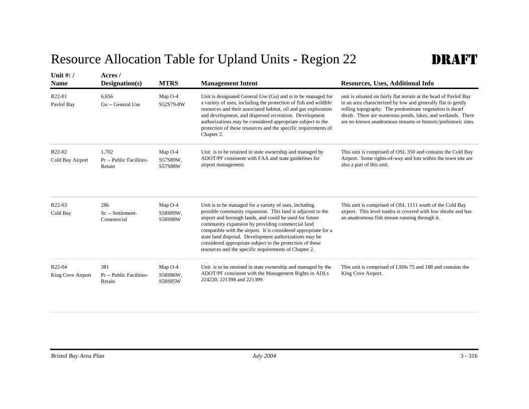
Resource Allocation Table for Upland Units - Region 22 DRAFT
Name MTRSDesignation(s) Management Intent Resources, Uses, Additional InfoAcres /Unit #: /
Pavlof Bay S52S79-8WMap O-4
Gu -- General UseUnit is designated General Use (Gu) and is to be managed for a variety of uses, including the protection of fish and wildlife resources and their associated habitat, oil and gas exploration and development, and dispersed recreation. Development authorizations may be considered appropriate subject to the protection of these resources and the specific requirements of Chapter 2.
unit is situated on fairly flat terrain at the head of Pavlof Bay in an area characterized by low and generally flat to gently rolling topography. The predominate vegetation is dwarf shrub. There are numerous ponds, lakes, and wetlands. There are no known anadromous streams or historic/prehistoric sites.
6,656R22-01
Cold Bay Airport S57S89W, S57S88W
Map O-4Pr -- Public Facilities-Retain
Unit is to be retained in state ownership and managed by ADOT/PF consistent with FAA and state guidelines for airport management.
This unit is comprised of OSL 350 and contains the Cold Bay Airport. Some rights-of-way and lots within the town site are also a part of this unit.
1,702R22-02
Cold Bay S58S89W, S58S88W
Map O-4Sc -- Settlement-Commercial
Unit is to be managed for a variety of uses, including possible community expansion. This land is adjacent to the airport and borough lands, and could be used for future community expansion by providing commercial land compatible with the airport. It is considered appropriate for a state land disposal. Development authorizations may be considered appropriate subject to the protection of these resources and the specific requirements of Chapter 2.
This unit is comprised of OSL 1111 south of the Cold Bay airport. This level tundra is covered with low shrubs and has an anadromous fish stream running through it.
286R22-03
King Cove Airport S58S86W, S58S85W
Map O-4Pr -- Public Facilities-Retain
Unit is to be retained in state ownership and managed by the ADOT/PF consistent with the Management Rights in ADLs 224220, 221398 and 221399.
This unit is comprised of LSHs 75 and 188 and contains the King Cove Airport.
381R22-04
3 - 316Bristol Bay Area Plan July 2004

Name MTRSDesignation(s) Management Intent Resources, Uses, Additional InfoAcres /Unit #: /
King Cove DOT Facilities
S59S86WMap O-4
Pr -- Public Facilities-Retain
Unit is to be retained in state ownership and managed by ADOT/PF under the terms of LSHs 75 and 288 and as public right-of-way.
This unit is comprised of LSHs 75 and 288 and OSL 981. There is a small lot within the town site of King Cove that contains equipment storage for the airport. The remainder of this unit is the road connecting the town to the airport.
0.90R22-05
False Pass Airport S61S94W Sec. 28,33-34
Map O-4Pr -- Public Facilities-Retain
The unit is to be retained in state ownership and managed by the Department of Transportation and Public Facilities (DOT) consistent with DOT guidelines and the Management Right ADL 224133.
This unit is comprised of OSL 977 and contains the False Pass Airport.
138R22-06
3 - 317Bristol Bay Area Plan July 2004

Resource Allocation Table for Tideland Units - Region 22 DRAFTUnit # /Name MTRSDesignation(s) Management Intent Resources, Uses, Additional Info
Acres /
R22T-01Tidelands adjacent to NWRs
Ha, Rd -- Habitat and Public Recreation and Tourism-Dispersed
Tidelands adjacent to the three National Wildlife Refuges and the State Game Refuges are to be managed to protect sensitive habitat values, fisheries and wildlife resources, and the public recreation resources of the National Preserve. A Tidelands Resource Management Zone (TRMZ) affects these tidelands. See 'Magement Summary, Tidelands' in Chapter 3 for a more detailed description of TRMZs and the management intent and requirements for such zones. As appropriate, consult with Alaska Maritime, Izembek, and Alaska Peninsula NWRs; USFWS; and NMFS prior to issuing authorizations.
This tideland unit adjoins three national wildlife refuges -- Izembek, Alaska Peninsula, and Alaska Maritime. Most of the Ikatan Peninsula and adjacent tidelands are included in the Ikatan Peninsula Sate Game Refuge. The Izembek State Game Refuge includes the tidelands within Izembek Lagoon and north of the Kudiakof Islands. This tideland unit contains a rich diversity of habitats and resources.
There are a variety of marine resources that are scattered throughout this Region, including eelgrass and kelp beds, numerous seabird colonies, sea lion rookeries and haulouts, as well as walrus rookeries and haulouts. This Region also contains a significant population of sea otter. The outstanding resource areas within this Region coincide with the area of the Izembek National Wildlife Refuge, Izembek State Game Refuge and with the Alaska Maritime NWR at Amak Island and rocks. Izembek SGR consists of an extensive lagoon system that is rich in eelgrass and kelp beds, and contains extensive areas used for harbor seal haulouts, brown bear concentrations (spring), and waterfowl seasonal concentrations (spring and fall). The Izembek Lagoon portion of the SGR is enclosed within the Izembek NWR which consists of uplands bordering the lagoon including spits and the Kudiakof Islands. The Amak Island and rocks contain a large population of walrus and sea lions and has haulout areas for both. Sea bird colonies are also present on this island. The remaining parts of the Region also possess significant resources, with most of these concentrated on the south side of the Alaska Peninsula. Within the latter area, there are numerous sea bird colonies, concentration areas of kelp and eel grass, and sea lion rookeries and haulouts. The Sanak Island group contain the majority of the sea lion rookery and haulout areas.
Harvest: Salmon are harvest in the tidelands on the northern side of the peninsula in this region, particularly around Izembek Lagoon and Moffet Bay. Commercial harvest of a variety of resources occurs along the southern coast and islands of this region. Pink chum and coho salmon are harvested throughout the tidelands but most extensively in
47,556 Map O-4
Bristol Bay Area Plan July 2004 3 - 318

Unit # /Name MTRSDesignation(s) Management Intent Resources, Uses, Additional Info
Acres /
Pavlof Bay, Belkofski Bay, King Cove and Cold Bay. Intensive purse seine and gill net harvest of salmon occurs around False Pass, Ikutan Bay and also from Ikutan Peninsula to Cape Lazeref on the south side of Unimak Island, including Unimak Bight. There are scattered set net sites along the southern coast of this region particularly in bays and lagoons where there is a high concentration of salmon. Halibut harvest occurs throughout the southern tidelands of this region, especially around the Sanak Islands, the south side of Unimak Island and the Krenitzin Islands area. Pollock, cod and herring sac roe (food/bait) are harvested in the Krenitzin Islands area as well. Red king and Tanner crab are harvested in the bay and lagoons all along the southern coast of the Alaska Peninsula. Dungeness crab are harvested in the highest numbers in Belkofski Bay and along the south shore of Unimak Island from Cape Lazeref to Unimak Bight. There are also concentrations of dungeness crab around the shores of the Krenitzin Islands.
Sportfishing is prevalent in the tidelands adjacent to this region. Seasonal subsistence fishing occurs around Kelkofski, King Cove, False Pass, Cold Bay and Akutan. Subsistence harvest consists mainly of salmon, but also includes halibut, clams, geese, other waterfowl and eggs and seals.
R22T-02False Pass North S61S94W
Sec. 22,27Wd -- Waterfront Development
Unit is to be managed to accommodate tideland commercial and industrial uses, including a new boat harbor for the community of False Pass.
Unit is situated to the north of the False Pass community in an area that is considered appropriate for tideland commercial and industrial uses. A new harbor may go in this unit.
403 Map O-4
Bristol Bay Area Plan July 2004 3 - 319

Unit # /Name MTRSDesignation(s) Management Intent Resources, Uses, Additional Info
Acres /
R22T-03False Pass Central S61S94W
Sec. 28Wd -- Waterfront Development
Unit is to be managed to accommodate tideland commercial and industrial uses.
Unit is situated near the main part of the False Pass community in an area that is considered appropriate for tideland commercial and industrial uses. There are a number of private tideland units near this unit, some of which have industrial and fisheries use.
Commercial fishing and fish processing are currently the dominant activities involving tidelands around False Pass. Tideland facilities support the fish processing industry and provide commercial docking facilities for the State Ferry which docks bi-monthly between May and October. False Pass also provides docking facilities for barge service from Seattle.
13 Map O-4
R22T-04False Pass South S61S94W
Sec. 33,34Wd -- Waterfront Development
Unit is to be managed to accommodate tideland commercial and industrial uses.
Unit is situated south of the False Pass community in an area that is considered appropriate for tideland commercial and industrial uses. There a number of private tideland units near this unit, some of which have industrial and fisheries use. Note: This tideland unit excludes ATS 58.
308 Map O-4
R22T-05Akutan Community North
S70S112W Sec. 8-12
Wd -- Waterfront Development
Unit is to be managed to accommodate tideland commercial and industrial uses. Note: It is unlikely that all of the area within this unit will be used for future commercial and industrial tideland uses. A fairly large area of tidelands is designated Waterfront Development given the uncertainty of the exact location of future facilities needed to support this community.
Unit is situated at, and east of, the community of Akutan in an area that is considered appropriate for tideland commercial and industrial uses. There a number of private tideland units that adjoin this unit, some of which have industrial and fisheries use. This tideland unit excludes all private tidelands. Commercial fishing and fish processing dominates Akutan's economy.
449 Map O-4
R22T-06Akutan Community South
S70S112W Sec. 9-13
Wd -- Waterfront Development
Unit is to be managed to accommodate tideland commercial and industrial uses. Note: It is unlikely that all of the area within this unit will be used for future commercial and industrial tideland uses. A fairly large area of tidelands is designated Waterfront Development given the uncertainty of the exact location of future facilities needed to support this community.
Unit is situated generally west and south of the community of Akutan in an area that is considered appropriate for tideland commercial and industrial uses. There are a number of private tideland units that adjoin this unit, some of which have industrial and fisheries use. This tideland unit excludes all private tidelands. Commercial fishing and fish processing dominates Akutan's economy.
503 Map O-4
Bristol Bay Area Plan July 2004 3 - 320

Unit # /Name MTRSDesignation(s) Management Intent Resources, Uses, Additional Info
Acres /
R22T-07Cold Bay North S57S88W,
S57S89WWd -- Waterfront Development
Unit is to be managed to accommodate tideland commercial and industrial uses. Note: It is unlikely that all of the area within this unit will be used for future commercial and industrial tideland uses. A fairly large area of tidelands is designated Waterfront Development given the uncertainty of the exact location of future facilities needed to support this community.
Unit is situated generally north and east of the community of King Cove in an area that is considered appropriate for tideland commercial and industrial uses. This tideland unit excludes all private tidelands.
Commercial fishing and fish processing are currently the dominant activities involving tidelands around King Cove. Seafood processing in this area occurs year-round and the north harbor provides ice-free moorage for fishing boats. Tideland facilities support the fish processing industry and provide commercial docking facilities for the State Ferry which docks bi-monthly between May and October.
869 Map O-4
R22T-08Cold Bay South S57S88W,
S58S88WWd -- Waterfront Development
Unit is to be managed to accommodate tideland commercial and industrial uses. Note: It is unlikely that all of the area within this unit will be used for future commercial and industrial tideland uses. A fairly large area of tidelands is designated Waterfront Development given the undertainty of the exact location of future facilities needed to support this community.
Unit is situated generally southeast of the community of King Cove in an area that is considered appropriate for tideland commercial and industrial uses. This tideland unit excludes all private tidelands.
3,415 Map O-4
Bristol Bay Area Plan July 2004 3 - 321

Unit # /Name MTRSDesignation(s) Management Intent Resources, Uses, Additional Info
Acres /
R22T-09Aleutians West Gu -- General Use
Manage unit for a variety of uses and resources. Protect eel grass beds and sea bird colonies. Maintain opportunities for commercial, subsistence, and sport fish harvest.
This unit consists of that portion of the Region not included within the Tideland Resource Management Zone (R22T-01) or in areas where tidelands adjoin municipalities (units R22T-02 through -08)
The vast majority of the sensitive biological resources occur with the TRMZ, particularly within the Izembek Lagoon, Amak Islands and Rocks, and the offshore islands on the Pacific side of the unit. Within R22T-09 there are scattered areas of eel grass beds and sea bird colonies.
Salmon are harvest in the tidelands on the northern side of the peninsula in this region, particularly around Izembek Lagoon and Moffet Bay. Commercial harvest of a variety of resources occurs along the southern coast. Pink chum and coho salmon are harvested throughout the tidelands but most extensively in Pavlof Bay, Belkofski Bay, King Cove and Cold Bay. Intensive purse seine and gill net harvest of salmon occurs around False Pass. There are scattered set net sites along the southern coast of this region particularly in bays and lagoons where there is a high concentration of salmon. Halibut, Red king and Tanner crab are harvested in the bay and lagoons all along the southern coast of the Alaska Peninsula. Dungeness crab are harvested in the highest numbers in Belkofski Bay.
Sport fishing is prevalent in the tidelands adjacent to this region. Seasonal subsistence fishing occurs around Kelkofski, King Cove, False Pass, Cold Bay and Akutan. Subsistence harvest consists mainly of salmon, but also includes halibut, clams, geese, other waterfowl and eggs and seals.
2,449,977 Map O-4
Bristol Bay Area Plan July 2004 3 - 322

PUBLIC REVIEW DRAFT Chapter 3 – Navigable Rivers and Lakes
Bristol Bay Area Plan July 2004 3 - 323
Navigable Rivers And Lakes 1
2
Management Intent of Navigable Water Bodies 3 4 Background 5 The intent of the plan is to designate and provide management intent for the shorelands under all 6 navigable water bodies. There are so many navigable rivers and lakes in the planning area that 7 it is not practical to state the management intent for each individual water body. Therefore the 8 plan identifies general management intent and designations for most of the water bodies within 9 the planning area. In some cases, however, specific designations are identified for a particular 10 water body because of the size, uniqueness, or particular values and functions of a river or lake. 11 12 The term "shorelands" is defined as land belonging to the state which is covered by non-tidal 13 water that is navigable under the laws of the United States up to the ordinary high water mark as 14 modified by accretion, erosion, or reliction (AS 38.05.965). See Figure 1.1 at the beginning of 15 Chapter 1 for a diagram that illustrates the differences between shore-lands, submerged lands, 16 and uplands. 17 18 Shorelands are not identified on the preceding plan designation maps within this Chapter. 19 Identification of all such water bodies is impractical on maps of the scale used in this plan. The 20 DNR records on navigability and hydrology must be consulted in order to determine whether a 21 specific stream or lake is likely to be navigable. These records are available in the Resource 22 Assessment and Development Section, Division of Mining, Land, and Water in Anchorage. 23 24 For further information on the state’s navigability policy, go to 25 http://www.dnr.state.ak.us/mlw/nav/nav_policy.htm 26 27 Public Trust Doctrine 28 The Public Trust Doctrine provides that public trust lands, waters and living natural resources in 29 a state are held by the state in trust for the benefit of all the people, and establishes the right of 30 the public to fully utilize the public trust lands, waters, and resources for a wide variety of 31 public uses. Each state has the authority and responsibility for managing these public trust 32 assets to assure the public rights are upheld. 33 34 The Public Trust Doctrine applies whenever navigable waters or the lands beneath those waters 35 are altered, developed, conveyed, or otherwise managed. It also applies whether the trust lands 36 are publicly or privately owned. Shorelands below the ordinary high water mark are considered 37 public trust lands. In summary, all submerged lands – including tidelands out to the three-mile-38 limit and the beds of navigable lakes, streams and rivers – are all public trust lands. 39 40

Chapter 3 – Navigable Rivers and Lakes PUBLIC REVIEW DRAFT
3 - 324 July 2004 Bristol Bay Area Plan
The Alaska Constitution contains numerous provisions embracing principles of the Public Trust 1 Doctrine that require the state to exercise authority to ensure that the right of the public to use 2 navigable waters for navigation, commerce, recreation, and related purposes is protected. In 3 Alaska, the Public Trust Doctrine extends beyond those submerged lands in which the state 4 holds title to include all waters that are navigable. The state's waters are themselves reserved to 5 the people for common use. 6 7 The Alaska Constitution (Article VIII, sections 1, 2, 3, 6, 13, and 14) and Alaska Statutes 8 (38.05.127 and 38.05.128) contain some of the provisions, which are the legal basis for applying 9 the Public Trust Doctrine in Alaska. In Alaska, this doctrine guarantees the public's right to 10 engage in activities such as commerce, navigation, fishing, hunting, trapping, and swimming, 11 while also providing for the protection of areas for ecological study. 12 13 The Alaska Constitution provides that "free access to the navigable or public waters of the state, 14 as defined by the legislature, shall not be denied any citizen of the United States or resident of 15 the state, except that the legislature may by general law regulate and limit such access for other 16 beneficial uses or public purposes." The Alaska Supreme Court has concluded "the provisions 17 in Article VIII [of the Constitution] were intended to permit the broadest possible access to and 18 use of state waters by the general public." Wernberg v. State, 516 P. 2d 1191, 1198-9 (Alaska 19 1973). The Alaska legislature has broadly defined the navigable and public waters available for 20 public use in AS 38.05.965. Moreover, the legislature has endorsed a broad interpretation of the 21 Public Trust Doctrine in Article VIII of Alaska's Constitution in finding that: 22 23 "Ownership of land bordering navigable or public waters does not grant an exclusive right to the 24 use of the water and any rights of title to the land below the ordinary high water mark are 25 subject to the rights of the people of the state to use and have access to the water for recreational 26 purposes or any other public purposes for which the water is used or capable of being used 27 consistent with the public trust." Sec. 1, Ch. 82, SLA 1985. 28 29 The legislature has also declared that the right to use state waters does not include the right to 30 enter or trespass upon private lands. Nevertheless, with 99 percent of Alaska in public 31 ownership at statehood, state laws regarding the transfer of land to private parties say the 32 transfers must provide for public access to navigable waters. For instance, AS 38.05.127 33 implements the state's constitutional guarantee of access to navigable waters under Article VIII, 34 Section 14. Under the statute, the Commissioner of the Alaska Department of Natural 35 Resources must "provide for the specific easements or rights-of-way necessary to ensure free 36 access to and along the body of water, unless the Commissioner finds that regulating or 37 eliminating access is necessary for other beneficial uses or public purposes." The state's 38 responsibilities to implement the Public Trust Doctrine are considered and used throughout this 39 plan. Any management actions will be consistent with the Public Trust Doctrine as defined by 40 the Alaska Constitution, statutes, court decisions, and public involvement. 41 42 Management Intent: Specific Rivers and Lakes 43 Because of their importance for recreation, commerce and habitat, certain rivers and lakes are 44 given specific use designations. The plan designations applied to shorelands are identical to 45

PUBLIC REVIEW DRAFT Chapter 3 – Navigable Rivers and Lakes
Bristol Bay Area Plan July 2004 3 - 325
those used for uplands, tidelands, and submerged lands. In addition to shorelands crossing state, 1 native, or private land that are navigable, the state asserts ownership of such shorelands within 2 federal conservation units. Within the planning area there are five National Wildlife Refuges, 3 two National Parks/Preserves, and one National Monument, all of which have navigable rivers 4 or lakes, or both.27 5 6 A listing of rivers and lakes that, at a minimum, are considered to be navigable is identified in 7 the table that follows. These are the largest waterbodies within each of the Regions.28, 29 8 9 Navigable Rivers and Lakes within Federal Conservation System Units 10 Certain rivers and lakes within Federal Conservation System Units (CSUs) are significant for 11 their habitat and recreational values. For example, streams with high bear concentrations are 12 important for their habitat value and as popular viewing areas. The navigable portions of water 13 bodies within CSUs that contain spawning and rearing areas for anadromous fish are designated 14 Habitat. All such areas are also designated Public Recreation – Dispersed.30, 31 The Habitat 15 designation converts to the land use classification of Wildlife Habitat Land and the designation 16 of Public Recreation -- Dispersed, to Public Recreation Land. Navigable water bodies that are 17 not anadromous and that are not otherwise designated Public Recreation – Dispersed are 18 designated General Use. See the following table for the specific designations applied to the 19 larger navigable rivers and lakes within the planning area. 20 21 State Navigable Rivers and Lakes: General 22 The designation and management intent for navigable water bodies that cross or are surrounded 23 by state-owned and state-selected lands not within federal conservation units, State Parks, or 24 State Game Refuges32 are the same as those of the upland tract, except for those streams that are 25 specifically designated Public Recreation – Dispersed and those portions of navigable, 26 anadromous streams where spawning and rearing occur, which are designated Habitat. These 27 water bodies are to be managed to be consistent with the designated upland uses. See the table 28 below for the specific designations applied to the larger navigable rivers and lakes within the 29 planning region. Many navigable rives and lakes are designated Public Recreation – Dispersed 30 because of their importance for public recreation. 31 32
27 National Wildlife Refuges: Togiak, Becharof, Alaska Peninsula, Izembek, and Alaska Maritime. National Parks: Katmai National Park and Preserve, Lake Clark National Park and Wilderness. National Monument: Aniakchak National Park and Preserve. 28 Although it is likely that much or most parts of these waterbodies are navigable, portions may not be. Consult with DNR’s Resource Assessment and Development Section in the Division of Mining, Land, and Water to determine if a waterbody is navigable at a particular site. See also footnote #4. 29 There are other waterbodies that are navigable. Consult with DNR’s Resource Assessment and Development Section to determine the navigability to a particular waterbody. See also footnote #3. 30 Thus, all such navigable waterbodies are co-designated Habitat and Public Recreation – Dispersed. Consult the ADF&G anadromous stream catalog to determine if a stream is anadromous and with ADF&G to determine if a specific portion of a stream is considered by that agency to be either a spawning or rearing area. 31 See also the discussion of specific lakes within federal conservation units that are important for public recreation purposes, following.

Chapter 3 – Navigable Rivers and Lakes PUBLIC REVIEW DRAFT
3 - 326 July 2004 Bristol Bay Area Plan
Navigable rivers and lakes that are not within State Parks or State Game Refuges, and are not 1 within state-owned, or state-selected upland management units, and are not otherwise 2 designated in the table below, are designated General Use. These water bodies are to be 3 managed to allow a diversity of uses consistent with the uses authorized on adjoining uplands in 4 federal, private, or other state entity ownership (e.g. Mental Health, University, and state tracts 5 quitclaimed to a state agency other than DNR). Upland uses are usually designated in an 6 adopted land use or resource management plan, or can be inferred from the actual or planned 7 use of the management unit. 8 9 10 Table 3.1: Some Navigable Waters -- Bristol Bay Area Plan 11 12
Region Water Body Waters Flowing Through
Waters Flowing Through
Land Use
State Uplands Federal Lands Designation (owned & Selected) (including CSU's) Gu Ha Rd 2 Akulikutak River Yes Yes 2 Arolik Lake Yes Yes Yes 2 Arolik River Yes Yes Yes Yes 2 Eek Lake Yes Yes 2 Eek River Yes Yes Yes 2 Fog River Yes Yes Yes 2 Goodnews River Yes Yes Yes Yes 2 Indian River Yes Yes Yes 2 Kagati Lake Yes Yes Yes 2 Kanektok River Yes Yes Yes 2 Kanuktik Lake Yes Yes 2 Kasigluk River Yes Yes Yes 2 Kinegnak River Yes Yes Yes 2 Kisaralik Lake Yes Yes Yes 2 Kisaralik River Yes Yes Yes Yes 2 Kukaklik River Yes Yes Yes 2 Kwethluk River Yes Yes Yes 2 Middle Fork Eek River Yes Yes Yes 2 Nanvakfak Lake Yes Yes 2 Pegati Lake Yes Yes Yes 2 Salmon River Yes Yes Yes 2 Tuluksak River Yes Yes Yes Yes 2 Ugaklik River Yes Yes 3 Amanka Lake Yes Yes Yes 3 Gechiak Creek Yes Yes Yes 3 Gechiak Lake Yes Yes Yes 3 Heart Lake Yes Yes Yes 3 Igushik River Yes Yes Yes 3 Izavieknik River Yes Yes Yes 3 Kanik River Yes Yes Yes 3 Kemuk River Yes Yes Yes 3 Kikertalik Lake Yes Yes 3 Kulukak River Yes Yes Yes 3 Matogak River Yes Yes Yes

PUBLIC REVIEW DRAFT Chapter 3 – Navigable Rivers and Lakes
Bristol Bay Area Plan July 2004 3 - 327
3 Nagugun Lake (Reg 3) Yes Yes 3 Nayorurun River Yes Yes Yes 3 Negukthlik River Yes Yes Yes 3 Nisua River Yes Yes Yes 3 Norseman Lake Yes Yes 3 Ongoke River Yes Yes 3 Osivak River Yes Yes Yes 3 Pungokepuk Creek Yes Yes Yes 3 Pungokepuk Lake Yes Yes 3 Quigmy River Yes Yes Yes 3 Slug River Yes Yes 3 Togiak Lake Yes Yes Yes 3 Togiak River Yes Yes Yes 3 Tuklun River Yes Yes Yes 3 Tunuing River Yes Yes Yes 3 Ualik Lake Yes Yes Yes 3 Ungalikthluk River Yes Yes Yes 3 Upper Togiak Lake Yes Yes 4 Not subject to BBAP 5 Aleknagik Lake Yes Yes Yes 5 Iowithla River Yes Yes Yes Yes 5 Muklung River Yes Yes Yes Yes 5 Nunavaugaluk (Snake)
Lake Yes Yes Yes
5 Nushagak River Yes Yes Yes 5 Snake River Yes Yes Yes Yes 5 Weary River Yes Yes Yes Yes 5 Wood River (part) Yes Yes Yes 6 Chichinok River Yes Yes Yes 6 Cranberry Creek Yes Yes Yes Yes 6 Isowitha River Yes Yes Yes 6 Keefer Creek Yes Yes Yes 6 King Salmon River Yes Yes Yes 6 Klutuk Creek Yes Yes Yes Yes 6 Klutuspak Creek Yes Yes 6 Koktuli River Yes Yes Yes 6 Kokwok River Yes Yes Yes 6 Mosquito River Yes Yes Yes 6 Mulchatna River Yes Yes Yes 6 Napotoli Creek Yes Yes 6 Nushagak River Yes Yes Yes 6 Nuyakuh River Yes Yes Yes 6 Old Man Creek Yes Yes 6 Stuyahok River Yes Yes Yes 6 Vukpalik Creek Yes Yes 7 Chilchitna River Yes Yes 7 Chilikadrotna River Yes Yes Yes Yes 7 Chulitna Yes Yes Yes 7 Koksetna River Yes Yes 7 Long Lake Yes Yes Yes 7 McKinley Creek Yes Yes 7 Mulchatna River Yes Yes Yes Yes

Chapter 3 – Navigable Rivers and Lakes PUBLIC REVIEW DRAFT
3 - 328 July 2004 Bristol Bay Area Plan
7 Nikabuna Lakes Yes Yes 7 Tutka Lake Yes Yes 8 Newhalen River Yes Yes Yes 8 Sixmile Lake Yes Yes Yes Yes 8 Tazimina River Yes Yes Yes 9 Boot Lake Yes Yes 9 Chekok Lake Yes Yes 9 Copper River Yes Yes Yes 9 Fog Lake Yes Yes 9 Gibraltar Lake Yes Yes 9 Iliamna Lake Yes Yes Yes 9 Iliamna River Yes Yes Yes 9 Kakhonak Lake Yes Yes 9 Kakhonak River Yes Yes 9 Long Lake Yes Yes 9 Lower Copper Lake Yes Yes 9 Meadow Lake Yes Yes 9 Moose Lake Yes Yes 9 Pile River Yes Yes Yes 9 Upper Copper Lake Yes Yes
10 Alagnak River Yes Yes No Yes Yes 10 Kaskanak Creek Yes Yes Yes Yes 10 Kvichak River Yes Yes Yes Yes 10 Ole Creek Yes Yes Yes 10 Pecks Creek Yes Yes Yes Yes 10 Yellow Creek Yes Yes No Yes Yes 11 King Salmon River Yes Yes Yes 11 Naknek River Yes Yes Yes 11 Pauls Creek Yes Yes Yes Yes 11 Smelt Creek Yes Yes 12 Becharof Lake Yes Yes Yes 12 Big Creek Yes Yes 12 Egegik River Yes Yes Yes Yes 12 Kejulik River Yes Yes Yes 12 King Salmon River Yes Yes Yes Yes 12 Swampy River Yes Yes 13 Lower Ugashik Lake Yes Yes Yes Yes 13 Ugashik River Yes Yes Yes 13 Upper Ugashik Lake Yes Yes Yes 14 Dog Salmon River Yes Yes Yes 14 King Salmon River Yes Yes Yes 14 Ugashik River Yes Yes Yes 15 Cinder River Yes Yes Yes 15 Dog Salmon River Yes Yes Yes 15 King Salmon River Yes Yes Yes Yes 15 Mother Goose Lake Yes Yes Yes 15 Needle Lake Yes Yes 15 Pumice Creek Yes Yes 16 Meshik River Yes Yes Yes Yes 16 Plenty Bear Creek Yes Yes Yes 17 Black Lake Yes Yes Yes

PUBLIC REVIEW DRAFT Chapter 3 – Navigable Rivers and Lakes
Bristol Bay Area Plan July 2004 3 - 329
17 Chignik Lake Yes Yes Yes 17 Chignik River Yes Yes Yes 17 Kametolook River Yes Yes Yes 18 Bear Lake Yes Yes Yes 18 Bear River Yes Yes Yes 18 Ilnik Lake Yes Yes 18 Ilnik River Yes Yes 18 Muddy River Yes Yes Yes 18 Ocean River Yes Yes Yes 18 Sandy Lake Yes Yes Yes Yes 18 Sandy River Yes Yes Yes Yes 18 Unangashak River Yes Yes Yes Yes 18 Wildman Lake Yes Yes Yes 19 Beaver River Yes Yes Yes 19 Bishop Creek Yes Yes Yes 19 Coal Creek Yes Yes Yes 19 Coleman Creek Yes Yes Yes 19 Foster Creek Yes Yes Yes 19 Johnson Creek Yes Yes Yes 19 Lawrence Creek Yes Yes Yes Yes 19 Portage Creek Yes Yes Yes 19 Susie Creek Yes Yes Yes 21 Big Fish Lake Yes Yes 21 Canoe Bay River Yes Yes 21 Caribou River Yes Yes Yes 21 Cathedral River Yes Yes Yes 21 David River Yes Yes 21 Sapsuk Lake Yes Yes 21 Sapsuk River Yes Yes Yes 22 Barney’s Creek Yes Yes Yes 22 Blinn Lake Yes Yes 22 Coal Oil Creek Yes Yes 22 Delta Creek Yes Yes Yes 22 Emmons Lake Yes Yes 22 Fisher Caldera Lakes Yes Yes 22 Joshua Green River Yes Yes Yes 22 Lake Hess Yes Yes 22 Lake Trelford Yes Yes 22 Lazaref River Yes Yes Yes 22 North Creek Yes Yes Yes 22 Pogromni River Yes Yes Yes 22 Rescue Lake Yes Yes 22 Southern Creek Yes Yes Yes 22 Winding Creek Yes Yes Yes
Aniakchak Aniahehak River Yes Yes Yes Aniakchak Meshik Lake Yes Yes Aniakchak Meshik River Yes Yes Yes Aniakchak Northeast Creek Yes Yes Yes Aniakchak Surprise Lake Yes Yes
Katmai American Creek Yes Yes Yes Katmai Battle Lake Yes Yes Yes Katmai Hammersley Lake Yes Yes

Chapter 3 – Navigable Rivers and Lakes PUBLIC REVIEW DRAFT
3 - 330 July 2004 Bristol Bay Area Plan
Katmai Idavain Lake Yes Yes Katmai Kukaklek Lake Yes Yes Yes Katmai Lake Brooks Yes Yes Katmai Lake Coville Yes Yes Katmai Lake Grosvenor Yes Yes Yes Katmai McNeil Lake Yes Yes Katmai Murray Lake Yes Yes Katmai Naknek Lake Yes Yes Yes Katmai Nonvianuk Lake Yes Yes Yes Katmai Savonoski River Yes Yes Yes
L.C. Chilikadrotna River Yes Yes Yes L.C. Chulitna River Yes Yes Yes L.C. Current Creek Yes Yes Yes L.C. Fishtrap Lake Yes Yes L.C. Kijik Lake Yes Yes L.C. Koksetna River Yes Yes L.C. Kontrashibuna Lake Yes Yes L.C. Kujak River Yes Yes L.C. Lake Clark Yes Yes Yes L.C. Little Lake Clark Yes Yes Yes L.C. Little Mulchatna River Yes Yes Yes L.C. Lower Tazimina Lake Yes Yes L.C. Pickerel Lakes Yes Yes L.C. Portage Lake Yes Yes L.C. Tanalian River Yes Yes Yes L.C. Tazimina River Yes Yes Yes L.C. Tlikakila River Yes Yes Yes L.C. Turquiose Lake Yes Yes L.C. Twin Lakes Yes Yes Yes L.C. Upper Tazimina Lake Yes Yes
1