Chapter 3. Affected Environment · Chapter 3. Affected Environment Introduction This chapter...
160
Chapter 3. Affected Environment Introduction This chapter briefly describes physical, biological, and cultural (social and economic) conditions within the planning area. The Eagle Lake Field Office (ELFO) planning area encompasses 1,022,767 acres in four counties of northeastern California (CA) and northwestern Nevada (NV). The description of existing conditions contained herein forms a baseline for analyzing expected impacts from management actions. Most of these data were provided by BLM’s ELFO; other federal, state, county, or local agencies; various non-governmental organizations; and other public and private sources. Sources include published and unpublished reports, maps, and electronically stored data (e.g., geographic information system [GIS] data). Most of the planning area is part of the Modoc Plateau, which belongs to a geological province known as the Great Basin Division. This is described in the Jepson Manual (Hickman 1993). The Modoc Plateau does not include the Warner Mountains. The planning area’s eastern boundary is at the terminus of the plateau, where it joins the barren playa of the Smoke Creek Desert. The remainder of the ELFO planning area (the western and southwestern portion near the boundary area) is part of the Cascade Range (which extends northward) and the Sierra Nevada region (specifically, its northernmost extension, the Diamond Mountains). This area is also part of the California Floristic Province. Susanville (population 17,400) is the only incorporated municipality in Lassen County; the largest unincorporated community is Westwood. The other significant population centers of Lassen County are Clear Creek, Johnstonville, Standish, Litchfield, Wendel, Janesville, Milford, Herlong, Doyle, Spaulding, and Ravendale. The dominant vegetation types are grasses, Great Basin shrubs, sagebrush, sagebrush/western juniper, western juniper, conifer, and riparian plants. The characteristic large mammals are mule deer, pronghorn, mountain lion, black bear, and coyote. Feral species include wild horses and burros. The principal land use activities are livestock grazing, agriculture, forestry, mineral extraction, and recreation. EAGLE LAKE FIELD OFFICE Proposed Resource Management Plan and Final Environmental Impact Statement 3-1
Transcript of Chapter 3. Affected Environment · Chapter 3. Affected Environment Introduction This chapter...

Chapter 3. Affected Environment
Introduction
This chapter briefly describes physical, biological, and cultural (social and economic) conditions within the planning area. The Eagle Lake Field Office (ELFO) planning area encompasses 1,022,767 acres in four counties of northeastern California (CA) and northwestern Nevada (NV). The description of existing conditions contained herein forms a baseline for analyzing expected impacts from management actions. Most of these data were provided by BLM’s ELFO; other federal, state, county, or local agencies; various non-governmental organizations; and other public and private sources. Sources include published and unpublished reports, maps, and electronically stored data (e.g., geographic information system [GIS] data).
Most of the planning area is part of the Modoc Plateau, which belongs to a geological province known as the Great Basin Division. This is described in the Jepson Manual (Hickman 1993). The Modoc Plateau does not include the Warner Mountains. The planning area’s eastern boundary is at the terminus of the plateau, where it joins the barren playa of the Smoke Creek Desert. The remainder of the ELFO planning area (the western and southwestern portion near the boundary area) is part of the Cascade Range (which extends northward) and the Sierra Nevada region (specifically, its northernmost extension, the Diamond Mountains). This area is also part of the California Floristic Province.
Susanville (population 17,400) is the only incorporated municipality in Lassen County; the largest unincorporated community is Westwood. The other significant population centers of Lassen County are Clear Creek, Johnstonville, Standish, Litchfield, Wendel, Janesville, Milford, Herlong, Doyle, Spaulding, and Ravendale.
The dominant vegetation types are grasses, Great Basin shrubs, sagebrush, sagebrush/western juniper, western juniper, conifer, and riparian plants. The characteristic large mammals are mule deer, pronghorn, mountain lion, black bear, and coyote. Feral species include wild horses and burros. The principal land use activities are livestock grazing, agriculture, forestry, mineral extraction, and recreation.
EAGLE LAKE FIELD OFFICE Proposed Resource Management Plan and Final Environmental Impact Statement 3-1

Chapter 3: AFFECTED ENVIRONMENT
3.1 Air Resources
The ELFO planning area (Lassen County) is part of the Northeast Plateau Air Basin, which also includes Siskiyou and Modoc Counties. The Lassen County Air Pollution Control District has jurisdiction over air quality and administers federal, state, and local regulations concerning air quality.
3.1.1 Current Conditions Northern California weather is dominated by the eastern Pacific high pressure cell, located off the west coast of North America. Due to its position, a nearly unbroken chain of winter storms normally descends on the planning area; most precipitation occurs during this winter storm period. Winter weather is normally accompanied by unstable air masses and strong winds, making for good dispersal of pollutants. Dispersal conditions are poor during fair weather periods, because conditions are usually stable and without strong winds.
Springtime movement of the Pacific high pressure cell results in declining precipitation, although conditions are rarely warm and dry, due to instability that continues to bring rain and snow. Dry, warm conditions characterize the summer months, although thunderstorms are not uncommon. The transition between summer and fall is often marked by cool, clear days and temperatures that often drop below freezing in the evening.
The most recent local air quality data, from Susanville’s Russell Monitoring Station, are for the period 1999 through 2001. They are presented in Table 3.1-1.
Table 3.1-1 Ambient Air Quality Monitoring Data at the Susanville Russel Monitoring Station (1999–2001)
Pollutant Standard 1999 2000 2001
Particulate Matter (as PM10) Maximum 24-hour concentration (μg/m3) 100.0 80.0 105.0 Second highest 24-hour concentration (μg/m3) 96.0 65.0 105.0 Average geometric mean concentration (μg/m3) 29 29 29 Average arithmetic mean concentration (μg/m3) 32 27 25
Number of Days Standard Exceededa
CAAQS 24-hour (>50 μg/m3)b 54 48 36 NAAQS 24-hour (>150 μg/m3)b 0 0 0
Notes: CAAQS = California ambient air quality standards. μg/m3 = Micrograms per cubic meter. NA = Not applicable. NAAQS = National ambient air quality standards.
aThe number of days above the standard is not necessarily the number of violations of the standard for the year. bCalculated exceedances are based on measurements taken every 6 days.
Sources: California Air Resources Board 2003, U.S. Environmental Protection Agency 2003.
EAGLE LAKE FIELD OFFICE Proposed Resource Management Plan and Final Environmental Impact Statement 3-2
Chapter 3: AFFECTED ENVIRONMENT
As revealed in Table 3.1-1, the planning area has, at times, exceeded California PM10 standards during this three-year period. The federal government and the State of California have established ambient air quality standards for six criteria pollutants; these are ozone (O3), carbon monoxide (CO), nitrogen dioxide (NO2), sulfur dioxide (SO2), particulate matter less than 10 micrometer (PM10), and lead (Pb). Table 3.1-2 (at the end of this section) provides a summary of state and federal ambient air quality standards.
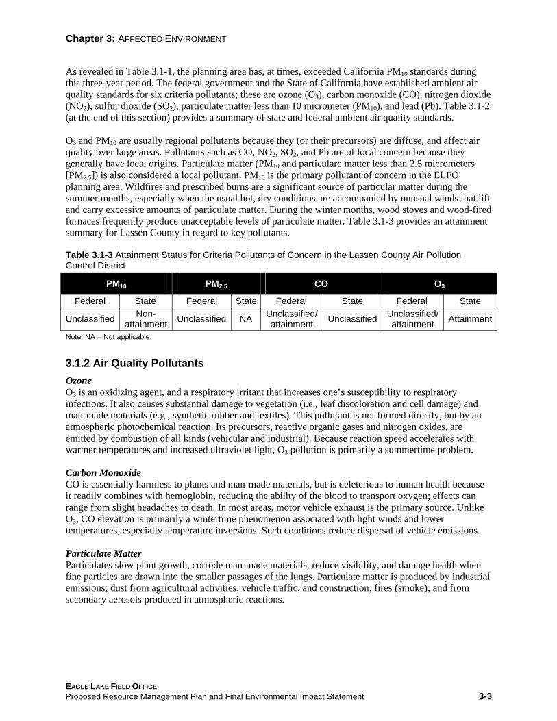
O3 and PM10 are usually regional pollutants because they (or their precursors) are diffuse, and affect air quality over large areas. Pollutants such as CO, NO2, SO2, and Pb are of local concern because they generally have local origins. Particulate matter (PM10 and particulare matter less than 2.5 micrometers [PM2.5]) is also considered a local pollutant. PM10 is the primary pollutant of concern in the ELFO planning area. Wildfires and prescribed burns are a significant source of particular matter during the summer months, especially when the usual hot, dry conditions are accompanied by unusual winds that lift and carry excessive amounts of particulate matter. During the winter months, wood stoves and wood-fired furnaces frequently produce unacceptable levels of particulate matter. Table 3.1-3 provides an attainment summary for Lassen County in regard to key pollutants.
Table 3.1-3 Attainment Status for Criteria Pollutants of Concern in the Lassen County Air Pollution Control District
PM10 PM2.5 CO O3
Federal State Federal State Federal State Federal State
Unclassified Non-attainment Unclassified NA Unclassified/
attainment Unclassified Unclassified/ attainment Attainment
Note: NA = Not applicable.
3.1.2 Air Quality Pollutants Ozone O3 is an oxidizing agent, and a respiratory irritant that increases one’s susceptibility to respiratory infections. It also causes substantial damage to vegetation (i.e., leaf discoloration and cell damage) and man-made materials (e.g., synthetic rubber and textiles). This pollutant is not formed directly, but by an atmospheric photochemical reaction. Its precursors, reactive organic gases and nitrogen oxides, are emitted by combustion of all kinds (vehicular and industrial). Because reaction speed accelerates with warmer temperatures and increased ultraviolet light, O3 pollution is primarily a summertime problem.
Carbon Monoxide CO is essentially harmless to plants and man-made materials, but is deleterious to human health because it readily combines with hemoglobin, reducing the ability of the blood to transport oxygen; effects can range from slight headaches to death. In most areas, motor vehicle exhaust is the primary source. Unlike O3, CO elevation is primarily a wintertime phenomenon associated with light winds and lower temperatures, especially temperature inversions. Such conditions reduce dispersal of vehicle emissions.
Particulate Matter Particulates slow plant growth, corrode man-made materials, reduce visibility, and damage health when fine particles are drawn into the smaller passages of the lungs. Particulate matter is produced by industrial emissions; dust from agricultural activities, vehicle traffic, and construction; fires (smoke); and from secondary aerosols produced in atmospheric reactions.
EAGLE LAKE FIELD OFFICE Proposed Resource Management Plan and Final Environmental Impact Statement 3-3

Chapter 3: AFFECTED ENVIRONMENT
3.1.3 Trends Unfortunately, BLM activities will continue to generate criteria pollutants, including substantial amounts of PM10 (inhalable particulates), especially from wildfires and prescribed burns. These will continue to have detrimental effects on regional air quality. The main sources of particulate matter (in order of importance) for the ELFO planning area are (Whitcome pers. comm.):
1. Wildfires (smoke)
2. Prescribed fires (smoke from area burns and brush piles)
3. Operation of heavy equipment (dust and vehicle emissions)
4. Road construction and maintenance (dust and vehicle emissions)
5. Reservoir construction and maintenance (dust and vehicle emissions)
6. Chainsaw emissions (fuel reduction and firefighting)
7. BLM field work and maintenance activities (dust and vehicle emissions)
EAGLE LAKE FIELD OFFICE Proposed Resource Management Plan and Final Environmental Impact Statement 3-4

Chapter 3: A
FFEC
TED E
NV
IRO
NM
EN
T
Table 3.1-2 Ambient Air Quality Standards Applicable in California Standard
Standard (micrograms (parts per million) per cubic meter) Violation Criteria Averaging
Pollutant Symbol Time CA U.S. CA U.S. CA U.S. If exceeded on more than 1 1 hour 0.09 0.12 180 235 If exceeded day per year If fourth highest 8-hour
Ozone O3 concentration in a year, 8 hours NA 0.08 NA 157 NA averaged over 3 years, is
exceeded at each monitor within an area If exceeded on more than 1 8 hours 9 9 10,000 10,000 If exceeded Carbon day per year CO monoxide If exceeded on more than 1 1 hour 20 35 23,000 40,000 If exceeded day per year
Carbon monoxide If equaled or (Lake CO 8 hours 6 NA 7,000 NA NA exceeded Tahoe only)
If exceeded on more than 1 Nitrogen 1 year NA 0.053 NA 100 NA NO2 day per year dioxide 1 hour 0.25 NA 470 NA If exceeded NA 1 year NA 0.03 NA 80 NA If exceeded
Sulfur If exceeded on more than 1 SO2 24 hours 0.04 0.14 105 365 If exceeded dioxide day per year 1 hour 0.25 NA 655 NA If exceeded NA
Hydrogen If equaled or H2S 1 hour 0.03 NA 42 NA NA sulfide exceeded Vinyl If equaled or C2H3Cl 24 hours 0.01 NA 26 NA NA chloride exceeded
EA
GLE L
AK
E FIELD
OFFIC
E Proposed R
esource Managem
ent Plan and Final Environm
ental Impact S
tatement
3-5

Chapter 3: A
FFEC
TED E
NV
IRO
NM
EN
T
Table 3.1-2 Ambient Air Quality Standards Applicable in California (cont.)
Standard Standard (micrograms
(parts per million) per cubic meter) Violation Criteria Averaging Pollutant Symbol Time CA U.S. CA U.S. CA U.S.
Annual geometric NA NA 20 NA If exceeded NA
mean PM10 Annual If exceeded at each monitor NA NA NA 50 NA arithmetic mean within area
If exceeded on more than 1 24 hours NA NA 50 150 If exceeded day per year Annual Inhalable
geometric NA NA 12 NA If exceeded NA particulate mean matter
If 3-year average from single Annual or multiple community-NA NA NA 15 NA PM2.5 arithmetic mean oriented monitors is
exceeded If 3-year average of 98th percentile at each population-24 hours NA NA NA 65 NA oriented monitor within an area is exceeded
Sulfate If equaled or SO4 24 hours NA NA 25 NA NA particles exceeded Calendar If exceeded no more than 1 NA NA NA 1.5 NA
Lead quarter day per year Pb particles If equaled or 30 days NA NA 1.5 NA NA exceeded
Notes: NA = Not applicable. All standards are based on measurements at 25ºC and 1 atmosphere pressure. National standards shown are the primary (health effects) standards. Source: California Air Resources Board, “Area Designations for State and National Ambient Air Quality Standards.”
EA
GLE L
AK
E FIELD
OFFIC
E Proposed R
esource Managem
ent Plan and Final Environm
ental Impact S
tatement
3-6

Chapter 3: AFFECTED ENVIRONMENT
3.2 Cultural Resources and Paleontology
The planning area has a relatively high incidence of significant archaeological sites. Thus far, almost 2.5% of the management area has been inventoried and 811 archaeological sites have been identified. Most are toolmaking stations, milling stations, rock art (petroglyphs and pictographs), and Midden sites. Estimates are that an additional 3,000 to 5,000 sites remain unrecorded (King et al. 2004). Euro-American sites are primarily historic roads and structures or remains of early farming and ranching activities.
The management area contains numerous National Register of Historic Places (NRHP) sites and districts. The most prominent of these are the Belfast Rock Art Complex and Heritage Education Area, the Bruff’s Rock National Register listed site, the (proposed) Upper Smoke Creek NRHP District, and the Eagle Lake Archaeological District NRHP Rock Art Site. The Horse Lake watershed has the greatest concentration of prehistoric sites in the district, many of which are of NRHP quality. The best-preserved segments of the Nobles Emigrant Trail and the Merrillville-Bieber Wagon Road are also located in the ELFO management area. Site data are being entered into a GIS database—along with data on soils, vegetation, fire history, land health, etc.—for use in developing cultural resource management plans.
The major factors that damaged or destroy cultural sites are grazing (trampling and excessive grazing by domestic stock and wild horses), roads and (on and off-road) vehicle travel, degraded vegetation and consequent erosion of soils and embankments, vandalism (illegal collecting and deliberate destruction), and intense or repetitive wildfires (e.g., frequent wildfires on sites dominated by exotic vegetation). A Class I cultural overview has been compiled (synthesizing the available data) to identify data gaps and develop management strategies (Far Western 2004).
Generally speaking, the ELFO has used the ecosystem management approach as a basis for most management decisions, including those that deal with cultural resources. For example, sites tend to be managed as a part of an over all ecosystem or landscape (e.g., Upper Smoke Creek, Belfast, Eagle Lake) and not as individual sites unless it is the only option (e.g., Rice Canyon, Tube"T"waba). Knowledge of soil types, vegetation condition, and the local fire history are essential in both understanding and managing the cultural ecology of cultural resources (e.g., Keter 1995; Hadley et al 1993; Manuel 2002). Cultural resources have been managed as individual sites, NRHP districts, or parts of a larger ecosystem. Sites in areas that have been managed as part of the larger ecosystem are more stable and protected than those managed individually. Educationally, cultural sites mean more to students and the public if represented and studied as a part of the overall environmental picture, such as a watershed or landscape, than as an individual site. Managers can also use a more holistic management approach when all resources are viewed as an ecosystem and not as an individual resource; additionally, funding by ecosystem or watersheds instead of by individual resources makes planning easier (Manuel 1999, 2002). In the future, all cultural resource management should be holistic and integrated with ecosystem management to ensure that both known and as yet undiscovered resources will be protected and properly managed in the long term.
Unless otherwise noted, the following contextual information is condensed from the Cal-Neva Grazing Environmental Impact Statement (EIS) (BLM 1981b), the northeastern California chapter in Raven’s “California Archaeology” (Moratto 1984), or the Class I overview currently being prepared for BLM’s Eagle Lake, Alturas, and Surprise field offices (Far Western 2004).
EAGLE LAKE FIELD OFFICE Proposed Resource Management Plan and Final Environmental Impact Statement 3-7

Chapter 3: AFFECTED ENVIRONMENT
3.2.1 Prehistoric Context The ELFO management area includes lands from four geographical/ecological regions: the western Great Basin, the Sierra Nevada, the Modoc Plateau, and the Cascade Range (Far Western 2004). These regions occupy the western margin of the Great Basin cultural area (Kroeber 1939). These regions are generally characterized by small bands of hunter-gatherers following seasonal migration patterns. At some point, after the end of the Pleistocene, foraging cultures entered the area; however, many scholars consider the lifestyle of the earliest inhabitants as a stable pattern that endured—with modifications—until the onset of the historic period (Jennings 1964). This wandering lifestyle was necessary because water was scarce and animal and plant foods were only seasonally abundant or available in any given locale, necessitating movement several times during the year. Subsistence patterns were diversified, to exploit the full range of arid land resources. Archaeological investigations have revealed that bighorn sheep, bison, deer, antelope, rabbits, rodents, and waterfowl were the principal components of the meat diet; and grass seeds, roots, and autumn fruits and nuts supplied the bulk of plant foods (O’Connell 1975, O’Connell and Hayward 1972, Delacorte 1997, McGuire 2000).
The following information was abstracted from Far Western (2004): During the last 20 years, archaeological research has defined much of the prehistoric, ethno-historiographic record of the area. For example, several major archaeological patterns have emerged for the last 12,000 years of (documented) human occupation of the ELFO management area. The following periods have been named and dated: Early Holocene (7,000+ years before present time [BP]), Post-Mazama (7,000-5,000 BP), Early Archaic (5,000-3,500 BP), Middle Archaic (3,500-1,300 BP), Late Archaic (1,300-600 BP), Terminal Prehistoric (600 BP-Contact), and Historic. These periods are defined by specific research criteria related to chronology, mobility, and land use; and evidence of late prehistoric subsistence-settlement change. These criteria are identified by specific artifacts and spatial patterns, certain geophysical and biological trends, and environmental changes. Each of these data sets can be used to evaluate the significance and vulnerability of individual sites, and for other resource management purposes. See the Far Western Final Report (2004, publication pending) for a complete description of these periods and how they relate to resource and ecosystem management, cultural issues, and Native American concerns.
3.2.2 Ethnography When Anglo-Americans first entered what is now the ELFO management area, it was inhabited by the Wadatkuht and Kamodokado Paiute, the Pit River, the Washoe, and Maidu tribes. However, the Paiute were predominant, living in small groups according to the typical, broad-based Great Basin subsistence strategy (Riddell 1978). Another tribe, the Maidu, dominated the Honey Lake Valley (King et al. 2004). Groups of Maidu numbering 100 to 200 individuals occupied the Honey Lake Valley and Secret Valley, and the eastern portion of the Madeline Plains; smaller bands (less than 100 individuals) ranged through the Smoke Creek watershed and the Smoke Creek Desert. The Washoe used the Long Valley area on a regular basis, and the southern shore of Honey Lake, though their home territory was south of Long Valley.
3.2.3 Northern Paiute In the southernmost portion of their territory (along the base of the Diamond Mountains), the Paiute made extensive use of acorns. Large, multi-family groups lived in winter villages, subsisting on stored food and locally available game (particularly jackrabbits) that could be taken year-round on the valley floor. However, generally lacking a rich and centralized resource base, the Northern Paiute followed a widespread foraging strategy based on seasonally available foods. In the spring, villages would empty, dissolving into family groups that moved into the high country to collect roots (especially camas), seeds (especially Indian ricegrass and Great Basin wild rye), and various greens and berries.
EAGLE LAKE FIELD OFFICE Proposed Resource Management Plan and Final Environmental Impact Statement 3-8

Chapter 3: AFFECTED ENVIRONMENT
Most animals (except carnivores) were hunted for food; pronghorn and jackrabbits were hunted communally (Fowler and Liljeblad 1986). Village composition was fluid, consisting of an informal assemblage of foraging groups present in the vicinity in late fall (Kelly 1932). This fluid mixture of people and locations maintained family ties and personal contacts over long distances. Although band leadership included a “headman” and succession was often hereditary, political organization was loose. Authority and power were generally vested in those who displayed the appropriate aptitudes. Winter dwellings were single-family and consisted of a conical structure of poles covered with mats against which grass or brush was laid for insulation (Riddell 1960). Summer dwellings were casual and roofless, being little more than windscreens made of brush. Similar to other Great Basin and California groups, technology was basic and tools were generalized.
3.2.4 Pit River There were two divisions, and 11 bands, in the Pit River tribe. Two Atsugewi bands occupied the southern portion of the Pit River country and nine Achumawi bands occupied areas north of (what is now) the ELFO management area. The Atsugewi bands were the Atsuge (associated with Hat Creek Valley) and the Apwaruge (associated with Dixie Valley). The Achumawi bands were the Ihewisedawi (associated with Goose Lake), the Kosalektawi (associated with the Alturas area), the Hammawi (associated with the Likely area), the Astariwawi (associated with the Canby area), the Atwansini (associated with Big Valley), the Ajumawi (associated with the Fall River Mills area), the Ilmawi (associated with Goose Valley), the Madesi (associated with Montgomery Creek), the Hewisedawi (near Goose Lake), and the Itsatawi (associated with Big Bend).
Within these territories, the Pit River bands enjoyed a great diversity of environmental zones; settlement patterns and resource utilization followed a yearly round of seasonally abundant foods and resources. Winter villages were a collection of semi-subterranean structures made of poles, covered in bark, and insulated with brush. Summer residences consisted of a willow framework covered in tule mats (Garth 1953). Villages functioned as multi-family social centers and as bases for staging communal hunting and gathering forays. Visiting between bands and villages was a favorite activity; in promising years a village might host a “big time” gathering. The village headman was an advisor to the group. Characteristic Pit River procurement and processing technology consisted of the sinew-reinforced bow, mortar-and-pestle, hand stones, and milling stones. Obsidian—the preferred material for flaked tools—was available to western groups at Glass Mountain and in the Medicine Lake Highlands; eastern groups obtained it from the Warner Mountains. The Pit Rivers maintained trade relations with other tribal groups to the west for certain hard-to-obtain items. The Paiute were disdained by most Pit River bands. The Modoc, on the other hand, were feared because they had acquired horses and embarked on a campaign of slave raids. By the early 20th century, most Pit River bands were adopting the trappings of Euro-American material culture.
3.2.5 Maidu (Mountain Maidu) The Mountain Maidu (one of three Maidu groups composed of the Mountain Maidu, the Konow, and the Nisenan) inhabited the Sierran meadows between Lassen Peak and the Sierra Buttes (to the west) and the country east to Susanville. Maidu settlement was concentrated in the large, flat-floored mountain valleys that are between 1,200 and 1,600 meters in elevation. These well-watered valleys offered a rich diversity of flora and fauna (Dixon 1905, Riddell 1978). Village sites were located near readily-available water (a stream or spring), and generally in sheltered, but open coves, where the topography afforded good drainage and an enemy could not easily approach unseen (Powers 1976). Maidu territory included Great Basin sagebrush and arid alkali flats near Honey Lake, in addition to the lush meadows, sloughs, and tributaries of the Susan River and Willow Creek (Riddell 1978).
EAGLE LAKE FIELD OFFICE Proposed Resource Management Plan and Final Environmental Impact Statement 3-9

Chapter 3: AFFECTED ENVIRONMENT
Maidu subsistence activities focused on the wealth of fish and waterfowl in the marshes and plentiful big-game, particularly deer and bear (Dixon 1905, Riddell 1978, Voegelin 1942). The women primarily gathered and processed greens, tubers, berries, seeds, and nuts–particularly acorns. Women also produced tools—particularly baskets—that were invaluable for gathering, processing, and storing food. Because of its functional importance and artistic appeal, skill at basket-weaving afforded much status to a woman.
There were three kinds of Maidu homes. A semi-subterranean structure was used during winter months (Dixon 1905, Voegelin 1942, Riddell 1978). Major villages also had a larger version of this type of lodge; this was owned by the chief and used as a ceremonial or assembly house. Simple, shade-pole shelters were used in summer (Riddell 1978). Each village or collection of villages had a chief—chosen with the aid of a shaman—whose role was essentially that of advisor (Dixon 1905). For this reason, he was consulted on all matters related to the “Secret Society”. The society was composed of a select group of men, initiated during youth, who provided the essential ritual and political leadership of the tribe (Dixon 1905). The shaman, also a significant figure in Maidu society, played an important role in social and ceremonial events, medicine, and relations with other tribes (Riddell 1978).
Seasonal celebrations were held in gratitude for the resources upon which life depended. Acorn, clover, and manzanita dances took place at harvest time to ensure a bountiful crop the following year (Powers 1976). Dances were held in the “dance house” and were often followed by feasting, gambling, or racing. An annual ceremony honored the dead. The family of the deceased prepared and displayed, then exchanged or burned, goods for five consecutive years. Villages included a designated burning ground presided over by a shaman (Riddell 1978).
3.2.6 Washoe The Washoe inhabited the arid Great Basin and portions of the high Sierra. They are the only inhabitants of the Great Basin who do not speak a Numic language, and their language, Washoe, does not have a close or well-accepted relationship to any other language (Jacobsen 1986). The Washoe practiced a hunting and gathering subsistence pattern with residential moves corresponding to the seasonal availability of target resources. Their territory encompassed several environmental zones which gave them access to a great diversity of plant and animal resources. Additionally, they made customary use of resources within other tribal lands, such as fish in Pyramid Lake, acorns on the western slopes of the Sierra, and the lake/marsh resources around Honey Lake (d’Azevedo 1986). Settlements were placed on high ground near rivers and springs, close to a variety of ecological zones. Temporary camps were set up near the target resources but permanent settlements were occupied year round. Fish, deer, antelope, mountain sheep, and rabbit were exploited as were bulbs, roots, tubers, seeds, berries, and nuts. The winter homes were fairly substantial and generally conical in shape with bark slabs leaned against poles and secured with willow strands.
Brush structures were used for summer shelter if needed (d’Azevedo 1986, Downs 1966, Stewart 1941). The basic political unit was a closely related group of households, or bunch, which shared the winter settlement with a recognized leader (Downs 1966). Several bunches resided in proximity to each other and cooperated in communal activities (d’Azevado 1986). Leadership was not a hereditary position; rather it was attained by an able man with the ability to give sound advice, maintain good relations with other groups, and act as spokesperson for the group. The Washoe traditionally practiced cremation during pre-contact times; after contact they switched to interment. The deceased were cremated or buried with gifts and their possessions and houses were burned (Stewart 1941).
Washoe territory encompassed several important passes over the Sierra, including Donner, Echo Summit, Carson, and Ebbets (Nevins 1956). These passes were increasingly used in the 1840s by Euro-Americans, especially after the discovery of gold in the Sierra foothills in 1848. These same passes had been used for
EAGLE LAKE FIELD OFFICE Proposed Resource Management Plan and Final Environmental Impact Statement 3-10
Chapter 3: AFFECTED ENVIRONMENT
untold generations by the Washoe on their journeys to the acorn groves on the western slopes of the Sierra. Conflict with, and depredations by, miners and settlers increased in the 1850s. Resistance by the Washoe was sporadic and often they had no opportunity to retaliate because they were surrounded by White settlements, ranches, and trading posts. Conflicts between the Paiutes and the Whites often resulted in the Washoe being forced to seek protection from the Whites against the Paiutes who were actively resisting Whites’ encroachment. The Washoe were not forced onto reservations because the land available was largely devoid of water or other conditions necessary for animal husbandry or agriculture. In the 1900s, the government and private parties sponsored the purchase of small tracts of land, called colonies, for the Washoe. Today most of the Washoe live in the Carson, Dresslerville, Reno-Sparks, and Woodsford colonies.
3.2.7 Ethnohistoric and Historical Context The Mountain Maidu were relatively unaffected by Euro-Americans until Peter Lassen reached Honey Lake in 1850; from then on, Indian lands were rapidly encroached by Euro-American settlers (Riddell 1978). William Noble’s pioneering shortcut (on the arduous Lassen-Applegate Trail) became a major route to the west shortly thereafter. Settlement of the Honey Lake Valley began in the same decade. Conflict between the Maidu and Euro-Americans quickly escalated as settlers and their livestock appropriated meadows and lands that sustained the Maidu people. Food became scarce or unavailable. Some desperate Maidu resorted to eating livestock. Settler response was usually swift and often brutal. Many Indians were killed by quasi-military vigilante groups (Riddell 1978). Killings tapered off by the 1870s, and the surviving Maidu were allowed to reside on remnants of their traditional lands where confrontations with Euro-Americans could be avoided. Because of this, the Maidu have been able to maintain many traditional practices within their historical homeland. Many descendants of the Honey Lake Maidu live in and around Susanville or on the Susanville Ranchería (also home to many Paiutes). A number of archaeological sites have been documented by Dixon (1902) and Riddell (1968, 1978). These include villages, and important gathering and hunting sites. Several of these sites are named—these include four sites of mythological significance and two roundhouses. (Locations of ethnographic sites are not included in this document.)
Since the early days of settlement, the local economy has been dominated by the livestock industry (cattle and sheep). However, the Desert Land Act (1879) and construction of the NC&O Railroad (1890) encouraged agriculture by providing access to southern and eastern markets. Establishment of the California-Nevada boundary settled what had occasionally been a fiercely contested dispute over area affiliations and economic dependencies. However, as before, major livestock operations continue to use rangelands in both states. The physical remains of early homesteads and ranches are widespread, although most are on private land.
3.2.8 Factors Currently Affecting Cultural Resources Historically, two factors have altered the integrity of cultural resources in the ELFO area, and continue to do so currently, accounting for the present condition of many sites. These factors are reduction of vegetation and overgrazing; and vandalism and looting.
The reduction of vegetative cover and associated erosion has visibly affected open sites, both those confined to surface scatters and those with vertical deposits. In many instances, soil erosion and slope wash have contributed to lateral displacement and downslope consolidation of surface scatters occurring in terrain of greater than 5% slope. They also have accelerated the attrition of the upper levels of deeper deposits. Throughout the area, the contents of sites are being exposed on the surface and their contexts are being washed away. The tendency of wind action to remove loosened fine, dry silts, and clays augments this erosional process.
EAGLE LAKE FIELD OFFICE Proposed Resource Management Plan and Final Environmental Impact Statement 3-11

Chapter 3: AFFECTED ENVIRONMENT
Recent monitoring data have noted serious impacts to cultural resources as a result of grazing activities (Foster-Curley 2003). These impacts are typically related to livestock trampling, wallowing, and trailing through sites. Livestock hoof action can significantly affect the surface and subsurface deposits of a site, hopelessly mixing archaeological contexts and rendering such sites ineligible for the NRHP. On sparse to moderate lithic scatters, these impacts can be devastating, resulting in the complete loss of the site. The lack of long-term monitoring data makes it impossible to determine how many other sites have been affected in a similar manner. Cultural resource surveys and monitoring data in 2004 show that in some areas up to half of the recorded sites have been affected by grazing activities.
Archaeological sites within the ELFO area have sustained repeated illegal artifact collection. Most sites that are easily accessible lack "collection quality" artifacts of both flaked stone tools and groundstone. Surface collection has been a favorite recreational activity throughout the region, as evidenced by the many private collections that have been donated to the local museum. Most open sites with cultural deposits have sustained damage due to collection and illegal excavation activities, as well as important cave deposits.
EAGLE LAKE FIELD OFFICE Proposed Resource Management Plan and Final Environmental Impact Statement 3-12

Chapter 3: AFFECTED ENVIRONMENT
3.3 Economic Conditions
The ELFO management area includes portions of five California counties (Lassen, Plumas, Nevada, Sierra, and Shasta) and part of Washoe County, Nevada. Some alternative management scenarios could bring county-wide socioeconomic changes and have significant fiscal impacts on county governments. This could result from changes in management emphasis or alteration of basic activities, particularly concerning livestock grazing, timber harvesting, mineral extraction, and recreation. Socioeconomic variables could include alterations in income, employment, and population. County revenues could be altered in response to changes in payments in lieu of taxes and from changes in federal revenue-sharing (particularly from timber sales, grazing fees, and mineral extraction) and from sales tax income related to increased recreational use.
3.3.1 Population The 2000 census ranked Lassen, Plumas, Nevada, Sierra, and Shasta Counties 47th, 50th, 36th, 57th, and 29th, respectively, among the 58 California counties. Washoe County was the second-most populous among the 17 Nevada counties. Population increased in all six counties (Table 3.3-1) between 1990 and 2000. Population growth in Lassen and Nevada Counties was higher than the 66% California average. Of the six counties, Washoe has the largest population (339,500), followed by Shasta County with 163,300 people. The same census ranked population density for Lassen, Plumas, Nevada, Sierra, and Shasta Counties as 7.4, 8.2, 96.1, 3.7, and 43.1 people per square mile, respectively. Population density for Washoe County was 53.5 people per square mile. These populations are well below the California state average of 217.1. However, population density in Washoe County was much greater than the Nevada average of 18.2 (U.S. Bureau of the Census 2004a, b). Population in all of these counties (except Plumas) is expected to grow through 2020 (Table 3.3-2). The population of Plumas County is expected to grow through 2010 then slightly decline. Population growth in Shasta County and Washoe County is expected to exceed respective state averages.
Table 3.3-1 Population of Lassen, Plumas, Nevada, Sierra, Shasta, and Washoe Counties; California; and Nevada (1970–2000)
County 1970 1980 Change (%) 1990 Change
(%) 2000 Change (%)
Lassen 14,690 21,661 +46 27,598 +27 33,828 +23
Plumas 11,707 17,340 +48 19,739 +14 20,824 +5
Nevada 26,346 51,645 +96 78,510 +52 92,033 +17
Sierra 2,365 3,073 +30 3,318 +8 3,555 +7
Shasta 77,640 115,715 +49 147,036 +27 163,256 +11
Washoe 121,068 193,623 +60 254,667 +32 339,486 +33
California 19,953,134 23,667,902 +19 29,760,021 +26 33,871,648 +14
Nevada 488,738 800,493 +64 1,201,833 +50 1,998,257 +66 Sources: U.S. Bureau of the Census 1995a, b; U.S. Bureau of the Census 2004a, n.
EAGLE LAKE FIELD OFFICE Proposed Resource Management Plan and Final Environmental Impact Statement 3-13

Chapter 3: AFFECTED ENVIRONMENT
Table 3.3-2 Population Projections for Lassen, Plumas, Nevada, Sierra, Shasta, and Washoe Counties; California; and Nevada (2000–2020) County 2000 2010 Change (%) 2020 Change (%) Lassen 33,828 36,954 +9 38,232 +4
Plumas 20,824 21,067 +1 20,983 -1
Nevada 92,033 106,910 +16 126,912 +19
Sierra 3,555 3,530 -1 3,654 +4
Shasta 163,256 196,464 +20 227,922 +16
Washoe 339,486 398,033 +17 439,284 +10
California 33,871,648 39,246,767 +16 43,851,741 +12
Nevada 1,998,257 2,690,078 +35 2,910,958 +8 Sources: California Department of Finance 2004; Nevada State Demographer’s Office 2002.
3.3.2 Employment and Income Employment in the six counties ranged from a high of 171,700 workers in Washoe County, to a low of 1,500 workers in Sierra County (Table 3.3-3). This disparity reflects abundant employment in the Reno-Sparks urban environment with the limited opportunities and rural character of Sierra County. In each county, public administration, retail trade, education, health, and social services formed the largest employment sectors. In Lassen, Plumas, Nevada, Sierra, Shasta, and Washoe Counties, government employment accounted for 43, 24, 15, 32, 18, and 13% (respectively) of the workforce.
Generally speaking, employment growth was largest in education, health and social services, arts and entertainment, recreation, and public administration. Conversely, employment in agriculture, forestry, fishing, mining, manufacturing, and transportation declined in most of the six counties. Decreases reflect a general decline in the forest products industry and increases in other sector—particularly a shift toward service-oriented occupations.
Unemployment ranged from a high of 5.5% (Sierra County) to a low of 3.4% in Washoe County (U.S. Bureau of the Census 2004c, o, v, and w). Statewide unemployment for California was 4% in 2000. Per capita income for the three counties ranged from a high of $17,700 (Shasta County) to a low of $14,700 in Lassen County (Table 3.3-4). However, income figures for all counties have increased from 1990 levels. Increases ranged from a low of 17% (Lassen County) to a high of 52% in Nevada County.
EAGLE LAKE FIELD OFFICE Proposed Resource Management Plan and Final Environmental Impact Statement 3-14

Table 3.3-3 Employment Sectors for Lassen, Plumas, Nevada, Sierra, Shasta, and Washoe Counties (1990 and 2000)
Employment Sector
Lassen 1990 2000
Plumas1990 2000
Nevada 1990 2000
Sierra 1990 2000
Shasta 1990 2000
Washoe 1990 2000
Agriculture, forestry, fishing, and mining
958 691 682 507 1,234 836 147 61 2,291 1,631 2,993 1,292
Construction 521 578 687 720 4,019 4,705 99 206 5,320 4,890 9,519 13,008
Manufacturing 726 342 1,062 853 4,017 3,898 181 132 6,438 4,199 10,438 12,903
Wholesale trade 207 129 150 145 836 1,093 13 32 1,907 1,984 6,110 7,361
Retail trade 1,423 1,117 1,331 1,006 5,951 5,166 227 67 11,835 9,309 23,254 20,332
Transportation and warehousing 519 326 607 484 1,931 1,553 147 68 4,513 3,730 11,995 10,344
Information - 141 - 208 - 1,025 - 13 - 1,335 - 4,184
Finance, insurance, and real estate
246 303 357 546 2,397 2,572 24 39 3,398 3,408 8,993 10,584
Professional, scientific, management
456 431 668 394 3,090 4,442 37 70 4,243 5,055 21,190 15,966
Education, health, social services
1,352 2,329 1,162 1,794 5,043 7,812 305 445 10,250 16,291 18,479 27,041
Arts, entertainment, recreation, accommodation , food services
111 700 210 936 770 4,133 22 147 688 6,258 13,573 34,406
Other services 999 339 508 379 2,419 2,420 76 96 9,283 3,952 8,403 6,858
Public administration 1,710 2,735 359 548 1,503 1,898 55 139 2,655 3,786 5,787 7,447
Total 8,843 10,161 7,783 8,520 33,210 41,553 1,333 1,515 58,578 65,828 140,734 171,723
Sources: U.S Bureau of the Census 2004b, c, w.
Chapter 3: A
FFEC
TED
EN
VIR
ON
ME
NT
EA
GLE L
AK
E FIELD
OFFIC
E Proposed R
esource Managem
ent Plan and Final Environm
ental Impact S
tatement
3-15

Chapter 3: AFFECTED ENVIRONMENT
Table 3.3-4 Per capita Income Levels for Lassen, Plumas, Nevada, Sierra, Shasta, and Washoe Counties; California; and Nevada (1990 and 2000)
County 1990 2000 Change (%) Lassen 12,626 14,749 +17 Plumas 12,952 19,391 +50 Nevada 15,760 24,007 +52 Sierra 13,731 18,815 +37 Shasta 12,381 17,738 +43 Washoe 16,365 24,277 +48
California 16,409 22,711 +38 Nevada 15,214 21,989 +45
Source: U.S. Bureau of the Census 2004c, j, o, v, aa.
3.3.3 County Revenues Lassen County Lassen County received $43,434,000 in revenues and transfer payments in fiscal year 2000/2001 (California State Controller 2003). Of this revenue, property taxes accounted for $2.9 million, sales taxes brought $733,000, and taxes on lodging provided $43,000. Payments from various government agencies accounted for the largest share of county revenues. Payments from state agencies and the federal government totaled $19.9 million and $8 million, respectively (California State Controller 2003).
Lassen County receives payments in lieu of taxes from federal agencies that administer public lands. Payments are based on population and the amount of public land in the county. In Lassen County, 1,640,000 acres are public land, 1,009,000 acres of which are administered by BLM (BLM 2004a). Lassen County received a $996,000 payment in lieu of taxes for fiscal year 2000/2001 (BLM 2004b). (The in-lieu-of tax payment for BLM-administered lands was estimated at $608,000.) Payments in lieu of taxes accounted for 1.4% of 2000/2001 Lassen County revenues.
Revenue-sharing funds are also received from the federal government. These are generated by grazing fees, land sales, timber receipts, and mineral royalties produced from BLM lands throughout California. Income from this source was only $203,000 in 2002 (BLM 2002), and the portion accruing to Lassen County was not significant.
Plumas County Plumas County received $37,882,000 in revenues and transfer payments in fiscal year 2000/2001 (California State Controller 2003). Of this revenue, property taxes accounted for $4.9 million, sales taxes brought $1.9 million, and taxes on lodging provided $958,300. Payments from various government agencies accounted for the largest share of county revenues. Payments from state agencies and the federal government totaled $16.2 million and $5.8 million, respectively (California State Controller 2003).
In Plumas County, 1,169,600 acres are public land; 10,600 acres of which are administered by BLM (BLM 2004a). Plumas County received a $687,757 payment in lieu of taxes for fiscal year 2000/2001 (BLM 2004b). (The in-lieu-of tax payment for BLM-administered lands was estimated at $6,200.) Payments in lieu of taxes accounted for less than 1% of 2000/2001 County revenues. Some revenue-sharing funds were also received, but these were not significant.
Nevada County Nevada County received $96,226,000 in revenues and transfer payments in fiscal year 2000/2001 (California State Controller 2003). Of this revenue, property taxes accounted for $12.8 million, sales taxes
EAGLE LAKE FIELD OFFICE Proposed Resource Management Plan and Final Environmental Impact Statement 3-16

Chapter 3: AFFECTED ENVIRONMENT
brought $3.5 million, and taxes on lodging provided $255,800. Payments from various government agencies accounted for the largest share of county revenues. Payments from state agencies and the federal government totaled $33.1 million and $21 million, respectively (California State Controller 2003).
In Nevada County, 202,300 acres are public land, 19,000 acres of which are administered by BLM (BLM 2004a). Plumas County received a $150,503 payment in lieu of taxes for fiscal year 2000/2001 (BLM 2004b). (The in-lieu-of tax payment for BLM-administered lands was estimated at $14,200.) Payments in lieu of taxes accounted for less than 1% of 2000/2001 County revenues. Some revenue-sharing funds were also received, but these were not significant.
Sierra County Sierra County received $15,797,000 in revenues and transfer payments in fiscal year 2000/2001 (California State Controller 2003). Of this revenue, property taxes accounted for $2.1 million, sales taxes brought $120,000, and taxes on lodging provided $231,200. Payments from various government agencies accounted for the largest share of county revenues. Payments from state agencies and the federal government totaled $8.7 million and $2.3 million, respectively (California State Controller 2003).
In Sierra County, 453,200 acres are public land, 1,921 acres of which are administered by BLM (BLM 2004a). Plumas County received a $92,358 payment in lieu of taxes for fiscal year 2000/2001 (BLM 2004b). (The in-lieu-of tax payment for BLM-administered lands was estimated at $400.) Payments in lieu of taxes and revenue-sharing funds were not a significant source of income for the County.
Shasta County Shasta County received $209,296,000 in revenues and transfer payments in fiscal year 2000/2001 (California State Controller 2003). Of this revenue, property taxes accounted for $12.7 million, sales taxes brought $6 million, and taxes on lodging provided $594,000. Payments from various government agencies accounted for the largest share of county revenues. Payments from state agencies and the federal government totaled $104 million and $51.4 million, respectively (California State Controller 2003).
In Shasta County, 981,000 acres are public land, 126,600 acres of which are administered by BLM (BLM 2004a). Plumas County received a $669,000 payment in lieu of taxes for fiscal year 2000/2001 (BLM 2004b). (The in-lieu-of tax payment for BLM-administered lands was estimated at $86,300.) Payments in lieu of taxes accounted for less than 1% of 2000/2001 County revenues. Some revenue-sharing funds were also received, but these were not significant.
Washoe County Washoe County received $329,674,000 in revenues during fiscal year 2001/2002 (Washoe County 2003). Of this revenue, ad valorem taxes (including property taxes) accounted for $122 million, and consolidated taxes (including sales taxes) accounted for another $76.6 million.
In Washoe County, 2,909,244 acres are public land, 2,638,342 acres of which are administered by BLM (BLM 2004a). Washoe County received a $1,509,213 payment in lieu of taxes for fiscal year 2000/2001 (BLM 2004b). (The in-lieu-of tax payment for BLM-administered lands was estimated at $1.4 million.) Payments in lieu of taxes accounted for less than 1% of 2000/2001 County revenues. Some revenue-sharing funds were also received, but these were not significant.
EAGLE LAKE FIELD OFFICE Proposed Resource Management Plan and Final Environmental Impact Statement 3-17

Chapter 3: AFFECTED ENVIRONMENT
3.4 Energy and Minerals
Federal mineral resource policy can be expressed in the language of the Mining and Minerals Policy Act (1970) as: “Foster and encourage private enterprise in the development of economically sound and stable industries, and in the orderly and economic development of domestic resources to help assure satisfaction of industrial, security, and environmental needs.” BLM plays an essential role in the orderly development of mineral resources and energy supplies while simultaneously protecting the integrity and productivity of public lands for other, equally important, sustainable uses. The effects of mineral energy development are discussed under three convenient headings: leasable minerals, locatable minerals, and saleable minerals.
3.4.1 Leasable Minerals Leasable minerals (primarily oil, gas, and geothermal; plus some solids such as coal and oil shale) are obtained from BLM-administered lands through leasing arrangements. Oil, gas, and geothermal leasing are regulated by the Mineral Leasing Act (1920); the Geothermal Steam Act (1970); and 43 Code of Federal Regulations (CFR), Parts 3100 and 3200. These laws allow leasing of the public mineral estate by an individual prospector or a corporate entity—providing that said lands are open for mineral leasing and not reserved or withdrawn for other purposes. Site-specific stipulations (to protect other resources) must be included in the mandatory environmental assessment prior to issuing a lease for oil, gas, or geothermal development. When the development plan is received, site-specific surveys are conducted to ensure that adverse impacts are eliminated or effectively mitigated.
Existing oil and gas leases in the Honey Lake and Ravendale areas have not been developed. Further exploration of oil and gas potential is unlikely until technological advances reduce the difficulty and expense of exploration beneath overlying volcanic deposits. However, geothermal potential in the ELFO management area has generated interest; this is currently at the preliminary discussion level. Honey Lake Power is currently using geothermal sources in the Wendel-Amadee Known Geothermal Resource Area (KGRA) to generate electrical power. Increasing demand and government support are expected to spur greater interest and further development of this resource within the planning area. High-temperature sources (for power generation) and (relatively) low-temperature sources (for agricultural and recreation) will be tested for production potential. In the near future, at least one other geothermal facility will probably be developed in the KGRA.
3.4.2 Locatable Minerals Locatable minerals are minerals for which mining claims can be precisely located. Typically, these include precious (e.g., gold and silver) and base metals (e.g., copper, lead, and zinc) and some nonmetallic minerals that are not classified “common variety” (e.g., stone, pumice, and cinder deposits with distinct and special properties that make them commercially valuable for manufacturing, industrial, or processing applications).
To determine commercial value, the following factors must be considered: quality and quantity of the deposit, geographic location, accessibility to transportation, and proximity to market or point of use. The General Mining Law (1872, as amended) establishes the right to prospect for minerals, and to locate and
EAGLE LAKE FIELD OFFICE Proposed Resource Management Plan and Final Environmental Impact Statement 3-18

Chapter 3: AFFECTED ENVIRONMENT
develop mining claims on public lands that are open to mineral entry. A mining claim is considered real property protected by constitutional rights. Active mining claims are limited to annual assessment and sporadic exploration (governed by the Mining Law of 1872). Notices and plans of operation for mining activities are processed according to regulations established for this purpose.
Administration of mining claims is governed by 43 CFR 3809 (Surface Management of Public Lands under U.S. Mining Laws). Prospectors can explore, claim, and develop locatable minerals in areas that are open to mineral location. BLM approval is not required if operations would disturb no more than five acres per year; however, notification is mandatory. For operations that would disturb more than five acres per year, a plan of operations must be submitted so BLM can prepare an environmental analysis. Exploration for locatable minerals is permitted and encouraged except on land specifically withdrawn from mineral entry, providing that renewable resources can be adequately protected. Furthermore, mineral closure on land known or suspected to contain sub-economic deposits is discouraged where renewable resources could be adequately protected.
Locatable mineral potential in the planning area includes mercury, gold, silver, and zeolites. Existing claims in the Hayden Hill District (mined historically and recently) will probably be retained; however, only minimal exploration is likely (depending on the price of gold). (Part of the Hayden Hill area is administered by BLM’s Alturas Field Office.) The Diamond Mountain District and Crescent Mills comprise the two existing lode and placer operations (based on minor gold vein mineralization)—but future activity is likely to be low or non-existent. Other locatable mineral activity is likely to be limited to sporadic exploration, focused primarily on existing claims. However, technological advances and new uses for rare minerals may spur speculative exploration. Advances in exploration technology may fuel currently risky exploration under the overlay of volcanic deposits that cover much of the planning area. The probability of discovering deposits with major potential is minimal, in any case. Such a discovery and development of a large mine would withdraw a sizable area from public access and multiple-use activities
3.4.3 Saleable Minerals Saleable minerals (e.g., pumice, cinders, gravel, sand, and decorative rock) may be purchased from BLM or acquired under use permits. Sand, gravel, and decorative rock are the primary saleable minerals in the ELFO planning area. Current policy is to issue free use permits for materials and to sell material aggregates to meet public demand. Aggregate materials are mined to support BLM, state, county, and city projects. County and state road departments have been the principal users of sand and gravel (available to government agencies free of charge). Exploitation of salable minerals in the ELFO planning area is expected to increase as sources convenient to areas of growth face an increasingly restrictive regulatory environment. Also, despite added transportation costs, permit fees and material costs are lower on BLM-administered land. For similar reasons, demand for decorative rock is likely to rise dramatically as sources close to urban areas are depleted and prices rise. High demand and large profit margins are almost certain to offset increased transportation costs.
3.4.4 Restrictions In most areas, BLM-administered lands are open to mineral exploration and development (under 43 CFR 3000-3800). Lands closed to all or withdrawn from some mineral activities are known as exclusion areas. Exclusion areas for salable and leasable mineral activities are of two types—discretionary and nondiscretionary. Discretionary closures are imposed at the (BLM) field office level while nondiscretionary closures are formal withdrawals by the Secretary of the Interior or by Congress. Withdrawal of lands from locatable mineral entry is only by nondiscretionary means.
EAGLE LAKE FIELD OFFICE Proposed Resource Management Plan and Final Environmental Impact Statement 3-19

Chapter 3: AFFECTED ENVIRONMENT
Discretionary closures commonly apply in areas of critical environmental concern (ACECs), research natural areas (RNAs), or where mining is incompatible with existing land uses and management objectives. Nondiscretionary closures apply to all wilderness areas and to some areas withdrawn for other purposes. Nondiscretionary closure also applies to wilderness study areas (WSAs) with respect to mineral leasing and salable minerals (43 CFR Subparts 3100.0-3 and 3201.11), though this does not apply for locatable minerals. However, severe restrictions to locatable mineral entry are imposed to prevent impairment of the area’s suitability for wilderness designation (43 CFR Subparts 3802.1-5). The planning area contains seven WSAs and one instant study area (ISA) (also under consideration for wilderness designation). Wilderness characteristics will be preserved in these areas until Congress makes a determination regarding wilderness designation. Meanwhile, new mineral or energy entry is not allowed. With these exceptions, additional mineral withdrawals are not expected during the life of this proposed resource management plan (PRMP).
Additional restrictions may apply to lands that are otherwise open to mineral exploration and development. Restrictions may be necessary to protect other resources, or to mitigate conflicts with other land uses or management objectives. Such restrictions typically apply in avoidance areas (e.g., ACECs and RNAs). Restrictions may also protect visual resources, significant archeological sites, and wildlife or important wildlife habitats. The restrictions are attached to mining notices, plans of operation, leases, permits, and contracts. Some areas may be closed to surface activities, i.e., the “no surface occupancy” restriction is required for mineral leasing operations. With this kind of restriction, surface drilling (for exploration, testing, or production) is not permitted. Therefore, angle drilling must be employed from an adjacent area where surface occupancy is allowed.
3.4.5 Factors Affecting Future Development Mineral and energy development has been limited and stable during the mandate of the existing management framework plan (MFP). However, a number of important factors will influence future development and use conditions, these include:
• Commodity prices for minerals and energy.
• Technological advances in the use of mineral products.
• Advances in mineral and energy exploration techniques.
• Increasing energy demand and changes in fossil fuel dependency.
• Legal and regulatory changes that support or oppose additional energy and mineral development.
• Designation of existing WSAs (and possible creation of additional WSAs) as wilderness areas.
• Continuation of stringent restrictions at the state and local level that, in response to increased demand, pushes mineral extraction into more remote, federally managed areas.
• Budget changes affecting the California Department of Transportation (Caltrans) that influence sand and gravel use.
EAGLE LAKE FIELD OFFICE Proposed Resource Management Plan and Final Environmental Impact Statement 3-20

Chapter 3: AFFECTED ENVIRONMENT
3.5 Environmental Justice
3.5.1 Introduction Environmental justice means meaningful involvement and fair treatment for all people with respect to the development and enforcement of laws, regulations, and policies that affect environmental conditions. Meaningful involvement means that (1) decision makers must seek and facilitate involvement by those who are potentially affected, (2) potentially affected residents must be presented with an adequate opportunity to participate in decisions that will affect their environment and/or health, (3) the concerns of all participants must be considered in the decision-making process, and (4) the public must have the ability to exert significant influence on the regulatory agency’s decisions. Fair treatment means that no identifiable group—regardless of race, ethnicity, or income—should bear a disproportionate share of any negative environmental consequences resulting from the execution and enforcement of federal, state, local, or tribal policies or programs. The Alturas-Eagle Lake-Surprise resource planning process incorporates environmental justice considerations. To ensure fair treatment, special attention is given to adverse environmental consequences or health considerations that could impact minority or low-income populations (to a greater extent than the general population).
3.5.2 Current Conditions Minority Populations in the ELFO Management Area For the purpose of ensuring environmental justice, minority populations are identified as those where (1) the minority population in the potentially affected area exceeds 50% or (2) the minority population in the potentially affected area significantly exceeds their overall presence in the general population (or other unit of geographical analysis) (Council on Environmental Quality 1997). Minority composition for the ELFO planning area is presented, according to state and county demographics, in Table 3.5-1. There are two identifiable minorities in the planning area. These are the American Indian/Alaska native group and the native Hawaiian/Pacific Islander group. The former group comprises 2.8% of the ELFO planning area population (compared to a statewide average of 1.3% for Nevada and 1% for California). The latter group comprises 0.6% of the ELFO planning area population (compared to a statewide average of 0.3% for California). Although the combined population of these groups is very small, it is nonetheless much greater than that in the general populations of California or Nevada.
EAGLE LAKE FIELD OFFICE Proposed Resource Management Plan and Final Environmental Impact Statement 3-21

Chapter 3: AFFECTED ENVIRONMENT
Table 3.5-1 Population Characteristics of Lassen, Plumas, Nevada, and Sierra, Counties in California and Washoe County in Nevada (2000)
Geographic Area (Total Population) W
hite
His
pani
c or
Latin
o (a
ny ra
ce)
Bla
ck o
r Afr
ican
A
mer
ican
Am
eric
an In
dian
an
d A
lask
a N
ativ
e
Asi
an
Nat
ive
Haw
aiia
n an
d O
ther
Pa
cific
Isla
nder
Som
e ot
her
Rac
e
Nevada County, CA (92,033) 95.9% (88,228)
5.7% (5,201)
0.5% (459)
2.2% (2,057)
1.3% (1,189)
0.3% (253)
2.7% (2,462)
Lassen County, CA (33,828) 83.3% (28,169)
13.8% (4,681)
9.1% (3,081)
4.6% (1,572)
1.1% (382)
0.6% (194)
4.1% (1,402)
Plumas County, CA (20,824) 94.3% (19,630)
5.7% (1,177)
0.8% (171)
4.2% (866)
0.9% (190)
0.2% (40)
2.4% (498)
Sierra County, CA (3,555) 96.6% (3,433)
6.0% (213)
0.3% (12)
3.1% (111)
0.6% (22)
0.3% (9)
1.7% (59)
Washoe County, NV (339,486) 83.2% (282,610)
16.6% (56,301)
2.6% (8,810)
2.7% (9,070)
5.2% (17,660)
0.7% (2,525)
9.1% (30,747)
Eagle Lake Field Office area 86.1% 13.8% 2.6% 2.8% 4.0% 0.6% 7.2%
State of Nevada (1,998,257) 75.2% 19.7% 6.8% 1.3% 4.5% 4.0% 8.0%
State of California (33,871,648) 59.5% 32.4% 6.7% 1.0% 10.9% 0.3% 16.8%
Notes: The Eagle Lake Field Office area numbers were extrapolated by combining the data available for all counties in the planning area. Race is typically broken out two ways. The Hispanic information is typically separate because Hispanics can be of any race. TheHispanic information is presented in combination with the other racial information in the above table.
Source: U.S. Bureau of the Census, 2000a
Low-Income Populations in the ELFO Management Area Low-income populations were identified according to income information from U.S. Bureau of the Census sources, and statistics (Table 3.5-2) used to define poverty and identify its prevalence on a county-by-county basis. By definition, an individual whose income falls below the defined threshold is “below the poverty level” (U.S. Bureau of the Census 2003b). In 2000, 10.6% of Californian families were living in poverty; for the state of Nevada the figure was 7.5% (U.S. Bureau of the Census 2003c). Lassen County, at 11.1%, had a significantly higher family poverty average than the state as a whole; however, averages for Nevada, Plumas, and Sierra Counties and Washoe County, Nevada were below the California average (though all except Washoe County were above that for Nevada).
EAGLE LAKE FIELD OFFICE Proposed Resource Management Plan and Final Environmental Impact Statement 3-22

Chapter 3: AFFECTED ENVIRONMENT
Table 3.5-2 Economic Characteristics of Nevada, Lassen, Plumas, and Sierra Counties in California and Washoe County in Nevada (2000)
County
Median Household
Income
Median Family Income
Per Capita Income
% of Families below Poverty
Level Nevada, CA $45,864 $52,697 $24,007 5.5 Lassen, CA $36,310 $43,398 $14,749 11.1 Plumas, CA $36,351 $46,119 $19,391 9.0 Sierra, CA $35,827 $42,756 $18,815 9.0
Washoe, NV $45,815 $54,283 $24,277 6.7 Statewide – Nevada $44,581 $50,849 $21,989 7.5
Statewide – California $47,493 $53,025 $22,711 10.6 Source: U.S. Census Bureau, 2000b.
Tribal Governments in the ELFO Management Area The ELFO management area is home to four tribes/tribal areas that are recognized by the federal government. These are the Susanville Rancheria (Susanville, Lassen County, CA), the Pyramid Lake Paiute (Nixon, Washoe County, NV), the Washoe (of California and Nevada) (Carson City, NV), and the Greenville Rancheria (Greenville, Plumas County, CA). The ELFO also consults with the Honey Lake Maidu (a non-recognized group that has ties to the Maude—a federally recognized tribe). Tribal lands (1,791 total acres) are less than 1% of the management area (4,858,251 acres).
EAGLE LAKE FIELD OFFICE Proposed Resource Management Plan and Final Environmental Impact Statement 3-23

Chapter 3: AFFECTED ENVIRONMENT
3.6 Fire and Fuels
Both fire and fuel conditions have been affected by human interventions and activities since prehistoric times. Vegetation and fuel types and amounts are the primary descriptors of fire and fuel conditions. Fuel is necessary to support combustion. Natural fuels may be composed of living vegetation or dead material, such as branches, needles, seeds, and cones. Vegetation, fuels, and fire conditions are greatly affected by environmental factors—particularly precipitation, temperature, wind, and soil type—and are also subject to large seasonal fluctuations.
3.6.1 Fuels Buildup and Ecosystem Alteration Characterization of the fire regime prior to Euro-American settlement is important for estimating the effects of its influence on prevailing fuel and fire conditions. An accurate assessment of the historical fire regime must determine the frequency, seasonality, intensity, duration, and scale with which fire historically passed through the habitat. This serves as a baseline for determining natural, healthy, and stable conditions. Five fire regime classes have been identified for the ELFO management area; these are summarized in Table 3.6-1.
Table 3.6-1 Fire Regime Classification
Classification Fire Return Interval Severity Example Habitats Group I 0–35 years Low Ponderosa pine, other long-needle pine
species, and dry-site Douglas-fir Group II 0–35 years Stand
replacement Drier grasslands, tallgrass prairie, and some Pacific chaparral ecosystems
Group III 35–100+ years Mixed Interior dry-site shrub communities, such as sagebrush and chaparral ecosystems
Group IV 35–100+ years Stand replacement
Lodgepole pine and jack pine
Group V >200 years Stand replacement
Temperate rain forest, boreal forest, and high-elevation conifer species
Sources: Hardy et al. 2001, Schmidt et al. 2002.
Corollary to these class descriptions is the necessity of quantifying deviation from historic (stable) conditions. The degree of deviation is a reliable indicator of the consequences that may be expected from conditions that increase wildfire severity or frequency.
• Condition Class 1: Fire conditions are primarily within the natural range. Vegetation composition and structure are natural and intact. The risk of losing key ecosystem components to fire is low.
• Condition Class 2: Fire conditions have been moderately altered from the natural range (either increasing or decreasing fire frequency and severity). The risk of losing key ecosystem components to fire is moderate.
EAGLE LAKE FIELD OFFICE Proposed Resource Management Plan and Final Environmental Impact Statement 3-24

Chapter 3: AFFECTED ENVIRONMENT
• Condition Class 3: Fire conditions have been greatly altered from the natural (fire) return interval or an ecological threshold has been crossed. Vegetation composition, diversity, and structure have been greatly modified. The risk of losing key ecosystem components to fire is high (Hardy et al. 2001, Schmidt et al. 2002).
As previously discussed, the concepts of fire regime group and condition class require an understanding of conditions as they existed before European settlement in order to measure departure from natural conditions. The fire ecology of major vegetation types discussed below describes current conditions based on personal observation and historical photos. Fire regime group and condition class are rated for each community. The fuel model and fuel loading are vital to an understanding of conditions and likely consequences from fire; the fuel model takes into account the types of fuels, spatial arrangement, and the total mass of combustible material. For example, a forest stand may be very clean and open with little downed material; however, an otherwise similar stand may contain decades of dead branches and accumulated debris, plus a thick understory of small trees. Diversity such as this would result in very different fire characteristics and behavior.
3.6.2 Fire Ecology of Major Vegetation Types Aspen/Riparian Communities Fire is not usually considered a key ecosystem component—although many riparian and wetland plants are fire-adapted species. These communities are generally small; however, they are vital habitat components of the vegetation communities discussed below. The presence of water or increased soil moisture creates conditions that tend to inhibit the spread or reduce the severity of fire. When considered on a landscape level, riparian communities often create breaks that reduce the spread of fire. However, in many riparian ecosystems, historic fire suppression has created heavy fuel loads that exceed that of adjacent habitats and consequently put the riparian area at higher risk than the surrounding plant communities. Some level of disturbance is important for maintaining aspen stands and is essential for proper regeneration. With regard to fire frequency and severity, aspen/riparian communities are fire regime group III with regard to frequency and severity. However, fire managers do not give these communities condition class ratings; instead, they are classified under the larger vegetation type or hydrologic unit.
Herbaceous and Grassland Communities Although fires burn quickly in these communities, severity is low. The natural fire regime is group II (frequent, stand-replacing fires). However, invasion by non-native annual grasses (e.g., cheatgrass) has accelerated this cycle, creating communities that could burn every season. When native bunch-grasses burn, there are several years of fire resistance because of the high moisture content of live fuel, poor fuel continuity, and very small amounts of dead material. With time, this changes and the plant community once again becomes fire-prone. When a fire occurs too early in this cycle, native grasses may be damaged. The planning area contains extensive areas where native herbaceous and grassland communities have been invaded and degraded by exotic annual grasses. Such communities are at imminent risk of vegetation type conversion to exotic annual grasses. Exotic annuals (also in fire regime group II) can rapidly spread and colonize large areas through wind dissemination. Areas that have already undergone type conversion are condition class 3.
Low Sagebrush Communities The natural fire return interval in low sagebrush communities is 100 years or more, due to shallow, rocky soils and sparse ground fuels. Because of poor surface fuel continuity, fires tend to burn in a discontinuous, mosaic-like pattern of mixed severity; fire regime is group III.
EAGLE LAKE FIELD OFFICE Proposed Resource Management Plan and Final Environmental Impact Statement 3-25

Chapter 3: AFFECTED ENVIRONMENT
(However, this may not be true where exotic annuals have invaded and degraded these communities or when an exceptionally wet spring produces an above-normal crop of grasses and forbs sufficient to carry fire uniformly through the site.) The planning area does contain a few low sagebrush communities that function within the natural fire return interval. In these communities (condition class 1), there is little risk of major disturbance or invasion by exotic grasses and weeds. These low-risk areas are among the best locations for wildland fire use.
However, many other low sagebrush communities have been degraded, or are at risk of invasion, by exotic grasses. Like so many Wyoming big sagebrush sites, many low sagebrush communities have been subjected to dramatically shortened fire return intervals, in many cases to the point where the low sagebrush component has been virtually eliminated. These sites are, of course, condition class 3.
Conifer/Juniper Woodlands Although primarily confined to Lassen and Plumas National Forests, the ELFO management area does contain significant stands of pine, fir, and cedar, particularly in the Feather River headwaters and the Eagle Lake watershed. Many stands are adjacent to national forests or private timberlands. Prior to European settlement, most coniferous forests were subject to frequent, low-intensity fires (fire regime group I) and occasionally to stand-replacing fires (fire regime group IV). Because of historic fire-suppression practices, most of these areas have missed several natural fire cycles, resulting in excessive fuel accumulations. Wildfires occurring under these conditions are likely to have severe effects on major species (condition class is 3).
Western juniper, although a native species, is widely invasive throughout the management area. It frequently occurs in high-density stands, especially in plant communities adjacent to its natural habitats. In the last 130 years, western juniper and pinyon pine have greatly increased in distribution and density throughout the Intermountain West (Miller and Tausch 2001). Prior to widespread livestock grazing and universal fire suppression, juniper usually grew in old-growth stands or as juniper savanna. Old-growth stands were small, isolated, and subject to rare, stand-replacing fires (fire regime group IV). These grew on rocky, shallow soils with small amounts of fine fuels. The second type, juniper savanna, is characterized by younger trees growing at low densities (<30% crown closure). Juniper savanna has a robust growth of shrubs, and an abundant understory of herbs and grasses. Soils were deeper, and fires more frequent and of mixed severity (fire regime group III). Of course, a continuum of stand types would have existed, along with various seral stages; however, these two conditions were predominant.
On many sites that, under natural conditions, would have supported low-density juniper woodlands, juniper density has expanded (to greater than the normal maximum 30% crown closure). This is a condition that would not have occurred (or only occurred rarely) prior to European settlement. Under these conditions, understory vegetation declines to the point where little, if any, surface vegetation is left, leaving substantial areas of bare ground. These sites have missed several fire return cycles; therefore, they have lost key ecosystem components. Under such conditions, a wildfire could lead to adverse soil effects and further degradation (condition class 3).
Where crown cover is less than 30%, juniper is usually associated with other plants, such as mountain big sagebrush. Depending on a number of factors (especially soil type), such sites might reflect historical conditions, in which case the plant association would be condition class 1. However, such sites may also be indicative of juniper encroachment into sagebrush communities. This situation also indicates one or more missed fire return cycles. In this situation, wildfires may have positive or negative effects (condition class is 2). However, further deterioration can result in class 3 conditions.
EAGLE LAKE FIELD OFFICE Proposed Resource Management Plan and Final Environmental Impact Statement 3-26

Chapter 3: AFFECTED ENVIRONMENT
Basin/Wyoming Big Sagebrush Communities Basin/Wyoming big sagebrush associations are the plant communities most at risk in the eastern portion of the planning area. Most have been degraded, or are at risk of invasion, by exotic annual grasses, particularly cheatgrass and medusahead. At some sites, sagebrush has been virtually replaced by exotic grasses. The natural fire return interval for Wyoming Big Sagebrush is 50 to 100 years (fire regime group IV) (Miller et al. 2001), although the natural interval for Basin big sagebrush remains uncertain (Welch and Criddle 2003). In any case, wholesale invasion by flammable exotics has dramatically shortened fire return intervals, in some cases to as little as one to two years. These sites are, of course, condition class 3.
Mixed Desert and Basin Shrub Communities Mixed desert and basin shrub communities are fire regime group IV. In much of the planning area, these communities have missed one or more fire return intervals. Paradoxically, where this has occurred, communities are at greater risk from wildfires. On some sites, type conversion to exotic annual grasses (e.g., cheatgrass and medusahead) and weeds is likely (condition class 3). In other areas, these communities have not missed a fire return interval and have not been invaded by exotic grasses. These communities are ecologically sound, and in class 1 condition.
Mountain Big Sagebrush Communities Under natural conditions, mountain big sagebrush burns with moderate frequency and mixed severity (fire regime group III). However, in most areas these communities have missed one or more fire return intervals. Paradoxically, where this has occurred, communities are at greater risk from wildfires. On some sites, type conversion to exotic annual grasses (e.g., cheatgrass and medusahead) and weeds is likely (condition class 3). These plant communities also contain much juniper that is recent in origin and probably invasive. Because of the large expanse of juniper and exotic grasses these communities are at great risk (condition class 3). Wildfire could have positive or negative effects in these degraded plant communities
3.6.3 Fire History Accurate information on the size and location of past fires, fire frequency and origin (lightning or man-caused), and previous fire-management practices is essential for effective fire planning. Over the last 23 years, the number of large fires (greater than 100 acres) has been highly variable, at one to 16 per year (Figure 3.6-2). Fire frequency, severity, and extent are highly dependent on weather-related variables and, to a lesser degree, the availability of fire suppression resources. On average, 12,000 acres/year (a mere 0.02% of the planning area) burns annually. (This fire history refers to fires that were within the borders of the management area, for which BLM had direct responsibility.)
Most fires are small and caused by lightning. Of the 809 fires recorded over the past 20 years, more than 85% have been controlled on less than 10 acres. On average, there have been 40 fires per year (67% lightning-caused and 33% human-caused). Lightning-caused fires generally occur from June through early September, often in remote locations where access is difficult. Lightning storms are also frequently dry with little or no rainfall. Under these circumstances, wildland fires can spread quickly and cover substantial territory, sometimes burning hundreds or thousands of acres in a single event. Wet lightning can also produce multiple fires, but these are usually much smaller and spread less quickly. Human-caused fires typically occur in areas that are more accessible; however, they’re often more frequent when extreme conditions exist; this allows them to spread quickly and cover large areas before fire suppression resources can be fully mobilized.
EAGLE LAKE FIELD OFFICE Proposed Resource Management Plan and Final Environmental Impact Statement 3-27
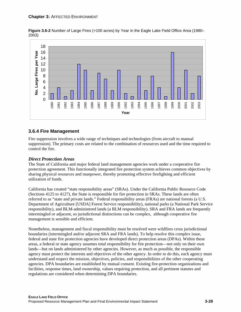
Chapter 3: AFFECTED ENVIRONMENT
Figure 3.6-2 Number of Large Fires (>100 acres) by Year in the Eagle Lake Field Office Area (1980– 2003)
0 2 4 6 8
10 12 14 16 18
1980
1981
1982
1983
1984
1985
1986
1987
1988
1989
1990
1992
1993
1994
1995
1996
1997
1998
1999
2000
2001
2002
2003
Year
No.
Lar
ge F
ires
per Y
ear
3.6.4 Fire Management Fire suppression involves a wide range of techniques and technologies (from aircraft to manual suppression). The primary costs are related to the combination of resources used and the time required to control the fire.
Direct Protection Areas The State of California and major federal land management agencies work under a cooperative fire protection agreement. This functionally integrated fire protection system achieves common objectives by sharing physical resources and manpower, thereby promoting effective firefighting and efficient utilization of funds.
California has created “state responsibility areas” (SRAs). Under the California Public Resource Code (Sections 4125 to 4127), the State is responsible for fire protection in SRAs. These lands are often referred to as “state and private lands.” Federal responsibility areas (FRAs) are national forests (a U.S. Department of Agriculture [USDA] Forest Service responsibility), national parks (a National Park Service responsibility), and BLM-administered lands (a BLM responsibility). SRA and FRA lands are frequently intermingled or adjacent, so jurisdictional distinctions can be complex, although cooperative fire management is sensible and efficient.
Nonetheless, management and fiscal responsibility must be resolved were wildfires cross jurisdictional boundaries (intermingled and/or adjacent SRA and FRA lands). To help resolve this complex issue, federal and state fire protection agencies have developed direct protection areas (DPAs). Within these areas, a federal or state agency assumes total responsibility for fire protection—not only on their own lands—but on lands administered by other agencies. However, as much as possible, the responsible agency must protect the interests and objectives of the other agency. In order to do this, each agency must understand and respect the mission, objectives, policies, and responsibilities of the other cooperating agencies. DPA boundaries are established by mutual consent. Existing fire-protection organizations and facilities, response times, land ownership, values requiring protection, and all pertinent statutes and regulations are considered when determining DPA boundaries.
EAGLE LAKE FIELD OFFICE Proposed Resource Management Plan and Final Environmental Impact Statement 3-28

Chapter 3: AFFECTED ENVIRONMENT
Whenever possible, boundaries follow easily identifiable features (e.g., highways and roads, rivers, or other well-defined ownership lines). DPA boundaries can also be revised. When the need for change is evident, the affected BLM field office submits a recommendation to the state office.
In the ELFO planning area, wildland fire protection for most public land is the responsibility of BLM. For some scattered tracts, particularly on the west side of the planning area, fire protection is provided by the California Department of Forestry and Fire Protection (under the terms of the aforementioned wildland fire protection agreement). Legislate directives and firefighting philosophy and strategy are sometimes at variance on these scattered tracts. At times, this has lead to disagreements regarding appropriateness of suppression intensity, impacts on natural resources, and suppression costs. However, basic fire management priorities, such as human safety and protection of private property, are usually consistent between the agencies.
3.6.5 Suppression Strategies Full Suppression Full suppression may be imposed as a general policy, or it may be an appropriate management response (AMR) to a specific wildland fire situation. With full suppression, fires are aggressively suppressed with the full array of available options, except where site-specific restrictions apply (e.g., WSAs and ACECs). As in any firefighting situation, human safety is the number one priority. Even if a fire is achieving resource objectives (i.e., reducing dangerous fuels or restoring fire-dependent ecosystems) and does not pose a threat to public safety or health, the fire would still be aggressively fought where full suppression is general policy.
Appropriate Management Response AMR provides the flexibility to respond in different ways according to the requirements of the location, wildland fire situation, and management objectives for the area. The Federal Wildland Fire Management Policy (1995, from the review and update of Jan. 2001 [pg. 35]) says this about AMR: “the response to a wildland fire is based on an evaluation of risks to firefighter and public safety, the circumstances under which the fire occurs, including weather and fuel conditions, natural and cultural resource management objectives, protection priorities, and values to be protected. The evaluation must also include an analysis of the context of the specific fire within the overall local, geographic area, or national wildland fire situation.” Therefore, AMR is formulated according to risk assessment, management objectives, environmental and fuel conditions, and other constraints. Suppression objectives are based on the maximum allowable acres per ignition (at various fire intensity levels). Wildfires in critical suppression areas (e.g., the wildland urban interface [WUI] [see discussion later in this section], recreation sites, critical wildlife habitats, cultural sites, unstable soils, and ACECs) would be fully suppressed as a matter of policy (i.e., full depression is the predetermined AMR). The AMR may also be aggressive suppression on one portion of a wildland fire while monitoring another portion of the same fire. Another AMR is monitoring while allowing the fire to burn in order to achieve resource objectives (such as rehabilitation of vegetation and wildlife habitats, and reduction of dangerous fuels).
3.6.6 Wildland Fire Use Wildland fire use (WFU) is not technically a suppression strategy; it is the use of a naturally ignited fire to achieve resource objectives for the affected area. This strategy is employed in pre-selected areas where fires are allowed to burn and function in their natural ecological role (as nearly as possible) in order to rehabilitate, maintain, enhance, or protect native vegetation, wildlife habitats, or other valuable resources. Such use must be based on an approved fire management plan and must follow specific prescriptions contained in operational plans. Areas where WFU is approved would not have large concentrations of
EAGLE LAKE FIELD OFFICE Proposed Resource Management Plan and Final Environmental Impact Statement 3-29

Chapter 3: AFFECTED ENVIRONMENT
dangerous fuels or be adjacent to areas where human life or property would be threatened. Typically, these areas would have missed fewer fire return cycles and would not be severely degraded (i.e., fuel buildup would be less).
3.6.7 Post-Fire Restoration The Emergency Fire Rehabilitation Handbook (H-1742-1) (BLM 1999) outlines the procedure for implementing emergency rehabilitation projects following wildland fires. Funds designated for this purpose may be used to:
• Protect life, property, soil, water, and vegetation
• Prevent unacceptable on-site or off-site damage
• Meet land-use planning objectives or fulfill other federal laws
• Prevent invasion by, or establishment of, alien weeds or undesirable native plants
The first step, following a significant wildland fire incident, is preparation of a burned area emergency stabilization and rehabilitation plan (BAER). BLM policy regarding preparation of BAER plans is found in Supplemental Emergency Stabilization and Rehabilitation Guidance (draft of Nov. 2002), the Interim Interagency BAER Handbook, and Departmental Manual 620 DM3 (draft of Dec. 2003). BAER plans are actually two plans, since the emergency stabilization plan is developed and implemented independently; it is followed by a separate (though related) rehabilitation plan. These documents outline the process for writing and implementing both types of plans.
By definition, emergency stabilization measures (such as mulching and seeding to minimize erosion and prevent invasion by noxious weeds) are accomplished within one year of the fire in order to stabilize the burn site, thereby minimizing degradation of natural resources or destruction of property and eliminating threats to human life or health. Rehabilitation measures (such as shrub or tree planting, treatment of weeds and invasive plants, and fence replacement) are accomplished within three years of the fire in order to repair sites that—without help—are unlikely to make a satisfactory recovery and to repair/replace minor facilities.
3.6.8 Wildland Urban Interface The WUI, as defined in the Federal Wildland Fire Management Policy, is: “…the line, area, or zone where structures and other human development meet or intermingle with undeveloped wildland or vegetation fuels.” In the ELFO planning area, most residential development outside town/suburban areas consists of scattered homes, ranches, and associated outbuildings; none of these can be defined as a community and are not part of the WUI. Such property is often at great risk during wildfire events; this fact does influence fire and fuel management decisions.
There are multiple developed areas that meet the WUI definition in the Susan River/Honey Lake watershed. The communities of Susanville, Janesville, Standish, Litchfield, Johnsonville, and Wendell are all at risk from catastrophic wildfire to varying degrees. The communities of Spalding and Stones-Bengard are at risk in the Eagle Lake watershed. Many small residential areas and scattered ranches that are associated with these communities also have wildland interface issues, particularly a lack of (or insufficient) defensible space, accumulation of natural fuels, hazardous materials, high ignition risk, and insufficient public awareness and preparedness.
EAGLE LAKE FIELD OFFICE Proposed Resource Management Plan and Final Environmental Impact Statement 3-30

-
Chapter 3: AFFECTED ENVIRONMENT
3.7 Forestry
Forest resources in the ELFO planning area exist as forestlands and woodlands. Forestlands are dominated by commercial timber species. These species include Jeffrey pine, ponderosa pine, sugar pine, lodgepole pine, Washoe pine, Douglas-fir, white fir, Shasta red fir, and incense cedar. Woodlands have a canopy cover of at least 6%; trees are primarily juniper, oak, aspen, mountain mahogany, and other non-commercial species. Forestland, which by definition has a canopy cover of at least 10%, is divided into commercial (high-site) forestland (i.e., capable of producing ≥ 20 cubic feet per acre per year) and non-commercial (low-site) forestland (i.e., capable of producing < 20 cubic feet per acre per year). Low-site forests are generally found where commercial forestland grades into juniper woodland. These transitional forests are composed of scattered ponderosa pine, Jeffrey pine, western juniper, and occasionally, oak. There are 11,020 acres of commercial forestland and 80,496 acres of woodland and low-site forestland in the planning area. Areas for each watershed are shown in Table 3.7-1.
Table 3.7-1 Forestland and Woodland Areas by Watershed for the Eagle Lake Field Office (acres)
Susan River
Watershed Forestland Woodland and Low Site Forestland Eagle Lake 2,166 10,055 Feather Headwaters 687 Probably present but no data Horse Lake 1,620 26,837 Madeline Plains 2,429 34,735 Sierra Valley 693 Probably present but no data Smoke Desert South 0 8,069 Susan River/Honey Lake 3,425 800 Total 11,020 80,496
Forestland constitutes a small fraction of the lands administered by the ELFO; almost half is within the Susan River or Honey Lake watersheds. The majority of forested land (i.e., forestlands and woodlands) are administered by Lassen and Plumas National Forests and, to a lesser degree, by Modoc and Tahoe National Forests. The quantity and value of harvested timber for area counties (Lassen, Nevada, Plumas, Shasta, Sierra, and Tehama) ranged between 33.3 and 152.1 million board-feet, and $6.6 to 39.3 million dollars, in 2002 (California State Board of Equalization 2002). By comparison, combined timber production from the Alturas and Eagle Lake Field Offices was only 1.9 million board-feet per in the same year (BLM-ELFO & AFO file data). Cover on planning area forestlands is two-thirds Jeffrey/ponderosa pine and about one-third white fir. However, sugar pine, incense cedar, Douglas-fir, lodgepole pine, and Shasta red fir are also present. The high-elevation timber on Fredonyer Mountain is primarily white fir; while lower elevation stands are pure pine. Trees throughout the planning area often grow in multi-aged stands, although most stands contain a sizable component of even-age trees.
Most planning area forestlands developed subsequent to logging and fires in the late 19th and early 20th
century. Since this time, burned areas have been planted to ponderosa and Jeffrey pine; these areas now support even-aged stands. From the origin of BLM (1946) through the 1960s, logging emphasized selective removal of “high-risk” (meaning trees that are likely to die within 20 years) old-growth trees.
EAGLE LAKE FIELD OFFICE Proposed Resource Management Plan and Final Environmental Impact Statement 3-31

Chapter 3: AFFECTED ENVIRONMENT
Trees of this kind were/are at least 200–400 years old. During this period, about half of the old-growth timber was selectively harvested. Although some old-growth timber was harvested from the late 1970s through 1993, logging primarily entailed commercial thinning, which concentrated on trees that had achieved economic maturity (i.e., approximately 120 years old and 21 inches diameter at breast height [dbh]).
Since 1993, salvage logging has been the driving force behind timber removal. Salvage logging has been conducted after wildfires and following insect infestations (e.g., white fir engraver and pine beetles) and disease outbreaks (e.g., dwarf mistletoe). Recent thinning and salvage operations have created stands that are relatively resistant to insect attack, but hazardous fuels (in the form of overstocked stands, logging slash, cast needles, and growth of bitterbrush and other shrubs) remain a concern. However, forestlands in the ELFO planning area have not been surveyed or rated for hazardous fuel loads–this needs to be done.
Productive timberland in the ELFO planning area is part of the sustained yield unit (SYU) 15 base (which encompasses commercial forests administered by the Redding, Alturas, Surprise, Eagle Lake, Folsom, Bishop, and Bakersfield Field Offices). It is managed for timber production, with certain constraints to protect endangered or threatened species and ensure its availability for multiple-use activities (including recreation, such as hunting and wild-crafting). Timber management in SYU 15 favors pre-commercial thinning, site preparation, and planting to maximize productivity (the annual allowable cut is 11.9 million board-feet). Saw-logs, pulpwood, and biomass fuel are produced. Woodlands and low-site forests are not part of the SYU 15 allowable cut; these are managed for firewood, some logging, and biomass fuel.
All watersheds in the ELFO planning area contain productive tree plantations with excessive accumulations of hazardous fuels. Thus far, large-scale fuel treatments have been conducted in the Eagle Lake, Horse Lake, and Lake Almanor watersheds. Approximately one-half of the productive forestland in the Feather River headwaters is ponderosa pine (planted in the mid-1960s). These plantations have also been thinned and hazardous fuels have been treated. One stand (240 acres) suffered severe wind-throw (following thinning) and is scheduled for additional treatment. Although most stands of timber in the Feather River headwaters are on cutover land, an 80-acre parcel on Dyer Mountain—adjacent to a proposed ski development—has never been harvested.
EAGLE LAKE FIELD OFFICE Proposed Resource Management Plan and Final Environmental Impact Statement 3-32

Chapter 3: AFFECTED ENVIRONMENT
3.8 Lands and Realty
3.8.1 Land Use Authorizations Much of the land administered by the ELFO exists as relatively small, scattered parcels. However, large, contiguous blocks of BLM-administered land are found between State Highway 139 and US Highway 395 and east into Washoe County, Nevada. Land ownership in the Eagle Lake Field Office area is summarized in Table 3.8-1.
Land use authorizations include the following:
• Authorizations and agreements for right-of-way (ROW) grants and road-use agreements (and associated Antelope Mountain temporary use permits) under several authorities; as well as leases, permits, and easements under Sec. 302 of the Federal Land Policy and Management Act (FLPMA) of 1976
• Airport leases
• Recreation and Public Purposes (R&PP) Act leases
BLM lands are also available for other rights, leases, or authorizations. However, such agreements are subject to restrictions that would protect resources or resolve conflicts with other users. For this planning effort R&PP transfers (unlike R&PP leases) are considered land ownership adjustments, and are covered under that heading. BLM lands have long been popular with the motion picture industry. The deserts, dry lake beds, and mountains are strong attractions for national and international television and motion picture companies. Special permits are required for commercial productions. Activities that are not specifically prohibited during the planning process are considered an acceptable use of BLM-administered land. Currently, ELFO analyzes requests for land use authorizations on a case-by-case basis, and, as a stipulation to the authorization, applies any mitigation measures that are found necessary during the National Environmental Policy Act (NEPA) compliance review.
Table 3.8-1 Land Ownership in the Eagle Lake Field Office Area Ownership Acres U.S. Department of the Interior (USDI) BLM, ELFO 1,022,767 USDA Forest Service 2,115,685 States of California and Nevada 68,739 Indian land 1,721 National Park Service 35,836 U.S. Army, Sierra Army Depot 82,894 Private 1,530,539 Total 4,858,251
The ELFO administers general land use authorizations under FLPMA on 1,022,767 acres in Lassen, Plumas, and Sierra County (northern California) and in Washoe County, Nevada. ROW grants for a myriad of facilities are held by groups and private individuals, as well as by business and government entities.
EAGLE LAKE FIELD OFFICE Proposed Resource Management Plan and Final Environmental Impact Statement 3-33

Chapter 3: AFFECTED ENVIRONMENT
Electrical transmission lines, gas distribution lines, roads, and telecommunication lines and facilities are the most common ROW authorizations, accounting for more than half of the grants. Other ROW authorizations include water lines, ditches, railroads, mineral material sites, wind energy towers, and fiber optic lines. The ELFO handles 20 to 30 ROW actions annually (including new applications and amendment, reassignment, renewal, or cancellation of existing ROW grants).
The ELFO did not formally designate any utility corridor ROWs or use areas in previous planning documents. However, BLM has been directed to begin coordinated intergovernmental and interagency utility corridor planning (including coordination with BLM land use plans) in partnership with industry and public-interest groups. To facilitate this effort, the Western Utility Group (Jan. 2003) updated its Western Regional Corridor Study of 1992 and presented BLM with a prioritized list of utility corridors for the western United States. Candidate sites have the highest potential for development and multiple uses (e.g., [other] electric transmission lines, oil and gas pipelines, and telecommunication facilities) within the next 10 years. The Alturas Transmission Line route had the highest potential for development in the ELFO planning area. WSAs are the only exclusion or avoidance areas. In November 1995, the final EIS for the Alturas Transmission Line project was published, amending previous planning documents. BLM subsequently granted an ROW for this project to Sierra Pacific Power Company.
The ELFO manages three communications site ROWs. The regulations (implemented in 1997) govern management of all three sites to minimize the number of grants that BLM must issue and administer. (This is one of several reasons why potential users are encouraged to place new facilities on existing communication sites.) The management plan for the Antelope Mountain site was completed in 1993; however, the Shaffer and Grasshopper Mountain sites do not have plans; this must be rectified during the life of this PRMP. In 2003, BLM began to create management plans for existing sites and to locate new communication sites in areas with high development potential. All new and existing sites will need a cadastral survey, map (with the location of all facilities), legal access, and information on future development.
The President’s National Energy Policy (May 2001) assigns a major role to public land and resource development to meet the nation’s increasing demand for energy (WO IB 2001-138). Toward this end, a series of initial actions, schedules, and assignments was developed to outline efficient and effective implementation of presidential policy. The National Energy Policy encourages energy development— including wind energy—as part of an overall strategy to create a diversified portfolio of domestic energy production. The current contribution of renewable energy is quite small. However, wind energy (and other renewable sources) is the fastest growing energy sector in the United States (BLM 2001e). Development of renewable energy sources will be extremely important in supplying clean, reliable power for the American economy. The testing and monitoring of potential wind energy sites can usually be accommodated within the existing land use plan without the necessity of amendment (especially since previous planning documents did not prohibit wind energy development).
3.8.2 Land Ownership Adjustment BLM is empowered to make land tenure adjustments, including acquisition and disposal, of lands under its jurisdiction for the public benefit. Previous MFPs and land use plans list areas that could be suitable for land tenure adjustments; these require review under the current PRMP. Disposal may not take place until the parcel has been cleared for sale. Clearances may reveal unique resources or environmental factors that necessitate custodial retention (sale criteria are listed in Section 203 of FLPMA). Adjustments are made on a case-by-case basis, in response to public demand or when initiated by BLM to fulfill management objectives.
EAGLE LAKE FIELD OFFICE Proposed Resource Management Plan and Final Environmental Impact Statement 3-34

Chapter 3: AFFECTED ENVIRONMENT
However, before acting on any land tenure adjustment, BLM must:
• Determine whether the adjustment would comply with FLPMA
• The action must be consistent with the goals and objectives of the current PRMP, MFP, or land use plan
• Conduct an environmental analysis
The Beckwourth Land Tenure Amendment (1982) listed 320 acres for disposal. Disposal of 160 acres has occurred, through exchange or sale. Remaining lands include two 40-acre parcels (80 acres) that have also undergone clearance evaluation; these parcels will be retained in custodial management. BLM receives many requests for land sale, exchange, or acquisition; each must be considered according to its individual merits and each requires a separate environmental clearance. Exchange or sale will be denied if:
• Important resources are present
• Disposal would not be consistent with PRMP goals and objectives
• Disposal does not meet FLPMA criteria (or other applicable laws)
Most BLM-administered lands are earmarked for active management, according to PRMP goals and objectives; these are called retention/acquisition areas. In some areas, it is desirable to increase public holdings (through donation, exchange, or purchase). Such lands must possess significant resources value (e.g., scenery, wildlife habitat, watershed protection, vegetation, cultural resources, recreational, or wilderness value). BLM cooperates with private landowners to exchange lands where this will be of mutual benefit. Retention/acquisition areas where BLM wishes to acquire private land are usually large parcels of public land that contain small private inholdings. Special management areas are slated for retention; these include wilderness areas, WSAs (until Congress makes a determination regarding wilderness designation), wild and scenic rivers (WSRs), ACECs, and RNAs.
The R&PP Act authorizes transfer or lease of public lands where this would serve the public interest. BLM is about to patent (i.e., transfer from federal ownership for the first time) three dumps in Lassen County; Herlong Transfer Station, Stones Transfer Station, and the Johnstonville (Bass Hill) Landfill. Lassen County Regional Solid Waste Management will assume liability when these lands are patented. Two other R&PP parcels are leased to Lassen County for recreational purposes; these consist of a remote-control airplane field and a rifle range.
The Bizz Johnson Trail corridor (see the Susanville-Westwood Trail Recreation Area Management Plan, BLM 1983b) is of regional as well as local significance. The unique scenic, recreational, and historic values of this trail is exceptional, when compared to other recreational trails of Northern California. For this reason, BLM will make every effort to acquire private inholdings (from willing owners) to better manage and protect this valuable public resource.
RNAs (see 43 CFR 8223) are federal lands protected and managed for research and education because they have one or more of the following characteristics:
1) An atypical presentation of a common plant or animal association 2) An unusual plant or animal association 3) Habitat for an endangered or threatened plant or animal 4) An atypical presentation of a common hydrologic, soil, or geological feature 5) An outstanding or unusual hydrologic, soil, or geological feature
EAGLE LAKE FIELD OFFICE Proposed Resource Management Plan and Final Environmental Impact Statement 3-35

Chapter 3: AFFECTED ENVIRONMENT
The Pine Dunes RNA (17 miles east of U.S. Highway 395 at Ravendale), preserves an isolated grove of pines in an extraordinary landscape of dunes (criteria 2 and 5). Because of its rarity and ecological value, the area will be retained and managed much the same as an ACEC.
3.8.3 Access Access refers to the physical ability and legal right of the general public, BLM and other-agency workers, and authorized users (i.e., under the authority of a use permit or special authorization) to reach public lands. The lands and realty program is primarily involved with easement acquisition.
Access to public lands is a perennial concern of the general public, as well as BLM. Much BLM land exists as small, or relatively small, blocks of public land intermingled with private, state, or other federally administered lands. This fragmented ownership pattern presents a plethora of legal and practical difficulties. Progress is being made, although some ELFO-administered lands still lack legal access. The field office area’s existing fragmented ownership pattern of BLM lands, intermingled with private, state, and other federal land, complicates the access situation. Under current planning documents, BLM has made progress in improving access to public lands. But some lands within the field office area still lack legal access. Under this PRMP, access acquisition will focus on:
• Larger blocks of BLM-administered land that are designated for (ownership) retention • Areas containing important resources • Areas where public demand for access is high • Areas where BLM has made a substantial investment of funds and resources
Access is acquired from willing owners on a case-by-case basis when the need is apparent under various laws and regulations and according to BLM policy. Road and trail easements are the principal means of acquiring access where none exists. In some cases, ownership consolidation has also improved access.
3.8.4 Withdrawal A withdrawal is a formal action that sets aside, withholds, or reserves federal lands for public purposes by administrative order or statute. A withdrawal accomplishes one or more of the following:
• It may segregate (close) specified federal lands to the operation of some—or all—mining laws (or other public-land uses)
• It may transfer jurisdiction (partially or totally) to another federal agency • It may dedicate federal lands for a specific purpose
Land withdrawals are of three major types:
• Congressional – Withdrawal by Congress under public laws (e.g., wilderness or WSR designation)
• Administrative – Withdrawal by the President, Secretary of the Interior, or other authorized official from the executive branch of the federal government (e.g., public water reserves and livestock driving-routes)
• Federal Power Act – Withdrawal under the Federal Power Act (June 1920); such withdrawals are automatically created when an application for hydro-power development is filed with the Federal Energy Regulatory Commission.
EAGLE LAKE FIELD OFFICE Proposed Resource Management Plan and Final Environmental Impact Statement 3-36
Chapter 3: AFFECTED ENVIRONMENT
Public lands administered by BLM may be withdrawn for specific purposes by agencies other than BLM. The ELFO may be required to review current withdrawals to assess the need for continuation, modification, revocation, or termination. Future withdrawals would be considered on an individual basis, according to Section 204 of FLPMA. The Secretary of the Interior may terminate any withdrawal, other than those made by an act of Congress.
Land withdrawals in the ELFO planning area include some lands that are part of the Sierra Army Depot. (Withdrawn lands are shown on the master title plats in BLM’s California State Office.) The Sierra Army Depot is charged with receiving, issuing, and renovating munitions, and with their safe and efficient destruction. However, a 1990 explosion extended beyond the boundary of the existing demolition range; therefore, an additional 1,328 acres of BLM-administered land was added to the Sierra Army Depot for public safety reasons (an improved security fence was also built). The U.S. Army Corps of Engineers has applied for official withdrawal of this land under 43 CFR 2300.
3.8.5 Trespass Trespass is of three types:
• Unauthorized use refers to activities that do no appreciably alter the physical character of the land or its resources (e.g., abandonment of property, trash, or disused enclosures; use of roads or trails where a user fee or ROW is required).
• Unauthorized occupancy refers to unauthorized intermittent or permanent occupancy (e.g., construction, placement, occupancy, or assertion of ownership of a facility, house, cabin, trailer, structure, or natural shelter).
• Unauthorized development refers to activities that physically alter public lands or vegetation (e.g., unauthorized cultivation or grazing, construction or realignment of roads or trails).
Trespass is controlled through prevention, detection, and resolution. Resolution of newly discovered, uses, occupancies, and developments are prioritized in order to prevent further environmental degradation or resource damage. Lesser priority is accorded historic trespass issues, where little or no damage has resulted.
3.8.6 Utilities, Transportation, and Telecommunications An ROW grant is an authorization to use a piece of public land for a specified project; typically, these
are roads, pipelines, or transmission lines. The grant allows certain land modifications and activities for a specified period of time. Other uses, such as communication facilities, require an ROW lease. ROW applications are generally initiated by corporations or individuals seeking developed access across public land. ROW applications are processed on a case-by-case basis. Although land use plans specify certain areas as acceptable for development of utility corridors, communication sites, and route upgrades or improvements, all such development and uses must comply with NEPA prior to approval. The (mandatory) NEPA environmental analysis may indicate the need for minor alteration, substantial modification, or denial of the ROW request to avoid unacceptable impacts on other resources.
Utilities Existing utility ROWs are identified on master title plats (maps) available in the ELFO. Designation of utility corridors is a highly controversial issue in this area. Most residents strongly object to utility corridors that would be visible from their homes, recreation areas, or high-use driving routes.
EAGLE LAKE FIELD OFFICE Proposed Resource Management Plan and Final Environmental Impact Statement 3-37

Chapter 3: AFFECTED ENVIRONMENT
Utility/transportation corridors were not and are not identified in previous or existing MFPs or land use plans.
Telecommunications Management of communication sites on BLM and USDA Forest Service lands is governed by 43 CFR 2800, which took effect in fiscal year 1996/97. New leases and renewals are governed by this legislation. The ELFO management area contains three communications sites: Shaffer Mountain, Antelope Mountain, and Grasshopper Mountain.
EAGLE LAKE FIELD OFFICE Proposed Resource Management Plan and Final Environmental Impact Statement 3-38

Chapter 3: AFFECTED ENVIRONMENT
3.9 Livestock Grazing
3.9.1 Historical Setting The Eagle Lake Field Office is located in an area that has been grazed by livestock for more than 100 years. Heavy livestock grazing from the late 1800s to the 1930s contributed to changes in plant composition and a reduction in rangeland productivity within the field office area. Many of today’s problems, including soil loss and vegetation changes, are more a result of earlier practices than of current ones. The introduction and establishment of invasive annual grasses (primarily cheatgrass and medusahead) that began during 1930s and 1940s has had a dramatic negative affect on some native plant communities by displacing and limiting recovery of the potential plant community.
However, improved livestock management began following the passage of the Taylor Grazing Act in 1934. Livestock numbers were again reduced during the adjudication period of the 1960s and portions of the forage allocations were subsequently redistributed for wildlife use within the planning areas. Today, livestock grazing use adjustments are based on the interpretation of monitoring data and land health management concerns.
3.9.2 General Management Approach Grazing potential is assessed according to three fundamental factors: the condition of vegetation, soil, and other resources that support grazing activity; the kinds of grazing animals; and control of animal movement, distribution, and numbers. Animals are described by species, breed, age, herd size, sex ratio, and food preferences. Management determines animal numbers, turn-out and removal times, animal movement, distribution, and land use restrictions. These descriptors are defined in the grazing permits issued to permittees. BLM rangeland is organized into grazing allotments, which are subdivided into pastures. Pasture fencing, drift fences, and water sources are used to control movement within grazing allotments.
Rangeland resources that are directly connected with livestock use are forage, cover, water, and minerals. The carrying capacity for a particular area of rangeland is described in terms of animal-unit-months (AUMs). This is the amount of forage required to support one animal (of a given species) and her calf/lamb for a period of one month. AUMs are used to determine the maximum number of animals that the range can support while meeting rangeland condition standards. Forage quantity and quality, in concert with animal food preferences, are also important factors in quantifying carrying capacity (Heady 1975). Allotment management plans (AMPs) are based on prevailing conditions, particularly the quantity and quality of forage, and the availability of water. AMPs must comply with NEPA and the broader governance of this PRMP. The AMP is used to determine basic permit conditions (which, like the AMP, are adjusted annually according to rangeland conditions and sensitivity issues). Grazing permits apply to individual allotments and are valid for 1-10 years (though generally issued for 10 years).
3.9.3 Current Livestock Grazing Conditions BLM’s Eagle Lake Field Office administers 1,022,767 acres of public land, of which 97% (987,779 acres) is included in livestock grazing allotments. Within these allotments, a total of 52,250 AUMs are available for permitted animals. Current permits allow for about 10,460 cattle and up to 22,000 sheep. However, current sheep numbers are between 5,000–6,000 (see Table 3.9-1 and Appendix J, “Livestock
EAGLE LAKE FIELD OFFICE Proposed Resource Management Plan and Final Environmental Impact Statement 3-39

Chapter 3: AFFECTED ENVIRONMENT
Grazing Allotments”). At this time, there are 49 holders of grazing permits. Most permittees are longtime residents, and many come from second or third-generation ranching families.
Rangeland Health Assessment Rangeland health assessment (RHA) is used to rate the condition of grazing allotments. Some factors of major importance to rangeland health include historic grazing practices, juniper encroachment, and proliferation of noxious weeds. Once assessed, allotments are placed in one of four condition categories listed below:
• Category 1 – Areas where one or more standard(s) has not been met, nor has significant progress been made toward meeting the standard(s); and livestock grazing is a significant factor.
• Category 2 – Areas where all standards have been met or significant progress has been made toward meeting the standard(s).
• Category 3 – Areas where one or more of the standard(s) is not known, or the cause of the failure to meet the standard(s) is not known.
• Category 4 – Areas where one or more standard(s) has not been met, nor has significant progress been made toward meeting the standard(s); due to causes other than–or in addition to–livestock grazing. (Allotments where livestock grazing is the primary cause for failure are also included in Category 1).
Recent RHAs are available for all ELFO grazing allotments. However, some allotments have not been yet been categorized. Where this is the case, allotments are categorized under the old system. This ranks the condition as improve, maintain, or custodial. The criteria for these categories are:
• Improve – There is potential for improving condition and production that is not being developed. Although there may be conflicts or controversy involving resource conditions and appropriate uses, there are realistic opportunities to enhance resource conditions.
• Maintain – The allotment is in satisfactory condition and producing at or near potential under the existing management strategy. There are little to no resource conflicts or management controversies.
• Custodial – These allotments are relatively small and frequently isolated among large amounts of private land. There are no conflicts regarding resource use or condition. Potential for economic returns is typically small.
BLM directs its funding, management, and monitoring efforts to areas were they will be most effectively employed. Therefore, major emphasis is placed on ‘Improve’ category allotments. Presently, 23 allotments (937,416 acres or 95% of the total area in allotments) are in the improve category, 10 allotments (31,447 acres or 3%) are in the maintain category, and 23 allotments (18,916 acres or 2%) in custodial management. (Table 3.9-1 lists grazing allotments and permitted use in each management category.)
EAGLE LAKE FIELD OFFICE Proposed Resource Management Plan and Final Environmental Impact Statement 3-40

Chapter 3: AFFECTED ENVIRONMENT
Table 3.9-1 Grazing Allotment Specifications and Permitted Use in the Eagle Lake Field Office Area Livestock Numbers Permitted AUMs
Management Category
Allotment Acres Cattle Sheep Cattle Sheep AUM %
Custodial 18,916 1,972 0 1,713 9 Improve 937,416 8,057 4,000 43,552 4,512 Maintain 31,447 431 2,000 2,194 270
10,460 6,000 47,459 4,791 9.2% sheep 90.8% cattle
Total 987,779 16,460 52,250 100% * Total livestock use varies seasonally, especially during drought conditions when use levels may range from 60 to 80% of total available AUMs.
3.9.4 Current Livestock Management The primary management objectives for livestock grazing have been to improve rangeland health, improve riparian functioning condition, and restore native plant communities. The primary tools to achieve this objective have been pasture fencing and strategically-placed water. Other important actions include season-of-use restrictions and (voluntarily) reduced stocking rates.
Management on BLM-Administered Lands Present management involves careful adherence to permit stipulations; particularly regarding livestock numbers and season-of-use restrictions. Grazing pressure is controlled with fencing, herding, and strategic placement of water. Rest-rotation grazing is also employed. With this method, a pasture is grazed for one season then rested for one or two seasons to allow sufficient recovery time. In addition, many allotments have been voluntarily managed with a combination of rest and/or deferred grazing. This can include early-on and early-off grazing, delayed turnout, or a modified annual season-of-use. Annual adjustments are made according to forage availability, and the prevalence of drought conditions or above-average precipitation. Livestock are moved to and from allotments and between pastures by trucking or overland cattle drives.
Management on Adjacent Lands Alternative (off-season) pastures are found on USDA Forest Service grazing allotments, (leased) private lands, or on home ranches; the rest are out-of-area pastures or feedlots. Presently, about 50% of the livestock grazed under permit on ELFO-administered lands are also pastured on nearby off-site areas; the rest are pastured in the Sacramento Valley. However, this proportion varies from year to year according to range and market conditions. Average herd size is 200 to 600 head. About 95% of local ranches are family or small-business enterprises; the remainder is controlled by corporate entities.
3.9.5 Observed Trends Range Conditions BLM is improving rangeland health by controlling animal numbers and season-of-use, and by resting severely damaged rangeland (principally caused by wildfires). Livestock grazing activities are monitored on an ongoing basis to ensure meaningful progress toward achieving BLM land health standards and, where progress is lacking or inadequate, altering grazing practices or correcting other conditions to achieve compliance. Forage production and availability, as elsewhere, is subject to substantial yearly fluctuations. Drought conditions, in particular, necessitate use restrictions on annual grazing permits.
EAGLE LAKE FIELD OFFICE Proposed Resource Management Plan and Final Environmental Impact Statement 3-41

Chapter 3: AFFECTED ENVIRONMENT
Factors of human and natural origin that interfere with land health restoration and threaten efforts to achieve the desired future condition include:
• Juniper encroachment in low sagebrush, big sagebrush, and oak woodland plant communities.
• Sheet erosion and pedestal formation (formed where individual plants or plant clumps retain soil while the intervening spaces are eroded)
• Competition from invasive weeds
• Decline in watercourse health and hydrologic function
• Decline in riparian vegetation, health, and function
• Soil trampling by feeding and traveling livestock—particularly along streambanks and in riparian areas—and erosion from roads and trails (especially near watercourses and riparian areas).
• Forage shrub decline due to drought conditions
• Wildfires tend to favor proliferation of exotic weeds (which are already established in most pastures). (Management actions, including altered grazing practices, would increase the extent and health of native perennial species, but are not likely to restore complete dominance.)
Grazing Use Grazing use has slightly declined in the last 20 years; about 70 to 80% of available AUMs are used annually to feed about 10,460 cattle and 6,000 sheep. However, more AUMs may be used in years with average or above-average forage production. Decline is primarily due to sale of ranching properties and flagging interest among family members. Ranches may have numerous grazing permits attached to the base property (usually the home ranch). When a ranching operation is sold, grazing permits remain with the base property, or they can be transferred to new permittees. While some of these permits have been transferred and, therefore, remain in production, others remain with the new property owner, who may or may not use them. Increased interest along the urban/rural interface has converted some ranches to residential developments; although not yet widespread, the ELFO management area contains at least one such development. However, a trend toward residential use may develop over the next 20 years. Ranching continues, as much is anything, because its practitioners are committed to the lifestyle, traditions, and family values that this occupation so richly fosters. Other factors that have discouraged ranching (primarily by increasing operational costs) have come from local land use decisions, changes in federal land management policy, and residential/industrial development (which usually increases taxes).
Grazing Management BLM and its grazing permittees have committed to improving rangeland health so that forage production and utilization are sustainable and that ranching remains a viable occupation. Despite some inherent difficulties, some local ranchers have begun to employ new grazing strategies that are beginning to show dramatic improvements in rangeland health. These changes have increased the extent and health of sensitive riparian and upland vegetation. Techniques include shorter grazing seasons, modified spring and summer grazing use, and intensive management of riparian areas and livestock pastures. Livestock exclosures and riparian pastures have been created to protect streams and riparian habitats. Improved fencing, frequent herding and moving, and season-of-use adjustments have been used to protect sensitive areas and improve rangeland condition. Leaving greater amounts of residual vegetation has enhanced hydrologic function and watershed condition by slowing (water) runoff, increasing infiltration, reducing erosion, and improving seedling establishment and ground cover. Although some areas have been improved by such measures, most rangeland still needs work to achieve and sustain ecological health (see Chapter 3.16 “Vegetation”).
EAGLE LAKE FIELD OFFICE Proposed Resource Management Plan and Final Environmental Impact Statement 3-42

Chapter 3: AFFECTED ENVIRONMENT
3.10 Recreation Resources
3.10.1 General Recreation Management A major focus of recreational planning is identification and management of high-use recreation areas. Special recreation management areas (SRMAs) fulfill the need for more intensive management to protect highly valued or unique resources; provide certain visitor facilities, services, and information (where desirable); ensure a safe recreational environment; and minimize user conflicts. The rest of the management area is known as the Extensive Recreation Management Area (ERMA).
The planning area contains three SRMAs: the Bizz Johnson Trail, the Eagle Lake Basin, and the Fort Sage Off-Highway Vehicle (OHV) Area. These areas comprise 10% of the management area (65,570 acres). Table 3.10-1 shows location, size, and visitor use for the SRMAs and the ERMA for fiscal year 2003/4.
Table 3.10-1 Recreation Management Areas in the Eagle Lake Field Office Area
Area Acres % of Field
Office Area
Visitor Use Estimates for
FY 04 10/1/03 - 9/30/04
% of Visitor Use in Field Office Area
10/1/03 - 9/30/04 Bizz Johnson Trail SRMAa 2,756 0.3 86,179 42.2 Eagle Lake Basin SRMAb 34,320 3.4 31,814 15.6 Fort Sage SRMAc 28,494 2.8 10,782 5.3 Extensive (ERMA)d 957,197 93.5 75,324 36.9 Total 1,022,767 100.0 204,099 100.0 FY = fiscal year a Use estimates based on data from trail and access road traffic counters and knowledge of use patterns b Use estimates based on data from daily observed use at developed sites and estimates of use at undeveloped areas. c Use estimates based on trail and access road traffic counters and interpretation of these data based on knowledge of use patterns. d The large size of the ERMA, multiple access points, and limited staff to collect visitor use data limit the precision of visitor use estimates. The visitor use estimate for the ERMA is BLM’s best professional estimate based on limited traffic counter data on some of the dirt and gravel roads, and general knowledge of visitor activities and use patterns in the area.
The ERMA (957,197 acres or 90% of the management area) is managed, as much as possible, to retain its natural appearance and undeveloped character, for self-sufficient recreation (whether vehicle-based or non-motorized). People who visit these large, essentially undeveloped areas are seeking self-reliant activities such as hunting, hiking/backpacking, sightseeing, wildlife viewing, horseback riding, mountain-biking, and recreational (OHV) driving. Nonetheless, there are areas where recreational activities are somewhat concentrated. Concentrated activity is generally associated with specific landforms (e.g., a mountain, canyon, reservoir, or creek). There are also two developed campgrounds within the ERMA: the Dodge Campground (10 sites at Dodge Reservoir) and Ramhorn Campground (12 sites at Ramhorn Springs). These campgrounds have long-established use associated with hunting and fishing; however, use is not sufficiently heavy or broad-based to justify SRMA designation.
EAGLE LAKE FIELD OFFICE Proposed Resource Management Plan and Final Environmental Impact Statement 3-43

Because a given area is not within a SRMA, does not indicate that it lacks unique or exceptional recreational value. Rather, it indicates that the mix of suitable recreational pursuits and visitor use is not sufficiently great to require or justify more intensive management, development, and funding. However, changes in level of use, types of use, adverse impacts, public interest, or management priorities may justify future SRMA designation for some areas. Of course, other types of special designations also exist within the ERMA. These areas provide focused resource management where recreational activities are not of primary concern, but instead, benefit from the designation. Such designations include the Pine Dunes RNA, the Nobles Emigramt Trail, seven WSAs, and seven proposed ACECs. (See Chapter 3.13.1, 3.13.2, and 3.13.3 for descriptions of these areas).
3.10.2 Extensive Recreation Management Area The major recreational activities in the ERMA are hunting, fishing, camping, sightseeing, wildlife-viewing, hiking, horseback riding, photography, picnicking, recreational driving (motorcycles, all-terrain vehicles [ATVs] and other OHVs), target shooting, and mountain-biking. Recreational activities with limited participation include backpacking, hang-gliding, and mineral collecting. Recreational activity is greatest in the fall and in spring/early summer. During the summer heat, visitors generally avoid the high-desert country in favor of mountain forests, lakes, and rivers. See Table 3.10-2 (at the end of this section) for a summary of self-contained camping and associated recreational activities within the ERMA.
3.10.3 Special Recreation Management Areas The following discussion describes natural and cultural resources, common recreational activities, and management emphasis for each of the three SRMAs in the ELFO planning area (size and visitor use are shown in Table 3.10-3).
Table 3.10-3 Visitor Use of Special Recreation Management Areas in the Eagle Lake Field Office Special Recreation Management Area Acres Fiscal Year ‘01
10/1/00 – 9/30/01 Fiscal Year ‘02 10/1/01 – 9/30/02
Fiscal Year ‘03 10/1/02 – 9/30/03
Fiscal Year ‘04 10/1/03 – 9/30/04
Bizz Johnson Trail a 2,756 66,939 78,365 81,894 86,179 Eagle Lake Basin b 34,320 39,219 31,279 34,169 31,814 Fort Sage OHV Area c 28,494 9,970 10,033 10,761 10,782
Total 65,570 116,128 119,677 126,824 128,775a Use estimates based on data from trail and access road traffic counters and knowledge of use patterns. b Use estimates based on data from daily observed use at developed sites and estimates of use at undeveloped areas. c Use estimates based on trail and access road traffic counters and interpretation of these data based on knowledge of use patterns.
Chapter 3: AFFECTED ENVIRONMENT
3.10.3.1 Bizz Johnson National Recreation Trail (SRMA) Current Conditions The Bizz Johnson Trail was named after former California congressman Harold T. “Bizz” Johnson, by an act of Congress in 1983. Bizz Johnson was instrumental in the rails-to-trails conversion effort and introduced the legislation that provided funding to acquire the former rail corridor, as well as the Hobo Camp trailhead and picnic area. The trail is 25 miles long and is non-motorized. It is built on the former railbed of the Fernley and Lassen Line, a branch of the Southern Pacific Railroad. The line was built in 1913/1914 to serve the Red River Lumber Company’s new Westwood mill. Management is focused on protecting natural resources in the Susan River Canyon and adjacent forested areas, preserving scenic quality and cultural features associated with the railroad, and providing non-motorized recreation. Mineral potential within the SRMA is low and no mineral development has taken place; however, placer claims
EAGLE LAKE FIELD OFFICE Proposed Resource Management Plan and Final Environmental Impact Statement 3-44

Chapter 3: AFFECTED ENVIRONMENT
were at one time filed along the Susan River (at the Goumaz area in Lassen National Forest) but were not developed and allowed to expire.
The trail corridor includes 11.3 miles of BLM-administered land and 13.7 miles of land administered by Lassen National Forest; it is managed by both agencies. The trail extends from within the city of Susanville to a point 5 miles north of Westwood (with connection to Westwood via County Road A-21). The management plan calls for construction of a trail extension to Westwood. BLM management is focused on a 9-mile section directly west of Susanville. For the sake of convenience and efficiency (because it is interspersed with national forest land), the remaining 2.3 miles of BLM-administered land are managed by Lassen National Forest.
The trail is primarily used for walking, running, mountain-biking, horseback riding, and cross-country skiing. Snowmobiles are also allowed on the section of trail west of Susan River (the portion administered by Lassen National Forest). The trail also provides convenient access to the river for fishing, swimming, kayaking, tubing, and other water-play activities. School groups use the SRMA for environmental education and historical field trips. Pigeon Cliffs (also within the SRMA, near Hobo Camp) is a popular single-pitch (i.e., no more than one rope length) rock-climbing area. The trail is also used for special events under BLM and USDA Forest Service special use permits.
The Bizz Johnson Trail SRMA is the most heavily used recreation area under ELFO jurisdiction, having received 86,000 visitors in fiscal year 2004 (October 1, 2003 through September 30, 2004). Popularity is based on its convenient and scenic location adjacent to the Susan River. From within the city of Susanville, the trail provides legal public access to the river for fishing and water sports and for a host of trail-related recreational activities. It is also a railroad heritage site, which is readily evinced by eleven steel railroad bridges and two tunnels. Furthermore; the trail is a source of community pride, a quality-oflife amenity for area residents, and a recreational destination for visitors to Lassen County.
Lassen County built a replica of the Westwood Railroad Depot (2002) that functions as a visitor center and trail information source for the trail’s western terminus. At the other end (beginning), the Susanville Railroad Depot serves a similar, but expanded, function. The Susanville Depot provides detailed information on the trail’s railroad heritage and is also a visitor center for Lassen County and the surrounding region.
Trends BLM maintenance responsibilities include five trailheads, one picnic area, nine miles of railroad grade, twelve bridges, and two tunnels, all of which require considerable staff time. Heavy equipment must be used to remove rockfall, restore proper drainage, and grade the trail on an annual basis. Bridge abutment and tunnels must be maintained and repaired when needed. Trailhead facilities also require maintenance; these include numerous signs and trash cans, trailhead access roads (a total of one mile), twelve picnic tables, three toilets, four information kiosks, and a fully equipped host site (trail guardian campsite). Weekly trailhead patrol and cleanup are conducted by maintenance personnel and volunteers at the heavily used Hobo Camp trailhead and day-use area (34,700 visitors in fiscal year 2003/2004).
Horses have the greatest impact on trail conditions (permits for equestrian events include a stipulation that the sponsor must restore the trail to satisfactory condition). If casual (equestrian) use becomes sufficiently destructive to interfere with other trail uses, a provision in the trail management plan will be invoked to redirect equestrian traffic to the Southside Trail (between Susanville and Devil’s Corral). Although most of this trail already exists, construction will be needed on a 1.5-mile length.
Streambank stabilization measures are continually needed to control erosion from the Susan River. Trail use also increases weed introductions (carried on human shoes and vehicle tires, as well as horse hooves
EAGLE LAKE FIELD OFFICE Proposed Resource Management Plan and Final Environmental Impact Statement 3-45

Chapter 3: AFFECTED ENVIRONMENT
and manure). Weeds of greatest concern are tall white-top, Canadian thistle, and puncture vine. (The use of weed-eaters and other mechanical equipment to clear grass around signs and facilities can also introduce weed seeds from other areas.)
Law enforcement concerns primarily involve the Hobo Camp day-use site and trailhead. This area is patrolled by Lassen County sheriff’s deputies (under contract with BLM, and subject to annual funding) and one BLM law enforcement officer (who patrols the trailheads and trail when needed).
Base funding is insufficient to operate and maintain the trail; therefore, other funds are required and volunteer help is essential. BLM recreation staff must plan and implement operational and maintenance projects, seek additional funding, and manage secured funds in an effective and accountable manner. Recreation staffers conduct public outreach programs (primarily involving natural history and railroad heritage themes) for community groups and visitors; and must also recruit, train, supervise, and recognize volunteers. The Susanville Depot Visitor Center building and grounds also require regular maintenance: funding for this purpose is provided by the Lassen Land and Trails Trust (a non-profit group that owns and operates the depot in partnership with BLM, Lassen National Forest, and the City of Susanville). The additional funds required for area administration and maintenance (i.e., beyond that provided in the annual BLM trail-maintenance budget) are primarily used for following priority activities:
• Stabilizing trail (railbed) embankments subject to erosion by the Susan River.
• Realigning trail segments that are highly subject to rockfall (for safety and maintenance reasons).
• Concrete repairs on three tunnel portals (although single-track tunnel bypass trails permit pedestrian, horse, and bicycle traffic, tunnel access is required for road maintenance equipment.)
• Replacement of a 90-foot railroad trestle (destroyed by wildfire in 2000) at Devil’s Corral.
• Painting the steel railroad bridges.
• Operational funds for the Susanville Depot Visitor Center and Trailhead and the Hobo Camp Day-Use Area and Trailhead.
• Providing adequate interpretive information (railroad heritage and natural history) as required by the SRMA management plan and BLM’s national initiative, “Priorities for Recreation and Visitor Services” (May 2003).
• Build a durable trail to the base of Pigeon Cliffs (for safe the access and emergency evacuation of injured climbers).
Forecast The Bizz Johnson Trail will continue to be very popular with area residents and visitors because of convenient access to the Susan River, trail-based (non-motorized) recreation, railroad history, and the scenic beauty of the canyon. Local, regional, and national publicity beyond BLM control (e.g., guidebooks, magazine articles, and websites) will promote the trail and increase visitor use. Resolution of the looming conflict between equestrians and other users will eventually necessitate transfer of equestrian use to the Southside Trail.
Access roads, trailhead facilities, and the trail itself will need regular maintenance, repair, or replacement. Weed abatement will always be an issue, as will trail embankment (railbed) erosion adjacent to the Susan River. Railroad tunnels and bridges will continue to deteriorate if not repaired. Because BLM funding is inadequate and the trail provides economic and recreational benefits for the community; local government and community organizations are expected to continue supplying funds and volunteers.
EAGLE LAKE FIELD OFFICE Proposed Resource Management Plan and Final Environmental Impact Statement 3-46

Chapter 3: AFFECTED ENVIRONMENT
The need for law enforcement patrols at the Hobo Camp day-use area and trailhead will continue. There is occasional shooting in the high-use area between Devil’s Corral and Susanville. There is currently no restriction on this activity except at trailheads and from (or across) the trail itself. Because of the high level of use, there is the possibility of serious injury or death, unless the shooting restriction is extended in this area. Paintball is also increasingly popular; the convenience of the trail and its surrounding cover are (unfortunately) ideal for this activity. Unless restricted by special regulation and community opprobrium, this will result in defacement of signs, structures, and natural features and the possibility of injury to other trail users.
Although unlikely, a placer mining claim (or other mining claims or leases) could be filed on the Susan River under current mining laws, unless a mineral withdrawal is established for the SRMA by BLM and Lassen National Forest. Needless to say, the sights and sounds of a placer operation (or other mining activity) would be highly detrimental to the recreational experience.
3.10.3.2 Eagle Lake Basin Special Recreation Management Area Current Conditions Eagle Lake is the second largest natural lake entirely within California and is geologically and biologically unlike any other in the region or the state. It is located in the northwest portion of the Great Basin and, like other Great Basin lakes, has no outlet. Despite its hydrology, Eagle Lake supports a trout subspecies, the Eagle Lake rainbow trout, which evolved in the environment of this lake and occur naturally nowhere else (although transplanted to other locations); anglers from California and beyond travel great distances to fish for Eagle Lake trout because they are unique, large, and tasty. Camping, bicycling, trail-walking, wildlife-viewing, swimming, sailing (including windsurfing), power boating (including jet-skis), and water skiing are popular activities. Approximately 80% of the shoreline is public land. BLM-ELFO and Lassen National Forest manage about 40% each. The remaining 20% is privately owned; this portion contains homes and summer cabins. Because the shoreline and adjacent upland areas are largely public land, the Eagle Lake Basin is relatively undeveloped. Eagle Lake is one of the major recreational attractions in Lassen County and the Eagle Lake Basin SRMA includes the entire watershed.
BLM management is focused on protecting water quality, maintaining scenic integrity, and preventing shoreline development. Basic day-use facilities are provided for fishing, swimming, and water sports. About ten miles of undeveloped shoreline are managed by BLM and available for walk-in or boat-in camping and other recreation. BLM operates a drive-in campground (20 sites near the lake east and west of Rocky Point) along five miles of Highway 139 that is also available for self-contained camping and day use. Developed boat-launching sites are not provided on the BLM portion of the lake; however, Lassen County provides two such sites nearby. BLM manages Stone Trail (a 1.2-mile hiking trail west of the Stone subdivision) at the north end of the lake; there are plans to connect this trail to the campground. Estimated visitor use of BLM-administered lands in the Eagle Lake Basin increased from 25,938 in 1995 to 31,814 in 2004 (with a high of 41,165 visitors in 2000). (Figures represent observed use at developed sites plus estimates for undeveloped areas.) BLM holds the Stone Ranch Conservation Easement plus a pedestrian access (easement) that crosses the property to provide public access to the lake. The conservation easement prevents subdivision of this 1,600-acre property while allowing continued agricultural use by the owners.
The Forest Service manages most of the recreational development on federal lands in the Eagle Lake Basin, and is therefore responsible for the majority of visitor use. In 2003, 83,656 visitors used Forest Service campgrounds around Eagle Lake. Forest Service facilities (located at the south end of the lake) include five developed campgrounds, a marina and boat dock, public beach, and the Eagle Lake Trail, a
EAGLE LAKE FIELD OFFICE Proposed Resource Management Plan and Final Environmental Impact Statement 3-47

Chapter 3: AFFECTED ENVIRONMENT
five-mile hiking/bicycling route that connects all Forest Service facilities. This trail is very popular and there is much interest in seeing it extended around the lake.
BLM is a member of the Eagle Lake Interagency Board of Directors (a collaboration of five agencies primarily responsible for land use and wildlife in the Eagle Lake Basin). The board’s function is to coordinate efforts to protect the unique features that make the Eagle Lake watershed such a valuable recreational resource. The board of directors is composed of the BLM-ELFO manager, Lassen National Forest supervisor, Lassen County supervisor for Eagle Lake, the California Department of Fish and Game (CDFG) regional manager, and the lands division manager for the California State Lands Commission (the agency responsible for sub-surface land and hydrology); the board convenes two to four times per year.
Lake Levels Fluctuating water levels and the basin’s closed hydrology play a vital ecological role, particularly for Eagle Lake rainbow trout, the primary attraction for most Eagle Lake visitors. Maintaining these natural fluctuations allows filling during wet cycles and provides reserve water that is essential for trout survival during dry cycles. The highest recorded lake level (1915) was 5,125 feet above mean sea level. The lowest recorded level was 5,090 feet, after being lowered 35 feet by the Bly Tunnel, an irrigation diversion. The irrigation company eventually failed, and the tunnel entrance was dynamited by local citizens who wanted to preserve the lake and see it return to former levels. The lake gradually refilled, reaching 5,110 feet in 1986. Since that time, the lake hasn’t risen above 5,108 feet (it was 5,100 feet in October, 2003); in the 1950s (when Eagle Lake was below 5,100 feet), what is now Highway 139 was built along its shore. Following tunnel closure, segments of the highway required realignment above the rising lake. More recently (1986), three areas were raised from 5,110 to 5,112 feet.
In the early 1990s, Caltrans, through a contract with a consultant (TAMS Consultants, 10-1992), completed a study on the Eagle Lake flooding of Highway 139. The study concluded that, based on hydrologic projections of lake level fluctuations and low traffic volume. the best action, in the event of flooding would be to close the affected highway segment until floodwaters recede, then repair and reopen the road. If wet cycles are prolonged and the road remains flooded, it should be raised two feet during the next dry period. (Hydrologic analysis found a two-foot lift sufficient.)
Lake level fluctuations also reduce camping space in the five-mile section of BLM land adjacent to the highway. When the lake level reaches 5,110 feet; the East Rocky Point road floods, blocking access to a popular camping area near the south end of the point. (On the other hand, gravel beaches exposed during low water allow vehicular access to areas where motor vehicles are not allowed.)
The Bly Tunnel Bly Tunnel (completed 1923) diverted water from Eagle Lake to Willow Creek through a tunnel that began and ended on what is now BLM land. The water was used for irrigation in Honey Lake Valley. This diversion lowered Eagle Lake by 35 feet between 1923 and 1935. The tunnel and irrigation company ultimately failed because the cost of building and maintaining the tunnel exceeded revenues from the sale of water (“The History of Eagle Lake,” Tim Purdy, 2003). This drawdown had a devastating effect on the Eagle Lake ecosystem by drying the shallow northern portions of the lake. When the irrigation company failed, the tunnel was closed through a combination of citizen actions and government efforts. BLM sealed the tunnel entrance in 1975, and a permanent concrete plug was installed in 1985.
Maintaining Eagle Lake in its naturally fluctuating state is critical to maintaining the Eagle Lake fishery and its most important recreational use. Though plugged, the continued existence of the tunnel is a source of perennial debate among those who fear reopening and use to regulate lake level, again degrading this prized ecosystem and endangering its unique fishery. However, the Eagle Lake Interagency Board of
EAGLE LAKE FIELD OFFICE Proposed Resource Management Plan and Final Environmental Impact Statement 3-48

Chapter 3: AFFECTED ENVIRONMENT
Directors is unanimous in its opposition to reopening the tunnel, especially for this purpose. However, there has been significant pressure to do so. In 1986, when lake level rose to 5,110 feet, Caltrans pressured BLM to reopen the tunnel in order to drain water that was flooding sections of Highway 139 and impacting shoreline development. BLM refused to do so, and waters were allowed to recede naturally. Geological (e.g., beaches and terraces) and historical (e.g., the location of the 19th-century Merrillville-Beiber Wagon Road and records from 1915) evidence indicates that lake level can naturally reach 5,125 feet during wet cycles.
Trends A number of actions called for in the 1983 Willow Creek MFP and the 1991 Eagle Lake Basin Plan were never accomplished. This includes purchase of undeveloped private property (from willing owners) to prevent development and retain the unspoiled character of the shoreline. Securing legal pedestrian access to Buck Point (a popular fishing area), securing access through three private parcels along the Merrillville-Beiber Wagon Road (for walking on the historic road), and developing a (primarily non-motorized) Eagle Lake loop trail are all worthy projects that should be accomplished under this PRMP.
Forecast Expectations of budget-tightening and low use of the North Eagle Lake Campground may force BLM to funnel most facility funding to higher-use areas; particularly Rocky Point and BLM lands along Highway 139 where use is greater because of easier access to shoreline areas. (The North Eagle Lake Campground is more than one quarter-mile from the shore and is not well-suited for boating because of shallow water and dense marshland vegetation.) However, new facilities would require user fees to pay for operating costs.
BLM will continue its focus on preserving natural hydrologic function and water quality, preserving open space, and maintaining primitive camping areas in suitable locations. However, it will be difficult to obtain adequate funds to secure open space (and prevent further development) without a special status designation for the lake (i.e., either as an ACEC or national recreation area). Implementation of BLM’s national initiative, “Priorities for Recreation and Visitor Services” (May 2003), to provide high-quality interpretation should aid BLM efforts to educate visitors (and garner additional support) for protecting the watershed’s unique hydrology, ecology, and fishery, as well as preserving its undeveloped natural beauty and outstanding recreational value.
3.10.3.3 Fort Sage OHV Area (SRMA) Current Conditions The Fort Sage OHV Area is located northeast of Doyle, CA (midway between Reno, NV and Susanville, CA). It attracts OHV enthusiasts from northern California and northern Nevada; motorcycle trail-riding is the primary activity, although there is also ATV and full-size four-wheel drive (4WD) activity. Other recreational uses of the area include horseback riding, hiking, mountain-biking, and special events. Special events have included (annual) motorcycle races, bird-dog trials, and “fox hunts” (a lead rider drags a scent rag and the riders and hounds follow). Visitor use for fiscal year 2004 (October 1, 2003 through September 30, 2004) is estimated at 10,782.
Prior to the OHV grant that funded the SRMA, there was opposition from local residents who pressured the BLM-ELFO manager to halt the project. The manager assembled a citizen’s advisory group, the Fort Sage Technical Review Team, to address issues raised by opponents and proponents. The team arrived at a consensus that allowed for motorcycle (and other OHV) use that is restricted to a system of ‘designated’ trails. The plan was implemented in 1987; subsequent meetings of the Fort Sage Technical Review Team (late 1980s and 1990s) addressed various management difficulties. The team also supported funding (OHV grants) from the State of California needed to operate and maintain the OHV area, and to acquire
EAGLE LAKE FIELD OFFICE Proposed Resource Management Plan and Final Environmental Impact Statement 3-49

Chapter 3: AFFECTED ENVIRONMENT
additional land for trail-riding. (Acquired land also serves as a buffer between riding areas and adjacent private lands.)
OHV use in the Fort Sage area began with surplus military jeeps following World War II. Motorcycles became popular in the 1960s and races were sponsored by the Lassen Motorcycle Club (beginning in the 1970s). BLM secured OHV grants from the State of California in 1983 to build a trailhead, improve an access road, and acquire easements and land where existing trails crossed private and state lands. The Fort Sage OHV Area now contains 90 miles of dirt roads and trails (all of which are designated for OHV use) on a (BLM) land base of 23,000 acres of Great Basin high desert terrain. There are no ‘Open’ or ‘Closed’ areas. Trails traverse the western slopes of the Fort Sage Mountains (decomposed granite and volcanic deposits) and the sandy, alkaline soils of the Honey Lake Valley. Most riding occurs in fall, winter, and early spring when cool temperatures prevail. Because of the area’s well-drained, decomposed granite/volcanic soils and desert setting (particularly low snowfall and winter temperatures that are frequently above freezing in daytime), Fort Sage is a popular destination when other areas in the Sierra Nevada are snowed in. Facilities include a small trailhead area equipped with a vault toilet, bulletin board, and parking for 40 vehicles. A second trailhead, at the base of the Widowmaker downhill, contains a large graveled parking area designed to support special events. (During events, portable toilets are brought in.)
The Fort Sage Mountains are also used and enjoyed by equestrians and hikers. The many OHV roads and trails and open grassy slopes afford numerous options, especially for equestrians. Hikers ascend the upper slopes, where the canyons and ridges afford ample opportunity for challenging exploration and a good measure of solitude. Visitors always enjoy the expansive views of Honey Lake Valley and the northern portion of the Sierra Nevada. Motorized and non-motorized activities are conducted with little conflict, primarily because the total number of users is relatively low.
Trends Maintenance work involves trailhead cleanup, sign repair, toilet servicing, and manual trail repair. Once a year, a small tractor is used to eliminate motorcycle-created bumps in the soft, sandy trail segments. Maintenance requirements depend on the level of use, which varies seasonally. The area is patrolled on weekends, when use is highest. These patrols do not involve law enforcement; they are conducted for facility maintenance, user counts, sign repair, and trail safety-patrolling and maintenance. In some areas, occasional heavy rains and vulnerable soils result in significant erosion on the steeper trail segments. Much of the area is not erosion-prone, due to the prevalence of well-drained, sandy soils. However, following cloudburst events, these soils can become super-saturated, resulting in significant, but localized, erosion. Some of these areas require trail realignment; in other areas, prompt maintenance (after rainstorms) is sufficient. Riders who have abused the trail designation system have created some new (illegal) cross-country routes and hill-climb sites. Significant washouts will occur on many of these routes due to the steepness of these illegal trails.
Operation and maintenance are largely funded by California OHV grants. A development grant funded construction of the Fort Sage trailhead, improved the access road, and purchased land and easements along the primary riding loop. Actual annual expenditure has varied between $25,000 and $98,000, because of variable operation and maintenance costs and the ability of the California OHV Division to supply funding. Law enforcement patrols by a Lassen County deputy sheriff are partly funded by California OHV grants. However, the increasing time and documentation required for grant applications and spending documentation may cause BLM managers to seek other sources of funding. The ELFO’s annual appropriation of funds for this purpose is not sufficient to cover routine trail maintenance and trailhead cleanup.
User support is required to make up for funding deficits. Volunteers are required for trail patrol and maintenance activities, and for trailhead upkeep. Creation of a host site with full utility hookups at the
EAGLE LAKE FIELD OFFICE Proposed Resource Management Plan and Final Environmental Impact Statement 3-50

Chapter 3: AFFECTED ENVIRONMENT
Fort Sage Trailhead would greatly improve BLM’s ability to recruit and retain a conscientious volunteer during the most popular use period (fall through spring). Hosts can be very effective for regular facility maintenance and as an on-site presence to represent BLM. Funding to support host recruitment, training, supervision, recognition, and payment of a stipend is necessary for success.
Forecast The trailhead toilet, parking area, information kiosk, and signs will deteriorate from natural weathering and vandalism if regular maintenance patrols are not funded or, alternatively, conducted by volunteers or a volunteer host. Law enforcement patrols by a BLM law enforcement officer and a Lassen County sheriff’s deputy may deter, but will not stop, off-trail riding. Proliferation of illegal routes will continue unless peer pressure and responsible riders exert sufficient influence to achieve general compliance. If illegal route proliferation and ecosystem degradation continues, opponents will use legal challenges and court orders to curtail OHV activities.
EAGLE LAKE FIELD OFFICE Proposed Resource Management Plan and Final Environmental Impact Statement 3-51

Chapter 3: A
FFEC
TED
EN
VIR
ON
ME
NT
EA
GLE L
AK
E FIELD
OFFIC
E Proposed R
esource Managem
ent Plan and Final Environm
ental Impact S
tatement
3-52
Table 3.10-2 Recreation Uses in the Extensive Recreation Management Area, Eagle Lake Field Office Principal Recreation Use(s)
Location Fishing Type
Hunting Type Camping Hiking Wildlife
Viewing Historic Site/ Petroglyph
Viewing
Motor-cycle/ ATV
Riding
Horse-back
Riding Scenic Driving
Target Shooting Other
Campgrounds Dodge
Campground See Dodge Reservoir Deer X
Ramhorn Campground
Pronghorn, deer, sage-
grouse, chukar
X X X X
Lakes and Reservoirs Dodge
Reservoir 1/
EL rainbow trout, Lahontan cutthroat trout,
brown trout
Deer X
Round Corral Reservoir 1/
EL rainbow trout, Lahontan cutthroat trout,
brown trout
Buckhorn Reservoir 1/
EL rainbow trout, Lahontan cutthroat trout,
brown trout
Biscar Reservoir, Upper and
Lower
Large-mouth bass, perch,
bluegill
Waterfowl, quail, dove, sage-grouse
X State Cooperative Wildlife Area
Honey Lake – 62,000 acres
Warm-water fish at mouths of Long Valley Creek & Susan
River during wet years
Waterfowl X
Shallow, periodically dry lake; limited
public access. Small boat use (waterfowl hunting and paddle craft). Some use of
dry lakebed.

Chapter 3: A
FFEC
TED
EN
VIR
ON
ME
NT
Table 3.10-2 Recreation Uses in the Extensive Recreation Management Area, Eagle Lake Field Office (cont.)
Principal Recreation Use(s) Motor-Historic Site/ Horse-Fishing Hunting Wildlife cycle/ Scenic Target Location Camping Hiking Petroglyph back Other Type Type Viewing ATV Driving Shooting Viewing Riding Riding
Little to no water-Numerous based recreation
shallow occurs except Waterfowl seasonally waterfowl hunting. dry lakes Little use of dry
lakebeds.
Creeks Willow Creek Environmental Brown trout, Petroglyph (through education at Belfast Lahontan Quail, dove X viewing at Tunnison petroglyphs and redside Belfast site WSA) along creek
Limited: Rainbow Upper Smoke
trout, Quail, dove, Petroglyph Creek X Lahontan sage-grouse viewing redside,
Tahoe sucker
Limited: Nobles Lower Smoke Tahoe Dove, chukar X Emigrant Creek sucker, green Trail sunfish
High Desert Activity Areas Pronghorn, Play riding in gravel Skedaddle deer, quail, pits, lower slopes of and Amedee X X X X chukar, sage- Amedee Mtn., and
Mountains grouse sand dunes Five Springs, Pronghorn, Rush Creek quail, chukar, X X and Cherry sage-grouse Mountains
Pronghorn, Dry Valley chukar, sage- X X X Rim grouse
Dry Valley Horseback Chukar X X OHV Area endurance events
EA
GLE L
AK
E FIELD
OFFIC
E Proposed R
esource Managem
ent Plan and Final Environm
ental Impact S
tatement
3-53

Chapter 3: A
FFEC
TED
EN
VIR
ON
ME
NT
Table 3.10-2 Recreation Uses in the Extensive Recreation Management Area, Eagle Lake Field Office (cont.)
Principal Recreation Use(s) Camping Historic Site/ Horse-Fishing Hunting Wildlife Motorcycle/ Scenic Target Location (self Hiking Petroglyph back Other Type Type Viewing ATV Riding Driving Shooting contained) Viewing Riding
High Desert Activity Areas Twin Peaks Chukar X Area
Buffalo Creek Chukar x
Canyons Pronghorn,
Buffalo Hills deer, X X chukar
Cottonwood Deer X Mountains Backcountry Buckhorn
exploring; Backcountry X X X Mountain Byway Biking
Scenic vistas Observation Deer X X via summit Peak access road Spanish Deer X Springs Peak Shinn Deer X X Mountain
Honey Lake Valley Perimeter Areas Bald Deer X X X Mountain
Dog walking, mountain Susanville X X biking, cross Ranch country skiing,
nature study At Antelope Hang glider Deer X Antelope Mountain launch site; Pit
In gravel Radio Play riding in pit area. controlled gravel pit & hill Rice Canyon Deer Controlled model airplane climb area at access rifle runway mouth of canyon (R+PP site) range.
EA
GLE L
AK
E FIELD
OFFIC
E Proposed R
esource Managem
ent Plan and Final Environm
ental Impact S
tatement
3-54

Chapter 3: A
FFEC
TED
EN
VIR
ON
ME
NT
Table 3.10-2 Recreation Uses in the Extensive Recreation Management Area, Eagle Lake Field Office (cont.) Principal Recreation Use(s)
Location Fishing Type
Hunting Type
Camping (self
contained) Hiking Wildlife
Viewing Historic Site/ Petroglyph
Viewing Motorcycle/ ATV Riding
Horse-back
Riding Scenic Driving
Target Shooting Other
Willow Creek
Canyon
Brown trout,
Lahontan redside
Quail, dove X
Petroglyph viewing at Belfast site
Environmental education at
Belfast and along creek
Shaffer Mountain Chukar
Scenic vistas via summit access road
Mountain biking
Wendel Hills X Hang glider
launch site Belfast
Petroglyph Site
X Interpretation and
Environmental education site
1/ Water rights are privately held and used for irrigation.
EA
GLE L
AK
E FIELD
OFFIC
E Proposed R
esource Managem
ent Plan and Final Environm
ental Impact S
tatement
3-55

Chapter 3: AFFECTED ENVIRONMENT
3.11 Social Conditions
3.11.1 Introduction This section briefly describes economic and social conditions and values within the counties that, in whole or in part, are encompassed by the ELFO management area (i.e., Lassen, Plumas, Sierra, and Nevada Counties, CA and Washoe County, NV). A characterization of the communities and placed-based values in the ELFO area is provided below.
3.11.2 Communities The planning area for BLM’s ELFO encompasses 4,858,251 acres in two states and five counties (as mentioned above). Within this planning area, the ELFO directly manages 1,022,767 acres of public land. The extent to which BLM management benefits or affects local communities and counties varies dramatically; depending on such factors as the size and proximity of BLM-administered lands, and the degree to which commercial operations (particularly ranches) rely on the resources that BLM administers.
For example, there is no BLM-administered land in Nevada County. Therefore, BLM management activities have little consequence (cost or benefit) for this county. However, Susanville (Lassen County) reaps substantial benefits from the presence of BLM, not only from the size, proximity, and economic importance of BLM-administered lands, but from BLM projects and activities and the presence of BLM employees in the community. In other communities, such as Litchfield (also in Lassen County), some commercial enterprises (e.g., restaurants, grocery stores, and motels) experience indirect and modest benefits from commercial activities related to the use of BLM-administered lands. A few communities have also benefited from land acquisition for public purposes (e.g., schools, recreation sites, and landfills), the Bizz Johnson Trail being a prime example.
3.11.3 Lassen County Susanville (population 17,400) is the only incorporated city in Lassen County. The largest unincorporated community is Westwood. Other communities include Clear Creek, Johnstonville, Standish, Litchfield, Wendel, Janesville, Milford, Herlong, Doyle, Spaulding, and Ravendale. There is also a good deal of small to moderate-sized (2.5 to 20 acres) rural residential development and isolated commercial establishments, particularly in the Honey Lake Valley (southeast of Susanville). These areas cannot be defined as communities. They more closely represent an extended settlement pattern.
The ELFO administrative facility and 699,564 acres of BLM-administered land are located in Lassen County (2,094,769 acres of the county are within the ELFO boundary). Because the ELFO is located in Susanville, the city and its immediate vicinity receive the benefits and effects of BLM employees living and working in the area. This community receives benefits from personal spending by these employees as well as from local operational expenditures by BLM.
3.11.4 Washoe County Washoe County contains 309,698 acres of BLM-administered land (336,050 acres of the county are within the ELFO boundary). The cities of Reno and Sparks are in Washoe County. Smaller, closely associated communities occur west and north of the Reno/Sparks area; these include Verdi, Golden Valley, and Sun Valley. There is much residential sprawl (e.g., Spanish Springs Valley and the area around Red Rock Road) outside identifiable community boundaries. The Pyramid Lake Indian
EAGLE LAKE FIELD OFFICE Proposed Resource Management Plan and Final Environmental Impact Statement 3-56
Chapter 3: AFFECTED ENVIRONMENT
Reservation and its associated communities (Pyramid, Sutcliffe, and Nixon) are located north of Sparks. Farther north are the small communities of Empire and Gerlach.
The ELFO-administered portion of Washoe County is northwest of Pyramid Lake and the Pyramid Lake Indian Reservation (its communities are the closest to the planning area). The reservation of the Pyramid Lake Paiute, in addition to the land around Pyramid Lake, includes land in Lyon and Storey Counties, NV. According to the 2000 census, the population of the reservation is 1,734 individuals, of whom 1,221 were “American Indian or Alaska Native”. About 45% of reservation residents live in Wadsworth and 15% in Sutcliffe.
3.11.5 Plumas County Plumas County communities include Quincy (the county seat), Portola (the only incorporated city), Greenville, and Chester (on Lake Almanor). There are numerous smaller communities/residential areas in mountain valleys and around Lake Almanor. These include Chilcoot, Vinton, and Beckworth in Sierra Valley; the communities of Blairsden, Mohawk, Graeagle, and Crescent Mills; and those around Lake Almanor, such as Canyon Dam, Lake Almanor West, Peninsula Village, Plumas Pines, and Prattville. Farther west are the small communities of Belden, Bucks Lake, and La Porte. The ELFO boundary includes virtually the entire county (1,671,618 acres or 35% of the field office); however, there are only 10,088 acres of widely scattered BLM administered land (less than 1% of the management area). This includes parcels north and south of Vinton (near Sierra Valley in the southeast portion of the county), a few parcels north of Lake Almanor, and several more widely scattered parcels elsewhere in the county.
3.11.6 Sierra County Most communities in the county are on or near State Highway 49. These include Downieville (the county seat), Sierra City, and the residential area of Verdi (across the line from Verdi, NV). The western portion of the county includes Indian Valley and a few other very small communities. The area along the southern fringe of Sierra Valley includes Loyalton (population 850 and the only incorporated town in the county) and the communities of Calpine, Sattley, and Sierraville. As in Plumas County, the field office boundary includes almost the entire county (615,586 acres) but only 3,417 acres of BLM-administered land. Most of the ELFO-administered land is in several parcels near Loyalton.
3.11.7 Nevada County The county contains three incorporated towns: Grass Valley, Nevada City, and Truckee. A number of unincorporated communities, such as Alta Sierra and Penn Valley, are located in the western part of the county, which also contains numerous subdivisions and rural residential properties. Land development is more consolidated in the east, being concentrated around Donner Lake (especially the large Tahoe-Donner development) and in some other rural residential locations. The ELFO boundary includes 139,385 acres of Nevada County, but there is no public land actually managed by this office.
3.11.8 Place-Based Values The first fundamental goal of the Sierra County General Plan encapsulates the prevailing attitude of rural counties in northeastern California and northwestern Nevada concerning their relationship to the land, resource use, and lifestyle. To quote from this plan: “It is the County’s most fundamental goal to maintain its culture, heritage, and rural character and preserve its rural quality of life.” (1996 Sierra County General Plan, Page ii). In a similar vein, the Lassen County General Plan notes that Lassen County has a strong and favorable historic, economic, and cultural connection with timber production, agriculture, and the livestock industry (2000 Lassen County General Plan). This western heritage is reflected in certain
EAGLE LAKE FIELD OFFICE Proposed Resource Management Plan and Final Environmental Impact Statement 3-57

Chapter 3: AFFECTED ENVIRONMENT
attitudes and customs, especially outside urbanized areas. Many residents of rural counties—even those not personally involved with ranching, agriculture, or the timber industry—embrace these attitudes to some degree.
However, this is a time of transition. Historic attitudes and values are subject to compromise because of economic changes and shifting demographics. As people from suburban and urban areas seek out rural communities and accept government, service, or other non-agricultural jobs, they often have different values and expectations regarding resource use and open space. Many rural residents have a deep respect and appreciation for the land’s open spaces and scenic qualities; much of which is managed by BLM. The availability of public land for hunting, fishing, wildlife viewing and other recreational pursuits—or the simple pleasure of gazing across an undeveloped landscape of great scenic beauty—is something that is highly valued by much of the local population, not just urban visitors.
Values based on place are heavily influenced by economic concerns. The natural resources element of the Lassen County General Plan notes that the county is obligated to respond to the needs of its people and communities, and that Lassen County has the most immediate concern for their economic and social welfare. It is also noted that the policies and management practices of federal and state agencies also have significant effects on private lands and (directly or indirectly) affect most Lassen County residents. Therefore, these agencies need to coordinate with the County (and each other) to effectively respond to environmental, social, economic, and other challenges that affect county residents; and to the impacts and ramifications of resource management actions designed to preserve the long-term health and value of County and regional resources (2000 Lassen County General Plan).
The issue of livestock grazing on federal lands is often cited in rural western communities as epitomizing the relationship of public land use with the lifestyle and economics of these communities. Livestock grazing is allowed on BLM-administered land under terms and conditions set forth in grazing permits. A number of ranching operations in Lassen and other nearby counties rely heavily on public grazing allotments. The agricultural element of the Lassen County General Plan states that the economic viability of these operations is substantially dependent on the continued and productive use of public rangeland and that there is a direct relationship between federal grazing privileges and the economic viability and real estate value of dependent ranches. The Plan maintains that, if grazing allotments were no longer available or rendered uneconomical due to unreasonable grazing fees, extensive management requirements, or excessively reduced capacity, the home ranches that depend on public land grazing allotments would lose their economic viability (Lassen County 2000). This could cause (or contribute to) the failure of small ranching operations that, in addition to the tragic consequences for the families involved, contributes to the trend to convert valuable agricultural land to other, non-productive—but more lucrative—non-agricultural uses. The Lassen County Board of Supervisors firmly believes that such losses to the agricultural base erode basic values and lifestyles cherished by most county residents.
Similar attitudes and policy positions are expressed by other rural county governments in the region; where sympathy for the economic challenges faced by ranchers, farmers, and timber companies is strong and the ramifications of economic factors (e.g., job loss, curtailment of local spending, and decreased tax revenues) are keenly felt. There is general concern for the protection and stewardship of natural resources; however, much of this is qualified by economic considerations when land use and resource management decisions are made (for example, the need to supply mills with timber or provide adequate grazing for livestock). With the steady increase of tourism as a significant component of the rural economy—and the continued value of recreational and scenic resources to local residents and visitors alike—there is also general recognition for the necessity of protecting natural resources and open spaces.
Residents of Nevada’s cities and towns view federal lands as an invaluable open space resource for urban dwellers. The Washoe County Comprehensive Plan recognizes the numerous scenic, natural, and cultural
EAGLE LAKE FIELD OFFICE Proposed Resource Management Plan and Final Environmental Impact Statement 3-58

Chapter 3: AFFECTED ENVIRONMENT
values that make the High Desert Planning Area (i.e., northern Washoe County) an attractive and exciting place to visit (2002 Washoe County Comprehensive Plan). Convenient access to public lands for recreational purposes is one of the area’s most attractive features and forms an important element in the personal lifestyle of numerous County residents. Love of the high desert, and the pleasure people derive from its scenic and natural wonders, are well worth the time and effort. The Policies and Action Programs section of the high desert plan includes a policy statement (HD.1.1) that expresses the intention to maintain the rural character of the planning area and protect its scenic resources, wilderness areas (and other preserves), and natural habitats generally. This is supported by the statement (HD.1.1.1) that: “Washoe County should continue to work closely with agencies seeking to preserve and protect the rural atmosphere and natural surroundings of the area” (2002 Washoe County Comprehensive Plan).
Place-based values are also very important to Native Americans. Some areas are important for traditional economic activities. Specific cultural sites may have great religious, ceremonial, social, or historical significance for local tribes. The following excerpt from BLM’s 1994 Draft Rangeland Reform EIS (p. 355) provides a concise statement of place-based Native American values: “Native Americans use their local environment to gather native plants, animals, and minerals for use in religious ceremonies, rites of passage, folk medicine, subsistence, and crafts. In Native American religious practice, any environment can contain specific places that are significant for spiritual purposes. Those sacred places embodying spiritual values are often associated with indigenous rock art, medicine wheels, rock cairns and effigy figures, spirit trails and spirit gates, caves, and springs or lakes. Contemporary use areas are associated with traditional plant and mineral collection locales, vision quest sites, sun dance grounds, shrines, and traditional trails.” See the Cultural Resources section of this chapter for more detailed information on cultural resources in the ELFO planning area.
EAGLE LAKE FIELD OFFICE Proposed Resource Management Plan and Final Environmental Impact Statement 3-59

Antelope Spring Black (Mollic) Vertisol Soil
Chapter 3: AFFECTED ENVIRONMENT
3.12 Soil Resources
The primary indicators for soil resources are soil/site stability and hydrologic function. These indicators are part of BLM’s Land Health Assessment (LHA), and are used to assess soil health in the context of BLM’s Standards and Guidelines. The LHA provides 12 indicators that are used to rank soil/site stability and hydrologic stability into five categories:
1) slight to no deviation from what would be expected on a reference site,
2) slight to moderate deviation,
3) moderate deviation,
4) moderate to extreme deviation, and
5) extreme deviation.
For consistency with other assessments, ratings 1 and 2 are considered to be in ‘Properly Functioning Condition’ (PFC), rating 3 is considered ‘Functioning-at-Risk’, and ratings 4 and 5 are considered ‘Non-Functional’.
Soil/site stability ratings reflect the capacity of a representative site to limit redistribution and loss of soil resources (including nutrients and organic matter) by wind and water. Hydrologic function reflects the capacity of the site to capture, store, and safely release water from rainfall, runoff, and snowmelt (where relevant); to resist a reduction in this capacity; and to recover this capacity following degradation.
3.12.1 Geographic Relationships and Distribution of Soils in the Eagle Lake Field Office Area
3.12.1.1 Soil Survey of Sierra Valley Area, California, Parts of Sierra, Plumas, and Lassen Counties
Soils in the Eagle Lake Field Office Area are mapped under four different soil surveys. The “Soil Survey of Sierra Valley Area, California, Parts of Sierra, Plumas, and Lassen Counties” (1993) covers part of the southern portion of the ELFO area and identifies four general kinds of landscapes for broad interpretive purposes. Each of the broad groups and a summary of soil associations in each group are described below.
Soils on Mountainous Uplands
The mountainous uplands that encircle the more extensive valley basins are the dominant feature outside of and adjacent to the survey area. The mountains rise abruptly from valley floors to elevations of 4,500 to 8,500 feet. Gradients range from 20 to 75%. Rock formations are predominantly volcanic, of andesitic origin, but in places are granitic and metamorphic. Annual precipitation ranges from 10 to 30 inches. The natural vegetation is chiefly pine-conifer forest in the western part of the area, and dominantly a mixture of sagebrush and grass in the more arid eastern part. The three soil associations described below make up about 32% of the mountainous uplands.
EAGLE LAKE FIELD OFFICE Proposed Resource Management Plan and Final Environmental Impact Statement 3-60

Chapter 3: AFFECTED ENVIRONMENT
Trojan-Delleker-Portola Association – Well-drained, gently sloping to steep sandy loams, cobbly sandy loams, and stony sandy loams forming in materials weathered from volcanic rocks. The soils in this association are used mainly for timber production and grazing. Most areas capable of producing timber have been logged and present stands consist of regrowth. Growth rates of pine are moderate. Sagebrush land and open areas in woods are commonly grazed by livestock, deer, and other animals.
Toiyabe-Bonta-Haypress Association – Excessively drained to well-drained, gently sloping to very steep loamy coarse sands forming in materials weathered from acid igneous rocks. The soils in this association are used for timber. Most areas capable of producing timber have been logged at least once. Brush encroachment, particularly by manzanita, sagebrush, and ceonothus, is a concern.
Basic Rockland-Aldax-Millich Association – Rock land and well-drained and somewhat excessively drained, moderately sloping to very steep gravelly sandy loams and very stony loams forming in materials weathered from basic igneous rocks. The sparse vegetation on the Aldax and Millich soils is used by livestock and wildlife. Basic rock land and the included areas of Acidic rock land and Rough broken land have no value for farming. The shallow uplands have high runoff rates and make up a sizable part of the watersheds that contribute to the Last Chance Creek and Long Valley Creek drainages.
Soils on Terraces and Fans Bordering Sierra Valley
The terraces that rim Sierra Valley are primarily undulating and hilly. Elevations range from 4,500 to 5,500 feet. The soils are forming mostly in stratified alluvium that is generally gravelly. Annual precipitation ranges from 8 to 18 inches. The natural vegetation is chiefly a mixture of sagebrush and grass, except for some pine and juniper on part of the western and southern slopes of the Sierra Valley. Two soil associations making up about 13% of the area are associated with this group.
Mottsville-Quincy Association – Excessively drained, gently sloping to strongly sloping loamy sands and sands. The soils in this association are used mainly for unimproved range. These soils are droughty, moderately steep in places, and easily eroded. They are in areas where a system for providing irrigation water has not been developed. The Quincy soils are on an unstabilized landscape where dunes and drifting sand are common.
Dotta-Martineck-Bieber Association – Well-drained, nearly level to moderately steep sandy loams. gravelly sandy loams, cobbly sandy loams, and very stony sandy loams; about half of the soils in this association are too stony, too cobbly, or too shallow to be used for other than unimproved range. Some areas of the Dotta and Bieber soils are used for growing pasture plants, small grains, and some alfalfa.
Soils on Terraces Bordering Long Valley
The terraces surrounding Long Valley are characterized by tabular plateaus and faulted scarp blocks that are somewhat rounded by erosion and are blended together by alluvial fans and valley fill. Elevations range from 4,500 to 5,500 feet. Annual precipitation ranges from 6 to 12 inches. The natural vegetation is chiefly a mixture of sagebrush and grass, but junipers are located on the hillsides of the eastern slopes. Two soil associations, making up about 14% of the area, are associated with this group.
Trosi-Saralegui Association – Well-drained, gently sloping to moderately steep loamy very stony sandy loams, and extremely stony sandy loams; the soils in this association are used mainly for range and as watershed.
EAGLE LAKE FIELD OFFICE Proposed Resource Management Plan and Final Environmental Impact Statement 3-61

Chapter 3: AFFECTED ENVIRONMENT
Galeppi-Reno-Reba Association – Well-drained, gently sloping to moderately steep loamy coarse sands, cobbly loamy coarse sands, and sandy loams. The soils in this association are used mainly for range. A few areas are used for irrigated truck crops or other crops.
Soils in the Valley Bottom
The valley basins are the most extensive physiographic features in the survey area. Elevations range from 4,000 to 5,500 feet. Characteristically the soils are nearly level or gently sloping. The soils are forming in valley-filling alluvium, mainly weathered from andesitic and granitic rock. Annual precipitation ranges from 8 to 20 inches. The natural vegetation is dominantly water-tolerant plants, including sedges, rushes, grasses, and forbs. Silver sagebrush is common on better drained sites. Three soil associations making up about 41% of the area are associated with this group.
Ramelli-Balman-Pasquetti Association – Very poorly drained to moderately well drained, nearly level to gently sloping clays, mucky silty clays, and loams. The soils in this association are used for native or meadow pasture, irrigated pasture, small grains, and hay.
Beckwourth-Loyalton-Ormsby Association – Poorly drained to moderately well-drained, nearly level to gently sloping loamy coarse sands, coarse sandy loams, fine sandy loams, and silt loams. The soils in this association are used for cereal rye, alfalfa, irrigated pasture, small grains, annual pasture, and range.
Calpine-Lovejoy-Dotta Association – Well-drained and moderately well-drained, nearly level to moderately sloping coarse sandy loams, sandy loams, clay loams, and loams. The soils in this association are used for small grains, cheat grass, irrigated pasture, row crops, hay, annual pasture, and range.
3.12.1.2 Washoe County, Nevada, Central Part
The “Soil Survey of Washoe County, Nevada, Central Part” (Blake 1997) covers the eastern portion of the ELFO area and identifies four general kinds of landscapes for broad interpretive purposes. Each of the broad groups and a summary of general map units in each group are described below.
Areas Dominated by Soils and Plays on Aggraded Desert Plain Floors, Inset Fans, and Alluvial Fans
Six general map units, making up about 36% of the area, are associated with this group.
Playas – Very deep, nearly level, very poorly drained soils on the lowest part of lake plains. Elevations are 3,800 to 4,000 feet. Average annual precipitation is 5 to 7 inches. Playas are typically stratified and moderately fine textured. They are strongly sodic and saline. They are ponded after winter and spring rains or after summer convection storms. The playas are barren and are used mainly for recreation.
Mazuma-Ragtown-Trocken – Very deep, nearly level to moderately sloping, moderately well-drained or well-drained soils on lake plain terraces. Elevations are 3,800 to 4,400 feet. Average annual precipitation is 5 to 7 inches. The soils in this general map unit are used mainly for rangeland and wildlife habitat.
Trocken-Bluewig – Very deep, moderately sloping or strongly sloping, well-drained or excessively drained soils on lake plain terraces and inset fans. Elevations are 3,800 to 4,400 feet. Average annual precipitation is 5 to 7 inches. The soils in this general map unit are used mainly for rangeland and wildlife habitat
EAGLE LAKE FIELD OFFICE Proposed Resource Management Plan and Final Environmental Impact Statement 3-62

Chapter 3: AFFECTED ENVIRONMENT
Typic Torriorthents-Trocken-Smaug – Very deep, nearly level to moderately sloping, well-drained soils on lake plain terraces. Elevations are 3,800 to 4,400 feet. Average annual precipitation is 5 to 7 inches. The soils in this general map unit are used mainly for rangeland and wildlife habitat.
Juva-Umberland-Mazuma – Very deep, nearly level, and gently sloping somewhat poorly drained or well-drained soils on alluvial fans and lake plain terraces. Elevations are 3,900 to 4,200 feet. Average annual precipitation is 5 to 7 inches. The soils in this general map unit are used mainly for rangeland, wildlife habitat, and cropland.
Gitakup-Chuckles-Ragtown – Very deep, nearly level, moderately well-drained soils on lake plain terraces. Elevations are 3,900 to 4,000 feet. Average annual precipitation is 5 to 7 inches. The soils in this general map unit are used mainly for rangeland and wildlife habitat. Scattered small areas are used for urban development.
Areas Dominated by Soils on Fan Piedmonts, Alluvial Fans, and Lake Plains
Four general map units, making up about 7% of the area, are associated with this group.
Jerval-Dorper – Very deep, gently sloping to strongly sloping, well-drained soils on fan piedmonts. Elevations are 4,400 to 4,900 feet. Average annual precipitation is 6 to 8 inches. The soils in this general map unit are used mainly for rangeland and wildlife habitat.
Buffaran-Fulstone-Phing – Shallow and very deep, gently sloping to strongly sloping, well-drained soils on fan piedmonts. Elevations are 4,300 to 5,400 feet. Average annual precipitation is 8 to 10 inches. The soils in this general map unit are used mainly for rangeland and wildlife habitat.
Veta-Haybourne – Very deep, gently sloping, and moderately sloping, well-drained soils on alluvial fans and lake plain terraces. Elevations are 4,000 to 4,400 feet. Average annual precipitation is 8 to 10 inches. The soils in this general map unit are used mainly for rangeland and wildlife habitat.
Leviathan-Haybourne-Springmeyer – Very deep, nearly level to strongly sloping, well-drained soils on alluvial fans and fan piedmonts. Elevations are 4,200 to 5,600 feet. Average annual precipitation is 9 to 11 inches. The soils in this general map unit are used mainly for rangeland and wildlife habitat.
Areas Dominated by Soils and Rock Outcrop on Hills and Low Plateaus
Three general map units, making up about 19% of the area, are associated with this group.
Slocave-Kaffur-Rock Outcrop – Very shallow, steep and very steep, well-drained soils on hills. Elevations are 4,300 to 5,800 feet. Average annual precipitation is 6 to 10 inches. The soils in this general map unit are used mainly for rangeland and wildlife habitat.
Coppereid-Foxcan-Sojur – Very shallow, strongly slopes to very steep, well-drained soils on hills. Elevations are 4,400 to 6,000 feet. Average annual precipitation is 8 to 10 inches. The soils in this general map unit are used mainly for rangeland and wildlife habitat.
Jaybee-Old Camp-Pickup – Very shallow to moderately deep, moderately sloping to steep, well-drained soils on hills and low plateau; elevations are 4,300 to 6,000 feet. Average annual precipitation is 8 to 12 inches. The soils in this general map unit are used mainly for rangeland and wildlife habitat.
EAGLE LAKE FIELD OFFICE Proposed Resource Management Plan and Final Environmental Impact Statement 3-63

Chapter 3: AFFECTED ENVIRONMENT
Areas Dominated by Soils and Rock Outcrop on Mountains and Plateaus
Six general map units, making up about 19% of the area, are associated with this group.
Devada-Tunnison-Softscrabble – Shallow to very deep, nearly level to steep, well-drained soils on mountains and plateaus. Elevations are 5,000 to 6,200 feet. Average annual precipitation is 10 to 14 inches. The soils in this general map unit are used mainly for rangeland and wildlife habitat.
Reywat-Wylo-Old Camp – Shallow, moderately sloping to very steep, well-drained soils on mountains and plateaus. Elevations are 4,300 to 8,000 feet. Average annual precipitation is 8 to 12 inches. The soils in this general map unit are used mainly for rangeland and wildlife habitat.
Softscrabble-Terca-Hutchley – Shallow or very deep, moderately sloping to very steep, well-drained soils on mountains and plateaus. Elevations are 5,500 to 8,000 feet. Average annual precipitation is 10 to 16 inches. The soils in this general map unit are used mainly for rangeland and wildlife habitat.
Graufels-Glenbrook-Rock Outcrop – Shallow or moderately deep, moderately sloping to very steep, somewhat excessively drained soils on mountains. Elevations are 5,000 to 6,200 feet. Average annual precipitation is 10 to 14 inches. The soils in this general map unit are used mainly for rangeland and wildlife habitat.
Berit-Hastee-Rock Outcrop – Very shallow or deep, moderately steep to very steep, well-drained or somewhat excessively drained soils on mountains; elevations are 4,800 to 9,000 feet. Average annual precipitation is 12 to more than 16 inches. The soils in this general map unit are used mainly for rangeland and wildlife habitat.
Home Camp-Newlands-Ninemile – Shallow to deep, moderately sloping to moderately steep, well- drained soils on mountains and plateaus. Elevations are 6,000 to 7,600 feet. Average annual precipitation is 14 to 16 inches. The soils in this general map unit are used mainly for rangeland and wildlife habitat.
3.12.1.3 Soil Survey of the Susanville Area, Parts of Lassen and Plumas Counties, California
The “Soil Survey of the Susanville Area, Parts of Lassen and Plumas Counties, California” covers the northern portion of the ELFO area. It identifies five general kinds of landscapes for broad interpretive purposes. Each of the broad groups and a summary of general map units in each group are described below.
Areas Dominated by Soils on Aggraded Desert Plain Floors, Lake Terraces, and Floodplains in the Madeline Plains, Secret Valley, Mountain Meadows, and Honey Lake Valley
Four general map units, making up about 16% of the area, are associated with this group.
Ravendale-Dryvalley-Termo – Very deep silty clays and silty clay loams that are well-drained or moderately well-drained on aggraded desert plains and lake terraces. Soils are nearly level. Elevations are 4,400 to 5,500 feet. Average annual precipitation is 10 to 30 inches. The soils in this general map unit are used mainly for rangeland and, to a minor extent, homesite developments. The soils are limited for many uses by flooding, ponding, high clay content, and slow permeability.
Saddlerock-Smocreek-Lakeview – Very deep silty clays, silty clay loams, and loams that are somewhat poorly or moderately well-drained on floodplains and stream terraces. Soils are nearly level. Elevations
EAGLE LAKE FIELD OFFICE Proposed Resource Management Plan and Final Environmental Impact Statement 3-64

Chapter 3: AFFECTED ENVIRONMENT
are 4,000 to 5,500 feet. Average annual precipitation is 10 to 30 inches. The soils in this general map unit are used mainly for meadow hay production and pasture. The soils are limited for many uses by flooding and depth to seasonal water table. The Saddlerock soil is also limited by a clayey surface and slow permeability.
Humboldt-Pit-Fortsage – Very deep silty clays, clays, and silt loams that are poorly drained, moderately well-drained, or somewhat poorly drained on floodplains. Soils are nearly level. Elevations are 4,000 to 4,400 feet. Average annual precipitation is 10 to 30 inches. The soils in this general map unit are used mainly for meadow hay production, pasture, and small grain and hay crops. The Humboldt soils are limited for many uses by poor drainage, flooding, and slow permeability. The Pit soils are limited by flooding and slow permeability. Fortsage soils are limited by flooding.
Mountmed-Keddie – Very deep peat and loam soils that are very poorly or poorly drained on fans and floodplains. Soils are nearly level. Elevations are 5,000 to 5,300 feet. Average annual precipitation is 10 to 30 inches. The soils in this general map unit are used mainly for pasture and wildlife habitat. The Mountmed soils are limited for many uses by flooding or ponding and slow permeability. The Eddie soils are limited by the seasonal high water table.
Areas Dominated by Soils on Lake Terraces in the Eastern Part of Honey Lake Valley
Three general map units, making up about 6% of the area, are associated with this group.
Ardep-Epot-Espac – Very deep silt loams and sandy loams that are well-drained on lake terraces. Soils are nearly level to gently sloping. Elevations are 3,995 to 4,200 feet. Average annual precipitation is 6 to 12 inches. The soils in this general map unit are used mainly for livestock grazing. The entire general map unit is limited by the hazard of soil blowing. The Ardep soils have few other limitations for many uses. The Epot and Wespac soils are limited for many uses by permeability and high salinity and sodicity.
Stiles-McDermott – Moderately deep and deep clay loams and silt loams that are well-drained on lake terraces; soils are nearly level to gently sloping. Elevations are 4,000 to 4,050 feet. Average annual precipitation is 8 to 10 inches. The soils in this general map unit are used mainly for livestock grazing. The major soils are limited for many uses by sodicity and clay pans. Stiles soils are also limited by soil depth.
Bobert-Blickenstaff-Yobe – Very deep sandy loams and silt loams that are moderately well- or somewhat poorly drained on lake terraces and low stream terraces. Soils are nearly level. Elevations are 4,000 to 4,300 feet. Average annual precipitation is 8 to 10 inches. The soils in this general map unit are used mainly for livestock grazing and irrigated alfalfa and small grains. The major soils are limited for many uses by salinity, sodicity, and seasonal high water table.
Areas Dominated by Soils on Alluvial Fans and Terraces in the Madeline Plains, Secret Valley, Willow Creek Valley, and Honey Lake Valley
Two general map units, making up about 5% of the area, are associated with this group.
Mottsville-Springmeyer-Calpine – Very deep loamy coarse sands and sandy loams that are well-drained on terraces and alluvial fans. Soils are nearly level to moderately sloping. Elevations are 4,050 to 4,400 feet. Average annual precipitation is 8 to 10 inches. The soils in this general map unit are used mainly for livestock grazing and for small grain and alfalfa hay crops. Soil blowing is a limitation for many uses. The Mottsville soils are limited for many uses by rapid permeability and low available water capacity. The Springmeyer and Calpine soils have few limitations for many uses.
EAGLE LAKE FIELD OFFICE Proposed Resource Management Plan and Final Environmental Impact Statement 3-65

Chapter 3: AFFECTED ENVIRONMENT
Cleghorn-Chime-Fordney – Moderately deep and very deep sandy loams and loamy fine sands that are well- or excessively drained on terraces and alluvial fans. Soils are nearly level to gently sloping. Elevations are 4,000 to 5,600 feet. Average annual precipitation is 8 to 10 inches. The soils in this general map unit are used mainly for livestock grazing and for small grain and alfalfa hay crops. The major soils in this general map unit have few limitations for many uses. Soil blowing and the water erosion hazard are the main limitations for growing small grains and hay crops. The short growing seasons in the Madeline Plains and Secret Valley reduce yields.
Areas Dominated by Soils on Mountains and Plateaus
Six general map units, making up about 57% of the area, are associated with this group.
Petescreek-Searles-Fredonyer – Moderately deep gravelly loams, very cobbly loams, and very stony loams that are well-drained on mountains. Soils are gently sloping to steep. Elevations are 5,400 to 7,000 feet. Average annual precipitation is 9 to 16 inches. The soils in this general map unit are used mainly for livestock grazing. The major soils are limited for many uses by depth to bedrock, stones on the surface, and steepness of slope.
Ninemile-Hart Camp-Anawalt – Shallow, very stony loams, and stony loams that are well-drained on plateaus and mountains. Soils are gently sloping to moderately steep. Elevations are 5,500 to 7,000 feet. Average annual precipitation is 9 to 16 inches. The soils in this general map unit are used mainly for livestock grazing. The major soils are limited for many uses by shallow depth, stones on the surface, and steepness of slope.
Brubeck-Devada-Horsecamp – Shallow, moderately deep, and deep very cobbly clays; very cobbly loams; and very cobbly silty clays that are well-drained soils on plateaus. Soils are gently sloping to moderately steep. Elevations are 4,300 to 5,600 feet. Average annual precipitation is 9 to 16 inches. The soils in this general map unit are used mainly for livestock grazing. The major soils are limited for many uses by depth to bedrock, stones on the surface, high clay content, and slope.
Devada-Fivesprings-Longcreek – Shallow and moderately deep, very cobbly loams and very stony loams that are well-drained on plateaus and mountains. Soils are gently sloping to steep. Elevations are 5,000 to 6,000 feet. Average annual precipitation is 9 to 16 inches. The soils in this general map unit are used mainly for livestock grazing. The major soils are limited for many uses by depth to bedrock, stones on the surface, and slope.
Dunnlake-Fiddler-Petescreek – Shallow and moderately deep, very stony loams and gravelly loams that are well-drained on plateaus and mountains. Soils are gently sloping to moderately steep. Elevations are 5,600 to 6,200 feet. Average annual precipitation is 9 to 16 inches. The soils in this general map unit are used mainly as juniper woodland. The major soils are limited for many uses by depth to bedrock, stones on the surface, and slope.
Glenbrook-Graufels-Galeppi – Shallow, moderately deep, and very deep gravelly loamy coarse sands, bouldery sands, and sandy loams that are somewhat excessively or well-drained on mountains and terraces. Soils are gently sloping to steep. Elevations are 4,000 to 6,500 feet. Average annual precipitation is 9 to 16 inches. The soils in this general map unit are used mainly for livestock grazing. The major soils are limited for many uses by sandy textures. The Glenbrook and Graufels soils are also limited by shallow soil depth and steepness of slope. Soil blowing is a limitation for some uses.
EAGLE LAKE FIELD OFFICE Proposed Resource Management Plan and Final Environmental Impact Statement 3-66

Chapter 3: AFFECTED ENVIRONMENT
Areas Dominated by Soils on Plateaus and Mountains North and West of Susanville
Five general map units, making up about 16% of the area, are associated with this group.
Lasco-Chimney-Toiyabe – Shallow, deep and very deep gravelly sandy loams and gravelly loamy coarse sands that are well- to excessively drained on mountains. Soils are gently sloping to very steep. Elevations are 4,300 to 7,000 feet. Average annual precipitation is 9 to 16 inches. The soils in this general map unit are used for timber production and livestock grazing. The major soils are limited for many uses by slope, low available water capacity, and severe erosion hazard. The Toiyabe soils are also limited by the hazard of wind throw.
Said-Fravel-Ninemile – Shallow, moderately deep, and deep gravelly loams and very stony loams that are well-drained on mountains. Soils are gently sloping to moderately steep. Elevations are 5,600 to 6,800 feet. Average annual precipitation is 9 to 16 inches. The soils in this general map unit are used for timber production and livestock grazing. The major soils are limited for many uses by depth to bedrock and slope.
Eaglelake-Weste-Redriver – Moderately deep and deep very gravelly loams, stony fine sandy loams, and very gravelly sandy loams that are somewhat excessively drained or well-drained on mountains and plateaus. Soils are gently sloping to steep. Elevations are 5,200 to 6,500 feet. Average annual precipitation is 9 to 16 inches. The soils in this general map unit are used for timber production. The major soils are limited for many uses by the depth to bedrock, surface rock fragments, and slope.
Swainor-Almanor-Whorled – Moderately deep and deep very stony sandy loams and very gravelly sandy loams that are well-drained on mountains and plateaus; soils are gently sloping to moderately steep. Elevations are 5,100 to 6,300 feet. Average annual precipitation is 9 to 16 inches. The soils in this general map unit are used for timber production. The major soils are limited for some uses by low available water capacity.
Penstock-Scaribou-Hangtown – Deep and very deep stony loams, very gravelly loams, and very cobbly sandy loams that are well-drained on mountains; soils are moderately sloping to very steep. Elevations are 4,500 to 7,000 feet. Average annual precipitation is 9 to 16 inches. The soils in this general map unit are used for timber production. The major soils are limited for some uses by low available water capacity, slope, and stones on the surface.
3.12.1.4 Soil Survey of the Surprise Valley - Homecamp Area, California - Nevada (1974)
“Soil Survey of the Surprise Valley - Homecamp Area, California – Nevada” covers a very small area in the northeastern portion of the ELFO area. Each of the broad groups of the soil associations are described in the “Soil Survey of Washoe County, Central Part.”
3.12.2 Assessment of Soil Condition and Present Management of Soil Resources The LHA indicators were used to provide to evaluate how well the soils standard in BLM’s Standards and Guidelines is being met. The two summary ratings, soil/site stability and hydrologic function, and the 12 indicators were reviewed for the following discussion. The 12 LHA indicators are listed below.
1. Rills 2. Water flow patterns 3. Pedestals and terracettes 4. Bare ground
EAGLE LAKE FIELD OFFICE Proposed Resource Management Plan and Final Environmental Impact Statement 3-67

Chapter 3: AFFECTED ENVIRONMENT
5. Gullies 6. Wind scour, blowout/depositional 7. Litter movement 8. Resistance to erosion 9. Soil loss or degradation 10. Plant community composition/distribution relative to infiltration and runoff 11. Compaction 12. Litter Amount
Soils are in relatively good condition in the ELFO area. Only 10 sites (about 4%) were determined to be ‘Non-Functional’ for soil/site stability and only five (about 2%) were ‘Non-Functional’ for hydrologic function. Eighty-one percent of the sites were rated as in PFC for soil/site stability and 80% for hydrologic function.
Horse Lake Watershed Of the 92 sites evaluated in the Horse Lake watershed, 79% were rated as having soil/site stability in PFC, 15% ‘Functioning-at-Risk’, and 5% ‘Non-Functional’.
The summary hydrologic function rating had 75% of the sites in PFC, 22% ‘Functioning-at-Risk’, and 3% ‘Non-Functional’. In descending order, litter amount, resistance to erosion, and bare ground—along with an associated degraded plant community—were the primary indicators of reduced condition. Extreme pedestalling was found only on the high shrink-swell shallow soils such as the Devada series.
Degraded plant community composition was most commonly found on the medusahead-infested sites and on the Devada-like soils. Although proper livestock and recreation management would lead to improvement, much more information is needed to understand how BLM’s management can best lead to the recovery of these sites. As a result of fire on Secret Creek, livestock use is automatically suspended for a period sufficient to ensure that livestock use will not prevent the site from achieving the site potential.
Eagle Lake Watershed Nine sites were assessed in the Eagle Lake watershed. Only one site was not in PFC for soil/site stability and two sites for hydrologic function. The combination of bare ground condition due to lack of litter and altered plant community resulted in excessive pedestals or terracettes and flow patterns.
Madeline Watershed Thirty-eight sites were evaluated in the Madeline watershed. Only two rated as ‘Functioning-At-Risk’ and one as ‘Non-Functional’ for soil/site stability. Thirty-four (87%) of the sites were in PFC for hydrologic function; none were rated as ‘Non-Functional’. Lack of ground cover resulted in more erosion than should occur on these sites.
A unique eolian soil occurs in the eastern portion of the Madeline Plains in a management area called the Pine Dunes. The soil is composed of nearly pure quartz sand that is well sorted and abraded on a sand sheet landform. The origin of the quartz sand is an unknown curiosity. The sand sheets are subject to wind erosion but are experiencing some degree of stabilization subsequent to closing the area to livestock and vehicles.
EAGLE LAKE FIELD OFFICE Proposed Resource Management Plan and Final Environmental Impact Statement 3-68

Chapter 3: AFFECTED ENVIRONMENT
Sierra Valley Watershed Fourteen sites were evaluated in the Sierra Valley watershed; eight had at least one indicator deviating from expectations into the ‘Non-Functional’ category. Only three sites had all indicators in PFC. However, nine sites had a soil/site stability rating of PFC; none were rated as ‘Non-Functional’. Of the ‘Functioning-at-Risk’ sites, only two were rated as ‘Functioning-at-Risk’ for hydrologic function.
The Sierra Valley watershed sites had the highest percentage of sites in ‘Non-Functional’ indicator status of any watershed. This result was not unexpected, because all but one livestock grazing allotment in the watershed is under custodial management, and they do not have specific allotment management plans. Because the Sierra Valley Soil Survey report is old and out of date and gave rather cursory detail in the uplands, there is limited confidence in the LHA ratings.
Smoke Creek Desert Watershed Sixty-five LHAs were conducted in the Smoke Creek Desert watershed. Less than 11% of soil/site stability and hydrologic function summary ratings were ‘Functioning-at-Risk’; the rest were in PFC. No single indicator stands out as a problem in this watershed; however, the vertisol soils are not as heavily invaded with medusahead as those in the Horse Lake watershed. If medusahead invasion increased within the Smoke Creek Desert Watershed, the hydrologic function ratings would shift significantly. The shallow shrink-swell soils present in the watershed are pedestalled; however, in some areas the bunch grasses have sufficient residual organic matter to protect the ped from raindrop impact. The Fulstone series usually exhibited indicators of excessive surface erosion wherever it was encountered.
Susan River/Honey Lake Watershed Of the 41 sites assessed, only four deviated more than moderately from expectations; these were on sandy sites in the Fort Sage Mountains. The Fort Sage area has experienced several wildfires in the last two decades, with marginal success of recovery. Livestock are very limited and were not a contributor to this condition. Most of the ‘Functioning at Risk’ sites are also on sandy soils. Once disturbed, these droughty soils can take a comparatively long time to recover.
The only special soil stabilization efforts are on sandy soils. A considerable effort has been focused on emergency stabilization and rehabilitation on these droughty soils following fires, with disappointing success. In the Wendel area, archaeological sites were being exposed and experiencing collapse due to eroding sand; these have been fenced to restrict all livestock and off-road activities. BLM developed a Trail Maintenance Plan that includes management measures to ensure zero discharge and protect soil resources.
Headwaters of the Feather River Watershed No data are available to assess the soil condition in the headwaters of the Feather River Watershed.
3.12.3 Overall Trends in the Eagle Lake Field Office Area The natural factors listed below affect soils in the ELFO area:
• Wildfires, • Wind events, • Floods, and • Noxious weeds and other invasive species.
The management-related factors listed below affect soils in the ELFO area:
• Wildfire suppression activities,
EAGLE LAKE FIELD OFFICE Proposed Resource Management Plan and Final Environmental Impact Statement 3-69
Chapter 3: AFFECTED ENVIRONMENT
• Livestock management,
• Wild horse management,
• Fuels management,
• Noxious weed and invasive species management,
• Recreation/OHV management, and
• Energy and mineral exploration/mining.
Western juniper encroachment is severely affecting the soils of the ELFO area by replacing natural sagebrush steppe ecosystems and crowding out pine forests and aspen groves. Juniper encroachment stems partially from fire suppression over the last 150 years. Juniper encroachment affects soils in riparian areas by competing with woody species such as willow and elderberry. Increasing juniper canopy is affecting soils in the uplands by shading out grasses and sagebrush, thus decreasing the extent of herbaceous production as well as soil stability.
EAGLE LAKE FIELD OFFICE Proposed Resource Management Plan and Final Environmental Impact Statement 3-70

Chapter 3: AFFECTED ENVIRONMENT
3.13 Special Designations - Areas of Critical Environmental Concern
BLM uses several special designations to denote areas that require additional protective measures and use limitations in order to protect natural and cultural resources or preserve outstanding recreational or scenic values. Special designations include ACECs, RNAs, national historic trails, WSAs, and wilderness areas, WSRs, and SRMAs. SRMAs (i.e., the Bizz Johnson Trail, Eagle Lake Basin, and Fort Sage OHV Area) are discussed in Chapter 3.10.3.
ACECs are areas—designated and administered by a federal land-management agency—that require special measures to: (1) prevent irreparable damage to important archaeological/historic or other Pine Dunes Research Natural Area cultural sites, protect scenic values, fish and wildlife resources or other natural systems or processes; or (2) to preserve human life from natural hazards (USDIBLM, ACEC Manual 1613.02).
43 CFR and BLM policy require that environmentally sensitive areas be evaluated and considered for special management as ACECs during the resource management planning process. Areas that contain high-value resources or critical natural systems, processes, or hazards are eligible for consideration, if certain relevance and importance criteria are fulfilled. In order to meet these criteria, an area must contain significant historical, cultural, scenic, wildlife habitat, or other natural values. Furthermore, the site’s importance must extend beyond the local level.
The designation of an ACEC is a BLM discretionary decision made through adoption of a PRMP. In order to protect the resource values that justified designation of each ACEC in this PRMP (see Appendix E, “ACEC Relevant and Important Criteria”), BLM is required to develop and implement an ACEC management schedule or an activity plan (BLM ACEC Manual 1613.6). Each ACEC’s management schedule or activity plan will be unique to the resources to be protected and are “management measures that would not be necessary and prescribed if the critical and important features were not present” (BLM ACEC Manual 1613.1.12).
Designation of an ACEC does not automatically create land use restrictions that affect all ongoing or proposed land uses but rather, requires development of a set of management prescriptions tailored to protect the unique resource values for which the ACEC is established. Following adoption of this PRMP, a management schedule or activity plan for each ACEC will subsequently be developed, involving affected stakeholders, to set future management direction for the area. An ACEC designation applies to BLM lands and does not apply to private property rights and privately held water rights.
There are currently no ACECs in the ELFO management area; however, there is the Pine Dunes RNA. This area meets ACEC criteria; when this PRMP is approved, it will become an ACEC. Since the last ELFO land use plan (early 1980s), public interest in protecting areas with important and unique resources has greatly increased; furthermore, BLM has a stronger mandate for special protective measures.
The ELFO management area contains six other areas that meet ACEC criteria; these are also recommended for designation when this PRMP is approved.
EAGLE LAKE FIELD OFFICE Proposed Resource Management Plan and Final Environmental Impact Statement 3-71

Chapter 3: AFFECTED ENVIRONMENT
The Pine Dunes RNA was created to protect a unique stand of relict ponderosa pines that grow in an isolated sand dune habitat. The Pine Dunes have long been of interest to those who recognized their uniqueness. The location is T35N, R16E, Section 25 MDM; in Lassen County, 17 miles east of Ravendale, CA. The dune area, which is derived from an ancient lakebed, is at the eastern edge of the Madeline Plains within a sagebrush community on the western edge of the Great Basin. The Pine Dunes were previously identified in the Cal-Neva Planning Unit’s Management Framework Plan as an area needing special management, with the recommendation that it be designated as an RNA. This happened in April of 1986 when BLM designated 160 acres as the Pine Dunes RNA. However, some of this pine-and-dune community is on private land. The ELFO has been attempting to acquire this land since designation.
Under the ACEC designation, the ELFO will continue to manage the Pine Dunes on the basis of the 1987 RNA management plan. The objectives of this plan are to: (1) protect the trees and their habitat, (2) preserve the area in its natural state for research and education, and (3) encourage scientific research. The area is closed to OHVs; this will continue with ACEC designation (including fence maintenance and monitoring for illegal use of OHVs).
EAGLE LAKE FIELD OFFICE Proposed Resource Management Plan and Final Environmental Impact Statement 3-72

Chapter 3: AFFECTED ENVIRONMENT
3.14 Special Designations - Historic Trails
Numerous wagon roads and military routes crossed the planning area in the mid-to-late 19th century. Sections and traces of many of these trails remain today. Perhaps the most significant of these is the Nobles Emigrant Trail, which became part of the national historic trail system by act of Congress in 1992 (under the Pony Express and California National Historic Trails Act). This trail is also included in BLM’s national landscape conservation system. This is a management designation that protects special areas, including historic trails. The National Historic Preservation Act also requires BLM to protect trail traces and minimize alteration of their natural settings. The following discussion includes trails of local and regional significance.
Historic Railroad Grades Fernley and Lassen Branch of the Central Pacific (later the Southern Pacific) Railroad: This was a regionally significant mainline railroad built in 1913/1914. Its primary importance was in opening Lassen and Plumas Counties to industrial-scale logging. This greatly increased regional commerce, established the town of Westwood, and also brought substantial growth to Susanville. The abandoned railway includes three segments that have been converted, or are being considered for conversion, to recreational trails.
The Bizz Johnson National Recreation Trail (25 miles) is a very popular rails-to-trails conversion on lands administered by BLM (11.3 miles) and Forest Service in Lassen County, CA. The trail runs from Susanville, through the scenic Susan River Canyon, traversing wooded uplands to Mason Station, five miles north of Westwood. It is the centerpiece of the Bizz Johnson Trail SRMA (see Section 3 10.3), which is the most-used special recreation management area under ELFO jurisdiction.
The second segment is the Wendel to Susanville segment of the Fernley and Lassen railroad (23 miles). Rail traffic on this line ended in 2004. If tracks are removed and a trail conversion completed, this segment could link the Bizz Johnson Trail with the Modoc Line (which is 85 miles in length; abandoned, and already trackless), creating a trail that would extend (roughly) from Wendel to Alturas. Legal abandonment of this segment was authorized by the Interstate Commerce Commission (now the Surface Transportation Board) in 1985. Despite legal abandonment, the Sierra Pacific lumber mill (Susanville) leased the line from 1985 to 2004 (when the mill was closed).
This railroad corridor could be of great value to local residents for close-to-home uses (particularly bicycle commuting and trail-based exercise) as well as linking already-existing or proposed trails. However, since it does not cross BLM lands, such a conversion must be completed by Lassen County (or other interested parties). The proposal is mentioned here, because such a trail would create a valuable link between the existing Bizz Johnson Trail and the proposed Modoc Line Trail, both of which cross large blocks of BLM-administered land.
The Union Pacific applied for legal abandonment of the final segment (22 miles from Wendel to Flanigan) in 2005 (also because the Susanville mill was closed). To date, this has not been authorized by the Surface Transportation Board. However, when authorized, Honey Lake Power may acquire this segment to bring fuel to its power plant. If this effort fails, abandonment will proceed and the rails will be removed. The abandoned line would then be available (and suitable) for trail conversion. Acquisition for this purpose could take place under federal rail-bank legislation created by the National Trail System Act [16 U.S. Code 1247(d)] and administered by the Surface Transportation Board. Political
EAGLE LAKE FIELD OFFICE Proposed Resource Management Plan and Final Environmental Impact Statement 3-73

Chapter 3: AFFECTED ENVIRONMENT
and financial support from Lassen County and Washoe County would be essential for acquisition and conversion.
Modoc Line: This narrow-gauge line (originally the Nevada, California, and Oregon Railroad) was built in the 1890s. It was acquired by Southern Pacific (1925), renamed the Modoc Line, and converted to standard gauge. The ELFO management area contains 52 miles of the railbed (an additional 33 miles is on land administered by the Alturas Field Office). The Surface Transportation Board authorized abandonment in 1996, and also approved a BLM request to negotiate a rail-banking agreement with Union Pacific. Active negotiations began in 2003, when the railroad began removing track. Since then, BLM, together with Lassen and Modoc Counties, has sought to acquire the entire line from Union Pacific under the rail-banking provisions of the National Trail System Act. If successful, this would preserve the entire corridor for possible future use as a functional, historic railroad, with interim use as a recreation trail.
Historic Wagon Roads Historic wagon roads within the ELFO management area include:
• Buffalo Hills Toll Road (follows the north fork of Buffalo Creek through its canyon)
• Fort Churchill (NV) to Fort Bidwell (CA) Military Road (a north-south route through the eastern portion of the management area)
• Merrillville–Beiber Wagon Road
o Eagle Lake Segment (a seven-mile trace along of Eagle Lake’s northeast shoreline and adjacent to California Highway 139)
o Willow Creek Segment (between the Belfast area and Willow Creek Valley)
• Military Patrol Road (follows upper Smoke Creek north to the Surprise Valley)
• Nobles Emigrant Trail: This is an offshoot of the Lassen Emigrant Trail. It began east of the Black Rock Desert (at Rabbit Hole Spring, NV) and traveled southwest through the Black Rock and Smoke Creek Deserts to Smoke Creek Canyon. From here it proceeded in a westerly direction to Susanville, thence to Shasta City (west of Redding, CA).
Even today, landscapes associated with many of these historic trails, roads, and railways remain largely unaltered; therefore, scenic qualities are much the same as their original users would have experienced. This relative lack of development is a quality that most visitors and residents find highly desirable (“Northeastern California Outdoor Recreation Market Analysis,” Tierney and Rosegard, 2002). Trail preservation is also managed by the National Park Service and is strongly supported by the Oregon-California Trails Association.
EAGLE LAKE FIELD OFFICE Proposed Resource Management Plan and Final Environmental Impact Statement 3-74

- -
Suitable (acres)
Non-Suitable(acres)
Chapter 3: AFFECTED ENVIRONMENT
3.15 Special Designations - Wilderness Study Areas
WSAs are designated by a federal land management agency as having wilderness characteristics. The Wilderness Act of 1964 defines a wilderness as an area where the earth and its community of life are untrammeled by people and where people are visitors who do not remain. The Act further defines a wilderness as an “Area of undeveloped federal land retaining its primeval character and influence, without permanent improvements or human habitation, which is protected and managed to reserve its natural conditions and that:
• generally appears to have been affected primarily by the forces of nature with the impact of people substantially unnoticeable;
• has outstanding opportunities for solitude or a primitive and unconfined type of recreation;
• has at least 5,000 acres of land or is of sufficient size to make practicable its preservation and use in unimpaired condition; and
• may also contain ecological, geological, or other features of scientific, educational, scenic, or historical value.”
Table 3.15-1 indicates the suitability of areas for designations as wilderness in the ELFO area, as determined in the 1990 California Statewide Wilderness Study Report (USDI BLM 1990) and the 1991 Nevada BLM Statewide Wilderness Report (USDI BLM 1991).
Table 3.15-1 Suitability of Areas for Designation as Wilderness in the Eagle Lake Field Office Area
Dry Valley Rim Wilderness Study Area
California Nevada
Name of WSA Suitable (acres)
Non Suitable (acres)
Suitable (acres)
Non Suitable (acres) Total
Tunnison Mountain 7,889 11,995 0 0 19,884
Skedaddle 37,055 24,366 589 0 62,010
Five Springs 0 47,823 0 1,383 49206
Dry Valley Rim 7,268 10,863 45,127 31,050 94,308
Twin Peaks 7,079 18,598 47,837 17,277 90,791
Buffalo Hills 0 856 0 37,334 38,190
Poodle Mountain 0 0 0 25,330 25,330
Bitterbrush Instant Study
Area (ISA) 640 640
Total 380,359
EAGLE LAKE FIELD OFFICE Proposed Resource Management Plan and Final Environmental Impact Statement 3-75

Chapter 3: AFFECTED ENVIRONMENT
3.15.1 Tunnison Mountain WSA The Tunnison Mountain WSA (Lassen County, CA) is roughly 10 miles long by 3.5 miles wide; it contains 19,884 acres of BLM-administered land and 553 acres of private land (in 13 parcels of 10 to 160 acres). Elevation is 4,200 to 6,400 feet. It occupies a transition zone between the wooded eastern slopes of the Cascades and the arid western border of the Great Basin. There are three dominant features: Horse Lake Mountain (a 5.5-mile north-to-south ridge in the northern half of the WSA); Tunnison Mountain (a 4.5-mile northwest-to-southeast ridge in the southern half of the WSA); and Willow Creek Canyon (50 to 200 feet deep, running west-to-east for 6.5 miles through the WSA). Ponderosa and Jeffrey pines dominate the southern portion (south of Willow Creek); elsewhere, vegetation is primarily shrubs, grasses, and scattered juniper. There are patches of mountain mahogany at higher elevations. Along Willow Creek, vegetation is primarily sedges, grasses, and occasionally, willows.
The human imprint is light, and primarily related to livestock grazing. This includes 5.5 miles of fence, nine stock ponds, two developed springs, and 4.5 miles of access ways (established by the repeated passage of OHVs rather than properly-built roads) to various ridges and Willow Creek. Three dead-end cherry-stem ways penetrate the WSA (so-called because, on a map, such routes resemble cherry stem bundles). Although they are inside the WSA, these visitor-created routes are technically excluded from it because the WSA boundary follows their outside edges.
Other than grazing permittees, use is primarily by hunters in late summer through early winter, and by fishermen, primarily in the first few weeks of fishing season (late April to early May). Fishermen drive the three OHV-accessible areas of Willow Creek Canyon then hike along the creek. Two rough dirt roads (technically, these are ways) access the upper and middle segments of Willow Creek within the WSA. An improved gravel road provides access to the WSA’s southeast corner (near Willow Creek). Human activity is greatest here, because of this road and the fact that it accesses the Belfast Petroglyphs. Woodcutters (under permit) also range the southern boundary road and adjacent private holdings. Grazing permittees also drive the access roads and use horses in the WSA.
According to BLM and CDFG, use estimates from the Eagle Lake-Cedarville wilderness study Final EIS (1987, p. 195), annual use was 2,400 visitor-days. Estimates of recent use have not been made. However, BLM field observations indicate increased visitation, especially at the Belfast Petroglyphs (a prehistoric site in the southeast corner of the WSA listed in the NRHP). The lower portion of Willow Creek Canyon (near the petroglyph site) has also been used more for hiking and sightseeing since the access road was realigned and graveled (2003). Improved access is especially beneficial for school groups that make regular spring and fall outings for environmental education classes. Other reasons for increased use are likely related to upland bird hunting and fishing by a growing number of Lassen County residents. Unlike big-game hunting, upland bird hunting is self-regulating. However, participation tends to vary yearly, according to the relative abundance of game birds. Big-game hunting, on the other hand, is limited by the number of deer and antelope tags issued by CDFG. Participation in this activity remains unchanged, because there has been no significant change in deer and antelope populations; therefore, the number of tags issued from year to year has varied little. BLM is endeavoring to acquire privately owned parcels (from willing sellers when sufficient funds are available) along Willow Creek and within the WSA, especially to improve legal access to the creek.
3.15.2 Skedaddle WSA The Skedaddle WSA lies within Lassen County, CA (99.5%) and Washoe County, NV (0.5%) and is roughly 12 miles long by 10 miles wide; it contains 62,010 acres of BLM-administered land and 1,179 acres of private land (in seven parcels of 40 to 640 acres). It is situated on the northwest edge of the Great Basin and consists of eroded volcanic mountains and broad desert valleys. The Skedaddle and Amedee
EAGLE LAKE FIELD OFFICE Proposed Resource Management Plan and Final Environmental Impact Statement 3-76

Chapter 3: AFFECTED ENVIRONMENT
Mountains form the central and southern parts of the WSA. From flat valley floors (seasonally wet, dry lakebeds), peaks rise from a base of low hills (4,000 feet) to the summit of Skedaddle Mountain (7,680foot Hot Spring Peak). The core area, a greatly eroded volcanic caldera, is characterized by rugged peaks and canyons, steep cliffsides, and scenic upland basins. At higher elevations, primarily on northern exposures, the Skedaddle Mountains contain scattered aspen groves and a patchy growth of large shrubs. The deep canyons support riparian vegetation (willows, wild rose, and shrubs). The dominant vegetation in most of the WSA is sagebrush and bunchgrass. Small meadows are found near springs. The sagebrush flats of the northern portion and eastern edge rise in long-toed slopes to the summits of the Skedaddle Mountains. The southern and western slopes are shrub-and-grass-covered gravel benches and alluvial slopes, the remnants of ancient (Pleistocene) Lake Lahontan shorelines. These slopes rise into the steep, rugged terrain of the Amedee Mountains. These much-eroded mountains are slashed by numerous canyons and ridges, and contain near-vertical cliffs of crumbly, volcanic rock. Hot Springs are located along the northeast side of adjacent Honey Lake. During drought years, Honey Lake dries up.
The human imprint is primarily related to livestock grazing and includes 6 miles of fence, 31 stock ponds, 15 developed springs, three wildlife guzzlers, and 47 miles of access ways. There are also 18 miles of dead-end (cherry-stem) ways that penetrate the WSA, primarily to access drainages. Although they are inside the WSA, these roads are technically excluded from it because the WSA boundary follows their outside edges.
Other than grazing permittees, use is primarily by hunters (late summer through early winter). According to BLM and CDFG use estimates from the Eagle Lake-Cedarville Wilderness Study Final EIS (1987, p. 208), annual use was 4,500 visitor-days. Estimates of recent use have not been made. The 1987 use estimates were largely based on the number of deer and antelope tags issued by CDFG, average hunting days per tag issued, and estimates of other hunting activity (primarily for chukar partridge). Big-game hunting is limited by the number of deer and antelope tags issued by CDFG. The number of big-game hunters remains unchanged, because there has been no significant change in deer and antelope populations; therefore, there has been little variation in the number of tags issued from year to year. The higher elevation core area of the Skedaddle Mountains is the best deer habitat and this is where most deer hunting takes place. Unlike big-game hunting, upland bird hunting is self-regulating. However, participation tends to vary yearly, according to the relative abundance of game birds. Hunting for chukar partridge (a naturalized, exotic gamebird) is very popular in the Skedaddle WSA. Most chukar hunting is on low to mid-elevation slopes. Some increased use is likely related to the growing number of Lassen County residents and visitors interested in upland bird hunting. Hunters form a higher percentage of Lassen County residents than the statewide average. In addition to a general increase in upland bird hunting, newspaper articles, hiking guidebooks, website information, and word-of-mouth has also increased use among hikers, horseback riders, and wildlife viewers. When access is feasible, the ridges and canyons of the WSA afford varied hiking and riding opportunities, and spectacular views of Honey Lake Valley.
4WD vehicles and ATVs are necessary to negotiate the rough roads and ways of the WSA. However, ATV use, especially by hunters, has increased significantly since the wilderness Final EIS of 1987. Recent improvements in ATV performance and reliability have increased pressure to extend travel routes into areas that formerly required walk-in hunting (or other non-motorized recreation).
There is one valid mining claim (to date, undeveloped) in the north fork of Wendel Canyon. The western portion of the WSA is also within the Wendel KGRA. The KGRA was opened to leasing in the mid1980s. Some areas adjacent to the WSA were leased but not developed; the leases have since been allowed to expire. At various times in the last 25 years there has been some limited geothermal development in valleys west of the WSA.
EAGLE LAKE FIELD OFFICE Proposed Resource Management Plan and Final Environmental Impact Statement 3-77

Chapter 3: AFFECTED ENVIRONMENT
3.15.3 Five Springs WSA The Five Springs WSA is in Lassen County, CA (97%) and Washoe County, NV (3%) and contains 49,206 acres of BLM-administered land and 1,195 acres of private land (in eight parcels of 40 to 640 acres). Surface owners control subsurface mineral rights beneath their holdings. The WSA is situated on the western edge of the Great Basin, and its core area contains three ridge-like mountains (Five Springs Mountain, Cherry Mountain, and Rush Creek Mountain). These mountains have been heavily eroded, and now form multiple peaks separated by numerous, wide canyons. Elevation is 4,500 to 6,300 feet. Stony and Rush Creeks are the major watercourses; these (primarily perennial) creeks originate in the WSA. Parts of Rush Creek contain dense riparian vegetation, while riparian vegetation in Stony Creek is sparse to moderately dense. Willows grow along creek bottoms and in springs; however, the vegetation characteristic of the WSA is shrubs (primarily sagebrush) and associated forbs and grasses.
The human imprint is primarily related to livestock grazing and includes 7.5 miles of fence, 14 stock ponds, nine developed springs, and 15 miles of access ways. There are also six miles of dead-end (cherrystem) ways that penetrate the WSA to access drainages. Although they are inside the WSA, these roads are technically excluded from it because the WSA boundary follows their outside edges.
Other than grazing permittees, use is primarily by hunters (late summer through early winter). According to BLM and CDFG use estimates from the Eagle Lake-Cedarville Wilderness Study Final EIS (1987, p. 200), annual use was 5,700 visitor-days. Estimates of recent use have not been made. The 1987 use estimates were largely based on the number of deer and antelope tags issued by CDFG, average hunting days per tag issued, and estimates of other hunting activity (primarily for chukar partridge). Big-game hunting is limited by the number of deer and antelope tags issued by CDFG. The number of big-game hunters remains unchanged, because there has been no significant change in deer and antelope populations; therefore, there has been little variation in the number of tags issued from year to year. However, most hunting in Five Springs WSA is for chukar partridge.
Most chukar hunting takes place on lower slopes, in the southwest and southeast corners of the WSA, primarily because these areas are readily accessible from Smoke Creek Road. Access ways are also available to the western and northern portions of the WSA; however, hunting activity is less because of rough roads and longer driving distances.
3.15.4 Dry Valley Rim WSA The Dry Valley Rim WSA lies within Washoe County, NV (81%) and Lassen County, CA (19%) and is, geologically, a 20-mile north-to-south fault-block containing 94,308 acres of BLM-administered land and 338 acres of private land (in eight parcels of 40 to 160 acres). Its gradual rise on the western side of the WSA leads to an abrupt drop of 500 to 1,500 feet (Dry Valley Rim) on the east side. Sagebrush and grasses are the predominant vegetation throughout the WSA.
The human imprint is very light, and primarily related to livestock grazing. This includes 21 stock ponds, three developed springs, and 12 miles of access ways. Four miles of dead-end (cherry-stem) ways penetrate the WSA. Although they are inside the WSA, these user-created routes are technically excluded from it because the WSA boundary follows their outside edges. The Nobles Emigrant Trail passes through Smoke Creek Canyon along the northern edge of the WSA. Well-preserved wagon ruts are still evident; the location is marked by a plaque alongside Smoke Creek Road (placed by Trails West). The adjacent landscape is much as it was when the trail was in active use.
Other than grazing permittees, use is primarily by hunters (primarily in fall). According to BLM, Nevada Department of Wildlife (NDOW) and CDFG use estimates from the Eagle Lake-Cedarville Wilderness
EAGLE LAKE FIELD OFFICE Proposed Resource Management Plan and Final Environmental Impact Statement 3-78

Chapter 3: AFFECTED ENVIRONMENT
Study Final EIS (1987, p. 215), annual use was 3,600 visitor-days. Estimates of recent use have not been made. The 1987 use estimates were largely based on the number of deer and antelope tags issued by NDOW and CDFG, average hunting days per tag issued, and estimates of other hunting activity (primarily for chukar partridge). Big-game hunting is limited by the number of deer and antelope tags issued. The number of big-game hunters remains unchanged, because there has been no significant change in deer and antelope populations; therefore, there has been little variation in the number of tags issued from year to year. Hunting—especially for chukar partridge—is the most popular use of this WSA. Most chukar hunting is on the Nevada side, because these birds favor the steep slopes of the escarpment and its canyons (which are located on the east and north sides of the WSA). Hunter access to the east side is via Pipe Springs Road; the north side is accessible from Smoke Creek Road.
3.15.5 Twin Peaks WSA The Twin Peaks WSA lies within Washoe County, NV (89%) and Lassen County, CA (11%) and contains 90,791 acres of BLM-administered land and 1,257 acres of private land (in 12 parcels of 40 to 320 acres). The WSA contains numerous peaks and ridges, steep canyons, many small springs, and two perennial streams. Plant life is a mixture of big and low sagebrush, various grasses, and scattered juniper. The elevation on the eastern border, where the WSA meets the Smoke Creek Desert, is 3,900 feet. Twin Peaks, in the south-central portion of the WSA, reaches 6,572 feet.
The human imprint is primarily related to livestock grazing and includes 9 miles of fence, two stock ponds, eight developed springs, one pipeline, one windmill-powered well, one livestock exclosure, and 38 miles of access ways. There’s also an overgrown and long-abandoned airstrip that was not identified in the wilderness inventory.
The northwest corner of the WSA entirely encompasses the Smoke Creek Archaeological District (in the California portion) on both sides of Smoke Creek (however, only 50% is recommended for wilderness designation). The (California) Historic Preservation Officer determined that the district is eligible for the NRHP. It extends up both sides of Smoke Creek (in a 0.5- to 1-mile band) and also ascends Smoke Creek’s major tributaries for one to two miles. The district includes outstanding petroglyph panels, as well as cave habitations and hunting blinds.
Other than grazing permittees, use is primarily by hunters (primarily in fall). According to BLM, NDOW, and CDFG use estimates from the Eagle Lake-Cedarville Wilderness Study Final EIS (1987, p. 229), annual use was 7,200 visitor-days. Estimates of recent use have not been made. The 1987 use estimates were largely based on the number of deer and antelope tags issued by CDFG, average hunting days per tag issued, and estimates of other hunting activity (primarily for chukar partridge). Big-game hunting is limited by the number of deer and antelope tags issued by CDFG and NDOW.
The number of big-game hunters remains unchanged, because there has been no significant change in deer and antelope populations; therefore, there has been little variation in the number of tags issued from year to year. Hunting—especially for chukar partridge—is the most popular use of this WSA. Chukar hunting is heaviest on the Nevada side, along the eastern and southern portions of the WSA, where access is available from Buffalo Meadows Road and Sand Pass Road. However, many hunters also access the WSA from the south off Burro Mountain Road and from the north off the Parsnip Wash Road. There was public access on the west side; however, this ended with the sale (and subsequent gating) of land along Smoke Creek where public access had formerly been allowed.
EAGLE LAKE FIELD OFFICE Proposed Resource Management Plan and Final Environmental Impact Statement 3-79

Chapter 3: AFFECTED ENVIRONMENT
3.15.6 Buffalo Hills WSA The Buffalo Hills WSA lies within Washoe County, NV (98%) and Lassen County, CA (2%) and contains 46,143 acres of BLM-administered land and 1,293 acres of private land (in ten parcels of 40 to 800 acres). The ELFO administers 38,187 acres of this WSA. The remaining 7,956 acres (to the north) are administered by the Surprise Field Office. Much of the WSA is relatively flat, and contains shallow canyons bordered by rimrock. However, there are steep slopes and deep canyons in the southern and western portions. The area is dominated by shrubland vegetation (primarily sagebrush) with associated grasses. Juniper is scattered throughout the northern half. Interesting geological features include Hole-inthe-Ground, a caldera-like feature that is 200 feet in depth, plus deep canyons eroded by the west, middle, and north forks of Buffalo Creek. The west and north fork canyons, in particular, are very impressive because of their steep-sided walls and dramatic scenery. The historic wagon road and military patrol route (used in the mid to late 1800s) between Fort Churchill (east of Carson City, NV) and Fort Bidwell (north of Cedarville, CA) followed the North Fork of Buffalo Creek.
The human imprint is primarily related to livestock grazing and includes nine miles of fence, ten stock ponds, five developed springs, and 26 miles of access ways. Nine miles of dead-end (cherry-stem) ways penetrate the WSA. Although they are inside the WSA, these user-created routes are technically excluded from it because the WSA boundary follows their outside edges.
Other than grazing permittees, use is primarily by hunters (primarily in fall). According to BLM and NDOW use estimates from the Eagle Lake-Cedarville Wilderness Study Final EIS (1987, p. 222), annual use was 3,500 visitor-days. Estimates of recent use have not been made. The 1987 use estimates were largely based on the number of deer and antelope tags issued by NDOW, average hunting days per tag issued, and estimates of other hunting activity (primarily for chukar partridge). Big-game hunting is limited by the number of deer and antelope tags issued. The number of big-game hunters remains unchanged, because there has been no significant change in deer and antelope populations; therefore, there has been little variation in the number of tags issued from year to year. Unlike big-game hunting, upland bird hunting is self-regulating. However, participation tends to vary yearly, according to the relative abundance of game birds.
3.15.7 Poodle Mountain WSA The Poodle Mountain WSA encompasses most of the Buffalo Hills and is centrally located in Washoe County, NV (15 miles northwest of Gerlach, NV). It is a roughly circular, basalt plateau dissected by large canyons that radiate from its center. It contains 142,050 acres of BLM-administered land, 3,226 acres of private land and 480 acres of split-estate land (i.e., private surface ownership with public mineral rights). A small part of the western portion (4,990 acres) is administered by the ELFO, while the vast majority (137,160 acres) is administered by BLM’s Winnemucca Field Office. Elevation is 3,850 to 6,832 feet. The WSA contains three distinct landforms: basalt plateau highlands, dissected plateau canyonlands, and the desert piedmont fringe. The highlands form the north-central and northwest portion of the WSA.
This is flat-to-rolling terrain that also contains small areas of alluvium. It also contains Poodle Mountain, the volcanic vent from which the Buffalo Hills basalt issued. The highlands are only moderately eroded compared to the canyon country that surrounds it. The basalt plateau canyonlands contain numerous deeply-cut canyons and narrow gorges. This portion is also characterized by finger-like, flat-topped ridges with plateau remnants between canyons. The landscape is extremely rugged, with very high relief compared to the relatively low-lying features of the highland plateau from which it radiates. The portion under ELFO jurisdiction is almost entirely deeply eroded canyons and ridges that extend westward into the north and main forks of Buffalo Creek.
EAGLE LAKE FIELD OFFICE Proposed Resource Management Plan and Final Environmental Impact Statement 3-80

Chapter 3: AFFECTED ENVIRONMENT
The desert piedmont fringe is situated along the south and southwest boundary area. It forms the transition between the Buffalo Hills and the Smoke Creek Desert to the south. The landform is low-relief alluvium, containing low-lying parallel ridges and shallow drainages.
The human imprint is primarily related to livestock grazing and includes 27.1 miles of fence, 23 stock ponds, 14 developed springs, one pipeline (0.5 mile), two corrals, one water trough, one study plot, and 76.9 miles of access ways. The WSA also contains 1,400 acres in mining claims. Development is projected on 65 acres, which will also require access guarantees (i.e., road construction). However, almost all of these impacts affect the portion administered by the Winnemucca Field Office. Human imprints on the ELFO-administered portion are limited to four miles of ways (user-established roads). The historic wagon road and military patrol route (used in the mid to late 1800s) between Fort Churchill (east of Carson City, NV) and Fort Bidwell (north of Cedarville, CA) followed the North Fork of Buffalo Creek.
Other than grazing permittees, use is primarily by hunters (primarily in fall). The number of visitors to the WSA is unknown, since use estimates were not included in the Nevada Statewide Wilderness Report (1991). However, since the WSA is principally visited by big-game and upland bird hunters, some notion of use can be gathered by NDOW deer and antelope tag quotas, average hunting days per tag issued, plus estimates of other hunting activity (primarily for chukar partridge). Big-game hunting is limited by the number of deer and antelope tags issued. The number of big-game hunters remains unchanged, because there has been no significant change in deer and antelope populations; therefore, there has been little variation in the number of tags issued from year to year. However, little deer or antelope hunting is conducted in the ELFO-administered portion because of the steep, rugged terrain and difficult access. Most deer and antelope hunting are focused in the highland plateau area administered by the Winnemucca Field Office. Unlike big-game hunting, upland bird hunting is self-regulating. However, participation tends to vary yearly, according to the relative abundance of chukar partridge. However, the deep canyons and very steep slopes are challenging areas to hunt these birds. Most chukar hunting in the Eagle Lake Field Office portion of the WSA is conducted on the slopes above the north fork of Buffalo Creek, which is accessed by a road in the creek bottom.
3.15.8 Current WSA Management Management of ELFO-administered WSAs currently consists of irregular patrols on boundary roads, installation of boundary signage (where needed), refuse cleanup (as required), intermittent assessment of perimeter roads (by qualified engineers), resource evaluation by BLM staff, and field checks by recreation planners (in areas that are most heavily used). Management-related factors that affect resource health and conditions of use (i.e., availability and practicality for recreational and economic uses) include a host of factors; but particularly, the absence or presence of roads, their condition, and legal public access (especially in relation to water developments for livestock and wildlife). Also, livestock grazing and grazing-related facilities have degraded historic trails, as has all types of vehicle traffic. Vandalism of roadside directional signs and WSA boundary signs is an ongoing problem. Natural factors also affect use conditions and cultural resources in the WSAs. Weather and aging degrade access routes and signs, and erode historic trails (e.g., the Nobles Emigrant Trail).
EAGLE LAKE FIELD OFFICE Proposed Resource Management Plan and Final Environmental Impact Statement 3-81

Chapter 3: AFFECTED ENVIRONMENT
Willow Creek
3.16 Special Designations - Wild and Scenic Rivers
The Wild and Scenic Rivers Act (Public Law 90542, as amended, Section 5 (d) (1), 1968) requires due consideration for WSR eligibility during federal agency planning efforts. In compliance with this act, ELFO resource specialists conducted a comprehensive determination for all rivers and streams in the management area to determine eligibility for inclusion in the national WSR system (NWSR) (Appendix L). To be eligible, a river or stream segment must be free-flowing and have at least one “outstandingly remarkable values” in one or more of the following seven areas: scenic, recreational, geological, fish, wildlife, historic and cultural. The Wild and Scenic Rivers Act, Section 1.(B) also provides for consideration of “other similar values” and may include unique hydrologic values, ecological/biological diversity, paleontologic, botanic, and scientific study opportunities (BLM Manual .31 C. 8.)
ELFO resource specialists have identified Susan River, Willow Creek, Upper Smoke Creek, and Lower Smoke Creek as eligible for designation. The land management planning process will be used to determine the suitability of the streams identified as eligible for selection into NWSR System.
3.16.1 Susan River The Susan River is the largest river on the east side of the Sierra Nevada north of the Truckee. It is also the largest river in that portion of the Modoc Plateau that flows into the Great Basin. The Susan is one of only four northern Sierra east slope rivers that sustain a significant flow of permanent water (the others are the Truckee, Carson, and Walker Rivers). The Susan has its source in the Caribou Wilderness (in Lassen National Forest), adjacent to the eastern boundary of Lassen National Park. From there, it flows into McCoy Reservoir (a shallow meadowland reservoir), then descends through Susan River Canyon into the town of Susanville, CA. In Susanville, the river channel was altered for flood control and for Susanville’s now defunct lumber mills. From Susanville, the river flows on through Honey Lake Valley, where much of its water is diverted for agriculture; the remainder flows into Honey Lake (a typical Great Basin lake that has no outlet).
The 8-mile segment of the Susan River evaluated for WSR designation in this plan includes that portion of the river from where it enters BLM-administered public land west of Highway 36 at Devil’s Corral and flows eastward to the town of Susanville. This segment of the Susan River is part of longer perennial and free-flowing segment that extends approximately 17 miles between McCoy Flat Reservoir (a broad shallow meadow reservoir above the Susan River Canyon), and Susanville. Seven miles of this section flows through Lassen National Forest and 8 miles through BLM-administered land; for two miles the river flows through private inholdings (these are encompassed by national forest and BLM lands). There are no impoundments or diversions between McCoy Flat Reservoir and Hobo Camp (on the west side of Susanville). Lassen Irrigation Company regulates flow from McCoy Flat Reservoir and Hog Flat Reservoir (a second meadowland reservoir flowing into the Susan River three miles downstream from McCoy Flat Reservoir).
EAGLE LAKE FIELD OFFICE Proposed Resource Management Plan and Final Environmental Impact Statement 3-82

Chapter 3: AFFECTED ENVIRONMENT
The river channel was realigned in numerous locations between Devil’s Corral and Susanville (in the lower portion of the Susan River Canyon) during construction of the Fernley and Lassen Branch of the Central Pacific Railroad (later the Southern Pacific) in 1913.
The railbed was built adjacent to the Susan River for seven miles of its 16-mile route through the Susan River Canyon. Most of the realignments are related to the numerous bridges (11) in this section; however, some are connected with construction of the railroad grade itself.
Streamflow Flow volume through the canyon ranges from 100 to 400 ft³/s in years of normal spring runoff. However, spring runoff volume of 700 ft³/s can be sustained in El Niño years (e.g., 1993). On occasion, flood volume may exceed 5,000 ft³/s. Summer volume depends on releases from the McCoy Flat and Hog Flat Reservoirs. Lassen Irrigation frequently maintains a volume of 50 to 100 ft³/s in summer/early fall. However, in drier years flow volume may be allowed to fall below 10 ft³/s or even below 5 ft³/s during this time. (Flow data were obtained from U.S. Geological Survey (USGS) data [2004] and by personal communication with Kevin Dossey, the former watermaster for the Susan River [California Department of Water Resources].)
Scenic Values The Susan River Canyon’s outstanding scenic qualities are largely due to its geology and vegetation. The diversity of these features results from its location at the juncture of three geomorphologic/ecologic provinces: the Sierra Nevada, the Cascades, and the Great Basin. This river segment flows through several kinds of upland habitats; particularly pine and fir woodlands and arid, Great Basin habitats. Riparian habitats are noteworthy for mature cottonwoods and willow thickets that lend exceptional beauty to the river and its canyon, especially in the fall. Dramatic volcanic features also punctuate the landscape. These include bluffs of columnar basalt, cliffs of agglomerate, and lava flows superimposed on beds of hardened ash. The riverbed contains numerous smooth basalt boulders and polished gravel, plus pleasant meanders, drop-offs and pools that accentuate this tranquil area and contribute to its exceptional scenic beauty.
Geology The Susan River carves through a transitional zone between two geomorphic provinces, the Sierra Nevada and the Cascade Range, exposing a granitic base that dates to the Cretaceous. Over this are basaltic formations, andesitic lava, and pyroclastic rocks from Miocene through Pleistocene times. The River Canyon also contains numerous geologic features associated with volcanic activity; such as lava flows, columnar basalt, volcanic dikes, and ash pinnacles.
Recreation The Susan River provides outstanding recreation for a river that is relatively small. There is excellent fishing, camping, swimming, water sports (e.g., kayaking and tubing), and picnicking. The location is also convenient for environmental education classes. Fishing is a major activity in spring, when the river is stocked with rainbow trout. Public access could not be more convenient, since the Bizz Johnson Trail passes through the Susanville city limits, and follows the river for 16 miles. On the edge of town, Hobo Camp, so-named for its Depression era origins, is now a BLM day-use area used primarily for river-related recreation such as fishing, swimming, tubing, and picnicking.
The Bizz Johnson Trail is a (non-motorized) rails-to-trails conversion of the Fernley and Lassen Branch of the Central Pacific Railroad (later the Southern Pacific) built in 1913/1914. The trail’s eastern two-thirds section travels the 16-mile length of Susan River Canyon (the canyon begins 1.5 miles downstream from McCoy Flat Reservoir and ends in Susanville).
EAGLE LAKE FIELD OFFICE Proposed Resource Management Plan and Final Environmental Impact Statement 3-83

Chapter 3: AFFECTED ENVIRONMENT
The Bizz Johnson Trail is perennially featured in outdoor magazines and guidebooks. Its railroad heritage is an integral part, not only of its physical structure, but of its general appeal. Construction of the railroad grade through the narrow Susan River Canyon required one wooden trestle, 10 steel railroad bridges, and two massive tunnels. These same structures allow trail users to easily travel through the rugged canyon. The bridges themselves are popular places to pause and contemplate the river. BLM estimates are that 51,000 people used the Bizz Johnson Trail (and associated trailhead facilities) during fiscal year 2004 (10/1/03–9/30/04).
An additional 33,000 people used the Hobo Camp day-use area. A grand total of 86,000 visitors for fiscal year 2004 represent the highest use of any BLM-administered area in northeastern California. The Susan River and the Bizz Johnson Trail remain popular throughout the year. However, most use occurs in spring (when fishing is best) and summer when warm water makes the river ideal for swimming and water-play activities. Recreational declines when river volume is very low. However, even then, there are still many moderate-to-deep pools (2 to 6 feet) available for swimming and relaxation.
There are good opportunities for rafting and kayaking, beginning at Devil’s Corral (usual input is below the Highway 36 Bridge, seven miles west of Susanville) and ending at Woodstock Dam (in eastern Susanville). During spring runoff, the Susan River—combined with added volume from Willard and Williams Creeks—has adequate volume for challenging rafting and kayaking. Water released from McCoy Flat and Hog Flat Reservoirs may also provide sufficient volume for floating in late spring, or even into summer. Under these conditions, the river provides excellent whitewater kayaking for skilled paddlers, featuring Class I to V whitewater in a context of great scenic beauty. However, the narrow river channel has numerous natural hazards; including exposed rocks, woody debris, low-lying limbs and exposed roots that can entrap the inexperienced. Sufficient skill, proper gear, and adequate knowledge of whitewater safety are essential prerequisites for paddling this river during high-water conditions.
Biology Riparian habitats along the Susan River contain a large number of plant and animal species; this is largely due to diverse and abundant upland habitats adjacent to a varied and well-developed riparian zone. Species and habitat diversity are greatly influenced by the location of the Susan River at the juncture of the Sierra Nevada, Cascade, and Great Basin geomorphic/ecological provinces. However, the river supports few native (Lahontan) fish. Game fish are primarily planted rainbow trout.
Two species of rare plants grow along this section of the Susan River: Susanville penstemon (Penstemon sudans) (also known as Susanville beardtongue), and Susanville milkvetch (Astragalus inversus). Susanville penstemon is only found near Susanville, on the eastern portion of the Modoc Plateau and is listed on the California Native Plant Society’s “1b” list of endangered, threatened, or rare plants. Susanville milkvetch is another plant endemic to the Modoc Plateau; however, it is more widely distributed.
Water Quality By California standards, water quality is impaired because of high sediment loads. Unfortunately, sedimentation is largely due to human activities on private lands in the upper portion of the watershed.
Cultural Resources The Fernley and Lassen Branch of the Central Pacific Railroad (later the Southern Pacific), was built in 1913/1914 and operated until 1955. This was a regionally significant, mainline railroad that supported three local, logging company railroads and their associated lumber mills (one in Westwood, CA and two in Susanville). The railbed and 11 surviving bridges are likely eligible for the NRHP. (There are also two tunnels that have been evaluated and are eligible.)
EAGLE LAKE FIELD OFFICE Proposed Resource Management Plan and Final Environmental Impact Statement 3-84

Chapter 3: AFFECTED ENVIRONMENT
Other historic features within the Susan River Canyon are the site of Roop’s sawmill (built in 1865) just east of what is now called Hobo Camp and Bremmer’s sawmill (built in the mid 1880s), located approximately ¼ mile upstream of where the railroad bridge is at Hobo Camp. Both mills burned after working for only a few years and the dams were subsequently destroyed. Also within the Susan River Canyon are evidence of basalt quarrying at Pidgeon Cliffs north of Hobo Camp, historic roads at Devil’s Corral, and a 1923 concrete arch highway bridge at Devil’s Corral.
3.16.2 Willow Creek Willow Creek’s headwaters arise in Upper Murrer Meadow; from here its waters flow southeast through Willow Creek Valley and Willow Creek Canyon, then into Honey Lake Valley where the stream empties into the Susan River. About seven miles of the creek passes through what is almost entirely BLM-administered land (in the Tunnison Mountain WSA). This segment (i.e., the upper and lower portions of Creek Canyon) has been nominated for wild and scenic river designation.
Upper Willow Creek Canyon is 3.5 miles long. This portion is narrow and steep-walled, ranging in depth from 100 to 200 feet. It is also dramatically beautiful, since the creek contains lush riparian vegetation, numerous pine and juniper trees, and flows between large blocks of basalt flanked by near-vertical canyon walls. Beyond the canyon rim, the north slope rises more than 600 feet to the summit of Tunnison Mountain (a ridge covered in grasses and shrubs typical of the Modoc Plateau). To the south, a series of low volcanic rims rise 100 feet to gently rolling terrain. Scattered ponderosa pine, Jeffrey pine, and western juniper are found throughout this area (which is the easternmost reach of coniferous growth in this part of the southern Cascades).
Lower Willow Creek Canyon is also about 3.5 miles long. This is the portion between Pete’s Creek and Honey Lake Valley, and is very different from the upper canyon, although also providing a sharp and pleasant contrast to the surrounding landscape. This open, U-shaped portion cuts through a broad, volcanic tableland, flanked on the west by Tunnison Mountain and on the east by Shaffer Mountain, with Snowstorm Mountain rising to the north.
Willow Creek has been fenced to exclude livestock and preserve riparian area since the mid-1980s. As a result, riparian vegetation is healthy and grows in natural abundance along most of the creek. Two 40-acre parcels and one 80-acre parcel of (undeveloped) private land span the creek. To date, private landowners have not attempted to block foot traffic. However, such a move could block public access to the creek.
Streamflow Mean monthly flow volume is 70 ft³/s in February, falls to 20 ft³/s by May, and is much less in late summer/early fall. A record high of 1,210 ft³/s was record on February 18, 1986 (USGS [2004] and Kevin Dossey, former watermaster, California Department of Water Resources [pers. com. 11/21/03]).
Scenic Values Willow Creek’s high scenic value is largely due to its varied and abundant vegetation and geological features. As previously mentioned, the upper canyon is narrow and precipitous (it slices through the southern end of Tunnison Mountain), and contains lush riparian vegetation and numerous conifers. The lower canyon is much wider, flat-bottomed, and covered with an abundance of grasses and sedges, plus scattered juniper. Steep cliffs and blocky basalt boulders dominate the upper canyon. Cliffs and talus slopes are prevalent in the lower canyon and, along with the flat canyon bottom, provide an entirely different visual experience. The sights and sounds of free-flowing water are appealing throughout the year.
EAGLE LAKE FIELD OFFICE Proposed Resource Management Plan and Final Environmental Impact Statement 3-85

Chapter 3: AFFECTED ENVIRONMENT
Geology The canyon of Willow Creek is typical of volcanic canyons in this region.
Recreation The most popular recreational activities are fishing (primarily for non-native brown trout), hunting, hiking, and sightseeing. The Belfast petroglyphs, in particular, are very popular with visitors. BLM provides interpretive talks for school groups at the petroglyph site and also facilitates environmental education classes along the lower portion of the creek. Use in general is concentrated here because of the petroglyphs, ease-of-access (i.e., a gravel road and parking area), and the area’s outstanding scenic beauty. Rafting/kayaking is not a viable activity because creek volume is insufficient. (Although possible during high flow events, river-running remains impractical due to large amounts of floating debris and muddy roads that entrap vehicles.) Other than the gravel road to the Belfast petroglyphs and lower Willow Creek Canyon, most of the canyon is physically inaccessible to OHVs. However, a very rough way (that consequently receives little use) does access the south side of Upper Willow Creek Canyon (just below the confluence of Pete’s Creek and Willow Creek) from Rice Canyon Road.
Biology Willow Creek contains an assortment of primarily non-native fish. Skilled and persistent anglers have caught wild brown trout that weigh as much as 2 pounds. The creek and canyon have no outstanding botanical or ecological features.
Cultural Resources The Belfast petroglyphs and portions of lower Willow Creek are a designated NRHP site because of this and other prehistoric features. Some scholars speculate that the petroglyphs were connected with solstice events; the site has been shown on USGS maps for decades.
Water Quality Water temperature is sufficiently elevated that water quality is marginal. This is caused by private land activities on upstream portions of the creek.
3.16.3 Upper Smoke Creek Smoke Creek is a small desert stream that is typical of the Modoc Plateau. What makes it unique is its origin, arising as it does from a series of closely-connected, cool-water springs, on private land (known collectively as “Big Springs”) that bubble out of nearly-flat ground to produce an immediate flow of two to four ft³/s. Other regional streams arise from typical sidehill sources. Big Springs occupies the head of a broad, volcanic tableland composed of Pleistocene basalt that flowed from the southeast slope of Observation Peak. The surrounding uplands are sagebrush-steppe dominated by low shrubs and grasses. Wetland grasses and sedges are predominant along the creek. The creek is three to six feet wide and four to six inches deep; there are occasional pools that are one to two feet deep.
The upper portion of Smoke Creek is free-flowing throughout its 13-mile length. Although quite shallow, it is deep enough to support a relatively diverse fishery that is home to a variety of Lahontan fish, as well as rainbow trout (wild descendents of hatchery stock).
From Big Springs, Smoke Creek flows south through gently sloping, open country (for 1.2 miles across private land then for three miles on BLM-administered land). As it flows through this area, the slope increases and rimrock areas, 10 to 30 feet high, appear on either side of the creek. Before leaving BLM land, the rimrock ends as the creek enters another open area where the creek itself is hemmed by low, rocky ledges.
EAGLE LAKE FIELD OFFICE Proposed Resource Management Plan and Final Environmental Impact Statement 3-86

Chapter 3: AFFECTED ENVIRONMENT
From here it flows for approximately 0.9 miles through private land and approximately .25 miles through CDFG land immediately north of the abandoned Shinn Ranch. The remains of this late 19th-century ranch include three abandoned buildings and a large grove of huge cottonwood trees that grow alongside a small tributary stream.
After leaving the Shinn Ranch property, the creek turns east, then southeast, cutting its way for 6.4 miles through a horizontal volcanic plateau to create a gradually deepening canyon. This section is flanked by steep basalt rims (of 10 to 30 feet) and talus slopes. Between the shallow canyon rims, upland grasses and shrubs predominate. There are no trees along the creek, which is dominated by streamside grasses and sedges. Gradually, the canyon reaches a depth of 40 to 80 feet or more with vertical walls and talus slopes forming a narrow, V-shaped canyon. For the last 2 miles, the canyon widens considerably, reaching a depth of 200 to 400 feet before leaving BLM land. The creek (and its impressive canyon) crosses 1.2 miles of private land before entering Smoke Creek Reservoir. This privately owned irrigation impoundment is situated below Rock Springs Ranch (formerly Smoke Creek Ranch) and extends up the canyon for 0.6 mile behind an earthen dam that is 1,500 feet in width.
Streamflow Stream flow data for Upper Smoke Creek are limited. A 1993 report (USDI USGS, 1993) evaluated water flow in 1988 – 1990. Stream flow data are gathered at a USGS stream gage at the lower end of lower Smoke Creek Canyon located in T30N R19E Section 5 (see following text on Lower Smoke Creek stream flows). However, it is estimated that Big Springs normally emits as much as 5 ft³/s—even in drought years, it flows reliably. Between Big Springs and Smoke Creek Reservoir, there are other springs that also add volume.
Scenic Values The four-mile stretch above Smoke Creek Reservoir is exceptionally scenic. The deep (200 to 400 feet), vertical canyon is in striking contrast to the horizontal flatness of the surrounding volcanic tableland. The somber black walls of dry, vertical basalt contrast sharply with the sinuous green ribbon of aquatic plants along the creek bottom.
Geology The upper portion of Smoke Creek is geologically unremarkable, since streams flowing across Quaternary basalt are relatively common throughout the region.
Recreation Smoke Creek provides visitors with the opportunity to view Native American rock art in a concentrated area. The many low rock rims along the first 5 miles below Big Spring contain numerous petroglyphs. This area is considered outstandingly remarkable because of the density and diversity of petroglyphs that can be viewed as compared to other petroglyph areas throughout the region.
The number of people utilizing the area along Smoke Creek is unknown. However, overall use is considered light based on the limited detectable impacts of foot traffic through the canyon.
Biology Upland habitats are occupied by sage-grouse. While not presently endangered or threatened; the species is of concern because of continued degradation of its sagebrush habitats. While good, habitats are not especially unique or exceptional compared to other areas in the region. The area contains no threatened, rare, or unique plants. However, a portion of the Lahontan assemblage of native fish is present in the creek that is an outstandingly remarkable value for this region. The creek also contains rainbow trout descended from hatchery stock.
EAGLE LAKE FIELD OFFICE Proposed Resource Management Plan and Final Environmental Impact Statement 3-87

Chapter 3: AFFECTED ENVIRONMENT
Cultural Resources Upper Smoke Creek contains a remarkable concentration of Native American rock art. Many low-lying rimrock areas in the first five miles below Big Springs exhibit numerous petroglyphs. This area is part of Bruff’s Rock Historic and Prehistory National Register District. (Bruff’s Rock was the first officially-recorded rock art site in the western United States.) Upper Smoke Creek is NRHP-listed because of the remarkable variety and abundance of figures, compared to other regional petroglyph sites.
Water Quality Water quality is adequate, and the area has no outstandingly remarkable values as a waterway.
3.16.4 Lower Smoke Creek The BLM-administered, free-flowing segment of lower Smoke Creek consists of a 3.2-mile segment within Lower Smoke Creek Canyon. Above this segment (upon exiting Smoke Creek Reservoir), the creek flows through 6.3 miles of privately owned irrigated pasture and meadowland above and below the old Smoke Creek Ranch (now the Rock Springs Ranch). These meadowlands end just above the Smoke Creek Station site (a 19th-century military post on the Nobles Emigrant Trail and Humboldt Wagon Road). The eligible segment begins 2.2 miles below this site.
The eligible segment flows through a steep-walled canyon composed of horizontally-layered dark red or reddish-brown basalt. The lower layers of rock are coated with a thick layer of whitish tuffa (calcium carbonate) formed in the Pleistocene by the waters of Lake Lahontan. The eastern end of the canyon contains ancient gravel terraces that pre-date Lake Lahontan. The precipitous main canyon and the lower portion of its steep tributary canyons, contain numerous overhangs and alcove-type caves. On the north side, cliffs rise 200 to 500 feet above the creek. The summit of Burro Mountain is about 2,000 feet higher and 1.5 miles north of the canyon rim. On the south side, cliffs of 100 to 200 feet form the south wall of the inner canyon. Above this are gradually sloping hills that become steeper one mile south of the creek to form the northern (and highest) end of Dry Valley Rim’s stair-stepped escarpment. (Dry Valley Rim is a 17-mile, north-to-south oriented fault-block escarpment that drops steeply to the east from its 2,000-foot crest to the Smoke Creek Desert.
Downstream from the eligible segment, the creek crosses primarily private land. However, it does flow through three small parcels (only 500 to 1,500 feet long) of BLM land near the mouth of the canyon. After leaving its canyon the creek crosses another 4.7 miles of private land that once supported small ranches. Still further east, it assumes a braided configuration for another 1.8 miles on BLM land before evaporating in the playa of the Smoke Creek Desert. The flat, open area at the edge of the Smoke Creek Desert has salty soils that support saltgrass and greasewood plant communities.
Washoe County Road #8 traverses the north bank of Smoke Creek for the length of the canyon; it becomes Lassen County’s Smoke Creek Road on the California side. This two-county gravel road connects Sand Pass Road (Washoe County, NV)–which traverses the western edge of the Smoke Creek Desert–with California Highway 395 (Lassen County, CA). The Washoe County Road Department estimates average yearly use at 20 vehicles per day. Traffic is much less during the winter months and significantly greater during the (popular) fall chukar-hunting season.
Streamflow Data from the USGS gauging station (T30N R19E, Section 5) near the mouth of Lower Smoke Creek Canyon indicate a consistent volume of 10 ft³/s (perhaps a bit less) (i.e., post-irrigation volume released from Smoke Creek Reservoir). In the past 12 years, flow volume has exceeded 50 ft³/s on 11 occasions; in the big storms of 1995, 1996, and 1997, there were instances where volume exceeded 500 ft³/s. The record, from 1995, is 1,700 ft³/s (USGS 2004).
EAGLE LAKE FIELD OFFICE Proposed Resource Management Plan and Final Environmental Impact Statement 3-88

Chapter 3: AFFECTED ENVIRONMENT
Scenic Values The outstandingly remarkable values of Lower Smoke Creek Canyon are principally due to the scenic attributes of its varied and impressive geological features (see “Geology” below). Flowing water, peaceful beaver ponds, and verdant banks of willows and other streamside vegetation form a delightful contrast with the somberly arid, reddish-brown cliffs and buff-colored slopes of the adjacent desert hills.
Geology As mentioned above, the outstandingly remarkable scenic qualities of Lower Smoke Creek Canyon are based largely on its varied and dramatic geological features. These features include multi-layered volcanic deposits, e.g., basaltic flows, andesitic extrusions, and pyroclastic materials from the upper Miocene through Pliocene times revealed in inner canyon cliffs that rise 100 to 500 feet above the creek. Pliocene (pre-Lake Lahontan) lacustrine deposits include terraces, alluvial fans, and pediment gravels. Lower-level rocks of the inner canyon are encrusted with thick deposits of whitish tuffa (calcium carbonate) left by Pleistocene Lake Lahontan. Interesting fluvial formations include Pleistocene lakeshore terraces and alcove-type caves.
Recreation The predominant recreational activities are camping in the cottonwood groves off Smoke Creek Road, upland bird hunting (primarily chukar, quail, and dove), and scenic appreciation (from vehicles and hiking). While the quality of these recreational pursuits is very good, it is not sufficiently distinctive to be classified as “outstandingly remarkable” for the region.
Biology Lower Smoke Creek boasts an abundance of riparian vegetation that includes willows, wetland grasses and sedges, and occasional groves of cottonwoods. In the late 1980s, BLM secured a water right below Smoke Creek Ranch (now Rock Spring Ranch) to maintain a minimal volume of five ft³/s. If natural streamflow is less than this, BLM has a right to the entire flow. Prior to this, decades of overgrazing had severely degraded riparian areas. During drought years, the creek dried entirely, decimating what remained of the streamside vegetation. Livestock grazing limitations and a reliable supply of water have reestablished riparian vegetation. Grazing is now limited to short periods, in order to improve and maintain healthy riparian vegetation. Vigorous streamside vegetation along this segment of the creek is evidence that riparian health is improving; what is more, lower Smoke Creek is now home to a healthy beaver population (a native species). The beaver have created numerous ponds within the canyon. Smoke Creek is one of very few streams in this arid region (on the edge of the Smoke Creek Desert) where the presence of beaver is beneficial to riparian habitats—this is an outstandingly remarkable value. Lower Smoke Creek also has good potential to maintain its unique (though partial) assemblage of native Lahontan species; this also, is an outstandingly remarkable value for the region.
Cultural Resources The Nobles Emigrant Trail (which is part of the national historic trail system), passes through Lower Smoke Creek Canyon. Later, this trail became the Humboldt Wagon Road, used to haul freight from California to mines in the Humboldt region of Nevada. A 1.5-mile segment crosses a ridge south of Smoke Creek to avoid a creekside section that was too rough for wagons. The eastern and western remnants of this route are visible from Smoke Creek Road (on the north side of the creek; a plaque marks its west end). Smoke Creek Station (on private land 2.2 miles upstream from the study area) was a military outpost on the Nobles Trail during the Civil War. During the war, it was used to check travelers entering California; it was also a waypoint on the military supply route between Fort Churchill, NV and Fort Bidwell, CA. Although not in the study area, its presence adds to the outstandingly remarkable value of this historic trail.
EAGLE LAKE FIELD OFFICE Proposed Resource Management Plan and Final Environmental Impact Statement 3-89

Chapter 3: AFFECTED ENVIRONMENT
The National Park Service Comprehensive Management and Use Plan for California Trails (1998), recognizes the importance of preserving trail traces on public lands that remain in good-to-excellent condition (e.g., the Nobles Emigrant Trail) where they can be preserved in relatively undisturbed landscapes (i.e., the absence of nearby power lines, railroads, freeways, or developments). The National Park Service Office of Historic Trails (Salt Lake City, UT) has overall responsibility for developing and coordinating a management plan for the California trail system (including the Nobles Trail). However, BLM has on-the-ground responsibility for protecting and interpreting trail remnants where they cross BLM land. The Nobles Emigrant Trail is also part of BLM’s National Landscape Conservation System. This is a BLM program that provides management emphasis and additional protection for lands that have special or unique values. Protection for this trail is also required by Section 106 of the National Historic Preservation Act. Section 106 requires that any action on BLM-administered land must not adversely affect historic resources. Section 106, also provides protection for the landscape through which the trail passes. Furthermore, this segment of the trail passes through the Dry Valley Rim WSA, where no actions are allowed that would impair suitability for wilderness designation. (However, this is an interim management protocol until Congress makes a decision regarding wilderness designation.)
Water Quality Hydrologic function and water quality are not outstandingly remarkable values on lower Smoke Creek.
Trends BLM will closely regulate livestock grazing (through stipulations on grazing permits) to ensure that riparian habitats continue to improve and BLM land health standards are satisfied, so that the ecological integrity of this special area is preserved.
EAGLE LAKE FIELD OFFICE Proposed Resource Management Plan and Final Environmental Impact Statement 3-90
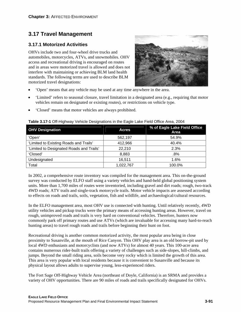
Chapter 3: AFFECTED ENVIRONMENT
3.17 Travel Management
3.17.1 Motorized Activities OHVs include two and four-wheel drive trucks and automobiles, motorcycles, ATVs, and snowmobiles. OHV access and recreational driving is encouraged on routes and in areas were motorized travel is allowed and does not interfere with maintaining or achieving BLM land health standards. The following terms are used to describe BLM motorized travel designations:
• ‘Open’ means that any vehicle may be used at any time anywhere in the area.
• ‘Limited’ refers to seasonal closure, travel limitation in a designated area (e.g., requiring that motor vehicles remain on designated or existing routes), or restrictions on vehicle type.
• ‘Closed’ means that motor vehicles are always prohibited.
Table 3.17-1 Off-Highway Vehicle Designations in the Eagle Lake Field Office Area, 2004
OHV Designation Acres % of Eagle Lake Field Office Area
‘Open’ 562,197 54.9% ‘Limited to Existing Roads and Trails’ 412,966 40.4% ‘Limited to Designated Roads and Trails’ 22,210 2.3% ‘Closed’ 8,883 .8% Undesignated 16,511 1.6% Total 1,022,767 100.0%
In 2002, a comprehensive route inventory was compiled for the management area. This on-the-ground survey was conducted by ELFO staff using a variety vehicles and hand-held global positioning system units. More than 1,700 miles of routes were inventoried, including gravel and dirt roads; rough, two-track 4WD roads; ATV trails and single-track motorcycle trails. Motor vehicle impacts are assessed according to effects on roads and trails, soils, vegetation, fish and wildlife, and archaeological/cultural resources.
In the ELFO management area, most OHV use is connected with hunting. Until relatively recently, 4WD utility vehicles and pickup trucks were the primary means of accessing hunting areas. However, travel on rough, unimproved roads and trails is very hard on conventional vehicles. Therefore, hunters now commonly park off primary routes and use ATVs (which are invaluable for accessing many hard-to-reach hunting areas) to travel rough roads and trails before beginning their hunt on foot.
Recreational driving is another common motorized activity, the most popular area being in close proximity to Susanville, at the mouth of Rice Canyon. This OHV play area is an old borrow-pit used by local 4WD enthusiasts and motorcyclists (and now ATVs) for almost 40 years. This 100-acre area contains numerous rider-built trails offering a variety of challenges such as side-slopes, hill-climbs, and jumps. Beyond the small riding area, soils become very rocky which is limited the growth of this area. This area is very popular with local residents because it is convenient to Susanville and because its physical layout allows adults to supervise young, less-experienced riders.
The Fort Sage Off-Highway Vehicle Area (northeast of Doyle, California) is an SRMA and provides a variety of OHV opportunities. There are 90 miles of roads and trails specifically designated for OHVs.
EAGLE LAKE FIELD OFFICE Proposed Resource Management Plan and Final Environmental Impact Statement 3-91

Chapter 3: AFFECTED ENVIRONMENT
Competitive motorcycling events have been held here for the past 30 years, and the area has been used for casual riding for at least 40 years.
There are a number of other free play (off-route) areas mainly used by motorcyclists and ATV riders. These include some small gravel pits along the northern edge of Honey Lake Valley. Other free play areas are some partially vegetated sand dunes north of Wendel, CA and an old borrow-pit on the lower slopes of the Amedee Mountains. These areas are further from Honey Lake Valley population centers but still receive casual day-use. Motorcycle trail-riding is also popular on dirt roads and single-track trails in the hills and mountains surrounding Dry Valley (north of Flanigan, NV on the eastern extremity of Honey Lake Valley). Enduro and Hare Scramble (motorcycle) events have been held here for more than 30 years.
Other vehicle-based recreation activities include pleasure-driving and back-country exploration in high-clearance vehicles, motorcycles, and ATVs conducted on 1,700 miles of dirt roads and trails throughout the management area. There’s not much snowmobiling because the management area receives little snow; however, some does take place at higher elevations, particularly on Fredonyer Peak and in the Eagle Lake Basin. Motor-boating is largely restricted to Dodge Reservoir and Eagle Lake because these waters are large enough to accommodate and justify motorboats (they are primarily used for fishing).
3.17.2 Non-Motorized Activities Non-motorized activities primarily mean hiking/backpacking, mountain-biking, and horseback riding.
Hiking By far the most popular non-motorized activity, hiking is primarily connected with hunting during late summer, fall, and winter. Some hiking is also inherent to fishing. Fishermen hike along the Susan River, Willow Creek, Upper Smoke Creek, and the shorelines of Eagle Lake, Dodge, Buckhorn, Round Corral, and Biscar Reservoirs. However, hiking for its own sake is also popular, primarily on the Bizz Johnson Trail. This 26-mile national recreation trail (nine miles of which are under BLM management) is a rails-to-trails conversion that extends from Susanville to Mason Station near Westwood, CA (most use is on the nine-mile BLM-administered section near Susanville). Other developed hiking trails include Stone’s Trail (at the north end of Eagle Lake), Wild Horse Trail (in the Fort Sage Mountains east of Doyle, CA), and Coyote Bluff Trail (in the Susanville Ranch Park).
Hiking in spectacular, unaltered settings is also readily available in a number of WSAs administered by the ELFO. Hiking possibilities include a variety of high-desert landscapes dominated by volcanic peaks, ridges, and lava rims. Many of these provide expansive views across the Great Basin, or to the west, the Sierra Crest and the Cascade Range. There are numerous canyons to explore, some of which contain perennial streams and good fishing. Some of the most interesting and enjoyable hiking experiences may be found in the following WSAs:
• The Skedaddle Mountains WSA is readily accessible and popular for hiking because of its dramatic canyons and ridges, and scenic vistas across Honey Lake Valley to the Sierra Crest.
• The Dry Valley Rim WSA offers hikers spectacular views across the vast expanse of the Smoke Creek Desert and surrounding mountains from atop a 20-mile fault-block escarpment.
• A 360° panorama of mountaintops, canyons, and the Smoke Creek Desert may be seen from atop Twin Peaks and other unnamed mountains in the Twin Peaks WSA.
The study area also affords hiking opportunities along Smoke Creek and Buffalo Creek—which are perennial streams—as well as in many unnamed canyons that penetrate the mountains of this WSA.
EAGLE LAKE FIELD OFFICE Proposed Resource Management Plan and Final Environmental Impact Statement 3-92
Chapter 3: AFFECTED ENVIRONMENT
• The Buffalo Hills WSA affords excellent cross-country hiking over gentle slopes dissected by numerous low-lying lava rims that afford scenic vistas across this open-country landscape.
• The western portion of the Poodle Mountain WSA is administered by the ELFO. This portion provides challenging canyonland hiking, including a dozen steep, rocky canyons (three to six miles long) that, in their lower reaches, exceed 1,000 feet in depth.
• The Five Springs WSA contains three broad, open ridges that provide expansive vistas of the surrounding country.
• The Tunnison WSA is on the western extremity of the Great Basin (where it joins the southern end of the Cascade Range). Interesting hiking opportunities are found along a modest mountain ridge and in Willow Creek Canyon, which is unique because of its wooded upper slopes and its perennial stream, which supports a viable trout fishery.
Of course, there are many other areas and mountains outside the WSAs that provide excellent hiking through canyons, along ridges, and cross-country. In particular, the upper slopes of the Fort Sage Mountains (east of Doyle, CA) provide interesting hiking over crumbling granitic boulders and bedrock fins and ridges that are unique in a region otherwise dominated by volcanic rock. The lower rim and upper ridges of Fredonyer Peak (northeast of Eagle Lake) afford outstanding views of this natural lake (the second-largest natural lake in California) and two major peaks in the southern Cascades: Mount Lassen and Mount Shasta.
The tracks have been removed from the (abandoned) Modoc Line roadbed. It now has a bed of packed gravel that extends 85 miles (from 1.5 miles north of Wendel to 12 miles south of Alturas). There is excellent potential for a rails to trails conversion; three segments being of particular interest to hikers: a section extending from a point near Wendel that extends to Viewland (adjacent to Highway 395), another section from Karlo to Crest (south of Ravendale), and a third from Madeline to McArthur siding (north of Likely) (this segment is administered by the Alturas Field Office). There is some backpacking (overnight hiking) in the above-mentioned areas but there are no developed trails of sufficient length to facilitate this activity. Therefore backpacking is sporadic, and mainly associated with hunting.
Mountain Biking Mountain-biking continues to gain popularity in Lassen County. Visitors drive long distances to bike the Bizz Johnson National Recreation Trail and, while here, find other areas in which to ride. Other notable rides include:
• Ascents of Shaffer Mountain, Fredonyer Peak, and Burro Mountain (which also offer dramatic scenic vistas).
• The Fort Sage Off-Highway Vehicle Area affords good mountain-biking in a scenic and mountainous high-desert environment.
• Dirt roads and trails throughout the management area (a total of 1,700 miles) offer a full range of riding experiences in a variety landscapes for every skill level.
At present, most roads are not used for mountain-biking because many are remote and not well known, or because trail surfaces are excessively rough and rocky or involve sustained elevation gain or loss. Most also do not provide conveniently circular routes, which are highly desirable for this activity. Skilled and fit bikers seek challenging rides in scenic locations, at low-to-moderate elevations on narrow, single-track trails that are not too rough, and (preferably) loop back to trailheads. Few single-track trails exist on ELFO-administered lands. A quality system of looped, single-track trails, built in suitable terrain, could become a significant regional attraction for practitioners of this sport.
EAGLE LAKE FIELD OFFICE Proposed Resource Management Plan and Final Environmental Impact Statement 3-93

Chapter 3: AFFECTED ENVIRONMENT
Lassen County is promoting nature-based tourism. There is excellent potential to support County and community efforts to expand rural tourism by disseminating information about existing mountain-biking opportunities and to work with local bikers to plan and develop a system of high-quality single-track mountain-bike trails on public land near population centers and popular recreation areas. There is excellent potential to develop trails that would serve local bikers and also capture and retain the interest of visiting mountain-bikers. A particularly worthy project would link 100 miles of existing dirt roads to create a grand loop trail around Honey Lake Valley on BLM-administered land north and east of the valley and on national forest land west and southwest of the valley (along the Sierra Crest). Such a trail could well become a multi-day destination, attracting mountain-bikers (and other users) from far afield to enjoy the fine riding, diverse landscapes and grand vistas it would provide. Such a trail would support economic diversification in Lassen and Plumas Counties.
If acquired for public use, the trackless roadbeds of the abandoned railroad grades of the Modoc Line and the Susanville to Wendel segment of the Fernley and Lassen Branch line would provide gentle grade trails that would serve local riders and visiting trails enthusiasts. If acquired and developed for trail use, these railroad grades, as they become known, should retain Bizz Johnson Trail visitors as they stay to explore these additional rail trails.
Horseback Riding Interest in recreational horseback riding is increasing. There are four riding clubs in Lassen County and each schedules rides on public land. Of course, many equestrians who are not club members also ride on public lands. Equestrian events are held in the high-desert and on the Bizz Johnson Trail (usually for recreation or endurance). Such events attract riders from throughout northern California and northwestern Nevada. Some of the WSAs (particularly the Dry Valley Rim, Skedaddle, Twin Peaks, Five Springs, and Buffalo Hills WSAs) are well-suited to horseback riding because of their open canyons and broad-backed ridges. The hills north of Wendel (east of the abandoned Modoc Line) also offer good riding. Honey Lake Valley residents frequently ride on Bald Mountain (near Standish and Janesville).
Non-Motorized Boating Non-motorized boats are common on Eagle Lake and Honey Lake, as well as on Buckhorn, Round Corral, Biscar, and Dodge Reservoirs. Buckhorn, Round Corral, and Biscar Reservoirs are small, and boats are primarily used for fishing. Rowboats, canoes, kayaks, and float-tubes are the most common watercraft. Dodge Reservoir, at 1.5 miles in length, is the largest of the reservoirs; however, the long, rough access road limits the size and number of boats. Like the other reservoirs, boats are primarily used for fishing. The same non-motorized craft are used on Eagle Lake and Honey Lake, primarily for fishing, leisure paddling, and relaxation.
Transportation Highways and major roads are built and maintained by Caltrans, Nevada Department of Transportation, and county governments. These highways and roads have been authorized by numerous acts of Congress, from the Mining Act of 1866 (Revised Statute [RS] 2477) to FLPMA (1976), including numerous federal-aid highway acts (administered by the Federal Highways Administration). Authorization details for individual highways are found in the master title plats. Section 8 of RS 2477 allowed construction of highways and roads across public lands not specifically reserved for other public purposes. Although repealed with the passage of FLPMA in 1976, roads built under RS 2477 have pre-existing rights. Furthermore, RS 2477 contained no provision for notifying the federal government of ROW grants or for their documentation in public land records. Therefore, the location and number of RS 2477 ROWs is unknown.
EAGLE LAKE FIELD OFFICE Proposed Resource Management Plan and Final Environmental Impact Statement 3-94

Chapter 3: AFFECTED ENVIRONMENT
Highways and major roads within the planning area include Interstate Highway 80; U.S. Highway 395; California Highways 49, 70, 89, 44, 36, and 139; and various county roads. However, most of these are not on BLM-administered land. A limited number of improved dirt roads are maintained by California or Nevada counties and BLM to facilitate public access. The ELFO has not conducted a comprehensive inventory of management area roads. These roads are unnamed, and their exact location and length is undocumented. (However, some are located, named, and measured with some precision on county road department maps.) State and county road departments routinely document and update road information. There are also numerous, user-created (some well-established) routes that cross BLM-administered lands throughout the planning area. This collection of casually established roads may be seen by some as a ‘major roadway network.’ However, the applicable regulations do not require ROW grants or temporary-use permits because such roads do not ordinarily cause appreciable damage to public resources, lands, or facilities. Under current BLM policy, all existing public roads, ways, and trails are open to motorized public use unless deliberately closed for specific and well-documented resource protection needs. Such closures become effective when a road closure notice is published in the Federal Register.
EAGLE LAKE FIELD OFFICE Proposed Resource Management Plan and Final Environmental Impact Statement 3-95
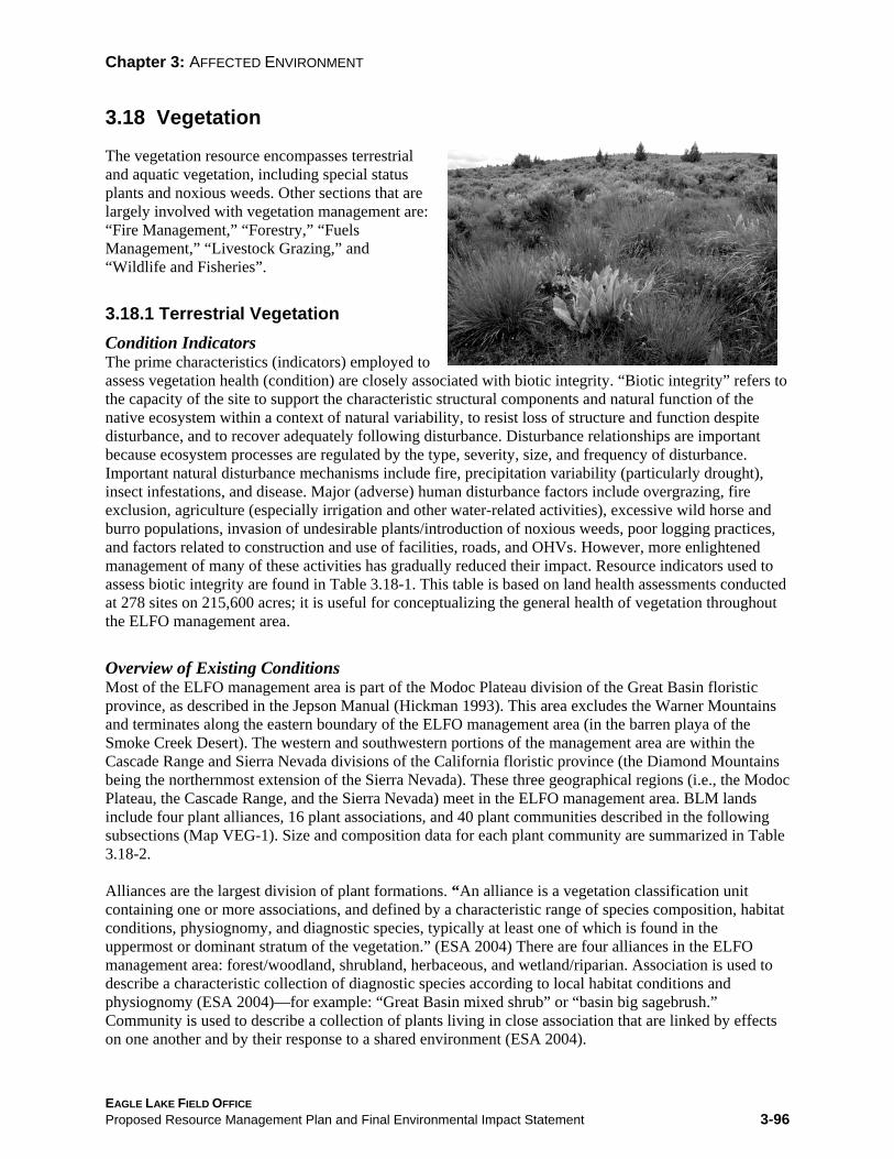
Chapter 3: AFFECTED ENVIRONMENT
3.18 Vegetation
The vegetation resource encompasses terrestrial and aquatic vegetation, including special status plants and noxious weeds. Other sections that are largely involved with vegetation management are: “Fire Management,” “Forestry,” “Fuels Management,” “Livestock Grazing,” and “Wildlife and Fisheries”.
3.18.1 Terrestrial Vegetation Condition Indicators The prime characteristics (indicators) employed to assess vegetation health (condition) are closely associated with biotic integrity. “Biotic integrity” refers to the capacity of the site to support the characteristic structural components and natural function of the native ecosystem within a context of natural variability, to resist loss of structure and function despite disturbance, and to recover adequately following disturbance. Disturbance relationships are important because ecosystem processes are regulated by the type, severity, size, and frequency of disturbance. Important natural disturbance mechanisms include fire, precipitation variability (particularly drought), insect infestations, and disease. Major (adverse) human disturbance factors include overgrazing, fire exclusion, agriculture (especially irrigation and other water-related activities), excessive wild horse and burro populations, invasion of undesirable plants/introduction of noxious weeds, poor logging practices, and factors related to construction and use of facilities, roads, and OHVs. However, more enlightened management of many of these activities has gradually reduced their impact. Resource indicators used to assess biotic integrity are found in Table 3.18-1. This table is based on land health assessments conducted at 278 sites on 215,600 acres; it is useful for conceptualizing the general health of vegetation throughout the ELFO management area.
Overview of Existing Conditions Most of the ELFO management area is part of the Modoc Plateau division of the Great Basin floristic province, as described in the Jepson Manual (Hickman 1993). This area excludes the Warner Mountains and terminates along the eastern boundary of the ELFO management area (in the barren playa of the Smoke Creek Desert). The western and southwestern portions of the management area are within the Cascade Range and Sierra Nevada divisions of the California floristic province (the Diamond Mountains being the northernmost extension of the Sierra Nevada). These three geographical regions (i.e., the Modoc Plateau, the Cascade Range, and the Sierra Nevada) meet in the ELFO management area. BLM lands include four plant alliances, 16 plant associations, and 40 plant communities described in the following subsections (Map VEG-1). Size and composition data for each plant community are summarized in Table 3.18-2.
Alliances are the largest division of plant formations. “An alliance is a vegetation classification unit containing one or more associations, and defined by a characteristic range of species composition, habitat conditions, physiognomy, and diagnostic species, typically at least one of which is found in the uppermost or dominant stratum of the vegetation.” (ESA 2004) There are four alliances in the ELFO management area: forest/woodland, shrubland, herbaceous, and wetland/riparian. Association is used to describe a characteristic collection of diagnostic species according to local habitat conditions and physiognomy (ESA 2004)—for example: “Great Basin mixed shrub” or “basin big sagebrush.” Community is used to describe a collection of plants living in close association that are linked by effects on one another and by their response to a shared environment (ESA 2004).
EAGLE LAKE FIELD OFFICE Proposed Resource Management Plan and Final Environmental Impact Statement 3-96

Chapter 3: AFFECTED ENVIRONMENT
The 40 (vegetation) communities of the ELFO management area are described below, according to the association to which they belong. Table 3.18-2 provides a summary of vegetation health according to biotic integrity findings for ELFO plant alliances, associations, and communities. Notably, the most visible factor resulting in an ‘At Risk’ determination is from ecosystem dominance by invasive native plants and/or alien weeds.
Biological (soil) crusts are frequently omitted from discussions of plant communities. Biological crusts (also known as cryptobiotic crusts or cryptograms) are composed of mosses, lichens, and cyanobacteria (formerly called blue-green algae). Mosses are the most common crust component in the management area. Much of the nitrogen (a vital nutrient) available on the nutrient-poor soils of the Great Basin derives from nitrogen fixation in biological crusts. Crusts also protect sparsely vegetated, fragile soils from excessive erosion. Intact crusts may also reduce invasion/establishment of alien annual grasses, such as cheatgrass (Kaltenecker et al. 1999). Biological crusts are most common on shallow soils, regardless of texture, and in deeper, fine-textured soils (e.g., silty loam). Highly calcareous soils (derived from limestone or gypsum) may be as much as 80% lichen-covered, while adjacent, but less calcareous soils may have a lichen cover of only 10% (Rosentretter and Belnap 2001). Vegetation structure and density exert strong influence on crusts and control their formation. Where vegetation is abundant, dense herbaceous growth and litter replace biological crusts.
Table 3.18-1 Average Indicator Scores for Biotic Integrity Status across the Eagle Lake Field Office Area Indicatora Scoreb Description
Soil structure resistance to erosion 2 ‘Healthy’ but trending away from healthy toward ‘At Risk’ or vice versa
Soil surface loss or degradation 2 ‘Healthy’ but trending away from healthy toward ‘At Risk’ or vice versa
Compaction layer 1 ‘Healthy’; values are those expected for sites surveyed. Compaction normally attributed to ungulate trailing or movement
Function/structural groups 3 At risk of becoming ‘Unhealthy’; this is a moderate departure from what is expected of the sites in this area
Plant mortality/decadence 2 ‘Healthy’ but trending away from healthy toward ‘At Risk’ or vice versa
Litter amount 2 ‘Healthy’ but trending away from healthy toward ‘At Risk’ or vice versa
Annual production (total site production not tied to specific species such as in ecological site evaluation)
2 ‘Healthy’ but trending away from healthy toward ‘At Risk’ or vice versa
Invasive plants (nonnative invasive species, predominantly cheatgrass and medusahead, as well as natives such as juniper)
3 At risk of becoming ‘Unhealthy’; this is a moderate departure from what is expected of the sites in this area
Reproductive capability of perennial plants 2 ‘Healthy’ but trending away from healthy toward ‘At Risk’ or vice versa
a The indicators are inter-related, not independent. No one indicator is weighted more than the others. The final biotic integrity ratingis based on the preponderance of evidence provided by the nine indicators together. b Indicator scores have been converted to numerals to facilitate analysis: 1 = No to slight deviation from that expected for the site sampled (‘Healthy’) and 5 = Extreme deviation from that expected for the site sampled (‘Unhealthy’). Site expectations are based on ecological site descriptions developed by the Natural Resources Conservation Service. Source: BLM ELFO Land Health Assessment, 2004
EAGLE LAKE FIELD OFFICE Proposed Resource Management Plan and Final Environmental Impact Statement 3-97

Table 3.18-2 Biotic Integrity for Selected Vegetation Associations in the Eagle Lake Field Office Area1/
Vegetation Alliance/Association Healthy Healthy/Lacking
Key Attributes 2/ At Risk Unhealthy Total
Coniferous Forest (all canopy cover classes) 14,000 4,000 4,000 0 22,000
True Juniper Woodland 0 4,000 10,000 7,000 21,000 Black Oak Woodland 0 1,000 0 0 1,000 Mountain Mahogany 1,000 500 0 0 1,500 Aspen Forest and Thicket 15 1,000 200 0 1,215 Big Sagebrush–Wyoming Big Sagebrush 2,000 6,000 17,000 3,000 28,000
Big Sagebrush–Mountain Big Sagebrush 14,000 28,000 8,000 0 50,000
Big Sagebrush–Basin Big Sagebrush 15,000 5,000 0 9,000 29,000
Low Sagebrush–Low Sagebrush 43,000 38,000 27,000 4,500 112,500
Low Sagebrush–Lahontan Sagebrush 6,000 54,000 14,000 0 74,000
Great Basin Mixed Shrub 181,000 157,000 146,000 48,000 532,000Mixed Desert Shrub 25,000 25,000 47,000 9,000 106,000Herbaceous Grassland– Annual 0 3,000 3,000 11,000 17,000
Herbaceous Grassland– Perennial 1,000 5,000 100 200 6,300
Herbaceous–Forb 0 0 2,500 2,500 5,000Total Area by Health Status 307,015 328,500 276,800 94,200 1,006,515
Percent Total Area by Health Status 30 33 27 9 100
LAND HEALTH RATING (acres)
1/ Acres based on LHA sample extrapolation using GIS analysis. Accuracy is a function of sample size/variability and GIS data integrity.2/ ‘Healthy/Lacking Key Attributes’ means that lands were rated as ‘Healthy’ based on the nine indicators for the biotic integrity attribute rating (USDI BLM 2000), but indicators did not fully meet the Biodiversity Land Health Standard. Source: USDI BLM ELFO, 2000.
Chapter 3: AFFECTED ENVIRONMENT
Activities that result in constant soil disturbance—or disturbance at the wrong time of year—will destroy biological crusts (Rosentretter and Belnap 2001). ELFO’s natural resource interdisciplinary team still needs to determine where biological crusts should naturally be present; however, their absence or presence is noted as a structural/functional indicator during land health evaluations. General descriptions of vegetation alliances, associations, and communities of the ELFO management area follow.
3.18.2 Vegetation Alliances 3.18.2.1 Forest and Woodland Alliance This alliance is characterized by a preponderance of trees (i.e., tall woody plants, usually having a single stem [trunk]). Within this alliance, thirteen plant communities are described for the ELFO management area. The dominant species in some cases can take tree or shrub form; however, these communities are included in this alliance because, under more favorable conditions, the dominant species would grow as trees (due either to better growing conditions or less feeding on young plants by herbivores).
EAGLE LAKE FIELD OFFICE Proposed Resource Management Plan and Final Environmental Impact Statement 3-98

Chapter 3: AFFECTED ENVIRONMENT
Coniferous Forest Association Coniferous forests and juniper woodlands cover 42,891 acres of the management area; it contains the following six plant communities.
Open White Fir/Eastside Pine Forest Community – This community consists of mixed evergreen forest with trees that (normally) reach heights of 100 to 120 feet and canopy cover that ranges from 25% to 59%. The open canopy allows more understory growth than would be found in a closed-canopy forest. Understory plants are primarily mixed mountain shrubs or evergreen mountain shrubs. Open white fir/eastside pine forests are dominated by white fir, Jeffrey pine, and ponderosa pine. Associated species are western juniper, curlleaf mountain mahogany, gooseberry and currant, greenleaf manzanita, tobacco brush, snowberry, antelope bitterbrush, mountain big sagebrush, California brome, squirreltail, silvery lupine, mule’s ears, and Columbia tower butterweed. This community is found on moderate-to-steep slopes at elevations of 4,500 to 8,000 feet. It is often a transitional community between forests of eastside pine and white fir. It is found in the Diamond Mountains and on Fredonyer Peak.
Open White Fir Forest/Mountain Big Sagebrush Community – This is a sparsely forested (canopy cover 10% to 24%) evergreen community where trees are generally less than 100 feet. The overstory is dominated by white fir; there’s a dense understory of 3 to 4-foot mountain big sagebrush. Associated species are western juniper, squaw carpet, wax currant, tobacco brush, snowberry, antelope bitterbrush, California brome, Idaho fescue, silvery lupine, slender penstemon, and Columbia tower butterweed. This community is found on gentle-to-moderate slopes, frequently on ridges and peaks in high-elevation sagebrush (6,800 to 8,000 feet).
Closed White Fir Forest Community – This is dense, white fir forest where trees reach 100 to 120 feet and canopy cover is 60% to 100%. Understory vegetation is very sparse; groundcover is primarily dead limbs and needle litter. Associated species are gooseberry, mountain snowberry, and pine drops. This community is found on moderate-to-steep slopes at elevations of 4,500 to 8,000 feet. It is located on the edge of the white fir precipitation zone and on more mesic sites adjacent to Jeffrey pine forests on Fredonyer Peak and in the Diamond Mountains.
Eastside Pine Forest Community – This is moderate-to-dense coniferous forest where canopy cover is 50% to 100%. The overstory is Jeffrey pine and ponderosa pine. There is a park-like understory of sparse shrubs and grasses combined with needle litter. Associated species are California black oak, antelope bitterbrush, big sagebrush, rubber rabbitbrush, squirreltail, Sandberg’s bluegrass, Kentucky bluegrass, cheatgrass, mule’s ears, and arrowleaf balsamroot. This community is found on the lower slopes of the Diamond Mountains, on Susan Peak, and at the south end of Eagle Lake on flat-to-moderate slopes, in sandy or loamy soils at elevations of 4,400 to 6,000 feet.
Eastside Pine Forest/Black Oak Community – This community is structurally diverse, rather densely canopied, and dominated by large Jeffrey and ponderosa pines (up to 100 feet) and California black oak (20 to 50 feet). The grass and shrub understory is open to moderately dense. Associated species are western juniper, curlleaf mountain mahogany, big sagebrush, rubber rabbitbrush, serviceberry, plateau gooseberry, blue wildrye, squirreltail, Sandberg’s bluegrass, Kentucky bluegrass, cheatgrass, yarrow, hot rock penstemon, mule’s ears, and arrowleaf balsamroot. It is found on dry, low-elevation slopes and on moderately steep mountainsides at higher elevations (4,200 to 5,200 feet) in rocky loams or sandy granitic soils. This community is found on lower slopes in the Diamond Mountains and in the foothills west and north of Susanville (it grades into eastside pine at higher elevations).
EAGLE LAKE FIELD OFFICE Proposed Resource Management Plan and Final Environmental Impact Statement 3-99

Chapter 3: AFFECTED ENVIRONMENT
Black Oak/Eastside Pine Community – This community is structurally diverse, rather densely canopied, and dominated by California black oak (20 to 50 feet) and Jeffrey or ponderosa pine (up to 100 feet). The grass and shrub understory is open to moderately dense. Associated species are western juniper, curlleaf mountain mahogany, big sagebrush, rubber rabbitbrush, serviceberry, plateau gooseberry, blue wildrye, squirreltail, Sandberg’s bluegrass, Kentucky bluegrass, cheatgrass, yarrow, hot rock penstemon, mule’s ears, and arrowleaf balsamroot. It is found on dry, low-elevation slopes and on moderately steep mountainsides at higher elevations (4,200 to 5,200 feet) in rocky loams or sandy granitic soils. This community is found on lower slopes in the Diamond Mountains and in the foothills west and north of Susanville.
Deciduous (Aspen) Forest Association Aspen is adapted to a much broader range of environmental conditions than most of its associated plants. It is one of few plants able to survive in all montane vegetation zones, from the basal planes to subalpine tundra (Daubenmire 1943). Consequently, it is a component species in a broad range of vegetation zones. At the lowest elevations, aspen frequently occurs as stringers or small islands on the fringes of semi-arid sagebrush-steppe. At intermediate elevations, it is usually found in pure or mixed stands interspersed with various coniferous forest types or as groves in other forested communities. Aspen fulfills a lower seral stage function in association with climax conifer forests and as the dominant species in the aspen forest association. Aspen clones (reproduces) vigorously by means of suckers following wildfires. Livestock grazing has contributed to structural diversity in aspen forests, were the lush undergrowth is excellent summer range. However, more than a century of over-utilization (especially in the late 1800s and early 1900s) has left its mark. Degradation is pronounced, though ill-defined, in terms of species composition and productivity (Mueggler 1988).
Aspen Forest Community – Aspen forests are dense to relatively open with a canopy cover of 30% to 100% and trees that may reach 60 feet. The understory may be covered with grasses and forbs (open) or of medium-height (less than 3 feet) and covered with forbs and deciduous shrubs. Associated species are: white fir, western juniper, curlleaf mountain mahogany, big sagebrush, snowberry, gooseberry, wax currant, California brome, columbine, and western chokecherry. This community occupies gentle to moderate slopes, primarily north or east-facing, throughout the region at elevations of 5,000 to 8,000 feet.
Aspen Thicket Connunity – Aspen thickets grow in mountainside concavities on north-facing slopes and on the leeward sides of mountains and plateaus. This plant community is usually found at high elevations (6,500 to 9,000 feet). Aspen thickets are dense and no higher than 15 feet at maturity. Individual thickets are usually the product of a single clone; therefore, their genetic composition is identical. Snowberry is an important understory shrub; forbs include horsemint, giant hyssop, daisy, geranium, waterleaf, lupine, groundsel, and meadowrue. Understory grasses include mountain brome, needlegrass, and slender wheatgrass.
Juniper Woodland Association As previously mentioned, coniferous forests and juniper woodlands cover 42,891 acres of ELFO-administered land. There are two juniper woodland communities within this area. A brief description of (juniper) woodland ecology is provided; followed by a description of both juniper woodland communities.
Western juniper is very adaptable; juniper woodlands may prosper in a variety of parent materials (especially different soils and plant cover) and in locations with widely differing topography and climate.
Therefore, juniper woodlands are complex, not only in terms of species composition and physiognomy, but also because the management area contains woodlands that vary greatly in successional stage (from
EAGLE LAKE FIELD OFFICE Proposed Resource Management Plan and Final Environmental Impact Statement 3-100

Chapter 3: AFFECTED ENVIRONMENT
early to senescent). The developmental stage greatly affects fuel loads, wildlife habitats, and management activities involving other natural resources. Treatment of invasive juniper—methods, cost, and response to treatment—also largely depends on developmental stage.
The distribution and prevalence of juniper has greatly increased since the late 1800s; not only in the ELFO planning area, but throughout the intermountain West. Juniper woodlands, which naturally grow in a variety of poor soils, now occupy more productive sites with deep, well-drained soils. This is due to a combination of factors; however, the most fundamental are long-term (more than a century), aggressive fire suppression and overgrazing. Heavy livestock grazing lowers the competitive capability of shrubland and grassland communities, leaving them vulnerable to invasion by juniper and noxious weeds (Tausch et al. 1993). Other influences may involve a slow decline in precipitation over the last 13,000 years and increased concentration of atmospheric carbon dioxide (Morrison 1991). Unfortunately, juniper has the potential to replace existing shrubland and grassland communities.
As (juniper) trees gain dominance, and shrubs and forbs decline, the fuel structure also changes. Fire return intervals, historically 12 to 25 years, are now 100 years or more in many locations. Densely packed juniper woodlands are now susceptible to intense crown fires. The aftermath of such hot fires often results in additional degradation due to invasion and dominance by alien weeds. In the past, juniper woodlands were treated to control expansion. However, due to other environmental concerns and wildlife issues, plus a different perception of the value of these environments, treatment (including the use of prescribed fire) has recently been reduced. During early-to-mid-stage development, when woodlands still contains a native shrub and forb understory, they can be successfully treated in various ways; prescribed fire being particularly effective. However, once these communities become mature, tree-dominated woodlands, treatment becomes difficult and expensive (Miller and Tausch 2001). Of course, the site potential for some soil types (Table 3.18-3) is juniper woodlands (USDA-NRCS 2004). These naturally occurring juniper woodlands should be preserved.
Table 3.18-3 Soil Series That Support Juniper Woodlands in the Eagle Lake Field Office Area Soil Series / Soil Map Unit Site Index Volume
(ft3/acre) Understory Ecological Site Number and Name
Buckbay 24 29 021XE007CA – Loam 12-16” Orhood 26 29 021XE004CA – Stony Loam 12-16” Fiddler 20 14 021XE004CA – Stony Loam 12-16” Whitinger 25 29 021XE004CA – Stony Loam 12-16”
Great Basin Juniper Woodland 10–24% Mixed Shrub/Perennial Grass Community – This is an open to moderately dense woodland/shrub community where juniper has not grown beyond 30 feet (mostly less) and canopy cover is 10% to 24%. Associated shrubs are medium-to-large big sagebrush (3– 6 feet) and antelope bitterbrush. The grass/forb understory is primarily bluebunch wheatgrass, Idaho fescue, Thurber’s needlegrass, squirreltail, mountain blue penstemon, rock erigonium, and woolly daisy. This community occupies flat areas or gentle-to-moderate slopes at elevations of 4,200 to 8,000 feet; sites are frequently rocky, since they often occupy basalt flows. Aggressive fire suppression, heavy livestock grazing, and climate change favor this plant community at the expense of shrubland and grassland communities.
Great Basin Juniper Woodland 10–24% Rock Conmunity – This is an open to moderately dense woodland community where juniper trees are typically old, large in diameter, and less than 20 feet high. Canopy cover is 10% to 24%. Associated plants are primarily low-lying (< 2 feet) evergreen shrubs (e.g., low sagebrush and plateau gooseberry), with the same grass and forb understory as the previous community. The primary feature that distinguishes this community from the other juniper woodland
EAGLE LAKE FIELD OFFICE Proposed Resource Management Plan and Final Environmental Impact Statement 3-101

Chapter 3: AFFECTED ENVIRONMENT
community is the heavy rock cover that dominates these sites. This community occupies old lava flows (basalt) and rock outcrops on flat to moderate slopes at elevations of 4,200 to 6,500 feet. It grows on Observation Mountain and in patches on the Tablelands. Disturbance factors that strongly influence the other juniper community do not necessarily apply, since the exceedingly rocky terrain limits fuel density and fire intensity, and the rough terrain is not subject to overgrazing.
Mountain Mahogany Association Curlleaf mountain mahogany grows on rocky ridges and steep slopes where soils are thin; about 1,500 acres of the management area is occupied by this small, but important association. This plant grows as a densely packed monoculture of small trees or as a secondary species in other tree-dominated communities (Sawyer and Keeler-Wolf 1995). It is intolerant of fire and (because seedling establishment is difficult in the shallow, rocky soil it inhabits) reproduction is slow. Mule deer, rabbits, and rodents also feed on the seedlings (as well as mature plants), further reducing reproductive success.
Mountain Mahogany 10–24% Mixed Shrub Community – This is an open or sparsely treed plant community of broad-leaf evergreen shrubs or trees dominated by curlleaf mountain mahogany. Canopy cover is 10% to 24%. The mountain mahogany takes a variety of forms, ranging from a young shrub of 3 to 10 feet to an old, small tree of 10 to 20 feet. Shrubs are evergreen or deciduous and primarily 3 to 5 feet in height. Associated species include white fir, western juniper, snowberry, antelope bitterbrush, plateau gooseberry, rubber rabbitbrush, serviceberry, bluebunch wheatgrass, squirreltail, arrowleaf balsamroot, phlox, and sulfur buckwheat. This community occupies the south end of Grasshopper Valley on gentle-to-moderate slopes at elevations of 5,300 to 7,000 feet.
Mountain Mahogany 25–39% Mixed Shrub Community – This is an open plant community of broadleaf evergreen shrubs or trees dominated by curlleaf mountain mahogany. Canopy cover is 25% to 39%. The mountain mahogany takes a variety of forms, ranging from a young shrub of 3 to 10 feet to an old, small tree of 10 to 20 feet. Other shrubs are primarily deciduous and of medium height (3–5 feet). The understory may be grassland vegetation or broken rock. Associated species include western juniper, ponderosa pine, Jeffrey pine, white fir, antelope bitterbrush, snowberry, Idaho fescue, bluebunch wheatgrass, squirreltail, silvery lupine, mule’s ears, arrowleaf balsamroot, and sulfur buckwheat.
Mountain Mahogany 40–59% Mixed Shrub Community – This is an open to fairly dense plant community of broad-leaf evergreen shrubs or trees dominated by curlleaf mountain mahogany. Canopy cover is 40% to 59%. The mountain mahogany takes a variety of forms, ranging from a young shrub of 3 to 6 feet to an old, small tree of 10 to 20 feet. Other medium-size shrubs (mostly big sagebrush) are interspersed with the mahogany; the understory is composed of small shrubs and perennial grasses. Associated species include western juniper, ponderosa pine, Jeffrey pine, white fir, rubber rabbitbrush, yellow rabbitbrush, serviceberry, antelope bitterbrush, snowberry, chokecherry, Idaho fescue, and bluebunch wheatgrass. This community is common throughout the region, from the foothills around Susanville northward into the Warner Mountains.
Mountain Mahogany 40–59% Rock Community – This is an open to fairly dense plant community of broad-leaf evergreen shrubs or trees dominated by curlleaf mountain mahogany. However, the mahogany primarily occurs as small, 10- to 15-foot trees. Canopy cover is 40% to 59%. This community is associated with lava flows and rock outcrops. Associated species include big sagebrush, antelope bitterbrush, serviceberry, bluebunch wheatgrass, Idaho fescue, Columbia tower butterweed, and sicklepod rockcress. It occupies gentle-to-moderate slopes on Observation Mountain at elevations of 4,500 to 8,000 feet.
EAGLE LAKE FIELD OFFICE Proposed Resource Management Plan and Final Environmental Impact Statement 3-102

Chapter 3: AFFECTED ENVIRONMENT
Mountain Mahogany 60–100% Community – This is a densely growing community of broad-leaf evergreen shrubs or trees dominated by curlleaf mountain mahogany. However, the mahogany overstory is largely composed of small, 8 to 15-foot trees. Canopy cover is 60% to 100%. Where stands are especially dense, understory vegetation is sparse; however, more open stands are interspersed with big sagebrush and perennial bunchgrass. Other associated species include Jeffrey pine, western juniper, white fir, big sagebrush, gooseberry and current, antelope bitterbrush, rubber rabbitbrush, chokecherry, bluebunch wheatgrass, and Idaho fescue. This community is found on gentle to steep slopes at elevations of 4,500 to 8,000 feet from the foothills around Susanville northward to the summits of the Warner Mountains.
3.18.2.2 Shrub Alliances Shrubs are woody plants, relatively short in height, that have multiple stems. Seven shrub associations have been identified in the ELFO management area; a description of each follows. Because many disturbance factors affect these associations similarly, they are addressed in a general manner here. Disturbance means a significant, and relatively sudden, modification of the resource (i.e., an alteration of the plant community away from a stable state, accompanied by changes in species composition, growth patterns, and reproduction). The key functional elements of any disturbance are its timing (seasonality), intensity (degree of resource modification/loss), frequency (recovery interval between disturbances), availability of abiotic (water and nutrients) and biotic (plant species, and effects of wildlife and domestic stock) resources and regime (connection with similar disturbances in time and space) (Sousa 1984). In the following discussion, variations in response to disturbance are noted for each plant community.
Past and current human influences on sagebrush-steppe ecosystems—particularly livestock grazing, fire, and recreation—are not perpetuating the original plant communities. West (1999) estimates that less than 1% of the sagebrush-steppe remains in unaltered condition. Furthermore, systematic disturbance has caused significant, and sometimes radical, changes in species composition in many areas. This has occurred in one of three ways: (1) disturbances may enhance the competitive ability of a dominant species (e.g., sagebrush) and force formerly dominant species into a subservient role (e.g., perennial grasses), (2) disturbances may enhance the competitive ability of a dominant species (e.g., a perennial grass) and eliminate the other formerly-dominant species (e.g., sagebrush), and (3) disturbance may result in loss of the original dominants. In order to preserve the integrity of the original plant community in all three scenarios, one or all of the originally-dominant species must exhibit sufficient dynamism and adaptability to compete with various disturbance-adapted species associated with human activities (e.g., cheatgrass and medusahead). The natural dominants, having evolved with an indigenous disturbance régime, are not well-adapted to this role.
Management of fire and livestock grazing (in particular) are difficult issues that involve much ecological uncertainty: the question is whether human activities will be sufficiently altered to rehabilitate and stabilize natural ecosystems or whether compromised, but fairly functional desired plant communities will be perpetuated. Given the present state of sagebrush-steppe ecosystems, difficult decisions about fire management and livestock grazing (including their absence in certain situations or locations) are required in order to salvage sagebrush-steppe communities.
The effects of overgrazing, high-frequency fires, and other factors (particularly off-road driving) on sagebrush-steppe communities and soils are obvious (Blaisdell et al. 1982, Bunting et al. 1987, and Vavra et al. 1994). Less obvious are the effects on other biota and more subtle changes. For instance, judicious grazing and prescribed fire are still associated with varying degrees of uncertainty regarding short-term and long-term outcomes in these plant communities. A degree of uncertainty can be expected because the manner in which these key disturbance activities are conducted varies with time and location.
EAGLE LAKE FIELD OFFICE Proposed Resource Management Plan and Final Environmental Impact Statement 3-103

Chapter 3: AFFECTED ENVIRONMENT
Furthermore, with a highly variable climate, they function more as a disturbance regime than as independent events (Eddleman and Doescher 1999).
Great Basin Mixed Shrub Association The ELFO management area has 530,996 acres in the mixed Great Basin plant association; this includes nine plant communities (a few with substantial variation in canopy cover or understory vegetation). Human and natural phenomena can have adverse effects on these communities. These include heavy late-summer livestock browsing on snowberry, antelope bitterbrush, and other palatable shrubs; juniper invasion; decreasing precipitation associated with long-term climate change; and short-term climate extremes (especially drought). The risk of dominance and type conversion to exotic annual grasses is high below 5,500 feet (because of lower precipitation and a dryer environment that supports hotter fires). Above this elevation, native plants normally receive more precipitation and respond better to disturbance; therefore, they compete successfully with invasive annuals such as cheatgrass.
Mixed Mountain Shrub 25–39% Perennial Grass Community – This is a moderate-to-dense, (primarily) broad-leaf community of 3 to 6-foot evergreen shrubs. Canopy cover is 25% to 39%. The dominant shrubs are mountain big sagebrush and snowberry. Grasses include California brome, western needlegrass, Idaho fescue, bluebunch wheatgrass, and squirreltail. Understory forbs include mule’s ears, old man’s whiskers, and silvery lupine. This plant community grows between 6,600 and 7,600 feet, and is frequently found on north-facing slopes throughout the region. However, it is most common on Observation Mountain, Shinn Mountain, and Skedaddle Mountain.
Evergreen Mountain 75–100% Shrub Community – This is a dense, broad-leaf community of evergreen shrubs less than 3 feet in height. Shrub cover is 75% to 100%. Sometimes, it contains scattered tall trees and open areas supporting bunchgrasses. The dominant shrubs are tobacco brush and greenleaf manzanita. Understory forbs include lupine, Columbia tower butterweed, slender penstemon, and phlox. Grasses include bluebunch wheatgrass and Idaho fescue. This community grows between 7,200 and 8,000 feet in areas where the snowpack lingers, most commonly on Fredonyer Peak, Observation Peak, and in the Diamond Mountains. Following fire, tobacco brush and greenleaf manzanita usually sprout vigorously and are quickly reestablished. This rapid response—when associated with conifer forests—slows forest recovery because these plants compete with tree seedlings (this natural process may extend forest recovery to 40 years).
Great Basin Mixed Shrub 10–24% Perennial Grass Community – This is an open to moderately dense, broad-leaf evergreen and deciduous community dominated by 3- to 6-foot big sagebrush. Canopy cover is 10% to 24%. Grasses include Sandberg’s bluegrass, squirreltail, bluebunch wheatgrass, basin wildrye, Thurber’s needlegrass, and cheatgrass. Understory forbs include tapertip hawksbeard, silvery lupine, skeletonweed, mule’s ears, arrowleaf and Hooker’s balsamroot, sulfur buckwheat, and rock eriogonum. This plant community occupies flats and moderate slopes at elevations of 4,500 to 5,800 feet on Shinn Mountain.
Great Basin Mixed Shrub 10–24% Bare Ground Community – This is an open, primarily broad-leaf evergreen shrub community dominated by 3- to 5-foot big sagebrush and rubber rabbitbrush. Canopy cover is 10% to 24%. The understory is either bare ground or annual weeds (e.g., medusahead, tumblemustard, tansymustards, and filaree). This community occupies flats and moderate slopes at elevations of 4,000 to 5,400 feet on the Karlo Tablelands and in the Skedaddle Creek and (upper) Smoke Creek watersheds. The presence of medusahead grass makes this community vulnerable to domination by this alien weed, should frequent fires occur. Injudicious grazing would also remove the native forbs and perennial grasses, with much the same result; conversion to a degenerate shrub/medusahead community.
EAGLE LAKE FIELD OFFICE Proposed Resource Management Plan and Final Environmental Impact Statement 3-104

Chapter 3: AFFECTED ENVIRONMENT
Great Basin Mixed Shrub 10–24% Rock Community – This community is similar to the previous one, i.e., the Great Basin mixed shrub (10–24%)/bare ground community, except that big sagebrush is the sole overstory species; the understory is bare rock with a few scattered forbs and perennial grasses. This community occurs in various locations throughout the Great Basin and Modoc Plateau at elevations of 4,200 to 6,200 feet; primarily on gentle-to-moderate slopes, but sometimes in steep rimrock areas.
Great Basin Mixed Shrub 25–39% Bare Ground Conmunity – This community is also similar to the Great Basin mixed shrub (10–24%)/bare ground community; however, the sagebrush/rubber rabbitbrush canopy is denser. Although there is some squirreltail, the understory is basically weeds: primarily Russian thistle, clasping pepperweed, and cheatgrass (rather than medusahead). It occurs on flats and gentle slopes at elevations of 5,200 to 5,400 feet on the Madeline Plains (between Termo and Madeline, California).
Low Sagebrush Scrub 10–24% Big Sagebrush Scrub 10–24% Community – This is an open, broadleaf evergreen community of low-to-medium height (1–5 feet) shrubs consisting of low or big sagebrush (solely or in combination). Canopy cover is 10% to 24%. Under natural conditions, the understory is composed of native forbs and perennial grasses; when ‘Unhealthy’, it is primarily exotic annuals. It occupies flats or gentle slopes at elevations of 4,200 to 6,800 feet, and is frequently associated with rocky areas and tablelands. This community is scattered throughout the region, but is especially prevalent in the Skedaddle Mountains.
Mountain Big Sagebrush Association Most researchers believe that genus Artemisia (sagebrush) evolved in Eurasia. Mountain big sagebrush (the most genetically primitive form) evolved during the middle Pliocene (5 million years ago), or earlier. During pluvial times, mountain big sagebrush had a nearly continuous distribution. However, under hypsothermal climatic conditions (and into recent times), mountain big sagebrush retreated into foothills and mountains where deep, well-drained, but summer-moist soils are prevalent (Trimble 1989).
The mountain big sagebrush association occupies 50,281 acres of ELFO-administered land. Mountain big sagebrush is normally found at elevations above 5,000 feet (in locations where soils are deep, well-drained, and moist). This species is not a fire responder, and recovery after fire may take 20 years (Bunting et al. 1987). Where undisturbed, canopy cover varies from 15% to 40%, (it may be 50% in wetter areas with deep, loamy soils and northerly exposures). Bitterbrush and snowberry are commonly associated shrubs (Tisdale 1994). Forbs are usually abundant, with 12 genera and many species. Idaho fescue, bluebunch wheatgrass, and Thurber’s needlegrass are the principal grasses on drier sites. On deeper, loamier sites, onion grass, western needlegrass, and subalpine needlegrass are more common.
Big Sagebrush 10–24% Perennial Grass Community – This is an open to moderately dense, broad-leaf evergreen shrub community dominated by 3- to 6-foot mountain big sagebrush. Canopy cover is 10% to 24%. The understory is primarily bluebunch wheatgrass; however, plateau gooseberry, antelope bitterbrush, snowberry, basin wildrye, Idaho fescue, arrowleaf balsamroot, mule’s ears, and prickly gilia are also present. This community grows on flats or gentle-to-steep slopes, primarily at elevations of 5,500 to 7,800 feet in the Amadee Mountains, the Skedaddle Mountains, and on Fredonyer Peak.
Big Sagebrush Scrub 40–59% Perennial Grass Community – This is a dense, broad-leaf, evergreen shrub community dominated by 3 to 5-foot mountain big sagebrush. Canopy cover is 40% to 59%. The understory is dominated by perennial grasses but also contains a variety of forbs. Associated species include antelope bitterbrush, snowberry, interior rose, bluebunch wheatgrass, Idaho fescue, junegrass, squirreltail, Sandberg bluegrass, mule’s ears, arrowleaf balsamroot, Hooker’s balsamroot, blue penstemon, sicklepod rockcress, and rosy everlasting. It occupies northern exposures at elevations of 5,500 to 7,600 feet in the Skedaddle Mountains.
EAGLE LAKE FIELD OFFICE Proposed Resource Management Plan and Final Environmental Impact Statement 3-105

Chapter 3: AFFECTED ENVIRONMENT
Basin Big Sagebrush Association The basin big sagebrush association occupies 28,640 acres of ELFO-administered land. This subspecies has trunk-like stems and is heavily branched with uneven tops. Shrub heights normally range from 3 to 6 feet, though plants in heavily incised drainages may reach 15 feet. This plant grows in various soils, but prefers the dry, deep, well-drained soils of the plains, and valleys and foothills below 7,000 feet (Blaisdell et al. 1982). The presence of this subspecies often indicates productive rangeland because it frequently grows in deep, fertile soil (Blaisdell et al. 1982; Collins 1984). Basin big sagebrush was once the most abundant shrub in North America. However, its lowland range has been largely converted to agricultural uses. This subspecies was thought to be intolerant of alkali; however, there are ecotypes that grow in relatively alkaline areas in association with alkali-tolerant plants such as black greasewood, shadscale, saltbush, and saltgrass (Blaisdell et al. 1982). Basin big sagebrush is killed by fire; recovery following fire may take as long as 50 years (Bunting 1990). Overgrazing can eliminate the understory of native perennial grasses. Communities in this association may then be easily dominated by exotic annual grasses (weeds) where this is allowed to happen.
Big Sagebrush 10–24% Perennial Grass Community – This is an open to moderately dense, broad-leaf evergreen shrub community dominated by 3 to 6-foot basin big sagebrush. Canopy cover is 10% to 24%. It is associated with forbs and perennial grasses, especially bluebunch wheatgrass, which dominates the understory. Other common grasses are basin wildrye, Sandberg’s bluegrass, and Thurber’s needlegrass. This community grows on flats at elevations of 4,700–7,800 feet in the Amadee Mountains, the Skedaddle Mountains, and on Fredonyer Peak.
Big Sagebrush Scrub 10–24% Bare Ground (Annuals) Community – This is an open, broad-leaf evergreen shrub community dominated by 3 to 6-foot basin big sagebrush. Canopy cover is 10% to 24%. In wet springs, interstitial spaces mostly support annual weeds (e.g., cheatgrass, tumblemustard, tansy mustard, and filaree); in dry springs this is bare ground. This community grows on flats or gentle slopes at elevations of 4,200 to 5,500 feet in the Madeline Plains and on Mud Flat. It has been chronically overgrazed and is in very poor condition.
Big Sagebrush Scrub 10–24% Rock Community – This is an open, broad-leaf, evergreen shrub community dominated by 3 to 5-foot basin big sagebrush. Canopy cover is 10 to 24%. Groundcover is primarily small-to-large rocks, boulders, or lava flows; interstitial spaces contain rocky soil. Associated species include rubber rabbitbrush, gray horsebrush, Mormon tea, spiny hopsage, basin wildrye, squirreltail, Sandberg’s bluegrass, cheatgrass, lupine, stemless goldenweed, desert yellow daisy, cespitose buckwheat, and low phlox. This community occupies lava flows, drainages, and mountain slopes at elevations of 4,200 to 6,000 feet on Painter Flat, and areas around Snowstorm Mountain and the Skedaddle Mountains.
Big Sagebrush Scrub 40–59% Perennial Grass Community – This is a dense, broad-leaf, evergreen shrub community of 3 to 5-foot big sagebrush. Canopy cover is 40 to 59%. The understory is dominated by perennial grasses; there are also many forbs. Associated species include antelope bitterbrush, snowberry, interior rose, bluebunch wheatgrass, Idaho fescue, junegrass, squirreltail, Sandberg bluegrass, mule’s ears, arrowleaf balsamroot, Hooker’s balsamroot, blue penstemon, sicklepod rockcress, and rosy everlasting. This community occupies north-facing slopes of drainages in the Skedaddle Mountains at elevations of 5,500 to 7,600 feet.
Wyoming Big Sagebrush Association The Wyoming big sagebrush association occupies 27,562 acres of ELFO-administered land. This big sagebrush subspecies appears to have originated as a cross between basin big sagebrush, mountain big
EAGLE LAKE FIELD OFFICE Proposed Resource Management Plan and Final Environmental Impact Statement 3-106

Chapter 3: AFFECTED ENVIRONMENT
sagebrush, and black sagebrush (Trimble 1989). Although Wyoming big sagebrush grows in combination with the other two (big sagebrush) subspecies; it occupies the drier, shallower, and poorer soils. It is the shortest subspecies, reaching only 3 to 4 feet under normal conditions (Blaisdell et al. 1982).
Natural fire intervals in Wyoming big sagebrush communities appear to range from 10 to 110 years or more. Post-burn recovery to 20% canopy cover may take more than 40 years after a stand-replacing fire (Young and Evans 1989; Winward 1991). Grasses usually dominate the site before reestablishment occurs. Because fuels are discontinuous in Wyoming big sagebrush communities, discontinuous burn patterns also frequently prevail; this leaves remnant plants to provide effective seeding (Bushey 1987). Sites are reestablished from (soil) seedbanks, and seeds from remnant and adjacent plants. Fire does not stimulate or inhibit germination of soil-stored seed (Champlin and Winward 1982). Because Wyoming big sagebrush occupies drier soils and poorer sites these communities are especially vulnerable to grazing impacts. In the ELFO management area, overgrazing has eliminated most of the perennial grass understory. This has opened these communities to invasion by exotic annual grasses (cheatgrass) which has now replaced the native perennial grasses in most areas. A cheatgrass understory is highly susceptible to fire, and greatly shortens the fire interval. As a result, these communities are dominated by exotic annual grasses and severely degraded (Young and Evans 1989).
Big Sagebrush 10–24% Perennial Grass Community – This is an open to moderately dense, broadleaf, evergreen shrub community dominated by Wyoming big sagebrush about 3 feet in height. Canopy cover is 10% to 24%. Low-growing sagebrush is associated with perennial grasses and forbs. Thurber’s needlegrass dominates the understory; other common species include squirreltail and Sandberg’s bluegrass. This community occurs on flats at elevations of 4,700 to 5,500 feet in-and-around the Amadee and Skedaddle Mountains.
Big Sagebrush Scrub 10-24% Bare Ground (Annuals) Community – This is an open, broad-leaf, evergreen shrub community dominated by Wyoming big sagebrush about 3 feet in height. Canopy cover is 10% to 24%. In wet springs, interstitial spaces mostly support annual weeds (e.g., cheatgrass, tumblemustard, tansy mustard, and filaree); in dry springs this is bare ground. This community grows on flats or gentle slopes at elevations of 4,200 to 5,500 feet on Little Mud Flat and on the flats between Shinn Mountain and the Skedaddle Mountains. It has been chronically overgrazed and is in very poor condition.
Big Sagebrush Scrub 25–39% Bare Ground (Annuals) Community – This is an open to moderately dense, broad-leaf, evergreen shrub community of 3 to 4-foot Wyoming big sagebrush. Canopy cover is 25-39%. In wet springs, interstitial spaces primarily support annual weeds (e.g., cheatgrass, tumblemustard, tansy mustard, and filaree); in dry springs the ground is almost bare, though it does support some sparse perennial vegetation (squirreltail and Sandburg’s bluegrass). This understory persists, even when canopy cover is substantial greater. Goodrich et al. (1999) estimates a 3.8% decrease in understory herbs for every 1% increase in canopy cover beyond 15%. This community occurs on flats or moderate slopes at elevations of 4,000 to 5,000 feet throughout the region. It has been chronically overgrazed and is in very poor condition.
Low Sagebrush Association The low sagebrush association occupies 187,352 acres of ELFO-administered land. Low sagebrush grows on very poor soils that are dry, rocky, and frequently alkaline. In the warmer, drier parts of its range, particularly in Nevada, it may grow at altitudes above 9,800 feet. In some areas, low sagebrush grows in discontinuous low- or high-elevation bands. Soils that support this species generally are rockier and contain more clay than those that support big sagebrush; they are also wetter in spring and dryer in fall (Blaisdell et al. 1982). Low sagebrush stands generally escape fire when mixed with big sagebrush.
EAGLE LAKE FIELD OFFICE Proposed Resource Management Plan and Final Environmental Impact Statement 3-107

Chapter 3: AFFECTED ENVIRONMENT
However, under extreme conditions, low sagebrush will burn; when this happens, recovery time is longer than for big sagebrush. If overgrazed, low sagebrush communities are susceptible to cheatgrass invasion (where clay content is high, the invasive grass is usually medusahead) (Blaisdell et al. 1982).
Low Sagebrush Scrub 10–14%/Perennial Grass Community – This is an open, broad-leaf evergreen shrub community dominated by low sagebrush, usually less than 1 foot in height. Canopy cover is 10% to 24%. Associated plants are primarily perennial grasses and forbs, sometimes with scattered western juniper. Sandburg’s bluegrass dominates the understory; other associated species include antelope bitterbrush, plateau gooseberry, gray horsebrush, squirreltail, bluebunch wheatgrass, Idaho fescue, ballhead sandwort, desert yellow daisy, low pussy-toes, rock erigonium, Bolander’s yampah, Hooker’s balsamroot, and cushion erigonium. Tufts of perennial grasses are often elevated, indicating soil loss. This community occurs on rocky flats or gentle slopes at elevations of 4,200 to 6,800 feet throughout the region, but especially in the Skedaddle Mountains, and on Fredonyer Peak and Observation Mountain.
Mixed Desert Shrub Association The mixed desert shrub association occupies 106,348 acres of ELFO-administered land. Salt-desert vegetation is characteristically sparse, and largely dominated by shrubs or half-shrubs of the family Chenopodiaceae. The most important shrubs are shadscale, fourwing saltbush, Torrey’s saltbush, and greasewood. This association also contains scattered sagebrush (Blaisdell and Holmgren 1984). Native annuals are seldom more than a small fraction of the total cover; unfortunately, three exotic weeds— cheatgrass, Russian thistle, and halogeton—thrive when these communities are degraded, especially when the timing and quantity of precipitation favors their growth. Halogeton, in particular, is poisonous to livestock (Blaisdell and Holmgren 1984). The naturally sparse plant cover and fine-grained, saline soil makes degraded salt-desert plant communities especially vulnerable to wind and water erosion. Although not all such communities are severely eroded, some localities are among the most degraded in the intermountain region. Biological crusts (primarily cyanobacteria) are especially important for communities in this association, because they fix nitrogen and bind soil, thereby sustaining fertility and resisting erosion. Trampling by livestock weakens or destroys this crust, making soils extremely vulnerable to wind and water erosion (Blaisdell and Holmgren 1984).
Big Sagebrush Scrub 10–24% Greasewood Community – This is an open, broad-leaf evergreen and deciduous desert shrub community, dominated by 3 to 5-foot basin big sagebrush and black greasewood. Canopy cover is 10% to 24%. The understory is primarily saltgrass or bare ground,or weedy annuals such as cheatgrass and Russian thistle. This community occurs on alkaline flats at elevations of 3,900 to 4,200 feet along the western border of the Smoke Creek Desert and near Flannigan, Nevada.
Greasewood Scrub 0–10% Mixed Shrub Community – This is a very open, broad-leaf deciduous desert shrub community dominated by 2- to 5-foot black greasewood and basin big sagebrush. The understory is primarily bare soil with sparse, annual, perennial, or mixed vegetation (e.g., rubber rabbitbrush, basin big sagebrush, spiny hopsage, saltgrass, and Russian thistle). This community grows primarily on alkaline flats at elevations of 4,000 to 5,300 feet. (It generally grows on lighter soils with sparser vegetation than the mixed desert shrub 0–9% community described below.)
Greasewood Scrub 10–24% Mixed Shrub Community – This is an open to moderately dense, broadleaf deciduous desert shrub community dominated by 2- to 5-foot black greasewood and basin big sagebrush. Canopy cover is 10% to 24%. Associated plants include shadscale, fourwing saltbush, rubber rabbitbrush, spiny hopsage, littleleaf horsebrush, saltgrass, basin wildrye, squirreltail, tumblemustard, tansy mustard, clasping pepperweed, povertyweed, and Russian thistle. This community grows on flats (usually associated with dry lake beds) or very gently sloping alkaline soils at elevations of 4,000 to 5,300
EAGLE LAKE FIELD OFFICE Proposed Resource Management Plan and Final Environmental Impact Statement 3-108

Chapter 3: AFFECTED ENVIRONMENT
feet; notably on Honey Lake Island, Mud Flat, the Madeline Plains, and at the northern end of the Smoke Creek Desert.
Mixed Desert Shrub 0–9% Community – This is a very open, broad-leaf, deciduous desert shrub community dominated by 3- to 5-foot rubber rabbitbrush, basin big sagebrush, and greasewood. The understory is primarily bare soil with sparse annual grasses or moderately abundant perennial grasses. Associated species include silver sagebrush, budsage, saltgrass, cheatgrass, tumblemustard, and Russian thistle. This community grows on alkaline flats at elevations of 4,000–5,300 feet; primarily in desert areas east of Honey Lake, the Smoke Creek Desert, and on the Madeline Plains (it may also grow on sand dunes, which it does on the Madeline Plains.)
Mixed Desert Shrub 10–24% Community – This is an open, broad-leaf deciduous desert shrub community dominated by 2- to 4-foot shadscale, spiny hopsage, and Wyoming big sagebrush. Canopy cover is 10 to 24%. The surface (soil) is largely light, loamy (biological) crust or gravel and/or stone. Understory vegetation is primarily annual forbs and grasses. Associated species include budsage, Mormon tea, littleleaf horsebrush, rubber rabbitbrush, greasewood, cheatgrass, squirreltail, basin wildrye, tumblemustard, and Russian thistle. This community grows on flats and the lower terraces of desert mountains at elevations of 4,000 to 5,300 feet; mostly on the periphery of the Smoke Creek Desert and on the Madeline Plains.
Rabbitbrush Scrub 0–10% Bare Ground (Annuals) Community – This is a very open, broad-leaf deciduous desert shrub community dominated by 3- to 5-foot rubber rabbitbrush. The understory is primarily bare soil with sparse annual vegetation. Associated species include basin big sagebrush, gray horsebrush, greasewood, cheatgrass, medusahead, poverty weed, and tumblemustard. This community grows on flats and gentle slopes at elevations of 4,500 to 5,500 feet on the Tablelands. Its vertisol soils are commonly infested with medusahead.
Rabbitbrush Scrub 10–24% Bare Ground Community – This is an open, broad-leaf deciduous desert shrub community dominated by 3- to 5-foot rubber rabbitbrush. Canopy cover is 10–24%. The understory is primarily bare soil infested with annual weeds. Associated species include basin big sagebrush, gray horsebrush, greasewood, cheatgrass, medusahead, poverty weed, low sagebrush, antelope bitterbrush, rushes, basin wildrye, squirreltail, Sandberg’s bluegrass, skeletonweed, Cusick’s sunflower, white-stemmed stickleaf, and tumblemustard. This community grows on alkaline flats and gentle slopes at elevations of 4,200 to 5,000 feet. It is found throughout the region and is frequently associated with burns or disturbed areas.
Silver Sagebrush Scrub Community – This is an open-to-dense, broad-leaf evergreen shrub community dominated by silver sagebrush, usually less than 2 feet in height. Canopy cover is 20 to 40%. Groundcover may consist of forbs and grasses, rushes, or sedges; or nearly bare ground. Associated species include basin big sagebrush, Baltic rush, basin wildrye, mat muhly, Lassen lomatium, whitestem rubber rabbitbrush, variedleaf green rabbitbrush, alkali plagiobothrys, meadow barley, and creeping wildrye. This community grows on flats in closed drainage basins on soils that are poorly drained, moist, and alkaline. It is often associated with basin big sagebrush and rabbitbrush communities, and grows on Painter Flat and the Madeline Plains at elevations of 4,000 to 5,600 feet.
3.18.2.3 Herbaceous and Grassland Alliance By definition, herbaceous plants have succulent (non-woody) stems; they include forbs and aquatic plants and may have annual or perennial life-cycles (Sawyer and Keeler-Wolf 1995). Herbaceous plants are usually a major part of the understory vegetation in tree or shrub-dominated communities. However, in this alliance, forbs and grasses are the dominant plants. The herbaceous and grassland alliance occupies
EAGLE LAKE FIELD OFFICE Proposed Resource Management Plan and Final Environmental Impact Statement 3-109

Chapter 3: AFFECTED ENVIRONMENT
28,466 acres of ELFO-administered land. These are primarily seasonal or permanent meadow and seep communities (the latter are described under “Wetland and Riparian Associations”). Although herbaceous and grassland habitats are characterized by low species diversity, when compared to habitats with more complex structural diversity, they are very important in terms of regional biodiversity.
Pasture and Cropland – Pasture and cropland does not normally occur on BLM-administered lands, except where BLM has recently purchased fallow fields or where ecosystem mapping parameters have grouped crested wheatgrass seedings under this community. Mapping includes 5,581 acres of ELFO-administered pasture and cropland. This community contains an assortment of agricultural crops, fallow fields, degraded crested wheatgrass seedings (rife with annual weeds), or former shrublands destroyed by fire and reseeded to crested wheatgrass. Most of this plant community is in the Madeline Plains, Honey Lake Valley, and Dry Valley at elevations of 4,000 to 5,000 feet.
Perennial Grass Community – This is an open perennial grassland community dominated by bluebunch wheatgrass or other perennial grasses. There are very few shrubs, those that occur are of minor importance. A monoculture of seeded crested wheatgrass, devoid of shrubs or forbs, is a common community type. These habitats are all of limited biological value, although used to some extent by mule deer, pronghorn, and sage-grouse.
Perennial and Annual Forb Community – These communities are dominated by annual and perennial sunflower, and are found primarily on the Tablelands. Although some shrubs and juniper are present, forbs dominate these habitats. Most herbaceous species native to the Modoc Plateau and Great Basin are capable of withstanding fire, unless the fire is very hot, so that crown and roots are killed. Grazing by livestock, and wild horses and burros, will damage or destroy herbaceous plants if not properly managed. This frequently results in replacement of native perennial forbs and grasses by invasive annual weeds. The use of motor vehicles in herbaceous or grassland communities is often of little consequence; however, frequent use of the same track will remove vegetation, cause erosion, and allow noxious weeds and invasive plants the opportunity to invade the site.
Annual Grassland Communities – Annual grassland habitats composed of invasive weeds (primarily cheatgrass and medusahead) are highly undesirable and considered biological deserts. Exotic annual grasses (particularly medusahead and cheatgrass) are likely to persist, whether or not livestock grazing continues on BLM-administered lands. These plants persist because of abundant annual seed production and long-term viability of seed stored in surface litter and soil; plus earlier germination than native perennials. Of course, damage and loss of native perennial shrubland/bunchgrass communities because of persistent grazing and frequent wildfires has greatly accelerated introductions and domination by exotic annual weeds. However, it is possible to reduce infestation, or at least slow its progress, through proper grazing management on lands surrounding the affected area. Improving health in adjacent areas creates a natural barrier to the spread of weeds. Properly designed grazing strategies have also noticeably improved areas presently dominated by exotic annuals. Areas where annual grasses are still a minor problem have also benefited from improved grazing management. Improvement is evidenced by increased vigor and seed production in native vegetation–such efforts are now being prioritized.
3.18.2.4 Wetland and Riparian Alliance Nationwide, riparian-wetland areas comprise less than 9% of the land base. However, these areas are the most productive and prized resource on BLM-administered lands. Riparian-wetland areas are essential to restoring and maintaining natural hydrologic function (particularly groundwater recharge and flood control) and the physical, chemical, and biological health of the nation’s water supply. There is disproportionately heavy use of riparian-wetland areas by numerous wildlife species, more so than any other habitat types. Riparian-wetland areas are also highly prized for their recreational value (e.g.,
EAGLE LAKE FIELD OFFICE Proposed Resource Management Plan and Final Environmental Impact Statement 3-110

-
Chapter 3: AFFECTED ENVIRONMENT
hunting, fishing, photography, hiking, and wildlife-viewing), economic value (e.g., livestock grazing), and for nature education. These habitats are highly valued by Native Americans for food-gathering and other traditional economic activities.
In the ELFO management area, riparian zones usually appear (from the air) as thin green ribbons in canyon bottoms. Green strips in many mountain drainages are less than 15 feet wide (including stream width); even the largest streams in the management area are only 10 to 40 feet wide. However, portions of the Susan River exceed 100 feet in width. The riparian vegetation zone varies tremendously in width, according to water depth, volume, and flow rate and local topography, soils, and streambank (or nearby) modifications. Riparian and wetland communities in this planning area are primarily found in or adjacent to seeps and springs, seasonal or permanent meadows, creeks and rivers, natural lakes or playas, and man-made irrigation canals and reservoirs. Because of the proximity and abundance of water, riparian plants are usually quite different from those found in adjacent upland areas; they also thrive in or tolerate wet or saturated soil conditions that upland plants cannot.
BLM’s “Riparian-Wetland Initiative for the 1990s” (USDI 1991) establishes national goals and objectives for protecting riparian-wetland resources on public lands. The initiative’s chief goals are: (1) restore and maintain riparian-wetland areas so that at least 75% are in PFC by 1997; and (2) achieve an advanced condition of ecological stability (except where resource management objectives, i.e., PFC requires an earlier stage of succession to provide greater habitat diversity for wildlife, fish, and watershed protection). The strategy of this initiative also requires holistic, watershed-based management. The condition of the entire watershed is an essential component for determining whether a riparian-wetland area is functioning properly.
The ELFO completed an intensive riparian-wetland health assessment from 1995 to 2000. An interdisciplinary team composed of staff specialists (including rangeland ecologists, botanists, wildlife biologists, hydrologists, soil scientists, and archaeologists) was assembled to inventory and assess the condition of riparian and wetland areas. The assessment included more than 200 streamside or spring/seep site assessments, more than 100 miles of flowing water, and over 200 acres of wetland/standing water sites. Most flowing or standing water riparian-wetland areas are in PFC; however, many are ‘Functioning At Risk, but with an upward trend’ (87% of these areas are either in PFC or making progress toward that goal). The riparian-wetland inventory is summarized in Table 3.18-4.
Table 3.18-4 Wetland and Riparian “Proper Functioning Condition’ Ratings Functioning at Risk
Community Type
Proper Functioning Condition
Trend Up Trend Not
Apparent Trend Down
Non functional Unknown Total
Riparian - flowing water (miles)
63 a 25 9 1 0 3 100
Percent of total riparian areas 63% 24% 10% 1% 0% 2% 100%
Wetland - standing water (acres)
121 8 32 19 0 0 180
Percent of total wetlands 65% 6% 17% 10% 0% 2% 100%
Note: See U.S. Bureau of Reclamation 1994 and 1995 for definitions of wetland and riparian status condition classes. a Combined total “on the ground” for riparian functional assessment field inventory 1995, 1996, 1997, 1998, and 1999–2002.
EAGLE LAKE FIELD OFFICE Proposed Resource Management Plan and Final Environmental Impact Statement 3-111

Chapter 3: AFFECTED ENVIRONMENT
It is reasonable to expect that (based on experience with many such sites) areas that are ‘Functioning at Risk, but with an upward trend’ will recover and stabilize very quickly with proper management (including protective fencing). Where the necessary components are in place—and the area rested from livestock grazing—PFC can often be achieved in five years or less. However, such progress also requires relatively satisfactory hydrologic condition—more work needs to be done here. Management efforts are usually focused on sites that are ‘Functioning at Risk’, with either a static or downward trend.
Protective fencing has been extensively employed for the last 10 to 15 years to exclude livestock, and wild horses and burros, from riparian-wetland areas. Although many sites are unfenced, changes in livestock management (particularly pasture rotation and grazing rest/deferment) have had positive effects on groundcover (i.e., improved vigor and productivity). This is evidenced by more residual vegetation and faster re-growth following livestock use in riparian areas. In many areas, off-site water (troughs) is provided for livestock, wild horses and burros, and wildlife. This measure provides necessary water for large grazing animals while protecting vegetation and soil around seeps and springs from grazing and trampling by herbivores. Birds and small ground-dwelling animals have access to water either inside the fenced area or from the water trough. Fences are also designed so that pronghorn and deer can jump or go under without injury. However, most wild ungulates use the troughs, even when livestock are nearby. The principal wetland and riparian communities of the management area are described below.
Riparian Scrub/Herbaceous Association Riparian zones and riparian plant communities in this association occupy areas adjacent to streams, lakes, and other natural sources of open water, as well as reservoirs; this water exerts a predominant influence on the native vegetation and the associated biotic community (USDA 1997). The riparian association, riparian communities, and ecological sites all describe plants that grow in the riparian zone. Obligate species require the environmental conditions that prevail within this zone; whereas facultative species tolerate these conditions and are frequently found outside the riparian zone. Riparian ecosystems are distinctly different from surrounding lands and vegetation because of the strong influence exerted by free (unbound) water in the soil (USDA 1997). Riparian (and all) plant communities are classified according to recognizable, repeatable, and clearly defined assemblages of riparian plant species. There are at least 570 total acres of riparian/wetland communities and ecological sites within the management area (not counting lands that border the northern portion of Eagle Lake). These riparian/wetland areas are too small to be tabulated, or shown on maps of the scale being used in this PRMP.
Willow Scrub Community – This is an open to moderately dense deciduous community of tall shrubs (less than 8 feet) or trees (less than 30 feet). The dominant genus is willow, combined with wet meadow plants and scattered low shrubs (3 feet or less). Associated species may include narrow-leaf willow, arroyo willow, red willow, Scouler’s willow, Lemmon’s willow, shining willow, interior rose, sedges, rushes, columbine, mountain alder, American dogwood, quaking aspen, and black cottonwood. This community occupies flats or gentle slopes in springs, meadows, and wet drainages throughout the region. Willows grow in riparian and wetland associations on periodically saturated soils. Healthy willow communities sprout vigorously following fire. Willows also sprout well from cuttings, and are extensively used for re-vegetation. However, close association with open water and palatability make willows especially vulnerable to overgrazing by livestock, wild horses, and burros. Repeated streambank trampling by livestock causes soil erosion and gullying, which lowers the water table and converts riparian habitats to upland shrub communities. Similar effects can result from improper road placement (through or alongside riparian habitats) and excessive motor vehicle traffic.
Seasonally Dry Meadow Community – This community occupies areas with remnant meadow soils that are wet in spring, but (usually) dry by early summer. It is primarily composed of perennial, grass-like plants, but also may contain scattered 3- to 6-foot shrubs. When in poor condition, it may contain
EAGLE LAKE FIELD OFFICE Proposed Resource Management Plan and Final Environmental Impact Statement 3-112

Chapter 3: AFFECTED ENVIRONMENT
numerous annual weeds or bare ground. The dominant plants are usually Baltic rush and various sedges. Associated species include silver sagebrush, rubber rabbitbrush, squirreltail, annual beardgrass, clustered field sedge, mat muhly, beardless wildrye, inland saltgrass, meadow barley, fine-branched popcornflower, and tanseyleaf evening primrose. This community occupies flats or gentle slopes at elevations of 4,000 to 6,000 feet. It is found throughout the region, but is often associated with overgrazed pastures in Honey Lake Valley and the Madeline Plains.
Wet Meadow or Seep Community – This community occupies seep, spring, or meadows that are wet most of the year. It supports a dense community of (primarily) riparian grass-like plants, and sometimes a few scattered 3- to 6-foot shrubs. Rushes and sedges are the dominant plants. Associated species include willow, golden currant, interior rose, Nebraska sedge, Baltic rush, common spikerush, short-awn foxtail, meadow barley, spike redtop, thingrass, western blue flag, small-flowered camas, hoary nettle, and common monkeyflower. This community grows on flats or gentle slopes at elevations of 4,000 to 8,000 feet. It is frequently associated with the outlet area of large watersheds throughout the region; but particularly the Honey Lake Basin.
Dry Lakebed/Alkali Playa Association The dry lakebed/alkali playa association occupies 10,832 acres of ELFO-administered land. Only one plant community is described for this association: ephemeral lake basins that (usually) contain light, fine-textured, poorly-drained soils. These basins are salty and generally have no outlet. Typically, they are devoid of vegetation, except for scattered saltgrass. They are frequently inundated in wet winters and usually dry in the summer months. This very sparse plant community is primarily found at elevations of 4,000 to 5,000 feet; notably in the Smoke Creek Desert, Madeline Plains, and Honey Lake Valley. (Plant communities adjacent to ephemeral lake basins were described earlier under the “Mixed Desert Shrub Association”).
EAGLE LAKE FIELD OFFICE Proposed Resource Management Plan and Final Environmental Impact Statement 3-113

Scotch thistle
Chapter 3: AFFECTED ENVIRONMENT
3.19 Noxious Weeds and other Invasive Species Noxious alien and invasive native plants have received worldwide recognition as a very serious threat to biodiversity, second only to habitat loss and fragmentation. These plants alter basic ecosystem functions such as nutrient cycling, hydrology, and wildfire frequency; overwhelm native plants and animals; and sometimes hybridize with native species. All natural plant communities are susceptible to noxious weed invasion. The presence, abundance, and influence of noxious weed infestations in a particular ecosystem are highly dynamic, responding to changes in local environmental conditions from a range of human and natural causes. Introduction, proliferation, and spread of noxious weeds and invasive plants—and priorities for their control—can change in as little as two years, as new infestations are located, known infestations are successfully treated (or increase in size and severity), and management priorities change. Table 3.19-1 identifies noxious weed infestations according to watershed, number of sites known in that watershed and a rough approximation of their size.
Trends in noxious weed infestation are assessed according to the number and severity of infestations, and their net and/or gross size (in acres). A sustained reduction in any of these factors is considered a positive trend. The ultimate goal of the noxious weed program is elimination (or effective control) of noxious weeds on ELFO-administered lands. Effects of change on the noxious weed problem are difficult to predict because of the complexity of ecosystem processes and the diversity of management activities. However, there is an undisputed consensus that, in the absence of continued inventory, a coordinated weed-treatment program, and yearly treatment evaluation the problem would rapidly worsen. Certain weeds have already become so ubiquitous that infestations are now considered too difficult, time-consuming, and costly to treat. Without an unrelenting focus on identification and control, noxious weeds will flourish in all watersheds. If this is allowed to happen, other weeds are also likely to become too widespread and abundant to control, thereby permanently degrading many natural ecosystems and significantly reducing their resource value. Toward this end, a memorandum of understanding is in place to coordinate ELFO weed control efforts with those of adjacent jurisdictions. This Integrated Weed Management Program is of great benefit to all agencies and groups concerned with this issue by coordinating efforts, optimizing available resources, and maximizing the effectiveness of control measures.
Aggressive fire suppression and overgrazing have led to invasion and degradation of sagebrush communities by certain native shrubs, particularly western juniper. Fire can be used to control invasive species or to approximate historic fire régimes. Nonetheless, land managers must be cautious when using fire for these purposes; if not used correctly, fire may favor proliferation of other fire-tolerant invasives or exotic weeds, resulting in further degradation of already-compromised ecosystems. Natural fire regimes in sagebrush ecosystems did not occur in the presence of numerous exotic plants, and its use may not be feasible if fire tolerant exotics are present (Brooks and Pyke 2001). Exotic annual grasses, in particular, especially benefit from fire and their proliferation results in its frequent reoccurrence (i.e.. an unnaturally shortened fire-return interval)—in many cases, to the point where native species cannot persist and sagebrush communities are converted to exotic annual grasslands. Type conversion of this kind severely reduces biodiversity, and is devastating for wildlife (including carnivores). Therefore, effective wildlife management depends on the control of invasive and exotic plants and use of appropriate, site-specific fire régimes (Brooks and Pyke 2001).
Cheatgrass, especially, is widespread in low-elevation juniper woodlands. However, cooler, mesic woodlands appear less susceptible to invasion and dominance by this and other exotic annuals. A better
EAGLE LAKE FIELD OFFICE Proposed Resource Management Plan and Final Environmental Impact Statement 3-114

Chapter 3: AFFECTED ENVIRONMENT
understanding of factors that influence woodland susceptibility to invasive and exotic species is required. Whistenant (1990) reviewed the effects of cheatgrass infestation on fire frequency in shrub-steppe communities and found that it tends to exert dominance on disturbed soils. Because it forms a continuous fuel load, its presence leads to more frequent fires. Frequent fire shrinks native plant cover, encourages proliferation of cheatgrass, and reduces biodiversity—making establishment easier on relatively undisturbed soils.
Although the combination of invasive/exotic plants and fire is frequently counterproductive, prescribed fire and some alien plants can be effective management tools. Under the right circumstances, fire may be used to control invasive plants, and some fire-resistant exotics may be used to create fuel breaks to control its spread. Fire is an effective management tool when hot enough to kill all adult plants – and if perennials, their persistent meristems – and eliminate seedbanks (Brooks and Pyke 2001, from Whelan 1995). For example, invasive annuals (such as cheatgrass) with short-lived seedbanks may be controlled with fire under the right circumstances. If burned before seed is released to the ground (i.e., before inflorescences dehisce), the soil seedbank can be largely emptied resulting in local extirpation or significant population reduction (Brooks and Pyke 2001). Although fire may be thus used, effects are often partial or temporary. Follow-up treatment with herbicides may be necessary to kill plants that escaped initial (fire) treatment. Washington State University is conducting an important study related to these matters entitled “Management of Fuel Loading in the Shrub-Steppe” (accessible at www.tricity.wsu.edu/shrub_steppe). This 3-year study is designed to develop a fuel management protocol that will reduce the risk of wildfire at minimum cost. The study places special emphasis on cheatgrass infestations in the Columbia National Wildlife Refuge by comparing treatment modalities and their comparative effectiveness in altering the competitive balance between native plants and cheatgrass. Part of this study is concerned with the ability of various treatments (especially prescribe fire, herbicides, and seeding with native plants) to reduce fuel loading. The study is investigating the relationship between the amount of fine fuel cover and its potential for a sustained fire. The ultimate goal is to restore a diverse assemblage of native plants and re-create a natural fire-return interval (Pellant et al. 2000).
Mechanical removal is another technique for controlling invasive plants; however, this also may create opportunities for (other) invasive plants or exotic weeds, which must be considered when applying this technique. Finally, techniques that would reduce available nitrogen immediately after fire may favor establishment by native plants and reduce the dominance of exotic annuals. More research is needed to identify and develop cost-effective techniques for employing this method to enhance the success of native plants (Brooks and Pike 2001).
EAGLE LAKE FIELD OFFICE Proposed Resource Management Plan and Final Environmental Impact Statement 3-115

Chapter 3: AFFECTED ENVIRONMENT
Table 3.19-1 Noxious Weed Species and Extent of Occurrence
Noxious Weed Species Known Sites Size (Net Acres)
Bull thistle (Cirsium vulgare) 1 1
Canada thistle (Cirsium arvense) 26 7
Dalmatian toadflax (Linaria dalmatica) 18 9
Dyers woad (Isatis tinctoria) 3 1
Halogeton (Halogeton glomeratus) 2 2
Hoary cress (Cardaria draba) 5 2
Jointed goatgrass (Aegilops cylindrica) 1 1
Mediterranean sage (Salvia aethiopis) 16 544
Perennial pepperweed (Lepidum latifolium) 66 103
Puncturevine (Tribulus terrestris) 2 5
Russian knapweed (Acroptilon repens) 21 33
Russian olive (Elaeagnus angustifolius) 1 1
Salt cedar (Tamarix ramosissima) 1 1
Scotch thistle (Onopordum acanthium) 71 66
Spotted knapweed (Centaurea maculosa) 4 16
Yellow starthistle (Centaurea solsistialis) 30 118
Source: Noxious Weed Inventory, BLM Eagle Lake Field Office, January 2007
EAGLE LAKE FIELD OFFICE Proposed Resource Management Plan and Final Environmental Impact Statement 3-116

Bakers Globe Mallow
Chapter 3: AFFECTED ENVIRONMENT
3.20 Special Status Plants For the purpose of this PRMP, special status plants are defined as:
• Plants protected under the Endangered Species Act; i.e., ‘endangered’ and ‘threatened’ species, and those proposed for listing (listed plants are covered under Section 17.12; proposed species are identified through notices in the Federal Register)
• Plants that are ‘candidates’ for possible future listing under the Endangered Species Act (67 FR 40657)
• Plants that are federally-recognized as ‘species of concern’ (former U.S. Fish and Wildlife Service [USFWS]C1 or C2 candidates)
• BLM ‘sensitive’ and ‘special-interest’ plants
• Plants listed under the California Endangered Species Act (CESA)
• List 1B species of the California Native Plant Society (CNPS) which lists species that are endangered, threatened, or rare in California (and elsewhere)
• Nevada Native Plant Society (NNPS) ‘Watch List’ species
Management actions or treatments to protect special status plants will prioritize federally listed endangered, then threatened plants; followed by federally proposed, then candidate plants; followed by California-listed plants; followed by BLM sensitive plants, then special-interest plants; and lastly CNPS 1B and NNPS watch list plants. Based on the most current data, a total of 26 special status plants are known or suspected to occur in the ELFO action area. Of these species, 18 have been identified to occur in the field office area. These plants are listed in Table 3.20-1 (at the end of this section) together with information on regional distribution, local occurrences, legal status, habitat requirements, and threats to known populations. Map VEG-4 shows the location of special status plant populations thus far identified in the management area.
EAGLE LAKE FIELD OFFICE Proposed Resource Management Plan and Final Environmental Impact Statement 3-117

Chapter 3: A
FFEC
TED
EN
VIR
ON
ME
NT
Table 3.20-1 Special-Status Plants Known or Suspected to Occur in the Eagle Lake Field Office Area Plant Name / Family Statusa Occurrence
in Area Locationsb Quadsc Habitat Threats Needs Current/Relevant Information
Astragalus agrestis Field milk-vetch Fabaceae
CNPS 2 BLM S
Known
Madeline Plains n. of Termo E-2, A-S
570A,657B658 A,658D Las; NV,OR+
Sagebrush scrub flats.
None known but watch grazing practices.
Continue inventory on the Madeline Plains.
Madeline Plains north of Termo Highly disjunct from other states’ occurrences.
Astragalus argophyllus var. argophyllus Silverleaf milk-vetch Fabaceae
CNPS 2 BLM S
Known
Smoke Creek Rd. area w. of NV state line. E-3
638D Las, Iny, Mon; NV +
Moist alkaline seeps in sagebrush scrub.
Not grazed. Could be out-competed by saltgrass?
Continue inventory. Ocular monitor populations in Buffalo Berry exclusion for saltgrass or other competition.
Smoke Creek Road area W. of Nevada state line. Highly disjunct from other states’ occurrences.
Astragalus geyeri var. geyeri Geyer’s milk-vetch Fabaceae
CNPS 2 BLM S
Known
Foothills n. of BLM horse corrals, east side Honey Lake Valley. (Also Washoe Co.) E-8, S-S
602A,602D 620C,621A Las, Iny, Mon; NV, OR +
Sandy areas in sagebrush scrub.
Livestock trampling in early spring and summer. Rodents eat plant.
Continue inventory and monitor livestock activity. This is an annual, so numbers can fluctuate greatly.
Foothills N. of BLM horse corrals uncommon, potential habitat.
Astragalus lentiformis Lens-pod milk-vetch Fabaceae
CNPS 1B Known
W. of Portola E-1
586B,586C 587A,587B 587C,588A 588D,603C Plu
Bitterbrush/ sagebrush in open pine forest.
None known on BLM site. Possible shrub and tree competition.
Ocular monitor population for possible disturbances such as trespass uses, and OHV annually
West of Portola, only known occurrence
Astragalus pulsiferae var. pulsiferae Pulsifer’s milk-vetch Fabaceae
CNPS 1B NNPS W
Known
N. end of Sierra Valley. (Bonta and Magee grazing lease allotments) E-2
586A,586C 586D,587D 604C Las, Plu, Sie; NV
Decomposed granite in sagebrush scrub and open pine.
Trespass uses (rock removal) on Bonta parcel. May be some competition from shrubs. Likes some disturbance and openings. Not noticeably grazed.
Ocular monitor parcel regularly for trespass uses on Bonta parcel. Watch for noxious weeds at site. Continue inventory in Sierra Valley.
North end of Sierra Valley. Bonta and McGee grazing allotments.
EA
GLE L
AK
E FIELD
OFFIC
E Proposed R
esource Managem
ent Plan and Final Environm
ental Impact S
tatement
3-118

Chapter 3: A
FFEC
TED
EN
VIR
ON
ME
NT
Table 3.20-1 Special-Status Plants Known or Suspected to Occur in the Eagle Lake Field Office Area Plant Name / Family Statusa Occurrence
in Area Locationsb Quadsc Habitat Threats Needs Current/Relevant Information
Astragalus pulsiferae var. coronensis Modoc Plateau milkvetch Fabaceae
CNPS 1B NNPS W
Known
Shaffer Mtn., Ramhorn e. to NV E= + 39, A= +11
621A,624C,625D,638B 638C,638D, 639A,639B 639C,640B, 656C,657C 675A,676B, 676D,692A 692D Las, Mod, Plu; NV OR
Rocky to gravelly sites in sagebrush scrub. Habitat not real descriptive or distinct.
None known
Inventory for BLM occurrences; new variety (coronensis); previously called var. suksdorfii. Now var. suksdorfii in Sha, western Las and Plu (on LNF), and WA.
Several occurrences in Alturas FO
Dalea ornata Ornate dalea Fabaceae
CNPS 2 BLM S
Known Tablelands n. of Belfast. E-6
621B,639C Las; NV OR +
Rocky clay sagebrush /rabbitbrush flats.
Often grows in areas of dense medusahead but not certain whether it affects the Dalea. Questionable impact from livestock or wildlife.
Continue to inventory and observe for any possible livestock or noxious weed impacts.
Tablelands north of Belfast. Highly disjunct from other states’ occurrences
Gratiola heterosepala Boggs Lake hedge-hyssop Scrophulariaceae
State E CNPS 1B
Known
Snowstorm Wetland; Green Place, Fall River Valley. E-1, A-5 (+?)
639B, 661A, 678B, 678D (+LNF and MNF quads) Las, Mod, Sha,+; OR
Vernal pools and flats. Often occurs in human-made reservoirs.
Changes in water regime. No threats at wetland site since it is fenced.
Continue to inventory for. RPSAC recommended downlisting, but it was not changed.
CA State Endangered, common on Modoc Plateau
Iliamna bakeri Baker’s globe mallow Malvaceae
CNPS 1B Known
Observation and Fredonyer Peaks, Willow Fire; Cold Sp Mtn., Bald Mtn.; Boot Lake + E-5, A-5+, S-4
640A,640C,656C,656D, 657C, 661C, 673C,673D,674D,675C,675D Las, Mod, Sha +; OR
Rocky sagebrush, juniper, and mountain mahogany communities-prevalent after fires.
Out-competed by dense shrub cover. Grazed and browsed by livestock and wildlife.
Continue to inventory for – especially recent burns. Ocular monitor grazing use of known populations.
Willow Fire, Blue Fire, Observation, and Fredonyer Peaks.
EA
GLE L
AK
E FIELD
OFFIC
E Proposed R
esource Managem
ent Plan and Final Environm
ental Impact S
tatement
3-119

Chapter 3: A
FFEC
TED
EN
VIR
ON
ME
NT
Table 3.20-1 Special-Status Plants Known or Suspected to Occur in the Eagle Lake Field Office Area Plant Name / Family Statusa Occurrence
in Area Locationsb Quadsc Habitat Threats Needs Current/Relevant Information
Ivesia aperta var. aperta Sierra Valley ivesia Rosaceae
CNPS 1B NNPS T Fed Sp of concern
Known
E. side of Sierra Valley n. of Correco Canyon. E-1
570B,570D 571A,571B 571D,586B 587C,587D 602C,603D Las, Plu, Sie; NV
Dry meadow flats and slopes in sagebrush and open pine. Often grows with sericoleuca
Affected by livestock grazing. BLM site grazed very little if any.
Continue to inventory for in and around Sierra Valley. Ocular monitor BLM populations at least biennially.
East side of Sierra Valley north of Correco Canyon.
Ivesia webberi Webber's ivesia Rosaceae
CNPS 1B NNPS T Candidate NV-CE#
Known
E. side of Sierra Valley (Dellera Allot.) Most of this pop. is on state land. S. of Hallelujah Junc. E. of Constantia. E-(1)
570A,570B 570D,586A, 586C,589B,60 5C Las, Plu, Sie; Was, Dou
Gravelly flat and slopes in sagebrush scrub.
Does not appear to be grazed by livestock but trampling would affect.
Continue to inventory for. Ocular monitor Dellera allotment population annually.
East side of Sierra Valley (Dellera allotment). Most of population is on state land south of Hallelujah Junction, east of Constantia. (Candidate sp.)
Loeflingia squarrosa var. artemisiarum Sagebrush loeflingia Caryophyllaceae
CNPS 2 Known
E. edge of Madeline Plains between Buckhorn and Horne Ranch Rds. Flats e. of Herlong.E-3, A-S?, S-S
602A,656C Las, Iny, (Kern, LA) NV, OR, WY
Moist sandy area in sagebrush/ rabbitbrush scrub.
Very small annual plant. Any spring or early summer surface activity could affect population. Changes in moisture regime may also affect.
Continue to inventory for. Ocular monitor known BLM occurrences biennially.
East edge of Madeline Plains between Buckhorn and Horne Ranch Roads. Flats east of Herlong.
Oryzopsis exigua Little ricegrass Poaceae
CNPS 2 BLM S Known
Upper slope of Observation Peak and Mt Dome. E-1, A-1, S-S
656C,730C Las, Sis; NV, OR +
Rocky outcrops in sagebrush steppe.
Could be affected by livestock grazing but is not noticeably grazed at this site.
Continue to inventory for. Two recent sites in CA.
Upper slopes of Observation Mountain Potential habitat in all field offices.
Pedicularis centranthera Dwarf lousewort Scrophulariaceae
CNPS 2 BLM S Known
Near Karlo area and s. E. of 395 n. of Mud Flat. E-5
639D, 638C Dry ashy flats in sagebrush scrub.
Not noticeably grazed by livestock; could be affected by trampling. Potential for OHV impacts at some sites.
Continue to inventory for. Ocular monitor known sites biennially for potential impacts.
Near Karlo area south and east of Highway 395 north of Mud Flat.
EA
GLE L
AK
E FIELD
OFFIC
E Proposed R
esource Managem
ent Plan and Final Environm
ental Impact S
tatement
3-120

Chapter 3: A
FFEC
TED
EN
VIR
ON
ME
NT
Table 3.20-1 Special-Status Plants Known or Suspected to Occur in the Eagle Lake Field Office Area Plant Name / Family Statusa Occurrence
in Area Locationsb Quadsc Habitat Threats Needs Current/Relevant Information
Penstemon sudans Susanville beardtongue Scrophulariaceae
CNPS 1B Known
Along Bizz Johnson Trail, n. of Susanville, and e to Tablelands, Observation, Snowstorm Mtn. E-25
622A,622B 623A,623B 623D,638B 639A,639D 640D, etc.
Rocky volcanic slopes and outcrops in sagebrush scrub.
No known threats. Doesn’t appear to be grazed. Recruits well on some disturbed sites.
Continue to inventory for. This plant is common locally but has very limited distribution. Known as Susanville penstemon.
Along Bizz Johnson Trail north of Susanville and east to Tablelands, Observation, and Snowstorm Mountain.
Phacelia inundata Playa phacelia Hydrophyllaceae
NNPS W CNPS 1B BLM S
Known
SE side of Eagle Lake, NW Modoc Co, NW Nevada. E-2, S-1
640B,640C 712A,728C Las, Mod NV,OR
Moist alkaline playas and meadows.
Trampling by livestock.
Continue to inventory for. Revisit historic Secret Valley site.
Southeastern side of Eagle Lake, northwest Modoc County, Nevada.
Pyrrocoma lucida Sticky pyrrocoma Asteraceae
CNPS 1B Known Claireville Flat.
E-2 588D
Seasonally wet flat or drainage within eastside pine forest.
Logging, OHV.
Inventory other Plumas County parcels. Monitor logging and OHV effects.
Thelypodium howellii var. howellii Howell's thelypodium Brassicaceae
CNPS 1B Known
Known from Rodeo Flat, e. edge of Madeline Plains, and Ash Valley (private). A-S, E-2
656A, 656C
Moist alkaline meadows and flats in sagebrush steppe.
Could be affected by livestock grazing and habitat manipulation. Rodeo Flat site is fenced.
Continue to inventory for. Ocular monitor biennially for potential impacts. Relocate Madeline Plains and Dixie Valley occurrences.
Known from Rodeo Flat and east edge of Madeline Plains. Potential habitat elsewhere.
Astragalus lemmonii Lemmon’s milkvetch Fabaceae
CNPS 1B Suspected
Sierra Valley and Ash Valley. E-S, A-S
587D, 675C 676D, 712A Las, Mod, Plu, Sie, Mon; NV OR
Moist sandy flats in silver sage.
Land conversion.
Inventory for on BLM parcels in Sierra Valley. Possibly in Madeline Plains.
Sierra Valley potential habitat.
Astragalus webberi Webber’s milk-vetch Fabaceae
CNPS 1B Suspected
S. of Crescent Mills. None known on BLM. E-S
605C, 605D 606D Plu, Sie
Open lower montane coniferous forest.
Unknown Continue to inventory for.
South of Crescent Mills. None known on BLM administered lands. Federal candidate.
EA
GLE L
AK
E FIELD
OFFIC
E Proposed R
esource Managem
ent Plan and Final Environm
ental Impact S
tatement
3-121

Chapter 3: A
FFEC
TED
EN
VIR
ON
ME
NT
Table 3.20-1 Special-Status Plants Known or Suspected to Occur in the Eagle Lake Field Office Area Plant Name / Family Statusa Occurrence
in Area Locationsb Quadsc Habitat Threats Needs Current/Relevant Information
Ivesia sericoleuca Plumas ivesia Rosaceae
CNPS 1B Suspected
Sierra Valley and areas to n. and s. of there. None known on BLM. E-S
570C, 570D, 571B, 571C, 571D, 572D, 586B, 587B, 587C,587D, 602C,603C,603D,622D Las, Plu, Sie, +
Dry meadow flats and slopes in sagebrush scrub and open pine. Often grows with I. aperta.
Affected by livestock grazing.
Continue to inventory for in and around Sierra Valley. Also reported from Janesville area.
Sierra Valley and areas to north and south of there. None known on BLM administered lands, potential habitat.
Lupinus dalesiae Quincy lupine Fabaceae
CNPS 1B Suspected
S. of Greenville. None known on BLM. E-S
589A, 605C 606A, 606B 606C, 606D Plu, Sie, Yub, But
Often disturbed areas in montane coniferous forests.
Unknown Continue to inventory for.
South of Greenville, potential habitat. None known on BLM-administered lands.
Mimulus evanescens Ephemeral monkeyflower Scrophulariaceae
CNPS 1B Suspected
Moll Reservoir and LNF. Historic “10 mi south of Ravendale”. E-1(historic), A-2
639A, 657B, 676A, 676D Las, Mod, Sis; OR, ID, NV?
At the edge of reservoirs and lakes and vernally moist depressions in sagebrush scrub.
Changes in water regime and trampling.
Continue to inventory for.
Potential habitat in Eagle Lake FO
Oreostemma elatum Tall alpine-aster Asteraceae
CNPS 1B Suspected
None known for Eagle Lake FO but suspected. Occurs on Dyer Mtn. e. of Almanor. E-S
589B, 590A 605C, 606A Las, Plu, Teh
Bogs and wet meadows. Unknown
Be aware of plant and keep an eye out for on suitable habitats.
None known of BLM-administered lands but suspected on potential habitat. Occurs, Dyer Mountain east of Almanor.
Polyctenium williamsiae William’s combleaf Brassicaceae
CNPS 1B NNPS T Fed Can
Suspected Mud Flat (private land) E-S
621A Seasonally wet flat.
Livestock, road maintenance.
Continue to inventory; Look closely at Polyctenium fremontii record locations.
Mud flat (private land).
Rorippa columbiae Columbia yellow cress Brassicaceae
CNPS 1B Suspected
Small potential for this plant in w. portion of Eagle Lake FO. Near intersection of A-21 and Hwy 44. A-S, E-S
642D
Vernally wet flats in sagebrush steppe.
Livestock trampling, hydrologic changes.
Be aware of this plant and search for in suitable habitat.
None known on BLM-administered lands. Near intersection of A-21 and Highway 44. Small potential for This plant in western portion of Eagle Lake Field Office and parts of Alturas FO.
EA
GLE L
AK
E FIELD
OFFIC
E Proposed R
esource Managem
ent Plan and Final Environm
ental Impact S
tatement
3-122

Chapter 3: AFFECTED ENVIRONMENT
3.21 Visual Resources
Visual resources are scenic features of the landscape that include land, water, vegetation, structures, and other objects. BLM uses a visual resources management (VRM) classification system during planning activities to manage the quality of the landscape and assess the level of potential impacts on visual resources resulting from development activities. These classes, Class I through Class IV, are developed through an inventory process and are based on the visual quality of an area, the sensitivity of the landscape to change, and the distance from which the landscape is viewed. The results of the inventory performed for the PRMP are shown in Table 3.21-1.
Visual resources are described and managed as one of four classes with the following resource management objectives.
Class I: The objective of this class is to preserve the existing character of the landscape. This class provides for natural ecological changes, but it does not preclude very limited management activity. The level of change to the characteristic landscape should be very low and must not attract attention.
Class II: The objective of this class is to retain the existing character of the landscape. The level of change to the characteristic landscape should be low. Management activities may be seen, but should not attract attention of the casual observer. Any changes must repeat the basic elements of form, line, color, and texture found in the predominant natural features of the characteristic landscape.
Class III: The objective of this class is to partially retain the existing character of the landscape. The level of change to the characteristic landscape should be moderate. Management activities may attract attention but should not dominate the view of the casual observer. Changes should repeat the basic elements found in the predominant natural features of the characteristic landscape.
Class IV: The objective of this class is to provide for management activities that require major modification of the existing character of the landscape. The level of change to the characteristic landscape can be high. These management activities may dominate the view and be the major focus of attention. But every attempt should be made to minimize the impact of these activities through careful location, minimal disturbance, and repeating the basic elements (form, line, color, and texture).
VRM classes have been determined under BLM’s visual resource inventory process as specified in BLM Manual H-8410-1. The VRM inventory process involves:
• Scenic quality ratings • Distance zones from specified viewing areas (roads, trails, camping areas and other use areas or
observation points) • Evaluation of visual sensitivity (i.e., identification of areas where there is significant public interest in
retaining scenic qualities)
EAGLE LAKE FIELD OFFICE Proposed Resource Management Plan and Final Environmental Impact Statement 3-123

Chapter 3: AFFECTED ENVIRONMENT
Table 3.21-1 Visual Resource Management Classes
Class Total Area (acres)
(Class I applies only to WSAs)1/ N/A Class II 507,843 Class III 442,028 Class IV 72,896 Grand Total (Classes II, III, and IV) 1,022,767 1/ VRM Class I objectives apply for all WSAs in the ELFO management area (380,359 acres). Class I objectives supersede other, underlying, class objectives. However, if a WSA is removed from wilderness study by Congress and returned to multiple-use management, the area will revert to its underlying VRM class. Because of uncertainty regarding wilderness designation, the table depicts only the underlying VRM class totals.
The ELFO is located at the junction of three geographic provinces. The 1,022,767 acres of the field office area are located where the northwestern edge of the Great Basin intersects the northern end of the Sierra Nevada Mountains and the southeastern side of the Cascade Range, with a sub-region called the Modoc Plateau comprising much of the Cascade portion of the area. The most dominant typical Great Basin segment of the field office area includes the expansive Honey Lake Valley; the Smoke Creek Desert on the eastern side of the field office jurisdiction; various small, shallow lakes that dry out in summer; and the expansive Madeline Plains, a Pleistocene lake bed now covered with shrubs and grasses. Unlike other shallow Great Basin lakes in the area, Eagle Lake (a closed basin lake with no outlet) contains a healthy fishery and is a major recreational attraction because of its high scenic quality and excellent Eagle Lake rainbow trout fishery.
Rising above these broad, open valleys are numerous fault block ridges, conical volcanic mountains of various sizes and eroded calderas reaching up to the mid 7,500-foot elevation above base elevations of 4,000 to 5,000 feet. Most rock is of volcanic origin; however, the Fort Sage Mountains in the southeast side of the field office are a striking mixture of lower slopes made up of rounded, granular, light-colored, decomposed granite with volcanic peaks rising up to the east nearly 8,000 feet and almost 4,000 feet of vertical relief above the 4,000-foot base elevation of Honey Lake Valley. The Skedaddle Mountains are the most striking of the desert mountains, with deeply incised canyons and vertical cliff faces. Dry Valley Rim, with over 1,500 feet of vertical relief, is a striking escarpment that extends over 20 miles north to south. The higher peaks of Shinn Mountain, Spanish Springs Peak, and Observation Peak ring the upper Smoke Creek watershed. Lower Smoke Creek cuts between Dry Valley Rim’s northern end and the steep slopes of Burro Mountain. Twin Peaks and the Buffalo Creek canyons comprise the northeastern end of the jurisdiction and contain rugged canyons and desert mountains. Antelope Mountain and Shaffer Mountain form the north side of the northwest end of Honey Lake Valley, where most of Lassen County’s population is located.
Three rivers on the eastern side of the field office area with perennial flows that eventually empty into Great Basin desert lakes and playas provide high visual interest. The Susan River Canyon provides scenic interest as it cuts through the Sierra/Cascade interface, slicing through primarily volcanic rock but also exposing granite in some areas. The Susan River flows year round and sustains a rich riparian habitat, including thick cottonwood groves and many species of shrubs. The canyon also contains the historic Fernley and Lassen Railway grade, with 11 steel railroad bridges and two tunnels, now the route of the scenic Bizz Johnson National Recreation Trail.
Willow Creek north of Belfast is a mixture of two very different canyon segments. The four miles of the upper canyon is a small, narrow, wooded canyon with scattered conifers and thick riparian vegetation located between Tunnison Mountain to the north and wooded hills to the south. The 3.5 miles of the
EAGLE LAKE FIELD OFFICE Proposed Resource Management Plan and Final Environmental Impact Statement 3-124

Chapter 3: AFFECTED ENVIRONMENT
lower canyon is entirely different and cuts through a flat volcanic tableland in a desert setting. Flows are low, but sufficient to sustain riparian growth—primarily grasses and some shrubs.
Upper Smoke Creek is a small stream that originates from a spring and proceeds to gradually cut a shallow but deepening canyon in its 13-mile run to Smoke Creek Reservoir in the middle of its course. Below the private reservoir, the creek cuts between the Twin Peaks and Burro Mountain areas to the east and north of the creek—and the Cherry Mountain and Dry Valley Rim areas to the west and south of the creek—before spreading out on the Smoke Creek Desert Playa, where the creek dries up. After 100 years of grazing, the vegetation along the creek was heavily affected. In the 1980s, BLM fenced the creek and has kept livestock out of most of the creek since then. The riparian area is now improving along the creek’s length. The Nobles Emigrant National Historic Trail passes through the lower Smoke Creek canyon. The largely unchanged physical landscape adds substantially to the historic context of experiencing the trail in this area. An historic military patrol route also passes along the volcanic tablelands adjacent to upper Smoke Creek. The largely unchanged physical landscape here also adds substantially to the historic context of experiencing the trail in this area.
Throughout the field office area, vegetation is primarily high desert species dominated by shrubs and grasses. However, areas of conifers, aspen, mountain mahogany, and juniper are located at the higher elevations—mainly on the western side of the office’s jurisdiction.
The landscape is largely natural appearing, with most human-made features associated with the development around the Honey Lake Valley; along the Highway 395 corridor between Reno, NV and Susanville, CA; and, to a far lesser extent, around smaller communities where residential properties and farming and ranching occur. One 345-kV powerline with a high rusted brown Corten steel “H” type double tower configuration extends along portions of Highway 395 between Alturas and Reno, with various segments also located away from the highway. Other smaller single wooden pole power lines and phone lines parallel Highway 395 and portions of other state and county roads.
Main highways considered as scenic corridors by Lassen County are Highways 36, 44, 139, and 395. These routes carry the most traffic through BLM lands, particularly 395 (1,400 to 8,500 average daily vehicles at various areas of the highway) and 139 (500 to 620 average daily vehicles at various areas of the highway). The highest traffic volume of any road through BLM land is on Highway 395. (www.dot.ca.gov/hq/traffops/saferesr/trafdata/2004all.htn) Visual sensitivity is considered high along all of these roads because of the high traffic volumes. Lassen County Road A-1 around Eagle Lake is also considered a scenic highway by the county.
In a randomly sampled population of northern Californians (study group called non-residents) and a separately sampled population of residents living within northeastern California, northwestern Washoe County, Nevada and Klamath Falls, Oregon, researchers found that “Over 82% of non-residents and 68% of residents agreed that maintaining the natural undeveloped appearance and vistas of the northeastern California and northwestern Nevada region was extremely important” (page iii, Executive Summary, Northeastern California Outdoor Recreation Market Analysis, Tierney, Patrick and Erik Rosegard, 2002).
BLM WSAs and other roadless areas area expected to receive increasing use from hikers and equestrians as they discover the relatively low-use areas of public land in the ELFO area. Motorized OHV enthusiasts and mechanized mountain bikers also will seek more public land roads and trails to enjoy their activities, and the 1,700 miles of existing dirt roads and trails in the ELFO area jurisdiction will continually receive more use. Maintenance of scenic quality will be a very important part of maintaining the opportunity for quality primitive recreational experiences currently enjoyed throughout most of the ELFO jurisdiction.
EAGLE LAKE FIELD OFFICE Proposed Resource Management Plan and Final Environmental Impact Statement 3-125

Chapter 3: AFFECTED ENVIRONMENT
Lassen County has excellent scenic resources and affords visitors the unusual opportunity to experience both desert and wooded mountain terrain during a relatively short visit. Trails and scenic driving loops have great potential to attract visitors to the area and to enhance visitor enjoyment of the Lassen County and northwestern Washoe County area.
Proposals for wind energy development in the ELFO area provide the greatest potential to affect existing visual quality. Construction of a second powerline parallel to the existing powerline would impact visual quality but would not be as significant if it followed the current line rather than along a new alignment. Proposals by cell phone tower installation companies to construct 200-foot tall cell phone towers at 5- to 7-mile intervals along Highway 395 have the potential to significantly alter the current landscape experienced by 395 travelers.
EAGLE LAKE FIELD OFFICE Proposed Resource Management Plan and Final Environmental Impact Statement 3-126

Biscar Reservoir
Chapter 3: AFFECTED ENVIRONMENT
3.22 Water Resources
The following discussion provides an overview of planning area water resources and associated regulations.
3.22.1 Climate and Precipitation Most of the ELFO planning area is high desert, which means warm summers and cold winters. Precipitation is mainly a wintertime phenomenon, and may fall as rain or snow. The 10-year, 24-hour average for precipitation events is 1.6 inches in the eastern portion of the planning area and 5.0 inches in the west. Interestingly, the 100-year, 24hour average for precipitation events is 2.4 inches in the east and 6.0 inches in the west (Western Regional Climate Center 1973). Average annual precipitation is less than 10 inches in the east, and more than 35 inches in the west. See Map WATER-3.
3.22.2 Hydrology Surface Water For the purpose of this discussion, ELFO surface water conditions are appraised for five of the seven watersheds: Horse Lake, Eagle Lake, Madeline, Smoke Creek Desert, and Susan River/Honey Lake. No information is available for the Sierra Valley watershed or the headwaters of the Feather River. BLM has employed various direct diversion techniques and structures to provide water for livestock. Water developments such as guzzlers, wetlands, and small reservoirs have also been developed to benefit wildlife. Surface water conditions have gradually deteriorated from many decades of overgrazing and road construction. In order to meet the increasing demand for water, relatively large irrigation dams have been built under permit on BLM-administered lands. Little information is available on water quality within the planning area. However, water-quality measurements and estimates are available from samples collected since hydrologic year (HY) 2002 for most perennial and important intermittent streams in the ELFO management area. Willow Creek and Susan River have had flow gauges installed by other government agencies. Flow gauges were also recently installed on Smoke Creek, below the Rock Springs Ranch. This was done to protect BLM water rights by ensuring a flow of at least 5 ft³/s during low-water periods. Reservoir capacities are known but, generally speaking, water levels have not been monitored.
3.22.3 Horse Lake Watershed The watershed contains perennial, as well as intermittent, streams. Willow Creek (and Pete’s Creek, its main tributary) flow into the Susan River which empties into Honey Lake; as do Secret Creek and its tributaries (i.e., Snowstorm Creek, Stony Creek, and Deep Creek). Shoal Creek, Pine Creek, and Cottonwood Creek drain the northwest corner of the watershed and empty into Horse Lake (an intermittent lake). Mean annual discharge rates range from 0.003 ft³/s for Stony Creek to 14 ft³/s for Willow Creek. The flow rate for Willow Creek (below Pete’s Creek) commonly falls below 2 ft³/s by late summer (by way of contrast, a winter high of 1,210 ft³/s was recorded in 1989). However, discharge averages do not include numerous streams that are dry from mid-summer to fall and are not tributary to these perennial streams.
EAGLE LAKE FIELD OFFICE Proposed Resource Management Plan and Final Environmental Impact Statement 3-127

Chapter 3: AFFECTED ENVIRONMENT
Trends
The Horse Lake watershed had seven study streams that were sampled in 2002 and 2003: Cottonwood Creek, Deep Creek, Secret Creek, Shoals Creek, Stoney Creek, Willow Creek, and Morgan Spring. Trends are discussed for the various water quality indicators.
Temperature – Maximum recorded daily temperature for the Horse Lake watershed in HY 2002 and 2003 was 29.82ºC on 7/22/03 at Willow Creek site W-1. Minimum recorded daily temperature was 5.21 ºC on 9/18/03 at Cottonwood Creek site CC-2. A maximum 7-day diel fluctuation of 14.2 ºC was recorded at Cottonwood Creek site CC-1alt during the week of 7/01/03, and a minimum of 1.1 ºC occurred during the week of 8/27/03 at Stony Creek site ST-4. Willow, Secret, Deep, Cottonwood, and Stony Creeks exceeded maximum daily water temperatures of 20 ºC in HY 2002 and 2003. Many of the other creeks did not have available data to determine compliance with the standard.
Dissolved Oxygen (DO) – Within the Horse Lake watershed, DO ranged from a minimum of 3.83 milligrams per liter (mg/L) to a maximum of 9.3 mg/L. All samples met the 3 mg/L objective for warmwater habitats, and all but one met the 4 mg/L objective for the coldwater habitat. All but 2 samples did not meet the 8 mg/L objective for coldwater spawning. Twenty-nine of the samples fell below 80% saturation; at least 27 probably didn’t meet the basin plan objective. Whether these are due to human controllable factors or not has not been determined. Stony Creek had the lowest DO values.
Turbidity and Suspended Sediment – Turbidity ranged from 0.18 national turbidity units (NTU) to 51.1 NTU, and the median was 3.7 NTU. All elevated turbidity measurements were recorded in Cottonwood Creek. All but four streams were below the visual detection limit of 15 or so for these streams.
Generally, suspended sediment concentrations were not analyzed on samples with turbidities less than 10 NTU. Because most of the Horse Lake watershed turbidity values were below 10 NTU, there were only ten suspended sediment concentration samples analyzed. Values ranged from 1.3 mg/L at to a maximum of 134 mg/L
Nutrients – All samples were below 0.4 mg/L for nitrate nitrogen except for one that was 0.86 mg/L. Phosphate phosphorus ranged from 0.05 mg/L to 0.78 mg/L. At the nitrate and phosphorus levels observed, it is unlikely that there are any contributions resulting from BLM management activities that would result in detectable biostimulation.
Coliform – Fecal coliform ranged from 0 colonies/100 milliliters (mL) to a maximum value of “too numerous to count” (TNTC) measured at Cottonwood Creek on multiple occasions. The median value for the Horse Lake watershed was 21 colonies/100 mL. Out of 39 measurements, 13 exceeded 75/100mL; all but one of these was from Cottonwood Creek. This was as expected due to observed concentrated livestock activity. The geometric mean of all samples (including those from Cottonwood Creek) fell below 20 colonies/100 mL.
3.22.4 Eagle Lake Watershed This watershed contains no perennial streams, and Grasshopper Creek is the only important intermittent stream that drains public lands. During the sampling events of August 28, 2002 and June 5, 2003 Grasshopper Creek was dry—suggesting that it may not have flowed at all in 2002–2003.
EAGLE LAKE FIELD OFFICE Proposed Resource Management Plan and Final Environmental Impact Statement 3-128
Chapter 3: AFFECTED ENVIRONMENT
3.22.5 Madeline Watershed For the portion of the Madeline watershed administered by ELFO, the perennial and important intermittent streams are Red Rock Creek, Slate Creek, Horse Camp Spring, Buckhorn Creek, and Painter Creek. (Slate Creek and Horse Camp Spring were only sampled in 2002 and Painter Creek only in 2003.) Mean annual discharge rates for these streams ranged from 0.05 ft³/s for Painter Creek to 3.0 ft³/s for Slate Creek. The mean annual discharge rate for the ELFO-administered portion of the watershed was 1.13 ft³/s.
Trends
Temperature – Maximum recorded daily temperature was 29.97 ºC on 7/21/03 at Red Rock Creek site RR-4. Minimum recorded daily temperature was -0.03 ºC at Red Rock Creek site RR-3 on 10/31/03, 11/01/02, and 11/05/03. Maximum 7-day average diel swing was 18.4 ºC during the week of 6/07/03; this was also on Red Rock Creek site RR-3. Minimum 7-day average diel swing was 3.2 ºC on 11/05/03 on Red Rock Creek at site RR-4. Other creeks in the Madeline watershed do not have continuous (thermistor) data, so Red Rock Creek temperature data dominates the records. Red Rock, Slate, and Painter were observed to exceed maximum daily water temperatures of 20 ºC in HY 2002 and 2003.
Dissolved Oxygen – DO concentrations met the Lahontan Basin Plan objectives for warm beneficial uses. Concentrations ranged from 3.5 mg/L in Painter Creek to 11 mg/L in Red Rock Creek. DO values as percent saturation, however, were less than the objective value of 80%. Painter Creek had values of 41% and 66% while Red Rock Creek had percent saturation values in the 70%. DO was not measured on Slate Creek or Horse Camp Spring Creek.
Turbidity and Suspended Sediment – Turbidity values in the Madeline watershed ranged from 4 NTU in Painter Creek to 61 NTU in Red Rock Creek. Painter Creek and Slate Creek at the confluence with Horse Camp Spring Creek turbidity values were below visible detection. Red Rock Creek had substantial turbidity values due to the colloidal clay suspended in the reservoir. In 2003, upstream of Dodge Reservoir (RR-1), turbidity was 24 NTU; this value increased to 61 NTU at RR-3 below the reservoir. Downstream, turbidity decreased to 46 NTU above Evans Ranch (RR-4) and then increased below Evans Ranch (RR-5) to 54 NTU. This value was also observed further downstream (55 NTU, at RR-6 above Union Reservoir). The increase in turbidity contradicts the Basin Plan objective not to increase turbidity over natural levels by more than 10%. However, the segments influencing the increases in turbidity, the reservoir and private land are outside BLM’s management purview. Suspended sediment concentrations varied with turbidity levels at the Red Rock Sites.
In 2003, suspended sediment concentrations ranged from 0.85 mg/L in Red Rock Creek to 77.5 mg/L at in lower Red Rock Creek. In 2002, samples were collected in July and November. The November suspended sediment values were low, indicating organic matter presence. It is likely that November turbidity values were, in part, due to algal senesce in the reservoir; field investigator notes documented the presence of an algal odor in the water sample.
Nutrients – Nitrate nitrogen values overall were low in the Madeline watershed. They ranged from 0 mg/L (nondetectable) at several Red Rock sites to 0.31 mg/L (also a Red Rock site). Phosphate values were elevated, ranging from 0.18 mg/L in Painter Creek to 1.04 mg/L in Red Rock Creek. In a two-way ANOVA evaluating watersheds and phosphate values, Madeline was significantly different (p=0.05) than the other watersheds analyzed. This may be due to the influence of the upstream reservoirs on Red Rock and Slate creeks.
EAGLE LAKE FIELD OFFICE Proposed Resource Management Plan and Final Environmental Impact Statement 3-129

Chapter 3: AFFECTED ENVIRONMENT
Coliform – Fecal coliform bacteria values ranged from 1 colony/100 mL in Red Rock Creek to TNTC/100 mL, also in Red Rock. The TNTC sample and a sample taken in Painter Creek (200/100 mL) exceed the Basin Plan objective. Five samples exceeded the 20/100 mL objective. These bacteria levels were most likely due to a combination of cattle and wild horses (primarily horses).
3.22.6 Smoke Creek Desert Watershed Perennial and important intermittent streams in the Smoke Creek Desert watershed are Rush Creek; Smoke Creek; Frog Creek; Parsnip Creek; and the West, Middle, and North Forks of Buffalo Creek. Rush Creek was dry (between Rush Spring and Rush Creek Ranch) at the time of sampling, as was most of Buffalo Creek’s North Fork. Gauging stations that had flowing water when sampled had flow rates ranging from 0.001 ft³/s in the West Fork of Buffalo Creek to 7.0 ft³/s in Smoke Creek.
Trends
Streams sampled in the Smoke Creek Desert watershed include Rush Creek Smoke Creek; Frog Creek; Parsnip Creek; and the West, Middle and North Forks of Buffalo Creek. Rush Creek was sampled only in 2002. Buffalo Creek, Parsnip Creek, and the lower reach of Smoke Creek (S-7 and S-8) are located in Washoe County, Nevada, and therefore must meet Nevada water quality standards.
Temperature – The maximum daily temperature for monitored water quality sites in the Smoke Creek Desert watershed was 35.18 ºC, recorded on 7/22/03 at the most downstream site on Smoke Creek, S-8. This site also exhibited the minimum recorded temperature of 3.17 ºC on 4/05/03 as well as the maximum 7-day averaged diel swing of 17.7 ºC during the week of 8/10/03. A minimum 7-day averaged diel swing of 2.8 ºC was recorded for Smoke Creek site S-6 during the week of 10/16/02. Smoke, Main Fork Buffalo, and West Fork Buffalo Creeks were observed to have maximum daily water temperatures exceeding 20 ºC in HY 2002 and 2003. Other streams did not have available data.
Dissolved Oxygen – All but one sample had DO concentration levels above 5 mg/L. On 9/23/03, Smoke Creek had an anomalous recorded DO of 2.8 mg/L, or 31% saturation. Maximum DO was also reached in lower Smoke Creek, with a reading of 11.7 mg/L, while the highest percent saturation was recorded in Buffalo Creek, supersaturated at 128%. At no time during the observation period did the station at the lower end of Smoke Creek (as it left BLM’s administration) have an average or minimum DO saturation potential below 6 mg/L. On the California side, all but two samples were below the 8 mg/L objective but near or above 6 mg/L. Depending on spawning times, these samples may or may not meet the Lahontan Basin Plan objectives.
Turbidity and Suspended Sediment – Generally in Smoke Creek, turbidity levels were low above Shinn Ranch, and above Al-Shinn Canyon (S-6) they were similar to the next station downstream. The tributary at Al-Shinn Canyon (S6-B) contributed an insignificant amount of sediment to Smoke Creek. The combined values averaged only 1.2 NTU. Except after spring thaw (when the upper station was always higher in turbidity due to reservoir effects), turbidity values for this tributary were higher at the lower end of the BLM-administered reach than upstream, where it flows onto BLM land (42 vs. 34 NTU). Turbidity values in the West and Middle Fork Buffalo Creeks were negligible. Highest turbidity in the Buffalo Creek system occurred in the North Fork (one sample) and in Buffalo Creek above Parsnip Creek.
Suspended sediment values in the Smoke Creek Desert were highest in lower Smoke Creek at 157.2 mg/L. The North Fork of Buffalo Creek had a turbidity of 15.1 and a suspended sediment concentration of 102.1 mg/L on one occasion.
EAGLE LAKE FIELD OFFICE Proposed Resource Management Plan and Final Environmental Impact Statement 3-130

Chapter 3: AFFECTED ENVIRONMENT
Nutrients – As previously stated, nutrients do not have a numeric limit in the Lahontan Basin Plan, but Nevada standards for Class A waters require that total phosphate must not exceed 0.30 mg/L in streams. Mean phosphate for the Smoke Creek Desert watershed was 0.35 mg/L. The average for the Smoke Creek sites located in Nevada was 0.46 mg/L. Nine of 22 samples exceeded the 0.30 mg/L standard. The mean phosphate value for the Buffalo Creek sites was 0.35 mg/L; Buffalo Creek sites exceeded the Nevada standard in 8 out of 12 samples. Conversely nitrate nitrogen values were low in the watershed. Values ranged from nondetectable in lower Smoke Creek to 1.49 mg/L in upper Smoke Creek. This high value was determined to be an outlier (two way ANOVA, p=0.0005). The median value was 0.09 mg/L.
Coliform – Fecal coliform bacteria ranged from nondetectable at several locations on different dates to TNTC/100 mL at Buffalo above Parsnip Creek (B-2). There was no consistent pattern in fecal coliform concentration at the Buffalo Creek or Smoke Creek Sites.
3.22.7 Susan River/Honey Lake Watershed The perennial and important intermittent streams in the Susan River/Honey Lake watershed are: Susan River, Cheney Creek, Skedaddle Creek, Snowstorm Creek, and Willow Ranch Creek.
Water Quality Water quality is assessed according to recognized water quality indicators; ELFO management efforts are primarily concerned with bodies of water that are known to be impaired. The major indicators of water quality are temperature, nutrient levels, coliform count (i.e., fecal bacteria concentration), turbidity, sediment load, dissolved oxygen, and stream channel condition. These indicators are based on the standards and guidelines discussed in Section 4.20. Table 3.22-1 is a water quality summary for key management area streams (water quality data is not available for Sierra Valley or the headwaters of the Feather River).
Impaired Waters There are multiple waters on or below BLM lands variously identified by the Sacramento Regional Water Quality Control Board (RWQCB), the Lahontan RWQCB, the State of Nevada, or the EPA as ‘impaired.’ Within the Susan River/Honey Lake watershed, the Susan River is impaired downstream from public lands because of toxicity from an unknown source. Honey Lake (into which the Susan River empties and also downstream from public lands) is impaired due to elevated salinity and arsenic levels. However, it is unlikely that economic or management activities on BLM lands are a significant factor in either case. Within the same watershed, Skedaddle Creek is impaired by fecal bacteria; ELFO has already implemented measures to reduce coliform contamination; therefore, the stream is recommended for removal from the 303(d) list (i.e., the official list of impaired waters). Within the Eagle Lake watershed, Eagle Lake is impaired by elevated nutrient levels (nitrogen and phosphorus). Activities on BLM land may be responsible for this impairment.
Data quantity and quality used in making the determinations shown in Table 3.22-1 varies widely. Generally, insufficient data was available (for example; limited samples collected) for those areas identified as not meeting the standard and guidelines for water quality. The determinations are estimates and should not be taken as a final determination until more data can be collected. Many of the streams listed in Table 3.22-1 had only one year (2003) of water samples collected and we recognize more samples are needed before a final determination can be made.
EAGLE LAKE FIELD OFFICE Proposed Resource Management Plan and Final Environmental Impact Statement 3-131

Chapter 3: AFFECTED ENVIRONMENT
Table 3.22-1 Water Quality Conditions for Key Streams in the Eagle Lake Field Office Area
Stream Meets State Standard?
Meets Beneficial Use Need?
Meets Standards and Guidelinesa
Water Quality Criteria?
Horse Lake Watershed
Willow No No Yes
Snowstorm Insufficient data Unknownb Insufficient data
Secret Probably Unknownb Probably
Stony Noc Yes Probably
Deep Dry No Probably not
Cottonwood No Probably not No
Shoals No Probably not No
Petes Insufficient data Insufficient data Probably
Pine Insufficient data Insufficient data Probably
Eagle Lake Watershed
Grasshopper Probably Probably Yes
Madeline Watershed
Red Rock No No No
Slate Creek Yes Probablyc Probably
Horse Camp Yes Probably Probably
Painter No Probably not Yesd
Smoke Creek Desert Watershed
Smoke No No Yes
North Fork Buffalo Creek Probably Probablyb Probably
West Fork Buffalo Creek Probably Probably Probably
Middle Fork Buffalo Creek Probably Probably Probably
Parsnip Dry Probablyb Probably
Frog Probably Probably Probably
Susan River/Honey Lake Watershed
Willow Ranch No No Yes
Susan No Probably Yes
Cheney Probably Probably notb Probably
Skedaddle Noe Probably (mostly dry) Probably a Based on U.S. BLM (1999). b Depends on the aquatic species to be managed. c More information is needed to determine the cause of high bacteria levels. d Wild horses were gathered after assessment but may return to the area. e This stream appears as a Section 303(d) listed stream for bacteria, but is recommended for removal from the list.
Source: BLM Water Quality Data, 2003
EAGLE LAKE FIELD OFFICE Proposed Resource Management Plan and Final Environmental Impact Statement 3-132

Chapter 3: AFFECTED ENVIRONMENT
Groundwater The ELFO management area contains some defined aquifers, while other areas lack proper aquifers. Where aquifers are clearly defined, the substrate is mainly weathered and fractured basalt (or other volcanic deposits), or alluvial or lake deposits. Subsurface formations in undefined areas are generally more consolidated and have lower yields. Groundwater in these areas is primarily found in fracture systems or weathered rock confined between relatively consolidated materials. Groundwater yield from fracture systems depends on the extent of fracturing, the degree to which fractures are connected, and the facility with which these fracture systems transmit water (California Department of Water Resources 2003). Groundwater sources are important for some bodies of water; however, because groundwater is not used as a municipal or industrial source within the ELFO management area, further discussion on this point is unnecessary.
Trends
Temperature – Because nearly all thermistor data for the Honey Lake/Susan River Watershed is from the Susan River, this water body is overrepresented. A maximum daily temperature of 27.06 ºC occurred 7/29/03 at site SR-1 on the Susan River. This value is not substantially higher than values occurring both years at all stations on the Susan River. A minimum daily temperature of 3.78 ºC occurred 10/03/02 at SR-3A, at the mouth of Cheney Creek. Maximum 7-day averaged diel swing was 12.7 ºC during the week of 6/08/03 at SR-3A, again on Cheney Creek. Minimum 7-day averaged diel swing of 1.7 ºC occurred during the week of 8/28/03 at site SR-4 on the Susan River. The Susan River and Cheney Creeks were observed to have maximum daily water temperatures exceeding 20 ºC in HY 2002 and 2003.
Dissolved Oxygen – DO responded similarly with a low point observation of 45% of saturation and corresponding 4.2 mg/L DO concentration. The mean value for the watershed was 69% saturation. Twenty-one out of 26 measurements did not meet DO standards in terms of percent saturation. All but three samples failed to meet the 9.5 mg/L requirement for coldwater spawning habitat, but no determination was made as to whether these samples were taken during spawning periods. Streams in the Susan River/Honey Lake watershed met the Lahontan Basin Plan objectives for DO concentrations in mg/L but not always for coldwater spawning or percent saturation.
Turbidity – Turbidity values throughout the watershed were fairly low during the sampling period, generally less that the visual detection limit. The only samples higher than 15 NTU were from anomalous events not associated with BLM’s management. As expected, higher turbidities were associated with intense storm events. In 2003, a reservoir release from Hog Flat Reservoir resulted in high turbidities due to suspended organic matter (decomposed plankton).
Nutrients – Nitrate nitrogen levels were below 0.4 mg/L on all streams. Phosphate phosphorus values throughout the watershed were below 1.0 mg/L and generally below 0.05. At the nitrate and phosphorus levels observed it is unlikely that there are any contributions resulting from BLM-management activities that would result in a detectable increase in biomass. It should be noted that rooted and matted vegetative growth along the margins of steams that have been over-widened as a result of human activities in the previous two centuries is desirable. This vegetation traps sediment and contributes to channel narrowing and deepening. Conversely, too much biomass will consume oxygen and contribute to elevated temperatures.
Coliform – Fecal coliform bacteria values were low in the Susan River/Honey Lake watershed. There were several 0 colonies/100 mL sites, and the maximum was 192 colonies/100 mL in the Susan River at Hobo Camp. Four samples exceeded 75/100 mL, and 46 exceeded the 20/100 mL objective. Out of the 45 measurements, 18 were collected at Hobo Camp, a popular recreation area; of these, 9 exceeded the 40/100 mL objective, and 6 exceeded the 20/100 mL objective.
EAGLE LAKE FIELD OFFICE Proposed Resource Management Plan and Final Environmental Impact Statement 3-133

Chapter 3: AFFECTED ENVIRONMENT
Skedaddle Creek is identified as impaired by the Lahontan RWQCB due to an apparent high bacteria sample (over 200 fecal coliform colonies per 100 mL) collected in the early 1980s that was supposedly due to livestock. The RWQCB does not have any records of this occurrence. It is unlikely that the sample would have been taken from BLM-administered lands due to the sparse distribution of livestock and general intermittent nature of the stream.
3.22.8 Regulatory Setting The ELFO management area straddles two states (California and Nevada); therefore, management is subject to the respective regulatory environment of one state or the other, depending on location.
3.22.9 State of California The California Water Resources Control Board (CWRCB), through its nine RWQCBs, is responsible for regulating water quality and water rights throughout the state. In 1993, the CWRCB signed a memorandum of understanding with BLM to develop a management agency agreement and water quality management plan to coordinate non-point source policies and activities on BLM-administered lands. To date, no such agreement has been achieved.
ELFO-administered lands in California are under the jurisdiction of the Central Valley RWQCB (Region 5) or the Lahontan RWQCB (Region 6). Both boards have developed basin plans to implement policies— and specific plans and actions—to achieve and maintain water quality in their respective regions. Basin plans identify and describe beneficial uses of surface water, as well as measures to ensure that water quality is suitable for (identified) beneficial uses within that basin.
3.22.10 Beneficial Uses and Water Quality Objectives The specific uses for which water is required determines the degree of purity (water quality), and the investment in technology and services, required to assure suitability for identified beneficial uses. Beneficial uses for surface water in the ELFO management area are municipal water supplies, agricultural supplies, groundwater recharge, fish habitats (especially adequacy for cold and warm-water spawning), terrestrial wildlife habitats, and (contact and non-contact) water-based recreation. Basin plans for both regional boards have established (surface) water quality objectives for: bacteria, biostimulatory substances, chemical constituents, dissolved oxygen, oil and grease, pH, pesticides, radioactivity, salinity, sediment load, floating materials, settleable materials, suspended materials, taste and odor, temperature, toxicity, turbidity, and color. Various and specific objectives for permissible levels of identified chemical constituents are also defined according to the collective requirements of designated beneficial uses for the particular body of water. Beneficial uses for groundwater in the ELFO management area are: municipal and domestic supplies, agricultural supplies, industrial supplies, and freshwater habitats. Basin plans for both regional boards have established groundwater objectives for: bacteria, chemical constituents, radioactivity, and taste and odor.
3.22.11 State of Nevada Nevada Water Pollution Control Law Water quality is governed by Nevada’s Revised Statutes (laws) and Administrative Code (regulations), Sections 445A.300 through 445A.730. The Nevada Division of Environmental Protection (NDEP) is responsible for administration of these laws and regulations, which give the state authority to protect water quality for public uses, wildlife, existing industry, and agriculture, and for beneficial economic
EAGLE LAKE FIELD OFFICE Proposed Resource Management Plan and Final Environmental Impact Statement 3-134

Chapter 3: AFFECTED ENVIRONMENT
developments. NDEP defines “waters of the state” as surface watercourses, waterways, and drainage systems; as well as underground water. NDEP administers National Pollutant Discharge Elimination System permits for surface stormwater discharges; however, it prohibits subsurface discharge if potential for groundwater contamination is present (zero-discharge permits are mandatory in such cases).
EAGLE LAKE FIELD OFFICE Proposed Resource Management Plan and Final Environmental Impact Statement 3-135

Chapter 3: AFFECTED ENVIRONMENT
3.23 Wild Horses and Burros
Wild horses and burros have a long history of residence in the ELFO planning area. The physical characteristics of today’s animals, habitat adaptability, and reproductive success are largely due to a mixture of genetically transmitted traits derived from their local domesticated predecessors. For this reason, herds may show considerable variation in genetic makeup, animal numbers, sex ratios, and herd descriptors (e.g., size, color, age-class ratios, and foaling characteristics).
3.23.1 Herd Management Areas Wild horse and burro herds are managed within designated herd management areas (HMAs) to control numbers and minimize habitat degradation. The management area contains three HMAs (Table 3.23-1 and Map WHB-1). The three HMAs currently contain 678,799 acres of BLM land and 149,770 acres of (mostly) private land. Management is conducted in cooperation with other landowners.
Appropriate management levels (AMLs) are established in order to minimize habitat degradation, ensure herd health, and keep animals within designated HMAs. The AML is established through analysis of forage and water conditions and effects on wildlife and livestock. Forage allocations (for horses and burros) are also made on this basis. The AML is a valuable census tool, useful in determining when excess animals must be removed (gathered). It is also subject to reevaluation and adjustment to ensure that land health is achieved and sustained. Band size is usually 7 to 14 animals. Although sex ratios may vary between herds, it is usually one to one. Assuming an average foaling rate of 20% (typical for northern California), ELFO herds will theoretically produce 211 foals per year, at the current population level. Presently, the combined AML range for all three HMAs is 513–848 horses and 72–116 burros. Population estimates from October 2003 reveal that there are 1,058 horses and 80 burros. While the burro population is within its AML, horse numbers exceed the combined AML by 25% (numbers are excessive in both horse HMAs) (Table 3.23-1).
Table 3.23-1 Wild Horse and Burro Herd Management Areas within the Eagle Lake Field Office Area Herd Management Area
Herd Number
BLM-Managed Lands and (Other
Lands) (acres)
Appropriate Management Level Range (Number of
Horses and Burros) Estimated Population
New Ravendale CA-243 9,615 (5,268) 10-25 95
Twin Peaks CA-242 653,425 (144,502) 448-758
(72-116 burros) 927
(80 burros) Fort Sage CA-241 15,759 (0) 55-65 36
Total 678,799 (149,770) 513-848 horses (72-116 burros)
1,058 horses (80 burros)
Source: BLM ELFO, 2003
EAGLE LAKE FIELD OFFICE Proposed Resource Management Plan and Final Environmental Impact Statement 3-136

Chapter 3: AFFECTED ENVIRONMENT
3.23.2 Wild Horse and Burro Management Although determined by population monitoring, it is generally necessary to gather horses and burros on a three- to four-year schedule to ensure that numbers remain within the AML. (Unfortunately, this has not been possible because of insufficient funding; therefore, AMLs are frequently exceeded.) Following gathers, some animals are selected for return to the HMA; excess horses or burros are placed in the adoption program or in long-term holding. Maintaining horse and burro populations within AMLs (to minimize habitat degradation) is the principal ongoing management action. Movement and distribution of horses and burros is strongly influenced by the distribution of water and location of fencing; however, decisions regarding these matters (i.e., AMPs) are generally concerned with livestock management and may be more or less inappropriate for managing wild horses and burros. Because of the expense, difficulty, and indifferent success thus far; genetic data is being collected for use in refining herd management techniques (e.g., fertility control and maintenance of historic traits).
For the past 25 years, herds have been deliberately managed to maintain their cohesiveness and physical integrity. When animals are gathered, individuals to be returned are carefully selected for conformity to the historical characteristics (type, color, size, and confirmation) of animals from that HMA. Because of this, ELFO horses are generally high-quality animals that are sought after in the regular adoption program, provided they are three years of age or younger. There is also some demand for animals four years of age, however, there is little demand for horses five years or older.
Twin Peaks (the largest HMA) is almost 800,000 acres in size, with an established AML of 448-758 horses and 72-116 burros. This HMA includes five home ranges, each with individual AMLs (established in 1988). At that time, allotment and pasture fencing (within the HMA) were thought to limit exchange of individuals between herds. However, following recent gathers, removed animals were quickly replaced by new arrivals, thus demonstrating that some natural movement is occurring between home ranges.
Because of funding priorities, a limited budget, and scheduling difficulties, gathers have been postponed for several years and horse populations have increased greatly. In addition, several large wildfires (of natural origin) have affected vegetation and forage production within this HMA. This situation has necessitated emergency gathers. However, these have not been successful in reducing populations to the AML.
The other HMAs are New Ravendale and Fort Sage—neither of which has an established AML. Both HMA are about 15,000 acres and estimated AMLs are 10-25 horses and 55-65 horses, respectively. Complete monitoring data has not been collected for either HMA, so a proper analysis cannot be conducted or an appropriate AML confidently established at this time.
In the past, herds have been gathered at the request of private landowners or for emergency situations (such as wildfire or drought). The New Ravendale HMA was gathered in 2004, and the population was within its estimated AML. Horse census numbers in 2006 indicate the New Ravendale herd is about twice the estimated AML and will need gathering by 2008. The Fort Sage HMA is within its estimated AML.
EAGLE LAKE FIELD OFFICE Proposed Resource Management Plan and Final Environmental Impact Statement 3-137

Chapter 3: AFFECTED ENVIRONMENT
3.24 Wildlife and Fisheries
3.24.1 Resource Indicators BLM is charged with providing sufficient habitat for the needs of wildlife (FLPMA 1976). Habitat means “the resources and conditions present in an area that produce occupancy—including survival and reproduction—by a given organism. Habitat is organism-specific. It relates to the presence of a species, population, or individual (animal or plant) and to an area’s physical and biological characteristics (Hall et al. 1997).” The four basic elements of habitat are food, water, cover, and space. Ecosystems provide the organism-specific conditions that supply these elements for indigenous species. An ecosystem encompasses a specific area of the earth that includes all resident organisms and abiotic (non-living) components within its boundaries (Likens 1992). The largest and most fundamental component discussed in this chapter is vegetation.
BLM is charged with maintaining biological diversity (USDI 1999 and 2000). Biological diversity, in a general sense, refers to the variety of organisms and life processes. This includes genotype and phenotype differences; as well as the various landscapes, ecosystems, habitats, and communities in which they occur (Keystone Center 1991). The Secretary of the Interior (USDI 2000) has directed ELFO to create sufficient biological diversity to achieve land health standards sufficient to meet BLM’s “biodiversity standard for land health.” This means that “Native and other desirable plant and animal populations are diverse, vigorous, and able to reproduce and support nutrient cycling and energy flows (USDI 2000)”.
The principal tool for determining biodiversity is analysis of biotic integrity using LHAs. LHAs are conducted by an interdisciplinary team to interpret specific indicators of land health. There are nine indicators of biotic integrity (i.e., the capacity of the site to support characteristic functional and structural communities within a context of normal variability, to resist loss of function and structure resulting from disturbance, and to recover following disturbance). The nine indicators of biotic integrity are directly related to the eight biodiversity criteria for land health. Table 3.24-1 lists the nine indicators of biotic integrity. Table 3.24-2 compares the eight criteria of the biodiversity health standard with the nine indicators of biotic integrity (Interagency Technical Reference 1734-6, Pellant et al. 2000).
3.24.2 Habitats Discussion of habitats must focus on vegetation. Table 3.24-4, at the end of this section, lists 24 habitats, along with associated (and potential) wildlife species. Of these, the 13 most important habitats are discussed here, along with biotic integrity information (Table 3.24-3). Habitats are listed and discussed according to structural complexity, beginning with the most complex and ending with the least. The Ecological Society of America (ESA 2004) states that “The structural complexity and diversity of ecosystems directly influences the pattern and rate of many ecosystem processes, as well as providing habitat for organisms that maintain important processes.”
Structural complexity, as it relates to (natural) forests, includes trees that vary in species, size, age, and condition, as well as standing and fallen deadwood, woody debris, and degree of canopy cover (single or multiple canopies and the size and pattern of canopy gaps). Structural complexity is critically important in providing habitats for a wide array of organisms, many of which have highly specialized requirements.
EAGLE LAKE FIELD OFFICE Proposed Resource Management Plan and Final Environmental Impact Statement 3-138

Chapter 3: AFFECTED ENVIRONMENT
Some of these organisms are key components of ecosystem function and health. For example, lichens that dwell on the forest canopy convert atmospheric nitrogen into biologically available form.
Table 3.24-1 Nine Indicators of Biotic Integritya That Apply to Land Health Number Indicator Description
8 Soil Surface Resistance to Erosion. Surface soil is stabilized by organic matter decomposition products and/or a biological crust.
9 Soil Surface Loss or Degradation. Soil surface horizon intact. Soil structure and organic matter content match that expected for the site.
11
Compaction Layer (below soil surface). A compaction layer is a near-surface layer of dense soil caused by the repeated impact on or disturbance of the soil surface. Compaction becomes a problem when it begins to limit plant growth, water infiltration, or nutrient cycling processes.
12
Functional/Structural Groups. Functional/structural groups are a suite of species that because of similar shoot (height and volume) or root (fibrous vs. tap) structure, photosynthetic pathways, nitrogen fixing ability, or life cycle, grouped together on an ecological site basis.
13 Plant Mortality/Decadence. The proportion of dead or decadent (e.g. moribund, dying) to young or mature plants in the community relative to that expected for the site, under normal disturbance regimes.
14 Litter Amount. That portion of the litter component that is in contact with the soil surface (as opposed to standing dead vegetation which is not) provides a major source of soil organic material and the raw materials for onsite nutrient cycling.
15 Annual Production. Above-ground biomass (i.e. annual production) is an indicator of the energy captured by plants and its availability for secondary consumers in an ecosystem, given current weather conditions.
16 Invasive Plants. Plants that are invasive to the area of interest. These plants may or may not be exotic.
17
Reproductive Capability of Perennial Plants (native or seeded [i.e., non-native]). Reproductive growth occurs in a modular fashion, similar to the remainder of the plant inflorescence production (e.g., seed stalks) becomes a basic measure of reproductive potential for sexually reproducing plants and clonal production (e.g. tillers) for vegetative reproducing plants.
a The determination of biotic integrity is based on the preponderance of evidence in evaluations using the nine indicators.
EAGLE LAKE FIELD OFFICE Proposed Resource Management Plan and Final Environmental Impact Statement 3-139

Table 3.24-2 A Comparison of the Indicators of Biotic Integrity with the Criteria for Biodiversity Criteria for the Biodiversity Standard for Land Health (with Biotic Integrity Indicator Numbers Applicable for each Criterion)b
Wildlife habitats include seral stages, vegetation structure, and patch size to promote diverse and viable wildlife populations. (12) A variety of age classes is present for most species. (13, 15, 17) Vigor is adequate to maintain desirable levels of plant and animal species to ensure reproduction and recruitment of plants and animals when favorable events occur. (11, 13, 15, 17) Distribution of plant species and their habitats allows for reproduction and recovery from localized catastrophic events. (12, 13, 17) Natural disturbances, such as fire, are evident but not catastrophic. (12, 13) Non-native plant and animal species are present at acceptable levels. (16) Habitat areas are sufficient to support diverse, viable, and desired populations and are connected adequately with other, similar habitat areas. (landscape ecology) Adequate organic matter (litter and standing dead plant material) is present for site protection and decomposition to replenish soil nutrients and maintain soil health. (8, 9, 11, 13, 14, 15) b All seven criteria used to describe biodiversity must be fulfilled to meet that standard. If biotic integrity is judged ‘Healthy’ (i.e.m the nine indicators are fulfilled) but one or more of the criteria for biodiversity have not been met, the vegetation alliance/association is ‘At-Risk’ or ‘Unhealthy’, and the over-all standard has not been met.
Vegetation Alliance/Association Healthy Healthy/Lacking
Key Attributes a At Risk Unhealthy Total
Coniferous Forest (all canopy cover classes) 14,000 4,000 4,000 0 22,000
True Juniper Woodland 0 4,000 10,000 7,000 21,000Black Oak Woodland 0 1,000 0 0 1,000 Mountain Mahogany 1,000 500 0 0 1,500 Aspen Forest and Thicket 15 1,000 200 0 1,215 Big Sagebrush–Wyoming Big Sagebrush 2,000 6,000 17,000 3,000 28,000
Big Sagebrush–Mountain Big Sagebrush 14,000 28,000 8,000 0 50,000
Big Sagebrush–Basin Big Sagebrush 15,000 5,000 0 9,000 29,000
Low Sagebrush–Low Sagebrush 43,000 38,000 27,000 4,500 112,500
Low Sagebrush–Lahontan Sagebrush 6,000 54,000 14,000 0 74,000
Great Basin Mixed Shrub 181,000 157,000 146,000 48,000 532,000 Mixed Desert Shrub 25,000 25,000 47,000 9,000 106,000Herbaceous Grassland– Annual 0 3,000 3,000 11,000 17,000
Herbaceous Grassland– Perennial 1,000 5,000 100 200 6,300
Herbaceous–Forb 0 0 2,500 2,500 5,000Total Area by Health Status 307,015 328,500 276,800 94,200 1,006,515 Percent Total Area by 30 33 27 9 100
LAND HEALTH RATING (acres)
Health Status a ‘Healthy/Lacking Key Attributes’ means that lands were rated as ‘Healthy’ based on the nine indicators used for the Biotic Integrity Attribute Rating (USDI 2000), but the indicators did not fully meet criteria for the Biodiversity Standard for Land Health (USDI 2000).
Table 3.24-3 Vegetation Habitat in Various Categories of Biotic Integrity Condition
Chapter 3: AFFECTED ENVIRONMENT
EAGLE LAKE FIELD OFFICE Proposed Resource Management Plan and Final Environmental Impact Statement 3-140

Chapter 3: AFFECTED ENVIRONMENT
Voles and other small mammals that inhabit rotting trees and deadfall are food for canopy-dwelling predators, such as owls. Structural complexity is also necessary for maintaining and regulating ecological processes such as natural hydrologic function. (Consult Section 3.18 Vegetation for further information on vegetation associations and communities).
Coniferous Forest Habitats
Coniferous forests are found on the north end of Eagle Lake, Fredonyer Peak, in the Susan River Canyon and adjacent lands, and in the Diamond Mountains. Ponderosa pine is usually the dominant tree, with a mixture of Jeffrey Pine. Pure stands of white fir occur on Fredonyer Peak. Ponderosa pine is more tolerant of drought and fire than white fir. It is in little danger, except (possibly) through insect infestation triggered by drought. Black oak woodlands intermingle with ponderosa pine in the Roop Mountain highlands and on Susan Peak ( north of Susanville), at mid-elevations in the Diamond Mountains (south of Susanville), and within and adjacent to the Susan River Canyon. Indicator wildlife for these habitats include Lewis’s woodpecker, white-headed woodpecker, brown creeper, western wood peewee, mountain chickadee, western screech owl, Cooper’s hawk, golden-mantled ground squirrel, and rubber boa.
Open areas in these habitats support shrub/grassland that is prime habitat for mule deer (especially where shrubs are primarily bitterbrush). Bald eagles use large pines for nesting, where such trees are a short distance from suitable aquatic foraging habitats.
Western Juniper Habitats
Western juniper is expanding in density and range in most of the planning area. Except where found as old-growth stands or juniper woodlands on suitable soils (these have been identified and mapped in soil surveys), it is a widely invasive and troublesome species. This is due to a long history of overly aggressive and near-total fire suppression, excessive livestock use, and, some believe (Miller and Wigand 1994), to excessive atmospheric carbon dioxide from global warming. As a result, juniper is widely invasive and has significantly degraded much sagebrush (and other shrubland) habitat.
However, naturally occurring western juniper habitats are often important thermal and hiding cover for mule deer and pronghorn. Juniper berries are a significant source of food for wintering birds (e.g., Townsend’s solitaire, mountain bluebird, American robin, and cedar waxwing). Breeding birds associated with juniper habitats include Swainson’s hawk, long-eared owl, juniper titmouse, and gray flycatcher. Golden eagle and ferruginous and red-tailed hawks roost and hunt from juniper perches. Some bats also roost in juniper. On the other hand, where juniper has invaded shrublands and reached a canopy cover of 18%, the natural bird population shifts from shrubland species (e.g. Brewer’s sparrow, sage thrasher, and sage sparrow) to juniper woodland species (e.g., western scrub jay, juniper titmouse, and Oregon junco).
The following discussion of native habitats and associated wildlife describes what should be present in healthy habitats. As shown in Table 3.24-3, 63% of ELFO habitats are in healthy condition—the rest are in some stage of degradation. Habitat degradation reduces species diversity, abundance, and vigor; and contributes to ecosystem instability.
Aspen Habitats
Quaking aspen occurs in two structural forms; habitats of both are limited in distribution and size. One form occurs as aggregations of trees, primarily on concave mountain slopes with moist, deep soils (e.g., Shinn Mountain, Skedaddle Mountain, and Spanish Spring Peak). The tree form is also associated with wetland and riparian areas; particularly on Fredonyer Peak and Skedaddle Mountain and adjacent to the Susan River (as small stands mixed with Fremont and black cottonwood). The second form occurs as aspen thickets. In these habitats, plants are bent and twisted into shrub-like form by the snowpack. Aspen
EAGLE LAKE FIELD OFFICE Proposed Resource Management Plan and Final Environmental Impact Statement 3-141

Chapter 3: AFFECTED ENVIRONMENT
thickets are found where the snowpack is heaviest, particularly on Shinn Mountain and Spanish Spring Peak, and on some other mountains. Many aspen stands have been significantly degraded by grazing livestock and by aggressive and relentless fire suppression. Aspen responds well to fire (if not extremely hot). Aspen stands are important foraging and fawning habitat for mule deer. Aspen stands also support large numbers of breeding birds, including some species that are primarily dependent on aspen or prefer it (e.g., northern goshawk, Cooper’s hawk, orange-crowned warbler, warbling vireo, Bullock’s oriole, tree swallow, house wren, mountain bluebird, sapsucker, western tanager, and some woodpeckers). Some bats use old and decayed aspen as nursery colonies and roosting sites.
Riparian Tree/Shrub Habitats
Riparian tree/shrub habitats are found adjacent to perennial streams of the management area. Of the three longest streams, woody riparian habitats are most continuous and healthy along the Susan River (where these habitats also include Fremont and black cottonwood, and some aspen). Willows such as shining, red, Pacific, and Scouler’s willow grow in shrub or tree form, while Lemmon’s and arroyo willow grow in shrub form along the Susan River. Shrub willows, and very small patches of cottonwood, are found on the upper and lower portions of Smoke Creek.
Lower Smoke Creek benefits from the presence of beaver, whose dams and ponds have widened and greatly aided the recovery of formerly degraded riparian habitats. Willow Creek supports some tree and shrub willows and very few cottonwoods. Of the three major management area streams, Willow Creek is the least diverse, probably because it is recovering from a degraded condition. These three waterways, their associated riparian vegetation, plus several other smaller streams, are less than 1% of the management area but have the greatest number and density of wildlife species of any habitats.
Mule deer use these habitats extensively for foraging and thermal cover, as well as for fawning and fawn-rearing. Point Reyes Bird Observatory recorded a greater number of bird species within these habitats (Susan River, lower Smoke Creek, and Willow Creek) than in the larger upland habitats they sampled. Bird species found in all three locations include Bewick’s wren, black-throated grosbeak, Bullock’s oriole, bushtit, canyon wren, killdeer, mallard duck, song sparrow, Wilson’s warbler, and yellow warbler. American dippers were found only on the Susan River. Reptiles and amphibians include the Rocky Mountain rubber boa, valley and Sierra garter snakes, and tree frog. Small mammals include porcupine, Great Basin and long-tailed pocket mice, long-tailed weasel, and montane vole.
Mountain Mahogany Habitat
Curlleaf mountain mahogany grows on rocky soils, usually along ridgetops or on mountain shoulders. Sizable stands are found on the side-slopes of Fredonyer Peak. Mountain mahogany can occur as dense, shrubby thickets, or in semi-open, tree-like stands. Although a fire-tolerant species, it may be killed in hot fires, as exhibited by the recent loss of a large stand on the upper north slope of Observation Peak (mountain mahogany is being re-seeded in this location). Mule deer utilize curlleaf mountain mahogany for foraging, escape, and thermal cover, and for fawning and fawn-rearing. Other characteristic wildlife include Say’s phoebe, sage thrasher, lesser goldfinch, western harvest mouse, least chipmunk, and porcupine.
Great Basin Mixed Shrub Habitats
Great Basin shrub habitats are the most widely distributed in the management area, and at least seven distinct plant communities are present. The common plant communities are tobacco brush and greenleaf manzanita at higher elevations, and snowberry/mountain sagebrush, bitterbrush/big sagebrush, bitterbrush, and low sagebrush/big sagebrush at lower elevations. Elevation-dependent habitat gradation may be seen on Fredonyer Peak, Shinn Mountain, Spanish Spring Peak, and in the Diamond Mountains.
EAGLE LAKE FIELD OFFICE Proposed Resource Management Plan and Final Environmental Impact Statement 3-142

Chapter 3: AFFECTED ENVIRONMENT
Sage-grouse use low sagebrush/big sagebrush as winter habitat. California quail are common in these habitats, while mountain quail, although rare, are found in higher-elevation plant communities. Other characteristic birds include black-chinned sparrow, western tanager, northern flicker, and gray flycatcher. Mule deer use tobacco brush stands for fawning, and as escape and thermal cover. Bitterbrush is an important browse species for deer in late summer, fall, and winter. Common small mammals include least chipmunk, deer mouse, and Great Basin pocket mouse.
Big Sagebrush Habitats
These habitats, found throughout the management area, include mountain big sagebrush, basin big sagebrush, and Wyoming big sagebrush. Mountain big sagebrush is found at higher elevations (usually above 5,500 feet) in deep, highly productive soils. These communities are normally more diverse, in terms of the shrub overstory and the understory of perennial grasses, than habitats containing the other two big sagebrush subspecies. Basin big sagebrush is the tallest subspecies, growing to more than six feet tall in deep soils at various elevations; but normally near or adjacent to degraded riparian or wetland areas. Wyoming big sagebrush grows in the least hospitable habitats. Habitats of this species are normally below 5,500 feet where annual precipitation is very limited (eight to ten inches annually) in the shallowest soils capable of supporting big sagebrush.
Wildlife abundance and diversity is greatest in mountain big sagebrush and lowest in Wyoming big sagebrush habitats. Sage-grouse primarily nest under Wyoming big sagebrush. Brood-rearing is conducted in all big sagebrush habitats, but those with the most diverse herbaceous understory make the best brood-rearing habitat. Other birds typical of big sagebrush habitats include Say’s phoebe, sage thrasher, gray flycatcher, sage sparrow, black-chinned sparrow and Brewer’s sparrow. Mule deer use big sagebrush for escape, bedding, and thermal cover. Sagebrush provides more crude protein than bitterbrush but, due to the caustic effects of the turpentine-like oils in its leaves, mule deer cannot consume large quantities. Pronghorn appear to be better equipped for consuming sagebrush, which they commonly do in winter. Wyoming big sagebrush, with its lower-to-the-ground structure, is more suitable for pronghorn than the other two subspecies. Pronghorn sometimes fawn in Wyoming big sagebrush, and also use it as thermal cover. Other common big sagebrush mammals include Great Basin pocket mouse, black-tailed jackrabbit, cottontail rabbit, deer mouse, and Heermann’s kangaroo rat. Great Basin rattlesnake, gopher snake, and terrestrial garter snake are the predominant reptilian species.
Low Sagebrush Habitats
Low sagebrush is a more palatable and nutritious forage than big sagebrush. Pronghorn and sage-grouse prefer this species for winter forage and often linger in these habitats until deepening snow forces them to seek less palatable forage (e.g., big sagebrush). Low sagebrush is also important for pronghorn because they are specially adapted to low-lying vegetation and such vegetation provides a better view of predators. Large raptors also frequent these habitats because prey species are more visible and, in many locations, there are fewer obstructions to low-level flight. Low sagebrush is common on the Dry Valley Rim and elsewhere on high shrink-swell soils; it is frequently found where there is much gravel and numerous boulders. The combination of soil surface, low height, and relatively wide spacing between plants makes these habitats reasonably fire-tolerant, except where intermingled with the taller sagebrush species or when fire is driven by intense winds.
Mixed Desert Shrub Habitats
Mixed desert shrub habitats include three black greasewood, two saltbush, and two rabbitbrush communities plus silver sagebrush. These plants grow on fine-grained saline soils, are frequently associated with dry lakebeds, or form the vegetation that borders barren playas. Major locations for these sparsely vegetated habitats are areas around Flannigan, NV; the Madeline Plains; Mud Flat; and the
EAGLE LAKE FIELD OFFICE Proposed Resource Management Plan and Final Environmental Impact Statement 3-143

Chapter 3: AFFECTED ENVIRONMENT
periphery of the Smoke Creek Desert. Mammalian and reptilian species include antelope ground squirrel, Merriam kangaroo rat, and pygmy and northern desert horned lizards. Northern and loggerhead shrikes and chipping sparrows commonly occupy these habitats. Mule deer and pronghorn make only sparse use of salt desert shrub habitats. During wintertime (in these habitats), pronghorn feed on winterfat, switching to sagebrush buds in early spring.
Herbaceous Riparian (Wetland) Habitats
These habitats are characteristic of wet or semi-wet meadows. The relative abundance and diversity of wildlife is striking around these normally postage stamp-sized habitats that are found throughout the management area. A major part of their attractiveness is the presence of surface water. Like other riparian areas, these miniature wetlands have a value for wildlife that far exceeds their small size. Marsh wrens occupy the wetter areas containing cattail and bulrush. Other common birds include winter wrens, red-winged blackbirds, and yellow-headed blackbirds. Sage-grouse utilize these wetlands for late summer brood-rearing. These habitats are also very attractive to mule deer, montane vole, and several species of bats.
Herbaceous/Grassland Habitats
This habitat group encompasses forb-dominated habitats, perennial grasslands, and annual grasslands. Although herbaceous and grassland habitats are characterized by low species diversity, when compared to habitats with more complex structural diversity, they are very important in terms of regional biodiversity. Annual grassland habitats composed of invasive weeds (primarily cheatgrass and medusahead) are highly undesirable and considered biological deserts.
Perennial Grass Habitats: These habitats—a subgroup of Herbaceous/Grassland Habitats—are dominated by bluebunch wheatgrass or other perennial grasses. There are very few shrubs, and those that occur are of minor importance. A monoculture of seeded crested wheatgrass, devoid of shrubs or forbs, is a common habitat type. These habitats are all of limited biological value, although used to some extent by mule deer, pronghorn, and sage-grouse. Small mammals include Great Basin pocket mouse, Northern grasshopper mouse, and Western harvest mouse. Raptors (golden eagle, northern harrier, red-tailed hawk, and rough-legged hawk) hunt these habitats because prey is easily visible. Other birds include horned larks, western meadowlarks, rock wrens, and valley quail. This habitat type is found on the steeper slopes of Skedaddle Mountain, and in the area burned by the Observation Peak fire in 2001.
Forb Habitats: These habitats—a subgroup of Herbaceous/Grassland Habitats—are dominated by annual and perennial sunflower, and are found primarily on the Tablelands. Although some shrubs and juniper are present, forbs dominate these habitats. Mammals include mule deer, pronghorn, California ground squirrel, and deer mice. Great Basin rattlesnake also occurs. Birds include sage- grouse, golden eagle, northern harrier, red-tailed hawk, rough-legged hawk, American kestrel, horned lark, western meadow lark, mourning dove, scrub jay, and American goldfinch.
Aquatic Habitats
Aquatic habitats are marshes (e.g., within the Biscar Wildlife Management Area), streams (also see riparian habitats), lakes (e.g., Eagle Lake) and reservoirs (e.g., Round Corral, Dodge, Buckhorn, and Pilgrim Reservoirs). These are essential habitats for fish and amphibians. Waterfowl, gulls, terns, herons, egrets, American dipper and marsh wren frequent aquatic habitats, and some of these species nest in shoreline vegetation or adjacent waterside habitats. Bald eagle, osprey, and other birds of prey depend on these habitats for foraging.
EAGLE LAKE FIELD OFFICE Proposed Resource Management Plan and Final Environmental Impact Statement 3-144

Chapter 3: A
FFEC
TED
EN
VIR
ON
ME
NT
Table 3.24-4 Habitat Relationships for Special-Status Species and Important Big Game Species
Common/ Scientific Name Statusa W
hite
Fir
Pond
eros
a/ J
effr
ey P
ine
Juni
per W
oodl
and
Mou
ntai
n M
ahog
any
Asp
en
Rip
aria
n
Mou
ntai
n Sh
rub
Juni
per/
Big
Sag
ebru
sh
Mix
ed S
hrub
Bitt
erbr
ush
Big
Sag
ebru
sh/
Bun
chgr
ass
Big
Sag
ebru
sh
Low
Sag
ebru
sh
Gre
asew
ood/
Sha
dsca
le
Silv
er S
age
Sem
i-Wet
Mea
dow
Blu
ebun
ch W
heat
gras
s
Che
atgr
ass
Sunf
low
er
Nat
ural
Aqu
atic
Man
mad
e R
eser
voir
Talu
s
Clif
f/ C
anyo
n
Alk
alin
e fla
ts/ S
altg
rass
Northern sagebrush lizard Sceloporus g. graciosus
BLM X X X # # # X # # X X X X X X #
Pygmy rabbit Brachylagus idahoensis
BLM # # X X X # X X
Townsend’s big-eared bat Plecotus townsendii
BLM X X X X X X X X X X
Pallid bat Antrozous pallidus
BLM # # X X X #
Spotted bat Euderma maculatum
BLM X X X X X X X X X X X X X X
Fringed myotis Myotis thysanodes
BLM X X X X X X X X X X # X X
Long-eared myotis Myotis evotis
BLM X # X X # X X # # X X
Small-footed myotis Myotis ciliolabrum
BLM X X X X X X X X X X X X X X
Yuma myotis Myotis yumanensis
BLM X X X X X X X X X
EA
GLE L
AK
E FIELD
OFFIC
E Proposed R
esource Managem
ent Plan and Final Environm
ental Impact S
tatement
3-145

Table 3.24-4 Habitat Relationships for Special-Status Species and Important Big Game Species
Chapter 3: A
FFEC
TED
EN
VIR
ON
ME
NT
Common/ Scientific Name Statusa W
hite
Fir
Pond
eros
a/ J
effr
ey P
ine
Juni
per W
oodl
and
Mou
ntai
n M
ahog
any
Asp
en
Rip
aria
n
Mou
ntai
n Sh
rub
Juni
per/
Big
Sag
ebru
sh
Mix
ed S
hrub
Bitt
erbr
ush
Big
Sag
ebru
sh/
Bun
chgr
ass
Big
Sag
ebru
sh
Low
Sag
ebru
sh
Gre
asew
ood/
Sha
dsca
le
Silv
er S
age
Sem
i-Wet
Mea
dow
Blu
ebun
ch W
heat
gras
s
Che
atgr
ass
Sunf
low
er
Nat
ural
Aqu
atic
Man
mad
e R
eser
voir
Talu
s
Clif
f/ C
anyo
n
Alk
alin
e fla
ts/ S
altg
rass
Bald eagle Haliaeetus leucocephalus
FT, SE, FEPA # # X # # #
Swainson's hawk Buteo
ST, BLM X X X X X # X X X X X X X X X X
swainsoni Golden eagle Aquila chrysaetos
FEPA X X # X X X # # # # # # # # # # # # # # #
Greater sage-grouse Centrocercus BLM # # # # # # # # # # # #
urophasianus Greater sandhill crane Grus canadensis
ST, BLM # # # #
tabida Yellow-billed cuckoo Coccyzus americanus
FC, SE X X
California spotted owl Strix occidentalis occidentalis
BLM X # X
Burrowing owl Athene cunicularia
BLM X X X # # # # #
EA
GLE L
AK
E FIELD
OFFIC
E Proposed R
esource Managem
ent Plan and Final Environm
ental Impact S
tatement
3-146

Table 3.24-4 Habitat Relationships for Special-Status Species and Important Big Game Species
Chapter 3: A
FFEC
TED
EN
VIR
ON
ME
NT
EA
GLE L
AK
E FIELD
OFFIC
E Proposed R
esource Managem
ent Plan and Final Environm
ental Impact S
tatement
3-147
Common/ Scientific Name Statusa W
hite
Fir
Pond
eros
a/ J
effr
ey P
ine
Juni
per W
oodl
and
Mou
ntai
n M
ahog
any
Asp
en
Rip
aria
n
Mou
ntai
n Sh
rub
Juni
per/
Big
Sag
ebru
sh
Mix
ed S
hrub
Bitt
erbr
ush
Big
Sag
ebru
sh/
Bun
chgr
ass
Big
Sag
ebru
sh
Low
Sag
ebru
sh
Gre
asew
ood/
Sha
dsca
le
Silv
er S
age
Sem
i-Wet
Mea
dow
Blu
ebun
ch W
heat
gras
s
Che
atgr
ass
Sunf
low
er
Nat
ural
Aqu
atic
Man
mad
e R
eser
voir
Talu
s
Clif
f/ C
anyo
n
Alk
alin
e fla
ts/ S
altg
rass
Willow flycatcher Empidonax traillii
SE # X X
Bank swallow Riparia riparia ST X X X # X
Tricolored blackbird Agelaius tricolor
BLM X X #
Carson wandering skipper Pseudoco-paeodes eunus obscurus
FE X
Mule deer Odocoileus hemionus
# # # # # # # # # # # # # X # # # # # # # #
Pronghorn Antilocapra americana
# X # #
# # # # # # # X # # #
Location indicators: a Status: # = Recorded during 1979 and other inventories. X = Potential for occurrence in habitat type.
FE = Federally listed as endangered. FT = Federally listed as threatened. FC = Federal candidate status for listing. SE = State listed as endangered. ST = State listed as threatened. BLM = BLM sensitive species. FEPA = Federal Bald and Golden Eagle Protection Act. PFL = Has been petitioned for listing under the Endangered Species Act.

Chapter 3: AFFECTED ENVIRONMENT
3.24.3 Federally Listed Threatened and Endangered Species The following information describes the current distribution and status of species that are known (or suspected) to inhabit the ELFO planning area that are “listed” (or candidate) wildlife under the (federal) Endangered Species Act. Typical habitats for these species are identified in Table 3.24-3.
Carson Wandering Skipper Habitat for the Carson wandering skipper (Pseudocopaeodes eunus obscurus), an endangered, federally listed butterfly, is alkaline-tolerant salt grass (Distichlis spicata) and nearby nectar sources. Saltgrass is the host plant for the larval stage, which is believed to produce only one brood annually (June to mid-July). Although habitat requirements are not fully known, the species tends to occur near a water source (0 to 4.7 miles, averaging 2 miles), particularly geothermal springs (0 to 11.2 miles, averaging 5.8 miles), according to findings of the Honey Lake Conservation Team. In general, sites were 0 to 4.7 miles (average 2 miles) from a water source and 0 to 11.2 miles (average 5.8 miles) from a geothermal spring. Almost all of the 18 occupied sites found during two consecutive yearly surveys (2004 and 2005) were between 3,970 and 4,030 feet in elevation (HLCT 2006).
The Carson wandering skipper does occur within the ELFO boundary, on lands managed by the CDFG, Department of Defense, and on private lands. On the basis of vegetation and soil series, 35,000 acres of suitable habitat may occur on BLM-administered lands. However, this species has not been found on ELFO-administered land. Surveys will continue, since some potential habitat remains un-inventoried. There is no information on population trends within the ELFO planning area.
A Carson Wandering Skipper Draft Recovery Plan has been developed by the USFWS in cooperation with other agencies and local citizens. Threats to this subspecies (identified in the recovery plan at the time of listing) are habitat destruction, fragmentation, and degradation due to urban and residential development, wetland modifications, agricultural practices (particularly excessive livestock grazing), gas and geothermal development, and habitat degradation by non-native plants. The USFWS has subsequently identified other threats including (illegal) specimen-collecting, livestock trampling, water exportation projects, road construction, recreation, pesticide drift, and the general lack of a state regulatory mechanism for the protection of endangered or threatened insects (USFWS 2005).
Bald Eagle The bald eagle (Haliaeetus leucocephalus) is still federally listed (‘threatened”) though proposed for de-listing. Bald eagles require large perching and nesting trees near lakes or large rivers. Most nest sites in California are within a mile of large bodies of water or free-flowing rivers with abundant populations of fish (Polite et al. 1990). Food is primarily fish, waterfowl, and carrion. Winter roosts are generally no more than 12 miles from foraging areas (Shimamoto and Newman 1981).
The following information is taken from the Pacific Bald Eagle Recovery Plan (USDI 1986) and Lehman (1979). Nesting trees are generally selected where canopy cover is 20% to 40%. Nest trees (76 to 150 feet tall and average dbh of 43 inches) are frequently upslope from a sizable body of water, in a prominent and exposed position. In California, 71% of nesting trees are ponderosa, Jeffrey, or sugar pine. Noise and inadvertent harassment from management activities is a concern. Disturbance studies have shown that nesting bald eagles are most sensitive to pedestrians, less so to boats and ground-based vehicles, and least sensitive to aircraft. Distance to human activity is an important determinant of response; a buffer zone of at least 600 meters is recommended around nesting sites (Grubb and King 1991). However, in northeastern California, some pairs have shown significantly increased tolerance to human disturbance.
EAGLE LAKE FIELD OFFICE Proposed Resource Management Plan and Final Environmental Impact Statement 3-148

Chapter 3: AFFECTED ENVIRONMENT
Bald eagle habitat is limited within the ELFO planning area (Detrich 1979). One active nesting territory is known on ELFO-administered lands. Monitoring during the 1990s showed an average annual occupancy of 77% and average annual productivity of 1.32 fledglings per occupied nest—this is consistent with a healthy population. Productivity is greater than any regional average for the 1970s and 1980s (when pesticides were affecting reproductive success). A large wintering population uses Eagle Lake, and smaller numbers are found on other ice-free waters throughout the planning area. The wintering population at Eagle Lake has increased substantially over the last 25 years (Table 3.24-5) which is indicative of species recovery throughout the region.
The Cleghorn Bald Eagle Habitat Management Plan is in effect throughout the Eagle Lake basin. Objectives of this plan specify that bald eagle habitat must be improved or maintained by (1) providing (protecting) an overstory of large ponderosa/Jeffrey pine with open-branched, thick-limbed trees and crown closure of 15–20% and (2) providing (protecting) a variable-height understory composed of multi-aged trees with 20–40% canopy cover (to ensure the vigor and long-term survival of the stand).
3.24.4 California State-Listed and BLM Sensitive Species The following information describes the current distribution and status of California-listed and BLM sensitive wildlife that inhabit the ELFO planning area. Typical habitats for these species are described below (and in Table 3.24-4).
Swainson’s Hawk Swainson’s hawk (Buteo swainsoni) (“threatened” under the CESA) nests in western juniper and other conifers, as well as hardwoods (Woodbridge et al. 1995). It often nests in low-density stands near agricultural fields; however, it will also roost on the ground if trees are not available (England et al. 1997). These birds hunt in open meadows and croplands where they feed on rabbits, small rodents, snakes, and arthropods (England et al. 1997). Only one (Swainson’s hawk) nesting territory has been identified in the ELFO management area (it was active in 2002 but inactive in 2003, 2004, and 2005). Private agricultural development has provided additional hunting habitat for these hawks in some watersheds. Current management is limited to enforcing (activity) buffer zones for 0.5 mile around occupied nests until the young are 10 days old (or from May 15 to July 1 in known nesting habitats where individual nests have not been identified).
Greater Sandhill Crane Greater sandhill cranes (Grus canadensis tabida) (threatened under CESA and a BLM sensitive species) primarily nest in wetlands, either in shallow water (where the birds assemble a nest of floating plant debris) or on nesting islands. They prefer to feed in wet (preferably) or dry meadows and croplands where they feed on roots, tubers, grasses and cropland grains, as well as on mice, snakes, frogs, crayfish, insects, and earthworms. They will also take fruits and berries, when available (Tacha et al. 1992). There is no nesting habitat for this subspecies on ELFO-administered land; however, suitable nesting wetlands do occur on private property and lands administered by CDFG. Crane habitat can be degraded or destroyed if cattle are allowed to graze in wet meadows and sedge marshes. There is no historic or current population information on this subspecies. Since neither habitats nor populations occur on ELFO-administered lands, there is no active management, only passive support (e.g., issuing ROW permits across BLM-administered land in support of CDFG management efforts).
EAGLE LAKE FIELD OFFICE Proposed Resource Management Plan and Final Environmental Impact Statement 3-149

Chapter 3: A
FFEC
TED
EN
VIR
ON
ME
NT
Table 3.24-5 Eagle Lake Bald Eagle Winter Survey (Total Eagles by Year)
19 20
60
18
0
64
83 79
63
83 81 84
175
26
11 9
92
32
72
127
169 173
52
33
4238
141
185
3837
0
20
40
60
80
100
120
140
160
180
200 19
78
1979
1980
1981
1982
1983
1984
1985
1986
1987
1988
1989
1990
1991
1992
1993
1994
1995
1996
1997
1998
1999
2000
2001
2002
2003
2004
2005
2006
2007
Year
Num
ber o
f Eag
les
EA
GLE L
AK
E FIELD
OFFIC
E Proposed R
esource Managem
ent Plan and Final Environm
ental Impact S
tatement
3-150

Chapter 3: AFFECTED ENVIRONMENT
Yellow-Billed Cuckoo The yellow-billed cuckoo (Coccyzus americanus) has not been recorded on ELFO-administered land and surveys conducted by the Point Reyes Bird Observatory (in 2002, 2003 and 2004) failed to locate any specimens in potential habitat (although two sightings are on record for Lassen County). Potential habitat is limited to the Susan River and lower Smoke Creek, and is not believed to be sufficient to support this species at this time.
Willow Flycatcher The willow flycatcher (Empidonax traillii) is state-listed as endangered. Habitats for this species are the larger meadows and riparian areas between 2,000 and 8,000 feet, where they usually nest in the larger willow thickets over, or adjacent to, slow-moving water (Sedgwick 2000, Harris et al. 1987). Although there are no known breeding records of willow flycatcher on ELFO-administered lands, recent and historical records indicate that breeding is possible in suitable habitat. Surveys by the Point Reyes Bird Observatory in ELFO-administered habitat failed to find any breeding pairs (PRBO 2005).
Bank Swallow The bank swallow (Riparia riparia) is listed as threatened under the CESA. Bank swallows nest on vertical or near-vertical riverbanks, bluffs, and road cuts. Nests are dug into the soft, fine-textured soil or sand of cliff faces, usually near water (generally a lake, stream, or, riparian area). Locally, bank swallows nest in the sides of deeply incised streambanks eroded by natural or human activity. Bank swallows hunt flying insects over open meadows and riparian areas. During migration, this species flocks with other swallow species over many open habitats (Garrison 1999). There are scattered breeding colonies in Lassen County (Airola 1980) and it is possible that some occur on ELFO-administered lands, although there are no current or historic breeding records or population information.
Northern Sagebrush Lizard The northern sagebrush lizard (Sceloporus graciosus graciosus) is a BLM sensitive species. However, they are widely distributed in the Great Basin and Intermountain regions (Stebbins 2003). Typical habitat is dominated by sagebrush, but they also live in open stands of western juniper, ponderosa pine, and lodgepole pine (Nussbaum et al. 1983). They eat small arthropods, such as ants and beetles (Stebbins 2003), and thermo-regulate by basking on rocks, the ground, or low-hanging branches. Eggs are laid in holes dug at the base of shrubs. In winter, they hibernate in crevices or rodent burrows. Northern sagebrush lizards are common in this region; however, there is little information on their local status. Except for the Fort Sage OHV Area, surveys for this species and its habitats have not been conducted since 1978; therefore, its status in the ELFO management area is unknown.
Golden Eagle The golden eagle (Aquila chrysaetos) is a BLM sensitive species. They generally nest on cliffs, although a few use large trees for this purpose (Menkens and Anderson 1987). These are long-lived birds that remain loyal to their territories (Steenhof et al. 1997). A study by BLM biologists in northeastern California showed that jackrabbit and cottontail rabbit formed more than 90% of the biomass consumed by golden eagles during the breeding season (Bloom and Hawks 1982). There is no recent information on numbers, territories, reproductive success, or population trends for the management area.
Greater Sage-Grouse Greater sage-grouse (Centrocercus urophasianus) is a BLM sensitive species. As a sagebrush-obligate species, it is heavily dependent on healthy (sagebrush) habitats. Breeding display grounds (also known as
EAGLE LAKE FIELD OFFICE Proposed Resource Management Plan and Final Environmental Impact Statement 3-151

Chapter 3: AFFECTED ENVIRONMENT
strutting grounds or leks) are located in open areas, primarily in low sagebrush, although the birds use this and other sagebrush habitats throughout the year (Connelly et al. 2000).
Sage-grouse usually nest under sagebrush with a mean height of 26 inches, a well-developed herbaceous understory (mean height 9 inches), where visual obstruction extends for about 13 inches (Popham and Gutierrez 2003).
Although many nesting attempts are made in low-quality habitats, these are almost always unsuccessful because of predation and subsequent nest abandonment. Sage-grouse require an abundance of early summer forbs to successfully raise broods. As these sites dry out, meadows and riparian habitats become increasingly vital. Here, the young birds can forage on the abundant supply of insects that are essential to their diet during the first few weeks of life (Schroeder et al. 1999).
In 2002, the USFWS received a petition to list greater sage-grouse throughout its range. A finding has been made by the USFWS that this species does not warrant listing (Federal Register 2005). A conservation strategy for sage-grouse and sagebrush ecosystems has been developed for the 1.6-millionacre Buffalo-Skedaddle Population Management Unit (PMU) (Northern California Sage-Grouse Working Group 2006), of which the majority is in the ELFOarea. The PMU conservation strategy is being prepared by BLM; CDFG; NDOW; representatives from Lassen County, the livestock industry, and the Northeast California Resource Advisory Council; and interested and affected private citizens under the facilitation of the University of California, Davis Cooperative Extension. The goals, objectives, and management actions of the conservation strategy are to be incorporated into the PRMP/Final EIS.
The sage-grouse population of the PMU fluctuates between 1,500 and 4,500 birds, depending on yearly conditions. Nesting success is low, at approximately only 5%. Sagebrush habitats make up 1,475,000 acres of the 1,600,000-acre PMU. The Northern California Sage-grouse Working Group (2006) found that almost half of (46%) is in a degraded condition (i.e., in habitat classes R-3 or R-4 as defined by the Northern California Sage-grouse Working Group; see Table 3.24-7) and has been substantially invaded by cheatgrass and juniper. Furthermore, 19% of sagebrush ecosystems within this PMU are dominated by cheatgrass or juniper (i.e., in habitat classes X-3 and X-4). While there are no reliable data to determine natural or early-historic populations in the Buffalo-Skedaddle PMU, the most essential breeding component (leks) have certainly experienced major decline (> 80%) since the 1950s. The reason for this loss is destruction of essential ecosystem components in sagebrush habitats adjacent to breeding display areas by fire, agriculture, livestock grazing, overhead power/telephone lines and range fencing (creates hunting perches for avian predators); and invasion by western juniper, as well as cheatgrass and other exotic annuals. Without re-vegetation, increases in fire frequency and size are a pervasive threat to Wyoming big sagebrush habitats (Northern California Sage-grouse Working Group 2006).
Burrowing Owl The burrowing owl (Athene cunicularia) is a BLM sensitive species. In northeastern California, burrowing owls are summer grassland and sagebrush residents. This small owl primarily roosts and nests in burrows made by ground squirrels and other small mammals. It hunts from low-lying perches from whence it pounces on insects and other small prey. Burrows and shrubs are also important for thermoregulation. Because of its dependence on ground squirrel burrows, rodent eradication campaigns often force burrowing owls to abandon the affected area. However, where natural burrows are scarce, man-made structures (e.g., pipes, culverts, and nest boxes) are frequently used for nesting (Haug et al. 1993). There is no record of burrowing owls on ELFO-administered lands; however, one confirmed nesting site has been found on private land within the field office boundary.
EAGLE LAKE FIELD OFFICE Proposed Resource Management Plan and Final Environmental Impact Statement 3-152

Chapter 3: AFFECTED ENVIRONMENT
These birds have declined in northeastern California generally, but reasons for this are unclear. There are very few records of this species from Modoc County or Lassen County since the mid-1980s; they may have been extirpated from much of the management area.
Table 3.24-6 Size and Definitions of Greater Sage-Grouse Habitat Condition Using “R” Values Value Class
Acres (percentage) Definition of Value Class
RO 124,120 (8.4)
Areas with desired species composition with sufficient, but not excessive, sagebrush canopy and sufficient grasses and forbs in the understory to provide adequate cover and forage to meet seasonal needs of sage-grouse (nesting, early brood, summer, and fall/winter).
R1 323,966 (22)
Areas with potential to produce sagebrush plant communities with a good understory composition of desired grasses and forbs but lack sufficient sagebrush canopy.
R2 66,275 (4.5)
Areas with potential to produce sagebrush plant communities with a sagebrush overstory but lack sufficient herbaceous understory.
R3 4,251 (0.3)
Areas with potential to produce sagebrush communities that have not crossed the pinion/juniper, or juniper woodland threshold but are in various stages of becoming dominated by pinion/juniper or juniper (mature sagebrush and seedlings are present).
X3 97,226 (6.6)
Areas that have crossed the threshold from sagebrush plant communities (sagebrush seedlings are absent) into pinion/juniper or juniper woodlands.
R4 684,627 (46)
Areas with potential to produce sagebrush communities (mature sagebrush and seedlings are present) whose understories are currently dominated by annual grass, forbs, or bare ground.
X4 175,041 (12)
Areas that have crossed the threshold from sagebrush communities (seedlings are absent) into annual grasslands, forbs, or bare ground.
Total 1,475,506 (100)
Note: R values are categories in a system that classifies sagebrush complexes according to their ability to respond positively to management. Source: Northern California Sage-Grouse Working Group, 2006.
California Spotted Owl The California spotted owl (Strix occidentalis occidentalis) is a BLM sensitive subspecies. In May of 2006, the USFWS published results of a 12-month investigation which determined that the species was not sufficiently jeopardized to warrant listing under the Endangered Species Act. This species is primarily a resident of hardwood or coniferous forests with large trees (>35 inches dbh) and a high canopy closure. The birds prey on squirrels, voles, woodrats, rabbits, mice, pocket gophers and, to a lesser extent, insects and amphibians (Gutierrez et al. 1995). Historic and current spotted owl habitat is unknown and, therefore, not identified in any specific land use plans. One nest was located on ELFO-administered land in the early 1990s (above Gold Run); a second was found on Lassen National Forest land (only a mile from the Gold Run site). The BLM nest site has been inactive in recent years. Current policy requires a survey for California spotted owl prior to commencing any forest management activity. There is insufficient information to determine whether a resident population exists on ELFO-administered land.
EAGLE LAKE FIELD OFFICE Proposed Resource Management Plan and Final Environmental Impact Statement 3-153

Chapter 3: AFFECTED ENVIRONMENT
Tricolored Blackbird The tricolored blackbird (Agelaius tricolor) is a BLM sensitive species. Tricolored blackbirds nest primarily in colonies in marshes dominated by cattails (Typha spp.), bulrushes (Scirpus spp.) and, to a lesser extent, willows (Salix spp.) and blackberries (Rubus spp.). They forage on insects, seeds, and livestock feed in lightly grazed rangelands, livestock feedlots, agricultural fields, wet meadows, irrigated pastures, and some shrublands (Beedy and Hamilton 1999).
There are a few scattered breeding colonies in Lassen County, and some nesting may occur on ELFO-administered wetlands. However, the last survey that recorded tricolor blackbirds on ELFO-administered wetlands was in 1978, so population status is unknown.
BLM Sensitive Bats Bats are common throughout the ELFO management area because of the large amount of suitable habitat; however, the following species are BLM sensitive: Yuma myotis (Myotis yumanensis), fringed myotis (Myotis thysanodes), long-eared myotis (Myotis evotis), small-footed myotis (Myotis ciliolabrum), pallid bat (Antrozous pallidus), spotted bat (Euderma maculatum), and Townsend’s western big-eared bat (Plecotus townsendii). Rock outcrops, canyonside cliffs, trees, and old mineshafts provide roosting and maternity habitats. Northeastern California and northwestern Nevada—unlike other areas of the west— have comparatively few minerals; therefore, old mine shafts that provide important bat habitats elsewhere are relatively few on ELFO-administered lands. There has not been a comprehensive survey that included bats since 1978. Therefore, there is no current or historic information on these (or other) bat populations.
Yuma Myotis – The Yuma myotis inhabits woodlands and forests and feeds over streams, ponds, and stock tanks. They roost and raise their young in caves, rock crevices, abandoned swallow nests, under bridges, or in buildings or mineshafts. This bat has a relatively poor ability to concentrate urine, so it must have ready access to water. Winter habits are poorly understood, but they apparently hibernate (Nevada Bat Working Group 2006).
Fringed Myotis – The fringed myotis inhabits a variety of landscapes, including desert scrub, grasslands, sagebrush-steppe, pinion-juniper woodlands, and pine forests. They prey on crawling beetles or on flying insects captured over land or water. This species has a relatively poor ability to concentrate urine, so it must have ready access to water. Snags (trees) or rock crevices are selected for day roosts; at night they often roost in caves, buildings, or old mine shafts. This species commonly breeds in nursery colonies of up to 200 females, but males often roost alone or in small groups. These bats do not migrate, but hibernate in caves and mineshafts (Nevada Bat Working Group 2006).
Long-Eared Myotis – The long-eared myotis primarily inhabits juniper woodlands and higher-elevation coniferous forests. These bats feed along ecotone boundaries, as well as in the open or over water. They are closely associated with water, because of their relatively poor ability to concentrate urine. Roost sites and nursery colonies are found in snags (often under slabs of bark), rock crevices, caves, or buildings. These bats hunt for shrub-dwelling beetles and spiders or moths, flies, or other flying insects over water or forest or shrubland vegetation. These bats do not migrate and winter hibernation habits are unknown (Nevada Bat Working Group, 2006).
Small-Footed Myotis – The small-footed myotis inhabits a variety of landscapes including desert scrub, grasslands, sagebrush-steppe, pinyon-juniper woodlands, and pine forests. Summer and winter ranges appear to coincide. Often seen foraging over water and trees, they prey on flying moths, flies, beetles, etc. Their small maternity colonies inhabit caves, buildings, or old mine shafts. These same sites, as well as bridges and deeply creviced bark, are used for roosting. These bats prefer humid roost sites and often go to water before hunting. They are tolerant of cold, and can be found in drafty sites that are unacceptable to
EAGLE LAKE FIELD OFFICE Proposed Resource Management Plan and Final Environmental Impact Statement 3-154

Chapter 3: AFFECTED ENVIRONMENT
other bats. The species is a hibernator, and often roosts and feeds with other bat species (Nevada Bat Working Group, 2006).
Pallid Bat – The pallid bat inhabits a variety of landscapes including desert scrub, grasslands, sagebrush-steppe, pinion-juniper woodlands, and pine forests. Primarily, they feed on large ground-dwelling arthropods (e.g., beetles, crickets, and centipedes) but also take flying moths. Trees, rock outcrops, caves, bridges, buildings, and old mine shafts are used as day roosts. At night they roost in caves, under bridges, or in old mines. They are light hibernators, and sometimes emerge in winter to forage and drink (Nevada Bat Working Group, 2006).
Spotted Bat – The spotted bat inhabits a variety of landscapes including desert scrub, grasslands, sagebrush-steppe, pinyon-juniper woodlands, and pine forests. They are closely associated with cliff faces, where they generally roost. Caves are sometimes used as winter roost sites; on occasion, buildings may also be used for this purpose. These bats prey on moths and other flying insects; most often in canyons, or over riparian, meadow, or scrubland vegetation. They apparently do not congregate, as they are usually seen hunting and roosting alone. They are light hibernators, and sometimes emerge in winter to forage and drink (Nevada Bat Working Group, 2006).
Townsend’s Western Big-Eared Bat – Townsend’s western big-eared bats inhabit a wide variety of landscapes, but are especially partial to late-seral forests and riparian vegetation. Foraging habitats also vary widely, but they prefer to feed on moths. These bats roost exclusively in caves, buildings, and old mines. In order to be suitable for roosting, caves must exhibit specific microclimatic conditions. This bat is also very vulnerable to disturbance (Campbell and MacFarlane 2000). Although foraging habitats include almost all vegetation types, the presence of caves, buildings, mines and other man-made structures is essential for roosting and breeding (Nevada Bat Working Group, 2006). Big Cave has the largest (known) population of Townsend’s big-eared bats in the ELFO management area. With the exception of buildings, other potential roosting and reproductive habitats (e.g., small caves, habitable old mines and other man-made structures) have not been inventoried. Because habitat requirements are so general, this bat can forage almost anywhere; providing there are suitable caves or man-made structures where they can roost and breed.
3.24.5 Species Requiring Special Consideration Pygmy Rabbit The pygmy rabbit (Brachylagus idahoensis) is not federally listed, California state-listed, or a BLM sensitive species but, because declines have been attributed to conversion of deep-soil sagebrush habitat to agricultural and managed grasslands, it is given special attention. In response to a petition to federally list the pygmy rabbit under the Endangered Species Act, on May 20, 2005, the USFWS published a non-substantial 90-day finding in the Federal Register, which means the petitioners did not provide substantial information to demonstrate that listing the species is appropriate at this time. Pygmy rabbits are dependent on sagebrush, primarily big sagebrush (Artemisia tridentate ssp.) growing in deeper soils. Soil types can be loamy to ashy, and burrows are generally found greater than 20 inches deep. Burrows tend to occur in areas with few bunchgrasses and with overall shrub cover ranging from 21 to 36%. Pygmy rabbit burrows are almost always located under big sagebrush and only rarely in the open. In some instances, pygmy rabbits use old burrows of badger and marmots, as well as other natural cavities in rock or in the ground (O’Neill and others 1997; Washington Department of Fish and Wildlife 1995).
A study to assess occurrence of the pygmy rabbit on BLM ELFO lands resulted in no detections of pygmy rabbits or their sign within the ELFO area, including locations of historical records (Sequin 2004). The paucity of recent sightings suggests that the species is currently rare or extirpated in the region.
EAGLE LAKE FIELD OFFICE Proposed Resource Management Plan and Final Environmental Impact Statement 3-155

Chapter 3: AFFECTED ENVIRONMENT
3.24.6 Ungulates The principal big-game species requiring management consideration are mule deer and pronghorn. Rocky Mountain elk are uncommon, but have the potential to increase in number. California bighorn sheep were historically present but have been extirpated. Habitats for these species are listed in Table 3.24-4.
Mule Deer Mule deer (Odocoileus hemionus) inhabit early- to intermediate-successional forests and brushlands, and prefer a mosaic of various-aged vegetation that provides woody cover, meadow and shrubby openings, and free water (Zeiner et al. 1990). High-quality habitat may be summarized as: 55% foraging area, 20% hiding cover, 10% thermal cover, 5% fawning and 10% fawn-rearing habitat. In winter, requirements for fawning, fawn-rearing, and about 1/5th of the hiding cover are replaced with an increased need for thermal cover. Mule deer use heavy shrub and tree cover and south-facing slopes to conserve energy in winter, and north-facing slopes for cooling in summer. Deer require an adequate supply of highly digestible, succulent forage for optimal growth and reproductive success (Anderson and Wallmo 1984).
Forage and foraging habitat is the primary limiting factor for mule deer in northeastern California. ELFO-administered lands contain much important transitional habitat for this species (CDFG 1998). Transitional range is important for preparing for fawning in spring, and for weight gain in preparation for winter. Bitterbrush, mountain mahogany, and juniper are important habitats, as well as habitats with a dense groundcover of nutritious forbs (Table 3.24-6).
Long-term, comprehensive monitoring data on the condition of mule deer habitats are unavailable; however, vegetation condition and species composition has certainly changed due to aggressive, fire suppression, livestock grazing practices, and, to some extent, from climatic conditions (extended drought). In many wintering areas, bitterbrush (and other browse) is old and dying, without much compensatory regeneration (i.e., browse plants are grown beyond the reach of deer and over-mature conditions do not permit seedling establishment). However, these stands still produce some winter browse, and dead and decaying plants provide thermal and hiding cover. Habitat alterations in the Madeline Plains watershed—from logging, livestock grazing, expanded agriculture and burning—have resulted in a long-term decline in the mule deer population. In other watersheds, invasive juniper has substantially decreased shrub health and reproductive success.
Pronghorn Prior to Euro-American settlement, pronghorn (Antilocapra americana) were one of the most abundant big-game species in California. However, by 1923 only about 1,000 remained due to adverse land use practices and unregulated hunting (Pyshora 1977). Pronghorn prefer open rangeland with a variety of vegetation. Low-lying shrubs and a diversity of native grasses and forbs typify summer habitats (Gregg et al. 2001). Pronghorn do not appear to depend on open water if their forage contains sufficient moisture (Reynolds 1984; O’Gara 1978). These animals depend on browse in winter; however, succulent forbs predominate in summer (O'Gara and Yoakum 2004). Pronghorn, and many other large and small game animals, greatly benefit from management actions that increase the health, variety, and density of forbs.
Pronghorn populations are managed under CDFG’s Pronghorn Antelope Management Plan (Pyshora 1977). Small numbers of pronghorn relative to southeastern Oregon occur throughout the ELFO area. They occupy low structured sagebrush habitats, agricultural fields on private lands, and some natural meadow areas. Pronghorn numbers declined historically due to natural causes, and human-associated activities. According to Frank Hall (pers. comm. 2005), the Unit Biologist for CDFG in Lassen County, pronghorn numbers have increased slightly over the last 25 years but are still low.
EAGLE LAKE FIELD OFFICE Proposed Resource Management Plan and Final Environmental Impact Statement 3-156

Chapter 3: AFFECTED ENVIRONMENT
Table 3.24-7 Habitat Values and Importance of Plant Communities for Deer Plant Community and
Key Plant Species Habitat Value Season Importancea
Tall sagebrushes
Mountain big sagebrush Hiding & thermal cover (good), forage (fair), fawning (good), fawn-rearing (good)
Summer, winter, and spring-fall 1
Wyoming big sagebrush Hiding & thermal cover (poor), forage (fair) Winter 1 Basin big sagebrush Hiding & thermal (good), forage (poor) Winter 1
Silver sagebrush Hiding & thermal cover (fair/poor), forage (good) Summer and winter 2 Short sagebrushes
Low sagebrush Hiding & thermal cover (poor), forage (good) Summer, winter, and spring-fall 1
Black sagebrush Hiding & thermal cover (poor), forage (poor) Summer and winter 3 Other shrubs
Bitterbrush Hiding & thermal cover (good), forage (good) Summer, winter, and spring-fall 1
Greasewood Hiding & thermal cover (poor), forage (poor) Winter 3 Shadscale Hiding & thermal cover (poor), forage (fair) Winter 3
Snowberry Hiding & thermal cover (good), forage (good), fawning (good), fawn-rearing (good)
Summer and spring-fall 1
Snowbrush Hiding & thermal cover (good), forage (good), fawning (good), fawn-rearing (good) Summer 1
Chokecherry; bittercherry Hiding & thermal cover (good), forage (good), fawn-rearing (good) Summer 1
Willow Hiding & thermal cover (good), forage (good), fawn-rearing (good) Summer 1
Squawapple Hiding & thermal cover (fair), forage (fair or poor) Spring-fall, winter 2 Trees
Quaking aspen Hiding & thermal cover (good), forage (good), fawning (good), fawn-rearing (good) Summer & spring-fall 1
Mountain mahogany Thermal cover (good), forage (fair) Summer & spring-fall 1 Mountain
mahogany/shrub Hiding & thermal cover (good), forage (good),
fawn-rearing (good) Summer and spring-
fall 1
Western juniper Hiding & thermal cover (good), forage (fair), fawn-rearing (fair)
Summer, winter, and spring-fall 1
Western juniper/shrub Hiding & thermal cover (good), forage (good), fawning (fair), fawn-rearing (fair)
Summer, winter, and spring-fall 1
Cottonwood Hiding & thermal cover (good), forage (good), fawning (good), fawn-rearing (good) Summer 1
Special communities
Riparian Hiding & thermal cover (good), forage (good), fawning (good), fawn-rearing (good)
Summer, winter, and spring-fall 1
Grassland Forage (good, especially fall and spring greenup) Summer, winter, and spring-fall
1 2
Bluebunch wheatgrass Forage (good needs livestock grazing to maximize availability of new growth)
Spring, some fall, and winter 2
Idaho fescue Forage (good needs livestock to maximize availability of new growth)
Spring, some fall, and winter 2
Cheatgrass Forage (good while green and early spring, fall, winter green-up) Spring, fall, & winter 1
Sandberg bluegrass Forage (good) Spring, fall, & winter 1
Bottlebrush squirreltail Forage (good, needs livestock grazing to maximize availability of new growth)
Spring, fall, and winter 2
a Importance to deer, based on habitat value and distribution: 1 = high, 2 = moderate, 3 = least. Source: Leckenby et al. 1982
EAGLE LAKE FIELD OFFICE Proposed Resource Management Plan and Final Environmental Impact Statement 3-157

Chapter 3: AFFECTED ENVIRONMENT
3.24.7 Native and Non-Native Fish and Other Aquatic Species In 2003, seventeen streams were surveyed to assess fish habitats and stream conditions in the ELFO management area (Appendix M). Eagle Lake and four reservoirs support viable fisheries (Table 3.24-8). Currently, all reservoirs have a minimum-pool requirement to preserve fish populations in late summer and early fall (low water). Eagle Lake is California’s second largest natural lake. Its depth naturally fluctuates according to yearly conditions and long-term climatic changes. Eagle Lake has a major regional sport fishery and the source of Eagle Lake rainbow trout, a distinct strain of rainbow trout that tolerates more highly alkaline conditions than expected for rainbow trout. This strain is used to stock many waterbodies in northeastern California and elsewhere in the state.
Table 3.24-8 Fish Species Present in Eagle Lake and Reservoirs
Water Body Fish Species Present
Dodge Reservoir Eagle Lake rainbow trout, Lahontan cutthroat trout, brown trout (all planted)
Biscar Reservoir – Biscar Cooperative Wildlife Management Area
Large-mouth bass, perch, bluegill (all planted)
Round Corral Reservoir Eagle Lake rainbow trout, Lahontan cutthroat trout (all planted)
Buckhorn Reservoir Eagle Eagle Lake rainbow trout, Lahontan cutthroat trout (all planted)
Eagle Lake Eagle
Eagle Lake rainbow trout, Eagle Lake tui chub, Lahontan red-sided shiner, Lahontan speckled dace, brown bullhead, Tahoe sucker, Lahontan cutthroat trout (planted)
Sources: BLM staff, Moyle 2002.
3.24.8 Other Native Wildlife A huge assortment of wildlife is included in this catch-all category which includes known and probable species occurrences. Included are large carnivores, small mammals, birds (e.g., waterfowl, raptors, shorebirds, and songbirds), reptiles, and amphibians. Appendix G provides a comprehensive list based on earlier BLM land use plans, a comprehensive 1979 inventory, museum records, field notes, and locally acquired knowledge. Most taxa (including invertebrates) have not been surveyed, or have been surveyed at a basic level. Other groups—particularly songbirds—have been surveyed more extensively, but largely in species-specific habitats (e.g., recent surveys by the Point Reyes Bird Observatory). Nonetheless, biotic integrity can be assessed for some areas and habitat types (Tables 3.24-3 and 3.24-4). Biodiversity is highest in riparian habitats, but is also relatively high in forests and aquatic habitats (Table 3.24-9).
Upland Gamebirds The upland gamebirds native to the ELFO management area are valley quail (Callipepla californica), mountain quail (Oreortyx pictus), greater sage-grouse (Centrocercus urophasianus), blue grouse (Dendragapus obscurus), and mourning dove (Zenaida macroura). Valley quail are common throughout the planning area, while mountain quail occur in many areas, primarily as small groups associated with creeks and abundant riparian vegetation. Blue grouse are fairly abundant in higher-elevation forestlands, primarily in the Diamond Mountains (above BLM-administered lands). Mourning doves occur throughout the region, but primarily near water. With the exception of sage-grouse, no data are available for the ELFO management area on population trends for any of these species.
EAGLE LAKE FIELD OFFICE Proposed Resource Management Plan and Final Environmental Impact Statement 3-158

Chapter 3: AFFECTED ENVIRONMENT
Table 3.24-9 Species Richness for Major Habitats in the Eagle Lake Field Office Number of Species
Habitat Type Reptiles and Amphibians Mammals Birds Total
White fir 6 35 108 149 Ponderosa/Jeffrey pine 12 42 79 133 Juniper woodland 10 32 63 105 Mountain mahogany 11 34 95 140 Aspen 10 37 122 169 Riparian 13 48 170 231 Mountain shrub 9 31 77 117 Juniper /big sagebrush 15 36 90 141 Mixed shrub 12 45 39 96 Bitterbrush 11 26 55 92 Big sagebrush/bunchgrass 17 30 65 112 Big sagebrush 16 30 69 115 Low sagebrush 13 20 37 70 Greasewood/shadscale 13 18 47 78 Semi-wet meadow 12 42 107 161 Bluebunch wheatgrass 5 14 36 55 Cheatgrass 5 13 41 59
Natural aquatic 10 6 119 135
Human-made reservoir 7 38 143 188 Note: For additional information on species, see Appendix G.
3.24.9 Nonnative Wildlife and Invasive Species The chukar partridge (Alectoris chukar) is a popular, non-native upland game bird that inhabits steep, rocky areas where grasses and forbs are the predominant vegetation. CDFG surveys these birds; however, data are not available for the ELFO management area. No species of non-native wildlife or fish have been identified as a management problem for native wildlife. However, the starling (Sturnus vulgaris) may compete for nest sites with some native birds. The brown-headed cowbird (Molothrus ater) (an obligate parasitic nester native to North America) has recently extended its range into this region. Both species tend to concentrate near agricultural and other developed lands. The cowbird has depressed nesting success for some native birds of northern California, although this may be a local phenomenon (Airola 1985). A number of alien warm water and coldwater sport fish, and the bullfrog, have been established in ELFO-administered waters. Many of these waters are reservoirs or other impoundments on public and private land. Water-use practices and artificial habitats often favor non-native species. In these waters, non-native fish commonly prey upon and out-compete native fish and amphibians.
EAGLE LAKE FIELD OFFICE Proposed Resource Management Plan and Final Environmental Impact Statement 3-159

Chapter 3: AFFECTED ENVIRONMENT
This page intentionally left blank.
EAGLE LAKE FIELD OFFICE Proposed Resource Management Plan and Final Environmental Impact Statement 3-160