Chapter 3 — Affected Environment · Chapter 3 — Affected Environment . 11. mountains. Water...
27
Chapter 3 — Affected Environment This chapter describes the biological, cultural, and socioeconomic resources of the SLVCA that could be affected by the no-action alternative (alternative A) and the proposed action (alternative B). The SLVCA consists of 5.2 million acres within the Southern Rock- ies and Arizona/New Mexico Plateau ecoregions (U.S. Environmental Protection Agency 2011). The project encompasses significant portions of seven counties in southern Colorado as well as small parts of two coun- ties in northern New Mexico. Just over 50 percent of the total project area is publicly owned; however, the distribution of public/private ownership is uneven, with over 90 percent of Mineral County administered by the USFS, but less than 1 percent of Costilla County in State or Federal ownership. The project boundary is defined by the headwaters hydrologic unit (HUC 6) of the Rio Grande. Because of the nearly 7,000 feet in elevation change across the project area, the SLVCA contains a diverse array of plant communities, ranging from rabbitbrush scrub and playa wetlands on the valley floor to alpine tundra and scree fields on the peaks of the surround- ing mountains. As described in detail in this chapter, the habitats of the valley and surrounding mountains are crucial to the breeding and migration of migra- tory birds, and provide important opportunities for persistence or reintroduction of populations of imper- iled species that are protected under the Endangered Species Act. Physical Environment GEOLOGY The San Luis Valley is part of the much larger Rio Grande Rift Zone, which extends from southern New Mexico northward through the San Luis and Upper Arkansas valleys to its northern termination near Leadville, Colorado (McCalpin 1996). The San Luis Valley is bordered on the east by the linear Sangre de Cristo Mountains, which were created by exten- sive block faulting during the Laramide Orogeny. The north-northwest portion of the valley is bordered by the southernmost reach of the Sawatch Mountains. The west side of the valley is flanked by the San Juan Mountains, the result of extensive Tertiary-aged volca- nism. In sharp contrast to the steeply rising mountains on the eastern side of the valley floor, the Oligocene volcanic rocks of the San Juan Mountains dip gently eastward into the valley floor, where they are inter- bedded with valley-fill deposits. Valley-fill deposits consist of sedimentary rocks that inter-finger with volcanic deposits. Quaternary deposits include pedi- ments along the mountain fronts, alluvium, and sand dunes (USFWS 2011). MINERALS Sand and gravel are the major mineral commodities mined in the vicinity of the San Luis Valley. Rock, sand, and gravel mines are scattered throughout the valley, but are concentrated around the cities of Ala- mosa and Monte Vista and the town of Del Norte, Colorado. No coal mining permits are active in the SLVCA (Colorado Division of Reclamation, Mining, and Safety 2012). Other minerals that are mined in the area include gold, silver, peat, and limestone. There is also nascent oil and gas exploration in the valley (USFWS 2011). WATER AND HYDROLOGY Surface Water The SLVCA contains the upper headwaters of the Rio Grande watershed (Figure 2). Because of its position in a high-mountain desert, the valley floor receives little precipitation, and most surface and ground water is a result of runoff from the surrounding mountains. There are numerous perennial and intermittent drainages that descend from the Sangre de Cristo and San Juan Mountains. Some of the larger waterways include the Conejos, San Antonio, and Rio Grande rivers. A portion of the northern valley, known as the Closed Basin or Sump, does not contribute water to the Rio Grande. The Closed Basin may have formed in the middle Pleistocene when the lake that filled the valley began to dry up, resulting in an environment of swamps and organic-rich sediments. Mayo et al. (2006; as cited in USFWS 2011) refer to the Closed Basin of Pleistocene time as the “ancestral sump.” Currently, the Closed Basin covers approximately 2,940 square miles in the northern part of the valley and is separated from the rest of the valley by a low alluvial fan. The Closed Basin is composed of the San Luis and Sagua- che creek drainage basins. Water enters the Closed Basin through precipitation and snowmelt from the 4,700 square miles of watershed in the surrounding
Transcript of Chapter 3 — Affected Environment · Chapter 3 — Affected Environment . 11. mountains. Water...

Chapter 3 — Affected Environment
This chapter describes the biological, cultural, and socioeconomic resources of the SLVCA that could be affected by the no-action alternative (alternative A) and the proposed action (alternative B). The SLVCA consists of 5.2 million acres within the Southern Rock-ies and Arizona/New Mexico Plateau ecoregions (U.S. Environmental Protection Agency 2011). The project encompasses significant portions of seven counties in southern Colorado as well as small parts of two coun-ties in northern New Mexico. Just over 50 percent of the total project area is publicly owned; however, the distribution of public/private ownership is uneven, with over 90 percent of Mineral County administered by the USFS, but less than 1 percent of Costilla County in State or Federal ownership. The project boundary is defined by the headwaters hydrologic unit (HUC 6) of the Rio Grande.
Because of the nearly 7,000 feet in elevation change across the project area, the SLVCA contains a diverse array of plant communities, ranging from rabbitbrush scrub and playa wetlands on the valley floor to alpine tundra and scree fields on the peaks of the surround-ing mountains. As described in detail in this chapter, the habitats of the valley and surrounding mountains are crucial to the breeding and migration of migra-tory birds, and provide important opportunities for persistence or reintroduction of populations of imper-iled species that are protected under the Endangered Species Act.
Physical EnvironmentGEOLOGYThe San Luis Valley is part of the much larger Rio Grande Rift Zone, which extends from southern New Mexico northward through the San Luis and Upper Arkansas valleys to its northern termination near Leadville, Colorado (McCalpin 1996). The San Luis Valley is bordered on the east by the linear Sangre de Cristo Mountains, which were created by exten-sive block faulting during the Laramide Orogeny. The north-northwest portion of the valley is bordered by the southernmost reach of the Sawatch Mountains. The west side of the valley is flanked by the San Juan Mountains, the result of extensive Tertiary-aged volca-nism. In sharp contrast to the steeply rising mountains
on the eastern side of the valley floor, the Oligocene volcanic rocks of the San Juan Mountains dip gently eastward into the valley floor, where they are inter-bedded with valley-fill deposits. Valley-fill deposits consist of sedimentary rocks that inter-finger with volcanic deposits. Quaternary deposits include pedi-ments along the mountain fronts, alluvium, and sand dunes (USFWS 2011).
MINERALSSand and gravel are the major mineral commodities mined in the vicinity of the San Luis Valley. Rock, sand, and gravel mines are scattered throughout the valley, but are concentrated around the cities of Ala-mosa and Monte Vista and the town of Del Norte, Colorado. No coal mining permits are active in the SLVCA (Colorado Division of Reclamation, Mining, and Safety 2012). Other minerals that are mined in the area include gold, silver, peat, and limestone. There is also nascent oil and gas exploration in the valley (USFWS 2011).
WATER AND HYDROLOGY
Surface WaterThe SLVCA contains the upper headwaters of the Rio Grande watershed (Figure 2). Because of its position in a high-mountain desert, the valley floor receives little precipitation, and most surface and ground water is a result of runoff from the surrounding mountains. There are numerous perennial and intermittent drainages that descend from the Sangre de Cristo and San Juan Mountains. Some of the larger waterways include the Conejos, San Antonio, and Rio Grande rivers.
A portion of the northern valley, known as the Closed Basin or Sump, does not contribute water to the Rio Grande. The Closed Basin may have formed in the middle Pleistocene when the lake that filled the valley began to dry up, resulting in an environment of swamps and organic-rich sediments. Mayo et al. (2006; as cited in USFWS 2011) refer to the Closed Basin of Pleistocene time as the “ancestral sump.” Currently, the Closed Basin covers approximately 2,940 square miles in the northern part of the valley and is separated from the rest of the valley by a low alluvial fan. The Closed Basin is composed of the San Luis and Sagua-che creek drainage basins. Water enters the Closed Basin through precipitation and snowmelt from the 4,700 square miles of watershed in the surrounding
10 Draft EA, San Luis Valley Conservation Area, Colorado and New Mexico
Figure 2 . The SLVCA captures the upper headwaters of the Rio Grande, the fourth longest river in the United States .

11 Chapter 3 — Affected Environment
mountains. Water exits primarily through evapotrans-piration. Approximately 7,000 miles of stream chan-nels and ditches flow through the valley. Surface water flows into San Luis Creek, which flows generally to the south. There is no outlet, so water is impounded in San Luis Lake and associated lakes in an area south of the Baca NWR (USFWS 2011).
GroundwaterThe project area is in the San Luis Valley portion of the Rio Grande Aquifer System. The San Luis Valley is the northernmost portion of the aquifer system that stretches from Saguache County, Colorado, to West Texas (Robson and Banta 1995). The San Luis Valley is estimated to contain more than 2 billion acre-feet of ground water in storage, with more than 140 million acre-feet estimated to be recoverable. The principal use of groundwater is agricultural (USFWS 2012).
The thick basin-fill deposits in the San Luis Valley consist of interbedded clay, silt, sand, gravel, and vol-canic rock. These form many separate aquifer systems, which are generally grouped into two major aquifers, a shallow unconfined aquifer and a deep confined aqui-fer, though the lines between these features are not absolute. Combined, these two aquifer systems are contained in valley-fill that can be as much as 30,000 feet thick (Brendle 2002). The unconfined aquifer is separated, but not totally disconnected, from the confined aquifer by clay layers and lava flows. The unconfined aquifer is recharged through infiltration of precipitation, irrigation water, runoff, and upward seepage of ground water from the confining bed. Dis-charge from the unconfined aquifer is from ground water withdrawals, ground water flow to the south, discharge to streams or drains, and evapotranspira-tion. Water levels in the unconfined aquifer respond to local climatic events and fall or rise with the avail-ability of precipitation. Wells drilled into the deep confined aquifer are artesian and are buffered from climatic conditions. The confined aquifer is recharged from precipitation and snowmelt in the high San Juan Mountains and Sangre de Cristo Mountains. Discharge from the confined aquifer is from ground water with-drawals, ground water flow to the south, and upward leakage through the confining bed (USFWS 2012).
A third aquifer system covers approximately 3,000 square miles in the Closed Basin in the northern part of the valley. This aquifer system has no natural sur-face water drain. The U.S. Bureau of Reclamation’s Closed Basin Project extracts ground water from the sump. The water levels in the unconfined aquifer in the Closed Basin are declining and ground water withdrawal is exceeding recharge (Rio Grande Water Conservation District 2012). Ground water from the Closed Basin Project is carried in the Closed Basin Canal, which starts in the central San Luis Valley, passes south through Baca NWR, and ends at the Rio
Grande on Alamosa NWR land. Salvaged Closed Ba-sin ground water helps Colorado meet its interstate compact with New Mexico and Texas (USFWS 2012).
CLIMATEThe climate of the San Luis Valley is consistent with its high mountain desert setting, with substantial 24-hour temperature swings due to cold air drainage from the surrounding mountains. This cold air also creates winter overnight temperatures that are often much lower than at many other places at similar elevations and latitudes. The mid-January high averages 340F while the low averages -20F, and the mid-July high averages 830F while the low averages 370F.
Precipitation in the valley is strongly influenced by the surrounding mountains. The windward side of the mountain ranges, particularly the San Juan Moun-tains, receives a substantial amount of orographic precipitation, which is caused when air masses rise and subsequently cool, dumping their precipitation at higher elevations. This results in a marked rain shadow effect on the lee side of the mountains, with annual precipitation in Alamosa averaging 7.25 inches per year (National Weather Service 2012).
Biological EnvironmentPLANT COMMUNITIESThe vegetation across the project area varies greatly, depending on hydrology, slope, aspect, and elevation. See Figure 3 for an overview of general landcover. The San Luis Valley’s hydrology is strongly influenced by the surface runoff and ground water flows from the surrounding mountains. This hydrology has created a network of riparian corridors and wetlands that break up large expanses of associated desert and upland habi-tats across a 7,000-foot elevation gradient, resulting in high plant diversity. The six Colorado counties that constitute the majority of the project area (Saguache, Mineral, Rio Grande, Costilla, Conejos, and Alamosa) contain 1,132 species of plants (Appendix B; Colorado State University Herbarium 2012), which is more than a third of the total plant species present in Colorado.
Wetlands
Wet Meadows . Wet meadow habitat is naturally pres-ent in the San Luis Valley in areas that have shallow water tables and areas that are periodically shallowly inundated early in the growing season. Wet meadows are the most widespread wetland type in the San Luis Valley. Dominant plants include Baltic rush, hair grass, and sedges. Most of the naturally occurring wet mead-ows have been modified by changes in water use, but in some areas wet meadows have also expanded due

12 Draft EA, San Luis Valley Conservation Area, Colorado and New Mexico
Figure 3 . An overview of the basic land cover and vegetation in the SLVCA .

13 Chapter 3 — Affected Environment
to artificial irrigation for hay fields and cattle grazing. These agricultural uses, while not without their own problems, do create habitat for a variety of wildlife (USFWS 2005).
The combination of plant structure and density coupled with water depth and duration creates rich habitat diversity within each larger area of wet meadow. This richness of habitat creates tremendous foraging and nesting opportunities for a variety of bird species. Among these are numerous species of waterfowl as well as sora, Virginia rail, white-faced ibis, American avocet, Wilson’s snipe, and Wilson’s phalarope. Wet meadows provide critical roosting and foraging areas for the Rocky Mountain population of greater sandhill cranes, which migrate through the valley in the spring and fall. Wet meadows also provide habitat for a vari-ety of regionally rare or unusual amphibian species, such as northern leopard frog and Plains spadefoot toad (USFWS 2005). Also present in this habitat, par-ticularly in areas of alkali soils, is the somewhat rare slender spiderflower, which once had a wide range in the southern Rocky Mountains but now occurs almost exclusively in the San Luis Valley.
Playa Wetlands . Playa wetlands form in areas where streams flow into closed basins, in areas where sea-sonally high water tables result in surface discharge or capillary flow from aquifers, or both (Rocchio 2005). In the San Luis Valley, playa wetlands are found both in the closed basin at the termini of San Luis and Sa-guache Creeks on and near the Baca NWR, and in and around the Blanca Wetlands, which are managed by
BLM. These wetlands are ephemeral or temporary, and since the water regime of the valley has been altered by human activity, they may remain dry in years of below average precipitation. The ephemeral nature of these wetlands adds to their uniqueness and their high productivity when inundated. During wet years, playas fill with rainfall during thunderstorms and with runoff from spring snowmelt in the surround-ing mountains, and then slowly dry until the next wet season. This flooding and drying cycle provides for the nutrient cycling conditions ideal for invertebrates such as tadpole shrimp, which is a valuable food re-source for wildlife, particularly migratory shorebirds. In particularly wet years, these wetlands are some of the most productive wetlands in the valley (Cooper and Severn 1992, as cited in USFWS 2005). Grease-wood and rubber rabbitbrush with an understory of saltgrass and western wheatgrass typically surround pans that are bare or vegetated with saltgrass. Bar-ren salt flats may be a component of playa wetland systems and can be important to foraging and nesting shorebirds (USFWS 2005).
Seasonal and Semipermanent Wetlands . Seasonal and semipermanent wetlands have hydrologic regimes that allow for the persistence of water throughout the growing season. Water in these areas is often deeper than 1 foot. Semipermanent wetlands may have sub-stantial areas of open water with aquatic vegetation beds, and are often fringed by tall emergent vegetation (Figure 4). Tall emergent wetlands can also be seasonal and are typically dominated by bulrush and cattails.
Figure 4 . Dozens of species of migratory waterbirds forage and/or nest in seasonal and temporary wetlands .
© J
oe Z
inn

14 Draft EA, San Luis Valley Conservation Area, Colorado and New Mexico
Figure 5 . The riparian corridors of the San Luis Valley serve as wildlife corridors and provide nesting habitat for the endangered southwestern willow flycatcher .
© J
oe Z
inn
Swimming birds, including grebes, coots, and wa-terfowl, as well as aerial species such as swallows and terns, use open water areas of these wetlands for foraging. Emergent vegetation provides breed-ing habitat for diving and dabbling ducks, Canada geese, American bitterns, snowy and cattle egrets, black-crowned night herons, white-faced ibis, and marsh passerines such as marsh wrens, common yel-lowthroats, and yellow-headed blackbirds. Northern harriers and short-eared owls will also nest in residual patches of tall emergent vegetation. Tall emergent wetlands with a high density of sedges and a shallow seasonal water regime host rails and provide nesting sites for dabbling ducks.
Riparian HabitatsRiparian habitat includes trees, shrubs, and other streamside vegetation and is associated with inter-mittent and perennial waterways (Figure 5). This community may flood every year. Its historic extent on the valley floor has been reduced due to surface water diversion. Woody riparian habitat is sensitive to excessive grazing, which limits regeneration of the dominant willows and narrowleaf cottonwood trees. Shrubs that contribute to the structural diversity of riparian habitat include red-osier dogwood and greasewood.
These shrublands and forests provide important stopover habitat for migratory passerines, as well as nesting habitat for species such as Lewis’ woodpecker, willow flycatcher, and possibly yellow-billed cuckoo. In addition, the shade and stream bank stabilization
provided by riparian vegetation is important in main-taining temperature and water quality in streams and rivers for species such as the endemic Rio Grande cut-throat trout, Rio Grande chub, and Rio Grande sucker.
UPLAND VEGETATION
Semi-desert Shrublands and Grasslands . Shrublands are the most common natural vegetation on the San Luis Valley floor. Many of the plants within these commu-nities are drought resistant and tolerant of high soil salinity. These shrublands are characterized by an open to moderately dense assemblage of rubber rab-bitbrush, greasewood, fourwing saltbush, shadscale, and winterfat. Also present in these communities are yucca, cactus, and various grasses. At slightly higher elevations than these, rabbitbrush shrublands are desert scrub and shrub-steppe habitats that have a significant cover of big sagebrush and/or sand sage-brush and that intergrade with the pinyon-juniper woodlands above. Grasses in these areas include In-dian ricegrass, alkali sacaton, western wheat grass, and blue grama.
Bird diversity and density tend to be relatively low in semi-desert shrublands due to structural and floristic simplicity (Wiens and Rotenberry 1981). Spe-cies common to this habitat include the horned lark, mourning dove, western meadowlark, and loggerhead shrike. Upland grassland habitats have the potential to support grassland-dependent species such as burrow-ing owl, long-billed curlew, and a variety of sparrows. The sagebrush-dominated habitats are also home to

15 Chapter 3 — Affected Environment
the declining sage thrasher and the Endangered Spe-cies Act candidate Gunnison sage-grouse.
Montane Forests . Above the semi-desert shrubland, the vegetation transitions into pinyon-juniper woodland. This open-canopy forest is dominated by pinyon pines and junipers, with an understory consisting of shrubs and grasses. According to the Colorado Natural Heri-tage Program, this woodland’s threat status is “fair” and its protection status is “poor-fair.” Pinyon-juniper woodland is particularly threatened by the spread of invasive grasses that increase its susceptibility to fire (Colorado Natural Heritage Program and The Nature Conservancy 2008). Much of the existing pinyon-juniper woodland in the San Luis Valley is managed by BLM, though there are extensive stands on private lands in Costilla County. Pinyon jays are obligate nesters in the pinyon-juniper woodlands; although their popula-tion is stable in Colorado, they are effective indicators of forest health and are therefore a priority species for Partners in Flight throughout the intermountain west (Colorado Partners in Flight 2000). Other pinyon-juniper associated species include black-throated gray warbler and juniper titmouse.
As the elevation increases, the forest becomes a mixed conifer forest, sometimes with an aspen compo-nent, and finally becomes a subalpine spruce-fir forest. The vast majority of land at the higher elevations is under the management of the USFS, with the excep-tion of areas of Costilla County, where it is largely part of a handful of large private ranches. These for-ests are home to a number of bird species, including olive-sided flycatcher, yellow warbler, and mountain chickadee. These higher elevation forests also pro-vide habitat and migration corridors for a number of important large mammals such as elk, black bear, and the threatened Canada lynx.
WILDLIFEThe diverse mix of wetland, riparian, shrubland, and forest habitats throughout the SLVCA provide for the habitat needs of many assemblages of reptiles and amphibians, aquatic species, birds, and mammals, in-cluding several species of special concern. Appendix B lists the wildlife species found in the San Luis Val-ley and surrounding mountains.
Amphibians and ReptilesThe San Luis Valley is a cold desert, so it supports only a limited number of reptiles and amphibians. The large areas of semi-desert shrubland and the scattered wetlands and riparian areas are home to a handful of snakes and lizards as well as the snapping turtle. The arid nature of the region restricts amphibians largely to wetlands and riparian corridors; these areas provide habitat for tiger salamander and seven species of frogs, toads, and spadefoot toads. Among the latter group is the boreal toad, a high-elevation toad that appears to
have declined substantially due to infection by Batra-chochytrium dendrobatadis, a pathogenic fungus. This species is State listed as endangered by both Colorado and New Mexico (Colorado Parks and Wildlife 2012).
Fish and Aquatic SpeciesThe project area contains the headwaters of the Rio Grande. The Rio Grande and its tributaries, the streams of the San Luis Closed Basin, and the valley’s marshes are home to several native fish as well as a range of introduced species. Most of the challenges faced by these aquatic species are a direct result of anthropo-genic changes to the hydrology of the valley, not the least of which are water diversions. These impacts have been magnified by persistent drought conditions since the 1990s. The SLVCA easement program will assist in the conservation of these species by ensuring that water use is tied to the land on which the ease-ment is purchased.
The Rio Grande chub is thought to have once been the most common fish throughout the Rio Grande drainage and in the San Luis Closed Basin, but it has been extirpated in much of its range, including from the main stem of the Rio Grande. The Rio Grande chub is now found in several small streams in the San Luis Valley, including Crestone Creek on Baca NWR. The Colorado Natural Heritage Program considers the Rio Grande chub to be an S1 (critically imperiled) species. It is thought to have declined due to habitat fragmentation by impoundments for diversions, habitat destruction due to poor land use practices, and preda-tion by, and competition with, introduced fish species (Rees et al. 2005a).
The Rio Grande sucker had a historic range simi-lar to that of the Rio Grande chub, and faces similar threats. It appears to have been particularly hard hit by competition with the introduced white sucker. At one point, the Rio Grande sucker was reduced to a single population in Hot Creek in Conejos County, Colorado, but it has since been reintroduced to several additional streams. It is considered a State endangered fish in Colorado (Rees et al. 2005b).
In historical times, Rio Grande cutthroat trout (Figure 6) were found in large numbers in the main stem of the Rio Grande and its major tributaries, such as the Conejos River; one account from the Conejos River in 1877 states that “fishing was so successful… our catch amounted to over a hundred pounds by mid-afternoon,” which the fishermen shipped off to a restaurant in Denver (Sanford 1933). At present, the native trout are restricted to high-elevation streams descending from the San Juan and Sangre de Cristo Mountains. The Rio Grande cutthroat trout occupies approximately 10 percent of its historic range. Threats to the species include competition and hybridization with, and predation by, introduced trout; reduction in habitat quality due to water diversions and other

16 Draft EA, San Luis Valley Conservation Area, Colorado and New Mexico
hydrological changes; and changes in stream tem-perature due to human water use and global climate change.1 It is currently a candidate species under the Federal Endangered Species Act; a decision on whether to list the species is due in 2014.
Figure 6 . The Rio Grande cutthroat trout, once found throughout the Rio Grande and Pecos River watersheds, is now only found in scattered cold water, high elevation streams .
© C
olor
ado
Par
ks a
nd W
ildlif
e
Some 57 species of non-native fish have been in-troduced to the San Luis Valley, either as naturalized aquarium fish, escaped aquaculture species, or inten-tionally introduced sport fish. The latter category includes rainbow, golden, brook, and brown trout; northern pike; bluegill; pumpkinseed; yellow bullhead; common carp; large and small mouth bass; blue, flat-head, and channel catfish; walleye; and yellow perch. Non-game species such as white suckers, Mozambique tilapia, grass carp, American eel, and even neotropi-cal tetras and armored catfish have become natural-ized in the Rio Grande drainage as well (USGS 2012).
BirdsThe wetlands, riparian corridors, uplands, and forests of the SLVCA provide habitat for at least 274 species of birds. Some of these birds are year-round residents, but many migrate through the valley on their way to and from wintering and breeding grounds while oth-ers come to the valley to breed or spend the winter. Among the migratory species are neotropical migrants 1 76 Federal Register No. 207, Wednesday, October 26, 2011. Endangered and Threatened Wildlife and Plants; Review of Native Species That Are Candidates for Listing as Endangered or Threatened; Annual Notice of Findings on Resubmitted Petitions; Annual Description of Progress on Listing Actions. 66403
that winter in Central and South America and breed in North America. Riparian corridors and forests are particularly important to these species. Cordilleran fly-catchers breed in forested areas of the SLVCA, includ-ing cottonwood riparian forest. These gallery riparian forests are also thought to host a limited number of yellow-billed cuckoos, a Federal candidate for listing as endangered. Olive-sided flycatchers breed in the coniferous forests of the mountains surrounding the valley. The southwestern willow flycatcher (shown in Figure 7), a subspecies of the more widespread willow flycatcher, breeds in shrub riparian and tree riparian with a willow understory; the southwestern willow flycatcher is federally and State listed as endangered. Examples of other neotropical migrants in the SLVCA include two species of phoebe, several additional fly-catchers, western tanager, gray catbird, Bullock’s oriole, and many species of warblers.
Figure 7 . The endangered southwestern willow flycatcher nests in the willows along the Rio Grande and its tributaries .
© S
uzan
ne L
angb
ridg
e/U
SG
S
Passerines are not the only migrants to make use of the area. Black-necked stilts and American avocets are shorebirds that migrate from winter ranges in Mexico and Central and South America to breed in the wet-lands of the San Luis Valley. At least 25 other species of shorebirds use these wetlands as either stopover or breeding habitat. Six of these shorebirds, including the snowy plover, which breeds in the playa wetlands of the Closed Basin, are either focal species for the USFWS Migratory Bird Program and/or are USFWS Region 6 Birds of Conservation Concern. Given the scarcity of water in high desert and mountain environments, it is perhaps not surprising that the San Luis Valley

17 Chapter 3 — Affected Environment
is regionally important to both resident and migrant waterbirds. The marshes of the valley support 27 species of waterfowl. Approximately 30 percent of the cinnamon teal that summer in Colorado breed in the valley (S. Johnson, USFWS Migratory Birds, personal communication 2012). The secretive Ameri-can bittern breeds in the valley, and has experienced population declines throughout its range, likely due to wetland disturbance. The white-faced ibis breeds in wet meadows and makes extensive use of natural and agricultural habitats in the valley. Nearly the entire Rocky Mountain population of sandhill cranes uses the San Luis Valley as migratory stopover habitat, particularly on and around the Monte Vista NWR, where they are the focus of an annual crane festival and a draw for thousands of tourists every year (Figure 8). Rookeries of great blue herons, snowy egrets, and black-crowned night-herons are also present. Conser-vation of wet meadow, playa, and emergent wetland habitat is crucial for these species.
The San Luis Valley hosts an array of diurnal rap-tors and owls throughout the year. Prairie falcons are common year-round residents and use uplands exten-sively for feeding and resting. The trees and snags along waterways are nesting sites for great horned
and long-eared owls, red-tailed hawks, American kes-trels, and Swainson’s hawks (USFWS 2011). The latter species is a bird of conservation concern in USFWS Region 6 and is known to be sensitive to habitat frag-mentation. Northern harriers and short-eared owls nest in wet meadows and emergent wetlands. These two species as well as ferruginous hawks, rough-legged hawks, and golden and bald eagles overwinter in the valley, where they forage for small mammals and other prey in riparian areas, uplands, and short-emergent wetlands where cover is abundant (USFWS 2011). The higher elevation portions of the project area are home to the northern goshawk, a generalist predator of rodents and birds that inhabits the montane forests of the surrounding mountains. It is probable that the forested canyons above the valley floor provide habi-tat for the Colorado and federally threatened Mexican spotted owl; these species are both State (Colorado) and federally listed as threatened, although no des-ignated critical habitat for the species occurs in the project area.
The San Luis Valley is also in the eastern corner of the sagebrush region of the Intermountain West (Pitkin and Quattrini 2010) and, as such, has some strongly sagebrush-associated or sagebrush-obligate
Figure 8 . The wetlands and fields of the SLVCA are an important stopover habitat for migrating sandhill cranes .
© J
oe Z
inn

18 Draft EA, San Luis Valley Conservation Area, Colorado and New Mexico
Figure 9 . The semi-desert shrublands and adjoining Sangre de Cristo Mountains near Baca NWR are home to thousands of elk .
US
FW
S
bird species, meaning that these species have life his-tory needs that cannot be met in other habitats. The Gunnison sage-grouse has a small population at the north end of the San Luis Valley (D. Reinkensmeyer, personal communication with M. Dixon, February 2012). This species is currently a candidate for list-ing under the Federal Endangered Species Act and is a species of special concern in Colorado. Gunnison sage-grouse likely had much broader distribution than they do at present (Schroeder et al. 2004), and the Colorado Parks and Wildlife has identified that some of this former range is still potential habitat for the species (Gunnison Sage-Grouse Rangewide Steering Committee 2005). This potential range is mostly in Conejos and Costilla Counties, Colorado, but since the area of potential habitat crosses the State border, there is also some potential habitat in Rio Arriba and Taos Counties, New Mexico. Sage sparrows have similar habitat associations, preferring sagebrush-dominated habitats with open to closed canopies (Williams et al. 2011). Sage thrasher is another denizen of the upland shrub habitats of the valley, including sagebrush and rabbitbrush scrub. It is a USFWS Migratory Bird focal species and a USFWS Region 6 species of concern. It is thought that the primary reasons for the decline of Gunnison sage-grouse are the loss and fragmentation of sagebrush habitat (Oyler-McCance et al. 2001), so this species is likely to benefit from the protection of remaining potential habitat that the proposed action would provide. Given the overlap in habitat needs of sage grouse and other sagebrush obligates (Rowland et al. 2006), species like sage thrasher and sage sparrow would likely benefit from conservation of sagebrush and steppe habitat as well.
MammalsThe arid uplands, wetlands, and stream and river cor-ridors of the SLVCA provide habitat for large game species, including pronghorn, elk, and mule deer. The higher elevations hold Rocky Mountain bighorn sheep. American bison were once an important component of both the San Luis Valley ecosystem and the so-cioeconomic system of the Ute and Pueblo peoples; however, the last bison were extirpated from the San Luis Valley by 1870 (Colville 1995). The Nature Conservancy currently manages a bison herd on their Medano-Zapata Ranch as a means of simulating natu-ral grazing regimes; however, their stated goal is to introduce a free-ranging genetically pure bison herd of at least 3,000 animals to the valley by 2015 (The Nature Conservancy 2008). These megafauna provide opportunities for hunting and wildlife viewing, but are not without controversy. Perceived overpopulation of elk, in particular, is contentious among farmers and ranchers in the valley, who are concerned about the crop damage and competition for forage between elk and cattle. The elk herd on the east side of the valley (Figure 9) has been estimated to number approxi-mately 5,000 animals (R. Rivale, Wildlife Biologist – CPW, personal communication, cited in USFWS 2005). A recent study of elk carrying capacity in the Great Sand Dunes ecosystem found that, under cur-rent management practices, the carrying capacity of the region should be 6,104 elk (Wockner et al. 2010). Development of plans for elk management in the val-ley is ongoing.
Small mammals in the SLVCA are those typical of the greater southern Rockies ecosystem. Riparian areas and marshes provide resources for beaver and common muskrat. Forested areas are home to North

19 Chapter 3 — Affected Environment
American porcupine and snowshoe hare. Uplands con-tain other rabbits, such as white-tailed jackrabbits and mountain cottontails, as well as the Ord’s kangaroo rat. In the highest reaches of the project area, primarily above the tree line, are the charismatic American pika and the vocal and inquisitive yellow-bellied marmot. Of conservation concern is the Gunnison’s prairie dog, which inhabits the valley floor. This species has suf-fered a sharp decline for reasons that include human persecution and outbreaks of plague. It is a candidate for Federal Endangered Species Act protection, and a listing decision will be made following a genetic re-evaluation of its taxonomic status.2
The aforementioned species serve as prey for sev-eral predator species in the project area. Black bear is a generalist omnivore whose flexibility makes it common in many habitat types in the valley. Coyote is often found hunting small mammals and occasionally larger prey throughout the study area. Similarly, both mountain lion and bobcat are quite catholic in their habitat needs, though the mountain lion has much larger home ranges and tends to specialize in hunting ungulates, whereas the bobcat is more opportunistic. In contrast to those two cats, the State endangered and federally threatened Canada lynx is largely a specialist predator of snowshoe hare; in the SLVCA, it is primarily found in the spruce-fir forests of the Sangre de Cristo and San Juan Mountains, where its preferred prey are found.
The grizzly bear once roamed the mountains of the area but was extirpated from Colorado in the early 20th century; the San Luis Valley grizzlies are remembered now as the mascot of Adams State College in Alamosa, Colorado. Similarly, the gray wolf historically hunted the San Luis Valley and surrounding mountains, but was extirpated from Colorado by 1945 (though it is still State and federally listed as endangered in Colorado). A mounting body of research demonstrates the poten-tial ecological benefits of natural or human-facilitated reintroduction of wolves, particularly on vegetation adversely affected by unnaturally high elk browsing (Ripple and Beschta 2012). However, this possibility was received with opposition by some local ranchers and some members of the big game hunting community during scoping meetings for the CCP for the San Luis Valley NWR Complex in 2012; reintroduction will be discussed as part of one alternative during the NEPA review for the CCP.
Finally, the SLVCA is home to nine species of bats. All are insectivorous and hunt primarily by capturing insects in flight. The hoary bat and silver-haired bat are solitary tree-roosting bats that are present in the San Luis Valley during the summer and migrate to
2 Federal Register 76, No. 207. October 26, 2011. Endangered and Threatened Wildlife and Plants; Review of Native Species That Are Candidates for Listing as Endangered or Threatened; Annual Notice of Findings on Resubmitted Petitions; Annual Description of Progress on Listing Actions. 66389
warmer climates during the winter. The presence of mature cottonwood riparian forests likely maintains their presence on the valley floor. The migratory Mexi-can free-tailed bat has an exceptionally large summer colony of approximately 100,000 individuals (Freeman and Wunder 1988) in the historic Orient Mine in the northern San Luis Valley. The remaining species are either resident or regionally migratory hibernators.
Cultural ResourcesOn the hottest days it is cool in the shade, and on the very coldest days it is comfortable in the sunshine.
—Geologist C.E. Siebenthal, describing the San Luis Valley in 1910
Humans have inhabited the San Luis Valley for over 12,000 years. Their uses of the land reflect both the traditions of those who moved to the valley and local adaptations. The following summary of the prehistory and history of the valley provides an overview of some of the major themes and events that illustrate the hu-man interaction with the land (Figure 10). There is an abundance of prehistoric evidence as well as early historical accounts, records, photographs, and local histories for the valley. This synopsis provides only a glimpse into the resources and information available with an emphasis on environmental references.
Figure 10 . The ranching heritage of the San Luis Valleyextends back into the 17th century, as evidenced by the national historic register listed Trujillo Homesteadon Baca NWR .
an N
ess/
US
FW
SM
eg V

20 Draft EA, San Luis Valley Conservation Area, Colorado and New Mexico
Figure 11 . The San Luis Valley contains archaeological sites extending thousands of years into prehistory .
an N
ess/
US
FW
SM
eg V
PREHISTORY
Paleo-Indian StageCurrent archaeological evidence indicates that the earliest humans, called the paleo-Indians, migrated to the region near the close of the last Ice Age approxi-mately 12,000 years ago. These people had a highly mobile lifestyle that depended on the hunting of large, now-extinct mammals, including mammoths and a huge ancient bison. The hallmark of most paleo-Indian sites are the beautiful but deadly spear points that were launched with the aid of a simple yet expertly engi-neered spear-thrower called an atlatl. These projectile points are generally recovered as isolated occurrences or in association with animal kills, butchering sites, or small temporary camps. Although the timing of this stage varies throughout the region and is constantly being refined as additional data become available, the stage generally lasted until about 7,500 years ago.
Information from the Colorado Office of Archaeol-ogy and Historic Preservation indicates that 62 paleo-Indian resources have been identified in the proposed SLVCA. These sites are often located near wetlands and along the shorelines of ancient lakes, reflecting the use of abundant floral and faunal resources available
in these locations. Several paleo-Indian sites in the valley and surrounding mountains have been exca-vated, including the high altitude Black Mountain Site (5HN55) located at 10,000 feet in the San Juan Mountains south of Lake City on the western edge of the proposed SLVCA. This campsite dates from ap-proximately 10,000 to 7,000 years ago and has yielded a variety of stone tools suggesting animal procurement and processing (Jodry 1999a).
Several paleo-Indian sites on the valley floor have been excavated and provide an extensive record of the early occupations (Figure 11). Three of these sites, the Cattle Guard site (5Al101), the Linger site (5AL91), and the Zapata site (5AL90), are located just south of Great Sand Dunes NPP and represent camps with an abundance of bison bone and associated stone tools (Cassells 1997, Jodry 1999a). The Reddin site (5SH77) near the town of Hooper yielded nearly 500 paleo-Indian artifacts suggesting a variety of activities and uses (Cassells 1997, Jodry 1999a).
Climatic fluctuations during the Holocene Epoch (which started about 12,000 years ago and has continued to the present) are often reflected in the archaeological record. Pollen remains, faunal assemblages, and geo-morphological deposits suggest periods of significant

21 Chapter 3 — Affected Environment
and rather abrupt vegetation changes and variations in the amount of moisture (Jodry 1999b, Martorano 1999a). Bison remains associated with archaeological sites on the Southern Plains also indicate oscillations in bison numbers in response to climatic conditions (Creel et al. 1990). Although additional research is needed and archaeologists’ ability to recover and in-terpret the prehistoric record is continually improving, these preliminary studies are an intriguing look into the evidence for and the consequences of long-term climatic change.
Archaic StageThere was a gradual but definite shift in the pattern of human use of the region that began about 7,500 years ago and continued until approximately 1,500 years ago. The changes were the result of a combina-tion of regional climatic fluctuations and an increas-ing population coupled with technological innovation and regional influences. Although the Archaic stage is better represented in the archaeological record than the preceding paleo-Indian stage, the identification and interpretation of the remains continues to be ex-panded and refined. Evidence of a greater diversity of tools and the use of a larger variety of plants and animals than during the preceding paleo-Indian stage is found on many sites.
There have been 618 Archaic stage resources re-corded in the Colorado portion of the study area. As with the earlier inhabitants, the Archaic peoples made extensive use of the valley’s wetland resources and occupied the rockshelters and several high-altitude locations found in the surrounding mountains. Speak-ing of Archaic sites in the northeastern portion of the valley, Hoefer states: “Most of the Closed Basin ar-chaeological sites are open camps containing debitage and fire-cracked rock scatters, approximately half of which contain ground stone implements such as metate fragments or manos. Many of these sites are located around seasonal wetland marshes and lakes” (Hoefer 1999).
The use of the atlatl with spear points continued and basketry, cloth, and cordage came into use. Al-though still very mobile, the population increasingly made short-term use of small groupings of structures with storage features. Former hunting blinds and other rock structures are fairly common but often difficult to interpret. Archaic Stage rock art is scat-tered throughout the region and the influences of surrounding regions, particularly the Plains and the Great Basin, are identifiable at several sites.
Late Prehistoric StageBeginning approximately 1,500 years ago, several in-novations greatly influenced life in the valley (Mar-torano 1999b). Although these changes were adopted at different rates and degrees throughout the area, the advent of pottery and the bow and arrow coupled
with a larger and more sedentary population defines the period until approximately 600 years ago. Early archaeological research in the valley identified numer-ous regional influences, with several sites exhibiting pueblo-inspired attributes (Renaud 1942). In 1694, Don Diego de Vargas documented his visit to the val-ley, thus providing an early historical written account and ushering in the historic period.
The 442 Late Prehistoric resources in the Office of Archaeology and Historic Preservation database are listed under a variety of designations for this stage, but all date to about the same time period. The dis-tribution of Late Prehistoric sites in the valley rein-forces the trend of intensive use of wetland habitats (Martorano 1999b). This is not surprising as the avail-able resources—both floral and faunal—would have continued to be abundant in these areas. Site types include camps, stone tool scatters, rock art, rock align-ments and enclosures, and quarries where the lithic material for stone tools was collected.
Protohistoric StageBy the late 1600s, Spanish incursions into the valley were beginning to affect the lives of the native popula-tions. The Utes, who, based on archaeological evidence, came to the valley sometime after A.D. 1100 (Reed 1994) and were the most prevalent occupants of the valley, quickly acquired horses and other trade items. Although numerous other Native American groups probably visited or traveled through the valley, the Comanche, Apache, Navajo, Arapaho, Cheyenne, and several northern Pueblos also had a significant if not sustained presence (Martorano 1999c).
The 59 recorded Office of Archaeology and Historic Preservation sites from this stage include the tradi-tional stone tools and ceramics mixed with utilized and/or flaked glass, trade beads, and metal projectile points. Wickiups (conical timbered structures) and trees with peeled bark (indicating the harvesting of the edible cambium layer) were common, as is rock art with motifs and depictions of post-contact goods.
EARLY HISTORYThe Historic period for the valley began with the re-occurring contact of the Native Peoples with people of European decent and ended in the mid-twentieth century. This interaction generally followed many years of occasional contact, often for the exchange of trade goods. The narrative below briefly summarizes some of the major historic influences, patterns, and themes in the region.
Early Exploration and Trade“...I take and seize one, two, and three times, one, two, and three times, one, two, and three times, and all those which I can and ought, the Royal tenancy and possession, actual, civil,

22 Draft EA, San Luis Valley Conservation Area, Colorado and New Mexico
and criminal, at this aforesaid River of the North, without excepting anything and with-out any limitation, with the meadows, glens, and their pastures and watering places. And I take this aforesaid possession, and I seize upon it, in the voice and name of the other lands, towns, cities, villas, castles, and strong houses and dwellings, which are now founded in the said kingdoms and provinces of New Mexico, and those neighboring to them, and shall in future time be founded in them, with their mountains, glens, watering places, and all its Indian natives...”
—Capitán Gaspar Pérez de Villagrá in La Historia de la Nuevo Mexico, 1610
With these bold words in 1598, Spain claimed all lands, structures, and people along the Rio Grande—includ-ing the San Luis Valley—forever. This followed sev-eral years of sporadic Spanish incursions into northern New Mexico and southern Colorado, which ushered in several decades of trade, conflict, and settlement. Many Spanish traveled along the Northern Branch of the Spanish Trail, which had both western and east-ern routes through the valley. Although the Spanish relinquished ownership of the valley in 1821, their in-fluence survives as a vital part of the landscape and people today.
There are numerous explorers and settlers who left a legacy of journals, maps, and other accounts of their time in the San Luis Valley. These documents offer a wide variety of historic and environmental in-formation. The examples summarized below provide a glimpse into the types of information and insight available in these early accounts.
Don Diego de Vargas: 1694 . The 1694 journal of Don Diego de Vargas survives as the earliest written ac-count of the San Luis Valley. The journal is a wealth of information concerning the native peoples, topog-raphy, and environment (Colville 1995). After leaving Santa Fe, De Vargas followed the North Branch of the Spanish Trail northward, travelling east of the Rio Grande, and entering the valley just southeast of Ute Mountain. From there he continued north, crossing what would become the New Mexico/Colorado State line and paralleling the western side of San Pedro Mesa before heading west along Culebra Creek. When he reached the Rio Grande, he turned south and crossed the river about five miles south of the confluence. His return trip to Santa Fe took him along the Rio San Antonito on the west side of the Rio Grande, exiting the valley on the west side of San Antonio Mountain (Colville 1995).
His six days in the valley included contact, trade, and occasional skirmishes with the Utes and confron-tations with Taos Puebloans. He also documented large herds of bison and some “very large deer.” This
reference is the earliest known historical account of bison in the Valley (Colville 1995), the last being a brief mention of bison by Juan Bautista Silva along the Rio San Antonio south of present day Antonito in the spring of 1859 (Kessler 1998). During de Vargas’s travels, the use of sign language and smoke signals for communication is well documented, as is the need to be near water during mid-summer.
Notable features of the de Vargas journal include the advantageous yet temporary alliance of de Vargas’ men with the Utes and Apaches to combat a mutual enemy: the Comanche. As he traveled along the west side of the valley, de Vargas refers to the San Juan Mountains by their early Spanish name: Sierra de la Grulla, or Mountains of the Cranes. And, in an inter-esting meteorological observation, de Vargas states on August 24 that: “From the beginning of the march we suffered from bitter cold”—this during a month that now has an average daytime high temperature in the upper 70s.
Juan Bautista de Anza: 1779 . Eighty-five years later in 1779, Juan Bautista de Anza, the Governor and Mili-tary Commander of New Mexico, left Santa Fe and headed north to quell the Comanche raids that were devastating Spanish settlements in the region. Travel-ing by night to avoid detection, de Anza followed the North Branch of the Spanish Trail along the eastern foothills of the San Juan Mountains, crossed Poncha Pass, and then headed east to the plains near Pikes Peak. From there he headed south along the foot-hills, through the areas that would become Colorado Springs and Pueblo, where he fought several victo-rious battles with the Comanche. He concluded his campaign by crossing back into the valley at Sangre de Cristo Pass (which is also known as La Veta Pass) and taking the eastern route of the North Branch of the Spanish trail back to Santa Fe (Kessler 1998). He initially entered the valley on August 19, 1779, and by September 4 of that year he had reentered the val-ley near Fort Garland on his return trip to Santa Fe.
Zebulon Montgomery Pike: 1807 . Unlike the earlier Spanish explorers, Captain Zebulon Montgomery Pike entered the San Luis Valley from the east, having traveled west from St. Louis across Missouri, Kan-sas, and the plains of Colorado. Pike’s mission was to map and describe the southern portions of the newly acquired Louisiana Purchase. On January 27, 1807, he and most of his men (except five that were left along the trail because they were unable to walk on their frozen feet) crossed the Sangre de Cristo Mountains and entered the valley near the Great Sand Dunes (Carter 1978, Hart and Hulbert 2006, Ubbelohde et al. 2001). Pike built a simple stockade near where the current town of Sanford is located and stayed there until February 26, when Spanish officials took him prisoner and escorted him down to Santa Fe because

23 Chapter 3 — Affected Environment
“...it was necessary his Excellency should receive an explanation of my business on his frontier...” (Zebulon Pike, Thursday, February 26, 1807).
Although Pike’s journal in the days preceding the ascent into the valley often mentions seeing “a gang of buffalo,” including in the Wet Valley, there is no men-tion of buffalo after he enters the San Luis Valley. In contrast, deer are often mentioned in the valley and goose was a part of at least one meal. Pike grew fond of the Valley and concluded that “...it was at the same time one of the most sublime and beautiful prospects ever presented to the eyes of man” (Zebulon Pike, Thursday, February 5, 1807).
Jacob Fowler: 1821 to 1822. The journal of Jacob Fowler, which dates from 1821 to 1822 and which The New York Times referred to as “quaint and interesting” (The New York Times 1898), is a wealth of informa-tion concerning the environment and the interactions between the various peoples who occupied the valley (Coues 1965). The New York Times further describes the journal—just published by noted ornithologist Elliott Coues—as “…a notable contribution to our knowledge of early adventure and pioneering in the Great West. His style is straightforward and his won-derful power of observation has made the narrative very attractive.”
Fowler was a fur trader who left Fort Smith, Ar-kansas, in September 1821 and entered the valley via La Veta Pass on February 4, 1822. For the next 3 months, he traveled between Taos and the central portion of the valley, going as far north as near where Fort Garland would be later established. Many ani-mals are noted in the valley, including beaver, elk, deer, bear, antelope, otter, big-horned sheep, wild horses, geese, ducks, and a wolf. Although great herds of “buffelow” were noted as the party crossed the Plains, and as far west as the Wet Valley, there is no mention of them once they reach the San Luis Valley. As with the references to animals, the descriptions of plants, particularly the distribution (or lack thereof) of cottonwoods and willows along specific creeks, is frequent and often detailed. These descriptions are mixed with wonderful accounts of life in the numerous small Spanish settlements that dotted the landscape and interactions with the native peoples.
Fowler recorded an exceptionally astute observa-tion while crossing the southern portion of the Valley on February 18, 1822:
I Have no doubt but the River from the Head of those Rocks up for about one Hundred miles has once been a lake of about from forty to fifty miles Wide and about two Hundred feet deep – and that the running and dashing of the Watter Has Woren a Way the Rocks So as to form the present Chanel.
With this, Robert Fowler had speculated about some of the complex geological processes that formed the Valley—processes that were studied and confirmed a hundred years later.
Numerous other explorers and settlers visited the valley and left behind journals of varying detail (Hart and Hulbert 2006, Kessler 1998, Preuss 1958, Rich-mond 1990, Sanchez 1997). Among these are:
■■ George Frederick Ruxton, 1846■■ John C. Fremont, 1848 to 1849■■ Charles Preuss, 1848 to 1849 (traveling with Fremont)■■ Gwinn Harris Heap, 1853■■ John Williams Gunnison, 1853■■ John Heinrich Schiel, 1853 (traveling with Gunnison)■■ Randolph Barnes Marcy, 1858■■ William Wing Loring, 1858■■ Juan Bautista Silva, 1859
POLITICAL BOUNDARIES, LAND GRANTS, AND PUBLIC LANDSThe San Luis Valley has endured many changes in governance over the last 300 years. Following nearly 12,000 years of sovereignty by various Native Ameri-cans, the control (or at least the declared control) and political boundaries of the region shifted continually until Colorado and New Mexico obtained statehood. The brief timeline below summarizes some of these changes in “ownership” of the San Luis Valley:
1598 Don Juan de Onate claims the San Luis Valley and surrounding areas for Spain.
1763 The Treaty of Paris at the end of the French and Indian War divides much of the North American interior between Spain and France. The San Luis Valley is considered Spanish territory.
1803 The Louisiana Purchase is negotiated between the United States and France but the western boundaries are not clari-fied and remain ambiguous.
1819 The U.S. negotiates the Adams-Onis Treaty with Spain to clarify the bound-aries of the Louisiana Purchase. The San Luis Valley remains part of Spain’s New Mexico Territory.
1821 Mexican War of Independence (1810 to 1821). The valley becomes a part of the new nation of Mexico.
1836 The Republic of Texas achieves inde-pendence from Mexico. Texas claims the land in the valley east and north of the Rio Grande. Mexico does not recognize the Republic, disputes this boundary, and continues to claim the entire valley.

24 Draft EA, San Luis Valley Conservation Area, Colorado and New Mexico
1837 The United States recognizes the Re-public of Texas, including the San Luis Valley.
1845 The United States annexes Texas, in-cluding the San Luis Valley, and Texas achieves statehood.
1848 Following the Mexican-American War (1846 to 1848), the Treaty of Guadalupe Hidalgo establishes the present Mex-ico–United States border except for the later 1853 Gadsden Purchase (southern Arizona and southern New Mexico).
1850 Amid much controversy over the admit-tance of free versus slave States, and as a result of the Compromise of 1850, Texas surrenders its claim to New Mexico, and the New Mexico Territory, including the San Luis Valley generally south of the Rio Grande (38th parallel), is established.
1854 The Kansas Territory, which includes the northern part of the San Luis Valley (above the 38th parallel), is established out of previously unorganized lands of the Louisiana Purchases.
1861 The Colorado Territory is created by the Colorado Organic Act with the same boundaries that would later become the State of Colorado.
1876 Colorado becomes a State.1912 New Mexico becomes a State.
Beginning in 1833, numerous Mexican land grants were issued in the valley as a direct result of the political turmoil noted above and the desire for Mexico City to maintain control over the distant northern borderlands of their newly independent nation. These land grants were intended to encourage Mexican settlement in the borderlands, thereby dissuading any thoughts of Texas independence and discouraging encroachment by American fur traders.
The first grants consisted of numerous small par-cels along the Conejos River in Colorado in 1833 (Athearn 1985). These small grants were ineffective in establishing permanent settlement, but the much larger 1842 Conejos Grant proved to have more suc-cess in persuading the founding of farms and towns. This grant covered over 2.5 million acres and included all of what would become the Colorado counties of Conejos and Rio Grande with parts of the counties of Mineral, Saguache, and Alamosa. As with other Mexican land grants in the valley, the grants were considered invalid following the Mexican-American War. The Court of Private Land Claims in 1900 ruled against the grantees and negated the claim (Colorado State Archives 2001).
The Sangre de Cristo grant included all of what is now Costilla County and extended a short distance
into the current State of New Mexico. The grant con-sisted of 1 million acres and was originally awarded to two Mexican nationals in 1844, but following their deaths during the Pueblo Revolt of 1847, the land was sold to Charles (Carlos) Beaubien. Unlike the Conejos Grant, Beaubien’s claim to the land was upheld by the courts in 1860. The land was later sold to William Gilpin (Colorado’s first territorial governor) in 1864. Large tracts of the grant have been sold to various develop-ers and disputes over the rights of local people to use the land have continued through 2009 (The Center for Grant Studies 2003, The Pueblo Chieftain 2009).
The Baca Land Grant in the San Luis Valley was the result of a land dispute. The Baca grants, of which there are five, were granted to the heirs of Luis Maria Baca in replacement for his 1825 grant near Las Ve-gas, New Mexico, which was also claimed by Juan de Dios Maiese in 1835. These conflicting claims came to light when the U.S. took control of the lands in the mid 1840s. The Baca claim was settled in 1860 and patented in 1903, when the Baca heirs were given five parcels of land: two in New Mexico, two in Arizona, and one in the San Luis Valley—Baca #4. In various configura-tions and sizes, the Baca #4 lands have changed hands many times over the ensuing hundred years, with a large portion established as the Baca National Wild-life Refuge in 2000.
Slightly under half of the SLVCA is publically owned. This includes large portions of the Rio Grande and the Pike-San Isabel National Forests in Colorado, with small sections of the Carson National Forest in New Mexico. The National Forest system was estab-lished at the turn of the 20th century as the Ameri-can public became alarmed at the destruction of for-ests by timber and mining interests. The BLM was established in 1946 as a result of combining several agencies and policies into one bureau and currently owns large parcels of land in the area, primarily in the western and northern parts of the valley floor. Great Sand Dunes NPP was initially established as a National Monument in 1932 and was expanded to include many upland parcels in 2004. Three national wildlife refuges, Monte Vista (1953), Alamosa (1962), and Baca (2000), were established to protect wetland habitat for migratory birds along the central flyway. Additional lands are owned by the Bureau of Recla-mation and the State of Colorado.
NATIVE PEOPLESThe post-contact history of Native Americans in the San Luis Valley involves both cooperation and conflict and ends with the establishment of reservations outside of the valley. Although several Native American tribes are currently represented in the valley, today they comprise less than 1 percent of the current population.
The Utes consist of several bands and at the time of contact were the primary Native American inhabitants
25 Chapter 3 — Affected Environment
of much of Utah, central and western Colorado, and parts of northern New Mexico. Increased settlement after the United States gained possession of the valley in 1848 and the surrounding Gold Rush of 1859 brought new people to the valley and ushered in several de-cades of escalating pressure to remove the Utes (El-lis 1996). Fort Massachusetts (1852 to 1858) and Fort Garland (1858 to 1883) were established in the valley primarily to protect settlers from Ute attacks. The 1863 and 1868 treaties between the United States and the Utes gave portions of Colorado, including the San Luis Valley, to the United States. Over the next four decades, a series of treaties and agreements contin-ued to reduce Ute lands and relocate the Ute peoples, with the eventual establishment of three reservations in southwestern Colorado and northern Utah by the early years of the 20th century.
Numerous other Native Americans visited or lived in the valley, including the Apache, Arapaho, Chey-enne, Comanche, Kiowa, and Navajo (NPS 2011). Early historical accounts frequently mention various mem-bers of pueblos along the Rio Grande coming north into the central San Luis Valley to hunt bison, caus-ing occasional confrontations with the Utes (Carson 1998, Colville 1995). The first Pueblo revolt of 1680, a response to the expanding Spanish control in north-ern New Mexico, effectively ceased Spanish rule in the region until Don Diego de Vargas reestablished control over the pueblos in 1692 and 1696. The Taos Pueblo rebelled against the occupation of U.S. troops during the Mexican-American War in 1847, but the rebellion was soon repelled, effectively ending major conflicts in the region.
SETTLEMENTSettlement of the San Luis Valley reflects cultural, economic, and political influences as well as creative adaptation to a unique environment. Following the 1610 establishment of Santa Fe as the capital of the New Mexico province, explorers and traders slowly made their way north into the central San Luis Val-ley. Jacob Fowler encountered several small Spanish settlements during his travels north of Taos and into southern Colorado in 1821 and 1822 (Coues 1965).
The Catholic Church, which was a primary influ-ence during the initial exploration of the region, con-tinued to play a major role in the establishment of settlements and in the day-to-day lives of the majority of the inhabitants. Members of various church orders were often part of the early explorations, such as the 22 Franciscans who accompanied de Onate during his 1598 exploration and settlement in northern New Mexico (Athearn 1989). The church was instrumental not only in matters of faith, but also as educators, trade coordinators, keepers of public records, and builders of comparatively grand architecture. On the other hand, the oppressive condemnation and suppression of the
Native American religious practices were a major con-tributor to the unrest that led to the Pueblo Revolt of 1680 and the destruction of several missions. Nonethe-less, the Catholic church began the 18th century as one of the few institutions in the area to prosper, and soon missions were established throughout the region (Athearn 1989). The journals of a Jesuit order near Conejos from 1871 to1875 reveal days full of baptisms, marriages, deaths, prayers, attending to the sick, and rituals, with a persistent concern for obtaining basic supplies (Stoller and Steele 1982).
In her 1997 book on the San Luis Valley, Olibama Lopez-Tushar describes the first attempted settle-ment of the valley as that of George Gold (Gould) near the town of Costilla in 1848 (Lopez-Tushar 1997. This settlement was found to be in trespass of the lands held by the Sangre de Cristo Grant and Gold was evicted prior to establishing a colony, although the town of San Luis de Culebra was established on the land grant 3 years later (Athearn 1985, Wyckoff 1999). The establishment of towns on the land grants was encouraged and within a few years the towns of San Pedro, San Acacio, Chama, and San Francisco were on the Sangre de Cristo Grant and the towns of Conejos, Guadelupe, Ortiz, and Magote were on the Conejos Grant.
Early settlements in the valley were established based on the traditional pattern of the Spanish plaza with homes, churches, and public buildings clustered around a central square and long narrow fields radi-ating out around the buildings and fronting a nearby creek—sometimes referred to as cordillera or plaza farming (Colville 1995). The extensive systems of early irrigation canals and water control structures sup-ported small grain fields and gardens, some of which are still in use today. Several large canals and their associated laterals, including the Travelers Canal, the Empire Canal, and the Monte Vista Canal, were built in the 1880s in response to the increasing demand for the valley’s beans, corn, grains, and other vegetables. The extensive irrigation in the valley was recognized early as a source of future problems as noted by Major John Wesley Powell in his 1890 testimony before the Senate Special Committee on Irrigation and Reclama-tion of Arid Lands:
Passing into New Mexico, then, the water that practically heads in the high mountains of Colorado is largely, almost wholly, cut off from the Rio Grande, so that no portion of the water that heads in these mountains where there is great precipitation will cross the line into New Mexico (in the dry season). In a dry season, nothing can be raised in the lower region and sometimes the dry seasons come two or three together. (Siebenthal 1910)

26 Draft EA, San Luis Valley Conservation Area, Colorado and New Mexico
The mining boom in the surrounding mountains in 1859, the completion of the Denver & Rio Grande Rail-road over the Sangre de Cristo Mountains and into the valley in 1877, and a vigorous advertising effort by land speculators led to a slow but steady increase in population in the latter half of the 19th century. Prior to the discovery of gold in 1859, the valley was the home of Colorado’s largest non-Native American population, and by 1870 the population of Conejos, Costilla, and Saguache Counties is estimated to have been approximately 5,000 (Wyckoff 1999). Speculators capitalized on the increasing number of immigrants heading west from the eastern United States and Eu-rope, as is illustrated by the description of the valley in a 1884 promotional brochure:
Society is very good. The intelligence of aver-age western people is far above those of the eastern States. Under the duck or buckskin coat of many a miner, farmer or stockman of Colorado is concealed diplomas from the best colleges of the east and Europe.
The climate is almost perfect. Extremes of heat or cold are unknown, and the land is one of almost perpetual sunshine by day, and cloudless skies at night. The healthful-ness of the country is notorious, sickness almost unknown. No malaria, no cyclones, no deluges, and when the orchards of small fruits, apples, cherries and plums, and groves of shade trees are planted, the country will be as fruitful and beautiful as the land of Italy. (The Republican Publishing Company 1884)
By the early 1870s, the effect of hunting and develop-ment was already taking a toll on Colorado’s wildlife. In 1872, the Colorado Territorial Governor Edward N. Cook passed the first game laws to protect certain birds, buffalo, deer, elk, and bighorn sheep (Colville 1995). His words sounded the alarm that the wildlife needed protection:
I desire to say a word in favor of protecting our game—birds, beasts, and fishes—all of which are being wastefully destroyed…and unless some law is passed…the buffalo, elk, deer ante-lope and trout will soon become extinct, and Colorado will be robbed of the many attrac-tions she today possesses.
SUMMARY OF KNOWN HISTORIC RESOURCESInformation concerning the recorded resources in the Colorado portion of the SLVCA is summarized from data obtained from the Colorado Office of Archaeology and Historic Preservation in February 2012. Similar trends can be extrapolated for the New Mexico por-tion of the area. The Office of Archaeology and Historic Preservation data represent the efforts of hundreds of agencies, organizations, and individuals to document
and study the past. The counts include sites, buildings, structures, and isolated finds; however, an individual resource may have many of these elements and may represent more than one time-period (multi-compo-nent) and therefore may be counted more than once. It is also important to note that the distribution of the known resources often indicates where modern activities have mandated cultural resource surveys and may also potentially indicate recorder bias as much as actual prehistoric or historic settlement or use patterns.
A total of 6,490 cultural resource sites or proper-ties have been recorded in the Colorado portion of the proposed SLVCA. Another 2,740 isolated artifacts or features have also been recorded in this area. These resources include 4,719 prehistoric components, 4,091 historic components, 62 components lacking a tempo-ral designation, and 3 paleontological locations, with some resources representing multiple components.
Nearly 20 percent of the prehistoric components are lithic scatters. These locations consist of stone tools and/or the remains associated with stone tool manu-facture. Camps, which are lithic scatters in association with the remains of a campfire, are only slightly less common and have been recorded at approximately 19 percent of the sites. The third most frequent prehis-toric site type, representing 4 percent of the sites, is architectural, and generally consist of stone circles or alignments. Other relatively frequent site types found in the valley but never consisting of more than 1 per-cent include peeled trees, rock art, and human burials. Over half of the prehistoric components on sites in the valley have not been classified into a particular type.
The 4,091 historic components include standing buildings or structures and/or historic archaeologi-cal deposits. Many of these are homes, commercial buildings, or public buildings within the towns in the valley, with 100 or more each recorded in Alamosa, San Luis, and Monte Vista. Rural sites with histori-cal components often include water control structures (111 recorded), cabins or homesteads (68 recorded), roads or trails (62 recorded), and railroad-related fea-tures (28 recorded). The 1,635 historical archaeology components include both isolated rubbish scatters and small features in addition to artifacts or deposits associated with a building or structure.
Two resources in the valley have been designated as National Historic Landmarks. These include Pike’s Stockade (5CN75) from 1808 and the Pedro Trujillo Homestead (5AL706) from the late 19th century. Ap-proximately 100 cultural resources in the valley are listed on the National or State Register of Historic Places. Another 435 resources are officially eligible to be listed on the National or State Registers but have yet to be formally nominated.

27 Chapter 3 — Affected Environment
Socioeconomic EnvironmentSOCIOECONOMIC PROFILE
PopulationThe SLVCA spans nine counties: Alamosa County, Conejos County, Costilla County, Hinsdale County, Mineral County, Rio Grande County, and Saguache County in Colorado and Rio Arriba County and Taos County in New Mexico. Table 1 lists population sta-tistics for these counties. The nine-county region has a population of roughly 120,000 people (U.S. Census Bureau 2010a). Over the past decade, population growth in the region has been slow, and the region has experienced some out-migration. Slow growth may be the result of increasing unemployment, decreasing nonresidential construction, and declining prices of key agriculture commodities (such as barley, alfalfa, and potatoes in 2009) (Colorado Legislative Council Staff 2011). From 2000 to 2010, the nine-county re-gion experienced a 2 percent increase in population, representing slow growth relative to the statewide figures for Colorado (which had a 17 percent increase from 2000 levels) and New Mexico (which had a 13 percent increase from 2000 levels). Of the seven Colo-rado counties in the nine-county region, the greatest in-migration was experienced in Hinsdale County (7 percent increase from 2000 levels), and in New Mexico, Taos County (10 percent increase from 2000 levels) ex-perienced the largest increase in population. Five of the nine counties in the region (Conejos, Rio Arriba, Rio Grande, Costilla, and Mineral Counties) experi-enced negative growth during these years, with the greatest out-migration occurring in Mineral County
(14 percent decrease from 2000 levels) (U.S. Census Bureau 2010a). Population growth in the nine-county region is ex-pected to continue at a slow pace over the next de-cade. From 2010 to 2025, the population of the local area is projected to increase by 14 percent, indicating slow growth compared to the projected statewide fig-ures for Colorado (which has a projected 26 percent increase) and New Mexico (which has a projected 19 percent increase) (Colorado Department of Local Af-fairs 2002, University of New Mexico 2002). Within the nine-county region, the greatest projected increases in population are expected to occur in the counties of Hinsdale (26 percent), Alamosa (25 percent), and Sa-guache (18 percent). The smallest projected increases are anticipated in the counties of Rio Grande (7 per-cent) and Costilla (8 percent) (Colorado Department of Local Affairs 2002, University of New Mexico 2002).
Table 1 Population statistics for the counties in Colorado and New Mexico that contain the San Luis Valley . Conservation Area (SLVCA) .
Percentage Percentage Persons per square population change population change
Residents (2010) mile (2010) (2000–2010) (2010–2025)†
Colorado 5,029,196 48.5 17% 26%
Alamosa County 15,445 21.4 3% 25%
Conejos County 8,256 6.4 -2% 10%
Costilla County 3,524 2.9 -4% 8%
Hinsdale County 843 0.8 7% 26%
Mineral County 712 0.8 -14% 16%
Rio Grande County 11,982 13.1 -3% 7%
Saguache County 6,108 1.9 3% 18%
New Mexico 2,059,179 17.0 13% 19%
Rio Arriba County 40,246 6.9 -2% 11%
Taos County 32,937 15.0 10% 17%
Sources: U.S. Census Bureau 2010a and †Colorado Department of Local Affairs 2002, University of New Mexico 2002
Race, Ethnicity, and EducationHispanic and Latino residents (57 percent of the to-tal population) represent the largest ethnicity in the nine-county region. The prevalence of this ethnic group is due to the presence of two large Hispanic communities in the local area. The region is home to a large population of White residents who identify themselves as being of the Hispanic or Latino ethnic-ity. This is particularly true in Alamosa, Conejos, Cos-tilla, Saguache, Rio Arriba, and Taos Counties, where, collectively, White Hispanics represent 32 percent of the countywide population on average (U.S. Census Bureau 2010a). The occurrence of this race-ethnicity pairing in the San Luis Valley may be due to residents of Hispano heritage (i.e., descendants from Spaniards) (Sangre de Cristo National Heritage Area 2012). His-panics of Mexican descent also represent a substantial
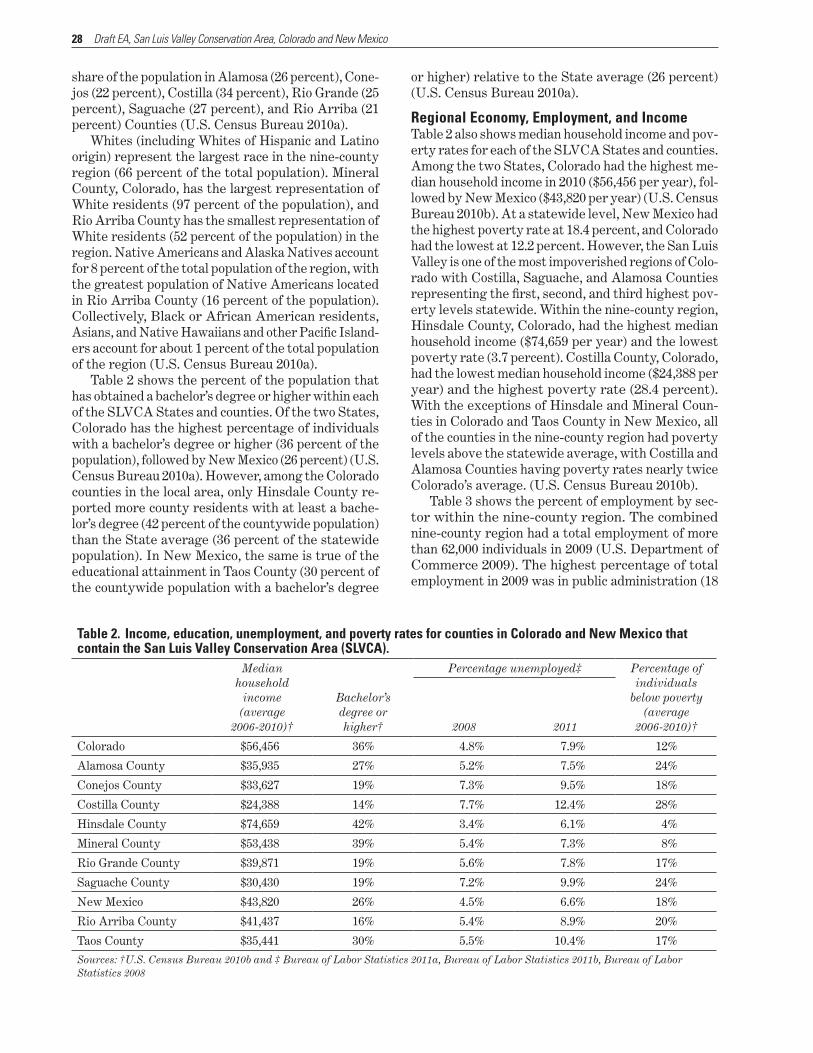
28 Draft EA, San Luis Valley Conservation Area, Colorado and New Mexico
share of the population in Alamosa (26 percent), Cone-jos (22 percent), Costilla (34 percent), Rio Grande (25 percent), Saguache (27 percent), and Rio Arriba (21 percent) Counties (U.S. Census Bureau 2010a).
Whites (including Whites of Hispanic and Latino origin) represent the largest race in the nine-county region (66 percent of the total population). Mineral County, Colorado, has the largest representation of White residents (97 percent of the population), and Rio Arriba County has the smallest representation of White residents (52 percent of the population) in the region. Native Americans and Alaska Natives account for 8 percent of the total population of the region, with the greatest population of Native Americans located in Rio Arriba County (16 percent of the population). Collectively, Black or African American residents, Asians, and Native Hawaiians and other Pacific Island-ers account for about 1 percent of the total population of the region (U.S. Census Bureau 2010a).
Table 2 shows the percent of the population that has obtained a bachelor’s degree or higher within each of the SLVCA States and counties. Of the two States, Colorado has the highest percentage of individuals with a bachelor’s degree or higher (36 percent of the population), followed by New Mexico (26 percent) (U.S. Census Bureau 2010a). However, among the Colorado counties in the local area, only Hinsdale County re-ported more county residents with at least a bache-lor’s degree (42 percent of the countywide population) than the State average (36 percent of the statewide population). In New Mexico, the same is true of the educational attainment in Taos County (30 percent of the countywide population with a bachelor’s degree
or higher) relative to the State average (26 percent) (U.S. Census Bureau 2010a).
Table 2 also shows median household income and pov-erty rates for each of the SLVCA States and counties. Among the two States, Colorado had the highest me-dian household income in 2010 ($56,456 per year), fol-lowed by New Mexico ($43,820 per year) (U.S. Census Bureau 2010b). At a statewide level, New Mexico had the highest poverty rate at 18.4 percent, and Colorado had the lowest at 12.2 percent. However, the San Luis Valley is one of the most impoverished regions of Colo-rado with Costilla, Saguache, and Alamosa Counties representing the first, second, and third highest pov-erty levels statewide. Within the nine-county region, Hinsdale County, Colorado, had the highest median household income ($74,659 per year) and the lowest poverty rate (3.7 percent). Costilla County, Colorado, had the lowest median household income ($24,388 per year) and the highest poverty rate (28.4 percent). With the exceptions of Hinsdale and Mineral Coun-ties in Colorado and Taos County in New Mexico, all of the counties in the nine-county region had poverty levels above the statewide average, with Costilla and Alamosa Counties having poverty rates nearly twice Colorado’s average. (U.S. Census Bureau 2010b).
Table 3 shows the percent of employment by sec-tor within the nine-county region. The combined nine-county region had a total employment of more than 62,000 individuals in 2009 (U.S. Department of Commerce 2009). The highest percentage of total employment in 2009 was in public administration (18
Table 2 . Income, education, unemployment, and poverty rates for counties in Colorado and New Mexico that contain the San Luis Valley Conservation Area (SLVCA) .
Median Percentage unemployed‡ Percentage of household individuals
income(average
Bachelor’s degree or
below poverty (average
2006-2010)† higher† 2008 2011 2006-2010)†
Colorado $56,456 36% 4.8% 7.9% 12%
Alamosa County $35,935 27% 5.2% 7.5% 24%
Conejos County $33,627 19% 7.3% 9.5% 18%
Costilla County $24,388 14% 7.7% 12.4% 28%
Hinsdale County $74,659 42% 3.4% 6.1% 4%
Mineral County $53,438 39% 5.4% 7.3% 8%
Rio Grande County $39,871 19% 5.6% 7.8% 17%
Saguache County $30,430 19% 7.2% 9.9% 24%
New Mexico $43,820 26% 4.5% 6.6% 18%
Rio Arriba County $41,437 16% 5.4% 8.9% 20%
Taos County $35,441 30% 5.5% 10.4% 17%
Sources: †U.S. Census Bureau 2010b and ‡ Bureau of Labor Statistics 2011a, Bureau of Labor Statistics 2011b, Bureau of Labor Statistics 2008
Regional Economy, Employment, and Income
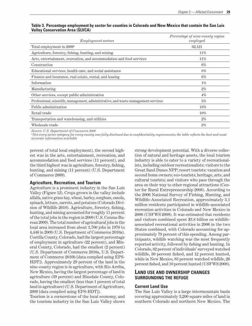
29 Chapter 3 — Affected Environment
percent of total local employment), the second high-est was in the arts, entertainment, recreation, and accommodation and food services (11 percent), and the third highest was in agriculture, forestry, fishing, hunting, and mining (11 percent) (U.S. Department of Commerce 2009).
Table 3 . Percentage employment by sector for counties in Colorado and New Mexico that contain the San Luis Valley Conservation Area (SLVCA)
Percentage of nine-county region Employment sectors employed
Total employment in 2009a 62,121
Agriculture, forestry, fishing, hunting, and mining 11%
Arts, entertainment, recreation, and accommodation and food services 11%
Construction 6%
Educational services, health care, and social assistance 8%
Finance and insurance, real estate, rental, and leasing 6%
Information 1%
Manufacturing 2%
Other services, except public administration 4%
Professional, scientific, management, administrative, and waste-management services 5%
Public administration 18%
Retail trade 10%
Transportation and warehousing, and utilities 2%
Wholesale trade 2%
Source: U.S. Department of Commerce 2009aNot every sector category for every county was fully disclosed due to confidentiality requirements; the table reflects the best and most accurate information available
Agriculture, Recreation, and TourismAgriculture is a prominent industry in the San Luis Valley (Figure 12). Crops grown in the valley include alfalfa, native grass hay, wheat, barley, sorghum, canola, spinach, lettuce, carrots, and potatoes (Colorado Divi-sion of Wildlife 2010). Agriculture, forestry, fishing, hunting, and mining accounted for roughly 11 percent of the total jobs in the region in 2009 (U.S. Census Bu-reau 2009). The total number of agricultural jobs in the local area increased from about 3,700 jobs in 1970 to 4,446 in 2009 (U.S. Department of Commerce 2010a). Costilla County, Colorado, had the largest percentage of employment in agriculture (22 percent), and Min-eral County, Colorado, had the smallest (2 percent) (U.S. Department of Commerce 2010a, U.S. Depart-ment of Commerce 2010b [data complied using EPS-HDT]). Approximately 29 percent of the land in the nine-county region is in agriculture, with Rio Arriba, New Mexico, having the largest percentage of land in agriculture (39 percent) and Hinsdale County, Colo-rado, having the smallest (less than 1 percent of total land in agriculture) (U.S. Department of Agriculture, 2009 [data complied using EPS-HDT]).Tourism is a cornerstone of the local economy, and the tourism industry in the San Luis Valley shows
strong development potential. With a diverse collec-tion of natural and heritage assets, the local tourism industry is able to cater to a variety of recreational-ists, including outdoor recreationalists; visitors to the Great Sand Dunes NPP; resort tourists; vacation and second home owners; eco-tourists; heritage, arts, and cultural tourists; and visitors who pass through the area on their way to other regional attractions (Cen-ter for Rural Entrepreneurship 2008). According to the 2006 National Survey of Fishing, Hunting, and Wildlife-Associated Recreation, approximately 3.1 million residents participated in wildlife-associated recreation activities in Colorado and New Mexico in 2006 (USFWS 2008). It was estimated that residents and visitors combined spent $3.8 billion on wildlife-associated recreational activities in 2006 in the two States combined, with Colorado accounting for ap-proximately 79 percent of this spending. Among par-ticipants, wildlife watching was the most frequently reported activity, followed by fishing and hunting. In Colorado, 82 percent of individuals’ surveyed watched wildlife, 30 percent fished, and 12 percent hunted, while in New Mexico, 83 percent watched wildlife, 26 percent fished, and 10 percent hunted (USFWS 2008).
LAND USE AND OWNERSHIP CHANGES SURROUNDING THE REFUGE
Current Land UseThe San Luis Valley is a large intermountain basin covering approximately 3,200 square miles of land in southern Colorado and northern New Mexico. The
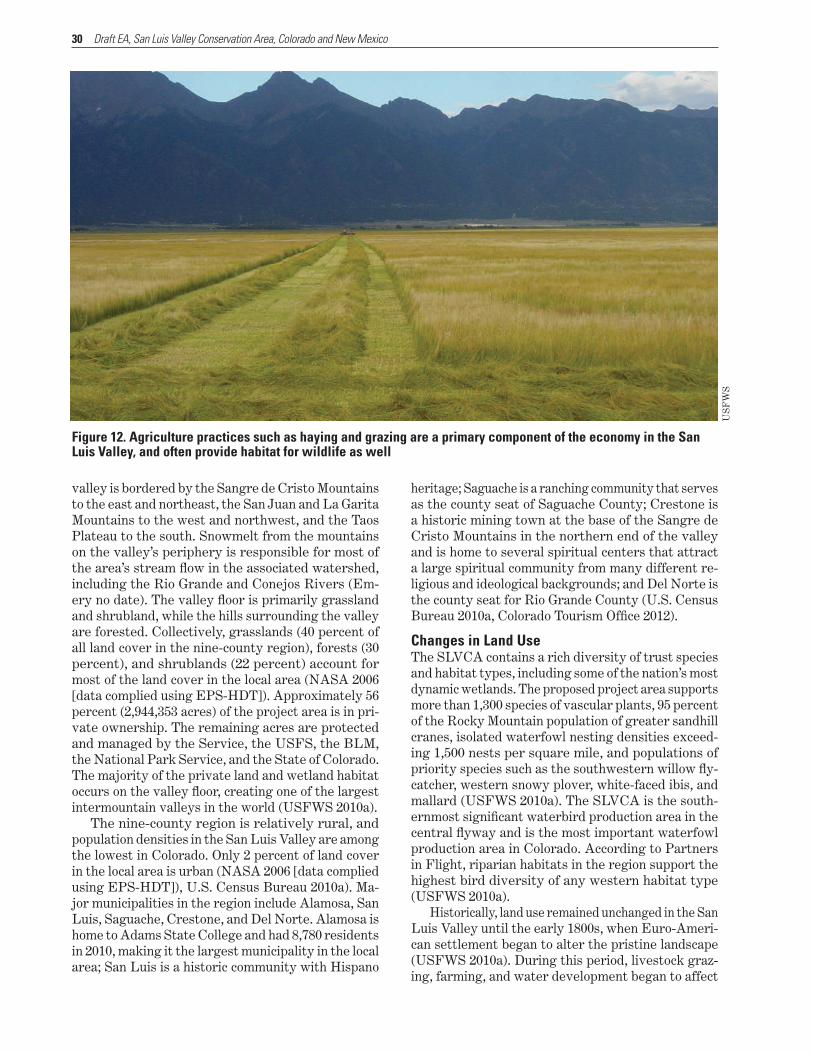
30 Draft EA, San Luis Valley Conservation Area, Colorado and New Mexico
valley is bordered by the Sangre de Cristo Mountains to the east and northeast, the San Juan and La Garita Mountains to the west and northwest, and the Taos Plateau to the south. Snowmelt from the mountains on the valley’s periphery is responsible for most of the area’s stream flow in the associated watershed, including the Rio Grande and Conejos Rivers (Em-ery no date). The valley floor is primarily grassland and shrubland, while the hills surrounding the valley are forested. Collectively, grasslands (40 percent of all land cover in the nine-county region), forests (30 percent), and shrublands (22 percent) account for most of the land cover in the local area (NASA 2006 [data complied using EPS-HDT]). Approximately 56 percent (2,944,353 acres) of the project area is in pri-vate ownership. The remaining acres are protected and managed by the Service, the USFS, the BLM, the National Park Service, and the State of Colorado. The majority of the private land and wetland habitat occurs on the valley floor, creating one of the largest intermountain valleys in the world (USFWS 2010a).
The nine-county region is relatively rural, and population densities in the San Luis Valley are among the lowest in Colorado. Only 2 percent of land cover in the local area is urban (NASA 2006 [data complied using EPS-HDT]), U.S. Census Bureau 2010a). Ma-jor municipalities in the region include Alamosa, San Luis, Saguache, Crestone, and Del Norte. Alamosa is home to Adams State College and had 8,780 residents in 2010, making it the largest municipality in the local area; San Luis is a historic community with Hispano
heritage; Saguache is a ranching community that serves as the county seat of Saguache County; Crestone is a historic mining town at the base of the Sangre de Cristo Mountains in the northern end of the valley and is home to several spiritual centers that attract a large spiritual community from many different re-ligious and ideological backgrounds; and Del Norte is the county seat for Rio Grande County (U.S. Census Bureau 2010a, Colorado Tourism Office 2012).
Figure 12 . Agriculture practices such as haying and grazing are a primary component of the economy in the San Luis Valley, and often provide habitat for wildlife as well
US
FW
S
Changes in Land UseThe SLVCA contains a rich diversity of trust species and habitat types, including some of the nation’s most dynamic wetlands. The proposed project area supports more than 1,300 species of vascular plants, 95 percent of the Rocky Mountain population of greater sandhill cranes, isolated waterfowl nesting densities exceed-ing 1,500 nests per square mile, and populations of priority species such as the southwestern willow fly-catcher, western snowy plover, white-faced ibis, and mallard (USFWS 2010a). The SLVCA is the south-ernmost significant waterbird production area in the central flyway and is the most important waterfowl production area in Colorado. According to Partners in Flight, riparian habitats in the region support the highest bird diversity of any western habitat type (USFWS 2010a).
Historically, land use remained unchanged in the San Luis Valley until the early 1800s, when Euro-Ameri-can settlement began to alter the pristine landscape (USFWS 2010a). During this period, livestock graz-ing, farming, and water development began to affect
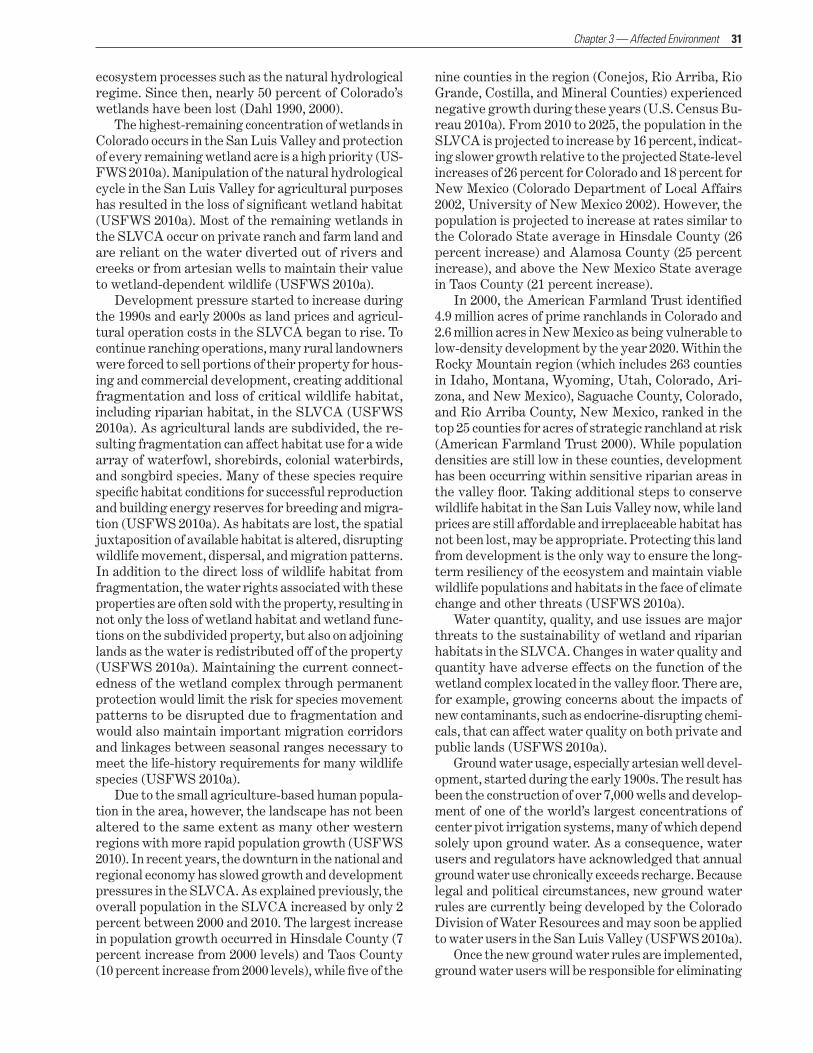
31 Chapter 3 — Affected Environment
ecosystem processes such as the natural hydrological regime. Since then, nearly 50 percent of Colorado’s wetlands have been lost (Dahl 1990, 2000).
The highest-remaining concentration of wetlands in Colorado occurs in the San Luis Valley and protection of every remaining wetland acre is a high priority (US-FWS 2010a). Manipulation of the natural hydrological cycle in the San Luis Valley for agricultural purposes has resulted in the loss of significant wetland habitat (USFWS 2010a). Most of the remaining wetlands in the SLVCA occur on private ranch and farm land and are reliant on the water diverted out of rivers and creeks or from artesian wells to maintain their value to wetland-dependent wildlife (USFWS 2010a).
Development pressure started to increase during the 1990s and early 2000s as land prices and agricul-tural operation costs in the SLVCA began to rise. To continue ranching operations, many rural landowners were forced to sell portions of their property for hous-ing and commercial development, creating additional fragmentation and loss of critical wildlife habitat, including riparian habitat, in the SLVCA (USFWS 2010a). As agricultural lands are subdivided, the re-sulting fragmentation can affect habitat use for a wide array of waterfowl, shorebirds, colonial waterbirds, and songbird species. Many of these species require specific habitat conditions for successful reproduction and building energy reserves for breeding and migra-tion (USFWS 2010a). As habitats are lost, the spatial juxtaposition of available habitat is altered, disrupting wildlife movement, dispersal, and migration patterns. In addition to the direct loss of wildlife habitat from fragmentation, the water rights associated with these properties are often sold with the property, resulting in not only the loss of wetland habitat and wetland func-tions on the subdivided property, but also on adjoining lands as the water is redistributed off of the property (USFWS 2010a). Maintaining the current connect-edness of the wetland complex through permanent protection would limit the risk for species movement patterns to be disrupted due to fragmentation and would also maintain important migration corridors and linkages between seasonal ranges necessary to meet the life-history requirements for many wildlife species (USFWS 2010a).
Due to the small agriculture-based human popula-tion in the area, however, the landscape has not been altered to the same extent as many other western regions with more rapid population growth (USFWS 2010). In recent years, the downturn in the national and regional economy has slowed growth and development pressures in the SLVCA. As explained previously, the overall population in the SLVCA increased by only 2 percent between 2000 and 2010. The largest increase in population growth occurred in Hinsdale County (7 percent increase from 2000 levels) and Taos County (10 percent increase from 2000 levels), while five of the
nine counties in the region (Conejos, Rio Arriba, Rio Grande, Costilla, and Mineral Counties) experienced negative growth during these years (U.S. Census Bu-reau 2010a). From 2010 to 2025, the population in the SLVCA is projected to increase by 16 percent, indicat-ing slower growth relative to the projected State-level increases of 26 percent for Colorado and 18 percent for New Mexico (Colorado Department of Local Affairs 2002, University of New Mexico 2002). However, the population is projected to increase at rates similar to the Colorado State average in Hinsdale County (26 percent increase) and Alamosa County (25 percent increase), and above the New Mexico State average in Taos County (21 percent increase).
In 2000, the American Farmland Trust identified 4.9 million acres of prime ranchlands in Colorado and 2.6 million acres in New Mexico as being vulnerable to low-density development by the year 2020. Within the Rocky Mountain region (which includes 263 counties in Idaho, Montana, Wyoming, Utah, Colorado, Ari-zona, and New Mexico), Saguache County, Colorado, and Rio Arriba County, New Mexico, ranked in the top 25 counties for acres of strategic ranchland at risk (American Farmland Trust 2000). While population densities are still low in these counties, development has been occurring within sensitive riparian areas in the valley floor. Taking additional steps to conserve wildlife habitat in the San Luis Valley now, while land prices are still affordable and irreplaceable habitat has not been lost, may be appropriate. Protecting this land from development is the only way to ensure the long-term resiliency of the ecosystem and maintain viable wildlife populations and habitats in the face of climate change and other threats (USFWS 2010a).
Water quantity, quality, and use issues are major threats to the sustainability of wetland and riparian habitats in the SLVCA. Changes in water quality and quantity have adverse effects on the function of the wetland complex located in the valley floor. There are, for example, growing concerns about the impacts of new contaminants, such as endocrine-disrupting chemi-cals, that can affect water quality on both private and public lands (USFWS 2010a).
Ground water usage, especially artesian well devel-opment, started during the early 1900s. The result has been the construction of over 7,000 wells and develop-ment of one of the world’s largest concentrations of center pivot irrigation systems, many of which depend solely upon ground water. As a consequence, water users and regulators have acknowledged that annual ground water use chronically exceeds recharge. Because legal and political circumstances, new ground water rules are currently being developed by the Colorado Division of Water Resources and may soon be applied to water users in the San Luis Valley (USFWS 2010a).
Once the new ground water rules are implemented, ground water users will be responsible for eliminating

32 Draft EA, San Luis Valley Conservation Area, Colorado and New Mexico
injury to senior water rights through a formal aug-mentation planning process with the State (USFWS 2010a). In most cases, this will require ground water users to acquire, and in many cases, remove senior water rights from other properties to augment their well use.
These circumstances threaten healthy riparian systems along the Rio Grande, Conejos, and Alamosa rivers, where senior water rights are currently used in the floodplain. The evolving economic and regulatory environment in the SLVCA will likely result in the acquisition of some of these water rights to augment distant wells, moving water out of the floodplain and degrading migratory bird habitat (USFWS 2010a). Additionally, this will increase the State’s difficulty in managing water in the Rio Grande and administering the Rio Grande Compact. For these reasons, the Rio Grande Water Conservation District and other water users in the San Luis Valley will support the SLVCA in acquiring conservation easements along these riv-ers (USFWS 2010a).
Energy development is also an emerging threat to wildlife in the SLVCA. Colorado is among the most promising sources of solar energy nationwide, and the San Luis Valley receives more direct solar radiation than any other part of the State (National Renewable Energy Laboratory 2007a, National Renewable En-ergy Laboratory 2007b). Interest in the development of the solar energy industry in the San Luis Valley continues to expand, especially since Colorado State legislation requires that 30 percent of large utilities’ electricity come from renewable sources by 2020 (Gal-braith 2010). Prospective solar development in the local area is supported by Federal initiatives and funding from the U.S. Department of Energy (U.S. Depart-ment of Energy 2011, Jaffe 2011). The growth of the solar industry in the local area, however, is dependent on the ability of solar producers to obtain power pur-chase agreements from the Public Service Company of Colorado and may also be dependent on the future provision of transmission lines out of the valley (Colo-rado Department of Local Affairs 2011). Other non-renewable (oil and gas) and renewable (wind) forms of energy development occur to a lesser extent in the SLVCA than many western States (USFWS 2010a).
SLVCA LAND CONSERVATION EFFORTSLand protection is a relatively new practice in the San Luis Valley, as most conservation easements have been completed within the last 10 years. How-ever, during this short time frame, more than 232,000 acres of land have been protected, which suggests that public support for land protection in the SLVCA is strong (USFWS 2010a). In fact, there are so many landowners interested in entering into conservation easements that organizations like the Rio Grande Headwaters Land Trust, The Nature Conservancy,
Ducks Unlimited, and the NRCS cannot handle the demand, either for time or funding (USFWS 2010a). Citizens of the San Luis Valley understand that the rural lifestyle and wildlife habitat is what makes this area unique and have voiced their concern over the loss of these values. They recognize that conservation easements are a tool to keep both ranches and wildlife habitat intact (USFWS 2010a).
The Service plans to conserve approximately 530,000 acres to protect the remaining expanses of wildlife habitat in the SLVCA. This would be accom-plished primarily through the purchase of conserva-tion easements by the Service on a voluntary basis from private landowners. Other Federal, State, and nongovernmental partners may assist in acquiring conservation easements or fee-title to a lesser extent. On a limited basis, fee-title acquisition may be used by the Service to protect wetlands such as the Alamosa Marshes on the valley floor of the SLVCA. Acquisi-tion of these lands will occur over a period assumed to range from 15 to 20 years, but based on past acquisi-tion rates, could reasonably be expected to occur over a longer period, possibly up to 100 years.
Conservation EasementsOne of the Service’s high-priority objectives is to guide residential and commercial development away from high-priority conservation areas by securing ap-propriate conservation easements. The SLVCA will focus on the protection of wetland habitat types and associated uplands on private land within the valley floor through acquisition of conservation easements from willing sellers (USFWS 2010a). Conservation easements leave land in private ownership, protect-ing private property rights, while providing the Ser-vice with a cost-effective conservation strategy that enables the conservation of large blocks of habitat. Within the SLVCA, the Service proposes to purchase conservation easements to protect up to 500,000 acres of significant wildlife habitat to maintain wildlife popu-lations, plant communities, and ecosystem processes in perpetuity (USFWS 2010a).
A conservation easement is a voluntary legal agree-ment entered into between a landowner and a conser-vation entity. Conservation easements are binding in perpetuity; the landowner reserves the right to sell or bequeath the property, but the easement and its asso-ciated restrictions remain with the property forever. Owners of land that does not contain a conservation easement have a set of rights associated with their land. For example, landowners have the right to run cattle, grow crops, harvest trees, build structures, and subdivide and sell their land. Under a conserva-tion easement, landowners maintain ownership of their property, but transfer some of their ownership rights to the conservation entity. The most common

33 Chapter 3 — Affected Environment
right transferred under a conservation easement is the right to develop or subdivide the land.
Conservation easements in the SLVCA may require the transfer of additional rights. A conservation ease-ment on a parcel of land may have restrictions for all types of human development, such as surface distur-bance from solar, mineral, or wind energy development, and may include restrictions to ensure maintenance of historic water use patterns that benefit wildlife. Protecting critical water sources on private land will be a key objective within the SLVCA, and easement agreements may include restrictions on the sale or diversion of water from the land.
Wetland habitat is common in the SLVCA on pri-vate lands in areas where ranchers irrigate and use habitat for native hay meadows and pastureland for livestock. Protection of wetland habitat types will ensure proper drying and flooding cycles while main-taining historic water use patterns in wetland basins that are beneficial to wildlife.
In most cases, a conservation easement acquired for wetland values will be associated with appurtenant irrigation water rights that have resulted in desirable wildlife habitat. Doing anything less may often result in separation of water use from the land, reducing the easement’s value to trust wildlife species. Water laws are sensitive to State requirements; therefore, water issues will need to be addressed individually for each easement. In all cases, the terms of a conservation easement must be mutually agreed upon by the land-owner and the easement holder. Conservation ease-ments acquired from private landowners would not affect their property rights beyond those purchased through conservation easement.
Subsurface rights are often severed from the sur-face rights of a parcel of land. Conservation easements apply only to surface rights; therefore, the mineral interest may be extracted at any time by the person who holds the qualified mineral right (Byers and Ponte 2005). For this reason, the Service is unlikely to enter into a conservation easement agreement for a parcel of land that has a viable subsurface mineral interest. Exceptions may be made if the parcel has high habitat value and the probability of mineral extraction is low.
Fee-title PurchasesWithin the SLVCA, the Service proposes to purchase limited property in fee-title at fair market value to pro-tect up to 30,000 acres of significant wildlife habitat and maintain wildlife populations, plant communities, and ecosystem processes in perpetuity (USFWS 2010a). Under fee-title purchases, full ownership of the land, including the underlying title, is transferred to another party. This gives the new owner maximum interest in the purchased land and allows the new owner to man-age the land in any manner that is consistent with lo-cal, State, and Federal laws. For fee-title acquisitions,
the Service intends to evaluate the purchase of water rights with each property.
The primary fee-title acquisition component of the SLVCA is expansion of the Alamosa National Wildlife Refuge western boundary to include wetlands iden-tified during the 1874, 1875, and 1877 Wheeler expe-dition as the Alamosa Marshes (U.S. Army Corps of Engineers 1878). The acquisition area includes the confluences of Alamosa River, Rock Creek, and La Jara Creek with the Rio Grande. The area still pro-vides one of the largest intact wetland complexes in the San Luis Valley. That said, the acquisition of fee-title will be considered only in circumstances where the Service’s conservation objectives could not be met with conservation easements.
WATER LAW
ColoradoColorado is divided into seven water divisions deter-mined by watershed boundaries. Each division has a Water Court and a division engineer who administers water rights by priority. The Rio Grande is in Division 3.
Water rights in Colorado are subject to the prior appropriation doctrine; the first entity to claim the water right has the first right to use the full amount of water they claimed for beneficial use. The prior ap-propriation doctrine allows State officials to properly manage and distribute water according to the decreed priority dates. There are four elements of a water right under the prior appropriation doctrine: intent, diversion, beneficial use, and priority. An applicant must demonstrate that there is intent to use the wa-ter, construct the diversion works, put the water to beneficial use, and establish a priority date. In Colo-rado, every water right must be adjudicated through the Water Court. There are now legal avenues to use water for beneficial use without a diversion, such as instream flows.
If there is not enough water to satisfy all water right holders in a particular stream, the State may shut off junior rights as necessary to ensure that se-nior water right holders receive their full appropria-tion. The Rio Grande basin in Colorado is considered over-appropriated.
Ground water in Colorado is designated as either tributary or non-tributary. Tributary ground water is water contained in aquifers that have a direct hydrau-lic connection to surface water. The unconfined aqui-fer in the San Luis Valley is tributary ground water. Tributary ground water is treated administratively the same as a surface water diversion. The confined aquifer in the San Luis Valley is also considered tribu-tary, though the hydraulic connection to the surface water system is poorly understood.
Water rights in Colorado can be transferred from one entity to another, but a change application must

34 Draft EA, San Luis Valley Conservation Area, Colorado and New Mexico
be filed and approved by the State Engineer and the Water Court. The amount available for transfer is limited to the consumptive use portion of the right. Water rights in Colorado are considered real property and they may be bought or sold. A water right can be conveyed either as part of a piece of property or sepa-rate from a property, as long as that water right has been severed from the land by an approved applica-tion through the State engineer and the Water Court.
In 1973, the Colorado legislature passed Senate Bill 97, creating the State’s Instream Flow Program. This program, one of the first of its kind, vested the Colorado Water Conservation Board (CWCB) with exclusive authority to protect streamflow through a reach of stream rather than just at a point, and to pro-tect levels in natural lakes. Until this law was passed, all appropriations of water in Colorado were required to divert water from the natural stream.
Since 1973, Colorado clarified the CWCB’s author-ity to acquire existing, decreed senior water rights on a voluntary basis from willing owners for instream flow uses. New appropriations are new, junior water rights claimed by the CWCB to preserve the natural environment. New appropriations are considered by the CWCB each year and are filed annually with the Water Court for adjudication. New appropriations are generally limited to the minimum amount necessary to fulfill the purpose of the instream flow.
New MexicoNew Mexico’s water law is also based on the doctrine of prior appropriation. All waters in New Mexico are declared to be public and subject to appropriation for beneficial use. Apart from water rights acquired be-fore 1907 and small-scale stockwatering (10 acre-feet or less), a permit from the State engineer is required to appropriate water, change the point of diversion, change the location of wells in declared basins, divert or store water, or change the place or purpose of wa-ter use. There is a new requirement in New Mexico that prior to obtaining a water right involving the use of public lands, the person seeking the right must prove that he or she actually has a permit to use the public lands.
The New Mexico groundwater code was enacted in 1931. Ground water procedures closely parallel those for surface water, with several important differences. A permit to drill a well and appropriate water is not required in areas outside of declared “underground-water basins.” Within undergroundwater basins, however, use is regulated by the State engineer. The State engineer has the authority to establish these basins when regulation is necessary to protect prior appropriations, ensure that water is put to beneficial use, and maintain orderly development of the State’s water resources. There are currently 33 declared undergroundwater basins throughout New Mexico.
Water rights in New Mexico can be transferred from one entity to another, but a change application must be filed and approved by the State engineer. Wa-ter rights in New Mexico are considered real property and they may be bought or sold. A water right can be conveyed as part of a piece of property or separate from a property, as long as that water right has been severed from the land by an approved application through the State engineer.
New Mexico has had adjudicated water rights since 1907. In an adjudication suit, each claimant has an opportunity to present evidence of water right to the court. The completion of adjudication results in a court decree outlining the priority, amount, purpose (determination of use), periods, and place of water use.
New Mexico’s instream flow program is complex, unclear, and continually evolving. New Mexico does not have a legislated instream flow program, and in-stream flow is not a recognized beneficial use. Recent case law, however, has allowed the development of an instream flow program in New Mexico. In 1998, the New Mexico Attorney General issued a legal opinion concluding that the transfer of a consumptive water right to an instream flow right is allowable under State law. The legal opinion determined that instream uses such as recreation and fish and wildlife habitat are beneficial uses, and that transfers of existing water rights to instream flows are not expressly prohibited. Prior to this opinion, New Mexico was the only State that did not recognize instream flow as a beneficial use.
The 1998 Attorney General’s opinion is limited to the transfer of existing water rights. The opinion notes that new appropriations of water for instream flow are not subject to this precedent. Although the opinion concludes that there are no legal barriers to the transfer of existing water rights to an instream flow right, the State engineer still has the responsibil-ity for approving such a transfer. Although instream flow in itself is not recognized as a beneficial use, it ap-pears that water can be dedicated to instream flow for the purpose of recreation or fish and wildlife habitat.
The Attorney General’s opinion does not explic-itly address the issue of ownership of instream flow rights. Since ownership of other types of water rights are not limited, it could be interpreted that instream flow rights could be held by a public or private entity. Current law is unclear and continues to develop.