Chapter 2 Resource Assessments and Expectations
42
Chapter 2 Resource Assessments and Expectations
Transcript of Chapter 2 Resource Assessments and Expectations

Chapter 2Resource Assessments and Expectations

CONTENTS
Page
World Outlook for Seabed Minerals ., . . . . . 39General Geologic Framework . . . . . . . . . . . . . 41Atlantic Region . . . . . . . . . . . . . . . . . . . . . . . . 43
Sand and Gravel . . . . . . . . . . . . . . . . . . . . . 45Placer Deposits . . . . . . . . . . . . . . . . . . . . . . . 48Phosphorite Deposits . . . . . . . . . . . . . . . . . . 52Manganese Nodules and Pavements . . . . . 53
Puerto Rico and the U.S. Virgin Islands . . . 54Sand and Gravel . . . . . . . . . . . . . . . . . . . . . 54Placer Deposits . . . . . . . . . . . . . . . . . . . . . . . 55
Gulf of Mexico Region . . . . . . . . . . . . . . . . . . 55Sand and Gravel . .’ . . . . . . . . . . . . . . . . . . . 55Placer Deposits . . . . . . . . . . . . . . . . . . . . . . . 56Phosphorite Deposits . . . . . . . . . . . . . . . . . . 56
Pacific Region . . . . . . . . . . . . . . . . . . . . . . . . . . 56Sand and Gravel . . . . . . . . . . . . . . . . . . . . . 57Precious Metals . . . . . . . . . . . . . . . . . . . . . . 58Black Sand—Chromite Deposits .. 58Other Heavy Minerals . . . . . . . . . . . . . . . . 60Phosphorite Deposits . . . . . . . . . . . . . . . . . . 61Polymetallic Sulfide Deposits . . . . . . . . . . . 61
Alaska Region . . . . . . . . . . . . . . . . . . . . . . . . . 65Sand and Gravel . . . . . . . . . . . . . . . . . . . . . 67Precious Metals . . . . . . . . . . . . . . . . . . . . . . 67Other Heavy Minerals . . . . . . . . . . . . . . . . 69
Hawaii Region and U.S. TrustTerritories . . . . . . . . . . . . . . . . . . . . . . . . . 69
Cobalt-Ferromanganese Crusts . . . . . . . . . 70Manganese Nodules . . . . . . . . . . . . . . . . . . . 75
BoxBox Page
2-A. Mineral Resources and Reserves . . . . . 40
Figure
2-1.
2-2.2-3.
2-4.
2-5.2-6.
2-7.
FiguresNo. Page
Idealized Physiography of aContinental Margin and SomeCommon Margin Types . . . . . . . . . . . . 42Sedimentary Basins in the EEZ . . . . . . 44Sand and Gravel Deposits Along theAtlantic, Gulf, and Pacific Coasts ..., 46Plan and Section Views of Shoals OffOcean City, Maryland . . . . . . . . . . . . . 47Atlantic EEZ Heavy Minerals . . . . . . . 51Potential Hard Mineral Resourcesof the Atlantic, Gulf, and PacificEEZs . . . . . . . . . . . . . . . . . . . . . . . . . . . . 54Formation of Marine PolymetallicSulfide Deposits . . . . . . . . . . . . . . . . . . . 62
Figure
2-8.
2-9.
2-1o.
2-11.
2-12.
2-13.
2-14.
No. Page
Locations of Mineral DepositsRelative to Physiographic Features . . . 66Potential Hard Mineral Resources ofthe Alaskan EEZ . . . . . . . . . . . . . . . . . . 68Potential Hard Mineral Resources ofthe Hawaiian EEZ . . . . . . . . . . . . . . . . . 70Cobalt-Rich Ferromanganese Crustson the Flanks of Seamounts andVolcanic Islands . . . . . . . . . . . . . . . . . . . 71EEZs of U.S. Insular and TrustTerritories in the Pacific . . . . . . . . . . . . 73Potential Hard Mineral Resources ofU.S. Insular Territories South ofHawaii . . . . . . . . . . . . . . . . . . . . . . . . . . . 75Potential Hard Mineral Resources ofU.S. Insular Territories West ofHawaii ..,..... . . . . . . . . . . . . . . . . . . . 76
TablesTable No. Page
2-1.
2-2.
2-3.
2-4.
2-5.
2-6.
2-7.
2-8,
Association of Potential MineralResources With Types of PlateBoundaries . . . . . . . . . . . . . . . . . . . . . . . .Areas Surveyed and EstimatedOffshore Sand Resources of the UnitedStates . . . . . . . . . . . . . . . . . . . . . . . . . . . . .Criteria Used in the Assessment ofPlacer Minerals . . . . . . . . . . . . . . . . . . . .Estimates of Sand and GravelResources Within the U.S. ExclusiveEconomic Zone . . . . . . . . . . . . . . . . . . . . .Estimates of Typical Grades ofContained Metals for Seafloor MassiveSulfide Deposits, Compared WithTypical Ore From Ophiolite MassiveSulfide Deposits and Deep-SeaManganese Nodules . . . . . . . . . . . . . . . . .Average Chemical Composition forVarious Elements of Crusts From<8,200 Feet Water Depth From theEEZ of the United States and OtherPacific Nations . . . . . . . . . . . . . . . . . . . . .Resource Potential of Cobalt, Nickel,Manganese, and Platinum in Crusts ofU.S. Trust and Affiliated Territories . .Estimated Resource Potential of CrustsWithin the EEZ of Hawaii and U.S.Trust and Affiliated Territories . . . . . . .
43
48
50
56
63
72
74
75

Chapter 2
Resource Assessments and Expectations
WORLD OUTLOOK FOR SEABED MINERALS
Ever since the recovery of rock-like nodules fromthe deep ocean by the research vessel H.M.S.Challenger during its epic voyage in 1873, therehas been persistent curiosity about seabed minerals.It was not until after World War II that the black,potato-sized nodules like those found by theChallenger became more than a scientific oddity.As metals prices climbed in response to increaseddemand during the post-war economic boom, com-mercial attention turned to the cobalt-, manganese-,nickel-, and copper-rich nodules that litter theseafloor of the Pacific Ocean and elsewhere. Also,as the Nation’s interest in science peaked in the1960s, oceanographers, profiting from technologicalachievements in ocean sensors and shipboard equip-ment developed for the military, expanded oceanresearch and exploration. The secrets of the seabedbegan to be unlocked.
Even before the Challenger discovery of man-ganese nodules, beach sands at the surf’s edge weremined for gold and precious metals at some loca-tions in the world (box 2-A). There are reports thatlead and zinc were mined from nearshore subseaareas in ancient Greece at Laurium and that tinand copper were mined in Cornwall. 1 Coal and am-ber were mined in or under the sea in Europe asearly as 1860. Since then, sand, gravel, shells, lime,precious coral, and marine placer minerals (e.g.titanium sands, tin sands, zirconium, monazite,staurolite, gold, platinum, gemstones, and magne-tite) have been recovered commercially. Barite hasbeen recovered by subsea quarrying. Ironically,deep-sea manganese nodules, the seabed resourcethat has drawn the most present-day commercialinterest and considerable private research and de-velopment investment, have not yet been recoveredcommercially. Rich metalliferous muds in the RedSea have been mined experimentally and are con-sidered to be ripe for commercial developmentshould favorable economic conditions develop.
IM.J. Cruickshank and W. Siapno, “Marine Minerals—An Up-date and Introduction, ,$ farinc Technology SocictjJournal, vol. 19,1985, pp. 3-5.
Recent discoveries of massive polymetallic sul-fides formed at seafloor spreading zones where su-perheated, mineral-rich saltwater escapes from theEarth’s crust have attracted scientific interest andsome speculation about their future commercial po-tential. These deposits contain copper, zinc, iron,lead, and trace amounts of numerous minerals.Similar deposits of ancient origin occur in Cyprus,Turkey, and Canada, suggesting that more knowl-edge about seabed mineralization processes couldcontribute to a better understanding of massive sul-fide deposits onshore. Cobalt-rich ferromanganesecrusts, found on the slopes of seamounts, have alsobegun to receive attention.
Beach placers and similar onshore deposits areimportant sources of several mineral commoditieselsewhere in the world, Marine placer deposits ofsimilar composition often lay immediately offshore.Among the most valuable marine placers, based onthe value of material recovered thus far, are the cas-siterite (source of tin) deposits off Burma, Thai-land, Malaysia, and Indonesia. The so-called “lightheavy minerals” —titanium minerals, monazite,and zircon—are found extensively along the coastsof Brazil, Mauritania, Senegal, Sierra Leone,Kenya, Mozambique, Madagascar, India, SriLanka, Bangladesh, China, and the southwesternand eastern coasts of Australia.
Although Australia has extensively mined“black” titaneous beach sands along its coasts, off-shore mining of these sands has not proven eco-nomical. 2 Titaniferous magnetite, an iron-richtitanium mineral, has been mined off the south-ern coast of Japan’s Kyushu Island. 3 Similar mag-netite deposits exist off New Zealand and the Gulfof St. Lawrence. Chromite placers are extensiveon beaches and in the near offshore of Indonesia,the Philippines, and New Caledonia. Chromite-
21. Morley, Black Sands: A History of the Mineral Sand AfiningIndustry in Eastern Australia (St. Lucia: University of QueenslandPress, 1981 ), p. 278.
3J. Mere, The Mineral Resources of the Sea (New York, NY: El-sevier Publishing Co., 1965), p. 16.
39

40 . Marine Minerals: Exploring Our New Ocean Frontier
bearing beach sands were mined along the south- minable gold are located in several nearshoreern coast of Oregon during World War 11 with gov- Alaskan areas in the Bering Sea, Gulf of Alaska,ernment support. and adjacent to southeastern Alaska. A commer-
cial gold dredge mining operation was begun byGold has been mined from many beach placers Inspiration Resources near Nome in 1986, but a
along the west coast of the United States and else- number of nearshore gold operations in the Nomewhere in the world. Marine placers of potentially area have been attempted and abandoned in the

Ch. 2—Resource Assessments and Expectations . 41
past. Diamonds have been recovered from near- gravel recovery is primarily limited to State waters,shore areas in Namibia, Republic of South Africa, mostly in New Jersey, New York, Florida, Mis-and Brazil. sissippi, and California. Japan and the European
The recovery of sand and gravel from offshorecountries have depended more on marine sand and
far exceeds the extent of mining of other marinegravel than has the United States because of limitedland resources. Special uses can be made of ma-
minerals. 4 In the United States, offshore sand and rine sand and gravel deposits in the Alaskan and———-4J. M. Broadus, “Seabed Materials, ” Science, vol. 235, Feb. 20, Canadian Beaufort Sea—the offshore oil and gas
1987, pp. 853-860. Also see M. Baram, D. Rice, and W. Lee, Ma- industry uses such material for gravel islands andrine Mininc of the Continental Shelf (Cambridge. MA: Ballinger.1978), p. 301
The potentialmineral deposits
<, “. gravel pads for drilling.
GENERAL GEOLOGIC FRAMEWORK
for the formation of economicwithin the Exclusive Economic
Zone (EEZ) of the United States is determined bythe geologic history, geomorphology, and environ-ment of its continental margins and insular areas.Continental margins are a relatively small portionof the Earth’s total surface area, yet they are of greatgeological importance and of tremendous linear ex-tent. In broad relief, the Earth’s surface consistsof two great topographic surfaces: one essentiallyat sea level— the continental masses of the world,including the submerged shelf areas—and the otherat nearly 16,000 feet below sea level—representingthe deep ocean basins. The boundaries betweenthese two surfaces are the continental margins.Continental margins can be divided into separateprovinces: the continental shelf, continental slope,and continental rise (see figure 2-1 ).
Continental margins represent active zoneswhere geologic conditions change. These changesare driven by tectonic activity within the Earth’scrust and by chemical and physical activity on thesurface of the Earth. Tectonic processes such as vol-canism and faulting dynamically alter the seafloor,geochemical processes occur as seawater interactswith the rocks and sediments on the seafloor, andsedimentary processes control the material depos-ited on or eroded from the seafloor. All of theseprocesses contribute to the formation of offshoremineral deposits.
Advanced marine research technologies devel-oped since World War II and the refinement andacceptance of the plate-tectonics theory have cre-ated a greater understanding of the dynamics ofcontinental margins and mineral formation. Ac-
cording to the plate-tectonics model, the Earth’souter shell is made up of gigantic plates of continen-tal lithosphere (crust and upper mantle) and/oroceanic lithosphere. These plates are in slow butconstant motion relative to each other. Plates col-lide, override, slide past each other along transformfaults, or pull apart along rift zones where new ma-terial from the Earth’s mantle upwells and is addedto the crust above.
Seafloor spreading centers are divergent plateboundaries where new oceanic crust is forming. Asplates move apart, the leading edge moves againstanother plate forming either a convergent plateboundary or slipping along it in a transform plateboundary. Depending on whether the leading edgeis oceanic or continental lithosphere, this processmay result in the building of a mountain range(e.g., the Cascade Mountains) or an oceanic islandarc (e. g., the Aleutian Islands) or, if the plates areslipping past one another, a transform fault zone(e.g., the San Andreas fault zone).
Four types of continental margins border theUnited States: active collision, trailing edge, ex-tensional transform, and continental sea. Wherecollisions occur between oceanic plates and platescontaining continental land masses, the thinneroceanic plate will be overridden by the thicker, lessdense continental plate. The zone along which oneplate overrides another is called a subduction zoneand frequently is manifested by an oceanic trench.
Coastal volcanic mountain ranges, volcanic is-land arcs, and frequent earthquake activity are re-lated to subduction zones. This type of active con-tinental margin borders most of the Pacific Oceanand the U.S. EEZ adjacent to the Aleutian chain

.
42 ● Marine Minerals: Exploring Our New Ocean Frontier
Figure 2-1 .—Idealized Physiography of aContinental Margin and Some Common Margin Types
I Continental margin rise plain I
r I
Atlantic: (trailing edge)
I 1
North Pacific Margin: (collision)
I 1
South Pacific: (volcanic arcs, trenches, and carbonate reefs)SOURCES: Office of Technology Assessment, 1987; R.W. Rowland, M.R. Goud,
and B.A. McGregor, “The U.S. Exclusive Economic Zone—A Summaryof its Geology, Exploration, and Resource Potential,” U.S. Geologi-cal Survey Circular 912, 1983.
and the west coast (figure 2-1 ). These regions haverelatively narrow continental shelves and their on-shore geology is dominated by igneous intrusiveand volcanic rocks. These rocks supply the thin ve-neer of sediment overlying the continental crust ofthe shelf. Further offshore, the Pacific coast EEZextends beyond the shelf, slope, and rise to thedepths underlain by oceanic crust. In the Pacificnorthwest, these depths encompass a region ofseafloor spreading where new oceanic crust is form-ing. This region includes the Gorda Ridge and pos-sibly part of the Juan de Fuca Ridge, which arelocated within the U.S. EEZ off California, Ore-gon, and Washington.
The trailing edge of a continent has a passivemargin because it lacks significant volcanic and seis-mic activity. Passive margins are located withincrustal plates at the transition between oceanic andcontinental crust. These margins formed at diver-gent plate boundaries in the past. Over millions ofyears, subsidence in these margin areas has allowedthick deposits of sediment to accumulate. The At-lantic coast of the United States is an example ofa trailing edge passive margin. This type of coastis typified by broad continental shelves that extendinto deep water without a bordering trench. Coastalplains are wide and low-lying with major drainagesystems. The greatest potential for the formationof recoverable ore deposits on passive margins re-sults from sedimentary processes rather than recentmagmatic or hydrothermal activity.
The Gulf of Mexico represents another type ofcoast that develops along the shores of a continen-tal sea. These passive margins also typically havea wide continental shelf and thick sedimentary de-posits. Deltas commonly develop off major riversbecause the sea is relatively shallow, is smaller thanthe major oceans, and has lower wave energy thanthe open oceans.
Plate edges are not the only regions of volcanicactivity. Mid-plate volcanoes form in regions over-lying “hot spots” or areas of high thermal activ-ity. As plates move relative to mantle ‘‘hot spots,chains of volcanic islands and seamounts are formed

Ch. 2—Resource Assessments and Expectations 43
Table 2-1 .—Association of Potential MineralResources With Types of Plate Boundaries
Type of plate boundary/Potential mineral resources
Divergent:● Oceanic ridges
—Metalliferous sediments (copper, iron, manganese,lead, zinc, barium, cobalt, silver, gold; e.g., Atlantis IIDeep of Red Sea)
—Stratiform manganese and iron ixodes andhydroxides and iron silicates (e.g., sites on Mid-Atlantic Ridge and Galapagos Spreading Center)
—Polymetallic massive sulfides (copper, iron, zinc,silver, gold, e.g., sites on East-Pacific Rise andGalapagos Spreading Center)
—Polymetallic stockwork sulfides (copper, iron, zinc,silver, gold; e.g., sites on Mid-Atlantic Ridge,Carlsberg Ridge, Costa Rica Rift)
—Other polymetallic sulfides in disseminated orsegregated form (copper, nickel, platinum groupmetals)
—Asbestos—Chromite
Convergent:● Offshore
—Upthrust sections of oceanic crust containing typesof mineral resources formed at divergent plateboundaries (see above)
—Tin, uranium, porphyry copper and possible goldmineralization in granitic rocks
Convergent:● Onshore
—Porphyry deposits (copper, iron, molybdenum, tin,zinc, silver, gold; e.g., deposits at sites in Andesmountains)
—Polymetallic massive sulfides (copper, iron, lead,zinc, silver, gold, barium; e.g., Kuroko deposits ofJapan)
Transform:. Offshore
—Mineral resources similar to those formed atdivergent plate boundaries (oceanic ridges) mayoccur at offshore transform plate boundaries; e.g.,sites on Mid-Atlantic Ridge and Carlsberg Ridge)
such as the Hawaiian Islands. These sites may alsohave significant potential for future recovery ofmineral deposits.
The theory of plate tectonics has led to the rec-ognition that many economically important typesof mineral deposits are associated with either pres-ent or former plate boundaries. Each type of plateboundary—divergent, convergent, or transform—is not only characterized by a distinct kind of in-teraction, but each is also associated with distincttypes of mineral resources (table 2-1). Knowledgeof the origin and evolution of a margin can serveas a general guide to evaluating the potential forlocating certain types of mineral deposits.
SOURCE: Peter A. Rona, “Potential Mineral and Energy Resources at SubmergedPlate Boundaries,” MTS ~oumal, vol. 19, No, 4, 19S5, pp. 18-25.
ATLANTIC
When the Atlantic Ocean began to form betweenAfrica and North America around 200 million yearsago, it was a narrow, shallow sea with much evap-oration. The continental basement rock whichformed the edge of the rift zone was block-faultedand the down-dropped blocks were covered withlayers of salt and, as the ocean basin widened, withthick deposits of sediment. A number of sedimen-tary basins were formed in the Atlantic region alongthe U.S. east coast (figure 2-2). Very deep sedi-
REGION
ments are reported to have accumulated in the Bal-timore Canyon Trough. In addition, a great wedgeof sediment is found on the continental slope andrise. In places, due to the weight of the overlyingsediment and density differential, salt has flowedupward to form diapirs or salt domes and is avail-able as a mineral resource. In addition, sulfur iscommonly associated with salt domes in the caprock on the top and flanks of the domes. Both saltand sulfur are mined from salt domes (often by so-

44 . Marine Minerals: Exploring Our New Ocean Frontier
Figure 2-2.–Sedimentary Basins in the EEZ
SoutheastAtlantic
Sedimentary‘1\ Basins
Several basins formed in the EEZ in which great amounts of sediment have accumulated. Whileof primary interest for their potential to contain hydrocarbons, salt and sulfur are also potentiallyrecoverable from sedimentary basins in the Atlantic and Gulf regions.
SOURCES: Office of Technology Assessment, 1987; U.S. Department of the Interior, “Symposium Proceedings—A National Pro-gram for the Assessment and Development of the Mineral Resources of the United States Exclusive Economic Zone,”U.S. Geological Survey Circular 929, 1983.

Ch. 2—Resource Assessments and Expectations 45
lution mining) and, thus, represent potentially re-coverable mineral commodities from offshore de-posits, although at present they would not be likelyprospects in the Atlantic region.
While they have potential for oil and gas forma-tion and entrapment, the bulk of these sedimen-tary rocks are not likely to be good prospects forhard minerals recovery because of their depth ofburial. Exceptions could occur in very favorable cir-cumstances where a sufficiently high-grade depositmight be found near the surface in less than 300feet of water or where it could be dissolved and ex-tracted through a borehole. Better prospects, par-ticularly for locating potentially economic andmineable placer deposits, would be in the overly-ing Pleistocene and surficial sand and gravel.
The igneous and metamorphic basement rocksof the continental shelf, although possible sites ofmineral deposits, would be extremely unlikely pros-pects for economic recovery because of their depthof burial. The oceanic crust that formed under whatis now the slope and rise also probably contains ac-cumulations of potential ore minerals, but these toowould not be accessible. The best possibility for lo-cating metallic minerals deposits in bedrock in theAtlantic EEZ probably would be in the continen-tal shelf off the coast of Maine where the sedimentsare thinner or absent and the regional geology isfavorable. There are metallic mineral deposits inthe region and base-metal sulfide deposits are minedin Canada’s New Brunswick.
One other area that may be of interest is theBlake Plateau located about 60 miles off the coastsof Florida and Georgia. It extends about 500 milesfrom north to south and is approximately 200 mileswide at its widest part, covering an area of about100,000 square miles. The Blake Plateau is thoughtto be a mass of continental crust that was an ex-tension of North America left behind during rift-ing. There is some expectation that microcontinentssuch as the Blake Plateau might be more mineral-ized than parent continents or the general ocean-floor, and, because they have received little sedi-ment, their bedrock mineral deposits should bemore accessible. s
‘K .0. Emery and B. J. Skinner, “Mineral Deposits of the Deep-Ocean Floor, Marine Mining, vol. 1 (1977), No. 1/2, pp. 1-71.
Sand and Gravel
Sand and gravel are high-volume but relativelylow-cost commodities, which are largely used as ag-gregate in the construction industry. Beach nourish-ment and erosion control is another common useof sand. Along the Atlantic coast most sand andgravel is mined from sources onshore except for aminor amount in the New York City area. For anoffshore deposit to be economic, extraction andtransportation costs must be kept to a minimum.Hence, although the EEZ extends 200 nauticalmiles seaward, the maximum practical limit forsand and gravel resource assessments would be theouter edge of the continental shelf. However, theeconomics of current dredging technology neces-sitate relatively shallow water, generally not greaterthan 130 feet, and general proximity to areas of highconsumption. While these factors would furtherlimit prospective areas to the inner continental shelfregions, they could potentially include almost theentire nearshore region from Miami to Boston.
Sand and gravel are terms used for different sizeclassifications of unconsolidated sedimentary ma-terial composed of numerous rock types. The ma-jor constituent of sand is quartz, although otherminerals and rock fragments are present. Gravel,because of its larger size, usually consists of multi-ple-grained rock fragments. Sand is generally de-fined as material that passes through a No. 4 mesh(O. 187-inch) U.S. Standard sieve and is retainedon a No. 200 mesh (0.0029-inch) U.S. Standardsieve. Gravel is material in the range of O. 187 to3 inches in diameter.
Because most uses for sand and gravel specifygrain size, shape, type and uniformity of material,maximum clay content, and other characteristics,the attractiveness of a deposit can depend on howclosely it matches particular needs in order to min-imize additional processing. Thus the sorting anduniformity of an offshore deposit also will be de-terminants in its potential utilization.
The Atlantic continental shelf varies in widthfrom over 125 miles in the north to less than 2 milesoff southern Florida. The depth of water at the outeredge of the shelf varies from 65 feet off the FloridaKeys to more than 525 feet on Georges Bank andthe Scotian Shelf. A combination of glacial, out-wash, subaerial, and marine processes have deter-

46 ● Marine Minerals: Exploring Our New Ocean Frontier
Figure 2-3.—Sand and Gravel Deposits Along the Atlantic, Gulf, and Pacific Coasts
e Plateau
n
Significant sand and gravel deposits lie on the continental shelf near urban coastal areas. As local onshore supplies of con-struction aggregate become exhausted, offshore deposits become more attractive. Sand is also needed for beach replenish-ment and erosion control.
SOURCES: Office of Technology Assessment, 1987; S. Williams, “Sand and Gravel–An Enormous Offshore Resource Within the U.S. EconomicZone,” manuscript prepared for U.S. Geological Survey Bulletin on commodity geology research, edited by John DeYoung, Jr.
mined the general characteristics and distributionof the sand and gravel resources on the shelf.
The northern part of the Atlantic shelf as farsouth as Long Island was covered by glaciers dur-ing the Pleistocene Ice Age. At least four major epi-sodes of glaciation occurred. Glacial deposition anderosion have directly affected the location of sandand gravel deposits in this region. Glacial till andglaciofluvial outwash sand and gravel deposits covermuch of the shelf ranging in thickness from over300 feet to places where bedrock is exposed at thesurface. The subsequent raising of sea level has al-lowed marine processes to rework and redistribute
sediment on the shelf. Major concentrations ofgravel in this region are located on hummocks andridges in the vicinity of Jeffrey’s Bank in the Gulfof Maine and off Massachusetts on Stellwagen Bankand in western Massachusetts Bay.
Concentrations of sand are found off Portland,Maine, in the northwestern Gulf of Maine and inCape Cod Bay northward along the coast throughwestern Massachusetts Bay to Cape Ann (figure 2-3). Large accumulations of sand also occur alongthe south coast of Long Island and in scattered areasof Long Island Sound. Large sand ridges on GeorgesBank and Nantucket Shoals are also an impressive

Ch. 2—Resource Assessments and Expectations ● 47
Figure 2-4.—Plan and Section Views of ShoalsOff Ocean City, Maryland
Several drowned barrier beach shoals off the DelmarvaPeninsula are potential sources of sand and possibly heavymineral placers.
SOURCE: S. Jeffress Williams, U S. Geological Survey
potential resource of medium to coarse sand. Theseridges range in height from 40 to 65 feet and inwidth from 1 to 2 miles, with lengths up to 12 miles.The ridge tops are often at water depths of less than30 feet, and a single ridge could contain on the or-der of 650 million cubic yards of sand.
South of Long Island through the mid-Atlanticregion, the shelf area was not directly affected byglacial scouring and deposition, but the indirect ef-fects are extensive. During the low stands of sealevel, the shelf became an extension of the coastalplain through which the major rivers cut valleysand transported sediment. The alternating periodsof glacial advance and marine transgression re-worked the sediments on the shelf, yet a numberof inherited features remain, including filled chan-nels, relict beach ridges, and inner shelf shoals. Fea-tures such as these are particularly common off NewJersey and the Delmarva Peninsula and are poten-
tial sources of sand and possibly gravel (figure 2-4). Seismic profiles and cores indicate that themajority of these shoals consist of medium to coarsesand similar to onshore beaches. Geologic evidencesuggests that most of the shoals probably formedin the nearshore zone by coastal hydraulic proc-esses reworking existing sand bodies, such as relictdeltas and ebb-tide shoals. c Some of the shoals mayalso represent old barrier islands and spits that weredrowned and left offshore by the current marinetransgression. Typical shoals in this region are onthe order of 30 to 40 feet high, are hundreds of feetwide, and extend for tens of miles. South of LongIsland, gravel is much less common and found onlywhere ancestral river channels and deltas are ex-posed on the surface and reworked by movingprocesses.
The southern Atlantic shelf from North Caro-lina to the tip of Florida was even further removedfrom the effects of glaciation and also from largevolumes of fluvial sediment. The shelf is more thinlycovered with surficial sand, and outcrops of bed-rock are common. Furthermore, unlike the mid-dle Atlantic region, the southern shelf is not cut byriver channels and submarine canyons, Sand re-sources in this region are described as discontinuoussheets or sandy shoals with the carbonate content(consisting of shell and coral fragments, limestonegrains, and oolites) increasing to the south.
Although there is more information on the At-lantic EEZ than on other portions of the U.S. EEZ,estimates of sand and gravel resources on the At-lantic continental shelf are limited by a paucity ofdata. Resource estimates have been made usingassumptions of uniform distribution and averagethickness of sediment but these are rough approx-imations at best since the assumptions are knownto be overly simplistic. A number of specific areashave been cored and studied in sufficient detail bythe U.S. Army Corps of Engineers to make localresource estimates. 7 Resource assessments of spe-cific sand deposits on the Atlantic shelf in water
Williams, “Sand and Gravel Deposits Within the U.S. Ex-clusive Economic Zone: Resource Assessment and Uses, Proceed-ings of the 18th Annual Offshore Technology Conference, Houston,TX, May 5-8, 1986, pp. 377-386.
Duane and W. L. ‘‘Sand and Gravel Resources,U.S. Continental Shelf, ” Geology of North America: Atlantic Re-gion, LT. S., Ch. XI-C, Geological Society of America, Decade of NorthAmerican Geology (in press).

48 . Marine Minerals: Exploring Our New Ocean Frontier
Table 2=2.—Areas Surveyed and Estimated Offshore Sand Resources of the United States
Area surveyed Sand volumeGeographic area Seismic miles Cores (mile 2) (X 10’ cubic yards)
New England:Maine . . . . . . . . . . . . . . . . . . . . . . . . . . . . . . . . . . .Massachusetts (Boston). . . . . . . . . . . . . . . . . . . .Rhode Island . . . . . . . . . . . . . . . . . . . . . . . . . . . . .Connecticut (Long Island Sound). . . . . . . . . . . .
Area totals . . . . . . . . . . . . . . . . . . . . . . . . . . . . .
Southshore Long Island:Gardiners-Napeague Bays . . . . . . . . . . . . . . . . . .Montauk to Moriches Inlet . . . . . . . . . . . . . . . . .Moriches to Fire Island Inlet . . . . . . . . . . . . . . . .Fire island to East Rockaway lnlet . . . . . . . . . .Rockaway ......,.. . . . . . . . . . . . . . . . . . . . . . . .
Area totals . . . . . . . . . . . . . . . . . . . . . . . . . . . . .
New Jersey:Sandy Hook . . . . . . . . . . . . . . . . . . . . . . . . . . . . . .Manasquan . . . . . . . . . . . . . . . . . . . . . . . . . . . . . . .Barnegat . . . . . . . . . . . . . . . . . . . . . . . . . . . . . . . . .Little Egg . . . . . . . . . . . . . . . . . . . . . . . . . . . . . . . .Cape May...... . . . . . . . . . . . . . . . . . . . . . . . . . .
Area totals . . . . . . . . . . . . . . . . . . . . . . . . . . . . .
Virginia:Norfolk . . . . . . . . . . . . . . . . . . . . . . . . . . . . . . . . . .
Delmarva. . . . . . . . . . . . . . . . . . . . . . . . . . . . . . . . . . .
North Carolina. . . . . . . . . . . . . . . . . . . . . . . . . . . . . .
Florida:Northern:
Fernandina—Cape Canaveral . . . . . . . . . . . . .Southern:
Cape Canaveral . . . . . . . . . . . . . . . . . . . . . . . . .Cape Canaveral—Palm Beach . . . . . . . . . . . .Palm Beach—Miami . . . . . . . . . . . . . . . . . . . . .
Area totals . . . . . . . . . . . . . . . . . . . . . . . . . . .
California:Newport-Pt. Dume . . . . . . . . . . . . . . . . . . . . . . .Pt. Dume—Santa Barbara . . . . . . . . . . . . . . . . . .
Area totals . . . . . . . . . . . . . . . . . . . . . . . . . . . . .
Hawaii . . . . . . . . . . . . . . . . . . . . . . . . . . . . . . . . . . . . .
Great Lakes:Erie . . . . . . . . . . . . . . . . . . . . . . . . . . . . . . . . . . . . .
Grand totals . . . . . . . . . . . . . . . . . . . . . . . . . . . .
1,900
955
25586
200389760
1,660
260
435
734
1,328
356611176
2,471
360145
505
Unknown
Unknown
280
122
10
38107
198
57
78
112
197
917231
391
6934
103
Unknown
Unknown
8.920 1.341
101752550
260
10016035012550
785
502575
120340
12357
141130
531
1621,9122,4041,3591,031
6,868
1,00060
448180
1,880610
180
310
950
1,650
350450141
3,568
20
225
218
295
2,00092
581
2,591
14090
230
Unknown
Unknown
2,673
49190
599
Unknown
Unknown
15,0117,266SOURCES: Published and unpublished reaortsof U.S. Armv CorDsof Enalneers Coastal Enalneerino Research Center: David B. Duane. “Sedimentation and Ocean
Engineerlng:PIac6r Mineral R&sources/’ MarheSedhrent Tra;spofi and Env/ronhenta/ fianagernerr~D.J. Stanley and D.J.P. Swlft(eds) (New York, NY:John Wiley&Sons, 1976~p. 550.
depth of 130 feet or less are included in table 2-2. Placer DepositsA total of over 15 billion cubic yards of commer-cial quality sand are identified in the table, and it Offshore placer deposits are concentrations ofis fair to say that the potential for additional heavy detrital minerals that are resistant to theamounts is large. Since the current annual U.S. chemical and physical processes of weathering.consumption of sand and gravel is about 1,050 mil- Placer deposits are usually associated with sand andlion cubic yards, these resources would clearly be gravel as they are concentrated by the same flu-ample to meet the needs of the east coast for the vial and marine processes that form gravel bars,foreseeable future. sandbanks, and other surficial features. However,
Ch. 2—Resource Assessments and Expectations 49
because they have different hydraulic behavior thanless dense materials they can become concentratedinto mineable deposits.
In addition to hydraulic behavior, a number ofother factors influence the distribution and char-acter of placer deposits on the continental shelf andcoastal areas. These factors include sources of theminerals, mechanisms for their erosion and trans-port, and processes of concentration and preserva-tion of the deposits.
While placer minerals can be derived from pre-viously formed, consolidated, or unconsolidatedsedimentary deposits, their primary source is fromigneous and metamorphic rocks, Of these rocks,those that had originally been enriched in heavyminerals and were present in sufficiently largevolumes would provide a richer source of materialfor forming valuable placer deposits. For example,chromite and platinum-group metals occur in ultra-mafic rocks such as dunite and peridotite, and theproximity of such rocks to the coast would enhancethe possibility of finding chromite or platinumplacers. While small podiform peridotite depositsare found from northern Vermont to Georgia,ultramafic rocks are not overly common in the At-lantic coastal region. Consequently, the prospectsfor locating chromite or platinum placers in surfi-cial sediments of the Atlantic shelf would be low.Other rock types, such as high-grade metamorphicrocks, would be a likely source of titanium mineralssuch as rutile, and high-grade metamorphic rocksare found throughout the Appalachians. Placer de-posits are generally formed from minerals dispersedin rock units, when great amounts of rock have beenreduced by weathering over very long periods oftime.
Time is a factor in the formation of placer de-posits in several respects. In addition to theirchemistry, the resistance of minerals to weather-ing is time and climate dependent. In a geomor-phologically mature environment where a broadshelf is adjacent to a wide coastal plain of low re-lief, such as the middle and southern Atlantic mar-gin, the most resistant heavy minerals will be foundto dominate placer deposit composition. Thesewould include the chemically stable placer mineralssuch as the precious metals, rutile, zircon, mona-zite, and tourmaline. Less resistant heavy minerals,such as amphiboles, garnets, and pyroxenes, which
are more abundant in igneous rock, dominateheavy mineral assemblages in more immature tec-tonically active areas such as the Pacific coast.These minerals are currently of less economic in-terest.
Placer deposits are frequently classified into threegroups based on their physical and hydraulic char-acteristics. The first group is the heaviest mineralssuch as gold, platinum, and cassiterite (tin oxide).Because of their high specific gravities, which rangefrom 6.8 to 21, these minerals are deposited fairlynear their source rock and tend to concentrate instream channels. For gold and platinum, the me-dian distance of transport is probably on the orderof 10 miles.8 Heavy minerals with a lighter specificgravity, in the range of 4.2 to 5.3, form the sec-ond group and tend to concentrate in beach depos-its; but they also can be found at considerable dis-tances from shore in areas where sediments havebeen worked and reworked through several ero-sional and depositional cycles. Minerals of eco-nomic importance in this group include chromite,rutile, ilmenite, monazite, and zircon.9 The thirdgroup is the gemstones of which diamonds are themajor example. These are very resistant to weather-ing, but are of relatively low specific gravity in therange of 2.5 to 4.1.
As a first step in assessing placer minerals re-sources potential in the Canadian offshore, a setof criteria was developed and the criteria were listedaccording to their relative importance. A rank-ing scheme was then adopted to assess the impli-cations of each criterion with regard to the likeli-hood of a placer occurring offshore (table 2-3). Thisapproach can be applied to the U.S. EEZ.
‘K. O. Emery and L.C. Noakes, “Economic Placer Deposits onthe Continental Shelf, United Nations Economic Commission forAsia and the Far East, Technical Bulletin, vol. 1, 1968, pp. 95-111.
‘Rutile and ilmenite are major titanium minerals (along with leu-coxene), and monazite is a source of yttrium and rare earth elementswhich have many catalytic applications in addition to uses in metal-lurgy, ceramics, electronics, nuclear engineering, and other areas. Zir-con is used for facings on foundry molds, in ceramics and other refrac-tory applications, and in several chemical products. Zircon is alsoprocessed for zirconium and halfnium metal, which are used in nu-clear components and other specialized applications in jet engines,reentry vehicles, cutting tools, chemical processing equipment, andsuperconducting magnets.
IOP. B. Hale and P. McLaren, “A Preliminary Assessment of Un-consolidated Mineral Resources in the Canadian Offshore, Cl&fBulletin, September 1984, p. 11.

50 ● Marine Minerals: Exploring Our New Ocean Frontier
Table 2-3.—Criteria Used in the Assessment of Placer Minerals
Information required
Criterion Implication a Types and sources.- . . . . -. . .1. Presence in marine sediments or
interest
2. Mineral presence in onlandunconsolidated deposits close tothe shoreline
3. Presence of drowned riverchannels and strandlines offshoreof coastal host rocks
4. Occurrence in source rock close toshore
5. Presence of unconsolidatedsediments seaward of onland hostrocks
6. Evidence of preglacial regolithsand mature weathering of bedrock
7. Sea-level fluctuations:(i) Transgression
(ii) Stable sea level
(iii) Regression
8. High-energy marine
9. Previously glaciated
10. Ice cover
11. Circulation patterns
12. Climate
+ + + Direct evidence
+ + + Alluvial sediments in seaward
+ +
+ ++
+
+
+
+
+
+
.
+
++
flowing watershed in glacialdeposit
With seaward flowing watershedNo watershed but previously
glaciated with offshore icemovement
Liberation of resistant heavyminerals from bedrock forsubsequent transportation andconcentration
For preservation of relict fluvialplacers now submerged
For formation of a contemporarybeach placer
For formation of a contemporaryriver mouth placer
For formation of a contemporaryplacer
For preservation of a relict placer
Glacial ice tends to scour out,disseminate or bury the heavyminerals
In some circumstances glaciationliberates heavy minerals andtransports them to considerabledistance to the offshore
Generally the longer the ice-freeperiod the greater potential togenerate a marine placer
Important to the maturity of themineral assemblage
Onsite bottom samples
Historical placer mining records,geological reports
High-resolution seismic surveys,detailed hydrographic surveys
CANMINDEX geological reports,mining records, topographicmaps, surficial geology maps
Offshore surficial geology maps,seismic records
Reports of residual deposits andearlier formed regoliths
Geological reports, air photos, tiderecords
Geological reports, air photos, tiderecords
Geological reports, air photos, tiderecords
Regional wave climates
Geological reports, surficialgeology maps
Ice cover maps
Current maps
Paleoclimatic maps
aA relative ranking scheme wag adopted to assess the irnpllmtlorls of each factor with regards to the likelihood of a placer occurring in the offshore. Favorable indicationsare as follows: + + + extremely favorable, + + + very favorabie and, + favorable. Factors Iikeiy to detract from the possibility of an offshore placer utiiize a similarapproach with a negative sign.
SOURCE: Modified from Peter B. Hale and Patrick McLaren, “A Preliminary Assessment of Unconsolidated Mineral Resources in the Canadian Off shore,” C/M Bu//efirr,September 19S4, p. 7.
Recent studies of heavy minerals in Atlantic con-tinental shelf sediments have found mineral assem-blages in the north Atlantic region dominated byless chemically stable minerals. The relatively im-mature mineral assemblages result from the directglaciation that the northern shelf recently received.In general, glacial debris is less well sorted and oftencontains fresher mineral assemblages than sedi-ment, which has been exposed to fluvial transport
and weathering processes over a long period oftime. While data for the north Atlantic region aretoo limited to be conclusive in terms of potentialresources, greater concentrations of heavy mineralsare found south of Long Island (figure 2-5). Totalheavy mineral concentrations in the middle Atlanticregion reach 5 percent or more in some areas, andthe mineral assemblages show a greater degree ofweathering. In comparison to the northern regions,

Ch. 2—Resource Assessments and Expectations . 51
Figure 2-5.—Atlantic EEZ Heavy Minerals
J- 1
Several areas of the Atlantic EEZ contain high concentrationsof heavy minerals in the surficial sediments. Further researchis needed to determine the extent of these deposits andpossible economic potential.
SOURCES: Office of Technology Assessment, 1987; A.E. Grosz, J.C, Hathaway,and EC. Escowitz, “Placer Deposits of Heavy Minerals in Atlantic Con-tinental Shelf Sediments,” Proceedings of the 18th Annual OffshoreTechnology Conference, Houston, Texas, OTC 5198, May 1988.
sediments of the southern Atlantic region containlower concentrations of heavy minerals, but the as-semblage becomes progressively more mature tothe south and, hence, more concentrated in heavyminerals of more economic interest such as tita-nium. 11 This situation suggests that the mineralcomposition of the southern Atlantic shelf regionholds the best prospects for economically attractivedeposits.
Precious Metals
Although, in general, the north Atlantic regionmay have relatively poor prospects for economicplacer deposits compared to the southern region,
11A, E, Grosz, J, C. Hathaway, and E.C. Escowitz, ‘‘Placer Depositsof Heavy Minerals in Atlantic Continental Shelf Sediments, Procee-dings of the 18th Annual Offshore Technology Conference, Houston,TX, May 5-8, 1986, pp. 387-394.
it might possibly be the most favorable area alongthe Atlantic EEZ for gold placers. Gold occurrenceshave been found in a variety of rocks along the Ap-palachians and in the maritime provinces of Can-ada, and both lode and placer gold deposits havebeen worked in areas that drain toward the coast.Because of its high specific gravity, placer gold isexpected to be near its point of origin, which wouldbe nearer to the coast in the New England area thanin southern areas where broad coastal plains aredeveloped. Further, glacial scouring and movementcould have brought gold-bearing sediment offshorewhere it could be reworked and the gold concen-trated by marine processes. While the prospects forgold placers are poor in the Atlantic EEZ, goldplacers have been found on the coastal plain in themid- and south Atlantic regions. To reach the EEZin those regions, gold would have been transportedby fluvial processes a considerable distance fromits source and, if found, probably would be veryfine-grained.
Heavy Minerals —Titanium Sands
The major area of interest for economic placerdeposits, particularly titanium minerals, would bethe middle and south Atlantic EEZ. Again the cri-teria in table 2-3 are useful. Concentrations of thecommercially sought heavy minerals have beenfound in the sediments offshore (criterion 1) andtitanium minerals mined onshore (criterion 2). Inaddition, several other criteria are also evident.These indicators would suggest a good potential forplacer deposits offshore. An interesting aspect ofthis, however, is a reconnaissance study by the U.S.Geological Survey (USGS) that found significantconcentrations of heavy minerals in surface grab-samples offshore of Virginia, where no economicdeposits are found onshore.12 However, rich rutileand ilmenite placer deposits have been mined inthe drainage basin of the James River, a tributaryof Chesapeake Bay. These deposits had their sourcein anorthosite and gneisses of the Virginia BlueRidge. 13 An earlier study, which had found high
12A, E. GroSz and E. c. Escowitz, ‘‘Economic Heavy Minerals ofthe U.S. Atlantic Continental Shelf, W. F. Tanner (cd.), Proceed-ings of the Sixth Symposium on Coastal Sedimentology, Florida StateUniversity, Tallahassee, FL, 1983, pp. 231-242.
13J. P. Minard, E.R. Force, and G.W. Hayes, “Alluvial IlmenitePlacer Deposits, Central Virginia, ” U.S. Geological Survey Profes-sional Paper 959-H, 1976.

52 ● Marine Minerals: Exploring Our New Ocean Frontier
concentrations of heavy minerals parallel to thepresent shoreline off the Virginia coast in waterdepths between 30 and 60 feet, hypothesized sourcesfrom the Chesapeake Bay and the Delaware River. 14
The deposit was thought to be a possible ancientstrandline where the heavy minerals were concen-trated by hydraulic fractionation.
Bottom topography may be an important clueto surface concentrations of heavy minerals. Oneinvestigation off Smith Island near the mouth ofChesapeake Bay found high concentrations of heavyminerals on the surface of a layer of fine sand thatwas distributed along the flanks of topographicridges.
15 However, coring data are needed to pro-vide information on the vertical distribution ofplacer minerals and on whether or not similar bur-ied topography is preserved and contains similarheavy mineral concentrations.
Overall, the south Atlantic EEZ would be afavorable prospective region for titanium placers,based on maturity of heavy mineral assemblages,although sediment cover is thinner and more patchythan farther north. However, individual featuressuch as submerged sand ridges could contain con-centrated deposits.
As with sand and gravel, regional resource esti-mates are probably not very useful since they arebased on gross generalizations. This caveat notwith-standing, recent studies indicate that the averageheavy mineral content of sediments on the Atlan-tic shelf is on the order of 2 percent, and that thetotal volume of sand and gravel may be larger thanearlier estimates.
16 17 These studies suggest thatwhatever the total offshore resource base is esti-mated to be, the southern Atlantic EEZ may holdconsiderable promise for titanium placer depositsof future interest, particularly in areas of paleo-stream channels where there are major gaps in the
14B, K. Goodwin and J. B. Thomas, ‘ ‘Inner Shelf Sediments Off ofChesapeake Bay III, Heavy Minerals, ” Special Scientific Report No.68, Virginia Institute of Marine Science, 1973, p. 34.
ISC. R. Be~uist and C. H. Hobbs! “Assessment of Ekonomic HeavyMinerals of the Virginia Inner Continental Shelf, ” Virginia Divisionof Mineral Resources Open-File Report 86-1, 1986, p. 17.
IGU S Department of the Interior, Program Feasibility Document.’. .OCS Hard Minerals Leasing, prepared for the Assistant Secretariesof Energy and Minerals and Land and Water Resources by the OCSMining Policy Phase II Task Force, August 1979, Executive Sum-mary, p. 40.
‘7 Grosz, Hathaway, and Esowitz, “Placer Deposits of HeavyMinerals in Atlantic Continental Shelf Sediments, ” p. 387,
Trail Ridge formation (a major onshore titaniumsand deposit). In any event, only high-grade, acces-sible deposits would be potentially attractive, andthe total heavy mineral assemblage would deter-mine the economics of the deposit.
Phosphorite Deposits
Sedimentary deposits consisting primarily ofphosphate minerals are called phosphorites. Theprincipal component of marine phosphorites is car-bonate fluorapatite. Marine phosphorites occur as
muds, sands, nodules, plates, and crusts, gener-ally in water depths of less than 3,300 feet. Phos-phatic minerals are also found as cement bondingother detrital minerals. Marine phosphorite depositsare related to areas of upwelling and high biopro-ductivity on the continental shelves and upperslopes, particularly in lower latitudes.
Bedded phosphorite deposits of considerable arealextent are of major economic importance in theSoutheastern United States. The bedded depositsin the Southeastern United States are related to
multiple depositional sequences in response to
transgressive and regressive sea level changes. 18
Major phosphate formation in this region beganabout 20 million years ago during the Miocene.Low-grade phosphate deposits are found in young-er surficial sediments on the continental shelf, butthese are largely reworked from underlying units.While these surface sediments are probably not ofeconomic interest, they may be important tracersfor Miocene deposits in the shallow subsurface.
On the Atlantic shelf, the northernmost area ofinterest for phosphate deposits is the Onslow Bayarea off North Carolina. (Concentrations of up to
19 percent phosphate have been reported in relictsediments on Georges Bank, but these are unlikelyto be of economic interest. ) In the Onslow Bay area,the Pungo River Formation outcrops in an north-east-southwest belt about 95 miles long by 15 to
30 miles wide and extends into the subsurface to
the east and southeast. The Pungo River Forma-tion is a major sedimentary phosphorite unit un-der the north-central coastal plain of North Caro-
IBS.R. Riggs, D.W. Lewis, A,K. Scarborough, et al., ‘‘Cyclic Depo-sition of Neogene Phosphorites in the Aurora Area, North Carolina,and Their Possible Relationship to Global Sea-Level Fluctuations,Southeastern Geology, vol. 23, No. 4, 1982, pp. 189-204.

Ch. 2—Resource Assessments and Expectations . 53
lina. Five beds containing high phosphate valueshave been cored in two areas of Onslow Bay. Thenorthern area harboring three phosphate beds con-tains an estimated resource of 860 million short tonsof phosphate concentrate with average phosphoruspentoxide (P2O5) values of 29.7 to 31 percent. TheP2O5 content of the total sediment in these bedsranges from 3 to 6 percent. The Frying Pan areato the south contains two richer beds estimated tocontain 4.13 billion tons of phosphate concentratewith an average content of 29.2 percent P2O5.
19 TheP2O5 content of the total sediment in these bedsranges from 3 to 21 percent. Of the two areas, theFrying Pan district is given a better potential foreconomic development. The deposits are in shal-low water relatively close to shore.
Further to the south, from North Carolina toGeorgia, phosphates occur on the shelf in relictsands. Phosphate grain concentrations of 14 to 40percent have been reported in water depths of 100to 130 feet. On the Georgia shelf off, the mouthof the Savanna River, a deposit of phosphate sandsover 23 feet thick has been drilled. Other depositsnear Tyber Island, off the coast of Georgia, includea 90-foot-thick bed of phosphate in sandy clay aver-aging 32 percent phosphate overlying a 250-footthick bed of phosphatic limestone averaging 23 per-cent phosphate. Concerns over saltwater intrusioninto an underlying aquifer may constrain poten-tial development in this area.
Further offshore, the Blake Plateau is an area oflarge surficial deposits of manganese oxides andphosphorites (figure 2-6). The Plateau is swept bythe Gulf Stream and water depth ranges from 2,000feet on the northern end to nearly 4,000 feet on thesoutheastern end. Phosphorite occurs in the shal-lower western and northern portions as sands,pellets, and concretions, The northern portion ofthe Blake Plateau is estimated to contain 2.2 bil-lion tons of phosphorite.20
Off the Florida coast near Jacksonville, deep andextensive sequences of phosphate-rich sediments ex-
f gs R Riggs, s. W. P. Snyder, A.C. H ine, et al., ‘‘Geologic Frame-. .work of Phosphate Resources in Onslow Bay, North Carolina Con-tinental Shelf, Economic Geology, vol. 80, 1985, pp. 716-738.
20F. T. Manheim, “Potential Hard Mineral and Associated Re-sources on the Atlantic and Gulf Continental Margins, Program Fea-sibility Document—OCS Hard Minerals Leasing, app. 12, U.S. De-partment of Interior, 1979, p. 42.
tend eastward onto the shelf. One bed, 20 feet thickbeneath 260 feet of overburden, containing 70 to80 percent phosphate grains, was slurry test-minedin this area. A core hole 30 miles east of Jackson-ville contained a 11 5-foot section of cyclic phos-phate-rich beds with the thickest unit up to 16 feetthick. The phosphate facies ran between 30 and 70percent phosphate grains.
Deep drill data in the Osceola Basin have showntwo phosphate zones extending eastward onto thecontinental shelf. The lower grade upper zone is1,000 feet thick with 140 feet of overburden andphosphate grain concentrations of 10 to 50 per-cent of the total sediment. The higher grade deeperzone is 82 feet thick with 250 feet of overburdenand phosphate grain concentrations ranging from25 to 75 percent of total sediment.
The Miami and Pourtales Terraces off the south-east coast of Florida are also known to have phos-phate occurrences. On the Pourtales Terrace,phosphorite occurs as conglomerates, phosphaticlimestone, and phosphatized marine mammal bones.This deposit is thought to be related to the phos-phatic Bone Valley Formation onshore.
Manganese Nodules and Pavements
Ferromanganese nodules are concretions of ironand manganese oxides containing nickel, copper,cobalt, and other metals that are found in deepocean basins and in some shallower areas such asthe Blake Plateau off the Southeastern UnitedStates. On the Blake Plateau, nodule concretionsare found at depths of 2,000 to 3,300 feet; and theircenters commonly are phosphoritic. Ferroman-ganese crusts and pavements are more common atshallower depths of around 1,600 feet. The fer-romanganese concretions of the Blake Plateau arewell below the metal values found in the prime nod-ule sites in the Pacific Ocean, but the Blake Pla-teau offers the advantages of much shallower depthsand proximity to the U.S. continent. Potential fer-romanganese nodule resources on the Blake Pla-teau are estimated to be on the order of 250 billiontons averaging O. 1 percent copper, 0.4 percentnickel, 0.3 percent cobalt, and 15 percent man-ganese.21
“I bid., p. 15.

54 Marine Minerals: Exploring Our New Ocean Frontier
Figure 2-6.–Potential Hard Mineral Resources of the Atlantic, Gulf, and Pacific EEZs
Explanation
Knownoccurrence
Placers o2
Phosphorites o3
Mn-nodules o4
Co-crusts o5
Likelyoccurrence
1
2
3
4
56
SOURCES: Office of Technology Assessment, 1987; U.S. Department of the Interior, “Symposium Proceedings —A National Program for the Assessment and Develop-
ment of the Mineral Resources of the United States Exclusive Economic Zone, ” US. Geological Survey Circular 929, 1983.
PUERTO RICO AND THE U.S. VIRGIN ISLANDS
Puerto Rico and the U.S. Virgin Islands are partof an island arc complex with narrow insular shelves.The geologic environment of this type of active plateboundary suggests that sand and gravel depositswould not be extensive and that placer mineral as-semblages would be relatively immature.
Sand and Gravel
Modern and relict nearshore delta deposits arethe main source of offshore sediment for bothPuerto Rico and the U.S. Virgin Islands. Furtheroffshore the elastic sediments contain increasing
amounts of carbonate material. In general, the is-lands lack large offshore sand deposits because waveaction and coastal currents tend to rework andtransport the sand across the narrow shelves intodeep water. Submarine canyons also play a role inproviding a conduit through which sand migratesoff the shelf. The outer edge of the shelves is at awater depth of around 330 feet.
Three major sand bodies are located on the shelfof Puerto Rico in water depths of less than 65 feet.As one might expect in an area of westward mov-ing winds and water currents, all three deposits areat the western ends of islands. Inferred resources

Ch. 2—Resource Assessments and Expectations ● 55
have been calculated for two of these areas, theCabo Rojo area off the west end of the south coastof Puerto Rico and the Escollo de Arenas area northof the west end of Vieques Island (near the eastcoast of Puerto Rico). The total volume of sand inthese deposits is estimated at 220 million cubicyards, which could supply Puerto Rico’s construc-tion needs for over 20 years .22
In the U.S. Virgin Islands, several sand bodiescontain an estimated total of 60 million cubic yards.Some of the more promising are located off thesouthwest coast of St, Thomas, near Buck Island,and on the southern shelf of St. Croix.
‘2R. W. Rodriguez, ‘ ‘Submerged Sand Resources of Puerto Ricoin USGS Highlights in Marine Research, USGS Circular 938, 1984,~Q. 57-63.
Placer Deposits
Heavy mineral studies along the north coast ofPuerto Rico found a strong seaward sorting withrelatively heavy minerals such as monazite andmagnetite enriched on the inner shelf relative topyroxenes and amphiboles. The high degree ofnearshore sorting may indicate a likelihood of theoccurrence of placers, particularly in the inner shelfzone. 23 Gold has been mined in the drainage ba-sin of the Rio de La Plata which discharges to thenorth coast of Puerto Rico, although no gold placersas yet have been found on the coast.
NO, H. pilkey and R. Lincoln, “Insular Shelf Heavy Mineral Par-titioning Northern Puerto Rico, “ Marine Mining, vol. 4, No. 4, 1984,pp. 403-414.
GULF OF MEXICO REGION
The Gulf of Mexico is a small ocean basin whosecontinental margins are structurally complex and,in some cases, rather unique. The major structuralfeature of the U.S. EEZ in the northern Gulf ofMexico is the vast amount of sediment that accu-mulated while the region was subsiding. The struc-tural complexity of the northern Gulf margin wasenhanced by the mobility of underlying salt bedsthat were deposited when the region was a shallowsea. In general, the sedimentary beds dip andthicken southward and are greatly disrupted by di-apiric structures and by flexures and faults of re-gional extent.
Sulfur and salt are both recovered from beddedevaporite deposits and salt domes in the Gulf re-gion. Sulfur is generally extracted by the Fraschhot water process, which is easily adaptable to oper-ation from an offshore platform. Sulfur has beenrecovered from offshore Louisiana and could bemore widely recovered from offshore deposits if themarket were favorable.
Sand and Gravel
The sand and gravel resources of the Gulf ofMexico are even more poorly characterized thanthe Atlantic EEZ. Most of the shallow sedimentaryand geomorphological features of the Gulf weresimilarly developed as a result of the sea-level fluc-
tuations during the Quaternary. The MississippiRiver dominates the sediment discharge into thenorthern Gulf of Mexico. Over time, the Missis-sippi River has shifted its discharge point, leavingancestral channels and a complex delta system. Aschannels shift, abandoned deltas and associated bar-rier islands are reworked and eroded, formingblanket-type sand deposits and linear shoals.24 Anumber of these shoals having a relief of 15 to 30feet are found off Louisiana. Relict channels andbeaches are also good prospects for sand deposits.Relict channels and deltas have been identified offGalveston, containing over 78 million cubic yardsof fine grained sand which may have uses for beachreplenishment or glass sand. Sand and gravel re-source estimates for the U.S. EEZ are given in ta-ble 2-4. Based on an average thickness of 16 feet,these are projected to be around 350 billion cubicyards of sand for the Gulf EEZ. No gravel resourcesare identified on the Gulf shelf although offshoreshell deposits are common and have been minedas a source of lime. Until more surveys aimed atevaluating specific sand and gravel deposits are con-ducted, resource estimates are little more than aneducated guess. In any event, the resource base islarge, although meeting coarser size specificationsmay be a limiting factor in some areas.
2+ Williams, ‘ ‘Sand and Gravel Deposits Within the United StatesExclusive Economic Zone, p. 381._

56 ● Marine Minerals: Exploring Our New Ocean Frontier
Table 2-4.—Estimates of Sand and Gravel ResourcesWithin the U.S. Exclusive Economic Zone
VolumesProvince (cubic meters)
Atlantic:Maine—Long Island. . . . . . . . . . . . . . . . . . 340 billionNew Jersey—South Carolina . . . . . . . . . . 190 billionSouth Carolina—Florida . . . . . . . . . . . . . . 220 billion
Gulf of Mexico . . . . . . . . . . . . . . . . . . . . . . . . 269 billion
Caribbean:Virgin Islands . . . . . . . . . . . . . . . . . . . . .> 46 millionPuerto Rico . . . . . . . . . . . . . . . . . . . . . . . . . 170 million
Pacific:Southern California . . . . . . . . . . . . . . . . . . 30 billionNorthern California—Washington . . . insufficient data
Alaska . . . . . . . . . . . . . . . . . . . . . . . . . . . . > 160 billion
Hawaii . . . . . . . . . . . . . . . . . . . . . . . . . . . . . 19 billionSOURCE: Modified after S.J. Williams, “Sand and Gravel Deposits Within the
United States Exclusive Economic Zone: Resource Assessment andUses,” 18th Annual Offshore Technology Conference, Houston, TX,1986, pp. 377-386.
Placer Deposits
Although reconnaissance surveys have not beenconducted over much of the region, concentrationsof heavy minerals have been found in a numberof locations in the Gulf of Mexico. Several offshoresand bars or shoals are found off Dog Island, SaintGeorge Island, and Cape San Bias in northwesternFlorida that may contain concentrations of heavyminerals .25 Some of these shoals are believed to bedrowned barrier islands.
One recent survey of the shelf off northwestFlorida found heavy mineral concentrations asso-ciated with shoal areas offshore of Saint George andSanta Rosa Islands. *G The heavy minerals of eco-
Z5W. F. Tanner, A. Mu]]ins, and J. D. Bates, ‘‘Possible MaskedHeavy Mineral Deposit: Florida Panhandle, ” ~conornk Geology, vol.
56, 1961, pp. 1079-1087.MJ. D. Arthur, s. Melkote, J. Applegate, et al., ‘‘Heavy Miner~
Reconnaissance Off the Coast of the Apalachicola River Delta, North-west Florida, ” Florida Bureau of Geology in Cooperation with U.S.Minerals Management Service, Contract No. 14-12-001-30115, Aug.16, 1985 (unpublished).
nomic interest totaled about 39 percent of the heavymineral fraction averaged over the study area.However, the percentages of heavy minerals andthe composition of the heavy mineral sites reportedare lower and of less economic interest, respectively,than those on the Atlantic shelf. Sediments derivedfrom the Mississippi River off Louisiana containheavy mineral fractions in which ilmenite and zir-con are concentrated. In the western part of theGulf, less economically interesting heavy mineralsof the amphibole and pyroxene groups are domi-nant. 27
An aggregate heavy-mineral sand resource esti-mate was not attempted for the gulf coast as partof the Department of the Interior’s Program Fea-sibility Study for Outer Continental Shelf hardminerals leasing done in 1979. Too little data areavailable and aggregate numbers are not verymeaningful in terms of potentially recoverable re-sources.
Phosphorite Deposits
Recent seismic studies indicate that the phos-phate-bearing Bone Valley Formation extends ata relatively shallow depth at least 25 miles into theGulf of Mexico and the west Florida continentalshelf. An extensive Miocene sequence also extendsacross the shelf, and Miocene phosphorite has beendredged from outcrops on the mid-slope. This sit-uation would suggest that the west Florida shelf mayhave considerable potential for future phosphate ex-ploration.
28 Core data would be needed to assessthis region more fully.
27R. G. BeauChamp and M.J. Cruickshank, ‘‘Placer Minerals onthe U.S. Continental Shelves—Opportunity for Development,Proceedings OCEANS ’83, vol. II, 1983, pp. 698-702.
26W .C. Burnett, “Phosphorites in the U.S. Exclusive EconomicZone, ” Proceedings, the Exclusive Economic Zone Symposium Ex-ploring the New Ocean Frontier, held at Smithsonian Institution,Washington, DC, October 1985 (Washington, DC: U.S. Departmentof Commerce, May 1986), pp. 135-140.
PACIFIC REGION
The continental margin along the Pacific coast tensional complex of basins, islands, banks, ridges,and Alaska has several subregions. Southern Cali- and submarine canyons. Tectonically, this regionfornia, from Mexico northward to Point Concep- is undergoing lateral or transform movement alongtion, is termed a ‘‘borderland, a geomorphic ex- the San Andreas fault system. The offshore base-
Ch. 2—Resource Assessments and Expectations ● 57
ment (deep) rocks include metasediments, schist,andesites, and dacites. Thick sequences of Tertiarysediments were deposited in deep marine basinsthroughout the region. The shelf is fairly narrow(3 to 12 miles) and is transected by several subma-rine canyons extending to the edge of the shelf.From Point Conception north along the moun-tainous coast to Monterey Bay, the shelf is quitenarrow in places, but north of San Francisco toCape Mendocino it widens again to 6 to 25 miles.The coast in this area is generally rugged with afew lowland areas along river valleys. Wave energyis high along the entire coast and uplifted wave-cut terraces indicating former higher stands of sealevel are common.
Northward along the coast of Oregon, the con-tinental shelf is as narrow as 6 miles and averagesless than 18 miles in width. Off Washington, theshelf gradually widens to over 30 miles and is un-derlain by a varied terrain of sedimentary rocks,mafic and ultramafic intrusive, and granite rocks.The Washington coast also has been influenced byglaciation, and glacial till and alluvium extend outonto the shelf. The Columbia River is a majorsource of sediment in the southern Washington andnorthern Oregon region. Beyond the shelf, butwithin the U.S. EEZ, the seafloor spreading centersof the Gorda and Juan de Fuca ridges and relatedsubduction zones at the base of the continental slopecontribute to the tectonic activity of the region.
Sand and Gravel
The narrow continental shelf and high waveenergy along the Pacific coast limit the prospectsfor recovering a great abundance of sand and gravelfrom surficial deposits. In southern California, de-posits of sand and gravel at water depths shallowenough to be economic are present on the SanPedro, San Diego, and Santa Monica shelves. Mostcoarse material suitable for construction aggregateis found in relict blanket, deltaic, and channel de-posits off the mouth of major rivers. One depositof coarse sand and gravel within 10 miles of SanDiego Bay in less than 65 feet of water has beensurveyed and estimated to contain 26 million cu-bic yards of aggregate. Total resource estimates forthe southern California region indicate about 40billion cubic yards of sand and gravel .29 However,
‘gWilliams, “Sand and Gravel Deposits Within the U.S. ExclusiveEconomic Zone, ” p. 382.
excessive amounts of overlying fine sand or mud,high wave energy, and unfavorable water depthmay all reduce the economically recoverable ma-terial by as much as an order of magnitude. Indi-vidual deposits would need to be studied for theirsize, quality, and accessibility.
Sand and gravel resource estimates for northernCalifornia are based primarily on surface informa-tion with little or no data on depth and variabilityof the deposits. As is typical elsewhere, the sandand gravel deposits are both relict and recent. Muchof the relict material appears to be too coarse tohave been deposited by transport mechanisms oper-ative at the present depth of the outer continentalshelf.30 These relict sands are thought to be near-shore bars and beach deposits formed during lowerstands of sea level in the Pleistocene. Recent coarsematerial is nearer the coast and generally depos-ited parallel to the coastline by longshore currents.Sand and gravel estimates for the northern Cali-fornia shelf, assuming an average thickness of about1 yard, are 84 million cubic yards of gravel, 542million cubic yards of coarse sand, and 2.6 billioncubic yards of medium sand.31 Most of this mate-rial would lie in State waters.
Off the coast of Oregon and Washington, sealevel fluctuations and glaciation controlled the loca-tion of coarse sand and gravel deposits. Most ofthe gravel lies to the north off Washington, whereit was deposited in broad outwash fans by glacialmeltwater streams when the sea level was about 650feet lower than present. Promising gravel resourceareas convenient to both Portland and Seattle areoff Gray’s Harbor, Washington, and the southernOlympic Mountains. Smaller gravel deposits offOregon lie in swales between submarine banks inrelict reworked beach deposits. Little data on thethickness of individual deposits are available, butgeneral information on the thickness of outwash andbeach sediments in the area suggest that estimatesof 3 to 15 feet average thickness are reasonable .32
‘OS.G. Martindale and H.D. Hess, “Resource Assessment: Sand,Gravel, and Shell Deposits on the Continental Shelf of Northern andCentral California, ” Program Feasibility Document—OCS HardMinerals L-easing, app. 9, U.S. Department of the Interior, 1979, p. 5.
311 bid., p. 7.32G. W. Moore and M.D. Luken, “Offshore Sand and Gravel Re-
sources of the Pacific Northwest, Program Feasibility Document—OCS Hard Minerals Leasing, app. 7, U.S. Department of the In-terior, 1979, p. 8.
72-672 0 - 87 -- 3

58 Marine Minerals: Exploring Our New Ocean Frontier
Precious Metals
Placer deposits containing precious metals havebeen found throughout the Pacific coastal regionboth offshore and along modern day beaches (fig-ure 2-6). In the south, streams in the southern Cali-fornia borderland drain a coastal region of sand-stone and mudstone marine sediments and graniticintrusive. These source rocks do not offer muchhope of economically significant precious metal con-centrations offshore, and fluvial placers have notbeen important in this area. North of Point Con-ception, gold placers have been worked and addi-tional deposits might be found offshore.
The most promising region along the Pacificcoast of the coterminous States is likely to be offnorthern California and southern Oregon wheresediments from the Klamath Mountains are depos-ited. The Klamath Mountains are excellent sourcerocks containing, among other units, podiformultramafic intrusive, which are thought to be thesource of the platinum placers found in the region.Gold-bearing diorite intrusive are also present andprovide economically interesting source rocks. Plati-num and gold placers have both been mined frombeaches in the region. In some areas, small flecksof gold appear in offshore surface sediments.
Several small gold and platinum beach placershave been mined on the coast of Washington fromdeposits which may have been supplied by glaciallytransported material from the north. The Olym-pic Mountains are not particularly noted for theirore mineralization, but gold and chromite-bearingrocks are found in the Cascades.
Two questions remain: do offshore deposits ex-ist? and, if so, are they economic? For heavierminerals such as gold or platinum, only very fine-grained material is likely to be found offshore. Goldis not uncommon on Pacific beaches from north-ern California to Washington, but is often too fine-grained and too dispersed to be economically re-covered at present. However, some experts also ar-gue that in areas undergoing both uplift and cyclicglaciation and erosion, such as the shelf off south-ern Oregon, there may be several cycles of retrain-ment and progressive transport which could alloweven the coarser grains of the precious metals tobe transported some distance seaward on the shelf.33
33K. C. Bowman, ‘ ‘Evaluation of Heavy Minerat Concentrationson the Southern Oregon Continental Shelf, ” Proceedings, Eighch An-
Black Sand—Chromite Deposits
Chromite-rich black sands are found in relictbeach deposits in uplifted marine terraces and inmodern beach deposits along the coast of southernOregon. The terrace deposits were actively minedfor their chromium content during World War 11.Remaining onshore deposits are not of current eco-nomic interest. However, there are indications thatoffshore deposits may be of future economic inter-est. Geologic factors in the development of placerdeposits in relatively high-energy coastal regimesoffer clues to chromite resource expectations in theEEZ.
Geologic Considerations
The ultimate source of chromite in the blacksands found along the Oregon coast of Coos andCurry counties is the more or less serpentinizedultramafic rock in the Klamath Mountains. How-ever much of the chromite in the beach depositsappears to have been reworked from Tertiarysedimentary rocks. 34 Chromite eroded out of theperidotites and serpentine of the Klamath Moun-tains was deposited in Tertiary sediments. Changesin sea level eroded these deposits and the chromitewas released again and concentrated into depositsby wind, wave, and current action. These depos-its have been uplifted and preserved in the presentterraces and beach deposits.
This reworking through deposition, erosion, andredeposition is an important consideration in theformation of offshore placer deposits. Not only doesreworking allow for the accumulation of more min-erals of economic value over time, but it also al-lows the less resistant (and generally less valuable)heavy minerals such as pyroxenes and amphibolesto break down and thus not dilute or lower thegrade of the deposit.
The river systems in the region were largely re-sponsible for eroding and transporting the heavyminerals from the Klamath Mountains. Once inthe marine environment, reworking of minerals wasenhanced during periods of continental glaciationwhen the sea level fluctuated and the shoreline
nual Conference, Marine Technology Society, 1972, pp. 237-253.34A. B. Griggs, “Chromite-Bearing Sands of the Southern Part of
the Coast of Oregon, U.S. Geological Survey Bulletin, 945-E, pp.113-150.

Ch. 2—Resource Assessments and Expectations 59
retreated and advanced across the shelf at least fourtimes. During these glacial periods, high rainfall,probable alpine glaciation in the higher Klamathpeaks, and increased stream gradients from loweredbase levels all contributed to accelerated erosion ofthe source area. Concentrations of heavy opaqueminerals along the outer edge of the continentalshelf off southern Oregon demonstrate the trans-port capacity of the pluvial-glacial streams duringlow stands of the sea.
35 High discharge and low
stands of sea also allow for the formation of chan-nel deposits on the shelf. During high interglacialstands of the sea, estuarine entrapment of sedimentsis a larger factor in the distribution of heavy min-erals in the coastal environment. Each transgres-sion and regression of the sea has the opportunityto rework relict or previously formed deposits. Pres-ervation of these deposits is related to changes inthe energy intensity of their environment.
While most geologists agree that uplifted beachterrace deposits and submerged offshore depositsare secondary sources of resistant heavy mineralsin the formation of placer deposits, questions re-main about which secondary source is more impor-tant. Differing views on the progressive enrichmentof placer deposits have implications for locating con-centrations of heavy minerals of economic value.One view is that each sea-level transgression re-works and concentrates on the shelf the heavy min-erals laid down earlier, and any deposits producedduring the more recent transgression are likely tobe richer or more extensive than the raised terracedeposits that served as secondary sources since theiremergence. This concentration effect would espe-cially include those deposits now offshore whichcould be enriched by a winnowing process that re-moves the finer, lighter material, thereby concen-trating the heavy minerals.36 The other view is thatoffshore deposits are likely to be reworked as the
sea level rises and heavy mineral concentrations informer beaches tend to move shoreward with thetransgressing shore zone so that then the modernbeaches would be richest in potentially economicheavy minerals. In this view, offshore depositswould be important secondary sources to the mod-
351 bid., p. 241.tcBowman, Ev~uation of Heavy Mineraf Concentrations on the
Southern Oregon Continental Shelf, p. 243.
ern beaches, and raised terraces would be the nextrichest in heavy minerals. 37
Prospects for Future Development
The black sand deposits that were mined forchromite in the past offer a clue as to the natureof the deposits that might be found offshore. Dur-ing World War II, approximately 450,000 tons of
crude sand averaging about 10 percent chromiteor 5 percent chromic oxide (Cr2O3) were produced.This yielded about 52,000 tons of concentrate at
37 to 39 percent Cr2O3. The chromium to iron ra-tio of the concentrate was 1.6:1. A number of in-vestigators have examined other onshore deposits.The upraised terraces near Bandon, Oregon, havebeen assessed for their chromite content with theaid of a drilling program. Over 2, 1 million tons of
sand averaging 3 to 7 percent Cr2O3 is estimatedfor this 15-mile area.
38 Deposit thicknesses range
from 1 to 20 feet, and associated minerals includemagnetite, ilmenite, garnet, and zircon.
In a minerals availability appraisal of chromium,the U.S. Bureau of Mines assessed the southwestOregon beach sands as having demonstrated re-sources (reserve base) of 11,935,000 short tons ofmineralized material with a contained Cr 2O 3 con-tent of 666,000 tons.39 In the broader category ofidentified resources, the Oregon beach sands con-tain 50,454,000 tons of mineralized material witha Cr2O 3 content of 2,815,000 tons. None of thebeach sand material is ranked as reserves becauseit is not economically recoverable at current prices.If recovered, the demonstrated resources wouldamount to a little over one year’s current domes-tic chromium consumption.
Another indication of the nature of potential Ore-gon offshore deposits comes from studies of coastalterrace placers, modern beach deposits, and off-shore current patterns. In general, longshore cur-rents tend to concentrate heavy minerals along thesouthern side of headlands. This concentration is
37 Emery and Noakes, “Economic Placer Deposits on the ContinentalShelf, ” p. 107.
‘8 Bowman, “Evaluation of Heavy Mineral Concentrations on (heSouthern Oregon Continental Shelf, ” pp. 242-243.
39J. F, Lemons, Jr, , E. H. Boyle, Jr. , and CC. Kilgore, ‘ ‘Chro-mium Availability—Domestic, A Minerals Availability System Ap-praisal, “ U.S. Bureau of Mines Information Circular, IC 8895, 1982,p. 4.

60 Marine Minerals: Exploring Our New Ocean Frontier
thought to be the result of differential seasonal long-shore transport and shoreline orientation with re-gard to storm swell approach and zones of deceler-ating longshore currents. In addition, platformgradient also influences the distribution of placersands, with steeper gradients increasing placerthickness. Similarly, the formation of offshoreplacer deposits would be determined by paleo-shoreline position and geometry, platform gradient,and paleo-current orientation .40
Bathymetric data indicate several wave-cutbenches left from former still stands of sea level.Concentrations of heavy minerals that may be re-lated to submerged beach deposits have been foundin water depths ranging from 60 to 490 feet. Sur-face samples of these deposits have black sand con-centrations of 10 to 30 percent or more, and someare associated with magnetic anomalies indicatinga likelihood of black sand placers within sedimentthicknesses ranging from 3 to 115 feet. In addition,gold is found in surface sediments in some of theseareas. These submerged features would be likelyprospects for high concentrations of chromite andpossibly for associated gold or platinum.
Several Oregon offshore areas containing con-centrations of chromite-bearing black sands in thesurface sediment have been mapped. These areasrange from less than 1 square mile to over 80 squaremiles in areal extent, and they are found from CapeFerrelo north to the Coquille River, with the largestarea nearly 25 miles long, centered along the coastoff the Rogue River. If metal tenor (content) in-creases with depth, as some investigators expect,there may be considerable potential for economi-cally interesting deposits offshore. Also dependingon the value of any associated heavy minerals, chro-mite might be recovered either as the primary prod-uct or as the byproduct of other minerals extraction.
Other Heavy Minerals
North of Point Conception in California, a fewsmall ultramafic bodies are found within coastaldrainage basins. Heavy mineral fractions in beachand stream sediments are relatively high in titanium
+OC. D. peterson, G. W, Gleeson, and N. Wetzel, ‘‘Stratigr-aphicDevelopment, Mineral Sources, and Preservation of Marine Placersfrom Pleistocene Terraces in Southern Oregon, USA, ” SedimentaryGeology, in press.
minerals associated with monazite and zircon, andsmall quantities of chromite have been found.Titanium minerals have been mined from beachsands in this area in the past.
The Klamath Mountains of southwestern Ore-gon and northwestern California contain a com-plex of sedimentary, metasedimentary, metavol-canic, granitoid, and serpentinized ultramafic rocksthat are the source of most, if not all, of the heavyminerals and free metals found on the continentalshelf in that region. In addition to metallic gold,platinum metals, and chromite discussed previ-ously, these minerals include ilmenite, magnetite,garnet, and zircon. Abrasion during erosion andtransport of these minerals is minimal, and theyare generally resistant to chemical weathering.
Another area of interest for heavy mineral placerdeposits is off the mouth of the Columbia River.The Columbia River drains a large and geologi-cally diverse region and its sediments dominate thecoastal areas of northern Oregon and southernWashington. A large concentration of titanium-richblack sand has been reported on the shelf south ofthe Columbia River.
41 Sand from this deposit hasbeen found to average about 5 percent ilmenite and10 to 15 percent magnetite. Several other smallerareas on the Oregon shelf containing high heavymineral concentrations lie seaward of or adjacentto river systems. Estimates of heavy mineral con-tent on the Oregon shelf suggest a potential of sev-eral million tons each of ilmenite, rutile, and zir-con. 42
Chromite, ilmenite, and magnetite are also foundin heavy mineral placers on the Washington coast.Five areas on the Washington shelf contain ano-malously high concentrations of heavy minerals.Three areas south of the Hoh River and off Gray’sHarbor are at depths of 60 to 170 feet and prob-ably represent beach deposits formed during lowstands of the sea. Two more areas are near themouth of the Columbia River.
41R. L.. Phillips, “Heavy Minerals and Bedrock Minerals on theContinental Shelf off Washington, Oregon, and California, ” ProgramFeasibility Document—OCS Hard Minerals Leasing, app. B, U.S.Department of the Interior, 1979, pp. 14-17.
4Z~auchmp and Cruickshank, “Placer Minerals on the U.S. Con-tinental Shelves—Opportunity for Development, p. 700.

Ch. 2—Resource Assessments and Expectations ● 61
Phosphorite Deposits
The southern portion of the California border-land is well known for marine phosphorite depos-its. The deposits are located on the tops of the nu-merous banks in areas relatively free of sediment.The phosphorites are Miocene in age and are gen-erally found in water depths between 100 and 1,300feet. The deposits consist of sand, pebbles, biologi-cal remains, and phosphorite nodules. Relativelyrich surficial nodule deposits averaging 27 percentP2O5 are found on the Coronado, Thirty Mile andForty Mile banks, and west of San Diego. Estimatesbased on available data on grade and extent of themajor deposits known in the region indicate a re-source base of approximately 72 million tons ofphosphate nodules and 57 million tons of phosphaticsands .43 However, because assumptions were nec-essary to derive these tonnages, these estimatesshould be regarded as being within only an orderof magnitude of the actual resource potential of thearea. Further sampling and related investigationsare necessary to define the resource base more ac-curately.
Phosphorite deposits are also found further northoff central California at water depths of 3,300 to4,600 feet. These deposits, located off PescaderoPoint, on Sur Knoll and Twin Knolls, range inP2O5 content from 11.5 to 31 percent, with an aver-age content of 24 percent .44 However, their patchydistribution and occurrence at relatively great waterdepths make them economically less attractive thanthe deposits off the southern California shore.
Polymetallic Sulfide Deposits
‘‘Polymetallic sulfide ‘‘ is a popular term used todescribe the suites of intimately associated sulfideminerals that have been found in geologically ac-tive areas of the oceanfloor. The relatively recentdiscovery of the seabed sulfide deposits was not anaccident. The discovery confirmed years of researchand suggestions regarding geological and geochem-ical processes at the ocean ridges. Research related
43H. D. Hess, ‘ ‘Preliminary Resource Assessment—Phosphoritesof the Southern California Borderland, Program Feasibility DOCU-
ment—OCS Hard Minerals Leasing, app. 11, U.S. Department ofthe Interior, 1978, p. 21.
44H ,T, h4uHins and R. F. Rasch, ‘ ‘Sea-Floor Phosphorites alongthe Central California Continental Margin, Economic Geology, vol.
80, 1985, pp. 696-715.
to: 1) separation of oceanic plates, 2) magma up-welling at the ocean ridges, 3) chemical evolutionof seawater, and 4) land-based ore deposits thatwere once submarine, has contributed to and cul-minated in hypotheses of seawater circulation andmineral deposition at ocean spreading centers thatclosely fit recent observations. Much of the currentinterest in the marine polymetallic sulfides stemsfrom the dynamic nature of the processes of for-mation and their role in hypotheses of the evolu-tion of the Earth’s crust. An understanding of theconditions resulting in the formation of these ma-rine sulfides allows geologists to better predict theoccurrence of other marine deposits and to betterunderstand the processes that formed similar ter-restrial deposits.
Geologic Considerations
The Gorda Ridge and possibly part of the Juande Fuca Ridge (pending unsettled boundary claims)are within the EEZ of the United States. They arepart of the seafloor spreading ridge system that ex-tends over 40,000 miles through the world’s oceans.These spreading centers are areas where moltenrock (less dense than the solid, cold ocean crust)rises to the seafloor from depth, as the plates moveapart. Plates move apart from one another at differ-ent rates, ranging from 1 to 6 inches per year.Limited evidence suggests that the relative rate ofspreading has an influence on the type, distribu-tion, and nature of the hydrothermal depositsformed, and that significant differences can be ex-pected between slow-spreading centers and inter-mediate- to fast-spreading centers .45
The mineralization process involves the interac-tion of ocean water with hot oceanic crust. Simply
stated, ocean water percolates downward throughfractures in the solid ocean crust. Heated at depth,the water interacts with the rock, leaching metals.Key to the creation of an ore deposit, the metalsbecome more concentrated in the percolating waterthan they are in the surrounding rocks. The hot(300 to 400° centigrade) metal-laden brine movesupward and mixes with the cold ocean water, caus-ing the metals to precipitate, forming sulfide min-
——45P. A. Rona, “Hydrothermal Mineralization at Slow-Spreading
Centers: Red Sea, Atlantic Ocean, and Indian Ocean, Marine A4in-ing, vol. 5, No. 2, 1985, pp. 117-145.
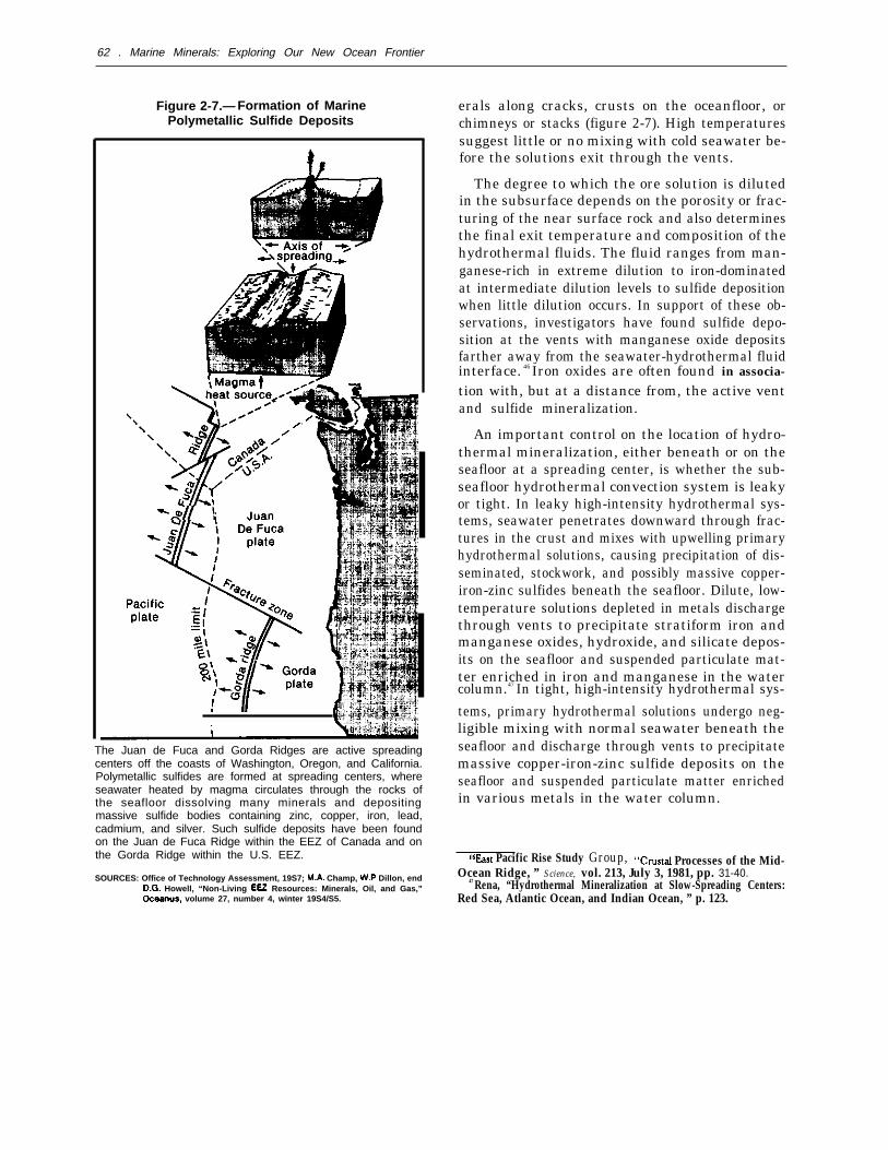
62 . Marine Minerals: Exploring Our New Ocean Frontier
Figure 2-7.— Formation of MarinePolymetallic Sulfide Deposits
The Juan de Fuca and Gorda Ridges are active spreadingcenters off the coasts of Washington, Oregon, and California.Polymetallic sulfides are formed at spreading centers, whereseawater heated by magma circulates through the rocks ofthe seafloor dissolving many minerals and depositingmassive sulfide bodies containing zinc, copper, iron, lead,cadmium, and silver. Such sulfide deposits have been foundon the Juan de Fuca Ridge within the EEZ of Canada and onthe Gorda Ridge within the U.S. EEZ.
SOURCES: Office of Technology Assessment, 19S7; Champ, Dillon, end Howell, “Non-Living Resources: Minerals, Oil, and Gas,”
volume 27, number 4, winter 19S4/S5.
erals along cracks, crusts on the oceanfloor, orchimneys or stacks (figure 2-7). High temperaturessuggest little or no mixing with cold seawater be-fore the solutions exit through the vents.
The degree to which the ore solution is dilutedin the subsurface depends on the porosity or frac-turing of the near surface rock and also determinesthe final exit temperature and composition of thehydrothermal fluids. The fluid ranges from man-ganese-rich in extreme dilution to iron-dominatedat intermediate dilution levels to sulfide depositionwhen little dilution occurs. In support of these ob-servations, investigators have found sulfide depo-sition at the vents with manganese oxide depositsfarther away from the seawater-hydrothermal fluidinterface. 46 Iron oxides are often found in associa-
tion with, but at a distance from, the active ventand sulfide mineralization.
An important control on the location of hydro-thermal mineralization, either beneath or on theseafloor at a spreading center, is whether the sub-seafloor hydrothermal convection system is leakyor tight. In leaky high-intensity hydrothermal sys-tems, seawater penetrates downward through frac-tures in the crust and mixes with upwelling primaryhydrothermal solutions, causing precipitation of dis-seminated, stockwork, and possibly massive copper-iron-zinc sulfides beneath the seafloor. Dilute, low-temperature solutions depleted in metals dischargethrough vents to precipitate stratiform iron andmanganese oxides, hydroxide, and silicate depos-its on the seafloor and suspended particulate mat-ter enriched in iron and manganese in the watercolumn.47 In tight, high-intensity hydrothermal sys-
tems, primary hydrothermal solutions undergo neg-ligible mixing with normal seawater beneath theseafloor and discharge through vents to precipitatemassive copper-iron-zinc sulfide deposits on theseafloor and suspended particulate matter enrichedin various metals in the water column.
Pacific Rise Study Group, Processes of the Mid-Ocean Ridge, ” Science, vol. 213, July 3, 1981, pp. 31-40.
47 Rena, “Hydrothermal Mineralization at Slow-Spreading Centers:Red Sea, Atlantic Ocean, and Indian Ocean, ” p. 123.

Ch. 2—Resource Assessments and Expectations 63
Table 2-5.—Estimates of Typical Grades of Contained Metals for Seafloor MassiveSulfide Deposits, Compared With Typical Ore From Ophiolite Massive
Sulfide Deposits and Deep-Sea Manganese Nodules
Sulfides, Iat 21° N. & Sulfides Sulfide ore, Deep-seaJuan de Fuca Ridge Galapagos rift Cyprus manganese nodules
Typical grade, Typical grade, Typical grade, Typical grade,Element in percent in percent in percent in percent
Zinc . . . . . . . . 30 0.2 0.2 0.13Copper . . . . . 0.5 5.0 2.5 0.99Nickel . . . . . . — — — 1.22Cobalt . . . . . . — 0.02 — 0.23Molybdenum — 0.017 — 0.018Silver . . . . . . . 0.02 — — —
Lead . . . . . . . 0.30 — — —
Manganese. . — — — 28.8Germanium. . 0.01 — — .
SOURCE Adapted from V. E. McKelvey, “Subsea Mineral Resources,” U.S. Geological Survey, Bulletin, 1669-A, 1966, p. 62
Prospects for Future Development
At the present time, too little is known about ma-rine polymetallic sulfide deposits to project theireconomic significance. Analysis of grab samples ofsulfides collected from several other spreading zonesindicate variable metal values, particularly from onezone to another. In general, all of the deposits sam-pled, except those on the Galapagos rift, have zincas their main metal in the form of sphalerite andwurtzite. The Galapagos deposits differ in that theycontain less than 1 percent zinc but have coppercontents of 5 to 10 percent, mainly in the form ofchalcopyrite. Weight percentage ranges of somemetals found in the sulfide deposits are given in ta-ble 2-5. Some of the higher analyses are from in-dividual grab samples composed almost entirely ofone or two metal sulfide minerals and analyze muchhigher in those metal values (e. g., a Juan de FucaRidge sample which is 50 percent zinc is primar-ily zinc sulfide). While this is impressive, it saysnothing about the extent of the deposit or its uni-formity. In any event, it is certain that any futuremining of hydrothermal deposits would recover anumber of metal coproducts.
Highly speculative figures assigning tonnagesand dollar values to ocean polymetallic sulfide oc-currences have begun to appear. Observers shouldbe extremely cautious in evaluating data related tothese deposits. The deposits have only been exam-ined from a scientific perspective related primar-ily to the process of hydrothermal circulation andits chemical and biological influence on the ocean.
No detailed economic evaluations of these depos-its or of potential recovery techniques have beenmade. Thus, estimates of the extent and volumeof the deposits are based on geologic hypotheses andlimited observational information. Even estimatesof the frequency of occurrence of submarine sul-fide deposits would be difficult to make at present.Less than 1 percent of the oceanic ridge system hasbeen explored in any detail.
A further note of caution is also in order. Indescribing the potential for polymetallic sulfide de-posits, several investigators have drawn parallelsor made comparisons to the costs of recovery andenvironmental impacts of ferromanganese nodulemining. There is also a parallel with regard to eco-nomic speculation. Early speculative estimates ofthe tonnages of ferromanganese nodules in the Pa-cific Ocean were given by John Mero in 1965 as1.5 trillion tons.
48 Even though this estimate wassubsequently expressed with caveats as to whatmight be potentially mineable (10 to 500 billiontons) ,49 the estimate of 1.5 trillion tons was widelyquoted and popularized, thus engendering a com-mon belief at the time that the deep seabed nod-ules were a virtually limitless untapped resource—awealth that could be developed to preferential ben-efit of less developed nations. The unlimited abun-
qeMero, Th e Mjneral Resources of th<’ Sc’a, P. 175.49J. L, Mere, “Potential Economic Value of Ocean-Floor Manganese
Nodule Deposits, ’ Ferromangancsc Deposits on the Ocean Floor,
DR. Horn (cd.), National Science Foundation, International Dec-ade of Ocean Exploration, Washington, DC, 1972, p. 202.

64 ● Marine Minerals: Exploring Our New Ocean Frontier
dance of seabed nodules was a basic premise onwhich the Third United Nations Conference on theLaw of the Sea was founded. Economic change andsubsequent research indicate both a more limitedmineable resource base and much lower projectedrates of return from nodule mining. However, asoften happens, positions that become establishedon the basis of one set of assumptions are difficultto amend when the assumptions change.
Creating expectations on the basis of highlyspeculative estimates of recoverable tonnages andvalues for hypothetical metal deposits serves little
Photo credit: U.S. Geological Survey
Hand sample of sulfide minerals recovered fromJuan de Fuca Ridge.
purpose. Avoiding the present temptation to ex-trapolate into enormous dollar values could avoidwhat may, upon further research, prove to be lessthan a spectacular economic resource in terms ofrecovery. This is not to say that the resource maynot be found, but simply that it is premature to de-fine its extent and estimate its economic value.
What then can be said about expectations for theU.S. EEZ? The Gorda Ridge is a relatively slowspreading active ridge crest. Until recently, mostsulfide deposits were found on the intermediate- tofast-spreading centers (greater than 2 inches peryear). This trend led some investigators to considerthe potential for sulfide mineralization at slow-spreading centers to be lower than at faster spread-ing centers. On the other hand, the convective heattransfer by hydrothermal circulation is on the sameorder of magnitude for both types of ridges. This
Ch. 2—Resource Assessments and Expectations 65
suggests that, if crustal material remains close tohydrothermal heat sources for a longer period oftime, it might become even more greatly enrichedthrough hydrothermal mineralization .50 In anyevent, a complete series of hydrothermal phases canbe expected at slow-spreading centers, ranging fromhigh-temperature sulfides to low-temperature ox-ides. The hydrothermal mineral phases includemassive, disseminated and stockwork sulfide depos-its and stratiform oxides, hydroxides, and silicates,
To account further for their differences, thedeeper seated heat sources at slow-spreading centerscan be inferred to favor development of leakyhydrothermal systems leading to precipitation ofthe sulfides beneath the seafloor. This inference,however, cannot be verified until the deposits aredrilled extensively.
Another view regarding the differences in poten-tial for mineralization between fast- versus slow-spreading ridge systems suggests that the extent ofhydrothermal activity and polymetallic sulfide depo-sition along oceanic ridge systems is more a func-tion of that particular segment’s episodic magmaticphase than the spreading rate of the ridge as awhole .51 According to this view, at any given timea ridge segment with a medium or slow averagespreading rate may show active hydrothermal vent-ing as extensive as that found along segments withfast spreading rates. Thus, massive polymetallic sul-fide deposits may be present along slow-spreadingridge segments, but they probably would be sepa-rated by greater time and distance intervals.
Another factor, particularly on the Gorda Ridge,is the amount of sediment cover. The 90-mile-long,
sediment-filled Escanaba Trough at the southernpart of the Gorda Ridge is similar to the GuaymasBasin in the Gulf of California, where hydrother-mal sulfide mineralization has been found. Theamount of sediment entering an active spreadingcenter is critical to the formation and preservationof the sulfide deposits. Too much material deliv-ered during mineralization will dilute the sulfideand reduce the economic value of the deposit. Onthe other hand, an insufficient sediment flux canresult in eventual oxidation and degradation of theunprotected deposit.
Sulfide deposits and active hydrothermal dis-charge zones have been found on the southern Juande Fuca Ridge beyond the 200-nautical-mile limitof the EEZ. The Juan de Fuca Ridge is a medium-rate spreading axis separating at the rate of 3 inchesper year. Zinc and silver-rich sulfides have beendredged from two vent sites that lie less than a mileapart. Photographic information combined with ge-ologic inference suggests a crude first-order esti-mate of 500,000 tons of zinc and silver sulfides ina 4-mile-long segment of the axial valley .52
Although marine polymetallic sulfide depositsmay someday prove to be a potential resource intheir own right, the current value of oceanfloor sul-fides lies in the scientific understanding of their for-mation processes as well as their assistance in thepossible discovery of analogous deposits on land(figure 2-8). Cyprus; Kidd Creek, Canada; and theKuroko District in Japan are all mining sites forpolymetallic sulfides, and all of these areas showthe presence of underlying oceanic crust. The keyto the past by studying the present is unravelingthe mechanisms by which this very important classof minerals and ores were formed.
50 Rena, “Hydrothermal Mineralization at Slow-Spreading Centers:Red Sea, Atlantic Ocean and Indian Ocean, ” p. 140.
s IA. M~ahoff, ‘ $ polymet~lic Sulfides-A Renewable Marine Re-source, Marine Mining: A New Beginning, Conference Proceed-ings, July 18-21, 1982, Hilo, HI, State of Hawaii, sponsored by De-partment of Planning and Economic Development, 1985, pp. 31-60.
ALASKA
In southeastern Alaska, the coast is mountainousand heavily glaciated. Glacial sediments covermuch of the shelf, which averages about 30 milesin width. The Gulf of Alaska has a wide shelf that
52R, A. Koski, W. R. Normark, and J. L. Morton, ‘‘Massive SUl -
fide Deposits on the Southern Juan de Fuca Ridge: Results of Inves-tigations in the USGS Study Area, 1980-83, Marine Mining, vol.
4, No. 2, 1985, pp. 147-164.
REGION
was mostly covered by glaciers during the Pleisto-cene. The eastern coast of the Gulf is less moun-tainous and lower than the steep western coast. Thesource rocks in the region include a wide range of

66 Marine Minerals: Exploring Our New Ocean Frontier
Figure 2-8.—Locations of Mineral Deposits Relative to Physiographic Features (vertical scale exaggerated)
Salt domes
SOURCES: Office of Technology Assessment, 1987; A. McGregor and Millington Lockwood, “Mapping and Research In the Exclusive Economic Zone,” Departmentof the Interior, U.S. Geological Survey and Department of Commerce, National Oceanic and Atmospheric Administration.
sedimentary, metamorphic, volcanic, and intrusivebodies.
The Alaska Peninsula and Aleutian Islands con-sist of intrusive and volcanic rocks related to thesubduction zone along the Pacific side. The shelfnarrows westward from a width of nearly 125 milesto places where it is nearly nonexistent between theAleutian Islands. The Aleutians are primarily an-desitic volcanics while granitic intrusive are foundon the peninsula.
The Bering Sea shelf is very broad and gener-ally featureless except for a few islands, banks, anddepressions. A variety of sedimentary, igneous, andmetamorphic rocks are found in the region. In thesouth, of particular mineralogical interest, are theKuskokwim Mountains containing Precambrianschist and gneiss, younger intrusive rocks, anddunite. The Yukon River is the dominant drain-age system entering the Bering shelf, although sev-eral major rivers contribute sediments includingstreams on the Asian side, The region also has been

Ch. 2—Resource Assessments and Expectations 67
significantly affected by glaciation and major sealevel changes. Glacial sediment was derived fromSiberia as well as Alaska. Barrier islands are foundalong the northern side of the Seward Peninsula.
The major physiographic feature of the northcoast of Alaska is the gently sloping arctic coastalplain, which extends seaward to form a broad shelfunder the Chukchi and Beaufort Seas. This areawas not glaciated during the Pleistocene, and onlyone major river, the Colville, drains most of theregion into the Beaufort Sea. The drainage areaincludes the Paleozoic sedimentary rocks of theBrooks Range and their associated local graniticintrusive and metamorphosed rocks.
Sand and Gravel
Approximately 74 percent of the continental shelfarea of the United States is off the coast of Alaska.Consequently, Alaskan offshore sand and gravelresources are very large. However, since these ma-terials are not generally located near centers of con-sumption, mining may not always be economicallyviable.
While glaciation has deposited large amounts ofsand and gravel on Alaska’s continental shelf, therecovery of economic amounts for construction ag-gregate is complicated by two factors:
1. much of the glacial debris is not well sorted,and
2. it is often buried under finer silt and mudwashed out after deglaciation.
Optimal areas for commercial sand and gravel de-posits would include outwash plains or submergedmoraines that have not been covered with recentsediment, or where waves and currents have win-nowed out finer material.
In general, much of the shelf of southeasternAlaska has a medium or coarse sand cover and isnot presently receiving depositional cover of finematerial. The Gulf of Alaska is currently receiv-ing glacial outwash of fine sediment in the easternpart and, in addition, contains extensive relict de-posits of sand and gravel. Economic deposits of sandhave been identified parallel to the shoreline westof Yakutat and west of Kayak Island. An exten-sive area of sand has been mapped in the lower
Cook Inlet, and gravel deposits are also presentthere (figure 2-9). Large quantities of sand andgravel are also found on the shelf of Kodiak Island.The Aleutian Islands are an unfavorable area forextensive sand and gravel deposits. Relict glacialsediments should be present on the narrow shelf,but the area is currently receiving little sediment.
Large amounts of fine sand lie in the southernBering Sea and off the Yukon River, but the north-ern areas may offer the greatest resource potentialfor construction aggregate. Extensive well-sortedsands and gravels are found at Cape Prince ofWales and northwest of the Seward Peninsula.However, distances to Alaskan market areas areconsiderable. Sand, silt, and mud are common onthe shelf in the Chukchi Sea and Beaufort Sea.Small, thin patches of gravel are also present, butavailable data are sparse. The best prospect ofgravel in the Beaufort Sea is a thick layer of Pleisto-cene gravel buried beneath 10 to 30 feet of over-burden east of the Colville River.
Overall sand and gravel resource estimates ofgreater than 200 billion cubic yards are projectedfor Alaska (table 2-4). In many areas, environ-mental concerns in addition to economic consider-ations would significantly influence development.
Precious Metals
Source rocks for sediments in southeasternAlaska are varied. Gold is found in the region andhas been mined from placer deposits. Platinum hasbeen mined from lode deposits on Prince of WalesIsland. Although few beach or marine placer de-posits are found in the area, the potential existssince favorable source rocks are present. However,glaciation has redistributed much of the sediment,and the shelf is receiving relatively little modernsediment.
Some gold has been recovered from beach placersin the eastern Gulf of Alaska; but, in general, theprospects for locating economic placers offshorewould not be great because of the large amount ofglacially derived fine-grained material entering thearea. In the western Gulf, the glaciation has re-moved much of the sediment from the coastal areaand deposited it offshore where subsequent rework-ing may have formed economically interesting

68 ● Marine Minerals: Exploring Our New Ocean Frontier
Figure 2-9.– Potential Hard Mineral Resources of the Alaskan EEZ
\
Gold and gravel have been mined from Alaskan waters and the potential exists for locating other offshore placer deposits.
SOURCES: Off Ice of Technology Assessment, 1987; U.S. Department of the Interior, “SYmPosium Proceedings-A National Program for the Assessment and Develop-ment of the Mineral Resources of the United States Exclusive Economic Zone,” U.S. Geological Survey Circular 929, 1983.
placer deposits.53 Gold is found in the region and
has been mined from beaches on Kodiak Island andCook Inlet. Placer deposits may have formed onthe outer shelf but recovery may be difficult. LowerCook Inlet might be the best area of the Gulf toprospect.
SSH, E. Clifton and G. Luepke, Heavy-Minera/ placer Deposits ofthe Continence Margin of Alaska and the Pacific Coast States, in Ge-ology and Resouree Potential of the Continental Margin of WesternNorth America and A~”acent Ocean Baaisn-Beaufort Sea to Baja, Cali-fornia, American Association of Petroleum Geologists Memoir, ed.,D.W. Scholl, (in press).
The shelf along the Aleutian Islands is a rela-tively unfavorable prospective locale for finding eco-nomic placer deposits. Sediment supply is limited,and ore mineralization in the volcanic source rocksis rare. Lode and placer gold deposits have beenfound on the Alaska Peninsula, and gold placersmay be found off the south shore near former min-ing areas.
Platinum has been mined from alluvial placersnear Goodnews Bay on the Bering Sea. Anoma-lous concentrations of platinum are also found on

Ch. 2—Resource Assessments and Expectations 69
the coast south of the Salmon River and in sedi-ments in Chagvan Bay.
54 The possibility exists thatplatinum placers may be found on the shelf if gla-cially transported material has been concentratedby marine processes. Source rocks are thought tobe dunites in the coastal Kuskokwim Mountains,but lode deposits have not been found. Gold placersare also found along the coast of the Bering Seaand are especially important to the north nearNome. Lode gold and alluvial placers are commonalong the southern side of the Seward Peninsula,and tin placers have also been worked in the area.Gold has been found offshore in gravel on sub-merged beach ridges and dispersed in marine sandsand muds. Economic deposits may be found in thesubmerged beach ridges or in buried channels off-shore. The region around Nome has yielded about5 million ounces of gold, mainly from beach de-posits, and it is suggested that even larger amountsmay lie offshore.
55 How much of this, if any, maybe discovered in economically accessible depositsis uncertain, but the prospects are probably prettygood in the Nome area.
54R. M. Owen, ‘ ‘Geochemistry of Platinum-Enriched Sediments:Applications to Mineral Exploration, Marine Mining, vol. 1, No.4, 1978, pp. 259-282.
jjBeauchamp and Cmickshank, “Placer Minerals on the U.S. Con-tinental Shelves—Opportun ity for Development, p. 700.
HAWAII
Hawaii is a tectonically
Other Heavy Minerals
The eastern Gulf of Alaska is strongly influencedby the modern glaciers in the area. Fresh, glaciallyderived sediments, including large amounts of fine-grained material, are entering the area and beingsorted by marine processes. Heavy mineral suitesare likely to be fairly immature and burial is rapid.In general, the prospects for locating economicallyinteresting heavy mineral placers offshore in thisarea would not be great.
About 2,000 tons of tin have been produced fromplacers on the western part of the Seward Penin-sula. Tin in association with gold and other heavyminerals may occur in a prominent shoal which ex-tends over 22 miles north-northeast from CapePrince of Wales along the northwest portion of theSeward Peninsula. While seafloor deposits off theSeward Peninsula might be expected to containgold, cassiterite, and possibly tungsten minerals,data are lacking to evaluate the resource potential.
In general, the Chukchi and Beaufort seas maynot contain many economic placers. Source rocksare distant, and ice gouging tends to keep bottomsediments mixed.
REGION AND U.S. TRUST TERRITORIES
active, mid-ocean vol-canic chain with typically narrow and limited shelfareas. Sand and gravel resources are in short sup-ply. The narrow shelf areas in general do not pro-mote large accumulations of sand and gravel off-shore. One area of interest is the Penguin Bank,which is a drowned shore terrace about 30 milessoutheast of Honolulu (figure 2-10). The bank’s re-source potential is conservatively estimated at over350 million cubic yards of calcareous sands in about180 to 2,000 feet of water.56 This resource couldsupply Hawaii’s long-term needs for beach resto-ration and, to a lesser extent for construction. How-ever, high winds and strong currents are common
‘b~. Il. Murdaugh, ‘ ‘Preliminary Feasibility Assessment: OffshoreSand Mining, Penguin Bank, Hawaii, ” Program Feasibilit}rDocument—OCS Hard Minerals Leasing, app. 19, U.S. Departmentof the Interior, 1979, p. 14.
on the Penguin Bank. Total sand and gravel re-source estimates for Hawaii may be as high as 25billion cubic yards (table 2-4).
No metalliferous deposits are mined onshore inHawaii. Thus the prospects are somewhat poor forlocating economically attractive placer deposits onthe Hawaiian outer continental shelf. Minor phos-phorite deposits have been found in the Hawaiiarea, although phosphorite is found on seamountselsewhere in the Pacific.
The geology of the U.S. Trust Territories is gen-erally similar to Hawaii with the islands being ofvolcanic origin, often supporting reefs or limestonedeposits. Clastic debris of the same material ispresent and concentrated locally, but very little in-formation is available as to the nature and extentof any sand or gravel deposits. Other areas are rela-

70 Marine Minerals: Exploring Our New Ocean Frontier
Figure 2-10.– Potential Hard Mineral Resources of the Hawaiian EEZ
Cretaceusseamounts
\
Explanation
Known Likelyoccurrence occurrence
1
Mn-nodules o4 4
Co-crusts o5 5
0Massive sulfides 6 6
SOURCES: Office of Technology Assessment, 1987; U.S. Department of the Interior, “Symposium Proceedings—A National Program for the Assessment and Develop-ment of the Mineral Resources of the United States Exclusive Economic Zone,” U.S. Geological Survey Circular 929, 1983.
tively free of sediment or are covered with fine sedi-ment consisting of red clay and/or calcareous ooze.The extent to which the United States has juris-diction over the EEZs of the various Trust Terri-tories (figure 2-1 1) is examined in appendix B.
Cobalt-Ferromanganese Crusts
Recently, high concentrations of cobalt have beenfound in ferromanganese crusts, nodules, and slabson the sides of several seamounts, ridges, and otherraised areas of ocean floor in the EEZ of the cen-tral Pacific region. The current interest in cobalt-enriched crusts follows an earlier period of consid-
erable activity during the 1960s and 1970s to de-termine the feasibility of mining manganese nod-ules from the deep ocean floor, While commercialprospects for deep seabed nodule mining havereceded because of unfavorable economics com-pounded by political uncertainties resulting fromthe Law of the Sea Convention, commercial inter-est in cobalt-ferromanganese crusts is emerging. Anumber of factors are contributing to this shift ofinterest, including seamount crusts that:
1. appear to be richer in metal content and morewidely distributed than previously recognized,
2. are at half the depth or less than their abyssalcounterparts,

Ch. 2—Resource Assessments and Expectations . 71
Figure 2-11 .—Cobalt-Rich Ferromanganese Crustson the Flanks of Seamounts and Volcanic Islands
Iron-manganese crusts enriched in cobalt occur on the flanksof volcanic islands and seamounts in geochemically favorableareas of the Pacific. Samples have been recovered forscientific purposes, but equipment for potential commercialevaluation and recovery has not been developed.
SOURCES: Office of Technology Assessment, 1987; Bonnie A. McGregor andTerry W. Of field, “The Exclusive Economic Zone: An Exciting NewFrontier, ” U.S. Department of the Interior, Geological Survey.
3.
4.
can be found within the U.S. EEZ whichcould provide a more stable investment cli-mate, andmay provide alternative sources of strategicmetals.
Geologic Considerations
Ferromanganese crusts range from thin coatingsto thick pavements (up to 4 inches) on rock sur-faces that have remained free of sediment for mil-lions of years. The deposits are believed to formby precipitation of hydrated metal oxides from near-bottom seawater. The crusts form on submarinevolcanic and phosphorite rock surfaces or as nod-ules around nucleii of rock or crust fragments. Theydiffer from deep ocean nodules, which form on thesediment surface and derive much of their metalsfrom the interstitial water of the underlying sedi-ment. Several factors appear to influence the com-position, distribution, thickness, and growth rateof the crusts. These factors include metal concen-tration in the seawater, age and type of the sub-strate, bottom currents, depth of formation, lati-tude, presence of coral atolls, development of anoxygen-minimum zone, proximity to continents,and geologic setting.
The cobalt content varies with depth, with max-imum concentrations occurring between 3,300 and8,200 feet in the Pacific Ocean. Cobalt concentra-tions greater than 1 percent are generally restrictedto these depths. Platinum (up to 1.3 parts per mil-
lion) and nickel (to 1 percent) are also found asso-ciated with cobalt in significant concentrations inmany ferromanganese crust areas. Other metalsfound in lesser but significant amounts include lead,cerium, molybdenum, titanium, rhodium, zinc,and vanadium (table 2-6).
At least two periods of crust formation occur insome crusts. Radiometric dating and other analy-ses indicate that crusts have been forming for thelast 20 million years, with one major interruptionin ferromanganese oxide accretion during the lateMiocene, from 8 to 9 million years ago, as detectedin some samples. During this period of interrup-tion, phosphorite was deposited, separating theolder and younger crust materials. In some areas,there is evidence of even older periods of crust for-mation. Crust thickness is related to age; conse-quently, within limits, the age of the seafloor is animportant consideration in assessing the resourcepotential of an area. However, crust thickness doesnot ensure high cobalt and nickel concentrations.
The U.S. Geological Survey found thick crustswith moderate cobalt, manganese, and nickel con-centrations on Necker Ridge, which links the Mid-

72 ● Marine Minerals: Exploring Our New Ocean Frontier
Table 2-6.–Average Chemical Composition for Various Elements of Crusts From <8,200 Feet Water DepthFrom the EEZ of the United States and Other Pacific Nations (all data are in weight percent)
Areas n Mn Fe Co Ni Cu Pb Ti SiO2 P205 Fe/Mn
Hawaii and Midway (on axis) . . . . . . . .Hawaii and Midway (off axis) . . . . . . . .Johnston Island . . . . . . . . . . . . . . . . . . .Palmyra Atoll-Kingman Reef . . . . . . . .Howland-Baker Islands . . . . . . . . . . . . .Marshall Islands . . . . . . . . . . . . . . . . . . .Average central Pacific crusts . . . . . . .Northern Marianna Islands
(and Guam). . . . . . . . . . . . . . . . . . . . . .Western U.S. borderland . . . . . . . . . . . .Gulf of Alaska Seamounts . . . . . . . . . .Lau Basin (hydrothermal) . . . . . . . . . . .Tonga Ridge and Lau Basin
(hydrogenous) . . . . . . . . . . . . . . . . . . .South China Sea . . . . . . . . . . . . . . . . . .Benin Island area (Japan) . . . . . . . . . . .French Polynesia . . . . . . . . . . . . . . . . . .Average for Pacific hydrogenous
crusts (all data from figures 2-8) . . .
2-38 24 16.0 0.91 0.45 0.054-15 21 18.0 0.60 0.37 0.10
12-40 22 17.0 0.70 0.43 0.117-8 27 16.0 1.1 0.51 0.063 29 18.0 0.99 0.63 0.08
5-13 26 14.0 0.94 0.56 0.1334-117 23 17.0 0.81 0.45 0.09
6-7 12 16.0 0.09 0.13 0.052-5 19 16.0 0.30 0,30 0.043-6 26 18.0 0.47 0.44 0.152 46 0.600.007 0.005 0.02
6-9 16 20.0 0.33 0.22 0.0514 13 13.0 0.13 0.34 0.041-1o 21 13.0 0.41 0.55 0.062-9 23 12.0 1.2 0.60 0.11
55-319 22 15.0 0.63 0.44 0.08
1.1 7.90.18 1.3 16.00.17 1.3 12.00.17 1.1 5.50.14 1.2 6.20.25 1.1 5.60.18 1.2 9.1
0.07 – –0.15 0.31 17.00.17 0.57 –0.006 0.005 –
0.16 1.0 –0.08 – 14.00.12 0.67 4.90.26 1.0 6.5
0.16 0,98 11.0
—1.01.21.91.70.901.3
——
0.870.05
1.0—
0.820.34
1.1
0.730.880.810,610.640.560.75
1.410.950.720.01
1.261.070.700.56
0.81n = Number of analyses for various elements.— = No data.
SOURCE: JR. Hein, L.A. Morgenson, D.A. Clague, and R.A. Koski, “Cobalt-Rich Ferromanganese Crusts From the Exclusive Economic Zone of the United States andNodules From the Oceanic Pacific,” D. Schoil, A. Grantz, and J. Vedder (eds.), Geology and Resource Potential of the Corrth’rerrta/ Margins of Western NorthAmerican and Adjacent Ocean Basins: American Association of Petroleum Geologkts, Memoir, in press.
Pacific Mountains and the Hawaiian Archipelago .57
Further, high cobalt values of 2.5 percent werefound in the top inch or so of crusts from the S.P.Lee Seamount at 8° N. latitude. These deposits oc-cur at depths coincident with a water mass that con-tains minimum concentrations of oxygen, leadingmost investigators to attribute part of this cobaltenrichment to low oxygen content in the seawaterenvironment. However, high cobalt values (greaterthan 1 percent) have also been found in the Mar-shall Islands, the western part of the HawaiianRidge province, and in French Polynesia, all ofwhich are outside the well-developed regionalequatorial oxygen-minimum zone but which ap-pear to be associated with locally developed oxygen-minimum zones. Oxygen-minimum zones are alsoassociated with low iron/manganese ratios. Figure2-12 illustrates the zone of cobalt enrichment infer-romanganese crusts on seamounts and volcanic is-lands. In general, while progress is being made tounderstand more fully the physical and geochemi-cal mechanisms of cobalt-manganese crust forma-
57J. R. Heine, et al., “Geological and Geochemical Data for Sea-mounts and Associated Ferromanganese Crusts In and Near the Ha-waiian, Johnston Island, and Palmyra Island Exclusive EconomicZones, ” U.S. Geological Survey, Open File Report 85-292, 1985,p. 129.
tion, the cobalt enrichment process is still uncer-tain. investigations to gain insight in this area willbe of considerable benefit in identifying future re-sources.
Surface texture, slope, and sediment cover alsomay influence crust growth rates. For example,sediment-free, current-swept regions appear to befavorable sites for crust formation.
Nodules are also found associated with cobalt-rich manganese crusts in some areas. These nod-ules are similar in composition to the crusts and,consequently, differ from their deep ocean coun-terparts. Another difference between crust-associated nodules and deep ocean nodules is thegreater predominance of nucleus material in thecrust-associated nodules. The cobalt-rich nodulesgenerally occur as extensive fields on the tops ofseamounts or within small valleys and depressions.While of much lesser extent overall than crustoccurrences, these nodules may prove more easilyrecoverable and, hence, possibly of nearer term eco-nomic interest.
Prospects for Future Development
The geologic considerations mentioned previ-ously are important determinants in assessing the

Ch. 2—Resource Assessments and Expectations 73
Figure 2-12.— EEZs of U.S. Insular and Trust Territories in the Pacific
Midway Island
Howland andBaker Islands
In addition to the waters off the fifty states, the Exclusive Economic Zone includes the waters contiguous to the insular territoriesand possessions of the United States. The United States has the authority to manage these economic zones to the extentconsistent with the legal relationships between the United States and these islands.
SOURCES: Office of Technology Assessment, 19S7; D.A. and “Cobalt-Rich Crusts From the ExclusiveEconomic Zone of the United States and Nodules From the Oceanic Pacific,” in D. Scholl, A. and J. “Geology and Resource Potentialof the Continental Margin of Western North America and Adjacent Ocean Basins,” American Association of Petroleum Geologists Memoir 43, in press.
resource potential of cobalt-rich ferromanganese cial concentrations of cobalt-rich crusts would becrusts. Using three primary assumptions based on confined to the slopes and plateau areas of sea-these factors, the East West Center in Hawaii mounts in water depths between 2,600 and 7,900produced a cobalt-rich ferromanganese crust re- feet. The second assumption was that commercialsource assessment for the Minerals Management concentrations would be most common in areasService .58 The first assumption was that commer- older than 25 million years, where both generations
of crust would be found, and less common in areas P. Humphrey, C .J, Johnson, et younger than 10 million years, where only thin-
Manganese Crust Potential, Study, MMS 85-0006, U.S. ner younger crust generation occurs. The third of the Interior, Minerals Management Service, 1985, 35 pp. primary assumption was that commercial concen-

74 ● Marine Minerals: Exploring Our New Ocean Frontier
Table 2-7.—Resource Potential of Cobalt, Nickel,Manganese, and Platinum in Crusts of U.S. Trust
and Affiliated Territories
Resource Potential
Nickel PlatinumTerritory Cobalt ( t x 10°) Manganese (OZ X 1OE)
Belau/Palau . . . . . . . . 0.55 0.31 15.5 0.68Guam . . . . . . . . . . . . . 0.55 0.31 15.5 0.68Howland-Baker . . . . . 0.19 0.11 5.5 0.48Jarvis . . . . . . . . . . . . . 0.06 0.03 1.6 0.15Johnston Island . . . . 1.38 0.69 41.6 3.50Kingman—Palmyra . 3.38 1.52 76.1 5.70Marshall Islands. .. .10.55 5.49 281.3 21.50Micronesia. . . . . ....17.76 9.96 496.0 34.70Northern Mariana
Islands . . . . . . . . . . 3.60 1.97 100.2 7.70Samoa . . . . . . . . . . . . 0.03 0.01 0.8 0.04Wake . . . . . . . . . . . . . 0.98 0.51 26.8 2.00NOTE: The above are estimates of in-place resources and as such do not indicate
either potential recoverability or mineable quantities.
SOURCE: Allen L. Clark, Peter Humphrey, Charles J. Johnson, and Dorothy K.Pak, Coba/t-Rich Manganese Crust Potential, OCS Study MMS 65-0006,1985, p. 20.
trations would be most common in areas of lowsediment cover that have been within the geographi-cally favorable equatorial zone for the majority oftheir geologic history.
The East-West Center’s procedure was to usedetailed bathymetric maps to determine permissiveareas for each EEZ of the U.S. Trust and AffiliatedTerritories in the Pacific. The permissive areas in-cluded all the seafloor between the depths of 2,600and 7,900 feet, making corrections for areas of sig-nificant slopes. Then, based on published data, themetal content and thickness of crust occurrencesfor each area were averaged. Crust thicknesses werealso assigned on the basis of ages of the seamounts,guyots, and island areas. Seamounts older than 40million years were assigned a thickness of 1 inch.Seamounts younger than 10 million years were as-signed a thickness of one-half inch, and seamountsyounger than 2 to 5 million years were not includedin the resource calculations. These data are sum-marized in table 2-7.
According to table 2-7, the five territories of high-est resource potential would be the Federated Statesof Micronesia, Marshall Islands, Commonwealthof the Northern Mariana Islands, Kingman-Palmyra Islands, and Johnston Island. Further ge-ologic inference suggests that the resource poten-tial of the Federated States of Micronesia and theCommonwealth of the Northern Mariana Islands
could be reduced because of uncertainties in ageand degree of sediment cover. Thus, according totheir more qualitative assessment, the largest re-source potential for cobalt crusts would likely bein the Marshall Islands, followed by the Kingman-Palmyra, Johnston, and Wake Islands (figure 2-13). The territories of lesser resource potentialwould include, in decreasing order, the FederatedStates of Micronesia, Commonwealth of the North-ern Mariana Islands (figure 2-14), Belau-Palau,Guam, Howland-Baker, Jarvis, and Samoa.59
Another assessment of crust resource potentialusing grade and permissive area calculations withgeologic and oceanographic criteria factored in isgiven in table 2-8.60 This assessment is also a qual-itative ranking without attempting to quantify ton-nages. In this regard, other factors that would haveto be considered to assess the economic potentialof any particular area include: nearness to port fa-cilities and processing plants, and the cost of trans-portation. In addition, factors highly critical to theeconomics of a potential crust mining operationwould be the degree to which the crust can be sep-arated from its substrate and the percentage of the
‘gIbid., p. 21.‘OJ. R. Hein, L.A. Morgenson, D.A. Glague, and R.A. Koski,
‘(Cobalt-Rich Ferromanganese Crusts From the Exclusive EconomicZone of the United States and Nodules From the Oceanic Pacific,D. Scholl, A. Grantz, and J, Vedder (eds. ), Geology and ResourcePotent]af of the Continental Margins of Western North America andAdjacent Ocean Basins, American Association of Petroleum Geolo-gists, Memoir (in press), 1986.
Table 2-8.—Estimated Resource Potential of CrustsWithin the EEZ of Hawaii and U.S. Trust
and Affiliated Territories
RelativePacific area banking Potential
Marshall Islands. . . . . . . . . . . . . . 1 HighMicronesia . . . . . . . . . . . . . . . . . . 2 HighJohnston Island . . . . . . . . . . . . . . 3 HighKingman-Palmyra. . . . . . . . . . . . . 4 High
Hawaii-Midway . . . . . . . . . . . . . . . 5 MediumWake . . . . . . . . . . . . . . . . . . . . . . . 6 MediumHowland-Baker. . . . . . . . . . . . . . . 7 Medium
Northern Mariana Islands. . . . . . 8 LowJarvis . . . . . . . . . . . . . . . . . . . . . . . 9 LowSamoa . . . . . . . . . . . . . . . . . . . . . . 10 LowBelau/Palau. . . . . . . . . . . . . . . . . . 11 LowGuam . . . . . . . . . . . . . . . . . . . . . . . 12 LowSOURCE: Modified from J.R. Hein, F.T. Manheim, and W.C. Schwab, Coba/t-Rich
Ferrornangwrese Crusts from the Centra/ Pac/flc, OTC 5234, OffshoreTechnology Conference, May 1966, pp. 119126,

Ch. 2—Resource Assessments and Expectations 75
Figure 2-13.– Potential Hard Mineral Resources of U.S. Insular Territories South of Hawaii
0 .0.
●
●
✎
Se
●●
Seamounts
Seamounts
Co-crusts o5
0Massive sulfides 6
5
60 500 1000 Miles
J i 1 J
SOURCES: Office of Technology Assessment, 1987; U.S. Department of the Interior, “Symposium Proceedings—A Program tne Assessment ana
ment of the Mineral Resources of the United States Exclusive Economic Zone,” U.S. Geological Survey Circular 929, 1983.
area that could not be mined because of roughnessof small-scale topography. When asked to place thestage of knowledge of the economic potential of co-balt crusts on the time-scale experienced in the in-vestigations of manganese nodules, one leadingresearcher chose 1963.61
M. Broadus, Seabed Mining, report to the Office of Technol-ogy Assessment, U.S. Congress, Feb. 14, 1984, p. 24,
Manganese Nodules
Ferromanganese nodules are found at most waterdepths from the continental shelf to the abyssalplain. Since the formation of nodules is limited toareas of low sedimentation, they are most commonon the abyssal plain. Nodules on the abyssal plainare enriched in copper and nickel and, until re-cently, have been regarded as candidates for com-mercial recovery. Nodules found on topographichighs in the Pacific are enriched in cobalt and werementioned in the previous section.

76 . Marine Minerals: Exploring Our New Ocean Frontier
Figure 2-14.– Potential Hard Mineral Resources of U.S. Insular Territories West of Hawaii
Northern Mariana Islands Wake Island
Co-crusts o5 5 1 I I
Massive sulfides o6 6
SOURCES: Office of Technology Assessment, 19S7; U.S. Department of the Interior, “Symposium Proceedings-A National Program for the Assessment and Develop-ment of the Mineral Resources of the United States Exclusive Economic Zone,” U.S. Geological Survey Circular 929, 19S3.
The prime area considered for commercial re- per square yard to be commercially interesting. Be-covery of nodules in the Pacific lies in international cause of uncertainties brought about by the Unitedwaters between the Clarion and Clipperton frac- Nations Law of the Sea Convention in regard toture zones in the mid-Pacific ocean. However, sev- mining in international waters, and because of theeral other smaller areas may contain suitable mine low price of copper on the world market, the re-sites, for example, southwest of Hawaii. A mine covery of nodules from the Clarion-Clipperton re-site should have an average grade of about 2.25 per- gion is not attractive at this time.cent copper plus nickel with 20 pounds of nodules