Chapter 2 Project Description 2.1 Introduction and … 2 Project Description Los Angeles Harbor...
43
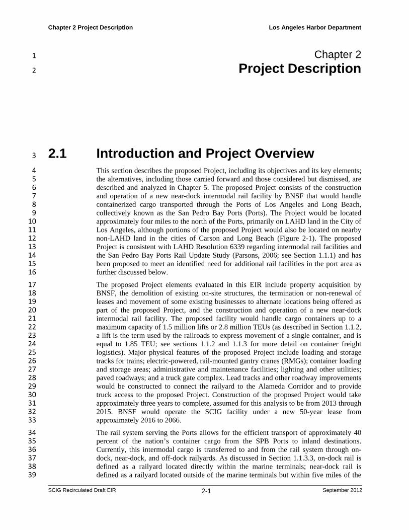
Chapter 2 Project Description Los Angeles Harbor Department SCIG Recirculated Draft EIR 2-1 September 2012 Chapter 2 1 Project Description 2 2.1 Introduction and Project Overview 3 This section describes the proposed Project, including its objectives and its key elements; 4 the alternatives, including those carried forward and those considered but dismissed, are 5 described and analyzed in Chapter 5. The proposed Project consists of the construction 6 and operation of a new near-dock intermodal rail facility by BNSF that would handle 7 containerized cargo transported through the Ports of Los Angeles and Long Beach, 8 collectively known as the San Pedro Bay Ports (Ports). The Project would be located 9 approximately four miles to the north of the Ports, primarily on LAHD land in the City of 10 Los Angeles, although portions of the proposed Project would also be located on nearby 11 non-LAHD land in the cities of Carson and Long Beach (Figure 2-1). The proposed 12 Project is consistent with LAHD Resolution 6339 regarding intermodal rail facilities and 13 the San Pedro Bay Ports Rail Update Study (Parsons, 2006; see Section 1.1.1) and has 14 been proposed to meet an identified need for additional rail facilities in the port area as 15 further discussed below. 16 The proposed Project elements evaluated in this EIR include property acquisition by 17 BNSF, the demolition of existing on-site structures, the termination or non-renewal of 18 leases and movement of some existing businesses to alternate locations being offered as 19 part of the proposed Project, and the construction and operation of a new near-dock 20 intermodal rail facility. The proposed facility would handle cargo containers up to a 21 maximum capacity of 1.5 million lifts or 2.8 million TEUs (as described in Section 1.1.2, 22 a lift is the term used by the railroads to express movement of a single container, and is 23 equal to 1.85 TEU; see sections 1.1.2 and 1.1.3 for more detail on container freight 24 logistics). Major physical features of the proposed Project include loading and storage 25 tracks for trains; electric-powered, rail-mounted gantry cranes (RMGs); container loading 26 and storage areas; administrative and maintenance facilities; lighting and other utilities; 27 paved roadways; and a truck gate complex. Lead tracks and other roadway improvements 28 would be constructed to connect the railyard to the Alameda Corridor and to provide 29 truck access to the proposed Project. Construction of the proposed Project would take 30 approximately three years to complete, assumed for this analysis to be from 2013 through 31 2015. BNSF would operate the SCIG facility under a new 50-year lease from 32 approximately 2016 to 2066. 33 The rail system serving the Ports allows for the efficient transport of approximately 40 34 percent of the nation’s container cargo from the SPB Ports to inland destinations. 35 Currently, this intermodal cargo is transferred to and from the rail system through on- 36 dock, near-dock, and off-dock railyards. As discussed in Section 1.1.3.3, on-dock rail is 37 defined as a railyard located directly within the marine terminals; near-dock rail is 38 defined as a railyard located outside of the marine terminals but within five miles of the 39
Transcript of Chapter 2 Project Description 2.1 Introduction and … 2 Project Description Los Angeles Harbor...
Chapter 2 Project Description Los Angeles Harbor Department
SCIG Recirculated Draft EIR 2-1 September 2012
Chapter 2 1
Project Description 2
2.1 Introduction and Project Overview 3
This section describes the proposed Project, including its objectives and its key elements; 4 the alternatives, including those carried forward and those considered but dismissed, are 5 described and analyzed in Chapter 5. The proposed Project consists of the construction 6 and operation of a new near-dock intermodal rail facility by BNSF that would handle 7 containerized cargo transported through the Ports of Los Angeles and Long Beach, 8 collectively known as the San Pedro Bay Ports (Ports). The Project would be located 9 approximately four miles to the north of the Ports, primarily on LAHD land in the City of 10 Los Angeles, although portions of the proposed Project would also be located on nearby 11 non-LAHD land in the cities of Carson and Long Beach (Figure 2-1). The proposed 12 Project is consistent with LAHD Resolution 6339 regarding intermodal rail facilities and 13 the San Pedro Bay Ports Rail Update Study (Parsons, 2006; see Section 1.1.1) and has 14 been proposed to meet an identified need for additional rail facilities in the port area as 15 further discussed below. 16
The proposed Project elements evaluated in this EIR include property acquisition by 17 BNSF, the demolition of existing on-site structures, the termination or non-renewal of 18 leases and movement of some existing businesses to alternate locations being offered as 19 part of the proposed Project, and the construction and operation of a new near-dock 20 intermodal rail facility. The proposed facility would handle cargo containers up to a 21 maximum capacity of 1.5 million lifts or 2.8 million TEUs (as described in Section 1.1.2, 22 a lift is the term used by the railroads to express movement of a single container, and is 23 equal to 1.85 TEU; see sections 1.1.2 and 1.1.3 for more detail on container freight 24 logistics). Major physical features of the proposed Project include loading and storage 25 tracks for trains; electric-powered, rail-mounted gantry cranes (RMGs); container loading 26 and storage areas; administrative and maintenance facilities; lighting and other utilities; 27 paved roadways; and a truck gate complex. Lead tracks and other roadway improvements 28 would be constructed to connect the railyard to the Alameda Corridor and to provide 29 truck access to the proposed Project. Construction of the proposed Project would take 30 approximately three years to complete, assumed for this analysis to be from 2013 through 31 2015. BNSF would operate the SCIG facility under a new 50-year lease from 32 approximately 2016 to 2066. 33
The rail system serving the Ports allows for the efficient transport of approximately 40 34 percent of the nation’s container cargo from the SPB Ports to inland destinations. 35 Currently, this intermodal cargo is transferred to and from the rail system through on-36 dock, near-dock, and off-dock railyards. As discussed in Section 1.1.3.3, on-dock rail is 37 defined as a railyard located directly within the marine terminals; near-dock rail is 38 defined as a railyard located outside of the marine terminals but within five miles of the 39

Chapter 2 Project Description Los Angeles Harbor Department
SCIG Recirculated Draft EIR 2-2 September 2012
Port (for example, the UP ICTF near Carson); and off-dock rail is defined as a railyard 1 located greater than five miles from marine terminals (for example, the BNSF 2 Hobart/Commerce railyard (hereafter, Hobart) and UP’s East Los Angeles Railyard, both 3 just east of downtown Los Angeles). 4
Maximizing the use of on-dock railyards is consistent with the CAAP and the LAHD’s 5 Intermodal Rail Policy mainly because on-dock rail eliminates truck trips to near/off-6 dock railyards, thereby reducing truck emissions and traffic congestion. Consistent with 7 those policies, the LAHD has developed, and is continuing to pursue, development of 8 additional on-dock rail facilities to increase the on-dock rail capacity in the Port of Los 9 Angeles, and is constructing additional rail infrastructure and trackage outside the marine 10 terminals to better connect the on-dock railyards with the Alameda Corridor. This 11 additional rail capacity is important to maximize use of the Alameda Corridor, and 12 consequently reduce the number of truck trips to near-dock and off-dock railyards. 13
Despite the efforts by the Ports to develop additional on-dock capacity and by the 14 railroads to increase utilization of on-dock rail (see Section 1.1.4), however, a number of 15 factors will continue to limit the overall percentage of intermodal cargo that can be 16 moved via on-dock rail. First, not all intermodal cargo can be handled at on-dock 17 railyards. As described in Section 1.1.3.3, cargo at a marine terminal is sorted by 18 destination. If there are enough cargo containers bound for the same destination (meaning 19 an intermodal facility in the eastern U.S.), a unit train to that destination will be built at 20 the on-dock facility. If, however, there are containers bound for different destinations, 21 they must be either stored in the terminal until enough are collected to form at least one 22 portion of a train, resulting in delays and congestion, or trucked to a near/off-dock facility 23 to be combined with cargo from other marine terminals bound for that same destination. 24
Second, not all marine terminals have, or can have, on-dock railyards. As described in 25 Section 1.1.5.4, constraints of terminal size and configuration can limit the size of on-26 dock facilities or prevent them from being constructed at all. 27
Third, as discussed in Section 1.1.5.3, the rail infrastructure within the ports and between 28 the ports and the Alameda Corridor will be inadequate to handle future volumes of 29 intermodal cargo from on-dock railyards, especially those on Terminal Island. 30
Other limiting factors include shipper and steamship line logistics (e.g. transloading, 31 transportation costs, etc.) and railroad operations (equipment availability, train schedules, 32 and contracts/arrangements with shippers). 33
Accordingly, there will always be a need for near-dock/off-dock facilities, and expansion 34 of near/off-dock rail capacity will be necessary to accommodate projected increases in 35 intermodal cargo volumes. Along with increasing on-dock capacity, LAHD seeks to 36 increase near-dock capacity over off-dock railyards to decrease truck trips in the region 37 as a whole while accommodating the cargo that cannot be handled at on-dock facilities. 38
39 40

1 2
Chapter 2
SCIG Recirc
Figure 2-
Project Descr
culated Draft EIR
1. Regional
ription
R
Location Maap.
2-3
Los Angeles Harbor Depar
Septemb
rtment
er 2012
Chapter 2 Project Description Los Angeles Harbor Department
SCIG Recirculated Draft EIR 2-4 September 2012
2.1.1 Long-Term Cargo Projections and On-Dock 1
Capacity 2
As discussed in Section 1.1.5, in 2009 the LAHD and the Port of Long Beach prepared an 3 update to the 2007 cargo forecast (Tioga, 2009) as well as an update to on-dock railyard 4 capacities within the Ports. The cargo forecast projects consumer and industry demand, 5 both for the U.S. and for its trading partners, by commodity and cargo handling type. 6 That demand is unconstrained by physical factors such as port capacity or the ability of 7 the region’s rail infrastructure (including on-dock, near-dock, and off-dock railyards) and 8 freeways to accommodate trade growth. Accordingly, the Ports also evaluated the ability 9 of the physical infrastructure (port terminal and regional rail) to accommodate the 10 demand. Terminal capacity estimates were developed by each port for existing and 11 planned container terminals. Those estimates reflect key assumptions about how much 12 land will ultimately be available for container use (backland acreage), number and size of 13 the terminal’s berths and cranes, and how the terminals will operate (labor rates and gate 14 hours). 15
To help accommodate the anticipated cargo volumes, the Ports plan to expand existing 16 and construct new on-dock railyards and supporting infrastructure over the next 10 to 15 17 years. In addition, the Ports will seek to maximize on-dock operations at the marine 18 terminals by encouraging tenants to schedule round-the-clock shifts and optimize labor 19 rules. LAHD’s on-dock rail expansion plan is discussed in the San Pedro Bay Ports Rail 20 Study Update (Parsons, 2006) and is summarized in Section 1.1.5.3. 21
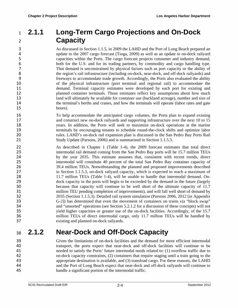
As described in Chapter 1 (Table 1-4), the 2009 forecast estimates that total direct 22 intermodal rail demand coming from the San Pedro Bay ports will be 15.7 million TEUs 23 by the year 2035. This estimate assumes that, consistent with recent trends, direct 24 intermodal will constitute 40 percent of the total San Pedro Bay container capacity of 25 39.4 million TEUs. Notwithstanding the planned and proposed improvements described 26 in Section 1.1.5.3, on-dock railyard capacity, which is expected to reach a maximum of 27 11.7 million TEUs (Table 1-4), will be unable to handle that intermodal demand. On-28 dock capacity in the ports will begin to be exceeded by the demand in the future (largely 29 because that capacity will continue to be well short of the ultimate capacity of 11.7 30 million TEU pending completion of improvements), and will fall well short of demand by 31 2035 (Section 1.1.5.3). Detailed rail system simulation (Parsons 2006, 2012 [in Appendix 32 G-2]) has determined that even the movement of containers on trains via “block swap” 33 and “unsorted” operations (see Section 5.2.1.2 for a discussion of these concepts) will not 34 yield higher capacities or greater use of the on-dock facilities. Accordingly, of the 15.7 35 million TEUs of direct intermodal cargo, only 11.7 million TEUs will be handled by 36 existing and planned on-dock railyards. 37
2.1.2 Near-Dock and Off-Dock Capacity 38
Given the limitations of on-dock facilities and the demand for more efficient intermodal 39 transport, the ports expect that near-dock and off-dock facilities will continue to be 40 needed to satisfy the Ports’ future intermodal needs related to: (1) overflow traffic due to 41 on-dock capacity constraints, (2) containers that require staging until a train going to the 42 appropriate destination is available, and (3) transload cargo. For these reasons, the LAHD 43 and the Port of Long Beach expect that near-dock and off-dock railyards will continue to 44 handle a significant portion of the intermodal traffic. 45
Chapter 2 Project Description Los Angeles Harbor Department
SCIG Recirculated Draft EIR 2-5 September 2012
The data in Table 1-4 show that under the 2009 forecast, approximately 4.1 million TEUs 1 of direct intermodal cargo will need to be handled by near- and off-dock railyards by the 2 year 2030 because of the shortfall of on-dock capacity. Both UP and BNSF at their 3 various intermodal facilities (see Section 1.1.3) also handle cargo other than direct 4 intermodal; specifically, the railroads handle imported cargo transloaded into domestic 5 containers and pure domestic cargo that has not gone through the ports. The growth of 6 these latter two types of cargo will put additional pressure on regional intermodal 7 capacity. The Port’s analysis indicates that at some point in the future, existing near- and 8 off-dock facilities as currently configured will not be able to accommodate future 9 volumes, given the expected growth in domestic and transloaded cargo. Accordingly, 10 additional lift capacity is needed for each railroad. The shortfall in capacity will be 11 addressed either by the proposed Project or by the modification of existing off-dock 12 railyards, as described in the No Project alternative (Section 5.3). 13
Historically, each of the two Class 1 railroads (i.e., UP and BNSF) has handled about 50 14 percent of the intermodal cargo from the ports. A basic assumption of the demand model 15 used in the cargo forecasts is that each of the Class 1 railroads will continue to compete 16 for market share, and each will continue to handle 50 percent of the projected demand, 17 including transloaded and domestic cargo. A review of the 2009 cargo forecast suggests 18 that the UP and BNSF at their various facilities will each handle about 2.0 million TEUs 19 of direct intermodal cargo (half of the projected 4.1 million TEUs of near/off-dock direct 20 intermodal cargo) in 2030. In addition to these volumes of direct intermodal cargo, each 21 railroad will handle half of the increased volumes of domestic and transloaded cargo. 22
It should be emphasized that these forecasts of cargo volumes are predicated upon the 23 following assumptions related to on-dock capacity: (1) all of the proposed/planned 24 POLA/POLB rail infrastructure (including on-dock railyards) is constructed more or less 25 in accordance with the projected timetables; (2) three labor shifts/day occur in the on-26 dock railyards; and (3) an ILWU labor rule modification allows some railcar movements 27 on adjacent tracks in the on-dock railyards for efficiency gains during loading/unloading 28 of stationary cars. To date none of these assumptions has been met. 29
This EIR takes a conservative approach: it analyzes the capacity the Project applicant 30 (BNSF) has applied for (a maximum of 2.8 million TEUs, or 1.5 million lifts at full 31 operation), and assumes that market factors would determine the actual demand that it 32 serves. The environmental analysis is based on the 2009 cargo forecast, which predicts 33 that actual demand for the proposed railyard would be less than 2.8 million TEUs, in 34 which case both Class 1 railroads would compete for their share of the market up to a 35 total of 4.1 million TEUs. 36
2.2 Existing Conditions 37
2.2.1 Regional Context 38
The Ports are located approximately 25 miles south of downtown Los Angeles. The port 39 complex is composed of approximately 80 miles of waterfront and 7,500 acres of land 40 and water, with approximately 500 commercial berths. The Ports include: automobile, 41 container, omni, lumber, and cruise ship terminals; liquid and dry bulk terminals; and 42 extensive transportation infrastructure for cargo movement by truck and rail. They also 43 accommodate commercial fishing, canneries, shipyards, and boat repair yards; provide 44 slips for 6,000 pleasure craft, sport fishing boats, and charter vessels; and support 45
Chapter 2 Project Description Los Angeles Harbor Department
SCIG Recirculated Draft EIR 2-6 September 2012
community and educational facilities such as a public swimming beach, the Boy/Girl 1 Scout Camp, the Cabrillo Marine Aquarium, the Maritime Museum, and public fishing 2 piers. The Ports are adjacent to the community of San Pedro to the west, the Wilmington 3 community and the City of Carson to the north, the City of Long Beach to the east, and 4 the Pacific Ocean to the south. 5
The proposed Project site was chosen by BNSF through a screening and analysis process 6 (see Section 1.1.1). It is located in a largely industrial area east of the Wilmington 7 community of the City of Los Angeles, with portions in the cities of Carson and Long 8 Beach, approximately four miles north of the Ports. The general area is characterized by 9 heavy industry (refineries), goods-handling facilities (warehouses, trucking facilities, 10 railroads, and related commercial and industrial establishments), light commercial uses, 11 and residential and institutional uses. Major highways including Interstate-405, Interstate-12 710, Alameda Street, Pacific Coast Highway, and State Routes 47 and 103 (Terminal 13 Island Freeway) are all within two miles of the proposed Project site. 14
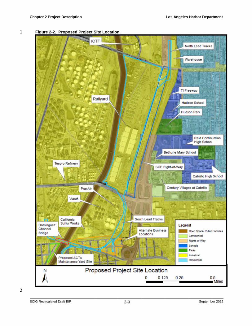
2.2.2 Project Setting 15
The proposed Project has three major components: the railyard itself (including the North 16 Lead Tracks), the alternate sites offered for some businesses, and the South Lead Track 17 (Figure 2-2). The site of the railyard component of the proposed Project is located in an 18 area that is zoned for heavy industrial uses, bounded generally by Sepulveda Boulevard to 19 the north, Pacific Coast Highway to the south, the Dominguez Channel to the west, and the 20 Terminal Island Freeway to the east. At present, the site is devoted to warehousing and 21 transloading (see Section 1.1.3.2 for a description of transloading); container and truck 22 maintenance, servicing, and storage; rail service; miscellaneous industrial uses; access 23 roads, an SCE transmission line right of way (part of which is leased to trucking 24 businesses California Cartage and Three Rivers Trucking), the former UP San Pedro 25 Subdivision rail line, and an equipment storage area leased from the City of Long Beach. 26
The site is surrounded by a variety of land uses (see Section 3.8 for more detail) that 27 include industrial facilities to the north, west, and south, and the Terminal Island Freeway 28 to the east, beyond which are residences, schools, churches, health care facilities, and 29 light commercial and institutional uses (Figure 2-2). Specifically, the area to the north of 30 the railyard site, across Sepulveda Boulevard, consists of the existing ICTF, operated by 31 UP and similar in function to the proposed Project. To the west, across the Dominguez 32 Channel, is a large refinery, owned by Tesoro Corporation, that processes crude oil to 33 produce petroleum products. To the south of the Pacific Coast Highway, in the alternate 34 sites for businesses and South Lead Track component of the proposed Project (Figure 2-35 2), are a series of container staging and maintenance facilities, a sulfur processing 36 facility, a chemical tank farm, a compressed/cryogenic gases facility, and various other 37 industrial operations. The area to the east, across the Terminal Island Freeway within the 38 West Long Beach area, is predominantly a single-family residential area, but also 39 includes two high schools, a middle school, two elementary schools, two child care 40 centers, a supportive housing complex (Century Villages at Cabrillo), a small medical 41 center, commercial businesses, and several warehousing and light industrial facilities 42 (Figure 2-2). 43
Additional support areas connected to the railyard component of the proposed Project 44 would accommodate the north and south lead tracks (see Section 2.4.2 for a description 45 of these project elements). The North Lead Tracks would extend through the SCE 46 corridor currently occupied by Three Rivers Trucking and connect to an existing rail line 47
Chapter 2 Project Description Los Angeles Harbor Department
SCIG Recirculated Draft EIR 2-7 September 2012
(formerly known as the UPRR San Pedro Branch) jointly owned by the LAHD and Port of 1 Long Beach. The north lead track would extend approximately 1,000 feet to the north from 2 the existing rail bridge at Sepulveda Boulevard. Adjacent to the west of the rail line is the 3 ICTF. To the north is the continuation of the existing rail line which extends beyond I-405. 4 To the east is an industrial warehouse and single-family residences within the West Long 5 Beach area. To the south is the continuation of the SCE corridor, including the portion that 6 is occupied by California Cartage. 7
The South Lead Track area and the alternate sites being offered to several businesses 8 (Section 2.4.2) are located generally south of Pacific Coast Highway (PCH), west of the 9 Terminal Island Freeway, north of a rail right-of-way and Southern Pacific Drive, and 10 east of the Alameda Corridor. This area consists of land owned and/or occupied by Fast 11 Lane Transportation (terminal services, cargo logistics, and container storage/repair) and 12 a subtenant (California Carbon: carbon production services), a portion of Caltrans right-13 of-way on PCH, an Alameda Corridor Transportation Authority (ACTA) maintenance 14 facility, vacant parcels, and railroad right-of-way connecting to the Alameda Corridor. To 15 the west is an industrial area occupied by Vopak (liquid bulk logistics), Praxair (industrial 16 gases processing facility), and California Sulfur Works (sulfur processing). To the north 17 is Pacific Coast Highway. To the east are additional areas used for container storage by 18 Fast Lane Transportation, and vacant parcels. To the south are several auto salvage 19 businesses, light industrial uses, and vacant parcels. 20
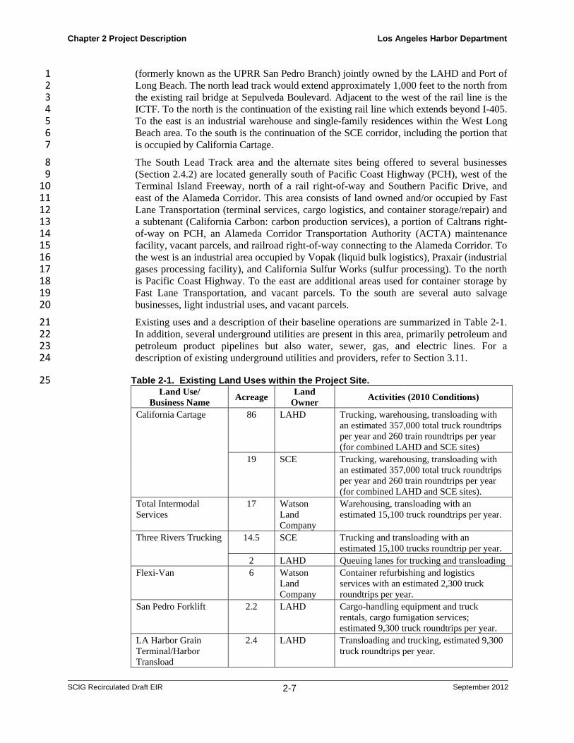
Existing uses and a description of their baseline operations are summarized in Table 2-1. 21 In addition, several underground utilities are present in this area, primarily petroleum and 22 petroleum product pipelines but also water, sewer, gas, and electric lines. For a 23 description of existing underground utilities and providers, refer to Section 3.11. 24
Table 2-1. Existing Land Uses within the Project Site. 25 Land Use/
Business Name Acreage
Land Owner
Activities (2010 Conditions)
California Cartage 86 LAHD Trucking, warehousing, transloading with an estimated 357,000 total truck roundtrips per year and 260 train roundtrips per year (for combined LAHD and SCE sites)
19 SCE Trucking, warehousing, transloading with an estimated 357,000 total truck roundtrips per year and 260 train roundtrips per year (for combined LAHD and SCE sites).
Total Intermodal Services
17 Watson Land Company
Warehousing, transloading with an estimated 15,100 truck roundtrips per year.
Three Rivers Trucking 14.5 SCE Trucking and transloading with an estimated 15,100 trucks roundtrip per year.
2 LAHD Queuing lanes for trucking and transloading Flexi-Van 6 Watson
Land Company
Container refurbishing and logistics services with an estimated 2,300 truck roundtrips per year.
San Pedro Forklift 2.2 LAHD Cargo-handling equipment and truck rentals, cargo fumigation services; estimated 9,300 truck roundtrips per year.
LA Harbor Grain Terminal/Harbor Transload
2.4 LAHD Transloading and trucking, estimated 9,300 truck roundtrips per year.

Chapter 2 Project Description Los Angeles Harbor Department
SCIG Recirculated Draft EIR 2-8 September 2012
Land Use/ Business Name
Acreage Land
Owner Activities (2010 Conditions)
Fast Lane Transportation
5.5 Hansen Aggregates/ Fast Lane
Terminal services, cargo logistics, and container storage/repair with an estimated 107,000 truck roundtrips per year b.
Pacific Coast Highway (PCH) Right-of-Way
6 Caltrans PCH grade separation right of way.
ACTA Maintenance Yard
10 LAHD/ POLB
Maintenance yard for materials storage with office space.
Access roads/vacant property
14.3 LAHD Ingress/egress for existing businesses.
Tesoroa 0.5 Tesoro (prev Texaco)
Oil refinery
Vacant parcels 0.1 Los Angeles County, Equilon, Harbor Oil Company, BNSF
Vacant parcels in the South Lead Track area along railroad right-of-way connecting to the Alameda Corridor.
a) Small amounts of land would be acquired by BNSF from these businesses, but because the proposed Project would not change their operations in any way, these businesses are not included in the analyses in this EIR.
b) Activity is for all 30 acres of land controlled by Fast Lane, which includes acreage outside but adjacent to the proposed Project site, but does not include Fast Lane’s subtenant, California Carbon, which would be unaffected by the proposed Project.
1
2
1
2
Chapter 2
SCIG Recirc
Figure
Project Descr
culated Draft EIR
e 2-2. Propos
ription
R
sed Project SSite Location
2-9
n.
Los Angeles Harbor Depar
Septemb
rtment
er 2012

Chapter 2 Project Description Los Angeles Harbor Department
SCIG Recirculated Draft EIR 2-10 September 2012
2.3 Project Objectives 1
The need for additional rail facilities to support current and expected cargo volumes, 2 particularly intermodal container cargo, was identified in several recent studies (see 3 Section 2.1.2). As discussed in those studies, even after maximizing the potential on-4 dock rail yards, the demand for intermodal rail service creates a shortfall in rail yard 5 capacity (Parsons, 2006). Those studies specifically identified a need for additional near-6 dock intermodal capacity to complement and supplement existing, planned, and potential 7 on-dock facilities (Parsons, 2006). Furthermore, as discussed in Section 1.1, the need for 8 more efficient, and hence more economical and less polluting, rail-based cargo 9 transportation has prompted state and regional planning agencies to encourage the 10 development of additional near-dock rail facilities. 11
As described in Section 1.1.5.4, near-dock rail yards provide a necessary complement to 12 on-dock railyards because they have specific logistical advantages, including the ability 13 to combine cargo from various marine terminals and build trains that efficiently transport 14 cargo to specific destinations throughout the country. In addition, near-dock facilities are 15 able to provide needed intermodal capacity with greatly reduced trucking impacts, 16 compared to the more remote off-dock facilities. Any cargo that is moved by train from 17 the Ports benefits the overall transportation system by reducing the truck trips and total 18 truck mileage along with the associated impacts. Movement of containers by train has 19 been determined to be from three to nearly six times as fuel efficient as by truck on a ton-20 mile basis, which reduces air emissions by a similar amount (Federal Railroad 21 Administration, 2009). However, near-dock usage has remained relatively flat due to the 22 availability of only one near-dock rail yard (the ICTF operated by UP), causing much 23 intermodal cargo to be drayed over 20 miles to the railyards near downtown Los Angeles. 24
LAHD has expressed its intent to promote increased use of rail in general, and near-dock 25 rail facilities in particular, as indicated in its Rail Policy (Section 2.1.1), and to comply 26 with the Mayor of Los Angeles’ goal for the LAHD to increase growth while mitigating 27 the impacts of that growth on the local communities and the Los Angeles region by 28 implementing pollution control measures, including the elements of the CAAP specific to 29 the proposed Project. Similarly, the California EPA has recommended the SCIG project 30 as a preliminary candidate in the 2007 Goods Movement Action Plan, and the Southern 31 California Association of Governments (SCAG) has identified the SCIG project as potentially 32 playing a key role in addressing the growth of high-density truck traffic in its 2008 Regional 33 Transportation Plan Goods Movement Report (SCAG, 2008). 34
The primary objective and fundamental purpose of the proposed Project is to provide an 35 additional near-dock intermodal rail facility serving the San Pedro Bay Port marine 36 terminals that would meet current and anticipated containerized cargo demands, provide 37 shippers with comparable intermodal options, incorporate advanced environmental 38 controls, and help convert existing and future truck transport into rail transport, thereby 39 providing air quality and transportation benefits. 40
The following specific project objectives accomplish the primary objective and 41 fundamental purpose: 42
1. Provide an additional near-dock intermodal rail facility that would: 43
a) Help meet the demands of current and anticipated containerized cargo from the 44 various San Pedro Bay port marine terminals, and 45
Chapter 2 Project Description Los Angeles Harbor Department
SCIG Recirculated Draft EIR 2-11 September 2012
b) Combine common destination cargo “blocks” and/or unit trains collected from 1 different San Pedro Bay Port marine terminals to build trains for specific destinations 2 throughout the country. 3
2. Reduce truck miles traveled associated with moving containerized cargo by providing a 4 near-dock intermodal facility that would: 5
a) Increase use of the Alameda Corridor for the efficient and environmentally sound 6 transportation of cargo between the San Pedro Bay Ports and destinations both inland 7 and out of the region, and 8
b) Maximize the direct transfer of cargo from port to rail with minimal surface 9 transportation, congestion and delay. 10
3. Provide shippers carriers, and terminal operators with comparable options for Class 1 11 railroad near-dock intermodal rail facilities. 12
4. Construct a near-dock intermodal rail facility that is sized and configured to provide 13 maximum intermodal capacity for the transfer of marine containers between truck and 14 rail in the most efficient manner. 15
5. Provide infrastructure improvements consistent with the California Goods Movement 16 Action Plan. 17
2.4 Proposed Project 18
2.4.1 Summary 19
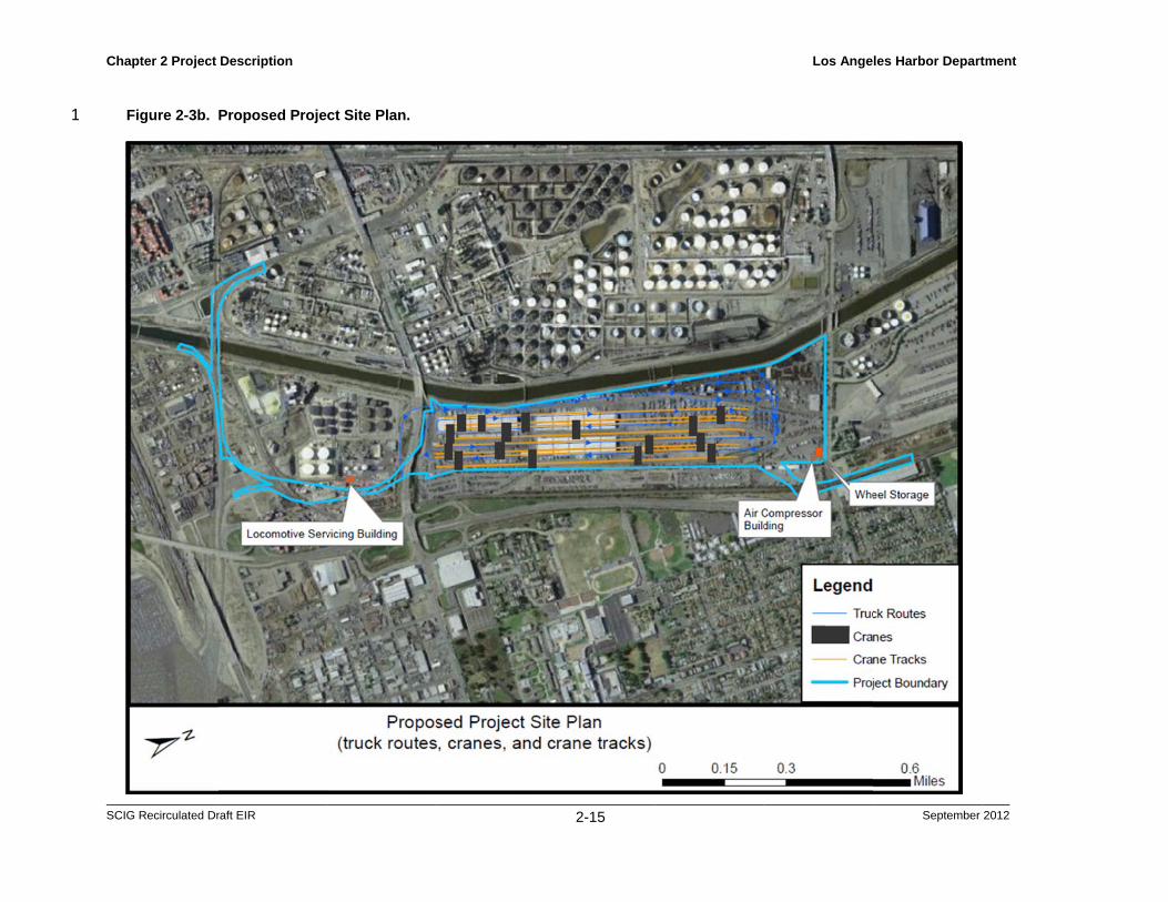
The proposed Project would include construction of a new, state-of-the-art, near-dock 20 intermodal railyard (Figures 2-3a and 2-3b), located approximately four miles to the 21 north of the Ports and connected to the Alameda Corridor. The proposed Project features 22 and operations are summarized in Table 2-2. It is estimated that the proposed Project 23 would handle approximately 570,800 TEUs in its first year of operation in 2016 and 24 increase to its maximum capacity of 2.8 million TEUs, as proposed by the project 25 applicant, by 2035. Construction would take approximately 36 months to complete (2013 26 through 2015), including crane installation that would occur in 2015 (more detail is 27 provided below). The proposed Project would generate approximately 93 operational jobs 28 starting in 2016 and 450 jobs by full build-out. The SCIG facility would be operated by 29 BNSF under a new lease from LAHD, assumed for the purposes of this EIR to be 50 30 years. 31
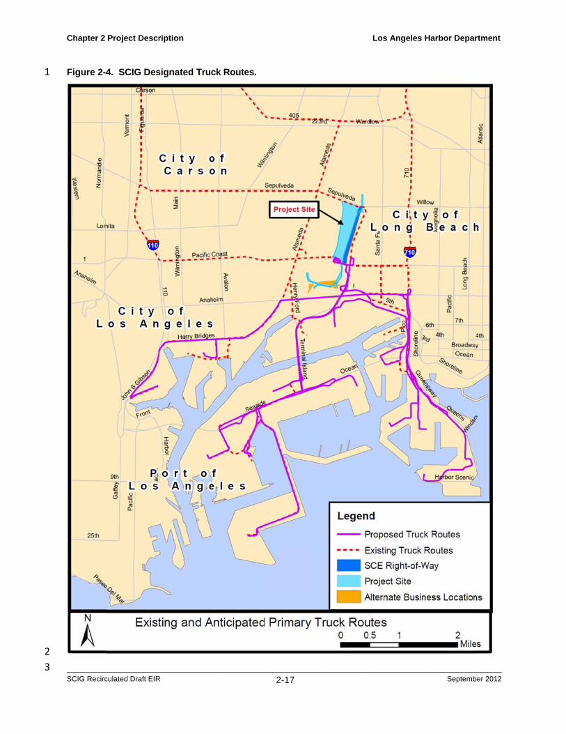
Because of its location approximately 4 miles from the ports, the proposed Project would 32 eliminate a portion (estimated at 95 percent; see Section 3.10 for details of this 33 assumption) of existing and future intermodal truck trips between the ports and the 34 BNSF’s Hobart/Commerce Yard (hereafter, Hobart Yard), approximately 24 miles north 35 of the ports in the cities of Los Angeles, Vernon, and Commerce, by diverting them to the 36 proposed SCIG facility. As a result, truck traffic on I-710 (the route that trucks currently 37 take to reach the Hobart facility) would be reduced by the number of trucks diverted to 38 the proposed Project. All truck trips between the ports and the SCIG facility would be 39 required to use designated truck routes to avoid local neighborhoods and sensitive 40 receptors. Figure 2-4 illustrates the current primary local truck routes between port 41 facilities and the major transportation corridors leading to BNSF’s Hobart Yard 42 (red/dashed line), and the designated routes between port facilities and the proposed 43 Project (purple/solid line). These changes in traffic patterns, which are evaluated in this 44 EIR, are being proposed in order to shorten a portion of the truck trips that move containers 45 between ships and railcars, thereby easing traffic conditions on local freeways and reducing 46

Chapter 2 Project Description Los Angeles Harbor Department
SCIG Recirculated Draft EIR 2-12 September 2012
regional air quality impacts. The proposed Project would provide direct access to the 1 Alameda Corridor and enable the Alameda Corridor to reach its potential in terms of train 2 capacity, thereby further realizing the significant benefits that already result from its use. The 3 estimated number of truck trips and train trips associated with the proposed SCIG Project is 4 also summarized in Table 2-2. 5
The proposed Project incorporates a number of pollution-reduction features in order to 6 promote the goals of the CAAP (see Section 1.6.1). In addition, elements and 7 requirements of the Memorandum of Understanding (MOU) between the BNSF Railroad 8 and the California Air Resources Board (CARB) would be implemented as part of the 9 proposed Project. The proposed Project would incorporate a state-of-the-art logistics 10 system that BNSF represents would significantly increase the efficiency of truck 11 operations by substantially reducing turnaround times, waiting times, and the proportion 12 of trucks making empty trips. The railyard is designed to reduce the number of train 13 movements needed to assemble and disassemble trains, thereby reducing locomotive 14 emissions, and would employ a new type of electric-powered gantry crane that would 15 generate substantially less emissions than conventional intermodal cranes. The project 16 applicant and LAHD anticipate that additional control technologies would be 17 implemented in future years as they are developed through the CAAP and regional and 18 state-wide initiatives, but such technologies (e.g., fuel-cell-powered trucks or hostlers, 19 non-wheeled container movement systems, non-diesel locomotives) are either not yet 20 available or not yet fully demonstrated at this time. 21
In response to the public comments received on the Notice of Preparation, BNSF has also 22 offered to enhance the following elements: 23
The operating contractor would be required to give qualified local residents priority 24 for all new job offers at SCIG; 25
BNSF would fund a workforce training program in partnership with local institutions 26 to assist area residents in obtaining these jobs; 27
Trucking companies contracted to the facility would be required to operate model 28 year 2007 or newer trucks; 29
Trucks serving the facility would be limited to specific non-residential truck routes and 30 be equipped with global positioning system (GPS) recording devices for compliance 31 monitoring. 32
This document analyzes only impacts that arise as a result of the proposed Project (Public 33 Resources Code 21065 and CEQA Guidelines 15378(a). It therefore does not analyze 34 activities at the Hobart Yard or the Sheila Commerce Mechanical Repair Facility at 6300 35 Sheila Street, in Commerce (the Sheila facility). Whether or not SCIG is built, domestic 36 traffic (i.e., traffic from non-Port sources) and transloaded cargos to Hobart will likely 37 continue to grow at a rate related to market demand in the United States economy. The 38 distribution of the domestic traffic coming to Hobart indicates that, although some traffic 39 does travel north on the I-710 from the Port area, the domestic truck traffic both to and 40 from Hobart is multidirectional. Because that growth is not dependent on SCIG being 41 built, it is not appropriate to evaluate that growth as part of SCIG, or any truck trips not 42 going to SCIG. The same is true for regional locomotive traffic. This approach is 43 supported by BNSF’s representation that they have no current plans to move intermodal 44 business from other regional facilities to Hobart in the event that SCIG is built (BNSF, 45 2012). 46
47

Chapter 2 Project Description Los Angeles Harbor Department
SCIG Recirculated Draft EIR 2-13 September 2012
1
The Sheila facility is a locomotive mechanical shop that primarily supports operations at 2 the nearby BNSF Hobart Railyard. Operations at the Sheila facility include, among other 3 things, locomotive maintenance. This facility would continue to service generally the 4 same volume of locomotives moving domestic and international cargo operating at the 5 SCIG and Hobart railyards as it would if SCIG were not built. 6
7

C
S
1 2
Chapter 2 Project
SCIG Recirculated Dr
Figure 2-3a.
Description
raft EIR
Proposed Projecct Site Plan.
2-14
Los Angelees Harbor Departm
September
ment
2012
C
S
1
Chapter 2 Project
SCIG Recirculated Dr
Figure 2-3b.
Description
raft EIR
Proposed Project Site Plan.
2-15
Los Angeles Harbor Depart
September
tment
2012

Chapter 2 Project Description Los Angeles Harbor Department
SCIG Recirculated Draft EIR 2-16 September 2012
Table 2-2. Summary of Proposed SCIG Railyard Features and Operations. 1 Element Description
Railroad tracks
12 loading 2 support North lead tracks South lead tracks 2 service tracks
Electric-powered rail-mounted gantry cranes (RMG cranes)
10 loading 10 stacking 90-100 feet in height Regenerative braking technology
Cargo-Handling Equipment
10 Liquefied Natural Gas (LNG)-fueled or equivalent technology yard hostlers
One diesel-powered railcar wheel changer
Drayage trucks
On-road trucks meeting 2007 EPA on-road standards
Compliant with 2010 CAAP Use of designated truck routes,
monitored by GPS
Locomotives
Low-emitting switching locomotive engines
Line-haul locomotives meeting 1998 SCAQMD MOU, 2005 CARB MOU and EPA linehaul locomotive emissions standards
Ultra-low-sulfur diesel (ULSD) fuel Automatic idling reduction devices
Lighting
Forty high-mast light poles, low-glare crane lighting, perimeter lighting, and roadway lighting.
Automation and efficient directional and shielding features
Truck trips per year (one-way) 1, 2 0.4 million in 2016 2.0 million by 2035 (at full capacity)
Train trips per year (round trips)3 720 trips in 2016 2,880 trips by 2035 (at full capacity)
Throughput (TEUs/lifts, direct intermodal cargo only)
570,808/308,545 annually in 2016 2.8 million/1.5 million annually by
2035
Containers per day 857 in 2016 4,167 by 2035
Employees 93 in 2016 450 by 2035
1) The number of trucks is greater than the number of containers to allow for a proportion of “bobtail” (i.e., unloaded) trips in cases where a truck is not loaded in both directions. The ratio of truck moves to containers is 1.33:1.
2) Total trips; the number of trips in each direction would be half of the total. 3) A train is assumed to carry 260 containers; the number of train moves per day would be
double the number of round trips (i.e., one inbound move, one outbound move). 2
1
2
3
Chapter 2
SCIG Recirc
Figure 2-
Project Descr
culated Draft EIR
4. SCIG Des
ription
R
signated Trucck Routes.
2-17
Los Angeles Harbor Depar
Septemb
rtment
er 2012
Chapter 2 Project Description Los Angeles Harbor Department
SCIG Recirculated Draft EIR 2-18 September 2012
2.4.2 Proposed Project Elements 1
This section describes the physical elements of the proposed Project. Construction 2 activities and phasing are described in Section 2.4.3 and operational activities are 3 described in Section 2.4.4. 4
2.4.2.1 Property Acquisition and Disposition of Businesses 5
The proposed Project requires acquisition or lease of privately-owned properties by the 6 project applicant BNSF and a new lease for the LAHD properties that would result in 7 certain terminations of existing leaseholds and the movement or displacement of 8 businesses occupying those properties. As a result, the LAHD has offered alternate sites 9 that some businesses could elect to move to as part of the proposed Project. However, 10 the LAHD would not purchase any new properties and would not be responsible for 11 constructing any new improvements at the alternate sites. In the case of the ACTA 12 maintenance yard, however, the LAHD would be responsible for moving its operations to 13 a new site as further discussed below. 14
Of the existing businesses within the proposed Project site (Table 2-3), only three (a 15 portion of California Cartage, a portion of Fast Lane Transportation, and the ACTA 16 maintenance yard) are assumed to move to alternate sites on nearby properties for the 17 purposes of this analysis. In the case of California Cartage and Fast Lane, this assumption 18 is conservative because it accounts for the businesses that have relatively high activity 19 levels and large operating footprints within and adjacent to the proposed Project site. 20 However, the final selection of businesses that would ultimately occupy the alternate sites 21 would be subject to real estate negotiations that are beyond the scope of this EIR. All 22 other remaining businesses within the proposed Project site on LAHD properties would 23 have their leases non-renewed/terminated and those on non-LAHD properties would be 24 removed upon acquisition of the properties by BNSF. The displaced businesses for which 25 no alternate locations were identified as part of the proposed Project or during the time of 26 this analysis are assumed to move to other compatible areas in the general port vicinity as 27 part of their own business operations and plans. Potential future locations identified 28 would be subject to separate environmental review by the lead agency with jurisdiction 29 over a particular site. This issue is considered in more detail in Chapter 3.8 Land Use. 30
Potential alternate locations for a portion of Fast Lane Transportation, the ACTA 31 maintenance yard, and a portion of California Cartage operations are depicted in Figure 32 2-5. The ACTA maintenance yard would move to an approximately 4-acre site just west 33 of the Dominguez Channel. This analysis assumes that Fast Lane would move a portion 34 of its operations from within the area of the South Lead Track to an approximate 4.5-acre 35 site just southwest of its current location. Fast Lane would continue to maintain its 36 operations (including the subtenant California Carbon) on the remaining parcels it owns 37 or occupies outside of the South Lead Track area, estimated at approximately 24.5 acres; 38 those parcels are not part of the proposed Project. The 4.5-acre site that Fast Lane is 39 assumed to occupy includes access roads and a rail line. In this analysis the roads are 40 assumed to remain active and in use in order that Fast Lane and other businesses in the 41 immediate vicinity have access to their sites. The rail line, which connects the Long 42 Beach Lead Track to the San Pedro Branch, would also remain active. These features 43 could affect the amount of land available for business operations within the site as a 44 whole. However, this analysis assumes, in order to be conservative, that the maximum 45 amount of land would be 4.5 acres. 46
Chapter 2 Project Description Los Angeles Harbor Department
SCIG Recirculated Draft EIR 2-19 September 2012
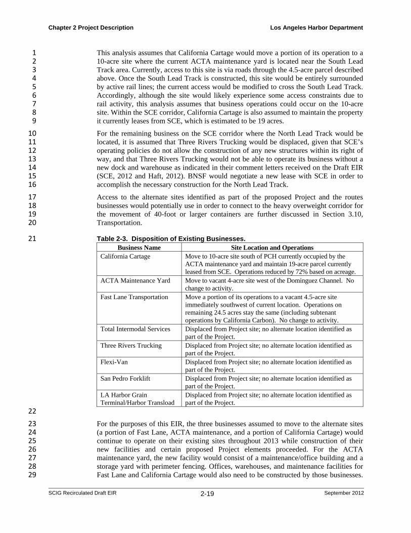
This analysis assumes that California Cartage would move a portion of its operation to a 1 10-acre site where the current ACTA maintenance yard is located near the South Lead 2 Track area. Currently, access to this site is via roads through the 4.5-acre parcel described 3 above. Once the South Lead Track is constructed, this site would be entirely surrounded 4 by active rail lines; the current access would be modified to cross the South Lead Track. 5 Accordingly, although the site would likely experience some access constraints due to 6 rail activity, this analysis assumes that business operations could occur on the 10-acre 7 site. Within the SCE corridor, California Cartage is also assumed to maintain the property 8 it currently leases from SCE, which is estimated to be 19 acres. 9
For the remaining business on the SCE corridor where the North Lead Track would be 10 located, it is assumed that Three Rivers Trucking would be displaced, given that SCE’s 11 operating policies do not allow the construction of any new structures within its right of 12 way, and that Three Rivers Trucking would not be able to operate its business without a 13 new dock and warehouse as indicated in their comment letters received on the Draft EIR 14 (SCE, 2012 and Haft, 2012). BNSF would negotiate a new lease with SCE in order to 15 accomplish the necessary construction for the North Lead Track. 16
Access to the alternate sites identified as part of the proposed Project and the routes 17 businesses would potentially use in order to connect to the heavy overweight corridor for 18 the movement of 40-foot or larger containers are further discussed in Section 3.10, 19 Transportation. 20
Table 2-3. Disposition of Existing Businesses. 21 Business Name Site Location and Operations
California Cartage Move to 10-acre site south of PCH currently occupied by the ACTA maintenance yard and maintain 19-acre parcel currently leased from SCE. Operations reduced by 72% based on acreage.
ACTA Maintenance Yard Move to vacant 4-acre site west of the Dominguez Channel. No change to activity.
Fast Lane Transportation Move a portion of its operations to a vacant 4.5-acre site immediately southwest of current location. Operations on remaining 24.5 acres stay the same (including subtenant operations by California Carbon). No change to activity.
Total Intermodal Services Displaced from Project site; no alternate location identified as part of the Project.
Three Rivers Trucking Displaced from Project site; no alternate location identified as part of the Project.
Flexi-Van Displaced from Project site; no alternate location identified as part of the Project.
San Pedro Forklift Displaced from Project site; no alternate location identified as part of the Project.
LA Harbor Grain Terminal/Harbor Transload
Displaced from Project site; no alternate location identified as part of the Project.
22
For the purposes of this EIR, the three businesses assumed to move to the alternate sites 23 (a portion of Fast Lane, ACTA maintenance, and a portion of California Cartage) would 24 continue to operate on their existing sites throughout 2013 while construction of their 25 new facilities and certain proposed Project elements proceeded. For the ACTA 26 maintenance yard, the new facility would consist of a maintenance/office building and a 27 storage yard with perimeter fencing. Offices, warehouses, and maintenance facilities for 28 Fast Lane and California Cartage would also need to be constructed by those businesses. 29

Chapter 2 Project Description Los Angeles Harbor Department
SCIG Recirculated Draft EIR 2-20 September 2012
The structures would likely be of modern steel and/or concrete construction and are 1 assumed generally to resemble the existing structures in size and appearance, except that 2 the California Cartage warehouses would be smaller, more modern, and more efficient 3 structures than the existing warehouses, given the large reduction in property acreage and 4 the fact that the existing California Cartage warehouses are very large World War II-era 5 structures that have been adapted to a truck-based transloading operation. Maintenance 6 facilities could include above-ground storage tanks for vehicle fuel. In 2014, it is 7 assumed those businesses would begin operation on their new sites and in combination 8 with their existing sites that would remain in the case of California Cartage and Fast 9 Lane, as described in Table 2-3, while the remaining proposed Project elements were 10 constructed. 11
This EIR assumes that the businesses that move a portion or all of their operations to 12 alternate locations would operate at the same levels on their new sites as they would have 13 on their existing sites. In the case of California Cartage, LAHD has requested information 14 regarding how California Cartage intends to maintain or scale down their operations at 15 the alternate location in combination with the SCE parcel they lease. At the time of the 16 analysis in the original Draft EIR, California Cartage had provided some information 17 related to truck parking but none related to transloading operations (California Cartage 18 communication, 2009). In their comment letter on the Draft EIR California Cartage stated 19 that they would not be able to conduct a transloading operation on the 10-acre site and 20 that it could only be used for storage and maintenance (Curry, 2012). In order to be 21 conservative, however, this analysis assumes that a transloading operation or operation of 22 a similar intensity could be conducted on the 10-acre parcel and the SCE parcel. 23 Accordingly, the transloading activity at their current 105-acre site is assumed to be 24 reduced by approximately 72 percent based on the available acreage at the new 10-acre 25 alternate location and the existing 19-acre SCE parcel. This is a conservative assumption 26 because it assumes that California Cartage would continue to provide some transloading 27 (including parking) services at the alternate location and on the SCE parcel if permitted 28 by SCE in accordance with their land use policies. California Cartage’s access to the 19-29 acre SCE parcel would be through a new driveway and access road from Sepulveda 30 Boulevard through the SCE right of way which is further discussed in Section 2.4.2.5. 31 BNSF would negotiate a new lease with SCE in order to accomplish the necessary 32 roadway improvements. 33
Minor property acquisitions by BNSF in the area of the proposed South Lead Tracks 34 would also be necessary in order to provide adequate space for the track alignments as 35 well as construction staging areas. None of those acquisitions would necessitate moving 36 businesses, as all involve small, vacant parcels of land. Those businesses include Tesoro, 37 Praxair, and rights of way owned by Los Angeles County, Equilon, and Harbor Oil 38 Company (see Table 2-1). 39
40

1
2 3
4
5 6 7 8 9 10
11 12 13 14 15 16 17
Chapter 2
SCIG Recirc
Figure 2-
2.4.2.2
Project Descr
culated Draft EIR
5. Potential
NewThe SCthe trathree mtrain o105,00The ra
Loaditracks,ends otracks separaon eithyard t
ription
R
Alternate Sit
w RailyardCIG facility w
ains that woulmajor sets ofoperations (F00 feet of tracailyard would
ng (Strip) T, known as st
of the railyardwould run
ated by a paveher side of theractors, and
tes for Busin
d would be cend move conta
f tracks (two Figure 2-3a).ck (including
also include
Tracks. The trip tracks, ead to lead trackdown the ceed container se tracks woulcranes that w
2-21
nesses.
tered around ainers in and osets of loadiThese tracksthe south leada number of s
train loadingach approximks providing aenter of the staging and stld be paved wwould load a
a railyard thaout of the poring tracks, ons would comd tracks, see bsupport eleme
g and unloadmately 4,000 f
access to the facility in twtorage area. T
with concrete and unload th
Los Angeles
at would conrt area. The rane of storage
mprise a totalbelow) and atents as descri
ding area wofeet long andregional rail
wo groups oThe area betwor asphalt to he trains. Th
Harbor Depar
Septemb
sist of trackagailyard wouldtracks) to su
l of approximt least 37 swiibed below.
ould consistd connected at
network. Theof six tracks ween the track
support the trhe rails thems
rtment
er 2012
ge for d have upport mately itches.
of 12 t both e strip each,
ks and rucks, selves

Chapter 2 Project Description Los Angeles Harbor Department
SCIG Recirculated Draft EIR 2-22 September 2012
would rest on concrete ties set in crushed rock known as ballast, which would represent a 1 permeable surface. 2
Storage Tracks. Two parallel 4,000-foot-long storage tracks would run along the eastern 3 edge of the railyard, parallel to the existing ports-owned San Pedro Branch tracks, from 4 one of the south lead tracks to the north lead tracks. 5
Service Tracks. Two 1,300-foot-long tracks for minor servicing of locomotives and 6 rolling stock would be located in the southern part of the railyard site. These tracks would 7 be connected to the south lead tracks. As used in this EIR, the terms “service” and 8 “servicing” when used in connection with locomotives refer to minor upkeep activities, 9 such as fueling via mobile fuel truck, cleaning (e.g., wiping windows, removing trash, 10 etc.) and resupplying (e.g., restocking of towels, napkins, water, etc.) of locomotives, 11 while the term “maintenance” refers to major locomotive repairs, load testing, and 12 periodic maintenance of parts, components, mechanical and electrical systems as needed 13 and as required by the Federal Railroad Administration. At times, this EIR may refer to 14 “major servicing” or “major service;” in such instances, the types of activities referred to 15 by such terms are the equivalent of what is meant by “maintenance.” There would be no 16 locomotive maintenance occurring on site; major service and maintenance would be 17 performed at BNSF’s Sheila Commerce Mechanical Repair Facility, located at 6300 18 Sheila Street in Commerce near the Hobart Yard east of downtown Los Angeles. 19
Container Loading and Stacking Areas. Three-lane paved areas adjacent and parallel 20 to the strip tracks would be used for trucks to come alongside the trains for loading and 21 unloading. Partially-paved areas for container staging would be located between the two 22 sets of strip tracks, on the west side of the western strip tracks, and in the northern portion 23 of the site. The staging areas would be used as temporary transfer points between trucks 24 and the intermodal trains. The areas near the tracks would be used for stacking containers 25 up to five high (40-foot height). The northern area would be used for truck parking and 26 for storing chassis-mounted containers ready for pickup by trucks. 27
A portion of the facility in the southwest corner of the site that is designated to 28 accommodate refrigerated containers would be equipped with electrical plugs so that the 29 diesel-powered or dual diesel/electric-powered portable refrigeration units (TRUs) could 30 be switched off while the containers are in the railyard, thereby reducing emissions. 31 Refrigerated containers are expected to constitute approximately one percent of the 32 containers handled at the facility. 33
Cargo-Handling Equipment. The railyard would have 20 electric-powered RMG 34 cranes, ten servicing each set of strip tracks (Figure 2-3a and b). These cranes would be 35 of a new design not currently in use at California intermodal facilities (but currently in 36 operation at a new BNSF intermodal facility in Memphis, TN), and would move on steel 37 wheels along steel tracks. Ten of the cranes, which would all be operational on opening 38 day, would be 89 feet high and 210 feet wide, enough to span a group of six strip tracks 39 (rather than the two tracks conventional cranes span), the adjacent truck lanes, and half of 40 the adjacent container staging area. This span would be due to extensions of lifting 41 components of the cranes that would be cantilevered out over the last two tracks on one 42 side and half of the stacking area on the other. These cranes, which would run on their 43 own rails set 120 feet apart, would load and unload the railcars and chassis. The other ten 44 cranes would be 98 feet high and 169 feet wide, enough span the truck lane on the other 45 side of each set of strip tracks and the entire adjacent container stacking area, and would 46 manage the stacks of containers. The cantilevered extensions of these stacking cranes, 47 which would operate on rails set 102 feet apart, would be able to pass over the shorter 48

Chapter 2 Project Description Los Angeles Harbor Department
SCIG Recirculated Draft EIR 2-23 September 2012
RMGs used to load the trains (Figure 2-3a), thereby maximizing the efficiency of the 1 stacking and loading/unloading operations. The stacking cranes would be installed over a 2 period of several years, beginning in 2015, as throughput increased. 3
The use of electric-powered, rail-mounted gantry cranes rather than the diesel-powered, 4 rubber-tired gantry cranes (RTGs) used in marine terminals and intermodal rail yards is 5 consistent with the terms of the CAAP. The cranes would be a modern design that would 6 include regenerative braking mechanisms that would return power to the grid during 7 braking and the container lowering phase of operations. 8
A small proportion of the chassis would be drayed between the chassis storage areas and 9 the strip tracks by up to 10 yard hostlers (hostlers are tractors used to haul chassis-mounted 10 containers around inside the facility). The hostlers would be equipped with LNG-fueled or 11 equivalent engines that would not be a source of diesel emissions. 12
A small, rubber-tired, wheel change machine would be used to change out faulty railcar 13 wheels. This piece of equipment would have a clean diesel engine, consistent with the 14 terms of the CAAP. The facility would also include 14 gasoline-powered service support 15 vehicles for transporting personnel and light equipment around the facility. 16
Office and Maintenance Area. The office and maintenance area would be located in the 17 northwest portion of the proposed Project site (Figure 2-3a) and would include an 18 administrative office building, a hostler maintenance building, a crane maintenance facility 19 for servicing the rail-mounted and wheeled cranes, and a driver assist facility. Other 20 maintenance elements, which would be located elsewhere in the facility, would include an 21 air compressor building (for supplying compressed air to the train brake systems), a fueling 22 facility (including a 1,000 gallon above-ground storage tank) for yard equipment, and an 23 electrical substation. The use and storage of hazardous materials (fuel, lubricants, paints, 24 and solvents for use in the facility) would be limited to these areas. 25
The administration building would be a three-story structure with approximately 26,000 26 square-feet (sq. ft.) of office space to house BNSF and contract personnel. The hostler 27 and crane maintenance building would be a single-story building of approximately 28 19,000 sq. ft. Given their sizes, both buildings fall under the POLA’s LEED (Leadership 29 in Energy and Environmental Design program) criteria. Accordingly, they would be 30 designed to LEED standards to meet energy-efficiency and sustainability goals, including 31 passive heating and cooling design, ecologically sound structural materials and coatings, 32 and energy-efficient heating, lighting, and ventilation systems. The air compressor building 33 would be an approximate 1,000 to 1,500-sq-ft, single-story structure. 34
Truck Gate Complex. Inbound and outbound gates would form a complex at the 35 northwest end of the facility near Sepulveda Boulevard. Both gates would include access 36 lanes, a portal, and a checkpoint. Trucks and other traffic would enter and leave the facility 37 via paved, 3,500-foot access lanes located along the west boundary of the railyard. The 38 inbound and outbound lanes would connect to PCH just south of the railyard. For most of 39 the distance along the railyard there would be one lane in each direction, but at the north 40 end of the railyard, at the checkpoint, the lanes would widen to eight in each direction. 41
The in-gate portal would be a small building located next to the inbound access lane 42 midway between the PCH off ramp and the facility checkpoint. The outbound portal would 43 be near the north end of the outbound lanes. The portals would allow trucks to be digitally 44 inspected via cameras using optical character recognition technology to document the 45 condition of the equipment, to check the integrity of the shipping seals, and to verify the 46 identity of the container and chassis. 47

Chapter 2 Project Description Los Angeles Harbor Department
SCIG Recirculated Draft EIR 2-24 September 2012
The inbound checkpoint would be at the end of the queuing lanes, at the entrance to the 1 railyard, and the outbound checkpoint would be a kiosk south of the outbound portal. The 2 inbound checkpoint would consist of approximately twelve (12) gate booths covered by a 3 222-foot-wide canopy with a small driver assistance building nearby. The portals and 4 checkpoints would not be staffed directly; rather, all transactions would be conducted by 5 computers and cameras linked to operators in the administration building. The driver 6 assistance building would be staffed. 7
Utilities and Lighting. Electrical service would be provided by either LADWP or SCE, 8 likely via a new 23kVa connection to a nearby substation together with another 23kVa 9 connection to a separate substation for redundancy. The facility would be provided with a 10 modern storm drain system that would meet the requirements of the City of Los Angeles 11 MS4-NPDES. More detail on the storm drain system is provided in sections 3.11 (Public 12 Service and Utilities) and 3.12 (Water Resources). New potable water and on-site sanitary 13 sewer systems would be constructed, but the site’s existing sewer mains to the Los Angeles 14 County Department of Public Works facilities would be used (since the site would support 15 fewer workers than at present, the sewers would not need to be upgraded). 16
The proposed facility would include 40 high-mast light standards, crane lighting 17 incorporating on-demand technology; perimeter lighting; and roadway lighting. The 18 lighting would include automation and efficient directional and shielding features in 19 accordance with LAHD lighting policy/practice in order to minimize light spillover into 20 adjacent facilities and residences and to minimize energy use. The crane lights would 21 illuminate only when the cranes were in operation (moving or actually lifting or placing 22 containers). 23
Landscaping. Landscaping would be installed around buildings and along fence lines 24 where appropriate and compatible with security. Landscaping would be consistent with 25 LEED standards (low-water plants, of native species where feasible). Landscaping 26 compatible with Caltrans standards (i.e., drought-tolerant, low maintenance ground cover 27 and shrubs) would be installed in the area of the new PCH interchange (Section 2.4.2.5). 28
In addition, a condition of the proposed Project (Section 3.1.5) will be that BNSF 29 endeavor to install an area of intensive landscaping along the western side of the 30 Terminal Island Freeway, east of the SCE right of way. This feature, would consist of 31 several hundred trees of native species selected to be drought-tolerant and non-invasive. 32
2.4.2.3 North Lead Tracks 33
Two north lead tracks, one from each group of six strip tracks, would cross Sepulveda 34 Boulevard on an existing bridge, which would need to be replaced, to connect the 35 proposed Project to the Ports’ San Pedro Branch track. These approximately 1,000-foot-36 long tracks would allow trains to uncouple or couple two train halves on the loading 37 tracks, but they could be used for train access to the railyard from the San Pedro Branch 38 in an emergency in the event the south lead tracks are inoperable. The north lead tracks 39 would cross SCE property, including an access road to the SCE land and SCE businesses 40 (i.e., a portion of California Cartage), via an overpass (Figure 2-8). In addition, several of 41 the electrical lines on SCE property would need to be raised in order to provide clearance 42 for the north lead tracks that would be elevated in this area. To accomplish this, the 43 existing transmission and subtransmission towers would be removed and new towers 44 would be built nearby. SCE would need to relocate its communication line from the 45 existing towers to temporary poles until the new towers were built, at which time the line 46 would be attached to the new towers. 47
Chapter 2 Project Description Los Angeles Harbor Department
SCIG Recirculated Draft EIR 2-25 September 2012
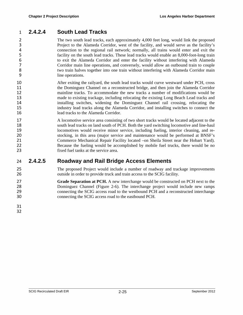
2.4.2.4 South Lead Tracks 1
The two south lead tracks, each approximately 4,000 feet long, would link the proposed 2 Project to the Alameda Corridor, west of the facility, and would serve as the facility’s 3 connection to the regional rail network; normally, all trains would enter and exit the 4 facility on the south lead tracks. These lead tracks would enable an 8,000-foot-long train 5 to exit the Alameda Corridor and enter the facility without interfering with Alameda 6 Corridor main line operations, and conversely, would allow an outbound train to couple 7 two train halves together into one train without interfering with Alameda Corridor main 8 line operations. 9
After exiting the railyard, the south lead tracks would curve westward under PCH, cross 10 the Dominguez Channel on a reconstructed bridge, and then join the Alameda Corridor 11 mainline tracks. To accommodate the new tracks a number of modifications would be 12 made to existing trackage, including relocating the existing Long Beach Lead tracks and 13 installing switches, widening the Dominguez Channel rail crossing, relocating the 14 industry lead tracks along the Alameda Corridor, and installing switches to connect the 15 lead tracks to the Alameda Corridor. 16
A locomotive service area consisting of two short tracks would be located adjacent to the 17 south lead tracks on land south of PCH. Both the yard switching locomotive and line-haul 18 locomotives would receive minor service, including fueling, interior cleaning, and re-19 stocking, in this area (major service and maintenance would be performed at BNSF’s 20 Commerce Mechanical Repair Facility located –on Sheila Street near the Hobart Yard). 21 Because the fueling would be accomplished by mobile fuel trucks, there would be no 22 fixed fuel tanks at the service area. 23
2.4.2.5 Roadway and Rail Bridge Access Elements 24
The proposed Project would include a number of roadway and trackage improvements 25 outside in order to provide truck and train access to the SCIG facility. 26
Grade Separation at PCH. A new interchange would be constructed on PCH next to the 27 Dominguez Channel (Figure 2-6). The interchange project would include new ramps 28 connecting the SCIG access road to the westbound PCH and a reconstructed interchange 29 connecting the SCIG access road to the eastbound PCH. 30
31 32

1
2 3 4 5 6 7 8 9 10 11 12 13 14 15 16 17 18 19
20 21 22 23
24
Chapter 2
SCIG Recirc
Figure 2-
Project Descr
culated Draft EIR
6. Proposed
Althoubeneatlead treight eastboallow under would would Terminchangebridgenew inPCH (Compa
Dominto be winvolvaccom
ription
R
d PCH Overp
ugh there is ath PCH. To acracks, it woultracks. The und PCH andthe southern the PCH on tallow the SCallow trucks
nal Island Fre would invo
e spans with nterchange wo(e.g., one of Fany, and a LA
nguez Channwidened to ac
ve widening tmmodate four
pass (view to
an existing roccommodate ld be necessaexisting PCHd the proposeportion of th
the way to thCIG access ros exiting the reeway, there
olve relocationew spans oould maintainFast Lane’s oAHD aggrega
nel Bridge. Tccommodate the abutmenttracks.
2-26
the south).
ad underpassthe transition
ary to construH bridge spaed Project sitehe strip trackhe Alameda Coad to be widfacility to pr
eby facilitatinn of abutmen
of increased ln access fromother sites, Prate crusher fac
The rail bridgthe south leadts and piers,
(E Road), then of the twelvuct a rail undeanning the Se would, ther
ks as they joiCorridor. In adened to two roceed eastbong access tonts and suppolength, and c
m PCH to E Rraxair, Vopakcility).
ge over the Dd tracks as sh and placing
Los Angeles
ere is no exisve strip trackserpass that co
SCIG access refore, need tin the south laddition, this b
lanes. The neound directly designated ort piers, repconstructing n
Road and the bk’s tank farm
Dominguez Chhown in Figug a new span
Harbor Depar
Septemb
sting rail undes into the two ould accommroad betweeo be lengthenlead tracks tobridge lengthew road unde
y onto PCH ttruck routes.lacing the exnew roadwaybusinesses sou
m, California S
hannel wouldure 2-7. This wn wide enou
rtment
er 2012
erpass south
modate en the ned to o pass hening erpass to the . This xisting y. The uth of Sulfur
d need would
ugh to

1
2 3 4 5 6 7 8 9 10 11 12 13 14
15 16 17 18 19 20 21 22 23
Chapter 2
SCIG Recirc
Figure 2-
Project Descr
culated Draft EIR
7. Proposed
Southportioneaseman exiproperaccessto servon thebelow Tracks
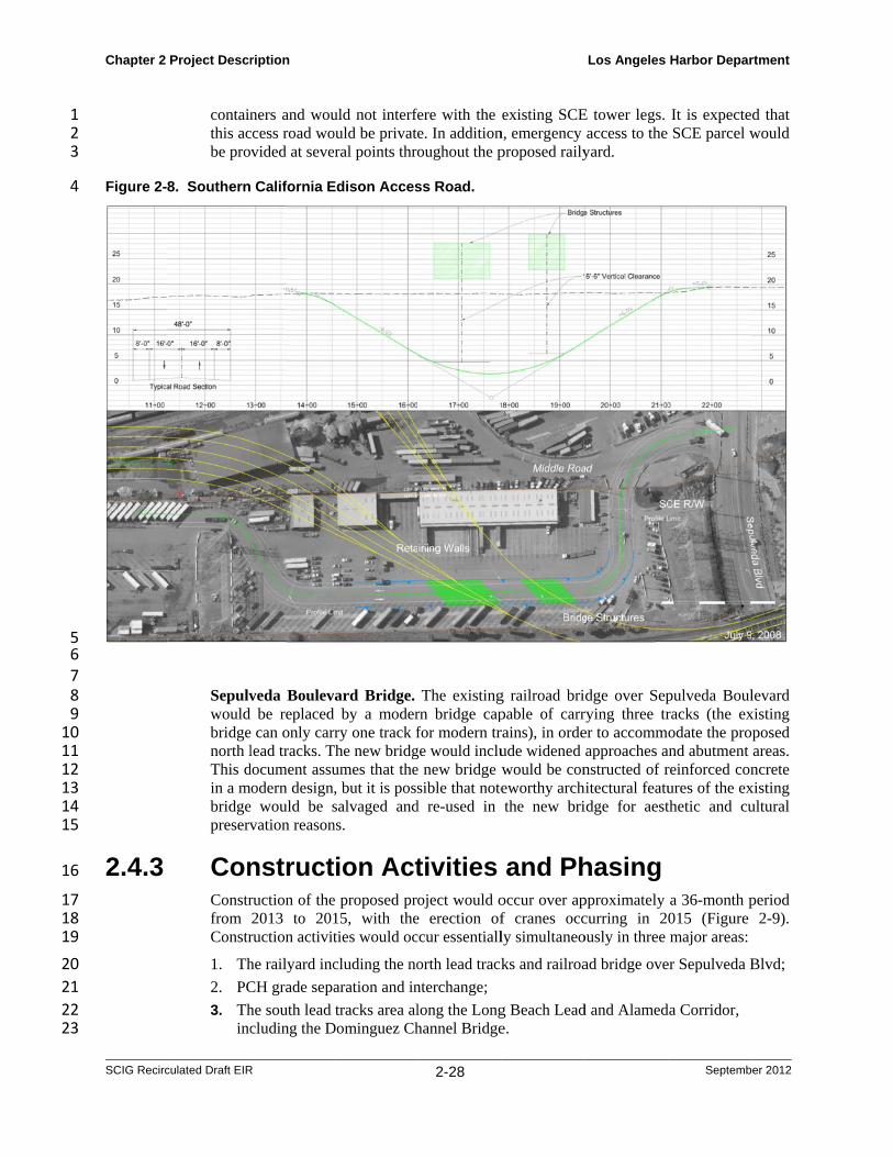
The acBoulevThe rorunninin eachthe roasectionwouldgeome
ription
R
d Dominguez
ern Californn of the SCEent that BNSisting access rty. The track road would b
ve as the prime property lea
existing grads.
ccess road wvard, which isoad would be ng under the rh direction anad would havn, and be sup
be providedetry of the acc
z Channel Ra
nia Edison AE property aloSF would neg
road to the Sks would be be upgraded
mary access foased from SCde for a short
ould start at s located apprapproximatel
railroad tracknd 8-foot-widve a 16’-6” vpported by retd to maintain cess road wou
2-27
ail Bridge.
Access Roadong the east sotiate (FigureSCE propertysupported byto the standar
or the portion CE and for SC
distance in o
the existing roximately 60ly 1,400 feet
ks, and 48 feee shoulders. A
vertical clearataining walls accessibility
uld meet desi
d. The Northside of the pre 2-8). A bridy that is locay two separa
ards of AASHof California
CE. The acceorder to pass
intersection o00 feet west olong, with a 7
et wide, proviAt the point wance and a 6%on each side
y at all times ign standards
Los Angeles
h Lead Tracroposed Projedge would caated at the noate bridge str
HTO Edition 5a Cartage thatess road woulunder the pro
of Middle Roof the Termin700-foot-longiding a 16-foowhere it cross% grade thro
e. Appropriate during the rfor large truc
Harbor Depar
Septemb
cks would crect site throu
arry the tracksorth end of Sructures. The5 (2004) to alt is assumed tld also be drooposed North
oad and Sepunal Island Freg depressed seot-wide trave
ses under the tough the depre drainage syrainy seasonscks pulling 45
rtment
er 2012
ross a ugh an s over SCE’s e SCE low it o stay opped
h Lead
ulveda eway. ection
el lane tracks ressed
ystems s. The 5-foot
1 2 3
4
5 6 7 8 9 10 11 12 13 14 15
16
17 18 19
20
21
22 23
Chapter 2
SCIG Recirc
Figure 2-
2.4.3
Project Descr
culated Draft EIR
containthis acbe pro
8. Southern
Sepulvwould bridgenorth lThis din a mbridgepreserv
ConConstrfrom Constr
1. Th
2. PC
3. Thinc
ription
R
ners and wouccess road wovided at seve
California E
veda Boulevbe replaced
e can only carlead tracks. T
document assumodern designe would be svation reason
nstructruction of the2013 to 201ruction activit
he railyard inc
CH grade sepa
he south lead cluding the D
uld not interfeould be privateral points thro
Edison Acces
ard Bridge. by a moder
rry one track fThe new bridgumes that the, but it is posssalvaged and
ns.
ion Acte proposed pro15, with theties would oc
cluding the no
aration and in
tracks area alDominguez Ch
2-28
fere with the e. In additionoughout the p
ss Road.
The existingrn bridge capfor modern tr
ge would inclue new bridge wsible that note
d re-used in
tivities oject would o
e erection ofccur essentiall
orth lead track
nterchange;
long the Longhannel Bridge
existing SCEn, emergency proposed raily
g railroad bripable of carrrains), in ordeude widened would be coneworthy archthe new bri
and Phoccur over apf cranes occly simultaneo
ks and railroa
g Beach Leade.
Los Angeles
E tower legs. access to the
yard.
dge over Seprying three trer to accommoapproaches anstructed of r
hitectural featuidge for aest
hasing pproximately curring in 20ously in three
ad bridge ove
d and Alamed
Harbor Depar
Septemb
It is expecteSCE parcel w
pulveda Boulracks (the exodate the pro
and abutment reinforced conures of the exthetic and cu
a 36-month p015 (Figure major areas:
er Sepulveda B
da Corridor,
rtment
er 2012
d that would
levard xisting posed areas. ncrete
xisting ultural
period 2-9).
Blvd;
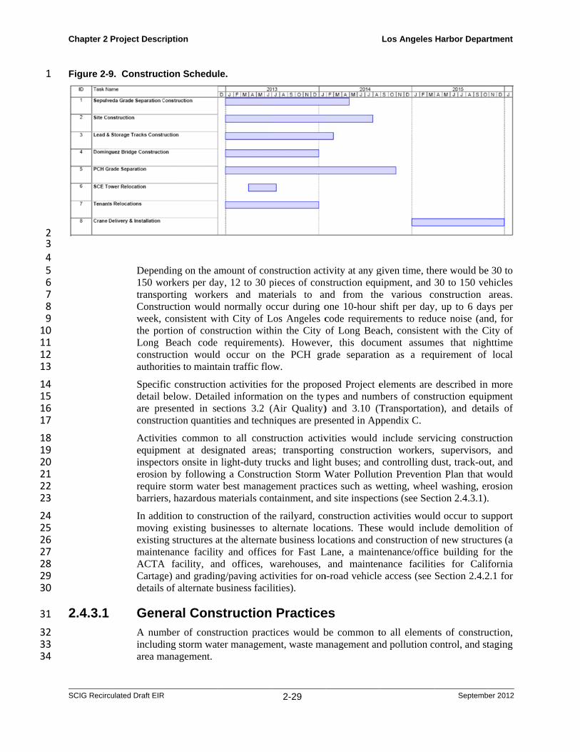
1
2 3 4 5 6 7 8 9 10 11 12 13
14 15 16 17
18 19 20 21 22 23
24 25 26 27 28 29 30
31
32 33 34
Chapter 2
SCIG Recirc
Figure 2-
2.4.3.1
Project Descr
culated Draft EIR
9. Construc
Depen150 wtranspoConstrweek, the poLong construauthor
Specifdetail are prconstru
Activiequipminspecerosionrequirebarrier
In addmovinexistinmainteACTACartagdetails
GenA numincludarea m
ription
R
ction Schedu
nding on the aworkers per da
orting workeruction wouldconsistent w
ortion of consBeach code
uction wouldrities to maint
fic constructiobelow. Detai
resented in seuction quantit
ties commonment at desictors onsite inn by followine storm waterrs, hazardous
dition to constng existing bung structures aenance facilit
A facility, ange) and gradins of alternate b
eral Consmber of consting storm wa
management.
le.
amount of conay, 12 to 30 pers and matd normally o
with City of Lstruction withe requiremend occur on tain traffic flo
on activities iled informatiections 3.2 (ties and techn
n to all constignated areasn light-duty trng a Construcr best managmaterials con
truction of thusinesses to at the alternatty and officend offices, wng/paving actbusiness facil
structiontruction practter managem
2-29
nstruction actpieces of conterials to anccur during o
Los Angeles chin the City onts). Howeve
the PCH grow.
for the propoion on the typ(Air Quality)niques are pre
truction activs; transportinrucks and lighction Storm Wement practicntainment, an
he railyard, coalternate loc
te business loes for Fast Lwarehouses, tivities for onlities).
n Practicetices would bent, waste ma
tivity at any gnstruction eqund from theone 10-hour code requiremof Long Bea
er, this docurade separatio
osed Project epes and num) and 3.10 (Tesented in Ap
vities would ng constructiht buses; and Water Pollutices such as w
nd site inspect
onstruction accations. Thesecations and c
Lane, a maintand mainten
n-road vehicle
es be common tanagement an
Los Angeles
given time, thuipment, and e various cshift per dayments to reduach, consistenument assumon as a req
elements are mbers of const
Transportatioppendix C.
include servion workers,controlling d
ion Preventiowetting, wheetions (see Sec
ctivities woule would incl
construction otenance/officnance facilitie access (see
to all elemennd pollution c
Harbor Depar
Septemb
here would be30 to 150 veonstruction
y, up to 6 dayuce noise (annt with the C
mes that nighquirement of
described in truction equip
on), and deta
vicing constru supervisors
dust, track-ouon Plan that wel washing, erction 2.4.3.1).
ld occur to sulude demolitiof new structue building foies for CalifSection 2.4.2
nts of construcontrol, and st
rtment
er 2012
e 30 to hicles areas. ys per
nd, for City of httime
local
more pment ails of
uction , and
ut, and would rosion .
upport ion of ures (a or the fornia
2.1 for
uction, taging
Chapter 2 Project Description Los Angeles Harbor Department
SCIG Recirculated Draft EIR 2-30 September 2012
Storm Water Management. All construction sites would be managed in accordance 1 with the proposed Project’s National Pollution Discharge Elimination System (NPDES) 2 construction storm water permit, which would require a storm water pollution prevention 3 plan (SWPPP) for each site. The SWPPPs would be developed by the LAHD, BNSF, the 4 contractor, and the construction management team, and no construction would start until 5 the SWPPPs had been approved by the LAHD. The SWPPPs would specify the best 6 management practices (BMPs) to be followed at each site to minimize or eliminate 7 discharges of water pollutants to surface and ground water via runoff from construction 8 areas. 9
BMPs would include both procedural controls and structural controls. Procedural controls 10 would include minimizing the amount of exposed soil at any one time during grading 11 operations; washing dirt off construction vehicles before they leave the site; refueling 12 construction equipment only in designated areas; keeping construction materials, fuels, 13 lubricants, and solvents in designated containment areas; protecting storm drain inlets 14 with covers, filters, or sandbags; and conducting regular inspections of procedures and 15 structures. Structural controls would include installing and maintaining berms, catchment 16 areas, and filters, and installing grates and wheel washers at site exits. Contractors would 17 be required to implement the provision of the SWPPP, and the construction manager 18 would be responsible for ensuring that compliance and for ensuring that the SWPPP is 19 modified as necessary during the construction phase to respond to changing conditions 20 and address ineffective BMPs. 21
Pollution Control. Construction equipment and practices would conform to CAAP’s 22 Construction Activity measure, as implemented by the LAHD’s Sustainable Construction 23 Guidelines (adopted February 2008). Specifically, all construction equipment would be 24 fitted with mufflers, all engines would be maintained regularly, the construction contract 25 would specify the use of newer off-road equipment meeting USEPA Tier-2 off-road 26 standards and fitted with diesel emissions control devices, as appropriate, and the use of 27 on-road trucks meeting the 2004 on-road standards, and the contractors would be 28 required to comply with SCAQMD Rule 403. 29
Dust control would include regular, frequent spraying of exposed soils by water trucks, 30 minimizing the amount of exposed soil by staging excavation and backfill, conducting 31 regular street sweeping and street wash down (employing storm water controls), rinsing 32 soil and dust off vehicles exiting the sties, and potentially applying surface stabilants with 33 spray trucks to areas that must be exposed for prolonged periods. 34
Non-hazardous recyclable solid wastes generated from construction (piping, welding and 35 coating wastes, scrap lumber and cardboard) would typically be hauled to local recycling 36 centers. Asphalt and concrete would be recycled on-site for use in project construction. 37 Used hydrostatic test water would be treated as required and discharged under permit. 38 Contaminated soils or groundwater could be encountered during the construction of 39 pipelines and. would be sent to a permitted treatment or disposal facility in accordance 40 with local, state, and federal regulations (see Section 3.7 for more detail). 41
Staging and Storage Areas. Sites for equipment laydown, material storage, construction 42 management, and worker parking and staging would be located on the proposed Project 43 site, Sepulveda Boulevard bridge site, and adjacent to the PCH and Dominguez Channel 44 sites. Storage yards and staging areas would be on sites that have already been improved, 45 with access to large commercial streets to allow easy movement of personnel and 46 equipment. It is anticipated that the majority of materials would be brought in during off-47
Chapter 2 Project Description Los Angeles Harbor Department
SCIG Recirculated Draft EIR 2-31 September 2012
peak traffic hours, with the primary exception being concrete, which must be mixed and 1 delivered within a limited window of time. 2
Construction material would also be stored at contractors’ existing facilities as well as at 3 those of suppliers providing equipment, materials, or labor to the proposed Project. 4 Aggregate, concrete, asphalt, sand, and slurry materials would be purchased locally 5 (when available) and storage would be provided by local suppliers or in one of the 6 designated storage areas. Staging and storage areas would be protected with storm water 7 controls in accordance with the proposed Project’s construction storm water permit and 8 Storm Water Pollution Prevention Plan (SWPPP; see Storm Water Management, above). 9
Hazardous Materials Abatement. Prior to demolition, existing structures would be 10 inspected by qualified personnel for the presence of asbestos-containing materials. If 11 asbestos is found in a material that will become friable during demolition, then these 12 materials would be removed and disposed of in compliance with EPA and Los Angeles 13 County regulations prior to demolition. The appropriate notification would be made to 14 these agencies prior to demolition. 15
Public Utility Management. Prior to the start of construction BNSF would prepare, or 16 cause to be prepared, a Public Services Relocation Plan that would describe the 17 procedures for minimizing public services and utility service disruptions in the Project 18 area. The Plan would be developed with input from the service providers for the Project site 19 and would be submitted to city regulatory departments (Los Angeles, Long Beach, and 20 Carson) for review and approval. The Plan would include the following measures: 21
Prior to disconnecting any existing services, new facilities (i.e., water, sewer, 22 communications, gas, and electricity) would be installed. Pipeline installation would 23 occur within existing utility corridors/easements to the extent possible. 24
As demolition activities progress, unnecessary facilities and connections would be 25 eliminated and new facilities and connections activated. 26
Minor service interruptions (those lasting 1 day or less) could occur during the 27 transition between obsolete and newly installed facilities and services. Affected 28 properties would be properly notified prior to any service interruption. 29
Full access to all utilities would be restored upon completion of Project construction. 30
It is anticipated that similar measures would be undertaken by the alternate business sites 31 during the construction. 32
Traffic Management Plan. A traffic management plan containing traffic control 33 measures conforming to the requirements and guidance of the Los Angeles Department 34 of Transportation (LADOT), Caltrans, and the cities of Carson and Long Beach, would 35 be required at the time construction permits are obtained. Potential measures may include 36 detour plans, limiting major road obstructions to off-peak hours, coordination with 37 emergency service and transit providers, coordinating access with adjacent property 38 owners and businesses, and advance notice of temporary parking loss or use of detour 39 roads. At a minimum, construction-related traffic would be prohibited from entering 40 residential areas and only local roadways and highways would be utilized. The details of 41 the TMP are described in Section 3.10, Transportation. 42

Chapter 2 Project Description Los Angeles Harbor Department
SCIG Recirculated Draft EIR 2-32 September 2012
2.4.3.2 Construction of the Railyard, North Lead Tracks, and 1
Sepulveda Railroad Bridge 2
Demolition. The proposed Project site and alternate business sites would be cleared of 3 existing structures and miscellaneous site features such as pavement, curbs, signs and 4 above-ground utilities prior to construction. These structures principally consist of: (a) 5 three warehouses; (b) several small buildings/structures; (c) pavement; and (d) access 6 roads and railroad tracks. The demolition debris would be recycled on-site (asphalt and 7 concrete) or transported to an offsite recycling or disposal facility. The demolition would 8 require approximately four to five months to complete. 9
Underground Utilities. A number of underground pipelines would need to be relocated 10 or reinforced in place in order to accommodate the configuration, weight, and vibration 11 of the proposed facility. This work would involve trenching both to access the existing 12 pipelines and to construct new alignments, cutting and disposal of pipelines, concrete 13 work, and construction of ancillary features (e.g., cathodic protection, valves, inspection 14 ports). The underground utility work would require approximately four to five months to 15 complete. 16
Earthwork. Earthwork would include excavating, repositioning, and compacting 17 approximately 325,000 cubic yards of earth and hauling another 175,000 cubic yards 18 offsite for reuse elsewhere or disposal in approved landfills. Some of the soils could 19 require environmental remediation prior to or during the earthwork phase of construction 20 if contamination is discovered. In that case, testing and disposal would be conducted 21 under the oversight of approved environmental professional in accordance with local, 22 state, and federal regulations (see Section 3.7 for more detail). Earthwork would require 23 approximately 9 months to complete. 24
Drainage and Utility Construction/Relocation. Underground utilities and drainage 25 piping would be installed at the Project site and alternate business sites at the same time 26 as the earthwork takes place. The project would require relocation of the above-ground 27 Los Angeles Department of Water and Power (LADWP) electrical power lines. The 28 existing SCE electrical power lines and towers would not be relocated except, as noted in 29 Section 2.4.2.3, for the SCE electrical lines in the vicinity of the south side of Sepulveda 30 Boulevard that would need to be raised to accommodate California Public Utility 31 Commission vertical clearance requirements where the north lead tracks would traverse 32 the SCE right of way to connect to the San Pedro Branch tracks. The underground utility 33 work would involve opening of trenches, installation of underground services, and 34 closure of trenches, and would require approximately six months to complete. 35
Fine Grading and Sub-grade Preparation. As the earthwork and drainage/utility 36 phases are completed, fine grading of unpaved areas and sub-grade preparation of areas 37 to be paved would commence. Approximately 245,000 cubic yards of aggregate base 38 course would be delivered to the facility and to alternate business sites as necessary, 39 where it would be spread by bottom dump trucks. This work would require 40 approximately two months to complete. 41
Paving. Approximately 10,000 cubic yards of reinforced concrete and 310,000 tons of 42 asphalt-concrete would be poured at the site in the construction of roads, truck lanes, 43 parking areas, curbing, crane runways, container stack runways, structure foundations, 44 and building pads. Traffic control barriers would be installed, and the paved areas would 45 be striped. This work would require approximately 3 months to complete. 46
Chapter 2 Project Description Los Angeles Harbor Department
SCIG Recirculated Draft EIR 2-33 September 2012
New Buildings. Buildings and other structures to be constructed at the project site and 1 alternate business sites would include administrative buildings; warehouses; a driver 2 assist building; hostler, crane, and general maintenance structures; checkpoint structures; 3 and light towers. Building construction would require the delivery and installation of 4 structural steel, concrete, siding, roofing, interior paneling, interior utilities, surface 5 coatings, and equipment. This work would require approximately 9 months to complete. 6
Track Work and Signal Installation. Approximately 46,000 feet of track (consisting of 7 ties, rails, tie plates, joint bars, spikes, and various other small materials), and at least 24 8 switches would be installed. Aggregate materials (crushed rock and ballast rock) would 9 be placed and the tracks leveled and straightened. Signal equipment necessary to control 10 movement of trains to and from the facility would be installed. Track work would take 11 approximately 3 months with crews working one 10-hour shift per day, up to 6 days per 12 week. 13
Sepulveda Railroad Bridge. The existing rail bridge over Sepulveda Boulevard/Willow 14 Street would need to be replaced to accommodate additional tracks. This work would 15 include widening the existing overpass abutments and installing a new steel span that 16 would carry three tracks over Sepulveda Boulevard/Willow Street. 17
Construction would proceed in three phases. In phase 1 the existing bridge and UPRR 18 track would be moved approximately 15 feet west to keep the UPRR track in service, and 19 the easterly portion of the new bridge, along with new approaches and retaining walls, 20 would be constructed. New track would be installed along the eastern half of the new 21 right of way that would become the new UPRR track. 22
In phase 2 the old UPRR track and the existing bridge would be removed and the western 23 portion of the new bridge, approaches, and retaining walls would be completed. The new 24 BNSF North Lead Track would be installed on the new bridge and approaches to 25 complete construction. 26
The existing bridge would be either a) moved to another location to be preserved as a 27 historical artifact, b) disassembled and partially salvaged for re-use or display, or c) 28 demolished after historical recordation. Certain features of the existing abutments might be 29 salvaged and re-used in the new bridge (see Section 3.4, Cultural Resources, for details 30 regarding the disposition of the existing bridge). 31
Other existing structures, pavement, and aggregate would be demolished and recycled or 32 disposed of, new pilings would be installed, new concrete abutments would be 33 constructed, and the new span and tracks would be installed. Construction would take 34 approximately 16 months. 35
Southern California Edison Access Road. Improvements to the SCE access road would 36 include demolition of most of the existing road, grading to lower the road profile and 37 widen the roadbed, dropping the road below existing grade for a short distance in order to 38 pass under the proposed north lead tracks, installing a bridge to carry the tracks over the 39 road, installing pavement, curbs, and storm drainage, striping the new pavement, and 40 installing signage as necessary. Excavated soil would be either used elsewhere on the 41 Project site or hauled away for appropriate disposal (most likely, sold to a soil broker or 42 used as landfill daily cover). Graders, haul trucks, concrete cutters, paving equipment, 43 concrete trucks, and utility vehicles would be used. An alternative access road approved 44 by the SCE, LADOT, POLA, and Caltrans would be established to maintain access to 45 SCE property during construction. This work would take approximately 120 days. 46

Chapter 2 Project Description Los Angeles Harbor Department
SCIG Recirculated Draft EIR 2-34 September 2012
2.4.3.3 Construction of the Pacific Coast Highway Grade 1
Separation 2
The existing PCH Bridge that spans the access road off of PCH into the proposed Project 3 site would be modified to accommodate the south lead tracks and access roads. 4 Modifications would include relocation of abutments and support piers, replacement of 5 the existing bridge spans with new, longer spans, and reconstruction of the PCH roadway 6 over the new underpass. Construction would include demolition of the existing structure 7 and pavement, installation of new reinforced-concrete pilings, fabrication of structural 8 steel, construction of new concrete abutments, installation of new reinforced concrete 9 spans, and construction of new asphaltic-concrete pavement, including striping, drainage, 10 and curbing. Traffic detours would be implemented in accordance with a traffic plan that 11 would be approved by the LADOT, POLA, and Caltrans. This work would take 12 approximately 22 months. 13
2.4.3.4 Construction of South Lead Tracks and Dominguez 14
Channel Bridge 15
Construction of the south lead tracks would require widening the Dominguez Channel 16 rail bridge to accommodate the additional tracks. 17
Earthwork and Utilities. Approximately 36,000 cubic yards of soil would be excavated, 18 repositioned, and compacted on the site to bring the site to finish grade. Recycled crushed 19 paving materials would be incorporated into the site to improve its geotechnical qualities. 20 Underground utilities would be relocated as necessary, which would involve trenching 21 and the installation of pipe and conduit, manholes, and catch basins. Earthwork and 22 utility relocation would take approximately 14 months to complete. 23
Track Work and Signal Installation. Track construction would involve the installation 24 of approximately 18,000 feet of track, ten switches, and signals as necessary between the 25 primary proposed Project Area and the western end of the reconstructed Dominguez 26 Channel Bridge. Approximately 10,000 cubic yards of sub-ballast and 45,000 cubic yards 27 of ballast materials would be placed in the right of way and then the tracks would be 28 installed, leveled, and straightened. Signal equipment to control the movement of trains 29 to and from the facility, the Alameda Corridor, and other port-area trackage would be 30 installed. This work would take approximately six months. 31
Dominguez Channel Bridge. Bridge reconstruction would involve widening the 32 abutments and piers, and placing new bridge elements. Soil would be excavated and re-33 used on site or disposed of, the old abutments would be demolished, piles would be 34 driven into the shoreline, new concrete abutments constructed, and a new steel span 35 fabricated and installed. Work would be staged so as to minimize disruptions of train 36 traffic between the ports and the Alameda Corridor. New pilings and new concrete 37 abutments would require work within waters of the United States. This work would take 38 approximately 12 months. 39
Landscaping. Following completion of the major site improvements, landscaping would 40 proceed along the site perimeter. This element would include installation of the intensive 41 landscaping along the western side of the Terminal Island Freeway (see section 2.4.2). 42 Construction would include fine grading, the installation of fencing materials, and the 43 placement of soil and plants. This work would take approximately 20 days. 44

Chapter 2 Project Description Los Angeles Harbor Department
SCIG Recirculated Draft EIR 2-35 September 2012
2.4.3.5 Installation of Loading Cranes 1
Once the railyard is completed the 10 RMG cranes would be assembled, tested, and 2 readied for the opening of the facility. This work would involve the delivery of crane 3 components by ship, truck, and rail, and their fabrication on site, and would take from six 4 to 12 months in 2015. Six stacking cranes would also be delivered, assembled, and tested 5 during 2015; the remaining four stacking cranes would be delivered and placed into 6 operation in subsequent years, as needed to handle increasing throughput. 7
2.4.4 Proposed Project Operations 8
The SCIG railyard is expected to begin operation in early 2016 and is assumed to reach 9 full operation (maximum capacity) in 2035. It would operate 24 hours a day, 7 days per 10 week, 360 days per year; trucks and trains would arrive at and depart from the facility 11 day and night. Upon opening, the facility would have approximately 93 employees (e.g., 12 crane operators, train crews on site, hostler drivers, mechanics, clerks, inspectors, 13 security personnel, and supervisors), which would increase to a maximum of 450 14 employees at full operation. The employees would operate the facility over three shifts 15 (typically 6AM-2PM, 2PM-10PM, 10PM-6AM). Up to 40 visitors and vendors (e.g., 16 customers, off-site BNSF staff, fuel truck deliveries, couriers/postal deliveries, and 17 janitorial service) would stop at the facility each day, on average, and train crews and 18 truck drivers would make use of on-site rest facilities. In the first year of operation, the 19 SCIG railyard is estimated to consume approximately 1,790 megawatt-hours (MWh) of 20 electricity, which would increase to 8,700 MWh at full operation, starting in 2035. 21
Operations would involve the use of a variety of cargo-handling equipment on site, and 22 activity by trucks and railroad locomotives from off-site locations. The use of remote 23 sensing and computerized inventory, scheduling, and communications would allow the 24 railyard to minimize redundant or unproductive truck and hostler trips. 25
2.4.4.1 Truck and Container Operations 26
Trucks would transport containers between the SCIG facility and the marine terminals at 27 the two ports. This document assumes that only marine cargo, i.e., direct intermodal 28 cargo, would be handled at the facility. This assumption is supported by the requirement 29 that only trucks that use the designated truck routes between the ports and the SCIG 30 facility and that are equipped with GPS devices would be allowed in the railyard. 31
Containers arriving from the ports on trucks would be loaded directly onto railcars if the 32 appropriate railcars are available, or staged in the container stacking areas if they are not. 33 Containers arriving on trains from the east would likely be temporarily staged in the 34 container stacking areas until being loaded on trucks for delivery to port terminals, 35 although to the extent trucks were available immediately they could be transferred 36 directly from railcars to trucks. 37
Containers would be picked up from and delivered to the marine terminals in the Ports by 38 on-road drayage trucks operated under contracts between various trucking companies and 39 BNSF for drayage between the SCIG railyard and the Ports. The contracts would specify 40 that all trucks would be powered by engines that meet or exceed the 2007 EPA on-road 41 standards (see section 5.2.2 for a discussion of potential alternative truck technologies). 42 This arrangement would ensure that the trucks entering and leaving the SCIG railyard 43 would meet the 2010 CAAP’s Clean Truck Program (CTP) engine emissions 44 requirements. 45

Chapter 2 Project Description Los Angeles Harbor Department
SCIG Recirculated Draft EIR 2-36 September 2012
The proposed SCIG facility would operate like a circuit. On-road trucks would arrive at 1 and depart from the facility hauling 20-, 40-, and 45-foot shipping containers on chassis. 2 The trucks would be typical tractors of the type used in 18-wheel semi-trailer rigs 3 throughout the country except, as described above, they would be powered by 2007 or 4 newer EPA on-road diesel engines. The number and frequency of these truck arrivals and 5 departures would vary depending on vessel and train schedules, but it is expected that at 6 full capacity an average of approximately 5,542 trucks, carrying 4,167 containers, would 7 arrive at and depart from the facility each day, as well as employee and vendor traffic 8 (Table 2-2; Appendix G). Truck travel to and from port terminals to the SCIG railyard 9 would occur along designated truck routes described below and shown in Figure 2-4. The 10 truck routes would be used as follows: 11
From the West Basin, trucks would proceed on Harry Bridges eastbound to Anaheim 12 Street, take Anaheim eastbound to the Terminal Island Freeway, then proceed 13 northbound on the Terminal Island Freeway, exiting at Pacific Coast Highway and 14 entering facility queuing lanes. 15
From Terminal Island, trucks would proceed on Seaside/Ocean Avenue to the 16 Terminal Island Freeway, then proceed northbound on the Terminal Island Freeway, 17 exiting at Pacific Coast Highway and entering facility queuing lanes. 18
From the Port of Long Beach, trucks would proceed north on Harbor Scenic Drive to 19 I-710, proceed north to exit I-710 at either 9th Street or Anaheim Street, proceed west 20 to the Terminal Island Freeway, then north on the Terminal Island Freeway, exiting 21 at Pacific Coast Highway and entering facility queuing lanes. 22
Use of these truck routes would be monitored and enforced through the use of GPS 23 devices installed in the trucks, in accordance with BNSF’s drayage contract requirements. 24
Inbound trucks would enter the SCIG railyard from the PCH off-ramps and proceed to an 25 on-site entry portal to undergo an automated inspection and identification process that 26 would use multiple digital cameras to document the condition of the equipment, check 27 that shipping seals are intact, and verify that the container identified by the trucker 28 corresponded to the actual container on the truck’s chassis. The digital imaging process 29 would comply with the Department of Homeland Security facility access regulations, and 30 would also reduce idling time and paperwork. From the portal trucks would proceed 31 along multiple queuing lanes along the western boundary of the facility, designed to 32 avoid truck lines on the streets and to minimize idling. The queuing lanes would lead to 33 checkpoint kiosks within the facility for additional inspection, driver identification (using 34 the Intermodal Driver Database maintained by the Intermodal Association of North 35 America), and exchange of security and cargo information. The applicant represents that 36 this process, which would be entirely remotely-controlled from the administration 37 building, would take less than 2 minutes for each truck. 38
After passing through the kiosks, the majority (BNSF estimates 90 percent) of trucks 39 would be directed straight to track side, where an RMG would lift the container off the 40 chassis and place it on a railcar for further shipment. This practice, called a “direct-to-41 railcar live lift,” is very efficient because the container is loaded immediately onto the 42 railcar as opposed to being parked in a temporary location, which requires extra 43 equipment activity, with the resultant additional emissions, to bring it to trackside later. 44 Trucks not directed to a live lift would be directed to a designated container stacking area 45 where the container would be lifted off of the chassis by an RMG and stacked for loading 46 onto a railcar at a later time. 47
Chapter 2 Project Description Los Angeles Harbor Department
SCIG Recirculated Draft EIR 2-37 September 2012
Outbound trucks would follow a similar process. Trucks that had performed a live lift or 1 delivered a container to a stacking area would in most cases be directed to a location in 2 the container stacking area where another container would be loaded onto the chassis by 3 an RMG for transport back to the port terminals. These trucks would then proceed out of 4 the facility, passing first through the out-gate portal at the north end of the facility. There, 5 a digital camera array would record images of equipment for inspection and identification 6 purposes, similar to the in-gate portal process described previously. The trucks would 7 then proceed to the outbound checkpoint, an automated kiosk where additional driver 8 biometric and cargo information would be collected. Once clear of the out-gate 9 checkpoint the truck would proceed on the truck exit lanes on the west side of the facility 10 to the PCH on-ramp, and head to the port terminals along the designated truck routes. 11 Based on experience at the similar Memphis, TN facility, BNSF estimates that the 12 amount of time a truck spends in the proposed facility would be approximately half of the 13 current “turn time,” which would reduce the amount of emissions per container and 14 increase the number of containers each truck could dray in a shift. 15
2.4.4.2 Train Operations 16
At full operation, the SCIG railyard is expected to handle eight inbound and eight 17 outbound trains per day. The trains would enter and leave the facility via the Alameda 18 Corridor. Inbound and outbound trains would typically operate as described below. 19 Trains would be comprised of a set of three or four diesel-electric locomotives and a 20 variable number of railcars. The locomotives would be large units of the type known as 21 “road engines”, identified as “long-haul” engines in the CAAP and “line-haul 22 locomotives” in the CARB MOU. Those engines are typically equipped with 4,000- to 23 5,000-horsepower diesel engines driving an electric generator that supplies tractive power 24 to the wheels. Consistent with CAAP Measure RL-2 and pursuant to the 2005 CARB 25 MOU, BNSF would maximize the use of ultra-low sulfur diesel (ULSD) fuel in these 26 locomotives. The fuel would be supplied during the refueling process at both the SCIG 27 railyard (for outbound trains) and the eastern California engine facilities from which 28 inbound trains would arrive. In addition, a single switching locomotive would be 29 stationed in the SCIG facility to remove defective (“bad-order”) railcars for servicing 30 (normally performed at central service facilities such as Barstow). This locomotive would 31 be a low-emissions unit compliant with the requirements of CAAP Measure RL-3. 32
The railcars would be flat-car-like units known as double-stack cars that are designed 33 especially for transporting containers. Each car has from one to five bays (also known as 34 platforms or wells), and each bay can hold two 40-foot containers stacked one on top of 35 the other (or two 20-ft units and one 40-ft unit, or one 45-ft container on top of a 40-foot 36 container). Multiple-bay cars have articulated couplings that connect the bays to let them 37 negotiate curving track. A five-bay, double-stack, articulated car for international 38 containers, the industry standard, is approximately 265 feet long. A typical intermodal 39 train is composed of as many as 29 such cars, or a mixture of five-bay, three-bay, and 40 single-bay cars, and is approximately 8,000 feet long (including locomotives and inter-41 car spaces). Depending upon the configuration of cars and containers, a train could carry 42 up to 333 containers; to be conservative, this document assumes a train would carry, on 43 average, 260 containers. 44
All train travel in the project area would be on tracks separated from local roads and streets, 45 so trains would not cause or encounter traffic conflicts. Inbound trains would exit the 46 Alameda Corridor, proceed across the Dominguez Channel Bridge onto one of the facility’s 47 south lead tracks (Figure 2-3a), and be routed onto a clear strip track. At this point all but one 48
Chapter 2 Project Description Los Angeles Harbor Department
SCIG Recirculated Draft EIR 2-38 September 2012
of the engines hauling the train would be turned off; the remaining engine would spot the 1 train on the strip tracks for loading and unloading. Trains would typically be longer than a 2 single strip track, and would have to be divided into two smaller segments (blocks) in order to 3 be positioned on the strip tracks for loading and unloading. Accordingly, inbound trains 4 would continue through the facility onto the north lead track until the rear end of the train had 5 cleared the switches at the south end of the strip track. The train would then stop, and the 6 portion of the train still inside the facility on the strip track would be uncoupled, leaving it 7 properly positioned for unloading. The front half of the train would pull northward to clear 8 the switches, then back southward onto another clear strip track (this process, which would 9 take up to 30 minutes per train, is termed “doubling the train”). The locomotives would be 10 uncoupled, and the locomotive consist would move south through the railyard along an empty 11 track (or, in rare cases when no empty yard tracks are available, on the San Pedro Branch 12 track east of the facility) to the staging area, where the locomotives would be refueled (from 13 mobile fuel trucks), if necessary, and receive minor service checks and service such as 14 sweeping, replenishing crew supplies, etc. Once that process was completed the locomotives 15 would be available to move an outbound train or be re-assigned to other duties in the region. 16
Locomotive movements within the railyard and along the north lead track would not require 17 the locomotives to sound their horns, as warning devices such as lights and barriers to prevent 18 rail/truck conflicts would eliminate the need for horns (however, this analysis assumes that 19 trains may occasionally sound their horns in the South Lead Track area when entering or 20 exiting the Alameda Corridor; see Section 3.9). Train-related noise would consist of the diesel 21 engines themselves, wheel-on-rail squealing, and the noise of railcars being coupled together. 22
Outbound trains would be assembled (“built”) and leave the facility in essentially the 23 reverse process, with the locomotives, typically working from the south end of the 24 facility, doubling the train to make a full, approximately 8,000-foot train. After proper 25 inspections and testing, the train would depart from the south end of the facility and 26 proceed onto the Alameda Corridor. 27
No locomotive load testing, engine repair and rebuilding, repainting, repair or replacement 28 of parts, components, mechanical and electrical systems as required by the Federal 29 Railroad Administration, or railcar rebuilding would take place on the SCIG facility; those 30 activities constitute “maintenance” and would take place at BNSF’s Sheila Commerce 31 Mechanical Repair Shop, as described in Section 2.4.2.4. There would also be no fixed 32 locomotive fueling or fuel storage facility or structures. All locomotive maintenance that 33 would be required for project-related trains already occurs at the Sheila facility. Only 34 locomotive servicing would occur at SCIG, which would be limited to minor upkeep 35 activities, such as fueling via fuel truck, cleaning (e.g., wiping windows, removing trash, 36 etc.) and resupplying (e.g., restocking of towels, napkins, water, etc.) of locomotives. 37
2.4.4.3 Support Activities 38
Fuels and Hazardous Substances Use and Storage. Hazardous substances at the 39 proposed facility would fall into two categories: (1) fuels and other products (solvents, 40 lubricants, batteries, etc.) used in the operation of the facility; and (2) cargo contained in 41 some of the shipping containers. Operational substances would be stored and handled in 42 accordance with the facility’s Business Plan, which would be submitted to the City of 43 Los Angeles Fire Department for approval, and BNSF’s corporate hazardous substances 44 management plans (see Section 3.7.2.4 for details). Those plans incorporate best 45 management practices (BMPs) for storage and handling, as well as procedures for 46 notifications and emergency response. No gasoline fuel would be stored on site, and any 47 other fueling (e.g., locomotives, hostlers, and other equipment) would be via direct 48
Chapter 2 Project Description Los Angeles Harbor Department
SCIG Recirculated Draft EIR 2-39 September 2012
fueling from outside contractor tanker trucks. The drayage fleet would be fueled and 1 serviced at off-site facilities that are not a part of the proposed Project. 2
According to LAHD, nearly 20,000 containers of hazardous cargos pass through the Ports 3 each year. The proposed SCIG facility would handle a portion of those containers, 4 applying established corporate procedures for hazardous cargos (see Section 3.7.2.4). 5
Fire Protection and Security. Fire protection would likely be provided by the City of 6 Los Angeles Fire Department (LAFD), although Los Angeles County and the City of 7 Long Beach may participate under mutual aid agreements that would be established by 8 the respective fire departments (see Section 3.11 for more detail). Buildings and 9 structures would be designed and constructed in accordance with the fire codes of the 10 relevant jurisdictions, and several emergency access routes would be provided. 11
The site would be fully secured by passive (fencing) and active (private security) 12 measures in accordance with U.S. Department of Homeland Security requirements, and 13 would include security lighting and a variety of security surveillance devices. Admission 14 would be restricted to personnel carrying Transportation Worker Identification Credential 15 (TWIC), and escorted authorized visitors (see Section 3.7 for more detail). The site is 16 located in the Harbor Division Area of the City of Los Angeles Police Department, 17 which, with the LAHD Police, would provide police protection, assisted as necessary by 18 the Los Angeles County Sheriff’s Department and the City of Long Beach Police 19 Department (see Section 3.11 for more detail). 20
Stormwater Management. The SCIG facility and alternate business facilities would 21 include structural and procedural BMPs for minimizing the escape of water pollutants via 22 stormwater runoff and dry weather flows. Structural BMPs would include swales 23 incorporated into landscaped areas, storm drain inserts, berms around critical areas such 24 as fueling and hazardous materials storage areas, and clarifier/settling basins as 25 necessary. BNSF represents that the SCIG facility would consist of 20 to 30 percent 26 permeable surfaces (landscaped areas, container stacking areas, and tracks). The new 27 SCIG and alternate business facilities would be operated in accordance with procedural 28 BMPs such as frequent sweeping, regular inspections, periodic employee training, 29 equipment storage and washdown practices, and appropriate storage and handling of 30 potential polluting substances. 31
2.5 Project Baseline 32
To determine significance, the proposed Project and alternatives are compared to a 33 baseline condition. The difference between the proposed Project or alternative and the 34 baseline is then compared to a threshold to determine if the difference between the two is 35 significant. 36
CEQA’s requirements for establishing a baseline are discussed in Section 1.5.5. For 37 purposes of this Recirculated Draft EIR, the CEQA Baseline for determining the 38 significance of potential impacts under CEQA are the conditions that existed in 2010. 39
2.6 Relationship to Existing Plans 40
One of the primary objectives of the CEQA process is to ensure that the proposed Project 41 is consistent with applicable statutes, plans, policies, and other regulatory requirements. 42 Table 2-4 lists the statutes, plans, policies, and other regulatory requirements applicable 43 to the proposed Project and alternatives. 44

Chapter 2 Project Description Los Angeles Harbor Department
SCIG Recirculated Draft EIR 2-40 September 2012
Table 2-4. Applicable Statutes, Plans, Policies, and Other Regulatory Requirements. 1
Applicable Rule, Plan, or Policy Description
City of Los Angeles General Plan The City of Los Angeles General Plan (City of Los Angeles, 1982a) has various elements that contain general goals, objectives, and policies related to regulating development, protecting natural and cultural resources, and improving environmental quality in the region. Relevant elements include Port (see below), Air Quality, Conservation, Transportation, Public Facilities and Services, Safety, Noise, and Land Use.
City of Los Angeles General Plan – Port of Los Angeles Plan Element
The Port of Los Angeles Plan is part of the General Plan for the City of Los Angeles and provides a 20-year official guide to the continued development and operation of the Port. It is designed to be consistent with the Port of Los Angeles Master Plan.
2010 San Pedro Bay Clean Air Action Plan Update
The Port, in conjunction with the Port of Long Beach and with guidance from AQMD, CARB, and USEPA, has developed the San Pedro Bay Clean Air Action Plan (CAAP), which was approved by the Los Angeles and Long Beach Boards of Harbor Commissioners on November 20, 2006. The Update was approved on November 22, 2010. The CAAP focuses on reducing diesel particulate matter (DPM), NOX, and SOX, with two main goals: (a) to reduce Port-related air emissions in the interest of public health, and (b) to disconnect cargo growth from emissions increases. The Plan includes near-term measures implemented largely through the CEQA/NEPA process and new leases at both ports.
Port of Los Angeles Risk Management Plan
The Risk Management Plan, an amendment to the Port of Los Angeles Master Plan, was adopted in 1983, per requirements of the California Coastal Commission. The purpose of the Risk Management Plan is to provide siting criteria relative to vulnerable resources and the handling and storage of potentially hazardous cargo such as crude oil, petroleum products, and chemicals. The Risk Management Plan provides guidance for future development of the Port to minimize or eliminate the hazards to vulnerable resources from accidental releases (LAHD, 1983).
Port of Los Angeles Real Estate Leasing Policy
The purpose of this Policy is to provide a framework that governs leasing and rental decisions as they relate to tenant retention, selecting new tenants, development of new agreements and, as appropriate, modifications to existing agreements by amendments.
Port of Los Angeles Strategic Plan The Port of Los Angeles Strategic Plan (LAHD 2012) identifies the mission of the Port and provides 11 strategic objectives for the next 5 years. The mission includes promotion of “grow green” philosophy combined with fiduciary responsibility and promotion of global trade. The 11 strategic objectives include, minimization of land use conflicts, maximizing the efficiency and the capacity of current and future facilities, addressing needed infrastructure requirements, maintaining financial self-sufficiency, raising environment standards and enhancing public health, promoting emerging and environmentally friendly cargo movement technology and energy sources, provide for safe and efficient operations and homeland security, strengthen local community relations and developing more and higher quality jobs.
City of Los Angeles Municipal Code The building code is contained in Sections 91.000 through 91.706 of the Municipal Code, which set out requirements for construction, grading, excavations, fill, and foundation work.
City of Long Beach Municipal Code The City’s building code is contained in Title 18.68 of the Municipal Code, which requires that all construction conform to the seismic requirements of the State of California’s 2007 Building Code.
City of Long Beach General Plan Via the General Plan the City has adopted the 1971 edition of the Uniform Fire Code as its Fire Prevention
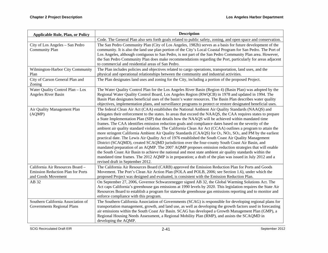
Chapter 2 Project Description Los Angeles Harbor Department
SCIG Recirculated Draft EIR 2-41 September 2012
Applicable Rule, Plan, or Policy Description
Code. The General Plan also sets forth goals related to public safety, zoning, and open space and conservation. City of Los Angeles – San Pedro Community Plan
The San Pedro Community Plan (City of Los Angeles, 1982b) serves as a basis for future development of the community. It is also the land use plan portion of the City’s Local Coastal Program for San Pedro. The Port of Los Angeles, although contiguous to San Pedro, is not part of the San Pedro Community Plan area. However, the San Pedro Community Plan does make recommendations regarding the Port, particularly for areas adjacent to commercial and residential areas of San Pedro.
Wilmington-Harbor City Community Plan
The Plan includes policies and objectives related to cargo operations, transportation, land uses, and the physical and operational relationships between the community and industrial activities.
City of Carson General Plan and Zoning
The Plan designates land uses and zoning for the City, including a portion of the proposed Project.
Water Quality Control Plan – Los Angeles River Basin
The Water Quality Control Plan for the Los Angeles River Basin (Region 4) (Basin Plan) was adopted by the Regional Water Quality Control Board, Los Angeles Region (RWQCB) in 1978 and updated in 1994. The Basin Plan designates beneficial uses of the basin’s water resources. The Basin Plan describes water quality objectives, implementation plans, and surveillance programs to protect or restore designated beneficial uses.
Air Quality Management Plan (AQMP)
The federal Clean Air Act (CAA) establishes the National Ambient Air Quality Standards (NAAQS) and delegates their enforcement to the states. In areas that exceed the NAAQS, the CAA requires states to prepare a State Implementation Plan (SIP) that details how the NAAQS will be achieved within mandated time frames. The CAA identifies emission reduction goals and compliance dates based on the severity of the ambient air quality standard violation. The California Clean Air Act (CCAA) outlines a program to attain the more stringent California Ambient Air Quality Standards (CAAQS) for O3, NO2, SO2, and PM by the earliest practical date. The Lewis Air Quality Act of 1976 established the South Coast Air Quality Management District (SCAQMD), created SCAQMD jurisdiction over the four-county South Coast Air Basin, and mandated preparation of an AQMP. The 2007 AQMP proposes emission reduction strategies that will enable the South Coast Air Basin to achieve the national and most state ambient air quality standards within the mandated time frames. The 2012 AQMP is in preparation; a draft of the plan was issued in July 2012 and a revised draft in September 2012.
California Air Resources Board – Emission Reduction Plan for Ports and Goods Movement
The California Air Resources Board (CARB) approved the Emission Reduction Plan for Ports and Goods Movement. The Port’s Clean Air Action Plan (POLA and POLB, 2006; see Section 1.6), under which the proposed Project was designed and evaluated, is consistent with the Emission Reduction Plan.
AB 32 On September 27, 2006, Governor Schwarzenegger signed AB 32, the Global Warming Solutions Act. The Act caps California’s greenhouse gas emissions at 1990 levels by 2020. This legislation requires the State Air Resources Board to establish a program for statewide greenhouse gas emissions reporting and to monitor and enforce compliance with this program.
Southern California Association of Governments Regional Plans
The Southern California Association of Governments (SCAG) is responsible for developing regional plans for transportation management, growth, and land use, as well as developing the growth factors used in forecasting air emissions within the South Coast Air Basin. SCAG has developed a Growth Management Plan (GMP), a Regional Housing Needs Assessment, a Regional Mobility Plan (RMP), and assists the SCAQMD in developing the AQMP.
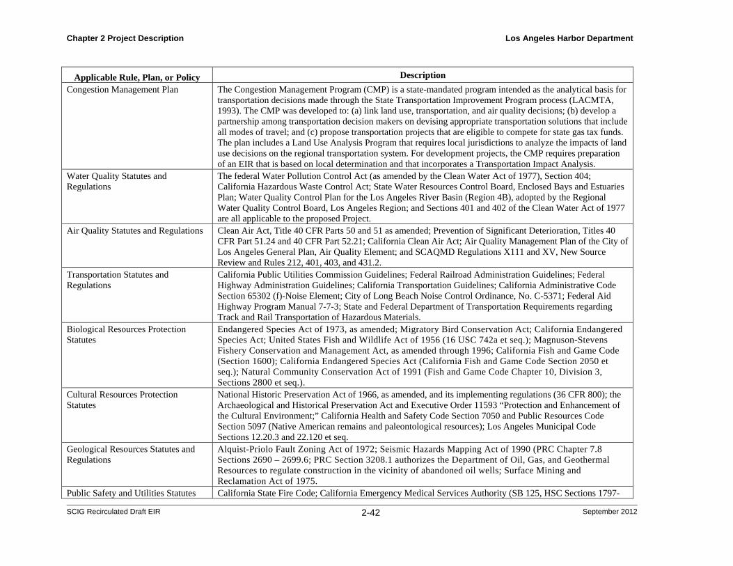
Chapter 2 Project Description Los Angeles Harbor Department
SCIG Recirculated Draft EIR 2-42 September 2012
Applicable Rule, Plan, or Policy Description
Congestion Management Plan The Congestion Management Program (CMP) is a state-mandated program intended as the analytical basis for transportation decisions made through the State Transportation Improvement Program process (LACMTA, 1993). The CMP was developed to: (a) link land use, transportation, and air quality decisions; (b) develop a partnership among transportation decision makers on devising appropriate transportation solutions that include all modes of travel; and (c) propose transportation projects that are eligible to compete for state gas tax funds. The plan includes a Land Use Analysis Program that requires local jurisdictions to analyze the impacts of land use decisions on the regional transportation system. For development projects, the CMP requires preparation of an EIR that is based on local determination and that incorporates a Transportation Impact Analysis.
Water Quality Statutes and Regulations
The federal Water Pollution Control Act (as amended by the Clean Water Act of 1977), Section 404; California Hazardous Waste Control Act; State Water Resources Control Board, Enclosed Bays and Estuaries Plan; Water Quality Control Plan for the Los Angeles River Basin (Region 4B), adopted by the Regional Water Quality Control Board, Los Angeles Region; and Sections 401 and 402 of the Clean Water Act of 1977 are all applicable to the proposed Project.
Air Quality Statutes and Regulations Clean Air Act, Title 40 CFR Parts 50 and 51 as amended; Prevention of Significant Deterioration, Titles 40 CFR Part 51.24 and 40 CFR Part 52.21; California Clean Air Act; Air Quality Management Plan of the City of Los Angeles General Plan, Air Quality Element; and SCAQMD Regulations X111 and XV, New Source Review and Rules 212, 401, 403, and 431.2.
Transportation Statutes and Regulations
California Public Utilities Commission Guidelines; Federal Railroad Administration Guidelines; Federal Highway Administration Guidelines; California Transportation Guidelines; California Administrative Code Section 65302 (f)-Noise Element; City of Long Beach Noise Control Ordinance, No. C-5371; Federal Aid Highway Program Manual 7-7-3; State and Federal Department of Transportation Requirements regarding Track and Rail Transportation of Hazardous Materials.
Biological Resources Protection Statutes
Endangered Species Act of 1973, as amended; Migratory Bird Conservation Act; California Endangered Species Act; United States Fish and Wildlife Act of 1956 (16 USC 742a et seq.); Magnuson-Stevens Fishery Conservation and Management Act, as amended through 1996; California Fish and Game Code (Section 1600); California Endangered Species Act (California Fish and Game Code Section 2050 et seq.); Natural Community Conservation Act of 1991 (Fish and Game Code Chapter 10, Division 3, Sections 2800 et seq.).
Cultural Resources Protection Statutes
National Historic Preservation Act of 1966, as amended, and its implementing regulations (36 CFR 800); the Archaeological and Historical Preservation Act and Executive Order 11593 “Protection and Enhancement of the Cultural Environment;” California Health and Safety Code Section 7050 and Public Resources Code Section 5097 (Native American remains and paleontological resources); Los Angeles Municipal Code Sections 12.20.3 and 22.120 et seq.
Geological Resources Statutes and Regulations
Alquist-Priolo Fault Zoning Act of 1972; Seismic Hazards Mapping Act of 1990 (PRC Chapter 7.8 Sections 2690 – 2699.6; PRC Section 3208.1 authorizes the Department of Oil, Gas, and Geothermal Resources to regulate construction in the vicinity of abandoned oil wells; Surface Mining and Reclamation Act of 1975.
Public Safety and Utilities Statutes California State Fire Code; California Emergency Medical Services Authority (SB 125, HSC Sections 1797-
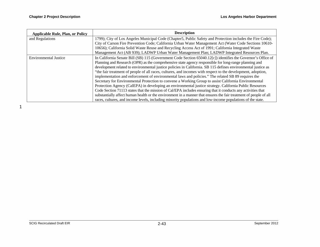
Chapter 2 Project Description Los Angeles Harbor Department
SCIG Recirculated Draft EIR 2-43 September 2012
Applicable Rule, Plan, or Policy Description
and Regulations 1799); City of Los Angeles Municipal Code (Chapter5, Public Safety and Protection includes the Fire Code); City of Carson Fire Prevention Code; California Urban Water Management Act (Water Code Sections 10610-10656); California Solid Waste Reuse and Recycling Access Act of 1991; California Integrated Waste Management Act (AB 939); LADWP Urban Water Management Plan; LADWP Integrated Resources Plan.
Environmental Justice In California Senate Bill (SB) 115 (Government Code Section 65040.12[c]) identifies the Governor’s Office of Planning and Research (OPR) as the comprehensive state agency responsible for long-range planning and development related to environmental justice policies in California. SB 115 defines environmental justice as “the fair treatment of people of all races, cultures, and incomes with respect to the development, adoption, implementation and enforcement of environmental laws and policies.” The related SB 89 requires the Secretary for Environmental Protection to convene a Working Group to assist California Environmental Protection Agency (CalEPA) in developing an environmental justice strategy. California Public Resources Code Section 71113 states that the mission of Cal/EPA includes ensuring that it conducts any activities that substantially affect human health or the environment in a manner that ensures the fair treatment of people of all races, cultures, and income levels, including minority populations and low-income populations of the state.
1