Chapter 2 2.pdf · Chapter 2 •Changes in Sea ... Skeptical Science(2010) 14. Chapter 2
Upload
lorraine-scottCategory
view
213download
0
Chapter 2
http://www.ic.arizona.edu/ic/kmartin/School/iroqcloth.htm

Early Native AmericansPaleo-Indians (old/early Indians)Hunters from Asia-crossing a land bridge11,000 years ago after the glaciers Archaeologists

Early Native AmericansHopewell Indians
http://www.michiganepic.org/historythemes/resources/hopewell_teacher_index.html
came from what is now Indiana & Ohio2,000 years agoWhat is left today: Norton Mounds near
Grand RapidsMound Builders: bury their dead
Source: http://www.michigan.gov/hal/0,1607,7-160-17449_18638_20846-54607--,00.html
A burial mound at Norton Mounds, near Grand
Rapids

The Anishinabeg IndiansMigrated
from Atlantic Coast to Michigan about 1,000 years ago to what is now Sault Ste. Marie
Sault St.
Marie
Quarton School
http://www.michigan-map.org/detailed.htm

The Anishinabeg Indians3 groups:
Ojibwa(or Chippewa) – “older brother”Ottawa – “middle brother”Potawatomi – “younger brother”
Known as the Three Fires Confederacy (family)
This is Chief Pontiac, the most famous Ottawa chief. Did you know that Pontiac, Michigan, and
Pontiac cars are named after him? Hmmm … what’s in his hand?
http://www.ohiohistorycentral.org/entry.php?rec=1857
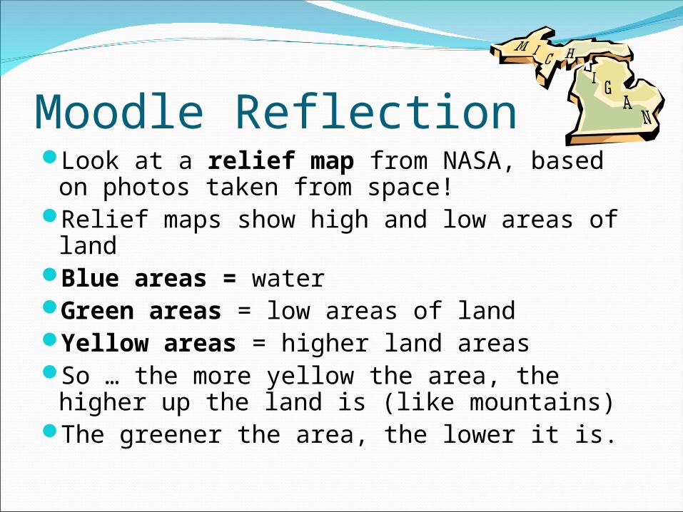
Moodle ReflectionLook at a relief map from NASA, based
on photos taken from space!Relief maps show high and low areas of
landBlue areas = waterGreen areas = low areas of landYellow areas = higher land areas So … the more yellow the area, the higher
up the land is (like mountains)The greener the area, the lower it is.

Moodle ReflectionCompare the map on the next
slide with the map in your book on page 51.
Explain where the Anishinabeg Indians came from and why they settled in different areas of Michigan.
Think about what they needed from their environment to survive.
How did geography affect their path?

Photo from
NA
SA
’s Jet Propulsion Lab: http://photojournal.jpl.nasa.gov/catalog/P
IA03377
Beverly School

The Huron IndiansHuron: Named by French traders Wendat: (people of the peninsula)Lots of things in Michigan
are named after the Hurons:Huron Street in Ann ArborHuron River in Ann ArborOne of our Great Lakes is Lake HuronThe Eastern Michigan University teams
used to be called the Hurons
Dolls from the Huron Tribe
Image: http://www.learner.org/amerpass/unit01/authors-8.html

The Iroquois Indians
Iroquois: New YorkForced the Huron to southeastern MichiganBitter enemies with the Huron IndiansSpoke same language and were relatedThey fought over land in the Upper PeninsulaArrived about 350 years ago
Iroquois beadwork. From http://www.bigorrin.org/iroquois_kids.htm

Vocabulary Words1. artifacts: objects made or used by people in the
past2. culture: similar art, beliefs, & customs of people3. migrate: move from one place to another4. Confederacy: a group united for a common
purpose5. wigwam: dome-shaped homes of bark and trees6. bands: small groups of people7. clans: groups of families with common ancestors8. stockade: high fences9. longhouses: large houses 25 x 200 feet long10.kinship: family relationships

Group Work Big Question: How did the first Michigan People
adapt to their environment?
Think about:Clothing, food, shelter, natural resources,
climate, weather, & travel.Create a project about your Indian group.Use any technology that you have learned so far.
Photo Story Create a wiki page Power Point Inspiration Audacity

Project Requirements1. Keep the big question in mind as you work.2. You need to research your tribe online.3. Read from the Michigan book to get information.4. Take notes in your own words to include all the
information about: clothes, food, natural resources, weather, climate, travel, & shelter.
5. Include vocabulary words from the list that are appropriate to your tribe.
6. You may include other interesting facts you find.7. Work together as a team.

Online Resourceshttp://www.native-languages.org/kids.htmhttp://www.bigorrin.org/chippewa_kids.htm Ojibwahttp://www.bigorrin.org/ottawa_kids.htm Ottawahttp://www.bigorrin.org/potawatomi_kids.htm Potawatomihttp://www.bigorrin.org/wyandot_kids.htm Huronhttp://www.bigorrin.org/iroquois_kids.htm Iroquoishttp://www.nativetech.org/clothing/regions/regions.html
Clothing of Native Americanshttp://www.nativetech.org/clothing/index.html clothes etc.http://www.ipl.org/div/natam/ The Internet Public Libraryhttp://nativeamericans.mrdonn.org/northeast/iroquois.htmlhttp://nativeamericans.mrdonn.org/northeast/ojibwa/index.htmlhttp://www.cdc.noaa.gov/USclimate/ Climatehttp://www.ic.arizona.edu/ic/kmartin/School/index.htm Iroquois

Free Online Clipart for Projecthttp://www.phillipmartin.info/clipart/
homepage.htm free cliparthttp://www.pppst.com/clipart.html free
clipart

Compare & Contrast TribesComplete the compare and contrast chart while you
listen to other groups present their information.
You will need to write small to fit details into the chart. If you miss details, you will find them on the wiki.
Please type your final copy after the presentations. You can go to the wiki to help you complete the
chart.
Tribes.doc


![Chapter 2 [Chapter 2]](https://static.fdocuments.net/doc/165x107/61f62040249b214bf02f4b97/chapter-2-chapter-2.jpg)