Chapter 2 - Alternatives, Including Proposed...
54
Jack Rabbit to Big Sky Meadow Village 161 kV Transmission Line Final Environmental Impact Statement Chapter 2 2-1 CHAPTER 2 ALTERNATIVES, INCLUDING PROPOSED ACTION 2.1 Introduction This chapter describes the Proposed Project facilities, construction and maintenance, and identifies alternatives to meet the need to provide reliable and economical energy to the Big Sky area. The Project is proposed to replace the existing 69 kilovolt (kV) transmission line, which needs to be upgraded and replaced. Five general alternatives were considered for the Proposed Project: Generation and Non-Transmission Alternatives Transmission Design Alternatives Transmission System Alternatives Proposed Action and Alternatives No Action Alternative The first three of these alternatives were considered but eliminated from consideration because they do not meet the purpose and need for the Proposed Project. The remaining action alternatives are the No-Action, Proposed Action, and two different routing options to construct a transmission line. The purpose of this chapter is to identify and compare the alternatives considered for the Jack Rabbit to Big Sky Meadow Village 161 kV Transmission Line Upgrade Project (JRBS or Proposed Project). It includes a description and map of each alternative considered. Further, it defines the differences between each alternative, and provides a clear basis for choice among options by the decision maker. Some of the information used to compare the alternatives is based upon the design of the alternative (e.g., increasing or decreasing transmission line crossings of the Gallatin River), and some of the information is based upon the environmental, social, and economic effects of implementing each alternative (e.g., the amount of visual impact caused by transmission line alternative routes). 2.2 Alternatives Analyzed in Detail The U.S. Forest Service (USFS or Forest Service) developed three action alternatives, and the No Action Alternative in response to issues raised by the public and agency specialists. The following sections describe alternatives that are being carried forward for full analysis in the Final Environmental Impact Statement (FEIS). The alternatives discussed in this EIS and shown in Figure 2-1, include a No Action Alternative (Alternative 1), the Proposed Action (Alternative 2), and two additional action alternatives that would be similar to the Proposed Action with minor routing adjustments (Alternatives 3 and 4).
Transcript of Chapter 2 - Alternatives, Including Proposed...
Jack Rabbit to Big Sky Meadow Village 161 kV Transmission Line Final Environmental Impact Statement
Chapter 2 2-1
CHAPTER 2 ALTERNATIVES, INCLUDING PROPOSED ACTION
2.1 Introduction This chapter describes the Proposed Project facilities, construction and maintenance, and identifies alternatives to meet the need to provide reliable and economical energy to the Big Sky area. The Project is proposed to replace the existing 69 kilovolt (kV) transmission line, which needs to be upgraded and replaced. Five general alternatives were considered for the Proposed Project:
Generation and Non-Transmission Alternatives Transmission Design Alternatives Transmission System Alternatives Proposed Action and Alternatives No Action Alternative
The first three of these alternatives were considered but eliminated from consideration because they do not meet the purpose and need for the Proposed Project. The remaining action alternatives are the No-Action, Proposed Action, and two different routing options to construct a transmission line. The purpose of this chapter is to identify and compare the alternatives considered for the Jack Rabbit to Big Sky Meadow Village 161 kV Transmission Line Upgrade Project (JRBS or Proposed Project). It includes a description and map of each alternative considered. Further, it defines the differences between each alternative, and provides a clear basis for choice among options by the decision maker. Some of the information used to compare the alternatives is based upon the design of the alternative (e.g., increasing or decreasing transmission line crossings of the Gallatin River), and some of the information is based upon the environmental, social, and economic effects of implementing each alternative (e.g., the amount of visual impact caused by transmission line alternative routes).
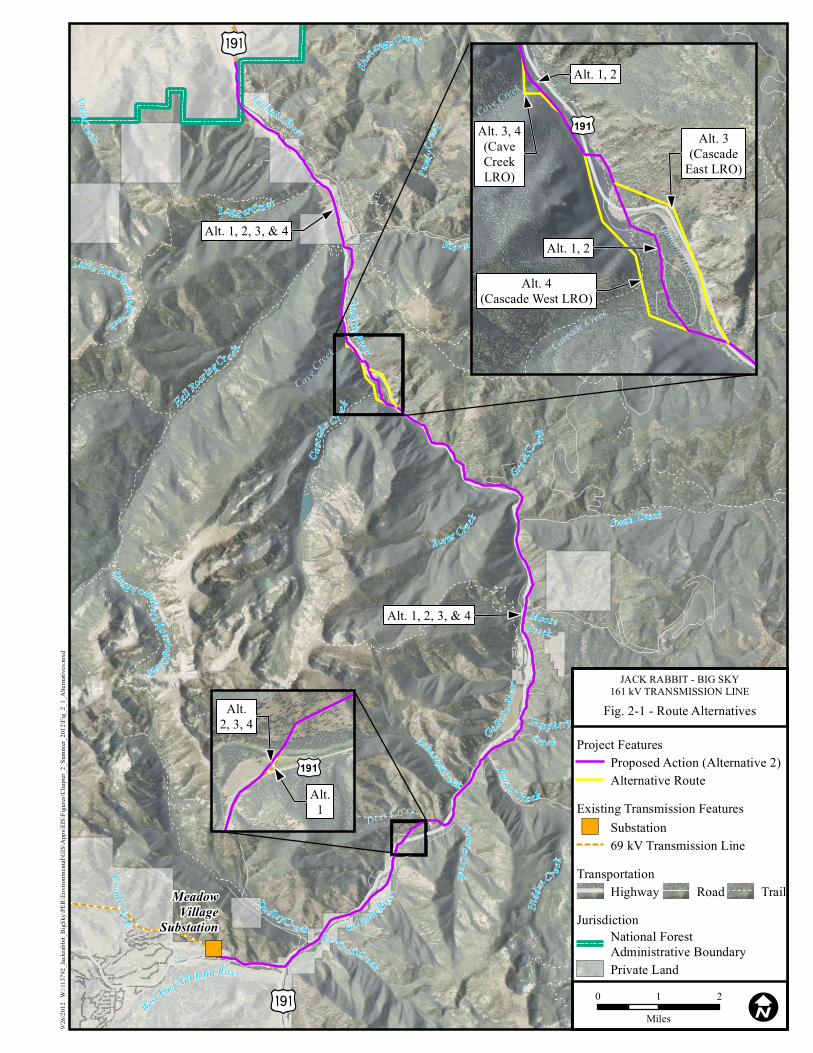
2.2 Alternatives Analyzed in Detail The U.S. Forest Service (USFS or Forest Service) developed three action alternatives, and the No Action Alternative in response to issues raised by the public and agency specialists. The following sections describe alternatives that are being carried forward for full analysis in the Final Environmental Impact Statement (FEIS). The alternatives discussed in this EIS and shown in Figure 2-1, include a No Action Alternative (Alternative 1), the Proposed Action (Alternative 2), and two additional action alternatives that would be similar to the Proposed Action with minor routing adjustments (Alternatives 3 and 4).

Final Environmental Impact Statement Jack Rabbit to Big Sky Meadow Village 161 kV Transmission Line
2-2 Chapter 2
THIS PAGE INTENTIONALLY LEFT BLANK.
")
Burnt Creek
Greek C
r e ek
Twin Creek
Portal Creek
St orm Castle C ree k
Logg er Creek
Dud ley Creek Levin sk i Creek
Asbestos Creek
Hidd
en C
reek
Deer Creek
Hell Roar
ing Cre e k
Cra il C reekSouth Fork Hel l Roaring Creek
Shenango Creek
Mica Creek
Lime C
reek
Mist Creek
Little Hell Roaring Creek
Purd
y Cree
k
Casca
de C r eek
Moose
Swan Creek
Tamphery Creek
Portal C re ek
Goose Creek
West Fork Gallatin River
Gal latin Rive
r
Gallatin
River
Gallatin River
Gallatin River
Creek
MeadowVillage
Substation
Deer Creek
Cav e C
reek
Iu
Iu
Alt. 1, 2, 3, & 4
Alt. 1, 2, 3, & 4
9/26/2
012
W:\1
1379
2_Jac
krabb
it_Bi
gSky
\PER\
Envir
onme
ntal\G
IS\A
pps\E
IS\Fi
gures
\Cha
pter_2
_Sum
mer_2
012\F
ig_2_
1_Al
terna
tives.
mxd
0 1 2Miles I
Fig. 2-1 - Route Alternatives
JACK RABBIT - BIG SKY161 kV TRANSMISSION LINE
Alt. 3, 4(CaveCreekLRO)
Alt. 4(Cascade West LRO)
Alt. 3(Cascade
East LRO)
Alt. 1, 2
Alt. 1, 2
Gallatin River
Cascade Creek
Cave Creek
£¤191
Alt.1
Alt.2, 3, 4
£¤191
TransportationRoad TrailHighway
Jurisdiction
Private Land
National ForestAdministrative Boundary
Existing Transmission Features") Substation
69 kV Transmission Line
Project Features
Alternative RouteProposed Action (Alternative 2)

Final Environmental Impact Statement Jack Rabbit to Big Sky Meadow Village 161 kV Transmission Line
2-4 Chapter 2
THIS PAGE INTENTIONALLY LEFT BLANK.
Jack Rabbit to Big Sky Meadow Village 161 kV Transmission Line Final Environmental Impact Statement
Chapter 2 2-5
2.2.1 Introduction
The Proposed Project is to upgrade the existing 69 kV line to 161 kV between the Jack Rabbit Substation west of Bozeman, and the Meadow Village Substation at Big Sky to accommodate current requirements, future growth, and to improve reliability for existing customers. The Project would be constructed in two major stages. The first construction stage would be to install new substation equipment; to expand the Jack Rabbit Substation; and to install autotransformer equipment at the Meadow Village Substation. The second construction stage would rebuild and upgrade the existing 69 kV Jack Rabbit transmission line to a 161 kV transmission line. A distribution system would be built below the 161 kV transmission circuit (underbuilt). The distribution system would be upgraded from a three-wire system (currently in place) hung on post insulators (consisting of three insulators protruding from the transmission pole underneath the 69 kV conductor) to a four-wire system hung on cross-arm supports (supporting hardware perpendicular to the transmission pole underneath the 161 kV conductor). The portion of the Project from the Gallatin National Forest (GNF) north boundary to the Jack Rabbit Substation would cross private lands. Proposed rebuild and upgrade of the transmission line on private lands are not part of the decision being considered in this EIS. NorthWestern Energy (NorthWestern) constructed this portion of the project during the 3rd and 4th quarter of 2012.This section of the line is scheduled to be finished 2nd quarter of 2013. This EIS evaluates the potential impacts of the Proposed Project and additional action alternatives on National Forest System (NFS) lands. This includes approximately 16 miles of the Proposed Project that cross NFS land in the Gallatin Canyon. The remaining 21 miles of the Proposed Project and associated substations are outside the Forest Service jurisdiction and are considered under the context of cumulative effects and connected actions; they are not part of the decision being made by the Forest Service. These 21 miles are subject to Gallatin County permitting requirements (Four Corners Zoning District or Gallatin Canyon/Big Sky Zoning District).
2.2.2 Alternative 1 - No Action
Under this alternative, the existing 69 kV transmission line between Jack Rabbit Substation and Big Sky Meadow Village Substation would not be rebuilt to a 161 kV transmission circuit. The existing 69 kV transmission lines within the Proposed Project area would remain on existing transmission structures along with the existing three-phase, 12.5 kV underbuild distribution. However, right-of-way (ROW) vegetation management (clearing and weed spraying), and operations and maintenance would continue. These efforts would include maintaining the existing 40 foot ROW width, hazard tree removal, and transmission structure replacement as needed to minimize failure, including poles and conductor wire.
2.2.3 Alternative 2 - Proposed Action
Under Alternative 2, the GNF would amend NorthWestern’s existing Special Use Permit (SUP) to authorize construction, operation, and maintenance of a 161 kV electrical transmission and distribution line on 16 miles of NFS lands in Gallatin Canyon between Four Corners and Big Sky, Montana. The Proposed Action would utilize the existing transmission line and United States Highway 191 (US Hwy 191) corridors for the entire length 16 miles under evaluation in this EIS. The Proposed Action-Alternative 2 would be constructed within 10 to 15 feet of the existing transmission line in the existing ROW. Tree clearing would be required to increase the transmission line ROW from the current width of approximately 40 feet, to a 50- to 80-foot wide varying distance depending on the type of transmission structure used.
Final Environmental Impact Statement Jack Rabbit to Big Sky Meadow Village 161 kV Transmission Line
2-6 Chapter 2
Vegetation clearing within the ROW would be necessary to construct the new 161 kV transmission line. After staking the transmission facilities, woody vegetation 14 feet or higher within the ROW would be felled and removed. The primary method of ROW vegetation clearing includes manually felling trees by hand with chainsaws or with handheld non-motorized tools and removing those trees from the ROW with ground based equipment or helicopters. The primary benefit of manual methods is selectivity (only unwanted or target vegetation is removed), while non-target vegetation is not disturbed. The manual vegetation removal techniques employed by NorthWestern are described in detail in the ROW Clearing Plan (see Appendix B). Work sites including log decking areas, staging areas and construction yards would also be utilized during construction. These work sites are further discussed in Section 2.2.6 below. Work sites would be restored using topsoil stockpiled for such purposes and approved native seed mixtures. The contractor would dispose of excess soils, rock, and other such materials that cannot be used in restoration. If soil compaction occurs, it may be necessary to perform ripping prior to seeding. The details of the reclamation are described in the Weed Management, Reclamation, and Revegetation Plan in Appendix C (also refer to reclamation in 2.2.7).
Five types of transmission structures may be used for the 161 kV transmission line. The most common type would consist of single-pole, wooden transmission structures placed approximately 300 feet apart (average ruling span), with an average transmission structure height above ground of approximately 60 to 70 feet (an increase of five to ten feet from existing transmission structure height). Depending on terrain and other design criteria, transmission structure height could be as tall as 90 feet. In some areas where single-pole wooden transmission structures are infeasible and additional structure support is needed, guyed transmission structures may be used. In some areas where single-pole wooden transmission structures are impractical due to obstructions, steep terrain, river and canyon crossings and/or areas where the line changes direction resulting in a greater angle, the transmission line may have self-supporting weatherized (Cor-Ten) steel transmission structures or wood laminate transmission structures directly embedded into the ground. “Weatherized" or “Cor-Ten” structures are allowed to rust and form a protective coating (Patina) on its surface that exhibits an increased resistance to atmospheric corrosion compared to other steels (shown in Figure 2-5). The layer protecting the surface develops and regenerates continuously when subjected to the influence of the weather. Installation methods for all of the pole types would be similar, as would the amount of expected ground disturbance.
In some areas, two-pole wooden "H-frame" transmission structures have been used on the existing 69 kV alignment, and could be used to allow further spacing between transmission structures. Two-pole wooden H-frame structures are typically used where a longer transmission line span is required, including canyon crossings and locations where terrain limits placement of single pole structures. However, this transmission structure has not been identified during pre-engineering for general use anywhere along the 16-mile segment on NFS lands. Transmission structures would typically be 1.5 feet in diameter; however, they could vary and be up to four feet in diameter depending on design criteria. The standard ROW width for a single transmission structure 161 kV transmission line is 50 feet, and 80 feet for two-pole “H-frame” line. The existing two-wire distribution underbuild circuit that is carried along much of the route would be replaced with a three-phase, four-wire 12.5 kV distribution circuit to improve electrical service for customers along the ROW. Final engineering would be completed after a decision has been made on which alternative is chosen, and final structure type and placement would be approved by the Forest Service prior to implementation. The existing transmission line crosses US Hwy 191 eight times and the Gallatin River eight times on NFS lands. The number of crossings would remain the same under the Proposed Action-

Jack Rabbit to Big Sky Meadow Village 161 kV Transmission Line Final Environmental Impact Statement
Chapter 2 2-7
Alternative 2. It would also remain in close proximity to a number of recreation residences (described in Section 3.3.1 – Scenery). The corridor for the transmission line has many existing trails and roads that would provide access to the Project area, including the pole locations. One new temporary access road, approximately 600 feet, may be required to access a construction yard; however, the existing road network may require some upgrading in a few locations to allow for construction equipment. Please refer to the access description in 2.2.6. The access maps can be found in the ROW Clearing Plan (Appendix B). Construction of the Project portion on NFS lands is forecasted to take approximately two years to complete. Construction would be scheduled to begin in 2013 with the system coming on line, energized at the 161 kV level, during the fall of 2014. The design, construction, operation and maintenance of the Proposed Project would meet or exceed: the requirements of the National Electrical Safety Code (NESC); U.S. Department of Labor, Occupational Safety and Health Standards; Western Electricity Coordinating Council (WECC) Transmission System Performance and Reliability Criteria; and NorthWestern’s requirements for safety and the protection of landowners and their property. The existing transmission line would be removed after the new one is completed and materials disposed of off NFS lands. Construction waste will also be disposed of off NFS lands. From the Jack Rabbit Substation, the proposed route would proceed south through open pasture, rolling slopes, and residential areas (in the extreme north end) before crossing US Hwy 191 and entering the Gallatin River Canyon in the NW ¼ Section 4, T4S R4E. The proposed route would then continue south following the existing alignment and US Hwy 191 for approximately 23 miles (16 miles through NFS lands) through the Gallatin River Canyon to the Big Sky turn-off at Montana State Highway 64 (MT Hwy 64) (SE ¼ Section 32, T6S R4E). From the Big Sky turn-off, the proposed route would then turn west, following the existing 69 kV line alignment for approximately 1.4 miles to the new Meadow Village Substation site.
2.2.4 Alternative 3 - Cave Creek and Cascade East LROs (Agency Preferred Alternative)
Alternative 3 would utilize the same alignment as the Proposed Action-Alternative 2, with the exception of the local routing options (LROs) described below. This alternative was developed to respond to the issues identified during the scoping process, specifically to respond to concern for transmission line impacts to the Lava Lake Trailhead, the Lava Lake wilderness access trail, the Gallatin River which is an eligible wild and scenic river, and impacts to the Cascade Creek and Cave Creek Tracts. The alternative would move the transmission line to the east side of US Hwy 191 and the Gallatin River, across from the Cascade recreation residences. It would eliminate two transmission line and one distribution line crossing of the Gallatin River and US Hwy 191.
Cave Creek LRO
The Cave Creek LRO is in T5S, R4E, Section 9, north of the Lava Lake Trailhead on the west side of US Hwy 191. This LRO was developed to reduce visual impacts to the recreation residence tracts, and to mitigate the potential effects to the historical character of the recreation residence tracts. The existing line contains seven transmission structures along this half-mile stretch (0.51 mile for the proposed LRO and 0.47 mile for the Proposed Action-Alternative 2). This LRO would require
Final Environmental Impact Statement Jack Rabbit to Big Sky Meadow Village 161 kV Transmission Line
2-8 Chapter 2
additional tree clearing due to the alignment moving upslope, approximately 200 feet in places, from the existing 69 kV transmission line. Portions of this LRO would occupy the original 1950s 50 kV transmission line corridor that was abandoned in the early 1970s when the current 69 kV transmission line was upgraded to address system load demands. The minor shift in the 1950s alignment (previous 50 kV) to the 1970s (current 69 kV) was likely due to more favorable construction access down slope. The existing distribution to the residences in the Cave Creek recreation residence tract would remain in place to provide local service to the cabins. Service for distribution would be connected at either the north or south end of the recreation residence tract due to the deviation from the existing alignment. The additional distance upslope from the recreation residences would likely require the installation of one to two distribution transmission structures on the north or south end of the recreation residence tract depending on where the connection is determined. The existing 69 kV transmission line structures outside of those required for distribution within the recreation residence tract would be removed.
Cascade East LRO
The Cascade East LRO is in T5S, R4E, Sections 15 and 16, across the river and across US Hwy 191 from the Lee Metcalf Wilderness Boundary and the Cascade Creek recreation residence tract. This LRO was developed to reduce: visual impact at the Lava Lake Trailhead, near the Lava Lake trail which is a wilderness access trail; potential impacts to the Gallatin River which is an eligible wild and scenic river; and concerns associated with the Cascade Creek and Cave Creek Recreation Residence Tracts. The transmission line would be moved to the east side of US Hwy 191 and the Gallatin River. This LRO would eliminate two transmission line crossings and one distribution line crossing of the highway and river, as well as eliminate visual impacts from the line crossing through the Lava Lakes trailhead. The distribution line crossing of the highway and river would remain with this alternative. This alternative would also result in the removal of a highly visible transmission pole in the Lava Lake trailhead parking lot. This LRO would require minimal tree clearing due to the alignment moving east of US Hwy 191 along less forested slopes. The existing distribution to the residences in the Cascade Creek recreation residence tract would remain in place. Service for distribution would likely be connected on the south end of the recreation residence tract similar to the Proposed Action alignment. The existing 69 kV transmission line structures outside of those required for distribution service to the recreation residence tract would be removed. Site Specific Forest Amendments The local route changes proposed in this alternative would also require two site specific Forest Plan amendments (see also Chapter 1, Section 1.5 for further discussion). First, the decision to authorize a utility corridor is automatically coupled with the decision to designate that corridor as Management Area (MA) 25 (electrical transmission lines and pipelines, climatic and snow measuring sites, and electric sites). The existing corridor is MA 25 and any new ROW, either transmission line or distribution line, would become a MA 25 designation also. Second, the Wild and Scenic River direction in the Forest Plan standards (pg. II-29) states that new facilities should be restricted to existing ROWs, where no reasonable alternatives exist. The mere fact that these LROs exist as alternatives to the Proposed Action demonstrates that there is another reasonable alternative, i.e., leaving the ROW in its current location. However, the standard also says that “the scenic, recreational, and fish and wildlife values must be evaluated in
Jack Rabbit to Big Sky Meadow Village 161 kV Transmission Line Final Environmental Impact Statement
Chapter 2 2-9
the selection of the site.” In the case of this alternative, these two somewhat ambiguous mandates may be in conflict and in order to select a site with consideration of the outstandingly remarkable values of the Gallatin River, the ROW location may need to change, thus prompting a site specific amendment to allow this.
2.2.5 Alternative 4 - Cave Creek and Cascade West LROs
Alternative 4 would utilize the same alignment as Alternative 3 with the exception of the Cascade West LRO (described below). Like Alternative 3, this alternative was developed to respond to the issues identified during the scoping process, specifically to respond to concerns for transmission line impacts to the Lava Lake Trailhead, the Lava Lake wilderness access trail, the Gallatin River as an eligible wild and scenic river and impacts to the Cascade Creek and Cave Creek Tracts. It would move the transmission line to the west of the recreation residences at Cascade and would eliminate two Gallatin River crossings and two US Hwy 191 crossings.
Cascade West
The Cascade West LRO is in T5S, R4E, Sections 15 and 16, northeast of the Lee Metcalf Wilderness Boundary and west of the Cascade Creek recreation residence tract. This LRO was developed to reduce visual, heritage, and recreational impacts associated with the Cascade recreation residences, and visual impacts to the Lava Lakes trailhead. This alternative is moved to the west of the Proposed Action (Alternative 2) in this area to be farther from the recreation residences and the Lava Lakes trailhead. This alternative would also eliminate two highway and two river crossings of the transmission line, thereby reducing visual impacts that result from the crossings. This alternative would also result in the removal of a highly visible transmission pole in the Lava Lake trailhead parking lot. This LRO would require tree clearing due to the alignment moving upslope, approximately 500 feet in places, in heavier forested lands. The existing distribution lines to the residences in the Cascade Creek recreation residence tract would remain in place. Service for distribution would be connected on the south end of the recreation residence tract, similar to the Proposed Action alignment. The existing 69 kV transmission line structures outside of those required for distribution service to the recreation residence tract would be removed. Site Specific Forest Amendments The local route changes proposed in this alternative would also require two site specific Forest Plan amendments (see also Chapter 1, Section 1.5 for further discussion). First, the decision to authorize a utility corridor is automatically coupled with the decision to designate that corridor as MA 25 (electrical transmission lines and pipelines, climatic and snow measuring sites, and electric sites). The existing corridor is MA 25 and any new ROW, either transmission line or distribution line, would become a MA 25 designation also. Second, the Wild and Scenic River direction in the Forest Plan standards (pg. II-29) states that new facilities should be restricted to existing ROWs, where no reasonable alternatives exist. The mere fact that these local routing options exist as alternatives to the Proposed Action demonstrates that there is another reasonable alternative, i.e., leaving the ROW in its current location. However, the standard also says that “the scenic, recreational, and fish and wildlife values must be evaluated in the selection of the site.” In the case of this alternative, these two somewhat ambiguous mandates may be in conflict and in order to select a site with consideration of the outstandingly remarkable values of the Gallatin River, the ROW location may need to change, thus prompting a site specific amendment to allow this.
Final Environmental Impact Statement Jack Rabbit to Big Sky Meadow Village 161 kV Transmission Line
2-10 Chapter 2
2.2.6 Project Design Features Common to All Action Alternatives
The discussion below describes the technical components that are common to all of the action alternatives with respect to the transmission line and transmission line construction.
Transmission Structures
The proposed rebuild of the existing 69 kV Jack Rabbit to Big Sky transmission line to a 161 kV transmission line would require the upgrade of the transmission structures. The proposed primary transmission structure type for the 161 kV transmission line would be single-circuit wood poles. Single transmission structures would typically be round solid wood. In some areas where single-pole wooden transmission structures are infeasible, or where guyed transmission structures are not practical due to obstructions, steep terrain, river and canyon crossings and/or areas where the line changes direction resulting in a greater angle, the transmission line could be supported by self-supporting steel transmission structures or wood laminate transmission structures directly embedded into the ground. The existing 69 kV transmission line contains approximately 10 miles of single wood pole structures and approximately six miles of guyed wood poles and H-frame structures. The existing structure types for the 69 kV transmission line likely represents a similar scenario for the proposed 161 kV transmission line. Single wood pole structures are the preferred structure type and guyed single wood pole, self-supporting single steel pole (corten type with rust colored finish), wood laminate, and H-frame structures maybe used in areas identified during design that will required additional support due to terrain, span length and structure load. In some areas, two-pole wooden "H-frame" transmission structures have been used on the existing 69 kV alignment, and could be used to allow further spacing between transmission structures. However, this transmission structure has not been identified during pre-engineering, for general use anywhere along the 16 mile segment on NFS lands. Of the approximate 16 miles of transmission line length on NFS land, only 0.3 mile exists as double-pole H-frame transmission structures. Distribution lines would be underbuilt on the new transmission line structures where feasible, with cross-arm supports. Figures 2-2, 2-3, 2-4, 2-5, and 2-6 show the proposed typical transmission structure types. Typical transmission structure heights for the tangent (structures that hold the line up, but bear little tension), dead-end (structure that bears tension) and angle transmission structures (structure that supports change in line direction and bears tension) would be approximately 60 to 90 feet, depending on terrain. The transmission structures would be direct embedded or installed on drilled pier concrete foundations to a depth of approximately 10 to 25 feet depending on load and soil characteristics. In areas where sloughing or steep rocky slopes exist, underground corrugated steel culverts or Sona Tubes (cylindrical paper forms) may be used to hold excavated walls. Transmission structure diameter would be approximately 1.5 to three feet, but could be up to four feet in diameter depending on framing configuration and the angle to adjacent transmission structures.
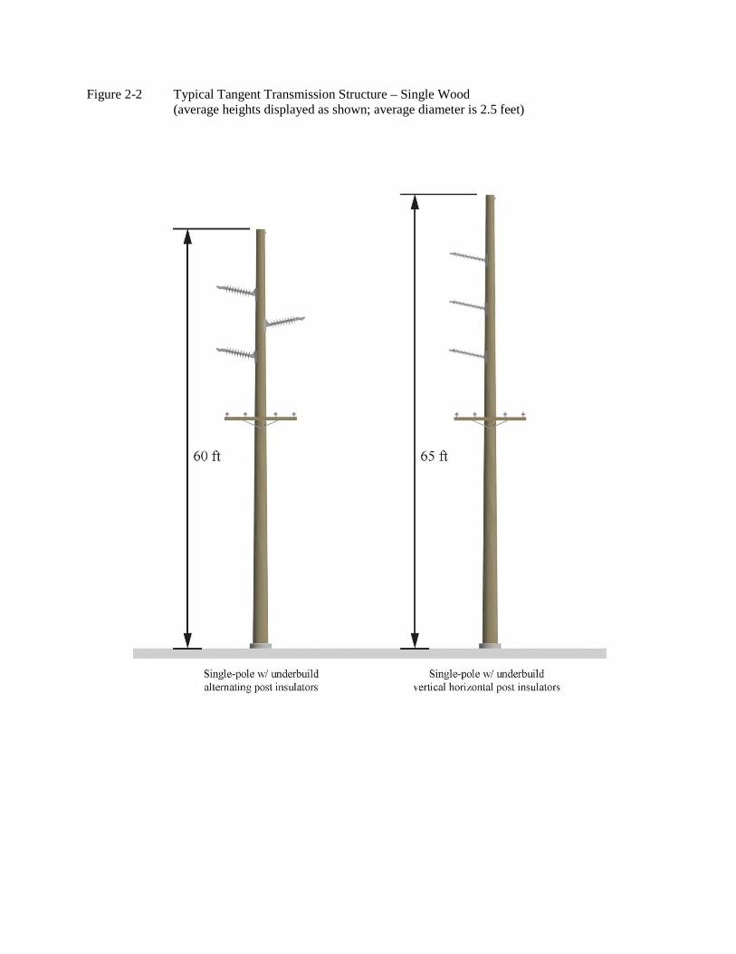
Figure 2-2 Typical Tangent Transmission Structure – Single Wood (average heights displayed as shown; average diameter is 2.5 feet)

Final Environmental Impact Statement Jack Rabbit to Big Sky Meadow Village 161 kV Transmission Line
2-12 Chapter 2
THIS PAGE INTENTIONALLY LEFT BLANK.
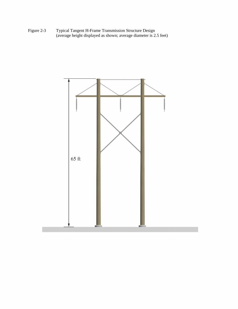
Figure 2-3 Typical Tangent H-Frame Transmission Structure Design (average height displayed as shown; average diameter is 2.5 feet)

Final Environmental Impact Statement Jack Rabbit to Big Sky Meadow Village 161 kV Transmission Line
2-14 Chapter 2
THIS PAGE INTENTIONALLY LEFT BLANK.
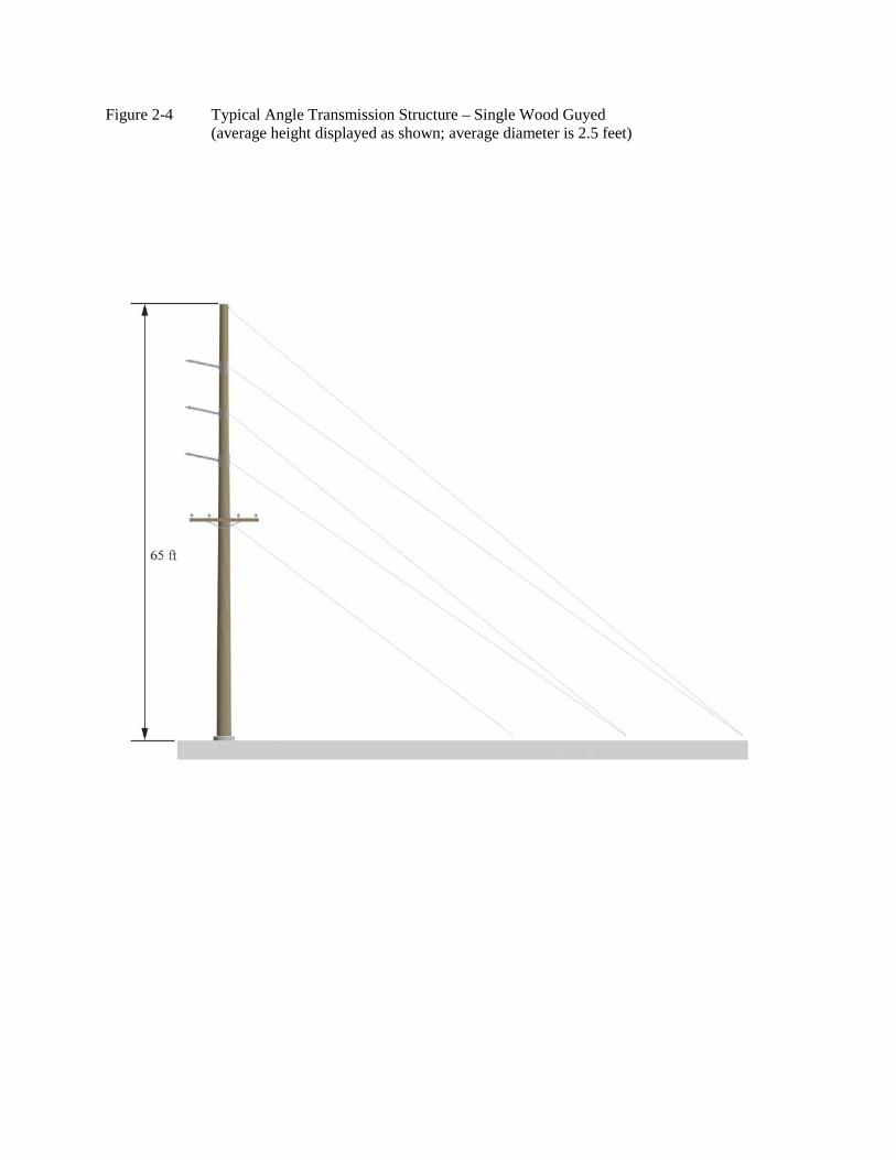
Figure 2-4 Typical Angle Transmission Structure – Single Wood Guyed (average height displayed as shown; average diameter is 2.5 feet)

Final Environmental Impact Statement Jack Rabbit to Big Sky Meadow Village 161 kV Transmission Line
2-16 Chapter 2
THIS PAGE INTENTIONALLY LEFT BLANK.
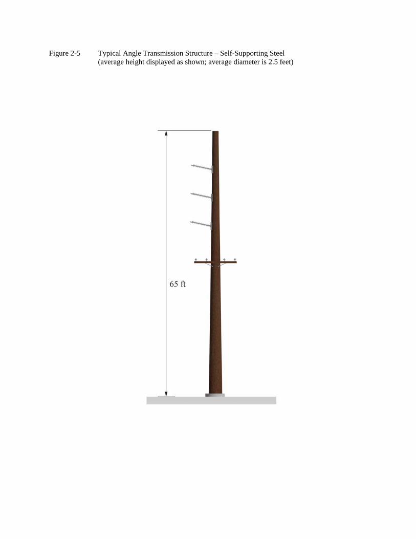
Figure 2-5 Typical Angle Transmission Structure – Self-Supporting Steel (average height displayed as shown; average diameter is 2.5 feet)

Final Environmental Impact Statement Jack Rabbit to Big Sky Meadow Village 161 kV Transmission Line
2-18 Chapter 2
THIS PAGE INTENTIONALLY LEFT BLANK.
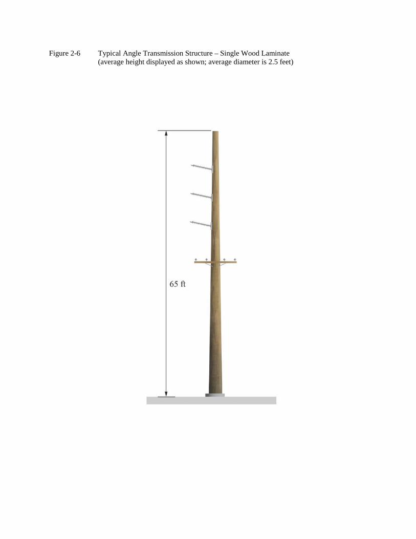
Figure 2-6 Typical Angle Transmission Structure – Single Wood Laminate (average height displayed as shown; average diameter is 2.5 feet)

Final Environmental Impact Statement Jack Rabbit to Big Sky Meadow Village 161 kV Transmission Line
2-20 Chapter 2
THIS PAGE INTENTIONALLY LEFT BLANK.
Jack Rabbit to Big Sky Meadow Village 161 kV Transmission Line Final Environmental Impact Statement
Chapter 2 2-21
Transmission Structures Setting Positions
The preferred transmission structure setting locations along the entire alignment would generally be offset and parallel to the existing facilities within approximately 10 to 15 feet of the current 69 kV centerline. This would allow for new 161 kV transmission structure placement along the Proposed Action alignment without interfering with the operations of the 69 kV transmission line during construction. During construction, the 69 kV line will be de-energized but the distribution line will stay in service. However, there may be times that the distribution line will be de-energized with generators or a backup power source provided to affected homes/businesses so they remain in service. Areas requiring helicopter construction, or that have a new alignment that jumps from one side to the other of the existing alignment, would require removal of the existing 69 kV conductor for safety purposes. This would be completed during low load periods or in short conductor stringing segments to minimize exposure to electrical power outages in the Big Sky area. Areas of heavy timber along the Proposed Action alignment would require additional tree clearing equal to the offset distance of 10 to 15 feet on one side of the existing ROW. This clearing would be completed by hand with chainsaws, and trees would be removed by ground based equipment or helicopter where safely feasible. Vegetation on one side of the existing ROW would be allowed to re-vegetate so that the entire ROW required for a single transmission structure would be a total of 50 feet. The offset side of the ROW proposed for construction would be determined by the existing resources present (such as residences, road, vegetation, etc.). Areas where it is desirable to maintain vegetation, preserve screening vegetation, and avoid sensitive resources adjacent to the existing ROW, etc., would be taken into account when choosing the offset side for construction. Generally, the clearing would be away from the highway.
Conductors and Associated Hardware
The 161 kV transmission line would consist of three phases with one wire or conductor per phase. Each conductor would consist of stranded aluminum with a high-strength steel reinforced core. Minimum conductor height above the ground for the 161 kV transmission line would be 24 feet, at 167 degrees Fahrenheit (°F), based on NESC standards and NorthWestern’s own internal standards. Typically the 161 kV conductor height above ground would be greater than 24 feet due to the presence of the 12.5 kV distribution underbuild circuit which would itself have a minimum ground clearance of 22 feet at 167°F. At road crossings, minimum clearance would typically increase to 30 feet above ground. The distances between phases are eight to 15 feet, depending on the transmission structure type. The H-frame designs would have greater conductor separation verses the single transmission structure design.
Fiber Optics
Fiber optic ground wire cable (OPGW) for substation-to-substation control would be installed on top of each transmission structure. The outer strands would consist of aluminum wire and the entire OPGW would be approximately 0.55 inch in diameter. The fiber optic wire would be reserved for use by NorthWestern, the owner operator. A third party operator could occupy vacant fibers in the future; however, NorthWestern would retain ownership of the fiber optic cable and all the associated maintenance.
Final Environmental Impact Statement Jack Rabbit to Big Sky Meadow Village 161 kV Transmission Line
2-22 Chapter 2
Distribution Network
The existing distribution network that provides the direct electrical hookups to individual customers (e.g., residences) would be upgraded to a four-wire system that is underbuilt horizontally on crossarm supports. The alignment of the distribution would remain unchanged for the Proposed Action-Alternative 2, and would be similar for all action alternatives. Exceptions to the existing distribution service changes would occur in areas where existing transmission structures need to be relocated for safety or other resource concerns. These minor adjustments would occur within the existing distribution ROW. Deviations to the existing distribution alignment are anticipated for the action alternatives (Alternatives 3 and 4). These deviations would occur as a result of the alignment shifting away from the existing ROW. For the most part, the distribution poles through the Cascade and Cave Creek recreation residence tracts would be shortened in height and the existing distribution poles would remain in place.
Right-of-Way
ROW width would vary from 50 to 80 feet, depending on the transmission structure type, terrain, access, and sensitive resources. An 80-foot wide ROW may be required for H-frame transmission structures where engineering design determines the need (e.g., angles and long spans), and a 50-foot wide ROW is needed for the single transmission structure design on the remainder. In areas where the alignment changes direction, transmission structures may require guying. The guy-wires would increase the transmission structure support where line tension is great on transmission structures. Guy-wires may extend beyond the typical 50 foot ROW. Guy-wires that support angle transmission structures may extend 50 to 100 feet beyond the edge of the ROW. Except as may be defined during final design at very site specific locations to accommodate terrain or construction access issues, there are no line segments in the Proposed Project that have been identified as requiring H-frame transmission structures. It is NorthWestern's intention to rebuild the existing 69 kV transmission line to 161 kV with single-pole transmission structures to the extent practical.
Access Roads
The utility corridor for the 69 kV transmission line has many existing trails and roads in the vicinity. All action alternatives would use existing roads and trails wherever feasible for access to minimize new disturbance. Of a total of 16 miles of Proposed Project on NFS lands, there are approximately 3.4 miles of the proposed 161 kV transmission line having conventional access to the ROW from existing roads and trails, and would require no road work. Approximately 1.6 miles of the proposed 161 kV transmission line would require use of existing roads and trails with conventional access, and would require road improvements. Approximately 600 feet of new temporary access road may be built to access the Indian Ridge construction yard. There are approximately 10.2 miles of the proposed 161 kV transmission line that have no access due to terrain or other obstacles. Therefore, helicopter and/or walk-in access would be needed unless a crane can reach from an existing road. An additional 0.8 mile has an undetermined access prescription due to lack of engineering design information, but would be similar to those described above. One new temporary access road, approximately 600 feet, and use of existing roads would be required to access new transmission structure locations within the ROW. However, it is possible that portions of existing access roads located outside of this ROW would require improvements. Where there are no existing access roads, the Proposed Action would use overland access to the
Jack Rabbit to Big Sky Meadow Village 161 kV Transmission Line Final Environmental Impact Statement
Chapter 2 2-23
greatest extent possible. Overland access would consist of “drive and crush” travel with tracked or rubber tired equipment. Drive and crush is vehicular travel to access a site without substantially modifying the landscape. Vegetation is crushed but not cropped. Soil is compacted, but no surface soil is removed. Even though vegetation may be damaged or destroyed, this creates vertical mulch upon the surface soil and leaves the seed bank in place. Crushed vegetation would likely re-sprout after temporary use is stopped. To minimize ground disturbance and/or reduce scarring (visual contrast) of the landscape, the alignment of any overland routes would follow the landform contours in designated areas where practicable, providing that such alignment does not impact other resource values additionally. Existing access roads would be used during construction to access work areas, and during periodic maintenance of the completed transmission line throughout the life of the Proposed Action. A new temporary, approximately 600 foot, access road may be needed to constructed to access the proposed Indian Ridge construction yard. US Hwy 191 will be used by construction contractors to deliver materials, personnel and equipment for the construction of the Proposed Project and Alternatives 3 and 4. Prior to construction, a Traffic Control Plan would be submitted to the Montana Department of Transportation (MDT) for review and approval to ensure the proposed traffic control measures along US Hwy 191 are appropriate for work zone safety and to ensure that all necessary permits are secured.
Construction Yards/Staging Areas
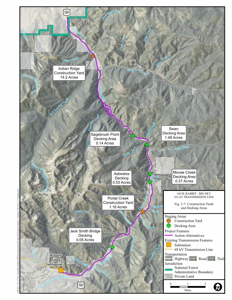
The decking areas and both construction yards may be placed on Forest Service property if suitable sites are not available on other ownership. These would be located on previously disturbed areas as shown on Figure 1 of Appendix B. Logs and/or trees removed from the ROW would be transported to the decking areas by mechanical skidders or helicopter where safely feasible. Helicopter refueling may take place at the Indian Ridge construction yard and potentially at the existing heli-pad located in Big Sky. Figure 1 (Appendix B) shows the locations of the proposed decking areas and construction yards. Currently there are two areas proposed on NFS land: a mid-canyon location near Portal Creek which would occupy approximately 1.2 acres; and a north canyon location near Indian Ridge trailhead which would occupy approximately 14 acres and use approximately 600 feet of new temporary access road. Before construction yards and staging areas would be approved on NFS land, all options for use of more appropriate areas on private land must be exhausted by the applicants. A summary documenting potential construction yards, staging areas, and contacts with private land owners regarding temporary use of these lands for construction is included in the Project Record. Vegetation crushing from overland travel and placement of materials on the ground would likely occur, though some cutting of vegetation may be required based on vegetation type. The construction yards would serve as field offices, reporting locations for workers, parking space for vehicles and equipment or sites for temporary marshalling of construction materials.
Decking Areas
Decking areas would be approved on NFS land, after all options on private land are exhausted by the applicant. A summary documenting potential decking areas on private lands and land owner contacts that were made regarding temporary use of these lands for construction is included in the Project Record. Five log decking areas approximately 0.1 to 1.5 acres each would be required for the temporary storage, collection, handling, sorting and/or loading of trees or logs. All five decking areas would
Final Environmental Impact Statement Jack Rabbit to Big Sky Meadow Village 161 kV Transmission Line
2-24 Chapter 2
be located on NFS lands on previously disturbed areas. Five decking areas would be on NFS lands, and additional decking areas may be located on private land, if those lands are available. Logs and/or trees removed from the ROW would be transported to the decking areas by mechanical skidders or helicopter. Figure 2-7 shows the locations of the proposed decking areas and construction yards.
Helicopter Use
Access is required to each transmission structure site for construction activities, and helicopters may be used to support construction activities in these areas. Project construction activities potentially facilitated by helicopters could include:
transport of construction laborers transport of equipment and materials to transmission structure sites transmission structure placement hardware installation tree removal wire stringing operations
All helicopter operations would be coordinated with and approved by the Federal Aviation Administration (FAA).
")
kj
kj
kj
kj
kj
kj
kj
Burnt Creek
Greek C
r e ek
Twin Creek
Portal Creek
St orm Castle C ree k
Logg er Creek
Dud ley Creek Levin sk i Creek
Asbestos Creek
Hidd
en C
reek
Deer Creek
Hell Roar
ing Cre e k
Cra il C reekSouth Fork Hel l Roaring Creek
Shenango Creek
Mica Creek
Lime C
reek
Mist Creek
Little Hell Roaring Creek
Purd
y Cree
k
Casca
de C r eek
Moose
Swan Creek
Tamphery Creek
Portal C re ek
Goose Creek
West Fork Gallatin River
Gal latin Rive
r
Gallatin
River
Gallatin River
Gallatin River
Creek
MeadowVillage
Substation
Fs 6959d
Swan Cr eek Rd
479
Fs 6993a
Fs 6964a
5410
Fs 984aFs
6959
Dudley Creek Rd
Fs
6964
Fs 6959c
Fs 2686
Fs 2686
Storm Cast le Rd
Karst
Stag
e Lp
Pine Tree R d
MooseCreek Rd
Iu
Iu
Indian RidgeConstruction Yard
14.2 Acres
SwanDecking Area
1.48 Acres
AsbestosDecking
0.53 Acres
Portal CreekConstruction Yard
1.16 Acres
Jack Smith BridgeDecking
0.05 Acres
Sagebrush PointDecking Area
0.14 Acres
Moose CreekDecking Area
0.37 Acres
8/28/2
012
W:\1
1379
2_Jac
krabb
it_Bi
gSky
\PER\
Envir
onme
ntal\G
IS\A
pps\E
IS\Fi
gures
\Cha
pter_2
_Sum
mer_2
012\F
ig_2_
7_Sta
ging.m
xd
0 1 2Miles I
JACK RABBIT - BIG SKY161 kV TRANSMISSION LINE
Fig. 2-7- Construction Yardsand Decking Areas
Project FeaturesAction Alternatives
TransportationRoad TrailHighway
Jurisdiction
Private Land
National ForestAdministrative Boundary
Staging Areas
kj Decking Areakj Construction Yard
Existing Transmission Features") Substation
69 kV Transmission Line

Final Environmental Impact Statement Jack Rabbit to Big Sky Meadow Village 161 kV Transmission Line
2-26 Chapter 2
THIS PAGE INTENTIONALLY LEFT BLANK.
Jack Rabbit to Big Sky Meadow Village 161 kV Transmission Line Final Environmental Impact Statement
Chapter 2 2-27
2.2.7 Transmission Line Construction
Sequence of Construction
Construction of the 161 kV transmission line on NFS lands would likely start in 2013. The yearly construction window for the majority of the work on the 161 kV transmission line would be limited by weather conditions and load demand. Most construction activities would likely occur from early spring to late fall each year over a two to three year period. The goal for construction completion and energization is the fall of 2014. The construction of the Proposed Project would follow the sequence of: 1) centerline surveyed and staked; 2) existing access roads improved only where necessary and one new 600 foot temporary access road at the proposed Indian Ridge construction yard; 3) work areas cleared as needed (see ROW Clearing below); 4) materials distributed along centerline; 5) transmission structure holes and or foundations installed, and transmission structures framed and erected; 6) OPGW ground wire, conductors installed; and 7) the site would be cleaned-up and reclaimed. Various phases of construction may occur at different locations throughout the construction process. This may require several crews operating at the same time at different locations.
Surveying
Construction survey work for the upgrade consists of determining or refining the centerline location through updated electronic and aerial survey techniques of specific transmission structure locations (also called transmission structure spotting), ROW boundaries, work area boundaries, and in some areas, access to work areas. Centerline and final alignment design would adhere to the conditions outlined in the Forest Service SUP, NESC and internal NorthWestern policies and specifications.
ROW Clearing
The Proposed Project would require tree clearing to increase the transmission line ROW from approximately 40 feet wide to generally 50 feet with some segments up to 80 feet wide, depending on the type of pole used. Clearing of some vegetation within the ROW would be required. However, selective clearing would be performed only when necessary to provide for surveying, electrical clearance, line reliability, and construction and maintenance operations. Removal of mature vegetation, under or near the conductors, would be done to provide adequate electrical clearance as required by the NESC standards and maintain reliability. After the ROW boundaries are staked and transmission structure locations are marked, woody vegetation 14 feet or higher, or vegetation that could grow to 14 feet or higher, within the ROW zone would be felled by hand and removed from the ROW with ground based equipment or helicopter where safely feasible. In addition, trees that are outside of the ROW boundary but have potential to fall into lines during windy conditions would be removed or trimmed. Dead, dying, or otherwise dangerous trees or tree limbs located near the ROW that could pose a hazard to the safe operation of the transmission line would be identified and removed as part of NorthWestern’s routine vegetation management program. These operational practices would be further defined in the Construction and Operation Plan (COP) that would be developed and approved by the GNF prior to construction. The primary method of ROW clearing would use handheld power saws to fell trees and either ground-based or helicopter equipment to remove large material. The primary benefit of this
Final Environmental Impact Statement Jack Rabbit to Big Sky Meadow Village 161 kV Transmission Line
2-28 Chapter 2
method is selectivity; only unwanted or target vegetation is removed, while non-target vegetation is not disturbed. The manual vegetation removal techniques employed by NorthWestern are described in detail in the ROW Clearing Plan (Appendix B).
Access Roads
Access roads would be upgraded as necessary to establish the road network to construct and operate the Proposed Action (and action alternatives). Equipment to improve existing access roads and one new temporary access road (approximately 600 feet), would include tracked bladed equipment, backhoes, dump trucks, and crew-haul vehicles. Specific actions would be implemented to reduce construction impacts. Standard design techniques such as installing water bars and dips to control erosion would be included. In addition, measures would be taken to minimize impacts such as rutting and soil compaction in specific locations and during certain periods of the year. Such conditions could arise during heavy rains.
Transmission Structure Hole Excavation
Excavation for transmission structure holes would be made generally with power auger or backhoe equipment. If rocky areas are encountered, transmission structure holes may require drilling and blasting. Where vehicle access is not permitted or possible, hand dug holes for transmission structure support would be excavated following drilling and blasting or loosening and excavation of the soil to the required depth using hand tools. Transmission structure holes left open or unguarded would be covered and/or fenced where practical to protect the public, livestock, and wildlife. Soil removed from transmission structure holes would be stockpiled at the localized work site and used to backfill holes. All remaining soil not needed for backfilling would be spread on the localized work site. If blasting is required, it would be conducted in strict compliance with safety orders or rules enforced where the operations are required. All employees engaged in any operation related to the handling and use of explosives would obtain all certifications required by federal, state, and county management agencies. Accurate accounting for all explosives would be maintained, and any shortages would be reported immediately to the construction manager and public law enforcement authorities. No explosives would be stored on the Project site. Safeguards such as blasting mats would be employed when needed to protect the adjacent property. At heavy angles and dead-end transmission structures where guying is not permitted or feasible, cast-in-place concrete footings would be installed to support self-supporting transmission structure types designed to bear heavy tension loads. Cast-in-place footings would be installed by placing reinforced steel in excavated foundation holes and encasing it in concrete. Concrete would be delivered to the site in concrete trucks. Concrete trucks would wash their chute debris into a depression in the permanent disturbance area at the transmission structure site and soil from the foundation excavation would be used to cover the chute debris.
Transmission Structure Framing and Assembly
Round wood and laminated wood associated hardware would be shipped to each site by truck or aerially carried to sites where access is not permitted. Generally, transmission structures would be assembled and framed at the work area. Areas need to be large enough to accommodate laying down the entire length of the transmission structures while insulators and cross-arms are mounted. Typically, insulator strings and stringing sheaves are then installed at each conductor
Jack Rabbit to Big Sky Meadow Village 161 kV Transmission Line Final Environmental Impact Statement
Chapter 2 2-29
and ground wire position while the transmission structure is on the ground. Stringing sheaves are used to guide the conductor during the stringing process for attachment onto the insulator strings. The assembled transmission structure would then be erected into place by a crane, line truck, or helicopter. Where helicopter construction techniques are used, transmission structure assembly would take place at the helicopter and/or material staging area.
Conductor Installation
Once transmission structures are in place, a “sock-line” would be pulled (strung) from transmission structure to transmission structure, and threaded through the stringing sheaves on each transmission structure. A helicopter would be used along more rugged sections of the transmission line to position the sock-line in the stringing sheaves. If necessary in longer, high tension stringing sections, a second larger diameter and stronger line would be attached to the sock-line and strung prior to the attachment of the conductor and the ground wires. This process would be repeated until the ground wire and conductor is pulled through all sheaves. Conductor splicing would be required at the end of a conductor spool during stringing. The work would occur on work areas for the transmission structures or pulling/tensioning sites. Conductor would be strung using powered pulling equipment at one end and powered braking or tensioning equipment at the other end. For public protection during wire installation, guard transmission structures would be erected over roadways, power-lines, transmission structures, and other obstacles. Guard transmission structures would typically consist of single-pole or wood H-frame transmission structures with cross arms placed on either side of an obstacle. These transmission structures prevent ground wire, conductor, or equipment from falling on an obstacle. Equipment for erecting guard transmission structures includes augers, line trucks, transmission structure trailers, and cranes. Guard transmission structures may not be required for small roads. On such occasions, other safety measures such as barriers, flagmen, or other traffic control would be used.
Remove Existing 69 kV Line and Distribution Facilities
The removal of the existing 69 kV transmission line and distribution facilities would occur simultaneously with the new 161 kV transmission line and distribution line construction in so far as practical. In some areas, the two facilities may co-exist until such time as “cut-over” to the new facilities can be achieved with minimal disruption to the local electrical system. Based on current peak load demand during the winter months, taking long sections of the existing 69 kV transmission line and distribution underbuild facility out of service for extended periods of time would be avoided. Underbuild distribution that would be upgraded and transferred to the 161 kV transmission structures would be removed along with the old 69 kV transmission structures unless they are providing service to residences. Distribution lines that serve local residences are proposed to be modified under the action alternatives.
Construction Waste Disposal
Construction sites, material storage yards, and access roads would be kept in an orderly condition throughout the construction period. Refuse and trash would be removed from the sites and disposed of in an approved facility (off of NFS lands). Oils and fuels would not be dumped along the line. Oils or chemicals would be hauled to an approved site for disposal. No open burning of construction trash would occur. All waste products and food garbage from construction sites
Final Environmental Impact Statement Jack Rabbit to Big Sky Meadow Village 161 kV Transmission Line
2-30 Chapter 2
would be stored and disposed of in accordance with Occupancy and Use Order #07-11-00-01, also referred to as the GNF Expanded Food Storage Order.
Site Reclamation
Work sites would be restored using: excess material, approved native vegetation and seed mixtures, and topsoil stockpiled for that purpose. The contractor would legally dispose of excess soil materials, rock, and other objectionable materials as directed by the GNF that cannot be used in restoration work (off of NFS lands). Disturbed areas, with the exception of existing access roads, would be restored, as nearly as possible, to their original contour and reseeded with Forest Service approved native seed mixtures where appropriate. Ripping and other surface scarification on existing construction roads or other areas would be done as necessary. In some cases, the amount of soil compaction and vegetation destruction may not warrant ripping and reclamation. This would be decided on a case-by-case basis.
2.2.8 Operation and Maintenance
Permitted Uses
After the transmission line has been energized, land uses compatible with safety regulations, operation, and maintenance would be allowed. The permittee does not have exclusive use of the permitted area. The Forest Service may implement special orders for temporary closures: if conditions warrant public safety; to prevent resource damage; and to protect wildlife populations and/or other reasons.
Safety
Safety is a primary concern in the design of this transmission line. An alternating current (AC) transmission line would be protected with power circuit breakers and related line relay protection equipment. If conductor failure or grounding (tree contact) occurs, power would be automatically removed from the line. Lightning protection would be provided by overhead ground wires along the line. Electrical equipment and fencing at the substation would be grounded. All fences, metal gates, pipelines, etc., that cross or are within the transmission line ROW would be grounded to prevent electrical shock. If applicable, grounding outside the ROW may also occur.
ROW Maintenance
NorthWestern would maintain the ROW in accordance with federal, state, and private land managers’ stipulations. Maintenance would be performed as needed and there would be a maintenance plan included in the SUP. When access is required for non-emergency maintenance and repairs, NorthWestern would adhere to the same precautions taken during the original construction and coordinated with the Forest Service. Emergency maintenance would involve prompt movement of crews to repair or replace any damage. Crews would be instructed to protect plants, wildlife and other environmental resources. Restoration procedures following completion of repair work would be similar to those prescribed for normal construction. Limiting noise, dust and the danger caused by maintenance vehicle traffic would be controlled to the extent possible. Weed control would be conducted annually as identified in the Weed Management, Reclamation, and Revegetation Plan (see Appendix C).
Jack Rabbit to Big Sky Meadow Village 161 kV Transmission Line Final Environmental Impact Statement
Chapter 2 2-31
Abandonment
At the end of the useful life of the line, if the facility were no longer required, the transmission line would be abandoned. Conductors, insulators and hardware would be dismantled and removed from the ROW. Transmission structures would be removed and foundations broken off below the ground surface. Following abandonment and removal of the transmission line from the ROW, any areas disturbed during abandonment would be restored and rehabilitated under Forest Service direction as near as possible to their original condition or to the condition immediately prior to the abandonment disturbance. Noxious weeds would be treated within the ROW until they are successfully eradicated.
2.2.9 Mitigation and Monitoring Common to All Alternatives
A specific COP that would address mitigation requirements would be prepared in consultation with the Forest Service prior to construction being authorized. This plan would detail additional measures required to minimize impacts to natural resources and human safety. The COP typically includes Best Management Practices (BMPs), tree clearing, reclamation and revegetation of the ROW, resource protection, noxious weed control, dust control, hazardous spill prevention, fire prevention, and storm water pollution prevention, as well as other resource protection measures. The COP would outline any required monitoring guidelines for the construction and operation of the line in order to avoid inadvertent impacts to resources. Ongoing maintenance of the line would be addressed as part of the master SUP. The Forest Service would appoint an authorized inspector to oversee construction activities, authorize revisions or changes in the field, and determine if environmental protection is being done according to the approved COP. NorthWestern is responsible for ensuring that all construction crews and contractors abide by all permit requirements and restrictions relevant to construction of the transmission line. Several resources would benefit from protection measures outlined in the COP. These measures are considered applicable across several resources and therefore serve as a multifaceted method for protecting resources and minimizing Project impacts. The Project Design Features (PDFs) discussed in this section are measures that NorthWestern would apply as a part of the Project design. These measures, designed to avoid or reduce the impacts of the Proposed Project, are organized by resource topics. Additionally, ROW Clearing and slash disposal/fuels reduction methods are detailed in Appendix B, Weed Management, Reclamation, and Revegetation methods are detailed in Appendix C, and BMPs are described in Appendix D. It is NorthWestern’s responsibility to obtain all applicable local, state, and federal permits prior to implementation (see Table 1.2).
Notifications
0.1 NorthWestern shall develop a comprehensive Transportation Management Plan (TMP) consistent with MDT’s requirements for appropriate traffic control measures to ensure public safety during construction. As defined by the MDT, a TMP consists of a Traffic Control Plan, a Public Information Component, and a Transportation Operations Component (TOC).
This plan shall be developed and submitted to the Forest Service prior to construction on NFS lands.
Final Environmental Impact Statement Jack Rabbit to Big Sky Meadow Village 161 kV Transmission Line
2-32 Chapter 2
0.2 NorthWestern shall communicate with the public, Forest Service concessionaires,
and local businesses to provide information on construction updates, temporary restrictions, and timelines. Methods to inform the public may include, but are not limited to, posting information on a designated website, providing a phone number for the public to call, and posting notices at trailheads, campgrounds, and river access points throughout the Project area.
0.3 NorthWestern shall coordinate with local emergency response agencies (e.g., police,
fire, ambulance and paramedic) in advance to avoid restricting emergency services, notify emergency response providers of the proposed locations, nature timing, and duration of any construction activities, and advise of any access restrictions that could impact their effectiveness.
Construction Operations
1.1 NorthWestern and the Forest Service shall predetermine and concur with the limits of construction, with activity restricted to and confined within those limits. This area is generally limited to the existing ROW and other approved areas such as LROs and staging areas.
1.2 Ground disturbance would be limited to that necessary to safely and efficiently install the proposed facilities and described in detail in the COP that would be developed and approved by the GNF prior to construction.
1.3 All construction vehicle movement shall be confined to existing ROW, on open
roads, or other areas as authorized in advance by the Forest Service. Construction vehicles are prohibited from operating off road and outside of the ROW corridor within Inventoried Roadless Areas (IRA).
1.4 NorthWestern shall clearly mark the construction boundary, which includes the ROW
area for vegetation clearing. The boundaries shall initially be flagged with temporary markers. The GNF will review, approve, and paint the boundary. In addition, sensitive features that must be avoided shall be flagged with temporary markers to ensure they are avoided.
1.5 NorthWestern shall span sensitive features within the limits of standard transmission
design. Sensitive features may include, but are not limited to, wetlands, riparian areas, water courses, cultural sites, and sensitive viewpoints. If the sensitive features cannot be completely avoided, transmission structures would be placed so as to minimize the impact. It is NorthWestern’s responsibility to obtain pertinent federal, state, or local permits for impacts to sensitive features than cannot be completely avoided, for example obtain a Clean Water Act (CWA) Section 404 permit to place a structure in a wetland.
1.6 NorthWestern shall place transmission structures at the maximum feasible distance
from highway and trail crossings within limits of standard transmission structure design in order to reduce potential impacts on recreation values, safety, and visual impacts.
1.7 NorthWestern shall redistribute course woody debris and reseed sites that that have
substantial ground disturbance in order to reduce visual contrast and reduce siltation
Jack Rabbit to Big Sky Meadow Village 161 kV Transmission Line Final Environmental Impact Statement
Chapter 2 2-33
in construction areas (e.g., staging areas, transmission structure sites). Methods to reclaim disturbed areas are described in the Weed Management, Reclamation, and Revegetation Plan (Appendix C).
1.8 The Forest Service must approve in writing, any major activities such as timber
felling, skidding or helicopter operations in developed sites, recreation residence tracts or other occupied areas on NFS land that would occur between Memorial Day Weekend and Labor Day.
1.9 NorthWestern shall comply with all requirements as specified in:
a) ROW Clearing Plan (Appendix B), which specifies tree clearing, vegetation
removal, and down woody debris measures that conform to GNF BMPs and applicable federal and state regulations.
b) Weed Management, Reclamation, and Revegetation Plan (Appendix C), which describes requirements to minimize the effects of noxious and invasive weeds, as well as reclamation and revegetation requirements.
c) BMPs (Appendix D) to avoid or minimize environmental impacts and to
protect the environment.
Facilities
2.1 NorthWestern shall repair or replace any Forest Service and/or recreation residence structure/improvement that becomes damaged during construction operations, and restore to an equal or better condition as agreed to by the parties involved. Examples may include roads, bridges, ditches, culverts, buildings, fences, etc.
2.2 Temporary fences and gates would need to be coordinated and approved by the
Forest Service prior to installation.
2.3 NorthWestern shall avoid placement of poles and transformers in front of recreation residences, avoid locating structures any closer to recreation residences than existing structures, and generally locate them to the extent practicable in a location that minimizes conflicts.
2.4 NorthWestern shall coordinate in advance with the Forest Service for all temporary
restrictions or traffic impacts on Forest Service roads/facilities. The Forest Service may implement temporary closure orders of Forest Service roads and facilities as needed to protect public safety. NorthWestern shall immediately repair any damage to improvements, recreation facilities or trails before the Forest Service re-opens the area to the public.
Historical and Archaeological Sites
3.1 Prior to construction, NorthWestern is responsible for ensuring all supervisory construction personnel are knowledgeable of the protection of historic and archaeological sites. To assist in this effort, the construction contract would address: (a) federal laws regarding antiquities, including collection and removal; (b) the importance of these resources and the purpose and necessity of protecting them; and (c) methods for protecting sensitive resources.
Final Environmental Impact Statement Jack Rabbit to Big Sky Meadow Village 161 kV Transmission Line
2-34 Chapter 2
3.2 NorthWestern shall flag known historic and archaeological sites prior to construction
to ensure these sensitive areas will be avoided. NorthWestern shall attempt to avoid these sites completely, or design the line to allow conductor spanning of the site if complete avoidance is not feasible. The flagging shall be removed post construction.
3.3 In the event that possible historic and archaeological sites are discovered during
construction, potentially destructive work within 100 feet of a discovery would be halted. NorthWestern’s construction inspector would immediately implement the following measures:
a. Flagging would be erected to prohibit potentially destructive activities from
occurring. b. NorthWestern’s archaeologist would make a preliminary assessment of the
newly discovered resource. c. If the archaeologist determines that the discovery represents a potential new
site, or an undocumented feature of a documented site, the Forest Service would be notified and protocol identified by the Agency would be followed.
d. On a new site or an undocumented feature of a documented site, construction
would not resume in the identified area until cleared by the Forest Service’s Authorized Officer.
e. Pursuant to 43 CFR 10.4(g), the holder of this authorization must notify the
Authorized Officer, by telephone, with written confirmation, immediately upon the discovery of human remains, funerary items, sacred objects, or objects of cultural patrimony. Further, pursuant to 43 CFR 10.4(c) and (d), the contractor must stop activities in the vicinity of the discovery and protect it for 30 days or until notified to proceed by the Authorized Officer.
Scenery
4.1 NorthWestern shall use non-specular conductors to reduce visual impacts. 4.2 The alignment of the access roads would follow the landform contours in designated
areas where practicable, providing that such alignment does not impact other resources to minimize ground disturbance and/or reduce scarring (visual contrast) of the landscape.
Biological
5.1 Prior to construction, NorthWestern is responsible for ensuring all supervisory construction personnel are knowledgeable of the protection of biological resources. To assist in this effort, the construction contract would address: (a) federal and state laws regarding plants and wildlife; (b) the importance of these resources and the purpose and necessity of protecting them; and (c) methods for protecting sensitive resources including specific mitigation measures outlined in this FEIS and the COP.
Jack Rabbit to Big Sky Meadow Village 161 kV Transmission Line Final Environmental Impact Statement
Chapter 2 2-35
5.2 Mitigation measures developed during the consultation period under Section 7 of the Endangered Species Act (1973) as amended would be adhered to as specified by the Forest Service and US Fish and Wildlife Service (USFWS). These include:
a. As per the Gallatin National Forest Travel Management Plan (GNF TMP),
wheeled motorized cross-country (i.e., overland or off-route) travel may be allowed but limited to the administration of a federal permit. Authorization by a line officer is required.
b. As per the GNF TMP, the temporary road constructed for Project activity
will be designed with minimum handbook standards necessary to accomplish the task, temporary in nature, and effectively gated to restrict public motorized use. Once the activity is complete, this road will be permanently and effectively closed and re-vegetated.
c. As per the GNF TMP, temporary, localized restrictions will be applied to
Project activities if necessary to prevent conflicts with grizzly bears. d. Helicopter flight paths will either be: a) within 500 meters (one-third mile)
horizontally of an open motorized access route when flying less than 500 meters above ground level; or b) at least 500 meters above ground level when flying over secure habitat (i.e., at least 500 meters away from an open motorized route).
e. All activities associated with Project implementation are to be in compliance
with forest-wide Special Order (#07-11-00-01), which regulates the storage of food and other attractants on NFS lands within the entire GNF boundary.
5.3 Except for emergency repairs, NorthWestern shall adhere to the following timing
restrictions for all construction and maintenance activities:
a. Peregrine Falcon: Helicopter use shall be restricted within 0.5 mile of known occupied peregrine falcon eyries during the nesting season (February 1 through August 31).
b. Goshawk Recommendations: If an active goshawk nest is detected in the
vicinity of the Proposed Project prior to or during construction, timing restrictions would be imposed (no ground disturbing activities within a 420-acre buffer of the nest (post-fledging area)) during the period of 15 April through 15 August (USFS 2006). Known occupied nest trees shall not be cut during construction.
c. Bald Eagle: Project-related construction activity would be restricted within
0.25 mile of an occupied bald eagle nest tree from February 1 through August 15 (Greater Yellowstone Bald Eagle Management Plan [GYBEMP], 1995).
d. Bighorn Sheep: Over flights and construction disturbance shall not occur
from November 15 – May 31 on the portions of the transmission line within wintering bighorn sheep habitat (areas by Deer Creek and along MT Hwy 64) (Montana Fish, Wildlife and Parks [MFWP] correspondence December 10, 2012).
Final Environmental Impact Statement Jack Rabbit to Big Sky Meadow Village 161 kV Transmission Line
2-36 Chapter 2
5.4 Avoid damaging residual trees with vehicles and equipment. 5.5 No holes or pits would be left open overnight or when the site is not manned to
prevent inadvertently trapping or injuring wildlife. 5.6 Avoid tree clearing of old-growth limber pine trees >9 inches diameter at breast
height (DBH) to the extent possible. Removal and/or trimming of limber pine trees >9 inches DBH that pose a fire/fuels risk would be conducted at the minimum required for operation and maintenance activities.
5.7 No special status plants have been documented on NFS lands in the Proposed Project
area, despite targeted surveys during the appropriate bloom period. If any new locations of special status plants are discovered, NorthWestern’s construction inspector would immediately implement the following measures:
a) The boundaries of the sensitive plant location would be delineated with
clearly visible flagging or fencing.
b) The sensitive plant would be avoided by spanning if possible.
c) In the event a sensitive plant location cannot be avoided, NorthWestern shall seek permission from the Forest Service to relocate the plants.
d) If avoidance or relocation is not practical, the topsoil surrounding the plants
would be salvaged, stored separately from subsoil and respread during the restoration process.
5.8 The Proposed Project would be developed consistent with the Avian Power Line
Interaction Committee (APLIC) guidelines (2006) for avian safety, and would be operated under an Avian Protection Plan to reduce risk of collision and electrocution.
Fire/Fuels
6.1 NorthWestern shall develop a Fire Protection Plan as part of the COP to minimize fire risk. The plan shall include:
a) Identify rules and regulations, fire prevention techniques, tools and
equipment, and training and notification requirements.
b) NorthWestern shall notify the GNF of any fire started.
c) Internal and external combustion engines of federally managed lands would be operated as per 36 CFR 261.52(j), which requires all such engines to be equipped with a qualified spark arrester that is maintained and not modified.
d) Vehicles and equipment would be outfitted with shovels, water and fire
extinguishers that are rated at a minimum as ABC-10 pound. 6.2 NorthWestern shall comply with the ROW Clearing Plan (Appendix B), which
provides direction for vegetation clearing, slash disposal and fuels reduction.
Jack Rabbit to Big Sky Meadow Village 161 kV Transmission Line Final Environmental Impact Statement
Chapter 2 2-37
Health, Safety, Noise
7.1 Construction operations and maintenance of the transmission line shall be in accordance with the National Electric Safety Code (NESC).
7.2 Hazardous materials would not be drained onto the ground or into streams or
drainage areas. Totally enclosed containment would be provided for all trash. All construction waste including trash and litter, garbage, and other solid waste, petroleum products and other potentially hazardous materials would be removed to a disposal facility authorized to accept such materials.
7.3 NorthWestern shall maintain spill containment/cleanup kits of appropriate type and
capacity, for all types and volumes of hazardous materials used and/or stored on the work site at all times.
7.4 NorthWestern is responsible for ensuring all field personnel are knowledgeable of
spill prevention, control, and countermeasure procedures.
Soil and Water
8.1 NorthWestern shall be responsible for obtaining all applicable permits to water resources/water quality, and providing copies of all plans and permits to the Forest Service prior to construction (see Table 1.2).
8.2 NorthWestern shall comply with all state of Montana BMPs for Forestry, Forest
Service Soil and Water Conservation Practices, applicable GNF Soil and Water BMPs, and state of Montana Streamside Management Zone Requirements. Forest Service BMPs are detailed in Appendix D.
8.3 Disturbed areas shall be rehabilitated and revegetated following construction as
described in the Weed Management, Reclamation, and Revegetation Plan (Appendix C). Appendix C requires the use of four different seed mixes based on soil type.
8.4 Temporary roads shall be decommissioned as described in Appendix D. 8.5 Ripping skid trails would be required only where detrimentally compacted mineral
soil is exposed at the surface, or where wheel ruts have formed at least two inches deep on grades of 15 percent or greater. After ripping, these areas would be treated as prescribed in Table 3.4.5-8 (Chapter 3; Soils) and detailed in the Weed Management, Reclamation and Revegetation Plan (Appendix C).
8.6 Fine-textured soils disturbed by vehicular overland access shall be ripped if there are
ruts.
2.3 Alternatives Considered and Eliminated Federal agencies are required by the National Environmental Policy Act (NEPA) to rigorously explore and objectively evaluate all reasonable alternatives and to briefly discuss the reasons for eliminating any alternatives that were not developed in detail (40 CFR 1502.14). Public comments received in response to the Proposed Project provided suggestions for alternative methods of achieving the purpose and need.
Final Environmental Impact Statement Jack Rabbit to Big Sky Meadow Village 161 kV Transmission Line
2-38 Chapter 2
The following alternatives to the Proposed Action were considered and eliminated from further study because they would not meet the purpose and need for the Proposed Project, were technologically infeasible, or they were not compatible with GNF Management directives. These alternatives are described in more detail in the following pages. They include: New Generation Alternatives (renewable, fossil fuel, and distributed); Design Alternatives (up-rate existing line from 69 kV to 161 kV, other voltage lines, double circuit options, upgrading to higher capacity 69 kV conductors, undergrounding or buried line); System Alternatives (new 161 kV line along Jack Creek, other system alternatives); Conservation and Demand Side-Management; and Routing Alternatives (LROs).
2.3.1 Generation and Non-Transmission Alternatives
Questions were raised during scoping related to alternative generation as an alternative to rebuilding the existing 69 kV transmission line, including non-transmission alternatives. Alternative generation would include renewable and hydrocarbon fuel generation. In particular, requests to consider wind, solar, hydroelectric, and hydrocarbon generation were submitted by the public.
Renewable Generation (Wind and Solar)
The proposed rebuilding of the existing transmission line is needed to address customer reliability and energy demand growth in the Big Sky region by providing a stronger transmission system that would serve peak load demands as a result of growing needs while ensuring continued reliable service to existing customers. To meet the demand, a minimum of 30 megawatts (MW) of wind generation would be required. This would require approximately 15 to 20 turbines depending on the turbine size. A wind facility of this magnitude would require a minimum of 500 acres (approximately 35 acres per turbine) of land in an area of suitable wind resource. Currently, there is not a known tract of land (approximately 1,800 acres) in the Big Sky area large enough with suitable wind resources to meet the 30 MW need. For a multi-turbine project, approximately 60 acres of land would be needed for every megawatt generated (Center for Sustainable Systems 2011). Based on National Renewable Energy Laboratory wind resource data, average annual wind speeds in the Project area are low, around five meters per second (AWS Truepower 2012). Large enough areas of suitable land can be found in the Madison Valley; however, if this area was utilized, an additional transmission line would be required to get the electricity to Big Sky. Furthermore, wind as a generation source is a variable resource with limited reliability for meeting load demands. This alternative was eliminated from further consideration because it would not meet the purpose and need of the Proposed Project for meeting peak load demands and reliable service. For example, even the best wind projects produce electricity only when the wind blows, usually between 30 to 40% of the total possible production. To meet the demand, a minimum of 30 MW of solar generation would be required. This would require approximately 4,000 residential roof tops or approximately 180 acres (approximately six acres per MW) of land. There are roughly 2,000 residences in Big Sky, which is approximately half of what would be needed if there was 100% participation to meet a 30 MW demand. Currently, there is not a known tract of land in the Big Sky area large enough with suitable solar resources to meet the 30 MW need. Modern solar system power output is generally one megawatt per 7.4 acres of photovoltaic solar panels (Entergy). Large enough areas of suitable land can be found in the Gallatin and Madison Valleys; however, if these areas were utilized, additional
Jack Rabbit to Big Sky Meadow Village 161 kV Transmission Line Final Environmental Impact Statement
Chapter 2 2-39
transmission lines would be required to get the electricity to Big Sky. Furthermore, solar as a generation source is a variable resource with limited reliability for meeting load demands. Limitations of solar energy are: 1) the amount of sunlight that arrives at the Earth's surface varies depending on location, time of day, time of year, and weather conditions; and 2) a large surface area is required to collect the energy at a useful rate because the sun does not deliver that much energy to any one place at any one time (US Energy Information Administration 2012).This alternative was eliminated from further consideration because it does not meet the purpose and need of the Proposed Project for meeting peak load demands and reliability criteria.
Hydroelectric Generation
The Gallatin River does not supply necessary flows to support a commercial hydroelectric facility. Portions of the Gallatin River maintain flow rates that would support a small hydroelectric facility (30 MW or less) but not one of commercial magnitude (greater than 30 MW). Mean flow rates along sections of the Gallatin River are approximately 800 cubic feet per second (cfs). These same sections of the river also serve as valued recreational stretches of the river. The recreational demands on these sections of the river require a minimum flow of 500 cfs. In addition to recreational use, these areas of the river serve as habitat for aquatic flora and fauna, and blue ribbon fishery. The minimum sustained water flow for the Gallatin River in areas that would support a small hydro electrical facility ranges from 70 to 100 cfs which would stress the required flows to maintain the aquatic fisheries and recreation demands placed on the river. A small hydroelectric facility requires a sustained 10 to 20 foot head of water which would require a substantial pool of water (impoundment). Construction of an impoundment would have significant impacts on aquatics and fisheries along the river. Flows on the Gallatin River vary substantially throughout the year with the lowest flows occurring during winter months. This is the time period in which load demand on the electrical system is the greatest. It is unlikely that the amount of water needed to generate electricity to meet peak demand in the winter months would be available. Therefore, hydro-generation would not meet reliability needs of the Proposed Project. The Gallatin River is designated as an eligible Wild and Scenic River under the Wild and Scenic Rivers Act (Public Law 90-542; 16 United States Code [U.S.C.] §1271 et seq.). Under the Gallatin National Forest Management Plan of 1987 (Forest Plan), eligible river segments would be managed to protect their “outstandingly remarkable” values (page II-6). Construction of a hydroelectric facility would detract from these values. This alternative was eliminated from further consideration because it would not meet the purpose and need of the Proposed Project to meet peak load demands and improve reliability; the impacts to resources (i.e., Gallatin River); and the current conflict with Wild and Scenic River Direction.
Conventional Generation
Conventional generation uses current fossil fuel electrical generation technologies, such as gas, propane, diesel, or coal-fired power plants. NorthWestern considered new conventional generation facilities for the Big Sky area, but identified several constraints as to why this was not further explored. A fuel generation facility would generally require the transportation and storage of large amounts of solid, liquid or gas fuels, and as such would require truck trips through the Gallatin Canyon to maintain the fuel supplies. This would result in increased traffic impacts, increased wear on the existing road network, and would increase the risk of an accidental spill or release of these fuels. Furthermore, resource impacts to air quality, water resources, visual resources, soils, wildlife, and other factors would occur, which would replace the impacts of the Proposed Project Alternatives and would not reduce them.
Final Environmental Impact Statement Jack Rabbit to Big Sky Meadow Village 161 kV Transmission Line
2-40 Chapter 2
The cost to construct and operate a 49 MW fuel generation facility was approximately twice the cost of constructing and operating the Proposed Project, a 161 kV transmission line. In addition to cost, electrical transmission and distribution upgrades to the existing 69 kV Jack Rabbit to Big Sky Meadow Village transmission line and local interconnections infrastructure for the power generation facilities would be required to achieve the same level of service and reliability as the Proposed Project (upgrade of the existing line). This alternative was eliminated from further consideration because it would likely create adverse environmental impacts as a result of construction and operations. This alternative was eliminated from further analysis due to the environmental tradeoffs from construction and operations as well as the excessive cost.
Distributed Generation
Distributed generation is the placement of small generators within load pockets in urban areas. A load pocket is an area where there is insufficient transmission capability to reliably supply 100% of the electric load without relying on generation capacity that is physically located within that area. Distributed generation systems are installed in or near the place where energy is used. They can be used in residential, commercial, and government applications for many different needs, such as continuous electric power, backup power, or supplemental power during times of peak demand. Distributed generation is typically less than five megawatts in net generating capacity that is located on distribution feeders near customer load (power being drawn from the electrical system by consumers). Examples of distributed generation include fuel cells, micro turbines, photovoltaics, wind, landfill gas, and digester gas. Distributed generation is being done where feasible in major population centers, but since the limited generation capability would not meet the peak load need of an additional 30 MW, this is not an alternative that meets the purpose and need for the Proposed Project. This alternative was eliminated from further consideration.
Energy Conservation and Load Management
Energy conservation would require more efficient use of electricity by customers. Conservation incentive programs are designed to reduce energy consumption per customer, providing an increase in energy resources for new loads from the energy saving measures. Load management refers to power supply system improvements by a utility. Load management programs direct all customer demand to be moved away from peak load hours, freeing existing resources to serve additional peak loads. One example is the City of Riverside, California, Public Utilities Department’s time-of-use rates, which encourage customers to use electric energy during off-peak periods. Although peak loads in the Big Sky area occur at various times of the year, the highest peak loads occur during the winter when ski resort operations and home heating occur all day long. It would not be feasible to eliminate this peak load for all customers in the Big Sky area during times of highest use. NorthWestern’s consideration of load management is reflected in their forecasts of future load growth in the Big Sky area. Load management savings greater than forecasted loads would not be achievable to eliminate or substantially reduce the projected load growth for the area. While energy conservation and load management can somewhat reduce the demand for electric energy, they would likely not reduce the load growth to zero, thereby eliminating the need for new generation sources and new transmission lines to serve increased load demands. Therefore, energy conservation and load management are important; however, the savings in energy use from these programs would not amount to enough power to fill the current demand or additional future needs and thus, do not meet the purpose and need for the Proposed Project. For this reason this alternative was eliminated from further consideration.
Jack Rabbit to Big Sky Meadow Village 161 kV Transmission Line Final Environmental Impact Statement
Chapter 2 2-41
2.3.2 Transmission Design Alternatives
Questions were raised during scoping related to design solutions as an alternative to rebuilding the existing 69 kV transmission line. Design alternatives would include up-rating the existing Jack Rabbit to Big Sky Meadow Village 69 kV transmission line, using alternative voltages other than the proposed 161 kV rebuild option, double circuiting options, upgrading the existing 69 kV conductor to a high capacity conductor, and undergrounding alternatives.
Voltages other than 161 kV
Rebuilding the transmission line between Jack Rabbit and Big Sky Meadow Village at another voltage besides 161 kV was also considered. For example, 100 kV would require new transmission line structures and permitting from the Forest Service, similar to the Proposed Project. A new 100 kV line would meet the immediate capacity need for peak load demand; however, this voltage would not meet future growth projections. Furthermore, the upgrade to 100 kV would result in comparable resource impacts as the Proposed Action during construction without addressing future demands for electricity. For these reasons, 100 kV as an alternative voltage was considered and eliminated. Other voltages such as 115 kV and 138 kV were also considered but not carried forward due to a lack of similar voltage within NorthWestern’s system in the Bozeman area. These voltages would require major compatibility upgrades to the regional system due to the absences of these voltages in the regional electrical system. Alternative voltages were eliminated from further consideration because they are not compatible with the regional system and would require major upgrades to the system. This type of system wide upgrade would be costly and would result in similar impacts anticipated from the Proposed Project.
Double Circuit Option
Double circuiting would involve placing multiple transmission lines on one set of poles or transmission structures. Multiple transmission lines on the same transmission structure that provide service to that same system would not meet WECC criteria for providing reliable service because if both lines are in the same location they are subject to the same hazards such as fire, earthquake, avalanche. The risk of line outage on double circuit systems is greater due to the likelihood of losing both lines simultaneously in an outage situation. This increased risk violates the WECC reliability criteria. NorthWestern is required to provide reliable service to their customers under the direction of WECC. A double circuit line from Jack Rabbit to Big Sky Meadow Village or Ennis to Big Sky would result in the same reliability violation to the WECC criteria. A double circuit option from Jack Rabbit to Big Sky Meadow Village would also require removal of the existing 69 kV transmission line, construction of a new double circuit transmission line, and a wider ROW to accommodate the two electrical circuits. Double circuiting as an alternative to the Proposed Project was eliminated from further consideration because it would not meet the reliability criteria of a single event, such as an earthquake or fire, taking out both circuits simultaneously and would require about the same construction impacts.
Final Environmental Impact Statement Jack Rabbit to Big Sky Meadow Village 161 kV Transmission Line
2-42 Chapter 2
Upgrading Existing Line though Reconductoring
Upgrading the existing 69 kV system to a high capacity conductor to meet peak load demands would still require the existing Jack Rabbit to Big Sky Meadow Village 69 kV transmission line to be rebuilt (new poles, wires, and hardware) because of its age, and because the structures would need to support more weight than would be possible on the existing transmission line structures. Upgrading the transmission line in this way would require construction similar to the Proposed Project and therefore would not eliminate or mitigate impacts to natural and human resources. Furthermore, the long distance between the Jack Rabbit and Big Sky Meadow Village substations would make a high-capacity 69 kV conductor solution less flexible to meet the projected future load at Big Sky. Projected electrical load growth in the Big Sky area would exceed the capacity on a high-capacity 69 kV conductor and therefore require in the not too distant future an additional upgrade. This alternative was eliminated from further consideration because: 1) construction impacts to support a high capacity conductor would be similar to the Proposed Project; 2) it would not meet the purpose and need of the Proposed Project to meet peak load demands and the reliability criteria of the WECC; and 3) it would have resource impacts that would not mitigate or eliminate the impacts of the Proposed Project.
2.3.3 Underground Transmission Line
Several comments were received from the public during scoping, requesting consideration of installing the transmission line underground. The following discussion addresses underground technologies, construction practices, maintenance requirements, reliability issues, cost, and environmental impacts, that when considered in total make undergrounding of transmission lines impractical except for short distances in congested metropolitan and suburban areas. A more detailed description of underground construction and technology can be found in Appendix A. High voltage underground 230 kV and some 345 kV transmission lines are now being used in large North American metropolitan cities like San Francisco and New York, as well as in Vancouver, British Columbia where the lines are placed in large tunnels underneath the streets of these highly congested cities that have no space available for overhead lines. Lower voltage underground transmission lines (69 kV through 161 kV) occur over short distances in the United States primarily in congested urban areas. Underground lines are difficult and time consuming to repair because it is difficult to locate problem areas. This reduces the reliability of underground lines. In these situations, multiple parallel lines are often needed so power is not disturbed to the area where a problem or outage occurs with one of the lines. This need for redundancy contributes to the increased cost of burying transmission lines, which can be five to ten times the cost of overhead, and in some areas can be as much as 20 times the cost of overhead construction. Underground transmission lines have markedly different technological requirements than overhead transmission lines. Overhead conductors are cooled by the open air surrounding them. Placing the conductors on transmission structures puts these conduits of energy above most human activity on the ground in a transmission corridor and deals effectively with the issue of heat. Underground transmission lines require cooling systems to dissipate the heat generated by the transmission of electricity. The large cooling systems add to the expense of underground lines. Further, underground systems over longer distances result in electrical impedance problems, which is resistance occurring in AC (as opposed to direct current or DC) electrical circuits, similar to causing a pinch point in the transmission line. The lower the impedance, the
Jack Rabbit to Big Sky Meadow Village 161 kV Transmission Line Final Environmental Impact Statement
Chapter 2 2-43
easier it is for electricity to flow through an object. Cooling system technology is discussed below. There are four basic underground cable technologies for underground circuits:
Solid Dielectric (Cross-Linked Polyethylene or XLPE) Gas Insulated Transmission Line (GIL) Pipe-type (High Pressure Fluid Filled or HPFF) Self-Contained Fluid Filled (SCFF)
Underground Considerations
The environmental impacts of constructing an underground transmission line would be similar to those for major pipeline construction. Typical construction would involve continuous trenching and associated ground disturbance for the entire distance. Trenching would be done for a width of 15 to 20 feet wide, and four-feet in depth through the difficult terrain of the Gallatin Canyon, not impossible in some locations, but very difficult or impossible in many locations. This type of continuous open trench would invariably increase vegetation clearing, soil movements, weed introduction, and potential erosion as compared to the Proposed Project, and offers no environmental benefits to natural resources. In the short term, these disturbance impacts would be very apparent. Crossing the Gallatin River would require boring under the river four to six feet below the river bottom. Possible leaks of drilling fluid into the stream could occur. Staging areas for the drilling equipment on either side of the river would require large excavations, which would also result in additional disturbance. In general, an underground line would need to trench through or bore under resources to avoid them. Overhead lines are much more flexible. Structures and facilities can be placed to avoid sensitive resources. The overhead wires result in visual impacts, but can easily span over sensitive natural resources, such as streams, wetlands, rare plants, cultural sites, etc. While underground transmission lines are relatively immune to weather conditions, they are vulnerable to washouts, seismic events, cooling system failures, and inadvertent excavation. Other possible causes for cable failure include water intrusion into the cable, overheating of the cable, high voltage transients (spikes in voltage), thermal movement during load cycling, and aging of the cable. The repair of underground cable systems has relatively long outage times compared to repairs of traditional overhead lines. When a fault occurs, the circuit is out of service and may not be placed back into service for several weeks and upwards of months. Typically, failures in overhead lines can be located and repaired in a matter of hours. Further, an underground conductor may last only 10 years, whereas an overhead line can last as long as 50 years because of a variety of factors like conductor heat buildup, underground water, and bacteria. One major reason why utilities do not normally install long distance transmission lines underground in rural areas is that the construction and operation costs of an underground transmission line are many times more expensive than the cost of overhead construction and operation. Added construction costs are related to continuous trenching, tunneling, more intensive rehabilitation, more aboveground substations, more underground splice vaults (large concrete encased structures) and more vegetation removal as the ROW needs to remain free of woody vegetation to prevent interference to the underground lines from tree roots. Depending on topography, costs for an underground 69 kV to 161 kV cable typically range from five to ten times greater than construction of overhead lines in open country with reasonable access and
Final Environmental Impact Statement Jack Rabbit to Big Sky Meadow Village 161 kV Transmission Line
2-44 Chapter 2
gentle terrain. Cost can quickly exceed ten times and up to 20 times those of overhead transmission in areas with limited access and rough terrain. Other electrical problems, referred to as capacitive characteristics, can be a problem for underground systems. These problems result in line loss or reduced electricity carried by the transmission line. To compensate for the electrical loss in underground lines due to the surrounding earthen substrate and line length in the case of the Proposed Project, the capacitive reactive loads are estimated to require above ground compensation stations located every seven to 20 miles along the transmission line route. These stations would control for line loss; however, the additional infrastructure would cause resource impacts in addition to the underground trenching described above. Due to the additional resource impacts described above as well as the technologic limitations associated with underground transmission line construction, this alternative was dismissed. NorthWestern is a regulated utility that is required to provide reasonable need and justification for rate based recovery of cost associated with their capital projects within their electrical system. Rate increase requests are reviewed and approved by the Public Service Commission (PSC) of Montana. In the event the PSC does not approve rate based recovery for costs associated with electrical system improvements, NorthWestern is faced with: 1) burdening the cost; 2) developing a reasonable cost effective solution that is not deemed excessive from PSC’s stand point; or 3) requiring the end user to incur the costs. At this time it is unclear whether the ratepayers or the utility would absorb these costs. In conclusion, because of the reliability and reactive compensation issues for long installations, increased land disturbance, the impracticality of construction on mountainous terrain, and high cost of an underground line as compared to overhead 161 kV transmission line, the alternative of undergrounding was not considered feasible for the entire length of the Proposed Project or for discrete segments. The reduction of long term visual impacts of underground versus overhead transmission does not outweigh the additional short term impacts to scenery and other resources from land disturbance and environmental impacts associated with underground construction, technical and constructability challenges; reduced reliability, and high cost. Underground distribution faces similar challenges to those of transmission. Cost associated with an underground line would be incurred by the end user. Should this type of additional service be desired from individuals or groups they would have to negotiate this with NorthWestern first, and then take the appropriate action with the Forest Service if their land was involved.
2.3.4 Transmission System Alternatives
Transmission system alternatives have been considered as a result of scoping comments and system studies by NorthWestern. System alternatives are those that would offer the same reliability and voltage from other points on NorthWestern’s grid.
Jack Creek Transmission Line
Based on comments received during scoping, an additional alternative from Ennis to Big Sky in the Jack Creek drainage was considered. Currently there is an existing transmission line between Ennis and Big Sky, along Jack Creek, that has been built to 161 kV standards with oversized conductors but is energized at 69 kV. The Ennis to Big Sky transmission line can be energized at
Jack Rabbit to Big Sky Meadow Village 161 kV Transmission Line Final Environmental Impact Statement
Chapter 2 2-45
161 kV in the future and is a component of NorthWestern’s solution to meet the identified need for peak load demand and growth in the Big Sky area. The Jack Creek line is designed to support adequate power if the line from Jack Rabbit to Big Sky is lost due to an unexpected outage. Conversely, however, if the Ennis to Big Sky line experienced an unexpected outage, the existing Jack Rabbit to Big Sky line is not adequate to provide reliable service to customers in the area. Therefore, in order to meet capacity requirements and provide reliable service to its customers, NorthWestern would need to build a second transmission line between Ennis and Big Sky in the rugged Jack Creek drainage. To be viable, the line would need to be in a physically separated corridor to meet the reliability criteria of the National Electric Reliability Council (NERC), per Federal Energy Reliability Council (FERC), and WECC criteria. Redundancy is required for system reliability; therefore, utility operators must maintain a level of reliable service to all customers, service that would be deemed “normal.” If one line goes out from a single and localized catastrophic event, such as wildfire or earthquake, then adequate service must come from elsewhere. In this case, the two systems servicing Big Sky (Ennis to Big Sky and Jack Rabbit to Big Sky) must both be capable of serving the load in the event either one of the paths goes out of service. Due to peak load demands, the existing Jack Rabbit to Big Sky system does not meet the reliability requirements, thus presenting the need for this Project as considered in this FEIS. Also, a second transmission line between Ennis to Big Sky, if routed on Forest Service land, would likely require an additional Forest Service ROW through the Lee Metcalf Wilderness and IRA, or be routed on private lands, which in this area are predominately encumbered with conservation easements that preclude new utility ROWs. While NorthWestern may have the legal right to challenge securing a ROW across these lands, the resource management intentions on these lands would result in a land use impact. Furthermore, physically separating the two lines, while avoiding the Wilderness and IRA, would not be possible with a route completely on private lands in Jack Creek. Reconstructing the existing Jack Creek line as a double circuit was also considered, but this alternative would have the same redundancy and reliability problems as described above. Because the Beaverhead-Deerlodge Forest Plan’s direction regarding Wilderness and National IRA direction would not be compatible with constructing a new transmission line through these areas, this alternative would have to be on private lands within the Jack Creek drainage. The inability to locate the second line on private land due to conservation easement constraints, and achieve geographic separation for reliability, collectively results in the elimination of this alternative from further consideration. Furthermore, this alternative offers no advantage to reduce or eliminate impacts expected from the Proposed Project or alternatives.
Other Transmission System Alternatives
Other transmission system alternatives within the region that were considered and eliminated included a new transmission line from or across these locations:
Yellowstone National Park Paradise Valley Norris north of Ennis Madison area feed into Big Sky
Final Environmental Impact Statement Jack Rabbit to Big Sky Meadow Village 161 kV Transmission Line
2-46 Chapter 2
No transmission line would be permitted to be constructed and operated across a National Park without an act of Congress, and a line from the south into the Big Sky area would need to cross Yellowstone National Park. Per National Park Service (NPS) Management Policies 2006, 8.6.4.1 ROWs for utilities to pass over, under, or through NPS property, may be issued only pursuant to specific statutory authority, and generally only if there is no practicable alternative to such use of NPS lands. This policy is governed by statutory authorities in 16 U.S.C. § 5 and 16 U.S.C. § 79. Because it would be impractical to attempt to site a transmission line through a national park, especially when other alternatives exist, this alternative was eliminated from further consideration. The Paradise Valley option for the Project would require a new corridor through the Hyalite, Porcupine, and Buffalo Horn Wilderness Study Area (WSA) on the GNF, which would not meet Forest Service management direction or Congressional Direction for a WSA on the GNF. The WSA must be managed so as to not preclude Congress from considering designating this area for Wilderness designation, which means it must be managed as closely as possible to Wilderness management. A transmission line would generally be prohibited crossing a WSA until such time that Congress would act to designate this area as Wilderness or remove it from consideration for Wilderness. Because a line cannot cross a WSA, this alternative was eliminated from detailed consideration. An existing 161 kV transmission line north of Ennis would provide an option similar to the Jack Creek Alternative; however, for reasons similar to the Jack Creek Alternative, paralleling or double-circuiting this line would not provide the geographic diversity needed for reliability. Therefore, this option was eliminated. An existing transmission line from Madison or West Yellowstone, near the intersection of United States Highway 287 (US Hwy 287) and US Hwy 191, is rated at 50 kV and would not offer enough energy capacity or reliability for the Big Sky area. This 50 kV line comes from Ennis and is mainly for localized distribution. Because this line would not be adequate to meet the need for the action, it was eliminated from further consideration.
Other Scoping Alternatives
Concerns identified during the scoping process included recommendations to reroute onto NFS land near Tamphrey recreation residences and along the Big Sky Spur Road. Moving the line up slope near Tamphrey would result in greater disturbance to NFS lands by creating more vegetation clearing and impacting more new lands, and no identifiable benefits to the NFS lands over the current alignment, and offered no reduction in impacts to a National Forest resources. Near the substation at Big Sky, a landowner requested that the line be moved from the highway ROW, which happened to be in front of his home to upslope NFS lands. Moving the line to this location would impact sensitive bighorn sheep wintering habitats, would move the line into the IRA, and would shift scenery impacts to homeowners adjacent to the GNF boundary. This reroute would unduly and negatively impact NFS land. The GNF also received a request to consider moving the line on private lands. This FEIS considers the effects on NFS land to support a decision to authorize use on NFS lands. Private land changes should be negotiated directly with NorthWestern for altering their easement. One principal criterion used to evaluate SUP applications by the Forest Service is that applications for private use of NFS lands would not be granted if locations and development on lands outside of NFS lands is reasonably possible. In these cases, there are legal easements on private land and new resource impacts to NFS land if the line were moved. For these reasons, these rerouting requests on the border of the NFS lands with private lands were eliminated.

Jack Rabbit to Big Sky Meadow Village 161 kV Transmission Line Final Environmental Impact Statement
Chapter 2 2-47
2.4 Comparison of Alternatives This section provides a summary of the effects of implementing each alternative. Information in Table 2-1 compares the Proposed Project elements, Project area, and the environmental effects associated with each alternative. There was no meaningful difference in impacts between the action alternatives (Alternatives 2, 3, and 4) for the following resource categories:
Historic and Archaeological Sites: No impact to resources eligible for the National Register of Historic Places.
Water Quality: Negligible impacts. Wetlands: The placement of fill or dredging into wetlands is not anticipated. Noxious Weeds: Approximately 22.5 acres of permanent and 13 acres of temporary disturbance. Soils: Approximately 1/3 acre of permanent and 52 to 54 acres of temporary disturbance. Forested Vegetation: Approximately 0.2 acre of permanent old growth forest disturbance, to the extent possible old-growth tree removal would be limited (see PDF 4.13). Inventoried Roadless Areas: The Gallatin Fringe IRA is not affected by the Alternatives; Impacts to the Madison IRA do not significantly further diminish the roadless character of the IRA. Wild and Scenic Rivers: The Scenery Outstandingly Remarkable Value (ORV) would have greater visual distraction due to new Project Design Features; The Recreation ORV would have short-term degradation due to temporary closures of river access points during construction; No impacts to the Fisheries ORV are anticipated.
2.5 Agency Preferred Alternative The Forest Service has chosen Alternative 3 as its Preferred Alternative for several reasons. The considerations that led to Alternative 3 as the Preferred Alternative were minimizing river crossings in a candidate wild and scenic river corridor and reducing scenery impacts to the wilderness access, primarily to the Lava Lake trail. This alternative would also remove a highly visible transmission line structure that currently exists in the heavily used Lava Lake trailhead parking lot.

Final Environmental Impact Statement Jack Rabbit to Big Sky Meadow Village 161 kV Transmission Line
2-48 Chapter 2
THIS PAGE INTENTIONALLY LEFT BLANK.
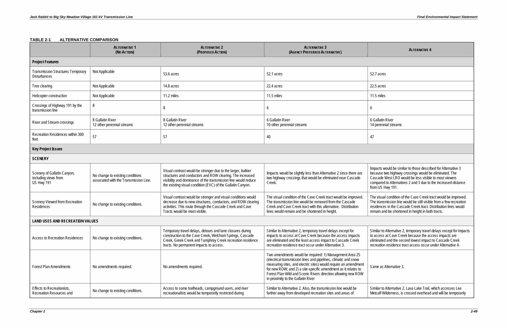
Jack Rabbit to Big Sky Meadow Village 161 kV Transmission Line Final Environmental Impact Statement
Chapter 2 2-49
TABLE 2-1 ALTERNATIVE COMPARISON
ALTERNATIVE 1 (NO ACTION)
ALTERNATIVE 2 (PROPOSED ACTION)
ALTERNATIVE 3 (AGENCY PREFERRED ALTERNATIVE) ALTERNATIVE 4
Project Features
Transmission Structures Temporary Disturbances
Not Applicable 53.6 acres 52.1 acres 52.7 acres
Tree clearing Not Applicable 14.8 acres 22.4 acres 22.5 acres
Helicopter construction Not Applicable 11.2 miles 11.5 miles 11.5 miles
Crossings of Highway 191 by the transmission line
8 8 6 6
River and Stream crossings 8 Gallatin River 12 other perennial streams
8 Gallatin River 12 other perennial streams
6 Gallatin River 10 other perennial streams
6 Gallatin River 14 perennial streams
Recreation Residences within 300 feet 57 57 40 47
Key Project Issues
SCENERY
Scenery of Gallatin Canyon, including views from US Hwy 191
No change to existing conditions associated with the Transmission Line.
Visual contrast would be stronger due to the larger, bulkier structures and conductors and ROW clearing. The increased visibility and dominance of the transmission line would reduce the existing visual condition (EVC) of the Gallatin Canyon.
Impacts would be slightly less than Alternative 2 since there are two highway crossings that would be eliminated near Cascade Creek.
Impacts would be similar to those described for Alternative 3 because two highway crossings would be eliminated. The Cascade West LRO would be less visible to most viewers compared to Alternatives 2 and 3 due to the increased distance from US Hwy 191.
Scenery Viewed from Recreation Residences No change to existing conditions.
Visual contrast would be stronger and visual conditions would decrease due to new structures, conductors, and ROW clearing activities. This route through the Cascade Creek and Cave Tracts would be most visible.
The visual condition of the Cave Creek tract would be improved. The transmission line would be removed from the Cascade Creek and Cave Creek tract with this alternative. Distribution lines would remain and be shortened in height.
The visual condition of the Cave Creek tract would be improved. The transmission line would be still visible from a few recreation residences in the Cascade Creek tract. Distribution lines would remain and be shortened in height in both tracts.
LAND USES AND RECREATION VALUES
Access to Recreation Residences No change to existing conditions. Temporary travel delays, detours and lane closures during construction to the Cave Creek, Welchom Springs, Cascade Creek, Greek Creek and Tamphrey Creek recreation residence tracts. No permanent impacts to access.
Similar to Alternative 2, temporary travel delays except for impacts to access at Cave Creek because the access impacts are eliminated and the least access impact to Cascade Creek recreation residence tract occur under Alternative 3.
Similar to Alternative 2, temporary travel delays except for impacts to access at Cave Creek because the access impacts are eliminated and the second lowest impact to Cascade Creek recreation residence tract access occur under Alternative 4.
Forest Plan Amendments No amendments required. No amendments required.
Two amendments would be required: 1) Management Area 25 (electrical transmission lines and pipelines, climatic and snow measuring sites, and electric sites) would require an amendment for new ROW; and 2) a site-specific amendment as it relates to Forest Plan Wild and Scenic Rivers direction allowing new ROW in proximity to the Gallatin River
Same as Alternative 3.
Effects to Recreationists, Recreation Resources and No change to existing conditions. Access to some trailheads, campground users, and river
recreationalists would be temporarily restricted during Similar to Alternative 2. Also, the transmission line would be farther away from developed recreation sites and areas of
Similar to Alternative 2. Lava Lake Trail, which accesses Lee Metcalf Wilderness, is crossed overhead and will be temporarily
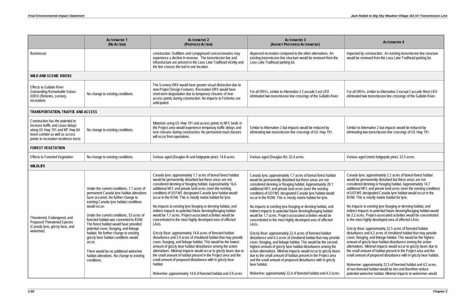
Final Environmental Impact Statement Jack Rabbit to Big Sky Meadow Village 161 kV Transmission Line
2-50 Chapter 2
ALTERNATIVE 1 (NO ACTION)
ALTERNATIVE 2 (PROPOSED ACTION)
ALTERNATIVE 3 (AGENCY PREFERRED ALTERNATIVE) ALTERNATIVE 4
Businesses construction. Outfitters and campground concessionaires may experience a decline in revenue. The transmission line and infrastructure are present in the Lava Lake Trailhead vicinity and the line crosses the trail in one location.
dispersed recreation compared to the other alternatives. An existing transmission line structure would be removed from the Lava Lake Trailhead parking lot.
impacted by construction. An existing transmission line structure would be removed from the Lava Lake Trailhead parking lot.
WILD AND SCENIC RIVERS
Effects to Gallatin River Outstanding Remarkable Values (ORV) (fisheries, scenery, recreation)
No change to existing conditions.
The Scenery ORV would have greater visual distraction due to new Project Design Features. Recreation ORV would have short-term degradation due to temporary closures of river access points during construction. No impacts to Fisheries are anticipated.
For all ORVs, similar to Alternative 2 Cascade East LRO eliminated two transmission line crossings of the Gallatin River.
For all ORVs, similar to Alternative 2 except Cascade West LRO eliminated two transmission line crossings of the Gallatin River.
TRANSPORTATION, TRAFFIC AND ACCESS
Construction has the potential to increase traffic and cause delays along US Hwy 191 and MT Hwy 64 travel corridor as well as access points to recreation residence tracts
No change to existing conditions. Motorists using US Hwy 191 and access points to NFS lands in the Project area would experience temporary traffic delays and lane closures during construction; No permanent road closures will occur from operations.
Similar to Alternative 2 but impacts would be reduced by eliminating two transmission line crossings of US Hwy 191.
Similar to Alternative 2 but impacts would be reduced by eliminating two transmission line crossings of US Hwy 191.
FOREST VEGETATION
Effects to Forested Vegetation No change to existing conditions. Various aged (Douglas-fir and lodgepole pine): 14.8 acres. Various aged (Douglas-fir): 22.4 acres. Various aged (moist lodgepole pine): 22.5 acres.
WILDLIFE
Threatened, Endangered, and Proposed Threatened Species (Canada lynx, grizzly bear, and wolverine)
Under the current conditions, 7.1 acres of permanent Canada lynx habitat alterations have occurred. No further change to existing Canada lynx habitat conditions would occur. Under the current conditions, 53 acres of forested habitat was converted to ROW. The forest habitat would have provided potential cover, foraging, and linkage habitat. No further change to existing grizzly bear habitat conditions would occur. There would be no additional wolverine habitat alterations. No change to existing conditions.
Canada lynx: approximately 1.7 acres of boreal forest habitat would be permanently disturbed but these areas are not considered denning or foraging habitat. Approximately 16.6 additional NFS and private land acres (over the existing condition) of USFWS designated Canada lynx habitat would occur in the ROW. This is mostly matrix habitat for lynx. No impacts to existing lynx foraging or denning habitat, and indirect impacts to potential future denning/foraging habitat would be 1.7 acres. Project-associated activities would be concentrated in the most highly developed area of affected LAUs. Grizzly Bear: approximately 14.8 acres of forested habitat disturbance and 3.9 acres of shrubland habitat that may provide cover, foraging, and linkage habitat. This would be the lowest amount of grizzly bear habitat disturbance among the action alternatives. Minimal impacts would occur to grizzly bears due to the small amount of habitat present in the Project area and the small amount of proposed disturbance with in grizzly bear habitat. Wolverine: approximately 14.8 of forested habitat and 3.9 acres
Canada lynx: approximately 1.7 acres of boreal forest habitat would be permanently disturbed but these areas are not considered denning or foraging habitat. Approximately 20.1 additional NFS and private land acres (over the existing condition) of USFWS designated Canada lynx habitat would occur in the ROW. This is mostly matrix habitat for lynx. No impacts to existing lynx foraging or denning habitat, and indirect impacts to potential future denning/foraging habitat would be 1.7 acres. Project-associated activities would be concentrated in the most highly developed area of affected LAUs. Grizzly Bear: approximately 22.4 acres of forested habitat disturbance and 4.3 acres of shrubland habitat that may provide cover, foraging, and linkage habitat. This would be the second highest amount of grizzly bear habitat disturbance among the action alternatives. Minimal impacts would occur to grizzly bears due to the small amount of habitat present in the Project area and the small amount of proposed disturbance with in grizzly bear habitat. Wolverine: approximately 22.4 of forested habitat and 4.3 acres.
Canada lynx: approximately 2.2 acres of boreal forest habitat would be permanently disturbed but these areas are not considered denning or foraging habitat. Approximately 14.7 additional NFS and private land acres (over the existing condition) of USFWS designated Canada lynx habitat would occur in the ROW. This is mostly matrix habitat for lynx. No impacts to existing lynx foraging or denning habitat, and indirect impacts to potential future denning/foraging habitat would be 2.2 acres. Project-associated activities would be concentrated in the most highly developed area of affected LAUs. Grizzly Bear: approximately 22.5 acres of forested habitat disturbance and 4.2 acres of shrubland habitat that may provide cover, foraging, and linkage habitat. This would be the highest amount of grizzly bear habitat disturbance among the action alternatives. Minimal impacts would occur to grizzly bears due to the small amount of habitat present in the Project area and the small amount of proposed disturbance with in grizzly bear habitat. Wolverine: approximately 22.5 of forested habitat and 4.2 acres. of non-forested habitat would be lost and therefore reduce potential wolverine habitat. Minimal impacts to wolverines would
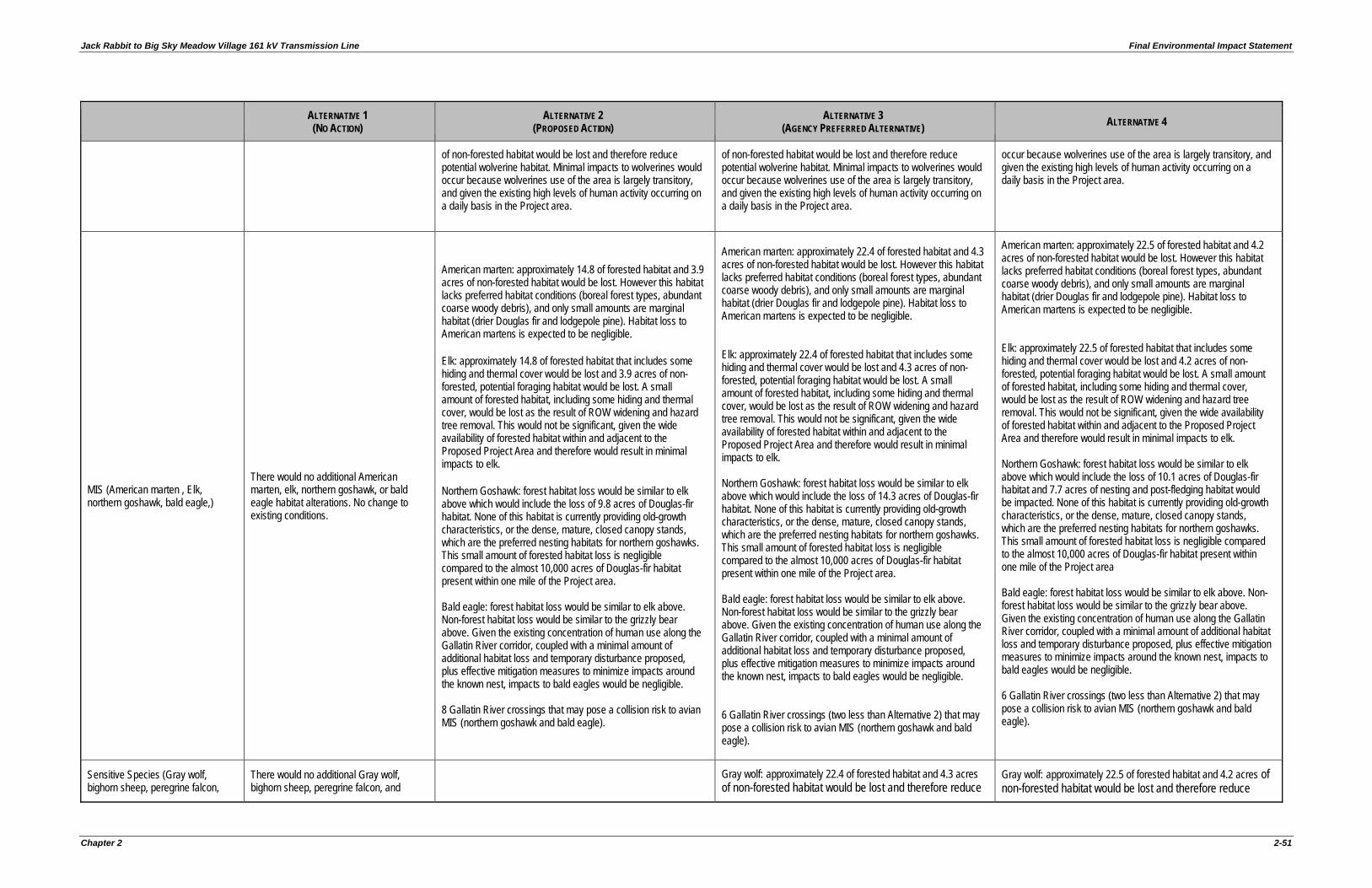
Jack Rabbit to Big Sky Meadow Village 161 kV Transmission Line Final Environmental Impact Statement
Chapter 2 2-51
ALTERNATIVE 1 (NO ACTION)
ALTERNATIVE 2 (PROPOSED ACTION)
ALTERNATIVE 3 (AGENCY PREFERRED ALTERNATIVE) ALTERNATIVE 4
of non-forested habitat would be lost and therefore reduce potential wolverine habitat. Minimal impacts to wolverines would occur because wolverines use of the area is largely transitory, and given the existing high levels of human activity occurring on a daily basis in the Project area.
of non-forested habitat would be lost and therefore reduce potential wolverine habitat. Minimal impacts to wolverines would occur because wolverines use of the area is largely transitory, and given the existing high levels of human activity occurring on a daily basis in the Project area.
occur because wolverines use of the area is largely transitory, and given the existing high levels of human activity occurring on a daily basis in the Project area.
MIS (American marten , Elk, northern goshawk, bald eagle,)
There would no additional American marten, elk, northern goshawk, or bald eagle habitat alterations. No change to existing conditions.
American marten: approximately 14.8 of forested habitat and 3.9 acres of non-forested habitat would be lost. However this habitat lacks preferred habitat conditions (boreal forest types, abundant coarse woody debris), and only small amounts are marginal habitat (drier Douglas fir and lodgepole pine). Habitat loss to American martens is expected to be negligible. Elk: approximately 14.8 of forested habitat that includes some hiding and thermal cover would be lost and 3.9 acres of non-forested, potential foraging habitat would be lost. A small amount of forested habitat, including some hiding and thermal cover, would be lost as the result of ROW widening and hazard tree removal. This would not be significant, given the wide availability of forested habitat within and adjacent to the Proposed Project Area and therefore would result in minimal impacts to elk. Northern Goshawk: forest habitat loss would be similar to elk above which would include the loss of 9.8 acres of Douglas-fir habitat. None of this habitat is currently providing old-growth characteristics, or the dense, mature, closed canopy stands, which are the preferred nesting habitats for northern goshawks. This small amount of forested habitat loss is negligible compared to the almost 10,000 acres of Douglas-fir habitat present within one mile of the Project area. Bald eagle: forest habitat loss would be similar to elk above. Non-forest habitat loss would be similar to the grizzly bear above. Given the existing concentration of human use along the Gallatin River corridor, coupled with a minimal amount of additional habitat loss and temporary disturbance proposed, plus effective mitigation measures to minimize impacts around the known nest, impacts to bald eagles would be negligible. 8 Gallatin River crossings that may pose a collision risk to avian MIS (northern goshawk and bald eagle).
American marten: approximately 22.4 of forested habitat and 4.3 acres of non-forested habitat would be lost. However this habitat lacks preferred habitat conditions (boreal forest types, abundant coarse woody debris), and only small amounts are marginal habitat (drier Douglas fir and lodgepole pine). Habitat loss to American martens is expected to be negligible. Elk: approximately 22.4 of forested habitat that includes some hiding and thermal cover would be lost and 4.3 acres of non-forested, potential foraging habitat would be lost. A small amount of forested habitat, including some hiding and thermal cover, would be lost as the result of ROW widening and hazard tree removal. This would not be significant, given the wide availability of forested habitat within and adjacent to the Proposed Project Area and therefore would result in minimal impacts to elk. Northern Goshawk: forest habitat loss would be similar to elk above which would include the loss of 14.3 acres of Douglas-fir habitat. None of this habitat is currently providing old-growth characteristics, or the dense, mature, closed canopy stands, which are the preferred nesting habitats for northern goshawks. This small amount of forested habitat loss is negligible compared to the almost 10,000 acres of Douglas-fir habitat present within one mile of the Project area. Bald eagle: forest habitat loss would be similar to elk above. Non-forest habitat loss would be similar to the grizzly bear above. Given the existing concentration of human use along the Gallatin River corridor, coupled with a minimal amount of additional habitat loss and temporary disturbance proposed, plus effective mitigation measures to minimize impacts around the known nest, impacts to bald eagles would be negligible. 6 Gallatin River crossings (two less than Alternative 2) that may pose a collision risk to avian MIS (northern goshawk and bald eagle).
American marten: approximately 22.5 of forested habitat and 4.2 acres of non-forested habitat would be lost. However this habitat lacks preferred habitat conditions (boreal forest types, abundant coarse woody debris), and only small amounts are marginal habitat (drier Douglas fir and lodgepole pine). Habitat loss to American martens is expected to be negligible. Elk: approximately 22.5 of forested habitat that includes some hiding and thermal cover would be lost and 4.2 acres of non-forested, potential foraging habitat would be lost. A small amount of forested habitat, including some hiding and thermal cover, would be lost as the result of ROW widening and hazard tree removal. This would not be significant, given the wide availability of forested habitat within and adjacent to the Proposed Project Area and therefore would result in minimal impacts to elk. Northern Goshawk: forest habitat loss would be similar to elk above which would include the loss of 10.1 acres of Douglas-fir habitat and 7.7 acres of nesting and post-fledging habitat would be impacted. None of this habitat is currently providing old-growth characteristics, or the dense, mature, closed canopy stands, which are the preferred nesting habitats for northern goshawks. This small amount of forested habitat loss is negligible compared to the almost 10,000 acres of Douglas-fir habitat present within one mile of the Project area Bald eagle: forest habitat loss would be similar to elk above. Non-forest habitat loss would be similar to the grizzly bear above. Given the existing concentration of human use along the Gallatin River corridor, coupled with a minimal amount of additional habitat loss and temporary disturbance proposed, plus effective mitigation measures to minimize impacts around the known nest, impacts to bald eagles would be negligible. 6 Gallatin River crossings (two less than Alternative 2) that may pose a collision risk to avian MIS (northern goshawk and bald eagle).
Sensitive Species (Gray wolf, bighorn sheep, peregrine falcon,
There would no additional Gray wolf, bighorn sheep, peregrine falcon, and
Gray wolf: approximately 22.4 of forested habitat and 4.3 acres of non-forested habitat would be lost and therefore reduce
Gray wolf: approximately 22.5 of forested habitat and 4.2 acres of non-forested habitat would be lost and therefore reduce
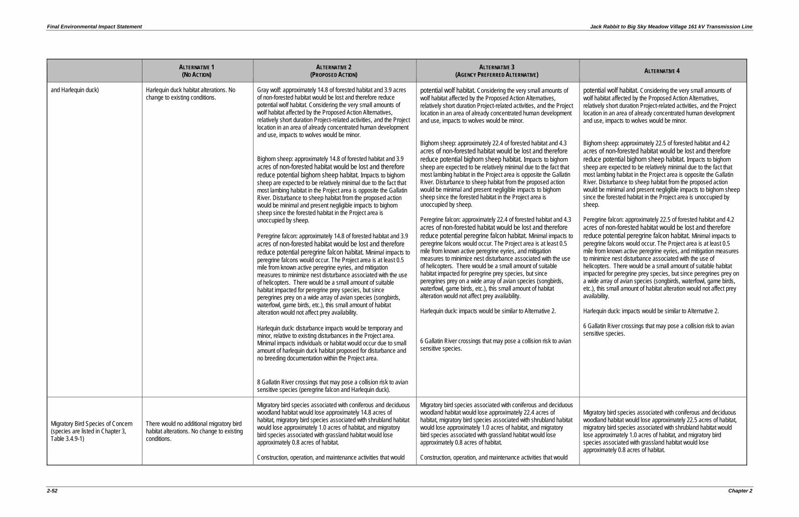
Final Environmental Impact Statement Jack Rabbit to Big Sky Meadow Village 161 kV Transmission Line
2-52 Chapter 2
ALTERNATIVE 1 (NO ACTION)
ALTERNATIVE 2 (PROPOSED ACTION)
ALTERNATIVE 3 (AGENCY PREFERRED ALTERNATIVE) ALTERNATIVE 4
and Harlequin duck) Harlequin duck habitat alterations. No change to existing conditions.
Gray wolf: approximately 14.8 of forested habitat and 3.9 acres of non-forested habitat would be lost and therefore reduce potential wolf habitat. Considering the very small amounts of wolf habitat affected by the Proposed Action Alternatives, relatively short duration Project-related activities, and the Project location in an area of already concentrated human development and use, impacts to wolves would be minor. Bighorn sheep: approximately 14.8 of forested habitat and 3.9 acres of non-forested habitat would be lost and therefore reduce potential bighorn sheep habitat. Impacts to bighorn sheep are expected to be relatively minimal due to the fact that most lambing habitat in the Project area is opposite the Gallatin River. Disturbance to sheep habitat from the proposed action would be minimal and present negligible impacts to bighorn sheep since the forested habitat in the Project area is unoccupied by sheep. Peregrine falcon: approximately 14.8 of forested habitat and 3.9 acres of non-forested habitat would be lost and therefore reduce potential peregrine falcon habitat. Minimal impacts to peregrine falcons would occur. The Project area is at least 0.5 mile from known active peregrine eyries, and mitigation measures to minimize nest disturbance associated with the use of helicopters. There would be a small amount of suitable habitat impacted for peregrine prey species, but since peregrines prey on a wide array of avian species (songbirds, waterfowl, game birds, etc.), this small amount of habitat alteration would not affect prey availability. Harlequin duck: disturbance impacts would be temporary and minor, relative to existing disturbances in the Project area. Minimal impacts individuals or habitat would occur due to small amount of harlequin duck habitat proposed for disturbance and no breeding documentation within the Project area. 8 Gallatin River crossings that may pose a collision risk to avian sensitive species (peregrine falcon and Harlequin duck).
potential wolf habitat. Considering the very small amounts of wolf habitat affected by the Proposed Action Alternatives, relatively short duration Project-related activities, and the Project location in an area of already concentrated human development and use, impacts to wolves would be minor. Bighorn sheep: approximately 22.4 of forested habitat and 4.3 acres of non-forested habitat would be lost and therefore reduce potential bighorn sheep habitat. Impacts to bighorn sheep are expected to be relatively minimal due to the fact that most lambing habitat in the Project area is opposite the Gallatin River. Disturbance to sheep habitat from the proposed action would be minimal and present negligible impacts to bighorn sheep since the forested habitat in the Project area is unoccupied by sheep. Peregrine falcon: approximately 22.4 of forested habitat and 4.3 acres of non-forested habitat would be lost and therefore reduce potential peregrine falcon habitat. Minimal impacts to peregrine falcons would occur. The Project area is at least 0.5 mile from known active peregrine eyries, and mitigation measures to minimize nest disturbance associated with the use of helicopters. There would be a small amount of suitable habitat impacted for peregrine prey species, but since peregrines prey on a wide array of avian species (songbirds, waterfowl, game birds, etc.), this small amount of habitat alteration would not affect prey availability. Harlequin duck: impacts would be similar to Alternative 2. 6 Gallatin River crossings that may pose a collision risk to avian sensitive species.
potential wolf habitat. Considering the very small amounts of wolf habitat affected by the Proposed Action Alternatives, relatively short duration Project-related activities, and the Project location in an area of already concentrated human development and use, impacts to wolves would be minor. Bighorn sheep: approximately 22.5 of forested habitat and 4.2 acres of non-forested habitat would be lost and therefore reduce potential bighorn sheep habitat. Impacts to bighorn sheep are expected to be relatively minimal due to the fact that most lambing habitat in the Project area is opposite the Gallatin River. Disturbance to sheep habitat from the proposed action would be minimal and present negligible impacts to bighorn sheep since the forested habitat in the Project area is unoccupied by sheep. Peregrine falcon: approximately 22.5 of forested habitat and 4.2 acres of non-forested habitat would be lost and therefore reduce potential peregrine falcon habitat. Minimal impacts to peregrine falcons would occur. The Project area is at least 0.5 mile from known active peregrine eyries, and mitigation measures to minimize nest disturbance associated with the use of helicopters. There would be a small amount of suitable habitat impacted for peregrine prey species, but since peregrines prey on a wide array of avian species (songbirds, waterfowl, game birds, etc.), this small amount of habitat alteration would not affect prey availability. Harlequin duck: impacts would be similar to Alternative 2. 6 Gallatin River crossings that may pose a collision risk to avian sensitive species.
Migratory Bird Species of Concern (species are listed in Chapter 3, Table 3.4.9-1)
There would no additional migratory bird habitat alterations. No change to existing conditions.
Migratory bird species associated with coniferous and deciduous woodland habitat would lose approximately 14.8 acres of habitat, migratory bird species associated with shrubland habitat would lose approximately 1.0 acres of habitat, and migratory bird species associated with grassland habitat would lose approximately 0.8 acres of habitat. Construction, operation, and maintenance activities that would
Migratory bird species associated with coniferous and deciduous woodland habitat would lose approximately 22.4 acres of habitat, migratory bird species associated with shrubland habitat would lose approximately 1.0 acres of habitat, and migratory bird species associated with grassland habitat would lose approximately 0.8 acres of habitat. Construction, operation, and maintenance activities that would
Migratory bird species associated with coniferous and deciduous woodland habitat would lose approximately 22.5 acres of habitat, migratory bird species associated with shrubland habitat would lose approximately 1.0 acres of habitat, and migratory bird species associated with grassland habitat would lose approximately 0.8 acres of habitat.
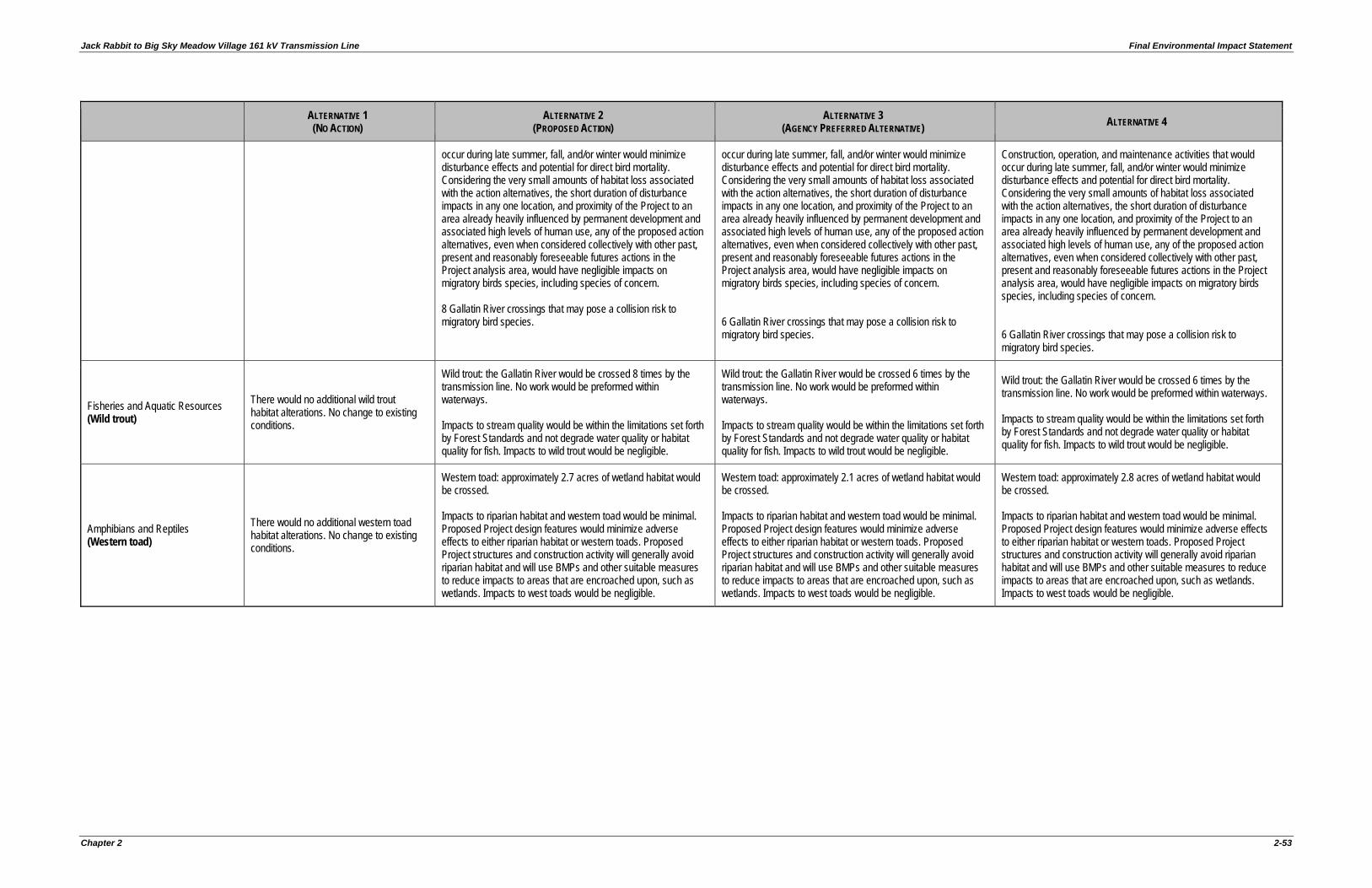
Jack Rabbit to Big Sky Meadow Village 161 kV Transmission Line Final Environmental Impact Statement
Chapter 2 2-53
ALTERNATIVE 1 (NO ACTION)
ALTERNATIVE 2 (PROPOSED ACTION)
ALTERNATIVE 3 (AGENCY PREFERRED ALTERNATIVE) ALTERNATIVE 4
occur during late summer, fall, and/or winter would minimize disturbance effects and potential for direct bird mortality. Considering the very small amounts of habitat loss associated with the action alternatives, the short duration of disturbance impacts in any one location, and proximity of the Project to an area already heavily influenced by permanent development and associated high levels of human use, any of the proposed action alternatives, even when considered collectively with other past, present and reasonably foreseeable futures actions in the Project analysis area, would have negligible impacts on migratory birds species, including species of concern. 8 Gallatin River crossings that may pose a collision risk to migratory bird species.
occur during late summer, fall, and/or winter would minimize disturbance effects and potential for direct bird mortality. Considering the very small amounts of habitat loss associated with the action alternatives, the short duration of disturbance impacts in any one location, and proximity of the Project to an area already heavily influenced by permanent development and associated high levels of human use, any of the proposed action alternatives, even when considered collectively with other past, present and reasonably foreseeable futures actions in the Project analysis area, would have negligible impacts on migratory birds species, including species of concern. 6 Gallatin River crossings that may pose a collision risk to migratory bird species.
Construction, operation, and maintenance activities that would occur during late summer, fall, and/or winter would minimize disturbance effects and potential for direct bird mortality. Considering the very small amounts of habitat loss associated with the action alternatives, the short duration of disturbance impacts in any one location, and proximity of the Project to an area already heavily influenced by permanent development and associated high levels of human use, any of the proposed action alternatives, even when considered collectively with other past, present and reasonably foreseeable futures actions in the Project analysis area, would have negligible impacts on migratory birds species, including species of concern. 6 Gallatin River crossings that may pose a collision risk to migratory bird species.
Fisheries and Aquatic Resources (Wild trout)
There would no additional wild trout habitat alterations. No change to existing conditions.
Wild trout: the Gallatin River would be crossed 8 times by the transmission line. No work would be preformed within waterways. Impacts to stream quality would be within the limitations set forth by Forest Standards and not degrade water quality or habitat quality for fish. Impacts to wild trout would be negligible.
Wild trout: the Gallatin River would be crossed 6 times by the transmission line. No work would be preformed within waterways. Impacts to stream quality would be within the limitations set forth by Forest Standards and not degrade water quality or habitat quality for fish. Impacts to wild trout would be negligible.
Wild trout: the Gallatin River would be crossed 6 times by the transmission line. No work would be preformed within waterways. Impacts to stream quality would be within the limitations set forth by Forest Standards and not degrade water quality or habitat quality for fish. Impacts to wild trout would be negligible.
Amphibians and Reptiles (Western toad)
There would no additional western toad habitat alterations. No change to existing conditions.
Western toad: approximately 2.7 acres of wetland habitat would be crossed. Impacts to riparian habitat and western toad would be minimal. Proposed Project design features would minimize adverse effects to either riparian habitat or western toads. Proposed Project structures and construction activity will generally avoid riparian habitat and will use BMPs and other suitable measures to reduce impacts to areas that are encroached upon, such as wetlands. Impacts to west toads would be negligible.
Western toad: approximately 2.1 acres of wetland habitat would be crossed. Impacts to riparian habitat and western toad would be minimal. Proposed Project design features would minimize adverse effects to either riparian habitat or western toads. Proposed Project structures and construction activity will generally avoid riparian habitat and will use BMPs and other suitable measures to reduce impacts to areas that are encroached upon, such as wetlands. Impacts to west toads would be negligible.
Western toad: approximately 2.8 acres of wetland habitat would be crossed. Impacts to riparian habitat and western toad would be minimal. Proposed Project design features would minimize adverse effects to either riparian habitat or western toads. Proposed Project structures and construction activity will generally avoid riparian habitat and will use BMPs and other suitable measures to reduce impacts to areas that are encroached upon, such as wetlands. Impacts to west toads would be negligible.
Final Environmental Impact Statement Jack Rabbit to Big Sky Meadow Village 161 kV Transmission Line
2-54 Chapter 2
THIS PAGE INTENTIONALLY LEFT BLANK.