Chapter 1 Laetoli Revisited: Renewed Paleontological and ...
Upload
nguyenduongCategory
view
227download
3
CHAPTER 16 PALEONTOLOGICAL RESOURCES
This chapter describes the paleontological resources in the study area and potential changes that could occur due to implementation of the alternatives. Paleontological resources are fossils that are the remains or traces of prehistoric life preserved in the geological (rock stratigraphic) record. They range from large fossils, such as dinosaur and mammoth bones, to the more obscure but scientifically important fossils, such as paleobotanical remains, trace fossils, and microfossils.
Fossils are important because of their use in (1) documenting the presence and evolutionary history of particular groups of now-extinct organisms, (2) reconstructing the environments in which these organisms lived, and (3) determining the relative ages of the strata in which they occur and the geologic events that resulted in the deposition of the sediments that formed these strata. Paleontological resources include the casts or impressions of ancient animals and plants, their trace remains (e.g., burrows, trackways), microfossils (e.g., fossil pollen, ostracodes, diatoms), and unmineralized remains (e.g., bones of Ice Age mammals or trunks of trees that lived long ago).
STUDY AREA The study area is defined as the geographical area within which the large majority of potential impacts are expected. The study area for paleonotological resources is the area where ground disturbance or exposure of previously submerged cultural resources would occur. This area is located within the Sea Bed and along the shoreline.
REGULATORY REQUIREMENTS Paleontological resources are non-renewable resources protected under federal and State laws. These laws do not extend to privately held lands, but they do apply to lands managed by federal and State agencies and to other lands where paleontological resources may be affected by a federal or State actions. Paleontological resources are protected by several federal and State statutes (California Office of Historic Preservation, 1983; Marshall, 1976; Fisk and Spencer, 1994), most notably by the 1906 Federal Antiquities Act. The Antiquities Act of 1906 (PL 59-209; 16 United States Code 431 et seq.; 34 Stat. 225) requires protection of historic landmarks, historic and prehistoric structures, and other objects of historic or scientific interest on federal lands.
State requirements for paleontological resource management pertain to Archaeological, Paleontological, and Historical Sites (California Public Resources Code Chapter 1.7, Section 5097.5 (Stats. 1965, c. 1136, p. 2792). This statute defines as a misdemeanor any unauthorized disturbance or removal of a fossil site or remains on public land and specifies that State agencies may undertake surveys, excavations, or other operations as necessary on State lands to preserve or record paleontological resources. This statute applies if construction or other related impacts occur on State-owned or managed lands.
Imperial and Riverside county general plans do not specifically address paleontological resources. However, general plans emphasize the conservation of historical and prehistorical resources.
HISTORICAL PERSPECTIVE The time period appropriate to understand the paleontological resources of the Salton Sea encompasses the last 20,000,000 years. Geologists recognize earlier depositional basins in the immediate vicinity of the Salton Trough, which were created and then destroyed during the tectonic evolution of this region over the last 20,000,000 to 30,000,000 years. These include the Vallecito Creek – Fish Creek Basin, the
Salton Sea Ecosystem 16-1 2006 Restoration Draft PEIR 062890023SAC
Chapter 16 Paleontological Resources
sediments of which are exposed to the southwest of the Salton Trough (Dorsey, 2005), and the Diligencia Basin to the east of the Salton Trough (Law et al., 2001). These basins and the Salton Trough have been characterized by geologically rapid subsidence and, consequently, rapid sedimentation. The thickness of basin fill in the deepest part of the Salton Trough is at least 2.5 to 3.7 miles (Dohrenwend and Smith, 1991). Sediments uplifted and exposed in areas adjacent to the Salton Trough provide important information on the history of this rift valley over the last 5,000,000 to 10,000,000 years, and the fossil record from these rocks is one of the most complete in the western United States for the last 7,000,000 years (Jefferson and Lindsay, 2006).
Jefferson (2004) summarized the history of paleontological investigations in the area since the late 1800s primarily in the Anza-Borrego Desert State Park area. During the early 1900s, there began to be considerable scientific interest in the invertebrate fauna of the Imperial Formation and the history of the intrusion of the Gulf of California into the area (Jefferson, 2004). Research on invertebrate fauna continues in the area and now includes vertebrate fauna. There have been more than 17,000 vertebrate fossil specimens collected and catalogued in the Anza-Borrego Desert State Park since the 1930s (Jefferson, 2004).
DATA SOURCES Literature on the Tertiary and Quaternary geology and on the paleontology of the Salton Trough, as well as site records of prior paleontological finds, was reviewed to understand the paleontologic sensitivity of surface and subsurface sediments near the Salton Sea. The results are presented below as inventories of the sensitivity of geological units and of the fossil sites within the area, including an assessment of each geological unit’s potential to yield scientifically significant, non-renewable paleontological resources (fossils). The geological inventory was accomplished by reviewing publications addressing the surface and subsurface geology of the Salton Trough, including geological maps; discussing the geology and paleontologic sensitivity of the area with paleontologists of the Stout Research Center, Anza-Borrego Desert State Park; and conducting reconnaissance and review of satellite imagery. Additional records from the San Bernardino County Museum, Los Angeles County Museum of Natural History, and University of California Museum of Paleontology at Berkeley were accessed either at the Anza-Borrego Desert State Park or though the university online paleontological records search utility. Those sites within or near the study area, are summarized below.
DATA LIMITATIONS The Salton Trough is composed largely of unconsolidated sediments as well as sedimentary rock; and, therefore most of the study area is underlain by potentially fossiliferous substrate. Paleontological research has been focused on the western and southwestern portions of this rift valley (Jefferson and Lindsay, 2006), and comparatively less is known of the paleontological potential of the sediments in the center of the Salton Trough. Specific data gaps that prevent a more accurate characterization of the paleontological sensitivity include lack of a paleontological survey, no confirmed fossil records for the Brawley, Borrego, or Palm Spring formations in the study area, and lack of localized geological data, which results in poor understanding of the extent of units with known paleontological potential.
EXISTING CONDITIONS To gain an understanding of the paleontological potential of the study area, this document also considers the geological history and physiography of the Salton Trough (described in Chapter 9). This allows consideration of such phenomena as changes in the location of discharge of the Colorado River from the Gulf of California to the Salton Sea, which profoundly influenced the fossil record of the study area, and the elaborate fossil record from the Anza-Borrego Desert. The Salton Trough was isolated from the Gulf of California as the fan-delta of the Colorado River was formed about 4,000,000 years ago. Fine-grained
2006 16-2 Salton Sea Ecosystem Restoration Draft PEIR
Chapter 16 Paleontological Resources
sediments prior to that age yield the fossils of marine organisms, from marine mammals to oyster beds. Following the formation of the delta, freshwater and terrestrial organisms are evident in the ancestral Salton Trough.
Areas with volcanic and geothermal activities along the southern shoreline are characterized by small rhyolite volcanoes (Robinson et al., 1976). One of these, Obsidian Butte, was an important source of obsidian tool stone to the prehistoric inhabitants of the area (Gruver, 2004).
During the period of 80,000 to 14,000 years ago, the water surface elevation of the ocean was as much as 400 feet lower than at present (Bloom, 1983). During that period, the Salton Trough probably was isolated from the Colorado River and the Gulf of California (Quade et al., 1995).
Paleontologic Sensitivity at the Salton Sea Paleontological sensitivity can be assessed by identifying the paleontological potential of stratigraphic units and understanding the paleontological records for the strata. Distribution of stratigraphic units can be identified through geologic mapping. The paleontological records are used to understand the sensitivity (high, moderate, low, or no sensitivity) of the presence of paleontological resources.
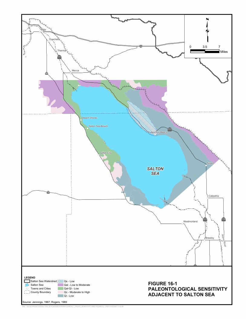
For the Draft Programmatic Environmental Impact Report (PEIR) analysis, a paleontologically sensitive stratigraphic unit is defined as a sedimentary deposit that has a high to moderate potential to yield fossils that may be unique or scientifically important. An individual fossil specimen may be considered scientifically significant if it is (1) identifiable, (2) complete, (3) well preserved, (4) age diagnostic, (5) useful in paleoenvironmental reconstruction, (6) a type or topotypic specimen, (7) a member of a rare species, or (8) a skeletal element different from, or a specimen more complete than, those now available for its species. For example, identifiable vertebrate marine and terrestrial fossils are generally considered scientifically important because they are relatively rare. However, marine invertebrates and other microfossils may be important to specialized paleoenvironmental studies, but as isolated specimens they are generally not considered a unique or scientifically significant paleontological resource. The paleontological sensitivity near the Salton Sea is shown in Figure 16-1.
Detailed mapping of geologic units has not been conducted for the Salton Sea. Generalized geologic mapping is the only available classification method, and has been used to assign provisional levels of paleontologic sensitivity.
The geologic base map chosen to display provisional levels of paleontologic sensitivity within the study area is that of Jennings (1967) for the majority of the area, supplemented by Rogers (1965) for the northwestern portion of the study area, as shown in Figure 16-1. Table 16-1 lists the map units employed and the provisional levels of paleontological sensitivity assigned to them based on this literature review and the records search results. The general map units are non-specific and do not allow confident assignment of paleontological sensitivity, therefore a sensitivity range was assigned.
Salton Sea Ecosystem 16-3 2006 Restoration Draft PEIR
Chapter 16 Paleontological Resources
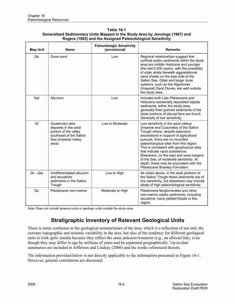
Table 16-1 Generalized Sedimentary Units Mapped in the Study Area by Jennings (1967) and
Rogers (1965) and the Assigned Paleontological Sensitivity
Map Unit Name Paleontologic Sensitivity
(provisional) Remarks
Qs Dune sand Low Regional relationships suggest that surficial eolian sediments within the study area are middle Holocene and younger (the last 6,000 years), with the possibility of older strata beneath aggradational sand sheets on the east side of the Salton Sea. Older and larger dune systems, such as the Algodones (Imperial) Sand Dunes, are well outside the study area.
Qal Alluvium Low Includes both Late Pleistocene and Holocene subaerially deposited bajada sediments; within the study area, generally finer-grained sediments of the distal portions of alluvial fans are found. Generally of low sensitivity.
Ql Quaternary lake deposits in the axial portion of the valley southeast of the Salton Sea (Imperial Valley area)
Low to Moderate Low sensitivity in the axial valleys (Imperial and Coachella) of the Salton Trough where, despite extensive excavations in support of agricultural pursuits, there are no recorded paleontological sites from this region. This is consistent with geophysical data that indicate rapid subsidence. Elsewhere, on the east and west margins of the Sea, of moderate sensitivity. At depth, these may be equivalent with the Pleistocene Brawley Formation.
Ql – Qal Undifferentiated alluvium and lacustrine sediments in the Salton Trough
Low to High As noted above, in the axial portions of the Salton Trough these sediments are of low sensitivity, but elsewhere may include strata of high paleontological sensitivity.
Qc Pleistocene non-marine Moderate to High Pleistocene fanglomerates and other non-marine clastic sediments, including lacustrine, have yielded fossils in this region.
Note: Does not include igneous rocks or geologic units outside the study area
Stratigraphic Inventory of Relevant Geological Units There is some confusion in the geological nomenclature of the area, which is a reflection of not only the extreme topographic and tectonic variability in the area, but also of the tendency for different geological units to look quite similar because they reflect the same paleoenvironment (e.g., an alluvial fan), even though they may differ in age by millions of years and be separated geographically. Up-to-date summaries are included in Jefferson and Lindsay (2006) and the works referenced therein.
The information provided below is not directly applicable to the information presented in Figure 16-1. However, general correlations are discussed.
2006 16-4 Salton Sea Ecosystem Restoration Draft PEIR
!(
!(
!(
!(
!(
!(
!(
!(
!(
!(
!(
!(
!(
!(!(!(
!(
SALTONSEA
New River
Alamo River
|ÿ86
|ÿ86
|ÿ78
|ÿ115|ÿ111
|ÿ111
|ÿ111
Ø10
Mecca
Indio
Seeley
Niland
Brawley
Thermal
Imperial
El Centro
Coachella
Calipatria
Salton City
Westmorland
Plaster City
Bombay Beach
Desert Shores
Salton Sea Beach
SAC \\GLACIER\SACGIS\SALTON_SEA\GIS\MXDS\PEIR\FIGURE16_1_PALEO_SENSITIVITY.MXD FIGURE16_1.PDF 6/16/2006 11:43:49
LEGENDSalton Sea WatershedSalton Sea
!( Towns and CitiesCounty Boundary
Qs - LowQal - Low to ModerateQal-Ql - LowQc - Moderate to HighQl - Low
FIGURE 16-1PALEONTOLOGICAL SENSITIVITYADJACENT TO SALTON SEA
Source: Jennings, 1967; Rogers, 1965
0 73.5Miles
q
Chapter 16 Paleontological Resources
Lacustrine Sediments of Lake Cahuilla Lake Cahuilla sediments include beach and near-shore deposits that mantle the surfaces on the margin of the Salton Sea (Waters, 1983). These are sands and sandy gravels often with the common shells of freshwater bivalves, gastropods, and fish bone. Mineralized bones of Pleistocene megafauna, which have been wave-rounded and abraded, have also been recovered from beach deposits of late Holocene Lake Cahuilla. These near-shore sediments are often of shallow depth, mantling the surfaces of alluvial fans and pediments, but can be substantially deeper in embayments and topographic lows. Deeper-water sediments of Lake Cahuilla that accumulated in the vast axial areas of the Salton Trough support the productive agricultural centers of the Imperial and Coachella valleys. These expansive areas of relatively flat, drained, and cultivated lacustrine silts occupy the Salton Trough both to the south-southeast and north-northwest of the Salton Sea. Most of the sediments included in these areas are shown as Ql and Qal-Ql on Figure 16-1.
The presence of the abundant vertebrae of the giant minnow or bonytail chub in a packrat midden from the west side of the Chocolate Mountains at about 820 feet mean sea level (msl) could demonstrate the presence of a freshwater lake about 10,000 years ago (Rinehart and MacFarlane, 1995). However, rather than indicating a lake reaching this elevation, these bones likely were transported some distance to the midden site in the gut of a bird and, after regurgitation, incorporated into the midden by a packrat. This is thought to be one means by which vertebrate remains are incorporated into ancient packrat middens (Van Devender and Bradley, 1990). No formal designation has been applied to these late Holocene sediments and hence the use of the term Lake Cahuilla sediments.
Paleospring Deposits Paleospring deposits have not been widely studied in the Salton Trough, but are evident particularly on the east side of the valley near the San Andreas Fault Zone, near State Highway 111, especially along Salt Creek. Areas of shallow and emergent groundwater are not unusual where valley-margin faults intersect a relatively shallow water table (Quade et al., 1995; Haynes, 1967). Phreatophytes, such as willow, cattail, and even dense saltbush, form thickets in the presence of wet ground, and these in turn trap eolian (wind-blown) silt that builds up as a spring mound over time. Spring mounds, consisting chiefly of sediment accumulated to a height exceeding 50 feet above the surrounding terrain, are in some areas. In other cases, upward displacement and subsequent erosion have exposed paleospring deposits in fault zones.
Undifferentiated Quaternary Alluvium and Eolian Sediments Alluvium is typically composed of sediment that is not buried quickly and consists of poorly sorted silt, sand, gravel, and cobble-sized clasts, occurring in the east as alluvial fan deposits and to the west of the Salton Sea chiefly as channel fill deposits and alluvial terraces. This sediment can occur both above and below late Holocene Lake Cahuilla deposits and can be composed of reworked lacustrine sediments. Older alluvium formations are assigned to the Ocotillo Conglomerate of Pleistocene age and to the still-older Cane Break Conglomerate of Plio-Pleistocene age. Most of the sediments included in these areas are shown as Ql and Qal on Figure 16-1.
Brawley Formation and Ocotillo Conglomerate The Pleistocene Brawley Formation is generally located below the Quaternary sediments composed chiefly of claystone within interbedded sandstone, and its finer-grained facies are of lacustrine origin. It forms extensive shelving of subhorizontal beds exposed on the southwestern portion of the Salton Trough and has been reported in surface exposures to the east of the Salton Sea near Durmid and the Bat Caves Buttes. Most of the sediments included in these areas are shown as Qc on Figure 16-1.
To the west of State Highway 86, the Brawley Formation is up to 2,000 feet thick and grades into the Ocotillo Conglomerate (Dorsey, 2005). Freshwater molluscan fauna and Ranchlabrean faunal elements,
Salton Sea Ecosystem 16-7 2006 Restoration Draft PEIR
Chapter 16 Paleontological Resources
such as mammoth (Mammuthus), North American horse (Equus), and camel (Camelops), are recorded for the Brawley Formation. It should be noted that even though the Ocotillo Conglomerate is composed of chiefly coarse-grained clasts, it is fossiliferous despite the implied high-energy depositional regime. A majority of the proboscidian (mammoths, mastodonts, and their relatives) remains from the Anza-Borrego Desert State Park area are from the Ocotillo Formation (McDaniel and Jefferson, 2003).
Borrego Formation Geologic mapping indicates that the Plio-Pleistocene Borrego Formation is up to 6,000 feet thick in some areas and generally located below the Brawley Formation and Ocotillo Conglomeration. Like the Brawley Formation, it is thought to be chiefly of lacustrine origin. To the west of the Salton Trough, this formation grades into and overlies the Palm Spring Group. However, unlike the Brawley Formation, it can also be found on the east side of the Salton Trough. In some areas, beach deposits of Lake Cahuilla directly overlie consolidated and tilted sediments of the Borrego Formation (Jefferson, 2005). Most of the sediments included in these areas are shown as Qs on Figure 16-1.
Palm Spring Group The beginning of deposition of sediments of the Palm Spring Group, and the end of the underlying Imperial Group, mark the single most important environmental change in the region in the last 10,000,000 years. The first evidence for terrestrial and freshwater habitats is found in the Palm Spring Group, in contrast to the marine environment of the underlying Imperial Group. The age of the basal Palm Spring Group is estimated to be about 3,900,000 years. Most of the sediments are located to the west of State Highway 86.
To the west of the Palm Spring Group, the Canebreak Conglomerate, Olla Formations, and Diablo Formation comprise progressive finer facies ranging from terrestrial/alluvial to fluvial and lacustrine paleoenvironments. The sands from the Diablo and Olla formations are of a mineral composition unique to the Colorado Plateau, and these sediments represent deposition of the ancestral delta of the Colorado River shortly after its advent. The lower Borrego Formation is thought to be about the same age with the upper members of the Palm Spring Group, the Hueso and Tapiado formations of Early Pleistocene and Late Pliocene age, respectively (Dorsey, 2005). The transition to these sediments marks the end of deposition of delta sediments at the head of the Colorado River and the beginning of lacustrine and fluvial deposition within a largely closed basin (Dorsey, 2005).
Imperial Group The Mio-Pliocene Imperial Group or Formation is generally located under the Borrego Formation to the west of State Highway 86, and is indicative of a time when the Salton Trough was as an extension of the Gulf of California. The progression of sedimentary units upward through the Deguynos Formation reflects the gradual shallowing and emergence of marine habitats in the transition from river delta/marine habitats represented by the mudstone of the Mud Hills Member formed 5,300,000 years ago, to muddy tidal flats of the Camels Head Member formed about 4,000,000 years ago. Beneath these Deguynos Formation sediments lie the sandy turbidites (sediments that have been churned by currents) and megabreccia (alluvial fan deposits) of the Latrania Formation.
Other Rocks Older rocks of the Split Mountain Group, underlying older Tertiary basin fill, and Tertiary through Pre-Cambrian basement rocks are not considered at greater length in this review because they either do not occur in the study area, or occur only at great depth. Quaternary volcanic rocks occurring in the southeastern portion of the Salton Sea are also not considered further since they have no paleontologic sensitivity because no potentially fossil-bearing ash flows have been discovered nearby and previously molten rock does not preserve fossils.
2006 16-8 Salton Sea Ecosystem Restoration Draft PEIR
Chapter 16 Paleontological Resources
Special Factors Contributing to Paleontologic Sensitivity
Contrasts Between the East and West Shores At many localities to the north and east of the Salton Sea, Lake Cahuilla sediments form a relatively shallow mantle unconformably overlying deformed and tilted Plio-Pleistocene Borrego Formation sediments. There is little evidence for the presence of the intervening Brawley Formation in this area. To the southwest of the Salton Sea, benches of Brawley Formation sediments are readily visible, especially south of Salton City, and these are located between the older Borrego Formation and youngest Lake Cahuilla sediments. As noted above, the contrast in exposed stratigraphy to the west and east of the Salton Sea is likely due to local differences in orogenic/tectonic histories.
Fault Zones and Paleospring Deposits Along active fault zones that intercept, or that in the geologically recent past have intercepted the groundwater table, paleospring deposits and active springs occur in relative abundance compared to many desert basins. The accumulated sediments and tufa deposits at these sites can be expected to yield Pleistocene fossils, based on records from similar habitats in the Mojave Desert to the north (Quade et al., 1995). Paleospring sediments include limited lacustrine, pond, and marsh deposits revealing complex local environmental histories linked not only to past variations in climate, but also local history of fault activity. In some areas, such as near Salt Creek, spring mounds exceed 50 feet in height, and some still have active springs.
Axial Deposits Due to the physiography of the rift valley occupied by the Salton Sea and the nature of subsidence in the bottom, much greater rates of sedimentation have taken place along the axis to the north-northwest and south-southeast than elsewhere on the margins of the Salton Sea. Not coincidentally, these axial deposits in the Coachella and the Imperial valleys are most amenable to agriculture and have received little paleontological survey due to lack of ground visibility. However, there have been extensive excavations for drainage canals and similar facilities in these areas, and no finds of Pleistocene megafauna have been reported. This is likely because the depth to Pleistocene sediments in these areas is many tens of feet below the surface due to relatively rapid subsidence and consequent sedimentation.
Records Review Fifty-two recorded paleontologic sites were found within the study area. Two additional sites within 3 miles were included in the review because they are relevant to the paleontological sensitivity of the study area. The first additional site is the Salt Creek packrat midden site (Rinehart and MacFarlane, 1995), which indicates that an additional resource (ancient packrat middens) may be present in such areas as the Bat Caves Buttes. Packrat middens are found in cave and rock shelters, such as those near Bat Caves Buttes, and they can be used to reconstruct past plant communities and climate (Betancourt et al., 1990). The second additional site is Travertine Point where Imperial Formation sediment of moderate to high paleontologic potential has been recorded, suggesting that the subsurface stratigraphy of that area includes this geologic unit.
The majority of fossil records (65 percent) from the study area are of mollusks and fish bone attributable to either late Holocene sediments of Lake Cahuilla, or to pond and marshy-ground sediments associated with paleospring deposits. As noted above, these paleospring deposits occur along the San Andreas Fault Zone to the east and northeast of the Salton Sea. Regionally, late Pleistocene groundwater recharge was greater than that of the present (Quade et al., 1995); and, therefore most paleospring deposits can be expected to possess Rancholabrean sediments and possibly a fossil record. The chief formation recognized at these sites is the Brawley Formation. Fossil records from the Borrego Formation and
Salton Sea Ecosystem 16-9 2006 Restoration Draft PEIR
Chapter 16 Paleontological Resources
underlying Palm Spring Formation are essentially absent from the study area, although sediments of at least the former appear widely distributed on the east side of the Salton Sea.
There are no known records of Pleistocene megafauna (e.g., mammoth, camel, horse) from sediments of the axial portions of the Salton Trough, which are the vast plains of lacustrine silt that comprise the Imperial and lower Coachella Valleys. This is significant because there has been over 100 years of trenching for irrigation and drainage in these areas. It is therefore likely that these sediments are Holocene and lack megafaunal remains. This is consistent with the physiography of the Salton Trough because subsidence is greatest in these areas; and, therefore sedimentation rates would also be greatest here. Paleontologically sensitive sediments of the Brawley Formation or its equivalent are likely to be buried at depths exceeding many tens of feet.
ENVIRONMENTAL IMPACTS
Analysis Methodology The impact assessment methodology for the paleontologic resources follows guidelines provided by the Society of Vertebrate Paleontology for assessing impacts to non-renewable paleontological resources (SVP, 1991, 1995). The assessment is based upon the potential for damage or disturbance as a result of exposure as the Salton Sea recedes or as a result of ground-disturbing activities.
Impacts would vary depending on the location and amount of construction required. The location of paleontologic resources varies spatially based on the variation in the composition and age; and, therefore the paleontological sensitivity, of the soils in the study area. For example, in the deep and rapidly subsiding axis of the Salton Trough, it is likely that paleontologically sensitive sediment is buried under a considerable thickness of Holocene sediment of low paleontological sensitivity. On the margins of the valley, however, fossil-bearing sediment may be at or near the surface due to uplift and/or erosional exposure. An important result of this impact analysis is that much of the Salton Sea basin is underlain by sediments that are paleontologically sensitive (designated as having moderate to high paleontological sensitivity). Therefore, avoidance as a means to reduce or eliminate impacts to paleontological resources is not practical.
Significance Criteria The following significance criteria were based on CEQA and air quality regulatory agency guidance and used to determine if changes as compared to Existing Conditions and the No Action Alternative would:
• Physical damage to a scientifically useful fossil such that the data potential of that fossil is reduced, or the specimen is destroyed; or unearthing of fossil(s) and removal from its stratigraphic context without appropriate scientific recordation of that context.
Application of Significance CriteriaSignificance criteria have been applied to the alternatives considered in the PEIR. The following list summarizes the overall methodology in the application of the criteria to the alternatives:
• Physical Damage to a Scientifically Useful Fossil or Unearthing of Fossils and Removal without appropriate Scientific Recordation – The primary risks to the fossils would occur due to direct damage during construction, exposure due to erosion of soil around fossils, exposure as water recedes, and possible looting of exposed fossils. A significant impact would occur if physical damage to a scientifically useful fossil occurred such that the data potential of that fossil were reduced, or the specimen were destroyed, and/or fossils were unearthed and removed from their stratigraphic context without appropriate scientific recordation of that context. This could
2006 16-10 Salton Sea Ecosystem Restoration Draft PEIR
Chapter 16 Paleontological Resources
Salton Sea Ecosystem 16-11 2006 Restoration Draft PEIR
occur from construction related excavations, unauthorized collection, or vandalism, or from erosion of paleontologically sensitive sediment unearthing and dispersing fossils.
Summary of Assumptions The assumptions related to the descriptions of the alternatives are described in Chapter 3. The specific assumptions related to the analysis of paleontological resources are summarized in Table 16-2.
Table 16-2 Summary of Assumptions for Paleontological Resources Impact Assessment
Assumptions Common to All Alternatives
1. Construction activities could occur anywhere in within the Sea Bed or along the shoreline. 2. Disturbance or excavations resulting in impacts to soils at depths equal to or greater than 5 feet could affect
paleontologically sensitive sediment on the east and west margins of the Salton Trough which includes the eastern and western shoreline of the existing Salton Sea.
3. Excavations or other disturbances to depths equal to or greater than 30 feet in the axial portions of the Salton Trough could affect paleontologically sensitive sediment.
4. Burial of paleontologically sensitive sediment by fill or permanent inundation is not considered an effect to paleontological resources.
5. As the Salton Sea recedes, the Imperial Irrigation District (IID) would conduct a series of surveys for paleontological resources at regular intervals (once every 3 years) to check the freshly exposed lands for the presence/absence of paleontologic sites. This action is required as the mitigation for the IID Water Conservation and Transfer Project and would occur until the elevation of the Sea reaches its lowest point attributable to the IID Water Conservation and Transfer Project. Discovered sites would be properly recorded. This would occur for exposed area from -235 to -248 feet msl.
Assumptions Specific to the Alternative
No Action Alternative and Alternatives 1, 2, 3, 4, 5, 6, 7, and 8
No additional assumptions were made.
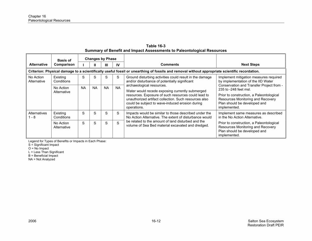
Summary of Impact Assessment The impacts shown in Table 16-3 assume implementation of the Next Steps to reduce the adverse impacts.
No Action Alternative As described in Chapter 3, this alternative would involve construction and operations and maintenance activities for the Sedimentation/Distribution Basins, Air Quality Management, Pupfish Channels, and Salton Sea. The construction activities would be identical under the No Action Alternative-CEQA Conditions and the No Action Alternative-Variability Conditions. Therefore, impacts related to disturbance would be the same for both conditions.
Ground disturbing activities that would occur under the No Action Alternative could result in physical damage to scientifically useful fossils, primarily near the eastern and western shorelines. Impacts also could result from the exposure and subsequent erosion of paleontologically sensitive sediment as the water recedes in Phases I through III.
2006 16-12 Salton Sea Ecosystem Restoration Draft PEIR
Changes by P
pter 16 ontological Resources
Table 16-3 Summary of Benefit and Impact Assessments to Paleontological Resources
hase Alternative
Basis of Comparison I II IV Comments Next Steps III
Criterion: Physical damage to a scientifically useful fossil or unearthing of fossils and removal without appropriate scientific recordation. Existing Conditions
S S S S No Action Alternative
No Action Alternative
NA NA NA NA
Ground disturbing activities could result in the damage and/or disturbance of potentially significant archaeological resources. Water would recede exposing currently submerged resources. Exposure of such resources could lead to unauthorized artifact collection. Such resources also could be subject to wave-induced erosion during operations.
Implement mitigation measures required by implementation of the IID Water Conservation and Transfer Project from -235 to -248 feet msl. Prior to construction, a Paleontological Resources Monitoring and Recovery Plan should be developed and implemented.
Existing Conditions
S S S S Alternatives 1 - 8
No Action Alternative
S S S S
Impacts would be similar to those described under the No Action Alternative. The extent of disturbance would be related to the amount of land disturbed and the volume of Sea Bed material excavated and dredged.
Implement same measures as described in the No Action Alternative. Prior to construction, a Paleontological Resources Monitoring and Recovery Plan should be developimplemented.
ed and
Legend for TypeS = Significant ImO = No Impact L = Less Than Significant B = Beneficial Impact NA = Not Analyzed
s of Benefits or Impacts in Each Phase: pact
ChaPale
Chapter 16 Paleontological Resources
Under the No Action Alternative, paleontological surveys in areas with potential impacts directly attributable to the Imperial Irrigation District (IID) Water Conservation and Transfer Project would be conducted. In the event of a discovery during constr on, all ground disturbance within 200 feet of the resource would be halted until the resource could be recovered by a qualified paleontologist.
The No Action Alternative would result in adverse i cts as compared to Existing Conditions due to the disturbance of 35,800 acres of land in the Sea Bed and along the shoreline, and about 5,050,000 cubic yards of Sea Bed material would be excavated or dredged. The impacts would be partially mitigated as a result of the IID Water Conservation and Transfer Project mitigation measures between -235 and -248 feet msl. The area between the shoreline and -235 feet msl and below -248 feet msl that would be exposed under the No Action Alternative would not be subject to mitigation measures by IID.
Alternative 1 – Saline Habitat Complex I As described in Chapter 3, this alternative would involve construction and operations and maintenance activities for the Sedimentation/Distribution Basins, Air Quality Management, Pupfish Channels, Saline Habitat Complex, and Brine Sink.
Impac sociated with ground disturbing activities would be similar to those described under No Action Alternative. Under Alternative 1, about 136,700 of a of land would be disturbed in the Sea Bed and along the shoreline, and about 77,140,000 cubic yar f Sea Bed material would be excavated or dredged. It is assumed that IID would implement the mitigation measures as described under the No Action Alternative between -235 to -248 feet msl in portions of the Sea Bed not covered by other components.
Alternative 2 – Saline Habitat Complex II As described in Chapter 3, this alternative would involve construction and operations and maintenance activities for the Sedimentation/Distribution Basins, Air Quality Management, Saline Habitat Complex, Shoreline Waterway, Saltwater Conveyance, and Brine Sink.
Impac sociated with ground disturbing activities would be similar to those described under No Action Alternative. Under Alternative 2, about 206,400 of acres of land would be disturbed in the Sea Bed and along the shoreline, and about 136,530,000 cubic yards of Sea Bed material would be excavated or dredg ent the mitigation measures as described under the No Action Alternative between -235 to -248 feet msl in portions of the Sea Bed not covered by other components.
Alternative 3 – Concentric Rings As described in Chapter 3, this alternative would involve construction and operations and maintenance activities for the Sedimentation/Distribution Basins, Air Quality Management, First and Second rings, and Brine Sink.
Impacts associated with ground disturbing activities would be similar to those described under No Action Alternative. Under Alternative 3, about 155,450 of acres of land would be disturbed in the Sea Bed and along the shoreline, and about 18,810,000 cubic yards of Sea Bed material would be excavated or dredged. It is assumed that IID would implement the mitigation measures as described under the No Action Alternative between -235 to -248 feet msl in portions of the Sea Bed not covered by other components.
ucti
mpa
ts as
ts as
ed. I
cresds o
t is assumed that IID would implem
2006 16-13 Salton Sea Ecosystem Restoration Draft PEIR
Chapter 16 Paleontological Resources
Alternative 4 – Concentric Lakes As described in Chapter 3, this alternative would inv e construction an nce activities for the Sedimentation/Distribution Basins; First, Second, ThirdSink.
Impacts associated with ground disturbing activities would be similar to those described under No Action Alternative. Under Alternative 4, about 96,950 of acres of land would be and along the shoreline, and about 154,215,000 cubic yards of Sea Bed material would be excavated or dredged. It is assumed that IID would implement the mitigation measures as described under the No Action Alternative between -235 to -248 feet msl in portions of the Sea Bed not covered by other components.
Alternative 5 – North Sea As described in Chapter 3, this alternative would involve construction and operations and maintenance activities for the Sedimentation/Distribution Basins, Air Quality Manage mplex, Shoreline Waterway, Saltwater Conveyance, Marine Sea, Marine Sea Recirculation Canal, and Brine Sink.
Impac sociated with ground disturbing activities uld be similar to those described under No Action Alternative. Under Alternative 5, about 230,450 of a of land would b Sea Bed and along the shoreline, and about 86,770,000 cubic yar f Sea Bed material would be excavated or dredged. It is assumed that IID would implement the mitigation measures as described under the No Action Alternative between -235 to -248 feet msl in portions of the Sea B other com ts.
Alternative 6 – North Sea Combined As described in Chapter 3, this alternative would involve construction and operations and maintenance activities for the Sedimentation/Distribution Basin, Air Quality Management, Pupfish Channels, Saline Habitat Complex, Shoreline Waterway, Saltwater Conveyance, Marine Sea, Marine Sea Mixing Zone, Marine Sea Recirculation Canal, and Brine Sink.
Impac with ground disturbing activities would be similar to those described under No Action Alternative. Under Alternative 6, about 224,250 of acres of land would be disturbed in the Sea Bed and along , and about 66,970,000 cubic yards of Sea Bed material would be excavated or dredged. It is assumed that IID would implement the mitigation measures as described under the No Action Alternative between -235 to -248 feet msl in portions of the Sea Bed not covered by other components.
Alternative 7 – Combined North and South Lakes As described in Chapter 3, this alternative would involve construction and operations and maintenance activities for the Sedimentation/Distribution Basin, Air Quality Management using Protective Salt Flat on Exposed Playa below -255 feet msl, Exposed Playa without Air Quality Management above -255 feet msl, Saline Habitat Complex, Recreational Saltwater Lake, Recreational Estuary Lake, Marine Sea Recirculation Canal, IID Freshwater Reservoir, two Treatment Plants, and Brine Sink.
Impacts associated with ground disturbing activities would be similar to those described under No Action Alternative. Under Alternative 7, about 131,950 of acres of land would be disturbed in the Sea Bed and along the shoreline, and about 33,522,000 cubic yards of Sea Bed material would be excavated or dredged. It is assumed that IID would implement the mitigation measures as described under the No
olv d operation, and Fourth lakes; and Brine
disturbed i
s and maintena
n the Sea Bed
ment, Saline Habitat Co
e disturbed in the
ed not covered by
ts as
ponen
ts as
the s
wocres
ds o
sociated
horeline
2006 16-14 Salton Sea Ecosystem Restoration Draft PEIR
Chapter 16 Paleontological Resources
Action Alternative between -235 to -248 feet msl in portions of the Sea Bed not covered by other components.
Alternative 8 – SoAs described in Chapter 3, this alternative would involve construction and operations and maintenance activities for the Sedimentation/Distribution Basins, Air Quality Management, Saline Habitat Complex, Shoreline Waterway, Marine Sea, Marine Sea Recirculation Canal, and Brine Sink.
Impacts associated with ground disturbing activities would be similar to those described under No Action Alternative. Under Alternative 8, about 209,550 of acres of land would be disturbed in the Sea Bed and along the shoreline, and about 47,230,000 cubic yards of Sea Bed material would be excavated or dredged. It is assumed that IID would implement the mitigation measures as described under the No Action Alternative between -235 to -248 feet msl in portions of the Sea Bed not covered by other components.
Next Steps During the project-level analysis, a Paleontological Resources Monitoring and Recovery Plan (PRMRP) should developed and implemented for all actions. The PRMRP should include protocols for paleontological resources monitoring in those areas re sediment with moderate to high paleontological sensitivity would be affected by con ction related excavations. The PRMRP also should set forth the following procedures:
nfirming the paleontological sensitivity (high, moderate, or low) of the areas to be impacted rough review of project-level geological and geotechnical data;
termining the qualifications of the paleontologist as established by the Society of Vertebrate leontology (SVP, 1991, 1995, 1996);
• e assessment and recovery of discovered fossil resources; and
• e preparation and curation of fossil finds.
The PRMRP should provide guidelines for the establishment of a yearly or biannual monitoring program led by aleontologist to determine the extent of fossiliferous sediment being exposed and affect , and determine whether paleontological resources are being lost. If loss of scientifically significant paleontological resources can be documented, then a recovery program should be instituted.
uth Sea Combined
be
• Coth
• DePa
Th
Th
a qued by
whestru
alified p erosion
Salton Sea Ecosystem 16-15 2006 Restoration Draft PEIR