Chapter 15 Water - BPA.gov Volume 2... · Chapter 15 Water This chapter describes water resources...
24
I-5 Corridor Reinforcement Project Draft EIS 15-1 November 2012 Words in bold and acronyms are defined in Chapter 32, Glossary and Acronyms. Chapter 15 Water This chapter describes water resources (watersheds, riparian buffers, floodplains, surface water, and groundwater) in the project area, and how the project alternatives could affect these resources. Related soils information can be found in Chapter 14, Geology and Soils. Information on water resources within wetlands can be found in Chapter 16, Wetlands. Related information about hydrologic changes, sediment delivery, and floodplain and riparian impacts can be found in Chapter 19, Fish, and Appendix K, Assessment of Relative Fish Habitat and Fish Population Impacts of I-5 Corridor Reinforcement Project Alternatives and Options. 15.1 Affected Environment 15.1.1 Watersheds The action alternatives cross three major watersheds in Washington: the Cowlitz, Lewis, and Salmon/Washougal watersheds (Water Resource Inventory Areas 26, 27, and 28) (see Map 15-1). In Cowlitz County, the alternatives cross the following major sub-watersheds: the Lacamas, Delameter, Lower Cowlitz, Ostrander, Lower Coweeman, Upper Coweeman, Lower Kalama, Middle Kalama, Cathlapotle, Lake Merwin, and Cougar. In Clark County, the alternatives cross the following major sub-watersheds: the Yacolt, Cedar Creek/Chelatchie Creek, Canyon Creek/Fly Creek, Vancouver, Horseshoe Falls, Lacamas Lake, Rock Creek, Little Washougal, West Fork Washougal, and Mount Zion. In Oregon, the project crosses the Columbia River and two watersheds: the eastern end of the Columbia Slough-Frontal Columbia River watershed and the western edge of the Beaver Creek-Sandy River watershed. Both are sub-watersheds of the Lower Willamette watershed in Multnomah County. Watershed conditions vary among and within these sub-watersheds. The action alternatives cross different precipitation zones, geology (see Chapter 14, Geology and Soils) and vegetation cover types (see Chapter 17, Vegetation). Precipitation increases water available for runoff and erosion. Underlying geology and slopes influence the susceptibility to erosion. Vegetation cover is an important factor in mitigating snow accumulation, snowmelt, runoff, and erosion. Precipitation increases west to east and occurs mostly as rain. Snow accumulation is limited and occurs at higher elevations. For the purposes of this analysis, the Integrated Watershed Assessment (IWA) natural erodibility rating used WDNR’s 1:100,000 scale 2010 Geology dataset to determine underlying geology. Most action alternatives cross underlying geology with low erodibility (massive igneous and sedimentary rocks) and gentle slopes (see Appendix K, Assessment of Relative Fish Habitat and Fish Population Impacts of I-5 Corridor Reinforcement Project Alternatives and Options). Highly erodible geology (unconsolidated sediment of alluvial, glacial or volcanic origin) is confined to several large river valleys and lowland areas. Developed and agricultural land use is also found mostly in lowland areas and along large river valleys (see Chapter 5, Land). Hardwood and conifer forest cover occurs naturally throughout the project area. The action alternatives cross large areas of forest managed for timber production.
Transcript of Chapter 15 Water - BPA.gov Volume 2... · Chapter 15 Water This chapter describes water resources...
I-5 Corridor Reinforcement Project Draft EIS 15-1 November 2012
Words in bold and acronyms are defined in Chapter 32, Glossary and Acronyms.
Chapter 15 Water This chapter describes water resources (watersheds, riparian buffers, floodplains, surface water, and groundwater) in the project area, and how the project alternatives could affect these resources. Related soils information can be found in Chapter 14, Geology and Soils. Information on water resources within wetlands can be found in Chapter 16, Wetlands. Related information about hydrologic changes, sediment delivery, and floodplain and riparian impacts can be found in Chapter 19, Fish, and Appendix K, Assessment of Relative Fish Habitat and Fish Population Impacts of I-5 Corridor Reinforcement Project Alternatives and Options.
15.1 Affected Environment
15.1.1 Watersheds
The action alternatives cross three major watersheds in Washington: the Cowlitz, Lewis, and Salmon/Washougal watersheds (Water Resource Inventory Areas 26, 27, and 28) (see Map 15-1). In Cowlitz County, the alternatives cross the following major sub-watersheds: the Lacamas, Delameter, Lower Cowlitz, Ostrander, Lower Coweeman, Upper Coweeman, Lower Kalama, Middle Kalama, Cathlapotle, Lake Merwin, and Cougar. In Clark County, the alternatives cross the following major sub-watersheds: the Yacolt, Cedar Creek/Chelatchie Creek, Canyon Creek/Fly Creek, Vancouver, Horseshoe Falls, Lacamas Lake, Rock Creek, Little Washougal, West Fork Washougal, and Mount Zion. In Oregon, the project crosses the Columbia River and two watersheds: the eastern end of the Columbia Slough-Frontal Columbia River watershed and the western edge of the Beaver Creek-Sandy River watershed. Both are sub-watersheds of the Lower Willamette watershed in Multnomah County.
Watershed conditions vary among and within these sub-watersheds. The action alternatives cross different precipitation zones, geology (see Chapter 14, Geology and Soils) and vegetation cover types (see Chapter 17, Vegetation). Precipitation increases water available for runoff and erosion. Underlying geology and slopes influence the susceptibility to erosion. Vegetation cover is an important factor in mitigating snow accumulation, snowmelt, runoff, and erosion. Precipitation increases west to east and occurs mostly as rain. Snow accumulation is limited and occurs at higher elevations.
For the purposes of this analysis, the Integrated Watershed Assessment (IWA) natural erodibility rating used WDNR’s 1:100,000 scale 2010 Geology dataset to determine underlying geology. Most action alternatives cross underlying geology with low erodibility (massive igneous and sedimentary rocks) and gentle slopes (see Appendix K, Assessment of Relative Fish Habitat and Fish Population Impacts of I-5 Corridor Reinforcement Project Alternatives and Options). Highly erodible geology (unconsolidated sediment of alluvial, glacial or volcanic origin) is confined to several large river valleys and lowland areas. Developed and agricultural land use is also found mostly in lowland areas and along large river valleys (see Chapter 5, Land). Hardwood and conifer forest cover occurs naturally throughout the project area. The action alternatives cross large areas of forest managed for timber production.

Chapter 15 Water
15-2 I-5 Corridor Reinforcement Project Draft EIS November 2012
15.1.2 Riparian Buffers
Washington and Oregon, and their counties and incorporated cities, have regulations intended to protect rivers and creeks and their tributaries. Regulating agencies establish buffers as boundaries between local waterways and existing or future development that help protect rivers and streams by filtering pollutants, providing flood control, preventing bank erosion, mitigating warming, and providing room for lateral movement of the waterway channel. These buffers also provide important habitat for wildlife. Riparian buffer widths range from 0 to 200 feet in Cowlitz County, and from 75 to 200 feet in Clark County, depending on stream flow (perennial or seasonal) and the presence or absence of fish.
The action alternatives cross non-forested and forested riparian buffers. Non-forested riparian buffers provide little to no stream shade and occur mostly in developed and agricultural land uses and in existing transmission line corridors. Riparian buffers containing conifers are common at higher elevations within the project area, especially in timber production lands. Riparian buffers containing conifers provide greater levels of stream shade. Hardwood riparian buffers are most common at lower elevations and provide less stream shade.
15.1.3 Floodplains
The Federal Emergency Management Agency (FEMA 1996) developed Flood Insurance Rate Maps as the official regulatory flood map for communities. These maps show 100-year floodplains and corresponding base flood elevations. In Washington, the action alternatives cross 15 FEMA designated 100-year floodplains of the following water bodies: Leckler Creek, Cowlitz River, Coweeman River, Kalama River, Little Kalama River, Lewis River, East Fork Lewis River, Salmon Creek, Burnt Bridge Creek, Little Washougal River, Washougal River, Lacamas Creek, Ostrander Creek, Speelyai Creek, and Canyon Creek (see Maps 15-2A through 15-2D). The project crosses the FEMA 100-year floodplain of the Columbia River in Washington and Oregon; it does not cross any other floodplains in Oregon.
Similar to riparian buffers, which are often located in floodplains, floodplains provide benefits to the human and natural environment. These areas, if undeveloped, prevent flooding to adjacent areas, filter pollutants, are typically nutrient rich, and also provide diverse wildlife habitat.
15.1.4 Surface Water
The action alternatives cross rivers and creeks mentioned in Section 15.1.3, Floodplains, and many other streams (perennial, intermittent, and ephemeral) (see Maps 15-2A through 15-2D). The West Alternative would have the fewest new river, stream, and creek crossings by the transmission line right-of-way and new access roads outside of the right-of-way (about 219 crossings). The Central Alternative would have about 301 crossings, the East Alternative would have about 277 crossings, and the Crossover Alternative would have about 297 crossings.
Section 303(d) of the Clean Water Act (EPA 2008a) requires states to maintain a list (commonly known as the 303(d) list) of all surface waters in the state for which beneficial uses, such as drinking, recreation, aquatic habitat, and industrial use, are impaired by pollutants. This list includes water quality limited estuaries, lakes, and streams that do not meet state surface water quality standards and are not expected to improve within 2 years.
Chapter 15 Water
I-5 Corridor Reinforcement Project Draft EIS 15-3 November 2012
The following 13 streams listed as impaired on Washington’s 303(d) list are crossed by the action alternatives: Arkansas Creek, Monahan Creek, Delameter Creek, Ostrander Creek, South Fork of Ostrander Creek, Coweeman River, Riley Creek, Lockwood Creek, Mason Creek, East Fork of Lewis River, Salmon Creek, Dwyer Creek, and Lacamas Creek (see Maps 15-2A through 15-2D). Most of these streams are listed for elevated water temperature. Riley Creek and Lacamas Creek are listed for elevated levels of fecal coliform, and Dwyer Creek and Lacamas Creek are listed for low levels of dissolved oxygen. No streams listed as impaired on Oregon’s 303(d) list are crossed by the project.
Some surface water is used as drinking water. The City of Camas supplements its drinking water from two surface water diversions dams along Jones and Boulder creeks within the Little Washougal watershed. Scoping comments indicated there are many other landowners along the action alternatives who get all or some of their drinking water from similar diversions dams or other means along streams and creeks high up in watersheds in the project area. Groundwater used for drinking water is also in direct contact with these surface waters.
15.1.5 Groundwater
Groundwater supply sources in the project area that are used for domestic, municipal, commercial, agricultural, and industrial needs come from several aquifers within unconsolidated alluvial, glacial, outburst flood, eolian (wind), and volcanic deposits, and sedimentary and igneous bedrock. These aquifers are important water sources because of their location in generally flat lowlands where human activities are concentrated. Aquifers in igneous bedrock (i.e., volcanic materials) occur mostly in the interconnected open spaces in interflow zones (between individual lava flows). These interflow zones can yield large volumes of water.
The Troutdale Aquifer in the southwestern portion of the project area is the area’s only sole source aquifer (EPA 2008b; see Map 15-3). This sandstone and gravel dominated aquifer provides about 99 percent of available drinking water for Clark County. The Troutdale Aquifer extends into Oregon although it is not designated a sole source aquifer in Oregon and not shown or labeled as such on Map 15-3.
The Critical Aquifer Recharge Area (CARA) ordinance provides local governments with a mechanism to protect the functions and values of a community’s drinking water by preventing pollution and maintaining supply. Category 1 areas are highly susceptible to groundwater contamination; Category 2 areas are moderately susceptible to groundwater contamination. Category 1 and Category 2 CARAs are present in the project area in Clark County, Washington (Clark County, Washington 2009a; see Map 15-3). No CARA data are available for Cowlitz County, Washington. In Oregon, no CARAs are present at the Sundial substation site.
Sources of water for domestic, municipal, commercial, agricultural, and industrial uses identified along the action alternatives include water rights (legal authorizations to use a certain amount of public water for a designated purpose), water wells (exempt and non-exempt wells in the Ecology Well Database), and source wells (Groups A and B) (see Map 15-4). Washington’s specific designation for public water systems regulated by the federal Safe Drinking Water Act (SDWA) is Group A. Group B wells are public water systems in Washington smaller than the minimum cut-off defined by the SDWA (Ecology 2010a).
An approximately 0.25-mile-wide corridor along each action alternative—0.125-mile (one-eighth mile) on either side of the proposed transmission line right-of-way—was used as the study area

Chapter 15 Water
15-4 I-5 Corridor Reinforcement Project Draft EIS November 2012
to identify the number of existing groundwater source wells, water wells, and water rights near the action alternatives, including near new and improved access roads (see Map 15-4). This study area was designed to capture any existing wells and water rights in the vicinity whose location may have been inaccurately recorded. For example, many wells and water rights are assigned the coordinates of the center of the quarter section in which they are located, regardless of their actual location. It is also possible that wells are present within 0.125 mile of the action alternatives that are not recorded. Water rights, water wells, and source wells outside of the 0.25-mile-wide study area are considered to have no risk of impact from the project.
In Oregon, source wells or water wells are not found within the study area, but several monitoring wells exist near the Sundial substation site. These wells were installed at the former Reynolds Metals Company aluminum reduction plant in Troutdale, Oregon (see Section 10.1.2.3, Reynolds Metals Company Site).
Wellhead protection areas are surface and subsurface zones surrounding a well or a public water system wellfield that are in place to reduce the risk of water source contamination from spills and contaminant discharges. Delineated wellhead protection areas are based on estimated groundwater travel times from the surrounding aquifer area to the wellhead. Emergency spill response programs are one of the key requirements for water purveyors within wellhead protection areas. Wellhead protection zones were identified in the project area for 1-year and 10-year travel times (ODEQ 2007; Washington State Department of Health 2010; see Map 15-4).
At the substation sites, the hydrogeology surrounding each site was determined using well logs within a 1-mile radius of each site:
The Sundial site consists of interbedded sand, gravel, cemented sand and gravel, and silt (based on information from four wells). The depth to groundwater ranges from 11 to 29 feet below ground. These sedimentary deposits form a highly permeable aquifer with well yields ranging from about 20 gallons per minute (gpm) for a domestic well, to over 2,000 gpm for properly designed municipal supply wells.
The Casey Road site consists of 10 to 70 feet of silt and clay overlying basaltic and sedimentary bedrock (siltstone, sandstone, and claystone) (based on information from 32 wells). All wells terminate in the basalt or sedimentary bedrock. The depth to groundwater ranges from 18 to 205 feet below ground. The sedimentary bedrock generally has low permeability, with well yields ranging from less than 1 gpm to 100 gpm. Most wells produced less than 20 gpm.
The Baxter Road site consists of 15 to 60 feet of silt and clay overlying sedimentary bedrock (siltstone, sandstone, and claystone) (based on information from 16 wells). All wells terminate in the sedimentary bedrock. The depth to groundwater ranges from 4 to 170 feet below ground. The sedimentary bedrock generally has low permeability, with well yields ranging from less than 1 gpm to 20 gpm.
The Monahan Creek site consists of 10 to 70 feet of silt and clay overlying basaltic and sedimentary bedrock (siltstone, sandstone, and claystone) (based on information from 24 wells). All wells end in the basalt or sedimentary bedrock. The depth to groundwater ranges from 3.5 to 185 feet below ground. The sedimentary bedrock generally has low permeability, with well yields ranging from about 1 gpm to 20 gpm.
Chapter 15 Water
I-5 Corridor Reinforcement Project Draft EIS 15-5 November 2012
See Chapter 19, Fish and Appendix K for more information on ecological (hydrology, sediment delivery, floodplain, riparian) and fish habitat impacts.
15.2 Environmental Consequences
General impacts that would occur for the action alternatives are discussed below, followed by impacts unique to each alternative.
15.2.1 Impact Levels
Impacts would be high where project activities would cause the following:
Long-term changes in watershed conditions that result in high impairment to hydrology or sediment functions
Permanent changes in riparian habitat conditions that could decrease shade and lead to temperature increases that would adversely affect aquatic life
Increased water temperature, decreased dissolved oxygen, or increased turbidity in streams listed on Washington’s 303(d) list for temperature, dissolved oxygen, or turbidity (no Oregon streams are crossed)
Increased water temperature, decreased dissolved oxygen, or increased turbidity in any streams to a level that exceeds state standards
Altered hydraulic function or decreased hydraulic capacity of floodplains to a degree that increases the potential for flooding and damage to personal property
Surface water contamination from oil and gas spills or herbicide use occurs at levels toxic to aquatic life and is extensive and long-term
Groundwater contamination occurring because depth to groundwater is at or near the surface (less than 5 feet below ground surface) and surficial sediments are highly-permeable in areas surrounding the rights-of-way or substations
Impacts would be moderate where project activities would cause the following:
Long-term changes in watershed conditions that result in moderate impairment to hydrology or sediment functions
Increased water temperature, decreased dissolved oxygen, or increased turbidity in stream segments that are not themselves listed, but are immediately upstream or downstream from stream segments listed on Washington’s 303(d) list for temperature, dissolved oxygen, or turbidity (no Oregon streams are crossed)
Increased water temperature, decreased dissolved oxygen, or increased turbidity in streams listed on Washington’s 303(d) list for constituents other than temperature, dissolved oxygen, or turbidity
Groundwater contamination may occur because depth to groundwater is moderate (5 to 20 feet below ground surface) within the depth of potential excavations, and surficial sediments are moderately permeable in areas surrounding the right-of-way or substations

Chapter 15 Water
15-6 I-5 Corridor Reinforcement Project Draft EIS November 2012
Impacts would be low where project activities would cause the following:
Long-term changes in watershed conditions that result in minor change in existing hydrology or sediment function
Permanent changes in riparian habitat conditions that result in the loss of stream shade along streams that already have limited shade and stream cooling
Increased water temperature, decreased dissolved oxygen, or increased turbidity in streams that do not exceed state standards
Altered hydraulic function or decreased hydraulic capacity of floodplains to a degree that does not increase the potential for flooding and damage to personal property
Surface water contamination from oil and gas spills or herbicide use occurs at levels that is not toxic to aquatic life or is localized and temporary
Groundwater contamination is less likely to occur because groundwater is relatively deep (greater than 20 feet below ground surface) compared to potential excavation depths and surficial sediments have low permeability in areas surrounding the rights-of-way or substations
No impact would occur where project activities would not disturb or alter water resources.
Impacts to wellhead protection areas and water rights, source wells, and water wells within 0.125 mile of the alternatives and options and the mitigation for each are described in Section 15.2.2, Impacts Common to Action Alternatives.
15.2.2 Impacts Common to Action Alternatives
15.2.2.1 Construction
The hardened surfaces of new roads and areas disturbed by new road construction could increase surface runoff in streams in watersheds crossed by the action alternatives. Increases could also occur through vegetation removal of hydrologically mature vegetation along rights-of-way. Opening of the tree canopy can cause greater snow accumulation, increased snowmelt in spring, accelerated melt rates, reduced rates of interception and evapotranspiration, and increased storm runoff volume due to increased soil moisture or snowmelt. Cutting and backfilling for new access roads, clearing and construction of the new line, and general construction traffic could expose topsoil or loose sediment. During rain events, fine sediment can be eroded from exposed surfaces and delivered to ditches and then to streams.
The action alternatives would affect soil types with different natural erodibility. Construction in more erodible terrain would cause higher sediment delivery impacts. Between about 100 acres and 1,000 acres of vegetation would be cleared (depending on the action alternative) that is currently highly effective in limiting the water available for runoff. About 70 miles of new line, and access roads and two substations would then be built potentially causing additional sediment delivery. However, these impacts would occur across watershed areas of between about 160,000 acres and 240,000 acres. The percent change in runoff and sediment delivery to streams would be less than 1 percent (see Appendix K). Long-term changes in watershed conditions would be minor; however, local high impacts from sediment delivery could occur. Properly implementing erosion control measures would minimize the amount of sediment
Chapter 15 Water
I-5 Corridor Reinforcement Project Draft EIS 15-7 November 2012
delivered to streams. Generally, impacts from long-term changes to watershed function would be low.
Trees and other vegetation would be removed for the transmission line right-of-way, substations, and new access roads constructed along fish-bearing streams, including trees within buffers that are normally protected under the Washington Forest Practices Act (76.09 RCW) and other land use regulations. Vegetation removal would not occur or would be minimal at many crossings that do not have trees or important buffers. At these and existing crossings where vegetation has already been removed and is not allowed to regrow, there would be no impact. Elsewhere, removing vegetation in riparian areas could decrease streamside shade. Reduced shade can lead to higher water temperatures. Generally, stream temperature changes would be greater where removed riparian vegetation is providing greater cover over the stream (see Appendix K). Forested vegetation would be cleared along about 2 to 3 miles of fish-bearing streams. Permanent changes to riparian function at project crossings could occur through the loss of stream shade. At the crossing scale, a range of stream shade would be lost along any action alternative; however, at the watershed scale, this loss could be buffered or moderated by stream cooling provided by shade elsewhere in the watershed (see Appendix K). Generally, crossing-scale impacts to shade from removal of riparian vegetation along fish-bearing streams would range from low-to-high. Low impacts would occur when the existing shade level is already low and provides limited stream cooling. In this instance, shade loss would cause a relatively minor stream temperature increase. High impacts would occur when the existing shade level does provide effective stream cooling and shade loss is more likely to result in temperature increases that adversely affect aquatic life (see Appendix K for more information on target shade levels used in the assessment).
Similarly, vegetation clearing has the potential to impact water quality (specifically turbidity and temperature/dissolved oxygen) in rivers and streams. No streams crossed are currently listed as impaired for turbidity, and with implementation of BMPs for erosion control, state standards for turbidity would continue to be met. Several streams crossed or downstream of crossings are listed on the 303(d) list as impaired due to elevated temperature (see Section 15.1.4, Surface Water). Short-term changes to temperature or dissolved oxygen from the loss of riparian vegetation would be low-to-high depending on the existing impairment status of the stream, the length, width, and elevation of the stream, and the shade provided by existing vegetation along the stream. Long-term changes in watershed conditions would be minor; however, local impacts could occur that result in locally high impairment. Generally, long-term changes to watershed function would create low impacts.
Except for one tower built on Ione Reef in the Columbia River, towers would not be built in waterways. As described in Section 3.2, Transmission Towers, this tower would be built on a small rock outcrop using coffer dams to allow dewatering of the work zone inside. Work would be conducted from barges stationed on the south side of Ione Reef, out of the navigation channel. All substrate material would be collected from within the sealed coffer dam, transferred to a spoils barge, and transported to an onshore upland area or landfill not within the floodplain. No material would be placed in the Columbia River. Tower support columns would be spaced about 50 feet apart. The open cross section (to stream flow) and round column shapes would allow large debris to pass.
In other locations where towers would be placed near streams or rivers, waterways would be spanned. Some new access roads would cross rivers or larger creeks and new access roads would invariably cross many intermittent tributaries or drainages. Where waterways, including

Chapter 15 Water
15-8 I-5 Corridor Reinforcement Project Draft EIS November 2012
intermittent drainages, would be crossed, culverts or bridges would be used to ensure unobstructed water passage during flood events. With implementation of BMPs for erosion control, impacts to water quality from construction near or in waterways would be low.
Towers, substations, and access roads would be sited to avoid floodplains. Where unavoidable, towers constructed in a floodplain would be designed to allow water flow around the tower legs. Although soil would be more compacted around tower footings or on access roads, it is likely the soil would remain partially porous and that water could still be absorbed. The volume of the tower footings would decrease the amount of water a floodplain could store; however, the volume of the tower footings relative to the volume of floodplain storage would be small given that towers would only be placed in floodplains that are too large to span; impacts would be low. However, as channels naturally migrate across their floodplains, streams or overland flood flows could directly impinge on towers. If this occurs, protection measures such as riprap or sheetpile structures could be installed to protect the tower, potentially interfering with stream dynamics, increasing impacts.
Access roads constructed or improved by placing fill material in floodplains could decrease flood storage volume, obstruct flow pathways, and lead to increased flow velocities or flood surface elevations. These effects would be lessened by constructing roads to existing grade when in floodplains. Overall impacts to floodplains would be low.
Accidental oil or gas spills from construction equipment and vehicles could cause petroleum products to enter surface water or groundwater. Fuel storage and the refueling of equipment would only be allowed away from natural or manmade drainage conveyances including ditches, catch basins, ponds, wetlands, and pipes. All equipment fueling operations would use pumps and funnels and absorbent pads. Additional fueling and storage requirements apply in some sensitive resource areas. Temporary, localized, no-to-low impacts would occur.
Groundwater concerns are typically focused on changes to available water quantity and to water quality. Groundwater quality is of most concern near wellhead protection areas. Petroleum products from accidental spills are the most likely substances to degrade water quality near the action alternatives during construction. Mitigation measures would be used to prevent these substances from reaching groundwater sources (see Table 3-2 and Section 15.2.8, Recommended Mitigation Measures).
Groundwater may be encountered during tower and substation excavations. Excavations for the substations would be about 5 to 8 feet deep. Excavations for towers would be about 11 to 16 feet, depending on the tower type and subsoil conditions (see Chapter 3, Project Components). If groundwater is encountered during excavations, it would be pumped from the excavations and re-infiltrated into the soil at a nearby upland site. The necessity for and degree of dewatering would be decided on a case-by-case basis. Although temporary, direct impacts could occur during excavation work, no long-term impacts on groundwater would occur. Holes would be back-filled with a native-rock mixture allowing subsurface water flow. In areas where concrete is used, the tower footings would be small enough in diameter (4 to 10 feet) that groundwater flow would not be impeded. Groundwater flow can be disrupted by building new roads, which increases turbidity through soil-disturbing activities or drilling, and groundwater can be contaminated through accidental spills of hazardous materials (such as fuels, oil) or excavation of existing contaminated soils. Mitigation measures would be implemented to minimize impacts (see Section 15.2.8, Recommended Mitigation Measures, and Table 3-2).
Chapter 15 Water
I-5 Corridor Reinforcement Project Draft EIS 15-9 November 2012
Impacts to groundwater from substation construction are discussed in Sections 15.2.2.3, Sundial Substation, and 15.2.3, Castle Rock Substation Sites.
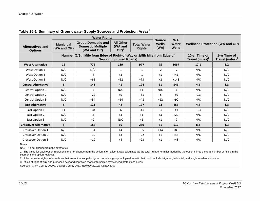
Some existing groundwater wells, including those identified based on water rights or as water wells or source wells (see Map 15-4), may be located in areas where new or improved roads, towers, and substation sites are proposed. Some municipal and domestic water rights and wells are likely within 0.125 mile of the action alternatives (see Table 15-1). If a decision is made to build a line, the location of all wells and water rights would be confirmed with landowners during land negotiations and during engineering field surveys along the transmission line route before construction. Wells and surface water diversions potentially disturbed by project activities would be relocated, or project activities would be adjusted to avoid them before construction. Since effects to water supply wells would be mitigated, no impacts on groundwater supplies would occur.
15.2.2.2 Operation and Maintenance
Operation and maintenance activities along the transmission line would include biannual inspection from helicopters and annual ground inspections from vehicles. Vehicle traffic on access roads would be infrequent, but could cause additional sediment delivery to streams. Properly implementing road drainage BMPs, regular maintenance, and placing rock on roads would reduce erosion on these roads (see Chapter 14, Geology and Soils), reducing the amount of road sediment that would reach streams. In emergencies, vehicles and equipment may need to drive across the right-of-way or other areas, which could temporarily cause erosion and deliver sediment to streams. BPA could mitigate these temporary impacts by rocking roads before and during construction and restoring riparian areas damaged by operation and maintenance activities. Sediment-related impacts to surface water quality in streams from operation and maintenance activities would be low.
Maintaining the transmission line right-of-way and access roads by keeping them clear of tall vegetation could reduce stream shade, potentially causing localized increases in water temperature of any adjacent streams. Long-term impacts from the loss of riparian vegetation would be low-to-high, depending on the impairment status of the stream, length of stream, and existing vegetation.
Overspray of herbicides used for noxious weed control within the rights-of-way and substation yards also could affect surface-water. However, if vegetation treatment is necessary, all application requirements would be followed and appropriate buffers would be established to prevent herbicides from being deposited in surface waters (BPA 2000b). Use of herbicides and pesticides could also affect groundwater quality. Minimizing use of these materials and appropriate management during use reduces the risk of such effects.
Chapter 15 Water
15-10 I-5 Corridor Reinforcement Project Draft EIS November 2012
Table 15-1 Summary of Groundwater Supply Sources and Protection Areas1
Alternatives and Options
Water Rights Source Wells (WA)
WA Water Wells
Wellhead Protection (WA and OR) Municipal (WA and OR)
Group Domestic and Domestic Multiple
(WA and OR)
All Other (WA and
OR)2
Total Water Rights
Number (1/8th Mile from Edge of Right-of-Way or 1/8th Mile from Edge of New or Improved Roads)
10-yr Time of Travel (miles)
3
1-yr Time of Travel (miles)
3
West Alternative 12 776 189 977 75 1067 17.1 3.2
West Option 1 N/C N/C -1 -1 -2 +2 N/C N/C
West Option 2 N/C -4 +3 -1 +1 +41 N/C N/C
West Option 3 N/C +61 +12 +73 +2 +143 N/C N/C
Central Alternative 8 141 45 194 31 546 4.6 1.3
Central Option 1 N/C +1 N/C +1 N/C -4 N/C N/C
Central Option 2 N/C +22 +9 +31 -5 -50 -0.3 N/C
Central Option 3 N/C +34 +14 +48 +12 +90 N/C N/C
East Alternative 8 121 48 177 23 453 4.6 1.3
East Option 1 +1 -28 -6 -33 -3 -41 -0.3 N/C
East Option 2 N/C -2 +3 +1 +3 +29 N/C N/C
East Option 3 N/C +2 N/C +2 +1 -9 N/C N/C
Crossover Alternative 8 182 69 259 31 512 8.3 1.3
Crossover Option 1 N/C +31 +4 +35 +14 +86 N/C N/C
Crossover Option 2 N/C +19 +3 +22 +1 +46 N/C N/C
Crossover Option 3 N/C +19 +4 +23 +1 +48 N/C N/C
Notes:
N/C – No net change from the alternative
1. The value for each option represents the net change from the action alternative. It was calculated as the total number or miles added by the option minus the total number or miles in the segments the option replaces.
2. All other water rights refer to those that are not municipal or group domestic/group multiple domestic that could include irrigation, industrial, and single residence sources.
3. Miles of right-of-way and proposed new and improved roads intersected by wellhead protections areas.
Sources: Clark County 2009a, Cowlitz County 2011, Ecology 2010a, ODEQ 2007

Chapter 15 Water
I-5 Corridor Reinforcement Project Draft EIS 15-11 November 2012
Impacts common to action alternatives are in Section 15.2.2. The remaining sections discuss impacts unique to each alternative, and recommended mitigation measures.
BPA would use a variety of vegetation control methods through its Vegetation Management Program, including manual methods (hand-pulling, clippers, chainsaws), mechanical methods (roller-choppers, brush-hogs), biological methods (insects or fungus for attacking noxious weeds), and use of EPA-approved herbicides. All herbicides sold and distributed in the U.S. must be registered with EPA. This means that EPA must conclude that they can be used without posing unreasonable risks to people or the environment, based on scientific evidence (see Chapter 10, Public Health and Safety). BPA uses herbicides as approved in its Transmission System Vegetation Management Program Record of Decision (BPA 2000b). BPA may adopt new herbicides, and if so, would review the effectiveness and the potential environmental impacts, which would include appropriate consultations with regulatory agencies. BPA bases selection of herbicides on the toxicity level, proximity to aquatic habitat, and delivery potential. BPA would use only those herbicides that are identified as “practically non-toxic” to “slightly toxic” near water environments. Any adverse changes would be temporary and localized; a no-to-low impact.
15.2.2.3 Sundial Substation
No impacts would occur from increased runoff and erosion, loss of riparian vegetation, or surface water contamination from oil and gas or herbicide use because the Sundial site is not near any water bodies except the Columbia River. Stormwater runoff would not be discharged into the Columbia River because an existing flood protection levee on the south side of the river separates the substation site from the river. No impacts to floodplains are expected because the site is outside the 100-year floodplain of the Columbia River.
Well logs show wells within a 1-mile radius of the Sundial site reach into the Troutdale Aquifer. Impacts to groundwater would be moderate if contamination from herbicides occurs because of the aquifer’s moderate depth to water and highly permeable nature. Construction dewatering (if needed) would likely have no long-term impact on existing wells because the high permeability of the aquifer would cause limited drawdown away from the dewatering site, and the rapid recovery of water levels that would occur after dewatering has ended.
Because the Reynolds Metals Company Site is an active NPL or “Superfund” site, and a fluoride-contaminated groundwater plume remains at depths from 30 to 100 feet below the ground, the fluoride in the groundwater is required to be addressed by extraction wells in the intermediate- and deep-zone groundwater, and enhanced focused extraction wells in the shallow groundwater (EPA 2002, CH2MHILL 2005). No water supply wells were identified or are likely to exist in this area, given the groundwater contamination.
15.2.3 Castle Rock Substation Sites
15.2.3.1 Casey Road
At the Casey Road site, the substation would be constructed over two intermittent, non-fishbearing streams. The streams originate within the substation site. One stream flows north to Rock Creek, about 1,800 feet north of the site; the second stream flows east to join an intermittent, non-fishbearing stream along the eastern boundary of the substation site (which then flows north to Rock Creek). Although direct impact on the intermittent streams would occur, subsurface water would likely continue to flow to nearby

Chapter 15 Water
15-12 I-5 Corridor Reinforcement Project Draft EIS November 2012
streams. Other perennial and intermittent streams and wetlands south of the substation site would be avoided (see Chapter 16, Wetlands).
An existing culvert provides a crossing over the perennial stream east of the site. Using erosion control measures during construction of the substation and possible improvement of the access road would minimize the sediment transport to any of the adjacent streams and wetlands including the stream that flows to Rock Creek. Impacts on water quality during construction would be low if turbidity standards continue to be met.
No impacts would occur from loss of riparian vegetation because riparian vegetation has already been cleared along intermittent streams and clearing would not occur along any other streams. No impacts on floodplains would occur because the Casey Road site is not within the 100-year floodplain of any nearby streams.
Well logs show water wells within a 1-mile radius of the Casey Road site terminate in bedrock. The risk of groundwater contamination from herbicides would be low because of the moderate to deep depth to water, the low-permeability clay layer over the bedrock, and because the wells are sealed into bedrock. Construction dewatering (if needed) would have no long-term impact on existing wells because of the low permeability of the clay and silt materials, which would require minimal dewatering.
During substation operation, stormwater runoff from the Casey Road site would be discharged to a detention pond north of the site (see Figure 4-6, Casey Road Substation). The detention pond would be designed to control stormwater runoff during peak flows; retention times would be short and would not create appreciable increases in water temperature within the pond. Water released from an outlet at the bottom of the pond would flow overland before reaching Rock Creek. Impacts on surface water quality during operation would be low.
15.2.3.2 Baxter Road
At the Baxter Road site, the substation would avoid nearby streams and wetlands to the south and west (see Chapter 16, Wetlands). The new and improved access road portions also would avoid streams and wetlands. Using erosion control measures during construction would minimize impacts to water bodies including any streams that flow to Baxter Creek (just east and north of the substation site); impacts on water quality during construction would be low if turbidity standards continue to be met. No impacts would occur from loss of stream shade because riparian vegetation clearing would not occur. No impacts on floodplains would occur because the Baxter Road site is not within the 100-year floodplain of any nearby streams.
Well logs show water wells within a 1-mile radius of the Baxter Road site are sealed into bedrock. The risk of groundwater contamination from herbicides would be low because of the low permeability clay layer over the bedrock and because the wells are sealed into bedrock. Construction dewatering (if needed) would have no long-term impact on existing wells because of the low permeability of the surficial clay and silt materials, which would require minimal dewatering.
The substation would detain stormwater in a detention pond, then, discharge the water to Baxter Creek, which is not on the Washington State 303(d) list. Similar to the Casey Road site, the stormwater detention pond, southeast of the substation about 1,000 feet upslope from Baxter Creek, would be sized appropriately and built to control stormwater runoff during peak
Chapter 15 Water
I-5 Corridor Reinforcement Project Draft EIS 15-13 November 2012
flows (see Figures 4-4 and 4-5, Baxter Road Substation). Retention times in the detention pond would be short and would not cause appreciable increases in water temperature within the pond. Water released from an outlet at the bottom of the pond would flow overland before reaching Baxter Creek. Impacts to surface water quality during operation would be low.
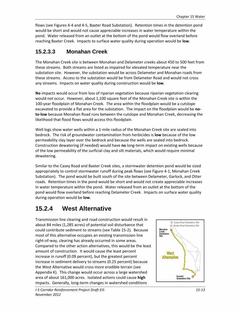
15.2.3.3 Monahan Creek
The Monahan Creek site is between Monahan and Delameter creeks about 450 to 500 feet from these streams. Both streams are listed as impaired for elevated temperature near the substation site. However, the substation would be across Delameter and Monahan roads from these streams. Access to the substation would be from Delameter Road and would not cross any streams. Impacts on water quality during construction would be low.
No impacts would occur from loss of riparian vegetation because riparian vegetation clearing would not occur. However, about 1,100 square feet of the Monahan Creek site is within the 100-year floodplain of Monahan Creek. The area within the floodplain would be a cutslope excavated to provide a flat area for the substation. The impact on the floodplain would be no-to-low because Monahan Road runs between the cutslope and Monahan Creek, decreasing the likelihood that flood flows would access this floodplain.
Well logs show water wells within a 1-mile radius of the Monahan Creek site are sealed into bedrock. The risk of groundwater contamination from herbicides is low because of the low permeability clay layer over the bedrock and because the wells are sealed into bedrock. Construction dewatering (if needed) would have no long-term impact on existing wells because of the low permeability of the surficial clay and silt materials, which would require minimal dewatering.
Similar to the Casey Road and Baxter Creek sites, a stormwater detention pond would be sized appropriately to control stormwater runoff during peak flows (see Figure 4-1, Monahan Creek Substation). The pond would be built south of the site between Delameter, Garlock, and Otter roads. Retention times in the pond would be short and would not create appreciable increases in water temperature within the pond. Water released from an outlet at the bottom of the pond would flow overland before reaching Delameter Creek. Impacts on surface water quality during operation would be low.
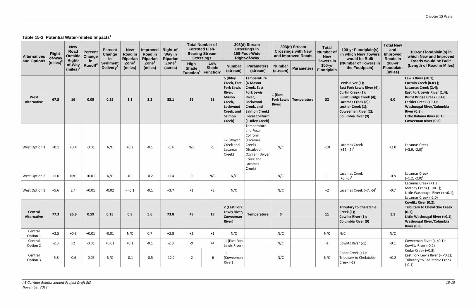
15.2.4 West Alternative
Transmission line clearing and road construction would result in about 84 miles (1,285 acres) of potential soil disturbance that could contribute sediment to streams (see Table 15-2). Because most of this alternative occupies an existing transmission line right-of-way, clearing has already occurred in some areas. Compared to the other action alternatives, this would be the least amount of construction. It would cause the least percent increase in runoff (0.09 percent), but the greatest percent increase in sediment delivery to streams (0.25 percent) because the West Alternative would cross more erodible terrain (see Appendix K). This change would occur across a large watershed area of about 161,000 acres. Isolated actions could cause high impacts. Generally, long-term changes in watershed conditions
Chapter 15 Water
15-14 I-5 Corridor Reinforcement Project Draft EIS November 2012
would be minor, and could cause minor changes in existing watershed functions. Impacts would be low.
Riparian vegetation would be cleared at 47 forested crossings of fish-bearing streams (see Table 15-2). Compared to other action alternatives, this would be the least number of forested crossings. Most crossings (28) would occur where the existing shade level is already low and provides limited stream cooling; impacts would be low. This is the greatest number compared to other alternatives. Nineteen crossings would occur where the existing shade level does provide effective stream cooling and where shade loss is more likely to cause temperature increases that adversely affect aquatic life; impacts would be high. This is the fewest number of high riparian impacts among the alternatives because there are relatively fewer forested crossings and because riparian vegetation at these crossings provides relatively lower shade. Compared to the other alternatives, crossings for this alternative would be at lower elevations where hardwood species composition is greater and hardwoods are not as effective as conifers in providing shade. Streams tend to be wider and forest canopies cannot fully cover the stream surface. At lower elevations, air temperatures also are higher and more shade is required to cool streams to adequate temperatures.
The West Alternative would cross five streams listed as impaired: Riley Creek, Lockwood Creek, East Fork Lewis River, Mason Creek, and Salmon Creek (see Table 15-2, Maps 15-2A through D). Riley Creek is listed for fecal coliform, and the other four are listed for elevated water temperature. Riparian vegetation has already been removed at all of these crossings and the project would cause no additional impacts on temperature or fecal coliform levels. However, soil disturbance that causes increased turbidity could affect these creeks. Using erosion control measures during construction would minimize the transport of sediment to streams. Properly implementing road drainage BMPs, regular maintenance, and rocking roads would reduce erosion on unpaved roads, lessening these impacts, and ensuring that turbidity standards are met. Impacts would be low.
Thirty-two towers would be constructed in the 100-year floodplains of the following water bodies: Lewis River (1), East Fork Lewis River (6), Curtin Creek (1), Burnt Bridge Creek (4), Lacamas Creek (8), Leckler Creek (1), Coweeman River (2), and Columbia River (9). Six miles of road would be constructed or improved within 100-year floodplains, about 5 more miles than the other action alternatives. Impacts to floodplains are similar to those common to the action alternatives (low). Towers and access roads would be designed to allow water flow and soil absorption.
About 20 miles of wellhead protection areas (1-year and 10-year time of travel) would be crossed by the West Alternative’s rights-of-way and access roads. This is more than the other action alternatives because the West Alternative would cross more populated land. Water quality impacts in these areas would be mitigated by using BMPs and spill containment and clean-up procedures. There would be no long-term impacts.
Chapter 15 Water
I-5 Corridor Reinforcement Project Draft EIS 15-15 November 2012
Table 15-2 Potential Water-related Impacts1
Alternatives and Options
Right-of-Way (miles)
2
New Road
Outside Right-of-Way (miles)
2
Percent Change
in Runoff
3
Percent Change
in Sediment Delivery
4
New Road in Riparian
Zone5
(miles)
Improved Road in Riparian
Zone5
(miles)
Right-of-Way in
Riparian Zone
5
(acres)
Total Number of Forested Fish-Bearing Stream
Crossings
303(d) Stream Crossings in
150-Foot-Wide Right-of-Way
303(d) Stream Crossings with New and Improved Roads
Total Number of
New Towers in
100-yr Floodplain
100-yr Floodplain(s) in which New Towers
would be Built (Number of Towers in
the Foodplain)
Total New and
Improved Roads in
100-yr Floodplain
(miles)
100-yr Floodplain(s) in which New and Improved
Roads would be Built (Length of Road in Miles) High
Shade Function
6
Low Shade
Function7
Number (stream)
Parameters (stream)
Number (stream)
Parameters
West Alternative
67.5 16 0.09 0.25 1.1 2.2 83.1 19 28
5 (Riley Creek, East Fork Lewis River, Mason Creek, Lockwood Creek, and Salmon Creek)
Temperature (4-Mason Creek, East Fork Lewis River, Lockwood Creek, and Salmon Creek) Fecal Coliform (1-Riley Creek)
1 (East Fork Lewis River)
Temperature 32
Lewis River (1); East Fork Lewis River (6); Curtin Creek (1); Burnt Bridge Creek (4); Lacamas Creek (8); Leckler Creek (1); Coweeman River (2); Columbia River (9)
6.0
Lewis River (<0.1); Curtain Creek (0.03 ); Lacamas Creek (2.4); East Fork Lewis River (1.4); Burnt Bridge Creek (0.4); Leckler Creek (<0.1); Washougal River/Columbia River (0.8); Little Kalama River (0.1); Coweeman River (0.8)
West Option 1 +0.1 +0.4 -0.01 N/C +0.2 -0.1 -1.4 N/C -1
+2 (Dwyer Creek and Lacamas Creek)
Temperature and Fecal Coliform (Lacamas Creek) Dissolved Oxygen (Dwyer Creek and Lacamas Creek)
N/C +10 Lacamas Creek (+15, -5)
8
+2.0 Lacamas Creek (+3.9, -2.0)
8
West Option 2 +1.6 N/C +0.01 N/C -0.1 -0.2 +1.4 -1 N/C N/C N/C +1 Lacamas Creek (+6, -5)
8
-0.8 Lacamas Creek (+1.2, -2.0)
8
West Option 3 +5.6 2.4 +0.01 -0.02 - <0.1 -0.1 +3.7 +1 +3 N/C N/C +2 Lacamas Creek (+7, -5)8 -0.7
Lacamas Creek (+1.2); Matney Creek (+ <0.1); Little Washougal River (+ <0.1); Lacamas Creek (-2.0)
Central Alternative
77.3 26.8 0.59 0.15 0.9 5.6 73.8 49 19
2 (East Fork Lewis River, Coweeman River)
Temperature 0 11
Tributary to Chelatchie Creek (1); Cowlitz River (1); Columbia River (9)
1.1
Cowlitz River (0.2); Tributary to Chelatchie Creek (0.1); Little Washougal River (<0.1); Washougal River/Columbia River (0.8)
Central Option 1
+2.5 +0.8 +0.01 -0.01 N/C 0.7 +2.8 +1 +1 N/C N/C N/C N/C N/C
Central Option 2
-2.3 +2 -0.01 +0.01 +0.1 -0.1 -2.8 -9 +4 -1 (East Fork Lewis River)
N/C -1 Cowlitz River (-1) -0.1 Coweeman River (+ <0.1); Cowlitz River (-0.2)
Central Option 3
-5.8 -0.6 -0.05 N/C -0.1 -0.5 -12.2 -2 -6 -1 (Coweeman River)
N/C N/C Cedar Creek (+1); Tributary to Chelatchie Creek (-1)
+0.2
Cedar Creek (+0.3); East Fork Lewis River (+ <0.1); Tributary to Chelatchie Creek (-0.1)
Chapter 15 Water
15-16 I-5 Corridor Reinforcement Project Draft EIS November 2012
Alternatives and Options
Right-of-Way (miles)
2
New Road
Outside Right-of-Way (miles)
2
Percent Change
in Runoff
3
Percent Change
in Sediment Delivery
4
New Road in Riparian
Zone5
(miles)
Improved Road in Riparian
Zone5
(miles)
Right-of-Way in
Riparian Zone
5
(acres)
Total Number of Forested Fish-Bearing Stream
Crossings
303(d) Stream Crossings in
150-Foot-Wide Right-of-Way
303(d) Stream Crossings with New and Improved Roads
Total Number of
New Towers in
100-yr Floodplain
100-yr Floodplain(s) in which New Towers
would be Built (Number of Towers in
the Foodplain)
Total New and
Improved Roads in
100-yr Floodplain
(miles)
100-yr Floodplain(s) in which New and Improved
Roads would be Built (Length of Road in Miles) High
Shade Function
6
Low Shade
Function7
Number (stream)
Parameters (stream)
Number (stream)
Parameters
East Alternative
75.5 22.5 1.02 0.00 0.4 7.8 61.8 35 17
2 (East Fork Lewis River, Coweeman River)
Temperature 0 10 Cowlitz River (1); Columbia River (9)
1.0
Cowlitz River (0.2); Little Washougal River (<0.1); Washougal River/Columbia River (0.8)
East Option 1 -1.8 +0.6 -0.05 +0.01 +0.1 -0.5 -7.2 -11 +5
+2 (South Fork Ostrander Creek, Ostrander Creek)
Temperature
+1 (South Fork Ostrander Creek)
Temperature -1 Cowlitz River (-1) -0.1
Ostrander Creek (+0.1); Cowlitz River (+0.1); South Fork Ostrander Creek (+ <0.1); Coweeman River (+ <0.1); Cowlitz River (-0.2)
East Option 2 +1.0 -2.2 -0.24 N/C -0.2 -1.1 -2.2 +5 +2 N/C N/C N/C N/C N/C
East Option 3 +1.1 -0.6 +0.03 N/C -0.1 N/C -1.1 +4 N/C N/C N/C N/C N/C N/C
Crossover Alternative
74.0 21 0.47 0.17 0.7 4.1 83.0 32 23 1 (East Fork Lewis River)
Temperature 0 12 Leckler Creek (1); Coweeman River (2); Columbia River (9)
1.6
Leckler Creek (<0.1); Little Kalama River (40.1); Coweeman River (0.8); Little Washougal River (<0.1); Washougal River/Columbia River (0.8)
Crossover Option 1
+5.2 +0.9 +0.01 N/C N/C + <0.1 +2.4 +1 +2 N/C N/C N/C N/C - <0.1 Little Washougal River (- <0.1)
Crossover Option 2
+4.3 +0.2 -0.01 -0.01 + <0.1 +0.2 +5.8 N/C +1
+2 (Arkansas Creek, Monahan Creek)
Temperature N/C N/C N/C N/C
Crossover Option 3
+4.2 +0.8 -0.07 -0.01 + <0.1 +0.2 +5.3 +1 +2
+2 (Arkansas Creek, Monahan Creek)
Temperature N/C N/C N/C N/C
Notes:
N/C – No change from the alternative
1. The value for each option represents the net change from the action alternative. It was calculated as the value added by the option minus the total value in the segments the option replaces.
2. Potential soil disturbance within a 150-foot transmission line right-of-way and a 30-foot road width outside of the transmission line right-of-way.
3. Represents the percent change in hydrologically immature vegetation in watersheds crossed by the action alternatives; hydrologically immature vegetation increases snow accumulation and snowmelt (see Appendix K).
4. Represents the percent change in sediment delivery in watersheds crossed by the action alternatives (see Appendix K).
5. Riparian zone is a 200-foot-wide buffer along perennial streams.
6. High shade function occurs at a crossing when the existing shade level provides effective stream cooling and shade loss is more likely to cause temperature increases that adversely affect aquatic life (see Appendix K).
7. Low shade function occurs when the existing shade level is already low and insufficient to provide adequate stream cooling (see Appendix K).
8. The positive value indicates towers or roads in the Lacamas Creek floodplain along the option’s segments. The negative value indicates the towers or roads in the Lacamas Creek floodplain along the segments that the option replaces.

Chapter 15 Water
I-5 Corridor Reinforcement Project Draft EIS 15-17 November 2012
15.2.4.1 West Option 1
West Option 1 would replace a portion of the alternative that follows existing right-of-way just east of Vancouver with an option that is farther west and closer to Vancouver. This portion of the alternative includes replacing one of the existing 230-kV lines with a new double-circuit 500-kV line. The existing 230-kV line and the new line would be placed on new 500-kV towers. West Option 1 would require one fewer low shade level forested crossing of a fish-bearing stream be cleared than the portion of line this option would replace on the West Alternative.
This option would cross Dwyer Creek, a stream listed as impaired for dissolved oxygen, and Lacamas Creek, listed as impaired for fecal coliform, temperature, and dissolved oxygen. Riparian vegetation has already been removed at these crossings and the project would cause no additional impacts on temperature, dissolved oxygen, or fecal coliform levels. Soil disturbance that causes increased turbidity could further affect these creeks. Using erosion control measures during construction would minimize sediment transport to streams. Properly implementing road drainage BMPs, regular maintenance, and rocking roads would reduce erosion on unpaved roads, lessening these impacts, and ensuring that turbidity standards are met. Impacts would be low.
West Option 1 would require an additional 10 towers (15 towers added and 5 removed) and an additional 2 miles of access roads in the Lacamas Creek floodplain.
Impact levels on riparian function, watershed function, water quality, floodplains and groundwater would be the same as the West Alternative.
15.2.4.2 West Options 2 and 3
West Option 2 would replace a portion of the alternative in the rural residential areas north of Camas with an option farther to the east in the same area. West Option 2 would require one less high shade level forested crossing of a fish-bearing stream be cleared than the portion of line replaced on the West Alternative. West Option 3 would replace a portion of the West Alternative in the rural residential areas north of Camas with a route crossing rural residential and rural areas farther east. West Option 3 would require clearing of one additional high shade level and three additional low shade level forested crossings of fish-bearing streams.
West Option 2 would require one additional tower in the Lacamas Creek floodplain (6 towers added and 5 removed) and West Option 3 would require two additional towers in the Lacamas Creek floodplain (7 towers added and 5 removed).
Impact levels on riparian function, watershed function, water quality, floodplains and groundwater would be the same as the West Alternative.
Chapter 15 Water
15-18 I-5 Corridor Reinforcement Project Draft EIS November 2012
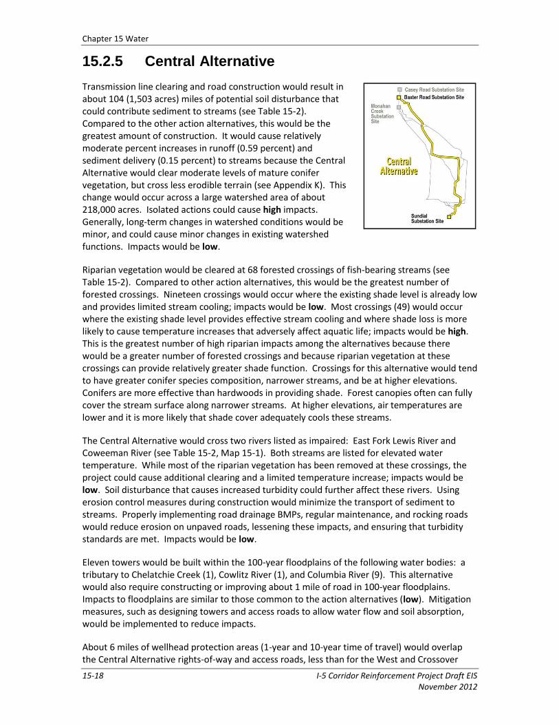
15.2.5 Central Alternative
Transmission line clearing and road construction would result in about 104 (1,503 acres) miles of potential soil disturbance that could contribute sediment to streams (see Table 15-2). Compared to the other action alternatives, this would be the greatest amount of construction. It would cause relatively moderate percent increases in runoff (0.59 percent) and sediment delivery (0.15 percent) to streams because the Central Alternative would clear moderate levels of mature conifer vegetation, but cross less erodible terrain (see Appendix K). This change would occur across a large watershed area of about 218,000 acres. Isolated actions could cause high impacts. Generally, long-term changes in watershed conditions would be minor, and could cause minor changes in existing watershed functions. Impacts would be low.
Riparian vegetation would be cleared at 68 forested crossings of fish-bearing streams (see Table 15-2). Compared to other action alternatives, this would be the greatest number of forested crossings. Nineteen crossings would occur where the existing shade level is already low and provides limited stream cooling; impacts would be low. Most crossings (49) would occur where the existing shade level provides effective stream cooling and where shade loss is more likely to cause temperature increases that adversely affect aquatic life; impacts would be high. This is the greatest number of high riparian impacts among the alternatives because there would be a greater number of forested crossings and because riparian vegetation at these crossings can provide relatively greater shade function. Crossings for this alternative would tend to have greater conifer species composition, narrower streams, and be at higher elevations. Conifers are more effective than hardwoods in providing shade. Forest canopies often can fully cover the stream surface along narrower streams. At higher elevations, air temperatures are lower and it is more likely that shade cover adequately cools these streams.
The Central Alternative would cross two rivers listed as impaired: East Fork Lewis River and Coweeman River (see Table 15-2, Map 15-1). Both streams are listed for elevated water temperature. While most of the riparian vegetation has been removed at these crossings, the project could cause additional clearing and a limited temperature increase; impacts would be low. Soil disturbance that causes increased turbidity could further affect these rivers. Using erosion control measures during construction would minimize the transport of sediment to streams. Properly implementing road drainage BMPs, regular maintenance, and rocking roads would reduce erosion on unpaved roads, lessening these impacts, and ensuring that turbidity standards are met. Impacts would be low.
Eleven towers would be built within the 100-year floodplains of the following water bodies: a tributary to Chelatchie Creek (1), Cowlitz River (1), and Columbia River (9). This alternative would also require constructing or improving about 1 mile of road in 100-year floodplains. Impacts to floodplains are similar to those common to the action alternatives (low). Mitigation measures, such as designing towers and access roads to allow water flow and soil absorption, would be implemented to reduce impacts.
About 6 miles of wellhead protection areas (1-year and 10-year time of travel) would overlap the Central Alternative rights-of-way and access roads, less than for the West and Crossover
Chapter 15 Water
I-5 Corridor Reinforcement Project Draft EIS 15-19 November 2012
alternatives. Water quality impacts in these areas would be mitigated by using BMPs and spill containment and clean-up procedures. Impacts would be similar to those common to the action alternatives (no long-term impacts).
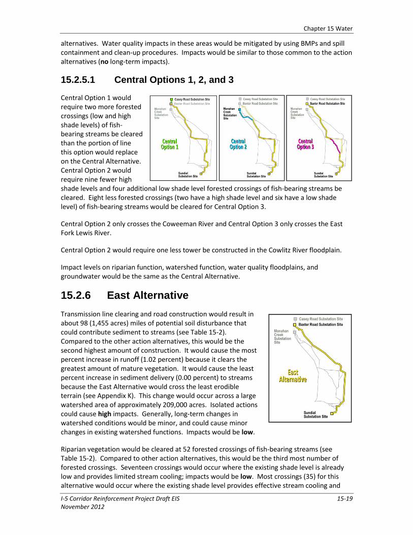
15.2.5.1 Central Options 1, 2, and 3
Central Option 1 would require two more forested crossings (low and high shade levels) of fish-bearing streams be cleared than the portion of line this option would replace on the Central Alternative. Central Option 2 would require nine fewer high shade levels and four additional low shade level forested crossings of fish-bearing streams be cleared. Eight less forested crossings (two have a high shade level and six have a low shade level) of fish-bearing streams would be cleared for Central Option 3.
Central Option 2 only crosses the Coweeman River and Central Option 3 only crosses the East Fork Lewis River.
Central Option 2 would require one less tower be constructed in the Cowlitz River floodplain.
Impact levels on riparian function, watershed function, water quality floodplains, and groundwater would be the same as the Central Alternative.
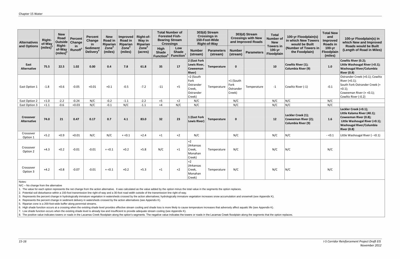
15.2.6 East Alternative
Transmission line clearing and road construction would result in about 98 (1,455 acres) miles of potential soil disturbance that could contribute sediment to streams (see Table 15-2). Compared to the other action alternatives, this would be the second highest amount of construction. It would cause the most percent increase in runoff (1.02 percent) because it clears the greatest amount of mature vegetation. It would cause the least percent increase in sediment delivery (0.00 percent) to streams because the East Alternative would cross the least erodible terrain (see Appendix K). This change would occur across a large watershed area of approximately 209,000 acres. Isolated actions could cause high impacts. Generally, long-term changes in watershed conditions would be minor, and could cause minor changes in existing watershed functions. Impacts would be low.
Riparian vegetation would be cleared at 52 forested crossings of fish-bearing streams (see Table 15-2). Compared to other action alternatives, this would be the third most number of forested crossings. Seventeen crossings would occur where the existing shade level is already low and provides limited stream cooling; impacts would be low. Most crossings (35) for this alternative would occur where the existing shade level provides effective stream cooling and

Chapter 15 Water
15-20 I-5 Corridor Reinforcement Project Draft EIS November 2012
where shade loss is more likely to cause temperature increases that adversely affect aquatic life; impacts would be high. This is the second greatest number of high riparian impacts among the action alternatives. Similar to the Central Alternative, existing crossings along the East Alternative provide greater shade function. Crossings for this alternative tend to have greater conifer species composition, narrower streams, and be at higher elevations. The reason for relatively fewer high impacts along the East Alternative is because there are fewer streams crossed.
The East Alternative would cross the same two rivers that are listed as impaired as those crossed by the Central Alternative: East Fork Lewis River and Coweeman River (see Table 15-2, Map 15-1). Both streams are listed for elevated water temperature. Impacts to water quality would be low because while most of the riparian vegetation has been removed along these streams, any additional vegetation clearing from the project could cause a limited temperature increase. Use of erosion control measures during construction would minimize potential sediment transport to these rivers, also a low impact.
Ten towers would be built within the 100-year floodplains of the following water bodies: Cowlitz River (1) and Columbia River (9). This alternative would also require constructing or improving about 1 mile of road in 100-year floodplains. Impacts to floodplains are similar to those common to the action alternatives (low). Implementation of mitigation measures such as designing towers and access roads to allow water flow and soil absorption would reduce impacts.
About 6 miles of wellhead protection areas (1-year and 10-year time of travel) would overlap the East Alternative rights-of-way and access roads, less than for the West and Crossover alternatives. Water quality impacts in these areas would be mitigated by using BMPs and spill containment and clean-up procedures. Impacts would be similar to those common to the action alternatives (no long-term impacts).
15.2.6.1 East Option 1
East Option 1 begins at the Monahan Creek substation site and would remove the portion of the East Alternative crossing the Cowlitz River north of Castle Rock. The option would use segments southeast of the Monahan Creek substation site that run through sparsely populated land, cross the Cowlitz River and I-5 and run through largely unpopulated land toward the east. East Option 1 would require 11 fewer high shade levels and five additional low shade level forested crossings of fish-bearing streams be cleared.
East Option 1 would add stream crossings at Ostrander Creek and the South Fork Ostrander Creek. Both streams are listed for elevated water temperatures. Impacts to water quality would be high in these streams because loss of riparian vegetation would increase water temperature. Use of erosion control measures during construction would minimize potential sediment transport to streams, a low impact.
East Option 1 would require one less tower constructed in the Cowlitz River floodplain.
Impact levels on riparian function, watershed function, floodplains and groundwater would be the same as the Central Alternative.
Chapter 15 Water
I-5 Corridor Reinforcement Project Draft EIS 15-21 November 2012
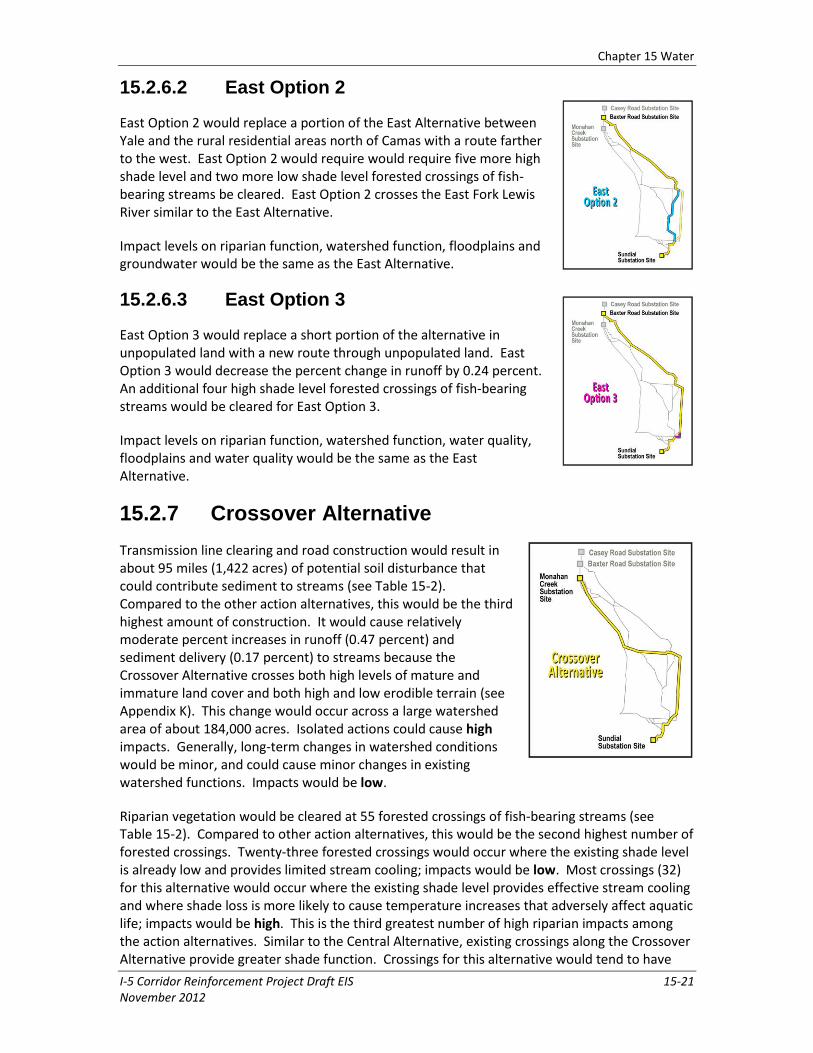
15.2.6.2 East Option 2
East Option 2 would replace a portion of the East Alternative between Yale and the rural residential areas north of Camas with a route farther to the west. East Option 2 would require would require five more high shade level and two more low shade level forested crossings of fish-bearing streams be cleared. East Option 2 crosses the East Fork Lewis River similar to the East Alternative.
Impact levels on riparian function, watershed function, floodplains and groundwater would be the same as the East Alternative.
15.2.6.3 East Option 3
East Option 3 would replace a short portion of the alternative in unpopulated land with a new route through unpopulated land. East Option 3 would decrease the percent change in runoff by 0.24 percent. An additional four high shade level forested crossings of fish-bearing streams would be cleared for East Option 3.
Impact levels on riparian function, watershed function, water quality, floodplains and water quality would be the same as the East Alternative.
15.2.7 Crossover Alternative
Transmission line clearing and road construction would result in about 95 miles (1,422 acres) of potential soil disturbance that could contribute sediment to streams (see Table 15-2). Compared to the other action alternatives, this would be the third highest amount of construction. It would cause relatively moderate percent increases in runoff (0.47 percent) and sediment delivery (0.17 percent) to streams because the Crossover Alternative crosses both high levels of mature and immature land cover and both high and low erodible terrain (see Appendix K). This change would occur across a large watershed area of about 184,000 acres. Isolated actions could cause high impacts. Generally, long-term changes in watershed conditions would be minor, and could cause minor changes in existing watershed functions. Impacts would be low.
Riparian vegetation would be cleared at 55 forested crossings of fish-bearing streams (see Table 15-2). Compared to other action alternatives, this would be the second highest number of forested crossings. Twenty-three forested crossings would occur where the existing shade level is already low and provides limited stream cooling; impacts would be low. Most crossings (32) for this alternative would occur where the existing shade level provides effective stream cooling and where shade loss is more likely to cause temperature increases that adversely affect aquatic life; impacts would be high. This is the third greatest number of high riparian impacts among the action alternatives. Similar to the Central Alternative, existing crossings along the Crossover Alternative provide greater shade function. Crossings for this alternative would tend to have
Chapter 15 Water
15-22 I-5 Corridor Reinforcement Project Draft EIS November 2012
greater conifer species composition, narrower streams, and be at higher elevations. The reason for relatively fewer high impacts along the Crossover Alternative is because there are fewer streams crossed.
The Crossover Alternative would cross the East Fork Lewis River, listed as impaired for elevated water temperature (see Table 15-2, Map 15-1). Impacts to water quality in the East Fork Lewis River would be low because while most of the riparian vegetation has been removed, any additional vegetation clearing from the project could cause a limited temperature increase. Use of erosion control measures during construction would minimize potential sediment transport to the river, also a low impact.
Twelve towers would be built within the 100-year floodplains of the following water bodies: Leckler Creek (1), Coweeman River (2), and Columbia River (9). This alternative would also require constructing or improving about 1.5 miles of road in 100-year floodplains. Impacts to floodplains are similar to those common to the action alternatives (low). Mitigation measures such as designing towers and access roads to allow water flow and soil absorption would be implemented to reduce impacts.
About 10 miles of wellhead protection areas (1-year and 10-year time of travel) would overlap the Crossover Alternative rights-of-way and access roads. Water quality impacts in these areas would be mitigated by using BMPs and spill containment and clean-up procedures. Impacts would be similar to those common to the action alternatives (no long-term impacts).
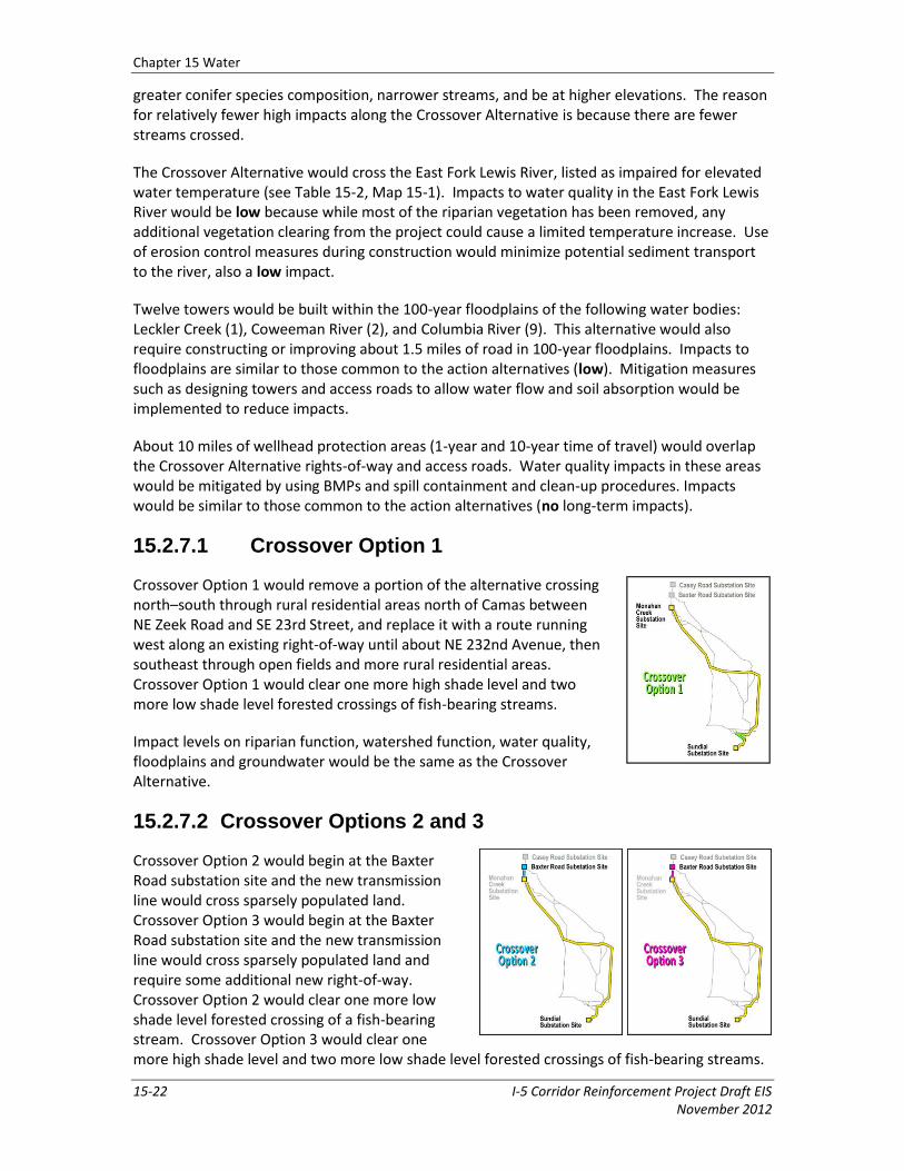
15.2.7.1 Crossover Option 1
Crossover Option 1 would remove a portion of the alternative crossing north–south through rural residential areas north of Camas between NE Zeek Road and SE 23rd Street, and replace it with a route running west along an existing right-of-way until about NE 232nd Avenue, then southeast through open fields and more rural residential areas. Crossover Option 1 would clear one more high shade level and two more low shade level forested crossings of fish-bearing streams.
Impact levels on riparian function, watershed function, water quality, floodplains and groundwater would be the same as the Crossover Alternative.
15.2.7.2 Crossover Options 2 and 3
Crossover Option 2 would begin at the Baxter Road substation site and the new transmission line would cross sparsely populated land. Crossover Option 3 would begin at the Baxter Road substation site and the new transmission line would cross sparsely populated land and require some additional new right-of-way. Crossover Option 2 would clear one more low shade level forested crossing of a fish-bearing stream. Crossover Option 3 would clear one more high shade level and two more low shade level forested crossings of fish-bearing streams.
Chapter 15 Water
I-5 Corridor Reinforcement Project Draft EIS 15-23 November 2012
Both Crossover Options 2 and 3 would add stream crossings at Arkansas and Monahan creeks (both listed for elevated water temperature). Impacts to water quality would be similar to those where some riparian vegetation has been removed but more vegetation removal could cause additional temperature elevation (low). Use of erosion control measures during construction would minimize potential sediment transport to these streams, also a low impact.
Impact levels on riparian function, watershed function, floodplains, and groundwater would be the same as the Crossover Alternative.
15.2.8 Recommended Mitigation Measures
Mitigation measures included as part of the project are identified in Table 3-2. The following additional mitigation measures have been identified to further reduce or eliminate adverse water resource impacts by the action alternatives. If implemented, these measures would be completed before, during, or immediately after project construction unless otherwise noted.
Minimize the number of road-stream crossings and avoid perennial crossings where possible.
Incorporate standard forest road drainage design BMPs into access road design to reduce erosion (road grading, ditching, drainage dips, culverts, armoring where necessary, discharging road drainage onto solid stable ground, etc.).
Use standard erosion control measures (BMPs) during vegetation clearing in the right-of-way.
Remove and dispose of sediment properly, away from surface waters in an upland location out of floodplains.
Conduct construction, operation, and maintenance activities along or near streams during dry periods.
Minimize traffic or avoid traffic on access roads during the rainy season.
Avoid or minimize clearing riparian vegetation where possible, especially where it may affect a 303(d) listed water.
Pursuant to Washington’s Forests and Fish Law (RCW 77.85), bring all existing access roads up to new forest road standards through Road Maintenance and Abandonment Plans (RMAPs) by 2016.
Design new access road crossings to preserve natural flow patterns, channel structure, and fish passage.
Avoid placing towers in waterways where possible.
Avoid placing towers and access roads in floodplains where possible.
Design towers in floodplains to prevent potential scour and erosion.
Minimize herbicide and pesticide application. Use physical methods of vegetation control when feasible. Use herbicides and application methods approved in the Transmission System Vegetation Management Program Record of Decision (BPA 2000b) or evaluate and consider using other herbicides or application methods at the request of property owners. Employ herbicide application BMPs in place based on the EIS and ROD
Chapter 15 Water
15-24 I-5 Corridor Reinforcement Project Draft EIS November 2012
for vegetation management (BPA 2000a; BPA 2000b), including established riparian zones.
Avoid construction immediately next to water supply wells or relocate water supply wells.
15.2.9 Unavoidable Impacts
If all erosion control mitigation measures are implemented, there would still be a small increase in sediment delivery to streams. Riparian vegetation would be removed reducing shade, which could lead to increased temperatures and possibly decreased dissolved oxygen, nutrient production, streambank stability, and habitat for aquatic and riparian dependent species. Final project design may still place some towers and access roads in larger floodplains that cannot be spanned or avoided, causing very small decreases in flood storage. Once final project design is complete, there may be some existing water wells that need to be moved to avoid towers and access roads.
15.2.10 No Action Alternative
Under the No Action Alternative, none of the action alternatives would be constructed. Existing forest production and farming practices would continue and many of the existing unpaved roads identified for use by this project would likely be improved periodically by the underlying landowner for forest production and farming purposes, which could increase sediment delivery to adjacent streams.
Riparian vegetation in forested lands that would have been cleared for the transmission line right-of-way would likely remain intact. Existing forest harvest practices require leaving a riparian buffer near streams.
No impacts to water wells or wellhead protection areas would occur. Excavations for towers and substations would not occur so no shallow groundwater would be encountered or need to be pumped. Because no additional herbicides and pesticides would be used to control vegetation, there would be no additional risk of water quality impacts from these substances.